
Sebring City Zoning Code
ARTICLE IV
ZONING DISTRICTS4
Editor's note— Section 5 of Ord. No. 1335, adopted Aug. 7, 2012, changed the title of art. IV from "District Regulations" to "Zoning Districts."
Sec. 26-120. - Purpose and introduction.
(a)
Article IV of chapter 26 establishes zoning districts and describes the use and regulations that apply to each district. Division 2 establishes zoning districts that divide the local government into various residential, commercial, industrial and other zoning districts. Each district establishes uses that are permitted "as of right" or as a conditional use.
(b)
The purpose of this Code is to promote the public health, safety, morals, or general welfare, and to protect and preserve places and areas of historical, cultural, or architectural importance and significance. These regulations are adopted in accordance with the comprehensive plan and are designed to:
• Lessen congestion in the streets;
• Secure safety from fire, panic, and other dangers;
• Promote health and general welfare;
• Provide adequate light and air;
• Prevent the overcrowding of land;
• Avoid an undue concentration of population; or
• Facilitate the adequate provision of transportation, water, sewers, schools, parks, and other public requirements.
• Distribute land uses to meet the physical, social, cultural, economic, and energy needs of present and future populations;
• Ensure that new development is compatible with surrounding development in use, character, and size;
• Provide for land uses that serve important public needs, such as affordable housing and employment generators;
• Promote mixed-use buildings and mixed-use neighborhoods;
• Promote infill housing and downtown retail and residential development;
• Integrate civic uses into neighborhoods;
• Protect natural resources; and
• Encourage retail development in commercial centers and the historic downtown.
(c)
In accordance with the foregoing purposes, this article establishes regulations governing the following:
• The height, number of stories, and size of buildings and other structures;
• The percentage of a lot that may be occupied;
• The size of setbacks, courts, and other open spaces;
• Population density; and
• The location and use of buildings, other structures, and land for business, industrial, residential, or other purposes.
(Ord. No. 1335, § 5, 8-7-2012)
Sec. 26-122. - Zoning districts enumerated.
(a)
The city is divided into zoning districts as follows:
Table 26-122.A: Zoning Districts Enumerated
Commercial zoning districts are C-1, C-2, and DMU. Industrial zoning districts are I-1 and I-2. Residential zoning districts are R-1AA, R-1A, R-1, R-2, R-3, R-3P, R-4, DR, RV, and MH. PD and MUQD are considered commercial, industrial, or residential or some combination when so designated in the development agreement or adopting ordinance applying the district to real property.
(b)
The zoning atlas showing the zoning within the city as it exists as of September 17, 1996, together with all properties rezoned and/or annexed into the city is hereby adopted as the official zoning atlas of the City of Sebring.
(c)
Consistency with the comprehensive plan land use classifications established. Future land use categories for the city are established in the future land use element of the comprehensive plan. These land use categories are defined in the future land use element and delineated on the future land use map. Refer to the future land use element of the comprehensive plan for the definitions of each use category. The zoning districts in this chapter are consistent with the land use categories of the comprehensive plan, and may be applied as shown in the Zoning District—Comprehensive Plan Consistency Table 26-122.C.
Table 26-122.C: Zoning District—Comprehensive Plan Future Land Use Category Consistency
(Ord. No. 1335, §§ 6—8, 8-7-2012; Ord. No. 1468, § 1, 12-21-2021)
Sec. 26-123. - Zoning atlas adopted; interpretation.
(a)
The districts listed in section 26-122 and their boundaries are shown upon the zoning map or series of maps of the city designated as the "City of Sebring Official Zoning Atlas." This map and all notations, references and other information shown on the map shall be a part of this chapter and incorporated herein by reference.
(b)
The (1) boundaries of such districts as are shown upon the zoning map adopted by this chapter; (2) adopted and approved amendments to the zoning map; and (3) regulations of this chapter governing the use of land and buildings, the height of buildings, building site area, the sizes of setbacks about buildings and other matters as set forth in this chapter are established and declared to be in effect upon all land included within the boundaries of each district shown upon the zoning map.
(c)
Rules for interpretation of boundaries. Where uncertainty exists as to boundaries of any district shown on the zoning map, the following rules shall apply:
(1)
The centerline of streets, alleys or lot lines, if indicated as boundaries, shall be understood as district boundaries.
(2)
In unsubdivided property or where a district boundary divides a lot, the location of such boundary, unless the location is indicated by dimensions, shall be determined by use of the scale appearing on the map.
(3)
Any platted lot line, other property line or the boundaries of an incorporated municipality, if indicated as boundaries, shall be understood as district boundaries.
(4)
The applicable regulations governing a vacated or abandoned public street or alley shall be those of the abutting property.
(5)
All areas within the corporate limits of the city that are under water and not shown as included within any district shall be subject to all of the regulations of the district which immediately adjoins the water area. If the water area adjoins two or more districts, the boundaries of each district shall be construed to extend into the water area in a straight line until they meet the other district.
(6)
Boundaries indicated as following railroad tracks shall be understood to be midway between the main tracks or rails.
(7)
Boundaries may be indicated as parallel to or extensions of streets, alleys, lot lines, property or city limit boundaries, railroad lines, or other features used in this section.
(8)
If any further uncertainty exists, the city council shall interpret the intent of the map as to location of such boundaries.
(d)
Changes made in district boundaries, or any other matter portrayed on the official zoning atlas, shall be noted on the official zoning atlas within five working days after the amendment has been approved by the city council, together with an entry in a log, to be placed at the front of the official zoning atlas showing the date the zoning atlas was updated, the date of the last zoning/district boundary change and the ordinance number. The changes, along with the adopting ordinance number, shall be placed on the subject parcels by the planning and zoning director.
(e)
No changes of any nature shall be made on the official zoning atlas or to any matter shown thereon except in conformity with the procedures set forth in this chapter.
(f)
The official zoning atlas shall be located in the office of the planning and zoning director and shall be the final authority as to the current zoning status of lands in the city, subject to any interpretation of city council pursuant to subsection (c)(8) above.
(Code 1981, § 22-4; Ord. NO. 1254, § 3, 12-4-2007; Ord. No. 1335, § 9, 8-7-2012)
Editor's note— Section 9 of Ord. No. 1335, adopted Aug. 7, 2012, amended and redesignated former § 26-97 as § 26-123.
Sec. 26-125. - Application of district regulations.
No building, structure or land shall be used or occupied, and no building or structure shall be erected, constructed, reconstructed, moved or structurally altered unless in conformity with the uses permitted and restrictions applicable in the district in which such building, structure or land is located.
(1)
Open spaces for each building or use. No part of a setback, parking space, loading space or open space required about or in connection with any building, structure or use for the purpose of complying with this chapter shall be used to meet a similar requirement for any other building, structure or use.
(2)
Reduction of lot or open spaces. No existing lot shall be reduced in area, width, or depth to less than that required by this chapter; nor shall any lot be reduced in any matter that would result in the reduction of any setback, parking space, loading space or other open space or spaces to less than that required by this chapter.
(Code 1981, § 22-5; Ord. No. 1335, § 11, 8-7-2012)
Editor's note— Section 11 of Ord. No. 1335, adopted Aug. 7, 2012, amended and redesignated former § 26-131 as § 26-125.
Sec. 26-126. - Uses or structures allowed in all zoning districts.
(a)
Accessory uses are regulated pursuant to section 26-222 (accessory uses and structures) of article V of chapter 26 and permitted only where it is accessory to another use that is permitted in the district on the same lot;
(b)
Docks and boat houses pursuant to article II (boathouses and docks) of chapter 25 (waterways);
(c)
Electrical transmission lines that only service residential neighborhoods with less than 69 kV;
(d)
Existing groves, provided no sign, displays or stands are used in connection with such use;
(e)
Highway, road, and street right of way and structures, existing, approved by the city council, Florida DOT, or Highlands County as applicable to who maintains the specific road, and new right of ways as platted pursuant to chapter 20;
(f)
The home occupations listed in subsections 26-243(d)(1) through (4) below are allowed by right in all zoning districts, provided that all persons engaged in such activities reside on the premises;
(g)
Home education programs (home schools) pursuant to Part IV of Chapter 1002—Student and Parental Rights and Educational Choices of Title XLVIII—K-20 Education Code of the Florida Statutes, as amended;
(h)
Parks or active open space/athletic fields/golf courses, playgrounds, parkways, recreation buildings, waterfront parks and recreational beaches and other recreation uses or passive recreation or open space owned and operated by a unit of local government or privately owned and designated by the city council as a private park;
(i)
Personal wireless facilities, only as provided in this Code;
(j)
Railroad right-of-way, existing, not including switching, freight or storage tracts, yards, buildings or maintenance structures;
(k)
School bus facilities, such as bus stops;
(l)
Utility structures in the public right of way (including electric transmission lines, pursuant to subsection (c) above, and water, sewer, drainage, irrigation or sanitation facilities) after approval by the city council either at public hearing for P public zoning district or by conditional use permit; and
(m)
Yard sales, pursuant to subsection 26-223(c)(7).
(Ord. No. 1335, § 12, 8-7-2012)
Sec. 26-127. - Uses not mentioned.
A use not specifically mentioned or described by category in the permitted use tables is prohibited. Evaluation of "uses not mentioned" shall be as set forth in section 26-129 (Interpretation—Materially similar uses) of this chapter.
(Ord. No. 1335, § 13, 8-7-2012)
Sec. 26-128. - Uses preempted by state statute.
Notwithstanding any provision of this article to the contrary, uses that are required to be permitted in any zoning district by state statute may be permitted in accordance with state law whether or not the use is included in the permitted use tables or listed under the applicable zoning district.
(Ord. No. 1335, § 14, 8-7-2012)
Sec. 26-129. - Interpretation—Materially similar uses, accessory structures and encroachment into setback.
The planning and zoning director (P&Z director) shall determine if a use not mentioned can reasonably be interpreted to fit into a use category where similar uses are described. Interpretations must be ratified by the Planning and Zoning board at a regularly scheduled meeting. It is the intent of this chapter to groups similar or compatible land uses into specific zoning districts, either as permitted uses or as uses authorized by a conditional use permit. Uses not listed as a permitted use or conditional use are presumed to be prohibited from the applicable zoning district. In the event that a particular use is not listed in the permitted use tables, and such use is not listed as a prohibited use and is not otherwise prohibited by law, the P&Z director shall determine whether a materially similar use exists in this section. Should the P&Z director determine that a materially similar use does exist, the regulations governing that use shall apply to the particular use not listed, and the P&Z director's decision shall be in writing. Should the P&Z director determine that a materially similar use does not exist, the matter may be referred to the planning and zoning board for consideration for amendment to the development code to establish a specific listing for the use in question. Unless an appeal is timely filed by an affected party pursuant to section 16-34, the P&Z director's decision is final. If, when seeking periodic ratification of interpretations, the P&Z director's interpretation is reversed, then decisions made in reliance on the P&Z director's interpretation are in violation of the development code. A similar procedure shall be utilized for determining whether accessory structures can reasonably be interpreted to fit into a category where similar accessory structures are described in Table 26-222.D and for determining whether a structure can reasonably be interpreted to fit into a category of structures for purposes of determining whether an encroachment into the required setback is permitted pursuant to section 26-176.
(Ord. No. 1335, § 15, 8-7-2012)
Secs. 26-130, 26-131. - Reserved.
Editor's note— See editor's note to § 26-125.
Sec. 26-132. - Single-family residential districts: R-1AA single-family district; R-1A single-family district; R-1 single-family district.
(a)
Establishment of single-family residential zoning districts. The full names, short names, and map symbols of the single-family residential zoning districts are the established below.
(1)
The R-1AA district is a single-family residential area, ranging from low to medium population density with larger lots of at least 30,000 square feet where the city's goal is to serve the district with city water and sewer.
(2)
The R-1A residential district is a single-family residential area with a density up to 3.48 dwelling units per acre with lots of at least 12,500 square feet where the city's goal is to serve the district with city water and sewer.
(3)
The R-1 residential district is a single-family residential area with a density 4.3 dwelling units per acre with medium size of at least 10,000 square feet where the city's goal is to serve the district with city water and sewer.
(b)
[Tables.] The permitted use tables present, in a quick-reference form information regarding permitted uses, permitted uses with extra requirements, conditional uses, and certain development standards for all zoning districts.
(1)
Permitted uses are indicated by the letter "P" where the listed use is permitted by right within the zoning district. Permitted uses are subject to all other applicable standards of this chapter.
(2)
Permitted use[s] with extra requirements are indicated by the letter "PX" where certain restrictions may apply to certain uses in order to consider said uses as permitted. These requirements are listed in "special land uses" in division 3 of article V (supplementary district regulations) of chapter 26 (zoning).
(3)
Conditional use[s] are indicated by the letter "C," in accordance the review procedures in section 26-41 "conditional use permits." Conditional uses require public hearings before the planning and zoning board and city council and are subject to approval by the city council. Additional regulations for conditional uses are listed "special land uses" in division 3 of article V (supplementary district regulations) of chapter 26 (zoning).
(4)
Accessory use[s] are indicated by the letter "A" where the listed use is permitted only where it is accessory to another use that is permitted in the district on the same lot, pursuant to section 26-223 "accessory uses and structures."
(5)
Prohibited uses are any use or structure not specifically, provisionally, or by reasonable implication permitted by permitted use, permitted use with extra requirement, or conditional use shall be considered prohibited. A blank space on the permitted use table shall indicate that the use is prohibited. Uses that are specifically prohibited within particular zoning districts are not permitted.
Table 26-132.B. Permitted Uses for the R-1AA, R-1A, and R-1 Zoning Districts
(c)
Table 26-132.C. Dimensional Standards for the R-1AA, R-1A, and R-1 Districts.
* Minimum floor area in the R-1 district: In the following R-1 district areas the ground floor requirements shall be 1,000, which may include enclosed garages and porches:
a.
A three-block area bounded by Sebring Parkway on the east, Franklin Street on the west, Cypress Street on the south, and Mat-lo Avenue on the north (Blocks 122, 123, and 124 of LaPaloma Subdivision at PB1, p44).
b.
Approximately a two-block area bounded by Orange Street on the west, Center Avenue on the north, Sebring Parkway on the east, and the Violet Avenue on the south (Blocks 40 and 52 of Palmhurst sub[division] at PB1, p49).
c.
1.
Blocks 136 and Lots 7 to 32 of Block 135 of Sunniland sub[division] (PB2, p30) generally located between Evanston Street on the west, and Dinner Lake on the north and North Ridgewood Drive on the east;
2.
Lots 3 through 14 of Dinner Lake Suburb subdivision (Transcript Book - 3A) generally located between the northern boundary of Lot 5 of Dinner Lake Suburb subdivision, Seaboard Railway on the east, and Dinner Lake on the west;
3.
Lots A-1, A-2, A-3 4,5, 6, 7, 8.0 and 8.1 excluding Lots 8, 9, and 10 of Block A of Town of Sebring subdivision (PB2, p56) generally located between North Ridgewood Drive on the west, and Grapefruit Avenue extended on the east.
**Additional setback provisions are in section 26-173, encroachment into setbacks table, division 1 "general regulations" of article V "supplementary district regulations."
_____
(d)
Cross references for other applicable code sections. A list of other major sections of the Code that apply to new and existing development in these zoning districts are:
(1)
Landscape regulations are in article VI (landscape requirements) of chapter 9 (environment).
(2)
Parking regulations are in sections 26-201 through 26-217 of division 3 of article V (supplementary district regulations) of chapter 26 (zoning).
(3)
Sign regulations are in chapter 17 of the Code of Ordinances.
(4)
Special land uses are in division 3 of article V (supplementary district regulations) of chapter 26 (zoning).
(5)
Community redevelopment CRA design review guidelines for property lying within the community redevelopment district as authorized in section 8-35 of article II (community redevelopment agency) of chapter 8 (community development) of the Code of Ordinances.
(6)
Historic districts or historic property regulations are in article III of chapter 11 of the Code of Ordinances.
(7)
Site plan review requirements [are in] sections 26-61 to 26-63.
(8)
Conditional use permit requirements [are in] section 26-41.
(e)
Nonconformity provisions in the R-1AA, R-1A, and R-1 zoning districts:
(1)
Where a lot has an area or width of less than the required minimum and was platted as of February 15, 1944, such lot may be occupied by a single-family dwelling provided the minimum side and front setback requirements set out in this section are complied with.
(2)
Where an existing building has been destroyed by an act of nature, a building of the same size as that destroyed may be replaced.
(Ord. No. 1335, § 16, 8-7-2012; Ord. No. 1367, § 2, 12-17-2013)
Editor's note— Section 16 of Ord. No. 1335, adopted Aug. 7, 2012, amended, combined and renumbered §§ 26-132—26-134 as new § 26-132. Former §§ 26-132—26-134 pertained to R-1AA single-family district; R-1A single-family district; R-1 single-family district, and derived from the 1981 Code, §§ 22-6—22-8; Ord. No. 1102, §§ 3—7, adopted June 1, 2004; Ord. No. 1162, §§ 2—4, adopted Nov. 1, 2005; Ord. No. 1218, §§ 1, 2, adopted Dec. 5, 2006; Ord. No. 1294, § 1, adopted Dec. 1, 2009; and Ord. No. 1311, §§ 5—13, adopted Oct. 19, 2010.
Secs. 26-133, 26-134. - Reserved.
Editor's note— See editor's note to § 26-132.
Sec. 26-135. - Multiple-family residential districts: R-2 one- and two-family district; R-3 multiple-family district; R-3P multiple-family/professional district; R-4 multiple-family district.
(a)
Establishment of multiple-family residential zoning districts. The full names, short names, and map symbols of the multiple family residential zoning districts are established below:
(1)
R-2 one- and two-family district is a single-family and two-family residential area with a density up to 5.8 dwelling units per acre with a lot area of 15,000 square feet for a duplex where the city's goal is to serve the district with city water and sewer.
(2)
R-3 multiple-family district is a multi-family zone that allows single-family and two-family dwellings with a lot area of 15,000 square feet for multi-family and a maximum density of 12 dwelling units per acre where the city's goal is to serve the district with city water and sewer.
(3)
R-3P multiple-family/professional district is a multi-family zone that allows professional offices, single-family and two-family dwellings with a lot area of 15,000 square feet for multi-family, and a maximum density of 12 dwelling units per acre where the city's goal is to serve the district with city water and sewer.
(4)
R-4 multiple-family district is a multi-family zone that allows single-family and two-family dwellings with a lot area of 15,000 square feet for multi-family and a maximum density of 12 dwelling units per acre. Construction of dwellings is allowed on the lots that are smaller than the minimum lot size with a number of 4,500 square foot lots eligible for construction of dwellings where the city's goal is to serve the district with city water and sewer.
_____
(b)
Table 26-135.B. Permitted Uses for the R-2, R-3, R-3P and R-4 Zoning Districts. The letters "P", "PX", "C", and "A" in the Permitted Use Table have the meanings pursuant to subsection 26-132(b).
(c)
Table 26-135.C. Dimensional Standards in the R-2, R-3, R-3P, and R-4 Districts.
* Height above 45 feet or density above 20 DU per acre up to 40 DU per acre requires PD zoning.
** Additional setback provisions are in section 26-173, encroachment into setbacks table, division 1 "general regulations" of article V "supplementary district regulations."
_____
(d)
Cross references for other applicable code sections. A list of other major sections of the code that apply to new and existing development in these zoning districts is in subsection 26-132(c).
(e)
Nonconformity provisions in the R-2, R-3, R-3P and R-4 districts:
(1)
Where a lot has an area or width of less than the required minimum and was platted as of February 15, 1944, such lot may be occupied by a single-family dwelling provided the minimum side and front setback requirements set out in this section are complied with. (See nonconforming lots of record).
(2)
Where an existing building has been destroyed by an act of nature, a building of the same size as that destroyed may be replaced.
(Ord. No. 1335, § 17, 8-7-2012; Ord. No. 1382, § 1, 11-4-2014; Ord. No. 1484, § 1(Exh. A), 4-5-2022)
Editor's note— Section 17 of Ord. No. 1335, adopted Aug. 7, 2012, amended, combined and renumbered §§ 26-135—26-137 as new § 26-135. Former §§ 26-135—26-137 pertained to R-2 one- and two-family district; R-3 multiple-family district; R-3P multiple-family/professional district; R-4 multiple-family district, and derived from the 1981 Code, §§ 22-9—22-11; Ord. No. 1102, §§ 8—14, adopted June 1, 2004; Ord. No. 1149, §§ 1, 2, adopted May 17, 2005; Ord. No. 1158, §§ 1, 2, adopted Aug. 16, 2005; Ord. No. 1192, §§ 2—7, adopted Jan. 17, 2006; Ord. No. 1218, §§ 3—5, adopted Dec. 5, 2006; and Ord. No. 1299, § 1, adopted March 2, 2010.
Secs. 26-136—26-138. - Reserved.
Editor's note— Section 19 of Ord. No. 1335, adopted 8-7-2012, amended and redesignated former § 26-138 as § 26-143. See also editor's note to § 26-135.
Sec. 26-139. - DR downtown residential.
(a)
Establishment of DR downtown residential zoning district. The DR downtown residential zoning district is to provide the downtown area with a mix of single-family and multi-family residential uses that are to be developed and redeveloped to a higher standard and provide a transitional area from the greater Sebring area to the downtown city core. The development and redevelopment of the area should promote the aesthetic principles and characteristics contained in the Community Redevelopment Area (CRA) Design Guidelines. A maximum of 20 dwelling units per acre is allowed with up to 40 dwelling units with a planned development district (PD).
(b)
Development review in the DR district by the city and community redevelopment agency (CRA).
(1)
All development shall be reviewed by the CRA pursuant to the adopted CRA Design Guidelines.
(2)
Site plan review is required for all new multi-family development and redevelopment pursuant to sections 26-61 to 26-62.
(3)
Appeals of the CRA's decisions by either an interested party or by the applicant shall be to the city council pursuant to the variance procedures as stipulated in subsections 16-35(1) through (3), except the meeting shall be a public meeting and not be a public hearing and appeals may be filed within 30 days of the CRA decision. The city council shall consider the appeal and determine whether the elements necessary for approval have been proven. The city council may approve the appeal when it complies with all applicable regulations; or approve the appeal with conditions when conditions are necessary to be in compliance with all applicable regulations; or deny the appeal if it fails to comply with all applicable regulations.
(4)
The adopted CRA Design Guidelines take precedence over and modify any dimensional requirement contained in subsection 26-139(d) (table of dimensional standards in the DR downtown residential district except density and height standards and any requirements of chapter 17 (signs). The CRA may continue to make exceptions to landscape requirements pursuant to subsection 9-154(b) of article VI (landscape requirements) of chapter 9 (environment), subject to the approval of the city council.
_____
(c)
Table 26-139.C. Permitted Uses for the DR Downtown Residential District. The letters "P", "PX", "C", and "A" in the permitted use table have the meanings pursuant to subsection 26-132(b).
(d)
Table 26-139.D. Dimensional Standards in the DR Downtown Residential district.
*Height above 45 feet or density above 20 DU per acre up to 40 DU per acre requires PD planned development zoning.
**Future Land Use Element Comp Plan Policy 14.2 requires that open space shall constitute no less than 20 percent of the gross acreage of the downtown mixed-use redevelopment area. The term "open space" shall include undeveloped lands suitable for passive recreation or conservation uses. (adopted by DMUR Ordinance # 1290, 2/16/2010)
***Additional setback provisions are in section 26-173, encroachment into setbacks table, division 1 "general regulations" of article V "supplementary district regulations.
_____
(e)
Cross references for other applicable code sections. A list of other major sections of the code that apply to new and existing development in this zoning district is in subsection 26-132(c).
(f)
Nonconformities in the DR district.
(1)
Buildings destroyed by act of God. When an existing building has been destroyed by an act of God, the building of the same size as that destroyed may be replaced.
(2)
Nonconforming lot. Where a lot has an area or width of less than the required minimum and was platted as of February 15, 1944, such lot may be occupied by a single-family dwelling provided the minimum side and front setback requirements set out in this section are complied with.
(Ord. No. 1335, § 18, 8-7-2012)
Sec. 26-140. - C-1 commercial district.
(a)
Uses permitted. Uses permitted in the C-1 district are:
(1)
Any use permitted in the R-3 district excluding single-family homes, group homes, and community residential homes.
(2)
Agencies, including financial institutions, insurance, rental and real estate offices.
(3)
Personal service establishments, including barbershops and beauty shops, clinics.
(4)
Offices, including medical, dental, legal, scientific, engineering, fine arts and literary offices but not including fortunetellers or psychics.
(5)
Trade service establishments, including cleaning and dyeing, hand laundries, shops for the sale and repair of lawnmowers, batteries, radios, bicycles, guns, shoes, trees, typewriters, watches and jewelry and other mechanisms, shops for interior decorators, painters, paper hangers and plumbers, addressing and mailing, advertising and distributing, multigraphing, printing and photography, and laboratories where the items being sold or service are housed primarily within a building, car care centers or car washes, automobile filling and parking stations, and automobile sales rooms.
(6)
Vocational schools, including trade, secretarial, art, professional, music, dancing and dramatic schools.
(7)
Commercial amusements, including theaters, ballrooms, commercial games and sports.
(8)
Retail stores, including department stores, drug stores, restaurants and cafes where the materials for sale are housed primarily within a building, except as permitted by section 26-232, lumberyards, junk dealers, recycling centers, new or used building material yards, or auto paint and body shops.
(9)
Sidewalk cafes with special permit issued under section 22-30 of this Code.
(10)
Child care facilities.
(11)
Motels and hotels.
(12)
Mini storage (self storage/mini warehouse).
(b)
Building height limit. The maximum building height shall be 50 feet.
(c)
Building site area. No minimum requirements, except that in no case shall a single-family, two-family or multiple-family dwelling be erected on a site that provides an area less per family than is required under the minimum area provisions stipulated for R-1, R-2 and R-3 districts.
(d)
Front yard area. No front yard is required except for dwellings; and in such cases, the provisions pertinent to the class of dwelling erected shall govern.
(e)
Side yard area. No side yard area is required for commercial buildings. In case of dwellings, the provisions pertinent to the class of dwelling erected shall govern.
(f)
Rear yard area. There shall be a rear yard not less than 20 feet in depth.
(g)
Impervious surface. New developments shall not exceed 70 percent impervious surface on the site except in the case where an existing building has been destroyed by an act of nature. In such cases, a building of the same size as that destroyed may be replaced.
(h)
Open space. All multi-family and nonresidential development shall provide a minimum of ten percent open space.
(i)
Conditional uses permitted in the C-1 district. Permitted only by conditional use permit, pursuant to the requirements set forth in section 26-41:
(1)
PWS facilities pursuant to the standards contained within chapter 19.
(Code 1981, § 22-13; Ord. No. 924, § 1, 1-17-1995; Ord. No. 983, § 1, 9-1-1998; Ord. No. 1102, § 16, 6-1-2004; Ord. No. 1156, § 1, 7-21-2005; Ord. No. 1318, § 5, 2-15-2011; Ord. No. 1335, § 19, 8-7-2012; Ord. No. 1358, § 2, 8-6-2013; Ord. No. 1407, § 1, 10-18-2016; Ord. No. 1409, § 2, 12-20-2016; Ord. No. 1483, § 1(Exh. A), 4-5-2022)
Cross reference— Businesses, ch. 6.
Editor's note— Section 19 of Ord. No. 1335, adopted Aug. 7, 2012, redesignated former § 26-139 as § 26-140.
Sec. 26-141. - C-2 commercial-industrial district.
(a)
Uses permitted. Uses permitted in the C-2 district are:
(1)
Any use permitted in the C-1 district.
(2)
Any business or establishment of a general retail, wholesale or service type.
(3)
Light manufacturing or industrial plant.
(4)
Lumber and storage yards.
(5)
Industries not detrimental to the health and welfare of the community by the emission of odors, dust, smoke or fumes.
(6)
Canneries for citrus and vegetables.
(b)
Uses prohibited. Uses prohibited in the C-2 district are single-family homes, group homes, and community residential homes.
(c)
Building height limit. The maximum building height shall be 50 feet.
(d)
Area and yards. There shall be no minimum area, front, side and rear yard requirements except as they pertain specifically to dwellings, in which case the provisions for the particular type of dwelling shall govern. Ample and adequate space shall be left around and about each industrial plant or other development to permit ready and easy access of firefighting apparatus in case of fire.
(e)
Building area. There are no minimum building area requirements, except that in no case shall a single-family, two-family or multiple-family dwelling be erected on a site that provides an area less per family than is required under the minimum area provisions stipulated for R-1, R-2 and R-3 districts.
(f)
Fencing. All lumberyards, junk dealers, auto-wrecking yards, recycling centers, new or used building material yards, and auto paint and body shops where the materials that are for sale, to be worked on or stored are not housed within a building, shall have such materials completely screened from the view of adjacent properties and streets by fences of not less than six feet in height and constructed in conformance with the fence code of the city.
(g)
Site plan review. The purpose of this section is to establish a commercial-industrial district that is well integrated with the community and to minimize the impact of commercial-industrial development on air and water quality. It is therefore required that before a building permit can be issued complete plans and specifications, including architectural design and type of construction, must be submitted to the building official and approved by him. Plans will be reviewed for compatibility with the character of surrounding neighborhood and historical districts. The applicant must also submit the following information:
(1)
A map depicting the location of the proposed industrial use with evidence that the site selected will provide the least impact on air quality standards.
(2)
Documentation that ambient air quality in the city will not be lowered by the proposed development.
(3)
Evidence of the adequate use of landscaping to promote air quality and reduce noise and view impacts by the development upon adjacent property.
(h)
Impervious surface. New developments shall not exceed 70 percent impervious surface on the site except in the case where an existing building has been destroyed by an act of nature. In such cases, a building of the same size as that destroyed may be replaced.
(i)
Open space. All multi-family and nonresidential development shall provide a minimum of ten percent open space.
(j)
Conditional uses permitted in the C-2 district. Permitted only by conditional use permit, pursuant to the requirements set forth in section 26-41:
(1)
PWS facilities pursuant to the standards contained within chapter 19.
(Code 1981, § 22-14; Ord. No. 924, § 2, 1-17-95; Ord. No. 1102, § 17, 6-1-2004; Ord. No. 1318, § 6, 2-15-2011; Ord. No. 1335, § 19, 8-7-2012)
Cross reference— Businesses, ch. 6.
Editor's note— Section 19 of Ord. No. 1335, adopted Aug. 7, 2012, redesignated former § 26-140 as § 26-141.
Sec. 26-142. - I-1 Light industrial district.
(a)
Uses permitted. Uses permitted in the I-1 district are:
(1)
Light industries and manufacturing plants that are not detrimental to the health and welfare of the community by the emission of noise, odors, dust, smoke or fumes.
(2)
Storage, warehousing and distribution facilities.
(3)
Auto body and/or paint shop.
(4)
Canneries for citrus and vegetables.
(5)
Auto wrecking yards.
(6)
Vehicle repair and service.
(7)
Lumber and storage yards.
(8)
Recycling centers.
(b)
Uses prohibited. Uses prohibited in I-1 zoning are:
(1)
Paint or varnish manufacture; oil compounding or barreling.
(2)
Manufacture of asphalt, brick, tile, cement, lime, plaster concrete or products thereof.
(3)
Outside storage in bulk of asphalt, brick, building materials, fuel, gasoline, gravel, propane, roofing materials, tarred or creosoted products.
(4)
Millwork, lumber or plan mill.
(5)
Meat processing, smoking, curing and canning.
(6)
Concrete hatching or transit mix plant or paving plant.
(7)
Feed grinding or processing.
(8)
Animal slaughterhouse or abattoir.
(9)
House wrecking yards or used building materials yards.
(10)
Residential housing.
(11)
Retail establishments.
(c)
Building height limit. The maximum building height shall be 50 feet unless the planning and zoning board grants permission, which is thereafter confirmed by city council, for a particular building to be erected in excess of 50 feet in height, but not exceeding 100 feet in height, based on site plan review as set forth herein. Permission for one building shall not allow other buildings erected or constructed on the property to exceed 50 feet unless permission is granted specifically for them as set forth above.
(d)
Area and yards. There shall be no minimum area required. There will be a minimum setback of ten feet from all property lines unless the planning and zoning board grants permission for a lesser setback, which is thereafter confirmed by city council. However, adequate space shall be left around and about each site or development to permit ready and easy access of firefighting apparatus in case of fire and to protect neighboring property from adverse impacts of the development.
(e)
Building area. There are no minimum building area requirements.
(f)
Landscaping and fencing. All facilities shall be screened from the view of adjacent properties which are not zoned I-1 and from public streets by landscaping approved by the planning and zoning board and properly maintained. All facilities shall be enclosed by fences of not less than six feet nor more than eight feet in height which are constructed in conformance with the fence code of the city.
(g)
Site plan review. The I-1 light industrial district is intended to locate light industry which will not require the use of equipment, processes, or machinery which will, by the emission of noise, vibration, odor or other pollution, create conditions detrimental to the value or use of adjacent properties, or in any way be incompatible with any nearby residential districts. It is therefore required that conceptual plans and specifications which are substantially in conformance with those approved by the planning and zoning board shall be submitted to the building official pursuant to section 26-63 hereof and approved by him. Before a building permit is issued complete plans and general specifications, including architectural design and type of construction and purposed uses, must be submitted and approved by the planning and zoning board. Plans, specifications and uses will be reviewed by the planning and zoning board for compatibility with the character of surrounding neighborhoods. The applicant must also submit the following information:
(1)
A map depicting the location of the proposed use with evidence that the site selected will provide the least impact on neighboring lands.
(2)
Documentation that ambient air quality in the area will not be lowered by the proposed development.
(3)
Evidence of the adequate use of landscaping to promote air quality and reduce noise and view impacts by the development upon adjacent property.
(4)
Proof that any building heights requested in excess of 50 feet will not cause any adverse impacts to adjoining lands nor to the general area.
(h)
Impervious surface. Impervious areas shall not exceed 70 percent of the total area of the site.
(i)
Conditional uses permitted in the I-1 district. Permitted only by conditional use permit, pursuant to the requirements set forth in section 26-41:
(1)
PWS facilities pursuant to the standards contained within chapter 19.
(Ord. No. 1104, § 1, 6-28-2004; Ord. No. 1318, § 7, 2-15-2011; Ord. No. 1335, § 19, 8-7-2012; Ord. No. 1409, § 1, 12-20-2016)
Editor's note— Section 19 of Ord. No. 1335, adopted Aug. 7, 2012, redesignated former § 26-144 as § 26-142.
Sec. 26-143. - MUQD mixed used quality development district.
(a)
Uses permitted. Uses permitted in MUQD district are:
(1)
Any use permitted in the R-3 district.
(2)
Professional offices, including clinics; provided animal hospitals and clinics shall be so constructed that noise will not emanate from the building in a manner that will unreasonably disturb adjoining property owners.
(3)
Restaurants and cafes, except drive-ins with service outside the building.
(4)
Retail stores similar in nature to drugstores, sundry stores, gift shops, etc., where all merchandise is housed within the building.
(5)
Accessory buildings and uses, including signs, customarily incident to any permitted use, when located on the same lot.
(b)
Building site area required. The minimum building area shall be a lot or parcel as follows:
(1)
For a two-family dwelling, 15,000 square feet.
(2)
For a multi-family dwelling, 15,000 square feet for the first two units, plus 3,600 square feet for each additional unit.
(3)
For a single-family dwelling, 10,000 square feet.
The minimum width of each lot or parcel shall be 100 feet for a two-family dwelling, 80 feet for a single-family dwelling and 150 feet for a multi-family dwelling. Where a lot has an area or width of less than the required minimum and was platted at the time of adoption of this ordinance, such lot may be occupied by a single-family residence provided the minimum side and front yard requirements set out in this section are complied with.
Where a lot has an area or width of less than the required minimum and was platted at the time of passage of this ordinance, the lot may be used for a single-family dwelling, provided the minimum side, front and rear yard requirements of this section are complied with.
(c)
Maximum density. Densities shall not exceed 12 dwelling units per gross acre.
(d)
Front yard requirements.
(1)
For uses under paragraph (a)(1) above, there shall be a front yard of not less than 25 feet.
(2)
For uses under paragraphs (a)(2) through (5) above, there shall be no front yard required.
(e)
Building height limit.
(1)
For uses under paragraph (a)(1) above, the maximum height limit shall be 45 feet.
(2)
For uses under paragraphs (a)(2), (3), (4) and (5) above, the maximum height limit shall be 50 feet.
(f)
Impervious surface. New developments shall not exceed 70 percent impervious surface on the site except in the case where an existing building with greater impervious coverage has been destroyed by an act of nature. In such cases, a building of the same size as that destroyed may be replaced.
(g)
Open space. All developments shall provide a minimum of 20 percent open space.
(h)
Conditional uses permitted in the MUQD district. Permitted only by conditional use permit, pursuant to the requirements set forth in section 26-41:
(1)
PWS facilities pursuant to the standards contained within chapter 19.
(Ord. No. 1216, § 1, 10-17-2006; Ord. No. 1218, § 6, 12-5-2006; Ord. No. 1318, § 3, 2-15-2011; Ord. No. 1335, § 19, 8-7-2012)
Editor's note— Section 19 of Ord. No. 1335, adopted Aug. 7, 2012, redesignated former § 26-138 as § 26-143.
Sec. 26-144. - PD planned development district.
(a)
Purpose and intent of district. The planned development ("PD") district is designed to allow an applicant to submit a developmental proposal for consideration, and to allow the city council to approve any proposal which it determines to be in the best interest of the public, along with any conditions, requirements or limitations thereon which the council deems advisable. PD districts are intended to:
(1)
Promote more efficient and economic uses of land;
(2)
Provide opportunities for design innovations by individual planned developments which are not provided for or allowed in other zoning districts;
(3)
Encourage flexibility in design and permit planned integration of multiple uses and structures;
(4)
Encourage uses of land which reduce transportation impacts;
(5)
Provide for more usable and suitably located recreational facilities, open spaces and scenic areas, either commonly owned or publicly owned, than would otherwise be provided under conventional land development procedures;
(6)
Lower development and building costs by permitting smaller lots, networks of utilities, and streets and the use of more economical building types and shared facilities; and
(7)
Accomplish more desirable living and working environments than would be possible through the strict application of the minimum requirements of the city's other zoning and subdivision regulations.
(b)
Voluntary procedure. Rezones to PD shall be an entirely voluntary procedure to be pursued only at the option of the applicant, and the city shall not itself initiate such rezoning on privately owned lands.
(c)
Conceptual and final development plans. The applicant may obtain tentative approval of a conceptual development plan from city council during the rezoning process, subject to submission and approval of a final development plan. When approved by city council, the final development plan (the "plan") and any development agreement (the "agreement") entered into between the developer and the city shall control development within a PD district and development shall occur in conformity with the approved plan and agreement. No building permit shall be issued unless and until city staff has reviewed plans and found them to be in compliance with the plan and the agreement, as properly amended. No certificate of occupancy shall be issued unless the development has been constructed in accordance to the plan and the agreement. The plan shall be binding on the applicant, land owner and all successors in interest so long as the PD zoning district applies to the land. Construction permits must be obtained within two years following PD approval by city council or the PD authorization shall expire and the zoning shall revert to its prior classification. City council may, at council's discretion, extend the time for pulling the permit for good reason shown.
(d)
Application of other ordinances. All building codes, housing codes, and other land use regulations of the city are applicable to the PD district, except where in conflict with the plan or agreement.
(e)
Amendment to approved plan and/or agreement. Whenever any application is made to substantially modify the approved plan or agreement or to undertake a new plan or agreement on part or all of the property, the application must be approved by city council. Minor amendments to an existing plan or agreement may be approved by the city administrator. Minor amendments may include the following:
(1)
Any decrease in density or any increase by five percent or less in the density in the approved plan and/or agreement;
(2)
Internal realignment of rights-of-way, other than a relocation of access points to the property itself, where there is no net reduction of the size of conservation/preservation areas or required easements;
(3)
Minor relocation or realignment of lots where there is no encroachment upon required conservation or preservation areas and no reduction in the setbacks between the buildings and perimeter boundary lines; and
(4)
Relocation, reduction, or reconfiguration of lakes, ponds, or other water facilities subject to the submittal and approval of revised water management plans.
(f)
Review and approval process. Except as provided in subsection (e), all amendments, changes in uses, conditions or development standards and other change in an approved plan will be submitted to the planning and zoning board for recommendation and then to city council for approval.
(g)
Uses permitted. Uses permitted in a PD district are:
(1)
Any uses permitted in R-1AA, R-1A, R-1, R-2 and R-3 districts. Residential uses shall also be allowed when located in the same building as nonresidential uses, such as on the upper floors of multi-story buildings over commercial establishments.
(2)
Professional offices, including clinics; provided animal hospitals and clinics shall be so constructed that noise will not emanate from the building in a manner that will be unreasonable and disturb adjoining property owners.
(3)
Restaurants and cafes.
(4)
Small retail stores similar in nature to drugstores, sundry stores, clothing stores, gift shops, etc., where all merchandise is housed within the building.
(5)
Accessory buildings and uses, including signs, customarily incident to any permitted use, when located on the same lots.
(h)
General requirements. Building site areas, density, set backs, building heights, impervious surfaces and open spaces shall be as set forth in the agreement.
(i)
Conditional uses permitted in the PD district. Permitted only by conditional use permit, pursuant to the requirements set forth in section 26-41:
(1)
PWS facilities pursuant to the standards contained within chapter 19.
(Ord. No. 1145, § 2, 4-19-2005; Ord. No. 1232, § 1, 3-20-2007; Ord. No. 1318, § 4, 2-15-2011; Ord. No. 1335, §§ 1, 19, 8-7-2012)
Editor's note— Section 19 of Ord. No. 1335, adopted Aug. 7, 2012, redesignated former § 26-138.5 as § 26-144.
Secs. 26-145—26-147. - Reserved.
Editor's note— Ord. No. 1335, § 19, adopted 8-7-2012, redesignated § 26-145 as § 26-153.
Sec. 26-148. - DMU downtown mixed use district.
(a)
[Intent.] Intent of the DMU downtown mixed use zoning district is to maintain and enhance the vitality of downtown, reinforce its intense development pattern, provide services in close proximity to one another, allow diverse uses, and maintain the presence of older, often historic, buildings. The compact development pattern of downtown establishes a pedestrian-oriented environment. The downtown district stresses pedestrian circulation, urban and civic design, protection of natural features, and encourages the reuse of existing buildings. Specific objectives are intended to:
(1)
Accommodate and promote commercial, residential, entertainment, educational, cultural, artistic, health care-related and governmental uses in the downtown;
(2)
Establish a mixed-use district zoning district for the downtown that ensures development and redevelopment occurs to a higher standard;
(3)
Preserve and reuse older buildings, as well as establish standards for the construction of new ones;
(4)
Expand the employment base and residential population of downtown;
(5)
Improve walkability and pedestrian interest;
(6)
Reinforce the unique physical character of downtown, focusing on the design context;
(7)
Express the community's special commitment to the visual quality of downtown by establishing minimum criteria for building design compatibility while promoting amenities necessary to attract business, residents and visitors; and
(8)
Improve mobility options downtown to reduce the need for on-site parking by encouraging alternative means of transportation, including use of pedestrian, bicycle use, and other traffic demand management options.
(b)
[Development review.] Development review in the DMU downtown mixed use district by the city and community redevelopment agency (CRA).
(1)
All development shall be reviewed by the CRA pursuant to the adopted CRA Design Guidelines.
(2)
Site plan review is required for all new development and redevelopment pursuant to sections 26-61 to 26-62.
(3)
Appeals of the CRA's decisions by either an interested party or by the applicant shall be to the city council pursuant to the variance procedures as set forth in subsection 16-35(1) through (3), except the meeting shall be a public meeting and not be a public hearing and appeals may be filed within 30 days of the CRA decision. The city council shall consider the appeal and determine whether the elements necessary for approval have been proven. The city council may approve the appeal when it complies with all applicable regulations; or approve the appeal with conditions when conditions are necessary to be in compliance with all applicable regulations; or deny the appeal if it fails to comply with all applicable regulations.
(4)
The adopted CRA Design Guidelines take precedence over and modify any dimensional requirement contained in subsection 26-139(d) (table of dimensional standards in the DR downtown residential district except density and height standards and any requirements of chapter 17 (signs). The CRA may continue to make exceptions to landscape requirements pursuant to subsection 9-154(b) of article VI (landscape requirements) of chapter 9 (environment), subject to the approval of the city council.
(c)
Permitted uses, permitted uses with extra requirements, conditional uses, and accessory uses permitted in the downtown mixed use district.
(1)
Permitted uses with extra conditions are subject to the conditions in division 3 - special land uses of article V; conditional uses are permitted only by conditional use permit pursuant to section 26-41; and accessory uses pursuant to section 26-223; and permitted principal uses are listed in the permitted use tables of this chapter.
(2)
Accessory uses and structures pursuant to section 26-223 and the design guidelines of the community redevelopment agency.
(3)
The letters "P", "PX", "C", and "A" in the permitted use table have the meanings pursuant to subsection 26-132(b).
_____
(4)
Table 26-148.C4. Permitted Uses for the Downtown Mixed Use DMU Zoning District.
(d)
Table 26-148.D. Dimensional Standards for the DMU Downtown Mixed Use Zoning District.
NA = Not applicable
* Height above 45 feet or density above 20 DU per acre up to 40 DU per acre requires PD planned development zoning.
** Future Land Use Element Comp Plan Policy 14.2 requires that open space shall constitute no less than 20 percent of the gross acreage of the DMU downtown mixed-use redevelopment area. The term "open space" shall include undeveloped lands suitable for passive recreation or conservation uses. (adopted by DMUR Ordinance No. 1290, [adopted] 2/16/2010).
***Additional setback provisions are in section 26-173, encroachment into setbacks table, division 1 "general regulations" of article V "supplementary district regulations."
_____
(e)
Signage in the downtown mixed use district. Signage requirements for uses in the downtown district shall be as set forth in chapter 17 of the Code of Ordinances and may also be subject to more stringent standards as set forth in the adopted CRA Design guidelines.
(f)
Landscape requirements for nonresidential uses in the DMU downtown mixed use district. Uses located in the DMU shall be subject to the landscaping requirements in the City Code of Ordinances including exceptions to landscape requirements made by the CRA, pursuant to [subsection] 9-154(b) of article VI (Landscape requirements) of chapter 9 (environment), subject to the approval of the city council.
(g)
Density bonuses for commercial and residential in the DMU downtown mixed use district.
(1)
Bonus for enclosed parking. The density of multiple-family dwellings may be increased by 20 percent if all required parking is provided within the building, entirely below grade, or in a parking garage of at least two levels.
(2)
Bonus for affordable housing. The maximum density of new multiple-family or single-family dwellings of five units or more may be increased by 20 percent if at least 20 percent of the dwelling units meet the definition of affordable housing adopted by resolution of the city council.
(3)
Bonus for environmentally sensitive design. maximum floor area of any new commercial or density of residential development may be increased by 20 percent if the entire project achieves a LEED (Leadership in Energy and Environmental Design), Energy Star or a comparable project standard.
(h)
Separate access required for commercial and residential uses in the downtown mixed use district. In structures, containing both nonresidential and residential uses, entrances and hallways for the residential uses shall be separated from those of the nonresidential uses through separate doors or separate doors through a joint lobby.
(i)
Enclosed building requirement in the downtown mixed use district.
(1)
In general. All production, processing, storage, sales, display or other business activity shall be conducted within a completely enclosed building, except as otherwise provided in the CRA design guidelines or in the City Code of Ordinances.
(2)
Outdoor dining. Outdoor dining pursuant to section 26-181 "sidewalk cafes" shall be allowed subject to conditions as established by the CRA design guidelines and the community redevelopment agency.
(3)
Outdoor sales and display. Outdoor sales and display may be permitted as allowed by the CRA design guidelines and other applicable provisions of the City Code of Ordinances.
(j)
Bicycle facilities in new developments. Non-residential uses shall include secure bicycle parking spaces if required by the community redevelopment agency during the design review process.
(k)
Cross references for other applicable code sections. A list of other major sections of the code that apply to new and existing development in this zoning district is in subsection 26-132(c).
(l)
Nonconformities in the DMU district:
(1)
Buildings destroyed by act of God. When an existing building has been destroyed by an act of God, the building of the same size as that destroyed may be replaced.
(2)
Nonconforming lot. Where a lot has an area or width of less than the required minimum and was platted as of February 15, 1944, such lot may be occupied by a single-family dwelling provided the minimum side and front setback requirements set out in this section are complied with.
(Ord. No. 1335, § 20, 8-7-2012; Ord. No. 1389, § 1(Exh. A), 4-21-2015)
Sec. 26-151. - Reserved.
Editor's note— Section 1 of Ord. No. 1468, adopted Dec. 21, 2021, repealed former § 26-151, which pertained to the WFC wetlands-floodplain conservation overlay district, and derived from the 1981 Code, § 22-15; and Ord. No. 1335, § 19, adopted Aug. 7, 2012.
Sec. 26-152. - WP wellhead protection overlay zone.
(a)
Purpose and intent. The purpose of wellhead protection standards is to safeguard the health, safety and welfare of the citizens of the city. This is accomplished through ensuring the protection, of the principal source of water for domestic, agricultural and industrial use. The availability of adequate and dependable supplies of good quality water is of primary importance to the future of the city. Therefore, standards are described in this section with the intent of protecting both the quantity and quality of the groundwater supply. It is further the intent of this section to control development in and adjacent to designated wellheads to protect water supplies from potential contamination.
(b)
Restrictions on development.
(1)
Within the zone of exclusion. No development activities shall take place in the zone of exclusion with the exception of recreational use and one single family dwelling unit per parcel, tract, or lot that may be entirely or partially within the zone of exclusion, provided that the parcel, tract, or lot was created on or before September 27, 1993, and provided that the residence cannot feasibly or practicably be located outside the zone of exclusion.
(2)
Prohibited uses and development activities within the wellhead protection zone. The following land uses are prohibited within any wellhead protection zone:
a.
Landfills.
b.
Facilities for the bulk storage, handling or processing of materials on the Florida Substance List (F.S. ch. 442).
c.
Activities that require the storage, use, handling, production or transportation of restriction substances, such as agricultural chemicals, petroleum products, hazardous/toxic wastes, industrial chemicals, medical wastes, etc.
d.
Feedlots or other concentrated animal facilities.
e.
Wastewater treatment plants, wastewater percolation ponds and similar wastewater facilities, however, retention and detention areas for drainage purposes are allowed.
(c)
Exemptions. Structures, facilities, chemicals and equipment utilized in the production of potable water shall be exempt from the provisions of this section.
(d)
Special restrictions on development allowed within the wellhead protection zone. Stormwater management practices shall not include drainage wells and sinkholes for stormwater disposal where recharge is into potable water aquifers.
(e)
Setbacks. Distances that certain land uses are required to be setback from a wellhead are established as set forth in Table 1, part A of Rule 62-532 F.A.C., as it may be amended from time to time.
(Code 1981, § 22-16; Ord. No. 1335, § 19, 8-7-2012; Ord. No. 1355, § 1, 5-21-2013)
Editor's note— Section 19 of Ord. No. 1335, adopted Aug. 7, 2012, redesignated § 26-142 as § 26-152.
Sec. 26-153. - P public.
(a)
The P public lands district is intended to include all public-owned lands by the city, county, state or federal government, Sebring Firemen, Inc., and Highlands County Fair Association, Inc., including but not limited to, offices, jails, parks, schools, playgrounds, recreational areas, fairgrounds, ball fields, auditoriums, rights-of-way, and utilities.
(b)
Proposed uses and/or changes in uses must be submitted at public hearings to the planning and zoning board/local planning agency and the city council for approval to ensure compatibility with the overall plan of the city.
(c)
Conditional uses permitted in the P district. Permitted only by conditional use permit, pursuant to the requirements set forth in section 26-41:
(1)
PWS facilities pursuant to the standards contained within chapter 19.
(Ord. No. 1254, § 4, 12-4-2007; Ord. No. 1318, § 8, 2-15-2011; Ord. No. 1335, § 19, 8-7-2012)
Editor's note— Section 19 of Ord. No. 1335, adopted Aug. 7, 2012, redesignated § 26-145 as § 26-153.
Sec. 26-154. - AU agricultural district.
(a)
Uses and structures permitted. Uses and structures permitted in the AU district are:
(1)
Single-family dwellings;
(2)
Community residential homes licensed by the State of Florida having six or fewer residents which otherwise meet the definition of a "community residential home" as that term is defined in F.S. ch. 419, provided that such community homes shall not be located within a radius of 1,000 feet of another existing community residential home with six or fewer residents;
(3)
Church, and accessory single-family dwelling;
(4)
Golf course, country club, private club, or outdoor recreation club, provided all buildings must be at least 50 feet from any street line and 100 feet from any private lot line;
(5)
Grove, produce farm, truck garden, horticultural farm, botanical garden, floriculture, nursery, sod farm, crop raising, hydroponic garden, greenhouse, slat house, forestry, beekeeping with use or keeping animals only as incidental or accessory thereto;
(6)
Cattle and horse raising and grazing, dairy farm, but not including commercial poultry, goat, sheep or hog raising;
(7)
Noncommercial raising or keeping a maximum of three in total number of the following animals: hogs, sheep, and goats collectively or singly;
(8)
Permanent or temporary structures to house farm labor personnel on farm site with structures located at least 300 feet from any other property under separate and different ownership;
(9)
Wayside stands for sale of agricultural products only as an accessory use to an adjacent farm when that farm is the principal use;
(10)
The parking of one nonagricultural commercial vehicle, on a minimum of five acres, where the commercial vehicle is used by a resident of the premises;
(b)
Limitations on uses. The following limitations on uses in this district shall apply:
(1)
Structures for the commercial raising of cattle and horses shall not be located within 500 feet of a dwelling under separate ownership or within 500 feet of residentially zoned property or within 100 feet of any lot line.
(2)
Nonagricultural commercial vehicles shall not be parked in any front yard nor nearer than 25 feet to any side or rear lot line.
(c)
Conditional uses permitted. The following uses only by conditional use permits pursuant to section 26-41:
(1)
Alternative energy system;
(2)
Cemetery, crematory, columbarium, mausoleum;
(3)
Commercial activity directly serving agricultural pursuits and limited to the service of agricultural pursuits;
(4)
Dude ranch, riding stable, livery stable, boarding place, fur farm, dog kennel;
(5)
Eleemosynary or philanthropic institution, including library, public museums/galleries, schools and similar institutions of a noncommercial nature;
(6)
Mining, including sand, gravel, rock or stone pit or quarry or other operation involving the extraction of natural materials and removing of earth or topsoil;
(7)
PWS facilities pursuant to the standards contained within chapter 19 and the Sebring Code;
(8)
Parking of more than one nonagricultural commercial vehicle on a minimum of five acres, where the commercial vehicles are used by a resident of the premises;
(9)
Residential group home or convalescent home, nursing home, not including contagious diseases, insanity, feeblemindedness, drug addicts or alcoholics;
(10)
Rodeos and carnivals;
(11)
Sale of nursery products;
(12)
Store, recycle, or mulch, soil, sand, muck and natural vegetative material;
(13)
Temporary or permanent housing to house farm labor so long as the same is not located within 300 feet of any property under separate ownership, when housing has a greater capacity than one dwelling unit or two persons for each five acres of land contained in the property upon which the housing is located and where the farm labor is used; or
(14)
Wayside stands for sale of agricultural products when a principal use or not adjacent to a farm.
(d)
Minimum lot requirements. Minimum lot requirements, in regard to area and width, in this district shall be as follows:
(1)
Area, five acres for residential uses.
(2)
Area, one acre for nonresidential uses.
(3)
Width, 100 feet of road frontage.
(4)
Note: Lot with minimum area of 5,000 square feet and minimum width of 50 feet, platted as single lot or acquired by present owner prior to January 1, 1971, may be utilized for single-family dwelling.
(5)
Note: Parcels of land created prior to June 26, 1973, with a minimum area of one acre and 100 feet of road frontage, and parcels of land created prior to January 16, 1991, with a minimum of five acres with at least 100 feet frontage on a road may be utilized for all uses permitted in this district to include a single-family dwelling.
(e)
Maximum impervious surface. Up to 20 percent for properties that are 40 acres or less, up to ten percent for properties that are 40 to 150 acres, and up to five percent for properties that are over 160 acres in size.
(f)
Minimum yard requirements. The minimum depth of front and rear yards and width of side yards in this district shall be as follows:
(1)
Front: 25 feet.
(2)
Side: Ten feet minimum required for one family dwelling and 25 feet for all other uses and 25 feet for parcels of five acres or more.
(3)
Rear: 25 feet.
(4)
Corner lots: 15 feet minimum and 25 feet on both abutting streets for parcels of five acres of more.
(g)
Maximum height of structures. No structure shall exceed three stories or 50 feet.
(h)
Minimum area of structures. The minimum area of structures in this district shall be 900 square feet for a family dwelling unit.
(Ord. No. 1051, § 1, 2-18-2003; Ord. No. 1311, § 14, 10-19-2010; Ord. No. 1335, § 19, 8-7-2012)
Editor's note— Section 19 of Ord. No. 1335, adopted Aug. 7, 2012, redesignated § 26-143 as § 26-154.
Sec. 26-155. - RV park district.
(a)
Permitted uses in the RV park district:
Table 26-155.A. Permitted Uses in the RV Park District. The letters "P", "PX", "C", and "A" in the Permitted Use Table have the meanings pursuant to subsection 26-132(b).
(b)
Special requirements in the RV Park district are:
(1)
All plans submitted for RV park approval must be first approved by the state department of health or similar controlling agency.
(2)
All structures, improvements and additions thereto may be made only after the Park owner has applied for and received a building permit from the City of Sebring. All such applications must be signed by the Park owner who shall be responsible for assuring that all construction, when completed, complies with the provisions of this Code.
(3)
Site plan review is required for all new development and redevelopment of RV parks, pursuant to section 26-61 and section 26-62.
(4)
City solid waste, public potable water, and central sewer shall be provided to each site.
(5)
One single-family dwelling permitted for the owner, manager or custodian of park.
(c)
Table 26-155.C. Dimensional Standards for the RV Park District.
*Also see setback provisions in division 1 "generally" of article V "supplementary district regulations."
*No encroachments into minimum setback requirements with any accessory additions or structures (i.e., carport, patio, utility building, cabana room) shall be allowed.
(d)
Cross references for other applicable code sections. A list of other major sections of the Code that apply to new and existing development in this zoning district is in subsection 26-132(c).
(Ord. No. 969, § 1, 12-16-1997; Ord. No. 1102, § 15, 6-1-2004; Ord. No. 1335, § 19, 8-7-2012; Ord. No. 1484, § 1(Exh. A), 4-5-2022)
Editor's note— Section 21 of Ord. No. 1335, adopted Aug. 7, 2012, amended and redesignated § 26-137.5 as § 26-155.
Sec. 26-156. - Mobile home park district.
(a)
Intent. The mobile home park district is intended to regulate the establishment and approval of mobile home parks where mobile homes are placed on rental spaces on transient, seasonal or permanent basis. Only single-family uses of mobile homes are allowed.
(b)
Table 26-156.B: Permitted Uses for the Mobile Home Park District. The letters "P", "PX", "C", and "A" in the Permitted Use Table have the meanings pursuant to subsection 26-132(b).
_____
(c)
Special requirements in the mobile home park district are:
(1)
All plans submitted for mobile home park approval will first: be approved by the County Department of Health or State Department of Health or similar controlling agency.
(2)
Site plan review is required pursuant for all new development and redevelopment, pursuant to section 26-61 to section 26-62.
(3)
All structures, improvements and additions thereto may be made only after the park owner has applied for and received a building permit from the City of Sebring. All such applications must be signed by the park owner who shall be responsible for assuring that all construction, when completed, complies with the provisions of this Code.
(4)
The site proposed shall have not less than 15 mobile home spaces completed and available at first occupancy.
(5)
A landscaped vegetative buffer zone, ten feet in width and eight feet in height, shall be provided where a park adjoins other lot lines, not zoned for mobile homes.
(6)
City solid waste, public potable water, and central sewer shall be provided to each site.
(7)
All canvas, portable or demountable roofs, porches or appurtenances shall be dismantled and stored if the mobile home is not to be occupied for a period of 30 days or more. A roof, porch or appurtenance constructed under a building permit issued by the city building department is not subject to dismantling and storage provisions.
(8)
In a mobile home park, display or sale of mobile homes is prohibited, except an occupied mobile home, or an unoccupied mobile home previously occupied on the same site or a mobile home affixed to a lot or space and shown as a model for sale to remain on the lot or space.
(9)
No exterior public address system shall be permitted.
(10)
Required recreation/disaster shelter building shall be provided if required by section 12-37 of the Code.
(11)
One single-family dwelling permitted for the owner, manager or custodian of park.
_____
(d)
Table 26-156.D: Dimensional Standards in the Mobile Home Park district.
*Also see setback provisions in division 1 "generally" of article V "supplementary district regulations".
** No encroachments into minimum setback requirements with any accessory additions or structures (i.e., carport, patio, utility building, cabana room) shall be allowed without a zoning variance.
_____
(e)
Cross references for other applicable Code sections. A list of other major sections of the Code that apply to new and existing development in this zoning district is in subsection 26-132(c).
(Ord. No. 1335, § 22, 8-7-2012)
Sec. 26-171. - Fences and walls.
Notwithstanding other provisions of this chapter, fences, walls and vegetation, including hedges, are permitted within the City of Sebring provided that:
(1)
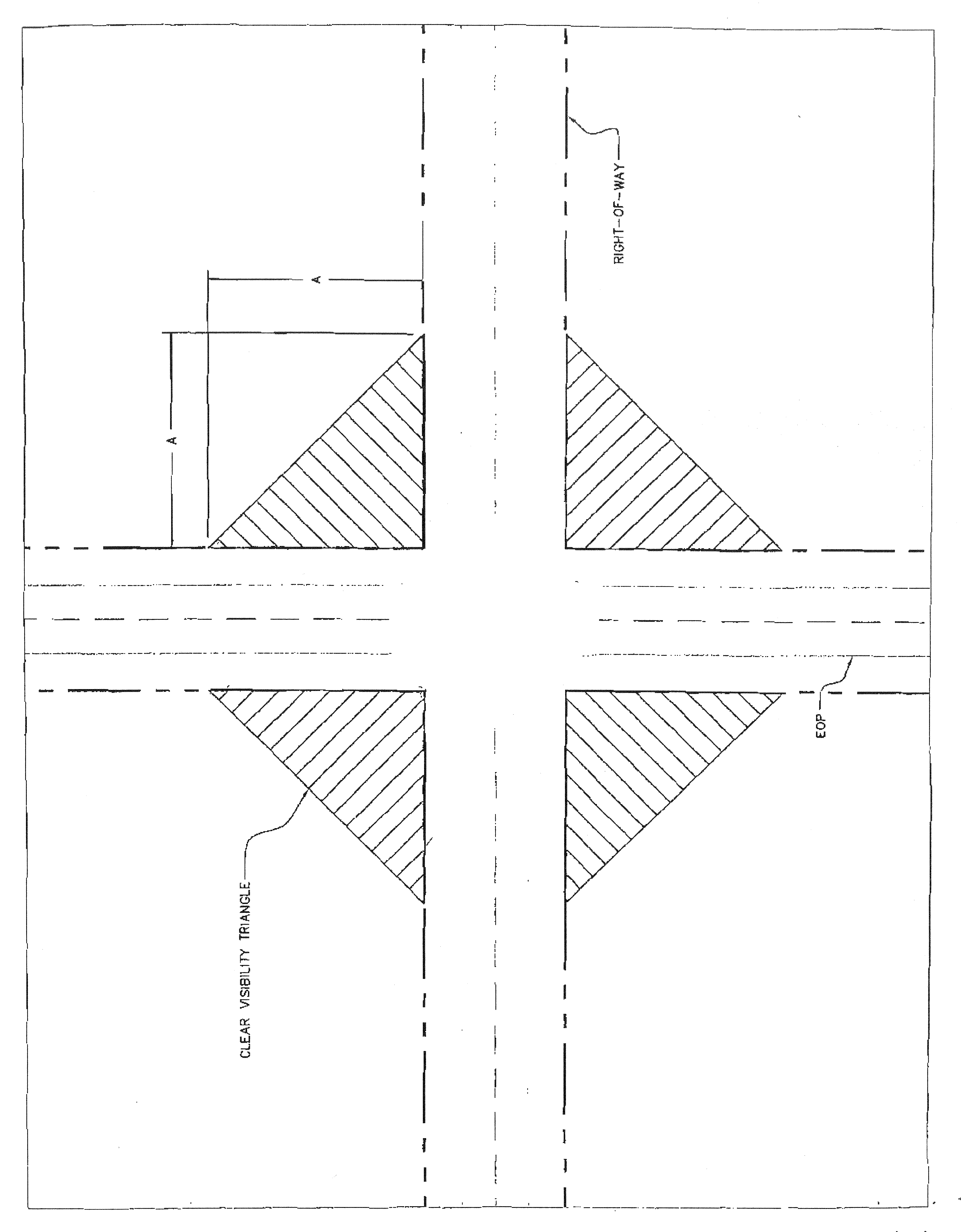
Clear visibility triangle at street intersections. In order to provide a clear view to motorists at intersecting streets, there shall be a triangular area of clear visibility (the "visibility triangle") at all such intersections as follows:
a.
Nothing shall be erected, placed, parked, planted, or allowed to grow in such a manner as to materially impede vision within the visibility triangle between a height of two and one-half feet and ten feet above the centerline grade of the intersection. Anything placed in this visibility triangle must be in accordance with the roadside recovery area provisions of the State of Florida Department of Transportation's Manual of Uniform Minimum Standards for Design, Construction, and Maintenance for Streets and Highways (the "Florida Greenbook"), current edition where appropriate.
b.
The visibility triangle shall be formed by the street rights-of-way and a third line connecting a point on each street right-of-way line located at the distance from the intersection of the street right-of-way lines indicated below.
c.
Chain link fences of up to four feet in height that do not include slats or other coverings may be allowed in the visibility triangle upon determination of the building official that the fence does not obstruct the view of motorists.
d.
Decorative fences of up to four feet in height may be allowed in the visibility triangle upon determination of the building official that the fence does not obstruct the view of motorists.
An example of the calculation of visibility triangles is shown on exhibit "A" attached hereto. The minimum distances required may be modified according to the current edition of the Florida Greenbook.
Exhibit A
(2)
Clear visibility triangle at driveways. In order to provide a clear view of the street for motorists at driveways, there shall be a visibility triangle formed by the intersection of the sides of the driveway and the street right-of-way line as follows:
a.
Nothing shall be erected, placed, parked, planted, or allowed to grow in such a manner so as to materially impede vision within the visibility triangle between a height of two and one-half feet and ten feet above the crown of the adjacent roadway.
b.
The driveway visibility triangles shall be formed at the intersection of each side of the driveway with the street right-of-way line as follows: Beginning at a point on each side of the driveway lying ten feet from the intersection of the driveway edge with the right-of-way line, thence run along the driveway edge to the street right-of-way, thence run along the street right-of-way in a direction away from the driveway for a distance of ten feet, thence run in a straight line across the property to the point of beginning. Where driveways are curved or intersect with the street at other than right angles, a visibility triangle shall be provided giving equivalent visibility to motorists. The visibility triangle shall be maintained on each side of the driveway.
c.
Chain link fences of up to four feet in height that do not include slats or other coverings may be allowed in the visibility triangle upon determination of the building official that the fence does not obstruct the view of motorists.
d.
Decorative fences of up to four feet in height may be allowed in the visibility triangle upon determination of the building official that the fence does not obstruct the view of motorists.
(3)
Height. Subject to subsections 26-171(1) and (2), the height of fences and walls are restricted as follows:
a.
Fences and walls on residentially zoned property.
1.
Front yard fence.
(a)
Between the front plane of the house and the front lot line, chain link fences may be installed up to a maximum of four feet in height.
(b)
Between the front plane of the house and the front lot line, decorative fences or walls, which shall not include chain link fences, may be installed or constructed up to maximum of four feet in height, unless one of the following exceptions applies:
i.
Fence. If the fence or wall is setback from the front property line at least 25 feet, the decorative fence or wall can be a maximum of six feet in height.
ii.
Posts. Posts may extend up to 12 inches above the height of the decorative fence or wall so long as the posts maintain the following horizontal separation: for posts up to six inches wide, there must be a minimum of six feet of decorative fence or wall separating each post; for posts over six inches wide, there must be a minimum of ten feet separating each post. Posts may not exceed three feet in width.
iii.
Entry features. Where set back a minimum of 25 feet from the front property line, gates and posts used as support structures for gates, including arches, can be a maximum of eight feet in height, so long as the combined width of the support structures and gate are no more than 25 percent of the overall width of the front lot line.
2.
Side and back yard fence. Fences or walls located between the front plane of the house and the rear lot line shall not exceed six feet in height, however posts may extend up to 12 inches above the height of the fence.
3.
Real property zoned R-1AA, R-1A, R-1, R-2, R-3, R-3P, R-4, MUQD, PD or RV Park district, which adjoins real property zoned C-1, C-2, I-1, AU and P district, may have a fence or wall up to a maximum of eight feet in height along the lot lines that divide such properties.
b.
Fences and walls on commercial and industrial zoned property. Fences or walls in C-1, I-1, I-2 zoning districts shall not exceed eight feet in height.
c.
Calculation of height. The height of all fences and walls shall be calculated from the level of the real property immediately adjacent to the outside of the fence or wall.
(4)
Permitting.
a.
Fences. Plans and specifications of fences shall be submitted to the building official together with an application for a permit, on forms specified by the city or the building official. Said plans and specifications shall show the location of the proposed fence in relation to the property boundaries and any structures located thereon, the height of the proposed fence and the materials to be used in its construction. The property owner shall be responsible for uncovering property corner markers to properly locate the proposed fence.
b.
Walls. Plans and specifications of walls, together with a boundary survey of the subject real property performed by a licensed Florida land surveyor for any wall, shall be submitted to the building official together with an application for a permit, on forms specified by the city or the building official. Said plans and specifications shall show the location of the proposed wall in relation to the property boundaries and any structures located thereon, the height of the proposed wall and the materials to be used in its construction.
(5)
Fees. The city shall charge such permit fees as may be required as may be established from time to time by resolution.
(6)
Location. All fences and walls shall be placed only upon the property owned by the party desiring the fence or wall. Any encroachment on another's property, without written consent, shall be considered trespassing. No fence or wall may be constructed or erected on public right-of-way. Anything constructed or erected on public right-of-way without express written permission from the City of Sebring shall be considered a violation of this Code and subject to immediate removal at the violator's expense.
(7)
Construction materials. Materials not normally used for fencing or for walls in the city may not be utilized without the specific written consent of the building official. The construction materials of fences and walls are further restricted as follows:
a.
Residential zoned property. Chain link fencing is permitted subject to subsection 26-171(3)a. so long as it is constructed of wire at least 0.113 inch in diameter, has a top rail of at least .042 inch wall thickness installed along the entire fence line and the chain link is installed with the barbs, if any, at the bottom of the fence. Fences made with barbed wire, wire fences other than chain link provided for herein, glass and spikes are not allowed anywhere in residential zoned property. Cementious material must be finished, on both sides, including the application of stucco or some other texture and paint.
b.
Agricultural zoned property. Wire fencing is allowed.
c.
Commercial zoned property. No fencing may be constructed of wire, except for chain link fence which must be of at least 12-gauge wire, and barbed wire may be used only on a security type fence and then only so long as said barbed wire is installed not less than six feet above the ground level and set back at least one foot from the property line.
d.
Industrial zoned property. No fencing may be constructed of wire, except for chain link fence which must be of at least 12-gauge wire, and barbed wire may be used only on a security type fence and then only so long as said barbed wire is installed not less than six feet above the ground level and set back at least one foot from the property line.
Pre-existing agricultural type fencing in non-agricultural zoned areas can remain until replaced; however, replacement fencing must comply with this section.
(8)
Variances. Variances from the terms of this article shall be considered pursuant to section 16-34.
(9)
Maintenance. Fences and walls must be maintained in good repair and free from structural defects by the owner of the real property upon which they are located. Missing or damaged boards, pickets, posts, gates, rails, chain link, cementious material, or other material parts of the fence or wall shall be replaced in a timely manner with material of the same type, quality, and finish as the existing fence or wall.
(10)
Residential subdivisions. Fences or walls enclosing residential subdivisions shall be of decorative fence where they front on a public right-of-way and shall maintain a minimum setback of ten feet from the public right-of-way. Fences or walls enclosing residential subdivisions may be constructed of chain link up to six feet in height on all portions of the boundary that do not front on a public right-of-way. Any chain link shall be installed according to the specifications in subsection 26-171(7)a.
(11)
Nonconforming fences and walls. Any fence or wall in existence March 15, 2011, that was constructed properly with a valid permit that does not conform to the requirements of this section may be maintained and repaired but shall not be extended or altered to further the nonconformity. Any nonconforming fence or wall destroyed, or damaged to the extent of 50 percent or more of its replacement value, shall not be repaired or rebuilt except in conformance with this section. Any such nonconforming fences or walls that encroach into a public right-of-way or present a public safety hazard are not hereby grandfathered in and may be subject to removal.
(Ord. No. 1293, § 2, 12-1-09; Ord. No. 1320, §§ 2—8, 3-1-2011; Ord. No. 1335, § 1, 8-7-2012; Ord. No. 1465, § 1, 9-7-2021)
Sec. 26-172. - Setbacks—General requirements.
Setback requirements stated in the schedule of district regulations of this Code and in this article are designed to ensure adequate light, air, ventilation, safety and privacy.
(Ord. No. 1335, § 23, 8-7-2012)
Sec. 26-173. - Encroachments into setbacks.
Every part of a required setback shall be open and unobstructed from the ground to the sky except as provided in this section or otherwise permitted by this chapter. The following items may project into required setbacks to the extent noted in those districts where such maximum requirements, as are set out in the zoning code or other requirements of the Code of Ordinances.
Table 26-173: Encroachments into Setbacks
—A dashed line means required setback applies minus the encroachment and other normal regulations apply. Where a setback and encroachment are indicated, the stricter applies.
Minimum setbacks apply for accessory uses, such as yard sales pursuant to subsection 26-223(c)(7), home occupations (subject to section 26-243, "home occupations"), and home schools. Personal wireless antennas, towers, and satellite dishes (telecommunications) pursuant to article IV of chapter 19 and signs (pursuant to sign code, chapter 17) are subject to all existing setbacks in the applicable district.
(Ord. No. 1335, § 24, 8-7-2012; Ord. No. 1353, § 3, 5-7-2013; Ord. No. 1428, § 1, 8-21-2018)
_____