
Silverthorne City Zoning Code
ARTICLE VI
Site Plan
Sec. 4-6-1.- Purpose.
This Article is established to achieve the following purposes:
(1)
It is the purpose of this Article to promote orderly and sound development standards as they apply to the Town. These site development standards are intended to enhance and protect the area's natural as well as man-made environments.
(2)
To promote the general health, safety and welfare of the present and future inhabitants of the Town. Site plans shall be such that the site can be used safely for the intended purpose without danger to health or peril from fire, flood, geologic hazards or other natural hazards.
(3)
To guide future growth and development within the Town and ensure adequate and efficient transportation, water, waste disposal, schools, fire and police protection, recreation and open space opportunities and other services and facilities.
(4)
To protect both urban and nonurban development by minimizing the conflicts between the land uses and structures.
(Ord. 2003-20 §2)
Sec. 4-6-2. - General requirements.
(a)
Site plan regulations shall apply to all new or changes in uses, buildings or structures or additions thereto or major alterations to exteriors of buildings, including changes to materials approved as part of a previous site plan submittal, within the Town to which at least one (1) of the following applies:
(1)
All uses located within the following zone districts, with the exception of duplex- and single-family residential:
a.
C-2 - Heavy Commercial.
b.
C-1 - Light Commercial.
c.
RFMU - River Front Mixed Use.
d.
PUD - Planned Unit Development.
e.
R-15 - Residential.
f.
R-6 - Residential.
g.
R-2 - Residential.
h.
AG - Agricultural.
i.
O - Open Space.
(2)
Uses which are located or to be located within any other zone district which are specifically made subject to this Article by the Town Council.
(3)
Uses which are located or to be located on property within any other zone district, and the owner or developer of the property requests an application of these site plan requirements, subject to this Article.
(b)
No site plan application shall be accepted which does not meet all zoning district standards. Any site plan not found to meet all zoning district standards shall first amend, or simultaneously submit a rezoning proposal with the site plan application.
(c)
No site plan will be approved prior to the platting of the subject property. A Final Plat, minor subdivision plat, residential, commercial subdivision or condominium plat may be submitted simultaneously with the proposed site plan upon approval of the Community Development Director. In such cases, approval of the site plan application will be made conditional upon the final approval of the subdivision plat by the Town Council.
(d)
No building permit for any use described in Subsection (a) above shall be issued for the construction of any new building, structure or improvement to the site or any addition or alteration to the structure or site, including exterior materials or colors, without first obtaining the approval of a site plan for the proposed use.
(e)
No overlot grading, drainage work, parking lot construction or other site improvements will be allowed, unless specifically provided for by the Town Council, without first obtaining approval of a site plan for the proposed use.
(f)
No certificate of occupancy will be issued until all improvements approved as part of the site plan have been completed or necessary security received as described in Section 4-6-9 of this Article. No temporary certificate of occupancy shall be permitted.
(g)
The site plan standards outlined by this Article apply throughout the zone districts and uses outlined in Subsection (a) above. These standards are in addition to any other development or design standard which may otherwise be applicable to a particular property or specific area within the Town. In the case of any perceived conflict among applicable development standards, the more restrictive standard will apply.
(h)
Design Districts.
(1)
Design Districts are hereby incorporated by reference into this Chapter, as may be amended from time to time. Those provisions of the Design Districts shall be used in addition to the criteria outlined in this Article. These Design District Standards shall be adopted as a regulation by the Town Council and shall be maintained in the Community Development Department.
(2)
The following design standards for the Town's Design Districts are hereby adopted as a regulation and fully incorporated herein by this reference.
a.
Riverfront District Design Standards and Guidelines, adopted July 8, 2015.
b.
Town Core District Design Standards and Guidelines, adopted February 11, 2015.
c.
Town Core Periphery District Design Standards and Guidelines, adopted August 26, 2015.
d.
Gateway District Design Standards and Guidelines, adopted April 8, 2015.
e.
Business Park District Design Standards and Guidelines, adopted September 23, 2015.
f.
Destination Commercial District Design Standards and Guidelines, adopted September 23, 2015.
All site development within the six (6) Design Districts, as hereinabove described, shall be in compliance with said standards. A failure of compliance with the standards shall be reasonable grounds for denial of the site development application.
(3)
The design standards for the foregoing Design Districts shall be amended and updated as a regulation from time to time upon recommendation of the Planning Commission and action by the Town Council by ordinance.
(i)
The Town may require public improvements to be constructed as a condition of site plan approval. All such improvements shall be reasonably related to and in proportion to the need for such improvements created by the proposed use, and may include but not be limited to street widening, the addition of acceleration/ deceleration lanes, access control devices, traffic signals, water and sewer lines, pedestrian/bicycle trails or other related improvements.
(j)
Yard exceptions. Architectural features, such as cornices, canopies, eaves or similar architectural features, may extend into a required yard not more than four (4) feet, but no closer than three (3) feet to any lot line.
(k)
Survey required to determine questionable measurements. Where doubt exists in establishing the minimum setback distance, side yard, rear yard, easements, drainageways, utilities or any other pertinent feature in question, the Community Development Department or Public Works Department shall require the property owner to provide a survey by a registered surveyor to determine such measurement.
(l)
Utilities to be underground. No site plan shall be approved unless the plans and specifications of the plan provide all utilities to be placed underground. The cost of such undergrounding of utilities shall be paid solely by the property owner and shall be installed subject to the plans, specifications and approval of the electric, natural gas, telephone and cable television utilities providing the service to the subject property and to any other utility designated to the Town.
(m)
Performance standards. The operation of any use permitted in this Chapter is subject to the standards of performance, as follows:
(1)
Obnoxious emissions prohibited. All uses must be operated so that all practical means are used to conform to the following standards:
a.
Vibration. Every use shall be so operated that the maximum ground vibration generated is not perceptible without instruments at any point on the lot line on which the use is located.
b.
Noise. Every use shall be within a reasonable noise level for the place and time of day or evening.
c.
Odor. Every use shall be so operated that no offensive or objectionable odor is emitted.
d.
Smoke and air pollution. Every use shall be so operated that no smoke from any source shall be emitted that exceeds the requirements set by the State Air Pollution Control Act, as amended June 1967, and as the same may hereafter from time to time be amended.
e.
Toxic gases. Every use shall be so operated that there is no emission of toxic, noxious or corrosive fumes or gases which exceed the emission levels permitted by the PIP Plan.
f.
Radiation. Every use shall be so operated that there is no dangerous amount of radioactive emissions in accordance with the standards of the Federal Radiation Council.
g.
Glare and heat. Any operation producing intense glare or heat shall be performed in an enclosure in such a manner as to be imperceptible along any lot line without instruments.
(2)
Illumination. Any light used to illuminate signs, parking areas or for any other purposes shall conform to Section 4-6-13 of this Article.
(3)
Vehicular traffic areas. All uses classified as commercial uses shall comply with all of the following requirements:
a.
Surfaces shall be properly graded for drainage and surfaced with concrete, asphaltic concrete or asphalt.
b.
Such areas shall be provided with barriers so that occupants of adjacent residential buildings are not unreasonably disturbed either day or night by the movement of vehicles. On each boundary line abutting directly on a lot zoned in any residential district, a solid wall or fence at least four (4) feet in height shall be erected, subject to the provisions governing fences.
c.
All entrances and exits to such areas shall be so located as to minimize traffic congestion and subject to all other Town regulations. Wheel or bumper guards shall be provided and so located and arranged that no part of any parked vehicle will extend beyond the boundaries of the parking area.
d.
No servicing equipment at gasoline service stations or public garages for the service of gasoline, oil, air, water, etc., shall be closer than ten (10) feet to the public right-of-way.
(4)
Traffic visibility. In order to minimize traffic hazards at intersections, in all commercial zones, no fence or wall, other than permitted structures, shall be erected and no hedge, shrub, tree or other growth, sign or display shall be maintained in such location upon any lot or property in a manner constituting a traffic hazard because of obstruction of view.
(5)
Recreational vehicle use. A recreational vehicle may be occupied on private property, which property is devoted to residential purposes, for up to two (2) weeks with the permission of the owners of said property, provided that no more than one (1) such occupied recreational vehicle is allowed per inhabited principal building and provided that the occupants of the recreational vehicle are nonpaying guests of the inhabitants of a dwelling unit on the same property. Recreational vehicles may not be occupied or stored on commercial property without specific site plan approval.
(Ord. 2009-18 §6; Ord. 2015-01 §1; Ord. 2015-03, §1; Ord. 2015-07 §1; Ord. 2015-11 §1; Ord. 2015-12 §1)
Sec. 4-6-3. - Site plan modification.
(a)
Intent. The intent of the site plan modification is to provide final plans for amendments to existing or previously approved site plans to ensure that the technical requirements, design standards and improvements of the Town and all Code requirements are met. This review will be done at a staff level to determine if the plan complies with zoning requirements and Code standards and regulations.
(1)
Site plan modifications shall follow the final site plan review process as outlined in this Article and be reviewed at a staff level according to Section 4-1-22 of this Chapter.
(2)
The final site plan submittal shall provide the final engineering plans, technical and design standards and improvements of the Town, and all other applicable Code requirements must be met. The final site plan shall be presented in a form that will be a clean copy for the final approval.
(3)
Site development regulations shall apply to all new or changes in uses, buildings or structures or additions thereto or major alterations to exteriors of buildings, including changes to materials approved as part of a previous site plan submittal, within the Town.
(4)
Changes to color schemes approved as part of a previous site plan submittal, that comply with the applicable district design standards for the project, shall be reviewed and approved, approved with conditions or denied at a staff level. Any proposed color changes that do not comply with the applicable district design standards for the project shall be processed as a site plan modification.
(b)
Preapplication conference prerequisite. Prior to submittal of the site plan modification application, the applicant shall meet with staff to discuss the procedures and submittal requirements, and is encouraged to meet with other referral agencies to identify potential issues and ways to address these issues. The preapplication conference may be waived by the Community Development Director.
(Ord. 2009-18 §7)
Sec. 4-6-4. - Site plan.
(a)
Intent. The intent of the site plan is to provide final plans to ensure that the technical requirements, design standards and improvements of the Town and all Code requirements are met. This review will be done at a preliminary and final level to determine if the plan complies with zoning requirements, Design District Standards and Code standards and regulations.
(1)
Site plans shall follow the preliminary and final site plan review process as outlined in this Article.
(2)
The purpose of the preliminary plan is to design the scope of the project, alert the developer and the Town to any particular circumstances concerning the property to determine the suitability of the development proposal prior to extensive site planning, and to eliminate major design concept problems prior to detailed architectural and engineering plans for the building site.
(3)
The final site plan submittal shall provide the final engineering plans, technical and design standards and improvements of the Town, and all other applicable Code requirements must be met. The final site plan shall be presented in a form that will be a clean copy for the final approval.
(4)
Site development regulations shall apply to all new or changes in uses, buildings or structures or additions thereto or major alterations to exteriors of buildings, including changes to materials approved as part of a previous site plan submittal, within the Town.
(5)
Changes to color schemes approved as part of a previous site plan submittal, that comply with the applicable district design standards for the project, shall be reviewed and approved, approved with conditions or denied at a staff level. Any proposed color changes that do not comply with the applicable district design standards for the project shall be processed as a site plan modification.
(b)
Preapplication conference prerequisite. Prior to submittal of the site plan application, the applicant shall meet with staff to discuss the procedures and submittal requirements, and is encouraged to meet with other referral agencies to identify potential issues and ways to address these issues. The preapplication conference may be waived by the Community Development Director.
(Ord. 2009-18 §8)
Sec. 4-6-5. - Preliminary plan application submittal requirements.
(a)
Each request for site plan approval shall be accompanied by a complete application form provided by the Planning Department, three (3) copies of the proposed site plan with related information and application fee. This submittal information will be accompanied by a signed transmittal letter from the applicant describing the contents of the submittal. Applicants that submit amendments to approved site plans shall be required to submit properly prepared site plan drawings, elevations or landscape plans that clearly depict the proposed amendments.
(b)
Submittal requirements: The applicant shall be required to submit to the Planning Department the information listed below:
(1)
Completed land use application form.
(2)
Application Pass-through fee.
(3)
Three (3) copies of the site plan (folded to 9" x 12") prepared in accordance with site plan exhibit listed below.
(4)
A narrative outlining the proposal.
(5)
A copy of the warranty deed and title commitment current within thirty (30) days of submittal.
(6)
A notarized letter of authorization from the landowner permitting a representative or other party to process the application.
(7)
Three (3) copies of the drainage plan (folded to 9" x 12"), if not already approved as part of a subdivision.
(8)
Three (3) copies of the landscape plan (folded to 9" x 12").
(9)
Three (3) copies of the building elevations (folded to 9" x 12") to include rooftop mechanical structures.
(10)
Colored building elevation of all sides.
(11)
Two (2) color and materials boards (one [1] of 9" x 12" maximum size and one [1] of suitable size for presentation to the Commission) containing materials, colors, specifications, manufacturers' names and product numbers.
Failure to submit all required documentation will result in a delayed application. Additional information may be requested after the formal application is received.
(c)
Submittal standards.
(1)
Site plan exhibit. The proposed site plan shall be prepared by a qualified professional (architect, planner, land planner or engineer) and drawn on one (1) or more sheets of paper measuring 24" x 36" with a minimum scale of 1" = 50'. Scales drawn at 1" = 40', 1" = 30', 1" = 20', and 1" = 10' will be acceptable. Each site plan will be signed by the applicant and shall contain the following information:
a.
Project name.
b.
The name, address and telephone number of the owner, licensed surveyor, licensed engineer and designer of the project. Final plans must be stamped.
c.
Date of preparation and date of all revisions.
d.
North arrow with written and graphic scale.
e.
Legal description and total acreage of the project.
f.
Vicinity map showing the relationship of the site to the surrounding area within a one-half-mile radius.
g.
Zoning on and adjacent to the property.
h.
Listings of the gross and net acreage of each proposed use, as well as the number of dwelling units and/or the number of buildings and gross floor area.
i.
The existing grading and drainage information on the site drawn at two-foot intervals and related to United States Geological Survey (USGS) datum, as well as finished grades and contours proposed by the applicant.
j.
Location and dimensions of all existing and proposed structures on site.
k.
Grading and revegetation plan. Revegetation of land is intended to reflect the Town as a visually pleasing place, as well as to reduce erosion by limiting the amount of sedimentation and siltation into waterways and generally to lessen the amount of windblown dust and dirt. Typically, the season for revegetation is from May 1 to October 1; however, it may vary from year to year. The plan shall contain:
1.
Both existing and proposed contours relative to USGS datum.
2.
Garage elevation and tie-in to public roadway elevation (relative to USGS datum).
3.
All culverts and drainage pans.
4.
Retaining walls - show if and where proposed.
5.
Wetlands delineation and setbacks as approved by the Army Corps of Engineers on or within one hundred (100) feet of property. Evidence of approved delineation and disturbance from Army Corps of Engineers also required.
6.
Proposed driveway grade - (garage slab and existing edge of road elevations relative to USGS datum).
l.
The size and location of all existing and proposed public and private utility and emergency easements or other rights-of-way.
m.
Location, size, depths, materials and plan and profile of proposed water lines within and adjacent to the project, including the location of valves, curb boxes and fire hydrants. Fire hydrants within one thousand (1,000) feet of the project should be noted. See the Town Water System Criteria.
n.
Location, size, depths, materials and plan and profile of proposed sanitary sewer lines within and adjacent to the project, including the location of cleanouts and the nearest upstream and downstream manholes. See the Town Sewerage System Criteria.
o.
Location, size, depths, materials and plan and profile of proposed storm sewer lines within and adjacent to the project, including the location of all manholes.
p.
Location and size of proposed gas, phone, electric and cablevision lines, including the size and location of all pedestals and transformers.
q.
The building envelope, size, setback dimensions and height of all proposed structures and all existing structures which are to be retained on the site.
r.
Location, dimensions and names of adjacent streets, and proposed internal streets showing center line radii and curb return radii. Where applicable, proper sight triangles and sight distance criteria will be shown on the site plan.
s.
Location and dimension of all existing streets, alleys, easements, drainage areas and other significant features on the property and within one hundred (100) feet of the project boundary or to the opposite edge of the adjacent R-O-W, whichever is greater. On large projects, all existing streets, alleys, easements, drainage areas and other significant features on the property within five hundred (500) feet of the project boundary or to the opposite edge of the adjacent R-O-W may be required as determined by the Community Development Department.
t.
The location and dimensions of bike/pedestrian paths and walkways shall be shown.
u.
Listings of the number of all parking stalls, as well as indicating the number of accessible spaces.
v.
The proposed layout of the parking lot, including location, dimensions and surface treatment of parking spaces, curb islands, maneuvering aisles and access driveways, with indication of direction of travel.
w.
Location, dimensions and surfaces of all points of access/egress, internal circulation, plan and profile of internal roadway system (see the Town Minimum Street Design Criteria on file at the Public Works Department), if any, and parking areas. All parking areas and travel ways for the public must be hard surfaced.
x.
Snow storage. A minimum of twenty-five hundredths (0.25) square foot of snow stacking per each square footage of paved surface. Snow storage areas should be shown graphically on the site plan. A chart or table showing the square footage calculation as a percent of paved areas is required.
y.
Outdoor lighting, furnishings and architectural accents shall be specified on the plans. Include specification cut sheets on all light fixtures.
z.
Existing specific physical features on the site, including drainage ways, lakes, buildings and structures with indication as to which are to be retained.
aa.
Adjacent properties and their physical features within one hundred (100) feet of the property line shall be identified, including setback dimensions of adjacent structures.
bb.
Final Landscape Plan which meets at least the minimum requirements as specified in this Code. The plan shall include the size and botanical identification of all plants, a planting chart summary using botanical and common names, seed mixes, irrigation system, if any, and maintenance plan.
cc.
Location of all existing and proposed recreational amenities, such as open play areas, swimming pools, tennis courts, tot lots and similar facilities.
dd.
Designation of areas in and adjacent to the one-hundred-year floodplain and floodway.
ee.
The size and location of areas to be reserved or dedicated for parks, playgrounds, schools or other public areas.
ff.
Sign plan for all directional and building identification signs and all reflective, roadway and/or pedestrian pathway delineators approved by the Town and proposed roadway guardrail locations.
gg.
A comprehensive sign plan for multi-tenant buildings.
hh.
A final soils report shall be provided which contains information required by the Community Development Department and provides information necessary for pavement and building design. Any other pertinent information as deemed necessary.
ii.
An erosion control plan and details.
(2)
Other information which shall be required, but need not be designated on the site plan includes:
a.
A copy of the executed covenants (when applicable).
b.
A copy of the approved development guide and plan required by the PUD - Planned Unit Development zone district (when applicable).
c.
Additionally, the applicant shall provide any reasonable information not covered above to aid in the review of the request by the Community Development Department. Such items include traffic studies, economic impact analysis, etc.
(3)
Site plan narrative. The applicant shall submit a narrative which includes the following information:
a.
Applicant's name.
b.
Description of the general proposal.
c.
Present zoning.
d.
General development schedule and phasing plan when the project is not constructed at one (1) time.
(4)
Deed. The applicant shall submit a copy of the most recent deed recorded at the County Clerk and Recorder.
(5)
Drainage plan. Provide a conceptual drainage plan showing the general location of on-site detention and the direction of on-site drainage, as well as consideration of off-site flows.
(6)
Architectural elevations. Each request for site plan approval shall be accompanied by a set of architectural elevations showing the proposed front, rear and side elevations. Architectural elevations shall be dimensioned to show building height given in USGS datum as well as architectural dimensions.
(7)
Tree conservation plan as required by Article VIII, Division 3 of this Chapter. The information to be provided may be combined with the required landscape plan upon approval of the Community Development Director.
(Ord. 2009-18 §12)
Sec. 4-6-6. - Preliminary plan review process.
(a)
The applicant shall submit three (3) copies of a complete preliminary plan application to the Community Development Department.
(b)
The preliminary plan submittal shall be reviewed for completeness within ten (10) days. The applicant shall be notified of any inadequacies. An incomplete submittal shall not be processed.
(c)
Once the submittal is determined complete, staff will notify the applicant of the number of copies of the plan required to be submitted for distribution to referral agencies. Referral packets, with all plan exhibits folded to 9" x 12", shall be provided by the applicant to the Community Development Department. Planning staff shall distribute the referral packets. The applicant shall distribute any revised plans, as required by staff.
(d)
All plan applications may be submitted to Town departments and other review agencies for review and comment if, in the opinion of the Community Development Department, the agency may be affected by the application or if comments by the agency will ensure a thorough analysis of the application. A list of review agencies is maintained by and available at the Community Development Department.
(e)
Referral agencies shall comment in writing within twenty-five (25) days of receiving a complete submittal. The Community Development Department shall forward referral comments to the applicant in a timely manner. The failure of any agency to respond within twenty-five (25) days shall for the purpose of plan review be considered no comment on the plan by that agency. The applicant is encouraged to meet with the planning staff, referral agencies and other interested parties to address any concerns.
(f)
The staff planner will review the referral comments and discuss the concerns with the applicant. The applicant shall address each issue identified by the referral agencies and revise the plan as needed. The revised plan must comply with all technical and/or regulatory requirements of the referral agencies and shall include a narrative that addresses each revision. Referral agencies shall comment in writing within fifteen (15) days of receiving the revised plan. Should subsequent revisions be required, each revision shall follow the process described herein.
(g)
Once all issues have been satisfactorily addressed, the staff planner shall notify the applicant of the scheduled meeting date and time and prepare a staff report for the Planning Commission.
(h)
The Planning Commission shall evaluate the application, referral comments and staff report, and make a recommendation to the Town Council to approve, approve with conditions, continue for additional information or further study or deny the preliminary plan. The burden shall be on the applicant to present sufficient evidence that the criteria contained in Subsection (k) of this Section have been satisfied. The Planning Commission's decision shall be based on the evidence presented and compliance with the criteria for a preliminary plan described in Subsection (k).
(i)
Following the recommendation by the Planning Commission, the staff planner will schedule the preliminary plan on the Town Council meeting agenda and notify the applicant of the meeting date and time.
(j)
The Town Council shall evaluate the preliminary plan, referral agency comments, staff report and the Planning Commission recommendation, and shall approve, conditionally approve, continue for additional information or for further study, remand to the Planning Commission or deny the preliminary plan. The burden shall be on the applicant to present sufficient evidence that the criteria contained in Subsection (k) of this Section have been satisfied. The Town Council's action shall be based on the evidence presented and compliance with the criteria for preliminary plans described in Subsection (k).
(k)
Criteria for a preliminary plan. The preliminary plan shall comply with all of the following standards:
(1)
Consistency with Comprehensive Plan. The proposed site plan is consistent with the goals and policies of the Town Comprehensive Plan.
(2)
Consistency with Chapter 4 of this Code and other minimum standards established by the Town. The proposed site plan complies with this Section and all other provisions of this Article, the Town Drainage Criteria, the Town Street Design Criteria, the Town Water System Criteria, the Town Sewerage System Criteria and other applicable standards adopted by the Town.
(3)
Consistency with Zone District Standards, Design District Standards or Planned Unit Development Guide, if applicable. The proposed site plan complies with all of the provisions of the applicable Zone District or Planned Unit Development Guide.
(Ord. No. 2009-18 §13)
Sec. 4-6-7. - Final site plan application submittal requirements.
(a)
Each request for site plan approval shall be accompanied by a complete application form provided by the Planning Department, three (3) copies of the proposed site plan with related information and application fee. This submittal information will be accompanied by a signed transmittal letter from the applicant describing the contents of the submittal. Applicants that submit amendments to approved site plans shall be required to submit properly prepared site plan drawings, elevations or landscape plans that clearly depict the proposed amendments.
(b)
Submittal requirements: The applicant shall be required to submit to the Planning Department the information listed below:
(1)
Completed application form.
(2)
Application Pass-through fee.
(3)
Copies of the site plan (folded to 9" x 12") prepared in accordance with the site plan exhibit listed below.
(4)
A narrative outlining the proposal.
(5)
A copy of the warranty deed and title commitment current within thirty (30) days of submittal.
(6)
A notarized letter of authorization from the landowner permitting a representative or other party to process the application.
(7)
Three (3) copies of the drainage plan (folded to 9" x 12"), if not already approved as part of a subdivision.
(8)
Three (3) copies of the landscape plan (folded to 9" x 12").
(9)
Three (3) copies of the building elevations (folded to 9" x 12"), to include rooftop mechanical structures.
(10)
Colored building elevation of all sides.
(11)
Two (2) color and materials boards (one [1] of 9" x 12" maximum size and one [1] of suitable size for presentation to the Commission) containing materials, colors, specifications, manufacturers' names and product numbers.
Failure to submit all required documentation will result in a delayed application. Additional information may be requested after the formal application is received.
(c)
Submittal standards.
(1)
Site plan exhibit. The proposed site plan shall be prepared by a qualified professional (architect, planner, land planner or engineer) and drawn on one (1) or more sheets of paper measuring 24" x 36" with a minimum scale of 1" = 50'. Scales drawn at 1" = 40', 1" = 30', 1" = 20', and 1" = 10' will be acceptable. Each site plan will be signed by the applicant and shall contain the following information:
a.
Project name.
b.
Name, address and telephone number of the owner, licensed surveyor, licensed engineer and designer of the project. Final plans must be stamped.
c.
Date of preparation and date of all revisions.
d.
North arrow with written and graphic scale.
e.
Legal description and total acreage of the project.
f.
Vicinity map showing the relationship of the site to the surrounding area within a one-half-mile radius.
g.
Zoning on and adjacent to the property.
h.
Listings of the gross and net acreage of each proposed use, as well as the number of dwelling units and/or the number of buildings and gross floor area.
i.
The existing grading and drainage information on the site drawn at two-foot intervals and related to United States Geological Survey (USGS) datum, as well as finished grades and contours proposed by the applicant.
j.
Location and dimensions of all existing and proposed structures on site.
k.
Grading and revegetation plan. Revegetation of land is intended to reflect the Town as a visually pleasing place, as well as to reduce erosion by limiting the amount of sedimentation and siltation into waterways and generally to lessen the amount of windblown dust and dirt. Typically, the season for revegetation is from May 1 to October 1; however, it may vary from year to year. The plan shall contain:
1.
Both existing and proposed contours relative to USGS datum.
2.
Garage elevation and tie-in to public roadway elevation (relative to USGS datum).
3.
All culverts and drainage pans.
4.
Retaining walls - show if and where proposed.
5.
Wetlands delineation and setbacks as approved by the Army Corps of Engineers on or within one hundred (100) feet of property. Evidence of approved delineation and disturbance from the Army Corps of Engineers also required.
6.
Proposed driveway grade - (garage slab and existing edge of road elevations relative to USGS datum).
l.
The size and location of all existing and proposed public and private utility and emergency easements or other rights-of-way.
m.
Location, size, depths, materials, plan and profile of proposed water lines within and adjacent to the project, including the location of valves, curb boxes and fire hydrants. Fire hydrants within one thousand (1,000) feet of the project should be noted. See the Town Water System Criteria.
n.
Location, size, depths, materials, plan and profile of proposed sanitary sewer lines within and adjacent to the project, including the location of cleanouts and the nearest upstream and downstream manholes. See the Town Sewerage System Criteria.
o.
Location, size, depths, materials, plan and profile of proposed storm sewer lines within and adjacent to the project, including the location of all manholes.
p.
Location and size of proposed gas, phone, electric and cablevision lines, including the size and location of all pedestals and transformers.
q.
The building envelope, size, setback dimensions and height of all proposed structures and all existing structures which are to be retained on the site.
r.
Location, dimensions and names of adjacent streets, and proposed internal streets showing center line radii and curb return radii. Where applicable, proper sight triangles and sight distance criteria will be shown on the site plan.
s.
Location and dimension of all existing streets, alleys, easements, drainage areas and other significant features on the property and within one hundred (100) feet of the project boundary or to the opposite edge of the adjacent R-O-W, whichever is greater. On large projects, all existing streets, alleys, easements, drainage areas and other significant features on the property within five hundred (500) feet of the project boundary or to the opposite edge of the adjacent R-O-W may be required as determined by the Community Development Department.
t.
The location and dimensions of bike/pedestrian paths and walkways shall be shown.
u.
Listings of the number of all parking stalls, as well as indicating the number of accessible spaces.
v.
The proposed layout of the parking lot, including location, dimensions and surface treatment of parking spaces, curb islands, maneuvering aisles and access driveways with indication of direction of travel.
w.
Location, dimensions and surfaces of all points of access/egress, internal circulation, plan and profile of internal roadway system (see the Town Minimum Street Design Criteria on file at the Public Works Department), if any, and parking areas. All parking areas and travel ways for the public must be hard surfaced.
x.
Snow storage. A minimum of twenty-five hundredths (0.25) square foot of snow stacking per each square foot of paved surface. Snow storage areas should be shown graphically on the site plan. A chart or table showing the square footage calculation as a percent of paved areas is required.
y.
Outdoor lighting, furnishings and architectural accents shall be specified on the plans. Include specification cut sheets on all light fixtures.
z.
Existing specific physical features on the site, including drainage ways, lakes, buildings and structures with indication as to which are to be retained.
aa.
Adjacent properties and their physical features within one hundred (100) feet of the property line shall be identified, including setback dimensions of adjacent structures.
bb.
Final landscape plan which meets at least the minimum requirements as specified in this Code. The plan shall include the size and botanical identification of all plants, a planting chart summary using botanical and common names, seed mixes and irrigation system details. The plan shall show building footprint with roofline and decks shown in a dashed line, a calculation of the percentage of the site that is landscaped and maintenance plan.
cc.
Location of all existing and proposed recreational amenities, such as open play areas, swimming pools, tennis courts, tot lots and similar facilities.
dd.
Designation of areas in and adjacent to the one-hundred-year flood plain and floodway.
ee.
The size and location of areas to be reserved or dedicated for parks, playgrounds, schools or other public areas.
ff.
Sign plan for all directional and building identification signs and all reflective, roadway and/or pedestrian pathway delineators approved by the Town and proposed roadway guardrail locations.
gg.
A comprehensive sign plan for multi-tenant buildings.
hh.
A final soils report shall be provided which contains information required by the Community Development Department and provides information necessary for pavement and building design. Any other pertinent information as deemed necessary.
ii.
Signed Site Improvements Agreement (SIA), in form and content approved by the Community Development Department
jj.
An erosion control plan and details.
(2)
Other information which shall be required, but need not be designated on the site plan includes:
a.
A copy of the executed covenants (when applicable).
b.
A copy of the approved development guide and plan required by the PUD - Planned Unit Development zone district (when applicable).
c.
Additionally, the applicant shall provide any reasonable information not covered above to aid in the review of the request by the Community Development Department. Such items include traffic studies, economic impact analysis, etc.
(3)
Site plan narrative. The applicant shall submit a narrative which includes the following information:
a.
Applicant's name.
b.
Description of the general proposal.
c.
Present zoning.
d.
General development schedule and phasing plan when the project is not constructed at one (1) time.
(4)
Deed. The applicant shall submit a copy of the most recent deed recorded at the County Clerk and Recorder.
(5)
Drainage plan. A final drainage plan, which includes calculations for historic runoff, increased runoff, on-site detention and plan for how the increased runoff will be detained and released, shall be provided. Each request for site plan approval shall be accompanied by a drainage plan prepared in accordance with the Town Drainage Design Criteria if a final drainage plan as part of a subdivision has not been approved. Copies of the proposed drainage plan prepared by a professional engineer or architect shall be submitted to the Town with the site plan submittal and then forwarded to the office of the Town Engineer. Review of the drainage plan will be simultaneous with that of the site plan.
(6)
Each request for a site plan approval shall be accompanied by a landscape plan prepared by a qualified professional and drawn on one (1) sheet of paper measuring 24" x 36" with a minimum scale of 1" = 50'. Larger scales are encouraged to effectively portray the landscape plan. The landscape plan shall contain the following information:
a.
Date of preparation.
b.
Scale and north arrow.
c.
Building footprint.
d.
Parking lots.
e.
Location, quantity and size of landscape materials. The location of all landscape materials shall be shown on the plan, accompanied by a chart showing the quantity planted, mature size and common names of the plant materials.
f.
A calculation of the percentage of the site that is landscaped.
(7)
Architectural renderings (building elevations). Each request for site plan approval shall be accompanied by a set of architectural renderings of the proposed buildings or structures. Copies of the renderings drawn on 24" x 36" paper will be submitted to the Town. These renderings shall include front, rear and side elevations accurately depicting the finished building or structure on the site. Architectural elevations shall be dimensioned to show building height given in USGS datum as well as architectural dimensions. Perspective renderings showing the building in one (1) or more oblique angles, scale models, photographs or similar structures or other similar techniques may be acceptable. In addition to this submittal, the following information shall be supplied:
a.
All exterior surfacing materials and colors shall be specified on the plans.
b.
Outdoor lighting, furnishings and architectural accents shall be specified on the plans.
c.
Any proposed signage for the site and its placement in relationship to the building or structure shall be indicated on the plan.
d.
A diagram or schematic showing screening of rooftop mechanical structures.
(8)
A tree conservation plan as required by Article VIII, Division 3 of this Chapter. The information to be provided may be combined with the required landscape plan upon approval of the Community Development Director.
(9)
A construction management plan is required. The construction management plan shall show the location of the construction fence, material storage and soil storage. If soil is not able to be properly stored on site, the excess soil must be hauled off site to an appropriate permitted location.
(Ord. 2009-18 §14)
Sec. 4-6-8. - Final site plan review process.
(a)
The applicant shall submit three (3) copies of a complete final site plan application to the Community Development Department.
(b)
The final site plan submittal shall be reviewed for completeness within ten (10) days. The applicant shall be notified of any inadequacies. An incomplete submittal shall not be processed.
(c)
Once the submittal is determined complete, staff will notify the applicant of the number of copies of the plan required to be submitted for distribution to referral agencies. Referral packets, with all plan exhibits folded to 9" x 12", shall be provided by the applicant to the Community Development Department. Planning staff shall distribute the referral packets. The applicant shall distribute any revised plans, as required by staff.
(d)
All plan applications may be submitted to Town departments and other review agencies for review and comment if, in the opinion of the Community Development Department, the agency may be affected by the application or if comments by the agency will ensure a thorough analysis of the application. A list of review agencies is maintained by and available at the Community Development Department.
(e)
Referral agencies shall comment in writing within twenty-five (25) days of receiving a complete submittal. The Community Development Department shall forward referral comments to the applicant in a timely manner. The failure of any agency to respond within twenty-five (25) days shall for the purpose of plan review be considered no comment on the plan by that agency. The applicant is encouraged to meet with the planning staff, referral agencies and other interested parties to address any concerns.
(f)
The staff planner will review the referral comments and discuss the concerns with the applicant. The applicant shall address each issue identified by the referral agencies and revise the plan as needed. The revised plan must comply with all technical and/or regulatory requirements of the referral agencies and shall include a narrative that addresses each revision. Referral agencies shall comment in writing within fifteen (15) days of receiving the revised plan. Should subsequent revisions be required, each revision shall follow the process described herein.
(g)
Once all issues have been satisfactorily addressed, the staff planner shall notify the applicant of the scheduled meeting date and time and prepare a staff report for the Town Council.
(h)
The Town Council shall evaluate the final site plan, referral agency comments and staff report, and shall approve, conditionally approve, continue for additional information or for further study or deny the final site plan. The burden shall be on the applicant to present sufficient evidence that the criteria contained in Subsection (i) of this Section have been satisfied. The Town Council's action shall be based on the evidence presented, and compliance with the criteria for final site plan described in Subsection (i).
(i)
Criteria for a final site plan. The final site plan shall comply with all of the following standards:
(1)
Consistency with Comprehensive Plan. The proposed site plan is consistent with the goals and policies of the Town Comprehensive Plan.
(2)
Consistency with Chapter 4 of this Code and other minimum standards established by the Town. The proposed site plan complies with this Section and all other provisions of this Article, the Town Drainage Criteria, the Town Street Design Criteria, the Town Water System Criteria, the Town Sewerage System Criteria, and other applicable standards adopted by the Town.
(3)
Consistency with Zone District Standards, architectural overlay district standards or Planned Unit Development Guide, if applicable. The proposed site plan complies with all of the provisions of the applicable Zone District or Planned Unit Development Guide.
(j)
Construction practices.
(1)
Periodic compliance review. The Community Development Department or any other Town department may elect to require site compliance inspections during the course of Building Department inspections. These inspections may be required prior to the finalization of a particular construction phase and shall be incorporated into the Building Department inspection process.
(2)
Storage and parking. Storage of all construction material and parking of employee vehicles shall be within the legal boundaries of the project or an alternate site as approved by the Community Development Department. None of the aforementioned shall be placed on a public right-of-way without the express written permission of the Town, or block access to the project, particularly access by emergency vehicles.
(Ord. 2009-18 §15)
Sec. 4-6-9. - Site plan building permit and certificate of occupancy.
If and when the application is approved or conditions for approval have been met, a building permit may be issued upon the request of the applicant. The certificate of occupancy will be issued, provided that:
(1)
Landscaping requirements have been met by the applicant.
(2)
A final drainage plan is approved by the Town Drainage Engineer.
(3)
Parking lots and drainage facilities are in, and are useable.
(4)
Sufficient fire flows or protection are present and accepted by the Lake Dillon Fire Protection District.
(5)
Any other requirements made by the Town's Building Officials, utilities or other agencies are satisfied.
(6)
In the months of November through April, prior to the issuance of a certificate of occupancy, with the approval of the Community Development Department, the applicant shall provide security for not less than one hundred and fifty percent (150%) of the then current written estimated cost of the remaining site improvements approved by the Community Development Department.
(Ord. 2003-20 §2; Ord. 2009-18 §16)
Sec. 4-6-10. - Parking requirements.
(a)
Applicability. The provisions of this Article shall apply to all areas, structures and uses, existing or proposed, within the Town.
(b)
Purpose. The purpose of this Section is to ensure that safe and convenient parking areas are provided to serve the requirements of all land uses in the Town, to avoid the adverse visual impact of large concentrations of exposed parking and to provide flexibility in the parking requirements to encourage the use of various forms of transportation.
(c)
Responsibility for parking areas.
(1)
It shall be the responsibility of all owners of land, structures or uses within the Town to provide sufficient facilities for the parking of vehicles to ensure that such land, structures or uses do not generate on-street parking.
(2)
No owner of existing land, structures or uses which do not, at the time of passage of these regulations, provide parking facilities in accordance with the minimum standards herein specified shall reduce such facilities in any respect.
(3)
No owner of existing land, structures or uses who provides, at the time of passage of these regulations, parking facilities in excess of the minimum standards herein specified shall reduce such facilities below such standards.
(4)
No site plan submitted for Town approval shall be approved unless the parking facilities shown thereon are in conformance with at least the minimum standards prescribed herein and unless the written analysis accompanying such plan shall indicate to the satisfaction of the Community Development Department that facilities in excess of such minimum standards are not required.
(d)
Space standards.
(1)
The space standards set out in Subsection (2) below shall be used to determine the minimum off-street parking space requirements for all land, structures and uses in the Town, except such as are described in Subsection (g) of this Section. Upon review of the submitted site plan and written analysis and in independent evaluation of the use characteristics, the Community Development Department and/or Public Works Department may recommend standards greater than the minimum set out below, as well as recommend that facilities be provided for motorcycle and bicycles. In the case of mixed uses, the minimum shall be the sum of the standards for the various uses. The Community Development Department or Public Works Department may recommend a reduction in this minimum parking space requirement if it finds that this requirement is not justified by the characteristics of the proposed development. The applicant may be required to present statistics or other additional information to justify a reduction in the required number of parking spaces.
(2)
The number of parking spaces required is based upon the anticipated parking demand of individual uses as follows:
____________________________________________________________________
(3)
In the case that a use is not specified in this Section, the most restrictive will apply, as determined by the Community Development Director.
(4)
In the case where the end user of a commercial development is unknown, the parking space standard of one (1) parking space per two hundred fifty (250) square feet of commercial space shall be used, as determined by the Community Development Director.
(5)
In the event this Subsection does not list the specific use under consideration, the Community Development Department shall recommend such standard as appropriate, taking into consideration the minimum standard for similar uses and all other attendant circumstances.
(6)
With the exception of the single-family, duplex, triplex and subdivided townhomes under separate ownership listed above, uses must provide additional handicap-accessible stalls as follows:
___________________________________________________________
All such handicap parking spaces shall be located as close as possible to a major entrance of a building or use.
___________________________________________________________
(7)
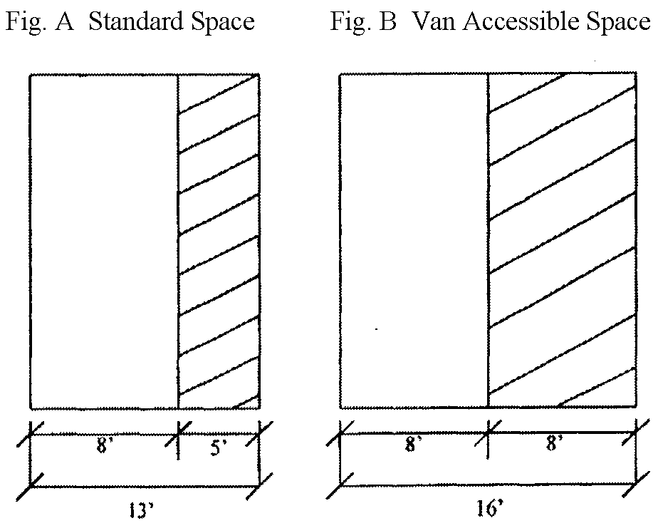
All spaces must be signed and striped as shown in Figures A and B:
(e)
Design standards.
(1)
The design and structural quality of all parking facilities shall conform to all applicable standards of the Town, as determined by the Public Works Department and the Community Development Department.
(2)
Size of parking stalls. The following minimum sizes shall apply to all off-street parking stalls within the Town:
(3)
Widths of aisles serving parking spaces. The following minimum aisle widths are required for the specified degrees of angle parking:
* Due to the difficulty of defining parking stalls and aisles during winter periods when there is snow cover, special provisions shall be required to define the limits of the parking stalls. Drive aisle shall be one way and adequately signed as determined by the Community Development Department and/or the Public Works Department.
(4)
Ingress and egress. The purpose of the Subsection is to allow for safe ingress and egress to off-street parking, to allow for adequate room for off-street snow storage to be used by the Town's Public Works Department and to locate the driveways so as to reduce the possibilities of traffic hazards. The ingress and egress provisions for off-street parking spaces shall conform to the following minimum standards. The Public Works Department may recommend a reduction in the standards if it finds that his requirement is not justified by the characteristics of the proposed ingress and egress:
a.
Intersections. No portion of any entrance or exit driveway leading from or to a public street, highway or alley for the purpose of off-street parking shall be closer than thirty-five (35) feet to an intersection of two (2) or more public streets, alleys or highways. The intersection point shall be determined by the crossing of two (2) rights-of-way or curbline or two (2) physically established edges of the public street, alley or highway, whichever is more restrictive.
b.
Width of driveways. The width of any driveway connecting an off-street parking area with a public street, alley or highway in all zone districts, except C-2, Heavy Commercial District, shall not exceed twenty-four (24) feet at its intersection with the property line, curbline, right-of-way or the physically established edge of the public street, alley or highway, whichever is most restrictive. In the C-2 District, the width of any connecting driveway shall not exceed thirty-five (35) feet at its intersection with the physically established edge of the public street, alley or highway, whichever is more restrictive. Each entry and exit lane shall be a minimum of twelve (12) feet wide for each travel lane. In residential areas, driveways serving one (1) to four (4) dwelling units may be a single lane, twelve (12) feet in width.
c.
Frequency of driveways. No two (2) driveways connecting a public or private street, alley or highway to an off-street parking area shall be within thirty (30) feet of one another at their intersections with the property line, curbline, right-of-way line or the physically established edge of the public street, alley or highway, whichever is most restrictive; provided, however, that for driveways along designated local streets in R-6 and R-15 Districts, fifteen (15) feet shall be the minimum distance between the closest points of the physically established edge of driveways for those driveways serving single-family, duplex and townhouse units.
d.
Angle of intersection. All driveways serving off-street parking facilities shall intersect public streets, alleys and other driveways at a ninety-degree angle, with the exception in residential areas of driveways serving up to four (4) dwelling units.
e.
Accessibility. All off-street parking stalls shall have legal, unobstructed access to a public street or alley.
f.
Forward-flow movement. Except for single-family and duplex parking areas, all other parking stalls shall be so designed, located and served by maneuvering lanes or spaces that their use will under no circumstances require a backing movement onto any public street or alley.
g.
Visual clearance. All driveways leading to and from off-street spaces that intersect possible pedestrian ways shall be visually unobstructed for such distances so as not to imperil pedestrians or interfere with vehicular traffic on the street.
h.
Traffic. The location and number of driveways must be so arranged that they will reduce the possibilities of traffic hazards as much as possible. Wheel or bumper guards may be provided but must be so located and arranged that no part of any parked vehicle extends beyond the boundaries of the parking area.
i.
Grades. Except for facilities serving single-family and duplex uses or structures, the sustained surface grades for parking facilities shall not be less than five-tenths percent (0.5%) for Portland cement concrete surfaces, not less than one percent (1%) for asphalt surfaces or more than four percent (4%) for either surface.
j.
Drainage. Facilities shall be graded for proper drainage so that surface discharge is channeled to a natural or improved drainageway without causing nuisance or damage to other properties or the improvements thereon. Proper drainage shall include the installation of such systems, including culverts if necessary, and will protect all affected public rights-of-way. Culverts shall be corrugated metal pipe or High-Density Poly Ethylene (HDPE) with a minimum eighteen-inch diameter or equivalent "squash" diameter unless otherwise approved by the Town in writing.
k.
Surfacing required. Facilities and driveways shall be surfaced concrete, asphaltic concrete or asphalt (for all uses), except for facilities serving single-family or duplex dwelling units, or parking facilities for recreational uses, which facilities may be surfaced with a dust-free surfacing material and must be maintained in good condition, free of weeds, dust, trash and debris. For the purpose of this Section, recreational uses means parking that is provided for fishing access, softball, baseball and soccer fields and overflow parking for special events. For facilities serving triplex and fourplex units, the Town Council shall determine if the parking area should be hard-surfaced. Among the factors which will be considered in such determination are soil conditions, density of development and surfacing proposed.
l.
Concrete curb and gutter required. All off-street parking surfaces shall be defined by concrete curb and gutter (for all uses), except for facilities serving single-family or duplex dwelling units. The Community Development Department and/or the Public Works Department may waive this requirement if it finds that this requirement is not justified by the characteristics of the proposed development.
m.
Location. Facilities for commercial uses which abut residential uses shall not be closer to the adjoining residential zone district boundary than ten (10) feet. Facilities serving residential or commercial uses shall not be closer to the property line than ten (10) feet.
n.
Screening. Facilities adjacent to residential structures shall be equipped with barriers or screens sufficient to prevent unreasonable disturbance to the occupants of such structures arising from the operation or use of the facility. Where the facility abuts directly upon a residential lot, a screen at least four (4) feet in height shall be erected. Screens or barriers may be solid walls, fencing or landscaping, whichever is most appropriate to the adjacent properties and accomplishes the purpose of this Article most suitably.
o.
Snow-stacking space. All surface facilities shall provide a minimum of twenty-five percent (25%) of total paved surface area. The snow-stacking space must be provided on the same property as the facility. Such space shall be so located as to reasonably facilitate the snow-plowing process. Landscaping in or around a snow-stacking space shall not interfere with the snow-stacking process. The space shall be located upon the site so as to comply with the maintenance criteria set forth in the Section below.
p.
All required parking spaces, excluding single and duplex units, facing and abutting a building, wall, fence, property line or walkway shall be provided with curb, bumper or wheel stops. Such devices shall be constructed and installed in conformance with adopted Town standards.
(f)
Parking requirement exceptions and reductions: It is the intent of this Subsection that all structures and land uses be provided with a sufficient amount of off-street parking, while allowing for some flexibility of site design to accommodate the unique characteristics of individual properties. This Section sets standards for conditions under which and exception of reduction of the general parking requirements may be allowed. The Community Development Director may require the submission of a parking demand analysis as part of any request for an exception or reduction from the general parking requirements. When multiple reductions are proposed, each subsequent reduction will be taken from the subtotal of the previous reduction.
(1)
Location of required parking spaces. All required facilities shall be provided on the same lot as the building or use served, except that up to fifty percent (50%) of the parking spaces required to serve business and commercial uses may be located within a three hundred-foot radius of the subject property, measured from any point on the property. If the building or use and parking area are not owned by the same owner, the owner shall submit, for approval by the Town Attorney, a binding covenant affording the use of the parking area. All required parking for residential uses shall be provided on the same lot as the residential use served.
(2)
Shared parking. No off-street parking space required for any building or use for the purpose of complying with the provisions of this Chapter shall be included as part of the off-street parking space required for another building or use. Provided, however, that projects consisting of a mix of a minimum of two (2) non-residential uses may reduce the aggregate parking required for the non-residential portion of the project by up to thirty percent (30%), if the combination of uses have peak parking demands during different times of the day. For example, uses such as theaters, public auditoriums, bowling alleys, bars, movie theaters and similar predominantly evening uses may share parking with uses such as banks, offices, and similar predominantly daytime uses. The applicant requesting shared parking reductions shall submit a parking study that details peak parking demands for the uses proposed, and demonstrates that shared parking will function effectively.
(3)
Parking reduction for proximity to a bus stop. Upon approval by Town Council, business, commercial and educational uses located within five hundred (500) feet of a Summit Stage Bus Service Stop or Transit Center may reduce the minimum number of required parking spaces by fifteen percent (15%) if all of the following criteria are met:
a.
There is reliable, regularly scheduled service during commuting hours, year-round.
b.
There is safe and convenient pedestrian access from the bus stop to the subject building or property.
c.
For commercial and business uses, the applicant provides a parking management plan that will encourage employees to use the bus service and provides alternatives in the event that the bus stop is relocated.
(4)
Parking reduction for provision of bicycle parking. Bicycle parking may substitute for up to five percent (5%) of the required parking in the ratio of seven (7) bicycle parking spaces for each one (1) required parking space. Each bicycle parking space must be at least two (2) feet by six (6) feet. In order to qualify for this reduction, there must be safe and convenient bike access to the property.
(5)
Parking reductions for the Town Core. In those instances where the applicant for a development permit within the Town Core District desires not to provide all parking spaces required in this Chapter, the applicant may apply for a reduction in the order set forth below. The reductions set forth below apply exclusively to commercial, business, and entertainment uses, including restaurants, bars, retail establishments, offices, auditoriums and theaters, that are listed as permitted uses in the underlying zone district.
a.
The minimum number of parking spaces set in Paragraph 4-6-10(d)(2) above may be reduced by up to twenty-five percent (25%).
b.
The minimum number of parking spaces set in Paragraph 4-6-10(d)(2) above may be provided, on a 1:1 ratio, by the construction of on-street parking in locations approved by the Town within the Town Core.
c.
In the event that the minimum number of off-street parking spaces for a development project cannot be met by Subsections (a) and (b) above, the applicant may choose to enter into an agreement with the Town to provide deficient parking spaces at a later date through participation in a Town Core Parking District.
The right of an applicant to enter into such an agreement, and the authority of the Town to accept such agreement, shall be subject to the following limitations:
1.
Agreement. The agreement shall specify the number of spaces the project is deficient, shall indicate the applicant's agreement not to protest the cost for the design and construction of future public parking facilities and shall be entered into prior to the issuance of a building permit.
2.
Any parking supplied in this manner shall run with the land (not be invalidated by change in ownership), and any subsequent change in use that requires more parking shall require subsequent action by the property owner to satisfy any additional parking requirements.
(g)
Maintenance standards and criteria.
(1)
General. Every owner of a parking facility within the Town shall maintain such facility, including the surfacing, drainage, signs, striping, lights and lighting and landscaping, in good repair and in an unobstructed condition so as to ensure its proper use at all times.
(2)
Snow removal. All operating facility surfaces shall be substantially cleared of snow within twenty-four (24) hours after uncompacted snow depth reaches four (4) inches. Removed snow shall be stored in the designated snow-stacking space in such a manner as not to impair lines of sight or disrupt or obstruct the flow of vehicular or pedestrian traffic or drainage.
(h)
Use restrictions.
(1)
Parking facilities shall be restricted to parking of operable private vehicles of residents, customers, patrons and employees only and shall not be used as permanent parking for resident vehicles, including trailers, mobile homes or vans; for storage of operable or inoperable vehicles or of materials and equipment; or for the parking of trucks or other vehicles used in connection with the business or use on the site. The parking requirements for such excluded vehicles shall be considered in site plan review separate from the consideration for included vehicles.
(2)
Storage. Except as provided in Subsection (3) below, off-street parking spaces shall not be used for the parking or storage of trailers, boats, detached campers, inoperable vehicles or other objects that will render the parking space unusable.
(3)
Sales and service. No off-street parking space shall be used for the sale, repair, dismantling or servicing of any vehicle, equipment, materials or supplies, except that this shall not prohibit the servicing or repair of private vehicles by their owners in facilities serving residential uses.
(i)
Nonconformance.
(1)
A facility shall be deemed nonconforming if it does not meet the requirements set forth in this Article on the effective date of the applicable section, as shown by the "prior code" notations following each such section.
(2)
Upon any expansion or modification of the use, structure or site served by said nonconforming facility, when such expansion or modification will cause, in the estimation of the Community Development Department, an increase in the demand for parking spaces, the owner of such use or structure shall be required to bring said facility into conformance with this Section.
(Ord. 2003-20 §2; Ord. 2008-10 §2; Ord. 2009-18 §16)
Sec. 4-6-11. - Landscaping requirements.
(a)
Purpose. The purpose of this Section is to promote and protect the health, safety and welfare of the public and to enhance and preserve the community's environmental and visual character by promoting public and private landscaping that has aesthetic appeal, that complements the built and natural environment and that utilizes water resources efficiently. This Article is to support the Comprehensive Plan of the Town and help implement the urban design guidelines of the Town. The requirements of this Section shall apply to all new landscaping planted or installed within the Town.
(b)
Conformance required. It is unlawful, after the effective date of this Section, for any site development requiring a building permit, site plan or other development approval by the Town, to install, construct or plant any landscaping except in conformance with the provisions hereof.
(c)
Definitions. As used in this Article, the following terms shall have the meanings indicated:
Berm means an earthen mound designed to provide visual interest, screen undesirable views and/or decrease noise.
Boulder means a natural rock or stone eighteen (18) inches or greater in diameter.
Buffer means an open space or physical element, such as plants, berms, fences or walls, which physically separates or visually screens incompatible or undesirable lands uses and/or views.
Caliper means the diameter of a tree trunk. A caliper measurement will be made as shown in Figure 1.
Figure 1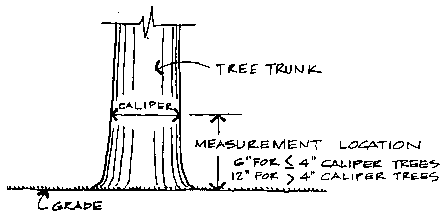
Deciduous means a plant or tree which sheds its foliage annually.
Evergreen means a plant or tree having green foliage throughout the year; also coniferous.
Landscaping includes but is not limited to plants, shrubs, trees, ground cover, vines, rocks, benches, picnic areas, planter boxes, berms, pavers (paving stone), gazebos, art forms, sculpture, water elements (i.e., pools, fountains and waterfalls), terraces and other natural materials.
Plant means an organism typically having cellulose wall, manufacturing its own food by photosynthesis and being incapable of self-locomotion.
Screen means a method of reducing the impact (both visual and audio) of undesirable elements with less offensive or more harmonious elements, such as plants, berms, fences or any other such element.
Shrub means a woody plant, smaller than a tree, consisting of several small stems from the ground or small branches near the ground; may be deciduous or evergreen.
Tree means a woody plant, usually having one (1) or several self-supporting stems or trunks and numerous branches; may be deciduous or evergreen.
Vegetated roof means a roof on a building that is partially or completely covered with vegetation and soil, or a growing medium, planted over a waterproofing membrane.
Xeriscape means landscaping that promotes water conservation by minimizing the amount of native vegetation removed, limiting new vegetation to native or drought tolerant vegetation and limiting the amount and type of irrigation.
(d)
Landscape plan. As part of the site plan or development review process, the owner/ applicant of any development except residential developments of three (3) units or less shall submit a properly conforming landscape plan, whose scale shall be one (1) inch to twenty (20) feet or larger if the applicant's project is one-half (½) acre, or less, or one (1) inch to fifty (50) feet or larger if the applicant's project is larger than one-half (½) acre, and which shall include or show:
(1)
North - indicating arrow.
(2)
Property lines.
(3)
Locations of the proposed and existing structures on site.
(4)
Locations of all existing and proposed hard surface areas.
(5)
Locations of all existing trees, shrubs, wetlands, etc.
(6)
All proposed plants at mature size and at the same scale as the landscape plan.
(7)
A table listing the botanical names, the common names and the planting sizes and quantities of all plantings. (NOTE: To ensure their viability or be readily adaptable to the climate and soil conditions, a list of conifer and deciduous trees, shrubs, perennials and grass seed mixes suitable to the Silverthorne area is available from the Community Development Department.)
(8)
The owners/developers of the project, their telephone numbers and address.
(9)
The designer/architect and his or her telephone number and address.
(10)
Written descriptions of procedures to be used for revegetation of previously stripped areas and analyses of drainage ways and areas prone to soil erosion and procedures designed to mitigate such erosion. The written description shall include sections and profiles of proposed and existing drainage ways or drainage forces.
(11)
Identify which existing trees will remain and which trees will be removed in accordance with the Tree conservation plan.
(12)
Location and description of landscaping improvements.
(13)
Methods and details for protecting existing vegetation during construction and the approved sediment control plan, if necessary.
(14)
Planting and installation details as necessary to ensure conformance with required standards.
(15)
Irrigation plans which discuss irrigation concepts to be followed for the development, including monthly water use calculation detail (in gallons). This is required for all commercial and large residential developments.
(e)
Review goals and objectives. In its review of the applicant's landscape plan, the Town shall take into consideration the following goals and objectives:
(1)
Whether the plan provides visual, noise and access barriers between conflicting land uses.
(2)
Whether the plan takes into account and does not inhibit the exercise of solar access rights of neighboring properties.
(3)
Whether the plan utilizes plantings to minimize soil erosion and protect sloped areas.
(4)
Whether the plan interferes with any line of sight of vehicle drivers entering or leaving the site.
(5)
Whether the plan enhances the architecture of the property; e.g., the landscaping tends to break up large expanses of a wall or other structure.
(6)
Whether the plan facilitates the movement of pedestrians and vehicles on the site and integrates with and helps to conceal parking facilities on the site.
(7)
Whether the plan utilizes and preserves existing and native vegetation to the greatest degree possible. Existing mature trees and vegetation shall count towards landscaping requirements.
(8)
Whether the plan takes into consideration Silverthorne's unique microclimate in the choice and location of proposed landscaping.
(9)
Whether the plan places an unreasonable burden on the Town water system and supply. The use of automatic irrigation systems is strongly encouraged.
(10)
Whether the plan enhances visual appearance from adjacent public rights-of-way.
(11)
Whether the plan promotes pedestrian opportunities to enjoy natural settings.
(12)
Whether the plan is coordinated with adjacent properties.
(13)
Whether the proposed landscape and irrigation plan considers water conservation and follows current xeriscape practices.
(14)
Whether the plan uses sod only where it has a practical function as described in Sections 4-6-11(f)8 and 4-6-11(g)16.
(15)
Whether the plan considers defensible space practices in the location and choice of new landscaping.
(f)
Requirements for single-family, duplex and triplex developments.
(1)
All disturbed areas on the site shall be revegetated or landscaped in a manner approved by the Community Development Department.
(2)
Existing on-site trees and shrubs that remain healthy and undisturbed during the site's development may be credited for required landscaping provided they meet the minimum size and species requirements.
(3)
No landscaping plan shall provide for plantings or construction which may interfere with the sight line of drivers entering or leaving the site. A sight triangle shall be established in accordance with the Town Street Design Standards, in which nothing is erected, placed, planted or allowed to grow in a manner as to limit or obstruct the sight distance of motorists entering or leaving the site.
(4)
All deciduous trees used to meet the landscaping requirements shall be a minimum of one-and-one-half-inch-caliper for single stem trees and a minimum of eight (8) feet in height for multi-stem trees, measured as shown in Figure 1. Minimum size for evergreen trees shall be six (6) feet or greater. All trees (existing and proposed) not meeting the one-and-one-half-inch caliper or six-foot-high standard will not count toward the landscaping requirements.
(5)
All shrubs used to meet the landscaping requirements shall be at least one and one-half (1.5) feet tall and a minimum number five (#5) container when planted.
(6)
The following are per-dwelling-unit minimum requirements for single-family homes, residential duplexes and triplexes:
a.
Three (3) trees and six (6) shrubs;
b.
Four (4) trees and three (3) shrubs; or
c.
Five (5) trees and no shrubs.
(7)
The Community Development Director may reduce the required number of trees and shrubs if fire mitigation requirements cannot be met with the minimum number of trees and shrubs.
(8)
Landscaped areas shall utilize the following xeriscaping practices, in accordance with the proposed landscape and irrigation plan.
a.
All proposed trees and shrubs shall be drought-tolerant species suited for semi-arid mountain environments, as listed in the Town's Recommended Plant List. Plants native to the Rocky Mountains are preferred. The Community Development Department may approve species that are not on the Town's Recommended Plant List on a case-by-case basis, provided the applicant demonstrates the proposed species are indeed drought-tolerant and capable of thriving in a semi-arid mountain environment.
b.
All proposed ground cover shall be drought-tolerant species suited for semi-arid mountain environments and preferably Rocky Mountain native, with the following exception. Areas covered by non-native, non-drought-tolerant grass shall be consolidated and limited to those areas on the site that provide for civic, community, or recreational use.
c.
Invasive plant species shall be prohibited. The following specific plant species shall also be prohibited:
• Cottonwood:
◦ Populus x berolinensis C. Koch (laurifolia x nigra var. italica)
◦ Populus x heimburgeri B. Boivin (alba x tremuloides)
◦ Populus x inopina Eckenwalder (fremontii x nigra)
◦ Populus x rouleauiana B. Boivin (alba x grandidentata)
◦ Populus x smithii B. Boivin (grandidentata x tremuloides)
• Eastern Cottonwood: Populus deltoides W. Bartram ex Marshall
• Fremont Cottonwood: Populus fremontii S. Watson
• Lanceleaf Cottonwood: Populus x acuminata Rydb. (pro sp.) (angustifolia x deltoides)
• Narrowleaf Cottonwood: Populus angustifolia James
• Parry Cottonwood: Populus x parryi Sarg. (balsamifera x fremontii)
• Swamp Cottonwood: Populus heterophylla L.
• Yew: Taxus spp.
(g)
Requirements for projects of four (4) residential units or more; any residential project where the landscaping is owned and/or maintained by a common entity; and all commercial projects. All landscaping plans shall meet the following requirements prior to approval.
(1)
All disturbed areas on the site shall be revegetated or landscaped in accordance with Subsection (k) of this Section. When seed is used to revegetate, mixes must be separated into percentages of grass and/or wildflower species. The species percentages and seed application rate should be noted on the final site plan or landscaping plan on all projects.
(2)
All on-site areas prone to soil erosion shall be defined on the landscape plan and shall be controlled through landscaping.
(3)
If requested by the Town, details must be submitted which show that no proposed landscaping plan shall cause interference with adjacent property owners' solar access rights.
(4)
No landscaping plan shall provide for plantings or construction which interferes with the sight line of drivers entering or leaving the site that would pose a safety hazard. A sight triangle shall be established in which nothing is erected, placed, planted or allowed to grow in a manner as to limit or obstruct the sight distance of motorists entering or leaving the site.
(5)
Where deemed necessary by the Town, the plan must provide for visual, noise and/or access barriers between lots or parcels and/or abutting streets or thoroughfares. In making its decision, the Planning Commission or Town Council will take into consideration the types of land uses on the adjoining lots or parcels.
(6)
To the greatest extent possible, existing healthy trees shall be saved upon development of a property unless it can be demonstrated that site restrictions necessitate their removal.
(7)
All deciduous trees used to meet the landscaping requirements shall meet the following size requirements:
a.
Thirty-four percent (34%) of the trees must have a minimum two-and-one-half-inch caliper.
b.
Thirty-three percent (33%) of the trees must have a minimum two-inch caliper.
c.
Thirty-three percent (33%) of the trees must have a minimum one-and-one-half-inch caliper.
(8)
All evergreen trees used to meet the landscaping requirements shall meet the following size requirements:
a.
Thirty-four percent (34%) of the trees must have a minimum height of ten (10) feet.
b.
Thirty-three percent (33%) of the trees must have a minimum height of eight (8) feet.
c.
Thirty-three percent (33%) of the trees must have a minimum height of six (6) feet.
(9)
All shrubs used to meet the landscaping requirement shall be at least one and one-half (1.5) feet tall and a minimum five-gallon container when planted.
(10)
Landscaped areas may be used for snow storage if the following conditions exist:
a.
The landscaping is so placed so as not to inhibit snow-plowing operations.
b.
Plowing or storage of snow will not damage any of the landscaping.
(11)
The applicant shall submit planting specifications and details.
(12)
If opaque fencing or screening is proposed, seventy-five percent (75%) of required landscaping shall be located outside the screened, fenced area in all nonresidential zoning districts.
(13)
Landscaped areas shall utilize the following xeriscaping practices, in accordance with the proposed landscape and irrigation plan.
a.
All proposed trees and shrubs shall be drought-tolerant species suited for semi-arid mountain environments, as listed in the Town's Recommended Plant List. Plants native to the Rocky Mountains are preferred. The Community Development Department may approve species that are not on the Town's Recommended Plant List on a case-by-case basis, provided the applicant demonstrates the proposed species are indeed drought-tolerant and capable of thriving in a semi-arid mountain environment.
b.
All proposed ground cover shall be drought-tolerant species suited for semi-arid mountain environments and preferably Rocky Mountain native, with the following exception. Areas covered by non-native, non-drought-tolerant grass shall be consolidated and limited to those areas on the site that provide for civic, community, or recreational use.
c.
Artificial turf and invasive plant species shall be prohibited. The following specific plant species shall also be prohibited:
• Cottonwood:
◦ Populus x berolinensis C. Koch (laurifolia x nigra var. italica)
◦ Populus x heimburgeri B. Boivin (alba x tremuloides)
◦ Populus x inopina Eckenwalder (fremontii x nigra)
◦ Populus x rouleauiana B. Boivin (alba x grandidentata)
◦ Populus x smithii B. Boivin (grandidentata x tremuloides)
• Eastern Cottonwood: Populus deltoides W. Bartram ex Marshall
• Fremont Cottonwood: Populus fremontii S. Watson
• Lanceleaf Cottonwood: Populus x acuminata Rydb. (pro sp.) (angustifolia x deltoides)
• Narrowleaf Cottonwood: Populus angustifolia James
• Parry Cottonwood: Populus x parryi Sarg. (balsamifera x fremontii)
• Swamp Cottonwood: Populus heterophylla L.
• Yew: Taxus spp.
d.
All landscape plans are required to have automatic irrigation systems. Landscaping plans must include the layout and design of the irrigation system. Efficient irrigation systems shall be equipped with a drip emitter and with a moisture sensing and/or rain shut-off device to avoid irrigation during periods of sufficient soil moisture.
(14)
For all surface parking facilities with a capacity larger than twenty-five (25) cars in more than two (2) aisles, the landscape plan must provide for interior plantings and construction in order to break up the expanse of hard-surface area. Parking facilities shall conform to the following three (3) elements:
a.
Along public right-of-way. A minimum of a ten-foot landscape strip shall be required adjacent to rights-of-way. The landscape strip shall buffer the parking facility from the right-of-way.
b.
Perimeter of parking. A minimum of a ten-foot landscaping buffer strip shall be provided for all parking facilities which abut the property line.
c.
Interior landscaping. In a parking facility of more than two (2) aisles, the developer shall provide for interior plantings in order to break up the expanse of hard-surface area. No tree-planting area may be less than five (5) feet wide in any dimension.
This Subsection does not abrogate the parking requirements elsewhere established in this Code.
(15)
Landscaped islands within parking lots shall meet the following requirements:
a.
Landscaping within landscaped islands shall not obstruct visibility for vehicles entering, maneuvering in or exiting the parking lot.
b.
Landscaped parking lot islands shall be at least one hundred fifty (150) square feet in area and contain a minimum of six (6) shrubs and one (1) tree per individual island.
c.
Landscaped parking lot islands greater than one hundred fifty (150) square feet in area shall have one (1) additional shrub for each additional fifteen (15) square feet, or fraction thereof, in area.
d.
One (1) tree may be substituted for ten (10) shrubs when approved during the site plan process.
e.
Landscaped parking lot islands shall be dispersed throughout the parking lot in such a manner as to divide and break up the expanses of paving. Landscaped islands shall be a minimum of ten (10) feet in width.
(16)
Where a commercial parking lot boundary adjoins property zoned for any residential use, a landscape buffer between such parking lot boundary and the adjoining residential property shall be required. Within this landscape buffer, an earthen berm, view-obscuring fence, or decorative wall, and groupings of trees and shrubs may be used for screening. The minimum width of the landscape buffer shall be determined by the minimum setback required for the parking lot.
___________________________________________________________
Figure 2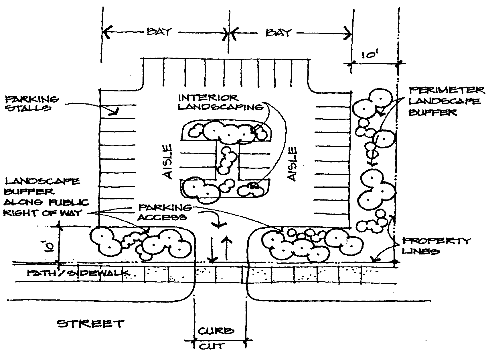
(17)
Landscaping requirements.
• Landscape Reduction Options:
1.
For the purposes of calculating required landscape area, the lot area may be reduced by the area covered by existing natural vegetation, wetland areas, buffer zones, and natural open space areas that will remain undisturbed during development, subject to approval by the Community Development Department. The natural vegetation within the area that is used to reduce the landscape area shall not also be counted towards Landscape Reduction Option 2, described below.
2.
Existing on-site trees and shrubs that remain healthy and undisturbed during the site's development may be credited for required landscaping provided that they meet the minimum size and species requirements. If this option is chosen, a survey with the quantity, caliper size, height, and species of trees and shrubs that are to remain undisturbed is required.
• Each deciduous tree and evergreen tree shall be deemed to cover one hundred twenty (120) square feet for the purpose of calculating the tree requirement. A minimum mix of fifty percent (50%) evergreen and fifty percent (50%) deciduous trees is required. Refer to Section 4-6-11(g)(9) and (10) for size requirements.
• Each shrub shall be deemed to cover twenty (20) square feet for the purpose of calculating the shrub requirement. Refer to Paragraph 4-6-11(g) for size requirements.
• Each landscape decorative element, including benches, picnic tables, gazebos, art forms or sculptures, shall be deemed to cover one hundred twenty (120) square feet of landscaping area. Landscaping elements shall be located in approved spaces that support their function and use.
• Each set of three (3) large boulders shall be deemed to cover one hundred twenty (120) square feet of landscaping area.
• Non-living ground cover within the area to be landscaped may include bark, wood chips, wood shavings, rock, stones or other materials approved during the site plan process. For the purposes of this section, non-living ground cover does not include structures or pavement for vehicle access, parking, or pedestrian walkways. Upon review and approval of the Community Development Director, other impervious landscaping features may be considered non-living ground cover. Any alternative landscape features such as benches or sculptures that are used to meet tree or shrub requirements are excluded from the non-living ground cover requirement.
• Living ground cover within the landscaping area may include native grasses, wildflowers, or other living plant material including trees or shrubs in excess of the minimum requirement. For purposes of calculating the living ground cover requirement, the minimum quantity of required trees and shrubs shall be excluded from the living ground cover minimum requirement.
___________________________________________________________
(18)
Exceptions to requirements.
a.
Up to ten percent (10%) of the required number of trees may be substituted for alternative forms of landscaping and decorative elements, including benches, picnic tables, gazebos, art forms, sculptures, larger boulders and planter boxes.
b.
Vegetated roofs may count towards required landscape area on a 1:1 square foot ratio, up to a maximum of fifty percent (50%) of the required landscape area.
c.
Upon review and approval of the Community Development Director, the required number of trees and shrubs may be reduced if fire mitigation requirements cannot be met with the minimum number of trees and shrubs.
d.
In order to avoid landscaping requirements that are inconsistent with a site's natural environment and/or fire mitigation requirements, applicants may propose, and the Community Development Department may approve, alternative methods for landscaping a site, provided that the applicant can demonstrate, and the Community Development Department determines, that there are unique and unusual physical characteristics on the site related to microclimate, aspect, defensible space, and/or soil conditions and that the alternative will meet or exceed the level of design that is expressed in the objectives in Subsection (e) of this Section.
(h)
Completion.
(1)
All approved landscaping must be completed prior to the issuance of certificates of occupancy generally in the months of May through October. Certificates of occupancy will be issued during the remainder of the year prior to completion of approved landscaping only if the applicant provides a guaranty of improvements which is acceptable to the Town.
(2)
In the case of a drought, as determined by the Town, the property owner may request from the Community Development Department an extension on the landscape installation time frame. If approved, the owner will be required to submit a bid from a local landscape contractor, along with one hundred fifty percent (150%) of the estimated cost of materials and labor, to be completed by the date given by the Community Development Department.
(i)
Guaranty of landscaping. Generally, in the months of November through April, prior to the issuance of a certificate of occupancy, the applicant shall provide security for not less than one hundred fifty percent (150%) of the then-current written estimated cost of the landscaping improvements (including materials and labor) approved by the Community Development Department. The written estimate shall be obtained from an independent landscaping contractor, and the security shall be in a form acceptable to the Town.
(j)
Maintenance of landscaping.
(1)
On single-family, duplex and triplex units, the landscaping shall be maintained in the amount and location required by the approved site plan.
(2)
Landscaping maintenance shall include water, fertilization, pruning and weed control. Nonliving elements in landscaping also need maintenance to avoid being in violation of this Section.
(3)
Prior to issuance of a certificate of occupancy on all multifamily and commercial projects, in accordance with Section 4-6-9, the applicant shall also submit a guaranty, in a form acceptable to the Town, of twenty-five percent (25%) of the estimated cost of live plant material provided as part of the landscaping requirement. This amount shall be retained by the Town until the plant materials have been maintained in a satisfactory condition for two (2) years after installation. The Town may during that time draw upon the twenty-five-percent guaranty to replace plant materials which have died. The remainder of the guaranty, if any, shall be returned to the owner of record upon the expiration of the two-year period. Funds shall only be returned during the months of April through October when survival of landscaping can be verified.
(4)
After the expiration of the security guaranty, the landscaping must be maintained in perpetuity.
(5)
All plantings shall be maintained in a healthy and attractive manner by the property owner of record, the property owner's agent or tenant, or a homeowners' association which has assumed landscape maintenance responsibility. Maintenance shall include, but not be limited to, watering, fertilizing, weeding, cleaning, pruning, trimming, spraying and cultivating.
(6)
Dead plant materials shall be removed and replaced within one (1) month with plant materials that meet the original intent of the approved landscape design. Dead, diseased and/or beetle-infested trees must be removed within ten (10) days of receipt of written notice to the property owner or an acceptable plan and schedule for removal must be submitted to the Community Development Department within ten (10) days, pursuant to Section 4-8-42 of this Chapter.
(7)
Natural landscape materials, such as rock, stone, bark chips and shavings which no longer cover the area in which they were originally deposited, shall be replenished so that they again achieve full coverage to a minimum depth of three (3) inches.
(8)
Landscaping structural features, such as fencing, planter boxes, etc., shall be maintained in a sound structural and attractive condition.
(9)
Failure to replace dead landscape materials within a reasonable period of time shall be considered a violation of the site plan approval and is subject to the provisions of Appendix A.
(k)
Grading and revegetation requirements:
(1)
All areas disturbed by construction, grading or any other impact left in an unimproved state must be revegetated predominantly free of weeds.
(2)
Required plant materials: Due to the limitations of growing conditions in the area, the use of a native mix is required at a minimum of 2 lb./1000 SF (list available at Community Development Department), and fertilizing shall be done at a minimum of 5 lb./1000 SF.
(3)
To guarantee growth and soil contact:
a.
Disturbed slopes require grading subterrain, including the removal of rocks larger than two (2) inches, to provide proper drainage.
b.
Topsoil, if not sufficient for growth, requires an addition of a minimum of two (2) inches topsoil or to a depth deemed necessary by the Community Development Department.
c.
After application of topsoil and seed, increased soil contact is done by hand rake or machine.
d.
Slopes less than 3:1 shall be seeded, fertilized and raked in. It is encouraged that slopes be hayed and tackified to prevent erosion.
e.
Slopes 3:1 and greater shall be cat-tracked, seeded and fertilized, hayed and netted or tackified. If the potential of runoff and drainage problems exist, soil stabilization blankets or retention walls may be required which the Community Development Department will determine.
f.
These requirements must be met, planned and submitted to the Community Development Department, along with the landscape plan.
(l)
Screening standards.
(1)
Required screening, unless otherwise specifically provided for in this Chapter, shall be constructed and maintained in accordance with the regulations in this Section.
(2)
Required screening shall not be less than six (6) feet in height.
(3)
The Town Council may permit screening with different standards during the development review process when the Town Council finds:
a.
A different standard meets the purposes of screening; and
b.
A different standard does not adversely affect neighboring property.
(4)
In the event a development is approved with a screening standard different from the standards in this Section, the standards established in the development review process shall control.
(5)
Required screening shall be constructed of:
a.
Brick, stone or concrete masonry, stucco, concrete or wood unless a different but equivalent material is specifically approved by the Community Development Department.
b.
Earthen berm planted with grass or ground cover generally recognized by landscape architects and horticulturists for local area use.
(6)
Access through the required screening may be provided by a solid gate or other site planning provision which preserves the integrity of the screening.
(7)
An owner shall provide screening in accordance with this Section for the rear or service side of a nonresidential building if:
a.
The nonresidential building is in a residential district and is exposed to a residential use, or
b.
The nonresidential building is in a nonresidential district and is exposed to and closer than one hundred fifty (150) feet to the boundary line of a residential district.
(m)
Plant materials used for required screening shall be maintained in a healthy growing condition at all times. The property owner is responsible for regular weeding, mowing of grass, irrigating, fertilizing, pruning and other maintenance of all plantings as needed. Any plant that dies shall be replaced with another living plant within one hundred twenty (120) days after notification by the Town.
(n)
All required screening with plant materials shall be irrigated by an automatic irrigation system installed to comply with the Town's standards and specifications.
(o)
In the Open Space District, all screening and/or fencing shall be consistent with the purpose of maintaining the open space values of the property and the screening standards found in this Section.
(Ord. 2003-20 §2; Ord. 2007-3 §1; Ord. 2009-15 §1; Ord. 2009-18 §16; Ord. 2025-10, §4)
Sec. 4-6-12. - Dumpster and dumpster enclosures.
All commercial and multi-family developments are required to provide a Dumpster and dumpster enclosure on site. The enclosure must be a four-sided solid opaque enclosure with similar architectural treatment for the gates and man door. The Dumpster enclosure shall not be located in a prominent location on the site and must be well screened. All Dumpsters must be located within the dumpster enclosure with gates which must remain closed.
(Ord. 2003-20 §2; Ord. 2009-18 §16)
Sec. 4-6-13. - Lighting standards.
(a)
Intent and purpose.
(1)
It is the intent of this Section to preserve, protect and enhance the lawful nighttime use and enjoyment of property through the use of appropriate lighting practices and systems. Individual fixtures and lighting systems shall be designed, constructed and installed to: control glare and light trespass, minimize obtrusive light, conserve energy and resources while maintaining safety, security and productivity and curtail the degradation of the nighttime visual environment.
(2)
It is the purpose of this Section to encourage lighting practices and systems that will: minimize glare, light trespass and light pollution; conserve energy and resources while maintaining nighttime safety, utility, security and productivity; and curtail the degradation of the nighttime visual environment.
(b)
Definitions. Unless plainly evident from the context that a different meaning is intended, certain words and phrases used in this Section are defined as follows:
Agricultural means areas zoned agricultural under Article IV of this Chapter.
Display means for uses such as auto dealership parking lots, outdoor storage areas and outdoor display.
Emergency lighting means lighting used by or for the purpose of Police Departments, Fire Departments or other government entities for the purpose of public safety.
Existing light fixture means a light fixture installed, or approved by the Town to be installed, pursuant to the effective date of this Section, December 10, 2003.
Flood light(or spot light) means any light fixture or lamp that incorporates a reflector or a refractor to concentrate the light output into a directed beam in a particular direction.
Foot-candle means a unit of measure of the intensity of light falling on a surface, equal to one (1) lumen per square foot and originally defined with reference to a standardized candle burning at one (1) foot from a given surface.
Fully shielded means that the outdoor light fixture is constructed so that, in its installed position, all of the light emitted by the fixture is projected below the horizontal plane passing through the lowest light-emitting part of the fixture.
Glare means the sensation produced by luminance within the visual field that is sufficiently greater than the luminance to which the eyes are adapted to cause annoyance, discomfort or loss in visual performance and visibility.
High Pressure Sodium (or HPS) means a bulb that is filled with high pressure sodium vapor.
Illuminating Engineering Society of North America (or IESNA) means the professional society of lighting engineers, including those from manufacturing companies and others professionally involved in lighting.
Light pollution means any artificial light that is emitted either directly or indirectly by reflection that alters the appearance of the night sky, interferes with astronomical observation or interferes with the natural functioning of nocturnal native wildlife.
Light trespass is any form of artificial illumination emanating from a fixture that penetrates other property other than that for which it is intended and permitted.
Low Pressure Sodium (or LPS) means a bulb that is filled with low pressure sodium vapor, which has a nearly monochromatic spectrum.
Lumen means a unit of light emission. One (1) foot-candle is one (1) lumen per square foot.
Luminaire means the complete lighting system, which includes the lamp(s) fixtures.
Luminaire pole height means the measurement from a paved or landscaped surface at ground level under the fixture to the top of the luminaire.
Motion sensors means a mechanism for controlling illumination by turning lights on when activated by motion, remaining on during activity for a set amount of time (typically thirty [30] minutes) following the last detection of motion.
Nonessential means lighting that is not necessary for an intended purpose after the purpose has been served. For example, lighting for a business sign, architectural accent lighting and parking lot lighting, is considered essential during business or activity hours, but is considered nonessential once the hours of operation have ended.
Outdoor lighting means any outdoor artificial lighting device, fixture, lamp or other similar device, whether permanently installed or portable, which is intended to provide illumination for either visibility or decorative effect. Such devices shall include, but not be limited to, area, search, spot, and flood lighting used for:
a.
buildings and structures;
b.
recreational facilities;
c.
parking lots;
d.
landscape lighting;
e.
business and advertising signs;
f.
roadways;
g.
walkways.
Partially shielded means that the outdoor lighting fixture is constructed so that at least ninety percent (90%) of the light emitted by the fixture is projected below the horizontal place of the lowest point of the fixture.
Photocells mean a mechanism that is activated by the nonpresence of sunlight and has the effect of illuminating a property all night. Photocells are permitted only at primary entrances and where the light source is fully shielded by opaque material.
Security lighting means a light used either commercially or residentially for protection of goods or property.
Up-lighting means lighting that is directed in such a manner as to shine light rays above the horizontal plane.
(c)
General exemptions. The following lighting is exempt from the requirements of this Section:
(1)
Emergency lighting: Lighting required for public safety in the reasonable determination of public safety officials with authority.
(2)
Decorative lighting: Low-wattage fixtures (comprised of incandescent bulbs of less than eight [8] watts each or other lamps of output less than one hundred [100] lumens each) used for holiday decoration on commercial buildings between November 1 and March 31. Decorative lighting shall not blink, flash or rotate.
(3)
Street lighting: Lighting required for public safety installed by a public entity or private utility company along a public right-of-way.
(d)
Prohibited lights. Use of the following lighting is prohibited:
(1)
Unshielded fixtures and lamps, except for flood or spot light lamp fixtures of one hundred (100) watts or less that are aimed straight down.
(2)
Use of any unshielded fixtures and lamps for outdoor lighting.
(3)
Searchlights used for advertising purposes.
(4)
Laser source lights for advertising purposes.
(5)
Neon or fluorescent lighting used for advertising and architectural purposes.
(6)
Semi-opaque or transparent backlit canopies and awnings.
(e)
General lighting standards. All outdoor lighting (other than lighting for single-family residential exterior lighting, gas station canopies and signs) shall conform to the following standards, as applicable:
(1)
A photometric site plan and cut sheets for all proposed exterior fixtures shall be included with the application requirements of subdivision of land or a site plan. The photometric plan shall provide computer printout information that shows the proposed feature meets the requirements of the Code.
(2)
Fully shielded fixtures required. All outdoor lighting fixtures shall utilize fully shielded fixtures; flood or spot lamp fixtures of one hundred (100) watts and less shall be aimed straight down. (NOTE: "Two thousand [2000] lumens" allows typical one-hundred-watt standard.)
(3)
Emitted light in no case may be greater than two-tenths (0.2) foot-candles at the property line, except at site entry points if determined by the Community Development Department to be necessary. Commercial uses adjacent to residential property or use shall maintain zero (0.0) foot-candles at the property line.
a.
Maximum fixture height. Maximum fixture height above adjacent grade for all fixtures except those used for sports facility (field, arena or track) lighting shall be as follows:
b.
Hours of illumination for nonresidential uses. Outdoor and decorative lighting for nonresidential uses shall be turned off within one (1) hour after the close of business and may not be turned on until one (1) hour prior to the opening of business. In cases of businesses open all night, no decorative or architectural lighting may be illuminated after 10:00 p.m., if adjacent to a residential zone district. Parking lot lighting shall conform to the same standard except for illuminating entryways by the fixture closest to building entrances.
c.
Maximum wattage. One hundred (100) watt maximum wattage for "decorative" cut-off luminaries.
d.
Lamp type. The lamp shall be metal halide, high pressure sodium or low pressure sodium.
e.
Maximum illumination. A maximum of twenty (20) foot-candles are permitted directly under the luminaire. A maximum of ten (10) foot-candles is permitted for paved driveway/fire lane at front of store or business, with a maximum of four (4) foot-candles outside of the twenty-foot radius of pole in parking areas.
f.
Location. The setbacks from the property line shall be at least equal to the total height of the luminaire.
(f)
Standards for specific uses.
(1)
Gas station canopies.
a.
All light fixtures mounted on the lower surface of canopies must be fully shielded in and of themselves (canopy edges do not qualify as shielding).
b.
The light source shall be metal halide, low pressure sodium or high pressure sodium (maximum of one hundred fifty [150] watts). Light fixtures shall be phosphor coated when used with a clear flat glass lens or may be clear, when used with a diffused flat glass lens.
c.
The light fixture shall have a flat lens, if recessed or, if not recessed but dropped and attached, a flat lens and opaque on all sides
(2)
Canopy lighting and lighting of service stations.
a.
Lighting of such areas shall not be used to attract attention to the business. Signs allowed under the appropriate section of this Code shall be used for that purpose.
b.
Lighting levels shall be no greater than thirty (30) foot-candles under the canopy.
c.
In order to minimize the extent of direct glare, light fixtures mounted on canopies shall be recessed so that the lens cover is recessed or flush with the bottom surface (ceiling) of the canopy or shielded by the fixture or the edge of the canopy so that light is restrained to seventy degrees (70°) or less from vertical.
d.
Areas outside a service station pump island canopy shall be illuminated so that the maximum horizontal illuminance at grade level is no more than ten (10) foot-candles.
(3)
Security and display lighting.
a.
Security lighting is defined as lighting designed and used to discourage crime and undesirable activity.
b.
Security lighting should use the lowest possible illumination to effectively allow surveillance.
c.
The use of motion sensors, timers, photocells or other means to activate lighting during times when it is needed is required to conserve energy, provide safety and promote compatibility between different land uses. In all cases, light intensity shall be a maximum of ten (10) foot-candles.
d.
In order to direct light downward and minimize the amount of light spill from the light source, all security lighting fixtures shall be full cut-off fixtures as defined by the Illuminating Engineering Society of North America (IESNA).
e.
Security lighting shall be shielded and aimed so that illumination is directed to the designated areas.
(4)
Architectural accent lighting.
a.
Fixtures used to accent architectural features, materials, colors, style of buildings, landscaping or art shall be located, aimed and shielded so that light is directed only on those features. Such fixtures shall be aimed or shielded to minimize light spill from the light source in conformance with the luminaire standards.
b.
Lighting fixtures shall not generate excessive light levels, cause glare or direct light beyond the façade onto neighboring property, streets or night sky.
c.
National flags may be illuminated from below, provided such lighting is focused primarily on the individual flag or flags to limit light trespass and spill into the sky. No corporate flags are permitted to have illumination.
d.
Should any outdoor light fixture, or the type of light source therein, be changed after the permit has been issued, a change request must be submitted to the Community Development Department for approval, together with adequate information to assure compliance with this Section, which must be received prior to substitution.
(g)
Recreational facilities.
(1)
Lighting for fields, courts or tracks shall not exceed maximum illuminance criteria as defined by the Illuminating Engineering Society of North America (IESNA).
(2)
Lighting for non-field, non-court and non-track areas shall conform to all provisions of this Section.
(3)
All events shall be scheduled so as to complete all activity by 10:00 p.m. Illumination of the playing field, court, or track after 10:00 p.m. shall be permitted only to conclude a scheduled event that was in progress before 10:00 p.m., and circumstances prevented the expected conclusion before 10:00 p.m.
(h)
Single-family residential exterior lighting. A luminaire's lamp(s)/bulb(s) shall not be visible. This shall be accomplished through the use of a lamp's/bulb's casing that diffuses the light and obscures the lamp(s)/bulb(s), or through the use of a fully shielded luminaire. The lamp(s)/bulb(s) shall be a maximum of nine hundred (900) lumens (equivalent to a 60-watt incandescent or 13-watt compact fluorescent lamp/bulb) per luminaire.
(i)
Compliance. All nonconforming light fixtures shall be required to immediately conform with the standards of this Section if either of the following conditions exist:
(1)
Lighting found by the Town to create a public hazard or nuisance; or
(2)
Upon repair or replacement of any component of any luminaire in connection with issuance of a building permit.
(j)
Violations.
(1)
Any person, firm or company, whether principal, agent, employee or otherwise, who violates any of the provisions of this Section shall be fined an amount not to exceed three hundred dollars ($300.00) for each such violation, such fine shall inure to the Town. Each day of the documented existence after written notification of any situation held to be in violation shall be deemed an equal and separate offense.
(2)
The Town may withhold certificates of occupancy or business license issuance or renewal, for any use that installs luminaries that do not comply with this Section.
(Ord. 2003-20 §2; Ord. 2005-1 §1; Ord. 2006-5 §1; Ord. 2007-16 §1; Ord. 2008-08 §1; Ord. 2009-18 §16)
CHAPTER 4
Community Development