
Smithfield City Zoning Code
ARTICLE 10
- PERFORMANCE STANDARDS
PART VI. - STORMWATER MANAGEMENT[2]
Editor's note— Ord. No. ZA-22-04, pt. 1, adopted March 7, 2022, repealed the former Part VI, §§ 10.42—10.55, and enacted a new Part IV as set out herein. The former Part IV pertained to similar subject matter.
Sec. 10.1. - Application.
The off-street parking and loading requirements shall apply to all districts shown on the Official Zoning Map of the Town of Smithfield.
Sec. 10.3. - Minimum/Maximum Parking Requirements.
The minimum number of required off-street parking spaces shall be calculated as follows. In the case of a building or use not expressly provided for, the number of off-street access spaces shall be the same as for a similar use or inclusive category which is provided for. Where there is more than one (1) use in a single structure, or on a single tract, or two (2) or more instances of the same use, the minimum number of required off-street parking spaces shall be equal to the sum of the requirements of the various uses, except for shopping centers which are expressly provided for.
Notes:
The maximum parking allowed shall not exceed one hundred fifty (150) percent of the minimum parking specified in this section.
Special situations which are not covered by the above shall be handled determined by the Board of Adjustment UDO Administrator. The Board of Adjustment shall make the final determination as to the number of spaces to be required but shall in all cases give due consideration to the needs therefor.
The requirements may result in the calculation of a fractional parking space. If the fraction is less than one-half (½), the fraction may be deleted. If the fraction is one-half (½) or greater, the fraction shall count as one (1) parking space.
(Ord. No. ZA-23-06, pt. 2, 11-12-24)
Sec. 10.7. - Purpose.
The purpose of this section is to establish minimum requirements to provide adequate visual buffering and screening of permitted uses, structures, parking areas, and preservation of protected trees. The intention of these requirements is to satisfy the following objectives:
10.7.1. To encourage the conservation of existing trees and vegetation, when practicable;
10.7.2. To provide visual and spatial buffering between adjoining and competing uses;
10.7.3. To enhance the beautification of the town;
10.7.4. To enhance property values and protect public and private investment;
10.7.5. To preserve the identity and environment of the town;
10.7.6. To provide a habitat for living things that might not otherwise occur in an urban environment;
10.7.7. To ensure that planting areas are distributed within developing sites in a manner which will provide shade, buffer noise, and filter glare.
Sec. 10.8. - Applicability.
The three (3) standard requirements in this section are: Parking Facility Requirements (Section 10.13), Bufferyard Requirements (Section 10.14), and Screening of Dumpsters (Section 10.15.3). These three (3) standard requirements shall be applicable to the following situations:
(Ord. No. ZA-23-06, pt. 2, 11-12-24)
Sec. 10.9. - Tree Resource Management.
Tree resource management regulations shall apply to all protected trees for both new and existing development in accordance with this Section 10.9. A zoning permit shall be required prior to removal of trees to ensure compliance with state and local regulations.
(Ord. No. ZA-23-06, pt. 2, 11-12-24)
Sec. 10.11. - Maintenance.[1]
Editor's note— Ord. No. ZA-23-05, pt. 1, adopted May 2, 2023, repealed the former Sec. 10.11, §§ 10.11.1—10.11.4, and enacted a new Sec. 10.11 as set out herein. The former Sec. 10.11 pertained to similar subject matter.
Sec. 10.12. - Authority of Public Utilities Director and Public Works Director to Treat or Remove Trees on Private Property.
No foliage shall be allowed to extend from public or private property into any portion of a street right-of-way below a height of thirteen (13) feet above the grade of the sidewalk at the property line, or, if no sidewalk grade has been established the height shall be measured vertically above the center of the roadway. The Public Utilities or Public Works Director may cause or order corrective action to prevent any such condition from existing. Removal of any tree on town-owned/maintained public right-of-way or property has to be approved by the Appearance Commission before removal.
Sec. 10.14. - Bufferyard Requirements.
Bufferyards are required for multi-family residential development with ten (10) or more parking spaces and nonresidential development as outlined in Section 10.8. See the table below to determine the type of bufferyard required.
Bufferyard requirements as they pertain to the Table of Uses and Activities (Section 6.6) are as follows:
(1)
Industrial shall include all uses allowed within the LI and HI Districts.
(2)
Commercial shall include all uses allowed within the O/I, B-1, B-2, and B-3 Districts.
(3)
Multi-Family Residential shall include all uses allowed within the R-6, R-8, R-MH, PUD, B-1, B-2, and B-3 Districts.
(4)
Single-Family Residential shall include all uses allowed within the R-6, R-8, R-10, R-20A, R-MH, PUD, O/I, B-1, B-2, B-3 Districts.
(5)
Manufactured Home Parks and Junkyards shall provide buffer Type C or D.
The following provides examples of Type A to D bufferyards.
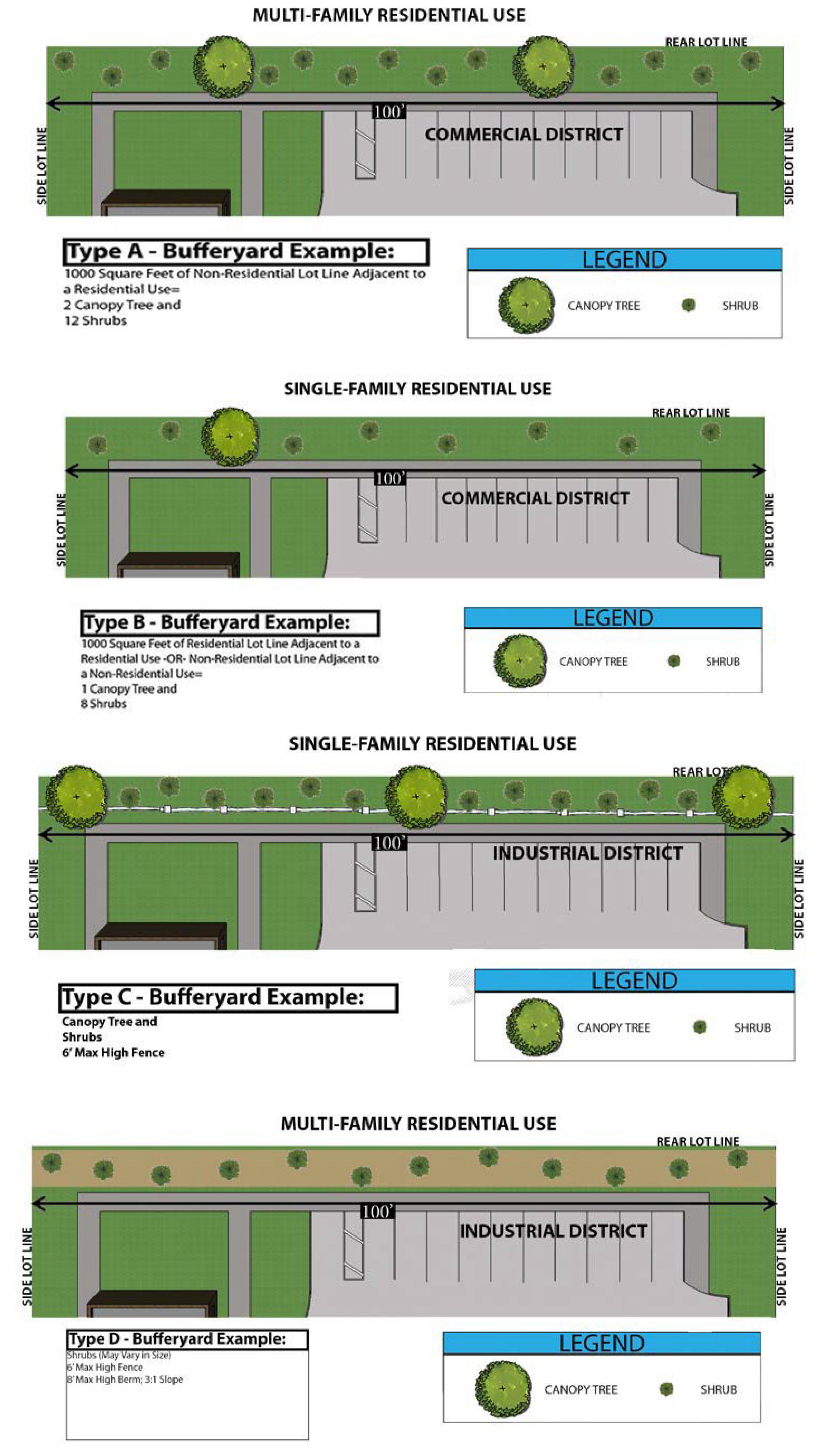
| Type A Bufferyard Screening. Minimum of 10 feet wide. For every 1,000 square feet, the screen shall consist of a combination of a minimum of 2 Canopy Trees and 12 Shrubs distributed evenly throughout the Bufferyard. (Shrubs shall be 3' minimum at planting and 6' minimum at maturity.) | 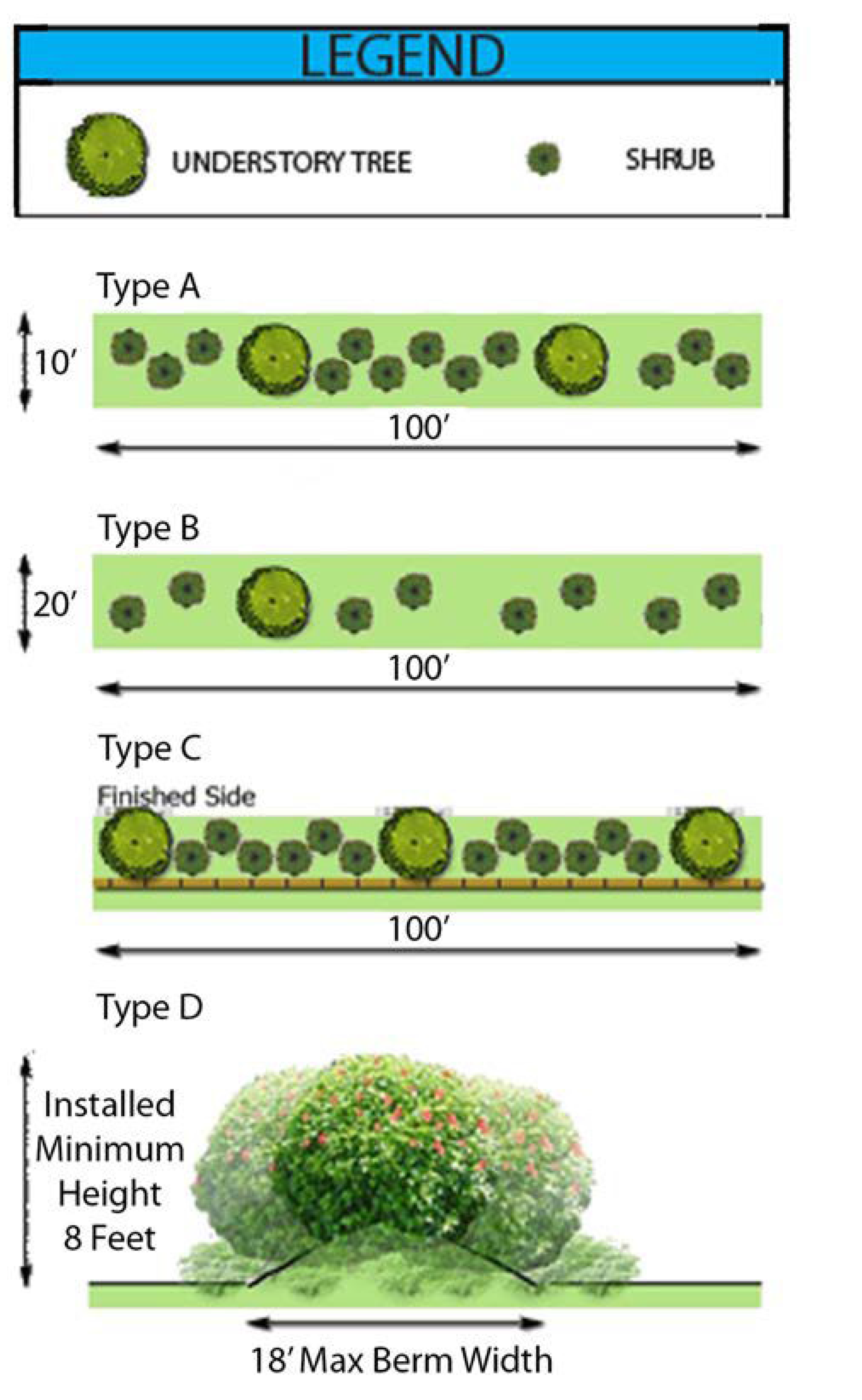 |
| Type B Bufferyard Screening. Minimum width of 20 feet, For every 1,000 square feet, or fraction thereof, the screen shall consist of a combination of a minimum of 1 Canopy Tree and 8 Shrubs. (Shrubs shall be 3' minimum at planting and 6' minimum at maturity. | |
| OPTIONS TO TYPE A AND/OR TYPE B | |
| Type C Bufferyard Screening. The design, color and materials of any fence or screen used to meet bufferyard requirements shall be approved by the UDO Administrator. The side of the fence facing the affected property owner shall be the finished side of the fence. The planting shall be three canopy trees and 12 shrubs per 100 linear feet of fencing. All planted screening required to be used in conjunction with a fence shall be approved by the UDO Administrator and planted on the finished side of the fence facing the affected use, and the remaining plantings shall be equally distributed in the bufferyard. The width of the planting bed shall be no less than five (5) feet and shall be wide enough to accommodate the plantings at maturity. | |
| Type D Bufferyard Screening. An earthen berm may be used in conjunction with planted vegetation made up of small, intermediate, and large shrubs, as approved by the UDO Administrator, provided that the combined height of the berm and planted vegetation shall be an installed minimum height of 6 feet. The slope of the berm shall be stabilized with vegetation and no steeper than 1½:1. The height of the berm shall be a maximum of 8 feet, with a level or rounded area on top of the berm. The berm shall be constructed of compacted earth. Depending upon plant type, plantings should be close enough to ensure an opaque screen at maturity. | |
| NOTE: It is recommended and encouraged that native species and related cultivars be planted. |
(Ord. No. ZA-23-06, pt. 2, 11-12-24)
Sec. 10.16. - Landscape Plan.
Landscape plans shall be submitted with minor or major site plans, special use permit application, and/or request for a zoning certificate of compliance, if Section 10.8 applies. The plans shall be drawn to scale and prepared by a landscape architect, licensed landscape contractor, architect, engineer, or other licensed design professional. These plans shall contain the following information:
10.16.1. Date of plan preparation.
10.16.2. Project name and description of land use.
10.16.3. Project owner and mailing address.
10.16.4. A tree removal permit is required for the removal of any protected trees as specified in Section 10.9.2.
10.16.5. A map at a scale of one (1) inch equals one hundred (100) feet or less showing:
10.16.5.1. North arrow.
10.16.5.2. Scale.
10.16.5.3. Approximate locations and species of all existing hardwood trees at least eight (8) inches DBH, all conifer trees at least twelve (12) inches DBH, and all protected trees (see subsection 10.9.2.1). The canopy drip line of those trees shall be delineated. If groves of protected trees exist that will not be removed or disturbed, it is permitted to label the grove as such on the map, stating the approximate number of protected trees and species mix, without specifying data on each individual tree.
10.16.5.4. Note on plan stating that prior to any clearing, grading, or construction activity, tree protection fencing will be installed around protected trees or groves of trees. And no construction workers, tools, materials, or vehicles are permitted within the tree protection fencing.
10.16.5.5. Locations, dimensions and square footages of required buffer strips and parking lot landscaping.
10.16.5.6. Details of required landscaping showing species, dimensions, and spacing of planted materials, including turfgrass sod or seeded areas, and the use and protection of existing vegetation.
10.16.5.7. All existing and proposed utilities and if applicable, their associated easements.
10.16.5.8. Location and square footage of structures and parking lots.
10.16.5.9. Adjacent zoning districts.
10.16.5.10. Approximate locations of all trees greater than eight (8) inches DBH within required buffers and of all areas of natural vegetation to be used as part of the buffer.
10.16.5.11. Setbacks of all structures and specifications and shielding of certain uses, as required.
10.16.5.12. Location of planting bed edges with edging and mulch materials identified.
10.16.5.13. Identification or notes indicating provisions for irrigation or other water supplies.
10.16.5.14. Landscape plan notes and special planting instructions.
(Ord. No. ZA-23-06, pt. 2, 11-12-24)
Sec. 10.17. - Tree Protection During Construction.
Tree preservation is a pre-planning activity and will be thoroughly considered prior to development of engineering and/or architectural plans and prior to initiation of construction projects. Protected trees shall be guarded during development against the following:
10.17.1. Unnecessary cutting, breaking, or skinning of roots.
10.17.2. Skinning and bruising of bark.
10.17.3. Excessive vehicular and foot traffic within drip lines.
10.17.4. Parking vehicles within drip lines.
10.17.5. During the land clearing and construction stage of development, the developer shall erect and maintain protective barriers (to the UDO Administrator's specifications consistent with good management practices) around all trees or groups of trees to be protected from the center of the tree(s) to the dripline. The developer shall not allow the movement of equipment or the storage of equipment, materials, debris or fill to be placed within the protective barrier.
10.17.6. During the construction stage of development, the developer shall not allow the cleaning of equipment or material within the drip line of any tree or groups of trees to be protected. Neither shall the developer allow the disposal of waste materials such as paint, oil solvents, asphalt, concrete, mortar and so on within the drip line of any tree or groups of trees.
10.17.7. No attachments or wires other than those of a protective nature shall be attached to any tree.
10.17.8. Soil disturbances within the drip line of a protected tree shall be limited to two (2) inches in depth removed or two (2) inches in depth added. Any soil added under the drip line of the tree shall be a loamy soil mix to ensure minimal compaction.
10.17.9. During land clearing and construction stage of development, the UDO Administrator shall periodically inspect the site to ensure compliance with the provisions of this section.
10.17.10. Tree location and replacement activity permitted or required under this section shall be done in accordance with standard forestry practices and procedures, and all such plantings shall be reasonably maintained and attended to promote successful establishment thereof.
Sec. 10.18. - Recommended Plant List.
The following is a recommended plant list to be utilized in the preparation of landscape plans to meet vegetation requirements. Note: Native vegetation is preferred. Exceptions to the recommended plant list may be granted by the UDO Administrator with the substitution of comparable vegetation. Some plants are listed under multiple categories as many of these plants are offered in numerous varieties. Mature height and spread of each plant is contingent on the variety. It is highly recommended that landscape plans be prepared by or in consultation with a Registered Landscape Architect or qualified landscape design professional.
Sec. 10.19. - Intent.
The intent of this section is, 1) to establish sign standards and restrictions that allow for the legitimate identification of residential, commercial, industrial, and other activities, 2) to provide for the safety of vehicular traffic by limiting visual interference, 3) to facilitate police and fire protection, 4) to protect the general public from injury caused by distracting and improperly placed signs, and 5) to protect property values while at the same time promoting the economic welfare of the Town of Smithfield by encouraging visually appealing and non-distracting forms of information transfer. For definitions relating to this section refer to Appendix A.
Sec. 10.28. - Prohibited Signs.
The following list of signs are prohibited in the town; any violation is subject to the regulations as stated in this article.
10.28.1. No sign may be located so that it substantially interferes with the view necessary for motorists to proceed safely through intersections or to enter onto or exit from public streets or private roads.
10.28.2. Signs that revolve or are animated or that utilize movement or apparent movement to attract the attention of the public. Signs with optical illusion of movement by means of a design which presents a pattern capable of reversible perspective, giving the illusion of motion. This prohibition includes, but is not limited to, flutter flags and wind signs as defined in Appendix A.
10.28.3. No sign may be erected so that by its location, color, size, shape, nature, or message, it would tend to obstruct the view of or be confused with official traffic signs or other signs erected by governmental agencies. Signs displaying intermittent light resembling the flashing light customarily used in traffic signals, or used by police, fire, ambulance, or other emergency vehicles, nor shall any sign use the word "stop," "danger," or any other words, phrases, symbol, or character in a manner that might be construed as a public safety warning or traffic sign.
10.28.4. Signs which obstruct free ingress to or egress from a driveway or a required door, window, fire escape, or other required exit way.
10.28.5. No signs shall overhang or be erected in any public right-of-way. Traffic regulation, information, or warning signs erected by the State Department of Transportation, signs erected by the town, or signs located in the B-1 district are exempt.
10.28.6. Any sign located in such a way as to intentionally deny an adjoining property owner visual access to an existing sign.
10.28.7. Flashing, fluttering, swinging, rotating signs (except governmental signs and signs, which give time and temperature and other commercial public information message).
10.28.8. Roof signs, or signs above the parapet of a building.
10.28.9. Electronic message boards in all residential districts, except for permitted nonresidential uses in a residential district.
10.28.10. Portable signs, except for "sandwich boards."
10.28.11. All Beacons and Spotlights. Illumination system(s) shall not contain or utilize any beacon, spot, search, or stroboscopic light or reflector which is visible from any public right-of-way or adjacent property, nor shall such lights be operated outside, under any circumstances, except by authorized agencies for emergency services purposes.
10.28.12. Flood lights shall not be utilized as a part of a sign illumination system which are not hooded or shielded so that the light source is not visible from any public right-of-way or adjacent property, nor shall any sign otherwise reflect or emit a glaring light so as to impair driver vision.
10.28.13. Any sign or sign structure that is structurally unsafe as determined by the Building Inspector.
10.28.14. Signs painted on or attached to trees, fences, or fence posts, and telephone or utility poles or signs on or attached to rocks or other natural features (snipe signs).
10.28.15. Signs placed on vehicles or trailers which are parked or located for the primary purpose of displaying said sign. This prohibition does not include temporary construction site vehicles on active construction sites.
10.28.16. Pole signs which are within six hundred sixty (660) feet of the nearest edge of the right-of-way and visible from the maintained traveled way of the Federal Aid Primary and Interstate System, all as described in the Federal Highway Beautification Assistance Act of 1979, as amended, and which are constructed or erected on or after the effective date of this section, unless excepted by G.S. § 136-129 (see Appendix C). Provided, further, pole signs located specifically as described hereinbefore which were erected prior to the effective date of this section are not prohibited from continuing, notwithstanding their non-conformance with regulations of this section, other than conformance with the maintenance provisions set forth in Section 10.30 hereinafter.
10.28.17. Pavement markings except those of a customary traffic-control nature, as found in the Manual of Uniform Traffic Control Devices.
10.28.18. Off-premises advertising signs except as permitted under Section 10.27.3.
10.28.19. Other signs not expressly permitted by this ordinance.
Sec. 10.29. - Sign Construction.
All signs shall be designed, constructed and maintained in accordance with the following additional standards:
10.29.1.1. Except for permitted banners, flags, temporary signs, and window signs conforming in all respects with the requirements of this Unified Development Ordinance, all signs shall be constructed of permanent materials and shall be attached to the ground or building.
10.29.1.2. All signs allowed by this section shall be constructed in accordance with the requirements of the North Carolina State Building Code.
Sec. 10.30. - Sign Maintenance.
To ensure that signs are erected and maintained in a safe and aesthetic manner, it shall be unlawful for any sign designed to be visible from any public street or highway within the jurisdiction of the Town of Smithfield to be erected or maintained by any person, other than by a sign contractor properly licensed under Section 10.20.2 or by a designated representative of such licensed contractor, except that this requirement shall be interpreted to exclude those persons who construct and erect a principal use identification sign when said sign is used at said person's place of business and to exclude licensed general contractors erecting signs as part of a permitted construction or renovation project; provided, however, in all cases, all erection must be properly permitted and inspected for compliance with the applicable codes of the State of North Carolina and the Town of Smithfield and with other parts of this article.
The following maintenance requirements must be observed for all signs visible from any public street or highway within the jurisdiction of this article:
10.30.1. No sign shall have more than twenty (20) percent of its surface area covered with disfigured, cracked, ripped, or peeling paint or poster paper for a period of more than thirty (30) successive days.
10.30.2. No sign shall be allowed to stand with bent or broken sign facing, broken supports, loose appendages or struts or be allowed to stand more than fifteen (15) degrees away from the perpendicular for a period of more than thirty (30) successive days.
10.30.3. No sign shall be allowed to have weeds, vines, landscaping, or other vegetation growing upon it and obscuring its view from the street or highway from which it is to be viewed for a period of more than thirty (30) successive days.
10.30.4. No neon or internally illuminated sign may be allowed to stand with only partial illumination for a period of more than thirty (30) successive days.
10.30.5. If a sign or sign structure is damaged such that more than fifty (50) percent of the value is lost, with such determination made by the UDO Administrator, any repair or replacement must be done in conformance with this section.
10.30.6. The UDO Administrator may inspect all signs for compliance with these maintenance requirements.
Sec. 10.31. - Nonconforming Signs.
Refer to Article 9, Section 9.9 for nonconforming sign regulations.
Sec. 10.36. - Purpose.
The traffic impact study will enable the Town of Smithfield to assess the impact of a proposed special use permit or development on the highway system when that system is at or near capacity or a safety problem exists. Its purpose is to ensure that proposed developments do not adversely affect the highway network and to identify any traffic problems associated with access from the site to the existing transportation network. The purpose of the study is also to identify solutions to potential problems and to present improvements to be incorporated into the proposed development.
Sec. 10.37. - Conduct.
A traffic impact study shall be prepared by a qualified professional traffic engineer and/or certified transportation planner with previous traffic study experience. The procedures and standards for the traffic impact study are set forth in Section 10.40 of this ordinance.
Prior to the preparation of a traffic impact study, a scoping meeting shall be held, including the planning staff, the applicant, and the preparer of the study. The discussion at this meeting should set the study parameters, including the study area, planned and committed roadway improvements (by NCDOT or others), road links and intersections to be analyzed, preliminary traffic distribution, other planned developments to be considered, traffic growth rate, available data, periods for which analysis is to be performed, and other staff concerns. The qualifications of the preparer may be discussed at or prior to this meeting.
Sec. 10.38. - Applicability.
Except as described below, a traffic impact study shall be required for all special use permits and site plans that meet the following criteria:
• Special Use Permit. Estimated traffic generated by the permit exceeds eight hundred (800) trips/day.
• Major Site Plans. Estimated traffic generated by the development exceeds eight hundred (800) trips/day.
• Single-Family Residential. Estimated traffic generated by the development exceeds eight hundred (800) trips/day.
• Planned Unit Development. Estimated traffic generated by the development exceeds eight hundred (800) trips/day.
Special use permits or major site plans/subdivisions that produce more than eight hundred (800) trips per day traffic may be exempted from the requirements to prepare and submit a traffic impact study if: (1) a traffic impact study has previously been prepared for this particular project or development, and (2) there is to be no change in land use or density that would increase travel, (3) there is to be no change in access to the external street system, or (4) material is submitted to demonstrate that traffic created by the proposal when adding to existing traffic will not result in a need for transportation improvements. The Planning Board and Town Council will review material submitted in support of an exemption and will determine from that material whether or not to grant the exemption. All exemptions shall be concurred with by the NCDOT District 3 Office. If an exemption is granted, documentation of the exemption will be submitted as part of the staff recommendation.
If the project is reviewed as a Planned Unit Development, only one (1) traffic impact study is required for a special use permit.
Sec. 10.39. - Capacity Analysis of the Existing System.
An indication of the adequacy of the existing street system is a comparison of traffic volumes versus the ability of the streets to move traffic freely at a desirable speed. The ability of a street to move traffic freely, safely, and efficiently with a minimum delay is controlled primarily by the spacing of major devices utilized. Thus, the ability of a street to move traffic can be increased by restricting parking and turning movements, using proper sign and signal devices, and by the application of other traffic engineering strategies.
Capacity is the maximum number of vehicles which has a "reasonable expectation" of passing over a given section of roadway, during a given time period under prevailing roadway and traffic conditions. The relationship of traffic volumes to the capacity of the roadway will determine the level of service (LOS) being provided. Six (6) levels of service have been selected for analysis purposes. They are given letter designations from A to F with LOS A representing the best operating conditions and LOS F the worst.
Sec. 10.40. - General Requirements and Standards.
The traffic impact study shall contain the following information:
Sec. 10.41. - Submission and Implementation.
The traffic impact study will be submitted to the Administrator within the applicable time frame indicated below. The Administrator will review the study as part of the development review process. Recommendations will be incorporated into the approval process as indicated below.
Sec. 10.42. - Purpose.
The purpose of this article is to protect, maintain and enhance the public health, safety, environment and general welfare by establishing minimum requirements and procedures to control the adverse effects of nitrogen in stormwater runoff and nonpoint and point source pollution associated with new development in the water shed of the Neuse River Basin, in accordance with the statutory authority of planning and regulations of development, NCGS 160-D Article 2, 3, 4, including particularly but, not limited to, NCGS 160D-404 (enforcement), G.S. ch. 160D art. 8 (subdivision), G.S. ch. 160D art. 7 (zoning) and 15A NCAC 2B.0235 Neuse River Basin Nutrient Sensitive Waters Management Strategy: Basinwide Stormwater Requirements. It has been determined that proper management of construction related and post development stormwater runoff will minimize damage to public and private property and infrastructure; safeguard the public health, safety and general welfare; and protect water and aquatic resources.
This ordinance seeks to meet its general purpose through the following specific objectives and means:
10.42.1.
Establishing decision-making processes for development that protects the integrity of watersheds and preserve the health of water resources;
10.42.2.
Requiring that new development not exceed export targets for nitrogen in stormwater runoff for the watershed through site layout, engineered stormwater controls, or permanent nutrient offset credits;
10.42.3.
Establishing minimum post-development stormwater management standards and design criteria for the regulation and control of stormwater runoff quantity and quality;
10.42.4.
Establishing design and review criteria for the construction, function, and use of engineered stormwater controls that may be used to meet the minimum post-development stormwater management standards;
10.42.5.
Encouraging the use of better management and site design practices, such as the use of vegetated conveyances for stormwater and the preservation of greenspace, riparian buffers and other conservation areas to the maximum extent practicable;
10.42.6.
Establishing provisions for the long-term responsibility for and maintenance of engineered stormwater controls to ensure that they continue to function as designed, are maintained appropriately, and pose no threat to public safety;
10.42.7.
Establishing administrative procedures for the submission, review, approval and disapproval of stormwater management plans, for the inspection of approved projects, and to assure appropriate long-term maintenance;
10.42.8.
Controlling illicit discharges into the municipal separate stormwater system and waters of the State;
10.42.9.
Providing education and outreach to the public regarding methods to prevent and minimize pollutant contributions to the municipal separate stormwater system and waters of the State.
(Ord. No. ZA-22-04, pt. 1, 3-7-22)
Sec. 10.53. - Records of Installation and Maintenance Activities.
The owner of each engineered stormwater control shall keep records of inspections, maintenance, and repairs for at least five (5) years from the date of creation of the record and shall submit the same upon reasonable request to the Stormwater Administrator.
(Ord. No. ZA-22-04, pt. 1, 3-7-22)
Sec. 10.54. - Easements and SCM Access.
Easements for stormwater SCMs shall include the area of the SCM, and enough area for access and maintenance from a public right-of-way in accordance with the Town's Standard Detail and Specifications Manual. The easement shall be recorded in the register of deeds at the expense of the applicant and shall be depicted on the final plat or recorded map prior to approval of the certificate of occupancy or final plat.
(Ord. No. ZA-22-04, pt. 1, 3-7-22)
Sec. 10.55. - Illegal Discharge.
No person shall cause or allow the discharge, disposal, pouring or pumping directly or indirectly to any stormwater conveyance structure, stormwater conveyance system, stream, lake, pond, wetland, or other body of water, or upon the land in proximity to the same, any fluid, solid, or other substance (other than stormwater). Prohibited substances include, but are not limited to, oil, anti-freeze, chemicals, animal waste, paints, garbage, and litter. Examples of illegal discharges are:
10.55.1. Dumping of oil, anti-freeze, paint or cleaning fluids;
10.55.2. Untreated commercial carwash wash water;
10.55.3. Industrial challenges;
10.55.4. Contaminated foundation drains;
10.55.5. Cooling waters, unless no chemicals added and has valid NPDES permit;
10.55.6. Wash water from commercial and industrial activities;
10.55.7. Chlorinated backwash and draining associated with swimming pools;
10.55.8. Domestic wastewater;
10.55.9. Septic system effluent;
10.55.10. Washing machine discharges.
(Ord. No. ZA-22-04, pt. 1, 3-7-22)
Sec. 10.55a. - Allowable Discharges.
Examples of allowed discharges are:
10.55a.1. Water line flushing;
10.55a.2. Irrigation;
10.55a.3. Uncontaminated groundwater pumping;
10.55a.4. Street wash water;
10.55a.5. Dechlorinated backwash and drainage associated with swimming pools;
10.55a.6. NPDES permitted discharges.
(Ord. No. ZA-22-04, pt. 1, 3-7-22)
Editor's note— Ord. No. ZA-22-04, pt. 1, adopted March 7, 2022, set out provisions intended for use as § 10.56. Inasmuch as there were already provisions so designated, said section has been codified herein as § 10.55a at the discretion of the editor.
Sec. 10.55b. - Illegal Connections.
Connections to a stormwater conveyance system or structure that allow the discharge(s) of non-stormwater are unlawful. Prohibited connections include, but are not limited to:
10.55b.1. Floor drains;
10.55b.2. Waste water from washing machines or sanitary sewers;
10.55b.3. Wash water from commercial vehicle washing or steam cleaning;
10.55b.4. Waste water from septic systems.
(Ord. No. ZA-22-04, pt. 1, 3-7-22)
Editor's note— Ord. No. ZA-22-04, pt. 1, adopted March 7, 2022, set out provisions intended for use as § 10.57. Inasmuch as there were already provisions so designated, said section has been codified herein as § 10.55b at the discretion of the editor.
Sec. 10.55c. - Determination of Connection.
Upon determining that said connection:
10.55c.1. May result in the discharge of hazardous materials, may pose a threat to health and safety, or is likely to result in immediate injury or harm to human or animal life, natural resources, to real or personal property, or habitat, or
10.55c.2. Was made in violation of any applicable regulation or ordinance, the UDO Administrator shall outline in a notice of violation, sent by certified mail, the time in which the connection shall be removed. Failure to comply with the terms and deadline set in the notice of violation will constitute a violation of this ordinance.
(Ord. No. ZA-22-04, pt. 1, 3-7-22)
Editor's note— Ord. No. ZA-22-04, pt. 1, adopted March 7, 2022, set out provisions intended for use as § 10.58. Inasmuch as there were already provisions so designated, said section has been codified herein as § 10.55c at the discretion of the editor.
Sec. 10.55d. - Riparian Buffers.
Fifty-foot wide riparian buffers shall be maintained along both sides of a stream, river or other water body as required by the Neuse River Basin: Nutrient Sensitive Waters Management Strategy—Protection and Maintenance of Riparian Buffers, Section 3(a-b). Riparian buffer shall be noted on the maps submitted for stormwater management plan approval and shall be noted on the final, recorded map.
If new development is proposed within the WS-IV-CA or WS-IV-PA Districts, the buffer shall be in accordance with Section 10.29.9.
Determination of exemptions as noted in 15A NCAC 2B.0233 Neuse River Basin: Nutrient Sensitive Waters Management Strategy—Protection and Maintenance of Riparian Buffers, Section 3 (a-b) shall be made by the NCDEQ Division of Water Resources.
(Ord. No. ZA-22-04, pt. 1, 3-7-22)
Editor's note— Ord. No. ZA-22-04, pt. 1, adopted March 7, 2022, set out provisions intended for use as § 10.59. Inasmuch as there were already provisions so designated, said section has been codified herein as § 10.55d at the discretion of the editor.
Sec. 10.55e. - Right to Enter.
Any town personnel, or contractors for the town shall be permitted to enter upon public or private property for the purposes of inspection, sampling, monitoring, testing, or otherwise verifying compliance. Should the town personnel, or contractor for the town, be denied reasonable access to any property, the UDO Administrator shall obtain an administrative search warrant.
No person shall obstruct, hamper or interfere with any such representative while carrying out his/her official duties.
(Ord. No. ZA-22-04, pt. 1, 3-7-22)
Editor's note— Ord. No. ZA-22-04, pt. 1, adopted March 7, 2022, set out provisions intended for use as § 10.60. Inasmuch as there were already provisions so designated, said section has been codified herein as § 10.55e at the discretion of the editor.
Sec. 10.56. - Statutory Authorization.
The Legislature of the State of North Carolina has in G.S. ch. 160D delegated to local governmental units the responsibility to adopt regulations designed to promote the public health, safety, and general welfare. Therefore, the Town Council of Smithfield, North Carolina, does ordain as follows.
Sec. 10.58. - Statement of Purpose.
It is the purpose of these regulations to promote public health, safety, and general welfare and to minimize public and private losses due to flood conditions within flood prone areas by provisions designed to:
10.58.1. Restrict or prohibit uses that are dangerous to health, safety, and property due to water or erosion hazards or that result in damaging increases in erosion, flood heights or velocities;
10.58.2. Require that uses vulnerable to floods, including facilities that serve such uses, be protected against flood damage at the time of initial construction;
10.58.3. Control the alteration of natural floodplains, stream channels, and natural protective barriers, which are involved in the accommodation of floodwaters;
10.58.4. Control filling, grading, dredging, and all other development that may increase erosion or flood damage; and
10.58.5. Prevent or regulate the construction of flood barriers that will unnaturally divert flood waters or which may increase flood hazards to other lands.
Sec. 10.59. - Objectives.
The objectives of this ordinance are to:
10.59.1. Protect human life, safety, and health;
10.59.2. Minimize expenditure of public money for costly flood control projects;
10.59.3. Minimize the need for rescue and relief efforts associated with flooding and generally undertaken at the expense of the general public;
10.59.4. Minimize prolonged business losses and interruptions;
10.59.5. Minimize damage to public facilities and utilities (i.e. water and gas mains, electric, telephone, cable and sewer lines, streets, and bridges) that are located in flood prone areas;
10.59.6. Minimize damage to private and public property due to flooding; (Amended 4/3/2018)
10.59.7. Make flood insurance available to the community through the National Flood Insurance Program; (Amended 4/3/2018)
10.59.8. Maintain the natural and beneficial functions of floodplains; (Amended 4/3/2018)
10.59.9. Help maintain a stable tax base by providing for the sound use and development of flood prone areas; and
10.59.10. Ensure that potential buyers are aware that property is in a Special Flood Hazard Area.
Sec. 10.60. - Lands to Which These Regulations Apply.
These regulations shall apply to all Special Flood Hazard Areas within the jurisdiction, including extraterritorial jurisdictions (ETJs), of the Town of Smithfield and within the jurisdiction of any other community whose governing body agrees, by resolution, to such applicability.
Sec. 10.61. - Basis for Establishing the Special Flood Hazard Areas. (Amended 4/3/2018)
The Special Flood Hazard Areas are those identified under the Cooperating Technical State (CTS) agreement between the State of North Carolina and FEMA in its Flood Insurance Study (FIS) dated June 20, 2018, for Johnston County and associated DFIRM panels, including any digital data developed as part of the FIS, which are adopted by reference and declared a part of this ordinance. Future revisions to the FIS and DFIRM panels that do no change flood hazard data within the jurisdictional authority of the Town of Smithfield are also adopted by reference and declared a part of this ordinance. Subsequent letter of map revisions (LOMRs) and/or physical map revisions (PMRs) shall be adopted within three (3) months.
The initial flood insurance rate maps are as follows for the jurisdictional areas at the initial date: Johnston County Unincorporated Area, dated September 30, 1983, and Town of Smithfield, dated April 1, 1982.
Sec. 10.62. - Establishment of Floodplain Development Permit.
A floodplain development permit shall be required in conformance with the provisions of these regulations prior to the commencement of any development activities within Special Flood Hazard Areas determined in accordance with the provisions of Section 10.61.
Sec. 10.63. - Compliance.
No structure or land shall hereafter be located, extended, converted, altered, or developed in any way without full compliance with the terms of these regulations and other applicable regulations.
Sec. 10.64. - Abrogation and Greater Restrictions.
These regulations are not intended to repeal, abrogate, or impair any existing easements, covenants, or deed restrictions. However, where these regulations and another conflict or overlap, whichever imposes the more stringent restrictions shall prevail.
Sec. 10.65. - Interpretation.
In the interpretation and application of these regulations, all provisions shall be:
10.65.1. Considered as minimum requirements;
10.65.2. Liberally construed in favor of the governing body; and
10.65.3. Deemed neither to limit nor repeal any other powers granted under state statutes.
Sec. 10.66. - Warning and Disclaimer of Liability.
The degree of flood protection required by this ordinance is considered reasonable for regulatory purposes and is based on scientific and engineering consideration. Larger floods can and will occur. Actual flood heights may be increased by man-made or natural causes. This ordinance does not imply that land outside the Special Flood Hazard Areas or uses permitted within such areas will be free from flooding or flood damages. This ordinance shall not create liability on the part of the Town of Smithfield or by any officer or employee thereof for any flood damages that result from reliance on these regulations or any administrative decision lawfully made hereunder.
Sec. 10.67. - Penalties for Violation. (Amended 4/3/2018)
Violation of the provisions of these regulations or failure to comply with any of its requirements, including violation of conditions and safeguards established in connection with grants of variance or special exceptions, shall constitute a Class 1 misdemeanor pursuant to G.S. § 143-215.58. Any person who violates these regulations or fails to comply with any of its requirements shall, upon conviction thereof, be fined not more than one hundred dollars ($100.00) or imprisoned for not more than thirty (30) days, or both. Each day such violation continues shall be considered a separate offense. Nothing herein contained shall prevent the Town of Smithfield from taking such other lawful action as is necessary to prevent or remedy any violation.
Sec. 10.68. - Designation of Floodplain Administrator. (Amended 4/3/2018)
The UDO Administrator, or his/her designee, hereinafter referred to as the "Floodplain Administrator," is hereby appointed to administer and implement the provisions of these regulations. In instances where the Floodplain Administrator receives assistance from others to complete tasks to administer and implement this ordinance, the Floodplain Administrator shall be responsible for the coordination and community's overall compliance with the National Flood Insurance Program and the provisions of this ordinance.
Sec. 10.70. - Duties and Responsibilities of the Floodplain Administrator.
The Floodplain Administrator shall perform, but not be limited to, the following duties:
10.70.1. Review all floodplain development applications and issue permits for all proposed development within Special Flood Hazard Areas to assure that the requirements of these regulations have been satisfied.
10.70.2. Review all proposed development within Special Flood Hazard Areas to assure that all necessary local, state and federal permits have been received.
10.70.3. Notify adjacent communities and the North Carolina Department of Crime Control and Public Safety, Division of Emergency Management, State Coordinator for the National Flood Insurance Program prior to any alteration or relocation of a watercourse, and submit evidence of such notification to the Federal Emergency Management Agency(FEMA).
10.70.4. Assure that maintenance is provided within the altered or relocated portion of said watercourse so that the flood-carrying capacity is maintained.
10.70.5. Prevent encroachments into floodways and non-encroachment areas unless the certification and flood hazard reduction provisions of Section 10.77 are met.
10.70.6. Obtain actual elevation (in relation to mean sea level) of the reference level (including basement) and all attendant utilities of all new and substantially improved structures, in accordance with the provisions of Section 10.69.3.
10.70.7. Obtain actual elevation (in relation to mean sea level) to which all new and substantially improved structures and utilities have been floodproofed, in accordance with the provisions of Section 10.69.3.
10.70.8. Obtain actual elevation (in relation to mean sea level) of all public utilities in accordance with the provisions of Section 10.69.3.
10.70.9. When floodproofing is utilized for a particular structure, obtain certifications from a registered professional engineer or architect in accordance with the provisions of Sections 10.69.3 and 10.74.2.
10.70.10. Where interpretation is needed as to the exact location of boundaries of the Special Flood Hazard Areas, floodways, or non-encroachment areas (for example, where there appears to be a conflict between a mapped boundary and actual field conditions), make the necessary interpretation. The person contesting the location of the boundary shall be given a reasonable opportunity to appeal the interpretation as provided in this article.
10.70.11. When base flood elevation (BFE) data has not been provided in accordance with the provisions of Section 10.61, obtain, review, and reasonably utilize any BFE data, along with floodway data or non-encroachment area data available from a federal, state, or other source, including data developed pursuant to subsection 10.75.2.2, in order to administer the provisions of these regulations.
10.70.12. When base flood elevation (BFE) data is provided but no floodway or non-encroachment area data has been provided in accordance with the provisions of Section 10.61 obtain, review, and reasonably utilize any floodway data or non-encroachment area data available from a federal, state, or other source in order to administer the provisions of these regulations.
10.70.13. When the lowest floor and the lowest adjacent grade of a structure or the lowest ground elevation of a parcel in a Special Flood Hazard Area is above the base flood elevation (BFE), advise the property owner of the option to apply for a letter of map amendment (LOMA) from FEMA. Maintain a copy of the LOMA issued by FEMA in the floodplain development permit file.
10.70.14. Permanently maintain all records that pertain to the administration of this ordinance and make these records available for public inspection, recognizing that such information may be subject to the Privacy Act of 1974, as amended.
10.70.15. Make on-site inspections of work in progress. As the work pursuant to a floodplain development permit progresses, the Floodplain Administrator shall make as many inspections of the work as may be necessary to ensure that the work is being done according to the provisions of the local ordinance and the terms of the permit. In exercising this power, the Floodplain Administrator has a right, upon presentation of proper credentials, to enter on any premises within the jurisdiction of the community at any reasonable hour for the purposes of inspection or other enforcement action.
10.70.16. Issue stop-work orders as required. Whenever a building or part thereof is being constructed, reconstructed, altered, or repaired in violation of this ordinance, the Floodplain Administrator may order the work to be immediately stopped. The stop-work order shall be in writing and directed to the person doing or in charge of the work. The stop-work order shall state the specific work to be stopped, the specific reason(s) for the stoppage, and the condition(s) under which the work may be resumed. Violation of a stop-work order constitutes a misdemeanor.
10.70.17. Revoke floodplain development permits as required. The Floodplain Administrator may revoke and require the return of the floodplain development permit by notifying the permit holder in writing stating the reason(s) for the revocation. Permits shall be revoked for any substantial departure from the approved application, plans, and specifications; for refusal or failure to comply with the requirements of state or local laws; or for false statements or misrepresentations made in securing the permit. Any floodplain development permit mistakenly issued in violation of an applicable state or local law may also be revoked.
10.70.18. Make periodic inspections throughout the Special Flood Hazard Areas within the jurisdiction of the community. The Floodplain Administrator and each member of his or her inspections department shall have a right, upon presentation of proper credentials, to enter on any premises within the territorial jurisdiction of the department at any reasonable hour for the purposes of inspection or other enforcement action.
10.70.19. Follow through with corrective procedures of Section 10.71.
10.70.20. Review, provide input, and make recommendations for variance requests.
10.70.21. Maintain a current map repository to include, but not limited to, historical and effective FIS Report, historical and effective FIRM and other official flood maps and studies adopted in accordance with the provisions of Section 10.61 of this ordinance, including any revisions thereto including letters of map change, issued by FEMA. Notify state and FEMA of mapping needs. (Amended 4/3/2018)
10.70.22. Coordinate revisions to FIS reports and FIRMs, including letters of map revision based on fill (LOMR-Fs) and letters of map revision (LOMRs).
Sec. 10.73. - General Standards.
In all Special Flood Hazard Areas the following provisions are required:
10.73.1. All new construction and substantial improvements shall be designed (or modified) and adequately anchored to prevent flotation, collapse, and lateral movement of the structure.
10.73.2. All new construction and substantial improvements shall be constructed with materials and utility equipment resistant to flood damage.
10.73.3. All new construction and substantial improvements shall be constructed by methods and practices that minimize flood damages.
10.73.4. All new electrical, heating, ventilation, plumbing, air conditioning equipment, and other service equipment shall be located at or above the RFPE or designed and installed to prevent water from entering or accumulating within the components during the occurrence of the base flood. These include, but are not limited to, HVAC equipment, water softener units, bath/kitchen fixtures, ductwork, electric/gas meter panels/boxes, utility/cable boxes, hot water heaters, and electric outlets/switches. (Amended 4/3/2018)
10.73.4.1. Replacement parts of a substantial improvement, electrical, heating, ventilation, plumbing, air conditioning equipment, and other service equipment shall also meet the above provisions.
10.73.4.2. Replacements that are for maintenance and not part of a substantial improvement may be installed at the original location provided the addition and/or improvements only comply with the standards for new construction consistent with the code and requirements for the original structure.
10.73.5. All new and replacement water supply systems shall be designed to minimize or eliminate infiltration of floodwaters into the system.
10.73.6. New and replacement sanitary sewage systems shall be designed to minimize or eliminate infiltration of floodwaters into the systems and discharges from the systems into flood waters.
10.73.7. On-site waste disposal systems shall be located and constructed to avoid impairment to them or contamination from them during flooding.
10.73.8. Nothing in these regulations shall prevent the repair, reconstruction, or replacement of a building or structure existing on the effective date of this ordinance and located totally or partially within the floodway, non-encroachment area, or stream setback, provided there is no additional encroachment below the regulatory flood protection elevation in the floodway, non-encroachment area, or stream setback, and provided that such repair, reconstruction, or replacement meets all of the other requirements of this ordinance.
10.73.9. New solid waste disposal facilities and sites, hazardous waste management facilities, salvage yards, and chemical storage facilities shall not be permitted, except by variance as specified in Section 10.72.10. A structure or tank for chemical or fuel storage incidental to an allowed use or to the operation of a water treatment plant or wastewater treatment facility may be located in a Special Flood Hazard Area only if the structure or tank is either elevated or floodproofed to at least the regulatory flood protection elevation and certified in accordance with the provisions of Section 10.69.3.
10.73.10. All subdivision proposals and other development proposals shall be consistent with the need to minimize flood damage.
10.73.11. All subdivision proposals and other development proposals shall have public utilities and facilities such as sewer, gas, electrical, and water systems located and constructed to minimize flood damage.
10.73.12. All subdivision proposals and other development proposals shall have adequate drainage provided to reduce exposure to flood hazards.
10.73.13. All subdivision proposals and other development proposals shall have received all necessary permits from those governmental agencies for which approval is required by federal or state law, including Section 404 of the Federal Water Pollution Control Act Amendments of 1972, 33 U.S.C. 1334.
10.73.14. When a structure is partially located in a Special Flood Hazard Area, the entire structure shall meet the requirements for new construction and substantial improvements.
10.73.15. When a structure is located in multiple flood hazard zones or in a flood hazard risk zone with multiple base flood elevations, the provisions for the more restrictive flood hazard risk zone and the highest base flood elevation (BFE) shall apply.
Sec. 10.74. - Specific Standards.
In all Special Flood Hazard Areas where base flood elevation (BFE) data has been provided, as set forth in Section 10.61, or Section 10.75, the following provisions, in addition to the provisions of Section 10.73, are required:
Sec. 10.75. - Standards for Floodplains Without Established Base Flood Elevations.
Within the Special Flood Hazard Areas designated as Approximate Zone A and established in Section 10.61, where no base flood elevation (BFE) data has been provided by FEMA, the following provisions, in addition to the provisions of Section 10.73, shall apply:
10.75.1. No encroachments, including fill, new construction, substantial improvements or new development shall be permitted within a distance of twenty (20) feet each side from top of bank or five (5) times the width of the stream, whichever is greater, unless certification with supporting technical data by a registered professional engineer is provided demonstrating that such encroachments shall not result in any increase in flood levels during the occurrence of the base flood discharge.
10.75.2. The BFE used in determining the regulatory flood protection elevation shall be determined based on the following criteria:
10.75.2.1. When base flood elevation (BFE) data is available from other sources, all new construction and substantial improvements within such areas shall also comply with all applicable provisions of this ordinance and shall be elevated or floodproofed in accordance with standards in Sections 10.73 and 10.74.
10.75.2.2. When floodway or non-encroachment data is available from a federal, state, or other source, all new construction and substantial improvements within floodway and non-encroachment areas shall also comply with the requirements of Sections 10.74 and 10.77.
10.75.2.3. All subdivision, manufactured home park and other development proposals shall provide base flood elevation (BFE) data if development is greater than five (5) acres or has more than fifty (50) lots/manufactured home sites. Such base flood elevation (BFE) data shall be adopted by reference in accordance with Section 10.61 and utilized in implementing this ordinance.
10.75.2.4. When base flood elevation (BFE) data is not available from a federal, state, or other source as outlined above, the reference level shall be elevated or floodproofed (nonresidential) to or above the regulatory flood protection elevation, as defined in Appendix A. All other applicable provisions of Section 10.74 shall also apply.
Sec. 10.76. - Standards for Riverine Floodplains with Base Flood Elevations but Without Established Floodways or Non-Encroachment Areas.
Along rivers and streams where base flood elevation (BFE) data is provided by FEMA or is available from another source but neither floodway nor non-encroachment areas are identified for a Special Flood Hazard Area on the FIRM or in the FIS report, the following requirements shall apply to all development within such areas:
10.76.1. Standards of Sections 10.73 and 10.74; and
10.76.2. Until a regulatory floodway or non-encroachment area is designated, no encroachments, including fill, new construction, substantial improvements, or other development, shall be permitted unless certification with supporting technical data by a registered professional engineer is provided demonstrating that the cumulative effect of the proposed development, when combined with all other existing and anticipated development, will not increase the water surface elevation of the base flood more than one (1) foot at any point within the community.
Sec. 10.77. - Floodways and Non-Encroachment Areas.
Areas designated as floodways or non-encroachment areas are located within the Special Flood Hazard Areas established in Section 10.61. The floodways and non-encroachment areas are extremely hazardous areas due to the velocity of floodwaters that have erosion potential and carry debris and potential projectiles. The following provisions, in addition to standards outlined in Sections 10.73 and 10.74, shall apply to all development within such areas:
10.77.1. No encroachments, including fill, new construction, substantial improvements and other developments shall be permitted unless:
10.77.1.1. it is demonstrated that the proposed encroachment would not result in any increase in the flood levels during the occurrence of the base flood, based on hydrologic and hydraulic analyses performed in accordance with standard engineering practice and presented to the Floodplain Administrator prior to issuance of floodplain development permit, or
10.77.1.2. A conditional letter of map revision (CLOMR) has been approved by FEMA. A letter of map revision (LOMR) must also be obtained upon completion of the proposed encroachment.
10.77.2. If Section 10.77.1 is satisfied, all development shall comply with all applicable flood hazard reduction provisions of this ordinance.
10.77.3. No manufactured homes shall be permitted, except replacement manufactured homes in an existing manufactured home park or subdivision, provided the following provisions are met:
10.77.3.1. The anchoring and the elevation standards of Section 10.74.3; and
10.77.3.2. The no encroachment standard of Section 10.77.1.
Sec. 10.78. - Standards of Areas of Shallow Flooding (Zone AO).
Located within the Special Flood Hazard Areas established in Section 10.61, are areas designated as shallow flooding areas. These areas have special flood hazards associated with base flood depths of one (1) to three (3) feet where a clearly defined channel does not exist and where the path of flooding is unpredictable and indeterminate. In addition to Sections 10.73 and 10.74, all new construction and substantial improvements shall meet the following requirements:
10.78.1. The reference level shall be elevated at least as high as the depth number specified on the flood insurance rate map (FIRM), in feet, plus a freeboard of two (2) feet, above the highest adjacent grade; or at least two (2) feet above the highest adjacent grade plus a freeboard of two (2) feet if no depth number is specified.
10.78.2. Non-residential structures may, in lieu of elevation, be floodproofed to the same level as required in Section 10.78.1 so that the structure, together with attendant utility and sanitary facilities, below that level shall be watertight with walls substantially impermeable to the passage of water and with structural components having the capability of resisting hydrostatic and hydrodynamic loads and effects of buoyancy. Certification is required in accordance with Sections 10.69.3 and 10.74.2.
10.78.3. Adequate drainage paths shall be provided around structures on slopes, to guide floodwaters around and away from proposed structures.
Sec. 10.79. - Standards of Areas of Shallow Flooding (Zone AH). (Amended 4/3/2018)
Located within the Special Flood Hazard Areas established in Section 10.61, are areas designated as shallow flooding areas. These areas are subject to inundation by one-percent annual chance shallow flooding (usually areas of ponding) where average depths are one (1) to three (3) feet. Base flood elevations are derived from detailed hydraulic analyses are shown in this zone. In addition to Sections 10.73 and 10.74, all new construction and substantial improvements shall meet the following requirements:
10.79.1. Adequate drainage paths shall be provided around structures on slopes, to guide floodwaters around and away from proposed structures.
Sec. 10.80. - Effect on Rights and Liabilities under the Existing Regulations.
These regulations in part come forward by re-enactment of some of the provisions of the Flood Damage Prevention Ordinance, adopted May 2, 1982, as amended, and it is not the intention to repeal but rather to re-enact and continue to enforce without interruption of such existing provisions, so that all rights and liabilities that have accrued thereunder are reserved and may be enforced. The enactment of this ordinance shall not affect any action, suit or proceeding instituted or pending. All provisions of the Flood Damage Prevention Ordinance of the Town of Smithfield enacted on May 2, 1982, as amended, which are not reenacted herein are repealed.
Sec. 10.81. - Effect Upon Outstanding Floodplain Development Permits.
Nothing herein contained shall require any change in the plans, construction, size, or designated use of any development or any part thereof for which a floodplain development permit has been granted by the Floodplain Administrator or his or her authorized agents before the time of passage of this ordinance; provided, however, that when construction is not begun under such outstanding permit within a period of six (6) months subsequent to the date of issuance of the outstanding permit, construction or use shall be in conformity with the provisions of these regulations.
Sec. 10.82. - Severability. (Amended 4/3/2018)
If any section, clause, sentence, or phrase of the ordinance is held to be invalid or unconstitutional by any court of competent jurisdiction, then said holding shall in no way effect the validity of the remaining portions of this ordinance.
Sec. 10.83. - Effective Date.
These regulations shall become effective upon adoption of the Town of Smithfield Unified Development Ordinance.
Sec. 10.84. - Purpose and Intent.
The purpose of this section is to facilitate the deployment of necessary telecommunication services that are the least visibly intrusive type of installation that is not proven to be commercially or technologically impracticable and that will effectively prohibit the applicant from accomplishing its intended goal(s).
Sec. 10.85. - Siting Hierarchy and Preferences.
The following list indicates the town's preferences for facility locations, in descending order of preference:
• Antennae co-location on an existing tower or utility pole;
• Concealed (stealth) antennae on existing building/structure;
• New concealed (stealth) tower fifty (50) feet in height oarless;
• New concealed (stealth) towers over fifty (50) feet in height;
• Building-mounted antennae and/or tower;
• New freestanding non-stealth towers (monopoles);
• New freestanding non-stealth towers (all other types).
Sec. 10.89. - General Standards and Design Requirements.
Design standards apply to all communication towers, both staff approved and special use permit.
Sec. 10.92. - Water Supply Watershed Protection Overlay Districts.[3]
Editor's note— Ord. No. ZA-23-09, pt. 1, adopted Jan. 23, 2024, repealed the former Sec. 10.92, §§ 10.92.1—10.92.19, and enacted a new Sec. 10.92 as set out herein. The former Sec. 10.92 pertained to similar subject matter and derived from Code of 2022, §§ 10.92.1—10.92.19.
Sec. 10.93. - Airport Height Hazard Overlay (AHH)[4]
Editor's note— Ord. No. ZA-23-06, pt. 2, adopted Nov. 12, 2024, repealed § 10.93, which pertained to entry corridor overlay districts and derived from Code of 2023 § 10.93. At the editor's discretion, the former § 10.95 was renumbered as 10.93, as set out herein.
Sec. 10.94. - Reserved[5]
Editor's note— Ord. No. ZA-23-06, pt. 2, adopted Nov. 12, 2024, repealed § 10.94, which pertained to rowhouse overlay districts and derived from Code of 2023 § 10.94.
Sec. 10.95. - Applicability.[6]
Editor's note— Ord. No. ZA-23-06, pt. 2, adopted Nov. 12, 2024, set out provisions intended for use as § 10.95. Inasmuch as there were already provisions so designated, said section has been codified herein as § 10.95 at the discretion of the editor.
Sec. 10.96. - Standards For Review.
Refer to Article 5 for the subdivision review process. Decision on approval or denial of preliminary or final plats may be made only on the basis of standards explicitly set forth in Article 10, Part X. Whenever the ordinance criteria for decisions requires application of judgment, those criteria must provide adequate guiding standards for the entity charged with plat approval.
Sec. 10.97. - Sketch Plans.
A sketch plan is recommended and should include the information specified in Section 5.4.4.
Sec. 10.98. - Preliminary Plats For Minor And Major Subdivisions.
The preliminary plat shall depict or contain the information provided in Section 10.100. Preliminary plats shall be clearly and legibly drawn at a scale of not less than two hundred (200) feet to one (1) inch. If a major subdivision is to be developed in states, a phasing plan must be submitted with the preliminary plat.
Sec. 10.100. - Information To Be Provided On Preliminary And Final Plats.
The preliminary and final plats shall depict or contain the information indicated in the following table. An "X" indicates that the information is required.
(Ord. No. ZA-23-06, pt. 2, 11-12-24)
Sec. 10.101. - Presale of Lots.
Pre-sale and pre-lease contracts are allowed only after a preliminary plat has been approved. The closing and final conveyance of lots subject to pre-sale and pre-lease contracts may not occur until after the final plat is approved and recorded. The buyer shall:
10.101.1. Be provided a copy of the preliminary plat at the time the contract is executed;
10.101.2. Be notified that no final plat has been approved;
10.101.3. Be advised that there is no guarantee that changes will not be made to the plat before final approval;
10.101.4. Be provided a copy of the final plat before final approval by the town; and
10.101.5. Be informed that the contract or lease may be terminated by the buyer/leasee if the final plat differs in any material way from the preliminary plat.
Sec. 10.103. - Resubdivision Procedures.
For any replatting or resubdivision of land, the same procedures, rules and regulations shall apply as prescribed herein for an original subdivision.
Sec. 10.104 - Compliance With Provisions Required.
Each subdivision shall contain the improvements specified in this section, which shall be installed in accordance with the requirements of this ordinance and paid for by the subdivider, unless other means of financing is specifically stated in this ordinance. Land shall be dedicated and reserved in each subdivision as specified in this section. Each subdivision shall adhere to the minimum standards of design established by this section.
Sec. 10.106. - Stormwater Drainage Facilities.
The preliminary plat shall be accompanied by evidence satisfactory to the Planning Board as to the proposed method of providing for stormwater drainage in accordance with Article 10, Part VI.
Sec. 10.107. - Erosion and Sedimentation Control.
The preliminary plat shall be accompanied by a written statement from NCDEQ, or the UDO Administrator, as the case may be, that any required soil erosion and sedimentation control plan has been approved.
(Ord. No. ZA-23-06, pt. 2, 11-12-24)
Sec. 10.108. - Riparian Buffers.
Riparian buffers within a lot are to be shown on the recorded plat, and the area of a lot within the riparian buffer must still count toward any dimensional requirements for lot size. Riparian buffers must be shown on all subdivision plats, including those on platted lots. If a riparian buffer is designated as a privately-owned common area (e.g., owned by a property owners association), the town may, upon request, attribute to each lot abutting the riparian buffer area a proportionate share based on the area of all lots abutting the riparian buffer area for purposes of development-regulated regulatory requirements based on property size. Dimensional lot requirements include calculations for, among other things, residential density standards, tree conservation area, open space or conservation area, setbacks, perimeter buffers, and lot area.
Sec. 10.109. - Cluster Mailbox Units (CBU).[7]
A shelter for any United States Postal Service (USPS)-required CBUs in districts permitting residential units is required and shall meet the following additional requirements:
(Ord. No. ZA-23-06, pt. 2, 11-12-24)
Editor's note— Ord. No. ZA-23-06, pt. 2, adopted Nov. 12, 2024, added new material designated as § 10.109 and in doing so renumbered former §§ 10.109—10.116 as 10.110—10.117. The historical notations have been retained with the amended provisions for reference purposes. Also see editor's notes at §§ 10.110—10.117.
Sec. 10.110. - General Policy Statements.[8]
Editor's note— Ord. No. ZA-23-06, pt. 2, adopted Nov. 12, 2024, renumbered the former §§ 10.109—10.109.4 as §§ 10.110—10.110.4 and enacted a new § 10.109 as set out herein. The historical notations have been retained with the amended provisions for reference purposes. See also editor's note at § 10.109.
Sec. 10.111. - Streets.[9]
Editor's note— Ord. No. ZA-23-06, pt. 2, adopted Nov. 12, 2024, renumbered the former §§ 10.110—10.110.20 as §§ 10.111—10.111.20 as set out herein. The historical notations have been retained with the amended provisions for reference purposes. See also editor's note at § 10.109.
Sec. 10.112. - Street Connectivity Requirements.[10]
Editor's note— Ord. No. ZA-23-06, pt. 2, adopted Nov. 12, 2024, renumbered the former §§ 10.111—10.111.8 as §§ 10.112—10.112.8 as set out herein. The historical notations have been retained with the amended provisions for reference purposes. See also editor's note at § 10.109.
Sec. 10.113. - Sidewalks.[11]
Editor's note— Ord. No. ZA-23-06, pt. 2, adopted Nov. 12, 2024, renumbered the former §§ 10.112—10.112.3 as §§ 10.113—10.113.3 as set out herein. The historical notations have been retained with the amended provisions for reference purposes. See also editor's note at § 10.109.
Sec. 10.114. - Utilities.[12]
Editor's note— Ord. No. ZA-23-06, pt. 2, adopted Nov. 12, 2024, renumbered the former §§ 10.113—10.113.5 as §§ 10.114—10.114.5 as set out herein. The historical notations have been retained with the amended provisions for reference purposes. See also editor's note at § 10.109.
Sec. 10.115. - Recreation.[13]
Editor's note— Ord. No. ZA-23-06, pt. 2, adopted Nov. 12, 2024, renumbered the former §§ 10.114—10-114.8 as §§ 10.115—10.115.8 as set out herein. The historical notations have been retained with the amended provisions for reference purposes. See also editor's note at § 10.109.
Sec. 10.116. - School Plans.[14]
This section may provide for the reservation of school sites in accordance with comprehensive Land Use Plans approved by the Town Council. If the Town Council and the County Board of Education with jurisdiction over the area have jointly determined the specific location and size of any school sites to be reserved, and this information appears in the comprehensive Land Use Plan, the Planning Board shall immediately notify the County Board of Education whenever a sketch plan for a subdivision is submitted which includes all or part of a school site to be reserved. At that time, the Board of Education shall promptly decide whether it still wishes the site to be reserved. If the Board of Education does not wish to reserve the site, it shall so notify the Town Council or the Planning Board, and no site shall be reserved. If the Board of Education does wish to reserve the site, the subdivision shall not be approved without such reservation. The Board of Education shall then have eighteen (18) months beginning on the date of final approval of the subdivision within which to acquire the site by purchase or by initiating condemnation proceedings. If the County Board of Education has not purchased or begun proceedings to condemn the site within eighteen (18) months, the subdivider may treat the land as freed of reservation.
Editor's note— Ord. No. ZA-23-06, pt. 2, adopted Nov. 12, 2024, renumbered the former § 10.115 as § 10.116 as set out herein. The historical notations have been retained with the amended provisions for reference purposes. See also editor's note at § 10.109.
Sec. 10.117. - Effect of Plat Approval on Dedications and Acceptances.[15]
Editor's note— Ord. No. ZA-23-06, pt. 2, adopted Nov. 12, 2024, repealed the former § 10.117, which pertained to adjustments and derived from Code of 2023, § 10.117; said ordinance also renumbered the former §§ 10.116—10.116.2, as §§ 10.117—10.117.2 as set out herein. The historical notations have been retained with the amended provisions for reference purposes. See also editor's note at § 10.109.
Sec. 10.118. - Cemetery Subdivision Lot Size Exemption.
Cemeteries and individual cemetery plot(s) may be platted and approved as minor subdivisions and recorded that do not meet the minimum lot size of the zoning district; however, the cemetery shall comply with all other zoning district restrictions. Where there is not reasonable access to individual lots, an eighteen-foot easement for ingress and egress may be established.
10.2.1. - Off-Street Parking Requirements.
There shall be provided at the time of the erection of any building, at the time an existing structure is demolished in order to permit new construction, or at the time any principal building is enlarged or increased in capacity by adding dwelling units, guest rooms, seats, or floor area; or before conversion from one (1) land use category to another, permanent off-street parking space in accordance with this ordinance. Such parking:
10.2.1.1. shall be provided in a parking garage or properly graded and paved parking lot in accordance with this ordinance.
10.2.1.2 shall be designed so that ingress to and egress from such area shall be established and maintained so that all vehicular traffic shall enter and leave the lot by forward motion of the vehicle.
10.2.1.3. shall not be permitted in a required street yard or buffer yard, within five (5) feet of a right-of-way line, or within any public right-of-way.
(Ord. No. ZA-23-06, pt. 2, 11-12-24)
10.2.2. - Minimum Parking Requirement.
Each application for a zoning permit shall include information as to the location and dimensions of off-street parking and loading space and the means of ingress and egress to such space. Required off-street parking area for three (3) or more automobiles shall have individual spaces marked, and shall be so designed, maintained, and regulated that no parking or maneuvering incidental to parking shall be on any public street, walk, or alley, and so that any automobile may be parked and unparked without moving another. This information shall be in sufficient detail to enable the Building Inspector to determine whether or not the requirements of this ordinance are met. No certificate of occupancy shall be issued until the parking requirements of this section are met.
10.2.3. - Vehicle Storage.
10.2.3.1. Residential Districts. Vehicles intended for personal use may be parked or stored on property zoned for residential use. No more than one (1) commercial truck, van, or trailer may be driven home and must be parked in a garage or carport or in the driveway and never on the street. Trucks with twenty-six thousand (26,000) pounds gross vehicle weight rating and trailers with ten thousand (10,000) [pounds] gross vehicle weight rating are prohibited from parking in residential districts.
10.2.3.2. Business and Industrial Districts. Customer and employee parking is permitted along with the parking and storing of governmental or commercial vehicles, in any business or industrial district. Inoperative vehicles shall only be permitted to be parked or stored while undergoing repairs at a commercial garage or automobile service station or if stored in an approved salvage yard. Overnight parking or storage of tractor trailers in commercial districts is strictly limited to vehicles associated with the commercial establishment operating on the premises.
(Ord. No. ZA-23-06, pt. 2, 11-12-24)
10.2.4. - Parking Space Arrangements and Dimensions.
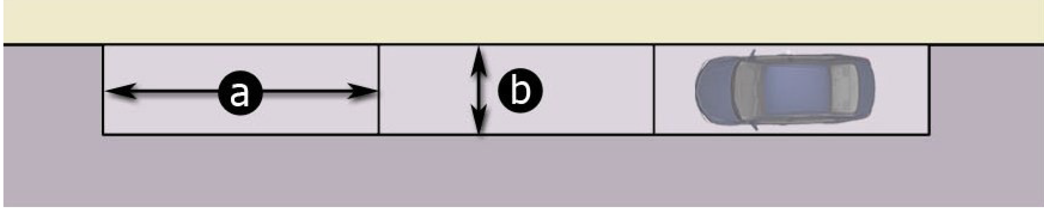
10.2.4.1. Parallel Parking. Parallel parking stalls for standard size automobiles shall have a minimum size of eight (8) feet by twenty-three (23) feet. All parallel parking stalls shall have a minimum of ten (10) feet for maneuvering space in one-way traffic and twenty (20) feet maneuvering space in two-way traffic.
10.2.4.2. Ninety-Degree Parking.
| (a) | Length: Eighteen (18) feet | 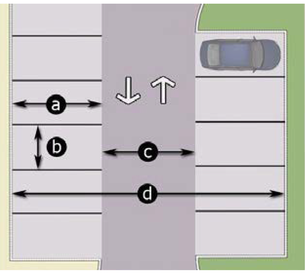 |
| (b) | Width: Nine (9) feet | |
| (c) | Aisle Width: Twenty-four (24) feet | |
| (d) |
Two Row Parking with Aisle:
Sixty (60) feet total | |
| (e) | Compact Cars: Length—Sixteen (16) feet | |
| Width—Eight (8) feet |
10.2.4.3. Sixty-Degree Parking.
| (a) | Length: Twenty (20) feet one (1) inch | 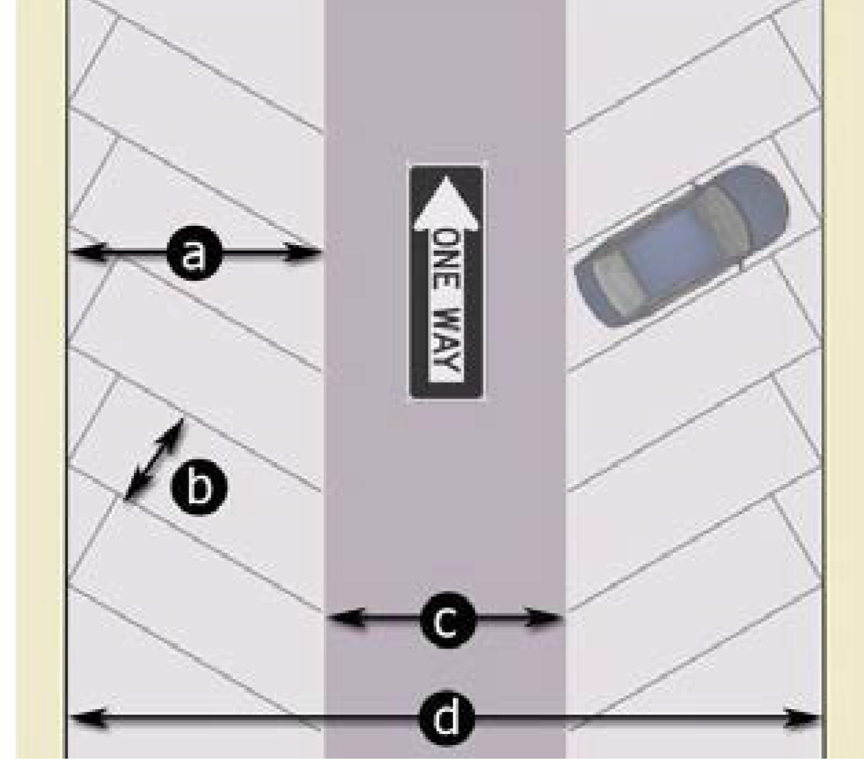 |
|
(measured from the end of striping
perpendicular to the curb) | ||
| (b) | Width: Nine (9) feet | |
| (c) | One-Way Aisle: Sixteen (16) feet | |
| Two-Way Aisle: Twenty (20) feet | ||
| (d) | Two Row Parking with One-Way Aisle: Fifty-six (56) feet two (2) inches total | |
| Two Row Parking with Two-Way Aisle: Sixty (60) feet two (2) inches total | ||
| (e) |
Compact Cars: Length—Seventeen
(17) feet six (6) inches | |
| (measured from the end of striping perpendicular to the curb) | ||
| Width—Eight (8) feet | ||
10.2.4.4. Forty-Five-Degree Parking.
| (a) | Length: Nineteen (19) feet one (1) inch | 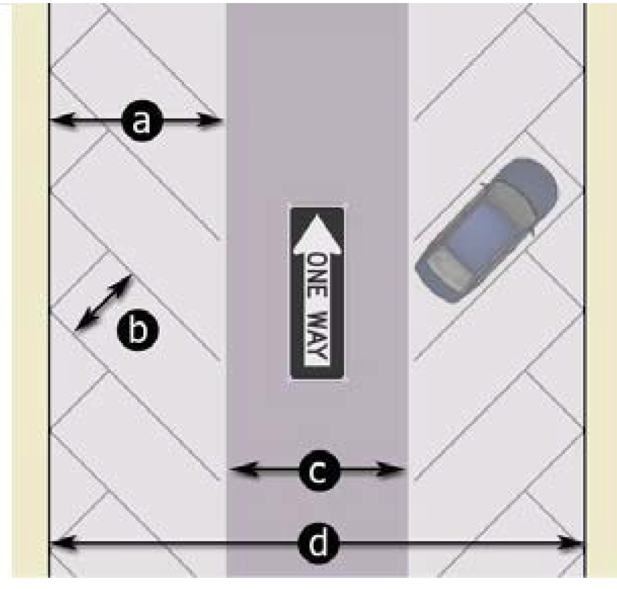 |
| (measured from the end of striping perpendicular to the curb) | ||
| (b) | Width: Nine (9) feet | |
| (c) | One-Way Aisle: Fifteen (15) feet | |
| Two-Way Aisle: Twenty (20) feet | ||
| (d) | Two Row Parking with One-Way Aisle: Fifty-three (53) feet two (2) inches total | |
| Two Row Parking with Two-Way Aisle: Fifty-eight (58) feet two (2) inches total | ||
| (e) |
Compact Cars: Length—Sixteen (16) feet
six (6) inches | |
| (measured from the end of striping perpendicular to the curb) | ||
| Width—Eight (8) feet | ||
10.2.4.5. Thirty-Degree Parking.
| (a) |
Length: Fifteen (15) feet eleven (11)
inches | 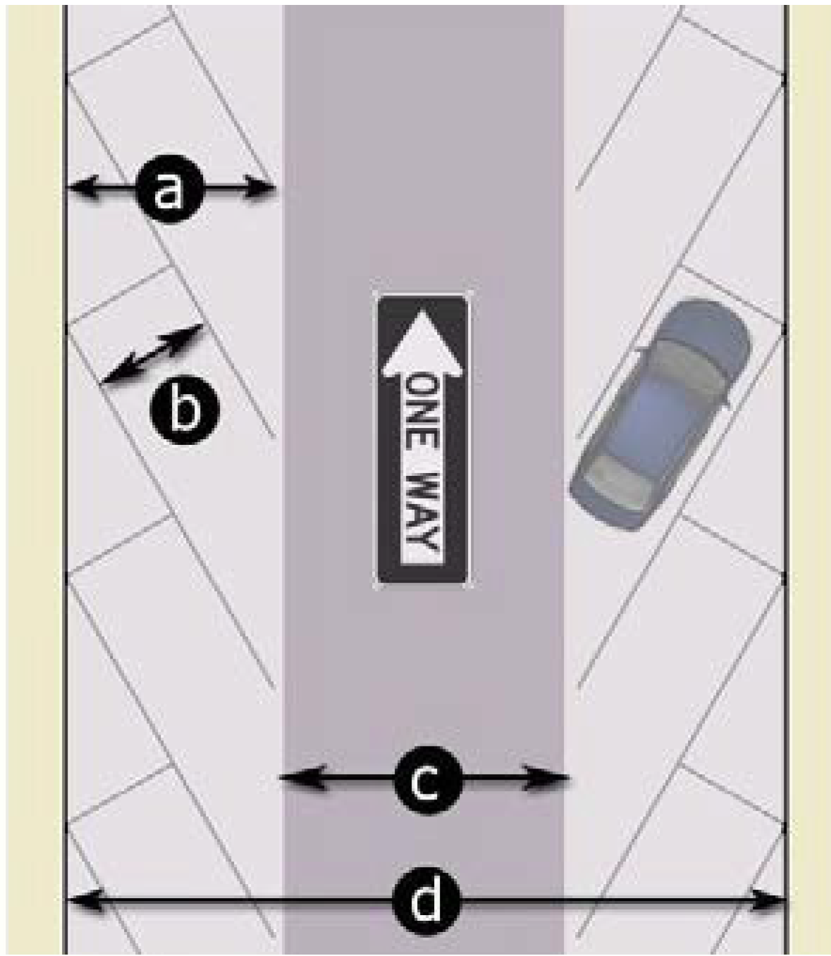 |
| (measured from the end of striping perpendicular to the curb) | ||
| (b) | Width: Nine (9) feet | |
| (c) | One-Way Aisle: Fourteen (14) feet | |
| Two-Way Aisle: Nineteen (19) feet | ||
| (d) | Two Row Parking with One-Way Aisle: Forty-five (45) feet ten (10) inches total | |
| Two Row Parking with Two-Way Aisle: Fifty (50) feet ten (10) inches total | ||
| (e) |
Compact Cars: Length—Fourteen (14)
feet six (6) inches | |
| (measured from the end of striping perpendicular to the curb) | ||
| Width—Eight (8) feet | ||
10.2.4.6. Semi-Tractor and Tractor Trailer Parking. Semi-tractor and tractor trailer parking shall be paved with either asphalt or concrete except for Heavy and Light Industrial zoning districts which shall be in accordance with Section 7.2. Such parking shall be striped such that the parking space is at least twelve (12) feet in width and at least fifty-five (55) feet in length exclusive of driveways, aisles, ramps, maneuvering space, columns, work areas, and shall have a vertical clearance of not less than fourteen (14) feet.
(Ord. No. ZA-23-06, pt. 2, 11-12-24)
10.2.5. - Parking Lots with More than Four Spaces.
10.2.5.1. Surfacing. All required off-street parking lots and associated driveway, interior access drive to and from such off-street parking areas shall be hard surfaced with asphalt, concrete or other similar material to provide a durable, dust-free surface
10.2.5.2. Markings. Each parking stall shall be striped in accordance with the Manual on Uniform Traffic Control Devices (MUTCD), with four (4) inch white lines.
10.2.5.3. Lighting. Any lighting shall be so arranged as to direct the light and glare away from streets and adjacent property in accordance with Part IV of this ordinance.
10.2.5.4. Yards. All required parking lots shall not encroach within a required streetyard or bufferyard and shall be in conformance with Section 10.2.1.4.
10.2.5.5. Curb/Gutter. Curb and gutter is required for all new parking lots, driveways, and interior access driveways. Breaks in the curb/gutter may be permitted if the engineer's design of the parking lot requires a break to obtain effective stormwater control.
10.2.5.6. Drainage. Parking lots shall not drain onto or across public sidewalks, or into adjacent property except into a natural watercourse or a drainage easement. In already developed areas where this condition would be impossible to meet, the UDO Administrator may exempt the developer from this requirement, provided that adequate provision is made for drainage that protects the public safety and welfare.
10.2.5.7. At locations where a sidewalk abuts a nineteen-foot-deep parking bay, the sidewalk shall be a minimum width of six (6) feet. If less than 6 feet, a wheel bumper shall be required and there shall be a space of three and one-half (3½) feet between the wheel bumper or curb and the edge of the walkway.
10.2.5.8. Entrances and Exits. These shall be provided in accordance with Section 10.6 of this ordinance.
10.2.5.9. Parking lots in the Industrial Zoning Districts shall be in accordance with Section 7.2 of this ordinance.
(Ord. No. ZA-23-06, pt. 2, 11-12-24)
10.2.6. - Combination of Required Parking Space.
The required parking space for any number of separate uses may be combined in one (1) lot but the required space assigned to one (1) use may not be assigned to another use, except that two (2) of the parking spaces required for churches, theater, or assembly halls whose peak attendance will be at night or on Sundays may be assigned to a use which will be closed at night and on Sundays.
10.2.7. - Remote Parking.
10.2.7.1. If the number of off-street parking spaces required by this ordinance cannot reasonably be provided on the same lot where the principal use associated with these parking spaces is located, then spaces may be provided on adjacent or nearby lots in accordance with the provisions of this section. These off-site spaces are referred to in this section as "satellite" parking spaces.
10.2.7.2. All such satellite parking spaces (except spaces intended for employee use) must be located within four hundred (400) feet of a public entrance of a principal building housing the use associated with such parking, or within four hundred (400) feet of the lot on which the use associated with such parking is located if the use is not housed within any principal building. Satellite parking spaces intended for employee use may be located within any reasonable distance. Satellite parking spaces must be located in a zoning district which permits parking lots for the use intended.
10.2.7.3. The developer wishing to take advantage of the provisions of this section must present satisfactory written evidence, on an annual basis, that he has the permission of the owner or other person in charge of the satellite parking spaces to use such spaces. The developer must also sign an acknowledgment that the continuing validity of his permit depends upon his continuing activity to provide the requisite number of parking spaces.
10.2.8. - Separation from Walkways, Sidewalks, and Streets.
All parking, loading, and service areas shall be separated from walkways, sidewalks, and streets by concrete curbing to prevent vehicles from intruding into these areas.
(Ord. No. ZA-23-06, pt. 2, 11-12-24)
10.2.9. - Phased Developments.
Each individual phase of a multi-phase development shall meet all applicable parking standards established in this section including shared parking facilities prior to initiation of the next phase.
10.2.10. - Lateral Access.
All new nonresidential development, specifically commercial development, shall provide lateral access to adjacent property which is either: (1) existing nonresidential, or (2) zoned nonresidential. In the site plan process review, lateral access shall be displayed and labeled clearly by showing the appropriate connections. All lateral access connections shall be a minimum of twenty (20) feet in width and maximum of twenty-four (24) feet in width. The UDO Administrator may waive from the lateral access requirements in circumstances where there would be little public benefit to providing a lateral access or the if the access is determined not to be feasible due to particularities of the parcel.
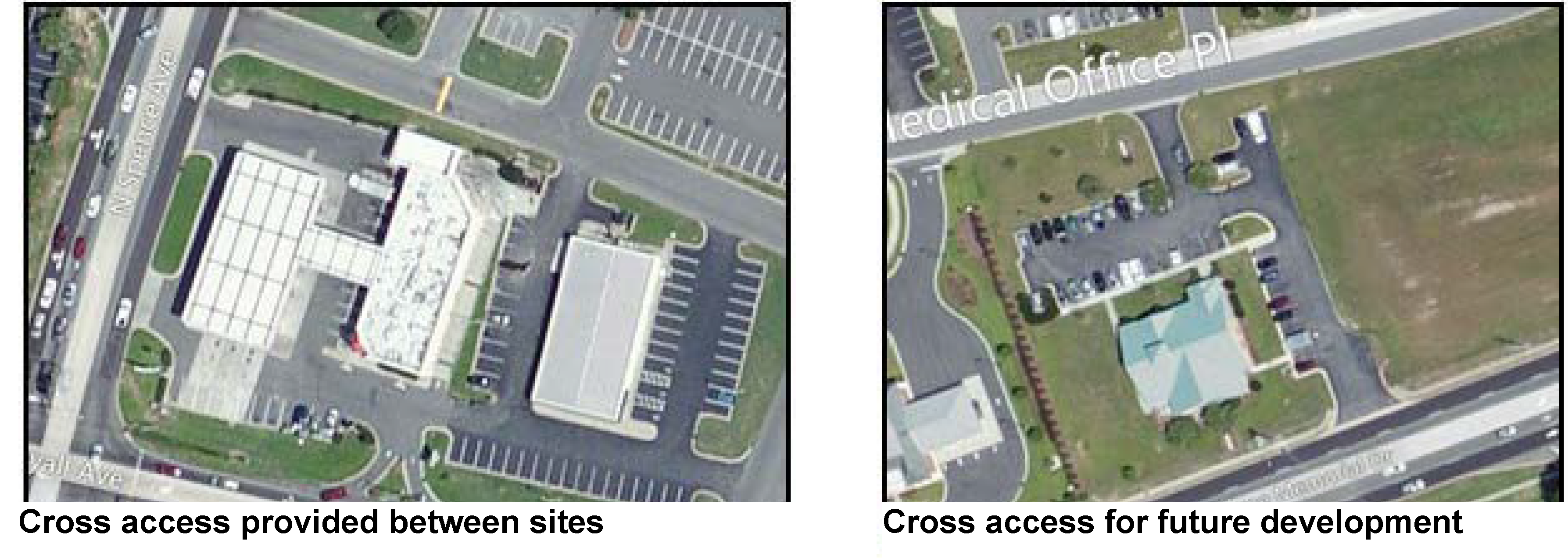
(Ord. No. ZA-23-06, pt. 2, 11-12-24)
10.2.11. - Handicapped Requirements.
Handicapped parking spaces shall be in accordance with regulations set forth by the Americans with Disabilities Act (ADA), the North Carolina Department of Transportation, the North Carolina Division of Motor Vehicles ADA requirements, the North Carolina State Building Code, and ICC A 117.1.
10.2.12. - Landscaping Requirements.
See Article 10, Part II.
10.2.13. - Exceptions.
10.2.13.1. The UDO Administrator may withhold a permit or certificate of occupancy if a parking layout not specifically prohibited by this section would be likely to cause avoidable safety or traffic congestion problems until modification is made.
10.2.13.2. In the Central Business District, the UDO Administrator may allow a new use to be established in an existing building even if all parking requirements of this article cannot be met for the new use, provided that as much off-street parking as can reasonably be provided is provided by the use, and not foreseeable traffic congestion problems will be created.
(Ord. No. ZA-23-06, pt. 2, 11-12-24)
10.4.1. - Vehicle Stacking Areas.
The vehicle stacking standards of this section shall apply unless otherwise expressly approved by the UDO Administrator. Additional stacking spaces may be required by the UDO Administrator where trip generation rates suggest that additional spaces will be needed.
10.4.2. - Minimum Number of Spaces.
Off-street stacking spaces shall be provided as follows:
10.4.3. - Design and Layout of Stacking Spaces.
Required stacking spaces shall be subject to the following design and layout standards:
10.4.3.1. Size. Stacking spaces shall be a minimum of eight (8) feet in width by twenty-five (25) feet in length.
10.4.3.2. Location. Stacking spaces shall not impede on- or off-site traffic movements or movements into or out of off-street parking spaces.
10.4.3.3. Design. Stacking spaces shall be separated from other internal driveways by raised medians if deemed necessary by the UDO Administrator for traffic movement and safety.
10.5.1. - Location.
10.5.1.1. No loading spaces shall be located within thirty (30) feet of street intersections or in any required front, side, or rear yard.
10.5.1.2. A minimum setback of fifty (50) feet shall be required where loading docks face a residential district or a structure with first-floor residential uses, unless the loading area is completely screened from view with an eight (8) foot high masonry wall in accordance with the requirements of Article 10, Part II.
10.5.1.3. Loading areas shall be located to provide the most convenient access to the use being served. Generally, loading areas should be adjacent to the building.
10.5.2. - Design.
10.5.2.1. Loading berths for office uses shall be a minimum of twelve (12) feet wide by thirty-five (35) feet long with a height clearance of fourteen (14) feet.
10.5.2.2. All other loading berths shall be a minimum of twelve (12) feet wide and fifty-five (55) feet long with a height clearance of fourteen (14) feet.
10.5.2.3. Each required off-street loading space shall be designed with appropriate means of vehicular access and circulation to a street from a driveway in a manner which will least interfere with traffic movements. Loading areas shall be designed such that vehicles shall enter and leave the site by forward motion of the vehicle.
10.5.2.4. Parking areas for passenger vehicles are prohibited where it may conflict with truck circulation or maneuvering into the truck loading areas.
(Ord. No. ZA-23-06, pt. 2, 11-12-24)
10.5.3. - Spaces.
The loading and unloading area must be of sufficient size to accommodate the numbers and types of vehicles that are likely to use this area, given the nature of the development in question. The following table indicates the number and size of spaces that, presumptively, satisfy the standard set forth in this subsection. However, the permit-issuing authority may require more or less loading and unloading area if reasonably necessary to satisfy the foregoing standard.
(Ord. No. ZA-23-06, pt. 2, 11-12-24)
10.6.1. - General.
All non-agricultural designed, approved, constructed, and surfaced in accordance with the provisions herein shall be allowed to provide motor vehicle access to or from any property upon which a building has been constructed, reconstructed, or physically altered.
10.6.1.1. Non-agricultural driveways shall be paved with either asphalt or concrete, or with alternative paving material (e.g., concrete pavers, brick, "turfstone" or similar pervious material) determined to exhibit equivalent wear resistance and load bearing characteristics as asphalt or concrete. Single-family properties in the R-20A zoning district with driveways exceeding fifty (50) feet in length, may pave the remainder of the driveway to the public right-of-way with gravel or similar load bearing material.
10.6.1.2. Driveways and parking may cover a maximum of fifty (50) percent of the front yard of single-family or two-family lot, unless restrictions on impervious surface coverage pose greater restrictions.
10.6.1.3. All new driveway aprons shall be constructed in accordance with the Town's Standard Detail and Specifications Manual.
10.6.1.4. Before a zoning permit is issued for the construction, reconstruction, or change in use of any building or land, all driveways shall be reviewed and approved by the Planning Director.
10.6.1.5. Discontinued Driveway Access. When the use of any driveway has been permanently discontinued, the property owner of that driveway shall, at his expense, replace all necessary curbs, gutters, aprons, sidewalks, and appurtenances thereto, within sixty (60) days of receipt of a written notice from the Administrator.
10.6.1.6. Driveway Conflicts. No driveway shall conflict with any municipal facility such as traffic signal standards, catch basins, fire hydrants, crosswalks, loading zones, bus stops, utility poles, fire-alarm supports, meter boxes, and sewer clean-outs or other necessary structures, except with the express approval of the Director of Public Works. Any adjustments to municipal facilities to avoid such conflicts shall be at the expense of the driveway applicant.
(Ord. No. ZA-24-01, pt. 1, 6-18-24)
10.6.2. - Permit Requirements.
A permit must be obtained from the Planning Director with approval from the Public Works Director prior to the removal, alteration, or construction of any curb, driveway, gutter, and/or pavement or prior to the performance of any other work in any public or private street. Conditions governing the issuance of such a permit are:
10.6.2.1. A continuing indemnity bond with sufficient surety acceptable to the town may be required of the party performing the work. All work must be done in conformity with the standards established herein.
10.6.2.2. The town shall be indemnified for any damages it might sustain as a result of the breach of condition above. The damages payable to the town shall be the amount required to make such an improvement conform to town standards.
Based on the Town of Smithfield Schedule of Fees, a fee shall be paid to the town at the time the application for a driveway permit is made.
(Ord. No. ZA-24-01, pt. 1, 6-18-24)
10.6.3. - Submission of Plans.
Two (2) copies of plans showing the location and dimensions of all proposed improvements shall be filed with the Planning Director for approval prior to the issuance of a driveway permit.
All design and construction of driveways shall conform to the Town of Smithfield Standard Detail and Specifications Manual.
(Ord. No. ZA-24-01, pt. 1, 6-18-24)
10.6.4. - Driveway Location(s).
10.6.4.1. A safe means of ingress and egress shall be provided for all parking spaces that is in conformance with the Town's Standard Detail and Specifications Manual. All driveways shall conform to the Town's Standard Detail and Specifications Manual.
10.6.4.2. Two (2) driveways entering the same street from a single lot shall be permitted only if the minimum distance between the closest edges of the driveways equals or exceeds fifty (50) feet, except for two-family residential lots.
10.6.4.3. Three (3) driveways entering the same street from a single lot shall be permitted only if the minimum distance between the closest edges of the driveways equals or exceeds one hundred fifty (150) feet and the third driveway is deemed necessary by the Town for reasonable service to the property without undue impairment of safety, convenience, and utility of the roadway. Normally, not more than two (2) driveways shall be permitted for any single property frontage.
10.6.4.4. In no case may the total width of all residential driveways exceed fifty (50) percent of the total property frontage.
10.6.4.5. No driveway (nearest edge) shall be located within ten (10) feet of a side lot property line for multi-family, commercial or industrial property, except in the case of a shared driveway (single curb/access point) utilized by two (2) or more lots.
10.6.4.6. No driveway (nearest edge) shall be located within twenty-five (25) feet of a local road intersection or within forty (40) feet of a collector road intersection except in the case where no other lot access to a public street or town-approved private road is available.
(Ord. No. ZA-23-06, pt. 2, 11-12-24)
10.6.5. - Driveway Permit Inspection.
Once the driveway permit is duly issued, the supervisor of the driveway construction site shall keep the permit available for on-the-job inspection by authorized personnel of the town. The inspector or other authorized representative of the town shall have the authority to require the immediate stoppage of work not performed either in accordance with the approved plans or under the requirements of this section and may order the nonconforming installations be corrected and/or blocked.
10.6.6. - Reserved.
Editor's note— Ord. No. ZA-23-06, pt. 2, adopted Nov. 12, 2024, repealed § 10.6.6, which pertained to brick driveways and derived from code of 2023 § 10.6.6.
10.8.1. - Single-Family-Residential-Development.
When a major residential subdivision with new roadways are proposed.
10.8.2. - All New Single-Family-Residential Homes on Existing Lots.
All new single-family and duplex dwellings on existing lots shall comply landscape regulations of Section 10.13.1.8.2, Single-Family and Town House Residential Developments.
10.8.3. - Multi-Family Residential Development.
When ten (10) or more parking spaces are required for all phases of development excluding all manufactured home parks.
10.8.4. - Nonresidential Development.
10.8.4.1. New Construction. When a permitted use, a use or combination of uses contained within a conditional use permit require ten (10) or more parking spaces.
10.8.4.2. Existing Development. When there is a change from an existing use to a new use which requires additional parking and the new use requires ten (10) or more parking spaces.
10.8.4.3. Expansion of Structure. When there is an expansion of an existing structure by greater than twenty-five (25) percent of the gross floor area.
10.8.4.4. Expansion of Site Improvements. When there is an expansion of site improvements by greater than twenty-five (25) percent of the site's hard surface area.
10.8.4.5. Reconstruction of Structure. When there is damage or destruction to an existing structure beyond fifty (50) percent of its assessed value, the reconstruction must conform to the new construction standards of this section.
10.8.4.6. Expansion of Parking Facility. When there is an expansion of the parking facility by a minimum of ten (10) percent of the parking with a minimum of ten (10) total spaces.
(Ord. No. ZA-23-06, pt. 2, 11-12-24)
10.9.1. - Exemptions.
All properties within the town's jurisdiction shall comply with the requirements of Section 10.9, Tree Resource Management, except as otherwise exempted below:
10.9.1.1. Small Trees. Any tree with a diameter/caliper less than eight (8) inches (circumference of twenty-five (25) inches) or less measured at diameter at breast height (DBH) may be cut at any time without a permit, except replacement plantings.
10.9.1.2. Nursery. A business location where trees are grown specifically for sale, as part of a primary commercial activity, shall be exempt.
10.9.1.3. Utility Construction. Companies and governmental agencies installing and maintaining utilities in easements and rights-of-way shall be exempt when acting in accordance with approved construction plans.
10.9.1.4. Wetlands Mitigation. Wetlands mitigation shall be exempt when working in accordance with an approved plan of the US Army Corps of Engineers or North Carolina Department of Environment and Natural Resources (NCDENR).
10.9.1.5. Hazardous Conditions. If any tree shall be determined to be in a hazardous condition so as to (i) immediately endanger the public health, safety, or welfare, or (ii) cause an immediate disruption of public service, the Public Utilities/Public Works director may determine that replacement with additional trees is necessary. In making determinations, the Public Utilities/Public Works Director shall utilize such professional criteria and technical assistance as may be necessary.
10.9.1.6. Certain Forestry Activities. Only activity associated with growing, managing, and harvesting trees on lands taxed on a present-use value as forest land, or activity being conducted in accordance with a forest management plan shall be exempt from tree resource management. Forestry activities are only permitted in the R-20A Zoning District in accordance with Section 6.5, Table of Uses and Activities.
10.9.1.7. Acts of God. The UDO Administrator may waive the requirements of this article during an emergency such as a hurricane, tornado, windstorm, tropical storm, flood, or other act of God.
(Ord. No. ZA-23-06, pt. 2, 11-12-24)
10.9.2. - Tree Preservation.
Vegetation existing on a site at the time of development that is required to be retained in accordance with the following provisions, shall be inventoried on a tree survey, performed and certified by a certified arborist or licensed forester, or submitted as part of the site plan review process.
10.9.2.1. Protected Trees. The following categories of existing vegetation shall be considered protected and shall be retained as indicated:
10.9.2.1.1. Natural Buffers. If existing trees and shrubs on the site where a buffer is required by Section 10.14 meet at least fifty (50) percent of the required opacity standard, then those trees and shrubs shall be retained for use in buffering and supplemented as needed with plantings, fences, and/or berms to meet the required standards.
10.9.2.1.2. Perimeter Trees. Existing trees greater than eight (8) inches in diameter at four and one-half (4½) feet in height above grade (DBH) within required buffers or street yards, shall be considered protected and shall be retained in all cases.
10.9.2.1.3. Regulated Trees. All regulated trees anywhere on the site shall be considered protected, and shall be preserved to the greatest extent practical and incorporated into required landscaping. Regulated tree removal will be allowed to the extent necessary to allow compliance with the requirements of this ordinance.
10.9.2.1.4. Significant Trees. Hardwood and conifer trees located in perimeter and street yards at least twenty-four (24) inches in DBH, and dogwoods, American Hollies and flowering trees at least eight (8) inches DBH, shall be considered protected, and must be preserved or their removal mitigated as in accordance with subsection 10.9.2.3, regardless of location on the site, unless the trees are shown to be dead, dying or severely damaged or diseased as a result of natural factors.
10.9.2.2. Retention Standards of Protected Trees.
10.9.2.2.1. Perimeter Trees and Regulated Trees. If any of these trees are to be cleared from the site, reasons for doing so shall be clearly stated on the tree survey. Suitable reasons for clearing one (1) or more of these trees include such factors as the essential site improvements cannot be elsewhere accommodated on the site or that it is impossible to position the building on the site or that necessary grading changes would significantly harm the tree. Unsuitable reasons include such factors as more parking than the minimum specified by this section, or that non-selective clearing by bulldozer is less expensive than selective clearing by chainsaw.
10.9.2.2.2. Significant Trees and Natural Buffers. All significant trees and natural buffers shall be retained and protected, or their removal mitigated as set forth in subsection 10.9.2.3 below.
10.9.2.2.3. Existing trees specified on the required landscape plan to remain on the site as a function fulfilling purposes of this section, shall be protected from vehicular movement and material storage during construction and in the final landscape design. An undisturbed area with a porous surface shall be preserved around each tree as determined by the trees drip ring of its natural canopy. The undisturbed area shall be protected during construction by approved tree protection fencing.
10.9.2.2.4. A minimum of fifteen (15) trees at least two (2) inches in diameter (measured six (6) inches above the ground) shall be retained or planted on the parcel for each acre or proportionate area disturbed by development.
10.9.2.3. Mitigation. The removal of any "significant tree" as defined by this ordinance, must be mitigated in accordance with the following standards:
10.9.2.3.1. The total caliper inches of all significant trees proposed for removal shall be totaled and doubled. The resultant number of caliper inches must be planted back on the site with two- to three-inch caliper trees as a minimum.
10.9.2.3.2. If the UDO Administrator determines that the site cannot accommodate the required number of trees, then only the amount of trees which can be accommodated on the site may be replaced.
10.9.2.3.3. Any mitigation trees required as a result of the removal of significant tree(s) shall not be counted to meet the requirements of the street yard, buffers or interior parking requirements. These trees must be provided in addition to any tree required by this ordinance.
10.9.3. - Marking of Trees Required.
Any tree(s) indicated on a site plan for removal inspection must be clearly marked with brightly colored tape, ribbon, or similar material prior to an inspection by the UDO Administrator.
10.9.4. - Purposeful Damage to Trees Prohibited.
It shall be unlawful for any person, corporation or other entity to damage, deface, mutilate, alter, or otherwise cause severe or permanent harm to any tree(s) regulated by this section. Purposeful damage to trees shall include topping and any other practices deemed harmful to trees based upon current forestry practices. Purposeful damage prohibitions also apply to tree re-plantings that are less than a diameter/caliper of eight (8) inches (circumference of twenty-five (25) inches). Trees and shrubs which are required to be planted by this ordinance cannot be trimmed/cut below the height requirement at planting.
10.10.1. - [Standards.]
Plants shall meet the standards for plant quality and size as defined in the most recent version of the American Standard of Nursery Stock manual, published by the American Horticulture Industry Association.
10.10.2. - [Installation Details.]
Plants shall be installed in accordance with the Town of Smithfield Standard Detail and Specifications Manual.
(Ord. No. ZA-23-06, pt. 2, 11-12-24)
10.11.1. - Vegetation.
All existing vegetation that is used to meeting landscaping requirements, all required plants, and all required berms shall be maintained by the owner of the property on a continuing basis for the life of the development.
10.11.1.1. Required landscape areas shall be free of refuse and debris and shall be maintained so as to prevent mulch, straw, dirt, or other materials from washing onto streets and sidewalks.
10.11.1.2. Plants shall be maintained in a way that does not obstruct sight distances at roadway and drive intersections, obstruct traffic signs or devices, and/or interfere with the use of sidewalks or pedestrian trails. Shrubs within existing vehicle use areas, streetscapes, and street fronts may be pruned, but must maintain a height of at least three (3) feet.
10.11.1.3. Any dead, unhealthy, or missing vegetation, or vegetation disfigured by severe pruning, shall be replaced with locally adapted vegetation that conforms to the standards of this ordinance and the approved development plan.
(Ord. No. ZA-23-05, pt. 1, 5-2-23)
10.11.2. - Removal, Damage and Pruning of Vegetation.
10.11.2.1. Removal, Disturbance, Damage and Severe Pruning Prohibited. Vegetation in required landscape areas may not be removed, disturbed, damaged, or severely pruned except as allowed in accordance with Section 10.11.2.2. For purposes of this Section 10.11, "disturbance" shall be defined as any action that results in injury or harm to required trees, shrubbery, or other vegetation. Plants shall be considered severely pruned if pruned in such a manner that growth of their natural form is impaired.
10.11.2.2. Exceptions. Vegetation within required landscape areas may be removed or modified with approval of the Planning Director as provided below:
10.11.2.2.1 Required Street Yard trees may be pruned to prevent damage to utilities or buildings, and to maintain street intersection sight visibility in accordance with Section 2.21 or requirements of NCDOT.
10.11.2.2.2 Where vegetation poses an immediate or imminent threat to improved structures on private or public property, severe pruning and/or removal of the vegetation is allowed, provided the required landscape area is maintained consistent with this ordinance.
10.11.2.2.3 Where vegetation or a physical element functioning to meet the standards of this ordinance is severely damaged due to an unusual weather occurrence or natural catastrophe, or other natural occurrence such as natural death or damage by wild or domestic animals, the owner may be required to replant if the required landscape area no longer achieves the requirements of this ordinance. The owner may have one (1) growing season to replace or replant the missing vegetation. The Planning Director shall consider the circumstances to decide on the extent of replanting requirements.
(Ord. No. ZA-23-05, pt. 1, 5-2-23)
10.11.3. - Replacement of Disturbed and Damaged Vegetation.
Where existing required vegetation has been removed, disturbed, or damaged in violation of this ordinance, the Planning Director shall require revegetation of the affected area consistent with the approved landscape plan.
(Ord. No. ZA-23-05, pt. 1, 5-2-23)
10.11.4. - [Opaque Fence or Opaque Walls.]
Opaque fence or opaque walls shall be maintained, cleaned and repaired by the owner of the property on a continuing basis for the life of the development. Such fencing shall be kept free of litter and advertising. Opaque fences or walls may be subject to periodic inspection by the UDO Administrator.
(Ord. No. ZA-23-05, pt. 1, 5-2-23)
10.11.5. - [Permit.]
A new certificate of occupancy/building permit/zoning permit or a complaint will result in an inspection for compliance.
(Ord. No. ZA-23-05, pt. 1, 5-2-23)
10.11.6. - [Violation.]
Failure to maintain landscaping required by Article 10, Part II will be considered a violation of this ordinance and subject to penalty as prescribed in Section 1.8.
(Ord. No. ZA-23-05, pt. 1, 5-2-23)
Editor's note— Ord. No. ZA-23-05, pt. 1, adopted May 2, 2023 set out provisions intended for use as § 10.11.4. Inasmuch as there were already provisions so designated, said section has been codified herein as § 10.11.6 at the discretion of the editor.
10.13.1. - Streetyard and Parking Facility Landscape Example.
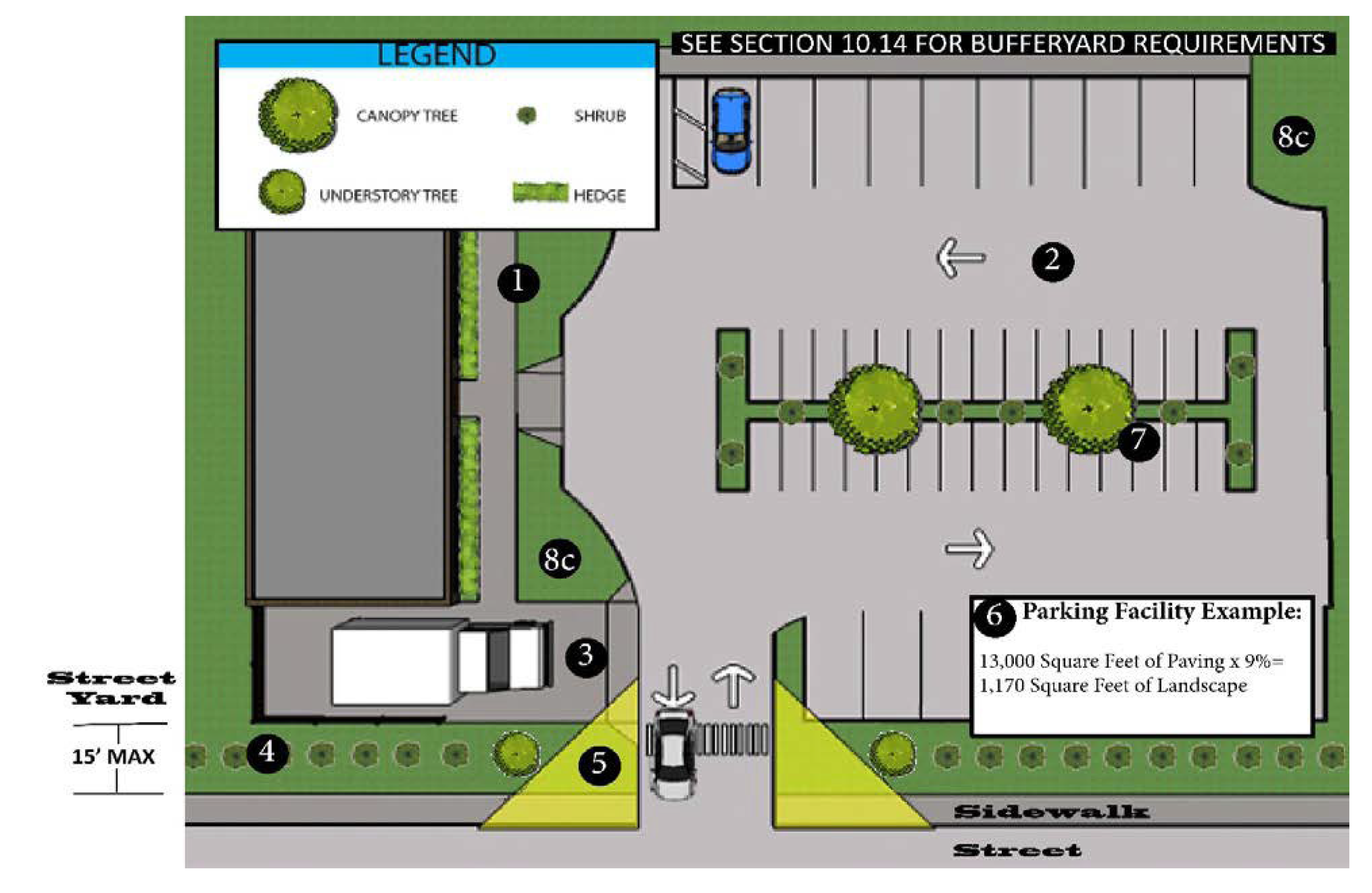
10.13.1.1. For all portions of buildings, which are adjacent to parking facilities or internal drive aisles, foundation plantings shall be required and located between the buildings face and the parking or drive isle curb.
10.13.1.2. All tree plantings shall be evenly distributed throughout the parking facility so that no parking stall shall be located farther than seventy-five (75) feet from the trunk of a tree.
10.13.1.3. All loading, utility, and open storage areas shall be screened from public right-of-way and adjacent properties by suitable fencing, wall, or hedge which shall maintain an opacity of at least seventy-five (75) percent year round.
10.13.1.4. Sight distance triangle shall be in compliance with Section 2.21.
10.13.1.5. Minimum Standards: For parking facilities having four (4) or more parking spaces, at least nine (9) percent of the gross paved area of the parking facility shall be landscaped and located in the interior of the facility.
10.13.1.6. Planting islands shall include at least one (1) canopy tree or one (1) understory tree and six (6) small shrubs. At least fifty (50) percent of the trees planted shall be canopy trees.
10.13.1.7. In support of the above, the following standards shall apply to interior plantings:
10.13.1.7.1. All plantings shall be evenly distributed throughout the parking facility.
10.13.1.7.2. All interior plantings shall be curbed or otherwise physically protected. Depressed landscaped islands shall be permitted for stormwater management purposes as approved by the UDO Administrator.
10.13.1.7.3. Landscaped islands shall be installed at each block of fifteen (15) consecutive parking spaces and at the ends of all parking rows. Landscaped islands shall contain at least one hundred (100) square feet in area and be at least eight (8) feet in width, measured from back of curb to back of curb.
10.13.1.8. Street Yards.
10.13.1.8.1. Commercial Developments. Street yards shall be provided with a minimum depth of fifty (50) percent of the required front or corner side yard setback as measured perpendicular to the street right-of-way, provided that no street yard in excess of fifteen (15) feet in depth shall be required. The width of the planting strip may vary, but the minimum width cannot be less than seven (7) feet and the average width shall be at least ten (10) feet. The planting area must be covered with living material, including trees, shrubs and/or ground cover, so that no soil is exposed at a rate of two (2) canopy tree and twenty (20) shrubs per every one hundred (100) linear feet of road frontage. Canopy trees can be replaced by understory trees if in conflict with overhead utilities. Required trees shall be placed in a planting strip on private property and not within the street right-of-way. No required street yard tree can be planted further than fifteen (15) feet from the edge of the right-of-way to meet this requirement.
10.13.1.8.2. Single Family and Town House Residential Developments. Street yards shall be provided with a minimum depth of fifteen (15) feet when adjacent to a major or minor arterial street and shall be planted with two (2) deciduous trees, one (1) evergreen tree and thirty (30) shrubs per one hundred (100) linear feet of road frontage. All interior streets within single family and townhouse developments shall provide two (2) deciduous trees, one (1) evergreen tree per one hundred (100) linear feet of road frontage on each side of the street. Shrubs shall be planted at a rate of three (3) per residential unit and placed adjacent to the front building façade. Required trees shall be placed in a planting strip on private property and not within the street right-of-way. No required tree can be planted further than fifteen (15) feet from the edge of the right-of-way to meet this requirement.
(Ord. No. ZA-23-06, pt. 2, 11-12-24)
10.13.2. - Foundation Plantings.
For all portions of buildings, which are adjacent to parking facilities or internal drive aisles, foundation plantings shall be required and located between the buildings face and the parking or drive isle curb. The minimum standards are required; however, it is encouraged that sites exceed the minimum whenever possible. The following minimum standards shall apply:
10.13.2.1. The area of the building wall face adjacent to the parking area or internal drive isle shall be calculated and multiplied by a minimum of twelve (12) percent. The resultant total square footage shall be planted as landscaped areas of sufficient variety, height, and approved by the Planning Department.
10.13.2.2. Exemptions from these requirements may be granted when the following circumstances exist or when any of the following conditions are proposed on the site:
10.13.2.2.1. For those portions of buildings which have drive up services along any side or rear of the building. (Such examples would include but not be limited to pharmacies, banks, fast food restaurants, dry cleaners, and photo shops.)
10.13.2.2.2. On the rear side of a building when less than ten (10) percent of the total required parking is located in the rear of the building and the rear is not adjacent to any public right-of-way.
10.13.2.3. If the requirements of this section conflict with any other requirements from other sections of this ordinance, the more stringent shall apply.
10.15.1. - Uses in the Bufferyard.
No activities shall occur in the bufferyard except for maintenance of the bufferyard, required ingress and egress and the installation and maintenance of water, sewer, electrical, and other utility systems where the installation causes minimal disturbance of existing vegetation.
10.15.2. - Uses in the Rear Yard and Side Yards Abutting a Residential Use.
The following uses shall be shielded from view from the property line of adjacent residentially used or zoned property by means of an opaque fence, opaque wall, or solid vegetative buffer:
10.15.2.1. Outside storage areas.
10.15.2.2. Loading/unloading areas.
10.15.3. - Dumpsters or Other Trash Holding Areas.
In all zoning districts, dumpsters must be located on a concrete pad with a six (6) foot high solid enclosure with solid gates. All dumpsters or other trash holding areas shall be accessed internally to the site.
(Ord. No. ZA-23-06, pt. 2, 11-12-24)
10.15.4. - Encroachment into Setbacks.
10.15.4.1. If an existing building is located within a setback where the implementation of the streetyard and/or bufferyard requirements are physically impossible and the encroachment into the yard (streetyard or bufferyard) allows for a minimum of three (3) feet of planting area, only the required shrubs shall be planted.
10.15.4.2. If the encroachment into the yard (streetyard or bufferyard) allows for less than three (3) feet of planting area, no planting shall be required in that yard.
(Ord. No. ZA-23-06, pt. 2, 11-12-24)
10.15.5. - Double Fronted Lots.
On all commercial, industrial, institutional, multifamily development (except townhouses) with street frontage on both the front and rear property lines, a fifteen-foot wide vegetated street yard shall be required along the rear frontage consisting of one (1) tree per fifty (50) lineal feet of road frontage: twenty (20) shrubs per one hundred (100) lineal feet of road frontage. Single-family-dwelling and townhouses subdivisions shall provide a minimum fifteen (15) feet wide with class C buffer.
(Ord. No. ZA-23-06, pt. 2, 11-12-24)
10.20.1. - Administration.
The Planning Department of the Town of Smithfield shall be responsible for the administration and enforcement of this section. The Administrator shall administer and enforce the terms and conditions of this section and all other provisions of laws relating to signs. The duties shall include not only the issuance of permits as required in Section 10.20.2, but also enforcement of the provisions of this section.
10.20.2. - Permit Requirements.
10.20.2.1. General Requirements. Except as otherwise provided by this ordinance in Sections 10.21 and 10.22, it shall be unlawful to erect, post, hang, paint, repair, replace, change, or maintain any sign without first obtaining a sign permit. Application for the permit shall be made in writing on forms furnished by the Administrator and signed by the applicant or authorized agent. Failure to secure a permit shall constitute a violation of this section.
10.20.2.2. Sign Maintenance. No permit shall be required for the maintenance requirements of Section 10.30 (Maintenance) hereinafter.
10.20.2.3. Plans, Specifications, and Other Data Required. The application shall be accompanied by complete information as required on forms provided by the Administrator and shall include, without being limited to, a site plan and elevation drawings of the proposed sign, a drawing of the building façade indicating the proposed location of the sign, height, dimensions and square footage of the proposed sign and any other data as the Administrator may determine is necessary for review of the application. The Administrator shall not issue a sign permit unless the plans, specifications, and intended use of such sign conform in all respects to the applicable provisions of this article.
10.20.2.4. Building Permit. A building permit must be obtained from the Johnston County Building Inspections Department.
10.20.2.5. Fees. A sign permit fee shall be paid upon the application for a sign permit and prior to commencement of any sign construction on the lot where the sign will be located. The fee to the Town of Smithfield for each sign permit applied for in accordance with this article in an amount determined by the Town of Smithfield Schedule of Fees. This permit fee does not include building permit fees which shall be additional
10.20.2.6. Revocation of Permits for Non-Use.
10.20.2.6.1. Commencement of Work. If actual work for the permitted sign on the site is not commenced within sixty (60) days from the date of such sign permit or if substantial work for the permitted sign is suspended for a period of sixty (60) consecutive days after issuance of the sign permit, the permit shall automatically become null and void. However, for new construction, the sign permit shall not become null and void until sixty (60) days after the zoning compliance release has been issued.
10.20.2.6.2. Extensions of Time. The provisions of subsection 10.20.2.6.1 above shall not apply when delays are not a result of willful acts or neglect of the persons obtaining the permit. In that event, the Administrator may grant an extension of time within which operations must be started or resumed. All requests for such extensions and approval thereof shall be in writing.
10.20.2.7. Forfeiture of Fees. When any permit has been revoked under the terms of this section, the permit fees shall not be refunded. If a sign permit is denied, however, the permit fee will be refunded.
10.20.2.8. Licenses. No person shall engage in the business of erecting or maintaining signs in the Town of Smithfield unless said person has been issued a sign contractor's license which has not expired at the time said work is done. This requirement shall be interpreted to exclude those persons who construct and erect a principal use identification sign when that sign is used at that person's place of business, provided all construction and installation is properly permitted and inspected for compliance with the applicable building codes of the Town of Smithfield and other parts of this section.
10.21.1. - Computation of Sign Area.
The surface area of a sign is computed as including the entire area within a parallelogram, triangle, circle, semi-circle, or other regular geometric figure, including all of the elements of the display, but not including blank masking (a plain strip, bearing no advertising matter around the edge of a sign), frames, display of identification or licensing officially required by any governmental body, or structural elements outside the sign surface. In the case of signs mounted back-to-back, only one (1) side of the sign is to be included in the area. Otherwise, the surface area of each sign is to be separately computed. In the case of cylindrical signs, signs in the shape of cubes, or other signs, which are substantially three-dimensional with respect to their display surfaces, the entire display surface or surfaces, is included in computations of area.
In the case of embellishments (display portions of signs extending outside the general display area), surface area extending outside the general display area is to be computed as part of the total surface area of the sign. Where three-dimensional figures are used as or on signs, the area shall be the total of all sides made an integral part of the projected figure used in conveying the intended message. If a sign is attached to an entrance wall or fence, only that portion of that wall or fence on which the sign face or letters are placed shall be calculated in the sign area.
In the case of a multi-faced pole sign, the area of the sign shall be considered to include all faces visible from one (1) direction.
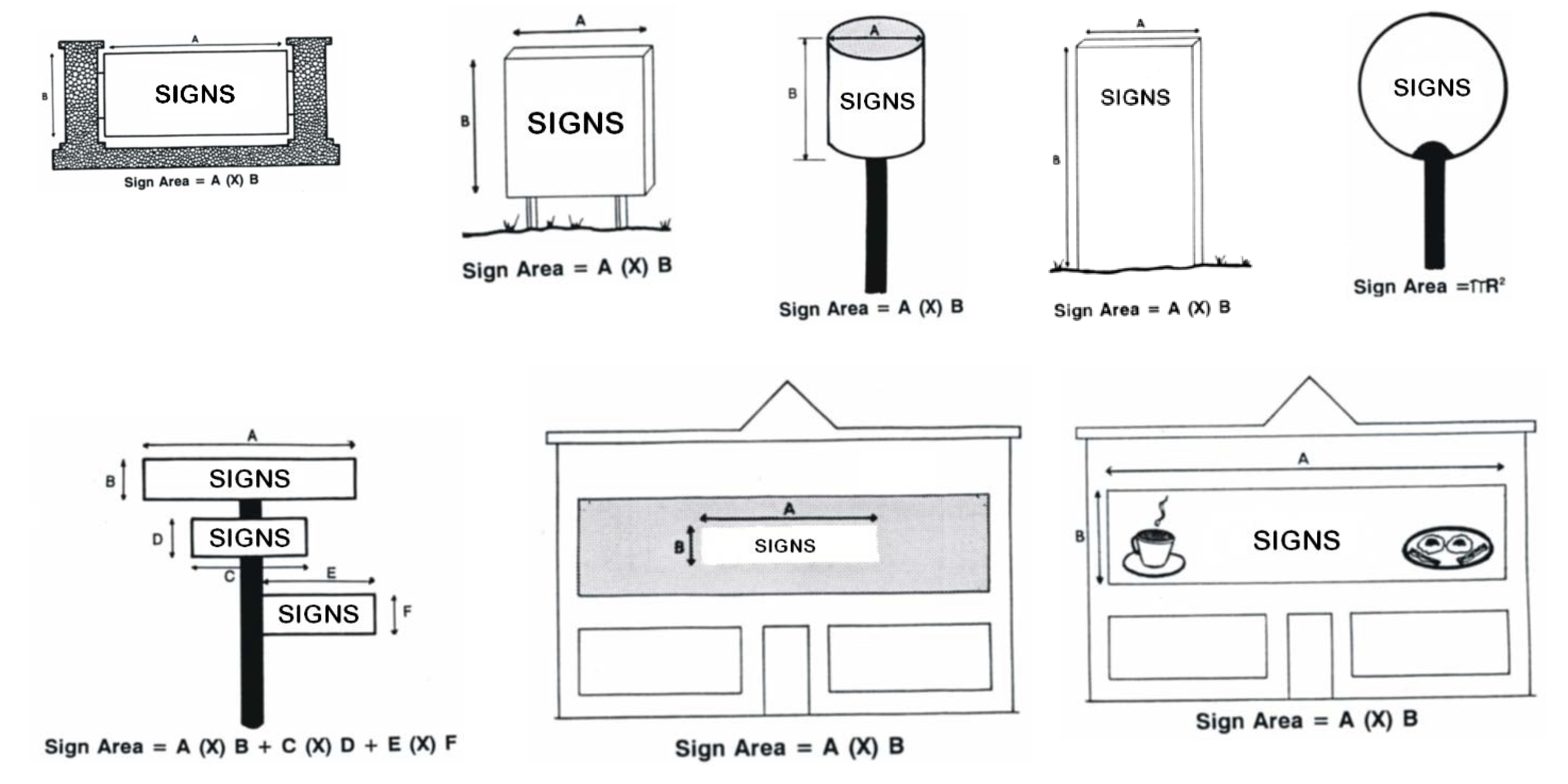
10.21.2. - Monument or Ground Mounted Sign Dimensional Requirements.
| The base of such sign structure shall be on the ground or a maximum of 24 inches above the adjacent grade. The width of the top of the sign structure shall be no greater than 120 percent of the width of the base. |  |
10.22.1. - Standards Applicable to All Signs.
10.22.1.1. Location. Unless specifically provided otherwise elsewhere in this section, all permitted signs shall adhere to the following provisions:
10.22.1.1.1. All signs regulated by this ordinance shall be on-premises signs located on private property.
10.22.1.1.2. Permitted signs shall always be located outside of the street right-of-way and required sight triangles.
10.22.1.1.3. All permitted signs must be placed no closer than ten (10) feet from property line, except within the B-1 District where it can be located zero (0) feet from the front property line/right-of-way
10.22.1.1.4. Permitted signage shall be located behind sidewalk areas except where encroachments are permitted as outlined in 10.22.1.2 below.
10.22.1.1.5. No new freestanding sign shall be placed within twenty (20) feet of an existing freestanding sign on an adjoining lot.
10.22.1.1.6. All signs must maintain a ten-foot setback from the public right-of-way except within the B-1 Zoning District or if otherwise specified herein.
10.22.1.2. Sign Encroachments. No portion of any sign shall encroach into or over a public right-of-way except awning signs, projecting/suspended signs and marquee signs within the B-1 District and may project over the sidewalk to within three-feet of the curbline provided that such signs shall maintain a minimum clearance of nine (9) feet above the sidewalk.
10.22.1.3. Discontinued Signs. Upon the discontinuance of a business or occupancy of an establishment for a consecutive period of one hundred eighty (180) days, the UDO Administrator shall require the removal of any nonconforming sign(s) advertising or identifying the establishment. The UDO Administrator shall give thirty (30) days' notice to the property owner to remove the sign(s). Failure to remove the sign(s) within the thirty-day period shall constitute a violation of this article and shall be remedied in accordance with the provisions of Section 1.8
10.22.2. - Wall Signs.
10.22.2.1. No wall sign shall project more than eighteen (18) inches from the building wall. Further, no wall sign or its supporting structure shall cover any window or part of a window, nor shall it extend on the roofline, parapet, or mansard roof.
10.22.2.2. Canopy and awning signs may be substituted for part or all of the allowable wall signage per premises. Copy area of the sign is limited to the drip flap. Logos may be placed on the awning itself.
10.22.2.3. No wall sign shall be attached to any cupola, tower, or other architectural feature that is above the roofline.
10.22.3. - Projecting Signs.
10.22.3.1. All Projecting Signs.
10.22.3.1.1. A projecting sign will not project more than four (4) feet from a building wall
10.22.3.1.2. A projecting sign will not extend vertically above the roofline or parapet of a building.
10.22.3.1.3. The sign shall be a minimum of nine (9) feet from the bottom of the sign above the finished grade.
10.22.3.1.4. The maximum area for the projecting signs shall be calculated as though it was a wall sign. The maximum area of a projecting sign shall be seventy-five (75) feet and there shall be no more than one (1) projecting sign per business entrance.
10.22.4. - Temporary Use Signs.
A zoning permit for a temporary use may also authorize one (1) temporary sign, not to exceed thirty-two (32) square feet in sign surface area, associated with the temporary use
10.22.5. - Electronic Messaging Signs.
Electronic message boards and kinetic sign lighted display areas shall not exceed thirty (32) square feet.
10.22.6. - Signs in the Entry Corridor Overlay District.
Signs within the Entry Corridor Overlay District shall comply with all sign regulations in Article 10 Part III except as modified in Article 10, Part IX Overlay Districts.
10.22.7. - Wireless Communication Facility Signage.
Refer to Article 10, Part VIII for requirements regarding wireless communication facilities.
10.23.1. - [Allowance.]
Unless otherwise prohibited by this chapter, signs may be illuminated if such illumination is in accordance with this section.
10.23.2. - [Compliance.]
Illuminated signs shall comply with the maximum light levels of Part IV, Lighting Ordinance, subsection 10.34.3.1.
10.23.3. - [Shielding.]
Lighting directed toward a sign shall be shielded so that it illuminates only the face of the sign and does not shine directly into a public right-of-way or residential premises.
10.23.4. - [Flashing/Intermittent Lighting.]
Subject to Section 10.28.7, no sign may contain or be illuminated by flashing or intermittent lights or lights of changing degrees of intensity, except signs indicating the time, date, or weather conditions.
10.23.5. - [Temporary Signs.]
10.24.1. - Residential Development Identification Signs (R-6, R-8, R-10, R-20A, R-MH, PUD and Residential Conditional Zoning).
10.24.1.1. Required Signs. Residential development identification signs shall be required at a minimum of two (2) entrances as applicable for all residential subdivision, multi-family development or manufactured home parks. Residential development identification signs shall be of a monument or wall sign design and shall not exceed four (4) feet in total overall height and twenty-four (24) square feet in area per sign side. No more than two (2) such signs shall be permitted at any entrance. Residential development identification signs shall not impede site distances and shall be no closer than ten (10) feet to a property or right-of-way line. All residential development identification signs and associated structure shall be in a designated sign easement and maintained by the development owner or owner's association.
10.24.1.2. Home Occupation Signs. Home occupations with a valid zoning permit are permitted one (1) sign with an area of no greater than four (4) square feet. Home occupation signage shall be permanently fixed to the residence within which the home occupation resides.
10.24.1.3. Non-residential Uses in Residential Districts. For residentially zoned permitted nonresidential uses: Non-residential uses with a valid zoning permit may have one (1) freestanding sign or one (1) wall sign per zoning lot of no more than thirty-two (32) square feet in area, with a maximum height of six (6) feet if ground mounted or no higher than the roof line if wall mounted.
10.24.2. - Single Tenant Business District Signs (O/I, B-1, B-2, B-3 and Business Conditional Zoning).
10.24.3. - Industrial District Signs (LI and HI).
10.24.4. - Multi-Tenant Business District Signs (O/I, B-1, B-2, and B-3).
10.25.1. - High-Rise Business Identification Signs (Single Tenant).
High-rise business identification signs may be permitted as a use by right for single tenant developments when located in the B-3 (Highway Entrance Business) zoning district and located within six hundred sixty (660) feet of Interstate 95. A zoning permit may be granted providing the following minimum standards are met.
10.25.1.1. High-rise signs shall only advertise activities conducted on the property upon which it is located.
10.25.1.2. Maximum sign height shall not exceed a total height of one hundred (100) feet and shall be a minimum total height of at least fifty (50) feet.
10.25.1.3. Maximum sign area shall not exceed four hundred (400) square feet of sign area per side.
10.25.1.4. No part of a high-rise sign shall be closer than ten (10) feet to a property line.
10.25.1.5. High-rise signs shall be free standing, ground mounted and of mono-pole design.
10.25.1.6. Only one (1) high-rise identification sign may be permitted per property and is in addition to all other allowable signs.
10.25.2. - Pole Signs (Outdoor Advertising).
10.25.2.1. General Provisions for Pole Signs. Following the effective date of this ordinance, pole signs shall not be erected, or maintained in any zoning district except in compliance with the provisions set forth in this section and with G.S. art. 11, Outdoor Advertising Act.
10.25.2.1.1. Computation of Sign Area. The area of the sign shall be considered to be that of the smallest rectilinear figure (but which shall have a continuous perimeter of not more than eight (8) straight lines) which encompasses all lettering, wording, frame, design, or symbols, together with any background on which the sign is located and any illuminated part of the sign, if such background or such illuminated part of the sign is designed as an integral part of and related to the sign. Any cutouts or extensions shall be included in the area of a sign but supports and bracing which are not intended as part of the sign shall be excluded. In the case of a multi-faced sign, the area of the sign shall be considered to include all faces visible from one (1) direction. Where three-dimensional figures are used as or on signs, the area shall be the total of all sides made an integral part of the projected figure used in conveying the intended message.
10.25.2.1.2. Encroachment into the Right-of-Way. No part of any pole sign shall be located on or extended into a public right-of-way.
10.25.2.1.3. Illumination. Sign illumination shall be in accordance with Section 10.23. Illuminated signs shall be subject to the following conditions: a) Any light used for the illumination shall be shielded so that the beams or rays of light will not shine directly into surrounding areas or on the public roadway; and b) Neither direct nor reflected light from any light source shall create a traffic hazard or distraction to operators of motor vehicles on public thoroughfares.
10.25.2.1.4. Visibility. No sign or structure shall be erected or maintained to impede safe and adequate visibility from vehicles or for pedestrians.
10.25.2.1.5. Extensions. No extension(s) shall be allowed beyond those dimensions for the sign area as initially permitted.
10.25.2.1.6. Stacking. Stacking of pole signs is not permitted.
10.25.2.2. Pole Sign, LED (Light Emitting Diodes). The use of LED or other similar technologies on pole signs shall be a permitted use by right in all zoning districts when adjacent to I-95. A zoning permit may be granted provided the following minimum standards are met.
10.25.2.2.1. The property on which the sign is to be located must be adjacent to I-95.
10.25.2.2.2. The sign cannot be located within six hundred sixty (660) feet of the edge of the right-of-way of I-95.
10.25.2.2.3. The sign shall comply with all regulations of the North Carolina Department of Transportation and with the North Carolina General Statutes.
10.25.2.2.4. No two (2) such LED pole signs shall be placed less than two thousand five hundred (2,500) feet apart; however, an LED pole sign may be allowed within five hundred (500) feet of a non-LED pole sign. Distance shall be measured as specified in North Carolina Administrative Code T19A:023.0200.
10.25.2.2.5. The sign shall be of monopole design and placed on the site so as to be viewed only from the corridor in which it is permitted.
10.25.2.2.6. Pole signs may not change content more than one (1) time within a thirty-second period and the change must occur within a two-second period. All LED pole signs must be equipped to automatically turn off in case of malfunction.
10.25.2.2.7. No pole sign can project over any public right-of-way.
10.25.2.3. Pole Signs in the HI District on Property Adjacent to I-95. Following the effective date of this ordinance, pole signs shall not be erected, or maintained in any zoning district except in compliance with the provisions set forth in this section. The following sign regulations shall be applicable within the HI District on properties adjacent to the I-95 corridor wherein pole signs are allowed. Any sign not specifically allowed is prohibited.
In the HI zoning District, pole signs are allowed subject to the restrictions set forth herein.
10.25.2.3.1. Size. No pole sign shall exceed three hundred (300) square feet per directional flow of traffic (three hundred (300) square feet total per sign structure). A maximum of two (2) faces per sign structure is allowed, positioned either back to back or V-shaped, such that only two (2) faces are allowed per side. Both sides of a double-faced or V-shaped sign shall be of equal size. In no case shall there be more than two (2) faces per directional flow of traffic.
10.25.2.3.2. Location. The property on which the sign is to be located must be adjacent to I-95.
10.25.2.3.3. Height. No pole sign located beyond six hundred sixty (660) feet of the right-of-way of the I-95 corridor shall exceed one hundred (100) feet. Within six hundred sixty (660) feet of the I-95 corridor and in the area between the I-95 and the CSX rights-of-way, the maximum sign height shall be twenty-five (25) feet.
10.25.2.3.4. Spacing.
10.25.2.3.4.1. The minimum distance between any two (2) sign structures shall be one thousand (1,000) linear feet on either side of the same street.
10.25.2.3.4.2. No pole sign shall be located within a two hundred-foot radius of a school, place of worship, public park, national park, and/or forestland(s) or bridge.
10.25.2.3.4.3. Except for pole signs permitted in Section 10.25.3, no pole sign shall be located within seventy-five (75) feet of any intersection.
10.25.2.3.4.4. Except for pole signs permitted in Section 10.25.3, no pole sign shall be located within a one hundred-foot radius of residentially zoned property.
10.25.2.3.4.5. No pole sign shall be located within fifty (50) feet of any building or on-premises sign.
10.25.2.3.5. Setback. Minimum setbacks from public right-of-way:
10.25.2.3.5.1. For sign area of zero (0) to seventy-five (75) square feet per face—ten (10) feet.
10.25.2.3.5.2. For sign area of seventy-six (76) to three hundred (300) square feet per face—twenty (20) feet. For all sign sizes, the minimum setback distances from all other property lines shall be ten (10) feet.
10.25.2.3.5.3. Pole Signs Per Parcel. There may not be more than two (2) pole sign per parcel.
10.25.3. - Pole Signs on Non-Industrial Commercial Property Adjacent to the I-95 Corridor.
10.25.3.1. Size. No pole sign shall exceed three hundred (300) square feet per directional flow of traffic (three hundred (300) square feet total per sign structure). A maximum of two (2) faces per sign structure is allowed, positioned either back-to-back or V-shaped, such that only two (2) faces are allowed per side. Both sides of a double-faced or V-shaped sign shall be of equal size. In no case shall there be more than two (2) faces per directional flow of traffic.
10.25.3.2. Pole Signs, Non-LED. Pole signs shall be a permitted use by right in all zoning districts when located on property adjacent to I-95. A zoning permit may be granted provided the following minimum standards are met.
10.25.3.2.1. The property on which the sign is to be located must be adjacent to I-95.
10.25.3.2.2. The sign cannot be located within six hundred sixty (660) feet of the edge of the right-of-way of I-95.
10.25.3.2.3. The sign shall comply with all regulations of the North Carolina Department of Transportation and with the North Carolina General Statutes.
10.25.3.2.4. No two (2) such structures shall be placed less than two thousand five hundred (2,500) feet apart. Distance shall be measured from center point to center point.
10.25.3.2.5. The sign shall be of monopole design and placed on the site so as to be viewed only from the corridor in which it is permitted. Sign height may not exceed one hundred (100) feet. The bottom of the sign must be at least fifty (50) feet above the base of the pole on which the sign is mounted.
10.25.4. - Pole Sign, LED (Light Emitting Diodes).
Pole signs utilizing LED or other similar technologies shall be a permitted use by right in all zoning districts when adjacent to I-95. A zoning permit may be granted provided the following minimum standards are met.
10.25.4.1. The property on which the sign is to be located must be adjacent to I-95.
10.25.4.2. The sign cannot be located within six hundred sixty (660) feet of the edge of the right-of-way of I-95.
10.25.4.3. The sign shall comply with all regulations of the North Carolina Department of Transportation and with the North Carolina General Statutes.
10.25.4.4. No two (2) such LED pole signs shall be placed less than two thousand five hundred (2,500) feet apart; however, an LED pole sign may be allowed within five hundred (500) feet of a non-LED pole sign. Distance shall be measured from center point to center point.
10.25.4.5. The sign shall be of monopole design and placed on the site so as to be viewed only from the corridor in which it is permitted.
10.25.4.6. Pole signs may not change content more than one (1) time within a thirty-second period and the change must occur within a two-second period. All LED pole signs must be equipped to automatically turn off in case of malfunction.
10.25.4.7. No pole sign can project over any public right-of-way.
10.26.1. - Temporary Signs on Residential Lots.
Any ground/freestanding sign containing any lawful message on a residential lot may be erected subject to the following:
10.26.1.1. Maximum Number. One (1) sign per one hundred (100) feet or fraction thereof, of lot frontage of all adjacent public streets with a maximum of three (3) signs per lot.
10.26.1.2. Size. Each sign shall not exceed four (4) square feet in area, and three (3) feet in height.
10.26.1.3. Maximum Duration. A temporary sign may be displayed up to fifteen (15) days prior to and fifteen (15) days following a specific event with which the sign is associated. Miscellaneous temporary use signs not tied to or connected to a specific event may be displayed for up to sixty (60) calendar days without a sign permit.
10.26.1.4. Location. Temporary signs are not permitted in the public right-of-way. No off-premises commercial signage permitted.
10.26.2. - Temporary Event Sign in O/I, B-1, B-2, B-3, PUD, LI, and HI Districts.
One (1) temporary sign may be displayed up to fifteen (15) days prior to and fifteen (15) days following the specific event with which the sign is associated, and no more than sixty (60) calendar days per year. Such signs shall not exceed thirty-two (32) square feet in area, six (6) feet in height and shall be located on the premises, set back ten (10) feet or more from any property line (Except in the B-1 District, such signs can be located at the property line).
10.26.3. - [Off-Premises Temporary Event Signs.]
Off-premises temporary event signs are permitted in commercial districts associated with town sponsored events. Such signs may be displayed up to fifteen (15) days prior to and fifteen (15) days following the specific event with which the sign is associated. Such signs shall not exceed thirty-two (32) square feet in area, six (6) feet in height and located on public or private property, but not within the public right-of-way.
10.27.1. - Commercial Sandwich Board Sign.
Limited to one (1) sign per business, except restaurants and prepared food service establishments may have two (2) sandwich board signs. Signs shall be limited to a maximum height of four (4) feet and a maximum length of three (3) feet. Folding and double-faced signs shall be considered one (1) sign. Sandwich board signs shall not be located on any public right-of-way, except that where the edge of the right-of-way is the face of the building and where such building abuts a public sidewalk, such signage may be allowed as a right-of-way encroachment. Sign placement shall not impede movement on the sidewalk.
10.27.2. - Construction Signs.
An on-site temporary sign identifying the names of the individuals and/or firms connected with the construction of an active project. Fence wraps displaying signage when affixed to perimeter fencing at a construction site are exempt until the certificate of occupancy is issued for the final portion of any construction at that site or twenty-four (24) months from the time the fence wrap was installed, whichever is shorter. If construction is not completed at the end of twenty-four (24) months from the time the fence wrap was installed, the town may regulate the signage but shall continue to allow fence wrapping materials to be affixed to the perimeter fencing. No fence wrap affixed pursuant to this subsection may display any advertising other than advertising sponsored by a person directly involved in the construction project and for which monetary compensation for the advertisement is not paid or required.
10.27.3. - Miscellaneous Exemptions.
10.27.3.1. Handicapped parking space signs: signs associated with the operation of equipment or other functional elements such as menu boards, automatic teller machines, gas pumps, vending machines, scoreboards, and similar incidental signs; signs visible only from the premises, markers which are non-commercial in nature.
10.27.3.2. Memorial signs, plaques or grave markers.
10.27.3.3. On-premises directional and instruction signs not exceeding four (4) square feet in area apiece.
10.27.3.4. Signs located within the interior of a business or operation.
10.27.3.5. Public interest signs (i.e., historical markers).
10.27.3.6. Identification signs not exceeding three (3) square feet in area (one (1) only per premises).
10.27.3.7. Address and name signs. Signs or plates on residential structures giving the name and/or address of the occupant.
10.27.3.8. Integral decorative or architectural features of buildings or works of arts, provided such features or works of art do not contain advertisements, trademarks, moving parts, or lights.
10.27.3.9. Displays, including lighting, erected in connection with the observance of holidays. Such displays shall not be considered as illuminated signs and they shall be removed within ten (10) days following the holiday.
10.27.3.10. Political signs erected in accordance with G.S. § 136-32 as follows:
10.27.3.10.1. During the period beginning on the thirtieth day before the beginning date of "one stop" early voting under G.S. § 163-227.2 and ending on the tenth day after the primary or election day, person may place political signs in the right-of-way of the state highway system or town street as provided in this section. Signs must be placed in compliance with subsection 10.27.3.10.2 below and removed by the end of the period prescribed herein.
10.27.3.10.2. The permittee must obtain the permission of the property owner of a residence, business or religious institution fronting the right-of-way where a sign would be erected. Signs must be placed in accordance with the following:
10.27.3.10.2.1. No sign shall be permitted in the right-of-way of a fully controlled access highway.
10.27.3.10.2.2. No sign shall be closer than three (3) feet from the edge of the pavement of the road.
10.27.3.10.2.3. No sign shall obscure motorist visibility at an intersection.
10.27.3.10.2.4. No sign shall be larger than eight hundred sixty-four (864) square inches.
10.27.3.10.2.5. No sign shall obscure or replace another sign.
10.27.3.11. ID plaques of no more than four (4) square feet per business or tenant in non-residential zoning districts and signs of no more than two (2) square feet in area in residential zoning districts, including signs bearing only property identification numbers and names, post office box numbers of occupants of the premises, or other identification of premises so that public safety agencies can easily identify the property from a public street. In cases where the building is not located within view of the public street, the identifier shall be located on a mailbox or other suitable device visible from the street. Such signs shall not be illuminated. The size and location of the identifying numerals and letters (if any) must be proportional to the size of the building and the distance from the street to the building.
10.27.3.12. Ornamental signs not exceeding six (6) square feet are permitted in the B-2, B-3, L-I, and H-I Zoning Districts displayed on/attached to light poles located at least fifteen (15) feet from any public right-of-way.
10.27.3.13. Governmental Signs. Any sign, symbol or device erected and maintained by a federal state, county, or municipal government or any such governmental agency in the performance of their duties such as regulatory signs, identification/directional signs, welcome signs, legal notice signs and traffic control signs.
10.27.3.14. Additional Subdivision Signage for New Developments.
10.27.3.14.1. Surface Area. Such signs may be no greater than thirty-two (32) square feet in area and six (6) feet in height.
10.27.3.14.2. Maximum Number. One (1) sign is permitted for each entrance to the subdivision.
10.27.3.14.3. Maximum Duration. Such signs shall be removed when eighty-five (85) percent of the lots have been sold or within five (5) years of erection, whichever is less.
10.27.3.15. Johnston County Community College Signs. Such signs shall be setback ten (10) feet from public right-of-way.
10.32.1. - [In General.]
Any conforming sign structure which has been damaged may be repaired and used as before, provided all repairs are initiated within thirty (30) days and completed within sixty (60) days of such damage. However, if the sign should be declared unsafe by the UDO Administrator, the owner of the sign or the owner of record of the real property whereon the sign is located shall immediately correct all unsafe conditions in a manner satisfactory to the UDO Administrator.
10.34.1. - Intent and Purpose.
Outdoor lighting shall be designed to provide the minimum lighting necessary to ensure adequate safety, night vision, and comfort, and not create or cause excessive glare onto adjacent properties and public street rights-of-way.
10.34.2. - Light Measurement Technique.
Light level measurements shall be made at the property line of the property upon which the light to be measured is being generated. If measurement on private property is not possible or practical, light level measurements may be made at the boundary of the public street right-of-way that adjoins the property of the complainant or at any other location on the property of the complainant. Measurements shall be made at finished grade (ground level), with the light-registering portion of the meter held parallel to the ground pointing up. The meter shall have cosine and color correction and have an accuracy tolerance of no greater than plus or minus five (5) percent. Measurements shall be taken with a light meter that has been calibrated within the year. Light levels are specified, calculated, and measured in footcandles (FC). All FC values below are maintained footcandles.
10.34.3. - General Standards for Outdoor Lighting.
10.34.3.1. Unless otherwise specified in Sections 10.34.4 through 10.34.9 below, the maximum light level shall be 0.5 maintained footcandle at any property line in a residential district, or on a lot occupied by a dwelling, congregate care, or congregate living structure, and 2.0 maintained footcandle at any public street right-of-way.
10.34.3.2. All flood lights shall be installed such that the fixture shall be aimed down at least forty-five (45) degrees from vertical, or the front of the fixture is shielded such that no portion of the light bulb extends below the bottom edge of an external shield. Flood lights and display lights shall be positioned such that any such fixture located within fifty (50) feet of a public street right-of-way is mounted and aimed perpendicular to the right-of-way, with a side-to-side horizontal aiming tolerance not to exceed fifteen (150 degrees from perpendicular to the right-of-way.
10.34.3.3. All flood lamps emitting one thousand (1,000) or more lumens shall be aimed at least sixty (60) degrees down from horizontal, or shielded such that the main beam from the light source is not visible from adjacent properties or the public right-of-way.
10.34.3.4. All wall pack fixtures shall be cutoff fixtures.
10.34.3.5. Service connections for all freestanding fixtures installed after application of this ordinance shall be installed underground.
10.34.3.6. All light fixtures installed by public agencies, their agents, or contractors for the purpose of illuminating public streets are otherwise exempt from this regulation. For regulations regarding street lighting, see Section 10.35.
(Ord. No. ZA-23-06, pt. 2, 11-12-24)
10.34.4. - Lighting in Parking Lots and Outdoor Areas.
10.34.4.1. Other than flood lights and flood lamps, all outdoor area and parking lot lighting fixtures shall be cutoff fixtures or comply with subsection 10.34.4.3.
10.34.4.2. The mounting height of all outdoor lighting, except outdoor sports field lighting and outdoor performance area lighting, shall not exceed forty-one (41) feet above finished grade.
10.34.4.3. Lighting in parking lots shall be shoebox style, downward facing with flush lens and fixtures shall be LED with a correlated color temperature that does not exceed 3000K.
10.34.4.4. Outdoor display areas shall have a maximum point of illuminance of twenty-four (24) maintained footcandles (FC).
10.34.4.5. Exceptions:
10.34.4.5.1. Non-cutoff fixtures may be used when the maximum initial lumens generated by each fixture shall not exceed nine thousand five hundred (9,500) initial lamp lumens per fixture.
10.34.4.5.2. All metal halide, mercury vapor, fluorescent, induction, white high-pressure sodium, and color improved high pressure sodium lamps used in non-cutoff fixtures shall be coated with an internal white frosting inside the outer lamp envelope.
10.34.4.5.3. All metal halide fixtures equipped with a medium base socket must utilize either an internal refractive lens or a wide-body refractive globe.
10.34.4.5.4. All non-cutoff fixture open-bottom lights shall be equipped with full cutoff fixture shields that reduce glare and limit uplight.
(Ord. No. ZA-23-06, pt. 2, 11-12-24)
10.34.5. - Lighting for Vehicular Canopies.
Areas under a vehicular canopy shall have a maximum point of horizontal illuminance of twenty-four (24) maintained footcandles (FC). Areas outside the vehicular canopy shall be regulated by the standards of Section 10.34.4 above. Lighting under vehicular canopies shall be designed with a recessed fixture incorporating a lens cover that is either recessed or flush with the bottom surface (ceiling) of the vehicular canopy so as not to create glare off-site.
(Ord. No. ZA-23-06, pt. 2, 11-12-24)
10.34.6. - Outdoor Sports Field/Outdoor Performance Area Lighting.
10.34.6.1. The mounting height of outdoor sports field and outdoor performance area lighting fixtures shall not exceed eighty (80) feet from finished grade unless approved by the Planning Board and Town Council as having no adverse effect.
10.34.6.2. All outdoor sports field and outdoor performance area lighting fixtures shall be equipped with a glare control package (louvers, shields, or similar devices). The fixtures must be aimed so that their beams are directed and fall within the primary playing or performance area.
10.34.6.3. The hours of operation for the lighting system for any game or event shall not exceed one (1) hour after the end of the event.
10.34.7. - Lighting of Outdoor Display Areas.
10.34.7.1. Parking lot outdoor areas shall be illuminated in accordance with the requirements for Section 10.34.4 above. Outdoor display areas shall have a maximum point of illuminance of twenty-four (24) maintained footcandles (FC).
10.34.7.2. All light fixtures shall meet the IESNA definition of cutoff fixtures. Forward throw fixtures (type IV light distribution, as defined by the IESNA) are required within twenty-five (25) feet of any public street right-of-way.
10.34.7.3. The mounting height of outdoor display area fixtures shall not exceed forty-one (41) feet above finished grade.
(Ord. No. ZA-23-06, pt. 2, 11-12-24)
10.34.8. - Sign Lighting.
Lighting fixtures illuminating signs shall be aimed and shielded so that direct illumination is focused exclusively on the sign.
10.34.9. - Lighting of Buildings and Landscaping.
Lighting fixtures shall be selected, located, aimed, and shielded so that direct illumination is focused exclusively on the building façade, plantings, and other intended site feature and away from adjoining properties and the public street right-of-way.
10.34.10. - Permits.
A permit is required for any work involving outdoor lighting. The applicant shall submit documentation at time of site plan approval that the proposed lighting plan complies with the provisions of this ordinance. The submission shall contain, but not be limited to the following, all or part of which may be part of or in addition to the information required elsewhere in this ordinance:
10.34.10.1. A point-by-point footcandle array in a printout format indicating the location and aiming of illuminating devices. The printout shall indicate compliance with the maximum maintained footcandles required by this ordinance.
10.34.10.2. Description of the illuminating devices, fixtures, lamps, supports, reflectors, poles, raised foundations and other devices (including, but not limited to, manufacturers or electric utility catalog specification sheets and/or drawings, and photometric report indicating fixture classification [cutoff fixture, wall pack, flood light, etc.]).
The UDO Administrator or his/her designee(s) may waive any or all of the above permit requirements, provided the applicant can otherwise demonstrate compliance with this ordinance.
(Ord. No. ZA-23-06, pt. 2, 11-12-24)
10.34.11. - Nonconformities.
10.34.11.1. Following application of this regulation, the installation of outdoor lighting, replacement of outdoor lighting, and changes to existing light fixture wattage, type of fixture, mounting, or fixture location shall be made in strict compliance with this ordinance. Routine maintenance, including changing the lamp, ballast, starter, photo control, fixture housing, lens and other required components, is permitted for all existing fixtures not subject to subsection 10.34.11.2 below.
10.34.11.2. All outdoor lighting that fails to conform with Section 10.34.3 above which is either located in a residential zoning district or which affects a lot occupied by a dwelling, congregate care, or congregate living structure located in a residential zoning district shall be discontinued, removed, or made to conform with Section 10.34.3 within five and one-half (5½) years from the effective date of this provision.
10.35.1. - Policy Purpose.
The purpose of this section is to establish an official policy for the Town of Smithfield pertaining to the installation of street lights for the purposes of traffic safety and crime control.
10.35.2. - Coverage.
This article, upon adoption, shall apply to all public rights-of-way within the municipal limits and the ETJ of the Town of Smithfield and any public rights-of-way annexed in the future until such time that this section is altered, modified, or rescinded by the Town Council.
10.35.3. - Policy.
The Town Council of the Town of Smithfield hereby establishes the following:
10.35.3.1. The owner, developer, or subdivider of a site plan or subdivision shall be required to install street lighting via underground distribution unless specifically approved otherwise by the Town Council, along all proposed streets and along all adjoining existing streets and thoroughfares in accordance with this section.
10.35.3.2. Through the site plan and subdivision plan approval process, the Town Council may approve street lighting which exceeds the standard town requirements for residential streets so as to reduce the length of sag vertical curves provided the street lights are operational prior to the issuance of any certificates of occupancy on such street. In any case, the minimum allowable length of sag vertical curves shall be as follows: residential streets—20A; cul-de-sacs and loop roads—15A.
10.35.3.3. All underground electrical distribution systems for street lighting within the corporate limits of the Town of Smithfield and its extraterritorial planning jurisdiction shall be installed according to the following standards:
10.35.3.3.1. Underground service for light fixtures shall be installed by the developer in conformance with Progress Energy and Town of Smithfield standards at the developer's expense.
10.35.3.3.2. The placement of street lighting fixtures in residential areas shall be at four hundred (400) to six hundred (600) foot intervals unless:
10.35.3.3.2.1. The roadway length is less than four hundred (400) feet but more than two hundred (200) feet in which case a street light will be provided at the end of the street; or
10.35.3.3.2.2. Where the roadway length is less than two hundred (200) feet and a street light is placed at the intersection and no natural features create a problem, no street light will be placed at the end of the roadway; or
10.35.3.3.2.3. The vertical and horizontal street alignment or natural features necessitate shorter spacing intervals.
10.35.3.3.3. The placement of street lighting along thoroughfares, marginal access streets, and collector streets and in nonresidential areas shall be in accordance with the latest revision of the Illuminating Engineering Society's American National Standards for Roadway Lighting.
10.35.3.3.4. A street light shall be provided at all street intersections.
10.35.3.4. Street light fixtures shall conform to the following:
10.35.3.4.1. All fixtures in residential areas shall be either five thousand eight hundred (5,800) or nine thousand five hundred (9,500) lumen enclosed high pressure sodium lamps on standard Progress Energy or Town of Smithfield poles twenty-five (25) feet in height. The five thousand eight hundred (5,800) lumen fixture shall be placed only at the "neck" of cul-de-sacs.
10.35.3.4.2. All fixtures along thoroughfares shall be twenty-eight thousand five hundred (28,500) lumen enclosed high pressure sodium lamps on Progress Energy or Town of Smithfield standard fiberglass poles thirty (30) feet in height or fifty thousand (50,000) lumen enclosed high pressure sodium lamps on Progress Energy or Town of Smithfield standard fiberglass poles thirty-five (35) feet in height. The twenty-eight thousand five hundred (28,500) lumen fixtures shall be placed in residential areas when spillover from the fifty thousand (50,000) lumen fixtures would be excessive.
10.35.3.5. Authorization for street light installations shall occur at such time as:
10.35.3.5.1. A developer, through the Town of Smithfield, requests the installation of street lights prior to the issuance of any certificates of occupancy. The developer shall incur a monthly electrical expense billed from Progress Energy or the Town of Smithfield equal to the monthly electrical expense incurred by the Town of Smithfield, for each street light installed. The developer will be billed by Progress Energy or the Town of Smithfield for the period beginning with installation of the street light and ending with notification to the Town of Smithfield, by the Developer, of issuance of a certificate of occupancy in the immediate area of each street light location, or
10.35.3.5.2. A certificate of occupancy is issued in the immediate area of the proposed street light location, or
10.35.3.5.3. A thoroughfare, marginal access street, or collector street is constructed or widened as a part of development. Thoroughfares, marginal access streets, and collector streets that are constructed or widened by the Town of Smithfield shall be lighted immediately after construction, dependent on the availability of funds.
10.35.3.6. Street lighting facilities and street lights shall be installed by the developer on any roadway, portion of roadway, or widening prior to the Town of Smithfield's acceptance of that roadway for routine maintenance unless otherwise approved by the Public Works Director.
10.35.3.7. Residents along a street may request the relocation of a street light provided that the proposed street light location meets town standards and the relocation is approved by the Public Works Director. Residents living at the cul-de-sac end of a street may request the replacement of an existing nine thousand five hundred (9,500) lumen semi-enclosed light fixture with a five thousand eight hundred (5,800) lumen semi-enclosed light fixture. A petition, signed by all persons owning property fronting on the street within the boundaries of the next closest installed or proposed street lights, shall be required. Also, the relocation or replacement cost and all facilities abandonment costs must be paid in full to Progress Energy or the Town of Smithfield in advance by the resident(s) requesting the relocation or replacement.
10.35.3.8. A developer may request to use decorative or "private" street lighting within a development provided:
10.35.3.8.1. Street light fixture types and locations must meet the minimum criteria set forth in this article and must be approved by the Town of Smithfield.
10.35.3.8.2. The developer and/or Homeowner's Association shall be responsible for all installation costs and monthly operating costs above what is accepted by policy of the Smithfield Town Council associated with the street lights.
10.35.3.8.3. The developer and/or Homeowner's Association shall be responsible for any costs associated with deletion of the street lights and any costs associated with installing the town's standard street lights.
10.35.3.8.4. The developer shall include all responsibilities of the Homeowner's Association pertaining to the street lighting in the development covenants. The developer shall inform all purchasers of property in the development of these same responsibilities.
10.39.1. - LOS A.
Describes primarily free flow conditions. The motorist experiences a high level of physical and psychological comfort. The effects of minor incidents of breakdown are easily absorbed. Even at the maximum density, the average spacing between vehicles is about five hundred twenty-eight (528) feet or twenty-six (26) car lengths.
10.39.2. - LOS B.
Represents reasonably free flow conditions. The ability to maneuver within the traffic stream is only slightly restricted. The lowest average spacing between vehicles is about three hundred thirty (330) feet or eighteen (18) car lengths.
10.39.3. - LOS C.
Provides for stable operations, but flows approach the range in which small increases will cause substantial deterioration in service. Freedom to maneuver is noticeably restricted. Minor incidents may still be absorbed, but the local decline in service will be great. Queues may be expected to form behind any significant blockage. Minimum average spacings are in the range of two hundred twenty (220) feet or eleven (11) car lengths.
10.39.4. - LOS D.
Borders on unstable flow. Density begins to deteriorate somewhat more quickly with increasing flow. Small increases in flow can cause substantial deterioration in service. Freedom to maneuver is severely limited, and the driver experiences drastically reduced comfort levels. Minor incidents can be expected to create substantial queuing. At the limit, vehicles are spaced at about one hundred sixty-five (165) feet or nine (9) car lengths.
10.39.5. - LOS E.
Describes operation at capacity. Operations at this level are extremely unstable, because there are virtually no usable gaps in the traffic system. Any disruption to the traffic stream, such as a vehicle entering from a ramp, or changing lanes, requires the following vehicles to give way to admit the vehicle. This can establish a disruption wave that propagates through the upstream traffic flow. At capacity, the traffic stream has no ability to dissipate any disruption. Any incident can be expected to produce a serious breakdown with extensive queuing. Vehicles are spaced at approximately six (6) car lengths, leaving little room to maneuver.
10.39.6. - LOS F.
Describes forced or breakdown flow. Such conditions generally exist within queues forming behind breakdown points.
10.40.0. - General Site Description.
The site description shall include the size, location, proposed land uses, number of units and gross square footage by land use, existing land use and zoning, construction staging, and completion date of the proposed land development to the extent known or able to be described at the time the application is prepared. If the development is residential, types of dwelling units and number of bedrooms shall also be included. A brief description of other major existing and proposed land developments within the study area shall be provided. The general site description shall also include probable socio-economic characteristics of potential site users to the extent that they may affect the transportation needs of the site (i.e., number of senior citizens).
10.40.1. - Transportation Facilities Description.
The description shall contain a full documentation of the proposed internal and existing external transportation system. This description shall include proposed internal vehicular, bicycle, and pedestrian circulation; all proposed ingress and egress locations; all internal roadway widths and rights-of-way, turn lanes, parking conditions, traffic channelizations; and any traffic signals or other intersection control devices at all intersections within the site.
The report shall describe the entire external roadway system within the study area. Major intersections in the study area and all intersections or driveways adjacent to or within eight hundred (800) feet of the site shall be identified and sketched. All existing and proposed public transportation services and facilities within one-mile of the site shall also be documented. Future highway improvements, including proposed construction and traffic signalization, shall be noted. All proposed traffic signals shall be approved by the NCDOT District 3 Office. This information shall be obtained from North Carolina's Transportation Improvement Program and the Smithfield Thoroughfare Plan. Any proposed roadway improvements due to proposed surrounding developments shall also be noted.
10.40.2. - Existing Traffic Conditions.
Existing traffic conditions shall be documented for all roadways and intersections in the study area. This shall include documentation of traffic accident counts as recorded by the North Carolina Department of Transportation District Engineers Office, town law enforcement, and the North Carolina Highway Patrol. Existing traffic volumes for average daily traffic, peak highway hour(s) traffic, and peak development generated hour(s) traffic, if appropriate, shall be recorded. Manual traffic counts at major intersections in the study area shall be conducted, encompassing the peak highway and development generated hour(s), if appropriate, and documentation shall be included in the report. Existing average daily or peak-hour traffic counts made within one (1) year of the study date may be used subject to Administrator approval. A volume/capacity analysis based upon existing volumes shall be performed during the peak highway hour(s) and the peak development generated hour(s), if appropriate, for all roadways and major intersections expected to be impacted by development traffic. Levels of service shall be determined for each signalized intersection or roadway segment analyzed above.
This analysis will determine the adequacy of the existing roadway system to serve the current traffic demand. Roadways and/or intersections experiencing levels of service E or F shall be noted as congestion locations (see Section 10.41).
10.40.3. - Transportation Impact of the Development.
Estimation of vehicular trips to result from the proposed development shall be completed for the average weekday, the average daily peak hours of highway travel in the study area, and if appropriate, the peak hour of traffic generation by the development. Vehicular trip generation rates to be used for this calculation shall be obtained from an accepted source such as "Trip Generation" (Institute of Transportation Engineers, Fourth Edition, 1987 as amended). These development-generated traffic movements, as estimated, and the reference source(s) and methodology followed shall be documented. These generated volumes shall be distributed to the study area and assigned to the existing roadways and intersections throughout the study area. Documentation of all assumptions used in the distribution and assignment phase shall be provided. All average daily traffic link volumes within the study area shall be shown graphically. Peak hour turning movement volumes shall be shown for signalized and other major intersections, including all access points to the development. Pedestrian and bicycle volumes at school crossings and as otherwise applicable shall be reported. Any characteristics of the site that will cause trip generation to vary significantly from average rates available in published sources shall be documented, including such factors as diversion of passer-by traffic, internal capture, staggered work hours, or use of transit.
10.40.4. - Analysis of Transportation Impact.
The total traffic demand that will result from construction of the proposed development shall be calculated. This demand shall consist of the combination of the existing traffic, traffic generated by the proposed development, and traffic due to other developments and other growth in traffic that would be expected to use the roadway at the time the proposed development is completed. If staging of the proposed development is anticipated, calculations for each stage of completion shall be made. This analysis shall be performed for average weekday traffic, the peak highway hour(s) and, if appropriate, peak development-generated hour(s) for all roadways and major intersections in the study area. Volume/capacity calculations shall be completed for all major intersections. It is usually at these locations that capacity is most restricted.
All access points and pedestrian crossings shall be examined for adequate sight distance and for the necessity of installing traffic signals. The traffic signal evaluation shall compare the projected traffic and pedestrian volumes to the warrants for traffic signal installation.
10.40.5. - Conclusions and Recommended Improvements.
Levels of service for all roadways and signalized intersections serving ten (10) percent or more of peak-hour project traffic shall be reported. All roadways and/or signalized intersections showing a level of service below D in urban or developed areas or below C in rural areas shall be considered deficient, and specific recommendations for the elimination of these problems shall be listed (see Section 10.41). This listing of recommended improvements shall include, but not be limited to, the following elements: internal circulation design, site access location and design, external roadway and intersection design and improvements, traffic signal installation and operation including signal timing, and transit service improvements. All physical roadway improvements shall be shown on the site plan.
10.41.1. - Special Use Permits.
10.41.1.1. Time of Submission. The traffic impact study shall be submitted to the UDO Administrator with, and as a part of, the application for the special use permit.
10.41.1.2. Implementation. The UDO Administrator and such other agencies or officials as may appear appropriate in the circumstances of the case shall review the impact study to analyze its adequacy in solving any traffic problems that will occur due to the proposed use.
The Town Council shall consider the impact study and the analysis of the impact study before the application is approved or denied. The Town Council may decide that certain improvements on or adjacent to the site or on roadways or intersections for which the improvements are needed to adequately and safely accommodate site traffic are mandatory for special use permit approval and may make these improvements conditions of approval, may require modifications in the use, or may deny the permit.
(Ord. No. ZA-23-06, pt. 2, 11-12-24)
10.41.2. - Site Plan Approval.
10.41.2.1. Time of Submission. The traffic impact study will be submitted to the UDO Administrator with, and as a part of, the site plan.
10.41.2.2. Implementation. The UDO Administrator and such other agencies or officials as may appear appropriate in the circumstances of the case shall review the impact study to analyze its adequacy in solving any traffic problems that will occur due to development proposed on the site plan. The UDO Administrator may recommend that certain improvements on or adjacent to the site or on roadways or intersections for which the improvements are needed to adequately and safely accommodate site traffic are mandatory for site plan approval and may require these improvements to be on the approved site plan.
(Ord. No. ZA-23-06, pt. 2, 11-12-24)
10.43.1. - [Applicability.]
The provisions of this section shall apply to all development and expansion of development in areas within the planning jurisdictional limits of the Town of Smithfield, unless exempt as provided in Section 10.43.2.
(Ord. No. ZA-22-04, pt. 1, 3-7-22)
10.43.2. - [Exceptions to Applicability.]
The provisions of this section shall not apply to:
10.43.2.1. Single family and duplex residential and related recreational development and expansion of development that disturbs less than one acre is exempt from the provisions of this ordinance.
10.43.2.2. Commercial, industrial, institutional, multifamily residential or local government development that disturbs less than one half acre and does not expand existing structures on a parcel is exempt from the provisions of this ordinance.
10.43.2.3. Commercial, industrial, institutional, multifamily residential or local government development that disturbs less than one-half (½) acre and expands existing structures on a parcel but does not result in a cumulative built-upon area for the parcel exceeding twenty-four (24) percent is exempt from the provisions of this ordinance.
10.43.2.4. Development that disturbs less than the above thresholds are not exempt if such activities are part of a larger common plan of development or sale and the larger common plan exceeds the relevant threshold, even though multiple, separate or distinct activities take place at different times on different schedules.
10.43.2.5. Development of an individual single-family or duplex residential lot that is not part of a larger common plan of development or sale and does not result in greater than five (5) percent built-upon area on the lot is exempt from the provisions of this ordinance.
10.43.2.6. Existing development or redevelopment if built-upon area is not increased is exempt from the provisions of this ordinance.
10.43.2.7. Activities subject to requirements of the Neuse River Basin Agriculture Rule, 15A NCAC 02B .0712—.0732 is exempt from the provisions of this ordinance.
10.43.2.8. Development or expansion of development with a vested right per the standards of G.S. § 160D-108 is exempt from the provisions of this ordinance.
10.43.2.9. Development or expansion of development for which the permit application was submitted prior to adoption of this ordinance (March 7, 2023) is exempt from the provisions of this ordinance per the requirements of G.S. § 143-755.
(Ord. No. ZA-22-04, pt. 1, 3-7-22)
10.43.3. - No Development or Expansion Until Compliance and Permit.
No development or expansion of development shall occur except in compliance with the provisions of this ordinance or unless exempted. No development or expansion of development for which a permit is required pursuant to this ordinance shall occur except in compliance with the provisions, conditions, and limitations of the permit.
(Ord. No. ZA-22-04, pt. 1, 3-7-22)
10.44.1. - Meaning and Intent.
All provisions, terms, phrases, and expressions contained in this ordinance shall be construed according to the general and specific purposes set forth in Section 10.42, Purpose. If a different or more specific meaning is given for a term defined elsewhere in Town of Smithfield Unified Development Ordinance, the meaning and application of the term in this ordinance shall control for purposes of application of this ordinance.
(Ord. No. ZA-22-04, pt. 1, 3-7-22)
10.44.2. - Text Controls in Event of Conflict.
In the event of a conflict or inconsistency between the text of this ordinance and any heading, caption, figure, illustration, table, or map, the text shall control.
(Ord. No. ZA-22-04, pt. 1, 3-7-22)
10.44.3. - Authority for Interpretation.
The Stormwater Administrator has authority to determine the interpretation of this ordinance. Any person may request an interpretation by submitting a written request to the Stormwater Administrator, who shall respond in writing within thirty (30) days. The Stormwater Administrator shall keep on file a record of all written interpretations of this ordinance.
(Ord. No. ZA-22-04, pt. 1, 3-7-22)
10.44.4. - References to Statutes, Regulations, and Documents.
Whenever reference is made to a resolution, ordinance, statute, regulation, manual (including the Design Manual), or document, it shall be construed as a reference to the most recent edition of such that has been finalized and published with due provision for notice and comment, unless otherwise specifically stated.
(Ord. No. ZA-22-04, pt. 1, 3-7-22)
10.44.5. - Computation of Time.
The time in which an act is to be done shall be computed by excluding the first day and including the last day. If a deadline or required date of action falls on a Saturday, Sunday, or holiday observed by the Town of Smithfield, the deadline or required date of action shall be the next day that is not a Saturday, Sunday, or holiday observed by the Town of Smithfield. References to days are calendar days unless otherwise stated.
(Ord. No. ZA-22-04, pt. 1, 3-7-22)
10.44.6. - Delegation of Authority.
Any act authorized by this ordinance to be carried out by the Stormwater Administrator of the Town of Smithfield may be carried out by his or her designee.
(Ord. No. ZA-22-04, pt. 1, 3-7-22)
10.45.1. - Reference to Design Manual.
The Stormwater Administrator shall use the policy, criteria, and information, including technical specifications and standards, in the Design Manual as the basis for decisions about stormwater permits and about the design, implementation and performance of engineered stormwater controls and other practices for compliance with this ordinance.
The Design Manual includes a list of acceptable stormwater treatment practices, including specific design criteria for each stormwater practice. Stormwater treatment practices that are designed, constructed, and maintained in accordance with these design and sizing criteria will be presumed to meet the minimum water quality performance standards of the Neuse River Basin Nutrient Sensitive Waters Management Strategy.
(Ord. No. ZA-22-04, pt. 1, 3-7-22)
10.45.2. - Relationship of Design Manual to Other Laws and Regulations.
If the specifications or guidelines of the Design Manual are more restrictive or apply a higher standard than other laws or regulations, that fact shall not prevent application of the specifications or guidelines in the Design Manual.
(Ord. No. ZA-22-04, pt. 1, 3-7-22)
10.45.3. - Changes to Standards and Specifications.
If the standards, specifications, guidelines, policies, criteria, or other information in the Design Manual are amended subsequent to the submittal of an application for approval pursuant to this ordinance but prior to approval, the applicant shall have the choice of using the new Design Manual in reviewing the application and in implementing this ordinance with regard to the application, or using the old Design Manual.
(Ord. No. ZA-22-04, pt. 1, 3-7-22)
10.46.1. - Permit Required; Must Apply for Permit.
A stormwater permit is required for all development and expansion of development unless exempt pursuant to this ordinance. A permit may only be issued subsequent to a properly submitted and reviewed permit application, pursuant to this section.
(Ord. No. ZA-22-04, pt. 1, 3-7-22)
10.46.2. - Effect of Permit.
A stormwater permit shall govern the design, installation, and construction of stormwater management and control practices on the site, including engineered stormwater controls and elements of site design for stormwater management other than engineered stormwater controls.
The permit is intended to provide a mechanism for the review, approval, and inspection of the approach to be used for the management and control of stormwater for the development site consistent with the requirements of this ordinance, whether the approach consists of engineered stormwater controls or other techniques such as low-impact or low-density design. The permit does not continue in existence indefinitely after the completion of the project; rather, compliance after project construction is assured by the maintenance provisions of this ordinance.
(Ord. No. ZA-22-04, pt. 1, 3-7-22)
10.46.3. - Authority to File Applications.
All applications required pursuant to this ordinance shall be submitted to the Stormwater Administrator by the land owner, a lessee or person holding an option or contract to purchase or lease land, or an authorized agent of the landowner. An easement holder may also apply for development approval for such development as is authorized by the easement.
(Ord. No. ZA-22-04, pt. 1, 3-7-22)
10.46.4. - Establishment of Application Requirements and Fees.
10.46.4.1. Application. The application shall be filed with the town on a form supplied by the town and shall be accompanied with the information identified in the stormwater design manual. At a minimum, the stormwater permit application shall describe in detail how post-development stormwater runoff will be controlled and managed, the design of all engineered stormwater controls, and how the proposed project will meet the requirements of this ordinance.
10.46.4.2. Fees. A list of fees associated with this section is available at the planning department in the Smithfield Town Hall in accordance with Section 2.7.
10.46.4.3. Submittal of Complete Application and Review. An application shall be considered as timely submitted only when it contains all elements of a complete application pursuant to this ordinance, along with the appropriate fee. If the Stormwater Administrator finds that an application is incomplete, the applicant shall be notified of the deficient elements and shall be provided with an opportunity to submit a complete application.
10.46.4.4. Approval. If the Stormwater Administrator finds that the application complies with the standards of this ordinance, the Stormwater Administrator shall approve the application. The Stormwater Administrator may impose conditions of approval as needed to ensure compliance with this ordinance. The conditions shall be included as part of the approval.
10.46.4.5. Fails to Comply. If the Stormwater Administrator finds that the application fails to comply with the standards of this ordinance, the Stormwater Administrator shall notify the applicant and shall indicate how the application fails to comply. The applicant shall have an opportunity to submit a revised application.
10.46.4.6. Revision and Subsequent Review. A complete revised application shall be reviewed by the Stormwater Administrator after its re-submittal and shall be approved, approved with conditions or disapproved.
If a revised application is not re-submitted within thirty (90) calendar days from the date the applicant was notified, the application shall be considered withdrawn, and a new submittal for the same or substantially the same project shall be required along with the appropriate fee for a new submittal.
(Ord. No. ZA-22-04, pt. 1, 3-7-22)
10.47.1. - Concept Plan and Consultation Meeting.
Before a submitting a stormwater management permit application or before one (1) is deemed complete, the Stormwater Administrator or developer may request a consultation on a concept plan for the post-construction stormwater management system to be utilized in the proposed development project. The purpose of this meeting is to discuss the stormwater management measures necessary for the proposed project, as well as to discuss and assess constraints, opportunities and potential approaches to stormwater management designs before formal site design engineering is commenced. A Concept Plan should include:
10.47.1.1. Existing Conditions/Proposed Site Plans. Existing conditions and proposed site layout sketch plans, which illustrate at a minimum: existing and proposed topography; perennial and intermittent streams; mapping of predominant soils from soil surveys (if available); stream and other buffers and features used in designing buffers and meeting any applicable buffer requirements; boundaries of existing predominant vegetation; proposed limits of clearing and grading; and location of existing and proposed roads, buildings, parking areas and other impervious surfaces.
10.47.1.2. Natural Resources Inventory. A written or graphic inventory of natural resources at the site and surrounding area as it exists prior to the commencement of the project. This description should include a discussion of soil conditions, forest cover, geologic features, topography, wetlands, and native vegetative areas on the site, as well as the location and boundaries of other natural feature protection and conservation areas such as lakes, ponds, floodplains, stream buffers and other setbacks (e.g., drinking water well setbacks, septic setbacks, etc.). Particular attention should be paid to environmentally sensitive features that provide particular opportunities or constraints for development and stormwater management.
10.47.1.3. Stormwater Management System Concept Plan. A written or graphic concept plan of the proposed post-development stormwater management system including: preliminary selection and location of proposed engineered stormwater controls; low-impact design elements; location of existing and proposed conveyance systems such as grass channels, swales, and storm drains; flow paths; location of floodplain/floodway limits; relationship of site to upstream and downstream properties and drainages; and preliminary location of any proposed stream channel modifications, such as bridge or culvert crossings.
(Ord. No. ZA-22-04, pt. 1, 3-7-22)
10.47.2. - Stormwater Management Permit Application.
The stormwater management permit application shall detail how post-development stormwater runoff will be controlled and managed and how the proposed project will meet the requirements of this ordinance, including Section 10.54, General Standards. All such plans shall be prepared by a qualified registered North Carolina professional engineer, surveyor, soil scientist or landscape architect, and the engineer, surveyor, soil scientist or landscape architect shall perform services only in their area of competence, and shall verify that the design of all stormwater management facilities and practices meets the submittal requirements for complete applications, that the designs and plans are sufficient to comply with applicable standards and policies found in the Design Manual, and that the designs and plans ensure compliance with this ordinance.
The submittal shall include all of the information required in the submittal checklist established by the Stormwater Administrator.
(Ord. No. ZA-22-04, pt. 1, 3-7-22)
10.47.3. - As-Built Plans and Final Approval.
Upon completion of a project, and before a certificate of occupancy shall be granted, the applicant shall certify that the completed project is in accordance with the approved stormwater management plans and designs and shall submit actual "as built" plans for all stormwater management facilities or practices after final construction is completed.
The plans shall show the final design specifications for all stormwater management facilities and practices and the field location, size, depth, and planted vegetation of all measures, controls, and devices, as installed. The designer of the stormwater management measures and plans shall certify, under seal, that the as-built stormwater measures, controls, and devices are in compliance with the approved stormwater management plans and designs and with the requirements of this ordinance. A final inspection and approval by the Stormwater Administrator shall occur before the release of any performance securities.
(Ord. No. ZA-22-04, pt. 1, 3-7-22)
10.47.4. - Other Permits.
No certificate occupancy shall be issued without final as-built plans and a final inspection and approval by the Stormwater Administrator, except where multiple units are served by the stormwater practice or facilities, in which case a percentage of certificates of occupancy may be withheld until as-built plans are submitted and final inspection and approval has occurred.
(Ord. No. ZA-22-04, pt. 1, 3-7-22)
10.48.1. - Effect of Approval.
Approval authorizes the applicant to go forward with only the specific plans and activities authorized in the permit. No deviations from the terms of the application or the approval shall be made until written approval of proposed changes or deviations has been obtained through permit revision and review. The approval shall not be construed to exempt the applicant from obtaining other applicable approvals from local, state, and federal authorities.
(Ord. No. ZA-22-04, pt. 1, 3-7-22)
10.48.2. - Time Limit/Expiration.
An approved plan shall become null and void if the applicant fails to make substantial progress on the site within one (1) year after the date of approval. The Stormwater Administrator may grant a single, one-year extension of this time limit, for good cause shown, upon receiving a written request from the applicant before the expiration of the approved plan.
In granting an extension, the Stormwater Administrator may require compliance with standards adopted since the original application was submitted unless there has been substantial reliance on the original permit and the change in standards would infringe the applicant's vested rights.
(Ord. No. ZA-22-04, pt. 1, 3-7-22)
10.49.1. - Right of Appeal.
Except as provided in G.S. § 160D-1403.1, any aggrieved person affected by any decision, order, requirement, or determination relating to the interpretation or application of this ordinance made by the Stormwater Administrator, may file an appeal to the Board of Adjustment or governing board within thirty (30) days from receipt of the notice of a determination. Appeals of variance requests shall be made in accordance with Section 4.10.
(Ord. No. ZA-22-04, pt. 1, 3-7-22)
10.50.1. - [Compliance.]
All projects to which this ordinance applies shall comply with the standards of this section. The approval of the stormwater permit shall require an enforceable restriction on property usage that runs with the land, such as a recorded deed restriction or protective covenants, to ensure that future development and expansion of development maintains the site consistent with the approved project plans.
(Ord. No. ZA-22-04, pt. 1, 3-7-22)
10.50.2. - Nitrogen Loading Rate Targets.
10.50.2.1. The project shall meet either a nitrogen stormwater loading rate target of 3.6 pounds per acre per year (lb/ac/yr) or meet "runoff volume match" as defined in 15A NCAC 02H .1002.
10.50.2.2. The project area used for nutrient calculation and stormwater requirements includes the site area less any existing built-upon area. The project density used for determining stormwater requirements is the amount of built-upon area subject to this ordinance at project completion divided by the project area.
10.50.2.3. The developer shall determine the nitrogen load and loading rate generated from the project area without engineered stormwater controls and determine the needed nitrogen load reduction to meet nutrient targets by using the approved accounting tool.
(Ord. No. ZA-22-04, pt. 1, 3-7-22)
10.50.3. - Nitrogen Standard is Supplemental.
The nitrogen loading standards in this ordinance are supplemental to, not replacements for, stormwater standards otherwise required by federal, state or local law, including without limitation any riparian buffer requirements applicable to the location of the development. This includes, without limitation, the riparian buffer protection requirements of 15A NCAC 02B .0714—.0734 and .0295.
(Ord. No. ZA-22-04, pt. 1, 3-7-22)
10.50.4. - Control and Treatment of Runoff Volume.
10.50.4.1. All projects shall meet the stormwater system design requirements set forth in 15A NCAC 02H .1003. Projects shall use a project density threshold of greater than twenty-four (24) percent built-upon area, whereupon high-density stormwater design is required. All engineered stormwater controls will meet the standards set in the Design Manual and the State's Minimum Design Criteria, 15A NCAC 02H .1059 through .1062.
10.50.4.2. Where high-density stormwater design is required, stormwater systems shall meet the standards set forth in 15A NCAC 02H .1003(3) and be designed to control and treat the volume of runoff generated from all built-upon area by one (1) inch of rainfall or equivalent runoff volume in one (1) or more Primary SCMs. These projects may utilize offsite Primary SCMs dedicated to treating an area encompassing the project.
10.50.4.3. Where high-density stormwater design is not required, stormwater systems shall meet the low-density stormwater design standards set forth in 15A NCAC 02H .1003(2).
(Ord. No. ZA-22-04, pt. 1, 3-7-22)
10.50.5. - Methods to Meet Nutrient Control Requirements.
Projects subject to this ordinance shall meet nitrogen loading targets through a combination of the following methods:
10.50.5.1. Projects may reduce export of nitrogen through any combination of engineered stormwater controls treating runoff on the site, in an approved offsite regional engineered stormwater control, or through the acquisition of permanent nutrient offset credits. The developer shall calculate the nitrogen reduction provided by these controls using the approved accounting tool.
10.50.5.2. Proposed development undertaken by a local government solely as a public road expansion or public sidewalk project, or proposed development subject to the jurisdiction of the Surface Transportation Board, may meet nitrogen reduction needs for the project entirely through the use of permanent nutrient offset credits pursuant to the Nutrient Offset Credit Trading Rule, 15A NCAC 02B .0703.
(Ord. No. ZA-22-04, pt. 1, 3-7-22)
10.50.6. - Use of Permanent Nutrient Offset Credits.
10.50.6.1. Sufficient permanent nutrient offset credits to meet project nutrient reduction needs not provided by engineered stormwater controls serving the project shall be acquired prior to approval of the development plan. The Stormwater Administrator shall issue an approval letter for the development that documents the needed nitrogen credits and where the development is located relative to the Neuse River Basin Nutrient Sensitive Waters Management Strategy; Basinwide Stormwater requirements. All permanent nutrient offset credits permitted by this ordinance shall meet the requirements of 15A NCAC 02B .0703.
10.50.6.2. Permanent nutrient offset credits shall be acquired pursuant to G.S. § 143-214.26 and 15A NCAC 02B .0703 prior to the start of construction of the project.
10.50.6.3. A developer subject to this ordinance may acquire permanent nutrient offset credits through one (1) of the following methods:
10.50.6.3.1. Through a private nutrient bank;
10.50.6.3.2. Through offsite offset provided by the developer and approved by Town of Smithfield;
10.50.6.3.3. Through payment into the Riparian Buffer Restoration Fund established in G.S. § 143-214.21.
10.50.6.4. Excess permanent nutrient offset credits acquired beyond what is required for the development may not be applied to any other development.
(Ord. No. ZA-22-04, pt. 1, 3-7-22)
10.50.7. - Evaluation of Standards for Stormwater Control Measures.
10.50.7.1. Evaluation According to Contents of Design Manual. All engineered stormwater controls and stormwater systems required under this ordinance shall be evaluated by the Stormwater Administrator according to the policies, criteria, and information, including technical specifications and standards and the specific design criteria for each stormwater practice in the Design Manual. The Stormwater Administrator shall determine whether proposed engineered stormwater controls will be adequate to meet the requirements of this ordinance.
10.50.7.2. Determination of Adequacy; Presumptions and Alternatives. Engineered stormwater controls that are designed, constructed, and maintained in accordance with the criteria and specifications in the Design Manual will be presumed to meet the minimum water quality and quantity performance standards of this ordinance. Whenever an applicant proposes to utilize a practice or practices not designed and constructed in accordance with the criteria and specifications in the Design Manual, the applicant shall have the burden of demonstrating that the practice(s) will satisfy the minimum water quality and quantity performance standards of this ordinance. The Stormwater Administrator may require the applicant to provide the documentation, calculations, and examples necessary for the Stormwater Administrator to determine whether such an affirmative showing is made.
(Ord. No. ZA-22-04, pt. 1, 3-7-22)
10.51.1. - Function of Engineered Stormwater Controls As Intended.
The owner of each engineered stormwater control installed pursuant to this ordinance shall ensure adequate maintenance and operate it so as to preserve and continue its function in controlling stormwater quality and quantity at the degree or amount of function for which the engineered stormwater control was designed.
(Ord. No. ZA-22-04, pt. 1, 3-7-22)
10.51.2. - Annual Maintenance Inspection and Report.
The person responsible for maintenance of any engineered stormwater control installed pursuant to this ordinance shall submit to the Stormwater Administrator an inspection report from a qualified professional certified by the North Carolina Cooperative Extension Service for stormwater treatment practice inspection and maintenance. The inspection report shall contain all of the following:
10.51.2.1. The name and address of the land owner;
10.51.2.2. The recorded book and page number of the lot of each engineered stormwater control;
10.51.2.3. A statement that an inspection was made of all engineered stormwater controls;
10.51.2.4. The date the inspection was made;
10.51.2.5. A statement that all inspected engineered stormwater controls are performing properly and are in compliance with the terms and conditions of the approved maintenance agreement required by this ordinance; and
10.51.2.6. The original signature and seal of the engineer, surveyor, or landscape architect.
All inspection reports shall be on forms supplied by the Stormwater Administrator. An original inspection report shall be provided to the Stormwater Administrator beginning one (1) year from the date of as-built certification and each year thereafter on or before the date of the as-built certification.
(Ord. No. ZA-22-04, pt. 1, 3-7-22)
10.51.3. - [Annual Inspection Performance.]
If the required annual inspection SCM is not submitted to the Town, the Stormwater Administrator may perform the annual inspection at the expense of the personal responsible for maintenance and inspection of the SCM in accordance with the Section 2.7 and 10.56.4.
(Ord. No. ZA-22-04, pt. 1, 3-7-22)
10.52.1. - Operation and Maintenance Plan.
There shall be an Operation and Maintenance Plan (O&M Plan) for every engineered stormwater control. The O&M Plan shall specify all operation and maintenance work necessary for the function of all engineered stormwater control components, including the stormwater conveyance system, perimeter of the device, inlet(s), pretreatment measures, main treatment area, outlet, vegetation, and discharge point.
The O&M Plan shall require the owner to maintain, repair and, if necessary, reconstruct the engineered stormwater controls, and shall state the terms, conditions, and schedule of maintenance for the engineered stormwater controls. The O&M Plan shall specify methods to be used to maintain or restore the engineered stormwater controls to design specifications in the event of failure.
The O&M Plan shall be signed by the owner and notarized. The owner shall keep maintenance records and these shall be available upon request by the Stormwater Administrator.
(Ord. No. ZA-22-04, pt. 1, 3-7-22)
10.52.2. - Operation and Maintenance Agreement.
Prior to the conveyance or transfer of any lot or building site to be served by engineered stormwater controls pursuant to this ordinance, and prior to issuance of any permit for development requiring engineered stormwater controls pursuant to this ordinance, the applicant or owner of the site must enter into an Operation and Maintenance Agreement (O&M Agreement) with the Stormwater Administrator. The O&M Agreement shall require the applicant or owner to maintain, repair, or reconstruct the engineered stormwater controls in accordance with the approved design plans and the Operation and Maintenance Plan. The O&M Agreement shall be binding on all subsequent owners of the site, portions of the site, and lots, or parcels served by the engineered stormwater control. Until the transference of all property, sites, or lots served by the engineered stormwater control, the original owner or applicant shall have primary responsibility for carrying out the provisions of the O&M Agreement.
The O&M Agreement shall grant to Town of Smithfield a right of entry in the event that the Stormwater Administrator has reason to believe it has become necessary to inspect, monitor, maintain, repair, or reconstruct the engineered stormwater control; however, in no case shall the right of entry, of itself, confer an obligation on Town of Smithfield to assume responsibility for the engineered stormwater controls.
The O&M Agreement must be approved by the Stormwater Administrator prior to development plan approval, and it shall be referenced on the final plat and shall be recorded with the county Register of Deeds upon final plat approval. A copy of the recorded O&M Agreement shall be given to the Stormwater Administrator within fourteen (14) days following its recordation.
(Ord. No. ZA-22-04, pt. 1, 3-7-22)
10.52.3. - Special Requirement for Homeowners' and Other Associations.
For all engineered stormwater controls required pursuant to this ordinance and that are to be or are owned and maintained by a homeowners' association, property owners' association, or similar entity, the required O&M Agreement shall include all of the following provisions:
10.52.3.1. Acknowledgment that the association shall continuously operate and maintain the engineered stormwater controls according to the specifications laid out in the Operation and Maintenance Plan.
10.52.3.2. Establishment of an escrow account, which can be spent solely for sediment removal, structural, biological or vegetative replacement, major repair, or reconstruction of the engineered stormwater controls. If engineered stormwater controls are not performing adequately or as intended or are not properly maintained, the Town of Smithfield, in its sole discretion, may remedy the situation, and in such instances the Town of Smithfield shall be fully reimbursed from the escrow account. Escrowed funds may be spent by the association for sediment removal, structural, biological or vegetative replacement, major repair, and reconstruction of the engineered stormwater controls, provided that the Town of Smithfield shall first consent to the expenditure.
10.52.3.3. Both developer contribution and annual sinking funds shall fund the escrow account. Prior to plat recordation or issuance of construction permits, whichever shall first occur, the developer shall pay into the escrow account an amount equal to fifteen (15) per cent of the initial construction cost of the engineered stormwater controls. Two-thirds (⅔) of the total amount of sinking fund budget shall be deposited into the escrow account within the first five (5) years and the full amount shall be deposited within ten (10) years following initial construction of the engineered stormwater controls. Funds shall be deposited each year into the escrow account. A portion of the annual assessments of the association shall include an allocation into the escrow account. Any funds drawn down from the escrow account shall be replaced in accordance with the schedule of anticipated work used to create the sinking fund budget.
10.52.3.4. The percent of developer contribution and lengths of time to fund the escrow account may be varied by the Town of Smithfield depending on the design and materials of the engineered stormwater controls.
10.52.3.5. Granting to the Town of Smithfield a right of entry to inspect, monitor, maintain, repair, and reconstruct engineered stormwater controls.
10.52.3.6. Allowing the Town of Smithfield to recover from the association and its members any and all costs the Town of Smithfield expends to maintain or repair the engineered stormwater controls or to correct any operational deficiencies. Failure to pay the Town of Smithfield all of its expended costs, after forty-five (45) days written notice, shall constitute a breach of the agreement. In case of a deficiency, the Town of Smithfield shall thereafter be entitled to bring an action against the association and its members to pay, or foreclose upon the lien hereby authorized by the agreement against the property, or both. Interest, collection costs, and attorney fees shall be added to the recovery.
10.52.3.7. A statement that this agreement shall not obligate the Town of Smithfield to maintain or repair any engineered stormwater controls, and the Town of Smithfield shall not be liable to any person for the condition or operation of engineered stormwater controls.
10.52.3.8. A statement that this agreement shall not in any way diminish, limit, or restrict the right of the Town of Smithfield to enforce any of its ordinances as authorized by law.
10.52.3.9. A provision indemnifying and holding harmless the Town of Smithfield for any costs and injuries arising from or related to the engineered stormwater controls, unless the name of Town of Smithfield has agreed in writing to assume the maintenance responsibility for the engineered stormwater controls and has accepted dedication of any and all rights necessary to carry out that maintenance.
(Ord. No. ZA-22-04, pt. 1, 3-7-22)
10.52.4. - Deed Recordation and Indications on Plat.
The inspection and maintenance agreement shall be recorded in the register of deeds at the expense of the applicant.
(Ord. No. ZA-22-04, pt. 1, 3-7-22)
10.52.5. - Inspection Program.
Inspections and inspection programs by Town of Smithfield may be conducted or established on any reasonable basis, including, but not limited to, routine inspections; random inspections; inspections based upon complaints or other notice of possible violations; and joint inspections with other agencies inspecting under environmental or safety laws. Inspections may include, but are not limited to, reviewing maintenance and repair records; sampling discharges, surface water, groundwater, and material or water in the engineered stormwater controls; and evaluating the condition of engineered stormwater controls.
If the owner or occupant of any property refuses to permit such inspection, the Stormwater Administrator shall proceed to obtain an administrative search warrant pursuant to G.S. § 15-27.2 or its successor. No person shall obstruct, hamper or interfere with the Stormwater Administrator while carrying out his or her official duties.
(Ord. No. ZA-22-04, pt. 1, 3-7-22)
10.52.6. - Performance Security for Installation and Maintenance.
10.52.6.1. The Town of Smithfield may, at its discretion, require the submittal of a performance security or bond with surety, cash escrow, letter of credit or other acceptable legal arrangement prior to issuance of a permit in order to ensure that the engineered stormwater controls are:
10.52.6.1.1. Installed by the permit holder as required by the approved stormwater management plan, and/or
10.52.6.1.2. Maintained by the owner as required by the Operation and Maintenance Agreement.
10.52.6.2. Amount.
10.52.6.2.1. Installation. The amount of an installation performance security shall be the total estimated construction cost of the engineered stormwater controls approved under the permit, plus twenty-five (25) percent.
10.52.6.2.2. Maintenance. The amount of a maintenance performance security shall be the present value of an annuity of perpetual duration based on a reasonable estimate of the annual cost of inspection, operation and maintenance of the engineered stormwater controls approved under the permit, at a discount rate that reflects the jurisdiction's cost of borrowing minus a reasonable estimate of long-term inflation.
10.52.6.3. Uses of Performance Security.
10.52.6.3.1. Forfeiture Provisions. The performance security shall contain forfeiture provisions for failure, after proper notice, to complete work within the time specified, or to initiate or maintain any actions which may be required of the applicant or owner in accordance with this ordinance, approvals issued pursuant to this ordinance, or an Operation and Maintenance Agreement established pursuant to this ordinance.
10.52.6.3.2. Default. Upon default of the owner to construct, maintain, repair and, if necessary, reconstruct any engineered stormwater control in accordance with the applicable permit or Operation and Maintenance Agreement, the Stormwater Administrator shall obtain and use all or any portion of the security to make necessary improvements based on an engineering estimate. Such expenditure of funds shall only be made after requesting the owner to comply with the permit or Operation and Maintenance Agreement. In the event of a default triggering the use of installation performance security, the Town of Smithfield shall not return any of the unused deposited cash funds or other security, which shall be retained for maintenance.
10.52.6.3.3. Costs in Excess of Performance Security. If Town of Smithfield takes action upon such failure by the applicant or owner, the Town of Smithfield may collect from the applicant or owner the difference between the amount of the reasonable cost of such action and the amount of the security held, in addition to any other penalties or damages due.
10.52.6.3.4. Refund. Within sixty (60) days of the final approval, the installation performance security shall be refunded to the applicant or terminated, except any amount attributable to the cost (plus twenty-five (25) percent) of landscaping installation and ongoing maintenance associated with the engineered stormwater controls covered by the security. Any such landscaping shall be inspected one (1) year after installation with replacement for compliance with the approved plans and specifications and, if in compliance, the portion of the financial security attributable to landscaping shall be released.
(Ord. No. ZA-22-04, pt. 1, 3-7-22)
10.57.1. - [In General.]
The flood prone areas within the jurisdiction of the Town of Smithfield are subject to periodic inundation which results in loss of life, property, health and safety hazards, disruption of commerce and governmental services, extraordinary public expenditures of flood protection and relief, and impairment of the tax base, all of which adversely affect the public health, safety, and general welfare.
10.57.2. - [Causes.]
These flood losses are caused by the cumulative effect of obstructions in floodplains causing increases in flood heights and velocities and by the occupancy in flood prone areas of uses vulnerable to floods or other hazards.
10.69.1. - Application Requirements.
Application for a Floodplain Development Permit shall be made to the Floodplain Administrator prior to any development activities located within Special Flood Hazard Areas. The following items shall be presented to the Floodplain Administrator to apply for a floodplain development permit:
10.69.1.1. A plot plan drawn to scale which shall include, but shall not be limited to, the following specific details of the proposed floodplain development:
10.69.1.1.1. The nature, location, dimensions, and elevations of the area of development/disturbance; existing and proposed structures, utility systems, grading/pavement areas, fill materials, storage areas, drainage facilities, and other development;
10.69.1.1.2. The boundary of the Special Flood Hazard Area as delineated on the FIRM or other flood map as determined in Section 10.61, or a statement that the entire lot is within the Special Flood Hazard Area;
10.69.1.1.3. Flood zone(s) designation of the proposed development area as determined on the FIRM or other flood map as determined in Section 10.61;
10.69.1.1.4. The boundary of the floodway(s) or non-encroachment area(s) as determined in Section 10.61;
10.69.1.1.5. The base flood elevation (BFE) where provided as set forth in Section 10.61, Section 10.70, or Section 10.75;
10.69.1.1.6. The old and new location of any watercourse that will be altered or relocated as a result of proposed development; and
10.69.1.1.7. The certification of the plot plan by a registered land surveyor or professional engineer.
10.69.1.2. Proposed elevation, and method thereof, of all development within a Special Flood Hazard Area including but not limited to:
10.69.1.2.1. Elevation in relation to NAVD 1988 of the proposed reference level (including basement) of all structures; (Amended 4/3/2018)
10.69.1.2.2. Elevation in relation to NAVD 1988 to which any non-residential structure in Zone AE, A or AO will be floodproofed; and (Amended 4/3/2018)
10.69.1.2.3. Elevation in relation to NAVD 1988 to which any proposed utility systems will be elevated or floodproofed. (Amended 4/3/2018)
10.69.1.3. If floodproofing, a floodproofing certificate (FEMA Form 81-65) with supporting data, an operational plan, and an inspection and maintenance plan that include, but are not limited to, installation, exercise, and maintenance of floodproofing measures.
10.69.1.4. A foundation plan, drawn to scale, which shall include details of the proposed foundation system to ensure all provisions of these regulations are met. These details include, but are not limited to:
10.69.1.4.1. The proposed method of elevation, if applicable (i.e., fill, solid foundation perimeter wall, solid backfilled foundation, open foundation on columns/posts/piers/piles/shear walls); and
10.69.1.4.2. Openings to facilitate automatic equalization of hydrostatic flood forces on walls in accordance with Section 10.74.4.3 when solid foundation perimeter walls are used in Zones A, AO, AE, and A1-30.
10.69.1.5. Usage details of any enclosed areas below the lowest floor.
10.69.1.6. Plans and/or details for the protection of public utilities and facilities such as sewer, gas, electrical, and water systems to be located and constructed to minimize flood damage.
10.69.1.7. Certification that all other local, state and federal permits required prior to floodplain development permit issuance have been received.
10.69.1.8. Documentation for placement of recreational vehicles and/or temporary structures, when applicable, to ensure that the provisions of Sections 10.74.6 and 10.74.7 of these regulations are met.
10.69.1.9. A description of proposed watercourse alteration or relocation, when applicable, including an engineering report on the effects of the proposed project on the flood-carrying capacity of the watercourse and the effects to properties located both upstream and downstream; and a map (if not shown on plot plan) showing the location of the proposed watercourse alteration or relocation.
10.69.2. - Permit Requirements.
The floodplain development permit shall include, but not be limited to:
10.69.2.1. A complete description of all the development to be permitted under the floodplain development permit (e.g., house, garage, pool, septic, bulkhead, cabana, pier, bridge, mining, dredging, filling, grading, paving, excavation or drilling operations, or storage of equipment or materials, etc.). (Amended 4/3/2018)
10.69.2.2. The Special Flood Hazard Area determination for the proposed development in accordance with available data specified in Section 10.61.
10.69.2.3. The regulatory flood protection elevation required for the reference level and all attendant utilities.
10.69.2.4. The regulatory flood protection elevation required for the protection of all public utilities.
10.69.2.5. All certification submittal requirements with timelines.
10.69.2.6. A statement that no fill material or other development shall encroach into the floodway or non-encroachment area of any watercourse unless the requirements of Section 10.77 have been met. (Amended 4/3/2018)
10.69.2.7. The flood openings requirements, if in Zones A, AO, AE or A1-30.
10.69.2.8. Limitations of below BFE enclosure uses, if applicable (i.e., parking, building access and limited storage only).
10.69.2.9. A statement that all materials below BFE/RFPE must be flood resistant materials. (Amended 4/3/2018)
10.69.3. - Certification Requirements.
10.69.3.1. Elevation Certificates.
10.69.3.1.1. An elevation certificate (FEMA Form 81-31) is required prior to the actual start of any new construction. It shall be the duty of the permit holder to submit to the Floodplain Administrator a certification of the elevation of the reference level, in relation to mean sea level. The Floodplain Administrator shall review the certificate data submitted. Deficiencies detected by such review shall be corrected by the permit holder prior to the beginning of construction. Failure to submit the certification or failure to make required corrections shall be cause to deny a floodplain development permit.
10.69.3.1.2. An elevation certificate (FEMA Form 81-31) is required after the reference level is established. Within seven (7) calendar days of establishment of the reference level elevation, it shall be the duty of the permit holder to submit to the Floodplain Administrator a certification of the elevation of the reference level, in relation to mean sea level. Any work done within the seven-day calendar period and prior to submission of the certification shall be at the permit holder's risk. The Floodplain Administrator shall review the certificate data submitted. Deficiencies detected by such review shall be corrected by the permit holder immediately and prior to further work being permitted to proceed. Failure to submit the certification or failure to make required corrections shall be cause to issue a stop-work order for the project.
10.69.3.1.3. A final as-built elevation certificate (FEMA Form 81-31) is required after construction is completed and prior to certificate of compliance/occupancy issuance. It shall be the duty of the permit holder to submit to the Floodplain Administrator a certification of final as-built construction of the elevation of the reference level and all attendant utilities. The Floodplain Administrator shall review the certificate data submitted. Deficiencies detected by such review shall be corrected by the permit holder immediately and prior to certificate of compliance/occupancy issuance. In some instances, another certification may be required to certify corrected as-built construction. Failure to submit the certification or failure to make required corrections shall be cause to withhold the issuance of a certificate of compliance/occupancy.
10.69.3.2. Floodproofing Certificate. If non-residential floodproofing is used to meet the regulatory flood protection elevation requirements, a floodproofing certificate (FEMA Form 086-0-3481-65), with supporting data, an operational plan, and an inspection and maintenance plan are required prior to the actual start of any new construction. It shall be the duty of the permit holder to submit to the Floodplain Administrator a certification of the floodproofed design elevation of the reference level and all attendant utilities, in relation to NAVD 1988. Floodproofing certification shall be prepared by or under the direct supervision of a professional engineer or architect and certified by same. The Floodplain Administrator shall review the certificate data, the operational plan, and the inspection and maintenance plan. Deficiencies detected by such review shall be corrected by the applicant prior to permit approval. Failure to submit the certification or failure to make required corrections shall be cause to deny a Floodplain Development Permit. Failure to construct in accordance with the certified design shall be cause to withhold the issuance of a certificate of compliance/occupancy. (Amended 4/3/2018)
10.69.3.3. A final finished construction floodproofing certificate (FEMA Form 086-0-34), with supporting data, an operational plan, and an inspection and maintenance plan are required, prior to the issuance of a certificate of compliance/occupancy. It shall be the duty of the permit holder to submit to the Floodplain Administrator a certification of the floodproofed design elevation of the reference level and all attendant utilities, in relation to NAVD 1988. Floodproofing certificate shall be prepared by or under the direct supervision of a professional engineer or architect and certified by same. The Floodplain Administrator shall review the certificate data, the operational plan, and the inspection and maintenance plan. Deficiencies detected by such review shall be corrected by the applicant prior to certificate of occupancy. Failure to submit the certification or failure to make required corrections shall be cause to deny a floodplain development permit. Failure to construct in accordance with the certified design shall be cause to deny a certificate of compliance/occupancy. (Amended 4/3/2018)
10.69.3.4. If a manufactured home is placed within Zone A, AO, AE, or A1-30 and the elevation of the chassis is more than thirty-six (36) inches in height above grade, an engineered foundation certification is required in accordance with the provisions of subsection 10.74.3.2.
10.69.3.5. If a watercourse is to be altered or relocated, a description of the extent of watercourse alteration or relocation; a professional engineer's certified report on the effects of the proposed project on the flood-carrying capacity of the watercourse and the effects to properties located both upstream and downstream; and a map showing the location of the proposed watercourse alteration or relocation shall all be submitted by the permit applicant prior to issuance of a floodplain development permit.
10.69.3.6. Certification Exemptions. The following structures, if located within Zone A, AO, AE or A1-30, are exempt from the elevation/floodproofing certification requirements specified in subsections 10.69.3.1 and 10.69.3.2:
10.69.3.6.1. Recreational vehicles meeting requirements of subsection 10.74.6.1;
10.69.3.6.2. Temporary structures meeting requirements of Section 10.74.7; and
10.69.3.6.3. Accessory structures less than one hundred fifty (150) square feet meeting requirements of Section 10.74.8.
10.69.4. - Determination for Existing Buildings and Structures. (Amended 4/3/2018)
For applications for building permits to improve buildings and structures, including alterations, movement, enlargement, replacement, repair, change of occupancy, additions, rehabilitations, renovations, substantial improvements, repairs of substantial damage, and any other improvement of or work on such buildings and structures, the Floodplain Administrator, in coordination with the Building Official, shall:
10.69.4.1. Estimate the market value, or require the applicant to obtain an appraisal of the market value, prepared by a qualified independent appraiser, of the building or structure before the start of construction of the proposed work; in the case of repair, the market value of the building or structure shall be the market value before the damage occurred and before any repairs are made;
10.69.4.2. Compare the cost to perform the improvement, the cost to repair a damaged building to its pre-damaged condition, or the combined costs of improvements and repairs, if applicable, to the market value of the building or structure;
10.69.4.3. Determine and document whether the proposed work constitutes substantial improvements or repair of substantial damage; and
10.69.4.4. Notify the applicant if it is determined that the work constitutes substantial improvement or repair of substantial damage and that compliance with the flood resistant construction requirements of the North Carolina Building Code and this ordinance is required.
10.71.1. - Violations to be Corrected.
When the Floodplain Administrator finds violations of applicable state and local laws, it shall be his or her duty to notify the owner or occupant of the building of the violation. The owner or occupant shall immediately remedy each of the violations of law cited in such notification.
10.71.2. - Actions in Event of Failure to Take Corrective Action.
If the owner of a building or property shall fail to take prompt corrective action, the Floodplain Administrator shall give the owner written notice, by certified or registered mail to the owner's last known address or by personal service, stating:
10.71.2.1. That the building or property is in violation of the floodplain management regulations;
10.71.2.2. That a hearing will be held before the Floodplain Administrator at a designated place and time, not later than ten (10) days after the date of the notice, at which time the owner shall be entitled to be heard in person or by counsel and to present arguments and evidence pertaining to the matter; and
10.71.2.3. That following the hearing, the Floodplain Administrator may issue an order to alter, vacate, or demolish the building; or to remove fill as applicable.
10.71.3. - Order to Take Corrective Action.
If, upon a hearing held pursuant to the notice prescribed above, the Floodplain Administrator shall find that the building or development is in violation of the Flood Damage Prevention Ordinance, he or she shall issue an order in writing to the owner, requiring the owner to remedy the violation within a specified time period, not less than sixty (60) calendar days, nor more than one hundred eighty (180) calendar days. Where the Floodplain Administrator finds that there is imminent danger to life or other property, he or she may order that corrective action be taken in such lesser period as may be feasible.
10.71.4. - Appeal.
Any owner who has received an order to take corrective action may appeal the order to the local elected governing body by giving notice of appeal in writing to the Floodplain Administrator and the clerk within ten (10) days following issuance of the final order. In the absence of an appeal, the order of the Floodplain Administrator shall be final. The local governing body shall hear an appeal within a reasonable time and may affirm, modify and affirm, or revoke the order.
10.71.5. - Failure to Comply with Order. (Amended 4/3/2018)
If the owner of a building or property fails to comply with an order to take corrective action for which no appeal has been made or fails to comply with an order of the governing body following an appeal, the owner shall be guilty of a Class 1 misdemeanor pursuant to G.S. § 143-215.58 and shall be punished at the discretion of the court.
10.72.1. - [Hearing; Decision.]
The Town Council as established by the Town of Smithfield, hereinafter referred to as the "appeal board," shall hear and decide requests for variances from the requirements of these regulations.
10.72.2. - [Appeal.]
Any person aggrieved by the decision of the appeal board may appeal such decision to the court, as provided in G.S. ch. 7A.
10.72.3. - [Variance Issuance.]
Variances may be issued for:
10.72.3.1. The repair or rehabilitation of historic structures upon the determination that the proposed repair or rehabilitation will not preclude the structure's continued designation as a historic structure and that the variance is the minimum necessary to preserve the historic character and design of the structure;
10.72.3.2. Functionally dependent facilities if determined to meet the definition as stated in Appendix A of this ordinance, provided provisions of subsections 10.72.9.2, 10.72.9.3, and 10.72.9.5 have been satisfied, and such facilities are protected by methods that minimize flood damages during the base flood and create no additional threats to public safety; or
10.72.3.3. Any other type of development, provided it meets the requirements of this section.
10.72.4. - [Considerations.]
In passing upon variances, the appeal board shall consider all technical evaluations, all relevant factors, all standards specified in other sections of this ordinance, and:
10.72.4.1. The danger that materials may be swept onto other lands to the injury of others;
10.72.4.2. The danger to life and property due to flooding or erosion damage;
10.72.4.3. The susceptibility of the proposed facility and its contents to flood damage and the effect of such damage on the individual owner;
10.72.4.4. The importance of the services provided by the proposed facility to the community;
10.72.4.5. The necessity to the facility of a waterfront location as defined under Appendix A of this ordinance as a functionally dependent facility, where applicable;
10.72.4.6. The availability of alternative locations, not subject to flooding or erosion damage, for the proposed use;
10.72.4.7. The compatibility of the proposed use with existing and anticipated development;
10.72.4.8. The relationship of the proposed use to the comprehensive plan and floodplain management program for that area;
10.72.4.9. The safety of access to the property in times of flood for ordinary and emergency vehicles;
10.72.4.10. The expected heights, velocity, duration, rate of rise, and sediment transport of the floodwaters and the effects of wave action, if applicable, expected at the site; and
10.72.4.11. The costs of providing governmental services during and after flood conditions including maintenance and repair of public utilities and facilities such as sewer, gas, electrical and water systems, and streets and bridges.
10.72.5. - [Written Report.]
A written report addressing each of the above factors shall be submitted with the application for a variance.
10.72.6. - [Attachment of Conditions.]
Upon consideration of the factors listed above and the purposes of these regulations, the appeal board may attach such conditions to the granting of variances as it deems necessary to further the purposes and objectives of these regulations.
10.72.7. - [Elevation.]
Any applicant to whom a variance is granted shall be given written notice specifying the difference between the base flood elevation (BFE) and the elevation to which the structure is to be built and that such construction below the BFE increases risks to life and property, and that the issuance of a variance to construct a structure below the BFE will result in increased premium rates for flood insurance up to twenty-five dollars ($25.00) per one hundred dollars ($100.00) of insurance coverage. Such notification shall be maintained with a record of all variance actions, including justification for their issuance.
10.72.8. - [Maintenance of Records.]
The Floodplain Administrator shall maintain the records of all appeal actions and report any variances to the Federal Emergency Management Agency and the State of North Carolina upon request.
10.72.9. - Conditions for Variances.
10.72.9.1. Variances shall not be issued when the variance will make the structure in violation of other federal, state, or local laws, regulations, or ordinances.
10.72.9.2. Variances shall not be issued within any designated floodway or non-encroachment area if the variance would result in any increase in flood levels during the base flood discharge.
10.72.9.3. Variances shall only be issued upon a determination that the variance is the minimum necessary, considering the flood hazard, to afford relief.
10.72.9.4. Variances shall only be issued prior to development permit approval.
10.72.9.5. Variances shall only be issued upon:
10.72.9.5.1. A showing of good and sufficient cause;
10.72.9.5.2. A determination that failure to grant the variance would result in exceptional hardship; and
10.72.9.5.3. A determination that the granting of a variance will not result in increased flood heights, additional threats to public safety, or extraordinary public expense, create nuisance, cause fraud on or victimization of the public, or conflict with existing local laws or ordinances.
10.72.10. - [Solid/Hazardous Waste Facilities.]
A variance may be issued for solid waste disposal facilities or sites, hazardous waste management facilities, salvage yards, and chemical storage facilities that are located in Special Flood Hazard Areas provided that all of the following conditions are met.
10.72.10.1. The use serves a critical need in the community.
10.72.10.2. No feasible location exists for the use outside the Special Flood Hazard Area.
10.72.10.3. The reference level of any structure is elevated or floodproofed to at least the regulatory flood protection elevation.
10.72.10.4. The use complies with all other applicable federal, state and local laws.
10.72.10.5. The Town of Smithfield has notified the Secretary of the North Carolina Department of Crime Control and Public Safety of its intention to grant a variance at least thirty (30) calendar days prior to granting the variance.
10.74.1. - Residential Construction.
New construction and substantial improvement of any residential structure (including manufactured homes) shall have the reference level, including basement, elevated no lower than the regulatory flood protection elevation, as defined in Appendix A of this ordinance.
10.74.2. - Non-Residential Construction. (Amended 4/3/2018)
New construction and substantial improvement of any commercial, industrial, or other non-residential structure shall have the reference level, including basement, elevated no lower than the regulatory flood protection elevation, as defined in Appendix A of this ordinance. Structures located in Zones A, AE, AO, and A99 may be floodproofed to the regulatory flood protection elevation in lieu of elevation provided that all areas of the structure, together with attendant utility and sanitary facilities, below the regulatory flood protection elevation are watertight with walls substantially impermeable to the passage of water, using structural components having the capability of resisting hydrostatic and hydrodynamic loads and the effect of buoyancy. For AO Zones, the floodproofing elevation shall be in accordance with Section 10.78.2. A registered professional engineer or architect shall certify that the floodproofing standards of this subsection are satisfied. Such certification shall be provided to the Floodplain Administrator as set forth in Section 10.69.3, along with the operational plan and the inspection and maintenance plan.
10.74.3. - Manufactured Homes.
10.74.3.1. New and replacement manufactured homes shall be elevated so that the reference level of the manufactured home is no lower than the regulatory flood protection elevation, as defined in Appendix A of this ordinance.
10.74.3.2. Manufactured homes shall be securely anchored to an adequately anchored foundation to resist flotation, collapse, and lateral movement, either by certified engineered foundation system, or in accordance with the most current edition of the State of North Carolina Regulations for Manufactured Homes adopted by the Commissioner of Insurance pursuant to G.S. § 143-143.15. Additionally, when the elevation would be met by an elevation of the chassis thirty-six (36) inches or less above the grade at the site, the chassis shall be supported by reinforced piers or engineered foundation. When the elevation of the chassis is above thirty-six (36) inches in height, an engineering certification is required.
10.74.3.3. All enclosures or skirting below the lowest floor shall meet the requirements of Section 10.74.4.
10.74.3.4. An evacuation plan must be developed for evacuation of all residents of all new, substantially improved or substantially damaged manufactured home parks or subdivisions located within flood prone areas. This plan shall be filed with and approved by the Floodplain Administrator and the local Emergency Management Coordinator.
10.74.4. - Elevated Buildings.
Fully enclosed area, of new construction and substantially improved structures, which is below the lowest floor:
10.74.4.1. Shall not be designed or used for human habitation, but shall only be used for parking of vehicles, building access, or limited storage of maintenance equipment used in connection with the premises. Access to the enclosed area shall be the minimum necessary to allow for parking of vehicles (garage door) or limited storage of maintenance equipment (standard exterior door), or entry to the living area (stairway or elevator). The interior portion of such enclosed area shall not be finished or partitioned into separate rooms, except to enclose storage areas;
10.74.4.2. Shall not be temperature-controlled or conditioned; (Amended 4/3/2018)
10.74.4.3. Shall be constructed entirely of flood resistant materials at least to the regulatory flood protection elevation; and
10.74.4.4. Shall include, in Zones A, AO, AE, and A1-30, flood openings to automatically equalize hydrostatic flood forces on walls by allowing for the entry and exit of floodwaters. To meet this requirement, the openings must either be certified by a professional engineer or architect or meet or exceed the following minimum design criteria:
10.74.4.4.1. A minimum of two (2) flood openings on different sides of each enclosed area subject to flooding;
10.74.4.4.2. The total net area of all flood openings must be at least one (1) square inch for each square foot of enclosed area subject to flooding;
10.74.4.4.3. If a building has more than one (1) enclosed area, each enclosed area must have flood openings to allow floodwaters to automatically enter and exit;
10.74.4.4.4. The bottom of all required flood openings shall be no higher than one (1) foot above the adjacent grade;
10.74.4.4.5. Flood openings may be equipped with screens, louvers, or other coverings or devices, provided they permit the automatic flow of floodwaters in both directions; and
10.74.4.4.6. Enclosures made of flexible skirting are not considered enclosures for regulatory purposes, and, therefore, do not require flood openings. Masonry or wood underpinning, regardless of structural status, is considered an enclosure and requires flood openings as outlined above.
10.74.5. - Additions/Improvements.
10.74.5.1. Additions and/or improvements to pre-FIRM structures when the addition and/or improvements in combination with any interior modifications to the existing structure are:
10.74.5.1.1. Not a substantial improvement, the addition and/or improvements must be designed to minimize flood damages and must not be any more non-conforming than the existing structure.
10.74.5.1.2. A substantial improvement, both the existing structure and the addition and/or improvements must comply with the standards for new construction.
10.74.5.2. Additions to post-FIRM structures with no modifications to the existing structure other than a standard door in the common wall shall require only the addition to comply with the standards for new construction.
10.74.5.3. Additions and/or improvements to post-FIRM structures when the addition and/or improvements in combination with any interior modifications to the existing structure are:
10.74.5.3.1. Not a substantial improvement, the addition and/or improvements only must comply with the standards for new construction.
10.74.5.3.2. A substantial improvement, both the existing structure and the addition and/or improvements must comply with the standards for new construction.
10.74.5.4. Any combination of repair, reconstruction, rehabilitation, addition, or improvement of a building of structure taking place during a one-year period, the cumulative cost of which equals or exceeds fifty (50) percent of the market value of the structure before the improvement or repair is started must comply with the standards for new construction. For each building or structure, the one-year period begins on the date of the first improvement or repair of that building or structure subsequent to the effective date of this ordinance. Substantial damage also means flood-related damage sustained by a structure on two (2) separate occasions during a ten-year period for which the cost of repairs at the time of each such flood event, on the average, equals or exceeds twenty-five (25) percent of the market value of the structure before the damage occurred. If the structure has sustained substantial damage, any repairs are considered substantial improvements regardless of the actual repair work performed. The requirement does not, however, include either: (Amended 4/3/2018)
10.74.5.4.1. Any project for improvement of a building required to correct existing health, sanitary or safety code violations identified by the building official and that are the minimum necessary to assume safe living conditions.
10.74.5.4.2. Any alteration of a historic structure provided that the alteration will not preclude the structure's continued designation of a historic structure.
10.74.6. - Recreational Vehicles. (Amended 4/3/2018)
Recreational vehicles shall either:
10.74.6.1. Temporary placement:
10.74.6.1.1. Be on site for fewer than one hundred eighty (180) consecutive days; or
10.74.6.1.2. Be fully licensed and ready for highway use (a recreational vehicle is ready for highway use if it is on its wheels or jacking system, is attached to the site only by quick disconnect type utilities, and has no permanently attached additions).
10.74.6.2. Permanent placement: Recreational vehicles that do not meet the limitations of temporary placement shall meet all the requirements for new construction.
10.74.7. - Temporary Non-Residential Structures.
Prior to the issuance of a floodplain development permit for a temporary structure, the applicant must submit to the Floodplain Administrator a plan for the removal of such structure(s) in the event of a hurricane, flash flood or other type of flood warning notification. The following information shall be submitted in writing to the Floodplain Administrator for review and written approval:
10.74.7.1. A specified time period for which the temporary use will be permitted. Time specified may not exceed three (3) months, renewable up to one (1) year;
10.74.7.2. The name, address, and phone number of the individual responsible for the removal of the temporary structure;
10.74.7.3. The time frame prior to the event at which a structure will be removed (i.e., minimum of seventy-two (72) hours before landfall of a hurricane or immediately upon flood warning notification);
10.74.7.4. A copy of the contract or other suitable instrument with the entity responsible for physical removal of the structure; and
10.74.7.5. Designation, accompanied by documentation, of a location outside the Special Flood Hazard Area, to which the temporary structure will be moved.
10.74.8. - Accessory Structures.
When accessory structures (sheds, detached garages, etc.) are to be placed within a Special Flood Hazard Area, the following criteria shall be met:
10.74.8.1. Accessory structures shall not be used for human habitation (including working, sleeping, living, cooking or restroom areas);
10.74.8.2. Accessory structures shall not be temperature controlled;
10.74.8.3. Accessory structures shall be designed to have low flood damage potential;
10.74.8.4. Accessory structures shall be constructed and placed on the building site so as to offer the minimum resistance to the flow of floodwaters;
10.74.8.5. Accessory structures shall be firmly anchored in accordance with the provisions of Section 10.73.1;
10.74.8.6. All service facilities such as electrical shall be installed in accordance with the provisions of Section 10.73.4; and
10.74.8.7. Flood openings to facilitate automatic equalization of hydrostatic flood forces shall be provided below regulatory flood protection elevation in conformance with the provisions of subsection 10.74.4.3.
An accessory structure with a footprint less than one hundred fifty (150) square feet that satisfies the criteria outlined above does not require an elevation or floodproofing certificate. Elevation or floodproofing certifications are required for all other accessory structures in accordance with subsection 10.69.3.
10.74.9. - Tanks. (Amended 4/3/2018)
When gas or liquid storage tanks are to be placed within a Special Flood Hazard Area, the following criteria shall be met:
10.74.9.1. Underground Tanks. Underground tanks in flood hazard areas shall be anchored to prevent flotation, collapse, or lateral movement resulting from hydrodynamic and hydrostatic loads during conditions of the design flood, including the effects of buoyancy assuming the tank is empty.
10.74.9.2. Above-Ground Tanks, Elevated. Above-ground tanks in flood hazard areas shall be elevated to or above the regulatory flood protection elevation on a supporting structure that is designed to prevent flotation, collapse, or lateral movement during conditions of the design flood. Tank-supporting structures shall meet the foundation requirements of the applicable flood hazard area.
10.74.9.3. Above-Ground Tanks, Not Elevated. Above-ground tanks that do not meet the elevation requirements of Section 10.73.2 of this ordinance shall be permitted in flood hazard areas provided the tanks are designed, constructed, installed, and anchored to resist all flood-related and other loads, including the effects of buoyancy, during conditions of the design flood and without release of contents in the floodwaters or infiltration by floodwaters into the tanks. Tanks shall be designed, constructed, installed, and anchored to resist the potential buoyant and other flood forces acting on an empty tank during design flood conditions.
10.74.9.4. Tank Inlets and Vents. Tank inlets, fill openings, outlets, and vents shall be:
10.74.9.4.1. At or above the regulatory flood protection elevation or fitted with covers designed to prevent the inflow of floodwater or outflow of the contents of the tanks during conditions of the design flood; and
10.74.9.4.2. Anchored to prevent lateral movement resulting from hydrodynamic and hydrostatic loads, including the effects of buoyancy, during conditions of the design flood.
10.74.10. - Other Development. (Amended 4/3/2018)
10.74.10.1. Fences in regulated floodways and NEAs that have the potential to block the passage of floodwaters, such as stockade fences and wire mesh fences, shall meet the limitations of Section 10.75 of this ordinance.
10.74.10.2. Retaining walls, sidewalks, and driveways in regulated floodways and NEAs. Retaining walls, sidewalks, and driveways that involve placement of fill in regulated floodways shall meet the limitations of Section 10.75 of this ordinance.
10.74.10.3. Roads and watercourse crossings in regulated floodways and NEAs. Roads and watercourse crossings, including roads, bridges, culverts, low-water crossings, and similar means for vehicles or pedestrians to travel from one (1) side of a watercourse to the other side, that encroach into regulated floodways shall meet the limitations of Section 10.75 of this ordinance.
10.86.1. - Expert Review of Application.
The town may charge up to one thousand dollars ($1,000) per application for expert assistance with the application review for collocation studies. For studies other than collocation, the town may charge a "reasonable and customary fee" under G.S. § 160D-935 provided the fees are fixed in advance.
10.86.2. - Administrative Review and Approval.
The following types of applications are subject to the review process as provided in Section 5.5. No other type of zoning or site plan review is necessary.
10.86.2.1. New wireless support structures that are less than fifty (50) feet in height, in any zoning district.
10.86.2.2. New wireless support structures that are less than two hundred (200) feet in height, in any Industrial district.
10.86.2.3. Concealed wireless facilities that are fifty (50) feet or less in height, in any residential district.
10.86.2.4. Concealed wireless facilities that are one hundred fifty (150) feet or less in height, in any zoning district except residential districts.
10.86.2.5. Monopoles or replacement poles located on public property or within utility easements or rights-of-way, in any zoning district.
10.86.2.6. Carrier on wheels or cell on wheels (COWs), in any zoning district, if the use of the COW is either not in response to a declaration of an emergency or disaster by the Governor, or will last in excess of one hundred twenty (120) days.
10.86.2.7. Small cell/e-pole devices.
10.86.2.8. Substantial modifications.
10.86.2.9. Collocations.
10.86.3. - Special Use Permit.
Any application for wireless facilities and/or wireless support structures not subject to administrative review and approval pursuant to this ordinance shall be permitted in any district upon the granting of a special use permit in accordance with the standards for granting special use permits set forth in Section 4.9.
10.86.4. - Exempt From All Approval Processes.
The following are exempt from all Town of Smithfield zoning approval processes and requirements, unless located within the Historic District Overlay (Amended 10/3/2017):
10.86.4.1. Removal or replacement of transmission equipment on an existing wireless tower or base station that does not result in a substantial modification as defined in this ordinance.
10.86.4.2. Ordinary maintenance of existing wireless facilities and wireless support structures. Nothing in this section requires an application and approval for routine maintenance or limits the performance of routine maintenance on wireless support structures and facilities, including in-kind replacement of wireless facilities.
10.86.4.3. Wireless facilities, including small wireless facilities, placed on existing or replacement utility poles subject to the following limitation: Each new small wireless facility in the public right-of-way shall not extend more than ten (10) feet above the utility pole, or the wireless support structure on which it is collocated. (Amended 10/3/2017)
10.86.4.4. COWs placed for a period of not more than one hundred twenty (120) days at any location within the Town of Smithfield or in response to a declaration of an emergency or a disaster by the Governor.
10.86.4.5. Non-tower wireless communications facilities are permitted by right in all zoning districts in a right-of-way.
10.87.1. - Content of Application Package—For All Sites.
All administrative review and Town Council application packages must contain the following in addition to those requirements outlined in Sections 5.5 and 5.6:
10.87.1.1. Copy of lease or letter of authorization from property owner evidencing applicant's authority to pursue application. Such submissions need not disclose financial lease terms.
10.87.1.2. Documentation from a licensed professional engineer if calculation of the fall zone and certification that the wireless support structure has sufficient structural integrity to accommodate the required number of additional users as provided in this ordinance.
10.87.1.3. For collocations and substantial modifications, written verification from a licensed professional engineer certifying that the host support structure is structurally and mechanically capable of supporting the proposed additional antenna or configuration of antennas.
10.87.1.4. For substantial modifications, drawings depicting the improvements along with their dimensions.
10.87.2. - Approval Schedule.
10.87.2.1. Applications for Collocation, Monopole or Replacement Pole, a Concealed Wireless Facility, a Non-Exempt COW, or a Substantial Modification. Within forty-five (45) days of the receipt of a complete application for a collocation, a monopole or replacement pole, a concealed wireless facility, a non-exempt COW, or a substantial modification, the UDO Administrator will:
10.87.2.1.1. Review the application for conformity with this ordinance. An application under this section is deemed to be complete unless the UDO Administrator provides notice that the application is incomplete in writing to the applicant within thirty (30) days of submission or within some other mutually agreed upon time frame. The notice shall identify the deficiencies in the application which, if cured, would make the application complete. The UDO Administrator may deem an application incomplete if there is insufficient evidence provided to show that the proposed collocation or eligible facilities request will comply with federal, state, and local safety requirements. The UDO Administrator may not deem an application incomplete for any issue not directly related to the actual content of the application and subject matter of the collocation or eligible facilities request. An application is deemed complete on resubmission if the additional materials cure the deficiencies indicated.
10.87.2.1.2. Issue a written decision approval an eligible facilities request application within forty-five (45) days of such application being deemed complete. For a collocation application that is not an eligible facilities request, the UDO Administrator shall issue its written decision to approve or deny the application within forty-five (45) days of the application being deemed complete.
10.87.2.1.3. Failure to issue a written decision within forty-five (45) calendar days shall constitute an approval of the application.
10.87.2.2. Applications for New Wireless Support Structures that are Subject to Administrative Review and Approval. Within forty-five (45) calendar days of the receipt of an application for a new wireless support structure that is subject to administrative review and approval under this ordinance, the UDO Administrator will:
10.87.2.2.1. Review the application for conformity with this ordinance. An application under this section is deemed to be complete unless the UDO Administrator provides notice that the application is incomplete in writing to the applicant within forty-five (45) days of submission or within some other mutually agreed upon time frame. The notice shall identify the deficiencies in the application which, if cured, would make the application complete. The UDO Administrator may deem an application incomplete if there is insufficient evidence provided to show that the eligible facilities request will comply with federal, state, and local safety requirements. The UDO Administrator may not deem an application incomplete for any issue not directly related to the actual content of the application and subject matter of the eligible facilities request. An application is deemed complete on resubmission if the additional materials cure the deficiencies indicated.
10.87.2.2.2. Issue a written decision approval on an eligible facilities request application within forty-five (45) days of such application being deemed complete.
10.87.2.2.3. Failure to issue a written decision within forty-five (45) calendar days shall constitute an approval of the application.
10.87.3. - Application Review.
When considering applications for wireless telecommunication facilities, the town shall comply with the requirements of G.S. § 160D-930 the Telecommunications Act of 1996, as amended, and the applicable U.S. statutes and FCC orders. The UDO Administrator's review of an application for the placement or construction of a new wireless support structure or substantial modification of a wireless support structure shall only address public safety, land development, or zoning issues. In reviewing an application, the UDO Administrator may not require information on or evaluate an applicant's business decisions about its designed service, customer demand for its service, the quality of its service to or from a particular area or site, or the radio frequency emissions that will be produced by the facility. The UDO Administrator may not require information that concerns the specific need for the wireless support structure, including if the service to be provided from the wireless support structure is to add additional wireless coverage or additional wireless capacity. The UDO Administrator may not require proprietary, confidential, or other business information to justify the need for the new wireless support structure, including propagation maps and telecommunication traffic studies. In reviewing an application, the UDO Administrator may review the following:
10.87.3.1. Applicable public safety, land use, or zoning issues addressed in its adopted regulations, including aesthetics, landscaping, land-use based location priorities, structural design, setbacks, and fall zones.
10.87.3.2. Information or materials directly related to an identified public safety, land development, or zoning issue including evidence that no existing or previously approved wireless support structure can reasonably be used for the wireless facility placement instead of the construction of a new wireless support structure, that residential, historic, and designated scenic areas cannot be served from outside the area, or that the proposed height of a new wireless support structure or initial wireless facility placement or a proposed height increase of a substantially modified wireless support structure, or replacement wireless support structure is necessary to provide the applicant's designed service.
10.87.3.3. The UDO Administrator may require applicants for new wireless facilities to evaluate the reasonable feasibility of collocating new antennas and equipment on an existing wireless support structure or structures within the applicant's search ring. Collocation on an existing structure is not reasonably feasible if the applicant shows by verifiable technical evidence that the collocation is technically or commercially impractical or the owner of the existing structure is unwilling to enter into a contract for such use at fair market value.
10.87.3.4. The town may require such information as necessary to provide that the proposed location and the type of support structure will work.
10.87.4. - Building Permit.
The Building Inspector shall issue a building permit following approval of the application under administrative review in accordance with the process and standards in this ordinance.
10.88.1. - Special Use Permit.
Any wireless facility or wireless support structures not meeting the requirements of Section 10.86.2 or 10.86.4 above, may be permitted in all zoning districts upon the granting of a special use permit, subject to:
10.88.1.1. The submission requirements of subsection 10.88.1.2. below; and
10.88.1.2. The applicable standards of Section 10.89 below; and
10.88.1.3. The requirements of the special use permit process in Section 4.9.
10.88.2. - Content of Special Use Permit Application Package.
All special use permit application packages must contain the following in addition to those requirements contained in Sections 4.9, 5.6, 10.87.1.
10.88.2.1. Written description and scaled drawings of the proposed wireless support structure or wireless facility, including structure height, ground and structure design, and proposed materials.
10.88.2.2. Number of proposed antennas and their height above ground level, including the proposed placement of antennas on the wireless support structure.
10.88.2.3. Line-of-sight diagram or photo simulation, showing the proposed wireless support structure set against the skyline and viewed from at least four (4) directions within the surrounding areas.
10.88.2.4. A statement of the proposed wireless support structure will be made available for collocation to other service providers at commercially reasonable terms, provided space is available and consistent with Section 10.89.1 of this ordinance.
10.88.3. - Approval Schedule.
Within one hundred fifty (150) calendar days of the receipt of an application under this section, the Town Council upon recommendation of the Planning Board will:
10.88.3.1. Complete the process for reviewing the application for conformity with this ordinance. An application under this section is deemed to be complete unless the UDO Administrator notifies the applicant in writing, within thirty (30) calendar days of submission of the application of the specific deficiencies in the application which, if cured, would make the application complete. The town loses the ability to object that the application is incomplete if the applicant is not notified within thirty (30) days. Upon receipt of a timely written notice that an application is deficient, the one hundred fifty-day clock is stopped until more information is received at which point the one hundred fifty-day clock starts again. If the application is still incomplete, the clock continues to run until the applicant is notified in writing. Applications are automatically approved after one hundred fifty (150) days.
10.88.3.2. Make a final decision to approve or disapprove the application.
10.88.3.3. Advise the applicant in writing of its final decision. If the Town Council denies an application, it must provide written justification of the denial.
10.88.3.4. Failure to issue a written decision within one hundred fifty (150) calendar days shall constitute an approval of the application.
10.89.1. - Design.
10.89.1.1. Wireless support structures shall be subject to the following:
10.89.1.1.1. Shall be engineered and constructed to accommodate a minimum number of collocations based upon their height:
10.89.1.1.1.1. Support structures fifty (50) to one hundred (100) feet shall support at least two (2) telecommunications providers.
10.89.1.1.1.2. Support structures greater than one hundred (100) feet but less than one hundred fifty (150) feet shall support at least three (3) telecommunications providers.
10.89.1.1.2. The equipment compound area surrounding the wireless support structure must be of sufficient size to accommodate accessory equipment for the appropriate number of telecommunications providers in accordance with Section 10.89.1.1.
10.89.1.1.3. There shall be no interference with local emergency communications or normal radio/television reception.
10.89.1.2. Concealed wireless facilities shall be designed to accommodate the collocation of other antennas whenever economically and technically feasible. Antennas must be enclosed, camouflaged, screened, obscured, or otherwise not readily apparent to a casual observer.
10.89.1.3. Upon request of the applicant, the UDO Administrator or Town Council may waive the requirement that new wireless support structures accommodate the collocation of other service providers if it finds that collocation at the site is not essential to the public interest, or that the construction of a shorter support structure with fewer antennas will promote community compatibility.
10.89.1.4. A monopole or replacement pole shall be permitted within utility easements or rights-of-way, in accordance with the following design requirements with approval of the entity controlling the utility easement:
10.89.1.4.1. The utility easement or right-of-way shall be a minimum of one hundred (100) feet in width.
10.89.1.4.2. The easement or right-of-way shall contain overhead utility transmission and/or distribution structures that are eighty (80) feet or greater in height.
10.89.1.4.3. The height of the monopole or replacement pole may not exceed by more than thirty (30) feet the height of existing monopole structure.
10.89.1.4.4. Monopoles and the accessory equipment shall be set back a minimum of fifteen (15) feet from all boundaries of the easement or right-of-way.
10.89.1.4.5. Single carrier monopoles may be used within utility easements and rights-of-way due to the height restriction imposed by subsection 10.87.1.4.3 above.
10.89.1.4.6. Poles that use the structure of a utility tower for support are permitted. Such poles may extend up to thirty (30) feet in height of the utility tower.
10.89.2. - Setbacks.
Unless otherwise stated herein, each wireless support structure shall be set back from all property lines a distance equal to its engineered fall zone.
10.89.3. - Height.
In residential districts, wireless support structures shall not exceed a height equal to one hundred ninety-nine (199) feet from the base of the structure to the top of the highest point, including appurtenances. Notwithstanding the foregoing, the UDO Administrator or Town Council shall have the authority to vary the foregoing height restriction upon the request of the applicant. With its waiver request, the applicant shall submit such technical information or other justifications as are necessary to document the need for the additional height to the satisfaction of the UDO Administrator or Town Council, whoever has authority to approve.
10.89.4. - Aesthetics.
10.89.4.1. Lighting and Marking. Wireless facilities or wireless support structures shall not be lighted or marked unless required by the Federal Communications Commission (FCC) or the Federal Aviation Administration (FAA).
10.89.4.2. Signage. Signs located at the wireless facility shall be limited to ownership and contact information, FCC antenna registration number (if required) and any other information as required by government regulation. Commercial advertising is strictly prohibited. Notwithstanding the foregoing, nothing in this ordinance shall prohibit signage that is approved for other uses on property on which wireless facilities are located (i.e., approved signage at locations on which concealed facilities are located).
10.89.5. - Accessory Equipment.
Accessory equipment, including any buildings, cabinets, or shelters, shall be used only to house equipment and other supplies in support of the operation of the wireless facility or wireless support structure. Any equipment not used in direct support of such operation shall not be stored on the site.
10.89.6. - Fencing.
10.89.6.1. Ground-mounted accessory equipment and wireless support structures shall be secured and enclosed with a fence not less than six (6) feet in height as deemed appropriate by the UDO Administrator or Town Council.
10.89.6.2. The UDO Administrator or Town Council may waive the requirement of subsection 10.89.6.1 if it is deemed that a fence is not appropriate or needed at the proposed location.
10.89.7. - Standards for Facilities in the Public Rights-of-Way.
Wireless telecommunication facilities may be placed in a publicly-owned right-of-way if all the following standards are met:
10.89.7.1. The public entity controlling the rights-of-way consents to the encroachment in writing.
10.89.7.2. No antennae may be discernable as antennae by the average person from more than two hundred fifty (250) feet, unless the standard of subsection 10.89.8 below applies. The stricter standard shall apply.
10.89.7.3. Wireless installations shall be on poles that meet or exceed current NESC standards and the wind and ice loading requirements of ANSI 222 Version G.
10.89.7.4. No open lattice work towers are permitted.
10.89.7.5. For town-controlled rights-of-way:
10.89.7.5.1. The UDO Administrator approves the encroachment; and
10.89.7.5.2. The established encroachment fees are paid; and
10.89.7.5.3. If requested by the town, the structure is designed to accommodate other reasonable attachments by the town's electric utility department; and
10.89.7.5.4. Unless proven unfeasible by clear and convincing evidence, in lieu of installing new poles, any wireless installation in the public right-of-way shall replace a pre-existing distribution pole, secondary pole, or streetlight.
10.89.8. - Standards for the R-20A, R-10, R-8, R-6, R-MH, PUDS, and O/I Districts.
In the R-20, R-8, R-6, PUD, B-3, and O/I zoning districts and in all other zoning districts on properties located within eight hundred (800) feet of any R-20, R-8, R-6, PUD, B-3, and O/I Zoning Districts (measured from the base of the tower or other supporting structure to the zoning district line), wireless facilities shall meet all of the following standards:
10.89.8.1. Poles must not be metal or concrete. Poles must not conduct electricity.
10.89.8.2. Poles shall be no taller than fifty (50) feet.
10.89.8.3. All supporting structures and antennae must be a "concealed design" including all cabling and antennae inside a "hollow pole" or mounted on the pole.
10.89.8.4. All poles must be non-reflective, matte finish.
10.89.8.5. No new structures shall be located directly in front of residences unless replacing an existing pole.
10.89.8.6. All antennae must be hidden from view or designed so as not to be identified as antennae by a layperson.
10.89.8.7. Installation of all facilities shall be the least visibly intrusive type of installation that is not proven to be commercially or technologically impracticable and that will not serve to effectively prohibit the applicant from accomplishing its intended goal.
10.89.8.8. Utility poles are not considered support structures.
10.89.8.9. New telecommunication devices and support structures shall not be located closer than eight hundred (800) feet from new and existing structures.
10.89.8.10. All radios, network equipment and batteries shall be enclosed in a pedestal cabinet near the pole; or in a pole-mounted cabinet or under a pole mounted shroud.
10.89.8.11. Cabinets shall be consistent in size and be no larger than standard NCDOT streetlight signal cabinets.
10.90.1. - Abandonment and Removal.
If a Wireless support structure is abandoned, and it remains abandoned for a period in excess of twelve (12) consecutive months, the Town of Smithfield may require that such wireless support structure be removed only after first providing written notice to the owner of the wireless support structure and giving the owner the opportunity to take such action(s) as may be necessary to reclaim the wireless support structure within sixty (60) days of receipt of said written notice. In the event the owner of the wireless support structure fails to utilize the wireless support structure within the sixty-day period, the owner of the wireless support structure shall be required to remove the same within six (6) months thereafter. The Town of Smithfield shall ensure and enforce removal by means of its existing regulatory authority, with costs of removal charged to the owner.
10.90.2. - Multiple Uses on a Single Parcel or Lot.
Wireless facilities and wireless support structures may be located on a parcel containing another principal use on the same site or may be the principal use itself.
10.91.1. - Facilities in Existence on the Date of Adoption.
Wireless facilities and wireless support structures that were legally permitted on or before the date this ordinance was enacted shall be considered a permitted and lawful use.
10.91.2. - Activities at Non-Conforming Wireless Support Structures.
Notwithstanding any provision of this ordinance:
10.91.2.1. Ordinary maintenance may be performed on a non-conforming wireless support structure or wireless facility.
10.91.2.2. Collocation of wireless facilities on an existing non-conforming wireless support structure shall not be construed as an expansion, enlargement, or increase in intensity of a non-conforming structure and/or use and shall be permitted through the administrative approval process defined in Section 10.85; provided that the collocation does not substantially modify the size of the equipment compound at that location or otherwise substantially modify the existing non-conformity.
10.91.2.3. Substantial modifications may be made to non-conforming wireless support structures utilizing the special use permit process defined in Section 4.9 of this ordinance.
10.92.1. - Purpose.
The purpose of this section is to regulate development and land use activities in a manner which will limit exposure of water supply watersheds to pollution. Sources of pollution include leachate from septic tank nitrification fields, storm water runoff, accidental spillage from residential, commercial, and industrial activities, and discharge of process and cooling water, among others.
As required by the Water Supply Watershed Protection Act of 1989, the State of North Carolina has reclassified each of the state's drinking water supply watersheds to its most appropriate classification. The Neuse River watershed is classified as WS-IV which are protected water supply watersheds which are generally moderate to highly developed. Water supply watershed protection is a proactive approach to the preservation and treatment of drinking water supplies rather than a reactive approach of treatment prior to consumption.
(Ord. No. ZA-23-09, pt. 1, 1-23-24)
10.92.2. - Authority.
Statutory authority for this section is derived from G.S. §§ 160D-702, 160D-703, and 160D-926.
(Ord. No. ZA-23-09, pt. 1, 1-23-24)
10.92.3. - Jurisdiction.
The regulations established shall apply within areas designated as a Public Water Supply Watershed by the North Carolina Environmental Management Commission and the boundaries of the watershed areas shall be as noted on the Town of Smithfield Zoning Map and is hereby made a part of this ordinance.
(Ord. No. ZA-23-09, pt. 1, 1-23-24)
10.92.4. - Exceptions to Applicability.
10.92.4.1. Existing development, as defined in this ordinance, is not subject to the requirements of this ordinance.
10.92.4.2. Expansions to existing development must meet the requirements of this ordinance, except single family residential development or unless expansion is part of common plan of development. In an expansion, the built-upon area of the existing development is not required to be included in the density calculations. Where there is a net increase of built upon area, only the area of net increase is subject to this ordinance. Where existing development is being replaced with new built upon area, and there is net increase of built upon area, only areas of net increase shall be subject to this ordinance.
10.92.4.3. Any lot or parcel created as part of a Family Subdivision after the effective date of these rules shall be exempt from these rules if it is developed for one (1) single-family detached residence and if it is exempt from subdivision regulation.
10.92.4.4. Any lot or parcel created as part of any other type of subdivision that is exempt from a local subdivision ordinance shall be subject to the land use requirements (including impervious surface requirements) of these rules, except that such a lot or parcel must meet the minimum buffer requirements to the maximum extent practicable.
10.92.4.5. An applicant may exceed the density limits in Sections 10.92.6 and 10.927 if all of the following circumstances apply:
10.92.4.5.1. The property was developed prior to the effective date of the local water supply watershed program.
10.92.4.5.2. The property has not been combined with additional lots after January 1, 2021.
10.92.4.5.3. The property has not been a participant in a density averaging transaction under G.S. § 143-214.5(d2).
10.92.4.5.4. The current use of the property is nonresidential.
10.92.4.5.5. In the sole discretion, and at the voluntary election, of the property owner, the stormwater from all of the existing and new built-upon area on the property is treated in accordance with all applicable local government, state, and federal laws and regulations.
10.92.4.5.6. The remaining vegetated buffers on the property are preserved in accordance with the requirements of this ordinance.
(Ord. No. ZA-23-09, pt. 1, 1-23-24)
10.92.5. - Violations of Water Supply Watershed Protection Overlay District Ordinance.
In addition to the enforcement provisions in Section 1.8, the N.C. Environmental Management Commission may assess civil penalties in accordance with G.S. § 143-215.6(a). Each day that the violation continues shall constitute a separate offense.
(Ord. No. ZA-23-09, pt. 1, 1-23-24)
10.92.6. - Effective Date.
This ordinance shall take effect and be in force on January 23, 2024.
(Ord. No. ZA-23-09, pt. 1, 1-23-24)
10.92.7. - Standards.
The standards of both the Water Supply Watershed Protection Overlay Districts and the underlying zoning district shall apply. Where these standards differ, the standards of the Overlay Districts shall govern.
(Ord. No. ZA-23-09, pt. 1, 1-23-24)
10.92.8. - Establishment of Watershed Areas.
For the purposes of this section, the Town of Smithfield and its extraterritorial jurisdiction are divided into the following Water Supply Watershed Protection Overlay Districts:
10.92.8.1. WS-IV-CA Critical Area Overlay District.
10.92.8.2. WS-IV-PA Protected Area Overlay District.
(Ord. No. ZA-23-09, pt. 1, 1-23-24)
10.92.9. - Development Regulations—WS-IV-CA District.
Only new development activities that require an erosion/sedimentation control plan under State law or approved local program are required to meet the provisions of this ordinance when located in a WS-IV watershed. In order to address a moderate to high land use intensity pattern, development shall be allowed at a maximum of twenty-four (24) percent built-upon area.
10.92.9.1. Allowed Uses.
10.92.9.1.1. Agriculture subject to the provisions of the Food Security Act of 1985 and the Food, Agriculture, Conservation and Trade Act of 1990 and the rules and regulations of the Soil and Water Conservation Commission.
10.92.9.1.2. Silviculture, subject to the provisions of the Forest Practices Guidelines Related to Water Quality (15 NCAC 1I.0101-.0209).
10.92.9.1.3. Residential uses.
10.92.6.1.4. Non-residential development, excluding: 1) landfills and 2) sites for land application of residuals or petroleum contaminated soils.
10.92.9.2. Density and Built-Upon Limits.
10.92.9.2.1. Residential and Non-Residential—development shall not exceed twenty-four (24) percent built-upon area on a project-by-project basis. For the purpose of calculating the built-upon area, total project area shall include total acreage in the tract on which the project is to be developed.
10.92.9.2.2. High Density Option. In addition to the development allowed under sections 10.92.9.2.1 and 10.92.9.2.2 above, the Town Council may approve new development and expansions to existing development utilizing the high-density option with up to fifty (50) percent built-upon area on a project-by-project basis. Projects must, to the maximum extent practicable, minimize built-upon surface area, direct stormwater away from surface waters and incorporate Best Management Practices to minimize water quality impacts. For the purpose of calculating built-upon area, total project area shall include total acreage in the tract on which the project is to be developed:
10.92.9.3. Stormwater Control Requirements.
10.92.9.3.1. Low Density Projects. In addition to complying with the project density requirements, low density projects shall comply with the following:
10.92.9.3.1.1. Vegetative Conveyances. Stormwater runoff from the project shall be released to vegetated areas as dispersed flow or transported by vegetated conveyances to the maximum extent practicable. Vegetated conveyances shall be maintained in perpetuity to ensure that they function as designed. Vegetated conveyances shall meet the following:
10.92.9.3.1.1.1. Side slopes shall be no steeper than 3:1 (horizontal to vertical) unless it is demonstrated to the local government that the soils and vegetation will remain stable in perpetuity based on engineering calculations and on-site soil investigation.
10.92.9.3.1.1.2. The conveyance shall be designed so that it does not erode during the peak flow from the ten-year storm event as demonstrated by engineering calculations.
10.92.9.3.1.2. Curb Outlet Systems. In lieu of vegetated conveyances, low density projects shall have the option to use curb and gutter with outlets to convey stormwater to grassed swales or vegetated areas. Requirements for these curb outlet systems shall be as follows:
10.92.9.3.1.2.1. The curb outlets shall be located such that the swale or vegetated area can carry the peak flow from the ten-year storm and at a non-erosive velocity.
10.92.9.3.1.2.2. The longitudinal slope of the swale or vegetated area shall not exceed five (5) percent except where not practical due to physical constraints. In these cases, devices to slow the rate of runoff and encourage infiltration to reduce pollutant delivery shall be provided.
10.92.9.3.1.2.3. The swale's cross section shall be trapezoidal with a minimum bottom width of two (2) feet.
10.92.9.3.1.2.4. The side slopes of the swale or vegetated area shall be no steeper than 3:1 (horizontal to vertical).
10.92.9.3.1.2.5. The minimum length of the swale or vegetated area shall be one hundred (100) feet;
10.92.9.3.1.2.6. Low density projects may use treatment swales designed in accordance with 15A NCAC 02H .1061 in lieu of the requirements specified in 10.92.9.3.1.2.1 through 10.92.9.3.1.2.5.
10.92.9.3.2. High Density Projects.
10.92.9.3.2.1. Stormwater Control Measures (SCMs) shall be designed, constructed, and maintained so that the project achieves either "runoff treatment" or "runoff volume match" as those terms are defined in 15A NCAC 02B .0621;
10.92.9.3.2.2. For high density projects designed to achieve runoff treatment, the required storm depth shall be one (1) inch. Applicants shall have the option to design projects to achieve runoff volume match in lieu of runoff treatment;
10.92.9.3.2.3. Stormwater runoff from off-site areas and Existing Development, shall not be required to be treated in the SCM. Runoff from off-site areas or existing development that is not bypassed shall be included in sizing of on-site SCMs;
10.92.9.3.2.4. SCMs shall meet the relevant Minimum Design Criteria set forth in 15A NCAC 02H .1050 through .1062
10.92.9.3.2.5. Stormwater outlets shall be designed so that they do not cause erosion downslope of the discharge point during the peak flow from the ten-year storm event as shown by engineering calculations.
10.92.9.4. Posting of Financial Security Required. All new stormwater control structures shall be conditioned on the posting of adequate financial assurance for the purpose of maintenance, repairs, or reconstruction necessary for adequate performance of the stormwater control structures in accordance with Article 5, Section 5.7.8.10
10.92.9.5. Stormwater SCM Operation and Maintenance Agreement. The permit applicant shall enter into the binding Operation and Maintenance Agreement between the Town of Smithfield and all interests in the development. Said Agreement shall require the owning entity to maintain, repair, and if necessary, reconstruct the stormwater control structure in accordance with the operation management plan or manual provided by the developer. The Operation and Maintenance Agreement shall be filed with the Johnston County Register of Deeds.
10.92.9.6. Calculation of Density.
10.92.9.6.1. Project density shall be calculated as the total built-upon area divided by the total project area.
10.92.9.6.2. A project with "Existing Development," as defined in this ordinance, may use the calculation method in 10.92.9.2.1. or may calculate project density as the difference of total built-upon area minus existing built-upon area divided by the difference of total project area minus existing built-upon area.
10.92.9.6.3. Expansions to Existing Development shall be subject to 15A NCAC 02B .0624 except as excluded in Rule 15A NCAC 02B .0622 (1)(d).
10.92.9.6.4. Where there is a net increase of built-upon area, only the area of net increase shall be subject to density and built upon area limits.
10.92.9.6.5. Where Existing Development is being replaced with new built-upon area, and there is a net increase of built-upon area, only the area of net increase shall be subject to density and built upon area limits
10.92.9.6.6. Total project area shall exclude the following:
10.92.9.6.6.1. Areas below the Normal High Water Line (NHWL).
10.92.9.6.6.2. Areas defined as "coastal wetlands" pursuant to 15A NCAC 07H .0205, herein incorporated by reference, including subsequent amendments and editions, and available at no cost at http://reports.oah.state.nc.us/ncac.asp, as measured landward from the NHWL.
10.92.9.6.7. Projects under a common plan of development shall be considered as a single project for purposes of density calculation except that on a case-by-case basis, local governments may allow projects to be considered to have both high and low density areas based on one (1) or more of the following criteria:
10.92.9.6.7.1. Natural drainage area boundaries.
10.92.9.6.7.2. Variations in land use throughout the project.
10.92.9.6.7.3. Construction phasing.
(Ord. No. ZA-23-09, pt. 1, 1-23-24)
10.92.10. - Development Regulations—WS-IV-PA District.
Only new development activities that require an erosion/sedimentation control plan under State law or approved local program are required to meet the provisions of this ordinance when located in a WS-IV watershed. Residential and non-residential development shall be allowed at a maximum of twenty-four (24) percent built-upon area. New residuals application sites and landfills are specifically prohibited.
10.92.10.1. Allowed Uses.
10.92.10.1.1. Agriculture, subject to the provisions of the Food Security Act of 1985 and the Food, Agricultural, Conservation and Trade Act of 1990.
10.92.10.1.2. Silviculture, subject to the provisions of the Forest Practices Guidelines Related to Water Quality (15 NCAC 1I.0101-.0209).
10.92.10.1.3. Residential development.
10.92.10.1.4. Nonresidential development.
10.92.10.2. Density and Built-Upon Limits.
10.92.10.2.1. Residential and Non-Residential—development shall not exceed twenty-four (24) percent built-upon area on a project-by-project basis. For projects without a curb and gutter street system, development shall not exceed thirty-six (36) percent built-upon area on a project-by-project basis. For the purpose of calculating built-upon area, total project area shall include acreage in the tract on which the project is to be developed.
10.92.10.2.2. High Density Option. In addition to the development allowed under paragraphs 10.92.10.2.1 and 10.92.10.2.2 above, the Town Council may approve new development and expansions to existing development utilizing the high-density option with up to seventy (70) percent built-upon area on a project-by-project basis. Projects must, to the maximum extent practicable, minimize built-upon surface area, direct stormwater away from surface waters and incorporate Best Management Practices to minimize water quality impacts. For the purpose of calculating built-upon area, total project area shall include total acreage in the tract on which the project is to be developed.
10.92.10.3. Stormwater Control Requirements.
10.92.10.3.1. Low Density Projects. In addition to complying with the project density requirements, low density projects shall comply with the following:
10.92.10.3.1.1. Vegetative Conveyances. Stormwater runoff from the project shall be released to vegetated areas as dispersed flow or transported by vegetated conveyances to the maximum extent practicable. Vegetated conveyances shall be maintained in perpetuity to ensure that they function as designed. Vegetated conveyances shall meet the following:
10.92.10.3.1.1.1. Side slopes shall be no steeper than 3:1 (horizontal to vertical) unless it is demonstrated to the local government that the soils and vegetation will remain stable in perpetuity based on engineering calculations and on-site soil investigation.
10.92.10.3.1.1.2. The conveyance shall be designed so that it does not erode during the peak flow from the ten-year storm event as demonstrated by engineering calculations.
10.92.10.3.1.2. Curb Outlet Systems. In lieu of vegetated conveyances, low density projects shall have the option to use curb and gutter with outlets to convey stormwater to grassed swales or vegetated areas. Requirements for these curb outlet systems shall be as follows:
10.92.10.3.1.2.1. The curb outlets shall be located such that the swale or vegetated area can carry the peak flow from the ten-year storm and at a non-erosive velocity;
10.92.10.3.1.2.2. The longitudinal slope of the swale or vegetated area shall not exceed five (5) percent except where not practical due to physical constraints. In these cases, devices to slow the rate of runoff and encourage infiltration to reduce pollutant delivery shall be provided;
10.92.10.3.1.2.3. The swale's cross section shall be trapezoidal with a minimum bottom width of two (2) feet;
10.92.10.3.1.2.4. The side slopes of the swale or vegetated area shall be no steeper than 3:1 (horizontal to vertical);
10.92.10.3.1.2.5. The minimum length of the swale or vegetated area shall be one hundred (100) feet
10.92.10.3.1.2.6. Low density projects may use treatment swales designed in accordance with 15A NCAC 02H .1061 in lieu of the requirements specified in 10.92.9.3.1.2.1 through 10.92.9.3.1.2.5.
10.92.10.3.2. High Density Projects.
10.92.10.3.2.1. Stormwater Control Measures (SCMs) shall be designed, constructed, and maintained so that the project achieves either "runoff treatment" or "runoff volume match" as those terms are defined in 15A NCAC 02B .0621;
10.92.10.3.2.2. For high density projects designed to achieve runoff treatment, the required storm depth shall be one (1) inch. Applicants shall have the option to design projects to achieve runoff volume match in lieu of runoff treatment;
10.92.10.3.2.3. Stormwater runoff from off-site areas and Existing Development, shall not be required to be treated in the SCM. Runoff from off-site areas or existing development that is not bypassed shall be included in sizing of on-site SCMs;
10.92.10.3.2.4. SCMs shall meet the relevant Minimum Design Criteria set forth in 15A NCAC 02H .1050 through .1062
10.92.10.3.2.5. Stormwater outlets shall be designed so that they do not cause erosion downslope of the discharge point during the peak flow from the ten-year storm event as shown by engineering calculations.
10.92.10.4. Posting of Financial Security Required. All new stormwater control structures shall be conditioned on the posting of adequate financial assurance for the purpose of maintenance, repairs, or reconstruction necessary for adequate performance of the stormwater control structures in accordance with Article 5, Section 5.7.8.10
10.92.10.5. Stormwater SCM Operation and Maintenance Agreement. The permit applicant shall enter into the binding Operation and Maintenance Agreement between the Town of Smithfield and all interests in the development. Said Agreement shall require the owning entity to maintain, repair, and if necessary, reconstruct the stormwater control structure in accordance with the operation management plan or manual provided by the developer. The Operation and Maintenance Agreement shall be filed with the Johnston County Register of Deeds.
10.92.10.6. Calculation of Density.
10.92.10.6.1. Project density shall be calculated as the total built-upon area divided by the total project area.
10.92.10.6.2. A project with "Existing Development," as defined in this ordinance, may use the calculation method in 10.92.9.2.1. or may calculate project density as the difference of total built-upon area minus existing built-upon area divided by the difference of total project area minus existing built-upon area.
10.92.10.6.3. Expansions to Existing Development shall be subject to 15A NCAC 02B .0624 except as excluded in Rule 15A NCAC 02B .0622 (1)(d).
10.92.10.6.4. Where there is a net increase of built-upon area, only the area of net increase shall be subject to density and built upon area limits.
10.92.10.6.5. Where Existing Development is being replaced with new built-upon area, and there is a net increase of built-upon area, only the area of net increase shall be subject to density and built upon area limits
10.92.10.6.6. Total project area shall exclude the following:
10.92.10.6.6.1. Areas below the Normal High Water Line (NHWL).
10.92.10.6.6.2. Areas defined as "coastal wetlands" pursuant to 15A NCAC 07H .0205, herein incorporated by reference, including subsequent amendments and editions, and available at no cost at http://reports.oah.state.nc.us/ncac.asp, as measured landward from the NHWL.
10.92.10.6.7. Projects under a common plan of development shall be considered as a single project for purposes of density calculation except that on a case-by-case basis, local governments may allow projects to be considered to have both high and low density areas based on one (1) or more of the following criteria:
10.92.10.6.7.1. Natural drainage area boundaries.
10.92.10.6.7.2. Variations in land use throughout the project.
10.92.10.6.7.3. Construction phasing.
(Ord. No. ZA-23-09, pt. 1, 1-23-24)
10.92.11. - Density Averaging.
Two (2) non-contiguous parcels can shall be treated as one (1) single parcel to meet the built-upon area/density requirements of the WSWP rules and this ordinance. These parcels can be under the same or separate ownership. Density averaging of non-contiguous parcels for purposes of complying with local Water Supply programs is permitted with the following minimum requirements:
10.92.11.1. The donor parcel and receiving parcel shall be located within the same water supply watershed. If one (1) of the properties is located in the critical area of the watershed, the critical area property shall not be developed beyond the applicable density requirements for its classification.
10.92.11.2. The impervious surface credit transfer shall not be from a donor parcel in protected area to a receiving parcel in critical area.
10.92.11.3. Overall project density meets applicable density or stormwater control requirements under 15A NCAC 2B .0200.
10.92.11.4. Vegetated buffers on both properties meet the minimum buffer requirements in accordance with Sections 10.55(d) and 10.92.11 of this ordinance.
10.92.11.5. Built upon areas are designed and located to minimize stormwater runoff impact to the receiving waters, minimize concentrated stormwater flow, maximize the use of sheet flow through vegetated areas, and maximize the flow length through vegetated areas.
10.92.11.6. Areas of concentrated density development are located in upland areas and, to the maximum extent practicable, away from surface waters and drainageways.
10.92.11.7. The property or portions of the properties that are not being developed will remain in a vegetated or natural state and will be managed by a homeowners' association as common area, conveyed to the Town as a park or greenway with Town Council approval, or placed under a permanent conservation or farmland preservation easement, or with deed restrictions. A metes and bounds description of the areas to remain vegetated and limits on use shall be recorded on the subdivision plat, in homeowners' covenants, and on individual deed and shall be irrevocable.
10.92.11.8. Development permitted under density averaging and meeting applicable low density requirements shall transport stormwater runoff by vegetated conveyances to the maximum extent practicable
10.92.11.9. The density averaging shall be reviewed and approved through use of the site plan process.
(Ord. No. ZA-23-09, pt. 1, 1-23-24)
10.92.12. - Buffer Areas Required.
10.92.12.1. A minimum one hundred-foot vegetative buffer is required for all new development activities that exceed the low-density option; otherwise, a minimum fifty-foot vegetative buffer for development activities is required along all perennial waters indicated on the most recent versions of U.S.G.S. 1:24,000 (7.5 minute) scale topographic maps or as determined by local government studies. Desirable artificial streambank or shoreline stabilization is permitted.
10.92.12.2. No new development is allowed in the buffer except for water dependent structures, other structures such as flag poles, signs and security lights which result in only diminutive increases in impervious area and public projects such as road crossings and greenways where no practical alternative exists. These activities should minimize built-upon surface area, direct runoff away from the surface waters and maximize the utilization of stormwater Best Management Practices.
(Ord. No. ZA-23-09, pt. 1, 1-23-24)
10.92.13. - Existing Development.
Existing development as defined in this ordinance, may be continued and maintained subject to the provisions provided herein. Expansions to structures classified as existing development must meet the requirements of this ordinance, however, the built-upon area of the existing development is not required to be included in the built-upon area calculations.
10.92.13.1. Uses of Land. This category consists of uses existing at the time of adoption of this ordinance where such use of the land is not permitted to be established hereafter in the watershed area in which it is located. Such uses may be continued except as follows:
10.92.13.1.1. When such use of land has been changed to an allowed use, it shall not thereafter revert to any prohibited use.
10.92.13.1.2. Such use of land shall be changed only to an allowed use.
10.92.13.1.3. When such use ceases for a period of at least one (1) year, it shall not be reestablished.
(Ord. No. ZA-23-09, pt. 1, 1-23-24)
10.92.14. - Variances.
The Board of Adjustment shall have the power to authorize, in specific cases, minor variances from the terms of this ordinance as will not be contrary to the public interests where, owing to special conditions, a literal enforcement of this ordinance will result in practical difficulties or unnecessary hardship, so that the spirit of this ordinance shall be observed, public safety and welfare secured, and substantial justice done. In addition, the town shall notify and allow a reasonable comment period for all other local governments having jurisdiction in the designated watershed where the variance is being considered.
10.92.14.1. Applications. Applications for a variance shall be made on the proper form obtainable from the Watershed Administrator and shall include the following information:
10.92.14.1.1. A site plan, drawn to a scale of at least one (1) inch to forty (40) feet, indicating the property lines of the parcel upon which the use is proposed; any existing or proposed structures; parking areas and other built-upon areas; surface water drainage. The site plan shall be neatly drawn and indicate north point, name and address of person who prepared the plan, date of the original drawing, and an accurate record of any later revisions.
10.92.14.1.2. A complete and detailed description of the proposed variance, together with any other pertinent information which the applicant feels would be helpful to the Watershed Review Board in considering the application.
10.92.14.1.3. The Watershed Administrator shall notify in writing each local government having jurisdiction in the watershed and the entity using the water supply for consumption. Such notice shall include a description of the variance being requested. Comments received by each local government shall become a part of the record of proceedings of the Watershed Review Board.
10.92.14.2. Required Findings. Before the Board of Adjustment may grant a variance, it shall make the following three (3) findings, which shall be recorded in the permanent record of the case, and shall include the factual reasons on which they are based:
10.92.14.2.1. There are practical difficulties or unnecessary hardships in the way of carrying out the strict letter of the ordinance. In order to determine that there are practical difficulties or unnecessary hardships, the Board must find that the five (5) following conditions exist:
10.92.14.2.1.1. If the applicant complies with the provisions of the ordinance, the applicant can secure no reasonable return from, nor make reasonable use of, his property. Merely proving that the variance would permit a greater profit to be made from the property will not be considered adequate to justify the Board in granting an variance. Moreover, the Board shall consider whether the variance is the minimum possible deviation from the terms of the ordinance that will make possible the reasonable use of his property.
10.92.14.2.1.2. The hardship results from the application of the ordinance to the property rather than from other factors such as deed restrictions or other hardship.
10.92.14.2.1.3. The hardship is due to the physical nature of the applicant's property, such as its size, shape, or topography, which is different from that of neighboring property.
10.92.14.2.1.4. The hardship is not the result of the actions of an applicant who knowingly or unknowingly violates the ordinance, or who purchases the property after the effective date of the ordinance, and then comes to the Board for relief.
10.92.14.2.1.5. The hardship is peculiar to the applicant's property, rather than the result of conditions that are widespread. If other properties are equally subject to the hardship created in the restriction, then granting a variance would be a special privilege denied to others and would not promote equal justice.
10.92.14.2.2. The variance is in harmony with the general purpose and intent of the ordinance and preserves its spirit.
10.92.14.2.3. In the granting of the variance, the public safety and welfare have been assured and substantial justice has been done. The Board shall not grant a variance if it finds that doing so would in any respect impair the public health, safety, or general welfare.
10.92.14.3. In granting the variance, the Board may attach thereto such conditions regarding the location, character, and other features of the proposed building, structure, or use as it may deem advisable in furtherance of the purpose of this ordinance. If a variance for the construction, alteration or use of property is granted, such construction, alteration or use shall be in accordance with the approved site plan.
10.92.14.4. The Board shall refuse to hear an appeal or an application for a variance previously denied if it finds that there have been no substantial changes in conditions or circumstances bearing on the appeal or application.
10.92.14.5. A variance issued in accordance with this Section shall be issued a zoning permit and such permit shall expire if a Building Permit or a Certificate of Occupancy for such use is not obtained by the applicant within six (6) months from the date of the decision.
10.92.14.6. If the application calls for the granting of a major variance, and if the Board of Adjustments decides in favor of granting the variance, the Board shall prepare a preliminary record of the hearing with all deliberate speed. The preliminary record of the hearing shall include:
10.92.14.6.1. The variance application;
10.92.14.6.2. The hearing notices;
10.92.14.6.3. The evidence presented;
10.92.14.6.4. Motions, offers of proof, objections to evidence, and rulings on them;
10.92.14.6.5. Proposed findings and exceptions;
10.92.14.6.6. The proposed decision, including any conditions proposed to be added to the permit.
10.92.14.7. The preliminary record shall be sent to the Environmental Management Commission (EMC) for review as follows:
10.92.14.7.1. If the EMC concludes from the preliminary record that the variance qualifies as a major variance and that (a) the property owner can secure no reasonable return from nor make any proposed variance is granted, and (b) the variance, if granted, will not result in a threat to the water supply, then the EMC shall approve the variance as proposed or approve the proposed variance with conditions and stipulations. The Commission shall prepare a Commission decision and send it to the Town Board of Adjustments. If the Commission approves the variance as proposed, the Board of Adjustments shall prepare a final decision granting the proposed variance. If the Commission approves the variance with conditions and stipulations, the Board of Adjustments shall prepare a final decision, including such conditions and stipulations, granting the proposed variance.
10.92.14.7.2. If the EMC concludes from the preliminary record that the variance qualifies as a major variance and that (a) the property owner can secure a reasonable return from or make a practical use of the property without the variance or, (b) the variance, if granted, will result in a serious threat to the water supply, then the EMC shall deny approval of the variance as proposed. The Commission shall prepare a Commission decision and send it to the Town Board of Adjustment. The Board of Adjustment shall prepare a final decision denying the variance as proposed.
(Ord. No. ZA-23-09, pt. 1, 1-23-24)
10.92.15. - Cluster Subdivisions.
Cluster development is allowed in all watershed areas under the following conditions:
10.92.15.1. Minimum lot sizes are not applicable to single family cluster development projects; however, the total number of lots shall not exceed the number of lots allowed for single family detached developments in Sections 10.92.6 and 10.92.7. Density or built-upon area for the project shall not exceed that allowed for the critical area, balance of watershed or protected area, whichever applies.
10.92.15.2. All built-upon area shall be designed and located to minimize stormwater runoff impact to the receiving waters and minimize concentrated stormwater flow, maximize the use of sheet flow through vegetated areas, and maximize the flow length through vegetated areas.
10.92.15.3. Areas concentrated density development shall be located in upland area and away, to the maximum extent practicable, from surface waters and drainage ways.
10.92.15.4. The remainder of the tract shall remain in a vegetated or natural state. The title to the open space area shall be conveyed to an incorporated homeowners association for management; to the Town of Smithfield for preservation as a park or open space; or to a conservation organization for preservation in a permanent easement. Where a property association is not incorporated, a maintenance agreement shall be filed with the property deeds.
10.92.15.5. Cluster developments that meet the applicable low-density requirements shall transport stormwater runoff by vegetated conveyances to the maximum extent practicable.
(Ord. No. ZA-23-09, pt. 1, 1-23-24)
10.92.16. - Rules Governing the Interpretation of Watershed Area Boundaries.
Where uncertainty exists as to the boundaries of the watershed areas, as shown on the Watershed Map, the following rules shall apply:
10.92.16.1. Where area boundaries are indicated as approximately following either street, alley, railroad or highway lines or centerlines thereof, such lines shall be construed to be said boundaries.
10.92.16.2. Where area boundaries are indicated as approximately following lot lines, such lot lines shall be construed to be said boundaries. However, a surveyed plat prepared by a registered land surveyor may be submitted to the town as evidence that one (1) or more properties along these boundaries do not lie within the watershed area.
10.92.16.3. Where the watershed area boundaries lie at a scaled distance more than twenty-five (25) feet from any parallel lot line, the location of watershed area boundaries shall be determined by use of the scale appearing on the watershed map.
10.92.16.4. Where the watershed area boundaries lie at a scaled distance of twenty-five (25) feet or less from any parallel lot line, the location of watershed area boundaries shall be construed to be the lot line.
10.92.16.5. Where other uncertainty exists, the Watershed Administrator shall interpret the Watershed Map as to location of such boundaries. This decision may be appealed to the Board of Adjustment.
(Ord. No. ZA-23-09, pt. 1, 1-23-24)
10.92.17. - Changes and Amendments to Water Supply Watershed Protection Ordinance.
10.92.17.1. The Town Council may, on its own motion or on petition, after public notice and hearing, amend, supplement, change or modify the watershed regulations and restrictions as described herein.
10.92.17.2. No action shall be taken until the proposal has been submitted to the Planning Board for review and recommendations. If no recommendation has been received from the Planning Board within forty-five (45) days after submission of the proposal to the Chairman of the Planning Board, the Town Council may proceed as though a favorable report had been received.
10.92.17.3. Under no circumstances shall the Town Council adopt such amendments, supplements or changes that would cause this ordinance to violate the watershed protection rules as adopted by the N.C. Environmental Management Commission. All amendments must be filed with the N.C. Division of Water Quality, N.C. Division of Environmental Health, and the N.C. Division of Community Assistance.
(Ord. No. ZA-23-09, pt. 1, 1-23-24)
10.93.1. - Purpose.
The purpose of the airport height hazard district (AHH) is to provide regulations that prohibits the creation or establishment of hazards that endangers public health, safety, welfare, or impacts an individual's quality of life, or prevents the safe movement of aircraft at the Johnston County Regional Airport and promotes the most appropriate use of land to prevent the creation or establishment of airport hazards.
(Ord. No. ZA-23-03, pt. 1, 5-2-23)
10.93.2. - Intent.
It is the intent of this section to prevent the creation or establishment of hazards to air navigation, eliminate, remove, alter or mitigate hazards to air navigation, by regulating the height of structures, and the use of property in the vicinity of the airport.
10.93.3. - Airport Hazard District Zones.
In order to carry out the provisions of this section, there are created and established certain zones which include all of the land lying beneath the runway protection zone, the approach surface, transitional surface, horizontal surface and conical surface as they apply to the Johnston Regional Airport. These zones are identified as A, B, C, D and E and are defined in Appendix A, in Section 10.95.3.4 and on the Airport Height Hazard Overlay Map which is on file in the office of the Johnston County planning office and the geographical informational services office and the Town of Smithfield planning office.
10.93.3.1. Reserved.
10.93.3.2. Reserved.
10.93.3.3. Reserved.
10.93.3.4. Dimensions for Airport Overlay Zones—Precision Runway
* Precision instrument approach slope is 50:1 for inner ten thousand (10,000) feet and 40:1 for an additional forty thousand (40,000) feet.
** 7:1 slope until intersection with the Horizontal Surface (RWY 3 and RWY 21), then add 7:1 slope on each side of RWY 3 Approach Surface for a horizontal distance of five thousand (5,000) feet laterally measured from the edge of the Approach Surface.
10.93.3.5. Reserved.
10.93.3.6. Reserved.
(Ord. No. ZA-23-03, pt. 1, 5-2-23)
10.93.4. - Airport Zone Height Limitations and Lighting Requirements.
Unless otherwise provided for in this ordinance, no structure, object, natural vegetation, or terrain shall be erected, altered, allowed to grow or be maintained within any airport zone established by this ordinance to a height in excess of the applicable height limitations established by this ordinance in Section 10.95.3.4. and shown on the "Airport Height Hazard Overlay Map."
Lighting and marking requirements will be determined through an FAA 7460-1 airspace analysis. The owner of any structure, object, natural vegetation, or terrain is hereby required to install, operate, and maintain such markers, lights, and other aids to navigation necessary to indicate to the aircraft operators in the vicinity of an airport the presence of an airport hazard.
(Ord. No. ZA-23-03, pt. 1, 5-2-23)
Editor's note— Ord. No. ZA-23-03, pt. 1, adopted May 2, 2023, repealed the former § 10.95.4 and enacted a new § 10.95.4 as set out herein. The former § 10.95.4 pertained to airport environs height regulations.
10.93.5. - Airport Zoning Map
The Airport Land Use and Height Overlay Zones established by this ordinance are shown on the Airport Height Hazard Overlay Map which is on file in the office of the Johnston County planning office and the geographical informational services office and the Town of Smithfield planning office. The Official Airport Land Use and Height Overlay Zoning Map, may be amended, and all notations, references, elevations, data, zone boundaries, and other information thereon, is hereby adopted as part of this ordinance.
(Ord. No. ZA-23-03, pt. 1, 5-2-23)
Editor's note— Ord. No. ZA-23-03, pt. 1, adopted May 2, 2023, repealed the former § 10.95.5 and enacted a new § 10.95.5 as set out herein. The former § 10.95.5 pertained to airport environs height regulations exceptions.
10.93.6. - Variances.
Any person desiring to erect or increase the height of any building or structure not in accordance with the regulations prescribed in this section, may apply to the Board of Adjustment for a variance from such regulations. The application for a variance must be accompanied by a determination letter from the Federal Aviation Administration as to the effect of the variance request on the operation of air navigation facilities and the safe, efficient use of navigable air space. An application for a variance from the requirements of this section shall be referred to the Airport Manager for advice as to the aeronautical effects of the variance request on the operation of the airport facilities. If the Airport Manager does not respond to the application request within fifteen (15) days after receipt of the application, the Board of Adjustment may act on its own to grant or deny such application.
(Ord. No. ZA-23-03, pt. 1, 5-2-23)
Editor's note— Ord. No. ZA-23-03, pt. 1, adopted May 2, 2023, repealed the former § 10.95.6 and renumbered the former § 10.95.10 as the new § 10.95.6 as set out herein. The former § 10.95.6 pertained to use regulations.
10.93.7. - Reserved.
Editor's note— Ord. No. ZA-23-03, pt. 1, adopted May 2, 2023, repealed § 10.95.7, which pertained to existing uses.
10.93.8. - Reserved.
Editor's note— Ord. No. ZA-23-03, pt. 1, adopted May 2, 2023, repealed § 10.95.8, which pertained to marking and lighting.
10.93.9. - Reserved.
Editor's note— Ord. No. ZA-23-03, pt. 1, adopted May 2, 2023, repealed § 10.95.9, which pertained to permits required.
10.93.10. - Reserved.
Editor's note— See editor's note at § 10.93.6.
10.93.11. - Reserved.
Editor's note— Ord. No. ZA-23-03, pt. 1, adopted May 2, 2023, repealed § 10.95.11, which pertained to obstruction marking and lighting.
10.95.1. - [In General.]
Subdivision regulations shall be applicable to all divisions of a tract or parcel of land into two (2) or more lots, building sites, or other divisions when any one (1) or more of those divisions is created for the purpose of sale or building development, whether immediate or future, and shall include all divisions of land involving the dedication of a new street or a change in existing streets.
(Ord. No. ZA-23-06, pt. 2, 11-12-24)
10.95.2. - Exempt Plats.
Exempt plats are not subject to the regulations of this ordinance and include the following:
10.95.2.1. The combination or recombination of portions of previously subdivided and recorded lots where the total number of lots is not increased and the resultant lots are equal to or exceed the standards of the local government as shown in its subdivision regulations.
10.95.2.2. The division of land into parcels greater than ten (10) acres where no street right-of-way dedication is involved.
10.95.2.3. The public acquisition by purchase of strips of land for the widening or opening of streets or for public transportation system corridors.
10.95.2.4. The division of a tract in single ownership whose entire area is no greater than two (2) acres into not more than three (3) lots, where no street right-of-way dedication is involved and where the resultant lots are equal to or exceed the standards of this ordinance.
10.95.2.5. The division of a tract into parcels in accordance with the terms of a probated will or in accordance with intestate succession under Chapter 29 of the General Statutes.
10.95.3. - Minor Subdivision Plats.
Plat recordation is required for the division of a tract or parcel of land in single ownership if all of the following criteria are met:
10.95.3.1. The tract or parcel to be divided is not exempted under subdivision (2) of subsection (a) of this section.
10.95.3.2. No part of the tract or parcel to be divided has been divided under this subsection in the ten (10) years prior to division.
10.95.3.3. The entire area of the tract or parcel to be divided is greater than two (2) acres.
10.95.3.4. After division, no more than three (3) lots result from the division.
10.95.3.5. After division, all resultant lots comply with all of the following:
a.
All lot dimension size requirements of the applicable land-use regulations, if any.
b.
The use of the lots is in conformity with the applicable zoning requirements, if any.
c.
A permanent means of ingress and egress is recorded for each lot.
(Ord. No. ZA-23-06, pt. 2, 11-12-24)
10.99.1. - Final Plat Contents.
The final plats shall depict or contain the information provided in Section 10.100. Final plats shall be clearly and legibly drawn by a registered land surveyor currently licensed in the State of North Carolina by the North Carolina State Board of Registration for Professional Engineers and Land Surveyors. The plat shall also be drawn at a scale of not less than two hundred (200) feet to one (1) inch and shall be drawn on a sheet size of mylar acceptable to the Register of Deeds of Johnston County.
10.99.2. - Certifications.
The final plat shall contain the certifications outlined in Section 10.119.
10.102.1. - [Vacation.]
Any plat or any part of any plat may be vacated by the owner or developer at any time before the sale of any lot in the subdivision by a written instrument to which a copy of such plat shall be attached, declaring the same to be vacated.
10.102.2. - [Adjustment.]
Any lot line may be adjusted of lots combined in a subdivision to which a copy of such revisions shall be attached deciding the adjustment.
10.102.3. - [Instrument Approval/Rejection.]
Such an instrument shall be approved by the same agencies as approved the final plat. The Town Council may reject any such instrument which abridges or destroys any public rights in any of its public uses, improvements, streets, or alleys.
10.102.4. - [Recording; Filing.]
Such an instrument shall be executed, acknowledged, or approved and recorded and filed in the same manner as a final plat; and being duly recorded or filed shall operate to destroy the force and effect of the recording of the plat so vacated, and to divest all public rights in the streets, alleys, and public grounds, and all dedications laid out or described in such plat.
10.102.5. - [Selling of Lots.]
10.105.1. - [Lands Which Post Danger.]
Land which has been determined by the Planning Board on the basis of engineering or other expert surveys to post an ascertainable danger to life or property by reason of its unsuitability for the use proposed shall not be platted for that purpose, unless and until the subdivider has taken the necessary measures to correct the conditions and to eliminate the dangers.
10.105.2. - [Areas Used for Disposal of Solid Waste.]
Areas that have been used for disposal of solid waste shall not be subdivided unless tests by the Johnston County Health Department, a structural engineer and a soils expert determine that the land is suitable for the purpose proposed.
10.105.3. - [Subdivision Proposals.]
All subdivision proposals shall be consistent with the Flood Damage Prevention Ordinance. In areas of flood hazard, identified on the Flood Insurance Rate Map of Johnston County, North Carolina, as Zones A and AE, all subdivisions shall be designed to minimize flood damage in accordance with the provisions of the Smithfield Flood Damage Prevention Regulations, Article 10, Part VII.
10.109.1. - Location.
10.109.1.1.Mail kiosks should be located on a lot deeded to a homeowners' association and be no more than fifty (50) feet from an off-street motorized vehicle parking lot as measured from curb to CBU
10.109.1.2. On-Street. Mail kiosks may be located along (outside) a public right-of-way with parallel on-street parking, where other location options are not feasible, where provided incompliance with the provisions of this Subsection. The required twelve-foot travel lanes in either direction shall be maintained at all times.
(Ord. No. ZA-23-06, pt. 2, 11-12-24)
10.109.2. - Structural Cover.
A structural cover, meeting the North Carolina State Building Code, may be provided over mail kiosks. Such cover shall have a minimum overhang of two (2) feet where mail is delivered and unloaded. For purposes of this ordinance, structural covers provided for mail kiosks shall not be considered accessory structures and therefore do not require compliance with accessory structure standards.
(Ord. No. ZA-23-06, pt. 2, 11-12-24)
10.109.3. - Pedestrian Access.
Mail kiosks shall be provided with ADA compliant sidewalks. When located in a subdivision or development where sidewalks are required, a sidewalk connection shall be provided from the mail kiosks to the sidewalk network within the public right-of-way. When located in a subdivision or development where sidewalks are not provided, such sidewalk access to the mail kiosks shall connect to the required parking.
(Ord. No. ZA-23-06, pt. 2, 11-12-24)
10.109.4. - Parking.
In addition to satisfying off-street Motorized Vehicle Parking space requirements the following minimum and maximum off-street short-term (marked and signed for ten-minute maximum) motorized vehicle parking space requirements must also be met:
(Ord. No. ZA-23-06, pt. 2, 11-12-24)
10.110.1. - [Land Subject to Flooding.]
Land subject to flooding and land deemed unacceptable for development for other reasons shall not be platted for residential occupancy, or for other such uses as may increase danger to life, health or property, or intensify the potential for flood hazard. Such land within a plan shall be specified for such uses as will not be endangered by periodic or occasional inundation. The delineation of flood hazard boundaries shall be determined by reference to the Flood Insurance Rate Map for the Town of Smithfield, provided by the Federal Emergency Management Agency (FEMA), as well as additional studies as they become available.
10.110.2. - [Future Streets/Subdivision.]
Where land is subdivided into larger parcels than ordinary building lots, such parcels shall be arranged to allow for the opening of future streets and logical further subdivision.
10.110.3. - [Railroad ROW.]
Where a subdivision if proposed adjacent to a railroad right-of-way, it shall be planned so as to avoid having lots that front on a street which is parallel and adjacent to the railroad right-of-way.
10.110.4. - [Costs for Utilities.]
The subdivider shall be responsible for all costs incurred in the extension of water, sewer, and other utilities. Requests for extension of electrical service from the town shall be administered through policies in effect at the time of application for such service.
10.111.1. - Design Standards.
The design of all streets and roads within the jurisdiction of this ordinance shall be designed, dedicated and constructed in accordance with town policies, standards of this ordinance, the adopted Transportation Plan, and the Town of Smithfield Standard Detail and Specifications Manual, he property owner/developer shall utilize good land planning practices and Town standards for the type of subdivision or development proposed. The street network shall provide for the continuation or appropriate extensions of principal streets to adjacent and surrounding areas and provide reasonable means of ingress and egress for the thoroughfare network within or adjacent to the proposed development. The arrangement of streets shall provide for pedestrian connectivity with existing and proposed streets, sidewalks, greenways, multi-use trails, parks, schools and other civic and service uses, and in addition:
10.111.1.1. Conformity to Existing Maps and Plans.
10.111.1.1.1. The location and width of all proposed streets shall be in conformity with the officially adopted Transportation Plan for the Town of Smithfield and shall be in conformity with all current plans of the Town of Smithfield.
10.111.1.1.2. The proposed street system within a subdivision shall, whenever possible, be tied in with the existing street system. The proposed street system shall also provide for the continuation of the existing town and state systems, whenever possible.
10.111.1.1.3. Connect to Destinations. A proposed subdivision or development shall provide multiple direct connections with the existing local street network to and between local destinations where feasible, such as parks, schools, and shopping without requiring the use of major or minor thoroughfares and streets.
10.111.1.2. All streets shall be labeled on the preliminary plat as: Arterial, Collector, Local Streets, or Cul-de-sacs.
10.111.1.3. Blocks.
10.111.1.3.1. Blocks shall be a maximum of one thousand (1,000) feet and a minimum of four hundred (400) feet in length.
10.111.1.3.2. Blocks shall have sufficient width to provide two (2) tiers of lots, except where another design may be necessary to separate residential development from through traffic or other non-residential uses.
10.111.1.4. Lots. All newly created lots shall comply with the following minimum requirements:
10.111.1.4.1 Insofar as practical, side lot lines which are not right-of-way lines shall be at right angles to straight street lines or radial to curved street lines.
10.111.1.4.2. Every lot shall have sufficient area, dimensions, and street access to permit a principal building to be erected thereon in compliance with all lot size and dimensions, yard space, setback, and other requirements of this ordinance.
10.111.1.4.3 The location of required front, side, and rear yards on irregularly shaped lots shall be determined by the UDO Administrator. The determination will be based on the spirit and intent of this ordinance to achieve an appropriate spacing and location of buildings and structures on individual lots.
10.111.1.4.4. Lot Area. All lots shall have a minimum gross area in accordance with Article 8 Zoning District Design Standard or adopted Conditional Zoning Districts. Additional lot area shall be required when:
10.111.1.4.1.1. A lot served by public water, but not public sewer, shall have a minimum lot area of thirty thousand (30,000) square feet.
10.111.1.4.1.2. A lot served by neither public water nor public sewer shall have a minimum lot area of forty thousand (40,000) square feet.
10.111.1.4.5. Lot Width and Depth. All lots shall have a minimum width and street frontage as required in Article 8, or adopted Conditional Zoning District, measured at the right-of-way, except in the case of the turning circle of cul-de-sacs where a minimum width at the minimum building line is permissible. Additional lot width shall be required when:
10.111.1.4.5.1. A lot served by either public water or sewer, but not both: shall have a minimum: Lot width - 100 feet;
10.111.1.4.5.2. A lot served by neither public water nor sewer shall have a minimum: Lot width - 125 feet;
10.111.1.4.6. Lot size, shape, and location shall be made with due consideration to topographic conditions, contemplated use, and the surrounding area.
10.111.1.4.7. Every lot shall maintain required street frontage as required in Article 8, or approved conditional zoning district on one (1) of the following:
10.111.1.4.7.1. A public street dedicated to and maintained by the Town of Smithfield or the North Carolina Department of Transportation.
10.111.1.4.7.2. A privately owned street constructed in conformance with the Town's Standard Detail and Specifications Manual with maintenance responsibilities defined by affirmative restrictive covenants when the lots are located outside the corporate limits of the Town of Smithfield.
10.111.1.4.7.3. A private driveway within a multi-family development where the overall site abuts a public street and is designed in such a manner that access is furnished to all interior lots or building sites by a private driveway with maintenance responsibilities defined by affirmative restrictive covenants.
10.111.1.4.8. Double frontage and reverse frontage lots shall be avoided except where necessary to separate residential development from through traffic or non-residential development. The minimum lot depth of any approved double fronted lot shall be one hundred twenty-five (125) feet.
10.111.1.4.9. Side lot lines shall be substantially at right angles or radial to street lines.
10.111.1.4.10. Flag-shaped lots shall only be permitted in cases where the minimum lot width and lot depth of this ordinance are complied with and the lot has a minimum street frontage of at least sixty (60) feet in width.
(Ord. No. ZA-23-06, pt. 2, 11-12-24)
10.111.1.5. - Easements.
10.111.1.5.1. To provide service to public utility facilities easements of not less than thirty (30) feet in width may be provided for on a subdivision plat.
10.111.1.5.2. To provide access to required engineered stormwater control facilities including SCMs. Easements for stormwater management facilities shall conform to the requirements of the NCDEQ Stormwater Design Manual.
10.111.1.5.3. To provide public access for trails, easements of not less than thirty (30) feet shall be provided for on a subdivision plat.
10.111.1.5.4. The location and extent of such an easement shall be finalized before the approval of the preliminary plat.
(Ord. No. ZA-23-06, pt. 2, 11-12-24)
10.111.2. - Private Streets.
10.111.2.1. Streets designated as private may be allowed in subdivisions when in the opinion of the Town Council they provide adequate ingress and egress onto collector streets, and sufficient assurance is provided through a legally established homeowners' association, that the street shall be properly maintained.
10.111.2.2. All such streets shall be designated a "private street" on the preliminary plans and final plats. Whenever a private street intersects a U.S. or North Carolina highway or North Carolina secondary road, a statement of approval for the intersection, signed by the District Engineer, North Carolina Department of Transportation, Division of Highways for Johnston County, shall be submitted concurrent with the final plat.
10.111.2.3. All private streets shall conform to the Town's Standard Detail and Specifications Manual standards for construction and maintenance.
10.111.2.4. A homeowners' association shall be established for each subdivision containing private streets and drainage systems. The final plat for each such subdivision shall contain a certificate indicating the book and page number of the homeowners' association covenants, conditions, and restrictions. The covenants, conditions, and restrictions shall specify lot owners' responsibilities for maintenance of private streets and drainage systems and shall provide for assessments to finance all maintenance activities. Covenants shall provide that the homeowners' association will construct all stub streets prior to offering any connecting for acceptance by NCDOT or the town. Final plats for subdivisions containing private streets and drainage improvements will not be approved until the subdivider's homeowners' association documents have been submitted and approved by the Town Attorney.
(Ord. No. ZA-23-06, pt. 2, 11-12-24)
10.111.3. - Marginal Access Streets.
Where a tract of land to be subdivided adjoins a arterial street, the subdivider may be required to provide a marginal access street parallel to the arterial street or reverse frontage on a local street for the lots to be developed adjacent to the arterial street. Where reverse frontage is established, private driveways shall be prevented from having direct access to the arterial street. In the case of minor subdivisions fronting on an arterial, the Town Council may regulate access onto an existing or proposed highway by requiring:
10.111.3.1. That access be limited to a local or collector street, when available.
10.111.3.2. That another access design, such as joint driveways, be used to achieve the intent of this regulation.
(Ord. No. ZA-23-06, pt. 2, 11-12-24)
10.111.4. - Subdivision Street Disclosure Statement.
All streets shown on the final plat shall be designated in accordance with G.S. § 136-102.6, and designation as public shall be conclusively presumed an offer of dedication to the public. Where streets are dedicated to the public but not accepted into a municipal or the state system, before lots are sold, a statement explaining the status of the street shall be included with the final plat.
10.111.5. - Half-Streets.
The dedication of half streets of less than sixty (60) feet at the perimeter of a new subdivision shall be prohibited. If circumstances render this impractical, adequate provision for the concurrent dedication of the remaining half of the street shall be furnished by the subdivider. Where there exists a half-street in an adjoining subdivision, the remaining half shall be provided by the proposed subdivision. However, in circumstances where more than sixty (60) feet of right-of-way is required, a partial width right-of-way, not less than sixty (60) feet in width, may be dedicated when adjoining undeveloped property is owned or controlled by the subdivider; provided that the width of the partial dedication is such as to permit the installation of such facilities as may be necessary to serve abutting lots. When the adjoining property is subdivided, the remainder of the full required right-of-way shall be dedicated.
10.111.6. - Street Names and House Numbers
Proposed streets which are obviously in alignment with existing streets shall be given the same name. In assigning new names, duplication of existing names shall be avoided, and in no case shall the proposed name be phonetically similar to existing names irrespective of the use of a suffix such as street, road, drive, place, court, etc. Street names and house numbers shall be assigned in accordance with the Town of Smithfield Construction Standards. Street names shall be subject to the approval of the Town Council.
10.111.7. - Collector and Local Streets.
Collector and local streets shall be so laid out that their use by through traffic will be discouraged. Streets shall be designed or walkways dedicated to assure convenient access to parks, playgrounds, schools, and other places of public assembly.
(Ord. No. ZA-23-06, pt. 2, 11-12-24)
Editor's note— Ord. No. ZA-23-06, pt. 2, adopted Nov. 12, 2024, amended § 10.11.7 and in doing so changed the title of said section from "Collector and Minor Streets" to "Collector and Local Streets," as set out herein.
10.111.8. - Nonresidential Streets.
The subdivider of a nonresidential subdivision shall provide streets in accordance with the Town's Standard Detail and Specifications Manual.
(Ord. No. ZA-23-06, pt. 2, 11-12-24)
10.111.9. - Right-of-Way Widths.
Right-of-way widths shall be in accordance with the Smithfield Standard Detail and Specifications Manual and the Smithfield Transportation Plan.
(Ord. No. ZA-23-06, pt. 2, 11-12-24)
10.111.10. - Street Design.
Streets shall be designed in accordance with the Smithfield Standard Detail and Specifications Manual.
(Ord. No. ZA-23-06, pt. 2, 11-12-24)
Editor's note— Ord. No. ZA-23-06, pt. 2, adopted Nov. 12, 2024, repealed the former § 10.110.10 and enacted a new § 10.111.10 as set out herein. The former § 10.110.10 pertained to pavement widths and derived from Code of 2023 § 10.110.10. See also editor's note at § 10.111 regarding renumbering.
10.111.11. - Reserved.
Editor's note— Ord. No. ZA-23-06, pt. 2, adopted Nov. 12, 2024, repealed § 10.110.11, which pertained to roads and street surfaces and derived from Code of 2023 § 10.110.11. See also editor's note at § 10.111 regarding renumbering.
10.111.12. - Reserved.
Editor's note— Ord. No. ZA-23-06, pt. 2, adopted Nov. 12, 2024, repealed § 10.110.12, which pertained to tangents and derived from Code of 2023 § 10.110.12. See also editor's note at § 10.111 regarding renumbering.
10.111.13. - Reserved.
Editor's note— Ord. No. ZA-23-06, pt. 2, adopted Nov. 12, 2024, repealed § 10.110.13, which pertained to street intersections and derived from Code of 2023 § 10.110.13. See also editor's note at § 10.111 regarding renumbering.
10.111.14. - Alleys.
10.111.14.1. Alleys may be required to serve lots used for commercial and industrial purposes for service access. Alleys shall not be provided in residential subdivisions unless necessitated by special circumstances, they are to privately owned and maintained by a property owners association and are approved by the Town Council.
10.111.14.2. All alleys shall be designed in accordance with North Carolina Department of Transportation Standards.
(Ord. No. ZA-23-06, pt. 2, 11-12-24)
10.111.15. - Reserved.
Editor's note— Ord. No. ZA-23-06, pt. 2, adopted Nov. 12, 2024, repealed § 10.110.15, which pertained to geometric characteristics and derived from Code of 2023 § 10.110.15. See also editor's note at § 10.111 regarding renumbering.
10.111.16. - Reserved.
Editor's note— Ord. No. ZA-23-06, pt. 2, adopted Nov. 12, 2024, repealed § 10.110.16, which pertained to minimum sight distances and derived from Code of 2023 § 10.110.16. See also editor's note at § 10.111 regarding renumbering.
10.111.17. - Reserved.
Editor's note— Ord. No. ZA-23-06, pt. 2, adopted Nov. 12, 2024, repealed § 10.110.17, which pertained to design speeds and derived from Code of 2023 § 10.110.17. See also editor's note at § 10.111 regarding renumbering.
10.111.18. - Cul-De-Sacs.
Cul-de-sacs shall not exceed seven hundred fifty (750) feet in length.
10.111.19. - PUD Streets.
10.111.19.1. A dense network of narrow streets with reduced curb radii may be fundamental to sound design. This network serves to both slow and disperse vehicular traffic and provide a pedestrian friendly atmosphere. Such alternate guidelines are encouraged in PUDs when the overall design ensures that non-vehicular travel is to be afforded every practical accommodation that does not adversely affect safety considerations. The overall function, comfort, and safety of a multi-purpose or "shared" street are more important than its vehicular efficiency alone.
10.111.19.2. PUDs should have a high proportion of interconnected streets, sidewalks, and paths. Sidewalks should be provided on both sides of each street. Streets and rights-of-ways are shared between vehicles (moving and parked), bicycles, and pedestrians. A dense network of PUD streets will function in an interdependent manner, providing continuous routes that enhance non-vehicular travel. Most PUD streets should be designed to minimize through traffic by the design of the street and the location of land uses. Streets should be designed to only be as wide as needed to accommodate the usual vehicular mix for that street while providing adequate access for moving vans, garbage trucks, fire engines, and school buses.
(Ord. No. ZA-23-06, pt. 2, 11-12-24)
10.111.20. - Street Construction Standards.
All streets must be constructed in conformance with the Town of Smithfield Standard Detail and Specifications Manual.
(Ord. No. ZA-23-06, pt. 2, 11-12-24)
10.112.1. - [Interconnected Street System.]
An interconnected street system is necessary in order to protect the public health, safety, and welfare in order to ensure that streets will function in an interdependent manner, to provide adequate access for emergency and service vehicles, to enhance nonvehicular travel such as pedestrians and bicycles, and to provide continuous and comprehensible traffic routes. All proposed new streets shall be platted according to the current town transportation plan. In areas where such plans have not been completed, the streets shall be designated and located in relation to existing and proposed streets, the topography, to natural features such as streams and tree cover, to public safety and convenience, and to the proposed use of land to be served by such streets.
(Ord. No. ZA-23-06, pt. 2, 11-12-24)
10.112.2. - [Continuation and Connectivity.]
All proposed streets shall be continuous and connect to existing or platted streets without offset with the exception of cul-de-sacs as permitted and except as provided below. Whenever practicable, provisions shall be made for the continuation of planned streets into adjoining areas.
10.112.3. - [Connectivity Ratio.]
The street network for any subdivision shall achieve a connectivity ratio of not less than one and forty-five hundredths (1.45) (see example below).
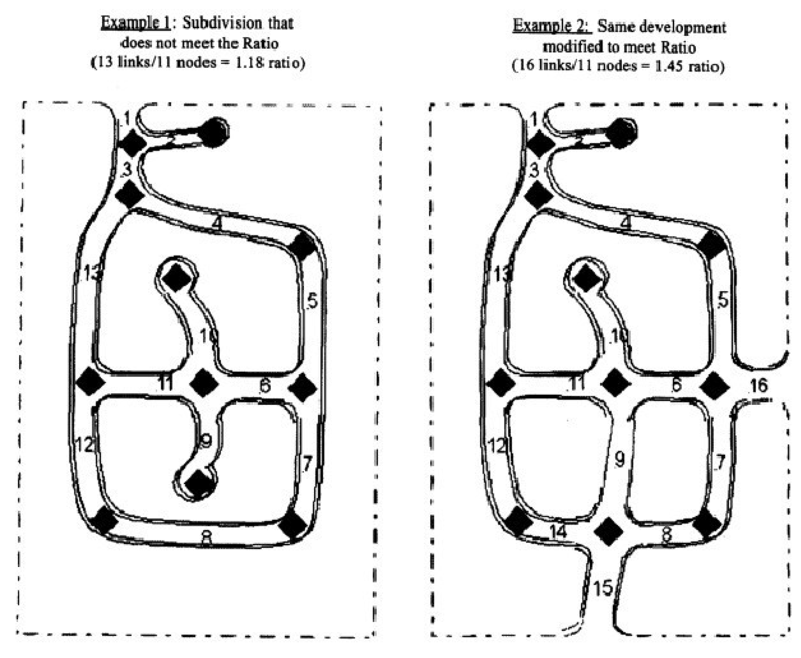
10.112.4. - [Street links.]
For the purposes of this section, the street links and nodes within the collector or thoroughfare streets providing access to a proposed subdivision shall not be considered in computing the connectivity ratio.
10.112.5. - [Residential Streets.]
Residential streets shall be designed so as to minimize the length of local streets, to provide safe access to residences, and to maintain connectivity between and through residential neighborhoods for autos and pedestrians.
10.112.6. - [Extensions.]
Where necessary to provide access or to permit the reasonable future subdivision of adjacent land, rights-of-way, and improvements shall be extended to the boundary of the development. A temporary turnaround may be required where the dead end exceeds one hundred fifty (150) feet in length. The platting of partial width rights-of-way shall be prohibited except where the remainder of the necessary right-of-way has already been platted, dedicated, or established by other means.
(Ord. No. ZA-23-06, pt. 2, 11-12-24)
10.112.7. - [Utility Stub-Outs.]
Utility stub-outs shall be provided at all required points of street connectivity.
10.112.8. - Ingress/Egress.
Single-family or two-family developments with thirty (30) or more lots and multi-family residential developments with more than one hundred (100) dwelling units shall have a minimum of two (2) ingress/egress points onto a public street, or as required by the Fire Code.
(Ord. No. ZA-23-06, pt. 2, 11-12-24)
Editor's note— Ord. No. ZA-23-06, pt. 2, adopted Nov. 12, 2024, renumbered the former § 10.111.8 as § 10.112.9 and enacted a new § 10.112.8 as set out herein. The historical notation has been retained with the amended provisions for reference purposes. See also editor's note at § 10.111.
10.112.9. - Exemptions.
New subdivisions that intend to provide one (1) new cul-de-sac street shall be exempt from the connectivity requirement when the UDO Administrator determines that the subdivision will provide for connectivity with adjacent future development and there are no options for providing stub streets due to topographic conditions, adjacent developed sites, or other limiting factors.
(Ord. No. ZA-23-06, pt. 2, 11-12-24)
Editor's note— See editor's note at § 10.112.9.
10.113.1. - [Construction Required.]
Except as provided in Section 10.113.3, sidewalks are required adjacent to one (1) side of new streets in subdivisions. The sidewalks required by this section shall be five (5) feet in width. All sidewalks shall be constructed according to the Smithfield Standard Detail and Specifications Manual.
(Ord. No. ZA-23-06, pt. 2, 11-12-24)
10.113.2. - [Pedestrian Access.]
Whenever the town finds that a means of pedestrian access is necessary from a subdivision to schools, parks, open space, playgrounds, roads, or other facilities and that such access is not conveniently provided by sidewalks adjacent to the streets, the developer shall be required to reserve an unobstructed easement of at least ten (10) feet in width and a five-foot sidewalk to provide such access.
(Ord. No. ZA-23-06, pt. 2, 11-12-24)
10.113.3. - [Subdivisions.] Exception.
Subdivisions fronting on major thoroughfares are required to construct five-foot wide sidewalk(s) on the thoroughfare right-of-way or adjacent to the right-of-way in a public easement. If the Smithfield Pedestrian Plan identifies a trail on the thoroughfare frontage or an eight-foot wide trail shall be installed in lieu of a sidewalk whether or not a sidewalk exists on the opposite side of the street. The sidewalk(s) and trails shall comply with the Town of Smithfield Standard Detail and Specifications Manual.
(Ord. No. ZA-23-06, pt. 2, 11-12-24)
Editor's note— Ord. No. ZA-23-06, pt. 2, adopted Nov. 12, 2024, amended § 10.113.3 and in doing so changed the title of said section from "[Subdivisions]" to "[Subdivisions.] Exceptions," as set out herein.
10.114.1. - Water and Sewerage Systems.
10.114.1.1. When available, the subdivider shall connect to the water and sewerage systems owned and operated by the town. For all residential and commercial development, the town may require that the developer install lines larger than required by the development in order to support future growth. The town will pay the material cost difference between the required utilities and the upsized lines.
10.114.1.2. Where public or community water supply and/or sewerage systems are not available or to be provided, a written statement from the County Health Department shall be submitted with the preliminary plat indicating that each lot has adequate land area and soil conditions suitable to accommodate the proposed methods of water supply and sewage disposal. The statement from the County Health Department shall be based upon a field investigation. The field investigation for sewage disposal shall include a sufficient number of percolation tests (at least one (1) per acre) to determine absorption capacity of the soil and test holes at least six (6) feet deep (as needed) to determine the depth to the ground water table, and the presence of rock formations or other impervious strata.
10.114.1.3. All Town utilities shall be installed in accordance with the Smithfield Standard Detail and Specifications Manualand at the direction of the Public Utilities Director.
(Ord. No. ZA-23-06, pt. 2, 11-12-24)
10.114.2. - Electric Power.
Every principal use and every lot within a subdivision shall have available to it a source of electric power adequate to accommodate the reasonable needs of such use and every lot within such subdivision. Compliance with this requirement shall be determined as follows:
10.114.2.1. If the use is not a subdivision and is located on a lot that is served by an existing power line and the use can be served by a simple connection to such power line (as opposed to a more complex distribution system, such as would be required in an apartment complex or shopping center), then no further certification is needed.
10.114.2.2. If the use is a subdivision or is not located on a lot served by an existing power line or a substantial internal distribution system will be necessary, then the electric utility service provider must review the proposed plans and certify to the town that it can provide service that is adequate to meet the needs of the proposed use and every lot within the proposed subdivision.
10.114.3. - Telephone Service.
Every principal use and every lot within a subdivision must have available to it a telephone service cable adequate to accommodate the reasonable needs of such use and every lot within such subdivision. Compliance with this requirement shall be determined as follows:
10.114.3.1. If the use is not a subdivision and is located on a lot that is served by an existing telephone line and the use can be served by a simple connection to such line (as opposed to a more complex distribution system, such as would be required in an apartment complex or shopping center), then no further certification is necessary.
10.114.3.2. If the use is a subdivision or is not located on a lot served by an existing telephone line or a substantial internal distribution system will be necessary, then the telephone utility company must review the proposed plans and certify to the town that it can provide service that is adequate to meet the needs of the proposed use and every lot within the proposed subdivision.
10.114.4. - Underground Utilities.
10.114.4.1. All electric power lines (not to include transformers or enclosures containing electrical equipment including, but not limited to, switches, meters, or capacitors which may be pad mounted), telephone, gas distribution, and cable television lines in subdivisions constructed after the effective date of this ordinance shall be placed underground in accordance with the specifications and policies of the respective utility service providers and the Town of Smithfield.
10.114.4.2. Whenever an unsubdivided development is hereafter constructed on a lot that is undeveloped on the effective date of this ordinance, then all electric power, telephone, gas distribution, and cable television lines installed to serve the development that are located on the development site outside of a previously existing public street right-of-way shall be placed underground in accordance with the specifications and policies of the respective utility service providers and the Town of Smithfield.
10.114.5. - Utilities to be Consistent with Internal and External Development.
10.114.5.1. Whenever it can reasonably be anticipated that utility facilities constructed in one (1) development will be extended to serve other adjacent or nearby developments, such utility facilities (i.e., water or sewer lines) shall be located and constructed so that extensions can be made conveniently and without undue burden or expense or unnecessary duplication of service.
10.114.5.2. All utility facilities shall be constructed in such a manner as to minimize interference with pedestrian or vehicular traffic and to facilitate maintenance without undue damage to improvements or facilities located within the development.
10.115.1. - Applicability.
Every person, firm, or corporation who subdivides land for residential purposes shall be required to dedicate a portion of such land for the purpose of public recreation/open space, including the preservation of natural and cultural resources, serving residents of the development or subdivision or more than one (1) subdivision or development within the immediate area and the Town of Smithfield.
(Ord. No. ZA-22-01, pt. 1, 12-6-22)
10.115.2. - Exceptions.
10.115.2.1. If the Town Council determines that assembling a piece of land to meet the requirements of this section, either (a) would create undue hardships, or (b) is not necessary because the needs of the subdivision are already being met by dedicated land, or the proposed land dedication does not meet the recreational needs of the area, it may require fee in lieu of land dedication in accordance with Section 10.115.8.
10.115.2.2. Reserved.
10.115.2.3. If the site abuts designated greenways or future greenways on the Town's Land Use Plan the Planning Board may recommend, and the Town Council may require, the dedication of a connecting path to the designated or future greenway. Also, the path must connect with an existing street that is accessible to all residents of the subdivision.
(Ord. No. ZA-22-01, pt. 1, 12-6-22)
10.115.3. - Dimensional Requirements.
At least seven (7) percent of an acre shall be dedicated for each dwelling unit planned or provided for in the subdivision plan, except where land is located in the flood plain of a stream or river as indicated by the flood plain maps of the Federal Insurance Administration and/or is characterized by steep slopes (fifteen (15) percent or greater), then at least ten (10) percent of an acre of such land shall be dedicated for each dwelling unit.
(Ord. No. ZA-22-01, pt. 1, 12-6-22)
10.115.4. - Site Suitability.
Land provided or dedicated for active recreational purposes shall be of a character, slope, and location suitable for use as play areas, tennis courts, multi-purpose courts, picnic areas, ball fields, and other similar recreation uses. Active recreation areas shall be located on land that is relatively flat (zero- to seven and one-half-percent slopes), free of wetlands and/or flood plains, free of easements for public utility transmission lines, and is otherwise capable of accommodating active recreation uses.
Land provided or dedicated for passive recreation and open space purposes shall be of a character, slope, and location suitable for use for walking, jogging, reading, and similar quiet activities, and the preservation of natural features and cultural resources such as steep slopes, rock outcrops, native plant life and wildlife cover, mature woodlands, and water resources.
In all cases, active and passive recreation sites as well as open space areas designated on the adopted Land Use Plan shall be incorporated into the design of the subdivision. Criteria for evaluating the suitability of proposed recreation areas shall include, but not be limited to, the following:
10.115.4.1. Location. Land dedicated for recreation purposes shall be located so as to serve the needs of the residents of the subdivision and the residents of the immediate neighborhood within which the subdivision is located. Recreation areas shall be located where more land better suited for recreational purposes due to shape, level slopes, and/or dry soil conditions is present. Where proposed park sites are shown on the adopted Land Use Plan, and a subdivision contains a portion of the park site, then the developer may be required to locate the recreation area in accordance with the park site as shown thereon.
10.115.4.2. Unity. Land dedicated for recreation purposes shall be a single parcel except where it is determined that two (2) or more parcels are suited to the needs of a particular subdivision. The Planning Board may recommend, and the Town Council may require, the dedication of a connecting path in addition to other land as may be required by this ordinance. Where a connecting path is necessary, a path of up to fifty (50) feet in width may be required, but in no case shall the path be less than thirty (30) feet in width.
10.115.4.3. Accessibility. Land dedicated for recreational purposes shall have at least fifty (50) feet of frontage on at least one (1) street within the subdivision. Where a recreation area is not accessible due to lot arrangement, the Planning Board may recommend, and the Town Council may require, the dedication of connecting paths which link the recreation area with other streets within the subdivision. Connecting paths so required shall be in addition to other land as may be required by this ordinance. Connecting paths of up to fifty (50) feet in width may be required, but in no case shall the paths be less than thirty (30) feet in width.
10.115.4.4. Usability. The dedicated land shall be usable for recreation. Lakes may not be included in computing dedicated land area unless acceptable to the Planning Board. Where the Planning Board determines that recreation needs are being adequately met, either by other dedicated parcels or existing recreation facilities, then land that is not used for recreation may be dedicated as open space.
10.115.5. - Recreation Facilities.
Private recreation facilities, either required or provided at the option of the applicant, shall meet the standards for site improvements contained herein. When choosing improvements for a recreational area, the anticipated characteristics and needs of the residents shall be considered in conjunction with the size of the development, any physical constraints posed by the site, and the availability of other improvements within the same general area as the subdivision. As an example, the existence of a public multi-purpose court in an adjacent, existing subdivision and the availability of the facility for use by residents of the proposed subdivision may indicate to the applicant that another facility, such as a tennis court, would be more appropriate. Recreation facilities which are suitable for various age groups include, but are not limited to, those shown on the following pages. Trash receptacles shall be provided for all recreational areas regardless of the number and type of other improvements located thereon. The owner/developer may choose
from the following recreational facilities. Other recreational facilities such as disk golf may be approved by the UDO Administrator. Dedicated public recreational facilities shall adhere to these standards.
RESIDENTIAL RECREATION FACILITY DEVELOPMENT STANDARDS FACILITY REQUIREMENTS PER DWELLING UNIT
In addition to land provided or dedicated for active recreation purposes, sufficient area shall be provided to make available a minimum of five (5) off-street parking spaces for the first two acres of each recreation site and one (1) space for each additional acre thereafter.
Where any of the following facilities are also provided, off-street parking as required shall be provided in addition to the general standard above.
Off-street parking shall comply with UDO Part I.
(Ord. No. ZA-22-01, pt. 1, 12-6-22)
10.115.6. - Flexibility in Administration Authorized.
10.115.6.1. The requirements set forth in this article may be deviated from due to the particular nature of a tract of land, or the nature of the facilities proposed for installation, or other factors, if: (i) the objectives underlying these standards can be met without strict adherence to them; and (ii) because of peculiarities in the developer's tract of land or the facilities proposed it would be unreasonable to require strict adherence to these standards.
10.115.6.2. Whenever the permit issuing board authorizes some deviation from the standards set forth in this section pursuant to subsection 10.115.6.1, the official record of action taken on the development application shall contain a statement of the reasons for allowing the deviation.
(Ord. No. ZA-22-01, pt. 1, 12-6-22)
10.115.7. - Method of Provision or Dedication.
Land dedicated for public recreation area as required by this ordinance shall be designated on both the preliminary and final plat(s) of the subdivision and must be dedicated to an appropriate unit of local government. Determination of the appropriate unit of local government shall be made by the Town Council, and the Planning Board. Acceptance of the dedication may be one in trust if deemed appropriate by the Town Council.
(Ord. No. ZA-22-01, pt. 1, 12-6-22)
10.115.8. - Payments in Lieu of Dedication.
Any subdivider required to dedicate recreation area pursuant to this ordinance may, with the approval of the Town Council, make a payment in lieu of dedication or make a combination of land dedicated and payment. Before approving a payment in lieu of dedication, the Town Council shall find that no recreation and/or open space sites have been designated on the adopted Land Use Plan for the property in question.
The payment in lieu of dedication shall be equal to the appraised tax value of the required acreage of land within the subdivision.
Where a combination of land dedication and payments in lieu are approved, the subdivider shall be given a credit equivalent to the appraised tax value per acre of land dedicated for recreation purposes. The credit amount shall be determined by multiplying the number of acres to be dedicated by the appraised tax value per acre. If the total payment in lieu as determined above is larger than the credit amount, the subdivider shall pay the difference between the two (2) amounts. If the credit amount is larger than the total payment in lieu as determined above, no additional payment in lieu is required. However, the subdivider may not transfer the excess credit from one (1) subdivision to another.
Upon approval by the Town Council, payment in lieu of dedication shall be made at the time of final subdivision plan approval. All monies received by the Town of Smithfield pursuant to these requirements shall be used only for the acquisition and development of recreation, park, and open space sites to serve the residents of the development and the residents of other developments in the immediate area within which the development is located. The Town Council shall also have the authority to sell land dedicated pursuant to these provisions with the proceeds of any such sale used solely for the acquisition of other recreation, park, or open space sites within the immediate area within which the development is located.
(Ord. No. ZA-22-01, pt. 1, 12-6-22)
10.117.1. - Plat Approval Shall Not Constitute Acceptance.
Pursuant to G.S. § 160D-806 the approval of a plat shall not be deemed to constitute or effect the acceptance by the municipality or public of the dedication of any street or other ground, public utility line, or other public facility shown on the plat. To be effective, all offers of dedication must be accepted by resolution.
10.117.2. - Acceptance of Dedications.
10.117.2.1. At the time of submittal of a preliminary plat with streets, utilities, or other proposed to be dedicated for acceptance by the town as public, the Town Council will decide if it will approve the dedication, subject to the street(s), parks, utilities, sidewalks, or other complying with all town requirements for acceptance. The Town of Smithfield is not obligated to accept any offer of dedication.
10.117.2.2. Acceptance of dedication will be provided by administrative approval of the final plat.
(Ord. No. ZA-23-06, pt. 2, 11-12-24)
10.119.1. - Minor Subdivision Approval.
10.119.1.1. Certificate of Ownership. I hereby certify that I am (we are) the owner(s) of the property shown and described hereon, which property is within the subdivision regulation jurisdiction of the Town of Smithfield, and that I freely adopt this plan of subdivision.
___________ ________
Owner(s) Date
10.119.1.2. Certificate of Approval. I hereby certify that the minor subdivision shown on this plat does not involve the creation of new public streets or any change in existing public streets, that the subdivision shown is in all respects in compliance with the Town of Smithfield Unified Development Ordinance, and that therefore this plat has been approved by the UDO Administrator, subject to its being recorded in the Johnston County Registry within sixty days of the date below.
___________ ________
UDO Administrator Date
10.119.1.3. Flood Damage Prevention Certificate of Approval for Recording. I certify that the plat shown hereon complies with the Town of Smithfield Flood Damage Prevention requirements and is approved by Smithfield for recording in the Register of Deeds office.
___________ ________
UDO Administrator Date
10.119.1.4. Certificate of Survey and Accuracy. I, ___________, certify that this plat was drawn under my supervision from an actual survey made under my supervision (deed description recorded in Book ________, Page ________ etc.) (other); that the boundaries not surveyed are clearly indicated as drawn from information found in Book ________, Page ________, that the ratio of precision as calculated is 1:________, that this plat was prepared in accordance with G.S. § 47-30 as amended. Witness my original signature, registration number and seal this ________ day of ________ A.D., 20________.
___________ Official Seal
Professional Land Surveyor
___________
Registration Number
The certificate of the Notary shall read as follows:
North Carolina, ___________County
I, ___________, a Notary Public of the County and State aforesaid, certify that ___________, a registered land surveyor, personally appeared before me this day and acknowledged the execution of the foregoing instrument. Witness my hand and official stamp or seal, this ________ day of ________, 20________.
___________ Official Seal
Signature
My Commission Expires:___________
10.119.1.5. Review Officer Certification. I, ___________, Review Officer of Johnston County, certify that the map or plat to which this certification is affixed meets all statutory requirements for recording.
___________ ________
Review Officer Date
10.119.1.6. Statement of Compliance with the Town of Smithfield Riparian Buffer Requirements. I certify that this subdivision fully complies with the 15A NCAC 25.023 Neuse River Basin Nutrient Sensitive Waters Management Strategy: Basinwide Stormwater Requirements.
___________ ________
Stormwater Administrator Date
10.119.1.7. Watershed Protection Approval Certification. I certify that the plat shown hereon complies with the Watershed Protection Ordinance and is approved by the Town Council for recording in the Johnston County Register of Deeds office.
___________ ________
Date Watershed Administrator
NOTICE: This property is located within a Public Water Supply Watershed— development restrictions may apply.
(Ord. No. ZA-23-09, pt. 2, 1-23-24)
Editor's note— Ord. No. ZA-23-09, pt. 2, adopted Jan. 23, 24, set out provisions intended for use as 10.119.1.6. Inasmuch as there were already provisions so designated, said section has been codified herein as 10.119.1.7 at the discretion of the editor.
10.119.2. - Major Subdivision Approval.
10.119.2.1. Certificate of Ownership and Dedication. I hereby certify that I am the owner of the property shown and described hereon, which is located in the subdivision jurisdiction of the Town of Smithfield, and that I freely adopt this subdivision plan with my free consent, establish minimum setback lines, and dedicate all streets, alleys, parks, and other sites and easements to public or private use as noted.
___________ ________
Owner Date
10.119.2.2. Certificate of Improvements. If the required improvements are completed prior to the submission of the Final Plat, the following certificate shall be lettered on the plat above the signature of the Town Engineer:
"Know all men by these present, that I hereby certify that on this, the ________ day of ________, 20________, all of the improvements as required by the Smithfield Subdivision Regulations have been installed by the developer in an approved manner."
If the required improvements are not completed prior to the submission of the Final Plat, the following certificate shall be lettered on the plat above the signature of the Town Manager:
"Know all men by these presents, that I hereby certify performance guarantee sufficient to secure the amount of $________ has been posted with the Town of Smithfield by the developer, thereby guaranteeing that all improvements required by the Smithfield Subdivision Regulations shall be constructed. Such improvements shall be completed within days from the date of this statement."
10.119.2.3. Flood Damage Prevention Certificate of Approval for Recording. I certify that the plat shown hereon complies with the Town of Smithfield Flood Damage Prevention requirements and is approved by Smithfield for recording in the Register of Deeds office.
___________ ________
UDO Administrator Date
10.119.2.4. Certificate of Survey and Accuracy. I, ___________, certify that this plat was drawn under my supervision from an actual survey made under my supervision (deed description recorded in Book ________, Page ________ etc.) (other); that the boundaries not surveyed are clearly indicated as drawn from information found in Book ________, Page ________, that the ratio of precision as calculated is 1: ________, that this plat was prepared in accordance with G.S. § 47-30 as amended. Witness my original signature, registration number and seal this ________ day of ________ A.D., 20________.
___________ Official Seal
Professional Land Surveyor
___________
Registration Number
The certificate of the Notary shall read as follows:
North Carolina, ___________ County
I, ___________, a Notary Public of the County and State aforesaid, certify that ___________, a registered land surveyor, personally appeared before me this day and acknowledged the execution of the foregoing instrument. Witness my hand and official stamp or seal, this ________ day of ________, 20________.
___________ Official Seal
Signature
My Commission Expires:___________
10.119.2.5. Approval and Acceptance of Dedication by the Town Council. I hereby certify that the Town of Smithfield has approved this plat for recording in the office of the Johnston County Register of Deeds, and accepts the dedication of streets, easements, rights-of-way, and public lands shown thereon, but assumes no responsibility to open or maintain the same until, in the opinion of the Smithfield Town Council, it is in the public interest to do so.
___________ ________
Town Manager Date
10.119.2.6. Review Officer Certification. I, ___________, Review Officer of Johnston County, certify that the map or plat to which this certification is affixed meets all statutory requirements for recording.
___________ ________
Review Officer Date
10.119.3. - Electronic Documents.
In order for a plat defined as an electronic document under G.S. § 47-16.2(3) to meet the requirements for plat size, reproducible form, and necessary certification, the following conditions must be met:
10.119.3.1. The Johnston County Register of Deeds has authorized the submitter to electronically register the electronic document.
10.119.3.2. The plat is submitted by a U.S. federal or state governmental unit or instrumentality or a trusted submitter.
10.119.3.3. Evidence of required certifications appear(s) on the digitized image of the document as it will appear on the public record.
10.119.3.4. With respect to a plat submitted by a trusted submitter, the digitized image of the document as it will appear on the public record contains the submitter's name in the following completed statement on the first page of the document image: "Submitted electronically by (submitter's name) in compliance with North Carolina statutes governing recordable documents and the terms of the submitter agreement with the Johnston County Register of Deeds."
10.119.3.5. Except as otherwise provided in this subsection, the digitized image of the plat conforms to all other applicable laws and rules that prescribe recordation.
10.119.4. - Exempt Plats.
10.119.4.1. Exempt Certification. I hereby certify that this recorded plat has been found to comply with the subdivision ordinance of the Town of Smithfield, North Carolina, and that this plat has been approved for recording in the register of deeds of Johnston County.
___________ ________
UDO Administrator Date
(Ord. No. ZA-23-06, pt. 2, 11-12-24)
Editor's note— Ord. No. ZA-23-06, pt. 2, adopted Nov. 12, 2024, set out provisions intended for use as § 10.119.1. Inasmuch as there were already provisions so designated, said section has been codified herein as § 10.119.4 at the discretion of the editor.