
Smithfield City Zoning Code
APPENDIX A—DEFINITIONS
Sec. A.1.- Purpose.
For the purposes of this ordinance, certain words, concepts, and ideas are defined herein. Except as defined herein, all other words used in this ordinance shall have their customary dictionary definition.
Sec. A.2. - Interpretation.
A.2.1. As used in this ordinance, words importing the masculine gender include the feminine and neuter.
A.2.2. Words used in the singular in this ordinance include the plural and words used in the plural include the singular.
A.2.3. Words used in the present tense include future tense.
A.2.4. The word "person" includes a firm, association, organization, corporation, company, trust, and partnership as well as an individual.
A.2.5. The words "may" and "should" are permissive.
A.2.6. The words "shall" and "will" are always mandatory and not merely directive.
A.2.7. The word "used for" shall include the meaning "designed for."
A.2.8. The words "used" or "occupied" shall mean "intended, designed, and arranged to be used or occupied."
A.2.9. The word "lot" shall include the words "plot," "parcel," "site," and "premises."
A.2.10. The word "structure" shall include the word "building."
A.2.11. The word "street" includes the word "alley," "road," "cul-de-sac," "highway," or "thoroughfare," whether designated as public or private.
A.2.12. The word "includes" shall not limit the term to specified examples, but is intended to extend its meaning to all other instances or circumstances of like kind or character.
A.2.13. The word "Town Councilman" shall include "Town Council" of the Town of Smithfield, North Carolina.
A.2.14. The word "director" shall mean the Town Manager or his designee.
A.2.15. The word "UDO Administrator" shall mean the Administrator of this ordinance or his designee.
A.2.16. The words "Zoning Board," "Zoning Commission," or "Planning Commission" shall mean the "Town of Smithfield Planning Board."
A.2.17. The word "town" shall mean the "Town of Smithfield," a municipal corporation of the State of North Carolina.
A.2.18. The words "map," "zoning map," and "Smithfield Zoning Map" shall mean the "Official Zoning Map for the Town of Smithfield, North Carolina."
A.2.19. The words "Board of Adjustment" shall mean the "Town of Smithfield Board of Adjustment."
Sec. A.3. - Definitions.
A
Abandoned vehicle. A motor vehicle that:
(1)
Has been left upon a street or highway in violation of a law or ordinance prohibiting parking; or
(2)
Is left on property owned or operated by the town for longer than twenty-four (24) hours; or
(3)
Is left on private property without the consent of the owner, occupant, or lessee thereof longer than two (2) hours; or
(4)
Is left on any public street or highway for longer than seven (7) days.
Abutting. A property which directly touches another piece of property, including those separated by a street, railroad, or other transportation corridor.
Accessory apartments. A self-contained unit incorporated within an existing structure for a single family.
Accessory building, structure, or use. A building, structure, or use incidental to, and on the same lot as, a principal use.
Accessory Dwelling Unit (ADU). A self-contained dwelling unit that is located on the same lot as a principal dwelling that meets the supplemental regulations identified in Section 7.3.3. An Accessory Dwelling Unit may be located above a garage. Accessory Dwelling Units may be detached, attached, or internal to the principal dwelling. Only residential uses are permitted in Accessory Dwelling Units.
Act of God. (Amended 10/3/2017) An event, such as an earthquake, tornado, or hurricane, that is caused by natural forces and cannot be prevented or foreseen.
Addition (to an existing building). An extension or increase in the floor area or height of a building or structure.
Adjacent. (Amended 10/3/2017) Property abutting directly on the boundary of, touching, or sharing a common point.
Administrator. The UDO Administrator for the Town of Smithfield as appointed by the Town Manager.
Administrative approval. Approval that the UDO Administrator or designee is authorized to grant after administrative review.
Administrative decision. Decisions made in the implementation, administration, or enforcement of development regulations that involve the determination of facts and the application of objective standards set forth in this Ordinance. These are sometimes referred to as ministerial decisions or administrative determinations
Administrative review. Non-discretionary evaluation of an application by the UDO Administrator or designee. This process is not subject to a public hearing.
Adult day care center. The provision of group care and supervision in a place other than their usual place of abode on a less than twenty-four-hour basis to adults who may be physically or mentally disabled.
Adult establishment (including sexually-oriented businesses). Adult- or sexually-oriented businesses include any businesses or enterprises that have as one (1) of their business purposes or as a portion of their business an emphasis on matter and conduct depicting, describing, or related to anatomical areas and sexual activities specified in G.S. § 14-202.10, including the display or sale of sexual aid devices.
Affiliate. (Amended 10/3/2017) A person that directly, or indirectly through one (1) or more intermediaries, controls, is controlled by, or is under common control of another person.
Agricultural products. Agricultural products are defined as products obtained primarily through farming or agricultural activities, including, but not limited to: pumpkins; grains and seed crops; fruits of all kinds; vegetables; nursery, floral, ornamental, and greenhouse products; trees and forest products, including Christmas trees, firewood, and pine straw; bees and beekeeping products; seafood; dairy products, any USDA-recognized agricultural product. Processed or prepared food products of any kind shall not be considered as agricultural products.
Agriculture. (Amended 10/3/2017) The use of land for agricultural purposes, including farming, dairying, pasturage, agriculture, horticulture, floriculture, viticulture, forestry, and animal and poultry husbandry and the necessary accessory uses for packing, treating, or storing the produce; provided, however, that the operation of any such accessory uses shall be secondary to that of normal agricultural activities and provided further that the above uses shall not include the commercial feeding of garbage or offal to swine or other animals. The use of waters for stock watering, irrigation, or other farm purposes.
Airport. (Amended 10/3/2017) A place where aircraft can take off and land, be repaired, take on or discharge passengers or cargo, be stored or refueled.
Airport height hazard district definitions. For the purposes of Article 10, Part IX, Section 10.93, Airport Height Hazard District, the following items, phrases, and words shall have the meaning herein:
(1)
Airport elevation. The topographical elevation above mean sea level. At the Johnston Regional Airport this elevation is one hundred sixty-five (165) feet.
(2)
Approach and runway protection zone map. The Approach and Runway Protection Zone Map is compiled from the criteria in 14 CFR Part 77, "Objects Affecting Navigable Airspace." It shows the five-airport overlay zones affected by the Airport Overlay Zoning Ordinance, and includes the layout of runways, airport boundaries, elevations, and area topography. Applicable height limitation areas are shown in detail.
(3)
Airport overlay zones. Zones intended to place height and land use conditions on land impacted by airport operations while retaining the existing underlying zone. The Title 14 Code of Federal Regulations Part 77 (14 CFR Part 77) Surfaces and runway protection zones have been combined to create five (5) airport overlay zones. The five (5) specific zones create a comprehensive area focused on maintaining compatible land use around airports.
(4)
Approach surface. A surface longitudinally centered on the extended runway centerline, extending outward and upward from the end of the primary surface and at the same slope as the approach zone height limitation slope set forth in Section 10.93.4 of this ordinance. In plan, the perimeter of the approach surface coincides with the perimeter of the approach zone.
(5)
Conical surface (Zone E). The conical surface extends upward and outward from the periphery of the horizontal surface at a slope of twenty (20) feet horizontally for every one-foot vertically (20:1) for a distance of four thousand (4,000) feet. It is the outermost zone of the overlay areas and has the least number of land use restriction considerations.
(6)
Hazard to air navigation. An obstruction determined to have a substantial adverse effect on the safe and efficient utilization of the navigable air space.
(7)
Height. The height limits set forth in Section 10.93 and as shown on the height hazard map, the datum shall mean sea level elevation except as otherwise specified.
(8)
Horizontal surface (Zone D). The horizontal surface is a horizontal plane located one hundred fifty (150) feet above the established airport elevation and begins at the edge of the transitional surfaces and primary surface for a distance of five thousand (5,000) feet for visual approach runways.
(9)
Larger than utility runway. The runway that is constructed for and intended to be used for propeller driven aircraft or greater than twelve thousand five hundred (12,500) pounds maximum gross weight or jet powered aircraft.
(10)
Non-precision instrument runway. The runway having an existing instrument approach procedure utilizing air navigation facilities with only horizontal guidance, or area type navigation equipment, for which a straight-in non-precision instrument approach procedure has been approved or planned.
(11)
Obstruction. Any building, structure, growth, or other object, including a mobile object which exceeds a limiting height as set out in Section 10.93.4 of this ordinance.
(12)
Precision instrument runway. A runway having an existing instrument approach procedure utilizing an instrument landing system (ILS) or a precision approach radar (PAR), or a runway for which a precision approach system is planned and is so indicated on the approved airport layout plan or any other planning document.
(13)
Primary surface. The primary surface is longitudinally centered on a runway. When the runway has a specially prepared hard surface, the primary surface extends two hundred (200) feet beyond each end of that runway. When the runway has no specially prepared hard surface, the primary surface ends at each end of that runway. The width of the primary surface is one thousand (1,000) feet, or five hundred (500) feet on either side of the runway centerline, for a precision instrument runway.,
(14)
Runway. A defined area on an airport prepared for landing and takeoff of aircraft along its length.
(15)
Runway approach surface (Zone B). A critical overlay surface that reflects the approach and departure areas for each runway at an airport. The approach surface is longitudinally centered on the extended runway centerline, extending outward and upward from the end of the runway. The approach slope for visual runways is 20:1 for a distance of five thousand (5,000) feet.
(16)
Runway protection zone (RPZ) (Zone A). The area off the end of the runway end designed to provide a clear area that is free of above ground obstructions and structures to enhance the protection of people and property on the ground. Zone A is intended to provide a clear area that is free of above-ground obstructions and structures.
(17)
Transitional surfaces (Zone C). The transitional surface extending outward and upward at right angles to the runway centerline and extends at a slope of seven (7) feet horizontally for each one-foot vertically (7:1) from the sides of the primary and approach surfaces. The Transitional surfaces extend to the point at which they intercept the horizontal surface at a height of one hundred fifty (150) feet above the established airport elevation.
(18)
Utility runway. A runway intended solely for the operation of aircraft using visual approach procedures.
(19)
Visual runway. A runway intended solely for the operation of aircraft using visual approach procedures.
Alterations. The word "alteration" shall include any of the following:
(1)
Any addition to the height or depth of a building or structure;
(2)
Any change in the location of any of the exterior walls of a building or structure;
(3)
Any increase in the interior accommodations of a building or structure;
(4)
Any structure modification of a building or structure;
(5)
Any movement or relocation of a building or structure.
Antenna. (Amended 10/3/2017) Communication equipment that transmits, receives, or transmits and receives electromagnetic radio signals used in the provision of all types of wireless communication services.
Antenna array. (Amended 10/3/2017) A single or group of antenna(s) and their associated mounting hardware, transmission lines, or other appurtenances which share a common attachment device such as a mounting frame or mounting support structure for the sole purpose of transmitting or receiving electromagnetic waves.
Apartment. A room or suite of one (1) or more rooms, each of which has kitchen facilities and is designed or intended to be used, as an independent unit, on a rental basis.
Appeal. A request for a review of the Administrator's interpretation of any provision of this ordinance or a request for a variance.
Approval authority. The Town Council of the Town of Smithfield, the Board of Adjustment or other board or official designated by ordinance as authorized to grant the specific zoning or land use permit or approval that constitutes a site specific development plan.
Art gallery. An establishment engaged in the sale, loan, or display of art books, paintings, sculpture, or other works of art. This classification does not include libraries, museums, or non-commercial art galleries.
Art, work of. All forms of original creations of visual art including, but not limited to: sculpture, in any material or combination of materials, whether in the round, bas-relief, high relief, mobile, fountain, kinetic, or electronic; painting, whether portable or permanently fixed, as in the case of murals; mosaics; photographs; crafts made from clay, fiber and textiles, wood, glass, metal, plastics, or any other material, or any combination thereof; calligraphy; mixed media composed of any combination of forms or media; unique architectural stylings or embellishments, including architectural crafts; environmental landscaping; or restoration and renovation of existing works of art of historical significance. Signs are not considered artwork.
Artisan's workshop. An establishment for the preparation, display, and sale of individually crafted artwork, jewelry, furniture, sculpture, pottery, leathercraft, hand-woven articles, and related items. An artisan's workshop includes an establishment that is engaged in the low-impact manufacturing, assembly, repair, or servicing of industrial, business, or consumer machinery, equipment, products, or by-products. Examples include contractors and building maintenance services and similar uses that perform services off-site, low-impact clothing or textile manufacturing, commercial bakery, food service contractor, movie production facility, printing, publishing, lithography, sign-making, welding, woodworking, arts-based (culinary, dance, art, music, photography) classroom, and other similar uses.
As-built plan. Plans reflecting actual field conditions which may include the construction plans with any changes identified and shown on the plan.
Assembly. A joining together of completely fabricated parts to create a finished product.
Assembly uses/event center. The principal use of a site or facility owned and/or operated for social, educational, or recreational purposes for-profit or non-profit. Typical uses include, but are not limited to, weddings, receptions, private parties, educational/informational workshops, fraternal organizations and union halls defined as assembly uses in the NC State Building Code.
Assisted living residence. Any group housing and services program for two (2) or more unrelated adults, by whatever name it is called, that makes available, at a minimum, one (1) meal a day and housekeeping services and provides personal care services directly or through a formal written agreement with one (1) or more licensed home care or hospice agencies. Settings in which services are delivered may include self-contained apartment units or single or shared room units with private or area baths. There are three (3) types of assisted living residences: adult care homes, adult care homes that serve only elderly persons, and multi-unit assisted housing with services. As used in this definition, "elderly person" means: (i) any person who has attained the age of fifty-five (55) years or older and requires assistance with activities of daily living, housing, and services; or (ii) any adult who has a primary diagnosis of Alzheimer's disease or other form of dementia who requires assistance with activities of daily living, housing, and services provided by a licensed Alzheimer's and dementia care unit.
(1)
Adult care home. An assisted living residence in which the housing management provides twenty-four-hour scheduled and unscheduled personal care services to two (2) or more residents, either directly or for scheduled needs, through formal written agreement with licensed home care or hospice agencies. Some licensed adult care homes provide supervision to persons with cognitive impairments whose decisions, if made independently, may jeopardize the safety or well-being of themselves or others and therefore require supervision. Medication in an adult care home may be administered by designated trained staff. Adult care homes that provide care to two (2) to six (6) unrelated residents are commonly called family care homes. Adult care homes include halfway houses and drug rehab facilities.
(2)
Multi-unit assisted housing with services. An assisted living residence in which hands-on personal care services and nursing services which are arranged by housing management are provided by a licensed home care or hospice agency through an individualized written care plan. The housing management has a financial interest or financial affiliation or formal written agreement which makes personal care services accessible and available through at least one (1) licensed home care or hospice agency. The resident has a choice of any provider, and the housing management may not combine charges for housing and personal care services. All residents, or other compensatory agents, must be capable, through informed consent, of entering into a contract and must not be in need of twenty-four-hour supervision. Assistance with self-administration of medications may be provided by appropriately trained staff when delegated by a licensed nurse according to the home care agency's established plan of care.
Attached dwelling unit for individual ownership (townhouse). A dwelling unit having a common or party wall with another dwelling unit. Each attached dwelling unit is characterized by its own subdivided lot of record which is conveyed with the dwelling unit when purchased.
Automobile repair shop. The use of a site for the repair of automobiles, noncommercial trucks, motorcycles, motorhomes, recreational vehicles, or boats, including the sale, installation, and servicing of equipment and parts. This use includes muffler shops, auto repair garages, tire sales and installation, wheel and brake shops, body and fender shops, and similar repair and service activities, but excludes dismantling or salvage.
Automobile service stations. A building or lot dedicated to the rendering of services such as the sale of gasoline, oil, grease, and accessories and the minor repair of automobiles, excluding body work, overhauling, and painting.
B
Base station. (Amended 10/3/2017) A station at a specific site authorized to communicate with mobile stations, generally consisting of radio receivers, antennas, coaxial cables, power supplies, and other associated electronics.
Battery charging station. An electrical component assembly or cluster or component assemblies designed specifically to charge batteries within electric vehicles, which meet or exceed federal, state, and/or local requirements.
Battery exchange station. A fully automated facility that will enable an electric vehicle with a swappable battery to enter a drive lane and exchange the depleted battery with a fully charged battery through a fully automated process, which meets or exceeds federal, state, and/or local requirements.
Bed and breakfast inn. A house, or portion thereof, where short-term lodging rooms and meals are provided. The operator of the inn shall live on the premises or in adjacent premises (including boarding home(s) and tourist home(s)).
Berm. An earthen mound designed to provide visual interest, screen undesirable view, and/or decrease noise. Slopes not to exceed a ratio of twelve to one (12:1).
Best management practices (BMP). (Amended 10/3/2017) A structural or nonstructural management-based practice used singularly or in combination to reduce nonpoint source inputs to receiving waters in order to achieve water quality protection goals.
Block. A piece of land bounded on one (1) or more sides by streets or roads.
Board of Adjustment. A semi-judicial body, composed of representatives from the Town of Smithfield and the town's ETJ, which is given certain powers under and relative to this ordinance.
Bona fide farm. Agricultural activities as set forth in G.S. § 160D-903.
Buffer. (Amended 10/3/2017) An area of natural or planted vegetation through which stormwater runoff flows in a diffuse manner so that the runoff does not become channelized and which provides for infiltration of the runoff and filtering of pollutants. The buffer is measured landward from the normal pool elevation of impounded structures and from the bank of each side of streams or rivers.
Buffer strip. A planted strip which shall be a minimum of sixteen (16) feet in width, shall be composed of evergreen shrubs and/or trees, and which complies with Article 10, Part II of this Ordinance.
Buildable area. The portion of a lot remaining after required yards and environmental/regulatory constraints have been made.
Building. (Amended 10/3/2017) Any structure having a roof supported by columns or by walls, and intended for shelter, housing or enclosure of persons, animals or property. The connection of two (2) buildings by means of an open porch, breezeway, passageway, carport or other such open structure, with or without a roof, shall not be deemed to make them one (1) building.
Building, accessory. See "accessory structure."
Building code. (Amended 10/3/2017) The North Carolina State Building code and any other uniform building, fire, electrical, plumbing, or mechanical codes adopted by a recognized national code organization together with state or local amendments to those codes enacted solely to address imminent threats of destruction of property or injury to persons.
Building, commercial. Any building used for business purposes.
Building, detached. A building having no party or common wall with another building except an accessory building or structure.
Building frontage. The distance expressed in linear feet of the horizontal dimension of a building wall that is parallel and adjacent to one (1) or more of the qualifying areas as follows: (a) a public or private street;(b) a common parking area in the case of a planned center; (c) a public parking area; or (d) a public access walkway.
Building, height of. The vertical distance from the average finished grade (prior to the addition of any fill) of the building lot to the highest point of the building. The average grade will be based on the condition of the lot prior to the date of adoption of this ordinance.
Building inspector. The person, officer, and his authorized representatives, whom the Town Council has designated as their agent for the administration and enforcement of the town building codes and minimum housing code.
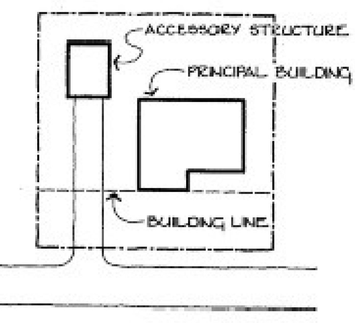
Building line. A line parallel to the street right-of-way which intersects the nearest point of the building to the street right-of-way.
Building line minimum. A line parallel to the street right-of-way which establishes the minimum allowable distance between the nearest portion of any building, excluding the outermost three (3) feet of any uncovered porches, steps, eaves, gutters and similar fixtures, and the street right-of-way line, when measured perpendicularly thereto, such minimum distance from the street right-of-way line as specified in Article 8, Zoning District Design Standards.
Building, main. A building in which the principal use of the lot on which the building is situated is conducted.
Building permit. An official administrative authorization issued by the Johnston County Inspections Department prior to beginning construction consistent with the provisions of G.S. § 160D-1101—1130.
Built-upon area. (Amended 10/3/2017) Built-upon areas shall include that portion of a development project that is covered by impervious or partially impervious cover including buildings, pavement, gravel areas (e.g. roads, parking lots, paths), recreation facilities (e.g. tennis courts), etc. (Note: Wooden slatted decks and the water area of a swimming pool are considered pervious.)
C
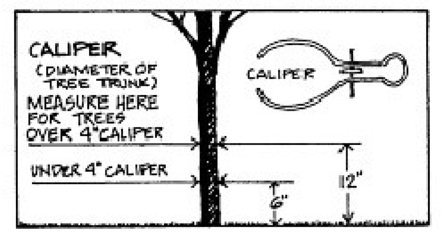
Caliper. A measurement of the diameter of a tree trunk taken to the following standards:
(1)
New nursery (to be installed) and nonregulated (existing on-site) trees: trees up to and including four (4) inches in diameter shall be measured six (6) inches above ground level. For trees above four (4) inches in diameter, the caliper measurement shall be taken twelve (12) inches above ground level.
(2)
Regulated on-site trees: the caliper of regulated trees shall be measured four and one-half (4½) feet above average ground level.
Canopy tree. An evergreen or deciduous tree that will attain a mature height greater than thirty-five (35) feet, with an expected crown spread of thirty (30) feet or more, as determined by the latest edition of American Standards of Nursery Stock.
Car wash. A building or structure where chain conveyors, blowers, steam cleaners, and other mechanical devices are employed for the purpose of washing motor vehicles.
Cemetery. (Amended 10/3/2017) A place used or to be used and dedicated or designated for interment of human remains or pet animal remains.
Certificate of occupancy/compliance. A statement signed by the Director or his authorized agent, after the building inspector, fire marshal, and UDO administrator has signed off that the building, structure, or use complies with or is significantly complete as proposed by any preliminary approved plan.
Certiorari. An appellate proceeding which brings into Superior Court or other appropriate forum the record of administrative, judicial, or quasi-judicial actions for the purposes of either reexamining the action taken by the inferior body to determine the appropriateness of said action or to obtain further information in the pending case.
Certify. Whenever this ordinance requires that some agency certify the existence of some fact or circumstance to the town, the town may require that such certification be made in any manner that provides reasonable assurance of the accuracy of the certification. By way of illustration, and without limiting the foregoing, the town may accept certification by telephone (with confirmation by mail) from some agency when the circumstances warrant it, or the town may require that the certification be in the form of a letter or other document.
Chemical storage facility. A building, portion of a building, or exterior area adjacent to a building used for the storage of any chemical or chemically reactive product.
Child care. A program or arrangement where three (3) or more children less than thirteen (13) years old, who do not reside where the care is provided, receive care on a regular basis of at least once per week for more than four (4) hours but less than twenty-four (24) hours per day from persons other than their guardians or full-time custodians, or from persons not related to them by birth, marriage, or adoption.
Child care facility. Includes child care centers, family child care homes, and any other child care arrangement not excluded by G.S. § 110-86(2) that provides child care, regardless of the time of day, wherever operated, and whether or not operated for profit.
(1)
Child care center. An arrangement where, at any one time, there are three (3) or more preschool-age children or nine (9) or more school-age children receiving child care.
(2)
Small child care center. Small centers in a residence that are licensed for six (6) to twelve (12) children which may keep up to three (3) additional school age children, depending upon the ages of other children in care. When the group has children of different ages, staff-child ratios and group size must be met for the youngest child in the group.
(3)
Family child care home. A child care arrangement located in a residence where, at any one time, more than two (2) children, but less than nine (9) children, receive child care.
Church or place of religious worship. An institution having state and federal tax exempt status that people regularly attend to participate in or hold religious services, meetings, and other activities. The term "church" shall not carry a secular connotation and shall include buildings in which the religious services of any denomination are held.
Circulation area. That portion of the vehicle accommodation area used for access to parking or loading areas or other facilities on the lot. Essentially, driveways and other maneuvering areas (other than parking aisles) comprise the circulation area.
City right-of-way. A right-of-way owned, leased, or operated by a town, including any public street or alley that is not a part of the state highway system.
City utility pole. A utility pole owned or operated by a town in the right-of-way of any public street or alley that is not part of the state highway system.
Club or private lodge. An incorporated or unincorporated association for civic, social, cultural, fraternal, literary, political, recreational or like activities operated on a nonprofit basis for the benefit of its members, and recognized as a nonprofit organization by the State of North Carolina.
Cluster development. (Amended 10/3/2017) Cluster development means the grouping of buildings in order to conserve land resources and provide for innovation in the design of the project including minimizing stormwater runoff impacts. This term includes nonresidential development as well as single-family residential and multi-family developments. For the purpose of this ordinance, planned unit developments and mixed use development are considered as cluster development.
Collocation. The placement, installation, maintenance, modification, operation, or replacement of wireless facilities on, under, within, or on the surface of the earth adjacent to existing structures, including utility poles, town utility poles, water towers, buildings, and other structures capable of structurally supporting the attachment of wireless facilities in compliance with applicable codes. The term "collocation" does not include the installation of new utility poles, Town utility poles, or wireless support structures.
Competent evidence. North Carolina General Statutes require that the rules of evidence as applied in the trial division of the General Court of Justice ordinarily be followed but adds the important exception that "when evidence is not reasonably available under such rules to show relevant facts, they may be shown by the most reliable and substantial evidence available." The Board just limit itself to the type of evidence that ought to be admissible before local administrative agencies generally. The term "competent" is essentially a synonym for "admissible before a local board."
Communication facility. (Amended 10/3/2017) The set of equipment and network components, including wires and cables and associated facilities used by a communication service provider to provide communication services.
Communication service. (Amended 10/3/2017) Cable service as defined in 47 U.S.C. § 522(6), information service as defined in 47 U.S.C. § 153(24), telecommunications service as defined in 47 U.S.C. § 153(53), or wireless services.
Communication service provider. (Amended 10/3/2017) A cable operator as defined in 47 U.S.C. § 522(5); a provider of information service, as defined in 47 U.S.C. § 153(24); a telecommunications carrier, as defined in 47 U.S.C. § 153(51); or a wireless provider.
Conditional zoning. A legislative zoning map amendment with site-specific conditions incorporated into the zoning map amendment.
Condominium. A dwelling unit in which the ownership of the occupancy rights to the dwelling unit is individually owned or for sale to an individual and such ownership is not inclusive of any land.
Construction plat. A plan with supporting data for a proposed subdivision, developed for the purpose of establishing the layout and provision of roads and utilities.
Contractor, general. One who is engaged in one (1) or more aspects of building construction and/or land development through a legal agreement.
Contractor, trades. One who accomplishes work or provides facilities under contract with another and specifically engages in a specialized trade, such as plumbing, heating, wiring, sheet metal and roofing work, etc.
Convenience store. A one-story, retail store containing less than two thousand (2,000) square feet of gross floor area that is designed and stocked to sell primary food, beverages, and other household supplies to customers who purchase only a relatively few items (in contrast to a supermarket). It is designed to attract and depends upon a large volume of stop-and-go traffic. Illustrative examples of convenience stores are those operated by the Fast Fare, 7-11, and Pantry chains.
County Commissioners. The Board of Commissioners of Johnston County, North Carolina.
Coverage. An area determined in square footage.
Critical area. (Amended 10/3/2017) The area adjacent to a water supply intake or reservoir where risk associated with pollution is greater than from the remaining portions of the watershed. The critical area is defined as extending either one-half (½) mile from the normal pool elevation of the reservoir in which the intake is located or to the ridge line of the watershed (whichever comes first); or one-half (½) mile upstream from the intake located directly in the stream or river (run-of-the-river), or the ridge line of the watershed (whichever comes first). Local governments may extend the critical area as needed. Major landmarks such as highways or property lines may be used to delineate the outer boundary of the critical area if these landmarks are immediately adjacent to the appropriate outer boundary of one-half (½) mile.
Curb (including curb and gutter). A structural element at the edge of an existing or proposed street or other way, generally at a higher elevation than the adjacent edge of roadway, installed to deter vehicles and water from leaving the roadway, to otherwise control drainage, to delineate the edge of existing or future roadways or driveways, to present a more finished appearance to the street, to assist in the orderly development of the roadside, and to contribute to the stability and structural integrity of the pavement.
Curtain wall. A continuous, uniform foundation enclosure constructed of masonry material and that is unpierced except for required ventilation and access. A curtain wall must comply with Town of Smithfield building code requirements.
Customary home occupations. Any use conducted entirely within a dwelling and carried on by the occupants thereof, which use is clearly incidental and secondary to the use of the dwelling for residential purposes and does not change the character thereof. Provided further that no mechanical equipment is installed or used except as is normally used for domestic or professional purposes, and that not over twenty-five (25) percent of the total floor space of any structure is used for the occupation. No home occupation shall be conducted in any accessory building except for the storage and service of a vehicle that is driven off site, such as a service repair truck, delivery truck, etc.
D
Data center. A data center is a building, dedicated space within a building, or a group of buildings used to house computer systems and associated components, such as telecommunications and storage systems.
Dedication. A gift by the owner, a right to use of land for a specified purpose or purposes, or a mandatory requirement to exercise the right to develop. Because a transfer of property rights is entailed, dedication must be made by written instrument, and is completed with an acceptance.
Designer. A professional who is permitted to prepare plans and studies required by this ordinance.
Detention facility. A structure designed and constructed for the collection and storage of surface water for subsequent gradual discharge.
Develop. The construction, landscaping, clearing projects or any other project which in any manner alters the natural structure of the land mass.
Development. Unless the context clearly indicates otherwise, the term means any of the following:
(1)
The construction, erection, alteration, enlargement, renovation, substantial repair, movement to another site, or demolition of any structure.
(2)
The excavation, grading, filling, clearing, or alteration of land.
(3)
The subdivision of land as defined in G.S. § 160D-802.
(4)
The initiation of substantial change in the use of land or the intensity of use of land.
Development (watershed). Any land disturbing activity which adds to or changes the amount of impervious or partially impervious cover on a land area or which otherwise decreases the infiltration of precipitation into the soil.
Development approval. An administrative or quasi-judicial approval made pursuant to this ordinance that is written and that is required prior to commencing development or undertaking a specific activity, project, or development proposal. Development approvals include, but are not limited to, zoning permits, site plan approvals, special use permits, variances, and certificates of appropriateness. The term also includes all other regulatory approvals required by regulations adopted pursuant to this ordinance including plat approvals, permits issued, development agreements entered into, and building permits issued.
Developed land use conditions. The land use conditions that would be permitted according to the current official town zoning maps.
Developer. A person who is responsible for any undertaking that requires a zoning permit, special use permit, or sign permit.
Dimensional nonconformity. A nonconforming situation that occurs when the height, size, or minimum floor space of a structure or the relationship between an existing building or buildings and other buildings or lot lines does not conform to the regulations applicable to the district in which the property is located.
Dish antenna (or earth station). An accessory structure and shall mean a combination of (1) antenna or dish antenna whose purpose is to receive communication or other signals from orbiting satellites and other extraterrestrial sources; (2) a low-noise amplifier which is situated at the focal point of the receiving component and whose purpose is to magnify and transfer signals; and (3) a coaxial cable whose purpose is to carry the signals into the interior of the building.
Dish antenna (or earth station) height. That distance as measured vertically from the highest point of the antenna or dish, when positioned at its lowest angle for operation, to ground level at the bottom of the vase which supports the antenna.
Dish antenna (or earth station) setback. The distance measured from the center mounting post supporting the antenna.
Disposal. The discharge, deposit, injection, dumping, spilling, leaking or placing of any solid waste into or on any structure, land, or water so that the solid waste or any constituent part of the solid waste may enter the environment or be emitted into the air or discharged into any waters, including groundwaters.
Distillery. A distillery as permitted by NCGS is an enterprise which engages in one (1) or more of the following:
(1)
Manufacture, purchase, import, possess and transport ingredients and equipment used in the distillation of spirituous liquor;
(2)
Sell, deliver and ship spirituous liquor in closed containers at wholesale to exporters and local boards within the state, and, subject to the laws of other jurisdictions, at wholesale or retail to private or public agencies or establishments of other states or nations;
(3)
Transport into or out of the distillery the maximum amount of liquor allowed under federal law, if the transportation is related to the distilling process.
District. Any section of the Town of Smithfield and its extraterritorial jurisdiction in which zoning regulations are uniform.
Drip line. A vertical line running through the outermost portion of the crown of a tree and extending to the ground.
Drive-in facility. An establishment at which employees provide curb service to customers and at which the customer does not customarily leave his vehicle; or accommodations through special equipment or construction from which a person may receive a service or place an order. Self-service gas pumps are excluded from this definition.
Driveway. That portion of the vehicle accommodation area that consists of a travel lane bounded on either side by an area that is not part of the vehicle accommodation area.
Dwelling. Any building, structure, manufactured home, or mobile home, or part thereof, used and occupied for human habitation or intended to be so used, and includes any outhouses and appurtenances belonging thereto or usually enjoyed therewith. For the purposes of this ordinance, the term does not include any manufactured home, mobile home, or recreational vehicle, if used solely for a seasonal vacation purpose.
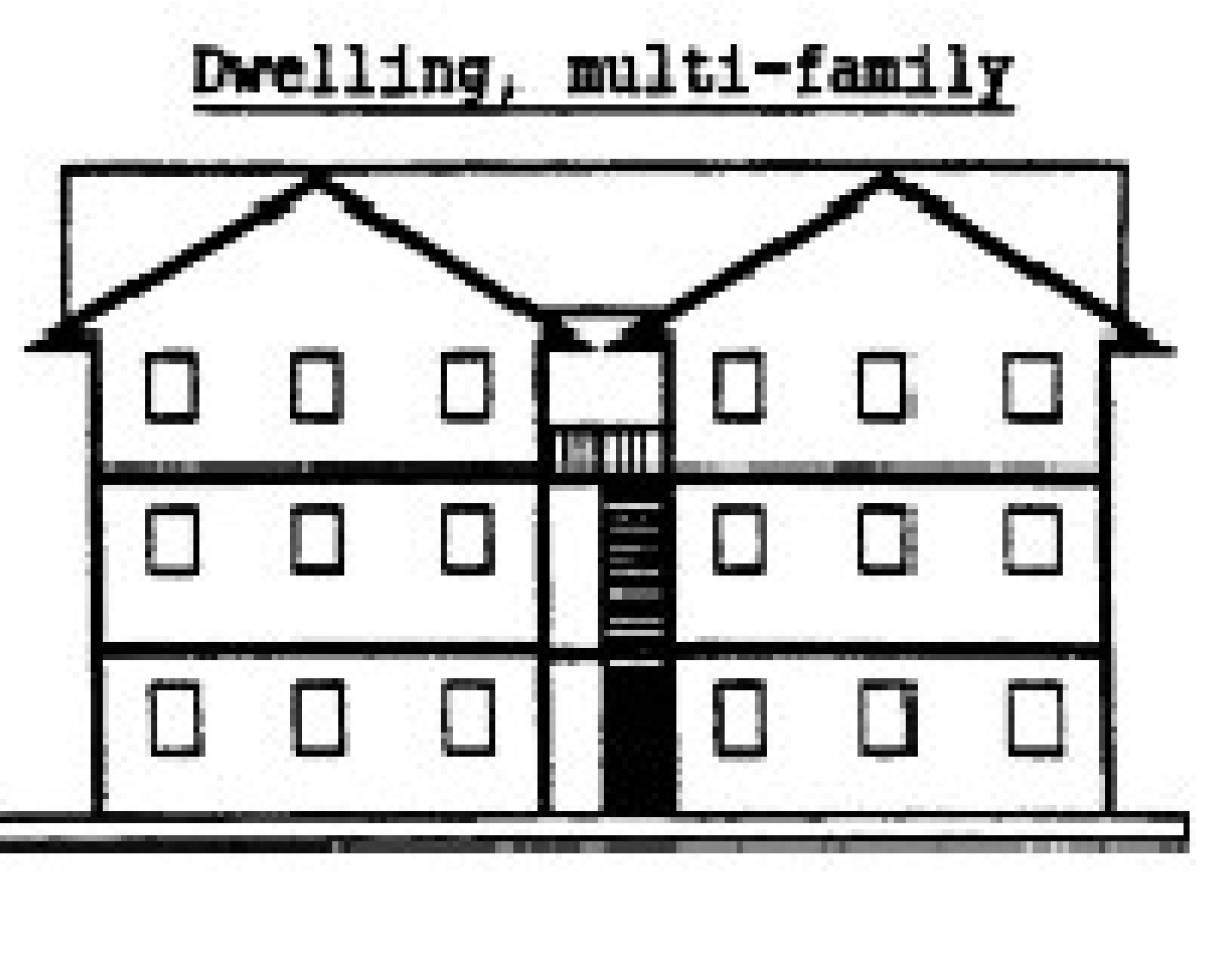
Dwelling, multiple family. A residential building designed for or occupied by three (3) or more families, with the number of families in residence not exceeding the number of dwelling units provided.
Dwelling, single-family. A detached building designed for or occupied exclusively by one (1) family.
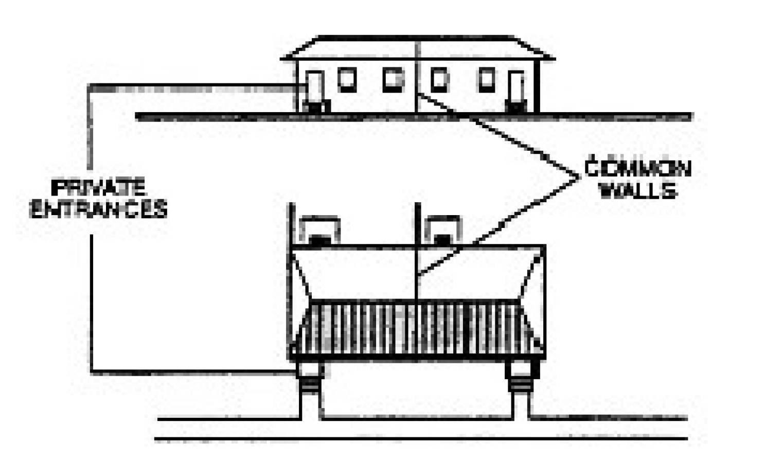
Dwelling, two family (duplex). A detached residential building containing two (2) dwelling units, designed for occupancy by not more than two (2) families. Units must share a common wall.
Dwelling unit. A room or group of rooms within a dwelling forming a single, independent, habitable unit; containing an independent kitchen, sanitary, and sleeping facilities; and provided such dwelling unit complies with local minimum housing standards.
E
Easement. A grant by the property owner of a strip of land for a specified purpose and use by the public, a corporation, or persons.
Effective date of this ordinance. Whenever the effective date of this ordinance is referred to, the reference shall be deemed to include the effective date of any amendments to this ordinance if the amendment, rather than this ordinance as originally adopted, creates a nonconforming situation.
Electric vehicle. Any vehicle that operates, either partially or exclusively, on electrical energy from the grid, or an off-board source, that is stored on-board for energy purpose. Electric vehicle includes: (1) a battery powered electric vehicle; and (2) a plug-in hybrid electric vehicle.
Electric vehicle charging station. A public or private parking space located together with a battery charging station which permits the transfer of electric energy (by conductive or inductive means) to a battery or other storage device in an electric vehicle. An electric vehicle charging station is permitted as an accessory use to any principal use.
Electric vehicle parking space. Any marked parking space that identifies the use to be exclusively for an electric vehicle.
Eligible facilities request. (Amended 10/3/2017) A request for modification of an existing wireless tower or base station that involves collocation of new transmission equipment or replacement of transmission equipment but does not include substantial modification.
Energy generating facility. A facility that uses a variety of sources and/or products for the production of power. Energy facilities may include, but are not limited to: petroleum; methane; ethanol; thermal; wind; solar; hydro-electric; and other energy generation facilities.
Engineered stormwater control. (Amended 10/3/2017) A structural BMP used to reduce pollution or peak flow rates to downstream properties and receiving waters in order to achieve water quality or water quantity control.
Entertainment, indoor. An establishment offering entertainment or games of skill to the general public for a fee or charge where the activity takes place indoors. Typical uses include bowling alleys; indoor tennis facilities; indoor swimming pools; inflatable play equipment; racquet clubs; game rooms including, but not limited to, video games, mechanical games, pay devices, or tables for which charge in money or some other valuable is made either directly or indirectly; laser tag; escape rooms; climbing walls; trampoline park; and electric go-karts.
Entertainment, outdoor. An establishment offering entertainment or games of skill to the general public for a fee or charge wherein any portion of the activity takes place in the open, excluding golf courses and public parks. Typical uses include archery ranges, athletic fields, batting cages, golf driving ranges and miniature golf courses, swimming pools and tennis courts.
Equipment compound. (Amended 10/3/2017) An area surrounding or near the base of a wireless support structure within which a wireless facility is located.
Erect. Build, construct, rebuild, or reconstruct, as the same are commonly defined.
Erosion. (Amended 10/3/2017) The wearing away of land surface by the action of wind, water, gravity or any combination thereof.
Essential site improvements. Any construction or reconstruction of the site development features required by local, state, or federal regulations, ordinances, or laws, such as underground drainage, off-street parking, driveways, retention areas or similar improvements required for the intended use of the site, which cannot be accommodated on the site without removal of the regulated trees.
Existing development. (Amended 10/3/2017) Those projects that are built or those projects that at a minimum have established a vested right under North Carolina zoning law as of the effective date of this ordinance based on at least one (1) of the following criteria:
(1)
Substantial expenditures of resources (time, labor, money) based on a good faith reliance upon having received a valid local government approval to proceed with the project, or
(2)
Having an outstanding valid building permit as authorized by G.S. § 160D-108, or
(3)
Having an approved site specific or phased development plan as authorized by G.S. § 160D-108.
Existing land use conditions. The land use conditions existing at the time the design plans are submitted for approval, including previously approved upstream developments.
Existing lot (lot of record). (Amended 10/3/2017) A lot which is part of a subdivision, a plat of which has been recorded in the Office of the Register of Deeds prior to the adoption of this ordinance, or a lot described by metes and bounds, the description of which has been so recorded prior to the adoption of this ordinance.
Ex parte. A Latin legal term meaning "from (by or for) [the/a] party." An ex parte decision is one decided by a judge without requiring all of the parties to the controversy to be present.
Extraterritorial jurisdiction. The area beyond the corporate limits within which the planning and zoning regulations of the town apply in accordance with state law. Such area is delineated on the official zoning map for the Town of Smithfield.
F
Fabrication. The process and/or assemblage of various components into a complete or partially completed commodity. Fabrication relates to stamping, cutting or otherwise shaping the processed materials into useful objects. The refining aspects of manufacturing and other initial processing of basic raw material such as metal ores, lumber and rubber, etc., are excluded.
Fall zone. (Amended 10/3/2017) The area in which a wireless support structure may be expected to fall in the event of a structural failure, as measured by engineering standards.
Family. An individual or two (2) or more persons related by blood, marriage, or adoption and living together in a dwelling; or a group of not more than four (4) unrelated persons living in a single unit.
Family care home. A home with support and supervisory personnel that provides room and board, personal care and habilitation services in a family environment for not more than six (6) resident persons with disabilities. "Person with disabilities" means a person with a temporary or permanent physical, emotional, or mental disability, including, but not limited to, mental retardation, cerebral palsy, epilepsy, autism, hearing and sight impairments, emotional disturbances and orthopedic impairments but not including mentally ill persons who are dangerous to others as defined in G.S. § 122C-3(11)b.
Family foster home. The private residence of one (1) or more individuals who permanently reside as members of the household and who provide continuing full-time foster care for a child or children who are placed there by a child placing agency or who provide continuing full-time foster care for two (2) or more children who are unrelated to the adult members of the household by blood, marriage, guardianship, or adoption.
Family subdivision. (Amended 10/3/2017) Family subdivision means a division of a tract of land: (a) to convey the resulting parcels, with the exception of parcels retained by the grantor, to a relative or relatives as a gift or for nominal consideration, but only if no more than one (1) parcel is conveyed by the grantor from the tract to any one (1) relative; or (b) to divide land from a common ancestor among tenants in common, all of whom inherited by intestacy or by will.
Farmers market. An establishment primarily engaged in the retail sale of fresh fruits and vegetables. Such uses are typically found in public or municipal markets.
Fence. A continuous barrier constructed of wood, stone, steel, or wire or other similar material.
Fence, screen. A continuous, opaque, unperforated barrier extending from the surface of the ground to a uniform height of not less than six (6) feet constructed of wood, stone, steel or similar material.
Fence, security. A continuous barrier extending from the surface of the ground to a uniform height of not less than six (6) feet constructed of wood, stone, steel, wire or other similar material.
Fill. Any material used to raise the elevation of the surface of the land, excluding a grade base and paving.
Fine arts. Individual art pieces, not mass-produced, consisting of one (1) or more (but not limited to one(1)) of the following: paintings, drawings, etchings, sculptures, ceramics, inlays, needlework, knitting, weaving and/or craftwork of leather, wood, metal or glass.
Flea market. A commercial operation held on a regular periodic basis and patronized by individual entrepreneurs who transport a variety of merchandise to a common geographical area for the purpose of sale or trade to the general public. This definition does not include sporadic and infrequent yard sales held in residential areas.
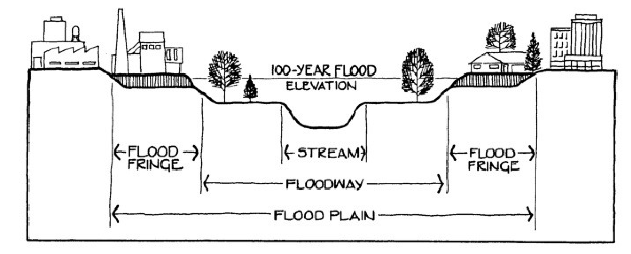
Flood damage prevention definitions. For the purposes of Article 10, Part VII, Flood Damage Prevention, the following items, phrases, and words shall have the meaning herein:
(1)
Accessory structure (appurtenant structure). A structure, which is located on the same parcel of property as the principal structure and the use of which is incidental to the use of the principal structure. Garages, carports, and storage sheds are common urban accessory structures. Pole barns, hay sheds, and the
like
qualify as accessory structures on farms, and may or may not be located on the same parcel as the farm dwelling or shop building.
(2)
Alteration of a watercourse. A dam, impoundment, channel relocation, change in channel alignment, channelization, or change in cross-sectional area of the channel or the channel capacity, or any other form of modification which may alter, impede, retard or change the direction and/or velocity of the riverine flow of water during conditions of the base flood. (Amended 4/3/2018)
(3)
Appeal. A request for a review of the UDO Administrator's interpretation of any provision of Article 10, Part VII.
(4)
Area of future-conditions flood hazard. The land area that would be inundated by the one-percent-annual-chance (one hundred-year) flood based on future-conditions hydrology. (Amended 4/3/2018)
(5)
Area of shallow flooding. A designated AO or VO zone on a community's Flood Insurance Rate Map (FIRM) with base flood depths from one (1) to three (3) feet where a clearly defined channel does not exist, where the path of flooding is unpredictable and indeterminate, and where velocity flow may be evident.
(6)
Area of special flood hazard. See "Special Flood Hazard Area (SFHA)."
(7)
Basement. The lowest level or story which has its floor subgrade on all sides.
(8)
Base flood. The flood having a one (1) percent chance of being equaled or exceeded in any given year.
(9)
Base flood elevation (BFE). A determination as published in the Flood Insurance Study of the water surface elevations of the base flood. This elevation, when combined with the freeboard, establishes the regulatory flood protection elevation.
(10)
Breakaway wall. A wall that is not part of the structural support of the building and is intended through its design and construction to collapse under specific lateral loading forces without causing damage to the elevated portion of the building or the supporting foundation system. A breakaway wall shall have a design safe loading resistance of not less than ten (10) and not more than twenty (20) pounds per square foot. A wall with loading resistance of more than twenty (20) pounds per square foot requires an architect or professional engineer's certificate.
(11)
Building. Any structure built for support, shelter, or enclosure for any occupancy or storage.
(12)
Design flood. See "regulatory flood protection elevation." (Amended 4/3/2018)
(13)
Development. Any man-made change to improved or unimproved real estate, including, but not limited to, buildings or other structures, mining, dredging, filling, grading, paving, excavation or drilling operations, or storage of equipment or materials.
(14)
Development activity. Any activity defined as development which will necessitate a floodplain development permit. This includes buildings, structures, and non-structural items, including, but not limited to, fill, bulkheads, piers, pools, docks, landings, ramps, and erosion control/stabilization measures. (Amended 4/3/2018)
(15)
Digital Flood Insurance Rate Map (DFIRM). The digital official map of a community, issued by the Federal Emergency Management Agency (FEMA), on which both the Special Flood Hazard Areas and the risk premium zones applicable to the community are delineated. (Amended 4/3/2018)
(16)
Elevated building. A non-basement building built to have the lowest floor elevated above the ground level by means of fill, solid foundation perimeter walls, pilings, columns (posts and piers), shear walls, or breakaway walls.
(17)
Encroachment. The advance or infringement of uses, fill, excavation, buildings, permanent structures or development into a floodplain, which may impede or alter the flow capacity of a floodplain.
(18)
Existing building and existing structure. Building and/or structure for which the "start of construction" commenced before date the community's first floodplain management ordinance was adopted. (Amended 4/3/2018)
(19)
Existing construction. For the purposes of determining rates, structures for which the start of construction commenced before the effective date of the FIRM or before January 1, 1975, for FIRMs effective prior to that date. "Existing construction" may also be referred to as "existing structures."
(20)
Existing manufactured home park or manufactured home subdivision. A manufactured home park or subdivision for which the construction of facilities for servicing the lots on which the manufactured homes are to be affixed (including, at a minimum, the installation of utilities, the construction of streets, and either final site grading or the pouring of concrete pads) was completed before the original effective date of the floodplain management regulations adopted by the town.
(21)
Expansion to an existing manufactured home park or subdivision. The preparation of additional sites by the construction of facilities for servicing the lots on which the manufactured homes are to be affixed (including the installation of utilities, the construction of streets, and either final site grading or the pouring of concrete slabs).
(22)
Flood or flooding. A general and temporary condition of partial or complete inundation of normally dry land areas from:
(a)
The overflow of inland or tidal waters; and/or
(b)
The unusual and rapid accumulation of runoff of surface waters from any source.
(23)
Flood boundary and floodway map (FBFM). An official map of a community, issued by the Federal Emergency Management Agency, on which the special flood hazard areas and the floodways are delineated. This official map is a supplement to and shall be used in conjunction with the flood insurance rate map (FIRM).
(24)
Flood hazard boundary map (FHBM). An official map of a community, issued by the Federal Emergency Management Agency, where the boundaries of the special flood hazard areas have been defined as Zone A.
(25)
Flood insurance. The insurance coverage provided under the National Flood Insurance Program.
(26)
Flood insurance rate map (FIRM). An official map of a community, issued by the Federal Emergency Management Agency, on which both the special flood hazard areas and the risk premium zones applicable to the community are delineated.
(27)
Flood insurance study (FIS). An examination, evaluation, and determination of flood hazard areas, corresponding water surface elevations (if appropriate), flood insurance risk zones, and other flood data in a community issued by the Federal Emergency Management Agency. The flood insurance study report includes flood insurance rate maps (FIRMs) and flood boundary and floodway maps (FBFMs), if published.
(28)
Flood prone area. See "floodplain."
(29)
Floodplain or flood prone area. Any land area susceptible to being inundated by water from any source.
(30)
Floodplain development permit. Any type of permit that is required in conformance with the provisions of Article 10, Part VII, prior to the commencement of any development activity.
(31)
Floodplain management. The operation of an overall program of corrective and preventative measures for reducing flood damage and preserving and enhancing, where possible, natural resources in the floodplain, including, but not limited to, emergency preparedness plans, flood control works, floodplain management regulations, and open space plans.
(32)
Floodplain regulations.Article 10, Part VII, and other zoning ordinances, subdivision regulations, building codes, health, regulations, special purpose ordinances, and other applications of police power which control development in flood-prone areas. This term describes federal, state, or local regulations, in any combination thereof, which provide standards for preventing and reducing flood loss and damage.
(33)
Floodproofing. Any combination of structural and nonstructural additions, changes, or adjustments to structures, which reduce or eliminate risk of flood damage to real estate or improved real property, water and sanitation facilities, or structures with their contents.
(34)
Flood-resistant material. Building product [material, component or system capable of withstanding direct and prolonged contact (minimum seventy-two (72) hours) with floodwaters without sustaining damage that requires more than low-cost cosmetic repair. Any material that is water-soluble or is not resistant to alkali or acid in water, including normal adhesives for above-grade use, is not flood-resistant. Pressure-treated lumber or naturally decay-resistant lumbers are acceptable flooring materials. Sheet-type flooring coverings that restrict evaporation from below and materials that are impervious, but dimensionally unstable are not acceptable. Materials that absorb or retain water excessively after submergence are not flood-resistant. Please refer to Technical Bulletin 2, Flood Damage-Resistant Materials Requirements, and available from the FEMA. Class 4 and 5 materials, referenced therein, are acceptable flood-resistant materials. Please refer to Technical Bulletin 2, Flood Damage-Resistant Materials Requirements, and available from the FEMA. Class 4 and 5 materials, referenced therein, are acceptable flood-resistant materials. (Amended 4/3/2018)
(35)
Floodway. The channel of a river or other watercourse, including the area above a bridge or culvert when applicable, and the adjacent land areas that must be reserved in order to discharge the base flood without cumulatively increasing the water surface elevation more than one (1) foot. (Amended 4/3/2018)
(36)
Floodway encroachment analysis. An engineering analysis of the impact that a proposed encroachment into a floodway or non-encroachment area is expected to have on the floodway boundaries and flood levels during the occurrence of the base flood discharge. The evaluation shall be prepared by a qualified North Carolina licensed engineer using standard engineering methods and models. (Amended 4/3/2018)
(37)
Flood zone. A geographical area shown on a flood hazard boundary map or flood insurance rate map that reflects the severity or type of flooding in the area.
(38)
Freeboard. The height added to the base flood elevation (BFE) to account for watershed development as well as limitations of the engineering methodologies for the determination of flood elevations. The freeboard plus the base flood elevation establishes the "regulatory flood protection elevation."
(39)
Highest adjacent grade. The highest natural elevation of the ground surface, prior to construction, immediately next to the proposed walls of the structure.
(40)
Letter of map change (LOMC). An official determination issued by FEMA that amends or revises an effective flood insurance rate map or flood insurance study. Letters of map change include: (Amended 4/3/2018)
(a)
Letter of map amendment (LOMA). An official amendment, by letter, to an effective National Flood Insurance Program map. A LOMA is based on technical data showing that a property had been inadvertently mapped as being in the floodplain, but is actually on natural high ground above the base flood elevation. A LOMA amends the current effective flood insurance rate map and establishes that a specific property, portion of a property, or structure is not located in a special flood hazard area.
(b)
Letter of map revision (LOMR). A revision based on technical l data that may show changes to flood zones, flood elevations, special flood hazard area boundaries and floodway delineations, and other planimetric features.
(c)
Letter of map revision based on fill (LOMR-F). A determination that a structure or parcel of land has been elevated by fill above the BFE and is, therefore, no longer located within the special flood hazard area. In order to qualify for this determination, the fill must have been permitted and placed in accordance with the community's floodplain management regulations.
(d)
Conditional letter of map revision (CLOMR). A formal review and comment as to whether a proposed project complies with the minimum NFIP requirements for such projects with respect to delineation of special flood hazard areas. A CLOMR does not revise the effective flood insurance rate map or flood insurance study; upon submission and approval of certified as-built documentation, a letter of map revision may be issued by FEMA to revise the effective FIRM.
(41)
Lowest adjacent grade. The lowest elevation of the ground, sidewalk, or patio slab immediately next to the building, or deck support, after completion of the building.
(42)
Lowest floor. The subfloor, top of slab or grade of the lowest enclosed area (including basement). An unfinished or flood resistant enclosure, usable solely for parking vehicles, building access, or limited storage in an area other than a basement area is not considered a building's lowest floor, provided that such an enclosure is not built so as to render the structure in violation of the applicable non-elevation design requirements of Article 10, Part VII.
(43)
Market value. The building value, excluding the land value and that of any accessory structures or other improvements on the lot, established by independent certified appraisal, replacement cost depreciated by age of building and quality of construction (actual cash value), or adjusted tax assessed values.
(44)
Non-encroachment area. The channel of a river or other watercourse and the adjacent land areas that must be reserved in order to discharge the base flood without cumulatively increasing the water surface elevation more than one (1) foot as designated in the Flood Insurance Study report.
(45)
Post-FIRM. Construction or other development which started on or after the effective date of the initial flood insurance rate map for the area.
(46)
Pre-FIRM. Construction or other development which started before the effective date of the initial flood insurance rate map for the area.
(47)
Principally above ground. At least fifty-one (51) percent of the actual cash value of the structure is above ground.
(48)
Reference level. The portion of a structure or other development that must be compared to the regulatory flood protection elevation to determine regulatory compliance. For structures within special flood hazard areas designated as Zone A1-A30, AE, A, or A99, the reference level is the top of the lowest floor or bottom of lowest attendant utility including ductwork, whichever is lower.
(49)
Regulatory flood protection elevation. The elevation, in relation to mean sea level, to which the reference level of all structures and other development located within special flood hazard areas must be protected. Where base flood elevations (BFEs) have been determined, this elevation shall be the BFE plus two (2) feet of freeboard. Where no BFE has been established, this elevation shall be at least two (2) feet above the highest adjacent grade.
(50)
Remedy a violation. To bring the structure or other development into compliance with state or local floodplain management regulations, or, if this is not possible, to reduce the impacts of its noncompliance. Ways that impacts may be reduced include protecting the structure or other affected development from flood damages, implementing the enforcement provisions of the ordinance or otherwise deterring future similar violations, or reducing federal financial exposure with regard to the structure or other development.
(51)
Repetitive loss. Flood-related damages sustained by a structure on two (2) separate occasions during any ten-year period for which the cost of repairs at the time of each such flood event, on the average, equals or exceeds twenty-five (25) percent of the market value of the structure before the damage occurred.
(52)
Riverine. Relating to, formed by, or resembling a river (including tributaries), stream, brook, etc.
(53)
Special flood hazard area (SFHA). The land in the floodplain subject to a one (1) percent or greater chance of flooding in any given year.
(54)
Structure. A walled and roofed building that is principally above ground, a manufactured home, a gas or liquid storage tank, or other manmade facilities or infrastructures.
(55)
Substantial damage. Damage of any origin sustained by a structure during any ten-year period whereby the cost of restoring the structure to its before damaged condition would equal or exceed fifty (50) percent of the market value of the structure before the damage occurred. (Amended 4/3/2018)
(56)
Substantial improvement. Any combination of repairs, reconstruction, rehabilitation, addition, or other improvement of a structure, taking place during any one-year period for which the cost equals or exceeds fifty (50) percent of the market value of the structure, before the start of construction of the improvement. This term includes structures which have incurred substantial damage, regardless of the actual repair work performed. The term does not, however, include either: (a) any correction of existing violations of state or local health, sanitary, or safety code specifications which have been identified by the community code enforcement official and which are the minimum necessary to assure safe living conditions; or, (b) any alteration of a historic structure, provided that the alteration will not preclude the structure's continued designation as a historic structure and the alteration is approved by variance issued pursuant to Section 10.72 of this ordinance. (Amended 4/3/2018)
(57)
Technical bulletin and technical fact sheet. A FEMA publication that provides guidance concerning the building performance standards of the NFIP, which are contained in Title 44 of the U.S. Code of Federal Regulations at Section 60.3. The bulletins and fact sheets are intended for use primarily by state and local officials responsible for interpreting and enforcing NFIP regulations and by members of the development community, such as design professionals and builders. New bulletins, as well as updates of existing bulletins, are issued periodically as needed. The bulletins do not create regulations; rather they provide specific guidance for complying with the minimum requirements of existing NFIP regulations. (Amended 4/3/2018)
(58)
UDO Administrator. The individual appointed to administer and enforce the floodplain management regulations.
(59)
Variance. A grant of relief from the requirements of Article 10, Part VII.
(60)
Violation. The failure of a structure or other development to be fully compliant with the town's floodplain management regulations. A structure or other development without the elevation certificate, other certifications, or other evidence of compliance required in Article 10, Part VII is presumed to be in violation until such time as that documentation is provided.
(61)
Water surface elevation (WSE). The height, in relation to mean sea level (existing grade in case of Zone AO), of floods of various magnitudes and frequencies in the floodplains of coastal or riverine areas.
(62)
Watercourse. A lake, river, creek, stream, wash, channel, or other topographic feature on or over which waters flow at least periodically. Watercourse includes specifically designated areas in which substantial flood damage may occur.
Floor. The top surface of an enclosed area in a building (including basement), i.e., top of slab in concrete slab construction or top of wood flooring in wood frame construction. The term does not include the floor of a garage used solely for parking vehicles.
Floor area. The total square footage on all floors within a building.
Floor area, gross. The number of square feet of total floor area bounded by the exterior faces of a structure, plus the number of square feet of unenclosed space devoted to the conduct of the use, excluding basements and unenclosed porches, balconies, and terraces, unless used in conjunction with the use, such as for outdoor eating, merchandising, storage, assembly, or similar uses, and excluding off-street parking and loading areas.
Forestry. A woodland area where all of the following occur:
(1)
The growing of trees;
(2)
The harvesting of timber, leaves, or seeds;
(3)
The regeneration of either timely replanting of trees or natural generation in accordance with a forest management plan acceptable to the Division of North Carolina Forest Resources;
(4)
The application of best management practices, including the North Carolina Department of Environment and Natural Resources, Forest Practice Guidelines Related to Water Quality, and all successor documents.
Foundation plantings. Required planted area between the curb line of a parking facility or drive isle and the building's façade.
Frontage. All property abutting on one (1) side of a street measured along the street line.
Fuel pump island. Any device or group of devices used for dispensing motor fuel or similar petroleum products to the general public.
G
G.S. or NCGS. North Carolina General Statute.
Garage apartment. A detached accessory or subordinate building to an existing single-family dwelling containing living facilities for not more than one (1) family and having sufficient enclosed area for at least one (1) parked automobile.
Garage, private. A building or space used as an accessory to or a part of the main building permitted in any residential district, that provides storage space for motor vehicles and in which no business, occupation or service for profit is in any way conducted.
Garage, public. Any building or premises, except those described as a private garage, used for the storage or care of motor vehicles, or where any such vehicles are equipped for operation, repaired, or kept for hire or sale.
Gate. A door or other device attached to a fence which, when opened, provides a means of ingress and egress of persons and things for which it was intended, and which, when closed, forms a continuous barrier and screen as a part of the fence in which it is attached.
Granny pod/temporary health care structure. A transportable residential structure providing an environment facilitating a caregiver's provision of care for a mentally or physically impaired person that (i) is primarily assembled at a location other than its site of installation, (ii) is limited to one (1) occupant who shall be the mentally or physically impaired person, (iii) has no more than three hundred (300) gross square feet, and (iv) complies with applicable provisions of the state building code and G.S. § 143-139.1(b). Mentally or physically impaired persons are those who require assistance with two (2) or more activities of daily living (bathing, dressing, personal hygiene, ambulation, transferring, toileting, and eating). The impairment must be certified in writing by a physician licensed in North Carolina.
Greenway. A linear park network left in its natural state, except for the introduction of trails to be used by pedestrians and bicyclists.
Gross density. The numerical value obtained by dividing the total number of dwelling units in a development by the gross area of the tract of land (in acres) within a development. This would include all nonresidential land uses and private streets of the development, as well as rights-of-way of dedicated streets; the result being the number of dwelling units per gross acre of land.
Gross site area. The total square footage of the proposed development as determined by actual on-site survey.
Guest lodging. A premises in which rooms are rented, with or without board, on a fee basis to permanent or transient guests; provided all accessory services, such as dining rooms, shall be available to such guests only, and not open to the general public.
Guideline. An objective.
H
Habitable floor. Any floor for living purposes, which includes working, sleeping, eating, cooking, or recreation, or any combination thereof. A floor used only for storage is not a habitable floor.
Half street. A street whose centerline coincides with a subdivision plat boundary, with one-half (½) the street right-of-way width being contained within the subdivision plat. Also, any existing street to which the parcel of land to be subdivided abuts on only one (1) side.
Hazardous waste management facility. A facility for the collection, storage, processing, treatment, recycling, recovery, or disposal of hazardous waste as defined in G.S. ch. 130A, art. 9.
Health spa. A commercial enterprise, private club, or business established for the purpose of providing an indoor facility for physical exercise with the use of athletic equipment and accessory services. The term "health spa" includes private exercise clubs, figure salons, or health clubs.
High density option. (Amended 10/3/2017) One (1) of two (2) approaches available for development in the Watershed Protection Overlays. The high density option relies on imperious surface limits and engineered stormwater controls to minimize risk of water pollution.
Historic Overlay District. That area designated by the Town of Smithfield and which is delineated upon a map adopted by the Town Council and on file at the Smithfield Town Clerk's Office.
Historic structure. Any structure that is:
(1)
Listed individually in the National Register of Historic Places (a listing maintained by the US Department of Interior) or preliminarily determined by the Secretary of Interior as meeting the requirements for individual listing on the National Register;
(2)
Certified or preliminarily determined by the Secretary of Interior as contributing to the historical significance of a registered historic district or a district preliminarily determined by the Secretary to qualify as a registered historic district;
(3)
Individually listed on a local inventory of historic landmarks in communities with a Certified Local Government (CLG) Program; or
(4)
Certified as contributing to the historical significance of a historic district designated by a community with a Certified Local Government (CLG) Program.
Certified Local Government (CLG) Programs are approved by the U.S. Department of the Interior in cooperation with the North Carolina Department of Cultural Resources through the State Historic Preservation Officer as having met the requirements of the National Historic Preservation Act of 1966 as amended in 1980.
Hotel (motel, inn). A building providing sleeping accommodations commonly available on a daily basis for pay to transient or permanent guests or tenants, in six (6) or more rooms. Dining rooms, restaurants or cafes, if existing, shall be conducted in the same building or buildings in connection therewith.
I
Impervious surface. Any material that significantly reduces and prevents natural infiltration of water into the soil. Impervious surfaces include, but are not limited to, roof, patios, balconies, decks, streets, parking areas, driveways, sidewalks, and any concrete, stone, brick, asphalt, or compacted gravel surface.
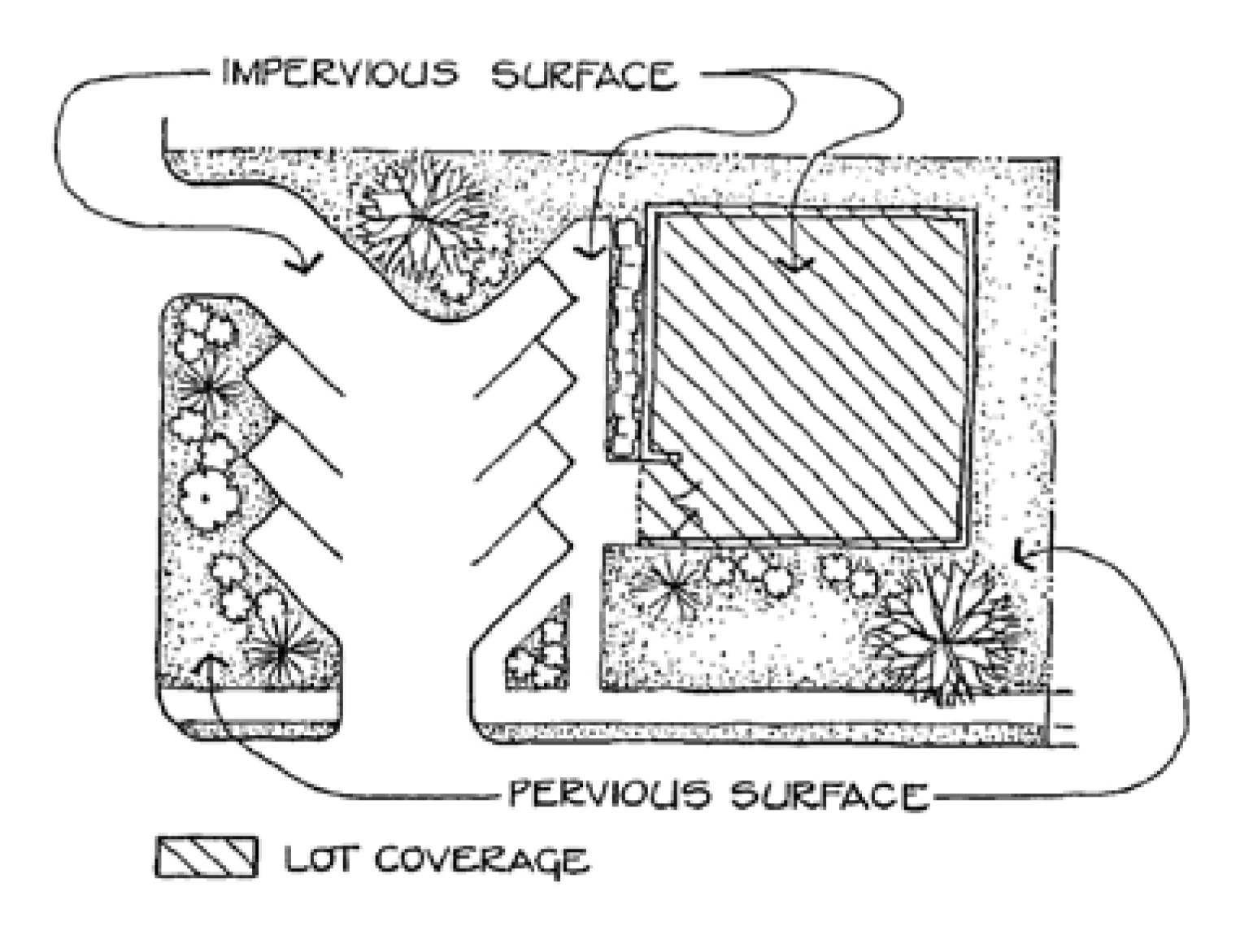
Industrial, heavy. Wholesale and industrial uses that requires an NPDES permit for an industrial discharge and/or requires the use or storage of any hazardous material for the purpose of manufacturing, processing, assembling, finishing, cleaning or developing any product or commodity.
Industrial, light. Wholesale and warehousing and industrial uses that include fabrication, manufacturing, assembly or processing of materials that do not require an NPDES permit for an industrial discharge or requires the use or storage of any hazardous material or requires the use or storage of any hazardous material for the purpose of manufacturing, processing, assembling, finishing, cleaning or developing any product or commodity.
Infiltration. The passage or movement of water into the soil sub-surface.
Improved landscape. Gardens, parks, parking lots, or any other proposed outside improvements including any planned vegetation, public street furniture, masonry walls, fences, light fixtures, steps and pavements, or other appurtenant features.
Improvements. The addition of any building, accessory building, parking area, loading area, fence, wall, hedge, lawn or mass planting (except to prevent soil erosion) to a lot or parcel of property.
Industrial development. (Amended 10/3/2017) Any non-residential development that requires an NPDES permit for an industrial discharge and/or requires the use or storage of any hazardous material for the purpose of manufacturing, assembling, finishing, cleaning or developing any product or commodity.
Institutionalized persons. Persons who are committed through some legal process (jail, hospital ward for the dangerously mentally ill), or persons committed to an institution, such as a halfway house, on a time-of-day basis.
Intensive livestock operations. Any enclosure, pen, feedlot, building, or group of buildings intended to be used or actually used to feed, confine, maintain or stable cattle, horses, sheep, goats, turkeys, chickens, swine, or any combination thereof, with at any time a total of one hundred (100) animal units or more present, where their dietary needs are met primarily by means other than grazing.
J
Jail. A municipal or county operated facility designed for the holding of individuals for trial, contempt, or punishment when the period is not to exceed one hundred and eighty (180) days.
Junk. Pre-used or unusable metallic parts and other nonmetallic manufactured products that are worn, deteriorated or obsolete, making them unusable in their existing condition, but are subject to being dismantled and salvaged.
Junkyard. The use of more than six hundred (600) square feet of any lot or tract for the outdoor storage and/or sale of waste paper, rags, scrap metal, or other junk, and including storage of automobiles or other vehicles or dismantling of such vehicles or machinery or parts thereof.
Junked vehicle. A motor vehicle that (1) is partially dismantled or wrecked; (2) cannot be self-propelled or moved in the manner in which it was originally intended to move; (3) is more than five (5) years old and appears to be worth less than one hundred dollars ($100.00); or (4) does not display a current license plate when the motor vehicle is required by laws of this state to have such a license plate to operate on public roads, unless stored within an enclosed structure.
K
Kennel, commercial. A commercial operation that: (a) provides food and shelter and care of three (3) or more dogs/cats for purposes not primarily related to medical care (a kennel may or may not be run by or associated with a veterinarian), or (b) engages in the breeding of animals for sale.
Kennel, private. A place or facility where five (5) or more domesticated animals (dogs or cats) over four (4) months of age are maintained by the owner or occupant of the property for the owner's personal enjoyment, hobby or sport, whether or not for compensation.
L
Land area. The total square footage within the development project property boundary of net buildable area.
Landfill. (Amended 10/3/2017) A facility for the disposal of solid waste on land in a sanitary manner in accordance with G.S. ch. 130A, art. 9. For the purpose of this ordinance, this term does not include composting facilities.
Lawn and garden stores. A place of business where retail and wholesale products and produce are sold to the consumer. These stores, which may include a nursery and/or greenhouses, import most of the items sold, and may include plants, nursery products and stock, potting soil, hardware, power equipment and machinery, hoes, rakes, shovels, and other garden and farm variety tools and utensils.
Legislative decision. The adoption, amendment, or repeal of a regulation under this ordinance. The term also includes the decision to approve, amend, or rescind a development agreement consistent with the provisions of ordinance.
Levee. A manmade structure, usually an earthen embankment, designed and constructed in accordance with sound engineering practices to contain, control, or divert the flow of water so as to provide protection from temporary flooding.
Level, floor. The bottom portion, inclusive of horizontal sills, of the first living floor of a structure intended for occupancy.
Light duty truck. (Amended 4/3/2018) Any motor vehicle rated at eight thousand five hundred (8,500) pounds gross vehicular weight rating or less which has a vehicular curb weight of six thousand (6,000) pounds or less and which has a basic vehicle frontal area of forty-five (45) square feet or less as defined in 40 CFR 86.082-2 and is:
(1)
Designed primarily for purposes of transportation of property or is a derivation of such a vehicle, or
(2)
Designed primarily for transportation of persons and has a capacity of more than twelve (12) persons; or
(3)
Available with special features enabling off-street or off-highway operation and use.
Loading and unloading area. That portion of the vehicle accommodation area used to satisfy the requirements of Article 10, Part I. It provides space for bulk pickups and deliveries, scaled to delivery vehicles and accessible to such vehicles at all times even when required off-street parking spaces are filled. Required off-street loading space is not to be included as off-street parking space in computation of required off-street parking space.
Lot. Land area of defined boundaries in single ownership, set aside for separate use or occupancy, and recorded as such in the office of the Johnston County Register of Deeds.
Lot, area of. The parcel of land enclosed within the boundaries formed by the property lines, plus one-half (½) of any alley abutting the lot between the boundaries of the lot, if extended.
Lot, corner. A lot which occupies the interior angle at the intersection of two (2) or more right-of-way lines. A lot abutting on the right-of-way of a curved street or streets shall be considered a corner lot if straight lines drawn from the foremost points of the side lot lines to the foremost point of the lot meet at an interior angle of less than one hundred thirty-five (135) degrees.
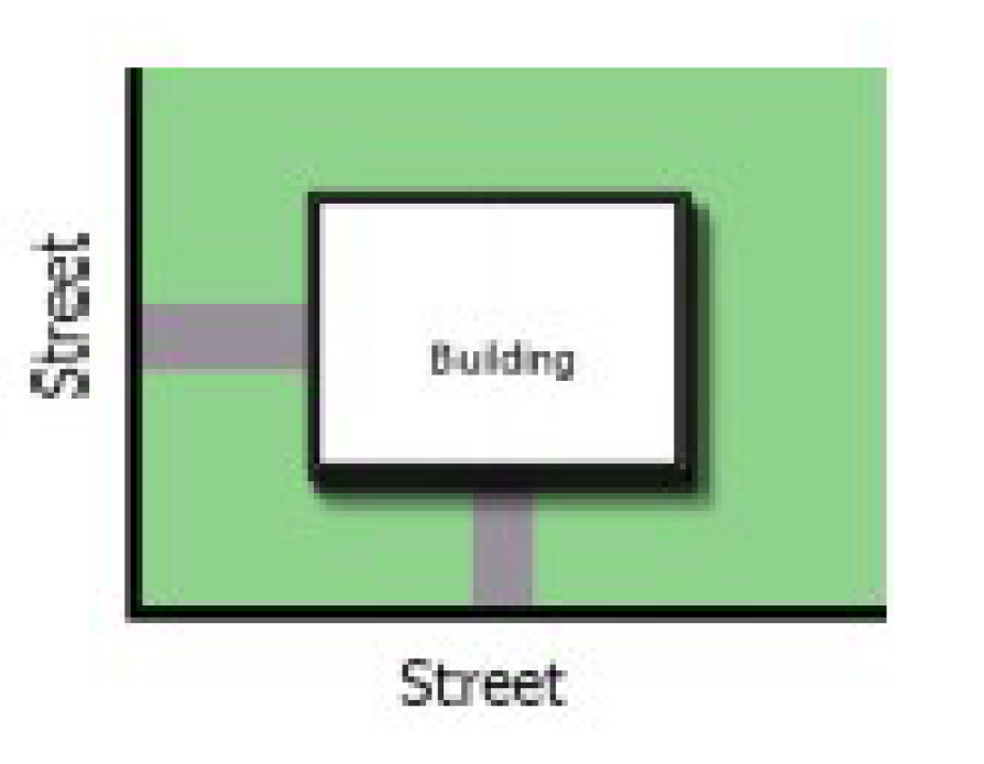
Lot coverage, maximum in percent. The maximum percent of the lot which may be covered with structures. All yard requirements must be met in addition to lot coverage requirements.
Lot, depth. The distance between the midpoints of straight lines connecting the foremost points of the side lot lines in front and the rearmost points of the side lot lines in the rear. On lots having an access strip extending from the front of the main portion of the lot, the foremost points of the side lot lines shall be measured at the place where the access strip joins the main portion of the lot.
Lot, flag. (Amended 4/3/2018) A lot with two (2) distinct parts:
(1)
The flag, which typically contains building site; and is located behind another lot; and
(2)
The pole, which connects the flag to the street; provides the only street frontage for the lot; and at any point is no less than 60 feet in width.
Lot, interior. A lot other than a corner lot with only one (1) frontage on a street.
Lot line. Any boundary of a parcel of land.
Lot line, front.
(1)
If a lot has one (1) property line which is coterminous with a street right-of-way line, such line shall constitute the front lot line;
(2)
If a lot has two (2) property lines which are also street right-of-way lines abutting different streets and those two (2) property (street right-of-way) lines form an angle between eighty (80) degrees and one hundred (100) degrees, then the shorter of those two (2) lines shall constitute the front property line; if both lines are equal, the front property line shall be determined by the property owner if a front property line has not been designated on the final plat (minimum building lines are construed to designate the front lot line);
(3)
If a lot is not encompassed by provision (a) or (b) and no front property line is designated on the final plat, the front property line shall be designated by the Board of Adjustment.
Lot line, rear. The property line(s) which is (are) opposite the front property line. If no property line is deemed to be opposite the front property line and no minimum building line exists on the final plat to establish a rear lot line, then there shall be no rear lot line; however, the rear yard setback shall be maintained from the point (apex) on the property's perimeter which is the furthest removed from the mid point of the front line. The rear yard minimum building line shall be a line perpendicular to a straight line connecting said apex and the mid point of the front lot line.
Lot line, side. A boundary line which is not defined as front or rear lot line.
Lot, nonconforming. A lot or parcel of land that has less than the required minimum area or width as established by the zone in which it is located and provided that such lot or parcel was of record as a legally created lot on the effective date of this ordinance.
Lot of record. A lot which is part of a subdivision, a plat of which has been recorded in the Office of the Register of Deeds of Johnston County prior to the adoption of this ordinance, or a lot described by metes and bounds, the description of which has been so recorded prior to the adoption of this ordinance.
Lot, reversed frontage. A lot on which the frontage is at right angles or approximately right angles (interior angles less than one hundred thirty-five [135] degrees) to the general pattern in the area. A reversed frontage lot may also be a corner lot, an interior lot, or a through lot.
Lot, single-tier. A lot which backs upon a limited access highway, a railroad, a physical barrier, or another type of land use and to which access from the rear is usually prohibited.
Lot, through or double frontage. A lot other than a corner lot with frontage on more than one (1) street. Through lots abutting two (2) streets may be referred to as double frontage lots.
Lot width. (Amended 4/3/2018) The distance between straight lines connecting front and rear lot lines at each side of the lot, measured across the rear of the required front yard; provided, however, that width between side lot lines at their foremost points (where they intersect the right-of-way line, or for lots having an access strip extending from the front of the main portion of the lot, at the place where the access strip joins the main portion of the lot) shall not be less than sixty (60) feet, except in the case of the turning circle of cul-de-sacs.
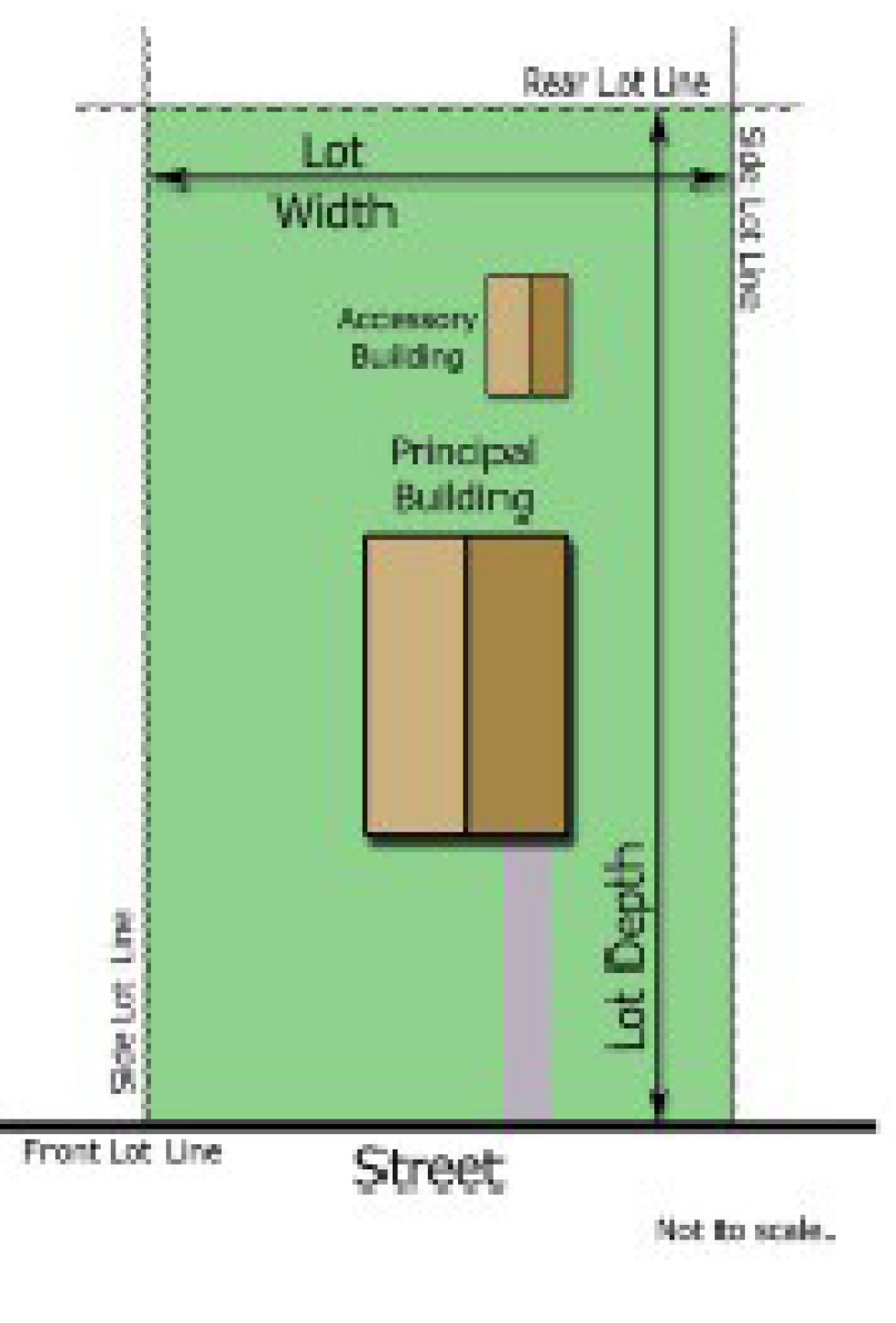
M
Major variance (watershed). A variance that is not a minor variance as defined in this ordinance.
Manufactured home. A structure, transportable in one (1) or more sections, which is built on a permanent chassis and designed to be used with or without a permanent foundation when connected to the required utilities. The term "manufactured home" does not include a recreational vehicle.
Manufactured home (mobile home) Class A. A double- or triple-wide manufactured home constructed after July 1, 1976, that meets or exceeds the construction standards promulgated by the U.S. Department of Housing and Urban Development that were in effect at the time of construction and that satisfies each of the following additional criteria:
(1)
The home has a length not exceeding four (4) times its width;
(2)
The pitch of the home's roof has a minimum vertical rise of one (1) foot for each five (5) feet of horizontal run, and the roof is finished with a type of shingle that is commonly used in standard residential construction;
(3)
The exterior siding consists of wood, hardboard, or aluminum (vinyl covered or painted, but in no case exceeding the reflectivity of gloss white paint) comparable in composition, appearance, and durability to the exterior siding commonly used in standard residential construction;
(4)
A continuous, permanent masonry foundation, unpierced except for required ventilation and access, is installed under the home; and
(5)
The tongue, axles, transporting lights, and removable towing apparatus are removed after placement on the lot and before occupancy.
Manufactured home (mobile home) Class B. A single-wide manufactured home constructed after July 1, 1976, that meets or exceeds the construction standards promulgated by the U.S. Department of Housing and Urban Development that were in effect at the time of construction but that does not satisfy the criteria necessary to qualify as a Class A manufactured home.
Manufactured home (mobile home) Class C. Any manufactured home that does not meet the definitional criteria of a Class A or Class B manufactured home. Class C manufactured homes are not permitted within Smithfield's planning jurisdiction.
Manufactured home park or subdivision. A parcel, or contiguous parcels, of land divided into two (2) or more manufactured home lots for rent or sale.
Manufactured home/recreational vehicle space. A plot of land within a MH/RV park designed for the accommodation of a single manufactured home/recreational vehicle in accordance with the requirements set forth in this section.
Manufactured home/recreational vehicle stand. That portion of the manufactured home/recreational vehicle space designed for and used as the area occupied by the MH/RV proper.
Manufacturing and processing. An establishment engaged in the manufacture, predominantly from previously prepared materials, of finished products or parts, including processing, fabrication, assembly, treatment and packaging of such products, and incidental storage, sales and distribution of such products, but excluding heavy industrial processing. Typical uses include food processing and beverage bottling, large-scale bakeries, electronics assembly, pharmaceuticals, monuments, tobacco products, dry cleaning plants and printing and publishing.
Microbrewery. A facility for the production and packaging of malt beverages of low alcoholic content for distribution, retail, or wholesale, on- or off-premises.
Micro wireless facility. (Amended 10/3/2017) A small wireless facility that is no larger in dimension than twenty-four (24) inches in length, fifteen (15) inches in width, and twelve (12) inches in height and that has an exterior antenna, if any, no longer than eleven (11) inches.
Mini-storage/self-service storage. A building or group of buildings consisting of individual, self-contained units leased to individuals, organizations, or businesses for self-service storage of personal property.
Minor variance (watershed). A variance from the minimum statewide watershed protection rules that results in a relaxation, by a factor of up to five (5) percent of any buffer, density or built-upon area requirement under the high density option; or that results in a relaxation, by a factor of up to ten (10) percent, of any management requirement under the low density option. For variances to a vegetated setback requirement, the percent variation shall be calculated using the foot print of built-upon area proposed to encroach with the vegetated setback divided by the total area of vegetated setback within the project.
Modular home. A factory-built structure that is designed to be used as a dwelling, is manufactured in accordance with the specifications for modular homes under the North Carolina State Residential Building Code, bears a seal or label issued by the Department of Insurance pursuant to G.S. § 143-139.1, and is placed on a permanent foundation and used for residential purposes.
Modular structure, commercial. A commercial unit which is constructed off-site and when assembled at a permanent site complies fully with the North Carolina State Building Code for commercial structures.
More intensive use. A use that will have a greater impact on the surrounding area than the previous use, including activities which generate more traffic, require more employees or service deliveries, or utilize more square footage than the previous use existing on the site.
Motor vehicle. Every vehicle which is self-propelled and every vehicle designed to run upon the highways which is pulled by a self-propelled vehicle. This shall not include mopeds as defined in G.S. § 20-4.01(27)d1.
N
Natural feature. Any outside landscape feature on the site such as trees, shrubs, or rock formations.
Net buildable area. The total area within the project property boundary less:
(1)
All easement for storm drain or utilities;
(2)
Highway and street rights-of-way;
(3)
Sediment basins and water retention ponds;
(4)
Wetlands, defined by the Division of Water Quality and/or US Corps of Engineers;
(5)
Water and wastewater treatment facilities;
(6)
Local or state designated historic sites;
(7)
Water areas including seasonal ponds; and
(8)
Buffered areas adjacent to streams and water bodies.
New construction.
(1)
Any development occurring on property utilized for governmental, commercial, or residential subdivision purposes for which a building permit is required.
(2)
For floodplain management purposes, structures for which the start of construction commenced on or after the effective date of this ordinance and includes any subsequent improvements to such structures.
New manufactured home park. A manufactured home park for which the construction of facilities for servicing the lots on which the manufactured homes are to be affixed (including at a minimum the installation of utilities, the construction of streets, and either final site grading or the pouring of concrete slabs) is completed on or after October 21, 1996.
Nonconforming building or development. Any legally existing building or development which fails to comply with the provisions of the ordinance.
Nonconforming lot of record (watershed). (Amended 10/3/2017) A lot described by a plat or a deed that was recorded prior to the effective date of local watershed protection regulations (or their amendments) that does not meet the minimum lot size or other development requirements of the statewide watershed protection rules.
Non-residential development. (Amended 10/3/2017) All development other than residential development, agriculture and silviculture.
Nursing home. A facility, however named, which is advertised, announced, or maintained for the express or implied purpose of providing nursing or convalescent care for three (3) or more persons unrelated to the licensee. A nursing home is a home for chronic or convalescent patients, who, on admission, are not as a rule, acutely ill and who do not usually require special facilities such as an operating room, X-ray facilities, laboratory facilities, and obstetrical facilities. A nursing home provides care for persons who have remedial ailments or other ailments, for which medical and nursing care are indicated; who, however, are not sick enough to require general hospital care. Nursing care is their primary need, but they will require continuing medical supervision.
O
Official maps or plans.Any maps or plans officially adopted by the Smithfield Town Council.
Open space. An area (land and/or water) generally lacking in manmade structures and reserved for the enjoyment of residents of a planned unit development, or other group project. Common open spaces may contain accessory structures, and improvements necessary or desirable for religious, education, non-commercial, recreational, or cultural uses.
OSR (open space ratio). The total square footage not covered by manmade structures.
Overhead canopy. Any structure placed over, around, or near a fuel pump island, drive-up bank teller facility, or similar use, and intended to provide lighting and/or protection from the elements for facility users.
P
"Park model" recreational vehicle. A manufactured home typically built in accordance with the construction requirements of HUD National Manufactured Housing Construction and Safety Standards Act of 1974, 42 U.S.C. 5401, et seq. but because of their limited size they are not required to be labeled by the HUD manufacturing housing program. Since these park model type units are not under the jurisdiction of the HUD program, they are labeled and sold as recreational vehicles. Note: Not permitted as permanent residences.
Parking area, aisles. A portion of the vehicle accommodation area consisting of lanes providing access to parking spaces.
Parking structures and underground parking garages, commercial. Any area (except an accessory use), either open or enclosed, structural or natural, for the storage of a vehicle or vehicles. Each parking structure shall have an approved means or ingress and egress.
Parking lot, commercial. An open area (except as an accessory use), outside of the public right-of-way, for the storage of a vehicle or vehicles. The term "parking area" shall be included in this definition. Each parking lot shall have an approved means of ingress and egress.
Parking space, off street. For the purpose of this ordinance, an off-street parking space shall consist of a space adequate for parking an automobile with room for opening doors on both sides, together with properly related access to a public street or alley and maneuvering room. No required off-street parking shall be located on any public right-of-way.
Patio home. A single-family detached or semi-detached unit built on a small lot which may be enclosed by walls which provide privacy.
Person. An individual, trustee, executor, other fiduciary, corporation, firm, partnership, association, organization, or other entity acting as a unit, including the following:
(1)
The agent in charge of a building, premises, structure, or facility; or
(2)
The owner of the building, premises, structure, or facility when such owner knew or reasonably should have known the nature of the business located therein, and such owner refused to cooperate with the public officials in reasonable measures designed to terminate the proscribed used; provided, however, that if there is an agent in charge, and if the owner did not have actual knowledge, the owner shall not be prosecuted; or
(3)
The owner of the business; or
(4)
The manager of the business.
Personal property. Property owned, utilized, and maintained by an individual or members of his or her residence, and acquired in the normal course of living in or maintaining a residence. It does not include merchandise which was purchased for resale or obtained on consignment.
Photovoltaic power. An active solar energy system that converts solar energy directly into electricity.
Planned unit development (PUD). (Amended 3/6/2018) A development constructed on a tract of land under single ownership, planned and developed as an integral unit, and may consist of a combination of residential and nonresidential uses and within a PUD special zoning district in accordance with Section 6.3.6.
Planning Board. A commission appointed by the Town Council and by the Johnston County Board of Commissioners for the following purposes:
(1)
To develop and recommend long-range development plans and policies;
(2)
To advise the Town Council in matters pertaining to current physical development and zoning for the town's planning jurisdiction.
Plant nursery. A use for which the principal purpose is the growing of plants outside or in a greenhouse for wholesale or retail sales.
Planting strip or area. A ground surface free of concrete, asphalt, stone, gravel, brick, or other paving material, aside from walkways, which is required or used for landscaping purposes.
Plat. A map or plan of a parcel of land which is to be, or has been, subdivided.
Predevelopment. The conditions that existed prior to the proposed project, site plan, or subdivision being in place.
Principal building, use or structure. The main use of a lot or the building or structure in or on which the main use of the lot takes place.
Private driveway. A roadway serving two (2) or fewer lots, building sites, or other division of land, and not intended to be public ingress or egress.
Private street. An undedicated private right-of-way which affords access to abutting properties and requires a subdivision streets disclosure statement in accordance with G.S. § 136-102.6.
Processing. Any operation changing the nature of material or material's chemical composition or physical properties; does not include operations described as fabrication.
Protected area. (Amended 10/3/2017) The area adjoining and upstream of the critical area of WS-IV watersheds. The boundaries of the protected area are defined as within five (5) miles of and draining to the normal pool elevation of the reservoir or to the ridgeline of the watershed; or within ten (10) miles upstream and draining to the intake located directly in the stream or river or to the ridgeline of the watershed.
Protected tree. An existing healthy tree which, when measured at four and one-half (4½) feet above the ground DBH, has a minimum diameter of eight (8) inches.
Public safety and/or nuisance. Anything which is injurious to the safety or health of an entire community or neighborhood, or any considerable number of persons, or unlawfully obstructs the free passage or use, in the customary manner, of any navigable lake, or a river, bay, stream, canal, or basin.
Public sewage disposal system. A system serving two (2) or more principal uses and approved by the Johnston County Health Department and the North Carolina Department of Environment and Natural Resources, Environmental Management Division.
Q
Quasi-judicial decisions. A decision involving the finding of facts regarding a specific application of a development regulation and that requires the exercise of discretion when applying the standards of the regulation. The term includes, but is not limited to, decisions involving variances, special use permits, certificates of appropriateness, and appeals of administrative determinations. Decisions on the approval of subdivision plats and site plans are quasi-judicial in nature if the regulation authorizes a decision-making board to approve or deny the application based not only upon whether the application complies with the specific requirements set forth in the regulation, but also on whether the application complies with one (1) or more generally stated standards requiring a discretionary decision on the findings to be made by the decision-making board
R
Recreation area or park. An area of land or combination of land and water resources that is developed for active and/or passive recreation pursuits with various man-made features that accommodate such activities.
Recreational vehicle. (Amended 4/3/2018) A vehicle which is:
(1)
Built on a single chassis;
(2)
Four hundred (400) square feet or less when measured at the largest horizontal projections;
(3)
Designed to be self-propelled or permanently towable by a light duty truck; and
(4)
Not designed for use as a permanent primary dwelling, but as temporary living quarters for recreational camping, travel, or seasonal use.
Recreational vehicle parks. Any single parcel of land upon which two (2) or more recreational vehicles, occupied for sleeping purposes, are located regardless of whether or not a charge is made for such purposes. Recreational vehicle parks are referred to in this ordinance as "RV park(s)."
Redevelopment. Renovation of an existing structure or structures which totals at least sixty (60) percent of the original structure.
Regulated tree. The subsurface roots, crown, and trunk of:
(1)
Any self-supporting woody perennial plant such as a large shade or pine tree, which usually has one (1) main stem or trunk, and has a measured caliper as follows:
(a)
Hardwood tree—Eight (8) inches, such as oak, maple, etc.
(b)
Pine tree—Twelve (12) inches, such as long leaf pine
(2)
Any small flowering tree, such as dogwood, with a measured caliper of at least four (4) inches.
(3)
Any tree having several stems or trunks, such as crepe myrtle, and at least one (1) defined stem or trunk with a measured caliper of at least two (2) inches.
Rehabilitation. Returning a property to a state of utility, through repair or alteration, which makes possible an efficient use while preserving those portions and features of the property which are significant to its historic, architectural, and cultural values.
Remove (including removing and removal). The cutting down of any live or dead regulated tree and all other acts which cause the death or destruction of any regulated trees.
Renewable energy resource. A solar electric, solar thermal, wind, hydropower, geothermal, or ocean current or wave energy resource; a biomass resource, including agricultural waste, animal waste, wood waste, spent pulping liquors, combustible residues, combustible liquids, combustible gases, energy crops, or landfill methane; waste heat derived from a renewable energy resource and used to produce electricity or useful, measurable thermal energy at a retail electric customer's facility; or hydrogen derived from a renewable energy resource. "Renewable energy resource" does not include peat, a fossil fuel, or nuclear energy resource.
Reservation. A reservation of land does not involve any transfer of property rights. It simply constitutes an obligation to keep property free from development for a stated period of time.
Residential child-care facility. A staffed premises with paid or volunteer staff where children receive continuing full-time foster care. Residential child-care facility includes child-caring institutions, group homes, and children's camps which provide foster care, but not family care homes.
Residential development. (Amended 10/3/2017) Buildings for residence such as attached and detached single-family dwellings, apartment complexes, condominiums, townhouses, cottages, etc. and their associated outbuildings such as garages, storage buildings, gazebos, etc. and customary home occupations.
Residuals. (Amended 10/3/2017) Any solid or semi-solid waste generated from a wastewater treatment plant, water treatment plant or air pollution control facility permitted under the authority of the Environmental Management Commission.
Restaurant. An establishment whose principal business is the sale of foods, frozen desserts, or beverages to a customer in a ready-to-consume state, and whose design and principal method of operation determines its classification as follows:
(1)
Standard. Customers are provided with an individual menu and served by an employee at the same table or counter at which their food and/or beverages generally are consumed within the restaurant.
(2)
Carry-out. (1) Foods and/or beverages are usually served in edible containers or in paper, plastic, or other disposable containers by an employee at a standing counter or drive-in window; and (2) consumption is normally off the premises, but may be allowed within a motor vehicle parked on the premises, or at other facilities on the premises outside the principal building.
(3)
Fast food. Same as "carry-out," but includes allowing consumption within the principal building.
Retail. Sale of a commodity, [the sale being] to the ultimate consumer and [the commodity being] not customarily subject to sale again.
Retention pond facilities. A permanent structure that provides for the storage of runoff and is designed to maintain a permanent pool of water.
Right-of-way. A strip of land, owned publicly or privately, which affords the principal means of access to abutting property.
Right-of-way (town). (Amended 10/3/2017) A right-of-way owned, leased, or operated by the Town of Smithfield, including any public street or alley that is not part of the state highway system.
Roof line. The top edge of the roof or the top edge of the parapet, whichever forms the top line of the building silhouette, but not including penthouses or equipment structures.
S
Sales office, off-premises (branch). In addition to maintaining inventories of goods; physically assembling, sorting, and grading goods in large lots; breaking bulk; delivery; and various types of promotion, such as advertising, a wholesaler or distributor may establish offices and other supportive areas for the use of personnel primarily employed for off-premises sales and other administrative or managerial needs. On-premises retail sales as the principal use are not included in this classification. Off-street parking for this portion of the building shall be calculated independently of any other use of the same structure.
Sales office, temporary. An office established within the boundaries of a subdivision or development which is used for the promotion and sales of real property solely within that subdivision or development.
Salvage operation or yard. Any non-residential property used for the storage, collection, and/or recycling of any type of equipment, and including, but not limited to, vehicles, appliances, and related machinery.
School. Any public or private institution for the teaching of children/adults.
Screening. The method by which a view of one (1) site from another adjacent site is shielded, concealed, or hidden. Screening techniques include fences, walls, hedges, berms, vegetation, or other natural or man-made visual barriers.
Search ring. (Amended 10/3/2017) The area within which a wireless support facility or wireless facility must be located in order to meet service objectives of the wireless service provider using the wireless facility or wireless support structure.
Service stations. A building or lot dedicated to the rendering of services such as the sale of gasoline, oil, grease, and accessories and the minor repair of automobiles, excluding body work, overhauling, and painting.
Setback. The minimum required distance existing between the abutting street right-of-way line (if no street right-of-way line is involved, the subject property line) and the minimum building line as specified in Article 8, Zoning District Development Standards.
Shadow flicker. The visible flicker effect when rotating turbine blades cast shadows on the ground and nearby structures causing the repeating pattern of light and shadow.
Shopping center. Two (2) or more commercial establishments, planned and constructed, as a single unit with off-street parking and loading facilities provided on the property.
Shrub, small. A hard-wooded perennial plant of species which normally reaches a height between eighteen (18) inches and four (4) feet.
Shrub, intermediate. A hard-wooded perennial plant of species which normally reaches a height between four (4) feet and six (6) feet.
Shrub, large. A hard-wooded perennial plant of species which normally reaches a height between six (6) feet and ten (10) feet.
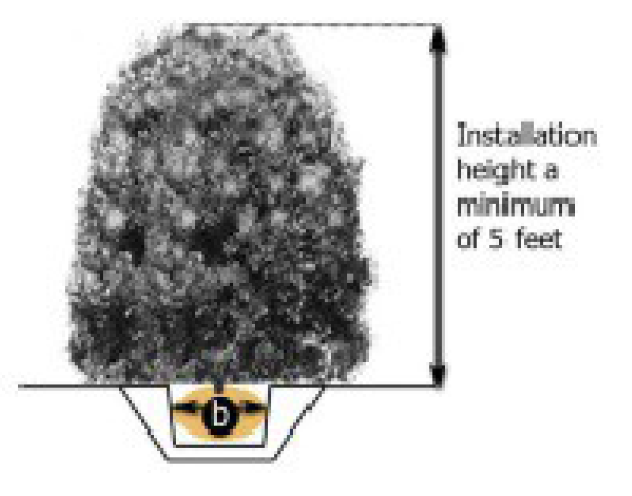
Sign. Any device that is designed to attract attention to a particular location with on-premises or off-premises copy is considered a sign.
Sign, area. The surface area of a sign shall be computed as including the entire area visible from any one (1) point, within a regular geometric form or combinations of regular geometric forms comprising all of the display area of the sign including lattice work, wall work, and individual letters and spaces between letters comprising part(s) of the sign. Computations of sign area shall include only one (1) side of a double-faced sign structure. If a sign has two (2) sides joined at an angle of greater than sixty (60) degrees, the surface of both sides of the sign shall be included in the computation of area. See Section 10.24.
Sign, banner. A sign intended to be hung either with or without a frame, possessing characters, letters, illustrations, or ornamentations applied to cardboard, plastic or fabric of any kind, excluding flags and emblems of political, professional, religious, education, or corporate organizations.

Sign, column/pole. A freestanding sign supported by one (1) or more columns or poles or other similar support.
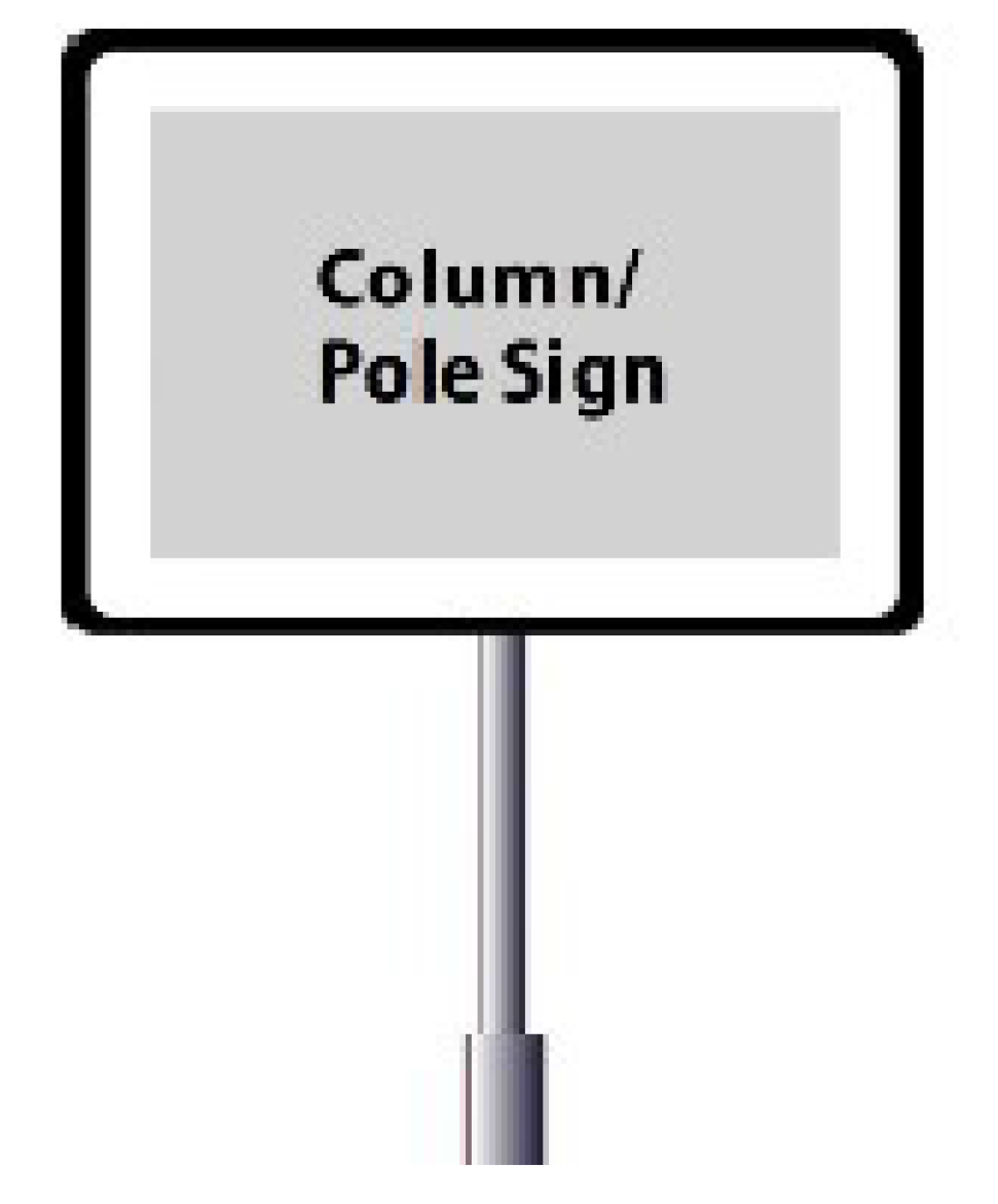
Sign, flutter flag. A freestanding temporary sign typically constructed of a single plastic or metal shaft driven in the ground with an attached pennant that is vertically elongated and attached to the shaft.

Sign, flag. A device generally made of flexible material, usually cloth, paper or plastic, typically used as a symbol of a government, school, or religion. The term "flag" does not include feather flag signs.

Sign, freestanding. A sign anchored directly to the ground or supported by one (1) or more posts, columns, or other vertical structures or supports, and not attached to or dependent for support from any building. Monument signs, pole signs, and some temporary signs are considered freestanding signs.
Sign, ground-mounted. A freestanding sign, supported by a contiguous structural base or planter box that is permanently affixed to the ground.
Sign, height of. The vertical distance measured from the ground to the top of the sign face or sign structure, whichever is greater.
Sign, message board. A sign or portion thereof with characters, letters, or illustrations that can be changed or rearranged without altering the face or the surface of the sign. This definition does not include menu and sandwich board signs.
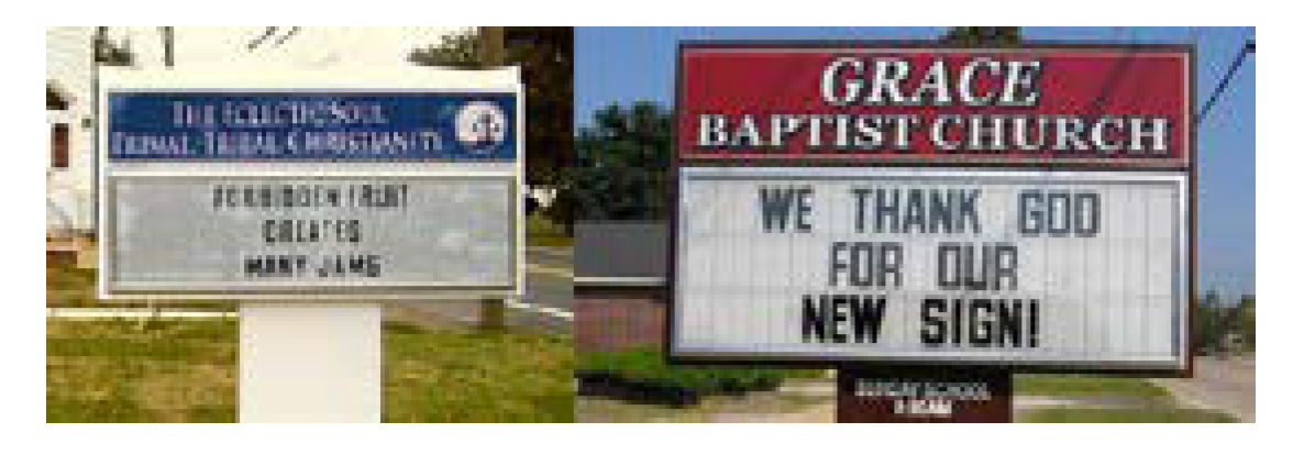
Sign, monument. A freestanding sign where the base of the sign structure is on the ground or a maximum of twelve (12) inches above the adjacent grade. The width of the top of the sign structure can be no more than one hundred twenty (120) percent of the width of the base.
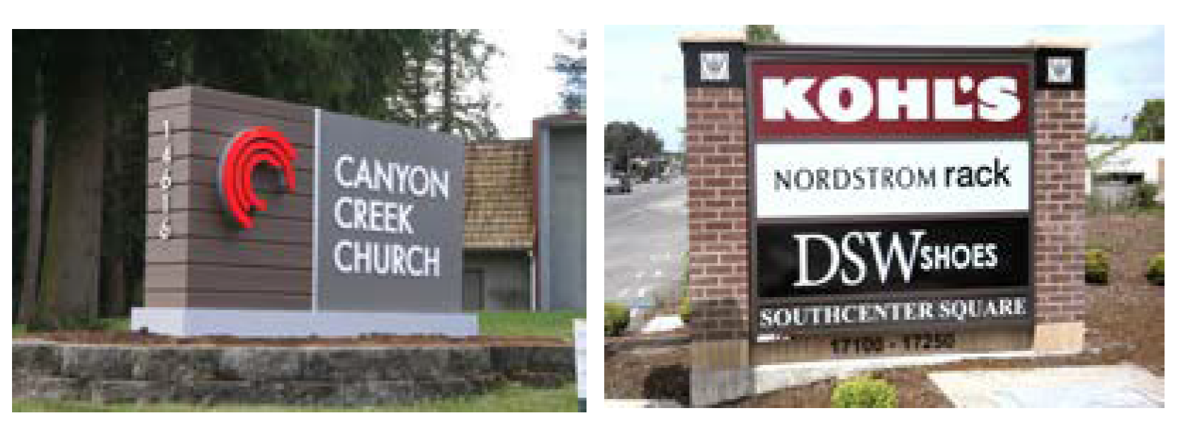
Sign, nonconforming. A sign which was legally erected prior to the effective date of this ordinance, but which does not conform to these regulations.
Sign, ornamental. A banner that uses any of a variety of images or colors of an ornamental nature, and that displays no on-premises or off-premises copy.
Sign, outdoor advertising. Any outdoor sign, display, light, device, figure, painting, drawing, message, plaque, poster, billboard, or any other thing which is designed, intended, or visible from any place on the main-traveled way of the interstate or primary system, whether the same be permanent or portable installation.
Sign, portable. Any sign not exceeding thirty-two (32) square feet in billboard area and not permanently attached to the property on which it is located.
Sign, projecting. Any sign, other than a wall, awning, canopy or marquee sign, which is affixed to a building and is supported only by the wall on which the sign is mounted.

Sign, roof. Any sign erected, constructed, or maintained upon or over the roof of a building, or extending above the highest wall of the building, and having its principal support on the roof or walls of the building.
Sign, snipe. A sign that is tacked, nailed, posted, pasted, glued or otherwise attached to trees, poles, stakes, fences, or to other objects.
Sign, suspended. A sign that is suspended from the underside of a horizontal plane surface such as a canopy or marquee and is supported by such surface.

Sign, temporary. A display, informational sign, banner, or other advertising device constructed of cloth, canvas, fabric, wood, or other temporary material, with or without a structural frame (including banners), and intended for a limited period of display, including decorative displays for holidays or public demonstrations.
Sign, wall. Any sign attached to, painted on, or erected against any wall of a building or structure so that the exposed face of the sign is on a plane parallel to the plane of said wall and which does not extend more than eighteen (18) inches from the wall.

Sign, wind. Any display or series of objects designed and fashioned in such a manner as to move when subjected to internal wind pressure.

Sign, window. Any sign appearing in, on or through a window of a structure and visible from outside. The term "window sign" shall not be used to define a window display.
Significant tree. Any tree, which meets or exceeds the following criteria:
(1)
All hardwood trees with a DBH (diameter at breast height) equal to or greater than twenty-four (24) inches.
(2)
All coniferous trees with a DBH (diameter at breast height) equal to or greater than twenty-four (24) inches.
(3)
All Dogwood, American Hollies, and other Flowering with a DBH (diameter at breast height) equal to or greater than eight (8) inches.
Site inspector. The site inspector, building inspector, fire marshal, UDO administrator, and town engineer or his designated representative for the Town of Smithfield.
Site plan. A scaled drawing and supporting text showing the relationship between lot lines and the existing or proposed uses, buildings, or structures on the lot. The site plan may include site-specific details such as building areas, building height and floor area, setbacks from lot lines and street rights-of-way, intensities, densities, utility lines and locations, parking, access pointes, roads, and stormwater control facilities that are depicted to show compliance with all legally required development regulations that are applicable to the project and the site plan review. A site plan approval based solely upon application of objective standards is an administrative decision and a site plan approval based in whole or in part upon application of standards involving judgment and discretion is a quasi-judicial decision. A site pan may also be approved as part of a conditional zoning decision.
Site specific development plan. A plan of development submitted to the town to obtain one (1) of the following zoning or land use permits or approvals:
(1)
Final subdivision plat;
(2)
Special use permit;
(3)
Planned unit development plan; or
(4)
Conditional zoning plan.
Notwithstanding the foregoing, a document that fails to describe with reasonable certainty the type and intensity of use for a specified parcel or parcels of property shall not constitute a site specific development plan.
Skirting. A continuous, uniform foundation enclosure constructed of vinyl, or metal fabricated for such purpose and that is unpierced except for required ventilation or access.
Small wireless facility. (Amended 10/3/2017) A wireless facility that meets both of the following qualifications:
(1)
Each antenna is located inside an enclosure of no more than six (6) cubic feet in volume or, in the case of an antenna that has exposed elements, the antenna and all of its elements, if enclosed, could fit within an enclosure of no more than six (6) cubic feet.
(2)
All other wireless equipment associated with the facility has a cumulative volume of no more than twenty-eight (28) cubic feet. For the purposes of this ordinance, the following types of ancillary equipment are not included in the calculation of equipment volume: electric meters, concealment elements, telecommunications demarcation boxes, ground based enclosures, grounding equipment, power transfer switches, cut-off switches, vertical cable runs for the connection of power and other services, or other support structures.
Solar collector (accessory). Any solar device that absorbs and accumulates solar radiation for use as a source of energy. The device may be roof-mounted or ground-mounted as an accessory use.
Solar energy. Radiant energy received from the sun that can be collected in the form of heat or light by a solar collector.
Solar energy system. A device or structural design feature, a substantial purpose of which is to provide daylight for interior lighting or provide for the collection, storage and distribution of solar energy for space heating or cooling, electricity generating, or water heating. Solar energy systems may include, but not be limited to, solar farms and any of several devices that absorb and collect solar radiation for use as a source of energy as an accessory use.
Solar farm. An area of land designated use for the sole purpose of deploying photovoltaic power and generating electric energy.
Solid waste disposal facility. Any facility involved in the disposal of solid waste, as defined in G.S. § 130A-290(a)(35).
Solid waste disposal site. Any place at which solid wastes are disposed of by incineration, sanitary landfill, or any other method.
Special use. A use that would not be an appropriate general use without restriction or review in a particular zoning district, but which, if controlled as to number, area, location or relation to surrounding uses, would promote the public health, safety or general welfare.
Special use permit. A permit issued by the Town Council to authorize development or land uses in a particular zoning district upon presentation of competent, material, and substantial evidence establishing compliance with one (1) or more general standards requiring that judgement and discretion be exercised, as well as compliance with specific standards in accordance with the Town of Smithfield Unified Development Ordinance as well as any additional requirements imposed by the Town Council. The term includes permits previously referred to as conditional use permits.
Standard. A mandatory requirement.
Standing. The following persons shall have standing to file a petition or appeal under this ordinance:
(1)
Any person meeting any of the following criteria:
(a)
Has an ownership interest in the property that is the subject of the decision being appealed, a leasehold interest in the property that is the subject of the decision being appealed, or an interest created by easement, restriction, or covenant in the property that is the subject of the decision being appealed.
(b)
Has an option or contract to purchase the property that is the subject of the decision being appealed.
(c)
Was an applicant before the decision-making board whose decision is being appealed.
(2)
Any other person who will suffer special damages as the result of the decision being appealed.
(3)
An incorporated or unincorporated association to which owners or lessees of property in a designated area belong by virtue of their owning or leasing property in that area, or an association otherwise organized to protect and foster the interest of the particular neighborhood or local area, so long as at least one (1) of the members of the association would have standing as an individual to challenge the decision being appealed, and the association was not created in response to the particular development or issue that is the subject of the appeal.
(4)
A town whose decision-making board has made a decision that the Council believes improperly grants a variance or is otherwise inconsistent with the proper interpretation of an ordinance adopted by the Town Council.
Start of construction. The date the building permit was issued, provided the actual start of construction, repair, reconstruction, rehabilitation, addition placement, or improvement was within one hundred eighty (180) days of the permit date. The actual start means the first placement of permanent construction of a structure (including a manufactured home) on a site, such as the pouring of slabs or footings, installation of piles, construction of piles, construction of columns, or any work beyond the stage of excavation; or the placement of a manufactured home on a foundation. Permanent construction does not include land preparation, such as clearing, grading, and filling; nor does it include the installation of streets and/or walkways; nor does it include excavation for a basement, footings, piers or foundations, or the erection of temporary forms; nor does it include the installation on the property of accessory buildings, such as garages or sheds not occupied as dwelling units or not part of the main structure. For a substantial improvement, the actual start of construction means the first alteration of any wall, ceiling, floor, or other structural part of the building, whether or not that alteration affects the external dimensions of the building.
Storage. A deposition of commodities or items for the purpose of future use or safekeeping.
Storage, open. The keeping of any goods, junk, material, merchandise, or vehicles in the same place (yard) for a period of more than twenty-four (24) hours in an unroofed area or any type of shed which does not have four (4) sides.
Storage facility, indoor. (Amended 8/7/18) A building or part of a building where the principal use is for storage of goods, wares, or equipment, including mini-storage, which consists of individual, small, self-contained units that are leased or owned for the storage of goods and wares.
Stormwater management definitions. For the purposes of Article 10, Part VI, Stormwater Management, the following items, phrases and words shall have the meaning herein:
(1)
Applicant. An owner or developer of a site who executes the storm water permit application pursuant to this ordinance is considered the applicant.
(2)
Approved accounting tool. The most recent version of the accounting tool for calculating nutrient loading and reduction approved by the Division for the relevant geography and development type under review.
(3)
Best management practices (BMPs). A wide range of practices that have been demonstrated to effectively manage the quality and/or quantity of stormwater runoff and which are compatible with the planned land use. BMPs can be structural (detention ponds, wetlands, etc.) or non-structural (reduced road pavement width, cluster development, etc.).
(4)
Built-upon area (BUA). Means the same as defined in N.C.G.S. 143-214.7(b2).
(5)
Channel bank. The location of the upper edge of the active channel above which the water spreads into the overbanks on either side of the channel or the elevation of the two-year frequency storm. Where the channel bank is not well defined, the channel bank shall be considered the edge of the waterline.
(6)
Design manual. The State Stormwater Design Manual approved by the Department for the proper implementation of the State Minimum Design Criteria for engineered stormwater controls. All references herein to the Design Manual are to the latest published edition or revision.
(7)
Developer. Means the same as defined in N.C.G.S. 160D-102(11).
(8)
Development. Means the same as defined in N.C.G.S. 143-214.7(a1)(1).
(9)
Division. The Division of Water Resources in the Department.
(10)
Drainage structures. Swales, channels, storm sewers, curb inlets, yard inlets, culverts, and other structures designed to convey stormwater.
(11)
Existing development. Means the same as defined in 15A NCAC 02H.1002(18).
(12)
Engineered stormwater control. A physical device designed to trap, settle out, filter, or otherwise remove pollutants from stormwater runoff; to alter or reduce stormwater runoff velocity, amount, timing, or other characteristics; to approximate the pre-development hydrology on a developed site; or to achieve any combination of these goals. Engineered stormwater control includes physical practices such as constructed wetlands, vegetative practices, vegetated conveyances, filter strips, grassed swales, and other methods installed or created on real property. "Engineered stormwater control" is synonymous with "structural practice," "Primary SCM," "stormwater control facility," "stormwater control practice," "stormwater treatment practice," "stormwater management practice," "stormwater control measures," "structural stormwater treatment systems," and similar terms used in this ordinance. It is a broad term that may include practices that do not require design by a professionally licensed engineer.
(13)
Existing development. An individual non-residential site with site plan approval by the Planning Department or a non-residential subdivision with preliminary subdivision approval from the Planning Board.
(14)
Illegal discharges. Any unlawful disposal, placement, emptying, dumping, spillage, leakage, pumping, pouring, or other discharge of any substance other than stormwater conveyance system, the waters of the state or upon the land such that the substance is likely to reach a stormwater conveyance system or waters of the State constitutes an illegal discharge.
(15)
Impervious surface. A surface composed of any material that impedes or prevents natural infiltration of water into the soil. Gravel areas shall be considered impervious.
(16)
Land disturbing activity. Means the same as defined in 15A NCAC 02B.0202(33).
(17)
Load. Means the mass quantity of a nutrient or pollutant released into surface waters over a given time period. Load in this ordinance refers to pounds of nitrogen or phosphorus per year.
(18)
Loading rate. Means the mass quantity of a nutrient or pollutant released from a given area into surface waters over a given time period. Loading rate in this ordinance refers to pounds of nitrogen or phosphorus per acre per year.
(19)
Minimum Design Criteria. Means the same as defined in 15A NCAC 02H.1002(24).
(20)
Natural drainage way. An incised channel with a defined channel bed and banks that are part of the natural topography. Construction channels such as drainage ditches shall not be considered a natural drainage way unless the constructed channel was a natural drainage way that has been relocated, widened, or otherwise improved.
(21)
New development. Defined as:
(22)
Any activity that disturbs greater than one (1) acre of land in order to establish, expand, or modify a single-family or duplex residential development or recreational facility.
(23)
Any activity that disturbs greater than one-half (½) an acre of land in order to establish, expand, or modify a multi-family residential development or a commercial, industrial, or institutional facility.
(24)
New development shall not include mining, agricultural, or forestry activities. Land disturbance is defined as grubbing, stump removal, and/or grading.
(25)
Nitrogen. Means total nitrogen unless specified otherwise.
(26)
1-year, 24-hour storm. Means the same as defined in 15A NCAC 02H.1002(30).
(27)
Outfall. A point at which stormwater (1) enters surface water or (2) exits the property of a particular owner.
(28)
Owner. The legal or beneficial owner of land, including, but not limited to, a mortgagee or vendee in possession, receiver, executor, trustee, or long-term or commercial lessee, or any other person or entity holding proprietary rights in the property or having legal power of management and control of the property. "Owner" shall include long-term commercial tenants; management entities, such as those charged with or engaged in the management of properties for profit; and every person or entity having joint ownership of the property. A secured lender not in possession of the property does not constitute an owner, unless the secured lender is included within the meaning of "owner" under another description in this definition, such as a management entity.
(29)
Permanent nutrient offset credits. Means the same as defined in 15A NCAC 02B.0701(38).
(30)
Redevelopment. Means the same as defined in N.C.G.S. 143-214.7(a1)(2).
(31)
Riparian buffer. An area of trees, shrubs, or other forest vegetation, that is adjacent to surface waters. For purposes of this ordinance, surface water shall be present if the feature is approximately shown on either the most recent version of the Johnston County soil survey report prepared by the Natural Resources Conservation Service (NRCS) or the most recent version of the 1:24,000 scale (7.5 min.) quadrangle topographic maps prepared by the United States Geological Survey. Riparian buffers adjacent to surface waters that do not appear on either of the maps shall not be subject to this ordinance, except areas designated by the Stormwater Administration to be environmentally sensitive. See Article 10, Part VI, Stormwater Management.
(32)
Runoff treatment. Means the same as defined in 15A NCAC 02H.1002(43).
(33)
Runoff volume match. Means the same as defined in 15A NCAC 02H.1002(44).
(34)
Stormwater. Flow resulting from and occurring after any form of precipitation.
(35)
Stormwater conveyance system or structure. Any feature, natural or manmade, that collects and transports stormwater, including, but not limited to, roadways with collection systems, catch basins, man-made and natural channels, streams, pipes and culverts, and any other structure or system designed to transport runoff.
(36)
Stormwater design manual. The manual of design, performance, and review criteria adopted by the Smithfield Town Council for the administration of the stormwater program. The Stormwater Design Manual will be maintained and revised as needed by the UDO Administrator.
(37)
Total nitrogen. Means the sum of the organic, nitrate, nitrite, and ammonia forms of nitrogen in water.
(38)
Vegetative buffer. An area that has a dense ground cover of herbaceous or woody species, which provides for diffusion and infiltration of runoff and filtering of pollutants.
(39)
Vested rights of stormwater. Based upon projects that require a state permit, such as landfills, NPDES wastewater discharges, land application or residuals and road construction activities, and shall be considered to have vested rights if a state permit was issued prior to the effective date of the adoption of the revised Stormwater Ordinance.
(40)
Water dependent structure. Those structures that require the access or proximity to, or sitting within surface waters to fulfill its basic purpose, such as boat ramps, boathouses, docks, and bulkheads. Ancillary facilities such as restaurants, outlets for boat supplies, parking lots, and commercial boat storage areas are not considered water dependent structures.
Story. That portion of a building between the surface of any floor and the floor or roof above it. The following are considered stories:
(1)
Mezzanine, if it extends one-third (⅓) of the total floor area of the story immediately below it;
(2)
Penthouse, if it exceeds one-third (⅓) of the total area of the roof;
(3)
Basement, if subdivided and used for dwelling or business purposes.
Street. A public thoroughfare which affords access to abutting property and is recorded as such in the office of the Johnston County Register of Deeds. The following classifications apply:
(1)
Arterial. The arterial system should serve the major centers of activity of an urban area, the highest traffic volume corridors, and the longest trip desires; and should carry a high proportion of the total urban area travel on a minimum of mileage. Arterials consist of Interstates; Other Freeways and Expressways; and Other Principal Arterials.
(2)
Collector. The collector street system provides land access service and traffic circulation within residential neighborhoods, commercial and industrial areas. It differs from the arterial system in that facilities on the collector system may penetrate residential neighborhoods, distributing trips from the arterials through the area to the ultimate destination.
(3)
Local. The local street system consists of all roads not defined as arterials or collectors and primarily provides access to land with little or no through movement.
(4)
Alley. A strip of land, owned publicly or privately, set aside primarily for vehicular service access to the back or side of properties otherwise abutting on a street.
Street line. The right-of-way boundary of a street.
Street yard. The area of a parcel immediately adjacent to a street right-of-way and reserved for planting. The minimum dimensions of street yards are established by Section 10.13 of this ordinance.
Structure. Anything constructed or erected with a fixed location on the ground, or attached to something having a fixed location on the ground. Among other things, structures include buildings, manufactured homes, fences, signs, swimming pools, and tennis courts.
Subdivider. Any person, firm, or corporation who subdivides or develops any land deemed to be a subdivision as herein defined.
Subdivision. The division of land for the purpose of sale or development as specified in G.S. § 160D-8-2.
Substantial modification, wireless facilities. (Amended 10/3/2017) The mounting of a proposed wireless facility on a wireless support structure that substantially changes the physical dimensions of the support structure. A mounting is presumed to be a substantial modification if it meets any one (1) or more of the criteria listed below. The burden is on the town to demonstrate that a mounting that does not meet the listed criteria constitutes a substantial change to the physical dimensions of the wireless support structure.
(1)
Increasing the existing vertical height of the structure by the greater of (i) more than ten (10) percent or (ii) the height of one (1) additional antenna array with separation from the nearest existing antenna not to exceed twenty (20) feet.
(2)
Except where necessary to shelter the antenna from inclement weather or to connect the antenna to the tower via cable, adding an appurtenance to the body of a wireless support structure that protrudes horizontally from the edge of the wireless support structure the greater of (i) more than twenty (20) feet or (ii) more than the width of the wireless support structure at the level of the appurtenance.
(3)
Increasing the square footage of the existing equipment compound by more than two thousand five hundred (2,500) square feet.
Substantially improved existing manufactured home park. Repair, reconstruction, rehabilitation, or improvement of the streets, utilities, and pads which equals or exceeds fifty (50) percent of the value of the streets, utilities, and pads before the repair, construction, or improvement commenced.
T
Telecommunication tower. A tower facility, including, but not limited to, radio and television transmission towers or similar utilities, microwave towers, and mobile telephone or radio towers. This term shall not include radio transmission facilities for use by ham radio operators or two-way local radio facilities for business or governmental purposes that are under one hundred (100) feet in height and that, at a height of fifty (50) feet above the base, have a maximum horizontal measurement of eighteen (18) inches nor shall it include any tower erected by a public authority for public safety or emergency service communication purposes.
Telecommunications facility. A communications tower or antenna and any associated accessory structures and equipment.
Telephone communication facility, unattended. A windowless structure containing electronic telephone equipment that does not require regular employee attendance for operating.
Temporary emergency, construction or repair residence. A subordinate residence (which may be a Class A manufactured home, travel trailer) that is located on the same lot as a single-family dwelling made uninhabitable by fire, flood, or other natural disaster and occupied by the persons displaced by such disaster, is located on the same lot as while the primary residence that is under construction or undergoing substantial repairs or reconstruction and is occupied by the persons intending to live in such permanent residence when the work is completed.
Temporary office units/modular office units. Factory-fabricated, transportable buildings that are designed to arrive at the site ready for occupancy, except for minor unpacking and connection to utilities, and designed for removal to, and installation at other sites.
Temporary storage facility (portable storage units). Any container intended for storing or keeping household goods, other personal property or business related goods intended to be filled, refilled, or emptied while located outdoors and later removed from the property for storage or disposal off-site. Temporary storage facilities are sometimes also known as portable storage units or portable storage containers.
Therapeutic foster home. A family foster home where, in addition to the provision of foster care, foster parents who receive appropriate training provide a child with behavioral health treatment services under the supervision of a county department of social services, an area mental health program, or a licensed private agency and in compliance with licensing rules adopted by the Commission.
Tiny house. A single-family detached home that is two hundred (200) square feet to six hundred (600) square feet in size (not including loft space) and complies with the North Carolina State Building Code. A tiny house on wheels for permanent occupancy (longer than thirty (30) days) is considered a recreational vehicle.
Temporary uses. Any use intended for temporary and limited duration, operated as an accessory to a principal use. The maximum frequency of such temporary use shall not exceed two (2) occurrences within any twelve-month period and the maximum duration of such temporary use shall be seven (7) days. For purposes of this definition, the duration of each separate occurrence shall be measured on continuous days. Such use shall be subject to applicable location, setback, parking, land use and other standards for the district. Christmas tree sales, fireworks sales, carnivals and nonprofit organizations are exempt from the frequency and duration provisions of this ordinance. Temporary uses shall be exempt from the vegetation and parking lot surface improvement standards, provided however, where the director of planning due to extended duration or frequency of operation finds that the use requirements shall apply. No temporary use may omit any noise, odors, dust, fumes, glare, or vibration or cause traffic or other safety issues that could be detrimental to adjoining properties or surrounding areas.
Thoroughfare plan. The official major thoroughfare plan of Smithfield, North Carolina, as adopted by the Smithfield Planning Board and the North Carolina Department of Transportation.
Tower. Any structure whose principal function is to support antenna.
Towing service, automotive or truck. A commercial enterprise, business or company established to tow or remove motor vehicles from one (1) location to another. A towing service includes the temporary storage or motor vehicles at its site, but under no circumstances shall any motor vehicle remain on the premises of a towing service for more than twenty-four (24) hours unless stored within an enclosed structure or the tow service is located in an industrial district. Such services shall comply with all ordinances of the town.
Town. The Town of Smithfield, North Carolina.
Town Council. The Town Council of the Town of Smithfield.
Townhouse. A principal structure containing two (2) or more single-family attached dwelling units with each unit on its own individual lot. All townhouse developments shall be subject to multiple family dwelling provisions of this chapter, with the following exceptions:
(1)
All townhouse developments shall comply with the multiple family density requirements of Article 8 of this ordinance; this standard can be met by individual lot area, by provision of common open space, or by a combination of lot area and common open space.
(2)
No unit shall be connected on more than two (2) sides by common walls.
(3)
All yard dimensional requirements shall apply to the property lines of the entire development. No individual unit shall be required to meet the yard dimensions.
Toxic substance. (Amended 10/3/2017) Any substance or combination of substances (including disease causing agents), which after discharge and upon exposure, ingestion, inhalation, or assimilation into any organism, either directly from the environment or indirectly by ingestion through food chains, has the potential to cause death, disease, behavioral abnormalities, cancer, genetic mutations, physiological malfunctions (including malfunctions or suppression in reproduction or growth) or physical deformities in such organisms or their off spring or other adverse health effects.
Tract. A tract is a piece of land whose boundaries have been described or delineated by a legal instrument or map recorded in the office of the Johnston County Register of Deeds.
Tract area. The total acreage/square footage of the entire tract being developed.
Tree diameter at breast height (DBH). The diameter of a tree trunk in inches measured at four and one-half (4½) feet above the ground.
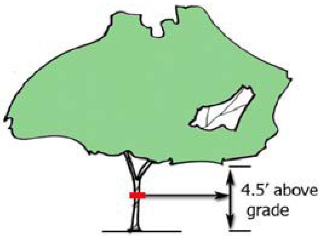
U
Understory tree. A deciduous tree that will attain a mature height between fifteen (15) feet and thirty-five (35) feet, with an expected crown spread between fifteen (15) and twenty-five (25) feet, as determined by the latest edition of American Standards of Nursery Stock.
Urn plots. (Amended 10/10/20, ZA-20-04) Urn plots in the ground are not defined by statute. Urn plots are defined herein as urns set in the ground according to a predesigned and approved plot plan to contain cremated human remains.
Use. The purpose for which land or structure thereon is designed, arranged or intended to be occupied or used, or for which it is occupied, maintained, rented or leased.
Use, accessory. A use incidental to and customarily associated with the use-by-right and located on the same lot with the use-by-right, and operated and maintained under the same ownership with the operation of the use-by-right.
Use-by-right. A use which is listed as an unconditionally permitted activity in this ordinance.
Use, nonconforming. A use of building or land that does not conform with the regulations of the district in which the building or land is situated.
Use, non farm. Any use of property which is not encompassed by the definition of a farm as so defined in this ordinance.
Utility pole. (Amended 10/3/2017) A structure that is designed for and used to carry lines, cables, wires, lighting facilities, or small wireless facilities for telephone, cable television, electricity, lighting, or wireless services.
V
Variance. A grant of relief to a person from the requirements of this Ordinance which permits construction in a manner otherwise prohibited by this ordinance where specific enforcement would result in unnecessary hardship.
Variance (watershed). A permission to develop or use property granted by the Board of Adjustments relaxing or waiving a water supply watershed management requirement adopted by the Environmental Management Commission that is incorporated into this ordinance.
Vested right. The right to undertake and complete the development and use of property under the terms and conditions of an approval secured as specified in G.S. § 160D-108 or under common law.
Video arcade. An indoor area containing coin-operated video games.
Violation of Unified Development Ordinance. Failure of a structure, use, lot, situation, or other development to be fully compliant with the requirements of this ordinance.
Visible. Capable of being seen without visual aid by a person of normal visual acuity.
W
Warehouse. A building or compartment in a building used and appropriated by the occupant for the deposit and safekeeping or selling of his own goods at wholesale and/or for the purpose of storing the goods of others placed there in the regular course of commercial dealing and trade to be again removed or reshipped.
Water dependent structure. (Amended 10/3/2017) Any structure for which the use requires access to or proximity to or citing within surface waters to fulfill its basic purpose, such as boat ramps, boat houses, docks and bulkheads. Ancillary facilities such as restaurants, outlets for boat supplies, parking lots and commercial boat storage areas are not water dependent structures.
Watershed. (Amended 10/3/2017) The entire land area contributing surface drainage to a specific point (e.g. the water supply intake.)
Watershed Administrator. (Amended 10/3/2017) The UDO Administrator who is the official or designated person of the Town of Smithfield responsible for administration and enforcement of this ordinance.
Watershed variance. (Amended 10/3/2017) A permission to develop or use property granted by the Board of Adjustment relaxing or waiving a water supply watershed management requirement adopted by the Environmental Management Commission that is incorporated into this ordinance.
Water tower. (Amended 10/3/2017) A water storage tank, a standpipe, or an elevated tank situated on a support structure originally constructed for use as a reservoir or facility to store or deliver water.
Wholesale. Sale of a commodity for resale to the public for direct consumption.
Wireless facility. (Amended 10/3/2017) Equipment at a fixed location that enables wireless communications between user equipment and a communications network, including (i) equipment associated with wireless communications and (ii) radio transceivers, antennas, wires, coaxial or fiber-optic cable, regular and backup power supplies, and comparable equipment, regardless of technological configuration. The term includes small wireless facilities. The term shall not include any of the following:
(1)
The structure or improvements on, under, within, or adjacent to which the equipment is collocated.
(2)
Wireline backhaul facilities.
(3)
Coaxial or fiber-optic cable that is between wireless structures or utility poles or town utility poles or that is otherwise not immediately adjacent to or directly associated with a particular antenna.
Wireless infrastructure provider. (Amended 10/3/2017) Any person with a certificate to provide telecommunications service in the State who builds or installs wireless communication transmission equipment, wireless facilities, or wireless support structures for small wireless facilities but that does not provide wireless services.
Wireless provider. (Amended 10/3/2017) A wireless infrastructure provider or a wireless services provider.
Wireless services. (Amended 10/3/2017) Any services, using licensed or unlicensed wireless spectrum, including the use of Wi-Fi, whether at a fixed location or mobile, provided to the public using wireless facilities.
Wireless services provider. (Amended 10/3/2017) A person who provides wireless services.
Wireless support structure. (Amended 10/3/2017) A new or existing structure, such as a monopole, lattice tower, or guyed tower that is designed to support or capable of supporting wireless facilities. A utility pole or town utility pole is not a wireless support structure.
Y
Yard. A required open space unoccupied and unobstructed by a structure or portion of a structure; provided, however, that fences, walls, poles, posts, and other customary yard accessories, ornaments, and furniture may be permitted in any yard subject to height limitations and requirements limiting obstruction of visibility.
Yard, front. A yard across the full width of the lot, extending from the front lot line of the building to the front line of the lot, including the area of steps, eaves, and uncovered porches, but not including the areas of covered porches.
Yard, rear. An area extending across the full width of the lot and lying between the rear lot line and a line parallel thereto at a distance therefrom as required in the applicable district.
Yard, side. An area extending along the length of the lot between the required front yard and the required rear yard, and between the side lot line and a line parallel thereto and a distance therefrom as required in the various districts.
Yard, street. A landscaped area located along a street.
Z
Zero lot line housing unit. A single-family detached housing unit placed on a lot such that a windowless wall is placed on one (1) side property line and the footage required for two (2) side yards is placed on the other side property line as the total side yard requirement for the lot.
Zoning compliance. A certification by the Administrator or his authorized agents that a course of action to use or occupy a tract of land or a building, or to erect, install or alter a structure, building or sign situated in the zoning jurisdiction of the town, fully meets the requirements of this ordinance.
(Ord. No. ZA-22-05, pt. 3, 2-7-23; Ord. No. ZA-23-03, pt. 2, 5-2-23; Ord. No. ZA-23-09, pt. 3, 1-23-24; Ord. No. ZA-23-06, pt. 3, 11-12-24)