
Snellville City Zoning Code
CHAPTER 100
GENERAL PROVISIONS
101-1.1. - Title
This document is "The Unified Development Ordinance for the City of Snellville, Georgia," and is referred to or cited throughout the document as "this UDO."
101-1.2. - Purpose
This UDO is intended to serve the following purposes:
A.
To promote the health, safety, morals, convenience, order, prosperity, aesthetics, and the general welfare of the present and future inhabitants of the City of Snellville;
B.
To ensure that the vision set forth in the Comprehensive Plan is implemented by the City's development regulations;
C.
To improve the city's appearance;
D.
To further safety for all transportation users;
E.
To secure safety from fire, panic, and other dangers;
F.
To provide adequate light and air;
G.
To facilitate the adequate provision of transportation, water, sewerage, schools, parks, and other public requirements;
H.
To protect property against blight and depreciation;
I.
To encourage the most appropriate use of land, buildings, and other structures throughout the City; and
J.
To secure economy in government expenditures.
101-1.3. - Application
A.
Territorial Application
This UDO applies to all land, uses, buildings, and structures in the corporate boundaries of the City of Snellville.
B.
General Application
In their interpretation and application, the provisions of this UDO are the minimum requirements for the promotion and protection of the public health, safety, and welfare.
C.
Required Conformance
1.
All buildings, structures, land, or open space, in whole or in part, must be used or occupied in conformance with this UDO;
2.
No building or structure, in whole or in part, may be erected, constructed, reconstructed, moved, or structurally altered unless in conformance with this UDO;
3.
The minimum, yards, parking spaces, landscape strips, buffers, and open spaces required by this UDO for each building existing before the effective date of this UDO, or for any building erected or structurally altered after the effective date, may not be encroached upon or considered as part of the yard, parking space, landscape strips, buffers, or open space required for any other structure; and
4.
It is unlawful to be in conflict with, or in violation of, any other requirements of this UDO.
D.
Control Over Less Restrictive Private Agreements
This UDO does not nullify any private agreement or covenant. However, when this UDO is more restrictive than a private agreement or covenant, this UDO controls. The City will not enforce any private agreement or covenant.
E.
Control Over Less Restrictive Laws and Regulations
If any requirement imposed by this UDO is more restrictive than a requirement imposed by any other law, rule, or regulation, the more restrictive condition or requirement governs, except as described in paragraph G below.
F.
Conflict
If any requirement imposed by this UDO contains an actual, implied or apparent conflict, the more restrictive condition or requirement controls, except as described in paragraph G below.
G.
Control Over Less Restrictive Conditions
If any requirement imposed by this UDO is more restrictive than a condition of approval for a rezoning, variance, special use permit, or other formal action by the City Council, the requirement of the condition governs.
H.
References to Other Laws
Whenever a provision of this UDO refers to any other part of the Snellville City Code or to any other law, the reference applies to any subsequent amendment of that law.
I.
Text and Graphics
Illustrations, photographs, and graphics are included in this UDO to illustrate the intent and requirement of the text. In the case of a conflict between the text of this UDO and any Illustrations, photographs, and graphics, the text governs.
101-1.4. - Transitional Provisions
A.
General
This subsection contains the transition to this UDO from the zoning ordinance, development ordinance, and other regulations in effect immediately before the effective date of this UDO.
B.
Approved Clearing, Clearing and Grubbing, or Grading Permit
Any subdivision or other activity for which only a clearing, clearing and grubbing, or grading permit was issued before the adoption of this UDO must be brought into conformance with this UDO. Subsequently, the development permit must conform to this UDO.
C.
Pending Development Permit
Any subdivision or other activity for which a valid and complete application for a development permit was received before the adoption of this UDO may, at the developer's option, proceed to completion and building permits may be issued as though this UDO had not been adopted, provided that the development permit is or may be issued within 90 days of the date of adoption and all time frames associated with said permit are observed.
D.
Approved Development Permit
Any subdivision or other activity for which a development permit has been issued before the adoption of this UDO may, at the developer's option, proceed to completion and building permits may be issued as though this UDO had not been adopted, provided all time frames associated with said permit are observed.
E.
Approved Building Permit
The adoption of this UDO does not affect the validity of any building permits lawfully issued before the adoption of this UDO.
F.
Pending Building Permit
Nothing in this UDO requires a change in the plans, construction, or designated use of any building or structure for which building permits were lawfully applied for or approved, before the effective date of this UDO or amendment thereto, provided:
1.
Such permit has not, by its own terms, expired before the effective date of this UDO.
2.
Actual building construction is commenced before the expiration of such permit.
3.
Actual building construction is carried on pursuant to said permit and limited to and in strict accordance with said permit.
4.
No renewals or extensions of said permit is authorized beyond 90 days following the effective date of this UDO.
101-1.5. - Amendments
A.
This UDO may be amended from time-to-time by the City Council in accordance with Sec. 101-1.6. Such amendments will be effective on their date of adoption unless otherwise stated in the adopting resolution.
B.
No amendment will affect the validity of any permit lawfully issued before the amendment's ordinance.
101-1.6. - Zoning Compliance Law
A.
This UDO is crafted as a series of chapters and articles.
B.
Articles 1 and 3 of Chapter 100, all articles of Chapter 200, Article 1 of Chapter 300, as well as those definitions set forth in Article 2 of Chapter 100 that constitute, by reference, text of these articles, are all intended to constitute a zoning ordinance within the meaning of O.C.G.A. § 36-66-1 et seq. Changes to the text of these articles, as well as Official Zoning Map amendments and other zoning actions addressed in those articles, must comply with the public notice and hearing procedures provided in Sec. 103-9 (Amendments) and in said State statute.
C.
The remaining chapters and articles are not intended to constitute a zoning ordinance and may be amended using the City's general procedures for ordinance amendments.
101-1.7. - Severability
If any article, section, subsection, paragraph, clause, sentence, or provision of this UDO is adjudged by any court of competent jurisdiction to be invalid or unconstitutional, that judgment does not affect, impair, invalidate or nullify the remainder of this UDO. The effect of the judgment is confined to the section, subsection, paragraph, clause, sentence, or provision immediately involved in the controversy in which judgment or decree was rendered.
101-1.8. - Effective Date
This UDO takes effect and is in force upon its adoption by the City Council.
101-2.1. - UDO Zoning Districts
In order to carry out the purposes of this UDO, the City is divided into the following zoning districts as established on the Official Zoning Map in Sec. 101-3.
Table Note:
[1] No additional land may be zoned to the PRC district.
101-2.2. - Transition from Former Districts
Upon adoption of this UDO, land which is presently zoned within an existing zoning classification which has changed names as set forth above will be reclassified to the applicable new zoning classifications. The boundaries for renamed zoning districts and the conditions of each zoning district will remain the same unless amended in the future in accordance Sec. 103-9 (Amendments).
101-3.1. - Official Zoning Map
A.
The Official Zoning Map for the City of Snellville is incorporated and made part of this UDO.
B.
The original Official Zoning Map must be kept on file with the City clerk. The map must indicate the date of the adoption, be signed by the Mayor, attested by the City clerk, and bearing the seal of the City under the following words: "This is to certify that this is the Official Zoning Map referred to in the City of Snellville Unified Development Ordinance," together with the map's date of adoption and notation of any map amendments.
C.
The City Council may, from time to time, readopt the Official Zoning Map.
D.
The Official Zoning Map may be kept electronically in a Geographic Information System (GIS). Any copy of the Official Zoning Map published on the web or otherwise portrayed electronically does not constitute the original Official Zoning Map.
E.
The Director may make paper copies of the Official Zoning Map available to the public for a fee.
101-3.2. - Interpretation of Map Boundaries
Where uncertainty exists with respect to the location of the boundaries of any zoning district, the following rules apply:
A.
Where a zoning district boundary line is shown as approximately following a corporate limits line, a militia district line, a land lot line, a lot line or the centerline of a street, a County road, a State route, or such lines extended, then such lines will be construed to be the zoning district boundary lines.
B.
Where a zoning district boundary line is shown as being set back from a street, a County road, or a State route, and approximately parallel thereto, then such zoning district boundary line will be construed as being at the scaled distance from the centerline of the street, County road, or State route and as being parallel thereto.
C.
Where a zoning district boundary line divides a lot, the location of the line will be the scaled distance from the lot lines. In this situation, the requirements of the zoning district in which the greater portion of the lot lies will apply to the balance of the lot except that such extension will not include any part of a lot that lies more than 50 feet beyond the zoning district boundary line.
D.
In the case of a through lot fronting on two approximately parallel streets that is divided by a zoning district boundary line paralleling the streets, the restrictions of the zoning district in which each frontage of the through lot lies will apply to that portion of the through lot.
E.
Where zoning district boundaries are in doubt, the Planning Commission will make such interpretation using the appropriate scale from the Official Zoning Map.
101-3.3. - Relationship to the Comprehensive Plan
A.
Role of the Comprehensive Plan.
The Snellville Comprehensive Plan, consisting of its Future Development Map, Future Land Use Map, and related policies, as may be amended from time to time, is established as the official policy of the City concerning designated future land uses, and as a guide to decisions regarding the appropriate manner in which property may be zoned. A copy of the Comprehensive Plan, as may be amended from time to time, must be maintained at the Department and be available for inspection by the public.
B.
Relationship between the Comprehensive Plan and Zoning.
The Comprehensive Plan does not change a property's zoning and does not itself permit or prohibit any existing or future land uses. Instead, the Comprehensive Plan establishes broad planning policies for current and future land uses and will be consulted as a guideline for making decisions about applications to amend the Official Zoning Map and text of this UDO.
C.
Consistency with Comprehensive Plan Character Areas.
Any applicant seeking to rezone property to a classification that is inconsistent with the adopted Comprehensive Plan must first obtain approval of an amendment to the Comprehensive Plan from the City Council, following the procedures in this UDO.
D.
Amendments to the Comprehensive Plan.
The Comprehensive Plan must be reviewed and updated or amended (as appropriate) according to a schedule approved by the City Council, and as required by the DCA in compliance with the Rules of DCA, Chapter 110-12-1, Minimum Standards and Procedures for Local Comprehensive Planning. However, exceptions may be granted by the City Council in between the regular review and update cycle in cases of demonstrated hardship, or in cases of large-scale developments that may provide special economic benefits to the community. Requests for exceptions are subject to approval by City Council. Future Land Use Map amendments are subject to the applicable provisions of Sec. 103-9 (Amendments).
101-3.4. - Annexation
A.
Any land subsequently annexed into the City must be assigned a Comprehensive Plan Future Land Use Map land use category and classified as one or more zoning districts at the time of annexation.
B.
Before the zoning decision and annexation are approved, public notice of such action must be provided and public hearings are held thereon as provided in O.C.G.A. §§ 36-66-4 and 36-36-36 and subsequent amendments thereto.
C.
The City Council, in determining the zoning classification, may take into account the use restrictions on the land before annexation and must take into account other policies of the Comprehensive Plan.
101-3.5. - De-Annexation
Undeveloped property which has been de-annexed from the City will be subject to the same zoning district, including any conditions established before annexation and will be subject to the regulations for de-annexed property by the Gwinnett County UDO.
101-3.6. - Zoning Verification Letter
A.
A Zoning Verification Letter can be issued by the Director upon written request for a fee.
B.
The person requesting the letter must submit the request in writing, with the subject property being identified by tax parcel number and, if known, by street address, along with a recent boundary survey of the subject property.
C.
The Zoning Verification Letter will convey the current zoning of the subject property, and associated conditions of zoning and approved variances, if known.
D.
The Zoning Verification Letter is only valid for 30 days from the date of the letter.
101-3.7. - Prior Approvals
A.
The adoption of this UDO and its Official Zoning Map will not repeal the conditions of use, operation, or site development accompanying zoning approval(s) or special use(s), variances, or permits issued under previous ordinances or resolutions. All such prior conditions will continue to apply, except as provided in paragraph B below.
B.
The adoption of this UDO and its Official Zoning Map will not repeal any special use permits, conditional use permits, variances, exceptions, modifications, or waivers previously granted by the Director, Board of Appeals, Planning Commission, or City Council. All such prior approvals will continue to apply, except as provided in paragraph C below.
C.
Modification or the repeal of prior conditions identified in paragraph A above or approvals identified in Paragraph B above may only be accomplished in accordance with Sec. 103-9 (Amendments).
102-1.1. - Rules of Interpretation
A.
Words used in this UDO are defined by their dictionary meaning unless defined in this article, or this UDO, or any other ordinance of the City.
B.
The dictionary meaning is the meaning given by common and ordinary use as defined by the latest edition of Webster's Third New International Dictionary.
C.
When definitions are provided in an individual article or section of this UDO, those definitions only apply in that article or section. If the same term or phrase is also defined in this section, the definition in this section does not apply in that instance.
D.
The words "must," "will," and "shall" are mandatory and not discretionary.
E.
The word "may" is permissive.
F.
The phrases "must not," "may not," and "shall not" are mandatory prohibitions.
G.
When appropriate to the context, words used in the singular include the plural, and the plural the singular; words used in the present tense include the future tense, and vice versa.
H.
Words in the masculine gender include the feminine.
I.
Words have the same meaning when capitalized or uncapitalized.
J.
The word "person" includes the words "individuals," "firms," "partnerships," "corporations," "associations," "governmental bodies" and all other legal entities.
K.
The word "erected" includes the words "constructed," "moved," "located," or "relocated."
L.
The word "zoning map" means the Official Zoning Map of Snellville County, Georgia.
M.
The words "used" or "occupied" include the words "intended, arranged or designed to be used or occupied."
N.
Use of the word "and" is inclusive and requires that all of the component phrases so connected must be present or fulfilled for sufficiency.
O.
Use of the word "or" is not exclusive (as in "either ... or"), and requires that at least one of the component phrases so connected must be present or fulfilled for sufficiency. The word "or" may allow more than one component phrase to be present or fulfilled, as is implied by the common term "and/or."
102-1.2. - Abbreviations
The following abbreviations appear in this UDO:
Sec. 102-2. - Defined Terms
A
Abutting. Touching at one point or along a common side, boundary, or lot line. Two pieces of property that are separated by a street or right-of-way are not abutting.
Accent, architectural. A structural or decorative element applied to the exterior wall of a building to accentuate rooflines, doors, windows, corners, stories, and similar features. Architectural accents include, but are not limited to, cornices, quoins, balusters, pilasters, trim, railings, belt courses, and similar features. Windows and doors (including all preassembled components), foundations, chimneys, awnings, and canopies are not considered architectural accents.
Accessory Building. A building detached from a principal building on the same lot and customarily incidental to the principal building or use including but not limited to detached garages serving one dwelling unit, utility buildings, sheds, gazebos, and barns. Detached garages and parking decks serving more than one dwelling unit are considered principal buildings.
Accessory Structure. A structure which is on the same lot as the principal structure and the use of which is incidental to the use of the primary structure. (syn. Accessory facility).
Accessory use. A use of land or of a building or portion thereof customarily incidental and subordinate to the principal use of the land or building and located on the same lot with such principal use.
Accidental discharge. A discharge prohibited by this section that occurs by chance and without planning or thought before occurrence.
Active recreation area. This category of common area includes, but is not limited to, bikeways, paths, tennis courts, ballfields, playfields, courts, swimming pools, clubhouses, toilets, dressing rooms, lockers, equestrian facilities, beaches, docks; amphitheaters, stages, bandshells, community buildings, fountains, plazas, patios, decks, lawns, picnic shelters or picnic areas, and similar facilities and the related storage, landscaping, lighting, sidewalks, outdoor furnishings, play structures, and utilities related to active recreation areas.
Addition (to an existing structure). Any walled and roofed expansion to the perimeter of a building in which the addition is connected by a common load-bearing wall other than a 4-hour firewall. Any walled and roofed addition which is connected by a 4-hour firewall or is separated by independent perimeter load-bearing walls is new construction.
Adjacent. Property that is abutting or on the opposite side of an easement that separates it from the subject property. Properties separated by a railroad track, a major thoroughfare, or a designated and numbered U.S. or State routes are not abutting or adjacent.
Adjoining. To share a common border with.
Adult entertainment establishment. "Adult Entertainment Establishment" will have the same meaning as set forth in Chapter 10, Article II of the City of Snellville Code of Ordinances.
Alley. A public or private service-way which is used primarily as a secondary means of vehicular and service access to the back or side of abutting properties.
Alternative tower structure. Manmade trees, clock towers, bell steeples, light poles, and similar alternative design mounting structures that camouflage or conceal the presence of telecommunication antennas or towers.
Antenna. An exterior apparatus designed for telephonic, radio, or television communications through the sending and/or receiving of electromagnetic waves.
Appeal. A request for a review of the Department's interpretation or decision of a provision of this UDO.
Applicant. A person, either the owner or the bona fide representative of the owner of land or structures governed by these regulations, who seeks authority to use, develop, construct upon or otherwise enjoy the use of property through any of the procedures established under these regulations.
Area of Future-conditions Flood Hazard. The land area that would be inundated by the 1% annual chance flood based on future-conditions hydrology (100-year future-conditions flood).
Area of shallow flooding. A designated AO or AH Zone on a community's Flood Insurance Rate Map (FIRM) with a 1% or greater chance of flooding to an average depth of 1 to 3 feet where a clearly defined channel does not exist, where the path of flooding is unpredictable and indeterminate, and where velocity flow may be evident. Such flooding is characterized by ponding or sheet flow.
Area of special flood hazard. The land area subject to a 1% or greater chance of flooding in any given year. This includes all floodplain and flood-prone areas at or below the base food elevation designated as Zones A, A1-30, A-99, AE, AO, AH, and AR on a community's Flood Insurance Rate Map (FIRM).
Arterial. A principal arterial, major arterial, or minor arterial street as classified on the Gwinnett County Long Range Road Classification map.
As-built survey. A survey or other drawing based on a field survey specifying the locations, dimensions, elevations, capacities, and operational capabilities of buildings, roads, drainage structures, other and facilities as they have been constructed.
Assisted living facility. See "Community living arrangement," "Family personal care home," or "Personal care home" in Chapter 200 Article 6.
Attached, or attached to. The relationship between two or more buildings or structures, or between a structure and the ground. In order for two or more buildings to be attached, they must be permanently connected along a common wall. A structure and building are attached when one relies on the other for structural support. A building or structure is attached to the ground when the ground provides the principal structural support and the structure or building is permanently affixed to the ground such that it is not movable or subject to tipping or falling due to design loads.
Attic. The unfinished space between the ceiling joists of the top story and the roof rafters.
Authorized Registered Professional.
A.
A landscape architect who possesses a current certificate of registration issued by the State of Georgia in accordance with Georgia Law; or
B.
A land surveyor who possesses a current certificate of registration issued by the State of Georgia in accordance with Georgia Law; or
C.
A professional engineer who possesses a current certificate of registration issued by the State of Georgia in accordance with Georgia Law;
An authorized registered professional must know and understand the limits of their professional expertise, certification, license or registration and may not perform work which is outside of the scope of said professional expertise, certification, license or registration. An authorized registered professional must be liable for complying with all State laws and rules and licensing board requirements that apply to their particular profession, including ethical standards, and must be liable for failure to meet the applicable standards of professional care. All documents and drawings submitted to the City by an authorized registered professional must bear that person's certification, license, registration or seal, as appropriate. The certification, license, registration or seal of an authorized registered professional on documents and drawings submitted to the City of Snellville must certify that the documents and drawings comply with all applicable City of Snellville ordinances, rules, and regulations and must certify that the documents and drawings are based on personal knowledge of the conditions depicted thereon and that the accuracy and completeness of the documents and drawings have been verified by field inspection of the facilities depicted therein.
Awning. A roof-like structure with a rigid frame that cantilevers from the elevation of a building designed to provide continuous overhead weather protection.
B
Base flood. The flood with a 1% chance of being equaled or exceeded in any given year; i.e., the "100-year flood."
Base flood elevation. The highest water surface elevation anticipated at any given point during the base flood.
Basement. That portion of a building with its floor subgrade (below ground level) along all or a majority of its perimeter length, and includes the term "cellar."
Bedroom. A separate room planned or intended for sleeping, separated from other rooms by a door, and accessible to a bathroom without crossing another bedroom.
Best Management Practices. A collection of structural measures and vegetative practices that, when properly designed, installed and maintained, will provide effective erosion and sedimentation control. The term "properly designed" means designed in accordance with the hydraulic design specifications contained in the "Manual for Erosion and Sediment Control in Georgia" specified in Georgia Law.
Big Haynes Creek Watershed Protection Area. That area of land lying within the drainage basin or watershed of Big Haynes Creek as shown on the official set of maps of the protection area maintained by the Department.
Block. A piece of land entirely surrounded by public or private streets, other than alleys.
Board of Appeals. The City of Snellville Board of Appeals as set forth in this UDO.
Bonus room. An occupied and finished room in a dwelling that is located over a semi-enclosed space such as over a carport, garage, or porch, which is connected to the remainder of the dwelling and does not have a separate outside entry.
Boundary tree. A tree on an adjacent property whose critical root zone area intrudes across the property line of the site under consideration.
Buffer. Land area used to visibly separate property of one use from another through screening and distance; to shield or block noise, light, glare, or visual or other conditions; to minimize physical passage to non-similar areas; or to reduce air pollution, dust, dirt, and litter.
A.
Natural, undisturbed buffer. Land area in which there is no disturbance and no grading allowed, except for approved perpendicular access and utility crossing.
B.
Enhanced buffer. Land area in which there is no disturbance with the exception for disturbance related to additional required plantings, specific to the zoning case and for approved perpendicular access and utility crossings.
C.
Landscape buffer. Land area in which grading is allowed and revegetation to a buffer standard is required specific to zoning case. Replanted per the approved landscape plan.
D.
Construction buffer. Land area in which there is no disturbance until a certificate of occupancy has been issued on the building lot at which time the construction buffer is removed.
E.
Stream buffer. The area of land immediately adjacent to the banks of State waters in its natural state of vegetation, which facilitates the protection of water quality and aquatic habitat. The definition of stream buffer is governed by Georgia law, (O.C.G.A. § 12-17-3(2)).
Buffer and landscape plan. A plan that identifies areas of tree preservation and methods of tree protection within the protected zone, undisturbed, or other buffer areas, as well as all areas of replanting. Within replanting areas, the common and botanical names of the proposed species, the number of plants of each species, the size of all plants, the proposed location of all plants, and any unique features of the plants must be indicated.
Buildable area. The portion of a lot which is not located within any minimum required yard, landscape area, or buffer, i.e., that portion of a lot wherein a building may be located.
Buildable lot of record. A lot or parcel of land which existed as a single parcel of ownership, recorded as such in its entirety and present boundaries with the clerk to superior court before April 19, 1999, or which is shown in its entirety and present boundaries on a final plat or exemption plat duly approved under these or any previously applicable regulations providing for the subdivision of land in the City of Snellville and recorded with the Clerk to Superior Court of Gwinnett County.
Building. Any structure attached to the ground with a roof supported by columns or walls which is designed for the shelter, housing, or enclosure of any persons, animals, process, or property of any kind.
Building inspector. The Planning and Development Director of the City of Snellville or their designee.
Building line. A line across a lot parallel to a street right-of-way or other property line formed by the building facade. All building lines must be at least as restrictive as the corresponding minimum yard required in this UDO.
Building permit. Authorization by the City of Snellville to construct, enlarge, repair, move, demolish, or change the occupancy of a building or structure, to erect, install, enlarge, alter, repair, remove, convert, or replace any electrical, fuel gas piping, mechanical, or plumbing system.
C
Caliper. An American Association of Nurseryman standard for trunk measurement of nursery stock. Caliper is the diameter (in inches) of new tree trunk. For non-fruit trees, the caliper of the trunk shall be taken 6 inches above the ground for up to and including 4-inch caliper size, and 12 inches above the ground for larger sizes.
Canopy. A roof-like cover with rigid frame and column supports, that projects from the wall of a building over a door, entrance, or window; or a freestanding or projecting cover above and outdoor service area, such as a gasoline service station. A marquee is not a canopy.
Canopy tree. A tree that, under normal forest conditions, will compose the top layer or canopy of vegetation and generally will reach a mature height of greater than 40 feet.
Cellar. See "basement."
Certificate of development conformance. Final approval issued by the Department for completion of land development activities for a subdivision or project for which a development permit was issued.
Certificate of occupancy. Final approval by the City of Snellville for the use or occupancy of a structure for which a building permit was issued.
Certified arborist. An individual who has been certified as an arborist by the International Society of Arboriculture and maintains said certification in good standing.
Certified personnel. For the purposes of Sec. 402.2 (Soil Erosion and Sedimentation Control), a person who has successfully completed the appropriate certification course approved by the Georgia Soil and Water Conservation Commission.
Channel. A natural or artificial watercourse with a definite bed and banks that conducts continuously or periodically flowing water.
City. The City of Snellville and its departments, employees, and agents with duties and responsibilities for administering and enforcing this UDO.
City Arborist. The Director or a certified arborist as assigned by the Director and charged with the duties of City Arborist.
City Council. The Mayor and City Council of the City of Snellville, Georgia.
Clean Water Act. The Federal Water Pollution Control Act (33 U.S.C. § 1251 et seq.), and any subsequent amendments thereto.
Clearing. The removal of trees or other vegetation, but not including grubbing activities.
Clearing (major). Clearing (minor) activities plus the cutting and removal of all trees regardless of diameter, but not including the removal of the stumps and root systems of the trees larger than 3 inches in diameter (DBH). The surface of a cleared site may be disturbed by the tracks or tires of the equipment used but may not be intentionally altered from its natural contour. Minor earthmoving to construct stream crossings is permitted.
Clearing (major) permit. An official authorization issued by the department of planning and development permitting clearing (major) activities (only) of a site.
Clearing (minor). The removal of underbrush, shrubs and other low growing vegetation and trees up to 3 inches in diameter (DBH), including the removal of the stumps and root systems. The surface of a cleared site may be disturbed by the tracks or tires of the equipment used but may not be intentionally altered from its natural contour. Minor earthmoving to construct stream crossings is permitted.
Clearing (minor) permit. An official authorization issued by the department of planning and development permitting clearing (minor) activities (only) of a site.
Clearing and grubbing. Clearing (major) activities plus grubbing activities.
Clearing and grubbing permit. An official authorization issued by the department of planning and development permitting clearing and grubbing (only) activities of a site.
Code enforcement officer. The Planning and Development Director of the City of Snellville or their designee.
Collocate.
A.
For the purposes of regulating small cell facilities, "collocate" means to mount, modify, or replace a small wireless facility on or adjacent to a pole, decorative pole, or support structure.
B.
For the purposes of regulating telecommunications antennas and towers, "collocate" means to place two or more service provider antennas upon a single tower or alternative tower structure.
Collocation. See "collocate."
Color, fluorescent. A hue with a high light reflectivity because it reflects absorbed ultraviolet energy as visible light, including, but not limited to, a hue equivalent to one that is advertised as "fluorescent," "neon," or "day glow" by any major paint manufacturer.
Color, primary. A hue that is visually indistinguishable (by average human eyes) to the blue, red, or yellow paint colors that cannot be created by combining any other paint colors.
Columbarium. A structure with niches for the respectful storage of funeral urns.
Commercial vehicle. Any motor vehicle licensed by the State as a commercial vehicle.
Common area. Natural or improved land that is owned in fee simple by a public entity or property owner association and provides continuous public access. See also the related terms "primary conservation area," "secondary conservation area," "active recreation area," and "public space."
Community living arrangement. Any State-licensed residence, whether operated for profit or not, that undertakes, through its ownership or management, to provide or arrange for the provision of daily personal services, supports, care or treatment exclusively for two or more adults who are not related to the owner or administrator by blood or marriage and whose residential services are financially supported, in whole or in part, by funds designated through the Georgia Department of Human Resources, Division of Mental Health, Developmental Disabilities, and Addictive Diseases. Personal services mean the provision of services, on a daily basis, that include, but are not limited to, individual assistance with or supervision of medications, ambulation and transfer, and essential activities of daily living such as eating, bathing, grooming, dressing and toileting. Supports, care, or treatment means specific services that are provided to the resident of the community living arrangement, coordinated by the administrator as necessary, or reasonably requested by the resident and that include, but are not limited to, mental health services, habilitation, rehabilitation, social services, medical, dental, and other health care services, education, financial management, legal services, vocational services, transportation, recreational and leisure activities, and other services required to meet a resident's needs.
Comprehensive Plan. The City of Snellville Comprehensive Plan, a plan summarizing and illustrating the adopted goals and objectives of the City Council regarding the future location and character of anticipated land uses, transportation, and other public facilities in the city. The term includes component or functional plans for the City, including but not limited to, a plan for land use (i.e., Future Land Use Map) or a plan for transportation facilities.
Concept plan. A drawing which shows the overall concept (i.e., a concept plan) of a proposed development, and which may include lots and streets in a subdivision or the general location of buildings and improvements for a multifamily or non-residential project, and which may be drawn to approximate dimensions in a freehand style.
Condominium. A form of property combining individual unit ownership with shared use or ownership of common property or facilities. A condominium is a legal form of ownership of real estate and not a specific building type or style.
Condominium. A multifamily dwelling or single-family attached dwelling in which each dwelling is owned and financed by the occupant, but in which halls, entrance ways, and underlying lands are owned jointly.
Connectivity. The degree to which streets, sidewalks, trails, and bike paths form a continuous and interconnected system that allows full mobility and convenient access between all origins and destinations as they may be distributed throughout a developed area.
Conservation easement. An agreement between a landowner and the City or other government agency or land trust that permanently protects open space or greenspace on the owner's land by limiting the amount and type of development that can take place, but continues to leave the remainder of the fee interest in private ownership.
Construction activity. For the purposes of Sec. 403-3 (Illicit Discharge and Illegal Connection), "construction activity" means activities subject to the Georgia Erosion and Sedimentation Control Act or NPDES General Construction Permits. These include construction projects resulting in a land disturbance. Such activities include but are not limited to clearing and grubbing, grading, excavating, stockpiling, and demolition.
Construction/demolition waste. For the definition, refer to the Georgia Department of Natural Resources, Environmental Protection Division Rules and Regulations, Solid Waste Management.
Consumer fireworks. Any small fireworks devices containing restricted amounts of pyrotechnic composition, designed primarily to produce visible or audible effects by combustion, that comply with the construction, chemical composition, and labeling regulations of the United States Consumer Product Safety Commission as provided for in Parts 1500 and 1507 of Title 16 of the Code of Federal Regulations, the United States Department of Transportation as provided for in Part 172 of Title 49 of the Code of Federal Regulations, and the American Pyrotechnics Association as provided for in the 2001 American Pyrotechnics Association Standards 87-1, and additionally shall mean Roman candles.
Consumer fireworks retail sales stand. The meaning provided for by NFPA 1124, as a temporary or permanent building or structure that has a floor area not greater than 800 square feet, other than tents, canopies, or membrane structures, that is used primarily for the retail display and sale of consumer fireworks.
Contamination. An impairment of the quality of the water, which creates an actual hazard to the public health through poisoning or through the spread of disease by sewage, bacteria, chemicals, industrial fluids, waste, etc.
Conveyance. An aboveground or underground natural or manmade stormwater infrastructure feature, that provides for the collection and movement of stormwater, and shall include but not be limited to concrete or metal pipes, ditches, depressions, swales, roads with stormwater facilities, highways, County streets, curbs, gutters, inlets, catch basins, piped storm drains, pumping facilities, structural stormwater controls, stormwater infrastructure channels, reservoirs, rights-of-way, storm drains, culverts, street gutters, oil/water separators, modular pavements, and other similar stormwater infrastructure.
Council. See "City Council."
County. Gwinnett County and such of its departments, employees, and agents as may have duties and responsibilities for administering and enforcing activities and implementation of the specific provisions of this UDO.
County standards. The County ordinances, standard drawings, Gwinnett County Stormwater Systems and Facilities Installation Standards and Specifications, Gwinnett County Department of Water Resources Water Main Design and Construction Standards for Private Development Projects, Gwinnett County Department of Water Resources Sanitary Sewer Standards for Developers, Traffic Calming Design Guide, and any other standards, specifications, and regulations that govern development permitting, and all procedures, rules, and policies pertaining thereto as these may be updated or amended from time to time.
Critical root zone (CRZ). A circular region measured outward from a tree trunk representing the essential area of roots that must be maintained or protected for the tree's survival. The CRZ is a radius of 1 foot for each 1 inch of diameter at breast height (DBH) of the tree. Adjustments to the root save area may be made by the Director if justified by specific documented site conditions.
Crown reduction pruning. Method of pruning to reduce the height or spread of a tree by performing appropriate pruning cuts.
Cul-de-sac. A street with one end open to traffic and being permanently terminated within the development by a vehicular turnaround. For the purpose of designation, a cul-de-sac street shall be interpreted to begin at the intersection of two or more streets nearest to the vehicular turnaround.
Culvert. Structures designed to convey water from one side of a public right-of-way to the other.
Cut. A portion of land surface or area from which earth has been removed, or will be removed, by excavation; the depth below original ground surface to excavated surface. Also known as "excavation."
D
Day. A calendar day unless otherwise indicated. When a time period is measured in days, it means a consecutive number of days.
Deck. An unenclosed, exterior floor without a permanent roof supported on at least two opposing sides by an adjacent structure, and/or posts, piers or other independent supports.
Density. The number of families, individuals, dwelling units or floor area per unit of land.
Department. The City of Snellville Department of Planning and Development.
Department of water resources. The Gwinnett County Department of Water Resources.
Design professional. An authorized, registered professional, forester, geologist, architect, CPESC, or certified personnel.
Destroy. Any intentional or negligent act or lack of protection that is more likely than not to cause a tree to die within a period of 5 years, as determined by the Director. Such acts include, but are not limited to: performing grade changes (including lowering or filling the grade) that affect more than 25% of the root save area; trenching of roots; cutting, girdling or inflicting other severe mechanical injury to the trunk, roots or other vital sections of the tree; removing more than 25% of the live crown of the tree; inflicting damage upon the root system of a tree by the application of toxic substances, including solvents, oils, gasoline and diesel fuel; causing damage by the operation of heavy machinery; causing damage by the storage of materials; and/or deliberately or negligently burning or setting fire to a tree. In addition, topping, tipping, or any similar improper or excessive pruning practices will automatically be deemed as destruction of a tree.
Detached. Being separated from a principle structure by at least 3 feet.
Detention. The temporary storage of stormwater runoff in a stormwater management facility for the purpose of controlling the peak discharge.
Detention facility. A detention basin or structure designed for the detention of stormwater runoff and gradual release of stored water at controlled rates.
Developed land. All lots not deemed as undeveloped land, as defined herein.
Developer. A person who undertakes land development activities.
Development.
A.
For the general purposes of this UDO, "development" means any man-made change to improved or unimproved real estate including, but not limited to, buildings or other structures, mining, dredging, filling, clearing, grubbing, grading, paving, any other installation of impervious cover, excavation, or drilling operations or storage of equipment or materials.
B.
For the purposes of Articles 2, 3, and 4 of Chapter 400, "development" means any action in preparation for construction activities which results in the alteration of either land or vegetation. This definition does not apply to individual single-family detached dwelling construction within a subdivision recorded before August 22, 1983, or to alterations, modifications or additions to single-family detached dwelling except for, in either case, individual single-family detached dwellings or individual single-family detached dwelling lots where site plans for each single-family detached dwelling lot are required by special designation on the recorded plat or when such lots are located in the intermediate floodplain. For the purpose of these articles, only the alterations of the drainage system will be deemed to be development on individual single-family detached dwelling lots.
Development permit. An official authorization issued by the Department permitting clearing, grubbing, grading or construction of storm drainage facilities, access drive streets, parking, or other improvements exclusive of buildings.
Development plans. The detailed and professional plans showing the layout and design, site work and construction activities proposed for a project (other than architectural building plans) and including the preliminary plat or site plan (as applicable), grading plan, tree preservation/replacement plan, erosion and sediment control plan, buffer and landscape plan, and construction drawings for streets, stormwater drainage facilities, sanitary sewers, water supply facilities, and other site improvements.
Development regulations. The portion of this UDO that is not considered a zoning ordinance under Sec. 101-1.6 (Zoning Compliance Law).
Developments of Regional Impact. Large-scale developments that are likely to have regional effects beyond the local government jurisdiction in which they are located as defined and regulated by the Georgia Department of Community Affairs per the Georgia Planning Act of 1989, as may be amended.
Diameter at breast height. A standard measure of tree size. The tree trunk diameter is measured in inches at a height of 4½ feet above the ground. If a tree splits into multiple trunks below 4½ feet, then the trunk is measured at its most narrow point beneath the split.
Director. The Planning and Development Director or their designee, except as otherwise stated.
Discharge. The direct or indirect release of water, fluid, materials or other matter to a conveyance or surface that drains to a conveyance.
Disease. Any fungal, bacterial, or viral infection that will result in the death of the tree, as determined by the Director. Disease also means any fungal, bacterial or viral infection that has progressed to the point where treatment will not prevent the death of the tree, as determined by the Director. In order for the Director to deem that a tree has a disease, the person requesting such determination must present a report from a certified arborist, a Georgia registered forester, or lab identifying and presenting the etiology (the cause and origin) of the fungal, bacterial or viral infection.
Distributor (fireworks). Any person, firm, corporation, association, or partnership that sells fireworks.
District. A zoning district unless otherwise indicated.
Drainage. A general term applied to the removal of surface or subsurface water from a given area either by gravity or by pumping, commonly applied to surface water.
Drainage easement. An easement appurtenant or attached to a tract or parcel of land allowing the owner of adjacent tracts or other persons to discharge stormwater runoff onto the tract or parcel of land subject to the drainage easement.
Drainage improvements. Those facilities and structures intended to control and direct the passage of stormwater and other surface water flows from and across a property; including, but not limited to, swales and ditches, cross drains and other piping systems, catch basins, detention ponds, and velocity dissipation devices.
Drainage plan. A plan prepared using appropriate and commonly accepted engineering standards that specifies the means for alternation or development of a drainage system.
Drainage structure. A device composed of a virtually nonerodable material such as concrete, steel, plastic or other such material that conveys water from one place to another by intercepting the flow and carrying it to a release point for stormwater management, drainage control or flood control purposes.
Drainage system. The surface and subsurface system for the removal of water from the land, including both the natural elements of streams, marshes, swales and ponds, whether of an intermittent or continuous nature, and the manmade element that includes culverts, ditches, channels, retention facilities, and the storm sewer system.
Dripline. A line on the ground established by a vertical plane extending from a tree's outermost branch tips down to the ground; i.e., the line enclosing the area directly beneath the tree's crown from which rainfall would drip.
Driveway. A vehicular access way in private ownership, other than a private street, which provides access primarily to only one property, or to no more than two single-family detached residences.
Dwelling, attached. A single-family attached dwelling, multiple-family dwelling, Towne Center loft, or Towne Center flat.
Dwelling unit. A single unit providing complete, independent living facilities for one family, including permanent provisions for living, sleeping, eating, cooking, and sanitation.
E
Easement. Recorded authorization for a specified purpose by a property owner for the use of any designated part of the real property by other entity.
Electric Vehicle (EV) Charging Station. A piece of equipment that supplies electrical power for charging plug-in electric vehicles by three levels of charging:
Level-1. Connects directly to a standard 120V alternating current (AC) residential outlet, capable of supplying 6—16 Amps depending on the capacity of a dedicated circuit.
Level-2. Utilizes 208V to 240V alternating current (AC) power supply between 6 and 80 Amps, providing a significant charging speed increase over Level-1 charging.
Level-3. Utilizes 400V to 900V direct current (DC) power supply between 80 and 400 Amps, providing the fastest charging speeds. Also known as DC fast chargers or Supercharger.
Elevated building. A non-basement building that has its lowest elevated floor raised above the ground level by foundation walls, pilings, columns, posts, piers, or shear walls.
Emergency. Any occurrence or set of circumstances involving actual or imminent physical trauma or property damage, demanding immediate attention.
Emergency vehicle. A motor vehicle belonging to a fire department; a certified private vehicle belonging to a volunteer firefighter or firefighting association, partnership or corporation; an ambulance; a motor vehicle belonging to a private security agency; or a motor vehicle belonging to a federal, State, County or municipal law enforcement agency, provided such vehicles are in use as an emergency vehicle by one authorized to use such vehicle for that purpose.
Emergency work. Any work for the purpose of preventing or alleviating the physical trauma or property damage threatened or caused by an emergency.
Environmental Health Section. The Gwinnett County Board of Health, Environmental Health Section.
Environmental Protection Agency (EPA). The U.S. Environmental Protection Agency or, where appropriate, the Regional Water Management Division Director, the Regional Administrator, or other duly authorized official of said agency.
Erosion. The process by which land surface is worn away by the action of wind, water, ice, or gravity.
Erosion and sedimentation control plan. A plan that is designed to minimize the accelerated erosion and sediment runoff at a site during land disturbance activities, as required by the Erosion and Sedimentation Control Act, O.C.G.A. Chapter 12-7, that includes, as a minimum protections at least as stringent as the State General Permit, best management practices, and requirements in Sec. 402.2 (Soil Erosion and Sedimentation Control).
Erosion control regulations. The City of Snellville Soil Erosion and Sediment Control Ordinance.
Exemption plat. A subdivision plat drawn to final plat standards, as contained herein, prepared in accordance with one of the exemptions provided under Chapter 100 Article 3.
Existing construction. For the purposes of Sec. 403-4 (Flood Protection), any structure for which the "start of construction" commenced before April 9, 1975.
Existing Density Factor (EDF). The density of existing trees to be preserved on site.
Existing manufactured home park or subdivision. Any manufactured home park or subdivision for which the construction of facilities for servicing the lots on which the manufactured homes are to be affixed (including at a minimum the installation of utilities, the construction of streets, and either final site grading or the pouring of concrete pads) is completed before April 9, 1975.
Expansion to an existing manufactured home park or subdivision. The preparation of additional sites by the construction of facilities for servicing the lots on which the manufactured homes are to be affixed, including the installation of utilities, the construction of streets, and either final site grading or the pouring of concrete pads.
Extended detention. Detention of stormwater runoff for an extended period, typically 24 hours or greater.
Exterior Insulation Finishing Systems (EIFS). Nonstructural, non-loadbearing, exterior wall cladding systems that consist of an insulation board (attached either adhesively or mechanically, or both, to the substrate), an integrally reinforced basecoat, and a textured protective finish coat.
Extreme flood protection. Measures taken to prevent adverse impacts from large low-frequency storm events with a return frequency of 100 years or more.
F
Façade. A vertical exterior face or elevation of a building.
Family. A person living alone, or any of the following groups living together as a single nonprofit housekeeping unit and sharing common living, sleeping, cooking and eating facilities (except as otherwise provided by Federal Law):
A.
Any number of persons related by blood, marriage, adoption, guardianship, foster or other duly authorized custodial relationship; or
B.
A maximum of three unrelated persons; or
C.
Two unrelated persons and any parents or children related to either.
Family personal care home. Any State-licensed and customary home business, non-institutional in character residential dwelling, whether operated for profit or not, which undertakes through its ownership to provide or arrange for the provision of housing, food service, and one or more personal services for two or more adults, aged 18 years or older who are not related to the owner by blood or marriage; personal services includes, but is not limited to, individual assistance with supervision of self-administered medication, assistance with ambulation and transfer, and essential activities of daily living such as eating, bathing, grooming, dressing, and toileting.
Fee simple. A form of property ownership in which the buildings and surrounding lands are owned by the same person.
Fence. An artificially constructed barrier of any material or combination of materials erected to enclose, screen, or demarcate areas of land.
Floor area. See Sec. 201-1.10 (Floor Area).
Fill. A portion of land surface to which soil or other solid material has been added; the depth above the original ground.
Final plat. A finished drawing of a subdivision showing completely and accurately all legal and boundary information and certification required by these regulations.
Final stabilization. All soil disturbing activities at the site have been completed, and that for unpaved areas and areas not covered by permanent structures and areas located outside the waste disposal limits of a landfill cell that has been certified by EPD for waste disposal, 100% of the soil surface is uniformly covered in permanent vegetation with a density of 70% or greater, or landscaped according to the erosion and sedimentation control plan (uniformly covered with landscaping materials in planned landscape areas), or equivalent permanent stabilization measures as defined in the Manual (excluding a crop of annual vegetation and seeding of target crop perennials appropriate for the region) (such as the use of rip rap, gabions, permanent mulches or geotextiles) have been used. Permanent vegetation must consist of planted trees, shrubs, perennial vines appropriate for the time of year and region; or a crop of annual vegetation and a seeding of target crop perennials appropriate for the region. Final stabilization applies to each phase of construction.
Finished grade. The final elevation and contour of the ground after cutting or filling and conforming to the proposed design.
Fire marshal's office. A section of the Gwinnett County Department of Fire and Emergency Services charged with the responsibility of enforcing the County's fire prevention and protection code, the standard fire prevention code, the National Fire Prevention Code, and Georgia handicapped laws.
Fire services division. A division of the Gwinnett County Department of Public Safety charged with the responsibility of enforcing the County's fire prevention and life safety codes, and the Gwinnett handicapped ordinance.
Flood or flooding. A general and temporary condition of partial or complete inundation of normally dry land areas from:
A.
The overflow of inland or tidal waters; or
B.
The unusual and rapid accumulation or runoff of surface waters from any source.
Flood insurance rate map (FIRM). An official map on which the Federal Emergency Management Agency has delineated both the areas of special flood hazard and/or the applicable risk premium zones.
Floodplain. Any land area susceptible to flooding, which would have at least a 1% probability of flooding occurrence in any calendar year based on the basin being fully developed as shown on the current land use plan; i.e., the regulatory flood.
Flood-prone area. See "floodplain."
Floodproofing. Any combination of structural and nonstructural additions, changes, or adjustments to structures which reduce or eliminate flood damage to real estate or improved real property, water and sanitary facilities, structures, and their contents.
Floodway. The channel of a stream, river or other watercourse and the adjacent land areas that must be reserved in order to discharge the base flood without cumulatively increasing the water surface elevation more than a designated height.
Floor. The top of the walking surface of an enclosed area in a building (including basement), i.e., top of slab in concrete slab construction or top of wood flooring in wood frame construction. The term does not include the floor of a garage used solely for parking vehicles.
Foot-candle. A unit of measure of the intensity of light falling on a surface, equal to 1 lumen per 1 square foot and originally defined with reference to a standardized candle burning at 1 foot from a given surface.
Forest. A naturally forested residential and/or commercially zoned premise larger than 1 acre, containing no habitable space.
Functionally dependent use. A use that cannot be used for its intended purpose unless it is located or carried out in close proximity to water. The term includes only docking facilities, port facilities that are necessary for the loading and unloading of cargo or passengers, and shipbuilding and ship repair facilities, but does not include long-term storage or related manufacturing facilities.
Future conditions flood. The flood with a 1% chance of being equaled or exceeded in any given year based on future conditions hydrology. Also known as the 100-year-conditions flood.
Future conditions flood elevation. The highest water surface elevation anticipated at any given location during the future conditions flood.
Future conditions floodplain. Any land area susceptible to flooding by the future-conditions flood.
Future conditions hydrology. The flood discharges associated with projected land use conditions based on a community's zoning maps, comprehensive land use plans, and/or watershed study projections, and without consideration of projected future construction of stormwater management (flood detention) structures or projected future hydraulic modifications within a stream or other waterway, such as bridge and culvert construction, fill, and excavation.
Future Land Use Map. A policy document adopted by the City Council, the purpose of, which is to provide a guide for the location, type and intensity of future land uses within the corporate limits of the City of Snellville.
G
Garbage. Solid wastes from the preparation, cooking, and disposing of food and from the handling, storage, and sale of produce.
Gatehouse. A roofed accessory structure located at the entrance to a development or lot.
Governing authority. The Mayor and Council of the City of Snellville, Georgia.
Governmental facilities and structures. Facilities or structures owned or substantially controlled by the Government and the services of any civilian and military personnel of the Government.
Grade, Average. A reference plane representing the average of finished ground level adjoining the building at all exterior walls. Where the finished ground level slopes away from the exterior walls, the reference plane shall be established by the lowest points within the area between the building and the lot line, or where the lot line is more than 6 feet from the building, between the building and a point 6 feet from the building.
Grading. Altering the shape of ground surfaces to a predetermined condition. This includes stripping, cutting, filling, stockpiling and shaping, or any combination thereof, and includes the land in its cut or filled condition.
Grading permit. An official authorization issued by the Department permitting grading of a site, which may include clearing and grubbing, and may include installation of attendant stormwater drainage facilities.
Grading plan. A plan showing existing and proposed contour lines at an interval of no more than 2 feet and shall outline the areas, including dimensions, that are required to remain undisturbed (i.e., tree protection areas, buffer, etc.) and shall indicate protective fencing or staking to be placed surrounding such areas. Grading for roads and improved ditches shall be shown as well as all stormwater detention facilities.
Greenspace. Open space.
Greenway. A linear open space primarily consisting of undisturbed natural areas, creeks and streams, and walking, bicycling, or multi-use trails.
Greenway trail. A type of open space that meets the applicable standards of such use provided in Title 3, Chapters 360 and 900 of the Gwinnett County Unified Development Ordinance and is designed in general conformity with Gwinnett County Open Space and Greenway Master Plan.
Ground elevation. The original elevation of the ground surface before cutting or filling.
Ground coverage: See "lot coverage."
Groundcover. A category of plants usually ranging from a few inches to a foot or more in height. Some groundcovers are excellent for preventing soil erosion; others are helpful in carrying out design patterns.
Group home. A State-licensed child-welfare agency that is any institution, society, agency or facility, whether incorporated or not, which either primarily or incidentally provides full-time care for six or more children through 18 years of age outside of their own homes, subject to such exceptions as may be provided in rules and regulations of the board of human resources. This full-time care is referred to as room, board, and watchful oversight.
Grubbing. The removal of stumps or roots from a property.
H
Habitable space. Space in a structure for living, sleeping, eating or cooking. Bathrooms, toilet rooms, closets, halls, storage or utility spaces, and similar areas are not considered habitable spaces.
Hard-surfaced area or all-weather surface. An area that has been paved with concrete, asphalt, or similar approved paving surface and confined by landscaping timbers, railroad cross-ties, concrete curbing, or masonry or rock walls.
Hardwood tree. A tree that does not bear either needles or cones. The term hardwood is based on the colloquialism and does not reflect any true qualities of the tree.
Hazard tree. Tree with uncorrectable defects severe enough to pose a present danger to people or buildings under normal conditions, as determined by Director.
Hazardous Waste. Solid or liquid waste material resulting from the manufacture or use of pesticides or drugs (other than normal household use) pathological wastes; highly flammable or explosive wastes; toxic wastes; sewage sludge; or other waste material that may be a hazard to the public health, safety or environment.
Health department. The Environmental Health Services Division of the Georgia Department of Human Resources for Gwinnett County.
Height of building. The vertical distance measured from the mean finished ground level at the front of the building to the highest point of the roof or the parapet.
Height of a tower or other telecommunication structure. When referring to a tower or other structure, the distance measured from ground level to the highest point on the tower or other structure, even if said highest point is an antenna.
Highest adjacent grade. The highest natural (original) elevation of the ground surface, before construction, next to the proposed foundation of a structure.
Historic structure. Any structure that is:
A.
Listed individually in the National Register of Historic Places (a listing maintained by the U.S. Department of Interior) or preliminarily determined by the Secretary of the Interior as meeting the requirements for individual listing on the National Register;
B.
Certified or preliminarily determined by the secretary of the interior as contributing to the historical significance of a registered historic district or a district preliminarily determined by the Secretary to qualify as a registered historic district;
C.
Individually listed on a State inventory of historic places and determined as eligible by the State; or
D.
Individually listed on a local inventory of historic places and determined as eligible by communities with historic preservation programs that have been certified by an approved State program.
Hobby breeding. Owning an animal that is considered to be a pet, which is registered with a national registry for the breed, in order to breed the animal to preserve and further the respective breed with regard to physical and temperamental soundness and in conformance with official breed standards.
Homeowners association. A community association in which membership of all the owners of property within the subdivision is mandatory, which holds title to certain common property, manages and maintains the common property, and enforces certain covenants and restrictions. The association shall have the duty and the authority to assess its members for such maintenance and improvements as set forth in the instrument creating the association.
Hotspot. An area where the use of the land has the potential to generate highly contaminated runoff, with concentrations of pollutants in excess of those typically found in stormwater or to violate water quality standards.
House location plan. A drawing showing lot information and all improvements, as required in this UDO.
Hydrologic Soil Group. A Natural Resource Conservation Service classification system in which soils are categorized into four runoff potential groups. The groups range from group A soils, with high permeability and little runoff produced, to group D soils, which have low permeability rates and produce much more runoff.
I
Illegal connection. Any of the following:
A.
A pipe, open channel, drain or conveyance, whether on the surface or subsurface, which allows an illicit discharge to enter the storm drain system including but not limited to any conveyances which allow any non-stormwater discharge including sewage, process wastewater, and wash water to enter the storm drain system, regardless of whether such pipe, open channel, drain or conveyance has been previously allowed, permitted, or approved by an authorized enforcement agency; or
B.
A pipe, open channel, drain, or other conduit, whether natural or manmade, that was designed, installed or redirected for the purpose of draining a non-stormwater discharge into the municipal separate storm sewer system; or
C.
A pipe, open channel, drain or conveyance connected to the municipal separate storm sewer system and which has not been documented in plans, maps, or equivalent records and approved by the City, regardless of whether such pipe, open channel, drain, or other conduit, whether natural or manmade, was permissible under law or practices applicable or prevailing at the time the connection was made, or has been previously allowed, permitted, or approved by the City or any other authorized enforcement agency. "Illegal connection" expressly includes, without limitation, those connections made in the past.
Illicit discharge. Any direct or indirect non-stormwater discharge to the municipal separate storm sewer system.
Impervious cover. A surface composed of any material that significantly impedes or prevents the natural infiltration of water into soil. Impervious surfaces include, but are not limited to, rooftops, buildings, streets and roads, and any concrete or asphalt surface.
Impervious surface. A paved, hardened or structural surface, including but not limited to, buildings, driveways, walkways, parking areas, patios, decks, streets, swimming pools, dams, tennis courts, and other structures.
In perpetuity. The state or condition of lasting forever, continuing forever, or occurring continually.
Industrialized building. A structure meeting the definition of "industrialized building" set forth in O.C.G.A. § 8-2-111, as amended, and that bears a valid insignia of approval issued by the Georgia Department of Community Affairs pursuant to the Georgia Industrialized Building Act, as amended. With the exception of mobile homes, any uses may occupy an industrialized building, as provided by law.
Infiltration. The process of percolating stormwater runoff into the subsoil.
Inoperable vehicle. A motorized vehicle incapable of immediately being driven.
Inspection and maintenance agreement. A written agreement providing for the long-term inspection and maintenance of stormwater management facilities and practices on a site or with respect to a land development project, which when properly recorded in the deed records constitutes a restriction on the title to a site or other land involved in a land development project.
J
Junk Vehicle. A vehicle, automobile, truck, van, trailer of any kind or type, or contrivance or part thereof which is wrecked, dismantled, partially dismantled, stripped, partially stripped, inoperative, abandoned, discarded, or kept parked, stored or maintained on any premises or public right-of-way without a current license plate and/or decal displayed on the vehicle.
K
Kennel. A location where boarding, caring for and keeping of more than a total of five dogs or cats or other small animals or combination thereof (except litters of animals of not more than 6 months of age) is carried on, and also raising, breeding, caring for or boarding dogs, cats or other small animal for commercial use.
L
Lakes, existing and proposed. An inland body of water fed by springs, creeks and surrounding runoff which has a surface area larger than 2 acres of water measured at outflow structure elevation. An existing lake is a body of water, formed by a natural or man-made dam, which is not increased as a result of development by more than 25%. A proposed lake is a body of water that is created by a developer or is an existing lake which realizes an increase of 25% or more as a result of development. Any body of water which has a surface area of 2 acres or less measured at outflow structure elevation will be considered floodplain for the purpose of calculating the required open space.
Land development. Any land change, including, but not limited to, clearing, digging, grubbing, stripping, removal of vegetation, dredging, grading, excavating, transporting and filling of land, construction, paving, and any other installation of impervious cover.
Land development activities. Those actions or activities which comprise, facilitate or result in land development.
Land development project. A discrete land development undertaking.
Land disturbance. A land or vegetation change, including, but not limited to, clearing, grubbing, stripping, removal of vegetation, dredging, grading, excavating, transporting and filling of land, that does not involve construction, paving or any other installation of impervious cover.
Land disturbance activity. Those actions or activities which comprise, facilitate or result in a land disturbance.
Land disturbance permit. A permit other than a building permit issued by the City that authorizes clearing or grading activities on a site or portion of a site. Said permit may be a clearing, clearing and grubbing, a grading, or development permit as defined and authorized herein.
Land disturbing activity. Activity which may result in soil erosion from water or wind and the movement of sediments into State waters or onto lands within the state, including but not limited to, clearing, dredging, grading, excavating, transporting and filling of land, but not including agricultural practices as described in O.C.G.A. § 1-3-3.
Landscape plan. A plan that identifies areas of tree preservation and methods of tree protection within the protected zone, as well as all areas of replanting. Within replanting areas, the common and botanical names of the proposed species, the number of plants of each species, the size of all plants, the proposed location of all plants, and any unique features of the plant shall be indicated.
Landscape strip. A land area located within the boundary of a lot and required to be set aside and used for landscaping upon which only limited encroachments are authorized.
Larger common plan of development or sale. A contiguous area where multiple separate and distinct construction activities are occurring under one plan of development or sale. For the purposes of this paragraph, "plan" means an announcement; piece of documentation such as a sign, public notice or hearing, sales pitch, advertisement, drawing, permit application, zoning request, or computer design; or physical demarcation, such as boundary signs, lot stakes, or surveyor markings, indicating that construction activities may occur on a specific plot.
Light-emitting diode. A solid-state semiconductor device that converts electrical energy directly into a discrete color of light.
Live retention. That quantity of water capable of being effectively contained by a designated facility for stormwater storage for a specified period of time.
Livestock. Cattle, horses, donkeys, mules, goats, sheep, swine and other hoofed animals; poultry, ducks, geese, pigeons, peacocks, and other live fowl; and fur or hide-bearing animals; whether owned or kept for pleasure, utility or sale. The term livestock shall not include small species of pigs, cage birds or rabbits kept within a dwelling as a household pet.
Loading space, on-site. Space logically and conveniently located for bulk pickups and deliveries scaled to delivery vehicles expected to be used.
Lobby. A lobby is a public internal waiting area at or near the entrance of a building. A lobby may include a variety of uses but is limited to contiguous open area and may not include separated space for public uses such as restrooms or offices.
Local issuing authority. The governing authority of any county or municipality, which has been certified by the Director of EPD as an issuing authority, pursuant to O.C.G.A. § 12-7-8(a).
Lost tree. A tree that has had its critical root zone (CRZ) impacted greater than 25%. A lost tree will not count towards the site's tree density factor.
Lot. See Sec. 201-1.3 (Lots).
Lot line. A boundary of a lot. Lot line is synonymous with a property line, except as otherwise provided for streetscape easements by Sec. 401-4.2.A.3.a.
Lot line, front. The shortest boundary of a lot coincident with a street right-of-way (except as otherwise provided for streetscape easements by Sec. 401-4.2.A.3.a), except on a corner lot, where the front is the boundary of a lot coincident with the shortest street right-of-way line unless otherwise determined by the Director.
Lot line, interior. A boundary of a lot not coincident with a street right-of-way line.
Lot of record. Land designated as a separate and distinct parcel in a subdivision, the plat of which has been recorded in the office of the Clerk of the Superior Court of Gwinnett County, or a parcel of land, the deed to which was recorded in said office before the adoption of this ordinance.
Lot, Stormwater Facility. A lot designed for the principal use of containing a stormwater treatment facility.
Low-to-mid-rise. A structure that is two or more stories high.
Lowest floor. The lowest floor of the lowest enclosed area, including a basement. An unfinished or flood-resistant enclosure, used solely for parking of vehicles, building access, or storage, in an area other than a basement, is not considered a building's lowest floor, provided that such enclosure is not built so as to render the structure in violation of other provisions of Sec. 403-4 (Flood Protection).
M
Maintenance. The act of keeping property, structures or vegetation in a proper condition so as to prevent their decline, failure or uncontrolled growth.
Maintenance of retention facility. Preserving the enclosing walls or impounding embankment of the retention facility in good condition; ensuring structural soundness, functional adequacy and freedom from sediment; and rectifying any unforeseen erosion problems.
Major intersection. The intersection of two or more public streets in which at least one of the streets is an arterial or major collector as classified on the Gwinnett County Long-Range Road Classification map.
Major thoroughfare. Any public street, existing or proposed, which is shown in the classified on the Gwinnett County Long-Range Road Classification map as an arterial or major collector.
Manufactured home. A structure (or building), transportable in one or more sections, which is built on a permanent chassis and designed to be used with or without a permanent foundation when attached to the required utilities. The term also includes mobile homes, park trailers, travel trailers, and similar transportable structures placed on a site for 180 days or longer and intended to be improved property. The term does not include a "recreational vehicle."
Massing. The exterior form of a building, a structure or a series of buildings seen as a whole, encompassing bulk, shape, height, width, scale, proportion, and the spatial relationships of buildings, landscaping, and open space.
Mayor. The Mayor of the City of Snellville, Georgia.
Mean sea level. The datum to which base flood elevations shown on a community's Flood Insurance Rate Map (FIRM) are referenced. For purposes of this UDO, the term is synonymous with National Geodetic Vertical Datum (NGVD) and/or the North American Vertical Datum (NAVD) of 1988.
Minor collector. A through street with the primary function of connecting subdivisions or other areas to major collector streets or other major thoroughfares, or functioning as a central route within a subdivision channeling traffic from the local streets to an abutting major thoroughfare or other minor collector street. For the purposes of these regulations, a central but nonthrough route within a subdivision or other project will be considered as a minor collector, if the average daily traffic generated by the development on the route will exceed 2,000 trips.
Mitigation, stream duffer. An action taken to avoid, minimize, rectify, reduce, compensate, or monitor the negative impacts of development on a protected stream buffer.
Mixed-use development. A development containing both residential and non-residential uses.
Mobile home park. A tract of land that is used, designated, maintained, or held out for rent to accommodate four or more mobile homes. Mobile homes located in a mobile home park are used only to provide living and sleeping accommodations: a mobile home park does not include an automobile or mobile home sales lot on which unoccupied mobile homes are parked for inspection or sale.
Mobile home subdivision. A tract of land that is used, designated, maintained, or held out for sale of lots to accommodate mobile homes. Services such as water, sewage, recreational facilities, and solid waste collection may be provided for a service charge.
Modification. A type of administrative appeal that may be granted by the Director only where specifically authorized in this UDO.
Month. A period of time between the same dates in consecutive calendar months.
Motor vehicle. A vehicle with two or more wheels, or a machine propelled or drawn by mechanical power, and used on the public roads and highways in the transportation of passengers or property, or any combination thereof, which must be licensed, but does not include any vehicle, locomotive or car operated exclusively on rails.
Municipal separate storm sewer system. Any facility designed or used for collecting and/or conveying stormwater, including but not limited to any roads with drainage systems, highways, City or County streets, curbs, gutters, inlets, catch basins, piped storm drains, pumping channels, reservoirs, and other drainage structures, and which is:
A.
Owned or maintained by the City or County;
B.
Not a combined sewer; and
C.
Not part of a publicly owned treatment works.
N
National Geodetic Vertical Datum (NGVD) as corrected in 1929, the vertical control used as a reference for establishing varying elevations within the floodplain.
National Pollutant Discharge Elimination System (NPDES) Stormwater Discharge Permit. A permit issued by the Georgia EPD under authority delegated pursuant to 33 USC § 1342(b) that authorizes the discharge of pollutants to waters of the United States, whether the permit is applicable to an individual, group, or general area-wide basis.
Natural area. An area of land or water that has substantially retained its innate character and functions as a habitat for plant and animal life.
Nephelometric turbidity units. Numerical units of measure based upon photometric analytical techniques for measuring the light scattered by finely divided particles of a substance in suspension. This technique is used to estimate the extent of turbidity in water in which colloidally dispersed particles are present.
New construction.
A.
For the general purposes of this UDO, "new construction" means any structure under construction, including improvements to any structure on or after the effective date of this Ordinance and includes any subsequent improvements to the structure.
B.
For the purposes of Sec. 403-4 (Flood Protection), any structure for which the "start of construction" commenced on or after April 9, 1975, and includes any subsequent improvements to the structure.
New development. For the purposes of Chapter 400 Article 4 (Stormwater), land development activity on a previously undeveloped site.
New manufactured home park or subdivision. A manufactured home park or subdivision for which the construction of facilities for servicing the lots on which the manufactured homes are to be affixed (including at a minimum, the installation of utilities, the construction of streets, and either final site grading or the pouring of concrete pads) is completed on or after April 9, 1975.
Non-common ownership. That part of the greenway land now owned jointly by the residents of a community association.
Non-residential district. Any zoning district except a residential district.
Non-residential use. Any use except a residential use.
Nonconforming building or structure. A building or structure that was lawful at the time of passage or amendment of this UDO which does not conform, after the passage or amendment of this UDO, with the regulations of the district in which it is located.
Nonconforming lot. A lot of record that does not comply with the current requirements of this UDO.
Nonconforming lot, legal. A lot of record that does not comply with the current requirements of this Ordinance, but was lawfully established before the adoption, revision, or amendment of the requirements in this Ordinance making the lot of record, structure, or use non-compliant.
Nonconforming use. A use of land that lawful at the time of passage or amendment of this UDO which does not conform, after the passage or amendment of this UDO with the use regulations of the district in which it is located.
Nonpoint source pollution. A form of water pollution that does not originate from a discrete point such as a sewage treatment plant or industrial discharge, but involves the transport of pollutants such as sediment, fertilizers, pesticides, heavy metals, oil, grease, bacteria, organic materials and other contaminants from land to surface water and groundwater via mechanisms such as precipitation, stormwater runoff, and leaching. Nonpoint source pollution is a by-product of land use practices such as agricultural, silvicultural, mining, construction, subsurface disposal, and urban runoff sources.
Non-residential district. A zoning district that is not a residential district.
Non-residential use. Any principal use not listed in Sec. 206-3 (Residential Uses).
Non-stormwater. For the purposes of Sec. 403-3 (Illicit Discharge and Illegal Connection), any surface flow, runoff, drainage, or discharge that is not composed entirely of stormwater and which may include pollutants, but that excludes:
A.
Water from those sources described in Sec. 403-3.4.B (Prohibition of Illicit Discharges); and/or
B.
Any discharge permitted under NPDES permit or order issued to the discharger and administered under the authority of the State and the federal Environmental Protection Agency, provided that the discharger is in full compliance with all requirements of the permit, waiver, or order and other applicable laws and regulations, and provided that written approval has been granted for any discharge to the municipal separate storm sewer system.
Nonstructural stormwater management practice (or nonstructural practice). Any natural or planted vegetation or other nonstructural component of the stormwater management plan that provides for or enhances stormwater quantity and/or quality control or other stormwater management benefits, and includes, but is not limited to, riparian buffers, open and greenspace areas, overland flow filtration areas, natural depressions, and vegetated channels.
North American Vertical Datum (NAVD) of 1988 means a vertical control used as a reference for establishing varying elevations within the floodplain.
Notice of intent. A notice of intent form provided by EPD for coverage under the State general permit.
Notice of termination. A notice of termination form provided by EPD to terminate coverage under the State general permit.
Nuisance. Anything which causes hurt, inconvenience, or damage to another, provided that the hurt, inconvenience or damage complained of shall not be fanciful or such as would affect only one of fastidious taste, but rather such as would affect an ordinary reasonable man; and the fact that the act done may otherwise be lawful shall not keep it from being a nuisance.
O
Occupancy. The purpose for which a building is utilized or occupied.
Occupant. Any individual living or sleeping in a building; or having possession of a space within a building.
Occupiable Space. Enclosed space designed and constructed for human occupancy and equipped with means of egress, and light and ventilation facilities in accordance with the applicable codes. Occupiable space does not include space used exclusively for unheated storage or vehicle parking.
Off-Site facility. For the purposes of Chapter 400 Article 4 (Stormwater), a stormwater management facility located outside the boundaries of the site.
On-site facility. For the purposes of Chapter 400 Article 4 (Stormwater), a stormwater management facility located within the boundaries of the site.
Open space.
A.
For the general purposes of this UDO, "open space" means land set aside, designated or reserved for public or private use or enjoyment or for the use and enjoyment of owners, occupants, and their guests in accordance with Sec. 401-2 (Open Space). Land used to meet the open space requirements of this UDO may not include any portion of an overhead power line easement or stormwater detention ponds (including required easements) unless said pond is an existing or proposed permanent lake or recreation area.
B.
For the purposes of Chapter 400 Article 4 (Stormwater), "open space" means permanently protected areas of the site that are preserved in a natural state.
Open space, Big Haynes Creek Watershed. A lot set aside, designated, and reserved which must remain in its natural state, undisturbed and unoccupied by any structures or impervious surfaces, and located within the Big Haynes Creek Watershed Protection Area.
Operator.
A.
Any person who has charge, care or control of a structure or premises which is let or offered for occupancy; or
B.
The party or parties that have Operational control of construction project plans and specifications, including the ability to make modifications to those plans and specifications; or
C.
The party or parties that have day-to-day operational control of those activities that are necessary to ensure compliance with an erosion, sedimentation and pollution control plan for the site or other permit conditions, such as a person authorized to direct workers at a site to carry out activities required by the erosion, sedimentation, and pollution control plan or to comply with other permit conditions.
Ornamental trees. Small growing trees, attaining a mature height of less than 40 feet, grown primarily for aesthetic purposes; i.e., flowers, fruit, etc. Common ornamental trees in this area include Dogwood and Bradford pear trees.
Outdoor storage. The keeping outdoors of any goods, materials, merchandise, equipment or vehicles in the same place for more than 24 hours whether for storage, display, processing or sale. Outdoor storage includes portable moving or storage containers and tractor trailers.
Outfall. The location where stormwater in a discernible, confined, and discrete conveyance, leaves a facility or site or, if there is a receiving water on site, becomes a point source discharging into that receiving water.
Owner. The legal or beneficial owner of a site, including but not limited to, a mortgagee or vendee in possession, receiver, executor, trustee, lessee or other person, firm, or corporation in control of the site.
P
Parcel. See "lot."
Parking, bicycle. An area that is designed and marked for the purpose of securing bicycles in an upright fashion, using a locker or open framework that is permanently attached to the ground, floor, wall, or ceiling, and providing secure anchorage.
Parking space, off-street. An off-street parking space consisting of a space adequate for parking an automobile with room for opening doors on both sides, together with properly related access to a public street or alley and maneuvering room.
Parking structure. Decks placed above-ground or underground in a structure designed principally for the parking and circulation of motor vehicles that includes a roof and/or more than one level. A parking structure may be either freestanding or incorporated in one structure along with other uses, such as office, residential or commercial uses.
Pedestrian way. A right-of-way or easement within a block dedicated to public use, intended primarily for pedestrians and from which motor vehicles are excluded.
Permanent stabilization (soil). When all soil disturbing activities at the site have been completed, and that a uniform and evenly distributed cover of perennial vegetation with a density of at least 90% has been established, without large bare areas, for unpaved areas of the site not covered by permanent structures.
Permit. The authorization necessary to conduct any land-disturbing or land development activity under the provision of this UDO.
Person. Any individual, partnership, firm, association, joint venture, public or private corporation, trust, estate, commission, board, public or private institution, utility, cooperative, State agency, municipality or other political subdivision of the State of Georgia, any interstate body or any other legal entity.
Pervious Paving. Materials used for surfacing parking lots and driveways such as porous concrete or modular porous paver systems that are designed to allow infiltration of stormwater and are consistent with Stormwater BMPs. Pervious paving areas are not considered as impervious surface areas for the purpose of calculating impervious surface coverage.
Pet or household pet. A domesticated animal such as a dog, cat, common cage bird, rodent, rabbit, ferret, or aquarium-kept fish, reptile, amphibian or turtle, which is traditionally kept in the home for companionship or pleasure rather than for utility or commercial purposes. This term specifically excludes livestock and wild animals.
Phase or phased. Subparts or segments of construction projects where the subpart or segment is constructed and stabilized before completing construction activities on the entire construction site.
Planned commercial/office/industrial development. A contiguous area or subdivision of land planned and maintained as a single entity and containing one or more structures to accommodate retail, service, commercial, office or industrial uses, or a combination of such uses, and appurtenant common areas and accessory uses incidental to the predominant uses (i.e., office park, shopping center, industrial park).
Planning and Development. See "Planning and Development Department."
Planning and Development Department. The Planning and Development Department of the City of Snellville.
Planning Commission. The City of Snellville Planning Commission.
Planter. A zone adjacent to the curb intended for planting street trees and the placement of street furniture including light poles, litter receptacles, utilities, traffic signs, newspaper vending, bike racks, bus shelters, and similar items in a manner that does not obstruct pedestrian access or motorist visibility and as approved by the City.
Plat. A map indicating the subdivision, resubdivision, or recombination of land.
Pollutant. Anything that causes or contributes to pollution. Pollutants may include, but are not limited to: paints, varnishes, and solvents; petroleum hydrocarbons; automotive fluids; cooking grease; detergents (biodegradable or otherwise); degreasers; cleaning chemicals; non-hazardous liquid and solid wastes and yard wastes; refuse, rubbish, garbage, litter, or other discarded or abandoned objects and accumulations, so that same may cause or contribute to pollution; floatables; pesticides, herbicides, and fertilizers; liquid and solid wastes; process wastewater and wash water; sewage, fecal coliform and pathogens; dissolved and particulate metals; animal wastes; wastes and residues that result from constructing a building or structure; concrete and cement; and noxious or offensive matter of any kind.
Pollution. The contamination or other alteration of any water's chemical, physical, or biological properties by the addition of any constituent and includes but is not limited to, a change in temperature, taste, color, turbidity, or odor of such waters, or the discharge of any liquid, gaseous, solid, radioactive, or other substance into any such waters as will or is likely to create a nuisance or render such waters harmful, detrimental or injurious to the public health, safety, welfare, or environment, or to domestic, commercial, industrial, agricultural, recreational, or other legitimate beneficial uses, or to livestock, wild animals, birds, fish, or other aquatic life.
Post-development. To the time period, or the conditions that may reasonably be expected or anticipated to exist, after completion of the land development activity on a site as the context may require.
Pre-development. The time period, or the conditions that exist, on a site before the commencement of a land development project and at the time that plans for the land development of a site are approved by the plan-approving authority. Where phased development or plan approval occurs (preliminary grading, roads and utilities, etc.), the existing conditions at the time before the first item being approved or permitted shall establish pre-development conditions.
Preexisting towers and antennas. Any tower or antenna for which a permit has been properly issued before the adoption of this ordinance.
Preliminary plat. A drawing that shows the perimeter boundary, topography, lotting arrangements, street layout, and other features of a proposed subdivision, as specified in these regulations.
Premises. Any building, lot, parcel of land, or portion of land whether improved or unimproved including adjacent sidewalks and parking strips.
Principal building. A building built to fulfill the primary or predominant purpose for which a lot is occupied and/or used. Garages and parking decks serving more than one dwelling unit are considered principal buildings.
Principal permitted use. That use of a lot, which is among the uses allowed as a matter of right under the zoning classifications.
Private deed restrictions or covenants. Private deed restrictions or covenants are imposed on land by private landowners. They bind and restrict the land in the hands of present owners and subsequent purchasers. They are enforced only by the landowners involved and not by the City or other public agency.
Procedure. For the purposes of Sec. 403-3 (Illicit Discharge and Illegal Connection), a procedure adopted by the Department of Planning and Development, by and through the Director, to implement a regulation or regulations adopted under said ordinance, or to carry out other responsibilities as may be required by this Code or other codes, ordinances or resolutions of the City or other agencies.
Project.
A.
For the general purposes of this UDO, "project" means a land development project.
B.
For the purposes of Sec. 402.2 (Soil Erosion and Sedimentation Control), "project means entire proposed development project regardless of the size of the area of land to be disturbed.
Project access improvement. Any improvement or facility that is planned and designed to provide service or access for a particular project and which is necessary for the use and convenience of the occupants or users of the project and is not a system improvement. A project access improvement includes but is not limited to: pedestrian access improvements; site driveways; new streets; median cuts; right turn lanes, left-turn lanes, acceleration lanes, and deceleration lanes made necessary to serve site driveways or new streets leading to or from the project; traffic control measures made necessary to serve site driveways or new streets; intersection improvements whose primary purpose at the time of construction is to provide access to the project; and, necessary right-of-way dedications required for any project access improvement.
Property line. See "lot line."
Property owner's association. A community association in which membership of all the owners of property within the subdivision holds title to certain common property, manages and maintains the common property and enforces certain covenants and restrictions. The association shall have the duty and authority to assess its members for such maintenance and improvements as set forth in the instrument creating the association.
Protected zone. All lands that fall outside of the buildable area of a lot, all areas of the lot required to remain in open space, and all areas required as landscaping strips according to the provisions of this UDO, or conditions of the zoning approval.
Protection area or stream protection area. With respect to a stream, the combined areas of all required buffers and setbacks applicable to such stream.
Public nuisance. A nuisance that damages all persons who come within the sphere of its operation, though it may vary in its effects on individuals.
Public officer. As used in O.C.G.A. § 41-2-17, means the Director.
Public right-of-way. Any street, avenue, boulevard, highway, sidewalk, alley or similar place normally accessible to the public which is owned or controlled by a governmental entity.
Public sewer. A sewer in which all owners of abutting properties have equal rights and which is controlled by public authority.
Public Space. Certain types of developed land held in perpetual common or public ownership for the collective use of multiple property owners, maintained and made accessible for public use. Public spaces shall be defined as common area and regulated by this Ordinance, provided they are designed in general conformity with the applicable [UDO Design Guidelines] and owned by a public entity, homeowners' association or property owners' association. See also the terms "pocket park," "green," "square," "plaza," "courtyard," "pedestrian way," and "greenway."
Q
Reserved.
R
Recreation facility. A place designed and equipped for the conduct of sports, leisure time activities and other customary and usual recreational activities.
Recreational vehicle. A vehicle which is:
A.
Built on a single chassis;
B.
Four hundred square feet or less when measured at the largest horizontal projection;
C.
Designed to be self-propelled or permanently towable by light duty truck; and
D.
Designed primarily not for use as a permanent dwelling but as temporary living quarters for recreational, camping, travel, or seasonal use.
Redevelopment. A land development project on a previously developed site, but excludes ordinary maintenance activities, remodeling of existing buildings, resurfacing of paved areas, and exterior changes or improvements which do not materially increase or concentrate stormwater runoff, or cause additional nonpoint source pollution.
Regional stormwater facility (or regional facility). Stormwater management facilities designed to control stormwater runoff from multiple properties, where the owners or developers of the individual properties may assist in the financing of the facility, and the requirement for on-site controls is either eliminated or reduced.
Replacement Density Factor (RDF). The density of new trees to be planted on a site.
Residential area. A residential district or a lot used for residential purposes.
Residential district. A zoning district in Chapter 200 Article 2 (Residential Districts).
Residential subdivision. A development made up entirely of single-family detached and/or two-family dwellings.
Residential use. Any use defined in Sec. 206-3 (Residential Uses).
Responsible party. In the context of enforcement procedures, a person (as defined above) who is alleged to have committed, caused, continued or created a violation of the terms, requirements, regulations, or provisions of these regulations whether as a direct act, through lack of action or neglect, or at the direction of or on behalf of others. A responsible party may be the owner of the premises where a violation has occurred; an occupant whether through ownership, lease or other tenancy; a contractor, builder or developer; an agent of or person otherwise acting on behalf of the aforementioned parties; or other person acting in violation of these regulations.
Retention. The storage of stormwater runoff and controlled release of such runoff during and after a flood or storm.
Revegetation. The replacement of trees and landscape plant materials into the minimum required landscape areas, as determined by this UDO or conditions of zoning approval.
Right-of-way, public. A strip of land acquired by reservation, dedication, forced dedication, prescription, or condemnation and intended to be occupied by a road, sidewalk, crosswalk, railroad, electric transmission lines, oil or gas pipeline, water line, sanitary or storm sewer, and other similar uses; right-of-way is not generally part of adjacent lots and usually coincides with adjacent lot lines.
Riparian. Belonging or relating to the bank of a river, stream, lake, pond or impoundment.
Road. See "Street, public."
Road frontage. The distance, measured in a straight line, from the two furthest property corners located on the same public right-of-way, excluding out lots.
Roadway. The paved portion of a street from the back of the curb to the back of the curb (or the edge to edge of the pavement for streets without curbs) but excluding driveway aprons, bridges, and large single and multi-cell culverts which in a hydrologic sense can be considered to function as a bridge.
Roadway drainage structure. A device such as a bridge, culvert or ditch, composed of a virtually nonerodible material such as concrete, steel, plastic or other such material that conveys water under a roadway by intercepting the flow on one side of a traveled way consisting of one or more defined lanes, with or without shoulder areas, and carrying water to a release point on the other side.
Roofed Accessory Structure. See "Accessory Building."
Rubbish. Discarded waste paper, cartons, boxes, wood, tree branches, yard trimmings, furniture, appliances, metals, cans, glass, crockery, dunnage, and/or similar materials.
Runoff. Stormwater runoff.
Runoff coefficient. The ratio of runoff to rainfall.
S
Sanitary sewer. A sewer which carries sewage and to which stormwaters, surface waters, and groundwaters are not intentionally admitted.
Screening. A method of shielding or obscuring one abutting or nearby structure or use from another by opaque fencing, walls, berms, densely planted vegetation, or the like.
Sediment. Solid material, both organic and inorganic, that is in suspension, is being transported or has been moved from its site of origin by wind, water, ice or gravity, as a product of erosion.
Sedimentation. The process by which eroded material is transported and deposited by the action of water, wind, ice or gravity.
Setback.
A.
See "yard."
B.
With respect to a stream, the area established by Sec. 403-1 (Stream Buffer Protection) extending beyond any buffer applicable to the stream.
Sewage. A combination of the water-carried wastes from residences, business buildings, institutions, and industrial establishments, together with such ground, surface, and storm waters as may be present.
Sewer. A pipe or conduit for carrying sewage.
Sewer system. All public sanitary sewer facilities for wastewater collection and treatment and other support facilities required for system operation.
Shopping center. A group of commercial uses (which may include craft manufacturing) with a site and building composition that is an architectural unit and is not a miscellaneous assemblage of stores; planned, developed, owned and managed as a unit related in location, size, and type of shops to the trade area that the unit serves, and providing on-site parking in definite relationship to the types and sizes of stores services (laundry, dry cleaning, barbering, shoe repair, etc.) for the day-to-day living needs of the immediate neighborhood, and is usually built around a supermarket which is the principal tenant.
Shrub. A woody plant that is never tree-like in growth habit and produces branches or shoots from or near the base.
Sign. Any structure, display, or device that is used to advertise, identify, direct, or attract attention to a business, institution, organization, person, idea, product, service, event, or location by any means, including words, letters, figures, design characteristics, symbols, logos, fixtures, movement, or illumination.
Single-family detached residential district. A zoning district beginning with "RS."
Site. See Sec. 201-1.1 (Sites).
Site plan. The plan required to acquire a development, construction or building permit which shows the means by which the developer will conform with applicable provisions of this UDO and other applicable ordinances.
Site work. Development activity to prepare a property for construction of buildings or finished structures, including clearing, grubbing, grading, and installation of soil sedimentation and erosion control facilities.
Sketch plan. See "concept plan."
Softwood tree. Any coniferous (cone-bearing) tree. The term softwood is based on the colloquialism and does not reflect any true qualities of the tree.
Solid Waste. Putrescible and non-putrescible wastes, except water-carried body waste, and shall include garbage, rubbish, ashes, street refuse, dead animals, sewage sludges, animal manures, industrial wastes, abandoned automobiles, dredging wastes, construction wastes, hazardous wastes and any other waste material in a solid or semi-solid state not otherwise defined in these regulations.
Special flood hazard area. The land in the floodplain within a community subject to a 1% or greater chance of flooding in any given year. This includes all floodplain and flood-prone areas at or below the base flood elevation (including A, A1-30, A-99, AE, AO, AH, and AR on the FHBM or the FIRM), all floodplain and flood-prone areas at or below the future conditions flood elevation, and all other flood-prone areas as referenced in Sec. 403-4 (Flood Protection). All streams with a drainage area of 100 acres or greater must have the area of special flood hazard delineated. In the absence of official designation by the Federal Emergency Management Agency, Special Flood Hazard Areas may be those designated by the local community and referenced in Sec. 403-4 (Flood Protection).
Special tree. Any tree, which qualifies for special consideration for preservation due to its size, type, and condition as defined in this article.
Special use. A use which while not permitted as a matter of right may be allowed within a given zoning district when meeting standards as prescribed by this UDO. Special land uses have operational characteristics and/or impacts that are significantly different from the zoning district's principal authorized uses and therefore require individual review pursuant to the standards and criteria set forth in this UDO.
Specimen tree. Any tree which has been determined by the Director to be of high value because of its type, size, age, and/or of historical significance, or other professional criteria, and has been so designated in administrative standards established by the City. This is usually a plant with desirable form, foliage, fruit, or flower that can be emphasized although isolated.
Stabilization means the process of establishing an enduring soil cover of vegetation by the installation of temporary or permanent structures for the purpose of reducing to a minimum the erosion process and the resultant transport of sediment by wind, water, ice or gravity.
Start of construction. Start of construction includes substantial improvement, and means the date the permit was issued, provided the actual start of construction, repair, reconstruction, or improvement was within 180 days of the permit date. The actual start means the first placement of permanent construction of a structure (including a manufactured home) on a site, such as the pouring of slabs or footings, installation of piles, construction of columns, or any work beyond the stage of excavation; or the placement of a manufactured home on a foundation. Permanent construction does not include land preparation, such as clearing, grading, and filling; nor does it include the installation of streets and/or walkways; nor does it include excavation for a basement, footings, piers or foundations or the erection of temporary forms; nor does it include buildings appurtenant to the permitted structure, such as garages or sheds not occupied as dwelling units or not part of the main structure. (Note: accessory structures are not exempt from any ordinance requirements). For a substantial improvement, the actual start of construction means the first alteration of any wall, ceiling, floor, or other structural part of a building, whether or not that alteration affects the external dimensions of the building.
State. The State of Georgia.
State general permit. The National Pollution Discharge Elimination System (NPDES) general permit or permits for stormwater runoff from construction activities as is now in effect or as may be amended or reissued in the future pursuant to the State's authority to implement the same through federal delegation under the Federal Water Pollution Control Act, as amended, 33 U.S.C. § 1251 et seq., and O.C.G.A. § 12-5-30(f).
State route. A road under the jurisdiction of the State of Georgia as defined in O.C.G.A. § 32-1-3.
State waters. Any and all rivers, streams, creeks, branches, lakes, reservoirs, ponds, drainage systems, springs, wells and other bodies of surface or subsurface water, natural or artificial, lying within or forming a part of the boundaries of Georgia which are not entirely confined and retained completely upon the property of a single individual, partnership or corporation.
Stealth technology. A method of concealing or reducing the visual impact of wireless support structures, including small cell wireless support structures, antennas, and small cell technology, by use of incorporating features or design elements of the installation which either totally or partially conceals the structure; achieves the result of the structure blending into the surrounding environment; or otherwise minimizes the visual impact of the structure.
Stop work order. An order to cease and desist building, development, and land disturbing that is issued by the Department of Planning and Development pursuant to the requirements of this UDO and the International Construction Code.
Storefront Street. A public or private street intended for a higher standard of Design and Walkability. Storefront Streets include Oak Road (that portion within the TCO District), Wisteria Drive, Clower Street, Hugh Drive, and other streets specifically designated through a condition of rezoning.
Storm sewer and storm drain. A sewer which carries storm and surface waters and drainage but excludes sewage and polluted industrial wastes.
Stormwater. For the purposes of Sec. 403-3 (Illicit Discharge and Illegal Connection), any surface flow, runoff, and drainage consisting entirely of water from any form of natural precipitation, and resulting from such precipitation, but which also includes:
A.
Water from those sources described in Sec. 403-3.4.B (Prohibition of Illicit Discharges); and/or
B.
Any discharge permitted under NPDES permit or order issued to the discharger and administered under the authority of the State and the federal Environmental Protection Agency, provided that the discharger is in full compliance with all requirements of the permit, waiver, or order and other applicable laws and regulations, and provided that written approval has been granted for any discharge to the municipal separate storm sewer system.
Stormwater better site design. Nonstructural site design approaches and techniques that can reduce a site's impact on the watershed and can provide for nonstructural stormwater management. Stormwater better site design includes conserving and protecting natural areas and greenspace, reducing impervious cover and using natural features for stormwater management.
Stormwater management. The collection, conveyance, storage, treatment and disposal of stormwater runoff in a manner intended to prevent increased flood damage, streambank channel erosion, habitat degradation, and water quality degradation, and to enhance and promote the public health, safety and general welfare.
Stormwater management design manual. The most recent version of the Gwinnett County Storm Water Design Manual.
Stormwater management facility. Any infrastructure that controls or conveys stormwater runoff.
Stormwater management measure. Any stormwater management facility or nonstructural stormwater practice.
Stormwater management plan. A document describing how existing runoff characteristics will be affected by a land development project and containing measures for complying with the provisions of this UDO.
Stormwater management system. The entire set of structural and nonstructural stormwater management facilities and practices that are used to capture, convey and control the quantity and quality of the stormwater runoff from a site.
Stormwater retrofit. A stormwater management practice designed for a currently developed site that previously had either no stormwater management practice in place or a practice inadequate to meet the stormwater management requirements of the site.
Stormwater runoff. The flow of surface water resulting from precipitation.
Story. Occupiable space of a building included between the upper surface of a floor and the upper surface of the floor or roof next above. It is measured as the vertical distance from top to top of two successive tiers of beams or finished floor surfaces and, for the topmost story, from the top of the floor finish to the top of the ceiling joists or, where there is not a ceiling, to the top of the roof rafters. A bonus room constructed above a garage serving a single-family residence does not constitute a story.
Story, Above Average Grade. Any story with its finished floor surface entirely above average grade, or in which the finished surface of the floor next above is:
A.
More than 6 feet above average grade; or
B.
More than 12 feet above the finished ground level at any point.
Stream. Any natural running water flowing continuously or intermittently in a channel on or below the surface of the ground, beginning at:
A.
The location of a spring, seep, or groundwater outflow that sustains streamflow; or
B.
A point in the stream channel with a drainage area of 25 acres or more;
C.
Where evidence indicates the presence of a stream in a drainage area of other than 25 acres, the City may require field studies to verify the existence of a stream.
Stream bank. The sloping land that contains the stream channel and the normal flows of the stream.
Stream channel. The portion of a watercourse that contains the base flow of the stream.
Stream, perennial. A watercourse with a source, terminus, banks, and channel through which water flows on a continuous basis as depicted on the most recent United States Geological Survey 7.5-Minute Quadrangle Map (scale 1:24,000).
Stream protection area. The combined areas of all required buffers and setbacks applicable to such stream.
Streamer. Any long, narrow flag, banner, tinsel or roping which is hung or strung from any structure to another structure or the ground.
Street. A right-of-way for vehicular traffic that affords the principal means of access to abutting properties. The various classifications of streets are defined as follows:
A.
Arterial. A street used primarily for fast and heavy traffic flow; is of considerable continuity; and is used as a traffic artery to interconnect areas and major activity centers.
B.
Major collector. A street carrying traffic from activity centers and minor collector streets to arterial streets.
C.
Minor collector. Principal entrance streets to subdivisions and the main thoroughfares providing circulation within subdivision serving a network of four or more local streets.
D.
Local. A street used primarily in residential subdivisions for access to abutting properties as opposed to the collection and dispersion of traffic.
E.
Cul-de-sac. A local street with only one outlet, closed and terminated by a vehicular turnaround.
Street, local non-residential. A surface street intended primarily to provide local access to adjacent existing or planned commercial or industrial development and not for through traffic.
Street, local residential. A surface street intended primarily to provide local access to adjacent residential development and not for through traffic.
Street, private. An access way similar to and having the same function, design, and construction standards as a public street, providing access to more than one property, but held in private ownership (as distinct from a "driveway").
Street, public. A right-of-way dedicated to and accepted by the City of Snellville or other governmental entity with jurisdiction for vehicular traffic or over which the City may hold a prescriptive easement for public access, and including designated and numbered U.S. highways and State routes. For the purposes of this UDO, the term "public street" is limited to those which afford or could afford a direct means of vehicular access to abutting lots and excludes limited access roadways which abut a lot but from which direct access may not be allowed under any circumstances.
Structural/erosion and sedimentation control measures. Practices for the stabilization of erodible or sediment-producing areas by utilizing the mechanical properties of matter for the purpose of either changing the surface of the land or storing, regulating or disposing of runoff to prevent excessive sediment loss. Examples of structural erosion and sedimentation control practices are riprap, sediment basins, dikes, level spreaders, waterways or outlets, diversions, grade stabilization structures, sediment traps, etc. Such measures can be found in the publication Manual for Erosion and Sediment Control in Georgia.
Structural stormwater control. A structural stormwater management facility or device that controls stormwater runoff and changes the characteristics of that runoff including, but not limited to, the quantity and quality, the period of release or the velocity of flow of such runoff.
Structure. Anything constructed or erected, the use of which requires a location on, above, or below the surface of land or water, or attached to something with a location on, above, or below the surface of land or water.
Stub-out Street. A street, usually relatively short in length, which terminates at the boundary of a site and is ultimately intended to connect to a street on the abutting site when said abutting site is developed.
Stucco, true hard coat. A material usually made of Portland cement, sand, and a small percentage of lime, and applied in a plastic state to form a hard covering for exterior walls. The term specifically excludes EIFS.
Subdivider. Any person, individual, firm, partnership, association, corporation, estate, trust, or any other group or combination acting as a unit dividing or proposing to divide land so as to constitute a subdivision as herein defined, including an agent of the subdivider.
Subdivision. Any division or re-division of a lot, regardless of its existing or future use, into two or more lots.
A.
The term, "subdivision" means the act or process of dividing property. Lots that do not abut or are not directly across a public street from other subdivided lots will be considered a separate distinct subdivision with a separate name.
B.
Where appropriate to the context, the term "subdivision" also may be used in reference to the aggregate of all lots held in common ownership at the time of division.
Subdivision entrance. A public street, or publicly approved private street, that provides access to subdivided lots.
Substantial building permit. A non-residential building permit issued by the City of Snellville with a total value in excess of the Gwinnett County Tax Assessor's 100% assessed value of the existing improvements only. The aggregate value of all building permits issued to the property over the previous 12 months shall be included in this calculation.
Substantial damage. Damage of any origin sustained by a structure whereby the cost of restoring the structure to its before damaged condition would equal or exceed 50% of the market value of the structure before the damage occurred. This definition also includes Repetitive Loss.
Substantial improvement. Any reconstruction, rehabilitation, addition, or other improvement to a structure, taking place during a 10-year period, in which the cumulative cost equals or exceeds 50% of the market value of the structure before the improvement. The market value of the building means:
A.
The appraised value of the structure before the start of the initial repair or improvement, or
B.
In the case of damage, the value of the structure before the damage occurring.
This term includes structures which have incurred "substantial damage, "regardless of the actual repair work performed. The term does not, however, include those improvements of a structure required to comply with existing State or local health, sanitary, or safety code specifications which are the minimum necessary to assure safe living conditions, which have been identified by the Director. The term does also not include any alteration of a historic structure, provided that the alteration will not preclude the structure's continued designation as a historic structure.
Substantially improved existing manufactured home parks or subdivisions. Such use where the repair, reconstruction, rehabilitation, or improvement of the streets, utilities and pads equals or exceeds 50% of the value of the streets, utilities and pads before the repair, reconstruction, or improvement commenced.
Swimming pool. Any structure intended for swimming, recreational bathing or wading that contains water over 18 inches deep including in-ground, above-ground and on-ground pools, hot tubs, spas and fixed-in-place wading pools.
System improvement. Any improvement or facility such as streets, bridges, or rights-of-way identified on the long-range road classification map (i.e., "the system"), and any traffic control measures, landscaping or other features to same, that is included in the Comprehensive Plan and which is further designed to provide service to the community at large.
T
Temporary use permit. Written authorization by the Director for the applicant to engage in a temporary use at a specified, fixed location meeting all requirements for the temporary use permit.
Tie point. The point of reference for a boundary survey. Said point of reference shall be an established, monumented position, which can be identified or relocated from maps, plats, or other documents on the public record.
Toilet room. A room containing a water closet or urinal but not a bathtub or shower.
Tower. Any structure that is designed and constructed primarily for the purpose of supporting one or more antennas, including self-supporting lattice towers, guy towers, or monopole towers. The term includes radio and television transmission towers, microwave towers, common-carrier towers, cellular telephone towers, alternative tower structures, and the like.
Townhome. A one-family dwelling unit in a row of at least three attached units in which each unit has its own front and rear access to the outside, no unit is located over another unit, and each unit is separated from any other unit by one or more vertical common fire-resistant walls.
Trailer (motor homes). A vehicle, including a motor home, designed and/or maintained for use as a temporary dwelling or sleeping place for travel or recreation purposes exclusively, with no foundation other than wheels or jacks.
Trailer park (camper). A site used solely for the rental or lease of lots for transient campers, trailers, motor homes or temporary parking of any other recreational vehicle that is not a mobile home.
Trash. Combustible and noncombustible waste material, except garbage, including paper, rags, cartons, boxes, wood, excelsior, rubber, leather, tree branches, yard trimmings, cans, metals, bricks, lumber, concrete, mineral matter, glass crockery, and including the residue from the burning of wood, coal, coke or other combustible material.
Tree. Any self-supporting, wood perennial plant which at maturity attains a trunk diameter of 4 inches or more measured at a point 4½ feet above the ground level and which normally attains a height of at least 25 feet at maturity, usually with one main stem or trunk and many branches.
Tree debris. The remains of a broken down or destroyed tree including whole trees, tree stumps, tree branches, and tree trunks.
Tree density unit/factor. A unit of measure used to prescribe and calculate required tree coverage on a site. Unit measurements are based upon tree size.
Tree diameter. The widest cross-sectional dimension of a tree trunk measured at diameter breast height (DBH) or at any point below DBH for new trees or multitrunked species, but in no case less than 6 inches from the ground.
Tree, hardwood. Any tree that is not coniferous (cone-bearing) or needle-bearing.
Tree, heritage. Any tree that is in fair or better condition with a 10-year minimum life expectancy and meets the following size criteria:
Tree, mid-canopy. A tree that normally attains a DBH of 10—25 inches and a height of 30—60 feet at maturity. Examples include Blackgum, European Hornbeam, Chinese Elm, and Laurel.
Tree, overstory. A tree that composes the top layer or canopy of vegetation and will generally reach a mature height of greater than 40 feet.
Tree preservation and/or replacement plan (TP/RP). A plan that identifies tree protection areas where existing trees are to be preserved and where proposed replacement trees are to be planted on a property to meet minimum requirements, as well as methods of tree protection to be undertaken on the site and other pertinent information.
Tree preservation/replacement plan. A plan that identifies tree protection areas, existing trees to be preserved and proposed replacement trees to be planted on a property to meet minimum requirements of the tree preservation ordinance, as well as methods of tree protection to be undertaken on the site and other pertinent information.
Tree protection area. Any portion of a site wherein are located existing trees which are proposed to be retained in order to comply with the buffer requirements of this UDO.
Tree protection plan. A plan that identifies tree protection areas, existing trees to be preserved, and methods of tree protection to be undertaken on a property to meet the minimum requirements of the tree preservation ordinance. The plan must be prepared and sealed by a Georgia Registered Landscape Architect, certified arborist, or registered forester and shall include (at a minimum): tree survey; definition of spatial limits; detail drawings of tree protection measures; tree density calculations; and procedures and schedules of implementation, installation, and maintenance of tree protection measures.
Tree protection zone. The area between the trunk of a tree identified for preservation and the tree protection fencing. No construction activity shall take place inside of a tree protection zone, including but not limited to, trenching, grading, paving, construction of buildings and other structures, staging of equipment and materials, and parking vehicles.
Tree, softwood. Any coniferous (cone-bearing) tree.
Tree, specimen. Any tree that is in fair or better condition with a 10-year minimum life expectancy and meets the following size criteria:
Tree survey. A to-scale map or site plan, prepared and sealed by a Georgia Registered Landscape Architect, certified arborist, Georgia Registered Forester, Georgia Registered Surveyor, or Georgia Registered Professional Engineer, showing the location of all specimen trees, labeled with their size and species, CRZ delineated and the spot elevation at the base of their trunk must be indicated. Trees must be labeled in a way to determine if they are intended for removal or preservation. All trees with a DBH of 12 inches or larger shall be located and their size and species shall be indicated.
Tree thinning. Selective cutting or thinning of trees only for the clear purpose of good forestry management in order to protect said forest from disease or infestation and in no way shall be construed as clear-cutting.
Tree topping. The removal of tree limbs, branches, or stems by cutting at the internodes and resulting in the failure of the tree to assume a typical dominance.
Tree, understory. A tree that normally attains a DBH of less than 10 inches and a height of less than 30 feet at maturity. Examples include Serviceberry, Redbud, Dogwood, and Fringe tree.
Trout streams. All streams or portions of streams within the watershed, as designated by the Wildlife Resources Division of the Georgia Department of Natural Resources under the provisions of the Georgia Water Quality Control Act, O.C.G.A. § 12-5-20 in the rules and regulations for Water Quality Control, Chapter 391-3-6 at www.epd.georgia.gov. Streams designated as primary trout waters are defined as water supporting a self-sustaining population of rainbow, brown or brook trout. Streams designated as secondary trout waters are those in which there is no evidence of natural trout reproduction, but are capable of supporting trout throughout the year. First order trout waters are streams into which no other streams flow except springs.
U
Undeveloped land. A lot that has less than 100 square feet of impervious surface.
Undisturbed. Land in its natural state of vegetation.
Unfinished space. Enclosed space within a building or structure which requires additional construction to render the space suitable for human occupancy in accordance with the applicable codes.
Use. The purpose or purposes for which land or building is designed, arranged, or intended, or to which said land or building is occupied, maintained or leased.
Utility. A public or private water or sewer piping systems, water or sewer pumping stations, electric power lines, fuel pipelines, telephone lines, roads, driveways, bridges, river/lake access facilities, stormwater systems, and railroads or other utilities identified by the City.
V
Variance. A grant of relief from a requirement of this UDO.
Vegetation. All plant growth, especially trees, shrubs, vines, ferns, mosses, and grasses.
Vegetative erosion and sedimentation control measures. Technical measures approved within the Georgia Manual for Erosion and Sediment Control for the stabilization of erodible or sediment-producing areas.
Violation. For the purposes of Sec. 403-4 (Flood Protection), the failure of a structure or other development to be fully compliant with the requirements of said ordinance. A structure or other development without the elevation certificate, other certifications, or other evidence of compliance required of Sec. 403-4 (Flood Protection) is presumed to be in violation until such time as that documentation is provided.
Visual quality. The appropriate design, arrangement, and location of tower structures in relation to the built or natural environment to avoid abrupt or severe differences.
W
Wall. See "fence."
Wall plate. A structural member consisting of a horizontal beam that provides bearing and anchorage for the joists or roof rafters above it.
Water quality. The chemical, physical, and biological characteristics of the State's public utilities.
Water quantity. The volume of runoff which is not entirely confined and retained completely upon a lot.
Watercourse. Any natural or artificial watercourse, stream, river, creek, channel, ditch, canal, conduit, culvert, drain, waterway, gully, ravine or wash in which water flows either continuously or intermittently and which has a definite channel, bed and banks, and including any area adjacent thereto subject to inundation by reason of overflow or floodwater.
Watershed. A drainage area or basin in which all land and water areas drain or flow toward a downstream collection area such as a stream, river, lake or reservoir.
Weeds. All rank vegetative growth including but not limited to kudzu, poison ivy, jimsonweed, burdock, ragweed, thistle, cocklebur, dandelion, plants of obnoxious odors, or other similar unsightly vegetative growths; however, this term shall not include cultivated flowers, fruits and vegetables, and gardens.
Wetlands. Those areas that are inundated or saturated by surface or groundwater at a frequency and duration sufficient to support, and that under normal circumstances do support a prevalence of vegetation typically adapted for life in saturated soil conditions. Wetlands generally include swamps, marshes, bogs, and similar areas.
Wild Animal. Any living member of the animal kingdom, excluding livestock and household pets.
X
Reserved.
Y
Yard. An open space between a lot line and any principal structure from the ground upward, except as otherwise provided in this UDO. In measuring a yard for the purpose of determining the width of a side yard, the depth of a front yard or the depth of a rear yard, the minimum distance between the lot line and the principal building must be used measured perpendicular to the applicable lot line. See Sec. 201-1.4.B (Measurement of Building Setbacks).
Yard, front. An open space situated between the front lot line and any principal structure extending the full width of the lot.
Yard, rear. An open space situated between the rear lot line and any principal structure extending the full width of the lot.
Yard, side. An open space situated between the side lot line or an existing or proposed street right-of-way and any principal structure extending from the required front yard to the required rear yard. Side yards adjacent to a street are considered side (street) yards; those not, are side (interior) yards.
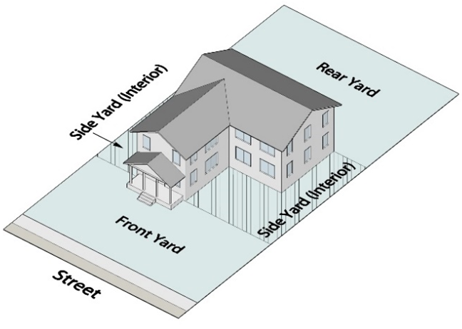 | 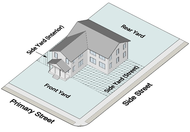 |
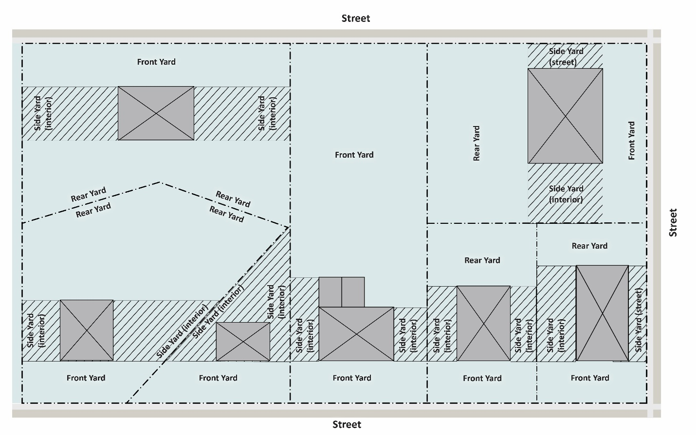 | |
Yard trimmings. Leaves, brush, grass clippings, pruned shrub and tree debris, discarded Christmas trees, nursery and greenhouse vegetative residuals, and vegetative matter resulting from landscape development and maintenance other than mining, agricultural and silvicultural operations.
Z
Zoning buffer. A buffer required by Sec. 207-2.1 (Buffers) or as a condition of zoning, special use of variance approval for a specific property.
Zoning ordinance. Those articles and definitions of this UDO that constitute a zoning ordinance within the meaning of O.C.G.A. § 36-66-1 et seq. See Sec. 101-1.6 (Zoning Compliance Law).
(UDO 21-01, § 1, 10-25-2021; UDO 22-01, § 1, 2-28-2022)
103-1.1. - UDO Administration
A.
Planning and Development Director
1.
The City Council authorizes the Planning and Development Director to administer, interpret, and enforce this UDO and to carry out the duties required in it. It is also the duty and responsibility of each officer and employee of the City, especially of each member of the police and fire departments, to assist the Director by reporting to them new construction and reconstruction of buildings, new land uses, and apparent violations of this UDO.
2.
Appeals of a decision by the Director are provided for in Sec. 103-7.3 (Board of Appeals).
B.
Exemptions
The powers authorized in paragraph A above do not extend other ordinances or regulations referenced in this UDO, such as the health, water, and sewer regulations. Those other ordinances and regulations are administered by the directors of the departments responsible them, as established by the Board of Commissioners of Gwinnett County or the City Council.
C.
Violations
If the Director finds that activities do not comply with the provisions of this UDO, or of a permit issued under this UDO, or without authorization of a permit which would otherwise be required by this UDO, the Director is authorized to suspend or invalidate such permits, order that all unauthorized or improper work be stopped, direct correction of deficiencies, issue summonses to any court of competent jurisdiction, or take any other legal or administrative action appropriate to the severity of the violation and degree of threat to the public health, safety, and welfare.
103-1.2. - Fees
A.
Established
Application filing and permit fees required by this UDO are as established from time-to-time by the City Council.
B.
Permit Fees
Permit fees, if any, must be submitted as a prerequisite to the issuance of the permit. Non-payment as a result of the submission of a check with insufficient funds on the account, or for any other reason, will cause the permit to be voided and reissuance subject to penalty as may be established by the City Council.
C.
Application Fees
Application fees, if any, must be submitted with the application and upon acceptance of said submission for review and consideration will not be refundable. Failure to pay a required application fee will cause the application to be returned to the applicant without acceptance for review or consideration by the City.
D.
Miscellaneous Fees
After the approval of development plans, and before authorization to begin construction, the developer must pay into the treasury of the City such required inspection, sanitary sewer permit charges, curb cut, or other fees as may be established from time-to-time by the City Council. Fees paid directly to the County must be verified by submittal of copies of paid receipts to the Department. Such fees will not be refundable following the issuance of a development permit, except upon approval of the Board of Appeals.
E.
Street-Related Fees
Before approval of development conformance for a project, the developer must provide to the Department such fees for traffic control signs, street name signs, and street striping as shall be required by traffic engineering regulations and established from time-to-time by the City Council.
F.
Performance, Maintenance Bond Fees
Before approval of a final plat or certificate of occupancy, the developer must provide to the Department such recording fees and performance and/or maintenance bonds as shall be required by this UDO or established from time-to-time by the City Council.
103-1.3. - City Employees
A.
No City employee may be relieved of their duty for complying with this UDO or any other ordinance, law or regulation whether or not such person has been advised by the Director or their designee or other City employees.
B.
The City may not be estopped by errors of its employees from enforcing this UDO and does not warrant the accuracy or completeness of its employees' advice as to compliance with laws, especially federal and State laws.
Sec. 103-2. - Enforcement
This section applies in addition to the specific enforcement provisions otherwise provided in this UDO.
103-2.1. - Inspection and Right of Entry
A.
Work that requires a permit by this UDO is subject to inspection by authorized City representatives upon presentation of City identification to the developer, contractor, owner, owner's agent, operator, or occupants during all reasonable hours, or outside reasonable hours in the event of any emergency threatening life or property. When an inspection is necessary to enforce this UDO, or when the Director or authorized City employee has a reasonable cause to believe that there exists upon a premises or property a condition which is contrary to or in violation of this UDO, the Director or authorized City employee is authorized to enter the property or premises at a reasonable time to inspect or to perform the duties required by this UDO, provided that, if the property or premises is occupied, credentials must be presented and entry requested. If the property or premises is unoccupied, the Director or authorized employee must first make a reasonable effort to locate the owner or other person having charge or control of the property or premises and request entry.
B.
If a property or facility has security measures in-force to require proper identification and clearance before entry is possible, the owner or operator must make the necessary arrangements to allow access to the Director.
C.
The owner or operator must allow the Director access to all parts of the premises for the purposes of inspection, investigation, observation, monitoring, measurement, recording, enforcement, sampling, and testing, photography and videotaping for the purpose of ensuring compliance with this UDO. The owner or operator must allow the Director to examine and copy any records that are required under the conditions of any permit granted under this UDO.
D.
The Director may set up on any premises, property, or facility such devices as are necessary in their opinion to conduct any monitoring and/or sampling procedures.
E.
The Director is authorized to require the owner or operator to install monitoring equipment and perform monitoring as necessary, and make the monitoring data available to the Director. This sampling and monitoring equipment shall be maintained at all times in a safe and proper operating condition by the owner or operator at his/her own expense.
F.
Any temporary or permanent obstruction to safe and easy access to, or from the premises, property or facility to be inspected and/or sampled must be promptly removed by the owner or operator at the written or oral request of the Director and may not be replaced. The costs of clearing such access shall be borne by the owner or operator.
G.
Unreasonable delays in allowing the Director or access to a facility, property, or premises will constitute a violation of this UDO.
H.
If the Director or authorized City employee has been refused access to any part of a premises, property or facility and the Director is able to demonstrate probable cause to believe that there may be a violation of this UDO, or that there is a need to inspect and/or sample as part of a routine inspection and sampling program designed to verify compliance with this UDO or any order issued hereunder, or to protect the overall public health, safety, environment and welfare of the community, then the Director or authorized City employee may seek an inspection warrant in accordance with Georgia law.
103-2.2. - Violations
A.
Any action or inaction that violates this UDO (including violations of conditions and safeguards established in connection with grants or variances or special uses) or the requirements of an approved plan or permit will be subject to the enforcement actions or penalties outlined in this section. Any such action or inaction that is continuous with respect to time is deemed to be a public nuisance and also may be abated by injunctive or other equitable relief. The imposition of any of the enforcement actions or penalties described in this section will not prevent such equitable relief.
B.
If any building or structure is erected, constructed, reconstructed, altered, repaired, converted or maintained or if any building, structure or land is used in violation of this UDO, the Mayor or City Council, the Director, or anyone else who would be damaged by such violation, in addition to other remedies, may institute injunction, mandamus or other appropriate action in proceeding to stop the violation in the case of such building, structure or land use.
C.
Any person who violates this UDO or fails to comply with any of its requirements will, upon conviction thereof, be fined not more than that prescribed by State law. In addition, that person must pay all costs and expenses involved in the case. Each day the violation continues will be considered a separate offense.
D.
The owner or tenant of any building, structure, premises, or part thereof, and any architect, builder, contractor, agent, or other person who commits, participates in, assists in, or maintains such violation may each be found guilty of a separate offense and suffer the penalties provided in this section.
E.
Nothing in this section will prevent the City from taking such, other lawful action as is necessary to prevent or remedy any violation.
103-2.3. - Emergency Work
A.
When emergency work is performed under this UDO, the person performing it must report the pertinent facts relating to the work to the Director on the next business day after the commencement of the work.
B.
Within 10 days of reporting the emergency work, the person must apply for a permit and perform such work within such time as may be determined by the Director.
103-2.4. - Enforcement Procedures
A.
Enforcement must begin with the issuance of a written notice of violation to the owner or responsible party by the Director. The notice may be delivered personally or sent by overnight delivery or first-class mail.
B.
The notice of violation must contain at least the following information:
1.
The name and address of the owner or responsible party;
2.
The location or address of the site upon which the violation is occurring;
3.
A description of the nature of the violation;
4.
A description of the remedial actions or measures necessary to bring an action or inaction into compliance with a permit, approved plan, or this UDO;
5.
The deadline or completion date of any such remedial actions or measures; and
6.
A statement of the penalty or penalties that may be assessed against the owner or responsible party to whom the notice of violation is directed.
7.
If the owner or responsible party fails to correct the violations after the deadline contained in the notice of violation, the Director is authorized to take or impose any one or more of the additional actions contained in this subsection.
C.
Stop Work Orders
When any building, structure, or premises is being developed, demolished, expanded, renovated, constructed, used, or occupied contrary to the provisions of this UDO, or the public interest is otherwise threatened in a manner requiring immediate action, the Director is authorized to issue stop work orders to an owner or responsible party. Stop work orders are effective immediately and will remain in effect until the necessary corrective actions or remedial measures stated in the notice of violation have occurred. Stop work orders may be withdrawn or modified by the Director in order to enable an owner or responsible party to take the necessary remedial actions or measures to correct the violations.
D.
Refusal to Issue Certificates of Occupancy or completion
The Director is authorized to refuse to issue certificates of occupancy or completion for the building or other improvements constructed or being constructed on a site until the owner or responsible party has taken the remedial actions or measures stated in the notice of violation or has otherwise corrected the violations described within it.
E.
Suspension, Revocation, or Modification of Permit
The Director is authorized to suspend, revoke, or modify a permit that was issued authorizing land disturbing activities or development. The Director is authorized to reinstate a suspended, revoked or modified permit after the owner or responsible party has taken the remedial actions or measures stated in the notice of violation or has otherwise corrected the violations described therein. The Director is also authorized to reinstate such permit, which may include conditions as the Director deems necessary, to enable the owner or responsible party to take the necessary remedial actions or measures to correct the violations.
F.
Refusal to Approve Final Subdivision Plats
The Director is authorized to refuse to approve final plats until the owner or responsible party has taken the remedial actions or measures stated in the notice of violation or has otherwise corrected the violations described within it.
G.
Issuance of Citations or Summons to Court
The Director is authorized to issue a citation or summons to the owner or responsible party requiring such person to appear in a court of competent jurisdiction to answer charges for violations of this UDO.
H.
Cumulative Remedy
The remedies provided in this subsection will not be exclusive but will be cumulative of all other remedies provided by law.
103-2.5. - Legal Penalties and/or Remedies
A.
Fine and/or Sentence
Any person convicted by a court of competent jurisdiction of violating any provision of this UDO will be guilty of violating a duly adopted ordinance of the City and will be punished either by a fine not less than $100.00 per day and not greater than $1,000.00 per day, or by a sentence of imprisonment not to exceed 60 days in jail, or both a fine and jail or work alternate. Each day that a violation continues after due notice has been served will be deemed a separate offense.
B.
Other legal Remedies
When a violation of this UDO has occurred, the City, in addition to other remedies provided by law, may petition for a restraining order, injunction, abatement, or take any other appropriate legal action or proceeding through a court of competent jurisdiction to prevent, restrain, or abate such unlawful use or activity.
103-3.1. - General
A.
Permit Required, Exemptions
No disturbance of the land, including clearing, grubbing, or grading activities, may begin or continue except in accordance with this UDO, unless the activity is for the construction of an individual single-family detached or duplex residence on a buildable lot of record.
B.
Plan Review and Approval
Any developer must first submit to the Department any plans, plats, or construction drawings required by this UDO and must have been granted a permit consistent with this UDO and approved by the Department before starting development activities. Approval of plans by City officials or employees will not imply nor transfer acceptance of responsibility for the application of the principles of engineering, architecture, landscape architecture, or any other profession, from the professional corporation or individual under whose hand or supervision the plans were prepared and sealed. Sec. 103-6 (Plans and Plats) details the elements of the required plans.
C.
Interdepartmental Review and Approval
The Department may not issue a permit for any development activities until the plans, plats, or construction drawings, as applicable, have been approved by such other departments or agencies as may have authority or jurisdiction over said activities in whole or in part.
D.
Activities Limited to permit Authorization
Development activities are limited to those as authorized by the applicable permit and as may be further restricted by conditions of approval pertaining thereto attached by the Department or other department or agency as may have authority or jurisdiction over said activities in whole or in part.
E.
Developer's Responsibility for Compliance
No permit may be interpreted to relieve any developer or subdivider of the responsibility of maintaining full compliance with all codes, ordinances, and other regulations of the City, except as amended by an approved waiver, variance, or other relief granted through applicable formal appeal procedures for a specific property or application. Any permit issued in error or in contradiction to the provisions of an adopted code, ordinance, or regulation of the City will be considered to have been null and void upon its issuance.
F.
Development Maintenance Compliance
Once substantial development activities have stopped for a period of at least 90 days, the developer/owner must bring the entire property to a state of permanent soil stabilization. Once permanent soil stabilization has been achieved, the developer/owner must perform routine property maintenance and keeping the site free of grass, weeds, or uncultivated vegetation over 12 inches high. The Director has the authority to determine when substantial development activities have stopped.
103-3.2. - Clearing, Clearing and Grubbing, and Grading
A.
Clearing (minor) Permit
1.
A permit limited to removal of underbrush, shrubs and other low growing vegetation and trees up to 3 inches in diameter (DBH), including the removal of the stumps and root systems. The surface of a cleared site may be disturbed by the tracks or tires of the equipment used but may not be intentionally altered from its natural contour. Minor earthmoving to construct stream crossings is permitted.
2.
Issuance is dependent upon the identification of the property, the limits of the area to be cleared, the type of activities to be undertaken and approved erosion and sedimentation control measures. All clearing activities are to be consistent with the provisions of this UDO and any conditions of zoning approval.
3.
A clearing (minor) permit will expire unless activities are started within 60 days of issuance of the permit or if activities lapse and are abandoned for a period exceeding 30 days. For this purpose, a lapse in or suspension of clearing activity as authorized by a clearing (minor) permit, as a direct result of action or inaction on the part of the City completely beyond the control of the developer/owner, will not be considered as a lapse in activity causing the clearing (minor) permit to expire. The 60 days within which clearing activity must begin will exclude any such time period during which the activity is prohibited or has been caused to lapse by said City action or inaction.
4.
A clearing (minor) permit will not be construed as approval of or authorization to construct any improvements, buildings, or other structures on the property.
5.
A permit for this activity is limited to a maximum of 3 acres.
6.
This activity is not considered to be associated with site development, therefore, sites for which this permit is obtained are not eligible for a development permit for a period of 6 months.
B.
Clearing (major) Permit
1.
A permit limited to all items included in clearing (minor) plus the cutting and removal of all trees regardless of diameter, but not including the removal of the stumps and root systems of the trees larger than 3 inches in diameter (DBH). The surface of a cleared site may be disturbed by the tracks or tires of the equipment used but may not be intentionally altered from its natural contour. Minor earthmoving to construct stream crossings is permitted.
2.
Issuance is dependent upon the identification of the property, the limits of the area to be cleared, the type of activities to be undertaken and approved erosion and sedimentation control measures. Issuance is also dependent upon approval of a concept plan and tree preservation and/or replacement plan (if required) for the development. All clearing activities are to be consistent with the provisions of this UDO and any conditions of zoning approval.
3.
A clearing (major) permit will expire unless activities are commenced within 60 days of issuance of the permit or if activities lapse and the project is abandoned for more than 30 days. For this purpose, a lapse in or suspension of clearing activity as authorized by a clearing (major) permit, as a direct result of action or inaction on the part of the City of Snellville completely beyond the control of the developer/owner, will not be considered as a lapse in activity causing the clearing (major) permit to expire. The 60 days within which clearing (major) activity must begin will exclude any such time period during which the activity is prohibited or has been caused to lapse by said City action or inaction.
4.
A clearing (major) permit will not be construed as approval of or authorization to construct any improvements, buildings or other structures on the property.
5.
A permit for this activity is limited to a maximum of 10 acres.
6.
All required (tree) replacement density (RRD) units, including special and specimen tree replacement density units, will be transferred with the project/property. The RRD units will be calculated in accordance with Sec. 207-4 (Tree Ordinance). Furthermore, the property owner must execute a covenant, in a form satisfactory to the City Attorney and recorded by the Clerk of the Superior Court of Gwinnett County, which discloses to any future property owner all requirements with respect to the required tree replacement density (RRD) units relating to the subject property and obligates such future property owner to comply with said requirements.
C.
Clearing and Grubbing Permit
1.
This construction activity includes all items included in clearing (major) plus the removal of the stumps and root systems of all trees cut and removed.
2.
A clearing and grubbing permit may be approved based on the approval of a concept plan and tree protection/replacement plan for the development. Appropriate soil erosion and sedimentation controls in accordance with Sec. 402-1 (Soil Erosion and Sedimentation Control) and tree protection measures in accordance with Sec. 103-6.8 (Tree Ordinance Plans) must be in-place and maintained as required.
3.
A clearing and grubbing permit will expire unless activities are commenced within 60 days of issuance of the permit or activities lapse and the project is abandoned for more than 14 days. For this purpose, a lapse in or suspension of clearing and grubbing activity as authorized by a clearing and grubbing permit, as a direct result of action or inaction on the part of the completely beyond the control of the developer/owner, will not be considered as a lapse in activity causing the clearing and grubbing permit to expire. The 60 days within which clearing and grubbing activity must begin will exclude any such time period during which the activity is prohibited or has been caused to lapse by said City action or inaction.
4.
A clearing and grubbing permit will be limited to the removal of trees and vegetation and stumps or roots from a property; the placement of required tree protection measures and soil erosion and sedimentation facilities, and may authorize the removal of existing structures on the property, at the option of the developer, and upon receiving an approved demolition permit (per structure). Under no circumstances may any grading (movement, removal, or addition of earth on a site by the use of mechanical equipment) or construction activity commence under a clearing and grubbing permit. The approval of a clearing and grubbing permit will not imply the approval of or authorization to construct any improvements, buildings, or other structures on the property.
5.
All required (tree) replacement density (RRD) units, including special and specimen tree replacement density units, will be transferred with the project/property. The RRD units will be calculated in accordance with Sec. 207-4 (Tree Ordinance). Furthermore, the property owner must execute a covenant, in a form satisfactory to the City Attorney and recorded by the Clerk of the Superior Court of Gwinnett County, which discloses to any future property owner all requirements with respect to the required tree replacement density (RRD) units relating to the subject property and obligates such future property owner to comply with said requirements.
D.
Grading Permit
1.
This construction activity includes the movement, removal or addition of earth on a site by the use of mechanical equipment that alters the natural contour of the site.
2.
Issuance of a grading permit, which may include clearing and grubbing, is dependent upon approved grading plans, erosion and sedimentation control measures, and stormwater management report (if applicable). All grading activities are to be consistent with the provisions of this UDO and any conditions of zoning approval.
3.
A grading permit will be limited in its authorization to land grading along with associated tree protection, clearing, and grubbing, and may authorize the removal of existing structures on the property, at the option of the developer/owner, and upon receiving an approved demolition permit (per structure), and may authorize the construction of storm drainage improvements and soil erosion and sedimentation facilities as allowed by the permit. Grading permit approval will not imply the approval of or authorization to construct any improvements, buildings, or other structures on the property, other than the construction of storm drainage improvements and soil erosion and sedimentation facilities.
4.
A grading permit will expire 60 days after permit issuance unless clearing, grubbing and grading activities as authorized by the permit is initiated within the 60-day period or if such authorized activities lapse and the project is abandoned for more than 30 days. For this purpose, a lapse in or suspension of development activity as authorized by a grading permit, as a direct result of action or inaction on the part of the City completely beyond the control of the developer/owner, will not be considered as a lapse in activity causing the grading permit to expire. The 60 days within which clearing, grubbing, and grading activity must begin will exclude any such time period during which the activity is prohibited or has been caused to lapse by said City action or inaction. Any site for which the grading permit expires must immediately be stabilized to prevent erosion.
5.
All required (tree) replacement density (RRD) units, including special and specimen tree replacement density units, will be transferred with the project/property. The RRD units will be calculated in accordance with Sec. 207-4 (Tree Ordinance). Furthermore, the property owner must execute a covenant, in a form satisfactory to the City Attorney and recorded by the Clerk of the Superior Court of Gwinnett County, which discloses to any future property owner all requirements with respect to the required tree replacement density (RRD) units relating to the subject property and obligates such future property owner to comply with said requirements.
103-3.3. - Development Permit
A.
Development Activities Authorized
A development permit must be issued to authorize all activities associated with the land development process, including clearing and grubbing, grading, and the construction of such improvements as streets, surface parking areas and drives, sewer systems, stormwater drainage facilities, sidewalks, or other structures permanently placed on or in the property except for buildings or other structures requiring the issuance of a building permit. Water system improvements must be authorized only upon approval by the Gwinnett County Department of Water Resources.
B.
Development Permit Approval
1.
Before the issuance of a site development permit, each permittee must designate a registered agent who is located within Gwinnett County by residence and/or office and who can be contacted 24-hours a day. This information will be kept by the Department and utilized when and if immediate action is required.
2.
A development permit (which may include grading, clearing, and grubbing) will be issued at the developer's request following approval of a preliminary plat for a subdivision or a site plan for a non-subdivision project, along with approval of all other development plans and documents required by this UDO. All plans approved for a development permit will expire after 6 months if no permit is issued within said time period.
3.
All required (tree) replacement density units (RRD), including special and specimen tree replacement density units, will be transferred with the project/property. The RRD units will be calculated in accordance with Sec. 207-4 (Tree Ordinance). Furthermore, the property owner must execute a covenant, in a form satisfactory to the City Attorney and recorded by the Clerk of the Superior Court of Gwinnett County, which discloses to any future property owner all requirements with respect to the required tree replacement density (RRD) units relating to the subject property and obligates such future property owner to comply with said requirements.
C.
Expiration of Development Permits
A development permit will expire 12 months after issuance unless the development activity authorized by the permit is initiated within the 12-month period or if such authorized activities lapse and the project is abandoned for more than 60 days. The Director may approve one extension not exceeding 3 months within which time development activity must commence or the permit will expire. The extension must be applied for within the first 12 months after the permit's issuance.
D.
Lapse in Construction Activity
For the purposes of this subsection, a lapse in or suspension of development activity as authorized by a development permit, as a direct result of action or inaction on the part of the City completely beyond the control of the developer, will not be considered as a lapse in activity causing the development permit to expire. The 12 months within which development activity must begin will exclude any such time period during which the activity is prohibited or has been caused to lapse by said City action or inaction.
103-4.1. - Permit Required
No building or other structure may be erected, moved, added to, or structurally altered without a permit such activity issued by the Director. In addition, no building permit may be issued except in conformity with this UDO, unless there is either an approved variance from the Board of Appeals or an approved administrative variance from the Director, both as provided by this UDO.
103-4.2. - Application
Building permit applications must be accompanied by plans in duplicate drawn to scale, showing the actual dimensions and shape of the lot to be built upon; the exact sizes and locations of existing buildings on the lot, if any; and the location and dimensions of the proposed building or alteration. The application must include such other information as lawfully may be required by the Director, including existing or proposed building or alteration; existing or proposed uses of the building and land; the number of families, housekeeping units, or rental units the building is designed to accommodate; conditions existing on the lot; and such other matters as may be necessary to determine conformance with, and provide for the enforcement of, this UDO. One copy of the plans must be returned to the applicant by the Director after they must have marked such copy either as approved or disapproved and attested to the same by their signature on such copy. The original, similarly marked, must be retained by the Director. If the plans conform with the provisions of this UDO, the City building codes and other ordinances of the City, the permit will be issued upon payment of the required fee. If compliance does not result, the building permit will be refused by the Director.
103-4.3. - Certificate of Occupancy
A.
It is unlawful to use or occupy or permit the use or occupancy of any building or premises, or both, or part thereof hereafter created, erected, changed, converted, or wholly or partly altered or enlarged in its use or structure until a certificate of occupancy has been issued therefor by the Director stating that the proposed use of the building or land conforms to the requirements of this UDO.
B.
No permit for the erection, alteration, moving or repair of any building may be issued until an application has been made for a certificate of occupancy. The certificate will be issued only if the building and use comply with the provisions of this UDO upon completion of the work.
C.
A temporary certificate of occupancy may be issued by the Director for a period not exceeding 6 months during alterations or partial occupancy of a building pending its completion, provided that such temporary certificate may include such conditions and safeguards as will protect the safety of the occupants and the public.
D.
The Director must maintain a record of all certificates of occupancy, and a copy must be furnished upon request to any person. Failure to obtain a certificate of occupancy will be a violation of this UDO and punishable under Sec. 103-2 (Enforcement).
103-4.4. - Construction and Use to be as Provided in Applications, Plans, Permits, and Certificates of Occupancy
Building permits or certificates of occupancy issued on the basis of plans and applications approved by the Director authorize only the use, arrangement, and construction set forth in such approved plans and applications, and no other use, arrangement or construction. Use, arrangement, or construction at variance with that authorized will be deemed a violation of this UDO and punishable under Sec. 103-2 (Enforcement).
103-4.5. - Applicable Codes
Building permits for all structures or interior finishes are issued after meeting the applicable requirements of Chapter 300 of this UDO, the fire prevention and life safety codes, and the various health, water, sewer, and building codes of the City and County.
103-4.6. - Health Department, On-Site Sewage Disposal
When on-site sewage disposal will be provided, a permit issued by the Gwinnett County Environmental Health Department is required before issuance of a building permit. Said permit may first require approval by the Gwinnett County Environmental Health Department of a plan showing the location of the sewage disposal system and other site improvements, in accordance with their regulations.
103-4.7. - Single-Family Detached and Two-Family Dwellings
A.
A building permit for a single-family detached or two-family dwelling may only be issued after the recording of a final plat or after the lot upon which the building is to be located has otherwise become a buildable lot of record.
B.
The approval by the Department of a house location plan (HLP), residential drainage plan (RDP), or residential drainage study (RDS), may be required before issuance of the building permit, as noted and conditioned on the final plat. For such lots, a certificate of occupancy may not be issued until conformance to the HLP, RDP, or RDS has been field verified by the Department as shown on a certified foundation survey prepared by a registered land surveyor.
103-4.8. - Swimming Pools
Issuance of a building permit for a swimming pool as an accessory use to a single-family or two-family dwelling, whether to be issued at the same time as or subsequent to the permitting or construction of the principal building, first requires the approval of a swimming pool location plan. The plan must show the proposed location of the swimming pool and enclosing fence relative to the residence, the property boundaries, setback lines, septic tank and septic tank drain field (if any), and any easements on the site, and must comply with all requirements of this UDO and swimming pool code. Based on-site conditions, a residential drainage study (RDS) may also be required before issuance of the building permit. In locations where septic tanks and drain fields exist the plan must also be approved by the Gwinnett County Environmental Health Department. A certificate of occupancy will not be issued until conformance to the swimming pool location plan (and to provisions of the RDS, if applicable) has been field verified by the Department of Planning and Development.
103-4.9. - Multifamily and Nonresidential Structures
A.
Issuance of a building permit for any principal building other than a single-family detached or two-family dwelling (and associated accessory structure) first requires the issuance of a development permit for the building site, and the building permit must be consistent with said development permit.
B.
Building plans must be reviewed and approved by the Department of Planning and Development, the Gwinnett County Fire Services Division, and the Gwinnett County Public Utilities Departments before permitting for all structures, except single-family detached or two-family dwelling and their accessory structures. Building plan approval will expire after 1 year, after which rereview and approval by the Department of Planning and Development is required before issuance of a building permit for the building or additional buildings.
103-4.10. - Issuance on Buildable Lots of Record, Exceptions
Building permits will only be issued on buildable lots of record, as defined in this UDO, except under special circumstances limited to and as specifically described below.
A.
In a single-family detached or two-family dwelling subdivision, building permits for no more than two model home buildings, except by approval of a modification application, on specific lots may be issued by the Department on the basis of an approved preliminary plat after the approval of the Gwinnett County Environmental Health Department or Gwinnett County Department of Public Utilities, as appropriate, and subject to all limitations or requirements as may be established by the Director. A certificate of occupancy will not be issued for the completed model home until the final plat encompassing the model home building lots has been approved and recorded.
B.
In fee-simple single-family attached subdivisions, a building permit may be issued on a buildable lot of record established for each building (containing any number of dwelling units) through recording of a final plat following completion of all required public improvements. Upon completion of the buildings, the final plat must be re-recorded to establish individual lots for the dwelling units, based on their actual locations, before issuance of certificates of occupancy.
C.
In subdivisions not subject to paragraphs A or B above, building permits may be issued by the Department on the basis of an approved preliminary plat and after a development permit has been approved reflecting the site plan and construction drawings for specific buildings and associated site improvements. Issuance of the building permits will be conditioned on the following:
1.
A performance bond or other approved surety must have been received in a form acceptable to the City Attorney, drawn in favor of the City and in an amount not less than 110% of the cost of completing all public improvements as authorized and required by the preliminary plat.
2.
The performance bond or other approved surety may not exceed an aggregate total for all required public improvements of $12,000.00 per acre for the total acreage included within the subdivision or portion of the subdivision wherein the improvements are proposed, except by approval of the City Council.
3.
Gwinnett County Fire Services Division approval is required before issuance of any building permit, which may include approval of acceptable access and water under pressure for combustible construction.
4.
Approval of the Gwinnett County Environmental Health Department for on-site sewage disposal or by the Gwinnett County Water Pollution Control Division for a building to be served by public sewer is required before issuance of any building permit.
5.
Construction of the required public improvements must proceed concurrently with the construction of the buildings.
6.
A certificate of occupancy may not be approved for any structure within the subdivision before the recording of the final plat without the express approval of the Director.
7.
The Director must have found that the public interest is best served and that a public purpose is involved in the acceptance of the performance bond.
103-5.1. - General
A.
Applicability
1.
All land disturbance activity or any other development activity must comply with the requirements of this section.
2.
All subdivision must comply with the requirements of this section, except as provided for in clause 3 below.
3.
If a proposed subdivision is located within the incorporated area of the City and partially within the unincorporated area of Gwinnett County or within the incorporated areas of another municipality the City Council may provide by contract with the governing authority of Gwinnett County or other municipalities involved so that either the provisions of this section will apply to the entire subdivision or so that the provisions of an ordinance of Gwinnett County or another municipality regulating the subdivision of land will apply to the entire subdivision. Lacking such an agreement, that portion of the subdivision lying within the City must conform to the provisions of this section.
B.
Dedication of Public Lands and Facilities
No land dedicated as a public street or other public purpose may be opened or accepted as a public street or for any other public purpose, and no subdivision of land may be made, nor subdivision plat, nor part thereof, may be recorded before obtaining final approval from the Department. The approval must be entered in writing on the final plat by the Director. The Director is authorized to accept such dedications of lands and public facilities on behalf of the city and to cause such dedications to be recorded by the Clerk to Superior Court of Gwinnett County, subject to ratification by the City Council.
C.
Transfer of Land Ownership
1.
Transfer criteria. No person, firm, partnership, association, corporation, estate, trust, developer, subdivider or any other owner or agent may transfer title or attempt to record the title to any land, and no building permit may be issued on said land, unless:
a.
Said land existed as a single lot of ownership, recorded as such in its entirety and present boundaries with the Clerk to Superior Court of Gwinnett County before the July 1985 Subdivision Regulations; or
b.
Said land is shown in its entirety and present boundaries on a final plat as approved (under these or any previously applicable regulations) and duly recorded with the Clerk to Superior Court of Gwinnett County; or
c.
Said land is shown in its entirety and present boundaries on a plat authorized by the Director and recorded with the Clerk to Superior Court of Gwinnett County pursuant to the regulations governing subdivision exemptions contained herein; or
d.
Said land is an aggregation of properties for land assembly purposes, and no building permit will be requested before the filing of an application for issuance of a development permit, pursuant to these regulations.
2.
Restrictions. No person, firm, partnership, association, corporation, estate, trust, developer, subdivider, or any other owner or agent may transfer title to any property by reference to, exhibition of, or any other use of any map of plat illustrating the subdivision of land without a final plat of said land showing said property first having been duly approved under the procedures of this UDO or any previously applicable regulations and recorded with the Clerk to Superior Court of Gwinnett County.
D.
Subdivision Exemptions
1.
General requirements. For the purpose of this UDO, the following types of activities are considered subdivisions but are exempt from the "procedures" and "required public improvements" portions of article and Sec. 401-1.5 (Required Public Improvements), except as noted. Each such subdivision must be drawn as an exemption plat in accordance with final plat standards (except clause 4.b) of this UDO and must be submitted in an appropriate number of copies together with the appropriate fees to the Department for review and approval. Upon approval, the Director will authorize the recording of the exemption plat with the Clerk of Superior Court of Gwinnett County and grant the issuance of building permits pursuant to the codes and ordinances of the City of Snellville.
2.
Recombinations. The combination or recombination of all of two or more buildable lots of record, where the total number of lots is not increased and the resultant lots are in compliance with the zoning district size regulations. An exemption plat is not required for aggregations of properties for land assembly purposes where no building permit will be requested before issuance of a development permit.
3.
Minor subdivision. The division of a buildable lot of record into five or fewer lots, provided:
a.
Each proposed lot complies with all zoning district size regulations and is limited to single-family detached dwelling use.
b.
Each proposed lot abuts upon an existing public street.
c.
All project-related slope and utility easements, as well as necessary street right-of-way as determined by the Department based on the Comprehensive Plan, are provided at no cost to the City.
d.
Each lot thus created may not be resubdivided under this paragraph D. Resubdivision may only be accomplished per Sec 103-5.3 (Subdivision Review).
e.
Each proposed lot must comply with the requirements of the Gwinnett County Department of Public Utilities and the Gwinnett County Environmental Health Department, as appropriate, whose certification of approval is required before approval of the exemption plat by the Department.
The Director is authorized to grant a modification from the five-lot maximum exemption; provided, however, modifications may not be granted to exceed a total of seven exempt lots. The Director may impose conditions of approval upon any modification thus granted as may be necessary to ensure the general public welfare.
4.
Estate subdivisions
a.
The division of land in any single-family detached residential district into lots with a minimum lot area of 5 acres, provided:
i.
Each proposed lot abuts upon an existing public street which contains the necessary right-of-way width required by these regulations as determined by the Comprehensive Plan.
ii.
Each proposed lot must provide at least 100 feet of frontage upon the street, must provide at least 200 feet of lot width, and must meet or exceed all other minimum requirements of the applicable zoning district.
iii.
All project-related slope and utility easements, as well as necessary street right-of-way, must be provided at no cost to the City as determined by the Department based upon the Comprehensive Plan.
iv.
No lot thus created may be resubdivided to less than 5 acres as an exemption to these regulations.
v.
Each proposed lot must comply with the requirements of the Gwinnett County Department of Public Utilities and the Gwinnett County Environmental Health Department, as appropriate, whose certification of approval is required before approval of the exemption plat by the Department of Planning and Development.
b.
The division of land in any single-family detached residential district into lots with a minimum lot area of 10 acres, provided:
i.
Each proposed lot abuts upon an existing public street.
ii.
Each proposed lot must provide at least 100 feet of frontage upon the street, must provide at least 200 feet of lot width, and must meet or exceed all other minimum requirements of the applicable zoning district.
iii.
No lot thus created may be resubdivided to less than 10 acres as an exemption to these regulations.
iv.
A record survey certified by a land surveyor currently registered in the State of Georgia must be submitted to and approved by the Department showing all lots.
5.
Nonresidential project management. The creation of a lot for recording within an overall nonresidential development, provided:
a.
The overall nonresidential development is being undertaken as a single multiphase or multiuse project under the unified control of a single developer, is zoned for such use or development, and an overall concept plan for the entire project has been approved by the Director.
b.
The proposed subdivision is clearly intended to transfer the title for financing or building management purposes and not for the sale of the property for future development, to the satisfaction of the Director.
c.
The proposed lot has been approved by the Department to be provided permanent vehicular access by a private drive. Said access must be established by easement or acceptable covenant before or concurrently with the recording of the exemption plat.
d.
The proposed lot must encompass a principal structure that has been granted a building permit and which is under construction or has been completed.
e.
The exemption plat must be drawn to include the entirety of the overall development and must clearly identify those lots to be recorded, those lots previously recorded and the remainder of the development which must be labeled "not included." All easements, dedications, etc., must be shown as appropriate or as required. Each lot must be consistent with the zoning approved for the overall development and the applicable requirements of this UDO.
103-5.2. - Traffic Impact Analysis
A.
Applicability
1.
A traffic impact analysis is required when a development seeking subdivision review, non-subdivision review, rezoning, or special use permit exceeds 50% of the threshold otherwise required by the DRI rules of GRTA.
2.
Any DRI that complies with the rules of GRTA is exempt from the traffic impact analysis requirement.
3.
A traffic impact analysis is not required when an application is initiated by the City.
4.
An application may be exempted from the traffic impact analysis requirement by the Director if a prior traffic impact analysis for the subject property has been submitted to the City and the proposed development is substantially similar to that for which the prior traffic impact analysis was conducted.
B.
Procedures
1.
During the required pre-application conference or before accepting a rezoning or special use permit application, the Director, in consultation with the Gwinnett DOT and GDOT, as applicable, must review the thresholds and submittal requirements for a traffic impact analysis.
2.
When required, a traffic impact analysis must be submitted before the application being deemed complete.
C.
Scoping Meeting
1.
Once it is determined that a traffic impact study is required, a scoping meeting may be held with the developer or their consultant and the appropriate representatives of the City. It is the responsibility of the developer or their consultant to initiate this meeting. The purpose of this meeting is to discuss the availability of site-specific information concerning the development, available forecasts of traffic volumes, and to ensure the applicant understands the content requirements for traffic impact studies.
D.
Required Contents of a Traffic impact Study
The traffic impact study must be prepared following and meeting the standards of the GRTA Development of Regional Impact technical guidelines, dated January 14, 2002, as may be amended from time to time. In addition, the following components must be included:
1.
Alternative transportation. Alternative transportation (sidewalk, bicycle, transit) impacted or needed as a result of the development.
2.
References. A listing of all technical documents and resources cited or consulted in preparing the traffic impact study.
3.
Technical Appendix. Relevant technical information, including but not limited to: copies of raw traffic count data used in the analysis, calculation sheets and/or computer software output for all LOS and V/C calculations in the analysis, and warrant worksheets for signals, turn lanes, signal phasing, etc. used in the analysis.
4.
Mitigation Measures and Costs. Listing of all intersections and road segments that are forecasted to be Level of Service "E" and "F" in the horizon year, or if phased, in the years that each phase is planned to be complete, and an identification and description of specific mitigation measures including signal, turn lane, or other warrant analyses as appropriate and necessary to bring these intersections and road segments into compliance with a Level of Service "D" or other City-adopted level of service for said road segment or intersection.
If roadway improvements are needed, the study shall show a drawing at an engineering scale of 1 inch = 20 feet for all recommended lane configurations.
If signalization is warranted by the traffic signal warrants outlined in the Manual on Uniform Traffic Control Devices (MUTCD), a warrant analysis shall also be conducted as a part of the traffic impact study. If a traffic signal is warranted, the warrant package in the study shall show a drawing at an engineering scale of 1 inch = 20 feet, detailing the signal design and phasing plans.
The estimated cost associated with implementing all such mitigation measures must be provided in the traffic impact study. The traffic impact study may take into account any City/County/State-approved roadway, traffic signalization and other improvements in determining mitigation measures and providing recommendations.
E.
Additional Technical Specifications
The Director is authorized to promulgate and require the use of additional technical specifications for conducting traffic impact studies, which must be consistent with analysis methods included in the most recent Highway Capacity Manual, Manual on Uniform Traffic Control Devices, "Trip Generation" published by the Institute of Transportation Engineers (ITE), and/or Traffic Access and Impact Studies for Site Development: A Recommended Practice (Washington, DC: Institute of Transportation Engineers, 1991), as may be amended or republished from time to time.
F.
Costs and fees
The City assumes no liability for any costs or time delays (either direct or consequential) associated with the preparation and review of traffic impact studies. There is no application review fee for a traffic impact study.
G.
Submittal and Review of Study
The applicant for the proposed development or the qualified professional must submit one electronic copy of the traffic impact study and technical appendix, two paper copies of the traffic impact study and one paper copy of the technical appendix to the Director. The Director may submit copies of the report to applicable review agencies which may include GDOT, GRTA, Gwinnett County, an adjacent local jurisdiction, and/or the ARC. Within 10 days of receipt of a traffic impact study, the Director will review all calculations and analyses and determine if they are complete, reasonable, understandable, consistent and fully explained. The conclusions presented in the traffic impact study must be consistent with and supported by the data, calculations, and analyses in the report. Calculations, graphs, tables, data and/or analysis results that are contrary to good common sense or not consistent with and supported by the data will not be accepted. In such events, the Director will return the traffic impact study to the development applicant for correction.
H.
Recommendations for mitigation of impacts
Within 10 days of receipt of a completed traffic impact study, the Director must complete their review of the study and submit to the applicant all recommendations for mitigation measures as stated in the traffic impact study and include any interpretations or recommended conditions of approving the discretionary development proposal that will mitigate traffic impacts of the proposed development.
I.
Determination of project and system improvements
1.
The Director will determine which mitigation measures constitute "project" improvements and which mitigation measures constitute "system" improvements within the context of the Georgia Development Impact Fee Act of 1990.
2.
If a particular improvement is called for in the traffic impact study or recommended by Director, and the Director is unable to uniquely attribute the recommendation as a project or system improvement or finds that such improvement has characteristics of both a project improvement and a system improvement, the Director will determine the proportion of the cost of such improvement that can reasonably be attributed to the development as a project improvement, and the portion of such improvement that can reasonably be considered a system improvement.
J.
Conditions of development approval for project improvements
Upon the determination of project improvements needed to mitigate the traffic impacts of the discretionary development proposal as provided in this section, the Director will recommend that the project improvements be completed by the developer as conditions of approval of the discretionary development proposal.
K.
System improvements
When the Director recommends improvements as a condition of a discretionary development proposal that the Director determines are wholly or partially "system" improvements, the Director may include such recommendations in the recommended conditions of approval for the discretionary development application. The development applicant and the City in the case of system improvements shall have the following options:
1.
The applicant for a discretionary development proposal may voluntarily agree to pay for the cost of providing the system improvements, or a pro-rated share of the cost of said system improvements that are reasonably attributed to the subject development, as determined by the City.
2.
When an application is for a discretionary development proposal before the City Council, the City may find that the proposed development will provide substantial adverse impacts on the transportation system. The City may find further that the existing transportation system is insufficient to serve the proposed development and the City is unable to provide adequate transportation facilities within a reasonable amount of time after the impacts of said development would occur. Given such findings, the City Council may reduce the development density or intensity to the degree that the impacts of the development proposal do not degrade transportation facilities below adopted level of service standards, require a phasing of the development in a manner that adequate public facilities will be provided publicly or privately, or in cases where such other alternatives do not address the adverse impacts, deny an application for a discretionary development proposal.
103-5.3. - Subdivision Review
A.
Pre-application Conference
When any subdivision of a tract of land is proposed, whether for residential or nonresidential development, the subdivider is encouraged to present to the Department preliminary documents and graphic exhibits to allow early evaluation of the subdivider's intentions and coordination with the Comprehensive Plan and UDO regulations, and to inform and provide the subdivider with the necessary regulations in order to properly accomplish the proposed project.
B.
Concept Plan Approval
1.
Application for concept plan approval must be submitted to the Department using an application form and in a number of copies to be determined by the Director. The concept plan must include the entire property proposed for development but need not include the applicant's entire contiguous ownership.
2.
If the subdivider chooses not to submit a concept plan, then the subdivider may proceed directly with the submittal of development plans (called a preliminary plat) if they show the entire property proposed for development. In so doing, however, the subdivider assumes the risk of premature design and engineering expenses if the City requires subsequent design and engineering changes.
3.
Copies of the approved concept plan must be provided to the Department for permanent record, in a number as determined by the Director.
C.
Development Plans Approval for Subdivisions
1.
An application for development plans (called a preliminary plat) approval and issuance of a development permit must be submitted to the Department using an application form and in a number of copies as determined by the Director. The development plans may encompass a portion of a property included within an approved concept plan. However, if no concept plan has been approved, the development plans must include the entire property being developed and having the same zoning district. The application must include the preliminary plat, and construction drawings. All construction drawings and other engineering data shall be prepared and sealed by a professional engineer currently registered in the State of Georgia, in accordance with provisions of Georgia Law.
2.
The Director must indicate on a review copy of the drawings or in a written memorandum all comments related to compliance of the development plans with this section, principles of good design, this UDO, conditions of zoning approval, and the regulations of other City and County departments and State agencies as appropriate. The Director has final authority to determine the applicability of any and all comments under this UDO or conditions of zoning approval.
3.
A preliminary plat may not be approved when it shows a lot that would present particularly unusual difficulties for construction of a building, which would clearly require a variance to be reasonably usable, or which is otherwise "unbuildable" because of its unusability, whether due to the presence of floodplain, unusual configuration, lack of public utilities or for any other reason. A House Location Plan (HLP) may be required to be filed as a part of the preliminary plat approval to substantiate the buildability of any such difficult or unusual lot. This provision does not apply to lots used exclusively for subdivision identification signage, entrance or landscape features, common areas, open spaces, private alleys, or stormwater facilities.
4.
The subdivider is responsible for compliance with all codes, regulations, and zoning requirements and for the satisfaction of all of the noted and written comments of the Director.
5.
If an applicant disagrees with the findings or final review comments of the Director or of any other City department, concluding that factual or interpretive errors have been made, the appeal procedure of Sec. 103-7.3 (Administrative Decision Appeals) must be followed to resolve the issues.
6.
When the Director has determined that the plat and other development plans are in compliance with all applicable City regulations and approval has been received from all affected City and County departments, the Director must sign and date a CERTIFICATE OF DEVELOPMENT PLANS APPROVAL stamped or printed on a reproducible copy of the plat. Copies of approved plat and development plans must be transmitted to the applicant and retained by the Department for its records.
7.
After the above approval by all affected City and County departments, a development permit will be issued at the developer's request to begin construction activities based on the approved development plans.
D.
Final Plat Approval
1.
When the provisions of this subsection have been complied with, the subdivider may submit to the Department an application for final plat approval, using an application form and a number of copies as determined by the Director.
2.
The Director must indicate on a review copy of the plat or in a written memorandum all comments related to compliance of the final plat with this UDO, conditions of zoning approval, and the regulations of other City and County departments and State agencies as appropriate. The Director will have final staff authority to determine the applicability of any and all comments under this UDO or conditions of zoning approval.
3.
A final plat may not be approved when it shows or otherwise creates a lot that would present particularly severe and unusual difficulties for construction of a building, which would clearly require a variance to be reasonably usable, or which is otherwise "unbuildable" due to the presence of floodplain, unusual configuration, lack of Gwinnett County Health Department approval, or for any other justified reason. This provision does not apply to lots used exclusively for subdivision identification signage, entrance or landscape features, common areas, open spaces, private alleys, or stormwater facilities.
4.
Lots which would appear to be buildable under certain circumstances and would require further study or additional information before a building permit could be issued, but which present problems or unusual difficulties which can reasonably be addressed or overcome by the lot owner, may be included in the plat with the appropriate notation of the steps necessary to allow issuance of a building permit.
5.
The subdivider is responsible for compliance with all codes, UDO requirements, and for the satisfaction of all of the comments of the Director.
6.
Final approval by the Director may not be shown on the final plat until all requirements of these and other applicable regulations have been met, and the Director has received a completed request for approval of development conformance and an executed development performance and maintenance agreement. The agreement must be accompanied by a bond, letter of credit or other acceptable surety providing for the maintenance of all installations and improvements required by these regulations in the subdivision for a period not to exceed 12 months following the date of approval of development conformance for subdivisions for which the final topping of a "two-pass" street has not been applied or for a period not to exceed 24 months. The maintenance bond period of application may be extended by the Director at the request of the developer, provided it is in the best interest of the health, safety, and welfare of the public.
7.
The Director must further determine that either:
a.
All improvements and installation to the subdivision required for approval of the final plat under the rules and regulations of the City of Snellville have been completed in accordance with the appropriate specifications; or
b.
All of the stormwater drainage and detention facilities, water and sewer utilities, street base and curbing construction required for approval of the final plat have been properly installed and completed and, for those required improvements not yet completed (grassing, pavement topping, required landscaping, sidewalks, etc.) a performance bond will have been filed by the subdivider with the development performance and maintenance agreement, which performance bond must:
i.
Be conditioned upon the faithful performance by the subdivider or developer of all work required to complete all improvements and installations for the subdivision, or approved portion thereof, in compliance with these rules and regulations within a specified time, not to exceed 3 months;
ii.
Be payable to, and for the indemnification of, the City;
iii.
Be in an amount equal to the cost of construction of the required improvements not yet completed plus an additional 10% of said costs, as calculated by the Director on the basis of yearly contract prices or City contracts, where available;
iv.
Be with surety by a company entered and licensed to do business in the State of Georgia; and
v.
Be in a form acceptable to the Director or the City Attorney.
8.
Payment for materials and installation of traffic control and street name signs must be made to the Department in accordance with the traffic engineering regulations before approval of the final plat. Payment of the cost of striping major thoroughfares or required signalization if required and not completed by the developer must also be received by the Department before approval of the final plat.
9.
Payment of the required plat recording fee must be made to the Department before approval of the final plat.
10.
Once the Department has approved the final plat and all other affected departments and agencies of government as required have certified compliance and signed the route sheet, the Director will certify by their signature on the original of the plat that all of the requirements of this UDO, and the conditions of zoning approval have been met, and that all other affected departments have approved the plat. The final plat may not be deemed approved until it has been signed by the Director and where the use of septic tanks is proposed, by a duly authorized representative of the Gwinnett County Health Department. The final plat when approved must be submitted to the Planning Commission for information purposes.
11.
Once the final plat has been so certified, the Director must authorize it to be recorded by the developer with the Clerk of the Superior Court of Gwinnett County. The developer must record the final plat within 30 days after final approval. Any plat not submitted within 30 days for recordation will be considered invalid and have to be resubmitted for review. The subdivider must provide the Department with an appropriate number of copies of the recorded plat, as determined by the Director. Deeds to lands dedicated to the City in fee simple, or to property owner associations for park or recreational use, must be recorded simultaneously with the final plat.
12.
Periodically, but no less often than once each month, the Director must submit a listing of all approved final plats to the City Council for ratification of acceptance of all dedications.
103-5.4. - Non-Subdivision Review
A.
Pre-application conference
When any development of a single site (other than a subdivision or a single-family detached or two-family dwelling) is proposed, the developer is encouraged to present to the Department preliminary documents and graphic exhibits to permit early evaluation of the developer's intentions and coordination with the Comprehensive Plan and this UDO, and to inform and provide the developer with the necessary regulations in order to properly accomplish the proposed project.
B.
Concept Plan Approval
1.
Application for concept plan approval must be submitted to the Department of Planning and Development using an application form and in a number of copies to be determined by the Director.
2.
The concept plan must include the entire property being developed. Properties that adjoin the subject property and are under the same ownership or control as the subject property must be indicated as such. If the developer elects not to submit a concept plan, then the developer may proceed directly with the submittal of development plans, provided they show the entire site being developed. In so doing, however, the developer assumes the risk of premature design and engineering expenses in the event that the City requires subsequent design.
3.
Copies of the approved concept plan must be provided to the Department for permanent record, in a number as determined by the Director.
C.
Site Development Plan Approval
1.
An application for development plan approval and issuance of a development permit must be submitted to the Department using an application form and in a number of copies as determined by the Director. The development plans may encompass a portion of a property included within an approved concept plan. However, if no concept plan has been approved, the development plans must include the entire property being developed and having similar zoning. As required by Sec. 103-6.7 (Site Development Plans), the application must include the site plan and construction drawings, as appropriate to the project. All construction drawings and other engineering data must be prepared and sealed by a professional engineer currently registered in the State of Georgia, in accordance with the provisions of Georgia law.
2.
The Director must indicate on a review copy of the drawings or in a written memorandum all comments related to compliance of the development plans with this UDO, principles of good design, conditions of zoning approval, and the regulations of other City and County departments and State agencies as appropriate. The Director will have final staff authority to determine the applicability of any and all comments under these this UDO or conditions of zoning approval.
3.
The developer is responsible for compliance with all codes, this UDO, and for the satisfaction of all of the noted and written comments of the Director.
4.
Deeds to lands dedicated to the City in fee simple must be submitted to the Director for recording.
5.
If an applicant disagrees with the findings or final review comments of the Director or of any other City department, concluding that factual or interpretive errors have been made, the appeal procedure of Sec. 103-7.3 (Administrative Decision Appeals) must be followed to resolve the issues.
6.
When the Director has determined that the site plan and other development plans are in compliance with all applicable City regulations and this UDO, and approval has been received from all affected City and County departments, they will sign and date a certificate of development plans approval on a reproducible copy of the plan. Approved copies of the approved development plans must be transmitted to the applicant and retained by the Department for its record.
7.
Following the above approval by all affected City and County departments, a development permit will be issued at the developer's request to begin construction activities based on the approved development plans. Said permit may include clearing, grubbing, and grading as appropriate and approved as part of the project. A building permit may also be issued on the basis of the approved development permit under the provisions of Sec. 103-4 (Building Permits). A certificate of occupancy may not be issued, however, until a certificate of development conformance for the project has been executed by the owner and an executed development performance and maintenance agreement has been received in accordance with these regulations.
D.
Certificate of Development Conformance Approval Process
1.
Final approval by the Director may not be shown on the certificate of development conformance until all requirements of these and other applicable regulations have been met, and the Director has received a completed request for approval of development conformance and an executed development performance and maintenance agreement. The agreement must be accompanied by a bond, letter of credit or other acceptable surety providing for the maintenance of all installation and public improvements required by these regulations in the development for a period not to exceed 12 months following the date of approval of development conformance for developments for which the final topping of a "two-pass" street has not been applied or for a period not to exceed 24 months. The maintenance bond period of application may be extended by the Director at the request of the developer, provided it is in the best interest of the health, safety, and welfare of the public.
2.
The Director must further determine that either:
a.
All public improvements and installations to the development required to be dedicated and for approval of the certificate of development conformance under the rules and regulations of the City have been completed in accordance with the appropriate specifications; or
b.
All of the stormwater drainage and detention facilities, water and sewer utilities, street base and curbing construction required for approval of the certificate of development conformance have been properly installed and completed, and, for those required public improvements not yet completed within areas to be dedicated (grassing, pavement topping, required landscaping, sidewalks, etc.), a performance bond will have been filed by the developer with the development performance and maintenance agreement, which performance bond will:
i.
Be conditioned upon the faithful performance by the developer of all work required to complete all public improvements and installation required to be dedicated for the development, or approved portion thereof, in compliance with these rules and regulations within a specified time, not to exceed 3 months;
ii.
Be payable to, and for the indemnification of, the City;
iii.
Be in an amount equal to the cost of construction of the required public improvements required to be dedicated not yet completed plus an additional 10% of said costs, as calculated by the Director on the basis of yearly contract prices or City contracts, where available;
iv.
Be with surety by a company entered and licensed to do business in the State of Georgia; and
v.
Be in a form acceptable to the Director or the City Attorney.
3.
Payment for materials and installation of traffic control must be made to the Department in accordance with the traffic engineering regulations before approval of the certificate of development conformance. Payment of the cost of striping major thoroughfares or required signalization if required and not completed by the developer must also be received by the Department before approval of the certificate of development conformance.
4.
Payment of the required plat recording fee must be made to the Department before approval of the final plat.
5.
Once the Department has approved the certificate of development conformance and all other affected departments and agencies of government as required have certified compliance and signed the route sheet, the Director must certify by their signature on the original of the certificate of development conformance that all of the requirements of this UDO, and the conditions of zoning approval have been met, and that all other affected departments have approved the plat. The certificate of development conformance is not deemed approved until it has been signed by the Director and, where the use of septic tanks is proposed, by a duly authorized representative of the Gwinnett County Health Department.
103-5.5. - Assignment of Names, Addresses
A.
Subdivision or Development Names
1.
Proposed subdivision or development names must be reviewed and approved before the issuance of a development permit. Names must be reviewed by the Gwinnett County Department of Planning and Development upon submittal of the preliminary plat or site plan. This submittal must be made directly by the developer to that County department.
2.
Proposed names may not duplicate or too closely approximate, phonetically, the name of any other subdivision or development in Gwinnett County or its municipalities except for extensions of existing subdivisions or developments.
3.
Subdivision and development names may be reserved if submitted and approved along with the concept plan for the project.
B.
Street Names
1.
Proposed street names must be reviewed and approved before the approval of a final plat for recording. Street names may be reserved through approval as shown on an approved concept plan or preliminary plat for the subdivision. Proposed names for private streets must follow the same rules as for public streets.
2.
Street names must consist of a root name of the developer's choosing and a suffix designation (such as "street," "avenue," "drive," etc.), and shall be followed by a quadrant suffix. Directional prefixes (i.e., "north," "south") and the prefixes "old" or "new" may not be used.
3.
All streets shall bear the proper quadrant suffix appropriate to its location within the County (i.e., NE, NW, SE, and SW), as determined by the Gwinnett County Department of Planning and Development.
4.
A proposed street that is obviously in alignment with another already existing and named street must bear the name of such existing street, unless this requirement is waived by the Gwinnett County Departments of Public Safety and Engineering.
5.
Except within the same development, no proposed street name may duplicate (be spelled the same or be phonetically the same) as an existing street name within Gwinnett County regardless of the use of such suffix designations as "street," "avenue," "boulevard," "drive," "place," "way," "court," or however otherwise designated. In the same subdivision, a root name may not occur more than twice.
6.
All street root names and suffix designations are subject to the approval of the Gwinnett County Department of Planning and Development. Obscene or otherwise unacceptable language, abbreviations, contractions, or initials may not be used.
7.
Root names may not exceed 13 characters including space, hyphens, etc. Letters not occurring in the English alphabet, and numerals, may not be used.
C.
Street Address Assignments
1.
A street address number must be assigned before issuance of a building permit. For any new structure proposed on a property that has not been assigned an address, a street number must be assigned upon confirmation or establishment of the property as a buildable lot of record under the requirements of these regulations.
2.
Subdivisions. House numbers must be assigned after an exemption plat or preliminary plat is approved for the property. Submit two copies of the approved plat to the Gwinnett County Department of Planning and Development. Block number assignments must also be designated for abutting major street name signs at this time.
3.
Commercial/industrial projects or buildings. Projects must be numbered after the developer submits the site plan to the City for development review. The developer must submit a copy of the site plan to the Gwinnett County Department of Planning and Development for this purpose.
4.
Multifamily rental projects. Projects must be numbered after the developer submits copies of the site plan for development review. The overall development must be issued a single street address. The developer must number/letter individual buildings and units and must also submit a copy of the site plan to the Gwinnett County Department of Planning and Development for this purpose.
5.
Multifamily and other condominium projects. Projects must be numbered after the developer submits the site plan for development review. Individual units must be numbered consecutively if located along public or private streets. Units in the "stacked-flat" configuration must use the same numbering approach as applies to an apartment project. The developer must submit a copy of the site plan to the Gwinnett County Department of Planning and Development for this purpose.
6.
Numbering system. The following numbering systems must be followed, per postal regulations:
a.
Individual mailbox for each dwelling unit: Each street in the project must be named.
b.
Cluster box system—Centralized mailbox for the entire project: One street name will serve to assign all house numbers for main delivery.
103-5.6. - Initiation of Development
A.
Initial Activities Required
After the issuance of any permit authorizing clearing and grading of a site:
1.
Required erosion control measures must be installed, where practical, by the developer and inspected and approved by the Director before actual grading or removal of vegetation. All control measures must be in place as soon after the commencement of activities as possible and in coordination with the progress of the project.
2.
Soil sedimentation facilities must be installed and operational before major grading operations.
3.
Areas required to be undisturbed by this UDO, conditions of zoning approval, or other ordinance or regulation must be designated by survey stakes, flags, or other appropriate markings and must be inspected and approved by the Director before starting any clearing or grading activities.
B.
Tree Protection Areas
Before starting land disturbance activities, and throughout the clearing and grading process, the following must occur for any designated tree protection area in accordance with any approved buffer and landscape plan or tree preservation/replacement plan:
1.
For those trees that are not to be removed, all temporary protection fencing, staking, and any tree protection area signs must be in-place. These barriers must be maintained throughout the land disturbance process and should not be removed until landscaping is begun.
2.
The tree protection areas may not be used for the storage of earth and other materials resulting from or used during the development process.
3.
Construction site activities, such as parking, materials storage, concrete washout, burning, etc., must be arranged to prevent disturbances in the tree protection areas.
C.
Development Inspections
The developer or contractor must verbally notify the Director at least 24 hours before starting each of the following phases, as authorized by any permit for site work or development. Inspections must be made by the Director and passed before the continuation of further activity or proceeding into new phases. A similar notification must be made to the Gwinnett County Inspection Department for any activity involving the water or sanitary sewer system.
1.
Clearing or clearing and grubbing of the site or any portion included under the permit.
2.
Grading. Installation of slope stakes is required. Upon completion of roadway grading, the water certificate shall be submitted to the Gwinnett County Department of Planning and Development certifying that the centerline of the road and the offset centerline of the water line is within 6 inches of that shown on the approved plans or relined plan submittal. Inspection and approval will be required before trenching or continuation with subbase preparation.
3.
Installation of storm drainage pipe, detention, or other stormwater facilities.
4.
Installation of sanitary sewer and appurtenances. This notification must be made simultaneously with official notification by the developer or contractor to the Gwinnett County Water Pollution Control Division, and if for informational purposes only, to the Department.
5.
Curbing of roadways. Inspection should be requested before the forms have been set (if used). Roadway width will be spot checked by string line between curb stakes.
6.
Subbase or subgrade of streets. After compaction, the subgrade must be string-lined for depth and crown. The subgrade must be roll tested and must pass with no movement, to the satisfaction of the inspection department.
7.
Street base. The base must be string-lined for depth and crown and must pass a roll test with no movement to the satisfaction of the Director.
8.
Paving. The Director must be on-site during the paving process to check consistency, depth, and workmanship, as applicable. For asphalt paving, the temperature of the material will be spot-checked, and the roadways will be cored after completion to check thickness.
D.
Responsibility for Quality and Design
The completion of inspections by City officials or employees and authorization for work continuation will not transfer responsibility for the quality of the work performed or materials used from the contractor or developer, nor imply or transfer acceptance of responsibility for project design or engineering from the professional corporation or individual under whose hand or supervision the plans were prepared.
E.
Stop Work Orders
Work which is not authorized by an approved permit, or which is not in conformance to the approved plans for the project, or which is not in compliance with the provisions of this UDO or any other adopted code, regulation or ordinance of the City, will be subject to immediate stop work order by the Director. Work which proceeds without having received the necessary inspections of the Director must be halted until all inspections of intervening work are completed.
F.
Stabilization for Erosion Control
If, for any reason, a clearing and grubbing, grading, or development permit expires after land disturbance activities have started, the developer must stabilize the site for erosion control, under the direction of the Director.
G.
Silt Fence Removal
Upon completion of a site development project, silt fences and other temporary erosion control measures must be removed before the issuance of a certificate of occupancy or within 30 days of permanent stabilization or submission of a notice of termination to the State of Georgia, whichever occurs first.
103-5.7. - Approval of Development
A.
Prerequisite to Final Plat or Certificate of Occupancy
This approval is a prerequisite to the approval of a final plat or issuance of a certificate of occupancy for any part of a project or issuance of a certificate of occupancy for any part of a project included in a development permit, except for single-family detached dwellings and two-family dwellings. The approval must reflect the owner's certification that all site work and construction has been accomplished according to the terms of approved plans and permits, and that all facilities intended for maintenance, supervision and/or dedication to the public are in compliance with appropriate standards, regulations, codes and ordinances. Such approval will be revoked in cases of fraud or whenever unauthorized changes are made to the site without the benefit of required permits.
B.
Submission Requirements
Upon completion of the project authorized for construction by the development permit, the owner must file a certificate of development conformance with the Director, along with as-built surveys of all stormwater detention facilities and modifications to the limits of the 100-year floodplain (if any). An "as-built" hydrology study for the project with the actual parameters from the record drawing of the detention facilities must be prepared. A record drawing of the sanitary sewer facilities must also be prepared, separately or included with the above, and submitted to the Public Utilities Department of Gwinnett County as well as the Department in accordance with their regulations. The certificate of development conformance must be in a form as required by the Director and must be accompanied by a development performance and maintenance agreement completed in draft form. If the owner is a corporation, the documents must be signed by the president or vice president, be affixed by the corporate seal, and either the corporate secretary must attest to the signature and affix the corporate seal, or a certificate of corporate resolution must also be submitted.
C.
Approval
Following final inspection and approval of all record drawings, the Director must approve the certificate of development conformance.
103-5.8. - Closeout and Maintenance
A.
Development Performance and Maintenance Agreement
Based on the approved certificate of development conformance, the owner must file a final development performance and maintenance agreement with the Director, along with any required certificate of corporate resolution and performance or maintenance surety, as a prerequisite to the approval of a final plat or issuance of a certificate of occupancy for any part of a project included in the development permit, except for single-family detached dwellings and two-family dwellings. The development performance and maintenance agreement must be in a form as required by the Director, and must include the following:
1.
Final required improvements yet to be completed (e.g., grassing, topping, sidewalks, required landscaping) and performance bonding. Final landscaping shall be provided in accordance with a schedule acceptable to the Department. The developer may take up to 3 months after the date of approval of the certificate of development conformance to finish other designated improvements.
2.
Maintenance of the public streets and drainage facilities within public streets or easements for the bonding period after the date of approval of the certificate of development conformance. Repairs must be made for any deficiencies identified within the bonding period or the bonds must be called to complete the same. The final street topping will not be applied until 90% of the lots have been issued a certificate of occupancy or until 36 months have passed from the date of final plat approval, whichever comes first. The Director has the ability to approve an alternate date for said topping based on the schedule of construction. The developer must post a 36-month performance surety in the amount of 110% of the cost of applying the final topping. If the final topping is not completed within 36 months of the date of final plat approval, the surety must be extended appropriately, as approved by the Director.
3.
Indemnification of the City against all liability for damages arising as a result of errors or omissions in the design or construction of the development for a period of 10 years. If liability is subsequently assigned or transferred to a successor in title or other person, a copy of such legal instrument must be filed with the clerk to superior court.
B.
Maintenance and Performance Surety
1.
The maintenance surety and the performance surety, required from the owner/developer or the contractor employed by the owner/developer, must be in the form of cash deposited with the City, or letter of escrow or letter of credit from a bank, or other financial institution in a form acceptable to the Director and City Attorney.
2.
Performance surety and maintenance surety must, in all cases, be provided in an amount as provided in Sec. 103-5.3.D (Final Plat Approval) or Sec. 103-5.4.D (Certificate of Development Conformance Approval Process), as applicable. The maintenance bond period of application may not be less than 24 months from installation of the wearing course or final topping for a one-pass street and not less than 12 months from the installation of the binder for a two-pass street and which time will be extended equal to any extension of time for the performance bond granted by the Director but not more than 24 months. The performance bond period of application may not exceed 3 months unless an extension of an additional 3 months has been granted by the Director. All cost estimates must be as prepared by or acceptable to the Department.
3.
A maintenance bond for the sanitary sewer facilities is required separately by the Water Pollution Control Division of Gwinnett County in accordance with their regulations. For the water system improvements, the contractor employed by the developer must maintain all water mains and appurtenances for 1 year from the date of approval of the certificate of development conformance by correcting all defects or deficiencies in materials or workmanship.
103-6.1. - General
A.
All plans must be submitted for review as two sets of either blue line or black line prints. Only one copy of the stormwater management report is required. Re-submitted revisions must also be submitted as the original submittal. After final revisions are approved, three sets as described for the initial submittal must be submitted before release of the permit. If stamped, approved sets are desired in return, then more than three sets should be submitted. If approval signature is desired for future printing, the original sheet bearing the certificate of development plans approval should be submitted. In the case of a final plat, one mylar copy must also be returned for City records after recording and notation of the plat book and page on the plat.
B.
When the Department provides written comments during plan review, a written response to those comments must be submitted with the re-submitted revisions. The written response must include the Department's comments and the applicant's responses to them.
C.
All approved permit drawings (including a concept plan) must be submitted using email, flash drive, or other means approved by the Director. The desired format is AutoCAD .dwg, however, universal .dxf format will also be acceptable if major plat integrity is maintained. An Acrobat .pdf of all drawings is also required. No other formats may be considered.
D.
When a traffic impact analysis is required by Sec. 103-5.2 (Traffic Impact Analysis), it must be included with the plans.
103-6.2. - Concept Plan Specifications
A.
General
The following paragraphs outline the required elements of both the required and optional plans and plats mentioned throughout this section.
B.
Scale
The concept plan for a subdivision or site development must be clearly and legibly drawn at a scale of not less than 1 inch = 100 feet. Sheet size may not exceed 48 inches by 36 inches, provided, however, a scale of 1 inch = 200 feet may be used to avoid sheets larger than 48 inches by 36 inches. The Director may approve other scales and sheet sizes as deemed appropriate.
C.
Freehand Drawing
The concept plan may be prepared as a freehand drawing to approximate scale of the proposed improvements, right-of-way, lot lines, etc., shown on a boundary survey or other property outline map of the property.
D.
Concept Plan Contents
The concept plan must contain the following:
1.
Approximate total acreage.
2.
Proposed total number of lots and minimum lot size.
3.
Size and location of adjoining existing streets or access drives and proposed right-of-way, roadways, and access drives.
4.
For multi-family and nonresidential site developments (not subdivisions), the approximate location and arrangement of buildings, parking areas, and other improvements including stormwater detention areas, and all required buffers.
5.
Topography with contour intervals no greater than 10 feet.
6.
Proposed method of sewage disposal, expressed as a note.
7.
Boundary lines of the overall property showing bearings and distances along all lines and the bearings and distance to an existing street intersection or other recognized permanent landmark. The source of this boundary information must be indicated.
8.
All contiguous property under the ownership or control of the developer, except those lands of a dissimilar zoning category specifically approved to be excluded by the Department. Areas not planned at the time of the submittal must be shown as "future development."
9.
Authorization statement on the concept plan to read as follows:
I hereby submit this Concept Plan as authorized agent/owner of all property shown thereon, and certify that all contiguous property under my ownership or control is included within the boundaries of this Concept Plan, as required by the Development Regulations.
10.
Location sketch (vicinity map).
11.
Lakes, ponds, and floodplains and the source of floodplain data including the panel number of flood insurance rate maps.
12.
Required recreation areas and other public areas to be dedicated to the public or held in common ownership by a homeowner association or other similar entity.
13.
Existing zoning of the property and adjoining properties.
14.
Land lot and district.
15.
Subdivider's name, local, and permanent (if different) address and phone number.
16.
Name of company or person who prepared plan, local and permanent river tributary protection areas, if applicable to the property.
17.
General development data (in tabular form) for individual multi-family or nonresidential site developments, such as number of residential units, number of gross square feet of nonresidential floor area by building, number of parking spaces, number of stories, etc.
18.
General development data (in tabular form) for single-family developments, such as minimum lot size, floor area, and all relevant conditions of zoning.
19.
Signature block to read as follows:
This Concept Plan has been reviewed and approved for general compliance with the Unified Development Ordinance of the City of Snellville, Georgia.
20.
The concept plan must be stamped and signed by a professional engineer, registered land surveyor, or landscape architect (as appropriate).
103-6.3. - Subdivision Development Plans
A.
Development Permit Application
An application for a development permit for a subdivision shall consist of the preliminary plat, a certified boundary survey, associated slope or construction easements (if any), and such other development plans as may be required by these regulations.
B.
Conformance
Development plans must generally conform to the concept plan, if any, and must constitute only that portion of the approved concept plan which the subdivider proposes to construct at one time as a single unit, provided that such portion conforms to the requirements of these rules and regulations. If no concept plan was approved on the property, the development plans must include the entire property being developed within the same zoning category.
C.
Scale
Development plans must be clearly and legibly drawn at a scale of not less than 1 inch = 100 feet. Sheet size may not exceed 48 inches by 36 inches. Plan and profile must have a horizontal scale of no less than 1 inch = 100 feet and a vertical scale of no less than 1 inch = 10 feet.
D.
Certified Boundary Survey
1.
The preliminary plat must be based on a certified boundary survey delineating the entirety of the property contained within the preliminary plat, and tied to a point of reference (tie point) with the same degree of accuracy as the boundary survey itself. The survey must have an initial field closure precision of 1 foot in no less than 10,000 feet and must meet all requirements of Georgia law regarding the recording of maps and plats.
2.
Each preliminary plat must be drawn on, accompanied by, or referenced to a boundary survey which must at least meet the requirements clause 1 above.
E.
Preliminary Plat Contents
The preliminary plat must contain the following:
1.
Proposed name of the subdivision.
2.
Name, address, and telephone number of the owner of record, and of the subdivider (if not the owner).
3.
Name, address, and telephone number of each professional firm associated with the Development Plans (engineer, surveyor, landscape architect, etc.).
4.
Date of survey, north point, and graphic scale, source of vertical datum, date of plat drawing, and space for revision dates.
5.
Proposed use of the site, such as single-family detached residences, duplexes, townhouses, office park, industrial subdivision, etc. For residential, indicate the total number of dwelling units within the plat.
6.
Location (land district and land lot), acreage, and density (if applicable).
7.
Location sketch locating the subdivision in relation to the surrounding area with regard to well-known landmarks such as major thoroughfares or railroads. Sketches may be drawn in freehand and at a scale sufficient to show clearly the information required, but not less than 1 inch = 2,000 feet. U.S. Geological Survey maps may be used as a reference guide for the location sketch.
8.
Name of former subdivision if any or all of the land in the preliminary plat has been previously subdivided, showing boundaries of the same.
9.
Boundary lines of the perimeter of the tract indicated by a heavy line giving lengths in feet and hundredths of a foot, and bearings in degrees, minutes, and seconds. Bearing and distance to designated tie point.
10.
Directional flow arrows for street drainage and individual lot drainage when finished grading of lots is not shown.
11.
Contour lines based on sea level datum, or other datum acceptable to the Department. These shall be drawn at intervals of not more than 2 feet. Contour lines shall be based on field surveys or photogrammetric methods from aerial photographs. The basis for the topographic contour shown must be specified and dated.
12.
Natural features within the proposed subdivision, including drainage channels, bodies of water, and other known significant features such as extensive exposed rock. On all watercourses leaving the tract, the direction of flow must be indicated. The 100-year floodplain must be outlined and the source of the depicted floodplain information must be indicated. For those lots containing floodplain, a floodplain lot chart must be provided showing the area (in square feet) of each lot lying inside and outside of the floodplain as though the land disturbance activity were completed.
13.
Man-made and cultural features existing within and adjacent to the proposed subdivision including existing right-of-way measured from the centerline, pavements widths, and names of existing and platted streets; all easements, City, and County jurisdiction lines; existing structures on the site and their disposition, and other significant information. Location and dimensions of existing bridges; water, sewer, and other existing utility lines and structures; culverts and other existing features should be indicated.
14.
Proposed layout including lot lines, lot numbers, and block letters; proposed street names, roadway, and right-of-way lines; and, sites reserved through covenants, easement, dedication, or otherwise for public uses. Lots must be numbered in numerical order and blocks lettered alphabetically. The minimum building setback line from all streets. Streets must be dimensioned to show right-of-way and roadway widths, central angles, intersection radii, and cul-de-sac roadway and right-of-way radii. Centerline curve data must be provided for all roadway curves [radius, length, amount of superelevation (if any), point of curvature (P.C.), point of tangency (P.T.), etc.] if not shown separately on construction drawings.
15.
Identify the unit number, division, or stage of development, if any, as proposed by the subdivider.
16.
Existing zoning of the property. Rezoning and variance case numbers, dates of approval and conditions (as applicable). Note minimum lot size and minimum yard setback requirements, and other applicable zoning requirements. Show and dimension any required buffers, landscape strips, no-access easements, etc. Note any approved waivers from these regulations.
17.
All adjoining property owners, subdivision names, lot numbers and lot lines, block letters, and zoning.
18.
Location of all known existing or previously existing landfills. A statement that no cut trees, timber, stumps, debris, rocks, stones, junk, rubbish, garbage, or other waste material of any kind must be buried in any right-of-way, under any proposed structure, and/or in any onsite/offsite pit.
19.
Proposed recreation area, if any; area of the site; area and percent of the site within the 100-year floodplain; proposed disposition of the site (public ownership, homeowners association, etc.).
20.
Such additional information as may be reasonably required to permit an adequate evaluation of the subdivision.
21.
Plans must be stamped and signed by a professional engineer, registered land surveyor or landscape architect (as appropriate).
F.
Certificate of Development Plans Approval and Owner's Acknowledgement
Each preliminary plat must carry the following certificate printed or stamped thereon:
All requirements of the City of Snellville Unified Development Ordinance relative to the preparation and submission of a subdivision development permit application having been fulfilled, and said application and all supporting plans and data having been reviewed and approved by all affected City and Gwinnett County Departments as required under their respective and applicable regulations, approval is hereby granted, on this Preliminary Plat and all other development plans associated with this subdivision, subject to all further provisions of said Unified Development Ordinance and other City existing regulations.
THIS CERTIFICATE EXPIRES TWELVE MONTHS FROM THE DATE OF APPROVAL UNLESS A DEVELOPMENT PERMIT IS ISSUED.
NOTE: The boundaries of the lots shown on this Plat have not been surveyed. This Plat is not for recording.
Owner's Acknowledgement for Preliminary Plat
(STATE OF GEORGIA)
(COUNTY OF GWINNETT)
The owner of the land shown on this plat and whose name is subscribed thereto, and in person or through a duly authorized agent, acknowledges that this plat was made from an actual survey, and accurately depicts the land owned by the undersigned and will dedicate to the use of the public forever all streets, sewer collectors, lift stations, drains, easements, and other public facilities and appurtenances thereon shown, and will transfer ownership of all public use areas in fee simple by deed, for the purposes therein expressed.
SUBDIVIDER _______ OWNER_______
DATE ________ _______
G.
Additional Plans
The preliminary plat must be accompanied by other development plans showing the following information when same is not shown on, or evident from the preliminary plat. The various plans may be combined where appropriate and clarity can be maintained.
1.
Erosion control plan prepared in accordance with the requirements of Sec. 402-2 (Soil Erosion and Sedimentation Control). Erosion control measures may be shown on the grading plan, if desired.
2.
Grading plan prepared in accordance with Sec. 402-1 (Grading) if grading is proposed beyond the street right-of-way.
3.
Stormwater drainage construction data:
a.
Location and size of all proposed drainage structures, including detention ponds, catch basins, grates, headwalls, pipes and any extensions thereof, energy dissipators, improved channels, and all proposed drainage easements to be located outside street right-of-way lines.
b.
Profiles of all storm drainage pipes and slope of receiving channels. On storm drainage profiles a pipe chart must be shown which will include pipe numbers, pipe size, pipe material, pipe slope, pipe length, contributing drainage area, design flow, design storm frequency, runoff coefficient, and velocity. On all pipes, the 100-year storm line hydraulic grade line must be shown from the outlet to the farthest upstream catch basin, grated inlet or yard inlet. On all outfall structures from detention ponds, the hydraulic grade line must be shown for the 100-year storm.
c.
Profiles of all open channels and ditches including Mannings' 25-year storm normal depth and velocity. On storm drainage profiles an open channel chart must be shown which will include open channel numbers, conveyance size, lining material, length, channel slope, contributing drainage area, design storm frequency, runoff coefficient, and velocity.
d.
Hydrological study used in determining the size of structures, including a map of all contributing drainage basins and acreage.
4.
If sanitary sewers are required by water pollution control, sanitary sewer plans, including the location and size of all proposed sewer lines, manholes, and any easements required therefore, together with sufficient dimensions to locate the same on the ground.
5.
Construction data for new streets and street widenings:
a.
Centerline profiles and typical roadway sections of all proposed streets, as well as plans and profiles for all proposed major thoroughfares. Typical roadway sections must be provided for street widenings.
b.
Where sanitary or storm sewers are to be installed within a street, the grade; size, location, and bedding class of pipe; location and invert elevation of manholes must be indicated on the road profile.
c.
Profiles covering roadways that are extensions of existing roadways must include: elevations at 50-foot intervals for such distance as may be adequate to provide continuity consistent with the standards required by the Regulations for street improvements, but no less than 200 feet.
d.
All elevations must be coordinated and tied into the U.S. Coast and Geodetic Survey or Department of Transportation benchmarks where feasible, or into reference monuments established by the Federal Emergency Management Agency.
e.
Stub streets must be profiled at least 200 feet onto adjoining property (no tree cutting).
6.
Buffer and landscape plan, if any such areas exist within the subdivision, prepared in accordance with the specifications under this subsection and other articles of this UDO.
7.
Tree preservation/replacement plan, as applicable.
8.
Floodplain management plans. If any floodplain areas are located on the property, such data as is required by Sec. 403-4 (Floodplain Protection) must be submitted.
H.
Encroachments
Where construction is proposed on adjacent property, an encroachment agreement or easement must be submitted to the Department.
103-6.4. - Final Plat Specifications
A.
Scale
The final plat must be clearly and legibly drawn in black ink on Mylar or other permanent reproducible material. The scale of the final plat must be not less than 1 inch = 100 feet. Sheet size must not exceed 48 inches by 36 inches. Any sheet that is larger than 17 inches by 22 inches must be photographically reduced to no more than 17 inches by 22 inches in order to be recorded with the Clerk of the Superior Court.
B.
Certified Boundary Survey
The final plat must be based on a certified boundary survey delineating the entirety of the property contained within the final plat, and tied to a point of reference (tie point) with the same degree of accuracy as the boundary survey itself. The survey must have an initial field closure precision of 1 foot in no less than 10,000 feet and must meet all requirements of Georgia law regarding the recording of maps and plats.
C.
Conformance
The final plat must substantially conform to the preliminary plat and it must constitute only that portion of the approved preliminary plat which the subdivider proposes to record at any one time, provided that such portion conforms to the requirements of these regulations, and said portion is not inconsistent with the public health, safety, or welfare. Any substantial deviation from the preliminary plat will require revision and reapproval of the preliminary plat.
D.
Final Plat Contents
The final plat must contain the following information:
1.
Name of the subdivision, unit number, land district, and land lot number.
2.
Name, address, and telephone number of the owner of record, and the subdivider (if not the owner).
3.
Name, address, and telephone number of each professional firm associated with the portion of the subdivision within the final plat (engineer, surveyor, landscape architect, etc.).
4.
Date of plat drawing, graphic scale, north point; notation as to the reference of bearings to magnetic, true north or grid north, and an indication whether bearings shown are calculated from angles turned.
5.
Location sketch of tract showing major surrounding features.
6.
Name of former subdivision, if any or all of the final plat has been previously recorded.
7.
Case number, date of approval and all provisions for any applicable rezoning, special use permit, variance or waiver affecting the property.
8.
Location and dimension of any buffer, landscape strip, special setback, no-access easement, etc., required by this UDO.
9.
Boundary lines of the tract, to be indicated by a heavy line, giving distances to the nearest one-hundredth foot and bearings to the nearest second. Bearing and distance to designated tie point shall be shown. The plat must have an initial field closure precision of 1 foot in no less than 10,000 feet.
10.
Municipal or county jurisdictional lines approximately tied to the lines of the subdivision by distance and angles when such lines traverse or adjoin the subdivision; land lot lines traversing or adjoining the subdivision must also be indicated.
11.
Locations, widths, and names of all streets and alleys within and immediately adjoining the plat, the location and widths of all internal public crosswalks, and all other public rights-of-way.
12.
Street centerlines showing angles of deflection and standard curve data including radii, length of arcs and tangents between curves, point of curvature (P.C.) and point of tangency (P.T.).
13.
Lot lines with dimensions to the nearest one-tenth of a foot and bearings to the nearest second, and radii of rounded corners, as necessary to delimit each lot.
14.
Building setback lines along streets with dimensions.
15.
When lots are located on a curve or when side lot lines are at angles other than 90 degrees, the lot width may be required to be shown, if deemed necessary by the Department.
16.
Lots numbered in numerical order and blocks lettered alphabetically.
17.
Location and size of all drainage pipe, location and extent of detention ponds, the location and size of all public water mains and fire hydrants, and the location, dimensions, and purpose of any easements, including construction or slope easements if required.
18.
Location of any areas to be reserved, donated, or dedicated to public use with notes stating their purpose and limitations. Location of any areas to be reserved by private deed covenant for the common use of all property owners, or dedicated to a homeowner's association.
19.
A statement of private covenants if any, and they are brief enough to be put directly on the plat; otherwise, if covenants are separately recorded, a statement as follows:
This plat is subject to the covenants set forth in the separate document(s) attached hereto dated _______, which hereby become a part of this plat, and which were recorded _______ and signed by the owner.
20.
Accurate location, material, and description of monuments and markers (all monuments must be in place before approval of the final plat.) A minimum of two permanent markers is required for horizontal and vertical reference. Additional markers may be required on larger developments.
21.
Certificates and statements specified in these regulations, below.
22.
Extent of the 100-year floodplain and a floodplain chart showing the area within and outside the floodplain for each lot containing any portion of the 100-year floodplain. The origin of the floodplain data must be indicated.
23.
Street address numbers and block number designations for street names signs on abutting streets, where appropriate.
24.
Individual lots must be designated HLP (house location plan), RDP (residential drainage plan) and/or RDS (residential drainage study) if required by the Department and to be approved before issuance of a building permit.
25.
All other notes or notations as may be required by the Department.
26.
Plat must be stamped and signed by a registered land surveyor.
E.
Open Space Lands
If any lands are shown on the final plat for dedication to a property owners association in order to meet minimum open space requirements of this UDO, a copy of the deed of transfer for such dedication and a copy of the instrument of incorporation of the property owner's association shall be submitted with the final plat application.
F.
Certificates and Statements
Each final plat must bear the following certificates or statements printed or stamped thereon as follows:
1.
Final surveyor's certificate:
It is hereby certified that this plat is true and correct as to the property lines and all improvements shown thereon, and was prepared from an actual survey of the property made by me or under my supervision; that all monuments shown hereon actually exist, and their location, size, type and material are correctly shown. The field data upon which this plat is based has a closure precision of one foot in _______ feet and an angular error of _______ per angle point, and was adjusted using _______ rule. This plat has been calculated for closure and is found to be accurate within one foot in _______ feet, and contains a total of _______ acres. The equipment used to obtain the linear and angular measurements herein was _______.
By:___________
REGISTERED GEORGIA LAND SURVEYOR
REG NO _______
DATE OF EXPIRATION _______
2.
Owners acknowledgment and declaration:
(STATE OF GEORGIA)
(COUNTY OF GWINNETT)
The owner of the land shown on this plat and whose name is subscribed hereto, in person or through a duly authorized agent, acknowledges that this plat was made from an actual survey, and accurately depicts the land owned by the undersigned and dedicated by this Acknowledgement and Declaration to the use of the public forever all streets, sewer collectors, lift stations, drains, easements, and other public facilities and appurtenances thereon shown.
________________________ ___________
SIGNATURE OF SUBDIVIDER DATE SIGNED
————————————————————
PRINTED OR TYPED NAME OF SUBDIVIDER
—————————————————
SIGNATURE OF OWNER DATE SIGNED
—————————————————
PRINTED OR TYPED NAME OF OWNER
3.
Final plat approval:
The Planning Commission Chairman and the Director of the City of Snellville, Georgia, certifies that this plat complies with the City of Snellville Unified Development Ordinance, and that it has been approved by all other operational City and county departments, as appropriate. This plat is approved subject to the provisions and requirements of the Development Performance and Maintenance Agreement executed for this project between the Owner and the City of Snellville.
DATED THIS ___ DAY OF _______, 20___.
_________________________________
Planning Commission Chairman
________________________________________
Planning and Development Director or Designee
4.
Health department certification (for subdivisions served by septic tanks):
The lots shown hereon have been reviewed by the Gwinnett County Health Department and with the exception of lots _______ are approved for development. Each lot is to be reviewed by the Gwinnett County Health Department and approved for septic tank installation prior to the issuance of a building permit.
DATED THIS ___ DAY OF _______, 20___.
BY:__________________________
TITLE:______________________________
GWINNETT COUNTY HEALTH DEPARTMENT
Note: The above authorization only constitutes approval by the Gwinnett County Health Department. Authorization for development shall not be considered complete and final until the procedure in Sec. 103-5.3.D (Final Plat Approval) has been complied with.
5.
Public notice - drainage:
Every single-family detached dwelling final plat must contain the following statement:
a.
NOTE: The City of Snellville assumes no responsibility for overflow or erosion of natural or artificial drains beyond the extent of the street right-of-way, or for the extension of culverts beyond the point shown on the approved and recorded subdivision plat.
b.
NOTE: Stream Buffer Easements are to remain in a natural and undisturbed condition.
c.
NOTE: Structures are not allowed in drainage easements.
Every final plat that is not a single-family detached dwelling subdivision must contain the following statement:
a.
NOTE: The City of Snellville assumes no responsibility for overflow or erosion of natural or artificial drains beyond the extent of the street right-of-way or for the extension of culverts beyond the point shown on the approved and recorded subdivision plat. The City of Snellville does not assume the responsibility for the maintenance of pipes in drainage easements beyond the City right-of-way.
b.
NOTE: Stream Buffer Easements are to remain in a natural and undisturbed condition.
c.
NOTE: Structures are not allowed in drainage easements.
6.
House Location Plans (HLP):
On any final plat containing a lot for which a house location plan approval will first be required before issuance of a building permit, the following statement must be included:
HLP HOUSE LOCATION PLAN
A House Location Plan shall be required to be approved by the Department prior to issuance of a Building Permit on those lots labeled "HLP." A House Location Plan is a scale drawing submitted by the builder at the time of permit. It is not required that this plan be prepared by a land surveyor or professional engineer. The purpose of this plan is to ensure that the house is properly located on the lot. Please refer to the City of Snellville Development Regulations or contact the Snellville Department of Planning and Development for further information.
7.
Residential drainage plan (RDP) or study (RDS):
On any final plat containing a lot for which a residential drainage plan (RDP) or residential drainage study (RDS) will first be required before issuance of a building permit, the following statement must be included, as applicable:
RDP RESIDENTIAL DRAINAGE PLAN
RDS RESIDENTIAL DRAINAGE STUDY
A Residential Drainage Plan or Residential Drainage Study must be approved by the Department of Planning and Development prior to issuance of a Building Permit on those lots labeled "RDP" or "RDS," respectively. Please refer to the City of Snellville Development Regulations and contact the Snellville Department of Planning and Development for further information.
103-6.5. - House Location Plan
A.
Scale
House location plans (HLPs) must be drawn to scale and may be shown on a certified boundary survey of the lot or any other drawing showing the information required below. The Department may accept a house location plan drawn to the same scale as shown on the final plat where sufficient detail can be shown to support an adequate review and approval. The house location plan may be combined with a residential drainage plan (RDP) if an RDP is required for the lot.
B.
Preparation
It is not the intent of the Department that the house location plan must be prepared by a registered surveyor or engineer, rather, it may be done by the individual proposing the improvements on the lot. It is the intent, however, to receive a drawing with sufficient readability and accuracy to ensure that the proposed improvements are constructed on the lot in conformance with the requirements of this UDO or other regulations, as applicable.
C.
Contents
House location plans must show the following as applicable:
1.
Boundary lines of the lot, giving distances to the nearest one-tenth of a foot and bearings to the nearest minute.
2.
Location and names of all abutting streets or other rights-of-way.
3.
Minimum required front, side and rear building setback lines with dimensions, and notation of the existing zoning on the property.
4.
The approximate outline of all buildings, driveways, parking areas, swimming pools, recreational courts, patios, accessory structures, and other improvements existing or proposed on the property, and dimensions of buildings and distances between all structures and the nearest property lines.
5.
All easements, public water, sewer or storm drainage facilities traversing or located on the property, septic tank, and septic tank drain field.
6.
Subdivision name, lot designation, land lot, and district.
7.
North arrow and scale.
8.
Limit of the 100-year floodplain and any applicable buffers or special building setback lines.
9.
All other applicable requirements of this UDO or conditions of zoning approval.
10.
Name, address, and telephone number of the owner and the person who prepared the HLP.
103-6.6. - Residential Drainage Plan or Study
A.
Scale
Residential drainage plans must be drawn to scale on a certified boundary survey of the lot prepared by a registered land surveyor, having an initial field error of closure not exceeding 1 foot in 5,000 feet. The residential drainage plan may be combined with a an HLP if an HLP is required for the lot. The requirements contained herein also apply to lots which formerly required SPED (site plan - engineering division) approval before the issuance of a building permit.
B.
Contents
Residential drainage plans must show the following, as applicable:
1.
Boundary lines of the lot, giving distances to the nearest one-tenth of a foot and bearings to the nearest minute.
2.
Location and names of all abutting streets or other rights-of-way.
3.
The outline of all buildings, driveways, parking areas, swimming pools, recreational courts, patios, accessory structures, and other improvements existing or proposed on the property, and dimensions of buildings and distances between all structures and the nearest property lines as required to locate the major improvements on the lot.
4.
All easements, public water or sewer facilities traversing or located on the property, and septic tank drain field.
5.
Subdivision name, lot designation, land lot, and district.
6.
North arrow and scale.
7.
Contour lines based on sea level datum. These must be drawn at intervals of not more than 2 feet and shall be based on a field survey. The proposed grading of the lot must be shown along with the finished floor elevation of the lowest habitable floor of the house.
8.
Stormwater features, including swales, pipes, stormwater detention and other structures, all drainage (D.E.) easements, and directions of flow.
9.
Floodplain features, including the limits of the flood hazard area, 100-year flood high water elevation, the origin of the floodplain data, and any proposed modifications to the floodplain limits.
10.
Sedimentation and erosion control measures to be taken or placed on the lot during construction.
11.
Names, address, and telephone number of the owner and person who prepared the RDP.
12.
Seal, registration number, and date of expiration of the professional engineer or landscape architect who prepared the drainage improvements or modifications shown on the RDP.
13.
Add the following notation: RESIDENTIAL DRAINAGE PLAN TO BE FIELD VERIFIED: A certificate of occupancy may not be issued for the structure until a written certification has been received from the developer's or builder's design professional stating that the provisions or improvements required by the residential drainage plan or as a result of the residential drainage study have been field verified.
C.
Residential Drainage Study
1.
A residential drainage study (RDS) must be conducted by the developer's or builder's design professional before issuance of a certificate of occupancy on those lots so noted on the final plat. The requirements for an RDS contained herein also apply to lots that formerly required SSED (site study - engineering division) approval before the issuance of a building permit.
2.
The grading and construction of the lot must be field verified by the developer's or builder's design professional as being in conformance with grading plans and stormwater management studies approved for the subdivision before issuance of a certificate of occupancy.
D.
Plans to be Field Verified
A certificate of occupancy may not be issued for the structure until a written certification has been received from the developer's or builder's design professional stating that the provisions or improvements required by the residential drainage plan or as a result of the residential drainage study have been field verified.
E.
Notation of Stream or Floodplain on Development Plans or Plat
If an RDP or RDS is required because a stream or floodplain is on or adjacent to the lot, the notation on the development plans and plat should be "RDP-E" or "RDS-E," as appropriate.
(UDO 22-01, § 1, 2-28-2022)
103-6.7. - Site Development Plans
A.
Application Criteria
An application for a development permit for a multi-family or nonresidential site must consist of the site plan, a certified boundary survey or final plat reference, associated slope or construction easements (if any), and such other development plans as may be required by this UDO.
B.
Conformance
The development plans must generally conform to the concept plan, if any, and may constitute only that portion of the approved concept plan which the developer proposed to construct at one time as a single unit, provided that such portion conforms to the requirements of these rules and regulations and all setbacks, maximum density, and other zoning district restrictions. If no concept plan was approved on the property, the development plans must include the entire property being developed having the same zoning district.
C.
Scale
The development plans must be clearly and legibly drawn at an engineering scale convenient to illustrate the details of the project. Sheet size shall not exceed 48 inches by 36 inches. Plan and profile sheets, if any, must have a horizontal scale of no less than 1 inch = 100 feet and a vertical scale of no less than 1 inch = 10 feet.
D.
Project Boundary Data
1.
The site plan must be based on the boundaries of a lot as recorded on a final subdivision plat or on a certified boundary survey delineating the entirety of the property contained within the project, and tied to a point of reference (tie point) with the same degree of accuracy as the boundary survey itself. The survey must have an initial field closure precision of 1 foot in no less than 10,000 feet and must meet all requirements of Georgia law regarding the recording of maps and plats.
2.
Each site plan must be drawn on, accompanied by, or referenced to a boundary survey which shall at least meet the requirements of clause 1 above.
E.
Site Plan Contents
The site plan must contain the following (on one or more sheets):
1.
Proposed name of development. If the project is located within a subdivision, the name of the subdivision, lot, and block number must also be shown.
2.
Name, address, and telephone number of the owner of record, and of the developer (if not the owner).
3.
Name, address, and telephone number of each professional firm associated with the development plans (engineer, landscape architect, surveyor, etc.).
4.
Date of survey, north point, and graphic scale, source of datum, date of plan drawing, and space for revision dates.
5.
Proposed use of the site, including gross square footage for each different use type or building.
6.
Location (land district and land lot), acreage or area in square feet, and density (if applicable).
7.
Location sketch locating the development in relation to the surrounding area with regard to well-known landmarks such as major thoroughfares or railroads. Sketches may be drawn in freehand and at a scale sufficient to show clearly the information required, but not less than 1 inch = to 2,000 feet. U.S. Geological Survey maps may be used as a reference guide for the location sketch.
8.
Size and location of all buildings, building setback lines, minimum yard lines, and distances between buildings and from buildings to property lines; location of outdoor storage areas; parking and loading areas, driveways, curb cuts and designated fire lanes. Each building must be identified with a number or letter.
9.
Boundary lines of the perimeter of the tract indicated by a heavy line giving lengths to the nearest one-hundredth of a foot and bearings to the nearest second. Bearing and distance to designated tie point.
10.
Directional flow arrows for street drainage.
11.
Contour lines based on sea level datum. These must be drawn at intervals of not more than 2 feet and shall include the entire site and all abutting public streets. Contour lines must be based on field surveys or photogrammetric methods from aerial photographs. The basis for the topographic contour shown must be specified and dated.
12.
Natural features within the proposed development, including drainage channels, bodies of water, and other known significant features such as extensive exposed rock. On all watercourses leaving the tract, the direction of flow must be indicated. The 100-year floodplain shall be outlined and the source of the depicted floodplain information must be indicated. The acreage or area in square feet within the floodplain must be indicated.
13.
Man-made and cultural features existing within and adjacent to the proposed development including existing right-of-way measured from the centerline, pavement widths, and names of jurisdiction lines; existing structures on the site and their disposition, and other significant information. Location and dimensions of existing bridges; water, sewer, and other existing utility lines and structures; culverts and other existing features should be indicated.
14.
Proposed street names, roadway and right-of-way lines and widths and sites reserved through covenants, easement, dedication or otherwise for public uses.
15.
Identify the unit number, division or stage of development, if any, as proposed by the developer.
16.
Show all adjoining property owners, subdivision names, lot numbers, lot lines and block letters, and zoning.
17.
Show the location and number of parking spaces according to the size of the building on the plans. Show factors used in determining the number of spaces required by Sec. 207-1.5 (Accessible Parking). Accessible parking spaces must be shown as required by the Georgia law.
18.
Zoning district rezoning case number, date of approval and conditions (as applicable). Variances obtained on the property should be shown with the case number, date of approval and conditions (if applicable). Note any approved waivers from these regulations.
19.
If buffers or other landscaping or screening treatments are required, show the location, size, and type (natural or planted) on the plans conforming to the tree preservation/replacement plan or buffer and landscape plan, as applicable.
20.
Location, height, and size of all freestanding signs to be erected on the site, and an indication of whether lighted or unlighted.
21.
Location of all known existing or previously existing landfills. A statement that no cut trees, timber, stumps, debris, rocks, stones, junk, rubbish, garbage, or other waste material of any kind must be buried in any right-of-way, under any proposed structure, and/or in any on-site/off-site pit.
22.
Such additional information as may be reasonably required to permit an adequate evaluation of the project.
23.
Plans must be stamped and signed by a professional engineer, registered land surveyor or landscape architect (as appropriate).
F.
Certificate of Development Plans approval and Owner's Acknowledgement
Each site plan must carry the following certificate printed or stamped thereon:
All requirements of the City of Snellville Regulations relative to the preparation and submission of a development permit application having been fulfilled, and said application and all supporting plans and data having been reviewed and approved by all affected city and county departments as required under their respective and applicable regulations, approval is hereby granted of this site plan and all other development plans associated with this project subject to all further provisions of said development and other city regulations.
THIS CERTIFICATE EXPIRES TWELVE MONTHS FROM THE DATE OF APPROVAL UNLESS A DEVELOPMENT PERMIT IS ISSUED
Owner's Acknowledgement and Declaration:
(STATE OF GEORGIA)
(COUNTY OF GWINNETT)
The owner of the land shown on this plat and whose name is subscribed thereto, and in person or through a duly authorized agent, acknowledges that this plat was made from an actual survey, and accurately depicts the land owned by the undersigned and dedicated by this declaration to the use of the public forever all streets, sewer collectors, lift stations, drains, easements, and other public facilities and appurtenances thereon shown, and transfers ownership of all public use areas in fee simple by deed, for the purposes therein expressed.
SUBDIVIDER _______ OWNER _______
DATE _______ DATE _______
G.
Additional Plans
The site plan must be accompanied by other development plans showing the following information when same is not shown on, or evident from the site plan. The various plans may be combined where appropriate and clarity can be maintained.
1.
Erosion control plan prepared in accordance with the requirements of Sec. 402-2 (Soil Erosion and Sedimentation Control). Erosion control measures may be shown on the grading plan, if desired.
2.
Grading plan, prepared in accordance with the requirements Sec. 402-1 (Grading).
3.
Stormwater drainage construction data:
a.
Location and size of all proposed drainage improvements, and all proposed drainage easements to be located outside street right-of-way lines.
b.
Profiles of all storm drainage pipes and slope of receiving channels. The hydraulic grade line for the 100-year storm is to be shown on all pipes and detention basin outfalls. On storm drainage profiles a pipe chart must be shown, including pipe numbers, pipe size, pipe material, pipe slope, pipe length, contributing drainage area, design flow, design storm frequency, runoff coefficient and velocity. Profiles of all open channels and ditches must be shown including the design flow normal depth and velocity. On storm drainage profiles an open channel chart must be shown which will include open channel numbers, conveyance size, lining material, length, channel slope, contributing drainage area, design flow, design storm frequency, runoff coefficient and velocity for the required design flow.
c.
Acreage of drainage areas and hydrological study used in determining the size of structures, including a map of all contributing drainage basins and acreages.
4.
Sewage disposal plans, as follows:
a.
Sanitary sewer plans, including the profiles and other information as may be required by Gwinnett County Water Pollution Control.
b.
For projects proposed to be served by on-site sewage disposal systems, location and extent of the septic tank, drain field and attendant structures, and other information required by the Gwinnett County Health Department.
5.
Street widening and construction data:
a.
Centerline profiles and typical roadway sections of all proposed streets, as well as plans and profiles for all proposed major thoroughfares. Profiles (and plans, where required) must be drawn on the standard plan and profile sheet with plan section showing street layout, pavement and right-of-way width, curvature, and required drainage facilities. Typical roadway sections shall be provided for street widenings.
b.
Where sanitary or storm sewers are to be installed within a street, the grade, size, location and bedding class of pipe; location and invert elevation of manholes shall be indicated on the road profile.
c.
Profiles covering roadways that are extensions of existing roadways shall include; elevations at 50-foot intervals for such distance as may be adequate to provide continuity consistent with the standards required by these regulations for street improvements, but no less than 200 feet.
d.
All elevations shall be coordinated and sited into U.S. Coast and Geodetic Survey or Department of Transportation benchmarks where feasible or into reference monuments established by the Federal Emergency Management Agency.
e.
Buffer and landscape plan, if any such areas exist within the site, prepared in accordance with the specifications here, and otherwise required by this UDO.
f.
Tree preservation/replacement plan, as applicable.
g.
Floodplain management plans; if any floodplain areas are located on the property. Such data as is required by the floodplain management ordinance must be submitted.
h.
Private water system plans, if any, indicating proposed water main size and location, with fire hydrants, on the site. The distance and direction to all other fire hydrants within 500 feet of the site or buildings along existing streets or other access drives must also be indicated.
i.
Street striping plan, showing striping in accordance with the Manual on Uniform Traffic Control devices, for any street newly constructed to four or more lanes, and all newly constructed or widened major thoroughfares.
H.
Encroachments
Where construction is proposed on adjacent property, an encroachment agreement or easement must be submitted to the Department.
I.
Public Notice, Drainage
Every site plan must contain the following statement:
1.
NOTE: The City of Snellville assumes no responsibility for overflow or erosion of natural or artificial drains beyond the extent of the street right-of-way or for the extensions of culverts beyond the point shown on the approved and recorded plan. The City of Snellville does not assume the responsibility for the maintenance of pipes in drainage easements beyond the City right-of-way.
2.
NOTE: Stream Buffer Easements are to remain in a natural and undisturbed condition.
3.
NOTE: Structures are not allowed in drainage easements.
103-6.8. - Tree Ordinance Plans
A.
Conformance
A tree preservation/replacement plan is required only when indicated in Sec. 207-4 (Tree Ordinance).
B.
Additional Plans
Tree preservation/replacement plans must be prepared in accordance with the specifications contained in Sec. 207-4 (Tree Ordinance). At the developer's option, the plan may be combined with other plans such as a general landscaping plan for the project.
103-6.9. - Buffer and Landscape Plans
A.
Required
A buffer and landscape plan are required when indicted in this UDO.
B.
Conformance
The buffer and landscape plans must be prepared in accordance with this UDO. At the developer's option, the plan may be combined with other plans such as a general landscaping plan.
103-7.1. - Proceedings
A.
The Board of Appeals must adopt rules necessary to the conduct of its affairs and in keeping with the provisions of this UDO. The Board of Appeals must conduct its regular meetings on the second Tuesday of each month and at such other times as the chairperson or board determines, with the chairperson or board having the right to re-schedule or cancel any meeting. The chairperson, or in their absence, the vice-chairperson, may administer oaths and compel the attendance of witnesses. All meetings must be open to the public.
B.
The Board of Appeals must keep minutes of its proceedings, showing the vote of each member upon each question, or, if absent or failing to vote, indicating such fact, and must keep records to its examinations and other official actions, all of which will be a public record and be immediately filed in the office of the board.
103-7.2. - Powers and Duties
The Board of Appeals has the following powers and duties:
A.
Administrative Review
To hear and decide appeals where it is alleged there is an error in any order, requirement, decision, or determination made by a staff member of the Department in the enforcement of this UDO. See Sec. 103-7.3 (Administrative Decision Appeals).
B.
Variances and Waivers
Unless contained in a rezoning amendment in front of the Mayor and Council, to authorize, upon appeal in specific cases, such variance from the terms of this UDO as will not be contrary to the public interest where, owing to special conditions, a literal enforcement of the provisions of the UDO would result in unnecessary hardship. A variance may not be granted by the Board of Appeals unless and until:
1.
A written application for a variance or waiver is submitted demonstrating:
a.
That special conditions and circumstances exist which are peculiar to the land, structure, or building involved and which are not applicable to other land, structures, or buildings in the same zoning district;
b.
That literal interpretation of the provisions of this UDO would deprive the applicant of rights commonly enjoyed by other properties in the same zoning district under the terms of this UDO;
c.
That the special conditions and circumstances do not result from the actions of the applicant;
d.
That granting the variance or waiver requested will not confer on the applicant any special privilege that is denied by this UDO to other lands, structures, or buildings in the same zoning district.
No nonconforming use of neighboring lands, structures, or buildings in the same zoning district, and no permitted or nonconforming use of lands, will be considered grounds for the issuance of a variance.
2.
Application Requirements. Any application for an administrative review, variance, and/or waiver must be submitted by 4:00 p.m., 50 calendar days before the date on which it is to be considered by the Board of Appeals. The application submittal must contain the following:
a.
Written narrative detailing the administrative review (appeal) or requested variance or waiver and hardship levied as a result of the UDO requirement.
b.
Site plan, drawn to scale, showing: property lines with dimensions; any improvements, structures and buildings; location of requested variance; building setbacks; easements, public water, sewer, or storm drainage facilities traversing or located on the property; limits of the 100-year floodplain; and any applicable buffers.
c.
Responses to items (a)—(d) in Sec. 103-7.2.B.1.
d.
Nine stapled or bound copies of the application and any supporting documents and exhibits,
e.
One unbound application bearing original signatures.
f.
A digital copy in .pdf format of all materials must be submitted using email, flash drive, or other means approved by the Director.
g.
Verification by Gwinnett County and the City of Snellville that all county and city property taxes owed have been paid and account is current.
h.
Warranty deed, security deed, or quit claim deed for all lots/parcels subject to the application.
i.
Map indicating the subject property and the adjacent properties, identified by tax parcel number.
j.
Payment of application fee and public notification fees (public notice sign and notice to adjoining property owners) as determined by the Department fee schedule.
k.
An initiating party must also file any other information or supporting materials that are required by the City Council, and/or the Department.
3.
Public Notifications. The Department must provide notice of the date, time and place of the public hearing as follows:
a.
Legal ad published in the newspaper which carries the legal advertisements of the City, by advertising the application and date, time, place and purpose of the public hearing not fewer than 30 days, nor more than 45 days before the date of the Board of Appeals hearing.
b.
Notification to the owners of adjoining properties of the property for which the appeal, variance, or waiver is sought and/or their agent by first class USPS mail to the mailing address provided by the Gwinnett County Tax Commissioner's office. The notification must be mailed not fewer than 30 days, nor more than 45 days before the Board of Appeals hearing. The notification must include a description of the application and the date, time, and place of the public hearing.
c.
Posting of a Public Notice Sign on the property, one sign per road frontage, per parcel, posted at least 30 days before the public hearing. The sign must include a description of the application and the date, time, and place of the public hearing.
4.
Once advertised the public hearing must be held. Any party may appear in person, or by agent or attorney.
5.
The Board of Appeals must further make findings that the requirements of Sec. 103-7.2.B have been met by the applicant for a variance or waiver.
6.
The Board of Appeals must further make a finding that the reasons set forth in the application justify the granting of the variance or waiver is the minimum variance that will make possible the reasonable use of the land, building, or structure.
7.
The Board of Appeals must further make a finding that the granting of the variance or waiver will be in harmony with the general purpose and intent of this UDO, and will not be injurious to the neighborhood, or otherwise detrimental to the public welfare.
In granting any variance, the Board of Appeals may prescribe appropriate conditions and safeguards in conformity with this UDO. Violation of such conditions and safeguards, when made a part of the terms under which the variance is granted, will be deemed a violation of this UDO that is punishable under its provision.
(UDO 23-02, § 1, 6-12-2023)
103-7.3. - Administrative Decision Appeals
A.
Appeals to the Board of Appeals concerning interpretation or administration of this UDO may be taken by any person aggrieved or by any officer or bureau of the governing body of the City affected by any decision of a staff member of the Department of Planning and Development. Appeals must be filed with the Department within 15 days of said decision on the form/application provided by the City, including payment of application fee and public notification fees as determined by the Department fee schedule. The Director must forthwith transmit to the board all papers constituting the record upon which the action appealed from was taken.
B.
An appeal stays all proceedings in furtherance of the action appealed from unless the Director certifies to the Board of Appeals that, by reason of facts stated in the certificate, a stay would, in their opinion, cause imminent peril, to life or property. In such a case, proceedings may not be stayed otherwise than by the Zoning Board of Appeals or by a restraining order granted by a court of record on application, and notice to the Director for good cause shown.
C.
The person requesting the appeal must first submit to Department a written statement clearly defining the nature of the disagreement, the specific reference to the sections of the regulations at issue, and the applicant's own opinion.
D.
If the Department fails to respond within ten business days from the date of transmittal of the appeal, the Department must automatically forward a copy of the appeal to the Board of Appeals for final action in their normal course of business.
E.
The Board of Appeals must hear and act upon within 50 days of receipt of the appeal application and give public notice thereof in accordance with Sec. 103-7.2.B.3 (Public Notifications). At the hearing, any party may appear in person or by agent or attorney.
F.
In exercising the above-mentioned powers, the Board of Appeals may, so long as such action is in conformity with the terms of the this UDO, reverse or affirm, wholly or partly, or may modify the order, requirement, decision, or determination as ought to be made, and to that end will have the powers of the Department staff member from whom the appeal is taken.
(UDO 23-02, § 1, 6-12-2023)
103-7.4. - Reapplication
If an application for a variance or waiver is denied by the Board of Appeals, a reapplication for such variance or waiver may not be made earlier than 12 months from the date of the original application.
(UDO 23-02, § 1, 6-12-2023)
103-7.5. - Appeals
Any person aggrieved by a decision or order of the Board of Appeals may appeal by certiorari to the Superior Court of Gwinnett County. Such appeal must be filed within 30 days from the date of the decision of the Board of Appeals. Any petition for writ of certiorari may be served through the City Manager on behalf of the lower judiciary body being appealed. The Mayor may be served with the petition on behalf of the City. Upon failure to file the appeal within 30 days from the date of decision, the decision of the Board of Appeals will be final.
(UDO 23-02, § 1, 6-12-2023)
103-8.1. - General
A.
The Director may modify the following standards during development review:
1.
Front yard or street side yard. Variance not to exceed five feet.
2.
Interior side yard. Variance not to exceed two feet.
3.
Rear yard. Variance not to exceed four feet.
4.
Height of building. Variance not to exceed five feet, provided the maximum number of stories allowed may not be increased.
5.
Side or rear yard. A variance for a zero-foot setback may be granted when part of a commercial or mixed-use development and planned as a unit with a similar architectural composition and not a miscellaneous assemblage of stores, provided, however, that before any issuance of the variance, the applicant must obtain approval from the affected side and/or rear yard property owner(s).
6.
Sidewalk setback. Variance for a zero-foot setback.
7.
The one exception would cover nonconforming structures. Structures that preceded this UDO and do not conform to it may be granted an administrative variance not identified in clauses 1 through 6 above when ownership is changing and the mortgage company requires conformity to the UDO.
B.
The Director may also modify other standards as specifically provided in this UDO in Sec. 201-1.6.D (Driveways); 201-3.1 (General Architectural Standards); 201-4 (Enhanced Architectural Standards); 401-3.4.H (Interparcel Access); 403-1.4 (Stream Buffer and Setback Requirements); and 403-1.5.E (Lots of Record in Big Haynes Creek Watershed) so long as the procedures, notice requirements, and criteria for approval are followed as stated herein.
C.
Any other modification beyond those contained in paragraphs A or B above must be considered by the Board of Appeals as a variance.
(UDO 23-02, § 1, 6-12-2023)
103-8.2. - Criteria for Approval
The applicant must demonstrate, and the Director must find, that all of the following criteria are present when approving a request for an administrative variance:
A.
There are clear and compelling reasons that are not purely financial demonstrating that the required standard cannot be met;
B.
The variance is the minimum amount necessary to meet the objectives identified above;
C.
The requested adjustment will not contravene the public interests or negatively impact adjoining properties; and
D.
And any additional criteria provided in this UDO and sections identified in Sec. 103-8.1.B.
(UDO 23-02, § 1, 6-12-2023)
103-8.3. - Procedure
A.
Any application for administrative variance, and/or waiver must be submitted by 4:00 p.m., 50 calendar days before the date on which it is to be considered by the Director. The application submittal must contain the following:
a.
Written narrative detailing the administrative variance request, hardship levied as a result of the UDO requirement and demonstration that approval criteria is present.
b.
Site plan, drawn to scale, showing: property lines with dimensions; any improvements, structures and buildings; location of requested variance; building setbacks; easements, public water, sewer, or storm drainage facilities traversing or located on the property; limits of the 100-year floodplain; and any applicable buffers.
c.
Two stapled or bound copies of the application and any supporting documents and exhibits.
d.
One unbound application bearing original signatures.
e.
A digital copy in .pdf format of all materials must be submitted using email, flash drive, or other means approved by the Director.
f.
Verification by Gwinnett County and the City of Snellville that all county and city property taxes owed have been paid and account is current.
g.
Warranty deed, security deed, or quit claim deed for all lots/parcels subject to the application.
h.
Map indicating the subject property(ies) and the adjacent properties, identified by tax parcel number.
i.
Payment of application fee and public notification fees (public notice sign and notice to adjoining property owners) as determined by the Department fee schedule.
j.
An initiating party must also file any other information or supporting materials that are required by the City Council, and/or the Department.
B.
Public Notifications.
The Department must provide notice of the date, time and place of the public hearing as follows:
a.
Legal ad published in the newspaper which carries the legal advertisements of the City, by advertising the application and date, time, place and purpose of the public hearing not fewer than 30 days, nor more than 45 days before the date of the public hearing.
b.
Notification to the owners of adjoining properties of the property for which the variance, or waiver is sought and/or their agent by first class USPS mail to the mailing address provided by the Gwinnett County Tax Commissioner's office. The notification must be mailed not fewer than 30 days, nor more than 45 days before the public hearing. The notification must include a description of the application and the date, time, and place of the public hearing.
c.
Posting of a Public Notice Sign on the property, one sign per road frontage, per parcel, posted at least 30 days before the public hearing. The sign must include a description of the application and the date, time, and place of the public hearing.
C.
Once advertised the public hearing must be held. Any party may appear in person, or by agent of attorney.
D.
Any person aggrieved by a decision of the Director may appeal to the Board of Appeals in accordance with Sec. 103-7.3.
(UDO 23-02, § 1, 6-12-2023)
103-9.1. - Applicability
A.
Zoning Amendments
Amendments to the provisions of this UDO that constitute a zoning ordinance under Sec. 101-1.6.B (Zoning Compliance Law) or that involve the Future Land Use Map of the Comprehensive Plan must conform to this section.
B.
Non-Zoning Amendments
Amendments to the provisions of this UDO that are not included in paragraph A above may be amended using the City's general procedures for ordinance amendments.
103-9.2. - General
The regulations, restrictions, and boundaries contained in this UDO may from time to time be amended, supplemented, changed, or repealed, provided, however, that no such action may be taken until after a public hearing in relation thereto, at which parties in interest and citizens must have an opportunity to be heard. This UDO, including the Official Zoning Map and the Future Land Use Map, may be amended from time to time by the City Council, but no amendment is effective unless it has been proposed by or has first been submitted to the Planning Commission for review and recommendation.
103-9.3. - Initiation of Amendments
A.
Prior to the submittal of an amendment application, the applicant must meet with the planning department staff for a Pre-Submittal Review Meeting.
B.
Amendment applications may be in the form of proposals to amend the text, the Future Land Use Map, or the Official Zoning Map. An application to amend the text of this UDO may be initiated by the Department, submitted to the Planning Commission by the City Council, or submitted by any person with an interest in the city. An application to amend the Future Land Use Plan or the Official Zoning Map may be initiated by the Planning Commission or be submitted to the Planning Commission by the City Council. Unless initiated by the City Council or the Planning Commission, all applications to amend the Future Land Use Plan, Official Zoning Map, or conditions of zoning must be submitted by the owner of the affected property or the authorized agent of the owner. Such authorization must be notarized and attached to the application.
(UDO 22-03, § 1, 1-9-2023)
103-9.4. - Application Requirements
Each application to amend the text of this UDO, the Future Land Use Map, or the Official Zoning Map must be filed with the Department. Applications must be submitted in compliance with the following:
A.
UDO Text Amendments
UDO text amendment applications must include the following:
1.
Payment of the appropriate application fee.
2.
Name and address of the applicant.
3.
Current provisions of text to be affected by the amendment.
4.
The proposed wording of text change.
5.
Letter of intent explaining what is proposed and the reason for the request.
6.
Applicant's certification.
7.
Conflict of interest certification and disclosure of campaign contributions.
8.
Ten stapled or bound copies of the text amendment application and all supporting documents, in addition to one unbound application bearing original signatures. In addition, a digital copy in .pdf format of all submitted materials must be submitted using email, flash drive, or other means approved by the Director.
B.
Future Land Use Map Amendments
Future Land Use Map amendment applications must include the following:
1.
Payment of the appropriate application and public notification fees as determined by the Department fee schedule.
2.
A current legal description of the site proposed for amendment. If the site proposed for amendment includes multiple lots, provide a separate legal description for each individual lot, together with a composite legal description for the site.
3.
Ten printed boundary surveys of the site that is to have a revised land use under the applicant's proposal, at least one of which should be an 11 x 17-inch (or smaller) reduction. In addition, a digital copy in .pdf format must be submitted using email, flash drive, or other means approved by the Director. The survey must have been prepared by a Georgia registered land survey no more than 24 months before the date of submittal.
4.
All permitted land uses for the identified area under the existing Future Land Use Map.
5.
All changes to existing land use designations that are proposed by the application.
6.
All land uses immediately adjacent to the subject property under the existing Future Land Use Map.
7.
A letter listing all the reasons for the amendment application.
8.
Applicant's and/or owner's certification.
9.
Names and addresses of the owner(s) of the land or their agent(s), if any, authorized to apply for an amendment.
10.
A written, documented analysis of the impact of the proposed land use change that specifically addresses each of the following matters:
a.
Whether the proposed land use change will permit uses that are suitable in view of the uses and development of adjacent and nearby property.
b.
Whether the proposed land use change will adversely affect the existing uses or usability of adjacent or nearby property.
c.
Whether the proposed land use change will result in uses which will or could cause excessive or burdensome uses of existing streets, transportation facilities, utilities, or schools.
11.
Whether there are other existing or changing conditions affecting the use and development of the affected land areas which support either approval or disapproval of the proposed land use change.
12.
Ten stapled or bound copies of the Future Land Use Map amendment application and all supporting documents, in addition to one unbound application bearing original signatures. In addition, a digital copy in .pdf format must be submitted using email, flash drive, or other means approved by the Director.
13.
Verification by Gwinnett County and the City of Snellville that all county and city property taxes owed have been paid (for all parcels/lots subject to this application).
14.
A warranty deed, security deed, or quit claim deed (for all lots subject to the application).
15.
A map indicating the site and the adjacent properties, identified by tax parcel number.
16.
An initiating party must also file any other information or supporting materials that are required by the City Council, Planning Commission and/or the Department.
C.
Zoning Map Amendments
Zoning map amendment applications must include the following:
1.
Payment of the appropriate application and public notification fees as determined by the Department fee schedule.
2.
A current legal description of the site to be rezoned. If the site proposed for amendment includes multiple lots, provide a separate legal description for each individual lot, together with a composite legal description for all lots.
3.
Ten printed boundary surveys of the site to be rezoned, at least one of which should be an 11 x 17-inch (or smaller) reduction. In addition, a digital copy in .pdf format must be submitted using email, flash drive, or other means approved by the Director. The survey must have been prepared by a Georgia registered land survey no more than 24 months before the date of submittal.
4.
Ten copies of the proposed site plan, and one 11 x 17-inch (or smaller) reduction of the plan, drawn to scale, showing: a north arrow; land lot, district, and parcel number: the dimensions with bearing and distance; acreage; location of the tract(s); the present zoning district of all adjacent lots; the proposed location of structures, driveways, parking, and loading areas; and the location and extent of required buffer areas. The site plan must be prepared by an architect, engineer, landscape architect or land surveyor whose State registration is current and valid. The site plan must be sealed, signed and dated by one of the four above-mentioned professionals no more than 12 months before the date of submittal. In addition, a digital copy in .pdf format must be submitted using email, flash drive, or other means approved by the Director.
5.
Letter of intent explaining what is proposed.
6.
Any requests for variances or waivers from the requirements of the UDO demonstrating:
a.
That special conditions and circumstances exist which are peculiar to the land, structure, or building involved and which are not applicable to other land, structures, or buildings in the same requested zoning district.
b.
That literal interpretation of the provisions of this UDO would deprive the applicant of rights commonly enjoyed by other properties in the same requested zoning district under the terms of this UDO.
c.
That the special conditions and circumstances do not result from the actions of the applicant.
d.
That granting the variance or waiver requested will not confer on the applicant any special privilege that is denied by this UDO to other lands, structures, or buildings in the same requested zoning district.
7.
Ten stapled or bound copies of the zoning map amendment application and all supporting documents, in addition to one unbound application bearing original signatures. In addition, a digital copy of all materials in .pdf format must be submitted using email, flash drive, or other means approved by the Director.
8.
Applicant's and/or owner's certification.
9.
Conflict of interest certification and disclosure of campaign contributions.
10.
The present and proposed zoning district for the site.
11.
The names and addresses of the owners of the land and their agents, if any.
12.
Each zoning map amendment application, whether submitted by the City or by another party, must include with it a written, documented analysis of the impact of the proposed rezoning with respect to each of the following matters:
a.
Whether the zoning proposal will permit a use that is suitable in view of the use and development of adjacent and nearby properties.
b.
Whether the zoning proposal would adversely affect the existing use or usability of adjacent or nearby property.
c.
Whether the property to be affected by the zoning proposal has a reasonable economic use as currently zoned.
d.
Whether the zoning proposal will result in a use that will or could cause excessive or burdensome use of existing, streets, transportation facilities, utilities, or schools.
e.
Whether the zoning proposal is in conformity with the policy and intent of the Future Land Use Map.
f.
Whether there are other existing or changing conditions affecting the use and development of the property, which give supporting grounds for either approval or disapproval of the zoning proposal.
13.
Architectural building renderings indicating each building elevation, colors, construction materials, etc. of which the facades and roofs will consist.
14.
Verification by Gwinnett County and the City of Snellville that all county and city property taxes owed have been paid (for all parcels/lots subject to this application).
15.
A warranty deed, security deed, or quit claim deed (for all lots subject to the application).
16.
A map indicating the site and the adjacent properties, identified by tax parcel number.
17.
A traffic impact analysis when required by Sec. 103-5.2.A.
18.
An initiating party must also file any other information or supporting materials that are required by the City Council, Planning Commission, and/or the Department.
D.
Timing
Applications must be submitted by noon at least 42 days before the date on which it is to be considered by the Planning Commission. Any application that does not include all of the components required in paragraphs A, B, and C above will be considered incomplete; submission date will be considered the date upon which the application is accepted as complete by the Department. Fees for an application to amend this UDO, the Official Zoning Map, the Future Land Use Map, or any combination thereof, must be paid by the applicant upon submission, except that a fee is not charged for applications initiated by the City Council or Planning Commission.
E.
Withdrawal
1.
Once an application for a Future Land Use Map amendment and/or Official Zoning Map amendment has been received by the Department, the applicant may withdraw such application without prejudice until such time that the legal ad has been ordered advertising the City Council public hearing date (no less than 28 days before the City Council public hearing). No application may be withdrawn less than 28 days before the City Council public hearing unless the request for withdrawal is granted by the City Council at the public hearing. Otherwise, all applications must be considered by the City Council.
2.
There will be no reimbursement for withdrawn applications. An applicant may request reimbursement in writing to the City Council. Said request will be considered during a regular meeting of the City Council.
F.
Denial
If an application for a Future Land Use Map amendment and/or an Official Zoning Map amendment is denied by the City Council, no application affecting any portion of the same property may be submitted less than 12 months from the date of denial.
G.
Zoning Action by Mayor and Council Related to Multifamily Uses
Pursuant to O.C.G.A. § 36-66-4, if the proposed amendment is initiated by the City and relates to an amendment of the UDO to revise one or more zoning classifications or definitions relating to single-family residential uses of property so as to authorize multifamily uses of property pursuant to such classification or definitions, or to grant blanket permission, under certain or all circumstances, for property owners to deviate from the existing zoning requirements of a single-family residential zoning, the Mayor and City Council shall comply with the following requirements:
1.
The zoning decision shall be adopted at two regular meetings of the City Council, during a period of not less than 21 days apart; and
2.
Prior to the first meeting provided for in subparagraph (1) of this paragraph, at least two public hearings shall be held on the proposed action. Such public hearings shall be held at least three months and not more than nine months prior to the date of final action on the zoning decision. Furthermore, at least one of the public hearings must be held between the hours of 5:00 p.m. and 8:00 p.m. The hearings required by this paragraph shall be in addition to any hearing required under Sec. 103-9.7 of the Ordinance. The local government shall give notice of such hearing by:
a.
Posting notice on each affected premises in the manner prescribed by Sec. 103-9.8 of this Code section; provided, however, that when more than 500 parcels are affected, in which case posting notice is required every 500 feet in the affected area; and
b.
Publishing in a newspaper of general circulation within the territorial boundaries of the local government a notice of each hearing at least 15 days and not more than 45 days prior to the date of the hearing.
c.
Both the posted notice and the published notice shall include a prominent statement that the proposed zoning decision relates to or will authorize multifamily uses or give blanket permission to the property owner to deviate from the zoning requirements of a single-family residential zoning of property in classification previously relating to single-family residential uses. The published notice shall be at least nine column inches in size and shall not be located in the classified advertising section of the newspaper. The notice shall state that a copy of the proposed amendment is on file in the Office of the City Clerk of the City of Snellville and in the Office of the Clerk of the Superior Court of Gwinnett County for the purpose of examination and inspection by the public. The City of Snellville shall furnish anyone, upon written request, a copy of the proposed amendment, at no cost.
(UDO 23-02, § 1, 6-12-2023)
103-9.5. - Department Study
A.
The Department, upon receiving an application to amend this UDO, Future Land Use Map, or the Official Zoning Map, may do the following:
1.
Consult with other departments of the City or County to fully evaluate the impact of any land use category or zoning district change upon public facilities and services including, but not limited to, schools, drainage, traffic, and related facilities.
2.
Conduct a site review of the property and surrounding area.
3.
Submit a written record of its investigation and recommendations to the Planning Commission and City Council. This report will be a matter of public record.
B.
The Department's report may recommend amendments to the applicant's request which would reduce the land area for which the application is made, change the land use category or zoning district requested, and/or recommend conditions of rezoning which may be deemed advisable so that the purpose of this UDO will be served and the public health, safety, morality, and general welfare secured.
103-9.6. - Planning Commission Action
The Planning Commission must hold a public hearing on each application in accordance with a schedule adopted by the City Council. Staff recommendations on each application must be submitted to the Planning Commission before the public hearing. In addition, the Planning Commission must, with respect to each application, investigate and make a recommendation as to each of the matters set forth in Sec.103-9.4.B.10 and/or Sec. 103-9.4.C.12 for approval, denial, deferral, withdrawal without prejudice, or no recommendation. Proponents and opponents of any amendment will be allotted at least 10 minutes, per side, for the presentation of data, evidence, and opinion during said public change. A written report of the Planning Commission's investigation and recommendation, along with the investigation and recommendation of the Department, must be submitted to the City Council and will be of public record.
(UDO 23-02, § 1, 6-12-2023)
103-9.7. - City Council Public Hearing
Before taking action on a proposed amendment and after receipt of the Department of Planning and Development and Planning Commission recommendations and reports thereon where required, the City Council will hold a public hearing on the proposal. At the public hearing, the City Council will review the reports prepared by the Department of Planning and Development and the Planning Commission. So that the purpose of this UDO will be served and the public health, safety, morality, and general welfare secured, the City Council may approve or deny the application, reduce the land area for which the application is made, change the district or land use category requested, and/or add or delete conditions of the application that are more or less restrictive than the current regulations. Proponents and opponents of any amendment will be allotted a minimum of 10 minutes, per side, for the presentation of data, evidence, and opinion during said public hearing. An action by the City Council to defer the application will include a statement of the date and time of the next meeting at which the application will be considered, which statement will constitute public notice of the hearing on the application and no further notice, such as that required by Sec. 103-9.8 (Public Notification), is required.
103-9.8. - Public Notification
The following are required for applications to amend the Future Land Use Map, Official Zoning Map, conditions of rezoning, or for a special use permit:
A.
Legal Notice
Due notice of the Planning Commission meeting and the City Council public hearing must be published in a newspaper of general circulation within the City and the newspaper which carries the legal advertisements of the City, by advertising the application and date, time, place and purpose of the public hearing, not fewer than 15 days, nor more than 45 days before the date of the Planning Commission meeting and the City Council public hearing. If the application is to amend the Future Land Use Map, the notice must include location, current land use category and proposed land use category. However, if the application is for an amendment to the Official Zoning Map, then the notice must also include the location of the property, the present zoning district of the property, and the proposed zoning classification of the property.
B.
Signs Posted
The Department must post a sign containing information that indicates that the application(s) has been filed and the date, time, and place of both the Planning Commission meeting and City Council public hearing at which the application(s) will be considered. The sign(s) must be posted at least 15 days, nor more than 45 days before the Planning Commission public hearing and must be posted in a conspicuous place on the property adjacent to and visible from each public street abutting the property for which an application has been submitted. Sign(s) must remain posted d through the time of final City Council decision. The Department is responsible for the removal of all public notice sign(s).
C.
Letters to Property Owners
The Department must notify the owners of adjoining properties of the property for which the amendment application or special use permit is sought and/or their agent by first class USPS mail to the mailing address provided by the Gwinnett County Tax Commissioner's office. The notification must be mailed at least 15 days, nor more than 45 days before the Planning Commission meeting. A second notification mailing must be mailed at least 15 days, nor more than forty-five (45) days before the City Council public hearing. The notification must include a description of the application and the date, time, and place of the public hearing.
(UDO 23-02, § 1, 6-12-2023)
103-9.9. - Rezoning Condition Alteration
A.
An application to alter conditions of rezoning must be submitted and processed in accordance with all provisions applicable to map amendments through the Department, the Planning Commission for a public hearing, and to the City Council for a public hearing.
B.
The City Council may add or delete conditions to rezoning applications during the public hearing that are more or less restrictive than this UDO.
103-9.10. - Order of Amendments
The permitted order in which amendments may be made to the text of this UDO, the Future Land Use Map, and the Official Zoning Map, respectively, is as follows:
A.
The text of this UDO may be amended without prior or subsequent amendment to the Future Land Use Map or the Official Zoning Map.
B.
The Official Zoning Map may be amended without an amendment to the Future Land Use Map if the proposed amendment would permit a use that is permitted by the Future Land Use Map.
C.
If a proposed amendment to the Official Zoning Map would permit a use that is not authorized within the land use category of the subject property as shown on the Future Land Use Map, then the applicant must obtain an appropriate amendment to the Future Land Use Map before applying for the rezoning. The applicant may apply for an appropriate amendment to the Future Land Use Map and at the same time apply for zoning map amendment.
D.
The Future Land Use Map may be amended regardless of the zoning districts that apply to the subject property.
E.
Where an application to amend the Future Land Use Map and an application to amend the Official Zoning Map each affect the same property and are scheduled to be heard at the same hearing, the application to amend the Future Land Use Map must be heard first and action authorized by this section taken before the application to amend the Official Zoning Map may be heard and action taken with respect thereto.
103-9.11. - Failure to Implement Plans
If a site development plan or preliminary plat has not been submitted to the Department within 12 months of the date of approval of the rezoning application, then the Planning Commission may review each case to determine if there are circumstances clearly justifying such delays. If justifying circumstances do not exist, the Planning Commission may recommend to City Council that the zoning map be amended to change the land to its prior zoning classification.
103-9.12. - Evaluation of Amendments
A.
In considering the applications for an amendment to this UDO or Official Zoning Map, or in making other zoning decisions, the following factors may be considered:
1.
The impact upon the appearance of the city;
2.
The impact upon thoroughfare congestion and traffic safety;
3.
The impact upon population density and the potential for overcrowding and urban sprawl;
4.
The impact upon the provision of water, sewerage, transportation, and other urban services;
5.
The protection of property against blight and depreciation;
6.
Consistency with the adopted Future Land Use Map and/or the Comprehensive Plan;
7.
The impact upon adjacent property owners if the amendment is approved;
8.
The impact upon the applicant if the amendment is denied; and/or
9.
Any other factor affecting the health, safety, morals, convenience, order, prosperity, or general welfare of the present and future inhabitants of the City of Snellville.
103-9.13. - Appeals
Any person aggrieved by a decision or order of the City Council may appeal by writ of certiorari to the Superior Court of Gwinnett County. Any such appeal must be filed within 30 days from the date of the decision of the City Council. Upon failure to file the appeal within 30 days, the decision of the City Council will be final.
(UDO 23-02, § 1, 6-12-2023)
103-10.1. - General
Special use permits are intended as a means for the City Council to authorize certain uses that are not permitted by-right in a zoning district. Special use permits may be subject to meeting specific standards by Chapter 200 Article 6 (Use Provisions), but still require individual review by City Council because of the increased potential for incompatibility with its immediate neighborhood.
103-10.2. - Application Requirements
A.
Each application for a special use permit must be filed with the Department and must include the following:
1.
Payment of the appropriate application fee.
2.
A current legal description of the site. If the site includes multiple lots, provide a separate legal description for each individual lot, together with a composite legal description for all lots.
3.
Ten printed boundary surveys of the site, at least one of which should be an 11 x 17-inch (or smaller) reduction. In addition, a digital copy in .pdf and .dwg. format must be submitted using email, flash drive, or other means approved by the Director. The survey must have been prepared by a registered land survey no more than 12 months before the date of submittal.
4.
Ten copies of the proposed site plan, and one 11 x 17-inch (or smaller) reduction of the plan, drawn to scale, showing: a north arrow; land lot, district, and parcel number: the dimensions with bearing and distance; acreage; location of the tract(s); the present zoning district of all adjacent lots; the proposed location of structures, driveways, parking, and loading areas; and the location and extent of required buffer areas. The site plan must be prepared by an architect, engineer, landscape architect or land surveyor whose State registration is current and valid. The site plan must be stamped and sealed by one of the four above-mentioned professionals no more than 6 months before the date of submittal. In addition, a digital copy in .pdf and .dwg format must be submitted using email, flash drive, or other means approved by the Director.
5.
Letter of intent explaining what is proposed.
6.
Ten stapled or bound copies of the special use permit application and all supporting documents, in addition to one unbound application bearing original signatures. In addition, a digital copy in .pdf format of all plan submittals must be submitted using the means requested by the Director.
7.
Architectural building renderings indicating building elevation, colors, construction materials, etc. of which the facades and roofs will consist.
8.
Additional information deemed necessary by the Director in order to evaluate a proposed use and its relationship to the surrounding area must be submitted.
9.
A traffic impact analysis when required by Sec. 103-5.2.
B.
Special use permits may not be used for securing early zoning for conceptual proposals which may not be undertaken for more than 6 months from the date the application is submitted. A special use permit application will be considered only if it is made by the owner of the property or their authorized agent.
103-10.3. - Review Criteria
In reviewing applications for a special use permit, the following standards and factors must be considered by the Planning Commission and the City Council in place of the matters identified in Sec. 103-9.4.B.10 and/or Sec. 103-9.4.C.11:
A.
Applicable use standards of Chapter 200 Article 6 (Use Provisions); and
B.
Whether the proposed use would be consistent with the needs of the neighborhood or community as a whole and would not be in conflict with policies and objectives of the Comprehensive Plan; and
C.
Whether the proposed use has adverse impacts on the surrounding area, especially with regard to, but not limited to, traffic, storm drainage, land values and compatibility of land use activities; and
D.
Whether the proposed use is desired for development and a more intensive zoning district which contains that use as a use by right would not be appropriate for the property; or
E.
Whether a proposed use is desired for development and no zoning district contains that use as a use by right; or
F.
Whether a unique use not addressed in any zoning district is desired for development and is not likely to be duplicated within the City; or
G.
Whether the density of development may be affected by the height of a building.
103-10.4. - Review Process
A.
Applications for special use permits must be submitted to the Department no later than noon, 42 days before the meeting date of the Planning Commission.
B.
The Department may prepare a study in accordance with Sec. 103-9.5 (Department Study), which must also include how the proposed use conforms to the review criteria in this subsection. The study may recommend conditions of approval which may be deemed advisable so that the purpose of this UDO will be served and the public health, safety, morality, and general welfare secured.
C.
The Planning Commission must hear the application for special use permit following the same procedures required for a rezoning in Sec. 103-9.6 (Planning Commission Action), except as follows:
1.
The Planning Commission may not consider the matters set forth in Sec. 103-9.4.B.10 and/or Sec. 103-9.4.C.11 as part of a special use permit.
2.
In lieu of the matters identified in clause C.1 above, the Planning Commission must consider the review criteria in this subsection.
3.
The Planning Commission may propose conditions that will ensure that the use standards identified in that clause are met and the public health, safety, and general welfare are secured.
D.
At least 15 days before the date of the public hearing to be held by the City Council, the special use request must be duly advertised and heard, following the same procedure required for a rezoning in Sec. 103-9.7 (City Council Public Hearing) and Sec. 103-9.8 (Public Notification). The City Council may approve conditions that will ensure that the review criteria in this subsection are met and the public health, safety, and general welfare are secured.
E.
If the special use permit application is denied by the City Council, no special use application affecting any portion of the same property may be submitted less than 6 months from the date of denial.
103-10.5. - Appeals
Any person aggrieved by a decision or order of the City Council may appeal by certiorari to the Superior Court of Gwinnett County. Any such appeal must be filed within 30 days from the date of the decision of the City Council. Upon failure to file the appeal within 30 days, the decision of the City Council will be final.
103-10.6. - Following Approval
A.
If an application is approved and a special use permit is granted, all conditions which may have been attached to the approval are binding on the property. All subsequent development and use of the property must be in accordance with the approved plan and conditions. All final site plans must be approved by the Director before the issuance of any permits. Once established, the special use must be in continuous operation. Upon discovery that the operation of the special use has or had ceased for a period of 180 days or more and the owner of the property has not requested voluntary termination of the special use permit, the Director must forward a report to City Council through the Planning Commission which may recommend that action be taken to remove the special use permit from the property.
B.
Changes to a special use or development of a site for the special use will be treated as an amendment to the special use permit and will be subject to the same application and review process as a new application.
C.
The special use for which a special use permit is granted must commence operations or construction within 12 months of the date of approval by the City Council. If, at the end of this 12-month period, the Director determines that active efforts are not proceeding toward operation or construction, a report may be forwarded to the City Council through the Planning Commission which may recommend that action be taken to remove the special use permit from the property.
D.
The Director or an officer of the City of Snellville Police Department has the right to periodically examine the operation of the specific use to determine compliance with the requirements of any conditions. If the Director determines that the requirements and conditions are being violated, a written notice will be issued to the owner of the property outlining the nature of the violations and giving the owner of the property a maximum of 30 days to come into compliance. This 30-day maximum will be amendable in the reasonable discretion of the Director. If after 30 days the violations continue to exist, the Director must forward a report to the City Council through the Planning Commission, which may recommend that action be taken to remove the special use permit from the property.
E.
Upon approval by the City Council, a special use permit must be identified on the Official Zoning Maps.
F.
Upon approval by the City Council of a special use permit, the owner of the property must be issued a notice from the Director, which states the specific use permitted, the requirements of this subsection and any conditions attached to the approval.
G.
The Department may not issue a certificate of occupancy for the specific use unless all requirements and conditions of the special use permit have been fulfilled by the owner of the property.
103-11.1. - Purpose
A.
Within the districts established by this UDO or amendments thereto that may later be adopted there exist lots, structures and uses of land and structures which were lawful before this UDO was passed or amended, but which would be prohibited under the terms of this UDO or any future amendment.
B.
It is the intent of this UDO to permit these nonconformities to continue until they are removed, but not to encourage their survival. It is further the intent of this UDO that nonconforming uses may not be enlarged upon, expanded nor extended, nor be used as a basis for additional structures or uses prohibited elsewhere in the same zoning district.
C.
To avoid undue hardship, nothing in this UDO may be deemed to require a change in the plans, construction or designated use of any building on which actual construction was lawfully begun before the effective date of adoption or amendment of this UDO and upon which actual building construction has been diligently carried on. Actual construction is hereby defined to include the placing of construction materials in a permanent position and fastened in a permanent manner, and demolition, elimination and removal of an existing structure in connection with such construction, provided that actual construction work shall be diligently carried on until the completion of the building involved.
103-11.2. - Nonconforming Lots of Record
In any district in which single-family detached dwellings are permitted, notwithstanding limitations imposed by other provisions of this UDO, a single-family detached dwelling and customary accessory buildings may be erected on any single lot of record, as officially recognized by the City, at the effective date of this UDO. This provision will apply even though such lot fails to meet the requirements for area or width, or both, that are generally applicable in the zoning district, if yard dimensions and other requirements not involving area or width, or both, of the lot must conform to the provisions of this UDO.
103-11.3. - Nonconforming Uses
A.
The lawful use of any building or structure or land existing at the time of the enactment or amendment of this UDO may be continued, even though such use does not conform with the provisions of this UDO, except that the nonconforming use may not be:
1.
Extended to occupy a greater area of land.
2.
Extended to occupy a greater area of a building or structure unless such additional area of the building or structure existed at the time of the passage or amendment of this UDO and was clearly designed to house the same use as the nonconforming use occupying the other portion of the building or structure.
3.
No such nonconforming use may be moved in whole or in part to any portion of the lot other than that occupied by such use at the effective date of adoption of this UDO.
4.
Reestablished after discontinuance for 6 months as based on available City records.
5.
Changed to another nonconforming use.
103-11.4. - Nonconforming Buildings and Structures
Where a lawful building or structure (excluding signs) exists at the effective date of adoption or amendment of this UDO that could not be built under the terms of these regulations and standards by reason of restrictions on area, lot coverage, height, yards, its location on the lot, or other requirements concerning the structure, such structure may be continued so long as it remains otherwise lawful, subject to the following provisions:
A.
No such nonconforming structure may be enlarged or altered in a way which increases its nonconformity, but any structure or portion thereof may be altered to maintain or improve its condition or to decrease its nonconformity.
B.
If such a nonconforming structure or nonconforming portion of a structure is destroyed by any means to an extent of more than 50% of its replacement cost at the time of destruction, it may not be reconstructed except in conformity with the provisions of this UDO.
C.
If such a structure is moved for any reason for any distance whatever, it must thereafter conform to the regulations for the district in which it is located after it is moved.
D.
Structures that are nonconforming due to front, side or rear yard requirements may be expanded or extended only in conformance with this UDO.
E.
Variances to non-conforming buildings and structures may be granted by the Board of Appeals.
103-11.5. - Nonconforming signs
A.
The lawful use of a permanent sign existing at the time of the adoption of the UDO may be continued in nonconformance, except that the nonconforming sign may not be enlarged, altered, modified, improved or rebuilt. However:
1.
A nonconforming sign may be repaired to the extent necessary to maintain it in a safe condition and neat and orderly appearance.
2.
A change in the advertising message on the sign shall not constitute an alteration or modification of the sign.
3.
Routine maintenance and changing of copy are permitted as long as such maintenance or changing of copy does not result in or change the shape, size or design.
B.
No structural repair or change in shape, size or design, is permitted except to make a nonconforming sign comply with all requirements of this UDO or to render the sign structurally sound.
C.
A nonconforming sign may not be removed by an act of the owner and later replaced by another nonconforming sign.
D.
No sign variances are allowed.
103-11.6. - Uses Under Prior Special Use Permits and Rezoning with Conditions
Any use for which a conditional use permit, special use permit, or a rezoning with conditions has been issued under a prior zoning code or ordinance will not be deemed a nonconforming use but may be deemed a conforming use in the district under the conditions required for the issuance and validity of the special use permit or rezoning.
103-11.7. - Repairs and Maintenance
A.
Work may be done on any nonconforming structure, or portion of a structure, containing a nonconforming use, on ordinary repairs, or on repair or replacement of load-bearing or non-bearing walls, fixtures, wiring, or plumbing, to an extent not exceeding 50% of the current replacement cost of the nonconforming structure or on conforming portion of the structure as the case may be, provided that the square footage or cubic content existing when it became nonconforming may not be increased.
B.
If a nonconforming structure or portion of a structure containing a nonconforming use becomes physically unsafe or unlawful due to lack of repairs and maintenance and is declared by any duly authorized official to be unsafe or unlawful by reason of physical condition, it shall not thereafter be restored, repaired or rebuilt except in conformity with the regulations of the district in which it is located.
C.
Nothing in this UDO may be deemed to prevent the strengthening or restoring to a safe condition of any building or part thereof declared to be unsafe by any official charged with protecting the public safety, upon order of such official.