
Snellville City Zoning Code
CHAPTER 400
- LAND DEVELOPMENT
401-1.1. - Applicability
This article applies to any development permit, land disturbance Permit, or building permit.
401-1.2. - Intent
The article is intended to promote good subdivision and site design that:
A.
Creates a functional and attractive development for future inhabitants and users;
B.
Minimizes adverse impacts on adjoining properties and residents;
C.
Minimizes adverse impacts on the natural environment; and
D.
Ensures that a project will be an asset to the community.
401-1.3. - Land Suitability and Site Analysis
A.
Primary Conservation Areas
1.
The following areas are unsuitable for development and are considered to be primary conservation areas:
a.
Unique and/or fragile areas, including wetlands as defined by the Army Corps of Engineers pursuant to the Clean Water Act;
b.
The regulatory 100-year floodplain;
c.
Steep slopes over 25%, as measured over a 20-foot horizontal interval, of at least 5,000 square feet contiguous area;
d.
Buffer zones of at least 75 feet width along all U.S.G.S. perennial and intermittent streams;
e.
Habitats for or populations of endangered or threatened wildlife, as identified on federal or State lists;
f.
Historically significant structures and sites, as listed on federal, State, City, or County lists of historic places; and
g.
Archaeological sites; cemeteries, and burial grounds.
2.
Primary conservation areas:
a.
Must be used for open space;
b.
May not be subdivided for residential occupancy;
c.
May not be developed for any uses that may be reasonably concluded to be harmful to the health, safety, life, property, or general welfare; and
d.
Must be protected by a conservation easement in perpetuity in accordance with Georgia law and City regulations.
3.
Relief from primary conservation area requirements may be approved by the Board of Appeals when an applicant demonstrated that conformance would be an unusual hardship and would be counter to the intent of this article.
B.
Secondary Conservation Areas
1.
The following are considered secondary open space areas and should be used as open space to the maximum extent possible:
a.
Existing healthy, native forests of at least 1 contiguous acre;
b.
Individual, existing healthy trees greater than 8 inches caliper, as measured at the diameter breast height (DBH);
c.
Other significant natural features and scenic viewsheds, such as ridgelines, peaks, and rock outcroppings, particularly those that can be seen from public roads;
d.
Important historic sites;
e.
Prime agricultural lands of at least 5 acres; and
f.
Existing trails that connect the tract to neighboring areas.
C.
Site Analysis Map Required
1.
A site analysis map must be made in the form of a sketch plat or concept plan of characteristics of the development site and site context including:
a.
Geology of soil, topography;
b.
Ecology;
c.
Existing vegetation;
d.
Surrounding structures and road networks;
e.
Visual features; and
f.
Past and present uses of the site.
The development of the site must be based on the site analysis. To the maximum extent practicable, development must be located to preserve natural features, to avoid areas of environmental sensitivity, and to minimize negative impacts and alteration of natural features.
2.
The design of the development must take into consideration all existing local and regional plans for the surrounding community including, but not limited to, the areas designated as conservation lands on the Future Land Use Map.
3.
The development must be laid out to:
a.
Avoid adversely affecting groundwater and aquifer recharge;
b.
Reduce cut and fill;
c.
Avoid unnecessary impervious cover;
d.
Prevent flooding;
e.
Provide adequate access to lots and sites; and
f.
Mitigate adverse effects of shadow, noise, odor, traffic, drainage, and utilities on neighboring properties.
4.
Minimum Lot Sizes. Primary conservation areas or secondary conservation areas must be:
a.
Located on their own lot meeting the minimum size requirements of the zoning district; or
b.
Placed in a buildable lot as excess land.
401-1.4. - Offers of Land Dedication
When a developer proposes the dedication of land to public use, and the reservation is not envisioned in the Comprehensive Plan or is otherwise deficient, the Director must obtain approval for the proposed reservation of land from the City Council before approval of the preliminary plat. If the Director finds that such land is neither required nor suitable for public use, the Director will require the rearrangement of lots to include such land in private ownership.
401-1.5. - Required Public Improvements
Improvements and associated lands required by this article must be provided at no cost to the City and must be dedicated or otherwise transferred, as required, to the public in perpetuity and without covenant or reservation, except as otherwise provided herein.
401-1.6. - Survey Monuments
A.
Marker requirements.
All lot corners must be marked with an iron rebar or pin, at least 0.5 inch in diameter and 18 inches long and driven to extend no less than 1 inch above the finished grade.
B.
Floodplains
On subdivisions containing floodplains, flood elevation references must be set in accordance with the requirements of the Flood Damage Prevention Ordinance.
401-1.7. - Standard drawings
A.
Maintenance
The Department must maintain a set of Snellville and Gwinnett County Department of Planning and Development standard drawings on file for consultation and distribution. These drawings illustrate details of the construction and design of streets, stormwater drainage facilities, site improvements, and other elements related to the development of land in accordance with this UDO.
B.
Case-by-Case Basis
The standard drawings provide minimum acceptable standards for land development activities authorized under this article and this UDO, but will not supersede more restrictive prudent design requirements or good engineering practice as may be applied by the Director to specific situations on a case-by-case basis.
C.
Minimum Standards
The standard drawings are incorporated by reference as part of this UDO and establish the minimum standards for design and construction of required improvements, subject to the amendment and appeal provisions of Chapter 100 Article 3.
401-2.1. - Open Space Conservation
A.
Applicability
This subsection applies to the following developments and is in addition to any recreation areas required by Sec. 401-2.2:
1.
Residential subdivisions over 10 acres in size, except in the TCO, TC, MU, NR, or RO districts; and
2.
Residential developments over 5 acres in size or with more than 36 units, except in the TCO, TC, MU, NR, or RO districts.
3.
Commercial, industrial, and mixed-use, developments over 10 acres in size, except in the TCO, TC, MU, NR, or RO districts.
B.
Intent
The intent of this subsection is to require applicable new developments to provide open space, in order to achieve the following purposes:
1.
Conserve open land, including those areas containing historic or cultural resources, or sensitive natural features and wildlife habitats;
2.
Provide greater design flexibility and efficiency in the siting of utilities and streets and the opportunity to reduce the length of roads, utility runs, and the amount of paving and land disturbance;
3.
Reduce erosion and sedimentation by minimizing land disturbance;
4.
Create developments with direct visual access to open land, open space amenities, and strong community identity;
5.
Provide active and passive recreational opportunities for residents and other users of developments;
6.
Provide multiple options for landowners in order to minimize the impact on environmental resources and provide standards reflecting the variety of circumstances and interests of individual property owners; and
7.
Implement the Comprehensive Plan, and other adopted land use and transportation policies of the City of Snellville and Gwinnett County and to implement the Georgia Greenspace Act (O.C.G.A. §§ 36-22-1—36-2-12).
C.
Existing Features
Subject to the review of the City Council, the Director may require that existing features which would add value to the planned development or to the city as a whole, such as trees, watercourses and falls, historic sites, and similar irreplaceable assets, be preserved.
D.
Open Space Requirement
1.
At least 20% of the site must be set aside as open space.
2.
Open space required by this section may be used in a variety of ways, including natural areas for wildlife and ecological functions, parks, gardens, landscaped medians, squares, village greens, courtyards, recreational space, or recreational facilities, provided the use is consistent with the requirements of this section.
3.
Land designated as unsuitable under Sec. 401-1.3 (Land Suitability and Site Analysis) counts toward the 20% open space requirement. Where the unbuildable area of a site is equal to or greater than 20% of the total area in the site, the open space requirement has been fulfilled. Where the unbuildable area is less than 20% of the total site area, additional land must be set aside so that the overall 20% open space requirement is fulfilled.
4.
Open space may not include areas devoted to public or private streets or any land which has been, or is to be, conveyed to a public agency, via a purchase agreement for such uses as parks, schools, or other public facilities, or which lies within any required private recreation facility, overhead power easement, or stormwater detention facility. No more than 50% of required stream buffers, 100-year floodplain, delineated wetlands, and proposed permanent lakes may be credited as open space.
E.
Open Space Standards
Open space required to meet the minimum requirements must comply with the following:
1.
Undeveloped and natural
a.
General. Open space must remain undeveloped and natural except for the provision of non-motorized passive recreation opportunities such as running, walking, biking, and similar outdoor activities, except as provided in sentence E.1.b below.
b.
Exceptions. "Greens" may be constructed and maintained in open space. A "green" is a landscaped area larger than 0.33 acre constructed for gathering or play, or visual enhancement. "Greens" may not exceed 10% of the total open space. At least 75% of the open space must be contiguous with a minimum width of 40 feet.
2.
The open space must adjoin any neighboring areas of open space, other protected areas, and non-protected natural areas that would be candidates for inclusion as part of a future area of protected open space, as defined by the Comprehensive Plan, the Gwinnett County Open Space and Greenway Master Plan, the Snellville Greenway Master Plan, or any other official City plan or project.
3.
Uses of open space may only include the following:
a.
Conservation of natural, archaeological, and/or historical resources.
b.
Meadows, woodlands, wetlands, wildlife corridors, game preserves, or similar conservation-oriented areas.
c.
Walking or bicycle trails, provided they are constructed of porous paving materials.
d.
Passive recreation areas, such as open fields.
e.
Active non-commercial recreation areas, such as playing fields, playgrounds, courts, and bikeways. They may be credited to no more than 25% of the required open space or 10 acres, whichever is less, and may not be located within primary conservation areas. Active recreation areas over this limit must be located outside of the protected Active recreation areas and may include impervious surfaces. Parking facilities for the same must also be permitted provided they may not be included in the required minimum open space.
f.
Agriculture, horticulture, silviculture, and/or pasture uses, provided that all applicable best management practices are used to minimize environmental impacts and such activities are not conducted within primary conservation areas.
g.
Pastureland for horses and other grazing livestock used solely for recreational purposes. Equestrian facilities, including commercial facilities, are permitted but may not consume more than 25% of the minimum required greenway land. Outdoor riding arenas are permitted. Rodeo facilities, indoor arenas, seating areas, and facilities for audiences are specifically excluded.
h.
Outdoor open space amenities such as village greens, commons, picnic areas, community gardens, trails, and similar low-impact passive recreational uses specifically excluding motorized off-road vehicles, rifle ranges, and other uses similar in character and potential impact as determined by the Department.
i.
Golf courses may comprise up to 50% of the minimum required open space, but may not include driving ranges or miniature golf. Golf course parking areas and any associated structures may not count toward the minimum required area of open space.
j.
Other conservation-oriented uses compatible with the purposes of this regulation.
4.
Prohibited uses of open space include the following:
a.
Roads, parking lots and impervious surfaces, except as specifically authorized in this article.
b.
Agricultural and forestry activities not conducted according to accepted best management practices.
c.
Commercial livestock operations involving swine, poultry, mink, and other animals likely to produce highly offensive odors.
d.
Impoundments.
e.
Other activities as determined by the applicant and recorded on the legal instrument for permanent protection.
5.
The use of certain areas to meet minimum open space requirements is restricted as follows:
a.
Environmentally critical areas such as required stream buffers, 100-year floodplains, delineated wetlands, and proposed permanent lakes only count at a ratio of 50% of their land area.
b.
Recreation area improvements. Impervious surfaces in recreation areas may be located in a protected open space but do not count towards requirements.
c.
Utility rights-of-way and/or easements for drainage, access, and underground utilities may be located in a protected open space but do not count towards requirements.
d.
Stormwater management facilities and practices do not be count towards requirements unless integrated into open spaces as follows:
i.
The open space containing the stormwater feature must be designed and stamped by a Landscape Architect licensed in the State of Georgia;
ii.
Stormwater features in open spaces must be designed as formal or natural amenities for the open space;
iii.
Stormwater features may not constitute more than 50% of the required open space;
iv.
Exposed concrete is not allowed in the stormwater management facility. This includes concrete located in retention or detention ponds, spillways, or basins;
v.
Stormwater features may not be fenced or enclosed by retaining walls over 30 inches in height.
e.
Land devoted to public or private streets or any land that has been, or is to be, conveyed to a public agency via a purchase agreement for such uses as parks, schools, or other public facilities do not count towards requirements.
F.
Conservation Surety
1.
Open space, except for "greens," must be permanently protected by the conveyance of (a) a covenant or scenic easement which runs in perpetuity under O.C.G.A. § 44-5-60 in favor of any corporation, trust, or other organization holding land for the use of the public or certain governmental entities; or (b) a conservation easement running in perpetuity to a third party "qualified organization" recognized by federal Treasury Regulation section 1.170A-14(c)(1). Qualified organizations recognized by this treasury regulation include, but may not be limited to: governmental entities, certain publicly supported charities, local and national land trusts, or other conservation groups that are organized or operated primarily or substantially for one of the conservation purposes specified in the Internal Revenue Code. Governmental entities qualifying to be named in covenants under O.C.G.A. § 44-5-60 or to receive conservation easements under the treasury regulation referred to above for purposes of this section include the federal government, the State of Georgia, Gwinnett County, or political subdivisions or authorities of the State of Georgia or Gwinnett County. If a covenant or conservation easement is recorded in favor of a governmental entity, the written acceptance of the covenant or conservation easement by the governmental entity must be obtained before the recording of the covenant or easement. The developer must record the necessary legal instrument to accomplish protection of the open space before, or concurrent with, the recording of the final subdivision plat.
2.
The instrument for permanent protection must include clear restrictions on the use of the open space. These restrictions must include all restrictions contained in this article, as well as any further restrictions the applicant chooses to place on the use of the open space or the City Council imposes as a condition of zoning.
G.
Ownership Requirements
Open space must be owned in fee-simple by a property owner's association; by the property owners; or by another entity approved in advance by the City. The developer must record the deed to the open space before, or concurrent with, the recording of the first final subdivision plat. An access easement following the alignment of future public streets is acceptable. However, "greens" may be deeded concurrent with the unit or phase of the final subdivision plat of which it is a part.
H.
Property Owner's Association
When a property owner's association is established, its bylaws must include the following:
1.
Governance of the association by the Georgia Property Owner's Association Act (O.C.G.A. § 44-3-220 et seq.) or a successor to that Act that grants lien rights to the association for maintenance expenses and tax obligations.
2.
Responsibility for maintenance of the open space.
3.
Responsibility for insurance and taxes.
4.
Automatic compulsory membership of all lot purchasers and their successors; and compulsory assessments.
5.
Conditions and timing for transferring control of the association from the developer to the lot owners.
6.
Guarantee that the association will not be dissolved without the advance approval of the City Council.
I.
Maintenance
1.
The property owner's association, or other entity approved in advance by the City Council, is responsible for the continuous maintenance of buffers, open space, and recreation areas.
2.
An open space management plan or private covenants must be prepared and submitted before the issuance of a site development permit. The open space management plan must:
a.
Allocate responsibility and guidelines for the maintenance and operation of the open space and any facilities located thereon, including provisions for ongoing maintenance and long-term capital improvements;
b.
Estimate the costs and staffing requirements needed for maintenance and operation of, and insurance for, the open space, and outlines how such funding will be obtained or provided;
c.
Provide that any changes to the plan be approved by the City Council; and
d.
Provide for the enforcement of the plan.
3.
If the party responsible for maintenance of the open space fails to maintain all or any portion in reasonable order and condition, the City may assume responsibility for its maintenance and may enter the premises and take corrective action, including the provision of extended maintenance. The costs of such maintenance may be charged to the property owner, homeowner association, or to the individual property owners that make up the homeowner association, and may include administrative costs and penalties. Such costs will become a lien on all subdivision properties, when applicable.
J.
Tax assessment of open space
When a legal instrument for permanent protection has been placed upon the open space, the City must reassess the open space at a lower value to reflect its more limited use. If the open space is used purely for passive recreational purposes and the terms of the instrument for permanent protection effectively prohibit any type of significant economic activity, then the assessment must be at a value of zero.
401-2.2. - Recreation Areas
A.
Applicability
This subsection applies to the following and is in addition to any open space conservation required by Sec. 401-2.1:
1.
Single-family detached subdivisions with more than 75 dwelling units and with an average residential lot size of less than 1 acre, except in TC, MU, NR, or RO districts; and
2.
Two-family subdivisions with more than 50 dwelling units, except in TC, MU, NR, or RO districts; and
3.
Single-family attached, townhouse, and multi-family developments greater than 5 gross acres in size or with more than 40 units, except in TC, MU, NR, or RO districts.
B.
General
1.
At least 6% of the site's gross land area must be provided for recreational use, but in no case will the area required exceed 6 acres, subject to the following:
a.
Not over 60% of the required recreational use land may be within the 100-year floodplain;
b.
The required recreational use land must be contiguous or separated only by parking areas and private drives; and
c.
The required recreational use land must be of suitable shape and condition for the construction of at least one swimming pool and one regulation-size tennis court.
2.
In subdivisions, recreational use land required by clause 1 above that is not proposed for improvement by the developer must be deeded to a qualified property owners association or the City (upon approval of City Council). Such land must be deeded upon the approval of the final plat and may only be used for recreational purposes. Membership in the qualified property owner's association must be mandatory for all the owners in the subdivision, and must be established under the laws of Georgia; it shall be responsible for the perpetuation, maintenance and function of the recreation areas and all uses or facilities therein. The association must have the authority and duty to assess its members for such maintenance and improvements as set forth in the instrument creating the association. All covenants must be recorded simultaneously with the final subdivision plat.
3.
If the developer builds recreational facilities as required and allowed by clause 1 above, the land area must be deeded to a homeowner association or other legal entity incorporated under the laws of Georgia. The land must be deeded to said organization with a restriction that the land may only be used for recreational purposes and is available to all residents of the subdivision on an equal basis. The deed must be filed with the Department simultaneously with the final plat and must be held by the Department until a certificate of occupancy is issued for the recreational improvements, whereupon the deed must be recorded.
4.
In multifamily rental or condominium projects, the land provided for recreational use in accordance with these requirements must be held in the ownership of the owner of the project.
5.
The City may lease or sell land reserved for public parks to a qualified property owners association. Such land must include a deed restriction that it must be used exclusively for open space or public recreational purposes in perpetuity. The organization of a qualified property owners association and its adequate financing for the discharge of its responsibilities shall be assured through acceptable private deed covenants running with the land or other such documents as approved by City Council.
401-2.3. - Civic Space
A.
Applicability
1.
This subsection applies in TC, MU, NR, and RO districts.
2.
Open space in C, MU, NR, and RO districts includes two types: civic space and amenity space.
3.
Open spaces must be incorporated into developments as required by district regulations, except as provided by a fee in lieu.
B.
Civic Space
1.
Defined. Civic space is the portion of open space for public use defined by the combination of certain physical constants including the relationships among their intended use, their size, their landscaping, and their adjacent buildings.
2.
Types. Civic spaces are limited to the following types:
a.
Park. An open space available for structured or unstructured recreation. A park may be independent of surrounding buildings at its edges. Its landscape may consist of paths and trails, meadows and lawns, water bodies, and woodlands. Recreation fields and courts may also be included but may not exceed 50% of the individual park area. The minimum size for a park is 1 acre.
b.
Square. An open space available for unstructured recreation and civic purposes. A square is spatially defined by buildings or streets at its edges. Its landscape must consist of paths and trees and may also include lawns and non-asphalt paved surfaces. The minimum size for a square is 0.5 acre.
c.
Plaza. An open space, available for civic purposes and commercial activities. A plaza must be spatially defined by buildings or streets at its edges. Its landscape must consist primarily of non-asphalt paved surfaces and trees. The minimum size for a plaza is 0.25 acre.
d.
Pocket Park. An open space, available for unstructured recreation. A pocket park may be spatially defined by buildings or streets at its edges. Its landscape must consist of lawn and trees, or just trees when the pocket park is wooded. There is no minimum size for pockets parks.
e.
Playground. An open space designed and equipped for the recreation of children. A playground must be fenced and may include an open shelter. Playgrounds must be interspersed within residential areas, may be placed within a block, and may be included in parks and greens. There is no minimum size for playgrounds.
C.
Amenity Space
1.
Defined. Amenity space is any covered or uncovered, but unenclosed, outdoor area of at least 100 square feet that is intended for use by the occupants, invitees and guests of the development and specifically excluding civic spaces and required sidewalks.
2.
Types. Amenity spaces may include, but are not limited to:
a.
Rooftop decks;
b.
Balconies;
c.
Patios and porches;
d.
Outdoor dining areas;
e.
Pool areas;
f.
Tennis courts, basketball courts, and similar uses;
g.
Yards, lawns, and gardens;
h.
Hardscape areas improved for pedestrian enjoyment; and
i.
Wooded areas.
D.
General
1.
Wetlands, lakes, ponds, streams, rivers, flood zones, and stream buffers may only be considered open space when located within one of the five types of civic spaces identified in paragraph B.2 above.
2.
No required buffer, except stream buffers, may be used to satisfy open space requirements.
3.
Stormwater management facilities and practices do not be count towards open space requirements unless integrated into open spaces as follows:
a.
The open space containing the stormwater feature must be designed and stamped by a Landscape Architect licensed in the State of Georgia;
b.
Stormwater features in open spaces must be designed as formal or natural amenities for the open space;
c.
Exposed concrete is not allowed in the stormwater management facility. This includes concrete located in retention or detention ponds, spillways, or basins; and
d.
Stormwater features may not be fenced or enclosed by retaining walls over 30 inches in height.
4.
No areas used for vehicles, except incidental service, maintenance, or emergency actions, may be used to satisfy open space requirements.
E.
Fee-in-Lieu
If the required civic space cannot be provided on-site, the Director may approve a fee contribution to the City of Snellville Open Space Fund. The following standards are established for administering these contributions and fund:
1.
The Director must review and approve all requests for fee-in-lieu compliance.
2.
No permit may be issued until the required fee contribution has been made to the Open Space Fund.
3.
The amount of the fee contribution is determined based on a developer-provided appraised value of the civic space acreage required. The appraisal must determine fair market value based upon an appraisal methodology consistent with the Uniform Standards of Professional Appraisals or other real estate valuation techniques approved and used by the State of Georgia when expending State funds for land acquisition. The appraisal must be prepared by a certified appraiser.
4.
The City of Snellville Open Space Fund must be used for purchasing and maintaining public open spaces within or within 1 mile of (as measured in a straight line) of the Towne Center.
F.
Credit for Off-Site Public Open Spaces
Developments within 500 feet of a public park or other public open space (measured in a straight line from the development lot line to the closest lot line of the park or open space) may use the area of such off-site open space to satisfy its open spaces requirements as follows:
1.
The Director must review and approve all requests to use this credit;
2.
Only credit from one off-site park or open space may be used per development;
3.
The area from one public park or open space may provide credit to multiple developments on multiple occasions; and
4.
If the credit area does not satisfy all open space requirements, additional open space must be provided on-site or by fee-in-lieu.
G.
Ownership Requirements
Civic space, but not amenity space, must be owned in fee-simple by a property owner's association; by the property owners; or by another entity approved in advance by the City. The developer must record the deed to the civic space before, or concurrent with, the recording of the first final subdivision plat. An access easement following the alignment of future public streets is acceptable.
H.
Property Owner's Association
When a property owner's association is established, its bylaws must include the following:
1.
Governance of the association by the Georgia Property Owner's Association Act (O.C.G.A. § 44-3-220 et seq.) or a successor to that Act that grants lien rights to the association for maintenance expenses and tax obligations.
2.
Responsibility for maintenance of the open space.
3.
Responsibility for insurance and taxes.
4.
Automatic compulsory membership of all lot purchasers and their successors; and compulsory assessments.
5.
Conditions and timing for transferring control of the association from the developer to the lot owners.
6.
Guarantee that the association will not be dissolved without the prior approval of the City Council.
I.
Maintenance
1.
The property owner's association, or other entity approved in advance by the City Council, is responsible for the continuous maintenance of buffers and civic space.
2.
A civic space management plan or private covenants must be prepared and submitted before the issuance of a site development permit. The management plan must:
a.
Allocate responsibility and guidelines for the maintenance and operation of the civic space and any facilities located thereon, including provisions for ongoing maintenance and long-term capital improvements;
b.
Estimate the costs and staffing requirements needed for maintenance and operation of, and insurance for, the civic space, and outlines how such funding will be obtained or provided;
c.
Provide that any changes to the plan be approved by the City Council; and
d.
Provide for the enforcement of the plan.
3.
If the party responsible for maintenance of the civic space fails to maintain all or any portion in reasonable order and condition, the City may assume responsibility for its maintenance and may enter the premises and take corrective action, including the provision of extended maintenance. The costs of such maintenance may be charged to the property owner, homeowner association, or to the individual property owners that make up the homeowner association, and may include administrative costs and penalties. Such costs will become a lien on all subdivision properties, when applicable.
J.
Tax assessment of open space
When a legal instrument for permanent protection has been placed upon the civic space, the City of Snellville must reassess the civic space at a lower value to reflect its more limited use. If the civic space is used purely for passive recreational purposes and the terms of the instrument for permanent protection effectively prohibit any type of significant economic activity, then the assessment must be at a value of zero.
401-3.1. - Intent
A.
The intent of the block standards is to provide a well-connected street network. Large blocks with limited connectivity discourage walking, contribute to street congestion, and add driving distance that can negatively impact emergency services. New streets should be designed to consider future development.
B.
The intent of access standards is to provide safe and convenient vehicular and pedestrian access within developments and between adjacent developments and to lessen traffic congestion and increase connectivity. Pedestrian, bike, and vehicular access should be safe, direct, and convenient.
401-3.2. - Blocks
A.
Layout
The lengths, widths, and shapes of blocks shall be determined with regard to:
1.
Provision of adequate building sites suitable to the special needs of the type of use contemplated;
2.
Applicable zoning district requirements as to lot size and dimensions;
3.
Needs for convenient access, circulation, control, and safety of street traffic; and
4.
Limitations and opportunities of topography.
B.
Measurement
1.
A block is bounded by a public street or a private street built to public standards (excluding alleys).
2.
Block perimeter is measured from intersecting street centerlines.
3.
The Board of Appeals may consider modification of the block perimeter requirements when steep slopes over 25%, pre-existing development, tree protection areas, stream buffers, cemeteries, open space, or easements would make the provision of a complete block infeasible.
C.
Town Center Overlay, Town Center Districts, NR District, MU District
1.
The following applies to developments in the TCO, TC, NR, or MU districts that are more than 5 acres in size.
2.
Developments must incorporate existing or new streets that terminate at other existing or new streets to form an interconnected network with the maximum block perimeter lengths shown in Table 401-3.3., except as provided in clauses C.3 and 4 below.
Table 401-3.3. Towne Center, NR, MU Block Sizes
3.
Blocks bounded by one or more State routes may increase their maximum permitted block perimeter lengths by an additional 100 feet for each abutting a State route.
4.
There is no maximum block perimeter length when a block contains a civic space of at least 1 acre in size and when no other use is located in said block.
5.
Streets used to satisfy this requirement must conform to Sec. 401-5 (Streets).
6.
Streets may not be gated.
7.
Other than stub-out streets, dead-end streets are not allowed unless a variance is granted by the Board of Appeals or City Council for topographic hardship.
(UDO 23-02, § 5, 6-12-2023)
401-3.3. - Pedestrian Access
In block faces over 1,000 feet long, the Director may, when existing or proposed pedestrian circulation patterns or public gathering places so justify, require pedestrian ways or pedestrian access easements, as appropriate, through the block.
401-3.4. - Vehicular Access
A.
Vehicular Access Required
Any lot or site required to provide minimum frontage by the zoning district in which it is located must provide vehicular access directly from a public street or public alley built to the standards in these regulations except as provided in paragraph G below (Vehicular Access Easements).
B.
Subdivisions
1.
General
a.
When land is subdivided into larger parcels that would allow further subdivision into building lots, such parcels must be arranged and designed to allow for the opening of future streets and to provide access to those areas not presently served by streets. The right-of-way for such future streets must be reserved and dedicated on the preliminary and final plats.
b.
No subdivision may be designed to eliminate all street access to adjoining parcels of land. Proposed streets must extend to the boundaries of the tract to be subdivided. Every development must be designed to facilitate either pedestrian or vehicular access to adjoining properties that are developed or anticipated to be developed. Locations of inter-parcel access will be as required by and subject to the approval of the Director.
c.
A stub street must be provided to the boundary of a development when necessary to provide access to a land-locked abutting property, for planned continuity of future circulation, for improved access for public safety vehicles, or for the extension of public water or other utilities to neighboring lands. Such stub streets must be designed to allow their reasonable extension and must be located to be reasonably incorporated into a street design for the neighboring property. The stub street requirement may be waived by the Director, in consultation with the Director of the Departments of Public Safety and the Gwinnett County Department of Public Utilities.
d.
Stub streets on an abutting property must be extended into a proposed development and incorporated into its street design. This requirement may be modified by the Director when a serious topographical hardship or dissimilar zoning exists which would create unacceptable land use conflicts between the two developments. This modification may be conditioned on the provision of easements necessary for the extension of public utilities, the provision of a cul-de-sac or other permanent turnaround on the stub street, or the removal of the stub street back to its nearest intersection.
C.
Towne Center Overlay, Towne Center Districts, NR District, MU District
1.
Applicability
The following applies to developments in the TCO, TC, NR, or MU districts that are more than five acres in size.
2.
Stub-out Streets Required
a.
Where a development abuts a parcel greater than five acres in size that is zoned TCO, TC-MU, TC-R, MU, NR, BG, OP, or CI, stub-out streets within the development must be installed to meet the block standards of Sec. 401-3.2.C.2. This requirement applies regardless of whether subdivision is proposed.
b.
The stub-out street right-of-way, pavement, and curbing must extend to the boundary of the abutting parcel to the point where the connection to the anticipated street is expected.
c.
Stub-out streets must be located so that the portion of the block perimeter located on the development does not exceed 50% of the applicable block perimeter maximum.
3.
Connecting to an Existing Stub-Out Street
If a stub-out street exists on an abutting parcel, the street system of any new development must connect to the stub-out street to form a through street.
4.
Exception
The Board of Appeals may consider variances to eliminate the requirement for a stub-out street or require pedestrian and bicycle-only access when steep slopes over 25%, highways, waterways, tree conservation areas, stream buffers, cemeteries, open space, civic space, or easements would make the provision of a stub-out street infeasible.
D.
Access Improvements for Single-Family Attached Subdivisions and Residential Subdivisions
1.
When property that abuts upon an existing or proposed City street is to be developed or redeveloped as a single-family attached or residential subdivision and the City street will provide access to the property, project access improvements to the City street (deceleration lanes, turn lanes, etc.) must be provided by the developer as required by this paragraph.
2.
A deceleration lane is required at each subdivision street entrance that is accessed from a minor collector street or major thoroughfare. If a street has an existing or proposed median, and the developer desires to construct a median break to serve the subdivision, then a left turn lane leading to the median break must be provided by the developer and must meet these standards.
3.
Deceleration lanes must follow the standards included in Chapter 4 of GDOT's Driveway and Encroachment Control Manual. Additional right-of-way to accommodate the deceleration lane and an 11-foot shoulder must be dedicated by the developer to the City at no cost. Associated drainage improvements as deemed necessary by the construction of the deceleration lane are also required.
4.
Other project access improvements may be required upon the recommendation of the Director to ensure adequate site access, pedestrian access, convenience, and safety to the motoring public.
5.
The developer must relocate public or private utilities and drainage structures, as may be occasioned by the required project access improvements.
E.
Access Improvements for Multifamily and Nonresidential Developments
1.
When property that abuts upon an existing or proposed City street is to be developed or redeveloped for multifamily or nonresidential uses and the City street will provide access to the property, access improvements to the City street (deceleration lanes, turn lanes, etc.) must be provided by the developer.
2.
A deceleration lane is required at each project driveway or subdivision street entrance, as applicable, that is accessed from a minor collector street or major thoroughfare. If a street has an existing or proposed median, and the developer desires to construct a median break to serve the project, then a left turn lane leading to the median break must be provided by the developer and must meet these standards.
3.
Deceleration lanes must follow the standards included in Chapter 4 of GDOT's Driveway and Encroachment Manual. Additional right-of-way to accommodate the deceleration lane and an 11-foot shoulder must be dedicated by the developer to the City at no cost. Associated drainage improvements deemed necessary by the construction of the deceleration lane are also required.
4.
Other project access improvements may be required by the Department upon the recommendation of the Director to ensure adequate site access, pedestrian access, convenience, and safety to the motoring public.
5.
The developer is responsible for the relocation of public or private utilities and drainage structures as may be occasioned by the required project access improvements.
F.
Dead End Streets
1.
Where a dead end street (other than a cul-de-sac) serves more than three lots, the developer must provide a temporary vehicular turnaround within the right-of-way. This requirement may be waived if an extension of the dead end street is approved and under construction before its inclusion in a final plat.
2.
Where a street dead ends at the property boundary and the street exceeds 1,000 feet in length, a permanent cul-de-sac is required. In this situation, right-of-way to the property boundary is required, but the pavement may not extend to the property boundary beyond the edge of the paved cul-de-sac turnaround. In no case may a dead end street exceed 2,000 feet in length unless approved by the Director due to unusual topographic conditions or property configurations.
G.
Vehicular Access Easements
1.
Applicability
The following applies when vehicular access is required by paragraph A above (Vehicular Access Required).
2.
General
Vehicular access may be provided from a public street indirectly via easement in any one or more of the following circumstances:
a.
The property is a buildable lot of record, as defined herein, but does not meet the minimum frontage requirement of the applicable zoning district. The property must be served by an exclusive access easement which must be limited to the provision of access to only one principal use or structure.
b.
The access easement serves a single-family residence on a lot which is otherwise a buildable lot of record, and which is sharing a common driveway with no more than one other single-family residence.
c.
The access easement was lawfully established as such under the Code, ordinances, or regulations of the City of Snellville before the adoption of this UDO.
d.
The access easement coincides with a private street approved under this UDO.
e.
The access easement serves a buildable lot of record which meets the minimum frontage requirements of this UDO, but at which point the access is not achieved.
H.
Inter-parcel Access
1.
Applicability
The following applies in the TCO, TC, RM, RX, MU, NR, BG, HSB, LM, OP, or CI districts along State routes, arterial streets, and collectors when lots of any size abut a lot zoned TCO, TC, RM, MU, NR, BG, HSB, LM, OP, or CI.
2.
General
a.
Internal vehicular circulation areas must be designed and installed to allow for cross-access between abutting lots.
b.
Vehicle cross-access may not be gated.
c.
When an abutting lot is vacant or already developed, a stub for a future cross-access connection must be provided at the point where the connection to the abutting parcel is expected to occur in the future.
d.
If a cross-access driveway stub exists on an abutting parcel, the internal vehicular circulation area must connect to the stub to form a cross-access connection.
e.
When cross-access for vehicles is deemed impractical by the Director based on topography, the presence of natural features, or vehicular safety factors, relief from the requirement for cross-access may be granted by administrative variance. Bicycle and pedestrian connections must be provided between abutting parcels when cross-access relief is granted.
f.
Property owners who establish cross-access easements must:
i.
Allow pedestrian and vehicular access to all properties on the same block face as the property owner establishing the cross-access. Pedestrian and vehicular access is contingent upon the granting of reciprocal vehicular, bicycle and pedestrian access rights to the granting property;
ii.
Record an easement allowing cross-access to and from properties served by the cross-access easement;
iii.
Record a joint maintenance agreement requiring each property owner to maintain the vehicular, bicycle and pedestrian access areas on their lot;
iv.
Contain a provision prohibiting the erection of fences, walls, and other obstructions that prevent the use of vehicular, bicycle and pedestrian access ways;
v.
Include a statement that the cross-access agreement is conveyed with the land, is binding on all successors, heirs, and assignees, and that the easement rights are perpetual; and
vi.
The cross-access agreement must be signed by all of the owners of the granting property.
(UDO 23-02, § 5, 6-12-2023)
401-4.1. - General
A.
Applicability
Streetscapes must be installed when one or more of the following applies:
1.
When a new public or private street is constructed; or
2.
When a building is built, renovated, or repaired along an existing public street, except as provided in paragraph B below.
B.
Exceptions
Streetscapes are not required to be installed when one or more of the following applies:
1.
When a building or site is renovated or repaired, and when there is no increase in floor area, and when there is no increase in the improved site area, and when said activity is not considered a substantial building permit.
2.
When a building or site is increased in floor area or improved site area cumulatively by less than 25% and when said activity is not considered a substantial building permit.
3.
When a single-family detached dwelling along an existing street is built, renovated, or repaired.
C.
Variances
The Board of Appeals may consider variances to the requirements of this section when one or more of the following applies:
1.
When the required streetscapes would result in loss of an existing street tree, specimen tree, or special tree;
2.
When an existing building is being renovated, repaired, or expanded and its existing placement limits the space available for the required streetscape;
3.
When an existing building is being renovated, repaired, or expanded and existing topography prevents the installation of the required streetscape without requiring the construction of retaining walls 3 or more feet in height; or
4.
When an existing building is being renovated or repaired and implementing the required streetscape would make a site non-conforming with regards to parking.
D.
Location Standards
When streetscapes are required, they must be installed:
1.
On both sides of new public and private streets; and
2.
Along the entire property frontage.
E.
State Routes
1.
Any development that abuts a State route must conform to the requirements of GDOT for access or improvements along State routes. Where a conflict exists between a requirement of this section and a GDOT requirement, the GDOT requirement applies.
2.
An approved permit for proposed access or improvements is required by GDOT and must be incorporated into the construction drawings for the project before the issuance of a Land Disturbance Permit.
(UDO 23-02, § 5, 6-12-2023)
401-4.2. - Streetscapes Required
A.
General
1.
All streetscapes that are required or installed must conform to Table 401-4.2.
Table 401-4.2. Streetscape Table
2.
On existing public streets where there is insufficient right-of-way for the required streetscape improvements, the right-of-way needed for such improvements may be expanded by mutual agreement between the property owner and the entity holding the right-of-way, or a public access easement may be dedicated to the City to meet the required improvements.
3.
Where an easement is provided to the City:
a.
The back of the minimum required sidewalk (adjacent to the lot) easement area is considered the lot line for the purpose of establishing required setbacks;
b.
The easement area is not included in lot coverage calculations; and
c.
The easement area does not count towards the minimum lot size requirements for new lots.
4.
A greenway or multi-use trail may be required instead of a sidewalk along any new or existing street when the location has been identified for one in the Snellville Greenway Master Plan greenway, in any other official City plan or project, or by GDOT. See Sec. 401-5.2.B.
B.
Towne Center Districts
1.
All streetscapes that are required or installed must conform to Table 401-4.2.
2.
Where a publicly funded streetscape using alternative planter standards was installed after January 1, 2010, the planter standards of the Table 401-4.2.B do not apply.
3.
Where streetscape is required and a property abuts a parcel where no streetscape is required, the streetscape within 20 feet of such parcel must taper to provide a smooth transition to the existing sidewalk. If no existing sidewalks exist, the sidewalk must taper to a width of 6 feet.
4.
Street trees must be planted in the planter as follows:
a.
Street trees must conform to Sec. 207-3.4, except as otherwise specifically provided below.
b.
Each tree must have a minimum of 40 square feet pervious planting area. The entire planting area must be planted with evergreen ground cover or a tree grate must be installed.
c.
Street trees may count toward the landscape strip requirements of Sec. 207-3.2.
d.
The area between required plantings must either be planted with evergreen ground cover or paved in accordance with clause B.6 below.
e.
The Director must approve all plantings, planting replacements, and planting removals.
5.
Tree grates are not required if sidewalk width requirements are met unless otherwise determined by the Director. If grates are installed, they must be at least 4 feet by 8 feet in size and of a type specified by the Director.
6.
All paving must be approved by the Director.
7.
No awning or canopy may extend over the planter.
8.
Trash receptacles or similar elements, when installed, must be of a type specified by the Director in accordance with design standards utilized by the City for placement of such objects in the public right-of-way.
9.
Decorative pedestrian lights must be installed as follows:
a.
Lights must be installed in the planter, except as provided in "B.9.c" below, a maximum of 40 feet on center and spaced equal distance between street trees.
b.
Lights must be of a type approved by the City for placement in the Towne Center public right-of-way.
c.
Lights may be installed in an adjacent yard when GDOT prohibits placing them in the planter.
10.
Utilities must be buried or placed to the rear of structures to allow for unobstructed use of sidewalks.
(UDO 22-01, § 6(Exh. I), 2-28-2022)
401-4.3. - Design Standards
All streetscapes that are required or installed must conform to the following unless a variance is approved by the Board of Appeals:
A.
Streets trees must be located in the planter in conformance with Sec. 207-3.4.
B.
Concrete curb and gutter are required where streetscapes are installed.
C.
Sidewalks must be constructed of concrete and must be a minimum of 4 inches thick. The concrete must be class "B" (as defined by GDOT) and have a strength of 2,200 psi at 28 days.
D.
All new sidewalks must match and provide a smooth transition to any existing sidewalks with no steps. Curb ramps must be provided at all curb termini.
E.
Expansion joints must be provided at all property lines (extended) and driveway crossings. Control joints must be provided every ten feet.
F.
Disturbed areas resulting from sidewalk construction must be backfilled, stabilized and grassed.
G.
All sidewalks must continue across any intervening driveway including any control or expansion joints. Hatched or stamped pattern concrete sidewalk must be used in the event the driveway apron consists of concrete.
(UDO 23-02, § 5, 6-12-2023)
401-4.4. - Installation Deadlines
A.
All required streetscapes must be installed before the issuance of a certificate of occupancy or final plat approval in accordance with this subsection unless a performance bond is posted. The cost of streetscape installation may be set aside in escrow where proposed road improvements may impact the location of the sidewalk.
B.
Streetscapes required on residential building lots must be installed before the issuance of a certificate of occupancy for each individual dwelling.
C.
Streetscapes required in recreation areas, open spaces, and retention/detention ponds must be installed before final plat approval.
D.
Streetscapes required on other projects must be installed before issuance of a certificate of occupancy or certificate of completion, as appropriate.
401-5.1. - General
A.
Applicability
This section applies to all existing or new streets, both public and private.
B.
Private Streets
1.
Private streets must be designed and constructed to public standards.
2.
Private street maintenance is the responsibility of private parties and must be clearly established on the final plat of the development.
3.
Lots used exclusively for private streets (including alleys) are not required to conform to the minimum size, width, lot coverage, setback, or other zoning district or use standards of this UDO unless such standard also applies to a public street or is specifically required for private streets.
4.
Private streets may be gated when approved by the Director upon finding that adequate provisions are made for emergency responder access and other public purposes.
C.
Improvements Required
Street improvements are required in accordance with this section, except as otherwise approved by the City Council.
D.
Dedication of Street Right-of-Way
Rights-of-way for existing and proposed public streets must be dedicated as follows:
1.
Existing streets or thoroughfares must have additional right-of-way dedicated along their frontage;
2.
In accordance with the street classifications as shown on the Gwinnett County DOT long-range road classification map included in the Gwinnett County Comprehensive Transportation Plan (CTP); and
3.
In accordance with the widths required in Table 401-5.2.
401-5.2. - Right-of-Way and Improvements
A.
Right-of-way and Pavement Widths
Public and private streets must be built according to one of the categories in Table 401-5.2. The Director will determine classifications by referencing Gwinnett County DOT's road classification list for existing streets included in the County's CTP, where applicable. Minimum widths for new construction (streets or project access improvements) must conform to Table 401-5.2.
B.
Greenway Trails
Public and private streets must incorporate width for a greenway or multi-use trail when the location has been identified for one in the Snellville Greenway Master Plan greenway, in any other official City plan or project, or by GDOT. The greenway or multi-use trail must either be in the roadway or in place of the required streetscape, per Sec. 401-4.2.A.4. The Director may conduct a review of up to 90 days from the date of the permit application to determine the necessary location and design requirements of the facility. If, after the 90-day review, the Director is unable to reach a decision, there may not be any further delay of a requested permit for this situation.
C.
Street Rights-of-Way
The minimum width of public street right-of-way must be dedicated based upon the street categories shown in the Gwinnett DOT's long-range road classification map and this UDO.
1.
Right-of-way beyond the width shown in Table 401-5.2 must be dedicated when the width is inadequate to accommodate any of the following improvements when required by this UDO or required to accommodate traffic, bicycle, and pedestrian safety:
a.
Utility easement as required by the Gwinnett County Department of Public Utilities;
b.
Deceleration lanes;
c.
Sidewalks and streetscapes;
d.
Greenway trails and bicycle facilities;
e.
Turning lanes; Storage lanes;
f.
Medians; and
g.
Intersection realignments.
2.
If the CTP, Gwinnett County, or the State of Georgia proposes a new street across a property, then right-of-way for the proposed street must be incorporated into the subdivision and dedicated to the City. The Director may conduct a review of up to 90 days from the date of the permit application to determine the necessary location and design requirements of the City, County, or State. If, after the 90-day review, the Director is unable to reach a decision, there may not be any further delay of a requested permit for this situation.
Table 401-5.2 Minimum Widths for New Streets and Project Access Improvements
Table Notes:
[1]
The greater right-of-way width applies under circumstances described in Sec. 401.5.2 (Right-of-Way and Improvements) and Sec. 401-3.4.D. (Access Improvements for Single-Family Attached Subdivisions and Residential Subdivisions). Rights-of-way may be public or private.
[2]
Roadway width dimensions exclude curb and gutter.
D.
New Streets
1.
In residential subdivisions, a dead end ("stub") street required by Sec. 401-3.4.B to provide access to an abutting property may be exempted from the construction of roadway improvements and public utilities under the following circumstances:
a.
No lot within the proposed subdivision will gain access from the stub street.
b.
A concept plan has not been submitted or approved on the neighboring tract.
c.
The "stub" street must be fully designed as part of the development plans. However, the right-of-way may only be cleared and rough graded in accordance with the approved plans, and all disturbed areas grassed.
d.
Connections for future extension of all public utilities must be constructed as part of the subdivision. Curb returns must be constructed as part of the subdivision. Curb returns must be provided to the future "stub" street roadway location, and curb and gutter must be installed across the roadway stub at the right-of-way line (extended).
e.
The right-of-way for the "stub" street must be dedicated as part of the final plat. Slope easements or construction easements, if required by the street design, must be shown on the final plat.
E.
Substandard Streets
1.
If a development has access to an abutting substandard street (i.e., a dirt or gravel road), the street must be upgraded by the developer to a paved roadway from the project entrance to the nearest standard paved road along the route of access.
2.
Off-site project access improvements required by "E.1" above must, at a minimum, result in a full-section roadway meeting the requirements of a local residential rural roadway (24 feet edge to the edge of the pavement, with drainage swale ditches as needed). Responsibilities are as follows:
a.
The developer must design the road and provide the labor, equipment, and materials required for roadway improvements and necessary drainage improvements.
b.
If the City desires the roadway to be improved to a standard greater than that for a local residential rural roadway, the City must provide or pay the cost of the additional materials and labor.
c.
All right-of-way required for these off-site improvements must be acquired by the developer at no expense to the City. If the developer is unable to acquire the right-of-way, the City must initiate acquisition proceedings, at the expense of the developer, after authorization by the City Council.
F.
Improvements along State Highways
For any development which abuts a State route or other right-of-way controlled by the State of Georgia, improvements to the roadway and the location and design of any street or driveway providing access from the State route must comply with the standards and requirements of Chapter 4 of GDOT's Driveway and Encroachment Control Manual. A permit for the proposed access or improvements must be approved by GDOT and incorporated into the construction drawings for the project before the issuance of a development permit.
(UDO 22-03, § 7(Exh. C), 1-9-2023)
401-5.3. - General Layout Requirements
A.
Conformance
The arrangement, character, extent, width, grade, and location of all streets must conform at a minimum to the standards that apply to their functional classification as determined by the Gwinnett County DOT and this UDO.
B.
Local Streets and Minor Arterials or Collectors
Local streets must be laid out [so] that their use by high-speed through traffic will be discouraged. Minor arterials or major collectors must be provided to channel through traffic movements within a development, where appropriate to the design and a major thoroughfare is not proposed by the Gwinnett County CTP. Major collectors or minor arterials also may be provided as central routes within large residential subdivisions, where appropriate to the design, based on project traffic demands exceeding 2000 trips per day (ADT).
C.
Cul-de-sac Streets
1.
Dead end streets designed to have one end permanently closed must provide a cul-de-sac turnaround and may not exceed 1,000 feet in length. Additional length necessitated by topography or property configuration may be approved by the Director.
2.
The length of a cul-de-sac street is measured from the center of the cul-de-sac to the center of the intersection with another street that is part of the connected street network. Connections of cul-de-sac streets onto other cul-de-sac streets are prohibited.
3.
Eyebrow cul-de-sacs (half cul-de-sacs) are prohibited.
4.
Cul-de-sacs must conform to the layout and dimensional requirements as shown in the Standard Drawings.
D.
Service Roads
Where a development borders on or contains a railroad right-of-way, or limited access highway right-of-way or major thoroughfare, a public street may be required to be constructed and dedicated within the development approximately parallel to and on each side of such right-of-way. The service road must be separated from the major thoroughfare by a landscaped median, as shown in the City's standard drawings.
E.
Half-streets
Half-streets (new boundary streets with one-half of the minimum required right-of-way or pavement width) are not allowed nor is access to them permitted if they exist.
F.
Reserve Strips
Land in private ownership adjacent to public rights-of-way which could control or are intended to control access to streets, alleys, or public lands are not permitted unless their control is given to the City under ownership, dedication, or easement conditions approved by the City Attorney or acceptable to the Director. No development may be designed to deny access to abutting properties.
G.
Alleys
1.
Where Allowed. Public or private alleys may be provided:
a.
Where existing topography prevents feasible access to a public street on the front of the lots; or
b.
Where lots front a major arterial and traffic conditions make alley access safer and more desirable; or
c.
Where allowed or required by the applicable zoning district; or
d.
Where desirable to reduce pedestrian and vehicular conflicts.
2.
Administration. The use and design of alleys must be approved by the Director.
3.
Design. All alleys:
a.
Must connect to a public street or a private street built to public standards;
b.
Must have a minimum public right-of-way or private easement width of 20 feet;
c.
Must have a minimum paved surface of 16 feet;
d.
May not be used to meet fire lane access requirements; and
e.
Are not required to provide curb and gutter or sidewalks.
4.
Maintenance. Private alleys must be owned and maintained by a mandatory homeowner association.
H.
Street Jogs
1.
Street jogs must either directly align or have offsets of a minimum of 125 feet for local residential subdivision streets and a minimum of 200 feet for local, nonresidential subdivision streets, as measured between centerlines of said streets.
2.
All principal arterials, minor arterials, major collectors, and minor collectors must provide offsets as required by the Department, where alignment is not desirable or feasible, but in no case be spaced less than 600 feet apart as measured between centerlines of said streets.
I.
Traffic Calming
1.
Residential subdivision streets must be designed in accordance with the Gwinnett County Traffic Calming Guide The maximum length of a roadway section between speed control points, as defined by the Traffic Calming Guide, is 500 feet.
2.
The traffic calming plan is subject to review and approval by the Director. The Director may administratively grant modifications.
401-5.4. - Traffic Control Devices
A.
Traffic Control Signs
Street signs, traffic control signs, and devices such as striping must be provided through the payment of fees to the City. Estimates of fees for other traffic control signs and devices may be determined by consulting a construction cost catalog, such as RS Means.
B.
Street Name Signs
Street name signs must have a green background with white legends mounted on channelized posts. Alternate post materials are subject to the review and approval of the Director. The posts and signs will be furnished and installed by the City at all street intersections. The developer (or homeowner association in the event an alternate signpost is chosen at a later date) must pay the City's costs.
C.
Traffic Signals and Signs
All traffic signals and signs must conform to the Manual on Uniform Traffic Control Devices (no decorative traffic control devices will be allowed).
D.
Striping Requirements
All newly constructed streets with four or more lanes (including auxiliary lanes) and existing streets being widened with one or more additional lanes must be striped or the payment of said striping costs are required from the developer by the Director before the approval of development conformance for the project. Striping must be accomplished with paint meeting GDOT standards conforming to the Manual on Uniform Traffic Control Devices.
E.
Payment of Fees
Payment for materials and installation of street names and traffic control signs in new developments is required by the Director before the approval of development conformance.
F.
Street Lights
1.
The installation of all street lighting fixtures within City rights-of-way must be approved by the Development before such installation.
2.
Within residential subdivisions, decorative street lighting approved by the Director must be used. Payment for the light pole, fixture, and installation, and 1 year's power must be supplied by the developer before final plat approval.
3.
Street lights must comply with the applicable requirements of Sec. 207-5 Lighting.
401-5.5. - Specifications
Unless otherwise specifically set forth herein, all of the materials, methods of construction, and workmanship for the work covered in reference to street construction must conform to the latest specifications of GDOT.
401-5.6. - Street Subgrade Preparation
A.
Georgia DOT Specifications
Subgrade preparation must be in accordance with GDOT specifications and these regulations.
B.
Removal of Unsuitable Material
If any sections of the subgrade are composed of topsoil, organic matter, or other unsuitable or unstable material, such material must be removed and replaced with suitable material and then thoroughly compacted as specified for fill or stabilized with stone, a geo-textile, or a geo-grid.
C.
Fill
Fill must be placed in uniform, horizontal layers not more than 8 inches thick (loose measurement). Moisture content must be adjusted as necessary to compact material to 95% of maximum dry density except for the top 12 inches which must be compacted to 100% of maximum dry density.
D.
Utility Installation
After the earthwork has been completed, all storm drainage, water, and sanitary sewer utilities have been installed within the right-of-way as appropriate, and the backfill in all such ditches thoroughly compacted, the subgrade must be brought to the lines, grades, and typical roadway section shown on the plans.
E.
Trenches
Utility trenches cut in the subgrade must be backfilled as specified herein. Compaction tests at the rate of one per 150 feet of the trench length must be provided to verify compaction.
F.
Proofrolling
The subgrade must pass roll testing before the placement of the base material. A geotextile or grid may be used to stabilize a subgrade that does not pass proofrolling.
G.
Traffic Surface Before Completion
When the street is to be used for construction traffic before the paving work is completed, a layer of stone (except crusher run) must be laid as a traffic surface. This material may not be used as a part of the base material. It may be worked into the subgrade, or it must be removed before the base course is set up for paving.
H.
Drainage
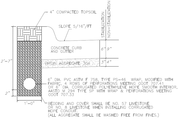
Provisions must be made to drain low points in the road construction when the final paving is delayed. A break in the berm section is required when the curbing has not been constructed. After installation, drainage under the curb to side slopes is required using minimum 4-inch diameter pipe sections. See the diagram below.
401-5.7. - Access Improvement Standards
A.
Sections 5 Feet or Greater in Width
For sections 5 feet or greater in width, the section must use Class A concrete and comply with GDOT's standards and detail. The base course must pass roll testing before paving. If a delay in paving is reasonably expected by the developer or the Department, the base must be sealed and retested before paving.
B.
Sections Less than 5 Feet in Width
For sections less than 5 feet wide, 7 inches of class A concrete base (5 inches on local and minor collector streets) are required and sections must comply with GDOT standards.
401-5.8. - New Local, Minor Collector Streets
A.
All new local and minor collector streets must conform to this subsection.
1.
Asphalt Streets. The following types of base materials may be used:
a.
Crushed Stone Base. The base course must consist of at least 8 inches of graded aggregate base. After being thoroughly compacted and brought to the proper section, an intermediate course of 2 inches of 19 mm Superpave must be applied. If a delay in paving is reasonably expected by the developer or the Department, the base must be primed the same day it is compacted, and cured in accordance with GDOT standards.
b.
Soil Cement Base.
i.
If the base material (resident soil) is unsatisfactory to the Director, a soil cement mix design with engineer test results acceptable to the Director must be submitted. The design must come from a geotechnical firm with the results certified by a professional engineer registered in the State of Georgia. The tests required for the design are ASTM D558 or AASHTO T134 or ASTM D559 and/or 560 or AASHTO T135 and 136.
ii.
The minimum base course must consist of at least 6 inches of suitable soil (high mica content not suitable) stabilized with 10% of Portland cement by volume (approximately 42.3 pounds per square yard). Depending on whether the street is to be constructed as a one-pass or two-pass street. Binder and/or paving must conform to Sec. 401-1.1.A.1.a. Where the grade of the street is 5% or greater, a single surface treatment course must be applied before the binder.
c.
Concrete Streets. Due to their difficult maintenance requirements, the City discourages the installation of concrete streets. Special design plans must be submitted by the applicant to the Department for review and approval before installation.
401-5.9. - New Major Thoroughfares
Major thoroughfares must be constructed in accordance with designs prepared by the City, Gwinnett County, or GDOT.
401-5.10. - Curb and Gutter
A.
Required
All new public and private streets, public and private project access improvements, and public and private non-single-family detached dwelling parking lots must be provided with curb and gutter. All gutters must drain smoothly with no areas of ponding. Parking wheel stops are required in non-single-family detached dwelling parking lots with stormwater management low impact development (LID) measures to promote shield flow to channels/stormwater management facilities.
B.
Residential Curbing
Residential curbing must meet the following requirements:
1.
Concrete must be class "A" (as defined by GDOT) and have a minimum strength of 3,000 psi at 28 days.
2.
The typical minimum section is 6" × 24" × 12".
3.
Vertical curbing only.
C.
Industrial or Commercial Curbing
Industrial or commercial curbing must meet the following requirements:
1.
Concrete must be class "A" (as defined by GDOT) and have a minimum strength of 3,000 psi at 28 days.
2.
The typical minimum section is 8" × 24" × 14".
3.
Vertical curbing only, except median curbs, should be sloped similar to GDOT Type 7, to allow emergency vehicles to mount curb.
D.
Principal Arterial and Major Arterial Curbing
Principal arterial and major arterial curbing must meet the following requirements:
1.
Concrete must be class "A" (as defined by GDOT) and have a minimum strength of 3,000 psi at 28 days.
2.
The typical minimum section is 8" × 30" × 14".
3.
Vertical curbing only, except median curb, should be sloped similar to GDOT Type 7, to allow emergency vehicles to mount curb.
E.
Construction Methods
1.
Curb and gutter must be set true to line and grade, must be horizontal, must be field staked, and must be finished to the section shown on the plans. Along project access improvements of a road which the City maintenance department has identified for resurfacing within 1 year of the new construction, the grade of the new gutter must be placed 1 inch above the project access improvement pavement grade in areas where drainage will not be adversely affected.
2.
Line and grade must be set by the developer's engineer or surveyor on grades less than 2% and over 12%, and within 100 feet in both directions from all low points.
3.
One-half inch expansion joints or premolded bituminous expansion joint material must be provided at all structures and radius points and at intervals not to exceed 250 feet in the remainder of the curb and gutter.
4.
Inferior workmanship or unprofessional construction methods resulting in unacceptable curb and gutter will be cause for rejection of the finished work.
5.
Disturbed areas along all curbing must be backfilled, stabilized and grassed.
401-5.11. - Roadway Design
A.
Street Grades and Design Speeds
1.
The minimum allowed grade for local and minor collector streets is 0.3%. The minimum for major collector and arterial streets must conform to GDOT practice.
2.
A minimum grade of less than 0.3% on a local street may be approved by the Department, based on adequate engineering designs, where at least 0.3% cannot reasonably be achieved due to topographical limitations imposed by the land. In such cases, a record drawing and such computations as necessary must be provided after construction to establish that the street will drain in accordance with these regulations. Street sections where unacceptable pooling, excessive spread at catch basins, or other hazardous conditions occur must be reconstructed or otherwise improved to eliminate such conditions.
3.
Minimum vehicle design speeds and maximum grades allowable in the City by street classification are as shown in Table 401-5.11.
4.
The maximum grade on any cul-de-sac turnaround is 6%.
Table 401-5.11A Design Speeds and Grades
Table Note
[1]
Grades between 12% and 14% may not exceed a length of 150 feet and require an "as graded" survey before the installation of the curb or utilities. The distance is measured as the tangent length between points of curvature.
B.
Vertical Street Alignment
1.
All changes in street profile grades with an algebraic difference greater than 1% must be connected by a parabolic curve with a minimum length (L) equal to the product of the algebraic difference between the grades in percent (A) and the design constant (K) assigned to the street according to its category (i.e., L = KA).
2.
Constant (K) values are shown in Table 401-5.11B. Constant (K) Values for Vertical Curves for both desirable and minimum acceptable ("hardship") conditions. In all cases, the "desirable" value must be used, unless it cannot be achieved due to topographic conditions beyond the developer's control. In such hardship situations, the Director may approve a lesser value to the extent required by the hardship situation, but in no event less than the value shown in the table as "minimum."
Table 401-5.11B. Constant (K) Values for Vertical Curves
C.
Horizontal Street Alignment
1.
All new streets must adhere to the following standards governing horizontal curvature and superelevation:
Table 401-5.11C Horizontal Curves
Table Note
[1]
No superelevation is allowed on minor collectors internal to residential subdivisions.
2.
Superelevation for horizontal curves must be calculated utilizing the following formula:
3.
Widening section along existing streets must be designed reflecting existing curvature and superelevation, if any, unless the existing street has been included in a specific design by the County or GDOT which calls for different standards, in which case the project will be coordinated with the overall design.
4.
Roadway edge curves must be provided for tangent runout (bringing edge from a normal crown to centerline elevation) and superelevation runoff (from the end of tangent runout to the point of design superelevation) in accordance with design standards of GDOT or other professional engineering standards.
5.
Between reverse horizontal curves there may be no less than the minimum centerline tangents shown in Table 401-5.11D unless otherwise specified by GDOT. Compound radii curves are prohibited. At least the "desirable" length must be provided unless hardship conditions of topography or property configuration will not allow lengths greater than those shown as "minimum." For compound circular curves, the ratio of the flatter radius to the sharper radius may not exceed 1.5 to one.
Table 401-5.11D Tangents
Table Note
Minimum tangents are based on the distance traveled in 1.7 seconds at the design speed for each category of the street. Desirable length is based on distance traveled in 2.0 seconds.
D.
Horizontal and Vertical Clearance
1.
Horizontal Clearances
a.
A shoulder of no less than 11 feet from the back of the curb or the edge of the pavement, appropriately graded and with gentle slopes of not more than 0.5 inch per 1 foot and rounded cross-sectional design, must be maintained along all streets. Beyond the shoulder but within the right-of-way, slopes may not exceed 1 foot of rise for every 2 feet of horizontal distance on a cut slope, and 1 foot of fall for each 3 feet of horizontal distance on a fill slope.
b.
Along all public streets, a clear zone must be provided for a minimum distance of 6 feet from the back of the curb or the edge of the pavement wherein nothing may be located above ground level except for traffic and street signs, public utility structures, and mailboxes.
c.
At selected locations, such as the outside of a sharp curve, a wider clear zone with greater horizontal clearances provided to any roadside obstruction may be required.
d.
The Department, in accordance with Georgia Law 32-6-51, is authorized to remove or direct the removal of any sign, signal, device, or other structure erected, placed, or maintained on the right-of-way of a public road that, because of its nature, construction, or operation, constitutes a danger to, or interferes with the vision of, drivers of motor vehicles.
2.
Vertical Clearances. Vertical clearance at underpasses must be at least 16.5 feet over the entire roadway width.
401-5.12. - Street Intersections
A.
Angle of intersection
1.
Intersections must generally be at right angles.
2.
Intersections may not be at an angle of less than 85 degrees unless approved by the Director.
3.
Intersections may not be at an angle less than 70 degrees unless the intersection is signalized and approved by the Director.
B.
Maximum Grade
Street intersections should be designed with a flat grade wherever possible, but in no case should the grade exceed 2% in normal situations (or 4% in topographical hardship situations on local streets).
C.
Approach Horizontal Alignment
1.
New local streets that approach an intersection with a street in a category higher than itself on a horizontal curve with a centerline radius less than 240 feet must provide a tangent section of roadway at least 30 feet long. Minor collectors approaching an intersection with a major thoroughfare on a horizontal curve with a centerline radius of less than 550 feet must also provide the 30-foot tangent section. The tangent length is measured along the centerline of the street, from the right-of-way line of the intersecting street, extended, to the point of tangency with the centerline of the curved section.
2.
New major thoroughfares must provide tangent sections at intersections with streets in equal or higher categories as needed to provide adequate stopping distances at their design speeds.
D.
Approach Vertical Alignment
1.
For intersections with local or minor collector streets, a leveling of the street at a grade not exceeding 2% must be provided but no level approach distance is required for streets approaching at less than 7%, and a minimum 25-foot level approach distance may be provided for streets approaching at a grade of 7% or more. (See standard drawings).
2.
As a street approaches an intersection with a major thoroughfare, there must be a suitable leveling of the street at a grade not exceeding 2% and for a distance not less than the following minimums:
Table 401-5.12D Approach Distances at Major Intersections
Table Note
[1]
Distance of the approach is measured from the edge of the pavement of the intersecting street to the point of curvature in the approaching street.
E.
Intersection Radii
Intersection radii for roadways measured at the back of the curb and for the right-of-way lines must be as follows. For intersecting streets of different classification, the larger radii must be provided. In all cases, adequate right-of-way must be provided to maintain a minimum of 11 feet from the back of the curb. Larger radii may be required for streets intersecting at angles less than 90 degrees. Roadway radii must be increased to 75 feet on roads with heavy truck traffic.
Table 401-512E Intersection Radii
Table Note
[1]
Intersecting right-of-way lines may be joined by an arc with the minimum radius shown, or by a miter which cuts across the right-of-way lines connecting the points where the required radius would have otherwise been tangent.
F.
Islands
Islands in street intersections must conform to the design requirements of the City's standard drawings. In no case may anything in an island extend more than 3 feet above the street grade within the right-of-way, except traffic regulatory devices and other infrastructure erected or approved by the City. No island may be approved which contains less than 100 square feet.
G.
Intersection Corner Sight Distance
1.
Intersections must be designed with adequate corner sight distance for each street which approaches a street in an equal or higher street category (except an intersection of two local streets). Where necessary, backslopes must be flattened and horizontal or vertical curves lengthened to provide the minimum required sight distance.
2.
The minimum corner sight distance from the approaching street must be equal to or exceed ten times the regulated speed of the intersecting street, as measured from the center of the approaching street in both directions along the right-of-way line of the intersecting street. As an alternative, the minimum corner sight distance requirement may be calculated using AASHTO's "Policy on Geometric Design of Highways and Streets," chapter 9 (at-grade intersections), latest edition. The sight distance must provide clear visibility of an object 4 feet above the intersecting street viewed from the centerline of the approaching street at the right-of-way line of the intersecting street, at a height of 3.5 feet above the ground.
H.
Obstructing Visibility at Intersections
On any corner lot, the requirements of Sec. 201-1.8 (Intersection Visibility) also apply.
I.
Turning Lanes at Intersections
1.
Left turning lanes are required on all new internal project streets, classified as a minor collector or major thoroughfare, intersecting a major thoroughfare, and may be required in other locations to meet traffic demand and safe operations. Right turning lanes may be required to meet traffic demands or safety concerns. When provided, turning lanes must meet the following criteria:
a.
Storage length. A minimum of 150 feet of storage length for turning lanes on any arterial roadway must be used. A minimum of 100 feet of storage length for turning lanes on all collectors must be used.
b.
Taper length. The minimum taper length is 50 feet.
2.
Left turning lanes from arterial roads are subject to longer storage lengths and tapers as determined on a case by case basis.
401-5.13. - Driveways
A.
Angle and Improvements
Driveways must generally intersect streets at right angles. All private driveways must be paved. The portion of a driveway located within a public right-of-way must be paved. Driveways providing access to parking lots that contain six or more spaces must be paved in accordance with the parking lot requirements of this UDO.
B.
Design Standards
1.
Driveways serving single-family detached or two-family dwellings may be no less than 10 feet wide at the right-of-way line and must provide a radius to the back of the curb or the edge of the pavement of the roadway of no less than 5 feet. All other driveway curb cuts on public streets must conform to the standards shown on the driveway details contained in the City's standard drawings, by land use type as follows:
a.
Driveway detail 1 (32-foot width, 25-foot radius) for:
i.
Gas stations;
ii.
Commercial sites (over 80,000 square feet);
iii.
Office/institutional complexes (over 100,000 square feet); and
iv.
Residential developments, except residential subdivisions (over 200 units).
b.
Driveway detail 2 (28-foot width, 25-foot radius) for:
i.
Commercial sites (80,000 square feet or less);
ii.
Office/institutional complexes (100,000 square feet or less); and
iii.
Residential developments, except residential subdivisions (200 units or fewer).
c.
Driveway detail 3 (32-foot width, 40-foot radius) for:
i.
Industrial sites.
d.
Driveway detail 4 (optional design with island) for:
i.
Private commercial/office street entrances.
e.
Private entrances to residential developments, except residential subdivisions (over 200 units).
2.
All driveways and driveway curb cuts on State routes must conform to GDOT Driveway and Encroachment Control Standards unless City requirements are more restrictive.
C.
Auxiliary Lanes
Along any major thoroughfare, a deceleration lane, acceleration lane, larger turning radius, traffic islands, or other devices or designs may be required to avoid specific traffic hazards that would otherwise be created by the proposed driveway location.
D.
Corner Sight Distance along Minor Collectors or Major Thoroughfares
All driveways approaching a minor collector or major thoroughfare must provide adequate corner sight distance. The minimum corner sight distance from the driveway must be equal to or exceed the standards of AASHTO's "Policy on Geometric Design of Highways and Streets," chapter 9 (at-grade intersections). The sight distance must provide clear visibility of an object 4 feet above the intersecting street viewed from the centerline of the driveway at the right-of-way line of the intersecting street, at a height of 3.5 feet above the ground.
E.
Separation and Spacing
All driveways except those serving residential units on individual lots are recommended to meet the following criteria:
1.
Minimum separation from a street intersection: 100 feet from the centerline of a driveway to the nearest right-of-way line of the intersecting street, extended. For any driveway on a major thoroughfare with a centerline between 100 feet and 200 feet from the intersecting street right-of-way line, access restriction may be imposed to avoid traffic hazards. Greater separation may be required for the safe operation of a free-right lane, acceleration or deceleration lane, etc.
2.
Minimum separation between driveways along the same side of a major thoroughfare: 100 feet between centerline as measured along the roadway edge or back of curb.
3.
Whenever possible, proposed driveways along one side of a street must coincide with existing or proposed driveways on the opposite side of such street.
4.
Maximum number of driveways serving a single project: one for every 400 feet of property frontage, or fraction thereof per street, along a major thoroughfare. This is not meant to be a spacing standard but only an expression of the total number of driveways that are permitted serving a single project.
402-1.1. - Grading Plan
A.
Grading must be done in accordance with the contour lines and grades shown on the approved Grading Plan.
B.
Grading plans must show existing and proposed contour lines at an interval of no more than 2 feet. Grading plans shall outline the areas which are required to remain undisturbed (i.e., Tree Protection Areas, buffers, etc.) and must indicate protective fencing or staking to be placed surrounding such areas.
C.
Grading for roads and improved ditches must be shown.
D.
A grading plan, showing building pad locations, must be submitted for single-family detached dwelling and two-family dwelling subdivisions zoned for a lot size of less than 12,000 square feet or a density of 4 units per acre or more unless a modification application is approved.
E.
Single-family detached dwelling and two-family dwelling subdivision lots must be graded to ensure adequate lot-to-lot drainage. Granting a modification will not nullify the intent of this UDO when the layout has a minimum lot area of 14,520 square feet and a minimum lot width of 90 feet. The grading plan may be used as a construction document before the approval of the Final Plat or as a guidance document for the individual lot grading after approval of the final plat.
402-1.2. - Embankments
Embankment layering must be consistent with the Gwinnett County Stormwater Management Manual.
402-1.3. - Maximum Slopes
A.
The maximum slope for cut and/or fill is 2:1 (2 feet of horizontal run for each foot of rise or fall), except: 1) for earthen dam embankments; 2) rock cuts; 3) where certified by a professional geotechnical engineer; or 4) as discussed in paragraph B below.
B.
The maximum slope for earthen dam embankments is 3:1 unless a modification application is approved. The earthen dam embankment slope regulation intends to provide for public safety, soil stability, and dam maintenance considerations. The depth of cut referred to herein is the maximum cut or fill allowed to occur in any one section of cut or fill. The slope of cut or fill must be uniform throughout for each section of cut or fill unless benching is approved by the City.
C.
Maximum slopes must otherwise be consistent with the Gwinnett County Stormwater Management Manual.
402-1.4. - Soil Stabilization
Special conditions for soil with low shearing resistance and cohesion are required as specified in the Gwinnett County Stormwater Management Manual.
402-2.1. - Title
This section is known as the "Soil Erosion and Sedimentation Control Ordinance."
402-2.2. - Applicability
A.
Design standards
This section applies when any land disturbance is proposed that requires a permit under this section and continues to apply until the project has been completed.
B.
Abandoned projects
Any project whose permit has lapsed under the terms of this UDO must immediately have all disturbed areas stabilized. This responsibility falls upon the owner, developer, contractor, or other responsible parties involved in the land disturbance activity.
402-2.3. - Exemption
This section applies to any land-disturbing activity undertaken by any person on any land, except for the following:
A.
Surface mining, as the same is defined in O.C.G.A. § 12-4-72, the "Georgia Surface Mining Act of 1968."
B.
Granite quarrying and land clearing for such quarrying.
C.
Such minor land-disturbing activities as home gardens and individual home landscaping, repairs, maintenance work, fences, and other related activities which result in minor soil erosion.
D.
The construction of single-family residences, when such construction disturbs less than 1 acre and is not a part of a larger common plan of development or sale with a planned disturbance or equal to or greater than 1 acre and not otherwise exempt under this subsection; provided, however, that construction of any such residence shall conform to the minimum requirements as set forth in O.C.G.A. § 12-7-7 and this Paragraph D. For single-family residence construction covered by the provisions of this paragraph there shall be a buffer zone between the residence and any State waters classified as trout streams pursuant to Article 2 of Chapter 5 of the Georgia Water Quality Control Act. In any such stream buffer zone, no land-disturbing activity shall be constructed between the residence and the point where vegetation has been wrested by normal stream flow or wave action from the banks of the trout waters. For primary trout waters, the buffer zone shall be at least 50 horizontal feet, and no variance to a smaller buffer shall be granted. For secondary trout waters, the buffer zone shall be at least 50 horizontal feet, but the Director may grant variances to no less than 25 feet. Regardless of whether a trout stream is primary or secondary, for first order trout waters, which are streams into which no other streams flow except for springs, the buffer shall be at least 25 horizontal feet, and no variance to a smaller buffer shall be granted. The minimum requirements of O.C.G.A. § 12-7-6(b) and the buffer zones provided by this paragraph shall be enforced by the issuing authority.
E.
Agricultural operations as defined in O.C.G.A. § 1-3-3, "definitions," to include:
1.
Raising, harvesting or storing of products of the field or orchard;
2.
Feeding, breeding or managing livestock or poultry;
3.
Producing or storing feed for use in the production of livestock, including, but not limited to, cattle, calves, swine, hogs, goats, sheep, and rabbits, or for use in the production of poultry, including, but not limited to, chickens, hens, and turkeys;
4.
Producing plants, trees, fowl or animals; and
5.
The production of aquaculture, horticultural, dairy, livestock, poultry, eggs and apiarian products, and farm buildings and farm ponds.
F.
Forestry land management practices, including harvesting; provided, however, that when such exempt forestry practices cause or result in land-disturbing or other activities otherwise prohibited in a stream buffer, as established in Sec. 402-2.4.C.15 and Sec. 402-2.4.C.16, no other land-disturbing activities, except for normal forest management practices, are allowed on the entire property upon which the forestry practices were conducted for 3 years after completion of such forestry practices.
G.
Any project carried out under the technical supervision of the Natural Resources Conservation Service (NRCS) of the United States Department of Agriculture.
H.
Any project involving less than 1 acre of disturbed area; provided, however, that this exemption shall not apply to any land-disturbing activity within a larger common plan of development or sale with a planned disturbance of equal to or greater 1 acre or within 200 feet of the bank of any State waters. For the purposes of this Paragraph H, the term "State waters" excludes channels and drainage ways which have water in them only during and immediately after rainfall events and intermittent streams which do not have water in them year-round; provided, however, that any person responsible for a project which involves less than 1 acre, which involves land-disturbing activity, and which is within 200 feet of any such excluded channel or drainage way, must prevent sediment from moving beyond the boundaries of the property on which such project is located and provided, further, that nothing contained herein shall prevent the local issuing authority from regulating any such project which is not specifically exempted by paragraphs A, B, C, D, E, F, G, I, or J of this section.
I.
Construction or maintenance projects, or both, undertaken or financed in whole or in part, or both, by the department of transportation, the Georgia Highway Authority, or the State Road and Tollway Authority; or any road construction or maintenance project, or both, undertaken by any county or municipality; provided, however, that construction or maintenance projects of the department of transportation or State Road and Tollway authority which disturb one or more contiguous acres of land shall be subject to provisions of O.C.G.A. § 12-7-7.1; except where the department of transportation, the Georgia Highway Authority, or the State Road and Tollway Authority is a secondary permittee for a project located within a larger common plan of development or sale under the State general permit, in which case a copy of a notice of intent under the State general permit shall be submitted to the local issuing authority, the local issuing authority shall enforce compliance with the minimum requirements set forth in O.C.G.A. § 12-7-6 as if a permit had been issued, and violations shall be subject to the same penalties as violations by permit holders.
J.
Any land-disturbing activities conducted by any electric membership corporation or municipal electrical system or any public utility under the regulatory jurisdiction of the Public Service Commission. Any utility under the regulatory jurisdiction of the Federal Energy Regulatory Commission, any cable television system as defined in O.C.G.A. § 36-18-1, or any agency or instrumentality of the United States engaged in the generation, transmission, or distribution of power; except where an electric membership corporation or municipal electrical system or any public utility under the regulatory jurisdiction of the Public Service Commission, any utility under the regulatory jurisdiction of the Federal Energy Regulatory Commission, any cable television system as defined in O.C.G.A. § 35-18-1, or any agency or instrumentality of the United States engaged in the generation, transmission, or distribution of power is a secondary permittee for a project located within a larger common plan of development or sale under the State general permit, in which case the local issuing authority shall enforce compliance with the minimum requirements set forth in O.C.G.A. § 12-7-6 as if a permit had been issued, and violations shall be subject to the same penalties as violations by permit holders; and
K.
Any public water system reservoir.
402-2.4. - Minimum Requirements
A.
General Provisions
Excessive soil erosion and resulting sedimentation can take place during land-disturbing activities if requirements of the ordinance and the NPDES general permit are not met. Therefore, plans for those land-disturbing activities which are not exempted by this section shall contain provisions for application of soil erosion, sedimentation and pollution control measures and practices. The provisions shall be incorporated into the erosion, sedimentation and pollution control plans. Soil erosion, sedimentation and pollution control measures and practices must conform to the minimum requirements of Sec. 402-2.5.B and Sec. 402-2.5.C. The application of measures and practices shall apply to all features of the site, including street and utility installations, drainage facilities and other temporary and permanent improvements. Measures shall be installed to prevent or control erosion, sedimentation, and pollution during all stages of any land-disturbing activity in accordance with the requirements of this section and the NPDES general permit.
B.
Minimum Requirements/BMPs
1.
Best management practices as set forth in Sec. 402-2.5.B and Sec. 402-2.5.C are required for all land-disturbing activities. Proper design, installation, and maintenance of best management practices will constitute a complete defense to any action by the Director or to any other allegation of noncompliance with clause 2 immediately below or any substantially similar terms contained in a permit for the discharge of stormwater issued pursuant to subsection O.C.G.A. § 12-5-30(f), the "Georgia Water Quality Control Act." As used in this paragraph the terms "proper design" and "properly designed" mean designed in accordance with the hydraulic design specifications contained in the "Manual for Erosion and Sediment Control in Georgia" specified in O.C.G.A. § 12-7-6(b).
2.
Discharge of stormwater runoff from disturbed areas where best management practices have not been properly designed, installed, and maintained will constitute a separate violation of any land-disturbing permit issued by a local issuing authority or of any State general permit issued by the division pursuant to O.C.G.A. § 12-5-30(f), the "Georgia Water Quality Control Act," for each day on which such discharge results in the turbidity of receiving waters being increased by more than 25 nephelometric turbidity units for waters supporting warm water fisheries or by more than 10 nephelometric turbidity units for waters classified as trout waters. The turbidity of the receiving waters will be measured in accordance with guidelines to be issued by the Director. This paragraph shall not apply to any land disturbance associated with the construction of single-family homes which are not part of a larger common plan of development or sale unless the planned disturbance for such construction is equal to or greater than 5 acres.
3.
Failure to properly design, install, or maintain best management practices will constitute a violation of any land-disturbing permit issued by a local issuing authority or of any State general permit issued by the division pursuant to O.C.G.A. § 12-5-30(f), the "Georgia Water Quality Control Act," for each day on which such failure occurs.
4.
The Director may require, in accordance with regulations adopted by the Board of Natural Resources, reasonable and prudent monitoring of the turbidity level of receiving waters into which discharges from land-disturbing activities occur.
5.
The LIA may set more stringent buffer requirements than stated in paragraphs C.15 and C.16 below in light of O.C.G.A. § 12-7-6(c).
C.
Manual for Erosion and Sediment Control in Georgia Adopted
The rules and regulations, ordinances, or resolutions adopted pursuant to O.C.G.A. § 12-7-1 et seq. to govern land-disturbing activities will require, at a minimum, protections at least as stringent as the State general permit; and best management practices, including sound conservation and engineering practices to prevent and minimize erosion and resultant sedimentation, which are consistent with, and no less stringent than, those practices contained in the Manual for Erosion and Sediment Control in Georgia published by the Georgia Soil and Water Conservation Commission as of January 1 of the year in which the land-disturbing activity was permitted, as well as the following:
1.
Stripping of vegetation, regrading, and other development activities must be conducted in a manner to minimize erosion;
2.
Cut-fill operations must be kept to a minimum;
3.
Development plans must conform to topography and soil type to create the lowest practicable erosion potential;
4.
Whenever feasible, natural vegetation shall be retained, protected and supplemented;
5.
The disturbed area and the duration of exposure to erosive elements shall be kept to a practicable minimum;
6.
Disturbed soil shall be stabilized as quickly as practicable;
7.
Temporary vegetation or mulching shall be employed to protect exposed critical areas during development;
8.
Permanent vegetation and structural erosion control practices shall be installed as soon as practicable;
9.
To the extent necessary, sediment in runoff water must be trapped by the use of debris basins, sediment basins, silt traps, or similar measures until the disturbed area is stabilized. As used in this clause, a disturbed area is stabilized when it is brought to a condition of continuous compliance with the requirements of O.C.G.A. § 12-7-1 et seq.;
10.
Adequate provisions must be provided to minimize damage from surface water to the cut face of excavations or the sloping of fills;
11.
Cuts and fills may not endanger adjoining property;
12.
Fills may not encroach upon natural watercourses or constructed channels in a manner so as to adversely affect other property owners;
13.
Grading equipment must cross flowing streams using bridges or culverts except when such methods are not feasible, provided, in any case, that such crossings are kept to a minimum;
14.
Land-disturbing activity plans for erosion, sedimentation and pollution control shall include provisions for treatment or control of any source of sediments and adequate sedimentation control facilities to retain sediments on-site or preclude sedimentation of adjacent waters beyond the levels specified in this section;
15.
Except as provided in clause C.16 immediately below, there is established a 25-foot buffer along the banks of all State waters, as measured horizontally from the point where vegetation has been wrested by normal stream flow or wave action, except where the Director determines to allow a variance that is at least as protective of natural resources and the environment, where otherwise allowed by the Director pursuant to O.C.G.A. § 12-2-8, where a drainage structure or a roadway drainage structure must be constructed, provided that adequate erosion control measures are incorporated in the project plans and specifications, and are implemented; or along any ephemeral stream. As used in this provision, the term "ephemeral stream" means a stream: that under normal circumstances has water flowing only during and for a short duration after precipitation events; that has the channel located above the groundwater table year-round; for which groundwater is not a source of water; and for which runoff from precipitation is the primary source of water flow. Unless exempted as along an ephemeral stream, the buffers of at least 25 feet established pursuant to part 6 of Article 5, Chapter 5 of Title 12, the "Georgia Water Quality Control Act," shall remain in force unless a variance is granted by the Director as provided in this clause. The following requirements shall apply to any such buffer:
a.
No land-disturbing activities shall be conducted within a buffer and a buffer shall remain in its natural, undisturbed state of vegetation until all land-disturbing activities on the construction site are completed. Once the final stabilization of the site is achieved, a buffer may be thinned or trimmed of vegetation as long as a protective vegetative cover remains to protect water quality and aquatic habitat and a natural canopy is left in sufficient quantity to keep shade on the stream bed; provided, however, that any person constructing a single-family residence, when such residence is constructed by or under contract with the owner for their own occupancy, may thin or trim vegetation in a buffer at any time as long as protective vegetative cover remains to protect water quality and aquatic habitat and a natural canopy is left in sufficient quantity to keep shade on the stream bed; and
b.
The buffer shall not apply to the following land-disturbing activities, provided that they occur at an angle, as measured from the point of crossing, within 25 degrees of perpendicular to the stream; cause a width of disturbance of not more than 50 feet within the buffer; and adequate erosion control measures are incorporated into the project plans and specifications and are implemented: (i) stream crossings for water lines; or (ii) stream crossings for sewer lines; and
16.
There is established a 50-foot buffer as measured horizontally from the point where vegetation has been wrested by normal stream flow or wave action, along the banks of any State waters classified as "trout streams" pursuant to Article 2 of Chapter 5 of Title 12, the "Georgia Water Quality Control Act," except where a roadway drainage structure must be constructed; provided, however, that small springs and streams classified as trout streams which discharge an average annual flow of 25 gallons per minute or less shall have a 25-foot buffer or they may be piped, at the discretion of the landowner, pursuant to the terms of a rule providing for a general variance promulgated by the Board of Natural Resources, so long as any such pipe stops short of the downstream landowner's property and the landowner complies with the buffer requirement for any adjacent trout streams. The Director may grant a variance from such buffer to allow land-disturbing activity, provided that adequate erosion control measures are incorporated in the project plans and specifications and are implemented. The following requirements shall apply to such buffer:
a.
No land-disturbing activities may be conducted within a buffer and a buffer must remain in its natural, undisturbed, state of vegetation until all land-disturbing activities on the construction site are completed. Once the final stabilization of the site is achieved, a buffer may be thinned or trimmed of vegetation as long as a protective vegetative cover remains to protect water quality and aquatic habitat and a natural canopy is left in sufficient quantity to keep shade on the stream bed; provided, however, that any person constructing a single-family residence, when such residence is constructed by or under contract with the owner for their own occupancy, may thin or trim vegetation in a buffer at any time as long as protective vegetative cover remains to protect water quality and aquatic habitat and a natural canopy is left in sufficient quantity to keep shade on the stream bed; and
b.
The buffer does not apply to the following land-disturbing activities, provided that they occur at an angle, as measured from the point of crossing, within 25 degrees of perpendicular to the stream; cause a width of disturbance of not more than 50 feet within the buffer; and adequate erosion control measures are incorporated into the project plans and specifications and are implemented: (i) stream crossings for water lines; or (ii) stream crossings for sewer lines.
D.
Stream Buffer Requirements
Nothing contained in O.C.G.A. § 12-7-1 et seq. will prevent any local issuing authority from adopting rules and regulations, ordinances or resolutions which contain stream buffer requirements that exceed the minimum requirements in this section.
E.
Presumption of Violation
The fact that land-disturbing activity for which a permit has been issued results in injury to the property of another shall neither constitute proof of, nor create a presumption of a violation of the standards provided for in this section or the terms of the permit.
402-2.5. - Application/Permit Process
A.
General
The property owner, developer and designated planners and engineers must design and review before submittal the general development plans. The local issuing authority must review the tract to be developed and the area surrounding it. They must consult the zoning ordinance, stormwater management ordinance, subdivision ordinance, flood damage prevention ordinance, this section, and any other ordinances, rules, regulations or permits, which regulate the development of land within the jurisdictional boundaries of the local issuing authority. However, the owner and/or operator are the only parties who may obtain a permit.
B.
Application Requirements
Application requirements are as follows:
1.
No person may conduct any land-disturbing activity within the City of Snellville without first obtaining a permit from the City of Snellville to perform such activity and providing a copy of the notice of intent submitted to EPD if applicable.
2.
The application for a permit must be submitted to the Department and must include the applicant's erosion, sedimentation and pollution control plan with supporting data, as necessary. Said plans must include, at a minimum, the data specified in paragraph C below. Erosion, sedimentation and pollution control plans, together with supporting data, must demonstrate affirmatively that the land-disturbing activity proposed will be carried out in such a manner that the provisions of Sec. 402-2.4.B and Sec. 402-2.4.C will be met. Applications for a permit will not be accepted unless accompanied by three copies of the applicant's erosion, sedimentation and pollution control plans. All applications shall contain a certification stating that the plan preparer or the designee thereof visited the site before the creation of the plan in accordance with EPD Rule 391-3-7-.10.
3.
In addition to the local permitting fees, fees will also be assessed pursuant to O.C.G.A. § 12-5-23(a)(5), provided that such fees may not exceed $80.00 per acre of land-disturbing activity, and these fees shall be calculated and paid by the primary permittee as defined in the State general permit for each acre of land-disturbing activity included in the planned development or each phase of development. All applicable fees must be paid before the issuance of the land disturbance permit. In a jurisdiction that is certified pursuant to O.C.G.A. § 12-7-8(a), half of such fees levied shall be submitted to the division; except that any and all fees due from an entity which must give notice pursuant to O.C.G.A. §§ 12-7-17(9) or (10) must be submitted in full to the division, regardless of the existence of a local issuing authority in the jurisdiction.
4.
Immediately upon receipt of an application and plan for a permit, the local issuing authority must refer the application and plan to the Gwinnett Soil and Water Conservation District for its review and approval or disapproval concerning the adequacy of the erosion, sedimentation, and pollution control plan. The Gwinnett Soil and Water Conservation District shall approve or disapprove a plan within 35 days of receipt. Failure of the Gwinnett Soil and Water Conservation District to act within 35 days will be considered an approval of the pending plan. The results of the Gwinnett Soil and Water Conservation District review will be forwarded to the local issuing authority. No permit will be issued unless the plan has been approved by the Gwinnett Soil and Water Conservation District, and any variances required by Sec. 402-2.4.C.15 and Sec. 402-2.4.C.16 have been obtained, all fees have been paid, and bonding, if required by clause B.6 below, been obtained. Such a review will not be required if the local issuing authority and the Gwinnett Soil and Water Conservation District have entered into an agreement that allows the local issuing authority to conduct such review and approval of the plan without referring the application and plan to the Gwinnett Soil and Water Conservation District. The local issuing authority with plan review authority shall approve or disapprove a revised plan submittal within 35 days of receipt. Failure of the local issuing authority with plan review authority to act within 35 days shall be considered an approval of the revised plan submittal.
5.
If a permit applicant has had two or more violations of previous permits, this section, or the Erosion and Sedimentation Act, as amended, within 3 years before the date of filing the application under consideration, the local issuing authority may deny the permit application.
6.
The local issuing authority may require the permit applicant to post a bond in the form of government security, cash, irrevocable letter of credit, or any combination thereof up to, but not exceeding, $3,000.00 per acre or fraction thereof of the proposed land-disturbing activity, before issuing the permit. If the applicant does not comply with this section or with the conditions of the permit after issuance, the local issuing authority may call the bond or any part thereof to be forfeited and may use the proceeds to hire a contractor to stabilize the site of the land-disturbing activity and bring it into compliance. These provisions will not apply unless there is in effect an ordinance or statute specifically providing for hearing and judicial review of any determination or order of the local issuing authority with respect to alleged permit violations.
C.
Plan Requirements
1.
Plans must be prepared to meet the minimum requirements as contained in Sec. 402-2.4.B and Sec. 402-2.4.C, or through the use of more stringent, alternate design criteria that conform to sound conservation and engineering practices. The Manual for Erosion and Sediment Control in Georgia is hereby incorporated by reference into this section. The plan for the land-disturbing activity must consider the interrelationship of the soil types, geological and hydrological characteristics, topography, watershed, vegetation, proposed permanent structures including roadways, constructed waterways, sediment control and stormwater management facilities, local ordinances and State laws. Maps, drawings, and supportive computations shall bear the signature and seal of the certified design professional. Persons involved in land development design, review, permitting, construction, monitoring, or inspections or any land-disturbing activity shall meet the education and training certification requirements, dependent on their level of involvement with the process, as developed by the Georgia State Soil and Water Conservation Commission and in consultation with the section and the stakeholder advisory board created pursuant to O.C.G.A. § 12-7-20.
2.
Data required for the site plan includes all the information required from the appropriate erosion, sedimentation, and pollution control plan review checklist established by the Georgia State Soil and Water Conservation Commission as of January 1 of the year in which the land-disturbing activity was permitted.
D.
Permits
1.
Permits must be issued or denied as soon as practicable but in any event not later than 45 days after receipt by the local issuing authority of a completed application, providing variances and bonding are obtained, where necessary and all applicable fees have been paid before permit issuance. The permit must include conditions under which the activity may be undertaken.
2.
No permit may be issued by the local issuing authority unless the erosion, sedimentation and pollution control plan has been approved by the Gwinnett Soil and Water Conservation District and the local issuing authority has affirmatively determined that the plan complies with this section, any variances required by Sec. 402-2.4.C.15 and Sec. 402-2.4.C.16, bonding requirements, if necessary, as per paragraph B.6 above, are met and all ordinances and rules and regulations in effect within the jurisdictional boundaries of the local issuing authority are met. If the permit is denied, the reason for denial must be furnished to the applicant.
3.
Any land-disturbing activities by a local issuing authority will be subject to the same requirements of this section, and any other ordinances relating to land development, as are applied to private persons and the division shall enforce such requirements upon the local issuing authority.
4.
If the tract is to be developed in phases, then a separate permit will be required for each phase.
5.
The permit may be suspended, revoked, or modified by the local issuing authority, as to all or any portion of the land affected by the plan, upon finding that the holder or their successor in the title is not in compliance with the approved erosion and sedimentation control plan or that the holder or their successor in title is in violation of this section. A holder of a permit shall notify any successor in title to him as to all or any portion of the land affected by the approved plan of the conditions contained in the permit.
6.
The LIA may reject a permit application if the applicant has had two or more violations of previous permits or the Erosion and Sedimentation Act permit requirements within 3 years before the date of the application, in light of O.C.G.A. § 12-7-7(f)(1).
402-2.6. - Inspection and Enforcement
A.
Inspection and Enforcement
1.
The City inspector will periodically inspect the sites of land-disturbing activities for which permits have been issued to determine if the activities are being conducted in accordance with the plan and if the measures required in the plan are effective in controlling erosion and sedimentation. Also, the local issuing authority will regulate primary, secondary and tertiary permittees as such terms are defined in the State general permit. Primary permittees will be responsible for the installation and maintenance of best management practices where the primary permittee is conducting land-disturbing activities. Secondary permittees will be responsible for the installation and maintenance of best management practices where the secondary permittee is conducting land-disturbing activities. Tertiary permittees will be responsible for installation and maintenance where the tertiary permittee is conducting land-disturbing activities. If, through inspection, it is deemed that a person engaged in land-disturbing activities as defined herein has failed to comply with the approved plan, with permit conditions, or with the provisions of this section, a written notice to comply must be served upon that person. The notice must set forth the measures necessary to achieve compliance and must state the time within which such measures must be completed. If the person engaged in the land-disturbing activity fails to comply within the time specified, he shall be deemed in violation of this section.
2.
The local issuing authority must amend its ordinances to the extent appropriate within 12 months of any amendments to the Erosion and Sedimentation Act of 1975.
3.
The City of Snellville shall have the power to conduct such investigations as it may reasonably deem necessary to carry out duties as prescribed in this section, and for this purpose to enter at reasonable times upon any property, public or private, for the purpose of investigation and inspecting the sites of land-disturbing activities.
4.
No person may refuse entry or access to any authorized representative or agent of the local issuing authority, the Georgia State Soil and Water Conservation Commission, the Gwinnett Soil and Water Conservation District, or division who requests entry for the purposes of inspection, and who presents appropriate credentials, nor shall any person obstruct, hamper or interfere with any such representative while in the process of carrying out their official duties.
5.
The Gwinnett Soil and Water Conservation District or the Georgia State Soil and Water Conservation Commission or both will semi-annually review the actions of counties and municipalities which have been certified as local issuing authorities pursuant to O.C.G.A. § 12-7-8(a). The Gwinnett Soil and Water Conservation District or the Georgia State Soil and Water Conservation Commission or both may provide technical assistance to any county or municipality for the purpose of improving the effectiveness of the county's or municipality's erosion, sedimentation, and pollution control program. The Gwinnett Soil and Water Conservation District or the Georgia State Soil and Water Conservation Commission shall notify the division and request investigation by the division if any deficient or ineffective local program is found.
6.
The division may periodically review the actions of counties and municipalities which have been certified as local issuing authorities pursuant to O.C.G.A. § 12-7-8(a). Such review may include, but is not limited to, review of the administration and enforcement of a governing authority's ordinance and review of conformance with an agreement, if any, between the Gwinnett Soil and Water Conservation District and the governing authority. If such review indicates that the governing authority of any county or municipality certified pursuant to O.C.G.A. § 12-7-8(a) has not administered or enforced its ordinances or has not conducted the program in accordance with any agreement entered into pursuant to O.C.G.A. § 12-7-7(e), the division must notify the governing authority of the county or municipality in writing. The governing authority of any county or municipality so notified will have 90 days within which to take the necessary corrective action to retain certification as a local issuing authority. If the county or municipality does not take necessary corrective action within 90 days after notification by the division, the division will revoke the certification of the county or municipality as a local issuing authority.
402-2.7. - Penalties and Incentives
A.
Failure to Obtain a Permit for Land-disturbing Activity
If any person commences any land-disturbing activity requiring a land-disturbing permit as prescribed in this section without first obtaining said permit, the person will be subject to revocation of their business license, work permit or other authorization for the conduct of a business and associated work activities within the jurisdictional boundaries of the local issuing authority.
B.
Stop Work Orders
1.
For the first and second violations of the provisions of this section, the Director or the local issuing authority must issue a written warning to the violator. The violator will have 5 days to correct the violation. If the violation is not corrected within 5 days, the Director or the local issuing authority must issue a stop-work order requiring that land-disturbing activities be stopped until necessary corrective action or mitigation has occurred; provided, however, that, if the violation presents an imminent threat to public health or waters of the State or if the land-disturbing activities are conducted without obtaining the necessary permit, the Director or the local issuing authority must issue an immediate stop-work order in lieu of a warning.
2.
For a third and each subsequent violation, the Director or the local issuing authority must issue an immediate stop-work order.
3.
All stop-work orders will be effective immediately upon issuance and will be in effect until the necessary corrective action or mitigation has occurred.
4.
When a violation in the form of taking action without a permit, failure to maintain a stream buffer, or significant amounts of sediment, as determined by the local issuing authority or by the Director, have been or are being discharged into State waters and where best management practices have not been properly designed, installed and maintained, a stop-work order shall be issued by the local issuing authority or by the Director. All such stop-work orders shall be effective immediately upon issuance and shall be in effect until the necessary corrective action or mitigation has occurred. Such stop-work orders will apply to all land-disturbing activity on the site except for the installation and maintenance of temporary or permanent erosion and sediment controls.
C.
Bond Forfeiture
If, through inspection, it is determined that a person engaged in land-disturbing activities has failed to comply with the approved plan, a written notice to comply must be served upon that person. The notice must set forth the measures necessary to achieve compliance with the plan and must state the time within which such measures must be completed. If the person engaged in the land-disturbing activity fails to comply within the time specified, he will be deemed in violation of this section and, in addition to other penalties, shall be deemed to have forfeited their performance bond, if required to post one under the provisions of Sec. 402-2.5.B.6. The local issuing authority may call the bond or any part thereof to be forfeited and may use the proceeds to hire a contractor to stabilize the site of the land-disturbing activity and bring it into compliance.
D.
Monetary Penalties
Any person who violates any provisions of this section, or any permit condition or limitation established pursuant to this section, or who negligently or intentionally fails or refuses to comply with any final or emergency order of the Director issued as provided in this section shall be liable for a civil penalty not to exceed $2,500.00 per day. For the purpose of enforcing the provisions of this section, notwithstanding any provisions in any City Charter to the contrary, municipal courts will be authorized to impose a penalty not to exceed $2,500.00 for each violation. Notwithstanding any limitation of law as to penalties which can be assessed for violations of County ordinances, any magistrate court or any other court of competent jurisdiction trying cases brought as violations of this section under County ordinances approved under this section will be authorized to impose penalties for such violations not to exceed $2,500.00 for each violation. Each day during which violation or failure or refusal to comply continues shall be a separate violation.
402-2.8. - Education and Certification
A.
Persons involved in land development design, review, permitting, construction, monitoring, or inspection or any land-disturbing activity must meet the education and training certification requirements, dependent on their level of involvement with the process, as developed by the Georgia State Soil and Water Conservation Commission in consultation with the division and the stakeholder advisory board created pursuant to O.C.G.A. § 12-7-20.
B.
For each site on which land-disturbing activity occurs, each entity or person acting as either a primary, secondary, or tertiary permittee, as defined in the State general permit, must have as a minimum one person who is in responsible charge of erosion and sedimentation control activities on behalf of said entity or person and meets the applicable education or training certification requirements developed by the Georgia State Soil and Water Conservation Commission present on-site whenever land-disturbing activities are conducted on that site. A project site shall herein be defined as any land-disturbance site or multiple sites within a larger common plan of development or sale permitted by an owner or operator for compliance with the State general permit.
C.
Persons or entities involved in projects not requiring a State general permit but otherwise requiring certified personnel on-site may contract with certified persons to meet the requirements of this section.
D.
If a State general permittee who has operational control of land-disturbing activities for a site has met the certification requirements of O.C.G.A. § 12-7-19(b)(1), then any person or entity involved in land-disturbing activity at that site and operating in a subcontractor capacity for such permittee shall meet those educational requirements specified in O.C.G.A. § 12-7-19(b)(4) and will not be required to meet any educational requirements that exceed those specified in said paragraph.
402-2.9. - Appeals
A.
Administrative Remedies
The suspension, revocation, modification, or grant with condition of a permit by the local issuing authority upon finding that the holder is not in compliance with the approved erosion, sediment, and pollution control plan; or that the holder is in violation of permit conditions; or that the holder is in violation of any ordinance; will entitle the person submitting the plan or holding the permit to a hearing before the board of zoning appeals within 30 days after receipt by the local issuing authority of written notice of appeal.
B.
Judicial Review
Any person, aggrieved by a decision or order of the local issuing authority, after exhausting their administrative remedies, shall have the right to appeal de novo to the Superior Court of Gwinnett County.
402-2.10. - Liability
A.
Neither the approval of a plan under the provisions of this section, nor the compliance with provisions of this section shall relieve any person from the responsibility for damage to any person or property otherwise imposed by law nor impose any liability upon the local issuing authority or the Gwinnett Soil and Water Conservation District for damage to any person or property.
B.
The fact that a land-disturbing activity for which a permit has been issued results in injury to the property of another neither constitutes proof of nor creates a presumption of a violation of the standards provided for in this section or the terms of the permit.
C.
No provision of this section permits any persons to violate the Georgia Erosion and Sedimentation Act of 1975, the Georgia Water Quality Control Act or the rules and regulations promulgated and approved thereunder or pollute any waters of the State as defined thereby.
403-1.1. - Title
This section is known as the "City of Snellville Stream Buffer Protection Ordinance."
403-1.2. - Findings and Purposes
A.
Findings
1.
Whereas, the City Council finds that stream buffers provide numerous benefits including:
a.
Protecting, restoring and maintaining the chemical, physical and biological integrity of streams and their water resources.
b.
Removing pollutants delivered in urban stormwater.
c.
Reducing erosion and controlling sedimentation.
d.
Protecting and stabilizing stream banks.
e.
Providing for infiltration of stormwater runoff.
f.
Maintaining base flow of streams.
g.
Contributing organic matter that is a source of food and energy for the aquatic ecosystem.
h.
Providing tree canopy to shade streams and promote desirable aquatic habitat.
i.
Providing riparian wildlife habitat.
j.
Furnishing scenic value and recreational opportunity.
k.
Providing opportunities for the protection and restoration of greenspace.
B.
Purposes
It is the purpose of this section to protect the public health, safety, environment, and general welfare; to minimize public and private losses due to erosion, siltation and water pollution; and to maintain stream water quality by provisions designed to:
1.
Create buffer zones along the streams of the city for the protection of water resources; and
2.
Minimize land development within such buffers by establishing buffer zone requirements and by requiring authorization for any such activities.
403-1.3. - Applicability
A.
General
This section applies to all land development activities on property containing a stream protection area. These requirements are in addition to, and do not replace or supersede, any other applicable stream buffer requirements established under State law and approval or exemption from these requirements do not constitute approval or exemption from stream buffer requirements established under State law or from other applicable local, State, or federal regulations.
B.
Grandfather Provisions
This section does not apply to the following activities:
1.
Work consisting of the repair or maintenance of any lawful use of land that is zoned and approved for such use on or before the effective date of this UDO.
2.
Existing development and on-going land disturbance activities including, but not limited to, existing agriculture, silviculture, landscaping, gardening and lawn maintenance, except that new development or land disturbance activities on such properties are subject to all applicable stream buffer requirements.
3.
Any land development activity that is under construction, fully approved for development, scheduled for permit approval or has been submitted for approval as of the effective date of this UDO.
4.
Land development activity that has not been submitted for approval, but that is part of a larger master development plan, such as for an office park or other phased development that has been previously approved within 2 years of the effective date of this UDO.
C.
Exemptions
The following specific activities are exempt from this section. Exemption of these activities does not constitute an exemption for any other activity proposed on a property.
1.
Activities for the purpose of building one of the following:
a.
A stream crossing by a driveway, transportation route or utility line;
b.
Public water supply intake or public wastewater outfall structures;
c.
Intrusions necessary to provide access to a property;
d.
Public access facilities that must be on the water including boat ramps, docks, foot trails leading directly to the river, fishing platforms and overlooks;
e.
Unpaved foot trails and paths;
f.
Activities to restore and enhance stream bank stability, vegetation, water quality and/or aquatic habitat, so long as native vegetation and bioengineering techniques are used;
g.
Stormwater outfalls to the stream, by pipe or channel, necessary to protect the buffer from erosion caused by high flow velocities due to steep slopes.
2.
Public sewer line easements paralleling the creek, except that all easements (permanent and construction) and land disturbance should be at least 25 feet from the top of the bank. This includes such impervious cover as is necessary for the operation and maintenance of the utility, including but not limited to manholes, vents and valve structures. This exemption shall not be construed as allowing the construction of roads, bike paths or other transportation routes in such easements, regardless of paving material, except for access for the uses specifically cited in this section.
3.
Land development activities within a right-of-way existing at the time this section takes effect or approved under the terms of this section.
4.
Within an easement of any utility existing at the time this section takes effect or approved under the terms of this section, land disturbance activities and such impervious cover as is necessary for the operation and maintenance of the utility, including, but not limited to, manholes, vents, and valve structures.
5.
Emergency work necessary to preserve life or property. However, when emergency work is performed under this section, the person performing it must report such work to the Department on the next business day after the commencement of the work. Within 10 days thereafter, the person must apply for a permit and perform such work within such time period as may be determined by the Department to be reasonably necessary to correct any impairment such emergency work may have caused to the water conveyance capacity, stability or water quality of the protection area.
6.
Forestry and silviculture activities on land that is zoned for forestry, silvicultural or agricultural uses and are not incidental to other land development activity. If such activity results in land disturbance in the stream buffer that would otherwise be prohibited, then no other land-disturbing activity other than normal forest management practices are allowed on the entire property for 3 years after the end of the activities that intruded on the stream buffer.
7.
Exemption of these activities does not constitute an exemption for any other activity proposed on a property.
D.
Land Development within Buffer
Any land development activity within a stream buffer established hereunder or any impervious cover within a setback established hereunder is prohibited unless a variance is granted pursuant to this section.
403-1.4. - Land Development Requirements
A.
Stream Buffer and Setback Requirements
All land development activity subject to this section must meet the following requirements:
1.
An undisturbed natural vegetative stream buffer must be maintained for 50 feet, measured horizontally, on both banks (as applicable) of the stream as measured from the top of the stream bank.
2.
An additional setback must be maintained for 25 feet, measured horizontally, beyond the undisturbed natural vegetative stream buffer, in which all impervious cover is prohibited. Grading, filling and earthmoving must be minimized within the setback.
3.
No septic tanks or septic tank drain fields are permitted within the stream buffer or the setback.
B.
Relief
1.
Relief from the requirements of this section may only be granted as provided for in paragraphs C and D below.
2.
Requests for relief from the requirements of this section must be submitted on an application form provided by the Director, along with required fees.
C.
Administrative variances
Administrative variances from the requirements of this section on single-family residential lots of record platted before May 23, 2005, may be granted if the applicant submits a residential site drainage plan approved by the Director, in accordance with the following:
1.
The lot or parcel's shape, topography, or other existing physical condition prevents land development consistent with this section, and the Director finds and determines that the requirements of this section prohibit the otherwise lawful use of the property by the owner.
2.
If a variance is requested from the required 50-foot undisturbed natural vegetative stream buffer, the request is for 10% or less (5 feet or less) of the required buffer.
3.
If a variance is requested from the required, additional 25-foot impervious surface setback, the request is for 20% or less (5 feet or less) of the required, additional setback, and no impervious cover is proposed within the reduced, additional setback.
4.
If an applicant is requesting a variance from both the undisturbed natural vegetative stream buffer and the required, additional 25-foot impervious surface setback, and the requests meet all the criteria listed above, the Director may grant an administrative variance for both requests.
5.
Additional water quality treatment practices appropriate for single-family residential lots, such as the incorporation of bio-retention areas, pervious paving that is at least 40% pervious, and sustainable landscaping, may be allowed by approval of the Director.
D.
Other variances
The Director will coordinate the review of each variance request with all other affected City departments and must forward such comments or recommendations as may be received to the Board of Appeals for action in their normal course of business.
Variances from the requirements of this section, except as provided for in "C" above, may only be granted in accordance with the following:
1.
Where a lot was platted before May 23, 2005, and its shape, topography or other existing physical condition prevents land development consistent with this section, and the Director finds and determines that the requirements of this section prohibit the otherwise lawful use of the property by the owner, the Board of Appeals may grant a variance from the buffer and setback requirements hereunder, provided such variance requires mitigation measures to offset the effects of any proposed land development on the lot.
2.
Except as provided above, the Board of Appeals may grant no variance from any provision of this section without first conducting a public hearing on the application for a variance and authorizing the granting of the variance by an affirmative vote of the Board of Appeals. The City must give public notice of each such public hearing in a newspaper of general circulation within the city. The City must require that the applicant post a sign giving notice of the proposed variance and the public hearing. The sign must be of a size and posted in such a location on the property as to be clearly visible from the primary adjacent road right-of-way.
Variances will be considered only in the following cases:
a.
When a property's shape, topography or other physical conditions existing at the time of the adoption of this section prevents land development unless a stream buffer variance is granted.
b.
Unusual circumstances when strict adherence to the minimal stream buffer requirements in the ordinance would create an extreme hardship.
3.
Variances will not be considered when, following the adoption of this section, actions of any property owner of a given property have created conditions of hardship on that property.
At a minimum, a variance request must include the following information:
a.
A site map that includes locations of all streams, wetlands, floodplain boundaries, and other natural features, as determined by field survey;
b.
A description of the shape, size, topography, slope, soils, vegetation and other physical characteristics of the property;
c.
A detailed site plan that shows the locations of all existing and proposed structures and other impervious covers, the limits of all existing and proposed land disturbance, both inside and outside the stream buffer and setback. The exact area of the stream buffer to be affected must be accurately and clearly indicated;
d.
Documentation of unusual hardship should the stream buffer be maintained;
e.
At least one alternative plan, which does not include a stream buffer or setback intrusion, or an explanation of why such a site plan is not possible;
f.
A calculation of the total area and length of the proposed intrusion;
g.
A stormwater management site plan, if applicable; and
h.
Proposed mitigation, if any, for the intrusion. If no mitigation is proposed, the request must include an explanation of why none is being proposed.
4.
The following factors will be considered in determining whether to issue a variance:
a.
The shape, size, topography, slope, soils, vegetation and other physical characteristics of the property;
b.
The locations of all streams on the property, including along property boundaries;
c.
The location and extent of the proposed stream buffer or setback intrusion;
d.
Whether alternative designs are possible which require less intrusion or no intrusion;
e.
The long-term and construction water-quality impacts of the proposed variance;
f.
Whether issuance of the variance is at least as protective of natural resources and the environment.
403-1.5. - Big Haynes Creek Watershed
A.
Applicability
In addition to the provisions of this section, the following requirements apply. Whichever provisions are more restrictive or impose higher protective standards for human health or the environment will be considered to take precedence.
B.
Variances
The variance procedures of this section do not apply here. Applicable variances are outlined in paragraph E below.
C.
Authority
This regulation is adopted pursuant to the Georgia Department of Natural Resources Rules for Environment Planning Criteria.
D.
Requirements
Within the designated Big Haynes Creek and Watershed Protection Area the following additional stream protection requirements must be met where applicable:
1.
Natural buffer zones and setbacks for impervious surfaces are required adjacent to both sides of perennial streams as measured from the stream bank as follows:
*Radial distances as measured upstream of a governmentally owned public drinking water supply intake or water supply reservoir.
2.
Septic tanks and septic tank drain fields are prohibited within the required setback area. Utilities are exempt from the above stream buffer and setback provisions in accordance with the following conditions if the utilities to be located in the stream buffer or setback areas cannot feasibly be located outside these areas: The utilities must be located as far from the stream bank as reasonably possible, except that all easements (permanent and construction) and land disturbance should be at least 25 feet from the top of bank.
a.
The installation and maintenance of the utilities must be such as to protect the integrity of the stream buffer and setback areas as best as reasonably possible.
b.
Roadways, bridges, and drainage structures may encroach upon required stream buffers and setbacks where such structures are necessary to provide access. Such roadways and bridges must cross streams perpendicularly where reasonably possible. The number of such stream crossings and associated structures must be minimized to the greatest extent possible.
E.
Lots of Record
All lots or parcels of record as of October 28, 1997, in the Big Haynes Creek Watershed and all lots or parcels which have been submitted by way of preliminary plat and approved by the Department in accord with the provisions of the 1985 Zoning Resolution of Gwinnett County, as of October 28, 1997, within the Big Haynes Creek Watershed, that are made unbuildable by the stream buffer and setback provisions, may still be developed on a case-by-case basis. Requests for development of these lots must be made to the Director as administrative variances. If development is allowed, the maximum possible impervious surface setback and stream buffer width, given the configuration of the lot, must be maintained.
403-1.6. - Compatibility with Other Buffers
This section is not intended to interfere with, abrogate, or annul any other ordinance, rule or regulation, statute or other provision of law. The requirements of this section should be considered minimum requirements, and where any provision of this section imposes restrictions different from those imposed by any other ordinance, rule, regulation or other provision of law, whichever provisions are more restrictive or impose higher protective standards for human health or the environment will be considered to take precedence.
403-1.7. - Additional Information Required
Any permit applications for a property requiring stream buffers and setbacks hereunder must include the following:
A.
A site plan showing:
1.
The location of all streams on the property;
2.
Limits of required stream buffers and setbacks on the property;
3.
Stream buffer zone topography with contour lines at no greater than 5-foot contour intervals;
4.
Delineation of forested and open areas in the stream buffer zone; and
5.
Detailed plans of all proposed land development in the stream buffer and of all proposed impervious cover within the setback;
B.
A description of all proposed land development within the stream buffer and setback; and
C.
Any other documentation that the Department may reasonably deem necessary for review of the application and to ensure that the stream buffer zone ordinance is addressed in the approval process.
D.
All stream buffer and setback areas must be recorded on the final plat of the property following plan approval.
403-1.8. - Responsibility
Neither the issuance of a development permit nor compliance with the conditions thereof, nor with the provisions of this section relieves any person from any responsibility otherwise imposed by law for damage to persons or property; nor will the issuance of any permit hereunder serve to impose any liability upon the City, its officers or employees, for injury or damage to persons or property.
403-1.9. - Administration
A.
Inspection
1.
The Department may cause inspections of the work in the stream buffer or setback to be made periodically during the course thereof and must make a final inspection following completion of the work. The permittee must assist the Department in making such inspections. The City will have the authority to conduct such investigations as it may reasonably deem necessary to carry out its duties as prescribed in this section, and for this purpose to enter at reasonable time upon any property, public or private, for the purpose of investigating and inspecting the sites of any land development activities within the protection area.
2.
No person may refuse entry or access to any authorized representative or agent who requests entry for purposes of inspection, and who presents appropriate credentials, nor may any person obstruct, hamper or interfere with any such representative while in the process of carrying out official duties.
B.
Violations, Enforcement, and Penalties
Any action or inaction which violates the provisions of this section or the requirements of an approved site plan or permit may be subject to the enforcement actions outlined in this section. Any such action or inaction, which is continuous with respect to time, is deemed to be a public nuisance and may be abated by injunctive or other equitable relief. The imposition of any of the penalties described below shall not prevent such equitable relief.
1.
Notice of violation. If the Department determines that an applicant or other responsible party has failed to comply with the terms and conditions of a permit, an approved site plan or the provisions of this section, it must issue a written notice of violation to such applicant or another responsible party. Where a person is engaged in an activity covered by this section without having first secured the appropriate permit therefor, the notice of violation shall be served on the owner or the responsible party in charge of the activity being conducted on the site.
The notice of violation must contain:
a.
The name and address of the owner or the applicant or the responsible party;
b.
The address or other description of the site upon which the violation is occurring;
c.
A statement specifying the nature of the violation;
d.
A description of the remedial measures necessary to bring the action or inaction into compliance with the permit, the approved site plan or this section and the date for the completion of such remedial action;
e.
A statement of the penalty or penalties that may be assessed against the person to whom the notice of violation is directed; and
f.
A statement that the determination of violation may be appealed to the Board of Appeals by filing a written notice of appeal within 30 days after the notice of violation (except that in the event the violation constitutes an immediate danger to public health or public safety, 24 hours' notice will be sufficient).
2.
Penalties. In the event the remedial measures described in the notice of violation have not been completed by the date set forth for such completion in the notice of violation, any one or more of the following actions or penalties may be taken or assessed against the person to whom the notice of violation was directed. Before taking any of the following actions or imposing any of the following penalties, the Department must first notify the applicant or other responsible party in writing of its intended action and must provide a reasonable opportunity, of not less than 10 days (except that in the event the violation constitutes an immediate danger to public health or public safety, 24 hours' notice will be sufficient) to cure such violation. In the event the applicant or other responsible party fails to cure such violation after such notice and cure period, the Department may take any one or more of the following actions or impose any one or more of the following penalties.
a.
Stop work order. The Department may issue a stop work order which must be served on the applicant or another responsible party. The stop work order must remain in effect until the applicant or other responsible party has taken the remedial measures set forth in the notice of violation or has otherwise cured the violation or violations described therein, provided the stop work order may be withdrawn or modified to enable the applicant or another responsible party to take necessary remedial measures to cure such violation or violations.
b.
Withhold certificate of occupancy. The Department may refuse to issue a certificate of occupancy for the building or other improvements constructed or being constructed on the site until the applicant or other responsible party has taken the remedial measures set forth in the notice of violation or has otherwise cured the violations described therein.
c.
Suspension, revocation or modification of permit. The Department may suspend, revoke or modify the permit authorizing the land development project. A suspended, revoked or modified permit may be reinstated after the applicant or other responsible party has taken the remedial measures set forth in the notice of violation or has otherwise cured the violations described therein, provided such permit may be reinstated (upon such conditions as the Department may deem necessary) to enable the applicant or another responsible party to take the necessary remedial measures to cure such violations.
d.
Civil penalties. In the event the applicant or other responsible party fails to take the remedial measures set forth in the notice of violation or otherwise fails to cure the violations described therein within 10 days (or such greater period as the Department may deem appropriate) (except that in the event the violation constitutes an immediate danger to public health or public safety, 24 hours' notice will be sufficient) after the Department has taken one or more of the actions described above, the Department may impose a penalty not to exceed $1,000.00 (depending on the severity of the violation) for each day the violation remains unremedied after receipt of the notice of violation.
e.
Criminal penalties. For intentional and flagrant violations of this section, the Department may issue a citation to the applicant or another responsible party, requiring such person to appear in the City municipal court to answer charges for such violation. Upon conviction, such a person will be punished by a fine not to exceed $1,000.00, or imprisonment for 60 days or both. Each act of violation and each day upon which any violation occurs will constitute a separate offense.
403-2.1. - Official Wetlands Map
The National Wetland Inventory Maps, prepared by the United States Fish and Wildlife Service, is the official wetland maps of the City of Snellville. These maps show the general locations of wetlands and should be consulted by persons contemplating activities in or near wetland areas.
403-2.2. - Plans
A.
Wetlands Indicated
Design professionals, after consulting the National Wetland Inventory Maps, must indicate wetlands on plans required for land disturbance permit applications.
B.
Design professional statement
Before the issuance of a land disturbance permit, the design professional who prepared the required plans accompanying the permit application, must add a statement to the plan sheet indicating land disturbance and the statement must read as follows:
Wetland Certification:
The design professional, whose seal appears hereon, certifies the following: 1) the National Wetland Inventory Maps have been consulted; and, 2) the appropriate plan sheet □ DOES/□ DOES NOT (mark appropriate box) indicate areas of United States Army Corps of Engineers jurisdictional wetlands as shown on the maps; and, 3) if wetlands are indicated, the land owner or developer has been advised that land disturbance of protected wetlands shall not occur unless the appropriate federal wetlands alteration ("section 404") permit has been obtained.
403-3.1. - Title
This section is known as the "Illicit Discharge and Illegal Connection Ordinance."
403-3.2. - Findings and Purpose
A.
Findings
It is hereby determined that:
1.
Discharges to the municipal separate storm sewer system that are not composed entirely of stormwater contribute to increased nonpoint source pollution and degradation of receiving waters;
2.
The municipal separate storm sewer system was designed and installed to manage stormwater so as to prevent localized flooding, damage to property and risk to public safety;
3.
The municipal separate storm sewer system was not designed or installed as a receiving system for non-stormwater discharges; these non-stormwater discharges occur due to spills, dumping and improper connections to the municipal separate storm sewer system from residential, industrial, commercial or institutional establishments;
4.
These non-stormwater discharges not only impact local waterways individually but geographically dispersed, small volume non-stormwater discharges can have cumulative impacts on receiving waters;
5.
The impacts of these non-stormwater discharges adversely affect public health and safety, drinking water supplies, recreation, fish and other aquatic life, property values and other uses of lands and waters;
6.
These impacts can be minimized through the regulation of spills, dumping and discharges into the municipal separate storm sewer system;
7.
Localities in the State of Georgia are required to comply with a number of State and federal laws, regulations and permits which require a locality to address the impacts of nonpoint source pollution due to improper non-stormwater discharges to the municipal separate storm sewer system;
8.
The Clean Water Act requires the management and maintenance of the municipal separate storm sewer system and the management of discharges to that system;
9.
Therefore, in order to prohibit such non-stormwater discharges to the municipal separate storm sewer system, it is determined that the regulation of spills, improper dumping, and discharges to the municipal separate storm sewer system is in the public interest and will prevent threats to public health and safety, and the environment.
B.
Purposes
The purpose of this section is to protect the public health, safety, environment, and general welfare through the regulation of non-stormwater discharges to the municipal separate storm sewer system to the maximum extent practicable as required by federal law. This section establishes methods for controlling the introduction of pollutants into the municipal separate storm sewer system in order to comply with requirements of the National Pollutant Discharge Elimination System (NPDES) permit process. The objectives of this section are to:
1.
Comply with all Georgia Department of Natural Resources (DNR) and federal Environmental Protection Agency (EPA) stormwater regulations developed pursuant to the Clean Water Act; and
2.
Regulate the contribution of pollutants to the municipal separate stormwater system by any person; and
3.
Prohibit illicit discharges and illegal connections to the municipal separate storm sewer system; and
4.
Prevent non-stormwater discharges, generated as a result of spills, inappropriate dumping or disposal, to the municipal separate storm sewer system; and
5.
To establish legal authority to carry out all inspection, surveillance, monitoring and enforcement procedures necessary to ensure compliance with this section.
403-3.3. - Administration
A.
The Department of Planning and Development administers, implements, and enforces the provisions of this section and any procedures, standards, and guidelines established under the authority of this section. Such power includes the right to maintain an action or procedure in any court of competent jurisdiction to compel compliance with or restrain any violation of this section.
B.
The Department is responsible for the conservation, management, maintenance (where applicable), extension and improvement of the municipal separate storm sewer system, including activities necessary to control stormwater and activities necessary to administer and implement the stormwater management programs incorporated by reference into the City's NPDES stormwater permit.
C.
The Department may develop, and update periodically, a stormwater management design manual for the guidance of persons preparing stormwater management plans, designing or operating stormwater management systems, and designing or operating facilities that may contribute non-stormwater discharges to the municipal's separate storm sewer system.
D.
The Department may:
1.
Establish or oversee the establishment of standards and guidelines for controlling stormwater; and
2.
Determine the manner in which conveyances should be operated; and
3.
Inspect private systems which discharge to the municipal separate storm sewer system; and
4.
Advise other departments on issues related to stormwater; and
5.
Protect facilities and premises controlled by the City and prescribe how they are to be used by others; and
6.
Require facilities or activities that create new, increased, or significantly changed stormwater contributions to the municipal's separate storm sewer system to comply with the terms of this section; and
7.
Develop programs or procedures to control the discharge of pollutants into the municipal separate storm sewer system.
403-3.4. - Prohibition of Illicit Discharges
A.
It is a violation of this section for any person to throw, drain, or otherwise discharge, cause, or allow others under its control to throw, drain, or otherwise discharge into the municipal separate storm sewer system any pollutants or waters containing any pollutants, other than stormwater.
B.
Discharges from the following sources are exempt from the prohibition in Paragraph A immediately above:
1.
Water line flushing performed by a government agency, other potable water sources, landscape irrigation or lawn watering, diverted stream flows, rising groundwater, groundwater infiltration to storm drains, uncontaminated pumped groundwater, foundation or footing drains (not including active groundwater dewatering systems), crawl space pumps, air conditioning condensation, springs, natural riparian habitat or wetland flows, and any other water source not containing pollutants;
2.
Discharges or flows from firefighting, and other discharges specified in writing by the City as being necessary to protect public health and safety.
403-3.5. - Illegal Connection Prohibition
A.
It is a violation of this section for any person to construct, connect, use, maintain, or allow the continued existence of any illegal connection to the municipal separate storm sewer system.
B.
This prohibition expressly includes, without limitation, illegal connections made in the past, regardless of whether the connection was permissible under law or practices applicable or prevailing at the time of connection.
C.
Illegal connections must be disconnected. The Department may require that illegal connections be disconnected and redirected if necessary, to an approved on-site sewage management system or the sanitary sewer system. Such redirected connections must be approved by the agency responsible for administering and operating those systems.
D.
The Department may require any underground or above-ground pipe, drain or other conduit, that has not been documented in plans, maps or equivalent, and which may be connected to the municipal's separate storm sewer system, to be located by the owner or occupant of that property upon receipt of written notice from the Department. Such notice must specify a reasonable time period within which the location of the drain or conveyance is to be completed, that the drain or conveyance be identified as storm sewer, sanitary sewer or other, and that the outfall location or point of connection to the storm sewer system, sanitary sewer system or other discharge point be identified. The results of these investigations are to be documented and provided to the Department. Failure to comply with the terms of the written notice mentioned here will constitute a violation of this section.
403-3.6. - Industrial or Construction Discharges
Any person subject to an industrial or construction activity NPDES stormwater discharge permit must comply with all provisions of such permit. Proof of compliance with said permit may be required in a form acceptable to the City before allowing discharges to the municipal separate storm sewer system.
403-3.7. - Access and Inspection
A.
Access and inspection.
The Director is permitted to enter and inspect premises, properties, and facilities at reasonable times as often as may be necessary to determine compliance with this section.
1.
If a property or facility has security measures in force, which require proper identification and clearance before entry into its premises, the owner or operator must make the necessary arrangements to allow access to the Director.
2.
The owner or operator must allow the Director ready access to all parts of the premises for the purposes of inspection, investigation, observation, monitoring, measurement, recording, enforcement, sampling, and testing, photography and videotaping for the purpose of ensuring compliance with the provisions of this section. The owner or operator must allow the Director to examine and copy any records that are required under the conditions of an NPDES permit. The Director must duly notify the owner of said property or the representative on-site, except in the case of an emergency.
3.
The Director has the right to set up on any premises, property or facility such devices as are necessary in their opinion to conduct monitoring and/or sampling of discharges.
4.
The Director may require the owner or operator to install monitoring equipment and perform monitoring as necessary and make the monitoring data available to the Department. This sampling and monitoring equipment must be maintained at all times in a safe and proper operating condition by the owner or operator at his/her own expense. All devices used to measure flow and quality must be calibrated to ensure their accuracy. Measurements, tests and analyses performed must be completed in accordance with 40 CFR Part 136, unless the Director approves another method.
5.
Any temporary or permanent obstruction to safe and easy access to the premises, property or facility to be inspected and/or sampled must be promptly removed by the owner or operator at the written or oral request of the Director and may not be replaced. The costs of clearing such access must be borne by the owner or operator.
6.
Unreasonable delays in allowing the Director access to a facility, property or premises will constitute a violation of this section.
7.
If the Director has been refused access to any part of a premises, property or facility from which stormwater is or would likely be discharged, and the Director is able to demonstrate probable cause to believe that there may be a violation of this section, or that there is a need to inspect and/or sample as part of a routine inspection and sampling program designed to verify compliance with this section or any order issued hereunder, or to protect the overall public health, safety, environment and welfare of the community, then the Department may seek issuance of a search warrant from any court of competent jurisdiction.
B.
Schedule
The Director may determine inspection schedules necessary to enforce the provisions of this section.
403-3.8. - Notification of Accidental Discharges and Spills
A.
Notwithstanding other requirements of law, as soon as any person responsible for a facility, activity or operation, or responsible for emergency response for a facility, activity or operation has information of any known or suspected release of pollutants or non-stormwater from that facility or operation which is resulting or may result in a discharge of those pollutants or non-stormwater into the municipal separate storm sewer system, State waters, or waters of the United States, said person must take all necessary steps to ensure the discovery, containment, and cleanup of such release so as to minimize the effects of the discharge.
B.
Said person must notify the Department within the requirements of the City's Municipal Separate Storm Sewer System (MS4) Permit Enforcement Response Plan (ERP), or the timeline contained in this UDO in Sec. 402-4.8.C, whichever is more stringent.
C.
Said person must notify the Department by phone, facsimile or in-person within 24 hours of discovering the discharge. Such notification must detail the nature, quantity and time of occurrence of the discharge. Notifications in person or by phone must be confirmed by written notice addressed and mailed to the Department within 3 business days of the phone or in-person notice. If the discharge emanates from a commercial or industrial establishment, the owner or operator of such establishment must also retain an on-site written record of the discharge and the actions taken to prevent its recurrence. Such records must be retained for at least 3 years. Said person must also take immediate steps to ensure no recurrence of the discharge or spill.
D.
In the event of such a release of hazardous materials, emergency response agencies and/or other appropriate agencies must be immediately notified.
E.
Failure to provide notification of a release or discharge as provided above is a violation of this section.
403-3.9. - Violations, Enforcement, and Penalties
A.
Violations
1.
It is unlawful for any person to violate any provision or fail to comply with any of the requirements of this section. Any person, who has violated or continues to violate the provisions of this section, may be subject to the enforcement actions outlined in it. Each day of noncompliance is considered a separate offense. The Department may institute appropriate action or proceedings at law or equity for the enforcement of this section. Any court of competent jurisdiction may have the right to issue restraining orders, temporary or permanent injunctions, and other appropriate forms of remedy or relief. Nothing herein contained will prevent the Department from taking such other lawful action as is necessary to prevent or remedy any violation, including an application for injunctive relief.
2.
In the event the violation constitutes an immediate danger to public health or public safety, the Department has the right but not the duty, to enter upon the subject private property or premises, without giving prior notice, and take any and all measures necessary to abate the violation and/or restore the property. The Department is authorized to seek costs of the abatement as outlined in paragraph E below.
B.
Notice of Violation
Whenever the Department finds that a violation of this section has occurred, the Department may order compliance by written notice of violation.
1.
The notice of violation must contain:
a.
The name and address of the alleged violator; and
b.
The address when available or a description of the building, structure, premises or land upon which the violation is occurring, or has occurred; and
c.
A statement specifying the nature of the violation; and
d.
A description of the remedial measures necessary to restore compliance with this section and a time schedule for the completion of such remedial action; and
e.
A statement of the penalty or penalties that will or may be assessed against the person to whom the notice of violation is directed; and
f.
A statement that the determination of violation may be appealed to the Department by filing a written notice of appeal within 30 days of service of notice of violation.
2.
Such notice of violation may require without limitation:
a.
The performance of monitoring, analysis, and reporting;
b.
The elimination of illicit discharges and illegal connections;
c.
That violations must cease and desist;
d.
The abatement or remediation of stormwater pollution or contamination hazards and the restoration of any affected property;
e.
Payment of costs to cover administrative and abatement costs;
f.
The implementation of pollution prevention practices;
g.
The development and provision to the Department of written remediation or action plans;
h.
The development and provision to the department of documents showing the location and discharge points of conveyances, pipes, channels, or drains; and
i.
Any other actions that will lead to the remedy of a condition of the violation.
C.
Appeal of Notice of Violation
Any person receiving a notice of violation may appeal the determination of the Director. The notice of appeal must be received by the Department within 30 days from the date of the notice of violation. Hearing on the appeal before the Director will take place within 15 days from the date of receipt of the notice of appeal. The decision of the Director will be final.
D.
Enforcement Measures
If the violation has not been corrected pursuant to the requirements set forth in the notice of violation or, in the event of an appeal, within 3 days of the decision of the Director upholding the decision of the Director, then, in addition to any other remedies that may be available, representatives of the Department or its contractors may enter upon the subject private premises, property or facility, where they are then authorized to take any and all actions or measures necessary to abate the violation and/or restore the property. Such measures or actions include but not be limited to repairs, maintenance, containment, cleanup, and remediation. It is unlawful for any person, owner, agent or person in possession of any premises, property or facility to refuse to allow the Department or designated contractor to enter upon the premises for the purposes set forth above.
E.
Costs of Abatement of the Violation
1.
Within 10 business days after abatement of the violation by the department or its contractors, the owner of the property will be notified of the cost of abatement, including administrative costs. The property owner may file a written protest objecting to the assessment or to the amount of the assessment within 10 business days of such notice. If the amount due is not paid within 30 days after receipt of the notice, or if an appeal is taken, within 30 days after a decision on said appeal, the charges must become a special assessment against the property and must constitute a lien on the property for the amount of the assessment.
2.
Any person violating any of the provisions of this section will become liable to the City by reason of such violation.
F.
Civil Penalties
In the event the alleged violator fails to take the remedial measures set forth in the notice of violation or otherwise fails to cure the violations described therein within 10 days, or such greater period as the City deems appropriate, after the Department has taken one or more of the actions described above, the Department may impose a penalty not to exceed $1,000.00 (depending on the severity of the violation) for each day the violation remains unremedied after receipt of the notice of violation.
G.
Criminal Penalties
For violations of this section, the Department may issue a citation to the alleged violator requiring such person to appear in a court of competent jurisdiction to answer charges for such violation. Upon conviction, such person will be punished by a fine not to exceed $1,000.00 or imprisonment for 60 days or both. Each act of violation and each day upon which any violation occurs will constitute a separate offense.
H.
Violations Deemed A Public Nuisance
In addition to the enforcement processes and penalties provided, any condition caused or permitted to exist in violation of any of the provisions of this section is a threat to public health, safety, welfare, and environment and is declared and deemed a nuisance, and may be abated by injunctive or other equitable relief as provided by law.
I.
Remedies Not Exclusive
1.
The remedies listed in this section are not exclusive of any other remedies available under any applicable federal, State, or local law and the Department may seek cumulative remedies.
2.
The Department may recover attorney's fees, court costs, and other expenses associated with enforcement of section, including sampling and monitoring expenses. If the amount due is not paid within 30 days after receipt of a notice requiring payment of such costs, or if an appeal is taken, within 30 days after a decision on said appeal, the charges will become a special assessment against the property and will constitute a lien on the property for the amount of the assessment.
403-4.1. - General
A.
Title
This Section is known as the "City of Snellville Flood Damage Protection Ordinance" or "Flood Damage Protection Ordinance."
B.
Findings
It is hereby determined that:
1.
The flood hazard areas of the City of Snellville are subject to periodic inundation which may result in loss of life and property, health and safety hazards, disruption of commerce and governmental services, extraordinary public expenditures for flood relief and protection, and impairment of the tax base, all of which adversely affect the public health, safety, and general welfare;
2.
Flood hazard areas can serve important stormwater management, water quality, streambank protection, stream corridor protection, wetland preservation, and ecological purposes when permanently protected as undisturbed or minimally disturbed areas;
3.
Effective floodplain management and flood hazard protection activities can: (1) Protect human life and health; (2) Minimize damage to private property; (3) Minimize damage to public facilities and infrastructure such as water and gas mains, electric, telephone and sewer lines, streets and bridges located in floodplains; and (4) Minimize expenditure of public money for costly flood control projects associated with flooding and generally undertaken at the expense of the general public; and
4.
Article IX, Section II of the Constitution of the State of Georgia and O.C.G.A. § 36-1-20(a) have delegated the responsibility to local governmental units to adopt regulations designed to promote the public health, safety, and general welfare of its citizenry. Therefore, the City of Snellville, Georgia, does ordain this section and establishes this set of floodplain management and flood hazard reduction policies for the purpose of regulating the use of flood hazard areas. It is determined that the regulation of flood hazard areas and the prevention of flood damage are in the public interest and will minimize threats to public health and safety, as well as to private and public property.
C.
Requirements
This section applies to all Special Flood Hazard Areas in the City of Snellville, as defined in this section and Chapter 100 of this UDO.
D.
Statement of Purpose
It is the purpose of this section to protect, maintain, and enhance the public health, safety, environment, and general welfare and to minimize public and private losses due to flood conditions in flood hazard areas, as well as to protect the beneficial uses of floodplain areas for water quality protection, streambank and stream corridor protection, wetlands preservation and ecological and environmental protection by provisions designed by:
1.
Restrict or prohibit uses which are dangerous to health, safety, and property due to flooding or erosion hazards or which increase flood heights or velocities;
2.
Require that uses vulnerable to floods, including facilities which serve such uses, be protected against flood damage at the time of initial construction or renovation;
3.
Limit the alteration of natural floodplains, stream channels, and natural protective barriers which are involved in the accommodation of floodwaters;
4.
Control filling, grading, dredging and other development which may increase erosion or flood damage;
5.
Prevent or regulate the construction of flood barriers which will unnaturally divert floodwaters or which may increase flood hazards to other lands; and
6.
Protect the stormwater management, water quality, streambank protection, stream corridor protection, wetland preservation and ecological functions of natural floodplain areas.
E.
Flood Area Maps and Studies
For the purposes of defining and determining "Areas of Special Flood Hazard," "Areas of Future-Conditions Flood Hazard," "Areas of Shallow Flooding," "Base Flood Elevations," "Floodplains," "Floodways," "Future-conditions Flood Elevations," "Future conditions Floodplains," potential flood hazard or risk categories as shown on FIRM maps, and other terms used in this section, the following documents and sources may be used for such purposes and are adopted by reference thereto:
1.
The most recent Flood Insurance Study (FIS) and Flood Insurance Rate Map prepared by FEMA for the City, with accompanying maps and other supporting data and any revision thereto.
2.
Other studies which may be relied upon for the establishment of the base flood elevation or delineation of the 100-year flood-prone areas including:
a.
Any flood or flood-related study conducted by the United States Corps of Engineers or the United States Geological Survey or any local, State, or federal agency applicable to the City of Snellville.
b.
Any base flood study authored by a currently registered professional engineer in the State of Georgia which has been prepared utilizing FEMA-approved methodology and approved by the City of Snellville Department of Planning and Development.
3.
Other studies, which may be relied upon for the establishment of the future-conditions flood elevation or delineation of the future conditions flood-prone areas, including:
a.
Any flood or flood-related study conducted by the United States Corps of Engineers, the United States Geological Survey or any other local, State, or federal agency applicable to the City of Snellville; and
b.
Any future-conditions flood study conducted by a registered professional engineer in the State of Georgia which has been prepared utilizing FEMA approved methodology approved by the City of Snellville Department of Planning and Development.
4.
The repository for public inspection of the FIS, accompanying maps and other supporting data is located at the following location:
The City of Snellville Department of Planning and Development
2342 Oak Road
Snellville Ga, 30078
F.
Interpretation
1.
In the interpretation and application of this section all provisions will be:
a.
Considered as minimum requirements;
b.
Liberally construed in favor of the City of Snellville; and
c.
Deemed neither to limit nor repeal any other powers granted under State statutes.
2.
Where interpretation is needed as to the exact location of floodplain or floodway boundaries (for example, where there appears to be a conflict between a mapped boundary and actual field conditions) the Department of Planning and Development will make the necessary interpretation based on data submitted by the applicant. The person contesting the location of the boundary must be given a reasonable opportunity to appeal the interpretation as provided in this section.
3.
Where flood plain elevations have been defined, the floodplain will be determined based on flood elevations rather than the area graphically delineated on the floodplain maps.
G.
Drainage Easement Established
On behalf of the public, a drainage easement is hereby established for the sole purpose of preserving and protecting the free flow of surface waters inside the future conditions flood contour elevations and along all watercourses. Where debris has accumulated in such a manner as would increase the need for flood protection, raise the flood level, or increase the risk of hazardous inundation of adjacent communities or jurisdictions, the City is hereby authorized to enter upon such watercourse and clear or remove such debris or obstructions as are hazardous to the public safety. The cost thereof will be charged to the owner of the property where such debris and/or obstruction was generated. Where erosion has occurred in such a manner as would endanger a building or a structure, the city is hereby authorized to enter upon such watercourse and stabilize the channel for public safety. The cost thereof will be charged to the owner of the property where the erosion has occurred and/or caused the erosion.
H.
Establishment of Development Permit
1.
No owner or developer may perform any development activities on a site where an Area of Special Flood Hazard or Area of Future-conditions Flood Hazard is located without first meeting the requirements of this section before commencing the proposed activity.
2.
Unless specifically excluded by this section, any landowner or developer desiring a permit for a development activity must submit to the City a permit application on a form provided by the City for that purpose.
3.
No permit will be approved for any development activities that do not meet the requirements, restrictions, and criteria of this section.
I.
Floodplain Management Plan Requirements
An application for a development project within any Area of Special Flood Hazard or Area of Future-conditions Flood Hazard located on the site shall include a floodplain management/flood damage prevention plan. This plan shall include the following items:
1.
Site plan drawn to scale, which includes but is not limited to:
a.
Existing and proposed elevations of the area in question and the nature, location and dimensions of existing and/or proposed structures, earthen fill placement, amount and location of excavation material, and storage of materials or equipment;
b.
For all proposed structures, spot ground elevations at building corners and 10-foot or smaller intervals along the foundation footprint, or 1-foot contour elevations throughout the building site;
c.
Proposed locations of water supply, sanitary sewer, and utilities;
d.
Proposed locations of drainage and stormwater management facilities;
e.
Proposed grading plan;
f.
Base flood elevations and future-conditions flood elevations;
g.
Boundaries of the base flood floodplain and future-conditions floodplain;
h.
If applicable, the location of the floodway; and
i.
Certification of the above by a registered professional engineer or surveyor.
2.
Building and foundation design details, including but not limited to:
a.
Elevation in relation to mean sea level (or highest adjacent grade) of the lowest floor, including basement, of all proposed structures;
b.
Elevation in relation to mean sea level to which any nonresidential structure will be floodproofed;
c.
Certification that any proposed nonresidential floodproofed structure meets the criteria in Sec. 403-4.4.A.2;
d.
For enclosures below the base flood elevation, location and total net area of flood openings as required in Sec. 403-4.4.F (Elevated Buildings);
e.
Design plans certified by a registered professional engineer or architect for all proposed structure(s).
3.
Description of the extent to which any watercourse will be altered or relocated as a result of the proposed development;
4.
Hard copies and digital files of computer models, if any, copies of work maps, comparison of pre- and post-development conditions base flood elevations, future-conditions flood elevations, flood protection elevations, Special Flood Hazard Areas and regulatory floodways, flood profiles and all other computations and other information similar to that presented in the FIS;
5.
Copies of all applicable State and federal permits necessary for the proposed development, including but not limited to permits required by Section 404 of the federal Water Pollution Control Act, Amendments of 1972, 33 U.S.C. 1334; and
6.
All appropriate certifications required under this section.
7.
The approved floodplain management/flood damage prevention plan must contain a certification by the applicant that all development activities will be done according to the plan or previously approved revisions. Any and all development permits and/or use and occupancy certificates or permits may be revoked at any time if the construction and development activities are not in strict accordance with approved plans.
J.
Warning and disclaimer of liability
The degree of flood protection required by this section is considered reasonable for regulatory purposes and is based on scientific and engineering considerations. Larger floods can and will occur; flood heights may be increased by manmade or natural causes. This section does not imply that land outside the Areas of Special Flood Hazard or uses permitted within such areas will be free from flooding or flood damages. This section shall not create liability on the part of the City of Snellville or by any officer or employee thereof for any flood damages that result from reliance on this section or any administrative decision lawfully made thereunder.
K.
Duties and Responsibilities of the Administrator
The duties of the Director include, but are not be limited to:
1.
Review all development applications and permits to assure that the requirements of this section have been satisfied and to determine whether proposed building sites will be reasonably safe from flooding;
2.
Require that copies of all necessary permits from governmental agencies from which approval is required by federal or State law, including but not limited to Section 404 of the federal Water Pollution Control Act Amendments of 1972,33 U.S.C. 1334, be provided and maintained on file;
3.
When base flood elevation data or floodway data have not been provided, then the Director shall require the applicant to obtain, review and reasonably utilize any base flood elevation and floodway data available from a federal, State, or other sources in order to meet the provisions of Sec. 403-4.3 (Standards for Development) and Sec. 403-4.4 (Standards for Buildings);
4.
Review and record the actual elevation in relation to mean sea level (or highest adjacent grade) of the lowest floor, including basement, of all new or substantially improved structures;
5.
Review and record the actual elevation, in relation to mean sea level to which any substantially improved structures have been floodproofed;
6.
When floodproofing is utilized for a nonresidential structure, the Director must review the design and operation/maintenance plan and obtain certification from a registered professional engineer or architect;
7.
Notify affected adjacent communities and the Georgia Department of Natural Resources before any alteration or relocation of a watercourse and submit evidence of such notification to FEMA;
8.
Where interpretation is needed as to the exact location of boundaries of the Areas of Special Flood Hazard (e.g., where there appears to be a conflict between a mapped boundary and actual field conditions) the Director shall make the necessary interpretation. Any person contesting the location of the boundary shall be given a reasonable opportunity to appeal the interpretation as provided in this section. Where floodplain elevations have been defined, the floodplain is determined based on flood elevations rather than the area graphically delineated on the floodplain maps;
9.
All records pertaining to the provisions of this section must be maintained in the office of the Director and must be open for public inspection;
10.
Coordinate all FIRM revisions with the GA DNR and FEMA; and
11.
Review variance applications and make recommendations to the Board of Zoning Appeals.
403-4.2. - Administration
A.
General Permit Procedures
An application for a development permit on any property where a special flood hazard area is located or is proposed to be altered or disturbed in any way must be made to the Department on appropriate forms before any development activities. The application must include, but not be limited to, plans drawn to scale of the property showing the floodplain, floodway and the nature, location, dimensions, and elevations of existing or proposed structures, fill, storage of materials, and drainage facilities.
B.
Floodway Encroachments
1.
Application procedure. An application for a development permit that proposes any encroachment into or alteration of a floodway requires submittal to the Department complete plans and engineering calculations as required by this section for "no rise" certification. The Department must review and authorize such encroachments before the issuance of a development permit and must obtain from the applicant an engineering "no-rise" certification signed by a professional engineer stating that the proposed development will not create any change to the pre-project base flood elevations, floodway elevations, or floodway widths. If the applicant proposes to revise the floodway boundaries or base flood elevations, no permit authorizing an encroachment into or the alteration of the floodway may be issued by the Department until an affirmative conditional letter of map revision (CLOMR) or conditional letter of map amendment (CLOMA), whichever is applicable, is issued and "no rise" certification is approved by the Department. An application for a map revision must be submitted first to the Department. As-built surveys and calculations must be provided to the Department by the applicant at the time of completion of the encroachment. Payment of any review fees associated with the review and approval of the encroachment is the responsibility of the applicant. Final plats or certificates of occupancy will not be issued by the Department until an affirmative letter of map revision (LOMR) or letter of map amendment (LOMA), whichever is applicable, is issued.
2.
Flood Levels Resulting from Floodway Encroachments. Located within Areas of Special Flood Hazard are areas designated as a floodway. A floodway may be an extremely hazardous area due to velocity floodwaters, debris or erosion potential. In addition, floodways must remain free of encroachment in order to allow for the discharge of the base flood without increased flood heights. Therefore, the following provisions shall apply:
a.
Encroachments are prohibited, including earthen fill, new construction, substantial improvements or other development are within the regulatory floodway, except for activities specifically allowed in "B.2.b" below.
b.
Encroachments for bridges, culverts, roadways, and utilities within the regulatory floodway may be permitted provided it is demonstrated through hydrologic and hydraulic analyses performed in accordance with standard engineering practice that the encroachment will not result in an increase to the pre-project base flood elevations, floodway elevations, or floodway widths during the base flood discharge. A registered professional engineer must provide supporting technical data and certification thereof.
c.
If the applicant proposes to revise the floodway boundaries, no permit authorizing the encroachment into or alteration of the floodway shall be issued by the City of Snellville until an affirmative Conditional Letter of Map Revision (CLOMR) is issued by FEMA or a no-rise certification is approved by the City.
d.
If the applicant proposes to revise the floodway boundaries, no permit authorizing the encroachment into or alteration of the floodway shall be issued by the City of Snellville until an affirmative Conditional Letter of Map Revisions (CLOMR) is issued by FEMA or a no-rise certification is approved by the City of Snellville.
C.
Other Permits or Approvals
1.
Copies of any additional federal or State permits or approvals as may be required by the Corps of Engineers, Georgia Department of Natural Resources, FEMA, or others must be provided by the developer upon their approval and maintained on file in the Department.
2.
The Department must notify adjacent communities and the Georgia Department of Natural Resources before any alteration or relocation of a watercourse, and submit evidence of such notification to FEMA.
D.
Maintenance Requirements
The property owner shall be responsible for continuing maintenance as may be needed within an altered or relocated portion of a floodplain on the property so that the flood-carrying or flood storage capacity is maintained. The City of Snellville may direct the property owner (at no cost to the City) to restore the flood-carrying or flood storage capacity of the floodplain if the owner has not performed maintenance as required by the approved floodplain management plan on file with the City.
403-4.3. - Standards for Development
A.
Definition of Floodplain Boundaries
1.
Studied "A" zones, identified in the City of Snellville Flood Insurance Study (FIS) shall be used to establish base flood elevations whenever available.
2.
For all streams with a drainage area of 100 acres or greater, the future-conditions flood elevations shall be provided by the Department. If future-conditions elevation data is not available from the Department, then it shall be determined by a registered professional engineer using a method approved by FEMA and the City of Snellville.
B.
Definition of Floodway Boundaries
1.
The width of a floodway shall be determined from the FIS or FEMA approved flood study. For all streams with a drainage area of 100 acres or greater, the regulatory floodway shall be provided by the Department. If floodway data is not available from the Department, then it must be determined by a registered professional engineer using a method approved by FEMA and the Department.
2.
Following a pre-design conference with the Department, the boundaries or limits of the floodway must be shown on the development plan containing existing topographic information.
C.
General Standards
1.
No development shall be allowed within any Area of Special Flood Hazard or Area of Future-conditions Flood Hazard that could result in any of the following:
a.
Raising the base flood elevation or future-conditions flood elevation equal to or more than 0.01 foot.
b.
Reducing the base flood or future-conditions flood storage capacity. All compensation must occur either within the boundaries of ownership of the property being developed, or within a permanent, recorded flood control easement (which will be a part of the departmental record), and must be within reasonable proximity to the location of the encroachment. Acceptable means of providing required compensation include: lowering of natural ground elevations within the floodplain; or lowering of adjoining land areas to create additional floodplain; or raising of the future conditions flood elevation within the boundaries of ownership of the property being developed. All cut areas are to be graded to a slope of no less than 2%. In no case may any required compensation be provided via bottom storage or by excavating below the elevation of the top of the natural (pre-development) stream channel unless such excavation results from widening or relocation of the stream channel. A step-backwater analysis is required to verify no rise conditions, flood storage volumes, and flow characteristics.
c.
Changing the flow characteristics as to the depth and velocity of the waters of the base flood or future-conditions flood as they pass both the upstream and the downstream boundaries of the development area. Verification must be provided via a step-backwater analysis.
d.
Creating hazardous or erosion-producing velocities, or result in excessive sedimentation.
2.
Any development within any Area of Special Flood Hazard or Area of Future-conditions Flood Hazard allowed under clause 1 above also meet the following conditions:
a.
Compensation for storage capacity shall occur between the average groundwater table elevation and the base flood elevation for the base flood, and between the average found water table elevation and the future-condition flood elevation for the future-conditions flood and lie either within the boundaries of ownership of the property being developed and shall be within the immediate vicinity of the location of the encroachment. Acceptable means of providing required compensation include lowering of natural ground elevations within the floodplain or lowering adjoining land areas to create additional floodplain storage. In no case shall any required compensation be provided via bottom storage or by excavating below the elevation of the natural (pre-development) stream channel unless such excavation results from the widening or relocation of the stream channel;
b.
Cut areas must be stabilized and graded to a slope of no less than 2%;
c.
Effective transitions shall be provided such that flow velocities occurring on both upstream and downstream properties are not increased or decreased;
d.
Verification of no-rise conditions (less than 0.01 foot), flood storage volumes, and flow characteristics shall be provided via a step-backwater analysis meeting the requirements of Section 10.4.5.D.
e.
Public utilities and facilities, such as sanitary sewer, gas, electrical and water systems, shall be located and constructed to minimize or eliminate infiltration or contamination from floodwaters.
f.
Any significant physical changes to the base flood floodplain shall be submitted as a Conditional Letter of Map Revision (CLOMR) or Conditional Letter of Map Amendment (CLOMA), whichever is applicable. The CLOMR submittal shall be subject to approval by the Department using the Community Concurrence forms before forwarding the submittal package to FEMA for final approval. The responsibility for forwarding the CLOMR to FEMA and for obtaining the CLOMR approval is the responsibility of the applicant. Within 6 months of the completion of development, the applicant must submit as-built surveys for a final letter of map revision (LOMR). A letter of map revision (LOMR) or letter of map amendment (LOMA) must be issued before the final plat can be approved or a certificate of occupancy can be issued. Significant changes or revisions are defined as any change to the City of Snellville FIRM easily observed when plotted at a scale of one" = 500'. The changes or revisions may be due to but are not limited to more current and/or superior topographic information or compensatory cut and fill grading done as a part of the development.
3.
On-site waste disposal systems must be located so as to avoid impairment to them or contamination from them during flooding.
4.
All development proposals must have public utilities and facilities, such as sewer, gas, electrical and water systems, located and constructed to minimize flood damage.
D.
Engineering Study Requirements for Floodplain Encroachments
An engineering study is required (as appropriate to the proposed development activities on the site) when a base flood or future conditions floodplain is located on the property proposed for development. This study must be prepared by a currently registered professional engineer in Georgia and made a part of the application for a development permit. This information must be submitted to and approved by the Department before the approval of any permit that would authorize the development.
1.
Description of the extent to which any watercourse or floodplain will be altered or relocated as a result of the proposed development.
2.
Any report that must be submitted for review, in accordance with this section, must use a step backwater analysis approved by the Department. Cross-sections (which may be supplemented by the applicant) and flow information from the existing FIS will be obtained whenever available. Where applicable, computations will be shown duplicating FIS results and then computations will be rerun with the proposed modifications to determine the new base flood and future conditions flood profiles.
3.
Floodplain storage calculations based on cross-sections (at least one every 100 feet) showing existing and proposed floodplain conditions must be provided to show that future conditions floodplain storage capacity will not be diminished by the development.
4.
If changes to the base flood or future conditions flood elevations are proposed, profiles of the channel showing the existing and proposed base flood and future conditions flood elevations must be provided.
5.
The study shall include a preliminary plat, grading plan, or site plan, as appropriate, which shall clearly define all future conditions floodplain encroachments.
6.
The floodway will be determined when any encroachment in the floodplain is proposed or a detailed study is performed to determine flood profiles.
7.
Detailed flood studies in areas where the floodplain has been established but the base flood elevation (BFE) and/or the floodway has not been established and in areas beyond the limits of study on the FIRM, which may contain a watercourse, and have greater than 100 acres of surface drainage area above the property, must be submitted showing the base flood elevations, future conditions flood elevations, and the floodway. Approval of the study must be received before the final plat of the affected lots can be approved or a certificate of occupancy can be issued.
E.
Maintenance Requirements
The property owner is responsible for continuing maintenance as may be needed within an altered or relocated portion of a floodplain on their property so that the flood-carrying or flood storage capacity is not diminished. The City of Snellville may direct the property owner (at no cost to the City) to restore the flood-carrying or flood storage capacity of the floodplain if the owner has not, in the opinion of the City pursuant to the approved plans and floodplain report on file with the Department, performed satisfactory maintenance.
F.
Standards for Utilities
1.
All new and replacement water supply and sanitary sewerage systems must be designed to minimize or eliminate:
a.
Infiltration of floodwaters into the systems; and
b.
Discharges from the systems into floodwaters.
2.
On-site waste disposal systems must be located outside the floodplain to avoid impairment to them, or contamination from them during flooding.
G.
Standards for Subdivisions
1.
All subdivision proposals must identify the special flood hazard area and provide base flood elevation data and future-conditions flood elevation data;
2.
All residential lots in a subdivision proposal must have sufficient buildable area outside of the future-conditions floodplain such that encroachments into the future-conditions floodplain for residential structures will not be required unless all requirements of Sec. 403-4.2 (Administration) and Sec. 403-4.3 (Standards for Development) have been met;
3.
All subdivision plans must provide the elevations of proposed structures in accordance with Sec. 403-4.2.B;
4.
All subdivision proposals must be consistent with the need to minimize flood damage;
5.
All subdivision proposals must have public utilities and facilities such as water, sanitary sewer, gas, and electrical systems located and constructed to minimize or eliminate infiltration of floodwaters, and discharges from the systems into floodwaters; and
6.
All subdivision proposals must include adequate drainage and stormwater management facilities per the requirements of the development regulations to reduce potential exposure to flood hazards.
403-4.4. - Standards for Buildings
A.
Structures and Buildings Authorized in the Floodplain
1.
Residential Buildings
a.
New construction. New construction of principal buildings, including manufactured homes, is not allowed within the limits of the future conditions floodplain unless all requirements of Sec. 403-4.2 (Administration) and Sec. 403-4.3 (Standards for Development) have been met. If all of the requirements of both sib-sections have been met, all new construction must have the lowest floor, including basement and access to the building, elevated no lower than 3 feet above the base flood elevation or 1 foot above the future-conditions flood elevation, whichever is higher. Should solid foundation perimeter walls be used to elevate the structure, openings sufficient to equalize the hydrologic flood forces on exterior walls and to facilitate the unimpeded movements of floodwaters must be provided in accordance with standards of paragraph F below (Elevated Buildings).
b.
Substantial improvements. For substantial improvements to existing principal residential buildings, the requirements of Sec. 403-4.2 (Administration) and Sec. 403-4.3 (Standards for Development) apply and the elevation of the lowest floor, including basement and access to the building, must be elevated at least 3 feet above the level of the highest base flood (100-year) elevation adjacent to the building or at least 1 foot above the future conditions flood elevation whichever is highest. Openings sufficient to facilitate the unimpeded movements of floodwaters must be provided in accordance with paragraph F below (Elevated Buildings).
2.
Nonresidential Buildings
a.
New construction. New construction of principal buildings, including manufactured homes, is not allowed within the limits of the future conditions floodplain unless all requirements of Sec. 403-4.2 (Administration) and Sec. 403-4.3 (Standards for Development) have been met. If all of the requirements both sub-sections have been met, the elevation of the lowest floor, including basement and access to the building, must be at least 1 foot above the level of the highest base flood (100-year) elevation adjacent to the building or at least as high as the future conditions flood elevation whichever is highest. Should solid foundation perimeter walls be used to elevate the structure, openings sufficient to equalize the hydrologic flood forces on exterior walls and to facilitate the unimpeded movements of floodwaters must be provided in accordance with paragraph F below (Elevated Buildings).
b.
Substantial improvements. Substantial improvements to existing principal nonresidential buildings may be authorized by the Department to be floodproofed in lieu of being elevated, in accordance with paragraph F (Elevated Buildings), provided that all areas of the building less than 1 foot above the base flood elevation or below the future conditions flood elevation, whichever is highest, are watertight with walls substantially impermeable to the passage of water, and use structural components having the capability of resisting hydrostatic and hydrodynamic loads and the effect of buoyancy. A registered professional engineer or architect must certify to the Department that the standards of this subsection are satisfied and must provide the Department a floodproofing certificate including floodproofing level immediately after floodproofing is completed. The certification must be prepared by or under the direct supervision of a professional engineer or architect and certified by same. The requirements of Sec. 403-4.2 and Sec. 403-4.3 apply.
3.
Accessory and nonhabitable buildings and structures. Accessory and nonhabitable structures (i.e., barns, sheds, gazebos, and other similar structures) which are permitted to be located within the limits of the floodplain under the provisions of Article 2 through Article 7 must be designed and constructed of flood-resistant materials to pass all floodwater and be anchored to prevent flotation, collapse, or lateral movement of the structure in a manner consistent with this section.
4.
Drainage structures and impoundments. Drainage structures and impoundments may be authorized provided they are designed and constructed pursuant to the requirements of the development regulations of the City of Snellville, are approved by the Department, and are consistent with the requirements of this section. Detention facilities may be located within the future conditions floodplain if the future conditions flood storage capacity is not reduced by the dam and water impounded behind the dam as required in Sec. 403-4.3.C.
B.
Structures and Buildings Authorized Adjacent to the Future Conditions Floodplain
1.
Residential buildings. For new construction or substantial improvement of any principal residential building or manufactured home, the elevation of the lowest floor, including basement and access to the building, must be at least 3 feet above the level of the highest base flood (100-year) elevation adjacent to the building or at least 1 foot above the future conditions flood elevation whichever is highest.
2.
Nonresidential buildings. For new construction or substantial improvement of any principal nonresidential building, the elevation of the lowest floor, including basement and access to the building, must be at least 1 foot above the level of the highest base flood (100-year) elevation adjacent to the building or at least as high as the future conditions flood elevation whichever is highest.
C.
Building Permit Requirements
Before the issuance of a building permit for site which contains or is adjacent to the floodplain, a drawing which shows the elevation of the proposed lowest floor of the building, including basement, the limits of the floodplain, and the highest future conditions flood elevation and base flood (100-year) elevation adjacent to the building, must be submitted to the Department for approval. If the proposed development is located in multiple flood zones or multiple base flood elevation cross the proposed building site, the higher or more restrictive base flood elevation or future condition elevation and development standards will take precedence at the building site. Proposed grading encroachments must be shown on this drawing. Elevations must be referenced to an accurate topographical reference (e.g., a recorded final plat whereon the future conditions and the base floodplain is shown).
D.
Construction Stage
1.
Upon completion of construction of the lowest floor of any building permitted under paragraph B above or substantial improvement permitted under paragraph A above, the permit holder must submit to the Department a certification of the as-built lowest floor elevation. A final elevation certificate must be provided after completion of construction including grading of the site. For buildings adjacent to the floodplain, this requirement will not apply, however, if the separation between the lowest floor elevation and the future conditions flood elevation shown on the drawing submitted as part of the permit application is greater than 10 feet. Said certification must be prepared by a land surveyor currently registered in the State of Georgia.
2.
Any work undertaken before submission and approval of the certification will be at the permit holder's risk. No framing inspection may be completed or approved by the Department until such required certification is received and verified by the Department. Deficiencies detected by such review must be corrected by the permit holder immediately and before further progressive work being allowed to proceed. Failure to submit the survey or failure to make said corrections required hereby, will cause to issue a stop work order for the project.
E.
Provisions for Flood Hazard Reduction
All new construction or substantial improvement of existing structures within or adjacent to special flood hazard areas must comply with the following:
1.
Must be constructed with materials and utility equipment resistant to flood damage;
2.
Must be constructed by methods and practices that minimize flood damage;
3.
Electrical, heating, ventilation, plumbing, air conditioning equipment, and other service facilities must be constructed or located so as to prevent water from entering or accumulating within the components during conditions of flooding;
4.
New and replacement water supply systems must be designed to minimize or eliminate infiltration of floodwaters into the system;
5.
New and replacement sanitary sewage systems must be designed to minimize or eliminate infiltration of floodwaters into the systems and discharges from the systems into floodwaters;
6.
New construction and substantial improvements of existing structures must be anchored to prevent flotation, collapse or lateral movement or the structure;
7.
On-site waste disposal systems must be located and constructed to avoid impairment to them or contamination from them during flooding;
8.
Manufactured homes must be anchored to prevent flotation, collapse, or lateral movement. Methods of anchoring may include, but are not limited to, use of over-the-top or frame ties to ground anchors. This standard is in addition to and consistent with applicable State requirements for resisting wind forces; and
9.
Any alteration, repair, reconstruction or improvement to a structure that is not compliant with the provisions of this section, may only be undertaken if the nonconformity is not furthered, extended or replaced.
F.
Elevated Buildings
All new construction or substantial improvements of existing structures that include any fully enclosed area located below the lowest floor formed by foundation and other exterior walls must be designed so as to be an unfinished or flood-resistant enclosure. The enclosure must be designed to equalize hydrostatic flood forces on exterior walls by allowing for the automatic entry and exit of floodwater.
1.
Designs for complying with this requirement must either be certified by a professional engineer or architect or meet the following minimum criteria:
a.
Provided a minimum of two openings with a total net area of not less than 1 square inch for every 1 square foot of enclosed area subject to flooding;
b.
The bottom of all openings may be no higher than 1 foot above grade; and
c.
Openings may be equipped with screens, louvers, valves or other coverings or devices provided they permit the automatic flow of floodwater in both directions.
2.
So as not to violate the "lowest floor" criteria of this section, the unfinished or flood-resistant enclosure may only be used for parking of vehicles, limited storage of maintenance equipment used in connection with the premises, or entry to the elevated area; and
3.
The interior portion of such an enclosed area may not be partitioned or finished into separate rooms.
G.
Building Standards for Residential Single-lot Developments on Streams without Established Base Flood Elevations and/or Floodway (A-Zones)
For a residential single-lot development not part of a subdivision that has areas of special flood hazard, where streams exist but no base flood data have been provided (A-Zones), the Director will review and reasonably utilize any available scientific or historic flood elevation data, base flood elevation and floodway data, or future-conditions flood elevation data available from a federal, State, local or other source, in order to administer the provisions and standards of this section.
If data are not available from any of these sources, the following provisions will apply:
1.
No encroachments, including structures or fill material, may be located within an area equal to twice the width of the stream or 50 feet from the top of the bank of the stream, whichever is greater; and
2.
In special flood hazard areas without base flood or future-conditions flood elevation data, new construction and substantial improvements of existing structures must have the lowest floor of the lowest enclosed area (including basement) elevated no less than 3 feet above the highest adjacent grade at the building site. Openings sufficient to facilitate the unimpeded movements of floodwaters must be provided in accordance with paragraph F above.
H.
Standards for Recreational Vehicles
All recreational vehicles placed on sites must either:
1.
Be on the site for fewer than 180 consecutive days and be fully licensed and ready for highway use, (a recreational vehicle is ready for highway use if it is licensed, on its wheels or jacking system, attached to the site only by quick disconnect type utilities and security devices, and has no permanently attached structures or additions); or
2.
The recreational vehicle must meet all the requirements for residential buildings—substantial improvements, including the anchoring and elevation requirements.
403-4.5. - Appeals and Variances
A.
Appeals
Appeals from the interpretation or requirements of this section must be made in accordance with the procedures and requirements of this subsection.
1.
Requests for variances from the requirements of this section must be submitted to the Department. All such requests will be heard and decided in accordance with the procedures outlined in Article 12; stormwater systems and facilities installation standards and specifications and as set forth by Section 5-4-1 of the Official Code of Georgia Annotated. At a minimum, such procedures must include notice to all affected parties and the opportunity to be heard.
2.
Any person adversely affected by any decision of a request for variance has the right to appeal the decision to the Board of Appeals in their normal course of business. At a minimum, such procedures must include notice to all affected parties and the opportunity to be heard.
B.
Evaluation of Variance Requests
1.
In passing upon variance applications for relief from the provisions of this section, all technical evaluations, all relevant factors, all standards specified in other sections of this section, and the items listed in the stormwater systems and facilities installation standards and specifications must be considered.
2.
Upon consideration of the factors listed in the stormwater systems and facilities installation standards and specifications, and the stated purposes of this section, such conditions to the granting of a variance as it deems necessary or appropriate, consistent with the purposes of this section may be attached to the variance.
3.
Variances may not be approved within any designated floodway if any increase in flood levels outside the boundaries of ownership of the property being developed or drainage easement during the future conditions or the base flood discharge would result.
4.
Variances may be issued for development necessary for the conduct of a functionally dependent use, provided the criteria of this section are met, no reasonable alternative exists, and the development is protected by methods that minimize flood damage during the base flood and create no additional threats to public safety.
5.
Any person requesting a variance must, from the time of the request until the time the request is acted upon, submit such information and documentation as deemed necessary to the consideration of the request.
6.
Variances may not be issued "after the fact."
C.
Historic Structures
Variances from the requirements of this section may be approved for the reconstruction, rehabilitation or restoration of structures listed on the National Register of Historic Places or the State Inventory of Historic Places, and provided the proposed reconstruction, rehabilitation, or restoration will not result in the structure losing its historical designation, and provided further that the requirements of paragraph E below are met.
D.
Conditions for Variance Approval
1.
Variances may only be approved upon a determination that the variance is the minimum necessary, considering the flood hazard, to afford relief; and in the instance of a historical building, a determination that the variance is the minimum necessary so as not to destroy the historic character and design of the building.
2.
Variances may only be issued upon a finding of the following:
a.
A showing of good and sufficient cause;
b.
A determination that failure to grant the variance would result in exceptional hardship; and
c.
A determination that the granting of the variance will not result in increased flood heights, additional threats to public safety, extraordinary public expense, create nuisance, cause fraud on or victimization of the public, or conflict with existing local laws or ordinances.
3.
No variance from the provisions of this section may be approved which would allow a structure or use of land otherwise prohibited in the flood hazard area under the provisions of the zoning resolution.
4.
Any person to whom a variance is granted must be given written notice specifying the difference between the base flood elevation and the elevation of the proposed lowest floor and stating that the cost of flood insurance will be commensurate with the increased risk to life and property resulting from the reduced lowest floor elevation.
E.
Records and Reports
The Department must maintain the records of all appeal actions and report any variances to the federal Emergency Management Agency upon request.
403-4.6. - Effective Date
A.
Any subdivision or other project for which a development permit has been issued before the effective date of this UDO may, at the developer's option, proceed to completion under the terms of said permit and the regulations of the City of Snellville in place before said effective date.
B.
Any subdivision or other project for which only a clearing, clearing and grubbing, or grading permit was issued before the effective date of this UDO must be brought into conformance with this section before issuance of a development permit.
C.
Nothing in this section be construed to affect the validity of any building permit lawfully issued before the effective date of this UDO.
403-4.7. - Amendments
A.
This section may be amended from time-to-time by resolution of the City Council.
B.
Any subdivision or other project for which a development permit has been issued before the adoption of an amendment to this section may, at the developer's option, proceed to completion as though no amendment had been approved.
C.
Any subdivision or other project for which only a clearing, clearing and grubbing, or grading permit has been issued before the adoption of an amendment to this section must be brought into conformance with the amendment (if applicable) before issuance of a development permit.
D.
No amendment to this section will be construed to affect the validity of any building permit lawfully issued before the adoption of said amendment.
403-4.8. - Violations, Enforcement, and Penalties
A.
Violations, Enforcement, and Penalties
Any action or inaction that violates the provisions of this section or the requirements of an approved plan or permit will be subject to the enforcement actions or penalties outlined herein. Any such action or inaction that is continuous with respect to time is deemed to be a public nuisance and also may be abated by injunctive or other equitable relief. The imposition of any of the enforcement actions or penalties described herein will not prevent such equitable relief.
B.
Enforcement Procedures
The following are the enforcement procedures authorized by this section:
1.
Notices of violation. Enforcement will begin with the issuance of a written notice of violation to the owner or responsible party by the Director. The notice may be delivered personally or sent by first-class mail. The notice of violation must contain at least the following information:
a.
The name and address of the owner or responsible party;
b.
The location or address of the site upon which the violation is occurring;
c.
A description of the nature of the violation;
d.
A description of the remedial actions or measures necessary to bring an action or inaction into compliance with a permit, approved plan or this section;
e.
The deadline or completion date for any such remedial actions or measures;
f.
A statement of the penalty or penalties that may be assessed against the owner or responsible party to whom the notice of violation is directed.
In the event the owner or responsible party fails to correct the violations after the deadline contained in the notice of violation, the Director is authorized to take or impose any one or more of the additional actions contained herein.
2.
Stop work orders. The Director is authorized to issue stop work orders to an owner or responsible party. Stop work orders are effective immediately and will remain in effect until the necessary corrective actions or remedial measures set forth in the notice of violation have occurred. Stop work orders may be withdrawn or modified by the Director in order to enable an owner or responsible party to take the necessary remedial actions or measures to correct the violations.
3.
Refusal to issue certificates of occupancy or completion. The Director is authorized to refuse to issue certificates of occupancy or completion for the building or other improvements constructed or being constructed on a site until the owner or responsible party has taken the remedial actions or measures set forth in the notice of violation or has otherwise corrected the violations described therein.
4.
Suspension, revocation, or modification of permit. The Director is authorized to suspend, revoke or modify a permit that was issued authorizing development. The Director is authorized to reinstate a suspended, revoked or modified permit after the owner or responsible party has taken the remedial actions or measures stated in the notice of violation or has otherwise corrected the violations described therein. The Director is also authorized to reinstate such permit, which may include conditions as the Director may deem necessary, to enable the owner or responsible party to take the necessary remedial actions or measures to correct the violations.
5.
Refusal to approve final subdivision plats. The Director is authorized to refuse to approve final plats until the owner or responsible party has taken the remedial actions or measures set forth in the notice of violation or has otherwise corrected the violations described therein.
6.
Issuance of citations or summons to court. The Director is authorized to issue a citation or summons to the owner or responsible party requiring such person to appear in a court of competent jurisdiction to answer charges for violations of this section.
C.
Legal Penalties and/or Remedies
1.
Fine and/or sentence. Any person convicted by a court of competent jurisdiction of violating any provision of this section will be guilty of violating a duly adopted ordinance of the City and will be punished either by a fine not less than $100.00 per day and not greater than $1,000.00 per day, or by a sentence of imprisonment not to exceed 60 days in jail, or both a fine and jail or work alternate. Each day that a violation continues after due notice has been served will be deemed a separate offense.
2.
Other legal remedies. In any case in which a violation of this section has occurred, the City, in addition to other remedies provided by law, may petition for a restraining order, injunction, abatement, or take any other appropriate legal action or proceeding through a court of competent jurisdiction to prevent, restrain, or abate such unlawful use or activity.
404-1.1. - Improvements Required
Stormwater conveyance systems, which include but are not limited to culverts, storm drainage pipes, catch basins, drop inlets, junction boxes, headwalls, gutter, swales, channels, and ditches, shall be provided for the protection of public right-of-way and private properties adjoining project sites and/or public rights-of-way. Stormwater conveyance systems that are designed to carry runoff from more than one lot, existing or proposed, must meet the requirements of this UDO.
404-1.2. - Design Criteria
All stormwater conveyance systems design calculations must be certified by a Professional Engineer currently registered in the State of Georgia. (See Sec. 404-2.5.)
A.
Methods to calculate stormwater flows shall be in accordance with the Gwinnett County Stormwater Management Manual.
B.
All portions of a stormwater conveyance system shall be analyzed using the same methodology.
C.
Runoff coefficients used for the Rational Method and runoff Curve Numbers used for the SCS Method shall be consistent with those shown in the Gwinnett County Stormwater Management Manual.
D.
Conveyance system design is to be in accordance with the methods contained in the Gwinnett County Stormwater Management Manual.
E.
The 100-year ponding limits at and upstream of the culvert shall be shown on the Development Plans and on the Final Plat (if applicable).
404-1.3. - Standard Specifications
A.
Unless otherwise specifically set forth herein all of the materials, methods of the construction, and workmanship for the work covered in reference to stormwater conveyances must conform to Gwinnett County's most recent minimum requirements.
B.
All piped stormwater conveyances dedicated to the City must be Reinforced Concrete Pipe (RCP).
C.
Only Reinforced Concrete Pipe (RCP) shall be used for all dams 9 feet or more in height unless the Georgia Safe Dams Program requires another material.
404-1.4. - Piped Outfall Location
A.
Piped Outfalls (such as headwalls) may not be located closer to the project site's property line with an adjoining property than the greater of the distance necessary to construct velocity protection or a flow distance equal to six pipe diameters. For non-circular conduits, this distance shall be six times the rise dimension of the conduit.
B.
The invert elevation of a piped conveyance system outfall shall be no more than 2 feet above the elevation of the bottom of the receiving watercourse.
404-1.5. - Concentrated Flows
A.
The maximum post-developed flow velocity at the project site's downstream property line with an adjoining tract may not exceed the maximum pre-developed flow velocity. Calculations are required to support this velocity standard.
B.
The discharge of concentrated flows of stormwater into public roadways must be avoided as practicable. In no case shall such concentrated flows, including flows from swales, ditches, draws, driveways, or piped systems, exceed the allowable peak flow rates in the table below.
C.
In residential subdivisions, the drainage area contributing to the peak flow along any property line between lots within 50 feet of the building setback line for either lot may not exceed 2 acres, unless contained within a piped drainage system or maintained in a natural watercourse. The stormwater conveyance shall be in a drainage easement.
404-1.6. - Public Drainage Systems
A.
Public drainage systems include any stormwater drainage structure located within the public right-of-way (ROW) engineered and constructed to manage stormwater passing parallel to or crossing the public ROW. These structures include, but are not limited to: catch basins, drop inlets, curb and gutter, culverts under roadways, and channels within the right-of-way.
B.
Piped drainage systems that originate and terminate on private property, or piped systems that depart the roadway right-of-way but are not in a dedicated drainage easement, will not be maintained by the City without the establishment of the appropriate easement that is dedicated to the City and recorded in accordance with City requirements. If a private piped system crosses roadway ROW, only that portion of the drainage system located within the right-of-way will be maintained by the City.
404-1.7. - Drainage Easements
A.
Drainage Easement Requirements
1.
Drainage easements are required for any part of the drainage system which is designed to carry stormwater runoff from more than one lot, existing or proposed.
2.
Drainage easements for drainage conveyances must be provided according to the minimum requirements found in Easements for Storm Drain Pipes Table and must conform to City standards. The minimum easement width is based on the pipe diameter (span) plus 2 feet plus two times the pipe invert depth. This value must be rounded to the nearest 5 feet. For pipes exceeding 16 feet in depth, a pre-submittal conference must be held with the Director to determine any potential, additional requirements.
Easements for Storm Drain Pipes Table
B.
Minimum Sanitary Sewer Easement Widths
Permanent sanitary sewer easements may be no less than 20 feet in width when no other parallel utilities are located therein. When warranted, temporary construction easement widths shall be determined by the Gwinnett County Department of Water Resources.
See Chapter 200 Article 7 for other utility easement requirements.
C.
Common Easement
A common easement for sanitary sewer and drainage purposes is allowed if the pipes are parallel and at least 10 feet is provided between pipes (on center).
See stormwater easements for minimum widths of common easements.
D.
Watercourse
Drainage easements must be provided where a development is traversed by or contains a watercourse, impoundment, detention facility, improved channel, floodplain, natural stream or channel. It may conform substantially to the flooding limits of the 100-year storm based on fully developed conditions per the land use but may be no less than 20 feet in width.
E.
Property owner responsibility
Drainage easements off the street right-of-way must be clearly defined on the final plat. The property owner must keep the easement free of obstruction in such a way as to assure the maximum designed flow at all times. The property owner may not alter any drainage improvements without prior written approval from the City. No structure except driveways may be constructed or erected in an easement without the prior written approval from the City. Driveways must cross an easement as close to perpendicular as practical. Property owners may plant landscaping in an easement that is piped; however, the City is not responsible for replacing the landscape material located in the easement when it is removed to maintain the drainage system.
F.
Stabilization Measures
All easements which were required to be cleared must be fine graded and grassed within 10 days of completing construction work. The use of sediment control measures may be required to protect the area until a comprehensive vegetative cover is obtained.
404-2.1. - Introduction
It is hereby determined that:
A.
Land development projects and other land use conversions, and their associated changes to land cover, permanently alter the hydrologic response of local watersheds and increase stormwater runoff rates and volumes, which in turn increase flooding, stream channel erosion, and sediment transport and deposition;
B.
Land development projects and other land use conversions also contribute to increased nonpoint source pollution and degradation of receiving waters;
C.
The impacts of post-development stormwater runoff quantity and quality can adversely affect public safety, public and private property, drinking water supplies, recreation, fish and other aquatic life, property values and other uses of lands and waters;
D.
These adverse impacts can be controlled and minimized through the regulation of stormwater runoff quantity and quality from new development and redevelopment, by the use of both structural facilities as well as nonstructural measures, such as the conservation of open space and greenspace areas. The preservation and protection of natural area and greenspace for stormwater management benefits is encouraged through the use of incentives or "credits." The Georgia Greenspace Program provides a mechanism for the preservation and coordination of those greenspace areas which provide stormwater management quality and quantity benefits;
E.
Localities in the State of Georgia are required to comply with a number of both State and federal laws, regulations, and permits which require a locality to address the impacts of post-development stormwater runoff quality and nonpoint source pollution;
Therefore, the City of Snellville has established this set of stormwater management policies to provide reasonable guidance for the regulation of post-development stormwater runoff to protect local water resources from degradation. It has determined that it is in the public interest to regulate post-development stormwater runoff discharges to control and minimize increases in stormwater runoff rates and volumes, post-construction soil erosion and sedimentation, stream channel erosion, and nonpoint source pollution associated with post-development stormwater runoff.
404-2.2. - Purpose and Intent
The purpose of this section is to protect, maintain and enhance the public health, safety, environment, and general welfare by establishing minimum requirements and procedures to control the adverse effects of increased post-development stormwater runoff and nonpoint source pollution associated with new development and redevelopment. It has been determined that proper management of post-development stormwater runoff will minimize damage to public and private property and infrastructure, safeguard the public health, safety, environment and general welfare of the public, and protect water and aquatic resources. Additionally, the City of Snellville must comply with several State and federal laws, regulations, permit, and the requirements of the Metropolitan North Georgia Water Planning District's regional water plan related to managing the water quantity, velocity, and quality of stormwater post-development. This ordinance seeks to meet that purpose through the following objectives:
A.
Establish decision-making processes surrounding land development activities that protect the integrity of the watershed and preserve the health of water resources;
B.
Require that new development and redevelopment maintain the pre-development hydrologic response in their post-development state as nearly as practicable in order to reduce flooding, streambank erosion, nonpoint source pollution and increases in stream temperature, and maintain the integrity of stream channels and aquatic habitats;
C.
Establish minimum post-development stormwater management standards and design criteria for the regulation and control of stormwater runoff quantity and quality;
D.
Establish design and application criteria for the construction and use of structural stormwater control facilities that can be used to meet the minimum post-development stormwater management standards;
E.
Encourage the use of nonstructural stormwater management and stormwater better site design practices, such as the preservation of greenspace and other conservation areas, to the maximum extent practicable. Coordinate site design plans, which include greenspace, with the County's greenspace protection plan;
F.
Establish provisions for the long-term responsibility for and maintenance of structural stormwater control facilities and nonstructural stormwater management practices to ensure that they continue to function as designed, are maintained, and pose no threat to public safety; and
G.
Establish administrative procedures for the submission, review, approval, and disapproval of stormwater management plans, and for the inspection of approved active projects, and long-term follow up.
404-2.3. - Applicability
A.
General
This section applies to all land development, including, but not limited to, site plan applications, subdivision applications, and grading applications, unless exempt under Paragraph B immediately below. These standards apply to any new development or redevelopment site that meets one or more of the following criteria:
1.
New development that involves the creation of 5,000 square feet or more of impervious cover, or that involves other land development activities of 1 acre or more;
2.
Redevelopment that includes the creation, addition or replacement of 5,000 square feet or more of impervious cover, or that involves other land development activity of 1 acre or more;
3.
Any new development or redevelopment, regardless of size, that is defined by the administrator to be a hotspot land use; or
4.
Land development activities that are smaller than the minimum applicability criteria set forth in clauses 1 and 2 above if such activities are part of a larger common plan of development, even though multiple, separate and distinct land development activities may take place at different times on different schedules.
B.
Exemptions
The following activities are exempt from this section:
1.
Individual single-family or duplex residential lots that are not part of a subdivision or phased development project;
2.
Additions or modifications to existing single-family or duplex residential structures;
3.
Agricultural or silvicultural land management activities within areas zoned for these activities; and
4.
Repairs to any stormwater management facility or practice deemed necessary by the administrator.
404-2.4. - Adoption of County Manual
A.
In implementing this section, the City must use and require compliance with all relevant design standards, calculations, formulas, methods, and other guidance from the Gwinnett County Stormwater Management Manual as well as all related appendices.
B.
This section is not intended to modify or repeal any other article, ordinance, rule, regulation or other provision of law, including but not limited to, any applicable stream buffers under State and local laws, and the Georgia Safe Dams Act and Rules for Dam Safety. In the event of any conflict or inconsistency between any provision in the City's MS4 permit and this section, the provision from the MS4 permit will control. In the event of any conflict or inconsistency between any provision of this section and the Gwinnett County Stormwater Management Manual, the provisions from this section shall control. In the event of any other conflict or inconsistency between any provision of this section and any other ordinance, rule, regulation, or other provision of law, the provision that is more restrictive or imposes higher protection standard for human health or the environment shall control.
404-2.5. - Permits
A.
Permit Application Requirements
No owner or developer may perform any land development activities without first meeting the requirements of this section before commencing the proposed activity.
Unless specifically exempted by this section, any owner or developer proposing a land development activity shall submit to the City a permit application on a form provided by the City for that purpose.
Unless otherwise exempted by this section, a permit application must be accompanied by the following items in order to be considered:
1.
Stormwater concept plan and consultation meeting certification in accordance with paragraph B below;
2.
Stormwater management plan in accordance with Paragraph C below;
3.
Inspection and maintenance agreement in accordance with Paragraph D below, if applicable;
4.
Performance bond in accordance with Paragraph E below, if applicable; and
5.
Permit application and plan review fees in accordance with Paragraph F below.
B.
Stormwater Concept Plan and Consultation Meeting
Before any stormwater management permit application is submitted, it is recommended that the landowner or developer meet with the City for a consultation meeting on a concept plan for the post-development stormwater management system to be utilized in the proposed land development project. This consultation meeting should take place at the time of the preliminary plan of subdivision or another early step in the development process. The purpose of this meeting is to discuss the post-development stormwater management measures necessary for the proposed project, as well as to discuss and assess constraints, opportunities and potential ideas for stormwater management designs before the formal site design engineering is commenced.
To accomplish this goal the following information should be included in the concept plan which should be submitted in advance of the meeting
1.
Existing Conditions/Proposed Site Plans. Existing conditions and proposed site layout sketch plans, which illustrate at a minimum:
a.
Existing and proposed topography;
b.
Perennial and intermittent streams;
c.
Mapping of predominant soils from soil surveys (when available);
d.
Boundaries of existing predominant vegetation and proposed limits of clearing and grading; and
e.
Location of existing and proposed roads, buildings, parking areas, and other impervious surfaces.
2.
Natural Resources Inventory. A written or graphic inventory of the natural resources at the site and surrounding area as it exists before the commencement of the project, including:
a.
Soil conditions, forest cover, topography, wetlands, and other native vegetative areas on the site.
b.
The location and boundaries of other natural feature protection and conservation areas such as wetlands, lakes, ponds, floodplains, stream buffers and other setbacks (e.g., drinking water well setbacks, septic setbacks, etc.).
c.
Identification of environmentally sensitive features that provide particular opportunities or constraints for development.
3.
Stormwater Management System Concept Plan. A written or graphic concept plan of the proposed post-development stormwater management system including:
a.
Preliminary selection and location of proposed structural stormwater controls;
b.
Location of existing and proposed conveyance systems such as grass channels, swales, and storm drains; flow paths;
c.
Location of floodplain/floodway limits;
d.
Relationship of the site to upstream and downstream properties and drainages; and
e.
Preliminary location of proposed stream channel modifications, such as bridge or culvert crossings.
4.
Local watershed plans, the County greenspace projection plan (if applicable), and any relevant resource protection plans will be consulted in the discussion of the concept plan.
C.
Management Plan Requirements
The stormwater management plan shall detail how post-development stormwater runoff will be controlled or managed and how the proposed project will meet the requirements of this section, including the performance criteria set forth in Sec. 404-2.6. This plan must be in accordance with the criteria established in this section and be prepared under the direct supervisory control of either a registered Professional Engineer or a registered Landscape Architect licensed in the State of Georgia. Clauses C.3, 4, 5, and 6 below must be prepared under the direct supervisory control of a registered Professional Engineer, who shall seal and sign the work. Portions of the overall plan may be prepared and stamped by a registered Land Surveyor licensed in the State of Georgia as appropriate, such as boundary surveys, contour maps, erosion, and sedimentation control plans.
The stormwater management plan must ensure that the requirements and criteria in this section are being complied with and that opportunities are being taken to minimize adverse post-development stormwater runoff impacts from the development.
The plan must consist of maps, narrative, and supporting design calculations (hydrologic and hydraulic) for the proposed stormwater management system. The plan shall include all of the information required in the Stormwater Management Site Plan checklist found in the stormwater design manual. This includes:
1.
Common address and legal description of the site.
2.
Vicinity Map.
3.
Existing Conditions Hydrologic Analysis. The existing condition hydrologic analysis for stormwater runoff rates, volumes, and velocities, which must include:
a.
A topographic map of existing site conditions with the drainage basin boundaries indicated;
b.
Acreage, soil types and land cover of areas for each subbasin affected by the project;
c.
All perennial and intermittent streams and other surface water features; all existing stormwater conveyances and structural control facilities;
d.
Direction of flow and exits from the site; analysis of runoff provided by off-site areas upstream of the project site;
e.
Methodologies, assumptions, site parameters and supporting design calculations used in analyzing the existing conditions site hydrology;
f.
Predevelopment conditions for the portion of the site undergoing land development activities shall be modeled assuming one of the following applicable conditions:
i.
For new development, use the associated runoff curve number assuming land cover type to be wooded in good condition. All site areas, which are clearly defined on plans to remain undisturbed land throughout project development, can use curve number values associated with the actual land cover that exists.
ii.
For redevelopment of land without existing stormwater management Facilities, use the curve number value associated with the current land cover condition of the site, which may not exceed the composite curve number associated with the land-use cover types indicated on the permitted development plan on record. Also, for land use cover types that are not clearly defined on permitted development plan on record, assume that all non-impervious areas are wooded in good condition.
iii.
For the redevelopment of previously developed land with existing stormwater management facilities either:
a.
Use the associated curve number, assuming the land cover type for the predevelopment condition is wooded in good condition; or
b.
Use the curve numbers based on the existing land cover; however, predevelopment hydrologic conditions must consider routing stormwater runoff through existing stormwater management facilities. When routing, stage/storage and stage/discharge for these facilities/practices shall be based on original permitted stormwater management report and/or approved as-built on record. The existing non-wooded land cover types and associated areas must be similar to and not exceed the land cover types and associated areas indicated within the approved stormwater management report and/or as-built stormwater management report on record.
4.
Post-Development Hydrologic Analysis. The post-development hydrologic analysis for stormwater runoff rates, volumes, and velocities, which must include:
a.
A topographic map of developed site conditions with the post-development drainage basin boundaries indicated;
b.
Total area of post-development impervious surfaces and other land cover areas for each subbasin affected by the project;
c.
Calculations for determining the runoff volumes that need to be addressed for each subbasin for the development project to meet the post-development stormwater management performance criteria in Sec. 404-2.6;
d.
Location and boundaries of proposed natural feature protection and conservation areas;
e.
Documentation and calculations for any applicable site design credits that are being utilized;
f.
Methodologies, assumptions, site parameters and supporting design calculations used in analyzing the existing conditions site hydrology;
g.
If the land development activity on a redevelopment site constitutes more than 50% of the entire site area, then the performance criteria in Sec. 404-2.6 must be met for the stormwater runoff from the entire site.
5.
Stormwater Management System. The description, scaled drawings and design calculations for the proposed post-development stormwater management system, which must include:
a.
A map and/or drawing or sketch of the stormwater management facilities, including the location of nonstructural site design features and the placement of existing and proposed structural stormwater controls, including design water surface elevations, storage volumes available from zero to maximum head, location of inlet and outlets, location of bypass and discharge systems, and all orifice/restrictor sizes;
b.
A narrative describing how the selected structural stormwater controls will be appropriate and effective; cross-section and profile drawings and design details for each of the structural stormwater controls in the system, including supporting calculations to show that the facility is designed according to the applicable design criteria;
c.
A hydrologic and hydraulic analysis of the stormwater management system for all applicable design storms (including stage-storage or outlet rating curves, and inflow and outflow hydrographs);
d.
Documentation and supporting calculations to show that the stormwater management system adequately meets the post-development stormwater management performance criteria in Sec. 404-2.6;
e.
Drawings, design calculations, elevations, and hydraulic grade lines for all existing and proposed stormwater conveyance elements including stormwater drains, pipes, culverts, catch basins, channels, swales and areas of overland flow; and
f.
Where applicable, a narrative describing how the stormwater management system corresponds with any watershed protection plans and/or local greenspace protection plan.
6.
Post-Development Downstream Analysis. A downstream peak flow analysis which includes the assumptions, results and supporting calculations to show the safe passage of post-development design flows downstream.
a.
The analysis of downstream conditions in the report shall address each and every point or area along the project site's boundaries at which runoff will exit the property.
b.
The analysis shall focus on the portion of the drainage channel or watercourse immediately downstream from the project. This area shall extend downstream from the project to a point in the drainage basin where the project area is 10% of the total basin area.
c.
In calculating runoff volumes and discharge rates, consideration may need to be given to any planned future upstream land use changes.
d.
The analysis shall be in accordance with the stormwater design manual.
e.
The analysis must include all culverts, obstructions, existing and potential erosion problems, elevations of existing improvements, existing drainage complaints, and any other existing modifications to natural conditions.
f.
The downstream watercourses and receiving conveyance must be analyzed to ensure that the channel velocities do not exceed values recommended in the stormwater design manual nor does the pipe system exceed the current design criteria of these regulations.
g.
If the existing downstream conditions are overburdened by the pre-developed flows in the stream, then the developer shall work with the City to resolve the problem. The meaning of "overburdened" shall include but not be limited to situations where 25-year velocities exceed the non-erosive velocity of the stream and/or habitable structures are shown to be subject to flooding for any frequency up to an including the regulatory flood and stormwater facilities that cannot carry the design storm in accordance with the stormwater design manual or other applicable regulations.
7.
Construction-Phase Erosion and Sedimentation Control Plan. An erosion and sedimentation control plan in accordance with the Georgia Erosion and Sedimentation Control Act (or reference to the local Erosion and Sedimentation Control Ordinance) or NPDES Permit for Construction Activities. The plan shall also include information on the sequence/phasing of construction and temporary stabilization measures and temporary structures that will be converted into permanent stormwater controls.
8.
Landscaping and Open Space Plan. A detailed landscaping and vegetation plan describing the woody and herbaceous vegetation that will be used within and adjacent to stormwater management facilities and practices. The landscaping plan must also include:
a.
The arrangement of planted areas, natural and greenspace areas and other landscaped features on the site plan;
b.
Clearly specify the type of trees, shrubs, and other vegetation within a stormwater management facility or practice and certify the survivability of the vegetation with the expected fluctuation of water ponding within the facility or practice. The stumps of all trees and shrubs within the stormwater management facility or practice, which are not indicated on the landscape plan, shall be cut flush with the ground or removed and associated debris removed, unless landscape plan modification is submitted and approved by the administrator;
c.
Information necessary to construct the landscaping elements shown on the plan drawings;
d.
Descriptions and standards for the methods, materials, and vegetation that are to be used in the construction;
e.
Density of plantings;
f.
Descriptions of the stabilization and management techniques used to establish vegetation; and
g.
A description of who will be responsible for ongoing maintenance of vegetation for the stormwater management facility and what practices will be employed to ensure that adequate vegetative cover is preserved.
9.
Operations and Maintenance Plan. Detailed description of ongoing operations and maintenance procedures for stormwater management facilities and practices to ensure their continued function as designed and constructed or preserved.
a.
These plans will identify the parts or components of a stormwater management facility or practice that need to be regularly or periodically inspected and maintained, and the equipment and skills or training necessary.
b.
The plan must include an inspection and maintenance schedule, maintenance tasks, responsible parties for maintenance, funding, access and safety issues.
c.
Provisions for the periodic review and evaluation of the effectiveness of the maintenance program and the need for revisions or additional maintenance procedures must be included in the plan.
10.
Maintenance Access Easements. The applicant must ensure access from a public right-of-way to stormwater management facilities and practices requiring regular maintenance at the site for the purpose of inspection and repair by securing all the maintenance access easements needed on a permanent basis.
a.
Such access shall be sufficient for all necessary equipment for maintenance activities of the stormwater management facility, which shall include but not be limited to:
i.
Clearing, grubbing, and grading access, so that it can be utilized by rubber-tired construction vehicles.
ii.
Maintaining a minimum access drive width of 15 feet with a maximum slope of 20% (5H:1V).
iii.
Requiring access drive to be grassed or paved.
b.
For non-residential lots and subdivisions, the easement width from the right-of-way to the stormwater management facility/practice shall be a minimum of 20 feet.
c.
For residential lots and subdivisions, the easement width from the right-of-way to the stormwater management facility/practice shall be a minimum of 30 feet.
d.
Every structural stormwater management facility and practice shall be enclosed within an easement, extending a minimum of 10 feet beyond the perimeter of the practice or a minimum of 10 feet beyond the 100-year ponding limit, whichever is greater. The easement enclosing the facility shall be named "Best Management Practice (BMP) Easement."
e.
Non-structural practices implemented and/or better site design credits applied toward achieving stormwater management performance criteria, which require an area of land to remain natural and/or undisturbed, shall be identified within a conservation easement. These areas may include but not be limited to: natural conservation areas (such as stream buffers, wetlands, and floodplains), undisturbed upland areas, and reforestation/revegetation.
f.
Upon final inspection and approval, a plat or document indicating that such easements exist shall be recorded and shall remain in effect even with the transfer of title of the property.
11.
Inspection and Maintenance Agreements. Unless an on-site stormwater management facility or practice is dedicated to and accepted by the City as provided in Paragraph D below, the applicant must execute an easement and an inspection and maintenance agreement binding on all subsequent owners of land served by an on-site stormwater management facility or practice in accordance with Paragraph D below.
12.
Evidence of Acquisition of Applicable Local and Non-local Permits. The applicant must certify and provide documentation to the City that all other applicable environmental permits have been acquired for the site before approval of the stormwater management plan.
D.
Inspection and Maintenance Agreements
Before the issuance of any permit for a land development activity requiring a stormwater management facility or practice hereunder and for which the City requires ongoing maintenance, the applicant or owner of the site must, unless an on-site stormwater management facility or practice is dedicated to and accepted by the City, execute an inspection and maintenance agreement, and/or a conservation easement, if applicable, that shall be binding on all subsequent owners of the site. If the development or redevelopment has a stormwater management facility and/or practice that was previously constructed during another phase of development and does not have a recorded inspection and maintenance agreement, an inspection and maintenance agreement must be established, approved, and recorded, following these same procedures.
The inspection and maintenance agreement, if applicable, must be approved by the City before plan approval, and recorded in the deed records upon final plat approval.
The inspection and maintenance agreement must identify by name or official title the person(s) responsible for carrying out the inspection and maintenance. Responsibility for the operation and maintenance of the stormwater management facility or practice, unless assumed by a governmental agency, shall remain with the property owner and shall pass to any successor owner. If portions of the land are sold or otherwise transferred, legally binding arrangements shall be made to pass the inspection and maintenance responsibility to the appropriate successors in title. These arrangements must designate for each portion of the site, the person to be permanently responsible for its inspection and maintenance.
As part of the inspection and maintenance agreement, a schedule shall be developed for when and how often routine inspection and maintenance will occur to ensure proper function of the stormwater management facility or practice. The agreement shall also include plans for annual inspections to ensure proper performance of the facility between scheduled maintenance and shall also include remedies for the default thereof.
In addition to enforcing the terms of the inspection and maintenance agreement, the City may also enforce all of the provisions for ongoing inspection and maintenance in accordance with Sec. 404-2.8.
The City, in lieu of an inspection and maintenance agreement, may accept dedication of any existing or future stormwater management facility for maintenance, provided such facility meets all the requirements of Sec. 404-2.8 and includes adequate and perpetual access and sufficient area, by easement or otherwise, for inspection and regular maintenance.
E.
Performance and Maintenance Bonds
Before or concurrent with the recording of a final plat for a subdivision, or issuance of a certificate of occupancy for a non-subdivision project, the developer shall provide acceptable surety such as a bond or letter of credit providing for the maintenance of the facility for a period of not less than 24 months. The amount of the surety shall be the greater of 50% of construction costs of the facility or 100% of the cost to clean out the facility. At the end of 18 months, the City may require the surety to be renewed due to anticipated maintenance caused by such concerns as future construction activity in the basin draining to the facility. A renewed surety may be required up to a total maximum of 10 years. The surety for a facility shall be renewed during the 10 years until:
1.
The surface water drainage area within the project has undergone final stabilization and all planned construction activity has been completed;
2.
All stormwater runoff in the surface water drainage area within the project is coming from undisturbed or stabilized areas;
3.
At least 90% of the lots in that surface water drainage area within the project have been sold to an unrelated party, permanent structures completed, and final stabilization achieved;
4.
The accumulation of acreage of undeveloped lots, lots with no completed permanent structure and no final stabilization, within the surface water drainage area within the project is less than 5 acres or 10% of the total area of the common development draining to the facility, whichever is greater; and
5.
Within 2 months of surety release, the facility shall be cleaned out, if necessary, and a new record survey, drawing and certification shall be submitted, showing that the volume of the facility is equal to or greater than the volume shown in the record survey, drawing and certification when the facility was approved. As an alternative, a new record survey, drawing and certification showing that the facility complies with these regulations per Chapter 400, Sec. 404-2.7.C, must be submitted.
F.
Application Procedure
1.
Applications for land development permits shall be filed with the City.
2.
Permit applications must include the items set forth in paragraph A above (two copies of the stormwater management plan and the inspection maintenance agreement, if applicable, must be included).
3.
The City must inform the applicant whether the application, stormwater management plan, and inspection and maintenance agreement are approved or disapproved.
4.
If either the permit application, stormwater management plan or inspection and maintenance agreement are disapproved, the City shall notify the applicant of such fact in writing. The applicant may then revise any item not meeting the requirements hereof and resubmit the same, in which event clause F.3 above and this clause shall apply to such resubmittal.
5.
Upon a finding by the City that the permit application, stormwater management plan, and inspection and maintenance agreement, if applicable, meet the requirements of this section, the City may issue a permit for the land development project, provided all other legal requirements for the issuance of such permit have been met.
6.
Notwithstanding the issuance of the permit, in conducting the land development project, the applicant or another responsible party will be subject to the following requirements:
a.
The applicant must comply with all applicable requirements of the approved plan and this section and must certify that all land clearing, construction, land development, and drainage will be done according to the approved plan;
b.
The land development project must be conducted only within the area specified in the approved plan;
c.
The City is allowed to conduct periodic inspections of the project;
d.
No changes may be made to an approved plan without review and written approval by the City; and
e.
Upon completion of the project, the applicant or another responsible party must submit the engineer's report and certificate and as-built survey required by Sec. 404-2.7.C.
G.
Application Review Fees
The fee for review of any stormwater management application will be based on the fee structure established by the City and must be made before the issuance of any building permit for the development.
H.
Modifications for Off-Site Facilities
The stormwater management plan for each land development project shall provide for stormwater management measures located on the site of the project, unless provisions are made to manage stormwater by an off-site or regional facility. The off-site or regional facility must be located on property legally dedicated for the purpose, must be designed and adequately sized to provide a level of stormwater quantity and quality control that is equal to or greater than that which would be afforded by on-site practices and there must be a legally-obligated entity responsible for long-term operation and maintenance of the off-site or regional stormwater facility. In addition, on-site measures must be implemented, where necessary, to protect upstream and downstream properties and drainage channels from the site to the off-site facility.
A stormwater management plan must be submitted to the City which shows the adequacy of the off-site or regional facility.
To be eligible for a modification, the applicant must demonstrate to the satisfaction of the City that the use of an off-site or regional facility will not result in the following impacts to upstream or downstream areas:
1.
Increased threat of flood damage to public health, life, and property;
2.
Deterioration of existing culverts, bridges, dams, and other structures;
3.
Accelerated streambank or streambed erosion or siltation;
4.
Degradation of in-stream biological functions or habitat; or
5.
Water quality impairment in violation of State water quality standards, and/or violation of any State or federal regulations.
404-2.6. - Performance Criteria
The following performance criteria apply to all stormwater management plans, unless otherwise provided for in this section:
A.
Water Quality
All stormwater runoff generated from a site must be adequately treated before discharge. It will be presumed that a stormwater management system complies with this requirement if:
1.
It is sized to treat the prescribed water quality treatment volume from the site, as defined in the Georgia Stormwater Management Manual;
2.
Appropriate structural stormwater controls or nonstructural practices are selected, designed, constructed or preserved, and maintained according to the specific criteria in the Georgia Stormwater Management Manual; and
3.
Runoff from hotspot land uses and activities identified by the City are adequately treated and addressed through the use of appropriate structural stormwater controls, nonstructural practices, and pollution prevention practices.
B.
Stream Channel Protection
Protection of stream channels from bank and bed erosion and degradation must be provided by using all of the following three approaches:
1.
Preservation, restoration and/or reforestation (with native vegetation) of the applicable stream buffer;
2.
24-hour extended detention storage of the 1-year, 24-hour return frequency storm event; and
3.
Erosion prevention measures such as energy dissipation and velocity control.
The 24-hour extended detention of the 1-year, 24-hour return frequency storm event may be waived by the administrator for sites that discharge either directly or through piped stormwater drainage systems, which discharge directly into larger rivers, wetlands, lakes, estuaries, tidal waters, or other situation where the reduction in the smaller flows will not have an impact of the stream bank or channel integrity.
C.
Overbank Flooding Protection
Downstream overbank flood and property protection must be provided by controlling (attenuating) the post-development peak discharge rate to the pre-development rate for the 25-year, 24-hour return frequency storm event. If control of the 1-year, 24-hour storm under paragraph B above is exempted, then peak discharge rate attenuation of the 2-year through the 25-year return frequency storm event must be provided.
D.
Extreme Flooding Protection
Extreme flood protection must be provided by controlling or safely conveying the 100-year, 24-hour storm event (denoted Q f ) such that flooding is not exacerbated. This must be accomplished either by:
1.
Controlling Q f through the stormwater management system to maintain the existing 100-year floodplain; or
2.
By sizing the onsite conveyance system to safely pass Q f and allowing it to discharge into a receiving water whose protected floodplain is sufficiently sized to account for extreme flow increases without causing damage.
If the option in clause D.2 above is used, the extreme flood protection criterion may be waived by City in lieu of provisions for safe and effective conveyance to receiving waters that have the capacity to handle flow increases to maintain a 100-year level.
E.
Structural Stormwater Controls
All structural stormwater management facilities must be selected and designed using the appropriate criteria from the Georgia Stormwater Management Manual. All structural stormwater controls must be designed appropriately to meet their intended function. For other structural stormwater controls not included in the Georgia Stormwater Management Manual, or for which pollutant removal rates have not been provided, the effectiveness and pollutant removal of the structural control must be documented through prior studies, literature reviews, or other means and receive approval from City before being included in the design of a stormwater management system. In addition, if hydrologic or topographic conditions, or land use activities warrant greater control than that provided by the minimum control requirements, the City may impose additional requirements deemed necessary to protect upstream and downstream properties and aquatic resources from damage due to increased volume, frequency, and rate of stormwater runoff or increased nonpoint source pollution loads created on the site in question.
Applicants must consult the Georgia Stormwater Management Manual for guidance on the factors that determine site design feasibility when selecting and locating a structural stormwater control.
The location of the structural stormwater management facilities may not disturb or encroach within:
1.
Any required (as opposed to voluntary) buffer, landscape strip, or tree protection areas;
2.
A public right-of-way, unless a written agreement is received granting permission from the authority having jurisdiction.
3.
Utility easements and/or adjacent lots, unless a written agreement is received granting permission from the impacted lot/utility owner(s).
4.
An individual lot of sale within a residential subdivision, unless the structural stormwater management facility is only intended for that lot (not providing stormwater management for more than one lot). If the facility provides stormwater management for more than one lot in a residential subdivision, the facility must be on a separate lot owned and maintained by a mandatory property owner's association.
F.
Credits for Nonstructural Measures
The use of one or more site design measures by the applicant may allow for a reduction in the water quality treatment volume required under paragraph A above. The applicant may, if approved by the (local permitting authority), take credit for the use of stormwater better site design practices and reduce the water quality volume requirement. For each potential credit, there is a minimum set of criteria and requirements which identify the conditions or circumstances under which the credit may be applied. The site design practices that qualify for this credit and the criteria and procedures for applying and calculating the credits are included in the Georgia Stormwater Management Manual.
G.
Drainage System Guidelines
Stormwater conveyance facilities, which may include but are not limited to culverts, stormwater drainage pipes, catch basins, drop inlets, junction boxes, headwalls, gutter, swales, channels, ditches, and energy dissipaters must be provided when necessary for the protection of public right-of-way and private properties adjoining project sites and/or public right-of-way. Stormwater conveyance facilities that are designed to carry runoff from more than one lot, existing or proposed, must meet the following requirements:
1.
Methods to calculate stormwater flows shall be in accordance with the stormwater design manual;
2.
All culverts, pipe systems, and open channel flow systems shall be sized in accordance with the stormwater management plan using the methods included in the stormwater design manual; and
3.
Design and construction of stormwater conveyance facilities shall be in accordance with the criteria and specifications found in the stormwater design manual.
H.
Dam Design Guidelines
Any land-disturbing activity that involves a site that proposes a dam must comply with the Georgia Safe Dams Act and Rules for Dam Safety as applicable.
404-2.7. - Construction Inspections
A.
Compliance with Approved Stormwater Management Plan
All development must be: (a) consistent with the approved stormwater management plan and all applicable land disturbance permit and building permit; and (b) conducted only within the area specified in the approved stormwater management plan. No changes may be made to an approved stormwater management plan without review and advanced written approval by the administrator.
B.
Inspections to Ensure Plan Compliance
During construction periodic inspections of the stormwater management system construction shall be conducted by the staff of the City or conducted and certified by a professional engineer who has been approved by the City. Construction inspections shall utilize the approved stormwater management plan for establishing compliance.
All inspections must be documented with written reports that contain the following:
1.
The date and location of the inspection;
2.
Whether the construction is in compliance with the approved stormwater management plan;
3.
Variations from the approved construction specifications; and
4.
Any other variations or violations of the conditions of the approved stormwater management plan. If any violations are found, the applicant must be notified in writing of the nature of the violation and the required corrective actions.
C.
Final Inspection and As-Built Plans
Upon completion of a project, and before a certificate of occupancy will be granted, the applicant is responsible for certifying that the completed project is in accordance with the approved stormwater management plan.
1.
Newly Constructed or Modified Stormwater Management Facilities/Practices for Development/Redevelopment: All applicants are required to submit actual as-built surveys for any stormwater management facilities or practices after final construction is completed. The surveys must show the final design specifications for all stormwater management facilities and practices and must be certified by a Professional Engineer. The surveys must be submitted for review and approval by the City. A final inspection by the City is also required before the release of any performance securities can occur.
2.
Non-Modified Stormwater Management Facilities That Existed Before Development/Redevelopment: All applicants are required to have a Professional Engineer certify that every non-modified existing stormwater management facility is operating as originally approved after construction is completed. The certification must be submitted to City for review and approval. A final inspection by the City is also required before the release of any performance securities can occur.
3.
The required certification for clauses C.1 and 2 above must, at a minimum, include a certification of volume, or another performance test applicable to the type of stormwater management system component, to ensure each component is functioning as designed and built in accordance to the design specifications in the approved stormwater management plan. This certification and the required performance tests must be performed by a qualified person and submitted to the City with the request for a final inspection.
404-2.8. - Ongoing Inspections
A.
Long-Term Maintenance Inspection of Stormwater Facilities and Practices
Stormwater management facilities and practices included in a stormwater management plan which are subject to an inspection and maintenance agreement must undergo ongoing inspections to document maintenance and repair needs and ensure compliance with the requirements of the agreement, the plan and this section.
A stormwater management facility or practice shall be inspected on a periodic basis by the responsible party in accordance with the approved inspection and maintenance agreement. In the event that the stormwater management facility has not been maintained and/or becomes a danger to public safety or public health, the City shall notify the person responsible for carrying out the maintenance plan by registered or certified mail to the person specified in the inspection and maintenance agreement. The notice shall specify the measures needed to comply with the agreement and the plan and shall specify the time within which such measures shall be completed. If the responsible party fails or refuses to meet the requirements of the inspection and maintenance agreement, the City may correct the violation as provided in Sec. 404-2.9 (Violations, Enforcement, and Penalties).
Inspection programs by the City may be established on any reasonable basis, including but not limited to: routine inspections; random inspections; inspections based upon complaints or other notice of possible violations; and joint inspections with other agencies inspecting under environmental or safety laws. Inspections may include, but are not limited to: reviewing maintenance and repair records; sampling discharges, surface water, groundwater, and material or water in stormwater management facilities; and evaluating the condition of stormwater management facilities and practices.
B.
Right-of-Entry for Inspection
The terms of the inspection and maintenance agreement shall provide for the City to enter the property at reasonable times and in a reasonable manner for the purpose of inspection. This includes the right to enter a property when it has a reasonable basis to believe that a violation of this section is occurring or has occurred and to enter when necessary for abatement of a public nuisance or correction of a violation of this section.
C.
Records of Maintenance Activities
Parties responsible for the operation and maintenance of a stormwater management facility shall provide records of all maintenance and repairs to the City.
D.
Failure to Maintain
If a responsible party fails or refuses to meet the requirements of the inspection and maintenance agreement, the City, after 30 days written notice (except, that in the event the violation constitutes an immediate danger to public health or public safety, 24 hours' notice shall be sufficient), may correct a violation of the design standards or maintenance requirements by performing the necessary work to place the facility or practice in proper working condition. The City may assess the owner(s) of the facility for the cost of repair work which shall be a lien on the property and may be placed on the ad valorem tax bill for such property and collected in the ordinary manner for such taxes.
404-2.9. - Violations, Enforcement, and Penalties
Any violation of the approved stormwater management plan during construction, failure to submit as-built surveys, or failure of the final inspection shall constitute and be addressed as violations of, or failures to comply with, the underlying land disturbance permit or building permit. To address a violation of section, the City shall have all the powers and remedies that are available to it for other violations of building and land-disturbing permits, including without limitation the right to issue notices and orders to ensure compliance, stop work orders, and penalties as set forth in the applicable articles for such permits.