
Snowmass Village City Zoning Code
ARTICLE IV
Development Evaluation Standards
This Article establishes evaluation standards for the review of development within the Town. These provisions are necessary and desirable in order to: (1) protect ecologically and environmentally sensitive areas; (2) use land, public and private services and facilities efficiently; (3) ensure development occurs in an orderly and timely fashion; and (4) ensure that a project's design is compatible with the existing scale and character of the Town.
Sec. 16A-4-10. - Purpose.
Protect environmental, aesthetic and natural resources of the Brush Creek and Owl Creek valleys, including wildlife habitat, stream corridors, sensitive hillsides and other unique lands and significant natural features. This Division establishes standards to ensure that as development occurs, these environmentally sensitive areas are protected and to ensure that development does not contribute significantly to the degradation of air quality and does not generate noise which would result in materially adverse impacts relating to the use of the land in question or adjacent land or occupants thereof.
(Ord. 4-1998 §1; Ord. 7-2000 §1)
Sec. 16A-4-20. - Sensitive wildlife habitat areas.
(a)
Purpose. This Section establishes procedures and standards to ensure that development is located, designed and used in such a way that these sensitive wildlife habitat areas are protected. Protection of wildlife habitat and promotion of biodiversity is important. Because wildlife habitat is sensitive to human activity, the Town intends to manage development such that it does not diminish wildlife habitat and ensures the continuing existence of species in the area. The Comprehensive Plan includes maps that portray elk production areas, elk concentration areas, elk severe winter range, elk migration corridors, mule deer severe winter range, bighorn sheep winter range and the nest sites of golden eagles, goshawks and red-tailed hawks within and adjacent to the Town limits.
(b)
Applicability. The provisions of this Section 16A-4-20 shall apply to any development application for PUD, amended PUD, subdivision or special review within the areas described in Subsection (c), Maps Incorporated, below. These provisions shall not apply to development of a lot subdivided prior to the effective date of this Development Code (September 2, 1998). However, development of such lots shall comply with any wildlife protection requirements that may have been applied to the property during the approval of the PUD or subdivision in which it is located.
(c)
Maps Incorporated. The Wildlife, Mule Deer Seasonal Activity and Elk Seasonal Activity maps in the Comprehensive Plan contain general information that depict the locations of sensitive wildlife areas within and adjacent to the Town limits. These maps are hereby incorporated in this Development Code by reference. Copies of the maps are available for public review in the Building and Planning Department during normal business hours.
(1)
Lands designated on maps. The following lands designated on the Wildlife, Mule Deer Seasonal Activity and Elk Seasonal Activity maps in the Comprehensive Plan shall be subject to the provisions of this Section 16A-4-20, Sensitive Wildlife Habitat Areas:
a.
Elk production areas.
b.
Elk concentration areas.
c.
Elk severe winter range.
d.
Elk migration corridors.
e.
Mule deer severe winter range.
f.
Bighorn sheep winter range.
g.
The nest sites of golden eagles, goshawks and red-tailed hawks.
(2)
Lands not designated on maps. Because these maps are general maps, and because animal distribution is fluid and animal populations are dynamic, the maps are considered to be a "guide" to probable locations. All areas mapped as sensitive wildlife habitat shall be verified on the ground, pursuant to Subsection (d), Wildlife Habitat Analysis. There may also be lands that function as any of the above-listed types of wildlife habitat, but are not so designated on the maps. The Town, in consultation with the Colorado Division of Wildlife, may determine that lands not designated on the maps provide any of the above-listed types of wildlife habitat and, therefore, development proposed for such lands will be subject to the provisions of this Section 16A-4-20, Sensitive Wildlife Habitat Areas. This determination shall be made during sketch plan review for an application that is a PUD, or during preliminary plan review for an application that is a subdivision.
(d)
Wildlife Habitat Analysis. An applicant proposing development on lands designated as sensitive wildlife habitat on the maps and for lands not so designated on the maps that are determined to be sensitive wildlife habitat shall complete a site specific wildlife habitat analysis. The analysis shall evaluate the relevant physical features of the property, shall make a site specific determination of the locations of wildlife habitat on the property and shall describe how the proposed development will comply with Subsection (e), General Standard. The analysis shall be prepared and submitted by a qualified wildlife biologist/ecologist or similar qualified expert, and shall contain the following materials:
(1)
Map. A map of the property depicting the activity patterns of the wildlife using the sensitive wildlife habitat, identifying migration routes, travel corridors or patterns, calving, nesting, feeding and watering areas, riparian areas, and any connections or relationships with habitat adjoining but outside the project site.
(2)
Report. A report that describes the activity patterns of the wildlife using the habitat and identifies any species that use the property that are listed by the U.S. Department of the Interior or the State of Colorado as endangered, threatened or species of special concern. The report shall also evaluate the potential impacts of the proposed development on the sensitive wildlife habitat and the species using that habitat.
(3)
Mitigation and enhancement plan. If the applicant proposes development within any of the sensitive wildlife habitat areas listed above, then the applicant shall submit a wildlife habitat mitigation and enhancement plan that describes how the proposed development will comply with Subsection (f), Wildlife Mitigation and Enhancement Standards, providing detail regarding the wildlife mitigation and enhancement techniques that will be employed. The plan shall include schedules for the applicant to report to the Town Council on progress and shall include provisions to ensure both implementation and monitoring of the plan by the applicant. As applicable, the report shall refer to any other wildlife enhancement or management plan that has been approved by the Town for this or other properties that would affect this property, to ensure consistency between previously approved and newly proposed mitigation and enhancement measures.
(e)
General Standard. Development shall be prohibited in elk production areas, elk concentration areas, elk severe winter range, elk migration corridors, mule deer severe winter range, bighorn sheep winter range and the buffer areas surrounding the nest sites of golden eagles, goshawks and red-tailed hawks. However, development may be considered within these areas if at least four (4) out of five (5) of the members of the Town Council adopt a resolution authorizing consideration of some development in such areas.
(1)
Resolution. The resolution shall direct the developer to formulate and present to the Town Council a proposed wildlife mitigation and enhancement plan for such areas prepared pursuant to the requirements of Subsection(d)(3), Mitigation and Enhancement Plan. However, such direction to the developer by the Town Council shall not constitute a decision to authorize development in such areas.
(2)
Ordinance. To authorize any development in such areas, the Town Council shall then adopt an ordinance, approved by at least four (4) out of five (5) of the members of the Town Council, identifying the reasons why the development is unable to avoid the habitat areas. Considering this finding, the ordinance shall then define the nature and the extent of the development that will be allowed, taking into account the wildlife habitat analysis and wildlife mitigation and enhancement plan. The ordinance shall also include findings that the development complies with Subsection (f), Wildlife Mitigation and Enhancement Standards.
(f)
Wildlife Mitigation and Enhancement Standards. Development proposed within any of the above-listed sensitive wildlife habitat areas shall comply with the following standards:
(1)
Elk, mule deer and bighorn sheep habitat areas.
a.
Location. The proposed development shall be sensitively located in relation to elk, mule deer or bighorn sheep habitat areas. This shall include locating development so it does not: (1) force elk to use new migration corridors or expose them to significantly increased predation, interaction with vehicles, intense human activity or more severe topography or climate; or (2) encircle elk, mule deer or bighorn sheep habitat with development.
b.
Not generate excessive intrusion. The proposed development shall not generate excessive human intrusion during periods when elk, mule deer or bighorn sheep use the area. When appropriate, the development proposal shall include techniques to minimize human intrusion, including: (1) visual and sound buffers, to screen structures and activity areas from habitat areas through effective use of topography, vegetation and similar measures; and (2) seasonal limitations on, or stoppages of, intrusive human activities during sensitive time periods, such as when elk migration or elk calving is occurring.
c.
Maintain native vegetation. The proposed development shall be designed to maintain large patches of native vegetation intact, so as to preserve areas that supply food or cover for wildlife. This shall include, but not be limited to, locating roads on the edge of habitat areas, so as to prevent fragmentation of habitat. When development removes native vegetation within habitat areas, a mitigation plan shall be devised that replaces it with vegetation that is equivalent in type and quantity. Disturbed areas shall be revegetated no later than the next growing season with native browse species with high food value, especially heavy seed, berry and fruit producing species.
d.
Enhancement. Where replacement of vegetation is not feasible, then the applicant shall commit to ongoing on-site or off-site wildlife habitat enhancement. Enhancement is the process of increasing wildlife carrying capacity on undisturbed habitat to replace the lost wildlife carrying capacity on habitats impacted, disturbed and/or destroyed by development. Enhancement can take many forms, including, but not limited to, prescribed burns, seeding, brush cutting and fertilization, as determined to be appropriate by the Town, based upon the advice of the Colorado Division of Wildlife. Enhancement shall be authorized for the following habitat types at the following ratios:
1.
Severe winter ranges. Eight (8) acres of enhanced habitat shall be provided for every one (1) acre of disturbed elk or mule deer severe winter range.
2.
Concentration areas and winter range. Five (5) acres of enhanced habitat shall be provided for every one (1) acre of disturbed elk concentration area or bighorn sheep winter range.
e.
Preserve watering areas. The proposed development shall preserve waterholes, springs, seepages, marshes, ponds and other watering areas to the maximum extent possible.
f.
Dogs prohibited. Dogs shall be prohibited within or adjacent to elk production areas, elk concentration areas, elk severe winter range, mule deer severe winter range and bighorn sheep winter range, except for dogs working as part of a bona fide agricultural operation. Dogs shall be kenneled within one-quarter (¼) mile of an elk migration corridor during the periods of May 1 to June 20, and October 1 to 31.
g.
Nuisances. The development shall not allow excessive lighting, noise or similar nuisances that could have a significant adverse effect on the continued use of the area by wildlife.
h.
Fences. Applicants should not fence the perimeter of their property. Any fences that are permitted shall be designed so that they do not adversely affect the movement of wildlife, including, at a minimum, compliance with the following standards:
1.
Height. Fences shall not exceed forty-two (42) inches in height.
2.
Materials. Wire fences shall be limited to a maximum of three (3) strands of smooth fence and shall not be made of woven wire. Rail fences shall be limited to three (3) rails of rounded or split rails. Wire fences shall have a kickspace (distance between the top two [2] wires) of twelve (12) inches. Rail fences shall have a distance of eighteen (18) inches between the rails.
3.
Removable sections. Fences in migration corridors shall have removable sections or openings to allow for seasonal passage of wildlife. It shall be the applicant's responsibility to remove fence sections when migration is occurring. Lay down fences are preferable over removable sections.
4.
Existing fences. Applicants proposing development within sensitive wildlife habitat areas shall, as a condition of development approval, agree to remove or to alter any existing fences on the property to comply with the above provisions.
5.
Fences around residences. Fences located in the immediate vicinity of a dwelling unit shall be exempt from these limitations.
6.
Two-rail fences. At the discretion of the Town Council, a two-rail wooden fence not to exceed thirty-six (36) inches in height may be required.
i.
Retaining walls. If a retaining wall is planned within a migration corridor, it shall be designed to permit passage of wildlife. This may include limiting the height of the wall to less than six (6) feet for any wall that is in excess of twenty-five (25) feet in length, or designing the wall so that it steps up in sections, so wildlife can climb over the wall.
j.
Trail management. The proposed development shall not include trails that cannot be managed, including closure by the applicant during critical wildlife use periods.
k.
Construction management plan. The proposed development shall be subject to a construction management plan that limits construction activity to acceptable levels during sensitive wildlife use periods.
l.
Access. The applicant shall provide access to CDOW personnel and Town staff to assist in the implementation and enforcement of wildlife mitigation and enhancement plans and to monitor wildlife activities.
(2)
Nest sites.
a.
Buffer. No development shall occur within a radius of three hundred (300) feet of a golden eagle nest site or within a radius of one hundred (100) feet of a goshawk or red-tailed hawk nest site.
b.
Limitations. If development is permitted to occur within or adjacent to the buffer area, it shall be designed to ensure there is no disturbance to the nest site between December 1 and June 1 and to ensure the eagle's or hawk's prey base in the vicinity of the nest is maintained. The development shall also be designed to retain tall, overly mature and standing dead trees that provide nesting or perching habitat for eagles and hawks.
(Ord. 4-1998 §1; Ord. 7-2000 §1)
Sec. 16A-4-30. - Brush Creek Impact Area.
(a)
Establishment of Brush Creek Impact Area. The Environmental Sensitivity Map in the Town's Comprehensive Plan identifies the Brush Creek Impact Area as an area that is sensitive to the environmental impacts of development. The Comprehensive Plan designates this area as an important environmental resource area for its aesthetic features, riparian habitat, wetlands and hydrological values. This Section establishes the Brush Creek Impact Area as an environmentally sensitive area and provides standards for development proposed within this area.
(b)
Applicability. The provisions of this Section 16A-4-30 shall apply to any development proposed within the areas described in Subsection (c), Map Incorporated.
(c)
Map Incorporated. The Brush Creek Impact Area, as depicted on the Environmental Sensitivity Map in the Town's Comprehensive Plan, is hereby incorporated in this Code by reference. A copy of the Environmental Sensitivity Map is available for public review in the Building and Planning Department during normal business hours.
(1)
Purpose of map. The Environmental Sensitivity Map is a general map that identifies the locations of lands whose development would impact Brush Creek and its associated riparian habitat and wetlands. Its purpose is to identify those lands that are subject to the provisions of this Section 16A-4-30.
(2)
Lands outside of Brush Creek Impact Area. Because the Environmental Sensitivity Map is a general map, the map should be considered to be a "guide." Lands mapped within this area shall be verified on the ground, pursuant to Subsection (d), Brush Creek Impact Report. There may also be lands located outside of the boundaries of the Brush Creek Impact Area whose development would impact Brush Creek and its associated riparian habitat and wetlands. The Town, in consultation with appropriate governmental agencies or other qualified natural resource specialists, may determine that the proposed development of such lands outside of (but in close proximity to) the boundaries of the Brush Creek Impact Area will also be subject to the provisions of this Section 16A-4-30. This determination shall be made during sketch plan review for an application that is a PUD, or during preliminary plan review for an application that is a subdivision.
(d)
Brush Creek Impact Report. Because the Environmental Sensitivity Map is a guide, an applicant proposing development on lands located within the boundaries of the Brush Creek Impact Area, or on lands located outside of the Brush Creek Impact Area whose development is determined to have the potential to impact Brush Creek and its associated riparian habitat and wetlands, shall first complete a site specific analysis of the property. The analysis shall evaluate the relevant hydrologic features, make a site specific determination of the location of riparian habitat and wetlands on the property, analyze how these areas contribute to water quality and wildlife habitat, and describe how the proposed development will comply with Subsection (e), Standards. The analysis shall be prepared by a natural resource specialist qualified in the appropriate disciplines, and shall contain the following materials:
(1)
Map. A map of the property shall be submitted that depicts the locations of riparian habitat, wetlands and the important hydrological features of the property in relationship to planned development areas.
(2)
Report. A report shall be submitted that evaluates the potential impacts of the development on Brush Creek and its associated riparian habitat and wetlands. It shall describe the activity patterns of the wildlife using the riparian area and wetlands, identifying breeding areas, nesting areas, watering areas and movement or travel corridors. It shall also identify any species that use the land that are listed by the State as endangered, threatened or species of special concern. The report shall also describe the current hydrologic conditions associated with the property and provide an evaluation of the potential impacts of the proposed development on water quality, the water cycle and the stream channel. Finally, the report shall describe how the proposed development will comply with Subsection (e), Standards, including proposed wildlife and water quality mitigation and enhancement measures.
(e)
Standards. Development subject to the provisions of this Section shall comply with the following standards:
(1)
Setback. Development shall not take place within the stream channel and shall not alter the channel of Brush Creek or its capacity, except as expressly permitted herein. Development shall be set back a minimum of twenty-five (25) feet, measured horizontally from the outer edge of any riparian or wetland areas that are subject to the provisions of this Section 16A-4-30, Brush Creek Impact Area. Development shall also comply with the provisions of Section 16A-4-40, Floodplain and Wetland Areas, with regard to the location of development in relation to one-hundred-year floodplains and jurisdictional wetlands, including establishment of a larger setback, if necessary, to ensure compliance with federal and local regulations.
a.
Exception for water-dependent structures. Recreation access sites, irrigation devices, water diversion facilities, erosion control devices and similar water-dependent structures may be permitted within this setback, provided any other applicable federal, state and local permits have been obtained, and the installation will comply with all other applicable standards of this Section.
b.
Exception for other necessary structures. Underground utilities, roads, trails, bridges and similar facilities may be permitted within this setback when the applicant demonstrates that: (1) it is necessary and appropriate to locate the structures outside of the setback; (2) any other applicable federal, state and local permits have been obtained; and (3) the installation will comply with all other applicable standards of this Section, including submission of a plan for restoration of disturbed areas, pursuant to Subsection (e)(2)b, Restoration Plan.
c.
Exception for stream restoration. Where the natural channel has previously been altered, efforts may be undertaken to restore the channel to its natural state or to enhance aquatic conditions within the stream. Where such efforts are permitted, provision shall be made for the following:
1.
Fish passage and wildlife movement. Provision shall be made to permit passage of fish and movement of wildlife through the structures.
2.
Pools and other cover. Stream enhancement shall be undertaken to compensate for any development activities that alter existing pools, or undercut banks and other stream cover used by fish and wildlife. This shall include the creation of new pools, the placement of trees, boulders and similar submerged objects, or the installation of drop structures and deflectors, based on the subject stream conditions.
3.
Stream sedimentation. The development shall not cause stream bank erosion and sedimentation. Any lands subject to cut or fill activity shall be stabilized with erosion control mechanisms as soon after disturbance as is practical. Vegetation that is removed shall be replaced, in compliance with the provisions of Subsection (e)(2), Vegetation Removal.
d.
Exception for other types of development. The Town Council may authorize other types of development not listed above to occur within the setback area if at least four (4) out of five (5) of the members of the Town Council approve an ordinance, identifying the reasons why the development is unable to avoid the setback area.
(2)
Vegetation removal. Development subject to the provisions of this Section shall avoid or minimize the removal or loss of vegetation characteristic of the riparian area, paying particular attention to soil-binding stream bank vegetation. Vegetation removal necessary for control of noxious weeds, as defined by the Colorado Cooperative Extension Service, shall be permitted.
a.
Erosion control. If vegetation is removed, or if soil is otherwise subject to erosion, then best management practices for the control of erosion shall be instituted during construction to protect water quality. Engineered stream bank stabilization practices, such as exposed rip-rap, shall be avoided wherever possible, and shall be limited to locations where more natural techniques cannot practically be utilized.
b.
Restoration plan. A restoration plan shall be prepared for the site, ensuring that vegetation which is removed is replaced on-site within the next growing season.
1.
Type of vegetation. Replacement vegetation shall be limited to native species that are typically found in riparian habitat and wetlands. Replacement vegetation shall be equivalent in type, quality and function to that removed because of development.
2.
Amount of vegetation. Vegetation should be replaced at a ratio of one to one (1:1), measured in terms of foliage mass and tree caliper size, giving consideration to expected vegetation growth. A lesser replacement ratio may be approved if vegetation was removed for the express purpose of permitting greater visibility of, or greater access to, the creek.
3.
Guarantee. The Town may require the applicant to guarantee performance of the restoration plan by providing security of not less than one hundred percent (100%) of the cost of the replacement vegetation.
(3)
Pollutants. Development shall not introduce organic or inorganic pollutants into Brush Creek. Herbicides may be used for noxious weed control when nonchemical methods will not be practical or effective. Hazardous materials associated with any use in the Brush Creek Impact Area shall be stored and used in compliance with applicable state and federal hazardous materials regulations. Measures shall be designed and implemented to contain fuel storage areas, to prevent spilled fuels, lubricants or other hazardous materials from entering the creek during the construction or operation of any use, and to control parking lot runoff from entering the creek.
(4)
Water cycle. Development shall not interfere with the water cycle that supports any riparian habitat or wetlands on the property. Water shall not be diverted from the site, and no development activities shall be undertaken that would lower the water table, or would cause the temperature of water in the creek to increase beyond the tolerance levels of trout and other aquatic habitat.
(Ord. 4-1998 §1; Ord. 7-2000 §1)
Sec 16A-4-40. - Floodplain and wetland areas.
(a)
General Standard. No development shall be allowed that would adversely affect the quantity, quality or accessibility of the water resources of the Town or region, or which would occur at the expense of established water-dependent agricultural activities, or which would result in increased salinization of water courses, loss of minimum stream flows, diminishment of wildlife habitat, or major expenditures to reacquire or redistribute major water resources. Development shall not be allowed to pollute or interfere with the natural changes of the river, stream or other tributary, including erosion and/or sedimentation during construction. Increased on-site drainage shall be accommodated within the parcel to prevent entry into the river or onto its banks. Pools or hot tubs cannot be drained outside the designated building envelope.
(b)
Floodplains. Floodplains are an extension of the stream channel cross-sections required to accommodate increased stream flow during flood periods. Their obstruction or alteration will alter stream behavior, leading to siltation, stream bank erosion and aggravated flood conditions. All development proposed in an application for PUD, subdivision or special review shall be located outside of the limits of the one-hundred-year floodplain, as depicted on the most recent edition of the Federal Emergency Management Agency (FEMA) Flood Insurance Rates Maps for areas within the Town. An applicant for a subdivision, PUD or special review proposed in an area where there are no detailed flood elevations depicted on the FEMA maps shall be required to submit a study that identifies the limits of the one-hundred-year floodplain on the property and to locate all proposed development outside of the limits of that area. A professional engineer licensed in the State shall prepare the study.
(c)
Wetlands. Areas that are considered to be jurisdictional wetlands, as defined by the United States Army Corps of Engineers, are prohibited from development unless appropriate mitigation is approved by the Corps of Engineers, by appropriate permit, or authorization under Section 404 of the Clean Water Act, and by the Town Council. This prohibition shall not apply to the development of a lot subdivided prior to the effective date of this Development Code (September 2, 1998). However, development of such lots shall comply with any wetlands protection and mitigation requirements that may have been applied to the property during the approval of the PUD or subdivision in which it is located.
(d)
Land Under Water. Whenever there is proposed for development a tract of land partially under water at any time during the year, there shall be excluded from development those areas of the tract that are under water, up to the mean high water mark, except where such a requirement would prevent construction of even one (1) single-family residence within the property.
(e)
Guarantee. A guarantee must provide in the event a watercourse or riparian area is altered or relocated, that applies to the developer and his or her heirs, successors and assigns that ensures that the flood-carrying capacity and riparian habitat on the parcel is not diminished and that no situation is created which causes additional erosion of streambanks into the watercourse.
(f)
Additional Requirements. In addition to the regulations set forth above, and in order to maintain eligibility in the National Flood Insurance Program (NFIP), the Town hereby incorporates the following subordinate regulations related to development and the prevention of flooding.
ARTICLE I TITLE AND PURPOSE
SECTION A. STATUTORY AUTHORIZATION
The Legislature of the State of Colorado has, in Title 29, Article 20 of the Colorado Revised Statutes, delegated the responsibility of local governmental units to adopt regulations designed to minimize flood losses. Therefore, the Town Council of Snowmass Village, Colorado, does hereby adopt the following floodplain management regulations:
SECTION B. FINDINGS OF FACT
(1)
The flood hazard areas of Snowmass Village are subject to periodic inundation, which can result in loss of life and property, health and safety hazards, disruption of commerce and governmental services, and extraordinary public expenditures for flood protection and relief, all of which adversely affect the health, safety and general welfare of the public.
(2)
These flood losses are created by the cumulative effect of obstructions in floodplains which cause an increase in flood heights and velocities, and by the occupancy of flood hazard areas by uses vulnerable to floods and hazardous to other lands because they are inadequately elevated, floodproofed or otherwise protected from flood damage.
SECTION C. STATEMENT OF PURPOSE
It is the purpose of this ordinance to promote public health, safety and general welfare and to minimize public and private losses due to flood conditions in specific areas by provisions designed to:
1.
Protect human life and health;
2.
Minimize expenditure of public money for costly flood control projects;
3.
Minimize the need for rescue and relief efforts associated with flooding and generally undertaken at the expense of the general public;
4.
Minimize prolonged business interruptions;
5.
Minimize damage to critical facilities, infrastructure and other public facilities such as water, sewer and gas mains; electric and communications stations; and streets and bridges located in floodplains;
6.
Help maintain a stable tax base by providing for the sound use and development of flood-prone areas in such a manner as to minimize future flood blight areas; and
7.
Insure that potential buyers are notified that property is located in a flood hazard area.
SECTION D. METHODS OF REDUCING FLOOD LOSSES
In order to accomplish its purposes, this ordinance uses the following methods:
1.
Restrict or prohibit uses that are dangerous to health, safety or property in times of flood, or cause excessive increases in flood heights or velocities;
2.
Require that uses vulnerable to floods, including facilities which serve such uses, be protected against flood damage at the time of initial construction;
3.
Control the alteration of natural floodplains, stream channels, and natural protective barriers, which are involved in the accommodation of flood waters;
4.
Control filling, grading, dredging and other development which may increase flood damage;
5.
Prevent or regulate the construction of flood barriers which will unnaturally divert flood waters or which may increase flood hazards to other lands.
ARTICLE II DEFINITIONS
Unless specifically defined below, words or phrases used in this ordinance shall be interpreted to give them the meaning they have in common usage and to give this ordinance its most reasonable application.
100-YEAR FLOOD. A flood having a recurrence interval that has a one-percent chance of being equaled or exceeded during any given year (1-percent-annual-chance flood). The terms "one-hundred-year flood" and "one percent chance flood" are synonymous with the term "100-year flood." The term does not imply that the flood will necessarily happen once every one hundred years.
100-YEAR FLOODPLAIN. The area of land susceptible to being inundated as a result of the occurrence of a one-hundred-year flood.
500-YEAR FLOOD. A flood having a recurrence interval that has a 0.2-percent chance of being equaled or exceeded during any given year (0.2-percent-chance-annual-flood). The term does not imply that the flood will necessarily happen once every five hundred years.
500-YEAR FLOODPLAIN. The area of land susceptible to being inundated as a result of the occurrence of a five-hundred-year flood.
ADDITION. Any activity that expands the enclosed footprint or increases the square footage of an existing structure.
ALLUVIAL FAN FLOODING. A fan-shaped sediment deposit formed by a stream that flows from a steep mountain valley or gorge onto a plain or the junction of a tributary stream with the main stream. Alluvial fans contain active stream channels and boulder bars, and recently abandoned channels. Alluvial fans are predominantly formed by alluvial deposits and are modified by infrequent sheet flood, channel avulsions and other stream processes.
AREA OF SHALLOW FLOODING. A designated Zone AO or AH on a community's Flood Insurance Rate Map (FIRM) with a one percent chance or greater annual chance of flooding to an average depth of one to three feet where a clearly defined channel does not exist, where the path of flooding is unpredictable and where velocity flow may be evident. Such flooding is characterized by ponding or sheet flow.
BASE FLOOD. The flood which has a one percent chance of being equaled or exceeded in any given year (also known as a 100-year flood). This term is used in the National Flood Insurance Program (NFIP) to indicate the minimum level of flooding to be used by a community in its floodplain management regulations.
BASE FLOOD ELEVATION (BFE). The elevation shown on a FEMA Flood Insurance Rate Map for Zones AE, AH, A1-A30, AR, AR/A, AR/AE, AR/A1-A30, AR/AH, AR/AO, V1-V30, and VE that indicates the water surface elevation resulting from a flood that has a one percent chance of equaling or exceeding that level in any given year.
BASEMENT. Any area of a building having its floor sub-grade (below ground level) on all sides.
CHANNEL. The physical confine of stream or waterway consisting of a bed and stream banks, existing in a variety of geometries.
CHANNELIZATION. The artificial creation, enlargement or realignment of a stream channel.
CODE OF FEDERAL REGULATIONS (CFR). The codification of the general and permanent Rules published in the Federal Register by the executive departments and agencies of the Federal Government. It is divided into 50 titles that represent broad areas subject to Federal regulation.
COMMUNITY. Any political subdivision in the state of Colorado that has authority to adopt and enforce floodplain management regulations through zoning, including, but not limited to, cities, towns, unincorporated areas in the counties, Indian tribes and drainage and flood control districts.
CONDITIONAL LETTER OF MAP REVISION (CLOMR). FEMA's comment on a proposed project, which does not revise an effective floodplain map, that would, upon construction, affect the hydrologic or hydraulic characteristics of a flooding source and thus result in the modification of the existing regulatory floodplain.
CRITICAL FACILITY. A structure or related infrastructure, but not the land on which it is situated, as specified in Article 5, Section H, that if flooded may result in significant hazards to public health and safety or interrupt essential services and operations for the community at any time before, during and after a flood. See Article 5, Section H.
DEVELOPMENT. Any man-made change in improved and unimproved real estate, including but not limited to buildings or other structures, mining, dredging, filling, grading, paving, excavation or drilling operations or storage of equipment or materials.
DFIRM DATABASE (usually spreadsheets containing data and analyses that accompany DFIRMs). The FEMA Mapping Specifications and Guidelines outline requirements for the development and maintenance of DFIRM databases.
DIGITAL FLOOD INSURANCE RATE MAP (DFIRM) - FEMA digital floodplain map. These digital maps serve as "regulatory floodplain maps" for insurance and floodplain management purposes.
ELEVATED BUILDING. A non-basement building (i) built, in the case of a building in Zones A1-30, AE, A, A99, AO, AH, B, C, X, and D, to have the top of the elevated floor above the ground level by means of pilings, columns (posts and piers), or shear walls parallel to the flow of the water and (ii) adequately anchored so as not to impair the structural integrity of the building during a flood of up to the magnitude of the base flood. In the case of Zones A1-30, AE, A, A99, AO, AH, B, C, X, and D, "elevated building" also includes a building elevated by means of fill or solid foundation perimeter walls with openings sufficient to facilitate the unimpeded movement of flood waters.
EXISTING MANUFACTURED HOME PARK OR SUBDIVISION. A manufactured home park or subdivision for which the construction of facilities for servicing the lots on which the manufactured homes are to be affixed (including, at a minimum, the installation of utilities, the construction of streets, and either final site grading or the pouring of concrete pads) is completed before the effective date of the floodplain management regulations adopted by a community.
EXPANSION TO AN EXISTING MANUFACTURED HOME PARK OR SUBDIVISION. The preparation of additional sites by the construction of facilities for servicing the lots on which the manufactured homes are to be affixed (including the installation of utilities, the construction of streets, and either final site grading or the pouring of concrete pads).
FEDERAL REGISTER. The official daily publication for Rules, proposed Rules, and notices of Federal agencies and organizations, as well as executive orders and other presidential documents.
FEMA. Federal Emergency Management Agency, the agency responsible for administering the National Flood Insurance Program.
FLOOD OR FLOODING. A general and temporary condition of partial or complete inundation of normally dry land areas from:
1.
The overflow of water from channels and reservoir spillways;
2.
The unusual and rapid accumulation or runoff of surface waters from any source; or
3.
Mudslides or mudflows that occur from excess surface water that is combined with mud or other debris that is sufficiently fluid so as to flow over the surface of normally dry land areas (such as earth carried by a current of water and deposited along the path of the current).
FLOOD INSURANCE RATE MAP (FIRM). An official map of a community, on which the Federal Emergency Management Agency has delineated both the Special Flood Hazard Areas and the risk premium zones applicable to the community.
FLOOD INSURANCE STUDY (FIS). The official report provided by the Federal Emergency Management Agency. The report contains the Flood Insurance Rate Map as well as flood profiles for studied flooding sources that can be used to determine Base Flood Elevations for some areas.
FLOODPLAIN OR FLOOD-PRONE AREA. Any land area susceptible to being inundated as the result of a flood, including the area of land over which floodwater would flow from the spillway of a reservoir.
FLOODPLAIN ADMINISTRATOR. The community official designated by title to administer and enforce the floodplain management regulations.
FLOODPLAIN DEVELOPMENT PERMIT. A permit required before construction or development begins within any Special Flood Hazard Area (SFHA). If FEMA has not defined the SFHA within a community, the community shall require permits for all proposed construction or other development in the community including the placement of manufactured homes, so that it may determine whether such construction or other development is proposed within flood-prone areas. Permits are required to ensure that proposed development projects meet the requirements of the NFIP and this floodplain management ordinance.
FLOODPLAIN MANAGEMENT. The operation of an overall program of corrective and preventive measures for reducing flood damage, including but not limited to emergency preparedness plans, flood control works and floodplain management regulations.
FLOODPLAIN MANAGEMENT REGULATIONS. Zoning ordinances, subdivision regulations, building codes, health regulations, special purpose ordinances (such as a floodplain ordinance, grading ordinance and erosion control ordinance) and other applications of police power. The term describes such state or local regulations, in any combination thereof, which provide standards for the purpose of flood damage prevention and reduction.
FLOOD CONTROL STRUCTURE. A physical structure designed and built expressly or partially for the purpose of reducing, redirecting, or guiding flood flows along a particular waterway. These specialized flood modifying works are those constructed in conformance with sound engineering standards.
FLOODPROOFING. Any combination of structural and/or non-structural additions, changes, or adjustments to structures which reduce or eliminate flood damage to real estate or improved real property, water and sanitary facilities, structures and their contents.
FLOODWAY (REGULATORY FLOODWAY). The channel of a river or other watercourse and adjacent land areas that must be reserved in order to discharge the base flood without cumulatively increasing the water surface elevation more than a designated height. The Colorado statewide standard for the designated height to be used for all newly studied reaches shall be one-half foot (six inches). Letters of Map Revision to existing floodway delineations may continue to use the floodway criteria in place at the time of the existing floodway delineation.
FREEBOARD. The vertical distance in feet above a predicted water surface elevation intended to provide a margin of safety to compensate for unknown factors that could contribute to flood heights greater than the height calculated for a selected size flood such as debris blockage of bridge openings and the increased runoff due to urbanization of the watershed.
FUNCTIONALLY DEPENDENT USE. A use which cannot perform its intended purpose unless it is located or carried out in close proximity to water. The term includes only docking facilities, port facilities that are necessary for the loading and unloading of cargo or passengers, and ship building and ship repair facilities, but does not include long-term storage or related manufacturing facilities.
HIGHEST ADJACENT GRADE. The highest natural elevation of the ground surface prior to construction next to the proposed walls of a structure.
HISTORIC STRUCTURE. Any structure that is:
1.
Listed individually in the National Register of Historic Places (a listing maintained by the Department of Interior) or preliminarily determined by the Secretary of the Interior as meeting the requirements for individual listing on the National Register;
2.
Certified or preliminarily determined by the Secretary of the Interior as contributing to the historical significance of a registered historic district or a district preliminarily determined by the Secretary to qualify as a registered historic district;
3.
Individually listed on a state inventory of historic places in states with historic preservation programs which have been approved by the Secretary of Interior; or
4.
Individually listed on a local inventory of historic places in communities with historic preservation programs that have been certified either:
a.
By an approved state program as determined by the Secretary of the Interior or;
b.
Directly by the Secretary of the Interior in states without approved programs.
LETTER OF MAP REVISION (LOMR). FEMA's official revision of an effective Flood Insurance Rate Map (FIRM), or Flood Boundary and Floodway Map (FBFM), or both. LOMRs are generally based on the implementation of physical measures that affect the hydrologic or hydraulic characteristics of a flooding source and thus result in the modification of the existing regulatory floodway, the effective Base Flood Elevations (BFEs), or the Special Flood Hazard Area (SFHA).
LETTER OF MAP REVISION BASED ON FILL (LOMR-F). FEMA's modification of the Special Flood Hazard Area (SFHA) shown on the Flood Insurance Rate Map (FIRM) based on the placement of fill outside the existing regulatory floodway.
LEVEE. A manmade embankment, usually earthen, designed and constructed in accordance with sound engineering practices to contain, control, or divert the flow of water so as to provide protection from temporary flooding. For a levee structure to be reflected on the FEMA FIRMs as providing flood protection, the levee structure must meet the requirements set forth in 44 CFR 65.10.
LEVEE SYSTEM. A flood protection system which consists of a levee, or levees, and associated structures, such as closure and drainage devices, which are constructed and operated in accordance with sound engineering practices.
LOWEST FLOOR. The lowest floor of the lowest enclosed area (including basement). Any floor used for living purposes which includes working, storage, sleeping, cooking and eating, or recreation or any combination thereof. This includes any floor that could be converted to such a use such as a basement or crawl space. The lowest floor is a determinate for the flood insurance premium for a building, home or business. An unfinished or flood resistant enclosure, usable solely for parking or vehicles, building access or storage in an area other than a basement area is not considered a building's lowest floor; provided that such enclosure is not built so as to render the structure in violation of the applicable non-elevation design requirement of Section 60.3 of the National Flood insurance Program regulations.
MANUFACTURED HOME. A structure transportable in one or more sections, which is built on a permanent chassis and is designed for use with or without a permanent foundation when connected to the required utilities. The term "manufactured home" does not include a "recreational vehicle".
MANUFACTURED HOME PARK OR SUBDIVISION. A parcel (or contiguous parcels) of land divided into two or more manufactured home lots for rent or sale.
MEAN SEA LEVEL. For purposes of the National Flood Insurance Program, the North American Vertical Datum (NAVD) of 1988 or other datum, to which Base Flood Elevations shown on a community's Flood Insurance Rate Map are referenced.
MATERIAL SAFETY DATA SHEET (MSDS). A form with data regarding the properties of a particular substance. An important component of product stewardship and workplace safety, it is intended to provide workers and emergency personnel with procedures for handling or working with that substance in a safe manner and includes information such as physical data (melting point, boiling point, flash point, etc.), toxicity, health effects, first aid, reactivity, storage, disposal, protective equipment, and spill-handling procedures.
NATIONAL FLOOD INSURANCE PROGRAM (NFIP). FEMA's program of flood insurance coverage and floodplain management administered in conjunction with the Robert T. Stafford Relief and Emergency Assistance Act. The NFIP has applicable Federal regulations promulgated in Title 44 of the Code of Federal Regulations. The U.S. Congress established the NFIP in 1968 with the passage of the National Flood Insurance Act of 1968.
NEW CONSTRUCTION. The construction of a new structure (including the placement of a mobile home) or facility or the replacement of a structure or facility which has been totally destroyed.
NEW MANUFACTURED HOME PARK OR SUBDIVISION. A manufactured home park or subdivision for which the construction of facilities for servicing the lots on which the manufactured homes are to be affixed (including at a minimum, the installation of utilities, the construction of streets, and either final site grading or the pouring of concrete pads) is completed on or after the effective date of floodplain management regulations adopted by a community.
NO-RISE CERTIFICATION. A record of the results of an engineering analysis conducted to determine whether a project will increase flood heights in a floodway. A No-Rise Certification must be supported by technical data and signed by a registered Colorado Professional Engineer. The supporting technical data should be based on the standard step-backwater computer model used to develop the 100-year floodway shown on the Flood Insurance Rate Map (FIRM) or Flood Boundary and Floodway Map (FBFM).
PHYSICAL MAP REVISION (PMR). FEMA's action whereby one or more map panels are physically revised and republished. A PMR is used to change flood risk zones, floodplain and/or floodway delineations, flood elevations, and/or planimetric features.
RECREATIONAL VEHICLE means a vehicle which is:
1.
Built on a single chassis;
2.
400 square feet or less when measured at the largest horizontal projections;
3.
Designed to be self-propelled or permanently towable by a light duty truck; and
4.
Designed primarily not for use as a permanent dwelling but as temporary living quarters for recreational, camping, travel, or seasonal use.
SPECIAL FLOOD HAZARD AREA. The land in the floodplain within a community subject to a one percent or greater chance of flooding in any given year, i.e., the 100-year floodplain.
START OF CONSTRUCTION. The date the building permit was issued, including substantial improvements, provided the actual start of construction, repair, reconstruction, rehabilitation, addition, placement, or other improvement was within 180 days of the permit date. The actual start means either the first placement of permanent construction of a structure on a site, such as the pouring of slab or footings, the installation of piles, the construction of columns, or any work beyond the stage of excavation; or the placement of a manufactured home on a foundation. Permanent construction does not include land preparation, such as clearing, grading and filling; nor does it include the installation of streets and/or walkways; nor does it include excavation for basement, footings, piers or foundations or the erection of temporary forms; nor does it include the installation on the property of accessory buildings, such as garages or sheds not occupied as dwelling units or not part of the main structure. For a substantial improvement, the actual start of construction means the first alteration of any wall, ceiling, floor, or other structural part of a building, whether or not that alteration affects the external dimensions of the building.
STRUCTURE. A walled and roofed building, including a gas or liquid storage tank, which is principally above ground, as well as a manufactured home.
SUBSTANTIAL DAMAGE. Damage of any origin sustained by a structure whereby the cost of restoring the structure to its before-damaged condition would equal or exceed 50 percent of the market value of the structure just prior to when the damage occurred.
SUBSTANTIAL IMPROVEMENT. Any reconstruction, rehabilitation, addition, or other improvement of a structure, the cost of which equals or exceeds 50 percent of the market value of the structure before "Start of Construction" of the improvement. The value of the structure shall be determined by the local jurisdiction having land use authority in the area of interest. This includes structures which have incurred "Substantial Damage", regardless of the actual repair work performed. The term does not, however, include either:
1.
Any project for improvement of a structure to correct existing violations of state or local health, sanitary, or safety code specifications which have been identified by the local code enforcement official and which are the minimum necessary conditions or
2.
Any alteration of a "historic structure" provided that the alteration will not preclude the structure's continued designation as a "historic structure."
THRESHOLD PLANNING QUANTITY (TPQ). A quantity designated for each chemical on the list of extremely hazardous substances that triggers notification by facilities to the State that such facilities are subject to emergency planning requirements.
VARIANCE. A grant of relief to a person from the requirement of this ordinance when specific enforcement would result in unnecessary hardship. A variance, therefore, permits construction or development in a manner otherwise prohibited by this ordinance. (For full requirements see Section 60.6 of the National Flood Insurance Program regulations).
VIOLATION. The failure of a structure or other development to be fully compliant with the community's floodplain management regulations. A structure or other development without the elevation certificate, other certifications, or other evidence of compliance required in Section 60.3(b)(5), (c)(4), (c)(10), (d)(3), (e)(2), (e)(4), or (e)(5) is presumed to be in violation until such time as that documentation is provided.
WATER SURFACE ELEVATION. The height, in relation to the North American Vertical Datum (NAVD) of 1988 (or other datum, where specified), of floods of various magnitudes and frequencies in the floodplains of coastal or riverine areas.
ARTICLE III GENERAL PROVISIONS
SECTION A. LANDS TO WHICH THIS ORDINANCE APPLIES
The ordinance shall apply to all Special Flood Hazard Areas and areas removed from the floodplain by the issuance of a FEMA Letter of Map Revision Based on Fill (LOMR-F) within the jurisdiction of Snowmass Village, Colorado.
SECTION B. BASIS FOR ESTABLISHING THE SPECIAL FLOOD HAZARD AREA
The Special Flood Hazard Areas identified by the Federal Emergency Management Agency in a scientific and engineering report entitled, "The Flood Insurance Study for Pitkin County and Incorporated Areas," dated Revised August 15, 2019, with accompanying Flood Insurance Rate Maps and/or Flood Boundary-Floodway Maps (FIRM and/or FBFM) and any revisions thereto are hereby adopted by reference and declared to be a part of this ordinance. These Special Flood Hazard Areas identified by the FIS and attendant mapping are the minimum area of applicability of this ordinance and may be supplemented by studies designated and approved by the Town Council. The Floodplain Administrator shall keep a copy of the Flood Insurance Study (FIS), DFIRMs, FIRMs and/or FBFMs on file and available for public inspection.
SECTION C. ESTABLISHMENT OF FLOODPLAIN DEVELOPMENT PERMIT
A Floodplain Development Permit shall be required to ensure conformance with the provisions of this ordinance.
SECTION D. COMPLIANCE
No structure or land shall hereafter be located, altered, or have its use changed within the Special Flood Hazard Area without full compliance with the terms of this ordinance and other applicable regulations. Nothing herein shall prevent the Town Council from taking such lawful action as is necessary to prevent or remedy any violation. These regulations meet the minimum requirements as set forth by the Colorado Water Conservation Board and the National Flood Insurance Program.
SECTION E. ABROGATION AND GREATER RESTRICTIONS
This ordinance is not intended to repeal, abrogate, or impair any existing easements, covenants, or deed restrictions. However, where this ordinance and another ordinance, easement, covenant, nor deed restriction conflict or overlap, whichever imposes the more stringent restrictions shall prevail.
SECTION F. INTERPRETATION
In the interpretation and application of this ordinance, all provisions shall be:
1.
Considered as minimum requirements;
2.
Liberally construed in favor of the governing body; and
3.
Deemed neither to limit nor repeal any other powers granted under State statutes.
SECTION G. WARNING AND DISCLAIMER OF LIABILITY
The degree of flood protection required by this ordinance is considered reasonable for regulatory purposes and is based on scientific and engineering considerations. On rare occasions greater floods can and will occur and flood heights may be increased by man-made or natural causes. This ordinance does not imply that land outside the Special Flood Hazard Area or uses permitted within such areas will be free from flooding or flood damages. This ordinance shall not create liability on the part of the Community or any official or employee thereof for any flood damages that result from reliance on this ordinance or any administrative decision lawfully made thereunder.
SECTION H. SEVERABILITY
This ordinance and the various parts thereof are hereby declared to be severable. Should any section of this ordinance be declared by the courts to be unconstitutional or invalid, such decision shall not affect the validity of the ordinance as a whole, or any portion thereof other than the section so declared to be unconstitutional or invalid.
ARTICLE IV ADMINISTRATION
SECTION A. DESIGNATION OF THE FLOODPLAIN ADMINISTRATOR
The Community Development Director is hereby appointed as Floodplain Administrator to administer, implement and enforce the provisions of this ordinance and other appropriate sections of 44 CFR (National Flood Insurance Program Regulations) pertaining to floodplain management.
SECTION B. DUTIES & RESPONSIBILITIES OF THE FLOODPLAIN ADMINISTRATOR
Duties and responsibilities of the Floodplain Administrator shall include, but not be limited to, the following:
1.
Maintain and hold open for public inspection all records pertaining to the provisions of this ordinance, including the actual elevation (in relation to mean sea level) of the lowest floor (including basement) of all new or substantially improved structures and any floodproofing certificate required by Article 4, Section C.
2.
Review, approve, or deny all applications for Floodplain Development Permits required by adoption of this ordinance.
3.
Review Floodplain Development Permit applications to determine whether a proposed building site, including the placement of manufactured homes, will be reasonably safe from flooding.
4.
Review permits for proposed development to assure that all necessary permits have been obtained from those Federal, State or local governmental agencies (including Section 404 of the Federal Water Pollution Control Act Amendments of 1972, 33 U.S.C. 1334) from which prior approval is required.
5.
Inspect all development at appropriate times during the period of construction to ensure compliance with all provisions of this ordinance, including proper elevation of the structure.
6.
Where interpretation is needed as to the exact location of the boundaries of the Special Flood Hazard Area (for example, where there appears to be a conflict between a mapped boundary and actual field conditions) the Floodplain Administrator shall make the necessary interpretation.
7.
When Base Flood Elevation data has not been provided in accordance with Article 3, Section B, the Floodplain Administrator shall obtain, review and reasonably utilize any Base Flood Elevation data and Floodway data available from a Federal, State, or other source, in order to administer the provisions of Article 5.
8.
For waterways with Base Flood Elevations for which a regulatory Floodway has not been designated, no new construction, substantial improvements, or other development (including fill) shall be permitted within Zones A1-30 and AE on the community's FIRM, unless it is demonstrated that the cumulative effect of the proposed development, when combined with all other existing and anticipated development, will not increase the water surface elevation of the base flood more than one-half foot at any point within the community.
9.
Under the provisions of 44 CFR Chapter 1, Section 65.12, of the National Flood Insurance Program regulations, a community may approve certain development in Zones A1-30, AE, AH, on the community's FIRM which increases the water surface elevation of the base flood by more than one-half foot, provided that the community first applies for a conditional FIRM revision through FEMA (Conditional Letter of Map Revision), fulfills the requirements for such revisions as established under the provisions of Section 65.12 and receives FEMA approval.
10.
Notify, in riverine situations, adjacent communities and the State Coordinating Agency, which is the Colorado Water Conservation Board, prior to any alteration or relocation of a watercourse, and submit evidence of such notification to FEMA.
11.
Ensure that the flood carrying capacity within the altered or relocated portion of any watercourse is maintained.
SECTION C. PERMIT PROCEDURES
Application for a Floodplain Development Permit shall be presented to the Floodplain Administrator on forms furnished by him/her and may include, but not be limited to, plans in duplicate drawn to scale showing the location, dimensions, and elevation of proposed landscape alterations, existing and proposed structures, including the placement of manufactured homes, and the location of the foregoing in relation to Special Flood Hazard Area. Additionally, the following information is required:
1.
Elevation (in relation to mean sea level), of the lowest floor (including basement) of all new and substantially improved structures;
2.
Elevation in relation to mean sea level to which any nonresidential structure shall be floodproofed;
3.
A certificate from a registered Colorado Professional Engineer or architect that the nonresidential floodproofed structure shall meet the floodproofing criteria of Article 5, Section B(2);
4.
Description of the extent to which any watercourse or natural drainage will be altered or relocated as a result of proposed development.
5.
Maintain a record of all such information in accordance with Article 4, Section B. Approval or denial of a Floodplain Development Permit by the Floodplain Administrator shall be based on all of the provisions of this ordinance and the following relevant factors:
1.
The danger to life and property due to flooding or erosion damage;
2.
The susceptibility of the proposed facility and its contents to flood damage and the effect of such damage on the individual owner;
3.
The danger that materials may be swept onto other lands to the injury of others;
4.
The compatibility of the proposed use with existing and anticipated development;
5.
The safety of access to the property in times of flood for ordinary and emergency vehicles;
6.
The costs of providing governmental services during and after flood conditions including maintenance and repair of streets and bridges, and public utilities and facilities such as sewer, gas, electrical and water systems;
7.
The expected heights, velocity, duration, rate of rise and sediment transport of the flood waters and the effects of wave action, if applicable, expected at the site;
8.
The necessity to the facility of a waterfront location, where applicable;
9.
The availability of alternative locations, not subject to flooding or erosion damage, for the proposed use;
10.
The relationship of the proposed use to the comprehensive plan for that area.
SECTION D. VARIANCE PROCEDURES
1.
The Appeal Board or Planning Commission, as established by the Community, shall hear and render judgment on requests for variances from the requirements of this ordinance.
2.
The Appeal Board or Planning Commission, shall hear and render judgment on an appeal only when it is alleged there is an error in any requirement, decision, or determination made by the Floodplain Administrator in the enforcement or administration of this ordinance.
3.
Any person or persons aggrieved by the decision of the Appeal Board may appeal such decision in the courts of competent jurisdiction.
4.
The Floodplain Administrator shall maintain a record of all actions involving an appeal and shall report variances to the Federal Emergency Management Agency upon request.
5.
Variances may be issued for the reconstruction, rehabilitation or restoration of structures listed on the National Register of Historic Places or the State Inventory of Historic Places, without regard to the procedures set forth in the remainder of this ordinance.
6.
Variances may be issued for new construction and substantial improvements to be erected on a lot of one-half acre or less in size contiguous to and surrounded by lots with existing structures constructed below the base flood level, providing the relevant factors in Section C of this Article have been fully considered. As the lot size increases beyond the one-half acre, the technical justification required for issuing the variance increases.
7.
Upon consideration of the factors noted above and the intent of this ordinance, the Appeal Board or Planning Commission, may attach such conditions to the granting of variances as it deems necessary to further the purpose and objectives of this ordinance as stated in Article 1, Section C.
8.
Variances shall not be issued within any designated floodway if any increase in flood levels during the base flood discharge would result.
9.
Variances may be issued for the repair or rehabilitation of historic structures upon a determination that the proposed repair or rehabilitation will not preclude the structure's continued designation as a historic structure and the variance is the minimum necessary to preserve the historic character and design of the structure.
10.
Prerequisites for granting variances:
a.
Variances shall only be issued upon a determination that the variance is the minimum necessary, considering the flood hazard, to afford relief.
b.
Variances shall only be issued upon:
i.
Showing a good and sufficient cause;
ii.
A determination that failure to grant the variance would result in exceptional hardship to the applicant, and
iii.
A determination that the granting of a variance will not result in increased flood heights, additional threats to public safety, extraordinary public expense, create nuisances, cause fraud on or victimization of the public, or conflict with existing local laws or ordinances.
c.
Any applicant to whom a variance is granted shall be given written notice that the structure will be permitted to be built with the lowest floor elevation below the Base Flood Elevation, and that the cost of flood insurance will be commensurate with the increased risk resulting from the reduced lowest floor elevation.
11.
Variances may be issued by a community for new construction and substantial improvements and for other development necessary for the conduct of a Functionally Dependent Use provided that:
a.
The criteria outlined in Article 4, Section D (1)-(9) are met, and
b.
The structure or other development is protected by methods that minimize flood damages during the base flood and create no additional threats to public safety.
SECTION E. PENALTIES FOR NONCOMPLIANCE
No structure or land shall hereafter be constructed, located, extended, converted, or altered without full compliance with the terms of this ordinance and other applicable regulations. Violation of the provisions of this ordinance by failure to comply with any of its requirements (including violations of conditions and safeguards established in connection with conditions) shall constitute a misdemeanor. Any person who violates this ordinance or fails to comply with any of its requirements shall upon conviction thereof be fined or imprisoned as provided by the laws of Snowmass Village. Nothing herein contained shall prevent the Town of Snowmass Village from taking such other lawful action as is necessary to prevent or remedy any violation.
ARTICLE V PROVISIONS FOR FLOOD HAZARD REDUCTION
SECTION A. GENERAL STANDARDS
In all Special Flood Hazard Areas the following provisions are required for all new construction and substantial improvements:
1.
All new construction or substantial improvements shall be designed (or modified) and adequately anchored to prevent flotation, collapse or lateral movement of the structure resulting from hydrodynamic and hydrostatic loads, including the effects of buoyancy;
2.
All new construction or substantial improvements shall be constructed by methods and practices that minimize flood damage;
3.
All new construction or substantial improvements shall be constructed with materials resistant to flood damage;
4.
All new construction or substantial improvements shall be constructed with electrical, heating, ventilation, plumbing, and air conditioning equipment and other service facilities that are designed and/or located so as to prevent water from entering or accumulating within the components during conditions of flooding;
5.
All manufactured homes shall be installed using methods and practices which minimize flood damage. For the purposes of this requirement, manufactured homes must be elevated and anchored to resist flotation, collapse, or lateral movement. Methods of anchoring may include, but are not limited to, use of over-the-top or frame ties to ground anchors. This requirement is in addition to applicable State and local anchoring requirements for resisting wind forces.
6.
All new and replacement water supply systems shall be designed to minimize or eliminate infiltration of flood waters into the system;
7.
New and replacement sanitary sewage systems shall be designed to minimize or eliminate infiltration of flood waters into the system and discharge from the systems into flood waters; and,
8.
On-site waste disposal systems shall be located to avoid impairment to them or contamination from them during flooding.
SECTION B. SPECIFIC STANDARDS
In all Special Flood Hazard Areas where base flood elevation data has been provided as set forth in (i) Article 3, Section B, (ii) Article 4, Section B(7), or (iii) Article 5, Section G, the following provisions are required:
1.
RESIDENTIAL CONSTRUCTION
New construction and Substantial Improvement of any residential structure shall have the lowest floor (including basement), electrical, heating, ventilation, plumbing, and air conditioning equipment and other service facilities (including ductwork), elevated to one foot above the base flood elevation. Upon completion of the structure, the elevation of the lowest floor, including basement, shall be certified by a registered Colorado Professional Engineer, architect, or land surveyor. Such certification shall be submitted to the Floodplain Administrator.
2.
NONRESIDENTIAL CONSTRUCTION
With the exception of Critical Facilities, outlined in Article 5, Section H, new construction and Substantial Improvements of any commercial, industrial, or other nonresidential structure shall either have the lowest floor (including basement), electrical, heating, ventilation, plumbing, and air conditioning equipment and other service facilities (including ductwork), elevated to one foot above the base flood elevation or, together with attendant utility and sanitary facilities, be designed so that at one foot above the base flood elevation the structure is watertight with walls substantially impermeable to the passage of water and with structural components having the capability of resisting hydrostatic and hydrodynamic loads and effects of buoyancy.
A registered Colorado Professional Engineer or architect shall develop and/or review structural design, specifications, and plans for the construction, and shall certify that the design and methods of construction are in accordance with accepted standards of practice as outlined in this subsection. Such certification shall be maintained by the Floodplain Administrator, as proposed in Article 4, Section C.
3.
ENCLOSURES
New construction and substantial improvements, with fully enclosed areas below the lowest floor that are usable solely for parking of vehicles, building access, or storage in an area other than a basement and which are subject to flooding shall be designed to automatically equalize hydrostatic flood forces on exterior walls by allowing for the entry and exit of floodwaters.
Designs for meeting this requirement must either be certified by a registered Colorado Professional Engineer or architect or meet or exceed the following minimum criteria:
a.
A minimum of two openings having a total net area of not less than one square inch for every square foot of enclosed area subject to flooding shall be provided.
b.
The bottom of all openings shall be no higher than one foot above grade.
c.
Openings may be equipped with screens, louvers, valves, or other coverings or devices provided that they permit the automatic entry and exit of floodwaters.
4.
MANUFACTURED HOMES
All manufactured homes that are placed or substantially improved within Zones A1-30, AH, and AE on the community's FIRM on sites (i) outside of a manufactured home park or subdivision, (ii) in a new manufactured home park or subdivision, (iii) in an expansion to an existing manufactured home park or subdivision, or (iv) in an existing manufactured home park or subdivision on which manufactured home has incurred "substantial damage" as a result of a flood, be elevated on a permanent foundation such that the lowest floor of the manufactured home, electrical, heating, ventilation, plumbing, and air conditioning equipment and other service facilities (including ductwork), are elevated to one foot above the base flood elevation and be securely anchored to an adequately anchored foundation system to resist flotation, collapse, and lateral movement.
All manufactured homes placed or substantially improved on sites in an existing manufactured home park or subdivision within Zones A1-30, AH and AE on the community's FIRM that are not subject to the provisions of the above paragraph, shall be elevated so that either:
a.
The lowest floor of the manufactured home, electrical, heating, ventilation, plumbing, and air conditioning equipment and other service facilities (including ductwork), are one foot above the base flood elevation, or
b.
The manufactured home chassis is supported by reinforced piers or other foundation elements of at least equivalent strength that are no less than 36 inches in height above grade and be securely anchored to an adequately anchored foundation system to resist flotation, collapse, and lateral movement.
5.
RECREATIONAL VEHICLES
All recreational vehicles placed on sites within Zones A1-30, AH, and AE on the community's FIRM either:
a.
Be on the site for fewer than 180 consecutive days,
b.
Be fully licensed and ready for highway use, or
c.
Meet the permit requirements of Article 4, Section C, and the elevation and anchoring requirements for "manufactured homes" in paragraph (4) of this section.
A recreational vehicle is ready for highway use if it is on its wheels or jacking system, is attached to the site only by quick disconnect type utilities and security devices and has no permanently attached additions.
SECTION C. STANDARDS FOR AREAS OF SHALLOW FLOODING (AO/AH ZONES)
Located within the Special Flood Hazard Area established in Article 3, Section B, are areas designated as shallow flooding. These areas have special flood hazards associated with base flood depths of 1 to 3 feet where a clearly defined channel does not exist and where the path of flooding is unpredictable and where velocity flow may be evident. Such flooding is characterized by ponding or sheet flow; therefore, the following provisions apply:
1.
RESIDENTIAL CONSTRUCTION
All new construction and Substantial Improvements of residential structures must have the lowest floor (including basement), electrical, heating, ventilation, plumbing, and air conditioning equipment and other service facilities (including ductwork), elevated above the highest adjacent grade at least one foot above the depth number specified in feet on the community's FIRM (at least three feet if no depth number is specified). Upon completion of the structure, the elevation of the lowest floor, including basement, shall be certified by a registered Colorado Professional Engineer, architect, or land surveyor. Such certification shall be submitted to the Floodplain Administrator.
2.
NONRESIDENTIAL CONSTRUCTION
With the exception of Critical Facilities, outlined in Article 5, Section H, all new construction and Substantial Improvements of non-residential structures, must have the lowest floor (including basement), electrical, heating, ventilation, plumbing, and air conditioning equipment and other service facilities (including ductwork), elevated above the highest adjacent grade at least one foot above the depth number specified in feet on the community's FIRM (at least three feet if no depth number is specified), or together with attendant utility and sanitary facilities, be designed so that the structure is watertight to at least one foot above the base flood level with walls substantially impermeable to the passage of water and with structural components having the capability of resisting hydrostatic and hydrodynamic loads of effects of buoyancy. A registered Colorado Professional Engineer or architect shall submit a certification to the Floodplain Administrator that the standards of this Section, as proposed in Article 4, Section C, are satisfied.
Within Zones AH or AO, adequate drainage paths around structures on slopes are required to guide flood waters around and away from proposed structures.
SECTION D. FLOODWAYS
Floodways are administrative limits and tools used to regulate existing and future floodplain development. The State of Colorado has adopted Floodway standards that are more stringent than the FEMA minimum standard (see definition of Floodway in Article 2). Located within Special Flood Hazard Area established in Article 3, Section B, are areas designated as Floodways. Since the Floodway is an extremely hazardous area due to the velocity of floodwaters which carry debris, potential projectiles and erosion potential, the following provisions shall apply:
1.
Encroachments are prohibited, including fill, new construction, substantial improvements and other development within the adopted regulatory Floodway unless it has been demonstrated through hydrologic and hydraulic analyses performed by a licensed Colorado Professional Engineer and in accordance with standard engineering practice that the proposed encroachment would not result in any increase (requires a No-Rise Certification) in flood levels within the community during the occurrence of the base flood discharge.
2.
If Article 5, Section D (1) above is satisfied, all new construction and substantial improvements shall comply with all applicable flood hazard reduction provisions of Article 5.
3.
Under the provisions of 44 CFR Chapter 1, Section 65.12, of the National Flood Insurance Regulations, a community may permit encroachments within the adopted regulatory floodway that would result in an increase in Base Flood Elevations, provided that the community first applies for a CLOMR and floodway revision through FEMA.
SECTION E. ALTERATION OF A WATERCOURSE
For all proposed developments that alter a watercourse within a Special Flood Hazard Area, the following standards apply:
1.
Channelization and flow diversion projects shall appropriately consider issues of sediment transport, erosion, deposition, and channel migration and properly mitigate potential problems through the project as well as upstream and downstream of any improvement activity. A detailed analysis of sediment transport and overall channel stability should be considered, when appropriate, to assist in determining the most appropriate design.
2.
Channelization and flow diversion projects shall evaluate the residual 100-year floodplain.
3.
Any channelization or other stream alteration activity proposed by a project proponent must be evaluated for its impact on the regulatory floodplain and be in compliance with all applicable Federal, State and local floodplain rules, regulations and ordinances.
4.
Any stream alteration activity shall be designed and sealed by a registered Colorado Professional Engineer or Certified Professional Hydrologist.
5.
All activities within the regulatory floodplain shall meet all applicable Federal, State and Snowmass Village floodplain requirements and regulations.
6.
Within the Regulatory Floodway, stream alteration activities shall not be constructed unless the project proponent demonstrates through a Floodway analysis and report, sealed by a registered Colorado Professional Engineer, that there is not more than a 0.00-foot rise in the proposed conditions compared to existing conditions Floodway resulting from the project, otherwise known as a No-Rise Certification, unless the community first applies for a CLOMR and Floodway revision in accordance with Section D of this Article.
7.
Maintenance shall be required for any altered or relocated portions of watercourses so that the flood-carrying capacity is not diminished.
SECTION F. PROPERTIES REMOVED FROM THE FLOODPLAIN BY FILL
A Floodplain Development Permit shall not be issued for the construction of a new structure or addition to an existing structure on a property removed from the floodplain by the issuance of a FEMA Letter of Map Revision Based on Fill (LOMR-F), unless such new structure or addition complies with the following:
1.
RESIDENTIAL CONSTRUCTION
The lowest floor (including basement), electrical, heating, ventilation, plumbing, and air conditioning equipment and other service facilities (including ductwork), must be elevated to one foot above the Base Flood Elevation that existed prior to the placement of fill.
2.
NONRESIDENTIAL CONSTRUCTION
The lowest floor (including basement), electrical, heating, ventilation, plumbing, and air conditioning equipment and other service facilities (including ductwork), must be elevated to one foot above the Base Flood Elevation that existed prior to the placement of fill, or together with attendant utility and sanitary facilities be designed so that the structure or addition is watertight to at least one foot above the base flood level that existed prior to the placement of fill with walls substantially impermeable to the passage of water and with structural components having the capability of resisting hydrostatic and hydrodynamic loads of effects of buoyancy.
SECTION G. STANDARDS FOR SUBDIVISION PROPOSALS
1.
All subdivision proposals including the placement of manufactured home parks and subdivisions shall be reasonably safe from flooding. If a subdivision or other development proposal is in a flood-prone area, the proposal shall minimize flood damage.
2.
All proposals for the development of subdivisions including the placement of manufactured home parks and subdivisions shall meet Floodplain Development Permit requirements of Article 3, Section C; Article 4, Section C; and the provisions of Article 5 of this ordinance.
3.
Base Flood Elevation data shall be generated for subdivision proposals and other proposed development including the placement of manufactured home parks and subdivisions which is greater than 50 lots or 5 acres, whichever is lesser, if not otherwise provided pursuant to Article 3, Section B or Article 4, Section B of this ordinance.
4.
All subdivision proposals including the placement of manufactured home parks and subdivisions shall have adequate drainage provided to reduce exposure to flood hazards.
5.
All subdivision proposals including the placement of manufactured home parks and subdivisions shall have public utilities and facilities such as sewer, gas, electrical and water systems located and constructed to minimize or eliminate flood damage.
SECTION H. STANDARDS FOR CRITICAL FACILITIES
A Critical Facility is a structure or related infrastructure, but not the land on which it is situated, as specified in Rule 6 of the Rules and Regulations for Regulatory Floodplains in Colorado, that if flooded may result in significant hazards to public health and safety or interrupt essential services and operations for the community at any time before, during and after a flood.
1.
CLASSIFICATION OF CRITICAL FACILITIES
It is the responsibility of the Town Council to identify and confirm that specific structures in their community meet the following criteria:
Critical Facilities are classified under the following categories: (a) Essential Services; (b) Hazardous Materials; (c) At-risk Populations; and (d) Vital to Restoring Normal Services.
a.
Essential services facilities include public safety, emergency response, emergency medical, designated emergency shelters, communications, public utility plant facilities, and transportation lifelines.
These facilities consist of:
i.
Public safety (police stations, fire and rescue stations, emergency vehicle and equipment storage, and, emergency operation centers);
ii.
Emergency medical (hospitals, ambulance service centers, urgent care centers having emergency treatment functions, and non-ambulatory surgical structures but excluding clinics, doctors' offices, and non-urgent care medical structures that do not provide these functions);
iii.
Designated emergency shelters;
iv.
Communications (main hubs for telephone, broadcasting equipment for cable systems, satellite dish systems, cellular systems, television, radio, and other emergency warning systems, but excluding towers, poles, lines, cables, and conduits);
v.
Public utility plant facilities for generation and distribution (hubs, treatment plants, substations and pumping stations for water, power and gas, but not including towers, poles, power lines, buried pipelines, transmission lines, distribution lines, and service lines); and
vi.
Air Transportation lifelines (airports (municipal and larger), helicopter pads and structures serving emergency functions, and associated infrastructure (aviation control towers, air traffic control centers, and emergency equipment aircraft hangars).
Specific exemptions to this category include wastewater treatment plants (WWTP), non-potable water treatment and distribution systems, and hydroelectric power generating plants and related appurtenances.
Public utility plant facilities may be exempted if it can be demonstrated to the satisfaction of the Town Council that the facility is an element of a redundant system for which service will not be interrupted during a flood. At a minimum, it shall be demonstrated that redundant facilities are available (either owned by the same utility or available through an intergovernmental agreement or other contract) and connected, the alternative facilities are either located outside of the 100-year floodplain or are compliant with the provisions of this Article, and an operations plan is in effect that states how redundant systems will provide service to the affected area in the event of a flood. Evidence of ongoing redundancy shall be provided to the Town Council on an as-needed basis upon request.
b.
Hazardous materials facilities include facilities that produce or store highly volatile, flammable, explosive, toxic and/or water-reactive materials.
These facilities may include:
i.
Chemical and pharmaceutical plants (chemical plant, pharmaceutical manufacturing);
ii.
Laboratories containing highly volatile, flammable, explosive, toxic and/or water-reactive materials;
iii.
Refineries;
iv.
Hazardous waste storage and disposal sites; and
v.
Above ground gasoline or propane storage or sales centers.
Facilities shall be determined to be Critical Facilities if they produce or store materials in excess of threshold limits. If the owner of a facility is required by the Occupational Safety and Health Administration (OSHA) to keep a Material Safety Data Sheet (MSDS) on file for any chemicals stored or used in the work place, AND the chemical(s) is stored in quantities equal to or greater than the Threshold Planning Quantity (TPQ) for that chemical, then that facility shall be considered to be a Critical Facility. The TPQ for these chemicals is: either 500 pounds or the TPQ listed (whichever is lower) for the 356 chemicals listed under 40 C.F.R. § 302 (2010), also known as Extremely Hazardous Substances (EHS); or 10,000 pounds for any other chemical. This threshold is consistent with the requirements for reportable chemicals established by the Colorado Department of Health and Environment. OSHA requirements for MSDS can be found in 29 C.F.R. § 1910 (2010). The Environmental Protection Agency (EPA) regulation "Designation, Reportable Quantities, and Notification," 40 C.F.R. § 302 (2010) and OSHA regulation "Occupational Safety and Health Standards," 29 C.F.R. § 1910 (2010) are incorporated herein by reference and include the regulations in existence at the time of the promulgation this ordinance but exclude later amendments to or editions of the regulations.
Specific exemptions to this category include:
i.
Finished consumer products within retail centers and households containing hazardous materials intended for household use, and agricultural products intended for agricultural use.
ii.
Buildings and other structures containing hazardous materials for which it can be demonstrated to the satisfaction of the local authority having jurisdiction by hazard assessment and certification by a qualified professional (as determined by the local jurisdiction having land use authority) that a release of the subject hazardous material does not pose a major threat to the public.
iii.
Pharmaceutical sales, use, storage, and distribution centers that do not manufacture pharmaceutical products.
These exemptions shall not apply to buildings or other structures that also function as Critical Facilities under another category outlined in this Article.
c.
At-risk population facilities include medical care, congregate care, and schools.
These facilities consist of:
i.
Elder care (nursing homes);
ii.
Congregate care serving 12 or more individuals (day care and assisted living);
iii.
Public and private schools (pre-schools, K-12 schools), before-school and after-school care serving 12 or more children);
d.
Facilities vital to restoring normal services including government operations.
These facilities consist of:
i.
Essential government operations (public records, courts, jails, building permitting and inspection services, community administration and management, maintenance and equipment centers);
ii.
Essential structures for public colleges and universities (dormitories, offices, and classrooms only).
These facilities may be exempted if it is demonstrated to the Town Council that the facility is an element of a redundant system for which service will not be interrupted during a flood. At a minimum, it shall be demonstrated that redundant facilities are available (either owned by the same entity or available through an intergovernmental agreement or other contract), the alternative facilities are either located outside of the 100-year floodplain or are compliant with this ordinance, and an operations plan is in effect that states how redundant facilities will provide service to the affected area in the event of a flood. Evidence of ongoing redundancy shall be provided to the Town Council on an as-needed basis upon request.
2.
PROTECTION FOR CRITICAL FACILITIES
All new and substantially improved Critical Facilities and new additions to Critical Facilities located within the Special Flood Hazard Area shall be regulated to a higher standard than structures not determined to be Critical Facilities. For the purposes of this ordinance, protection shall include one of the following:
a.
Location outside the Special Flood Hazard Area; or
b.
Elevation of the lowest floor or floodproofing of the structure, together with attendant utility and sanitary facilities, to at least two feet above the Base Flood Elevation.
3.
INGRESS AND EGRESS FOR NEW CRITICAL FACILITIES
New Critical Facilities shall, when practicable as determined by the Town Council, have continuous non-inundated access (ingress and egress for evacuation and emergency services) during a 100-year flood event.
(Ord. 4-1998 §1; Ord. 7-2000 §1; Ord. 9-2019 §2)
Sec. 16A-4-50. - Geologic hazard areas, steep slopes and ridgeline protection areas.
(a)
Purpose. Steep slopes are prone to erosion and soil instability, are difficult to revegetate and may also be subject to geologic hazards. The purpose of this Section is to ensure that development does not occur on slopes that are excessively steep, unstable or hazardous. Applicants are also referred to Section 16A-4-320, Landscaping, Grading and Other Design Standards, to ensure that development which is permitted on slopes that are more stable is done in a manner that minimizes environmental and aesthetic impacts on the Town.
(b)
Applicability. The standards in this Section shall apply to all development proposed within the Town.
(c)
Development Prohibited in Geologic Hazard Areas. No development proposed in any SPA, PUD, subdivision or special review application shall be approved in any area that the Town Council finds, on the basis of competent engineering or geologic data, to be unsuitable for the proposed activity or use due to the potential harm to the public health, safety or welfare that would be posed by mud flow, rock slide, avalanche, steep or unstable slopes or soils, or other geologic hazards, features or conditions.
(d)
Development Prohibited on Slopes Greater Than Thirty Percent (30%). No development shall be allowed on any slope greater than thirty percent (30%), except in the following circumstances:
(1)
Ski area improvements. Construction of roads, driveways, ski trails and related ski area improvements including, but not necessarily limited to lift towers, but excluding restaurants and similar structures that are intended for human occupancy, may be allowed on slopes greater than thirty percent (30%).
(2)
Lots subdivided prior to January 1, 1987. Development may be allowed on lots and within approved building envelopes containing areas of slopes greater than thirty percent (30%) if the lot was subdivided prior to January 1, 1987.
(3)
Man-made slopes. Development may be permitted on slopes greater than thirty percent (30%) that are the result of minor man-made cutting or filling of an otherwise continuous natural slope.
(4)
Other circumstances. The Town Council may authorize development on slopes greater than thirty percent (30%) in circumstances not listed above if at least three-quarters (¾) of the members of the Town Council present and voting approve an ordinance finding that:
a.
The development is unable to avoid the steep slopes, and the reasons therefor; and
b.
On the basis of competent engineering or geologic reports and data and testimony received, the design and/or construction techniques that will be incorporated within the development will satisfactorily mitigate the risk of potential harm to the public health, safety or welfare.
(5)
Engineer's opinion. For the Town to allow development under any of the above circumstances, the applicant shall provide an opinion from a professional geotechnical engineer licensed in the State stating that:
a.
The slope is not prone to instability or failure; or
b.
The proposed development will not cause greater slope instability or increase the potential for slope failure, and that therefore, there will be no significant risk that damage to adjacent property will result from the proposed construction.
(e)
Avoid Activities Which May Affect Stability on Slopes Greater Than Fifteen Percent (15%). Development activities that decrease the stability of any slope that is greater than fifteen percent (15%) shall be avoided. These activities include, but are not limited to, activities that add water to a slope, activities that add weight to the top of a slope and activities that steepen the existing grade of a slope.
(f)
Ridgeline Protection Areas.
(1)
Ridgeline protection areas. Ridgeline protection areas are those lands that are visible from Brush Creek Road, Owl Creek Road or the Town Community Park and are at the crest or highest elevation of a ridge or hillside, or are within fifty (50) feet of elevation, measured vertically, from the crest of a ridge or hillside. These lands frame the natural mountain setting within the Town and include lands outside the Town boundary. It is the intent of the Town to ensure that the mountaintops surrounding Snowmass Village retain their natural appearance by preventing structures from being built at or near the crest of a ridge or hillside.
(2)
Ridgeline penetration prohibited. Except as provided in subparagraph (f)(3) below, no development of new structures shall be designed or located within a ridgeline protection area in such a way that it will appear to penetrate above the crest of a ridgeline protection area as seen from Brush Creek Road, Owl Creek Road or the Town Community Park when viewed from within the park or road surface edge at a height of five (5) feet. In addition, any existing structure that is located within a ridgeline protection area that is demolished may only be rebuilt if its design complies with the standards of this Subsection (f).
(3)
Exception for single-family residence or existing structures. The Planning Director may approve an application for a single-family residence or the reconstruction, relocation or alteration of an existing structure if the prohibitions of paragraph (2) above would prevent the development of a single-family residence on a lot subdivided prior to the effective date of this Land Use and Development Code (September 2, 1998) or where the reconstruction, relocation or alteration of an existing structure does not cause the structure to encroach into a ridgeline protection area to a greater extent in any dimension or configuration, specifically height, width or mass, than the existing structure. The Planning Director shall only approve the application if it is found that the development complies with the standards that follow below and all other applicable standards of this Land Use and Development Code. The Planning Director is authorized to require the applicant to submit such visual sight line analysis information as may be necessary to determine the application's compliance with these standards and is also authorized to impose such conditions on the application as are necessary to ensure its compliance with these standards.
a.
Mass. The mass of the proposed development shall be broken into smaller forms and stepped down or along the hill or shall be otherwise configured to follow the slope of the terrain so as to minimize the amount of the building that penetrates above the ridgeline.
b.
Form. The form of the development (in particular, its roof form) shall replicate, parallel or complement the natural form of the ridgeline, so it appears to be an element of that natural form.
c.
Preserve existing trees. Existing live trees on the site shall be preserved to the maximum extent possible, so as to screen or soften the appearance of the development. Trees that must be removed shall be replaced with the same size tree that was removed. Replacement trees shall be planted, or, for sites that do not contain trees, new trees shall be planted in locations that will help to screen the development.
d.
Exterior materials. The exterior materials of the structure, including roofs, shall be built, painted or stained to blend with or replicate the predominant colors of the surrounding land features or vegetation (earth tones). Reflective roof materials shall not be used, unless the materials are treated to eliminate reflections. Reflective or mirrored glass shall not be used on the exterior of the structure.
e.
Exterior lighting. Any exterior lighting used on the property shall be down-directional and contained so that the bulb or other light source is opaquely shielded from view. Floodlights shall not be used to illuminate the structure or adjacent land features.
(4)
Exception for community or ski area facility. The Town Council may grant an exception from the prohibitions of paragraph (2) above for a community or ski area facility, when the applicant demonstrates, to the satisfaction of the Town Council, that the function of the facility requires it to be located within a ridgeline protection area. The Town Council shall only grant the exception if the Town Council finds that the development will comply with the standards of paragraph (3) above that can be accommodated by the applicant without preventing the facility from functioning, and will comply with all other applicable standards of this Land Use and Development Code.
(5)
Exception for Town Council approval. The Town Council may, upon such terms and conditions as it deems necessary and proper, grant approval of a development which fails to comply with the standards of paragraph (2) above, if the development complies with the standards of paragraph (3) above and all other applicable standards of the Land Use and Development Code. When reviewing any request to penetrate the ridgeline, the Town Council shall consider the recommendations of the Planning Commission in determining:
a.
The extent of the visual encroachment;
b.
The visual significance of the ridgeline or skyline being affected;
c.
The effectiveness of the mitigation being proposed by the applicant to minimize the visual impact; and
d.
Whether the encroachment is unavoidable or necessary to provide for the reasonable use of the land.
Any approval of a development by the Town Council which does not comply with this Subsection (f) may only be granted upon approval by at least three-quarters (¾) of the Town Council members present and voting, for good cause shown and by identifying the reasons why the noncompliance is warranted.
(Ord. 4-1998 §1; Ord. 7-2000 §1; Ord. 5-2001 §1; Ord. 06-2004 §1)
Sec. 16A-4-200. - Applicability.
(a)
Minimum Requirements. Improvements standards are intended as minimum standards to further the orderly layout and use of land. These standards shall apply to all development applications for PUD, subdivision, subdivision exemption or special review submitted within the Town. The designer should be aware that whenever unusual or complex circumstances are anticipated in conjunction with a proposed development, additional information or analysis beyond the minimums set forth herein may be required by the Town Engineer.
(b)
Standards Are Not Inflexible. These design standards are intended to ensure a certain level of performance; however, they are not inflexible. If an alternate design, procedure or material can be shown to provide performance equal to or better than that established by these standards, or where it can be shown that strict compliance with these standards would cause unacceptable environmental impacts, or would result in adverse site conditions because of unusual topography, size or shape of the property, existing vegetation or other exceptional situation or condition, then the Town Engineer may recommend that the Town Council accept the alternative. The Town Engineer's evaluation shall consider whether the alternative will provide for an equivalent level of public safety and whether the alternative will be equally durable so that normally anticipated user and maintenance costs will not be increased.
(c)
Plans Shall Be Prepared by Professional Engineer. All plans, reports and specifications for development or redevelopment of improvements addressed within this Division shall be prepared by, or under the direct supervision of, a professional engineer licensed in the State. Final public improvement plans, reports and specifications shall bear the seal and signature of the professional engineer responsible for their preparation.
(Ord. 4-1998 §1; Ord. 7-2000 §1)
Sec. 16A-4-210. - Streets and related improvements.
(a)
General Standards.
(1)
Capacity standard. Traffic generated by any proposed development shall not cause the capacity of the Town's road network (including in all cases Brush Creek Road) providing access to the development to be exceeded. Level of service "C" or better (as described in the Comprehensive Plan or as calculated by the Town Engineer) is hereby deemed to be the acceptable design standard for all intersection and roadway segment operations within the Town. In order to determine the impacts of the proposed development on the capacity of the Town's road network, the following steps shall be followed:
a.
Trip generation. The applicant shall determine the number of trips the project is expected to generate, pursuant to Section 16A-5-340(c)(2)o, Transportation Impact Analysis, and shall include that determination in the preliminary PUD application.
b.
Analysis of cumulative impact. The applicant shall calculate the cumulative impact on the Town's road network of the trips that will be generated by the applicant's project and by the other development that is planned to occur within the Town (as described in the buildout analysis in the Comprehensive Plan). Using this information, the Town Engineer shall determine whether any segment of the Town's road network or any intersection will be caused to exceed level of service "C."
c.
Percentage allocation. If the Town Engineer determines that the cumulative impact of the remaining development will be to cause any segment of the Town's road network or any intersection to exceed level of service "C," then the Town Engineer shall calculate what percentage of this impact on the road network is due to the applicant's project. The method of calculation shall be subject to the approval of the Town Engineer. This shall be determined by comparing the number of trips the applicant's project is projected to generate to the number of trips that will be generated by the other development that is planned to occur within the Town (as described in the buildout analysis in the Comprehensive Plan).
d.
Options. The conclusions of the Town Engineer shall be considered by the Town Council, who shall then require the applicant to demonstrate how the development will accomplish either, or a combination of, the following options:
1.
Reduce number of trips. Implement transportation demand management actions, such as provision of private transit services, enhancement of public transit service, shifting of required parking to preferred locations off-site, improvement of other public parking facilities, and similar actions to reduce the development's number of projected trips below the level at which its share of the cumulative number of projected trips will cause any segment of the Town's road network or any intersection to exceed level of service "C"; or
2.
Pay fee. Pay an in-lieu fee which the Town Engineer determines represents the development's share of the total cost of improvements that must be made to the Town's road network, transit facilities and public parking facilities to ensure that the cumulative number of projected trips does not cause any segment of the Town's road network or any intersection to exceed level of service "C."
a)
Use of funds. All funds collected by the Building and Planning Department shall be deposited in a separate interest-bearing account. Monies in this account shall be used solely for the planning, design and construction of road network, transit facilities and public parking facilities in locations that are consistent with the recommendations of Chapter 7 of the Comprehensive Plan, "Future Transportation Plan."
b)
Refund. Any payment made for a project for which a building permit is not issued or is cancelled may be refunded if the current owner of the property submits a request for a refund to the Town's Finance Director. All requests for refunds shall be accompanied by a copy of the receipt issued for payment of the fee.
(2)
Maintenance. No development shall be approved that would increase the Town's road maintenance responsibilities beyond the Town's capabilities. Roadways shall be designed, engineered and constructed so as to minimize future maintenance costs, to alleviate visual and functional problems that occur on hillsides and to avoid deep cuts.
(3)
Service and emergency vehicles. No development shall be approved that will create traffic hazards or that does not provide adequate access for service vehicles and emergency vehicles, including fire trucks, ambulances and police vehicles, or that is not designed to facilitate reasonable removal or storage of snow from traffic areas.
(4)
Security gates. No development shall be approved that will include any attempt to physically block entrance of vehicles or pedestrians from entering the development via private streets or trails. Physical blocks include security gates and fences.
(b)
Street Design Standards. The following design standards apply to new and substandard streets in all developments, regardless of type or size, unless the street involved has been fully improved. No development shall be approved that includes elements that are not in compliance with these design standards, except as described in Section 16A-4-200(b), Standards Are Not Inflexible, and also except that within the Open Space (OS) and Conservation (CON) zone districts only, the Town Council may authorize roads that do not meet these design standards.
(1)
Street pattern. Streets shall conform to approved plans for street extensions and shall bear a logical relationship to topography and to the location of existing planned streets in adjacent properties.
(2)
Standards for road design. Public and private streets shall meet the standards of Table 4-1, Standards for Road Design.
(3)
Dedications. Rights-of-way shall be dedicated for the entire width for all minor, local, collector and arterial streets. The Town Council may permit private road easements when problematic topography exists or low traffic volumes are expected. Private road easements will be permitted only when such roadways meet the intent of the standards of Table 4-1, Standards for Road Design, and a provision for maintenance is agreed to by the developer.
(4)
Half-street dedications. Half-street dedications shall be prohibited, unless they are for the purpose of increasing the width of an inadequate existing right-of-way.
(5)
Streets that end on perimeter of plat. When the plat dedicates a street that ends on the plat or is on the perimeter of the plat, the applicant shall convey the last foot of the street on the terminal end or outside the perimeter of the plat to the Town in fee simple, and such shall be designated by using out-lots. The Town shall put the same to public use for public road and access purposes when, within its sole and absolute discretion, it deems advisable.
(6)
Dead-end streets. Dead-end streets, except for cul-de-sacs, shall be prohibited unless they are designed to connect to future streets in adjacent land that has not been platted, in which case a temporary vehicular turnaround shall be required, subject to approval by the Town Engineer and the Fire Chief.
(7)
Reverse curves. Reverse curves on arterial and collector streets shall be joined by a tangent of at least one hundred (100) feet in length.
(8)
Service access. Service access shall be provided in commercial, business and industrial areas.
(9)
Intersections. Intersections shall be ninety degrees (90°) unless otherwise approved by the Town Engineer. In no case shall the intersection be less than sixty degrees (60°). Intersections shall have a minimum tangent of fifty (50) feet on each leg. The number of intersections of local streets with collector and arterial streets shall be minimized.
(10)
Intersection grades. Intersection grades shall not exceed four percent (4%) for a minimum distance of fifty (50) feet on each leg; flatter grades are preferred.
(11)
Curb return radii. Curb return radii for street intersections shall be as follows:
a.
Arterial and collector streets: thirty-five (35) feet minimum, or greater if so determined by the Town Engineer.
b.
Local streets: fifteen (15) feet.
Curb return radii and corner setbacks for all other types of intersections shall be as approved by the Town Engineer. Approval shall be based upon the expected types of vehicle usage, traffic volumes and traffic patterns, using accepted engineering standards. In case of streets that are unable to adhere to ninety-degree angles, appropriate increases in curb return radii shall be made for the necessary turning movements.
(12)
Turn lanes. Right turn bypasses or left turn lanes shall be required at the intersections when traffic conditions, as determined by the Town Council, indicate their need. The subdivider shall dedicate sufficient right-of-way to accommodate them when they are required.
(13)
Street names. When streets are in alignment with existing streets, the new streets shall be named according to the streets with which they correspond. Streets that do not fit into an established street-naming pattern shall be named in a manner that will not duplicate or be confused with existing street names within the Town or its environs. The Building Official shall assign street numbers, in accordance with the Town's numbering system.
(14)
Damage shall be remedied. Any finish paving, curb, gutter, sidewalks or driveways that are installed physically above and within one (1) year of the construction of any subsurface utilities shall be installed at the risk of the subdivider, and any damage created shall be remedied in conformance with the guarantee of public improvements approved for the development.
(15)
Improvements shall conform to specifications. All streets shall be constructed in accordance with specifications established by the Town Engineer. Any street name signs shall conform to the current Town specifications. Any required traffic control signs, signals or devices shall conform to the "Town Specifications on Uniform Traffic Control Devices."
(16)
Monuments. Prior to paving any street, permanent range point monuments meeting the standards of Section 16A-4-270, Survey Monuments, shall be installed to approximately finish grade. Permanent range point boxes shall be installed during or as soon as practicable after paving.
(17)
Street lights. Street lights, if required, shall be placed at a maximum spacing of three hundred (300) feet and are subject to Town approval.
(Ord. 4-1998 §1; Ord. 7-2000 §1)
Sec. 16A-4-220. - Public trails.
(a)
General Standard. New development shall, to the greatest extent possible, incorporate features that promote nonmotorized transportation alternatives such as pedestrian walkways and trails and the use of public or private mass transit systems that reduce the incentive for occupants of the development to use personal motor vehicles. In order to facilitate this standard and the goals of the Comprehensive Plan, the Town Council may require dedication of easements or right-of-way locations determined appropriate by the Town to accommodate such transportation systems.
(b)
Trail Design Standards. The following standards apply to all public trails in the Town.
(1)
Standards for trail classifications. Public trails shall meet the standards of Table 4-2, Standards for Trail Design.
(2)
Clearances.
a.
Vertical clearance. Minimum vertical clearance (trail surface to overhead obstructions) should be eight and one-half (8.5) feet. The desirable clearance is ten (10) feet.
b.
Lateral clearance. Minimum lateral clearance to static objects (parked cars, utility poles, trees, etc.) is two (2) feet. Minimum desirable lateral clearances from soft shoulders and sloped drop-offs is one and one-half (1.5) feet.
c.
Handicapped accessibility. Consideration should be given to handicapped accessibility.
(3)
Site distance. Site distance is the length of route visible to the cyclist and pedestrian, including intersecting roads and driveways. Adequate sight distance shall be provided for a cyclist to stop or take evasive maneuvers. An adequate lateral view shall be available at intersection and driveway connections.
(4)
Horizontal alignment. To minimize interface between cyclists and pedestrians moving in opposite directions at curves, additional pavement should be provided on the inside edge of curves.
(5)
Grade. With the exception of Class II unpaved trails intended for the pedestrian or equestrian, grades of four percent (4.0%) to five percent (5.0%) are generally desirable. The maximum grade on paved trails should not exceed eight percent (8.0%).
(6)
Drainage. To ensure that surface water and debris do not accumulate on paved trails, a two- to three-percent (2%-3%) cross pitch should be provided on Class I paved trails. A drainage ditch should be placed on the high side of the trail where a trail is cut into a hillside.
(7)
Materials. A Class I paved trail shall be constructed with a minimum of six (6) inches of base course and two (2) inches of asphalt.
(Ord. 4-1998 §1; Ord. 7-2000 §1)
Sec. 16A-4-230. - Water supply, sewage disposal, solid waste disposal and utilities.
(a)
Water Supply and Sewage Disposal. No development shall be approved without the applicant submitting competent evidence that a water supply of adequate quantity, pressure and dependability is available to support the use intended and to provide for protection from fire, and that facilities to collect, treat and dispose of anticipated types and quantities of wastewater and sewage are available or can and will be provided with suitable capacity, quality of discharge, suitable point of discharge and dependability and that any such proposed system is financially feasible. All water lines, sewer lines, fire hydrants and appurtenances shall meet the standards, specifications, rules and regulations of the applicable fire protection and water and sanitation district, or shall be as approved by the Town Engineer.
(b)
Solid Waste Disposal. No development shall be approved without the applicant submitting a solid waste disposal plan that includes enough container capacity to accommodate three (3) times per week pickup or less. All solid waste disposal containers shall be animal-proof, conforming to the specifications for such facilities promulgated by the Colorado Division of Wildlife.
(c)
Utilities.
(1)
Underground Placement. All utilities shall be placed underground. Any areas excavated to place utilities underground shall be revegetated within one (1) growing season after installation, to stabilize and restore disturbed areas.
(2)
Exception. Transformers, switching boxes, terminal boxes, meter cabinets, pedestals, ventilation ducts and other facilities appurtenant to underground utilities may be placed above ground when the utility company demonstrates to the Town Engineer that the facilities cannot reasonably be placed underground. The Town Engineer shall review the location and design of such above-ground appurtenances to ensure they do not block the visibility of motorists and pedestrians, and do not hinder road maintenance and snow removal activities. Such facilities shall be landscaped to reduce their visibility and shall be maintained, including painting, so they do not become an eyesore.
(3)
Other Utilities. Other utilities not specifically mentioned shall be provided in accordance with the standards and regulations of the respective utility department or company.
(Ord. 4-1998 §1; Ord. 7-2000 §1)
Sec. 16A-4-240. - Fire protection.
(a)
Service by Fire Authority. Developments and new construction on existing lots shall be located and designed in a manner that enables them to be served by the Roaring Fork Fire Rescue Authority and complies with the adopted standards of said Fire Authority.
(1)
Unusual Fire Hazards. No future development and construction on existing lots shall be approved that, due to design, size (including height) or building materials, could present unusual fire hazards that are beyond the fire-fighting capability of the Roaring Fork Fire Rescue Authority.
(2)
Location. Development and new construction on existing lots shall not be located in such a way as to adversely affect the capability of the fire authority or other public service entities to respond to fires or other non-fire emergencies in any other structure or area of the Town.
(3)
Fire Access. Fire lanes, emergency access and fire apparatus access roads shall conform to the provisions of the Fire Code, as set forth in Chapter 18, Article VII of the Municipal Code.
(b)
Development and New Construction on existing lots in Areas Subject to Wildfire Hazards.
(1)
Purpose. All lands within the Town have the potential to pose hazards to human life and safety and to property due to wildfire. The purpose of this Section is to ensure that development and new construction on existing lots avoids these wildfire hazard areas whenever possible. Where it is not possible for development or new construction to avoid these areas, standards are provided to reduce or minimize the potential impacts of these hazards on the occupants of the property and, as applicable, the occupants of adjacent properties.
(2)
Applicability. The Planning Director and the Roaring Fork Fire Authority have determined that due to the vegetation, slopes and other factors present on lands within the Town, there is a potential for development within the Town to be threatened by wildfire hazards, as such, the Planning Director shall refer all applications for new development and new construction on existing lots to the Roaring Fork Fire Rescue Authority (RFFR) for review and comment.
(3)
RFFR shall review the application and determine the degree of wildfire hazard posed to persons and property. RFFR shall consider the proposed design of the development or new construction on existing lots (including the planned or existing roads and water supply facilities and the configuration and location of lots), the topography of the site, the types and density of vegetation present, the fire protection measures proposed by the applicant and other related factors in making its determination.
(4)
Recommendations by RFFR. If RFFR finds that any degree of severity of wildfire hazard may be posed to persons and property, RFFR shall make recommendations as to the mitigation techniques that should be incorporated in the development or construction on existing lots. These recommendations shall be based on guidelines promulgated by the Colorado State Forest Service (CSFS) (see, for example, CSFS publications entitled "Wildlife Protection in the Wildland Urban Interface" and "Wildfire Safety Guidelines for Rural Homeowners") and may include, but are not limited to, the following mitigation techniques:
a.
Locations. Recommendations to locate structures outside of severe hazard areas, off of steep slopes and outside of draws and canyons.
b.
Manipulate Vegetation. Recommendations to manipulate the density and form of vegetation, so as to create defensible space buffers around proposed building envelopes, to remove hanging tree limbs near chimneys and to establish fuelbreaks or reduce the severity of the hazard. The form and the extent of the recommended vegetation manipulation shall be based on the severity of the hazard that is found to be present.
c.
Structural Design. Recommendations to use noncombustible materials, to require pitched roofs and to sheath, enclose or screen projections and openings above and below the roof line, as applicable.
d.
Water Supply. If access to a pressurized water system with fire hydrants is not provided, recommendations may be made to ensure the availability of a water supply for individual structures, in the form of access to a pond, installation of an underground water storage tank, provision of dry hydrants or similar methods.
e.
Access. Recommendations to provide for separate routes of entrance and exit into a subdivision, existing lot or PUD, to lay out roads so as to create fuel breaks and to ensure the adequacy of access by emergency vehicles, including the provision of regularly spaced turnouts along roadways, the establishment of adequate grades and sight distances and the prohibition of dead-end streets (but not cul-de-sacs) in the project.
f.
Utility Approaches. Access to all building exterior electrical and/or gas utilities, meters, regulators, and piping shall remain free and clear of all obstructions including fencing, or vegetation. Enclosures are permitted provided proper ventilation is installed.
g.
Maintenance. Maintenance and Miscellaneous Recommendations:
1.
Roofs and gutters shall be kept clear of debris.
2.
Roof vents shall be screened with corrosive-resistant wire mesh, with mesh one-eighth (⅛) inch maximum.
3.
Yards shall be kept clear of all litter, slash and flammable debris.
4.
All flammable materials shall be stored on a parallel contour a minimum of fifteen (15) feet away from any structure.
5.
Weeds and grasses within the ten (10) foot perimeter shall be maintained to a height not more than six (6) inches.
6.
Firewood/wood piles shall be stacked on a parallel contour a minimum of fifteen (15) feet away from the structure.
7.
Swimming pools and ponds shall be accessible by the local fire authority.
8.
Fences shall be kept clear of brush and debris.
9.
Wood fences shall not connect to other structures.
10.
Fuel tanks shall be installed underground with an approved container.
11.
Propane tanks shall be buried, if possible, or installed according to NFPA 58 standards and on a contour away from the structure with standard defensible space vegetation mitigation around any aboveground tank. Any wood enclosure around the tank shall be constructed with materials approved for two (2) hour fire-resistive construction on the exterior side of the walls.
12.
Each structure shall have a minimum of one ten (10) pound ABC fire extinguisher.
13.
Addresses shall be clearly marked with two (2) inch non-combustible letters and shall be visible at the primary point of access from the public or common access road and installed on a non-combustible post.
(5)
Compliance. The Town Council shall consider the recommendations of RFFR, and shall apply those recommendations they deem to be appropriate as conditions of new development. Proposed construction on existing lots will be reviewed as part of a building permit submission that will be referred to the RFFR for their approval.
(Ord. 4-1998 §1; Ord. 7-2000 §1; Ord. 13-2019 §2(Exh. A))
Sec. 16A-4-250. - Storm drainage.
(a)
General Standard. The integrity of existing and natural drainage patterns shall be preserved in order that the aggregate of future public and private development activities will not cause storm drainage and flood water patterns to exceed the capacity of natural or constructed drainage ways, will not subject other areas to increased potential for damage by flood erosion or sedimentation and will not pollute natural streams. New development shall provide for structures and/or detention facilities necessary to ensure that run-off characteristics of a site after development are no more disruptive to natural streams, land uses or drainage systems than are the run-off characteristics calculated for the site's natural state. In cases where storm runoff from an upstream source passes through the subdivision, the drainage plan shall provide adequate means for maintaining the historical drainage system.
(b)
Drainage Plan Required. A drainage plan shall be submitted as part of the development application, to include anticipated discharge volumes and general technique for conveying storm waters through the site. The drainage plan shall be prepared to meet the specifications of the Town Engineer, and shall be as approved by the Town Council.
(c)
Reference to Water Quality Standards. Applicants are also referred to Section 16A-4-30, Brush Creek Impact Area, and Section 16A-4-40, Floodplain and Wetland Areas, for additional standards that are applicable to managing runoff from development sites.
(Ord. 4-1998 §1; Ord. 7-2000 §1)
Sec. 16A-4-260. - Easement characteristics.
(a)
Utility Easements. Utility easements ten (10) feet in width on each side of all rear lot lines and five (5) feet on each side of side lot lines shall be dedicated where necessary. Where the rear or side lot lines abut on property outside of the subdivision on which there are not easements at least five (5) feet in width, then the easements on the rear and side lot lines in the subdivision shall be fifteen (15) feet and ten (10) feet in width respectively. Easements of ten (10) feet shall be required on the inside of the front lot line where necessary.
(b)
Cul-De-Sacs. Easements twenty (20) feet in width shall be dedicated in "T" intersections and cul-de-sacs for the continuation of utilities or drainage improvements where necessary.
(c)
Water and Sewer Easements. Water and sewer easements shall be a minimum of thirty (30) feet in width wherever possible. Easements less than thirty (30) feet wide shall be submitted to the Snowmass Water and Sanitation District for review and approval.
(d)
Planned Utility or Drainage System. Whenever a tract to be developed embraces any part of a planned utility or drainage system designated on an adopted plan, the necessary easements shall be dedicated to accommodate the plan within the tract.
(e)
Drainage Easement. Where an irrigation ditch or channel, natural creek or stream traverses a development, an easement sufficient for drainage and to allow for maintenance of the ditch shall be dedicated.
(f)
Trail Plan. Whenever a tract to be subdivided includes any part of a bikeway, bridle path, cross country ski trail or hiking trail designated on an adopted trail plan, twenty-foot easements shall be dedicated to accommodate the plan within the tract.
(Ord. 4-1998 §1; Ord. 7-2000 §1)
Sec. 16A-4-270. - Survey monuments.
(a)
Boundaries Shall Be Monumented. The external boundaries of all subdivisions, blocks and lots shall be monumented on the ground by reasonably permanent monuments solidly embedded in the ground. These monuments shall be set not more than one thousand four hundred (1,400) feet apart along any straight boundary line, at all angle points, and at the beginning, end and points of change of direction or change of radius of any curve boundaries.
(b)
Comply with C.R.S. All monuments shall be set in accordance with the provisions of Section 38-51-101, C.R.S., unless otherwise provided for in this Development Code.
(c)
Range Points and Boxes. Range points and boxes shall be set on the centerline of the street rights-of-way unless designated otherwise.
(Ord. 4-1998 §1; Ord. 7-2000 §1)
Sec. 16A-4-300. - Purpose.
This Division establishes standards for the design of development sites, including standards for off-street parking, landscaping, grading, outdoor storage and energy conservation.
(Ord. 4-1998 §1; Ord. 7-2000 §1)
Sec. 16A-4-310. - Off-street parking standards.
(a)
Applicability. The standards of this Section shall apply to all development, including development of new uses, expansion of existing uses and the change of use of land or structures. Responsibility for complying with these standards rests with the owner of the property.
(1)
Uses established after effective date. For all uses established or placed into operation after the effective date of this Development Code (September 2, 1998), there shall be provided that number of off-street parking spaces as specified in this Section.
(2)
Uses established prior to effective date. For land, structures or uses established or placed into operation prior to the effective date of this Development Code (September 2, 1998), the number of existing off-street parking spaces shall not be reduced below the minimum number of existing spaces required herein. If such land area, structure or use is enlarged or expanded, there shall be provided at least the additional number of off-street parking spaces that is required by this Section.
(b)
Minimum Parking Required. All uses shall be required to provide that number of parking spaces that complies with the standards set forth in Table 4-3, Minimum Off-Street Parking Requirements for Each Zone District, unless a reduction in that number is approved pursuant to Subsection (c), Reduction of Required Parking. Where any calculation of the number of required off-street parking spaces results in a fractional space being required, such fraction shall be rounded up to the next higher number of spaces.
Table 4-3
Minimum & Maximum Off-Street Parking
Requirements for Each Zone District with Required
Inclusions
(c)
Reduction of Required Parking. Parking may be proposed to be reduced by one (1) or more of the following options:
(1)
Shared parking. Off-street parking facilities for separate uses may be provided collectively, if the total number of spaces provided is not less than the sum of the separate requirements of each such use. However, no parking space or portion thereof shall serve as the required space for more than a single use, unless the Town specifically authorizes a shared parking arrangement. In order to obtain approval of a shared parking arrangement, the applicant shall be required to show in a Parking Management Plan that the peak use period for the uses will not overlap with one another, that the uses are located on the same or adjoining sites, and that the total number of spaces that would be required for all uses has not been reduced by more than twenty percent (20%).
(2)
Alternative parking plan. The Comprehensive Plan recommends that day skier parking be reduced west of the Woodbridge pedestrian bridge and be increased east of that bridge. In order to accomplish this recommendation, applicants proposing development that will be located west of the Woodbridge Bridge are encouraged to, but applicants proposing development that will be located east of said pedestrian bridge may propose to, develop fewer spaces on site than would be required by Table 4-3, both subject to the submission of a Parking Management Plan. For the number of required parking spaces to be reduced, the applicant shall comply with one (1) or a combination of the following options:
a.
Create parking in desired location. The applicant may develop that parking which would have been required on site in a location that is consistent with the recommendations of Chapter 8, "Future Transportation Plan," of the Comprehensive Plan. The Town may place appropriate limitations on the approval of the development to ensure the off-site spaces are available for use by the public no later than the time the development receives its certificate of occupancy;
b.
Offer options to automobile usage. The applicant may commit to offering transportation options to residents, visitors or guests of the development that will reduce or eliminate the need for parking on site. Such options may include provision of limousine or van services, payment for enhanced transit services by the Town or RFTA, purchase of transit passes for employees and similar approaches, shared vehicle(s), commonly shared drop-off, pick-up or pull out space, E-bikes, cycling, equestrian (such as a hitching rail provision), and other transportation modes over and above the minimum standard; or
c.
Provide compact size parking spaces. The applicant may propose, within a predominantly enclosed parking structure and in conjunction with at least one (1) of the other options, to include compact size parking spaces as part of the required parking, up to a maximum of fifteen percent (15%) of the total enclosed parking being provided. Said spaces will only be considered within portions of the structure sufficiently enclosed or screened to prevent fallen, plowed or windblown snow from accumulating within the compact size parking spaces. The appropriate number of compact spaces will be determined based upon the nature of the proposed uses, public/private parking and access requirements, parking lot management, signage, location and grouping of the compact spaces, design, layout and vehicular circulation patterns within the proposed parking structure.
d.
Tandem/stacked parking. The applicant may propose, in conjunction with at least two (2) of the other options, to include tandem/stacked parking spaces as part of their required parking. Tandem/stacked parking will only be considered in conjunction with the overall parking management plan and may only be allowed if there will be valets or other persons employed to assist in the parking of automobiles. A suitable form of guarantee must be provided, ensuring that a valet or other persons will always be available when the parking lot is in operation. The appropriate number of tandem/stacked parking spaces will be determined based upon:
1.
The operational nature and parking requirements of the residential project being served;
2.
The parking lot management plan; and
3.
The tandem/stacked parking location, design, layout and vehicular circulation patterns within the proposed parking lot or structure.
e.
Contribute cash-in-lieu. The applicant may make a one-time cash payment to the Town, in the amount of twenty-five thousand dollars ($25,000.00) per space. Approval of the payment-in-lieu shall be at the option of the Town Council.
1.
Payment due at building permit. The payment shall be due and payable at the time of the issuance of a building permit.
2.
Use of funds. All funds collected by the Building and Planning Department shall be deposited in a separate interest-bearing account. Monies in this account shall be used solely for the planning, design and construction of new public parking spaces in locations that are consistent with the recommendations of the currently adopted Comprehensive Plan.
3.
Refund. Any payment made for a project for which a building permit is not issued or is cancelled may be refunded if the current owner of the property submits a request for a refund to the Finance Director. All requests for refunds shall be accompanied by a copy of the receipt issued for payment of the fee.
4.
Review of fee schedule. In order to ensure that the payment-in-lieu schedule is fair and represents current cost levels, it shall be reviewed within two (2) years of its effective date, and every two (2) years thereafter. Any necessary amendments to this Section shall be initiated by the Town Council to address the results of the review.
(d)
Characteristics of Required Off-Street Parking.
(1)
Minimum dimensions. Each exterior off-street parking space shall consist of an unobstructed open area measuring at least nine (9) feet wide by nineteen (19) feet long with the exception that a required single-family detached parking space may be reduced in size to consist of an unobstructed open area measuring eight (8) feet wide by eighteen (18) feet long. Spaces within enclosed parking areas may be reduced to eight (8) feet six (6) inches in width and eighteen (18) feet in length. Compact parking spaces may be eight (8) feet wide by sixteen (16) or eighteen (18) feet long, as approved by the Town Council. All parking spaces shall have a minimum unobstructed vertical clearance of seven (7) feet six (6) inches in height.
(2)
Surface treatment. Off-street parking spaces shall be paved with a durable all-weather surface or be covered with gravel, and shall be maintained in a usable condition at all times. Paved surfaces shall be striped to demarcate the parking spaces and shall be graded for proper drainage.
(3)
Unobstructed access. Excepting parking for single-family and two-family residences (see paragraph (4) below), each parking space shall have unobstructed access to a street, driveway or aisle. Off-street parking lots shall be provided with entrances and exits that are located to provide safe and efficient means of vehicular access to such parking spaces, to minimize traffic congestion and hazards and to not interfere with roadway and roadside ditches and drainage.
(4)
Parking for residences. Parking areas provided for single-family detached and two-family dwellings may consist of garage area, parking strip or apron, which allows for tandem and stacked parking.
(5)
Lighting. Lighting facilities, if provided, shall be arranged so that lights neither unreasonably disturb occupants of adjacent properties nor interfere with driver vision. Light sources shall be shielded from sight and shall be arranged to prevent direct light from spilling over onto adjacent residential uses. The maximum height of any light pole shall be twenty (20) feet. Poles of a lower height, that are more compatible in scale with pedestrians, are encouraged. Overall compliance with the Town's lighting codes is required.
(e)
Prohibited Uses of Parking Spaces. Required parking spaces shall be available for the parking of operable passenger vehicles of residents, guests, customers, patrons and employees of the use for which they are required. Prohibited uses of required parking spaces shall be as follows:
(1)
Vehicle sale or repair. Required off-street parking spaces shall not be used for the sale, repair, dismantling or service of any vehicle, equipment, materials or supplies, nor shall any such activity adjacent to an off-street parking space obstruct required access to off-street parking spaces.
(2)
Storage. Required off-street parking spaces shall not be used for storage of earth-moving machines, trailers, motor homes or construction-related or similar heavy equipment.
(f)
Parking Lot Design.
(1)
Minimum dimensions. The minimum dimensions for parking spaces, rows and aisles, based on one-way movement, are listed in Table 4-4, Minimum Dimensions for Parking Design, and are depicted in the illustrations that follow. The letters shown in the columns in the table correspond to the letters depicted on the illustrations or a site plan.
The minimum aisle width, based on two-way movement, shall be twenty-two (22) feet.
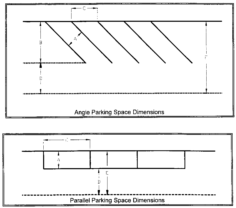
(2)
Setbacks and snow storage. Setbacks a minimum of eight (8) feet in width shall be required on each side of any parking lot, except in an area immediately adjoining the building which the parking serves. Where any parking lot directly adjoins a building, approved barriers shall be installed to prevent vehicles from striking the building. Parking lot setbacks and other portions of the lot not used for required parking may be used for purposes of snow storage. Adequate drainage shall be provided for the snow storage area, to ensure snow melt does not drain onto adjacent property. Snow shall not be stored within required parking spaces, except on an emergency basis for a period not to exceed forty-eight (48) hours.
(3)
Handicapped parking. Parking for any use requiring handicapped access shall be provided in accordance with the provisions of Chapter 18 of this Code.
a.
Sign. All spaces reserved for physically handicapped persons shall have a raised standard identification sign. The identification sign shall be twelve (12) inches by eighteen (18) inches, with a height not to exceed seven (7) feet. The standard colors of the sign shall be white on blue.
b.
Location. Parking spaces reserved for physically handicapped persons shall be located as close to the use's entrance as is reasonably possible.
(4)
Compact parking spaces. Compact parking spaces shall be grouped together when practicable, with each space identifiable by the location of a sign stating "Compact Cars Only." The dimensional area of the parking space shall be unobstructed.
(Ord. 4-1998 §1; Ord. 7-2000 §1; Ord. 7-2004 §1; Ord. 16-2010 §1; Ord. No. 3-2023, § 2(Exh. A))
Sec. 16A-4-320. - Landscaping, grading and other design standards.
(a)
Landscaping Standards.
(1)
Preserve existing vegetation. Existing vegetation and live trees shall be preserved so as to: (a) reduce the potential for erosion and sedimentation from development; (b) screen or soften the appearance of development; and (c) buffer uses from one another. Existing vegetation and trees that are removed shall be replaced with appropriate, similar size plantings and shall be supplemented with additional plantings that help to screen the development, cover exposed areas and hold soil in place.
(2)
Standards for new plantings. All plants used for landscaping shall be compatible with the local climate and the soils, drainage and water conditions of the site. Wherever possible, native varieties shall be used. When planting occurs on hillsides, slopes, drainageways or similar natural areas, plant material should duplicate adjacent plant communities both in species composition and spatial distribution patterns. Evergreen shrubs should be planted in clusters to maximize their chance for survival. When appropriate, landscaping should use drought-resistant varieties, employ xeriscape design principles and promote water conservation. Provision shall be made for irrigation, when necessary, to ensure survival of the plants.
(3)
Landscaping of multi-family and nonresidential development. All portions of lots containing multi-family dwellings and nonresidential development that are not covered by impervious materials shall be landscaped with grass, ground cover, shrubs or similar landscape treatments. A mix of deciduous and evergreen trees and shrubs shall also be planted to effectively buffer proposed nonresidential uses from adjacent residential uses and to provide a buffer between such uses and surrounding collector and arterial streets.
(b)
Grading Standards. All development shall comply with the following standards:
(1)
Mass grading. Mass grading that removes existing vegetation and leaves large areas of soil exposed shall be properly managed to control erosion. When significant portions of a site are to be disturbed, the Town may require grading activities to be phased, so disturbed areas can be stabilized. The Town may also require topsoil to be stockpiled, for re-use on areas requiring revegetation and landscaping.
(2)
Limitations on site disturbance. Cuts, fills, grading, excavation, vegetation removal and building construction shall be confined to designated building envelopes, except as permitted pursuant to Section 16A-3-200(b), Construction in Required Setbacks, and except for site disturbance necessary to install and maintain utilities, roadways, trails, irrigation ditches, fences and trees and similar plant material. Material excavated from the building envelope may be stockpiled outside of the building envelope for later use on the property.
a.
Earth berm outside building envelope. Where site disturbance is proposed to create an earth berm outside of a designated building envelope, the applicant shall demonstrate that the berm: (1) has been blended into the natural topography to the greatest extent possible; (2) will not exceed a fifty-percent slope (one [1] foot vertical to two [2] feet horizontal); (3) will not obstruct sight visibility at road or driveway intersections or create other safety hazards; and (4) will not adversely affect Town snow removal operations.
b.
Administrative modification. An administrative modification may be required, pursuant to Section 16A-5-250, Administrative Modifications, if the Planning Director determines that any berm located outside the building envelope does not satisfy the above criteria.
(3)
Mark envelope. Prior to the commencement of site disturbance, the applicant shall visibly mark the extent of the designated building envelope. The applicant shall maintain said marking in place throughout the duration of construction. Relocation or removal of the marking without the prior approval of the Town shall be considered a violation of this Code.
(4)
Restoration of disturbed areas. Disturbed areas shall be restored as undulating, natural-appearing landforms, with curves that blend in with adjacent undisturbed slopes. Abrupt angular transitions and linear slopes shall be avoided. As necessary, cuts and fills shall be supported by retaining walls, made of wood, stone, vegetation or other materials that blend with the natural landscape. Areas disturbed by grading shall be contoured so they can be revegetated and shall be revegetated within one (1) growing season after construction, using native species similar to those growing on the site.
(5)
Design shall fit natural topography and site conditions. Proposed structures shall be located and designed to fit the site's natural topography and site conditions, rather than adjusting the topography and site conditions to fit the structure. For example, instead of creating a flat bench or terrace for a building platform on a sloping site, the structure should instead be stepped up or down the slope. Roads and driveways shall follow the contours of the natural terrain.
(c)
Outdoor Storage of Materials, Equipment and Vehicles. Unless otherwise determined by the Town Council, all commercial materials and equipment, including snow grooming equipment, stored outside for a period of time exceeding fifteen (15) days, during which time said materials or equipment remain unused, shall be fenced or screened in a manner that it is not visible from an adjacent street or property. Such fences or screening shall be a minimum of eight (8) feet high from grade, unless the Planning Director shall determine that a fence or screen of lesser height be found to meet the intent of this Subsection. All fences shall be of sound construction and shall have not more than ten percent (10%) open area. All other unlicensed, inoperable or dismantled vehicles and parts shall be contained within an enclosed structure. The outside storage of materials, equipment or vehicles which: (1) are not customarily found in association or connection with the principal permitted use of the property, (2) alter the essential character of the surrounding neighborhood, or (3) adversely affect public welfare is prohibited.
(d)
Regulations for Ski Lifts. No development shall be approved in proximity to an existing or proposed ski lift unless said development complies with all applicable regulations governing said ski lift.
(e)
Quality of Skiing. No development shall be approved that adversely affects the quality of skiing at the Snowmass Ski Area, including the distribution of skiers on the mountain and access to the ski area.
(f)
Access to Public Lands. New development shall not result in loss or significant limitation of existing access to public lands.
(g)
Historical or Archaeological Sites. No development shall be approved which would result in the destruction or significant alteration of any sites or structures that have been determined by the Town Council to have historical or archaeological significance to the Town, the region or the State.
(h)
Construction Management. No PUD, amended PUD or subdivision development shall be approved unless a construction management plan has been submitted to and approved by the Town Council or the Planning Director where final approval is administrative. The number of residential units and the amount of commercial space that can be under construction at any one (1) time shall be subject to reasonable limitation in order to minimize disruption to normal business activities, disturbance to the peace and quiet of residential neighborhoods, interference with vehicular and pedestrian movement and/or damage to public roads, utilities and facilities, without unnecessarily interfering with the anticipated development activity. The extent of any such limitations shall be determined in the review and approval of each development project and shall be set forth in a construction management plan to be approved therewith.
(Ord. 4-1998 §1; Ord. 13-1998 §1; Ord. 1-1999 §1; Ord. 7-2000 §1; Ord. 3-2023, § 2(Exh. A))
Sec. 16A-4-330. - Energy conservation.
(a)
General Standard. Energy conservation shall be promoted and maximum advantage taken of solar and alternative energy source opportunities. To achieve this purpose, applications for subdivision, planned unit development or special review shall contain an energy conservation plan, which shall optimize the planning and utilization of all possible energy conservation features in proposed new construction without reducing the percentage of authorized buildable lot area or density allowed by the existing zoning. Failure to submit a satisfactory energy conservation plan, which complies with the provisions of this Section, shall constitute grounds for denial of the application.
(b)
Contents of Energy Conservation Plan. An energy conservation plan shall contain the following materials:
(1)
Map. A map showing the orientation and placement of the building or buildings in relation to topography, vegetation, other structures and all other factors affecting solar access, so as to optimize sunlight access sufficient to take advantage of solar energy systems in as many buildings as is possible. Detailed information shall also be provided identifying and indicating the number of structures that shall have four (4) full hours of direct sunlight between the hours of 10:00 a.m. and 2:00 p.m.
(2)
Shadow study. Evidence that the proposed structures are sited to provide sufficient year-round solar access to a south wall or a south roof, including a shadow study, for major structures that may create shadow on other structures or roadways. Shadow studies shall be based on a thirty-percent sun angle at 9:00 a.m., 12:00 noon and 3:00 p.m.
(3)
Passive or active techniques proposed. A detailed description, including both text and map, of the specific passive or active heating and cooling techniques being utilized, including but not limited to building configuration, window exposure, grading, landscaping, interior and exterior passive and active solar energy features, and attention to elimination or impairment of solar access to possible adjacent building sites. This description should also include an energy utilization analysis in relation to snowmelt areas, heating systems, swimming pools, saunas, Jacuzzis and other significant energy-consuming elements of the project and an estimate of the anticipated energy gain through the planned energy systems.
(Ord. 4-1998 §1; Ord. 7-2000 §1)
Sec. 16A-4-340. - Building design guidelines to preserve community character.
(a)
Purpose. The building design guidelines contained within this Section are intended to preserve the character of the Town as a unique mountain setting, in which development is an element of the natural environment, and does not dominate those natural features. These guidelines are not intended to restrict imagination, innovation or variety in design, but rather are intended to assist in focusing on design principles that can result in creative solutions that are consistent with the character of the Town.
(b)
Applicability. The provisions of this Section 16A-4-340 shall apply to any development application for PUD, amended PUD, subdivision, special review or building permit for nonresidential development or redevelopment. These provisions shall not apply to development of a single-family detached dwelling unit or a two-family dwelling (duplex) on a lot subdivided prior to the effective date of this Development Code (September 2, 1998).
(c)
Building Design Guidelines.
(1)
Site integration. Building design shall be influenced by, and shall respond to, the natural features and mountain setting that surround the property. Structures shall be designed so they do not overwhelm the surrounding mountain environment.
a.
Minimize modification. Developments should be planned to minimize the extent to which it is necessary to modify the natural terrain and natural watercourses. Where earthmoving techniques are necessary, man-made forms should be soft and natural in appearance. Natural water features should be preserved and enhanced.
b.
Indigenous details. Indigenous details and landscape accents, such as streams, boulders, trees and wildflowers, should be used to connect the development to natural conditions.
c.
Complement natural landforms. New buildings should be designed to complement natural landforms, by setting them into the slope, or by reflecting the angles and shapes found in the natural landscape. Building massing should be broken up or stepped along a slope, to conform to the shape, aspect and scale of the natural terrain.
d.
Signs. Interpretive information and signs should be used to draw attention to nature and mountain ecology.
e.
Grade. Awkward changes of grade in public spaces should be avoided. Natural grade changes should be used to separate and define activity areas. The needs of disabled persons should be considered in the layout of uses and in circulation patterns, as circulation on sloping terrain can be an obstacle to the disabled.
(2)
Scale and mass. Buildings shall be designed to ensure that they are not perceived as being monumental in scale.
a.
Relation to scale of surrounding buildings. The height and mass of new buildings should be related to the prevailing scale, form and proportion of surrounding buildings, to avoid overwhelming or dominating the existing character of the area.
b.
Design articulation. Groups of buildings should be located to avoid creating a "wall" or "row" effect. Individual buildings should incorporate offsets or projections that relieve the visual effect of a single long wall, help to articulate individual units or groups of units and give the appearance the building is made up of a collection of smaller structures. Buildings should be sited so their longest frontages are not on their most visible sides.
c.
Human scale. People spaces should respect human scale. The design should include articulated building and roof configurations; staggered roof lines; sloping roof forms with overhangs; setbacks of upper stories; variations in grade level, floor plane and wall textures; spatial enclosure; and the use of design elements that break up the volume of space.
d.
Screen mechanical equipment. The roofs of structures containing nonresidential or multi-family uses should be designed to screen heating, ventilation and mechanical equipment from view from neighboring properties and public rights-of-way.
(3)
Building materials. Buildings shall be designed with natural materials and details that are indigenous to Colorado and that are nonreflective.
a.
Authenticity. Materials should be predominantly authentic in their appearance, with natural textures and weathering.
b.
Materials. The indigenous materials of the surrounding mountains should be conveyed by integrating heavy timbers, natural siding materials and rock into the building design.
(4)
Climate/solar orientation. Buildings should be located to maximize their exposure to winter sun and natural light, and for protection from wind and temperature extremes. The sizing, height and placement of windows should take advantage of the sun's seasonal track and the intensity of solar radiation that is found in the area.
(5)
Views. Buildings should be oriented to take advantage of views and view corridors, and to frame views and enclose open space, but should also preserve important sight lines, overlooks and landmarks as viewed from public roadways and other public spaces, and as viewed from neighboring developments. Buildings shall be located to comply with the provisions of Section 16A-4-50(f), Ridgeline Protection Areas.
(Ord. 13-1998 §1; Ord. 1-1999 §1; Ord. 10-1999 §1; Ord. 7-2000 §1)
Sec. 16A-4-400. - Purpose.
To provide adequate housing for persons of low, moderate or middle income, provisions for comfortable and affordable housing in locations approved by the Town Council shall be made to accommodate sixty percent (60%) of new employees generated by development and redevelopment within the Town.
(Ord. 4-1998 §1; Ord. 7-2000 §1; Ord. 1-2002 §1; Ord. 09-2004 §4; Ord. 3-2011 §3)
Sec. 16A-4-410. - Restricted housing requirements.
(a)
Employee Generation Rates. Employee generation rates vary by the type of employment. The employee generation rates found in Table 4-5, Employee Generation Rates Per Type of Use, shall be applied to each type of use in the development at its maximum annual (peak) employment impact on the community. For any use not listed, or special circumstances as determined by the Town Council, the Planning Director shall determine the applicable employee generation rate by consulting recognized professional publications or studies completed for resort communities similar to the Town. At the Town Council's discretion, the developer may be required to prepare, or the developer may provide, a peak season (maximum annual) employee staffing plan to determine whether certain multi-family or other short-term occupancy dwellings should be considered as Multi-Family-1 or Hotel/Lodge for purposes of applying the appropriate employee generation rates.
Table 4-5
Employee Generation Rates Per Type of Use
* FSA: Furnished Sleeping Area
(b)
Square Footage Per Employee. For that number of employees required to be housed in restricted housing, as determined in Subsection (a) above, the developer shall be responsible for the creation of a total square footage equal to four hundred forty-eight (448) square feet (as measured in Section 16A-3-210(b), Measuring Floor Area) for each employee to be housed. The total square footage for which the developer shall be responsible shall be provided in dwelling units whose size shall be within the range of sizes described in Subsection (c), Size Ranges of Restricted Dwelling Units. The unit mix and methods of providing housing shall be determined as described in Section 16A-4-420, Methods of Complying With Requirements.
(c)
Size Ranges of Restricted Dwelling Units for Full-time Employees. Table 4-6, Size Ranges of Restricted Dwelling Units, establishes the minimum and maximum size range of restricted dwelling units, to ensure that the size of dwelling units contributed by a developer is appropriate. All units contributed by a developer shall meet these size limits.
Table 4-6
Size Ranges of Restricted Dwelling Units
(d)
Size Ranges of Restricted Housing Units for Seasonal Employees. Seasonal employee housing shall be designed to provide efficient, comfortable and affordable accommodations for seasonal employees and may include dormitory style or shared living accommodations configured to provide single-room occupancy for each employee with shared living, restroom and kitchen facilities. To ensure that the size of the housing contributed by a developer for shared living accommodations is appropriate, each building shall provide two hundred twenty-four (224) square feet of private or jointly shared living area for each employee being housed.
(e)
Redevelopment.
(1)
Redeveloped properties. Except as provided in Subparagraph (3) below, the developer shall receive a credit toward restricted housing requirements of up to one hundred fifteen percent (115%) of the housing mitigation that would be required on the existing square footage and use of the building to be redeveloped as computed in accordance with the provisions of Subsections (a) and (b) above.
(2)
Existing employee housing replacement. If any existing square footage currently utilized as employee housing is to be removed, an equal square footage of restricted housing shall be replaced within the development.
(3)
Existing FTE employees housed. The developer shall provide verifiable information specifying the maximum number of full time equivalent (FTE) employees, including seasonal employees, housed within nonrestricted units at any one (1) time within the development during the year prior to submitting the redevelopment application. This number shall be deducted from the "pre-development employees generated" amount in the redevelopment formula in Paragraph (f)(2) below unless the redevelopment proposal provides the same units occupied by existing employees, or comparable units, as restricted housing within the development.
(f)
Formula. To calculate the amount of square footage of restricted housing to be provided in accordance with the provisions of this Section, the developer shall utilize the appropriate formula as follows:
(1)
New development. (Number of employees generated x 60% x 448 square feet).
(2)
Redevelopment. (Number of post-redevelopment employees generated x 448 square feet x 60%) minus (Number of existing pre-redevelopment employees generated minus existing FTE employees housed x 448 square feet x 60% x 115%).
(g)
Alternative Independent Calculation. An applicant may submit an alternative independent calculation requesting modification to any of the employee generation rates within Table 4-5 above. The alternative independent calculation shall be supported by comparable resort and local data with analysis, surveys and/or other supporting materials that provide competent substantial evidence supporting the proposed modifications. Such an alternative independent calculation shall be received by the Town as an equally acceptable methodology of determining employee generation rates as the rates contained in Table 4-5. The alternative independent calculation shall then be reviewed by the Town Council. If the materials and information supporting the calculation demonstrated by substantial competent evidence that there is a reasonable basis to modify the employee generation rates because of unique circumstances related to the proposed development, the Town Council may, at its sole discretion, make the appropriate modifications.
(h)
Independent Payroll Audit. In the event of an independent calculation, the Town Council may require the applicant to have an independent payroll audit performed two (2) years following the subject building's occupancy to determine if the number of employees in the project corresponds with the applicant's calculation. The Town Council may waive or extend the date of the independent payroll audit. The applicant and the Town shall agree upon a method for mitigating any additional restricted housing that may be required as a result of the audit and said methodology shall be specified within the restricted housing agreement.
(Ord. 4-1998 §1; Ord. 11-1998 §1; Ord. 7-2000 §1; Ord. 1-2002 §1; Ord. 09-2004 §4; Ord. 3-2011 §3)
Sec. 16A-4-420. - Methods of complying with requirements.
Restricted housing shall be provided as follows:
(1)
Preliminary review. During preliminary review of the project, and based upon the information provided by the developer and Town staff, the Town Council shall determine:
a.
Whether the project is an appropriate project to be financed, constructed, owned and operated by the Town.
b.
Whether the project is an appropriate project to be financed, constructed, owned and operated by the developer.
c.
Any combination of the above that the Town Council determines to be in the best interest of the Town.
d.
The total anticipated construction cost of the project, including all site development costs, including soft costs.
(2)
Methods of providing housing. Housing shall be provided using one (1) or more of the following methods with preferences given to Subparagraph a or b below:
a.
Developer buy-down. Developer builds rental units, transfers title of the project, including land, to the Town and the Town pays to the developer the bondable amount derived from the net operating income (amortized for a twenty-year period). The net operating income means the amount of revenue generated from the rents of a project, less capital replacement reserve and operating expense other than debt service. When the estimated net operating income of a project is insufficient to meet the debt service requirements of the restricted units, the developer shall pay the difference between the bondable amount derived from the net operating income (amortized for a twenty-year period) and total construction costs.
b.
Restricted sale. Developer builds the restricted units and sells the units to qualified employees, at prices established by the Town Council, as determined by current sale prices of comparable restricted units within the Town.
c.
Other means. Such other means as may be agreed upon by the Town Council at its sole discretion and the developer of a project requiring restricted housing, as required by Article IV of this Chapter, which may include:
1.
Restricted rates and use. The developer builds, owns and manages restricted rental units in accordance with current Town of Snowmass Village Restricted Housing Guidelines. When permitted by all applicable state and local laws, or when agreed to by the developer, the units shall be restricted at the same rental rates charged by the Town for similar size units with similar amenities, as determined by the Town Council. Rental rates may be adjusted annually based on the inflation index used by the Town. A restricted housing agreement shall be entered into between the Town and the developer identifying the conditions of occupancy, maintenance and rental guidelines for the restricted units.
2.
Land for credits. The Town Council, at its sole discretion, may grant to the developer employee housing credits in exchange for developable land.
(3)
Cash in lieu for minor developments. The Town Council may, at its sole discretion, accept cash in lieu of restricted employee housing as defined in this Chapter. Cash in lieu of employee housing shall include the net cost (total cost less the amount covered by rental or sale income) of land and all related planning, design, site development, construction and construction management costs of the project, in current dollars, which would be incurred by the Town in order to provide the required amount of restricted housing, or as agreed to by the Town and developer.
(4)
Developer responsibilities. The developer shall be responsible for planning, design and development approvals for any housing proposed to mitigate employee impact. The developer shall provide adequate land for the project and shall be responsible for the full costs of constructing the project. If the Town Council has determined that the restricted housing will be owned by the Town, upon issuance of a certificate of occupancy, the developer shall convey the project free and clear of any monetary liens or restraints on alienation to the Town and the Town shall thereafter own and manage the restricted units. The developer shall warrant that the project is free of any construction defects for a period of one (1) year from the transfer of title to the Town.
(5)
Town Council responsibilities. The Town Council shall determine, at the time of Preliminary PUD review of the specific restricted housing projects, the unit mix and configuration of restricted units to be provided, fair and reasonable rental rates and sale prices for each type of restricted unit, estimates of occupancy rates, estimates of operating budgets (including maintenance and capital reserve), and the effect of the proposed restricted units on the overall restricted housing inventory in the Town. The criteria shall be the Comprehensive Plan, the most recent housing surveys, comparable restricted rental rates, information provided by the developer and recommendations from Town staff. At the Town Council's discretion, the developer may be required to prepare, or the developer may provide, a peak season (maximum annual) employee staffing plan for all or portions of the development being mitigated to determine the appropriate full-time/seasonal restricted housing mix to be provided by the developer.
(6)
Homeowner's Association. If a restricted housing unit is developed as part of a mixed free market/restricted housing development project in which both free market and restricted units will be included in the same association, then the documents creating the condominium regime, Homeowner's Association (HOA) and any Covenants, Conditions and Restrictions (CC&R) shall state that the restricted housing unit shall only be assessed monthly dues and other shared assessments based on whichever of the following two (2) formulas apply:
a.
The size of the restricted housing unit in square feet as compared to the total size of the other units in the development; or
b.
The size of the lot on which the restricted housing unit is located as compared to the total size of the other lots in the development.
The Town shall consider the economic effect all assessments may have upon the Town's goal of successfully maintaining reasonable long-term affordability of the restricted housing units or lots. The Town Council will evaluate the proposed assessment rates considering the nature of the project, the level of maintenance, types of utilities, services and amenities being provided relative to those of comparable wholly restricted projects. The condominium regime, HOA and any CC&R documents shall state the maximum share of general, common, limited, special or other assessments allocated to each restricted housing unit or lot and how such documents may be amended in the future within a restricted housing agreement.
(Ord. 4-1998 §1; Ord. 11-1998 §3; Ord. 7-2000 §1; Ord. 09-2004 §4; Ord. 3-2011 §3)
Sec. 16A-4-500. - Purpose.
The purpose of this Division is to create the framework for a comprehensive but balanced system of signs in the community. This Division is intended to serve the following purposes:
(1)
Authorize signs. To authorize and promote the use of signs that are:
a.
Compatible. Compatible with their surroundings;
b.
Appropriate. Appropriate to the type of activity to which they pertain;
c.
Expressive. Expressive of the identity of both individual proprietors and the community as a whole; and
d.
Legible. Legible in the circumstances in which they are seen.
(2)
Promote orderly display. To enhance the economy and the businesses within the Town by promoting the reasonable, orderly and effective display of signs and encouraging better communication with the public.
(3)
Preserve open character. To preserve the open and uncluttered feeling characteristic of the Town.
(Ord. 4-1998 §1; Ord. 7-2000 §1)
Sec. 16A-4-510. - Applicability, exempt signs and prohibited signs.
(a)
Provisions Shall Apply. The provisions of this Division shall apply to all signs located within the Town, except for those signs listed in Section 16A-4-510(b), Exempt Signs.
(b)
Exempt Signs. The provisions of this Division shall not apply to the following signs, nor shall the following signs be considered as a permitted sign for any business establishment:
(1)
Construction site signs. A sign which names the contractors, subcontractors, architects and all other related enterprises engaged in the construction on the property where the sign is located. Such signs: (a) shall not exceed thirty-two (32) square feet in area, and six (6) feet in height; (b) shall not be erected prior to the start of construction; and (c) shall be removed at the time of final building inspection. There shall be one (1) such freestanding on-premises sign permitted per construction site.
(2)
Development leasing/rental signs. Freestanding on-premises signs that provide only leasing or sales information during a new construction phase on the property on which the sign is located. Such signs shall not exceed twenty (20) square feet in area, and six (6) feet in height, shall not be erected prior to the start of construction and shall be removed at the time the leases and/or sales have been completed. No more than one (1) development leasing/rental sign shall be permitted per street or business frontage.
(3)
Informational signs. Signs which are not more than six (6) square feet in area and which are used to direct automobile, pedestrian and/or skier traffic, or to direct parking on private property or in designated ski areas. Informational signs shall bear no advertising material.
(4)
Public signs. Legal notices, identification, informational or directional signs erected or required by governmental bodies, or authorized by the Town for public purposes which meet the requirements of this Division, except for those provisions prohibiting said signs in the rights-of-way.
(5)
Public regulatory signs. All public regulatory signs located in the Town which meet all state requirements.
(6)
Real estate signs. Signs, other than development identification signs, which advertise the sale or rental of the real estate upon which said sign is located or which indicate that the property has been sold. Real estate signs shall not exceed three and one-half (3.5) square feet in area. Real estate signs may remain in place during the time the property is listed for sale or rent, and shall be removed no later than one (1) week after the sale or rental of the property. No more than one (1) real estate sign shall be allowed per property, except a lot with more than one (1) street front exposure may have one (1) real estate sign per street front.
(7)
Garage sale or special event signs. Signs which advertise garage or rummage sales or other special events shall not be displayed more than four (4) times per year for a given property, and the exposure of said signs shall only be for the duration of the event. The individual responsible for the sign shall ensure that the sign is removed on the last day of the event. These signs shall not exceed six (6) square feet in area.
(8)
Interior signs. Signs located on the interior of any building, or within an enclosed lobby of any building or group of buildings, that cannot readily be seen from the exterior of the building and are designed and located to be viewed exclusively by patrons of such use or uses.
(9)
Utility signs. Signs of public utility or cable television companies which show the locations of underground facilities.
(10)
Street address and identification signs. Signs whose content include only the name or professional title of the occupant and address of the premises. Such signs shall not exceed two (2) square feet in area. The sign shall be limited to a wall-mounted, freestanding or window type sign. No more than one (1) such sign shall be permitted per premises unless physical characteristics of the site or other locational considerations preclude visibility of the street address sign from the roadway, in which case a second sign shall be permitted along the road.
(11)
Customer information signs. Customer information signs may display such items as "credit cards accepted," prices and menus. Each such sign shall not exceed four (4) square feet in area.
(12)
Security signs. Signs whose content include only the name of the security company providing service to the premises. Such sign shall not exceed one (1) square foot in area. The sign may be a freestanding, wall-mounted or window type sign. No more than one (1) such sign shall be permitted on the premises.
(c)
Prohibited Signs. No signs or advertising devices of any nature shall be erected or maintained on any property except as necessary to identify the business, its address or as may be necessary or desirable to give directions, advise of rules and regulations or caution or warn of danger, and such signs as may be otherwise required by law. The following signs are strictly prohibited in the Town:
(1)
Flashing signs.
(2)
Roof signs.
(3)
Moving signs.
(4)
Neon signs.
(5)
Signs advertising home occupations.
(6)
Mobile signs. Mobile signs except those that conform to the temporary sign provisions that promote a business.
(7)
Signs that obstruct motorists. Signs that, by reason of size, location, content, coloring or manner of illumination, obstruct the vision of motorists or obstruct or detract from the visibility or effectiveness of any traffic sign or control device on any road or street, as determined by the Planning Director, Public Works Director and/or Chief of Police.
(8)
Signs that constitute a hazard. Any sign or sign structure that constitutes a hazard to public health or safety, as determined by the Building Official and/or Chief of Police.
(9)
Signs on trees or public property. Signs on trees or public property, other than public information signs that are not part of a building structure.
(Ord. 4-1998 §1; Ord. 7-2000 §1)
Sec. 16A-4-520. - Permitted signs.
The following types of signs shall be permitted within the Town:
(1)
Wall-mounted, window, projecting, hanging or awning sign. Each business shall be permitted per business frontage with an access point, either one (1) wall-mounted sign, one (1) window sign, one (1) projecting sign, one (1) hanging sign or one (1) awning sign, provided that the sign complies with the requirements of this Division. If the individual business so desires, it may construct a sign on a business frontage without an access point if it gives up the right to maintain a sign as permitted above.
(2)
Freestanding or joint identification sign. Either one (1) freestanding, on-premises sign or one (1) joint identification sign shall be permitted at each vehicular access point to a business or the group of businesses advertised on the sign. There shall be a minimum of one hundred (100) feet between freestanding, on-premises signs of an individual business. There shall be a minimum of one hundred (100) feet between joint identification signs permitted for a group of businesses located in the same building or building complex. In no case shall there be more than one (1) freestanding, on-premises or joint identification sign permitted at any access point.
(Ord. 4-1998 §1; Ord. 7-2000 §1)
Sec. 16A-4-530. - Standards applicable to all signs.
(a)
Material and Color. It is recognized that it is desirable to have some diversity of sign design within the Town. However, it is also desirable to assure that construction material and color schemes utilized on signs within the Town shall be consistent with the image of the community. It shall be the responsibility of the Planning Director to review sign design submitted with an application for a permit for consistency with community image. Any signs that have been found to be inconsistent by the Planning Director shall be referred to the Town Council for its review.
(b)
Construction.
(1)
Structure. All sign structures shall be designed and constructed in a manner that is safe, and shall be free of any exposed extra bracing, angle iron, guy wires, cables, etc. No sign structure shall have any nails, wires or sharp metal edges protruding therefrom.
(2)
Wiring. The wiring of all signs shall be contained in raceways or enclosed in poles or comply with the Electrical Code as adopted by the Town. In no case shall the wiring be exposed to the view of the public.
(3)
Glass. Any glass forming a part of any sign shall be heavy safety glass, having a minimum thickness of one-fourth (¼) inch. Where any single piece or pane of glass has an area exceeding three (3) square feet, it shall be wired glass.
(c)
Illumination. All sign illumination shall be concentrated on the sign. The amount of direct light cast to areas other than the sign itself shall be minimized. There shall be no sign illumination permitted within the Town that casts a red, green or blue hue.
(d)
Restriction by Zoning District. Signs shall be restricted by zoning districts as follows:
(1)
Residential zone districts. In the SF-4, SF-6, SF-15, SF-30, SF-150, EST, MF/PUD, DU, CON and OS zone districts, the only signs which shall be erected are those that are exempt from the provisions of this Division, pursuant to Section 16A-4-510(b), Exempt Signs, together with residential subdivision/complex identification signs, which shall meet all the requirements of a freestanding on-premises sign. Signs erected in these zone districts shall be located at a distance of at least ten (10) feet from any property line.
(2)
Commercial zone districts. In the MU/PUD, CC, CC/PUD, PUD or SPA zone districts, only the following signs shall be erected, provided the signs are in compliance with the provisions of this Division:
a.
Commercial advertisement signs.
b.
Institutional signs.
c.
Joint identification signs.
d.
Residential subdivision/complex identification signs.
e.
Temporary signs.
f.
Exempt signs. All signs listed in Section 16A-4-510(b), Exempt Signs.
(e)
Registration. All existing signs and every sign erected after December 4, 1984, shall be registered with the Town. Owners of existing signs shall register their signs within one (1) year from December 4, 1984. Signs constructed after this date shall be considered registered upon issuance of a permit.
(Ord. 4-1998 §1; Ord. 7-2000 §1)
Sec. 16A-4-540. - Standards applicable to particular types of signs.
(a)
Freestanding On-Premises Signs and Joint Identification Signs.
(1)
Height of freestanding on-premises signs. When grade perpendicular to the road decreases, there may be up to three (3) feet of support structure at lowest grade elevation at the base of the sign allowed to get from grade at the base of a freestanding on-premises sign up to road level, up to two and one-half (2.5) feet of additional support to get the sign above an acceptable snow level, and then no more than two and one-half (2.5) feet within which the display surface shall be located. In no case shall the highest point of such a sign be more than five (5) feet above the highest grade elevation at the base of the sign.
(2)
Height of joint identification signs.
a.
Grade decreases. When grade perpendicular to the road decreases, there may be up to three (3) feet of support structure at the lowest grade elevation at the base of a joint identification sign allowed to get from grade at the base of the sign up to the level of the road, up to two and one-half (2.5) feet of additional support to get the sign above an acceptable snow level, and then no more than four and one-half (4.5) feet within which the display surface shall be located. In no case shall the highest point of such a sign be more than seven (7) feet above the grade of the road.
b.
Grade is level or increases. When grade perpendicular to the road is level or increases, the maximum height of a joint identification sign shall be seven (7) feet above the highest grade elevation at the base of the sign.
(3)
Width. No freestanding on-premises sign or joint identification sign shall be more than seven (7) feet in width.
(4)
Display area. The display area of a freestanding on-premises sign, including any architectural embellishments or background materials that are an integral part of the display, shall not exceed seventeen and one-half (17.5) square feet. The display area of a joint identification sign, including any architectural embellishments or background materials that are an integral part of the display, shall not exceed thirty-one and one-half (31.5) square feet. The display area shall be measured as the smallest area enclosing all wording, logos and any other architectural embellishments or background materials utilized as an attention-getting device. If the sign is three-dimensional, the display area shall be the total of each side of the sign which is visible.
(5)
Location. Freestanding on-premises signs and joint identification signs shall be permitted only when they are located within a landscaped area. Landscaping shall not adversely affect pedestrian or vehicular traffic. In no case shall such a sign project into the public right-of-way unless granted a variance, or be situated near an intersection in such a manner so as to interfere with vehicular sight distance.
(6)
Illumination. Freestanding on-premises signs may be illuminated by indirect illumination, provided that such illumination in no way adversely affects pedestrian and/or vehicular traffic. Internal illumination may be utilized only when lettering is the only translucent portion of the display area and the smallest possible rectangle enclosing the translucent lettering is less than thirty percent (30%) of the total display area. Joint identification signs may be illuminated, provided that only indirect illumination shall be utilized, and such illumination shall in no way adversely affect pedestrian and/or vehicular traffic.
(7)
Copy. The copy on any commercial joint identification sign shall list either the specific names of all businesses within a building or complex which wish to advertise on the sign, describing the general nature of the businesses in the building or complex, or it may list the name of the business together with a general description of the business.
(b)
Wall-Mounted On-Premises Signs.
(1)
Area and measurement.
a.
Area. No wall-mounted on-premises sign shall exceed six (6) square feet for any establishment having a business frontage of thirty (30) linear feet or less. For any establishment having a business frontage of more than thirty (30) linear feet, one (1) square foot of signage will be allowed for each five (5) linear feet of business frontage, up to a maximum of twenty-five (25) square feet.
b.
Multiple businesses share frontage. When two (2) or more businesses are located in the same building and share the same business frontage, they shall be limited to and may share one (1) wall-mounted sign, having an area that complies with Subsection (b)(1)a, Area.
c.
Measurement. The area of all wall-mounted signs shall be the smallest possible area enclosing the extreme limits of the display surface. The display surface also includes any architectural embellishments or background materials that are an integral part of the display and used to differentiate the sign from its surroundings.
(2)
Location.
a.
Not cover major architectural features. A wall-mounted sign shall not cover or interrupt major architectural features such as doors and windows.
b.
Projection from wall. A wall-mounted sign shall not project out more than six (6) inches from the wall on which it is mounted.
c.
Projection from roof. No wall-mounted sign shall project beyond the line established by that part of the roof which projects from the wall upon which the sign is mounted, nor shall it extend above the roof line. A mansard roof shall not be considered a wall.
(3)
Illumination. Wall-mounted signs may be illuminated, provided that only indirect illumination shall be utilized, and such illumination shall in no way adversely affect pedestrian and/or vehicular traffic.
(c)
Awning Signs on Premises.
(1)
Lettering. The lettering on any awning sign shall not exceed six (6) inches in height.
(2)
Wording. The wording on any awning sign shall not exceed seven (7) feet in width.
(d)
Temporary Signs.
(1)
Area.
a.
Freestanding temporary signs. Freestanding temporary signs shall not exceed nine (9) square feet.
b.
Banners. Banners or any other temporary signs hung from a building or other supports shall not be greater than three (3) feet in height by twelve (12) feet in length.
(2)
Display limits. Temporary signs may be displayed no more than two (2) weeks prior to commencement of the event advertised and shall be promptly removed upon its termination.
(e)
Projecting On-Premises Signs.
(1)
Area and measurement.
a.
Area. No projecting sign shall exceed six (6) square feet.
b.
Measurement. The area of a projecting sign shall be the smallest possible rectangle enclosing the extreme limits of the display surface. The display surface also includes any architectural embellishments or background materials that are an integral part of the display and used to differentiate the sign from its surroundings.
(2)
Clearance. Signs which project more than four (4) inches over a pedestrian walkway must allow seven and one-half (7.5) feet of clearance between the bottom of the sign and any pedestrian walkway.
(3)
Illumination. Hanging signs may be illuminated, provided that only indirect lighting is utilized, and that the light source does not interfere with pedestrian or vehicular traffic.
(f)
Window Signs.
(1)
Area and measurement.
a.
Area. No window sign shall exceed ten percent (10%) of the area of the window in which it is placed.
b.
Measurement. The area of a window sign shall be the smallest possible rectangle enclosing the extreme limits of the display, which is comprised of all letters, logos or other graphic information.
(2)
Illumination. Window signs may be illuminated, provided that only indirect lighting is utilized and the source does not interfere with pedestrian or vehicular traffic.
(Ord. 4-1998 §1; Ord. 7-2000 §1)
Sec. 16A-4-550. - Procedure to obtain sign permit.
(a)
Permit Required. It shall be unlawful for any person to erect, construct, alter or relocate any sign within the Town, other than those signs listed in Section 16A-4-510(b), Exempt Signs, without first obtaining a permit, including signs approved in a comprehensive sign plan. Routine maintenance or changing of parts shall not be considered an alteration, provided that such change does not alter the surface dimension or height, or otherwise make the sign nonconforming.
(b)
Application Contents. Application for the permit shall be made to the Building Department and shall include the following information:
(1)
Identification. Name, address and telephone number of the applicant, owner and occupant of the property, and the name of the person who will erect the sign.
(2)
Location of structure. Location of the structure or parcel of property on which the sign will be attached or erected.
(3)
Position of sign. Position of the sign in relation to nearby buildings, structures, property lines and rights-of-way.
(4)
Plans. A copy of plans and specifications showing material and method of construction, illumination, electrical wiring, location and support.
(5)
Sketch. Sketch showing sign faces, exposed surfaces and proposed message, accurately represented in scale as to size, area, proportions and color. The proposed message requirement does not apply to those signs whose copy could change frequently.
(6)
Consent. Written consent of the owners of the building, structure or land on which the sign is to be erected.
(7)
Temporary sign. On any application for a temporary sign, the applicant shall list the earliest date on which the sign may be established and the date on which the sign shall have been removed.
(8)
Fee. The required permit fee for each sign shall accompany the application. The amount of such permit fee shall be determined and set by the Town Council from time to time.
(Ord. 4-1998 §1; Ord. 7-2000 §1)
Sec. 16A-4-560. - Comprehensive sign plan.
(a)
Purpose. There are special circumstances within the Town that deserve flexibility from the standards prescribed in this Division, when such flexibility is in the best interest of the community. The purpose of this Section is to authorize a comprehensive sign plan to be submitted so as to afford such flexibility, while still meeting the purpose of this Division.
(b)
Applicability. The Town Council may permit the utilization of comprehensive sign plans for multiple businesses located in a single building, or for building complexes that are located on one (1) lot or parcel or two (2) or more continuous parcels, that are held in unified control.
(c)
Plan Requirements. Comprehensive sign plans shall meet the following requirements:
(1)
Submission of application. An application for a comprehensive sign plan shall be submitted to the Planning Director. The application shall include the following materials:
a.
Minimum contents. The minimum contents for any application, as specified in Section 16A-5-40(b), Minimum Contents.
b.
Detailed sign plan. A detailed sign plan with an accurate survey map or sufficient legal description describing the area in which the plan will be in effect. The plan shall include written stipulations that address all relevant concerns, including but not limited to the location of proposed signs and their size, height, color, lighting, orientation, construction material and copy. If there are signs within the plan area that will not conform to the standards described in the comprehensive sign plan, procedures and time frames for securing the removal of nonconforming signs shall be detailed.
c.
All parties must join. All parties affected by provisions of the comprehensive sign plans must join in the application for such plans. If multiple businesses in a single building, building complexes or portions thereof are governed by a management agreement, the duly constituted representative of the management association or firm shall join in such plan. It is unnecessary for owners or lessees to join if said representative has joined on their behalf.
(2)
Staff review. Staff review of the application shall be accomplished, as specified in Section 16A-5-50, Staff Review of Application.
(3)
Planning Commission review. A complete copy of the application shall be forwarded to the Planning Commission, together with a copy of the staff review. The Planning Commission shall review the application, and shall make its recommendations to the Town Council, considering whether the comprehensive sign plan contains appropriate limitations within its plan stipulations to ensure that the sign plan will minimize its impact on surrounding land uses and is compatible with the purposes of this Division.
(4)
Town Council first reading. The Planning Commission's recommendations shall be forwarded to the Town Council at a regular meeting, together with a complete copy of the application and a copy of the staff's review. The Town Council shall consider all relevant materials and shall adopt an ordinance on first reading approving the comprehensive sign plan as recommended or with modifications, or shall adopt a resolution denying the application, citing specific reasons therefor.
(5)
Public hearing. Prior to second reading and final adoption of such ordinance, the Town Council shall hold a public hearing. Public notice of the hearing shall be given by publication, mailing and posting of notice, pursuant to Section 16A-5-60(b), Manner and Timing of Notice. The Town Council shall consider the application, any relevant support materials, the staff report, the Planning Commission's recommendation and the public testimony given at the public hearing. Following closure of the public hearing, the Town Council shall adopt the ordinance, adopt the ordinance with modifications or deny the ordinance.
(6)
Amendment. Once authorized by the Town Council, a comprehensive sign plan may only be amended as follows:
a.
Procedure. The Planning Director shall submit notice of the requested change and all relevant material to the Planning Commission for its review and recommendation to the Town Council.
b.
Standards. The Planning Commission may recommend approval, and the Town Council may approve the proposed change only if the following standards are met:
1.
Not adversely affect sign plan. The proposed amendment will not adversely affect the development and preservation of the entire sign plan;
2.
Not adversely affect surrounding uses. The proposed amendment will not adversely affect surrounding land uses;
3.
Not conflict with purposes. The proposed amendment will not conflict with the purposes of this Division; and
4.
Not confer special benefit. The proposed amendment will not be granted solely to confer a special benefit upon any party.
(7)
Town Council authority. Nothing in these provisions shall be construed to deny the Town Council power to require any modification of or release from any provision of the comprehensive sign plan so that the plan conforms to other Town ordinances.
(Ord. 4-1998 §1; Ord. 7-2000 §1)
Sec. 16A-4-570. - Nonconforming signs.
(a)
General. All signs existing on December 4, 1984, that do not conform to the provisions of this Article shall be regarded as lawful nonconforming signs.
(1)
Exception for comprehensive sign plan. Signs that are not in compliance with this Division but have been approved by the Town Council as part of a comprehensive sign plan shall not be considered nonconforming.
(2)
Exception for signs less than five percent (5%) over maximum. All signs existing on December 7, 1984, that would be considered nonconforming by virtue of allowable measurement (square footage, height and width) shall not be considered nonconforming if the sign is less than five percent (5%) over the maximum measurement allowed.
(b)
Sign shall be maintained. A lawful nonconforming sign shall be maintained in good condition but shall not be:
(1)
Changed. Changed in any manner to another nonconforming sign;
(2)
Structurally altered. Structurally altered so as to prolong the life of the sign;
(3)
Expanded;
(4)
Re-established after discontinuance. Re-established after its discontinuance for thirty (30) days;
(5)
Moved. Moved in whole or in part to another location unless said sign is made to conform to all of the regulations of this Division; and
(6)
Re-established after damage. Re-established after damage or destruction in an amount exceeding fifty percent (50%) of its estimated initial value, as determined by the Planning Director.
(c)
Amortization Period. It is reasonable that a time limit (amortization period) be placed upon the continuance of existing nonconforming signs. This will allow the owner to continue using a lawful nonconforming sign for a period of time, but it will also ensure that the nonconforming sign will eventually be brought into substantial uniformity with all signs permitted in the community. The following amortization schedule shall apply to all lawful nonconforming signs:
(1)
Nonconforming due to number of signs. Any use which has signs which are nonconforming because of the number of signs on the premises shall bring the number of signs into conformity within ninety (90) days of the effective date of the ordinance codified herein.
(2)
Other nonconformities. All other nonconforming signs shall be brought into conformance with the provisions of this Division within one (1) year of the effective date of the ordinance codified herein.
(Ord. 4-1998 §1; Ord. 7-2000 §1)
Sec. 16A-4-580. - Sign variances.
An application for a variance from the provisions of this Division shall be processed pursuant to the provisions of Section 16A-5-240, Variances. Provided, however, that the application for a sign variance shall not be evaluated pursuant to the standards of Section 16A-5-240(c), Review Standards. Instead, the applicant shall be required to demonstrate that the proposed signage cannot be reasonably installed as provided in this Division due to unique physical characteristics of the property, its surroundings and/or the unique nature of the sign itself. Any variance granted shall be only for the minimum amount necessary to overcome the unique features.
(Ord. 4-1998 §1; Ord. 7-2000 §1)
Sec. 16A-4-590. - Enforcement.
The Planning Director shall be responsible for enforcing the provisions of this Division. Violation of the provisions of this Division shall result in punishment in accordance with the provisions of Section 1-72 of this Municipal Code.
(Ord. 4-1998 §1; Ord. 7-2000 §1)