
Social Circle City Zoning Code
ARTICLE 15
- ABBREVIATIONS AND DEFINITIONS
Sec. 15.1.- Abbreviations.
The following abbreviations appear in this UDC:
(Ord. No. 2023-3, § 1(Exh. A), 6-20-2023)
Sec. 15.2. - Defined terms, general.
—A—
Abandonment. The relinquishment of property, or a cessation of the use of the property, by the owner or lessee without any intention of transferring rights to the property to another owner or of resuming the use of the property.
Abatement. The method of reducing the degree and intensity of pollution, nuisance, or identified area of non-compliance with this development code.
Absorption. The penetration of one substance into or through another; or, the length of time it takes for a product or real estate to be sold or rented.
Abut or adjoin. To physically touch or border on; or to share a common property line but not overlap.
Acceleration lane. An added roadway lane that permits integration and merging of slower moving vehicles into the main vehicular stream.
Access. A way or means of approach to provide vehicular or pedestrian physical entrance to a property.
Access management plan. A plan showing the design of access upon a lot. It involves planning for the entry and exit of traffic on major roads in such a way as to keep interference with traffic flow to a minimum and maximize public safety.
Access permit. A permit issued by the appropriate governmental agency for the construction, maintenance, and use of a driveway or public street connecting to a highway.
Accessible design. Accessible generally means that environments, objects, and systems meet prescribed requirements for accessibility for people with disabilities.
Accessible route. A continuous, unobstructed path connecting all accessible elements and spaces of a building or facility.
Accessory structure. A structure detached from a principal building located on the same lot and customarily incidental and subordinate to the principal building or use, and unless otherwise stated in this UDC, limited to a maximum of 300 gross square feet. The accessory structure must be on the same lot as the principal structure unless this development code specifically permits it to be located on another lot. An example of this, is a parking structure for a commercial establishment.
Accessory use. A use of land or of a building or portion thereof customarily incidental and subordinate to the principal use of the land or building and located on the same lot with such principal use.
Acre. A measure of land containing 43,560 square feet.
Activity center. A community focal point providing for the combination, rather than scatteration, of general retail, service, commercial, professional office, higher density housing, and appropriate public/quasi-public uses.
Act of God. An unintentional hazard event (usually a natural hazard) whereby society feels that no individual or organization is responsible for the hazard occurrence or its impact; i.e., an "accident."
Adaptive reuse. The development of a new use for an older builder or for a building originally designed for a special or specific purpose.
Addition.
(1)
A structure added to the original structure at some time after the completion of the original;
(2)
An extension or increase in floor area or height of a building or structure.
Adjoining lot or land. A lot or parcel of land that shares all or part of a common lot line with another lot or parcel of land and includes properties separated only by public or private rights-of-way. See Abut.
Adverse impact. A condition that creates, imposes, aggravates or leads to inadequate, impractical, unsafe, or unhealthy conditions on a site proposed for development or on off-tract property or facilities. Adverse impacts usually related to circulation, erosion, drainage, potable water, sewage collection and treatment, but may also relate to lighting and glare, aesthetics quality of life, and environmental impact.
Affordable housing. Housing with sales price or rent within the means of a low-, middle-, or moderate-income household as defined by state or federal legislation. Not necessarily the same as subsidized housing.
Agrarian. Relating to land, particularly agriculture.
Agricultural building. A structure on agricultural land designed, constructed, and used to house farm implements, livestock, or agricultural produce or products grown or raised on the premises.
Agricultural land, prime. Land that qualifies for a rating as Class I in the US Department of Agriculture (USDA) Soil Conservation Service land-use capability classification.
Agriculture. The production, storage, keeping, harvesting, grading, packaging, processing, boarding or maintenance, for sale, lease, or personal use, of plants and animals useful to humans including but not limited to: forages and sod crops, grains and seed crops; dairy animals and dairy products; poultry and poultry products; livestock including beef cattle, sheep, swine, horses, ponies, mules, or goats, including the breeding and grazing of any or all such animals; bees and apiary products; fur animals; trees and forest products; fruits of all kinds, including grapes, nuts, and berries; vegetables; nursery, floral, ornamental, and greenhouse products; or land devoted to a soil conservation or forestry management program.
Agricultural services. Establishments primarily engaged in supplying soil preparation services, crop services, landscaping, horticultural services, veterinary and other animal services, and farm labor and management services.
Agri-entertainment. Events and activities, such as mazes, hayrides, and petting zoos, that allow for recreation, entertainment, and tourism in conjunction with agricultural support and services directly associated with ongoing agricultural activity on-site. See also Agritourism.
Agritourism. Agricultural uses such as farms, ranches, and vineyards, that, through promotion and advertising, facilities, and activities seek to attract visitors and guests. Examples of agritourism include dinner on the farm where paid meals are prepared for members of the public from products of the farm, roadside markets, winery, agricultural craft and gift sales, garden and nursery sales, and special events.
Aisle. The traveled way by which cars enter and depart parking spaces.
Alley. A service roadway providing a secondary means of access to abutting property and not intended for general traffic circulation.
Alteration, major. Any change or rearrangement in the supporting members of an existing building, such as bearing walls, columns, beams, girders, or interior partitions, as well as any change in doors, windows, or means of ingress or egress; or any, enlargement to or diminution of a building or structure, whether horizontally or vertically; or the moving of a building or structure from one location to another.
Alteration, minor. Modifications to an existing structure that are of a cosmetic nature, replacement of utilities, or rearrangement of non-load bearing partitions.
Alternative living arrangement. An arrangement in which households maintain private rooms, yet share kitchen and bathroom facilities, central heating, and common areas. Examples may include boarding homes, residential health-care facilities, group homes for the developmentally disabled and mentally ill, and congregate living arrangements.
Alternative Access.
(1)
The ability to enter a highway indirectly through another improved roadway instead of from a direct driveway entrance from the principal roadway frontage;
(2)
The availability of another means of access to a roadway or property in addition to the primary access.
Americans With Disabilities Act (ADA). A 1990 federal law designed to bring Americans with disabilities into the economic mainstream by providing them equal access to jobs, transportation, public facilities, and services.
Anchor tenant. The major store or stores within a shopping center.
Ancillary use. See Accessory use.
Annexation. The incorporation of land area into an existing community with a resulting change in boundaries of that community.
Applicant. Any person, firm, partnership, corporation, or public agency submitting an application for development.
Application for development. The application form and all accompanying documents and exhibits required of an applicant by an approving authority for development review and approval purposes.
Approved plan. A plan that has been granted final approval by the appropriate approving authority.
Approving authority. The agency, board, group, or other legally designated individual or agency that has been charged with the review and approval of plans and applications.
Architectural projections. Building projections that are permitted to intrude into the required front, rear, and side yards.
Articulation. For structures, a change in the depth of the building plane, roofline, or height.
As-built plans. Accurate and precise drawings of post-construction site features and characteristics, including all buildings, structures, infrastructures, boundaries, and natural features.
Assemblage. The merger of separate properties into a single tract of land. See Consolidation.
Average setback. The average distance from the street right-of-way on both sides of a lot.
Awning. A roof-like cover that projects from the wall of a building for the purpose of shielding a doorway or window from the elements.
—B—
Back-to-back lots. Separate land parcels that have at least half of each rear lot line coterminous.
Barn. A large farm building used for storing grain, hay, or straw, or housing livestock or storing equipment. See Agricultural building.
Base flood. The minimum magnitude flood to be used by a community as a basis for its floodplain management regulations; presently required by regulation to be that flood which has a one-percent change of being equaled or exceed in any given year.
Basement. That portion of any building for which the finished surface of its floor is more than six feet below the finished ground level for more than 50 percent of the total building perimeter; or more than 12 feet below the finished ground level at any point.
Best management practices (BMPs). The physical, institutional, or strategic approaches and procedures to environmental or development problems, particularly with respect to non-point source pollution control.
Bicycle (bike). A device propelled solely or in part by human power having tow or more wheels in tandem, including children's bicycles, except a toy vehicle intended for use by young children, such as a tricycle.
Big box store. A large, freestanding, single-story retail store, of generally more than 50,000 square feet, and usually part of a regional or national chain.
Bike lane. A portion of a road that is designated by striping, signing, and pavement markings for the preferential or exclusive use of bicyclists. Most often these are done in couplets, each one being one-way and adjacent to the outside through travel lane.
Bike path.
(1)
A facility that is paved or unpaved and physically separated from motorized vehicular traffic by an open space or barrier;
(2)
A designated right-of-way for bicycles, separated from pedestrian and motor vehicles.
Bike route. A segment of road designated by the jurisdiction having authority, with appropriate directional and informational markers, but without striping, signing, and pavement markings for the preferential or exclusive use of bicyclists.
Blank wall. An exterior building wall with no openings and generally constructed of a single material, uniform texture, and on a single plane.
Blighted area. An area characterized by deteriorating and/or abandoned buildings; inadequate or missing public or community services; and vacant land with debris, litter, lack of utilities, accumulation of trash and junk and impacted by adverse environmental nuisances, such as odor, noise, and heavy traffic.
Block. A unit of land bounded by streets or by a combination of streets and public land, railroad right-of-way, waterways, or any other barrier to the continuity of development.
Boat. A vessel propelled on water by oars, sails, or an engine, which means and includes a boat, raft, jet ski, and all related equipment.
Buffer area. Land area used to visibly separate one use from another through screening and distance; to shield or block noise, light, glare, or visual or other conditions; to block physical passage to non-similar areas; or to reduce air pollution, dust, dirt, and litter.
Buildable area. The area of a lot remaining after the minimum yard and open space requirements of the UDC have been met.
Building. Any structure having a roof supported by columns of walls and intended for the shelter, housing, enclosure of any individual, animal, process, equipment, goods, or materials of any kind and intended for use in one place.
Building, accessory. A subordinate structure on the same lot as the principal or main building or use.
Building, principal. The building in which is conducted the principal use of the lot on which it is located.
Building coverage. The ratio of the horizontal area, measured from the exterior surface of the exterior walls of the ground floor, of all principal and accessory buildings on a lot to the total lot area.
Building footprint. The area encompassed by a building's outer wall at ground level.
Building height. The vertical distance measured from the highest grade adjacent to the highest point of roof surface of a flat roof, to the deck line of a mansard roof, or to the top of the highest ridge of a gable, hip, or gambrel roof.
Image 15.2. Building Height, Defined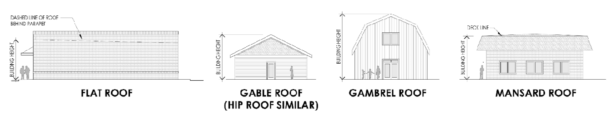
Building line. A line parallel to the street right-of-way line touching that part of the primary building closest to the street.
Building mass. The three-dimensional bulk of a structure: height, width, and depth.
Building permit. Written permission issued by the proper municipal authority for the construction, repair, or alteration of a structure, or addition to a structure.
Building scale. The relationship of a particular building, in terms of building mass, to other nearby and adjacent buildings.
Business incubator. An organization [or physical space] designed to accelerate the growth and success of entrepreneurial companies through an array of business support resources, and services that could include small business-appropriate physical space, capital, coaching, common services, and networking connections.
—C—
Caliper. The diameter of a tree trunk.
Certificate of appropriateness. A certificate issued by the approving authority on approval of the exterior architectural features of any new building construction or alterations to an existing building located within a historic zone.
Certificate of occupancy. A document issued by a governing authority allowing the occupancy or use of a building and certifying that the structure or use has been constructed and will be used in compliance with all applicable municipal codes and ordinances.
Change of use.
(1)
A change from one use classification in the UDC to another use classification;
(2)
Any use that differs substantially from the previous use of a building or land.
Character. Special physical characteristics of a structure or area that set it apart from its surroundings and contribute to its interest/individuality.
Clearing. The removal of vegetation from a property, whether by cutting or other means.
Concept plan. A schematic or conceptual design for land development, prepared for informal review purposes, that carries no vesting rights or obligations to any party.
Commercial vehicle. A vehicle that meets one of the following conditions:
1.
Has a gross vehicle weight rating of 10,001 pounds or more;
2.
Is designed or used to transport more than eight passengers (including the driver) for compensation;
3.
Is designed or used to transport more than 15 passengers (including the driver), whether or not used to transport passengers for compensation
4.
Is used to transport hazardous materials;
5.
Is titled or registered to a company used for business;
6.
Is a form of motorized construction equipment, except on private property for construction in progress.
Community park. A public park serving residents and usually including restrooms and lighted outdoor recreation facilities and other facilities such as swimming pools, recreation centers, on-site parking, and group picnic areas.
Critical root zone (CRZ). The minimum area beneath a tree. The CRZ will typically be represented by a concentric circle centering on the tree's trunk with a radius equal in feet to one and one-half times the number of inches of the trunk diameter.
Conditional zoning. The granting or adoption of zoning for a property subject to compliance with restrictions as to use, size, project design or timing of development, stipulated by the mayor and council of the city to mitigate adverse impacts that could be expected without the imposition of such conditions.
Consolidation. The removal of lot lines between contiguous parcels.
Courtyard. Landscaped outdoor areas that are walled for privacy.
Curb. A stone, concrete, or other improved boundary marking the edge of a roadway or paved area.
—D—
Damage, substantial. Refers to any change to a structure which impairs its value, usefulness, or normal function. For the purposes of this UDC, substantial damage shall occur when the cost of restoring the structure would equal or exceed 50 percent of the market value of the structure before the damage occurred.
Deciduous. Plants that drop their foliage annually before becoming dormant.
Deck. An unroofed platform, either freestanding or attached to a building, that is supported by pillars or posts.
Dedication. The transfer of property by the owner to another party.
Density. The number of families, individuals, dwelling units or housing structures per unit of land. Gross density includes all the land within the boundaries of the particular area excluding nothing. Net density excludes street right-of-way dedications, land identified as a flood hazard area or within any electricity or gas transmission easement or right-of-way.
Developable land. Parcels or sites free of constraints to development such as, but not limited to, wetlands, steep slopes, water bodies, unstable soils, easements, and legal impediments and that have frontage on or access to an improved roadway and can be served by public or private utilities and facilities such as sewer, water, electricity and gas.
Development, major. Any alteration of the natural environment which requires the approval of a development or site plan and issuance of a building permit. By way of illustration, but not limitation, major development shall also include substantial removal or destruction of trees incidental to the development of land or to the marketing of land for development, the removal or destruction of trees in conjunction with any grading activity, including the removal or filling (stockpiling) of soil or the removal of trees not in conjunction with an ongoing forest management program.
Development, minor. Any alteration of the natural environment, which may or may not require development, site plan approval, or issuance of a building permit, but which would possibly cause minor removal or destruction of any tree(s). Any removal of trees that constitutes major development, as that term is herein defined, shall not constitute minor development.
Developments of regional impact. Projects or development activities that have impacts beyond local government borders or that affect more than one community.
Diameter breast height (DBH). The diameter of a tree measured at a point four and one-half feet above the ground.
Discharge, accidental. A discharge prohibited by this UDC that occurs by chance and without planning or thought prior to occurrence.
Discharge, illicit. Any direct or indirect non-stormwater discharge to the city separate stormwater sewer system, except as exempted by this UDC.
Dormer. A projection from a sloping roof that contains a window.
Drainage structure. A device composed of a non-erodible material such as concrete, steel, plastic of other such material that conveys water from one place to another by intercepting the flow and carrying to a release point for stormwater management, drainage control, or flood control purposes.
Driveway. A private roadway providing access generally to one property or project.
Dwelling. A building designed or used exclusively for human habitation.
Dwelling unit (DU). One or more rooms, designed, occupied or intended for occupancy as separate living quarters, with cooking, sleeping and sanitary facilities provided within the dwelling unit for the exclusive use of a single-family maintaining household.
—E—
Easement. A grant of one or more property rights by the property owner to and/or for use by the public, a corporation, or another person or entity.
Easement, conservation. The grant of a property right requiring that the described land will remain in its existing natural state in perpetuity.
Easement, drainage. The land required for the installation of stormwater sewers or drainage ditches and/or required for the preservation or maintenance of a natural stream or watercourse or other drainage facility.
Easement, façade. An easement that prohibits or restricts any changes to the façade of a building that would alter or damage its historic integrity or architectural character.
Easement, utility. The right-of-way acquired by a utility or governmental agency to locate utilities, including water, sewer, stormwater, gas mains, and telephone and electric poles, cables, pylons, and towers.
Eave. The projecting lower edges of a roof overhanging the wall of a building.
Electric vehicle (EV). An automotive-type vehicle for on-road use, such as passenger automobiles, buses, trucks, vans, neighborhood electric vehicles, electric motorcycles, and the like, powered by an electric motor that draws current from a rechargeable storage battery, fuel cell, photovoltaic array, or other source of electric current which is charged by being plugged into an electrical source.
Electric vehicle, plug-in hybrid (PHEV). An automotive-type vehicle for on-road use, such as passenger automobiles, buses, trucks, vans, neighborhood electric vehicles, electric motorcycles, and the like, powered by an electric motor that draws current from a rechargeable storage battery, fuel cell, photovoltaic array, or other source of electric current which is charged by being plugged into an electrical source, and having a second source of motive power such as gasoline or diesel.
Elevation.
(1)
A vertical distance above or below a fixed reference level.
(2)
A fully dimensioned drawing of the front, rear, or side of a building, showing features such as windows, doors, and relationship of grade to floor level.
Encroachment. Any obstruction or illegal or unauthorized intrusion into a floodway, right-of-way, or adjacent land.
Evergreen. A plant that retains its foliage and that remains green year-round.
Existing use. The use of a property at the time that an application for redevelopment or development is made.
—F—
Façade. The exterior portion of a building exposed to public view. This term is primarily used in reference to special architectural treatments that are meant to enhance the building's aesthetics. Design or architectural standards or guidelines may have particular requirements for façades as opposed to other exterior surfaces of a building (e.g., color, materials, style or articulation).
Façade, principal. The face of a building which is most exposed to public view, such as a street, park, or plaza.
Factory. A building in which raw material and semi-finished or finished materials are converted to a different form or state, or where goods are manufactured, assembled, treated, or processed.
Family. An individual, or two or more persons related by blood, marriage, adoption or guardianship, or a group of not more than four unrelated persons, occupying a single dwelling unit.
Fence. An artificially constructed barrier of any material or combination of materials erected to enclose, screen, or separate areas.
Fenestration. Windows and other openings on a building façade.
Fire lane. An unobstructed paved or improved surface area clearly defined by pavement markings and signs, at least 12 feet wide, and designed to provide access for fire-fighting equipment.
Flood plain. The channel and the relatively flat area adjoining any natural or man-made stream, pond, lake, river, or any other body that is subject to flooding during a storm.
Floor area. The gross heated, finished horizontal area of the several floors of a building or dwelling unit exclusive of basement, attic, carport, or garage.
Front lot line. See Lot line, front.
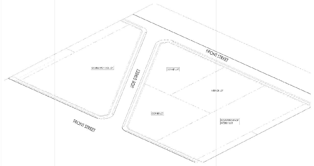
Frontage. That side of a lot abutting a street; see the front lot line. On unbuilt or unimproved corner or through lots, the frontage may be designated by the owner, but it should be consistent with the orientation of the buildings on the other lots and improvements on the same side of the street. On improved corner or through lots, the frontage is usually the side where the main building entrance is located and in the general direction in which the principal building faces.
Frontage, road. A service road, usually parallel to a highway, designed to reduce the number of driveways that intersect the highway. Also referred to as "local service road."
—G—
Garage sale. The sale or offering for sale to the general public of items of personal property by the owner or tenant of an improved lot in a residential district, whether within or outside the building.
Gate.
(1)
An opening in a fence;
(2)
An artificial barrier capable of being opened or closed, permitting or denying access across a driveway or path.
Gated community. Residential development that limits access to residents, invited guests, and authorized service and delivery vehicles.
Gateway. A major entrance or point of access into a neighborhood, district, community or region.
Glare. The effect produced by light from a luminaire or fixture with an intensity sufficient to cause annoyance, discomfort, or loss in visual performance and visibility.
Governing body. The chief legislative body of the municipality of Social Circle, i.e., the mayor and city council.
Government agency. Any department, commission, independent agency, or instrumentality of the United States, of the state, county, incorporated or incorporated municipality, district, or other governmental unit.
Grade.
(1)
When used in conjunction with the terms "existing," "finished," or "natural," is the same as elevation;
(2)
When used as a measurement, grade refers to the percentage of a rise or descent of a sloping surface.
Grade, finished. The final elevation of the average ground level adjoining a building at all exterior walls after development.
Grade, natural. The elevation of the ground level in its natural state, before construction, filling, or excavation.
Grading. Any striping, cutting, filling, or stockpiling of earth or land, including the land in its cut or filled condition, to create new grades.
Grease trap. A device in which the grease present in wastewater is intercepted and congealed by cooling and from which it may be skimmed off liquid wastes for disposal.
Green area. Land shown on a development plan, master plan, or official map for conservation, preservation, recreation, landscaping, or park. See Open space.
Greenfield. Farmland and open areas where there has been no previous industrial or commercial activity.
Ground cover. Grasses or other low-growing plants and landscaping. It can help to limit soil erosion by forming a dense mat covering an area, which over time prevents soil from being blown or washed away; and, typical requires less mowing, care, fertilizer, and maintenance than lawns.
Ground floor. The first floor of a building other than a cellar or basement.
Gutter. A shallow channel, usually set along a curb or the pavement edge of road, for purposes of catching and carrying off run-off water.
Gym. The abbreviated term for gymnasium, which is an enclosed facility for exercise and athletics.
—H—
Habitable floor area. The total floor area of all the habitable (i.e., heated) rooms in a dwelling unit.
Habitable room. Any room in a dwelling unit other than a kitchen, bathroom, pantry, closet, hallway, cellar, storage place, garage, unfinished basement, cellar, or attic.
Handicapped parking space. Parking spaces reserved for people with disabilities.
Hardscape. Nonliving components of a landscaped design, such as walls, sculptures, paved walkways, patios, stone and gravel areas, benches, fountains, and similar hard-surface areas and objects.
Hazard.
(1)
Potential or actual force, physical condition, or agent with the ability to cause human injury, illness, and/or death, and significant damage to property, environment, critical infrastructure, agriculture or business operations, or other types of harm or loss;
(2)
Something that is potentially dangerous or harmful, often the root cause of an unwanted outcome.
Hazardous waste. Any solid waste which has been defined as a hazardous waste in regulations, promulgated by the administrator of the United States Environmental Protection Agency pursuant to the federal act, which are in force and effect on February 1, 1988, codified as 40 C.F.R. Section 261.3.
Highest and best use. The reasonably probable and legal use of vacant land or an improved property that is physically possible, appropriately supported, and financially feasible that results in highest value.
Historic area. A district, zone, or area designated by the city or other government unit within which the buildings, structures, appurtenances, and places are of vital importance because of their association with history; or because their unique architectural style and scale, including color, proportion, form, and detail; or because of their being part of or related to a square, park, or area or general arrangement which should be preserved or developed according to specific standards. See National Register of Historic Places.
Historic preservation. An endeavor which seeks to preserve and protect features in the built environment such as buildings, districts, or communities which are of particular documented historic significance.
Historic structure. Any structure that is:
(1)
Listed individually on the National Register of Historic Places (a listing maintained by the Department of the Interior) or preliminarily determined by the Secretary of the Interior as meeting the requirements for individual listing on the National Register;
(2)
Certified or preliminary determined by the Secretary of the Interior as contributing to the historical significance of a registered historic district or a district preliminarily determined by the Secretary to qualify as a registered district;
(3)
Certified or preliminarily determined by the State Historic Preservation Office as contributing to the historical significance of a registered historic district.
Historic site. A site which is the location of a significant event, a prehistoric or historic occupation or activity, or a building or structure, whether standing, ruined or vanished, where the location itself possesses historic, cultural or archaeological value regardless of the value of any existing structure.
Household pets. Domesticated animals weighing less than 150 pounds and cared for by the members of the household and which are not raised for commercial gain or considered livestock as defined herein.
—I—
Impermeable. Not permitting the passage of water.
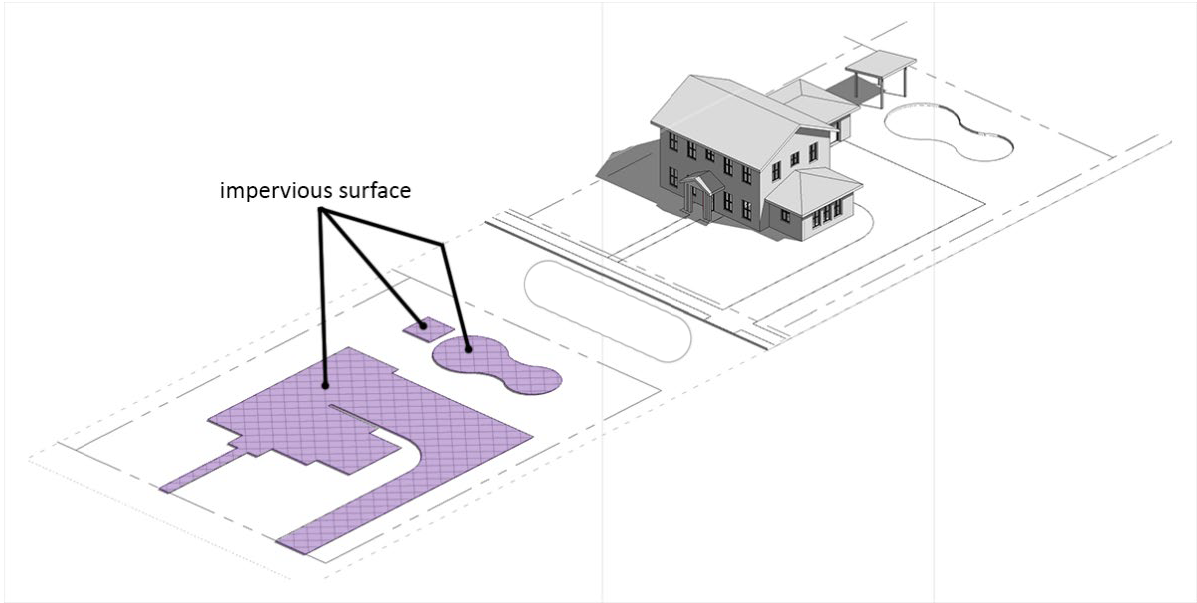
Impervious surface. A surface that has been compacted or covered with a layer of material that is highly resistant to infiltration by water. Examples are buildings, roads, driveways, parking lots, decks, swimming pools or patios.
Impervious surface ratio. A measurement of the area or percentage of a lot that is covered by buildings, structures, swimming pools, streets, sidewalks, patios, driveways, parking areas, and other impervious surfaces.
Improvement. Any permanent structure that becomes part of, is placed upon, or affixed to real estate.
Incidental. Subordinance and minor in significance or bearing a relationship to the principal use.
Industrial waste. Any liquid, gaseous chemical, or solid residue or by products of an industrial process.
Inoperative vehicle. Any vehicle at present inoperable but capable of being repaired to place it in operation condition without exceeding its present estimated value and repair cost. An inoperative vehicle shall include any motor vehicle, trailer, automobile, contrivance, or part thereof (except farm equipment) which is either dismantled/partially dismantled and inoperative; or wrecked and inoperative; or abandoned/discarded; and which does not have a current Georgia state motor vehicle tag, if required, attached thereto. Abandoned/discarded shall mean any automobile, motor vehicle, trailer (except farm equipment) of any kind or type, or contrivance or part thereof, which does not have a valid current Georgia state motor vehicle tag attached thereto and has not moved or been attended to for a period of six months commencing from the date the tag expires.
Intensity of use. The number of dwelling units per acre for residential development and the floor area ratio for nonresidential development, such as commercial, office, industrial.
—J—
Junk. Any scrap, waste, reclaimable material, or debris, whether or not stored, for sale or in the process of being dismantled, destroyed, processed, salvaged, stored, baled, disposed of, or for other use or disposition. For example, but not limited to, tires, unregistered and inoperable vehicles, equipment, paper, rages, metal, building materials, household appliances, or lumber.
—K—
—L—
Land disturbance. Any activity involving the clearing, cutting, excavating, or grading of land, or any other activity that alters land topography or vegetative cover.
Land disturbance permit (LDP). A permit issued by the city that authorizes land disturbance activities. See Land disturbance.
Land use. A description of how land is occupied or used.
Landlocked. A lot or parcel of land without direct access to a public road.
Livestock. Any animal raised for food, raw materials or pleasure, and customarily kept on a farm, including but not limited to, beef and dairy cattle, sheep, swine, poultry, horses, mules, donkeys, goats, turkeys, bison, llama, emus and any animal having hooves. This definition of livestock shall not apply to pet chickens owned pursuant to section 9-72 as domesticated animals.
Loading space. Off-street vehicle space or berth used for the loading or unloading of cargo, products, or materials from vehicles.
Lot. A designated parcel, tract, or area of land established by plat, subdivision, or as otherwise permitted by law, to be separately owned, used, developed, or built upon.
Lot, corner. A lot or parcel of land abutting on two or more streets at their intersection.
Lot, double frontage. See Through lot.
Lot, flag. A lot that does not meet the minimum frontage requirements and where access to the public road is provided by a narrower extension of the lot encompassing a driveway, or by private right-of-way or easement.
Lot, through. A lot that fronts on two parallel streets or that fronts on two streets that do not intersect at the boundaries of the lot.
Lot area. The total area within the lot lines of a lot, excluding any right-of-way.
Lot depth. The average distance measured from the front lot line to the rear lot line.
Lot frontage. The length of the front lot line measured at the right-of-way line.
Image 15.2. Lot Frontage, Defined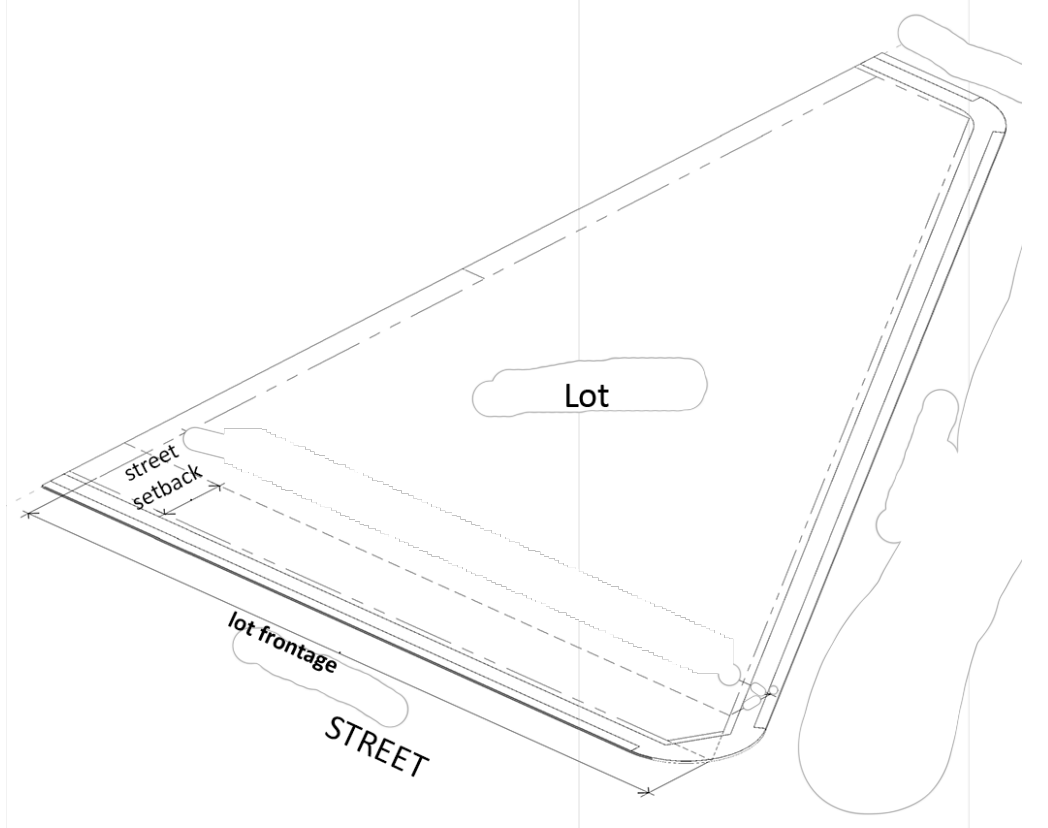
Lot line. A line of record bounding a lot that divides one lot from another lot or from a public or private street or any other public space.
Lot line, front. The lot line separating the lot from a street right-of-way.
Lot line, rear. The lot line opposite and most distant from the front lot line. In the case of triangular or irregularly shaped lots, that line that is most distant from or more nearly parallel to the front lot line.
Lot line, side. Any lot line other than a front or rear lot line.
Lot of record. A lot that exists as shown or described on a plat or deed in the records of the local registry of deeds.
Lot width. The horizontal distance between the side lines of a lot measured at the minimum required front yard (building setback) line.
—M—
Metes and bounds. A method of describing the boundaries of land by directions (bounds) and distances (metes) from a known point of reference.
Minor subdivision. See Subdivision, minor.
Mixed-use development. The development of a neighborhood, tract of land, building, or structure with a variety of complementary and integrated uses, such as but not limited to, residential, office, retail, public and recreational uses in a compact urban form. Mixed use developments generally include at least three distinct use types, blended both vertically and horizontally. An example of mixed-use development is residential apartments above ground floor retail uses.
—N—
Natural drainage flow. The pattern of surface and stormwater drainage from a particular site before the construction or installation of improvements or prior to any regrading.
Neighborhood. An area of a community with characteristics that distinguish it from other areas and that may include distinct housing types, schools, or boundaries defined by physical barriers, such as highways or railroads, or natural features such as water bodies.
Neighborhood park. A park area designed to serve the active recreational needs of the neighborhood, such as field games, playground apparatus, crafts, and picnicking. The National Recreation and Park Association publishes guidelines and general development standards for variety of park and recreational facilities.
Net acreage. The area of the lot remaining after areas devoted to infrastructure, including streets and utilities, are deducted from total lot area.
Net residential density. The number of dwelling units relative to the net acreage used for residential purposes.
Noise disturbance. Any noise exceeding the noise level limits established for the specific zoning district.
Nonconforming lot. A lot, the area, dimensions, or location of which was lawful prior to the adoption, revision, or amendment of the UDC or unified development code, but that fails by reason of such adoption, revision, or amendment to conform to the present requirements of the zoning district.
Nonconforming structure or building. A structure or building, the size, dimensions, or location of which was lawful prior to the adoption, revision, or amendment of the UDC but that fails by reason of such adoption, revision, or amendment to conform to the present requirements of the UDC.
Nonconforming use. A land use or activity, which was lawful prior to the adoption, revision, or amendment of the UDC but that fails by reason of such adoption, revision, or amendment to conform to the present requirements of the UDC.
Nuisance. A condition or situation that results in an interference with use and enjoyment of property.
Nuisance abatement. Programs designed to acquire, in an expedited manner, properties that are declared nuisances for all or some of the following reasons: blight, habitually used for illegal purposes, fire damage, gross neglect, disrepair, and debris.
—O—
Off-site. Located outside the lot lines of the lot in question but within the property (of which the lot is a part) that is the subject of a development application or within a continuous portion of a street or right-of-way.
Off-street parking. A parking space that is not located on a dedicated street right-of-way and that is directly accessible to an access aisle.
On-site. Located on the lot that is the subject of the application for development.
On-street parking space. A parking space that is located on a dedicated street right-of-way.
One-way car sharing. A car sharing system where the vehicle does not have to be returned to the location from which it was rented.
Open space. A parcel or area of land or water that is comprised of undeveloped land, naturally landscaped areas, and/or programmed spaces that are set aside, dedicated, or reserved for the enjoyment of property owners, occupants, property guests, and/or the general public for recreational or conservational purposes.
Open space, common. Land within or related to a development, not individually owned or dedicated for public use, that is designed and intended for the common use or enjoyment of the residents of the development and their guests and that may include complementary structures and improvements as are necessary and appropriate.
Open space, natural. An open space area that is in an unimproved and undisturbed state, with no changes to existing grade or removal of existing vegetation.
Open space, private. Open space, the use of which is limited to the occupants of a single dwelling, building or property.
Open space, public. Open space owned by a public entity and maintained by it for the use and enjoyment of the general public.
Ordinance. A law or regulation adopted by a governing body.
Outdoor storage. The keeping, in an unenclosed area, of any goods, junk, material, merchandise, or vehicles in the same place for more than 24 hours.
Overlay zone. A zoning district that encompasses one or more underlying zones and that imposes additional requirements beyond those required for the underlying zone.
Owner. An individual, firm, syndicate, partnership, or corporation having sufficient proprietary interest to seek development of land.
—P—
Parapet.
(1)
A barrier, roof, wall, or railing along the edge of a balcony, bridge, terrace, or roof where there is a drop and sudden danger of failing; or
(2)
A wall or hip-roof extension along the edge of the roof to visually and acoustically screen rooftop mechanical and HVAC equipment.
Paratransit. A form of public transportation service characterized by the flexible routing and scheduling of small vehicles, such as taxis, vans, small buses, to provide shared occupancy, doorstep, or curbside personalized transportation service. Example: Lyft, Uber, Yellow Cabs, MARTA.
Parcel. A piece or area of land formally described and recorded with block and lot numbers, by metes and bounds, by ownership, or in such a manner as to specifically identify the dimensions and/or boundaries.
Park, dog. A parcel or tract of public or privately owned land set aside and designated for the use by dog owners as "off-leash" areas for exercising their canine pets.
Park, private. A tract of land owned or controlled and used by a specific person or entity for active or passive recreational purposes.
Park, public. A tract of land owned by a branch of government and available to the general public for recreation purposes.
Parking, shared. The joint utilization of a parking area for more than one use. Involves spaces that are used at different times by different uses, or a single space that serves several stores so that a vehicle does not need to be moved from place to place. Shopping center parking is an example of shared parking. For new construction, instead of computing the parking requirement for each use, a single overall parking ratio may be used.
Parking space. A space for the parking of a motor vehicle within a public or private parking area.
Parking structure. A building or structure consisting of more than one level and used to store motor vehicles. See Garage; Garage, municipal; Garage, public.
Party driveway. A single way providing vehicular access to two or more properties.
Party wall. A common wall shared by two attached structures, buildings, or dwelling units.
Path. A cleared way for pedestrians or bicyclists that may or may not have been improved.
Patio. A level area covered by hard surface, directly adjacent to a principal building or within three feet of the finished grade and not covered by a permanent roof.
Pavement.
(1)
A created surface, such as a brick, stone, concrete, or asphalt, placed on the land to facilitate passage;
(2)
That part of a street having an improved surface.
Pedestrian. An individual who travels on foot.
Pedestrian walkway. A right-of-way for pedestrians, separate from vehicular traffic and including access ramps, stairs, mechanical lifts, and routes through buildings and other areas that are available for public use.
Percolation test. A test designed to determine the ability of the ground to absorb water and used to determine the suitability of soil for drainage or septic system use.
Performance guarantee. Any security that may be accepted by a governmental entity to ensure that improvements required as part of an application for development will be satisfactorily completed. Examples, cash, surety bond, or letter of credit.
Period of significance. The length of time when a property was associated with important events, activities, or persons, or attained the characteristics which qualify it for National Register listing. The documented period of significance should be based on specific events directly related to the significance of the property, for example, the date of construction for a building significant for its design or the length of time a mill operated and contributed to local industry.
Permeable pavement system. An alternate or supplemental stormwater management system using cast-in-place or pre-cast modular units, both of which create voids for gravel or grass.
Permit. Written authorization issued by an authorized governmental official, empowering the holder thereof to do some act not forbidden by law but not allowed without some such authorization.
Permitted use. Any use allowed in a zoning district as a matter of right.
Permittee. Any person to whom a permit is issued.
Personal transportation vehicle (PTV). A motor vehicle having not less than three wheels in contact with the ground and unladen weight less than 1,300 pounds which is designed and manufactured for operation on a golf course for sporting or recreational purposes and that is not capable of exceeding speeds of 20 miles per hour and any motor vehicle having no fewer than four wheels and an unladen weight of 1,375 pounds or less and which cannot operate at more than 20 miles an hour. Such vehicles may also be referred to as "motorized carts" or "golf carts." The term does not include mobility aids, including electric personal assistive mobility devices, power wheelchairs and scooters that can be used indoors and outdoors for the express purpose of enabling mobility for a person with a disability. The term also does not include any all-terrain vehicle or multi-purpose off-highway vehicle.
Planned unit development. An area of minimum size that is planned, developed, operated, and maintained as a single entity and containing one or more structures to accommodate retail, service, commercial, industrial, office, and residential uses or a combination of such uses, an appurtenant common areas and accessory uses, customary and incidental to the predominant uses.
Plat.
(1)
A map representing a tract of land, showing the boundaries and locations of individual boundaries and streets;
(2)
A map of subdivision showing compliance with the requirement of all applicable sections of this UDC and any conditions of approval set by mayor and city council.
Plat, final. A map of all or a portion of a subdivision that is presented to the approving authority for final approval. Approval of the final plat is usually granted only upon the completion or installation of all improvements or the posting of performance guarantees ensuring the completion of such improvements. Final approval is required before the property can be transferred or building permits issued.
Plat, preliminary. The approval of a preliminary plat merely gives the subdivider the authorization to proceed with the planning and development phase of the project.
Plaza. An open space that may be improved and landscaped; usually surrounded by streets and buildings.
PODS. The abbreviation for Portable On Demand Storage Units, i.e., lightweight storage containers that provide temporary storage for homeowners in yards or driveways.
Porch. A roofed, open area, which may be screened, attached to or part of a building, with direct access to or from it.
Portico.
(1)
An open-sided structure, attached to a building and sheltering an entrance or serving as semi-enclosed space;
(2)
A roofed area supported by columns forming a front porch.
Pre-existing use. The use of a lot or structure prior to the enactment of this UDC.
Principal entrance. The place of ingress and egress most frequently used by the public.
Prohibited use. A use that is not permitted in a zoning district.
Public hearing. A meeting announced and advertised in advance and open to the public, with the public given an opportunity to ask questions, comment, and participate.
—Q—
Quorum. A majority of the full authorized membership of a board or agency.
—R—
Recreation, active. Leisure time activities, usually of a formal nature and performed with others, requiring equipment and taking place at a prescribed place, site, or field.
Recreation, passive. Activities that involve inactive or less energetic activities, such as walking, sitting, picnicking, and board and table games.
Recreational vehicle. A vehicle type portable structure without a permanent foundation that can be towed, hauled, or driven and is primarily designed as temporary living accommodation for recreational and camping purposes that can be motorized or non-motorized. These include:
1.
Travel trailers. A vehicular unit, mounted on wheels, of such size and weight as not to require special highway moving permits with drawn by motorized vehicles (eight and one-half feet wide maximum) designated and constructed to provide temporary living quarters for recreational, camping, or travel use and not larger than 400 square feet when used for camping in set up mode.
2.
Truck camper. A portable unit, designed to be loaded onto or affixed to, the bed or chassis of a truck and constructed to provide temporary living quarters for recreational, camping, or travel use and not larger than 400 square feet.
3.
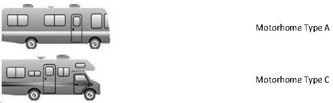
Motorized recreational vehicle. A vehicular unit or motorhome built on a self-propelled motor vehicle chassis, designed to provide temporary living quarters for recreation, camping, or travel use and not larger than 400 square feet. All such vehicles shall have a current state license, inspection sticker, and registration and be titled in the name of the current owner.
4.
Camper trailer. A vehicular unit mounted on wheels and constructed a collapsible partial side walls which fold for towing by another vehicle and unfold on the camp site and designed to provide temporary living quarters for recreational, camping, or travel use and not larger than 400 square feet.
5.
Tent. A moveable shelter made of canvas or other similar material and supported by a pole or poles and designed and manufactured to provide temporary living quarters for recreational and camping use.
6.
Other trailer. A cart or wagon designed to be pulled by an automobile, van, truck or tractor for hauling boats, floats, rafts, canoes, jet skis, motorcycles, and other recreational equipment and devices as well as those carts and wagons used for utility purposes, i.e., hauling, landscaping materials, lawnmowers, livestock, furniture, and household goods, plus the normal equipment to transport the same on the highway, and all related equipment.
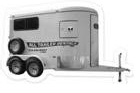
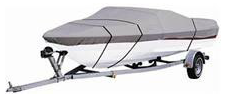
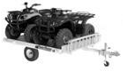
7.
Non-motorized recreational vehicle. A towable recreational vehicle, combining transportation and temporary living quarters for travel, recreation, or camping, that can be unhitched. Examples include conventional travel trailer, fifth-wheel travel trailers, travel trailers with expandable ends, folding camping trailers, and sport utility trailers. Boats, horse trailers, utility trailers for storing recreational vehicles, equipment, and all-terrain vehicles (ATVs), motorcycles or personal watercraft stored on trailers utilized for recreational purposes are also considered non-motorized recreational vehicles. Pickup camper shells that have been removed from the vehicle and stored are considered non-motorized recreational vehicles. The following diagrams represent examples and are not meant to be a complete list of examples:
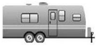 | Travel Trailer |
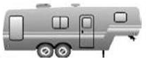 | Fifth-Wheel Travel Trailer |
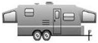 | Travel Trailer with Expandable Ends |
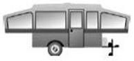 | Folding Camping Trailer |
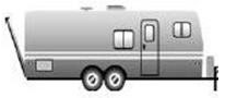 | Sport Utility Trailer (Toy Hauler) |
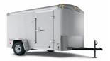 | Utility Trailer Enclosed |
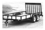 | Utility Trailer Open |
 | Utility Horse Trailer |
 | Boat |
 | Personal Watercraft Stored on Trailer |
 | All-Terrain Vehicle (ATV) Stored on Trailer |
Remodel. To construct an addition or alter the design or layout of a building or make alterations or structural changes.
Residential district. An area where buildings used for exclusively for residential purposes occupy more than 50 percent of the total street frontage. These include AG, R-24, R-15, and RMD.
Resource, contributing. A contributing building, site, structure or object that adds to the historic associations, historical architectural qualities, or archeological values for which a property is significant because:
(1)
It was present during the period of significance, relates to the documented significance of the property, and possesses historic integrity or is capable of yielding important information about the period; or
(2)
It independently meets the National Register Criteria.
Resource, noncontributing. A noncontributing building, site, structure or object that does not add to the historic architectural qualities, historic associations, or archeological values for a which a property is significant because:
(1)
It was not present during the period of significance, or does not relate to the documented significance of the property; or
(2)
Due to alterations, disturbances, additions, or other changes, it no longer possesses historic integrity or is capable of yielding important information about the period; or
(3)
Does not independently meet the National Register criteria.
Retaining walls. A structure that is constructed between the lands of different elevations to stabilize the surfaces, prevent erosion, and/or protect structures.
Rezone. To change the zoning classification of a parcel of land.
Right-of-way.
(1)
A strip of land acquired by reservation, dedication, prescription, or condemnation, and intended to be occupied by a street, crosswalk, railroad, utility line, or similar use;
(2)
Generally the right of one to pass over the property of another.
Roof. The outside top covering of a building or structure.
Road frontage. The distance on which a parcel of land adjoins a public street or public road right-of-way dedicated to and accepted by the city or the county for vehicular traffic or over which the city or the county may hold a prescriptive easement for public access and including designated and numbered U.S. and state highways.
1.
Road, minor collectors. A road/street serving county-wide traffic, these roads collect traffic from local roads/streets and bring developed areas within a reasonable distance of a major collector road; provide service to smaller communities; and link the locally important traffic generators with other areas.
2.
Road, major collectors. The primary purpose of a collector road is to collect and distribute traffic between the local streets and the major and minor arterial streets and to provide access to adjacent properties. These roads, with minor collectors, primarily serve county rather than state traffic. More moderate speeds are typical. They serve traffic generators of intra county importance, such as consolidated schools, shipping points, county parks, and important business and agricultural areas. They link these places with nearby cities, arterials and freeways, and serve the more important intra county travel corridors.
3.
Road, rural minor arterials. With the principal arterial system, these roads form a rural network that links other cities, larger cities, and other traffic generators capable of attracting travel over long distances; links all developed areas of the state; and serve corridors with trip lengths and travel density greater than those predominantly served by rural collector or local systems. Minor arterials' design should provide for relatively high overall travel speeds, with minimum interference to through-movement.
4.
Road, rural principal arterials. A road, which includes interstates and rural freeways, that serves substantial statewide or interstate traffic, as defined by high mileage or volume; often connects urban areas of 25,000 or more; and provides an integrated network.
Rural area. A sparsely developed area, with population density of fewer than 100 persons per square mile, where the land is undeveloped or primarily used for agricultural purposes.
—S—
Sanitary sewer. An underground system that carries wastewater and sewerage to a treatment plant.
Scale. The relationship between distances on a map and actual ground distance; or, the proportioned relationship of a size of parts to one another.
Scale of development. The relationship or a particular project in terms of its size, height, bulk, intensity and aesthetics to its surroundings.
School. Any building or part thereof, that is designed, constructed, or used for education or instruction in any branch of knowledge or skill.
Screen. A structure, berm, or planting consisting of fencing and/or evergreen trees or shrubs providing a continuous view obstruction within a site or property or a portion thereof.
Self-storage facility. A building or group of buildings containing separate, individual, and private storage spaces of varying sizes available for lease or rent for varying periods of time.
Septic system. An underground system with a septic tank used for the decomposition of domestic wastes.
Setback. The required space between a property line and a building or specified structure to be open, unoccupied, and unobstructed by buildings or structures from ground to sky, except where encroachments or accessory buildings and other structures are expressly permitted. Also considered the required yard.
Sight triangle. The triangular shaped portion of land at street intersections in which nothing is erected placed or planted or allowed to grow as to limit obstructions to the sight distance of motorists entering or leaving the intersection.
Sign. Any object, device, display, or part thereof, situated outdoor or indoors, that is used to advertise, identify, display, or direct or attract attention to an object, person, organization, business, product, service, event, or location by means of words, letters, figures, design, symbols, fixtures, colors, illumination, or projected image.
Sign, animated or moving. A sign or part of a sign that changes physical position or light intensity by any movement or rotation or that gives the visual impression of such movement or rotation.
Sign, awning. A sign that is mounted, painted, or attached to an awning or other window or door canopy that is otherwise permitted by this UDC.
Sign, banner. A temporary sign of cloth or similar material.
Sign, blade. A vertically oriented wall sign, also known as a projecting sign.
Sign, canopy. A sign attached to the underside of a canopy.
Sign, digital. Changeable electronic variable message signs that have changeable messages or displays and meet the requirements related to the duration of messages, transition time, lighting, and brightness.
Sign, directional. Signs located within a development at an intersection or private drive, frequently using arrows or other symbols to assist in navigation.
Sign, directory. A sign listing the tenants or occupants of a building or group of buildings.
Sign, freestanding. Sign not affixed to a building.
Sign, ground. A freestanding sign, other than a pole sign, whose entire supporting base is in contact with the ground. Also known as a monument or pedestal sign.
Sign, hanging. A freestanding sign supported by extended arm of a single post.
Sign, holiday decoration. Temporary signs, in the nature of decorations, and customarily and incidentally associated with a national, local, or religious holiday.
Sign, illuminated. A sign lighted by or exposed to, artificial lighting either by lights on or in the sign or directed toward the sign.
Sign, inflatable. Any display capable of being expanded by air or other gas.
Sign, official. A sign placed by or at the direction of a governmental body, governmental agency, board of education, or other public authority related to its public duties.
Sign, roof. A sign projecting more than six inches from the outside wall of a building.
Sign, sidewalk or sandwich. A movable A-frame sign.
Sign, wall. A sign fastened to or painted on, the wall of a building or structure in such a manner as the wall becomes the supporting structure for or forms the background surface of the sign, and that does not project more than 12 inches from such building or structure.
Sign, window. A permanent sign that is painted or mounted on a windowpane or hung directly inside a window for the purpose of identifying the sign from the right-of-way or street.
Sign area. The face of the sign, including letters, numerals, or graphics, but excluding any framing, trimming, molding or supporting structures.
Sign face. The area or display surface on a sign used for the message.
Similar use. Use that is similar in terms of the nature or activity conducted on premises; as well as similar trip generation; type of traffic, parking, and circulation; environmental impacts; physical space need; and market area.
Site plan. The development plan for one or more lots on which is shown the existing and proposed conditions of the lot including topography, vegetations, drainage, floodplains, and waterways; landscaping and open areas; walkways; means of ingress and egress; circulation; utility services; structures and buildings; lighting; berms, buffers, and screening devices; surrounding development; and other information that may be reasonably required in order for the governing authority to make an informed decision.
Site plan, minor. A development plan involving an alteration or small addition to an existing development in which the increase in floor area is less than ten percent of the existing floor area, does not require a new street or an extension of an existing street, does not require off-tract improvements, and does not require variances.
Solid waste. Putrescible and non-putrescible wastes, except water-carried body waste, and shall include garbage, rubbish, ashes, street refuse, dead animals, sewage sludges, animal manure, industrial wastes, abandoned automobiles, dredging wastes, construction wastes, hazardous wastes and any other waste material in a solid or semi-solid state not otherwise defined in these regulations.
Special use. A use which is not automatically permitted by right, but which may be permitted within a zoning district subject to meeting specific conditions contained in this UDC or as required by the governing body after a public hearing.
Specimen tree. A particularly impressive or unusual example of a species because of its size, age, shade, or other trait that epitomizes the character of the species.
Spite strip. A piece of land used to separate a street or road rights-of-way from adjoining property and whose primary purpose is to preclude access to such rights-of-way.
Street. Any vehicular way that is:
(1)
An existing state, county or municipal roadway;
(2)
Shown upon a plat approved pursuant to law;
(3)
Approved by other official action;
(4)
Shown on the official map or adopted master plan or GDOT record.
Street, collector. A street that collects traffic from local streets and connects with minor and major arterials.
Street, complete. A road designed and maintained to enable safe and comfortable travel and access for users of all ages and abilities, regardless of their mode of transportation.
Street, cul-de-sac. A street with a common ingress and egress, and with a turnaround at the end.
Street, dead-end. Street with a single common ingress and egress.
Street, dual. A street with opposing lanes separated by a median strip, center island or other barrier, which cannot be crossed except at specific locations.
Street, local. A street that provides frontage for access to abutting lots and carries slow speed traffic primarily having a destination or origin on the street itself.
Street, major arterial. A street that connects and distributes traffic to and from minor arterials, with access control, channelized intersections, and restricted parking.
Street, minor arterial. A street that interconnects and links major arterials and distributes traffic to and from collector streets.
Street, rural. A road primarily serving as access to abutting building lots in areas with densities of less than one unit per acre.
Street, thoroughfare. A divided multilane highway for high-speed vehicles with limited points of access or exit, having few if any intersections.
Street furniture. Constructed, above ground objects, such as outdoor seating, kiosks, bus shelters, sculptures, trash receptacles, planters, bollards, fountains that have the potential for enlivening and giving variety to streets, sidewalks, plazas, and outdoor spaces.
Subdivision. Any division of land into two or more lots, building sites or other divisions.
Subdivision, consolidation. The combining of individual recorded lots to form fewer tracts than currently exist.
Subdivision, minor. Any subdivision of land that does not involve the following:
(1)
Creation of more than the maximum number lots allowed by this UDC for that district;
(2)
Any new street;
(3)
The extension of any off-tract improvements.
—T—
Tree service. A business whose primary operation is the trimming or removal of trees and the storage and use of associated equipment and vehicles.
—U—
Utility, private or public.
(1)
Any agency that, under public franchise or ownership, or by grant of
Utility box. Electric transformers, switch boxes, telephone pedestals, and telephone boxes, cable television boxes, traffic control boxes and similar devices.
Utility corridors. Rights-of-way or easements for utility lines on either publicly or privately owned property.
Utility services. The generation, transmission, and/or distribution of electricity, gas, steam, communications and water; the collection and treatment of sewage and solid waste; and the provision of mass transportation.
—V—
Vacancy. Any unoccupied land, structure, building or part thereof that is available and suitable for occupancy.
Variance. Permission to depart from the literal requirements of a zoning standard.
—W—
Wall.
(1)
The vertical exterior of a building;
(2)
One of the vertical interior surfaces that divide the building into rooms.
Waste. An unusable or unwanted substance or material.
Wetlands. Those areas inundated or saturated by surface or groundwater at a frequency and duration sufficient to support, and that under normal circumstances do support, a prevalence of vegetation typically adapted for life in saturated soil conditions. See Division 420. Wetlands generally include swamps, marshes, bogs and similar areas. (33 CFR 32.93) The ecological parameters for designating wetlands include hydric soils, hydrophytic vegetation, and hydrological conditions that involve a temporary or permanent source of water to cause soil saturation. Freshwater wetlands do not include any areas defined as "coastal marshlands" by the State Coastal Marshlands Protection Act.
—X—
Xeriscape. Landscape design encouraging the use of drought resistant plants and ground cover, as well as water conservation and retention techniques.
—Y—
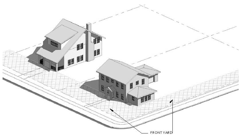
Yard. An open space between the principal building and the nearest lot line, and unoccupied by any structure except as otherwise provided herein.
Yard, front. An open space extending the full width of the lot between any building and the front lot line. Corner and double-frontage lots have two front yards.
Yard, rear. A space extending across the full width of the lot between the principal building and the rear lot line. Where a lot has more than one front yard, no rear yard exists.
Yard, side. A space extending from the front yard to the rear yard between the principal building and the side lot line.
Yard sale. See Garage sale.
—Z—
Zoning buffer. A buffer required by the UDC or as a condition of zoning, special use or variance approval for a specific property.
(Ord. No. 2023-3, § 1(Exh. A), 6-20-2023)