
Social Circle City Zoning Code
ARTICLE 5
- OVERLAY DISTRICTS
Table 5.1.0. Overlay Districts Legend
Sec. 5.1.- Downtown Corridor Overlay (DCO) district.
5.1.1. General.
A.
Intent. These criteria are intended to address a building's appearance and integration into the local and national historic districts as adjacent or proximate projects. The criteria are intended to elicit high quality materials, enhanced pedestrian experience, an appropriate scale, and a development pattern that effectively implements the city's planning and visioning documents.
B.
Prohibited uses. The following uses are prohibited in the DCO, regardless of whether the underlying zoning district allows the use:
1.
Animal boarding.
2.
All "other financial services (check cashing, pawnshop, other)".
3.
Extended stay lodging.
4.
Tattoo parlors.
5.
Vape shop or smoke store.
6.
Vehicle equipment sales, service.
7.
Vehicle maintenance and repair, minor.
8.
Vehicle maintenance and repair, major.
9.
Equipment and material storage.
10.
All "other wireless facilities".
C.
Alternative setback. The front setback for any lot in the DCO shall be reduced to zero feet.
D.
Alternative Impervious Surface Ratio (ISR). The ISR for any lot in the DCO shall be increased to 100 percent.
5.1.2. Single-family residential building design standards.
A.
Applicability. The building design regulations of this section apply to all buildings in the Downtown Corridor Overlay (DCO) district that are:
1.
Used for single-family residential purposes; and
2.
Are larger than 100 square feet in area; and
3.
Are not regulated by the historic district design guidelines.
B.
Applicable façades. The building design regulations apply to all façades visible from the street, facing streets, facing main parking lots, and adjacent to or visible from required open spaces, unless otherwise noted.
C.
Exterior finish materials.
1.
Exterior building materials shall be primarily brick, stone, other masonry, glass, wood, or cementitious fiberboard. Other materials such as vinyl may be used only as accent and trim materials.
2.
All exposed foundation walls on all sides of the building shall be faced with brick, stone, or marble.
3.
All brick, stone, or other masonry shall be full- or half-depth. Simulated veneer panels are prohibited. Simulated masonry that are individually stacked or applied are acceptable.
4.
Metal shall be permitted only as metal split seam roofing or as an architectural accent comprising a maximum of ten percent of any one façade. Acceptable metal materials are limited to architectural metal panels, architectural metal cladding, metal mesh, and perforated metal. Examples of metal materials not permitted include but are not limited to stock PEMB metal skins commonly referred to as 'R-panel' and sheet metal systems with exposed fasteners, except as required for perforated metal.
D.
Architectural requirements. Every single-family residential dwelling unit shall provide at minimum one feature from each of the following categories:
1.
Private outdoor space.
a.
Front porch (minimum 30 square feet in area).
b.
Front-facing balcony (minimum 50 square feet in area).
c.
Rear terrace (minimum 100 square feet in area).
d.
Rooftop terrace (minimum 150 square feet in area).
e.
Private yard space with at least one tree (minimum 150 square feet in area).
2.
Architectural projection.
a.
Projection window (bay or bow).
b.
Turret.
c.
Covered balcony or porch.
d.
Alternative approved by the community development director.
3.
Roof element.
a.
Dormers.
b.
Front gable or pediment.
c.
Rooftop terrace.
d.
Varied gable system.
e.
Cornice detailing.
f.
Alternative approved by the community development director.
4.
Unit or façade variation (required when more than five units front on a single block face in single-family attached dwellings).
a.
Change in brick/stone color or a change in masonry material.
b.
Change in window composition.
c.
Projection or recess of an architectural feature that is a minimum of five feet deep or 15 feet tall (used to distinguish and separate façades vertically because of the significance of the projection).
d.
Alternative approved by the community development director.
5.
Recessed window systems. Window systems recessed from the façade of the building a minimum of one and three-quarters inches. This reveal shall be accomplished through the design of the window casing reveals and frames.
Image 5.1.2.D.5. Window Systems Recessed from Facade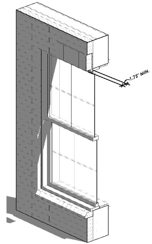
5.1.3. Non-single-family residential building design standards.
A.
Intent. These criteria are intended to address a building's appearance and integration into the Downtown Corridor Overlay (DCO) district. The criteria are intended to elicit high quality materials, enhanced pedestrian experience, an appropriate scale, and a development pattern that effectively implements the city's planning and visioning documents.
B.
Applicability.
1.
The regulations of this section apply to all buildings, lots, and uses in the Downtown Corridor Overlay (DCO) district that are:
a.
Used for non-single-family residential purposes; and
b.
Are not regulated by the historic district design guidelines.
2.
Applicable façades. The building design regulations apply to all façades visible from the street, facing streets, facing main parking lots, and adjacent to or visible from required open spaces, unless otherwise noted.
C.
Dumpsters. Dumpsters in the DCO are not required to meet the screening and location requirements in article 8.6, dumpsters if the community development determines compliance is infeasible due to the existing conditions of the building and/or site.
D.
Exterior finish materials.
1.
Primary building materials.
a.
Primary building materials shall be used on at least 70 percent of any building façade, calculated on the basis of each individual façade.
b.
[Reserved.]
c.
Primary building materials include brick, including full-depth and half-depth masonry brick; stone, including unpainted natural stone, unpainted cast stone having the appearance of natural stone; and unpainted terracotta. Simulated veneers are prohibited.
2.
Secondary building materials.
a.
Secondary building materials may be used on up to 30 percent of any exterior building façade, calculated on the basis of each individual façade.
b.
Secondary building materials include wood, including natural wood or cement-based artificial wood siding; shingles, including wood or cement-based shakes and shingle.
3.
Other standards.
a.
Building materials, other than those expressly identified in this section, may be used on up to ten percent of any exterior building façade, provided they have not been prohibited by this section.
b.
Material proportion calculations shall not include building foundations, window systems, and doors. Proportions are calculated on the basis of each individual façade.
c.
Materials shall continue around the corner of the building onto façades not visible from the public street a minimum depth of one architectural bay.
d.
Prohibited materials. Synthetic stucco, concrete masonry units (CMU), and vinyl are not permitted as exterior finish materials.
e.
Building façades shall be constructed of no more than three primary materials and/or colors. Additional materials may be used as secondary, trim, or accent materials.
f.
Awnings. Plastic and vinyl awnings are prohibited. Materials repurposed into textiles for use on an awning is prohibited.
E.
Building articulation on street facing façades. The ground story of all non-single-family residential façades fronting on North/South Cherokee Road or East/West Hightower Trail shall contain the following elements as illustrated in Image 5.1.3.E below.
1.
Cornice/articulated floor line. The cornice visually separates one floor from the adjacent floor(s). The cornice can be articulated with a change of color, pattern, or material.
2.
Sign board. A sign board shall be an area between the cornice and window system where a wall sign is placed. The sign board shall be a minimum of two feet in height and shall extend the width of each architectural bay.
3.
Transom. Transoms are horizontally articulated windows located below the sign board. The window system shall extend the full width of the architectural bay or tenant space but may be separated by mullions and muntins consistent with the design aesthetic. Grilles are prohibited.
4.
Recessed entry. Recessed entries are important to the retail experience to protect the users from inclement weather, increase the amount of space in which to display merchandise, and to ease the transition of users to and from the public realm. Entryways shall be recessed from the plane of the shopfront façade a minimum of three feet.
5.
Display window. Display windows provide frames for retail users to display merchandise and contribute to the active and vibrant character along the historic street front. Display windows shall not be separated with mullions, muntins, or grilles.
6.
Bulkhead. Bulkheads shall be a minimum of 18 inches in height and shall extend the full length of the architectural bay or tenant space.
7.
Fenestration. Fenestration proportions shall comply with standards in this section. Grilles, other faux features, and metal shopfront window systems are prohibited.
F.
Wall projections. In order to avoid large expanses of flat (one-dimensional) exterior walls along sidewalks, building façades over 50 feet in length along a street, shall incorporate wall projections or recesses a minimum of 12 inches in depth. The combined length of such recesses and projections shall constitute at least 20 percent of the total façade length along the public street.
G.
Vertical divisions. Each structure shall provide a minimum of one of the following to divide the façade into vertical divisions at increments no greater than 100 feet as measured along the base of the façade.
1.
A change of façade material and window system from grade to roof; or
2.
Change of building height of at least one story; or
3.
A change in façade composition and/or architectural style from grade to roof; or
4.
An open space or pedestrian passage with a minimum width of ten feet and a minimum depth of 30 feet.
5.
Similar means intended to convey the impression of separate buildings.
6.
Change in color alone, window system alone, or setback alone, do not satisfy this requirement.
H.
Rooflines. Building roof lines along street-facing façades shall change at least once every 200 feet of façade length. This change shall occur for a minimum length of 20 feet and be accomplished through at least one of the following:
1.
A change of roof parapet wall height and material.
2.
A change of roof cornice design.
3.
A change in the number of stories.
4.
A change in roof-shape.
I.
Blank walls. Blank wall area applies to ground and upper story façades visible from a street (not including an alley) or open space.
1.
Blank wall area is measured in linear feet applied in both vertical and horizontal directions.
2.
There shall be no more than 20 feet of blank wall area.
3.
Blank wall area can be broken up or interrupted to meet these provisions with any one of the following interventions:
a.
Fenestration.
b.
Substantial material change. Changing or alternating paint colors alone does not constitute a material change.
c.
Façade articulation greater than 12 inches in depth.
d.
Patterns and designs articulated with building materials.
e.
Vertical green walls, made of landscaped material specified for vertical, climbing growth.
J.
Residential balconies.
1.
Where balconies are incorporated into building design, they shall be integral to the façade.
2.
Balconies on stepped-back stories may be independently secured, extending from the façade as a cantilever.
3.
Juliet balconies are prohibited.
K.
Window systems.
1.
A minimum of 50 percent of commercial façades and 25 percent of residential façades shall be covered with fenestration. Fenestration percentage is calculated based façade area and by floor. The façade area used to determine fenestration is measured from the top of the finished door to the top of the finished floor above or top of a roof parapet.
2.
Fenestration requirements apply to façades that abut a public or private street (not including an alley), or a required open space.
3.
Glass used to satisfy fenestration requirements shall be unpainted, shall have a transparency (visible light transmission) higher than 70 percent and shall have an external reflectance of less than 15 percent. Transparency and external light reflectance shall be established using the manufacturer's specifications.
4.
Glazed doors, window frames, sashes, mullions, and similar features that are integral to the window system count towards fenestration requirements. Opaque doors and windows do not.
5.
No shades, blinds, or other coverings are permitted on the ground floor fenestration of any non-residential building.
6.
Grilles, inoperable shutters, and other faux window treatments are prohibited.
7.
Window systems shall be recessed from the façade of the building a minimum of three inches. This reveal shall be accomplished through the design of the window casing reveals and frames.
Image 5.1 3.E. Building Articulation Features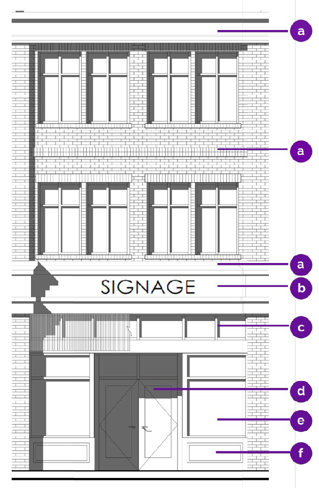
Image 5.1.3.I. Blank Wall Areas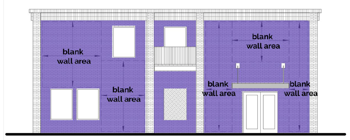
Image 5.1.3.K. Fenestration Calculations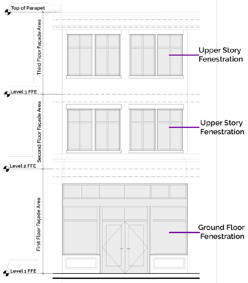
(Ord. No. 2023-3, § 1(Exh. A), 6-20-2023)
Sec. 5.2. - Traditional neighborhood development overlay district.
5.2.1. Purpose.
A.
This section provides for the establishment of the Traditional Neighborhood Development Overlay District (herein after called "TND") for the following purposes:
1.
To avail neighborhoods of an opportunity to ensure that new and remodeled single-family dwellings and related accessory uses and structures are compatible with the height, size, and forestation of existing dwellings and lots; and
2.
To encourage property owners to improve and renovate existing housing stock rather to the demolish the same; and
3.
To balance preservation of the character of mature neighborhoods while accommodating compatible new residential development; and
4.
To allow neighborhoods the opportunity to establish architectural standards that will preserve the character of their existing neighborhoods.
5.2.2. Scope of regulations.
A.
Establishment of a TND does not regulate the interiors or use of the building. Any principal or accessory use allowed in the base zoning district shall be allowed in TNDs.
B.
Establishment of a TND does not prohibit the lawful demolition of any structure.
C.
Under a TND, any LDP or building permit which includes any of the following activities within their proposed scope of work, shall be subject to subsection 5.2.5, design criteria, as set in effect upon the property following the adoption of the TND by mayor and city council:
1.
Alterations to the façade of a principal building, where visible from a street;
2.
Expansion of the principal building by more than 30 percent of building square footage;
3.
Construction of a new residential building.
5.2.3. Property eligibility requirements for inclusion in a TND.
A.
The proposed boundary of a traditional neighborhood overlay district cannot overlap with the limits of the historic district overlay.
B.
At least 60 percent of the properties in the boundary shall have a residential zoning classification and contain an active residential use.
C.
No more than 20 percent of the land may consist of vacant or undeveloped lots.
D.
The proposed boundary shall consist of at least 20 contiguous properties.
E.
It shall be established to the satisfaction of mayor and city council that the land within the proposed boundary of a traditional neighborhood overlay district possesses a consistent architectural character as a result of a concentration of buildings of similar character.
5.2.4. Application process.
A.
TND overlays shall be approved through the process in section 13.5, rezoning (map amendment). Any person interested in pursuing the approval of a TND shall submit an application package to the community development director which includes the following:
1.
Application forms provided by the community development department; and
2.
Petition document signed by 60 percent of the property owners within the proposed TND; and
3.
Aerial image showing the proposed limits of the new TND; and
4.
List of the tax parcel number, acreage, property owner(s) of record, and address for all properties to be included in the TND; and
5.
Letter of intent that describes why a TND is being sought, which design criteria standards from subsection 5.2.5, design criteria the petitioners seek to impose; and
6.
An analysis that provides responses to each of the following criteria:
a.
Whether the built environment of a neighborhood and its location, size, or age, is one in which it is desirable to ensure that new and remodeled single-family dwellings and related accessory uses and structures are compatible with the height, size, and level of forestation of the existing dwellings and lots; and
b.
How the proposed boundary was established; and
c.
Whether there is specific evidence that recent and proposed development patterns in the surrounding area pose a potential threat to the character of the mature neighborhood; and
d.
Whether the type of additional standards proposed in the TND will accommodate the renewal of the neighborhood while maintaining compatibility of new residential development and improvements to existing homes.
B.
If determined to be a completed application package and with no property in conflict of any of the eligibility criteria, the community development director shall notify all included and adjacent property owners of the proposed TND boundary of the date and location the scheduled public hearing(s) at planning commission and mayor and city council. No later than one week prior to the scheduled planning commission meeting, the person who filed the petition on behalf of the neighborhood group shall submit an updated petition signed by 75 percent of the property owners within the proposed TND boundary. If 75 percent of property owner signatures are not received at this time, the petition shall be removed from the public hearing agenda, and the application shall be considered withdrawn.
C.
No later than one week prior to the scheduled planning commission meeting, the person who filed the petition on behalf of the neighborhood group shall submit an updated petition signed by 75 percent of the property owners within the proposed TND boundary. If 75 percent of property owner signatures are not received at this time, the petition shall be removed from the public hearing agenda and the application shall be considered withdrawn.
D.
If the mayor and city council approve the creation of the TND, all parcels submitted as part of the proposed boundary listing of parcels shall be designated TND properties on the official zoning map of the city.
5.2.5. Design criteria.
A.
The following criteria shall be in addition to any development or use requirements established by the base zoning district of the property. Should there be a conflict between the standards of base district and this section, the more restrictive shall govern.
B.
TNDs may impose one or more of the following standards, to be set as a function of the zoning map amendment process:
1.
Height. New construction or additions to primary buildings shall not exceed the average height of three existing properties on the same proposed street.
2.
Building materials. The new or remodeled house shall be constructed with compatible building materials so that the building materials on the façade of the proposed house are of the same type and colors as the majority of materials used on the façades of houses on abutting the subject property.
3.
Square footage. The heated floor area of the proposed new or remodeled house shall not be less than the heated floor area of the existing house and shall not exceed 150 percent of the heated floor area of the existing house. If there was no previous house on the subject property, then the minimum floor area of the proposed house may not exceed 150 percent of the average of the houses on properties abutting the subject property.
4.
Front setback. The new or remodeled house shall maintain front setbacks that are no less than the average setback of the three closest existing houses on the same block face or on the same side of the street.
5.
Roof forms. The new or remodeled house shall only use those roof forms (hip, gable, flat, mansard, gambrel, etc.) that are used on the majority of houses on properties abutting the subject property.
6.
Threshold elevation. The front door threshold of the newly constructed or remodeled house shall be at an elevation that is no more than one foot higher or lower than the elevation of the door threshold of the house prior to the proposed constructed or remodeling.
7.
Other. Other design standards may be considered as for incorporation into the adopted standards as proposed by the applicant.
C.
Certificates of appropriateness are not required for properties within TND.
D.
Variances. The planning commission and mayor and city council may consider variances to the provisions of subsection 5.2.5, design criteria that were applied at the time of zoning through subsection 13.8, variances.
E.
Removal of the traditional neighborhood district overlay. Removal of any property from boundaries of a TND shall be subject to subsection 5.2.4, application process.
(Ord. No. 2023-3, § 1(Exh. A), 6-20-2023)
Sec. 5.3. - Watershed protection overlay district.
5.3.1. Establishment. The Watershed Protection Overlay District (herein after "WPD") shall consist of those land areas defined as Significant Ground Water Recharge Areas by the Georgia Department of Natural Resources (i.e., DNR) and mapped by the on the DNR's Hydrologic Atlas 18 (1989 edition or as subsequently amended); and, those properties within the Cornish Creek, Hard Labor Creek, and Beaverdam Watershed Basins. The watershed protection overlay district shall be further delineated on the official zoning map of the city.
5.3.2. Purpose. It is the intent of this overlay to protect the designated areas from the adverse effects of development activities such as the leaching of septic systems, increased stormwater run-off, and other potential sources of pollution, in order to ensure water quality.
5.3.3. General criteria.
A.
Protective buffers, setbacks, greenways.
1.
There shall be no land disturbing activities within 50 feet of any stream bank except where it is allowed for the construction of drainage structures or roads under a development permit.
2.
Stream buffer. There shall be a protective stream buffer extending a distance of 100 feet from the banks of all perennial streams (i.e., streams that flows throughout the year). This protective stream buffer shall remain natural and undisturbed.
3.
Stream setback. There shall be an impervious surface setback extending a distance of 150 feet from the banks of all perennial streams (i.e., streams that flows through the year). No permanent structures such as buildings, patios, decks, or pavement shall be constructed inside stream setbacks. Grading, filling, and earth moving shall be minimized within stream setbacks.
4.
Water impoundment buffer. There shall be a protective buffer extending a distance of 100 feet from the normal pool of elevation of any water impoundment (e.g., ponds, lakes, or reservoirs), except around the Hard Labor Creek Reservoir where such protective buffer shall increase to a distance of 150 feet. Protective buffers shall not apply adjacent the dam side of any water impoundment. Protective buffers shall remain natural and undisturbed.
5.
Water impoundment setback. There shall be an impervious surface setback extending a distance of 150 feet from the normal pool of elevation of any water impoundment (e.g., pond, lakes, or reservoirs). No permanent structures such as buildings, patios, decks, or pavement shall be constructed inside stream setbacks. Grading, filling, and earth moving shall be minimized within stream setbacks.
B.
Permitted uses.
1.
Permitted and special uses shall be those of the underlying base zoning district, except where the provisions of this overlay district differ.
2.
The following land uses are prohibited:
a.
New hazardous waste treatment or disposal facilities.
b.
New sanitary landfills.
c.
New facilities that involve the treatment, storage, or disposal of hazardous waste.
d.
New septic tanks or septic drainage fields are prohibited in the city where it is feasible to connect sewer service instead, as per section 11-53, use of public sewers required.
e.
Mining and quarrying activities are prohibited.
3.
The following uses are allowed within the overlay district subject to compliance with the supplemental standards stated herein:
a.
A new above ground chemical or petroleum storage tank must have secondary containment of 110 percent of the volume of the tank or 110 percent of the volume of the largest tank in a cluster of tanks. This requirement does not apply to:
i.
Any tank having a maximum capacity of less than 660 gallons; and
ii.
Any tank used for agricultural purposes, provided it complies with all Federal requirements.
b.
New agricultural waste impoundment sites larger than 50 acre-feet must be lined. The liner must be constructed of compacted clay having a thickness of one foot and a vertical hydraulic conductivity of less than 5 x 10⁻⁷ cm/sec or other criteria established by the U.S. Soil Conservation Service.
c.
A new home served by a septic tank/drain field system must be approved by the health department and must have a lot that is at least 110 percent of the minimum lot size required by Table MT-1 of the Manual for On Site Sewage Management Systems.
d.
A new manufactured home park served by a septic tank/drain field system shall be approved by the health department and must have a lot or space that is at least 110 percent of the minimum lot or space size required by Table MT-2 of the Manual for On Site Sewage Management Systems.
5.3.4. Development criteria.
A.
Generally. The zoning and land development requirements applicable to any property per this UDC shall remain in effect, except where the provisions of this overlay district differ or are more restrictive:
1.
Minimum lot area. Minimum lot area in the watershed protection District shall be one acre. No subdivision plat shall be authorized for recording which creates new lots of less than one acre in size.
2.
Reserved.
B.
New residential construction. Construction of new dwellings shall not be authorized in the overlay district unless all dwellings are serviced by public sewer; and project density is no greater than one dwelling unit per acre; and the following open space regulations are met:
1.
At least 25 percent of the total area of the tract to be developed shall be dedicated as open space.
2.
Lands designated as open spaces shall be comprised of contiguous buildable and non-buildable lands. Open space minimums shall not be met through the sum of left over portions of property, scattered throughout the proposed development.
3.
Lands designated as open spaces on land disturbance permits shall be recorded on final plats to be preserved in perpetuity. They shall not be subdivided out as a parcel distinct from the primary development.
4.
Lands designated as open spaces shall located and configured in such a way as to maximum the ultimate purpose of the open space (i.e., outdoor recreation, landscape protection, habitat protection, etc.). The proposed residential development should be designed and built around these natural features.
5.
No more than 50 percent of the required open space may be land that is located in a floodplain, wetland, utility easement, land with slopes greater than 25 percent, or other non-buildable land.
6.
Fifty percent of the required open space shall contain or provide a minimum tree density of 200 inches per acre (i.e., twice the forestation than required for base districts, per the tree ordinance).
7.
Rights-of-way of streets (e.g.., any vegetation or planting strips required along streets) shall be excluded from land considered for open space.
8.
If the development is to be built in phases, 100 percent of the open space for the entire development must be shown on phase one. There shall be no further subdivision of any phase into Phase 1A, Phase 1B, etc. allowed.
C.
Impervious surface ratio. The maximum permitted impervious surface ratio, including all private structures, utilities, or facilities within the WPD shall be 25 percent or existing.
D.
Septic tank construction. Septic tanks and septic tank drain fields are prohibited within any stream buffer, stream setback, water impoundment buffer, or water impoundment setback as established under this district.
E.
Public utilities. Public utilities shall be exempt from the stream buffer, stream setback, water impoundment buffer, and water impoundment setback provisions in accordance with the following conditions, if the city determines that the utilities cannot be feasibly located outside these areas:
1.
Utilities shall be located as far from stream bank or water impoundment source as reasonably possible.
2.
The installation and maintenance of utilities shall be such to protect the integrity of protective buffer and protective setback areas as best as reasonably possible using best management practices to the greatest extent practical.
F.
Authorized encroachments. Roadways, bridges, and stormwater drainage structures may encroach upon required stream buffers, stream setbacks, water impoundment buffers, or water impoundment setbacks, where such structures are necessary to provide access and no other feasible location for that infrastructure exists on the property. Such roadways and bridges shall cross the stream perpendicularly where reasonably possible. The number of such stream crossings and associated structures shall be minimized to the greatest extent possible, as certified by community development director in consultation with the city engineer or public works director.
G.
Stormwater management.
1.
Stormwater management shall be designed in accordance with the stormwater management standards found in section 7.7, stormwater management.
2.
If a development project (non-residential or residential) is provided with an on-site stormwater detention facility, the property owner's association shall be established for its ownership and maintenance. The association bylaws shall be recorded concurrently with the recording of the final plat. The association by laws shall include the following provisions:
a.
Automatic (mandatory) membership of all purchasers of lots therein and their successors; and
b.
Conditions and timing of transferring control of the association from the developer to the lot owners shall be specified which shall not exceed four years from the date of recording of the final plat of the development; and
c.
Responsibility for maintenance, insurance, and taxes; and
d.
Sharing the costs of maintenance among the lot owners with shares defined by association by laws; and
e.
Authority to place liens on the real property of members who fail to pay their dues or assessments; and
f.
Prohibition on the dissolution of the association without the approval of the city.
H.
Limitations on variances.
1.
Administrative variances to allow for the reduction or elimination of the stream buffer, stream setback, water impoundment buffer, or water impoundment setback shall be made to the community development director. Such requests shall be reviewed against the variance criteria found in section 13.9, administrative variances. The only properties eligible for such relief shall be those lots or parcels of record platted as of the effective date of this UDC. No other variance from the watershed protection overlay district shall be allowed.
2.
Variances from the provisions of this watershed protection overlay district are prohibited, except as follows: Administrative variances to allow for the reduction or elimination of the stream buffer, stream setback, water impoundment buffer, or water impoundment setback shall be made to the community development director. Such requests shall be reviewed against the variance criteria found in section 13.9, administrative variances. The only properties eligible for such relief shall be those lots or parcels or record platted as of the effective date of this UDC. No other variance from the watershed protection overlay district shall be allowed.
(Ord. No. 2023-3, § 1(Exh. A), 6-20-2023)