
South Daytona City Zoning Code
Sec. 5.5
Schedule of zoning district regulations.
A.
Establishment of zoning districts. This ordinance establishes the following zoning districts which regulate land uses and development in the city:
B.
Interpretation of permitted uses. See Section 5.4-E above (Uses Not Permitted by Right).
C.
R-1A single-family residential district.
1.
Purpose and intent: This district is intended to protect existing residential development and to provide for future residential development.
2.
Permitted uses:
Single-family dwellings;
Public parks.
3.
Accessory uses: Uses customarily associated with, dependent on, and incidental to, the principal use.
4.
Special exceptions: None
5.
Dimensional requirements - see Figure 2.
D.
R-1B single-family residential district.
1.
Purpose and intent: This district is intended to protect existing residential development of similar nature and to provide for future residential development.
2.
Permitted uses:
Single-family dwellings;
Public parks.
3.
Accessory uses: Uses customarily associated with, dependent on, and incidental to, the principal use.
4.
Special exceptions: None.
5.
Dimensional requirements - see Figure 2.
E.
R-1C single-family residential district.
1.
Purpose and intent: This district is intended to protect existing residential development of similar nature and to provide for new infill development.
2.
Permitted uses:
Single-family dwellings;
public parks.
3.
Accessory uses: Uses customarily associated with, dependent on, and incidental to, the principal use.
4.
Special exceptions: None.
5.
Dimensional requirements - see Figure 2.
F.
R-2 single-family, two-family residential district.
1.
Purpose and intent: This district is intended to provide for areas where more affordable housing is desired. It may serve as a transitional zone between multiple-family and single-family housing areas.
2.
Permitted uses:
Single-family dwellings;
Two-family dwellings;
Public parks.
3.
Accessory uses: Uses customarily associated with, dependent on, and incidental to, the principal use.
4.
Special exceptions: None.
5.
Dimensional requirements - see Figure 2.
G.
R-3 Multiple-family residential district.
1.
Purpose and intent: The intent of the R-3 district is to provide for the construction of multiple-family dwellings on tracts of single or common ownership; require the preparation and approval of detailed site plans; and require a sufficient amount of open space. Properties in the R-3 district shall have direct access to an arterial, collector or minor collector as designated by the comprehensive plan.
2.
Permitted uses:
Condominiums;
Townhouses;
Apartments;
Multiple-family dwellings;
Single-family dwellings on lots of one acre or less provided that the setbacks and other dimensional requirements for the "R-1a" Zoning Classification are applied;
Duplex dwellings on lots of one acre or less provided that the setbacks and other dimensional requirements for the "R-2 2F" Zoning Classification are applied.
Public parks;
Existing single-family dwelling on a lot of record;
Recreational uses.
3.
Accessory uses: Uses customarily associated with, dependent on and incidental to, the primary uses. These include uses such as recreation facilities, laundry rooms, maintenance buildings and community buildings.
4.
Special exceptions: None.
5.
Dimensional requirements: The following dimensional requirements shall apply to multi-family development in all R-3 areas:
a.
Minimum project size: The minimum project size shall be one acre. However, on existing lots of record designated by the comprehensive plan as suitable for multiple-family development, projects on smaller sites may be approved.
b.
Project density: The maximum number of dwelling units shall not exceed ten units per gross acre.
c.
Project perimeter setbacks: Front, rear and side setbacks shall be designed so that no building is located closer than 25 feet from a public right-of-way. Setbacks from interior property lines shall be equal to or greater than the height of the tallest building in the development, but in no case shall be less than 20 feet.
d.
Building spacing requirements: Fifty feet between any combination of fronts or rears of adjacent buildings. Twenty-five feet between any other combination of principal buildings.
e.
Maximum building height: The maximum building height shall be 35 feet.
f.
Location of parking areas: No parking or drives shall be located in the first 20 feet of the required front yard except for direct access drives through the yard. Driveways or parking areas may be permitted in the side or rear yards but may not be within ten feet of a property line or any building.
g.
Sidewalks: Sidewalks shall be constructed along all public streets.
6.
Open space and landscaping: At least 40 percent of the project site shall be retained as open space. Open space does not include any land area devoted to buildings, sidewalks, interior streets, parking areas or access drives. All open space areas shall be landscaped in accordance with the city's landscape ordinance.
7.
Development plan review: Prior to the issuance of a building permit, a site plan approval shall be obtained according to the provisions of Article III of this Code.
H.
MHP - mobile home park residential district.
1.
Purpose and intent: This district is intended to provide for adequate areas for mobile home development owned and managed as a single unit. These areas are reserved exclusively for mobile homes because the mixing of mobile homes and conventional dwellings is found to create incompatibilities among both dwelling types.
2.
Permitted uses:
Mobile home parks;
Public parks.
3.
Accessory uses: Uses customarily associated with, dependent on and incidental to, the principal use. These uses include such items as recreation facilities, laundry rooms, community buildings and park management offices.
4.
Special exceptions: None.
5.
Dimensional requirements:
a.
Minimum project size: The minimum project size shall be five acres.
b.
Maximum density: The maximum density shall not exceed nine units per gross acre.
c.
Minimum yard requirements: Each mobile home park shall have a front yard of 40 feet. All other park lot lines shall have a yard of 15 feet.
6.
Mobile home park development standards.
a.
Mobile home space: Each mobile home space shall be a minimum of 4,000 square feet and shall be at least 40 feet in width. The minimum yards required between mobile homes, including accessory structures, shall be eight feet for the front yard and five feet for side and rear yards.
b.
Access roads: Access roads within a mobile home park shall be paved to a width of not less than 20 feet in a common access area of at least 40 feet. All access roads will be paved in accordance with city specifications. Sidewalks not less than four feet in width shall be provided along all access roads. All access roads and walkways shall be lighted with an average illumination of at least 0.3 foot candles.
c.
Parking: The required parking for each unit shall be located on the same lot as that unit. Where common facilities are provided, additional parking shall be required in accordance with this Code.
d.
Utilities: All dwellings and public buildings shall be served by municipal water and sewer systems.
7.
Development plan review: Prior to the issuance of a building permit, a development plan approval shall have been issued according to the provisions of this Code.
I.
MHS - mobile home subdivision residential district.
1.
Purpose and intent: This district is intended to provide for adequate areas for mobile home development on subdivided lots. These areas are reserved exclusively for mobile homes because the mixing of mobile homes and conventional dwellings is found to create incompatibilities among both dwelling types.
2.
Permitted uses:
Mobile home subdivisions;
Public parks.
3.
Accessory uses: Uses customarily associated with, dependent on and incidental to, the principal use. These uses include such items as recreation facilities, laundry rooms, and community rooms.
4.
Special exceptions:
None.
5.
Dimensional requirements:
a.
Minimum project size: The minimum project size shall be five acres.
b.
Maximum density: The maximum density shall be exceed nine units per gross acre.
c.
Minimum yard requirements: Each mobile home subdivision shall have a front yard setback of 40 feet with side and rear yard setbacks of 15 feet.
6.
Mobile home subdivision development standards:
a.
Subdivision requirements: All mobile home subdivisions shall meet the requirements of the subdivision ordinance.
b.
Parking: The required parking for each unit shall be located on the same lot as that unit. Where common facilities are provided, additional parking shall be required in accordance with this Code.
c.
Open space: A minimum of 400 square feet of common open space per unit shall be provided. Required setbacks, easements and street rights-of-way shall not be considered part of the common open space.
d.
Homeowner's association: Each subdivision shall establish a homeowners' association or similar entity approved by the city attorney to maintain all common areas and required setbacks.
J.
Business general commercial (BGC) district.
1.
Purpose and intent: This district is intended to provide for retail, service and professional business located along arterial roads. Automotive related uses and certain other types of businesses are permitted as special exceptions. It is intended that automotive uses be located on arterial roads in clusters at intersections with these arterial roads.
2.
Permitted uses:
3.
Special exceptions:
4.
Screening: Any business abutting a residential district shall provide a six-foot high solid fence or wall conforming to the provisions of Section 5.6(E) with the following exception: Businesses located on property under a single ownership with zoning split between residential zoning and some other zoning classification shall not be required to erect a screening fence unless the community development director determines that different uses developed in different adjoining zones warrant such screening.
5.
Accessory uses: Those uses customarily associated with, dependent on, and incidental to, the principal use.
6.
Development plan review: Prior to the issuance of a building permit, a development plan review shall be required as set forth in this Code.
7.
Dimensional requirements - see Figure 2.
8.
Massage therapists shall not operate between the hours of 10:00 p.m. and 5:00 a.m., unless one of the following exceptions applies:
a.
Located on the premises of a health care facility as defined in F.S. 408.07; a health care clinic as defined in F.S. 400.9905(4); a hotel, motel, or bed and breakfast inn, as those terms are defined in F.S. 509.242; a timeshare property as defined in F.S. 721.05; a public airport as defined in F.S. 330.27; or a pari-mutuel facility as defined in F.S. 550.002;
b.
In which every massage performed between the hours of 10:00 p.m. and 5 a.m. is performed by a massage therapist acting under the prescription of a physician or physician assistant licensed under F.S. Chapter 458, an osteopathic physician or physician assistant licensed under F.S. Chapter 459, a chiropractic physician licensed under F.S. Chapter 460, a podiatric physician licensed under F.S. Chapter 461, an advanced registered nurse practitioner licensed under part I of F.S. Chapter 464, or a dentist licensed under F.S. Chapter 466; or
c.
Operating during a special event if the county or municipality in which the establishment operates has approved such operation during the special event.
K.
BPO - business professional office district.
1.
Purpose and intent: This district is intended to provide areas for professional and business office uses, with special emphasis given to site design and landscaping. Professional office areas are to be located only on arterial roads or adjacent thereto.
2.
Permitted uses: Uses permitted in the BPO district are limited to the specific uses stated below:
3.
Accessory uses: Those uses customarily associated with, dependent on, and incidental to, the principal use.
4.
Special exceptions: Laboratories, scientific and industrial.
5.
Development plan review: Prior to the issuance of a building permit, a development plan approval shall be required under the provisions of this Code.
6.
Dimensional requirements - see Figure 2.
L.
BNC - business neighborhood commercial district.
1.
Purpose and intent: This district is intended to provide for limited commercial uses that directly serve residential neighborhoods. Development standards and permitted uses are designed to ensure compatibility with adjacent residential uses, and permitted uses should not attract substantial amounts of traffic from outside the neighborhood. BNC districts shall be located at the intersection of collectors.
2.
Permitted uses: Uses permitted in the BNC district are limited to those specifically stated below.
3.
Accessory uses: Those uses customarily associated with, incidental to, and dependent on, the principal use.
4.
Special exceptions: None.
5.
Off-street parking and loading requirements: No parking area or internal drives are permitted in required front or side yards. Access drives shall take a direct path through the required front yard.
6.
Development plan review: Prior to the issuance of a building permit, a development plan review and approval shall be required under the provisions of this Code.
7.
Dimensional requirements - see Figure 2.
M.
BHC - business heavy commercial district.
1.
Purpose and intent: The purpose and intent of the business heavy commercial district is to provide for those storage and commercial uses which are too intensive for general commercial areas or are disruptive of general commercial development patterns. These uses would include mini-warehouses, retail sales, activities which typically require outdoor storage, and automotive repair.
Proper buffering is required in relation to other uses, and these districts should generally be located on arterial roadways.
2.
Permitted uses: Uses permitted in the business heavy commercial district are limited to those specifically stated below:
3.
Accessory uses: Those uses associated with, incidental to and dependent on the principal use.
4.
Special exceptions:
Laboratories - scientific and industrial;
Vehicle dealer;
Recreational vehicle storage.
5.
Development plan review: Prior to the issuance of a building permit, a development plan shall be required under the provisions of this Code.
6.
Dimensional requirements - see Figure 2.
N.
LI - light industrial district.
1.
Purpose and intent: The primary purpose and intent of this district is to adequately locate and regulate limited industrial operations engaged in the fabricating, repair, or storage of manufactured goods from which no objectionable by-products of the activity (such as odors, smoke, dust, refuse, electromagnetic interference, or excessive noise) are noticeable beyond the lot on which the facility is located. Other uses which are not readily compatible with other zoning districts may be considered for location in the LI district.
2.
Permitted uses: Manufacturing or distribution of the following products or location of the following businesses is permitted in the LI district:
3.
Accessory uses: Those uses associated with, incidental to and dependent on, the principal use, including caretaker's residence.
4.
Special exceptions:
Laboratories - scientific and industrial;
Recreational vehicle storage.
5.
Development plan review: Prior to the issuance of a building permit, a development plan approval shall be required under the provisions of this Code.
6.
Dimensional requirements - see Figure 2. Note that there shall be no minimum rear yard setback requirements where the rear yard in a light industrial zone abuts the Florida East Coast Railroad right-of-way. Also, the front yard setback shall be 25 feet instead of 50 feet if the front yard is not designed or used for loading/unloading.
O.
PUD - planned unit development district.
1.
Purpose and intent: The purpose and intent of the planned unit development (PUD) district is to promote efficient land use, a range of housing types and housing costs, usable open space areas, the preservation of natural resources and ecologically important areas from destruction, innovative site planning concepts, and orderly and economical development. The PUD also allows for a judicious combination of residential and non-residential uses.
2.
Unified ownership: All land within the PUD shall be under the ownership of the applicant at the time of rezoning whether that applicant be an individual, partnership or corporation, or groups of individuals, partnerships, or corporations. PUD applicants shall present firm evidence at the time of application of unified ownership of the entire area within the proposed PUD.
3.
Permitted uses: In general, the PUD district is intended to accommodate the following uses; however, specific uses permitted shall be defined in the master development agreement:
Apartments, multiple-family dwellings, townhouses, garden apartments, parks, playgrounds, and other recreation facilities to serve the residents of the project.
Single-family dwellings.
Two-family dwellings.
Other uses as permitted in the development agreement.
4.
Accessory uses: Uses customarily associated with, dependent on, and incidental to, approved principal uses.
5.
Minimum parcel size: Minimum size for rezoning to PUD shall be three acres. Except for high-density range 4 areas designated on future land use map, a lesser minimum area may be approved if the city council determines that the intent and purpose of these PUD regulations and expressed municipal development policy can be served in the particular case.
6.
Maximum density: The maximum number of dwelling units allowed in the PUD shall be the gross number of units per acre allowed by the underlying future land use map designation plus 50 percent, with the exception that PUDs which provide for an adult-only community through appropriate age restrictions shall be allowed 50 percent of the underlying land use designation or 20 units per acre, whichever is greater. An adult-only community is defined as a multifamily development that requires residents to be the age of 55 years or older. It shall be permissible for the husband or wife to be less than 55 provided that the spouse is 55 or older. The age restrictions must be contained in recorded restrictive covenant that runs with the land and which is enforceable by the city, or other form of restriction acceptable to and enforceable by the city. The maximum number of dwelling units allowed shall be specified in the master development agreement as approved by the city council.
7.
Minimum lot area and yard requirements: Lot area and yard requirements shall be determined as part of the development review process and set forth in the master development agreement. Yards abutting the PUD boundary shall not be less than the yard requirements of the zoning district most similar to that portion of the PUD. The city council may require greater peripheral yards when it is determined that the proposed use may have adverse effects upon adjoining properties or prejudice development thereon.
8.
Maximum building height: The maximum building height for a specific project shall be determined as part of the development review process and set forth in the master development agreement as approved by the city council.
9.
Open space and common facilities requirements: At least 30 percent of the project area shall be open space. A minimum of 20 percent of the project area shall be designated for use as common open space or common facilities. No area shall be accepted as common open space unless it meets the following standards:
a.
Common open space shall be dedicated to and usable by all residents of the planned unit development, or specific phase thereof.
b.
Common open space must be developed for aesthetic, amenity or recreational purposes.
c.
The location, shape, size, and character of common open space must be shown on the plan.
d.
Common open space must be suitably improved for its intended use. Common open space containing natural features worthy of preservation may be left unimproved.
e.
Common open space shall not include any structures other than recreational or incidental maintenance buildings.
f.
Appropriate arrangements acceptable to the city shall be made to guarantee the continued maintenance of common open space through the establishment of trust funds or the creation of a homeowner's association.
10.
Underground utilities: All utilities within a PUD including telephone, television cables, and electrical systems shall be installed underground. Appurtenances to these systems and primary facilities which customarily require above ground installation may be exempted.
11.
Supplemental standards for high-density residential development: (Note that for purposes of this paragraph, high-density residential development is defined as a density of more than ten units per gross acre.)
a.
Primary use: Multi-family residential development.
b.
Minimum land area for a project: Three acres.
c.
Minimum principal building setbacks (inclusive, but not in reduction of any required bufferyard):
(1)
Front yard: Thirty feet.
(2)
Waterfront yard: Sixty feet from the bulkhead line. However, where the site abuts an R1a single-family zoning district, an additional setback of ten feet shall be required for any portion of the building height which exceeds 40 feet above finished grade only if the principal structure exceeding 40 feet is adjacent to the water, not taking into consideration the location of accessory structures next to the water.
(3)
If the building height of the principal structure adjacent to the water, not taking into consideration the location of accessory structures next to the water, exceeds the maximum allowed height in the city zoning on either of the abutting properties located within the city, the following additional setback shall apply. The riverside exterior wall of the building itself shall not be located closer to the Halifax River shoreline than 15 feet behind (west of) an imaginary straight line drawn across the rear of the subject property to connect the riverside exterior building walls of the existing principal buildings themselves on the riverfront lots abutting on the north and south sides of the subject property; if one or both of the abutting lots is/are vacant, the imaginary line shall be drawn to connect where the side yard and bulkhead yard setbacks intersect on the vacant lot.
(4)
Rear yard that is not a waterfront yard: Twenty feet.
(5)
Side yard adjacent to an R1a single-family zoning district boundary: The basic setback shall be 25 feet along the R1a boundary segment. However, a minimum additional setback of 30 feet shall be required for any portion of the building height which exceeds 40 feet above finished grade.
(6)
Side yard adjacent to any zoning district other than R1a single-family: Twenty feet.
d.
Maximum building coverage: Maximum allowed building coverage is 40 percent of the project site, with the following conditions:
(1)
Parking: If interior parking is located within the footprint of the principal building and contains at least 50 percent of the required parking, the maximum site coverage for floors used exclusively for parking shall be 50 percent.
(2)
Uncovered ground-level outdoor area: Uncovered ground-level outdoor areas are not included in the computation of maximum allowable building coverage; such areas or facilities include, but are not limited to, features such as swimming pools, tennis courts, jogging trails, driveways, parking located outside of the footprint of the principal building, etc., and such features may extend into the required building setbacks.
e.
Maximum impervious surface coverage of site: The maximum impervious surface coverage of a site shall be 70 percent.
f.
Maximum building height:
(1)
Items excluded: The maximum building height shall not include roof-mounted mechanical equipment, antennae, elevator housing, exit stairways, roof parapets, or other non-habitable accessory, chimneys, roof parapets or capulas, or other non-habitable accessory, decorative or service features not visible from the street frontage lot line.
(2)
Height measurement method: The maximum building height shall be measured vertically from the lowest residential floor or 25 feet above finished grade where lower-level under-residential-floors parking is provided, whichever is lower.
(3)
Multi-family with a density of more than ten units per gross acre but less than 25 units per gross acre: The maximum height shall be up to 75 feet. The maximum height shall be measured from finished grade.
(4)
Multi-family with a density of 25 units or more per gross acre: The maximum height shall be 120 feet, exclusive of lower-level, under-residential-portion-of-building parking; except that additional building height may be approved by the city council on a case-by-case basis according to the following formula: an additional ten feet of height may be granted for each additional ten feet of setback beyond the minimum required; if the project abuts an R1A residential zone, the additional setback must at least be provided up against that residential zone; the additional height may be provided anywhere on the building or buildings. However, in no case may the maximum building height exceed 185 feet through any combination of parking or residential stories as measured from the finished grade.
(5)
Multi-family with a height greater than 75 feet must be located on parcels with Halifax River frontage.
g.
Density bonus:
(1)
Multi-family in the density category of more than ten units per gross acre but less than 25 units per gross acre: The maximum density shall be 24 units per gross acre; except when the project design is eligible for density bonuses of up to 36 units per gross acre based upon the criteria below; the city council may exercise considerable discretion in selecting among said criteria for any particular project.
[a]
Innovative and high-quality design.
[b]
Parcel aggregation.
[c]
Enhanced landscaping along public right-of-way.
[d]
Reduced impervious surface.
[e]
On-site recreational amenities and open space.
[f]
Redevelopment of under-performing site.
[g]
Innovative imagery and architecture.
[h]
Replacement of deteriorating or dilapidated structures.
[i]
Rehabilitation of deteriorating structures.
(2)
Multi-family in the density category of 25 units or more per gross acre: The maximum density shall be 40 units per gross acre, except when the project design is eligible for density bonuses of up to 60 units per gross acre based upon the criteria below; the city council may exercise considerable discretion in selecting among said criteria for any particular project.
[a]
Innovative and high-quality design.
[b]
Parcel aggregation.
[c]
Enhanced landscaping along public right-of-way.
[d]
Reduced impervious surface.
[e]
On-site recreational amenities and open space.
[f]
Redevelopment of under-performing site.
[g]
Innovative imagery and architecture.
[h]
Replacement of deteriorating or dilapidated structures.
[i]
Rehabilitation of deteriorating structures.
[j]
Minimum five-story building.
[k]
Inwardly "stepped" setbacks from the waterfront side for that portion of the building height which is greater than 40 feet.
h.
Minimum size of dwelling units: shall be determined as part of the development review process and set forth in the master development agreement.
i.
Public-street access requirements:
(1)
Projects of less than 25 units per gross acre: Such projects must have a direct connection access to a collector roadway; direct connection access to a local street is prohibited.
(2)
Projects of 25 units per gross acre or more: Such projects must have a direct connection access to an arterial roadway; direct connection access to a local street is prohibited.
(3)
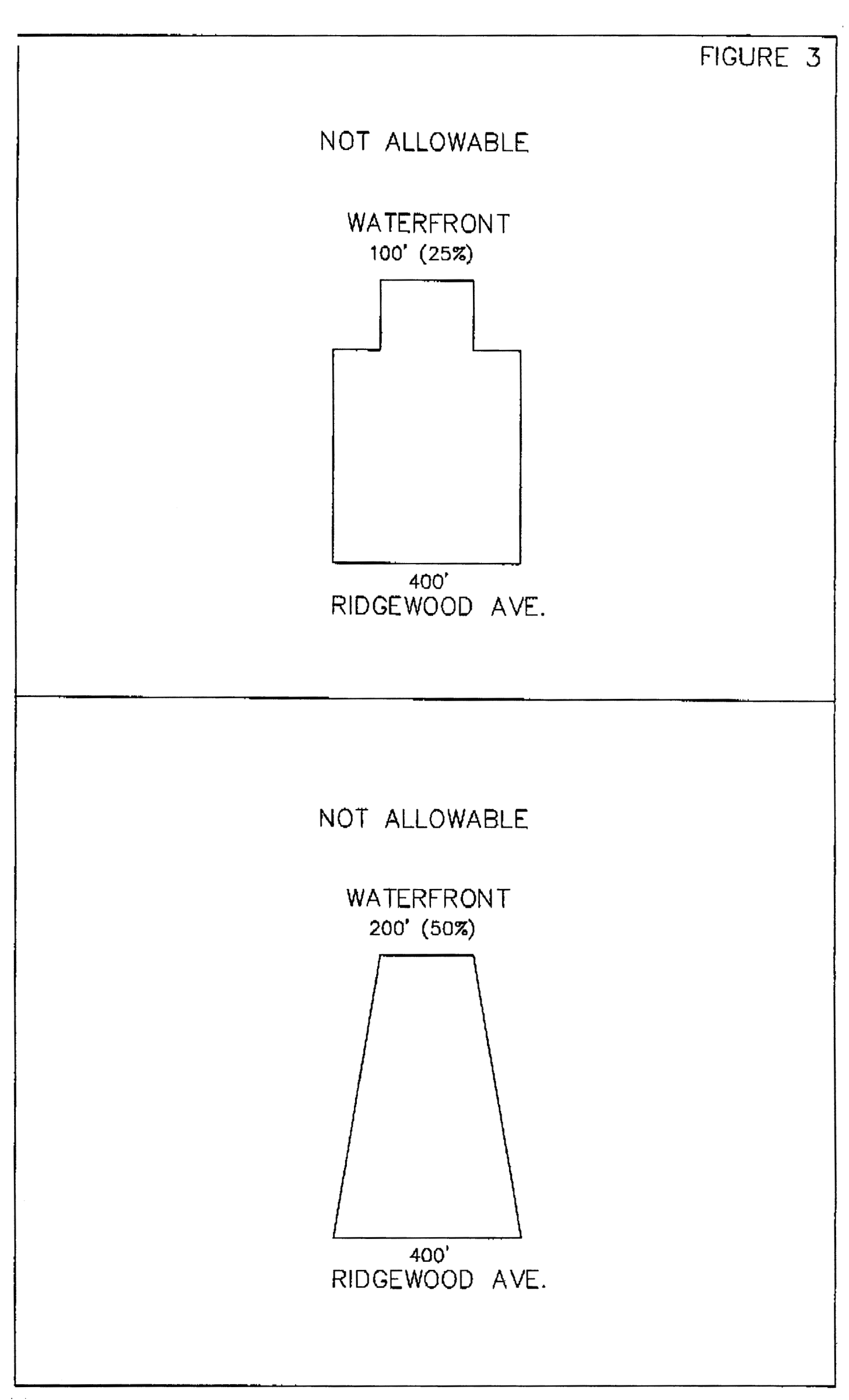
Multi-family with a height greater than 75 feet: Such projects must have a ratio of South Ridgewood Avenue frontage to Halifax River frontage no greater that 100 divided by 70 (i.e. 1.42857) (the reciprocal of the ratio does not apply), which equates to a maximum difference between the two frontages of 30 percent. For example, a site with 100 lineal feet of roadway frontage must have a minimum of 70 feet of Halifax River frontage.
j.
Architectural standards: Projects in the Ridgewood Ave. Redevelopment District must meet the architectural standards established for the redevelopment district; the alternative overarching themes are "Florida Vernacular", "Mediterranean", and "Spanish" (e.g. the South Daytona City Hall and the Piggotte Community Center).
k.
Landscape buffers. All landscaping must meet or exceed the landscape provisions of Article VIII, General Design Standards, of the Consolidated Land Development Regulations of the City of South Daytona; however, notwithstanding the minimum requirements of Article VIII, for high-rise developments of 25 units or more per gross acre the following criteria shall apply along the applicable property lines of the project area if they are more restrictive than those minimum requirements:
(1)
A six-to-eight-foot high stuccoed masonry wall shall be constructed along the depth of the principal building (along north- and south-side property lines).
(2)
A four-foot high stuccoed masonry wall shall be constructed to extend out from the plane of the riverside wall of the principal building toward the shoreline, with a setback from the shoreline of ten feet (along north- and south-side property lines).
(3)
The bufferyard in the side yards of the project area shall be a minimum design-type #2 (i.e. ten feet wide, with three shade trees, three understory trees, and 30 bushes per 100 lineal feet).
(4)
Landscape buffer along the street frontage of the project site: The bufferyard shall be a minimum design-type #5 (i.e. 40 feet wide, with seven shade trees, eight understory trees, and 60 bushes per 100 lineal feet).
l.
Underground utilities: All high-density development shall be required to participate in the cost of burying any existing overhead utility "lines" located in any Ridgewood Avenue street frontage which abuts the project site. The developer shall have the option of either contracting to bury such utilities or paying the estimated cost of same (as determined by the city) into a city fund dedicated to the burying of those utilities.
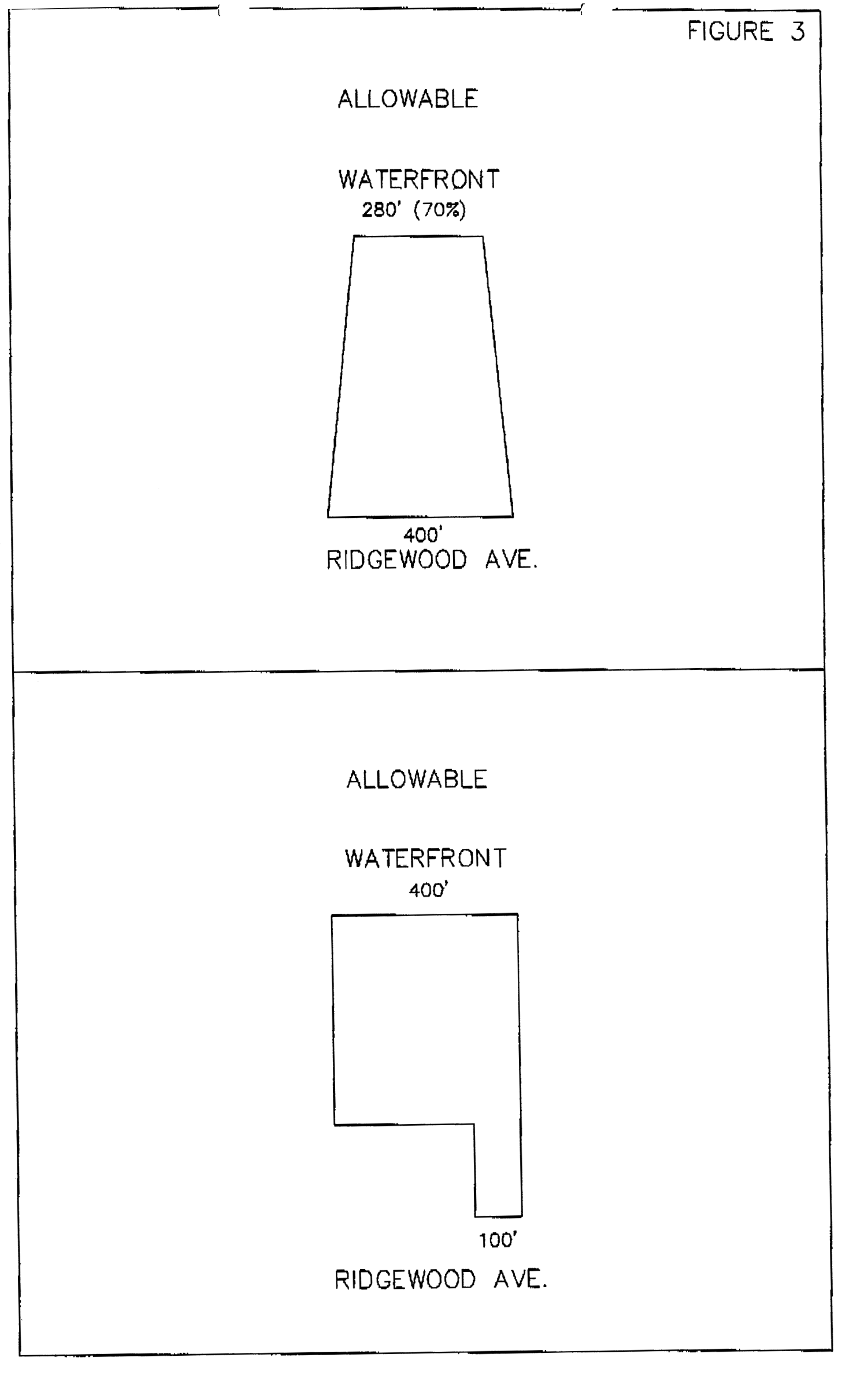
fig.3a
12.
Application for rezoning: All applications for rezoning shall be conducted in conformance with the process delineated in Article III.
a.
Application information: Upon application for rezoning to the PUD district, the developer shall submit the required number of copies of a proposed conceptual development plan to include:
[1]
Project name and name, address and telephone number of developer and design professionals.
[2]
General character of the proposed project including land uses, densities, ownership concept, design/landscape concepts, and any other information specific to the site or project.
[3]
North arrow, scale, vicinity map, names of abutting property owners, zoning of abutting properties, legal description, and location of all existing property improvements on or adjacent to the site.
[4]
Existing site conditions including soil types, vegetation types, natural drainage patterns, topography at one-foot contour intervals based on N.V.G.D. data, location and character of wooded areas, ponds, marshes, and wetland areas, and the 100-year floodplain area.
[5]
Location of proposed access points and location of existing water, sewer, and drainage facilities that are proposed to be extended to the site.
[6]
Concept plan of proposed internal circulation, utility service, and drainage systems.
[7]
General character, size and location of buildings and parking areas for each proposed land use.
[8]
Proposed master development agreement covering terms of the conceptual development plan and improvements required by the city, and setting forth any further specific agreements to be made for final development of specific phases.
[9]
Proposed phasing of development and proposed number and character of owner associations.
[10]
Any other information deemed pertinent by the applicant, city staff, planning advisory board (PAB) or city council.
b.
Review procedure. The PAB shall have 60 days from the first public hearing to review the concept plan and provide comments to the city council. If the review is not completed within 60 days, the plan will be forwarded to the council without comment.
The concept plan shall be approved or disapproved by the city council within 30 days after initial review by the council. However, the council may table the plan for further study at any time. If the concept plan is disapproved, reasons for disapproval shall be formally stated. Any change to the application in order to solicit approval shall be formally submitted in writing, and may be referred back to the PAB for further review, at the council's discretion.
Approval of the concept plan shall coincide with rezoning to the PUD district, with development bound by the conceptual plan and general development agreement, which shall be signed by the mayor and attested by the city clerk.
13.
Amendments to concept plan. City council approval shall be required for all major amendments to an approved concept plan. The city manager shall have the right to approve all minor amendments to an approved concept plan. The determination as to whether an amendment is minor or major shall be made in the sole discretion of the city. As guiding principles, and in no way to limit the city's discretion in making the determination, a major amendment may include a decrease in required minimum setbacks, buffers or landscaping, an increase in the maximum building height, or a decrease in minimum required parking.
P.
PCD - planned commercial development district.
1.
Purpose and intent: The purpose of the planned commercial development district is to provide for the development of integrated commercial projects, such as shopping centers, office parks and industrial parks, where conventional zoning and subdivision regulations are waived to encourage innovative site planning, and orderly and economical development of larger projects. Developments of this type should be encouraged to locate in those areas identified for major commercial or industrial development in the future land use plan.
2.
Unified ownership: All land within the PCD shall be under the ownership of the applicant whether that applicant be an individual, partnership or corporation, or groups of individuals, partnerships, or corporations. PCD applicants shall present firm evidence at the time of application of unified ownership of the entire area within the proposed PCD.
3.
Permitted uses: Listing and character of permitted uses shall be included in the written development agreement and may include any commercial or industrial uses deemed appropriate by the city council within the context of the adopted comprehensive plan and the overall development and surrounding area. However, the PCD district shall generally be considered to include and exclude the following:
4.
Special exceptions: Special exceptions may be considered above and beyond the language of the development agreement. Special exceptions may be granted where it is demonstrated that:
a.
The use is consistent with the character of the overall complex.
b.
The proposed site and building can be developed so as to mitigate any negative impacts on surrounding properties.
c.
The proposed use is compatible with adjoining properties.
5.
Minimum parcel size: A PCD shall contain a minimum of three acres. A lesser minimum area may be approved if the city council determines that the intent and purpose of these PCD regulations and expressed municipal development policy can be served in the particular case before the council.
6.
Minimum bufferyard areas: Minimum bufferyard areas in the PCD district shall be equivalent to those specified in this Code for similar land uses.
7.
Maximum building height: Maximum building height shall be determined as part of the development review process and set forth in the master development agreement. However, heights of buildings near or along the perimeter of the project area shall be related to and consistent with building heights in adjoining districts.
8.
Minimum building setback: Building setback requirements shall be determined as part of the development review process and set forth in the master development agreement. Setbacks in areas abutting the PCD boundary shall not be less than the setback requirements of the zoning district most similar to that portion of the PCD. The city council may require greater building setbacks when it is determined that the proposed use may have adverse effects upon adjoining properties or prejudice their development.
9.
Minimum landscaping requirements: Buffer areas and parking areas shall be landscaped according to the minimum requirements of the city's landscape ordinance. Other areas not devoted to building, parking, loading and accessory uses shall be landscaped with grass, shrubs, or trees.
10.
Zoning application and development plan approval: The procedure for rezoning to the PCD classification, the submission and approval of development plans, and permitting and enforcement procedures shall be the same as set forth for the PUD district in 5.5.O.
Q.
Mixed Use Development (MXD) District - 1.
1.
Purpose and intent: The purpose of this zoning district is to provide greater site-design and land use flexibility by removing some conventional zoning restrictions so that land under unified control can be planned and developed for a compatible mix of office, commercial, and multi-family residential, uses along with limited single-family uses as an adjunct to a business use. Mixed Use 1 zoning is limited to arterial roadway corridors and the redevelopment district. This zoning is encouraged for the following reasons:
a.
Land use diversity: Diversification of uses, residential structure types and open spaces when not in conflict with abutting properties.
b.
Efficiency: Reduction of facility improvement and maintenance costs through a more efficient use of land and a smaller network of utilities and streets than is possible through application of conventional site design controls.
c.
Open space: Conservation of the natural amenities of the land by encouraging the preservation of scenic and functional open space.
d.
Site planning: Maximum opportunity for innovative site planning concepts to create pleasing living and working environments.
e.
Preliminary plan: Ensuring that development will occur according to the limitations of housing types, uses, site design, density, building coverage, improvement standards, and construction phasing authorized through a preliminary plan.
2.
Restrictions:
a.
Unified ownership: All land for a proposed project within the MUD-1 district must be under the ownership of the applicant at the time that a development order is issued or a development agreement is executed; prior to issuance of a development order or execution of a development agreement the applicant must provide firm evidence of unified ownership of the entire project area.
b.
Location: This district is intended for use in suitable areas which have been assigned the comprehensive plan future land use designation of Mixed Use 1.
c.
Development agreement: A development agreement shall be required for major projects as determined by the city.
3.
Permitted uses: Any permitted uses in neighborhood commercial, business general commercial, professional office, or multi-family zoning classifications shall be permitted uses under the MUD-1 zoning classifications. Special uses and special exceptions may also be granted in a MUD-1 district. A single-family use may be permitted only as an adjunct to a business use for occupancy by the business owner, business manager or caretaker.
4.
Accessory uses: Those uses customarily associated with, dependent on, and incidental to the principal use.
5.
Special exceptions:
Auction sales
Automotive service stations
Automotive parts with installation services
Bar, lounges, night clubs
Boat sales with outdoor display
Hotel and motels
Laboratories—scientific and industrial
Motor vehicle sales and service
Motorcycle sales and service
6.
Special uses:
Childcare center
Clubs and lodges
Group housing
Houses of worship
Nursing homes
Public and private schools
Public utility station
7.
Development plan review: Prior to the issuance of a building permit, a development plan approval shall be required under the provisions of this Code.
8.
Development incentives: Recognizing the benefits of increased land use diversity, efficiency, and site planning, the city may allow for such incentives as a reduction in required parking and a 50 percent density bonus for residential units during approval of the final site plan and preparation of a development agreement. These incentives are based upon performance standard bonuses as follows:
Innovative and high quality design
Parcel aggregation
Enhanced landscaping along public right-of-ways
Enhanced on-site landscaping
Increased pervious surface
Public access to internal plazas/open spaces
A minimum of three stories and three uses
Rehabilitation or re-placement of dilapidated structures
Use of innovative imagery/architectural guidelines
Retention/creation of business/employment
9.
Dimensional requirements: See Figure 2.
10.
Maximum intensity: Maximum principal building coverage shall not exceed 40 percent of the lot. Residential uses shall not exceed 75 percent of the land area of the project site.
11.
Residential density: Residential density shall not be less than ten du/acre not exceed 15 du/acre.
12.
Zoning application and development plan approval: The procedure for rezoning to the MUD-1 classification, the submission and approval of development plans, and permitting and enforcement procedures shall be the same as set forth for the PUD district in 5.5.O.(11.)(12.)(13.) of the Consolidate Land Development Regulations.
R.
Mixed Use Development (MXD) District - 2.
1.
Purpose and intent: The purpose of this zoning district is to provide greater site-design and land use flexibility by removing some conventional zoning restrictions so that land under unified control can be planned and developed for a compatible mix of office, commercial, light industrial, and multi-family residential uses, along with limited single-family uses as an adjunct to a business use. Mixed Use 2 zoning is limited to arterial roadway corridors. This zoning is encouraged for the following reasons:
a.
Land use diversity: Diversification of uses, residential structure types and open spaces when not in conflict with abutting properties.
b.
Efficiency: Reduction of facility improvement and maintenance costs through a more efficient use of land and a smaller network of utilities and streets than is possible through application of conventional site design controls.
c.
Open space: Conservation of the natural amenities of the land by encouraging the preservation of scenic and functional open space.
d.
Site planning: Maximum opportunity for innovative site planning concepts to create pleasing living and working environments.
e.
Preliminary plan: Ensuring that development will occur according to the limitations of housing types, uses, site design, density, building coverage, improvement standards, and construction phasing authorized through a preliminary plan.
2.
Restrictions:
a.
Unified ownership: All land for a proposed project within the MUD-2 district must be under the ownership of the applicant at the time that a development order is issued or a development agreement is executed; prior to issuance of a development order or execution of a development agreement the applicant must provide firm evidence of unified ownership of the entire project area.
b.
Location: This district is intended for use in suitable areas which have been assigned the comprehensive plan future land use designation of Mixed Use 2.
c.
Development agreement: A development agreement shall be required for major projects as determined by the city.
3.
Permitted uses: Any permitted uses in neighborhood commercial, business general commercial, professional office, light industrial, or multi-family districts unless listed by special exception, below. A single-family use may be permitted only as an adjunct to a business use.
4.
Accessory uses: Those uses customarily associated with, dependent on, and incidental to the principal use.
5.
Special exceptions:
Auction sales
Automotive service stations
Automotive parts with installation services
Bar, lounges, night clubs
Boat sales with outdoor display
Hotel and motels
Laboratories—scientific and industrial
Motor vehicle sales and service
Motorcycle sales and service
6.
Special uses:
Childcare center
Clubs and lodges
Group housing
Houses of worship
Nursing homes
Public and private schools
Public utility station
7.
Development plan review: Prior to the issuance of a building permit, a development plan approval shall be required under the provisions of this Code.
8.
Development incentives: Recognizing the benefits of increased land use diversity, efficiency, and site planning, the city may allow for the reduction in required parking, a 50 percent density bonus for residential units, and an increase in building heights to a maximum of 45 feet during approval of the preliminary plan and preparation of a development agreement. These incentives are based upon performance standard bonuses as follows:
Innovative and high quality design
Parcel aggregation
Enhanced landscaping along public rights-of-way
Enhanced on-site landscaping
Increased pervious surface
Public access to internal plazas/open spaces
A minimum of three stories and three uses
Rehabilitation or re-placement of dilapidated structures
Use of innovative imagery/architectural guidelines
Retention/creation of business/employment
9.
Dimensional requirements: See Figure 2.
10.
Maximum intensity: Maximum principal building coverage shall not exceed 50 percent of the lot. Residential uses shall not exceed 50 percent of the land area of the project site.
11.
Residential density: Residential density shall not be less than ten du/acre not exceed 15 du/acre.
12.
Zoning application and development plan approval: The procedure for rezoning to the MUD-2 classification, the submission and approval of development plans, and permitting and enforcement procedures shall be the same as set forth for the PUD district in subsections 5.5.O.(11.)(12.)(13.).
S.
Community redevelopment district overlay.
1.
Purpose and intent: The city has adopted a redevelopment plan and program for selected areas of the city that have been designated as needing redevelopment under state statute. As a result of the implementation of the redevelopment plan and the redevelopment needs of the community redevelopment area some provisions of the city's standard zoning regulations that are appropriate generally within the city may not be consistent with the redevelopment plan and redevelopment goals, and some requirements of the redevelopment plan may not be appropriate for the city as a whole. The community redevelopment district overlay provides for the application of specific regulations modifying the underlying zoning regulations within the community redevelopment area.
2.
Establishment of overlay area: The community redevelopment district overlay shall be the community redevelopment area adopted by Resolution 97-06 as amended.
3.
Permitted uses: Permitted uses within the community redevelopment district overlay shall be the same as the underlying zoning classification except the following uses shall be prohibited within the overlay district. Any prohibited uses currently established within the community redevelopment district overlay shall be subject to the nonconforming use provisions of Section 3.13 C. of this Code.
a.
Thrift stores, pawns shops, secondhand stores, and any other retail activity in which the inventory consists of used and/or damaged items.
b.
Check cashing businesses.
c.
Animal grooming; unless provided by full service veterinarian clinic.
d.
Animal day care; unless provided by full service veterinarian clinic.
e.
Substance abuse clinics or clinics which provide walk-in treatment or any other type of treatment for addictive substances such as methadone clinics.
f.
Tattoo parlors.
g.
Internet gambling businesses including any sweepstakes operations that use internet gaming systems for the promotion of a product.
h.
Employment agencies that offer day labor services where workers congregate at the business location to receive daily assignments.
i.
Blood banks and laboratories that offer cash or any other form of compensation for blood or plasma.
j.
Services that encourage regular congregation of homeless populations.
k.
Massage therapist establishments.
l.
Smoke shop/tobacco store, e-cigarette/vape shop, smoking bar/lounge.
(i)
Definitions.
1.
Ancillary sale shall mean where a grocery store, supermarket, convenience store or any other retail establishment with no more than two percent of its gross floor area, or 200 square feet, whichever is less, for the display, sale, distribution, delivery, offering, furnishing, or marketing of conventional cigars, cigarettes, tobacco, electronic cigarettes, vaping devices or any smoking, tobacco, electronic cigarette, vaping device, hookah pipe or any other type of smoking device paraphernalia. For any grocery store, convenience market, retail kiosk or any other retail establishment consisting of 250 square feet or less, "ancillary sale" shall mean where no more than five square feet are used for the display, sale, distribution, delivery, offering, furnishing, or marketing of conventional cigars, cigarettes, tobacco, electronic cigarettes, vaping devices or any smoking, tobacco, electronic cigarette, vaping device, hookah pipe or any other type of smoking device paraphernalia, regardless of square footage uses, is subject to the restrictions in this section.
2.
E-cigarette or vaping device shall mean any electronically actuated device or inhaler meant to simulate cigarette smoking that uses a heating element to vaporize a liquid solution, popularly referred to as "juice," and that causes the user to exhale smoke, vapor, or substance other than produced by unenhanced human exhalation. The juice used in e-cigarettes and other vaping devices typically contains nicotine, and for this reason e-cigarettes, vaping devices and their juice can be classified as both tobacco products and tobacco paraphernalia.
3.
E-cigarette or vape shop shall mean any establishment that exceeds the definition for ancillary sale, display, distribution, delivery, offering, furnishing, or marketing of any tobacco product, juice, e-cigarette or vaping device products or paraphernalia.
4.
Smoke shop and tobacco store shall mean any establishment that exceeds the definition for ancillary sale, display, distribution, delivery, offering, furnishing, or marketing of tobacco, tobacco products, or tobacco paraphernalia.
5.
Tobacco shall mean any preparation of the nicotine-rich leaves of the tobacco plant, which are cured by a process of drying and fermentation for use in smoking, chewing, absorbing, dissolving, inhaling, snorting, sniffing, or ingesting by any other means into the body.
6.
Tobacco paraphernalia shall mean any paraphernalia, equipment, device, or instrument that is primarily designed or manufactured for the smoking, chewing, absorbing, dissolving, inhaling, snorting, sniffing or ingesting by another means into the body of tobacco, tobacco products, or other controlled substances as defined by the State of Florida Statute Chapter 893 Drug Abuse and Prevention. Items classified as tobacco paraphernalia include, but are not limited to, the following items: pipes, punctured metal bowls, bongs, water bongs, electric pipes, e-cigarette juice, buzz bombs, vaporizers, hookahs, and devices for holding burning material. Lighters and matches shall be excluded from the definition of tobacco paraphernalia
7.
Tobacco product shall mean any product in leaf, flake, plug, liquid, or any other form, containing nicotine derived from the tobacco plant, or otherwise derived, which is intended to enable human consumption of the tobacco or nicotine in the product, whether smoked, chewed, absorbed, dissolved, inhaled, snorted, sniffed, or ingested by an other means. For the purposes of this section, the term "tobacco product" excludes any product that has been specifically approved by the United States Food and Drug Administration (FDA) for sale as a tobacco/smoking cessation product or for other medical purposes, where such product is marketed and sold solely for such an approved propose.
8.
Smoking bar or lounge shall mean any business that sells, leases, or provides for onsite consumption or use by customers, either individually or communally, tobacco, tobacco products, tobacco paraphernalia, E-cigarette or vaping device. This includes, but is not limited to, establishments known as Hookah bars or lounges and Shisha bars.
m.
Small box discount stores.
(i)
Definition.
Small box discount store means a retail store that is 16,000 square feet or less in size, which offers for sale a variety of convenience shopping goods and continuously offers the majority of the items in their inventory for sale at a price lower than traditional retail stores, and does not include a pharmacy, does not sell gasoline or diesel fuel, or specialty items and food items as a primary product (i.e., greeting cards, consignment, meats, seafood, cheese, or oils and vinegars).
n.
Liquor stores.
(i)
Definition.
Liquor store means a retail store licensed pursuant to the Beverage Law (F.S. chs. 561-568) with a 3PS quota class alcoholic beverage license or a 4COP quota class alcoholic beverage license, which sells alcohol for off-premises consumption.
o.
Storage facilities. Storage facilities include all commercial storage structures, constructed for the purpose of storage for personal or commercial goods and equipment, for rent to the general public or to commercial businesses, including mini warehouses.
p.
Call centers.
q.
Automotive, vehicle, or vessel related facilities including but not limited to oil change, repair shops, tire services, paint and body shops, parts sales with installation services, automotive, vehicle, or vessel sales, bus garages, vehicle impound lots, towing services, and other services related to automobiles, vehicles, boats, motorcycles, tractors, mowers, construction equipment, all-terrain vehicles (ATVs), scooters, golf carts, low-speed vehicles, e-bikes or bicycles.
r.
Bait and tackle stores.
s.
Houses of worship, private meeting halls, and halls for hire.
t.
Schools (through higher education), tutoring facilities, childcare and daycare centers, nursing homes and group living facilities, and instructional studios or facilities, including but not limited to those for martial arts, dance, and gymnastics.
u.
Laundromats and dry cleaners.
v.
Contracting, landscaping services, or pest control services (including contracting yards and landscape nurseries).
w.
Sign and print shops.
x.
Bars, lounges and night clubs.
y.
Amusement centers.
z.
Manufacturing.
aa.
Cell phone repair.
ab.
Morgues, mortuaries, cemeteries or funeral homes.
ac.
Cannabis sales, including dispensaries, retail sales, or any establishment selling cannabis or cannabis-derived products for medicinal or recreational use.
ad.
Fireworks sales, including seasonal or year-round retail operations engaged in the sale of consumer fireworks or similar pyrotechnic devices. This prohibition excludes a small seasonal retail display in grocery and existing discount stores.
ae.
Appliance repair.
af.
Pain clinics.
ag.
Mobile home parks.
ai.
Bail bonds.
aj.
Counseling services.
ak.
Fitness gyms.
4.
Accessory uses: Accessory uses permitted within the community redevelopment district overlay shall be the same as the underlying zoning classification.
5.
Special exception uses: Special exception uses permitted within the community redevelopment district overlay shall be the same as the underlying zoning classification.
6.
Special uses: Special uses permitted within the community redevelopment district overlay shall be the same as the underlying zoning classification.
7.
Design guidelines: Private development and redevelopment shall conform to the design guidelines presented in Section 8.1 and Section 8.4 of this Code.
8.
Other development standards: In addition to the development standards enumerated for the community redevelopment district overlay, the other development standards for the underlying zoning classification and the land development regulations generally shall apply. If there is a conflict between the overlay standard and other standards in the Code, the overlay standard shall control.
Figure 2 - DIMENSIONAL REQUIREMENTS
*Note: Mixed use projects may deviate from these requirements as per development agreements approved by the city council.
A.
One-acre minimum project size.
B.
Five-acre minimum project size.
All waterfront yards shall meet the requirements set forth for front yards. Riverfront properties shall have a setback of 50 feet from the bulkhead line to the principal building.
In all residential districts, the height of accessory structures shall not exceed 15 feet.
**Note that there shall be no minimum rear yard setback requirement where the rear yard in a light industrial zone abuts the Florida East Coast Railroad right-of-way.
***The front yard setback shall be 25 feet instead of 50 feet if the front yard is not designed or used for loading/unloading.
Table 2 - Permitted Uses by District
(Ord. No. 00-11, § 1, 8-22-00; Ord. No. 02-14, § 1, 10-8-02; Ord. No. 04-05, §§ 1—5, 4-13-04; Ord. No. 04-18, § 1, 7-27-04; Ord. No. 04-30, §§ 1, 2, 11-9-04; Ord. No. 04-31, § 1, 11-9-04; Ord. No. 05-03, § 1, 2-22-05; Ord. No. 05-24, § 1, 7-26-05; Ord. No. 06-15, 8-8-06; Ord. No. 07-16, § 1, 8-28-07; Ord. No. 07-21, § 1, 10-23-07; Ord. No. 08-09, §§ 1, 2, 6-10-08; Ord. No. 08-15, §§ 3, 4, 8-26-08; Ord. No. 14-11, § 1, 11-11-14; Ord. No. 16-08, §§ 1, 2, 1-10-17; 16-09, §§ 2—4, 1-10-17; Ord. No. 18-09, § 1, 6-12-18; Ord. No. 19-01, § 1, 3-12-19; Ord. No. 2020-09, § 1, 9-29-20; Ord. No. 2021-07, § 2, 6-8-21; Ord. No. 2021-09, § 4, 5, 7-27-21; Ord. No. 2021-11, § 2, 9-13-21; Ord. No. 2021-13, § 2, 1-11-22; Ord. No. 2022-07, § 2, 8-9-22; Ord. No. 2023-16, § 2, 10-10-23; Ord. No. 2024-05, § 2(Att. A), 8-13-24; Ord. No. 2025-08, § 2, 9-8-25)