
South Kingstown City Zoning Code
ARTICLE 6
- OVERLAY ZONES, SPECIAL ZONES AND SPECIAL MANAGEMENT DISTRICTS
Sec. 600.- Historic Overlay District.
600.1.
Purpose.
The intent of this section is to safeguard the heritage of South Kingstown by preserving structures and districts that reflect elements of its cultural, social, economic, political, and architectural history; to stabilize and improve property values in the districts; to foster civic beauty; to strengthen the local economy; to promote the use of historic districts for the education, pleasure, and welfare of the citizens of South Kingstown; and to provide, where feasible, that housing in historic districts be made available to low and moderate income residents.
600.2.
District boundaries.
For the purposes of this article, the boundaries of historic overlay district(s) are shown on the official zoning map.
600.3.
Definitions.
The following terms shall have the following respective meanings unless a different meaning clearly appears from the context:
Alteration. An act that changes one (1) or more of the exterior architectural features of a structure or its appurtenances, including, but not limited to, the erection, construction, reconstruction, or removal of any structure or appurtenance.
Appurtenances. Features other than the primary or secondary structures that contribute to the exterior historic appearance of a property, including, but not limited to, paving, doors, windows, signs, materials, decorative accessories, fences, and historic landscape features.
Certificate of appropriateness. A certificate issued by the historic district commission indicating approval of plans for alteration, construction, repair, removal, or demolition of a structure or appurtenances of a structure within a historical district. Appropriate, for the purposes of passing upon an application for a certificate of appropriateness, means not incongruous with those aspects of the structure, appurtenances, or district that the commission has determined to be historically or architecturally significant.
Construction. The act of adding to an existing structure or erecting a new principal or accessory structure or appurtenances to a structure, including, but not limited to, buildings, extensions, outbuildings, fire escapes, and retaining walls.
Demolition. An act or process that destroys a structure or its appurtenances in part or whole.
Historic cemetery. A cemetery registered by the town pursuant to G.L. 1956, § 23-18-10.1.
Historic district. A specific division of the town as designated by the official zoning map. A historic district may include one (1) or more structures.
Removal. The relocation of a structure on its site or to another site.
Repair. A change meant to remedy damage or deterioration of a structure or its appurtenances.
Structure. Anything constructed or erected, the use of which requires permanent or temporary location on or in the ground, including, but not limited to, buildings, gazebos, billboards, outbuildings, decorative and retaining walls, and swimming pools.
600.4.
Construction, alteration, and demolition of structures.
A.
Before a property owner may authorize or commence construction, alteration, repair, removal, or demolition affecting the exterior appearance of a structure or its appurtenances within a historic district, the owner must apply for and receive a certificate of appropriateness from the historic district commission.
B.
In applying for such a certificate, the property owner must comply with the application procedures established by the commission. A certificate of appropriateness must be obtained, when required by this article, whether or not a permit also must be obtained from the building official. The building official shall not issue a permit until the commission has granted a certificate of appropriateness.
600.5.
Routine maintenance.
Nothing in this article shall be construed to prevent ordinary maintenance or repair of any structure within a historic district provided that such maintenance or repair does not in any way change the design, type of material, or appearance of the structure or its appurtenances; nor shall anything in this article be construed to prevent work under a permit issued by the building official prior to adoption of this article.
600.6.
Historic cemeteries.
A.
Before a property owner may authorize or commence construction, alteration, repair, removal, or demolition affecting a historic cemetery or its appurtenances, whether or not the cemetery is located within a historic district, the owner must apply for and receive a certificate of appropriateness from the commission.
B.
In the case of any work requiring the demolition, removal or relocation of all or part of a historic cemetery, the property owner shall comply with all provisions of local and state law and shall make suitable and appropriate provisions for the reinterment of any human remains in an established cemetery. Original or existing headstones and markers shall be preserved and reinstalled at the site of reinterment.
600.7.
Historic district commission.
A.
There is hereby established a South Kingstown Historic District Commission (HDC) consisting of seven (7) regular members and one (1) auxiliary member appointed by the town council president.
B.
Members shall be residents of South Kingstown. Members shall be appointed to terms of three (3) years, and shall be eligible for reappointment. At the expiration of his or her term, a member shall continue to serve until a successor is appointed. When a vacancy occurs, the town council president shall make an interim appointment for the unexpired portion of the term. Appointments in place at the time of adoption of this article shall remain in full force and effect.
C.
Duly organized and existing historical and preservation groups may present to the town council president a list of qualified citizens from which members may be appointed.
D.
The concurring votes of four (4) members of the commission shall be necessary to grant a certificate of appropriateness or to reject an application. The auxiliary member shall sit, and shall have the powers of a regular member of the commission, only when a regular member is absent.
600.8.
Rules and regulations of commission.
A.
Within twelve (12) months of the adoption of this article, the commission shall adopt and publish rules and regulations for the conduct of its functions under this article, and criteria by which applications for certificates of appropriateness shall be reviewed. The commission shall have the authority to amend its rules and regulations and its review criteria when reasonably necessary, and all such amendments shall be published.
B.
All meetings of the commission shall be open to the public, and any person or his duly constituted representative shall be entitled to be heard on any matter before the commission. The commission shall keep a record of its proceedings, resolutions, findings, decisions, and actions, and such record shall be open to the public. The commission shall comply with all the requirements of the open meetings law, G.L. 1956, § 42-46-1 et seq.
600.9.
Standards of review.
A.
In reviewing an application for a certificate of appropriateness, the commission shall consider:
1.
The historic and architectural significance of the structure and its appurtenances;
2.
The way in which the structure and its appurtenances contribute to the historical and architectural significance of the district; and
3.
The appropriateness of the general design, arrangement, texture, materials, and siting proposed by the applicant.
The commission shall pass only on exterior features of a structure and its appurtenances and shall not consider interior arrangements.
B.
In the case of an application involving a structure or its appurtenances that the commission deems so valuable to the town, state or nation that its loss would be a great loss to the town, state or nation, the following procedure shall apply:
1.
The commission shall try to develop with the owner an economically feasible plan for preservation of the structure. If such a plan can be developed that will, in the view of the commission, preserve the structure in a historically and architecturally appropriate manner, the commission shall issue a certificate of appropriateness.
2.
The commission shall reject the application unless the commission finds that retention of the structure in its present condition constitutes a hazard to public safety, and the owner does not have the economic means available to eliminate the public safety hazard, and the owner is unable to sell the structure to a buyer willing to preserve it.
3.
If the application is rejected, no new application for the same or similar work shall be filed within one (1) year after the rejection, unless there is a change in the structure arising from casualty.
C.
If an application involves a structure that the commission deems to be valuable for the period of architecture it represents and important to the neighborhood in which it is located, but the commission finds that the owner's plan for preservation of the structure does not satisfy the standards contained in subsection 600.9.A. of this section, the commission may nevertheless issue a certificate of appropriateness if:
1.
Retention of the structure in its present condition constitutes a hazard to public safety, and the owner does not have the economic means available to eliminate the public safety hazard and is unable to sell the structure to a buyer willing to preserve it; or
2.
Preservation of the structure is a deterrent to a major improvement program that will be of substantial benefit to the community; or
3.
Preservation of the structure would cause undue or unreasonable hardship to the owner and the owner is unable to sell the structure to a buyer who is willing to preserve it; or
4.
Preservation of the structure would not be in the interest of a majority of the community.
D.
When considering an application to demolish or remove a structure of historic or architectural value, the commission shall assist the owner in identifying and evaluating alternatives to demolition, including sale of the structure and its present site. In addition to any other criteria, the commission also shall consider whether there is a reasonable likelihood that some person or group other than the current owner is willing to purchase, move, and preserve the structure and whether the owner has made continuing, bona fide and reasonable efforts to sell the structure to any such purchaser.
600.10.
Decisions of commission.
A.
All decisions of the commission shall be in writing. The commission shall articulate and explain the reasons and bases of each decision on a record, and in the case of a decision not to issue a certificate of appropriateness, the commission shall include the bases for its conclusion that the proposed activity would be incongruous with those aspects of the structure, appurtenances or the district that the commission has determined to be historically or architecturally significant. A copy of the decision shall be sent to the applicant.
B.
The commission shall file with the building official its certificate of appropriateness or rejection of plans submitted to it for review. No work shall begin until such certificate is filed. In the case of rejection, such decision shall be binding on the building official and no permit shall be issued in such case.
C.
The failure of the commission to act upon each application submitted to it within forty-five (45) days from the day the application is filed, unless an extension is mutually agreed upon by the applicant and the commission, shall constitute approval. However, in the event that the commission makes a finding that the circumstances of a particular application require additional study and information than can be obtained within forty-five (45) days of submission, the commission shall have a total of up to ninety (90) days within which to act on the application.
600.11.
Appeals from commission decisions.
A.
Any person or persons jointly or severally aggrieved by a decision of the historic district commission shall have the right of appeal concerning the decision to the zoning board of review, and a further right of appeal from the zoning board of review to the Superior Court in the same manner provided by G.L. § 45-24-69, and from the Superior Court to the Supreme Court by petition for issuance of a writ of certiorari.
B.
When hearing appeals from commission decisions, the zoning board of review shall not substitute its own judgment for that of the commission, but must consider the issue upon the findings and record of the commission. The zoning board of review shall not reverse a commission decision except on a finding of prejudicial procedural error, clear error, or lack of support by the weight of the evidence in the record. The zoning board of review shall articulate and explain the reasons and bases for its decisions on the record. The decision of the zoning board of review shall be in writing, and copies shall be sent to the applicant and to the commission.
600.12.
Enforcement.
The building official, through duly-appointed legal counsel for the town, may bring an action in the Washington County Superior Court to enforce the provisions of this article. The town may seek restraining orders and injunctive relief to restrain and enjoin violations or threatened violations of this article.
600.13.
Avoiding demolition caused by neglect.
A.
All structures located in historic districts shall be maintained in compliance with the provisions of the Rhode Island State Building Code, G.L. 1956, Tit. 23, Ch. 27.3, that are applicable to exterior maintenance and structural integrity.
B.
The historic district commission shall identify structures and appurtenances of historical or architectural value within historic districts whose preservation is endangered because of their deteriorating condition. When such a structure or appurtenance is identified, the commission may petition the town council to require its repair.
C.
Upon receipt of such a petition, the town council may establish a reasonable time of not less than thirty (30) days within which the owner must begin repairs. When such repairs are ordered, the owner shall be notified by certified mail.
D.
If the building official determines that the owner has not begun repairs within the time established, the town council shall conduct a hearing at which the owner may appear and state his or her reasons for not commencing repairs. Upon good cause shown, the council may extend the period for repairs to begin.
E.
If the owner does not appear at the hearing, or does not comply with the town council's orders, the town council may direct the building official to arrange for the required repairs to be made at the expense of the town. If such repairs are made, the building official shall direct the town solicitor to cause a lien to be placed against the real property for repayment, and to institute any action necessary to enforce the lien.
Sec. 601. - Special Flood Hazard Area (SFHA) Overlay District
601.1.
Establishment of district.
There is hereby established a Special Flood Hazard Area (SFHA) Overlay District, the boundaries of which are shown on the official zoning map. The SFHA Overlay District is delineated by the boundary and overall extent of the special flood hazard areas identified and shown on Federal Emergency Management Association (FEMA) Flood Insurance Rate Maps (FIRMs). These areas include all zones identified as 'A', 'AE', and 'VE' Flood Zones representing the areas with a one (1) percent annual chance of flooding. The one (1) percent annual chance flood is also referred to as the base flood or one hundred-year flood. The provisions of this ordinance shall apply to all lands located within the SFHA Overlay District.
601.2.
Purpose.
The purpose of the Special Flood Hazard Area (SFHA) Overlay District is to ensure public safety, to minimize hazards to persons and property from recurring and dynamic flooding, to protect the health, safety, and general welfare of the residents of South Kingstown, and to require resilient development within at-risk coastal and riverine areas. Regulation of new development and significant alterations to existing structures within the district provides for orderly growth and development that recognizes the natural characteristics of the land and the values and dynamic nature of coastal and freshwater ponds, the shoreline, and freshwater and coastal wetlands.
601.3.
Definitions.
For the purpose of this section, the following phrases shall be defined as provided below:
Coastal Barrier Resources System. The Coastal Barrier Resources Act (CBRA) was passed by Congress in 1982 to encourage conservation of hurricane-prone, biologically rich coastal barriers, which are referred to as the units within the Coastal Barrier Resources System (CBRS). CBRA prohibits most new federal expenditures that encourage development or modification of coastal barriers. Therefore, most new or substantially improved residences, businesses, or other developments in the CBRS are not eligible for certain federal funding and financial assistance, including coverage under the National Flood Insurance Program (NFIP). Development can still occur within the CBRS, as long as private developers or other non-federal parties bear the full cost. CBRS boundaries are shown on maps that were originally adopted by Congress, and with few exceptions, only Congress can change the CBRS boundaries. These CBRS areas, herein referred to as CBRS units, are shown on maps maintained by the U.S. Fish and Wildlife Service.
Cumulative improvement value. Within a Special Flood Hazard Area, the cumulative value of all improvements made to a structure that did not, or does not, meet the building code requirements for construction within the flood zone, whether or not substantially damaged or substantially improved, as determined by the building official, over the most recent five-year period.
Development project. New construction of a structure intended for occupancy, substantial improvement of a structure, as determined by the building official, repair and/or renovation of a substantially damaged structure, as determined by the building official, or any improvement of a structure that has a cumulative improvement value equal to or exceeding fifty (50) percent of the value of the structure.
601.4.
Establishment of base flood elevation.
Pursuant to G.L. § 45-24-31, any structure located within a SFHA, as depicted on the official FEMA FIRM, shall have building height measured from base flood elevation (BFE). Building permit applicants may choose to utilize the BFE required by the FIRM, including up to an additional five (5) feet of freeboard, or may choose to establish BFE using one (1) of the coastal resource management council (CRMC) design elevation maps. Each CRMC Design Elevation Map depicts a specific level of anticipated sea level rise and provides recommended design flood elevations for structures, or in other words, the elevation at which a building should be constructed to withstand a once in hundred-year storm event given the amount of sea level rise depicted on the specific map. Utilization of CRMC's Design Elevation Maps to establish BFE is intended to increase the ability of the structure to withstand future storm surge conditions, therefore increasing coastal resiliency and further protecting public health and safety.
601.5.
Applicability.
A.
Development projects, as defined in section 601.3, located within the Special Flood Hazard Overlay District which use the BFE identified on FEMA FIRMs utilizing allowable freeboard (one (1) foot minimum up to five (5) feet maximum) shall be subject to the provisions of section 601.7.A.
B.
Development projects, as defined in section 601.3, located within the Special Flood Hazard Overlay District which utilize a CRMC design elevation map to establish BFE and where the design elevation chosen is greater than five (5) feet above the FEMA BFE shall be subject to the provisions of section 601.7 and be permitted only upon issuance of a special use permit by the South Kingstown Zoning Board of Review, as required by section 601.6.A. The purpose of requiring a special use permit for such development projects is to ensure appropriateness and consistency of construction activities with the sea level rise scenario depicted on the selected CRMC map.
C.
Select construction activities, as defined in section 601.6.B, located within a coastal barrier resources system (CBRS) unit, shall be permitted only upon issuance of a special use permit by the South Kingstown Zoning Board of Review. The purpose of requiring a special use permit for such activities is to ensure appropriateness of construction activities within CBRS units. All CBRS units are located within the Special Flood Hazard Overlay District.
D.
For the purposes of this section, development projects that have received a completed CRMC preliminary determination and/or an approval of an onsite wastewater treatment system application from the Rhode Island Department of Environmental Management (RIDEM) on or before February 28, 2019 shall be exempt from the development standards outlined in section 601.7.B.
601.6.
Special use permits.
A.
Development projects utilizing a CRMC map to establish BFE. Within the SFHA Overlay District, in addition to the standards set forth in section 907, the zoning board of review shall only grant a special use permit for a development project that utilizes a CRMC design elevation map to establish BFE upon submittal of credible evidence by the applicant, to the satisfaction of the board, that the following standards have been met:
1.
The structure shall maintain land-based, adequate vehicular access to U.S. Route 1 along an existing roadway, with the projected amount of sea level rise inundation depicted on the design elevation map utilized to establish BFE. The applicant must use CRMC's sea level rise maps to demonstrate maintained vehicular access.
2.
The footprint of the proposed structure lies completely outside of any land area that is below the mean high-water mark with the projected amount of sea level rise depicted on the selected design elevation map utilized by the applicant to establish BFE. The applicant must use CRMC's maps to demonstrate that no portion of the building will lie above an area projected to be inundated by sea level rise.
3.
The structure will be serviced by an approved onsite wastewater treatment system (OWTS) that will function compliantly with the projected amount of sea level rise depicted on the design elevation map utilized to establish BFE. Submitted evidence must include a certification from a Rhode Island registered professional engineer and RIDEM licensed OWTS system designer that the OWTS is anticipated to remain compliant at the projected level of sea level rise.
4.
The structure will be adequately serviced by public potable water or a private potable water supply approved by RIDOH. All private wells shall be located completely outside of any land area that is below the mean high-water mark with the projected amount of sea level rise depicted on the selected design elevation map utilized by the applicant to establish BFE.
5.
The structure shall be constructed with the foundation type required by the state building code for the flood zone projected by CRMC to be in effect with the projected amount of sea level rise depicted on the design elevation map utilized to establish BFE. CRMC's design elevation maps provide the projected flood zone given the amount of sea level rise indicated; development projects shall utilize the foundation type required by the state building code which conforms to the projected flood zone.
6.
For development projects proposed within CRMC's jurisdiction, the project has received a Preliminary Determination from CRMC, and all recommendations included in the preliminary determination have been addressed to the satisfaction of the zoning board.
B.
Select construction activities located within a CBRS unit.
1.
Within a CBRS unit, the zoning board of review shall only grant a special use permit for the construction activities outlined below upon submittal of credible evidence by the applicant, to the satisfaction of the board, that the following additional standards have also been met:
(a)
Indoor and/or outdoor recreation facility owned and operated by a nonprofit neighborhood association. Before any special use permit shall be granted permitting the use of land for an indoor and/or outdoor recreation facility owned and operated by a nonprofit neighborhood association, the applicant shall, in addition to complying with all other requirements for the granting of special use permits as set forth elsewhere in this ordinance, show to the satisfaction of the board that the proposed recreation facility is located:
(1)
Within the same geographical area from which such neighborhood association's membership is derived, and
(2)
On a lot of record which is contiguous to other lots of record owned by members of the association. For the purposes of this section, lots which are separated by a street shall be construed to be contiguous to each other.
(b)
Individual beach cabanas, dressing rooms, or bathhouses, limitations. Individual beach cabanas, dressing rooms, or bathhouses permitted by special use permit under the provisions of article 3, shall be:
(1)
No larger than one hundred (100) square feet in floor area.
(2)
No more than fifteen (15) feet in height.
(3)
Used for daytime occupancy only.
(4)
Not designed for use as dwellings.
(5)
Limited to one (1) such individual beach cabana or dressing room or bathhouse per lot.
2.
The zoning board of review shall have the ability to condition any granted special use permit as necessary to ensure the above findings are met. Such conditions may include, but not be limited to, the following:
(a)
Modification of waste disposal and water supply facilities.
(b)
Limitations on periods of use and operation.
(c)
Imposition of performance standards, operational controls and sureties.
(d)
Requirements on the location, construction, durability and safety of roads, driveways, parking areas and access routes.
3.
At a minimum, every special use permit granted pursuant to this section shall be conditioned on the construction conforming to the state building code requirements of the projected flood zone, as outlined in subsection A.5., above.
601.7.
Development standards and dimensional requirements.
When considered as part of a development project (as defined in section 601.3.C), the following height standards shall apply to the Special Flood Hazard Area Overlay District, except as provided in A and B below.
A.
Maximum Building Height.
1.
No structure shall exceed the following height measurements:
(a)
Structures that are elevated to a distance above grade of less than or equal to five (5) feet shall be limited to thirty-five (35) feet of building height;
(b)
Structures that are elevated to a distance above grade of greater than five (5) feet but less than or equal to ten (10) feet shall be limited to thirty (30) feet of building height;
(c)
Structures that are elevated to a distance above grade of greater than ten (10) feet but less than or equal to fifteen (15) feet shall be limited to twenty-five (25) feet of building height.
(d)
Structures that are elevated to a distance above grade of greater than fifteen (15) feet shall be limited to twenty (20) feet of building height.
2.
No part of any structure shall exceed the maximum height listed above except for those exclusions listed in the definition of "building height" in article 12.
B.
Development Standards.
1.
Properties for which any portion of any principal building footprint lies within the SFHA Overlay District shall not be limited to a maximum building lot coverage percentage as defined by section 401. Instead, building size shall be determined by floor area ratio (FAR) and maximum deck area (MDA) as described below:
(a)
For all properties located within the SFHA Overlay District, the maximum amount of livable space shall be determined by using an FAR of three-tenths (0.30) to calculate the maximum allowable GFA for the parcel.
(b)
For all properties located within the SFHA Overlay District, the maximum amount of total deck area (MDA) shall be no greater in size than fifteen (15) percent of the calculated maximum allowable GFA for the parcel.
(c)
For properties with more than one (1) principal structure, i.e. multi-households, all structures shall share the total allowed GFA and MDA for the parcel. In such cases, the maximum allowable GFA and MDA for each principal structure shall be equal to the maximum GFA or MDA divided by the number of principal structures on the parcel, as applicable. This requirement may be modified only when two (2) or more structures on a multi-household parcel are being simultaneously improved, have applied for simultaneous special use permits (or a single special use permit for the applicable structures), and the total GFA of the structures combined does not exceed the maximum GFA allowed for the parcel. In such cases, the GFA and/or MDA may be unevenly distributed between structures.
2.
For lots with rear lot lines abutting a coastal feature, applicants may propose the minimum front-yard setback to be the average setback of those parcels located within two hundred fifty (250) feet of the parcel on the same side of the street, in both directions.
Example Table: Maximum Gross Floor Area and Floor Area Calculations
* Integrated decks located within the footprint of the structure shall not count toward the MDA calculation.
C.
Inapplicability to certain development projects. Notwithstanding A and B above, the standards in this section shall not apply to:
1.
Nonresidential zoning districts. The standards established in this section shall not be applied to development projects wholly within a commercial (CD, CW), industrial (I-1, I-2, I-3), government and institutional (GI), and public marina special management district (PMSMD) zoning districts.
2.
Coastal Community Overlay District. The standards established in this section shall not apply to development projects located wholly within a coastal community overlay district (section 608).
3.
For the purposes of this section, the standards established in this section shall not apply to development projects that have received a completed CRMC preliminary determination and/or an approval of an onsite wastewater treatment system application from the Rhode Island Department of Environmental Management (RIDEM) on or before February 28, 2019.
D.
Other than described in A and B above, nothing in this section shall be construed as to modify any dimensional requirements established elsewhere in this ordinance.
(Ord. of 2-25-19(1); Ord. of 7-22-19(1))
Sec. 602. - Groundwater Protection Overlay District.
602.1.
Establishment of district.
There is hereby established a Groundwater Protection Overlay District (GPOD) which shall be the area defined as lots of record which are indicated as the GPOD on the official zoning map of the Town of South Kingstown. The GPOD is superimposed over any other zoning district established by this ordinance. The regulations imposed by the GPOD shall apply in addition to the regulations of the underlying zoning district. In the event of a conflict or inconsistency between the regulations imposed by the GPOD and those imposed by the underlying zoning district, the regulations imposed by the GPOD shall govern.
602.2.
Purposes.
The purposes of this section are to protect, preserve and maintain the quality and supply of certain groundwater reservoirs in the town through regulation of land use and certain activities in the areas over the groundwater reservoirs and critical portions of their groundwater recharge area. It is further the intent of this section to permit the use of land within the GPOD for agricultural purposes, and to encourage the use of farmland in a manner which is consistent with protection of surface and groundwater resources.
602.3.
Delineation of districts.
The Groundwater Protection Overlay District is intended to regulate uses within the following areas:
A.
Groundwater reservoirs are the highest yielding portions of the state's stratified drift aquifers (saturated thickness greater than forty (40) feet and transmissivity greater than four thousand (4,000) feet squared per day) that are capable of serving as a significant source of public supply; and
B.
Critical portions of the recharge areas to the above groundwater reservoirs, as defined by the Rhode Island Department of Environmental Management (RIDEM) as groundwater classified as GAA; and that portion of the Beaver-Pasquiset recharge area within South Kingstown; and
C.
Area adjacent to Factory Pond defined by RIDEM as the area of contribution to existing public water supplies.
602.4.
References.
Identification of areas within the GPOD have been made by reference to maps and studies prepared by the following:
A.
Ground-Water Resources of the Kingston Quadrangle, Rhode Island, by the Rhode Island Development Council, Geological Bulletin No. 9, 1956.
B.
Availability of Ground Water, Upper Pawcatuck River Basin, Rhode Island, Geological Survey Water-Supply Paper 1821, prepared in cooperation with the Rhode Island Development Council and the Rhode Island Water Resources Coordinating Board, 1966.
C.
Groundwater Quality Regulations, Materials Used in the Development of the Rhode Island Dem Groundwater Regulations, pursuant to G.L. 1956, Chs. 46-12, 46-13.1, 42-17.1 and 42-35.
D.
Hydrology, Water Quality, and Groundwater Development Alternatives in the Chipuxet Groundwater Reservoir, R.I., U.S.G.S. Water Resources Investigation Report 84-4254. by Herbert E. Johnston and David C. Dickerman, 1985.
602.5.
Permitted and prohibited uses.
A.
All uses indicated in section 301 as permitted uses (Y) and special permit uses (S) in the underlying zoning district are permitted or conditionally permitted in the Groundwater Protection Overlay District, with the exception of prohibited uses and activities as further provided in subsection B., below. Also permitted are uses or structures accessory to any permitted use.
B.
The following principal uses and activities are prohibited in the GPOD:
1.
Any use prohibited (N) in the underlying zoning districts;
2.
General automotive service and repair shops, including repair to motorcycle, marine, aircraft, recreational vehicles, farm or lawn mowing equipment, or other similar vehicles and equipment. Included among these uses are establishments which sell, store, lease or rent such equipment and which include service and repair as accessory activities. Noncommercial repair work, or repair work incidental to a permitted use, is not prohibited.
3.
Gasoline service stations (minor repairs only);
4.
Automobile body shops;
5.
Lawn and garden supply stores;
6.
Welding shops, sheet metal shops, machine shops;
7.
Automobile junk yards, junk and salvage yards of any type;
8.
Fuel dealers, oil and bottled gas sales and service, and open lot storage of such fuels;
9.
Metal plating, finishing and polishing, including jewelry manufacturing;
10.
Dry cleaning plant (not including pick-up);
11.
Beautician, barber or cosmetologist, except if serviced by public sewers;
12.
Commercial wood preserving and furniture painting or refinishing;
13.
On site photographic processing or printing;
14.
Incinerators, sanitary landfill sites, solid waste disposal facilities, solid waste transfer stations, resource recovery or recycling facilities, injection wells, and hazardous waste management facilities;
15.
Land disposal of septage or sewage sludge, including composted industrial sludge. Not prohibited is the application of wastewater treatment facility composted sludge, applied according to the Rhode Island Department of Environmental Management "Rules and Regulations Pertaining to the Treatment, Disposal, Utilization, and Transportation of Wastewater Treatment Facility Sludge," 1991.
16.
All uses which involve the use, storage or generation of hazardous or toxic waste or materials or other toxic pollutants as defined herein. Provided, however, that minor or insignificant quantities of such materials may be stored on the premises of any lawful use, if, in the opinion of the Building Official, the presence of such substance does not constitute a potential for degradation of surface or groundwater resources in the area and such substance is contained in a suitable storage area. In making a determination of the presence of significant quantities of such materials, the building official shall obtain the written opinions of the Rhode Island Department of Environmental Management (DEM) Division of Air and Hazardous Materials, the Rhode Island DEM Division of Agriculture, or the Rhode Island Pesticide Coordinator, as applicable. Insignificant quantities of hazardous materials may be construed as that which is necessary for the operation of a farm, residence, office, or business including the operation of equipment, vehicles or other mechanical systems necessary for the operation of a permitted use;
17.
Underground storage tanks as defined in article 12 are prohibited. However, storage tanks used for storing home heating oil (No. 2 fuel oil) and serving a one- or two-household dwelling are permitted if the following conditions are met:
(a)
The tank capacity does not exceed three hundred (300) gallons (per dwelling unit); and
(b)
The tank is located in a basement or cellar, and is above the surface of the basement floor and the basement floor is constructed of concrete or contains a membrane liner capable of containing spills; or the tank is located above ground or in a basement having a dirt floor provided the following criteria are met:
(1)
Provision is made to protect the tank from the elements;
(2)
Rust-proofing is applied to all tank surfaces;
(3)
The tank shall be securely anchored; and
(4)
The tank shall be placed onto a concrete foundation capable of supporting the tank, which foundation must be larger than the size of the tank in length and width to prevent leaks onto pervious surfaces.
All storage tanks of three hundred (300) gallons capacity or greater and which are located above ground shall be governed by the provisions of subsection 602.6.B. Above ground storage tanks which exceed ten thousand (10,000) gallons per lot are permitted only by the granting of a special use permit by the zoning board of review. In reviewing said special use permit the zoning board shall require an applicant to submit a detailed report by a qualified specialist on the design and construction of storage tanks and containment devices, and shall consider the potential impact on groundwater in the event of leaks, spills, fires, maintenance, deliveries and other such activities and events;
18.
Storage of road salt and deicing materials which are not covered by a roof and located on an impermeable base;
19.
The parking of vehicles for the storage or delivery of fuel oil or other hazardous or toxic materials for a period exceeding two (2) hours in any twenty-four-hour period. This shall not prohibit the use of vehicles for delivery of fuels or for application of fertilizers, pesticides, or herbicides to any use permitted by this ordinance;
20.
Vehicle washing shop (including automatic);
21.
Motor freight terminal;
22.
Fish hatcheries;
23.
Textile Mill Products Manufacturing, use code 72, except assembly of finished textile products.
602.6.
Site design standards.
The following site design and construction standards shall be required for all new and substantially reconstructed uses, other than one- or two-household residential uses within the GPOD, established after the effective date of this article. "Substantial reconstruction" shall mean the improvement, alteration or replacement of more than thirty (30) percent of the floor area or land area of the existing use. Site design and construction standards shall follow, where applicable, the recommendations and guidelines as provided in the following documents: the Rhode Island Soil Erosion and Sediment Control Handbook, 1989, as amended; the Rhode Island Department of Environmental Management's Recommendations of the Stormwater Management and Erosion Control Committee Regarding the Development and Implementation of Technical Guidelines for Stormwater Management, 1988, as amended; and Controlling Urban Runoff: A Practical Manual for Planning and Designing Urban B.M.P.s, by the Metropolitan Washington Council of Governments, 1987, as amended.
A.
Storage of hazardous or toxic waste or materials, where permitted, shall be located within a building having roofing, walls, and floor(s) constructed of such materials as to render said building weather tight, so as to prevent leakage of such products or materials into or onto the ground.
B.
Storage tanks for petroleum products or hazardous or toxic materials excluding portable fuel tanks for farm uses may be located outdoors provided they are located within a containment structure that has an impermeable base and surrounding dike. Such base and dikes shall be constructed of material which is both impermeable and compatible with the material being contained. At minimum, the structure shall be designed to contain one hundred ten (110) percent of total tank capacity. Such containment structures shall be covered to protect the tanks and prevent accumulation of precipitation within the dike. Where roofing is not practical, the containment structure shall be designed with an additional capacity sufficient to contain precipitation from a twenty-five-year twenty-four-hour rainfall event. Runoff from the containment shall be controlled by means of pumps, siphons or piping designed to eliminate discharge of contaminated water into the environment in the event of a spill, or have a drain valve which will allow clear stormwater to be manually released as needed.
C.
Interior floor drains designed to permit fluid from any interior space to be discharged into or onto the ground shall be prohibited. Provided, however, that such interior floor drains may be permitted if designed to empty into an aboveground storage tank, capable of completely containing anticipated flows. Such tanks, if provided, shall also be subject to containment provisions specified in subsection 602.5.B.17., above.
D.
Dumpsters which are used to store solid wastes shall be covered or located within a roofed area and have drain plugs intact. No washing or rinsing of dumpsters on-site shall occur.
E.
Rainwater collected upon permanent roofing over one thousand five hundred (1,500) square feet in total area per lot shall be directed into dry wells, injection wells, or underground leaching galleys or otherwise diverted to a permeable ground surface, so as to encourage recharge of the ground water. Provided, however, that such rainwater shall not be mixed with stormwater runoff from any parking area, roadway, or area subject to contamination from any hazardous or toxic waste or material or petroleum product prior to discharge into or onto the ground.
F.
Stormwater runoff from paved parking lots, public and private streets, loading areas, storage and operating areas, and other impervious surfaces subject to contamination from road deicing materials or petroleum products, shall be:
1.
Collected and diverted through an oil/water separator prior to discharge to the environment; and/or
2.
Collected and discharged into "wet" stormwater detention basins capable of achieving water quality enhancement of the runoff; and/or
3.
Collected and discharged into extended detention dry basins; and/or
4.
Diverted toward vegetated filter strips, swales, or riprap lined channels; and/or
5.
Diverted into sand bed filters; and/or
6.
Discharged or diverted to other stormwater management facility(s) designed to attenuate runoff and provide pollutant removal capabilities.
The procedure for review of stormwater runoff controls shall be as specified in subsection 505.1 of this ordinance; provided, however, that said site plans shall also be submitted to the conservation commission for their site review and advisory opinion. The planning board shall have the authority to approve the design of all such stormwater runoff controls required under this section.
The above stormwater management requirements shall incorporate best management practices, as that term is used in "Controlling Urban Runoff: A Practical Manual for Planning and Designing Urban B.M.P.s," by the Metropolitan Washington Council of Governments, 1987, as amended, and be designed to be effective in pollutant removal sufficient to minimize harmful impacts to groundwater and surface water resources. They shall be commensurate with the size and nature of the proposed use; provided, however, that the following shall not be required to provide said stormwater management facilities:
(a)
Single- or two-household residential uses on a single lot; and
(b)
Streets serving a residential compound or minor subdivision approved by the planning board.
G.
Garbage disposal systems (in sinks) shall be prohibited in areas not serviced by public sewers.
H.
At least twenty (20) percent of the area of each lot shall be covered with existing or introduced vegetation.
I.
Commercial earth removal, as defined in section 506 of this ordinance, excluding construction necessary for new farm ponds, new drainage structures, and new farm roads, shall be subject to the following restrictions in the GPOD:
1.
A minimum separation distance of three (3) feet between the bottom of the excavation and the seasonal high water table, as verified by RIDEM, shall be maintained;
2.
The installation and regular maintenance of permanent soil erosion and sediment control measures, as outlined in the Rhode Island Soil Erosion and Sediment Control Handbook, 1989, as revised, shall be required, including permanent revegetation of the land surface upon cessation of earth removal operations; and
3.
The provisions of items 1. and 2. of this subsection as set forth above shall also be deemed to apply to earth removal activities conducted as part of an approved subdivision.
J.
Any use which would utilize an individual sewage disposal system, or multiple systems, serving the same use, or combination of uses on a lot for which the total maximum daily design sewage flow exceeds two thousand (2,000) gallons per day shall be permitted, only upon the granting of a special use permit for such ISDS by the zoning board of review. In reviewing said special use permit the zoning board shall require an applicant to submit a detailed report by a qualified specialist on the present water quality conditions and the potential impact to ground and surface waters from the proposed use, including the cumulative impacts of sewage discharge over an extended period of time.
602.7.
Maintenance of facilities.
All facilities constructed in accordance with subsection 602.6 shall be maintained by the owner so as to assure their ability to function as designed. Failure to properly maintain said facilities shall constitute a violation of this ordinance, and is subject to enforcement action by the town as provided in article 9. As a condition of granting a building permit for any such facility, the building official is empowered to enter onto the premises in order to inspect said facilities for the purpose of determining their functionality.
Sec. 603. - Government and Institutional (GI) Zone.
603.1.
Permitted uses.
In addition to the uses set forth in section 301 as being permitted in the GI Zone, the uses set forth below are also permitted, subject to the conditions and restrictions set forth in this section. This zone includes major land holdings of local, state and federal governments or their agencies, and major semi-public institutions. It includes the University of Rhode Island and South County Hospital. This zoning district recognizes the extent of public and semi-public land holdings and provides guidance for the utilization of these lands. The uses described herein shall be construed as principal uses and must be directly related and incidental to the public purpose of this GI Zone. Any accessory use to an allowed principal use shall be clearly incidental and directly related to the principal use. For example, a restaurant (including a fast food establishment) would be permitted inside the University of Rhode Island Student Union as an accessory use, while a free-standing restaurant located on the Route 138 edge of the Campus would be a prohibited principal use.
603.2.
Health care institution.
A.
Health care institution, defined. "Health care institution" means a nonprofit hospital (as licensed by G.L. § 23-15-2), including:
1.
Uses accessory thereto such as medical clinic, medical laboratory, medical supply house, ambulance service, emergency treatment center, medical waste and other waste storage (in compliance with applicable laws), hospital staff offices, doctors and nurses quarters, hospital administrative offices, restaurant or cafeteria for the hospital's use, limited support retail normally associated with a hospital (gift shop, including books and periodicals, greeting cards, stationery, florist), day care center, apothecary (drug store), optical shops; and
2.
Private office or clinic located on land owned by a licensed hospital for health care providers who are affiliated with such hospital, such as physicians, dentists, physical therapists, rehabilitation medicine specialists, mental health providers, other medical specialists and the like; and
3.
Parking, loading and emergency vehicle access for the exclusive use of the hospital and warehousing of medical supplies and equipment; and
4.
Helistop (not including service and maintenance) for the rapid evacuation of the acutely ill or injured patients and for the reception of ill or injured patients from both local and offshore locations.
B.
Dimensional regulations and design criteria.
1.
Minimum lot area: Four hundred thousand (400,000) square feet.
2.
Maximum height: Variable heights based on the distance from any lot line, as follows:
3.
Minimum yard dimensions (setbacks):
Front yard: Fifty (50) feet.
Side yard: Fifty (50) feet, plus twenty (20) feet if abutting any residential zoning district.
Rear yard: Fifty (50) feet, plus twenty (20) feet if abutting any residential district.
4.
Floor area ratio—Ratio of the gross leasable floor area (GLFA, as defined in article 12 of the zoning ordinance) of a building(s) to the area of the lot, excluding land unsuitable for development: Thirty-five-hundredths (.35).
5.
Building coverage—Percent of the lot covered by a building(s): Twenty-five (25).
6.
Parking lot landscaping. The provisions of subdivision and land development regulations and article 7 of this ordinance shall apply to all parking lots.
7.
Parking. The minimum number of parking spaces shall be required as set forth below:
(a)
Hospital and accessory use (except day care):
Thirty-three-hundredths (.33) spaces per patient bed, plus
One (1) space per each staff or visiting doctor (calculated according to the largest number in attendance at any hour during an average day), plus
One (1) space per employee (full time equivalent), including nurses and volunteers (calculated according to the largest number in attendance for any work shift during an average day), plus
One (1) space per two hundred fifty (250) square feet GLFA for outpatient medical care facilities, plus
One (1) space for each hospital-owned vehicle.
(b)
Private office or clinic: One (1) space per two hundred fifty (250) square feet GLFA for private office space.
(c)
Day care: Two (2) for each classroom in a day care facility but not less than six (6) for the building.
Note: Space used for a helistop shall not be counted towards the minimum required parking.
8.
Loading. One (1) loading dock(s) per one hundred thousand (100,000) square feet GLFA.
9.
Lighting. See section [704] of the zoning ordinance.
10.
Signs. Signs for health care institutions in public zoning districts shall be governed by the following:
(a)
There shall be no more than four (4) freestanding signs located along adjacent streets to identify health care institutions, major buildings, entrances/exits, uses or activities. The top of such sign shall not be more than eight (8) feet above the ground, and shall not exceed an area of thirty-six (36) square feet per side.
(b)
There may be one (1) wall-mounted or freestanding sign for each principal building or, if part of a larger complex of buildings, one (1) wall-mounted or freestanding sign for each major wing or section of the complex. For institutions having less than two hundred thousand (200,000) square feet of GLFA, there shall be a maximum of eight (8) such wall-mounted or freestanding signs. For institutions having two hundred thousand (200,000) square feet or greater GLFA, there shall be one (1) additional wall-mounted sign or freestanding sign permitted for each fifty thousand (50,000) square feet GLFA above two hundred thousand (200,000) square feet. The maximum size of each wall-mounted sign or freestanding sign shall be thirty-six (36) square feet.
In addition to the above wall-mounted signs or freestanding signs, there may be one (1) wall-mounted sign identifying each building entrance primarily providing access for emergency treatment or ambulance service, not to exceed one hundred ten (110) square feet in area.
(c)
Signs may be either wall-mounted or freestanding.
(d)
Signs may be illuminated or indirectly illuminated.
(e)
The provisions of section 811, Signs Prohibited in All Zoning Districts, shall apply.
(f)
The provisions of section 880, Off-Site Directional Signs, shall apply.
(g)
The provisions of section 810.E regarding on-site instructional or directional signs shall apply, provided that there shall be no maximum number of signs for each applicable activity and that wall-mounted signs shall not exceed six (6) square feet and freestanding signs shall not exceed twelve (12) square feet per side.
C.
Institutional Master plan requirement. All health care institutions shall file an Institutional Master Plan (herein after referred to as a Master Plan) with the planning board, which shall be in compliance with the use and dimensional requirements of this ordinance and the Town's Comprehensive Plan and which shall be approved by the planning board under the framework of Development Plan Review.
1.
Purpose. A Master Plan is required to promote the orderly growth and development of healthcare institution's campus by preserving neighborhood character and historic resources while maintaining consistency with the Town's Comprehensive Plan and adopted land use policies. The Master Plan shall detail existing site conditions as they relate to land use and all improvements anticipated over the next five (5) years. This information shall be used to provide a basis for rational decision making regarding the long term physical development of the institution campus. In order to achieve the goals and objectives of the plan, the Master Plan shall include an implementation element which identifies the specific public actions to be undertaken by the institution on its campus over the following five (5) years or more.
2.
Filing requirements. Health care institutions shall file with the Planning Board a Master Plan within six (6) months following the adoption of this ordinance, and within every five (5) years thereafter (regardless of any intervening changes). No later than six (6) months prior to the expiration of an approved Master Plan, said institution shall make a submission to the Planning Board with the following information:
(a)
A letter outlining the improvements that have been made since the existing Master Plan was last approved, including confirmation that all improvements completed are consistent with the previously approved plan; and
(b)
A new and/or revised Master Plan for review and approval. The submitted Master Plan may take the form of either a new plan (assembled in accordance with these regulations) or revised version of the previously approved plan which shall include a cover letter explaining any changes to said plan that have been forecasted by the institution. The Master Plan may be amended by the institution upon submission to and approval by the Planning Board at any time provided that the proposed amendments shall be submitted no less than six (6) months prior to:
(1)
Any planned construction of a new building; or
(2)
The demolition of any existing building; or
(3)
Any addition to an existing building which will increase the size of such existing building by one thousand (1,000) square feet GFLA; or
(4)
Any improvement or modification that increases the need for additional parking by more than five (5) percent; or
(5)
Any addition to an existing structure that increases the peak hour traffic (AM and/or PM by more than ten (10) percent).
(c)
Previously approved Master Plans that have exceeded the five-year approval window shall be considered expired, provided however, that if the institution has submitted a new Master Plan prior to the expiration of the previously approved plan, and the new Master Plan has been determined to be complete by the Administrative Officer, the previously approved plan shall remain in full force and effect until the new Master Plan is approved. Building permits for any improvements not contained in the approved Master Plan or not otherwise authorized by this Ordinance, shall not be issued by the Town for any health care institution with an expired Master Plan.
3.
Review and approval. A Master Plan shall be subject to the procedure for review and approval set forth in the subdivision and land development regulations of the Town of South Kingstown, Article IV.F., Special Requirements—Development Plan Review.
(a)
Certification of Master Plan Application. The application shall be certified complete or incomplete by the Administrative Officer within twenty-five (25) days of its receipt by the Planning Department.
(b)
Decision. The Planning Board shall, within ninety (90) days of certification of completeness, or within such further time as may be consented to by the applicant, approve of the Master Plan as submitted, approve with changes and/or conditions, or deny the application according to the requirements of Article XI, Section E of the Town of South Kingstown Subdivision and Land Development Regulations.
(c)
Consistency with Zoning. In the event that a component or component(s) of the Master Plan require(s) relief to achieve compliance with the Zoning Ordinance, the applicant shall note the relief that is required and the Planning Board shall issue an advisory opinion to the Zoning Board on the required relief as part of the Master Plan review process.
4.
Pre-submittal Public Workshop. Prior to formal submittal of a Master Plan for Planning Board review and approval, the institution shall conduct a minimum of one (1) public workshop meeting to discuss the contents of the Master Plan and all anticipated improvements with community residents and said work shop shall be open to the general public and held in an accessible (ADA) meeting space. Notice for such meeting shall be mailed:
(a)
To all abutting property owners within two hundred (200) feet from the perimeter of the subject parcel(s) no less than ten (10) days prior to the meeting. Said notice shall be sent utilizing the United States Postal Service Certificate of Mailing Form (PS Form 3817).
(b)
To all abutting property owners between two hundred (200) feet and five hundred (500) feet from the perimeter of the subject parcel(s) no less than ten (10) days prior to the meeting. Said notice shall be sent utilizing United Postal Service First Class Mail.
(5)
Public Hearing Required. All Master Plans submitted for review and approval by the Planning Board shall require a public hearing which shall require the same public notice procedures outlined within Article V.4.r and V.4.s, Procedure for Review and Approval of Plats and Plans, Major Land Development Projects and Major Subdivisions.
D.
Master Plan contents. The Master Plan shall, at a minimum, contain the following:
1.
Mission statement of the hospital, including its relationship with the neighborhood and community in which its campus is physically situated.
2.
A list of all existing buildings owned or leased by the hospital, with the following information, provided in tabular form, using the following as column headings:
Building, by name or address.
Exterior size or footprint.
Height in stories and feet.
Physical condition.
Primary use.
Percent used for patient care.
Percent used for administrative offices.
Accessory use or ancillary use.
Calculated interior Gross Floor Areas (GFA) for categories of services types.
Identification of parking spaces associated with the uses within the building.
3.
Statement of five-year goals with a ten-year outlook and means and approaches through which such goals and objectives may be reached.
4.
Parking and Circulation Analysis indicating existing and proposed vehicular access, parking configurations, pedestrian sidewalks and general circulation layout of the campus. The analysis shall be prepared by a registered professional Traffic Engineer and shall address all on and off-site impacts to adjacent streets. In addition, the analysis shall address the adequacy of on-site traffic circulation, parking and loading, sidewalk/pedestrian circulation, delivery, emergency access, safety, and related circulation issues, including the location of all parking on and off the campus. The analysis shall clearly identify:
(a)
The number of parking spaces that exist (both on and off-site) and the number of parking spaces that are required in accordance with Section 603.2.B.7 of this ordinance;
(b)
The location of any new spaces required as a result of any proposed development; and,
(c)
Other information deemed appropriate.
If the analysis shows that the subject property is not in compliance and/or anticipated projects are or will not be in compliance with Section B.7 above, the applicant may seek an exemption per Section E. below.
5.
Proposed changes in land holdings of the campus including property to be purchased and/or sold, proposed street(s) to be abandoned, and/or any new streets or driveways to be established including private rights-of-way.
6.
Proposed changes in land use within the hospital's campus and grounds.
7.
Proposed capital improvements including new structures, additions to existing structures, parking lots (surface or structure), driveways, access roads, and landscaped areas or buffers. Major repairs that affect the building and/or campus grounds shall be included. The plan shall, at a minimum, identify the location of such improvements (on a map of the campus), the footprint and exterior dimensions of any new structure, height in stories and feet, proposed uses and associated GFAs, including primary and accessory uses, parking and loading to support such uses, landscaping and/or landscaped buffers.
8.
For any new building or addition to an existing building that has building plans, including scaled plans and elevations, such plans and drawings shall be included in the master plan. For building plans, including additions to existing buildings, that are in the conceptual planning stages and architectural drawings are not available at the time of submission of the master plan, the planning board shall require, as a condition for approval of the master plan, that when such architectural drawings are prepared, they shall be submitted for review and approval by the Administrative Officer for consistency and compliance with the approved Master Plan.
9.
Proposed demolition of any building, structure, parking lots (surface or structure), or any other campus facility.
10.
The Master Plan shall contain text and maps to facilitate the review process.
11.
In addition to the above, any hospital subject to regulation by the Department of Health pursuant to G.L. 1956, Ch. 23-15, as amended, and to the rules and regulations promulgated by the Director of Health for the State of Rhode Island pursuant thereto, which are required thereby to obtain a certificate of need as a precondition to licensure of any new or additional premises, shall obtain said certificate of need prior to the issuance of a building permit.
12.
Conditional agreement for payment in lieu of taxes (PILOT) with regard to for-profit enterprises of the health care institution, if applicable.
13.
Application filing fee, to be established by the town council from time to time.
E.
Exemption from Section 603.2.B.7 (Parking Requirements).
1.
For health care institutions, exemptions to required off-street parking requirements may be granted based on submittal and approval of an Alternative Parking Analysis and Management Plan, which is approved by the Planning Board as part of the review and approval of an Institutional Master Plan. Exemptions may be granted for the implementation and demonstrated effectiveness of managing the facilities available parking spaces and analyzing transportation alternatives that provide employees and/or visitors with options designed to reduce demand for parking and relieve congestion.
2.
When a healthcare institution has a non-contiguous campus, parking may be supplied on one (1) part of the campus to meet the parking needs of the other non-contiguous part of the campus provided that a shuttle service is supplied by the institution to move employees and/or visitors between the non-contiguous campuses.
3.
Reductions in parking requirements will be evaluated on a case-by-case basis with a potential reduction of up to thirty (30) percent when it is clear that the parking analysis and/or transportation alternative(s) will result in a corresponding reduction in parking demand.
4.
A campus-wide Parking Management Plan shall be submitted as part of the Master Plan when the parking requirements of Section 603.2.B.7 cannot be met. Said plan shall include the following information:
(a)
The number, size, location, access, and general operation and management of all required and proposed on-site and off-site parking and loading spaces.
(b)
Traffic demand management strategies including, but not limited to:
(1)
Available public transportation options.
(2)
Existing and proposed shuttle services.
(3)
Bicycle parking.
(4)
Facility design, operation, shared vehicle, and/or parking strategies.
(5)
Enforcement and controls.
(6)
Overflow management strategies.
(c)
A parking and trip demand analysis prepared by a certified professional traffic engineer.
F.
Modifications to an Approved Institutional Master Plan. The following development actions are considered minor modifications and deemed to be consistent with an approved Master Plan upon confirmation by the Administrative Officer:
1.
Interior renovations of an existing structure provided that the proposed use within the area to be renovated does not result in an increase in the amount of parking required as outlined in Section 603.2.B.7 of this ordinance and does not increase peak hour traffic (AM and/or PM) by more than ten (10) percent.
2.
Façade renovations of an existing structure once it is determined that the renovations are consistent with any design guidelines that are in effect at the time of the proposed renovation.
3.
A change of use to any allowed use within the hospital campus provided that the proposed use does not result in an increase in the amount of parking required as outlined in Section 603.2.B.7 of this ordinance and does not increase peak hour traffic (AM and/or PM) by more than ten (10) percent.
4.
Creation or expansion of any bicycle parking facilities.
5.
Creation or expansion of electric vehicle charging stations where said creation or expansion results in a loss of ten (10) or fewer overall campus parking spaces.
6.
Creation or expansion of open space, walking paths, outdoor seating, and/or alternate landscape designs.
(Ord. of 4-11-22(1))
Sec. 604. - Kingstown Road Special Management District.
Construction of any new use, or significant expansion of any existing use having direct lot frontage on Kingstown Road, Saugatucket Road or Curtis Corner Road within the Kingstown Road Special Management District shall be subject to development plan review, and shall also conform to the following standards:
A.
Frontage lots. Creation of new lots having frontage and vehicular access on Kingstown Road, Saugatucket Road or Curtis Corner Road shall be avoided. If possible, new lots shall front on internal streets. The use of common or shared driveways among adjacent lots or access through parcels abutting the frontage lot to the side or rear, and/or construction of private or public access roads shall be employed.
B.
No-access easement. Where permanent vehicular access to the lot is provided from an internal circulation road, through adjacent land, or from any point other than from the roads listed above, the lot shall be restricted by means of an easement granted to the town prohibiting any future driveway or other vehicular access from the roads listed above.
C.
Common driveways. Where alternative access as provided in subsection A., above, is not possible, adjacent lots of record in the same ownership shall be required to share a common driveway so as to limit the total number of driveways with direct access to the roads listed above to the smallest possible number. Standards for common driveways shall be as provided in the subdivision and land development regulations of the Town of South Kingstown.
D.
Parking. Parking lots shall be located to the side or rear of the building away from major streets whenever possible. The area between the building and the street shall be devoted to a landscaped street yard.
E.
Landscaped street yards. Within any zoning district within the Kingstown Road Special Management District any lot having direct frontage on Kingstown Road, Saugatucket Road or Curtis Corner Road shall provide landscaping within the area between the street right-of-way line and the principal building. Landscaped street yards may contain only the following features:
1.
Landscaping, as provided in the subdivision and land development regulations;
2.
Driveways, not to exceed twenty (20) feet in width for single-household and two-household residential uses, or thirty-five (35) feet in width for any other uses, with no parking permitted;
3.
Pedestrian walkways or bicycle paths;
4.
Permitted freestanding signs;
5.
Mailboxes customarily accessory to residential uses;
6.
Street signs or traffic control signs;
7.
Underground utilities.
The delineation of the landscaped street yard is illustrated by the landscape diagrams in the subdivision and land development regulations. This requirement shall not apply to use code 45, Automotive or Gasoline Service Stations.
F.
Location of buildings. In order to allow parking in the rear of the building in the Kingstown Road Special Management District, the front yard and corner side yard setbacks may be reduced to zero (0) by the planning board as a condition of approval of development plan review.
G.
Residential uses. Single-household and two-household detached structures having direct lot frontage on Kingstown Road, Saugatucket Road or Curtis Corner Road within the Kingstown Road Special Management District shall be subject to development plan review, and shall also conform to the following standards:
1.
Common driveways shall be employed for adjacent lots wherever possible;
2.
A landscaped street yard shall be required;
3.
Any garages shall have doors facing to the side or rear of the house and away from the roads listed above;
4.
Any off-street parking facility located on the side of the house or in any side yard shall be screened from the roads listed above.
H.
Drive-through-windows. Notwithstanding the provisions of section 220, no drive-through window service of any kind accessed by motor vehicles for any use shall be permitted within the Kingstown Road Special Management District.
I.
Maximum building size. Within the Kingstown Road Special Management District, no structure containing any use shall exceed seven thousand five hundred (7,500) square feet of gross leasable floor area (GLFA). The GLFA of a shopping center shall not exceed ten thousand (10,000) square feet. No single use within a shopping center, however, shall exceed seven thousand five hundred (7,500) square feet GLFA.
J.
Driveway openings. The width of driveway openings (curb cuts) on Kingstown Road shall be no more than twenty-four (24) feet for any use, other than Automotive or Gasoline Service Stations (use code 45) and Public Safety Facilities (use code 25.2).
K.
Prohibited uses. Any use in Use Code Category 10 - Marijuana-Related Uses shall be prohibited within the Kingstown Road Special Management District.
(Ord. of 5- 8-17)
Sec. 605. - Route 1 Special Management District.
605.1.
Conformity to Comprehensive Plan.
All development within the Route 1 Special Management District ("the District") shall conform to the policies and design guidelines as set forth in the comprehensive community plan. In order to demonstrate such conformity, the applicant shall be required to submit a description of all proposed development with the planning board. This description shall be a statement, in text, maps, illustrations or other media of communication that is designed to provide a basis for rational decision making regarding the long-term physical development of the Special Management District. The plan shall include all items identified in the supplementary checklist for special management districts as provided in article XV of the subdivision and land development regulations.
605.2.
Purpose.
The purpose of the Route 1 Special Management District is to provide an area for economic development in the community according to prescribed review and approval procedures, and according to design standards particular to the district. The district is intended to provide for a diversity of compatible land uses and development densities, which may include a mixture of residential, office, retail, light industrial, recreational, open space, and other miscellaneous uses.
The district is also designed to preserve, create or enhance the scenic roadside view from US Route 1 and adjacent properties, and to encourage traditional architecture and historical village settlement patterns which are well integrated into the existing community, while avoiding the creation of large scale shopping centers, business or industrial parks having little or no relation to each other or to the surrounding community.
It is also the purpose of the Route 1 Special Management District to encourage development of residential uses which have little impact on public school enrollments and which are within the capacities of the town to provide educational services; and to permit residential densities and dwelling unit types that are compatible within a mixed-use environment but which may not be compatible with other residential areas of the town.
605.3.
Applicability.
Provisions of this section shall apply only to property located in the zoning district entitled Route 1 Special Management District, or SMD, as shown on the official zoning map.
605.4.
Procedure for approval.
For new uses on undeveloped land, development within the Route 1 Special Management District shall be reviewed and approved by the planning board as a major land development project, and as further provided herein. In order to expedite the review and approval of major land development projects within the district, the planning board may combine the stages of review as provided in section V.C.4 of the subdivision and land development regulations.
Existing conforming uses seeking approval for enlargement or significant expansion, or change to another permitted use code category shall be reviewed as new uses. Existing nonconforming uses within the district may be continued as provided in article 2.
605.5.
Permitted uses.
All uses listed in section 301, Schedule of Use Regulations Table, except those uses specifically prohibited in subsection 605.6, below, are permitted in the Route 1 Special Management District, provided however that a special use permit shall not be required for a restaurant serving alcohol (use code 56.1), accessory entertainment to restaurant or bar (use code 56.3). A special use permit shall be required for liquor stores (use code 55.3). The planning board shall determine, at the time of review for approval of, or amendment to, a previously-approved land development project within the Route 1 Special Management District, that the proposed use is consistent with the comprehensive community plan; provided however, that the planning board may not approve any use listed as a prohibited use in subsection 605.6., below. Changes in use of land or buildings or combination thereof to an approved land development project shall be reviewed by the administrative officer as provided in article VI, section D of the subdivision and land development regulations.
The planning board shall, in reviewing applications for development within the district, apply such controls and restrictions as may be necessary to achieve the provisions of the comprehensive plan with regard to the proportion of buildable land which is devoted to different uses. The board shall require that at least fifty (50) percent of the buildable land in the entire district be used for office, institutional, light industrial of similar nonretail business use. Within the southern portion of the District the board may allow a greater percentage of buildable land (greater than fifty (50) percent) to be devoted to low-impact residential development provided such development is found by the board to be at a scale and density appropriate to the southern District setting, provides adequate buffers to existing land uses in the vicinity and is not visually intrusive from Route 1.
In making this determination the planning board shall make affirmative findings relative to each of the following during the conceptual master plan review of a proposed land development project:
A.
The proposed use will have no or very limited impact on those town capacities that are critical in constraining the town's current six-year capacity, as identified by the town council in determining that capacity as provided in article 11, section 1102.4.D of the zoning ordinance.
B.
The applicant has demonstrated that the site planning methodology, standards and techniques utilized in the preparation of the site plan for the proposed land development project are consistent with the "South Kingstown Residential Design Manual," (South Kingstown Subdivision and Land Development Regulations, article IV, A.4.a—e).
C.
The design and scale of the project is found to preserve and enhance the Route 1 viewshed by providing buffers that are determined to be adequate, building yard setbacks that meet or exceed the requirements of any adjacent residentially zoned properties and open space that meets the requirements of article 6, section 605, without the inclusion of required highway buffer areas.
D.
The density of the proposed development is found be appropriate to the southern district setting.
At least fifteen (15) percent of the buildable land area in the entire District shall be set aside for open space as provided in subsection 605.15., Open Space, below.
605.6.
Prohibited uses.
The following uses are prohibited in the Route 1 Special Management District:
A.
Residential dwellings of any type having more than two (2) bedrooms per dwelling;
B.
Drive-up windows for any use except a bank;
C.
Open lot storage and sales of materials or products of any kind;
D.
Noxious or heavy commercial or industrial uses or any use, activity or operation exceeding the performance standards set forth in subsection 605.23., below; and
E.
Any of the following uses or use code categories:
(Ord. of 5- 8-17)
605.7.
Highway access and buffering.
No new building or use shall be provided with any new direct driveway access to US Route 1. All new uses constructed after the effective date of this section shall be provided with vehicular access to a common internal street(s) or frontage road(s) which shall intersect with US Route 1 at a location(s) approved by the Planning Board. Subject to the approval of the Board, new uses may also have vehicular access from Kelley Way or Albro Lane. In reviewing applications for new or expanded existing uses having existing driveway access to US Route 1, the board shall determine if such access to the proposed new use would be safe, attractive and otherwise consistent with the intent and purpose of this district and shall make their findings in writing. Based on these findings, the board may permit new use(s) to utilize existing access, may require improvements to such access or may deny such access.
Uses with existing direct vehicular access to US Route 1 shall be permitted to retain such access. Change of existing uses to other permitted uses in the District or additions or enlargements which do not involve significant expansion of a structure as defined in section 505.1 shall not require new access. Any expansion, enlargement or intensification of such existing use may require the relocation of existing driveways on US Route 1 to internal streets or common driveways. New streets and street patterns shall consider and accommodate parcels within and adjacent to the district.
No new principal building shall be located within one hundred (100) feet of the state highway line of US Route 1 or Kelley Way (or any highway access easement granted to the Rhode Island Department of Transportation). No parking area or access drive, except required principal access streets or driveways, if allowed, shall be located within this one hundred-foot setback unless the planning board finds that such parking area or access drive can be totally hidden from view by motorists on US Route 1 or Kelley Way. Such screening shall be accomplished by lowering the elevation of such parking area or drive by a significant amount below the grade of US Route 1 or Kelley Way, which, in combination with grading, landscaping, stone or masonry walls, or a combination thereof, will have the effect of completely preventing views of such facilities from US Route 1 or Kelley Way.
The area within the required one hundred-foot setback shall be devoted to a landscaped or natural buffer zone, the purpose of which is to provide an audio and visual screen of development within the district from US Route 1. Provided, however that the buffer zone adjacent to any driveway or access road may be cleared of vegetation which may impede sight distances to vehicles entering or exiting the district, but shall be suitably landscaped in a manner consistent with the purposes of this ordinance and the comprehensive plan. The planning board shall require a landscape plan prepared by a landscape architect of all portions of this buffer zone to be submitted for review and approval.
605.8.
Buffering from adjacent residential uses.
Buffering of uses proposed to be developed within the district shall be governed by the applicable provisions of the subdivision and land development regulations. Provided, however that in reviewing any new use proposed to be developed within the district adjacent to existing residential uses, the planning board may require additional screening, landscaping or buffering, including, but not limited to, the construction of fences, walls or other architectural barriers the purpose of which is to mitigate any adverse impacts upon adjacent residential property.
605.9.
Dimensional and density standards.
A.
Regulation of permitted residential uses. Permitted residential uses shall be regulated by net density as well as by the dimensional standards set forth herein. The provisions of section 401, Schedule of Dimensional Regulations, shall not apply to uses in the Route 1 Special Management District.
B.
Incentives authorized. In order to reduce impacts on public schools caused by new residential development which generates significant amounts of school-aged children, this ordinance permits increases in residential density and reduction of certain dimensional requirements, not permitted in other zoning districts, as an incentive for construction of dwellings which have been documented as having relatively low impacts on public school enrollments as compared to traditional single-household dwellings.
C.
According to 1997 town data, dwelling units can be expected to generate different rates of school children based on the type of dwelling and the number of bedrooms per dwelling.
D.
Residential dwellings constructed in the district shall be regulated as follows:
1.
Single-household detached structures (two (2) bedrooms or less per unit).
(a)
For dwellings on individual lots (subdivisions):
Minimum lot area: Five thousand (5,000) square feet.
Minimum lot width/street frontage: Fifty (50) feet (frontage prohibited on US Route 1).
Yard dimensions:
Build-to line: As established by the planning board.
Front yard: Minimum of ten (10) feet; maximum of twenty-five (25) feet.
Rear yard: Twenty-five (25) feet.
Side yard: Ten (10) feet.
Maximum residential density: Four (4.0) dwelling units per developable acre.
Minimum pervious area: Fifty (50) percent.
Maximum lot building coverage: Forty (40) percent.
Maximum building height: Thirty-five (35) feet.
b.
For detached structures or condominiums or other residential structures on the same lot or on commonly-owned land, the dimensional and density standards set forth in a. above, shall apply. The minimum separation between buildings on the same lot shall be twenty (20) feet for walls containing windows serving habitable rooms, or fifteen (15) feet between walls one (1) of which contains a window serving a habitable room; or ten (10) feet for walls none of which contain windows serving habitable rooms.
2.
Two-household detached dwellings (two (2) bedrooms or less per unit).
(a)
For dwellings on individual lots (subdivisions):
Minimum lot area: Seven thousand (7,000) square feet.
Minimum lot width/street frontage: Eighty (80) feet (frontage prohibited on US Route 1).
Yard dimensions:
Build-to line: As established by the planning board.
Front yard: Minimum of ten (10)feet; maximum of twenty (20) feet.
Rear yard: Minimum twenty-five (25) feet.
Side yard: Minimum ten (10) feet.
Maximum residential density: Four (4.0) dwelling units per developable acre.
Minimum pervious area: Forty (40) percent.
Maximum lot building coverage: Fifty (50) percent.
Maximum building height: Thirty-five (35) feet.
b.
For detached structures or condominiums or other residential structures on the same lot or on commonly-owned land, the dimensional and density standards set forth in a. above, shall apply. The minimum separation between buildings on the same lot shall be twenty (20) feet for walls containing windows serving habitable rooms, or fifteen (15) feet between walls one (1) of which contains a window serving a habitable room; or ten (10) feet for walls none of which contain windows serving habitable rooms.
3.
Multi-household dwelling structures (two (2) bedrooms or less per unit):
Minimum lot area: Eight thousand eight hundred (8,800) square feet.
Lot width: Minimum of eighty (80) feet and maximum of one hundred fifteen (115) feet.
Lot depth: Maximum of one hundred fifty (150) feet and minimum of one hundred ten (110) feet.
Maximum residential density: Five (5) dwelling units per developable acre.
Yard dimensions:
Build-to line: As established by the planning board.
Front yard: Minimum of ten (10) feet and maximum of twenty (20) feet.
Rear yard: Minimum of fifty-five (55) feet.
Side yard: Minimum of ten (10) feet.
Maximum lot building coverage: Sixty (60) percent.
Minimum pervious area: Thirty (30) percent.
Maximum building size: Eight (8) dwelling units in a building and ninety-five (95) feet in length.
Minimum interior yards (separation between buildings on the same lot): Twenty (20) feet.
Rear yard parking and service lane access are required.
4.
Multi-household land development projects (two (20) bedrooms or less per unit). Two (2) or more multi-household structures may be located on the same lot in accordance with the following standards:
Minimum lot area: Twenty thousand (20,000) square feet.
Maximum residential density:
Less than two (2) bedrooms per dwelling unit or elderly: Five (5.0) dwelling units per developable acre.
Two (2) bedrooms per dwelling unit: Five (5.0) dwelling units per developable acre.
Yard dimensions:
Build-to line: As established by the planning board.
Front yard: Minimum of ten (10) feet and maximum of twenty (20) feet.
Rear yard: Minimum of fifty-five (55) feet.
Side yard: Minimum of ten (10) feet.
Minimum separation between buildings: Minimum separation between buildings: Thirty (30) feet for buildings containing four (4) units or fewer, fifty (50) feet for buildings containing five (5) residential units or more.
Maximum lot building coverage: Sixty (60) percent.
Minimum pervious area: Thirty (30) percent.
Maximum building size: Thirty (30) dwelling units in a building and one hundred sixty (160) feet in length.
Rear yard parking and service lane access are required.
5.
Accessory apartments. Accessory apartments shall be counted as one-quarter (¼) [of a] dwelling unit for the purpose of calculating the maximum residential density permitted in the SMD Zoning District. Density for single- or two-household detached dwellings with accessory apartments shall be cumulative. Accessory apartments shall not be permitted for multi household dwellings. Yard dimensions and all other regulations shall be governed by the applicable provisions of subsection 605.9.D.1.
6.
Residential care and assisted living facilities. Residential care and assisted living facilities which provide assisted living services for persons age fifty-five (55) or older are permitted in the Route 1 Special Management District subject to the following:
(a)
No assisted living unit shall have more than two (2) bedrooms and no unit shall have more than two (2) permanent occupants;
(b)
The average floor area for all residential units shall not exceed six hundred (600) square feet;
(c)
The maximum number of dwelling units in a single building shall be one hundred twenty (120) dwelling units;
(d)
Permitted uses shall include the following:
Residential unit (apartment or condominium);
Common dining area or kitchen;
Central laundry facilities;
Offices for staff and administration of the assisted living facility only;
Indoor and/or outdoor recreational and/or entertainment facilities for use of the residents and guests; including, but not limited to, library, exercise room, lounge, or similar accessory uses.
(e)
In addition to other open space requirements for the district in general, there shall be at least one hundred (100) square feet of outdoor area per dwelling unit, which shall be suitably designed and landscaped to meet the specific needs of elderly and/or handicapped residents of the facility.
(f)
The density for assisted living facilities shall not exceed the maximum residential density requirements applicable to multi-household land development projects (two (2) bedrooms or less per unit) as provided in subsection 605.9.D.4, above.
(g)
The following dimensional requirements shall apply to assisted living facilities:
Yard dimensions:
Build-to line: As established by the planning board.
Front yard: Minimum of ten (10) feet.
Rear Yard: Minimum of fifty-five (55) feet.
Side yard: Minimum of ten (10) feet.
Minimum separation between buildings: Fifty (50) feet for walls containing windows serving habitable rooms, or thirty (30) feet between walls one (1) of which contains a window serving a habitable room; or twenty (20) feet for walls none of which contain windows serving habitable rooms.
Maximum lot building coverage: Sixty (60) percent.
Minimum pervious area: Thirty (30) percent.
605.10.
Retail uses, personal, business and professional services, and mixed-use buildings.
Minimum lot area: Two thousand five hundred (2,500) square feet.
Lot width at front yard setback line: Minimum of twenty-five (25) feet and a maximum of eighty (80) feet.
Lot depth: Minimum of one hundred (100) feet.
Yard dimensions:
Build-to line: As established by the planning board.
Front yard: Minimum of zero (0) feet; maximum of ten (10) feet.
Rear yard: Minimum of twenty-five (25) feet.
Side yard: Minimum of zero (0) feet, if attached to an adjacent building or a minimum of five (5) feet if not attached to an adjacent building.
Maximum lot building coverage: Seventy (70) percent.
Minimum pervious area: Twenty (20) percent. The twenty (20) percent may be used on other parcels in the district subject to approval of the planning board.
Minimum separation between buildings on the same lot: Fifteen (15) feet.
Maximum building size: One hundred (100) feet in length, including buildings on adjacent lots if attached thereto.
On-street parking is permitted, provided however that off-street parking must be located in rear yards where feasible. Service lane access is recommended.
605.11.
Light industrial uses; intensity of development.
Maximum floor area ratio (FAR): Eight-tenths (0.80).
Minimum front yard: Twenty-five (25) feet.
Minimum side and rear yards: Forty (40) feet.
Minimum pervious area: Ten (10) percent.
605.12.
Maximum floor area for individual uses (per building).
Within the Route 1 Special Management District, no building or portion of a building devoted to an individual use as specified below, may be constructed which exceeds the following maximum gross leasable floor area (GLFA):
Maximum floor area for restaurants: Five thousand five hundred (5,500) square feet GLFA.
Maximum floor area for theaters or theater complexes: Twelve thousand (12,000) square feet GLFA.
Maximum floor area for retail uses: Ten thousand (10,000) square feet GLFA.
Maximum floor area for light industrial and office uses: Sixty thousand (60,000) square feet GFLA.
Maximum floor area for hotels, motels and inns: Fifty thousand (50,000) square feet GFLA for one hundred (100) guestrooms.
Maximum floor area for indoor sports facilities: Twenty thousand (20,000) square feet.
605.13.
Building height.
Buildings within the District shall be limited to a maximum height of forty (40) feet. Buildings which at their nearest point to Route 1 are situated at a grade lower than Route 1 shall be permitted one (1) additional foot in height for each foot below Route 1, up to a maximum of forty-five (45) feet in height. No building over forty (40) feet in height can have a flat roof.
605.14.
Parking standards.
A.
Ratios. Parking ratios for all uses within the district shall be as provided in article 7.
B.
Landscaping. Parking lot landscaping for all uses within the district shall be as provided in subdivision and land development regulations. To the extent practicable, existing trees shall be retained and used to satisfy the provisions of this section. The planning board may require the preparation of a plan showing the location of significant trees on property proposed for development in order to maximize the preservation of such trees and/or to incorporate them into the proposed development plan.
C.
Shared parking. Common parking areas shall be encouraged for mixed-use developments which have different hours, days and/or seasons of peak parking demand. The board may, in approving development within the district, permit individual parking standards to be reduced for separate uses where it can be demonstrated that adequate parking may be made available on a shared basis. The board may require written easements or other assurances as may be required to enforce shared parking arrangements. Where reasonable and practicable, the planning board shall require common driveways and interconnected parking lots in order to facilitate shared parking.
D.
Location. To the greatest extent possible, off-street parking lots and loading facilities shall be located to one (1) side or behind commercial, industrial and multi-household buildings in order to screen such facilities from adjacent streets. Parking and garages for all single- and two-household dwellings shall be prohibited in front yard setback areas.
The planning board shall review the proposed location of parking facilities and may require relocation, modification or additional screening as required in order to protect views from adjacent public and private streets. Provided however, that the planning board shall require that all off-street parking and loading facilities shall be located so that they are not visible from US Route 1.
E.
On-street parking. On-street parking may be permitted by the planning board for any development within the district. In permitting on-street parking, the board may require roadway construction standards, including pavement width, which may be reasonably necessary to accommodate on-street parking. If permitted, the number of on-street spaces may be added to the number of off-street spaces for the purpose of calculating minimum parking requirements. The board may impose conditions required in order to guarantee that on-street parking spaces remain available for parking in the future.
F.
Required loading and service areas. When required, loading and other service areas such as trash dumpsters shall be placed to the rear or side of buildings in visually unobtrusive locations. Screening and landscaping shall prevent direct views of the loading areas and their driveways from adjacent properties or from public or private streets used by the general public. Screening and buffering shall be achieved through walls, fences and landscaping, shall be a minimum of five (5) feet tall, and shall be visually impervious.
605.15.
Open space.
At least fifteen (15) percent of the land suitable for development in the District shall be designated as open space. In order to achieve this requirement, the developer of any parcel proposed for development within the Route 1 SMD shall provide open space by means of any of the following options, subject to the approval of the planning board:
Designation of open space upon the individual parcel proposed for development; or
Designation of open space in another part of the district; or
Payment of a fee-in-lieu of open space dedication to the town may be required by the planning board as provided in the subdivision and land development regulations. Such funds shall be kept in restricted accounts by the town and shall only be spent on purchase of open space land within the district; or
Any combination of the above options.
The designation of land in the district shall be encouraged by the board as a preferable alternative to the payment of fees-in-lieu of open space. Payment of fees shall be restricted to situations only where the board finds that designation of land is impractical.
Open space within the district may include the following:
Uses permitted in open space in a residential cluster development in section 304.A.4 of the zoning ordinance.
Highway buffer areas.
Pedestrian parks, plazas, town green, village commons, etc.
Water features (fountains, pools, etc.).
Bicycle or foot paths, but excluding sidewalks.
Lawns, landscaped or wooded areas larger than five thousand (5,000) square feet.
Farm lands, gardens, and vineyards.
Prior to the approval of any development within the district, the planning board shall require the submission of an overall conceptual open space use plan for the parcel(s) being developed for review and approval. This conceptual open space use plan shall indicate the general patterns and type of open space proposed to be created or reserved on the parcel(s). the planning board shall review this plan for consistency with the comprehensive plan and shall encourage the development of a comprehensive system of open space throughout the district. This open space plan shall coordinate the individual reservation or creation of open spaces upon individual parcels in order to create a system of open space for the whole district. This plan may be amended and refined by approval of the planning board as individual portions of the district are developed over time. Required open space dedications on individual parcels may be combined with open space dedicated from other parcels to a common open space area(s) within the district. Such open space dedication shall be consistent with an approved open space use plan as provided above. Open space shall be protected against further development and unauthorized alteration in perpetuity by appropriate deed restrictions and by the grant of a conservation or preservation restriction to the town as provided in the subdivision and land development regulations. No more than twenty-five (25) percent of the minimum required open space in the district may be devoted to impervious surfaces. Wetlands may be devoted to open space but shall not be counted towards the minimum open space requirements as set forth in this section. Parking areas or access drives located within the one hundred-foot wide highway buffer required in subsection 605.7, above shall not be counted as open space for the purpose of fulfilling the minimum open space requirements of this subsection. No more than twenty-five (25) percent of the required highway buffer shall be devoted to parking areas or access drives.
The planning board may allow incentives as provided below, within the district in order to encourage a comprehensive system of open space throughout the district, on adjacent parcels, or on single parcels. In granting such incentives, the board shall find that the incentive so granted will promote the objectives and purposes of the comprehensive community plan and the zoning ordinance. Incentives so authorized may include the following:
1.
Adjustments from the literal dimensional requirements of the zoning ordinance in the instance of the construction, alteration, or structural modification of a structure or lot of record up to a maximum of twenty-five (25) percent of the requirements of this section.
2.
Increases in permitted residential density up to a maximum of five (5) percent of the requirements of this section.
605.16.
Architectural standards. The architectural design of buildings, structures and site layout shall be visually compatible with the traditional historic character of the town and the surrounding area, including building materials, massing, scale, and roof line.
A diversity of roof heights, gable orientations and volumes in new buildings shall be considered. New buildings shall be designed with traditional roof forms that are compatible with the character of the town, including, but not limited to, gambrel, gable and hipped roofs commonly found in South Kingstown and other small New England towns.
Architectural elements such as dormers should be in proportion with the overall building and should also be in keeping with the surrounding building context. Exaggerated or excessively large (or small) architectural elements shall be avoided. Traditional and contemporary architectural detailing which creates variety, interest and texture on new buildings and additions and which is compatible with the historical character of the town is encouraged.
Traditional building materials such as shingles, wood clapboards, brick and stone should be used for the exterior skin of additions and new construction. These materials shall be considered for all buildings or portions of buildings facing public or private streets. Especially with regard to buildings visible from Route 1, the exterior architectural design and exterior materials used shall be compatible with the traditional historic character of the area.
The construction of buildings which are designed primarily according to themes or architectural styles associated with chain stores or restaurants shall be reviewed by the planning board, and may be modified or prohibited if found to be inconsistent with the comprehensive plan or with this ordinance.
Large scale development should take the form of village-like groupings of small scale buildings, rather than a large individual structure or box-like buildings set back on a large expanse of paved parking. New buildings shall not be large, bulky masses, but shall be scaled down into groupings of smaller attached or detached structures.
The planning board shall require schematic architectural drawings of the exteriors of all proposed new buildings to be submitted as part of review of land development projects. The board shall review these drawings for conformity with the design guidelines set forth herein and in the comprehensive plan. The board may permit specific written or graphic architectural standards or codes for building appearance and design to be submitted by the applicant for review and approval.
605.17.
Signs.
The planning board shall require the submission of a comprehensive signage plan for all uses, individual buildings or complex of buildings and uses as part of its review. The signage plan shall include conceptual drawings and supporting information describing the proposed signage for all major buildings and uses, including entrance signs, directional signs, etc. The board may approve, revise or reject such plan as required to achieve consistency with the comprehensive plan and the purposes of this ordinance.
Revisions to signs in an approved signage plan shall be reviewed by the administrative officer as an amendment to an approved plan, as provided in article VI, section D, of the subdivision and land development regulations.
Signs for individual buildings and uses shall not be located within the one hundred-foot highway open space buffer, except for permanent signs at major entrances to the development. The planning board shall limit the number of such major entrance signs to roads or driveways which provide access to major complexes of uses and buildings within the district, and not to individual uses or buildings. No such major entrance sign shall be permitted for individual uses or buildings. Such entrance signs shall be not more than two hundred (200) square feet in sign display area per side and no more than fifteen (15) feet in height.
For commercial, institutional, office and light industrial uses in the SMD there may be one (1) or more wall mounted sign(s) for each main building, the total of which does not exceed one (1) square foot for each lineal foot of the building frontage on which the sign is located, not to exceed seventy-five (75) feet.
In addition to permitted wall mounted signs for main buildings above, there may be one (1) individual wall mounted sign or projecting sign on each side of the building to identify each individual use in a multiple use building. An individual use may place said signs only on those sides of the building that are contiguous to the use. Such signs shall not exceed ten (10) square feet in area per use and shall be located at or near any entrance open to the public.
In addition to permitted wall-mounted signs, there shall also be allowed one (1) freestanding sign for each main building or use not to exceed forty (40) square feet per side. Such freestanding signs shall not exceed twenty (20) feet in height above the ground. No such freestanding sign shall be erected in such a manner as to materially impede vision or obstruct access to or from any public or private street, sidewalk, driveway, off-street parking or loading facility or any other access required by this ordinance.
In consideration of the comprehensive sign plan for a building or buildings, the planning board may increase the size of the wall mounted signs by reallocating in whole or in part the allowable square footage of the freestanding sign to the wall mounted sign. Where such consideration is granted by the board, no freestanding sign shall be permitted.
Signs for residential uses in the SMD shall be governed by the provisions of section 804.
Permitted signs within the district may be illuminated or indirectly illuminated.
605.18.
Utilities.
All proposed new uses in the district shall be serviced with public sewer and water service unless it is not available to the site at the time of the proposed improvements. Electric and communication lines shall be placed underground. Installation schedules for public utilities shall be controlled by the planning board. Individual lots within the Special Management District may be developed prior to the availability of public water, provided however, connection to the utility once available may be required by the planning board.
605.19.
Internal street and drainage standards.
Construction of streets and stormwater drainage facilities within the district shall be as provided in the subdivision and land development regulations. The planning board may modify these standards as required in order to adapt street standards to meet special conditions or other requirements particular to nonresidential development in the district. The provisions for inspections, recording of approved plans and revisions thereto, and posting of performance guarantees for all required improvements shall be applicable to development within the district.
605.20.
Off-site traffic improvements.
The planning board shall require vehicular traffic created by development in the district to be integrated into the surrounding area and be compatible with abutting and nearby properties. Proposed vehicular traffic circulation shall be regulated to provide for safe and efficient traffic flow to and from US Route 1 and Old Tower Hill Road. The board may require improvements to abutting streets such as Route 1, Kelley Way, Albro Lane or to the existing frontage road on US Route 1 and may require the installation of traffic signals at appropriate off-site locations. If state highways are involved, such improvements shall also be approved by the Rhode Island Department of Transportation and Federal agencies, if applicable. In making this determination of the need for off-site traffic improvements, the board may require a separate circulation plan to be submitted by the developer as part of the application for approval.
The costs of installing or constructing off-site improvements shall be distributed equitably among all proposed development in the district which will benefit from such improvements. the planning board may require that construction improvements be made as a condition of approval, or may require the payment of a fee to the town in lieu of construction of off-site improvements. Such payment shall be used for off-site improvements within or adjacent to the district on a shared basis among all property owners in the district for which development is proposed. All payments in lieu of construction shall be kept in restricted accounts by the town and shall only be spent on the mitigation of the identified impacts for which it is required.
All required public improvements shall reflect the character defined for the district in the comprehensive community plan.
The planning board shall clearly state the need for such improvements in writing, setting forth findings of fact based on studies of traffic circulation in the impacted area, the comprehensive plan, or the capital improvement program.
The board shall identify any significant negative impacts of proposed development projects on existing conditions within or in the vicinity of the District and the reasons for and extent to which mitigative measures are required.
605.21.
Lighting.
Streets, parking areas, pedestrian areas and other actively used development in the district shall be provided with adequate lighting while minimizing adverse impacts, such as glare and overhead sky glow, on adjacent properties and public rights-of-way. Street lights shall be decorative and blend with the architectural style of buildings in the district.
Along all commercial or mixed use streets, parking areas, sidewalks, walkways, courtyards, community greens, and interior open spaces, twelve-foot high decorative lamp posts shall be provided at regular intervals. Posts shall be spaced at no greater than eighty (80) feet on center on both sides of a commercial main street. Lighting on residential streets should be confined to street intersections and corners. Lighting standards shall be consistent throughout the district. In parking lots, post heights may be extended to a maximum of sixteen (16) feet.
Use of minimum wattage metal halide or color corrected sodium light sources is encouraged. Non-color corrected low pressure sodium and mercury vapor lights are prohibited, except in light industrial areas where access by the public is restricted.
Porch light and yard post lighting shall be required in residential areas, and shall be incorporated into the street lighting design.
605.22.
Pedestrian and bicycle circulation.
As part of its review of development within the district, the planning board shall require that adequate, safe and attractive pedestrian and/or bicycle circulation be provided. A sidewalk network shall be provided throughout the district that interconnects all dwelling units with other dwelling units, non-residential uses, common open spaces, and with major activity centers adjacent to the district. The board may require construction of on-site or off-site sidewalks, footpaths or bicycle paths. In particular, pedestrian access shall be provided in residential and retail commercial areas, but pedestrian access for light industrial and institutional development shall be required only if the planning board finds that such access is reasonable and necessary for reasons of public safety. Access to off-site areas is required, particularly to permit pedestrian and/or bicycle access to the existing retail areas on Old Tower Hill Road or to public, semi-public and/or recreational facilities on Broad Rock Road.
605.23.
Performance standards.
Uses, activities or operations which violate any governmental building, fire, safety, health, environmental or other standards or regulation are prohibited. The provisions of section 507 shall be applicable to commercial and industrial uses in the Route 1 Special Management District.
No nuisance shall be permitted to exist or operate upon any lot so as to be offensive or detrimental to any adjacent lot or property or to its occupants. A nuisance shall include, but not be limited to, any of the following conditions:
Any use, including careless construction activity, that emits dust, sweepings, dirt, or cinders into the atmosphere, or discharges liquid, solid wastes, or other matter into any street, property or wetland which may adversely affect the health, safety comfort of, or intended use of their property by persons within or adjacent to the district.
The escape or discharge of any fumes, odors, gases, vapors, steam, acids or other substance into the atmosphere, which may be detrimental to the health, safety or welfare of any person or may interfere with the comfort of persons within the district or which may be harmful to property or vegetation.
The radiation or discharge of intense glare or heat, or atomic, electromagnetic, microwave, ultrasonic, laser or other radiation. Any operation producing intense glare or heat or such other radiation shall be performed only within an enclosed or screened building and then only in such a manner that the glare, heat or radiation emitted will not be discernible from any point exterior to the site or lot upon which said operation is conducted.
Excessive noise. No outside speaker or public address system shall be permitted without the express written consent of the planning board. At no point outside of any lot line shall the sound pressure level of any machine, device, or any combination of same, from any individual plant or operation, exceed the decibel levels set forth in article 5, section 507.13.
Excessive emissions of smoke, steam or particulate matter. Visible emissions of smoke or steam shall be prohibited that exceeds the levels set forth in section 507.16. Wind borne dust, sprays and mists originating in any commercial or industrial operation are prohibited.
Storage of hazardous materials. No material of a hazardous character, as defined by G.L. § 23-24-2, the Hazardous Substance Act, shall be stored except within a building having roofing, walls and floors constructed of such materials as to render said building weather tight, and so as to prevent leakage of materials into the ground or release into the atmosphere. Storage and use of such materials shall be in strict compliance with the requirements of applicable local, state and federal agencies governing such storage and use.
All outdoor refuse storage, collection and recycling areas shall be enclosed and solidly screened by wood enclosures or by brick walls, with a minimum height of seven (7) feet, and shall extend on three (3) sides of such an area, with a gate or door on the fourth side. Such a brick wall, if used, shall be capped at the top. A landscaped planting strip a minimum of three (3) feet in width shall be planted on three (3) sides of such area. The planning board may modify this requirement if such area is not visible from abutting property or streets, and, in the opinion of the planning board, is not necessary in order to screen or buffer abutting property or streets or to otherwise meet the purposes of the comprehensive plan or this zoning ordinance.
605.24.
Timing of development.
In order to regulate the development of new construction within the district and to prevent excessive development from exceeding the capacity of the town and/or other public or private agencies to provide essential services and facilities, the planning board may provide for the construction to be divided into reasonable phases. if phasing of development is determined to be necessary by the board, the following shall apply:
The board shall grant approval of the entire site design first as a master plan. Thereafter the development plans may be submitted for preliminary and/or final review and/or approval by phases.
The master plan documents may contain information on the physical limits of the phases, the schedule and sequence of public improvement installation, improvement guarantees, and the work and completion schedules for approvals and construction of the phases.
The planning board may set phasing of construction in order to coordinate the generation of traffic from the district to schedules for completion of on-site or off-site traffic control improvements; to ensure that adequate capacity exists or will exist for provision of wastewater treatment or drinking water supplies. The board may also phase construction which, if developed too quickly, may create significant negative financial impacts upon critical town services, including schools, emergency services, stormwater drainage facilities or other services. Where mixed-use development is proposed or anticipated, the board may also establish requirements on the amount of development in a particular land-use category which may be completed before other types or categories of development are completed.
In establishing phasing requirements, the board shall consider the ability of the town, state or other public or private agencies to provide adequate permanent or interim services, facilities or capacity and shall establish timing controls which regulate development according to these capacities, but do not unreasonably restrict the development of the district according to the policies of the comprehensive plan and in accordance with these and other land use regulations of the town.
(Ord. of 12-16-03; Ord. of 6-14-04; Ord. of 8-15-06(2); Ord. No. 9-14-20(1))
Sec. 606. - Carrying Capacity Overlay District.
606.1.
Definition.
This overlay district includes areas classified as "Lands Developed Beyond Carrying Capacity" in the document entitled Rhode Island's Salt Pond Region: A Special Area Management Plan, prepared by the Rhode Island Coastal Resources Management Council, dated November 27, 1984, including the September 1993 addenda and subsequent amendments thereto and areas classified as "Lands Developed Beyond Carrying Capacity" in the document entitled The Narrow River Special Area Management Plan, prepared by the Rhode Island Coastal Resources Management Council, dated December 8, 1986, and subsequent amendments thereto.
606.2.
Accessory apartments prohibited.
No accessory apartment which is not serviced by a public sewer system shall be established in the following areas shown on the zoning map as Carrying Capacity Overlay District.
Section 607. - Public Marina Special Management District (PMSMD).
607.1.
Intent.
The intent of this district is to preserve and enhance the historic uses of the town-owned waterfront properties as a marina basin at the north boundary of Point Judith Pond. The district is intended to provide for marine based commercial uses that are complementary to the historic land use pattern of the area and the public access and recreational resources of the Marina Park facility. The district recognizes the practical requirements necessary for the operation of marine related and other businesses in this public district in balance with the recreational function of Marina Park.
607.2.
Applicability.
Provisions of this section shall apply only to property and improvements located in the zoning district entitled Public Marina Special Management District as shown on the South Kingstown Official Zoning Map. Said properties are located on the southerly side of Salt Pond Road and are referenced as Assessor's Plat 64-4, lot 11 (portion below Salt Pond Road only) and lot 12. Said properties comprise seven and fifty-two-hundredths (7.52) acres, plus or minus. This district shall not regulate any other municipal properties at Marina Park or activities/events held or conducted on such lands or facilities with the permission of the Town of South Kingstown.
All property within this district is subject to the requirements of section 606 of this ordinance, Carrying Capacity Overlay District. Further, building and construction activities within this district are within the regulatory jurisdiction of the RI Coastal Resources Management Council (CRMC) and may require approval from such agency, in addition to a permit from the town, to proceed.
607.3.
Permitted Uses.
The use codes specifically listed below are permitted in the Public Marina Special Management District. Within this district one (1) or more of the uses listed below may be established on a single lot or parcel. All use codes that are not specifically listed below are prohibited in this district.
1.
Use Code 33.4 - Marina/Yacht Club.
2.
Use Code 35 - Non-profit Community Park or Playground.
3.
Use Code 52.1 - Boat Storage.
4.
Use Code 56 - Restaurant Without Alcohol.
5.
Use Code 56.1 - Restaurant With alcohol - (maximum of one (1) facility in the district).
6.
Use Code 56.3 Accessory Entertainment to Restaurant or Bar (requires special use permit issuance by the zoning board of review).
607.4
Dimensional Standards.
A.
All buildings in this district shall conform to the minimum standards and requirements listed below. The provisions of section 401, Schedule of Dimensional Regulations, shall not apply to uses in the Public Marina Special Management District.
Minimum lot area: not applicable to this district.
Maximum lot building coverage: Twenty-five (25) percent.
Minimum front yard: Ten (10) feet.
Minimum side yard: Ten (10) feet.
Minimum rear yard: Five (5) feet.
Maximum building height: Twenty-five (25) feet for principal use structures allowed in the district; thirty-five (35) feet for accessory buildings associated with use code 33.4 Marina/Yacht Club (boat sheds, service buildings and similar support facilities).
607.5.
Signs.
Signage for individual uses within this district shall be regulated by the standards for the Commercial Waterfront Zoning District, as detailed in article 8 of this ordinance.
607.6.
Utilities.
All structures requiring water or sewage shall be served by public water and public sewers. All exterior electric and communication lines shall be placed underground.
607.7.
Parking.
Parking for uses within this district shall be defined by the article 7 of this ordinance, "Standards for Parking Lots and Loading Facilities." Use of town parking facilities associated with Salt Pond Road and the parking lots for Marina Park is permitted as a method of compliance with the standards of article 7.
(Ord. of 6-23-08)
Sec. 608. - Coastal Community Overlay District.
608.1.
Purposes.
The purposes of this section are as follows:
•
Permit and manage change for these existing, legal non-conforming residential communities which are reflective of South Kingstown's summer resort heritage.
•
Provide straightforward land use controls and allowances for the consideration of applications for changes to these subject properties.
•
Allow for the continuation of these non-conforming uses in a manner that respects the historic use of the premises, is mindful of scale, bulk, height, environmental setting and relationship of these uses to the surrounding community/neighborhood setting.
•
Accommodate RI State building code and Coastal Resource Management Council (CRMC) requirements, as may be amended from time to time, relating to one hundred-year flood plain areas as defined by the Federal Emergency Management Agency (FEMA) on the properties noted under section 608.2 below.
•
Acknowledge the projected impacts of sea level rise (SLR) and climate change in these areas and encourage building and engineering practices that will promote adaptation to the impacts these environmental trends will have on these subject premises.
608.2.
Applicability.
Properties that the requirements of this overlay district apply to consist solely of the following premises:
•
Assessor's Plat 87-3, lot 2, nine and twenty-two-hundredths (9.22) acres +/- (now/formerly (n/f) The Pointe at East Matunuck, LLC).
•
Assessor's Plat 87-3, lots 5 and 6, nine and eighty-nine-hundredths (9.89) acres +/- (n/f Village at Potter Pond, LLC).
•
Assessor's Plat 92-1, lot 9, fifty and two-tenths (50.2) acres +/- (n/f Matunuck Beach Properties, Inc., a/k/a Roy Carpenter's Beach).
•
Assessor's Plat 92-2, lot 46, two and two-tenths (2.2) acres +/- (n/f Matunuck Beach Trailer Association).
•
Assessor's Plat 92-2, lot 54, one and three-tenths (1.3) acres +/- (n/f Blackbeard's).
•
Assessor's Plat 92-2, lot 55, eighteen and twenty-nine-hundredths (18.29) acres +/- (n/f Mary Carpenter et al, a/k/a Carpenter's Beach Meadow).
608.3.
Findings.
In adopting these amendments to the zoning ordinance the South Kingstown Town Council makes the following findings in support of this overlay district:
A.
South Kingstown's coastal cottage and trailer (residential) communities are reflective of the town's summer resort heritage and important components of the history of the Matunuck and East Matunuck village areas.
B.
These residential communities are non-conforming by use and dimension compared to their base zoning designation, as land uses that were lawfully established at the time of adoption or amendment of this zoning ordinance.
C.
The residential units in these communities are typically small, one (1) story-cottages and trailers in close proximity to other uses within the development serviced by limited infrastructure. While typically small these units vary greatly in terms of condition, style, and construction materials utilized. This diversity of appearance and orientation is found to be a valuable component of the heritage of these communities and the town at large.
D.
These communities are situated in sensitive environmental settings in close proximity to the ocean, salt pond areas and coastal wetlands.
E.
These communities may also lie, in whole or in part, within flood zones as defined by the Federal Emergency Management Agency (FEMA) designated one hundred-year floodplain area ("A" or "V" zone). As such improvements to component units within these communities may require adherence to flood zone construction standards and Rhode Island State building code compliance. While these construction standards may be required they have the potential to change the character of the community if not mitigated in part through administrative review and regulatory requirements.
F.
These communities are subject to requirements articulated in the State of Rhode Island's Coastal Resources Management Program, commonly referred to as the Coastal Resources Management Council's (CRMC's) "Red Book," and Special Area Management Plan (SAMP) for the Salt Pond Region. Further, issues relating to OWTS (on-site wastewater treatment systems) are subject to regulatory review and permitting by the RI Department of Environmental Management (RIDEM).
G.
On January 26, 2016 the CRMC adopted changes to section 145 of the "Red Book," "Climate Change and Sea Level Rise" to reflect National Oceanic and Atmospheric Administration (NOAA) predicted sea level rise. Section 145, C. Policies, 4 states in part "as of 2015 the range in sea level rise change is projected by NOAA to be a maximum of one (1.0) foot in 2035, two (2.0 )feet in 2050 and seven (7.0) feet in 2100."
H.
This overlay district provides additional regulatory requirements for proposals to expand or change these developments and/or the individual units within the same.
I.
This overlay district permits minor changes to residential units within these communities via an administrative process managed by the zoning enforcement officer through the technical review committee (TRC).
608.4.
Definitions.
Baseline footprint and gross livable floor area (GLFA). For individual structures, trailers or manufactured homes in this overlay district the baseline footprint calculations and gross livable floor area shall be based upon the year 2000 town-wide revaluation conducted by the South Kingstown Tax Assessment Department. This figure does not include covered (roofed), unenclosed (open air) porches, exterior stairs, ramps or decks.
Coastal community. A parcel of land that is managed for occupancy and use and which contains leased land structures. This designation shall also apply to former leased land communities that convert to condominium type ownership, as listed in section 608.2 above.
Coastal community structure. A structure (cottage, trailer or manufactured home) on land managed by the land owner, agent or association containing a single residential unit typically utilized as defined in the lease or condominium declaration governing said unit. Such structures may contain a single room or rooms with facilities for eating, sleeping, bathing and cooking. Individual structures may contain bathroom facilities or be serviced by common bathhouse facilities (where such is a requirement of the land owner).
Freeboard. A factor of safety expressed in feet above the base flood elevation of a flood hazard area for purposes of floodplain management. Freeboard compensates for the many unknown factors that could contribute to flood heights such as wave action, bridge openings, and the hydrological effect of urbanization of the watershed.
Major changes. Any change or expansion that is not deemed to be a minor change by the South Kingstown Zoning Enforcement Officer. Major changes to these communities shall require the issuance of a special use permit by the South Kingstown Zoning Board of Review.
Minor changes or modifications. Administrative allowances for minor expansions and changes (modifications) to existing structures trailers and appurtenances as determined by the South Kingstown Zoning Enforcement Officer, and as further defined under section 608.6 herein.
Replacement in-kind. Demolition of an existing structure and replacement of same with a new structure on the same footprint with the same (or smaller) building configuration and gross livable floor area.
Replacement structure. A new structure proposed in replacement of an existing, legally established structure, trailer or manufactured home within a leased land community. No replacement structure shall be more than fifty (50) percent or one hundred fifty (150) square feet (whichever is less) larger than the structure it is replacing in terms of GLFA.
Sleeping loft. An area in a residential structure's attic, eaves or half story (area between the eaves and ridge line of a building with a pitched roof) utilized for sleeping purposes. Such area may be accessed by stairs, ladder or other means. Sleeping lofts do not meet current building code requirements for use as a bedroom.
608.5.
Permitted changes to coastal community structures.
The following changes to coastal leased land community structures are permitted as of right, subject to the issuance of a building permit from the building official (zoning enforcement officer):
A.
Replacement in-kind structures, as defined above.
B.
Handicapped ramps and stairs for access to cottages or trailer units.
608.6.
Changes to coastal community structures allowed with approval of the technical review committee (TRC).
A.
Upon referral by the zoning enforcement officer the technical review committee is authorized to permit minor changes or modifications to existing structures, trailers, and appurtenances.
B.
Minor changes may allow for expansion of baseline footprint and/or GLFA square footage up to twenty-five (25) percent or one hundred fifty (150) square feet, whichever is less. For trailer or manufactured home replacements with "bump-out" extension features, the bump-out shall be counted toward the square footage of the replacement structure.
C.
Small decks of up to one hundred (100) square feet may be allowed by the TRC under this section.
D.
Such allowances shall be available one-time only for any structure, trailer or appurtenance under this section.
E.
The administrative requirements under section 905, modifications granted by the zoning enforcement officer shall not be applicable to review by the technical review committee.
F.
Where the zoning enforcement officer declines to refer an application to the technical review committee as an administrative allowance, said expansion shall be considered a major change and the applicant must secure a special use permit from the zoning board of review to permit any proposed expansion.
G.
If the TRC declines to approve an application as a minor change the application shall be considered a major change and require the issuance of a special use permit from the zoning board of review to proceed.
608.7.
Changes to coastal community structures allowed by zoning board.
A.
The following changes to coastal leased land community structures are permitted subject to the issuance of a special use permit from the zoning board of review:
1.
Except as specifically permitted above, any applicant seeking an expansion, replacement unit or addition to an existing structure, trailer or manufactured home shall be required to apply for a special use permit as required under section 203 of this ordinance. In consideration of such applications, the zoning board shall be guided by the requirements, allowances and limitations of article 2, Nonconformance, and article 9, Administration Enforcement and Relief, section 907 A.2., Special use permit.
2.
The enclosure and conversion of open porches or decks to living area.
3.
Detached accessory structures to cottages or trailers for storage or other purposes.
4.
Any replacement or new construction projects utilizing a CRMC design elevation map to establish a base flood elevation (BFE). The zoning board of review shall only grant a special use permit for such project upon submittal of credible evidence by the applicant, to the satisfaction of the board, that the following standards have been met:
(a)
The structure shall maintain land-based, adequate vehicular access to U.S. Route 1, with the projected amount of sea level rise inundation depicted on the design elevation map utilized to establish BFE. The applicant must use CRMC's sea level rise maps to demonstrate maintained vehicular access.
(b)
The footprint of the proposed structure lies completely outside of any land area that is below the mean high-water mark with the projected amount of sea level rise depicted on the selected design elevation map utilized by the applicant to establish BFE. The applicant must use CRMC's maps to demonstrate that no portion of the building will lie above an area projected to be inundated by sea level rise.
(c)
The structure will be serviced by an approved onsite wastewater treatment system (OWTS) that will function compliantly with the projected amount of sea level rise depicted on the design elevation map utilized to establish BFE. Submitted evidence must include a certification from a Rhode Island registered professional engineer and RIDEM licensed OWTS system designer that the OWTS is anticipated to remain compliant at the projected level of sea level rise.
(d)
The structure will be adequately serviced by public potable water or a private potable water supply approved by RIDOH. All private wells shall be located completely outside of any land area that is below the mean high-water mark with the projected amount of sea level rise depicted on the selected design elevation map utilized by the applicant to establish BFE.
(e)
The structure shall be constructed with the foundation type required by the state building code for the flood zone projected by CRMC to be in effect with the projected amount of sea level rise depicted on the design elevation map utilized to establish BFE. CRMC's design elevation maps provide the projected flood zone given the amount of sea level rise indicated; development projects shall utilize the foundation type required by the State Building Code which conforms to the projected flood zone.
B.
Decks allowed by special use permit (unenclosed and unroofed) shall not exceed fifty (50) percent of the GLFA as defined herein or two hundred (200) square feet, whichever is less.
C.
Any application involving two (2) or more structures, trailers or manufactured homes shall require a special use permit by the zoning board of review.
D.
Where a special use permit application involves changes to more than five (5) units, the building official/zoning officer shall require the applicant to contact CRMC to ascertain if a "preliminary determination" process is appropriate as a pre-requisite to the zoning board of review's formal consideration.
608.8.
Prohibited changes to coastal community structures. The following changes to coastal leased land community structures are prohibited:
A.
Enclosure of the area below the BFE with breakaway walls, lattice or similar treatments.
B.
Detached decks at ground level.
C.
Second stories.
D.
Sleeping lofts.
E.
Roof decks.
608.9.
General standards for changes to coastal community structures.
The following standards shall apply to all changes to coastal leased land community structures:
A.
Expansion to existing structures or replacement structures that are currently less than fifteen (15) feet from other existing structures must maintain or increase the existing separation between structures.
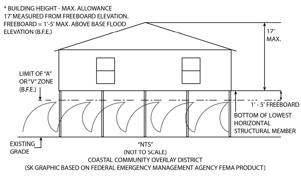
(Ord. of 9-26-16(1); Ord. of 2-25-19(1); Ord. of 7-22-19(1); Ord. of 12-9-19(2))
Sec. 609. - Coastal Resiliency Overlay District.
609.1.
Establishment of district.
There is hereby established a Coastal Resiliency (CR) Overlay District, the boundaries of which are shown on the official zoning map. The CR Overlay District contains the land area depicted on the Coastal Resources Management Council (CRMC) Design Elevation Maps as being vulnerable to storm surge during a one hundred-year storm event with the presence of five-feet of sea level rise (SLR) that lies outside of the Federal Emergency Management Agency's (FEMA) Special Flood Hazard Areas (SFHA).
609.2.
Purpose.
The purpose of the CR Overlay District is to protect the public health, safety, and general welfare by promoting awareness of future projections of sea level rise and the associated impacts from flooding and storm surge to current and future property owners. CRMC's design elevation maps allow municipalities and property owners to plan for the effects of storm surge, coastal erosion and wave conditions given future projected amounts of sea level rise. Each CRMC design elevation map depicts a specific level of anticipated sea level rise and provides recommended design flood elevations for structures, or in other words, the elevation at which a building should be constructed to withstand a once in hundred-year storm event given the amount of sea level rise depicted on the specific map. Utilization of CRMC's design elevation maps is intended to increase the ability of the structure to withstand future storm surge conditions, therefore increasing coastal resiliency and further protecting public health and safety.
609.3.
Recording of resiliency information prior to building permit application.
For all new construction, prior to application for a building permit, the applicant shall request information from the planning department relative to future projected sea level rise scenarios. The information to be furnished by the planning department shall be determined by the director of planning. Upon provision of the information to the applicant, the planning department shall record the information in the town's land evidence records, so that future property owners may benefit from the knowledge. The town intends this informational exercise to ensure that current and future property owners are aware of the risks from future sea level rise, flooding and storm surge. Elevating structures to a design elevation depicted on a CRMC design elevation map, however, is optional.
609.4.
Development standards and dimensional requirements.
When considered as part of a development project (as defined in section 601.3.C), the following height standards shall apply to the Coastal Resiliency Overlay District, except as provided in B below.
A.
Maximum Building Height.
1.
No structure shall exceed the following height measurements:
(a)
Structures that are elevated to a distance above grade of less than or equal to five (5) feet shall be limited to thirty-five (35) feet of building height;
(b)
Structures that are elevated to a distance above grade of greater than five (5) feet but less than or equal to ten (10) feet shall be limited to thirty (30) feet of building height;
(c)
Structures that are elevated to a distance above grade of greater than ten (10) feet but less than or equal to fifteen (15) feet shall be limited to twenty-five (25) feet of building height.
(d)
Structures that are elevated to a distance above grade of greater than fifteen (15) feet shall be limited to twenty (20) feet of building height.
2.
No part of any structure shall exceed the maximum height listed above except for those exclusions listed in the definition of "building height" in article 12.
B.
Inapplicability to Certain Development Projects. Notwithstanding A above, the standards in this section shall not apply:
1.
Inapplicability to Development Projects within Nonresidential Zoning Districts. The standards established in this section shall not be applied to development projects wholly within a Commercial (CD, CW), Industrial (I-1, I-2, I-3), Government and Institutional (GI, and Public Marina Special Management District (PMSMD) zoning districts.
2.
Inapplicability to Development Projects within Coastal Community Overlay District. The standards established in this section shall not apply to development projects located wholly within a Coastal Community Overlay District (section 608).
3.
For the purposes of this section, development projects that have received a completed CRMC Preliminary Determination and/or an approval of an Onsite Wastewater Treatment System application from the Rhode Island Department of Environmental Management (RIDEM) on or before February 28, 2019 shall be exempt from the development standards outlined in A above.
C.
Other than described in A above, nothing in this section shall be construed as to modify any dimensional requirements established elsewhere in this ordinance.
(Ord. of 2-25-19(1); Ord. of 7-22-19(1))

