
South St Paul City Zoning Code
ARTICLE IV
DISTRICT REGULATIONS
DIVISION 2. - MISSISSIPPI RIVER CRITICAL CORRIDOR AREA OVERLAY DISTRICT[3]
Editor's note— Ord. No. 1411, § 1, adopted Aug. 21, 2023, repealed the former Div. 2, §§ 118-165—118-171, and enacted a new Div. 2 as set out herein. The former Div. 2 pertained to SP, special purpose zoning districts and derived from Code 1992, § 1500.20; Code 1992, § 1500.26, subds. 1—3; Code 1992, § 1500.33, subds. 1—31; Ord. No. 1251, §§ 1, 2, adopted Nov. 7, 2011.
Sec. 118-121. - R-1, single-family district.
(a)
Permitted uses. Within the R-1 single-family district, no building, structure or land shall be used except for one or more of the following uses, unless otherwise provided in this chapter:
(1)
Principal use.
a.
One single-family dwelling (not to include mobile homes).
b.
Churches, chapels, temples, and synagogues, including Sunday schools, and parish houses meeting the requirements of this district.
c.
Public parks and playgrounds.
d.
A state licensed residential care facility serving six or fewer persons.
e.
Child day care facility serving 12 or fewer persons.
f.
Adult day care facility serving 12 or fewer persons.
(2)
Accessory uses.
a.
Garages used as an accessory to the dwelling and located upon the same parcel, intended or capable of providing for the storage of motor vehicles, as regulated herein by the performance standards section 118-208. No business, occupation, or service may be conducted in any garage unless an interim use permit has been obtained in accordance with the standards contained in section 118-249.
b.
One accessory storage building or structure, in addition to the garage, the use of which is incidental to and located on the same parcel as the dwelling, as regulated herein by the performance standards section 118-208.
c.
One accessory building that cannot be used as a storage building, such as a greenhouse or gazebo, as regulated herein by the performance standards section 118-208.
d.
Swimming pools and tennis courts, as regulated herein by the performance standards section.
e.
Keeping of domestic pets.
f.
Fences, signs, and recreation equipment, as regulated herein.
g.
Home occupations and home offices, subject to the standards contained in section 118-249 of this Code.
h.
A PWS antenna located entirely inside a building or structure.
i.
Keeping of chickens as per the backyard chicken regulations found in section 15-9.
j.
Group family day care located in a single-family dwelling or duplex serving no more than 14 children.
(b)
Uses by conditional use permit. Within the R-1 district, the following uses shall be by conditional use permit only:
(1)
Accessory buildings that have a size which triggers a conditional use permit requirement, as detailed in City Code section 118-208.
(2)
Hospitals or sanatoriums, philanthropic and charitable institutions, except correctional institutions and animal hospitals. Any building permitted to be used shall have an appearance that shall be in appropriate harmony with the residential character of the area.
(3)
Essential services (public utility and municipal services).
(4)
Elementary, junior, and senior high schools and incidental and accessory uses, when situated on the same site or unit of property.
(5)
Cemeteries.
(6)
A PWS antenna mounted on the outside of an institutional building or structure of any height, as defined in section 118-207, and any governmental building or structure.
(7)
A small wireless facility, as defined in section 54-402, that is located in the right-of-way, as long as all provisions of sections 54-400 through 54-429 have been met.
(8)
A detached garage when the principal dwelling already has an attached garage. No more than one detached garage shall be allowed per lot or per property under single ownership.
(9)
A reception or meeting hall that is not part of a church, school, charitable organization, or other allowed use when contained within an existing building that is listed on the National Register of Historic Places.
(10)
Child day care facility except as provided in section 118-121(a).
(c)
Building height, width, area, and architectural requirements. Within the R-1 district, residential dwellings must comply with the following:
(1)
Shall not exceed a height of three stories, or 28 feet above grade as defined in the Minnesota State Building Code;
(2)
Shall be a minimum of 24 feet wide; and
(3)
Shall have a minimum area footprint of 800 square feet.
(4)
Shall comply with the architectural requirements for residential structures contained in section 118-9.
(d)
Lot requirements. Within the R-1 district, the following requirements shall apply:
(1)
Lot area, width, and depth. Each dwelling, together with its accessory buildings, shall be located on a lot having an area not less than 9,000 square feet, width of not less than 75 feet, and depth of not less than 120 feet, except in the following circumstances:
a.
A dwelling may be erected on a lot platted prior to May 1, 1967 or a lot of record that was lawfully established, having less than the foregoing area, width, and depth but having no less than 4,000 square feet of lot area. A lot platted prior to May 1, 1967 which has been combined with other lots may be restored to its original dimensions, subject to the provisions of Section 114-5.
b.
When an existing block contains lots platted prior to May 1, 1967 or other lots of record that do not meet standard R-1 requirements, new lots may be created on the block which also do not meet standard R-1 lot dimension requirements provided that they are consistent with existing lot dimensions on the block. No new lot being created under this provision may have a width that is less than the narrowest lot of record on the block which faces the same street. No new lot being created under this provision may have a lot area that is less than the smallest lot of record on the block which faces the same street. Additionally:
1.
New lots which do not have access to an abutting improved alley must have an area of at least 6,000 square feet, a width of at least 50 feet, and a depth of at least 120 feet.
2.
New lots which do have access to an abutting improved alley must have an area of at least 4,800 square feet, a width of at least 40 feet, and a depth of at least 120 feet.
(2)
Ingress and egress. All lots shall front on a public street or have adequate ingress and egress to a public street.
(3)
Percent of land use. All dwellings and accessory buildings on any lot shall not cover more than 35 percent of the area of the lot (see article VII of this chapter for additional requirements).
(4)
Front yard. No building shall be erected, reconstructed, altered or moved nearer to the front lot line than the average setback observed by residential buildings on the same side of the street and fronting thereon within the same block. Further, no part of the structure shall be closer than 25 feet to the street line on which it faces, except when the average setback is less than 25 feet.
(5)
Side yard. There shall be a side yard of not less than five feet along each side of each building located on an interior lot having a frontage of 60 feet or less; such side yard on a lot having a frontage of more than 60 feet shall be not less than nine feet; provided, however, that the side of the house which includes an attached garage with no basement below it may have a side yard of not less than five feet. There shall be a side yard of not less than nine feet on the street side of any structure constructed on a corner lot. No attached garage shall be placed within ten feet of any dwelling unit on an adjacent lot. When an alley runs parallel to a side property line, a garage with an entrance facing said alley must be set back at least eight feet from the alley right-of-way line.
(6)
Rear yard. Each lot shall have a rear yard of not less than 25 feet in depth.
(7)
Conditional use permit requirements. All uses by conditional use permit shall provide such setback in front, side, and rear yards as the city council shall determine, taking into account the proposed use, the character of the surrounding area, the density of the area, and other relevant factors.
(e)
Off-street loading and unloading berths. In the R-1 district, off-street loading and unloading shall be governed by the provisions of article VII of this chapter.
(f)
Prohibited uses. The following uses are prohibited because they are not compatible with the purposes of the R-1 single-family district: PWS towers and antennas, except as permitted under subsections (a)(2)g and (b)(7) of this section and small wireless facilities located outside of the right-of-way.
(Code 1992, § 1500.09; Ord. No. 1267, § 1, 2-19-2013; Ord. No. 1297, § 1, 4-20-2015; Ord. No. 1312, § 1, 11-21-2016; Ord. No. 1318, § 3, 6-5-2017; Ord. No. 1321, § 2, 9-18-2017; Ord. No. 1326, § 2, 10-16-2017; Ord. No. 1357, § 1, 6-1-2020; Ord. No. 1365, § 1, 9-21-2020; Ord. No. 1379, § 1, 5-3-2021; Ord. No. 1380, § 2, 5-3-2021; Ord. No. 1382, § 1, 7-20-2021; Ord. No. 1383, § 1, 9-7-2021; Ord. No. 1408, § 1, 6-5-2023; Ord. No. 1418, § 4, 2-5-2024; Ord. No. 1424, § 6, 5-20-2024)
Sec. 118-122. - R-2, single- and two-family residence district.
(a)
Permitted uses. Within the R-2 district, no structure or land shall be used except for one or more of the following uses, except as otherwise permitted by this chapter:
(1)
Principal and accessory uses permitted in the R-1 district;
(2)
Duplex or twin home (see subsection (e) of this section); and
(3)
A PWS antenna located entirely inside a building or structure.
(b)
Uses by conditional use permit. Within the R-2 district, the following uses shall be by conditional use permit only:
(1)
All uses allowed by a conditional use permit in the R-1 district.
(c)
Building height, width, area, and architectural requirements. Within the R-2 district, building height, width, area, and architecture for residential dwellings shall be as regulated in the R-1 district.
(d)
Lot requirements; single-family dwellings. Each dwelling, together with its accessory buildings, shall be located on a lot having an area of not less than 6,000 square feet, width of not less than 50 feet, and depth of not less than 120 feet, except in the following circumstances:
(1)
A dwelling may be erected on a lot platted prior to May 1, 1967 or a buildable lot of record that was lawfully established, having less than the foregoing area, width, and depth but having no less than 4,000 square feet of lot area. A lot platted prior to May 1, 1967 which has been combined with other lots may be restored to its original dimensions, subject to the provisions of section 114-5.
(2)
When an improved alley is provided along the rear or side property line, a new buildable lot may be created with an area of not less than 4,800 square feet, a width of not less than 40 feet, and a depth of not less than 120 feet.
(e)
Lot requirements; two-family dwellings. The following minimum lot and building requirements shall apply to all two-family dwellings in the R-2 district whether the two-family homes are newly constructed or are newly created by remodeling an existing structure which was previously not a two-family dwelling:
(1)
Lot area, width, and depth. No two-family dwelling shall be erected on a lot having less than 60 feet of frontage, and 7,200 square feet of area.
(2)
Percent of land use. The two-family dwelling and accessory buildings on any lot shall not cover more than 35 percent of the area of the lot.
(3)
Access to unit. Each unit of the two-family dwelling shall have a separate access to the outside of the dwelling or to a common hallway or entryway.
(4)
Inspection and license. Each rental unit within a two-family dwelling shall be inspected in accordance with article VII of chapter 106 of this Code prior to occupancy.
(5)
Separate bathroom, kitchen, sleeping area. Each dwelling unit must have a separate bathroom, kitchen and sleeping area.
(6)
Miscellaneous. The requirements of sections 118-121(d)(2) and (d)(4)—(6) shall apply to two-family dwellings.
(f)
Off-street parking, loading and unloading berths. Within the R-2 district, the provisions of article VII of this chapter shall apply.
(g)
Prohibited uses. The following uses are prohibited because they are not compatible with the purposes of the R-2 residence district: PWS towers and antennas, except as permitted under subsections (a) and (b) of this section and small wireless facilities located outside of the right-of-way.
(Code 1992, § 1500.10; Ord. No. 1273, § 1, 9-16-2013; Ord. No. 1318, § 3, 6-5-2017; Ord. No. 1321, § 2, 9-18-2017; Ord. No. 1389, § 1, 2-22-2022; Ord. No. 1424, § 7, 5-20-2024)
Editor's note— Ord. No. 1273, § 1, adopted September 16, 2013, renamed § 118-122, from R-2, duplex residence district to R-2, single- and two-family residence district.
Sec. 118-123. - R-3, general residence district.
(a)
Permitted uses. Within the R-3 district, no structures or land shall be used except for one or more of the following uses:
(1)
Any use permitted in the R-1 and R-2 districts, as regulated therein, except that a state licensed residential care facility may only serve six or fewer persons and must be located on a lot that is being used as a single-family use.
(2)
Townhouses not exceeding eight dwelling units (also see section 118-267).
(3)
Buildings containing two or more dwelling units, not to exceed 12 dwelling units. No building permit shall be issued for any apartment building or townhouse containing three or more dwelling units unless the zoning administrator has first approved drawings showing the following information:
a.
The overall size of the exterior of the building or buildings and the general character and appearance of the building or buildings in elevation.
b.
A site plan filed with the city clerk, as approved by the zoning administrator, shall be submitted showing the placement of buildings on the site, proposed parking and ingress and egress, proposed contours and retaining walls as related to existing contours, general layout of any proposed access roads, and locations of sewer and water connections, as may be needed.
(b)
Permitted accessory uses. Within the R-3 district, the following uses shall be permitted accessory uses: All accessory uses permitted in the R-1 and R-2 districts and as regulated therein.
(c)
Uses by conditional use permit. Within the R-3 district, no structures or land shall be used for the following, except by conditional use permit:
(1)
State licensed residential care facility serving up to 16 persons;
(2)
Adult day care facility serving between 13 and 16 persons.
(3)
Any conditional use permitted in the R-1 and R-2 districts.
(d)
Lot area, yard, and building height, width, area, and architectural requirements.
(1)
One- and two-family dwellings shall comply with the requirements of the R-2 district;
(2)
Buildings containing three or more dwelling units shall be subject to the provisions of section 118-267.
(e)
Off-street parking and loading. Off-street parking and loading within the R-3 zoning district shall be as required and regulated in article VII of this chapter.
(f)
Prohibited uses. The following uses are prohibited because they are not compatible with the purposes of the R-3 district:
(1)
PWS towers and antennas, except as permitted under this section;
(2)
State-licensed residential care facilities, except as provided in sections 118.123(a)(1) and 118.123(c)(1);
(Code 1992, § 1500.11; Ord. No. 1318, § 3, 6-5-2017; Ord. No. 1365, § 1, 9-21-2020; Ord. No. 1383, § 2, 9-7-2021; Ord. No. 1424, § 8, 5-20-2024; Ord. No. 1431, § 13, 2-3-2025)
Sec. 118-124. - R-4, multifamily residential district.
(a)
Permitted uses. Within the R-4 district, no land or structure shall be used except for one or more of the following uses:
(1)
Multifamily residential buildings containing four or more dwelling units but not exceeding 20 dwelling units nor three stories or 38 feet in height. No building permit shall be issued for any multifamily residential building unless the city has first approved drawings showing the same information as that required by section 118-123(a)(3) and following the same procedures.
(2)
Any use permitted in the R-1, R-2, and R-3 districts, as regulated therein, except that a state licensed residential care facility may only serve six or fewer persons and must be located on a lot that is being used as a single-family use.
(3)
PWS antennas located entirely inside a building or structure.
(b)
Uses by conditional use permit. Within the R-4 district, no land or buildings shall be used for the following, except by conditional use permit:
(1)
All conditional uses permitted in the R-1, R-2, and R-3 districts;
(2)
Multifamily residential developments that exceed 20 dwelling units;
(3)
All multifamily residential buildings that exceed three stories or 38 feet in height;
(4)
State licensed residential care facility serving up to 16 persons;
(5)
PWS antennas mounted on a building or structure 30 feet high or higher.
(6)
Adult day care facility.
(c)
Accessory uses. These shall include all accessory uses permitted in the R-3 district.
(d)
Lot area, yard, building height, and architectural requirements.
(1)
One- and two-family dwellings shall comply with the requirements of the R-2 district;
(2)
Buildings containing three or more dwelling units shall be subject to the provisions of section 118-267.
(e)
Off-street parking and loading. Within the R-4 district, off-street parking and loading shall be as required and regulated in article VII of this chapter.
(f)
Prohibited uses. The following uses are prohibited because they are not compatible with the purposes of the R-4 multifamily residential district:
(1)
PWS towers and antennas, except as permitted under subsections (a)(3) and (b)(4) of this section;
(2)
State-licensed residential care facilities, except as provided in sections 118-124(a)(2) and 118-124(b)(4);
(Code 1992, § 1500.13; Ord. No. 1318, § 3, 6-5-2017; Ord. No. 1365, § 1, 9-21-2020; Ord. No. 1383, § 3, 9-7-2021; Ord. No. 1424, § 9, 5-20-2024)
Sec. 118-125. - CGMU, Concord Gateway mixed-use district.
(a)
Purpose. The purpose of the Concord Gateway mixed-use (CGMU) district is to provide an area for compact, mixed-use development made mutually compatible through a combination of careful planning, urban design and coordinated public and private investment. The mixture of land uses within the district is essential to establishing the level of vitality and intensity needed to support retail and service uses. The placement of building edges and the treatment of building, parking, landscaping, and pedestrian spaces is essential to creating the pedestrian-friendly environment envisioned for the CGMU. The standards in this section are intended to implement and effectuate the principles and relationships established in the city's Concord Gateway Framework Plan, a copy of which is on file in the office of the city clerk, which will be carried out through specific standards related to site planning, signage, architecture, building materials, and landscaping. The CGMU is divided into two subdistricts, CGMU-1 and CGMU-2, as depicted on the official zoning map. In 2022, the architectural standards were updated to allow contemporary architecture and contemporary exterior building materials with the understanding that buildings constructed with this style still must be pedestrian-oriented and adhere to the core principles of the district.
(b)
Permitted uses. Within either the CGMU-1 or CGMU-2 subdistricts, no structure or land may be used except for one or more of the following uses, provided such use is less than 10,000 square feet in gross floor area:
(1)
Accessory store, apparel.
(2)
Altering, pressing and repair of wearing apparel.
(3)
Appliance store.
(4)
Art gallery.
(5)
Bakery.
(6)
Banks and other financial institutions without drive-through facilities.
(7)
Barbershop.
(8)
Beauty shop.
(9)
Body art establishment (defined and regulated by section 118-276).
(10)
Bookstore.
(11)
Cafe, cafeteria, restaurant, or delicatessen, without drive-through facilities.
(12)
Camera store.
(13)
Candy, nut or confectionery store.
(14)
Club or lodge, private.
(15)
Copy service or printing service.
(16)
Craft production, including the production of alcoholic beverages, cannabis products, and lower-potency hemp edibles.
a.
Must include a retail/eating/drinking/tasting component that is open to the public and occupies a minimum of ten percent of usable space. This space must front the street at the ground floor level or have a well-marked and visible entrance at the ground floor level.
b.
All production, processing, and distribution activities except for the loading of finished products onto trucks are to be conducted within an enclosed building.
c.
Craft production of alcoholic beverages shall require a conditional use permit for off- sale or on-sale liquor.
d.
Craft production of cannabis products and lower-potency hemp edibles shall require a conditional use permit.
(17)
Department store.
(18)
Flower shop.
(19)
Furniture store.
(20)
Gift, novelty, or souvenir store.
(21)
Grocery store.
(22)
Hardware store.
(23)
Hotel or motel.
(24)
Instrument store, musical.
(25)
Laundromat or dry cleaning.
(26)
Library.
(27)
Locksmith.
(28)
Luggage store.
(29)
Machines, business sales and service.
(30)
Magazine stand or newsstand.
(31)
Massage therapy (licensed pursuant to article XII of chapter 18 of the City Code).
(32)
Meat market for retail sale to the public.
(33)
Medical or dental office or clinic (for humans only).
(34)
Municipal buildings and uses.
(35)
Museum.
(36)
Musical instrument and musical recordings store.
(37)
Notions store.
(38)
Office.
(39)
Optician.
(40)
Painting, wallpaper and decorating store for retail sales and service.
(41)
Pet store.
(42)
Public parks and playgrounds.
(43)
Repair and servicing of items the sale of which is permitted in this district.
(44)
Residential multifamily dwelling units, if within a structure containing at least four units.
(45)
Shoe store.
(46)
A small wireless facility, as defined in section 54-402, that is located in the right-of-way, as long as all provisions of sections 54-400—54-429 have been met.
(47)
Sporting goods store.
(48)
Stationary store.
(49)
Tanning salon.
(50)
Tobacco store.
(51)
Toy store.
(52)
Variety store.
(53)
Video sales and rental.
(c)
Accessory uses. Within the CGMU-1 or CGMU-2 subdistricts, the following uses shall be permitted accessory uses:
(1)
Off-street parking of automobiles for patrons or employees of a permitted use.
(2)
Off-street loading areas as regulated herein.
(3)
Signs, fences, and decorative landscape features as regulated herein.
(4)
Customary uses incidental to the principal use as determined by the city council.
(5)
Off-sale 3.2 percent malt liquor sales (licensed pursuant to chapter 6 of the City Code).
(6)
Lower-potency hemp edible retailer.
(7)
Cannabis transportation and delivery accessory to a cannabis business provided there is no on-site delivery vehicle fleet.
(d)
Conditional uses, CGMU-1. Within the CGMU-1 subdistricts, no structure or land may be used for any of the following uses except by conditional use permit:
(1)
On-sale and off-sale liquor establishments as regulated by this Code.
(2)
Amusement or entertainment, as defined and regulated by this Code.
(3)
Church.
(4)
Medical uses (for animals).
(5)
Residential dwelling units within the same building as nonresidential uses, if provisions for parking, security, noise, odors, and other related issues affecting the residential units can be shown to be handled adequately and in keeping with the best interests of the residents.
(6)
Theaters.
(7)
Schools, public or private.
(8)
Adult day care facility.
(9)
Child day care facility.
(10)
Parking ramps or parking garages.
(11)
Buildings in excess of 50 feet in height, if such buildings will not block significant views from existing uses or views to significant features within the CGMU district, and if such buildings can be shown to be in keeping with the intent and character of the CGMU district and compatible with surrounding uses.
(12)
Any permitted use or any other conditional use, if 10,000 square feet or more in gross floor area, if such use can be shown to be in keeping with the intent and character of the CGMU district and compatible with surrounding uses.
(13)
Pet grooming and pet training provided that:
a.
Unless expressly allowed by the conditional use permit, all activity must take place within a completely enclosed building with odor and sound control except for the walking of dogs. No outdoor kenneling shall be permitted.
b.
There shall be no overnight kenneling of customers' pets and no animal may be present inside the business between the hours of 10:00 p.m. and 6:00 a.m. unless their owner is also present.
c.
Any outdoor off-leash exercise/relief area that is provided shall be entirely enclosed by a fence. Pets may not be off-leash in these areas between the hours of 8:00 p.m. and 7:00 a.m.
(14)
Cannabis retailer
(15)
Cannabis testing facility
(16)
Cannabis cultivation of up to 15,000 square feet of plant canopy when accessory to a cannabis dispensary or craft production facility producing cannabis products or lower- potency hemp edible products.
(17)
Other uses determined by the city council to be similar in purpose and character to other permitted or conditional uses in this district.
(e)
Conditional uses, CGMU-2. Within the CGMU-2 subdistricts, no structure or land may be used for the following uses, except by conditional use permit:
(1)
Any conditional use allowed in the CGMU-1 subdistrict.
(2)
Automobile and truck service uses.
(3)
Equipment and vehicle rental.
(4)
Gasoline service stations, auto repair, sales, and storage.
(5)
Automobile car wash.
(6)
Screened outdoor storage.
(7)
Drive-through facilities for a permitted use, if provisions for vehicle stacking, vehicle maneuvering, outdoor speaker devices, appearance and lighting of outdoor menu boards, and other related matters can be shown to be in keeping with the intent and character of the CGMU district and compatible with surrounding uses.
(f)
Lot area, lot width, and yard requirements. The following standards apply to both the CGMU-1 and CGMU-2 subdistricts:
(1)
Principal structure setback standards shall be as follows:
*
Reduced rear yard setbacks may be allowed by conditional use permit.
(2)
Accessory structure setback standards shall be as follows:
(3)
Parking setback standards shall be as follows:
(4)
In the CGMU district in the front yard, a build-to line is established which provides a minimum and maximum front setback for buildings and other structures, from the right-of-way or property line. The minimum front building setback shall be zero feet, and the maximum shall be ten feet from the right-of-way or property line, for all properties on streets within the CGMU-1 subdistrict.
(5)
For parking, different minimum setbacks apply, but there is no maximum.
(6)
For all properties within the CGMU district, the required setbacks to Concord Street shall follow the rear yard setbacks above.
(7)
In the CGMU-1 subdistrict, at least 60 percent of the street frontage of any lot shall be occupied by building façades meeting the build-to line. Other portions of a building beyond the 60 percent may be set back farther than required by the build-to line.
(8)
In the CGMU-2 subdistrict, at least 40 percent of the street frontage of any lot shall be occupied by building façades meeting the build-to line. Other portions of a building beyond the 40 percent may be set back farther than required by the build-to line. The length of the building façade shall be measured as the maximum width of the building projected to the front lot line on lines perpendicular to the front lot line.
(9)
On lots with more than one street frontage, the build-to line shall apply on each side fronting a street.
(10)
The build-to line may be met either with an enclosed building or an arcade constructed with a permanent roof of the same materials as the remainder of the building.
(11)
At least the first and second floor must meet the build-to-line. Arcades at street level and terracing of building façades above the second floor are encouraged.
(12)
At a minimum, the first 50 feet of the lot frontage on either side of a street intersection must be occupied by buildings meeting the build-to line. Parking or other space open to the sky is not allowed within this first 50 feet.
(13)
Wherever a surface parking area faces a street frontage, such frontage shall be screened with a decorative wall, railing, hedge, or a combination of these elements to a minimum height of two and one-half feet. The maximum height of fences and walls is regulated by section 118-199.
(14)
New parking structures (including garages) shall maintain a setback equal to the setbacks required in this section for other structures, except that where such parking structure is adjacent to other parking in a side or rear yard condition, the parking structure may have a zero setback. Where a new parking structure is adjacent to an existing use in a side or rear yard condition, the parking structure must maintain at least a ten-foot setback.
(15)
Drive-through or drive-in lanes are not allowed within the build-to line or in front of any building; they must be located to the side or rear of a building.
(16)
"Building height" means the vertical distance from the average elevation of the adjoining ground level or the established grade, whichever is lower, to:
a.
The top of the cornice of a flat roof;
b.
The top of a mansard roof;
c.
A point directly above the highest wall of a shed roof;
d.
The uppermost point of a round or other arch-type roof; or
e.
The mean distance from the eave line to the peak of the highest gable on a pitched or hip roof.
(17)
The maximum height of buildings in the CGMU district shall be 50 feet, except as allowed by conditional use permit. The minimum height shall be 24 feet in the CGMU-1 subdistrict and 16 feet in the CGMU-2 subdistrict.
(g)
Parking.
(1)
Parking for residential units in the CGMU district shall be provided on site, and shall be calculated as required under article VII of this chapter. The residential parking spaces shall be specifically reserved for the use of residents and visitors only, separate from any commercial, office, or other uses on site or nearby, and shall not be counted as part of any shared parking or joint parking arrangement. Parking in driveways at the rear of townhomes may be counted towards the requirements of this regulation if it does not interfere with other traffic movement.
(2)
Parking for nonresidential uses shall be as required under article VII of this chapter. If present, on-street parking directly in front of a given building or lot shall count toward fulfilling the total parking requirement.
(3)
On-grade parking is prohibited in the front yard directly in front of a building. Parking shall be provided to the side or rear of buildings in midblock areas.
(4)
In the CGMU-1 subdistrict where parking fronts a public street, the maximum parking lot width shall be 65 feet measured at the lot frontage.
(5)
In the CGMU-2 subdistrict where parking fronts a public street, the maximum parking lot width shall be 130 feet, measured at the lot frontage.
(6)
Parking shall be prohibited within 50 feet of the intersection of any public streets within the CGMU district.
(7)
For all properties west of Concord Street, outdoor parking of trucks and commercial vehicles in off-street facilities that are accessory to nonresidential uses shall be limited to vehicles of not more than 26,000 pounds gross vehicle weight unless otherwise allowed by conditional use permit. Such a conditional use permit shall be subject to the following:
a.
The vehicle(s) must be accessory to a principal use taking place at the subject property and that use must be allowed in the CGMU zoning district. The outdoor storage of large trucks and commercial vehicles owned by members of the general public is prohibited.
b.
The conditional use permit may limit the number and size of vehicles to be parked and may specify where they will be located on the property. Screening and landscaping improvements may be required when practical.
(h)
Building and architectural provisions.
(1)
All buildings shall be designed to accomplish the goals and policies of the comprehensive plan and the framework plan. Building materials shall be attractive in appearance, durable with a permanent finish, and of a quality that is consistent with the standards and intent of the framework plan. Where appropriate, buildings shall carry over materials and colors of adjacent buildings, with the exception of prohibited materials.
(2)
All buildings shall include the following elements:
a.
Accent materials, which shall be wrapped around walls that are visible from a public street or open space;
b.
Buildings containing office and retail uses shall maintain 30 percent minimum window coverage on each first floor front that faces a street or public open space. In the CGMU-2 subdistrict, these buildings must have windows facing all public streets but the city council may allow window coverage that is below 30 percent through a site plan review so long as the façade includes design elements that will provide visual interest to pedestrians;
c.
Complimentary major material colors;
d.
A combination of vertical and horizontal pattern designs in the building façade.
(3)
Any exterior building wall adjacent to or visible from a public street, public open space, or abutting property may not exceed 50 feet in length without significant visual relief consisting of one or more of the following:
a.
The façade shall be divided architecturally by means of significantly different materials or textures;
b.
Horizontal offsets of at least four feet in depth;
c.
Vertical offsets in the roofline of at least four feet; or
d.
Fenestration at the first floor level that is recessed horizontally at least one foot into the façade.
(4)
Reserved.
(5)
Exterior building materials shall be classified primary, secondary, or accent materials. Primary materials shall cover at least 60 percent of the façade of a building. Secondary materials may cover no more than 30 percent of the façade unless otherwise noted. Accent materials may include door and window frames, lintels, cornices, and other minor elements, and may cover no more than ten percent of the façade. Allowable materials are as follows:
a.
Primary exterior building materials may be brick, natural stone or manufactured stone that replicates natural stone, glass, or any material defined as Class I in section 118-9. Bronze-tinted or mirror glass are prohibited as exterior materials.
b.
Secondary exterior building materials may be decorative block, cement-based architectural products (i.e. Hardieboard), engineered wood products (i.e. LP Smartside), architectural metal siding, integrally-colored stucco, or any material defined as Class II in section 118-9.
c.
Synthetic stucco may be permitted as a secondary material on upper floors only.
d.
Accent materials may be wood or metal if appropriately integrated into the overall building design and not situated in areas that will be subject to physical or environmental damage.
e.
Manufactured stone, brick, stucco, and decorative block shall be integrally colored.
f.
Decorative block shall be colored only by means of a pigment integral to the block material, not applied to the surface.
g.
Sheet metal, corrugated metal, asbestos, iron, shakes, and plain flat concrete block (whether painted or integrally colored or not) are not acceptable as exterior wall materials on buildings within the Concord Gateway district.
h.
Cement based architectural products (i.e. Hardieboard) may be used to satisfy up to half of the primary exterior material requirement for each façade.
i.
On the west side of Concord Exchange, rear facades facing the toe of the bluff which are not readily visible from public streets may be constructed out Class I materials and Class II materials as defined in section 118-9, engineered wood products, synthetic stucco, cement-based architectural products, and architectural metal siding. No specific material percentages are required for these façades.
(6)
For properties south of Grand Avenue that have frontage on both Concord Exchange and Concord Street, the right-of-way line along Concord Street shall be considered a rear property line and the principal structure is required to meet rear yard setbacks unless otherwise approved by conditional use permit. Properties north of Grand Avenue that have frontage on both Concord Exchange and Concord Street shall be considered to have front property lines along both streets.
a.
For properties north of Grand Avenue that have frontage on both Concord Exchange and Concord Street, the City Council may grant flexibility from the build-to-line requirement along Concord Street via the site plan review process if the setback is pedestrian-oriented and contributes to the quality and character of the streetscape. An example of this would be an outdoor dining area.
(7)
All exterior trash enclosures or other accessory structures shall be constructed of the same materials and colors as the principal building except for properties that have legal nonconforming exterior trash handling. These properties are permitted to bring their trash handling into partial compliance by constructing a trash enclosure out of composite decking material. Trash enclosures constructed of composite decking material must be placed at least ten feet away from the principal building unless the principal building is equipped with sprinklers.
(8)
Consistent interior window treatments are required for windows that are visible from a public street or open space in offices and multiple residential complexes.
(9)
All buildings containing nonresidential uses on the ground floor shall meet the following standards:
a.
The building shall have entrances to a street or public open space spaced no more than 100 feet apart.
b.
Entrances shall be oriented conveniently to the street frontage and to on-street and off-street parking serving the use.
(10)
All buildings containing residential uses on the ground floor shall have a first floor elevation at least two and one-half feet above the adjacent street level in the front yard. This requirement may be waived by the city council during site plan review if the first floor contains a street-facing amenity area with transparent glass windows or some other similar use on the ground floor that provides visual interest.
(11)
All trash, recyclable materials, and equipment for handling them, including compactors, shall be totally screened from eye-level view from public streets and adjacent properties, whether in the front, side or rear, either by being stored within the principal structure or stored within an accessory structure and readily served through swinging doors or an overhead door on tracks.
(12)
Loading docks shall not be located in the front yard and shall be completely screened from eye-level view of public streets and public open spaces by means of landscaping which is at least 80 percent opaque year-round within two years after planting, or by a screen wall of the same materials and colors as the principal building.
(13)
All landscaping shall comply with the following provisions:
a.
All land area not occupied by buildings, parking, driveways, sidewalks, or other hard surface shall be sodded or mulched and landscaped with city-approved ground cover, flowers, shrubbery and trees.
b.
At least ten percent of the total land area within the perimeter of private parking and driveway areas shall be landscaped. Landscaped areas provided within the build-to line may be credited toward this ten percent landscaping requirement on a square-foot-for-square-foot basis, for up to half of the ten percent requirement, or five percent.
c.
Parking lot landscaped islands shall be a minimum of 150 square feet in area and include at least one overstory or evergreen tree meeting the requirements of this article.
d.
Where parking abuts the site perimeter there shall be provided at least one overstory tree per 25 feet of site perimeter.
e.
At least one overstory tree shall be provided for every 500 square feet of landscaped area on the entire site.
f.
The landscape plan shall include a full complement of overstory, ornamental and evergreen trees, shrubbery, and ground covers that are hardy and appropriate for the locations in which they are planted, and which provide year-round color and interest.
g.
Plant selection shall be as follows:
1.
The following trees may not be used to satisfy the landscaping requirement of this section:
2.
The following trees may be used to satisfy the landscaping requirement of this section, but only in areas that are reasonably protected from winter wind conditions:
3.
The following trees may be used to satisfy the landscaping requirement of this section, but only in areas that are not on or immediately adjacent to a public street boulevard:
(14)
Reserved.
(15)
Lighting in the CGMU district shall be subject to the following:
a.
All exterior lighting in the CGMU district shall be downcast cutoff type fixtures and shall follow the styles and types identified in the framework manual. Parking lot light poles may not exceed 20 feet in height, except by conditional use permit for buildings that are more than 20 feet in height.
b.
The applicant for any building project shall provide a photometric lighting diagram prepared by a qualified professional showing light levels, in footcandles, from all exterior artificial lighting for all points on and within ten feet of the site.
c.
Lighting levels in exterior parking areas shall average one-half footcandle with a minimum of one-tenth footcandle in all locations.
d.
Lighting levels in interior parking areas shall average two footcandles, with a minimum of one-half footcandle in all locations.
e.
In addition to adhering to all of the requirements listed in section 118-245, lighting in the Concord Gateway Mixed-Use District may not cast more than one footcandle of light onto an abutting property that does not have residential zoning, as measured at the property line.
(i)
Nonconformities.
(1)
Nonconformities shall be administered consistent with state statute and the city's adopted nonconformity ordinance unless otherwise noted in this section.
(2)
Requirements for expansion or enlargement of nonconforming buildings.
a.
The total square footage or percentage of any and all previous expansions to an existing nonconforming building that have taken place since the adoption of the CGMU ordinance in 2003 shall be aggregated for calculating the percentage of the total expansion to the existing building under the terms of this section.
b.
A nonconforming building may be expanded so long as the expansion or addition itself meets the provisions of this section. Expansion of a nonconforming building by more than 10,000 square feet or by more than 50 percent of its original floor area shall require a conditional use permit and the city may add reasonable design conditions to bring the entire site and building into partial compliance with the CGMU district's design requirements.
c.
Applicability to nonconforming uses. It is not the intent of this section to permit the expansion of a nonconforming use. That portion of a nonconforming building that is expanded under the terms of this section may only contain uses allowed in the CGMU zoning district.
(3)
Buildings that have facades consisting of lawful nonconforming exterior building materials may have their nonconforming facades upgraded using materials that are allowed as primary and secondary materials in the CGMU zoning district. In these situations, the city council may allow deviations from the strict ratios that are required for new construction buildings by conditional use permit.
(j)
Administration. Permitted uses in the CGMU-1 or CGMU-2 subdistricts must first be submitted to the city, in accordance with the site plan provisions of this chapter, which shall determine conformance of the proposed projects, with the intent and requirements of this section. All development plans are subject to city council review and approval. Conditional use permits shall be processed in accordance with section 118-40.
(k)
Prohibited uses. The following uses of land or buildings in the CGMU are prohibited:
(1)
State-licensed residential care facilities;
(2)
Within the CGMU-1 or CGMU-2 subdistricts, no structure or land may be used for small wireless facilities located outside of the right-of-way.
(Code 1992, § 1500.15; Ord. No. 1216, § 1, 5-18-2009; Ord. No. 1260, § 1, 8-20-2012; Ord. No. 1318, § 4, 6-5-2017; Ord. No. 1321, § 2, 9-18-2017; Ord. No. 1352, § 1, 3-2-2020; Ord. No. 1365, § 1, 9-21-2020; Ord. No. 1375, § 1, 3-1-2021; Ord. No. 1383, § 4, 9-7-2021; Ord. No. 1392, § 2, 5-2-2022; Ord. No. 1395, § 1, 6-20-2022; Ord. No. 1397, § 2, 8-15-2022; Ord. No. 1401, § 1, 2-6-2023; Ord. No. 1405, § 1, 2-21-2023; Ord. No. 1411, § 9, 8-21-2023; Ord. No. 1415, § 3, 9-8-2023; Ord. No. 1417, § 2, 1-16-2024; Ord. No. 1422, § 3, 3-18-2024; Ord. No. 1425, § 2, 5-20-2024; Ord. No. 1428 , § 4, 12-16-2024)
Sec. 118-126. - C-1, retail business district.
(a)
Permitted uses. No land or buildings within the C-1 district shall be used except for one or more of the following uses:
(1)
Accessory store, apparel.
(2)
Altering, pressing and repair of wearing apparel.
(3)
Ambulance service.
(4)
Appliance store.
(5)
Art gallery.
(6)
Bakery.
(7)
Bank.
(8)
Barbershop.
(9)
Beauty shop.
(10)
Body art establishment that offers only micropigmentation and cosmetic tattooing (defined and regulated by section 118-276).
(11)
Bookstore.
(12)
Bus terminal.
(13)
Cafe, cafeteria, or restaurant.
(14)
Camera store.
(15)
Candy, nut or confectionery store.
(16)
Caterer.
(17)
Church.
(18)
Clinic, dental or medical.
(19)
Club or lodge, private.
(20)
Coin-operated laundromat or dry cleaning.
(21)
Dance studio, health club, martial arts studio, and similar uses.
(22)
Delicatessen store.
(23)
Dental labs.
(24)
Department store.
(25)
Drugstore.
(26)
Dry goods store.
(27)
Floral shop.
(28)
Food locker plant.
(29)
Furniture store.
(30)
Gift, novelty, or souvenir store.
(31)
Grocery store.
(32)
Hardware store.
(33)
Hobby supply store.
(34)
Hotel.
(35)
Jewelry store.
(36)
Laundry employing not more than five people.
(37)
Library.
(38)
Locksmith.
(39)
Luggage store.
(40)
Machines, business sales and service.
(41)
Magazine stand or newsstand.
(42)
Mail order house.
(43)
Massage therapy (licensed pursuant to article XII of chapter 18 of the City Code).
(44)
Meat market.
(45)
Motel.
(46)
Municipal building and uses.
(47)
Museum.
(48)
Musical instrument and musical recordings store.
(49)
Notions store.
(50)
Office.
(51)
Optician.
(52)
Paint and wallpaper store.
(53)
Painting and decorating.
(54)
Pet store.
(55)
Printing and publishing.
(56)
Public parks and playgrounds.
(57)
PWS antennas located entirely inside a building or structure.
(58)
Radio and television broadcasting.
(59)
Repair and servicing of any article the sale of which is permitted in the district.
(60)
School, elementary or secondary.
(61)
Shoe store.
(62)
A small wireless facility, as defined in section 54-402, that is located in the right-of-way, as long as all provisions of sections 54-400—54-429 have been met.
(63)
Sporting goods store.
(64)
Stationery store.
(65)
Supermarket or grocery store.
(66)
Tanning salon.
(67)
Tile and linoleum store.
(68)
Tobacco store.
(69)
Toy store.
(70)
Variety store.
(71)
Video sales and rental.
(b)
Uses by conditional use permit. The following uses shall require a conditional use permit:
(1)
Other uses deemed by the city council to be similar in purpose and character to those set forth in subsections (a) and (b) of this section.
(2)
Apartment houses as provided in section 118-123, provided the property is guided "mixed-use" in the comprehensive plan.
(3)
Gasoline service station and auto repair.
(4)
On-sale and off-sale liquor establishments.
(5)
All drive-in businesses.
(6)
Structures exceeding 45 feet in height.
(7)
Amusement or entertainment, as defined and subject to the conditions contained in section 118-268.
(8)
Craft production.
a.
Must include a retail/eating/drinking/tasting component that is open to the public and occupies a minimum of ten percent of usable space. This space must front the street at the ground floor level or have a well-marked and visible entrance at the ground floor level.
b.
All production, processing, and distribution activities except for the loading of finished products onto trucks are to be conducted within an enclosed building.
c.
Craft production of alcoholic beverages shall require a conditional use permit for off-sale or on-sale liquor.
d.
Craft production uses that are listed as permitted uses, such as bakeries and butcher shops, shall not require a conditional use permit. However, these uses still must include a retail/eating/drinking/tasting component.
(9)
Funeral home and mortuary.
(10)
Parking garage.
(11)
A PWS antenna mounted on a building or structure 30 feet high or higher.
(12)
Outdoor display or sales (vehicle sales are not permitted by this provision) which are accessory to a permitted use in the C-1 district, provided:
a.
The outdoor display and sales are kept on private property.
b.
The outdoor display and sale items must be removed at the close of business and stored inside the building when the business is closed. The outdoor display and sale items must not be permanently attached to the ground, building, or any other surface.
c.
The outdoor display and sales items are kept well maintained so as not to present a nuisance to the neighborhood.
d.
The outdoor display and sales should not occupy required parking or access aisles.
e.
The outdoor display and sales are for items typically carried for sale inside the principal building.
(13)
Adult day care facility.
(14)
Child day care facility.
(15)
Pet grooming and pet training provided that:
a.
Unless expressly allowed by the conditional use permit, all activity must take place within a completely enclosed building with odor and sound control except for the walking of dogs. No outdoor kenneling shall be permitted.
b.
There shall be no overnight kenneling of customers' pets and no animal may be present inside the business between the hours of 10:00 p.m. and 6:00 a.m. unless their owner is also present.
c.
Any outdoor off-leash exercise/relief area that is provided shall be entirely enclosed by a fence. Pets may not be off-leash in these areas between the hours of 8:00 p.m. and 7:00 a.m.
(16)
Residential dwelling units in a building that contains a ground-floor nonresidential use, subject to the following standards:
a.
For new buildings, at least 90 percent of any building façade facing a public street shall be Class I, Class II, or Class III materials as defined in section 118-9. In addition to the listed materials, finished wood siding and engineered wood siding may also be used. For additions onto existing buildings, the addition must be architecturally consistent with the existing building.
b.
For new buildings, exterior building walls facing a public street shall not exceed 50 feet in length without including at least two of the following: Change in plane, change in texture or masonry pattern, windows, or an equivalent element that subdivides the wall into human scale proportions. Additions onto existing buildings shall follow this requirement as much as is practical.
c.
To be eligible for the conditional use permit, the property must be guided "mixed-use" in the comprehensive plan.
d.
No individual mixed-use building may contain more than 12 dwelling units. No mixed-use development shall be permitted to exceed the maximum density established in the comprehensive plan.
(17)
Body art establishment that offers body art procedures other than micropigmentation and cosmetic tattooing (defined and regulated by section 118-276).
(18)
A commercial or mixed-use building that is located on a corner lot with frontage on Southview Boulevard and is on the same lot as an existing residential building, subject to the following standards:
a.
The commercial or mixed-use building must be oriented towards Southview Boulevard and shall have a maximum setback of ten feet from the property line along Southview Boulevard.
b.
Each principal building on the lot shall have its own separate sewer and water utility connection.
(19)
Lot split of a commercial or mixed-use building that is located on a corner lot with frontage on Southview Boulevard and is on the same lot as a residential building, provided that each parcel has at least 30 feet of street frontage, each building has its own separate sewer and water utility connection, and all building code requirements are met.
(c)
Interim uses. The following interim uses shall be permitted:
(1)
Outdoor display or sales (vehicle sales are not permitted by this provision) which are accessory to a permitted use in the C-1 district, provided:
a.
The outdoor display and sales are kept on private property (except as provided in subsection f).
b.
The outdoor display and sale items must be removed at the close of business and stored inside the building when the business is closed. The outdoor display and sale items must not be permanently attached to the ground, building, or any other surface.
c.
The outdoor display and sales items are kept well maintained so as not to present a nuisance to the neighborhood.
d.
The outdoor display and sales should not occupy required parking or access aisles.
e.
The outdoor display and sales are for items typically carried for sale inside the principal building.
f.
"Sidewalk" sales may be located on city right-of-way provided:
1.
"Sidewalk" sales may be held twice per year and are limited to ten calendar days per year.
2.
The outdoor display and sales must not obstruct a driveway or public sidewalk, trail, road, or other public right-of-way. A minimum width of four feet must be maintained to prevent obstruction of city sidewalks and pedestrian ways.
3.
The outdoor display and sales are only located on the street frontage directly adjacent to the building which the "sidewalk" sale is for.
4.
The outdoor display and sales must be located behind the curb and in such a manner as to prevent obstructing access to vehicles using on-street parking.
5.
Properties that would like to hold a "sidewalk" sale are not required to obtain an interim use permit but shall be required to register the occurrence and the dates for the occurrence with the zoning administrator prior to holding the sale.
(2)
Farmers' markets and seasonal garden centers.
(d)
Accessory uses. The following accessory uses shall be permitted:
(1)
Off-street parking and loading, signs, fences, and decorative landscape features, as regulated herein.
(2)
Temporary construction buildings and storage as may be approved by the zoning administrator.
(3)
Customary uses incidental to the principal use as may be approved by the zoning administrator.
(4)
Residential garage as allowed in the R-1 and R-2 districts.
(5)
Off-sale 3.2 percent malt liquor sales (licensed pursuant to chapter 6 of the City Code).
(6)
Lower-potency hemp edible retailer.
(e)
Yard requirements. The following yard requirements apply to nonresidential and mixed-use buildings in the C-1 district:
(1)
Front yard. There is no front yard setback requirement.
(2)
Side and rear yard setbacks. No side or rear yard setback is required beyond the requirements of the state building code except under the following circumstances:
a.
Unless otherwise allowed by conditional use permit, building walls shall be set back at least 15 feet from the centerline of any adjacent alley right-of-way.
b.
A side or rear yard of at least six feet shall be required along any interior property line that abuts a lot with R zoning or which contains an existing single-family or two-family home. These setback requirements shall be waived if an easement agreement is recorded as to the affected properties. Proof of such recorded easement shall be provided at the time of application for a building permit. The recording of the easement agreement shall be interpreted to mean that the following intents and purposes of these setback requirements are met: Adequate supply of light and air to adjacent property; sufficient space for maintenance of the building from the same lot; and prevention of damage to adjoining property by fire or runoff from roofs.
(f)
Height. Building height shall be limited to three stories or 38 feet, whichever is less. Institutional uses such as churches and schools may be allowed additional height by conditional use permit.
(g)
Off-street parking. In addition to any applicable requirements listed in article VII, Off-Street Parking and Loading, the following standards shall apply to surface parking facilities in the C-1 district:
(1)
Surface parking stalls shall be set back at least five feet from side and rear property lines. This requirement may be reduced to zero in cases where a cross-access easement is put in place to allow cars to circulate between adjacent properties.
(2)
Surface parking stalls shall be set back at least five feet from front property lines. This requirement may be reduced in situations where an applicant demonstrates that they are able to provide code-compliant screening for their surface parking within a smaller setback area, such as by constructing a masonry wall.
(3)
Where parking faces a public street frontage, it shall be screened with an edge planting, decorative fence, wall, or a combination of these elements that is at least two and one-half feet in height. The maximum height of fences and walls is regulated by Section 118-199.
(h)
Design criteria.
(1)
Building design. Buildings in the C-1 district shall include treatments that make the property more visually appealing and physically accessible to pedestrians who are utilizing adjacent public streets and sidewalks. Building treatments may include transparent doors and windows, texture, projections, awnings and canopies, ornamentation, and other similar design features. Buildings must have a primary building entrance which either faces the public street or is readily accessible off of a decorative porch or landing that faces the public street.
(2)
Pedestrian connectivity. Each property is responsible for providing a public sidewalk along each frontage which shall extend to the property edges to provide connections to adjacent lots unless the city council determines that construction of a public sidewalk is impractical or unnecessary for a specific frontage. The main entrance of the building shall have a sidewalk connection to the public right-of-way unless this is deemed impractical by the city council.
(i)
Trash or garbage disposal.
(1)
For any commercial building constructed after December 16, 1968, there shall be no exterior incineration, and any trash storage shall be completely screened from view by a trash enclosure. This trash enclosure shall be constructed of composite decking material or concrete or another incombustible material and shall be painted or surfaced to be attractive and neat appearing. Trash enclosures constructed of composite decking material must be at least ten feet from the principal building unless the principal building is equipped with sprinklers.
(2)
Trash enclosures need not be covered or roofed, but all trash within uncovered enclosures must be stored in covered receptacles. Manufactured containers specifically designed for trash storage and removal may be used provided they are covered and maintained in a neat, attractive manner and remain adequately painted. Trash enclosures constructed of composite decking materials may not be covered or roofed.
(j)
Truck and commercial vehicle parking for nonresidential uses. Outdoor parking of trucks and other commercial vehicles shall be limited to operable, single rear axle vehicles of not more than 15,000 pounds gross vehicle weight.
(k)
Prohibited uses. The following uses are prohibited because they are not compatible with the purposes of the C-1 district:
(1)
PWS towers and antennas, except as permitted under subsections (a)(54) and (b)(11) of this section;
(2)
State-licensed residential care facilities;
(3)
Within the C-1 district, no structure or land may be used for small wireless facilities located outside of the right-of-way.
(Code 1992, § 1500.17; Ord. No. 1162, § 2, 4-18-2005; Ord. No. 2011-1249, § 1, 8-5-2011; Ord. No. 1260, § 2, 8-20-2012; Ord. No. 1318, § 5, 6-5-2017; Ord. No. 1321, § 2, 9-18-2017; Ord. No. 1365, § 1, 9-21-2020; Ord. No. 1375, § 2, 3-1-2021; Ord. No. 1383, § 5, 9-7-2021; Ord. No. 1397, § 3, 8-15-2022; Ord. No. 1401, § 3, 2-6-2023; Ord. No. 1408, § 2, 6-5-2023; Ord. No. 1411, § 10, 8-21-2023; Ord. No. 1415, § 4, 9-8-2023; Ord. No. 1417, § 4, 1-16-2024; Ord. No. 1422, § 4, 3-18-2024; Ord. No. 1425, § 3, 5-20-2024; Ord. No. 1428 , § 5, 12-16-2024; Ord. No. 1431, § 14, 2-3-2025; Ord. No. 1432, § 1, 3-3-2025)
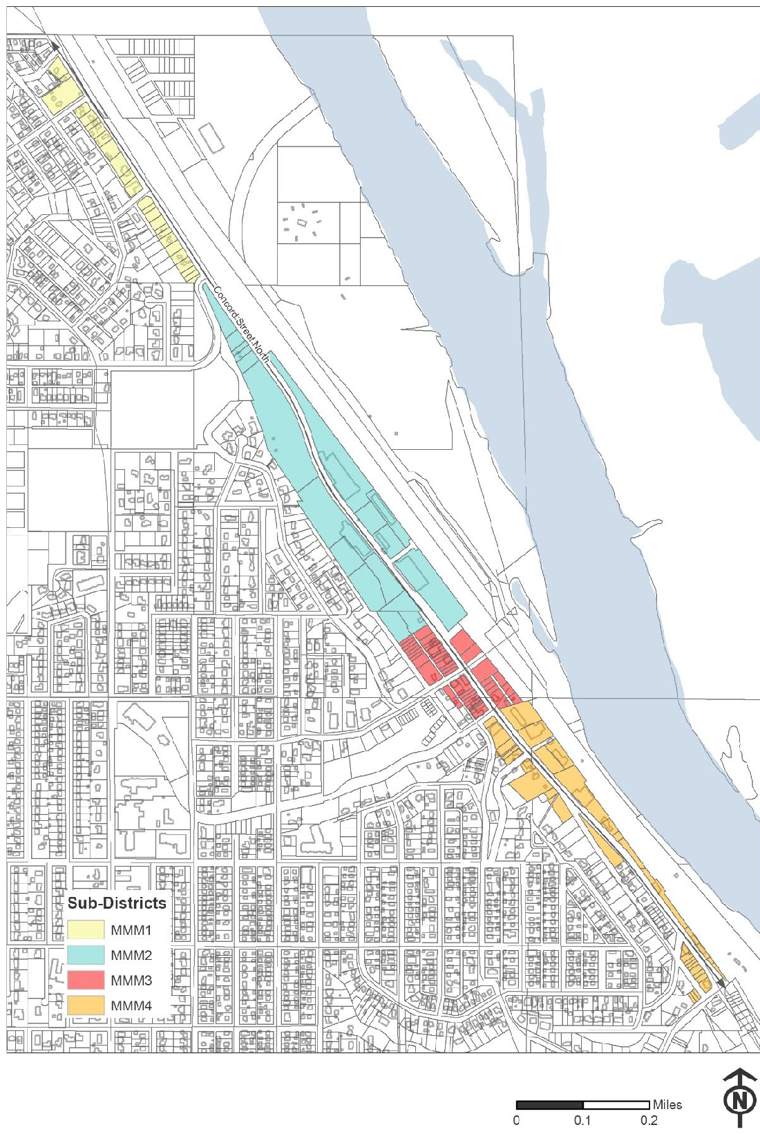
Sec. 118-127. - MMM, mixed markets and makers district.
(a)
Purpose. The purpose of the mixed markets and makers (MMM) district is to provide for flexibility of allowed uses in an effort to make the corridor more business-friendly, open to development, and positioned to adapt to evolving use demands. This includes allowing a mix of uses throughout the corridor and specific land development standards for each of four sub-districts. The district is organized around two key ideas:
(1)
A business-friendly, market-driven approach with reduced or no minimum parking requirements for some areas/properties, and;
(2)
Coordination with the Mississippi River Corridor Critical Area ordinance to establish bluff-impact regulations that preserve the buildable potential of parcels along the corridor.
(b)
Sub-districts. The district is comprised of four sub-districts that are based on the different built character and conditions of each. Development and investment are guided by the sub-district boundary and regulating plan, a consolidated table of uses (Table 1) and a development standards table (Table 2). The standards in this section are intended to implement the corridor vision document adopted by the city council on June 21, 2021.
(1)
Sub-district boundaries.
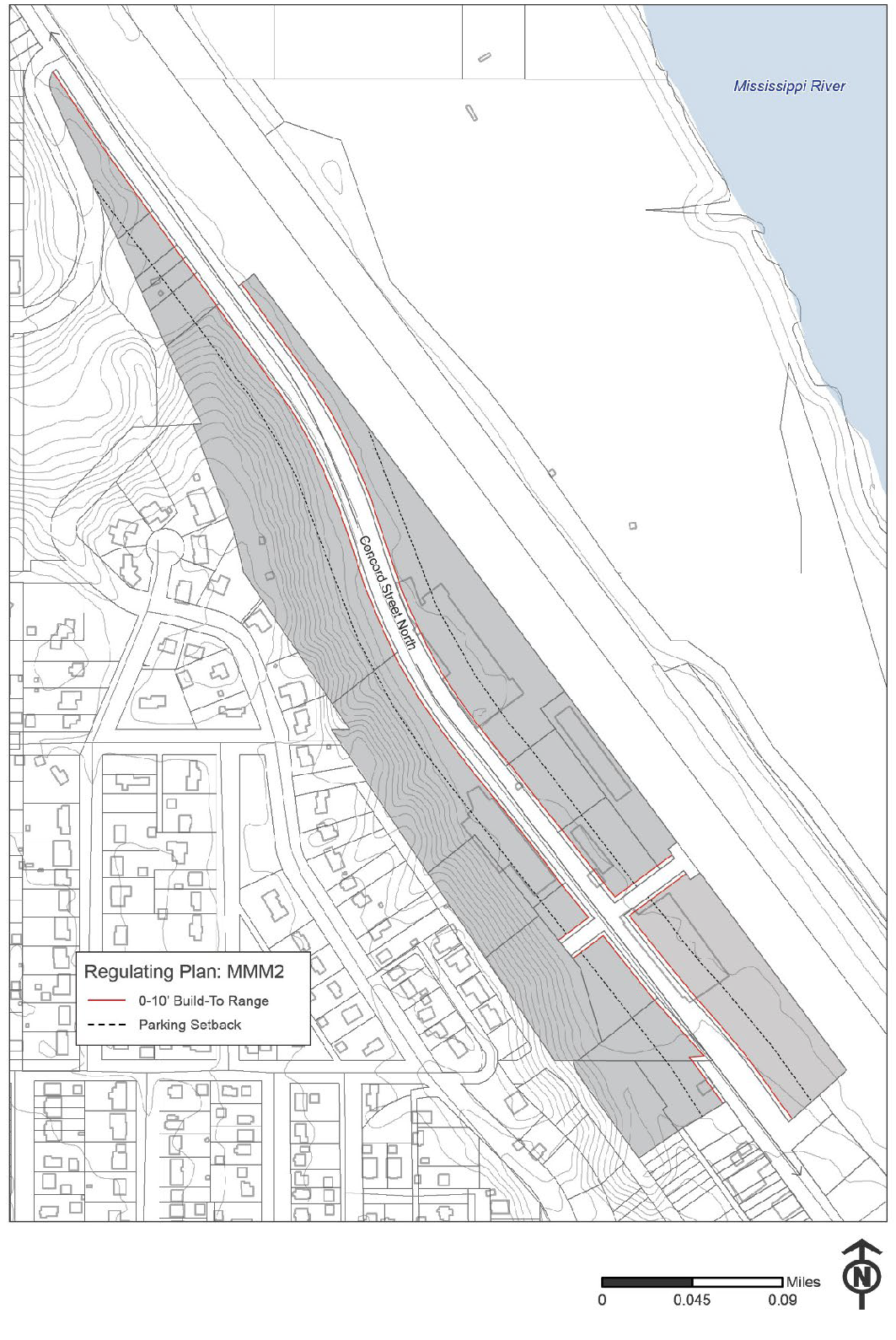
(2)
Sub-district MMM2 regulating plan.
(3)
Sub-district MMM3 regulating plan.
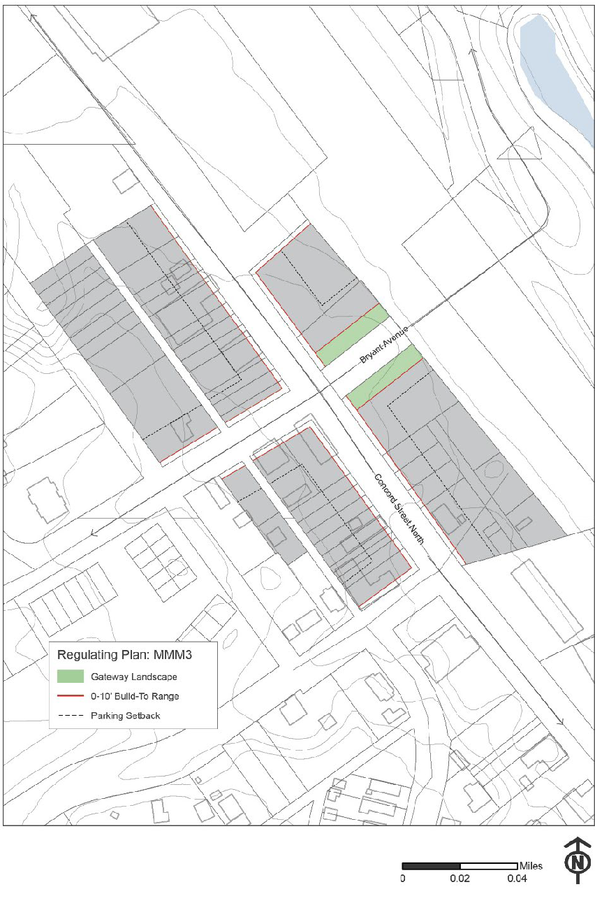
a.
Building façade types. In sub-district MMM3, the façades of new buildings which face a public street must have an especially high level of pedestrian-oriented design. The façade types listed below are expressly allowed. Any other proposed building façade must be reviewed by the city council as part of a site plan review:
1.
Shopfront.
2.
Common entry.
3.
Stoop.
(4)
MMM2 and MMM3 build-to line requirement.
a.
Building build to line. In the MMM2 and MMM3 sub-districts, the building build-to line (maximum building setback) shall be zero to ten feet.
1.
For any lot with frontage on Concord Street, at least 50 percent of the footprint of the principal building shall meet the build-to line requirement along Concord Street.
2.
The build-to line requirement stated above is also in effect for side streets in the MMM3 district but the requirement may be waived or modified by the city council as part of a site plan review if it can be demonstrated that the proposed building will create an overall positive pedestrian-oriented experience.
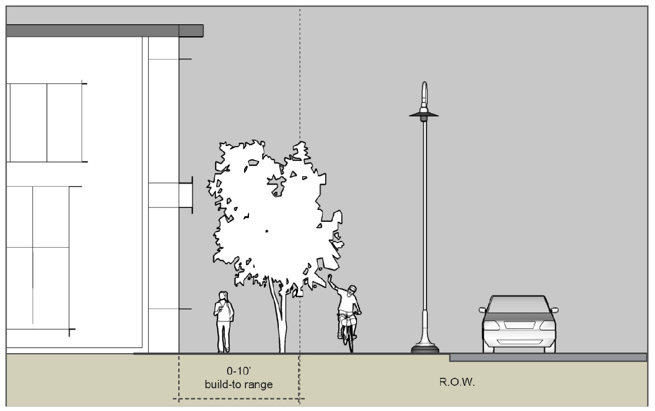
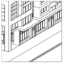
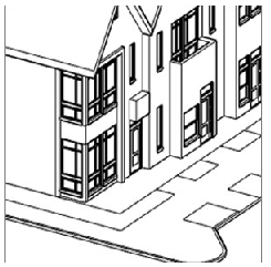
Graphic Illustrating Build-To Line (Maximum Building Setback)
(c)
Table 1. Permitted, Conditional and Accessory Uses.
(d)
Table 2. Dimensional Standards.
(e)
Design and development standards.
(1)
Building materials.
a.
At least 90 percent of any building façade facing Concord Street shall be Class I, II, or III materials as defined in section 118-9. In addition to the listed materials, architectural metal siding, finished wood siding, and engineered wood siding may also be used.
b.
On a corner lot, at least 90 percent of the façade facing the side street shall be comprised of Class I, II, or III materials as defined in section 118-9. In addition to the listed materials, architectural metal siding, finished wood siding and engineered wood siding may also be used.
c.
Façades that face an interior property line or a rear property line may be comprised of any combination of Class I, II, III, or IV materials, as defined in section 118-9. In addition to the listed materials, engineered wood siding and architectural metal siding may also be used.
d.
Up to ten percent Class IV or Class V materials may be used on any façade as an accent material.
e.
Single-family dwellings, two-family dwellings, and three-family dwellings in the MMM1 sub-district shall be permitted to utilize any exterior building material that is allowed for two-family dwellings in the R-2 zoning district.
(2)
The façade of buildings along Concord Street shall include elements that relate to pedestrians which must be oriented towards Concord Street. These should include doors and windows, texture, projections, awnings and canopies, ornament, etc. There shall be a primary pedestrian building entrance which faces Concord Street (a door at the corner of an intersection will satisfy this requirement).
(3)
Exterior building walls facing Concord Street and side streets on corner lots shall not exceed 50 feet in length without including at least two of the following: Change in plane, change in texture or masonry pattern, windows, or an equivalent element that subdivides the wall into human scale proportions.
a.
This provision shall not apply to single-family dwellings, two-family dwellings, and three-family dwellings in the MMM1 sub-district.
(4)
Accessory buildings.
a.
Accessory buildings shall be constructed of similar materials and colors as the principal building. Unique accessory buildings which differ from the principal building to create a deliberate aesthetic effect and accessory buildings that are over 200 square feet in size may be allowed through a site plan review by the city council.
b.
For single-family dwellings, two-family dwellings, and three-family dwellings in the MMM1 sub-district, accessory buildings and structures shall be regulated as if the property is a two-family dwelling in the R-2 district.
(5)
Trash/recycling enclosure. Any trash storage that is not contained within a building must be completely screened by a trash enclosure.
a.
Trash enclosures should be constructed of concrete, block, or a similar incombustible material and the enclosure shall be surfaced or painted to match or complement the principal building. Chain link fences with privacy slats are not permitted as a trash enclosure material.
b.
Trash enclosures need not be covered or roofed, but all trash within uncovered enclosures must be stored in covered receptacles. Manufactured containers specifically designed for trash storage and removal may be used provided they are covered and maintained in a neat, attractive manner and remain adequately painted.
c.
Properties that have existing legal nonconforming exterior trash handling may construct a trash enclosure out of composite decking material. Trash enclosures constructed of composite decking material must be placed at least ten feet away from the principal building unless the principal building is equipped with sprinklers.
d.
For single-family dwellings, two-family dwellings, and three-family dwellings in the MMM1 sub-district, trash handling shall be regulated as if the property is a two-family dwelling in the R-2 district.
(6)
Loading docks. Shall not be located in a front yard and doors shall not face Concord Street.
(7)
Mechanical equipment screening.
a.
Mechanical equipment which is located on the ground or protrudes from the side of a building shall be screened in a manner that is consistent with the standards laid out for the GB and Industrial districts in section 118-9. Mechanical equipment that is located on a rooftop shall be screened in accordance with section 118-242.
b.
For single-family dwellings, two-family dwellings, and three-family dwellings in the MMM1 sub-district, mechanical equipment screening shall be regulated as if the property is a two-family dwelling in the R-2 district.
(8)
Building height is defined as the vertical distance from the average elevation of the finished elevation of the site to:
a.
The top of the cornice of a flat roof;
b.
The top of a mansard roof;
c.
A point directly above the highest wall of a shed roof;
d.
The uppermost point of a round or other arch-type roof;
e.
The mean distance from the eave line to the peak of the highest gable on a pitched, gambrel, or hip roof.
(9)
Landscape improvements.
a.
All land area not occupied by buildings, structures, accessory structures, parking areas, driveways, sidewalks, or other hard surface areas shall be sodded or mulched and landscaped with approved ground cover, flowers, shrubbery and trees.
b.
At least ten percent of the total land area within the perimeter of private parking and driveway areas shall be landscaped.
c.
At least one overstory tree shall be provided for every 1,500 square feet of landscaped area on the entire lot.
d.
For single-family dwellings, two-family dwellings, and three-family dwellings in the MMM1 sub-district, landscaping shall be regulated as if the property is a two-family dwelling in the R-2 zoning district.
(10)
Parking.
a.
Structured parking shall be subject to the same setback requirements as other structures.
b.
Surface parking as an accessory use:
1.
Surface parking is prohibited in the front yard directly in front of a building. Parking shall be provided to the side or rear of buildings in midblock areas.
2.
Surface parking stalls shall be set back at least five feet from side and rear property lines. This requirement may be reduced to zero in cases where a cross-access easement is put in place to allow cars to circulate between adjacent properties.
3.
Surface parking shall be set back at least five feet from the front property line. This requirement may be reduced in situations where an applicant demonstrates that they are able to provide code-compliant screening for their surface parking within a smaller setback area, such as by constructing a masonry wall.
c.
Surface parking as a principal use.
1.
Shall not be located on corner lots.
2.
Shall be set back at least 80 feet from the Concord Street right-of-way, as shown on the regulating plans.
3.
Public parking lots may be closer than 80 feet to the Concord Street right-of-way but still must comply with all other requirements outlined in this section.
d.
The site design requirements for the parking facilities of single-family dwellings, two-family dwellings, and three-family dwellings in the MMM1 sub-district shall be the site design requirements that are in place for two-family dwellings in the R-2 district.
e.
Parking minimums, residential. At least one parking space shall be provided for each dwelling unit. In a mixed-use building that includes a commercial space that occupies at least 50% of the ground-floor level or 5,000 square feet, whichever is less, there shall be no minimum parking requirement for the first four dwelling units.
f.
Parking minimums, nonresidential uses. See section 118-352.
g.
All provisions of article VII of the zoning ordinance, which regulates off-street parking and loading, shall be in effect in the MMM districts unless explicitly stated otherwise in this section. In situations where there is a conflict between the MMM ordinance and article VII, the provisions of the MMM ordinance shall prevail.
h.
Screening on public street frontage. Where parking fronts a public ROW it shall be screened with an edge planting, decorative fence, wall, or a combination of these elements to a minimum height of three feet. The maximum height of fences and walls is regulated by section 118-199. The screening shall also include one overstory tree per 30 feet, on center, of lot perimeter unless this requirement is waived or modified by the city engineer in situations where the parking setback area is not sufficiently wide to allow the planting of overstory trees without damaging adjacent infrastructure. The graphic below shows an example of screening that could be employed to satisfy this requirement.
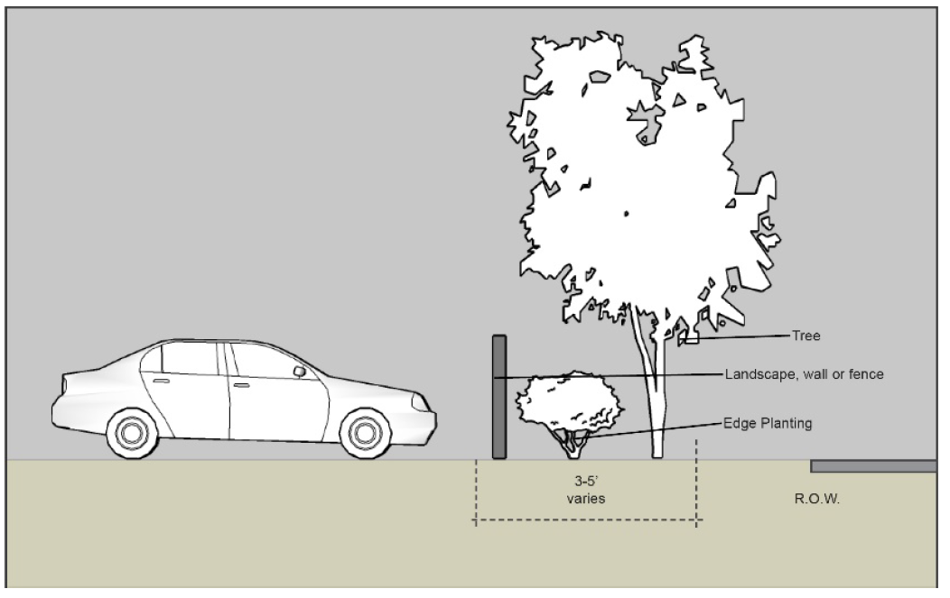
Public Street Frontage Screening Example
(f)
Performance standards for specific uses. In addition to performance standards found elsewhere in the City Code, the following performance standards are in effect for a number of specific uses in the MMM district:
(1)
Accessory outdoor sales and display.
a.
Shall only be permitted within an area not greater than 1,000 square feet or ten percent of the gross floor area of the ground floor of the building, whichever is greater.
b.
Shall be located at least 25 feet from any residentially used or zoned property.
(2)
Auto sales, leasing, rental.
a.
Requires minimum one acre site and minimum floor area ratio (FAR) of 0.25.
b.
Surface parking lots used for display of for-sale vehicles must adhere to the same screening requirements as customer parking areas.
c.
May include automobile repair and service uses.
(3)
Child day care facility.
a.
If a child care center has a play area which is located in a front yard or adjacent to a public or private street, the play area shall be surrounded by a fence that is at least three and one-half feet in height.
b.
The fencing requirement shall not be applicable to group family day cares, as defined in section 118-8.
(4)
Commercial indoor storage.
a.
Commercial indoor storage as an accessory use shall require a conditional use permit.
b.
Commercial indoor storage is limited to being located within the principal building.
c.
That portion of the principal building that is used for commercial indoor storage must be located at least 80 feet from the Concord Street right-of-way. A conditional use permit application shall include a site plan and floor plan that demonstrates compliance with this requirement.
(5)
Craft production.
a.
Must include a retail/eating/drinking/tasting component that is open to the public and occupies a minimum of ten percent of usable space. This space must front the street at the ground floor level or have a well-marked and visible entrance at the ground floor level.
b.
All production and processing activities are to be conducted within an enclosed building. Distribution activities except for the loading of finished products onto trucks must be conducted within an enclosed building unless otherwise allowed by conditional use permit.
c.
May include accessory exterior storage by conditional use permit, subject to the provisions outlined in this section.
d.
Craft production of alcoholic beverages shall require a conditional use permit for off-sale or on-sale liquor.
e.
Craft production of cannabis products and lower-potency hemp edibles shall require a conditional use permit.
f.
Any craft production use with a gross floor area that is greater than 15,000 square feet shall require a conditional use permit. This requirement shall not apply to craft production uses that are considered general retail uses such as bakeries and butcher shops.
(6)
Drive thru or drive in lanes are not allowed within the building build-to range or in front of any building; they must be located to the side or rear of a building.
(7)
Exterior storage.
a.
Exterior storage is allowed only as an accessory use. It requires a conditional use permit and must abide by section 118-240.
b.
All exterior storage must be set back at least 80 feet from the Concord Street right-of-way.
c.
Exterior storage shall be screened with a wall or privacy fence a minimum of 60 inches high. Chain link fences with privacy slats are not permitted as screening for exterior storage.
d.
Off-site exterior storage, which requires a conditional use permit, is allowed only as an accessory use. The off-site exterior storage site must be located within 2,640 feet of the principal use and the principal use must be located within the MMM district. The distance shall be measured from the nearest property line of the two parcels.
(8)
Live/work unit.
a.
The office or business component of the unit shall not exceed 30 percent of the total gross floor area of the unit.
b.
The business component of the live-work unit may include offices, small service establishments (not including auto service or repair), homecrafts which are typically considered accessory to a dwelling unit, and the limited retailing of goods that can be sold as a permitted use in the underlying MMM sub-district, by appointment only.
c.
The size and nature of the work space shall be limited so that the building type may be governed by residential building codes. An increase in size or intensity beyond the specified limit would require the building to be classified as a mixed-use building. Likewise, the use of the unit for a type of business not listed above would require the building to be classified as a mixed-use building and the use would then be subject to applicable zoning requirements.
(9)
Pet boarding, kenneling, training, and grooming.
a.
Unless expressly allowed by the conditional use permit, all activity must take place within a completely enclosed building with odor and sound control except for the walking of dogs.
b.
There shall be no overnight kenneling of customers' pets and no animal may be present inside the business between the hours of 10:00 p.m. and 6:00 a.m. unless their owner is also present.
c.
Any outdoor off-leash exercise/relief area that is provided shall be entirely enclosed by a fence. Pets may not be off-leash in these areas between the hours of 8:00 p.m. and 7:00 a.m.
(10)
Vehicle rental.
a.
Vehicle rental as an accessory use shall require a conditional use permit.
b.
Rental vehicles must be stored at least 80 feet from the Concord Street right-of-way in a clearly marked designated area that is identified in the conditional use permit.
c.
The conditional use permit shall establish a maximum number of rental vehicles that can be stored on the property and may include limitations on the type and size of rental vehicles that can be stored on a particular property. It is not the intent of this section that vehicle rental be the principal use of a property or that the use consumes a large amount of space on any particular property.
d.
This section is not intended to restrict the parking of shared passenger vehicles that are provided by a car sharing provider that has been authorized to operate in South St. Paul.
(11)
Veterinary clinics.
a.
All activity shall take place completely within an enclosed building with soundproofing and odor control. Outdoor kennels are prohibited.
(12)
No multi-family residential development or mixed-use development shall be permitted to exceed the maximum density per acre established in the comprehensive plan.
(g)
Nonconformities.
(1)
Nonconformities shall be administered consistent with state statute and the city's adopted nonconformity ordinance unless otherwise noted in this section.
(2)
Requirements for expansion or enlargement of existing nonconforming buildings.
a.
The total square footage or percentage of any and all previous expansions to an existing nonconforming building that have taken place since November 1, 2021 shall be aggregated for calculating the size or percentage of the total expansion to the existing building under the terms of this section.
b.
Expansion or enlargement of nonconforming buildings. Any expansion of an existing nonconforming building shall be constructed using compatible materials, colors, and architecture. If an expansion or addition is greater than 10,000 square feet or if the expansion or addition adds more than 50 percent to the building's original floor area, a conditional use permit is required and the city may add reasonable design conditions to comply with the MMM district's design requirements.
c.
Applicability to nonconforming uses. It is not the intent of this section to permit the expansion of a nonconforming use. That portion of a nonconforming building that is expanded under the terms of this section may only contain allowed uses.
(h)
Administration.
(1)
Permitted uses and development plans in the MMM district must be submitted to the zoning administrator for review. The zoning administrator, after seeking comment from the city's other departments and any relevant regulatory agency, shall have the authority to approve site and building plans so long as the proposed use is permitted and the site and building plan is fully compliant with all of the terms of this section. At their discretion, the zoning administrator may refer a site and building plan to the planning commission and city council for review.
(2)
Site plans shall be processed in accordance with section 118-47.
(3)
Variances shall be processed in accordance with section 118-39.
(4)
Conditional use permits shall be processed in accordance with section 118-40.
(5)
Appeals shall be processed in accordance with section 118-38.
(i)
Prohibited uses. The following uses of land or buildings in the MMM district are prohibited:
(1)
State-licensed residential care facilities.
(2)
Within the MMM district, no structure or land may be used for small wireless facilities located outside of the right-of-way.
(Ord. No. 1385, § 1, 11-1-2021; Ord. No. 1388, § 1, 2-7-2022; Ord. No. 1392, § 3, 5-2-2022; Ord. No. 1397, § 4, 8-15-2022; Ord. No. 1401, § 4, 2-6-2023; Ord. No. 1415, § 5, 9-8-2023; Ord. No. 1422, § 5, 3-18-2024; Ord. No. 1425, § 4, 5-20-2024; Ord. No. 1428 , § 6, 12-16-2024; Ord. No. 1431, § 15, 2-3-2025; Ord. No. 1432, § 2, 3-3-2025)
Editor's note— Ord. No. 1385, § 1, adopted Nov. 1, 2021, repealed the former § 118-127, and enacted a new § 118-127 as set out herein. The former § 118-127 pertained to NCMU, North Concord mixed-use district and derived from Code 1992; Ord. No. 1216, adopted May 18, 2009; Ord. No. 1260, adopted Aug. 20, 2012; Ord. No. 1318, adopted June 5, 2017; Ord. No. 1321, adopted Sep. 18, 2017; Ord. No. 1365, adopted Sep. 21, 2020; Ord. No. 1375, adopted March 1, 2021; Ord. No. 1383, adopted Sep. 7, 2021.
Sec. 118-128. - GB, general business district.
(a)
Permitted uses.
(1)
All uses listed as permitted in the C-1 Retail Business district unless that use is listed as requiring a conditional use permit in the GB General Business district.
(2)
Body art establishment (defined and regulated by section 118-276)
(3)
Contractor operation when there is no exterior storage.
(3)
Craft production.
a.
Must include a retail/eating/drinking/tasting component that is open to the public and occupies a minimum of ten percent of usable space. This space must front the street at the ground floor level or have a well-marked and visible entrance at the ground floor level.
b.
All production, processing, and distribution activities except for the loading of finished products onto trucks are to be conducted within an enclosed building.
c.
May include accessory exterior storage by conditional use permit.
d.
Craft production of alcoholic beverages shall require a conditional use permit for on- sale or off-sale liquor.
e.
Any craft production use with a gross floor area that is greater than 20,000 square feet shall require a conditional use permit. This requirement shall not apply to craft production uses that are listed as permitted uses in the C-1 Retail Business district, such as bakeries and butcher shops.
(b)
Uses by conditional use permit. Within the GB district, the following uses may be allowed only by conditional use permit:
(1)
Adult day care facility.
(2)
Armories, skating rinks, convention halls, and similar uses.
(3)
Auditorium or recreational building.
(4)
Automobile and truck service uses.
(5)
Automobile car wash.
(6)
Boat, marine, trailer, farm equipment, automobile, truck, and similar sales.
(7)
Bottling works.
(8)
Bowling alley.
(9)
Carpet or rug cleaning.
(10)
Child day care facility.
(11)
Church.
(12)
Commercial recreation and equipment storage.
(13)
Contractor operation, if exterior storage is utilized.
(14)
Vocational schools.
(15)
Drive-in business of all types.
(16)
Dry cleaning.
(17)
Dwelling units in any building.
(18)
Equipment and vehicle rental.
(19)
Essential services.
(20)
Open sales lot, provided the same business occupies space in a building on the same lot.
(21)
Food locker plant.
(22)
Funeral home and mortuary.
(23)
Laundry.
(24)
Lumber yard.
(25)
Manufacturing as permitted in the I-1 Light Industrial district.
(26)
Medical uses (human and animal).
(27)
On-sale and off-sale liquor sales.
(28)
Other uses deemed by the city council to be similar in purpose and character to those set forth in this subsection and in subsection (a) of this section.
(29)
Parking garage.
(30)
Pet boarding, kenneling, training, and grooming provided that:
a.
Unless expressly allowed by the conditional use permit, all activity must take place within a completely enclosed building with odor and sound control except for the walking of dogs. No outdoor kenneling shall be permitted.
b.
There shall be no overnight kenneling of customers' pets and no animal may be present inside the business between the hours of 10:00 p.m. and 6:00 a.m. unless their owner is also present.
c.
Any outdoor off-leash exercise/relief area that is provided shall be entirely enclosed by a fence. Pets may not be off-leash in these areas between the hours of 8:00 p.m. and 7:00 a.m.
(31)
PWS antennas.
(32)
PWS tower.
(33)
Reception or meeting hall.
(34)
Seasonal business.
(35)
Spur tracks.
(36)
Supper club.
(37)
Structures exceeding 45 feet in height.
(38)
Theater.
(39)
Wholesaling.
(40)
Alternative financial establishment, subject to the supplemental regulations in section 118-275.
(c)
Accessory uses. Within the GB district, accessory uses permitted in the C-1 district shall be permitted.
(d)
Lot area, yard, and building height requirements. Within the GB district, lot area, yard, and building height requirements shall be as permitted and regulated in section 118-270.
(e)
Structural coverage. No lot shall be covered by buildings, structures, or paved surfaces in excess of 95 percent.
(f)
Off-street parking, loading, and signs. Requirements for off-street parking and loading and for signs shall be permitted as required and regulated by this Code. In addition to any applicable requirements listed in article VII, Off-Street Parking and Loading, the following standards shall apply to off-street parking and loading facilities in the GB district:
(1)
Surface parking stalls shall be set back at least five feet from side and rear property lines. This requirement may be reduced to zero in cases where a cross-access easement is put in place to allow cars to circulate between adjacent properties.
(2)
Surface parking stalls shall be set back at least five feet from front property lines.
(3)
For industrial uses that require a conditional use permit, the city council may require as part of the conditional use permit that off-street parking and loading facilities be designed to prevent conflicts with nearby residential, commercial-retail, and office uses. The city council may require these facilities to have similar design and landscaping treatments as commercial-retail development or, in architectural contexts where it is deemed appropriate, they may require that the off-street parking and loading facilities for industrial uses meet the setback, landscaping, and design requirements of the I-1 Light Industrial district, as regulated by section 118-134.
(g)
Prohibited uses. Some land uses because of their inherent characteristics are neither suitable or compatible with the purpose statement for the GB district and, therefore, should not be permitted. The following uses are prohibited:
(1)
Metal shredder location or operation;
(2)
State-licensed residential care facilities;
(3)
Within the GB district, no structure or land may be used for small wireless facilities located outside of the right-of-way.
(Code 1992, § 1500.19; Ord. No. 2011-1243, §§ 5, 6, 6-20-2011; Ord. No. 1260, § 4, 8-20-2012; Ord. No. 1278, § 3, 12-16-2013; Ord. No. 1318, § 7, 6-5-2017; Ord. No. 1321, § 2, 9-18-2017; Ord. No. 1357, § 1, 6-1-2020; Ord. No. 1365, § 1, 9-21-2020; Ord. No. 1383, § 7, 9-7-2021; Ord. No. 1397, § 5, 8-15-2022; Ord. No. 1401, § 5, 2-6-2023; Ord. No. 1408, § 3, 6-5-2023; Ord. No. 1411, § 11, 8-21-2023; Ord. No. 1415, § 6, 9-8-2023; Ord. No. 1422, § 6, 3-18-2024; Ord. No. 1425, § 5, 5-20-2024)
Sec. 118-129. - I, industrial district.
(a)
Purpose. The purpose of the industrial (I) district shall be to provide for the continuation and establishment of industrial and manufacturing uses that are of high quality and can be built to high performance standards. All new uses in the industrial zone that are not going into existing facilities or are going into existing structures that are being structurally modified shall go before the city council for site plan approval.
(b)
Permitted uses.
(1)
Commercial recreations (handball, racquetball and tennis).
(2)
Manufacturing in an enclosed building with permanent walls and roof, Except as prohibited by subsection (d) of this section.
(3)
Municipal and government buildings and uses.
(4)
Offices.
(5)
Printing and publishing.
(6)
Public recreational uses.
(7)
PWS antennas located entirely inside a building or structure.
(8)
A small wireless facility, as defined in section 54-402, that is located in the right-of-way, as long as all provisions of sections 54-400—54-429 have been met.
(9)
Radio, television and other transmitting studios and towers under 50 feet in height.
(10)
Warehousing and distribution in an enclosed building with permanent walls and roof.
(11)
Within the boundaries of the South St. Paul Municipal Airport, aviation- and airport-related businesses.
(c)
Uses by conditional use permit or interim use permit. The following uses shall require a conditional use permit or an interim use permit, and all applications for such conditional use permits shall follow the review and procedural guidelines set forth in section 118-132 of this chapter, governing planned unit developments:
(1)
Armories, convention halls and similar uses.
(2)
Automobile, truck and other vehicle repair.
(3)
Cannabis cultivation.
(4)
Cannabis retailer when accessory to a cannabis or lower-potency hemp edible manufacturing business or cannabis cultivation business.
(5)
Cannabis or lower-potency hemp edible manufacturing.
(6)
Cannabis wholesaler.
(7)
Commercial kennels, animal hospitals.
(8)
Child day care facility when located within the same building as the principal use and provided only for employees of the principal use.
(9)
Exterior processing on industrial zoned property south of I-494, except that part north of Richmond Street, west of Hardman Avenue north of vacated Malden Street from Hardman Avenue to the Mississippi River, the south one-half of section 35, T28N, R22W and the east one-half of the NW 1/4 of section 35, T28N, R22W.
(10)
Exterior storage (not as a principal use).
(11)
Exterior storage and open sales lot in conjunction with an approved use on the same site.
(12)
Exterior storage and processing of wood chips, accessory to an approved business, provided a detailed screening, parking, driveway, storage, and display plan for the wood chip processing and storage area and all off-street parking and driveway area is implemented, consistent with current city codes, subject to the city council review and approval.
(13)
Exterior storage as a principal use on industrial zoned property south of I-494, except that part north of Richmond Street, west of Hardman Avenue, north of vacated Malden Street, from Hardman Avenue to the Mississippi River, the south one-half of section 35, T28N, R22W and the east one-half of the NW 1/4 of section 35, T28N, R22W.
(14)
Hotel or motel.
(15)
Laundry and dry cleaning processing plants (not retail).
(16)
Other uses deemed by the city to be similar to those set forth in this subsection and consistent with the purpose set forth in subsection (a) of this section.
(17)
Pawnbrokers and precious metal dealers, as defined in article XIV of chapter 18 of this Code, 500 feet north of I-494 and south of Grand Avenue.
(18)
Private and business schools.
(19)
PWS antenna.
(20)
PWS tower.
(21)
Restaurants.
(22)
Sexually oriented uses, as defined in article XVIII of chapter 18, 500 feet north of I-494 and south of Grand Avenue.
(23)
Spur tracks.
(24)
Structures of any type over 50 feet in height.
(25)
Temporary on-site rock crushing operation when used for surcharging the land as an integral part of a land reclamation plan approved by the city engineer.
(26)
Temporary structures.
(27)
Truck stop.
(28)
Veterinary clinic.
(29)
Wholesaling.
(d)
Prohibited uses. Some land uses are not compatible with the purpose statement for the I district and therefore shall not be permitted. The following uses are prohibited:
(1)
Acid manufacturing.
(2)
Asphalt plants.
(3)
Creosote treatment or manufacture.
(4)
Exterior storage as a principal use, except as permitted by subsections (c)(5) and (c)(8) of this section.
(5)
Junkyards.
(6)
Landfills (not including the filling and grading of land with totally buildable materials to prepare the land for development).
(7)
Manufacturing of hazardous chemicals as a principal use.
(8)
Reserved.
(9)
Metal shredder location or operation.
(10)
Mining of any type.
(11)
Open sales lots.
(12)
Petroleum refineries.
(13)
Permanent or temporary storage of hazardous waste as a principal use.
(14)
Small wireless facilities located outside of the right-of-way.
(15)
Sludge disposal.
(16)
State-licensed residential care facilities.
(17)
Reserved.
(e)
Accessory uses.
(1)
Bars and taverns located within a hotel or motel.
(2)
Dwelling units for security purposes.
(3)
Mini-storage facilities (not as a permitted principal use).
(4)
Off-street parking and loading, signs, fences and decorative landscape features as regulated herein.
(5)
Parking garage for public and/or employee use.
(6)
Retail outlet sales counter; provided that retail outlet floorspace cannot exceed ten percent of total building floorspace for that business.
(7)
Temporary construction buildings and storage during construction of the principal use.
(8)
Cannabis transportation and delivery accessory to a cannabis business.
(9)
Lower-potency hemp retailer that is accessory to a retail use that is allowed in the I district or accessory to a restaurant, bar, or tavern.
(f)
Lot area, yard and building height. Within the I district, the following requirements shall be met:
(1)
No structure shall be more than 50 feet in height except by conditional use permit.
(2)
Minimum building setbacks measured from the property line or right-of-way line shall be as follows:
(3)
Minimum lot size shall be one acre.
(4)
The minimum floor area ratio shall be 0.2.
(g)
Certificate of occupancy. A certificate of occupancy shall be required for all uses.
(h)
Lot coverage. Lot coverage by buildings shall not exceed 40 percent of the lot.
(i)
Off-street parking and loading signs.
(1)
Off-street parking shall have the following setbacks from the right-of-way line or side or rear lot line:
(2)
Signs shall be in accordance with article VI of chapter 118 and shall be shown on the site plan.
(j)
Landscaping. In addition to the requirements of section 118-243, all areas in this zone shall present a detailed landscape plan prepared by a landscape architect or other qualified person approved by the zoning administrator. The landscaping plan shall provide for a landscaped area that is a minimum of 15 percent of the parcel's total area. The landscaping plan shall present a pleasing handling of the lot and shall include overstory trees, understory trees and appropriate plants and shrubs. The trunks of all deciduous trees shall be at least two and one-half inches in diameter, and all coniferous trees shall be at least six feet in height. The minimum number of overstory trees shall be equal to the perimeter of the lot divided by 70. If any of these specific landscaping requirements are not practicable, as determined by a qualified landscaping expert, due to soil conditions, water tables, availability of plant species or other conditions beyond the control of the property owner, these requirements may be modified by the city at the request of the owner. The plan shall certify that the cost of the plant materials is equal to or exceeds two percent of the cost of the proposed building. For buildings over $1,000,000.00 in cost, the amount of landscaping cost may be reduced by the city council.
(k)
Exterior building materials. See section 118-9.
(l)
Standards for Individual Hangar Lots at Fleming Field Municipal Airport. The following standards shall apply to individual hangar lots located within the official boundaries of Fleming Field Municipal Airport.
(1)
Lot size. There shall be no minimum lot size provided that each lot is sized appropriately for the type of hangar it is designed to accommodate.
(2)
Setbacks. Hangar buildings shall adhere to all setback requirements imposed by the state building code and the Federal Airline Administration (FAA) and shall also meet the following zoning setback requirements:
a.
Hangar buildings shall be at least five feet from any side property line or rear property line that is shared with another platted hangar lot. Unless otherwise approved by the airport manager, no hangar building may be placed within ten feet of any hangar building on an adjacent lot.
b.
Unless otherwise allowed by conditional use permit, hangar buildings shall comply with I district setback requirements for all property lines that are shared with properties that are not part of the airport.
c.
Unless otherwise allowed by conditional use permit, hangar buildings must meet I district front yard setback requirements for front yards that abut a public road that is not within the airport's security fence.
(3)
Landscaping. The I district's landscaping requirements shall not apply to individual hangar lots within the interior of the airport or to yards that face the interior of the airport. Yards facing a public street shall be well-landscaped in keeping with the general intent of the I district standards but a strict application of the Code shall not be required and overstory tree requirements may be relaxed or waived if deemed necessary to comply with FAA standards. New subdivisions which create additional hangar lots may be required to provide landscaping along any property line that is shared with properties that are not part of the airport.
(4)
Lot coverage restrictions and the minimum floor area ratio requirement are not applicable.
(Code 1992, § 1500.21; Ord. No. 1168, § 1(1500.21), 10-17-2005; Ord. No. 1199, § 1, 4-7-2008; Ord. No. 1306, § 1, 7-5-2016; Ord. No. 1318, § 8, 6-5-2017; Ord. No. 1321, § 2, 9-18-2017; Ord. No. 1365, § 1, 9-21-2020; Ord. No. 1383, § 8, 9-7-2021; Ord. No. 1391, § 3, 3-21-2022; Ord. No. 1411, § 12, 8-21-2023; Ord. No. 1428 , § 7, 12-16-2024; Ord. No. 1431, § 16, 2-3-2025)
Sec. 118-130. - NRDD, north riverfront development district.
(a)
Purpose. The purpose of this district is to promote and regulate the development of mixed commercial and certain high-density uses in the area adjacent to and in the vicinity of the Mississippi River by the balancing of utilization of land for the purposes for which it is most appropriate and protection of the river amenities in the public interest.
(b)
Permitted uses. No building, structure, or land shall be used in whole or in part except for the following permitted uses:
(1)
Boat marinas.
(2)
Public recreational uses.
(3)
PWS antennas located entirely inside a building or structure.
(4)
A small wireless facility, as defined in section 54-402, that is located in the right-of-way, as long as all provisions of sections 54-400—54-429 have been met.
(c)
Conditional uses. The following uses shall be allowed by conditional use permit in the NRDD district: Commercial recreational uses.
(d)
Prohibited uses. Within the NRDD district, no structure or land may be used for small wireless facilities located outside of the right-of-way.
(e)
Accessory uses. In the NRDD, accessory uses shall be the same as those listed for the C-1 district. Said accessory uses shall be subject to the provisions of section 118-126(c).
(f)
Lot area, yard, building height and lot coverage. Within the NRDD, lot area, yard, building height, and lot coverage shall be regulated as determined by the city council for each project.
(g)
Off-street parking and loading signs. Within the NRDD, off-street parking, off-street loading, and signs shall be regulated as determined by the city council for each project.
(h)
Landscaping. Within the NRDD, landscaping shall be regulated as determined by the city council for each project.
(Code 1992, § 1500.22; Ord. No. 1321, § 2, 9-18-2017)
Sec. 118-131. - RT, railroad transportation district.
(a)
Purpose. The purpose of the RT district is to allow certain existing railroad transportation uses and to provide for new or modified railroad uses as provided in this section.
(b)
Existing uses.
(1)
Existing uses are all railroad transportation uses and operations of land and structures existing on the effective date of the ordinance from which this section is derived, as modified by the conditional use permit issued and development agreement, each effective as of the effective date of the ordinance from which this section is derived. Existing uses do not include spur tracks. Existing uses may be continued, but may not undergo a major modification without a conditional use permit being first issued as required by subsection (c) of this section.
(2)
Existing uses also include:
a.
Temporary outside storage of tracks, repair or replacement materials at or near the location of the repair or replacement during the time reasonably necessary to accomplish a required repair or replacement.
b.
Routine minor repairs (including repairs required on site by governmental regulations) and maintenance of locomotives, cars, tracks, ties, buildings, and servicing facilities.
(c)
Uses by conditional use permit.
(1)
Except for existing uses, the following uses and major modifications to existing uses shall be allowed in the RT district by conditional use permit. As part of the conditional use permit process and as a condition to the issuance of a conditional use permit, the city may require a development agreement with regard to the proposed use, defining the rights and obligations of the parties with respect thereto, which must be executed between the permittee and the city in a form and content acceptable to both.
a.
Office building.
b.
Necessary accessory uses to an office building, e.g., lunch facilities, shower facilities, locker room.
c.
Railroad trackage, including, but not limited to, classification, service receiving/departure, mainline and switching leads.
d.
Locomotive fueling, sanding, watering and lubrication facilities including fuel storage tanks.
e.
Uses accessory and appurtenant to the foregoing.
(2)
Major modification, for the purpose of this subsection, is defined as any alteration or expansion to buildings, structures or other facilities which exceed by 20 percent the existing square feet of any building or structure, and expansion of more than ten percent in linear feet of track, as defined by existing uses.
(3)
The following uses do not require a conditional use permit:
a.
Construction of facilities on site required by governmental regulation or major modifications of existing uses required by governmental regulation;
b.
Addition or relocation of tracks within the classification yard of the RT district, as shown on the drawing identified as exhibit 1, "Project Site Plan," dated December 15, 1992, on file in the office of the city clerk, to accommodate or serve industries within the industrial district and surrounding communities.
(d)
Prohibited uses. The following uses are prohibited in the RT district:
(1)
Major permanent car repair or rebuilding facility.
(2)
Major permanent locomotive repair or rebuilding facility.
(3)
Permanent outside storage of track maintenance, repair or replacement materials.
(4)
The location of classification yard tracks within 325 feet of property zoned for residential use as of the effective date of the ordinance from which this section is derived.
(e)
Criteria for conditional use permit. A conditional use permit shall not be issued unless the city council, having considered the report of the planning commission, shall determine, at a minimum, that the proposed use will satisfy and comply with the following criteria:
(1)
The provisions of section 118-40(e), except subsections (e)(7) and (e)(8)a and (e)(8)b of this section.
(2)
The requirements for the overlay districts in sections 118-167 through 118-169, including site plan criteria and approval standards within section 118-167(h).
(3)
The proposed uses shall not unreasonably disturb the uses of nearby residential properties nor adjoining uses by the adverse effects of noise, dust or excessive lighting, taking into consideration applicable local, state and federal standards.
(f)
Lot area, yard, building height, setback and lot coverage requirements.
(1)
All building uses in the RT district shall comply with section 118-129(f) and 118-129(h).
(2)
Fueling facilities shall comply with section 118-129(f)(2).
(g)
Off-street parking; signs. Off-street parking and signs shall comply with section 118-129(i).
(h)
Landscaping. A landscaping plan may be required to be submitted with the site plan when deemed appropriate by the city at the time of an application for a conditional use permit. The intent of the landscaping plan is to buffer the proposed uses, as may be necessary and appropriate. The landscaping plan must be in such design as approved by the city council.
(Code 1992, § 1500.23)
Sec. 118-132. - PUD, planned unit development.
(a)
Location and intent. Planned unit developments may be permitted in any zoning district by conditional use permit. It is the intent of this section to provide design flexibility by allowing substantial variances from the provisions of this chapter relating to land use, density, subdivision, and similar regulations. The variances, if granted, shall be fully consistent with the general intent and purposes of this chapter relating to land use, subdivision, and development. It is not the intent of this section to increase density beyond limits imposed by applicable provisions of the comprehensive municipal plan.
(b)
Eligibility. Planned unit developments are permitted in all zoning districts and are allowed for new projects on undeveloped land, redevelopment of previously built sites, or conversions of existing buildings and land. A planned unit development may include mixed residential and commercial developments and more than one principal use in a single building. An individual detached single-family home may not be reviewed as a planned unit development.
(1)
When required. A planned unit development may be used, but is not required, for a proposed development that includes a single principal use or structure on a single parcel of land. A planned unit development shall be required for any proposed development that includes two or more principal uses or structures on a single parcel of land unless the underlying zoning district separately authorizes multiple uses or structures as a permitted or conditional use.
(c)
Code flexibility. Planned unit developments may be granted flexibility to deviate from certain requirements of this chapter relating to land use, subdivision, and development, providing:
(1)
A general development plan is approved.
(2)
The city council shall find that the proposed development is fully consistent with the purposes of this chapter and consistent with the comprehensive municipal plan.
(3)
Adequate performance bonds or other security shall be given to secure completion of the development as provided by the general development plan.
(d)
Preliminary review. Before applying for a planned unit development permit, the developer shall first apply for preliminary review of the proposed development. The application shall be accompanied by payment of a preliminary review fee as set by chapter 26. The application shall be filed with the zoning administrator and shall contain the following information relating to the property, developer, and the proposed development:
(1)
Standards. Reports shall be bound and submitted on eight and one-half-inch by 11-inch size paper, vertical format. The scale of maps submitted shall be at least one inch to 100 feet or one inch to 50 feet, as may be required by the zoning administrator.
(2)
Site information. A sketch or preliminary plan shall be submitted showing the location of the site, significant topographical and physical features of the site, existing buildings and structures on the site, proposed use, proposed traffic and pedestrian circulation, and proposed lot layout.
(3)
Existing buildings and adjacent uses. If the developer contemplates the retention of existing buildings or extension of facilities or utilities serving adjacent uses, these facts shall be documented.
(4)
Ownership. The applicant shall supply proof of existing ownership consisting of an abstract of title, certificate of title, or an attorney's title opinion, together with any unrecorded documents whereby the applicant acquired a legal or equitable property interest.
(5)
Development experience. The developer shall submit information of personal experience in real estate development. If the developer has not had any previous experience in land development, such evidence as is necessary to demonstrate competence to undertake proposed development shall be submitted.
(6)
Financial capability. The developer shall submit certified evidence of present financial position to include existing or proposed credit sources for land acquisition, construction, and permanent financing. It must be shown that the developer possesses or has the ability to acquire sufficient funds for development of the site.
(7)
Neighboring landowners. The applicant shall submit a licensed abstractor's certificate showing the names and addresses of the record owners of all property located within 350 feet of the site proposed for development.
(8)
Action of the city. Within 60 days after its first regular meeting after an acceptable application for preliminary review has been filed with the zoning administrator, the city shall give preliminary plan approval, reject the proposed plan, or request additional information and/or plan changes. If the preliminary plans are approved by the city, the developer may proceed to apply for a permit for a planned unit development.
(e)
Application for planned unit development permit.
(1)
Fee. The application shall include payment of a fee established by the city council.
(2)
Preliminary review approval. The applicant shall have secured preliminary plan approval from the city within the previous 12 months.
(3)
Information required. The applicant shall file with the city such information as required by this Code and as required by the zoning administrator.
(4)
Referrals. Upon receipt of all required information, said information shall be referred to the planning commission, fire department, police department and others as may be appropriate.
(5)
Public hearing. Within the period of time the application is under consideration, the city shall hold a public hearing on the application after not less than ten days' published notice of the hearing. All property owners within 350 feet of the site shall be notified by mail of the hearing date, time, and place.
(6)
Action by the city. If the city contemplates approval of the general development plan, it shall determine by resolution that the proposed use will not be detrimental to the health, safety, morals, or general welfare of the city and that said use is fully consistent with the purposes of this chapter and the comprehensive municipal plan. If it approves the plan, the city may impose conditions and time limits for development as deemed appropriate. Each project approval shall be granted for a particular use and development and not for a particular applicant. Following action by the city, no development will be permitted without approval by the city council.
(7)
Withdrawing an application for a permit. Any application may be withdrawn by the applicant any time prior to filing any required final plat or at any time prior to site grading or other construction.
(8)
Amending a planned unit development permit. Any desired change involving structural alterations, enlargement, or intensification of land use or any request for a variance from the specific terms of a previously approved planned unit development permit shall require that the applicant file for an amended permit, and all procedures shall then apply as if a new permit was being applied for.
(9)
Cancellation of a planned unit development permit. If development has not proceeded within a reasonable time period, as deemed appropriate and in the general public interest by the city council, or within the time limits contained in the permit, an existing approved planned unit development permit may be cancelled, if so requested by the current landowner, may expire according to its own terms, or the city council may act to cancel following notices to the permittee and an opportunity for the permittee to be heard.
(f)
General development plan requirements. The city may require a general development plan containing such information as it deems necessary, but not less than the following shall be submitted by the applicant:
(1)
Complete details of the proposed site development including proposed uses, location of buildings, driveways, parking spaces, dimensions and lot area, setbacks, and similar information.
(2)
Landscaping plans.
(3)
Pedestrian circulation plans.
(4)
Projected population (numbers, age, etc.) if applicable.
(5)
Plans for sewer, water, gas, phone, electrical systems and possible impact upon existing facilities and services.
(6)
Plans for proposed stormwater drainage.
(7)
Preliminary architectural plans showing the floor plan and exterior elevations of the proposed buildings.
(8)
A projected construction schedule.
(9)
Plans for vehicular traffic access and circulation.
(10)
Results of soil tests, if required by the city engineer.
(11)
Any potential sources of environmental pollution and proposed methods for minimization or elimination of said pollution.
(g)
General provisions. General requirements are as follows:
(1)
Records. The city shall maintain a complete record of all planned unit development permits issued and note all approved permits on the city's zoning district map. All approved permits shall be recorded with the county recorder or registrar of titles.
(2)
Bonding to ensure conformance to the general plan of development. The city shall require posting of a bond, letter of credit, or other financial security for the faithful performance of work, agreements or permit conditions, and payment of any costs in an amount as recommended by the city council.
(3)
Building sites. In the event any or all of the planned unit development site is conveyed, the buyers thereof shall be bound by the provisions of the planned unit development permit. Nothing herein shall be construed to create nonconforming uses by virtue of planned unit development site sales, in whole or in part, provided that a subdivision plan for such sales has been approved by the zoning administrator.
(4)
Staged developments. If a planned unit development is to be developed over a period of two or more years, the city may approve submission of very detailed information only for the first stage of development. A public hearing shall be required for each separate stage of development upon receipt of detailed plans and information by the city.
(Code 1992, § 1500.24; Ord. No. 1379, § 1, 5-3-2021; Ord. No. 1431, § 17, 2-3-2025)
Sec. 118-133. - MH, mobile home district.
(a)
Permitted uses. Within the MH district, the following uses may be permitted:
(1)
Principal uses. The land shall only be used as a mobile home park to provide sites for mobile or factory manufactured homes meeting the requirements of applicable state statutes.
(2)
Accessory uses.
a.
On a mobile home site, the following are permitted accessory uses:
1.
Sheds or storage-type structures not exceeding 150 square feet in area.
2.
Steps, utility enclosures, awnings, patio covers, carports, cabanas, screened porches, and expandable rooms if the same are commercially made expressly for the mobile home industry.
3.
Garages, subject to the requirements of the state building code and other applicable regulations relating to size and materials used therefor.
4.
Driveways.
b.
In no event shall there be more than one shed, storage-type facility or utility enclosure on the site. In no event shall there be more than one patio cover, cabana, screened porch, or expandable room on the site. In no event shall there be more than one garage or carport on the site.
(b)
Uses by conditional use permit. Within an MH district, the following uses shall be by conditional use permit only:
(1)
Sales office for the sale of mobile homes.
(2)
Display and sale of mobile homes, provided that each such home be on a completed site, that no advertising signs be on any such site, that there be no special lighting at any such site, that only six or less such sites be used, and that such use be of a limited duration. Notwithstanding the above, the sale of a mobile home occupied by the owner and offered for sale by the owner shall be permitted.
(3)
Swimming pools.
(c)
Application for zoning. The owner of the land for which an MH district designation is requested shall make application therefor. The application, in addition to other information that may be requested by the city, shall include the following:
(1)
A legal description of the land for which rezoning application is made.
(2)
The full name and address of the owner.
(3)
A description of the existing use of the land.
(4)
Design drawings that fix and describe the size and character of the entire mobile home park as to the following:
a.
Locations and dimensions of streets, sidewalks, and driveways; locations of fire hydrants and lighting system.
b.
Schematic drawing showing the landscaping and buffer area plan, including the dimensions of the buffer area.
c.
Location of utilities, such as electric, water, telephone, sanitary sewer, and storm sewer services.
d.
Topographical plan showing proposed overall site drainage, final grading and slopes.
e.
Plat plan showing dimensions and square footage for each mobile home site.
f.
Schematic drawing of the utility building and the refuse disposal area, including the dimensions thereof.
g.
Recreational area plan, including dimensions and type of apparatus to be constructed thereon.
h.
Off-street parking, including plan for excess vehicle storage, including storage of boats, boat trailers, snowmobiles, utility trailers and travel trailers. The minimum area required for excess vehicle storage shall be determined by multiplying the total number of mobile homes by 75 square feet. The plan therefor shall show the dimensions thereof.
(d)
Design requirements. A mobile home park shall contain the following design features:
(1)
Minimum number of sites. A mobile home park shall contain at least 50 sites for mobile homes; not more than one mobile home shall be placed on a site.
(2)
Minimum site size. Each site for a mobile home shall have a minimum gross area of 5,000 square feet, with the site width at the mobile home front facing the street of not less than 50 feet, except those lots having a gross area of 5,000 square feet or more may be 34 feet wide at the front setback line.
(3)
Setback requirements. Each mobile home and accessory permitted use placed upon a site shall be located with the following minimum setbacks:
a.
Front and rear setback. The total of the front and rear setback shall be at least 33 feet. The front setback shall be not less than 18 feet and no greater than 23 feet from the curbline. The rear setbacks shall be no less than ten feet and no greater than 15 feet from the lot line.
b.
Side setback. No mobile home shall be located less than 20 feet from an adjacent mobile home. If any necessary permitted use is placed on the site, each side lot shall have at least a five-foot passageway.
c.
Corner lot. On a corner lot, the setback shall be at least 18 feet from the side corner curbline.
(4)
Streets and roadways. All streets and roadways located within the mobile home park shall have concrete curbs and gutters and shall be hard-surfaced concrete or blacktop under specification set by the city engineer. The minimum width between curb faces shall be 32 feet for collector streets and 28 feet for minor streets, unless the city engineer determines that a greater width is necessary due to projected traffic patterns and volume. Roadways shall have at least a six-inch positive crown. One-way streets may be 20 feet wide.
(5)
Off-street parking. Off-street parking shall be provided based on the formula of at least two off-street parking spaces for each mobile home site. Parking on streets less than 32 feet wide, measured between curb faces, within the mobile home park shall be prohibited. There may be off-street parking on driveways located on the mobile home site. All off-street parking areas shall be bituminous or Portland cement concrete surfaced. If an off-street parking area is provided on land not adjacent to a mobile home site, such off-street parking area shall adequately be provided light, the parking stalls shall be marked, and at the entrance of the mobile home park, appropriate signs shall be posted advising visitors as to the location of the off-street parking area.
(6)
Sewer and water. The mobile home park shall be serviced by the municipal sanitary sewer system and water system that must meet city specifications and be approved by the city engineer.
(7)
Grade; drainage. The mobile home park shall be located on a well-drained site, and each mobile home lot shall be graded so as to prevent the accumulation of stormwater or other waters. All stormwater ponding or pooling areas shall be controlled by the operator by whatever means necessary to prevent the breeding of insects.
(8)
Utilities. Such utilities as electricity, natural gas, oil, and telephone shall be installed underground in an approved method. Such methods shall meet the requirements of the state and the city.
(9)
Buffer area. Every mobile home park shall provide for a buffer area adjacent to other properties. A 50-foot buffer shall be provided in the mobile home park in those locations where the mobile home park is adjacent to residential areas. A 20-foot buffer shall be provided in the mobile home park in those locations where the mobile home park is adjacent to a public street not within the park or a commercial or industrial area. Such buffer zone shall be planted with a dense combination of trees, shrubs, and bushes so as to form a screen from adjacent properties and public streets not within the mobile home park.
(10)
Recreational area. All mobile home parks shall have a suitable recreational area. Said recreational area shall be not less than five percent of the gross usable land within the mobile home park. The recreational area shall be established and maintained by the owner of the mobile home park. For the purposes of this subsection, "gross usable area" shall mean the total area within the park with the exception of those slopes exceeding a grade of 1.5 to one. The recreational area shall be landscaped in a manner so as to prevent erosion.
(11)
Vehicle storage areas. No boats, boat trailers, utility trailers, travel trailers, or any vehicles other than the personal automobiles of the occupants or their guests shall be parked on a mobile home site, nor shall any structure be permitted on a mobile home site for the storage of such vehicles. Within the mobile home park, there shall be a separate hard-surfaced area where boats, boat trailers, utility trailers, and other such vehicles shall be parked or stored. This area shall be located at least 20 feet away from any public street that is not within the mobile home park. This area also shall be densely screened and enclosed by a fence in an approved manner.
(12)
Garbage and refuse disposal. Refuse and garbage collection shall be made at least twice each week and more often when necessary to prevent nuisance conditions. No refuse or garbage containers shall be located, stored, or kept on any mobile home site, except within the mobile home, garage, or storage shed.
(13)
Fuel distribution. A central fuel oil and gas distribution system shall be installed underground to provide each mobile home site with adequate heating service. No individual oil tanks outside the mobile home shall be allowed.
(14)
Landscaping. Each mobile home site shall be sodded in all areas not actually used for the mobile home or for patios, storage, parking, or gardening. There shall be at least one shade tree on each mobile home site. Each site shall have a sidewalk from the front door to the driveway or from the front door to the sidewalk that abuts the street. Areas in the mobile home park, other than for mobile home sites, off-street parking areas, streets, and storage areas, shall be suitably landscaped so as to prevent erosion.
(15)
Lighting system. Each mobile home park shall have a lighting system that will adequately illuminate the streets, roadways, storage areas, and separate off-street parking within the mobile home park.
(16)
Utility building. Each mobile home park shall have a utility building as required by state statutes. A building permit from the city shall be required for such utility building.
(e)
General provisions.
(1)
The rezoning application shall be considered and heard in the manner provided by section 118-41.
(2)
No construction of a mobile home park shall begin until the land has been rezoned to MH and until the city council has approved the design drawings for the mobile home park.
(3)
Prior to construction of a mobile home park, the owner shall file for approval by the zoning administrator a detailed set of plans and specifications concerning those design features set forth herein. The detailed construction plans and specifications shall be in accordance with the design drawings as approved by the city council and in accordance with the design requirements contained herein unless the city council has granted a variance therefrom. If the detailed construction plans and specifications are not in accordance, no construction shall begin. The zoning administrator shall determine if the detailed construction plans and specifications are in accordance with the design requirements. If the zoning administrator finds noncompliance, the decision may be appealed to the city council, which shall either affirm, modify, or reverse the decision of the zoning administrator.
(4)
Prior to construction of a mobile home park, the owner shall file with the city a bond or cash deposit of 100 percent of the cost of improvements for landscaping, concrete curbs and gutters, streets, street lighting, recreational areas, and sewer and water for the total park development, or any section thereof, that is planned to be developed under the rezoning application, and as determined and set by the zoning administrator, for the purpose of insuring compliance by the applicant with the design drawings, as approved by the city council; provided, however, that certain preliminary construction work, such as preliminary grading, slope alteration, preliminary landscaping and berm placement, can be performed if the owner files with the city a performance bond for the cost thereof as estimated by the zoning administrator.
(5)
No mobile home shall be located on any site within the mobile home park until an occupancy permit has been issued for such specific site. Occupancy permits shall be issued by the building official if:
a.
Construction of the specific mobile home site has been completed in accordance with the detailed construction plans and specifications as submitted to and approved by the building official;
b.
Construction of the off-street parking areas, vehicle storage areas and recreational area have been substantially completed so as to serve the number of mobile home sites completed; construction shall be in accordance with the detailed construction plans and specifications;
c.
All landscaping, buffer zones, grading slopes and drainage affecting the mobile home site have been completed in accordance with the detailed construction plans and specifications;
d.
All sidewalks, streets, roadways, lighting systems, utilities, sewer and water systems serving the completed site have been completed in accordance with the detailed construction plans and specifications;
e.
The utility building and the refuse disposal area have been completed in accordance with the detailed construction plans and specifications; and
f.
All licenses and permits required by the state have been obtained.
(6)
If the building official denies an occupancy permit, the decision may be appealed to the city council, which shall either affirm, modify, or reverse the decision of the city engineer.
(7)
The fee for a rezoning application shall be as set forth in section 118-43. The fee for an occupancy permit for each mobile home shall be as stated in section 118-45.
(8)
Nothing contained herein shall relieve the landowner from obtaining from the city the necessary building permits for the permanent structures located within a mobile home park.
(9)
All mobile home parks established prior to the effective date of the ordinance adopting this chapter shall be exempt from the provisions herein until such time as a physical change, such as reorganization, remodeling, expansion or upgrading, is planned, at which time the provisions herein shall apply to those mobile home sites for which a physical change is planned.
(10)
Any person who violates the provisions herein is guilty of a misdemeanor. Each act of violation and every day on which a violation occurs or continues is a separate violation.
(Code 1992, § 1500.25; Ord. No. 1431, § 18, 2-3-2025)
Sec. 118-134. - I-1, light industrial district.
(a)
Purpose. The purpose of the I-1 light industrial district shall be to provide for the continuation and establishment of light manufacturing and assembly, warehousing, office and similar uses that are of high quality and can be built to high performance standards with minimal impact on surrounding zoning districts and uses. The city's comprehensive plan has articulated as policy efforts to diversify and transition land uses that are visible along I-494 and between Concord Street and the Mississippi River, in the area historically dominated by agricultural-industrial uses including stockyards, slaughterhouses, animal waste rendering, and meat packaging. The I-1 light industrial district is intended to regulate and map those areas identified in the comprehensive plan for uses that do not in their operation create levels of noise, odor, particulate emissions, smoke, dust, outdoor storage, earth vibration, and other externalities that are offensive and detrimental to the orderly development and use of surrounding properties for permitted use.
(b)
All new uses in the I-1 zone that require new structures or a substantial alteration to existing structures that alter the footprint of the existing structures require site plan approval.
(c)
Permitted uses.
(1)
Commercial recreation (golf, handball, health club, racquetball and tennis).
(2)
Manufacturing in an enclosed building with permanent walls and roof, except as prohibited by subsection (e) of this section.
(3)
Municipal and government buildings and uses.
(4)
Offices.
(5)
Printing and publishing.
(6)
Public recreational uses.
(7)
PWS antennas located entirely inside a building or structure.
(8)
A small wireless facility, as defined in section 54-402, that is located in the right-of-way, as long as all provisions of sections 54-400—54-429 have been met.
(9)
Radio, television and other transmitting studios and towers under 50 feet in height.
(10)
Warehousing and distribution in an enclosed building with permanent walls and roof.
(d)
Uses by conditional use permit. The following uses or other uses deemed to be similar shall require a conditional use permit:
(1)
Adult day care facility.
(2)
Automobile, truck and other vehicle repair.
(3)
Cannabis cultivation.
(4)
Cannabis retailer when accessory to a cannabis or lower-potency hemp edible manufacturing business or cannabis cultivation business.
(5)
Cannabis or lower-potency hemp edible manufacturing
(6)
Cannabis wholesaler
(7)
Child day care facility.
(8)
Commercial kennels, animal hospitals, dog/pet daycare or lodging.
(9)
Enclosed mini-storage facilities.
(10)
Exterior storage (not as a principal use) subject to the following:
a.
Exterior storage use shall be incidental to an approved use on the same site.
b.
Exterior storage shall be screened from adjacent properties and public view and shall meet the required performance standards of section 118-240.
c.
The city may impose reasonable conditions on the exterior storage such as, but not limited to, maximum lot coverage, height, and type of the exterior storage.
(11)
Open sales lot incidental to an approved use on the same site.
(12)
Hotel or motel.
(13)
Laundry and dry cleaning processing plants (not retail).
(14)
On-sale liquor.
(15)
Pawnbrokers and precious metal dealers, as defined in article XIV of chapter 18 of this Code, 500 feet north of I-494.
(16)
Pet cremation.
(17)
PWS antenna.
(18)
PWS tower.
(19)
Restaurants.
(20)
Schools: Private, business, and vocational schools.
(21)
Sexually oriented uses, as defined in article XVIII of chapter 18, 500 feet north of I-494 and south of Grand Avenue.
(22)
Spur tracks.
(23)
Structures of any type over 50 feet in height.
(24)
Temporary on-site rock crushing operation when used for surcharging the land as an integral part of a land reclamation plan approved by the city engineer.
(25)
Temporary structures.
(26)
Truck stop.
(27)
Veterinary clinic.
(28)
Wholesaling.
(29)
Exterior processing of wood chips, accessory to a permitted or conditional use and subject to the required performance standards in section 118-134(d)(4).
(e)
Prohibited uses. Some land uses are not compatible with the purpose statement for the I-1 district and therefore shall not be permitted, even in an enclosed building. The following uses are prohibited:
(1)
Acid manufacturing.
(2)
Asphalt and concrete plants.
(3)
Creosote treatment or manufacture.
(4)
Exterior storage as a principal use.
(5)
Impound lots.
(6)
Junkyards.
(7)
Landfills (not including the filling and grading of land to prepare the land for development).
(8)
Manufacturing of hazardous chemicals as a principal use.
(9)
Metal shredder location or operation.
(10)
Mining of any type.
(11)
Open sales lots, except as permitted by subsection (d)(5).
(12)
Petroleum refineries.
(13)
Permanent or temporary storage of hazardous waste as a principal use.
(14)
Processing of hides or skins of animals.
(15)
Processing of grease or organics into by-products.
(16)
Rendering, reclaiming or processing of animals or meat by-products.
(17)
Slaughtering of animals.
(18)
Small wireless facilities located outside of the right-of-way.
(19)
Sludge disposal.
(20)
State-licensed residential care facilities.
(21)
Reserved.
(f)
Accessory uses.
(1)
Restaurants located within a hotel or motel.
(2)
Dwelling units for security purposes.
(3)
Off-street parking and loading, signs, fences and decorative landscape features as regulated herein.
(4)
Parking garage for public and/or employee use.
(5)
Retail outlet sales counter.
(6)
Temporary construction buildings and storage during construction of the principal use subject to city approval.
(7)
Cannabis transportation and delivery accessory to a cannabis business.
(8)
Lower-potency hemp retailer that is accessory to a retail use that is allowed in the I-1 district or accessory to a restaurant, bar, or tavern.
(g)
Lot area, yard and building height. Within the I-1 district, the following requirements shall be met:
(1)
No structure shall be more than 50 feet in height except by conditional use permit.
(2)
Minimum building setbacks measured from the property line or right-of-way line shall be as follows:
(3)
Minimum lot size shall be one acre.
(4)
The minimum floor area ratio shall be 0.2.
(h)
Certificate of occupancy. A certificate of occupancy shall be required for all uses.
(i)
Lot coverage. Lot coverage by buildings shall not exceed 40 percent of the lot.
(j)
Off-street parking and loading signs.
(1)
Off-street parking shall have the following setbacks from the right-of-way line or side or rear lot line:
(2)
Signs shall be in accordance with article VI of chapter 118 and shall be shown on the site plan.
(k)
Landscaping. In addition to the requirements of section 118-243, all areas in this zone shall present a detailed landscape plan prepared by a landscape architect or other qualified person approved by the zoning administrator. The landscaping plan shall provide for a landscaped area that is a minimum of 15 percent of the parcel's total area. The landscaping plan shall present a pleasing handling of the lot and shall include overstory trees, understory trees and appropriate plants and shrubs. The trunks of all deciduous trees shall be at least two and one-half inches in diameter, and all coniferous trees shall be at least six feet in height. The minimum number of overstory trees shall be equal to the perimeter of the lot divided by 70. If any of these specific landscaping requirements are not practicable, as determined by a qualified landscaping expert, due to soil conditions, water tables, availability of plant species or other conditions beyond the control of the property owner, these requirements may be modified by the city at the request of the owner. The plan shall certify that the cost of the plant materials is equal to or exceeds two percent of the cost of the proposed building. For buildings over $1,000,000.00 in cost, the amount of landscaping cost may be reduced by the city council.
(l)
Exterior building materials. (See section 118-9: Architectural standards.)
(Ord. No. 1350, § 1, 11-18-2019; Ord. No. 1365, § 1, 9-21-2020; Ord. No. 1383, § 9, 9-7-2021; Ord. No. 1391, § 4, 3-21-2022; Ord. No. 1411, § 13, 8-21-2023; Ord. No. 1428 , § 8, 12-16-2024; Ord. No. 1431, § 19, 2-3-2025)
Sec. 118-165. - Authority, intent, and purpose.
(a)
Statutory Authorization. This Mississippi River Corridor Critical Area (MRCCA) section is adopted pursuant to the authorization and policies contained in Minn. Stat. ch. 116G, Minnesota Rules, Parts 6106.0010—6106.0180, and the planning and zoning enabling legislation in Minn. Stat. chs. 462 and 473.
(b)
Policy. The Legislature of Minnesota has delegated responsibility to local governments of the state to regulate the subdivision, use and development of designated critical areas and thus preserve and enhance the quality of important historic, cultural, aesthetic values, and natural systems and provide for the wise use of these areas.
(Ord. No. 1411, § 1, 8-21-2023)
Sec. 118-166. - General provisions.
(a)
Jurisdiction. The provisions of this division shall apply to land within the river corridor boundary as described in the State Register, volume 43, pages 508 to 519 and shown on the official zoning map.
(b)
Enforcement. The City of South St. Paul is responsible for the administration and enforcement of this division. Any violation of its provisions or failure to comply with any of its requirements including violations of conditions and safeguards established in connection with grants of variances or conditional uses constitutes a misdemeanor and is punishable as defined by law. Violations of this division can occur regardless of whether or not a permit is required for a regulated activity listed in section 118-168(b).
(c)
Severability. If any section, clause, provision, or portion of this division is judged unconstitutional or invalid by a court of competent jurisdiction, the remainder of this division shall not be affected thereby.
(d)
Abrogation and greater restrictions. It is not intended by this division to repeal, abrogate, or impair any existing easements, covenants, or deed restrictions. However, where this division imposes greater restrictions, the provisions of this division shall prevail. All other sections inconsistent with this division are hereby repealed to the extent of the inconsistency only.
(e)
Underlying zoning. Uses and standards of underlying zoning districts apply except where standards of this overlay district are more restrictive.
(Ord. No. 1411, § 1, 8-21-2023)
Sec. 118-167. - Definitions.
Unless specifically defined below, words or phrases used in this article shall be interpreted to give them the same meaning they have in common usage and to give this article its most reasonable application. For the purpose of this article, the words "must" and "shall" are mandatory and not permissive. All distances, unless otherwise specified, are measured horizontally. Definitions in this section are unique to division 2. All other definitions refer to section 118-8 of this title.
Access path means an area designated to provide ingress and egress to public waters.
Adjacent means having a boundary that physically touches or adjoins.
Agricultural use means a use having the meaning given under Minn. Stat. § 40A.02.
Alternative design means subdivision design methods such as conservation design, transfer of development density, or similar zoning and site design techniques that protect open space and natural areas.
Biological and ecological functions means the functions of vegetation in stabilizing soils and slopes, retaining and filtering runoff, providing habitat, and recharging groundwater.
Bluff means a natural topographical feature having:
(1)
A slope that rises at least 25 feet where the grade of the slope averages 18 percent or greater, measured over any horizontal distance of 25 feet, from the toe of the slope to the top of the slope. Where the slope begins below the ordinary high water level, the ordinary high water level is the toe of the slope. See figure 1; or
Figure 1. Bluff
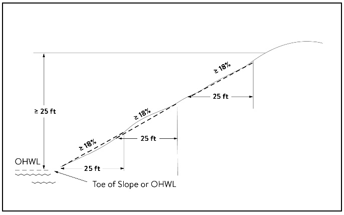
(2)
A natural escarpment or cliff with a slope that rises at least ten feet above the ordinary high water level or toe of the slope, whichever is applicable, to the top of the slope, with a slope of 75 degrees or greater. See figure 2.
Figure 2. Natural Escarpment Bluff and Bluff Impact Zone
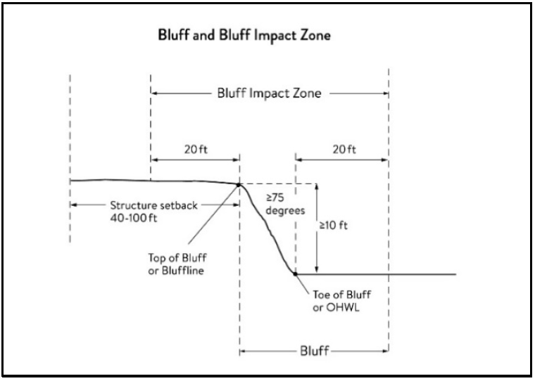
Bluff impact zoning (BIZ) means a bluff and land located within 20 feet of the bluff. See figure 2 for natural escarpment or cliff example and figure 3 for more common bluff example.
Figure 3. Bluff Impact Zone, Bluffline, Toe of bluff, and Top of Bluff
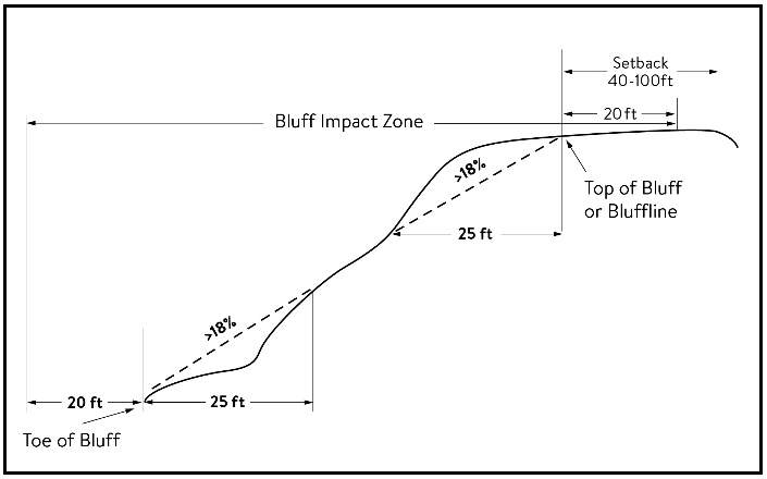
Bluffline means a line delineating the top of the bluff. More than one bluffline may be encountered proceeding landward from the river. See figures 2 for natural escarpment or cliff example and figure 3 for more common bluff example.
Bluff, toe of means a line along the bottom of a bluff, requiring field verification, such that the slope above the line exceeds 18 percent and the slope below the line is 18 percent or less, measured over a horizontal distance of 25 feet. See figure 2 for natural escarpment or cliff example and figure 3 for more common bluff example.
Bluff, top of means a line along the top of a bluff, requiring field verification, such that the slope below the line exceeds 18 percent and the slope above the line is 18 percent or less, measured over a horizontal distance of 25 feet. See figure 2 for natural escarpment or cliff example and figure 3 for more common bluff example
Buildable area means the area upon which structures may be placed on a lot or parcel of land and excludes areas needed to meet requirements for setback, rights-of-way, bluff impact zones, historic properties, wetlands, designated floodways, land below the ordinary high water level of public waters, and other unbuildable areas.
Building means a structure with two or more outside rigid walls and a fully secured roof and affixed to a permanent site.
Certificate of compliance means a document written after a compliance inspection, certifying that the development complies with applicable requirements at the time of the inspection.
Commissioner means the commissioner of the Minnesota Department of Natural Resources.
Conditional use means a use having the meaning given under Minn. Stat. chs. 394 and 462.
Conservation design means a pattern of subdivision that is characterized by grouping lots within a portion of a parcel, where the remaining portion of the parcel is permanently protected as open space.
Conventional subdivision means a pattern of subdivision that is characterized by lots that are spread regularly throughout a parcel in a lot and block design.
Deck means a horizontal, unenclosed, aboveground level structure open to the sky, with or without attached railings, seats, trellises, or other features, attached or functionally related to a principal use or site.
Developer means the meaning given under Minn. Stat. § 116G.03.
Development means the meaning given under Minn. Stat. § 116G.03.
Discretionary action means an action under this division related to land use that requires a public hearing by local ordinance or statute, such as preliminary plats, final subdivision plats, planned unit developments, conditional use permits, interim use permits, variances, appeals, and rezonings.
Dock means the meaning given under Minnesota Rules, chapter 6115.
Electric power facilities means equipment and associated facilities for generating electric power or devices for converting wind energy to electrical energy as identified and defined under Minn. Stat. § 216E.
Essential services means underground or overhead gas, electrical, communications, steam, or water distribution, collection, supply, or disposal systems, including storm water. Essential services include poles, wires, mains, drains, pipes, conduits, cables, fire alarm boxes, traffic signals, hydrants, navigational structures, aviation safety facilities or other similar equipment and accessories in conjunction with the systems. Essential services does not include buildings, treatment works as defined in Minn. Stat. § 115.01, electric power facilities or transmission services.
Feedlot means the meaning given for animal feedlots under Minnesota Rules chapter 7020.
Floodplain means the meaning given the meaning given under Minnesota Rules chapter 6120.
Fully reconstructs means the reconstruction of an existing impervious surface that involves site grading and subsurface excavation so that soil is exposed. Mill and overlay and other resurfacing activities are not considered fully reconstructed.
Hard-surface trail means a trail surfaced in asphalt, crushed aggregate, or other hard surface, for multi-purpose use, as determined by local, regional, or state agency plans.
Historic property means an archaeological site, standing structure, site, district, or other property that is:
(1)
Listed in the National Register of Historic Places or the State Register of Historic Places or locally designated as a historic site under Minn. Stat. ch. 471;
(2)
Determined to meet the criteria for eligibility to the National Register of Historic Places or the State Register of Historic Places as determined by the director of the Minnesota Historical Society; or
(3)
An unplatted cemetery that falls under the provisions of Minn. Stat. ch. 307, in consultation with the Office of the State Archaeologist.
Impervious surface means a constructed hard surface that either prevents or retards the entry of water into the soil and causes water to run off the surface in greater quantities and at an increased rate of flow than prior to development. Examples include rooftops, decks, sidewalks, patios, parking lots, storage areas, and driveways, including those with concrete, asphalt, or gravel surfaces.
Intensive vegetation clearing means the removal of all or a majority of the trees or shrubs in a contiguous patch, strip, row, or block.
Interim use means the meaning given under Minn. Stat. chs. 394 and 462.
Land alteration means an activity that exposes the soil or changes the topography, drainage, or cross section of the land, excluding gardening or similar minor soil disturbances.
Local government means counties, cities, and townships.
Lot means the meaning given under Minnesota Rules chapter 6120.
Lot width means the shortest distance between lot lines measured at both the ordinary high water level and at the required structure setback from the ordinary high water level. See figure 4.
Figure 4. Lot Width
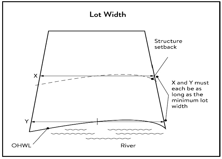
Marina means the meaning given under Minnesota Rules chapter 6115.
Mississippi River Corridor Critical Area (MRCCA) means the area within the River Corridor Boundary.
Mississippi River Corridor Critical Area (MRCCA) plan means a chapter in the City of South St. Paul's comprehensive plan.
Mooring facility means the meaning given under Minnesota Rules part 6115.0170.
Native plant community means a plant community identified by the Minnesota Biological Survey or biological survey issued or adopted by a local, state, or federal agency.
Natural-surface trail means a trail composed of native soil and rock or compacted granular stone, primarily intended for hiking, equestrian, or mountain bike use, as determined by local, regional, or state agency plans.
Natural vegetation means any combination of ground cover, understory, and tree canopy that, while it may have been altered by human activity, continues to stabilize soils, retain and filter runoff, provide habitat, and recharge groundwater.
Nonconformity means the meaning given under Minn. Stat. § 394.22.
Nonmetallic mining means construction, reconstruction, repair, relocation, expansion, or removal of any facility for the extraction, stockpiling, storage, disposal, or reclamation of nonmetallic minerals such a stone, sand, and gravel. Nonmetallic mining does not include ancillary facilities such as access roads, bridges, culverts, and water level control structures. For purposes of this subpart, "facility" includes all mine pits, quarries, stockpiles, basins, processing structures and equipment, and any structures that drain or divert public waters to allow mining.
Off-premises advertising signs means those signs that direct attention to a product, service, business, or entertainment venue that is not exclusively related to the premises where the sign is located.
Ordinary high water level (OHWL) means the meaning given under Minn. Stat. § 103G.005.
Overlay district means a zoning district applied over one or more previously established zoning districts, establishing additional or stricter standards and criteria for covered properties in addition to those of the underlying zoning district. Overlay districts are often used to protect historic features and natural resources such as shoreland or floodplain.
Parcel means the meaning given under Minn. Stat. § 116G.03.
Patio means a constructed hard surface located at ground level with no railings and open to the sky.
Picnic shelter means a roofed structure open on all sides, accessory to a recreational use.
Plat means the meaning given under Minn. Stat. §§ 505 and 515B.
Port means a water transportation complex established and operated under the jurisdiction of a port authority according to Minn. Stat. ch. 458.
Primary conservation areas (PCAs) mean key resources and features, including shore impact zones, bluff impact zones, floodplains, wetlands, gorges, areas of confluence with tributaries, natural drainage routes, unstable soils and bedrock, native plant communities, cultural and historic properties, and significant existing vegetative stands, tree canopies, and other resources identified in local government plans.
Private facilities means private roads, driveways, and parking areas, private water access and viewing facilities, decks and patios in setback areas, and private signs.
Professional engineer means an engineer licensed to practice in Minnesota.
Public facilities means public utilities, public transportation facilities, and public recreational facilities.
Public recreation facilities means recreational facilities provided by the state or a local government and dedicated to public use, including parks, scenic overlooks, observation platforms, trails, docks, fishing piers, picnic shelters, water access ramps, and other similar water-oriented public facilities used for recreation.
Public river corridor views (PRCVs) means views toward the river from public parkland, historic properties, and public overlooks, as well as views toward bluffs from the ordinary high water level of the opposite shore, as seen during the summer months and documented in the MRCCA plan/chapter of the comprehensive plan.
Public transportation facilities means all transportation facilities provided by federal, state, or local government and dedicated to public use, such as roadways, transit facilities, railroads, and bikeways.
Public utilities means electric power facilities, essential services, and transmission services.
Public waters means as defined under Minn. Stat. § 103G.005.
Readily visible means land and development that are easily seen from the ordinary high water level of the opposite shore during summer months.
Resource agency means a federal, state, regional, or local agency that engages in environmental, natural, or cultural resource protection or restoration activities, including planning, implementation, and monitoring.
Retaining wall means a vertical or nearly vertical structures constructed of mortar and rubble masonry, rock, or stone regardless of size, vertical timber pilings, horizontal timber planks with piling supports, sheet pilings, poured concrete, concrete blocks, or other durable materials.
River corridor boundary means the boundary approved and adopted by the Metropolitan Council under Minn. Stat. § 116G.06, as approved and adopted by the legislature in Minn. Stat. § 116G.15, and as legally described in the State Register, volume 43, pages 508 to 518.
River-dependent use means the use of land for commercial, industrial, or utility purposes, where access to and use of a public water feature is an integral part of the normal conduct of business and where the use is dependent on shoreline facilities.
Rock riprap means a natural coarse rock placed or constructed to armor shorelines, streambeds, bridge abutments, pilings and other shoreline structures against scour, or water or ice erosion.
Selective vegetation removal means the removal of isolated individual trees or shrubs that are not in a contiguous patch, strip, row, or block and that does not substantially reduce the tree canopy or understory cover.
Setback means a separation distance measured horizontally.
Shore impact zone (SIZ) means land located between the ordinary high water level of public waters and a line parallel to it at a setback of 50 percent of the required structure setback or, for agricultural use, 50 feet landward of the ordinary high water level. See figure 5.
Figure 5. Shore Impact Zone
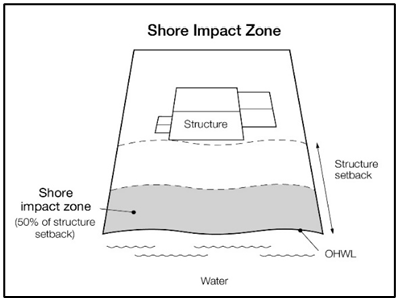
Shoreline facilities means facilities that require a location adjoining public waters for ingress and egress, loading and unloading, and public water intake and outflow, such as barge facilities, port facilities, commodity loading and unloading equipment, watercraft lifts, marinas, short-term watercraft mooring facilities for patrons, and water access ramps. Structures that would be enhanced by a shoreline location, but do not require a location adjoining public waters as part of their function, are not shoreline facilities, such as restaurants, bait shops, and boat dealerships.
Steep slope means a natural topographic feature with an average slope of 12 to 18 percent, measured over a horizontal distance equal to or greater than 50 feet, and any slopes greater than 18 percent that are not bluffs.
Storm water management facilities means facilities for the collection, conveyance, treatment, or disposal of storm water.
Structure means a building, sign, or appurtenance thereto, except for aerial or underground utility lines, such as sewer, electric, telephone, or gas lines, and utility line towers, poles, and other supporting appurtenances.
Subdivision means the meaning given under Minn. Stat. § 462.352.
Subsurface sewage treatment system means having the meaning given under Minnesota Rules, part 7080.1100.
Transmission services means:
(1)
Electric power lines, cables, pipelines, or conduits that are:
a.
Used to transport power between two points, as identified and defined under Minn. Stat. § 216E.01, Subd. 4; or
b.
For mains or pipelines for gas, liquids, or solids in suspension, used to transport gas, liquids, or solids in suspension between two points; and
(2)
Telecommunication lines, cables, pipelines, or conduits.
Treeline means the more or less continuous line formed by the tops of trees in a wooded area when viewed from a particular point. The treeline is determined during all seasons as if under full foliage.
Variance means the meaning given under Minn. Stat. § 394.22.
Water access ramp means a boat ramp, carry-down site, boarding dock, and approach road, or other access that allows launching and removal of a boat, canoe, or other watercraft with or without a vehicle and trailer.
Water-oriented accessory structure means a small building or other improvement, except stairways, fences, docks, and retaining walls, that, because of the relationship of its use to public waters, needs to be located closer to public waters than the normal structure setback. Examples include gazebos, screen houses, fish houses, pump houses, and detached decks and patios.
Water quality impact zone means land within the shore impact zone or within 50 feet of a public water, wetland, or natural drainage route.
Wetland means as defined under Minn. Stat. § 103G.005.
Wharf means as defined under Minnesota Rules, part 6115.0170.
(Ord. No. 1411, § 1, 8-21-2023)
Sec. 118-168. - Administration.
(a)
Purpose. The purpose of this section is to identify administrative provisions to ensure this division is administered consistent with its purpose.
(b)
Permits. A permit is required for the construction of buildings or building additions (including construction of decks and signs), the installation and/or alteration of sewage treatment systems, vegetation removal consistent with section 118-174 and land alterations consistent with section 118-175.
(c)
Variances. Variances to the requirements under this section may only be granted in accordance with Minn. Stat. § 462.357 and City Code section 118-38 and must consider the potential impacts of variances on primary conservation areas, public river corridor views, and other resources identified in the MRCCA plan. In reviewing the variance application, the city shall:
(1)
Evaluate the impacts to these resources. If negative impacts are found, require conditions to mitigate the impacts that are related to and proportional to the impacts, and
(2)
Make written findings that the variance is consistent with the purpose of this section, as follows.
a.
The extent, location and intensity of the variance will be in substantial compliance with the MRCCA plan;
b.
The variance is consistent with the character and management purpose of the MRCCA district in which it is located;
c.
The variance will not be unduly detrimental to PCAs and PRCVs nor will it contribute to negative incremental impacts to PCAs and PRCVs when considered in the context of past, present and reasonable future actions; and
d.
The variance will not negatively impact other resources identified in the city's critical area plan.
(d)
Conditional and interim use permits. All conditional and interim uses, required under this division, must comply with Minn. Stat. § 462.3595 and must consider the potential impacts on primary conservation areas, public river corridor views, and other resources identified in the MRCCA plan. In reviewing the application, the city shall:
(1)
Evaluate the impacts to these resources and if negative impacts are found, require conditions to mitigate the impacts that are related to and proportional to the impacts, consistent with section 118-168(e).
(2)
Make written findings that the conditional or interim use is consistent with the purpose of this section, as follows.
a.
The extent, location and intensity of the conditional use will be in substantial compliance with the MRCCA plan;
b.
The conditional use is consistent with the character and management purpose of the MRCCA district in which it is located;
c.
The conditional use will not be unduly detrimental to PCAs and PRCVs nor will it contribute to negative incremental impacts to PCAs and PRCVs when considered in the context of past, present and reasonable future actions; and
d.
The conditional use will not negatively impact other resources identified in the city's critical area plan.
(e)
Conditions of approval. The city shall evaluate the impacts to PCAs, PRCVs, and other resources identified in the MRCCA plan, and if negative impacts are found, require conditions to mitigate the impacts that are related to and proportional to the impacts. Mitigation may include:
(1)
Restoration of vegetation identified as "vegetation restoration priorities" identified in the MRCCA plan.
(2)
Preservation of existing vegetation;
(3)
Stormwater runoff management;
(4)
Reducing impervious surface;
(5)
Increasing structure setbacks;
(6)
Wetland and drainage route restoration and/or preservation;
(7)
Limiting the height of structures;
(8)
Modifying structure design to limit visual impacts on PRCVs; and
(9)
Other conservation measures.
(f)
Application materials. Applications for permits and discretionary actions required under this division must submit the following information in addition to the material requirements elsewhere in the zoning code unless the zoning administrator determines that the information is not needed:
(1)
A detailed project description; and
(2)
Scaled maps and plans, dimensional rendering, maintenance agreements, and other materials that identify and describe:
a.
Primary conservation areas;
b.
Public river corridor views;
c.
Buildable area;
d.
Existing and proposed topography and drainage patterns;
e.
Proposed storm water and erosion and sediment control practices;
f.
Existing and proposed vegetation to be removed and established;
g.
Ordinary high-water level, blufflines, and all required setbacks;
h.
Existing and proposed structures;
i.
Existing and proposed impervious surfaces; and
j.
Existing and proposed subsurface sewage treatment systems.
(g)
Nonconformities.
(1)
All legally established nonconformities as of the date of this article may continue consistent with Minn. Stat. § 462.357, Subd. 1e.
(2)
New structures erected in conformance with the setback averaging provisions of section 118-171(c)(4) are conforming structures.
(3)
Site alterations and expansion of site alterations that were legally made prior to the effective date of this article are conforming. Site alterations include vegetation, erosion control, storm water control measures, and other nonstructural site improvements.
(4)
Legally nonconforming principal structures that do not meet the setback requirements of section 118-171(c) may be expanded laterally provided that:
a.
The expansion does not extend into the shore or bluff impact zone or further into the required setback than the building line of the existing principal structure (See figure 5); and
b.
The expanded structure's scale and bulk is consistent with that of the original structure and existing surrounding development.
Figure 6. Expansion of Nonconforming Structure
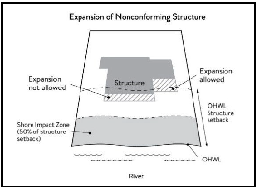
(h)
Notifications.
(1)
Amendments to this division and to the MRCCA plan must be submitted to the Commissioner as provided in Minnesota Rules, part 6106.0070, Subp. 3, Items B—I.
(2)
Notice of public hearings for discretionary actions, including conditional and interim use permits, variances, appeals, rezonings, preliminary plats, final subdivision plats, and PUDs, must be sent to the following entities at least ten days prior to the hearing:
a.
The commissioner in a format prescribed by the DNR;
b.
National Park Service; and
c.
Where building heights exceed the height limit specified in section 118-171(b) as part of the conditional use or variance process, adjoining local governments within the MRCCA, including those with overlapping jurisdiction and those across the river.
(3)
Notice of final decisions for conditional and interim use permits, variances, appeals, rezonings, preliminary plats, final subdivision plats, and PUDs, including findings of fact, must be sent to the commissioner, the National Park Service, and adjoining local governments within the MRCCA within ten days of the final decision.
(4)
Requests to amend district boundaries must follow the provisions in Minnesota Rules, part 6106.0100, Subp. 9, Item C.
(i)
Accommodating Disabilities. Reasonable accommodations for ramps or other facilities to provide persons with disabilities access to the persons' property, as required by the federal Americans with Disabilities Act and the federal Fair Housing Act and as provided by Minnesota Rules, chapter 1341, must:
(1)
Comply with sections 118-171 to 118-177; or
(2)
If sections 118-171 to 118-177 cannot be complied with, ramps or other facilities are allowed with an administrative permit provided:
a.
The permit terminates on either a specific date or upon occurrence of a particular event related to the person requiring accommodation; and
b.
Upon expiration of the permit, the ramp or other facilities must be removed.
(Ord. No. 1411, § 1, 8-21-2023)
Sec. 118-169. - MRCCA districts and special zoning areas.
(a)
Purpose. The purpose of this section is to establish districts under which building height and structure placement are regulated to protect and enhance the Mississippi River's resources and features consistent with the natural and built character of each district. This section also establishes two special zoning areas where flexibility from structure placement regulations may be granted under certain circumstances.
(b)
District description and management purpose. The MRCCA within the City of South St. Paul is divided into the following MRCCA Districts:
(1)
Rural and open space (ROS).
a.
Description. The ROS district is characterized by rural and low-density development patterns and land uses and includes land that is riparian or visible from the river, as well as large, undeveloped tracts of high ecological and scenic value, floodplain, and undeveloped islands. Many primary conservation areas exist in the district.
b.
Management purpose. The ROS district must be managed to sustain and restore the rural and natural character of the corridor and to protect and enhance habitat, parks and open space, public river corridor views, and scenic, natural, and historic areas.
(2)
River neighborhood (RN).
a.
Description. The RN district is characterized by primarily residential neighborhoods that are riparian or readily visible from the river or that abut riparian parkland. The district includes parks and open space, limited commercial development, marinas, and related land uses.
b.
Management purpose. The RN district must be managed to maintain the character of the river corridor within the context of existing residential and related neighborhood development, and to protect and enhance habitat, parks and open space, public river corridor views, and scenic, natural, and historic areas. Minimizing erosion and the flow of untreated storm water into the river and enhancing habitat and shoreline vegetation are priorities in the district.
(3)
Separated from river (SR).
a.
Description. The SR district is characterized by its physical and visual distance from the Mississippi River. The district includes land separated from the river by distance, topography, development, or a transportation corridor. The land in this district is not readily visible from the Mississippi River.
b.
Management purpose. The SR district provides flexibility in managing development without negatively affecting the key resources and features of the river corridor. Minimizing negative impacts to primary conservation areas and minimizing erosion and flow of untreated storm water into the Mississippi River are priorities in the district. The RTC district must be managed in a manner that allows continued growth and redevelopment in historic downtowns and more intensive redevelopment in limited areas at river crossings to accommodate compact walkable development patterns and connections to the river. Minimizing erosion and the flow of untreated storm water into the river, providing public access to and public views of the river, and restoring natural vegetation in riparian areas and tree canopy are priorities in the district.
(4)
Urban mixed (UM).
a.
Description. The UM district includes large areas of highly urbanized mixed-use that are a part of the urban fabric of the river corridor, including institutional, commercial, industrial, and residential areas and parks and open space.
b.
Management purpose. The UM district must be managed in a manner that allows for future growth and potential transition of intensely developed areas that does not negatively affect public river corridor views and that protects bluffs and floodplains. Restoring and enhancing bluff and shoreline habitat, minimizing erosion and flow of untreated storm water into the river, and providing public access to and public views of the river are priorities in the district.
(c)
Special zoning areas. The MRCCA within the City of South St. Paul contains two special zoning areas where the city has been granted flexibility from statewide MRCCA regulations:
(1)
Zoning area A.
a.
Description. Zoning area A includes areas of land located west of Concord Street which have existing commercial and residential development.
b.
Purpose. Zoning area A is a developed area with shallow parcel depths that cannot accommodate full compliance with the rules for bluff impact zones at the toe of a bluff. Zoning area A offers flexibility related to the placement of retaining walls, structures, and impervious surfaces near the toe of the bluff with a conditional use permit.
(2)
Zoning area B.
a.
Description. Zoning area B is a strip of land located on the east side of Concord Street between Bryant Avenue and Wentworth Avenue which has existing commercial development.
b.
Purpose. Zoning area B is a developed area with shallow parcel depths that cannot comply with MRCCA setback rules for a bluffline. Zoning area B offers flexibility related to the placement of structures and impervious surfaces near the bluffline with a conditional use permit.
(d)
MRCCA district map. The locations and boundaries of the MRCCA districts and the special zoning areas established by this section are shown on the maps entitled "MRCCA Zoning Districts Map" and "MRCCA Special Zoning Areas Map" which are incorporated herein by reference. The district and zoning area boundary lines are intended to follow the centerlines of rivers and streams, highways, streets, lot lines, and municipal boundaries, unless a boundary line is otherwise indicated on the map. Where district boundaries cross unsubdivided property, the district boundary line is determined by use of dimensions or the scale appearing on the map.
(Ord. No. 1411, § 1, 8-21-2023)
Sec. 118-170. - Special land use provisions.
(a)
Purpose. To identify development standards and considerations for land uses that have the potential to negatively impact primary conservation areas and public river corridor views.
; Ord. No. 1437, § 3, 12-15-2025)
(b)
Underlying zoning. Uses within the MRCCA are generally determined by underlying zoning, with additional provisions for the following land uses:
(1)
Agricultural use. Perennial ground cover is required within 50 feet of the ordinary high water level and within the bluff impact zone.
(2)
Feedlots. New animal feedlots and manure storage areas are prohibited. Existing animal feedlots and manure storage areas must conform with Minnesota Rules, chapter 7020.
(3)
Forestry. Tree harvesting and biomass harvesting within woodlands, and associated reforestation, must be consistent with recommended practices in Conserving Wooded Areas in Developing Communities: Best Management Practices in Minnesota.
(4)
Nonmetallic mining. Nonmetallic mining requires a conditional use permit or interim use permit issued by the local government, subject to the following:
a.
New nonmetallic mining is prohibited within the shore impact zone and bluff impact zone and within the required structure setback from the bluffline and OHWL;
b.
Processing machinery must be located consistent with setback standards for structures as provided in section 118-171(c);
c.
Only one barge loading area, which must be limited to the minimum size practicable, is permitted for each mining operation;
d.
New and, where practicable, existing nonmetallic mining operations must not be readily visible and must be screened by establishing and maintaining natural vegetation. The unscreened boundaries of nonmetallic mining areas are limited to only the barge loading area;
e.
A site management plan must be developed by the operator and approved by the local government before new nonmetallic mining commences. Operations must be consistent with the site plan throughout the duration of operations at the site. The site management plan must:
1.
Describe how the site will be developed over time with an emphasis on minimizing environmental risk to public waters;
2.
Explain where staged reclamation may occur at certain points during the life of the site;
3.
Address dust, noise, storm water management, possible pollutant discharges, days and hours of operation, and duration of operations; and
4.
Describe any anticipated vegetation and topographic alterations outside the pit, and reclamation plans consistent with the stated end use for the land;
f.
Existing and new nonmetallic mining operations must submit land reclamation plans to the local government compatible with the purposes of this article.
(5)
River-dependent uses. River-dependent uses must comply with the following design standards:
a.
Structures and parking areas, except shoreline facilities and private roads and conveyances serving river-dependent uses as provided in section 118-177 must meet the dimensional and performance standards in this section, must be designed so that they are not readily visible, and must be screened by establishing and maintaining natural vegetation;
b.
Shoreline facilities must comply with Minnesota Rules, chapter 6115 and must:
1.
Be designed in a compact fashion so as to minimize the shoreline area affected; and
2.
Minimize the surface area of land occupied in relation to the number of watercraft or barges to be served; and
c.
Dredging and placement of dredged material are subject to existing federal and state permit requirements and agreements.
(6)
Wireless communication towers. Wireless communication towers as regulated in section 118-271 require a conditional or interim use permit within the boundaries of the MRCCA district and are subject to the following design standards:
a.
The applicant must demonstrate that functional coverage cannot be provided through co-location, a tower at a lower height, or a tower at a location outside of the MRCCA;
b.
The tower must not be located in a bluff or shore impact zone; and
c.
Placement of the tower must minimize impacts on public river corridor views.
d.
Comply with the general design standards in section 118-173(b).
(Ord. No. 1411, § 1, 8-21-2023)
Sec. 118-171. - Structure height and placement and lot size; impervious surface requirements.
(a)
Purpose. To establish standards that protect primary conservation areas and public river corridor views from development impacts and ensure that new development is sited consistent with the purpose of the MRCCA.
(b)
Structure height. Structures and facilities must comply with the following standards unless identified as exempt in section 118-177.
(1)
Structures and facilities must comply with the following standards unless identified as exempt in section 118-177:
a.
ROS district: 35 feet
b.
RN district: 35 feet
c.
SR district: Height is determined by underlying zoning, provided the allowed height is consistent with that of the mature treeline, where present, and existing surrounding development, as viewed from the OHWL of the opposite shore.
d.
UM district: 65 feet, provided tiering of structures away from the Mississippi River and from blufflines is given priority, with lower structure heights closer to the river and blufflines, and that structure design and placement minimize interference with public river corridor views. Structures over 65 feet are allowed as a conditional use according to section 118-171(b)(3).
(2)
Height is measured on the side of the structure facing the Mississippi River.
(3)
In addition to the conditional use permit requirements of section 118-168(d), criteria for considering whether to grant a conditional use permit for structures exceeding the height limits must include:
a.
Assessment of the visual impact of the proposed structure on public river corridor views, including views from other communities;
b.
Identification and application of techniques to minimize the perceived bulk of the proposed structure, such as:
1.
Placing the long axis of the building perpendicular to the river;
2.
Stepping back of portions of the facade;
3.
Lowering the roof pitch or use a flat roof;
4.
Using building materials or mitigation techniques that will blend in with the natural surrounding such as green roofs, green walls, or other green and brown building materials;
5.
Narrowing the profile of upper floors of the building; or
6.
Increasing the setbacks of the building from the Mississippi River or blufflines;
(4)
Identification of techniques for preservation of those view corridors identified in the MRCCA plan; and
(5)
Opportunities for creation or enhancement of public river corridor views.
(c)
Structure and impervious surface placement.
(1)
Structures and impervious surfaces must not be placed in the shore or bluff impact zones unless identified as an exemption in section 118-177. Properties in the special zoning areas are eligible for specific flexibility from these requirements:
a.
On properties in zoning area A, structures, retaining walls, and impervious surfaces may be placed within the bluff impact zone at the toe of the bluff, but not in the bluff or within 20 feet of the top of the bluff, with a conditional use permit meeting the standards in section 118-171(c)(1)c. A new retaining wall may be allowed by conditional use permit for the purpose of stabilizing the toe of a bluff. Retaining walls in the following situations do not require a conditional use permit:
1.
The replacement or modification of an existing retaining wall in the same location as long as the replacement wall does not have a substantially larger exposed face than the existing wall and does not encroach further into the bluff than the existing wall.
2.
Retaining walls located on or adjacent to the right-of-way of an existing improved public street or alley if the city determines the wall is necessary for continued functionality and safety.
3.
New retaining walls to address an emergency situation determined by the City.
b.
On properties in zoning area B, structures and impervious surfaces may be placed within the 40-foot bluff top setback and within 20 feet of the top of the bluff up to the top of the bluff or bluffline by conditional use permit meeting the standards in section 118-171(c)(1)c. No structure or impervious surface may extend beyond the bluffline.
c.
Conditional use permit standards.
1.
Plans must demonstrate, through analysis of soil and geotechnical studies if requested by the city, that structures, retaining walls, and impervious surface can be installed without compromising the stability of the bluff.
2.
Compliance with land alteration conditions of approval in section 118-175(f).
3.
Compliance with vegetation removal and restoration standards in Section 118-174(d).
(2)
Structures, impervious surfaces, and facilities must comply with the following OHWL setback provisions unless identified as exempt in section 118-177.
a.
ROS district: 200 feet from the Mississippi River.
b.
RN district: 100 feet from the Mississippi River.
c.
UM district: 50 feet from the Mississippi River.
(3)
Structures, impervious surfaces, and facilities must comply with the following bluffline setback provisions unless identified as exempt in section 118-177:
a.
ROS district: 100 feet.
b.
RN district: 40 feet.
c.
SR district: 40 feet.
d.
UM district: 40 feet.
(4)
Where principal structures exist on the adjoining lots on both sides of a proposed building site, the minimum setback may be altered to conform to the average of the adjoining setbacks, if the new structure's scale and bulk riverward or bluffward of the setbacks required under section 118-171(c)(2) and section 118-171(c)(3) are consistent with adjoining development. See figure 7.
Figure 7. Structure Setback Averaging
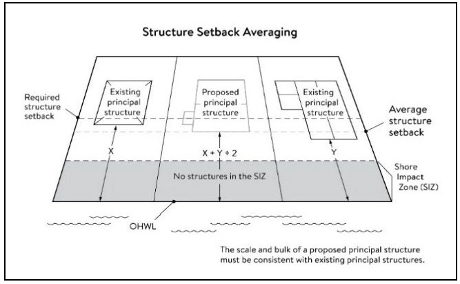
(5)
Subsurface sewage treatment systems, including the septic tank and absorption area, must be located at least 75 feet from the ordinary high water level of the Mississippi River and all other public waters.
(d)
Lot size and buildable area.
(1)
The width of lots abutting the Mississippi River in the ROS district must be at least 200 feet, unless alternative design methods are used that provide greater protection of the riparian area.
(2)
All new lots must have adequate buildable area to comply with the setback requirements of section 118-171(c)(2) and section 118-171(c)(3) so as to not require variances to use the lots for their intended purpose, except for land in zoning area B.
(e)
Impervious surface coverage on properties within 300 feet of the ordinary high water level (OHWL) of the Mississippi River.
(1)
Restrictions on impervious surface coverage:
a.
For properties with residential zoning, no lot shall exceed 30 percent impervious surface coverage without a conditional use permit.
b.
For properties with commercial or mixed-use zoning, no lot shall exceed 75 percent impervious surface coverage without a conditional use permit.
c.
For properties with industrial zoning, no lot shall exceed 75 percent impervious surface coverage without a conditional use permit.
d.
Regardless of a lot's total impervious surface coverage, a conditional use permit is not required if at least 75 percent of the portion of the lot that is within 300 feet of the OHWL of the Mississippi River is maintained as open green space. The city may require a certificate of survey verifying compliance with this provision.
(2)
In addition to the conditional use permit standards in section 118-168, the applicant for a conditional use permit shall demonstrate compliance with the following:
a.
The lot is served by municipal sewer and water if services are readily available.
b.
The lot complies with the stormwater management criteria listed in article IV and all development plans, including erosion control measures, have been reviewed and approved by the city engineer.
c.
Any other conditions that are deemed necessary to protect the shorelands of public waters.
(Ord. No. 1411, § 1, 8-21-2023; Ord. No. 1437, § 2, 12-15-2025)
Sec. 118-172. - Performance standards for private facilities.
(a)
Purpose. To establish design standards for private facilities that are consistent with best management practices and that minimize impacts to primary conservation areas, public river corridor views and other resources identified in the MRCCA plan.
(b)
General design standards. All private facilities must be developed in accordance with the vegetation management and land alteration requirements in section 118-174 and section 118-175.
(c)
Private roads, driveways, and parking areas. Except as provided in section 118-177, private roads, driveways and parking areas must:
(1)
Be designed to take advantage of natural vegetation and topography so that they are not readily visible;
(2)
Comply with structure setback requirements according to section 118-171(c); and
(3)
Not be placed within the bluff impact zone or shore impact zone, unless compliant with section 118-171(c)(1) or exempt under section 118-177 and designed consistent with section 118-173(b).
(d)
Private water access and viewing facilities.
(1)
Private access paths must be no more than:
a.
Eight feet wide, if placed within the shore impact zone; and
b.
Four feet wide, if placed within the bluff impact zone.
(2)
Private water access ramps must:
a.
Comply with Minnesota Rules, parts 6115.0210 and 6280.0250; and
b.
Be designed and constructed consistent with the applicable standards in Design Handbook for Recreational Boating and Fishing Facilities.
(3)
Design and construction of private stairways, lifts, and landings are subject to the following standards:
a.
Stairways and lifts must not exceed four feet in width on residential lots. Wider stairways may be used for commercial properties and residential facilities held in common, if approved by the city;
b.
Landings for stairways and lifts on residential lots must not exceed 32 square feet in area. Landings larger than 32 square feet area allowed for commercial properties and residential facilities held in common, if approved by the city;
c.
Canopies or roofs are prohibited on stairways, lifts, or landings;
d.
Stairways, lifts, and landings must be located in the least visible portion of the lot whenever practical; and
e.
Ramps, lifts, mobility paths, or other facilities for persons with physical disabilities are allowed for achieving access to shore areas according to section 118-172(3)a—d, and as provided under section 118-168(h).
(4)
One water-oriented accessory structure is allowed for each riparian lot or parcel less than 300 feet in width at the ordinary high water level, with one additional water-oriented accessory structure allowed for each additional 300 feet of shoreline on the same lot or parcel. Water-oriented accessory structures are prohibited in the bluff impact zone and must:
a.
Not exceed 12 feet in height;
b.
Not exceed 120 square feet in area; and
c.
Be placed a minimum of ten feet from the ordinary high water level.
(e)
Decks and patios in setback areas. Decks and at-grade patios may encroach into the required setbacks from the ordinary high water level and blufflines without a variance, when consistent with section 118-174 and 118-175, provided that:
(1)
The encroachment of the deck or patio into the required setback area does not exceed 15 percent of the required structure setback;
(2)
The area of the deck or patio that extends into the required setback area occupies no more than 25 percent of the total area between the required setback and the 15 percent using the formula:
[Required setback depth (feet) × 0.15 × lot width (feet) × 0.25 = maximum total area]
(3)
The deck or patio does not extend into the bluff impact zone, except as listed in section 118-172(e)(4). See figure 8.
Figure 8. Deck and Patio Encroachment
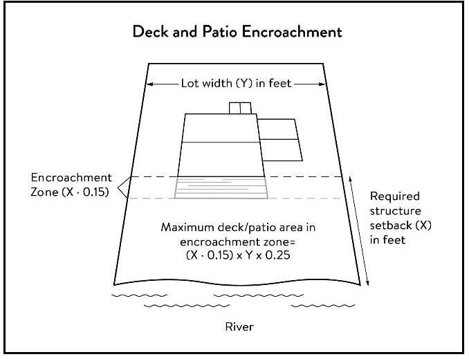
(4)
Decks and at-grade patios in zoning area B may exceed the limits in section 118-172(e)(1), section 118-172(e)(2), and may extend into the bluff impact zone, but not in the bluff, consistent with section 118-171(c)(1)b.
(f)
Off-premises and directional signs.
(1)
Off-premises advertising signs must:
a.
Meet required structure placement and height standards in section 118-171(b) and 118-171(c).
b.
Not be readily visible.
(2)
Directional signs for patrons arriving at a business by watercraft must comply with the following standards:
a.
They must be consistent with Minn. Stat. § 86B.115.
b.
Only convey the location and name of the establishment and the general types of goods and services available, if located in a shore impact zone.
c.
Be no greater than ten feet in height and 32 square feet in surface area; and
d.
If illuminated, the lighting must be shielded to prevent illumination out across the river or to the sky.
(Ord. No. 1411, § 1, 8-21-2023)
Sec. 118-173. - Performance standards for public facilities.
(a)
Purpose. To establish design standards for public facilities that are consistent with best management practices and that minimize impacts to primary conservation areas, public river corridor views and other resources identified in the MRCCA plan. Public facilities serve the public interest by providing public access to the Mississippi River corridor or require locations in or adjacent to the river corridor and therefore require some degree of flexibility.
(b)
General design standards. All public facilities must be designed and constructed to:
(1)
Minimize visibility of the facility from the river to the extent consistent with the purpose of the facility;
(2)
Comply with the structure placement and height standards in section 118-171, except as provided in section 118-177;
(3)
Be consistent with the vegetation management standards in section 118-174 and the land alteration and storm water management standards in section 118-175, including use of practices identified in Best Practices for Meeting DNR General Public Waters Work Permit GP 2004-0001, where applicable;
(4)
Avoid primary conservation areas, unless no alternative exists. If no alternative exists, then disturbances to primary conservation areas must be avoided to the greatest extent practicable, and design and construction must minimize impacts; and
(5)
Minimize disturbance of spawning and nesting times by scheduling construction at times when local fish and wildlife are not spawning or nesting.
(c)
Right-of-way maintenance standards. Right-of-way maintenance must comply with the following standards:
(1)
Vegetation currently in a natural state must be maintained to the extent feasible;
(2)
Where vegetation in a natural state has been removed, native plants must be planted and maintained on the right-of-way; and
(3)
Chemical control of vegetation must be avoided when practicable, but when chemical control is necessary, chemicals used must be in accordance with the regulations and other requirements of all state and federal agencies with authority over the chemical's use.
(d)
Crossings of public water or public land. Crossings of public waters or land controlled by the commissioner are subject to approval by the commissioner according to Minn. Stat. §§ 84.415 and 103G.245.
(e)
Public utilities. Public utilities must comply with the following standards:
(1)
High-voltage transmission lines, wind energy conversion systems greater than five megawatts, and pipelines are regulated according to Minn. Stat. chs. 216E, 216F, and 216G respectively.
(2)
If overhead placement is necessary, utility facility crossings must minimize visibility of the facility from the river and follow other existing rights-of-way as much as practicable.
(3)
The appearance of structures must be as compatible as practicable with the surrounding area in a natural state with regard to height and width, materials used, and color.
(4)
Wireless communication facilities, according to section 118-170 (b)(6).
(f)
Public transportation facilities. Public transportation facilities shall comply with structure placement and height standards in section 118-171. Where such facilities intersect or about two or more MRCCA districts, the least restrictive standards apply. Public transportation facilities must be designed and constructed to give priority to:
(1)
Providing scenic overlooks for motorists, bicyclists, and pedestrians;
(2)
Providing safe pedestrian crossings and facilities along the river corridor;
(3)
Providing access to the riverfront in public ownership; and
(4)
Allowing for use of the land between the river and the transportation facility.
(g)
Public recreational facilities. Public recreational facilities must comply with the following standards:
(1)
Buildings and parking associated with public recreational facilities must comply with the structure placement and height standards in section 118-171, except as provided in section 118-177;
(2)
Roads and driveways associated with public recreational facilities must not be placed in the bluff or shore impact zones unless no other placement alternative exists. If no alternative exists, then design and construction must minimize impacts to shoreline vegetation, erodible soils and slopes, and other sensitive resources.
(3)
Trails, access paths, and viewing areas associated with public recreational facilities and providing access to or views of the Mississippi River are allowed within the bluff and shore impact zones if design, construction, and maintenance methods are consistent with the best management practice guidelines in trail planning, design, and development guidelines.
a.
Hard-surface trails are not allowed on the face of bluffs with a slope exceeding 30 percent. Natural surface trails are allowed, provided they do not exceed eight feet in width
b.
Trails, paths, and viewing areas must be designed and constructed to minimize:
1.
Visibility from the river;
2.
Visual impacts on public river corridor views; and
3.
Disturbance to and fragmentation of primary conservation areas.
(4)
Public water access facilities must comply with the following requirements:
a.
Watercraft access ramps must comply with Minnesota Rules chapters 6115.0210 and 6280.0250; and
b.
Facilities must be designed and constructed consistent with the standards in Design Handbook for Recreational Boating and Fishing Facilities.
(5)
Public signs and kiosks for interpretive or directional purposes are allowed in the bluff or shore impact zones, provided they are placed and constructed to minimize disturbance to these areas and avoid visual impacts on public river corridor views.
(6)
Public stairways, lifts, and landings must be designed as provided in section 118-172(d)(3).
(Ord. No. 1411, § 1, 8-21-2023)
Sec. 118-174. - Vegetation management.
(a)
Purpose. To establish standards that sustain and enhance the biological and ecological functions of vegetation; preserve the natural character and topography of the MRCCA; and maintain stability of bluffs and steep slopes and ensure stability of other erosion-prone areas.
(b)
Applicability. This section applies to:
(1)
Shore impact zones;
(2)
Areas within 50 feet of a wetland or natural drainage route;
(3)
Bluff impact zones;
(4)
Areas of native plant communities; and
(5)
Significant existing vegetative stands identified in the MRCCA plan.
(c)
Activities allowed without a vegetation permit.
(1)
Maintenance of existing lawns, landscaping and gardens;
(2)
Removal of vegetation in emergency situations as determined by the City of South St. Paul;
(3)
Right-of-way maintenance for public facilities meeting the standards of section 118-173(c);
(4)
Agricultural and forestry activities meeting the standards of sections 118-170(b)(1) and 118-170(b)(3);
(5)
Selective vegetation removal, provided that vegetative cover remains consistent with the management purpose of the MRCCA district, including removal of:
a.
Vegetation that is dead, diseased, dying, or hazardous;
b.
Vegetation to prevent the spread of diseases or insect pests;
c.
Individual trees and shrubs; and
d.
Invasive nonnative species.
(d)
Activities allowed with a vegetation permit.
(1)
Only the following intensive vegetation clearing activities are allowed with a vegetation permit:
a.
Clearing of vegetation that is dead, diseased, dying, or hazardous;
b.
Clearing to prevent the spread of diseases or insect pests;
c.
Clearing to remove invasive nonnative species.
d.
Clearing to prepare for restoration and erosion control management activities consistent with a plan approved by the City of South St. Paul.
e.
The minimum necessary for development that is allowed with a building permit or as an exemption under 118-177.
(2)
General performance standards. The following standards must be met, in addition to a restoration plan under section 118-174(f), in order to approve a vegetation permit:
a.
Development is sited to minimize removal of or disturbance to natural vegetation;
b.
Soil, slope stability, and hydrologic conditions are suitable for the proposed work as determined by a professional engineer;
c.
Clearing is the minimum necessary and designed to blend with the natural terrain and minimize visual impacts to public river corridor views;
d.
Vegetation removal activities are conducted so as to expose the smallest practical area of soil to erosion for the least possible time; and
e.
Any other condition determined necessary to achieve the purpose of this section.
(e)
Prohibited activities. All other vegetation clearing is prohibited.
(f)
Vegetation restoration plan.
(1)
Development of a vegetation restoration plan and reestablishment of natural vegetation is required:
a.
For any vegetation removed with a permit under 118-174(d)(1);
b.
Upon failure to comply with any provisions in this section; or
c.
As part of the planning process for subdivisions as provided in section 118-176.
(2)
Restoration plan performance standards. The vegetation restoration plan must satisfy the application submittal requirements in section 118-168(e) and:
a.
Vegetation should be restored in one or more of the restoration priority areas as identified in the crucial area plan.
1.
Areas with soils showing signs of erosion, especially on or near the top and bottom of steep slopes and bluffs;
2.
Shoreline areas within 25 feet of the water with no natural vegetation, degraded vegetation, or planted with turf grass;
3.
Areas on steep slopes and bluffs that are visible from the river with no natural vegetation, degraded vegetation, or planted with turf grass; or
4.
Other approved priority opportunity areas, including priorities identified in the MRCCA plan, if none of the above exist.
b.
Include vegetation that provides suitable habitat and effective soil stability, runoff retention, and infiltration capability. Vegetation species, composition, density, and diversity must be guided by nearby patches of native plant communities and by Native Vegetation Establishment and Enhancement Guidelines;
c.
Any highly erodible soils disturbed during removal and/or restoration must be stabilized with deep-rooted vegetation with a high stem density;
d.
Vegetation removed must be restored with native vegetation to the greatest extent practicable;
e.
For restoration of removed native plant communities, restored vegetation must also provide biological and ecological function equivalent to the removed native plant communities. Restoration plans should be prepared by a qualified individual and include a maintenance plan that includes management provisions for controlling invasive species and replacement of plant loss for three years.
(3)
A certificate of compliance will be issued after the vegetation restoration plan requirements have been satisfied.
(Ord. No. 1411, § 1, 8-21-2023)
Sec. 118-175. - Land alteration standards and stormwater management.
(a)
Purpose. To establish standards that protect water quality from pollutant loadings of sediment, nutrients, bacteria, and other contaminants; and maintain stability of bluffs, shorelines, and other areas prone to erosion.
(b)
Land alteration.
(1)
Within the bluff impact zone, land alteration is prohibited, except for the following, which are allowed by permit.
a.
Erosion control consistent with a plan approved by the local government or resource agency and consistent with 118-175(f);
b.
The minimum necessary for development that is allowed as an exception under Section 118-177; and
c.
Repair and maintenance of existing buildings and facilities.
(2)
Within the water quality impact zone, land alteration that involves more than ten cubic yards of material or affects an area greater than 1,000 square feet requires a permit.
(c)
Rock riprap, retaining walls, and other erosion control structures.
(1)
Construction, repair, or replacement of rock riprap, retaining walls, and other erosion control structures located at or below the OHWL must comply with Minnesota Rules, part 6115.0215, Subp. 4, item E, and 6115.0216, Subp. 2. Work must not proceed until approved by the commissioner, permitted by the U.S. Army Corps of Engineers, and any other permits are obtained. See figure 9.
Figure 9. Riprap Guidelines
(2)
Construction or replacement of rock riprap, retaining walls, and other erosion control structures within the bluff impact zone and the water quality impact zone are allowed with a permit consistent with provisions of section 118-175(f) provided that:
a.
If the project includes work at or below the OHWL, the commissioner has already approved or permitted the project.
b.
The structures are used only to correct an established erosion problem as determined by the City of South St. Paul.
c.
The size and extent of the structures are the minimum necessary to correct the erosion problem and are not larger than the following, unless a professional engineer determines that a larger structure is needed to correct the erosion problem:
1.
Retaining walls must not exceed five feet in height and must be placed a minimum horizontal distance of ten feet apart; and
2.
Riprap must not exceed the height of the regulatory flood protection elevation.
d.
Repair of existing rock riprap, retaining walls, and other erosion control structures above the OHWL does not require a permit provided it does not involve any land alteration.
(d)
Stormwater management.
(1)
In the bluff impact zone, storm water management facilities are prohibited, except by permit if:
a.
There are no alternatives for storm water treatment outside the bluff impact zone on the subject site;
b.
The site generating runoff is designed so that the amount of runoff reaching the bluff impact zone is reduced to the greatest extent practicable;
c.
The construction and operation of the facility does not affect slope stability on the subject property or adjacent properties; and
d.
Mitigation based on the best available engineering and geological practices is required and applied to eliminate or minimize the risk of slope failure.
(2)
In the water quality impact zone, development that creates new impervious surface, as allowed by exemption in section 118-177, or fully reconstructs existing impervious surface of more than 10,000 square feet requires a storm water permit. Multipurpose trails and sidewalks are exempt if there is down gradient vegetation or a filter strip that is at least five feet wide.
(3)
In all other areas, storm water runoff must be directed away from the bluff impact zones or unstable areas
(e)
Development on steep slopes. Construction of structures, impervious surfaces, land alteration, vegetation removal, or other construction activities are allowed on steep slopes if:
(1)
The development can be accomplished without increasing erosion or storm water runoff;
(2)
The soil types and geology are suitable for the proposed development; and
(3)
Vegetation is managed according to the requirements of section 118-174.
(f)
Conditions of land alteration permit approval.
(1)
Temporary and permanent erosion and sediment control measures retain sediment onsite consistent with best management practices in the Minnesota Stormwater Manual;
(2)
Natural site topography, soil, and vegetation conditions are used to control runoff and reduce erosion and sedimentation;
(3)
Construction activity is phased when possible;
(4)
All erosion and sediment controls are installed before starting any land disturbance activity;
(5)
Erosion and sediment controls are maintained to ensure effective operation;
(6)
The proposed work is consistent with the vegetation standards in Section 118-174; and
(7)
Best management practices for protecting and enhancing ecological and water resources identified in Best Practices for Meeting DNR General Public Waters Work Permit GP 2004-0001.
(g)
Compliance with other plans and programs. All development must:
(1)
Be consistent with Minn. Stat. ch. 103B, and local water management plans completed under Minn. Stat. ch. 8410;
(2)
Meet or exceed the wetland protection standards under Minnesota Rules, chapter 8420; and
(3)
Meet or exceed the floodplain management standards under Minnesota Rules, sections 6120.5000—6120.6200.
(Ord. No. 1411, § 1, 8-21-2023)
Sec. 118-176. - Subdivision and land development standards.
(a)
Purpose.
(1)
To protect and enhance the natural and scenic values of the MRCCA during development or redevelopment of the remaining large sites;
(2)
To establish standards for protecting and restoring biological and ecological functions of primary conservation areas on large sites; and
(3)
To encourage restoration of natural vegetation during development or redevelopment of large sites where restoration opportunities have been identified in MRCCA plans.
(b)
Applicability.
(1)
The design standards in this section apply to subdivisions, planned unit developments and master-planned development and redevelopment of land involving ten or more acres for parcels that abut the Mississippi River and 20 or more acres for all other parcels, including smaller individual sites within the following developments that are part of a common plan of development that may be constructed at different times:
a.
Subdivisions;
b.
Planned unit developments; and
c.
Master-planned development and redevelopment of land.
(2)
The following activities are exempt from the requirements of this section:
a.
Minor subdivisions consisting of three or fewer lots;
b.
Minor boundary line corrections;
c.
Resolutions of encroachments;
d.
Additions to existing lots of record;
e.
Placement of essential services; and
f.
Activities involving river-dependent commercial and industrial uses.
(c)
Application materials. Project information listed in section 118-168(f) must be submitted for all proposed developments.
(d)
Design standards.
(1)
Primary conservation areas, where they exist, must be set aside and designated as protected open space in quantities meeting the following as a percentage of total parcel area:
a.
CA-ROS district: 50 percent;
b.
CA-RN district: 20 percent;
c.
CA-UM: Ten percent;
d.
CA-SR district: Ten percent if the parcel includes native plant communities or provides feasible connections to a regional park or trail system, otherwise no requirement.
(2)
If the primary conservation areas exceed the amounts specified in Section 118-176(d), then protection of native plant communities and natural vegetation in riparian areas shall be prioritized.
(3)
If primary conservation areas exist but do not have natural vegetation (identified as restoration priorities in the MRCCA plan), then a vegetation assessment must be completed to evaluate the unvegetated primary conservation areas and determine whether vegetation restoration is needed. If restoration is needed, vegetation must be restored according to section 118-174(f)(2).
(4)
Storm water treatment areas or other green infrastructure may be used to meet the protected open space requirements if the vegetation provides biological and ecological functions.
(5)
Land dedicated for public river access, parks, or other open space or public facilities may be counted toward the protected open space requirement.
(6)
Protected open space areas must connect open space, natural areas, and recreational areas, where present on adjacent parcels, as much as possible to form an interconnected network.
(e)
Permanent protection of dedicated open space.
(1)
Designated open space areas must be protected through one or more of the following methods:
a.
Public acquisition by a government entity for conservation purposes;
b.
A permanent conservation easement, as provided in Minn. Stat. ch. 84C;
c.
A deed restriction; and
d.
Other arrangements that achieve an equivalent degree of protection.
(2)
Permanent protection methods must ensure the long-term management of vegetation to meet its biological and ecological functions, prohibit structures, and prohibit land alteration, except as needed to provide public recreational facilities and access to the river.
(f)
Alternative design standards.
(1)
Alternative design standards may be considered through a planned unit development approval.
(Ord. No. 1411, § 1, 8-21-2023)
Sec. 118-177. - Exemptions.
(a)
Purpose. To provide exemptions to structure placement, height and other standards for specific river or water access dependent facilities as provided in Minn. Stat. § 116G.15 Subd. 4.
(b)
Applicability.
(1)
Uses and activities not specifically exempted must comply with this article. Uses and activities exempted under shore impact zone and bluff impact zone must comply with the vegetation management and land alteration standards in section 118-174 and section 118-175.
(2)
Uses and activities in section 118-177(c) are categorized as:
a.
Exempt-E. This means that the use or activity is allowed;
b.
Exempt if no alternative-(E). This means that the use or activity is allowed only if no alternatives exist; and
c.
Not exempt-N. This means that a use or activity is not exempt and must meet the standards of this article.
(c)
Uses and activities exemption classification.
(1)
General uses and activities.
E—Exempt
(E)—Exemption if no alterative
N—Nonexempt
(2)
Public utilities.
E—Exempt
(E)—Exemption if no alterative
N—Nonexempt
(3)
Public recreation facilities.
E—Exempt
(E)—Exemption if no alterative
N—Nonexempt
(4)
River-dependent uses.
E—Exempt
(E)—Exemption if no alterative
N—Nonexempt
(5)
Private residential and commercial water access and use facilities.
E—Exempt
(E)—Exemption if no alterative
N—Nonexempt
(Ord. No. 1411, § 1, 8-21-2023)
Sec. 118-184. - Reserved.
Editor's note— Ord. No. 1437, § 1, adopted Dec. 15, 2025, repealed § 118-184, which pertained to shoreland management district and derived from Ord. No. 1411, § 2, 8-21-2023.
Sec. 118-185. - Floodplain districts.
(a)
Authority; findings of fact; purpose.
(1)
Statutory authorization. The legislature of the State of Minnesota has, in Minn. Stat. chs. 103F and 462 delegated the responsibility to local government units to adopt regulations designed to minimize flood losses. Therefore, the city council of the City of South St. Paul, Minnesota, does ordain as follows:
(2)
Findings of fact.
a.
Public health, safety, general welfare. The flood hazard areas of the City of South St. Paul, Minnesota, are subject to periodic inundation which results in potential loss of life, loss of property, health and safety hazards, disruption of commerce and governmental services, extraordinary public expenditures or flood protection and relief, and impairment of the tax base, all of which adversely affect the public health, safety, and general welfare.
b.
Methods used to analyze flood hazards. This section is based upon a reasonable method of analyzing flood hazards which is consistent with the standards established by the Minnesota Department of Natural Resources.
c.
National Flood Insurance Program compliance. This section is adopted to comply with the rules and regulations of the National Flood Insurance Program codified as 44 Code of Federal Regulations parts 59—78, as amended, so as to maintain the community's eligibility in the National Flood Insurance Program.
(3)
Statement of purpose. It is the purpose of this section to promote the public health, safety, and general welfare and to minimize those losses described in subsection (a)(2)a. by provisions contained herein.
(b)
General provisions.
(1)
Lands to which section applies. This section shall apply to all lands within the jurisdiction of the city shown on the official zoning map and/or the attachments thereto as being located within the boundaries of the floodway and flood fringe districts.
(2)
Establishment of official zoning map. The official zoning map together with all materials attached thereto is hereby adopted by reference and declared to be a part of this section. The attached material shall include the flood insurance study for Dakota County, Minnesota, and incorporated areas and flood insurance rate map panels therein numbered 27037C0041E, 27037C0043E, 27037C0044E, 27037C0107E and the flood insurance rate map index (map number 27037CIND4A), all dated December 2, 2011, and prepared by the Federal Emergency Management Agency. The official zoning map shall be on file in the office of the city clerk and the city planner.
(3)
Regulatory flood protection elevation. The regulatory flood protection elevation shall be an elevation no lower than one foot above the elevation of the regional flood plus any increases in flood elevation caused by encroachments on the floodplain that result from designation of a floodway.
(4)
Interpretation.
a.
In their interpretation and application, the provisions of this section shall be held to be minimum requirements and shall be liberally construed in favor of the city council and shall not be deemed a limitation or repeal of any other powers granted by state statutes.
b.
The boundaries of the zoning districts shall be determined by scaling distances on the official zoning map. Where interpretation is needed as to the exact location of the boundaries of the district as shown on the official zoning map, as for example where there appears to be a conflict between a mapped boundary and actual field conditions and there is a formal appeal of the decision of the zoning administrator, the board of adjustment shall make the necessary interpretation. All decisions will be based on elevations on the regional (100-year) flood profile, the ground elevations that existed on the site at the time the community adopted its initial floodplain ordinance or on the date of the first National Flood Insurance Program map showing the area within the 100-year floodplain if earlier, and other available technical data. Persons contesting the location of the district boundaries shall be given a reasonable opportunity to present their case to the board of adjustment and to submit technical evidence.
(5)
Abrogation and greater restrictions. It is not intended by this section to repeal, abrogate, or impair any existing easements, covenants, or deed restrictions. However, where this section imposes greater restrictions, the provisions of this section shall prevail. All other ordinances inconsistent with this section are hereby repealed to the extent of the inconsistency only.
(6)
Warning and disclaimer of liability. This section does not imply that areas outside the floodplain districts or land uses permitted within such districts will be free from flooding or flood damages. This section shall not create liability on the part of the city or any officer or employee thereof for any flood damages that result from reliance on this section or any administrative decision lawfully made thereunder.
(7)
Severability. If any section, clause, provision, or portion of this section is adjudged unconstitutional or invalid by a court of competent jurisdiction, the remainder of this article shall not be affected thereby.
(8)
Definitions. For purposes of this section, the following definitions shall be used. Unless specifically defined below, words or phrases used in this section shall be interpreted so as to give them the same meaning as they have in common usage and so as to give this section its most reasonable application.
a.
Accessory use or structure means a use or structure on the same lot with, and of a nature customarily incidental and subordinate to, the principal use or structure.
b.
Basement means any area of a structure, including crawl spaces, having its floor or base subgrade (below ground level) on all four sides, regardless of the depth of excavation below ground level.
c.
Conditional use means a specific type of structure or land use listed in the official control that may be allowed but only after an in-depth review procedure and with appropriate conditions or restrictions as provided in the official zoning controls or building codes and upon a finding that:
1.
Certain conditions as detailed in the zoning ordinance exist.
2.
The structure and/or land use conform to the comprehensive land use plan if one exists and are compatible with the existing neighborhood.
d.
Equal degree of encroachment means a method of determining the location of floodway boundaries so that floodplain lands on both sides of a stream are capable of conveying a proportionate share of flood flows.
e.
Flood means a temporary increase in the flow or stage of a stream or in the stage of a wetland or lake that results in the inundation of normally dry areas.
f.
Flood frequency means the frequency for which it is expected that a specific flood stage or discharge may be equaled or exceeded.
g.
Flood fringe means that portion of the floodplain outside of the floodway. Flood fringe is synonymous with the term "floodway fringe" used in the flood insurance study for Dakota County, Minnesota, and Incorporated Areas.
h.
Floodplain means the beds proper and the areas adjoining a wetland, lake or watercourse which have been or hereafter may be covered by the regional flood.
i.
Floodproofing means a combination of structural provisions, changes, or adjustments to properties and structures subject to flooding, primarily for the reduction or elimination of flood damages.
j.
Floodway means the bed of a wetland or lake and the channel of a watercourse and those portions of the adjoining floodplain which are reasonably required to carry or store the regional flood discharge.
k.
Lowest floor means the lowest floor of the lowest enclosed area (including basement). An unfinished or flood-resistant enclosure, used solely for parking of vehicles, building access, or storage in an area other than a basement area, is not considered a building's lowest floor.
l.
Manufactured home means a structure, transportable in one or more sections, which is built on a permanent chassis and is designed for use with or without a permanent foundation when attached to the required utilities. The term "manufactured home" does not include the term "recreational vehicle."
m.
Obstruction means any dam, wall, wharf, embankment, levee, dike, pile, abutment, projection, excavation, channel modification, culvert, building, wire, fence, stockpile, refuse, fill, structure, or matter in, along, across, or projecting into any channel, watercourse, or regulatory floodplain which may impede, retard, or change the direction of the flow of water, either in itself or by catching or collecting debris carried by such water.
n.
Principal use or structure means all uses or structures that are not accessory uses or structures.
o.
Reach means a hydraulic engineering term to describe a longitudinal segment of a stream or river influenced by a natural or manmade obstruction. In an urban area, the segment of a stream or river between two consecutive bridge crossings would most typically constitute a reach.
p.
Recreational vehicle means a vehicle that is built on a single chassis, is 400 square feet or less when measured at the largest horizontal projection, is designed to be self-propelled or permanently towable by a light-duty truck, and is designed primarily not for use as a permanent dwelling but as temporary living quarters for recreational, camping, travel, or seasonal use. For the purposes of this section, the term recreational vehicle shall be synonymous with the term travel trailer/travel vehicle.
q.
Regional flood means a flood which is representative of large floods known to have occurred generally in Minnesota and reasonably characteristic of what can be expected to occur on an average frequency in the magnitude of the 100-year recurrence interval. Regional flood is synonymous with the term "base flood" used in a flood insurance study.
r.
Regulatory flood protection elevation means the regulatory flood protection elevation shall be an elevation no lower than one foot above the elevation of the regional flood plus any increases in flood elevation caused by encroachments on the floodplain that result from designation of a floodway.
s.
Structure means anything constructed or erected on the ground or attached to the ground or on-site utilities, including, but not limited to, buildings, factories, sheds, detached garages, cabins, manufactured homes, recreational vehicles not meeting the exemption criteria specified in subsection (h)(3)a. of this section and other similar items.
t.
Substantial damage means damage of any origin sustained by a structure where the cost of restoring the structure to its before-damaged condition would equal or exceed 50 percent of the market value of the structure before the damage occurred.
u.
Substantial improvement means within any consecutive 365-day period, any reconstruction, rehabilitation (including normal maintenance and repair), repair after damage, addition, or other improvement of a structure, the cost of which equals or exceeds 50 percent of the market value of the structure before the "start of construction" of the improvement. This term includes structures that have incurred "substantial damage," regardless of the actual repair work performed. The term does not, however, include either:
1.
Any project for improvement of a structure to correct existing violations of state or local health, sanitary, or safety code specifications which have been identified by the local code enforcement official and which are the minimum necessary to assure safe living conditions.
2.
Any alteration of a "historic structure," provided that the alteration will not preclude the structure's continued designation as an "historic structure." For the purpose of this section, "historic structure" shall be as defined in 44 Code of Federal Regulations, part 59.1.
v.
Variance means a modification of a specific permitted development standard required in an official control including this section to allow an alternative development standard not stated as acceptable in the official control, but only as applied to a particular property for the purpose of alleviating a hardship, practical difficulty or unique circumstance as defined and elaborated upon in a community's respective planning and zoning enabling legislation.
w.
Zoning administrator means the city engineer or the city engineer's designee.
(9)
Annexations. The flood insurance rate map panels adopted by reference into subsection (b)(2) above may include floodplain areas that lie outside of the corporate boundaries of the city at the time of adoption of this section. If any of these floodplain land areas are annexed into the city after the date of adoption of this section, the newly annexed floodplain lands shall be subject to the provisions of this section immediately upon the date of annexation into the city.
(c)
Establishment of zoning districts.
(1)
Districts.
a.
Floodway district. The Floodway district shall include those areas designated as floodway on the flood insurance rate map adopted in subsection (b)(2).
b.
Flood fringe district. The flood fringe district shall include those areas designated as floodway fringe. The flood fringe district shall include those areas shown on the flood insurance rate map as adopted in subsection (b)(2) as being within zones AE but being located outside of the floodway.
(2)
Compliance. No new structure or land shall hereafter be used and no structure shall be constructed, located, extended, converted, or structurally altered without full compliance with the terms of this article and other applicable regulations which apply to uses within the jurisdiction of this section. Within the floodway and flood fringe districts, all uses not listed as permitted uses or conditional uses in subsections (d) and (e) that follow, respectively, shall be prohibited. In addition, a caution is provided here that:
a.
New manufactured homes, replacement manufactured homes and certain travel trailers and travel vehicles are subject to the general provisions of this section and specifically subsection (h).
b.
Modifications, additions, structural alterations, normal maintenance and repair, or repair after damage to existing nonconforming structures and nonconforming uses of structures or land are regulated by the general provisions of this section and specifically subsection (j).
c.
As-built elevations for elevated or floodproofed structures must be certified by ground surveys and floodproofing techniques must be designed and certified by a registered professional engineer or architect as specified in the general provisions of this section and specifically as stated in subsection (i).
(d)
Floodway district (FW).
(1)
Permitted uses.
a.
General farming, pasture, grazing, outdoor plant nurseries, horticulture, truck farming, forestry, sod farming, and wild crop harvesting.
b.
Industrial-commercial loading areas, parking areas, and airport landing strips.
c.
Private and public golf courses, tennis courts, driving ranges, archery ranges, picnic grounds, boat launching ramps, swimming areas, parks, wildlife and nature preserves, game farms, fish hatcheries, shooting preserves, target ranges, trap and skeet ranges, hunting and fishing areas, and single or multiple purpose recreational trails.
d.
Residential lawns, gardens, parking areas, and play areas.
(2)
Standards for floodway permitted uses.
a.
The use shall have a low flood damage potential.
b.
The use shall be permissible in the underlying zoning district if one exists.
c.
The use shall not obstruct flood flows or increase flood elevations and shall not involve structures, fill, obstructions, excavations or storage of materials or equipment.
(3)
Conditional uses.
a.
Structures accessory to the uses listed in subsection (d)(1) above and the uses listed in subsections (d)(3)b. through (d)(3)h. below.
b.
Extraction and storage of sand, gravel, and other materials.
c.
Marinas, boat rentals, docks, piers, wharves, and water-control structures.
d.
Railroads, streets, bridges, utility transmission lines, and pipelines.
e.
Storage yards for equipment, machinery, or materials.
f.
Placement of fill or construction of fences.
g.
Recreational vehicles either on individual lots of record or in existing or new subdivisions or commercial or condominium type campgrounds, subject to the exemptions and provisions of subsection (h)(3).
h.
Structural works for flood control such as levees, dikes and floodwalls constructed to any height where the intent is to protect individual structures and levees or dikes where the intent is to protect agricultural crops for a frequency flood event equal to or less than the ten-year frequency flood event.
(4)
Standards for floodway conditional uses.
a.
All uses. No structure (temporary or permanent), fill (including fill for roads and levees), deposit, obstruction, storage of materials or equipment, or other uses may be allowed as a conditional use that will cause any increase in the stage of the 100-year or regional flood or cause an increase in flood damages in the reach or reaches affected.
b.
All floodway conditional uses shall be subject to the procedures and standards contained in subsection (i)(4).
c.
The conditional use shall be permissible in the underlying zoning district if one exists.
d.
Fill.
1.
Fill, dredge spoil, and all other similar materials deposited or stored in the floodplain shall be protected from erosion by vegetative cover, mulching, riprap or other acceptable method.
2.
Dredge spoil sites and sand and gravel operations shall not be allowed in the floodway unless a longterm site development plan is submitted which includes an erosion/sedimentation prevention element to the plan.
3.
As an alternative, and consistent with subsection 2. immediately above, dredge spoil disposal and sand and gravel operations may allow temporary, on-site storage of fill or other materials which would have caused an increase to the stage of the 100-year or regional flood but only after the city council has received an appropriate plan which assures the removal of the materials from the floodway based upon the flood warning time available. The conditional use permit must be title registered with the property in the office of the county recorder.
e.
Accessory structures.
1.
Accessory structures shall not be designed for human habitation.
2.
Accessory structures, if permitted, shall be constructed and placed on the building site so as to offer the minimum obstruction to the flow of floodwaters:
(i)
Whenever possible, structures shall be constructed with the longitudinal axis parallel to the direction of flood flow; and
(ii)
So far as practicable, structures shall be placed approximately on the same flood flow lines as those of adjoining structures.
3.
Accessory structures shall be elevated on fill or structurally dry floodproofed in accordance with the FP-1 or FP-2 floodproofing classifications in the state building code. As an alternative, an accessory structure may be floodproofed to the FP-3 or FP-4 floodproofing classification in the state building code provided the accessory structure constitutes a minimal investment, does not exceed 500 square feet in size at its largest projection, and for a detached garage, the detached garage must be used solely for parking of vehicles and limited storage. All floodproofed accessory structures must meet the following additional standards:
(i)
The structure must be adequately anchored to prevent flotation, collapse or lateral movement of the structure and shall be designed to equalize hydrostatic flood forces on exterior walls;
(ii)
Any mechanical and utility equipment in a structure must be elevated to or above the regulatory flood protection elevation or properly floodproofed; and
(iii)
To allow for the equalization of hydrostatic pressure, there must be a minimum of two "automatic" openings in the outside walls of the structure having a total net area of not less than one square inch for every square foot of enclosed area subject to flooding. There must be openings on at least two sides of the structure and the bottom of all openings must be no higher than one foot above the lowest adjacent grade to the structure. Using human intervention to open a garage door prior to flooding will not satisfy this requirement for automatic openings.
f.
Storage of materials and equipment.
1.
The storage or processing of materials that are, in time of flooding, flammable, explosive, or potentially injurious to human, animal, or plant life is prohibited.
2.
Storage of other materials or equipment may be allowed if readily removable from the area within the time available after a flood warning and in accordance with a plan approved by the city council.
g.
Structural works for flood control that will change the course, current or cross section of protected wetlands or public waters shall be subject to the provisions of Minn. Stat., ch. 103G. Community-wide structural works for flood control intended to remove areas from the regulatory floodplain shall not be allowed in the floodway.
h.
A levee, dike or floodwall constructed in the floodway shall not cause an increase to the 100-year or regional flood and the technical analysis must assume equal conveyance or storage loss on both sides of a stream.
(e)
Flood fringe district (FF).
(1)
Permitted uses. Permitted uses shall be those uses of land or structures listed as permitted uses in the underlying zoning use district(s). If no preexisting, underlying zoning use districts exist, then any residential or nonresidential structure or use of a structure or land shall be a permitted use in the flood fringe district provided such use does not constitute a public nuisance. All permitted uses shall comply with the standards for flood fringe district "permitted uses" listed in subsection (e)(2) and the "standards for all flood fringe uses" listed in subsection (e)(5).
(2)
Standards for flood fringe permitted uses.
a.
All structures, including accessory structures, must be elevated on fill so that the lowest floor including basement floor is at or above the regulatory flood protection elevation. The finished fill elevation for structures shall be no lower than one foot below the regulatory flood protection elevation and the fill shall extend at such elevation at least 15 feet beyond the outside limits of the structure erected thereon.
b.
As an alternative to elevation on fill, accessory structures that constitute a minimal investment and that do not exceed 500 square feet at their largest projection may be internally floodproofed in accordance with subsection (d)(4)e.3.
c.
The cumulative placement of fill where at any one time in excess of 1,000 cubic yards of fill is located on the parcel shall be allowable only as a conditional use, unless said fill is specifically intended to elevate a structure in accordance with subsection (e)(2)a.
d.
The storage of any materials or equipment shall be elevated on fill to the regulatory flood protection elevation.
e.
The provisions of subsection (e)(5) shall apply.
(3)
Conditional uses. Any structure that is not elevated on fill or floodproofed in accordance with subsections (e)(2)a. and (e)(2)b. and or any use of land that does not comply with the standards in subsections (e)(2)c. and (e)(2)d. shall only be allowable as a conditional use. An application for a conditional use shall be subject to the standards and criteria and evaluation procedures specified in subsections (e)(4), (e)(5) and (i)(4).
(4)
Standards for flood fringe conditional uses.
a.
Alternative elevation methods other than the use of fill may be utilized to elevate a structure's lowest floor above the regulatory flood protection elevation. These alternative methods may include the use of stilts, pilings, parallel walls, etc., or above-grade, enclosed areas such as crawl spaces or tuck under garages. The base or floor of an enclosed area shall be considered above-grade and not a structure's basement or lowest floor if:
1.
The enclosed area is above grade on at least one side of the structure;
2.
It is designed to internally flood and is constructed with flood-resistant materials; and
3.
It is used solely for parking of vehicles, building access or storage. The above-noted alternative elevation methods are subject to the following additional standards:
(i)
Design and certification. The structure's design and as-built condition must be certified by a registered professional engineer or architect as being in compliance with the general design standards of the state building code and, specifically, that all electrical, heating, ventilation, plumbing and air conditioning equipment and other service facilities must be at or above the regulatory flood protection elevation or be designed to prevent flood water from entering or accumulating within these components during times of flooding.
(ii)
Specific standards for above-grade, enclosed areas. Above-grade, fully enclosed areas such as crawl spaces or tuck under garages must be designed to internally flood and the design plans must stipulate:
(iii)
A minimum area of openings in the walls where internal flooding is to be used as a floodproofing technique. There shall be a minimum of two openings on at least two sides of the structure and the bottom of all openings shall be no higher than one foot above grade. The automatic openings shall have a minimum net area of not less than one square inch for every square foot of enclosed area subject to flooding unless a registered professional engineer or architect certifies that a smaller net area would suffice. The automatic openings may be equipped with screens, louvers, valves, or other coverings or devices provided that they permit the automatic entry and exit of floodwaters without any form of human intervention; and
(iv)
That the enclosed area will be designed of flood-resistant materials in accordance with the FP-3 or FP-4 classifications in the state building code and shall be used solely for building access, parking of vehicles or storage.
b.
Basements, as defined by subsection (b)(8)b., shall be subject to the following:
1.
Residential basement construction shall not be allowed below the regulatory flood protection elevation.
2.
Nonresidential basements may be allowed below the regulatory flood protection elevation provided the basement is structurally dry floodproofed in accordance with subsection (e)(4)c.
c.
All areas of nonresidential structures including basements to be placed below the regulatory flood protection elevation shall be floodproofed in accordance with the structurally dry floodproofing classifications in the state building code. Structurally dry floodproofing must meet the FP-1 or FP-2 floodproofing classification in the state building code and this shall require making the structure watertight with the walls substantially impermeable to the passage of water and with structural components having the capability of resisting hydrostatic and hydrodynamic loads and the effects of buoyancy. Structures floodproofed to the FP-3 or FP-4 classification shall not be permitted.
d.
When at any one time more than 1,000 cubic yards of fill or other similar material is located on a parcel for such activities as on-site storage, landscaping, sand and gravel operations, landfills, roads, dredge spoil disposal or construction of flood control works, an erosion/sedimentation control plan must be submitted unless the community is enforcing a state approved shoreland management ordinance. In the absence of a state approved shoreland ordinance, the plan must clearly specify methods to be used to stabilize the fill on site for a flood event at a minimum of the 100-year or regional flood event. The plan must be prepared and certified by a registered professional engineer or other qualified individual acceptable to the city council. The plan may incorporate alternative procedures for removal of the material from the floodplain if adequate flood warning time exists.
e.
Storage of materials and equipment:
1.
The storage or processing of materials that are, in time of flooding, flammable, explosive, or potentially injurious to human, animal, or plant life is prohibited.
2.
Storage of other materials or equipment may be allowed if readily removable from the area within the time available after a flood warning and in accordance with a plan approved by the city council.
f.
The provisions of subsection (e)(5) shall also apply.
(5)
Standards for all flood fringe uses.
a.
New principal structures. All new principal structures must have vehicular access at or above an elevation not more than two feet below the regulatory flood protection elevation. If a variance to this requirement is granted, the city council must specify limitations on the period of use or occupancy of the structure for times of flooding and only after determining that adequate flood warning time and local flood emergency response procedures exist.
b.
Commercial uses. Accessory land uses, such as yards, railroad tracks, and parking lots may be at elevations lower than the regulatory flood protection elevation. However, a permit for such facilities to be used by the employees or the general public shall not be granted in the absence of a flood warning system that provides adequate time for evacuation if the area would be inundated to a depth and velocity such that when multiplying the depth (in feet) times velocity (in feet per second) the product number exceeds four upon occurrence of the regional flood.
c.
Manufacturing and industrial uses. Measures shall be taken to minimize interference with normal plant operations especially along streams having protracted flood durations. Certain accessory land uses such as yards and parking lots may be at lower elevations subject to requirements set out in subsection (e)(5)b. above. In considering permit applications, due consideration shall be given to needs of an industry whose business requires that it be located in floodplain areas.
d.
Fill. Fill shall be properly compacted and the slopes shall be properly protected by the use of riprap, vegetative cover or other acceptable method. The Federal Emergency Management Agency (FEMA) has established criteria for removing the special flood hazard area designation for certain structures properly elevated on fill above the 100-year flood elevation; FEMA's requirements incorporate specific fill compaction and side slope protection standards for multistructure or multilot developments. These standards should be investigated prior to the initiation of site preparation if a change of special flood hazard area designation will be requested.
e.
Floodplain developments. Floodplain developments shall not adversely affect the hydraulic capacity of the channel and adjoining floodplain of any tributary watercourse or drainage system where a floodway or other encroachment limit has not been specified on the official zoning map.
f.
Standards for recreational vehicles are contained in subsection (h)(3).
g.
All manufactured homes must be securely anchored to an adequately anchored foundation system that resists flotation, collapse and lateral movement. Methods of anchoring may include, but are not to be limited to, use of over-the-top or frame ties to ground anchors. This requirement is in addition to applicable state or local anchoring requirements for resisting wind forces.
(f)
Subdivisions.
(1)
Review criteria. No land shall be subdivided which is unsuitable for the reason of flooding, inadequate drainage, water supply or sewage treatment facilities. All lots within the floodplain districts shall be able to contain a building site outside of the Floodway district at or above the regulatory flood protection elevation. All subdivisions shall have water and sewage treatment facilities that comply with the provisions of this section and have road access both to the subdivision and to the individual building sites no lower than two feet below the regulatory flood protection elevation. For all subdivisions in the floodplain, the floodway and flood fringe district boundaries, the regulatory flood protection elevation and the required elevation of all access roads shall be clearly labeled on all required subdivision drawings and platting documents.
(2)
Removal of special flood hazard area designation. The Federal Emergency Management Agency (FEMA) has established criteria for removing the special flood hazard area designation for certain structures properly elevated on fill above the 100-year flood elevation. FEMA's requirements incorporate specific fill compaction and side slope protection standards for multistructure or multilot developments. These standards should be investigated prior to the initiation of site preparation if a change of special flood hazard area designation will be requested.
(g)
Public utilities, railroads, roads, and bridges.
(1)
Public utilities. All public utilities and facilities such as gas, electrical, sewer, and water supply systems to be located in the floodplain shall be floodproofed in accordance with the state building code or elevated to above the regulatory flood protection elevation.
(2)
Public transportation facilities. Railroad tracks, roads, and bridges to be located within the floodplain shall comply with subsections (d) and (e). Elevation to the regulatory flood protection elevation shall be provided where failure or interruption of these transportation facilities would result in danger to the public health or safety or where such facilities are essential to the orderly functioning of the area. Minor or auxiliary roads or railroads may be constructed at a lower elevation where failure or interruption of transportation services would not endanger the public health or safety.
(3)
On-site sewage treatment and water supply systems. Where public utilities are not provided:
a.
On-site water supply systems must be designed to minimize or eliminate infiltration of floodwaters into the systems; and
b.
New or replacement on-site sewage treatment systems must be designed to minimize or eliminate infiltration of floodwaters into the systems and discharges from the systems into floodwaters and they shall not be subject to impairment or contamination during times of flooding. Any sewage treatment system designed in accordance with the state's current statewide standards for on-site sewage treatment systems shall be determined to be in compliance with this section.
(h)
Manufactured homes and manufactured home parks and placement of recreational vehicles.
(1)
New manufactured home parks and expansions to existing manufactured home parks shall be subject to the provisions placed on subdivisions by subsection (f).
(2)
The placement of new or replacement manufactured homes in existing manufactured home parks or on individual lots of record that are located in floodplain districts will be treated as a new structure and may be placed only if elevated in compliance with subsection (e). If vehicular road access for preexisting manufactured home parks is not provided in accordance with subsection (e)(5)a., then replacement manufactured homes will not be allowed until the property owner(s) develops a flood warning emergency plan acceptable to the city council.
a.
All manufactured homes must be securely anchored to an adequately anchored foundation system that resists flotation, collapse and lateral movement. Methods of anchoring may include, but are not to be limited to, use of over-the-top or frame ties to ground anchors. This requirement is in addition to applicable state or local anchoring requirements for resisting wind forces.
(3)
Recreational vehicles that do not meet the exemption criteria specified in subsection (h)(3)a. below shall be subject to the provisions of this section and as specifically spelled out in subsections (h)(3)c. and (h)(3)d. below.
a.
Exemption. Recreational vehicles are exempt from the provisions of this section if they are placed in any of the areas listed in subsection (h)(3)b. below and further they meet the following criteria:
1.
Have current licenses required for highway use.
2.
Are highway ready meaning on wheels or the internal jacking system, are attached to the site only by quick disconnect type utilities commonly used in campgrounds and recreational vehicle parks and the recreational vehicle has no permanent structural type additions attached to it.
3.
The recreational vehicle and associated use must be permissible in any pre-existing, underlying zoning use district.
b.
Areas exempted for placement of recreational vehicles.
1.
Individual lots or parcels of record.
2.
Existing commercial recreational vehicle parks or campgrounds.
3.
Existing condominium type associations.
c.
Loss of exemption. Recreational vehicles exempted in subsection (h)(3)a. lose this exemption when development occurs on the parcel exceeding $500.00 for a structural addition to the recreational vehicle or exceeding $500.00 for an accessory structure such as a garage or storage building. The recreational vehicle and all additions and accessory structures will then be treated as a new structure and shall be subject to the elevation/floodproofing requirements and the use of land restrictions specified in subsections (d) and (e). There shall be no development or improvement on the parcel or attachment to the recreational vehicle that hinders the removal of the recreational vehicle to a flood-free location should flooding occur.
d.
New commercial recreational vehicle parks or campgrounds and new residential type subdivisions and condominium associations and the expansion of any existing similar use exceeding five units or dwelling sites shall be subject to the following:
1.
Any new or replacement recreational vehicle will be allowed in the floodway or flood fringe districts provided said recreational vehicle and its contents are placed on fill above the regulatory flood protection elevation and proper elevated road access to the site exists in accordance with subsection (e)(5)a. No fill placed in the floodway to meet the requirements of this section shall increase flood stages of the 100-year or regional flood.
2.
All new or replacement recreational vehicles not meeting the criteria of subsection (a) above may, as an alternative, be allowed as a conditional use if in accordance with the following provisions and the provisions of subsection (i)(4). The applicant must submit an emergency plan for the safe evacuation of all vehicles and people during the 100-year flood. Said plan shall be prepared by a registered engineer or other qualified individual, shall demonstrate that adequate time and personnel exist to carry out the evacuation, and shall demonstrate the provisions of subsections (h)(3)a.1. and (h)(3)a.2. will be met. All attendant sewage and water facilities for new or replacement recreational vehicles must be protected or constructed so as to not be impaired or contaminated during times of flooding in accordance with subsection (g)(3).
(i)
Administration.
(1)
Zoning administrator. A zoning administrator or other official designated by the city council shall administer and enforce this section. If the zoning administrator finds a violation of the provisions of this section the zoning administrator shall notify the person responsible for such violation in accordance with the procedures stated in subsection (k).
(2)
Permit requirements.
a.
Permit required. A permit issued by the zoning administrator in conformity with the provisions of this section shall be secured prior to the erection, addition, modification, rehabilitation (including normal maintenance and repair), or alteration of any building, structure, or portion thereof; prior to the use or change of use of a building, structure, or land; prior to the construction of a dam, fence, or on-site septic system; prior to the change or extension of a nonconforming use; prior to the repair of a structure that has been damaged by flood, fire, tornado, or any other source; and prior to the placement of fill, excavation of materials, or the storage of materials or equipment within the floodplain.
b.
Application for permit. Application for a permit shall be made in duplicate to the zoning administrator on forms furnished by the zoning administrator and shall include the following where applicable:
1.
Plans in duplicate drawn to scale, showing the nature, location, dimensions, and elevations of the lot;
2.
Existing or proposed structures, fill, or storage of materials; and
3.
The location of the foregoing in relation to the stream channel.
c.
State and federal permits. Prior to granting a permit or processing an application for a conditional use permit or variance, the zoning administrator shall determine that the applicant has obtained all necessary state and federal permits.
d.
Certificate of zoning compliance for a new, altered, or nonconforming use. It shall be unlawful to use, occupy, or permit the use or occupancy of any building or premises or part thereof hereafter created, erected, changed, converted, altered, or enlarged in its use or structure until a certificate of zoning compliance shall have been issued by the zoning administrator stating that the use of the building or land conforms to the requirements of this section.
e.
Construction and use to be as provided on applications, plans, permits, variances and certificates of zoning compliance. Permits, conditional use permits, or certificates of zoning compliance issued on the basis of approved plans and applications authorize only the use, arrangement, and construction set forth in such approved plans and applications, and no other use, arrangement, or construction. Any use, arrangement, or construction at variance with that authorized shall be deemed a violation of this section, and punishable as provided by subsection (k).
f.
Certification. The applicant shall be required to submit certification by a registered professional engineer, registered architect, or registered land surveyor that the finished fill and building elevations were accomplished in compliance with the provisions of this section. Floodproofing measures shall be certified by a registered professional engineer or registered architect.
g.
Record of first floor elevation. The zoning administrator shall maintain a record of the elevation of the lowest floor (including basement) of all new structures and alterations or additions to existing structures in the floodplain. The zoning administrator shall also maintain a record of the elevation to which structures or alterations and additions to structures are floodproofed.
h.
Notifications for watercourse alterations. The zoning administrator shall notify, in riverine situations, adjacent communities and the commissioner of the department of natural resources prior to the community authorizing any alteration or relocation of a watercourse. If the applicant has applied for a permit to work in the beds of public waters pursuant to Minn. Stat., ch. 103G, this shall suffice as adequate notice to the commissioner of natural resources. A copy of said notification shall also be submitted to the Chicago Regional Office of the Federal Emergency Management Agency (FEMA).
i.
Notification to FEMA when physical changes increase or decrease the 100-year flood elevation. As soon as is practicable, but not later than six months after the date such supporting information becomes available, the zoning administrator shall notify the Chicago Regional Office of FEMA of the changes by submitting a copy of said technical or scientific data.
(3)
City council.
a.
Rules. The city council shall adopt rules for the conduct of business and may exercise all of the powers conferred on such boards by state law.
b.
Administrative review. The city council shall hear and decide appeals where it is alleged there is error in any order, requirement, decision, or determination made by an administrative official in the enforcement or administration of this section.
c.
Variances. The city council may authorize upon appeal in specific cases such relief or variance from the terms of this section as will not be contrary to the public interest and only for those circumstances such as hardship, practical difficulties or circumstances unique to the property under consideration, as provided for in the respective enabling legislation for planning and zoning for cities or counties as appropriate. In the granting of such variance, the city council shall clearly identify in writing the specific conditions that existed consistent with the criteria specified in this section, any other zoning regulations in the community, and in the respective enabling legislation that justified the granting of the variance. No variance shall have the effect of allowing in any district uses prohibited in that district, permit a lower degree of flood protection than the regulatory flood protection elevation for the particular area, or permit standards lower than those required by state law. The following additional variance criteria of the Federal Emergency Management Agency must be satisfied:
1.
Variances shall not be issued by a community within any designated regulatory floodway if any increase in flood levels during the base flood discharge would result.
2.
Variances shall only be issued by a community upon:
(i)
A showing of good and sufficient cause,
(ii)
A determination that failure to grant the variance would result in exceptional hardship to the applicant, and
(iii)
A determination that the granting of a variance will not result in increased flood heights, additional threats to public safety, extraordinary public expense, create nuisances, cause fraud on or victimization of the public, or conflict with existing local laws or ordinances.
3.
Variances shall only be issued upon a determination that the variance is the minimum necessary, considering the flood hazard, to afford relief.
d.
Hearings. upon filing with the city council of an appeal from a decision of the zoning administrator, or an application for a variance, the city council shall fix a reasonable time for a hearing and give due notice to the parties in interest as specified by law. The city council shall submit by mail to the commissioner of natural resources a copy of the application for proposed variances sufficiently in advance so that the commissioner will receive at least ten days' notice of the hearing.
e.
Decisions. The city council shall arrive at a decision on such appeal or variance within 60 days. In acting upon an appeal, the city council may, so long as such action is in conformity with the provisions of this section, reverse or affirm, wholly or in part, or modify the order, requirement, decision or determination of the zoning administrator or other public official. It shall make its decision in writing setting forth the findings of fact and the reasons for its decisions. In granting a variance the city council may prescribe appropriate conditions and safeguards such as those specified in subsection (i)(4)e., which are in conformity with the purposes of this section. Violations of such conditions and safeguards, when made a part of the terms under which the variance is granted, shall be deemed a violation of this section punishable under subsection (k). A copy of all decisions granting variances shall be forwarded by mail to the commissioner of natural resources within ten days of such action.
f.
Appeals. Appeals from any decision of the city council may be made, and as specified in this community's official controls and also by Minnesota Statutes.
g.
Flood insurance notice and record keeping. The zoning administrator shall notify the applicant for a variance that:
1.
The issuance of a variance to construct a structure below the base flood level will result in increased premium rates for flood insurance up to amounts as high as $25.00 for $100.00 of insurance coverage; and
2.
Such construction below the 100-year or regional flood level increases risks to life and property. Such notification shall be maintained with a record of all variance actions. A community shall maintain a record of all variance actions, including justification for their issuance, and report such variances issued in its annual or biennial report submitted to the administrator of the National Flood Insurance Program.
(4)
Conditional uses. The city council and planning commission shall hear and decide applications for conditional uses permissible under this section. Applications shall be submitted to the zoning administrator who shall forward the application to the planning commission for consideration. The planning commission will make a recommendation and then forward to the city council for consideration.
a.
Hearings. Upon filing with the city an application for a conditional use permit, the city shall submit by mail to the commissioner of natural resources a copy of the application for proposed conditional use sufficiently in advance so that the commissioner will receive at least ten days' notice of the hearing.
b.
Decisions. The city council shall arrive at a decision on a conditional use within 60 days except where additional time is permitted. In accordance with state law, in no case shall the city take longer than 120 days to arrive at a decision. In granting a conditional use permit the city council shall prescribe appropriate conditions and safeguards, in addition to those specified in subsection (i)(4)e., which are in conformity with the purposes of this section. Violations of such conditions and safeguards, when made a part of the terms under which the conditional use permit is granted, shall be deemed a violation of this section punishable under subsection (k). A copy of all decisions granting conditional use permits shall be forwarded by mail to the commissioner of natural resources within ten days of such action.
c.
Procedures to be followed by the city council and planning commission in acting on conditional use permit applications within all floodplain districts.
1.
Require the applicant to furnish such of the following information and additional information as deemed necessary by the planning commission and city council for determining the suitability of the particular site for the proposed use:
(i)
Plans in triplicate drawn to scale showing the nature, location, dimensions, and elevation of the lot, existing or proposed structures, fill, storage of materials, floodproofing measures, and the relationship of the above to the location of the stream channel; and
(ii)
Specifications for building construction and materials, floodproofing, filling, dredging, grading, channel improvement, storage of materials, water supply and sanitary facilities.
2.
Transmit one copy of the information described in subsection 1. to a designated engineer or other expert person or agency for technical assistance, where necessary, in evaluating the proposed project in relation to flood heights and velocities, the seriousness of flood damage to the use, the adequacy of the plans for protection, and other technical matters.
3.
Based upon the technical evaluation of the designated engineer or expert, the city council shall determine the specific flood hazard at the site and evaluate the suitability of the proposed use in relation to the flood hazard.
d.
Factors upon which the decision of the planning commission and city council shall be based. In passing upon conditional use applications, the planning commission and city council shall consider all relevant factors specified in other sections of this section, and:
1.
The danger to life and property due to increased flood heights or velocities caused by encroachments.
2.
The danger that materials may be swept onto other lands or downstream to the injury of others or they may block bridges, culverts or other hydraulic structures.
3.
The proposed water supply and sanitation systems and the ability of these systems to prevent disease, contamination, and unsanitary conditions.
4.
The susceptibility of the proposed facility and its contents to flood damage and the effect of such damage on the individual owner.
5.
The importance of the services provided by the proposed facility to the community.
6.
The requirements of the facility for a waterfront location.
7.
The availability of alternative locations not subject to flooding for the proposed use.
8.
The compatibility of the proposed use with existing development and development anticipated in the foreseeable future.
9.
The relationship of the proposed use to the comprehensive plan and floodplain management program for the area.
10.
The safety of access to the property in times of flood for ordinary and emergency vehicles.
11.
The expected heights, velocity, duration, rate of rise, and sediment transport of the floodwaters expected at the site.
12.
Such other factors which are relevant to the purposes of this article.
e.
Conditions attached to conditional use permits. Upon consideration of the factors listed above and the purpose of this section, the planning commission and city council shall attach such conditions to the granting of conditional use permits as it deems necessary to fulfill the purposes of this section. Such conditions may include, but are not limited to, the following:
1.
Modification of waste treatment and water supply facilities.
2.
Limitations on period of use, occupancy, and operation.
3.
Imposition of operational controls, sureties, and deed restrictions.
4.
Requirements for construction of channel modifications, compensatory storage, dikes, levees, and other protective measures.
5.
Floodproofing measures, in accordance with the state building code and this section. The applicant shall submit a plan or document certified by a registered professional engineer or architect that the floodproofing measures are consistent with the regulatory flood protection elevation and associated flood factors for the particular area.
(j)
Nonconforming uses.
(1)
A structure or the use of a structure or premises which was lawful before the passage or amendment of this section but which is not in conformity with the provisions of this section may be continued subject to the following conditions. Historic structures, as defined in subsection (b)(8)u.2., shall be subject to the provisions of subsections (j)(1)a. through (j)(1)d.
a.
No such use shall be expanded, changed, enlarged, or altered in a way that increases its nonconformity except as authorized by law.
b.
Any structural alteration or addition to a nonconforming structure or nonconforming use which would result in increasing the flood damage potential of that structure or use shall be protected to the regulatory flood protection elevation in accordance with any of the elevation on fill or floodproofing techniques (i.e., FP-1 through FP-4 floodproofing classifications) allowable in the state building code, except as further restricted in [subsection] (j)(1)c. below.
c.
If any nonconforming use is discontinued for 12 consecutive months, any future use of the building premises shall conform to this section. The assessor shall notify the zoning administrator in writing of instances of nonconforming uses that have been discontinued for a period of l2 months.
d.
If any nonconforming use or structure is substantially damaged, as defined in subsection (b)(8)t. it shall not be reconstructed except in conformity with the provisions of this section. The applicable provisions for establishing new uses or new structures in subsections (d) and (e) will apply depending upon whether the use or structure is in the floodway or flood fringe district, respectively.
(k)
Penalties for violation.
(1)
Violation of the provisions of this section or failure to comply with any of its requirements (including violations of conditions and safeguards established in connection with grants of variances or conditional uses) shall constitute a misdemeanor and shall be punishable as defined by law.
(2)
Nothing herein contained shall prevent the city from taking such other lawful action as is necessary to prevent or remedy any violation. Such actions may include but are not limited to:
a.
In responding to a suspected ordinance violation, the zoning administrator and other government agencies may utilize the full array of enforcement actions available to it including, but not limited to prosecution and fines, injunctions, after-the-fact permits, orders for corrective measures or a request to the National Flood Insurance Program for denial of flood insurance availability to the guilty party. The community must act in good faith to enforce these official controls and to correct ordinance violations to the extent possible so as not to jeopardize its eligibility in the National Flood Insurance Program.
b.
When an ordinance violation is either discovered by or brought to the attention of the zoning administrator, the zoning administrator shall immediately investigate the situation and document the nature and extent of the violation of the official control. As soon as is reasonably possible, this information will be submitted to the appropriate department of natural resources and Federal Emergency Management Agency Regional Office along with the community's plan of action to correct the violation to the degree possible.
c.
The zoning administrator shall notify the suspected party of the requirements of this section and all other official controls and the nature and extent of the suspected violation of these controls. If the structure and/or use is under construction or development, the zoning administrator may order the construction or development immediately halted until a proper permit or approval is granted by the community. If the construction or development is already completed, then the zoning administrator may either:
1.
Issue an order identifying the corrective actions that must be made within a specified time period to bring the use or structure into compliance with the official controls; or
2.
Notify the responsible party to apply for an after-the-fact permit/development approval within a specified period of time not to exceed 30 days.
d.
If the responsible party does not appropriately respond to the zoning administrator within the specified period of time, each additional day that lapses shall constitute an additional violation of this section and shall be prosecuted accordingly. The zoning administrator shall also upon the lapse of the specified response period notify the landowner to restore the land to the condition which existed prior to the violation of this section.
(l)
Amendments.
(1)
The floodplain designation on the official zoning map shall not be removed from floodplain areas unless it can be shown that the designation is in error or that the area has been filled to or above the elevation of the regulatory flood protection elevation and is contiguous to lands outside the floodplain. Special exceptions to this rule may be permitted by the commissioner of natural resources if they determine that, through other measures, lands are adequately protected for the intended use.
(2)
All amendments to this section, including amendments to the official zoning map, must be submitted to and approved by the commissioner of natural resources prior to adoption. Changes in the official zoning map must meet the Federal Emergency Management Agency's (FEMA) Technical Conditions and Criteria and must receive prior FEMA approval before adoption. The commissioner of natural resources must be given ten days' written notice of all hearings to consider an amendment to this section and said notice shall include a draft of the ordinance amendment or technical study under consideration.
(Ord. No. 1411, § 2, 8-21-2023)
State Law reference— Floodplain Management Law, Minn. Stat. § 103F.101 et seq.; local floodplain management ordinances, Minn. Stat. § 103F.121.