
Spanish Fork City Zoning Code
PART 1
GENERAL
24-2023
22-19
26-19
07-20
03-21
07-21
13-21
ORD 12-22
34-22
37-22
09-2023
21-2023
05-2024
20-2024
21-2024
12-21
15.1.04.010 Rules Of Construction
For the purpose of carrying out the intent of this Title, certain words or terms are defined in §15.1.04.020. Any word not defined in this ordinance shall be construed as defined in the Building Code of the City, if defined therein. If no definition is found in either this ordinance or the Building Code, then the word or term shall be defined according to its commonly used meaning. Illustrations contained in this Title are for illustrative purposes only. If a conflict exists between the text of this Title and any illustration, the text shall control.
Amended by Ord. 24-2023 Amending Various Sections of the Spanish Fork Municipal Code Pertaining to Title 15 updates and Amendments Regarding Adding Illustrations, Mailboxes, and Off-Street Parking on 12/12/2023
15.1.04.020 Definitions
"Accessory Dwelling Unit (ADU)": a habitable living unit added to, created within, or detached from a primary single-family dwelling and contained on one lot.
"Accessory Use or Building": A subordinate use or building customarily incidental to and located upon the same lot occupied by the main use or buildings.
“Active Recreation Areas”: areas of the landscape such as parks, sports fields and play areas dedicated to active play, where lawn is an appropriate landscape surface.
“Activity Zones”: a Localscapes® design principle that establishes specific areas of the home landscape for recreation or similar functions such as storage areas, fire pits, vegetable gardens and play areas (see Localscapes®).
"Adjoining Properties": As defined by ASTM 1527-21 or current; specifically, any real property or properties the border of which is contiguous or partially contiguous with that of the subject property, or that would be contiguous or partially contiguous with that of the subject property but for a street, road, or other public thoroughfare separating them.
"Adult Day Care": Continuous care and supervision for three or more adults for at least four but less than 24 hours a day, that meets the needs of functionally impaired adults through a comprehensive program that provides a variety of health, social, recreational, and related support services in a protective setting.
"Affected Entity": A government entity, school district, public utility, interlocal cooperative entity, or a service or similar district, whose facilities are likely to require expansion or significant modification because of an intended use of land, or the entity’s facilities or boundaries are within one mile of land which is the subject of the land use ordinance change.
"Agritainment": Agriculturally-based recreation, entertainment and tourism activities held in conjunction with on-going agricultural uses on a property. Activities may include corn mazes, hay rides, petting zoos, farm stands, and farmer's markets.
"Alluvial Fan Flooding": means flooding occurring on the surface of an alluvial fan or similar landform which originates at the apex and is characterized by high-velocity flows; active processes of erosion, sediment transport, and deposition; and unpredictable flow paths.
"Apex": means a point on an alluvial fan or similar landform below which the flow path of the major stream that formed the fan becomes unpredictable and alluvial fan flooding can occur.
"Area of Shallow Flooding": means a designated AO, AH, AR/AO, AR/AH or VO zone on a community's Flood Insurance Rate Map (FIRM) with a 1 percent (1%) or greater annual chance of flooding to an average depth of 1 to 3 feet where a clearly defined channel does not exist, where the path of flooding is unpredictable and where velocity flow may be evident. Such flooding is characterized by ponding or sheet flow.
"Area of Special Erosion Hazard": Is land that is adjacent to or within 200 feet of the centerline of the Spanish Fork River or within 100 feet of any other open channel facility that conveys runoff water located within the corporate limits of City.
"Area of Special Flood Hazard": Is the land in the floodplain within a community subject to a 1 percent (1%) or greater chance of flooding in any given year. The area may be designated as Zone A on the FHBM. After detailed ratemaking has been completed in preparation for publication of the Flood Insurance Rate Map (FIRM), Zone A usually is refined into Zones A, AO, AH, A1-30, AE, A99, AR, AR/A1-30, AR/AE, AR/AO, AR/AH, AR/A, VO or V1-30, VE, or V. For purposes of these regulations, the term "special flood hazard area" is synonymous in meaning with the phrase "area of special food hazard".
"Assisted Living Facility": A residential facility, licensed by the State of Utah, with a home-like setting that provides an array of coordinated supportive personal and health care services, available 24-hours per day, to residents who have been assessed under Utah Department of Health or the Utah Department of Human Services rules to need any of these services. Each resident shall have a service plan based on the assessment, which may include: (1) specified services of intermittent nursing care; (2) administration of medication; and (3) support services promoting the resident’s independence and self-sufficiency. Such facility does not include adult day care provided in conjunction with a residential facility for persons with a disability.
"Attached Structure": Any structure that is attached to another structure by a common wall, or by a footing or foundation and roof combination. This does not include an open breeze way.
"Automotive Repair": A facility which services motor vehicles with all types of repair work, including major engine and transmission repairs, body work, painting, and similar activities.
"Automotive Service Station": A facility having pumps and storage tanks from which fuel is dispensed into motor vehicles. Minor automotive repair may also be included as an incidental use.
"Base Flood": means the flood having a 1 percent chance of being equaled or exceeded in any given year.
"Base Flood Elevation: (BFE): Is the water surface elevation of the 1 percent (1%) annual chance flood. The height in relation to mean seal level expected to be reached by the waters of the base flood at pertinent points in the floodplains of coastal and riverine areas.
"Basement": A story of a building, partly or wholly underground. For floodplain management purposes, "Basement" means any area of the building having its floor subgrade (below ground level) on all sides.
"Bed and Breakfast": A dwelling in which five (5) or fewer guest rooms are provided for overnight lodging of travelers.
"Blade Sweep": The diameter of the wind turbine blades as determined by the blade rotation.
"Building": A structure. For floodplain management purposes, a walled and roofed building that is principally above ground, as well as a manufactured home. For insurance purposes, "Building" means:
- A structure with two or more outside rigid walls and a fully secured roof, that is affixed to a permanent site; or
- A manufactured home (a "manufactured home," also known as a mobile home, is a structure built on a permanent chassis, transported to its site in one or more sections, and affixed to a permanent foundation); or
- A travel trailer without wheels, built on a chassis and affixed to a permanent foundation, that is regulated under the community's floodplain management and building ordinances or laws.
"Building Height": The vertical distance from the average finished grade surface of the building to the peak of the roof.
"Building Setback": The shortest horizontal distance between the property line and the outside surface of the foundation, wall, or main frame of the building. Roof eaves may extend into the required setback a maximum of one (one) foot.
"Caretaker Dwelling": A dwelling which in ancillary to the principal use of a property which is exclusively occupied by an individual or individuals who are in charge of the maintenance of a building or business. Caretaker dwellings shall not have more than one bedroom.
"Carwash (full service)": A carwash that is completely mechanized (drive-thru operation) and that is ancillary to another use or an operation where the cleaning services are exclusively performed by employees of the establishment without the aid of the patron or coin operated devices.
"Carwash (self-serve)": A business establishment which provides car cleaning services where part or all of the cleaning is performed by the patron with the aid of coin operated cleaning devices.
“Certified Irrigation Designer”: a person certified by the Irrigation Association to prepare irrigation system designs, and/or a Professionally Licensed Landscape Architect (PLA) in the State of Utah.
“Central Open Space”: a Localscapes® design principle that establishes specific areas of the home landscape as unobstructed focal point and a primary use area.
"Child Care Center": Any facility in which child care is provided to 13 or more children, including the provider’s own pre-school age children, on the premises at the same time.
"Church": A structure which is intended for conducting organized religious services for organizations with tax-exempt status, with no overnight facilities. Secondary uses such as child care, senior services, professional counseling, rehabilitation services, or similar uses are not included in the definition. A church does not include organizations that violate Federal, State, or City laws or codes.
"City": Spanish Fork City.
"City Council": The governing body of the City, consisting of five elected council persons and the Mayor.
"Civil Engineer": A person licensed with the State of Utah to practice as a professional engineer.
"Clinics, Emergency Medical Care Facilities": A medical facility for the diagnosis and treatment of human patients which may include emergency services, but not overnight housing of patients.
"Commercial Child Care Center": Any facility located in a non-residential or non-industrial zone in which child care is provided on the premises.
"Commission": The Planning Commission of Spanish Fork City, unless indicated otherwise.
"Completion Date": The date the entire subdivision, development, or construction is completed and an approved final inspection statement is given.
"Comprehensive General Plan" or "General Plan": The land use element of the Comprehensive General Plan document as approved by the City Council.
"Conditional Letter of Map Revision": means FEMA's comment on a proposed project that would, upon construction, affect the hydrologic or hydraulic characteristics of a flooding source and thus result in the modification of the existing regulatory floodway, the effective Base Flood Elevations, or the Special Flood Hazard Area. The letter does not revise an effective map; it indicates whether the project, if built as proposed, would be recognized by FEMA. A CLOMR does not replace a floodplain development permit.
"Constituents of Concern": Specific Chemical s that are identifies for evaluation in the site assessment process.
"Construction Plans and Profiles": Plans drawn by a civil engineer or land surveyor showing all required improvements including the location, size, grade and elevations.
"Convenience Store": A building or use which is primarily engaged in the provision of frequently needed, day to day retail goods including gasoline, food and non-food products.
"Council": The City Council.
"Crawlspace": is that area below an elevated building that is typically built on a solid (perimeter) wall foundation and is used to access utilities and/or the building is elevated over unsuitable foundation materials. Height limitations apply.
"Critical Feature": means an integral and readily identifiable part of a flood protection system, without which the flood protection provided by the entire system would be compromised.
"Design and Development Standards": The standards as referred to in this Title and adopted by the Council.
"Development": Any man-made change in improved or unimproved real estate, including but not limited to buildings or other structures, mining, dredging, filling, grading, paving, excavation or drilling operations or storage of equipment or materials.
"Developer": Person, Partnership, Limited Liability Company, Corporation, or other legal entity developing residential, commercial or industrial property.
"Development": means any man-made change to improved or unimproved real estate, including but not limited to buildings or other structures, demolition of buildings or structures, fences, mining, dredging, filling, grading, paving, excavation or drilling operations or storage of equipment or materials.
"Development Review Committee" or "DRC": A committee that provides technical review, analysis, and recommendations to the Planning Commission and City Council related to the City’s Comprehensive General Plan, Zoning Ordinance, subdivisions, capital facilities plans and site plans.
"Disability": A physical or mental impairment that substantially limits one or more of a person’s major life activities, including a person having a record of such an impairment or being regarded as having such an impairment. A “disability” does not include current illegal use of, or addiction to, any federally controlled substance, as defined in Section 102 of the Controlled Substances Act, 21 U.S.C. 802 or successor law.
- “Major life activities” means functions such as caring for one’s self, performing manual tasks, walking, seeing, hearing, speaking, breathing, learning and working.
- “Has a record of such an impairment” means has a history of, or has been classified as having, a mental or physical impairment that substantially limits one or more major life activities.
“Drought Tolerant Plant”: a plant that can survive without irrigation for limited periods of time. The application of supplemental irrigation water may be desirable during extended drought periods for improved appearance, disease resistance and survival rates (see Non-Drought Tolerant Plant).
"Duplex": A building designed for two (2) family units living independently of each other on the same lot.
"Dwelling, Multi-Family": A building arranged or designed to include three (3) or more homes, each to be occupied by one (1) family.
"Dwelling, Single-family": A detached building designed for one family unit and having one main kitchen.
"Dwelling Unit": A building, structure, or portion thereof used as residence that includes living or sleeping accommodations that also provides a kitchen and a bathroom.
"Elderly Person": A person who is 60 years old or older, who desires or needs to live with other elderly persons in a group setting, but who is capable of living independently.
"Elevated Building": means a non-basement building (i) built, in the case of a building in Zones A1-30, AE, A, A99, AO, AH, B, C, X, and D, to have the top of the elevated floor, elevated above the ground level by means of pilings, columns (posts and piers), or shear walls parallel to the floor of the water and (ii) adequately anchored so as not to impair the structural integrity of the building during a flood of up to the magnitude of the base flood. In the case of Zones A1-30, AE, A, A99, AO, AH, B, C, X, and D, "Elevated Building" also includes a building elevated by means of fill or solid foundation perimeter walls with openings sufficient to facilitate the unimpeded movement of flood waters.
"Enclosed Area": is that portion of an elevated building below the lowest elevated floor that is either partially or fully enclosed by rigid walls. For the purposes of the NFIP, enclosed areas can be an enclosure, crawlspace, subgrade crawlspace, or attached garage.
"Enclosure": is the area below an elevated building that is partially or fully enclosed and over 5' in height from enclosure floor to finish floor elevation of the floor immediately above the enclosed area. That portion of an elevated building below the lowest elevated floor that is either partially or fully enclosed by rigid walls.
"Engineer": The person appointed by the City to be the City Engineer.
"Environmental Professional": A person who meets the criteria and qualifications as set forth pursuant to 40 CFR 312.00, and as reprinted in Appendix X2 of the ASTM Standard E1527-21. Also, a person who meets the criteria and qualifications for conducting environmental work beyond the Phase l Environmental Site Assessments as set forth by DEQ and the United States Environmental Protection Agency.
"Erosion": means the process of the gradual wearing away of land masses. This peril is not per se covered under the Program.
"Event Center": A place with indoor or outdoor facilities that provides for gatherings of individuals assembled for purposes such as a weddings, receptions, meetings or parties.
"Existing Construction": means for the purposes of determining rates, structures for which the "start of construction" commenced before the effective date of the FIRM or before January 1, 1975, for FIRMs effective before that date. "Existing Construction" may also be referred to as "existing structures".
"Feedlot": Any dairy, stockyard, feedyard, or similar livestock operation for cattle, sheep, swine, goats, poultry, or game animals, where the animals are corralled, penned, tethered, or otherwise caused to remain in a restricted area for any purpose, and in which the surface of such restricted area is or will become bare of any feed growth in the normal growing season. Normal grazing activities for pastured livestock are excluded from this definition.
"Fence": A structure serving as an enclosure, a barrier, or a boundary, usually made of posts or stakes joined together by boards, wire, vinyl panels or fiberglass encapsulated foam panels.
"Final Decision": A decision by a land use authority which approves, approves with conditions, or denies a land use application. A final decision is made by motion and majority vote in a public meeting, or by a written decision if no vote is taken in the public meeting. When the land use authority is a staff member, it is their decision, granting or denying a land use application in writing.
"Final Plat": An original map or plat drawn on mylar in a form as approved by the City, showing all lots, streets, utility easements, etc.
"Flag Lot": A lot of irregular configuration in which an access strip (a strip of land of a width less than the required lot width) connects the main body of the lot to the street frontage.
"Flag Pole": A staff or pole that is no greater than 24 inches in diameter that exists for the primary purpose of displaying a flag.
"Flood Insurance Rate Map (FIRM)": Means an official map of the City, on which the Federal Emergency Management Agency has delineated both the areas of special flood hazards and the risk premium zones applicable to the community.
"Flood Insurance Study": The official report provided by the Federal Emergency Management Agency. The report contains flood profiles, water surface elevation of the base flood, as well as the Flood Boundary-Floodway Map.
"Flood" or "Flooding": means
- A general and temporary condition of partial or complete inundation of normally dry land areas from:
- The overflow of inland or tidal waters; or
- The unusual and rapid accumulation or runoff of surface waters from any source; or
- Mudslides (i.e., mudflows) which are proximately caused by flooding as defined in paragraph (a)(2) of this definition and are akin to a river of liquid and flowing mud on the surfaces of normally dry land areas, as when earth is carried by a current of water and deposited along the path of the current.
- The collapse or subsidence of land along the shore of a lake or other body of water as a result of erosion or undermining caused by waves or currents of water exceeding anticipated force of nature, such as flash flood or an abnormal tidal surge, or by some similarly unusual and unforeseeable event which results in flooding as defined in paragraph (a)(1) of this definition.
"Flood Elevation Determination": means a determination by the Administrator of the water surface elevations of the base flood, that is, the flood level that has a one percent or greater change of occurrence in any given year.
"Flood Insurance Rate Map (FIRM)": means an official map of the City, on which the Administrator has delineated both the special hazards areas and the risk premium zones applicable to the community.
"Flood Insurance Study": or Flood elevation study means an examination, evaluation and determination of flood hazards and, if appropriate, corresponding water surface elevations, or an examination, evaluation and determination of mudslide (i.e., mudflow) and/or flood related erosion hazards.
"Flood Proofing": means any combination of structural and non-structural additions, changes, or adjustments to structures, which reduce or eliminate flood damage to real estate or improved real property, water and sanitary facilities, structures and their contents. Wet floodproofing includes permanent or contingent measures applied to a structure or its contents that prevent or provide resistance to damage from flooding while allowing floodwaters to enter the structure or area and may be applied to residential or non-residential structures. Dry floodproofing is making a structure watertight below the level that needs flood protection to prevent floodwaters from entering. Making the structure watertight requires sealing the walls with waterproof coatings, impermeable membranes, or a supplemental layer of masonry or concrete and can only be used for non-residential structures.
"Flood Protection System": means those physical structural works for which funds have been authorized, appropriated, and expended and which have been constructed specifically to modify flooding in order to reduce the extent of the areas within a community subject to a "special flood hazard" and the extent of the depths of associated flooding. Such a system typically includes dams, reservoirs, levees or dikes. These specialized flood modifying works are those constructed in conformance with sound engineering standards.
"Floodplain" or "flood-prone area": means any land area susceptible to being inundated by water from an source (see definition of "flooding").
"Floodplain Management": means the operation of an overall program of corrective and preventive measures for reducing flood damage, including but not limited to emergency preparedness plans, flood control works and floodplain management regulations.
"Floodplain Management Regulations": means zoning Ordinances, subdivision regulations, building codes, health regulations, special purpose ordinances (such as a floodplain ordinance, grading ordinance and erosion control ordinance) and other applications of police power. The term describes such state or local regulations, in any combination thereof, which provide standards for the purpose of flood damage prevention and reduction.
"Floodway (Regulatory Floodway)": means the channel of a river or other watercourse and the adjacent land areas that must be reserved in order to discharge the base flood without cumulatively increasing the water surface elevation more than a designated height
"Floodway Encroachment Lines": means the lines marking the limits of the floodways on Federal, State and local flood plain maps.
"Formally Initiated": An act taken to change or modify a land use ordinance by application or by motion of the Planning Commission or City Council, made in a public meeting.
"Freeboard": means a factor of safety usually expressed in feet above a flood level for purposes of floodplain management. "Freeboard" tends to compensate for the many unknown factors that could contribute to flood heights greater than the height calculated for a selected size flood and floodway conditions, such as wave action, bridge openings, and the hydrological effect of urbanization of the watershed.
"Front": The lot line adjacent to a street, except as follows:
1. Corner Lot. The front property line is determined by which direction the required setbacks for the front and rear can both be met. If all applicable setbacks can be met either way, the front setback shall be located on the same side as the front door of the structure and the other frontage shall be the side-street side.
2. Through of Double Frontage Lot. The lot line which is obviously the front by reason of the prevailing custom of the other buildings on the block. The other street frontage shall be a rear lot line. Where such property line is not obviously evident, the Community Development Director shall determine the front property line.
"Functionally Dependent Use": means a use which cannot perform its intended purpose unless it is located or carried out in close proximity to water. The term includes only docking facilities, port facilities that are necessary for the loading and unloading of cargo or passengers, and ship building and ship repair facilities, but does not include long-term storage or related manufacturing facilities.
"Funeral Home": The provision of services including storing and preparing human remains for burial, cremation, and arranging, managing, and conducting funerals.
“Gathering Areas”: a Localscapes® design principle that establishes specific areas of the home landscape as patios, gazebos, arbors, decks, and similar spaces suitable for congregating and gathering.
"Garage": A building or indoor area with four walls, a roof and at least one door, of which the primary purpose is to provide an enclosed space for parking or storing motor vehicles. Required garages must have an unobstructed area that is at least nine (9) feet wide by 18 feet deep.
"General Plan": The Comprehensive General Plan of Spanish Fork City.
"Grain Mill": Facilities that provide the storage and elevating of agricultural commodities; the milling of agricultural grains, including grinding, rolling, cracking, flaking and pelletizing; the processing and storage of fertilizers; and the packaging of commodities and fertilizers.
“Ground Cover”: material planted in such a way as to form a continuous cover over the ground that can be maintained at a height not more than twelve inches (12").
“Hardscape”: durable and generally hard landscape materials such as concrete, wood, pavers, stone and compacted crushed stone.
"Hazardous Waste or Hazardous Substance": A constituent of concern, chemical, waste or contaminant in any form such as gas, vapor, liquid, fluid, solid, water, or soil which is regulated or listed by the Utah County Health Department, the DEQ or the United States Environmental Protection Agency. A hazardous waste includes petroleum by-products and other chemicals and biological hazards by definition.
"Highest Adjacent Grade": means the highest natural elevation of the ground surface prior to construction next to the proposed walls of a structure.
"Historic Structure": means any structure that is:
- Listed individually in the National Register of Historic Places (a listing maintained by the Department of Interior) or preliminarily determined by the Secretary of the Interior as meeting the requirements for individual listing on the National Register.
- Certified or preliminarily determined by the Secretary of the Interior as contributing to the historical significance of a registered historic district or a district preliminarily determined by the Secretary to qualify as a registered historic district.
- Individually listed on a state inventory of historic places in states with historic preservation programs which have been approved by the Secretary of the Interior, or
- Individually listed on a local inventory of historic places in communities with historic preservation programs that have been certified either:
- By an approved state program as determined by the Secretary of the Interior.
- Directly by the Secretary of the Interior in states without approved programs.
"Home Child Care Center": Any single home in which child care is provided for seven (7) to 12 children, including the provider’s own pre-school age children, on the premises at the same time.
"Home Occupation": An occupation, profession, activity, or use that is clearly incidental and secondary to the use of a residential home.
"Hospital": A facility used for inpatient or outpatient medical and healthcare-related uses or services (one of which provides emergency medical services) or any incidental, ancillary or related uses or services including but not limited to medical office, research and/or development, information technology, warehouse and distribution, hospitality, food service and lodging.
"Hotel/Motel": A building which provides guest rooms for the overnight lodging of travelers. It may include customarily incidental uses such as meeting rooms, restaurants, and gift shops.
“Impervious Surface”: areas which prevent or impede the infiltration of stormwater into the soil as it entered in natural conditions prior to development. Common impervious areas include, but are not limited to, rooftops, sidewalks, walkways, patio areas, driveways, parking lots, storage areas, compacted gravel and soil surfaces, awnings and other fabric or plastic coverings.
"Impound Yard": A facility that provides for the secured storage of automobiles with or without the permission of the owners by a person who is licensed to hold the automobiles.
"Improved Lot": A lot which has all the improvements required in Part 4 of this Title.
"Improvements": Includes roads, streets, curbs, gutters, sidewalks, grading, landscaping, water systems, sewer systems, irrigation systems, drainage systems, power systems, fences, public facilities, trees, and/or other items required by this Title.
"Indoor Commercial Recreation Facility": Enterprises which include recreation and entertainment uses such as arcades, bowling alleys, indoor playgrounds, pool halls, racquetball and handball courts, skating rinks, trampoline parks, or other similar activities that are wholly enclosed in a building.
"Indoor Pickleball Facility": A building that contains indoor pickleball courts and other improvements that are provided to serve players using the courts.
"Instructional Studio": A facility in which instruction is offered for piano, gymnastics, voice, art, or similar activities.
"Institution of Higher Education": An institution offering academic or technical curriculum which is accredited to grant a degree, certificate or other indication of successful completion of an instructional program. The definition includes colleges, universities, trade schools or other operations offering vocational training. This primarily includes post high school educational facilities or educational facilities which include residential facilities for its students.
“Irrigated Landscape Area”: all portions of a development site to be improved with planting and irrigation. Natural open space areas shall not be included in the irrigated landscaped area.
"Jail": A place of incarceration owned and operated by the County or State.
"Juvenile Detention Facility": A place of temporary detention for delinquent juveniles, which either is owned and operated by the State of Utah or is under contract with the State of Utah.
"Juvenile Secure Facility": A place of incarceration for delinquent juveniles, which either is owned and operated by the State of Utah or is under contract with the State of Utah.
"Landscape Irrigation Auditor":(LIA): A person certified by the Irrigation Association to conduct a landscape irrigation audit.
“Landscape Area”: Improved areas of the property that incorporate all the completed features of the landscape. The Landscape Area does not include footprints of buildings or structures, required sidewalks and required driveways.
“Landscape Water Allowance”: for design purposes this is the upper limit of annual applied water for the established landscaped area. It is based upon the local reference evapotranspiration rate, the ETo adjustment factor and the size of the landscaped area
"Land Surveyor": A person licensed by the State of Utah to practice as a land surveyor.
"Land Use Authority": A person, board, commission, agency, or other body designated by ordinance to act upon a land use application.
"Land Use Ordinance": A planning, zoning, development, or subdivision ordinance of the City, but does not include the Comprehensive General Plan.
"Large Wind Energy System": Wind energy conversion system consisting of a wind turbine, a tower, and associated control or conversion electronics, which has a rated capacity of more than 100 kW.
“Lawn”: ground that is covered with grass or turf that is regularly mowed and irrigated (see Turf).
"Letter of Map Amendment": means an official amendment, by letter, to an effective map. A LOMA establishes a property's location in relation to the Special Flood Hazard Area and are usually issued because a property has been inadvertently mapped as being in the floodplain, but is actually on natural high ground above the base flood elevation.
"Letter of Map Revision": means FEMA's modification to an effective Flood Insurance Rate Map, or Flood Boundary and Floodway Map, or both. LOMRs are generally based on the implementation of physical measures that affect the hydrologic or hydraulic characteristics of a flooding source and thus result in the modification of the existing regulatory floodway, the effective Base Flood Elevations, or the Special Flood Hazard Area.
"Letter of Map Revision Based on Fill": means FEMA's modification of the Special Flood Hazard Area shown on the Flood Insurance Rate Map based on the placement of fill outside the existing regulatory floodway.
"Levee": means a man-made structure, usually an earthen embankment, designed and constructed in accordance with sound engineering practices to contain, control, or divert the flow of water so as to provide protection from temporary flooding. Only levees that are recognized by FEMA will be shown on the FIRMs as providing protection from the 1% annual chance flood.
"Levee System": means a flood protection system, which consists of a levee, or levees, and associated structures, such as closure and drainage devices, which are constructed and operated in accordance with sound engineering practices.
“Localscapes®”: a water-conserving design approach developed by Utah horticulturists, landscape architects, landscape experts, irrigation experts and members of the water industry that simplifies water-conserving design into a five-step process that is easy to implement by non-professionals and appropriate for use in Utah. Localscapes® is supported by the Spanish Fork City and is particularly appropriate for single-family and similar residential, twin home and similar yards and landscapes (see Water-conserving Landscape, Water-wise Landscape and Xeriscape).
"Lowest Floor": means the lowest floor of the lowest enclosed area (including basement). An unfinished or flood resistant enclosure, usable solely for parking of vehicles, building access or storage in an area other than a basement area is not considered a building's lowest floor; provided, that such enclosure is not built so as to render the structure in violation of the applicable non-elevation design requirements of Sec. 60.3.
"Lot": A parcel of land with frontage or other approved access to a public street, occupied or designed to be occupied by a building and its accessory uses, and which has been subdivided or otherwise lawfully permitted.
"Lot, Corner": A lot located at the intersection of two or more streets.
"Lot, Depth": The shortest distance between the midpoint of the front lot line and the midpoint of the rear lot line.
"Lot, Interior": A lot other than a corner lot.
"Lot, Irregular": A building lot whose rear property line is not generally parallel to the front property line such as a pie-shaped lot on a cul-de-sac, or where the side property lines are not parallel to each other.
"Lot, Through" or "Double Frontage": A lot which abuts upon two parallel or approximately parallel streets.
"Lot Line":
- Front: The lot line adjacent to a street, except as follows:
- Corner Lot. The front property line is determined by which direction the required setbacks for the front and rear can both be met. If all applicable setbacks can be met either way, the front setback shall be located on the same side as the front door of the structure and the other frontage shall be the side-street side.
- Through or Double Frontage Lot. The lot line which is obviously the front by reason of the prevailing custom of the other buildings on the block. The other street frontage shall be a rear lot line. Where such property line is not obviously evident, the Community Development Director shall determine the front property line.
- Rear: The lot line most nearly opposite the front property line or, if the front property is a curved line, to a line tangent to the front property line at its midpoint.
- Side: Those other lot lines not defined as a front or rear lot line.
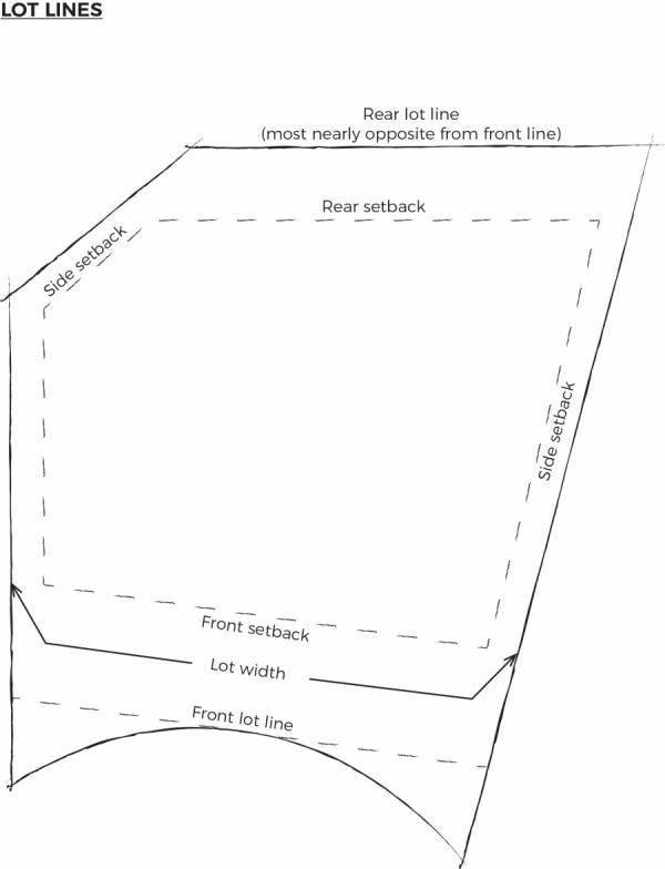
"Lot Width": If the side lot lines are parallel, the shortest distance between these side lines. If the side property lines are not parallel, the width shall be the distance between the side lines at the front setback line, as in the following illustration: "Lube Center": A facility which primarily provides oil change and similar servicing or performs minor mechanical repair of motor vehicles. The outdoor overnight storage of vehicles is not permitted in association with the Lube Center use.
"Manufactured Home": A transportable factory-built housing unit constructed on or after June 15, 1976, according to the National Manufactured Housing Construction and Safety Standards Act of 1974. For floodplain management purposes "Manufactured Home" means a structure, transportable in one or more sections, which is built on a permanent chassis and is designed for use with or without a permanent foundation when attached to the required utilities. The term "manufactured home" does not include a recreation vehicle.
"Meat Processing Facility": An enclosed facility, with no Feedlot, used for the killing of dressing of animals; including cattle, sheep, swine, goats, poultry or game animals; and the storage, freezing, and curing of meat and preparation of meat products on sites of less than 20 acres that process 500 or fewer animals in any 24-hour period of time.
“Mulch”: any material such as bark, wood chips, crushed stone, chat or similar materials left loose and applied to the soil for the purpose of preventing evapotranspiration.
"Municipal Utility Easement": an easement which:
- Is not a public utility easement pursuant to Utah Code Ann. §54-3-27;
- Is entirely owned by Spanish Fork City; and
- Is either:
- Not being used or occupied; or
- Is being exclusively used and occupied by Spanish Fork City or its approved franchisees to provide utility services, such as sanitary sewer, culinary water, pressurized irrigation water, storm water, broadband, telecommunications, etc.
"Museum": A building or place where works of art, scientific specimens, historic artifacts or other objects of permanent value are kept and displayed.
"New Construction": means for the purposes of determining insurance rates, structures for which the "start of construction" commenced on or after the effective date of an initial FIRM or after December 31, 1974, whichever is later, and includes any subsequent improvements to such structures. For floodplain management purposes, "new construction" means structures for which the "start of construction" commenced on or after the effective date of a floodplain management regulation adopted by a community and includes any subsequent improvements to such structures.
"Non-complying Structure": A structure that (1) legally existed before its current land use designation; and (2) because of one or more subsequent land use ordinance changes, does not conform to the setback, height restrictions, or other regulation excluding those regulations, which govern the use of land.
"Non-conforming Use": A use of land that:
- Legally existed before its current land use designation; and
- Has been maintained continuously since the time a land use ordinance governed the land; and
- Because of one or more subsequent land use ordinance changes, does not conform to regulations that now govern the use of the land.
"Nursing" or "Retirement Homes": A long term residential facility for elderly, or otherwise ill persons which may include some or all of the following: individual homes, living and sleeping rooms, a common dining room, skilled nursing care, recreational facilities, and transportation for social and medical purposes. Such facility does not include an adult day care facility or adult day care provided in conjunction with a residential facility for elderly persons or a residential facility for persons with a disability.
"Office": A building or portion of a building where services are performed involving predominately administrative, professional, or clerical operations.
"Offsite Facilities": Facilities outside of the boundaries of the subdivision or development site which are designated and located to serve the needs of the subdivision or development or adjacent property, usually lying between a development and existing facilities.
"Onsite Facilities": Facilities installed within or on the perimeter of the subdivision or development site.
"Outdoor Commercial Recreation Facility": Enterprises which include such uses as miniature golf courses, batting cages, waterslides, swimming pools or other similar activities that do not involve motorized vehicles.
"Outdoor Display Area": An area that is designated on a Site Plan for the outdoor display of the following items that are available for retail sale or rent: new or used automobiles, trailers, boats, recreational vehicles, construction equipment, or other finished products.
"Outdoor Storage Area": An area that is designated on a Site Plan for the storage of raw materials, finished products, vehicles, trailers or other equipment.
"Parcel of Land": A contiguous area of land in the possession or ownership of one entity with one tax identification number.
“Park Strip”: a typically narrow landscaped area located between the back-of-curb and sidewalk or fence line in cases where no sidewalk exists. The application of water-conserving landscape treatments is generally encouraged in such locations.
“Paths and Walkways”: a Localscapes® design principle that establishes specific areas of the home landscape as routes that link other landscape areas and features.
"Pending Ordinance": A land use ordinance that has been placed on a DRC agenda for discussion or action. A pending ordinance is enforceable until it is enacted, declined, or modified by action of the Council, or six months, whichever time period is shorter.
"Personal Service Business": A business involved in a service that does not usually produce a commodity. Typical uses include beauty and barber shops, tanning salons, massage therapists, laundry and dry-cleaning establishments, shoe repair, tailors, insurance agents, lawyers, accountants, and medical providers.
"Phase I Environmental Site Assessment or Phase l ESA": A Phase l Environmental Site Assessment is a comprehensive non-invasive inquiry of on-site and off-site environmental factors and land use encumbrances which may impact a target property or which has impacted a target property. A Phase l Environmental Site Assessment is an inquiry which seeks to identify recognized environmental conditions according to ASTM E1527-21. A Phase l Environmental Site Assessment is further defined by ASTM E1527-21 or current, up-to-date ASTM International Standards. A Phase l Environmental Site Assessment is a inquiry which also meets the standards of the federal All Appropriate Inquiry (AAI) standards, pursuant to the Final Rule at 40 CFR Part 312. A Phase l successfully provides for the defense of innocent landowners, contiguous property owners and Bona Fide Prospective Purchasers (BFPP) against the Comprehensive Environmental Response, Compensation, and Liability Act (CERCLA).
"Phase II Environmental Sit Assessment of Investigation": An invasive study or inquiry of the target property and /or surrounding properties which is conducted after the Phase l Environmental Site Assessment has been completed or when environmental issues are suspected. A Phase II Investigation usually includes but is not limited to the collection and analysis of vapors. soil, water, and solids samples. Sampling may include but are not limited to vapors, subsurface soil, ground water, surface waters, and impoundments, landfills, above ground material and soils, and hazardous wastes. A Phase II may include studies necessary to further characterize issues at a property including but not limited to wetlands, potential archaeological and historical sites, endangered species or hazardous material inventory.
"Planning Commission": The Planning Commission of Spanish Fork City.
“Planting Bed”: a Localscapes® design principle that establishes portions of the home landscape for the planting of regionally-appropriate and water-conserving plants, trees, shrubs, perennials, ornamental grasses and groundcovers.
"Porch": a covered approach on a platform to a pedestrian entrance to a building which is open on at least two sides. The purpose of a porch is to shelter persons, not to shelter cars, material, or other equipment.
"Preliminary Plat": A map or plat of a proposed subdivision or development with accompanying supplementary documents.
"Principal Building": A primary building located upon a lot, or a building that provides services in direct support of a property’s primary use. Properties that are developed in a campus fashion may have more than one principal building located on an individual parcel.
"Private School, Academic": A parochial or private institution offering academic or religious curriculum which is accredited to grant a degree or other indication of successful completion of an instructional program. The definition includes elementary, middle, junior, and high schools. This does not include post high school educational facilities or educational facilities which include residential facilities for its students.
"Public School, Academic": A publicly-owned and operated institution offering academic curriculum which is accredited to grant a degree or other indication of successful completion of an instructional program. The definition includes elementary, middle, junior, and high schools. This does not include post high school educational facilities or educational facilities which include residential facilities for its students.
"Rehabilitation/Treatment Facility": A facility owned and operated by a government entity to provide temporary occupancy and supervision of individuals (adults/juveniles) in order to provide rehabilitation, treatment, or counseling services. Without limitation, such services may include rehabilitation, treatment, counseling, or assessment and evaluation services related to delinquent behavior, alcohol and drug abuse, sex offenders, sexual abuse, or mental health. Associated education services may also be provided to juvenile occupants.
"Recreational Vehicle": a travel trailer, camping trailer, truck camper, motorhome, or vehicle used for temporary travel, recreation, or vacation that is either self-propelled or is mounted on or pulled by another vehicle.
"Remediation or Mitigation": Cleanup or other methods used to remove or contain a toxic spill or hazardous material from a property or site. Any actions taken to clean up or mitigate a property after contaminants or hazardous wastes have been identified on the property.
"Residential Treatment Center": A 24-hour group living environment for four or more individuals unrelated to the owner or provider that offers room or board and specialized treatment, rehabilitation, or habilitation services for persons with emotional, psychological, developmental, or behavioral dysfunctions, impairments, or chemical dependencies. In residential treatment, individuals are assisted in acquiring the social and behavioral skills necessary for living independently in the community. This does not include individuals who have been charged with the commission of any felony or who are sex offenders.
"Residential Facility for Persons with a Disability": A residence in which eight (8) or fewer persons with disability reside and which is:
- Licensed or certified by the Department of Human Services under Title 62A, Chapter 2, of the Utah Code, Licensure of Programs and Facilities.
- Licensed or certified by the Department of Health under Title 26, Chapter 21, Health Care Facility Licensing and Inspection Act.
"Residential Facility for Elderly Persons": A facility that houses and provides at least some services that contribute towards the care of elderly residents.
"Responsible Party": A person or business that is responsible for a hazardous site; whenever possible , EPA requires Responsible Parties, through administrative and legal actions, to clean up the sites they have contaminated. The party, parties, entities and/or individuals who are responsible for the environmental issues associated with the land to be developed.
"Retail Use": A business involved in the sale of commodities to ultimate consumers for personal or household consumption.
"Sensitive Lands": Lands having any of the following characteristics: slopes in excess of 30%, wetlands, 100-year floodplain, natural drainages, fault zones, streams, and lakes.
"Shelter Care Facility (Protective Housing Facility)": A facility either (1) operated, licensed or contracted by a governmental entity, or (2) operated by a charitable, non-profit organization, which, for no compensation provides temporary lodging, meals, and counseling to individuals and groups such as the homeless, pregnant teenagers, victims of domestic violence, neglected children, and runaways. Short-term care is typically less than 30 days.
"Sign": Any device used for visual communication which is intended to attract the attention of the public and is visible from the public rights-of-way or other properties. The term “sign” shall not include any flag, badge or insignia of any governmental unit nor shall it include any item of merchandise normally displayed within a show window of a business.
"Sign, Awning": Signs which are placed on or integrated into a fabric or other material canopies which are mounted on the exterior of a building.
"Sign, Billboard": A sign which is intended to advertise a business, commodity, service, entertainment, product, or attraction sold, offered, or existing elsewhere than on the property where the sign is located.
"Sign, Construction and Development": A temporary sign providing information about future development or current construction on a site, and the parties involved in the project.
"Sign, Directional": An on-premise sign that includes information assisting in the flow of pedestrian or vehicular traffic such as enter, exit, and one-way.
"Sign, Directory": A sign, other than an identification sign, listing the names, uses, or locations of the various businesses or activities conducted within a building or group of buildings, which is centrally located and intended to provide on-site directions.
"Sign, Fascia": A sign which is mounted against the horizontal piece covering the joint between the top of a wall and the projecting eaves of the roof.
"Sign, Freestanding": A sign which is erected on its own self-supporting permanent structure, detached from any supporting elements of a building.
"Sign, Identification": A sign that is designed and intended to identify only the business, place, organization, building, street address, or person on the property on which it is located.
"Sign, Mansard": A sign permanently affixed to a wall or surface designed to protect the edge of a roof, such surface being no more than 30 degrees from vertical.
"Sign, Menu Board": A permanently mounted sign displaying the menu and prices for a drive thru restaurant.
"Sign, Monument": A freestanding sign whose sign face extends to the ground or to a base.
"Sign, Noncommercial": A sign which does not contain information or advertising for any business, commodity, service, entertainment, product, or attraction.
"Sign, Nonconforming": A sign lawfully erected and maintained prior to the adoption of this ordinance which does not conform with the requirements of this ordinance.
"Sign, Pole or Pylon": A freestanding sign, other than a monument sign, erected and maintained on a mast(s) or pole(s) and not attached to any building.
"Sign, Political": A sign which supports any candidate for public office or urges action for or against any other matter on the ballot of primary, general, or special elections.
"Sign, Portable": Any sign not affixed to a structure or ground mounted on a site.
"Sign, Projecting": A sign attached to a building or other structure and extending in whole or in part more than 14 inches beyond the building.
"Sign, Reader Panel": A sign designed to permit immediate change of copy either manually or electronically.
"Sign, Roof": A sign erected on a roof, or signs that project above the highest point of the roof line, parapet, or fascia of the building.
"Sign, Shingle": A sign suspended from, and located entirely under a covered porch, covered walkway, or awning.
"Sign, Temporary": A sign not intended or designed for permanent display.
"Sign, Wall": A sign mounted flat against and projecting less than 14 inches from, or painted on the wall of a building with the exposed face of the sign parallel to the face of the wall.
"Sign, Window": A sign affixed to the interior or exterior of a window, or placed immediately behind a window pane so as to attract the attention of persons outside the building.
"Solid Waste Transfer Facility": A publicly owned facility for the drop off and temporary holding of refuse, green waste, compost, recyclables, and similar materials.
"Stacked Flat": One home attached to one or more homes by common horizontal and vertical walls.
"Start of Construction": (for other than new construction or substantial improvements under the Coastal Barrier Resources Act. (Pub. L. 97-348)), includes substantial improvement and means the date the building permit was issued, provided the actual start of construction, repair, reconstruction, rehabilitation, addition, placement, or other improvement was within 180 days of the permit date. The actual start means either the first placement of permanent construction of a structure on a site, such as the pouring of slab or footings, the installation of piles, the construction of columns, or any work beyond the stage of excavation; or the placement of a manufactured home on a foundation. Permanent construction does not include land preparation, such as clearing, grading and filling; nor does it include the installation of streets and/or walkways; nor does it include excavation for a basement, footings, piers or foundations or the erection of temporary forms; nor does it include the installation on the property of accessory buildings, such as garages or sheds not occupied as dwelling units or not part of the main structure. For a substantial improvement, the actual start of construction means the first alteration of any wall, ceiling, floor, or other structural part of a building, whether or not that alteration affects the external dimensions of the building.
"Streets": A thoroughfare which has been dedicated and accepted by the City Council, which the City has acquired by prescriptive right or which the City owns, or is offered for dedication on an approved recorded
"Structure": Anything built, placed or constructed on a parcel of land including, but not limited to, portable buildings or storage containers. For floodplain management purposes, "Structure" means a designed and/or constructed system including but not limited to a building (walled and roofed building that is principally above ground), as well as a manufactured home, a gas or liquid storage tank, levee, road, culvert, or bridge.
"Subdivision": Any parcel of land that is divided, re-subdivided or proposed to be divided into two or more lots, parcels, sites, units, plots, or other division of land for the purpose, whether immediate or future, for offer, sale, lease, or development either on the installment plan or upon any and all other plans, terms, and conditions. Subdivision includes:
- The division or development of land whether by deed, metes and bounds description, devise and testacy, lease, map, plat, or other recorded instrument; and
- Divisions of land for all land for all residential and nonresidential uses, including land used or to be used for commercial, agricultural, and industrial purposes.
"Substantial Damage": Damage of any origin sustained by a structure whereby the cost of restoring the structure to its before damaged condition would equal or exceed 50% of the market value of the structure before the damage occurred.
"Substantial Improvement": means any reconstruction, rehabilitation, addition, or other improvement of a structure, the cost of which equals or exceeds 50% of the market value of the structure before "Start of Construction" of the improvement. This term includes structures, which have incurred "Substantial Damage", regardless of the actual repair work performed. The term does not, however, include either:
- Any project for improvement of a structure to correct existing violations of state or local health, sanitary, or safety code specifications which have been identified by the local code enforcement official and which are the minimum necessary to assure safe living conditions; or
- Any alteration of a "historic structure" provided that the alteration will not preclude the structure's continued designation as a "historic structure".
"Supervisory Care Facility": A facility with characteristics of a residential facility for persons with a disability or residential facility for elderly persons which has nine (9) or more individuals.
"Support Structure": A pole, tower, or other structure used to support an amateur radio antenna.
"Tire Care Center": A facility which primarily sells and services automotive tires, provides oil change and similar servicing, and performs minor mechanical repair of motor vehicles. The outdoor overnight storage of vehicles is not permitted in association with the Tire Care Center use.
"Tower Height": The height of a wind turbine measured from the grade level to the hub.
"Townhome": One single home constructed in a group of three or more attached homes in which each home extends from the foundation to roof and with open space on at least two (2) sides.
"Transfer Facility": A publicly owned facility for the drop-off and temporary holding of refuge. The facility is to be self-enclosed and completely fenced.
"Travel Center": A facility primarily engaged in the sale of fuel, accessories or equipment for over-the-road trucks and similar commercial vehicles, commonly referred to as a truck stop. A Travel Center may also include overnight accommodations, showers, vehicle scales, restaurant facilities, game rooms, and/or other services and diversions intended mainly for use by interregional travelers.
“Turf”: ground that is covered with grass or lawn that is regularly mowed (see Lawn).
"Twin Home": One (1) single residence home attached to one (1) other single residence home by a common vertical wall, with each home located on a separate lot.
"Unbuildable Land": Land that is made unsuitable for construction or incapable of being built upon because of easements or other legal restrictions, soil conditions, hazard created by previous land uses or other characteristics that adversely impact the lands usability.
"Utilities": Includes culinary water lines; irrigation lines; sanitary and storm sewer lines; gas lines; electric power lines; telecommunication lines; underground conduits; and junction boxes and all appurtenances to the above.
"Wall": Barrier structure constructed of concrete, either precast or poured in place, or of individual concrete units that are adjoined with mortar. For purposes of this ordinance, fencing built with a polystyrene foam or other non-concrete/masonry core does not meet the definition of a Wall. Decorative walls are walls constructed with split face blocks, colored blocks, soldier courses, textured coatings, wall and column caps, or other features provided to adorn the Wall. Cinder block walls constructed without decorative caps or other features listed above are not decorative walls.
“Water-conserving Landscape”: see Water-wise Landscape and Xeriscape.
“Water-conserving Plant”: a plant that uses less water than standard plants.
"Water Surface Elevation": means the height, in relation to the National Geodetic Vertical Datum of 1929 (NGVD) (or other datum, where specified), of floods of various magnitudes and frequencies in the floodplains of coastal or riverine areas.
"Water-wise Landscape”: (see Localscapes®, Water-conserving Landscape and Xeriscape)
“Xeriscape”: a type of landscape design that reduces the need for water. Xeriscape is also known as Water-conserving and Water-wise landscape design that is permitted and encouraged in Spanish Fork City. Localscapes® is a type of xeriscape design (see Localscapes®, Water-conserving Landscape and Water-wise Landscape).
"Yard, front": area between the front of the primary structure and the street or front property line that is typically or may be landscaped.
"Yard, rear": area between the rear of the primary structure and the rear property line that is typically or may be landscaped.
“Yard, side”: area that is typically or may be landscaped between the primary structure and the side property line or street extending from the front yard to the rear yard except on street facing sides where the area extends to the rear property line.
“Zero-scape”: a type of landscape design that eliminates the need for irrigation water by eliminating plants from the landscape and utilization of gravel, rock and stone in place of plants (see Localscapes®, Water-conserving Landscape, Water-wise Landscape and Xeriscape).
"Zoning Text Amendment": Change(s) to the wording of the comprehensive Zoning Ordinance, new zones, and changes to the zone map. (Ord. No. 07-09, Amended 02/10/2009) (Ord. No. 12-09, Amended 08/04/2009) (Ord. No. 02-10, Amended 02/16/2010) (Ord. No. 15-13, Amended 09/03/2013) (Ord. No. 04-14, Amended 04/01/2014) (Ord. No. 13-14, Amended 08/19/2014) (Ord. No. 15-14, Amended 10/07/2014) (Ord. No. 02-15, Amended 02/03/2015) (Ord. No. 11-15, Amended 06/16/2015) (Ord. No. 15-15, Amended 09/15/2015) (Ord. No. 05-16, Amended 04/05/2016) (Ord. No. 14-16, Amended 09/20/2016) (Ord. No. 04-17, Amended 02/07/2017) (Ord. No. 20-18, Amended 11/20/2018)(Ord. No. 14-19, Amended 07/09/2019)
Amended by Ord. 22-19 on 10/7/2019
Amended by Ord. 26-19 on 12/10/2019
Amended by Ord. 07-20 on 6/16/2020
Amended by Ord. 03-21 on 2/16/2021
Amended by Ord. 07-21 on 5/18/2021
Amended by Ord. 13-21 on 7/13/2021
Adopted by Ord. ORD 12-22 Making Various Amendments to Title 15 on 3/6/2022
Amended by Ord. 34-22 Amending Title 15 of the Spanish Fork municipal Code Pertaining to Travel Trailers and Accessory Dwelling Units on 9/20/2022
Amended by Ord. 37-22 Amending Title 15 of the Spanish Fork Municipal Code Pertaining to Development Applications , Annexations, Environmental Reviews and Master Planned Developments on 11/15/2022
Amended by Ord. 09-2023 Amending Title 15 of the Spanish Fork Municipal Code Pertaining to Landscape Regulations on 6/6/2023
Amended by Ord. 21-2023 Amending Title 15 of the Spanish Fork Municipal code Regarding Amateur Radio Antennas on 10/17/2023
Amended by Ord. 24-2023 Amending Various Sections of the Spanish Fork Municipal Code Pertaining to Title 15 updates and Amendments Regarding Adding Illustrations, Mailboxes, and Off-Street Parking on 12/12/2023
Amended by Ord. 05-2024 Amending Title 15 of the Spanish Fork Municipal Code Pertaining to Event Centers and Entertainment Uses on 3/19/2024
Amended by Ord. 20-2024 Amending Title 15 of the Spanish Fork Municipal Code Pertaining to Event Centers and Entertainment Uses on 12/10/2024
Amended by Ord. 21-2024 Title 15 Amendments: Indoor Pickleball on 12/10/2024
15.1.04.030 Compliance And Enforcement
- Designation. The Community Development Director is hereby designated and authorized as the land use authority and the officer charged with the administration and enforcement of Parts 2 and 3 of this Title, unless specifically indicated otherwise.
The City Engineer is hereby designated and authorized as the land use authority and the officer charged with the administration and enforcement of Part 4 of this Title, unless specifically indicated otherwise. - Permits. The Building Official shall not grant a building permit or certificate of occupancy permit nor shall any City Officer grant or authorize the issuance of any license or permit for the use of any land or the construction or alteration of any building or structure on a lot which would be in violation of any land use law, rule, or regulation of the State of Utah or of this Title. Any license or permit issued in conflict with such provisions shall be null and void.
- Violation. Violations of this Chapter may be dealt with administratively with the service of a notice of administrative violation and subject to a fine or charged criminally as a Class C Misdemeanor. Any violation of any section of Chapter may result in the owner of the property receiving a notice of administrative violation with fines being assessed as follows: 1. $500.00 for the first offense which may be reduced to $100.00 if the violation is cured to the City’s satisfaction within ten (10) days after the date of notice; 2. $500.00 for the second offense which may be reduced to $300.00 if the violation is cured to the City’s satisfaction within ten (10) days after the date of notice; and 3. $500.00 for the third offense and every offense thereafter. If an alleged violator wants to challenge the violation or otherwise does not want to resolve the matter administratively, they shall receive a citation to court.
- A person, Firm, Partnership, Limited Liability Company, Corporation, or other legal entity violating any of the stipulations, conditions of approval, or any other provision of this Title may receive a notice of administrative violation and be subject to a fine or may be charged criminally with a Class C misdemeanor, punishable by a fine or imprisonment, or by both. Any such person, Firm, Partnership, Limited Liability Company, Corporation, or legal entity shall be deemed guilty of a separate offense for each and every day during which any violation occurs. In addition to, or independent of the criminal penalties provided above, the City may bring a civil proceeding in a court of competent jurisdiction to enforce compliance with the terms of this ordinance, or to prevent, restrain, or abate any violation of the terms of this ordinance. Any violation of this ordinance is declared to be a public nuisance, and instead of, or in addition to, any criminal or civil enforcement measure authorized by this ordinance, may be enjoined or restrained by the City as other nuisances are abated under authority of the Spanish Fork Municipal Code.
- Inspections. The City Engineer or his or her designee shall inspect all required improvements at appropriate stages of construction as designated in the Construction Standards and the Design and Development section of this Title.
(Ord. No. 14-16, Amended 09/20/2016)
Amended by Ord. 12-21 on 7/13/2021
15.1.04.040 Notices
Notices informing of public hearings shall provide a minimum of 10 days’ notice and shall be given as follows: Zoning Map Changes, Zoning Text amendments, Comprehensive General Plan amendments, and Conditional Use approval requests.
Conditional Use Permits and specific property Zone Changes shall be posted on the subject property and mailed to all property owners located within 300 feet of the subject property.
Land Use Ordinance amendments shall be mailed, sent by facsimile, or e-mailed to affected entities.
In addition to the above notices, all notices shall be posted on the State Notice Website. (Ord. No. 11-09, Amended 09/15/2009) (Ord. No. 04-14, Amended 04/01/2014)
Amended by Ord. 22-19 on 10/7/2019
Amended by Ord. 07-21 on 5/18/2021
Amended by Ord. 24-2023 Amending Various Sections of the Spanish Fork Municipal Code Pertaining to Title 15 updates and Amendments Regarding Adding Illustrations, Mailboxes, and Off-Street Parking on 12/12/2023 on 12/12/2023
15.1.04.050 Appeal Process
Any land use decision made under this Title may be appealed by an interested party by following the procedures set forth in this section. All appeals shall be to the Appeal Authority identified in this Title. Appeals from the Appeal Authority shall be to the District Court.
All appeals must be in writing and, unless otherwise indicated, must be filed within 15 days from the date of a final decision by the appropriate land use authority.
Appeals must be received in the office of the City Recorder, and any fees paid, within the appeal time limit.
Matters considered by the Appeal Authority shall be de novo. Matters appealed to the District Court shall be a review of the record made before the Appeal Authority or Council. No matter may be considered on appeal which was not first presented to the land use authority for its consideration.
15.1.04.060 Appeal Authority
The Council shall act as the Appeal Authority for land use decisions made under this Title, except those decisions made by the Council as the land use authority. In those instances when the Council is the land use authority, appeals shall be filed directly with the District Court. All appeals shall follow the process set forth in §15.1.04.050, unless more specific procedures are set forth for a specific appeal.
15.1.04.070 Fees
Fees for all services as required by this Title, including, but not limited to, Rezoning, Text Amendments, Conditional Use Permits, Variances, Design Review, Appeals, and Administrative Reviews shall be established by the Council, either by resolution, or as part of the Annual Budget.
15.1.04.080 Severability
- Whenever any provision of this Title refers to or cites a section of the Utah Code and that section is later amended or superseded, this Title shall be deemed amended to refer to the amended section or section that most nearly corresponds to that superseded section.
- The sections, paragraphs, sentences, clauses, and phrases of this Title are severable, and if any such section, paragraph, sentence, clause, or phrase is declared unconstitutional or otherwise invalid by any court of competent jurisdiction in a valid judgment or decree, such unconstitutionality or invalidity shall not affect any of the remainder of this Title other than the part determined to be unconstitutional or invalid.
15.1.04.090 Licensed Contractor
All work performed in accordance with this Title shall be performed by a contractor licensed to perform such work by the State of Utah.