
Spanish Fork City Zoning Code
PART 3
COMPREHENSIVE ZONING ORDINANCE
22-19
20-2024
03-2023
15-2025
08-22
37-22
24-2023
ORD 08-20
ORD 18-19
07-21
13-21
26-19
ORD 12-22
03-21
06-2023
23-2023
13-2025
05-2024
15-2024
14-20
21-2024
17-2025
02-2025
02-2026
15-13
13-14
11-17
25-17
21-18
20-18
03-19
12-19
12-22
10-09
15-15
14-16
03-17
26-17
03-18
11-20
01-20
02-20
ORD 18-20
05-2023
13-2024
12-2024
Z11-2025
10-20
15-20
11-21
18-21
Ord 24-22
34-22
21-2023
10-2025
31-22
15.3.04.010 Title
Part 3 of this Title shall be known as the “Zoning Ordinance of Spanish Fork City, Utah”. Within the ordinance text, it shall be cited as “this ordinance”.
15.3.04.020 Authority And Purpose
This ordinance is adopted pursuant to the authority contained in Utah Code Annotated §10-9a-101 et seq. (1953 as amended) to promote the public health, safety, and general welfare of the community. It is the intention of the Council that this ordinance and any amendments thereto implement the planning policies as expressed and adopted in the General Plan. The purpose of this ordinance is to:
- Establish land use classifications dividing the City into various zoning districts.
- Govern the use of land for residential, commercial, office, industrial, and all other uses.
- Regulate and limit the height and bulk of buildings and other structures.
- Limit the occupancy and size of yards and open spaces.
- Establish performance and design standards.
- Establish boards and commissions and define powers and duties for each.
- Provide procedures for changing zoning districts and the standards which govern these districts, conditional use permits, variances and all other permits required by this ordinance.
- Prescribe penalties for violations of this ordinance.
15.3.04.030 Noncomplying Structures, Nonconforming Uses, And Lots
These regulations are designed to regulate and protect the rights of legally existing nonconforming uses and noncomplying structures. Any lawful use or activity conducted under County zoning regulations at the effective date of Annexation or under previous City zoning regulations in effect at the adoption of this ordinance which no longer complies with the regulations of this ordinance shall be considered a legal nonconforming use or noncomplying structure. The site, structure, or use will be encouraged to convert to a conforming use in the future, although some limited expansion or enlargement may be allowed subject to the provisions of this section. A nonconforming use is lost if it is abandoned.
- Abandonment may be presumed to have occurred if:
- A majority of the primary structure associated with the nonconforming use has been voluntarily demolished without prior written agreement with the City regarding an extension of the nonconforming use.
- The use has been discontinued for a minimum of one (1) year.
- The primary structure associated with the nonconforming use remains vacant for a period of one (1) year.
- A legal nonconforming use may continue subject to the following limitations:
- A noncomplying structure may not be reconstructed or structurally altered during its life to an extent in the aggregate of 50% of the fair market value of the building without the approval of the Planning Commission.
- A building that does not conform to setback regulations may be added to as long as the portion to be added conforms to the setback regulations.
- Any legal lot which does not conform to lot area or lot dimensions for the zoning district in which it is located may be used for any use permitted in that district provided all other applicable City and zoning regulations are complied with. However, substandard residential lots will be restricted to the number of homes allowed in accordance with this ordinance, except as otherwise permitted in this section.
- No noncomplying structure or use shall be changed to another nonconforming use.
- A noncomplying structure or a nonconforming use of a structure that has been damaged by fire, flood, explosion, or an act of God can be rebuilt or repaired. The new structure must be constructed using the same footprint as prior to being destroyed. The new structure will need to meet all other applicable Building Codes and zoning regulations.
- A noncomplying structure that has been allowed to deteriorate to a condition that the structure is rendered uninhabitable and is not repaired or restored within six months after written notice to the property owner from the City may not be reconstructed or restored and any nonconforming use shall be lost.
- Expansion, enlargement, or reconstruction: Limited expansion, enlargement or reconstruction: of a nonconforming use or noncomplying structure may be considered and approved by the Planning Commission. The Planning Commission will hold a public hearing and review the expansion, enlargement or reconstruction. The Planning Commission may place certain conditions on the operation, expansion, or reconstruction to help mitigate potential impacts and to increase compatibility of the use with surrounding development and the City as a whole.
- Nonconforming signs shall be removed or brought into conformance with this ordinance when:
- When a sign is damaged, destroyed or deteriorated and the cost of repairs exceeds 50% of the reproduction cost of the sign or sign structure.
- The property undergoes development or redevelopment in accordance with the Design Review section of this ordinance.
Amended by Ord. 22-19 on 10/7/2019
Amended by Ord. 20-2024 Amending Title 15 of the Spanish Fork Municipal Code Pertaining to Event Centers and Entertainment Uses on 12/10/2024
15.3.08.010 Administrative Bodies And Officers
- Community Development Director: The Community Development Director shall be responsible for preparing, receiving, and reviewing applications under this Title. The Community Development Director is the land use authority in those instances when he/she makes a final decision with regard to a land use decision.
- Development Review Committee:
- Purpose: The DRC is created to provide technical review, analysis, and recommendations to the Commission and Council related to the City’s General Plan, Zoning Ordinance, Subdivisions, Capital Facilities Plans, and Site Plans.
- Organization: The DRC shall consist of the City Public Works Director, Engineering Division Manager, Electric Division Superintendent, City Manager, City Community Development Director, City Attorney, Fire Marshall, Parks and Recreation Director and Building Official. An alternate member may be designated by each member, who has the authority to attend and vote in the place of the member. Other entities may be invited to participate as non-voting members, such as utility companies, irrigation companies, the US Postal Service or others. The City Public Works Director shall be the chair of the DRC and shall retain the right to cast a vote while acting as chair. A quorum shall consist of five (5) voting members. Before any business can be transacted a quorum must be present. A majority vote of a quorum shall be necessary to approve any item or recommend approval of any item to the Commission or Council.
- Policies and Procedures: The DRC shall adopt rules for its own organization for the transaction of business, conduct of meetings, voting, etc. Such rules shall not be in conflict with any ordinances or laws.
- Powers and Duties: The DRC shall be the land use authority to review and approve Site Plans and Final Plats. It shall also have the following powers and perform the following duties:
- Review and make recommendations to the Commission on General Plan amendments, Preliminary Plats, Conditional Use Permits, non-conforming use expansions, and amendments to the Zoning Ordinance and map.
- Other such functions as may be assigned by the Council by resolution, ordinance or directive.
(Ord. No. 10-12, Amended 08/21/2012)
(Ord. No. 15-13, Amended 09/03/2013)
(Ord. No. 14-16, Amended 09/20/2016) - Planning Commission:
- Purpose: The Planning Commission is created to provide analysis and recommendations to the Council related to the City’s General Plan, Zoning Ordinance, subdivisions, and capital facilities plans.
- Organization: The Commission shall consist of six (6) members, to be appointed by the Mayor with the consent of the City Council from among qualified residents of Spanish Fork. Members shall be selected without respect to political affiliations, and shall serve without compensation except for reasonable expenses. Each member shall be appointed for a term of three (3) years or until his/her successor is appointed, and may serve only two (2) full successive terms. A Commission member may be removed by the Mayor if the member fails to attend at least 50% of the Planning Commission meetings.
- Policies and Procedures: The Commission shall adopt rules for its own organization for the transaction of business, conduct of meetings, voting, etc. Such rules shall not be in conflict with any ordinances or laws.
- Powers and Duties: The Commission shall have the following powers and perform the following duties in accordance with the requirements of the Utah Code:
- Prepare and recommend a General Plan and amendments to the General Plan to the Council.
- Recommend Zoning Ordinances and maps, and amendments to Zoning Ordinances and maps to the Council.
- Recommend subdivision regulations and amendments to those regulations, and review and make recommendations on proposed subdivisions to the Council.
- Act as the land use authority for Preliminary Plats.
- Act as the land use authority for the approval or denial of Conditional Use Permits.
- Exercise any other powers that are delegated to it by the Council.
- Public Works Director:
- The Public Works Director is hereby designated as the land use authority charged with the administration and approval of Notice of Consent Simple Boundary Adjustment forms.
(Ord. No. 10-12, Amended 08/21/2012)
(Ord. No. 03-18, Amended 02/20/2018)
Amended by Ord. 03-2023 An Ordinance Ameding Section 15.3.08.010 of the Spanish Fork Municipal Code Pertaining to the Organization of the Development Review Committee on 3/7/2023
Amended by Ord. 15-2025 Title 15 Amendments: Notice of Consent Boundary Adjustments on 10/21/2025
15.3.08.020 Interpretations And Administrative Review
- Interpretations: The Community Development Director shall be responsible for interpretation of the Zoning Ordinance, and shall act as the land use authority unless specifically designated otherwise. Interpretations may be considered if there is a question of clarity of any development standard or permitted use as described in this ordinance.
(Ord. No. 14-16, Amended 09/20/2016)
15.3.08.030 Annexations
- Application: A party seeking Annexation to the City shall submit an Annexation application. Application is made by following the instructions on the electronic form provided by the Community Development Department, which meets the criteria established by state law. The City may require a petition to be signed and notarized by each property owner within the annexation, a plat of the annexation, a legal description of the annexation, a copy of the annexation, and a copy of the annexation application filed with the Utah County Clerks/Auditor's Office. The application will be placed on the Council agenda for rejection or acceptance for further review, the City Recorder shall publish the notices, and provide the written notices as required by state law and follow the requirements of state law. During the publication period, the application will be forwarded to the Community Development Director for presentation to the DRC and Commission, for their recommendations. An application for Annexation expires if it is not approved by the City within 36 months from the time the application is submitted and accepted. The City may also initiate an Annexation as outlined in Utah Code Ann. §10-2-418 where islands or peninsulas exist within its boundaries.
- Development Review Committee: The DRC shall address the following items in its review of the Annexation application:
- Whether the proposed property is within the Growth Management Boundary of the General Plan.
- Present and proposed land use and zoning.
- Present and potential demand for various municipal services.
- Distances from existing utility lines, public schools, parks, and shopping areas.
- Specific time tables for extension of services to the area and how these services would be financed.
- Potential impact on existing and proposed streets.
- The effect that the Annexation will have upon City boundaries and whether the Annexation will create potential for islands, or difficult service areas.
- An estimate of potential revenue versus potential service costs.
- Requirements imposed by State law.
- Planning Commission Review: The Commission shall consider the DRC recommendation, together with testimony from the petitioner and other interested parties, and make a recommendation on the Annexation and zoning districts to the Council.
- City Council Review: If no protest is filed, a public hearing shall be scheduled before the Council to act upon the application. If a protest is filed, the Council shall schedule a public hearing to act upon the application after the Boundary Commission has rendered its decision. The petitioners shall be responsible for the costs of any feasibility studies, which payment shall be made in advance of the study. The Council may schedule the matter at any time to deny the application.
- Granting of Application: If an Annexation application is granted, an ordinance accepting the Annexation and designating the zoning shall be prepared for the territory shown on the plat map. A certified copy of the Annexation Ordinance and the Plat shall be filed in the office of the County Recorder.
- Address Change: The address of annexed properties shall be changed to a Spanish Fork address within one (1) month from the date the annexation becomes final. The Engineering Division shall file the appropriate documents to formally change the address and street coordinates. Property owners shall change the address marker on the property and mailbox. An exception may be allowed in the interest of public safety with the consent of both the Police Chief and Fire & EMS Director.
(Ord. No. 14-16, Amended 09/20/2016)
Amended by Ord. 22-19 on 10/7/2019
Amended by Ord. 08-22 Requiring Address Change for Annexed Properties on 2/1/2022
Amended by Ord. 37-22 Amending Title 15 of the Spanish Fork Municipal Code Pertaining to Development Applications , Annexations, Environmental Reviews and Master Planned Developments on 11/15/2022
15.3.08.040 Variance And Appeals
- General: Variances from the terms of this ordinance and appeals from decisions made by the Community Development Director in administering or interpreting this ordinance shall be processed and reviewed in accordance with this section.
- Application: Only the owner of record, the equitable interest owner, or a person owning a specific power of attorney with respect to the property may request a variance. Application is made by following the instructions on the electronic form provided by the Community Development Department and submitting all required materials. The application form will require the applicant to provide certain documentation and information about the site, surrounding area, and proposed use that will help the Appeal Authority properly evaluate the request. The specific information to be included with the application is described on the application form.
- Findings: Variances to the terms of the Zoning Ordinance can only be granted by the Appeal Authority, upon making the following findings:
- Literal enforcement of the Zoning Ordinance would cause an unreasonable hardship for the applicant that is not necessary to carry out the general purpose of the Zoning Ordinance.
- There are special circumstances attached to the property that do not generally apply to other properties in the same district.
- Granting the variance is essential to the enjoyment of a substantial right possessed by other property in the same district.
- The variance will not substantially affect the General Plan and will not be contrary to the public interest.
- The spirit of the Zoning Ordinance is observed and substantial justice done.
- Review Procedures: The Appeal Authority shall hold a public meeting on the application. Prior to the meeting, notice shall be provided as follows:
- A notice of time and place of such meeting shall be posted on the Utah Public Notice web page at least 10 days prior to the time of such meeting.
- All property owners, as shown on the last tax assessment role, adjacent to or across the street from the exterior boundaries of the property subject to the application shall be deemed interested parties and shall be sent notice by first class mail, postmarked at least 10 days prior to the date of the scheduled public meeting.
The applicant and interested parties shall be permitted to address the Appeal Authority and express any concerns. The Appeal Authority shall consider the recommendation of the Community Development Director, together with information provided by the applicant and interested parties at the public meeting both for and against the application. The Appeal Authority may approve, approve with conditions, or deny the application.
(Ord. No. 14-16, Amended 09/20/2016)
Amended by Ord. 24-2023 Amending Various Sections of the Spanish Fork Municipal Code Pertaining to Title 15 updates and Amendments Regarding Adding Illustrations, Mailboxes, and Off-Street Parking on 12/12/2023 on 12/12/2023
15.3.08.050 Amendments To The Zoning Ordinance - Text And Maps
- General: Amendments to this Zoning Ordinance which change property from one zoning district to another, which modify ordinance text, or which amend or modify stipulations or conditions of approval shall be adopted in accordance with this section. The City may require applicants to submit Site Plan or Preliminary Plat applications to accompany applications for Zoning Map or Text Amendments.
- Application: Application is made by following the instructions on the electronic form provided by the Community Development Department and submitting all required materials. The application form will require the applicant to provide certain documentation and information about the site, surrounding area, and proposed use that will help the City properly evaluate the request. A Zoning Text or Map Amendment application expires if it is not approved by the City within 24 months from the time its application is submitted and accepted.
Any interested party may request a change in the text of the Zoning Ordinance. Only the following may request an amendment to change property from one zoning district to another:- The owner or any of the joint owners of the property.
- The owners of 75% or more of the area covered by the application when the application covers more than one property.
- The Planning Commission or City Council on its own motion at a public meeting.
- Findings: Amendments to the Zoning Ordinance and the Zoning Map may be approved only upon making the following findings:
- The amendment is consistent with the policies of the General Plan, including any policies of the Capital Improvements Plan.
- For amendments to the Zoning Map, consideration has been given to include any conditions necessary to mitigate adverse impacts on adjoining or nearby properties.
- Review and Public Hearing Procedures:
- Development Review Committee: Completed applications will be reviewed by the DRC and evaluated in accordance with the criteria described in the above “Findings”. The DRC shall forward a recommendation to the Commission for approval, approval with conditions, or denial based upon consideration and evaluation of the “Findings”.
- Planning Commission: The Commission shall hold a public hearing on the application. Prior to the hearing, notice shall be provided as set forth in §15.1.04.040. The Commission shall consider the recommendation of the DRC, together with information provided by the applicant, and any statements made at the public hearing both for and against the application. The Commission may recommend approval, approval with conditions, or denial of the application to the Council.
- City Council: The Council shall hold a public hearing on the application. Prior to the hearing, notice shall be provided as set forth in §15.1.04.040. After the public hearing, the Council may approve, approve with conditions, or deny the application.
(Ord. No. 14-16, Amended 09/20/2016)
Amended by Ord. 22-19 on 10/7/2019
Amended by Ord. ORD 08-20 on 6/16/2020
Amended by Ord. 24-2023 Amending Various Sections of the Spanish Fork Municipal Code Pertaining to Title 15 updates and Amendments Regarding Adding Illustrations, Mailboxes, and Off-Street Parking on 12/12/2023 on 12/12/2023
15.3.08.060 Conditional Use Permits
- Purpose: Certain uses have characteristics that may have a greater impact on the adjoining properties, surrounding neighborhood, or community as a whole than do other permitted uses in the specific zoning district. These uses require a more comprehensive review to determine whether the proposed use at a specific location is appropriate, or whether the use can be made compatible by placing certain conditions on its operation that mitigate or eliminate potential detrimental impacts. The Commission is the Land Use Authority for Conditional Use Permits and is empowered to approve, to approve with conditions, or to deny the Conditional Use Permit application, subject to the findings and hearing requirements of this section. A Conditional Use application expires if it is not approved by the City within 24 months from the time its application is submitted and accepted.
- Application: Application is made by following the instructions on the electronic form provided by the Community Development Department and submitting all required materials.
- Findings: The DRC shall consider, and the Commission must make the following findings prior to granting a Conditional Use Permit:
- The proposed use is consistent with the policies of the City’s General Plan and the purpose of the zoning district in which the site is located.
- The proposed use will not be materially detrimental to the health, safety, or general welfare of persons residing or working within the neighborhood of the proposed use, when consideration is given to the character and size of the use and hours of operation.
- The proposed site is adequate in size and shape to accommodate the intended use, and that all requirements for the zoning district, including but not limited to: setbacks, walls, landscaping and buffer yards are met.
- The proposed site has adequate access to public streets to carry the type and quantity of traffic which may be generated by the use, and that on-site circulation is adequate to permit driveways, parking, pedestrian ways, and loading requirements in a manner which is safe and efficient.
- Adequate conditions or stipulations have been incorporated into the approval of the Conditional Use Permit to ensure that any anticipated detrimental effects are minimized.
- Review and Public Hearing Procedures:
- Development Review Committee: Completed applications will be reviewed by the DRC and evaluated in accordance with the criteria described in the above “Findings”. The DRC shall forward a recommendation to the Planning Commission for approval, approval with conditions, or denial based upon consideration and evaluation of the “Findings”.
- Planning Commission: The Commission shall hold at least one (1) public hearing on the application. Prior to the hearing, notice shall be provided as described in §15.1.04.040. The Commission shall consider the recommendation of the DRC, together with information provided by the applicant, and any statements made at the public hearing both for and against the application. The Commission shall approve, approve with conditions, or deny the application.
Conditions may be imposed on the use which is deemed necessary to mitigate potential impacts and ensure compatibility of the use with surrounding development and the City as a whole. These conditions may include, but are not limited to:- Requirements for setbacks, open spaces, buffers, fences or walls, and landscaping; the purpose of which is to mitigate conflicts from visual, noise, lighting, and similar impacts associated with the use.
- Dedication and/or improvements of street or other public rights-of-way, control location of access points, and on-site circulation, to mitigate traffic impacts from increased volumes or nature of traffic activity associated with the use.
- Limitations on hours of operation, methods of operation, building height and size, on-site lighting and on signage.
- Revocation: Failure to comply with the conditions or stipulations of a Conditional Use Permit is a violation of this ordinance and will be enforced as such. Revocation procedures may be initiated and processed by the Planning Commission as follows:
- The City shall notify, by certified mail, the holder of the Conditional Use Permit of the intention to conduct a hearing to consider the revocation of the Conditional Use Permit. Notice shall be postmarked at least 15 days prior to the date of the scheduled hearing. At the hearing the Planning Commission shall consider evidence from all interested parties, and after consideration of all available information, may revoke the Conditional Use Permit if it is determined that conditions or stipulations of the approved Permit have not been met.
- Transfer of Conditional Use Permit: A Conditional Use Permit granted in accordance with this section shall run with the land and continue to be valid regardless of ownership of the site or structure, as long as it operates within the conditions or stipulations of the Conditional Use Permit approval.
(Ord. No. 04-14, Amended 04/01/2014)
Amended by Ord. 22-19 on 10/7/2019
15.3.12.010 Zoning Map
- Boundaries of the zoning districts established in this Zoning Ordinance shall be shown on a map titled “Official Zoning Map of Spanish Fork City”, which is incorporated and adopted as a part of this ordinance. Spanish Fork Interactive Map
- Amendments to the Official Zoning Map shall be by ordinance as prescribed in this Title.
15.3.12.020 District Boundaries
When there is uncertainty with respect to the boundaries of any zoning district on the Official Zoning Map, the following rules shall apply:
- Where district boundaries are indicated as approximately following streets or highway rights-of-way, the center line of such street or highway right-of-way shall be construed to be the boundary.
- Where district boundaries approximately follow property lines, such lines shall be construed to be the boundary.
- Where district boundaries are approximately parallel to rights-of-way of streets or highways, such boundaries shall be construed as being parallel thereto at such distance as specified by ordinance, or, if no such distance is specified, as determined by the use of the scale of measurement shown on the map; or
- Where the application of the above rules does not clarify the zoning district boundary, the Community Development Director shall interpret the map and determine the boundary location.
(Ord. No. 14-16, Amended 09/20/2016)
15.3.12.030 Districts Established
Uses of land which are not expressly permitted within the zoning districts as set forth in Part 3 of this Title are prohibited. The City shall be divided into zoning districts as follows:
- A-E Exclusive Agriculture
- R-R Rural Residential
- R-1-80 Residential District
- R-1-60 Residential District
- R-1-40 Residential District
- R-1-20 Residential District
- R-1-15 Residential District
- R-1-12 Residential District
- R-1-9 Residential District
- R-1-8 Residential District
- R-1-6 Residential District
- R-3 Residential District
- R-4 Residential District
- R-5 Residential District
- I-F Infill Overlay
- R-O Residential Office
- C-O Commercial Office
- C-D Downtown Commercial
- C-1 Neighborhood Commercial
- C-2 General Commercial
- S-C Shopping Center
- C-UV Urban Village Commercial
- B-P Business Park
- I-1 Light Industrial
- I-2 Medium Industrial
- I-3 Heavy Industrial
- P-F Public Facilities
- AIO Airport Impact Overlay
- FP Floodplain Hazard Overlay
- GH Geologic Hazards Overlay
- SM Surface Mining Overlay
- SS Self Storage Overlay
(Ord. No. 14-16, Amended 09/20/2016)
15.3.16.010 Agricultural And Rural Residential Districts
A-E. Exclusive Agriculture. The purpose of this district is to promote agricultural production on lands with high quality soil types. The lands will usually not be suited for other urban uses because of location within a floodplain, or distance to other urban services. All agricultural uses are allowed in this zone. A cannabis cultivation facility is permitted with conditions (see SFMC §5.48.030(A) and (B)) R-R. Rural Residential. This district is similar in character to the A-E District, but parcel sizes are generally somewhat smaller and the soil types may be lower quality. Many of these areas within the Growth Management boundary will likely be rezoned and developed with higher density uses as utilities are extended and adequate streets are developed and/or widened. Other lands outside the Growth Management Boundary may eventually be converted to urban uses when a need is shown to expand that boundary.
- Permitted Uses:
- Agriculture, including the production of food and fiber crops, and tree farms, grazing and animal husbandry of livestock.
- Agritainment.
- Commercial horse riding, training, and boarding stables. (A-E District only).
- Living quarters for agricultural employees employed on the premises. (A-E District only).
- Grain Mill.
- Wholesale nurseries.
- One (1) single residence dwelling per lot.
- Veterinary offices including outdoor boarding of animals if animals are kept at least 200 feet from any neighboring house.
- Churches.
- Veterinary offices for large animals and/or outside boarding of any animals.
- Municipal facilities required for local service.
- Uses Subject to Conditions:
- Accessory Dwelling Units in the R-R zone provided that the conditions of §15.3.24.090 are met.
- Home Occupations (as described in §5.40.010 et seq.).
- Manufactured Home (as described in §15.3.24.040 et seq.).
- Residential facility for persons with a disability (As described in §15.3.24.010(A) et seq.).
- Residential facility for elderly persons (As described in §15.3.24.010(B) et seq.).
- Seasonal fruit, vegetable, and hay retail sales in structures of less than 500 square feet when at least some of the products being sold are raised on the premises. Subject to having access, parking, and any utility needs approved by the DRC.
- Uses Subject to Conditional Use Permit (see §15.3.08.060):
- Wireless communication facilities on existing structures, with the intent to make them “stealth” facilities, which are not noticeable to a degree greater than the structure to which it is attached; or new stealth facilities which are camouflaged into its surroundings.
- Accessory Buildings and Uses (see §15.3.24.090).
- Development Standards (see Table 1).
- Site Plan/Design Review (see §15.4.08.010 et seq.): Design review is required for uses subject to Conditional Use Permit.
- Landscaping, Buffering, Walls (see §15.4.16.130): Landscaping, buffering, and/or walls may be required for uses subject to a Conditional Use Permit.
- Signs (see §5.36.010 et seq.).
- Parking (see §15.4.16.120).
(Ord. No. 12-09, Amended 08/04/2009) (Ord. No. 04-14, Amended 04/01/2014) (Ord. No. 21-18, Amended 12/11/2018)
Amended by Ord. ORD 18-19 on 9/2/2019
Amended by Ord. 07-21 on 5/18/2021
Amended by Ord. 13-21 on 7/13/2021
15.3.16.020 Residential Districts
R-1-80, R-1-60, R-1-40, R-1-30: These districts provide a rural residential environment within Spanish Fork that are characterized by large single-family lots conducive to animal rights as defined in §15.3.24.090(G). R-1-20, R-1-15, R-1-12: These districts provide low density single-family lots within Spanish Fork City. In the event a Master Planned Development is constructed within any of these zones, townhomes, condominiums, and twin homes are allowed, consistent with the requirements of the Master Planned Development section of Title 15, found in §15.3.20.080. R-1-9, R-1-8: These districts are to provide moderate density that is characterized by a variety of single-family housing types and lot sizes. In the event a Master Planned Development is constructed within either of these zones, townhomes, condominiums, and twin homes are allowed, consistent with the requirements of the Master Planned Development section of Title 15, found in §15.3.20.080. R-1-6: This district provides a residential environment that is medium density. In the event a Master Planned Development is constructed within this zone, townhomes, condominiums, duplexes, and twin homes are allowed, consistent with the requirements of the Master Planned Development section of Title 15, found in §15.3.20.080. Single-family homes on lots that are less than 6,000 square feet may also be permitted if a project is approved for the Infill Overlay Zone.
- Permitted Uses:
- One (1) single residence dwelling per lot.
- Municipal facilities required for local service.
- Churches.
- Uses Subject to Conditions:
- Accessory Dwelling Units in the R-1-6, R-1-8, R-1-9, R-1-12, R-1-15, R-1-20, R-1-30, R-1-40, R-1-60 or R-1-80 zones provided that the conditions of §15.3.24.090 are met.
- Home Occupations (as described in §5.40.010 et seq.).
- Manufactured Homes (as described in §15.3.24.040 et seq.).
- Master Planned Developments (as described in §15.3.20.080 et seq.).
- Residential facility for elderly persons (as described in §15.3.24.010(B) et seq.).
- Residential facility for persons with a disability (as described in §15.3.24.010(A) et seq.).
- Subdivision Model Home Complexes (as described in §15.3.24.060 et seq.).
- Temporary office or construction trailers (as described in §15.3.24.070 et seq.).
- Uses Subject to Conditional Use Permit (see §15.3.08.060):
- Assisted living facility must meet the minimum conditions of §15.3.24.010(c).
- Private schools (when located on a collector or arterial street).
- Residential treatment centers must meet the conditions of §15.3.24.010 et.seq.
- Wireless communication facilities on existing structures, with the intent to make them “stealth” facilities, which are not noticeable to a degree greater than the structure to which it is attached; or new stealth facilities which are camouflaged into its surroundings.
- Accessory Buildings and Uses (see §15.3.24.090).
- Development Standards (see Table 1).
- Site Plan/Design Review (see §15.4.08.010 et seq.).
- Landscaping, Buffering, Walls (see §15.4.16.130).
- Signs (see §5.36.010 et seq.).
- Parking (see §15.4.16.120).
(Ord. No. 12-09, Amended 08/04/2009)
(Ord. No. 10-12, Amended 08/22/2012)
(Ord. No. 17-15, Amended 12/15/2015)
(Ord. No. 03-18, Amended 02/20/2018)
(Ord. No. 21-18, Amended 12/11/2018)(Ord. No. 12-19, Amended 06/18/2019)
Amended by Ord. 07-21 on 5/18/2021
15.3.16.030 R-3 Residential District
This district is intended to promote high density residential uses. There will be a mix of dwelling types, with a larger proportion of twin homes, duplexes, and multi-family dwellings than single residence dwellings. Only individual lots for single-family homes will be approved as standard subdivisions. For a project to include twin homes, duplexes, and multi-family dwellings, a project must be approved as a Master Planned Development §15.3.20.080 or with the Infill Overlay Zone §15.3.16.035.
- Permitted Uses:
- One (1) single residence dwelling per lot.
- Municipal facilities required for local service.
- Churches.
- Uses Subject to Conditions:
- Accessory Dwelling Units in the R-3 zone provided that the conditions of §15.3.24.090 are met.
- Home Occupations (as described in §5.40.010 et seq.).
- Manufactured Homes (as described in §15.3.24.040 et seq.).
- Master Planned Developments (as described in §15.3.20.080 et seq.).
- Residential facility for elderly persons (as described in §15.3.24.010(B) et seq.).
- Residential facility for persons with a disability (as described in §15.3.24.010(A) et seq.).
- Subdivision Model Home Complexes (as described in §15.3.24.060 et seq.).
- Temporary office or construction trailers (as described in §15.3.24.070 et seq.).
- Uses Subject to Conditional Use Permit (see §15.3.08.060):
- Assisted living facility must meet minimum conditions of §15.3.24.010(C).
- Residential Treatment Center must meet minimum conditions of §15.3.24.010 et. seq.
- Wireless communication facilities on existing structures, with the intent to make them “stealth” facilities, which are not noticeable to a degree greater than the structure to which it is attached; or new stealth facilities which are camouflaged into its surroundings.
- Accessory Buildings and Uses (see §15.3.24.090).
- Development Standards (see Table 1).
- [Repealed]
- (Ord. No. 13-08, Repealed 12/02/2008)
- Landscaping, Buffering, Walls (see §15.4.16.130).
- Signs (see §5.36.010 et seq.).
- Parking (see §15.4.16.120).
(Ord. No. 12-09, Amended 08/04/2009) (Ord. No. 17-15, Amended 12/15/2015) (Ord. No. 03-18, Amended 02/20/2018) (Ord. No. 21-18, Amended 12/11/2018)
Amended by Ord. 07-21 on 5/18/2021
15.3.16.032 R-4 Residential District
This district is intended to allow high density residential uses. There will be a mix of home types in this zone and it is anticipated that the majority of the homes in this zone will be in multi-unit structures arranged in both townhome and stacked flat configurations. Only individual lots for single-family homes will be approved as standard subdivisions. For a project to include twin homes, duplexes, and multi-family dwellings, a project must be approved as a Master Planned Development §15.3.20.080.
- Permitted Uses:
- Single-family homes.
- Recreation and other support facilities connected to housing developments.
- Municipal facilities required for local service.
- Churches.
- Uses Subject to Conditions:
- Home Occupations (as described in §5.40.010 et seq.).
- Master Planned Developments (as described in §15.3.20.080 et seq.).
- Subdivision Model Home Complexes (as described in §15.3.24.060 et seq.).
- Temporary office or construction trailers (as described in §15.3.24.070 et seq.).
- Uses Subject to Conditional Use Permit (see §15.3.08.060):
- Wireless communication facilities on existing structures, with the intent to make them stealth facilities, which are not noticeable to a degree greater than the structure to which it is attached; or new stealth facilities which are camouflaged into its surroundings.
- Accessory Buildings and Uses (see §15.3.24.090).
- Development Standards.
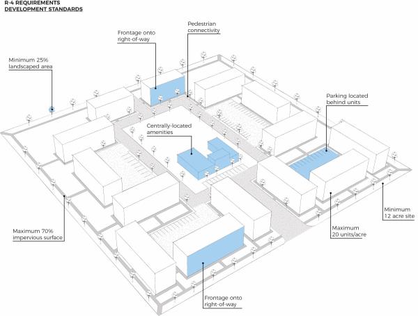
- Density shall not exceed 20 units per acre. For purposes of calculating allowed density, sensitive lands, church sites, school sites, and sites for other non residential uses may not be counted in the density calculations.
- Minimum project size is 12 acres.
- Minimum street frontage for a development is 80 feet.
- Maximum impervious surface in the R-4 zone shall be 70% of the project area.
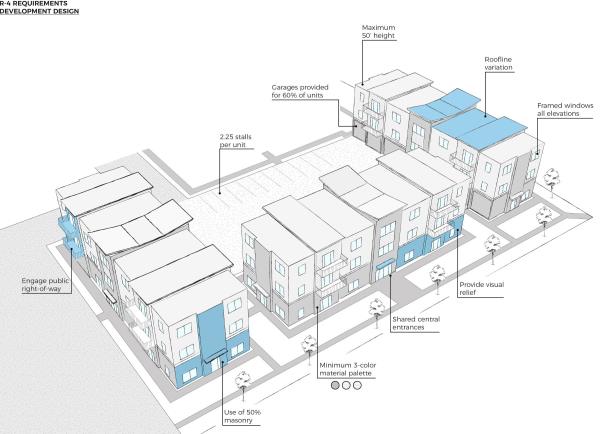
- Minimum parking shall include two and one-half (2.5) spaces for each unit in the development. Enclosed garages shall be provided for 60% of the units and one-half (0.5) spaces for each unit shall be made available for guest parking. On street parking on public streets may count for up to 20% of the overall parking requirement. The specific number of spaces that can be provided on-street will be determined at the time of Site Plan or Preliminary Plat approval. Parking on adjacent sites (a site with a shared boundary) may be used to provide up to 30% of the required parking for an R-4 development provided that the following provisions are met:
- That a perpetual parking easement is granted on the adjacent site for the shared parking.
- That clearly identified, well-lit, and otherwise safe pedestrian connections are provided between the two (2) adjacent sites.
- Minimum finished living space shall be provided as follows:
- Single-family residence, 1,000 square feet.
- Twin home, 900 square feet, each unit.
- Duplex, 900 square feet, each unit.
- Townhome, 900 square feet, each unit.
- Other multi-family units, 600 square feet for each studio unit, 800 square feet for each one-bedroom unit, 1,080 square feet for each two-bedroom unit, 1,240 square feet for each unit with three or more bedrooms.
- All projects must have an average home size of 960 square feet or larger.
- Useable space on balconies for stacked flats may count towards the minimum living space requirement.
- Curb, gutter, and sidewalk shall be provided in accordance with the City’s Development Standards.
- Development Design.
- Building Design: multi-family projects shall include design features that differentiate adjoining units and create identity for each unit by meeting the following requirements:
- Multi-family projects shall include a variety of unit sizes.
- Multi-family projects shall include elements that engage public right-of-way and common areas.
- Where possible, units shall have direct access to the public right-of-way.
- Balconies and porches shall be provided adjacent to public right-of-ways and common areas.
- Where possible, units shall have direct access to the public right-of-way.
- Multi-family projects shall include a variety of heights with a maximum height of 50 feet.
- Long, continuous rooflines and ridgelines greater than 50 feet shall not be permitted.
- Where projects abut property that is zoned R-1 or R-3, the maximum height shall be 35 feet within 100 feet of the property boundary line.
- The front facade of multi-family structures shall exhibit visual relief through an array of architectural features such as roof dormers, hips, gables, balconies, porches, wall projections, and fenestration.
- Multi-family projects shall include a variety of building colors and materials. A minimum of three (3) colors per elevation is required. Multi-family project proposals may be required to submit a sample board containing examples of all exterior surfacing materials and colors.
- Side-by-side multi-family homes, that are attached horizontally, shall not exceed six (6) attached units per building.
- Exposed foundation walls shall not exceed four (4) feet above finished grade at any point.
- Project Design: multi-family projects shall meet the following requirements:
- All exposed sides of multi-family structures shall have framed windows.
- Side and rear elevations that are visible from public and private streets shall match the architectural detailing of the front facade.
- Building materials for multi-family structures shall consist of at least 50% brick, stone, or synthetic stone on all sides of the structure. No more than 25 % of the structure may be clad in stucco or similar material.
- Street oriented facades shall protrude beyond the garage door by at least five (5) feet.
- Shared entrances for multi-family structures shall be centrally located, accentuated with architectural detailing, and well lit.
- Utility and mechanical equipment extending from multi-family structures shall be clustered and screened. When the project architecture contains pitched roofs, the roof mounted utility equipment shall be situated on the back side of the roof pitch.
- Carports and garages shall complement the project architecture in terms of design, materials, and colors.
- Building Placement and Orientation: multi-family projects shall meet the following requirements:
- All multi-family structures shall front onto a public right-of-way. The City Council may grant exceptions to this rule for:
- Multi-family structures that have eight (8) or fewer units and comprise less than twenty (20) percent of the homes in the development.
- Multi-family structures that have eight (8) or fewer units and comprise less than twenty (20) percent of the homes in the development.
- Where the R-4 zone abuts any R-1 or R-3 zone, the setback for primary buildings adjacent to the R-1 or R-3 zoned properties shall match or exceed the building’s height. Otherwise, setbacks shall be as follows for all primary buildings:
- Front yard, 20 feet from public right-of-way or shared driveway to living space.
- Corner side yard, 15 feet to living space.
- Interior side yard, 10 feet, provided 15 feet exists between buildings.
- Rear yard, 15 feet.
- Accessory buildings, 5 feet to property lines and other structures.
- Garage doors, 20 feet from public right-of-way.
- Interior fencing for multi-family projects shall be limited to encourage shared open space, pedestrian access, and project integration into the surrounding neighborhood. Private fencing (owned by an owner of an individual unit) shall only be permitted when the fence extends directly from the unit to delineate between common and private space. Fencing shall be uniform in design and construction.
- Parking should generally be located behind multi-family structures. This includes rear loaded garages, auto courtyards, and parking lots.
- Required guest parking shall be evenly distributed throughout multi-family projects and be easily accessible.
- Landscaping strips in the middle of driveways (between parking spaces) should be used to break up expanses of impervious surface.
- Parking areas shall be broken into smaller parking clusters of 12 spaces or less.
- All multi-family structures shall front onto a public right-of-way. The City Council may grant exceptions to this rule for:
- Open Space: no less than 30% of the gross project area shall be open space. Applicants shall submit landscape plans for all open space. Landscape plans shall meet all applicable landscaping requirements including those found in 15.4.16.130 and shall include a plant schedule, planting plan, irrigation plan, fencing plans, planting details, and plans for any proposed structures or features. Required open space may include the following:
- Open space areas shall be available to everyone residing in the boundaries of the development.
- Open space may include pathways and outdoor amenities.
- Open space excludes private balconies, decks, patio areas, recreation buildings, indoor amenities, vehicle parking, streets, and streetscape sidewalks.
- Open space should be centrally located.
- Open space should be clustered to create the most beneficial and efficient use of space.
- Amenities: centrally located amenities shall be provided for multi-family projects.
- Projects fewer than 50 homes shall provide an amenities package appropriate for the project size and location. Projects of 50 units or greater shall provide amenities as follows:
- Multi-family projects shall include at least one amenity per 50 units from the following list:
- Community garden.
- Courtyard with benches.
- Other active or passive recreational areas that meet the intent of this guideline.
- Picnic tables and BBQ area with shade structures.
- Sports courts (i.e., tennis, basketball, volleyball).
- Swimming pool (indoor or outdoor).
- Tot lot with play structure.
- Projects of 51 to 100 homes shall include the following amenities in addition to those required in subsection §15.3.16.032(F)(5(a)(i).
- A minimum of one (1) indoor, centrally located, fully functional social area, no less than 1,000 square feet in size, or a minimum of one (1) outdoor social function area, no less than 2,000 square feet in size.
- Projects of 101 or more homes shall include the following amenities in addition to those required in subsection 15.3.16.032(F)(a)(i) and (ii).
- A minimum of one (1) indoor, centrally located, fully functional social area, no less than 1,000 square feet in size.
- A minimum of one (1) outside, social function area, no less than 2,000 square feet in size.
- Multi-family projects shall include at least one amenity per 50 units from the following list:
- Projects fewer than 50 homes shall provide an amenities package appropriate for the project size and location. Projects of 50 units or greater shall provide amenities as follows:
- Access: street connectivity should be enhanced with an R-4 development and connections to surrounding neighborhoods.
- A traffic impact study may be required for multi-family projects.
- The number of street connections and access points for a multi-family project shall be proportional to the number of units.
- Local streets shall not exceed 600 feet in length without an intersecting street.
- Pedestrian pathways shall be provided between access points, entryways, public gathering nodes, and parking areas. Pedestrian access points should be installed between the project and the surrounding neighborhood.
- All multi-family projects shall submit a photo-metric lighting plan.
- Development Agreements: In order to ensure conformity to approved plans and conditions of approval, and to give assurance that any successor in interest is bound by the same plans and conditions, the City may require applicants to enter into project-specific development agreements with covenants which run with the land. A notice of the development agreement will be recorded against the land.
- Building Design: multi-family projects shall include design features that differentiate adjoining units and create identity for each unit by meeting the following requirements:
(Ord, No. 05-16, Enacted 04/05/2016)
Amended by Ord. 22-19 on 10/7/2019
Amended by Ord. 26-19 on 12/10/2019
Adopted by Ord. ORD 12-22 Making Various Amendments to Title 15 on 3/6/2022
Amended by Ord. 24-2023 Amending Various Sections of the Spanish Fork Municipal Code Pertaining to Title 15 updates and Amendments Regarding Adding Illustrations, Mailboxes, and Off-Street Parking on 12/12/2023 on 12/12/2023
Amended by Ord. 20-2024 Amending Title 15 of the Spanish Fork Municipal Code Pertaining to Event Centers and Entertainment Uses on 12/10/2024
15.3.16.033 R-5 Residential District
This district is intended to allow for the redevelopment of parcels located in the central part of the community. It is anticipated that the majority of the dwellings in this zone will be in multi-unit structures arranged primarily in a stacked configuration. The R-5 zone may only be utilized in the original plats of the City between 300 West, 1000 North, 800 East and 400 South. The R-5 zone is only available where properties have the Mixed Use, High Density Residential or Urban Density designations in the Comprehensive General Plan.
- Permitted Uses:
- Single-family dwellings.
- Twin homes.
- Duplexes.
- Townhomes.
- Stacked flats.
- Recreation and other support facilities connected to housing developments.
- Municipal facilities required for local service.
- Churches (when located on a collector or arterial street).
- Uses Subject to Conditions:
- Home Occupations (as described in 5.40.010 et seq.).
- Master Planned Developments (as described in 15.3.24.030 et seq.).
- Subdivision Model Homes (as described in 15.3.24.060 et seq.).
- Temporary office or construction trailers (as described in 15.3.24.040 et seq.).
- Uses Subject to Conditional Use Permit (see 15.3.08.060):
- Wireless communication facilities on existing structures, with the intent to make them stealth facilities, which are not noticeable to a degree greater than the structure to which it is attached; or new stealth facilities which are camouflaged into its surroundings.
- Accessory Buildings and Uses (see 15.3.24.090).
- Development Standards.
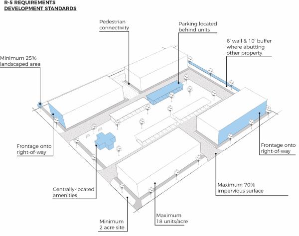
- Density shall not exceed 18 units per acre. For purposes of calculating allowed density, sensitive lands, church sites, school sites, and sites for other non‑residential uses may not be counted in the density calculations.
- Minimum project size is 2 acres.
- Minimum street frontage for a development is 80 feet.
- Maximum impervious surface in the R-5 zone shall be 75% of the project area.
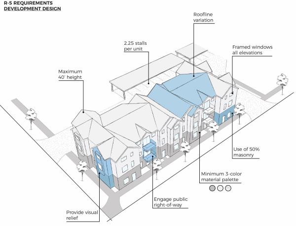
- Minimum parking shall include 2.25 spaces for each unit in the development. One covered parking space shall be provided for each unit and enclosed garages shall be provided for fifty percent 50% of the units.
- Minimum finished living space shall be provided as follows:
- Single-family residence, 1,000 square feet.
- Twinhome, 900 square feet, each unit.
- Duplex, 900 square feet, each unit.
- Townhome, 900 square feet, each unit.
- Other multi-family units, 600 square feet for each studio unit, 800 square feet for each one-bedroom unit, 1,080 square feet for each two-bedroom unit, 1,240 square feet for each unit with three or more bedrooms.
- All projects must have an average dwelling unit size of 960 square feet or larger.
- Curb, gutter, and sidewalk shall be provided in accordance with the City’s Development Standards.
- Development Design.
- Building Design: multi-family projects shall include design features that differentiate adjoining units and create identity for each unit by meeting the following requirements:
- Multi-family projects shall include a variety of unit sizes.
- Multi-family projects shall include elements that engage public right-of-ways and common areas.
- Where possible, units shall have direct access to the public right-of-way.
- Balconies and porches shall be provided adjacent to public rights-of-way and common areas.
- Multi-family projects shall include a variety of heights with a maximum height of forty (40) feet.
- Long, continuous rooflines and ridgelines greater than forty (40) feet shall not be permitted.
- The front facade of multi-family structures shall exhibit visual relief through an array of architectural features such as roof dormers, hips, gables, porches, wall projections and fenestration.
- Multi-family projects shall include a variety of building colors and materials. A minimum of three (3) colors per elevation is required. Multi-family project proposals may be required to submit a sample board containing examples of all exterior surfacing materials and colors.
- Side-by-side multi-family dwelling units, that are attached horizontally, shall not exceed six (6) attached units per building.
- Exposed foundation walls shall not exceed four (4) feet above finished grade at any point.
- Project Design: multi-family projects shall meet the following requirements:
- All exposed sides of multi-family structures shall have framed windows.
- Side and rear elevations that are visible from public and private streets shall match the architectural detailing of the front facade.
- Building materials for multi-family structures shall consist of at least fifty percent (50%) brick, stone, or synthetic stone on all sides of the structure.
- Street oriented facades shall protrude beyond the garage door by at least five (5) feet.
- Shared entrances for multi-family structures shall be centrally located, accentuated with architectural detailing, and well lit.
- Utility and mechanical equipment extending from multi-family structures shall be clustered and screened. When the project architecture contains pitched roofs, the roof mounted utility equipment shall be situated on the back side of the roof pitch.
- Carports and garages shall complement the project architecture in terms of design, materials, and colors.
- Building Placement and Orientation: multi-family projects shall meet the following requirements:
- All multi-family structures shall front onto a public right-of-way.
- Where the R-5 zone abuts any R-1 or R-3 zone, the setback for primary buildings adjacent to the R-1 or R-3 zoned properties shall match or exceed the building’s height. Otherwise, setbacks shall be as follows for all primary buildings:
- Front yard, 10 feet from public right-of-way or shared driveway to living space.
- Corner side yard, 15 feet to living space.
- Interior side yard, 10 feet, provided 15 feet exists between buildings.
- Rear yard, 15 feet.
- Accessory buildings, 5 feet to property lines and other structures.
- Garage doors, 20 feet from public rights-of-way.
- Interior fencing for multi-family projects shall be limited to encourage shared open space, pedestrian access, and project integration into the surrounding neighborhood. Private fencing (owned by an owner of an individual unit) shall only be permitted when the fence extends directly from the unit to delineate between common and private space. Fencing shall be uniform in design and construction.
- Parking should generally be located behind multi-family structures. This includes rear loaded garages, auto courtyards, and parking lots.
- Required guest parking shall be evenly distributed throughout multi-family projects and be easily accessible.
- Landscaping strips in the middle of driveways (between parking spaces) should be used to break up expanses of impervious surface.
- Parking areas shall be broken into smaller parking clusters of twelve (12) spaces or less.
- Open Space: no less than twenty percent (20%) of the gross project area shall be open space. Applicants shall submit landscape plans for all open space. Landscape plans shall include a plant schedule, planting plan, irrigation plan, fencing plans, planting details, and plans for any proposed structures or features. Required open space may include the following:
- Open space areas shall be available to everyone residing in the boundaries of the development.
- Open space may include pathways and outdoor amenities.
- Open space excludes private balconies, decks, patio areas, recreation buildings, indoor amenities, vehicle parking, streets, and streetscape sidewalks.
- Open space should be clustered to create the most beneficial and efficient use of space.
- Amenities: centrally located amenities shall be provided for multi-family projects.
- Projects of fewer than fifty (50) dwelling units shall provide an amenities package appropriate for the project size and location.
- Multi-family projects shall include at least one amenity per fifty (50) units from the following list:
- Tot lot with play structure.
- Community garden.
- Courtyard with benches.
- Picnic tables and BBQ area with shade structures.
- Swimming pool (indoor or outdoor).
- Sports courts (i.e., tennis, basketball, volleyball).
- Other active or passive recreational areas that meet the intent of this guideline.
- Projects of fifty-one (51) to one hundred (100) dwelling units shall include the following amenities in addition to those required in subsection (5)(a)(i) of this section.
- A minimum of one inside, centrally located, fully functional social area, no less than one thousand (1,000) square feet in size, or a minimum of one outside social function area, no less than two thousand (2,000) square feet in size.
- Projects of one hundred and one (101) or more dwelling units shall include the following amenities in addition to those required in subsection (5)(a)(i) and (ii) of this section.
- minimum of one inside, centrally located, fully functional social area, no less than one thousand (1,000) square feet in size.
- A minimum of one outside social function area, no less than two thousand (2,000) square feet in size.
- Multi-family projects shall include at least one amenity per fifty (50) units from the following list:
- Projects of fewer than fifty (50) dwelling units shall provide an amenities package appropriate for the project size and location.
- Access: street connectivity should be enhanced with an R-5 development and connections to surrounding neighborhoods.
- A traffic impact study may be required for multi-family projects.
- The number of street connections and access points for a multi-family project shall be proportional to the number of units.
- Pedestrian pathways shall be provided between access points, entryways, public gathering nodes, and parking areas. Pedestrian access points should be installed between the project and the surrounding neighborhood.
- All multi-family projects shall submit a photo-metric lighting plan.
- Development Agreements: In order to ensure conformity to approved plans and conditions of approval, and to give assurance that any successor in interest is bound by the same plans and conditions, the City may require applicants to enter into project-specific development agreements with covenants which run with the land. A notice of the development agreement will be recorded against the land.
- Building Design: multi-family projects shall include design features that differentiate adjoining units and create identity for each unit by meeting the following requirements:
Amended by Ord. 22-19 on 10/7/2019
Adopted by Ord. ORD 12-22 Making Various Amendments to Title 15 on 3/6/2022
Amended by Ord. 24-2023 Amending Various Sections of the Spanish Fork Municipal Code Pertaining to Title 15 updates and Amendments Regarding Adding Illustrations, Mailboxes, and Off-Street Parking on 12/12/2023 on 12/12/2023
15.3.16.035 Changed To 15.3.20.090
(Ord. No. 24-2023, Repealed 12/12/2023)
Amended by Ord. 22-19 on 10/7/2019
15.3.16.040 R-O Residential Office
This district is intended to allow low intensity professional office uses on a scale consistent with residential areas. Strict architectural and Site Plan review will be required to ensure compatibility with adjoining residential areas. This district serves as a transition between more intense commercial areas and residential land uses, or is located along busier streets where limited office use is being introduced. Residential and office use of the same structure is allowed. Some limited commercial use may also be allowed in selective locations.
- Permitted Uses:
- Adult Daycare.
- Bed and Breakfast Inns.
- Child Care Centers.
- Churches.
- Duplexes. The minimum lot size is 9,700 square feet; the minimum lot width is 60 feet and the side setback 10 feet.
- Funeral Homes.
- Home Occupations.
- Instructional Studio.
- Municipal Facilities required for local service.
- Museums.
- Offices.
- Single Residence Dwellings.
- Art Galleries and Studios.
- Financial Institutions with no drive-thru service.
- Personal Service businesses.
- Restaurants (no drive-thru or drive-in service).
- Specialty retail uses including, but not limited to, Gift Shops, Bookstores, Florists, Antiques, Crafts, Collectibles, Food and Beverages, Apparel, and other similar items.
- Adult Daycare.
- Uses subject to Conditions (as described in §15.3.24.010 et seq.):
- Manufactured Homes (as described in §15.3.24.040 et seq.).
- Residential facility for elderly persons (as described in §15.3.24.010(B) et seq.).
- Residential facility for persons with a disability (as described in §15.3.24.010(A) et seq.).
- Accessory Buildings and Uses (see §15.3.24.090).
- Development Standards (see Table 1).
- Site Plan/Design Review (see §15.4.08.010 et seq.)
- Landscaping, Buffering, Walls (see §15.4.16.130).
- Signs (see §5.36.010 et seq.).
- Parking (see §15.4.16.120): No parking will be allowed in front of the principal structure for non-residential uses.
- Uses subject to Conditional Use Permit (see §15.3.08.060):
- Assisted Living Facilities.
- Financial Institutions not located between 100 West and 100 East.
- Museums.
- Nursing or Retirement Homes.
- Residential Treatment Centers.
- Shelter Care Facilities.
- Supervisory Care Facilities.
- Wireless Communication Facilities on existing structures, with the intent to make them “stealth” facilities, which are not noticeable to a degree greater than the structure to which it is attached; or new stealth facilities which are camouflaged into its surroundings.
(Ord. No. 12-09, Amended 08/04/2009)
Amended by Ord. 22-19 on 10/7/2019
Amended by Ord. 03-21 on 2/16/2021
Adopted by Ord. ORD 12-22 Making Various Amendments to Title 15 on 3/6/2022
Amended by Ord. 06-2023 Amending Table 1 - Residential Development Standards of the Spanish Fork Municipal Code Pertaining to Density Calculation of Master Planned Developments on 4/18/2023
Amended by Ord. 23-2023 Amending Various Sections of the Spanish Fork Municipal Code Pertaining to Adult Day Care on 12/12/2023
15.3.16.050 C-O Commercial Office
This district is intended to provide for general office development. It may serve as a transition between commercial uses and residential areas, or it may be designed as a concentration of similar uses intended as an employment center.
- Permitted Uses:
- Adult Day Care.
- Child Care Centers.
- Emergency Medical Care Facilities.
- Event Center.
- Financial Institutions.
- Funeral Homes.
- Instructional Studios.
- Medical and Dental Clinics.
- Medical and Dental Laboratories.
- Municipal Facilities required for local service.
- Nursing or Retirement Homes.
- Offices.
- Office Supply Stores.
- Personal Service Businesses.
- Pharmacies.
- Retail Stores.
- Supervisory Care Facilities.
- Veterinary Offices for small animals with no outside boarding of animals.
- Adult Day Care.
- Uses Subject to Conditional Use Permit (see §15.3.08.060):
- Any permitted use with a drive-thru.
- Museums.
- Restaurants.
- Wireless Communication Facilities on existing structures, with the intent to make them “stealth” facilities, which are not noticeable to a degree greater than the structure to which it is attached; or new stealth facilities which are camouflaged into its surroundings.
- Accessory Buildings and Uses (see §15.3.24.090).
- Development Standards (see Table 2).
- Site Plan/Design Review (see §15.4.08.010 et seq.).
- Landscaping, Buffering, Walls (see §15.4.16.130).
- Signs (see §5.36.010 et seq.).
- Parking (see §15.4.16.120).
(Ord. No. 12-09, Amended 08/04/2009) (Ord. No. 03-18, Amended 02/20/2018) (Ord. No. 21-18, Amended 12/11/2018)
Amended by Ord. 23-2023 Amending Various Sections of the Spanish Fork Municipal Code Pertaining to Adult Day Care on 12/12/2023
Amended by Ord. 13-2025 Title 15 Amendments: Adding Event Center to C-O on 10/21/2025
15.3.16.060 C-D Downtown Commercial
This district is intended to promote and maintain the character of a pedestrian oriented retail district along Main Street. Building orientation should strongly encourage pedestrian use by having buildings close to the street with frequent entrances to buildings, and significant amounts of glass. Drive-thru uses should be strongly discouraged.
- Permitted Uses: The following uses are permitted if operated from a permanent, enclosed building, with no outside storage. The outside display of merchandise for sale is allowed between the hours of 7:00 a.m. and 9:00 p.m. if the merchandise remains off from the public right-of-way. Merchandise is allowed on the public right-of-way during sidewalk sales, which are allowed every weekend:
- Art Galleries and Studios.
- Financial Institutions with no drive-thru service.
- Hotels, with all guest rooms above the first floor.
- Instructional Studios.
- Indoor Commercial Recreation Facilities.
- Municipal Facilities required for local service.
- Office Supply, Copying, Printing businesses.
- Offices.
- Personal Service businesses.
- Residential uses when located above the first floor.
- Restaurants.
- Retail uses.
- Uses Subject to Conditions:
- Reserved
- Reserved
- Uses Subject to Conditional Use Permit (see §15.3.08.060):
- Drive-thru facilities as part of a financial institution.
- Lube Centers.
- Parking structures.
- Tire Centers.
- Wireless Communication Facilities on existing structures, with the intent to make them “stealth” facilities, which are not noticeable to a degree greater than the structure to which it is attached; or new stealth facilities which are camouflaged into its surroundings.
(Ord. No. 12-09, Amended 08/04/2009) (Ord. No. 18-10, Amended 09/23/2010) (Ord. No. 06-11, Amended 04/20/2011) (Ord. No. 12-12, Amended 09/28/2012) (Ord. No. 21-18, Amended 12/11/2018)
Amended by Ord. 38-22 Amending Title 15 of the Spanish Fork Municipal Code Pertaining to Event Centers in the Commercial Downtown on 12/13/2022
Amended by Ord. 05-2024 Amending Title 15 of the Spanish Fork Municipal Code Pertaining to Event Centers and Entertainment Uses on 3/19/2024
Amended by Ord. 15-2024 Amending Title Amendments: Event Centers and Entertainment Uses on 8/6/2024
15.3.16.070 C-1 Neighborhood Commercial
This district is intended to provide small scale retail, personal and business services, and office uses to serve the immediate residential area. Individual businesses may not exceed 7,500 square feet and buildings may not exceed 10,000 square feet. Buildings and sites shall be designed to limit the size of parking fields and to have similar characteristics of surrounding neighborhoods. Particular focus and attention shall be given to building design to encourage compatibility with the surrounding homes.
- Permitted Uses: The following uses are permitted if operated from a permanent, enclosed building with no outside storage or display of merchandise.
- Adult Day Care.
- Child Care Centers.
- Convenience Store.
- Drive-thru facilities.
- Financial Institutions.
- Instructional Studio.
- Municipal Facilities required for local service.
- Office Supply, Copying, Printing businesses.
- Offices.
- Personal Service businesses.
- Restaurants.
- Retail Uses.
- Adult Day Care.
- Uses Subject to Conditions:
- Seasonal Sales and Special Events (as described in §15.3.24.050 et seq.).
- Uses Subject to Conditional Use Permit (see §15.3.08.060):
- Car wash (self or full service).
- Wireless Communication Facilities on existing structures, with the intent to make them “stealth” facilities, which are not noticeable to a degree greater than the structure to which it is attached; or new stealth facilities which are camouflaged into its surroundings.
- Accessory Buildings and Uses (see §15.3.24.090).
- Development Standards (see Table 2).
- Site Plan/Design Review (see §15.4.08.010 et seq.).
- Landscaping, Buffering, Walls (see §15.4.16.130).
- Signs (see §5.36.010 er seq.).
- Parking (see §15.4.16.120).
(Ord. No. 12-09, Amended 08/04/2009)
Amended by Ord. 22-19 on 10/7/2019
Amended by Ord. 26-19 on 12/10/2019
Amended by Ord. 23-2023 Amending Various Sections of the Spanish Fork Municipal Code Pertaining to Adult Day Care on 12/12/2023
15.3.16.080 C-2 General Commercial
This district is intended to provide for a wide range of commercial uses designed to serve neighborhood, community, and regional needs. Uses may be freestanding or integrated in a center.
- Adult Day Care.
- Art Galleries and Studios.
- Car Wash (full service).
- Child Care Centers.
- Convenience Stores. Permitted Uses: The following uses are permitted if operated from a permanent, enclosed building with no outside storage of merchandise:
- Event Center.
- Financial Institutions
- Hotels and Motels.
- Indoor Commercial Recreation Facilities.
- Instructional Studios.
- Lube Centers.
- Medical and Dental Laboratories.
- Municipal Facilities required for local service.
- Office Supply, Copying, Printing businesses.
- Offices.
- Outdoor display area.
- Personal Service businesses.
- Private Clubs.
- Public Utility Facilities required for local service.
- Repair Services for small appliances, bicycles, jewelry, and similar items.
- Restaurants.
- Retail uses.
- Tire Centers.
- New and Used Automobile, Motorcycle, Boat, Truck, Recreational Vehicle Sales and Rental Facilities, and Repair Services associated with such facilities.
- Adult Day Care.
- Uses Subject to Conditions:
- Seasonal Sales and Special Events (as described in §15.3.24.050 et seq.).
- Uses Subject to Conditional Use Permit (see §15.3.08.060):
- Outdoor display or storage of materials or merchandise in conjunction with any permitted use.
- Wireless Communication Facilities on existing structures, with the intent to make them “stealth” facilities, which are not noticeable to a degree greater than the structure to which it is attached; or new stealth facilities which are camouflaged into its surroundings.
- Accessory Buildings and Uses (see §15.3.24.090):
- Development Standards (see Table 2).
- Site Plan/Design Review (see §15.4.08.010 et seq.).
- Landscaping, Buffering, Walls (see §15.4.16.130).
- Signs (see §5.36.010 et seq.).
- Parking (see §15.4.16.120).
(Ord. No. 12-09, Amended 08/04/2009)
(Ord. No. 02-10, Amended 02/16/2010)
(Ord. No. 21-18, Amended 12/11/2018)
(Ord. No. 14-19, Amended 07/09/2019)
Amended by Ord. 22-19 on 10/7/2019
Amended by Ord. 13-21 on 7/13/2021
Amended by Ord. 23-2023 Amending Various Sections of the Spanish Fork Municipal Code Pertaining to Adult Day Care on 12/12/2023
Amended by Ord. 05-2024 Amending Title 15 of the Spanish Fork Municipal Code Pertaining to Event Centers and Entertainment Uses on 3/19/2024
15.3.16.090 S-C Shopping Center
This district is intended to provide retail uses, service-oriented businesses, offices, and restaurants in an integrated center. Each center shares common architecture, access, parking, signage, and landscape design. Centers will typically be five (5) acres in size and provide neighborhood or community level destination shopping while incorporating a design which enhances pedestrian orientation within the center.
- Adult Day Care
- Art Galleries and Studios.
- Car Wash (full service).
- Child Care Centers.
- Convenience Store.
- Permitted Uses.
- Financial Institutions.
- Indoor Commercial Recreation Facilities.
- Instructional Studios.
- Lube Center.
- Municipal Facilities required for local service.
- Office Supply, Copying, and Printing businesses.
- Personal Service businesses.
- Restaurants.
- Retail Uses.
- Tire Center.
- New and Used Automobile, Motorcycle, Boat, Truck, Recreational Vehicle Sales and Rental Facilities, and Repair Services associated with such facilities.
- Adult Day Care
- Uses Subject to Conditions:
- Seasonal sales and special events (as described in §15.3.24.050 et seq.).
- Offices. Buildings or portions of buildings occupied by office uses cannot exceed 3,000 square feet. No more than five percent (5%) of any development’s gross building square footage can be dedicated to office uses.
- Outdoor display area. Areas are only allowed for the storage of materials and merchandise in conjunction with a permitted use that has a permanent facility in the center. Areas should be sufficiently screened and/or organized so as to maintain an attractive and inviting atmosphere in the center. Areas shall not impede pedestrian or vehicular traffic to, from, or within a center.
- Uses Subject to Conditional Use Permit (see §15.3.08.060):
- Hotels and Motels.
- New Automobile, Motorcycle, Boat, Truck, Recreational Vehicle Sales and Rental Facilities, and Repair Services associated with such facilities.
- Outdoor display or storage of materials or merchandise in conjunction with any permitted use.
- Wireless Communication Facilities on existing structures, with the intent to make them “stealth” facilities, which are not noticeable to a degree greater than the structure to which they are attached; or new stealth facilities which are camouflaged into its surroundings.
- Accessory Buildings and Temporary Uses (see §15.3.24.090).
- Self-storage Warehouses and/or Recreational Vehicle Storage.
- Warehousing.
- Development Standards (see Table 2).
- Site Plan/Design Review (see §15.4.08.010 et seq.).
- Landscaping, Buffering, Walls (see §15.4.16.130).
- Signs (see §5.36.010 et seq.).
- Parking (see §15.4.16.120).
(Ord. No. 12-09, Amended 08/04/2009)
(Ord. No. 15-15, Amended 09/15/2015)
Amended by Ord. 22-19 on 10/7/2019
Amended by Ord. 14-20 on 9/15/2020
Amended by Ord. 13-21 on 7/13/2021
Amended by Ord. 23-2023 Amending Various Sections of the Spanish Fork Municipal Code Pertaining to Adult Day Care on 12/12/2023
Amended by Ord. 05-2024 Amending Title 15 of the Spanish Fork Municipal Code Pertaining to Event Centers and Entertainment Uses on 3/19/2024
15.3.16.100 C-UV Urban Village Commercial
This district is intended to provide controlled and compatible settings for a wide range of commercial and residential uses in the same area, uses designed to serve neighborhood, community, and regional needs. Uses may be freestanding or integrated in a center. Developments in this district will be designed towards pedestrians in mind; designs will have the character of an urban village; with high quality materials being used. The Planning Commission will review all Site Plans and subdivisions.
- Permitted Uses:
- Dental and Medical Offices.
- Financial Institutions with no drive-thru services.
- Health, Fitness, and Recreation Facilities.
- Instructional Studios.
- Laundry and Dry Cleaning.
- Multi-family residential.
- Museums.
- Offices.
- Personal Service businesses.
- Private Schools, Professional and Vocational.
- Restaurants.
- Retail Uses.
- Uses Subject to Conditions:
- Seasonal sales and special events (as described in §15.3.24.050 et seq.).
- Uses Subject to Conditional Use Permit (see §15.3.08.060):
- Adult Day Care.
- Child Care Centers.
- Financial Institutions with drive-thru facilities.
- Restaurants with drive-thru facilities.
- Adult Day Care.
- Accessory Buildings and Uses (see §15.3.24.090).
- Site Plan/Design Review/Performance Standards (see §15.4.08.010 et seq.): These standards are intended to foster the creation of an urban environment that accommodates growth and is compatible with the existing homes and uses in the area:
- Outdoor Sales, Display and Storage. The outdoor permanent sales or display of merchandise shall not encroach into areas of required parking, sidewalks, or landscaping.
- Lighting. On-site lighting, including parking lot lighting and illuminated signs, shall be located, directed or designed in a manner to prevent glare on adjacent properties and be designed for pedestrians. All lighting should have the same design elements throughout the development.
- Location of Service Areas. All loading docks and other service activities shall be located away from view of any public street. Exceptions to this requirement may be approved through the Site Plan Process. If such activities are permitted adjacent to a public street, a visual screening design approved by the Planning Department shall be required.
- Urban Design. Designs for this area should envision a “village character” relating to the heritage of the early residents of the community. Safe and efficient pedestrian circulation is a priority:
- Architectural Character and Materials.
- A differentiated base will provide human scale through change, contrast, and intricacy in facade form. Scaling elements such as insets and projections serve to break up flat or monotonous facades along with color and a change in materials.
- The climate in Spanish Fork City is such that in the summer months’ shade is preferred, and in the winter months, protection from the snow and wind is necessary. By providing the pedestrian with a sidewalk that is enjoyable to use year-round, a pedestrian oriented development is encouraged. Therefore, the following will be encouraged.
- Arcades, Awnings and/or marquees.
- Entrance and Visual Access.
- The intent in this district is to encourage pedestrian activity between the public street/sidewalk and buildings. Sidewalks shall provide continuous, uninterrupted access and amenities. The environment will benefit with increased pedestrian activity, this activity will only occur if opportunities are provided that make walking to a destination a preferred and an enjoyable pursuit. The use of blank building facade walls is discouraged. Therefore, all buildings in this district are subject to the following standards:
- Minimum First Floor Glass. The first-floor elevation of a commercial building facing a street shall not have less than 40% glass surfaces. All first-floor glass shall be non-reflective. Display windows that are three (3) dimensional and are at least two (2) feet deep are permitted and may be counted toward the 40% glass requirement.
- Provide at least one (1) operable building entrance per elevation that faces a public street. Buildings that face multiple streets are only required to have one door on either street, if the facades for both streets meet the 40% glass requirement.
- The maximum length of any blank wall uninterrupted by windows, doors, art or architectural detailing at the first-floor level shall be 40 feet.
- All building equipment and service areas, including on-grade and roof mechanical equipment and transformers that are readily visible from the public right-of-way, shall be screened from public view.
- The intent in this district is to encourage pedestrian activity between the public street/sidewalk and buildings. Sidewalks shall provide continuous, uninterrupted access and amenities. The environment will benefit with increased pedestrian activity, this activity will only occur if opportunities are provided that make walking to a destination a preferred and an enjoyable pursuit. The use of blank building facade walls is discouraged. Therefore, all buildings in this district are subject to the following standards:
- Public Amenities and Public Art.
- Amenities and works of art enhance quality of life as well as visual interest. Public amenities and art encourage pedestrian activity and contribute to the “village” experience. A cohesive, unified lighting and amenity policy will help give the district its own distinctive identity. Therefore, all projects will be required to have public amenities and art that are subject to the following standards:
- Sidewalks and street lamps installed in the public right of way shall be of the type specified in the City’s construction and development standards. All parking lot lights will be required to match the City’s standards.
- Park benches will be required within the development.
- Public art (which may include artists’ work integrated into the design of the building, and landscaping, sculpture, painting, murals, glass, mixed media or work by artisans), that is accessible or directly viewable to the general public shall be included in all projects. The plan to incorporate public art shall be reviewed and approved by the Spanish Fork Arts Council.
- All projects will be required to have a minimum of 20% open space and developments with residential units will be required to have 35% open space.
- Amenities and works of art enhance quality of life as well as visual interest. Public amenities and art encourage pedestrian activity and contribute to the “village” experience. A cohesive, unified lighting and amenity policy will help give the district its own distinctive identity. Therefore, all projects will be required to have public amenities and art that are subject to the following standards:
- Architectural Character and Materials.
- Conditional Use Approval. A modification to the urban design/performance provisions of this section may be granted as a conditional use, subject to conformance with the standards and procedures.
- For the purpose of this section, “Façade” means the front of a building, or any other “face” of a building on a street or courtyard given special architectural treatment.
- Landscaping, Buffering, Walls (see §15.4.16.130) Same as the S-C zone requirements.
- Signs (see §5.36.101 et seq.). All individual developments (not a planned center) must follow the requirements of the C-O zone.
- Parking Standards (see §15.4.16.120).
- Restrictions on Parking Lots. The following regulations shall apply to parking facilities.
- All parking lots adjacent to a public street will be required to have a 25-foot landscape setback and a minimum three (3) foot berm, with trees spaced every 30 feet.
- Restrictions on Parking Lots. The following regulations shall apply to parking facilities.
- Solid Waste Receptacle Areas (see §15.4.16.140).
- Building Height. Same as the S-C zones requirements.
- Height Exceptions: spires, towers, or decorative non-inhabitable elements shall have a maximum height of 60 feet measured from the street grade.
- Development Standards.
- Projects are allowed a density of five (5) to 12 residential units per acre.
- Projects will be required to have public art integrated and 35% open space area.
- Projects with a residential component will be required to have at least 30% of the project’s total building square footage dedicated to commercial or office uses. The City will require that this ratio be maintained with each phase of the development.
- Residential units will be required to meet the High Density Residential (R-3) setbacks.
- Residential units must be designed in a manner to blend with the urban village and not be a separate element of the area.
(Ord. No. 10-09, Amended 06/17/2009) (Ord. No. 12-09, Amended 08/04/2009) (Ord. No. 17-09, Amended 09/15/2009)
Amended by Ord. 23-2023 Amending Various Sections of the Spanish Fork Municipal Code Pertaining to Adult Day Care on 12/12/2023 on 12/12/2023
15.3.16.110 B-P Business Park
- Permitted Uses: The following uses are permitted if operated from a permanent, enclosed building with no outside storage or display of merchandise:
- Adult Day Care.
- Car Wash (full service).
- Child Care Centers.
- Convenience Stores.
- Financial Institutions.
- Health Clubs.
- Hospitals.
- Instructional Studios.
- Lube Center.
- Municipal Facilities required for local service.
- Museums.
- Office Supply, Copying, Printing businesses.
- Offices.
- Personal Service businesses.
- Research, Development, and Testing services.
- Restaurants.
- Telecommunication Towers not taller than 60 feet.
- Tire Center.
- Trade or Business schools.
- Adult Day Care.
- Uses Subject to Conditional Use Permit (see §15.3.08.060):
- Hotels and motels.
- Accessory Buildings and Uses (see §15.3.24.090).
- Development Standards (see Table 2).
- Performance Standards.
- No use shall be conducted which may cause the dissemination of glare, vibration, smoke, gas, dust, odor, or any other atmospheric pollutant outside the building in which the use is conducted.
- No use shall result in noise perceptible beyond the boundaries of the immediate site of the use.
- Outdoor storage is prohibited.
- Site Plan/Design Review (see §15.4.08.010 et seq.).
- Landscaping, Buffering, Walls (see §15.4.16.130).
- Signs (see §5.36.010 et seq.).
- Parking (see §15.4.16.120).
(Ord. No. 12-09, Amended 08/04/2009)
Amended by Ord. 23-2023 Amending Various Sections of the Spanish Fork Municipal Code Pertaining to Adult Day Care on 12/12/2023 on 12/12/2023
15.3.16.120 I-1 Light Industrial
This district is intended to provide for employment related uses including light manufacturing, assembling, warehousing, and wholesale activities. Associated office and support commercial uses are allowed. Uses that emit significant amount of air, water, or noise pollution will not be allowed. Residential uses are not allowed.
A. Permitted Uses:
1. Adult Day Care.
2. Agriculture, including the Production of Food and Fiber Crops, Tree Farms, Grazing, and Animal Husbandry of Livestock, not including Feedlots.
3. Automotive Repair.
4. Automotive Service, Paint and Body Work, other consumer goods repair.
5. Caretaker's Residence.
6. Car Wash (self or full service).
7. Child Care Centers
8. Contractor Warehouse and Storage Yards.
9. Financial Institutions.
10. Funeral Homes.
11. Indoor Manufacturing, Assembly and Storage of finished products.
12. Indoor Pickleball Facility
13. Instructional Studios.
14. Lube Centers.
15. Lumber and Building Material Yards.
16. Municipal Facilities required for local service.
17. New and Used Automobile, Motorcycle, Boat, Truck, Recreational Vehicle Sales and Rental Facilities, and Repair Services associated with such facilities.
18. Office Supply, Copying, Printing businesses.
19. Offices.
20. Outdoor display areas.
21. Research, Development, and Testing services.
22. Restaurants.
23. Retail businesses.
24. Telecommunication Towers not taller than 60 feet.
25. Tire Care Centers.
26. Trade or Business schools.
27. Trucking and Warehousing.
28. Veterinary Offices for large animals and/or outside boarding of animals.
29. Wholesale Trade Businesses except explosives or automobile wrecking or salvage yards.Permitted Uses:
B. Uses Subject to Conditions:
1. Outdoor storage areas (see §15.3.24.090(I)).
2. Seasonal Sales and Special Events (as described in §15.3.24.050 et seq.).
3. Sexually Oriented businesses as defined in Chapter 5.28 of the Spanish Fork Municipal Code.
4. Cannabis Processing Facility (see §5.48.030).
C. Uses Subject to Conditional Use Permit (see§15.3.08.060).
1. Commercial Kennels, Animal Shelters, and Veterinary Hospitals with outdoor boarding or exercise facilities.
2. Drive-in Theaters.
3. Indoor Commercial Recreation Facilities.
4. Jails. for County and/or City.
5. Meat Processing Facilities.
6. Outdoor Commercial Recreation Facilities.
7. Publicly owned and operated compost facilities.
8. Publicly owned and operated recycling centers.
9. Rehabilitation Treatment Facilities.
10. Residential Treatment Centers (not owner occupied).
11. Shelter Care Facilities.
12. Telecommunication Towers taller than 60 feet.
(Ord. No. 12-09, Amended 08/04/2009) (Ord. No. 02-10, Amended 02/16/2010)
Amended by Ord. 22-19 on 10/7/2019
Amended by Ord. 13-21 on 7/13/2021
Amended by Ord. Ord 23-22 Amending Section 15.3.16.120 I-1 Light Industrial Zones of the Spanish Fork Municipal Code Pertaining to Adding Child Care Centers As a Permitted Use on 5/17/2022
Amended by Ord. 23-2023 Amending Various Sections of the Spanish Fork Municipal Code Pertaining to Adult Day Care on 12/12/2023 on 12/12/2023
Amended by Ord. 05-2024 Amending Title 15 of the Spanish Fork Municipal Code Pertaining to Event Centers and Entertainment Uses on 3/19/2024
Amended by Ord. 21-2024 Amending Title 15 Amendments Indoor Pickleball on 12/10/2024
Amended by Ord. 17-2025 Title 15 Amendments: Cannabis Processing Facility on 10/21/2025
15.3.16.130 I-2 Medium Industrial
This district is intended to provide for employment related uses including light manufacturing, assembling, warehousing, and wholesale activities. Associated office and support commercial uses are allowed. Uses that emit moderate amounts of air, water, or noise pollution may be considered as conditional uses. Residential uses are not allowed.
- Permitted Uses:
- Automotive Repair.
- Caretaker's Residence.
- Car Wash (self or full service).
- Contractor Warehouse and Storage Yards.
- Financial Institutions.
- Lube Centers.
- Lumber and Building Material Yards.
- Manufacturing and Assembly of finished products except animal fats and oils, ammunition, and those manufacturing uses listed as conditional uses.
- Municipal Facilities required for local service.
- Office Supply, Copying, Printing businesses.
- Offices.
- Outdoor display areas.
- Research, Development, and Testing services.
- Restaurants.
- Retail businesses.
- Telecommunication Towers not taller 60 feet.
- Tire Care Centers.
- Trade or Business schools.
- Trucking and Warehousing.
- Wholesale Trade businesses except explosives or automobile wrecking or salvage yards.
- Uses Subject to Conditions:
- Outdoor Storage Areas (see §15.3.24.090(I)).
- Seasonal Sales and Special Events (as described in §15.3.24.050 et seq.).
- Impound Yard (see §15.3.24.090 (M)).
- Uses Subject to Conditional Use Permit (see §15.3.08.060):
- Commercial Kennels, Animal Shelters, and Veterinary Hospitals with outdoor boarding or exercise facilities.
- Drive-in Theaters.
- Manufacture of Concrete Products.
- Self-storage Warehouses and/or Recreational Vehicle Storage.
- Telecommunication Towers taller than 60 feet.
- Accessory Buildings and Uses (see §15.3.24.090):
- Development Standards (see Table 2):
- The setback for self-storage buildings may be reduced to as little as 10 feet, at the discretion of the Planning Commission, based on the creation of an adequate buffer between the self-storage buildings and the adjacent property. The adequate buffer shall include landscaping, architectural upgrades, and any other measures deemed necessary by the Commission.
- Site Plan/Design Review (see §15.4.08.010 et seq.).
- Landscaping, Buffering, Walls (see §15.4.16.130).
- Signs (see §5.36.010 et seq.).
- Parking (see §15.4.16.120).
(Ord. No. 12-09, Amended 08/04/2009) (Ord. No. 02-10, Amended 02/16/2010)
Amended by Ord. 22-19 on 10/7/2019
Amended by Ord. 02-2025 I-2 Medium Industrial on 5/20/2025
15.3.16.140 I-3 Heavy Industrial
This district is intended to provide for employment related uses including heavy manufacturing, assembling, warehousing, and wholesale activities. Residential uses are not allowed.
- Permitted Uses:
- Caretaker's Residence.
- Contractor Warehouse and Storage Yards.
- Impound Yard.
- Lumber and Building Material Yards.
- Manufacture of Concrete Products.
- Manufacturing and Assembly of finished products.
- Municipal Facilities required for local service.
- Offices Incidental to an industrial use.
- Outdoor Storage area.
- Research, Development, and Testing services.
- Trucking and Warehousing.
- Wholesale Trade businesses except explosives or automobile wrecking or salvage yards.
- Uses Subject to Conditions:
- Large Wind Energy Systems (see §15.3.24.090(H)).
- Rock Crushers with Surface Mining Overlay approval (see §15.4.20.040).
- A cannabis processing facility (see §5.48.030).
- Uses Subject to Conditional Use Permit (see §15.3.08.060):
- Self-storage Warehouses and/or Recreational Vehicle Storage.
- Telecommunication Towers taller than 60 feet.
- Transfer Facilities.
- Accessory Buildings and Uses (see §15.3.24.090).
- Development Standards (see Table 2).
- Site Plan/Design Review (see §15.4.08.010 et seq.).
- Landscaping, Buffering, Walls (see §15.4.16.130).
- Signs (see §5.36.010 et seq.).
- Parking (see §15.4.16.120)
(Ord. No. 07-06, Repealed 07/18/2006) (Ord. No. 02-10, Enacted 02/16/2010)
Amended by Ord. ORD 18-19 on 9/2/2019
Amended by Ord. 22-19 on 10/7/2019
15.3.16.150 (Reserved)
(Ord. No. 12-09, Repealed 08/04/2009)
15.3.16.160 Public Facilities (P-F)
This district is intended to provide for structures and uses that are owned, leased, or operated by a governmental entity for the purpose of providing governmental services to the community. Allowed uses will be necessary for the efficient function of the local community or may be desired services which contribute to the community's cultural or educational enrichment. Other allowed uses will be ancillary to a larger use that provides a direct governmental service to the community.
- Permitted Uses:
- Adult Day Care.
- Automotive Repair.
- Campgrounds.
- Caretaker's Residence
- Car Wash (self or full service).
- Cemeteries.
- Child Care Centers.
- Court Buildings and Related Facilities.
- Golf Courses and Related Facilities.
- Government Maintenance Shops and Related Facilities.
- Government Owned Nurseries and Tree Farms.
- Government Storage Buildings.
- Government Storage Yards.
- Gun Clubs and Firing Ranges.
- Institutions of Higher Education.
- Libraries.
- Lube Centers.
- Municipal Facilities required for local service.
- Museums.
- Offices.
- Parking structures.
- Public Art Galleries.
- Public Parks and Recreational Facilities.
- Public Safety Facilities.
- Public Schools, Academic
- Publicly Owned Stadiums and Arenas.
- Publicly Owned Zoos.
- Temporary Office and Construction Trailers.
- Theaters.
- Transit Centers and Related Facilities.
- Wireless Communication Facilities on light stanchions in public parks, playgrounds, schools, golf courses and related facilities so long as the structure height does not exceed 20 feet above the existing structure and is a monopole.
- Adult Day Care.
- Uses Subject to Conditions:
- Outdoor Storage Areas (see §15.3.24.090(I)).
- Uses Subject to Conditional Use Permit (see §15.3.08.060):
- Hospitals.
- Restaurants.
- Solid Waste Transfer Facilities, provided all operating aspects of the facility are fully enclosed within a building and the grounds are completely fenced.
- Wireless Communication Facilities on existing structures, with the intent to make them “stealth” facilities, which are not noticeable to a degree greater than the structure to which it is attached; or new stealth facilities which are camouflaged into its surroundings.
- Accessory Buildings and Uses (see §15.3.24.090).
- Development Standards.
- The maximum height of any building or structure shall be limited to 65 feet.
- Setbacks shall be as follows for all main buildings:
- Front Yard, 20 feet.
- Corner side yard, 20 feet.
- Interior Side Yard, 10 feet.
- Rear yard, 20 feet.
- Setbacks for walls around power substations shall be as follows:
- Front Yard. 10 feet.
- Corner side yard. 10 feet.
- Interior Side Yard, none.
- Rear yard. none.
- Site Plan/Design Review (see §15.4.08.010 et seq.).
- Landscaping, Buffering, Walls (see §15.4.16.130).
- Signs.
- Signage shall be permitted in accordance with §5.36.010. Substitute or additional signage shall be permitted if it is deemed essential to providing a government service.
- Parking (see §15.4.16.120).
(Ord. No. 12-09, Amended 08/04/2009) (Ord. No. 02-10, Amended 02/16/2010) (Ord. No. 13-14, Amended 08/19/2014) (Ord. No. 21-18, Amended 12/11/2018)
Amended by Ord. 22-19 on 10/7/2019
Amended by Ord. 03-21 on 2/16/2021
Amended by Ord. 23-2023 Amending Various Sections of the Spanish Fork Municipal Code Pertaining to Adult Day Care on 12/12/2023 on 12/12/2023
Amended by Ord. 02-2026 Public Facilities (P-F) on 4/7/2026
15.3.20.010 Airport Impact Overlay
This district is intended to provide for the development of improvements at the airport that will enhance the facility’s functionality and visual appeal. These standards are not intended to limit creativity but are expected to facilitate development that creates a distinct sense of place that is recognizable by aeronautical professionals and the community at large. The distinct sense of place will be created by following basic provisions concerning building materials, building orientation, building color and signage. Care shall be taken in this district to ensure compliance with FAA regulations.
- Permitted Uses
- Aircraft maintenance and repair facilities.
- Indoor manufacturing, assembly, and storage of finished products for aeronautical uses.
- Aeronautical related instructional studios.
- Municipal facilities required for local service.
- Aeronautical related offices.
- Research, development, and testing services.
- Restaurants.
- Retail businesses which support aeronautical related uses.
- Aeronautical related trade or business schools.
- Non-hangar Building Standards
- Buildings should orient lobbies and other public areas to the street with windows and building entries that provide visual interest and a connection to the street. The ground level should make use of appropriate fenestration, texture and other architectural elements to avoid creating blank walls.
- The setback from Main Street shall be a minimum of 25 feet and a maximum of 75 feet. Setbacks elsewhere shall be five (5) feet on side property lines and 25 feet on the front and rear.
- Massing changes, distinct colors, material changes or entrance canopies shall be used to make building entrances recognizable and a focal part of the overall design.
- The mass of structures fronting Main Street shall be designed so as to present an articulated and interesting visual presence.
- The exterior design of a building should reveal differences in its internal function as expressions of height, massing, and the composition of their elevations.
- The use of decorative elements and colors is recommended to provide accent and soften buildings' mass.
- Building height shall be limited to the lesser of 50 feet or FAA requirements.
- Roofs shall be flat or have a very low pitch not to exceed 2:12.
- All loading, receiving, and storage areas shall be effectively screened from public view by architectural or landscape features. Loading areas shall not be permitted in the front of a building. Service areas should be visually unobtrusive and integrated with each building’s architecture and site design.
- Hangar Standards
- Hangars shall have minimum dimensions of 41 feet six (6) inches by 33 feet. In areas of the Airport that have been approved for T-hangars, a clear area of the same dimensions shall be provided.
- Hangars shall have an exterior wall skin of pre-painted metal or painted concrete masonry units. In the event that concrete masonry units are used, the owner shall re-coat as needed to maintain an even-colored appearance. Hangar trim may be constructed of stucco or masonry materials.
- Hangars shall have a pre-painted metal door which provides a minimum height for Aircraft Tail Clearance 11 feet. Bi-fold doors are recommended. Approved swing out, overhead, or sliding doors may also be used.
- Each stand-alone building shall have water service, fire extinguishers, and/or other protection required by the Fire Code.
- All hangars shall be connected to the Airport’s paved aircraft movement surfaces by a paved surface, matching the grade of the aircraft movement surface and no less than 25 feet wide and of constructed in accordance with Spanish Fork City Standards.
- Accessory Buildings and Uses (see §15.3.24.090):
- Development Standards (see Table 2):
- Site Plan/Design Review (see §15.4.08.010 et seq.).
- Landscaping, Buffering, Walls (see §15.4.16.130).
- Signs (see §5.36.010 et seq.).
- Parking (see §15.4.16.120).
(Ordinance 16-17; Created June 20, 2017)
15.3.20.040 Surface Mining Overlay
This district is intended to provide for the extraction of earth products using surface mining methods while protecting the rights of neighboring properties and while protecting public facilities, such as roads, from unusual wear or damage. This is an interim use of the land, with the ultimate intent being to rehabilitate the site and convert the property to a use or uses compatible with the surrounding area. This district shall overlay other zoning district(s) where it is applied.
- Permitted Uses:
- Extraction of sand, gravel, clay, topsoil, rock, or other minerals by an open pit method.
- Offices and related buildings and structures necessary to the surface mining operation.
- Application: Applications to establish a Surface Mining Overlay shall be processed in the same manner as that for other zoning amendments. The application shall be accompanied by a Development Plan including the following information:
- An area map showing adjacent property owners and locations of all buildings and existing uses within 600 feet of the property.
- Description of any environmental impacts of the proposed use, including air pollution, noise, or impacts on the public infrastructure in the surrounding area.
- Legal description of the property.
- Narrative and site plan description of the proposed operation including phasing plans, proposed buildings or structures, landscaping, lighting, and other site improvements.
- Proposed circulation system showing access to and along public streets and highways to potential users of the resource material.
- Proposed duration of the operation prior to site rehabilitation.
- Proposed hours of operation.
- Performance Standards: All surface mining operations must comply with the following standards. The City Council may also impose additional conditions on an operation if necessary to minimize potential detrimental effects on adjoining properties.
- The operable portion of the pit or site of extraction shall be an area no larger than 10 acres at any one time. The pit, or portions of it, shall be closed, rehabilitated, and approved by the City Engineer as meeting the standards of this ordinance before further areas are excavated.
- Dust generated in the extraction and processing of the earth products shall be contained on site by paving main roads in the pit, wetting extractions areas and loaded trucks, chemical treatment, placing landscaped berms, and other similar measures.
- All cuts and fills shall be set back from the property boundary or approved extraction site a distance of at least five (5) feet.
- The operation shall be in compliance with all State and Federal regulations.
- The Rehabilitation Plan must show that the site will be smoothed and evenly contoured with no slope steeper than 25 degrees, nor with any undrained hole, bowl, depression, pond, or intermittent lake of the floor of the rehabilitated site.
- Findings: The following findings must be made before granting any Surface Mining Overlay District:
- That the proposed use will not disrupt the development character of the adjacent properties.
- That the proposed use will not be materially detrimental to the health, safety, or general welfare of persons residing or working within the neighborhood of the proposed use, when consideration is given to the character and size of the use, noise, dust, and hours of operation.
- That the proposed site is adequate in size and shape to accommodate the intended use, and that all requirements for the zoning district, including but not limited to: setbacks, walls, landscaping and buffer yards are met.
- That the proposed site has adequate access to public streets to carry the type and quantity of traffic which may be generated by the use.
- That adequate conditions or stipulations have been incorporated into the approval of the operation to ensure that any anticipated detrimental effects can be minimized.
- Bond:
- A cash or surety bond in the amount set by City Council, but not less than $2,500 per acre shall be posted by the applicant to guarantee compliance with the performance standards and any other conditions imposed by the City Council.
- The bond shall be forfeited if rehabilitation has not been completed within one (1) year of cessation of operation in the pit.
(Ord. No. 12-09, Amended 08/04/2009)
15.3.20.050 Self Storage Overlay
This district is intended to provide for the development of new Self Storage Warehouses and/or Recreational Vehicle Storage while protecting the City’s potential for economic growth by preserving sites that could potentially support retail, professional office, or manufacturing uses. This district shall overlay the Light Industrial I-1 zoning district where it is applied.
- Permitted Uses:
- Self-Storage Warehouses and/or Recreational Vehicle Storage.
- Application: Applications to establish a Self-Storage Overlay District shall be processed in the same manner as that for other zoning amendments. The application shall be accompanied by a development plan including the following information:
- Legal description of the property.
- An area map showing adjacent property owners and locations of all buildings and existing uses within 600 feet of the property.
- Narrative and Site Plan for the proposed facility including phasing plans, proposed buildings or structures, landscaping, lighting, and other site improvements.
- Performance Standards: The Self-Storage Overlay District may only be approved in the I-1 Light Industrial zoning district. The Self Storage Overlay may not be approved within 1,000 feet of the 2700 North/Interstate 15 overpass or within 250 feet of Main Street or Interstate 15. An exception to the restrictions exists for parcels that abut the planned site for the City's new wastewater treatment plant.
- Findings: The following findings must be made by the Council before approving any Self Storage Overlay District:
- There is no recognizable potential for retail uses on the subject property.
- That access and/or visibility to the subject property is limited to some degree which limits its development potential for retail, office, or manufacturing uses.
- The site’s configuration makes the site ill-suited for another use.
- The subject property is small enough that it will not support manufacturing or other uses that would create employment opportunities.
- The proposed site has adequate access to public streets to carry the type and quantity of traffic which may be generated by the use.
- That adequate conditions or stipulations have been incorporated into the approval of the operation to ensure that any anticipated detrimental effects can be minimized.
- The Site Plan adequately describes screening and other improvements that make the development an attractive addition to the City.
(Ord. No. 17-15, Enacted 12/15/2015)
Amended by Ord. 11-20 on 8/18/2020
15.3.20.060 Development Enhancement Overlay
This district is intended to provide an ability to develop properties within R-O Residential Office Zone, C-O Commercial Office Zone, C-2 General Commercial Zone, S-C Shopping Center Zone, C-UV Urban Village Commercial Zone, I-1 Light Industrial Zone, and B-P Business Park Zone which otherwise have a difficult time meeting the standards for those zones for any number of reasons, including, but not limited to, parking standards, landscaping standards, etc.
- Permitted Uses: Uses permitted in the underlying zone are allowed with the Development Enhancement Overlay Zone.
- Limitations: The Development Enhancement Overlay Zone is limited to the specific use approved. When the specific use ceases to operate at the approved location, the property reverts to the underlying zone.
- Performance Standards: In those situations, when it has been found that a development cannot meet the requirements of development in the allowed zones, the Development Enhancement Overlay Zone may be requested and approved. The application will be analyzed on a case by case basis, paying particular attention to the provisions of the underlying zone which the Developer cannot meet.
The City Council has the discretion to impose conditions with the Development Enhancement Overlay Zone to mitigate negative impacts incurred by not meeting the standard requirements, which may include architectural requirements, color requirements, more intense landscaping, shared parking with adjacent uses, height requirements, signage requirements, lighting requirements, or others deemed appropriate in the specific circumstances to compensate for any deficiencies in the standard requirements. If the City Community Development Director deems it helpful, an appropriate study may be required of the Developer addressing the deficiency in the standards, why a more lenient standard works for the specific intended use, and how to compensate for the deficiency. - Application: In order to have the Development Enhancement Overlay Zone approved, a developer must submit an application, on the electronic form provided by the City, spelling out the requirements which cannot be met in the particular zone, why the requirements cannot be met, why the developer believes the requirements do not need to be met in this specific instance, how the deficiency will not adversely impact neighboring properties, and proposing conditions which will provide a solution.
- City Findings: The City Council may approve an application for the Development Enhancement Overlay Zone, with conditions as outlined in subparagraph B, upon making the following findings:
- That the proposed use is an appropriate use on the specific parcel as compared with other possible uses;
- That granting the Development Enhancement Overlay Zone with modified restrictions will not cause a detriment to prospective patrons, to adjacent property owners, nor to traffic flows on the adjacent public streets;
- That adequate conditions have been incorporated into the Zone which will offset the easing of usual requirements;
- If a study has been submitted by the Developer, the Council accepts the study as accurate as far as addressing the more lenient standards and the impact it will have on adjacent property owners and the City.
(Ord. No. 08-17, Enacted 03/07/2017) (Ord. No. 24-17, Amend 10/17/2017)
Amended by Ord. 01-20 on 2/4/2020
Amended by Ord. 13-21 on 7/13/2021
Amended by Ord. 37-22 Amending Title 15 of the Spanish Fork Municipal Code Pertaining to Development Applications , Annexations, Environmental Reviews and Master Planned Developments on 11/15/2022
15.3.20.070 Aggregate Transportation, Storage And Reclamation Overlay
This district allows for the operation of facilities that sell, transport, store, process, and reclaim aggregate materials for use and reuse in the construction industry. The primary function of these operations are the transportation of aggregate and the maintenance of vehicles. The storage of aggregate material, both raw material and material that has been or will be recycled, and facilities to process that material, such as screens and crushers, are ancillary components of the operation.
- Permitted Uses: Uses permitted in the underlying zone are allowed with the Aggregate Transportation, Storage and Reclamation Zone.
- Application: Applications to establish an aggregate Transportation, Storage and Reclamation District shall be processed in the same manner as that for other zoning amendments. The application shall be accompanied by a development plan including the following information:
- Legal description of the property.
- An area map showing adjacent property owners and locations of all buildings and existing uses within 60 feet of the property.
- A detailed Site Plan for the proposed facility including phasing plans, proposed buildings or structures, landscaping, lighting, and other site improvements.
- Performance Standards: The Aggregate Transportation, Storage and Reclamation District may be approved in the I-1 Light Industrial, I-2 Medium Industrial, or I-3 Heavy Industrial Zones and may not be approved within 1,000 feet of Main Street and 2,500 feet of Interstate 15. Only sites that are 36 acres in size or larger qualify for the Aggregate Transportation, Storage and Reclamation District. The City Council has the discretion to approve or deny requests for the implementation of the Aggregate Transportation, Storage and Reclamation Zone. The Council may also impose conditions with the Aggregate Transportation, Storage and Reclamation Zone to mitigate any anticipated negative impacts of the operation. Particular care will be given when reviewing an application for the Aggregate Transportation, Storage and Reclamation Zone to make sure that truck traffic will have minimal impact on local streets, that the operation will be visually consistent with the surrounding area, and that the operation will not impact surrounding properties with noise or dust.
- City Findings: The City Council may approve an application for the Aggregate Transportation, Storage and Reclamation Overlay upon making findings to establish:
- That the site can accommodate the proposed use without impacting adjacent properties.
- That adequate conditions have been incorporated into the Zone to ensure compatibility with surrounding uses and the future development of the area.
Adopted by Ord. 02-20 on 2/18/2020
Amended by Ord. ORD 18-20 on 11/17/2020
15.3.20.080 Master Planned Development Overlay District
This district is an alternative to developing property by strict adherence to standard zoning and development requirements, which may only be approved as a Zoning Map Amendment as provided in this section. The Master Planned Development (MDP) Overlay District is not a replacement for a standard subdivision but serves as an option. It is intended to provide an option in order to create residential neighborhoods that will increase in value over time by doing the following:
- allowing for efficient designs that provide needed public infrastructure,
- allowing for deviations from typical zoning standards in order to permit uniquely configured or situated properties to be developed in a functional manner that enhances the City,
- allowing developments to include a total number of units up to the maximum density found in the underlying zone as identified in Table 1 - Residential Development Standards of Title 15,
- establishing residential neighborhoods with a distinct character and sense of unity, and allowing for the development of neighborhoods with multi-family homes and a mixture of housing types.
- Application
- Applications to establish a Master Planned Development Overlay District shall be processed in the same manner as that for other zoning map amendments. The application shall be accompanied by a complete Preliminary Plat or Site Plan application which includes the following information:
- a complete description of the intended nature and character of the development,
- a description of all proposed private or public open space areas, including improvements, ownership, and maintenance provisions,
- a proposed project phasing,
- plans representing proposed landscaping, fences, walls, entry treatments, signage and lighting,
- preliminary conditions, covenants, and restrictions (CC&R's),
- any variations from the non-Master Planned Development standards,
- any proposed amended development standards, including such things as variations in setbacks, heights, and lot sizes,
- a data table which includes total acreage, acreage of sensitive lands, total number of homes and units by type, dwelling units per acre, acreage of open space, percent of acreage in open space, and
- a phasing plan that specifies the timing of public improvements and residential construction. This plan must be submitted at the submission of the Preliminary Plat or Site Plan. If the sequence of construction of various portions of the development is to occur in stages, then the amenities shall be developed, or committed thereto, in proportion to the number of homes intended to be developed during any given stage of construction.
- Applications to establish a Master Planned Development Overlay District shall be processed in the same manner as that for other zoning map amendments. The application shall be accompanied by a complete Preliminary Plat or Site Plan application which includes the following information:
- Performance Standards
- Permitted Use
- All uses listed in R-1, R-3, R-4, and R-5 Districts, subject to the same restrictions or limitations of the use.
- Multi-family homes.
- Subdivision Design
- Project size. The minimum size of a development is five (5) gross contiguous acres in R-1-8, R-1-9, R-1-12, R-1-15, R-1-20, R-1-30, and R-1-40 Zones. The minimum size of a development in the R-1-6, R-3, and R-5 zones is two (2) gross contiguous acres. The minimum size of a development in the R-4 zone is twelve (12) gross contiguous residential acres. School, church and other non-residential sites are to be excluded from the acreage calculation.
- Density calculations and lot size. Density shall be limited to the base density per acre as defined in Table 1 - Residential Development Standards. Church sites, school sites, other non-residential uses, sensitive lands and land that is unbuildable by encumbrance or otherwise may not be counted in the density calculations. The average lot size for any development must meet or exceed the minimum lot size required for a standard subdivision in that zone. For projects that include land with multiple zoning districts, the total allowed density will be the sum of the allowed density for each of the distinctly zoned areas. This density may be dispersed throughout the project provided that average lot sizes in the project are commensurate with the distinctly zoned areas. Where projects include features that serve as amenities for the development, plazas, entrance features, private park, the land area of those features may be included in the lot area for purposes of calculating average lot size. Where projects include uniquely large lots, the area of the uniquely large lots that is included for purposes of calculating project density and average lot size shall be limited to twice the minimum lot size of the Zoning District.
- Street design. Local streets shall not exceed 600 feet in length without an intersecting street.
- Infrastructure. Inasmuch as isolated, disconnected developments and their public infrastructure systems are an undesirable, inefficient, and in some cases a dangerous condition, developments shall provide infrastructure necessary to serve the MPD and to connect it to surrounding developments, undeveloped property, and anticipated future growth. The MPD must enhance infrastructure connectivity between the MPD and its surroundings by providing road and utility stubs where appropriate. Infrastructure that is intended for public use shall be dedicated to the City. Design, arrangement, and layout of developments may be adjusted by the City to achieve the goals of this section.
- Architecture
- Minimum house sizes, finished area (square feet). For the purposes of calculating required finished area, square footage in basements shall not qualify. For split level homes, finished area on floors that are at least 50%below the finished grade of the lot shall not count towards the required finished area.
- Distinct designs. Development shall include a variety of home styles to ensure a diverse and interesting streetscape. Neighborhoods that have repetitive single-family homes constructed along the same street are not allowed. In order to ensure that the neighborhood is non-repetitive, the same street facing elevation shall not be built on adjacent lots on the same street or on lots directly or diagonally across the street from one another. Different elevations shall be characterized by elements such as, but not limited to, distinct footprints, rooflines, cladding materials or architectural features which contribute to home designs that are easily distinguishable from other home designs along the same street.
- Parking. Developments in the R-4, R-3, R-1-6, R-1-8, R-1-9, R-1-12, R-1-15, R-1-20, R-1-30, and R-1-40 zones shall provide at least two and a half (2.5) parking spaces per home in the development. Developments in the R-5 zone shall provide at least two and one-quarter (2.25) parking spaces per home in the development. A two (2) car garage for each single-family residence is required. Townhomes and multi-family units must have one (1) attached or detached garage (minimum 12 feet x 20 feet) per unit. Developments shall include no less than one-half (0.5) guest parking spaces per home. Developments that include, with each home, a two (2) car garage and driveway space for two (2) vehicles shall not be required to provide additional guest parking. When required guest parking shall be located within 200 feet of each home.
- Roofs. Single-family homes in the development shall have at least a 6/12 pitched roof on the main portion of the roof unless it is determined by the Community Development Department that a lesser pitch roof is essential to maintain the integrity of a particular architectural style and that the style is a substantial improvement to what would be built in a standard subdivision.
- Exterior materials. Homes shall be clad in masonry, or masonry-based materials or a chemically-treated, wood-based, nail-on, lap siding that has at least a 50-year warranty. The City Council may grant a waiver of this requirement based upon superior architectural design plans which involve other materials.
Minimum Finished Floor Area R-1 and R-3 Zones
(see 15.3.16.032 and 15.3.16.033 for R-4 and R-5 Zone requirements)
Minimum Lot Size and Multi-family
One Story
Multi-Level
80,000 sq. ft.
1,600 sq. ft.
2,400 sq. ft.
60,000 sq. ft.
1,600 sq. ft.
2,400 sq. ft.
40,000 sq. ft.
1,600 sq. ft.
2,400 sq. ft.
30,000 sq. ft.
1,500 sq. ft.
2,200 sq. ft.
20,000 sq. ft.
1,500 sq. ft.
2,200 sq. ft.
15,000 sq. ft.
1,500 sq. ft.
2,200 sq. ft.
12,000 sq. ft.
1,400 sq. ft.
2,000 sq. ft.
9,000 sq. ft.
1,300 sq. ft.
1,600 sq. ft.
8,000 sq. ft.
1,200 sq. ft.
1,500 sq. ft.
6,000 sq. ft.
1,100 sq. ft.
1,400 sq. ft.
Multi-family
1,000 sq. ft. (one level)
1,200 sq. ft. (multi-level)
- Minimum house sizes, finished area (square feet). For the purposes of calculating required finished area, square footage in basements shall not qualify. For split level homes, finished area on floors that are at least 50%below the finished grade of the lot shall not count towards the required finished area.
- Landscaping
- Developments shall meet all applicable landscaping requirements including those found in 15.4.16.130. Applications for Master Planned Developments shall also include a Street Tree Plan that identifies where trees shall be installed in the park-strips of public rights-of-way throughout the development. Trees included in the Plan shall be spaced 30 feet apart, shall not be placed in restricted areas found in 15.4.16.150 and shall be selected from the Spanish Fork City Shade Tree List. Street trees in Master Planned Developments shall be installed prior to a Certificate of Occupancy being granted for the adjacent lot unless provisions are made for the developer to provide financial assurance to the City that the trees will be installed at a later time.
- Permitted Use
- Findings: the following findings must be made by the Council before approving any Master Planned Development Overlay District and accompanying Preliminary Plat:
- That the proposed development will provide a more pleasant and attractive living environment than a conventional residential development established under the application of the provisions of the underlying zone.
- That the proposed development will not be materially detrimental to the health, safety, or general welfare of persons residing or working within the neighborhood.
- That any variation allowed from the development standards of the underlying district will not create increased hazards to the health, safety, or general welfare of the residents of the development of adjacent areas.
- That the development will improve infrastructure connectivity.
Adopted by Ord. 05-2023 Adopting Title 15, Part 3, Chapter 20, section 80 of the Spanish Fork Municipal code Pertaining to Master Planned Development Overlay District on 4/18/2023
Amended by Ord. 20-2024 Amending Title 15 of the Spanish Fork Municipal Code Pertaining to Event Centers and Entertainment Uses on 12/10/2024
15.3.20.090 Infill Overlay Zone (I-F)
This district is intended to provide flexibility in development standards for small residential parcels. consisting of two (2) acres or less. that are difficult to develop under standard residential requirements. allowing them to be developed with modified standards. while maintaining high quality construction and maintaining the general character of the underlying zone. This zone may only be applied as an overlay zone in the R-1-6 and R-3 zones. Prior to approving the 1-F Zone, the City Council shall determine that the proposed development promotes the historic character of the neighborhood and conforms to the physical characteristics of the adjoining properties including architectural style, materials and size.
- Permitted Uses:
- Single-family homes.
- Twin Homes (R-3 zone only).
- Duplexes (R-3 zone only).
- Triplexes (R-3 zone only).
- Fourplexes (R-3 zone only).
- Townhomes, up to six (6) homes per building (R-3 zone only)
- Accessory Buildings and Uses (see §15.3.24.090).
- Development Standards. Development standards for projects in the I-F Zone shall be generated on a project-by-project basis. It is expected that the development standards will provide for project designs that will promote conformity to existing neighborhood characteristics while allowing for innovation and creativity. Development standards shall also include design elements that will provide appropriate screening and buffers between the project and the surrounding properties. As appropriate, project designs should incorporate amenities for the use of the project’s residents. In each case, standards created for elements including but not limited to setbacks, lot size, building design, fencing and landscaping shall be presented to the Planning Commission for recommendation and the City Council for approval.
Notwithstanding the potential flexibility in development standards for the I-F Zone, the following standards must be maintained:- Building design shall incorporate architectural elements that reinforce architectural styles found in other structures in the neighborhood and/or along the street. Architectural considerations shall offer reasonable protection relative to the privacy of adjoining properties. Architectural elements utilized to promote the purpose of the zone may include the following:
- Building articulation.
- Building colors.
- Building materials.
- Building ornamentation.
- Door and window placement and orientation.
- Garage placement.
- Roof pitch.
- Variation in setbacks from the underlying zone may be considered on a case by case basis.
- No more than one (1) unit for every 3,260 square feet of project area shall be permitted for developments in the R-3 Zone. No more than one (1) unit for every 4,420 square feet of project area shall be permitted for developments in the R-1-6 Zone.
- Minimum street frontage for a development is 80 feet except for duplexes where the minimum frontage requirement is 60 feet.
- Maximum impervious surface in the I-F zone shall be 70% of the project area.
- Minimum parking shall include one (1) garage per home and one and a half (1.5) additional spaces per unit within the development.
- Minimum finished living space shall be provided as follows:
- Single-family residence, 1,000 square feet.
- Duplex, 900 square feet, each side.
- Triplex, 900 square feet, each unit.
- Other multi-family units, 900 square feet, each unit.
- Curb, gutter, and sidewalk shall be provided in accordance with the City’s Development Standards.
- Building design shall incorporate architectural elements that reinforce architectural styles found in other structures in the neighborhood and/or along the street. Architectural considerations shall offer reasonable protection relative to the privacy of adjoining properties. Architectural elements utilized to promote the purpose of the zone may include the following:
- Site Plan/Design Review (see §15.4.08.010 et seq.).
- Landscaping, Buffering, Walls (see §15.4.16.130). An exception to the requirement to install a decorative masonry wall where a multi-family use abuts a single-family residential use or district may be waived for projects that have four or fewer multi-family units where the City Council finds that a different type of fence or wall is sufficient.
- Detailed landscape plans shall be submitted with each application for I-F Zone approval. Landscape plans shall be generally consistent with surrounding properties. Projects shall be landscaped in a manner that is consistent with the approved plans. Landscape Plans shall identify the following:
- Details for any proposed structures or features.
- Irrigation plan.
- Parking (see §15.4.16.120).
- Plant schedule.
- Planting plan, including all ground cover.
- Signs (see §5.36.010 et seq.).
- Walls.
(Ord. No. 04-09, Amended 07/08/2009) (Ord. No. 02-15, Amended 02/03/2015) (Ord, No. 04-16, Amended 02/16/2016) (Ord, No. 05-16, Amended 04/05/2016) (Ord. No. 21-18, Amended 12/11/2018) (Ord. No. 03-19, Amended 01/22/2019)
Amended by Ord. 24-2023 Amending Various Sections of the Spanish Fork Municipal Code Pertaining to Title 15 updates and Amendments Regarding Adding Illustrations, Mailboxes, and Off-Street Parking on 12/12/2023 on 12/12/2023
Amended by Ord. 20-2024 Amending Title 15 of the Spanish Fork Municipal Code Pertaining to Event Centers and Entertainment Uses on 12/10/2024
15.3.20.100 Complete Neighborhood Overlay District
- This district provides an incentive for developers to create developments that include a mix of residential types, which may only be approved as a Zoning Map Amendment as provided in this section. The Complete Neighborhood (CN) Overlay District is not a replacement for a standard subdivision but serves as an option for properties in the R-1 Residential Districts. It intended to create residential neighborhoods that will increase in value over time by doing the following:
- allowing for efficient designs that include a combination of single-family, twin home and three-unit multi-family residential structures in the same development,
- providing density in qualifying developments that exceeds the base density of the underlying zone as identified in Table 1 - Residential Development Standards of Title 15,
- allowing for deviations from typical zoning standards in order to permit uniquely configured or situated properties to be developed in a functional manner that enhances the City,
- establishing residential neighborhoods with a distinct character and sense of unity, while maintaining the scale and ambiance of a neighborhood composed of single- family homes.
- allowing for efficient designs that include a combination of single-family, twin home and three-unit multi-family residential structures in the same development,
- Application
- Applications to establish a Complete Neighborhood Overlay District shall be processed in the same manner as that for other zoning map amendments. The application shall be accompanied by a complete Preliminary Plat application which includes the following information:
- A complete description of the intended nature and character of the development,
- A description of all proposed private or public open space areas, including improvements, ownership, and maintenance provisions,
- A proposed project phasing,
- Plans representing proposed landscaping, fences, walls, entry treatments, signage and lighting,
- Preliminary conditions, covenants, and restrictions (CC&R's),
- Any variations from the standard zoning requirements,
- Any proposed amended development standards, including such things as variations in setbacks, heights, and lot sizes,
- A data table which includes total acreage, acreage of sensitive lands, total number of homes and units by type, dwelling units per acre, acreage of open space, percent of acreage in open space,
- Building elevations and footprints for residential structures in the development,
- A plan that identifies which structures will be constructed on which lots, and
- A phasing plan that specifies the timing of public improvements and residential construction which must be submitted at the submission of the Preliminary Plat. If the sequence of construction of various portions of the development is to occur in stages, then the amenities shall be developed, or committed thereto, in proportion to the number of homes intended to be developed during any given stage of construction.
- A complete description of the intended nature and character of the development,
- Applications to establish a Complete Neighborhood Overlay District shall be processed in the same manner as that for other zoning map amendments. The application shall be accompanied by a complete Preliminary Plat application which includes the following information:
- Performance Standards
- Permitted Use
- All uses listed in R-1 Districts, subject to the same restrictions or limitations of the use.
- Twin homes.
- Multi-family homes.
- All uses listed in R-1 Districts, subject to the same restrictions or limitations of the use.
- Project size. The minimum size of a development is five (5) gross contiguous acres for the R-1-12, R-1-15, R-1-20, R-1-30, R-1-40, R-1-60 and R-1-80 zones. The minimum size of a development is two (2) gross contiguous acres for the R-1-6, R-1-8 and R-1-9 zones. School, church and other non-residential sites are to be excluded from the acreage calculation.
- Density calculations and lot size. The density included in a development is limited to the base density per acre as defined in Table 1 - Residential Development Standards plus .5 units per acre. Church sites, school sites, other non-residential uses, sensitive lands and land that is unbuildable by encumbrance or otherwise may not be counted in the density calculations. For projects that include land with multiple zoning districts, the total allowed density will be the sum of the allowed density for each of the distinctly zoned areas. This density may be dispersed throughout the project provided that average lot sizes in the project are commensurate with the distinctly zoned areas. Where projects include features that serve as amenities for the development, plazas, entrance features, private park, the land area of those features may be included in the lot area for purposes of calculating average lot size. Where projects include uniquely large lots, the area of the uniquely large lots that is included for purposes of calculating project density and average lot size shall be limited to twice the minimum lot size of the Zoning District. See the Minimum Finished Floor Area Subdivision Design table below.
- Housing type. The composition of housing types shall include a number of twin home and/or multi-family structures that is no less than the number of units that exceed the base number of units allowed in the underlying zone. No fewer than sixty percent of the residential structures in the development shall be single-family homes.
- Street design. Local streets shall not exceed 600 feet in length without an intersecting street.
- Infrastructure. Inasmuch as isolated, disconnected developments and their public infrastructure systems are an undesirable, inefficient, and in some cases a dangerous condition, developments shall provide infrastructure necessary to serve the development and to connect it to surrounding developments, undeveloped property, and anticipated future growth. The development must enhance infrastructure connectivity between the development and its surroundings by providing road and utility stubs where appropriate. Infrastructure that is intended for public use shall be dedicated to the City. Design, arrangement, and layout of developments may be adjusted by the City to achieve the goals of this section.
- Project size. The minimum size of a development is five (5) gross contiguous acres for the R-1-12, R-1-15, R-1-20, R-1-30, R-1-40, R-1-60 and R-1-80 zones. The minimum size of a development is two (2) gross contiguous acres for the R-1-6, R-1-8 and R-1-9 zones. School, church and other non-residential sites are to be excluded from the acreage calculation.
- Architecture
- Minimum house sizes, finished area (square feet). For the purposes of calculating required finished area, square footage in basements shall not qualify. For split level homes, finished area on floors that are at least 50% below the finished grade of the lot shall not count towards the required finished area.
- Distinct designs. Development shall include a variety of home styles to ensure a diverse and interesting streetscape. Neighborhoods that have repetitive residential structures constructed along the same street are not allowed. In order to ensure that the neighborhood is non- repetitive, the same street facing elevation shall not be built on adjacent lots on the same street or on lots directly or diagonally across the street from one another. Different elevations shall be characterized by elements such as, but not limited to, distinct footprints, rooflines, cladding materials or architectural features which contribute to home designs that are easily distinguishable from other home designs along the same street.
Distinct designs. Development shall include a variety of home styles to ensure a diverse and interesting streetscape. Neighborhoods that have repetitive residential structures constructed along the same street are not allowed. In order to ensure that the neighborhood is non- repetitive, the same street facing elevation shall not be built on adjacent lots on the same street or on lots directly or diagonally across the street from one another. Different elevations shall be characterized by elements such as, but not limited to, distinct footprints, rooflines, cladding materials or architectural features which contribute to home designs that are easily distinguishable from other home designs along the same street. . Parking. Developments shall provide at least two and a half (2.5) parking spaces per home in the development. A two-car garage for each single-family residence is required. Two and three-unit structures must have at least a one-car attached or detached garage. One-car garages shall be at least 12 by 20 feet in size, two-car garages shall be at least 20 by 20 feet in size. Doors for no more than one garage may be visible per residential structure, per street. Driveways located between garage doors and street facing property lines shall be at least 20 feet deep.
Exterior materials. Homes shall be clad in masonry, or masonry-based materials or a chemically-treated, wood-based, nail-on, lap siding that has at least a 50-year warranty. The City Council may grant a waiver of this requirement based upon superior architectural design plans which involve other materials.
- Landscaping
- Developments shall meet all applicable landscaping requirements including those found in 15.4.16.130. Applications for Complete Neighborhoods shall also include a Street Tree Plan that identifies where trees shall be installed in the park-strips of public rights-of-way throughout the development. Trees included in the Plan shall be spaced 30 feet apart, shall not be placed in restricted areas found in 15.4.16.150 and shall be selected from the Spanish Fork City Shade Tree List. Street trees in Complete Neighborhoods shall be installed prior to a Certificate of Occupancy being granted for the adjacent lot 6 7 unless provisions are made for the developer to provide financial assurance to the City that the trees will be installed at a later time.
- Developments shall meet all applicable landscaping requirements including those found in 15.4.16.130. Applications for Complete Neighborhoods shall also include a Street Tree Plan that identifies where trees shall be installed in the park-strips of public rights-of-way throughout the development. Trees included in the Plan shall be spaced 30 feet apart, shall not be placed in restricted areas found in 15.4.16.150 and shall be selected from the Spanish Fork City Shade Tree List. Street trees in Complete Neighborhoods shall be installed prior to a Certificate of Occupancy being granted for the adjacent lot 6 7 unless provisions are made for the developer to provide financial assurance to the City that the trees will be installed at a later time.
- Permitted Use
- Findings: the following findings must be made by the Council before approving any Complete Neighborhood Overlay District:
- That the proposed development will provide a more pleasant and attractive living environment than a conventional residential development established under the application of the provisions of the underlying zone,
- That the proposed development will not be materially detrimental to the health, safety, or general welfare of persons residing or working within the neighborhood,
- That any variation allowed from the development standards of the underlying district will not create increased hazards to the health, safety, or general welfare of the residents of the development of adjacent areas,
- That the development will improve infrastructure connectivity,
- That the development will include two and/or three-unit residential structures,
- That the design of the residential structures in the development will create interesting streetscapes and blend with single-family neighborhoods through the thoughtful inclusion of design elements and by maintaining single-family home scale.
- That the proposed development will provide a more pleasant and attractive living environment than a conventional residential development established under the application of the provisions of the underlying zone,
| Minimum Finished Floor Area | ||
| Minimum Lot Size and Multi-Family | One story | Multi-Level |
| 80,000 sq. ft. | 1,600 sq ft. | 2,400 sq. ft. |
60,000 sq. ft | 1,600 sq ft. | 2,400 sq. ft. |
| 40,000 sq. ft. | 1,600 sq. ft. | 2,400 sq. ft. |
| 30,000 sq. ft. | 1,500 sq. ft. | 2,200 sq. ft. |
| 20,000 sq. ft | 1,500 sq. ft. | 2.200 sq. ft. |
| 15,000 sq. ft | 1,500 sq. ft. | 2,200 sq. ft. |
| 12,000 sq. ft. | 1,400 sq. ft. | 2,000 sq. ft. |
| 9,000 sq. ft. | 1,300 sq. ft. | 1,600 sq. ft. |
| 8,000 sq. ft. | 1,200 sq. ft. | 1,500 sq. ft. |
| 6,000 sq. ft. | 1,100 sq. ft. | 1,400 sq. ft. |
| Multi-Family | 1,000 sq. ft. (one-level) | 1,200 sq. ft. (multi-level) |
Amended by Ord. 13-2024 An Ordinance Amending Title 15 of the Spanish Fork Municipal Code Pertaining to a Complete Neighborhoods Overlay District on 6/18/2024
Amended by Ord. 20-2024 Amending Title 15 of the Spanish Fork Municipal Code Pertaining to Event Centers and Entertainment Uses on 12/10/2024
15.3.20.110 REPEALED Large Utility Facility Overlay District
- REPEALED 07-15-2025
Amended by Ord. 12-2024 Amending Title 15 of the Spanish Fork Municipal Code Pertaining to a Large Utility Facility Overlay District on 6/18/2024
Repealed by Ord. Z11-2025 To Remove the Large Utility Facility Overlay District on 7/15/2025
15.3.24.010 Treatment Facilities
- Residential Facility for Persons with a Disability. The following conditions must be met:
- A valid Spanish Fork City Business License shall be obtained.
- The facility must comply with the development standards of the zoning district.
- The building character and landscaping shall be of the same general character of those of other residences and yards in the neighborhood.
- No facility shall be made available to an individual whose tenancy would constitute a direct threat to the health or safety of other individuals or result in substantial physical damage to the property.
- Prior to the occupancy of any facility, the person or entity licensed or certified by the Department of Human Services or the Department of Health to establish and operate the facility shall:
- Provide a copy of such license or certification to the City.
- Be classified as Level 1 or Level 2 as set forth in the Small Health Care Facility Rules as promulgated by the State of Utah, Department of Health Care Licensing.
- Persons placed in a Level 2 facility shall be deemed non-violent or non-threatening and shall be permitted with no further requirements.
- Individuals placed in a Level 1 facility shall produce, through the operator of the facility, a certificate issued by the appropriate medical or other licensed mental health professional ie: LCSW, D.O., PhD. or M.D., M.F.T., MSW, and based upon professional evaluations such as, but not limited to, the ICAP, MMPI, DSM, and/or such other resources, including a potential patient’s behavioral history, as may be available to the medical or other mental health professional, which certificate shall indicate that the person is not violent, nor a direct threat to the safety of the property or any other person at the time of placement. Production of the certificate required by this section shall be a prerequisite to the obtaining of the business license required by this chapter. Each new resident shall also provide said certificate in order for the facility to be eligible to renew its business license.
- The facility shall comply with all health and safety codes applicable to that type of building and use.
- The operator of any facility shall be required to provide supervision in accordance with the rules and regulations of the State of Utah Department of Social Services or Department of Health, which care shall be on a 24 hour basis if so required by the aforementioned rules and regulations.
- Off-street parking shall be provided to accommodate staff and one (1) visitor space for every three (3) residents.
- No facility licensed for the housing of more than eight (8) disabled persons, shall be established or maintained within 660 feet measured in a straight line between the closest property lines of the lots or parcels, of the following facilities:
- Another residential facility for persons with a disability licensed for the housing of more than eight (8) persons.
- A residential facility for the elderly with more than eight (8) elderly persons in residence.
- Any of the following facilities: shelter care facility, assisted living center, and residential treatment center.
- The use permitted by this section is non-transferrable and shall be terminated if:
- The facility is devoted to a use other than a residential facility for persons with a disability.
- The license or certification issued has been terminated or revoked, or the facility fails to comply with these conditions.
- Residential Facility for Elderly Persons. The following conditions must be met:
- A valid Spanish Fork City Business license shall be obtained.
- The facility must comply with the development standards of the zoning district.
- The building character and landscaping shall be of the same general character of those of other residences and yards in the neighborhood.
- No facility shall be made available to an individual whose tenancy would constitute a direct threat to the health or safety of other individuals or result in substantial physical damage to the property.
- Prior to the occupancy of any facility, the person or entity licensed or certified by the Department of Human Services or the Department of Health to establish and operate the facility shall:
- Provide a copy of such license or certification to the City.
- Certify in a sworn affidavit to the City that no person will reside or remain in the facility whose tenancy would likely:
- Constitute a direct threat to the health or safety of other individuals.
- Result in substantial physical damage to the property of others.
- The facility shall comply with all health and safety codes applicable to that type of building and use.
- No facility licensed for the housing of more than eight (8) elderly persons, shall be established or maintained within 660 feet measured in a straight line between the closest property lines of the lots or parcels, of the following similar facilities:
- Another residential facility for elderly persons licensed for the housing of more than eight (8) persons.
- A residential facility for the disabled with more than eight (8) persons in residence.
- Any of the following facilities: shelter care facility, assisted living facility and residential treatment center.
- The use permitted by this section is non-transferrable and shall be terminated if:
- The facility is devoted to a use other than a residential facility for elderly persons.
- The license or certification issued has been terminated or revoked.
- The facility fails to comply with these conditions.
- Assisted Living Facility. The following conditions must be met:
- A valid Spanish Fork City Business License shall be obtained.
- The facility must comply with the development standards of the zoning district.
- Lot Size:
- 20 beds or less - 1,000 square feet per bed (ratio 10 beds = 10,000 square feet).
- More than 20 beds - one (1) acre minimum plus 1,000 square feet per bed over the 20.
- The building character and landscaping shall be of the same general character of those of other residences and yards in the neighborhood.
- Off-street parking shall be provided to accommodate staff and one (1) visitor space for every three (3) residents for facilities larger than 15 beds.
- No facility shall be made available to an individual whose tenancy would constitute a direct threat to the health or safety of other individuals or result in substantial physical damage to the property.
- Prior to the occupancy of any facility, the person or entity licensed or certified by the Department of Human Services or the Department of Health to establish and operate the facility shall:
- Provide a copy of such license or certification to the City.
- Certify in a sworn affidavit to the City that no person will reside or remain in the facility whose tenancy would likely:
- Constitute a direct threat to the health or safety of other individuals.
- Result in substantial physical damage to the property of others.
- The Assisted Living Facility shall comply with all health and safety codes applicable to that type of building and use.
- No Assisted Living Facility licensed for the housing of more than eight (8) persons, shall be established or maintained within 660 feet measured in a straight line between the closest property lines of the lots or parcels, of the following similar facilities:
- Another assisted living facility for more than eight (8) persons.
- A residential facility for the disabled with more than eight (8) persons in residence.
- Any of the following facilities: shelter care facility and residential treatment center.
- The use permitted by this section is non-transferrable and shall be terminate if:
- The facility is devoted to a use other than an assisted living facility.
- The license or certification issued has been terminated or revoked.
- The facility fails to comply with these conditions.
- Residential Treatment Center. The following conditions must be met:
- A valid Spanish Fork City Business License shall be obtained.
- The facility must comply with the development standards of the zoning district.
- The facility must be located on at least a two (2) acre parcel or larger:
- 20 beds or more - two (2) acre parcel minimum plus 1,000 square feet per bed over the 20 to a maximum of 40 beds.
- The building character and landscaping shall be of the same general character of those of other residences/structures and landscaping in the area of the facility.
- Off-street parking shall be provided to accommodate staff and one (1) visitor space for every three (3) residents or met the requirement of the zoning district.
- No facility shall be made available to an individual whose tenancy would constitute a direct threat to the health or safety of other individuals in the facility or result in substantial physical damage to the property.
- Prior to the occupancy of any facility, the person or entity licensed or certified by the Department of Human Services or the Department of Health to establish and operate the facility shall:
- Provide a copy of such license or certification to the City and the facility shall be classified as Level 1 or Level 2 as set forth in the Small Health Care Facility Rules as promulgated by the State of Utah, Department of Health Care Licensing.
- Persons placed in a Level 2 facility shall be deemed non-violent or non-threatening and shall be permitted with no further requirements.
- Individuals placed in a Level 1 facility shall produce, through the operator of the facility, a certificate issued by the appropriate medical or other licensed mental health professional ie: LCSW, D.O., PhD. or M.D., M.F.T., M.S.W., and based upon professional evaluations such as the ICAP, MMPI, DSM, and/or such other resources, including a potential patient’s behavioral history, as may be available to the medical or other mental health professional, which certificate shall indicate that the person is not violent, nor a direct threat to the safety of the property of any other person at the time of placement. Production of the certificate required by this section shall be a prerequisite to the obtaining of the business license required by this chapter. Each new resident shall also provide said certificate in order for the facility to be eligible to renew its business license.
- Provide a copy of such license or certification to the City and the facility shall be classified as Level 1 or Level 2 as set forth in the Small Health Care Facility Rules as promulgated by the State of Utah, Department of Health Care Licensing.
- The facility shall comply with all health and safety codes applicable to that type of building and use.
- Must meet the Design and Separation requirements in paragraph E of this section if located in a residential zone.
- Any Residential Treatment Facility located in a residential zone must be supervised 24 hours a day seven (7) days a week which shall include, but not necessarily be limited to, house parents who are on site 24 hours a day, and video monitoring in all common areas, including entrances and exits. Other surveillance measures may be included which are designed to protect the health and safety of residents therein.
- The use permitted by this section is non-transferrable and shall be terminated if:
- The facility is devoted to a use other than a Residential Treatment Center.
- The license or certification issued has been terminated or revoked.
- The facility fails to comply with these conditions.
- Any Residential Treatment Facility shall be 660 feet from any public or private school or church measured from the shortest point from structure to structure.
- The conditions will be reviewed annually by the DRC to assure conformance.
- Design and Separation
- All Residential Facilities for Persons with a Disability, Residential Treatment Center, and Supervisory Care Facility must meet these requirements.
- Any new or remodeled facility shall comply with the following design standards:
- The design, exterior materials and colors of the facility shall match the principal structures in the neighborhood (area).
- The facility shall be constructed in a manner as to blend in and not draw attention.
- A facility located in a residential zone is required to have a two-car garage facing the street or a side entry garage. Any additional parking will be paved and located behind the facility.
- The facility shall not exceed the square footage of the average of the 20 nearest residential homes.
- The facility shall meet all zoning requirements of the zone in which it is proposed.
- The facility shall have a fully fenced rear yard enclosed by either a Wall or solid Fence six (6) feet in height.
- Any new or remodeled facility shall comply with the following design standards:
- No facility listed in subsection 1 may be located within 660 feet from another.
- An existing building which has been vacant for over one year may be converted to a residential treatment facility, if it meets all other criteria of §15.3.24.010(D) and (E), but shall be exempt from the criteria found in subsection (E)(2) and shall, in lieu thereof, meet the following criteria:
- Provide a report from a licensed structural engineer indicating the building is safe, or can be made safe, for its intended use. The City Building Official and Fire Inspector will have the final say on what must be done to meet current codes.
- Veneer finishes to the exterior of the building may be required, depending on the exterior material of the building and the other buildings in the neighborhood, to match the type and color of existing materials on other residences within the neighborhood.
- Bring the building up to current standards on all codes (building, fire, safety, energy, etc.).
- Provide a landscaping plan prepared by a landscape architect which shows a minimum of 50% of the entire site to be green landscaped, unless the size of the vacant building makes it impossible or very difficult, then a landscape plan shall be approved by the Planning Commission.
- Provide off-street parking for all staff members on duty at the highest shift, plus one (1) additional stall for each three (3) residents.
- At the discretion of the Electric Division, remove any overhead electric lines and place them underground.
- The facility shall have a fully fenced rear yard enclosed by either a Wall or solid Fence six (6) feet in height.
- The only signage shall conform to that permitted for a home occupation §5.40.040.
- Security lighting shall be adjusted such that no overflow light falls onto adjoining properties.
- Windows shall be non-reflective.
- All Residential Facilities for Persons with a Disability, Residential Treatment Center, and Supervisory Care Facility must meet these requirements.
(Ord. No. 04-12, Enacted 04/17/2012) (Ord. No. 04-17, Amended 02/07/2017)
15.3.24.020 Billboards
Billboards are addressed in Spanish Fork Municipal Code §5.36.070.
(Ord. No. 10-12, Amended 08/22/2012)
(Ord. No. 04-14, Amended 04/01/2014)
(Ord. No. 14-16, Amended 09/20/2016)
(Ord. No. 09-19, Amended 05/07/2019)
15.3.24.030 Repealed Master Planned Development
Ord 05-2023 Repealed 04/18/2023 and put in 15.3.20.080 Master Planned Development Overlay District
(Ord. No. 07-06, Amended 07/18/2006) (Ord. No. 08-09, Enacted 05/19/2009) (Ord. No. 11-13, Amended 07/16/2013) (Ord. No. 15-13, Repealed; Re-enacted 09/03/2013) (Ord. No. 04-14, Amended 04/01/2013) (Ord. No. 15-15, Amended 09/15/2015) (Ord. No. 01-17, Repealed 01/03/2017) (Ord. No. 03-19, Amended 01/22/2019)
Amended by Ord. 22-19 on 10/7/2019
Amended by Ord. 03-21 on 2/16/2021
Adopted by Ord. ORD 12-22 Master Planned Development (PUD) on 3/6/2022
Amended by Ord. 37-22 Amending Title 15 of the Spanish Fork Municipal Code Pertaining to Development Applicaitons, Annexations, Environmental Reviews, and Master Planned Developments on 11/15/2022
Renumbered by Ord. 05-2023 Adopting Title 15, Part 3, Chapter 20, Section 80 of the Spanish Fork Municipal Code Pertaining to Master Planned Development Overlay District on 4/18/2023
15.3.24.040 Manufactured Homes
- Are permitted subject to the following:
- The minimum width of the home shall be 20 feet and the minimum length shall be 40 feet, exclusive of any garage, porch or awning area.
- Transportable sections shall be at least 10 feet wide, unless transportable in three (3) or more sections, in which case only one (1) section must be 10 feet wide.
- At least 60% of the roof of the dwelling must be pitched at a 4/12 pitch or greater at the time of installation.
- The dwelling shall be permanently connected to all required utilities.
- The dwelling shall be taxed as real property and appropriate affidavit filed with the Utah State Tax Commission.
(Ord. 07-06, Amended 07/18/2006)
15.3.24.050 Seasonal Sales And Special Events
Temporary sales or display of goods or special events are allowed only if they are related to a particular seasonal, cultural, traditional, or community activity or event for a period not to exceed 60 calendar days, as determined by the City Planner. In making a determination, the City Planner shall consider the following criteria:
- The nature, location, and manner of operation of the activity or event does not constitute a health or safety hazard to the public;
- The goods or services displayed are customarily and traditionally related to a widely celebrated or observed seasonal activity, event, or holiday;
- The activity or event is consistent with other uses permitted in the zoning district;
- The use does not interfere with pedestrian access ways, fire lanes, driveways, or traffic visibility;
- Parking on the property is adequate to serve any existing permanent uses and the seasonal sale or special event use.
The sale or special event possesses a valid City Business License.
15.3.24.060 Subdivision Model Home
- A model home may be provided in conjunction with residential subdivisions subject to the following:
- The model is used only to market homes being built in the subdivision or Master Planned Development in which it is located. No off-site sales are allowed.
- A model home plan is required, which shows the lot(s) to be used, parking areas, fencing, lighting, and signage. The Community Development Director shall review and approve the plan prior to the issuance of building permits for models.
- Prior to occupancy as a residential unit, all model homes must conform to all provisions of this ordinance, and any temporary parking, office, lighting, fencing, signage, and similar improvements shall be removed.
(Ord. No. 14-16, Amended 09/20/2016)
15.3.24.070 Temporary Office Or Construction Trailers
- Temporary office trailers are allowed in conjunction with new development projects subject to the following:
- The office trailer is allowed only after building permits have been issued for the permanent building(s) to occupy the site.
- May be authorized for use exclusively as a temporary office or construction shed incidental to a construction project for a period of 12 months. The Community Development Director may authorize extensions of additional six (6) month increments where construction within the project site is proceeding in a timely manner.
- May be authorized for use as a home sales office subject to submitting a home complex plan which shows the parking areas, fencing, lighting, and signage.
(Ord. No. 14-16, Amended 09/20/2016)
15.3.24.080 Sexually Oriented Businesses
Sexually oriented businesses are permitted only in the I-1 Light Industrial Zone north of 1600 North and west of Interstate 15, with the following restrictions:
- They may not be located within 200 feet of Main Street or any other road that provides a major entry or gateway into the City.
- They may not be located within 1,000 feet of an establishment that is licensed to sell alcoholic beverages for consumption on the premises (measured from property line to property line).
- They may not be located within 1,000 feet of a church, school, library, park, or residence (measured from property line to property line).
- They may not be located within 1,000 feet of another sexually oriented business (measured from property line to property line).
- Their hours of operation are limited to 8:00 a.m. until 1:00 a.m. the following morning, provided that they may not operate on Sundays.
For purposes of this section, “park” means public land within the City which has been designated for park or recreational activities, including but not limited to, a Child Care Center, a park, playground, nature trail, swimming pool, reservoir, athletic field, basketball or tennis court, open space, wilderness areas, or similar public land and related facilities such as parking lots, playgrounds, and ball fields, which are under the control, operation, or management of the City or other governmental authorities.
Amended by Ord. Ord 23-22 Section 15.3.24.080 Sexually Oriented Businesses on 5/17/2022
15.3.24.090 Supplementary Regulations
Accessory Buildings, Structures, or Satellite Earth Stations.
Swimming Pools
Yard/Garage Sales
Irregular Lots
Accessory Dwelling Units (ADUs)
Awnings, Carports or Covered Decks
Animals
Wind Turbines (WT)
Outdoor Storage Areas
Public Rights-of-Way
Temporary Uses
Amateur Radio Antennas
- Accessory Structures:
- All accessory structures must meet the following requirements:
- All accessory structures are required to obtain a building permit. Permits for structures that are less than 200 square feet or are otherwise exempt from the adopted Building Code, as set forth in §14.04.010, are free of charge.
- All detached accessory structures must be located behind the front wall plane of the principal structure.
- Where property abuts against Interstate 15 or U.S. Highway 6, accessory structures have no required set back from the Interstate 15 or Highway 6 right-of-ways.
- The combined square footage of all detached accessory structures shall not exceed 15% of the total lot area if the structure is entirely within the setbacks for the principal structure, or 10% of the total lot area if the structure is located elsewhere on the lot.
- If any accessory structure must be removed, relocated, or otherwise modified in any manner in order to access public utilities, the property owner shall bear the full expense of such removal, relocation or modification, together with all costs of restoration.
- Accessory structures located on a corner lot shall meet the same front, rear, and side setbacks as required for accessory structures on an interior lot. Accessory structures located behind the front plane of the house and within 20 feet a public right-of-way shall be architecturally compatible with the primary structure on the lot. The second clear vision area as addressed in §15.4.16.150 needs to be maintained at all times.
- The minimum front setback for detached accessory structures shall conform to the minimum front setback for the existing principal structure and shall be set at least five (5) feet, measured from eave to eave, from all structures on the property.
- Accessory structures that meet the setback requirement for the principal building may be allowed to meet the maximum height allowed in that zone.
- The maximum height for detached accessory structures shall be 20 feet to the peak of the roof measured from the finish grade (measured five (5) feet from the proposed structure). Any structures taller than 15 feet shall have a roof pitch of no less than 2/12.
- Properties over one-half (1/2) acre in size can increase the maximum height to 24 feet by having the rear and side setbacks the same as the building height.
- The structure must be constructed so all water runoff from the accessory structure does not flow onto adjoining properties.
- Accessory structures that house Accessory Dwelling Units shall be architecturally compatible with the Primary Structure on the lot, shall be permanently connected to utilities via laterals from the Primary Structure or laterals from the public right-of-way, and shall maintain setbacks of no less than five (5) feet from all property lines and other structures.
- On parcels that are less than one (1) acre in size, external or detached Accessory Dwelling Units shall not have more than 1,000 square feet of habitable living space. External or detached Accessory Dwelling Units on parcels that are one (1) acre in size or larger, must meet the minimum setback requirements applicable to the Primary Structure and may be constructed in a manner that is not architecturally compatible with the Primary Structure as long as the style is consistent with other homes in the area.
- A Recreational Vehicle is not considered an accessory structure and may not be used as a dwelling unit within any zone. It shall be unlawful for any person to reside in a Recreational Vehicle as a dwelling unit.
- Structures that are 200 square feet and less in area and are less than five (5) feet from the property line must meet the following additional requirements:
- Structures with a wall height of eight (8) feet or less and a maximum peak height of 12 feet may be constructed with no side or rear setback from property lines. In no case may any portion of a structure extend beyond the property line.
- Structures larger than 200 square feet in area must meet the following additional requirements:
- Meet all adopted Building Code regulations as set forth in §14.04.010.
- Must maintain a minimum setback of five (5) feet to the side or rear property line.
- Be anchored to concrete footings as outlined in the adopted Building Code as set forth in §14.04.010.
- Accessory structures over 200 square feet in size that are located between the front and back planes of the house must be architecturally compatible with the principal structure.
- All accessory structures must meet the following requirements:
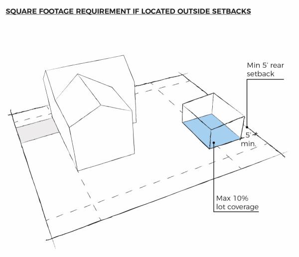
B. Swimming Pools:
1. Swimming Pools and Jacuzzis shall comply with the following setbacks:
a. Minimum setback to a front property line is thirty (30) feet; however, they shall also be located behind the front wall plane of the principal structure.
b. Minimum setbacks to interior side or rear property lines are five (5) feet.
c. Minimum setback to a corner property line is ten (10) feet.
2. Enclosures or coverings shall comply with accessory structure regulations.
3. Swimming Pools shall not be located in municipal or public utility easements. Setback requirements from property lines must still be met.
4. Swimming Pools shall comply with applicable Building Code safety regulations.
C. Yard/Garage Sales:
1. Yard sales are permitted for no more than three (3) events of 48 hours or less within a 12-month period at the same residence or street address. No signage related to such events shall be placed in the public right-of-way (e.g. no placement of signs on telephone and light poles).
D. Irregular Lots:
1. All dwelling structures and other main buildings located on an irregular lot shall be set back an average of 20 feet from the rear property line provided that no portion of the building is closer than 15 feet to the property line.
E. Accessory Dwelling Units (ADUs):
1. This sub-section is established to provide regulations for ADUs.
2. Requirements for Approval. A building permit may only be issued for ADUs provided that the following requirements are met:
a. The property must be located in the R-3, R-1-6, R-1-8, R-1-9, R-1-12 or R-1-15, R-1-20, R-1-30, R-1-40, R-1-60, R-1-80 or R-R zones.
b. The owner of the property must reside on the property. Exceptions shall be permitted if the property owner applies to have the occupancy requirement suspended, if the owner has resided on the property for at least one (1) year and if any of the following situations exist:
1. The owner has a bona fide, temporary absence of three (3) years or less for activities such as temporary job assignments, sabbaticals, or voluntary service (indefinite periods of absence from the dwelling shall not qualify for this suspension).
2. The owner is placed in a hospital, nursing home, assisted living facility or other similar facility.
c. Only one (1) ADU shall be created on a parcel. The ADU may only be located within a single-family dwelling or in an Accessory Structure. Accessory Structures that house ADUs shall be constructed as permanent structures. A Recreational Vehicle is not considered an accessory structure and may not be used as an ADU.
d. ADUs are only permitted on lots 6,000 square feet or larger.
e. The property must have a total of three (3) parking spaces for the primary single-family dwelling with an internal ADU and four (4) parking spaces for a primary single-family dwelling with an external or detached ADU, which meet the criteria provided in section §15.4.16.120. i.e., two (2) parking spaces are required for the primary single-family dwelling and one (1) parking space for the internal ADU. The parking spaces for the ADU may not be provided in a tandem arrangement.
f. The ADU must be registered with the City Community Development Department. Any fees required for registration shall be defined in the City's Annual Budget.
g. The ADU shall meet all applicable building and fire codes.
F. Awnings, Carports or Covered Decks:
1. Awnings or structures that are open on three (3) sides on the rear portion of a home may extend within 15 feet of the rear property line.
2. Awnings or other structures that are open on three (3) sides must be setback at least five (5) feet from the side property line.
3. A building permit must be obtained for all awnings.
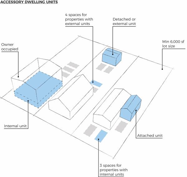 G. Animals:
1. Animals are allowed in the A-E, R-R, I-1, and I-2 zoning districts with no restrictions on the maximum number. Animals are allowed in all other zoning districts subject to the following regulations:
a. The portion of the property on which the animals, except for household pets, are kept must be at least one-half (1/2) acre in size. The chart following this section sets forth the only types of animals that may be kept and the maximum number of animals which may be kept per each one-half (1/2) acre of property. The numbers are not cumulative. A maximum of one (1) species precludes any other species. For example, on a half-acre (1/2) two (2) horses may be kept, or four (4) sheep, or one (1) horse and two (2) sheep, but two (2) horses and four (4) sheep are not allowed.
b. All requirements set forth in Title 6, Animals, must be met. The keeping of chickens and potbellied pigs in any zone other than the A-E, R-R, I-1, or I-2 is governed by Title 6.
c. No animal shall be kept in a residential zone for purpose of commercial production.
| Animal | Maximum # Per 1/2 Acre |
| Cattle | 2 |
| Horses | 2 |
| Sheep, Goats, Llamas, Ostriches | 4 |
| Rabbits | 10 |
| Pigeons | 12 |
| Ducks, Geese | 8 |
| Game Birds * | 8 |
| *with appropriate permits |
H. Wind Turbines (WT):
1. It is the purpose of this section to promote the safe, effective, and efficient use of large wind energy systems installed to provide electricity to utilities and to promote the adoption of renewable energy resources to reduce dependence on fossil fuel power generation.
a. Requirements:
1. Minimum parcel size: A large wind energy system consisting of one (1) tower must be located on a parcel that is a minimum of five (5) acres in size. An additional acre of property is required for each additional tower.
2. Onsite structures may be located up to the foundation of the tower.
3. Setback from a residential zone or use: The tower base must be setback a minimum of 500 feet from residential zoning districts.
4. Distance from rights-of-way and property lines: None; but all tower bases must be located on leased or owned property. The blade sweep cannot encroach upon adjoining properties or rights-of-way without easements providing for their encroachment. The easement must be a recorded document.
5. Height: Tower height is not to exceed 270 feet. Provided that, in all cases, the system shall comply with all applicable Federal Aviation Administration (FAA) requirements.
6. Height of Blade (tip at low point of blade sweep from ground): No closer than 50 feet.
7. Braking Device: All WT devices shall have braking systems when winds reach speeds in excess of 65 miles per hour.
8. Sign: One (1) project identification warning sign is permitted containing a telephone number for emergency calls, no larger than 16 square feet in size.
9. Color/Finish: white or other non-reflective color.
10. Interference with Broadcast Signals: The system shall not create electromagnetic interference and shall be filtered and/or shielded to prevent interference with broadcast signals.
11. Compliance with International Building Code (IBC): Building Permit applications for large wind energy systems shall be accompanied by standard drawings of the WT structure, including the tower, base, and footings. An engineering analysis of the tower and WT showing compliance with the Building Code and certified by a professional engineer licensed in the state of Utah shall also be submitted.
12. Compliance with FAA Regulations: Large wind energy systems must comply with applicable FAA regulations, including any necessary approvals for installations close to airports.
13. Utility Notification: A letter shall be provided from any interconnecting utility companies confirming approval for any interconnection.
14. Zoning Districts: Large wind energy systems are permitted only in the I-3 Heavy Industrial zoning district.
15. Wind Study: A wind or feasibility study must be conducted and recommend a specific location for the WT. The study must also recommend an optimal height for the WT and if the location is feasible for a WT.
16. The tower shall not be climbable from the exterior.
I. Outdoor Storage Areas. The following conditions must be met:
1. The storage area must be paved with asphalt or concrete or be covered with gravel. In situations where gravel is utilized, no less than four (4) inches of untreated base course shall be installed. Additional improvements may be required by the City Engineer in accordance with the findings of a site-specific geotechnical report. Where a paving material other than asphalt or concrete is utilized, a drive apron shall be installed at all points of vehicular access. The drive apron shall be 26 feet wide and no less than 60 feet long.
2. The outdoor storage area must be screened from surrounding properties with a six (6) foot tall Wall except where the adjoining property is a railroad right-of-way, Interstate 15 or SR-6 adjacent to industrial zones. Where the outdoor storage area abuts a public street, a 10-foot-wide landscaped planter shall be installed between the Wall and the sidewalk or right-of-way. Landscaping shall be installed and maintained in accordance to the requirements found in §15.4.16.130.
3. For outdoor storage areas located in the Industrial 2 or 3 zones, stackable concrete blocks may be used as the required screen for outdoor storage areas unless the screen would be placed adjacent to a public street. When stackable concrete blocks are used to provide a required screen for outdoor storage areas, they shall include a wall cap and be painted or stained in the same manner as other walls as described in the City's construction standards. Where the screen is required adjacent to a public street, the stackable concrete blocks shall not be allowed but instead a wall as described in Title 15 and further defined in the City's construction standards is required.
4. Lighting shall be provided in outdoor storage areas. A photometric lighting plan shall be submitted with the Site Plan application. The lighting plan shall demonstrate the capacity of the proposed lighting to uniformly illuminate the storage area without creating undue spillover onto surrounding properties.
5. Material kept in an outdoor storage area cannot be stacked or piled to a height that exceeds 12 feet.
J. Public Rights-of-Way:
1. It is not permitted to store or display merchandise or any other material, excepting those signs permitted in §5.36.050(I), within any public right-of-way. In certain locations designated by Spanish Fork City, outdoor seating may be permitted in accordance with restrictions provided in the City’s Development Standards.
K. Temporary Uses:
1. Certain uses may be permitted on a temporary basis in Zoning Districts where they otherwise are not allowed. Express written approval must be provided by the Community Development Director prior to the commencement of a Temporary Use. Temporary Uses will be limited to those identified in a particular Zoning District and will be subject to conditions. The specific conditions associated with each Temporary Use will address the approved duration of the use, the precise nature of the use, the scope of the use and any others deemed appropriate for a particular situation. Business operating approved Temporary Uses must maintain a valid Spanish Fork City Business License.
L. Amateur Radio Antennas:
1.This section shall apply to amateur radio, also known as HAM radio, antennas and support structures.
2. General Regulations. Amateur radio antennas and support structures are allowed as a permitted use in all zones up to a height of forty-five (45) feet, subject to the conditions of this section. All amateur radio antennas and support structures shall comply with the following requirements.
a. All facilities shall comply with any pertinent regulations of the Federal Communications Commission (FCC) and the Federal Aviation Administration (FAA).
b. A building permit is required for any antenna and support structure with a combined height over twelve (12) feet. The design and construction of the antenna, as demonstrated by manufacturer specifications or by certification of a design professional (architect, professional engineer, or structural engineer) and support structure must be able to withstand wind loads of 80 mph and greater.
c. No more than one amateur radio support structure per lot or parcel may be installed. A support structure may only be located in the rear yard of a home or primary structure. A roof-mounted antenna shall be allowed provided that the height of the antenna and support structure does not exceed twelve (12) feet above the roof.
d. Setbacks for all amateur radio support structures shall be at least twenty feet (20’) from neighboring property lines and a minimum of thirty feet (30’) from any public right of way.
e. Support structures and all antennas, including when such antennas are fully extended, shall be located entirely upon and within the owner’s private property. No part of a support structure or antenna may extend beyond the boundaries of the lot or parcel upon which it is located, including into the right-of-way of any public or private street. No part of an antenna or support structure may be closer than 15 feet from an electric distribution conductor or 30 feet from an electric transmission conductor.
f. A support structure shall be composed of non-reflective galvanized steel or aluminum and shall be a neutral color or a color to match the background against which it will be most commonly seen.
g. Antennas are to be installed on a building or property in the least conspicuous location possible.
h. A support structure in a residential zone may not make use of guy wires.
i. Antennas shall be retracted, lowered, nested, or otherwise moved to a resting position when they are not being actively used for transmitting and receiving signals.
3. Conditional Use for Additional Height, Lesser Setbacks. The City desires to provide reasonable accommodations for antennas and support structures, where appropriate, to ensure the standards contained in this section represent the minimum practicable regulation to accomplish the City’s legitimate safety and aesthetic purposes. A conditional use permit shall be granted by the Planning Commission to allow amateur radio antennas and support structures to exceed 45 feet in height or to be setback less than the distance required by this section if it finds that the additional height or lesser setback will not create any negative impact or if reasonable conditions are proposed, or can be imposed, to mitigate the reasonably anticipated detrimental effects of the additional height or lesser setback in accordance with applicable standards. It is the intent of the City to reasonably accommodate antennas and support structures to the greatest extent practicable without negatively impacting public safety or the aesthetic quality of the neighborhood in which they are located. Antennas and support structures will generally not be allowed at a greater height or lesser setback to the extent the greater height or lesser setback negatively impacts the public safety or aesthetics of the neighborhood in which they are located. In determining whether amateur radio antennas and support structures should be allowed to exceed 45 feet in height or have a lesser setback, the Planning Commission shall consider the following factors:
a. The potential negative impact on public safety, especially the safety of life and property in the public rights-of-way or on adjacent properties.
b. The potential negative impact that the structure will have on the views of properties in the neighborhood. Special consideration shall be given to the impact on the views of attractive natural features such as the Wasatch Mountains, the Spanish Fork River bottoms, and Utah Lake.
c. The potential negative impact that the structure will have on the overall aesthetic quality of the neighborhood in which the structure is located.
d. The potential impact the structure may have on property values in the neighborhood in which the structure is located as demonstrated by a market analysis or appraisal. Speculative testimony is insufficient to establish any impact upon property values.
e. The need of the owner/operator for an antenna and support structure in excess of 45 feet or for a lesser setback distance.
f. The extent to which any reasonably anticipated detrimental effects of the structure can be mitigated. Factors that may reduce the negative impact that a structure will have on the aesthetic quality of a neighborhood and which may be made a condition(s) for the allowance of a height greater than 45 feet or lesser setback include but are not limited to the following:
1. For additional height, setbacks from adjoining property that significantly exceed the required setbacks listed in subsection (1)(d) above.
2. The current existence and use of trees or other means to screen or camouflage the structure.
3. The use of a retractable support structure, which is retracted when not in use or which is fully extended only during limited hours so long as the antenna, when extended, does not cross property lines.
4. The location of a support structure adjacent to land that is undeveloped and not likely to be developed due to topography or other characteristics. Streets may not be considered as undeveloped land.
5. The location of a support structure in or adjacent to commercial property, churches, schools, parks, or similar property such that the support structure will not unreasonably impair the views of residential property owners.
6. Any other factor that could reasonably mitigate the negative impact of the structure.
g. The existence of one or more of the conditions listed above does not create a presumption that the negative impacts of an antenna or antenna support structure are adequately mitigated.
4. Abandonment. An antenna or support structure shall be deemed to be abandoned and must be removed if the antenna is not used for a period of two (2) years or more. However, this two-year period shall not run during any time when the owner is away on a temporary leave of absence due to military service, a volunteer service assignment, ecclesiastical assignment, or other similar absence.
M. Impound Yard. The following conditions must be met:
1. The yard must be paved with asphalt or concrete or be covered with gravel. In situations where gravel is utilized, no less than found (4) inches of untreated base course shall be installed. Additional improvements may be required by the City Engineer in accordance with the findings of a site-specific geotechnical report. Where a paving material other than asphalt or concrete is utilized, a drive apron shall be installed at all points of vehicular access. The drive apron shall be paved with concrete or asphalt 26 feet wide and no less than 60 feet long and a 26 foot-wide all-weather driveway shall be constructed from the end of the apron to the Impound Yard.
2. When the yard is located within 100 feet of a public right-of-way, a six (6) foot tall Wall shall be constructed between the yard and the public right-of-way. Exceptions to the Wall requirement may be granted by the Community Development Department where the public right-of -way is interstate 15 and a determination has been made that the yard is not visible from Interstate 15. When the yard abuts a public right-of-way, except for Interstate 15, a 10-foot-wide landscaped planter shall be installed between the Wall and the sidewalk or right-of-way. Landscaping shall be installed and maintained in accordance with the requirements found in §15.4.16.130.
3. Lighting shall be provided in impound Yards. A photometric lighting plan shall be submitted with the Business License application. The lighting plan shall demonstrate the capacity of the proposed lighting to uniformly illuminate the storage area without creating undue spillover onto surrounding properties.
4. Impound Yards shall be no larger than 30,000 square feet.
(Ord. No. 08-05, Enacted 06/07/2005) (Ord. No. 02-10, Amended 02/16/2010) (Ord. No. 23-10, Amended 11/16/2010) (Ord. No. 06-11, Enacted 04/19/2011)(Ord. No. 05-12, Amended 04/17/2012)(Ord. No. 10-12, Amended 08/21/2012)(Ord. No. 11-13, Amended 07/16/2013)(Ord. No. 04-14, Amended 04/01/2014)(Ord. No. 02-15, Amended 02/03/2015)(Ord. No. 11-15, Amended 06/16/2015)(Ord. No. 15-15, Amended 09/15/2015)(Ord. No. 17-15, Amended 12/15/2015)(Ord. No. 04-17, Amended 02/07/2017)(Ord. No. 04-17, Amended 02/07/2017)(Ord. No. 06-19, Amended 04/16/2019)(Ord. No. 12-19, Amended 06/18/2019)
Amended by Ord. 22-19 on 10/7/2019
Amended by Ord. ORD 08-20 on 6/16/2020
Amended by Ord. 10-20 on 8/18/2020
Amended by Ord. 14-20 on 9/15/2020
Amended by Ord. 15-20 on 9/15/2020
Amended by Ord. 07-21 on 5/18/2021
Amended by Ord. 11-21 Amending Title 15 Land Use, of the Spanish Fork Municipal Code, Related to Various Text Amendments on 5/18/2021
Amended by Ord. 18-21 on 9/21/2021
Amended by Ord. Ord 24-22 Amending Section 15.3.24.090 Supplementary Regulations Pertaining to the Rear Setback Requirement for Irregular Shaped Lots on 6/7/2022
Amended by Ord. 34-22 Amending Title 15 of the Spanish Fork Municipal Code Pertaining to Travel Trailers and Accessory Dwelling Units on 9/20/2022
Amended by Ord. 21-2023 Amending Title 15 of the Spanish Fork Municipal Code Regarding Amateur Radio Antennas on 10/17/2023
Amended by Ord. 24-2023 Amending Various Sections of the Spanish Fork Municipal Code Pertaining to Title 15 updates and Amendments Regarding Adding Illustrations, Mailboxes, and Off-Street Parking on 12/12/2023 on 12/12/2023
Amended by Ord. 02-2025 Supplementary Regulations on 5/20/2025
Amended by Ord. 10-2025 Ordinance Amending Title 15 regarding Regulations for Detached Accessory Dwelling Units on 9/16/2025
15.3.28.010 Definitions
For the purposes of this Chapter, the following words and phrases shall have the meanings respectively ascribed to them below:
“Advisory Board” means the Utah County Agriculture Protection Area Advisory Board.
“Agriculture production” means production for commercial purposes of crops, livestock, and livestock products and includes the processing or retail marketing of any crops, livestock, and livestock products when more than 50% of the processed or merchandised products are produced by the farm operator. Agriculture production includes Agritainment as defined in Title 15, including corn mazes, hay rides, petting zoos, farm stands, and farmer's markets.
“Agriculture protection area” means a geographic area within Spanish Fork City created under the authority of Chapter 41, Title 17, Utah Code Annotated, 1953 as amended, and of this Chapter, that is granted the specific legal protections contained in Chapter 41, Title 17, Utah Code Annotated, 1953 as amended.
“Contiguous” means touching along a common side or so close in proximity as to be separated only by the width of a road, canal, railroad track, easement, or similar right-of-way.
“Crops, livestock, and livestock products” includes: (1) land devoted to the raising of useful plants and animals with a reasonable expectation of profit, including: (A) forages and sod crops; (B) grains and feed crops; (C) livestock as defined in Subsection 59-2-102(20), Utah Code Annotated, 1953, as amended; (D) trees and fruits; or (E) vegetables, nursery, floral and ornamental stock; or (2) land devoted to and meeting the requirements and qualifications for payments or other compensation under a crop-land retirement program with an agency of the state or federal government.
“Planning Commission” means the Spanish Fork Planning Commission.
“Political subdivision” means a county, city, town, school district, or special district.
“Proposal sponsors” means the owners of land in agricultural production who are sponsoring the proposal for creating an agriculture protection area.
“State agency” means each department, commission, board, council, agency, institution, officer, corporation, fund, division, office, committee, authority, laboratory, library, unit, bureau, panel, or other administrative unit of the state.
“Unincorporated” means not within a city or town.
Adopted by Ord. 31-22 Ordinance Adopting Title 15, Part 3, Chapter 28, of the Spanish Fork Municipal Code Pertaining to Agriculture Protection Areas on 8/16/2022
15.3.28.020 Purpose
Spanish Fork City supports the establishment of agriculture protection areas within the limitations established by this Chapter to protect and sustain production agriculture. Furthermore, Spanish Fork City recognizes that the adoption of an agriculture protection area will not restrict a citizen’s ability to file a complaint about an agriculture practice. Rather, Spanish Fork City hopes to protect agricultural land owners from civil lawsuits and criminal prosecution as long as the owner employs safe, sound, and reasonable agriculture practices.
Adopted by Ord. 31-22 Ordinance Adopting Title 15, Part 3, Chapter 28, of the Spanish Fork Municipal Code Pertaining to Agriculture Protection Areas on 8/16/2022
15.3.28.030 Proposal For Creation Of Agriculture Protection Area
- A proposal to create an agriculture protection area or an amendment to an existing agriculture protection area within Spanish Fork City may be filed with the City Council by completing the standard forms adopted by the City Council and by filing said forms in the Community Development office.
- To be accepted for processing by the City Council, a proposal under Subsection (A) shall be signed by a majority in number of all owners of real property and the owners of a majority of the land area in agricultural production within the proposed agriculture protection area.
- For the purpose of Subsection (B)(1), the owners of real property shall be determined by the records of the County Recorder.
- The Community Development Director or designee shall accept and process such forms only if they are properly completed and accompanied by the filing fee. The filing fee is set forth in the adopted Fee Schedule.
- The proposal shall contain the following information:
- the boundaries of the land proposed to become part of an agriculture protection area;
- any limits on the types of agriculture production to be allowed within the agriculture protection area;
- and for each parcel of land:
- the names of the owners of record of the land proposed to be included within the agriculture protection area;
- the tax parcel number or account number identifying each parcel; and
- the number of acres of each parcel.
- An agriculture protection area may include within its boundaries land used for a roadway, dwelling site, park, or other nonagricultural use, if that land constitutes a minority of the total acreage within the agriculture protection area.
Adopted by Ord. 31-22 Ordinance Adopting Title 15, Part 3, Chapter 28, of the Spanish Fork Municipal Code Pertaining to Agriculture Protection Areas on 8/16/2022
15.3.28.040 Area Requirements
- In accordance with Section 17-41-301, Utah Code Annotated, 1953, as amended, the minimum number of contiguous acres that must be included in an agriculture protection area within the City is hereby established as twenty (20) acres, which land must be receiving the benefits of Title 59, Chapter 2, Part 5, Farmland Assessment Act (commonly, “greenbelt”).
- Land which is used in intensive livestock operations or in fruit production may be included in an agriculture protection area with an area less than the minimum acreage requirement. An area that is contiguous to an existing agriculture protection area or contiguous to an existing or proposed agriculture protection area that is not within the boundaries of the City may be included in an agriculture protection area with an area less than the minimum acreage requirement.
- Creation of an agriculture protection area shall not impair the ability of land within the area to obtain the benefits of Title 59, Chapter 2, Part 5, Farmland Assessment Act. The eligibility of land for the benefits of Title 59, Chapter 2, Part 5, Farmland Assessment Act, shall be determined exclusively by the provisions of that act, notwithstanding the land’s location within an agriculture protection area.
Adopted by Ord. 31-22 Ordinance Adopting Title 15, Part 3, Chapter 28, of the Spanish Fork Municipal Code Pertaining to Agriculture Protection Areas on 8/16/2022
15.3.28.050 Notice Requirements
- The City Council or staff shall provide notice of the proposal for an agriculture protection area within the City by:
- Posting notice on the Utah Public Notice Website created in Section 63A-16-601 of the Utah Code, as amended;
- Posting notice at five (5) public places, within or near the proposed agriculture protection area; and
- Mailing written notice to each owner of land within 1,000 feet of the land proposed for inclusion within the agriculture protection area.
- The notice shall contain:
- A statement that a proposal for the creation of an agriculture protection area has been filed with the City Council;
- A statement that the proposal will be open to public inspection in the office of the City Council;
- A statement that any person or entity affected by establishment of the area may, within 15 days of the date of the notice, file with the City Council written objections to the proposal or a written request to modify the proposal to exclude land from or add land to the proposed agriculture protection area;
- A statement that the City Council will submit the proposal to the Advisory Board and to the Planning Commission for review and recommendations;
- A statement that the City Council will hold a public hearing to discuss and hear public comment on:
- the proposal to create the agriculture protection area;
- the recommendations of the Advisory Board and Planning Commission; and
- any requests for modification of the proposal and any objections to the proposal; and
- A statement indicating the date, time, and place of the public hearing.
- A person wishing to modify the proposal for the creation of the agriculture protection area, within 15 days after the date of the notice, shall file a written request for modification of the proposal, which identifies specifically the land that should be added to or removed from the proposal.
- Any person wishing to object to the proposal for the creation of the agriculture protection area, within 15 days after the date of the notice, shall file a written objection to the creation of the agriculture protection area.
Adopted by Ord. 31-22 Ordinance Adopting Title 15, Part 3, Chapter 28, of the Spanish Fork Municipal Code Pertaining to Agriculture Protection Areas on 8/16/2022
15.3.28.060 Review Of Proposal
- After 15 days from the date of the notice, the City Council shall refer the proposal and any objections and proposed modifications to the proposal to the Advisory Board and Planning Commission for their review, comments, and recommendations.
- Within 45 days after receipt of the proposal, the Planning Commission shall submit a written report to the City Council that:
- analyzes and evaluates the effect of the creation of the proposed area on the City’s planning policies and objectives;
- analyzes and evaluates the proposal by applying the criteria contained in §15.3.28.070, Evaluation Criteria.
- recommends any modifications to the land to be included in the proposed agriculture protection area;
- analyzes and evaluates any objections to the proposal; and
- includes a recommendation to the City Council either to accept, accept and modify, or reject the proposal.
- Within 45 days after receipt of the proposal, the Advisory Board shall submit a written report to the City Council that:
- recommends any modifications to the land to be included in the proposed agriculture protection area;
- analyzes and evaluates the proposal by applying the criteria contained in §15.3.28.070, Evaluation Criteria;
- analyzes and evaluates any objections to the proposal; and
- includes a recommendation to the City Council either to accept, accept and modify, or reject the proposal.
- The City Council shall consider a failure of the Planning Commission or Advisory Board to submit a written report within the 45 days under Subsections (b) and (c) as a recommendation of that committee to approve the proposal as submitted.
Adopted by Ord. 31-22 Ordinance Adopting Title 15, Part 3, Chapter 28, of the Spanish Fork Municipal Code Pertaining to Agriculture Protection Areas on 8/16/2022
15.3.28.070 Public Hearing
After receipt of the written reports from the Advisory Board and Planning Commission, or after the 45 days has expired, whichever is earlier, the City Council shall:
- Schedule a public hearing;
- Provide notice of the public hearing by:
- Posting notice on the Utah Public Notice Website created in Section 63A-16-601 of the Utah Code, as amended; and
- Posting notice at five public places, within or near the proposed agriculture protection area; and
- Mailing written notice to each owner of land within 1,000 feet of the land proposed for inclusion within the agriculture protection area.
- Ensure that the notice includes:
- the time, date, and place of the public hearing on the proposal;
- a description of the proposed agriculture protection area;
- any proposed modifications to the proposed agriculture protection area;
- a summary of the recommendations of the Advisory Board and Planning Commission; and
- a statement that interested persons may appear at the public hearing and speak in favor of or against the proposal, any proposed modifications to the proposal, or the recommendations of the Advisory Board and Planning Commission.
- The City Council shall:
- convene the public hearing at the time, date, and place specified in the notice; and
- take verbal or written testimony from interested persons.
- Within 120 days of the submission of the proposal, the City Council shall approve, modify and approve, or reject the proposal.
- The creation of an agriculture protection area is effective at the earlier of:
- the City Council’s approval of a proposal or modified proposal; or
- 120 days after submission of a proposal complying with this chapter, if the City Council has failed to approve or reject the proposal within that time.
- To give constructive notice of the existence of the agriculture protection area to all persons who have, may acquire, or may seek to acquire an interest in land in or adjacent to the agriculture protection area, within 10 days of the creation of an agriculture protection area, the City Council shall file an executed document containing a legal description of the agriculture protection area with:
- the County Recorder; and
- the Planning Commission.
- Within ten days of the recording of the agriculture protection area, the City Council or designee shall send written notification to the Commissioner of Agriculture and Food that the agriculture protection area has been created, and include in the notification the following:
- the number of landowners owning land within the agriculture protection area;
- the total acreage of the area;
- the date of approval of the area; and
- the date of recording.
- Failure by the City Council or designee to record the notice required under Subsection (e) does not invalidate the creation of an agriculture protection area.
- The City Council may consider the cost of recording notice under Subsection (E), the cost of sending notification under Subsection (F), and all other estimated costs in establishing a fee under §15.3.28.020, Proposal for Creation of Agriculture Protection Area.
Adopted by Ord. 31-22 Ordinance Adopting Title 15, Part 3, Chapter 28, of the Spanish Fork Municipal Code Pertaining to Agriculture Protection Areas on 8/16/2022
15.3.28.080 Evaluation Criteria
In evaluating a proposal and in determining whether or not to create or recommend the creation of an agriculture protection area, the Advisory Board, Planning Commission, and City Council shall apply the following criteria:
- Whether or not the land is currently being used for agriculture production;
- Whether or not the land is zoned for agriculture use;
- Whether or not the land is viable for agricultural production;
- The extent and nature of existing or proposed farm improvements;
- Anticipated trends in agricultural and technological conditions; and
- Whether the land contains land planned by the City or another political subdivision or state agency for a roadway, park, utility corridor, or commercial development as determined by the official maps of the City or other political subdivision or state agency. Such areas may be excluded from the agriculture protection area.
No single criterion is necessary or sufficient for the establishment of an agriculture protection area. Rather, the criteria in this section are for evaluation and consideration by the Advisory Board, Planning Commission, and the City Council.
Adopted by Ord. 31-22 Ordinance Adopting Title 15, Part 3, Chapter 28, of the Spanish Fork Municipal Code Pertaining to Agriculture Protection Areas on 8/16/2022
15.3.28.090 Adding Land To An Agriculture Protection Area
- Any owner may add land to an existing agriculture protection area within the City by:
- Filing a proposal with the City Council through the Community Development Department; and
- Obtaining the approval of the City Council for the addition of the land to the area.
- The City Council shall comply with the provisions for creating an agriculture protection area in determining whether or not to accept the proposal.
Adopted by Ord. 31-22 Ordinance Adopting Title 15, Part 3, Chapter 28, of the Spanish Fork Municipal Code Pertaining to Agriculture Protection Areas on 8/16/2022
15.3.28.100 Removing Land From An Agriculture Protection Area
- An owner may remove land from an agriculture protection area within the City by filing a petition for removal of the land from the agriculture protection area with the City Council through the Community Development Department.
- The City Council:
- Shall grant the petition for removal of land from an agriculture protection area even if removal of the land would result in an agriculture protection area of less than the number of acres established by the City Council as the minimum under §15.3.28.030, Area Requirements;
- To give constructive notice of the removal to all persons who have, may acquire, or may seek to acquire an interest in land in or adjacent to the agriculture protection area and the land removed from the agriculture protection area, shall file a legal description of the revised boundaries of the agriculture protection area with the County Recorder and the Planning Commission; and
- May not charge a fee in connection with a petition to remove land from an agriculture protection area.
- The remaining land in the agriculture protection area is still an agriculture protection area.
Adopted by Ord. 31-22 Ordinance Adopting Title 15, Part 3, Chapter 28, of the Spanish Fork Municipal Code Pertaining to Agriculture Protection Areas on 8/16/2022
15.3.28.110 Review Of Agriculture Protection Areas
- For the purposes of this Section, the term “calendar year” means the period from January 1 to December 31, inclusive.
- The City Council shall perform an initial review of any agriculture protection area created under the authority of this Chapter in the 20th calendar year after it is created to determine whether the agriculture protection area should be continued, modified, or terminated.
- To assist the City Council in its review, the City Council may:
- request the Planning Commission and Advisory Board to submit recommendations about whether the agriculture protection area should be continued, modified, or terminated;
- at least 120 days before the end of the 20th calendar year, hold a public hearing to discuss whether the agriculture protection area should be continued, modified, or terminated;
- give notice of the hearing using the same procedure required by Section 15.3.28.040 Notice Requirements; and
- after the public hearing, continue, modify, or terminate the agriculture protection area.
- If the City Council modifies or terminates the agriculture protection area, it shall file an executed document containing the legal description of the agriculture protection area with the County Recorder.
- If the City Council determines after that initial review that the agricultural protection area should be continued or otherwise fails to affirmatively continue, modify, or terminate the agriculture protection area in the 20th calendar year, then the agriculture protection area is considered to be reauthorized for another 20 years.
Adopted by Ord. 31-22 Ordinance Adopting Title 15, Part 3, Chapter 28, of the Spanish Fork Municipal Code Pertaining to Agriculture Protection Areas on 8/16/2022
15.3.28.120 Benefits
- Property located within an approved agriculture protection area shall enjoy the benefits and protections as provided in state law, as such may be amended from time to time. Such benefits may include limitations on local regulations, limitations on zoning map amendments, protection from civil and criminal nuisance claims, favorable policy from state agencies, restrictions on eminent domain, and restrictions on state development projects.
- Specifically, for an agriculture protection area, any agricultural activity or operation within an agriculture protection area conducted using sound agricultural practices shall be excluded from the definition or prohibition of a public nuisance under Title 8 unless that activity or operation bears a direct relationship to public health or safety.
Adopted by Ord. 31-22 Ordinance Adopting Title 15, Part 3, Chapter 28, of the Spanish Fork Municipal Code Pertaining to Agriculture Protection Areas on 8/16/2022
Table 1 Residential
| Table 1 - Residential Development Standards | ||||||||||
| District | Maximum Density Per Acre | Minimum lot dimensions | Minimum Setback | Max Building Height5 | ||||||
| Lot Area | Width | Depth | Front6 | Rear7 | Side | Corner | Principal Building | Accessory Building1 | ||
| A-E | N/A | 40 acres | 400' | 400' | 50' | 50' | 50' | 50' | 35' | 35' |
| R-R | N/A | 5 acres | 200' | 200' | 50' | 50' | 25' | 50' | 35' | 35' |
| R-1-80 | .4 units | 80,000 sf | 180' | 200' | 40' | 80' | 20' | 30' | 35' | 20' |
| R-1-60 | .53 units | 60,000 sf | 160' | 200' | 40' | 60' | 20' | 30' | 35' | 20' |
| R-1-40 | .8 units | 40,000 sf | 140' | 200' | 30' | 40' | 20' | 30' | 35' | 20' |
| R-1-30 | 1.07 units | 30,000 sf | 130' | 150' | 40' | 40' | 15' | 25' | 35' | 20' |
| R-1-20 | 1.60 units | 20,000 sf | 125' | 150' | 30' | 30' | 15' | 25' | 35' | 20' |
| R-1-15 | 2.13 units | 15,000 sf | 100' | 125' | 20-25'2 | 25' | 10' | 15-25'4 | 35' | 20' |
| R-1-12 | 2.67 units | 12,000 sf | 100' | 100' | 20-25'2 | 25' | 10' | 15-25'4 | 35' | 20' |
| R-1-9 | 3.56 units | 9,000 sf | 85' | 90' | 15-25'2 | 25' | 10' | 15-25'4 | 35' | 20' |
| R-1-8 | 4 units | 8,000 sf | 75' | 90' | 15-25'2 | 25' | 10' | 15-25'4 | 35' | 20' |
| R-1-6 | 5.34 units | 6,000 sf | 50' | 90' | 15-25'2 | 25' | 5-10'3 | 15-25'4 | 35' | 20' |
| R-3 | 12 units | 6,000 sf | 50' | 90' | 15-25'2 | 25' | 5-10'3 | 15-25'4 | 35' | 20' |
| R-4 | 20 units | 6,000 sf | 50' | 90' | 15-25'2 | 25' | 5-10'3 | 15-25'4 | 50' | 20' |
| R-5 | 18 units | 6,000 sf | 50' | 90' | 10-20'8 | 15' | 15' | 15' | 40' | 20' |
| R-0 | N/A | 6.000 sf | 50' | 90' | 115-25'2 | 25' | 5-10'3 | 15-25'4 | 35' | 20' |
| ||||||||||
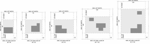
Amended by Ord. 15-13 on 9/3/2013
Amended by Ord. 13-14 on 8/19/2014
Amended by Ord. 05-16 on 4/5/2016
Amended by Ord. 11-17 on 4/18/2017
Amended by Ord. 25-17 on 10/17/2017
Amended by Ord. 21-18 on 11/20/2018
Amended by Ord. 20-18 on 11/20/2018
Amended by Ord. 21-18 on 12/11/2018
Amended by Ord. 03-19 on 1/22/2019
Amended by Ord. 12-19 on 6/18/2019
Amended by Ord. 12-22 on 2/15/2022
Amended by Ord. 06-2023 Amendment to Title 15 that would modify the density that is permitted in Master Planned Developments on 4/18/2023
Amended by Ord. 24-2023 Amending Various Sections of the Spanish Fork Municipal Code Pertaining to Title 15 updates and Amendments Regarding Adding Illustrations, Mailboxes, and Off-Street Parking on 12/12/2023 on 12/12/2023
Table 2 Commercial And Industrial
| Table 2 - Commercial and Industrial Development Standards | |||||||
| District | Minimum Setback1 | Max Building Height | |||||
| Front | Rear | Side | Corner | Principal Building | Accessory Building1 | ||
| C-O | 15'4 -25' | 0-25' | 0-10' | 10'5-15' | 30' | 20' | |
| C-UV | 25' | 0-25' | 0-20' | 15' | 35'-48'1 | 20' | |
| C-D | 0' (10' max) | 0-25' | 0' | 0' (10' max) | 48' | 20' | |
| C-1 | 25' | 0-25' | 0-20' | 0-15' | 30' | 20' | |
| C-2 | 15'4 -25' | 0-25' | 0-20' | 10'5-15' | 35-48'2 | 20-25'2 | |
| S-C | 25' | 0-25' | 0-20' | 15' | 35-60'2 | 20' | |
| B-P | 25' | 0-25' | 0-25' | 15' | 120' | 20' | |
| I-1 | 25' | 0-25' | 0-25' | 15' | None | None | |
| I-2 | 50' | 50' | 50' | 50' | None | None | |
| |||||||
Amended by Ord. 10-09 on 6/17/2009
Amended by Ord. 15-15 on 9/15/2015
Amended by Ord. 14-16 on 9/20/2016
Amended by Ord. 03-17 on 2/7/2017
Amended by Ord. 26-17 on 11/7/2017
Amended by Ord. 03-18 on 2/20/2018