
Springfield City Zoning Code
ARTICLE III
USES PERMITTED IN DISTRICTS
The intent of this section is to describe reasonable permitted uses for each zoning district in the City of Springfield, in order to promote and protect the health, safety, and welfare of the public. Uses not specifically listed below may be approved by the City Council, provided that these uses meet the objectives and requirements of this zoning ordinance.
Failure to list a use as prohibited does not render such use permitted. Items listed in Article IV, General Provisions, shall apply to all districts listed herein. In the event of a conflict between the zoning districts and other sections of this code, the stricter of the two shall apply.
3.1 - "R-1" Detached Single Family Residential District.
3.1.1 Permitted Uses.
3.1.1.1 One Family site-built detached dwelling.
3.1.1.2 Non-commercial horticulture or agriculture, but not including the keeping of poultry or farm animals.
3.1.1.3 Community parks, playgrounds, and other non-commercial recreational facilities.
3.1.1.4 Approved Home Occupations
3.1.2 Secondary Uses. The secondary uses listed below may be permitted upon application and approval by the Building and Zoning Department.
(reserved)
3.1.3 Conditional Uses. The following uses shall be permitted in the R-1 District upon approval of the governing authority:
3.1.3.1 Unlighted, regulation-size or par three golf courses, including normal club house and pro shop activities, and other business activity associated with country clubs.
3.1.3.2 Churches, synagogues, temples or other place of worship provided that 1) such use is housed in a permanent structure, and 2) no structure on the lot is closer than 25 feet from any residential property line.
3.1.3.3 Public and private school engaged in teaching general curriculum for education advancement provided the structures are placed not less than 50 feet from any residential property line.
3.1.3.4 Public utilities substation or subinstallation including water towers and lift stations, provided that: 1) such use is enclosed by a painted or chain-link fence or wall at least six feet in height above finished grade; 2) there is neither office not commercial operation nor storage of vehicles or equipment on the premises; and 3) a landscaped strip not less than five feet in width is planted and suitably maintained around the facility.
3.1.4 Lot and Building Requirements. The Principal Building and Accessory Buildings shall be located and construction in accordance with the following requirements:
3.1.5Required Utilities: For properties not served by a sanitary sewer system, Health Department approval must be obtained prior to the issuance of a building permit or final plat approval.
3.1.6 Required Improvements. Prior to approval of the subdivision or development of three or more lots in this district, the following improvements must be shown on the Engineering Review submission or individual site plans:
a.
Sidewalks of a five-foot minimum width. All sidewalks should connect to major roads and/or pedestrian trail systems located within 100 feet of the property to be developed or subdivided.
b.
Streetlights at regular intervals on all streets and alleys;
c.
Street trees (i.e., trees planted or located between the sidewalk and road or in a median) at regular intervals with minimum distance between trees to be 25 feet;
d.
The location of underground power; and
e.
All additional improvements required by City of Springfield Subdivision Regulations.
3.1.7 Trees
a.
Trees must be maintained on all undevelopable areas. If no trees are on a lot to be developed, a minimum of two trees per housing parcel shall be planted; such trees shall have a diameter at breast height of no less than one-half inch. Street trees may count toward this requirement. Species of trees required to be planted pursuant to this section must be specified in the submitted subdivision plans or building permit application. Species of trees required to be planted pursuant to this section must not be: sweetgums, mulberry, laurel oak, chinaberry, paper birch, eucalyptus, mimosa, or Bradford pear.
3.1.8 Design standards
Reserved.
(Ord. No. 2021-06, § 1, 9-14-2021)
3.2 - "R-2A" Duplex Residential District.
3.2.1
Permitted Uses.
Duplex Dwelling.
Customary Accessory Buildings incidental to the above permitted uses.
Approved Home Occupations.
3.2.2
Secondary Uses. The secondary uses listed below may be permitted upon application and approval by the Building and Zoning Department:
(reserved)
3.2.3
Conditional Uses. The following uses shall be permitted in the R-2 District upon approval of the governing authority:
All Uses permitted in the R-1 District.
Limited Multifamily
All Conditional Uses in R-1
3.2.4
Lot Size and Building Requirements for Duplex Dwellings.
3.2.5
Required utilities: For properties not served by a sanitary sewer system, health department approval must be obtained prior to the issuance of a building permit or final plat approval.
3.2.6
Public space requirements. Before being granted rezoning to R-2A, the applicant shall show that a minimum of 25 percent of the development area shall be preserved for public space(s) with improvements, and the applicant shall provide a plan for how the applicant will memorialize the preservation of such public space. Green space used for this calculation may not be developed in future phases and must be conserved in perpetuity. A plan for the maintenance of the public spaces must be approved by the City Council.
3.2.7
Required improvements. In order for subdivision of any lots for development in the R-2A District to be approved, the following improvements must be shown on the preliminary plat submission:
a.
Sidewalks connected to major roads and walking trail systems. Minimum sidewalk width of five feet.
b.
Street lamps at regular intervals on all streets. Streetlights at regular intervals on all lanes.
c.
Street trees for roads without parallel parking. (i.e., trees planted or located between the sidewalk and road or in a median) at regular intervals with minimum distance between trees to be 25 feet.
d.
Trees must be maintained on all undevelopable areas. If no trees are on a lot to be developed, a minimum of one tree per housing parcel shall be planted; such trees shall have a diameter at breast height of no less than one-half inch. Species of trees required to be planted pursuant to this section must be specified in the submitted subdivision plans. Species of trees required to be planted pursuant to this section must not be: sweetgums, mulberry, laurel oak, chinaberry, paper birch, eucalyptus, mimosa, and bradford pear.
e.
Underground power.
f.
Satisfaction of public space requirements.
g.
All improvements required by City of Springfield Subdivision Regulations.
(Ord. No. 2024-01, § 1, 2-13-2024)
3.2A "R-2B" - Townhome Residential District.
3.2A.1
Permitted uses.
Townhome dwellings.
Customary accessory buildings incidental to the above permitted uses.
Approved home occupations.
3.2A.2
Secondary uses. The secondary uses listed below may be permitted upon application and approval by the building and zoning department:
(reserved)
3.2A.3
Conditional uses. The following uses shall be permitted in the R-3 District upon approval of the governing authority:
All uses permitted in the R-1 District.
Limited multifamily.
All conditional uses in R-1.
3.2A.4
Lot size and building requirements for town homes with rear onsite parking.
3.2A.5
Lot size and building requirements for townhomes with front onsite parking.
3.2A.6
Required utilities. For properties not served by a sanitary sewer system, health department approval must be obtained prior to the issuance of a building permit or final plat approval.
3.2A.7
Minimum lot reduction for townhome dwellings. To provide for visual interest and promote a variety between units, lot sizes for units within a block may vary. The minimum lot width may be reduced by up to four feet for a maximum of ⅔ of the units within a block, provided that each of the remaining units' lot width be at least four feet greater than the minimum lot width (lot area reductions that result from this lot width reduction shall be allowed).
Example of all lots at the same minimum width:
Example of lots ⅔ of lots reduced by four feet and ⅓ of lots increase by four feet:
3.2A.8
Onsite parking. Each unit shall provide onsite parking for a minimum of two vehicles. Onsite parking shall not block sidewalks.
3.2A.9
Overflow parking must be provided within the development. A minimum of one parking space per unit of overflow parking must be provided. A minimum of 85 percent of the units must have access to overflow parking within 200 feet of the unit. Parallel street parking is encouraged. Parallel street parking and amenity parking may be counted toward this number provided the distance requirements are met.
3.2A.10
Streets. Minimum widths required:
3.2A.11
Public space requirements. Before being granted rezoning to R-2B, the applicant shall show that a minimum of 25 percent of the development area shall be preserved for public space(s) with improvements, and the applicant shall provide a plan for how the applicant will memorialize the preservation of such public space. Green space used for this calculation may not be developed in future phases and must be conserved in perpetuity. A plan for the maintenance of the public spaces must be approved by the City Council.
3.2A.12
Required improvements. In order for subdivision of any lots for development in the R-2B District to be approved, the following improvements must be shown on the preliminary plat submission:
i.
Sidewalks connected to major roads and walking trail systems. Minimum sidewalk width of five feet.
ii.
Street lamps at regular intervals on all streets. Streetlights at regular intervals on all lanes.
iii.
Street trees for roads without parallel parking, (i.e., trees planted or located between the sidewalk and road or in a median) at regular intervals with minimum distance between trees to be 25 feet.
iv.
Trees must be maintained on all undevelopable areas. If no trees are on a lot to be developed, a minimum of one tree per housing parcel shall be planted; such trees shall have a diameter at breast height of no less than one-half inch. Species of trees required to be planted pursuant to this section must be specified in the submitted subdivision plans. Species of trees required to be planted pursuant to this section must not be: sweetgums, mulberry, laurel oak, chinaberry, paper birch, eucalyptus, mimosa, and bradford pear.
v.
Underground Power.
vi.
Satisfaction of public space requirements.
vii.
All improvements required by City of Springfield Subdivision Regulations.
(Ord. No. 2024-01, § 1, 2-13-2024)
Editor's note— Ord. No. 2024-01, § 1, adopted Feb., 13, 2024, set out provisions intended for use as § 3.3. Inasmuch as there were already provisions so designated, said section has been codified herein as § 3.2A at the discretion of the editor.
3.3 - "R-3" Multi-Family Residential Districts.
3.3.1 Permitted Uses.
i.
Limited Multi-Family Dwellings.
ii.
Group Dwelling.
iii.
Approved Home Occupations.
3.3.2 Secondary Uses. The secondary uses listed below may be permitted upon application and approval by the Building and Zoning Department:
i.
Customary Accessory Buildings incidental to the above permitted uses.
3.3.3 Conditional Uses. The following uses shall be permitted in the R-3 District upon approval of the governing authority:
i.
Multi-Family Dwelling.
ii.
All uses permitted in the R-2 District.
iii.
All conditional uses in R-1.
iv.
Senior residential facilities.
3.3.4 Lot and Building Requirements.
i.
A buffer as required by this ordinance shall be installed. The buffer shall be either undisturbed vegetation or planted vegetation in accordance with the standards set in Article IV of this ordinance. In addition to any required vegetated buffer, a solid fence no less than six foot in height shall be required within or bordering the buffer.
ii.
Setbacks shall apply to all permanent structures onsite. Patios or pervious surfaces shall not be allowed within the setback area. Parking and/or interior roads may be within the setbacks, provided they do not disturb the required buffers.
iii.
Lot and building requirements for Townhomes, Duplex, and LMF shall be as defined in R-2.
iv.
Principal Building—Multi-Family Dwelling.
3.3.5 Buffers. Site shall comply with all requirements of the buffer ordinance. Nothing in this section shall reduce the required buffer. Setback area maybe used to accommodate buffers. Required yards shall not be used toward buffer requirements.
3.3.6 Site Design Requirements.
i.
Parking.
a.
Parking shall be reviewed by the city engineer and evaluated on soil conditions and traffic loading prior to review by city council as required by site plan approval procedures of Article IV of this ordinance.
b.
All parking areas shall be marked with paint lines or in some other manner approved by city council and maintained in a clearly visible condition.
c.
All off street parking areas shall be continually maintained in satisfactory condition so as to be safe and free of any hazard, nuisance or other unsafe condition.
ii.
Sidewalks.
a.
Sidewalks are required to connect resident parking areas to all resident or publicly accessible buildings on this site.
b.
Required sidewalks shall connect to existing city sidewalks located within 100 feet of the entrance to the development.
iii.
Streets.
a.
All entrance ways, streets, or drive aisles shall provide sufficient turning radii in accordance with approved engineering standards so as to be adequate for all vehicle movement, including fire and safety vehicles, school buses or other over size vehicles which may make use of the area.
b.
All entrance ways, streets, or drive aisles open to two-way traffic must be a minimum of 24 feet wide.
c.
All roads shall be built in accordance with the standards set forth in the residential development regulations and maintained at that standard.
iv.
Lighting.
a.
Lighting shall be provided on site that shall be sufficient to accommodate a safe, attractive, and visible approach from parking areas or public right-of-ways to building entrances.
b.
Onsite lighting shall be directed and shielded in such a way as to not contribute to light pollution or create a nuisance or an unsafe situation to neighboring properties or adjacent rights-of-way.
v.
Landscaping.
a.
A landscaping plan shall be submitted to city council for approval at the time of application for site plan approval required by Article IV of this ordinance. The city council shall have the right to request changes to the landscape plan to avoid any adverse impacts on neighboring properties. The city council shall not approve landscape plan changes that would reduce the buffer requirements established in Article IV of this ordinance.
3.3.7 Building Design.
i.
Building designs shall be submitted to city council for review at the time of application for site plan approval required by Article IV of this ordinance. Building design submissions shall include at minimum:
Building Elevations.
Floor Plans.
ii.
With each Conditional Use Request for a Multi-Family Dwelling, city council shall consider if the proposed building design is appropriate for the specific location of the property. Council shall have the right to request reasonable modifications of the building design. In addition to the criteria in 5.4.1.2 the applicant shall meet the following requirements:
a.
The design of the building shall be similar or compatible with that of buildings located on adjacent property or within the district in which it is generally located.
b.
All building faces shall have the same level of architectural design and detail.
c.
The design of the building shall not be allowed to have a negative impact on adjacent property, especially as it pertains to facades visible from public ROW or single family or two family residential lots.
(Ord. No. 2021-07, § 1, 6-8-2021)
3.4 - "A-R" Agricultural-Residential District.
3.4.1 Permitted uses.
i.
One-Family Dwellings.
ii.
Manufactured Homes.
iii.
Agricultural pursuits, and structures incidental thereto, including dairy products, keeping of livestock in pastures, poultry and poultry products; production of field crops; and forestry. Provided that a 25 foot setback for the agricultural activity shall be maintained when adjacent to any property not located in the A-R zoning district.
iv.
Public and private parks, open space, and Commercial Recreational facilities containing no more than five percent of impervious surface coverage, excluding commercial amusement facilities, game parlors, and recreational vehicle and travel trailer overnight camping sites.
v.
Churches, charitable, semi-private, or philanthropic institutions, or camps and state parks excluding recreational vehicle and travel trailer overnight camping sites.
vi.
Government-owned utilities.
vii.
Approved Home Occupations.
3.4.2 Secondary Uses. The secondary uses listed below may be permitted upon application and approval by the Building and Zoning Department:
(Reserved)
3.4.3. Conditional uses. The following uses shall be permitted in the A-R District upon approval of the governing authority:
i.
Commercial riding stables, provided that no building or enclosure for animals is located closer than 100 feet from any property line.
ii.
Cemeteries, when accessory to and on the same property as a permitted use in the A-R District.
iii.
Commercial recreational facilities that do not have more than five percent of impervious surface coverage.
iv.
Licensed Family Child Care Learning Homes defined in OCGA Section 290-2-3-03 (j) (2018).
v.
Impervious surface coverage over 35 percent.
vi.
Solar farms.
vii.
Bed and Breakfast Inns.
3.4.4 Lot and building requirements. The Principal Building shall be located so as to comply with the following requirements:
Accessory Buildings:
3.4.5 (Reserved)
3.5 - "B-1" General Commercial District.
3.5.1 Permitted Uses.
Auto Brokerage Business,
Event Venues,
Restaurants such as full service and take-out,
Bed and Breakfast Inns,
Retail Business,
Personal Services such as salons and fitness centers,
Financial Institutions such as banks and mortgage companies,
Professional Services such as finance, insurance and real-estate,
Drive-in Theaters,
Mortuaries,
Commercial Greenhouses and Plant Nurseries,
Research and Testing Facilities,
Laundromats,
Accessory Uses to the above.
3.5.2 Secondary Uses. The secondary uses listed below may be permitted upon application and approval by the Building and Zoning Department:
Vending Machines,
Vending Machine Structures.
3.5.3 Conditional Uses. The following uses shall be permitted in B-1 District upon approval of the governing authority:
Entertainment Facilities such as movie theatres, bowling alleys, civic centers and game halls,
Restaurants with Drive Thru Facility,
Hotels,
Motels,
Public and Semi-Public Uses,
Animal Hospitals, Clinics or Kennels,
Pet Grooming Business,
Shopping centers,
Feed and Grain Sales and Storage,
Wholesale Business such as warehouses and bulk sales facilities,
Equipment Sales and Repair,
Truck Terminals,
Stone or Monument Works,
Cemeteries,
Apartments,
Machine Shops,
Storage Facilities and Mini Warehouses,
Garages for Service and/or Vehicular Sales,
Lumber Yards or places for the storage, treatment or refining of lumber,
Commercial Recreation such as parks,
Mobile and Modular Home Sales,
Car Wash including self-service and full-service, or any variation thereof,
Vehicle Service Station,
Utilities,
Cell Towers,
Day Care Facilities,
Liquor Stores,
Medical Uses,
Vape Shops,
CBD Stores,
Vehicle Rentals,
Commercial Entertainment and Amusement,
Accessory Uses to the above.
3.5.4 Lot and Building Requirements.
3.5.5 Signage in the B-1 District shall comply with Section 4.44 of this ordinance.
3.5.6 B-1 Design Standards.
(Reserved)
(Ord. No. 2019-04, § 1, 4-9-2019; Ord. No. 2021-05, § 1, 5-11-2021; Ord. No. 2022-10, § 1, 5-10-2022; Ord. No. 2023-08, §§ 1, 2, 4-11-2023; Ord. No. 2023-29, § 2, 1-9-2024; Ord. No. 2024-19, § 2, 11-12-2024; Ord. No. 2025-03, §§ 1, 2, 3-11-2025)
3.6 - "R-4" High Density Residential.
3.6.1 Permitted Uses.
3.6.1.1 One Family site-built detached dwelling.
3.6.1.3 Community parks, playgrounds, and other non-commercial recreational facilities.
3.6.1.4 Approved Home Occupations.
3.6.2 Secondary Uses.
The secondary uses listed below may be permitted upon application and approval by the Building and Zoning Department: [Reserved].
3.6.3 Conditional Uses. The following conditional uses shall be permitted in the R-4 District upon application and approval of the governing authority:
3.6.3.1 Unlighted, regulation-size or par three golf courses, including normal club house and pro shop activities, and other business activities associated with country clubs.
3.6.3.2 Churches, synagogues, temples or other place of worship provided that 1) such use is housed in a site built permanent structure, and 2) no structure on the lot is closer than 25 feet from any residential property line.
3.6.3.3 Public and private school engaged in teaching general curriculum for education advancement provided no structure on the lot is placed closer than 50 feet from any residential property line.
3.6.3.4 Public utilities substation or subinstallation including water towers and lift stations, provided that: 1) such use is enclosed by a painted or solid fence or wall at least six feet in height above finished grade; 2) there is neither office not commercial operation nor storage of vehicles or equipment on the premises; and 3) a landscaped strip not less than five feet in width is planted and suitably maintained around the facility.
3.6.4 Lot and Building Requirements. The Principal Building and Accessory Buildings shall be located and constructed in accordance with the following requirements:
3.6.5 Required Utilities: All properties in this district are required to have City of Springfield-provided water and sewer services.
3.6.6 Public Space Requirements. Before being granted rezoning to R-4, the applicant shall show that a minimum of 25% of the development area shall be preserved for public space(s) with improvements, and the applicant shall provide a plan for how the applicant will memorialize the preservation of such public space. Green space used for this calculation may not be developed in future phases and must be conserved in perpetuity. A plan for the maintenance of the public spaces must be approved by the City Council.
i.
Required improvements. Public spaces shall include any of the following:
a.
Maintained green space lawn for passive recreation that must include at least two of the following improvements.
1)
Playground;
2)
Athletic equipment;
3)
Benches;
4)
Lighting.
b.
Children's Playground.
c.
Walking trails. All trails shall have:
1)
Clearly marked entrances;
2)
Improvement at the entrance such as lighting, seating or trail map;
3)
Connectivity to a sidewalk network or green space.
d.
Golf Course in compliance with 3.6.3.1.
e.
Sports fields or courts (including informal intramural fields).
f.
Other public spaces not listed above may be presented to the City Council and can count toward the requirements of this section if approved. Sidewalks adjacent to public roads shall not be counted toward public space requirements listed in this section.
3.6.7 Required Improvements. In order for subdivision of any lots for development in this district to be approved, the following improvements must be shown on the Preliminary Plat submission:
i.
Sidewalks connected to major roads and walking trail systems.
ii.
Streetlights at regular intervals on all streets and alleys.
iii.
Street trees (i.e., trees planted or located between the sidewalk and road or in a median) at regular intervals with minimum distance between trees to be 25 feet.
iv.
Trees must be maintained on all undevelopable areas. If no trees are on a lot to be developed, a minimum of 2 trees per housing parcel shall be planted; such trees shall have a diameter at breast height of no less than one-half inch. Street trees may count toward this requirement. Species of trees required to be planted pursuant to this section must be specified in the submitted subdivision plans. Species of trees required to be planted pursuant to this section must not be: sweetgums, mulberry, laurel oak, chinaberry, paper birch, eucalyptus, mimosa, and Bradford pear.
v.
Underground Power.
vi.
Satisfaction of Public Space Requirements.
vii.
All Improvements required by City of Springfield Subdivision Regulations.
3.6.8 Design Guidelines. All housing in the district shall be subject to the design guidelines listed here. Enforcement of this section shall be the responsibility of the Building Official and all new building permits for construction must incorporate at least 4 of the following design elements on all new buildings within the development:
i.
Front porches extending beyond the front facade of the house.
ii.
Front gable or minimum of two dormers perpendicular to the main roof ridge.
iii.
Use of two finish materials on front facing facades.
iv.
Detached garages.
v.
Recessed entry way.
vi.
Aesthetic veneer over the foundation (stone, brick, etc.).
vii.
A delineated path to the front door with landscaped separation between the path and house foundation.
(Ord. No. 2020-01, § 2, 2-11-2020)
3.7 - "DT" Downtown District.
Purpose: Springfield seeks to regulate infill development and to preserve, promote and support the revitalization of its traditional city core. History demonstrates that certain urban and historical design conventions will generate building types and forms which allow profitable, positive infill and change, which strengthen property values and appearance, and which offer a high quality of life. This district establishes new standards for land development in order to:
i.
Preserve and extend the unique and historic character of Springfield's historic commercial corridor through the design and placement of building types and public spaces;
ii.
Create high-quality street spaces by using buildings to form an interesting and safe environment that is efficient and positive for pedestrians, bicyclists and motorists;
iii.
Enhance the viability of local businesses and reduce travel demand by focusing growth in appropriate locations and making spaces accessible to pedestrians;
iv.
Provide a measure of predictability to property owners and occupants about what may be built on their land or that of their neighbors, yet allow for a market-driven mixture of land uses and construction styles; and
v.
Promote and protect pedestrian activity and reduce the impacts of vehicle traffic traversing crosswalks and sidewalks at driveways.
3.7.1
The specific boundaries of the DT District are depicted in the zoning map and generally considered the historic commercial corridor of Laurel Street.
3.7.2
Permitted uses.
i.
The first floor (street level) of any building shall be devoted to those uses as listed below:
Food stores such as general grocery or specialty food items,
Food shops such as bakery, ice cream, or other food items for off premises consumption,
Movie theaters,
Museums,
Art galleries,
Libraries,
Parks,
Office buildings or multi-tenant buildings,
Personal service such as salons and beauty parlors,
Professional uses such attorneys, accountants, or engineering firms,
Restaurants such as dine-in or take-out,
Retail sales establishments,
Medical or dentistry services,
Auto Brokerage Business.
ii.
Limited frontage multi-family dwelling units.
For purposes of this subsection, a "limited frontage multi-family dwelling unit" is defined as a building containing multi-family dwelling units located on floors above a first-floor, a ground level which includes one of the other uses listed above.
iii.
Residential dwellings shall be permitted only above the first floor of any existing or new building with commercial and/or retail uses on the first floor. An entrance, foyer or lobby for the sole purpose of accessing the residential uses above the first floor shall be allowed.
3.7.3
Conditional uses:
Gas stations, service stations, and convenience stores.
Residential uses located on the first level or ground floor of a building.
Vending machines.
Vending machine structures.
Drive-in, or drive-through commercial uses.
Liquor stores.
Artisan crafts or light manufacturing (a retail storefront component is required).
Event Venues.
Restaurants.
Medical Uses.
Commercial Entertainment and Amusement.
Vehicle Rentals.
Pet Grooming Business.
3.7.4
Prohibited uses. Notwithstanding the foregoing, none of the following retail, commercial and service uses shall be permitted within the DT district.
Auto repair,
Auto salvage,
Mini storage facilities,
Storage as a primary use,
Car wash facilities,
Vape Shops,
CBD Stores,
No more than 30 percent of a building can be used for storage of personal or business items, unless those items are directly related to the retail or service function that is also located in that building.
3.7.5
Application requirements for the downtown district.
3.7.5.1
Before issuance of any permit for construction, rehabilitation, renovation or addition to any structure, review by the building and zoning official is required. The following items may be requested for review by the building and zoning official:
i.
A current site survey.
ii.
A current tree survey.
iii.
A site plan, drawn to scale, which shall indicate:
a.
Building locations;
b.
Parking locations and number of spaces;
c.
Paved surfaces, materials and location(s);
d.
Site location diagram and legal description;
e.
Building elevations illustrating all sides of all structures;
f.
Location of mechanical equipment and miscellaneous features including:
Solid waste/trash,
Fuel tanks,
HVAC units.
g.
Location of proposed structures within the public right-of-way including:
Tables,
Chairs,
Signs,
Potted landscaping,
Light fixtures, and
h.
Other reasonable supporting documents to indicate intentions and/or any other items required by the building and zoning official.
3.7.5.2
The purpose of the review is to promote authenticity within the DT district. The guidelines encourage construction which is straightforward and functional, and which draws its ornament and variety from the traditional assembly of genuine materials, with preference shown to those ornaments, details, finishes, and other vernacular architectural elements typically found in historic Springfield structures. The planning and zoning board shall have authority to approve substitute building facade materials and finishes.
3.7.6
Nonconforming buildings and structures. For purposes of the DT district, "abandon" or "abandonment" means discontinuance of the nonconforming use or any use of the nonconforming building or structure regardless of the property owner's intent to relinquish the right to so use the property. A building, land, structure or activity is considered abandoned when:
i.
It has been intentionally discontinued, remains idle or unused;
ii.
Necessary utilities, such as water, sewer or electricity have been discontinued for any reason including a failure to pay fees, rates or other required charges lawfully established by the service provider; or
iii.
The principal buildings or structures are no longer actively occupied for a period of six months or more.
iv.
Residential buildings in the DT district that have previously been using the first floor as a primary residence may be allowed to remain as such. If at any point the first floor of the building is used for commercial or non-residential purposes, the building shall not be again used as a residence.
3.7.6.1
Applicability.
i.
Nonconforming buildings and structures are buildings or structures that are nonconforming in height, area, setback, use, bulk or other dimensional or architectural requirements of this Article.
3.7.6.2
Repair and reconstruction from damage.
i.
If a nonconforming building or structure is damaged by any cause whatsoever to an extent less than 50 percent of the existing square footage or 50 percent of the fair market value of the nonconforming building or structure based upon the most recent market value as determined by the Effingham County Assessor's Office, prior to the damage, it may be repaired or reconstructed and used as before the time of damage, provided that such repair or reconstruction is substantially completed within 12 months of the date of such damage and provided the degree of nonconformity is not increased in any respect.
ii.
If a nonconforming building or structure is damaged by any cause whatsoever to an extent equal to or exceeding 50 percent of the fair market value based upon the most recent market value as determined by the Effingham County Assessor's Office prior to the damage, it may not be repaired or reconstructed, except in conformity with this Article.
3.7.6.3
Renovation and expansion.
i.
A nonconforming building or structure may be renovated provided the estimated cost of the renovation does not exceed 50 percent of the existing square footage or 50 percent of the fair market value of the nonconforming building or structure based upon the most recent market value as determined by the Effingham County Assessor's Office, whichever value is less, and the renovations serve to reduce the nonconformities associated with site improvements.
ii.
A nonconforming building or structure may be expanded provided the estimated cost of the expansion does not exceed 50 percent of the existing square footage or 50 percent of the fair market value of the nonconforming building or structure based upon the most recent market value as determined by the City of Springfield's Assessor's Office, whichever value is less, and the expansion serves to reduce the nonconformities associated with the building or structure.
iii.
A renovation, expansion or improvement of a nonconforming building, structure or site that is disapproved by the building and zoning official may be appealed to the city council.
iv.
A renovation or expansion of a nonconforming structure that exceeds the 50 percent thresholds listed above shall be required to bring the building into compliance with current standards to the fullest extent possible.
3.7.6.4
Abandonment of nonconforming buildings and structures.
i.
No use or occupancy of a nonconforming building or structure shall be resumed if it has been abandoned for a continuous period of six months. After the specified time period referenced herein, the nonconforming building or structure shall not again be used except in conformity with this district.
3.7.7
General Provisions.
3.7.7.1
Setbacks. Building facades shall comply with the following setback standards. Corner lots are deemed to have two frontages and shall conform to the setback requirements for both facades, unless off street parking is required along the side of the building per requirements of this district.
i.
Front setback:
a.
Buildings shall be setback between zero and five feet from the edge of the right-of-way. The maximum setback does not apply to the following elements:
(1)
a front or side courtyard, not to exceed 75 percent of the frontage;
(2)
any recessed entryway.
b.
If new construction incorporates an existing structure located within the required setback, the new construction may abide by the established setback of the existing structures.
c.
No new doors shall swing into the minimum setback in a manner that disrupts pedestrian traffic.
d.
Pedestrian areas, including plazas, courtyards, and outdoor cafes may be permitted within the public right-of-way subject to any required encroachment permits or agreements from the City or the Georgia Department of Transportation. Such areas shall be set back a minimum of five feet from the back of the curb. No permanent fixtures or structures shall be allowed in the public right-of-way.
ii.
Side setback:
a.
Buildings shall be set back a minimum of zero and a maximum of three feet from the side property line, except for street facing sides. Buildings may be setback between eight to 12 feet from a side lot line in order to accommodate a pedestrian passageway.
iii.
Rear setback:
a.
Primary buildings shall be setback a minimum of ten feet from the rear property line to accommodate rear access. Lots with established rear access alleys shall be set back a minimum of 15 feet to accommodate rear parking and loading.
b.
Outbuildings, including those on service lanes, are setback a minimum of three feet from the rear property line.
3.7.7.2
Building requirements.
i.
Building size:
a.
Buildings shall not exceed 10,000 square feet in size.
b.
Exceptions to this maximum size requirement shall only be granted by request for a special exception through City Council.
ii.
Building heights:
a.
A minimum height of 20 feet shall be required for all new structures in the DT district, regardless of the number of functional stories. The maximum height permitted in the district is three stories, excluding spires, domes, chimneys, cupolas, and similar portions of the roof's structure.
iii.
Building design:
Buildings shall be oriented to the street. A building is "oriented to the street" where:
a.
The setback standards established within the district are met.
b.
Principal entrances to buildings face a street or open to a square, plaza, or sidewalk. The principal entrance shall not open onto an off-street parking lot. Off-street parking may be accessed from a secondary entrance.
All street level uses with sidewalk frontage shall be furnished with an individual entrance facing the sidewalk.
c.
Off-street parking does not lie between the building's principal entrance and the street.
d.
When entrances are not adjacent to an existing sidewalk, pedestrian access from the public sidewalk, street right-of-way or driveway to the principal structure shall be provided. Materials shall be of similar quality and walkway of similar width to the connected sidewalk.
e.
Buildings shall be aligned with the finished grade of the street.
3.7.7.3
Fenestration—Storefronts and other uses. This subsection does not apply to the conversion of a residential building to a commercial use. Where a nonconforming existing structure is being renovated, building designs should strive to accomplish as many requirements as possible. Where historic buildings are being renovated, any details or building elements listed below shall not be removed.
1.
Facades facing or visible from the downtown streets shall include:
i.
Street level windows. Between 60 percent to 90 percent of the length, and at least 50 percent of the surface, of the first floor street frontage shall be in transparent public entrances or windows (including retail display windows). Window frames may be metal or wood, and must be painted or stained. First floor windows should contain at least one the following:
a.
Masonry detailing above the window. Arches or header trim are acceptable,
b.
Transom windows,
c.
Heavy windowsill details and/or paneling detail under windows.
ii.
Windows in each story above the ground level. Individual window openings shall not exceed four feet horizontally and eight feet vertically. Between ten percent to 50 percent of the surface of the front facade for each floor above the first-floor street frontage shall be in transparent windows. Circular, semicircular and octagonal windows are permitted on the highest floor of the building. Requirement maybe waved for buildings with stepped gable facades. Window frames may be metal or wood and must be painted or stained.
iii.
Glazed exterior doors. Single or double doors are permitted. Doors must be a minimum of 50 percent transparent. Where window height exceeds door height, transom or decorative paneling above the door is required to match the window height. Doors should not exceed six feet horizontally, and eight feet vertically. Door frames may be metal or wood, and must be painted or stained.
iv.
Horizontal architectural treatment between separate floors such as awnings, sign bands, molding or masonry accents, as examples.
v.
Vertical architectural treatment between separate units in the form of pilaster columns, or facade roof variations in size or height, or change in material or facade thickness or depth.
vi.
Exterior lighting such as wall sconces adjacent to entry door or windows; or wall mounted lighting for illuminating signage.
vii.
Additional encouraged design elements:
a.
Recessed entry ways,
b.
Gooseneck lighting for upper-level signage,
c.
Corner pilaster details and appurtenances,
d.
Awnings above individual windows and doors as opposed to solid, connected awnings spanning the full width of the facade.
2.
Roof types and shapes shall be one of the following:
i.
Flat roofs are allowed for masonry or stucco facades. A cornice adjoining the top of the roof or top of the facade shall be required. Other dimensional architectural appurtenances at the top of the facade, such as masonry details or depressions may be substituted where a historical reference can be provided. A cornice is any horizontal, molded or otherwise decorated projection which crowns or finishes the part to which it is affixed.
ii.
Stepped gable facade shall be allowed for single story buildings with gabled roofs. Sign bands or designated signage location above the ground level windows are required. A combination of triangular and stepped gable designs are permitted.
iii.
A pediment roof, or triangular end of a gable or a triangular ornamental element resembling it shall be allowed in wood construction where horizontal siding is used. Gable vent or windows shall be required in the gable. Pediment roofs must include horizontal cornice detail delineating the bottom of the pediment.
iv.
Other roof and facades types. The architectural details required in this section are enforced to encourage and regulate infill development that is cohesive and complimentary to the historic downtown buildings in Springfield. If a proposed building design does not fit into the facade regulations above, the planning & zoning board will have the authority to approve alternative designs. The applicant should be prepared to provide historical context and justification for the alternative design.
3.
Miscellaneous facade element regulations.
i.
Canopies, awning and similar appurtenances are encouraged at the entrances to buildings and in open space areas. Such features may be constructed of rigid or flexible material designed to complement the streetscape of the area. Such features shall not obscure the upper stories or a sign panel located above the first floor. Vertical supports for such features are not allowed. No canopy shall extend into the public right-of-way more than 36 inches unless an encroachment permit or agreement required by the City and State has been approved and issued.
ii.
A canopy or awning may be used as a sign only if:
a.
No wall sign is included on the same facade; and
b.
The message does not exceed ten inches in height when mounted above the canopy; and
c.
The message is an integral part of the canopy or awning covering; and
d.
Signage on the canopy or awning sign does not exceed one-half of the area bounded by the edges of the canopy or awning visible from the public right-of-way. If signage is only found in fringe drip-flap portion of the canopy, the entire portion of said area may be utilized for signage.
iii.
Upper story decks, balconies, and similar appurtenances are encouraged along the frontage of the upper stories. Such features shall be constructed outside of the rights-of-way and supported by cantilever support. Columns supports will not be allowed.
iv.
Roofs shall drain to the rear of the building. Roofs shall not mask or obscure the architectural features of the front facade such as pediments or cornices.
v.
Heating and/or air conditioning mechanical equipment, whether ground level, raised or rooftop, shall be located in rear or side yards and screened from view from the right-of-way. In addition, garbage receptacles, fuel tanks, electric and gas meters and other unsightly objects must be screened from view. "Screened from view" means concealed from view from any abutting road or adjacent tract of land by a structure constructed of the same materials as the exterior elevation of the principal structure, and if on or attached to the principal structure front, such structure shall be designed to be perceived as an integral part of the building.
3.7.7.4
Parking. Parking shall be placed along streets and in small, strategically located onsite lots where applicable.
3.7.7.4.1
Off-street parking lot location and design.
i.
Wherever possible, parking lots shall be located on the side or rear of buildings. In no case shall the side parking area be wider than 50 percent of the lot frontage and in no case shall parking be located in front of a building. Landscaped buffering shall be required to separate parking areas from pedestrian walkways.
ii.
Front driveways to rear or side parking areas are permitted only where rear or side street access is unavailable.
iii.
Access through parking lots across property lines should be encouraged, especially when there is no alley.
vii.
Loading/unloading areas shall be located only in the rear. Where rear access is not available, loading doors may be permitted on the side of the building, provided they are located closer to the rear of the building that the front of the building.
viii.
Parking areas shall have a paved surface or a hard surface. Ground surface areas not covered with a paved surface or a hard surface shall be restricted from parking by signage and curbing, fencing, or other physical barriers. Parking areas shall provide direct access via a hard surface to building entrances and adjacent sidewalks.
3.7.7.4.2
Interior Parking Lot Landscaping Requirements.
i.
Landscaped islands are required in parking areas at the following intervals for either head-in or diagonal parking stalls: No more than five consecutive parking stalls are permitted without a landscape break of at least five feet in width and extending the entire length of the parking stall. Each landscape break shall have at least one tree and be covered with grass, shrubs, or living ground cover. To minimize water consumption, the use of low-water vegetative ground cover other than turf is encouraged. Local and drought tolerant species are preferred.
3.7.7.5
Access standards. Points of access to any street shall be determined and approved by the City of Springfield. Vehicle ingress and egress onto side streets and alleys is preferred.
3.7.7.6
Accessory Structures. Accessory structures are permitted and may contain parking, storage space, and/or accessory dwelling units. Accessory dwelling units shall not be greater than 625 square feet in area. Accessory structures shall match the facade materials and colors of the primary building, provided the primary building design and materials are conforming to the district.
3.7.7.7
Exceptions from build-to lines. Exceptions from build-to lines may be granted for avoiding trees with calipers greater than eight inches at diameter breast height (DBH).
3.7.7.8
Building walls.
i.
Permitted building finish materials:
a.
Wood siding, painted or natural (cypress and cedar preferred);
b.
Cement-fiber siding accents (hardi-plank or equal);
c.
Concrete masonry units with stucco (C.B.S.);
d.
Reinforced concrete with stucco;
e.
Brick;
ii.
The following building finishes are prohibited and shall only be approved on a case-by-case basis as a special exception:
a.
Vinyl siding,
b.
Metal siding (which includes metal buildings).
iii.
Concrete block finishes which were original to the building shall be allowed on contributing structures in the historic district, provided that the concrete block finish maintains the historic integrity of district.
3.7.7.9
Garden walls and fences.
i.
Fences, garden walls, or hedges are strongly encouraged and, if built, should be constructed along all unbuilt rights-of-way which abut streets and alleys. Maximum height shall be 48 inches along front and side property lines adjacent to streets. Maximum height for rear and interior property lines shall be 72 inches. Pillars and posts may extend up to six inches above the height limitations provided such pillars and posts average no more than ten feet apart. Fences and garden walls shall be a minimum of 25 percent opaque. Fences made of chain-link (wholly or in part) are prohibited along all right-of-way lines which abut streets.
ii.
Permitted finish materials:
a.
Wood: Painted white, left natural, or painted/stained;
b.
Concrete masonry units with stucco (C.B.S.);
c.
Reinforced concrete with stucco;
d.
Wrought iron;
e.
Brick.
iii.
Permitted Configurations:
a.
Wood;
b.
Picket fences: Minimum 30 percent opaque, with corner posts;
c.
Other: To match building walls;
d.
Concrete masonry units with stucco (C.B.S.);
e.
Stucco: With smooth or light texture to match building walls;
f.
Wrought iron: vertical, five-eighths inch minimum dimension, four to six inch spacing.
3.7.7.10
Columns, arches, piers, and porches.
i.
Permitted finish materials:
a.
Columns:
1.
Wood, painted or natural (cypress and cedar preferred);
2.
Concrete with smooth finish;
3.
Brick.
b.
Arches:
1.
Concrete masonry units with stucco (C.B.S.);
2.
Reinforced concrete with stucco;
3.
Brick.
c.
Piers:
1.
Concrete masonry units with stucco (C.B.S.);
2.
Reinforced concrete with stucco;
3.
Brick.
d.
Porches (railings, balustrades):
1.
Wood, painted or natural (cypress and cedar preferred).
3.7.7.11
Roofs.
i.
Permitted Finish Materials on Roofs visible from Laurel Street:
a.
Roofs:
1.
Metal (strongly encouraged): Galvanized, copper, aluminum, zinc-alum;
2.
Shingles: Asphalt, "dimensional" type metal;
3.
Tile (other options preferred; permitted only if approved by the planning board or city council).
3.7.7.12
Miscellaneous materials.
i.
The following shall be located in rear yards or side yards not facing side streets:
a.
Air-conditioning compressors;
b.
Electrical utility meters;
c.
Antennas;
d.
Permanent barbecues; and
e.
Solid waste receptacles.
ii.
The following are prohibited:
a.
Undersized shutters (the shutter or shutters must be sized so as to equal the width that would be required to cover the window opening);
b.
Plastic shutters;
c.
Reflective and/or bronze-tint glass;
d.
Plastic or PVC roof tiles;
e.
Backlit awnings;
f.
Glossy-finish awnings;
g.
Styrofoam cornices; and
h.
Front-yard fences made of chain link, barbed wire, or plain wire mesh.
3.7.7.13
Landscaping. Landscaping requirements are characterized by buildings arranged on small lots, with buildings typically consuming the entire street frontage and areas with undesirable appearances, such as parking, masked by buildings or walls. Accordingly, no landscaping is required for lots or parcels abutting downtown district streets except as follows:
i.
Existing buildings that are set back further than three feet from the front or side property line shall provide a landscape plan for the front and/or side lot line of the setback area for review by city council or their designated review board.
ii.
All lot areas not covered by buildings, hard surfaces or paved surfaces shall be landscaped.
3.7.7.14
Lighting. Lighting shall be installed above front entrances to buildings located in the district. Lighting sources shall provide a minimum of 0.5 foot-candles. All lighting shall be directed on-site or onto adjacent walkways and shall be shielded from direct off-site viewing. All lighting shall be reviewed by the building and zoning official.
3.7.7.15
Signs.
i.
General. Signage will be allowed in the downtown district that advertises the business and/or building name. Signs shall comply with any other sections referenced to signs.
ii.
Freestanding signs. No freestanding signs are permitted except as provided below:
a.
The sign shall not exceed 12 feet in height;
b.
The base of such signs shall be surrounded with decorative a masonry foundation or landscape island;
c.
No portion of the shaft shall have a diameter exceeding 15 inches; and
d.
The message area shall not exceed ten square feet in area.
iii.
Ground mounted or monument signs. Ground mounted or monument signs are allowed as follows:
a.
Such signs shall not exceed five feet in height and 20 square feet in area.
b.
Such signs shall be located outside of the street right-of-way and out of any sight distance triangle prescribed by the City or the Georgia Department of Transportation (GDOT). Unless attached to the front wall of a building.
c.
Such signs shall not be located within the public or pedestrian right-of-way.
d.
One sign is permitted per facade per property.
iv.
Illuminated Signs.
a.
Channel lettering shall be allowed in the downtown district only if the following criteria are met:
1)
Each channel letter shall be individually lit.
2)
Lettering may be lit from the front or back; backlit "halo" lighting is permitted.
3)
Channel lettering shall only be mounted to a building wall or awning. Special exemptions for roof mounted channel letters may be heard by city council.
4)
Channel lettering may be accompanied by a business symbol or logo, provided the symbol or logo is no larger in height than any individual letter.
5)
Square footage of a channel letter signs shall be calculated based on the combined length and width of the total area occupied by channel letters/symbols, and not by the individual square footage of each letter/symbol.
6)
Internal lighting shall be void of color. Accent colors are acceptable, provided they are less used in less than 20 percent of the total sign area.
7)
Illuminated signs shall not blink, flash or change colors in any way.
b.
Cabinet lighting shall be allowed the downtown district only if the following criteria are met:
1)
The illuminated portion of the sign shall not exceed the non-illuminated portion in size. The only portion of the sign that the internal lighting passes through shall be the business lettering and/or logo.
2)
Internally illuminated areas shall be void of color. Accent colors are acceptable, provided they are less used in less than 20 percent of the total sign area.
3)
Cabinet signs shall be maintained and not fall into a state of disrepair. Faded, broken, peeling, discolored or otherwise deteriorating cabinet signs shall not be allowed.
c.
Externally illuminated signs and signs in which the letters or graphics are constructed of neon tubing are permitted only where historic reference can be provided showing neon previously used on the building in a similar way.
d.
Illuminated signs shall not be oriented such that the direction and intensity of lighting creates glare or a hazardous condition for drivers or pedestrians.
v.
Hanging signs will be allowed and shall not exceed 10 square feet in area. Hanging signs may be affixed to building facades or free-standing sign poles. Inspection by the Building Department will be required for any hanging signs that are cantilevered over pedestrian or vehicular rights of ways. A minimum overhead clearance of eight feet from the sidewalk must be maintained.
vi.
Blad signs and projecting signs shall not project more than 42 inches from the building facade. Inspection by the Building Department will be required for any hanging signs that are cantilevered over pedestrian or vehicular rights of ways. A minimum overhead clearance of eight feet from the sidewalk must be maintained.
3.7.7.16
Utilities and trash receptacles. All new transformer vaults, utility structures, air vents, backflow preventers, or any other similar devices, including these facilities when located below grade, must be located behind the front setback or the front facade, whichever is furthest from the front property line. Trash receptacles and utility equipment shall be either located in an alley or screened so as not to be visible from the public right-of-way. All utilities and trash receptacles shall be reviewed as listed in application requirements in section 3.7.4.1.iii.
(Ord. No. 2019-04, § 1, 4-9-2019; Ord. No. 2020-21, § 1, 12-8-2020; Ord. No. 2022-10, § 2, 5-10-2022; Ord. No. 2023-11, § 1, 8-8-2023; Ord. No. 2023-26, § 3 Att. C, 12-12-2023; Ord. No. 2024-08, § 2 Att. A, 3-12-2024; Ord. No. 2023-29, § 3, 1-9-2024; Ord. No. 2024-19, § 3, 11-12-2024; Ord. No. 2025-03, §§ 3, 4, 3-11-2025)
3.8 - "PUD" Planned Unit Development District.
The purpose of a PUD district is to provide that the public health, safety, and welfare be furthered in an area of increasing urbanization and growing demand for housing of all types and design: to ensure that the enacted zoning ordinance provisions encourage innovations in residential and non-residential development and redevelopment so that the growing demand for housing and commercial areas may be met by a greater variety in type, design and layout of buildings and by the conservation and more efficient use of land and of public services and to reflect changes in the technology of land development so the economies secured may add to the benefit of those who need homes; and, in the aid of these purposes to provide a procedure which can relate the type, design and layout of residential and non-residential development to the particular site and the particular demand for housing and commercial activity existing at the time of development in a manner consistent with the preservation of the property values within existing areas, and to ensure that the increased flexibility of regulations over land development authorized here is carried out under such administrative standards and procedures as shall encourage the disposition of proposals for land development without undue delay.
It is the intent that a planned unit development be established by rezoning the applicable property to the PUD district and by simultaneously approving the preliminary development plan (with conditions and required modifications). Thereafter development will be guided by the provisions of the development plan (and attachments) for the specific project.
Uses permitted within a planned unit development:
i.
Residential uses, including single family, two-family, and multi-family dwellings.
ii.
Commercial uses of a type, size, and location designed to be compatible with the proposed residential development.
iii.
Other accessory of ancillary uses as are permitted in residential areas and conditional uses identified in standard zoning districts. Conditional uses may be specifically shown on the approved development plan or may later permitted through the conditional use permit approval process.
3.8.1 Applicability of the Planned Unit Development District.
3.8.1.1 The provisions of this section shall apply only to a tract of land which has a minimum of fifteen acres.
3.8.1.2 The Planning and Zoning Board and City Council in their review of the proposed development plan shall consider:
i.
The adequacy of existing and proposed streets, utilities, and other public services to serve the development.
ii.
The proper relation between the proposed development and surrounding uses, and the effect of the plan upon comprehensive planning for the surrounding area.
iii.
The character, design, and appropriateness of the proposed land uses and their adequacy to encourage desirable living conditions, to provide separation and screening between uses where desirable to preserve the natural amenities of streams, wooded areas and similar natural features.
iv.
The adequacy of open and play area and that recreation facility are provided for the needs of development.
3.8.1.3 Recommendation by the Planning and Zoning Board and approval by the City Council shall be accompanied by a report stating the reasons for approval of the application and specific evidence and facts showing that the proposed Planned Unit Development will not adversely affect the property adjacent to the area included in the plan.
3.8.2 Review and Administrative Procedures
3.8.2.1 Pre-Application Conference. Before submitting an application for a planned unit development, an applicant, at his option, may confer with the Planning and Zoning Board and/or City Council to obtain information, and guidance before entering into binding commitments or incurring substantial expense in the preparation of plans, surveys, and other data.
3.8.2.2 Application and Development Plan. An Application for approval of a planned unit development shall consist of a request for rezoning to the PUD district along with a preliminary development plan and supporting documentation. The following information shall appear on the preliminary development plan:
i.
Detail plan and general location map—Showing project area prepared at a scale not less than 1" × 100' and shall show such designations as proposed streets (public and private), all buildings and their use, common open space, recreation facilities, parking areas, service areas, and other facilities to indicate the character of the proposed development. The submission may be composed of one or more streets and drawings and shall include
a.
Boundary lines—Bearings and distance.
b.
Easement—Location, width, and purpose.
c.
Streets on, and adjacent to, the tract, street name, right-of-way width existing or proposed center line elevations, pavement, walks, curbs, gutters, and culverts (and their respective types).
d.
Utilities on, and adjacent to the tract location, size, and invert elevation of sanitary and storm sewers; location and size of water mains; location of gas lines, fire hydrants, manholes, electrical and telephone lines and street lights; direction and distance to, and size of, nearest water mains and sewer adjacent to the tract showing invert elevation of sewers.
e.
Ground elevations on the tract - for land that slopes less than two percent, show one foot contours; show spot elevations at all breaks in grades, along
all drainage channels or swales, and at selected points not more than 100 feet apart in all directions; for land that slopes more than two percent, show contours at five foot intervals.
f.
Subsurface conditions on the tract, if required by the Engineer designated by the City Council—Location and results of tests made to ascertain subsurface soil, rock, and groundwater, unless test pits are dry at a depth of five feet.
g.
Zoning on land adjacent to the tract.
h.
Internal uses of such building or structure, as well as the specific overall land use of the premises.
i.
Title and certificates—Present tract designation according to official records of the Office of Deeds; title under which the proposed development is to be recorded, with names and addresses of owners, and notation stating acreage.
j.
Names—The names and addresses of the persons to whom notice of hearings are to be sent including the subdivider or development, the designer of the subdivision or development, and the owners of the land immediately adjoining the land to be platted.
k.
Open space—All parcels of land intended to be dedicated to public use or reserved for the use of all property owners with the purpose indicated and their sizes.
l.
General location, purpose, and height of each building, other than single family residences on individually platted lots.
m.
Map data—Name of development, north point, scale and date of preparation.
ii.
Character—Explanation of the character of the planned unit development and the reasons why it has been planned to take advantage of the flexibility of these regulations.
iii.
Ownership—Statement of present and proposed ownership of all land within the project
iv.
Schedule—Development schedule indicating:
a.
Stages in which project will be built with emphasis on area, density, use, and public facilities such as open space to be developed with each stage. Where a development is proposed in phases or stages, each stage must be a complete unit with all facilities required for its permanent operation and development in the event that subsequent stages are not developed. Where a facility required to support one phase or stage is included in a subsequent stage, the City Council shall require a performance agreement secured by a bond or other appropriate security sufficient to guarantee construction of the facility. No undevelopable parcels or tracts of land may be created in a stage or as a result of the layout of a stage unless such parcel or tract is dedicated to and accepted by an owner's association or to the City for perpetual ownership or maintenance.
b.
Estimated dates for beginning and completion of each stage
v.
Covenants—Proposed agreements, provisions which will govern the use, maintenance, and continued protection of the planned unit development and any of its open space.
vi.
Density—Information on the density of uses, including structures per acres, and the number of buildings by type.
vii.
Non-residential use—Information on the type and amount of ancillary and non-residential uses in a residential planned unit development, including the amount and location of usable open space.
viii.
Service facilities—Information on all service facilities and off-street parking facilities.
ix.
Architectural plans—The Building Official may require preliminary architectural plans for all primary buildings that shall be submitted in sufficient detail to permit an understanding of the style of the development, the design of the building, and the number, size, and type of dwelling units.
x.
Facilities plans—Preliminary plans for:
a.
Roads, including classification, width of right-of-way, width of pavement.
b.
Sidewalks.
c.
Sanitary sewers.
d.
Storm drainage.
e.
Water supply system.
f.
Underground utilities program
g.
A general landscape planting plan.
3.8.2.3 Review of Preliminary Plan.
i.
Public Hearings.
a.
Within 45 days after the filing of a complete application, a public hearing shall be held by the Planning and Zoning Board, which shall forward its report to the City Council. The Planning and Zoning Board may hold its public hearing in conjunction with the City Council.
b.
Within 45 days after the Planning and Zoning Board forwards its report to the City Council, a public hearing pursuant to public notice on said application shall be held by the City Council. The Mayor, or in his/her absence, the Mayor pro-tem, of the City Council or its designated agency may administer oaths and compel the attendance of witnesses. All testimony by witnesses at any hearings shall be given under oath and every party of record at a hearing shall have the right to cross-examine adverse witnesses.
c.
A verbatim record of the hearing shall be made by the City Council whenever such records are requested by any party to the proceeding; but the cost of making and transcribing such a record shall be borne by the party requesting it and the expense of copies of such record shall be borne by those who wish to obtain copies. All exhibits accepted in evidence shall be identified and duly preserved or, if not accepted in evidence, shall be properly identified and the reason for the exclusion clearly noted in the record.
d.
The City Council may continue the hearing from time to time, and may refer the matter back to the planning agency for a report, provided, however, that in any event, the public hearing or hearings shall be concluded within 60 days after the date of the first public hearing.
e.
The City Council, within 30 days following the conclusion of the public hearing provided for in this Article shall, by official written communication, to the landowners, either:
(1)
Grant tentative approval of the development plan as submitted;
(2)
Grant tentative approval subject to specified conditions not included in the development plan as submitted; or
(3)
Deny tentative approval to the development plan.
Failure to so act within said period shall be deemed to be a grant of tentative approval of the development plan as submitted. In the event, however, that tentative approval is granted subject to conditions, the landowner may, within 30 days after receiving a copy of the official written communication of the City Council, notify such governing body of his refusal to accept all said conditions, in which case, the City Council shall be deemed to have denied tentative approval of the development plan.
In the event the landowner does not, within said period, notify the City Council of his refusal to accept all said conditions, tentative approval of the development plan, with all said conditions, shall stand as granted.
The granting or denial of tentative approval by official written communication shall include not only conclusions but also findings related to the specified proposal and shall set forth the reasons for the grant, with or without conditions, or for the denial, and said communications shall set forth with particularity in what respects the development plan would or would not be in the public interest.
3.8.2.4 Status of Plan After Tentative Approval.
i.
The official written communication provided for in this Article shall be certified by the secretary or clerk of the City Council and shall be filed in his/her office, and a certified copy shall be mailed to the landowner. Where tentative approval has been granted, the same shall be noted in the zoning map.
ii.
Tentative approval of a development plan shall not qualify a plat of the planned unit development for recording nor authorize development or the issuance of any building permits.
iii.
Within a maximum of six months following the approval of the preliminary plan, the applicant shall file with the City Council a final development plan. At its discretion and for good cause, the City Council upon written request from the applicant may extend for six months the period for filing of the final development plan.
iv.
In the event that a development plan is given tentative approval and thereafter, but prior to final approval, the landowner shall elect to abandon said development plan and shall so notify the governing body in writing, or in the event the landowner shall fail to file application or applications for final approval within the required period of time or times, as the case may be, the tentative approval shall be deemed to be revoked and all the portion of the area included in the development plan for which final approval has not been given shall be subject to those local ordinances otherwise applicable thereto as they may be amended from time to time, and the same shall be noted on the zoning map and in the records of the secretary or clerk of the government.
v.
Final Detailed Plan Content—A final plat, suitable for recording with the Register of Deeds shall be prepared. The purpose of the planned development plan is to designate with particularity the land subdivided into conventional lots as well as the division of other lands, not so treated, into common open areas and building areas, and to designate and limit the specific internal uses of each building or structure, as well as of the land in general. The final plan of the planned unit development shall include, but not be limited to:
a.
An accurate legal description of the entire area under immediate development within the planned development.
b.
If subdivided lands are included in the planned development, a subdivision plat of all subdivided lands in the same form and meeting all the requirements of a normal subdivision plat.
c.
An accurate legal description of each separate unsubdivided use area, including unusable open space.
d.
Designation of the exact location of all buildings to be constructed, and a designation of the specific internal uses to which each building shall be put.
e.
Tabulations on each separate unsubdivided use area, number of dwelling units per acre.
f.
Public Facilities—All public facilities and improvements made necessary as a result of the planned development shall be either constructed in advance of the approval of the final plan, or, at the election of the City Council, escrow deposits, irrevocable letters of credit in a form approved by the City Council, or performance bonds shall be delivered to guarantee construction of the required improvements.
g.
Covenants—Final agreements, provisions, or covenants shall govern the use, maintenance and continued protection of the planned development.
h.
A landscape plan showing the location, type and size at installation of all proposed landscape materials, existing landscaping and trees to be retained on the site, as well as an identification of the existing trees to be removed that are two inches in diameter or greater, all proposed fences, walls, berms and any pertinent architectural elements associated with the landscape plan.
3.8.2.5 Within a maximum of three weeks following the date of Final Approval by the City Council of the final development plan, the applicant shall submit an 18 × 24" reproducible mylar of the approved final development plan to the Building and Zoning Official who, at the expense of the developer, shall record said Final Plan in the Office of the Clerk of Superior Court of Effingham County. The mylar shall contain the following information:
i.
Graphic representations of the exact location of all buildings and accessory structures.
ii.
Land use characteristics in table form containing the following information:
a.
Gross project area in terms of acres.
b.
Net project area in terms of acres.
c.
Approved density for the projection in terms of area per structure.
d.
Approved usable open space for the project in terms of square feet of open space per structure.
e.
Total number of parking spaces.
f.
Total number of dwelling units in the project.
g.
Number and type of nonresidential units in the project.
iii.
Types and square footage of floor spaces of all non-residential uses, including a graphic representation of all public easements and legal descriptions thereof, who the easement is conveyed to, the purpose of such easement, and any conditions relating to the use of the easement.
iv.
Legal description of the gross project area.
v.
All public and private streets, roads, and alleys included in the project shall be shown by their bearings, widths and names. All streets, roads or alleys, not dedicated to public uses, shall be defined by curve data including pints of curvature, points of tangency, points of compound curvature, radii or curves, central angles and length and bearings of its long chord.
vi.
In the event streets in the planned development are to be dedicated, a statement shall appear on the mylar that the streets shown on it are dedicated to the use of the public.
vii.
The City Council shall issue a certificate certifying the planned unit development, and the Mayor of the City Council shall place his signature on such certificate, which shall appear on the mylar. In the event said mylar is not submitted three weeks following the date of Final Approval the Building Official shall not issue any building permits for the development or phase of particular development until said mylar is received.
viii.
In the event the planned unit development is to be submitted for Final Approval in stages, the applicant shall submit reproducible mylars for each stage of the development containing the information required above.
3.8.2.6 Control of the Planned Development after Final Approval.
i.
After the certificate of approval has been stamped on the reproducible mylar and other prints of plans and signed by appropriate officials, the use of land and the construction, modifications or alteration of any buildings or structures within the planned development will be governed by the approved and recorded final development plan rather than by other provisions of this zoning ordinance except the minor land use and engineering changes permitted by this section.
ii.
After the certificate of final approval has been issued and the final plan recorded, no changes may be made in the approved final development plan except upon application to the appropriate agency under the procedures provided below:
a.
Major Land Uses Changes. Changes which alter the concept or intent of the planned development including changes in the approved public street or private drive construction standards, increases in density, decreases in proposed open space, changes in sizes of public and/or private sewer or water lines, other than service connections, resulting in less capacity, changes in the location of and type of nonresidential uses approved by the City Council, change in the alignment of any street, drive, parking area or water or sewer line in excess of 25 feet, change in location of any public easement, change in the proportion of housing types by not more than 15 percent of the approved dwelling unit count, a violation of any specific condition set forth by the City Council and any changes in the final governing agreements, provisions or covenants. All such changes may be approved only by submission of a new preliminary plan and supporting data, following the "preliminary approval" steps and subsequent amendment of the final planned unit development plan.
b.
Minor Land Use Changes. The following minor changes to the approved final plan may be authorized by the Mayor and the City Council upon written request by the developer and upon submission of detailed plans demonstrating the requested change:
(1)
Decrease in density.
(2)
Increase in open space.
(3)
Changes in the proportion of housing unit types by less than 15 percent of the approved dwelling unit court.
(4)
Increase in acreage of the planned development provided that the acreage under consideration is ten percent or less of the gross site area, in which the increase can only be used for open space, Accessory Buildings or parking.
(5)
A density increase of not more than ten percent of the approved dwelling unit total, providing that the overall lot area requirement per dwelling unit of the district is not exceeded.
c.
Minor Engineering Changes. The following engineering changes to the approved engineering plans may be authorized by an engineer designated by the City Council only upon written request by the developer and submission of detailed engineering plans demonstrating the requested change:
(1)
Changes in road alignment and parking lot location by 25 feet or less.
(2)
Changes in the alignment of storm and sanitary sewer and water lines by 25 feet or less.
(3)
Increase in the approved capacity of storm and sanitary sewers and water lines.
d.
A development plan, or any part thereof, which has been given final approval shall be so certified without delay by the City Council and shall be filed on record forthwith in the office of the recorder of deeds before the development shall take place in accordance therewith. Upon filing record of the development plan the zoning and subdivision regulations otherwise applicable to the land included in such plan shall cease to apply thereto. Pending completion within a reasonable time of said planned development or of that part thereof, as the case may be, that has been finally approved, no modification of the provisions of said development plan, or part thereof, as finally approved, shall be made except with the consent of the landowner.
e.
In the event that a development plan, or a section thereof, is given final approval and thereafter the landowner shall abandon such plan or the section thereof that has been finally approved, and shall so notify the governing body in writing; or in the event the landowner shall fail to commence and carry out the planned development within one year after final approval has been granted, no development or further development shall take place on property included in the development plan until after the said property is resubdivided and is reclassified by enactment of an amendment to the zoning ordinance.
3.9 - "RO" Residential Office District.
3.9.1 Purpose. The primary purpose of the Residential Office District (RO) is to create a transition from intensively used areas to residential neighborhoods. Specifically, the RO District is intended to:
i.
Allow limited office uses as a transition between intensive commercial/institutional uses located within the historic district.
ii.
Limit the impact of non-residential development on residences by requiring a residential character, limiting the scale of buildings, controlling the location of parking areas, and requiring buffer landscaping.
iii.
Control access and limit the impact of development within the historic district.
iv.
Allow residences fronting major roads and close to other residences to convert to office uses, provided the residential character of the neighborhood and building is not changed.
v.
Encourage reuse of existing residential buildings.
3.9.2. Permitted uses.
i.
One-Family Dwelling.
ii.
Outdoor community parks, playgrounds, and other non-commercial recreational facilities.
3.9.3. Conditional uses. A lot may be used for one of the following classes of use, provided a conditional use is received in accordance with the requirements of subsection 3.9.5 of this section and all standards of the RO District are met:
i.
Conversion of an existing home into professional offices.
ii.
Conversion of an existing home into a professional office and one apartment.
iii.
Conversion of an existing home into a bed and breakfast facility.
3.9.4. Dimensional standards. Proposed uses shall meet the following dimensional requirements:
3.9.5 Conditional use standards and criteria.
i.
Buildings, driveways, parking areas, light sources, trash areas and other potential nuisances shall be located and designed to minimize adverse impacts on abutting residential properties. In order to limit the adverse impact of a proposed conditional use, the Planning and Zoning Board or City Council may require site layouts, including increased setbacks from residential property lines, different locations of buildings, parking areas, and driveways, and increased screening for light sources and activity areas.
ii.
All conditional uses shall be served by sanitary sewer and water facilities.
iii.
For all conditional uses, the proposed use must preserve, utilize, and maintain any existing Principal Building.
iv.
For all conditional uses, no new freestanding non-residential buildings shall be constructed on the property, and existing buildings shall be expanded by no more than 25 percent of the residential building floor area that existed at the time of passage of this section. Building additions must be to the rear or side of the existing Principal Building.
v.
All new conditional use buildings and additions must have a residential character, as demonstrated through elevations and other architectural drawings. All conditional use buildings shall be constructed in such a manner that the use can easily be changed to a single-family detached dwelling. They also must include the following features:
1.
A pitched roof covering the building or addition with a pitch of at least six vertical inches to every 12 horizontal inches. Dormers or gables shall be used to break up the bulk of roofs.
2.
On all sides of buildings, residential building materials and colors that are similar to those found in compatible residences in the immediate neighborhood.
3.
A working front door that faces the street and serves as a primary entrance.
4.
Residentially scaled windows and doors, compatible in scale to those found in other residences in the immediate neighborhood.
vi.
Driveway access controls: No more than one driveway access shall be permitted per property, which shall be located in the rear via the unpaved lane (Gum St). If the property is also located on a side street, an additional driveway access shall be permitted. In cases where the property is not accessible via the unpaved lane, nor accessible via a side street, an exception shall be made to maintain use of the existing access.
vii.
Parking is not permitted in front yards or between buildings, except as indicated in the exception listed in Section 3.9.5.vi. However, no additional parking area shall be permitted.
viii.
No outdoor storage is permitted and trash must be kept inside a Principal Building or in approved residential carts (limited to two).
ix.
The following regulations shall apply to all surfaces utilized to advertise a service or business establishment:
a.
No signs shall be erected within five feet of the property line.
b.
Signs shall be limited in size to no more than eight square feet.
c.
No internal lighting is permitted on any sign. Exterior lighting may not become a nuisance or impair vehicle traffic in any way
d.
The number of signs shall be limited to two, one of which shall be located in rear to direct public access to any parking areas.
e.
Signs are allowed to be freestanding or hanging on the porch, with limited affect to the structure.
x.
Lighting shall not shine on abutting residential properties, and lighting poles shall not exceed 12 feet in height. Nonresidential light fixtures shall be setback a minimum of 20 feet from residential property lines, and the light source itself shall not be visible from abutting residential properties.
xi.
All nonresidential uses shall provide landscaping consistent with other residential properties in the district.
3.10 - "I-1" Industrial District.
3.10.1. Permitted uses. Uses in this section shall be permitted provided that such uses meet all the requirements of this section and all other provisions established in this code.
A.
All uses in the B-1 District
B.
Warehousing
C.
Light Industrial Assembly or Fabrication of previously manufactured parts such as:
1.
Apparel and other textile products;
2.
Electronic and other electric equipment, electrical generator and distribution equipment;
3.
Fabric samples;
4.
Furniture and fixtures;
5.
Industrial machinery and equipment;
6.
Instruments and related products;
7.
Lumber and wood products, excluding the processing of material for the production of paper and allied products;
8.
Metal products;
9.
Plastic and rubber products;
10.
Transportation equipment.
D.
Light Industrial Manufacturing, including but not limited to the manufacturing items such as:
1.
Bakery products;
2.
Beverages, including alcoholic beverages;
3.
Communication equipment;
4.
Computer and office equipment;
5.
Electrical lighting and wiring equipment;
6.
Electronic equipment;
7.
Fabricated metals, excluding use of blast furnaces and drop forges;
8.
Grain mill products;
9.
Audio and visual equipment;
10.
Appliances;
11.
Ice;
12.
Meat products, excluding slaughtering, dressing, and rendering;
13.
Medical instruments and supplies;
14.
Pharmaceutical products;
15.
Biodiesel in an enclosed system.
E.
Boat sales and repairs.
F.
Automotive sales and repairs.
G.
Automotive storage, excluding junk yards.
H.
Florist—retail and wholesale.
I.
Laboratories.
J.
Printing and publishing.
K.
Recycling centers.
L.
Repair of any goods, equipment, and vehicles of which the manufacture, assembly or sales are permitted in this district.
M.
Research facilities.
N.
Vocational schools.
O.
Utility operations centers.
P.
Ready-mix concrete facilities.
3.10.2. Conditional Uses.
A.
Heavy Industrial Manufacturing of:
1.
Aerospace vehicles and parts
2.
Automobiles and parts
3.
Paper
4.
Lumber
5.
Concrete pipe
6.
Asphalt
7.
Boats
8.
Grain mill products
9.
Sugar
10.
Wood chips
11.
Ethanol
12.
Chemicals
13.
Plastics
B.
Energy plant
C.
Railroad switchyards
D.
Metal plating or smelting
E.
Junkyards. The following factors will be considered.
1.
The effect the proposed activity will have on traffic flow along adjoining streets;
2.
Ingress and egress to the property;
3.
The number, size and types of signs proposed for the site;
4.
The amount and location of open space;
5.
Protective screening;
6.
Hours and manner of operation;
7.
Outdoor lighting; and
8.
Compatibility with surrounding land use.
F.
Any other Proposed uses not listed, subject to review and approval in accordance with section 3.10.3.
3.10.3. Uses not listed. All proposed uses not listed within this section are subject to review and conditional approval. The following shall be required of conditional use request in this district:
3.10.3.1. Submission requirements. Design and operation plans shall be submitted to the zoning administrator and consist of at least the following:
A.
Name, address, and telephone number of petitioner, architect, surveyor, engineer of designer.
B.
Names and addresses of all property owners of the site.
C.
Zoning district classification of adjoining land.
D.
Site plan to include the following:
i.
Location and dimensions of existing and/or proposed structures with the type of usage designated.
ii.
Proposed and existing access and egress.
iii.
Proposed and existing rights-of-way.
iv.
Proposed and existing easements.
v.
Proposed and existing water, sewer, and storm-water facilities.
vi.
Proposed and existing buffers.
vii.
Setbacks.
viii.
Streams, lakes, and jurisdictional wetland areas.
ix.
Proposed waste treatment/handling facilities.
x.
Proposed parking.
xi.
Proposed outdoor lighting and signage.
xii.
Proposed hours of operation.
E.
Traffic study.
F.
Where the noise generated by the proposed development is expected to exceed 55 dB(A) at any point along the property line, the developer shall provide a detailed proposal for noise-reduction measures and shall depict said improvements on all site plans.
G.
Written report outlining the industrial operation, schedule of development, and listing the toxic and/or hazardous materials regulated by local, state, or federal regulations, including disposal/handling plans of said materials.
3.10.4. Performance standards. All industrial uses must conform to the following performance standards. If anything in this section is found to be in conflict with other sections the stricter rule shall apply.
3.10.4.1. Smoke.
The emission from any air contaminant source the opacity of which is equal to or greater than 40 percent shall not be permitted. Furthermore, from fuel-burning equipment, visible emissions the opacity of which is equal to or greater than 20 percent, except for one six-minute period per hour of not more than 27 percent opacity, shall not be permitted. Any operation, process, handling, transportation, or storage facility which may result in fugitive dust shall take all reasonable precautions to prevent such dust from becoming airborne. The percent opacity from any fugitive dust source shall not equal or exceed 20 percent. "Opacity" means the degree to which emissions reduce the transmission of light and obscure the view of an object in the background and is expressed in terms of percent opacity. The measurement of percent opacity does not include the measurement of the obscuration of view due to uncombined water droplets. Any determination of the percent opacity shall be made by the arithmetic average of six minutes of data. Any visual observation or determination of opacity taken for the purpose of determining compliance with any requirement of this standard shall be made by personnel certified according to procedures established for such certification by the Georgia EPD or by US EPA to make such observation or determination.
3.10.4.2. Odor.
Any process which may involve the creation or emission of any odors shall be provided with a secondary safeguard system, so that control will be maintained if the primary safeguard system should fail. There is hereby established as a guide in determining such quantities of offensive odors Table 3 (Odor Thresholds) in Chapter 5, Air Pollution Abatement Manual, copyright 1951, by Manufacturing Chemists Association, Inc., Washington, D.C. Where said publication gives range of figures a simple average of these shall be used.
3.10.4.3. Toxic gases.
The emission of gases or fumes injurious to persons or property beyond the lot lines occupied by the use is prohibited.
3.10.4.4. Glare and heat.
Glare and heat from arc welding, acetylene torch cutting, or similar processes shall be performed so as not to produce glare which is visible, or objectionable heat beyond the property line of the lot on which the operation is located. Direct glare from incandescent exposed lights shall not be visible from adjoining streets or properties. All lighting shall be downward facing and shielded.
3.10.4.5. Wastewater.
No discharge is permitted at any point in any private sewage disposal system or stream or into the ground of any materials in such a way or of such nature or temperature as could contaminate any water supply, or otherwise cause the emission of dangerous objectionable elements, except in accordance with the standards as approved by water pollution control boards of appropriate agencies of the state department of natural resources.
3.10.4.6. Solid Waste.
No accumulation of solid wastes conducive to the breeding of rodents or insects shall be permitted.
3.10.4.7. Storage of toxic or hazardous wastes, chemicals, and materials.
Any applicant who intends to store, handle, or transport toxic or hazardous waste, chemicals, or materials shall submit to the county fire marshal a listing of all compounds and contents to be contained on the proposed site. Upon approval by the county fire marshal that the use, transport, and storage of said materials meets the federal and state guidelines, the applicant shall be issued a permit authorizing such secured storage. Disposal of toxic or hazardous wastes, chemicals, and materials is prohibited.
3.10.4.8. Vibration.
Any use creating intense earthshaking vibration shall be set back as far as possible from the lot lines on all sides, and in no case shall any such vibration be perceptible along any lot line.
3.10.5. Buffers.
A.
Buffers for the industrial district shall meet the minimum guidelines as specified in Article IV of this ordinance.
B.
For projects that meet two out of the three non-metropolitan thresholds for DRI review the required buffer screening may be lessened to allow for architectural views upon approval of the zoning administrator.
C.
Required plantings in Buffers as specified in Article IV.
(Ord. No. 2020-22, § 2(Exh. A), 12-8-2020)
3.11 - Highway 21 Bypass Overlay District.
3.11.1 Intent and Purpose. The intent of the Highway 21 Bypass Overlay District is to establish minimum design standards for public improvements and private property development that address transportation connectivity, landscaping, architecture, lighting and other design elements that make the corridor visibly recognizable for its quality and consistency. Access and connectivity standards set forth in this ordinance seek to create a development pattern that creates a safer and more easily navigable circulation for vehicles, pedestrians, and alternative transportation methods as it relates to connections and relationships within the overlay district and ways in which the overlay district connects back to the surrounding community and amenities, as well as existing and planned roadways.
The purpose of the Highway 21 Bypass Overlay District is to:
a.
Promote the general health, safety, and welfare of the community.
b.
Improve the connectivity and reduce curb cuts on GA Highway 21.
c.
To promote safe and efficient movement within and into the Overlay District for persons using all modes of travel - motorized vehicles, bicycles, and walking.
d.
To create a welcoming gateway to the City that is aesthetically appealing while being environmentally responsible.
e.
To set minimum standards for connectivity, landscaping, architecture, lighting, and other design elements.
3.11.2 Definitions.
a.
Director. Community Development Director or his/her designee.
b.
Review Board. As designated by this ordinance the Springfield Planning and Zoning Board shall act as the Overlay Review Board and shall be responsible to approve or deny new projects seeking development or renovation within the overlay district area.
3.11.3 Highway Overlay Boundary and Allowed Uses.
a.
Location. The Overlay District includes all properties located on either side of the Highway 21 Bypass that are in the current or future jurisdictional city limits of Springfield, the boundaries of which are in whole or in part within 500 feet of any boundary of the GA Highway 21 right-of-way. Where there are existing intersecting streets, these standards (landscape strips, buffers, access, etc.) shall apply for the first 500 feet of depth back from the street intersection with GA Highway 21.
b.
This district excludes those portions of GA Hwy 21 also referred to as Laurel Street.
c.
Future Applicability. The entirety of all property contained within any parcel subject to this ordinance on the date of adoption of this Ordinance shall continue to be subject to this Article, even if the parcel is subdivided in the future.
d.
Zoning. This Overlay District is supplemental to the underlying zoning district classifications and regulations established in the Zoning Ordinance of Springfield, Georgia. The provisions of this Article shall be overlaid upon and shall be imposed in addition to said underlying zoning regulations and other City ordinances. The Director is authorized to interpret and enforce such rules, regulations, guidelines, and standards as may be reasonably necessary or desirable to give effect to the provisions herein.
In any case where the standards and requirements of the Overlay District conflict with those of the base-zoning district or with other provisions of the City Code, the standards and requirements of the Overlay District shall govern unless otherwise specified.
3.11.4 District Enforcement and Procedures.
3.11.4.1. Enforcement.
a.
All new projects requiring compliance with these regulations shall submit plans for approval to the City of Springfield Building Department. The City of Springfield Planning and Zoning Board will review the submission and issue approval of Site, Landscape, and Building Design when they feel confident the proposed project is in compliance with the standards set forth in this ordinance.
b.
Exceptions. The provisions of this Article shall not apply to the following:
1.
Completion of work subject to site development plans, construction plans, building permits, or other permits approved prior to the effective date of this ordinance.
2.
Improvements and additions that are made to a single-family residence previously permitted and built on a lot of record prior to enactment of this ordinance.
3.
Construction of a single-family dwelling on an existing lot of record within a single family residential subdivision with preliminary plat approved prior to enactment of this ordinance provided that the new construction shall be of a similar floor area, materials and design as the single-family dwellings on adjacent lots in the same subdivision.
4.
Construction, rehabilitation, restoration, repair of a non-residential structure, interior renovations or interior finishes within an existing structure, or addition to an existing non-residential structure that was permitted prior to the enactment of this ordinance provided that such construction is on a lot of record and does not affect a change to more than 50 percent of the existing permitted structure (or site). If greater than the above, compliance with the requirements herein shall be required.
a.
If more than 50 percent of the site is affected with the addition of new facilities or buildings, compliance with the requirements of this ordinance shall be required.
b.
If more than 50 percent of the area of the front facade of a building is undergoing renovation, restoration or repair, compliance with the requirements of this ordinance shall be required.
3.11.4.2. Review Procedure. The procedure for review and approval of an Overlay District construction project shall be as follows:
a.
General Site and Building Plan Application.
i.
All site and building plans submitted pursuant to an application for a building permit should clearly indicate all of the proposed building materials and colors for each facade as described in this ordinance.
ii.
The plans should clearly show the location and calculate the amount/percentages of all specific requirements or standards with this Article.
iii.
Groups of buildings on the same parcel of land may be reviewed and permitted as a single project rather than individual buildings.
b.
Pre-Design submission. All projects shall be required to submit a conceptual and/or preliminary design. This preliminary submission will be reviewed by the Director and any other city staff deemed necessary. The developer will receive comments regarding the design submitted. The purpose of this submission is to offer guidance on ordinance interpretation of the conceptual site plan, landscape plan, and building design. Submitted drawings may vary but should however provide enough information to make determinations and provide feedback on the following:
i.
Entrance and Egress from adjacent Streets
ii.
Number, Size and Location of Buildings
iii.
Location and number of parking spaces
iv.
Architectural Style
v.
Building Finish Materials
vi.
Fence/Wall Materials and Finishes
vii.
Landscaping concept
viii.
Expected setbacks
ix.
Buffer locations and types
x.
Draft Subdivision plan
c.
Review by Board. The developer should submit a project for review by forwarding a copy of the project plans to the Director. After confirmed receipt of the plans, the Director shall call a meeting of the Review Board. The Director will provide a staff report to interpret compliance of the project to the overlay district standards, along with a summary of relevant notes from the pre-design submission. Additionally, the Director may seek to provide recommendations from licensed architects or landscape architects for larger scale projects.
The Approval of the site and design elements of a proposed project by the Review Board does not override any other specific requirements set forth in the remainder of the zoning ordinance. Any use related zoning actions, such as Rezonings, Annexations, Conditional Uses, Special Exemptions or Variances should be applied for separately though the Planning and Zoning Board and approved by City Council. As appropriate any zoning approvals necessary to approve the project shall take place prior to a project's review by the Review Board.
d.
Additional Reviews as required. Projects requiring additional approvals as stated in Development Regulations, Zoning Code, or Building Regulations shall be submitted to the Building Department after the Review Board has approved the project. If the Building Department deems appropriate, one or more of the following approvals, as applicable, may be required prior to the Review Board submission. In such cases approval of the following may be granted contingent upon Review Board Approval. In no way shall the following approvals negate the requirements of the overlay district.
i.
Engineering Review. All projects requiring commercial engineering review due to sanitary water and/or sewer infrastructure and/or site disturbance shall submit Engineering and Design Plans to the Building Department as specified in the City's Development Regulations.
ii.
Site Plan Approval. Projects requiring Site Plan Approval by City Council as stated in Article IV of the Zoning Ordinance shall submit plans to the Building Department for review.
iii.
Plat Approval. Where plat approvals are required, the Preliminary Plat review and approval by City Council shall take place after Review Board approval has been acquired.
e.
Appeals. Any decision made by the Review Board under this Section 3.11 shall be appealable to the City Council.
f.
Site Preparation. After all applicable approvals are issued, non-vertical construction may begin. The site construction will be overseen by the Building Department and Inspections will be scheduled as needed. Any deviations or changes from previously approved plans must be submitted to the building department for review. The Director will then determine if the changes affect the prior approval of the Review Board. If necessary, a meeting of the Review Board will be called to consider whether to approve the proposed amendments to the original plan.
g.
Building Construction. All new vertical construction must apply for and receive a building permit prior to starting construction. Applications shall be submitted to the Building Department. The submitted building plans will be reviewed for building code compliance and compliance with the plans and architectural design approved by the Review Board. Any deviations or changes from previously approved plans must be submitted to the Building Department for review. The Director will then determine if the changes materially deviate from the plans previously approved by the Review Board. If necessary, a meeting of the Review Board will be called to consider whether to approve the proposed amendments to the original plan.
h.
Sign Application Approval. All signage in the City of Springfield must be approved. Sign Approval Applications shall be submitted to the Building Department and approved or denied by the Building and Zoning Official. All signage must comply with the City's signage ordinance and adhere to any specific requirement as approved by the Review Board.
i.
Certificate of Occupancy. The Certificate of Occupancy will not be granted by the Building Department until all of the requirements of the district and the Review Board have been met. All landscape, site and design requirements must be met before issuance of a Certificate of Occupancy.
3.11.5 Site Planning Standards.
3.11.5.1. Minimum lot size shall be as required by the base zoning district.
3.11.5.2. Vehicular/Pedestrian Streets and Site Access:
a.
Dedication. The applicant may be required to build and/or dedicate right-of-way(s) for public streets in order to provide interconnectivity and a parallel route to Highway 21. Such new streets shall be provided and shall be designed and constructed to meet City design standards for construction materials and quality but shall provide lanes, on street parking, bike/pedestrian accommodations and street trees as shown on the sections below.
b.
The intent of the Overlay District is to limit access to Hwy 21 to predetermined locations as shown. Inter-parcel connectivity should then be accessed primarily from the Hwy 21 Connector Streets. The public street network expansion may be similar to the exhibit shown here:
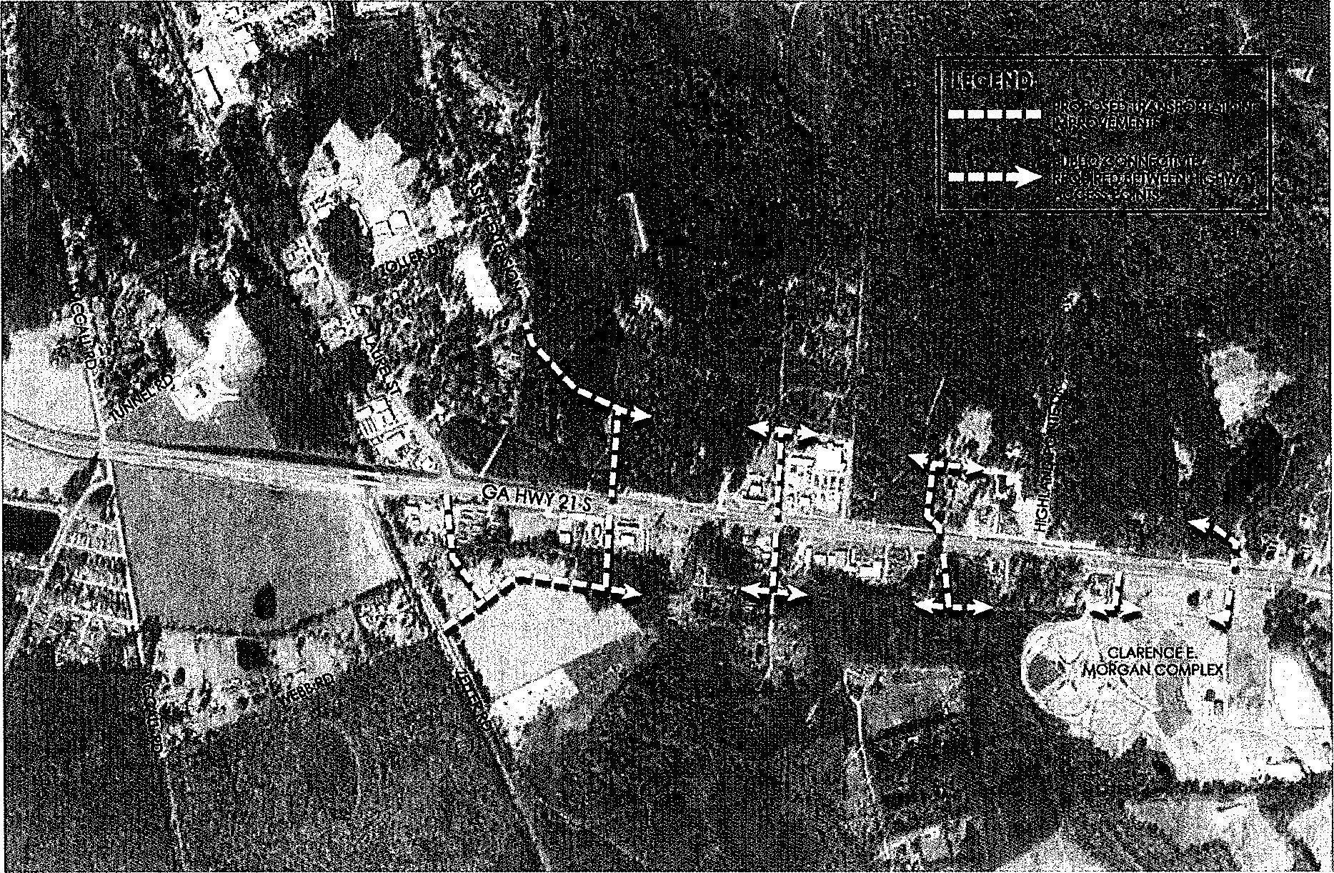
c.
Arterial Streets perpendicular to Hwy 21 shall have a right-of-way width of 60'. The street design and layout shall follow either Option 1 or Option 2 below. The Review Board will work with the developer to determine the appropriate street design. Street Design goals are:
i.
Limited on-street parking near Hwy 21 intersections
ii.
Hard surface multiuse path designated for pedestrians, bikes, and permitted motorized carts.
iii.
Utility extensions within the path of the right-of-way.
Option 1 - Street Design:
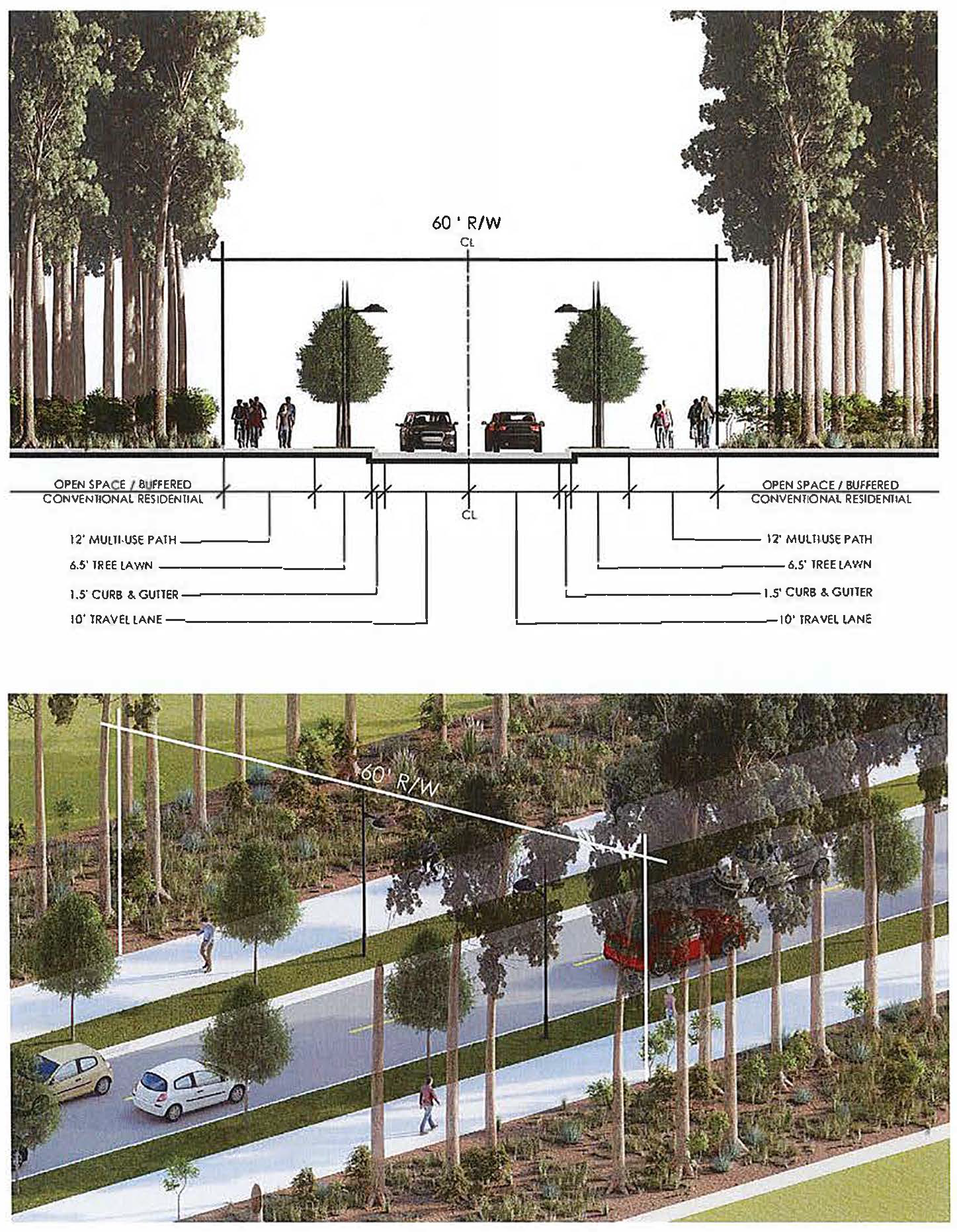
Option 2 - Street Design:
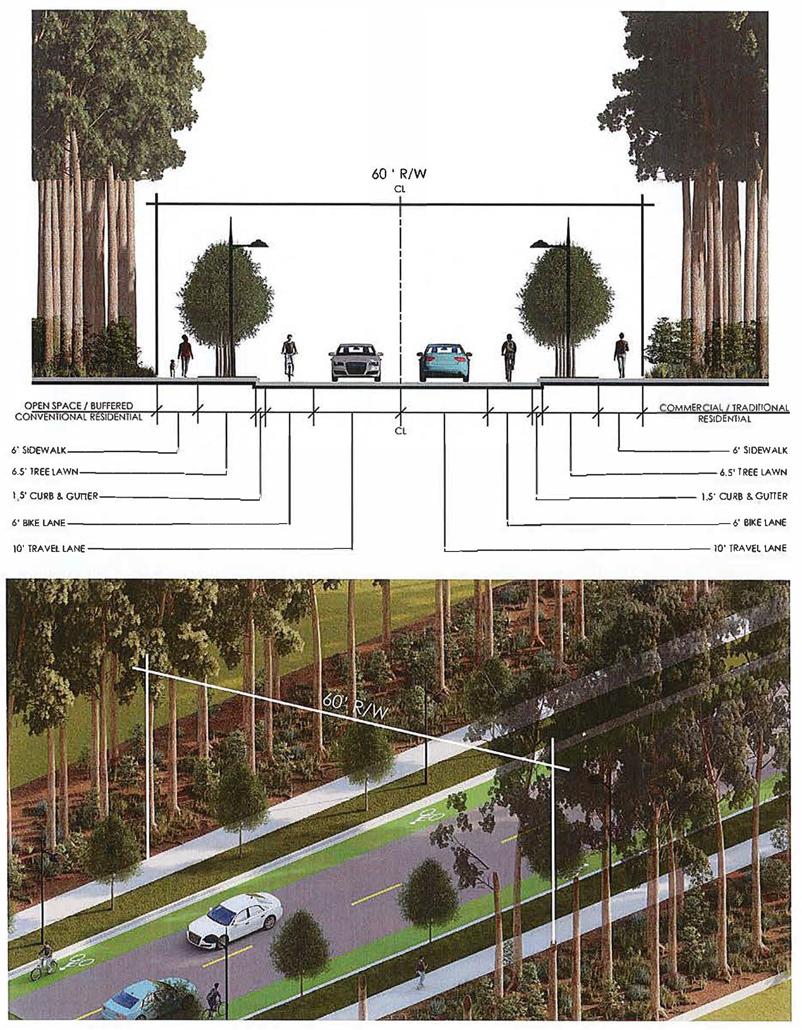
d.
Connector Streets typically running parallel to Hwy 21 and connecting Arterial Streets shall have a right-of-way width of 60' or 75'. The street design and layout shall follow either Option 3 or Option 4 below. The Review Board will work with the developer to determine the appropriate street design. Street Design goals are:
i.
Providing safe and connections among business developments.
ii.
Providing ease of pedestrian and alternative transportation methods to promote connection between uses.
iii.
Providing capacity for on-street parking .
Option 3 - Street Design:
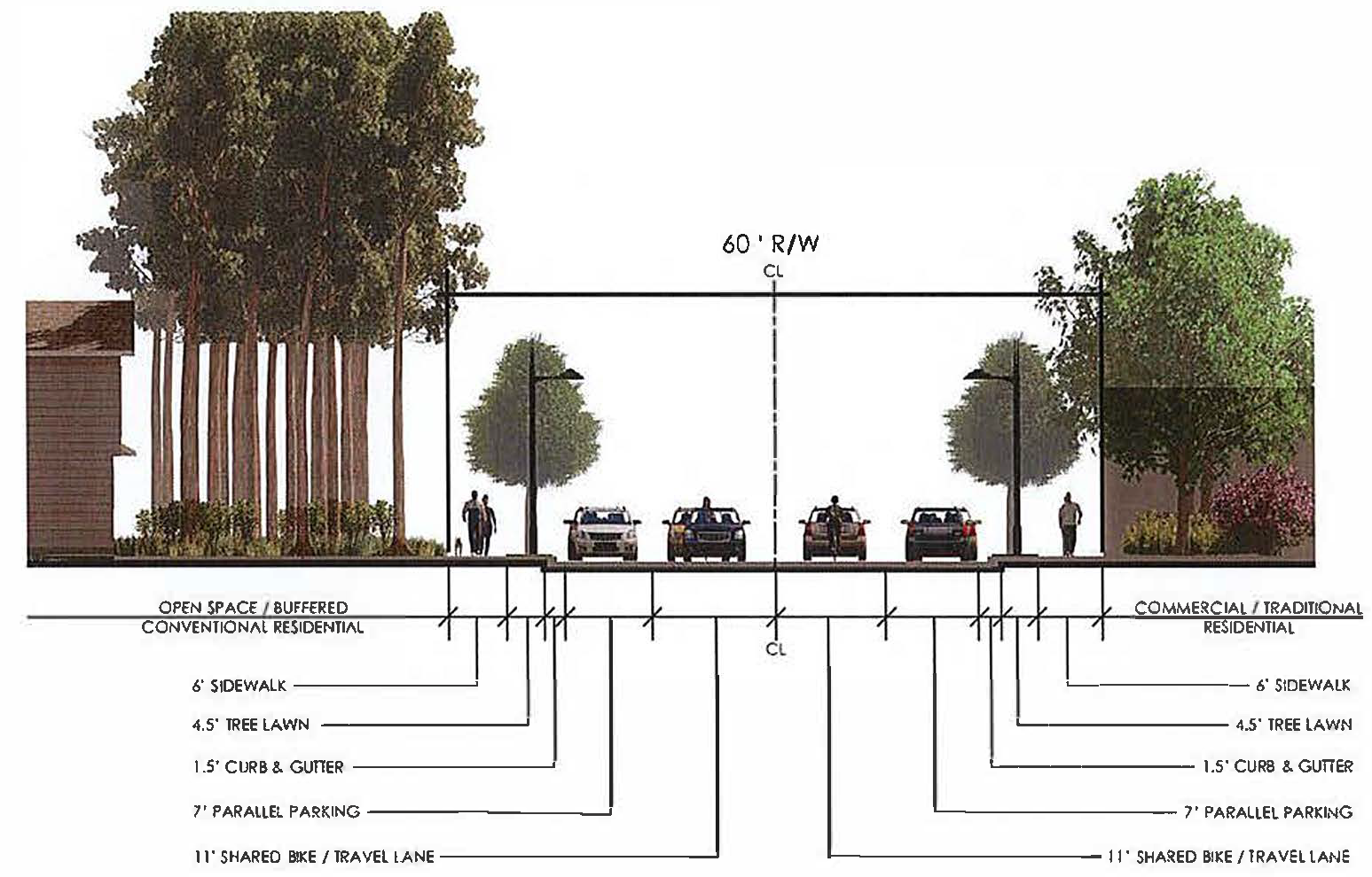
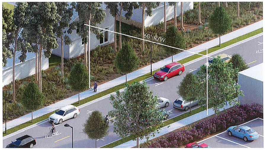
Option 4 - Street Design:
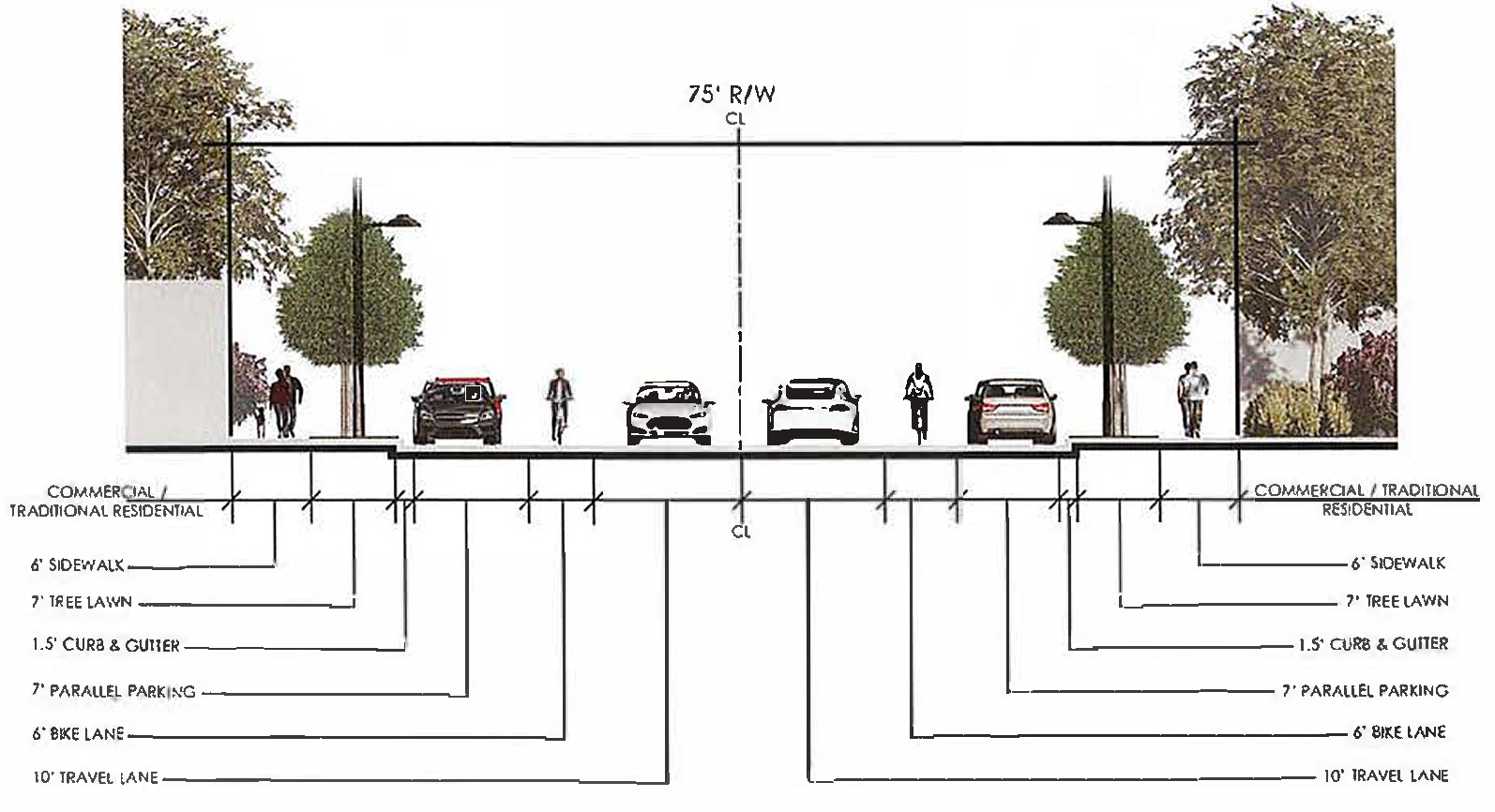
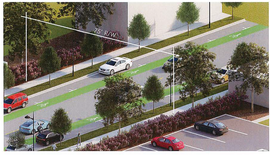
e.
For all new streets, street trees spaced 30' to 60' on center shall be provided. Species shall be a large or understory species. Spacing shall be 30' to 45' o.c. for understory and 50' to 60' o.c. where large species are used.
f.
Pedestrian scaled street lighting shall be provided to provide minimal foot candle levels needed based on the planned intensity of the uses adjacent to the street.
g.
Minimum spacing of driveways/vehicular access points shall be per the GDOT standards in Chapter 3 of the Regulations for Driveway and Encroachment Control Manual.
h.
Minimum throat depth from right-of-way to first internal access point to allow for traffic stacking shall be per the GDOT standards for placement of interior driveways in the Regulations for Driveway and Encroachment Control Manual.
i.
Provide inter-parcel access points suitable for vehicular, bicycle and pedestrian travel between all contiguous commercial, office, industrial or residential uses. This requirement may be waived by the Review Board only if it is demonstrated that an inter-parcel connection is not feasible due to traffic safety, environmental or topographic issues.
i.
The point of access shall meet the minimum spacing and throat depth requirements above and shall be established on a first come basis. Subsequent adjacent parcel developments will be responsible for developing a site plan that utilizes the established connection point.
3.11.5.3. Detached/Attached Single Family Residential subdivisions shall comply with one of the following requirements:*
a.
Provide reverse-fronting lots (fronts face Highway 21 with rear loading) where residential subdivisions are adjacent to the Highway 21 right-of-way. Reverse-fronting residential lots shall be platted with a landscaped common use access easement for pedestrian flow but restricting vehicular access placed adjacent to the Highway 21 right-of-way. Such easement shall be a minimum of 20 feet in depth and shall include the following:
i.
A continuous four-foot-high solid or pierced masonry wall or a four-foot-high fence constructed with masonry pillars with minimum spacing of 30 feet on center;
ii.
Canopy trees spaced on average 50 feet on center; and
iii.
A minimum five-foot wide pedestrian walkway along the entire frontage providing access to and between all lots. Common areas with a five-foot wide pedestrian walkway providing access between lots shall be spaced no greater than every 500 feet.
b.
Provide a minimum 20-foot-wide Type A buffer and a residential street, with the residential lot facing the Highway right-of-way.
c.
Provide a minimum 30-foot-wide Type D buffer and a residential lot may have the rear yard facing towards the highway right-of-way.
d.
Required setbacks on residential lots shall not overlap with the required buffer.
3.11.5.4. Non-residential, mixed use and all other residential types other than detached/attached single family residential shall comply with the following requirements.
a.
Minimum of 20 percent of the site shall be open/landscaped area. The areas required in standards below may count towards achieving this standard.
b.
Sight lines shall be accommodated in all landscape designs.
c.
15' minimum landscape strip along Hwy 21 frontage.
i.
This landscape strip is intended to create a consistent landscape aesthetic and not to block visibility to the use. The following shall be the minimum provided within the landscape strip for every 100 feet of Hwy. 21 frontage:
1)
Five understory trees (may be grouped as long as there is no more than 50 feet between trees in any area).
2)
Fifteen shrubs or ornamental grasses. If ornamental grasses are used they must be of a species that will mature to a height of a minimum of 30 inches and a maximum of 6 feet.
3)
Minimum of 50 percent of the total area shall be landscaped with trees, shrubs and living ground cover. This results in a maximum of 50 percent turfgrass allowed.
d.
Five feet minimum landscape strip on each parcel for the side and rear lot lines for areas where a city-wide buffer would not apply. For areas where a city-wide buffer standard would apply, the required buffer shall be used.
i.
Fifteen shrubs or ornamental grasses. If ornamental grasses are used they must be of a species that will mature to a height of a minimum of 30 inches and a maximum of 6 feet.
ii.
Minimum of 75 percent of the total area shall be landscaped with trees, shrubs and living ground cover. This results in a maximum of 25 percent turfgrass allowed.
e.
Parking lot layout:
i.
For lots greater than 10 total spaces:
1)
No more than 10 spaces in a row without a tree island that is a minimum of 9 feet wide and as deep as the adjacent spaces.
2)
A minimum of one medium or large canopy tree species provided in each island unless there is a conflict with an overhead utility. In that case, an understory tree may be used.
3)
Site and parking lot lights cannot be in the tree islands.
ii.
For lots fronting on Highway 21, no more than one bay of parking in the front of the building - Minimum facade build to line of 90 feet. (60 foot depth allows for 18 feet parking stall, 24 drive aisles, 18 feet parking stall).
iii.
Standards may be waived by the Review Board if other innovative approaches are taken to minimize the impact of the parking field.
3.11.6 Landscape Design Standards.
a.
Non-residential, mixed use and all other residential types other than detached/attached single family residential.
1.
Minimum of 50 percent of the required 20 percent open/landscape area shall be planted in trees, shrubs and groundcovers/ornamentals. No more that 50 percent of the landscape shall be in turfgrass whether seeded, sprigged or sodded.
2.
Minimum of 10 large canopy trees per acre shall be provided. This may be accomplished through preservation, planting or a combination of the two.
3.
Provide the landscape strip standards in this section and buffers, if required, from other ordinance requirements.
4.
Clear sight lines at driveways and pedestrian crossings shall be provided.
3.11.7 Screening Requirements and Design Standards.
a.
Outdoor storage areas and loading facilities shall be screened from view from adjacent public rights-of-way and residential uses and shall be at least 50 feet from any residential zoning district or use. Screening must be 12 inches higher than storage material and made of decorative masonry walls, decorative wooden fencing, and/or vegetative screening from five to eight feet in height. Solid wood fences shall follow the requirements of the buffer ordinance.
b.
Garbage/Refuse areas and receptacles shall be placed in an accessible location as far as practical from any public streets and shall be enclosed on three sides with decorative masonry walls of a similar material to match the architecture. The fourth side shall be a self-closing opaque gate made from non-combustible materials. The walls and gate shall be a minimum of 12 inches higher than the receptacle.
c.
HVAC units shall be screened from view from public streets. This may be accomplished by locating them behind the buildings, behind walls/fences or through adequate landscape plantings.
d.
Loading and dumping activities within 150 feet of a residential district or use are permitted between the hours of 7:00 a.m. and 10:00 p.m.
e.
Vegetative screening, shall include 100 percent coverage of planting area, including a minimum of 75 percent evergreen plant materials, have a height of not less than one foot above the height necessary to fully screen (whichever is greater) in two years and shall be a minimum of four feet in height at time of planting.
3.11.8 Lighting Design Standards.
a.
Streetlights shall be provided and shall utilize decorative fixtures and poles. Streetlights shall be provided along all internal streets and along all public rights-of-way. Streetlights shall be provided along both sides of the internal streets and shall be spaced appropriately for the needs of pedestrians and vehicular use.
b.
Light housings and posts shall be dark color/material and be non-reflective, and consistent with the design and architectural character of the buildings.
c.
Fixtures shall meet IESNA standards for full cut-off type and designed to accommodate a house-side shield when adjacent to residential uses.
d.
Lighting shall not directly illuminate adjacent residential properties.
e.
Canopy lighting fixtures shall be completely recessed into the canopy and shall be shielded such that the lamp source is not visible. No lighting shall be permissible on top or on the side of the canopy.
f.
Parking lot light posts shall not exceed a height of 25 feet from finished grade.
g.
Street/Pedestrian light posts shall not exceed a height of 18 feet from finished grade and shall be a uniform decorative post and cap to be accepted by the City.
3.11.9
Signage design standards. All signage within the overlay district shall abide by the adopted sign ordinance in effect at the time of submission to the review board for review.
a.
If no additional allowances are stated in the following standards, signs shall be allowed as specified by the sign ordinance for the base zoning district in which the property is located.
b.
Signs allowances for non-residential, mixed use and all other residential types other than detached/attached single family residential:
i.
Free standing signs.
1)
Free standing signs may be up to 35 feet tall within the overlay district.
2)
Sign area shall be no more than 150 square feet in total and less than ten feet in width.
ii.
Monument signs.
1)
Single tenant sites may have one double faced monument sign permitted per road frontage. Such signs shall not exceed ten feet in height and cannot exceed 150 square feet of signage per face. Monument width shall be as limited by the sign ordinance. Two or more businesses that share a single tenant space shall meet the requirements for single tenant sites.
2)
Multi-tenant developments may have one double faced monument sign for the overall development per road frontage. Such signs shall not exceed 25 feet in height and shall not exceed 250 square feet of signage per face. Monument sign structures must be constructed of brick, stone, masonry or equal architectural material and reflect the architecture of the development. No exposed concrete block.
3)
There shall be a minimum 50-foot separation between monument signs on any street frontage.
4)
Exceptions: Gas stations may have an additional 24 square feet per street frontage to advertise gasoline prices.
iii.
Wall signs.
1)
Each place of business is allowed a maximum of two wall signs.
2)
Wall signs shall be placed only on exterior building walls facing public street(s)
3)
Four square feet per linear foot of the wall, up to a maximum of 150 square feet for buildings three stories or less and up to a maximum of 300 square feet for buildings between four and seven stories is permissible.
iv.
Window and door signs.
1)
Permanent and/or temporary signs shall not exceed ten percent of the aggregate window area. Signs may be placed in one window panel or distributed in more than one panel. Signs shall not be placed on doors.
2)
Proprietors' name, business name, address, phone numbers, hours of operation, and information required to be posted by local, state, or federal governments are exempt from the ten percent limit.
3)
Lettering shall not exceed three inches in height. Address numbers must be between four and six inches in height, and visible from the street.
i.
Temporary signs and banners may not exceed 60 square feet.
3.11.10 Architectural Design Standards.
a.
Non-residential, mixed use and all other residential types other than detached/attached single family residential.
i.
Developments shall divide large building masses into heights and sizes that relate to human scale by incorporating actual or perceived changes in building mass/footprint, parapet height, recessed/projected entrances, changes in material, changes in color or other design elements used to divide elevations visually. These design elements are divided into two major categories:
1)
Major Articulations: Generally refers to the breaking up of larger elevations into smaller masses.
2)
Minor Articulations: Generally refers to the way each of those masses is given a variety of detail.
ii.
Each new building with elevations over 50 lineal feet corner to corner shall be broken into smaller Major Articulations intended to convey the impression of separate buildings. Facades (over 100 feet) should be broken into at least thirds vertically with a maximum spacing between breaks in materials or massing occurring no less than every 50 feet horizontally or at each change in occupant (diagram A). Each unit within a single building containing multiple units (strip malls) should treat every business' facade (more than 50 feet from the adjacent business measured entry to entry) with a change in material, color and/or massing (diagram B). This variation can be achieved using color changes, material changes, slight projections in material, offsetting of the building envelope or changes in parapet height (diagram C). In general, any change in material or color should also include a change in the profile of the material or outlined with trim. Changes in material and color should not butt one another within the same vertical plane. Changes in perceived massing can be achieved through slight projections of veneers (three to four inches) or changes in parapet heights and are not required to include actual offsets in the footprint.
Diagram A: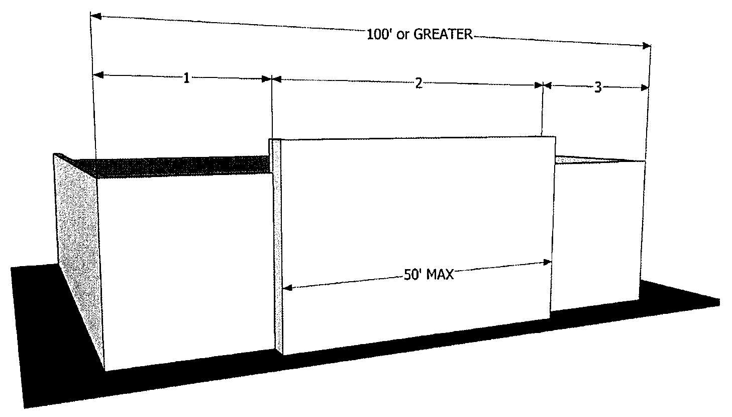
Diagram B:
Diagram C:
iii.
Major Articulations shall occur at least every 50 feet of horizontal facade length or at changes between tenants, whichever is less as stated above. Minor articulations shall occur approximately every 30 feet of horizontal facade length and may be accomplished through the use of pilasters; the use of smaller offsets; or similar means intended to create the appearance of structural bays. Minor Articulations may include variation in shading devices, fenestration, canopies, control joints and/or material trim used to deconstruct the geometry and add variety to a design (diagram D).
Diagram D:
iv.
Building exteriors shall all have consistent architectural features, building materials, and rooflines. Elevations of all four sides of the building shall be part of the building permit application. Metal wall panels used as veneer on pre-engineered metal buildings should be limited to no more than 40 percent of any given facade on the front and both side elevations. The same material and color mix approved for the front elevation should be carried around both sides (diagram E). Requirements for both Major and Minor Articulations above will apply to the front elevation as well as to both side elevations.
Diagram E:
v.
Buildings at the corner of two public streets shall create corner focal points which anchor the corner. Focal points may include a chamfered corner, display windows, corner entrances, features such as fountains, or an outdoor gathering area with landscaping and furniture. Varying the height, adding canopies, additional glazing, projecting materials, changes in materials, etc. are additional ways to create a focal point and anchor the corner (diagram E).
vi.
Primary entrance, and individual tenant space entries, shall be designed to express greater architectural detail through the use of awnings, recessed/projected entries, changes in material, variations of the material patterning, or other similar techniques intended to create a focal point at the entry (diagram F).
Diagram F: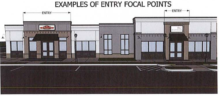
vii.
Colors. Earth tones (greens, tans, light browns, terracotta, etc.), grays, pale primary and secondary colors (less than 50 percent color value), white cream tones, and the like. Dramatic accents and/ or primary colors, may only be used for small areas such as trim, logos, or to distinguish an architectural feature. In no instance, shall the combination of dramatic accent color or primary colors compose more than ten percent of any building facade. It is highly recommended that material selections and/or colors are layered horizontally and detailed to present the appearance of a base, body and crown. Simple metal coping topping a parapet is not considered a design element and will not be considered a crown (diagram G).
Diagram G: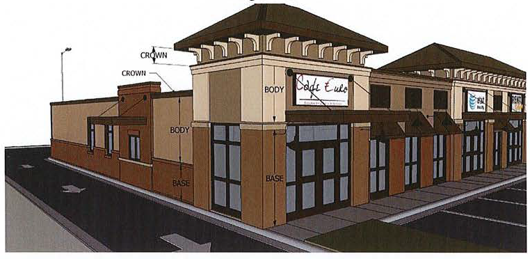
viii.
Corporate or logo architecture. Prototypical buildings that are designed for repetition to project a company or chain image may be rejected altogether. However, these designs may be acceptable if they conform to the above categories or adapt their features to fit the above categories.
ix.
Exterior materials and features prohibited.
1)
Plywood, cinderblock, unfinished poured concrete (architectural poured in place concrete or concrete veneer panels will be considered), un-faced concrete block, plastic and/or metal not closely resembling a natural material (smooth, pre-finished architectural metal panels, cement fiber panels and stucco panels will all be considered). No ribbed, standard metal wall panels will be accepted.
2)
No mansard roofs (other than as limited to focusing attention on primary entries or corners), low slope roofs without a parapet or unarticulated roofs having a length exceeding 50 feet without a change in parapet height.
3)
Incongruous architectural details or contrasting color combinations.
4)
Unscreened chain link or woven metal fences.
5)
Reflective materials as the main building feature, to include highly reflective glass.
x.
The architectural review is to include both a preliminary and final submittal with the preliminary review occurring during the schematic design phase. The preliminary review should consist of (at a minimum) an Architectural Site Plan, Preliminary Floor Plans, four (or more) Exterior Elevations, Roof Plan and one Colored Rendering. The final submittal should consist of the complete set of construction documents and written specifications along with written responses to comments made during the preliminary submittal review process.
(Ord. No. 2022-01, § 1, 1-11-2022; Ord. No. 2023-26, § 2 Att. B, 12-12-2023)