
Springfield Charter Township
City Zoning Code
City Zoning Code
ARTICLE IV
SPECIAL DEVELOPMENT STANDARDS
Sec. 40-593.- Condominium project regulations.
Condominium projects shall be subject to the following regulations:
(1)
Intent. It is the intent of this section to regulate condominium projects in accordance with this chapter and any other applicable township standards and regulations.
(2)
General requirements.
a.
Any condominium project shall comply with the use, density, setback and other applicable regulations of this chapter.
b.
In a site condominium project, each condominium lot shall be considered equivalent to a single lot as defined by this chapter and shall meet all minimum requirements for area, width, and depth-to-width ratios.
c.
Each condominium lot shall front on and have direct access to a public road or a private street approved by the township board. Approval for a private street may be conferred by the township board during site plan approval.
(3)
Approval of the condominium plan and condominium documents.
a.
Approval of the site plan and proposed condominium documents by the planning commission and township board in accordance with the provisions of this chapter shall be required prior to recording of the master deed for the project, as a condition to the right to construct, expand or convert a condominium project.
b.
The applicant shall submit a site plan pursuant to the standards and provisions set forth in sections 40-136 or 40-594 (if applicable).
c.
Prior to township board review and approval, the applicant shall submit the proposed condominium documents. The proposed condominium documents shall be reviewed by the township attorney and other appropriate staff and consultants prior to action by the township board.
(4)
Revision of condominium plan. If the condominium plan is revised prior to the request for final approval, the site plan shall be revised accordingly and submitted for review and approval or denial by the township board before any building permit may be issued, where such permit is required. The township may, in its discretion, allow minor changes to the site plan without the necessity for full review pursuant to this section.
(5)
Monuments. Monuments shall be established in the following manner:
a.
Monuments shall be located in the ground and made according to the requirements set forth in this subsection, but it is not intended or required that monuments are placed within the traveled portion of a street to mark angles in the boundary of the site condominium if the angle points can be readily reestablished by reference to monuments along the sidelines of the streets.
b.
All monuments used shall be made of solid iron or steel bars at least one-half inch in diameter and 36 inches long and completely encased in concrete at least four inches in diameter.
c.
Monuments shall be located in the ground at all angles in the boundaries of the site condominium; at the intersection lines of streets and at the intersection of the lines with the boundaries of the site condominium and at the intersection of alleys with the boundaries of the site condominium; at all points of curvature, points of tangency, points of compound curvature, points of reverse curvature and angle points in the side lines of streets and alleys; and at all angles of an intermediate traverse line.
d.
If the required location of a monument is in an inaccessible place, or where the locating of a monument would be clearly impracticable, it is sufficient to place a reference monument nearby and the precise location thereof is clearly indicated on the plan and referenced to the true point.
e.
All required monuments shall be placed flush with the ground where practicable.
f.
All lot corners shall be monumented in the field by iron or steel bars or iron pipes at least 18 inches long and one-half inch in diameter, or other approved markers.
(6)
Requirement for certificates of occupancy.
a.
Following construction of the condominium development, and prior to the issuance of any certificates of occupancy, the applicant shall secure final approval from the township building official.
b.
In connection with an application to receive any certificate of occupancy, the applicant shall submit:
1.
A copy of the recorded master deed (including exhibits).
2.
A copy of any recorded restrictive covenants.
3.
Two copies of an as-built survey.
4.
A copy of the site plan of photographic hard copy, laminated photostatic copy or Mylar sheet of at least 13 inches by 16 inches with an image not to exceed 10½ inches by 14 inches at a scale of at least one inch equals 100 feet.
5.
Appropriate approval from the state and/or county for any improvements for which such approvals are required.
6.
Fees as established by resolution of the township board.
7.
Certification that monuments have been installed or that a cash escrow, in an amount as determined by the township, has been deposited with the township to ensure installation.
c.
The township building official, township attorney, township engineer, and other appropriate staff and consultants shall review the condominium documentation to ensure that the documentation meets the requirements of this chapter, as well as any other applicable laws or regulations, and that the documentation contains satisfactory provisions dealing with:
1.
Repair, replacement, and maintenance of facilities that service the condominium development, including, but not limited to, roads, stormwater maintenance facilities, sanitary sewer facilities, and water facilities;
2.
Access to the condominium project for governmental purposes; and
3.
Any other provisions reasonably determined to be necessary.
Review of this documentation shall include any easements or similar documents for property outside the condominium project which services the project.
d.
The township building official, township attorney, township engineer, and other appropriate staff and consultants shall review the information submitted to ensure that the condominium development has been constructed in accordance with the approved site plan, approved condominium documents, the provisions of this section, and applicable provisions of this chapter, applicable township ordinances, and engineering standards, and any other applicable laws or regulations. All condominium projects shall also comply fully with all applicable state and federal statutes.
e.
In the event required monuments, stormwater drainage facilities, sewage disposal facilities, water supply facilities, or any other required improvements are not completed prior to occupancy of any condominium unit, the township supervisor may require a performance guarantee be provided by the applicant in accordance with section 40-35 to ensure the installation and/or completion of such improvements without cost to the township.
f.
If certificates of occupancy are required for only a portion of the land included within the approved site plan, all improvements necessary to service the portion for which approval is requested must be initiated or completed, or the appropriate performance guarantee provided by the applicant in accordance with section 40-35 to ensure the installation and/or completion of such improvements without cost to the township. This subsection shall apply even if the improvements to be constructed are located outside the portion for which final approval is requested.
(7)
Amendment to condominium documents. Any amendment to a master deed or bylaws that affects the approved site plan, or any conditions of approval of a site plan, shall be reviewed and approved by the township board, before any building permit may be issued which could be affected by such amendment, where such permit is required. In such event, the township board may require the applicant to submit information reasonably required to allow the township board to make a decision. The township board may require its review and approval of an amended site plan if, in its opinion, such changes in the master deed or bylaws require corresponding changes in the site plan.
(8)
Conversion condominiums.
a.
The applicant shall submit a conversion condominium plan to the township in accordance with this section and section 40-136 (site plan review). A plan submitted for a conversion project shall include all existing conditions and clearly identify all proposed site and/or building changes.
b.
If the township determines the site and/or building changes on the property are not significant, then conversion condominium plan approval may be granted administratively, following a review and recommendation from the township planning consultant and township engineering consultant. The township may waive any of the requirements of section 40-136(3) or (4) administrative approval process. Modifications to parking to bring it into compliance with section 40-681, and landscaping and/or screening upgrades that are necessary to bring the site into compliance with the standards of section 40-721 are examples of changes that are not significant. If the township determines the site changes are significant, the condominium conversion plan shall be reviewed in the same manner as a new development on the site. Significant changes may include, but are not limited to:
1.
An increase in the number of units, either as a result of interior subdividing or new construction;
2.
Provision of additional site features or amenities, such as garages, community or recreation buildings, and the like;
3.
Any site work that would impair a state or township-regulated wetland;
4.
A reduction in available off-street parking to less than the minimum required by this chapter; or
5.
If a rezoning is requested or required.
c.
Following the administrative approval of the conversion condominium plan, exhibit B drawings and master deed and bylaws shall be submitted for review by the township attorney, township planning consultant, township engineer, and other appropriate staff and consultants, to ensure that the documentation meets the requirements of this section, as well as any other applicable laws or regulations, and that the documentation contains satisfactory provisions dealing with the following:
1.
Repair, replacement and maintenance of facilities that service the condominium development, including, but not limited to, roads, stormwater facilities, sanitary sewer facilities, and water facilities;
2.
Access to the condominium project for governmental purposes; and
3.
Any other provisions reasonably determined to be necessary.
Review of this documentation shall include any easements or similar documents for property outside the condominium project that services the project.
d.
If the exhibit B and master deed and bylaws are complete, the township attorney, township planning consultant and township engineering consultant shall recommend approval, approval with conditions, or disapproval to the township.
e.
The township shall have the authority to approve the exhibit B and master deed and bylaws. The exhibit B drawings shall be substantially identical to the approved conversion condominium plan. If the township approves the exhibit B and master deed and bylaws, he shall direct the township attorney to record the approved documents with the county register of deeds.
f.
Once the exhibit B and master deed and bylaws have been recorded, the applicant may sell units within the condominium.
(Ord. No. 26, § 18.10, 9-13-1990; Ord. of 12-11-2008(2), § 1(13); Ord. No. 2013(3), § 2, 3-14-2013)
State Law reference— Condominium act, MCL 559.101 et seq.
Sec. 40-594. - Cluster housing regulations.
(a)
Intent. The intent of the cluster housing option is to permit the development of single-family and two-family residential patterns which, through design innovation, will:
(1)
Allow greater flexibility;
(2)
Encourage a more creative approach to the development of single-family residential areas;
(3)
Encourage a more efficient aesthetic and desirable use of the land;
(4)
Provide a more desirable living environment through the preservation and conservation of natural features such as topography, wetlands, woodlands, bodies of water, and other natural assets;
(5)
Encourage the provision of open space so that benefits may accrue directly to the residents of the development;
(6)
Provide for optimum setbacks from major thoroughfares and/or freeways;
(7)
Provide for the sound physical development and handling of site situations where a conventional subdivision approach would be unnecessarily restrictive.
(b)
Applicability. The cluster housing option may be applied for in the R-1A, R-1, R-2 and R-3 single-family residential districts and in the RM and RM-1 multiple residential districts, in the RM and RM-1 districts, cluster housing developments shall comply with restrictions applied in the R-3 district. The following additional standards shall determine whether the cluster housing option is treated as a permitted or special land use:
(1)
As a permitted principal use. The cluster housing option shall be a principal use permitted of right in the zoning districts described in this subsection where a minimum of 50 percent of the net site area is permanently preserved in an undeveloped state, subject to all applicable standards set forth herein. Application for cluster housing as a principal use permitted of right shall be at the option of the applicant. This option shall be known as the open space preservation provision of this chapter.
(2)
As a special land use. The cluster housing option shall be a special land use in all other circumstances where it is not a permitted use, subject to all applicable standards set forth herein.
(c)
Criteria. In the review of any proposed special land use development under this section, the township shall make a finding that the intent of the cluster housing option, as set forth in subsection (a) of this section and one or more of the standards set forth below are met:
(1)
The parcel contains natural assets which would be preserved through the use of cluster development. Such assets may include natural stands of large trees; land which serves as a natural habitat for wildlife; wetlands; bodies of water (e.g., streams, rivers, and lakes); unusual topographic features; or other natural assets which should be preserved.
(2)
The parcel contains major topographic conditions which make development under the normal subdivision approach impractical. In considering qualification under this subsection, the township shall determine that the following conditions exist:
a.
The natural land forms are so arranged that the change of elevation within the site includes slopes in excess of 15 percent between these elevations. These elevation changes and slopes shall appear as the predominant feature of the site rather than the exception or infrequent feature of the site.
b.
Mass grading of the site would be necessary in order to achieve the maximum road grade permitted by the county road commission and the use of cluster housing development will allow for a greater preservation of a desirable natural setting.
(3)
The parcel contains substantial portions of floodplain and wetlands, as verified by a floodplain and wetlands map, issued by the appropriate federal, state, county or township agency, or prepared by a qualified wetlands consultant.
(4)
Due to the size and shape of the parcel, utilization of the cluster lot option would result in the more creative and efficient use of the property and would not create a negative impact upon surrounding properties.
(d)
Procedures for review and approval, principal use permitted of right. The procedures set forth in subsection (e) of this section shall be followed in the review and approval of applications of the cluster housing option permitted of right, with the following changes.
(1)
The project narrative and site analysis required by subsection (e)(1)a.1 of this section shall not be required.
(2)
The planning commission and township board review of the concept plan shall be limited to a determination of the achievable density on the property.
(3)
The application shall be subject to all other applicable ordinances, laws, and rules, including specifically section 40-136 and the applicable provisions of subsections (e), (f) and (h) of this section.
(e)
Procedures for review and approval. A two part process will be followed in the review and approval of applications for the cluster housing option, described as follows:
(1)
Concept plan review. The application for a cluster housing option shall require the review of concept plans and relevant supportive material by the planning commission and township board. The following procedures shall be followed:
a.
The applicant shall file a request for a concept review by the planning commission by filing with the clerk an application, the applicable fee, and 12 copies of the following information:
1.
Project narrative and site analysis: A summary explanation and graphic illustration of the development concept and the manner in which the criteria in subsection (c) of this section are met.
2.
Density concept plan. A plan which illustrates achievable development of the property without application of the cluster option and with all applicable ordinances and laws observed. The density concept plan shall not rely upon community septic and sewer systems, as defined by this chapter, to justify achievable density.
3.
Cluster concept plan. A plan which illustrates development of the property with application of the cluster option.
b.
Both the density and cluster concept plans shall contain the following information:
1.
Evidence of ownership; location and description of site; dimensions and areas.
2.
General topography, soils information, woodlands, wetlands, floodplains and surface water.
3.
Scale, north arrow, date of the plan.
4.
Existing zoning of site; existing land use and zoning of adjacent parcels; location of existing buildings, drives and streets on the site and within 100 feet of the site.
5.
Lot and street layout.
6.
Location, size, and uses of open space.
7.
General description of proposed water, sewage disposal, and storm drainage systems.
c.
Upon receipt of an application for concept review, the clerk shall transmit the application and related material to the planning commission, township planner, and township engineer. Concept review shall be scheduled at the first available planning commission meeting.
d.
The planning commission shall review concept plans and relevant supportive material and shall be entitled to make reasonable inquiries of and receive answers from the applicant. The planning commission shall provide the township board with a specific recommendation in regards to the density concept plan and cluster concept plan. The official minutes shall reflect the recommendations of the planning commission.
e.
Following completion of concept review by the planning commission, the application and related material shall be transmitted to the township board for action.
f.
Specific details of the site plan prepared in accordance with section 40-136 shall serve as the basis for determining that all township standards have been met.
(2)
Final review. Within 12 months following the review and approval of the concept plan, by the township board, the applicant shall submit a final plan in accordance with the procedures set forth in section 40-145 and conforming to this section. If a final plan is not submitted by the applicant for approval within 12 months following receipt of township board approval of the concept plan, the concept review becomes null and void.
(f)
Site design requirements. All cluster developments submitted under this option shall conform to the following site design requirements:
(1)
Type of dwelling unit permitted. Development is restricted to single-family and two-family dwelling units.
(2)
Density. Whether a permitted use or special land use, the number of dwelling units permitted under the cluster housing option shall not exceed the number of dwelling units if the site were developed with a conventional layout and all applicable ordinances and laws observed, as demonstrated by the density concept site plan submittal in accordance with subsection (e)(1) of this section.
(3)
Open space. Cluster housing treated as a permitted land use shall have a minimum of 50 percent of the net site area devoted to open space, provided such open space is left in an undeveloped state, as defined by this chapter.
a.
Cluster housing treated as a special land use shall have significant areas devoted to open space for the use and enjoyment of residents of the development and the preservation of natural features. Designated open space shall remain either in an undeveloped state and/or used for specifically designated recreational purposes.
b.
In all cases, designated open space shall be subject to the following standards:
1.
Designated open space shall include the areas within any greenbelts required by subsection (f)(6) and (7) of this section.
2.
Designated open space shall not include: rights-of-way or easements designated for road purposes; areas within lots; or, land which is under water (lakes, streams, watercourses, and other similar bodies of water).
3.
Designated open space shall be designed to avoid fragmentation of the natural resources and to include significant native plant communities and habitats located on the site.
(4)
Setbacks. Minimum setback requirements shall be established in a manner which permits variation in the siting of individual dwelling units in order to encourage creativity in design and compatibility with natural resource features. The following minimum setback requirements for each dwelling unit shall be applied:
MINIMUM SETBACKS AND LOT WIDTH PER DWELLING UNIT (IN FEET)
IN SUBDIVISIONS AND SITE CONDOMINIUMS
MINIMUM SETBACKS AND DISTANCES BETWEEN DWELLING UNITS (IN FEET)
IN REGULAR CONDOMINIUMS
(5)
Required road frontage. All lots shall have frontage on a public road which has been accepted for maintenance by the county road commission, or a road which is part of a condominium development where design, construction, and perpetual maintenance of the road have been approved by the township. The extent of road frontage shall be determined by the township, in its discretion, taking into consideration: the extent and importance of natural resources, topographical conditions, floodplains, and wetlands to be preserved on the property, the size and shape of the development site; public safety, aesthetics; and, impact upon the surrounding developments.
(6)
Greenbelt adjacent and parallel to county certified primary and local roads. It is the intent of the township that cluster lot developments shall not appear to be more intense than conventional developments as viewed from off site. In addition to any required minimum setback specified in subsection (f)(4) of this section, a greenbelt having the minimum width of a 100 feet shall be required along any adjacent county certified primary or local road. The greenbelt shall be measured from the future right-of-way line in accordance with the county right-of-way plan. The township at its discretion, may permit either reductions or variations in width of the greenbelt taking into consideration topographic and/or other natural resource conditions, density of existing vegetation to be preserved, and size and shape of the development site.
(7)
Transition from adjacent parcels. In order to provide an orderly transition of density when a cluster development abuts a single-family residential district of equal or lower density, the township, at its discretion, shall require designation of open space along the common boundaries; screening in accordance with the requirements of section 40-721; and/or an area or row of lots of commensurate size as neighboring residential lots.
(g)
Grant of approval. Upon the grant of special land use approval under this section, the township shall stipulate the general development concept and all discretionary decisions made under this section as part of the approval process, and all conditions imposed as part of the approval.
(h)
Preservation and maintenance. The effectiveness of any approval of a cluster lot development under this section shall be conditioned upon recording of appropriate conservation easements or other instruments for the purpose of providing for long-term maintenance and preservation of common areas, open space areas, wooded areas and/or other areas with natural resources or features to be preserved on the property. Such easement and/or other instrumentation shall be in a form and contain the content approved by the township attorney.
(Ord. No. 26, § 18.11, 9-13-1990)
State Law reference— Cluster zoning, MCL 125.3503; open space preservation, MCL 125.3506.
Sec. 40-595. - Lake access regulations.
The township is a rapidly developing urbanized township with many lakes of varying sizes and characteristics. The township is concerned about lake ecology and the safe use of lakes within the community and seeks to promote their safe use and preserve them as community assets. In some cases the character and intensity of lake use can create conditions amounting to a nuisance, impair important and irreplaceable natural resources, destroy property values, and threaten the health, safety and welfare of the public. It is the intent of this section to establish a framework for study of specific township lakes on an "as needed" basis. The study will have the purpose of determining whether it is appropriate to permit keyhole access to a lake and if so the minimum regulation necessary to eliminate the conditions which are a nuisance, impair important and irreplaceable natural resources, destroy property values, and threaten the health, safety and welfare of the public. Lake access shall be permitted as a special land use subject to the following:
(1)
Special land use approval required. For purposes of this section, the term "lake access" means use of a lake for any purpose. Except as provided in subsection (2) of this section, special land use approval is required to use property to provide lake access:
a.
Regardless of the means, to persons who do not reside on the property over which lake access is provided;
b.
To benefited property which does not have lake frontage;
c.
By license or some other mechanism, to individuals who, as of the effective date of the ordinance from which this section is derived, cannot trace title to a common grantor, within the last conveyance, whose property had direct lake frontage; or
d.
To proposed lots, units, or parcels in a subdivision development, condominium development, or development created by division of an acreage parcel, where such proposed lot, unit, or parcel does not itself have lake access.
(2)
Special land use approval not required. Special land use approval is not required to provide lake access:
a.
Over or through property which possesses lake frontage at the time of passage of the ordinance from which this section is derived, for the benefit of property which also possesses lake frontage; or
b.
For the sole purpose of swimming, or launching nonmotorized watercraft that is capable of being hand carried.
(3)
Other exceptions. The private use of property with direct lake access by the owner, the owner's family, and the owner's guests on an occasional, informal and casual basis is not intended to be subject to the requirements of special land use approval.
(4)
Lake study plans. A detailed graphical lake study plan shall be submitted with the application for special land use. This study is meant to constitute a complete lake boat carrying and capacity study and water quality study. The plan shall be prepared under the direction of a registered engineer or other licensed professional such as a limnologist, having recognized expertise in this area.
a.
Drawn to scale of one inch equal 50 feet.
b.
Sheet size shall be 24 inches by 36 inches.
c.
General descriptive and identification data shall include:
1.
Petitioner's name, address, telephone number.
2.
Preparer's name, address, telephone number.
3.
Title block.
4.
Scale.
5.
North point.
6.
Date of submission and revisions.
d.
Show gross size of lake in acres or fractions of acres.
e.
Show band 100 feet from shore into lake, determined by lineal foot along the shore.
f.
Show lineal feet of navigable tributaries (including canals).
g.
Show length of shoreline in feet.
h.
Show location of existing drainage courses, canals, floodplains, wetlands, rivers and streams within one-half mile which affects the lake.
i.
Include a depth chart, showing contours of the lake at its bottom.
j.
Include a lake bottom soils survey.
k.
Show existing and proposed lake access easements.
l.
Show location and size of vacant property possessing riparian rights to access to the lake.
m.
Show all points of general or limited public access.
n.
Show actual use of properties with direct lake access.
o.
Show actual use of properties with current keyhole lake access.
p.
Show zoning and master plan for properties with direct lake access.
q.
Show zoning and master plan for properties with current keyhole lake access.
r.
For all properties with keyhole lake access, attach copies of declaration of covenants and restrictions, master deeds or similar recorded instruments providing authority for such access.
s.
Include a use study showing the following:
1.
Number of watercraft docked or stored for lake use. Distinguish by type:
(i)
Sail craft;
(ii)
Human powered;
(iii)
Powered by motors under ten horsepower;
(iv)
Powered by motors between ten horsepower and 25 horsepower; and
(v)
Powered by motors over 25 horsepower.
2.
Number of watercraft using the lake during the months of May through September.
3.
Number of reported watercraft accidents, citations, warnings or incidents. The breakdown of those involved in lake accidents as follows:
(i)
Relationship to lake.
A.
Stranger.
B.
Direct lake access owner.
C.
Keyhole lake access owner.
D.
Other.
(ii)
Fault.
(iii)
Injury.
(iv)
Property damage.
(v)
Nuisance behavior.
(vi)
Other basis for reported incidents.
4.
Lineal feet of shoreline developed for beach purposes.
5.
Usage of the lake for winter recreational purposes, indicating the type of activity, time period for such activity and an approximate number of individuals involved with each such activity. The information shall be provided for the two years immediately preceding the date of the study.
t.
Provide a report showing current water quality of the lake.
u.
Provide a status report detailing shoreline erosion conditions.
v.
Provide a report of wildlife, waterfowl and fish habitat conditions on and surrounding the lake.
w.
If the lake level has been established for the lake, an indication of the lake level established and the means by which such lake level was established.
x.
List all subdivision associations, condominium associations and public interest groups with an interest in the lake.
y.
If the lake borders another political subdivision list all regulations affecting lake access.
z.
Provide any other information requested by the planning commission, township board or their consultants impacting or relating to the need for regulation of lake usage as a means of protecting the public health, safety and welfare.
(5)
Review considerations. When reviewing a request for lake access the planning commission and township board shall consider the following factors in addition to those detailed in section 40-145:
a.
Will the additional access create conditions leading to overcrowding of the lake.
b.
Will the additional access lead to conditions unreasonably limiting the access and use rights of riparian owners.
c.
Will the additional access lead to conditions which could degrade water quality in the lake to unsafe or unhealthful levels.
d.
Will the use of the access site create nuisance conditions for neighboring property owners.
e.
Will use of the access site create unreasonable traffic congestion in the neighborhood surrounding the site.
f.
Whether a minimum lot size for the keyhole lake access property should be established. In determining whether such a minimum lot size should be established the township board shall consider the following:
1.
The proposed size of the keyhole lake access property.
2.
The proposed uses for the keyhole lake access property.
3.
The approximate number of users for the keyhole lake access property.
4.
The effect of the keyhole lake access property on surrounding properties.
5.
The absence of presence of any wetlands on such property or surrounding properties.
(6)
Consultant to review. The township may elect to have the lake study plans reviewed by its consultants.
(7)
Expiration. A lake study plan prepared under this chapter shall be considered to be valid for three years from the date of submittal of the application for special land use under this chapter.
(Ord. No. 26, § 18.12, 9-13-1990)
State Law reference— Inland lakes and streams, MCL 324.30101 et seq.
Sec. 40-596. - Dixie highway overlay district.
(a)
Intent and purpose
(1)
The intent of the Dixie Highway Overlay District is to enhance the economic climate of the Dixie Highway Corridor and to provide benefits to business and property owners as well as the township. Further, it is intended that the district provide for various types of land uses planned in a manner which shall encourage the use of land in accordance with its character and adaptability; conserve natural resources and energy; encourage innovation in land use planning; provide enhanced housing, employment, shopping, traffic circulation and recreational opportunities for the people of the township; and bring about a greater compatibility of design and use.
(2)
The purpose of the Dixie Highway Overlay District shall be to encourage the development and redevelopment of property in accordance with the township master plan and in a manner that will promote the image of Dixie Highway as a high-quality corridor and an attractive investment environment; allow mixed-use development; promote development that is compatible with the character of the township; encourage the redevelopment and reuse of certain properties which are no longer capable of serving their intended purpose; ensure safe and complementary vehicular and pedestrian circulation patterns; and, control vehicular access to Dixie Highway.
(3)
The provisions of this overlay district are specifically intended to establish Dixie Highway as an area which:
a.
Promotes the goals and policies of the master plan.
b.
Provides for a compatible mixture of use in close proximity to one another.
c.
Enhances the visual appearance of the corridor by preserving natural views and coordinating design of buildings, site arrangement and landscaping, signs and other elements.
d.
Encourages redevelopment of property by removing or making material modifications to the existing structures, discontinuing the existing nonconforming use on the property, and establishing a new use consistent with the intent and provisions of this section.
e.
Manages access to existing properties and future development while simultaneously preserving and improving the flow of traffic on the surrounding road system in terms of safety, capacity needs, and speed.
(b)
Applicable overlay area, conformance with design guidelines and standard review procedure.
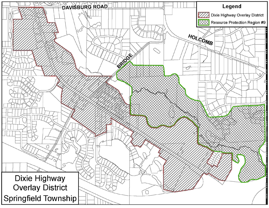
(1)
The Dixie Highway Overlay District includes parcels fronting Dixie Highway from I-75 to Davisburg Road as illustrated on the Dixie Highway Overlay District map which is included at the end of this section and is attached to and made part of the official zoning map of the township. Also shown on the map bordering the Dixie Highway Overlay District is Region 9 of the Resource Protection Overlay District, provisions for which are detailed in section 40-892 of this chapter.
(2)
Design standards. In addition to complying with the standards set forth in this chapter, all proposed development and construction within the Dixie Highway Overlay District shall comply with the Dixie Highway Design Guidelines that may be amended from time to time by the township board.
(3)
Standard review procedures. These procedures to be used for projects not utilizing the Dixie Highway Corridor Expedited Review and Flexible Zoning Review option.
a.
Site plan review. For those uses that are permitted principal uses in the underlying zoning districts the site plan review procedures found in section 40-136 must be met.
b.
Special land use review. For those uses that are noted as special land uses in the underlying zoning districts the special land use procedures found in section 40-145 must be met.
(c)
Dixie Highway Corridor Expedited Review and Flexible Zoning Review Option.
(1)
Intent. The Dixie Highway Corridor Expedited Review and Flexible Zoning option is intended to provide incentives to developers and business owners to work cooperatively with the township to achieve the community's vision for the Dixie Highway Corridor. Incentives to developers include flexibility in the use of property, flexibility in design, and an expedited review process.
(2)
Requirements and qualification. The Dixie Corridor Expedited Review and Flexible Zoning option may be applied for in any zoning district within the Dixie Highway Overlay District subject to the following criteria, to be addressed in a separate project narrative and provided as part of each expedited review application. To qualify, the township planning commission, and if applicable the township board, shall find that each of the following criteria has been met.
a.
The proposed development shall be consistent with the goals and policies of the township master plan.
b.
The proposed type and density of use shall not result in an unreasonable increase in the need for or burden on public services, facilities, roads and utilities.
c.
The proposed development shall not negatively impact the public health, safety and welfare of the township.
d.
The proposed development shall conform to the requirements of the Dixie Highway Design Guidelines, unless modified during the plan review process.
e.
The proposed development shall be under single ownership and/or control such that there is a single person having responsibility for completing the project in conformity with this chapter.
f.
The development proposed shall demonstrate one or more of the criteria found in section 40-596(a)(3).
(3)
Flexible land use and standards as authorized by Section 503 of the Michigan Zoning Enabling Act. Although consistent with the master plan, certain projects may deviate from the underlying zoning and/or contemplate redevelopment or reuse of nonconforming properties. To address site challenges and further promote the intent and purpose of the Dixie highway Overlay District, the following shall apply to the review of development proposed as a part of the Dixie Highway Corridor Expedited Review and Flexible Zoning Option.
a.
Allowed Uses. Any use or a combination of uses listed in the following table, subject to section 40-596(c)(4)c. Dixie Highway Overlay Expedited Review Procedures may be allowed.
b.
Modification and deviations from zoning provisions. Modifications or deviations from the specific requirements of this section may be considered upon a request of the applicant and upon finding that one or more of the following factors are found:
1.
Nonconforming lot area (limited parcel depth and width) and the arrangement of site features provide inadequate space to accommodate one or more dimensional requirements.
2.
The public benefit intended by the provisions in question could be achieved with less than the required standard.
3.
The regulation prevents reasonable use of the site.
4.
Other design constraints and considerations as approved by the Planning Commission.
c.
Development bonus incentives. In order to encourage projects that exceed minimum requirements and as an incentive to develop a property in a way that would enhance the overlay district and to provide an option for applicants, the following development bonuses may be granted by providing two or more district enhancements options as adopted by resolution of the township board. Development bonus incentives may be requested in addition to or separate from modifications and deviations as noted in the previous section.
The following development bonuses may be considered by the planning commission:
1.
Increased residential development density (maximum 25 percent increase in residential density).
2.
Increased signage (maximum 25 percent increase in sign area)
3.
Relief from one or more of the specific architectural standards of the district as contained in the Dixie Highway Design Guidelines.
(4)
Dixie Overlay expedited review procedure.
a.
Pre-application meeting. Applicant reviews the development concept with township staff including the township planning administrator, township supervisor or designee, planning consultant, engineering consultant, and township attorney as necessary. The pre-application meeting also will be used to discuss the requirements, qualification and procedure for expedited review, the Dixie Highway Design Guidelines, and other applicable zoning standards and regulations pursuant to section 40-136(h)(2)a. Additional pre-application meetings may be requested by either the applicant or township prior to submission of a final site plan.
b.
Checklist review of application packet. Applicant submits a completed application for expedited review and a project narrative detailing thorough demonstration of conformance with the requirements of [section] 40-596(c)(2), and identifying any modifications or deviations requested per [section] 40-596(c)(3)b., and/or development bonus requested per [section] 40-596(c)(3)c.
1.
If the application packet is complete and no modifications, deviations, or development bonuses are requested, the applicant will be directed to submit a final site plan for review as detailed in subsection c. below.
2.
If the application packet is complete and includes a request for modification, deviation, and/or development bonus, the applicant will be directed to submit a final site plan for review as special land use as detailed in subsection d. below.
3.
If the application packet is incomplete, the applicant is notified of the deficiencies and may address the deficiencies and request an additional pre-application meeting, or resubmit an application under standard review procedures.
c.
Review as site plan. The expedited review procedure eliminates the need for preliminary site plan. Applicant submits the information and follows the procedures required for a final site plan pursuant to section 40-136(g)(2)(c), and complete project narrative.
d.
Review as special land use.
1.
All uses or combination of uses which are listed as principal uses—Permitted subject to special conditions or are not permitted in the underlying district, or require a modification or deviation from zoning provisions or a development bonus as outlined above shall require special land use approval and may, upon request of the applicant, proceed to a combined special land use and final site plan review.
2.
If a development bonus as described is requested by the applicant, the planning commission shall review the District Enhancements proposed and make a recommendation to the township board that the proposed development bonus enhancements addresses the intent and purpose of this section. The township board shall consider the planning commission's recommendation and make the final determination regarding the development bonus.
(Ord. No. 26, § 18.13, 9-13-1990; Ord. No. 2020(6), § 1, 11-12-2020)
Sec. 40-597. - Mineral mining.
(a)
Intent and purpose. It is the intent and purpose of this section to promote the underlying spirit and intent of this article, but at the same time allow for the extraction of minerals in locations where they have been naturally deposited. These regulations are also intended to ensure that mineral mining activity shall be compatible with adjacent uses of land, the natural environment, and the capacities of public services and facilities affected by the land use, and to ensure that mineral mining activities are consistent with the public health, safety, and welfare of the township.
(b)
Application of regulations. The mining of sand, gravel, stone, and/or other mineral resources in the township shall be allowed under the following circumstances: a) as authorized by the grant of special land use and site plan approval by the township board, after recommendation of the planning commission, in accordance with this section or b) pursuant to section 40-554 as to mining operations in effect as of December 31, 2015. Mineral mining shall also be subject to the requirements of chapter 12, article IV, mining control. Mineral mining shall be considered a special land use in the R-1A, C-1, C-2, PL, M-1 and M-2 Districts and shall be prohibited in all other districts.
(c)
Exemption. Uses and activities which do not require a permit under section 12-80(c) shall be exempted from the provisions of this section.
(d)
Application requirements. The following information shall be submitted:
(1)
A completed application for special land use approval as set forth in section 40-145.
(2)
A completed application and all required information for site plan approval as set forth in section 40-136.
(3)
A completed application and all required information as set forth in section 12-81.
(4)
Market information. The applicant shall submit a report prepared by a geologist and/or other experts with appropriate credentials to demonstrate compliance with MCL 125.3205, as amended, that the natural resources to be extracted shall be considered valuable, and the applicant can receive revenue and reasonably expect to profit from the proposed mineral mining operation. The applicant shall also provide documentation to demonstrate that there is a need for the natural resources to be mined by either the applicant or in the market served by the applicant.
(e)
Standards. The applicant shall have the burden of demonstrating that there are valuable natural resources located on the relevant property, that there is a need for the natural resources by the applicant, or in the market served by the applicant, and that no very serious consequences would result from the extraction, by mining, of the natural resources.
(1)
The decision on a special land use request under this section shall be based upon the following:
a.
A determination by the township board that the applicant has met the burden of demonstrating that there are valuable natural resources on the relevant property and that there is a need for the natural resources by the applicant or in the market served by the applicant;
b.
A determination by the township board that the applicant has demonstrated compliance with the standards for special land use approval contained in this chapter.
c.
A determination by the township board that very serious consequences would not occur as a result of the mining operations. The following factors shall be considered in making that determination:
1.
The relationship of extraction and associated activities with existing land uses.
2.
The impact on existing land uses in the vicinity of the property.
3.
The impact on property values in the vicinity of the property and along the proposed hauling route serving the property.
4.
The impact on pedestrian and traffic safety in the vicinity of the property and along the proposed hauling route serving the property.
5.
The impact on other identifiable health, safety, and welfare interests in the local unit of government.
6.
The overall public interest in the extraction of the specific natural resources on the property.
d.
The proposed mining operation shall have immediate and direct access to a road having the necessary and appropriate load bearing and traffic volume capacity in relation to the proposed intensity of the use.
(f)
Approval. For operations requiring special land use approval it is the intent that the application procedure in this section and the application procedure for a mining permit of section 12-81 be reviewed concurrently.
(g)
Conditions. In addition to any other conditions that may be imposed by the Township Board, a condition of special land use approval is that:
(1)
During the term of the special land use permit, the total area (or areas) being mined and which has (or have) not been reclaimed shall at no time exceed the lesser of 150 acres or 40 percent of the entire parcel approved as a special use; and
(2)
The applicant shall be required to secure any renewals of the mining permit required by section 12.81.
(Ord. No. 2016(7), § 1.1, 9-8-2016)