
Stockbridge City Zoning Code
CHAPTER 16
INFRASTRUCTURE IMPROVEMENTS
16.1 - Generally.
A.
No person shall do any paving work, or any other related or similar roadwork, on, or adjacent to, a city road without a permit.
B.
All transportation system design, street design, and construction for nonlocal roadways shall comply with Georgia Department of Transportation (GDOT) requirements. The latest edition of the GDOT manual, "Standard Specifications, Construction of Roads and Bridges," shall apply.
C.
Where conflict arises between GDOT standards and this section concerning non-local roadways, the stricter standard shall apply. Design of local roadways shall be governed by the policies as stated within the UDC; however, construction methods/practices of said roadways shall be governed by the stricter of the GDOT standards and the UDC.
D.
All materials, equipment, labor, and other matters related to street construction shall be provided by the applicant. The following is a summary of the improvements required:
1.
All streets, roads, and alleys shall be graded to their full width right-of-way by the applicant so that the pavements and sidewalks, when installed in the future, can be constructed on the same level plane. The preparation of the right-of-way before grading is started and the construction of cuts and fills shall be accomplished according to the specifications of the city.
2.
Three (3) copies of an as-built subgrade centerline profile shall be submitted to the city. The profile shall include both proposed and as-built centerline elevations at every even station. No curb and gutter or waterlines shall be installed prior to subgrade approval.
3.
An adequate drainage system, including necessary curb, pipes, culverts, headwalls, intersectional drains, drop inlets, bridges, swale ditches, and detention areas, shall be provided for the proper drainage of all surface water. The drainage system shall be designed by a registered professional engineer, licensed in the State of Georgia.
4.
After preparation of the subgrade, the roadbed shall have base material and paving applied according to city specifications (see Section 16.6).
E.
Roadways may be created by:
1.
Dedication;
2.
Prescription;
3.
Express grant of an easement;
4.
Deed;
5.
Special statutory proceeding; or
6.
Condemnation.
F.
City roadways classification:
1.
Private Road.
a.
A private road is a roadway that is created by an easement from a landowner to a certain individual or individuals and the use of said road can be controlled by the parties to the easement.
b.
Only one (1) building permit shall be issued by a private easement roadway.
c.
A private roadway shall not be maintained by the city.
2.
Public Road.
a.
A paved public roadway is a roadway where the general public has acquired an implied easement for a roadway over the property of others by virtue of the unobstructed use of said roadway for a sufficient length of time to establish a public easement over the roadway. Public roadways are roadways over which the public has the right to travel but have not been accepted by the city council as city roads and the city assumes no responsibility to maintain said roadways.
b.
An unpaved public roadway with rights-of-way of sixty (60) feet or greater is used for the general public purpose and is maintained by the city consistent with the maintenance policy developed by the city.
c.
An unpaved public roadway with deeded rights-of-way of fifty (50) feet or greater, but less than sixty (60) feet, is used for the general public purpose and was deeded to the city at a time when a fifty-foot right-of-way was sufficient according to the ordinances in effect in the city at the time of acceptance. These roadways shall be maintained by the county consistent with the maintenance policy developed by the city.
d.
An unpaved public roadway with rights-of-way less than sixty (60) feet is used for the general public purpose and is maintained by the city in accordance with the maintenance policy developed by the city, but shall not be maintained to the same standard as roads categorized in subsection 16.4.I. hereof, because of insufficient rights-of-way. These roads shall be upgraded to subsection 16.4.I. as rights-of-way of sixty (60) feet or greater and deeded to the City of Stockbridge by adjoining landowners.
3.
City Road. A city roadway is one that has been acquired by dedication, prescription, by the express grant of easement, by deed, by statutory proceedings, or by condemnation, and further has been accepted by the city council and designated as a "city road" and the city has assumed the responsibility to maintain said road for the general public.
G.
Upon compliance with all of the provisions of the UDC, building permits may be issued for building on public roads upon the applicant signing a "statement of understanding" that said roadway is a public road and that the city assumes no responsibility for the maintenance of said road until such time as it becomes feasible and advisable to accept said roadway as a "city road." The city at such time shall accept said road as a city road provided that the property owners along said road convey a right-of-way to the city conveying the minimum width required by the city.
H.
Upon compliance with the provisions of this UDC, building permits may be issued on city roads.
16.2 - Traffic impact studies (TIS).
A.
Purpose and Intent. Understanding the demands placed on the city's transportation network by development is an important dimension of assessing the overall impacts of development. All development generates traffic, and it may generate enough traffic to create congestion and thus require the community to invest more capital funds into the transportation network in the form of new roads, traffic signals, and intersection improvements. Traffic congestion results in a number of problems, including economic costs due to delayed travel times, air pollution, and accidents. By requiring traffic impact studies for proposed developments meeting certain thresholds, the city will be better able to determine the transportation demands of development proposals and provide for reduction of adverse impacts on the transportation system.
B.
Objectives. The city finds that requiring a traffic impact study for proposed developments that meet certain thresholds will help to achieve the following objectives:
1.
To foster and support the coordinated and comprehensive transportation plan.
2.
Provide transportation investments that reinforce the land use plans and development vision of the city.
3.
Forecast additional traffic associated with new development based on accepted practices.
4.
Determine the improvements that are necessary to accommodate new development.
5.
Allow the city government to asses the impacts that a proposed development may have and assist the city government in making decisions regarding development proposals.
6.
Help so ensure safe and reasonable traffic conditions on streets after the development is complete.
7.
Reduce the negative impacts created by developments by helping to ensure that the transportation network can accommodate the development.
8.
Protect the substantial public investment in the street system.
9.
Provide information relevant to comprehensive planning, transportation planning, and future transit planning, and the provision of programs and facilities for traffic safety, road improvements, transportation demand management, pedestrian access, and other transportation system considerations.
C.
Thresholds of Applicability. A traffic impact study shall be required for all developments that are expected to generate more than one hundred (100) new trips during a morning or evening peak hour or more than seven hundred fifty (750) new trips in an average day or involves the construction of fifty thousand (50,000) square feet or greater of nonresidential building space, in single or multiple phases. Developments of regional impact (DRIs) are exempt from the aforementioned criteria. All DRIs shall adhere to the guidelines set forth by the Georgia Department of Community Affairs (DCA). The traffic study shall be prepared in accordance with industry accepted standards, including, at a minimum, level of service impacts for adjacent roadways and intersections and a mitigation package to address the cumulative effects from the project's impact. Said applicant shall be also required to coordinate and fund any recommended mitigation measures limited to project related improvements with applicable Federal, State, and local agencies, including the Georgia Regional Transportation Authority (GRTA) and the Atlanta Regional Commission (ARC). The determination of a traffic study shall be made during the zoning request stage or during the phase in which a site plan is submitted for a land disturbance permit. The director or his/her designee shall notify the appropriate departments within five (5) business days. Traffic impact studies shall be required for submittal during the land disturbance stage and shall not be required during the zoning process.
D.
Exemptions.
1.
A traffic impact study is not required if a development proposal is initiated by the city.
2.
Any development of regional impact (DRIs) the complies with the rules of the Georgia Department of Community Affairs (DCA), the Atlanta Regional Commission (ARC), and Georgia Regional Transportation Authority (GRTA) shall be exempt from this chapter.
3.
A traffic impact study will not be required by the city for those developments with frontage and access along a State route.
E.
Trip Generation Data. The source for trip generation rates for the purposes of this chapter shall be the most recent edition of "Trip Generation" published by the Institute of Transportation Engineers (ITE), unless otherwise approved by the director. Determinations of whether this chapter applies shall be made based on application of data from ITE Trip Generation, which may change from time to time, or as otherwise approved by the director.
F.
Determination of Applicability. At the time a development proposal is filed, or during any pre-application meeting for zoning proposal, exclusive of variances and modifications to a zoning condition, the director shall determine whether a traffic impact study shall be required according to this section.
Applicants for development proposals shall provide sufficient information about the development proposal (e.g., number of dwelling units, square footage of buildings, number of employees, land area of the development, etc.) for the director to apply professionally accepted trip generation rates to the proposed development. All traffic studies shall be required to be submitted before the issuance of any development permits, including, but not limited to, a land disturbance, clearing and grading, building permit, and/or development permit.
G.
Cases Where Data is Not Available. If information submitted by the applicant of the development proposal is sufficient to calculate the trip generation that would be expected to result from the proposed development, but trip generation rates or other data are not available or in sufficient quantity of studies to make a determination of applicability, then under the terms of this section, the following shall apply:
1.
The director shall determine if:
a.
Professionally acceptable trip generation rates applicable to the subject development exist from other reputable sources, such as the Journal of the Institute of Transportation Engineers;
b.
Other trip generations studies of similar development are available; or
c.
Professionally acceptable trip generation rates for one (1) or more similar land uses can be used in making the determination of applicability.
H.
Specifications for Peak-Hour Trip Generation Studies.
1.
Discounting of "Pass-By" Trips. The peak-hour trip generation study may subtract from the empirical data on actual vehicle trips if those trips are reasonably considered to be "pass-by" trips as defined by this chapter, using professionally accepted assumptions about the percent of "pass-by" trips approved by the director.
2.
Reduction for Internal Trips in Multiuse or Mixed-Use Development. In calculating the new trips generated from a proposed development containing multiple uses or mixed-use a qualified professional with the approval of the director my apply a percentage reduction to the total vehicle trips shown in any peak hour trip generation study to account for internal trips, as defined in this chapter, so as to account for (discount) the number of internal trips reasonably expected to occur in such multiuse or mixed-use development. Said reduction shall not exceed twenty-four percent (24%) of total trips generated.
I.
Study Scope Meeting. Once it is determined that a traffic impact study is required, a scope meeting must be held with the developer or his or her consultant and the appropriate representatives of the city. It will be the responsibility of the developer or his or her consultant to initiate this meeting. The purpose of this meeting is to discuss the availability of site-specific information concerning the development, available forecasts of traffic volumes, and to ensure the applicant understands the content requirements for traffic impact studies.
J.
Required Contents of a Traffic Impact Study. A traffic impact study must evaluate the adequacy of the existing transportation system to serve the proposed development and determine the expected effects of the proposed development on the transportation system. The traffic impact study must provide adequate information for city staff to evaluate the development proposal and, when appropriate, recommend conditions of approval.
The qualified professional preparing the traffic impact study is encouraged to coordinate preparation with city staff and staff from other jurisdictions, as appropriate, to ensure that all necessary components are included in the traffic impact study and to reduce revision and review time. To be reviewed, the traffic impact study must include the following minimum components:
1.
Title Page. A title page listing the name of the proposed development and its location.
2.
Table of Contents. A table of contents outlining the study shall be provided.
3.
Certification. The study shall be signed and stamped by a qualified professional.
4.
Executive Summary. An executive summary discussing the development, the major findings of the analysis, and recommendations made by the qualified professional shall be provided.
5.
Vicinity Map. A vicinity map showing the location of the proposed project in relation to the transportation system of the area.
6.
Study Area Map. A map of the traffic impact study area. For the purposes of this chapter, the traffic impact study area shall be determined according to trip generation rates as follows. In the event there is a difference because of applying peak and total trips, the more restrictive requirement (larger study area) shall apply.
Study Area Size Requirements
7.
Inventory of Transportation Facilities in the Study Area. A description of transportation facilities in the study area, including roadway names, locations, and functional classifications, intersection lane configurations, traffic control (including signal timing), existing rights-of-way, transit routes and stops (if any), pedestrian and bicycle facilities, and planned transportation system improvements. An existing lane configuration sketch shall be submitted for all roadways intersections within the study area.
8.
Site Plan and Development Data. A complete description of the proposed development, including a site plan with the best available information as to the nature and size of each proposed used and the proposed location and traffic control of all proposed access points, including the distance from all proposed access points to adjacent access and/or streets, including those across a street right-of-way from the subject development.
9.
Existing Traffic Volumes. Peak and total daily traffic volumes on all arterial, collector, and local streets within the study area. Traffic counts should be no more than one (1) year old when the report is prepared. Traffic counts between one (1) and three (3) years old may be used if factored to the current year. Traffic counts older than three (3) years will not be accepted. Utilizing available data from an industry accepted source, i.e., Georgia Department of Transportation, Henry County Department of Transportation, City of Stockbridge, or Atlanta Regional Commission.
10.
Facility Performance. Existing performance of the transportation system, including levels of service (LOS) and volume/capacity ratios (V/C) for all intersections and road segments, as appropriate, within the study area. Identification of any project related improvements necessary to mitigate the impact on the level of service (LOS) for the abutting roadways and unsignalized/signalized intersection resultant from the trips generated by the proposal.
11.
Trip Generation. Complete trip generation figures for all aspects of the proposed development. The source for trip generation rates shall be most recent edition of "Trip Generation" published by the Institute of Transportation Engineers (ITE), unless otherwise approved by the director. If phased development is proposed, the study shall include projections for the year that each phase of the development is planned to be complete. The traffic impact study shall also include trip generation data for any pending and approved developments that would affect the study area. The city staff shall facilitate the review of applicable files by a qualified professional to determine the names and development characteristics of pending and approved developments in the study area.
12.
Trip Distribution and Assignment. Trip distribution for the proposed development. For developments expected to generate more than thirty (30) truck trips per day, the study shall include separate trip distribution figures for trucks.
13.
Forecast Performance Without the Development. Forecast performance, including levels of service (LOS) and volume/capacity (V/C) ratios of the transportation system without the development in the year that each phase is planned to be complete and in the horizon year.
14.
Forecast Traffic Volumes with the Development. Forecast traffic volumes with the development, on all arterial, collector, and local roads within the study area, in the year that the proposed development is planned to commence and in the horizon year.
15.
Forecast Performance with the Development. Forecast performance, including levels of service (LOS) and volume/capacity (V/C) ratios of the transportation system with the development in the year that each phase is planned to be complete and in the horizon year.
16.
Sight Distance. A safety analysis of the site accesses and an assessment whether adequate sight distances are provided at driveways and streets abutting the development.
17.
Operational Characteristics. Analysis of prevailing operating speeds, if significantly different than speed limits, right and left turn lane warrants, queue lengths, acceleration and deceleration lanes, including lengths and tapers, throat lengths, channelization, and other characteristics of the site accesses, which exist and may be needed, as appropriate. The traffic impact study shall address whether driveways and intersections are located and spaced safely and designed to accommodate expected traffic volumes and maneuvers. The operational characteristics analysis shall also evaluate the turning and traveling characteristics of the vehicles that will be using the proposed development and the adequacy of the geometrics of the existing and proposed roadway (public and/or private) configurations to accommodate these characteristics.
18.
On-Site Circulation. The traffic impact study shall address whether on-site vehicular and pedestrian circulation and parking layouts are safe and efficient.
19.
Significant Impacts. Analysis as appropriate of any potential adverse or controversial effects of the proposed development on the transportation system in the area. Examples of possible effects include, but are not limited to, infiltration of nonresidential traffic into residential neighborhoods, traffic noise, creation of potential for traffic violations, conflicting turning movements with other driveways, any new pedestrian or bicycle transportation needs arising from the development, etc.
20.
Mitigation Measures and Costs. Listing of all intersections and road segments that are forecasted to be level of service "E" and "F" in the horizon year, or if phased, in the years that each phase is planned to be complete, and an identification and description of specific mitigation measures, including signal, turn lane, or other warrant analyses as appropriate and necessary to bring these intersections and road segments into compliance with a level of service "C" or other city adopted level of service for said road segment or intersection. Should the proposed development reduce the level of service, mitigation factors must be included and will be included as a condition of final plat approval. If roadway improvements are needed, the study shall show a drawing at an engineering scale of one (1) inch equals twenty (20) feet for all recommended lane configurations. If signalization is warranted by the traffic signal warrants outlined in the Manual on Uniform Traffic Control Devices (MUTCD), a warrant analysis shall also be conducted as a part of the traffic impact study. If a traffic signal is warranted, the warrant package in the study shall show a drawing at an engineering scale of one (1) inch equals twenty (20) feet detailing the signal design and phasing plans. The estimated cost associated with implementing all such mitigation measures shall be provided in the traffic impact study. The traffic impact study may consider any city/county/State-approved roadway, traffic signalization and other improvements in determining mitigation measures and providing recommendations.
21.
Alternative Transportation. Alternative transportation (sidewalk, bicycle, transit) needed because of the study, shall be identified.
22.
References. A listing of all technical documents and resources cited or consulted in preparing the traffic impact study.
23.
Technical Appendix. Relevant technical information, including, but not limited to, copies of raw traffic count data used in the analysis, calculation sheets and/or computer software output for all LOS and V/C calculations in the analysis, warrant worksheets for signals, turn lanes, and signal phasing, etc. used in the analysis.
K.
Additional Technical Specifications. The director is further authorized to promulgate and require the use of additional technical specifications for conducting traffic impact studies, which shall be consistent with analysis methods included in the most recent Highway Capacity Manual, Manual on Uniform Traffic Control Devices, and/or Traffic Access and Impact Studies for Site Development: A Recommended Practice (Washington, DC: Institute of Transportation Engineers, 1991), as may be amended or republished from time-to-time.
L.
Costs and Fees. The city assumes no liability for any costs or time delays (either direct or consequential) associated with the preparation and review of traffic impact studies. There shall be no application review fee for a traffic impact study.
M.
Submittal and Review of Study. The applicant for the proposed development or the qualified professional shall submit one (1) electronic copy of the traffic impact study and technical appendix, three (3) paper copies of the traffic impact study, and one (1) paper copy of the technical appendix to the director. The director shall review all calculations and analyses and determine if they are complete, reasonable, understandable, consistent, and fully explained. The conclusions presented in the traffic impact study shall be consistent with and supported by the data, calculations, and analyses in the report. Calculations, graphs, tables, data, and/or analysis results that are contrary to good common sense or not consistent with and supported by the data will not be accepted. In such events, the director shall return the traffic impact study to the development applicant for correction.
N.
System Improvements. The director shall include system improvement recommendations in the conditions for approval of the development plan.
16.3 - Access requirements.
A.
Requirements for Connection to Existing Street System.
1.
All proposed development shall provide a street system that is connected to the existing or planned street system. All proposed streets shall be continuous and in alignment with existing, planned, or platted streets.
2.
Proposed streets shall be extended to the boundary lines of the tract to be developed or subdivided, unless prevented by topography or other physical conditions.
3
Whenever a subdivider divides a parcel where one-half of a road or alley exists on the adjacent parcel, the subdivider shall dedicate the other half of the road or alley such that together there will be sufficient right-of-way for the street or alley.
B.
Frontage on a State Highway or Arterial Street.
1.
When a tract fronts on a State highway, major arterial, or minor arterial street, a frontage street may be required for access to individual lots.
2.
All residential lots in a subdivision shall only take direct access from within the subdivision.
3.
Any access to a State highway shall be consistent with the requirements of the GDOT.
C.
No approval shall be granted for a subdivision, or subsequent phase or addition to an existing subdivision, unless the property is served by a paved county road, with right-of-way sufficient to meet the requirements of subsection 17.4.I.
D.
Specific Access Requirements for Developments.
1.
Emergency vehicle access shall be provided to all lots within a subdivision.
2.
In order to ensure emergency vehicle access, every subdivision with more than fifty (50) lots shall have at least two (2) continuously open points of ingress/egress from the existing street system.
3.
Access points, whether private commercial/industrial drives or city or county roadways, shall line up directly across from one another when possible. For driveways/roadways that require an offset, the spacing between drives/roadways, whether on the same side or opposite side of the intersecting roadway shall be required to have the minimum centerline to centerline spacing:
For intersecting roadways that are not classified as collector or above and have posted speed limits thirty (30) miles per hour or less, private commercial/industrial driveways may be allowed to have a reduced offset requirement at the city's or Henry County Department of Transportation's discretion.
4.
Where a subdivision is providing two (2) or more connections to the existing street system pursuant to subsection 16.3.D.2., the requirement for two (2) points of ingress/egress is met. The requirement for access shall not be satisfied by a stub-out to a future, planned, or platted street that has not been constructed.
5.
A subdivision on a single, dead-end street, containing twenty (20) or fewer lots shall not be required to provide two (2) points of ingress/egress as otherwise required in paragraph D.2., above.
6.
Where a subdivision is allowed one (1) point of access pursuant to subsection 16.3.D.2., that entrance street shall be designed with a three-lane divided entrance street. The right turn lane shall be required to have a seventy-five-foot radius to provide needed lateral separation between two (2) cars exiting at the same time.
E.
Limitations on Residential Curb Cuts. Within any residential zoning district (see subsection 16.3.D.3. for other driveway spacing requirements) where the lowering or cutting away of any curbs for purposes of ingress and egress is required, such curb cut shall be subject to the following provisions:
1.
Any parcel of property with frontage of less than one hundred (100) feet on any one (1) street shall be allowed only one (1) combined entrance and exit.
2.
Any parcel of property with frontage of one hundred (100) feet to two hundred (200) feet on any one (1) street shall be allowed no more than two (2) combined entrances and exits.
3.
Any parcel of property with frontage of more than two hundred (200) feet on any one (1) street shall be permitted additional entrances or exits after showing of actual requirements of convenience and necessity and upon approval of the city.
4.
At street intersections, no curb cut shall be located within fifty (50) feet of the intersections of two (2) curb lines or such lines extended, or within fifteen (15) feet of the intersection of two (2) property lines extended.
5.
The distance between any two (2) curb cuts on the same side of the street and located on one (1) property shall be not less than ten (10) feet. Curb cut distance shall be measured between the points of tangency of the curb return radii and the established curb line of the abutting street.
6.
All driveways shall be constructed to be at least two (2) feet from any property line.
7.
The maximum width of any driveway shall not exceed forty (40) feet measured at the right-of-way line.
8.
The maximum width of any curb cut, including curb returns, shall not exceed fifty (50) feet.
9.
The sum of the two (2) curb return radii for any one (1) curb cut shall not exceed fifteen (15) feet.
16.4 - Design and construction standards for streets.
A.
Location.
1.
The location, arrangement, extent, width, and grade of all streets shall conform to the comprehensive plan and the comprehensive transportation plan and shall be considered in relation to existing and planned streets, topographical conditions, public safety and convenience, and proposed use of land to be served by the streets. The layout of a subdivision shall conform to the requirements and design principles described in this UDC.
2.
The location of all streets and roads shall conform to the comprehensive plan and the comprehensive transportation plan. Provision shall be made in developments for the construction of streets at locations shown in the comprehensive plan and comprehensive transportation plan.
3.
Whenever a tract to be subdivided includes any part of a major arterial, minor arterial, major collector, or minor collector street designated on the comprehensive plan or comprehensive transportation plan, such part of said street shall be installed by the applicant in the location and at the full width indicated by the functional classification for right-of-way and pavement widths indicated in this UDC.
B.
Design and construction standards for curb and gutter.
1.
Curbs shall be required in all residential subdivisions.
2.
Curbs shall be required for streets in commercial and industrial subdivisions.
3.
Curbs in all subdivisions shall be L-back curbs twenty-eight (28) inches in overall width, six (6) inches thick, and shall have an eighteen-inch gutter.
4.
Curb and gutter immediately adjacent to the major travel lane along roadways with a posted speed limit of forty (40) miles per hour or forty-five (45) miles per hour shall be L-back curbs thirty (30) inches in overall width, six (6) inches thick, and shall have an eighteen-inch gutter. The curb and gutter shall be per GDOT Standard 9032B.
5.
All curbs shall be constructed of Portland cement concrete.
6.
Curbs shall be designed to provide handicapped access at street intersections, wherever sidewalks are constructed.
C.
Street Grade Standards.
1.
Grades on major and minor arterials shall not exceed five percent (5%) and grades on local residential streets shall not exceed twelve percent (12%).
2.
All changes in grade shall be connected by vertical curves which adhere to the design criteria as set forth by the more restrictive of the 1990 or 2004 AASHTO Guide, A Policy on Geometric Design of Highways and Streets.
D.
Radius of Horizontal Curves. The radius of horizontal curves on local residential streets within a subdivision shall be no less than two hundred (200) feet. The horizontal radius for collector and arterial streets or any streets with a design speed of more than twenty-five (25) miles per hour shall comply with the latest version of the American Association of State Highway and Transportation Officials (AASHTO) standards. The radius of horizontal curves on local commercial and industrial streets within a subdivision shall be no less than three hundred (300) feet.
E.
Street Intersection Standards.
1.
Street intersections shall be as nearly at right angles as possible.
2.
In residential subdivisions, no intersection shall be at an angle of less than eighty (80) degrees or more than one hundred (100) degrees.
3.
Street intersections in commercial and industrial subdivisions shall be at an angle of no less than ninety (90) degrees, if at all possible. At the director's discretion, street intersection angle may be allowed to be between eighty (80) degrees and one hundred (100) degrees.
4.
The minimum curb radius at street intersections shall not be less than twenty-five (25) feet in residential subdivisions. For streets/roadways to have a dual lane exit, the exit curb radius shall not be less than seventy-five (75) feet. Where a county collector or an arterial roadway intersects with another county collector or arterial roadway the minimum radii at the intersection shall be fifty (50) feet.
5.
The minimum curb radius of street intersections for industrial and commercial subdivisions shall be fifty (50) feet. For commercial/industrial streets/roadways to have a dual lane exit, the exit curb radius shall not be less than seventy-five (75) feet.
6.
Pedestrian ramps shall be designed for all intersections in accordance with standard drawings for subdivisions and residential developments designed to include sidewalks and shall meet the minimum standards in of the Georgia Accessibility Code, Chapter 120-3-20 of the Rules and Regulations of the Georgia Safety Fire Commissioner. The curb shall be depressed to accommodate future installations at the same time as the curb.
7.
Interior subdivision street intersections shall have a minimum centerline offset of at least one hundred twenty-five (125) feet when not aligned directly across from one another. See subsection 17.3.D.3. for requirements of intersection offsets on roadways with posted speed limits over thirty (30) miles per hour.
F.
Minimum Tangent Lengths. The minimum tangent lengths on roadways with superelevation shall be governed by the minimum runoff and runout lengths necessary to adequately transition the superelevation rates required for the curvature based on the design speed and maximum allowable superelevation rate of the roadway. Design speeds, typical sections of roadway, maximum superelevation rates, and other roadway design items are to be set by the city on an individual roadway basis. The minimum tangent lengths on commercial and industrial subdivision streets are one hundred (100) feet.
G.
Dead End Street. Local streets designed to have one (1) end permanently closed and not connected with any existing street, proposed future street, or not intended to extend to the property line of an adjacent tract, shall be no longer than seven (7) times the lot width required by the underlying zoning district, unless necessary due to the topographic or other physical conditions of the property.
1.
Permanent dead-end streets shall be joined by a cul-de-sac with a paved turnaround having an outside diameter of eighty (80) feet and a right-of-way of at least one hundred ten (110) feet diameter. Dead-end streets designed to be permanent and that exceed more than eight hundred (800) feet in length may be required to have a cul-de-sac turn around midway between the entrance intersection and the end of the street to provide maneuvering for emergency vehicles, when the dead-end street is the only street in a subdivision.
2.
Stub streets which are intended to provide access for future development within a tract of land or adjacent tracts shall be required to have a temporary turnaround area having a diameter of at least eighty (80) feet, consisting of six (6) inches of graded aggregate base.
3.
For subdivisions with a temporary turnaround, it shall be required of the applicant to provide a letter of credit equal to the cost of permanent cul-de-sac construction.
H.
Alleys. Alleys may be provided at the rear of lots in residential, commercial, and industrial subdivisions.
I.
Right-of-Way and Pavement Width Standards.
Right-of-way and Pavement Width Standards
* The city may require additional right-of-way and pavement widths in specific situations. Roadways with medians and/or additional language will require extra right-of-way and pavement widths.
† Roadways with posted speed limits of forty (40) miles per hour or forty-five (45) miles per hour will require thirty-inch curb and gutter.
J.
Additional Street System Requirements for Major Subdivisions or Commercial/Industrial Development.
1.
Private streets are permissible and shall meet and adhere to all city standards. Every subdivision with private streets shall have a mandatory homeowners' association.
2.
Subdivisions that adjoin existing streets shall dedicate additional right-of-way if needed to meet the minimum street right-of-way requirements.
3.
Half streets shall be prohibited except where essential to the reasonable development of the subdivision.
4.
Where it is determined to be practical to require the dedication of the additional half when adjoining property is subdivided, the other half of the street shall be platted to create a full width right-of-way serving the adjoining tracts of land.
5.
Any subdivision or development which has an entrance onto a State highway, major arterial, minor arterial, or collector city road shall provide lanes for deceleration, ingress, and egress. Design requirements of GDOT shall be met on State roads and design requirements of the city shall be met on city roads.
6.
Any subdivision or development which has an entrance onto a major arterial, minor arterial, or collector roadway shall be required to design and construct a left turn lane improvement if the criteria is met as stipulated in Chapter 4 of the GDOT Regulation for Driveway and Encroachment Control. The developer will also be responsible for acquisition of right-of-way as well as for the relocation of utilities.
7.
The names of proposed streets shall not duplicate existing street names, irrespective of the use of the word street, avenue, boulevard, drive, place, court, etc., in the naming of the street.
K.
No Parking. No parking areas shall be established for the use of fire equipment and emergency vehicles to ensure access to the premises in cases of emergency. Said areas shall be marked "Fire Lane-No Parking." The fire lane areas shall comply with provisions of the Henry County Code of Public Safety.
16.5 - Joint access.
Joint Access Driveways and Cross Access Easements. Joint access driveways and cross access easements shall be required in corridor overlay districts, interchange activity center zoning districts, and rural neighborhood commercial development areas according to the following provisions:
A.
Adjacent commercial or office properties shall provide a cross access drive and pedestrian access to allow circulation between sites through a system of joint use driveways and cross access easements. The design of the joint or cross access area shall incorporate the following:
1.
A continuous service drive or cross access corridor extending the entire length of each block served to provide for driveway separation;
2.
Stub-outs and other design features to make it visually obvious that the abutting properties may be tied in to provide cross-access via a service drive; and
3.
Sufficient separation between side street access to the property and the major road to ensure safety.
B.
In order to ensure continuous availability of access to all properties, all property owners shall:
1.
Record an easement with the deed allowing cross access to and from other properties served by the joint use driveways and cross access or service drive;
2.
Record an agreement with the deed that remaining access rights along the thoroughfare shall be dedicated to the city and pre-existing driveways shall be closed and eliminated after construction of the joint-use driveways; and
3.
Record a joint maintenance agreement with the deed defining maintenance responsibilities of property owners.
16.6 - Construction requirements for residential, industrial, and commercial subdivision streets.
The grading, base, and pavement for street construction shall be as follows:
A.
Grading. All streets shall be graded to the elevations shown on the approved construction plans.
1.
The contractor may begin clearing and grubbing the project after:
a.
A development permit has been issued by the city;
b.
A pre-construction conference has been held, the director or designee duly notified; and
c.
All required silt and erosion control measures have been installed and approved.
2.
Clearing and Grubbing.
a.
All trees, stumps, logs, roots, grass, weeds, poles, and other objectionable matter shall be cleared and grubbed from within the construction limits of the project.
b.
A thirty-foot undisturbed buffer shall be maintained on all property lines prior to submission of construction plans.
c.
No rubbish or other material resulting from the clearing and grubbing of the roadway shall be buried at the site.
d.
If burning is permitted, all burn pits shall be located outside of the roadway construction limits. After burning, the pit shall be cleared out. A city inspection is required prior to backfilling and must be shown on the final plat.
3.
Excavation.
a.
All grading operations shall be planned and executed by the contractor in such a manner as to provide suitable subgrade material for the roadway with the top twelve (12) inches compacted to one hundred percent (100%) maximum dry density, ninety-five percent (95%) below the top.
b.
In areas where the material in place is not suitable for subgrades, these areas shall be undercut a minimum of twelve (12) inches and backfilled with suitable material.
c.
All rock and boulders in the roadbed shall be excavated and the space backfilled to the correct grade with suitable material.
d.
Any stones, broken rock, or boulders resulting from the grading of the roadway may not be placed in any roadway fill area except when approved by the director and then under his/her supervision.
e.
During the construction of the roadway on a day-to-day basis, the roadbed edges shall be kept lower than the center and the grading shall be done so that the surfaces of the excavated areas and fill shall be kept reasonably smooth and well drained. Adequate surface ditches shall be cut at the tops of cut slopes, extending to each end of the cuts in order to carry the water from the side hill. Side ditches or gutters emptying from cuts to fill areas shall be turned outward so as to prevent erosion of the fill slopes.
4.
Placement of Fill.
a.
Fill construction shall not begin until all clearing and grubbing of the fill area has been completed.
b.
All depressions in the ground shall be filled level with the adjacent surface using suitable material and compacted to the approximate density of the surrounding soil before placement of the fill is begun.
c.
The entire area upon which fill is to be placed shall be plowed, scarified, and finely broken up to a depth of a minimum of six (6) inches.
d.
Before the placement of fill material is begun, all loosened soil shall be compacted the approximate density of the underlying soil.
e.
Where a depth of fill and surfacing is three (3) feet or less, the original ground shall be compacted a minimum twelve (12) inches deep to at least ninety-five percent (95%) of the maximum laboratory dry density as determined from representative samples of the material being compacted.
f.
In areas where layers of organic or other unstable materials exist, the existing ground shall be excavated, for the full width of the fill area, to an underlying stable material. The subgrade thus created shall then be compacted to the approximate density of the underlying material.
g.
All fill material shall be deposited and spread in uniform horizontal layers, no more than six (6) inches thick, for the full width of the fill area, and these layers shall be kept uniform by the use of graders, bulldozers, or other approved equipment.
h.
Each layer shall be compacted within the range of optimum moisture content necessary to achieve the compaction required. Material containing too much water shall be dried to the correct moisture content. If the material is too dry, water shall be added and uniformly mixed with the soil before it is compacted.
i.
Fills shall be compacted to at least ninety-five percent (95%) of the maximum dry density to within the top twelve (12) inches of the fill. The top twelve (12) inches of the fill shall be compacted to at least one hundred percent (100%) of the maximum dry density.
j.
The entire roadbed shall be scarified and compacted with a sheep's foot or other approved rollers.
k.
While the work is in progress, contractor shall maintain the surface in a manner so that the excavation, fills, subgrade, base course, and ditches always present a smooth and even surface.
l.
The contractor shall have available on the job at all times at least one (1) motor patrol grader with adequate power to blade and maintain the roadbed.
5.
Final Finishing of Roadway.
a.
After all excavation has been completed and all fills have been placed, the entire road bed surface shall be finally shaped with a grading machine supplemented with hand work whenever required to secure a smooth surface and uniform cross-section.
b.
Slopes of cuts and fills shall also be carefully shaped to the true section specified.
c.
When final shaping is finished, the road surface shall conform accurately to the line, grade, and cross-section shown of plans, and no roots, sod, grass, stones, or other unsuitable material shall remain in the top twelve (12) inches of the finished roadbed.
d.
All ditches and drains shall be opened to effectively drain the roadway.
B.
Placement of Curb and Gutter.
1.
After sanitary sewer lines have been installed, all storm drainage in place, and the final finishing of the roadway has been approved by the director or designee, and the centerline profile has been approved, the installation of the concrete curb and gutter may begin.
2.
Any curb and gutter which does not conform to a true section, texture, line, and grade shall be removed and replaced as directed by the director or designee.
3.
Water lines shall be installed after installation of the curb and gutter.
C.
Subgrade.
1.
Before placing any pavement base, the entire surface of the subgrade shall be plowed, harrowed, and mixed to a depth of at least six (6) inches. If a subgrade stabilization material is required, then it shall be incorporated into the subgrade at this time.
2.
After the material has been thoroughly mixed, the subgrade shall be brought into a proper line and grade and compacted to one hundred percent (100%) of maximum dry density just prior to placing the base material.
3.
The centerline profile shall conform to the established elevations with an acceptable tolerance of one-half (½) inch.
4.
The acceptance crown tolerance shall be one-half (½) inch.
D.
Base Construction.
1.
The director shall be notified twenty-four (24) hours prior to the placing of any base material.
2.
The director may authorize the placing of the base material after all equipment necessary for the proper construction of road base is on the project and the subgrade has been brought to the proper line, grade, and crown and compacted to the required density.
3.
The director shall check the completed base course after the base material has been placed and compacted to the required density. All areas found to be deficient shall be marked and corrected before any asphalt pavement is placed. Areas where the crown is found to exceed that which is specified or the exposed edge of the concrete gutter is less than the minimum depth required, shall be reshaped and rolled to obtain the required cross-section.
4.
After the compacted material has been approved, field tests shall be taken by the field contractor and by a professional engineer as directed by the director to determine the thickness of the constructed base course. Tests shall be taken at four hundred (400) feet intervals alternating between each lane and center of roadway. Measurements shall be taken per GDT-42, Method of Test for Measurement of Thickness of Bases and Subbases. Areas found to be deficient in thickness shall be corrected as directed by the director or designee. No asphalt course shall be placed until deficiencies in base have been adequately addressed.
5.
A copy of all delivery tickets for the graded aggregate base material shall be furnished prior to placing any asphaltic concrete paving material. A shortage in the base material used shall require that the asphaltic concrete surface course thickness be increased.
6.
All work and materials shall be in accordance with the pertinent Graded Aggregate Construction sections of the Georgia Department of Transportation "Standard Specifications," latest edition.
E.
Soil Cement. A soil cement base may be used to improve the subgrade but shall not be used as a substitute for base construction.
F.
Paving.
1.
The contractor shall begin the construction of the asphaltic concrete pavement upon approval of the road base by the director.
2.
All asphaltic concrete material and construction shall be in accordance with the "hot mix asphaltic concrete construction" sections of the Georgia Department of Transportation "Standard Specifications," latest edition.
3.
The director shall check the cross-section of the finished pavement. Any area found to be deficient shall be marked and a record of deficiencies made by the director or designee.
4.
If, in the opinion of the director, the extent of deficiencies will impair the performance of the pavement, he/she shall direct that an overlay of a minimum thickness of one (1) inch be placed before the roadway is opened to traffic.
5.
A copy of the delivery tickets for the asphaltic concrete material used shall be furnished to the director at the time of completion of the work. If the delivery tickets indicate a shortage in the material used from the quantity estimated, then the director or designee may require a minimum one-inch overlay of the streets.
6.
As mentioned in subsection 16.6.D.4., the base thickness is to be measured and accepted by the city prior to placement of any asphalt course. The applicant shall have core tests made to verify the thickness and compaction of the two-inch asphalt pavement course. The minimum core diameter shall be such that compaction of the sample can be determined in the lab and subsequent data supplied to the director or designee. The compaction of the course shall be required to meet Georgia Department of Transportation (GDOT) specifications per the asphalt mix placed. If a two-course asphalt section is required, the cores for the binder layer shall be cut, reviewed, and approved by the director prior to placement of the topping lift. Also, in the event that a two-course asphalt section is required, the cores for the topping lift, if between one and one-half (1½) inch and one and one-quarter (1¼) inch in thickness, shall be made to determine the thickness only. All cores shall be made on four hundred-foot intervals, alternating between each lane and center of roadway. If these cores indicate a deficiency in thickness or compaction of the asphalt pavement, an overlay shall be required when the following deficiencies occur:
a.
When the number of cores deficient in thickness within the allowable one-quarter-inch tolerance, or deficient in compaction exceeds thirty-five percent (35%) of the total cores taken on one (1) street.
b.
When two (2) or more consecutive tests show a deficiency of more than one-quarter-inch allowable tolerance or a deficiency in compaction. When a core shows a deficiency in excess of the allowable tolerance or compaction additional cores shall be taken to delineate the area of the deficient thickness/compaction.
7.
The applicant shall correct any deficiency with an overlay extending a minimum of one hundred fifty (150) feet beyond the outer limits of the deficient area for the full width of the street. Smooth, neat joints shall be saw cut normal to the roadway for full depth of asphalt pavement, removing the original pavement for a minimum of ten (10) feet at each end of the overlay. The thickness of the overlay shall be determined by the depth of the deficient area and shall not be less than one and one-quarter-inch in compacted thickness. The type of material used in the overlay shall be specified by the director.
G.
Shoulder and Drainage Improvements. After the paving has been inspected and approved, the pavement edges or behind the curb and gutter shall be backfilled and compacted and the ditches and back slopes properly graded, shaped, seeded, and mulched. An eighty percent (80%) stand of grass shall be obtained. All swales and ditches excavated below required depth shall be backfilled and compacted to ninety-five percent (95%) of maximum dry density.
H.
Compliance with Minimum Standards. Road design and construction for residential subdivisions shall comply with the minimum standards shown below in subsection 17.6.I. Acceleration and deceleration lane construction shall comply with the standards set forth in subsection 17.6.K. For roadways with more than one hundred fifty (150) lots of contributing traffic a pavement design is to be done and submitted to the city for review. The GDOT Asphalt Pavement Design program is an accepted method for the pavement design submittal for roadways with more than one hundred fifty (150) lots of contributing traffic.
I.
Table of Residential Subdivision Street Construction Standards.
Residential Subdivision Street Roadway Standards
J.
Design and Construction Requirements. The design and construction requirements for subdivision developments for industrial, commercial, or office use and urban streets which are to be city arterial roads shall:
1.
Be required to have concrete curb and gutter along each side.
2.
Comply with the minimum standards shown below.
K.
Table of Industrial, Commercial, and Office Subdivision Street Construction Standards.
Industrial, Commercial, and Office Subdivision Street Construction Standards
16.7 - Improvements to existing streets and rights-of-way for residential, commercial, and industrial developments.
Existing Unpaved Road. Any unpaved road upon which a development has frontage and access shall be widened and paved, according to the functional class of the road, as set forth in subsection 16.4.I. along the frontage of the development to the nearest intersection with a paved city road. The minimum right-of-way required according to subsection 16.4.I. shall be dedicated along the entire frontage of the development back to the nearest intersection in which the roadway is to be improved. In addition to the design, construction, and right-of-way acquisition, the developer shall also be responsible for relocation of utilities. Where a development has frontage, but does not provide access to an unpaved road, the developer shall preserve right-of-way along the development's frontage for future improvements to the roadway.
16.8 - Visibility at intersections.
A.
Corner Lots. On corner lots within all zoning districts, no fence, shrubbery, or other obstruction shall be placed within the sight line triangles that blocks or disrupts the line of sight based on a driver eye height of three and one-half (3½) feet located fourteen (14) feet from edge of travel lane (when there is a deceleration lane, the driver eye shall be located fourteen (14) feet from the edge of deceleration lane) and an object height of three and one-half (3½) feet located in the center of each respective lane. However, street signs, streetlights, mailboxes, or similar shall be permitted within the sight line triangles.
B.
Intersection Sight Distance for All Streets.
1.
Curb cuts shall be placed so as to provide for the minimum intersection sight distance based on the intersecting road's posted speed limit. The intersection sight distance is measured using a driver-eye height of three and one-half (3½) feet and an object height of three and one-half (3½) feet with the driver eye being located fourteen (14) feet beyond the edge of the travel lane (when there is a deceleration lane, the driver eye shall be located fourteen (14) feet from edge of deceleration lane) and an object height of three and one-half (3½) feet located in the center of each respective oncoming lane.
2.
Table of minimum intersection sight distances relative to design speed posted on streets are:
Intersection Sight Distance for Two-Lane Roadway
Source: 1990 AASHTO Guide, A Policy on Geometric Design of Highways and Streets.
C.
Stopping Sight Distance for All Streets.
1.
Minimum street centerline stopping sight distance shall be designed relative to the design speed of the street and shall be measured above the street centerline using a driver eye height of three and one-half (3½) feet and an object height of six (6) inches.
2.
Table of minimum centerline stopping sight distances relative to design speed posted on streets are:
Stopping Sight Distance
Source: 1990 and 2004 AASHTO Guide, A Policy on Geometric Design of Highways and Streets.
As info concerning the above minimum crest "k" values, where there is an intersecting street on or near the vertical curve, the minimum "k" value may not provide for the minimum intersection sight distance requirement. If this is the case, the "k" value for the crest curve will need to be increased in order to obtain the minimum intersection sight distance required.
16.9 - Pedestrian access and facilities requirements.
A.
Sidewalks shall be at least four (4) feet in width and four (4) inches in thickness and shall be constructed of Portland cement concrete. Sidewalks shall be installed no closer than two (2) feet to the back of curb line and shall not be constructed over any underground gas, electric, communications, or water and sewer utilities. Sidewalks and curbs, at street intersections, shall be designed to permit handicapped access. Sidewalks shall be required on both sides of streets within all commercial, industrial, or residential subdivisions and all mixed-use developments.
B.
Sidewalks shall be installed by the builder on lots upon which a dwelling is being constructed before the issuance of a certificate of occupancy. All sidewalks along common areas, including pond lots, amenity areas, open space, and lots containing existing homes or lots that are unbuildable, shall be installed by the developer before the end of the three-year maintenance period. After the three-year maintenance period has expired, any broken curbing and sidewalk will be repaired by the builder before a certificate of occupancy is issued.
C.
Twelve (12) months from the completion of at least ninety percent (90%) of the dwellings in any subdivision, or phase of any subdivision, the City of Stockbridge reserves the right to install sidewalks along any areas not yet containing sidewalks. The cost of construction and installation shall be repaid to the City of Stockbridge via a lien placed on the adjacent property upon which the sidewalk fronts.
D.
The provisions established in this section may be applied to any project currently under review or under bond as of the date of adoption of this Code.
16.10 - Street names and sign requirements.
A.
Street Names.
1.
All proposed street names within the city for new roads or roads within commercial, industrial, or residential subdivisions shall be approved by the director during the preliminary plat review process or prior to recording of the road and its right-of-way deed.
2.
Any request to change the name of an existing road shall be submitted to the director for review and approval, with the city council having final approval of the change.
B.
Street Signs.
1.
The director shall determine the need and location of street signs within a subdivision. The location of the street signs shall be determined during the review of the preliminary plat.
2.
The city's standard steel street posts or wooden four-inch by four-inch posts with horizontal reflectorized street name plates with four-inch letters shall be furnished and installed by the city.
3.
The cost of street signs and their installation shall be paid by the applicant at a fee determined by the city.
4.
The required fee shall be paid by the applicant when submittal of a final plat is made to the city.
16.11 - Streetlight and pedestrian light requirements.
A.
In order to ensure adequate illumination of public rights-of-way and promote safety and security, The American National Standard Practice for Roadway Lighting of the Illumination Engineering Society (RP-8-00), as approved by the American National Standards Institute (1993), as from time to time amended, is hereby adopted as the standard for the installation and operation of lighting in the city.
B.
Approval of Lighting Plan.
1.
A lighting plan, which may be prepared by the streetlight provider, shall be provided to the director or designee for the erection, construction, or installation of streetlight and/or pedestrian light fixtures or equipment upon which the illumination thereof falls upon public rights-of-way. This shall include security lights of all kinds and nature. The lighting plan shall illustrate the illumination provided by pedestrian lights. The overlap of pedestrian light illumination and streetlight illumination shall be minimized to such an extent that streetlights may not be required at all in areas where pedestrian lights provide the required illumination without streetlights.
2.
Lighting plans shall be submitted with the final plat and any additions.
3.
Plans shall demonstrate how the proposed lighting meets the standards of this section and include a drawing showing the exact location of streetlights.
4.
No lighting shall be installed or operated without approval of the division director or designee.
C.
Streetlight and pedestrian light fixtures or equipment shall be erected, constructed, or installed by the applicant in such a manner to ensure that the lateral light distribution which causes a glare does not inhibit the users of the rights-of-way from safely traversing and using the rights-of-way.
D.
Streetlight and Pedestrian Light District Requirements for New Development.
1.
Streetlights shall be provided in new subdivisions where new streets are required to be dedicated to the city or which allow lot access to existing city streets.
2.
The developer of residential subdivisions shall install streetlights and pedestrian lights with underground wiring. It shall be the responsibility of the applicant to coordinate the installation of the streetlights and pedestrian lights with the appropriate utility and the city consistent with the standards contained in this UDC.
3.
Each property owner shall be assessed a rate based on the total cost of annual lighting charge within the district divided by the number of properties within the district. Unit cost of lighting fixture charges shall be based on fees provided by electric utility companies of both overhead and underground installation.
4.
The rates or charges for lighting service shall constitute assessments on the property so served. Those assessments shall be added to tax bills at the end of each year and shall constitute a lien upon the property. Said lien shall have the same priority as tax assessments and an execution may issue for the purpose of enforcing the lien, including foreclosure and/or judicial sale.
E.
Streetlight and Pedestrian Light District Requirements in Existing Residential Development.
1.
Individuals owning real property in an existing residential area desiring to install streetlights and/or pedestrian lights may apply with the city to establish a streetlight and pedestrian light district.
2.
The application shall be supported by a petition signed by property owners representing more than fifty-one percent (51%) of the property owners in the district which is sought to be established.
3.
Upon receipt of a complete streetlight application, the director will contact the utility provider to request a layout, price, and contract, if necessary, for the streetlights. For pedestrian lights, the proposed layout prepared by an engineer licensed in the State of Georgia and the fixture specifications, the unit price, and the contract, if necessary, shall be provided as part of a complete streetlight and pedestrian light district application.
F.
Up to three (3) additional streetlights or pedestrian lights may be added to an existing street light district by the director. If four (4) or more additional streetlights or pedestrian lights are required, the request must follow the procedure in subsection 16.11.E.2. above.
16.12 - Drainage standards for street—Placement, location, and design.
A.
The size, length, and location of all surface drainage pipe or structures shall be shown on all preliminary plats. All storm drain pipes or culverts carrying stormwater from the street and adjacent property or through lots in the subdivision shall be extended to ten (10) feet from the rear property line. Stormwater shall be released into a channel or swale without causing scouring, erosion, or resulting in sedimentation of the receiving channel. The outlet channel shall include structural and vegetative measures to assure nonerosive velocities of stormwater.
B.
Installations, backfilling, and compaction around drainage pipes shall be in accordance with Georgia Department of Transportation (GDOT) specifications. All pipes shall have a minimum cover of eighteen (18) inches from the bottom of the road base, and head walls or inlet basins constructed at the ends of the pipes.
C.
The design of drainage structures shall be based on recognized hydrological formulae.
D.
Piped collection systems for public streets (catch basins, inlets, cross drains, longitudinal piping), shall be designed for the fifty-year storm.
E.
Road culverts, which carry live streams, shall be RCP and off-site drainage shall be designed for the one hundred-year storm and the developer's engineer is to provide a no-rise certification letter.
F.
Cross drainpipes within the public rights-of-way shall be designed and constructed at or near a ninety (90) degree angle with the roadway centerline. Where a slight skew is necessary, the pipe shall be placed within an eighty- to one hundred-degree angle with the roadway centerline.
G.
Longitudinal pipes along a curved section of roadway shall be located on the inside of the curve to avoid pipe beneath the roadway footprint. In the event that the longitudinal pipe needs to be along the outside of the curve, the pipe shall be wholly located outside the limits of the curb and gutter by use of additional junction boxes. For pipe at a cul-de-sac location, all pipe shall be wholly located outside of the footprint of the curb and gutter that encircles the cul-de-sac.
16.13 - Drainage standards for street—Materials and installation.
A.
Standard Specifications.
1.
All of the materials, methods of the construction, and workmanship for the work covered in reference to stormwater conveyance facility construction shall conform to the most recent Standard Specifications of the Georgia Department of Transportation (GDOT).
2.
Allowable pipe material for all applications in drainage easements and public street rights-of-way, except as specified below, are aluminum-coated (Type 2) corrugated steel pipe (ASP), corrugated aluminum alloy pipe, smooth-lined corrugated high density polyethylene pipe (HDPE), or reinforced concrete pipe (RCP). Usage is summarized in the table below titled Allowable Pipe Use.
3.
For roads constructed with public funds, either wholly or in part, or roads classified as major thoroughfares, materials which meet the Georgia Department of Transportation (GDOT) design standards shall be used unless an alternative is specifically approved by the city.
4.
Only reinforced concrete pipe (RCP) shall be used for all dams nine (9) feet or more in height with an impounding capacity of twenty (20) acre-feet or more unless the Georgia Safe Dams Program requires another material.
5.
Reinforced concrete pipe (RCP) shall be used under non-local roads when the ADT is greater than fifteen thousand (15,000) vehicles per day (vpd). Reinforced concrete pipe (RCP) or smooth-lined corrugated high density polyethylene (HDPE) pipe shall be used under nonlocal roads when the ADT is less than fifteen thousand (15,000) vpd.
6.
The director may approve an alternative pipe material with the recommendation of an engineer registered in the State of Georgia.
B.
Minimum Pipe and Pipe Coating Requirements. The type of pipe material used shall be in accordance with subsection 16.13.A., Standard Specifications.
1.
Reinforced concrete pipe shall be in no less than eight-foot joint lengths. All joints shall be bell and spigot type, with a rubber gasket conforming to ASTM C-443. Pipe shall be manufactured in accordance with AASHTO M-170 and/or ASTM C-76. Class of pipe and wall thickness shall be in accordance with 1030-D, Georgia DOT specification, Table No. 1.
2.
Aluminum-coated (Type 2) steel pipe shall comply with AASHTO M-274 for the coating and AASHTO M-36 for the pipe fabrication. Aluminum alloy pipe shall comply with AASHTO M-196 for material and fabrication.
3.
The director shall determine the minimum acceptable combinations of gages, diameters, and corrugation configurations for corrugated aluminum alloy pipe and pipe arches, and for corrugated aluminum-coated steel pipe and pipe arches.
4.
Each end of each pipe section, to be joined by a coupling band, shall have a minimum of two (2) annular corrugations. Coupling bands shall be so constructed to lap on an equal portion of each of the pipe sections to be joined. The connecting bands shall have a minimum of two (2) annular corrugations and fully engage, over the entire pipe periphery, one (1) corrugation on each pipe. Bands shall be fabricated from the same material as the pipe. The minimum band gauges for aluminum pipe and aluminized pipe shall be as specified in AASHTO M-196, Section 19, and AASHTO M-36, Section 9, respectively.
5.
Gaskets may be required as determined by the city in the field, shall be either sleeve type or O-ring type and shall meet the requirements for gaskets as specified in AASHTO M-36, Section 9.3.
C.
Structural Plate Drainage Structures. Structural plate drainage structures shall conform to the following specifications:
1.
Corrugated aluminum alloy structural plate pipe, pipe arches and arches shall consist of aluminum plates and galvanized bolts and nuts of the size, shape and thickness as shown on the approved plans. These structures shall conform to the requirements of AASHTO M-219.
D.
Smooth Interior Corrugated Polyethylene Pipe.
1.
This specification applies to high density polyethylene corrugated pipe with an integrally formed smooth-lined interior (HDPE). HDPE pipe manufacturers shall be approved by the director.
2.
This pipe shall conform to the requirements of AASHTO M-294, Type S.
3.
Joints shall be as recommended by the manufacturer and approved by the city. Connections shall create a soil tight joint at a minimum and shall use a rubber gasket, which conforms to ASTM F-477.
4.
Installation shall be in accordance with ASTM Recommended Practice D2321, AASHTO Section 30, or as specified by the city.
5.
Certification from the manufacturer that the product was manufactured, tested, and supplied in accordance with this specification shall be furnished to the city upon request.
Allowable Pipe Use
Notes:
1) All pipe materials shall meet the minimum requirements of the Georgia Department of Transportation's Standard Specifications Construction of Transportation Systems, most current edition.
2) Allow smoothed-lined HDPE, Type S (AASHTO M294) pipe for storm (longitudinal and cross) and side drain applications through forty-eight (48) inch diameter so long as roadway's ADT is less than fifteen thousand (15,000) vehicles per day.
E.
Pipe Installation.
1.
Installation Standards. Reinforced concrete pipe (RCP), corrugated aluminum alloy pipe, corrugated aluminum coated steel pipe, and smooth interior corrugated polyethylene pipe shall be installed in accordance with Section 550 of the Georgia DOT Standard Specifications, Construction of Roads and Bridges. Prior to approval of a final plat, the city may require the submittal of certification from a mandrel testing agency indicating that all installed pipe (other than RCP) does not exceed five percent (5%) deflection. Based on field inspections, video surveillance may be conducted by the city or required by the city on storm drain installations before approval of the final plat or issuance of the certificate of occupancy. If required, video surveillance should be done after completion of all activities that may damage the pipe but prior to the placement of base and the paving or landscaping over or near the pipe. If video surveillance indicates problems such as pipe deformation, cracking, or joint separation, the pipe shall be removed and replaced before approval.
2.
Bedding. All pipe structures shall be placed on stable earth or fine granular foundation with the characteristics of which would be expected to provide long-term stability. In all live stream pipe installations, in areas of low bearing solid or non-uniform foundations, in area where rock is encountered at the foundation level, or in other locations where conditions warrant, a minimum of six (6) inches of crushed stone bedding is required (maximum size of stone shall be three-quarters (¾) inch). Geotextiles or geogrids may also be required by the city in problem areas.
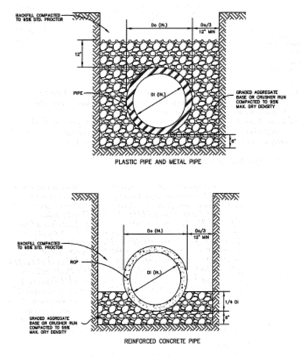
3.
Backfilling. Backfill for CSP, CAP, and HDPE pipe installations shall be constructed using graded aggregate base or crusher run six (6) inches below the bottom of pipe to twelve (12) inches above the pipe crown. Backfill for RCP pipe installations shall be constructed using graded aggregate base or crusher run six (6) inches below the pipe invert to one-quarter (¼) of the pipe diameter. Foundation backfill material shall be used for RCP above one-quarter (¼) of the pipe diameter (if graded aggregate base is not used above the one-quarter (¼) of the pipe diameter) as per Type I or Type II, as specified in Georgia DOT Standard Specifications. These materials shall be placed in players of no more than six (6) inches loose. Compaction of these materials shall be accomplished by hand tamping or machine tamping. Required compaction levels are as follows:
a.
Within Street Right-of-Way. Backfill within all street rights-of-way shall be compacted to ninety-five percent (95%) maximum density, tested using the AASHTO Method T-99.
b.
In Other Areas. Backfill in all other areas shall be compacted to ninety percent (90%) maximum density, tested using the AASHTO Method T-99.
c.
Construction Loads and Minimum Covers. If drainage pipe is installed prior to the completion of grading, a minimum of four (4) feet of fill should be provided where needed to adequately protect the drainage structure during the land development phase, unless the structure itself is designed to withstand the anticipated live load during construction.
F.
End Finish.
1.
Headwalls or other end treatments are required on all culverts and at the outlet of all piped collection systems. Where ends of pipe are located within, or near, the right-of-way and are parallel, or nearly parallel, with the roadway, safety end sections shall be required when the posted speed limit is thirty-five (35) miles per hour and over.
2.
Headwalls are to be precast concrete, stone masonry with reinforced concrete footings, or poured in place, reinforced concrete with reinforced concrete footings. Precast concrete headwalls for corrugated aluminum coated steel pipe or aluminum alloy pipe shall be made with aluminum coated steel or aluminum alloy pipe stubs.
3.
End treatments that conform to the slope may be pre-cast concrete end sections; aluminum coated steel or aluminum alloy end sections, masonry, PE end sections, reinforced poured-in-place slope collars, or grouted rip-rap. Concrete and metal flared end sections shall conform to applicable Georgia DOT Standard Drawing 1120, 1122, or Detail D-39.
G.
Junction Boxes and Catch Basins. Junction boxes and catch basins shall have metal manhole frames and lids for access.
H.
Other Structures. Natural bottom arches and box culverts may be used in accordance with the latest standard specifications of the Georgia Department of Transportation. Bottomless culverts shall require that a scour analysis be done by a registered professional engineer in that field to Georgia Department of Transportation Specifications and Standards to ensure the soundness of the proposed structure.