
Stockbridge City Zoning Code
CHAPTER 2
ZONING AND OVERLAY DISTRICTS
2.1 - Generally.
All buildings, land, and structures shall be used in accordance with the comprehensive plan for the City of Stockbridge, and they shall comply with the development standards of the applicable zoning district which is established in this chapter. Such buildings, land, and structures shall be occupied or used only in conformity with each of the standards that are set forth herein for the district in which they are located.
2.2 - Official zoning map.
The City of Stockbridge is hereby divided into zoning districts, as is shown on the official zoning map, together with all explanatory notes thereon. The official zoning map may be amended according to procedures that are established in Chapter 2.
2.3 - Establishment of zoning districts.
The zoning districts which are established in this unified development code are comprised of base districts and overlay districts. The base zoning districts refer to "how a property is zoned," while the overlay districts are special areas of the city where additional regulations apply. Many properties in the city have overlay districts in addition to their base zoning districts, whereby properties must comply with the regulations of both districts. If there is any conflict between a property's base zoning district and its overlay district, the overlay district regulations shall rule.
Most properties that are located along the major roads within the City of Stockbridge are also located within the Parkway Mixed Use Overlay District. Please see the adopted overlay map to view these parcels. These properties therefore have two (2) zoning districts—a base zoning district and an overlay district. Each district is assigned development standards that regulate the use and development of property within the city limits of Stockbridge. Uses may be permitted "by right" with no further approvals required; uses may be subject to supplemental standards; and certain uses may be prohibited. The range of residential uses is presented in the respective residential zoning districts. Commercial, institutional, and industrial uses are presented in the respective nonresidential zoning districts. Accessory uses which are permitted in residential and nonresidential districts are presented in the individual zoning districts.
A.
List of Current Zoning Districts. Listed below are the City of Stockbridge's current zoning districts. They are grouped by base zoning districts and overlay districts. The base zoning districts are further grouped by residential districts, commercial districts, industrial districts, and other districts.
_____
LIST OF THE CITY OF STOCKBRIDGE'S CURRENT ZONING DISTRICTS
The City of Stockbridge's current zoning district consists of base zoning districts and overlay zoning districts, as are listed below.
BASE ZONING DISTRICTS:
• Residential Zoning Districts:
◦ Rural Residential District (RR)
◦ Suburban Residential District (SR)
◦ City Center Residential District (CCR)
◦ Multiple Family Residential District (MFR)
◦ Mobile Home Residential District (MHR)
• Commercial Zoning Districts:
◦ Neighborhood Commercial District (C1)
◦ General Commercial District (C2)
◦ Heavy Commercial District (C3)
◦ Office-Institutional District (OI)
◦ Downtown District (DT)
• Industrial Zoning Districts:
◦ Light Industrial District (LI)
◦ Heavy Industrial District (HI)
• Mixed Use Zoning Districts:
◦ Planned Unit Development District (PUD)
OVERLAY ZONING DISTRICTS:
• Parkway Mixed Use Overlay District (PMU)
• Downtown Village Overlay District (DTV)
_____
B.
City of Stockbridge Zoning District Conversion Chart. During the preparation of this new unified development code, some zoning districts were retained, some districts were converted to new districts or combined with other districts, some districts were eliminated, and new districts were added. The City of Stockbridge Zoning District Conversion Chart below provides this information.
CITY OF STOCKBRIDGE ZONING DISTRICT CONVERSION CHART
2.4 - Zoning districts—Uses and development standards.
The following sections present those development standards that must be met in the respective zoning districts that are established in this unified development code.
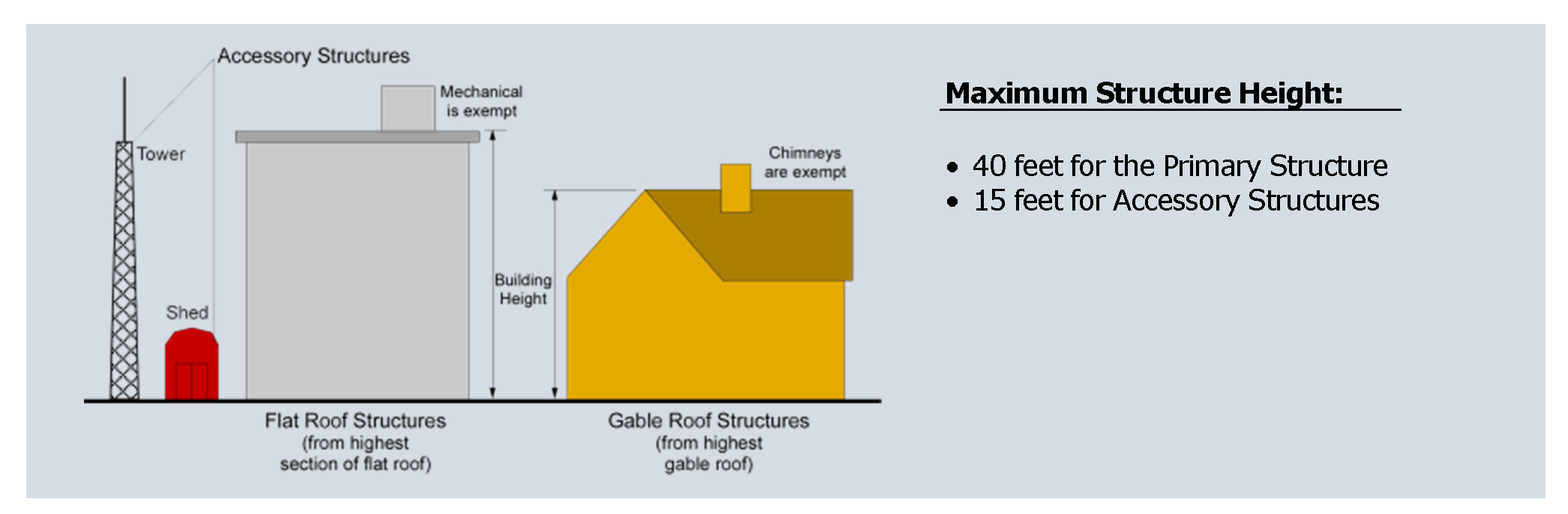
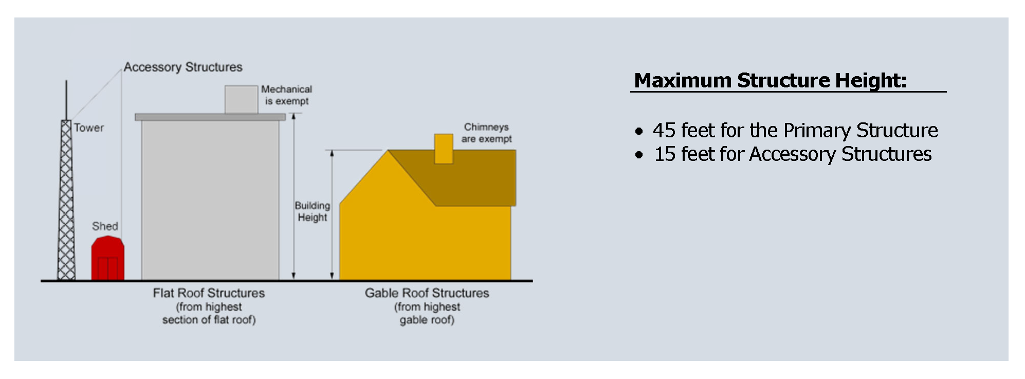
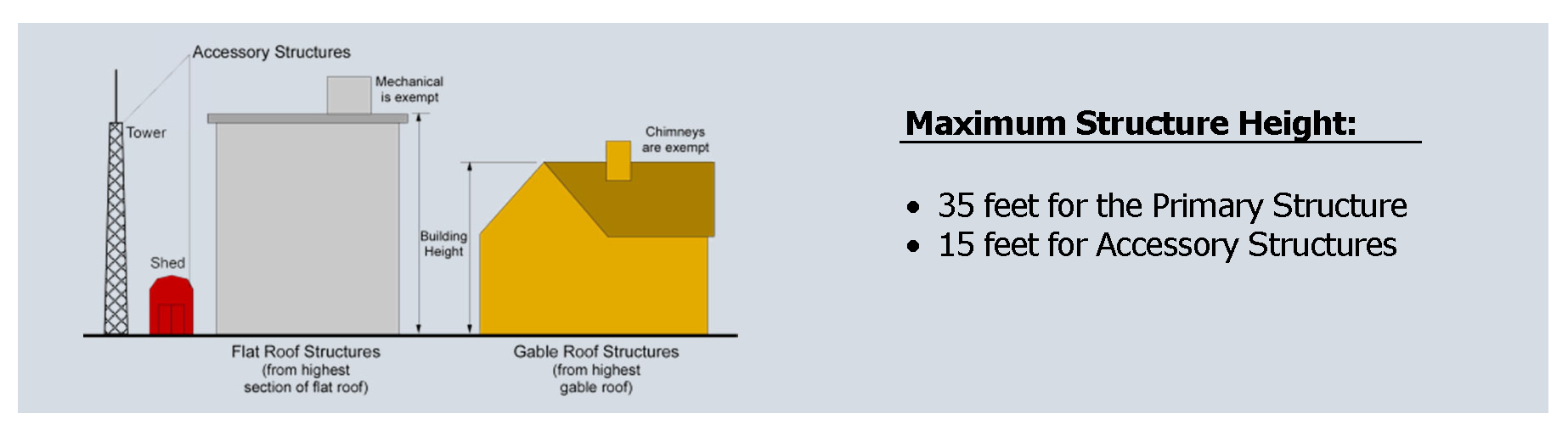
2.4.1 - RR—Rural Residential District.
A.
District Intent. The intent of the Rural Residential District is to preserve the mixed agricultural and residential character of land which presently serves as a transition between rural land and land which may become urban in character.
B.
District Standards.
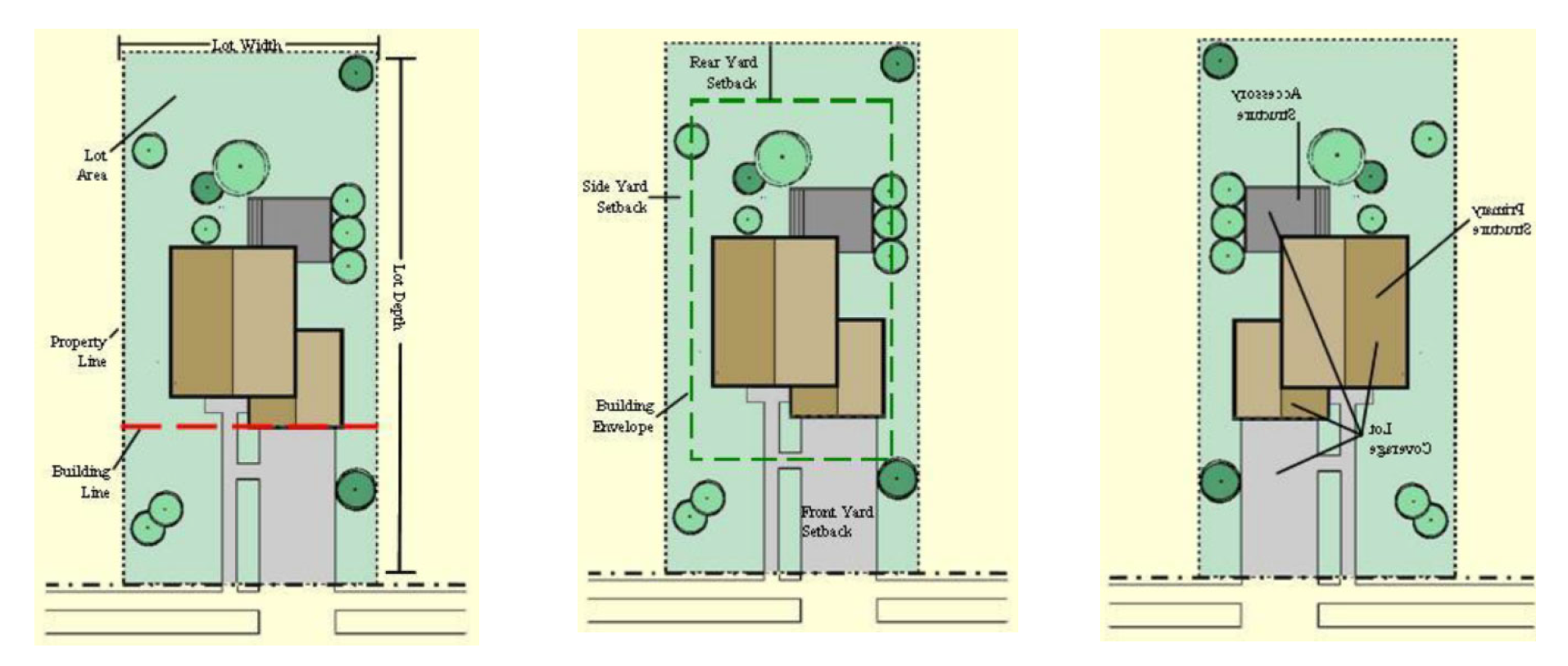
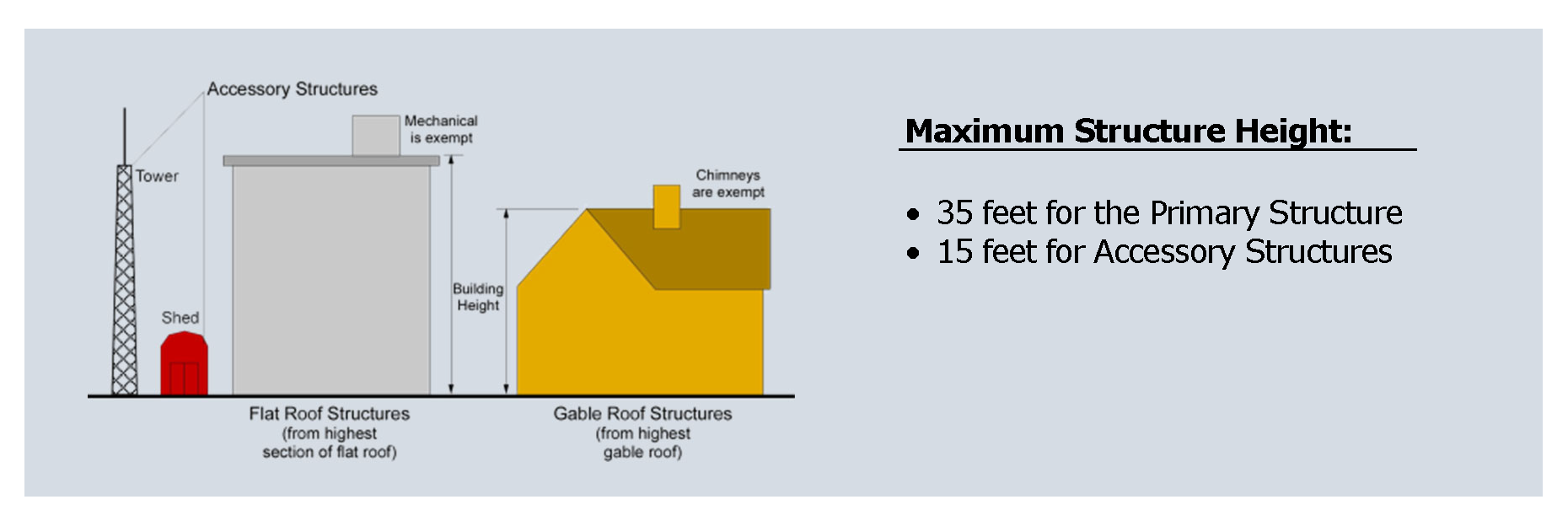
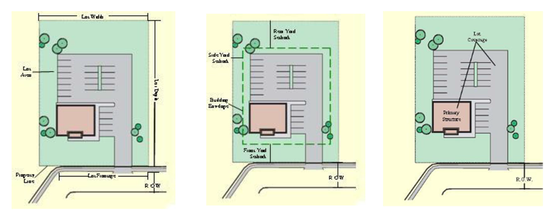
2.4.2 - SR—Suburban Residential District.
A.
District Intent. The intent of the Suburban Residential District is to provide for single-family dwellings of a low to moderate density character on individual lots.
B.
District Standards.
2.4.3 - CCR—City Center Residential District.
A.
District Intent. The intent of the City Center Residential District is to provide a diversity of residential housing types on smaller lots where public sewer systems are present, when they are a part of a planned development project.
B.
District Standards.

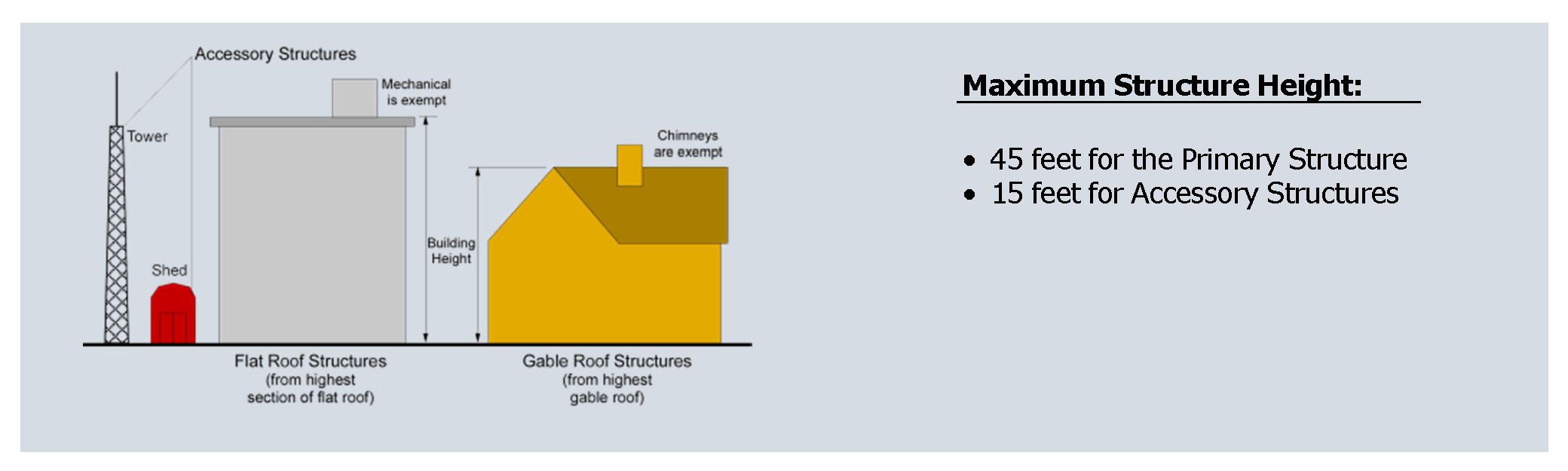
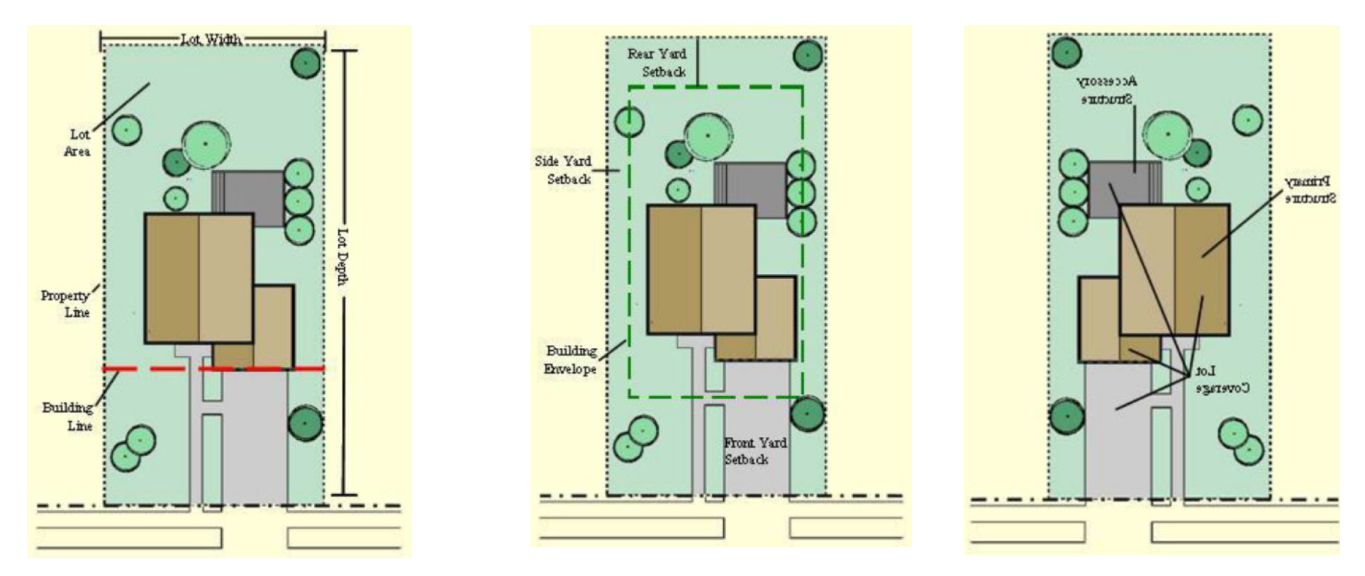
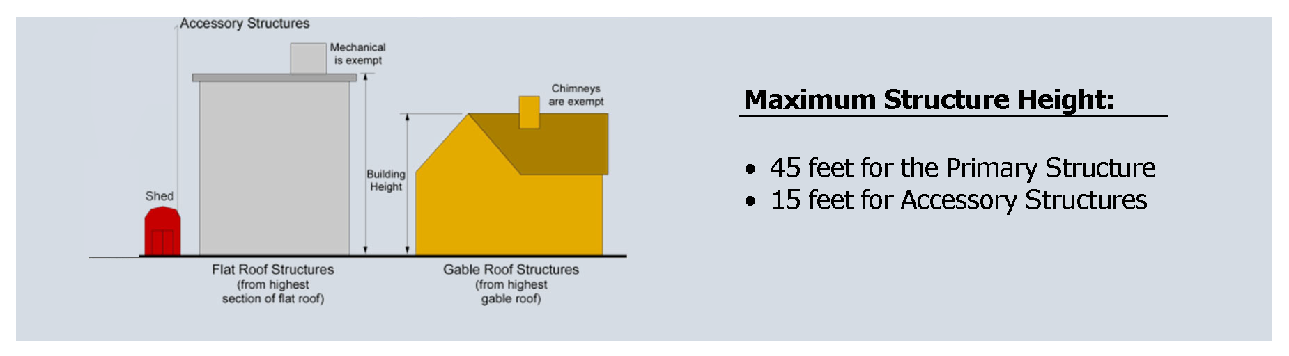
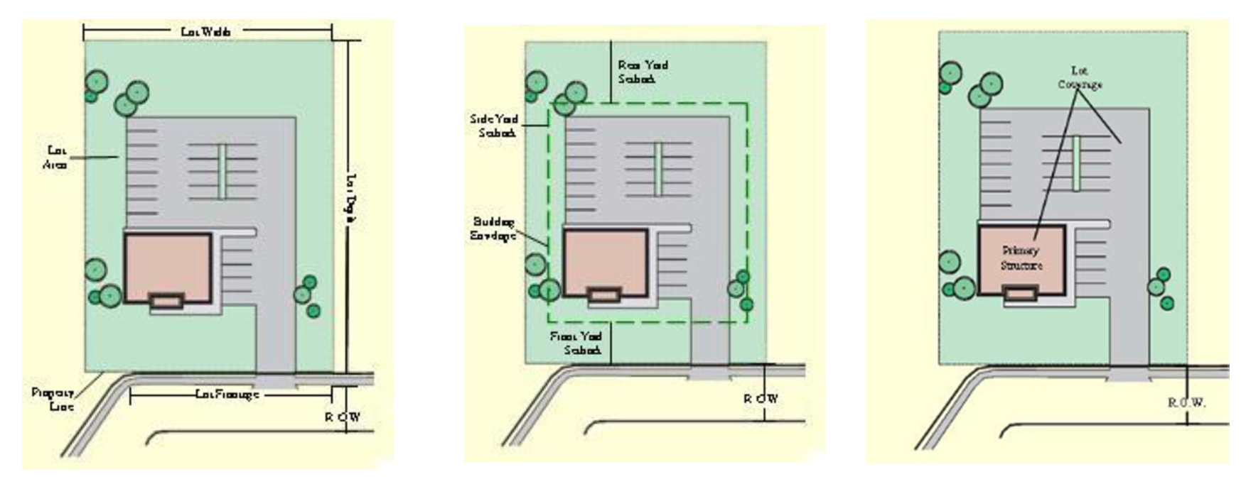
2.4.4 - MFR—Multiple Family Residential District.
A.
District Intent. The intent of the Multiple Family Residential District is to allow the development of multiple family residences served by public water and sewer systems. The provisions that regulate this land use district provides for the development of residential neighborhoods in a high-density urban development environment with access provided on streets that are classified as collector streets of higher.
The city should promote an average density of fourteen (14) dwelling units per acre or higher.
B.
District Standards.
C.
Multiple Family Residential District Design Guidelines.
1.
Single-Family Development (Attached) Townhomes. Townhouses shall either be designed as a unified building or as a series of individualized units. Townhouses are suitable to be in both residential or nonresidential areas and may either be on a common lot or individually lotted.
The development standards for townhome/multi-family dwelling units are as follows:
a.
Definition. Townhomes in buildings containing three (3) or more dwelling units. Current development trends see buildings constructed with six (6) to nine (9) units per building.
i.
Architectural Image and Character. Townhome units may vary in size and scale, but all should strive to maintain a residential character through appropriate massing, materials, and detailing. This guideline does not advocate for or prohibit any architectural style, provided that the minimum requirements of this section are met. Townhome units should be designed and constructed with facades that are compatible with the custom single-family homes:
One thousand (1,000) square feet for a one-bedroom unit; one thousand three hundred (1,300) square feet per two-bedroom unit; one thousand four hundred (1,400) square feet per three-bedroom unit; and two hundred (200) additional square feet per additional bedroom.
ii.
The front facade of each dwelling unit shall be comprised of not less than eighty percent (80%) of either brick, stone, or stucco, or a combination of brick and stone, and the remaining twenty percent (20%) may be comprised of stucco, shake, and/or cement fiberboard siding. In determining the percentage of materials on the front facade, neither doors, windows, garage doors, gables nor eaves shall be included in such calculation.
iii.
The front and side facades of each dwelling unit must be comprised of any combination of primary materials including brick and/or stone and secondary materials including stucco, shake and/or cement fiberboard (CF not to exceed thirty percent (30%) of the entire house) siding; provided, however, the proposed materials must be harmonious with the front facade materials for such dwelling unit. The rear elevation can be comprised of cementitious fiber or a combination of primary materials.
iv.
Review and Approval Process. Site and architectural plans will be reviewed by the community development department as part of the process for the related site plan, subdivision plat, or other applicable development application. Such a review shall be completed prior to issuance of any permits.
v.
In no case shall vinyl, metal, or aluminum siding of any kind be used on the front, side or rear elevations of a dwelling unit, including the gables and eaves.
c.
Massing and Roof Form. Townhome units and buildings shall not exceed two and one-half (2½) stories in height when viewed from the street. When parking is within the above-grade ground floor of the building, it shall be considered a story and must meet all the requirements of this guideline.
Townhome buildings shall have pitched roofs. The predominant roof form shall be hip, gable, shed, or flat. Building facades shall reflect the roof (e.g., a gable roof shall not be concealed by a parapet well intended to make the building appear to have a flat roof).
Dormers, when provided, shall be functional (correlating to an occupied space) and placed in a manner consistent with the prevailing architectural style of the building. Dormers may be allowed as vents or to conceal equipment provided, they are proportional to thereof.
d.
Building Materials and Colors.
i.
Complimentary Materials. Building design should consider the scale, texture and patterns of the building materials by utilizing them in common recognizable applications.
ii.
Building Materials. The following guidelines should be followed with regards to building materials:
(a)
Use high-quality, durable materials that reflect the local character such as brick, stucco, stone, or cementitious fiberboard siding. Three-sided brick or stone and rear shall cementitious fiber or brick, stone, or stucco.
(b)
Preference is given to natural stone over manufactured stone. However, manufactured stone may be accepted subject to special review of product.
iii.
Building Colors.
(a)
Colors should consist of a cohesive, complimentary palette.
(b)
Limited use of accent colors is permitted if they are not bright or fluorescent and complement the overall palette of materials.
iv.
Materials and Colors.
(a)
A minimum of three (3) materials and three (3) colors shall be utilized on front or street side elevations, or facade abutting common open space. A minimum of two (2) materials and two (2) colors shall be utilized on interior side and rear elevations.
v.
Architectural Wrap.
(a)
Stone, brick, wainscot and other materials shall be wrapped a minimum of two (2) feet into interior side elevations.
(b)
Stone, brick, wainscot, and other front elevation.
(c)
Materials shall extend the full width of any street side yard, or facade abutting common open space.
e.
Building Features. The primary common building entrance shall be covered by an appropriately scaled architectural projection from the facade or shall be recessed in order to identify the point of entry. Canvas or other fabric awnings or canopies shall not be permitted at the primary entry way. The entry way shall be connected to a vestibule and an interior lobby.
Each dwelling unit shall have its own functional balcony (or defined patio area for ground floor units). Juliet balconies shall be permitted when architecturally appropriate to the style of the building. Exterior, elevated open walkways, landings, and common stairs required to access individual units are strictly prohibited.
f.
Details and Ornamentation. When thin veneer brick or stone (class B) materials are used, either for full-height walls or wainscoting, the material shall return to an inside corner with an adjacent wall. In the case of outside building corners, a minimum twenty-four-inch return shall be provided.
Appropriately scaled trim of at least four (4) inches in width shall be included around all window and door openings, building corners, rooflines, and facade material transitions. Trim color shall be of a contrasting but compatible color to the primary building material color.
Shutters, if used, must be in proportion to the area of adjoining windows. All soffits and overhangs shall project no less than twelve (12) inches.
g.
Landscaping. Landscaping shall comply with Chapter 5, Landscaping Ordinance Codes.
2.4.5 - MHR—Mobile Home Residential District.
A.
District Intent. The intent of the Mobile home Residential District is to accommodate mobile home developments as attractive and attainable housing options. Mobile home parks shall be designed in accordance with O.C.G.A §§ 8-2-160 through 168, the State Board of Health requirements, and the requirements of this Code.
It is intended that such mobile home developments shall be so located, designed, and improved as to provide a desirable residential environment, protection from potentially adverse neighboring influences, and access for vehicular traffic without traversing local streets in adjoining residential neighborhoods. Mobile home developments, including mobile home parks and mobile home subdivisions, shall be located on a thoroughfare having the minimum classification of an arterial roadway.
B.
District Standards.
2.4.6 - OI—Office Institutional District.
A.
District Intent. The intent of the OI district is to allow a land use category for offices, banks, and personal business services which can serve as a transitional area between residential and commercial districts.
B.
District Standards.
2.4.7 - DT—Downtown District.
A.
District Intent. The intent of the DT District is to maintain, enhance, and expand the development patterns and mixed use and open space character of Downtown Mainstreet. It is also to encourage compatible infill and redevelopment opportunities. Development standards within the district are intended to continue historic development patterns and promote a predominant land use activity for retail, dining, entertainment, cultural events, community festivals, and residential options, while still allowing for other uses to locate in the district.
B.
District Standards.
C.
Permitted Uses.
1.
Art studio.
2.
Dance studio.
3.
Hotels and boutique hotels (must be four-star or higher; three-star and below will require a special use permit).
2.4.8 - C1—Neighborhood Commercial District.
A.
District Intent. The intent of the C-1 District is to provide locations for limited retail and service uses to satisfy the common and frequent needs of nearby residents of nearby residential neighborhoods. It is the intent of this district to encourage such uses to be a part of a neighborhood convenience shopping center designed as a continuous architectural unit and on roads classified as minor arterial.
B.
District Standards.
2.4.9 - C2—General Commercial District.
A.
District Intent. The intent of the C-2 District is to provide locations for a wide variety of retail and service uses and wholesale establishments to satisfy the common and frequent needs of residents in large sections of the county and of the traveling public. It is the intent of this district to encourage businesses to be part of planned commercial convenience centers, neighborhood or community shopping centers, and/or developed sections along roads with a classification of minor arterial.
B.
District Standards.
2.4.10 - C3—Heavy Commercial District.
A.
District Intent. The intent of the C-3 District is to provide distinct areas for commercial activities which provide products and services that require locations along major arterial roads, highway intersections, and freeway interchange areas, due to their generation of heavy traffic or their need to transport and display heavy bulk materials, and which provide services that would not be appropriately located in areas providing neighborhood or other commercial retail and service activities. Uses in this district shall be located on roads having a minimum classification of major arterial.
B.
District Standards.
2.4.11 - LI—Light Manufacturing District.
A.
District Intent. The intent of the Light Manufacturing District is to provide for light industrial uses, all of which shall be nuisance-free and not generators of hazardous wastes. It is intended that light manufacturing uses shall be located on either arterial or major collector streets, or within industrial parks having access to such thoroughfares.
B.
District Standards.
2.4.12 - HI—Heavy Industrial District.
A.
District Intent. The intent of the Heavy Manufacturing District is to provide for the broadest range of industrial operations permitted in the city. It is the district for the location of those industries which have not reached a technical stage which renders them to be free of all nuisance factors. These uses are to be located on either an arterial or major collector street, or, when they are located within an industrial park, shall have access to such thoroughfares.
B.
District Standards.
2.4.13 - PUD—Planned Unit Development District.
A.
District Intent. The intent of the Planned Unit Development District is to:
1.
Allow the development of balanced neighborhoods containing physical, economic, and social assets which are difficult to achieve through the traditional separation of use and density zones;
2.
Provide an appropriate district for mixed-use developments; and
3.
Allow flexibility in design for environmentally challenged properties.
New developments may contain two (2) or more types of uses. Traditional single-family detached subdivisions are envisioned to be in Suburban Residential Districts instead of PUD Districts, unless an unusual site design is proposed (such as cluster housing) or the physical characteristics of the property necessitate flexibility in the site design. Traditional multifamily developments are similarly envisioned to be in a Multiple Family Residential District rather than in a PUD District.
This is accomplished by allowing the applicant the freedom necessary to protect natural resources, to protect and improve the social and economic environment; and to protect the investment of both the city and the community within the development.
In designing a PUD development, special attention should be focused on the arrangement of buildings and other improvements for the orderly function and aesthetics, the preservation of open space for the use of residents and workers in the development, the variety of housing types and densities necessary to achieve a balanced neighborhood, and the provision of a pedestrian environment separate from the vehicular environment.
B.
Permitted Uses and Special Uses.
C.
District Standards.
2.4.14 - PUD—Planned Unit Development District design guidelines and procedures.
A.
Definitions. The definitions of various terms, as they apply to the PUD District, are provided below.
"Comprehensive plan" means the City of Stockbridge's adopted Comprehensive Plan 2018—2038. It is a long-range plan containing policies to guide the growth and development of the city, which includes the analysis, recommendations, and proposals for the City of Stockbridge's population, economy, housing, transportation, community facilities, and land use.
"Master development plan" means a written in graphic submission for a plan development which represents attractive land, purpose, subdivision, the location in bulk of buildings and other structures, density of development, public and private streets, parking facilities, common open space, public facilities and all covenants related to use thereof. The master development plan is submitted in conjunction with a rezoning application for the PUD District.
"Maximum allowable net density" means the total number of dwelling units or housing structures per unit of land, based on net land area.
"Net land area" means the area that is calculated in terms of net acres, or the land that is devoted to residential, commercial, or industrial use, exclusive of street rights-of-way, flood hazard areas, and public lands.
"Nonresidential land uses" means those designated areas which are not residential land uses, which includes, but are not limited to, the following: Commercial or industrial zones, common open space, private streets, service drives in parking areas, recreation space, and other open space areas.
"Open space" means land within or related to a development, which is not individually owned or delegated for public use, which is designed and intended for the common ownership and use by the residents of development plan. It may include complementary structures and improvements, as are necessary and appropriate.
"Ownership types" consist of all types of residential development, including, but not limited to, single-family, duplex, triplex, quadraplex, apartments, townhouses, and condominiums. Ownership may be fee simple, lease purchase, leased, or rented with a common ownership of open spaces recreation facilities streets and parking areas.
"Preliminary concept plan" means a preliminary plan of the proposed plan development of sufficient accuracy to be used for purpose of reviewing the proposed land uses in general layout.
"Professional consultant" means the person who is a registered and/or certified engineer, architect, or planner who prepared the plan within the scope of their respective legal responsibilities.
"Residential land uses" means any variety of residence types as permitted within respective separately zoned areas of the PUD, and as shown on the approved master development plan.
B.
General Requirements for a Planned Unit Development District.
1.
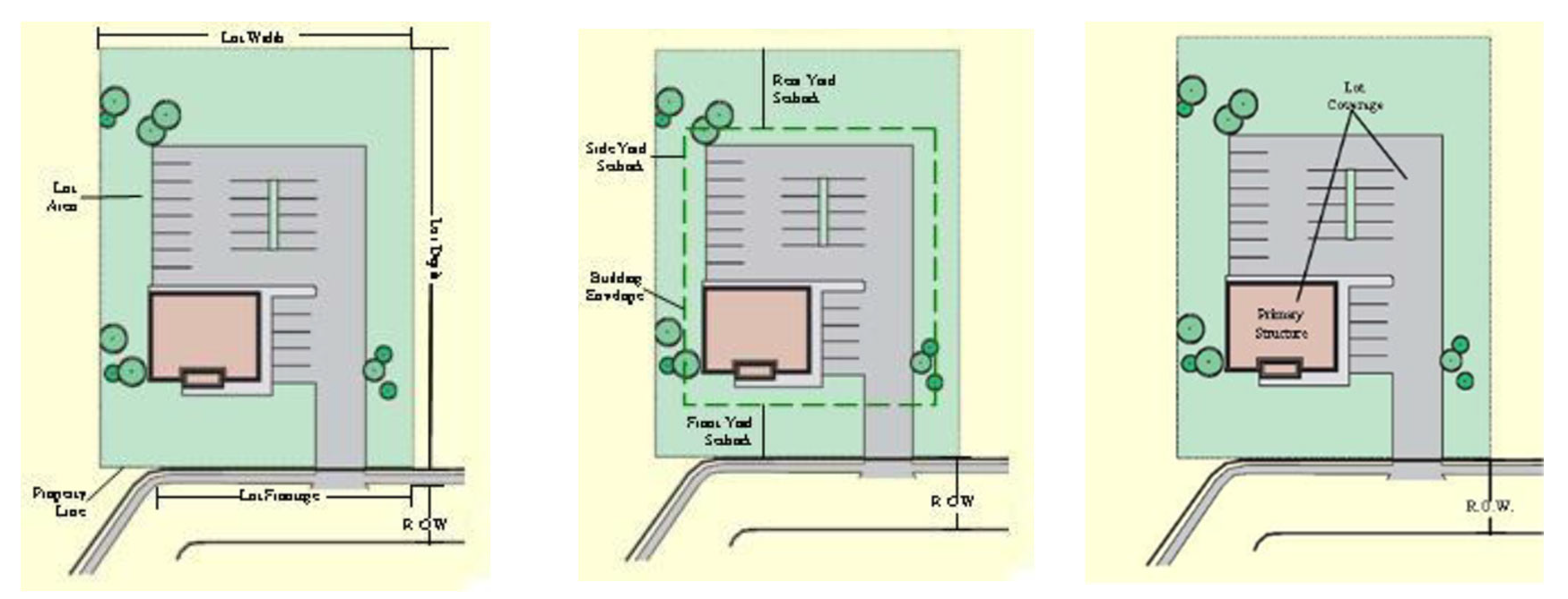
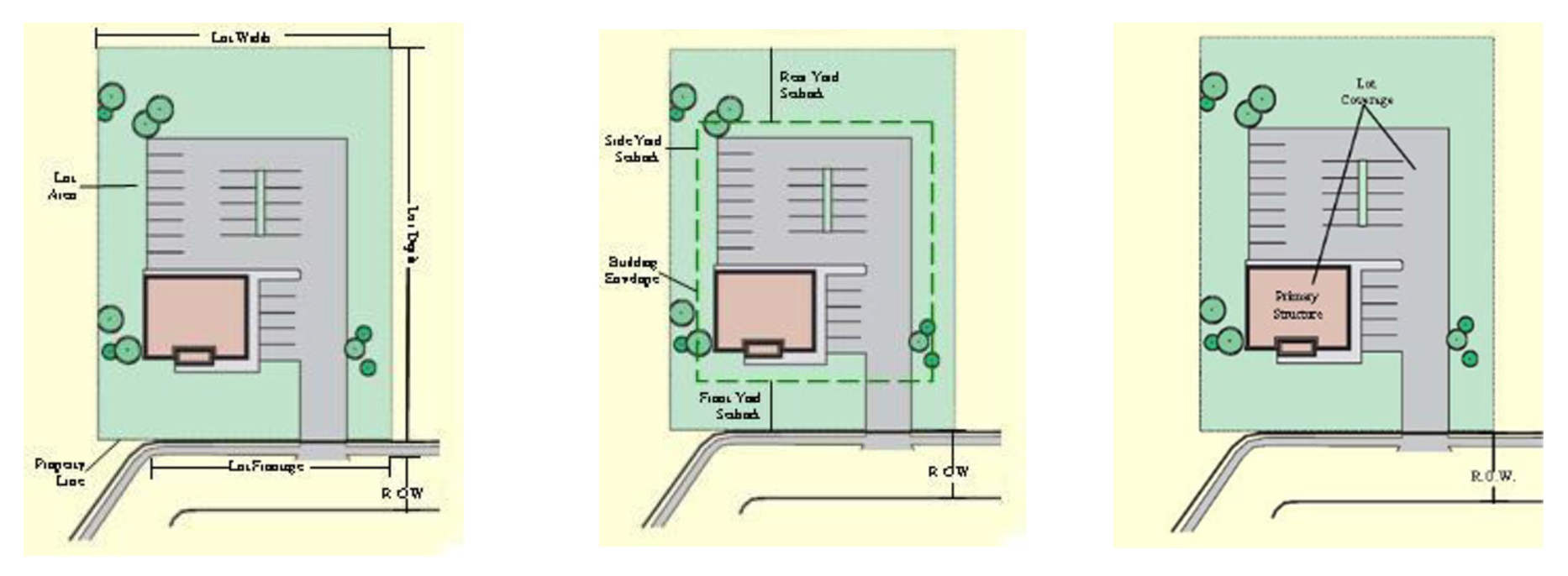
Area. The minimum area that is required for a PUD District shall be three (3) contiguous acres of land.
2.
Uses. Each PUD final development plan must include at least two (2) different uses and/or two (2) types of varied housing options.
C.
Application Procedure.
1.
Preliminary Concept Plan Review. Before an application for rezoning to the PUD zoning district is authorized, the applicant shall submit a preliminary concept plan for review by the community development department.
D.
Required Information. The preliminary concept plan shall include the following information:
1.
Planned unit development name.
2.
The owner and developer of the property.
3.
Architect, engineer, or planner who designed the plan.
4.
Location or orientation map of the property.
5.
Legal description of the parcel.
6.
Date, scale, and north arrow.
7.
Acreage in the total tract.
8.
Topography at ten-foot contour intervals.
9.
Proposed land uses and net acreage in each type.
10.
Proposed street layout.
11.
Proposed lot layout.
12.
General location of proposed buildings to be used for commercial, recreational, or public facility uses.
13.
Proposed buffers, open space, and natural environmental features, such as surface drainage and open water.
14.
Proposed amenities.
E.
Official Rezoning. Following the preliminary concept plan review and approval by the community development department, the applicant of the PUD project shall apply for rezoning.
F.
PUD Master Development Plan Approval Request. A master development plan which incorporates the comments and modifications made by the community development department in its review of the preliminary concept plan shall be submitted with the application for rezoning. The master development plan shall include the following information:
1.
A site plan for the complete development project, which is drawn to a scale of one (1) inch equals fifty (50) feet or one (1) inch equals one hundred (100) feet. The plan shall include information that is contained on the preliminary concept plan, as well as any and all modifications that were previously made by the planning commission. The plan shall include one (1) or more sheets, as necessary, to accurately show the following information:
a.
Property information:
i.
Planned development project name.
ii.
Owner and developer of the property.
iii.
Architect, engineer, or planner who designed the plan.
iv.
Date, scale, and north arrow.
v.
An area map showing adjacent property owners, the zoning classifications of adjacent parcels, and existing land uses within five hundred (500) feet of the property for the PUD project.
vi.
A legal description of the parcel.
b.
Existing conditions:
i.
Existing topographical features of this site, with a minimum contour interval of five (5) feet. The outline of wooded areas and surface drainage such as streams, lakes and wetlands shall be shown.
ii.
Soil conditions according to the U.S. Soil Conservation Service classification for Henry County (including the City of Stockbridge).
iii.
The location of any flood hazard areas subject to a one-hundred-year flood according to the Henry County Flood Damage Prevention Ordinance. The location of the one-hundred-year flood shall be shown relative to contour elevations.
iv.
The location and extent of any aircraft approach zones over the subject PUD property.
v.
The location of any existing property lines within the parcel, railroads, utility rights-of-way or easements, and existing buildings and structures.
vi.
Existing public facilities, such as sanitary sewers, water mains, storm drainage facilities, culverts, or bridges in underground or above-ground facilities within the parcel to be developed; or within the right-of-way of roads bordering the parcel, with sizes, grades, and an invert elevation from field surveys or other sources.
c.
Proposed development conditions:
i.
Phases of the proposed development.
ii.
The location and extent of the proposed interior road system, including pavement and right-of-way width.
iii.
Delineations of the proposed residential uses, including the location of residential land uses and dwelling unit types, the total number of dwelling units, the total number of lots, and the percentage allocation by dwelling unit type.
iv.
Proposed layout and dimensions of lots within each proposed residential zoning district.
v.
Calculation of residential density in dwelling units per net acres by proposed dwelling unit type.
vi.
The delineation of proposed nonresidential areas, including the lot layout and dimensions, as well as the general location of the proposed buildings.
vii.
The interior common open space system.
viii.
Proposed dedication or reservation of land for public use, including streets, parks, schools, and other public buildings and facilities.
ix.
Proposed improvements to existing community facilities, including roads, sewers, drainage facilities, and water facilities adjoining or near the site.
d.
A written report shall be submitted by the applicant which contains the following information concerning the master development plan:
i.
General description of the proposal.
ii.
Proposed standards for development, including restrictions on the use of the property, density standards, yard requirements, and restrictive covenants.
iii.
Proposed dedication or reservation of land for public use, including streets, easements, parks, and school sites.
iv.
Exceptions or variations from the requirements of the zoning ordinance and subdivision ordinance, if any, the area that is being requested.
v.
Plans for the provision of the utilities, including water, sanitary sewer, and drainage facilities, as well as appropriate calculations regarding the sizing of drainage areas and pipes.
vi.
A report from the Henry County Water and Sewerage Authority or municipal authority as appropriate indicating the adequacy of sanitary sewer and water services.
vii.
Plans for the protection of abutting properties.
viii.
Plans for the maintenance of common open space areas.
ix.
A table showing the total number of acres in the proposed development and the percentage that is designated for each type of proposed land use, including public facilities. Information should be provided in net acres.
x.
Tabulations of the overall net density for residential uses.
xi.
An explanation of phasing or stages of the PUD project.
xii.
Adequacy of an arrangement of vehicular traffic access and circulation, including intersections, roadway widths, and traffic controls.
xiii.
Adequacy of an arrangement of pedestrian traffic access in circulation, including separation of pedestrians from vehicular traffic and pedestrian convenience.
xiv.
Location and arrangement of off-street parking and loading.
xv.
Location, arrangement, size, and placement of buildings, lighting, and signs.
xvi.
Plan development projects for which two thousand (2,000) or more average daily vehicle trips will be generated, and/or for which at least twenty thousand (20,000) gallons per day of sewage treatment plant capacity will be required, must submit with the application an environmental impact report. The report shall follow the format which is used by the community development department. The report shall objectively discuss the positive and negative impacts of the proposed development on land uses; on public water and sewerage facilities; on traffic patterns volumes and road improvements; on storm drainage facilities and school enrollments; on the tax base (economic base); on natural vegetation and wildlife habitat; and on area appearance and aesthetics. The report shall be prepared by a professional consultant.
e.
Review of application. In reviewing the application for PUD preliminary development plan approval and zoning approval, the planning commission and city council shall consider those items which are listed in Chapter 9 concerning zoning map amendments.
f.
The consideration of a PUD District approval or disapproval and master development plan shall also include, but not be limited to, the following:
i.
The relationship to the comprehensive plan;
ii.
The adequacy and arrangement of vehicular traffic access and circulation, including intersections, road widths, and traffic controls;
iii.
The adequacy of an arrangement of pedestrian traffic access in circulation, including separation of pedestrian from vehicular traffic, and pedestrian convenience;
iv.
The location, arrangement, appearance, and sufficiency of off-street parking and loading;
v.
The location, arrangement, and size in the placement of buildings(s), lighting, and signs;
vi.
The arrangement of landscape features and buffer areas;
vii.
The adequacy of public water supply;
viii.
The adequacy of stormwater and sanitation waste disposal facilities; and
ix.
The adequacy of structures, roadways, in areas with moderate to high susceptibility to flooding and ponding and/or erosion.
G.
Modifications.
1.
Minor Modifications. The community development director shall have the authority, in the administration of the PUD, to approve minor modifications of the master development plan without a public hearing in a manner that is consistent with the purpose or intent of the overall development. Minor changes are those which implement only slight alterations to the approved site design layout; which are made necessary by actual field conditions at the time of development; or which do not alter the impact of the development on nearby properties, nor the intent or integrity of the conditions as they were originally imposed. Any request for a minor change of the master development plan shall be made in written form to the director. Furthermore, the request for a minor change shall be accompanied by copies of the revised master development plan.
2.
Major Modifications. Any major change to the site plan, or to conditions that were attached to an approved master development plan, shall require an application and hearing before the planning commission and the city council, as is required within subsection 2.4.14.F. Without limiting the meaning of the phrase, the following are examples of what constitutes a "major change" for purposes of interpreting this section:
a.
The movement of any building or structure adjacent to an exterior boundary line, closer to the boundary line of the property; if this causes an encroachment upon the required yard setbacks;
b.
Any increase in the number of dwelling units or any increase in the total amount of floor space of any nonresidential building;
c.
Any change in any buffer requirement(s) that were imposed in the original conditional zoning amendment;
d.
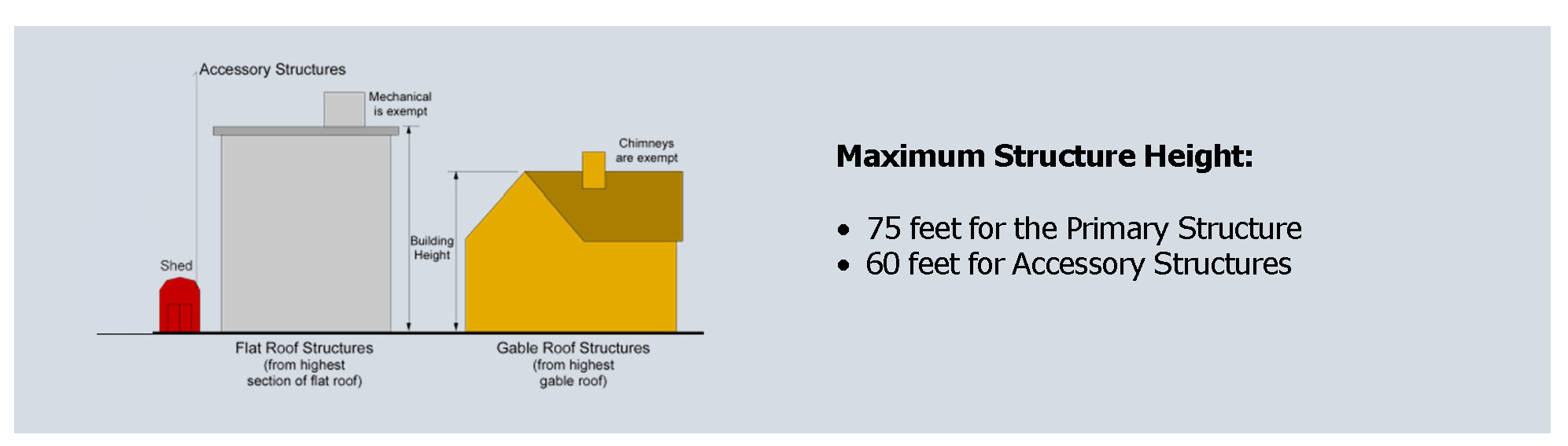
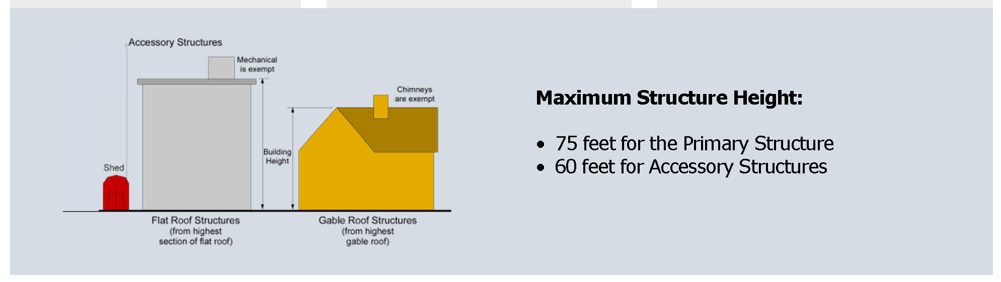
Any increase in the height of any building or structure; or
e.
Any change in the proportion of floor space that is devoted to different authorized uses.
(Ord. No. OR23-525, § 1, 2-13-2023; Ord. No. OR24-559, 3-4-2024; Ord. No. OR24-580, § 1, 11-12-2024; Ord. No. OR24-581, §§ 1.1, 1.2, 11-19-2024)
2.5.1 - Generally.
A.
These districts are superimposed on portions of one (1) or more underlying zoning districts that allow application of additional standards to accomplish a special purpose, for promoting the aesthetics of the city for the general public and the existing residents.
B.
Relationship to Underlying Zoning District Standards and Other Provisions of Unified Land Development Code. In any case where the standards and requirements of the overlay district conflict with those of the base-zoning district or with other provisions of the unified land development code, the standards and requirements of the overlay district shall govern.
C.
Application. Overlay districts are supplemental to the underlying zoning district classifications established in the city's unified land development code governing all properties and approvals within this overlay district. The provisions of this section shall be overlaid upon and shall be imposed in addition to said underlying zoning regulations and other city ordinances. The community development director or designee is authorized to promulgate and enforce such rules, regulations, guidelines, and standards as may be reasonably necessary or desirable to give effect to the provisions of this section.
D.
Exceptions. The provisions of this section shall not apply to the following:
1.
Completion of work subject to preliminary plats, site development plans, construction plans, building permits, or interior finish permits approved prior to the effective date of adoption of the ordinance from which this section is derived for those parcels not previously covered within the highway overlay district.
2.
Improvements and additions that are made to a single-family residence that was previously permitted and built on a lot of record prior to enactment of the ordinance from which this section is derived for those parcels not previously covered within the overlay district.
3.
Construction of a single-family dwelling on an existing lot of record within a single-family residential subdivision with a final plat that was approved prior to the enactment of the ordinance from which this section is derived, for those that were parcels not previously covered within the overlay district, provided that the new construction shall be of a similar floor area, materials, and design as the single-family dwellings on adjacent lots in the same subdivision.
4.
Construction, rehabilitation, restoration, repair of a nonresidential structure, interior renovations, or interior finishes within an existing structure, or addition to an existing nonresidential structure that was permitted prior to the enactment of the ordinance from which this section is derived for those parcels that were not previously covered within the Parkway Mixed Use Overlay District shall not be subject to the provisions of the Parkway Mixed Use Overlay District, provided that such construction is on a lot of record and does not affect a change to more than twenty percent (20%) of the existing permitted structure or five thousand (5,000) square feet, whichever is less.
2.5.2 - PMU—Parkway Mixed Use Overlay District.
A.
Purpose. The purpose of the Parkway Mixed Use Overlay District is:
1.
To promote the general health, safety, and welfare of the community where residents and visitors can live, work, eat, and play.
2.
To promote economic development by diversifying the employment base for a stronger city.
3.
To improve public health and provide safe and efficient movement within the overlay district by promoting development patterns that encourage physical activity such as walking and bicycling.
4.
To encourage a balanced mix of retail, professional, residential, civic, entertainment, and cultural uses.
5.
To improve the efficient operation of traffic around the city.
6.
To provide accessible, sufficient parking in an unobtrusive manner.
7.
To create an attractive gateway that is aesthetically appealing and environmentally responsible.
8.
To encourage innovative development projects that set standards for landscaping, open space, community design, and public amenities.
9.
To establish consistent and harmonious design standards for public improvements and private property development within the overlay district so as to unify the distinctive visual quality of the city.
B.
Applicability.
1.
These regulations of the Parkway Mixed Use Overlay District pertain to all properties which have frontage on one (1) or more streets that are identified in the "Boundaries" paragraph.
2.
The previous "Highway 138 Overlay District" has been eliminated as a separate district, but its regulations are merged into this revised Parkway Mixed Use Overlay District.
3.
The previous "High-Rise Mixed-Use Overlay District" has been eliminated as a separate district and the two (2) mapped areas which comprised that district are no longer recognized. However, the regulations of the High-Rise Mixed-Use Overlay District which applied specifically to high-rise buildings (defined as having five (5) or more totally above-ground floors) and/or mixed-use buildings are now merged into this revised Parkway Mixed Use Overlay District. Any high-rise buildings and/or mixed-uses which are located in the Parkway Mixed Use Overlay District shall meet the associated additional standards which previously comprised the High-Rise Mixed-Use Overlay District.
4.
These regulations of the Parkway Mixed Use Overlay District shall take precedence over the regulations of all other districts, including the base zoning districts and any other type of overlay district.
5.
Boundaries. The boundaries for the overlay are designated on the overlay district map.
C.
Permitted Uses. Any combination of uses permitted in C1, C2, OI, CCR, and MFR are permitted in the Parkway Mixed-Use (PMU) Overlay District, provided that they are not among the prohibited uses in subsection 2.5.2.D. below, and provided that they meet the stated Requirements for the Select Uses that are listed in subsection 2.5.2.C.1. and subsection 2.5.2.C.2. below,
1.
List of Select Uses.
a.
Gasoline stations, minor automotive service/repair/maintenance centers, car washes, convenience stores, and other associated uses.
b.
Restaurants with drive-through (a.k.a. "drive-thru") facilities or windows.
c.
Other special uses, to be determined by the community development director.
2.
Requirements for Select Uses.
a.
A select use must be located on a property which has frontage on either a collector or an arterial road, as is classified by the Georgia Department of Transportation or the Henry County Department of Transportation.
b.
The property must have a base zoning district which allows such uses.
c.
All property design standards of the base zoning district must be met.
d.
Any existing nonconforming structures may not be enlarged.
e.
Building facades for both primary and accessory structures must be constructed of brick on all sides.
f.
At gasoline stations, an equal number of electric charging stations as gas pumps must be provided on the site, and covered canopies must be provided over gas pumps and electric charging stations.
g.
An acceptable means of access and internal circulation must be provided, to be determined by the fire marshal.
h.
The required number of parking spaces must be provided.
i.
The required buffers must be provided.
j.
Other special requirements, to be determined by the community development director.
D.
Prohibited Uses.
1.
Adult entertainment establishments.
2.
Ambulance service.
3.
Automobile broker (no vehicle storage), except for office uses.
4.
Automobile rental and leasing facilities.
5.
Automotive service repair and maintenance facilities—major.
6.
Building and lumber supply establishments, providing that there is no outside storage of materials or equipment.
7.
Daycare centers.
8.
Funeral home, mortuaries, and crematoriums.
9.
Greenhouses and nurseries including landscape service.
10.
Pawnshop, loan brokers, check cashing, and other than mortgage loan brokers.
11.
Retail warehouses/wholesalers providing sales of merchandise with no outdoor storage.
12.
Rooming and boarding houses.
13.
Self-service storage, mini-warehouses, or warehousing and storage.
14.
Specialized housing facilities.
15.
Tattoo and piercing parlors.
16.
Trade shops, including electrical plumbing, heating/cooling, and roofing siding, having no outside storage.
17.
Truck terminals, truck trailer storage lots, truck parking lots, and truck repair.
18.
Industrial uses, warehouses, and business distribution centers.
19.
Vape stores.
20.
Veterinary clinic.
E.
Architectural Standards. The following design guidelines and standards apply to all newly-constructed buildings used for commercial, industrial, or residential purposes.
1.
The use of a common palette of building materials should be maintained in the department of community development for building facades to create a consistent and traditional architectural identity. Traditional architecture shall include, for example, the use of brick, pitched roofs, low-profile signage, and subdued colors. For large commercial/retail buildings and multifamily buildings, variations in facade, roofline, and depth should be provided to lend the appearance of multitenant occupancy. All design and construction shall be subject to architectural review by the community development director or its designated architect to ensure adherence with this subsection and the structures of traditional architecture.
2.
All ground or roof-mounted mechanical, HVAC, and like systems shall be screened from public street view (within three hundred (300) feet) on all sides by an opaque wall or fence made of brick, stucco, split face block, or landscaping.
3.
For all commercial buildings, roof-mounted mechanical, HVAC, and like systems shall be screened from public street view (within three hundred (300) feet) on all sides by a raised parapet or pitched roof along the edge of the roofline.
4.
Contrasting accent colors on any single facade shall be limited to no more than ten percent (10%) of the total wall area for any single facade.
5.
Permanent mounted exterior neon lights shall not be allowed.
6.
Buildings that are located on outparcels and all accessory buildings shall be constructed of materials complementing the principal building with which they are associated.
7.
Back-lit awnings, roof-mounted lights, and/or roof mounted flag poles are not permitted. Satellite dishes shall be located and painted to blend with the background as much as practical.
8.
Building Materials. The "Allowed Building Materials Table" below and this subsection outlines allowed building materials that may be used and combined to create a consistent, attractive, interesting and long-lasting building design:
Allowed Building Materials Table
9.
Allowed Building Materials.
a.
Brick, except that brick veneers that are intended to simulate brick exteriors are not acceptable;
b.
Stone. Natural stone such as, but not limited to, granite, limestone, acid marble are allowed building materials. Terra cotta and/or cast stone, which simulate natural stone, are also acceptable. Painted stone is not allowed;
c.
Split-face block/concrete masonry unit (CMU) is restricted to ten percent (10%) of the surface area of the facade;
d.
Tilt/architectural pre-cast concrete is not allowed;
e.
High-grade stucco is restricted to fifty percent (50%) of the surface area of a facade;
f.
Natural wood and/or cementitious fiberboard siding are allowed only for residential buildings;
g.
Glass;
h.
Exposed concrete block, metal, and tile are not allowed as building materials on a facade.
F.
Building Standards.
1.
Height requirement: Maximum building height twenty (20) stories; minimum of two (2) stories; the first finished floor level being level with sidewalk grade.
2.
At least the first floor (sidewalk grade) of residential buildings in the overlay district are required to be commercial space.
3.
Maximum residential density shall not exceed forty-five (45) dwelling units per acre. Additional density may be permitted per the bonus density requirements below.
a.
The director may administratively grant a density bonus based on the amenities which are provided in the development. An increase in density up to sixty (60) units per an acre may be permitted if two (2) or more amenities are provided and an increase in density up to ninety (90) units per an acre may be permitted if four (4) or more amenities are provided.
b.
Amenities may include, but are not limited to, indoor or outdoor swimming pool facilities, gym/workout space, community space, outdoor public space, parks and playgrounds, or walking/hiking/biking trails or other approved by director of community development.
4.
The impervious surface area shall not exceed eighty-five percent (85%) of the lot area.
G.
Streetscape Design Standards. The streetscape along the major highways shall be divided into three (3) distinct zones consisting of a building frontage zone, pedestrian travel zone, and fixtures/planting zone. The widths of each zone shall be as provided below:
1.
Building frontage zones are encouraged to provide outdoor activities and gathering areas and may be permitted at varying widths between five (5) and twenty (20) feet wide.
2.
Pedestrian travel zones shall be a minimum of ten (10) feet wide, paved in concrete, and kept clear and unobstructed for the safe and convenient use of pedestrians.
3.
Fixtures/planting zones shall be a minimum of ten (10) feet wide and planted with grass, ground cover or flowering plants. Within the fixtures/planting zone:
a.
Sidewalk benches shall be placed in front of retail locations at a maximum distance of five hundred (500) feet from one another.
b.
Trash receptacles shall be placed at street intersections and at a maximum of five hundred (500) feet apart from one another.
c.
Bicycle racks should be located at a maximum distance of two hundred fifty (250) feet apart.
d.
Pedestrian-scale lighting should be incorporated along all pedestrian paths and shall be placed a maximum of every forty (40) feet on center.
H.
Site Design Standards. All development in this district must meet the following minimum site design standards.
1.
Parking must be located to the rear or side of buildings, where feasible.
2.
Parking lots shall be directly connected to a sidewalk leading to the main entrances of all buildings on the site, and they shall include marked crosswalks across interior driveways and vehicular aisle.
3.
The community development director may approve a reduction of up to twenty-five percent (25%) in the number of parking spaces required for a specific use where inter-parcel access is provided, and a shared parking analysis demonstrates that adequate parking will be provided. The process for determining the minimum parking requirements for a mixed-use development or for contiguous properties containing multiple uses is:
a.
Determine the minimum number of parking spaces required for each use category from Section 4.8.5, Parking and Loading Space Standards.
b.
Multiply each parking requirement by the corresponding percentage for each of the time periods shown on the table below.
c.
Total the number of parking spaces for each of the time periods (add together the numbers in each column).
d.
The largest column total is the minimum shared parking requirement for the development or collectively for the contiguous properties.
e.
In no case shall parking spaces that are farther than one thousand (1,000) feet from a building entrance be allowed to satisfy off-street parking requirements for a use or be counted towards shared parking requirements.
Shared Parking Space Requirements
4.
Access.
a.
Adjoining properties shall be encouraged to share curb cuts to reduce interruptions to the sidewalks.
b.
Properties that are adjoining are required to have curb cuts to adjacent properties to create a connection between the two (2) properties. This keeps traffic off the main road and increases the likelihood that a customer will only have to look for a parking space once, if desired.
5.
Landscaping/Buffering.
a.
At least thirty percent (30%) of the paved surface area of each surface parking lot shall be shaded by mature landscaping within five (5) years of construction to provide a cool environment.
b.
The area between a parking lot and the public ROW shall have a boundary strip of at least five (5) feet. Trees within the boundary shall be planted a maximum of forty (40) feet on center, and no boundary shall have less than one (1) tree. A brick or stone wall thirty (30) inches tall, or shrubs maintained at a minimum mature height of twenty-four (24) inches and a maximum height of thirty (30) inches, shall be provided within the strip.
c.
All areas along the corridor which are not developed with buildings or prepared surfaces for parking, circulation, utilities or the like, shall be landscaped and maintained with ornamental plantings. These plantings should be native or drought-tolerant plants to minimize the need for irrigation. Green fields and wooded areas should be left as they are, until they are developed into another use. Paved areas of the site shall be limited in size to the area that is required to accommodate the intended use.
6.
Exterior Lighting.
a.
Decorative lighting must be provided at all entrances, pathways, parking areas, and recessed areas.
b.
All exterior lighting fixtures shall use full cutoff luminaires to reduce both energy usage and glare, as well as prevent light pollution.
c.
Lighting shall be pointed at the ground or the building directly to prevent glare onto neighboring areas.
d.
Light fixtures, light pole bases, and poles, shall be consistent with each other, with the architecture of buildings (if any), and/or with the nearby street lighting.
7.
Building Orientation.
a.
The required building setbacks of the underlying zoning district may be reduced in order to encourage new commercial buildings to develop closer to the street.
b.
Buildings may be set back further to allow for an appropriate building frontage zone which may include balconies or steps, public plazas, outdoor dining areas, or additional landscaping.
c.
Corner lots should be oriented to the corner and be used to create focal points at the four (4) corners of major street intersections.
d.
When buildings are located adjacent to existing commercial developments that are set further back, a step-back design may be utilized to transition to the desirable setback pattern, reducing excessive variation.
I.
Building Service Elements.
1.
Mechanical or utility equipment, including utility meters, shall be screened from public view.
a.
The method of screening may be architecturally integrated with the structure in terms of materials, color, shape, and size in such a manner that the equipment is not visible from street level.
b.
Vegetation and landscaping may be used to screen on-grade elements. Landscaping must be maintained.
2.
Refuse containers or dumpsters shall be located in the rear or side yard of a property and shall be screened from view of the public right-of-way.
a.
Enclosures shall reflect the architecture of the proposed development and shall include walls constructed with appropriate and compatible materials.
b.
The enclosure shall have a minimum height of eight (8) feet, or two (2) feet taller than the highest point of the waste/grease container, compactor, or dumpster, whichever is greater.
c.
Gates shall allow access to refuse containers while denying open views of the contents within.
d.
The use of chain link fencing is not acceptable as concealment of mechanical units or waste/grease containers.
e.
New development shall bury utilities when possible to avoid a visually cluttered streetscape and to promote a more aesthetically pleasing environment.
f.
Rooftop mechanical units or other services and utilities that are located above grade shall be screened from public view. The method of screening can be met by implementing one (1) or more of the following strategies:
i.
Enclosing the utility within a roof that is integrated into the building form;
ii.
Locating the utility within an enclosed mechanical penthouse whose materials and detailing complement the building architecture;
iii.
Locating the utility far enough from the parapet so as to be effectively invisible from adjacent public rights-of-way.
J.
Entrances.
1.
All first story uses shall have a primary pedestrian entrance, which faces, is visible from, and is directly accessible from the sidewalk.
2.
All first-story businesses with more than sixty (60) feet of frontage along sidewalks shall provide one (1) pedestrian entrance for every sixty (60) linear feet of frontage or fraction thereof.
3.
Some form of protection is required at all retail frontage along the corridor for relief from inclement weather. This can take the form of awnings, canopies, or other accessory shade structures as may be approved by the community development director.
4.
Awnings should be architecturally consistent with the building and be made of durable opaque materials such as cloth or canvas. The use of shiny, high-gloss, translucent materials such as vinyl or plastic is prohibited.
5.
The color of awnings shall be compatible with the building facade.
6.
The scale of the awning (height, length, depth and overall bulk) shall be compatible with the building storefront.
7.
Columns to support canopies are not permitted in the public right-of-way.
8.
Awnings and canopies shall only include signage when such signage is located within an apron that is less than twelve (12) inches in height. They are subject to all other applicable sign requirements of this document.
K.
Underground Utilities.
1.
Utilities shall be located underground.
2.
For all new construction and redevelopment, utilities along public streets must be placed underground. This requirement does not apply to the temporary provision of electricity, including, but not limited to, construction power.
3.
Water and sewer utilities shall be located in either street rights-of-way or easements located at the outer edge of street rights-of-way.
2.5.3 - DTV—Downtown Village Overlay District.
A.
Description of District. The Downtown Village Overlay District mainly consists of the Historic City of Stockbridge, and it is delineated on the adopted zoning map.
B.
Purpose. The purpose and intent of the Downtown Village Overlay District are:
1.
To recognize and affirm the function of the existing traditional downtown as the central focus of commercial, artisan, and civic activities within the community.
2.
To allow the existing downtown to flourish, intensify, and expand wherever it may be appropriate, in a manner that is consistent with its traditional character.
3.
To provide a local retail, service, artisan and civic center for the community.
C.
Applicability.
1.
These regulations of the Downtown Village Overlay District shall take precedence over the regulations of all other districts, including the base zoning districts and any other type of overlay district.
2.
The boundaries for the overlay are designated on the overlay district map.
3.
The requirements of this district are not intended to apply to existing single-family residences. The requirements for such uses shall be those provided under the appropriate zoning classifications for such uses, except where single-family or multiple family use(s) are/is located in a building containing another nonresidential permitted use in this district.
D.
Permitted Uses. The following are permitted uses in the Downtown Village Overlay District:
1.
All permitted uses as provided within the Downtown (DT) District.
2.
Residential units which are located on upper floors above and/or to the rear of commercial and/or office uses.
E.
Special uses. The following are special uses in the Downtown Village Overlay District:
1.
All special uses as provided in the Downtown (DT) District.
2.
Bed and breakfast establishments.
3.
Multi-family residential buildings.
4.
Passenger depots and transit shelters.
5.
Single-family residences.
F.
Prohibited Uses. The following uses are prohibited in the Downtown Village Overlay District:
1.
Adult entertainment establishments.
2.
Boarding and rooming homes.
3.
Catering establishments.
4.
Child and adult day care centers.
5.
Consignment and thrift stores.
6.
Family day care homes.
7.
Payday loan, title loans, money cash exchanges.
8.
Places of worship.
9.
Public and private schools and related facilities.
10.
Restaurants with drive-through facilities and/or windows.
11.
Tobacco and vape shops.
12.
Tattoo and piercing studios.
13.
Extended stay.
G.
Temporary Uses. The following temporary uses are required to seek special event approval from the director of community development within the Downtown Village Overlay District. The director may impose specific calendar dates, times, or relevant conditions to the approval.
1.
Carnivals, fairs, and other similar activities of a temporary nature.
2.
Food trucks and similar temporary vendors.
3.
Outdoor recreational and/or educational opportunities.
4.
Sidewalk sales.
H.
Design Standards. All structures, except single-family homes, duplexes, triplexes, and quadraplexes, in this district must meet the minimum structural and architectural design standards that are listed below. These standards apply to new building construction and renovations, remodels, or expansions of existing buildings.
1.
Architectural Features and Details. Exterior facades, including eaves, columns, pilasters, cornices, windows and window surrounds, canopies, fascia, and roofs shall be proportionate with the building and compatible with surrounding traditional buildings. The scale of new construction, including the arrangement of windows, doors, and other openings within the building facade, shall be compatible with surrounding traditional buildings.
2.
Permitted Materials. Exterior surfaces, exclusive of windows and doors, of all buildings shall be faced on three (3) sides with one hundred percent (100%) brick, and the front side shall be faced with fifty percent (50%) brick, stone or stucco. The remainder of the front side may include wood, stone, decorative glass, decorative block, architectural concrete, or precast concrete units, provided that surfaces are molded, serrated, or treated with a textured material in order to give the front side a three-dimensional character. Vinyl, metal, or cement fiber board siding may be used in the eves, soffits and gables of a building.
3.
Colors. The colors that are to be used for exterior surfaces, including roofs, shall be harmonious with surrounding development and shall visually reflect the traditional concept of the Old Downtown. Incompatible colors include metallics, neon, and/or primary colors.
4.
Prohibited Materials. No buildings shall be constructed of sheet aluminum, asbestos, iron, steel, corrugated metal, vinyl, plastic or fiberglass siding. Facia materials which rapidly deteriorate or become unsightly such as galvanized metal or unfinished structural clay tile, are not permitted.
5.
Outdoor Dining. Restaurant tables and chairs are permitted in the front setback but shall not be positioned so that their use blocks or requires use of more than two (2) feet of the sidewalk. Within two (2) hours of the posted closing time, such tables and chairs must be stored inside the primary or accessory building.
6.
Mechanical Equipment and Utilities. All mechanical equipment, such as furnaces, air conditioners, elevators, transformers, and utility equipment, whether they are on roofs or mounted on the ground, shall be completely screened from contiguous properties and adjacent streets to be compatible with the architectural treatment of the principal structure.
7.
Accessory Structures. All accessory structures, screen walls, and exposed areas of retaining walls shall be of a similar type, quality, and appearance as the principal structure.
8.
Loading and Service Areas. Loading and service areas must be completely screened, except at access points, from the ground level view from contiguous property and adjacent streets.
9.
Outdoor Storage. There shall be no outdoor storage of either materials or products.
10.
Trash and Recycling. All trash handling, related equipment, and outside areas for holding trash or materials for recycling, shall be completely enclosed and screened and shall be constructed out of materials which are compatible with the architectural treatment of the principal structure.
11.
Streetscape. An eight-foot-wide sidewalk shall be located within the front yard that includes a six-foot-wide sodded landscape buffer between the street and the sidewalk. The landscaping of these buffer areas shall consist of at least one (1) tree or more as needed to provide a continuous balanced treescape with no greater than forty-foot spacing between trees. The exact species and location shall be determined by the community development director to ensure that it does not overly obstruct the view of the store front. Additional vegetation requirements may be required in accordance with Section 4.6, Buffer Requirements, and/or Section 4.7, Landscape Requirements. In addition, one (1) metal trash receptacle and/or one (1) metal bench should be added at strategic locations throughout the district, as determined by the community development director.
12.
Street Lights. Historic style street lamps, approved by the community development director, shall be installed throughout the district.
13.
Roads. Roadways shall be designed utilizing curb and gutter, in accordance with Chapter 16, Infrastructure Improvements.
I.
Setback and Height Standards.
1.
Setbacks.
a.
Front Yard Setback. Minimum of fourteen (14) feet from the curb and may be increased to twenty (20) feet if additional space is landscaped as a garden or outdoor seating or dining area. Entries may be recessed up to twenty-five (25) feet.
b.
Side Yard Setback (each side). Zero (0) feet if attached to or abuts an adjacent building. A minimum of ten (10) feet if the side of building is not attached to or does not abut an adjacent building and a maximum of twenty (20) feet.
c.
Rear Yard Setback. Minimum of twenty-five (25) feet. If located within the historic downtown, a minimum of fifty-five (55) feet with at least one (1) row of tree shaded parking.
2.
Height Requirement. Maximum building height: Four (4) stories or fifty-five (55) feet with the first finished floor level being level with sidewalk grade. A height variance may be applied for in accordance with Section 10.1.4.
J.
Required Parking Facilities.
1.
On-street parking, either angled or parallel, may be provided along all public streets, unless otherwise determined by the mayor and city council.
2.
Off-street parking shall be required for any permitted use within this district in accordance with the parking requirements for such use. In the case of a mixed-use building, the minimum amount of parking required shall be that of the use that provides the greatest number of spaces. The community development director may reduce the parking requirement by twenty-five percent (25%).
3.
Off-street parking facilities shall provide an eight-foot-wide buffer between the facility and streets, islands eight (8) feet in width separating isles of parking, and separations four (4) feet in width every twelve (12) spaces. Said buffers, islands, and separations shall be landscaped with sod, three-gallon drought resistant shrubs (four (4) per parking space) and two and one-half (2½) caliper canopy trees which are approved by the community development director planted of a forty-foot spacing.
4.
Off-street parking facilities shall be illuminated with downcast lighting using energy-efficient bulbs.
K.
Underground Utilities.
1.
Utilities shall be located underground.
2.
For all new construction and redevelopment, utilities along public streets must be placed underground. This requirement does not apply to the temporary provision of electricity, including, but not limited to, construction power.
3.
Water and sewer utilities shall be located in either street rights-of-way or easements located at the outer edge of street rights-of-way.
(Ord. No. OR23-544, § 1(Exh. A), 8-29-2023; Ord. No. OR24-559, 3-4-2024; Ord. No. OR24-563, § 1, 5-13-2024; Ord. No. OR24-565, § 1(Exh. A, C., D.), 5-13-2024; Ord. No. OR24-580, § 2(Exh. A), 11-12-2024)