
Suffolk City Zoning Code
SEC. 31-412
SPECIAL CORRIDOR OVERLAY DISTRICT SCOD.
(a)
PURPOSE. The purpose of this Section is to maintain the long-term mobility function of arterial and collector roadways; to limit access and the number of conflict points and, thereby, reduce the need for additional crossover locations and traffic signals; to promote improved pedestrian and vehicular circulation; to encourage land assembly and the most desirable use of land in accordance with the Comprehensive Plan; to promote architectural continuity; to encourage designs which produce a desirable relationship between individual buildings, the circulation systems and adjacent areas; to control signage visibility obstructions and clutter and to permit a flexible response of development to the market as well as to provide incentives for the development of a variety of land uses and activities of high quality.
(b)
APPLICABILITY.
(1)
The corridor overlay district shall include all land as specified on the Official Zoning Map.
(2)
Except with regard to Subsection (e) of this Section, Access and Internal Circulation, Special Corridor Overlay Districts shall not include recorded subdivisions consisting of single-family detached residential structures.
(3)
All uses and structures proposed for properties included within the corridor overlay district shall be permitted, subject to the submittal and approval of a site plan, as set forth in Section 31-307, including a sign package, as set forth in Appendix B of this Ordinance. Provided, however, that:
A.
Where the affected property has an approved Site Plan and Access Plan, internal lots not located next to SCOD road and which utilize internal streets, shall be subject only to the submittal and approval of an access plan which complies with the approved site plan.
B.
With the exception of corner lots as set forth in Subsection (c)(1), below, any lot with frontage along an SCOD road, but which does not take access from said road, shall be subject to the setbacks prescribed herein only along the SCOD road and setbacks not along the SCOD road shall conform to the requirements of the underlying zoning district.
C.
For purposes of this Subsection, a "SCOD road" means and refers to any street or road right-of-way which lies within the SCOD and which is designated an arterial or collector in the Thoroughfare Plan.
(4)
Lots within the SCOD which are internal lots subject to an approved Site Plan, and which are adjacent to a public internal street rather than a SCOD road (as defined in Subsection (3)C, above), shall be subject only to the access management requirements of Subsection (e) of this Section.
(5)
Where property within a SCOD has recorded covenants or declarations which specify architectural guidelines, and which have an approved architectural review board (ARB) which meets the requirements of this Subsection (4), the Director shall review the guidelines to determine whether they are stricter than those set forth in this Section. If the guidelines are stricter than the standards established in this Section, the approval of submittals by the ARB shall constitute compliance with the requirements of Subsections (f)(3), (f)(4), and (h) of this Section. The ARB shall consist of a licensed architect, a licensed landscape architect, and a representative of the developer.
(c)
YARD AND HEIGHT REQUIREMENTS.
(1)
Yard, setback and height requirements for all buildings, driveways, parking areas, stormwater detention and retention structures, and best management practices (BMPs) shall conform to the requirements set out below.
A.
SETBACKS. All buildings, drives and parking areas, and stormwater detention and retention structures, and best management practices (BMP's) shall have a minimum 30-foot front, side, and rear yard setback from an adjacent public right-of-way designated as a Special Corridor Overlay District. The minimum corner front, side, and rear yard setback from an adjacent public right-of-way not designated as a Special Corridor Overlay District shall be 20 feet. One foot shall be added to each front, side and rear yard for each three feet that the building height adjacent thereto exceeds 45 feet or three stories, whichever is less.
B.
SIDE YARDS. The side yard setbacks for buildings, drives and parking areas, and stormwater detention and retention structures, and best management practices (BMP's) shall be a minimum of ten feet except when adjacent to any agricultural or residential district, where the minimum setback shall be 20 feet. One foot shall be added to each side yard for each three feet that the building height adjacent thereto exceeds 45 feet or three stories, whichever is less.
C.
REAR YARD. The minimum rear yard setback for buildings, drives and parking areas, and stormwater detention and retention structures, and best management practices (BMP's) shall be 20 feet, except when adjacent to any agricultural or residential district, where the minimum setback shall be 30 feet. One foot shall be added to each rear yard for three feet that the building height adjacent thereto exceeds 45 feet or three stories, whichever is less.
D.
HEIGHT REQUIREMENTS. The maximum height of all buildings in the Special Corridor Overlay District shall be as permitted by the underlying zoning districts.
(2)
ENCROACHMENT. The required minimum and side yards for any lot or parcel may be reduced with the provision of additional landscaping, as follows:
A.
The Administrator, after consulting with the Director, may approve the encroachment into any required front, side or rear yard or setback by a stormwater detention or retention structure, or best management practices (BMPs) with the provision of additional landscaping in accordance with the landscaping standards and Subsection (g) of this Section (landscaping requirements), provided that:
(i)
The approved encroachment does not exceed ten feet;
(ii)
The remaining yard setback has a minimum depth of ten feet;
(iii)
The approved encroachment will not obstruct visibility at any intersection;
(iv)
If the encroachment is for a rear yard, the encroachment is necessary to provide a connection to parking lots, driveways or alternative access roadways to the rear of the principal building;
(v)
The approved encroachment is the minimum necessary to afford relief; and
(vi)
The approved encroachment is not contrary to the intent and purpose of this Ordinance.
B.
A greater encroachment than that permitted in Subsection A, above, may be permitted, provided that:
(i)
The encroachment is for a proposed stormwater facility that will serve the needs of two or more adjacent and contiguous developments; and
(ii)
The encroachment is into the yard setback adjacent and contiguous to the developments that will be served by the proposed stormwater facility.
(3)
SETBACK MODIFICATIONS. In properties for which an application for subdivision approval has been submitted and where an approved site plan exists, the Administrator may waive the side and/or rear setbacks where the requirements of A. and B. are satisfied and at least one of the conditions set forth in Subsections C. through E. exist:
A.
Perimeter and frontage landscaping is provided consistent with the landscaping standards of this Ordinance.
B.
The use does not abut a residential area.
C.
Buildings, parking and loading areas are clustered in order to promote more efficient circulation and to minimize impervious surfaces.
D.
Access drives, parking and loading areas are shared consistent with the shared parking provisions of the parking standards of this Ordinance.
E.
The development is under multiple ownership with internal common side lot lines, such as a shopping center, and the scale, mass and length of the buildings conforms to the approved site plan.
(d)
USE LIMITATIONS. All uses shall be subject to the use limitations set forth in the underlying zoning district(s) (see Table 406-1 and Article 7, Supplemental Use Regulations).
(e)
ACCESS AND INTERNAL CIRCULATION.
(1)
PURPOSE AND INTENT. The purpose and intent of this Subsection is to maximize the functional capacity and maintain the level of service of arterial roadways; to minimize the number of access points to major arterials and other public rights-of-way; to promote the sharing of access and the ability to travel between sites; to provide pedestrian circulation networks among residential, commercial and recreational areas; and to enhance safety and convenience for uses of the corridor.
(2)
ACCESS TO ARTERIAL ROADS.
A.
Any parcel or lot having frontage along an arterial and in existence prior to November 7, 1990, shall be permitted one direct access to that arterial, unless an access plan is submitted to, and approved by, the City for more than one access.
B.
At the time of plan submission and approval, if two or more parcels in existence prior to November 7, 1990, are placed under one ownership, control and/or maintenance, such assembly shall be permitted one direct access to the arterial, unless an access plan is submitted to, and approved by, the City for more than one access.
C.
Direct access to arterial roads shall be provided by one or more of the following means for lots or parcels not permitted direct access to the arterial:
(i)
Access to the site may be provided by an existing or planned public street; and/or
(ii)
Access to the site may be provided via the internal circulation of a shopping center, an office complex, or similar group of buildings having access in accordance with an approved access plan; and no additional direct access shall be provided to the site from a public street intended to carry through traffic over and above those entrances which may exist to provide access to the shopping center, office complex or similar group of buildings. Access through side or rear setbacks is encouraged, provided that the access is internal and generally perpendicular to the setback; and/or
(iii)
Access to the site may be provided by a service drive and/or shared access which provides controlled access to the site.
D.
Spacing between crossovers shall be determined by the following minimum requirements:
Source: Virginia Department of Transportation, Table A.2-1, Crossover Spacing Criteria.
E.
Developers of all parcels or lots located at existing or proposed crossovers shall submit an access plan to the City for approval which addresses access for the surrounding area. The access plan shall demonstrate the ability to provide adequate access to surrounding properties via cross-easement agreement(s) or document of same as shared access and/or public road(s). An access plan shall be submitted and approved prior to planned development, preliminary plat or site plan approval. Such access plan shall be drawn to scale, including dimensions and distances, and clearly delineate the traffic circulation system and the pedestrian circulation system as coordinated with adjacent properties, including the location and width of all streets, driveways, access aisles, entrance to parking areas, walkways and bicycle paths.
F.
Right-in right-out curb cuts between median cross-overs shall not be approved unless there will be no reduction in the adopted level of service for the affected roadway, as set forth in the adequate public facilities standards.
(3)
INTERNAL CIRCULATION. Sites shall be designed to achieve direct and convenient pedestrian and vehicular circulation between adjacent properties, unless otherwise required by the City.
(4)
TRAFFIC IMPACT ANALYSIS. A traffic impact analysis shall be submitted in accordance with the requirements of Appendix B to this Ordinance.
(f)
DEVELOPMENT STANDARDS.
(1)
UTILITY LINES UNDERGROUND. All utility lines such as electric, telephone, CATV or other similar lines shall be installed underground. This requirement shall apply to lines serving individual sites as well as to utility lines necessary within the project. All junction and access boxes shall be screened with appropriate landscaping. All utility pad fixtures and meters should be shown on the site plan. The necessity for utility connections, meter boxes, etc., should be recognized and integrated with the architectural elements of the site plan.
(2)
LOADING AREAS. Sites shall be designed and buildings shall be oriented so that loading areas are visually screened from any of the project perimeters adjoining any agricultural or residential district or any public right-of-way. Screening shall be in accordance with Section 31-603, landscaping requirements and 31-715, large shopping centers and big box retail.
(3)
ARCHITECTURAL TREATMENT. No building facade (whether front, side or rear) shall consist of architectural materials which differ in composition, appearance or detail from any other facade of the same building. The intent of this requirement is not to preclude the use of different materials on different building facades (which would be acceptable if representative of good architectural design), but rather to preclude the use of inferior materials on sides which face adjoining property and thus might adversely impact pedestrian activity, existing or future
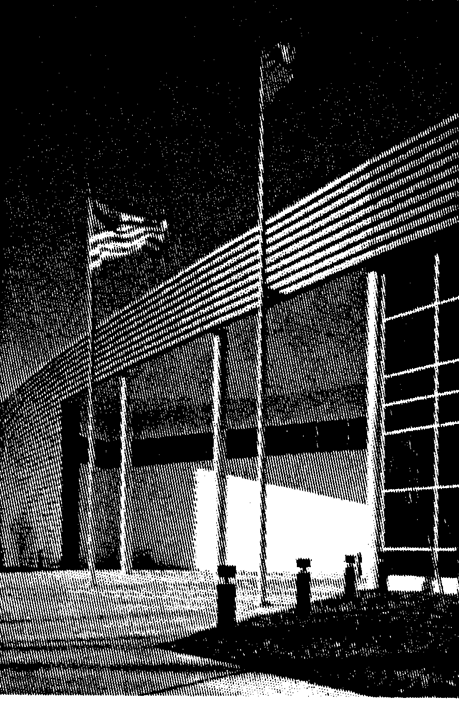
Example of split face block and "architectural metal at Gateway 2000 facility in Hampton, Virginia. Source: HGA Minneapolis at Http://www.hga.com/division/Corporate/Type/gw2000.htm. Reprinted with permission.
development, and property values. No portion of a building constructed of unadorned cinder block or corrugated and/or sheet metal shall be visible from any adjoining property or public right-of-way. Split face block or "architectural metal," brick masonry, stone, cast stone, and glass shall be permitted on all building walls. Painted cinder block shall be permitted on building walls facing the rear of the lot. Mechanical equipment, whether ground-level or rooftop, shall be shielded and screened from public view and designed to be perceived as an integral part of the building.
(4)
EXTERIOR LIGHTING. All exterior lights shall be arranged and installed so that the direct or reflected illumination does not exceed one-half foot-candle above background measured at the lot line of any adjoining residential or agricultural parcel or public right-of-way. Lighting standards shall be of a directional type capable of shielding the light source from direct view.
(5)
DRIVEWAYS AND PARKING AREAS. Driveways and parking areas shall be paved with concrete, bituminous concrete or other similar material. Surface-treated parking areas and drives shall be prohibited. Concrete curb and gutters shall be installed around the perimeter of all driveways and parking areas. Drainage shall be designed so as not to interfere with pedestrian traffic. Except as otherwise specified, driveways and parking areas serving development located in any agricultural or rural residential district may be surfaced with crushed stone or similar material, as approved by the City of Suffolk, provided that the cumulative total number of parking spaces serving the development does not exceed ten spaces. In such cases, the associated curb and gutter may be constructed of four-inch by four-inch (4" × 4") landscape timbers or similar material rated for ground contact, as approved by the City.
(6)
OUTSIDE STORAGE AREAS. Outdoor display and storage areas shall be as permitted by the outdoor display and storage area standards of the underlying zoning districts; and must comply with Section 31-609, Outside Storage and Display or Section 31-717, Temporary Uses as applicable. Outdoor storage shall include the parking of all company-owned-and operated vehicles, with the exception of passenger vehicles.
(7)
STORMWATER DETENTION AND RETENTION STRUCTURES, AND BEST MANAGEMENT PRACTICES (BMPS). Stormwater detention and retention structures, and best management practices (BMPs) shall not be located in any required front, side or rear yard or setback, except as permitted in accordance with Subsection (c)(2) of this Section, Permitted Variations in Yard Requirements.
(g)
LANDSCAPING REQUIREMENTS.
(1)
GENERALLY. Except as specified herein, all applicable development shall comply with the landscaping of this Ordinance. Where a conflict between regulations exist, the most stringent requirement shall apply.
(2)
YARDS ADJACENT TO PUBLIC RIGHT-OF-WAYS DESIGNATED AS A SPECIAL CORRIDOR OVERLAY DISTRICT. At minimum, a continuous 15-foot deep streetscape and screening planting strip, exclusive of easements, shall be located in the required front, side, or rear yard setback located adjacent to any public right-of-way designated as a Special Corridor Overlay District, in accordance with the landscaping standards of this Ordinance (section 31-603), provided that:
A.
One large street tree measuring a minimum of three to three and one-half inches in caliper at DBH shall be required every 40 feet on center or fraction thereof, or one medium street tree measuring two inches in caliper shall be required every 20 feet on center or fraction thereof. Street trees may be planted in multiple rows or groupings.
B.
The under story shall be planted with multiple rows or groupings of streetscape and screening shrubs measuring a minimum of 24 to 30 inches in height and spaced every three feet on center or fraction thereof so as to provide the most effective opaque screening of parking areas and best landscape design. Berms three feet in height and a maximum 3:1 slope may replace shrubs to a maximum of 50 percent.
(3)
YARDS ADJACENT TO PUBLIC RIGHTS-OF-WAY NOT DESIGNATED AS A SPECIAL CORRIDOR OVERLAY DISTRICT. At minimum, a continuous 15-foot deep streetscape and screening planting strip, exclusive of easements, shall be located in the required front, side, or rear yard setback located adjacent to any public right-of-way not designated as a Special Corridor Overlay District, in accordance with the landscaping standards of this Ordinance (section 31-603), provided that:
A.
One large street tree measuring a minimum of three to three and one-half inches in caliper shall be required every 40 feet on center or fraction thereof, or one medium street tree measuring two inches in caliper shall be required every 20 feet on center or fraction thereof. Street trees may be planted in multiple rows or groupings.
B.
The under story shall be planted with multiple rows or groupings of streetscape and screening shrubs measuring a minimum of 24 to 30 inches in height and spaced every 3 feet on center or fraction thereof so as to provide the most effective opaque screening of parking areas and best landscape design. Berms three feet in height and a maximum 3:1 slope may replace shrubs to a maximum of 50 percent.
(4)
OTHER YARDS. In addition to the requirements of Section 31-407, Table 407-1, all other front, side and rear yard setbacks shall be screened in accordance with the landscaping standards of this Ordinance, and Subsection (c)(2) of this Section.
(5)
STORMWATER DETENTION AND RETENTION STRUCTURES, AND BEST MANAGEMENT PRACTICES (BMPS). When a stormwater detention or retention structure, or Best Management Practice (BMP) encroaches into any required front, side or rear yard setback, as permitted in accordance with Subsection (c)(2)of this Section, at minimum, a continuous ten-foot deep screen landscape planting strip, exclusive of easements, shall be located adjacent to any such stormwater detention or retention structure, or Best Management Practice (BMP), in accordance with the landscaping standards of this Ordinance (section 31-603).
(h)
LIMITATION OF SIGNS.
(1)
PURPOSE AND INTENT. The purpose and intent of this Subsection is to regulate the use of publicly visible displays or graphics; to protect and enhance the character of arterial roadways and surrounding areas; to prevent diminishing property values within these areas; to safeguard the public use and nature of arterial roadways; and to minimize visual distractions to motorists along public roads.
(2)
GENERAL REGULATIONS FOR ALL SIGNS. The following shall apply to all signs:
A.
Applicable state and federal sign controls. In addition, all signs shall be in accordance with the signs standards of this Ordinance. (See Sections 31-302 and 31-714)
B.
Signs shall not obstruct any window, door, fire escape, stairway, ladder or opening intended to provide light, air or ingress and egress for any building or structure.
C.
Whenever a sign becomes structurally unsafe or endangers the safety of a building or premises or endangers the public safety, it shall be made safe or removed in accordance with the Uniform Statewide Building Code.
D.
Where permits are required, all signs shall be set back at least ten (10) feet from the front property lines or existing right-of-way lines, unless a greater setback is specified. Along roads which have proposed right-of-way expansion as delineated in the general plan for the City of Suffolk, signs erected after the delineation of such roads on the plan may be located within the proposed right-of-way. Once the proposed right-of-way is acquired, all signs erected after the delineation of such roads on the plan must be set back the required ten-foot minimum from the new right-of-way, unless a greater setback is specified.
E.
Sign lighting shall be positioned and shielded so as not to impair the vision of any motor vehicle operator or cause any direct glare into or upon any property other than the property to which the sign may be accessory.
F.
An abandoned sign shall be removed by the owner of the sign or the owner or lessee of the property. Any sign located on property which becomes vacant and is unoccupied for a period of thirty (30) days or more shall be deemed abandoned.
G.
No sign shall be higher than the roof line or parapet wall of any building for which the sign is proposed. A sign may be attached to the facia of a shed roof of a structure but may not be located so as to extend above the upper edge of the facia of such shed roof. Also, a sign may be attached to the facia of or located on the sloping roof of a structure but may not be located so as to extend more than four feet above the lower edge of sloping roof.
(3)
SIGN DESIGN STANDARDS.
A.
Signage Plan. A unified system of signage and graphics shall be designed for each individual development. Letter style, graphic display and color shall be analogous for all signage and graphics within an individual development. Signage concepts should be considered during the design of buildings, so that signage and graphics are architecturally incorporated into those buildings and the site they inhabit. Size, height, location, material and color should strongly relate to building and site design.
B.
Freestanding Sign Design. Freestanding signs shall be encased within a structure that is architecturally related to and compatible with the main building(s) and overall architectural design of the development.
C.
Landscaping. Landscaping shall be integrated with each individual freestanding sign. This requirement shall be depicted on the landscaping plan as required in the landscaping standards of this Ordinance.
D.
Illumination.
(i)
External Illumination. External lighting shall be limited to light fixtures utilizing white, not colored, lighting and shall not be blinking, fluctuating or moving. External lighting shall be provided by concealed and/or screened spots or floods and shall be arranged and installed so that direct or reflected illumination does not exceed one-half footcandle above background measured at the lot line of any adjoining residential or agricultural parcel or public right-of-way.
(ii)
Internal Illumination. Internal lighting shall be limited to internal light contained within translucent letters and internally illuminated sign boxes, provided the background or field on which the copy and/or logos are placed is opaque. The area illuminated is restricted to the sign face only. White light shall be used to illuminate any sign and the direct or reflected illumination shall not exceed one-half footcandle above background measured at the lot line of any adjoining residential or agricultural parcel or public right-of-way.
E.
Sign Package. Prior to the erection of any permanent sign noted herein, a comprehensive sign package shall be submitted to the City of Suffolk pursuant to the signs standards of this Ordinance, and Subsection (b)(3) of this Section. Six copies of sign plans shall be submitted to the City, which shall check for compliance with the regulations of this Ordinance. The plans shall show the size and location of the sign and the property identification. In the case of projecting signs complete specifications and methods of anchoring and support shall be required. In addition, the sign package shall include a landscaping plan in accordance with the landscaping standards of this Ordinance and Appendix B. The sign package shall provide detailed renderings to include colors, sizes, lighting, location, etc., for all signs within any development.
(Ord. No. 09-O-045, § 1(Exh. B), 8-19-2009; Ord. No. 13-O-021, 2-20-2013; Ord. No. 21-O-079, § 3(Exh. B), 7-21-2021; Ord. No. 25-O-053, § 2(Exh. B), 5-21-2025)