
Sugar City City Zoning Code
9-3 ZONING
DISTRICTS AND LAND USE
9-3-1 PURPOSE AND INTENT
- The purpose of this chapter is to establish zones for specific types of land use, consistent with Idaho statutes, the comprehensive plan, and this code.
- The intent of this chapter is to describe these districts and the land uses allowed in them and to set forth development standards and related regulations.
9-3-2 ZONING DISTRICTS
SINGLE-FAMILY RESIDENTIAL (R1): Provides stable neighborhoods of detached, single-family dwellings on larger lots, medium to large landscaped yards, low building heights, ample setbacks and side yards, predominantly off street parking, low traffic volumes, and low nuisance potentials. Maximum density shall be four (4) dwellings per acre.
MEDIUM DENSITY RESIDENTIAL (R2): Provides stable neighborhoods of detached, single-family dwellings and/or twin homes on smaller lots compatible with medium to small landscaped yards, low building heights, ample setbacks and side yards, predominantly off street parking, low to medium traffic volumes, and low nuisance potentials. Maximum density shall be five (5) dwelling units per acre.
HIGH DENSITY RESIDENTIAL (R3): Provides for high density residential use typically located near collector and arterial streets and characterized by multi-family dwellings, ample off street parking with a minimum of 2.0 spaces per unit, higher traffic volumes, open space, and low nuisance potential. Maximum density shall be sixteen (16) dwelling units per acre. All units shall be subject to approval by the Design Review Committee for the City.
MULTIPLE USE 1 (MU1): Provides for a mixture of uses such as residential coupled with business, professional and commercial. This district is intended to permit diversity within a planned community or set of uses and to encourage open space and other amenities. Residential units are small and have a minimum parking requirement of 2.0 spaces per unit. Maximum density shall be sixteen (16) dwelling units per acre. All units shall be subject to approval by the Design Review Committee for the City.
MULTIPLE USE 2 (MU2): Provides a mixture of uses such as high density residential coupled with business, professional and commercial. This district is intended to permit diversity within a planned community or set of uses and to encourage some open space and other amenities. Residential units shall have a minimum parking requirement of 2.0spaces per unit and twenty percent (20%) open space. Maximum density shall be twenty-four (24) units per acre. All units shall be subject to approval by the Design Review Committee for the City.
OPEN (O): Provides for parks, walking trails and other recreational facilities, conservation of land and natural resources, and preservation of historic or scenic sites.
PUBLIC FACILITIES (PF): A zoning category for government-operated or public entity facilities, including buildings, parks, roads, and etc. to streamline their development with minimal zoning impact. Uses typical of public entities are permitted by right by submitting an application according to the Public Facilities Ordinance. Special Use permits shall be required for non-typical uses or for applications with large potential impacts. The zone has flexible lot dimensions but maintains yard and height regulations to ensure neighborhood compatibility. Transfers of PF property trigger rezoning, Public Facility applications require detailed plans and impact assessments to meet city standards.
RURAL RANCHETTE (RR): A zoning category designed for residential living with the unique feature of accommodating small-scale agricultural activities within the city limits and impact area. The purpose of establishing the Rural Ranchette Zone is to promote and maintain a single-family residential neighborhood that protects animal rights as part of allowed uses. The purpose is to preserve areas of land where small acreage including domestic farm animals may be kept within the city limits and the impact area. The zone also includes residential uses for Accessory Dwelling Units (ADUs), and for handicapped and elderly persons up to eight (8) as referenced by Idaho Code Section 67-6531.
DOWNTOWN COMMERCIAL (CD): Provides for preservation and redevelopment of the city's historic center and a compact commercial space emphasizing pedestrian friendliness and a traditional downtown atmosphere. Business units are relatively small and tightly clustered.
NEIGHBORHOOD COMMERCIAL (C1): Provides for local commercial services at the perimeter of residential neighborhoods and with a primarily local clientele, for example at a street intersection or as a modestly sized strip mall. C1 districts are relatively small and businesses in them are generally small and few in number.
COMMUNITY COMMERCIAL (C2): Provides for general shopping and business needs. All businesses permitted in C1 are also permitted in C2, as are larger businesses and some that entail relatively more intense uses.
HIGHWAY COMMERCIAL (C3): Provides for travel related uses such as hotels and motels, service stations, truck stops, drive-in restaurants, and offices; also limited warehousing, commercial services, and retail sales. C3 districts are located on or near major roads to serve the motoring public.
REGIONAL COMMERCIAL (C4): Provides for a Regional Commercial Zone that includes a cohesive and complimentary mixture of land uses, including commercial, residential, recreational, and/or business park. A Regional Commercial Zone shall largely include facilities and venues that have a destination orientation and encourage use by tourists and visitors from outside the City. Uses should focus on services for tourists, visitors, and the local community. A unifying design and operating theme should unite the varied and mixed uses. Developments should promote creative property configuration with usable public and private recreation areas, parks, pedestrian areas, and open space. Developments within the Regional Commercial Zones shall comply with the development standards in Section 9-3-8.2
BUSINESS PARK (BP): Provides for technical laboratories, research and development facilities, offices and office complexes, and limited manufacturing, including small scale production, storage, and distribution. Support activities may also be permitted. Business parks are free of hazardous or objectionable levels of such elements as noise, odor, dust, smoke, or glare. Work is conducted indoors and generates minimal industrial traffic.
LIGHT MANUFACTURING (M1): Provides for manufacturing and wholesale establishments that are free of hazardous or objectionable levels of such elements as noise, odor, dust, smoke, or glare, that are operated indoors, and that generate little industrial traffic. Limited office and commercial development may be permitted as ancillary uses.
HEAVY MANUFACTURING (M2): Provides for large scale manufacturing, processing, warehousing, and major research and testing. Operations are free of hazardous or objectionable levels of such elements as noise, odor, dust, smoke, or glare. Limited office and commercial development may be permitted as ancillary uses.
TRANSITIONAL AGRICULTURE (TA): The purpose of the TA District is to permit current agricultural, large lot rural residential and other types of open land uses to be maintained and to protect agricultural land from spasmodic, disorderly and indiscriminate development. This district is also established to control the infiltration of urban type development, which could adversely affect agricultural operations, until such time as property owners desire such development.
9-3-3 ZONING UPON ANNEXATION
Prior to annexation of land, the planning and zoning commission shall recommend to city council how the land should be zoned. Concurrently with or immediately after the adoption of an ordinance of annexation, city council shall amend the comprehensive plan and the zoning ordinance, showing on maps all lands annexed and designating zoning classifications for all lands annexed.
9-3-4 ZONING MAP
- Zoning Map: Boundaries of the zoning districts shall be indicated on a zoning map on file in city hall and on the city website, if any.
- Amendments: Amendments to the zoning map shall be by the procedures set forth in this title as they relate to annexation and reclassification.
- Uncertainty Of District Boundaries: Where uncertainty exists as to the boundary of a zoning district shown on the zoning map, the following rules shall apply:
- Street, Alley, Or Public Way: Where the boundary line is indicated as following a street, alley, or public way, it shall be construed the middle or center of such street, alley, or public way.
- Lot Line: Where the boundary line is indicated as approximately following a lot line, the lot line shall be construed the boundary.
- Parallel To Centerlines: Where the boundary line is indicated as approximately parallel to the centerline of a street or highway, the boundary shall be construed as being parallel to the centerline and at such distance away as indicated on the zoning map. If no distance is given, dimensions shall be determined by use of the scale shown on the zoning map.
9-3-5 GENERAL PROVISIONS
- Frontage: To ensure orderly development and to provide access for firefighting equipment and other services, no building shall be erected or moved onto any parcel of land unless the parcel has frontage on a public right of way.
- Access To Arterials And Collectors: Individual lots in platted developments shall not have direct access onto an arterial or major collector, but onto a local street or minor collector. Established preexisting access may remain in use (see definitions in SCC Title 10).
- Property Lines: The property owner shall be responsible for determining property lines by survey.
- Exclusions: All land in the city is zoned, and all uses are subject to regulation. However, some uses are also regulated in titles or chapters of this code other than this chapter. Uses regulated in other places in this code or by state law include, but are not limited to, home occupation and home business (see SCC 9-10, "Home Business"), kennels (see SCC 4-1), wind turbines (see SCC 8-5, "Wind Turbines"), wireless telecommunications facilities (see SCC 8-3, "Wireless Telecommunications") and manufactured and mobile home parks (see SCC Title 11).
- Cemeteries: Notwithstanding any provision of law to the contrary, it shall be unlawful to bury or store the remains of any human body within the city except within a cemetery owned or operated by a political subdivision of the state or within a cemetery that complies with the endowment care cemetery act of the state of Idaho, or except where the remains are in the temporary care and custody of a public agency or public official, a state licensed funeral establishment or an educational institution accredited or funded by the state.
9-3-6 LAND USE SCHEDULE
| Y - Permitted |
| S - Permitted only by special use permit |
| (Blank) - Not permitted |
| R1 | R2 | R3 | RR | MU | O | CD | C1 | C2 | C3 | RC | BP | M1 | M2 | TA | |
| AGRICULTURE RELATED: | |||||||||||||||
| Agriculture related structures | Y | S | S | S | S | Y | |||||||||
| Growing, harvesting and storing crops | Y | Y | |||||||||||||
| Raising livestock | Y | Y | |||||||||||||
| Other agriculture related use | S | S | S | S | S | S | S | S | S | S | S | S | Y | ||
| RESIDENTIAL: | |||||||||||||||
| Condominium | S | S | S | Y | |||||||||||
| Manufactured home (see SCC 9-3-8E) | Y | Y | Y | S | |||||||||||
| Manufactured home park (see SCC Title 11) | S1 | S1 | |||||||||||||
| Mobile home (see SCC Title 11) | S1 | S1 | |||||||||||||
| Multi-family dwelling of just 2 units; twin home | S | Y | Y | S | |||||||||||
| Multi-family dwelling of more than 2 units | Y | S | S | Y | |||||||||||
| Patio home | Y | Y | S | ||||||||||||
| Planned unit development | S | S | S | S | S | S | Y | ||||||||
| Rooming/boarding house | S | S | S | S | |||||||||||
| Shelter home (8 or fewer residents) | Y | Y | Y | S | |||||||||||
| Single family dwelling | Y | Y | Y | Y | S | Y | |||||||||
| Townhouse | S | Y | S | ||||||||||||
| Vertical mixed use | S | S | S | S | S | Y | |||||||||
| Accessory Dwelling Unit (ADU)** | Y | Y | Y | ||||||||||||
| Other residential | S | S | S | S | S | S | S | ||||||||
| BUSINESS COMMERCIAL: | |||||||||||||||
| Arboretums and gardens | Y | Y | |||||||||||||
| Art gallery | Y | ||||||||||||||
| Assisted living facility | S | S | S | ||||||||||||
| Auction establishment | S | S | S | S | S | S | |||||||||
| Automotive body shop | S | S | Y | ||||||||||||
| Automotive repair | S | S | Y | Y | |||||||||||
| Automotive sales/parts store | S | Y | S | Y | |||||||||||
| Automotive service station | S | S | S | Y | Y | S | |||||||||
| Automotive storage | Y | Y | |||||||||||||
| Bakery/baked goods store | Y | S | Y | Y | Y | Y | Y | S | Y | ||||||
| Bank, savings and loan | S | Y | Y | Y | Y | Y | Y | ||||||||
| Barber, beauty shop | Y | S | Y | Y | Y | Y | Y | S | |||||||
| Bed and breakfast | Y | S | S | S | S | S | |||||||||
| Bowling alley | S | Y | Y | Y | |||||||||||
| Building supply outlet | S | Y | Y | Y | |||||||||||
| Car wash | S | S | S | Y | Y | Y | |||||||||
| Cleaning, dry | S | S | Y | Y | S | S | |||||||||
| Contractor office | S | Y | Y | Y | Y | Y | Y | Y | |||||||
| Convalescent/nursing home | S | S | S | S | |||||||||||
| Convenience store | S | S | Y | Y | Y | Y | Y | S | S | ||||||
| Convenience store with fuel service | S | S | S | Y | Y | Y | Y | S | S | ||||||
| Dance, music, voice studio | S | S | Y | Y | Y | S | Y | S | |||||||
| Daycare center | S | S | S | S | S | S | Y* | S | S | S | |||||
| Daycare, group | S2 | S | S | S | S | S | S | S | S | ||||||
| Daycare, home | Y | Y | Y | Y | S | S | S | S | S | S | S | S | |||
| Detention facilities | S | S | |||||||||||||
| Drive-in restaurant | S | Y | Y | S | |||||||||||
| Drugstore | S | Y | Y | Y | Y | Y | |||||||||
| Electronic/video sales/rental | S | Y | Y | Y | Y | ||||||||||
| Entertainment facility, indoor | S | S | S | S | S | Y | |||||||||
| Entertainment facility, outdoor | S | S | S | Y | S | S | |||||||||
| Equipment rental/sales | S | S | S | Y | S | Y | Y | ||||||||
| Farm equipment sales/service | S | Y | S | Y | Y | ||||||||||
| Food store | S | S | Y | Y | Y | S | Y | ||||||||
| Frozen food locker | S | S | Y | S | Y | S | |||||||||
| Furniture repair/refinishing | S | S | S | Y | Y | Y | Y | ||||||||
| Furniture store | S | S | S | Y | Y | Y | |||||||||
| Gift/flower shop | S | Y | Y | Y | Y | Y | |||||||||
| Health club, spa, reducing salon | S | S | S | Y | S | Y | S | ||||||||
| Hotel/motel | S | S | S | Y | Y | ||||||||||
| Kennel, commercial | S | S | S | S | S | ||||||||||
| Laboratory: medical, dental, optical | S | S | Y | Y | S | Y | |||||||||
| Laundromat, self-service | S | S | Y | Y | Y | ||||||||||
| Laundry, commercial | S | S | Y | Y | Y | Y | |||||||||
| Liquor store | S | ||||||||||||||
| Live entertainment event | S | S | S | S | S | S | Y | ||||||||
| Loan firm (small or short term loans) | S | ||||||||||||||
| Lumberyard, retail | S | Y | Y | Y | |||||||||||
| Massage, tanning salon | S | Y | Y | Y | S | Y | S | ||||||||
| Mortuary | S | Y | Y | S | |||||||||||
| Nursery, plants and flowers | Y | S | S | Y | Y | S | S | ||||||||
| Office, professional | S | Y | Y | Y | Y | Y | Y | ||||||||
| Open air market | S | Y | |||||||||||||
| Outlet mall | Y | ||||||||||||||
| Parking facility | S | S | Y | Y | Y | Y | Y | Y | |||||||
| Pharmacy | S | Y | Y | Y | Y | Y | S | ||||||||
| Photographic studio | S | Y | Y | Y | S | Y | Y | S | |||||||
| Preschool | S2 | S | S | S | S | S | S | S | S | S | |||||
| Printer | S | S | S | Y | Y | Y | Y | Y | |||||||
| RV, trailer park | S | ||||||||||||||
| RV, trailer sales/service | Y | S | Y | Y | |||||||||||
| Restaurant with State Alcohol License | S | ||||||||||||||
| Restaurant | S | S | Y | Y | Y | Y | S | S | S | ||||||
| Retail stores and services | S | S | Y | Y | Y | Y | S | ||||||||
| Sexually oriented/adult business | S | S | |||||||||||||
| Shopping mall | Y | ||||||||||||||
| Sign shop | S | S | S | S | S | Y | Y | ||||||||
| Storage, enclosed building | Y | S | S | Y | Y | ||||||||||
| Storage, fenced area | S | S | S | Y | |||||||||||
| Theater, indoor | S | S | S | Y | Y | Y | |||||||||
| Tire shop, repair and sales | S | S | Y | Y | Y | ||||||||||
| Truck stop | S | S | S | ||||||||||||
| Veterinary clinic, livestock | S | S | S | Y | Y | ||||||||||
| Veterinary clinic, small animal | Y | S | S | S | Y | S | Y | Y | Y | ||||||
| Other business/commercial | S | S | S | S | S | S | S | S | S | S | |||||
| INDUSTRIAL: | |||||||||||||||
| Asphalt plant | |||||||||||||||
| Beverage bottling plant | Y | Y | |||||||||||||
| Cabinet shop | S | S | S | Y | Y | ||||||||||
| Cement or clay products | S | ||||||||||||||
| Chemical storage/manufacturing | S | S | Y | ||||||||||||
| Cold storage plant | Y | Y | |||||||||||||
| Concrete batch plant | |||||||||||||||
| Concrete mixing: 2 cubic yards maximum | S | Y | Y | Y | |||||||||||
| Contractor storage yard | S | S | S | Y | |||||||||||
| Dairy products processing | S | S | |||||||||||||
| Food processing plant | S | S | S | ||||||||||||
| Grain elevator | Y | S | |||||||||||||
| Grain storage | Y | Y | Y | Y | |||||||||||
| Junkyard | |||||||||||||||
| Machine shop | S | Y | Y | ||||||||||||
| Meatpacking plant | S | S | S | ||||||||||||
| Metal fabrication | S | S | S | Y | Y | ||||||||||
| Monument works, stone | S | S | Y | S | Y | Y | |||||||||
| Petroleum storage | Y | ||||||||||||||
| Public utility yard | Y | Y | |||||||||||||
| Railroad yard or shops | Y | ||||||||||||||
| Recycling operation | S | ||||||||||||||
| Sanitary landfill | |||||||||||||||
| Terminal yard, trucking | Y | ||||||||||||||
| Truck and tractor repair | S | S | S | Y | |||||||||||
| Warehousing, wholesaling | S | S | S | Y | Y | ||||||||||
| Wood processing plant | S | S | |||||||||||||
| Wrecking yard | S | ||||||||||||||
| Other industrial (ie. Cargo Containers/Storage) | S | S | S | S | S | ||||||||||
| AUXILIARY USES: | |||||||||||||||
| Personal wireless service facility (by type of support structure): | |||||||||||||||
| Guyed support tower | S | ||||||||||||||
| Lattice frame tower | S | ||||||||||||||
| Leased utility pole | S | S | S | S | Y | Y | Y | Y | Y | ||||||
| Monopole tower | S | S | S | S | Y | ||||||||||
| Stealth tower | S | S | S | S | S | S | S | Y | Y | ||||||
| Virtually invisible on building or alternate support structure | S | S | S | S | Y | Y | Y | Y | Y | ||||||
| Visible on building or alternate support structure | S | S | S | S | S | S | S | Y | |||||||
| Wind turbine | S | S | S | Y | S | S | S | S | S | S | S | S | S | ||
| Other auxiliary use | S | S | S | S | S | S | S | S | S | S | S | S | S | ||
| PUBLIC/QUASI-PUBLIC: | |||||||||||||||
| Church Cemetery | |||||||||||||||
| Cemetery, private | |||||||||||||||
| S | |||||||||||||||
| City Park | S | ||||||||||||||
| Golf Course | S | ||||||||||||||
| Governmental or Public Service | S | ||||||||||||||
| Hospital | |||||||||||||||
| Library | S | ||||||||||||||
| Museum | S | ||||||||||||||
| School | S | ||||||||||||||
| Splash Pad | Y | ||||||||||||||
| Swimming Pool/Aquatic Center | Y | ||||||||||||||
| Waste Treatment Plant | |||||||||||||||
Notes:
* In conjunction with another business only
**Permitted upon compliance with ADU Health Safety Code Inspection and Off-Street Parking requirements being met.
1Subject to approval and licensing as provided in SCC Title 11.
2The maximum number of children at a given time is 12.
3A public or quasi-public facility is sometimes desirable in a zoning district whose description it does not fit. These facilities may be permitted as indicated
Adopted by Ord. 290 on 10/14/2010
Amended by Ord. 297 on 5/24/2012
Amended by Ord. 315_2016 on 5/26/2016
Amended by Ord. 382_2023 on 3/23/2023
Amended by Ord. 391_2024 on 2/8/2024
Amended by Ord. 393_2024 on 5/23/2024
Amended by Ord. 403_2025 on 1/9/2025
Amended by Ord. 409_2025 Land Use Amendment on 9/11/2025
9-3-7 AREA, FRONTAGE, SETBACK, AND HEIGHT
- Schedule for districts other than multiple use (see definitions in SCC 9-2-2 of terms in column headings below): Notes:
Area: Lot Size Frontage Setback Minimum in Feet Height Zoning District Min. Interior (Sq. Ft.) Min. Corner (Sq. Ft.) Min. Frontage (Ft.) Front Rear Inner Side Outer Side Alley Side Max. (Ft.) R1 10,000 10,000 1001 20 20 5/102 20 5 35 R2 8,000 10,000 801 20 15 5 20 5 35 R3 7,000 8,500 701 20 15 5 15 5 35 O - - - 20 20 5 20 5 35 CD - - 25 - 10 - - 5 35/403 C1 2,500 2,500 25 - 10 - - 5 35 C2 - - - - - - - - 45 C3 - - - 20 15 - 20 5 45 BP 7,500 7,500 75 20 - 5 20 5 35 M1 - - 50 20 - - 20 5 45 M2 - - 50 20 - - 20 5 45
1. A lot in a cul-de-sac shall have a minimum frontage of 50 feet; normal setbacks apply.
2. One side setback shall be at least 10 feet unless an alley allows access to the rear yard.
3. Maximum for parapet or front eave is 35 feet; maximum for ridgeline parallel with Center Street is 40 feet. - Schedule for multiple use district (see definitions in SCC 9-2-2 of terms in column headings below):
Lot Footprint Setback Minimum in Feet Height Building Type Min. Width (Ft.) Min. Depth (Ft.) Min. Area (Sq. Ft.) Front Rear Inner Side Outer Side Alley Side Max. (Ft.) Single-family dwelling 35 50 3,200 15 10 5 15 5 35 Twin home 45 70 5,200 15 10 5 15 5 35 Multi-family dwelling 15 10 5 15 5 35 Vertical mixed use 35 Commercial 35
9-3-8 DEVELOPMENT STANDARDS
- Setbacks: See definition in SCC 9-2-2.
- Setback is to the nearest structural projection of the building.
- Open structures such as porches, canopies, balconies, platforms, covered patios, and similar architectural projections are considered part of the building to which they are attached.
- For a multi-story building in an R1 district, the front setback shall be an additional five feet (5') per floor above the ground floor.
- When a commercial or manufacturing use abuts a residential district, its setback(s) along the abutting residential boundary (ies) shall be the same in the residential district.
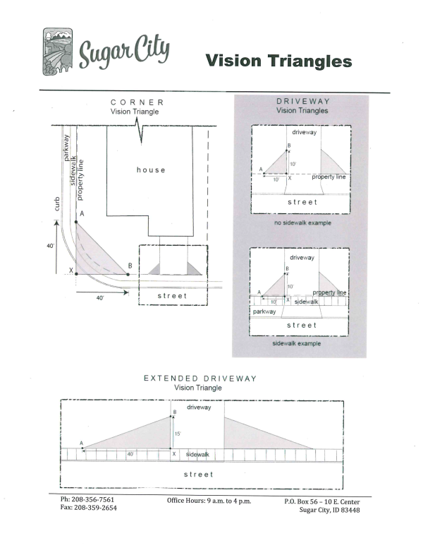
- Corner vision triangle means a triangular area on corner lots with specific height limitations for structures and vegetation, including fences, buildings, and hedges. The triangle is formed by following three steps (see attached illustration):
- Draw imaginary straight lines that extend the front property lines until they intersect at a single point (Point X);
- Locate two points along each property line that are 40 feet from the intersection point (Points A and B); and
- Connect all three points to form a triangle.
- Driveway vision triangle means a triangular area next to a driveway, alleyway, or multi-use path with specific height limitations for structures and vegetation, including fences, buildings and hedges. The triangle is formed by the following three steps (see attached illustration):
- Use the point where the inside edge of the sidewalk and the edge of the driveway intersect (Point X);
- Locate two points along the edge of the driveway and sidewalk that are 10 feet from the intersection point (Points A and B). If there is no sidewalk, the vision triangle is measured along the property line. If a driveway has been widened without a corresponding widening of the curb approach, the driveway vision triangle is measured from the original driveway edge.
- Connect all three points to form a triangle.
- Extended driveway vision triangle means a triangular area measured in a similar manner as a driveway vision triangle but with the following dimensions (see attached illustration):
- The point along the edge of the sidewalk (Point A) is 40 feet from the intersection point (Point X); and
- The point along the edge of the driveway (Point B) is 15 feet from Point X.
- New structures, including signs, are subject to extended vision triangle requirements when located on lots with more than 100 parking spaces.
- Corner vision triangle means a triangular area on corner lots with specific height limitations for structures and vegetation, including fences, buildings, and hedges. The triangle is formed by following three steps (see attached illustration):
- Vison Triangle Requirements
- Parking Spaces - Parking areas are prohibited in all vision triangles.
- Structures and Vegetation in Vision Triangles - Structures and vegetation are limited to 3.5 feet in height within any vision triangle. A structure may include buildings, fences, accessory structures, signs, or any other physical object. Vegetation may include plants, shrubs, and trees. The following structures and vegetation are exempt from vision triangle requirements:
- Trees with Circumferences Less than 38 Inches. A tree of 38 inches in circumference as measured 4.5 feet from the ground may be located within a vision triangle if the lowest tree branches and foliage are at least 10 feet from the ground at maturity.
- Building Canopies. A building canopy may project 5 feet into a vision triangle if the canopy is at least 10 feet high as measured from the top of curb closest to the canopy. Ground-mounted support posts are prohibited within any vision triangle.
- Open Fences. "Open fences" as defined in ? (General Fence Requirements) may be located in a vision triangle.
- Special Requirements for Safety. The Director may require additional setbacks if needed for pedestrian , motorist, or bicyclist safety.
- Downtown District. Properties within the Downtown Commercial (CD) zone are exempt from vision triangle requirements.
- Uniform front setbacks may be established by ordinance and an amendment to the zoning map when adjacent zoning districts are provided different front setbacks in SCC 9-3-7.
- TA District setback requirements:
- Front yard. No building or structure shall be erected nearer than 50 feet from the center line of the street. Not-withstanding the setback in subsection (b)(1) of this section, if the property abuts a major or minor arterial roadway, the setback shall be no less than 60 feet.
- Side yard. No building shall be erected closer than 10 feet to any side property line, except corner lots shall maintain a 50-foot side yard adjacent to the street which intersects the street upon which the building fronts.
- Rear yard. There shall be a rear yard having a depth of not less than 25 feet.
- Exceptions. Some setback exceptions exist for specific architectural features, as outlined in section 101-10.
- Height:
- Height is the vertical distance from the average grade at the front of the structure to the highest point of the structure.
- A building shall not exceed three (3) stories, except by special use permit.
- Maximum height may be increased by special use permit.
- There shall be no height restrictions in the TA District, except as may be imposed by state or federal regulations. Wind turbines and communication towers have specific height restrictions as outlined in chapter 109, articles III and V.
- Lot Size:
- Lot Larger Than Minimum: Lots may need to be larger than minimum to meet requirements for parking, setback, and/or open space.
- Undersized Parcel: A parcel of less than the minimum width or area specified for its zoning district shall not be created and recorded unless it is zoned or rezoned open and has covenants (a written agreement) recorded providing for its maintenance.
- Planned Unit Development: In a planned unit development, lot sizes may be decreased if there is an increase in open space (see SCC Title 10, "Subdivision And Platting").
- Lots Not Meeting Zoning District Requirements: Any lot or parcel of land, which was of record in the Madison County recorder's office at the time its zoning district was determined but does not meet the requirements of the zoning district in which it is located for minimum lot width and/or area, may be utilized if all requirements of this title are met other than for minimum lot width and/or area.
- TA District minimum lot width is 250 feet. Area/density requirements.
- Agriculture owners may split off the original home site on any parcel of not less than one-acre from the rest of the farm ground for the purpose of selling the farm and retaining the home.
- Owner of a farm may sell off any parcel of not less than one-acre of land by attaching the deed restriction giving up the developmental rights on the balance of the 16 acres. Example: A one-acre lot would require the owner give up the development rights on the adjoining 15 acres; two-acre split would require the adjoining 14 acres be place under a developmental restriction and so on. The parcel with the deed restriction shall state that on the deed and which parcel it is tied to. The two resulting parcels will each be counted as a parcel split. The original larger parcel can do one more such split then any further splits of the parcel will require platting. This is inclusive of the original parcel.
- Single-Family Dwellings, Patio Homes And Twin Homes: Except as provided in SCC Title 11 for dwellings in manufactured home parks, single-family dwellings, patio homes, and twin homes:
- Shall enclose a space of at least one thousand (1,000) square feet on the main level and have an interior width of not less than twenty feet (20') (per each dwelling unit).
- Shall be placed on an excavated and backfilled permanent foundation.
- Shall have a pitched roof with a slope of at least three to twelve (3/12) and an eave projection of at least six inches (6").
- Shall have exterior wall surfaces that are typical of residential neighborhoods, including, but not limited to, masonry, clapboard or cement simulated clapboard, vinyl or metal siding, wood shingles or shakes, or similar materials. Surfaces shall not have a high gloss finish and shall not be composed of metal or plastic panels.
- Manufactured Homes:
- Shall enclose a space of at least one thousand (1,000) square feet on the main level and have an interior width of at least twenty feet (20').
- When placed on an individual lot, shall meet the standards for a single-family dwelling, plus the following standards:
- The home shall be of multisectional construction and constructed after 1976.
- Hitch, axles, and wheels shall be removed and the foundation fascia shall be similar in appearance and durability to the masonry foundation of site built homes.
- Existing manufactured homes not meeting the above standards may be permitted in established manufactured home subdivisions or manufactured home parks.
- Accessory Storage Sheds:
- Are permitted in all zoning districts;
- Shall not intrude into a front yard or front setback;
- If smaller than two hundred (200) square feet and not on a permanent foundation, may be placed adjacent to the rear property line, along an inside property line, or along the alley if on a corner lot;
- If larger than two hundred (200) square feet or on a permanent foundation:
- Shall meet similar design standards as principal buildings and resemble them in exterior materials and color;
- Shall observe setbacks of at least five feet (5');
- Shall not occupy area greater than twenty five percent (25%) of the rear yard (accessory buildings individually or collectively); and
- If openings face an alley, shall comply with county fire codes.
- Temporary Buildings: A temporary office or office building may be permitted as an accessory building on a construction site for up to one year. One year extensions may be granted.
- Commercial Abutting Residential: Where a commercial or business use abuts a lot in a residential zone, the commercial or business entity shall provide a shrubbery buffer not less than four feet (4') high and four feet (4') wide or asightly solid fence between five (5) and eight feet (8') high.
- Lots Lying In Multiple Zoning Districts: When a lot is located so that it extends into more than one zoning district, the most restrictive requirements among the zoning districts shall apply.
- Outdoor Storage: Machinery, inoperable vehicles, inventory materials, and unsightly items stored outdoors shall be enclosed by solid fencing or vegetation so as to be screened from view. Composition, dimensions, and extent of screening shall be as required by city council to suit the situation.
- Fences, Walls, And Hedges: Fences, walls, and hedges are allowed by permit in any required yard or along the edge of any yard. Except when screening commercial or business from residential (see subsections H and J of this section), maximum height shall be three feet (3') around a front yard and six feet (6') on back yards and side yards. No fence, wall, or hedge shall obstruct the clear vision triangle. No fence, wall, or hedge shall be placed in a right of way required by the city.
- TA District requirements for access to city streets, county roads and state highways. All access to city streets, county or state roads shall be in conformance with the Comprehensive Plan and follow all access policies and ordinances as set by the jurisdiction over the street/road/highway. Multiple accesses will be discouraged and shared access will be encouraged under these policies.
- TA District requirements for animal clinics and hospitals, veterinary offices, and kennels. These will be located at least 300 feet from any residence including motels and hotels, except for an owner's residence. The city may modify these requirements if the animals are housed in soundproof structures that screen them from view of the abutting residential property.
9-3-9 NONCONFORMING USES
- Continuation: Established nonconforming uses are permitted to continue as provided in Idaho Code section 67-6538.
- Maintenance: Nothing in this section shall be deemed to prohibit routine maintenance or to prohibit restoration necessary for safety.
- Enlargement: A nonconforming use may not extend or enlarge its facilities, or add new facilities.
- Moving a nonconforming use into existing facilities or onto land where it is not already established is not permitted.
- Exterior remodeling for cosmetic or advertising purposes is not permitted.
- Changing from an existing nonconforming use to a different nonconforming use is not permitted.
- Discontinuation: When a nonconforming use is discontinued or abandoned for more than one year (except when governmental action impedes access to the premises), the use may not thereafter be resumed except as provided in SCC 9-1-2F.
- Residences: An existing single-family dwelling or twin home in a zoning district where it is not permitted, or on a substandard lot of record, is permitted to continue, and customary accessory buildings may be erected, notwithstanding other limitations in this section.
9-3-10 OBJECTIONABLE CONDITIONS
- Objectionable Conditions Not Relating To Animals Or Livestock: No permit shall be issued for use or improvement of land if it shall be used or improved in a manner that creates dangerous, injurious, noxious, or otherwise objectionable conditions affecting surrounding areas, except that any permitted use may be undertaken if acceptable measures are taken to mitigate such conditions. Determinations and measurements should be by recognized standards, such as those published by the American National Standards Institute, the Manufacturing Chemists' Association, Inc., the U.S. bureau of mines, and the state health authority. Objectionable conditions include, but are not limited to, the following:
- Fire Hazard: Flammable or explosive material shall be protected by adequate safety equipment and procedures. Such material shall be held adequate distances from surrounding premises and activities. Standards of the latest fire code and national safety foundation shall be observed.
- Radioactivity; Electromagnetic: Emission of radioactivity or electromagnetic interference that causes adverse effects beyond the boundaries of the premises is not permitted.
- Air Pollution: Standards of relevant health authorities and the U.S. environmental protection agency shall be observed.
- Water Pollution: Standards of relevant health authorities, relevant water authorities, and the U.S. environmental protection agency shall be observed.
- Erosion: Erosion causing adverse effects beyond the boundaries of the premises is not permitted.
- Vibration: Vibration that is readily discernible without instruments beyond the boundaries of the premises is not permitted.
- Noise: Noise of objectionable volume or quality is not permitted.
- Glare: Objectionable glare is not permitted.
- Odor: Objectionable odor is not permitted.
- Objectionable Conditions Relating To Animals Or Livestock: See SCC 9-8, "Area Of City Impact"; also SCC 9-4.
- Objectionable Conditions Relating To Home Business: See SCC 9-10, "Home Business".
- Complaints About Objectionable Conditions: Complaints regarding objectionable conditions relative to existing uses and improvements shall be addressed to the planning and zoning commission. It shall consider such complaints and recommend any action it may deem appropriate to the city council. The city council may pursue any action permitted by the city code or state law (see SCC 9-1-6B, "Complaint").
- Objectionable Conditions Relating to the TA District:
- Bulk storage of flammable liquids and gases. Bulk storage of flammable liquids and gases will:
- Be located at least 300 feet from a residence, motel or hotel, except for an owner's residence.
- Be erected with the written approval of the fire authority having jurisdiction.
- Have suitable loading and unloading spaces and off-street parking facilities meeting the approval of the fire authority.
- Chemical, pesticide, and fertilizer facilities. These facilities will have adequate fire protection, storage area, handling and disposal as approved in writing by the fire authority having jurisdiction.
- Bulk storage of flammable liquids and gases. Bulk storage of flammable liquids and gases will:
290
312_2016
315_2016
339_2019
382_2023
391_2024
393_2024
321_2016
324_2017
325_2017
326_2017
297
403_2025
409_2025 Land Use Amendment
346_2019
378_2022
9-3-8.2-1 PURPOSE AND INTENT
The intent of the Regional Commercial Zone and this Chapter is to recognize and provide for the orderly development of certain properties as a tourist, convention, hospitality, business, and gathering destination and to provide for the implementation of Sugar City's Comprehensive Plan. Furthermore, this ordinance and the standards for development contained herein are intended specifically to accomplish the following:
- Recognize and promote the potential of Sugar City as a premier destination community in Idaho, with is strategic locale centralized at the junction of two State Highways (US20 and State Hwy 33) leading to internationally recognized tourist destinations.
- Recognize the uniqueness of a family-oriented tourist destination and encourage the development and operation of facilities catering to tourists, local families, and convention/group-related events which will ultimately bring all levels of consumers to the city.
- capture previously unreachable tax revenues by providing an incentive for business owners and retail operators from inside and outside the state to locate in the new destination area in Sugar city.
- Accommodate the mixed and progressive development of land, facilities, and buildings that inter-mingle various uses while maintaining a harmonious relationship, and while protecting the health, safety, and long-term welfare of the community.
- Enhance local property values by creating a property use zone that is completely unique to the State and surrounding states, and that attracts world-class business operators.
- Support public service entities such as Police and Fire Departments by dedicating land or utilizing certain space within the Regional Commercial Zone at no cost to the City.
- Allow the City to more quickly realize tax revenues by providing for the timely development of the regional commercial property through an expedited approval and permit process of individual projects as described below in 9-3-8.2-9.
- Allow the City to encourage and facilitate more detailed and specific planning and analysis for the Regional Commercial Zone area of the City.
- Establish provisions and requirements which enable the City to address unique areas of the City or where other characteristics exist that warrant a comprehensive set of land use policies and standards which will encourage an efficient and imaginative development pattern. An application for approval of a Regional Commercial Zone is a request by the applicant for additional flexibility beyond that allowed by the traditional zones within the City. It is the sole responsibility and burden of the applicant to convince the Planning Commission and City Council that the proposed Regional Commercial Zone is preferable to traditional zoning. Approval for use of the Regional Commercial Zone lies at the discretion of the city Council.
9-3-8.2-2 REGIONAL COMMERCIAL DESCRIPTIONS
A regional Commercial Zone shall include a cohesive and complimentary mixture of land uses, including commercial, residential, recreational, and/or business park. A Regional Commercial Zone shall largely include facilities and venues that have a destination orientation and encourage use by tourists and visitors from outside the City. Uses should focus on services for tourists, visitors, and the local community. A unifying design and operating theme should unite the varied and mixed uses. Development should promote creative property configuration with usable public and private recreation areas, parks, pedestrian areas, and open space.
9-3-8.2-3 MINIMUM ELIGIBILITY REQUIREMENTS
A property that is eligible for establishment as a Regional Commercial Zone must meet the following requirements:
- The property must include a minimum area of Forty (40) contiguous acres.
- Sixty percent (60%) of the property shall be used for facilities and venues that are considered tourist, hospitality, or resort destinations. The remaining for percent (40%) of the property may be used as non-resort commercial, business park and resort related residential uses (residential uses not to exceed 10% of the total property) as defined in an approved Proposed Master Plan.
- The property in a Regional Commercial Zone is considered highly dependent upon traffic and visitors from outside the City, and shall be located in the US-20/State Hwy 33 corridor, being immediately adjacent to the Highways or adjacent to a major arterial transportation corridor feeding those highways. If the arterial corridor is not an existing corridor, the developer of the proposed Regional Commercial Zone shall be responsible for the construction of the corridor. Maintenance of the corridor shall also be the responsibility of the developer unless otherwise agreed upon between the City and the developer.
9-3-8.2-4 ALLOWED USES
Each requested use must be authorized through a proposed Master Plan that has been approved and adopted by the City Council. Proposed uses will be reviewed for compatibility within the Regional Commercial Zone as well as compatibility with allowed uses in adjacent zones.
9-3-8.2-5 PUBLIC SUPPORT REQUIREMENTS
The large scale and public nature of a Regional Commercial Zone requires the specialized support of various public services. As part of the approval process, the City may require the property owners to make certain allowances within the Regional Commercial Zone property for public facilities and public support operations as follows:
- Fire/EMS Sub-station. One half (1/2) acre of property shall be dedicated to the City without cost whereon a Fire Sub-station may be constructed and operated by the City.
- Police Sub-station. A facility or space within a facility shall be provided to the City without cost wherein a Police Sub-station may be operated.
- Public Facilities. Space shall be provided wherein the public and City may develop needed public facilities.
- Security Services. A professional security staff may be employed by the property owners in an effort to help promote public safety. The Regional Commercial Zone's security staff shall cooperate with the Sheriff Department and Fire Department, but shall in no way or at any time replace or assume the responsibilities of the Sheriff and Fire Departments.
9-3-8.2-6 PROCEDURES FOR ESTABLISHMENT OF REGIONAL COMMERCIAL ZONES
- Comprehensive Plan Amendment. All areas proposed for development as a Regional Commercial Zone shall require a Comprehensive Plan Amendment in accordance with this Code.
- Master Development Concept Plan. Concurrent with any request to amend the Land Use Element of the Comprehensive Plan to a Regional Commercial Zone, a Master Development Concept Plan shall be submitted. A Master Development Concept Plan must be reviewed by the City Council, following Planning Commission and Reviewing Departments' evaluation, prior to property being designated as a Regional Commercial Zone Land Use.
- The Master Development Concept Plan gives the applicant, Reviewing Departments, Planning Commission, and City Council an opportunity to discuss the development prior to the Comprehensive Plan land use being established and prior to the preparation of a more detailed Proposed Master Plan. The applicant can use the Master Development concept Plan meetings to ask questions and receive direction on project layout, as well as discuss the procedure for approval, specifications and requirements for layout of streets, drainage, water, sewerage, fire protection, mitigation of environmental impacts, and similar matters, and the availability of existing services.
- The Master Development Concept Plan shall cover the entire area proposed as a Regional Commercial Zone and shall identify in general terms the followg:
- Proposed land uses
- Overall layout and locations of uses including potential civic/religious uses
- Major infrastructure improvements that may be necessary
- Proposed site-planning standards including architecture and materials of buildings
- Park areas, open space areas, trails and other community amenities
- Proposed landscaping, buffering, and transitioning treatments
- Location of any critical lands
- All other issues that must be addressed to allow a thorough informed review by the Reviewing Departments, Planning Commission, and City Council of the proposed Master Development Concept Plan.
- To accommodate requests for changes to the Master Development Concept Plan, the City may allow the Comprehensive Plan to be amended. Amendments shall follow the same requirements for initial review of a Master Development Concept Plan including review by the Reviewing Departments, Planning Commission, and City Council.
- A Master Development Concept Plan shall be effective for a period of two years from the date that the Master Development Concept Plan is reviewed by the City Council, at the end of which time as application for a Zoning Map amendment and Proposed Master Plan shall have been submitted and under review by the City. If an application for Porposed Master Plan approval in conjunction with an application for a Zoning Map Amendment to the Regional Commercial Zone has not been filed within the two-year period, the Master Development Concept Plan shall be void. The City Council may grant an extension of the concept Plan according to the provisions of 9-3-8.2-12
- Properties designated as a Regional Commercial Zone Land Use for which the Master Development Concept Plan has become void shall require the applicant to submit a new Master Development concept Plan for review subject to the then existing provisions of this Code and Comprehensive Plan.
- Zoning Map Amendment and Proposed Master Plan. Following approval of a Comprehensive Plan Amendment and review of a Master Development Concept Plan by the city Council, the applicant may prepare a Zoning change application pursuant to the provisions of this Code. The establishment of a Regional Commercial Zone requires the City Council to review, approve, and adopt a Proposed Master Plan for those properties proposed for a Regional Commercial Zone, following receipt of a Reviewing Departments and Planning Commission recommendation, prior to approval and adoption of an Proposed Master Plan, the Reviewing Departments, Planning Commission, and City Council shall verify that the Regional Commercial Zone follows the general layout of the Master Development Concept Plan. The Proposed Master Plan must comply as closely as possible wit the Master Development Concept Plan, and shall cover the entire Regional Commercial Zone.
- Effect of Proposed Master Plan Approval. If a proposed Master Plan is adopted by the City pursuant to Chapter 10 of this Code, all permits, licenses, and development must comply with the adopted Proposed Master Plan. Additionally, developers and builders must comply with the Sugar City Comprehensive Plan, the Sugar City Development Code, and all other codes and ordinances of the city unless modified by the adopted Proposed Master Plan.
- Additions to Regional Commercial Zone Boundaries. Properties adjacent to an existing Regional Commercial (RC) Zone may be added to the Zone according to the provisions of the Code for amendments to the comprehensive Plan and Zoning District Map and subject to the following conditions:
- There is a mutual agreement between the principal owner(s) of property located within the existing Regional Commercial Zone and the party or parties requesting to be added to the Zone.
- The Proposed Master Plan for the Regional Commercial Zone shall be amended to reflect the additional property.
- Any approval for expansion of an existing Regional Commercial Zone by Sugar City does not grant the applicant for expansion an automatic right to force existing entities within the established Regional Commercial Zone to amend their CC&Rs.
9-3-8.2-7 DEVELOPMENT STANDARDS
Where a Regional Commercial Zone proposes a mix of recreational and commercial or business park uses, the following development standards shall apply in addition to any other commercial development standards contained in this Code or the Design Standards and Public Works Standard;
- Building Design. The proposed structures shall be complimentary to the surrounding architecture in terms of scale, massing, roof shape, and exterior materials. Buildings shall be scaled down into groupsings of smaller attached structures. Buildings adjacent to single family detached units should be limited to 2 stories or 35 fee.
- Parking. Shall be reduced and broken into smaller parking areas through the use of parking lot landscaping and or off site lots linked to the site by intermodal or public transportation. Parking lots shall include ample landscaping to buffer cars from neighboring properties including the use of berms and landscaped islands and parking structures are encouraged.
- Access and Traffic. Adequate vehicular and pedestrian access must be provided. A traffic impact study shall be required as part of the Proposed Master Plan, in order to project auto and truck traffic generated by the uses proposed.
- Roof Design. Rooflines shall blend with surrounding buildings in a way that promotes an attractive, unified architectural design. Roof design may be further defined as part of an approved Proposed Master Plan.
- Materials. New buildings shall blend with the material of surrounding buildings. Building materials may be further defined as part of an approved Proposed Master Plan.
- Signage. Signage of buildings shall be part of a coordinated signage system for the entire Regional Commercial Zone development. Signage shall help unify the development and provide a positive image. Natural materials such as wood, stone, rock and metal with external illumination shall be used. The size and location of signage shall conform to the requirements and design guidelines of this Code.
- Lighting. Outdoor lighting shall be screened by shields or hoods to prevent glare onto adjacent properties. The intensity of large fixtures shall be reduced by utilizing a larger number of smaller light poles of twelve (12) to eighteen (18) feet. Incandescent lights shall be used in smaller pedestrian spaces where quality light is especially important.
9-3-8.2-8 RESIDENTIAL DESIGN STANDARDS
The following design standards shall apply to any residential developments within a Regional Commercial Zone including any defined sug-area or pod, or any residential project or development or any portion of a residential project or development.
- Single Family Design Standards. For all single family detached units, the following standards shall apply:
- Product Mix. Single family detached areas shall provide a variety of home styles to insure a diverse and interesting street scene. Neighborhoods that have nearly identical homes and streets without variation in product placement and form are not allowed. In order to ensure that the neighborhood is non-repetitive, the same home elevation or homes with the same color scheme shall not be built on adjacent lots on the same street or on lots directly or diagonally across the street from one another.
- Corner Lots. Attention should be paid to corner lots. At least one home plan per neighborhood shall be designed specifically for corner home sites. This home plan is required to include wrap-around architecture to provide visual interest on both the front and corner side yard of the home, and the ability to turn the garage for side entry. An example would be continuing a full-wrap of material accent onto the side facade, adding a wraparound porch, or facing the home on a diagonal towards the intersection.
- Garages. The home and front yard rather than the garage shall be the primary emphasis of the front elevation. The garage shall not extend forward of the main architecture of the home. The use of side load/swing-in type garages is highly encouraged.
- Wall Variations. Each exterior wall of the home shall have architectural variations. At least four (4) or more of the following architectural features shall be incorporated into the design; a change in building materials, building projections measuring at least three (3) feet in depth, roof line variations measuring at least three (3) feet in height, awnings and lighting, or another architectural variation that creates visual interest.
- Multi-Family Design Standards. The standards found in 8-4-6 and 8-4-7 of this Code shall apply to all multi-family attached residential projects.
9-3-8.2-9 DEVELOPMENT APPROVALS AND PERMITS
Following the establishment of a Regional Commercial Zone, and approval and adoption of a Proposed Master Plan by the city Council, the applicant may prepare and submit application for development approval including subdivision and site plan approval pursuant to Chapter 11, Application Requirements, of this Code with the exceptions to the review and approval procedures as noted below. The Applicant must make a complete submittal according to the requirements specified in Chapter 11 and the City's current application form(s) prior to the review of any development request by the City.
The City recognizes the importance of timely reviews when dealing with large scale resort projects. In order to facilitate and expedite the review process, the following review provisions shall apply to site plan and subdivision applications within the Regional Commercial Zone:
- Expedited Subdivision Review Process.
- Minor subdivisions. The Preliminary and Final plans may be submitted and reviewed simultaneously. The Zoning Administrator of the Public Works Director may request input from the Reviewing Departments, Planning Commission, or City Council as deemed necessary.
- All other subdivisions shall require the City's standard procedures for review and approval of a subdivision plat but will be encouraged to process preliminary and final plan simultaneously.
9-3-8.2-10 HOSPITALITY INCENTIVES
The universal success of the City and the private developer within the Regional Commercial Zone is considered largely dependent upon the participation and use of certain hospitality services within the zone. The City is willing to consider the formation of an Urban Renewal District and use available public financial tools and resources to facilitate the success of the development.
9-3-8.2-11 INSPECTION AND OCCUPANCY
- All development and construction shall be subject to inspection and inspection approval by City Officials. The applicant must make a complete submittal according the Building Department's building permit submittal checklist prior to review of any building permit by the City.
- If development exceeds the capacity of the City Inspection Staff, independent professional inspection services may be secured. The hiring of the independent professional shall be the responsibility of the City and the cost of inspection services shall be borne by the owner(s) of the Development. The hiring of the independent professional shall be done in mutual agreement between the City and the owners of the property.
- All development and construction shall be subject to occupancy approval by City Officials.
9-3-8.2-12 VARIATIONS FROM DEVELOPMENT CODE AND DESIGN STANDARDS
In the process of approving a Proposed Master Plan for a Regional Commercial Zone, the Planning Commission may recommend and City Council may approve variations from applicable standards of this Code or Sugar City Design Standards and Public Works Standard if all of the following conditions are met:
- That the granting of the variation will not adversely affect the rights of adjacent landowners or residents
- That the variation desired will not adversely affect the public health, safety or general welfare.
- That the granting of the variation will not be opposed to the general spirit and intent of this Chapter or the Comprehensive Plan.
9-3-11-2 PERMITTED USES
The city Land Use Table does not regulate uses permitted in the Public Facilities Zone. All uses typical and deemed necessary by individual public entities (municipalities, special districts, public utilities) are allowed as a use by right. Site plan approval, encroachment permits, and building permits are still required and conformance with all other applicable city ordinances.
Activities not typical or ordinary to an individual public entity’s function require a Special Use Permit to mitigate potential impacts on adjacent landowners. Public facilities, public schools, and parks currently in existence by legal process may be modified for continued use, provided any changes are submitted to the city for administrative review and approval.
Site plans must be approved administratively by the city engineer and the Planning and ZoningAdministratorZoning administrator Conditional approvals may include, but not limited to, parking and loading (regulations may be and)required, catering to the needs of public facilities with considerations for shared and joint use arrangements. Furthermore, regulations may be set for the development and maintenance of utility and transportation networks within the zone, emphasizing efficiency, safety, and minimal disruption to existing networks. Special provisions may be required to ensure that all developments and uses within the zone adhere to health and safety standards, including emergency access, fire safety, and environmental health requirements.
9-3-11-3 LOT AREA
No minimum lot size.
9-3-11-4 LOT WIDTH
9-3-11-5 LOT FRONTAGE
No minimum lot frontage.
9-3-11-6 YARD REQUIREMENTS
The following minimum yard requirements shall apply to the PF Zone:
- Front Yard. Each lot, developed site, or parcel of land in the PF Zone shall have a front yard of not less than ten (10’) feet from the right-of-way.
- Adjacent to Residential. Lots, sites, or parcels lying adjacent to a residential zone along the same street frontage shall have a front yard equal to that required by the provisions of the most restrictive residential zone which it abuts along said street frontage.
- Side and Rear Yard.
- Adjacent to Residential. When the parcel of property in the PF Zone abuts the side or rear yard of a lot or parcel lying within a residential zone, the yard width shall be equal to that required by the provisions of the residential zone established on the abutting property.
- Otherwise, no setback requirement.
9-3-11-7 BUILDING HEIGHT
- Permitted Building Height with Conditions. No lot or parcel of land in the PF Zone shall have a building or structure which exceeds a height of fifty-five (55’) feet, measured at the top of building’s horizontal wall, unless one of the following conditions exists:
- The horizontal setback of the building from the nearest residential zone boundary is equal to or exceeds twice the building's height; or
- A Special Use Permit has been granted by the Planning and Zoning Commission in accordance with the provisions of Sugar City Code. Unique characteristics of a particular building site (such as significant topographic differences between the building site and adjoining residential properties) may justify the city's zoning administrator requiring the project to undergo special use review, even though the condition outlined in (1) above is satisfied. A Special Use Permit may allow heights greater than fifty-five (55’) feet.
- Accessory Building.: No minimum size. Accessory structures must be smaller than the primary structure.
9-3-11-8 LANDSCAPING AND LAND USE IMPACTS, AND PERMISSABLE LOT COVERAGE
- Landscaping: A minimum of ten (10%) percent of the site shall be landscaped.
- Permissible Lot Coverage: In a PF Zone, all buildings and structures shall not cover more than sixty (60%) percent of the lot or parcel of land upon which they are placed unless approved by a Special Use Permit.
9-3-11-9 CHANGE IN USE OF PUBLIC FACILITIES
- Change of Use. Before any existing Public Facility use may be changed to another use, but under the same ownership, a site plan review and approval must be taken out with the City of Sugar City. This is a review by the fire district, building official, and land use planner.
- Administrative Permit. Uses typical of the public entity shall be permitted by right by submitting a building application and approved administratively as provided in this chapter.
- Special Use Permit. Uses not typically associated with the public entity or anticipated by the administrator to have larger impacts shall require a Special Use Permit as outlined under City Code..
- Mitigating Land Use Impacts. Any change of use that creates more intense impacts may be denied by the Planning and Zoning Commission or administrator
9-3-11-10 SALE OF PUBLIC FACILITY ZONED PROPERTY
If any land zoned Public Facility (PF) is sold, gifted, or transferred to another financially unrelated party, the following must immediately be completed:
- Rezone. A new zoning category must immediately be sought.
- Moratorium. There will be a moratorium based on approvals of new land uses and building permits on the property until a new zoning district can be established.
9-3-11-11 APPLICATIONS AND REQUIREMENTS IN PUBLIC FACILITY ZONES
The following shall be required to approve facilities in Public Facility Zones.
- Completed Application Form. A completed application form and site plan.
- Existing Conditions Summary:
- Vicinity map (may have a scale up to 1 inch equals 800 feet) showing the proposed sites in relation to roads and streets with their classifications and in relation to any adjacent subdivision with its name, book, and page number.
- Tract map showing existing conditions:
- Boundaries of any property to be subdivided, with dimensions and acreages.
- Contour intervals indicating drainage characteristics of the land.
- Location of all water features, direction of flow, areas subject to inundation, and areas of floodplain.
- Other special conditions (see SCC 10-5).
- Within or adjacent to the tract: locations, widths, names, and classifications of streets, railroads, rights of way, easements, public areas, structures to remain after development (including water wells), and city boundaries.
- Other infrastructure.
- Zoning classifications of all portions of the tract.
- Names and addresses of owners of land that lies within three hundred feet (300 feet) of the proposed site.
- Master Plan of the Facilities (IC 50-1302):
- The portion of the entire tract that is intended for development.
- Street layout with locations, widths, and names of streets, alleys, pedestrian ways, easements, and connections to adjacent streets and/or tracts. The parcel as a whole is served by all public streets adjacent to and running through the PF Zone as well as private roads and streets owned and maintained by the respective owners.
- Parking in the PF Zone should be located in a manner which will serve the needs of the public and owners. All buildings, public improvements and other structures on the parcel should be served by parking lots, wherever situated. Utility Company Service Facility Parking need not be paved.
- Total number of lots in the facility development and in each of its phases; each lot with its boundaries, dimensions, area, and number in accordance with this code and the Idaho Code.
- Intended use desired and proposed sites.
- Location, width, and use of easements.
- Land to be reserved for public use or excluded, with the use named and whether any land or facility is intended for dedication to the City.
- Land intended for public or quasi-public facilities, with the use named and whether or not the land is intended for dedication to the City.
- Description of hazardous or unusual development features, such as hillside or floodplain, planned unit development, cemetery, or manufactured buildings (see SCC 10-5).
- Plan for phased development, if applicable.
- Infrastructure not elsewhere specified.
- A draft of restrictive covenants, if applicable.
- Other features or factors relevant to consideration of the application.
- Utility Services Plan:
- Summary of utility services to be provided by public utility companies or by the City.
- Design and operation of sanitary sewage facilities.
- Design, operation, volume, and quality of water facilities and supply (IC 50-1334).
- Design and operation of system for storm water and other drainage.
- Design and operation of common pressurized irrigation system.
- Summary of data relevant to District 7 Health Department and the soil conservation service.
- Impact Study An impact study may be required for any particular issues including, but not limited to: transportation and traffic; water, drainage, and sanitary sewer; city services; natural, environmental, and historical features; and demographic and commercial factors. Requirements for the impact study are related to the size of the Public Facility Development, and possible land uses in it.
- Draft Development Agreement: A draft development agreement, submitted in both electronic and hard copy formats. The draft shall address the master plan and/or development phase or phases, as applicable.
9-3-11-1 PURPOSE AND OBJECTIVES
This zone is intended to reduce the effect that the location of public facilities may have on zoning in residential, commercial, or industrial areas. Typical uses will be allowed in other zones to accommodate public facilities in appropriate areas without undue difficulty initially; however, it is intended that the Public Facilities (PF) Zone be applied to all such facilities for ease of recognition and accurate statistical indexing. It is also the intention of the PF Zone to create a zoning designation where all land uses typically needed by public agencies are permitted as a use by right without further review by the city planning and zoning commission. A special use permit process is provided in the rare case of an exception being proposed.
To qualify for this zone, a public facility can be any facility, including, but not limited to, buildings, property, recreation areas, and roads, which are owned, leased, or otherwise operated or funded by a governmental body or public entity. It can also mean a street, plaza, pedestrian mall, and any improvements to a street, plaza, or pedestrian mall, including street furniture and beautification, park, parking facility, recreational facility, right-of-way, structure, waterway, bridge, lake, pond, canal, utility line or pipe, building, and access routes to any of the foregoing, designed and dedicated to use by the public generally, or used by a public agency.
Public facilities can include but are not limited to, centers for seniors, persons with disabilities, youth, and childcare centers, community centers, homeless shelters, housing for people with special needs, libraries, health clinics, and neighborhood fire stations. Parks and recreational facilities are also considered public facilities. They can include buildings, property, recreation areas, roads, and various services such as flood control, irrigation, power, sewage, water, education, etc.
9-3-12-1 ESTABLISHMENT, PURPOSE STATEMENT
The purpose of establishing the Rural Ranchette Zone is to promote and maintain a single-family residential neighborhood that protects animal rights as part of allowed uses. The purpose is to preserve areas of land where small acreage including domestic farm animals may be kept within the city limits and the impact area. The zone also includes residential uses for Accessory Dwelling Units (ADUs), and for handicapped and elderly persons up to eight (8) as referenced by Idaho Code Section 67-6531.
9-3-12-2 PERMITTED AND CONDITIONAL USES
All permitted, conditional, and accessory uses in this zone are regulated by the use table in Section 9-3-6 LAND USE SCHEDULE.
9-3-12-3 LOT SIZE REQUIREMENTS
- Lot Area: Minimum lot area requirement is one (1) acre.
- Lot Width: Minimum lot width at the building line is seventy-five feet (75').
- Lot Depth: Minimum lot depth of one hundred-forty feet (140').
- Lot Frontage: Minimum lot frontage of one hundred feet (100')
9-3-12-4 PRIOR CREATED LOTS
Lots which pre-existed this title will not be denied a building permit based on nonconformance with these area and dimensional requirements.
9-3-12-5 LOT CONFIGURATION AND DENSITY
A single dwelling unit and one accessory dwelling unit (ADU) is allowed in the Rural Ranchette Zone.
9-3-12-6 YARD REQUIREMENTS
- Minimum setback requirements for primary structures are measured from the furthest projecting part of the structure:
- Front Yard: Thirty feet (30').
- Side Yard: Five feet (5').
- Rear Yard: Twenty feet (20').
- Minimum setback requirements for primary structures on a corner lot:
- Front Yard: Thirty feet (30').
- Side Yard: Five feet (5'0. The side yard on the intersecting street must have a minimum twenty-foot (20') setback.
- Rear Yard: Twenty feet (20').
9-3-12-7 SETBACKS AND RIGHTS-OF-WAY EXCEPTIONS
9-3-12-8 BUILDING REGULATIONS
- Building Height: The height of structures is limited to sixty feet (60'), measured at the top of the building's tallest horizontal wall.
- Distance Between Buildings:
- Permissible Lot Coverage: The total area that may be covered by buildings is forty percent (40%) of the lot.
9-3-12-9 PARKING, LOADING AND ACCESS
9-3-12-10 FENCING
Fencing must be sufficient to keep farm animals on the subject property and built commensurate with the type of animal and size.
9-3-12-11 SIGNS
See City Sign Code.
9-3-12-12 APPLICATIONS AND REQUIREMENTS
The following shall be required to approve developments in the Rural Ranchette Zone:
- Completed Application Form: A comprehensive application form and detailed site plan must be submitted.
- Existing Conditions Summary:
- Vicinity map at an appropriate scale showing the proposed sites in relation to roads, streets, and any adjacent rural properties. Developments shall comply as close as practically possible to City and/or County Transportation Plans.
- Tract map indicating existing conditions:
- Boundaries of any property to be developed, specifying dimensions and acreages.
- Topographical contour lines indicating natural drainage and topography.
- Identification of all natural features, water bodies, floodplains, and other environmentally sensitive areas.
- Existing infrastructure and easements pertinent to rural development.
- Zoning classifications of all sections of the tract.
- Names and Addresses: List of names and addresses of property owners within three hundred feet (300') of the proposed development site.
- Master Plan for developments for large subdivisions, commercial developments and other impactful developments:
- Outline the portion of the land intended for residential and agricultural development.
- Plan for rural roadways, access points, and easements that serve the Rural Ranchette parcels, including proposed new road constructions or improvements to existing rural roads
- A layout of agricultural spaces, dwelling sites, and additional structures such as barns or sheds.
- Description of each lot within the development, indicating boundaries, size, intended residential or agricultural use.
- Proposed locations for Accessory Dwelling Units (ADUs) and provisions for elderly and handicapped accommodations.
- Utility and Services Plan:
- Assessment of existing utilities and additional requirements to support the rural development.
- Design and operation of waste management systems suitable for rural settings.
- Water systems planning, including considerations for irrigation and livestock.
- Storm water management strategies that respect the rural landscape and minimize environmental impact.
- Impact Study: An impact study may be required which assesses potential effects on local ecosystems, agricultural viability, traffic patterns, and community services. This study should address the unique characteristics of rural development and it integration with the existing landscape.
- Draft Development Agreement: A preliminary development agreement highlighting how the master plan aligns with the Rural Ranchette Zone's objectives may be required by the City. The agreement should address land use, preservation of rural character, and maintenance of agricultural functions.
9-3-12-13 COMMERCIAL USES
- Schools and churches are authorized in all residential zones. Off-street parking must be provided for all participants and employees. Designated drop-off zones, free from traffic interference, must be provided for those who arrive in other than personal conveyance.
- Small service type businesses, such as accounting, tax preparation, dog groomers, hair salons, childcare services, etc., can be authorized in most residential zones with the issuance of a Special Use Permit.
These businesses cannot have more than two (2) employees on site at any one time. Off-street parking must be provided for all employees. Such businesses cannot have more than two (2) customers on the premises at any one time. - Small commercial enterprises such as corner markets, bake shops, etc. can be authorized in residential zones by applying for a Special Use Permit. Off-street parking must be provided for all employees and customers.
9-3-12-14 ANIMALS RIGHTS
- Purpose: The purpose of these regulations is to manage the keeping of farm animals within the Rural Ranchette Zone to maintain neighborhood quality, ensure animal welfare, and minimize nuisances to surrounding properties.
- Definitions:
- Animal Unit: A unit measurement used to equate the space requirements of different types of farm animals based on their size, the land needed for sustainable keeping, and potential nuisance impact.
- Unit Equivalents:
- One cow or horse = 1.0 Animal Unit
- Four sheep, goats, or pigs = 1.0 Animal Unit
- 100 chickens or rabbits - 1.0 Animal Unit
- Four beehives = 1.0 Animal Unit
- For purposes of this code a beehive shall be any man-made structure, typically box-shaped or dome-shaped, designed to house a colony of honey bees. It provides a place for bees to live and raise their young, and for beekeepers to manage and harvest honey and beeswax.
- Animal Unit Allowances:
- Minimum Lot Size: One acre is required as the minimum lot size for keeping any farm animals
- Animal Units Per Acre: A maximum of four animal units are allowed per acre.
- Animal Density Adjustments:
- Seasonal adjustments for animal density are permissible where natural forage is available and does not compromise the welfare of the animals or degrade the land. Such adjustments must be pre-approved by the Zoning Administrator and comply with environmental management requirements.
- Increased density must revert to standard limits immediately upon the depletion of seasonal forage as verified by the Zoning Administrator.
- Special Conditions:
- Animals not common to traditional farm environments in Idaho, such as exotic animals or non-standard farm animals, require a Special Use Permit.
- The total number of animals and the mix must comply with the Animal Units formula to ensure no overstocking occurs irrespective of lot size.
- Public Nuisance and Animal Welfare:
- All animal keeping is subject to regulations that prevent public nuisances as per Title 52, Chapters 1-4, Idaho Code.
- Any instances of neglect, cruelty, or environmental damage will lead to enforcement actions which may include revocation of animal keeping privileges.
- Enforcement and Modifications: These regulations shall be enforced by the Zoning Administrator who may also issue modifications to the Animal Unit allocations based on specific case reviews involving animal welfare reports, neighborhood complaints, or changes in property usage.
9-3-13-1 OWNERSHIP
If the proposed Accessory Dwelling Unit is located in a R1, TAG, or RR Zone:
- The owner of the property on which the Accessory Dwelling is to be created shall occupy one or the other of the dwelling units. For the purposes of this section:
- Owner shall mean one or more individuals who hold title directly or indirectly to the dwelling, and who is the owner of record as recorded with Madison County, and for whom the dwelling is the primary residence; a natural or adopted parent, grandparent, child, grandchild, brother, or sister of the owner of the dwelling may be considered the owner occupying one or the other of the dwelling units.
- Owner occupancy shall mean a property owner who makes his or her legal residence at the site, as evidenced by voter registration, vehicle registration, or similar means, and resides at the site more than six (6) months in any given year.
9-3-13-2 DEED RESTRICTION
Before obtaining a Building Permit, a Deed Restriction shall be recorded requiring that either the primary unit or the accessory unit be owner occupied and that the Accessory Dwelling Unit shall not be sold separately. The Deed Restriction shall also include an acknowledgement by the owner and his assigns that City Utilities shall not be provided by the city to properties in violation with this deed restriction. The Deed Restriction shall run with the land but may be lifted at a future time if the main dwelling and the accessory are converted back into a single residence, or the property conforms to current zoning standards.
9-3-13-3 LOCATION
- An Accessory Dwelling Unit is located on the same lot as a single household dwelling unit, either within the same building as the single household dwelling or in a detached building such as a guest house or attached to a garage. It shall not be attached to a duplex or other multi-family structure.
- An Accessory Dwelling Unit may also be attached to or part of a non-residential structure or land use, such as a caretaker unit, parsonage, live-work unit, or loft apartment. Multiple apartments above or behind commercial space in mixed-use buildings are not considered Accessory Dwellings.
- Accessory Dwelling Units (ADUs) are permitted with restrictions throughout the city in the R1. TAG, and RR Zones. New subdivisions in R1 Zones may also be allowed Accessory Dwelling Units if requested at the time of plat development and approval.
- There is no minimum lot size requirement for receiving a permit for an ADU or maximum lot coverage requirements other than the required setbacks for the zone.
9-3-13-4 SIZE AND HEIGHT
- Accessory Dwelling Units (ADUs) associated with a single household dwelling shall be smaller than and clearly subordinate to the primary dwelling unit, and no larger than one thousand square feet (1,000 ft.) in size. If the ADU will occupy one level of the home (e.g. basement), it is not feasible to use the remaining area on that level as part of the primary dwelling, and it meets all other requirements of this chapter, it may be authorized by the director or his designee to occupy the entire level, regardless of size.
- An Accessory Dwelling Unit associated with a non-residential structure or land use shall not be limited in size but must be smaller than and subordinate to the primary land use.
- The height of the Accessory Unit shall not exceed the height of the main structure on site, or as permitted by the underlying zoning district, whichever is less.
9-3-13-5 PARKING AND ACCESS
- For Accessory Units associated with a single household dwelling, one (1) additional off-street parking space shall be required in addition to the spaces required for the primary dwelling. Garages and carports may be included in the required amount of off-street parking. Residential driveway parking spaces shall be at least ten feet (10') wide and twenty feet (20') deep from back of sidewalk and may not cover more than 60% of the required front yard setback. No more than one (1) parking stall for an ADU will be allowed in the required Front Yard setback..
- For Accessory Units associated with a non-residential structure or land use, parking may be shared with the primary land use, but at least one (1) parking space shall be dedicated for each bedroom if the dwelling is greater than one thousand square feet (1,000 ft.) in size.
- A waiver to the parking requirements may be granted by the director subject to documentation that unusual circumstances of the occupancy will result in a reduced need for parking on the premises and will not negatively impact the neighborhood. The waiver and the circumstances allowing for the waiver will be documented in the Deed Restriction required above.
- A walkway shall be provided from the Accessory Unit to the street and shall be a minimum of three feet (3') wide and shall be finished with a hard all-weather surface.
9-3-13-6 DESIGN COMPATIBILITY
- In order to maintain an exterior consistent with the primary dwelling and the character of the neighborhood, or the associated non-residential structure or land use, any additions or modifications to create an Accessory Dwelling Unit shall incorporate materials, colors, and design motifs that are compatible with and complement the primary dwelling or land use, including siding, roofing materials, exterior colors, window trim, and roof style. If it is not feasible for the Accessory Dwelling to meet these requirements, an alternative design may be approved through a design review process.
- For Accessory Dwelling Units attached to a house, only one entrance to the structure may be located on the front building elevation of the house unless multiple entrances are already in existence.
- The Accessory Dwelling shall not be created in or from a production building, vehicle, or temporary structure. Conversion of a garage is not permitted unless the required parking can be sited legally elsewhere on the property.
9-3-13-7 PERMIT PROCEDURES
Any person applying for an Accessory Dwelling Unit (ADU) shall make application to the City Building Department and obtain an approved Site Plan as well as approval of the ADU building proposal according to city building and land use permitting process. This will require application approval by the city planning and building departments, as well as the local fire district. .
All accessory Dwelling Units will be charged applicable individual water and sewer connection fees and rates for the additional unit.