
Sugar City City Zoning Code
9-8 AREA
OF CITY IMPACT
9-8-1 PURPOSE
The purpose of establishing the city impact area is to identify a logical fringe area in the unincorporated territory surrounding the city within which there is potential for development or changes in land use that could have an impact on the area and the city; could impact the timely or economical provision of public services such as water supply, sewage collection and treatment and community service facilities; or could impact the quality of life within the city.
9-8-2 ESTABLISHMENT OF AREA
The city impact area shall be determined by the county commissioners and the city council. The following factors shall be addressed by the county commissioners and the city council when a proposed development or change in land use within the area of city impact:
- Grandfather Rule: The grandfather rule will apply to all existing lands and businesses.
- Agricultural Land: Agricultural land should be preserved for agricultural use. The area of city impact shall not be construed as authorizing restrictions on farm practices, including, but not limited to: use and application of fertilizers, pesticides, herbicides and fungicides (which are allowed to be used legally); soil tillage and conditioning; use of machinery for tillage, conditioning, harvesting, application of chemical inputs and transport; the use of aircraft and its resulting noise and other impacts; and the production of livestock and poultry.
- Replatting; Public Services: Any development or change in land use should be laid out in a manner which will permit replatting and the provision of public services when warranted.
- Strip Development: Strip development along major arterials should be considered by the planning and zoning commission.
- Water And Sewer: Before additional development occurs within the area of impact, the availability of water and adequacy of centralized sewer or individual on site sewage disposal systems must be established in compliance with health department codes.
- Traffic: Traffic circulation and access to existing primary and secondary arterials must be adequate.
9-8-3 CRITERIA FOR DEFINING AREA
The following criteria should be considered in defining the area of city impact:
- Trade Area: The area related to economic influences which could have an impact on the city; i.e., shopping facilities, employment and patterns of growth;
- Geographic Factors: Topographical features which influence the direction of development; i.e., waterways, soil suitability and topography suitable for development of streets and extension of public services; and
- Areas Considered For Annexation: Areas the city could reasonably be expected to provide services to within five (5) to ten (10) years, i.e., police, fire, central water or sewer facilities.
9-8-4 APPLICATION OF PLANS, ORDINANCES, PERMITS AND CODES
Unless otherwise provided in the city-county area of city impact agreement, the following shall apply:
- Flood Hazard Areas: The flood hazard ordinance meeting the requirements for participation in the federal flood insurance program adopted by the county shall apply within the area of city impact;
- Manufactured And Mobile Homes: Manufactured home and mobile home regulations of the city shall apply within the area of city impact;
- Subdivision Regulations: The subdivision title of the city, and any subsequent amendments thereto, shall apply within the area of city impact. Subdivision development outside the city limits shall receive due concern based on location, availability of services, etc.;
- Building Regulations: The building code and any subsequent amendments thereto, as adopted by the state shall apply within the area of city impact; and
- Administration And Enforcement: The county commission and city council shall be responsible for the administration and enforcement of the above listed regulations within the area of city impact.
196
290
390_2023
393_2024
389_2023
215
9-8A-1 INTENT
The following area of city impact zoning districts are hereby established. For interpretation of this article, the zoning districts have been formulated to realize the general purpose as set forth in this title and to conform with the comprehensive plan and its stated goals and objectives. In addition, the specific purpose of each zoning district shall be as stated.
9-8A-2 ZONING DISTRICTS ESTABLISHED
- A Agricultural District: The purpose of the A district is to permit current agricultural, large lot rural residential and other types of open land uses to be maintained, and to protect agricultural land from spasmodic, disorderly and indiscriminate development. This district is also established to control the infiltration of urban type development, which could adversely affect agricultural operations, until such time as property owners desire such development.
- R-A Residential-Agricultural District: The purpose of the R-A district is to create, protect and maintain a living environment composed of single-family, detached dwellings on lots of reasonable size to be able to maintain the minimum distances required for setback, drainfields, canals and property lines in areas now so developed or to be developed.
- HC Highway Commercial District: The purpose of the HC district is to provide for the location and development of businesses and service establishments which are incompatible with other districts, in that they involve enterprises which depend primarily on motorized vehicular traffic and require outside activities, relatively large lot sizes and easy highway access. These districts are normally located along highways leading into the city and are characterized by buildings set well back from the right of way.
- M Manufacturing District: The purpose of the M district is to encourage manufacturing and wholesaling activities in an area which will impact as little as possible on the other districts within the city and area of city impact. As this type of enterprise normally needs heavy truck or railroad access, it is normally located along highways leading into the city or along railways. This district should be kept free from residential and retail commercial activities.
- RR Rural Ranchette District: The purpose of establishing the Rural Ranchette Zone is to promote and maintain a single-family residential neighborhood that protects animal rights as part of allowed uses. The purpose is to preserve areas of land where small acreage including domestic farm animals may be kept within the city limits and the impact area. The zone also includes residential uses for Accessory Dwelling Units (ADUs), and for handicapped and elderly persons up to eight (8) as referenced by Idaho Code Section 67-6531.
9-8A-3 ADOPTION OF CITY-COUNTY AGREEMENT AS TO THE CITY'S AREA OF IMPACT
- Impact Area Boundary Map: See 9-8A-3-1 Impact Area Boundary Map. In situations where the boundary is a road, the impact area shall include housing adjoining and or contingent to either side of the road itself. Property on the outside of the impact area not adjoining the road shall not be considered as within the impact area
- Conflict: In the event of a discrepancy between the official map and the legal description, the map shall control, subject to an other provisions of this Ordinance. In the event of any ambiguity, the map and description shall be read together to effectuate the will of the governing body. Upon the passage of this ordinance, it shall supersede and replace any and all prior impact agreements or maps related to the subject matter herein.
- Renegotiation: This Impact Area Agreement shall be reviewed by Madison County and the City of Sugar City every five years at a minimum; however, a request to revise the Area of City Impact Agreement from the Sugar City City Council or Madison County may occur one year after issuance of this ordinance or anytime thereafter. The renegotiation of this agreement shall begin within 30 days after written request by either the City of Sugar City or Madison County and shall follow procedures set forth in Idaho Code, Section 67-6526. Anytime an area of annexation extends to the limit of, or into the impact area, the Agreement shall be reviewed by the City of Sugar City. Review shall begin within 30 days after annexation of an area that meets these criteria.
- Ordinance Applicability: The City of Sugar City Planning and Zoning Ordinance, Subdivision Ordinance, and Mobile Home Ordinance, and all amendments thereunto, shall be in full force and effect within the Impact Area and are hereby adopted by Madison County as those ordinances applicable inside the impact area. Approving or denying development requests within the Area of City Impact will be determined by the Madison County Commission after having received the recommendation of the Impact Area Planning and Zoning Commission.
- Requirements to Connect City of Sugar City Sewer System & Other Public Works: All subdivisions within the Area of City Impact, where bonafide engineering analysis shows financially feasible, shall be required to connect to the City of Sugar City sanitary sewer system. The developer shall bear the cost of all public works to include, but not be limited to, connection to the City of Sugar City sanitary sewer system within the subdivision and all costs to connect to the city sewer system from the boundary of the subdivision to the most appropriate connection point within the City of Sugar City as defined by the Sugar City Council. Other public works may be defined by the Sugar City Council such as open spaces, parks, walk paths and bridges, storm runoff, street lighting, etc. A Development Agreement is required for all said improvements that may include reimbursement criteria to the developer as future development connects to required infrastructure extensions.
- Relation to Adjoining Street Systems: The arrangement of streets in new subdivisions shall make provision for the continuation of the existing streets in adjoining areas (or their proper protection where adjoining land is not subdivided) at the same or greater width (but in no case less than the required minimum width) unless the variations are deemed necessary by the planning and zoning commission for public requirements.
- Administration and Enforcement: Madison County will issue building permits for the impact area and will be responsible for construction inspections within the Impact Area. Madison County shall administer and enforce the hereby established Comprehensive Plan, Planning and Zoning Ordinance, Subdivision Ordinance, and Mobile Home Ordinance.
- Coordination with Sugar City Council: The Sugar City Impact Area Planning and Zoning Commission, as part of their fact-finding process, will submit all applications to the Sugar City City Council for review and comment. City recommendations must be integrated into the findings of fact prior to recommending an application to the County Commission.
- Appeals: The Madison County Commissioners will hear any and all appeals to land use decisions and issues inside the Impact Area. Madison County shall administer and enforce the established Comprehensive Plan, Planning and Zoning Ordinances, Subdivision Ordinances, and Mobile Home Ordinances as set forth by the City of Sugar City and hereby adopted by Madison County.
- Planning and Zoning Commission Selection and Requirements for Area of City Impact: Madison County, having sole jurisdiction in the Sugar City Impact Area, does hereby appoint the standing members of the Sugar City Planning and Zoning Commission, whom are all eligible and qualified residents of the County, to be the Madison County Sugar City Impact Area Planning and Zoning Commission to process all land use applications within said impact area. This Sugar City Impact Area Planning and Zoning Commission is hereby formed as a stand-alone county entity serving at the will and pleasure of the Madison County Commissioners on all land use applications that lie within Sugar City’s Impact Area.
Representation on this county board shall include two members residing in the impact area and will be appointed as follows: One (1) member appointed by the Madison County Commission, and one (1) member appointed by the Madison County Commission from the recommendation of the Sugar City Council. The remainder of the impact area board is comprised of the three to five commissioners previously appointed by the city from within the city limits. The length of term for all commissioners is the regular length of term as identified in city code and as hereby adopted by the Madison County Commissioners. The County Commissioners may approve additional terms. Unexpected vacancies will be filled in the same manner as the original appointment.
In matters pertaining to the Area of City Impact, a vote of the Planning and Zoning Commissioners residing within the Area of City Impact, shall have the same weight as the combined voting weight of the other three to five members of the commission residing within the city limits. In situations where the commissioners from the impact area cancel each other’s vote or there is a tie vote between the commissioners from the impact area and the commissioners from the city, the issue shall be heard and decided by the County Commissioners.
- Applicable Comprehensive Plan Provisions, Policies And Ordinance
- The city of Sugar City comprehensive plan adopted by the city as of July 24, 2008, and as it may be amended in the future shall apply within the city impact area.
- This chapter, constituting the city's zoning ordinance applicable to the area of impact, shall apply within the impact area. Accordingly, the impact area is hereby specifically zoned, in accordance with the applicable sections of this code as they may be amended from time to time:
- The impact area shall be designated as able to contain as many as five (5) separate zoning districts, namely: agricultural district (A), residential-agricultural district (R-A), transitional agriculture 1 (TAG1), highway commercial district (HC), and manufacturing district (M).
Administrative procedures set forth in Madison County ordinances shall be used to implement this chapter.
- Madison County shall be responsible for the administration and enforcement of the city's ordinances within the impact area.
- All subdivision plat applications in the impact area shall require a street and utility easement plan, providing for such streets and utilities to connect into and become a part of the existing city system. Said plan shall provide for future resubdividing to urban densities and shall be included on the final plat.
- City road widths and profiles found in this code, including all amendments thereto, shall apply within the impact area, except where improved standards of the county differ from those of the city, the provisions imposing the highest level of improvements shall prevail as then agreed between the county and the city.
- A condition of approval for all subdivision plats in the impact area shall require that:
- Prior to the occupancy of the subdivision's first dwelling unit, sewer and water lines shall be installed to accommodate the future resubdivision to urban densities; and
- Development agreements be in place.
- All lands in the impact area may be considered for rezoning to urban density as urban services become available.
- The Madison County street and address numbering system, and ordinance (if applicable) shall apply to all property within the impact area. Street names and addresses shall be assigned by the county.
- All subdivision applications within the impact area shall comply with this code governing subdivisions.
- A certificate shall appear on the face of each final plat within the impact area, for execution by the city engineer, attesting to the plat's conformance with the city infrastructure standards.
- Amendments And Zoning Applications:
- Prior to amendment by the county of any of its ordinances, which are applicable in the impact area, the county shall forward the proposed change to the city for review and comment at least thirty (30) days prior to the first public meeting at which such proposed amendment will be considered and shall further comply with the requirements of the joint city-county agreement dated July 12, 2010.
- Prior to amendment by the city of any of its ordinances, which are applicable in the impact area, the city shall forward the proposed change to the county for review and comment at least thirty (30) days prior to the first public meeting at which such amendment will be considered and shall further comply with the requirements of the joint city-county agreement dated July 12, 2010.
- All county applications for planned developments, subdivisions, conditional use permits and private roads within the impact area shall be sent to the city, for review and comment at least thirty (30) days prior to the public meeting at which such application will be considered.
9-8A-4 INTERPRETATION OF DISTRICT BOUNDARIES
Where uncertainty exists with respect to the boundaries of any of the area of city impact use districts as shown on the official area of impact map, the following shall apply:
- Centerlines: Where district boundaries are indicated as approximately following the centerline of streets, highway right of way, streams, canals or other bodies of water, the centerline shall be construed to be such boundary;
- Lot Lines: Where district boundaries are indicated as approximately following lot lines, such lot lines shall be construed to be said boundaries;
- Parallel: Where district boundaries are so indicated that they are approximately parallel to the centerlines or street lines of streets or the centerlines or right of way lines of highways, such district boundaries shall be construed as being parallel thereto and at such distance therefrom as indicated on the official area of impact map; and
- Railroad Line: Where the boundary of a district follows a railroad line, such boundary shall be deemed to be located in the middle of the main tracks of said railroad line.
9-8A-5 DESIGNATED ARTERIALS
9-8B-1 COMPLIANCE REQUIRED
The regulations for each district as set forth by this title shall be minimum requirements and shall apply uniformly to each class or kind of structure or land, specifically:
- District Regulations: No building, structure or land shall be used or occupied and no building or structure or part thereof shall be erected, constructed, reconstructed, moved or structurally altered except in conformity with all the regulations herein specified for the district in which it is located and until the proper permits have been obtained;
- Buildings And Structures: No building or other structure shall be erected or altered to:
- Provide for greater height or bulk;
- Accommodate or house a greater number of families;
- Occupy a greater percentage of lot area; or
- Have a narrower or smaller rear yard, front yard or other open spaces; Other than herein required or in any other manner contrary to the provisions of this title; and
- Yard Or Lot Reduction: No yard or lot existing at the time of passage of the ordinance codified herein shall be reduced in dimension or area below the minimum requirements set forth herein. Yards or lots created after the effective date hereof shall meet at least the minimum requirements set forth herein.
9-8B-2 INTERPRETATION OF SCHEDULE
The administrator shall interpret the appropriate district for land use not specifically listed on the official schedule of area of impact district regulations (see SCC 9-8B-3) by determining the district in which similar uses are permitted. When several combined land uses exist or are proposed, the most intensive land use shall be considered as the primary activity.
9-8B-3 SCHEDULE OF USES
| P - Permitted | S - Special use permit | N - Not Allowed |
| * Allowed, provided such development is directly related to the primary use of the district and/or consistent with planned development unit and subdivision regulations and procedures. | ||
| Land Use | Districts | |||
| A | R-A | HC | M | |
| General: | ||||
| Planned unit development | * | * | * | * |
| Subdivision development | * | * | * | * |
| Agriculture: | ||||
| Agriculture, general | P | P | P | P |
| Dairy operation | S | S | N | S |
| Feedlot | S | S | N | S |
| Poultry and swine operation | S | S | N | S |
| Warehousing | S | S | S | P |
| Residential: | ||||
| Additional dwelling | P | P | N | N |
| Home business | S | S | S | N |
| Home occupation | P | P | P | N |
| Manufactured home park | S | N | S | N |
| Mobile home | S | S | S | S |
| Multi-family dwelling | S | N | S | N |
| Rooming house | N | N | N | N |
| Shelter home (8 or less) | S | S | S | N |
| Single-family dwelling | P | P | S | S |
| Two-family dwelling | S | S | N | N |
| Highway commercial: | ||||
| Amusement, indoor | N | N | P | N |
| Amusement, outdoor | S | S | P | S |
| Animal clinic | S | N | P | P |
| Auto sale/service | N | N | P | P |
| Auto service station | N | N | P | P |
| Bank, savings and loan | N | N | P | N |
| Broadcast facility | S | S | P | S |
| Broadcast tower | S | S | P | P |
| Building supply | N | N | P | S |
| Cabinet shop | N | N | P | S |
| Car wash | N | N | P | N |
| Sheet metal shop | S | S | P | P |
| Sign painting shop | S | S | P | P |
| Storage units | S | N | P | P |
| Tavern, lounge, bar | N | N | S | S |
| Terminal yard, trucking | S | S | P | P |
| Trailer sales/service | N | N | P | S |
| Training facilities | S | S | S | S |
| Travel trailer park | S | N | S | S |
| Industrial: | ||||
| Asphalt plant | N | N | N | P |
| Bottling plant | N | N | P | P |
| Cement products manufacturing | N | N | N | P |
| Chemical storage/distribution | S | N | P | P |
| Concrete batch plant | N | N | N | P |
| Excavation | S | S | S | S |
| Factory outlet | N | N | P | P |
| Fertilizer storage/distribution | S | N | P | P |
| Grain storage | S | N | P | P |
| Gravel extraction | S | S | S | S |
| Machine shop | S | S | P | P |
| Manufacturing plant | S | S | S | S |
| Meatpacking (no slaughter) | S | N | S | P |
| Meatpacking (slaughter) | N | N | S | S |
| Mineral extraction | S | S | N | S |
| Monument works | N | N | P | P |
| Planing/sawmill | N | N | P | P |
| Potato packing shed and potato processing | S | N | P | P |
| Public utility yard | S | N | P | P |
| Rendering plant | N | N | N | S |
| Rock crushing | S | N | N | P |
| Salvage yard | N | N | S | S |
| Tannery | N | N | N | S |
| Warehousing | N | N | S | P |
| Public: | ||||
| Cemetery | S | S | N | N |
| Church | P | P | N | N |
| County facility | S | S | S | S |
| Federal facility | S | S | S | S |
| Private school | S | S | S | N |
| Recreation facility | S | S | N | N |
| Sanitary landfill | S | N | N | S |
| School | S | S | N | N |
| State facility | S | S | P | P |
| Utility facility | S | S | P | P |
| Waste treatment plant | S | S | S | S |
Notes:
1. Permits are not required for general, nonstructural agricultural uses.
2. All uses not herein listed shall be required to obtain a special use permit.
9-8B-4 HEIGHT REGULATIONS
- A District: There shall be no minimum or maximum height requirements in the A district.
- R-A District: Maximum building height in R-A district shall be two (2) stories or thirty five feet (35').
- HC District: There shall be no minimum or maximum height requirements in the HC district.
- Building Code Requirements: Height regulations as specified in the building code shall be observed in all districts.
- Visibility At Intersections: On a corner lot in any area of impact district, nothing shall be erected, placed, planted or allowed to grow in such a manner as to materially impede vision between a height of two and one-half feet (2½') and ten feet (10') above the centerline grades of the intersecting streets in the area bounded by the right of way lines of such corner lots and a line joining points along said right of way lines forty feet (40') from the point of intersection.
- Exceptions: Height limitations do not apply to spires, belfries, cupolas, antennas, water tanks, ventilators, chimneys or other appurtenances usually required to be placed above roof level and not intended for human occupancy, except when the height of such structure will constitute a hazard to aircraft.
- Sight Obscuring Structures: No fence, wall, hedge or other sight obscuring structure which is more than three feet (3') in height shall be constructed or allowed closer than twenty five feet (25') from the intersection corner.
- Commercial/Manufacturing Uses: All commercial/manufacturing uses having a common boundary line with a residential use shall have a view obscuring wall, fence or hedge not less than five feet (5') in height between such uses for the purpose of screening and controlling access, said screen to be installed by the latter developer.
- Public, Public Utility, Church And School Buildings: Public and public utility buildings, public and private schools and churches may be erected to any height, provided the building is set back from required lot lines at least one foot (1') for each additional foot of building height above the maximum height permitted in the district in which the building is located.
9-8B-5 MINIMUM AREA AND SETBACK REQUIREMENTS
| District | Minimum Lot Area | Minimum Lot Width | Minimum Setback Requirements (From Right Of Way/Lot Line) | |||
| Front | Rear | Interior Side | Street Side | |||
| A | Variable | 100' | 50' | 25' | 10' | 50' |
| R-A | Variable | 80' | 50' | 25' | 20' | 40' |
| HC | Variable | Variable | 30' | 0 | 0 | 0 |
| M | Variable | Variable | 10' | 0 | 0 | 0 |
| Lot size is supported by the requirement of setback, environmental condition, soil drainage with logical reasoning dictating size. Health authority review is necessary before a permit will be issued. |
- Multi-Family Dwellings: Multi-family dwellings shall be considered as one building for the purpose of determining front, side and rear setbacks. The entire group as a unit shall require one front, one rear and two (2) side setbacks as specified in this section.
- Well Placement: A well shall not be placed in any existing or designated right of way.
- Roadside Stands: Roadside stands shall be located according to setback requirements of the existing district or thirty feet (30') of the right of way.
9-8B-6 ACCESSORY BUILDINGS
- A District: In the A district, detached accessory and farm buildings shall not be placed in the front setback and side and rear setbacks shall be five feet (5').
- Residence Districts; Side Setback: In all area of impact residence districts, accessory building side setback shall be the same as SCC 9-8B-5, except that setback may be reduced to five feet (5') if the accessory building is located more than twelve feet (12') in the rear of the main building. On corner lots, accessory building side setback shall be fifteen feet (15') on the street side.
- Rear Setback; Interior Lots: In all area of impact residence districts, accessory building rear setback on interior lots shall be three feet (3') to eave line, except where an alley is located at the rear of the lot, in which case setback shall be five feet (5') from the lot line.
9-8B-7 FRONTAGE REGULATIONS
For the purpose of ensuring orderly development and to provide adequate access for emergency equipment and other services to all buildings, no residential, commercial or industrial building shall be erected or moved onto any lot, tract or parcel of land in any area of impact district adopted under the provisions of this title, unless said lot meets minimum lot width requirements and abuts on a right of way or road meeting one of the following criteria:
- Established Roads; Public Street Purposes: Established roads which are designated as receiving highway users tax monies or city streets which are deeded, dedicated or abandoned to the public for street purposes;
- Access To Major Arterials: No direct access will be permitted to an arterial, when a lot is sold, the subdivider must plot for homesites so that each home will have access to the access road which opens to the arterial;
- Platting; Resubdividing: No platting or subdividing is required if the lot size is five (5) acres or more. The owner will be able to construct a single-family dwelling and outbuildings on this acreage without conforming to the subdivision title;
- Maintained By County Or City: Roads or streets which are maintained or accepted for maintenance by the county or city;
- Private Roads And Easements: Private roads and easements, providing access to three (3) or more primary structures, provided the following are observed:
- All property owners using the easement must sign a petition approving such use and acknowledge that no city or county services are provided on said easement and that the city or county will not be held liable for any reason concerning said easement;
- The easement must be fifty feet (50') wide and be recorded on each property owner's deed; and
- Setbacks shall be the same as provided in the setback regulations and all regulations of the area of impact of this title shall apply; and
- Private Driveways: A private driveway, providing access to no more than two (2) homes, shall be subject to the following conditions:
- The principal structure is at least twenty feet (20') from the nearest building on the same or an adjoining lot;
- The principal structure is accessible to emergency vehicles;
- Side, front and rear setbacks are at least as great as those required in the district in which the property is located; and
- The structure is located in harmony with the objectives and characteristics of the district in which it is located.
9-8B-8 MANUFACTURED HOME PARKS
9-8B-9 PLANNED UNIT DEVELOPMENTS
9-8B-10 SUBDIVISION REGULATIONS AND PROCEDURES
9-8B-11 OFF STREET PARKING AND LOADING
9-8B-12 SIGN REGULATIONS
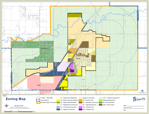
9-8A-3-1 IMPACT AREA MAP
The officially adopted and agreed upon Impact Area for Sugar City, Idaho (Impact Area) is established by this Ordinance #388_2023, and is set forth and described herein:
Legal Description for Proposed Sugar City Impact Area
“Commencing at the North Quarter Corner of Section 35, of Township 7 North, Range 40 East, of the Boise Idaho Meridian, which point is on the Madison Fremont County boundary, and is the Point of Beginning; thence continuing in a Southerly direction along Section centerlines approximately 3 miles to the South Quarter Corner of Section 11, of Township 6 North, Range 40 East, of the Boise Idaho Meridian; thence in a Westerly direction following Section lines approximately 3 miles to the intersection of the Section line and North Yellowstone Hwy, or South Railroad Ave; thence in a Northeasterly direction along the centerline of South Railroad Ave to the Quarter Quarter line of Section 8, Township 6 North, Range 40 East; thence Westerly following Quarter Section lines to the West Quarter Corner of said Section 8; thence in a Northerly direction following the West Section line of Section 8 to the center of the US Highway 20 Right-of-Way; thence Westerly and Southwesterly following the centerline of the US Highway 20 Right- of-Way to its intersection with the Western section line of Section 7, Township 6 North, Range 40 East; thence in a Northerly direction following Section lines to the intersection of the Western section line of Section 6, Township 6 North, Range 40 East and the Teton River; thence following the meanderings of the Teton River in an Easterly direction to a point along the Southern boundary of Section 32, Township 7 North, Range 40 East and the intersection of the Teton River, which point is approximately 123 rods East of the Southwest Corner of said Section; thence in a Northerly direction to the North boundary of Section 32, Township 7 North, Range 40 East, approximately 1 mile, which point is also coincident with the Madison Fremont County boundary; thence in an Easterly direction following Section lines and the County boundary to the Point of Beginning.”
9-8B-6.1 ACCESSORY STORAGE AND SHED BUILDINGS
9-8B-6.2 ACCESSORY DWELLING UNIT
See Sugar City Code Chapter 9-3-12-15 Accessory Dwelling Unit (ADU) for more information.