
Sutter Creek City Zoning Code
CHAPTER 18
12 - ZONES
18.12.010 - Land use zones—Classes designated.
In order to classify, regulate, restrict and segregate the uses of land and buildings; to regulate and restrict the height and bulk of buildings; and to regulate the area of yards and other open spaces about buildings; and to regulate the density of population, fifteen classes of land use zones are established to be known as follows:
(Ord. 333 §2(Exh. A), 2010; Ord. 373, §6(a, b), 2023)
18.12.015 - Combining zones.
In addition to the base zones listed in section 18.12.010, there are also three "combining zone" designations which can be applied to specified base zones as follows:
18.12.020 - Zoning map.
Figure 1—Sutter Creek Zoning Map attached hereto and incorporated herein.
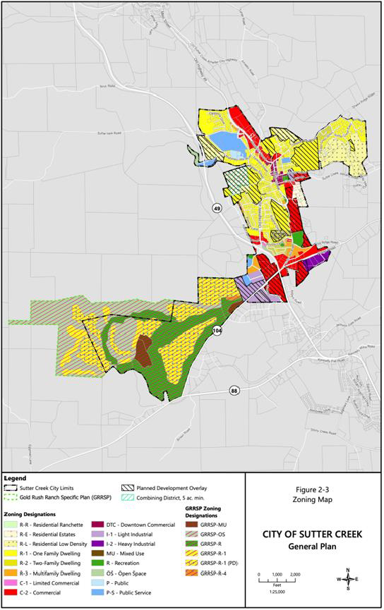
(Ord. 373, §6(c), 2023)
18.12.030 - Boundaries.
Where uncertainty exists as to the boundaries of any zone shown on the zoning map, the following rules shall apply:
A.
Where such boundaries are indicated as approximately following street and alley lines or lot lines, such lines shall be construed to be such boundaries;
B.
In unsubdivided property or where a zone boundary divides a lot, the location of such boundary, unless the same is indicated by dimensions, shall be determined by use of the scale appearing on the map;
C.
In case any uncertainty exists, the planning commission shall determine the location of boundaries;
D.
Where any public street or alley is officially vacated or abandoned, the regulations applicable to abutting property apply to such vacated or abandoned street or alley;
E.
Where any private right-of-way or easement of any railroad, railway, canal, transportation or public utility company is vacated or abandoned, the regulations applicable to abutting property apply to such vacated or abandoned property; and
F.
All property in the city and all property hereafter annexed and pre-zoned upon annexation, shall be classified consistent with the land use diagram, Figure 4-1 the General Plan.
(Ord. 373, §6(d), 2023)
18.12.040 - Permitted uses.
Except as hereinafter provided in Chapter 18.46, nonconforming buildings and uses:
A.
No building shall be erected, and no existing building be moved, altered, added to or enlarged, nor any land, building or premises be used, designed or intended to be used for any purpose or in any manner other than a use specifically listed in this title or amendments thereto as permitted in the zones to which such land, building or premises is located;
B.
No building shall be erected nor any existing building be moved, reconstructed or structurally altered to exceed in height the limit established by this title or amendments thereto for the zone in which such building is located;
C.
No building shall be erected nor any existing building be moved, altered, enlarged or rebuilt nor any open spaces surrounding any building be encroached upon or reduced in any manner except in conformity with the building site requirements and the area and yard regulations established by this title or amendments thereto for the zone in which such building is located; and
D.
No yard or other open space provided about any building for the purpose of complying with the regulations of this title, or amendments thereto, shall be considered as providing a yard or open space for any other building or structure.
18.12.050 - Minimum residential densities.
In all R-3 zoning districts allowing residential development, the minimum density of residential units allowed for that zoning district shall be required per gross acre and such units shall be constructed as all or part of any proposed project, exclusive of any density bonuses or incentives mandated by state law to encourage affordable housing development, unless findings are made by the planning commission that the minimum density requirement cannot be met. Density ranges between districts shall be consecutive and there shall be no overlaps or gaps between districts.
(Ord. 330 §2, 2008; Ord. 373, §6(a, e), 2023)
18.12.060 - Transitional and supportive housing.
A.
Pursuant to Government Code Section 65583, supportive housing and transitional housing shall be subject to those restrictions that apply to other residential dwellings of the same type in the same zoning district.
B.
Pursuant to Government Code Section 65651, permanent supportive housing shall be allowed, by right, in any mixed use and nonresidential zoning districts permitting multifamily uses."
(Ord. 373, §6(f), 2023)
18.12.065 - Low barrier navigation centers.
Pursuant to Government Code Section 65662, low barrier navigation centers shall be allowed by right in any mixed use and nonresidential zoning districts permitting multifamily uses."
(Ord. 373, §6(g), 2023)
18.12.070 - Pets.
No person shall keep or maintain more than four dogs or cats (a maximum of four animals) over four months of age.
(Ord. 373, §6(h), 2023)
18.12.080 - Airport safety zones.
Development within Safety Zones 5 and 6 identified in the Westover Field Airport Land Use Plan (ALUP) shall be reviewed by the City for compatibility with the ALUP and may be subject to Amador Airport Land Use Committee review.
(Ord. 373, §6(i), 2023)