
Tampa City Zoning Code
ARTICLE III
ESTABLISHMENT OF ZONING DISTRICTS AND DISTRICT REGULATIONS
Sec. 27-156. - Official schedule of district regulations.
(a)
Schedule of statements of purpose and intent. The following array presents for the several districts the statements of purpose and intent applicable to each district.
(1)
Single-family residential districts. Single-family districts provide for detached residential housing development on a variety of lot sizes in accordance with the Tampa Comprehensive Plan. Accessory uses, compatible related support uses for residential development and special uses are also permitted.
a.
RS-150 residential single-family. This district provides areas primarily for low density single-family detached dwellings on spacious lots, wherein a property owner may obtain reasonable assurance of compatible development.
b.
RS-100 residential single-family. This district provides areas primarily for low density single-family detached dwellings similar to those provided for in the RS-150 residential single-family district, but with smaller minimum lot size requirements.
c.
RS-75 residential single-family. This district provides areas for primarily low density single-family detached dwellings similar to those provided for in the RS-150 and RS-100 residential single-family districts, but with smaller minimum lot size requirements.
d.
RS-60 residential single-family. This district provides areas for primarily low density single-family detached dwellings similar to those provided for in the RS-150, RS-100 and RS-75 single-family districts, but with smaller minimum lot size requirements.
e.
RS-50 residential single-family. This district provides areas for primarily low density single-family detached dwellings similar to those provided for in the RS-150, RS-100, RS-75 and RS-60 single-family districts, but with smaller minimum lot size requirements.
f.
PD and PD-A planned development districts approved primarily for single-family residential uses.
(2)
Multiple-family residential districts. The following multiple-family districts provide for residential development at a variety of densities in accordance with the Tampa Comprehensive Plan. Accessory uses, compatible related support uses to residential development and certain special uses are also permitted.
a.
RM-12 residential multiple-family. This district provides primarily for low-medium density residential uses including single-family and two-family developments. Multiple-family development may be permitted through the special use permit procedure.
b.
RM-16 residential multiple-family. This district provides primarily for low-medium density residential uses, similar to those provided in the RM-12 district, including single-family and two-family developments, at an increased density. Multiple-family development may be permitted through the special use permit procedure.
c.
RM-18 residential multiple-family. This district provides primarily for low-medium density residential uses, similar to those provided in the RM-12 district, including single-family and two-family developments, at an increased density. Multiple-family development may be permitted through the special use permit procedure.
d.
RM-24 residential multiple-family. This district provides primarily for medium density multiple-family residential development.
e.
RM-35 residential multiple-family. This district provides primarily for medium-high density multiple-family residential development.
f.
RM-50 residential multiple-family. This district provides primarily for high density multiple-family residential development.
g.
RM-75 residential multiple-family. This district provides primarily for high density multiple-family residential development. Such high density residential structures shall be located in close proximity to regional shopping, employment and public transportation opportunities.
h.
PD and PD-A planned development districts approved primarily for multiple-family residential uses.
(3)
Office districts. Development of the following office and professional districts shall be in accordance with the Tampa Comprehensive Plan. They are intended to provide for a combination of office, institutional and residential uses, compatible special uses and compatible related support uses under the provisions of this chapter.
a.
RO residential office. This district provides primarily for low density residential development and low intensity office uses compatible with residential neighborhoods. The district permits conversion of residential structures or the construction of new structures for office and related use. In addition, this district may be used to provide a buffer between residential and more intensive commercial and office districts.
b.
RO-1 residential office. This district provides primarily for low to low-medium density residential development and low-medium intensity office uses compatible with residential neighborhoods. This district would permit conversion of residential structures or the construction of new structures for office and related use.
c.
OP office professional. This district provides primarily for institutional, professional and general office development of an intensity greater than the RO-1 residential office zoning district and less than the OP-1 office professional zoning district. This district shall be applied to land located along arterial and collector streets, as shown on the major street map.
d.
OP-1 office professional. This district provides primarily for high intensity areas of institutional and professional and general office development, while allowing for limited retail and entertainment uses to permit mixed-use development within the district. This district shall be applied in areas of the city where specific nodes of intense office and mixed-use development are appropriate. The district shall be applied to land located along arterial or collector streets, as shown on the major street map.
e.
PD and PD-A planned development districts approved primarily for office uses.
(4)
Commercial districts. The commercial districts provide for various retail sales, personal services, office and institutional uses, accessory uses as appropriate thereto and compatible supporting uses, as well as selected special uses, all at appropriate intensities and in locations in accordance with the Tampa Comprehensive Plan. Planned development districts (PD and PD-A), in accordance with the regulations of this chapter and in conformity with the Tampa Comprehensive Plan, are also permitted.
a.
CN commercial-neighborhood. This district provides areas for limited retail and personal services in residential neighborhoods. This district shall be placed at appropriate locations to supply the daily service needs of such neighborhoods and shall not be used to promote strip commercial development.
b.
CG commercial-general. This district provides areas where a variety of retail and commercial service activities can be conducted compatible with surrounding uses and residential districts.
c.
CI commercial-intensive. This district provides areas for intense commercial activity, permitting heavy commercial and service uses.
(5)
Industrial districts. The industrial districts provide primarily for manufacturing, processing, assembly, warehousing and related uses at appropriate intensities and locations in accordance with the Tampa Comprehensive Plan. Performance standards are used to ensure compatibility with neighboring uses and districts. Planned development districts (PD and PD-A) are also permitted in appropriate locations in accordance with the Tampa Comprehensive Plan.
a.
IG industrial-general. This district provides primarily for areas of light manufacturing, wholesaling, warehousing, assembly or product processing, heavy equipment and vehicular repairs and other light industrial uses. The industrial general district is established to provide areas for industry in locations, which are served by major transportation facilities and adequate utilities, but are not feasible nor highly desirable for heavier industrial development because of proximity to residential, recreational, commercial or related developments. The district is to permit development compatible with uses of residential property adjoining or surrounding the district, with suitable open spaces, landscaping and parking area, which emits limited noise, odors, or light which can be detected on surrounding land.
b.
IH industrial-heavy. This district provides primarily for areas of intensive manufacturing and industrial uses in areas related to the Port of Tampa or other areas capable of supporting such uses. The industrial heavy district is established to provide areas for uses that can generate emissions and are not compatible with primary commercial, institutional, and residential uses.
(6)
M-AP airport compatibility districts. The airport compatibility district is designed to promote the appropriate type and intensity of development of land uses on and surrounding an airport. The purpose of designating land and water areas in this district is to encourage development that is compatible with aircraft operation and to increase safety and limit population by maintaining a lower density of development and to promote and protect the utility of the airport. This district shall be applied to airport landing areas and to other surrounding areas in proximity to airport boundaries or operations. The M-AP airport compatibility district shall consist of five (5) subdistricts or sectors. The subdistricts are described as follows:
a.
M-AP-1. Because these areas are most affected by aircraft traffic, development in these areas shall promote the maximum safety or aircraft, people, and property, and promote the full utility of the airports.
b.
M-AP-2. The height of structures and land use permitted in these areas are of low intensity to reduce population in proximity to the airport and its runways.
c.
M-AP-3. The land uses, intensities and heights of structures are limited to those which, for safety purposes, reduce population in the path of aircraft approaching or departing on these runways.
d.
M-AP-4. The land uses, intensities and heights of structures are designed to maintain the density of population for safety in areas surrounding the airport.
e.
PD and PD-A planned development districts approved for airport-compatible uses.
(7)
Ybor City Historic District. The purpose of the Ybor City Historic District is to promote and preserve this historic district and its landmarks for the educational, cultural, economic and general welfare of the public through the preservation, protection and regulation of buildings, sites, monuments, structures and other areas of historic interest or importance within the Ybor City area of the city; to safeguard the heritage of our city by preserving and regulating this district and its landmarks, which reflect elements of our cultural, social, economic, political and architectural history; to preserve and enhance the environmental quality and safety of this district and the neighborhoods within it; to strengthen the city's economic base by the stimulation of the tourist industry; to establish, stabilize and improve property values; to foster economic development and manage growth. The Ybor City Historic District consists of the following nine (9) subdistricts:
a.
YC-1 central commercial core. This subdistrict comprises the cultural, social, shopping and service heart of the Original Ybor City Historic District. The regulations are intended to preserve and enhance the touristic, cultural and economic functions by preserving its rich mixture of land uses, relatively modest intensity of development, low-rise structures and distinctive architecture.
b.
YC-2 residential. This subdistrict comprises land devoted to residential development, including single-family and multi-family dwellings. The regulations are intended to preserve and conserve this predominately single-family and two-family housing form, and to encourage the development of vacant tracts suitable for residential uses.
c.
YC-3 Hillsborough Community College. This subdistrict comprises land devoted to and designated for development as part of the Hillsborough Community College and supporting related uses.
d.
YC-4 mixed use redevelopment. This subdistrict comprises mainly vacant land redesignated for neighborhood redevelopment which will support and enhance the tourists, cultural and economic functions of the Original Ybor City Historic district, providing an urban mixed use core coincident to the revitalization of the district's commercial core.
e.
YC-5 general commercial. This subdistrict comprises land used and designated for retail and commercial service operations primarily to serve the residents of the immediate area.
f.
YC-6 community commercial. This subdistrict comprises land devoted to general and intensive commercial uses located on the southern fringes of the historic district, and which will provide a transition into the industrial uses to the south and east.
g.
YC-7 mixed use. The purpose of the YC-7 subdistrict is to allow the development of land uses that are consistent with the adopted future land use element of the Tampa Comprehensive Plan, encourage maximum land development opportunities that are well designed, provide for a balanced mixed use development, including residential, which while restricting the more intense commercial and industrial uses, contribute to the appropriate mix of land uses needed to ensure a viable economic base for the historic district.
h.
YC-8 residential. The purpose of the YC-8 subdistrict is to allow the development of single family detached residential dwellings on relatively large lots in the Expanded Historic District. The regulations are intended to preserve and conserve this predominately single-family housing form, and to encourage the development of vacant tracts suitable for residential uses.
i.
YC-9 site planned controlled. The purpose of the YC-9 subdistrict is to allow the development of land uses that are in conformance with the adopted future land use element of the Tampa Comprehensive Plan while encouraging well-designed developments that:
1.
Are characterized by unique conditions or situations which other zoning districts cannot accommodate including, but specifically not limited to unusual physical or environmental features, transportation, access, etc.; or
2.
Include a mixture of appropriate land uses, which may not otherwise be permitted in other districts.
(8)
Central Business District (CBD). The purpose of the CBD district is to implement the goals of the Center City Plan, a component of the Center City Plan, a component of the Tampa Comprehensive Plan, and to guide development through design regulations to create a public realm of high-quality through the regulation of the physical form of buildings, streets, and open spaces, the form and mass of buildings in relation to one another, and the establishment of a pedestrian-friendly relationship between building facades and the public realm. Refer to section 27-181.1 for provisions related to CBD-1 and CBD-2 zoning subdistricts.
(9)
The Channel District (CD). The purpose and intent of the Channel District ("CD") is to provide for a growing mixed-use area which lies between and complements the Central Business District and the Ybor City Historic District. The CD provides for a variety of commercial, residential and industrial uses, in conformance with the Tampa Comprehensive Plan, and seeks to guide development according to the district design regulations. Refer to section 27-197 for provisions related to CD-1, CD-2 and CD-3 zoning subdistricts
(10)
Seminole Heights District (SH). The purpose of the Seminole Heights district is to implement the goals of the Greater Seminole Heights Vision Plan, a component of the Tamp Comprehensive Plan, and to guide development through design regulations to ensure that all development is compatible in form, building and structural orientation, general site layout, height, lot dimensional requirements and other site spatial relationships to the precedent within the established block and generally, the surrounding area. Refer to section 27-211 for provisions related to SH-RS, SH-RS-A, SH-RM, SH-RO, SH-CN, SH-CG, SH-CI, and SH-PD zoning subdistricts.
(11)
Planned development.
a.
PD Planned Development. The purpose of the planned development district (PD) is to allow the development of land uses that are in conformance with the adopted future land use element of the Tampa Comprehensive Plan while encouraging maximum land development opportunities and well-designed developments that:
1.
Are characterized by unique conditions or situations which other zoning districts cannot accommodate including, but specifically not limited to unusual physical or environmental features, transportation, access, etc.; or
2.
Include a mixture of appropriate land uses which may not otherwise be permitted in other districts.
b.
PD-A Planned Development Alternative. The purpose of this alternative review process is to provide conceptual approval for planned development districts involving large-scale developments with a lengthy projected buildout time. The alternative review process allows flexibility within the parameters established by specific stated performance standards.
(12)
University-Community District (U-C). The purpose of the University Community District shall be to provide for the appropriate development and arrangement of land uses for the University of South Florida and its associated land uses and to assure a development pattern which is compatible with university operations and to further encourage the grouping of those land uses having specific inter-relationships. The intent of the U-C District is to protect and promote the long-term stability of both the university and its accessory uses.
(13)
Mixed use districts. The purpose of these districts is to allow the development of land uses that are consistent with the Tampa Comprehensive Plan, encourage maximum land development opportunities that are well designed, provide for a balanced mixed use development, including residential and neighborhood scale office and commercial uses, which contribute to the appropriate mix of land uses needed to ensure a viable economic base within Tampa's Urban Villages. Refer to sections 27-212 and 27-212.2 for provisions related to the following zoning subdistricts:
a.
NMU-16: Mixed use, neighborhood scale office and commercial, and all single-family dwelling types.
b.
NMU-24: Mixed use, civic, neighborhood scale office and commercial, and all single-family and multi-family dwelling types.
c.
NMU-35: Mixed use, civic, neighborhood scale office and commercial, and all single-family and multi-family dwelling types.
(14)
PP public parks. This district is designed to identify and protect those publicly owned parcels used or proposed for park, recreation and open space use.
(b)
Schedule of permitted uses by district. Except as specifically provided in this chapter, regulations governing the use of land and structures within the various districts in the city shall be as shown in the schedule of permitted uses by district.
The M-AP subdistricts, YC subdistricts, PD and PD-A districts, SH subdistricts, CBD subdistricts, NMU subdistricts, and CD subdistricts are not shown in the following Table 4-1, Schedule of Permitted Uses by District. However, district regulations governing said districts and subdistricts are set forth in this chapter as follows:
M-AP—Article III, Division 2, Subdivision 1
YC—Article III, Division 2, Subdivision 2
PD and PD-A—Article III, Division 3
CBD—Article III, Division 2, Subdivision 3
CD—Article III, Division 2, Subdivision 4
SH—Article III, Division 2, Subdivision 5
NMU—Article III, Division 2, Subdivision 6
The use of land or structures that are not expressly listed in the schedule of permitted uses by district as permitted principal uses or permitted accessory uses are prohibited uses and shall not be established in that district.
Uses listed as permitted special uses may be established in that district only after approval of an application for a special use permit in accordance with the procedures and requirements in Article II, Division 5.
TABLE 4-1
SCHEDULE OF PERMITTED, ACCESSORY, AND SPECIAL USES BY DISTRICT*
Notes:
1 See section 27-290 for accessory structure requirements.
2 See section 27-282.12 for buffering requirements for open storage.
3 In the RS and RM zoning districts, congregate living facilities of six (6) or fewer residents may not locate within a one-thousand-foot radius of each other.
4 See section 27-282.8 Single-Family, semi-detached design standards., and section 27-282.11 Townhouse lot regulations.
5 See section 27-282.9 Single-family attached design standards., and section 27-282.11 Townhouse lot regulations.
6 The ability to establish a permitted use on a parcel of land is contingent on compliance with all land development regulations, including but not limited to concurrency, drainage, environmental regulations, and parking requirements.
7 See section 27-283.13(b) for special event parking regulations.
8 See section 27-283.13(a) for interim parking regulations.
9 Off-street parking is a permitted accessory use in this zoning district only in those instances when the criteria set forth in section 27-283.13(d) have been satisfied.
10 See section 27-282.17 for regulations applicable to temporary film production. Additionally, the section 271-30 buffer requirements shall not apply to this use.
11 See section 27-282.15 for specific criteria related to crematoriums as accessory uses.
12 See section 27-282.14 for supplemental regulations related to crematoriums as principal uses.
13 Temporary vendor sales may be considered for permit on parcels that are zoned or used for non-residential sales subject to section 27-132 criteria.
14 Refer to Articles II, Division 5 Special Use Permits and IX Alcoholic Beverages for applicable provisions.
15 Proposed single-use developments, excluding those within and subject to the Westshore Overlay District, shall comply with the yard (setbacks and/or build-to lines) and height standards set forth for the CG zoning district, for the following uses: Catering Shop; Craft Distillery; Dry-cleaning Plant, small; Kennel, small; Printing, light; Restaurant, Drive-in; Retail Bakery; all Retail Sales types; Truck/trailer rental; Veterinary Office; Wine production, customized.
16 Refer to section 27-282.29 for supplemental regulations related to this use. Any request to reduce distance requirements set forth in this section, shall be processed as a special use-2 permit (refer to article II, division 5). Requirements of this section shall serve as supplemental special use criteria (refer to section 27-132). Dispensaries in the IG and IH zoning districts may only be an accessory use to a medical marijuana processing facility.
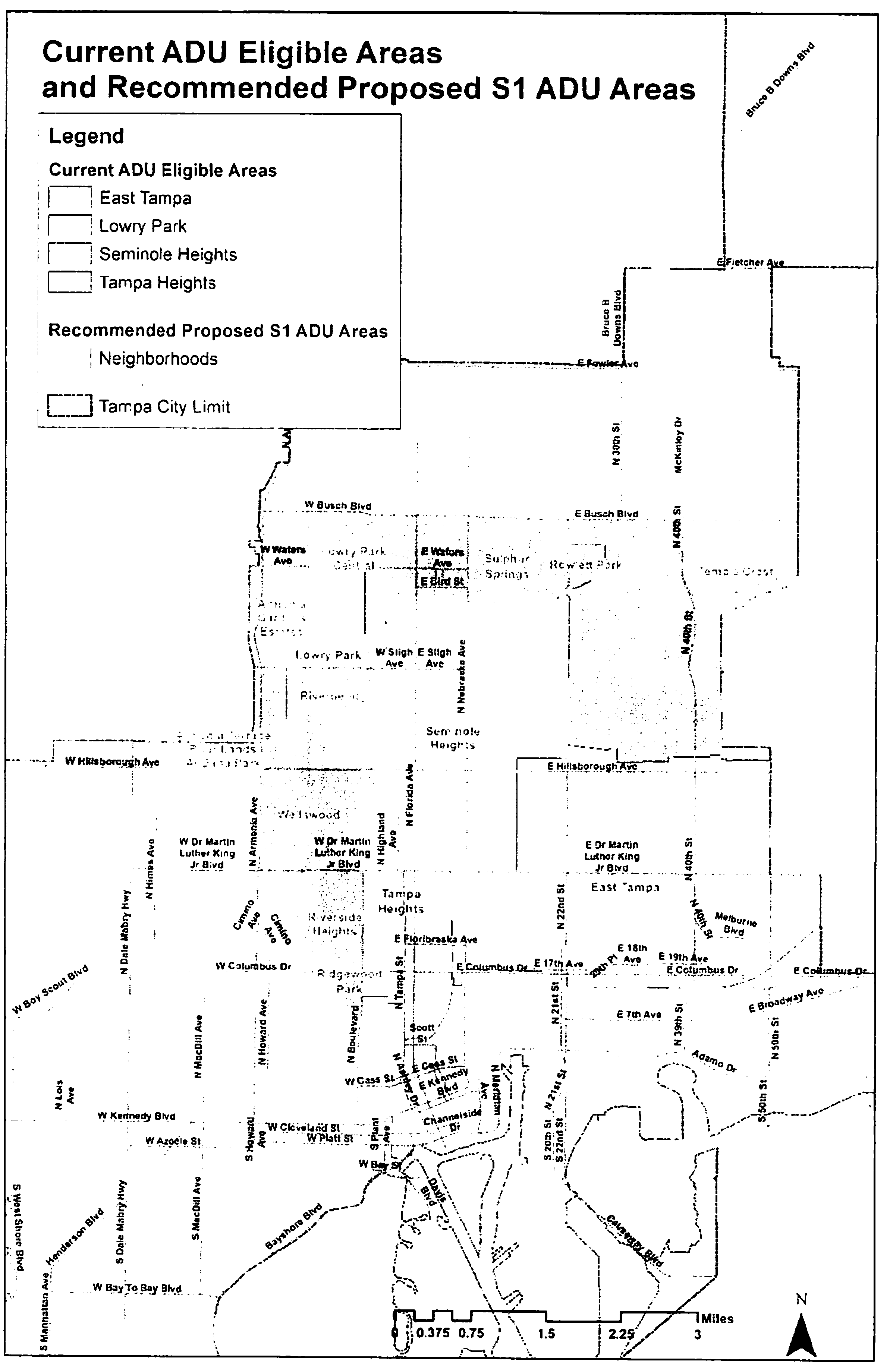
17 The accessory dwelling unit special use is limited to: The area of the City west of North Boulevard, south of W. Dr. Martin Luther King, Jr. Boulevard and east and north of the Hillsborough River; The area south of W. Busch Boulevard and north of W. Hillsborough Avenue; The area south of Hillsborough Avenue, east of N. Armenia Avenue, west of the Hillsborough River and north of W.D. Martin Luther King, Jr. Boulevard; The east Tampa Overlay District as described in section 27-240 (as a special use); The accessory dwelling unit is a permitted use in the Tampa Heights Overlay District in accordance with section 27-244. (See "ADU Eligible Areas" map, Exhibit "A" to section 27-156).
18 Refer to Articles II, Division 5 Special Use Permits and IX Alcoholic Beverages for applicable provisions. Requests may process as an administrative special use permit (S-1) only when sales meet the specific use standards in section 27-132. If any waivers are needed, the request shall process as an (S-2).
19 Requests for Public Golf Course with alcoholic beverage sales shall adhere to the definition of "Alcoholic beverage classification: Beer, wine, liquor; Public Golf Course" contained in section 27-43.
20 Development sites (zoning lots) for these production limits must contain at least two (2) acres of land.
21 Development sites (zoning lots) for medical marijuana processing facilities in the IG zoning district must contain at least twenty thousand (20,000) square feet. The aggregate floor area for processing facilities on a zoning lot shall not exceed one hundred thousand (100,000) square feet.
22 Refer to section 27-282.5 for supplemental regulations related to this use.
23 Refer to section 27-282.21 for supplemental regulations related to this use.
24 Refer to section 27-282.22 for supplemental regulations related to this use.
25 Refer to section 27-282.20 for supplemental regulations related to this use.
26 Refer to section 27-164 for supplemental regulations.
27 Refer to section 27-282.24 for applicable provisions.
28 Refer to section 27-282.25 for applicable provisions.
29 Refer to section 27-285.26 for applicable provisions.
30 Refer to section 27-282.28 for applicable provisions.
31 Refer to section 27-282.30 for applicable provisions.
(c)
Schedule of area, height, bulk and placement regulations. Except as specifically provided in other sections of this chapter, regulations governing the minimum lot area and width, required front, side and rear yards, floor area ratio, height of structures, area of signs and related matters shall be as shown in the schedule of area, height, bulk and placement regulations.
The M-AP districts, YC subdistricts, PD and PD-A districts, CBD subdistricts, CD subdistricts, SH subdistricts, and NMU subdistricts are not shown in the following Table 4-2 , Schedule of Area, Height, Bulk and Placement Regulations. However, district regulations governing said districts and subdistricts are set forth in this chapter as follows:
M-AP—Article III, Division 2, Subdivision 1
YC—Article III, Division 2, Subdivision 2
PD and PD-A—Article III, Division 3
CBD—Article III, Division 2, Subdivision 3
CD—Article III, Division 2, Subdivision 4
SH—Article III, Division 2, Subdivision 5
NMU—Article III, Division 2, Subdivision 6
TABLE4-2
SCHEDULE OF AREA, HEIGHT, BULK AND PLACEMENT REGULATIONS
Table 4-2 Notes:
1.
Except where lesser height is specified by Hillsborough County Authority regulations.
2.
For each foot of building height above thirty-five (35) feet, the required yards shall be increased by one (1) foot.
3.
For each two (2) feet of building height over thirty (30) feet, the required front and corner yards shall be increased by one (1) foot, except that if the zoning lot is immediately adjacent to a residential zoning district, the rear and side yards shall also meet the setback noted above.
4.
For each three (3) feet of building height above fifty (50) feet, the required yards shall be increased by one (1) foot.
5.
For each four (4) feet of building height above thirty (30) feet, the required yards shall be increased by one (1) foot.
6.
Places of assembly in the CG & CI districts may exceed the maximum permitted height provided that for every one (1) foot of height above forty-five (45) feet, all required yards shall be increased by one (1) foot.
7.
For the sole purpose of preserving specimen or grand tree(s), building height and yards applicable to the subject lot may be altered without a variance or alternative design exception, as follows:
a.
Up to twenty-five (25) percent reduction for front and corner yards.
b.
Up to one (1) foot reduction for side yard.
c.
Up to forty (40) percent reduction for rear yard.
d.
Up to ten (10) percent increase for building height.
8.
The structural edge of the vehicular entrance to the garage, carport or any vehicular storage area must be setback a minimum of eighteen (18) feet from the property line located adjacent to a street for a one-vehicle storage area and ten (10) feet for a two- or more vehicle storage area, provided that the visibility standards of section 27-283.5 are met. Alternative setbacks may be considered by the zoning administrator, or designee, for those structures that access alleys.
9.
Public utility substations and structures in the U-C district shall be exempt from the minimum lot area requirements.
10.
In the U-C district only, lot width shall be measured along the front property line.
11.
For each foot of building height above thirty-five (35) feet, the required yards shall be increased by one (1) foot.
12.
The required side yard setback in the CG district is reduced from 10 feet to 0 feet when the side property line abuts a non-residential zoning district.
13.
Section 27-284.3.3, buffers and screening may require additional setback for required buffer area.
14.
The zoning administrator may approve a reduction or waiver of the required front yard or corner yard setback when the historical pattern of development on the subject block face is less than the current requirement. For properties in a National or Local Historic District or historic conservation overlay district, the zoning administrator shall consult with the appropriate historic district administrator to determine the appropriate front yard or corner yard setback for a parcel. Consideration shall be given to the existing setbacks on the blocks immediately adjacent to the subject property. At no time may the reduction or waiver exceed the average front setback of the two (2) adjacent properties. It will be the responsibility of the party requesting the waiver to provide a survey that identifies the existing setbacks on the adjacent properties. For the replacement of structures on properties located in a National or Local Historic District or historic conservation overlay district, the zoning administrator, after consultation with the appropriate historic district administrator, may approve a reduction or waiver of the required yard setbacks for a principal or accessory structure when such structures are being placed on the subject lot in conformity with the historical and precedent patterns of building setbacks for other similarly situated properties, and only when such replacement structures are being placed on the same building footprint and retain the same residential density or commercial intensity as the original structures.
15.
RS-50 and RS-60 side yard setbacks may be altered without a variance for the sole purpose of off-setting the parking area when no garage or carport is provided within the front face of the structure, subject to the following requirements: (i) both side yards combined shall equal fourteen (14) feet; and, (ii) no one (1) side shall be reduced to less than five (5) feet. Additionally, any yard reduced to less than six (6) feet by this provision shall not be permitted to apply for an administrative variance.
16.
Allow reduction to five-foot side yard, only when not adjacent to single-family use.
17.
Refer to the Tampa Comprehensive Plan for maximum density/floor area ratio ("FAR") limits. For properties seeking bonus density/FAR, refer to section 27-140 for applicable methodology and criteria.
N/A. Not applicable.
(d)
Minimum lot area and density factors. The following summary Table 4-2.1 shows the district acronyms, the district names, the zoning lot area and density factors required by district. In order to determine density for residential use, the following formula shall be used:
TABLE 4-2.1
Notes:
1.
Development of single-family attached and semi-detached dwellings is permitted to have a minimum lot area of one thousand six hundred (1,600) square feet.
2.
The maximum allowed density is governed by the Tampa Comprehensive Plan.
(Ord. No. 2013-72, § 4, 6-6-2013; Ord. No. 2013-73, § 4, 6-6-2013; Ord. No. 2013-101, § 2, 7-18-2013; Ord. No. 2015-10, § 3, 1-15-2015; Ord. No. 2015-99, § 2, 9-17-2015; Ord. No. 2015-110, § 2, 11-5-2015; Ord. No. 2016-14, § 2, 2-4-2016; Ord. No. 2016-58, § 4, 4-21-2016; Ord. No. 2016-76, § 2, 5-26-2016; Ord. No. 2016-78, § 2, 5-26-2016; Ord. No. 2017-132, § 4, 8-24-2017; Ord. No. 2017-163, § 2, 11-16-2017; Ord. No. 2018-176, § 3, 11-1-2018; Ord. No. 2019-54, § 25, 4-18-2019; Ord. No. 2020-14, § 2, 2-6-2020; Ord. No. 2022-52, § 2, 3-17-2022; Ord. No. 2022-157, § 3, 9-1-2022; Ord. No. 2022-158, § 4, 9-1-2022; Ord. No. 2023-128, § 3, 9-21-2023; Ord. No. 2023-129, § 1, 9-21-2023; Ord. No. 2023-135, § 1, 10-5-2023; Ord. No 2024-76, § 4, 7-18-2024)
Sec. 27-157. - Regulations encumbering land required to satisfy regulations.
No portion of a lot used in connection with an existing or proposed building, structure or use and necessary for compliance with the area, height and placement regulations of this chapter shall, through sale or otherwise, be used again as a part of the lot required in connection with any other building, structure or use.
Sec. 27-158. - Height regulation generally.
(a)
Excluded portions of structures. Except as specifically provided herein, the height limitations of this chapter shall not apply to any penthouses or roof structures for housing elevators, stairways, tanks, ventilating fans, solar energy collectors, chimneys or similar equipment required to operate and maintain the building (provided that such structures shall not cover more than twenty (20) percent of roof area), nor to place of religious assembly spires, steeples, belfries, cupolas, domes, monuments, widow's walk or other accessible features, nor to water towers, skylights, flag poles, vents or similar structures and other similar architectural features which may be erected above the height limit, nor to fire or parapet walls, provided however that such walls shall not extend more than five (5) feet above the roof. Such features on fences/walls shall not extend more than one (1) foot above the maximum height, and shall have an eight-foot spacing between them.
(b)
Aviation hazards. No building or other structure (regardless of exclusions set forth in subsection (a) above) shall be located in a manner or built to a height that constitutes a hazard to aviation or creates hazards to persons or property by reason of unusual exposure to aviation hazards. In any area within the city, in addition to height limitations established by this chapter, limitations established by ordinance or by any ordinance amending or replacing such ordinance or by lawful federal, state or county aviation authority regulations shall apply to heights of buildings, structures or natural vegetation.
(c)
Exemption for public safety equipment and towers. Communication equipment and towers owned and operated by governmental agencies responsible for public safety (such as the city police and fire departments, county sheriff's office, and Federal Aviation Authority) shall be exempt from any height limitations found in this chapter.
Sec. 27-159. - Permitted projections into required yards.
(a)
Front porches in residential districts.
(1)
For new and existing residential development in Residential Single-Family districts (RS Districts) and Residential Multi-Family districts (RM Districts) that allow detached, semi-detached and attached residential single-family development, a front porch may project into the required front yard no more than eight (8) feet provided the following conditions are met:
a.
The porch is open on all sides except where it is attached to the principal structure. No permanent screening, lattice-work, banister, or other permanent, attached, visual obstruction shall be permitted except for safety purposes, not to exceed the minimum to meet building code safety code standards.
b.
The zoning administrator shall encourage the construction and integration of residential front porches in the overlay districts. In overlay districts where block averaging or other averaging techniques are required, the front porch shall be allowed to encroach up to eight (8) feet into the established front yard. However, at no time may the front porch be placed less than five (5) feet from the front property line.
c.
A porch projecting into the required front yard shall be a maximum one-story porch. The maximum height of the eave above finish grade shall not exceed twelve (12) feet. If the finished floor of the residence is elevated for flood purposes, the porch may extend above the twelve (12) feet to remain on the same visual plane as the first floor of the residence, but must remain in proportion to said residence.
d.
A porch shall be "additive" and not "incised" into the primary mass of the building. In other words, the porch needs to be a separate mass.
e.
The proposed porch must be designed in keeping with the architectural style of the structure.
(b)
Architectural features including, but not limited, to cornices, eaves, gutters, flower boxes, bay windows, decorative molding and balconies, which are part of the structure or attached thereto, may project no more than three (3) feet into the required front, corner and rear yards. Within the side yard setback, the only architectural features permitted to encroach three (3) feet into the required setback are cornices, eaves, gutters and decorative molding. However, architectural features may not encroach into any setback reduced by a variance approval unless such encroachments were specifically approved as part of the variance request. Equipment, tanks, filters, stairways and enclosed floor space are not considered architectural features and, therefore, must meet principal structure setbacks, unless otherwise varied pursuant to other sections of this chapter.
(Ord. No. 2021-9, § 1, 2-4-2021; Ord. No 2024-76, § 5, 7-18-2024)
Sec. 27-160. - Special street setbacks.
(a)
Regardless of any other provisions of this chapter relating to the establishment of yard or other setback lines, there shall be a setback line, as specified below, for any building or structure on property abutting any of the streets hereinafter named. No building or other structure shall be constructed or moved nearer than the specified setback line, unless otherwise provided for in this Code. The special street setback line shall be measured from the centerline of the existing right-of-way. Where adequate right-of-way exists and where specific zoning district setbacks exist, then such zoning district setbacks shall control.
(b)
The department may authorize a waiver or reduction of the special street setbacks as required below, after consultation with the traffic engineer, provided the following regulations are met:
(1)
The request for a waiver shall be in a form approved by the city and shall be signed by the property owner.
(2)
The applicant acknowledges and agrees that the waiver may be revoked at any time by the city; upon revocation, the sign or structure shall be relocated to conform with this section or, if relocation is not feasible, the sign or structure shall be removed at property owner's expense.
(3)
Any waivers granted shall be presented to the building official prior to issuance of a permit.
(4)
Any waiver granted hereunder shall not be construed as a waiver of any of the remaining setback requirements contained in this Code.
(5)
No funding has been approved for right-of-way acquisition for the street segment involved in the request.
(6)
The proposed development is designed to minimize encroachment into the special street setback.
(Ord. No. 2020-166, § 27, 12-17-2020)
Sec. 27-161. - Lots, yards and measurements.
(a)
Measurements of lot width and yards.
(1)
Lot width. The width of a lot shall be measured at the rear of the required front yard and shall be maintained for a depth required to meet fifty (50) percent of the required minimum lot area; however, if the lot is a lot of record as of the adoption of this ordinance, then the width of the lot may be measured according to the regulations in effect at the time the lot was created. For those lots that do not meet the specific criteria set forth in the section, an application may be made for city council consideration through the rezoning process.
The intent of the minimum lot width provision is to maintain a reasonable distance between structures for the purposes of preservation of open space, adequate provision of air and light, reduction of fire dangers, limitation on density, and aesthetics. In consideration of the stated intent of said provision, a lot shall be deemed to be in violation of the minimum lot width requirement if said lot, while in technical compliance with the lot width measurement requirement, is inconsistent with or fails to achieve the aforementioned intent of the minimum lot width provision.
The following are circumstances when lot width may be in technical compliance with the lot width measurement requirement, but said lot width is inconsistent with the stated intent of the minimum lot width provision, and therefore will be deemed to be in violation of the minimum lot width provision:
a.
Minimum lot width is achieved at the rear of the required front yard (width measurement point), and may also be achieved at some other point or points along the side lot line, but is not achieved along a substantial portion of the side lot line; and the lot lines or lot configuration is patently inconsistent with existing lot development in the area; or
b.
A minimum amount of property is acquired or divided or separated from an adjacent lot simply to meet the minimum lot width requirement at the width measurement point, and may also be acquired or divided or separated at some other point or points along the side lot line, but is not acquired or divided or separated from an adjacent lot, along a substantial portion of the side lot line, and/or is not acquired or divided or separated to accommodate any development or structure; and the lot lines or lot configuration is patently inconsistent with existing lot development in the area; or
c.
The lot lines are jogged or zig-zagged at the width measurement point, and may also be jogged or zig-zagged at some other point or points along the side lot line, but is not jogged or zig-zagged to accommodate any development or structure; and the lot lines or lot configuration is patently inconsistent with existing lot development in the area.
(2)
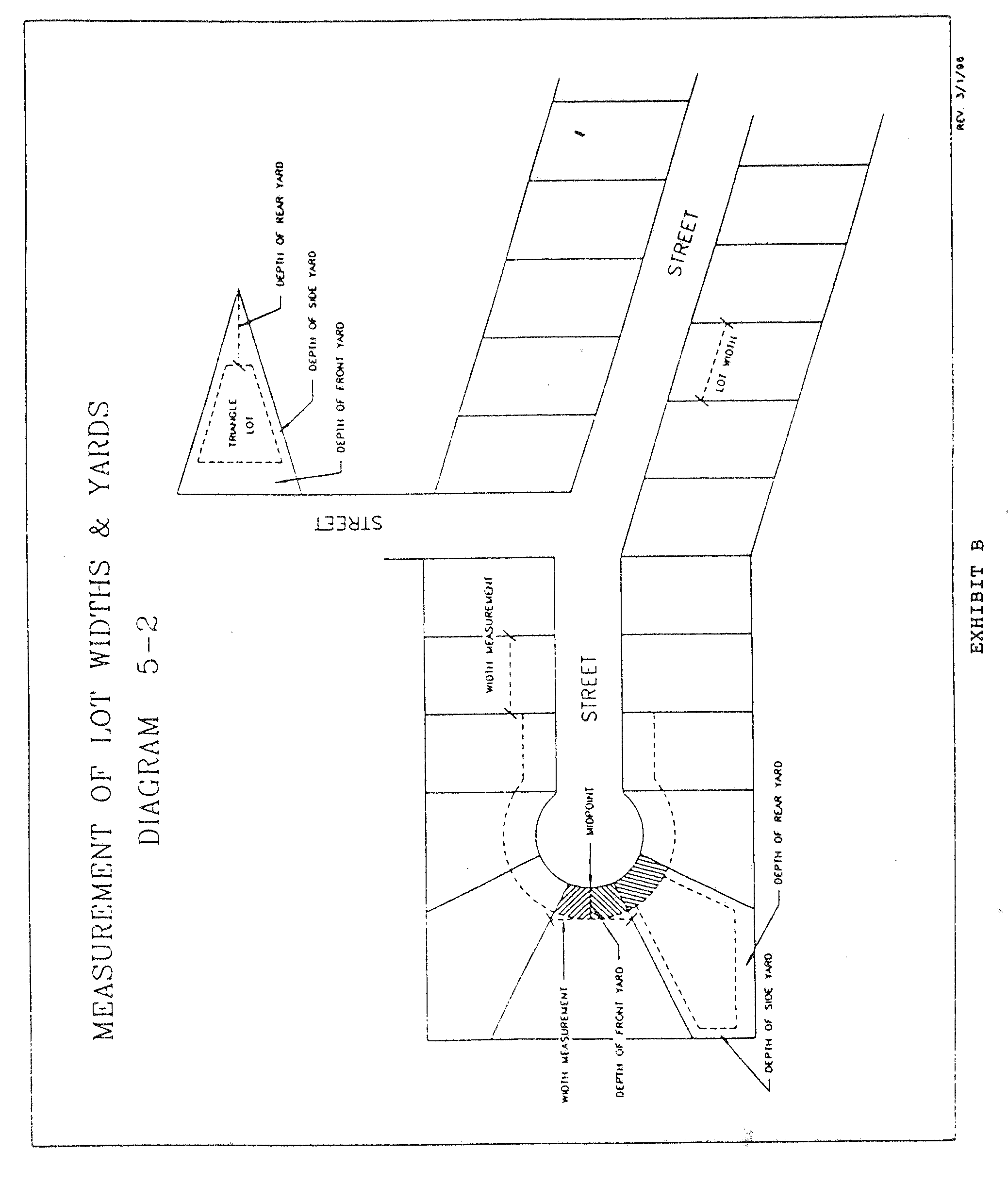
Lot yards. Setback requirements for minimum yards shall be measured parallel to property lines and at a radius to any point.
If a nonconforming lot width or yard is created as a result of governmental acquisition of property, lot width and yards shall be measured from the property line location prior to acquisition.
(b)
Measurement of yards on waterfront property. For lots with seawalls, the depth of a waterfront yard shall be measured perpendicular to the centerline of the seawall. For lots without seawalls, the waterfront yard shall be measured perpendicular to the waterside lot line or perpendicular to the mean high waterline, whichever is nearer to the principal structure on the same lot. The depth of a waterfront yard shall be determined by its location as a front, side or rear yard.
(c)
Lot area. Lot area shall include all land within the legally described property boundaries. Lot area shall not include private or public streets or access easements; lot area may include any other utility easement, as determined by the zoning administrator. If a nonconforming lot width or yard is created as a result of governmental acquisition of property, lot width and yards shall be measured from the property line location prior to acquisition.
The intent of the minimum lot area provision is to maintain reasonable space on a lot for the purposes of preservation of open space, adequate provision of air and light, reduction of fire dangers, limitation on density, and aesthetics. In consideration of the stated intent of said provision, a lot shall be deemed to be in violation of the minimum lot area requirement if said lot, while in technical compliance with the lot area requirement, is inconsistent with or fails to achieve the aforementioned intent of the minimum lot area provision.
The following are circumstances when lot area may be in technical compliance with the lot area requirement, but said lot area is inconsistent with the stated intent of the provision, and therefore will be deemed to be in violation of the minimum lot area provision. If the zoning administrator finds (a), (b), (c), or (d) to be true, the property shall not be divided as presented:
a.
Land area (property) is acquired, divided, or separated from an adjacent lot simply to meet the minimum lot area requirement for the proposed lot and one (1) or more of the lots created are oddly shaped, such as lots with a panhandle;
b.
At the intersection of two (2) streets, a lot of record is divided in compliance with the minimum lot area but the lot depth is shallow and out of character with the surrounding neighborhood;
c.
The lot lines or lot configuration is patently inconsistent with existing lot development in the area; or,
d.
The lot lines are jogged or zig-zagged for the purpose of satisfying the minimum lot area requirement, which render the lot lines or lot configuration patently inconsistent with existing lot development in the area.
(d)
Types of lots.
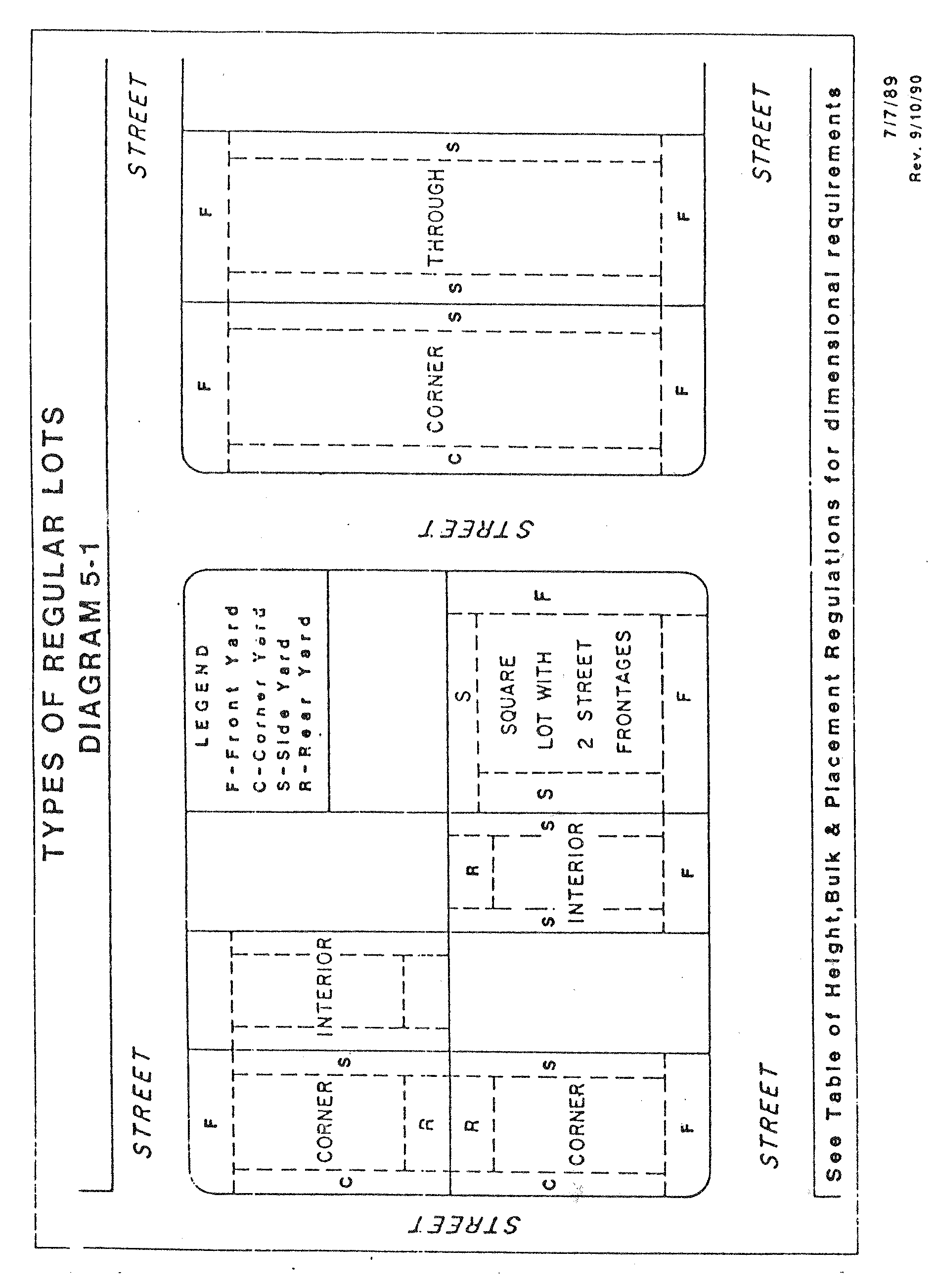
(1)
Corner lot is a lot located at the intersection of two (2) or more streets (see Diagram 5-1).
(2)
Interior lot is a lot abutting only one (1) street (see Diagram 5-1).
(3)
Through lot is a lot other than a corner lot, with two (2) street frontages, where the streets are generally parallel to each other (see Diagram 5-1).
(e)
Determination of yards.
(1)
On corner lots with two (2) street frontages, the front yard shall be the shortest boundary adjacent to the street. The second lot line adjacent to a street shall be considered a corner yard as determined by the schedule of area, height, bulk and placement regulations.
(2)
On corner lots with three (3) or more street frontages, there shall be two (2) front yards which are the two (2) shortest boundaries adjacent to the street and most nearly parallel to each other. The third and other street frontages shall be considered corner yards as determined by the schedule of area, height, bulk and placement regulations.
(3)
Double front lots are lots with two (2) street frontages of equal length and where the abutting lot has their front yard along the common street.
(4)
Through lots shall be considered to have two (2) front yards adjacent to the street and side yards perpendicular to the front yards. No rear yard shall be required for through lots. However, if adjacent properties have developed with a distinct rear yard, the zoning administrator may allow rear yard regulations to apply along one (1) of the streets.
(5)
The address of a house or direction which the house faces shall have no effect on the yard regulations outlined above.
(6)
On those corner lots where there is a clear established historical pattern of one (1) street having a front yard orientation that is contrary to subsections (1)—(3) above, the zoning administrator may allow development to follow that same historical pattern. The zoning administrator, in making this determination, shall consider the following:
a.
The original subdivision plat design;
b.
Existing structures on both the subject property and adjacent properties, with regard to their orientation toward the street(s); and
c.
Whether the lot frontage involves unimproved street right-of-way.
d.
The existing historical precedent with regard to curb cuts and right-of-way access to and from the lots on both the block on which the property is located and on adjacent blocks.
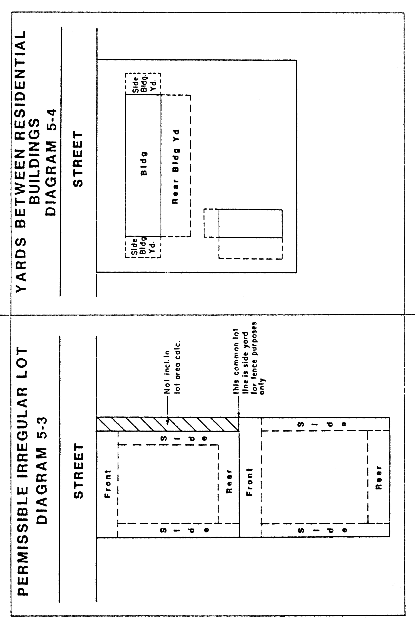
Irregular Lots
Sec. 27-162. - Yards between residential buildings.
Yards between buildings shall be provided at fifteen (15) feet for single family detached, single family attached, single family semi-detached, two family and multi-family buildings, and hotels and motels.
(Ord. No. 2022-52, § 3, 3-17-2022)
Sec. 27-163. - Setback requirements for construction within flood-prone areas.
No building or structure may be set, constructed, moved to or within the floodplain and drainage retention area (approximately sixty (60) acres located generally within the elevation 28.0 contour) as designated for the Curiosity Creek Drainage System and more specifically described as follows:
(1)
The east one-half of Block 4 of the North Tampa Acreage in Section 13, Township 28 South, Range 18 East, of record in Plat Book 11, page 84, Public Records of Hillsborough County, Florida; containing approximately 199,850 square feet.
(2)
The east one-half of Block 3 of North Tampa Acreage in Section 13, Township 28 South, Range 18 East, of record in Plat Book 11, page 84, Public Records of Hillsborough County, Florida; containing approximately 200,195 square feet.
(3)
All of Lot 7 and the east one-half of Lots 3, 4, 5 and 6, all in Block 4 of W. E. Hamner's Forest Acres in Section 13, Township 28 South, Range 18 East, a subdivision of record in Plat Book 61, Page 44, Public Records of Hillsborough County, Florida; containing approximately 290,555 square feet.
(4)
The west one-half of the northeast quarter of the northwest quarter of Section 13, Township 28 South, Range 18 East, less and except Larue Grande Subdivision, of record in Plat Book 41, Page 66, Public Records of Hillsborough County, Florida, and the following described parcel of land:
Begin at the northwest corner of the northeast quarter of the northwest quarter of Section 13, Township 28 South, Range 18 East, run easterly 520 feet, more or less, along the northerly boundary of the west one-half of the northeast quarter of the northwest quarter of Section 13; thence southerly 340 feet, more or less; thence westerly 520 feet to the westerly boundary of the west one-half of the northeast quarter of the northwest quarter; thence northerly along the westerly boundary to the point of beginning; less existing rights-of-way;
And less a tract described as commencing at the southwest corner of the west one-half of the northeast quarter of the northwest quarter of Section 13, Township 28 South, Range 18 East, Hillsborough County, Florida; run thence north 89 degrees 36 minutes 00 seconds east along the southerly boundary of the west one-half of the northeast quarter of the northwest quarter of such section a distance of 26.0 feet; thence north 00 degrees 00 minutes 00 seconds east (assumed bearing) 30.0 feet to the point of beginning; continue thence north 00 degrees 00 minutes 00 seconds east 175.00 feet to the southwest corner of Larue Grande Subdivision Unit 1, as recorded in Plat Book 41, Page 66 of the Public Records of Hillsborough County, Florida; thence north 89 degrees 37 minutes 00 seconds east along the southerly boundary of such subdivision and the easterly projection thereof 280.66 feet; thence south 00 degrees 00 minutes 00 seconds west 175.02 feet; thence south 89 degrees 36 minutes 00 seconds west 280.67 feet to the point of beginning;
And less the south 100 feet of the north 612.71 feet of the east one-half of the west one-half of the northeast quarter of the northwest quarter of Section 13, Township 28 South, Range 18 East, Hillsborough County, Florida, less the west 25 feet for road right-of-way; containing 495,710 square feet, more or less.
(5)
A tract of land in the east one-half of the northeast quarter of the northwest quarter of Section 13, Township 28 South, Range 18 East, described as follows:
From the northwest corner of the east one-half of the southeast quarter of the northwest quarter of Section 13 run northerly along the westerly boundary of the east one-half of the northeast quarter of the northwest quarter of Section 13, a distance of 590 feet, more or less, to the point of beginning; continue northerly along the westerly boundary a distance of 710 feet; thence easterly 150 feet; thence southerly parallel to the westerly boundary 310 feet; thence easterly 180 feet; thence southerly parallel to the westerly boundary 400 feet; thence westerly 330 feet; less existing rights-of-way; containing approximately 178,500 square feet.
(6)
A tract of land in the east one-half of the southeast quarter of northwest quarter of Section 13, Township 28 South, Range 18 East, described as follows:
From the northwest corner of the east one-half of the southeast quarter of the northwest quarter of Section 13, Township 28 South, Range 18 East, run southerly along the westerly boundary of the east one-half of the southeast quarter of the northwest quarter of Section 13, a distance of 245 feet, more or less, to the point of beginning; thence easterly 100 feet; thence southerly parallel to the westerly boundary 380 feet; thence westerly 100 feet to a point on the westerly boundary; thence northerly along the westerly boundary to the point of beginning; containing approximately 38,000 square feet.
(7)
The west one-half of the southeast quarter of the northwest quarter of Section 13, Township 28 South, Range 18 East, less existing rights-of-way; containing approximately 877,800 square feet.
Sec. 27-164. - RO, RO-1 and CN Districts Urban Design Criteria.
(a)
Purpose. To provide districts which balance the need for nonresidential uses in infill areas while protecting the surrounding neighborhood and adjacent residences; and to recognize urban conditions and encourage rehabilitation of existing structures and redevelopment.
(b)
Specific requirements: Urban design criteria. In keeping with the intent of this district which is, in part, to maintain neighborhood characteristics and scale, the zoning administrator shall review by and determine compliance with following urban design guidelines for the proposed development:
a.
Façade: The building façade shall be consistent with the scale and architectural style of the surrounding neighborhood in terms of materials, texture and details, roof shape, orientation and proportion and rhythm of openings.
b.
Signage: Freestanding signs shall be limited to ground signs not exceeding four (4) feet in height. Signage incorporated into the architectural design of the building shall not exceed the apex of the roof pitch.
c.
Parking: Parking areas shall be designed to minimize negative affects on adjacent residences and surrounding neighborhood. Access shall be designed to discourage travel through the neighborhood. Parking spaces shall be located to maximize privacy and to minimize noise and lights upon adjacent residences.
(c)
Previously approved RO, RO-1, and CN site plan zoning districts shall remain valid subject to section 27-138 and any substantial changes thereto require compliance with this article.
Subdivision 3. - Central Business District (CBD) Districts[6]
Editor's note— Ord. No. 2016-79, § 1(Exh. A), adopted May 26, 2016, repealed the former Subdiv. 3, §§ 27-181—27-190, and enacted a new Subdiv. 3 as set out herein. The former Subdiv. 3 pertained to similar subject matter. See Code Comparative Table for complete derivation.
Subdivision 5. - Seminole Heights (SH) District
Click here to view a PDF version of Subdivision 5. Seminole Heights (SH) District.
Sec. 27-226. - Purpose.
The purpose of this article is to provide for zoning districts that recognize unique conditions, allow design flexibility, and promote planned diversification and integration of uses and structures, which other zoning districts cannot accommodate. Through this process city council retains authority to establish such limitations and regulations as it deems necessary to protect the public health, safety, and general welfare, with the exception of standard technical requirements, as described in this section. The intent of these site plan zoning districts is to provide standards and requirements which:
(1)
Promote the efficient and sustainable use of land and infrastructure, with careful consideration of potential adverse impacts to onsite natural elements, surrounding impacted neighborhood(s), and cultural resources;
(2)
Allow the integration of different land uses and densities in one (1) development that would not otherwise be provided for or allowed under general zoning districts established in this chapter, which encourage compatibility in overall site design and scale, both internal and external to the project site;
(3)
Provide a procedure which can relate the type, design and layout of residential and nonresidential development to the particular site;
(4)
Acknowledge changing needs, technologies, economics and consumer preferences and allows for ingenuity and imagination in the planning and development of relatively large tracts under unified control as well as allowing flexibility in the redevelopment of older areas of the city;
(5)
Encourage flexible land development which reduces transportation needs, conserves energy, and will maximize the preservation of natural resources, such as streams, lakes, floodplains, groundwater, wooded areas, uplands, and areas of unusual beauty or importance to the natural ecosystem; open space; greenspace; and, historical and archaeological sites;
(6)
Promote and encourage development where appropriate in location, character, and compatibility with the surrounding impacted neighborhood(s), built environment, and existing geography;
(7)
Promote more desirable living and working environments than would be possible through the strict application of minimum requirements of other zoning districts;
(8)
Promote architectural features and elements, which compliment the surrounding community and enhance the overall quality of the development; and,
(9)
Promote the retention and reuse of existing building stock.
Site plan districts include general guidelines and review criteria and are subject to the procedures outlined in this article. Construction on property zoned under a site plan district may only take place consistent with the site development plan approved by city council at the time of rezoning. For purposes of this article, site plan zoning districts include Planned Development (PD); Planned Development-Alternative (PD-A) which is intended for large or multi-phase projects; RO, RO-1 and CN districts which permit neighborhood scale office or commercial near residential or infill areas; Tampa Quality Development (TQD); YC-9 which is found in Article III; and Central Business District (CBD-2) which is found in Article III.
Sec. 27-227. - PD Planned Development District.
(a)
Purpose/definition. The purpose of this district is to provide an alternative zoning procedure that may be used to establish Planned Development (PD) Districts at appropriate locations and in accordance with the planning and development objectives of the City of Tampa for residential, commercial, industrial and mixed use developments. In addition, all requests for rezoning to PD zoning districts must be found consistent with the overall purpose and intent of a site plan controlled rezoning request, as referenced in section 27-136.
(b)
Permitted uses. The type or types of land uses permitted must be consistent in all respects with the comprehensive plan, this article and the City of Tampa Code; and such uses, including adaptive reuse, shall be found to be so located and arranged to ensure complete compatibility among themselves, with adjacent existing or future land uses, and with existing or future public facilities, services and utilities.
(c)
Density/intensity. The density/intensity for a PD project shall not exceed that which is permitted by the land use category in which the parcel is located (as per the adopted future land use map of the Tampa Comprehensive Plan). Density/intensity bonuses, up to the maximum permitted in the plan, may be achieved by providing certain amenities or design features, as outlined in section 27-140.
(d)
Dimensional regulations. Building (structure) setbacks and height shall be designed using those prescribed in section 27-156 (c) Table 4-2 . as a guideline. Flexibility in setbacks for nonresidential projects will be allowed provided there is adequate space for site improvements and fire access; that there is no adverse impact on surrounding properties and there is adequate distance between structures and public or private streets for residential projects, flexibility in setbacks will be allowed according to section 27-139 Alternative Residential Development. Flexibility in building height will be allowed provided that they are compatible with the surrounding neighborhood; and provide increased setbacks to compensate for added building height.
(e)
Site development plan. In addition to the requirements of section 27-138, the following information shall be included on the site development plan for a planned development district:
(1)
Location, size, height and use of all proposed structures.
(2)
Proposed or existing location of fire hydrants and distance to structures.
(3)
Location and method of buffering from adjacent residential zoning districts.
(4)
Location and method of screening of refuse stations, storage areas and off-street loading areas.
(5)
Location and method of stormwater retention.
(6)
Location, size and total amount of open space, if applicable.
(7)
Location and dimensions of proposed parking and service areas, including typical parking space dimensions.
(8)
Proposed parking area landscaping.
(9)
Southern Florida Building Code definitions for types of construction proposed and existing.
(10)
Proposed means of vehicular and pedestrian access from the site(s) within the development to adjacent streets and/or alleys, showing all existing and proposed curb cuts and sidewalks.
(Ord. No. 2017-43, § 7, 3-16-2017)
Sec. 27-228. - PD(A) planned development alternative.
(a)
Purpose/definition. The purpose of a PD(A) District is to allow for a conceptual level of approval for PD districts, thereby maintaining design flexibility for large projects with lengthy projected build out schedules while ensuring ultimate compliance with the requirements of this article. The project is approved in two (2) steps; a conceptual site plan as approved by city council; and a subsequent detailed site plan as approved by the department. In addition, all requests for rezoning to PD(A) Zoning Districts must be found consistent with the overall purpose and intent of a site plan controlled rezoning request, as referenced in section 27-136.
(b)
Permitted uses. PD(A) Districts are limited as to the types of land uses which are consistent in all respects with the comprehensive plan, this article and the City of Tampa Code; and, such uses shall be found to be so located and arranged to ensure complete compatibility among themselves, with adjacent existing or future land uses, and with existing or future public facilities, services and utilities.
The PD-A site plan and development standards shall demonstrate compatibility between residential and non-residential uses. The non-residential uses must be consistent with the locational criteria found in the comprehensive plan, or the applicant must be able to demonstrate the appropriateness of the relationship between the residential use and the non-residential use. An example of such a relationship is a golf course or other recreational amenity typical of a master planned residential community.
(c)
Density/intensity. The density/intensity for a PD project shall not exceed that which is permitted by the future land use category in which the parcel is located (as per the adopted future land use map of the Tampa Comprehensive Plan). Density/intensity bonuses, up to the maximum permitted in the plan, may be achieved by providing certain amenities or design features, as outlined in section 27-140.
(d)
Dimensional regulations. Building (structure) setbacks and height shall be designed using those prescribed in section 27-156(c) Table 4-2. as a guideline. Flexibility in setbacks for nonresidential projects will be allowed provided there is adequate space for site improvements and fire access; that there is no adverse impact on surrounding properties; and there is adequate distance between structures and public or private streets. For residential projects, flexibility in setbacks will be allowed according to section 27-139 Alternative residential development. Flexibility in building height will be allowed provided that they are compatible with the surrounding neighborhood; and provide increased setbacks to compensate for added building height.
(e)
Specific requirements.
(1)
Site area and phasing. Any proposed planned development which is greater than twenty (20) acres, may undergo the PD(A) review and approval process. Proposed planned developments which are less than twenty (20) acres shall be required to undergo the PD review and approval process, per this article.
(2)
Conceptual site development plan. The petitioner for a PD(A) District shall provide the department with a conceptual site development plan, which shall meet, at minimum, the informational requirements of section 27-138.
The site plan informational requirements under section 27-138 are intended to permit the reviewing city staff to make informed decisions on the approval or denial of a proposed PD(A) District without requiring the applicant to provide detailed information such as lot layout, location of local streets, location of projected utility lines or improvements, location of drainage facilities and other site specific information required under subsections 27-227(c) through (e), for general PD Districts.
(3)
Detailed site development plan.
a.
Prior to the commencement of development on any portion of a PD(A) Zoning District, the developer/applicant, or authorized agent/representative, shall submit a detailed site development plan for approval by the zoning administrator or designee. A detailed site development plan may be submitted either for the entire development, or on any portion thereof. The developer/applicant, or authorized agent/representative, shall submit the following materials:
1.
A completed application shall be submitted to the department.
2.
A letter of transmittal officially submitting the proposal for approval, signed by the developer or authorized agent/representative.
3.
Dimensional detailed site plan meeting those requirements outlined in section 27-227(e).
b.
The zoning administrator or designee shall review the detailed site plan to determine its compliance with the conceptual site development plan and with the guidelines and standards established in the plan and established by the city council at the time of site development plan approval. If requested, developer/applicant shall provide transportation data to show compliance with conceptual site development plan. Following the review, the zoning administrator or designee shall either approve or disapprove said plan.
c.
In the event of administrative disapproval, the detailed site development plan may be revised and resubmitted to the department for further review, or may be submitted upon appeal to the city council of the City of Tampa for final determination. The city council may approve the detailed site development plan, may approve it with changes, or disapprove it.
d.
Any change to a detailed site development plan subsequent to detailed site development plan approval must be filed with the zoning administrator or designee in accordance with section 27-138, substantial changes.
e.
At their own risk, a developer of a project of single-family attached or detached dwelling units, may waive the detailed site plan procedure. Compliance with the conceptual site plan and other zoning criteria will be assessed during the subdivision and commercial plan review processes. In such cases it is in the developer/applicant's best interest to ensure that drawings for both the subdivision and commercial plan review process meet all applicable regulations of the land development code.
(Ord. No. 2021-34, § 1, 3-18-2021)
Sec. 27-171. - District regulations for M-AP airport compatibility districts.
(a)
Tampa International Airport (TIA) and Peter O. Knight Airport in the city are publicly owned by the Hillsborough County Aviation Authority. The Hillsborough County Aviation Authority is required to prepare an Airport Master Plan in compliance with Federal Aviation Authority guidance. The Airport Master Plan is adopted by reference in the city's Comprehensive Plan. The Airport Layout Plan is a component of the Airport Master Plan and is formally approved by the Federal Aviation Authority. The Airport Layout Plan depicts existing facilities and planned development on airport property. It includes runway approach surface drawings and a land use map. Airport Zoning Regulations and Airport Height Zoning Map are adopted and administered by the Hillsborough County Aviation Authority under the provisions of F.S. ch. 333 and Chapter 2012-234, Laws of Florida, as amended. The city's interlocal agreement with Hillsborough County Aviation Authority promotes land use compatibility in the airport environs. The M-AP airport compatibility district shall consist of four (4) subdistricts or sectors. These subdistricts are described as follows:
M-AP-1. Peter O. Knight Airport, Tampa International Airport, and a subdistrict of the M-AP district that includes areas lying within the boundaries of the approach surfaces or zones to runways 10, 28, 19L, 19R, 1L, and 1R at Tampa International Airport (identified on the officially adopted Airport Layout Plan) and lying within five thousand (5,000) feet of the threshold end of each above-mentioned runways. Because these areas are most affected by aircraft traffic, development in these areas shall promote the maximum safety of aircraft, people, and property, and promote the full utility of the airports.
M-AP-2. A subdistrict of the M-AP district that includes areas lying between the approach surfaces or zones for runways 19L and 19R and runways 1L and 1R at TIA and within five thousand (5,000) feet of the nearest threshold end of an above-mentioned runway and those areas lying west of runway 19R-1L at TIA to the west edge of the transitional surface of runway 19R-1L at TIA (as shown on the officially adopted Tampa International Airport Layout Plan) beginning, at the south, at a point five thousand (5,000) feet from the threshold end of runway 1L and running to a point, at the north, five thousand (5,000) feet from the threshold end of runway 19R. The height of structures and land uses permitted in these areas are of low intensity that reduces population in proximity to the airport and its runways.
M-AP-3. A subdistrict of the M-AP district that includes lying within the boundaries of the approach surfaces or zones for runways 19L, 19R, 1L and 1R at TIA and lying beyond five thousand (5,000) feet from the threshold end of the above-mentioned runways. The land uses, intensities and heights of structures are limited to those which, for safety purposes, reduce population in the path of aircraft approaching or departing on these runways.
M-AP-4. A subdistrict of the M-AP district that includes those areas of land not included in subdistricts M-AP-1, M-AP-2 or M-AP-3. The land uses, intensities and heights of structures are designed to maintain the density of population for safety in areas surrounding the airport.
TABLE4-3
(1) SCHEDULE OF M-AP PERMITTED, ACCESSORY, AND
SPECIAL USES, MAXIMUM FLOOR AREA RATIO
AND MAXIMUM COVERAGE REGULATIONS BY DISTRICT*
TABLE FOOTNOTES:
[1]
Any use which emits light or smoke or which attracts birds, and is incompatible with normal airport operations or endangers public safety is prohibited notwithstanding its listing as a permitted, accessory or special use. In making the determination relating to incompatibility or endangerment, the zoning administrator may request the Hillsborough County Aviation Authority to review and comment regarding the same.
[2]
Coverage means maximum lot coverage of buildings.
[3]
Subject to sidewalk café permit regulations set forth in chapter 22.
[4]
FAR and lot coverage is not applicable for the sidewalk café portion of the development. The principal use of the site shall adhere to the FAR and lot coverage percentages based on the underlying M-AP district.
[5]
FAR limits for alcoholic beverage sales in conjunction with another use on this table shall be limited to the maximum FAR listed for the other use.
[6]
Refer to Articles II, Division 5, Special Use Permits Procedures and IX Alcoholic Beverages for applicable provisions. Requests for uses marked as "S1/S2" may process as an administrative special use permit (S1) only when sales meet the specific use standards in section 27-132, and if any waivers are needed, the request shall process as an (S2).
[7]
Refer to section 27-282.25 for applicable provisions.
[8]
Refer to section 27-282.26 for applicable provisions.
[9]
Use shall be permitted as a principal or accessory use on Hillsborough County Aviation Authority owned lands within the Tampa International Airport Master Plan/Airport Layout Plan boundaries.
[10]
For lands within the Tampa International Airport Master Plan/Airport Layout Plan boundaries, refer to the Tampa Comprehensive Plan Future Land Use designation for maximum FAR.
[11]
Coverage maximums shall not apply to lands within the Tampa International Airport Master Plan/Airport Layout Plan boundaries.
[12]
Refer to section 27-282.29 for supplemental regulations related to this use. Any request to reduce distance requirements set forth in this section, shall be processed as a special use-2 permit (refer to article II, division 5). Requirements of this section shall serve as supplemental special use criteria (refer to section 27-132).
[13]
Refer to section 27-282.20 for supplemental regulations related to this use.
[14]
Refer to section 27-282.30 for supplemental regulations related to this use.
TABLE 4-4
(2) SCHEDULE OF MINIMUM LOT AREA, WIDTH, MAXIMUM HEIGHT AND REQUIRED YARDS
[1]
All structures and construction or alternation shall comply with Airport Zoning Regulations and Airport Height Zoning Map as adopted and administered by the Hillsborough County Aviation Authority under the provisions of Chapter 333, Florida Statutes and Chapter 2012-234, Laws of Florida, as amended, subject to the interlocal agreement between the City and Hillsborough County Aviation Authority. The regulations provide height limits for structures and objects of natural growth and standards for use of land pursuant to Federal Aviation Authority regulations, that protect arriving and departing aircraft, and to encourage and promote the proper and sound development of areas within the range of terminal navigational aids and radar.
[2]
Structure heights shall be controlled by Airport Zoning Regulations and Airport Height Zoning Map as adopted and administered by the Hillsborough County Aviation Authority under the provisions of Chapter 333, Florida Statutes and Chapter 2012-234, Laws of Florida, as amended.
_____
(1)
Additional criteria regarding the application of regulations within the M-AP district. In addition to the criteria established in Article I, the following criteria are provided to assist in the administration of the M-AP districts:
a.
The district regulations outlined in this section are intended to describe regulations for individual uses on a zoning lot. Where an applicant proposes to develop a multiple-tenant building or buildings on a zoning lot and the ultimate users of the buildings are unknown, the following rules shall apply:
1.
The applicant must indicate, when applying for a zoning compliance permit, a list of probable uses that may locate on the site;
2.
The development of the zoning lot will be governed by the regulations controlling the most restrictive use listed in the applicant's request for a zoning compliance permit; and
3.
Actual use or occupancy of the zoning lot when the development is completed shall comply with the data provided in the request for a zoning compliance permit.
b.
Accessory uses shall be clearly incidental and subordinate to the permitted or principal use of the zoning lot or structures on the lot. Where occupational licenses are required by other laws in order to perform the accessory use function, the accessory use's incidental and subordinate relationship to the principal use must clearly be demonstrated to the zoning administrator before the accessory use is permitted. Accessory uses, including but not limited to employees' restaurants, snack bars, conference rooms, etc., shall not display signs, maintain access points external to the structure of the principal use or exhibit any characteristics that would imply or suggest that the accessory use is more than incidental or subordinate to the principal use.
c.
The regulations for the M-AP districts shall be construed in a manner that does not encourage or advocate the assembly or concentration of people within the districts, unless the purpose is to implement the Tampa International Airport Master Plan/Airport Layout Plan, particularly within the M-AP-1 and M-AP-2 subdistricts. Therefore, within the M-AP districts, assembly halls, meeting centers, theatres and other similar uses that may serve as accessory uses to the principal permitted use and serve as an attraction to users from outside of the districts are prohibited except for those uses which implement the Tampa International Airport Master Plan/Airport Layout Plan. This section should not be interpreted to prohibit general conference and meeting rooms for the occupants.
d.
When a zoning lot contains two (2) or more subdistrict designations with different regulations, the zoning administrator shall make all necessary determinations and interpretations to enforce the regulations in a manner consistent with the purpose and intent of the district and other regulations outlined elsewhere in this chapter. However, under no circumstances shall the permitted use or maximum development regulations differ or exceed what is permitted for that portion of the zoning lot.
(b)
Exemption. Property owned or controlled by the Hillsborough County Aviation Authority and used for airports and airport-related uses shall be exempt from the provisions of this section. Uses not described under airports and airport-related uses or otherwise permitted in the M-AP may be established on land owned by the Hillsborough County Aviation Authority pursuant to the Tampa International Airport Master Plan/Airport Layout Plan, as amended.
(Ord. No. 2013-71, § 2, 6-6-2013; Ord. No. 2013-73, § 5, 6-6-2013; Ord. No. 2015-99, § 3, 9-17-2015; Ord. No. 2017-132, § 5, 8-24-2017; Ord. No. 2018-176, § 4, 11-1-2018; Ord. No. 2022-157, § 4, 9-1-2022)
Sec. 27-176. - Intent.
(a)
The purpose of the Ybor City Historic District is to promote and preserve this historic district and its landmarks for the educational, cultural, economic and general welfare of the public through the preservation, protection and regulation of buildings, sites, monuments, structures and other areas of historic interest or importance within the Ybor City area of the city; to safeguard the heritage of our city by preserving and regulating this district and its landmarks which reflect elements of our cultural, social, economic, political and architectural history; to preserve and enhance the environmental quality and safety of this district and the neighborhoods within it; to strengthen the city's economic base by the stimulation of the tourist industry; to establish, stabilize and improve property values; to foster economic development and to manage growth.
(b)
As a regulatory tool, the Ybor City Historic District will assist in the revitalization efforts directed toward Ybor City. These efforts are set out in the Community Redevelopment Plan for the Ybor City Community Redevelopment Area of 1988. It will establish a regulatory framework within which appropriate uses of land will be encouraged. It will allow a compatible mix of residential, commercial, light industrial and public uses, which will strengthen Ybor City's local and regional identity. The character, architectural style and historic value of property will be protected from repairs and construction of inferior quality and appearance and from alterations that are incompatible with their preservation. These elements will be further enhanced by maintaining a high quality of design in infill construction and other new development in the area. The district regulations will require adherence to high standards of landscaping, control of signs and the maintenance of property in both public and private ownership, the intent of this article being to stabilize and strengthen the district's rehabilitation efforts, to protect the value of the buildings therein, and to preserve this irreplaceable area of historical significance for the benefit and enjoyment of future generations.
Sec. 27-177. - Historic district established.
(a)
Generally. The "Ybor City Historic District" is hereby established as two (2) areas designated as the Original Ybor City Historic District and the Expanded Ybor City Historic District. Together the area is known as the Ybor City Historic District.
(1)
The Original Ybor City Historic District contains the following zoning districts:
a.
YC-1 central commercial core. This subdistrict comprises the cultural, social, shopping and service heart of the Ybor City Historic District. The regulations are intended to preserve and enhance its touristic, cultural and economic functions by preserving its rich mixture of land uses, relatively modest intensity of development, low-rise structures and distinctive architecture.
b.
YC-2 residential. This subdistrict comprises land devoted to residential development including single-family and multifamily dwellings. The regulations are intended to preserve and conserve this predominately single-family and two-family housing form, and to encourage the development of vacant tracts suitable for residential uses.
c.
YC-3 Hillsborough Community College. This subdistrict comprises land devoted to and designated for development as part of the Hillsborough Community College and supporting related uses. Any property situated in the YC-3 zoning district shall comply with all provisions contained in Article III so long as said compliance by Hillsborough Community College does not conflict with applicable mandatory state building codes and regulations.
d.
YC-4 mixed use redevelopment. This subdistrict comprises mainly vacant land designated for neighborhood redevelopment which will support and enhance the touristic, cultural and economic functions of the Ybor City district, providing an urban mixed use core coincident to the revitalization of the district's commercial core. In addition to residential development, mixed use developments comprising residential dwellings, supporting personal services, and retail sale of convenience goods will be encouraged. Office development will be considered, in appropriate locations, subject to compliance with each of the following performance criteria:
1.
Nonresidential development must be designed to be compatible with existing or potential future residential uses;
2.
Compliance with design guidelines of the Barrio Latino Commission, including the applicable criteria set forth in section 27-97 is required.
e.
YC-5 general commercial. This subdistrict comprises land used and designated for retail and commercial service operations primarily to serve the residents of the immediate area.
f.
YC-6 community commercial. This subdistrict comprises land devoted to general and intensive commercial uses located on the southern fringe of the historic district and which will provide a transition to the industrial uses south of the historic district.
g.
YC-7 mixed use. The purpose of the YC-7 subdistrict is to allow the development of land uses that are consistent with the adopted future land use element of the Tampa Comprehensive Plan, encourage maximum land development opportunities that are well designed, provide for a balanced mixed use development, including residential, commercial and office uses, which contribute to the approximate mix of land uses needed to ensure a viable economic base to the historic district.
h.
YC-8 residential. The purpose of the YC-8 district is to allow the development of single family detached residential dwellings on relatively large lots in the Expanded Historic District. The regulations are intended to preserve and conserve this predominately single-family housing form, and to encourage the development of vacant tracts suitable for residential uses.
i.
YC-9 site planned controlled. The purpose of the YC-9 subdistrict is to allow the development of land uses that are in conformance with the adopted future land use element of the Tampa Comprehensive Plan while encouraging well-designed developments that:
1.
Are characterized by unique conditions or situations which other zoning districts cannot accommodate including, but specifically not limited to unusual physical or environmental features, transportation, access, etc.; or
2.
Include a mixture of appropriate land uses which may not otherwise be permitted in other districts.
(2)
The Expanded Ybor City Historic District consists of property directly east and south of the original district which is being impacted by the development and growth occurring in the original district. It contains a high concentration of historic structures and redevelopment potential where assurance is needed that the design of new structures and renovated existing structures and use of property is compatible with the Ybor Historic District. Property may be considered for rezoning to any YC subdistrict provided the petition is consistent with section 27-21, Consistency Matrix. The purpose of the YC-8 district is to allow the development of single family detached residential dwellings on relatively large lots in the Expanded Historic District. The regulations are intended to preserve and conserve this predominately single-family housing form, and to encourage the development of vacant tracts suitable for residential uses.
(b)
Historic district boundaries and subdistricts shown on zoning atlas. The boundaries of the district and subdistricts shall be as shown on the official zoning atlas. The Ybor City Historic District is illustrated on Map 8-1.
(1)
The boundaries of the Original Ybor City Historic District are as follows:
The rear property line on the North side of Columbus Drive on the north; the rear property line on the South side of Fourth Avenue on the south; the rear property line on the East side of Twenty-Second Street on the east; and the rear property line on the West side of Nebraska Avenue on the west; and, the area from the rear property line on the South side of Fourth Avenue at Eighteenth Street, South to Second Avenue, East to Nineteenth Street and North to the rear property line on the South side of Fourth Avenue.
(2)
The boundaries of the Expanded Ybor City Historic District are as follows:
That part of Section 18 and 19, Township 29 South, Range 19 East, Hillsborough County, Florida, lying within the following described boundaries to wit:
Beginning at the intersection of the centerline of 3rd Avenue and 15th Street; run thence Southerly along said centerline of 15th Street to its intersection with the centerline of Frank Adamo Drive (S.R. 60); thence Easterly along said centerline of Adamo Drive to the centerline of 26th Street to its intersection with the Westerly projection of the Southerly boundary of the Northerly one-half (½) of Lots 20 and 19, Block 5 of GARY-TOWN, a subdivision of record as recorded in Plat Book 2, Page 22 of the public records of Hillsborough County, Florida; thence easterly along said projection and Southerly boundary to its intersection with the Easterly boundary of said Lot 19; thence Northerly along said Easterly boundary and its Northerly projection to its intersection with the centerline of 7th Avenue; thence Westerly along said centerline to its intersection with the centerline of 26th Street; thence Northerly along said centerline of 26th Street to its intersection with the centerline of 8th Avenue; thence Easterly along said centerline of 8th Avenue to its intersection with the centerline of 27th Street; thence Northerly along said centerline of 27th Street to its intersection with the centerline of 9th Avenue; thence Easterly along said centerline of 9th Avenue and its Easterly projection to and along the Southerly boundary of Block 2, of said GARY-TOWN, to its intersection with the Easterly boundary of the Westerly 98⅓ feet of said Block 2; thence Northerly along said Easterly boundary and its Northerly projection to the centerline of 10th Avenue; thence Westerly along said centerline of 10th Avenue to its intersection with the Southerly projection of the Easterly boundary of Lot 2, Block 13, of said GARY-TOWN; thence Northerly along said Southerly projection and Easterly boundary of said Lot 2 to a point on the Southerly boundary of the Northerly ½ of Block 1 of said GARY-TOWN, said point also being the Northeast corner of Lot 2, Block 13, of said GARY-TOWN; thence Easterly along said Southerly boundary of the Northerly ½ of Block 1, to its intersection with the Easterly boundary of the Westerly 123.7 feet of the Northerly ½ of Block 1, of said GARY-TOWN; thence Northerly along said Easterly boundary and its Northerly projection to and along the centerline of 28th Street, to its intersection with the centerline of 13th Avenue; thence Westerly along said centerline of 13th Avenue to its intersection with the Easterly boundary of the existing local Ybor City Historic District, as established per City of Tampa Ordinance 9324-A; thence Southerly along said Easterly boundary of the local Historic District, to the Southeasterly corner thereof; thence meandering Westerly, Southerly, Northerly and Easterly along the Southerly boundary of said existing Historic District, to its intersection with the Northerly projection of the Westerly boundary of Lot 10, Block 38 of LESLEY'S SUBDIVISION, a subdivision of record as recorded in Plat Book 1, Page 8 of the public records of Hillsborough County, Florida; thence Southerly along said projection and Westerly boundary of Lot 10 and its Southerly projection thereof to its intersection with the centerline of 3rd Avenue; thence Easterly along said centerline to its intersection with the centerline of 15th Street, said intersection being the Point of Beginning.
(c)
Official schedule of permitted and permissible special uses within the Original Ybor City Historic District. Except as otherwise specifically provided in this chapter, regulations governing the use of land, water and structures within the Ybor City Historic District shall be as shown in Table 8-1, Schedule of Permitted Uses and Permissible Special Uses within the Original Ybor City Historic District.
Use of land or structures that are not expressly listed in this schedule as permitted principal uses, permitted accessory uses or permissible special uses are prohibited uses and shall not be established in the district.
Uses listed as permissible special uses may be established in the district only after approval of an application for a special use permit in accordance with the procedures and requirements in Article II, Division 5.
(d)
Official schedule of area, height, bulk and placement regulations. Except as otherwise specifically provided in this Code, regulations governing the minimum lot size, minimum lot width, required setbacks, maximum height and density shall be as shown in Table 8-2 , Schedule of Dimensional Regulations.
(e)
Lot of record established. Any lot of record, as defined by this code, existing as of January 1, 2004 and located within the boundaries of the Ybor City Historic District, shall be deemed to be conforming and may be used for permitted principal and accessory uses and special uses in the district in which located. Such lots may be used, provided that all other provisions of this chapter, except the requirements for minimum lot size and minimum lot width, are met.
TABLE 8-1
SCHEDULE OF PERMITTED, ACCESSORY, AND SPECIAL USES BY DISTRICT*7
Note:
1 Congregate living facilities of six (6) or fewer residents may not locate within a one-thousand-foot radius of each other.
2 A special event parking lot may be operated in the YC-1, YC-3, YC-4, YC-5, YC-6 and YC-7 districts during the occurrence of an official public event as defined in section 25-56(c), City of Tampa Code.
3 See section 27-283.13(b) for special event parking regulations.
4 No portion of an off-street parking area shall be located within fifty (50) feet of the right-of-way on 7th Avenue between Nuccio Parkway and the eastern boundary of the Ybor City Historic District.
6 See section 27-282.17 for regulations applicable to temporary film production. Additionally, the section 27-284.3.3 buffer requirements shall not apply to this use.
7 The ability to establish a permitted use or special use on a parcel of land is contingent on compliance with the Tampa Comprehensive Plan and with Land Development regulations, including but not limited to the Future Land Use designation of the property and environmental regulations.
8 YC-9 is a site plan controlled zoning district and the uses permitted are identified on the approved site plan adopted by ordinances.
9 Residential uses are prohibited on property designated an industrial land use category according to the Tampa Comprehensive Plan.
10 Refer to Articles II, Division 5, Special Use Permits and IX Alcoholic Beverages for applicable provisions.
11 Refer to section 27-282.24 for applicable provisions.
12 A development may process this request for this use concurrently, as a separate application, with a request for a site plan controlled rezoning process and the application will be subject to review based on both the site plan rezoning criteria and the special use criteria in this chapter, as well as all other applicable development codes; however, the use shall not be permitted in the YC-9 if the use is prohibited in the underlying zoning district.
13 Refer to section 27-282.20 regulations for specified uses.
14 Refer to Articles II, Division 5, Special Use Permits and IX Alcoholic Beverages for applicable provisions. Requests may process as an administrative special use permit (S-1) only when sales meet the specific use standards in section 27-132. If any waivers are needed, the request shall process as an (S-2).
15 Refer to section 27-282.25 for applicable provisions.
16 Refer to section 27-282.28 for applicable provisions.
17 Development sites (zoning lots) for these production limits must contain at least two (2) acres of land.
18 Refer to section 27-282.29 for supplemental regulations related to this use. Any request to reduce distance requirements set forth in this section, shall be processed as a special use-2 permit (refer to article II, division 5). Requirements of this section shall serve as supplemental special use criteria (refer to section 27-132).
19 Refer to section 27-282.5 for applicable provisions.
TABLE8-2
SCHEDULE OF DIMENSIONAL REGULATIONS
SP = as per city council approved site plan
N.A. = not applicable
1 See section 27-284.3.3 for screening and buffering requirements.
2 Refer to the Tampa Comprehensive Plan for maximum density/floor area ratio ("FAR") limits. For properties seeking bonus density/FAR, refer to section 27-140 for applicable methodology and criteria.
3 Reserved.
4 Antennas, as an accessory use, may exceed the maximum permitted height, up to a maximum combined building and antenna height of one hundred (100) feet, provided that for every one (1) foot of height above forty-five (45) feet, all yards, as they relate to such use, shall be increased by one (1) foot.
5 Development of single-family attached and semi-detached dwellings is permitted to have a minimum lot size of seventeen (17) feet [in] width and one thousand six hundred (1,600) square feet in area.
6 The zoning administrator may consider an alternative design exception, subject to section 27-60, for the required front, side and rear yard setback when the historical pattern of development on the subject block is less than the current requirement. The zoning administrator shall consult with the historic district administrator to determine the appropriate yard setback for a parcel. Consideration shall be given to the existing setbacks on the blocks immediately adjacent to the subject property. At no time may the alternative design exception exceed the average front setback of the two (2) adjacent properties. It will be the responsibility of the party requesting the alternative design exception to provide a survey that identifies the existing setbacks on the adjacent properties.
7 Residential uses are prohibited on property designated an industrial land use category according to the Tampa Comprehensive Plan.
(Ord. No. 2013-72, § 5, 6-6-2013; Ord. No. 2013-73, § 6, 6-6-2013; Ord. No. 2013-101, § 3, 7-18-2013; Ord. No. 2015-10, § 4, 1-15-2015; Ord. No. 2015-110, § 3, 11-5-2015; Ord. No. 2017-132, § 6, 8-24-2017; Ord. No. 2018-118, § 1, 8-2-2018; Ord. No. 2018-176, § 5, 11-1-2018; Ord. No. 2019-54, § 26, 4-18-2019; Ord. No. 2022-158, § 5, 9-1-2022; Ord. No. 2024-76, § 6, 7-18-2024)
Sec. 27-178. - Parking requirements.
(a)
General parking requirements.
(1)
All principal use parking lots that have received Barrio Latino Commission ("BLC") approval as of October 15, 2024, and have continued to operate in accordance with such BLC approval, shall be considered conforming with this subsection (a). Principal use parking lots that have not received BLC approval prior to October 15, 2024, shall comply with the requirements of section 27-177 and this subsection (a) and (b).
(2)
Number of off-street parking spaces.
a.
Any building within the YC-2, YC-4, YC-5, YC-6, YC-7, YC-8 and YC-9 subdistricts that is erected, expanded, increased in floor area or seating capacity, or changes its use shall meet the applicable parking requirements as set forth in Table 8-1, Table of Required Parking Spaces. All other applicable regulations of article VI, division 3 shall be met, except as provided in this section.
b.
Off-street parking is not required in subdistricts YC-1 and YC-3. However, if off-street parking is provided, it must meet the design regulations, and all other applicable regulations set forth in article VI, division 3 of this chapter, except as provided in this section.
TABLE 8-1
TABLE OF REQUIRED PARKING SPACES
(3)
Surface parking lot standards. All applications for principal use parking lots shall be reviewed for certificate of appropriateness by the Barrio Latino Commission. All surface parking lots shall meet the following standards:
a.
Layout. Parking aisle layout, traffic lanes, and ingress/egress to the surrounding roadway network shall meet the standards and requirements set forth in Article VI, Division 3, City of Tampa Code of Ordinances, except for the parking space(s) required by the American Disabilities Act. All other spaces may meet compact parking standards.
b.
Driveway. Any driveway access (apron) located in the public right-of-way shall be paved per Transportation Technical Manual standards to preserve the edge of the roadway and protect it from erosion or damage.
c.
Space delineation. Parking spaces must be delineated with bumper stops, striping, or other mobility division approved methods.
d.
Surface. The parking surface must be level and suitable for the quantity and frequency of traffic expected to use it. At minimum the parking spaces may be turf or hard rock. Turf areas shall be mowed to a maximum height of eight (8) inches. Irrigation systems are to maintain a ninety-eight (98) percent operational status and be controlled by an automatic timer with a rain shutoff mechanism. All drive aisles must be surfaced with asphalt or Portland cement binder pavement or an equivalent material to provide a durable and dustless surface, as provided in Article VI, Division 3 of this chapter.
e.
Vehicular use area landscaping. Parking lots within the Ybor City Historic District shall meet the following minimum landscaping standards:
1.
The landscape buffer width between the vehicular use area and the street right-of-way shall be five (5) feet with a four-foot transparent fence of material deemed appropriate by the Barrio Latino Commission. The planting requirements within the five-foot landscape buffer shall follow the standards in section 27-284.3.3.
2.
Interior landscaping shall be installed on lots over seven thousand five hundred (7,500) feet in accordance with section 27-284.3.3.
3.
All landscaping shall be maintained to CPTED standard which requires that trees adjacent to surface parking areas be trimmed to maintain a six-foot clear height, and hedges and bushes should be trimmed to maintain a maximum of two (2) feet in height.
f.
Irrigation. Permanent irrigation systems are required on all parking lots within the Ybor City Historic District. Plants, including turf parking area, must be maintained in healthy condition. Failure to maintain the required vegetation shall be a violation of this section and require replanting consistent with the standards in section 27-284.3.3.
g.
Buffers and screening. Standards are as follows and shall be consistent with Ybor City Design Guidelines:
1.
For parking lots adjacent to property used for residential purposes, there shall be a minimum fifteen-foot landscape buffer and a six-foot opaque fence of material deemed appropriate by the Barrio Latino Commission along the shared property line.
2.
For parking lots adjacent to non-residential properties, there shall be a minimum five-foot landscape buffer.
3.
All fencing is subject to section 27-283.5, visibility at intersection.
(4)
Enhanced lighting required. Any public or private parking lot or garage located within the Ybor City Historic District must provide lighting that meets standards established by the City of Tampa Mobility Division.
Special event parking lots operating in conformance with section 27-283.13(b) shall be exempt from the lighting requirements contained herein.
(5)
Signs. In addition to any sign required under Florida Statutes for parking lots, each lot owner shall post the following signs in all parking lots:
a.
One (1) sign of no less than six (6) square feet and no greater than twelve (12) square feet shall be posted on private property at each entrance stating:
1.
The cost of parking,
2.
Lot hours of operation,
3.
Physical lot address, and
4.
The name of the parking lot security company including telephone number.
The sign shall not exceed six (6) feet in height and shall be approved by the Barrio Latino Commission. For those principal use parking lots operating pursuant to section 27-178(b), all signs shall include contact information for the security company.
b.
One (1) sign measuring no less than 18×24 inches in size, shall be conspicuously posted advising that it is unlawful for any person to consume, assist, or aid another in consuming any alcoholic beverage on the property, in accordance with section 14-64.
Any sign required hereunder shall be placed on private property. No sign required hereunder shall be placed in the right-of-way.
(b)
Additional standards for principal use parking lots.
(1)
Security requirements. Effective October 15, 2024, every public or private principal use parking or garage located within the Ybor City Historic District at which a fee is charged for the parking of vehicles, must meet the following personnel requirements:
a.
Provide at least one (1) uniformed private security guard who is licensed by the State of Florida and bonded. The security guard shall remain physically and visibly on the premises of the lot or garage on Thursday, Friday, and Saturday between the hours of 10:00 p.m. and 4:00 a.m.
b.
The business owner or principal operator may have one (1) uniformed security guard for two (2) lots if:
1.
The lots are adjoining and not separated by a public right-of-way;
2.
The lots are owned and operated by the same business owner or principal operator; and
3.
That allow clear visibility for safety.
c.
Provide two (2) uniformed private security guards for lots with over one hundred fifty (150) parking spaces and submit a plan that demonstrates clear visibility for safety.
d.
The uniformed private security guard must be physically and visibly on the lot if the lot is available for parking during any time that a city special event permit is in force in the Ybor City Historic District.
(2)
Annual operation and security plan. Effective January 1, 2025, and on or before January 1 of each subsequent year, the owner/operator of a principal use parking lot shall submit to the Barrio Latino Commission administrator an operations and security plan stating the following:
a.
An intent to continue to operate at a paid parking lot;
b.
A statement and illustration of the parking lot, showing the physical layout and continued compliance with the Barrio Latino Commission approval of the parking lot;
c.
A copy of the contract with the security firm;
d.
Photos of the posted signs described in this section; and
e.
An affidavit attesting to compliance with this section.
(c)
Alternative design. Alternative design concepts may be considered and approved by the Barrio Latino Commission through the regular certificate of appropriateness process as provided in section 27-97, but only if consistent with the stated intent in section 27-98, review criteria.
(Ord. No. 2019-54, § 27, 4-18-2019; Ord. No. 2024-89, § 1, 9-5-2024)
Sec. 27-181. - The Central Business District ["Center City"]; establishment of district boundaries.
(a)
Description of area. The established boundaries of the district are as follows:
An area within the Central Tampa Planning District (see Tampa Comprehensive Plan), which is generally located south of Interstate 275, west of Meridian Avenue, north of Garrison Channel, and east of the Hillsborough River, and more particularly described as follows: An area bounded on the west by the Hillsborough River; on the north beginning at the centerline of Hillsborough River and extending easterly along the southern boundary of Interstate 275 to Marion Street; thence south to the centerline of Scott Street; thence east to the western boundary of the Encore (PD) Development; thence easterly along the southern boundary of the Encore (PD) Development to the centerline of Nebraska Avenue; thence southeasterly to the southwest corner of Twiggs Street and Meridian Avenue; thence southerly along the centerline of Meridian Avenue to the centerline of Channelside Drive (Platt Street); thence westerly along the centerline of Channelside Drive (Platt Street), to the intersecting point with the centerline of Beneficial Drive; thence southwesterly along the centerline of Beneficial Drive to the centerline of Garrison Channel; thence along the centerline of Garrison Channel to the intersecting point with the centerline of Hillsborough River; thence north along the centerline of Hillsborough River to the point of beginning.
(b)
Purpose. The purpose and intent of this special district, commonly known and referred to as "Center City" or "Downtown," is to implement the Center City Plan and Tampa Comprehensive Plan; to create a public realm of high-quality through the regulation of the physical form of buildings, streets, and open spaces, the form and mass of buildings in relation to one another, and the establishment of a pedestrian-friendly relationship between building facades and the public realm.
The Center City's waterfront is integral to the district's identity and its development pattern. The purpose of the Waterfront Overlay District is to promote the city's downtown waterfront as a community resource; provide for the orderly development and redevelopment of the waterfront; ensure high quality design; ensure public access to and along the water's edge; and, create a pedestrian-oriented environment along the waterfront.
Furthermore, it is the purpose and intent of the Tampa Comprehensive Plan, and of this article, which aids in implementing it, to promote the public health, safety, comfort, amenities, prosperity, and general welfare of the city; and to provide, among other matters, a wholesome, serviceable, and attractive community; to help foster a more favorable environment in which to live, learn, work, and play; to ensure that there is a seamless integration between private property and the public realm; to regulate the use, construction, and maintenance of the public realm (including but not limited to streets, alleys, sidewalks, street lights); to regulate the use and development of land; to provide regulations, which allow and encourage creativity, effectiveness, and flexibility in the design and use of land while promoting traffic safety and avoiding an environment that encourages visual blight; to protect trees, wetlands, and natural resources by regulating the trimming or removing of trees, site clearing, landscaping, tree planting, and irrigation in the district.
(c)
Center City Plan. The land use pattern, growth, and economic development of the district are guided by the Center City Plan and Tampa Comprehensive Plan.
(Ord. No. 2016-79, § 1(Exh. A), 5-26-2016)
Sec. 27-181.1. - Establishment of the regulating plan, street types zoning sub-districts; off-street parking and fence zones; existing historic structures.
The regulating plan derives its zoning and development authority through section 27-23. The base layer of the regulating map is the zoning atlas. Each additional layer represents a regulatory mechanism that directly relates to development layout, building form and/or design character, geographical location, and relationships of these development characteristics to the public realm. The regulating map shall be maintained in the city's geographic information systems (GIS) database. The layers of the regulating map are as follows:
(a)
Base layer: Zoning atlas (refer to most current adopted zoning atlas).
(1)
Sub-districts established. CBD-1 and CBD-2 shall be the only zoning districts permitted within the CBD. Both sub-districts are appropriate for a variety of residential, office, commercial, and mixed-use developments with an urban, pedestrian, and transit-oriented development pattern. Geographically, CBD-1 is typically located in the northern areas of the district, and CBD-2 is typically in the central and southern areas of the district.
(2)
Procedures for rezoning to CBD sub-districts:
a.
Rezoning requests for CBD-1 or CBD-2 shall be governed by the Euclidean parcel rezoning procedures set forth in article II, division 7 of this chapter.
1.
Rezoning requests to CBD-1 are limited to those lands within the Central Business District boundary lying North of the centerline of Jackson Street and West of the centerline of Jefferson Street.
2.
Rezoning requests to CBD-2 are limited to those lands within the Central Business District boundary lying South of the centerline of Jackson Street and East of the centerline of Jefferson Street.
b.
Properties with CBD-2 site plan zoning (adopted with a site plan) can be developed by either of the following processes:
1.
Develop according to the adopted site plan, subject to the development activity time parameters described in section 27-138(6)b.; or,
2.
Develop according to the development procedures standards of this subdivision.
(b)
Map CBD 182: Street types, overlays, and view corridors.
(1)
Map CBD 182a: Northwest Quadrant.
(2)
Map CBD 182b: Northeast Quadrant.
(3)
Map CBD 182c: Southwest Quadrant.
(4)
Map CBD 182d: Southeast Quadrant.
(c)
Map CBD 185: Off-Street Parking Zones and Fence Zones.
(d)
Designated historic structures. The following standards are intended to maintain the heritage of Tampa's Center City through adaptive reuse and sensitive rehabilitation of designated historic structures that contribute to the character of the Center City.
(1)
Structures, buildings, and/or properties, designated pursuant to section 27-114, that undergo major renovation, shall comply with all applicable procedures and requirements set forth in sections 27-111 through 27-118 and all other provisions of the City Code, only to the extent that they do not conflict with sections 27-111 through 27-118.
(2)
Transfer of development rights. Use of transfer of development rights method, set forth in section 27-141, shall be available to further encourage the rehabilitation and redevelopment of designated historic properties within the Center City.
(3)
Other incentive programs, established by the city, including the historic ad valorem exemption program (Ordinance 93-137, as amended by Ordinance 97-4), shall be available to further encourage the rehabilitation and redevelopment of designated historic properties.
(Ord. No. 2016-79, § 1(Exh. A), 5-26-2016)
Sec. 27-181.2. - Compliance; administrative authority; general procedures; CBD design alternatives.
(1)
Compliance. All requests for new development, new construction, major renovation, special use, and/or rezoning shall comply with the applicable development procedures and standards set forth in this subdivision.
(a)
Prior to issuance of a building permit for new development, new construction, major renovation, building additions, surface parking, fences, and/or any activities proposed within the public realm zone, an application and all required documents must be submitted to the city, in accordance with the design district review (DDR) process set forth in section 27-181.2(3). CBD design alternative(s) may be considered and granted through this process. Any person aggrieved by any order, requirement, decision, or determination made with regard to these design standards, may petition for review of that order, requirement, decision, or determination, in accordance with section 27-61.
(2)
Administrative authority and general procedures.
(a)
Purpose. The purpose of the design district review (DDR) is to provide a comprehensive, streamlined review, to ensure compliance with the specific design standards in the central business district (CBD), and to allow consideration of CBD design alternatives as part of the overall review. Specifically, applications for design review that need any CBD design alternatives allowed for consideration under section 27-181.2(3) may include such request for review and decision as part of the design review application, subject to the review criteria section 27-181.2(3).
(b)
Where required. Any application for new construction or major renovation, including construction of surface parking lots, fences/walls, and changes to the public realm, shall obtain design approval for the building or structure by complying with the provisions of this section and the CBD development design regulations set forth in article III, division 2, subdivision 3. Any such application that includes a building, structure, or site that has been designated as a landmark or included in a designated historic district under article V of this chapter shall be governed by the provisions of sections 27-256 through 27-267, and the provisions of the CBD district and this section shall apply only to the extent that they do not conflict with those historic preservation-related sections.
(c)
Review procedure. The urban design coordinator or designee(s) is hereby authorized to review and approve the DDR including any CBD design alternatives. The process is specifically intended to implement the CBD code and to provide flexibility in the administration of standards in recognition of site-specific conditions found within the central business district.
1.
Before a DDR application can be submitted, the applicant shall be required to meet with the transportation division in order to define the appropriate methodology for the analysis. If a transportation analysis is required, the analysis is due upon submittal of the DDR.
2.
Review timeline. Upon acceptance of a complete application as determined by the urban design coordinator, all designated reviewers will have thirty (30) business days to complete the initial review and submit comments and request revisions. Upon acceptance of applicants' resubmittal, the second review period shall be ten (10) business days. All subsequent resubmittals shall be ten (10) business days upon receipt of complete application.
3.
Application. Applications for the DDR shall include all applicable fees and shall be submitted and processed with the following requirements and procedures:
a.
Preapplication meeting. Prior to submitting a formal application for DDR, the applicant shall meet with the urban design coordinator and other appropriate city staff as determined by the urban design coordinator, in order to determine the scope of the request and the required documentation necessary to support the application.
b.
Submission requirements. All applications for the DDR shall be made through the city's online permitting system and contain the following, at a minimum, unless otherwise approved by the urban design coordinator or designee:
(1)
Required plan elements:
a.
A project narrative of the proposed development to include the height, number of units, square footages of each use, and a description of any CBD design alternative(s) requested;
b.
Sealed property survey including boundary, topographical, and a tree table (location, size, species) for trees both onsite and within twenty (20) feet of the property boundary;
c.
Detailed site plan including the street level floor plan, and parking level plan(s), containing the following information:
1.
North arrow and scale (engineer's scale required);
2.
Property line boundaries and dimensions;
3.
Adjacent street rights-of-way with number of traffic lanes denoted and direction of traffic flow;
4.
Vehicle and pedestrian circulation, including ingress, egress, loading/unloading and parking layout and counts by proposed use and floor;
5.
Typical floor plan with major use categories as necessary to describe all levels of building;
6.
Street-level floor plan designating all grade changes and indicating the various uses of spaces;
7.
Riverwalk floor plan illustrating pedestrian access and movement.
d.
Building design plan containing drawings of the building or structure including the following:
1.
Exterior elevations, in color, of all sides of the project at a scale no smaller than 1/16 " = 1'0" (include any existing structures abutting the proposed project on the same street wall);
2.
Sections of the structure as necessary to adequately describe shapes and the relationship of spaces (scale no smaller than 1/16 " = 1'0", except if such scale is not practical due to the magnitude of the project, a scale agreed to by the city may be acceptable);
3.
Exterior perspective in color at the pedestrian level from all sides that front the public realm;
4.
Designation of building materials, finishes, and colors (outline specifications only);
5.
Designation of all ADA ramps, including areas where the sidewalk intersects driveways and garages.
e.
Streetscape plan indicating the streetscape and landscape plan proposed containing the following information:
1.
North arrow and scale of not less than 1" = 30' (if such scale is not practical due to the magnitude of the project, a scale agreed to by the city may be acceptable);
2.
Sidewalk width, paving materials (surface and base), paving patterns and system, curbing materials/specifications;
3.
Location and dimension of proposed driveways, ADA ramps, ingress and egress points, and curbs;
4.
Existing vegetation to be saved (identified by species and size) and method of protection during construction;
5.
Proposed planting areas, plants proposed, including type plant or tree (botanical or common name), number of plants or trees, height and spread, spacing and caliper or gallon size;
6.
Materials/specifications for tree grates/planting beds/barriers;
7.
Tree lighting and utility lines;
8.
Irrigation system;
9.
If required, riverwalk streetscape and landscape plan including the location, dimension, description and type of seating, planters, tables, fountains, public art and other street furniture to be included.
f.
Open space/public open space plan shall be a detailed site plan, containing the following information:
1.
The location, placement, and dimensions of the open space, indicating what space(s) is (are) to be designated "public" in compliance with section 27-183, Table 183;
2.
Computation of percentages for "public" and "general" open spaces;
3.
A landscape plan (if applicable); and
4.
The location, dimension, description and type of seating, planters, tables, fountains, public art and other furniture to be included in the open space(s).
g.
Transportation analysis (if required). If required, must be included for application to be deemed complete.
h.
Archeological analysis and report (if required). If required, must be included for application to be deemed complete.
i.
Maintenance agreement for all improvements in public ROW (if required). The maintenance agreement must be apprved by the city attorney's office, approved by city council, and recorded at the clerk of the circuit court prior to receiving a certificate of occupancy.
(3)
CBD design alternatives. The urban design coordinator shall review and approve any proposed CBD design alternatives to "Subdivision 3. - Central Business District (CBD) Districts." The urban design coordinator shall consider the following factors when approving a CBD design alternative:
a.
Unique site constraints.
b.
Other government jurisdiction requirements that are in conflict with City of Tampa code requirements.
c.
Conflicting engineering and technical standards of City of Tampa departments.
d.
If the proposed public realm design is a higher quality than required in section 27-182 regarding public realm configuration, material, or quality of required furnishings.
When reviewing and approving CBD design alternatives, discretion shall be given to the urban design coordinator to consider the interrelatedness of design, engineering, and technical standards. The urban design coordinator must also consider the existing surrounding public realm and urban fabric at the time of application, as well as proposed changes to the public realm and future developments that will change the site context. Any proposed CBD design alternatives must be requested and approved as part of the DDR application process listed above in section 27-181.2(2), administrative authority and general procedures.
(4)
Application completeness. The urban design coordinator shall determine when a submitted application is deemed complete and can be sent out for review.
(5)
Approval, denial, petitions for review. When design approval is required, review for design approval shall be conducted prior to application for a building permit. Approval or denial of design review shall be reported to the applicant in writing. If an application is denied, the applicant may file a petition for review for city council consideration, following the same procedure as for a zoning administrator decision, subject to section 27-61.
(6)
Review during building permit phase. Following DDR approval, the applicable reviewing official shall review the building permit application to ensure it is consistent with the DDR approval. No building permit shall be issued for property subject to the central business district (CBD) design requirements unless consistent with design approval. Construction on property subject to the requirements of central business district design requirements shall only take place consistent with design approval. The applicable reviewing official(s) shall be permitted on site to conduct periodic inspections to ensure construction is consistent with the approved design review.
(Ord. No. 2016-79, § 1(Exh. A), 5-26-2016; Ord. No. 2023-49, § 3, 3-16-2023)
Sec. 27-181.3. - Design standards for streets and blocks (new, reconstructed, expanded, retrofitted).
(a)
Intent. New development shall maintain and improve Center City's walkable block and street pattern. The procedure for introducing new streets and blocks is intended to provide for the urban setting, consisting of small, walkable blocks and an interconnected, human-scale network of streets.
(b)
New streets through development. In all areas designated as part of the regulating map and depicted on Maps CBD 182 and 182a through 182d, any development that proposes new streets of any type, shall provide such (and related connections to existing streets) consistent with the street network alignment, right-of-way width, and public frontage type indicated on these maps and in this subdivision.
(c)
Variations in alignment; additional new streets. Comparable street alignments, which vary from the regulating plan alignment, may be approved subject to subdivision procedures set forth in Article II of this chapter. Any such request must include review for compliance by the planning and urban design manager or designee, transportation design engineer or designee, and any applicable infrastructure and/or utility agencies. Alternative design(s) may be considered and processed concurrently with the subdivision application, through the design district review and/or transportation alternative design exception review process (as applicable). Any person aggrieved by any order, requirement, decision, or determination made with regard to this subparagraph, may petition for review of that order, requirement, decision, or determination, in accordance with the applicable review method set forth in city code.
(Ord. No. 2016-79, § 1(Exh. A), 5-26-2016)
Sec. 27-181.4. - Public art requirements.
(a)
Purpose. The purpose of the public art requirements is to:
(1)
Increase the presence of art in the Center City, visible to the general public;
(2)
Ensure that art can be enjoyed by the general public; and,
(3)
Support the promotion of the Center City as the cultural center of the region.
(b)
Requirements. Refer to section 27-183, Table 183.
(c)
Public art fund. A public art fund shall be created and shall consist of all payments for public art requirements within the Center City (CBD). The public art fund shall be used solely for the selection, acquisition, installation, maintenance, and insurance of public art to be displayed on public property in the Center City, unless otherwise agreed by mutual agreement of a private property owner and the city to be placed on private property (subject to section 27-181.6). Refer to chapter 4, City Code.
(d)
Maintenance of public art on private property and maintenance covenant. Refer to section 27-181.6.
(Ord. No. 2016-79, § 1(Exh. A), 5-26-2016; Ord. No. 2017-43, § 3, 3-16-17)
Sec. 27-181.5. - Waterfront overlay; Riverwalk design regulations.
Requirements. The following requirements shall apply to all property located in the Waterfront Overlay:
(a)
Variations. Variations of the Waterfront Overlay requirements for building setback, building design, off-street parking, loading, and/or Riverwalk improvements may be considered through the design district review process, subject to the procedure and review criteria set forth in section 27-60.1.
(b)
Riverwalk. The Riverwalk design standards are established to provide a design framework, which requires a certain level of quality, enhances the water's edge to attract pedestrian use, and provides a continuity of pedestrian scale and rhythm between ownership parcels. Refer to section 27-183, Table 183 for additional standards.
(1)
Any property owner or authorized entity proposing to construct any portion of the Riverwalk or connection thereto, or to construct a building or structure on any property within the Waterfront Overlay, shall construct that portion of the Riverwalk (respective to the subject property) in compliance with the design standards set forth in the "The Tampa Riverwalk Masterplan," completed in July 2006, herein adopted by reference. Previous standards for the Riverwalk, adopted by reference in this code (prior to June 1, 2016), were set forth in the "Riverwalk Design Standards," June 1989 edition.
(2)
General. The elevation along the Riverwalk shall be held to specifications to ensure handicapped requirements are met. Continuity of the Riverwalk across ownership parcels shall be maintained to facilitate public access use and enjoyment. The design of the Riverwalk shall be integrated with all intersecting streetscape designs.
(3)
Encroachments. No construction, improvements, structures, decorations, signs, furniture, awnings and displays will be undertaken or placed on, in, under, or over the Riverwalk, without the written approval of the property owner and the city or an authorized Riverwalk management association, if such entity lawfully operates and holds such authority.
(c)
Building design, off-street parking, and loading requirements. All new construction and major renovations of properties/structures within the Waterfront Overlay, shall meet the requirements set forth in section 27-183, Table 183. Refer to section 27-184, Table 184 for requirements specific to off-street parking.
(Ord. No. 2016-79, § 1(Exh. A), 5-26-2016; Ord. No. 2018-93, § 1, 6-28-2018; Ord. No. 2022-155, § 2, 9-1-2022)
Sec. 27-181.6. - Maintenance agreements: Public realm zone; waterfront overlay; Riverwalk; public art.
(a)
For certain improvements made by and/or agreed to by a property owner, the property owner is required to execute a maintenance agreement and covenant for certain such improvements, within specific areas, as follows:
(1)
Construction/installation of Public Realm Zone improvement(s) within the public right-of-way (refer to section 27-182, Tables 182.1, and Tables 182.1A-182.1D).
(2)
Construction/installation of Riverwalk and improvements thereon (refer to section 27-181.5(b) above).
(3)
Public art funded by public art fund monies that are placed on private property (refer to sections 27-181.4 and 27-183, Table 183).
(b)
The maintenance agreement and covenant shall be executed and compliant with the following:
(1)
The document(s) shall be in a form acceptable to the city attorney;
(2)
The property owner shall maintain and repair all elements of the improvement(s); and
(3)
The document(s) shall be recorded in the public records of Hillsborough County and shall be binding on all successors in interest.
(c)
Maintenance of public art on located on private property and maintenance covenant.
(1)
Public art placed on private property and subject of/to a maintenance agreement and covenant executed prior to June 1, 2016, shall continue to be subject to all terms and requirements of such agreement and covenant, unless otherwise agreed to by the city.
(2)
Public art placed on private property, subsequent to June 1, 2016, shall be subject to the maintenance agreement and covenant terms and requirements of this section, unless otherwise agreed to by the city.
(Ord. No. 2016-79, § 1(Exh. A), 5-26-2016; Ord. No. 2017-43, § 4, 3-16-2017)
Sec. 27-181.7. - Miscellaneous.
All property located and all activities conducted in the central business district shall also be subject to the provisions of the following ordinances and resolutions, where applicable:
(a)
Ordinances No. 8249-A, No. 8838-A, No. 9675-A and No. 88-76, and Resolution No. 2148-I: Downtown Tampa CBD DRI Development Order and amendments thereto, Downtown DRI Anti-Stockpiling Ordinance and Downtown DRI Trade-off methodology.
(b)
Ordinances No. 88-139 and No. 88-306: Franklin Street Mall and Café Seating Regulations.
(c)
Resolutions No. 2119-H, No. 2871-H, No. 4912, No. 8421-G, No. 88-2, No. 88-4, No. 88-957 and No. 88-1163 and Ordinance No. 88-198: Community Redevelopment Plan for the CBD CRA Areas and Establishment of the CRA Trust Fund.
(Ord. No. 2016-79, § 1(Exh. A), 5-26-2016)
Sec. 27-182. - Public realm and public realm zone standards.
(a)
Purpose and intent. Center City (CBD) streets are multi-faceted, civic spaces shared among many different types of users and serving many different functions. Within the Center City, walking is the fundamental mode of transportation. To promote pedestrian trips, streets must be designed foremost for pedestrians with shade, ample sidewalks, crosswalks, protection from automobiles, and must offer direct route options among all locations. The public realm zone standards are established to enhance street level design that attracts pedestrian use and accentuates the Center City identity as Tampa's premiere district to live, learn, work, and play. Three (3) types of streets are hereby designated and identified on Maps CBD-182 and CBD-182a through CBD-182d: Street Types, Overlays, and View Corridors, and based on a hierarchy of pedestrian accommodations are further regulated by the standards set forth in Table 182.1 and Tables 182.1A through 182.1D in this subdivision.
CBD 182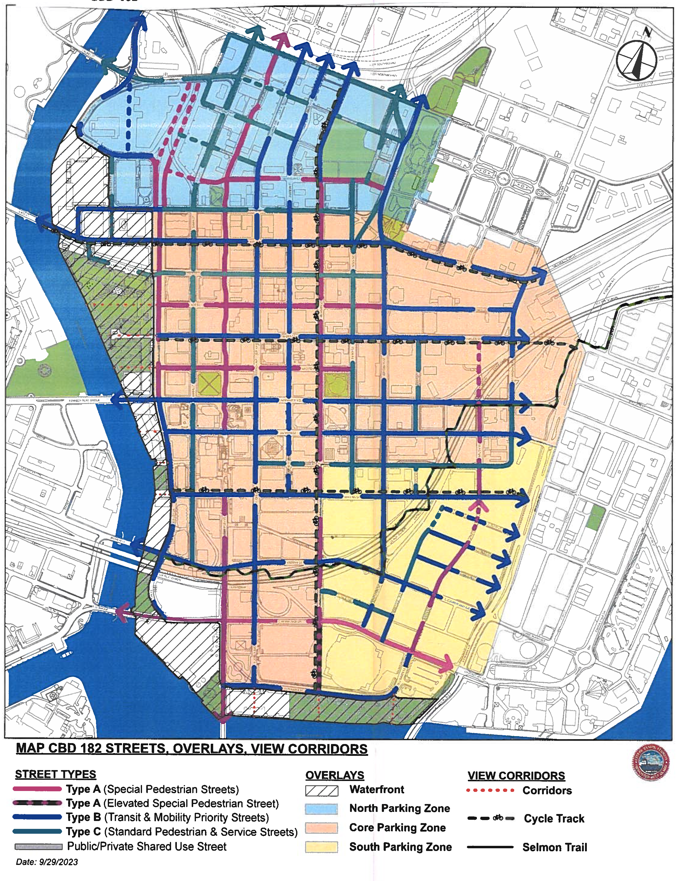
CBD 182a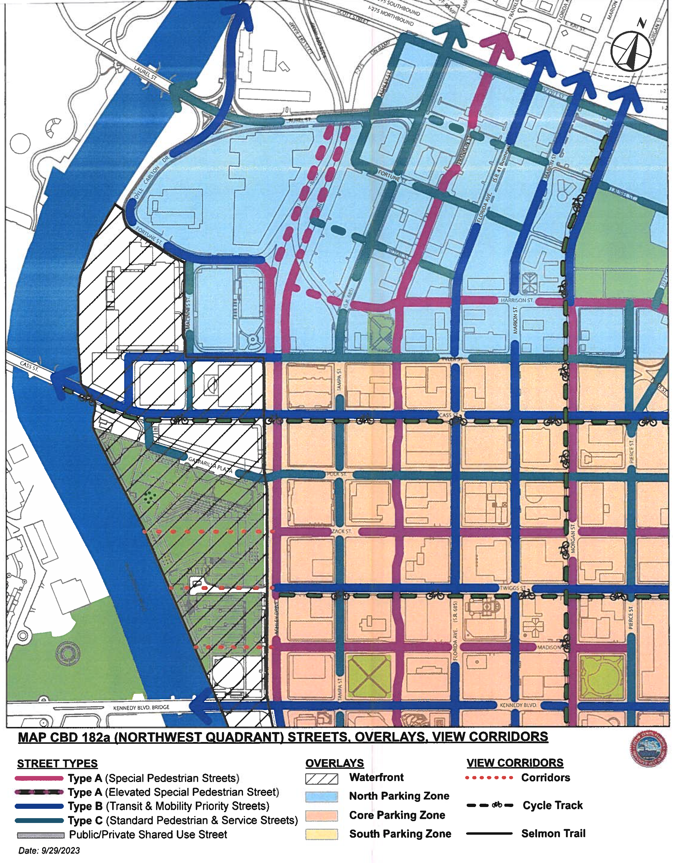
CBD 182b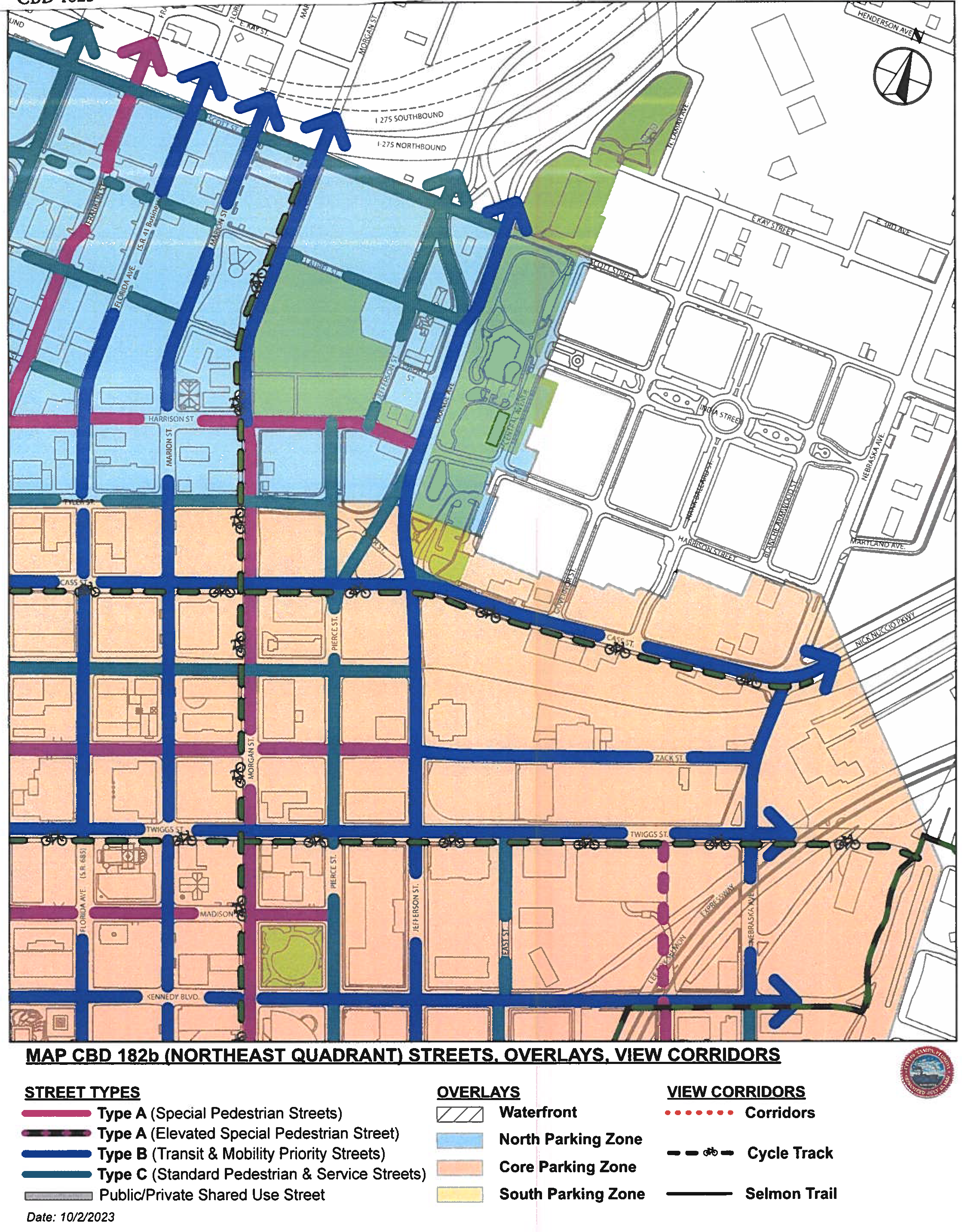
CBD 182c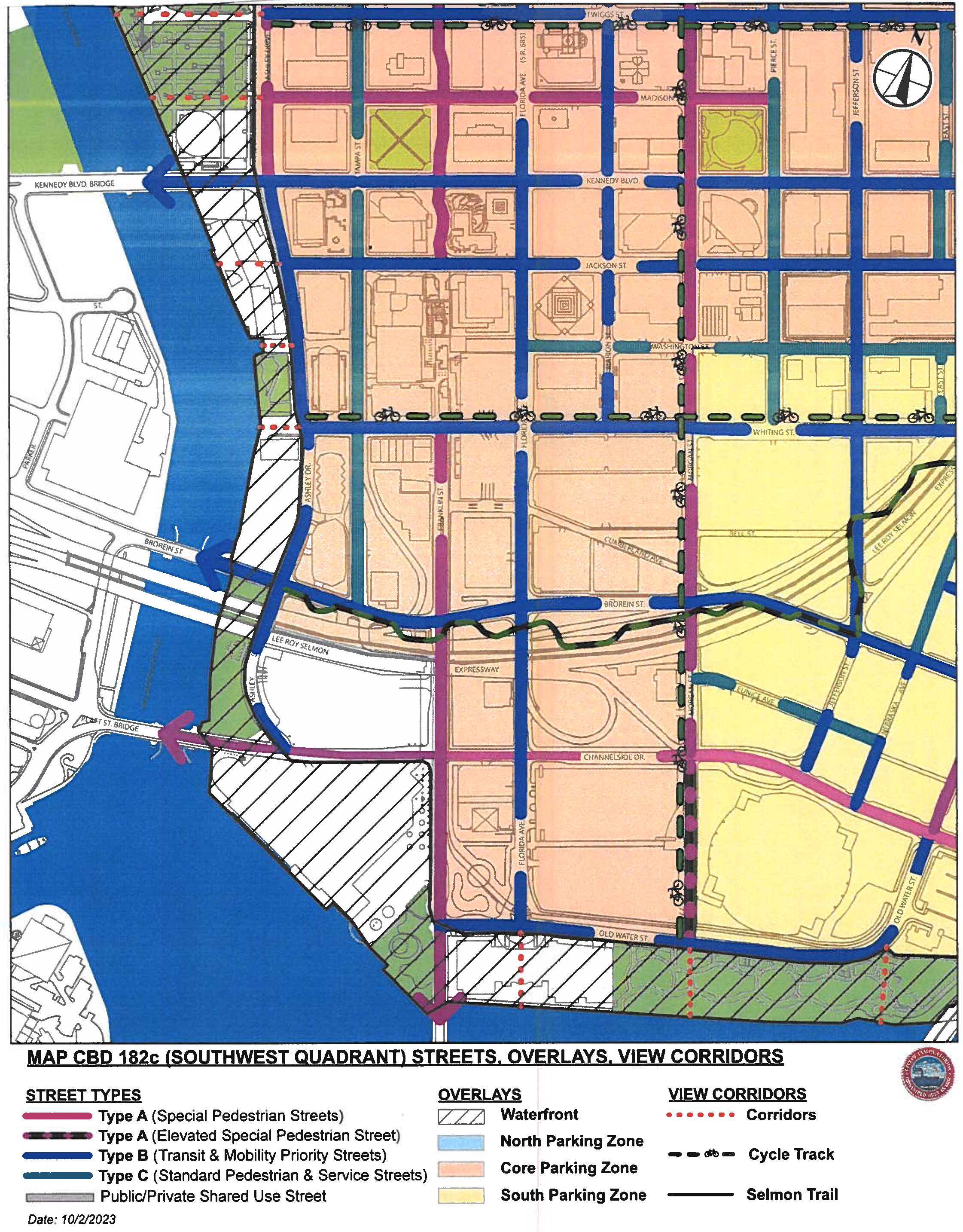
CBD 182d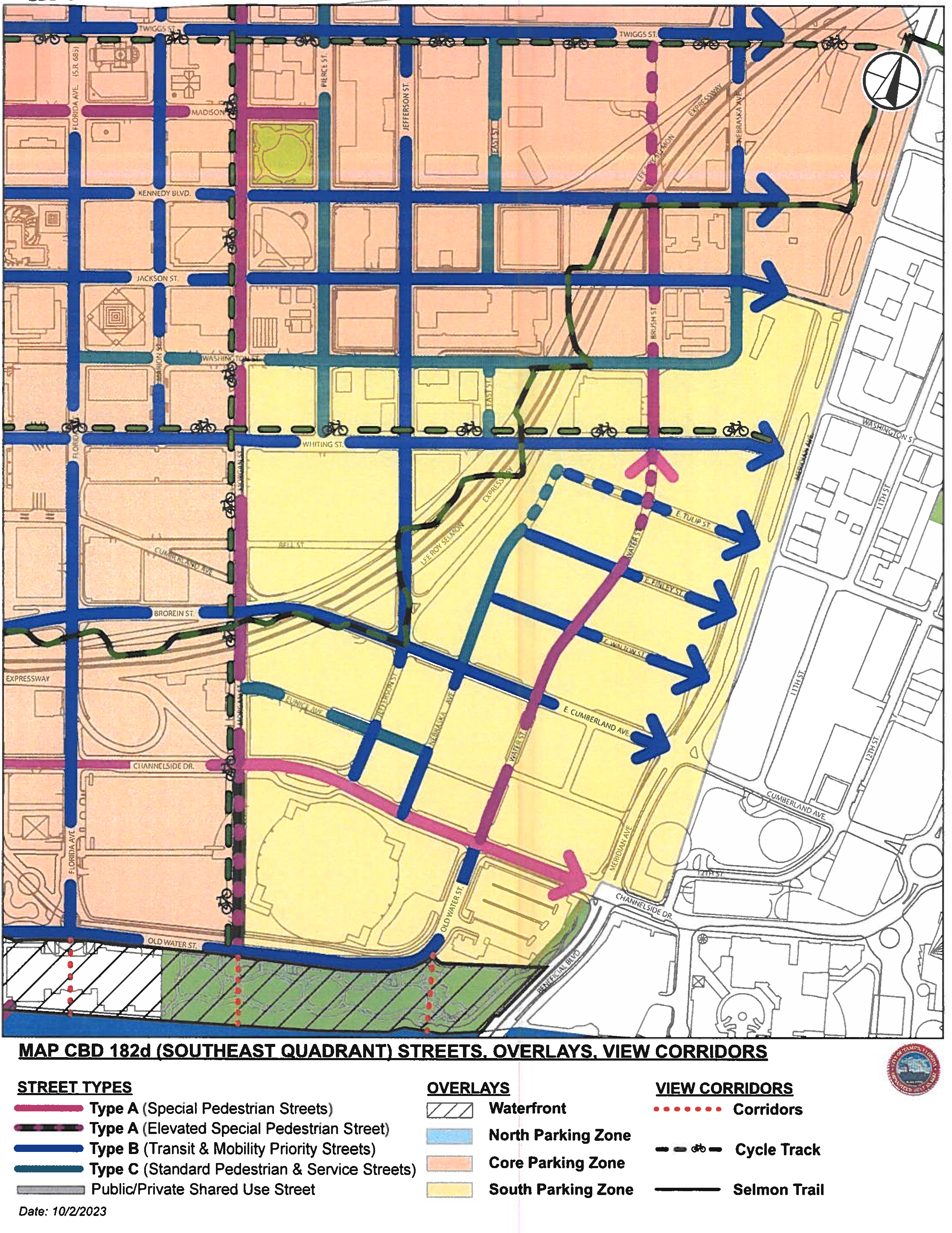
| TABLE 182.1 PUBLIC REALM ZONE [1-10]: | |||||||
|---|---|---|---|---|---|---|---|
| Requirements. The Public Realm Zone consists of the portions of the street and adjacent development parcel between the existing back of curb (or edge of pavement if no curb exists) and the front (vertical plane) of buildings. | |||||||
STREET TYPE/ORDER [3] | DESCRIPTION | SUB-ZONES [3] (MIN. DIMENSIONS) | TOTAL MIN. WIDTH [5X] | PUBLIC REALM ZONE GRAPHIC | |||
CURBSIDE [1X] | FURNITURE/LANDSCAPE [2X] | WALKWAY [3X] [4] | FRONTAGE [4X] | ||||
| A | SPECIAL PEDESTRIAN STREETS: Formal, axial connections between river, special civic places, districts within Center City and to surrounding urban villages and neighborhoods; high activity level building frontages required [see Tables 183.1A and B]; streetscapes have highest level of design detail, with public amenities such as enhanced lighting, street furniture, and specialized paving. | 2' | 7' | 9' | 2' | 20' | 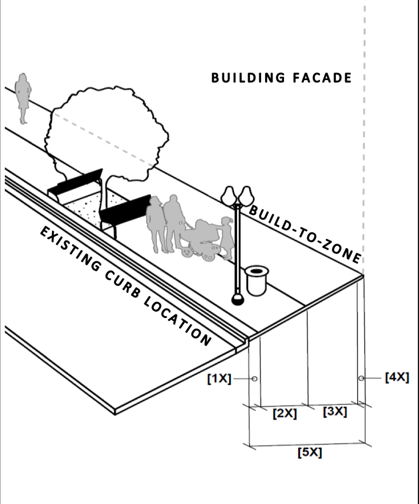 |
| B | TRANSIT & MOBILITY PRIORITY STREETS: Provide for increased multi-modal access to and through Center City; moderate to high activity level building frontages required [see Tables 183.1A-C]; streetscapes have moderate to high level design detail, with mix of standard and enhanced public amenities. | 16" | 6' | 5'8" | 2' | 15' | |
| C | STANDARD PEDESTRIAN & SERVICE STREETS: Local service streets within Center City grid; serve adjacent buildings with primary vehicular and service access, loading areas, typical "back of house" activities; low activity level building frontages permitted [see Tables 183.1D and E]; basic/standard pedestrian features. | - | 6' | 5' | - | 11' | |
| Refer to TABLES 182.1A-182.1D for Public Realm Zone layout, dimensional, placement, and component standards, and all Table Notes below. | |||||||
| TABLE 182.1A PUBLIC REALM ZONE [1-10] (continued) | |||
|---|---|---|---|
| "A" - SPECIAL PEDESTRIAN STREET: STREETSCAPE DETAILS BY STREET TYPE | |||
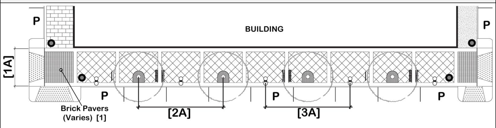 | |||
| KEY | 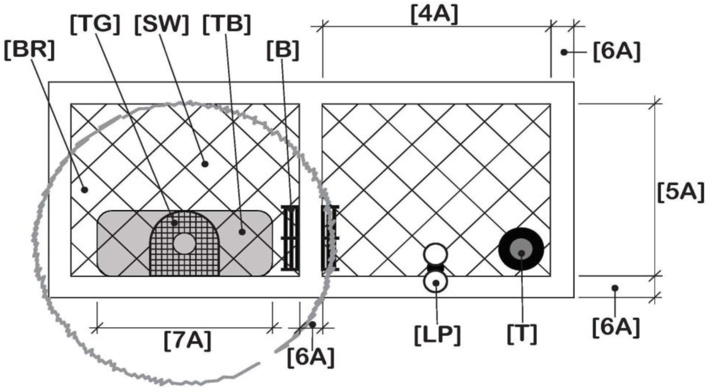 | ||
| [B] Bench | |||
| [BR] Bike Rack | |||
| [LP] Lamp and Pole | |||
| [P] Parking | |||
| [SW] Sidewalk | |||
| [TG] Tree Grate | |||
| [TB] Tree Bed (Pit) | |||
| [T] Trash Receptacle | |||
| PLACEMENT & LAYOUT STANDARDS | |||
| [1A]: Total Sidewalk Width | 20' | [5A]: Sidewalk Pattern (Saw Cut) Depth | 16' |
| [2A]: Street Tree Spacing (On Center) | 35' min - 40' max | [6A]: Sidewalk Pattern Border Width | 2' |
| [3A]: Lamp and Pole & Bench Spacing | 35' min - 40' max | [7A]: Tree Bed (Pit) Option (Options in Table 182.1D) | 7' × 7' min up to 7' × 16' max |
| [4A]: Sidewalk Pattern (Saw Cut) Width | 20' | ||
| VEHICLE ACCESS | |||
| Vehicle access is prohibited on/to/from Type "A" Streets, unless all other vehicle access option(s) is (are) prohibited and/or the development has no other street frontage. [DWA]: Driveway Apron with Flares (refer to COT Trans. Tech. Manual) | |||
| FURNISHINGS, COMPONENTS, SPECS [6]: TYPICAL AESTHETIC | |||
| REFER TO TABLE 182.1D FOR SPECIFIC TYPES AND MATERIALS REQUIRED, AND APPLICABLE TABLE NOTES BELOW. | |||
| TABLE 182.1B PUBLIC REALM ZONE [1-10] (continued) | |||
|---|---|---|---|
| 'B' - TRANSIT & MOBILITY PRIORITY STREETS: STREETSCAPE DETAILS BY STREET TYPE | |||
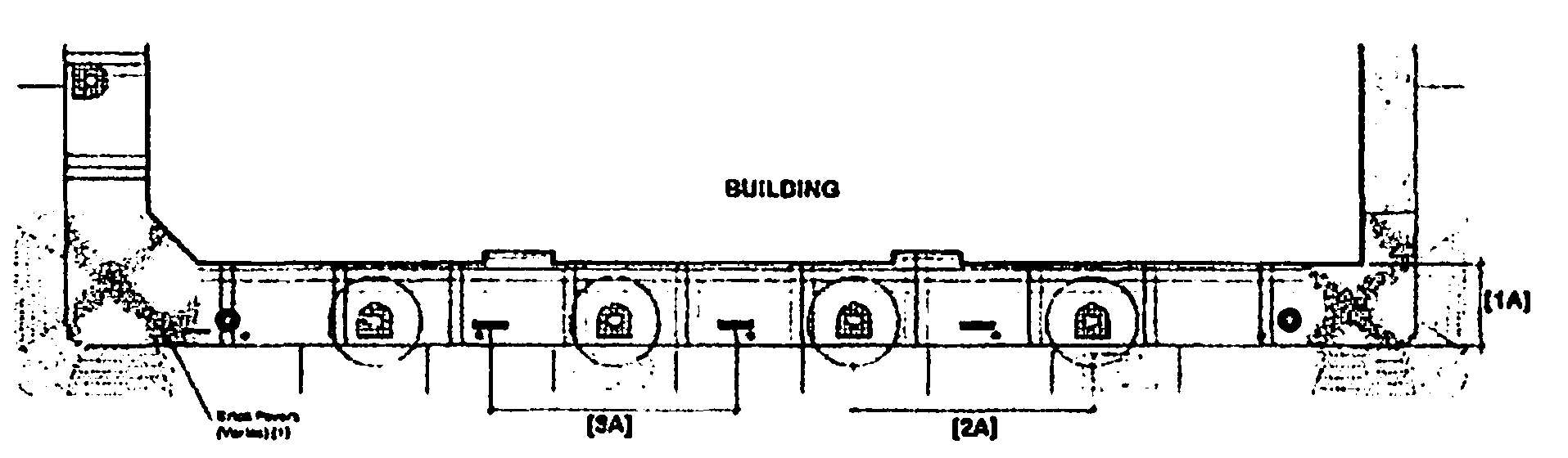 | |||
| KEY | 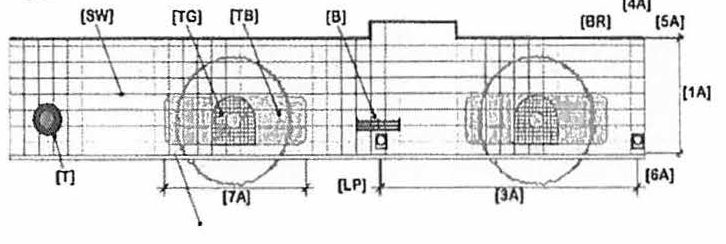 | ||
| [B] Bench | |||
| [BR] Bike Rack | |||
| [LP] Lamp and Pole | |||
| [P] Parking | |||
| [SW] Sidewalk | |||
| [TG] Tree Grate | |||
| [TB] Tree Bed | |||
| [T] Trash Receptacle | |||
| PLACEMENT & LAYOUT STANDARDS | |||
| [1A]: Total Sidewalk Width | 15' | [5A]: Sidewalk Pattern - Depth (⅜" width by ½" depth tooled 'V' joint, staggered rectangles) | 3' |
| [2A]: Street Tree Spacing (On Center) | 35' min - 40' max | [6A]: Required Space between Tree Grate/Tree Bed (Pit) and Curb (Inside edge) | 16" |
| [3A]: Lamp and Pole & Bench Spacing (when applicable) | 35' min - 40' max | [7A]: Tree Bed (Pit) Option (Options in Table 182.1D) | 6' × 6' min up to 6' × 20' max |
| [4A]: Sidewalk Pattern - Width (⅜" width by ½" depth tooled 'V' joint, staggered rectangles) | 2' | ||
| VEHICLE ACCESS | |||
| [DWA]: Driveway Apron with Flares (refer to COT Trans. Tech. Manual) | Permitted on Type "B" Street | ||
| FURNISHINGS, COMPONENTS, SPECS [6]: TYPICAL AESTHETIC | |||
| REFER TO TABLE 182.1D FOR SPECIFIC TYPES AND MATERIALS REQUIRED, AND APPLICABLE TABLE NOTES BELOW. | |||
| TABLE 182.1C PUBLIC REALM ZONE [1-10] (continued) | ||||
|---|---|---|---|---|
| 'C' - STANDARD PEDESTRIAN & SERVICE STREETS: STREETSCAPE DETAILS BY STREET TYPE | ||||
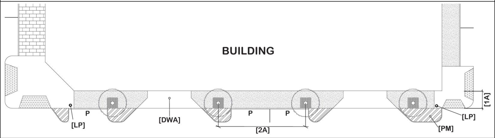 | ||||
| KEY | ||||
| [B]: Bench | [DWA]: Driveway Apron with Flares (refer to COT Trans. Tech. Manual) | [LP]: Lamp and Pole | [P]: Parking | [PM]: Pavement Markings (refer to COT Trans. Tech. Manual) |
| PLACEMENT & LAYOUT STANDARDS | ||||
| [1A]: Total Sidewalk Width (Standard Brushed Concrete) | 10' | |||
| [2A]: Street Tree Placement/Spacing (On Center) | 35' min - 65' max (placement/spacing is dependent on vehicular access locations) | |||
| [LP]: Lamp and Pole Placement/Spacing (when applicable) | 35' min - 65' max (placement/spacing is dependent on vehicular access locations) | |||
| VEHICLE ACCESS | ||||
| [DWA]: Driveway Apron with Flares (refer to COT Trans. Tech. Manual) | Permitted; Preferred on Type "C" Street | |||
| FURNISHINGS, COMPONENTS, SPECS [6]: TYPICAL AESTHETIC | ||||
| REFER TO TABLE 182.1D FOR SPECIFIC TYPES AND MATERIALS REQUIRED, AND APPLICABLE TABLE NOTES BELOW. | ||||
| TABLE 182.1D PUBLIC REALM ZONE [1-10] (continued) COMPONENTS AND SPECIFICATIONS | |||||
|---|---|---|---|---|---|
| TYPICAL AESTHETIC: Street Tree [10] | |||||
| TREE 1: Permitted on Street Types A or B | TREE 2: Permitted on Street Types B or C [5] | TREE 3: Permitted on Street Type C ONLY | |||
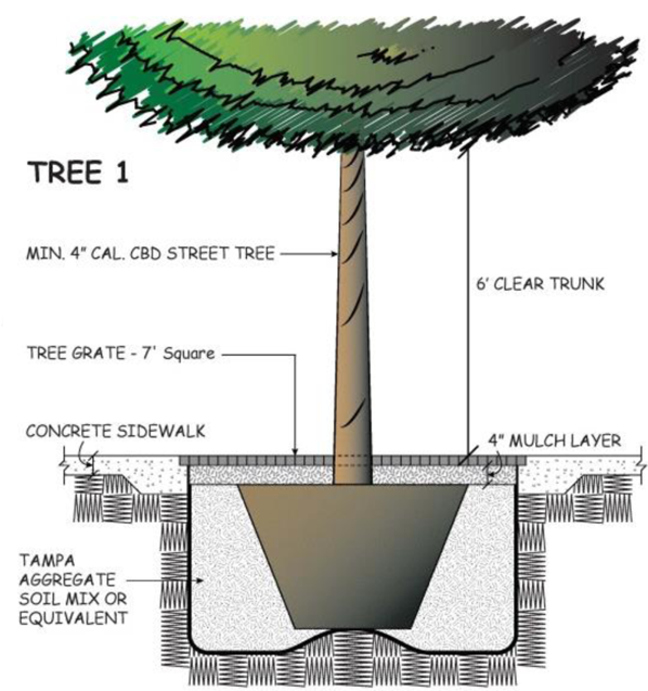 | 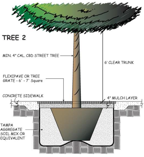 | 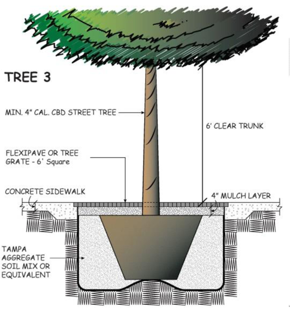 | |||
| TYPICAL AESTHETIC: [TG] Tree Grate [9] | |||||
| FULL SQUARE OPTION | SEMI-CIRCLE/SQUARE OPTION | FULL-CIRCLE OPTION | BED (PIT) BARRIER OPTIONS | ||
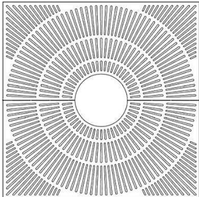 | 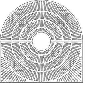 |  |  | ||
| TYPE | MANUFACTURER | MODEL | MINIMUM DIMENSIONS BY STREET TYPE | COLOR | |
| Grate | Canterbury International or Ironsmith | 'Bola Square to Round Grate' or 'Sunrise Grate' | Street Types A or B: | 7'×7' or 7' diameter | Black Powder Coat |
| Street Types B or C: | 6'×6' or 6' diameter [5,9] | ||||
| Street Type C ONLY: | 6'×6' or 6' diameter [5,9] | ||||
| Bed (Pit) Barrier | Tree Pit Guard Type 'C' or 'D' | Horizontal Dimension Varies: (refer to Tables 182.1A-B) Vertical Dimension Min-Max: 12"—18" high | |||
| TYPICAL AESTHETIC: [LP] Lamp and Pole [7] | |||||
| REQUIRED ON STREET TYPE | FIXTURE/WATTAGE/COLOR | DOUBLE BRACKET | POLE/MOUNTING HEIGHT/COLOR | ||
| A | Salem LED/99 W/Black | YES | Franklin/12'/Black | ||
| B and C [8] | Evolve LED Area/202 W/Bronze | N/A | Waterford/12'/Brown | ||
| TABLE 182.1D PUBLIC REALM ZONE [1-10] (continued) COMPONENTS AND SPECIFICATIONS | |||||||
|---|---|---|---|---|---|---|---|
| TYPICAL AESTHETIC: [BR] Bike Rack, [B] Bench, [T] Trash, [BL] Bollard | |||||||
| TYPE | MANUFACTURER | MODEL | COLOR | BY STREET TYPE | TYPICAL DIMENSIONS | TYPICAL GRAPHIC | |
| REQUIRED | PERMITTED | ||||||
| [BR] Bike Rack | Dero Bike Racks | 'Swerve Rack' | Black | A, B | C |
34"H × 12"W (at base)
21.5"W (at bend) 1.9" Diameter (Di) Bar |  |
| [B] Bench | Landscapeforms | 'Plainwell Bench' | Black Metal with Wood Exterior Finish | A, B | C |
60"-72"L
24"-30"D |  |
| [T] Trash Receptacle | Dumor, Inc | 'Receptacle 107-32-FTO (32 Gallon) with DM-Dome Top Lid' | Black | ALL | ALL |
36"H (up to Rim)
32"W (at Rim) |  [BL]
[BL]
|
| Bollard | Fairweather | 'B-3 (6") Removable Bollard' | Black | - | ALL |
48"H (from grade)
6" Diameter (Di) Post | 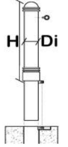 |
(Ord. No. 2016-79, § 1(Exh. A), 5-26-2016; Ord. No. 2022-155, § 3, 9-1-2022; Ord. No. 2024-16, § 7(Exh. I), 2-1-2024)
Sec. 27-183. - General district development standards.
| TABLE 183. BUILDING PLACEMENT, HEIGHT, AND STREET ORDER STANDARDS | ||||
|---|---|---|---|---|
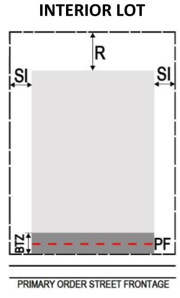 | 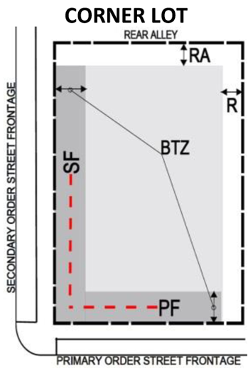 | 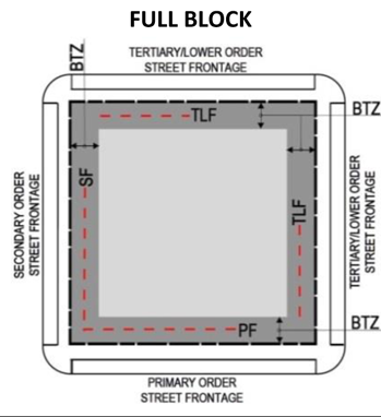 | 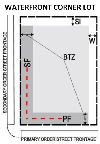 | 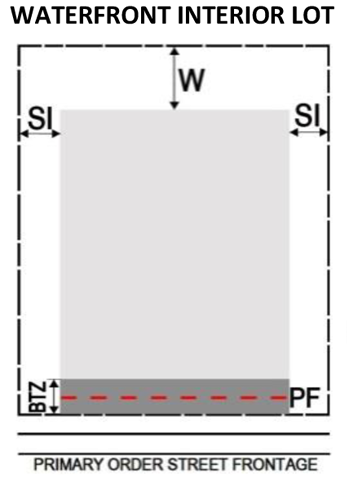 |
| BUILDING PLACEMENT | BUILDING STREETWALL % WITHIN BTZ, BY STREET ORDER [5, 6, 7] | |||
| BUILD-TO ZONE (BTZ) | PRIMARY STREET FRONTAGE [PF] [8] | |||
| Build-to Zone [BTZ] | 0' min - 6' max [1] | Special Pedestrian Street ('A'-Street) | 85% min | |
| SETBACK [2] | Transit & Mobility Priority Street ('B'-Street) | 60% min | ||
| Side Interior [SI] | 0' min | Standard Pedestrian & Service Street ('C'-Street) | 50% min | |
| SECONDARY STREET FRONTAGE [SF] [8] | ||||
| Rear [R] | 0' min | Special Pedestrian Street ('A'-Street) | 75% min | |
| Transit & Mobility Priority Street ('B'-Street) | 50% min | |||
| Rear Alley [RA] | 3' min | Standard Pedestrian & Service Street ('C'-Street) | 25% min | |
| TERTIARY/LOWER STREET FRONTAGE [TLF] [8] | ||||
| Waterfront [W] [3,4] | 23' min | Transit & Mobility Priority Street ('B'-Street) | 30% min | |
| Standard Pedestrian & Service Street ('C'-Street) | 20% min | |||
| MAXIMUM HEIGHT | ||||
| CBD-1 or CBD-2 | [9] | |||
| Parapet wall | 5' above principal or accessory building height [10] | |||
| Elevator/mechanical housing, steeples, flag poles, widow's walk, cupolas, other architecturally integrated features | Exempt, except shall occupy no more than 30% of roof area [10] | |||
| PUBLIC OPEN AND GENERAL OPEN SPACE REQUIREMENTS | ||||
| Total Open Space to be Provided | Public Open Space Provided at Grade [11] | Conditions for Open Space not at Grade | ||
| Minimum area required (SF): 10% of development parcel | Minimum 30% of Total Open Space must be placed at Grade and meet the definition of "Public Open Space" in sec. 27-43. | Areas provided on the building podium, open to the sky, shall be counted towards the overall open space requirement, but not towards the "public open space" | ||
| RIVERWALK (Also refer to sec. 27-181.5) | ||||
| Within Waterfront [W] Setback | Emergency Vehicle Access | |||
|
17' paved (includes 2' for bulkhead wall)
Remaining area: landscape, appropriate furniture, etc. |
Min clearance: 12' wide for pedestrians (i.e. sidewalk) at all times
Min clearance: Increased to 20' wide for emergency vehicles [12] | |||
| PUBLIC ART (Also refer to sec. 27-181.4) | ||||
| Required Contribution Rate | Maximum Fee | Benchmark to Pay Fee | Public Art Fund | |
| Required for New Construction Only: 0.75% x total project development cost | $200,000.00 | Prior to issuance of certificate of occupancy | Fund consists of all payments for public art requirements within the Center City (CBD) | |
| TABLE 183.1A "SHOPFRONT" FRONTAGE | ||
|---|---|---|
| Description and General Standards. A shopfront frontage is typical for single- or mixed-use commercial or office frontage. The façade is located within the Build-to-Zone pursuant to Table 183, with the pedestrian entrance at sidewalk grade. The façade may include an awning, shed roof, or gallery (structural canopy with no habitable building area above it) that covers the sidewalk. The facade has a substantial amount of glazing (transparency) at the sidewalk level. Recessed entrances are acceptable. All shopfront frontages shall comply with development standards set forth below: | ||
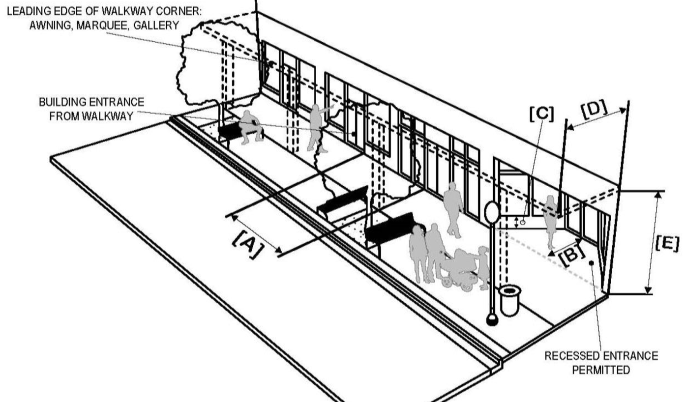 | "SHOPFRONT" FRONTAGE BY STREET TYPE | |
| STREET TYPES | STATUS | |
| A | Permitted; Preferred | |
| B | Permitted | |
| C | Permitted | |
| REQUIREMENTS [3-6] | MINIMUM | MAXIMUM |
| Distance between Openings [A] [2] | 10' | 30' |
| Door Recess [B] | - | 10' |
| Height to Bottom of Window [C] | - | 2' |
| Transparency [1] | 70% | - |
| OPTIONAL ELEMENTS | MINIMUM | MAXIMUM |
| Awning or Marquee Depth [D] | 4' | 10' |
| Gallery Depth (clear) [D] | 8' | 10' |
| Awning, Marquee, Gallery Height (clear) [E] | 14' | - |
| NOTES: | ||
| [1] Transparency measured horizontally from edge to edge of wall plane and vertically between 2' and 15' above finished grade. | ||
| [2] Streetwall design shall include door openings at no more than 125' between openings along all street fronts. This shall include a minimum of one (1) door opening per property, to the primary street. | ||
| [3] Prohibit large expanses of opaque or blank walls. No blank walls of more than 25' in length are permitted without relief or protrusion of at least 6". | ||
| [4] Maintain the following: (i) the distinction between the upper and lower levels of the building with treatments such as cornice lines, changes in material, color, or fenestration pattern; and (ii) the cornice line of adjacent existing buildings, where applicable, to continue the definition of the public realm. | ||
| [5] Protect the integrity of the existing street grid by prohibiting connections that promote a continuous level of commercial uses above grade. This requirement shall not discourage tenant-serving commercial on any level of a building, so long as such commercial is placed at street level. | ||
| [6] Waterfront Overlay: A public entrance shall be oriented towards or placed on the Riverwalk. Rooftop mechanical equipment shall be screened from pedestrian view through the use of architectural enclosures designed as an integral part of the building architecture. To present an attractive roof-top/roof-deck, special consideration shall be given to the design treatment of all roof components, including terraces, or portions of the building. | ||
| TABLE 183.1B "ARCADE" FRONTAGE | ||
|---|---|---|
| Description and General Standards. This type is appropriate for single- or mixed-use commercial or office frontage. An arcade frontage is shopfront facade with an attached colonnade with habitable building space above, placed adjacent to the right-of-way. The shopfront and/or walkway is/are located within the Build-to-Zone pursuant to Table 183, to provide the required Public Realm Zone dimension. The facade has a substantial amount of glazing (transparency) at the sidewalk level. All arcade frontages shall comply with development standards set forth below: | ||
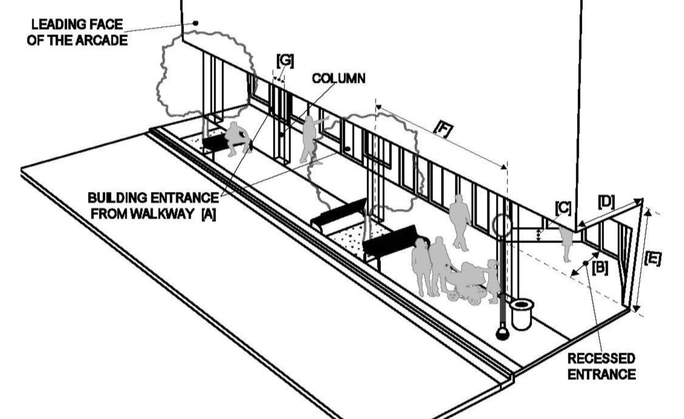 | "ARCADE" FRONTAGE BY STREET TYPE | |
| STREET TYPES | STATUS | |
| A | Permitted; Preferred | |
| B | Permitted | |
| C | Permitted | |
| REQUIREMENTS [3-6] | MINIMUM | MAXIMUM |
| Distance between Openings [A] [2] | 10' | 30' |
| Door Recess [B] | - | 10' |
| Height to Bottom of Window [C] | - | 2' |
| Arcade Depth (clear) [D] | 10' | - |
| Arcade Height (clear) [E] | 15' | - |
| Spacing Between Columns (clear) [F] | 10' | - |
| Column Width (clear) [G] | - | 4' |
| Transparency [1] | 70% | - |
| NOTES: | ||
| [1] Transparency measured horizontally from edge to edge of wall plane and vertically between 2' and 15' above finished grade. | ||
| [2] Streetwall design shall include door openings at no more than 125' between openings along all street fronts. This shall include a minimum of one (1) door opening per property, to the primary street. | ||
| [3] Prohibit large expanses of opaque or blank walls. No blank walls of more than 25' in length are permitted without relief or protrusion of at least 6". | ||
| [4] Maintain the following: (i) the distinction between the upper and lower levels of the building with treatments such as cornice lines, changes in material, color, or fenestration pattern; and (ii) the cornice line of adjacent existing buildings, where applicable, to continue the definition of the public realm. | ||
| [5] Protect the integrity of the existing street grid by prohibiting connections that promote a continuous level of commercial uses above grade. This requirement shall not discourage tenant-serving commercial on any level of a building, so long as such commercial is placed at street level. | ||
| [6] Waterfront Overlay: A public entrance shall be oriented towards or placed on the Riverwalk. Rooftop mechanical equipment shall be screened from pedestrian view through the use of architectural enclosures designed as an integral part of the building architecture. To present an attractive roof-top/roof-deck, special consideration shall be given to the design treatment of all roof components, including terraces, or portions of the building. | ||
| TABLE 183.1C "FORECOURT" FRONTAGE | ||
|---|---|---|
| Description and General Standards. This type is appropriate for single- or mixed-use commercial, office, or residential frontage. A forecourt is a recessed courtyard with street-facing edges providing additional transparency. For this frontage, the 'streetwall(s)' is(are) located within the Build-to Zone, pursuant to Table 183. The 'interior forecourt wall' is recessed to form an open-air court (typically uncovered). The forecourt is suitable for passive seating/gathering, outdoor dining, public art, gardens, formal entries, etc. All forecourt frontages shall comply with development standards set forth below: | ||
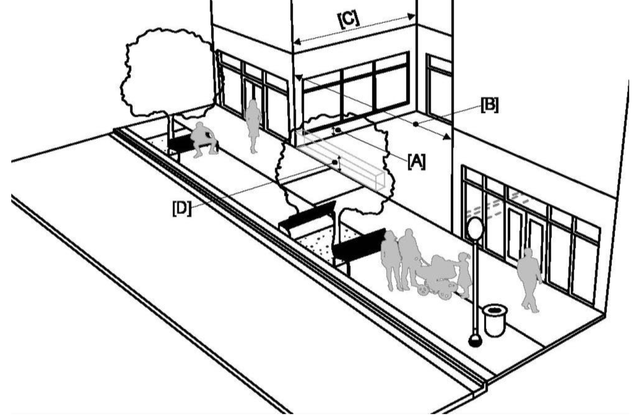 | "FORECOURT" FRONTAGE BY STREET TYPE | |
| STREET TYPES | STATUS | |
| A | Permitted; Preferred | |
| B | Permitted; Preferred | |
| C | Permitted | |
| REQUIREMENTS [3-10] | MINIMUM | MAXIMUM |
| Height to Bottom of Window [A] | - | 2' |
| Forecourt Width (clear) [B] | 12' | ⅓ of building length |
| Forecourt Depth (clear) [C] | 12' | 50' |
| Seating Wall Height [D] [2] | 2' | 3' |
| Streetwall Transparency [1,6] | 30% | - |
| Interior Forecourt Wall Transparency [1,6] | 50% | - |
| NOTES: | ||
| [1] Transparency measured horizontally from edge to edge of wall plane and vertically between 2' and 15' above finished grade. | ||
| [2] Seat-wall(s) within forecourt area limited to heights above. A seat-wall may be placed at the edge of the Public Realm Zone to define the forecourt space. | ||
| [3] The forecourt space is counted as frontage. | ||
| [4] The forecourt may be elevated behind a retaining wall at or near the front lot line with entry steps to the court. | ||
| [5] ADA access is required to the forecourt from the Public Realm Zone, regardless of final design. | ||
| [6] Streetwall and Interior Forecourt Wall shall include at least one (1) door opening each, for each development. | ||
| [7] Prohibit large expanses of opaque or blank walls. No blank walls of more than 15' in length are permitted without relief or protrusion of at least 6". | ||
| [8] Maintain the following: (i) the distinction between the upper and lower levels of the building with treatments such as cornice lines, changes in material, color, or fenestration pattern; and (ii) the cornice line of adjacent existing buildings, where applicable, to continue the definition of the public realm. | ||
| [9] Protect the integrity of the existing street grid by prohibiting connections that promote a continuous level of commercial uses above grade. This requirement shall not discourage tenant-serving commercial on any level of a building, so long as such commercial is placed at street level. | ||
| [10] Waterfront Overlay: A public entrance shall be oriented towards or placed on the Riverwalk. Rooftop mechanical equipment shall be screened from pedestrian view through the use of architectural enclosures designed as an integral part of the building architecture. To present an attractive roof-top/roof-deck, special consideration shall be given to the design treatment of all roof components, including terraces, or portions of the building. | ||
| TABLE 183.1D "STOOP" FRONTAGE | ||
|---|---|---|
| Description and General Standards. This type is appropriate for single- or mixed-use office or residential frontage. A stoop is an elevated entry placed close to the Public Realm Zone with small front yards. For a stoop, the façade is located within the Build-to Zone, subject to applicable requirements. The façade includes an elevated landing with stairs, (with appropriate ADA accessibility for non-residential uses), that is placed at or near the edge of the sidewalk. The stoop may include a cover for weather protection (i.e. roof, awning). All stoop frontages shall comply with development standards set forth below: | ||
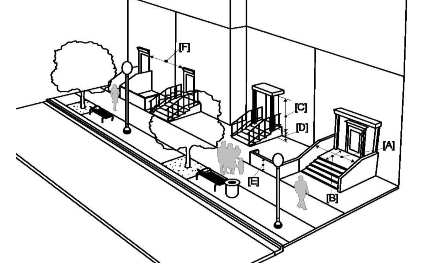 | "STOOP" FRONTAGE BY STREET TYPE | |
| STREET TYPES | STATUS | |
| A | Permitted; Preferred | |
| B | Permitted | |
| C | Permitted | |
| REQUIREMENTS [3-6] | MINIMUM | MAXIMUM |
| Stoop Width (clear) [A] | 6' | 12' |
| Stoop Landing Depth (clear) [B] | 4' | 10' |
| Stoop Height (clearance above landing) [C] | 8' | - |
| Stoop Landing Elevation [2] [D] | 1.5' | - |
| Front Separator Wall Height [E] | 2' | 4' |
| Distance between Openings/Stoops [F] [2] | 10' | 40' |
| Transparency [1] | 30% | - |
| NOTES: | ||
| [1] Transparency measured horizontally from edge to edge of unit wall plane and vertically between [D] and 15' above [D]. ([D] as designed for development) | ||
| [2] Streetwall design shall include door openings at no more than 125' between openings along all street fronts. This shall include a minimum of one (1) door opening per property, to the primary street. | ||
| [3] Prohibit large expanses of opaque or blank walls. No blank walls of more than 25 feet in length are permitted without relief or protrusion of at least 6 inches. | ||
| [4] Maintain the following: (i) the distinction between the upper and lower levels of the building with treatments such as cornice lines, changes in material, color, or fenestration pattern; and (ii) the cornice line of adjacent existing buildings, where applicable, to continue the definition of the public realm. | ||
| [5] Protect the integrity of the existing street grid by prohibiting connections that promote a continuous level of commercial uses above grade. This requirement shall not discourage tenant-serving commercial on any level of a building, so long as such commercial is placed at street level. | ||
| [6] Waterfront Overlay: A public entrance shall be oriented towards or placed on the Riverwalk. Rooftop mechanical equipment shall be screened from pedestrian view through the use of architectural enclosures designed as an integral part of the building architecture. To present an attractive roof-top/roof-deck, special consideration shall be given to the design treatment of all roof components, including terraces, or portions of the building. | ||
| TABLE 183.1E "GARAGE" FRONTAGE | |||
|---|---|---|---|
| Description and General Standards. This type is appropriate for vehicle parking and must include single- or mixed-use commercial, office, or residential uses at the street level. All of the frontage types set forth in Tables 183.1A-D may be incorporated at the ground level. All garage frontages shall comply with development standards set forth below: | |||
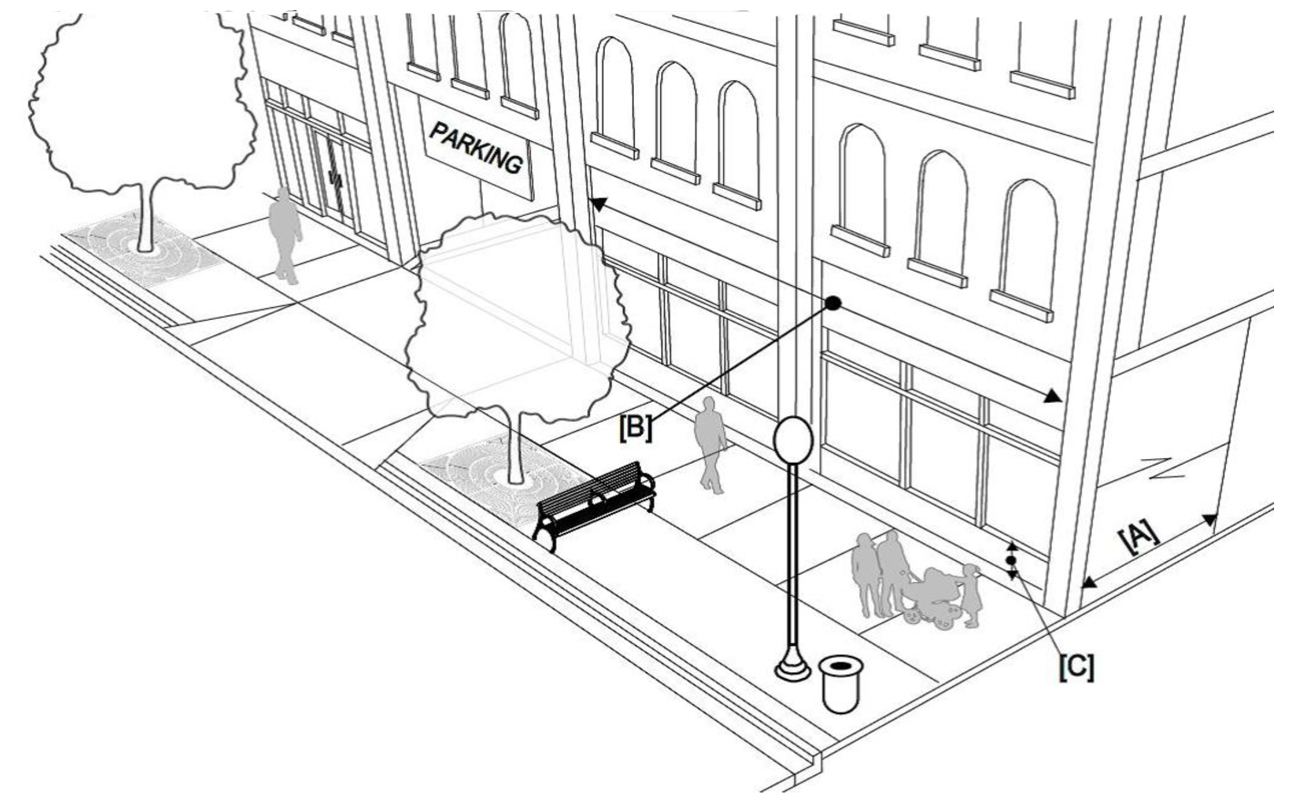 | "GARAGE" FRONTAGE BY STREET TYPE | ||
| STREET TYPES | STATUS | ||
| A | Prohibited [1] | ||
| B | Permitted | ||
| C | Permitted; Preferred | ||
| REQUIREMENTS [1-6] | MINIMUM | MAXIMUM | |
| Active Space Depth [A] | 25' | - | |
| Active Space Width [B] | ½ of building length | - | |
| Height to Bottom of Window [C] | - | 2' | |
| Transparency [2] | 70% | - | |
| WITHIN WATERFRONT OVERLAY (Refer to sec. 27-181.5) | |||
| PARKING STRUCTURES | SERVICE, LOADING AREAS; RELATED ACCESS DRIVES | ||
| VEHICLE ACCESS PROHIBITED: | From orienting towards the Riverwalk | PLACEMENT, DESIGN, SCREENING: | Located to minimize visibility of these components from Public Realm Zone and Riverwalk |
| From being located within the Waterfront Setback (Table 183) | |||
| STREETWALL & WATERFRONT-ORIENTED FACADE DESIGN: | Must be architecturally integrated with the principal structure | ||
| Conceal vehicles from grade-level views | Screened to provide a minimum 50% opacity at time pedestrian view | ||
| Utilize landscaping elements or other design features to soften the appearance of the exterior façade | |||
| NOTES: | |||
| [1] On Street Type A, structural parking garages are required to design to either the "Shopfront" (Table 183.1A) or "Arcade" (Table 183.1B) frontage. Vehicle access is prohibited on/to/from Street Type A, unless all other vehicle access option(s) is(are) prohibited and/or the development has no other street frontage. | |||
| [2] Transparency measured horizontally from edge to edge of wall plane and vertically between 2' and 15' above finished grade. Transparency may differ if an alternate frontage type is used at the ground level (refer to transparency requirement of the applicable frontage type proposed.) | |||
| [3] Streetwall design shall include a minimum of one (1) door opening per property, to the primary street. | |||
| [4] Prohibit large expanses of opaque or blank walls. No blank walls of more than 25' in length are permitted without relief or protrusion of at least 6 inches. | |||
| [5] Maintain the following: (i) the distinction between the upper and lower levels of the building with treatments such as cornice lines, changes in material, color, or fenestration pattern; and (ii) the cornice line of adjacent existing buildings, where applicable, to continue the definition of the public realm. | |||
| [6] Protect the integrity of the existing street grid by prohibiting connections that promote a continuous level of commercial uses above grade. This requirement shall not discourage tenant-serving commercial on any level of a building, so long as such commercial is placed at street level. | |||
(Ord. No. 2016-79, § 1(Exh. A), 5-26-2016; Ord. No. 2022-155, § 4, 9-1-2022; Ord. No. 2022-170, § 1, 10-6-2022)
Sec. 27-184. - Official schedule of permitted principal, accessory and special uses; required off-street parking ratios by use; parking space equivalencies by transportation mode.
(a)
Except as otherwise specifically stated in this chapter, the use of and required parking count for land, water, and structures within the Center City (CBD) shall only be permitted in accord with Table 184-A, including those parking space equivalencies by transportation mode set forth in Table 184-B. All other uses of land, water, and structures in the CBD, which are not expressly listed in this section, are prohibited uses and shall not be established in the CBD. Refer to section 27-185.2 for alternative compliance options.
(b)
Parking space equivalencies by transportation mode. Parking shall be provided in accordance with the ratios set forth in Table 184-A above. Developments may provide all required vehicle parking spaces for automobiles or in combination with the alternative modes of transportation, using associated equivalency ratios, set forth in Table 184-B below. No more than 25 percent of required vehicle parking may be substituted with parking for other transportation modes in this manner.
(Ord. No. 2016-79, § 1(Exh. A), 5-26-2016; Ord. No. 2017-132, § 7, 8-24-2017; Ord. No. 2017-163, § 3, 11-16-2017; Ord. No. 2018-93, § 2, 6-28-2018; Ord. No. 2018-176, § 6, 11-1-2018; Ord. No. 2019-12, § 2, 1-10-2019; Ord. No. 2020-14, § 3, 2-6-2020; Ord. No. 2022-155, § 5, 9-1-2022; Ord. No. 2022-157, § 5, 9-1-2022; Ord. No. 2022-158, § 6, 9-1-2022)
Sec. 27-184.1. - Miscellaneous use standards.
(a)
Applicability; effect. The regulations in this section shall apply to the specific uses as indicated below, as a supplement to the other regulations set forth in the subdivision.
(b)
Auto rental standards.
(1)
Auto rental shall be limited to noncommercial automobiles, SUV's, and vans;
(2)
No more than twenty (20) rental vehicles shall be stored on the property at one (1) time;
(3)
Storage areas for rental vehicles shall be located within an enclosed building or on the second (2nd) level or higher of a multi-story structural parking garage; and
(4)
Accessory uses may include car wash, cleaning, and preparation and minor vehicle repairs for rental vehicles only, and such activities shall only occur within an enclosed building or on the second (2nd) level or higher of a multi-story structural parking garage.
(c)
Private pleasure craft.
(1)
For such occupancy for living quarters, required off-street parking shall be provided on the zoning lot; and
(2)
Regulations of the city, state or federal government regarding sewage disposal, availability of potable water, security against menaces due to storm surge, tides, currents, and hurricane menace shall be met.
(d)
Bank, drive-in.
(1)
A drive-in bank shall only be permitted as an accessory use to a bank which located on the same zoning lot; and
(2)
Use shall be limited to one (1) drive-through lane for each zoning lot.
(Ord. No. 2017-163, § 4, 11-16-2017; Ord. No. 2022-155, § 6, 9-1-2022)
Sec. 27-185. - General parking design standards by transportation mode.
(a)
General parking layout, design, and materials shall adhere to Table 185 standards. Off-street parking: refer to Table 185.1.
(b)
Surface Parking Zones and Fence Zones are hereby depicted in Map CBD 185. All surface parking lots shall adhere to the applicable standards as set by parking zone. All fences shall adhere to the standards as set forth by fence zone and further described in section 27-185.3.
CBD 185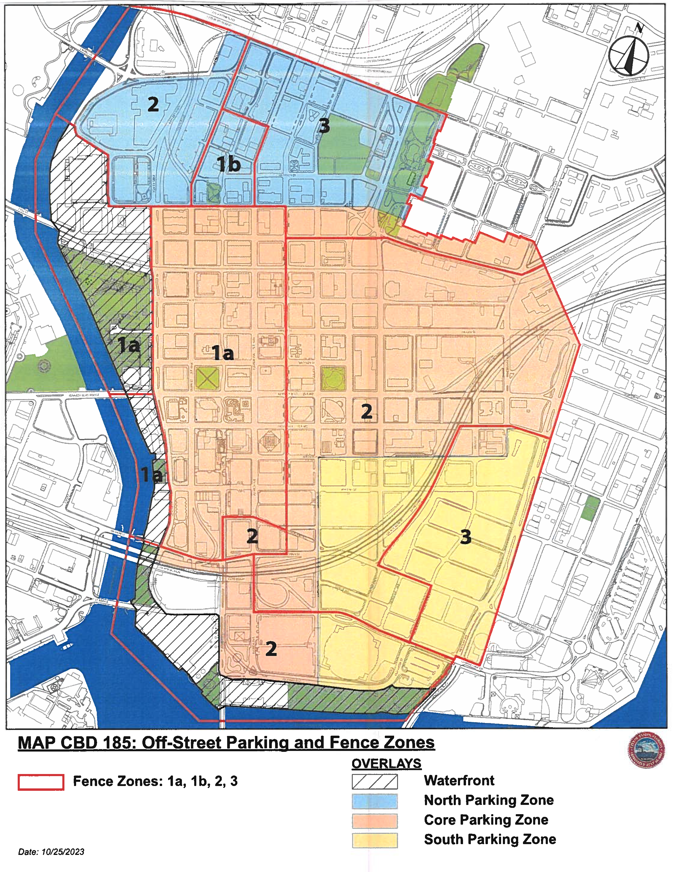
(Ord. No. 2016-79, § 1(Exh. A), 5-26-2016; Ord. No. 2022-155, § 7, 9-1-2022; Ord. No. 2024-16, § 8(Exh. II), 2-1-2024)
Sec. 27-185.1. - Off-street surface parking design standards.
Off street surface parking zones and surface parking lot design standards.
(a)
All off-street surface parking lots within Center City shall comply with the applicable requirements of this section by parking zone, and as depicted in Map CBD 185 and further described below.
(b)
The use of tandem parking spaces may be allowed, so long as the surface parking lot has a live attendant(s) onsite, to perform activities such as monitoring the parking lot and maneuvering vehicles in a safe and orderly fashion. Said attendant(s) shall be onsite at all times when the surface parking spaces are used in a tandem formation.
(c)
Any existing, legally established, permanent surface parking lot (paved with concrete or asphalt) shall not be required to comply with the following requirements, until such time a change of use, major renovation, or new construction of the surface parking lot occurs. For new construction, building additions, and/or major renovation of a site that contains such parking, the Public Realm Zone requirements shall be met (refer to sec. 27-182).
Graphic 18.2a: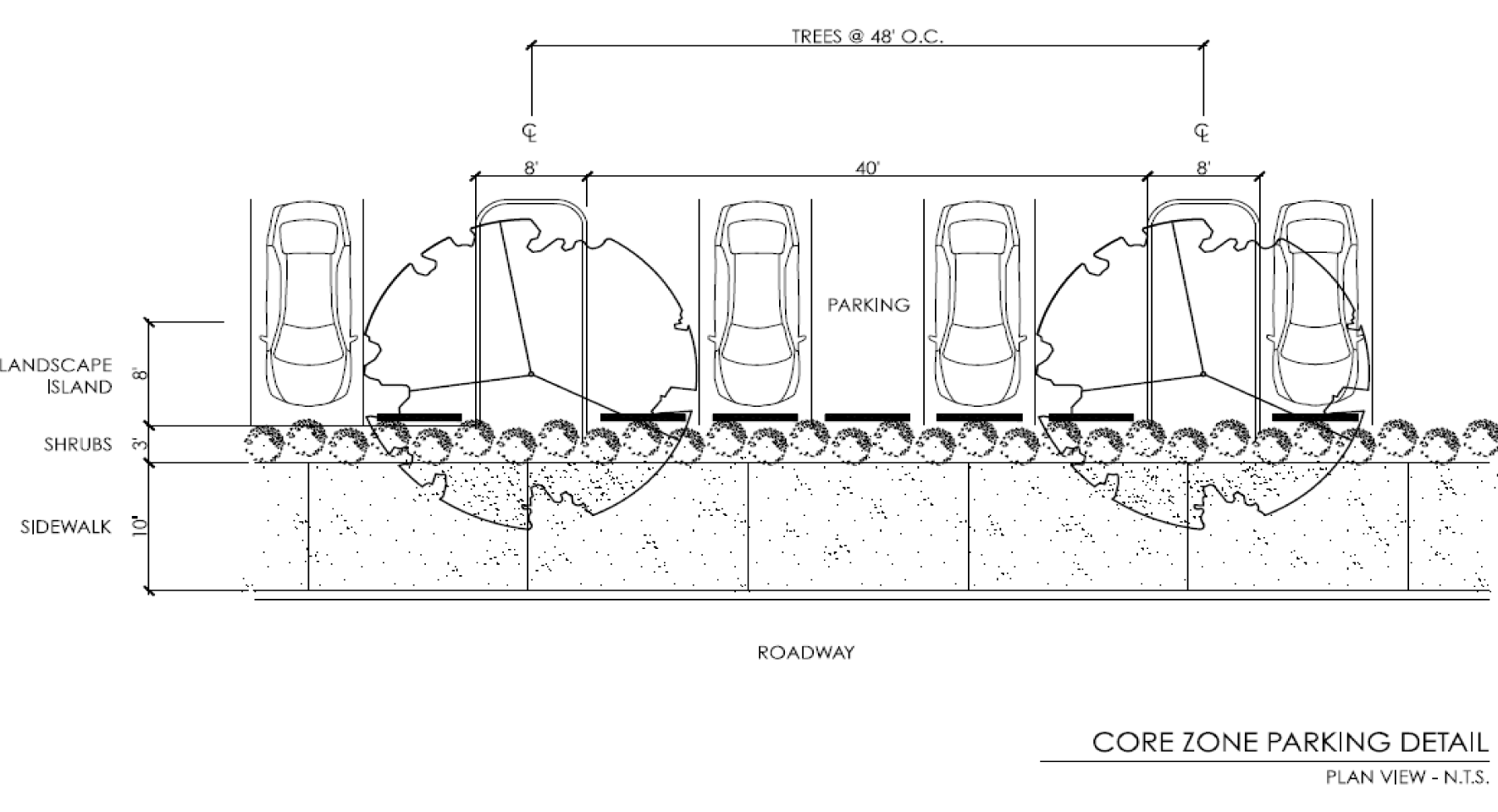
Graphic 18.2b: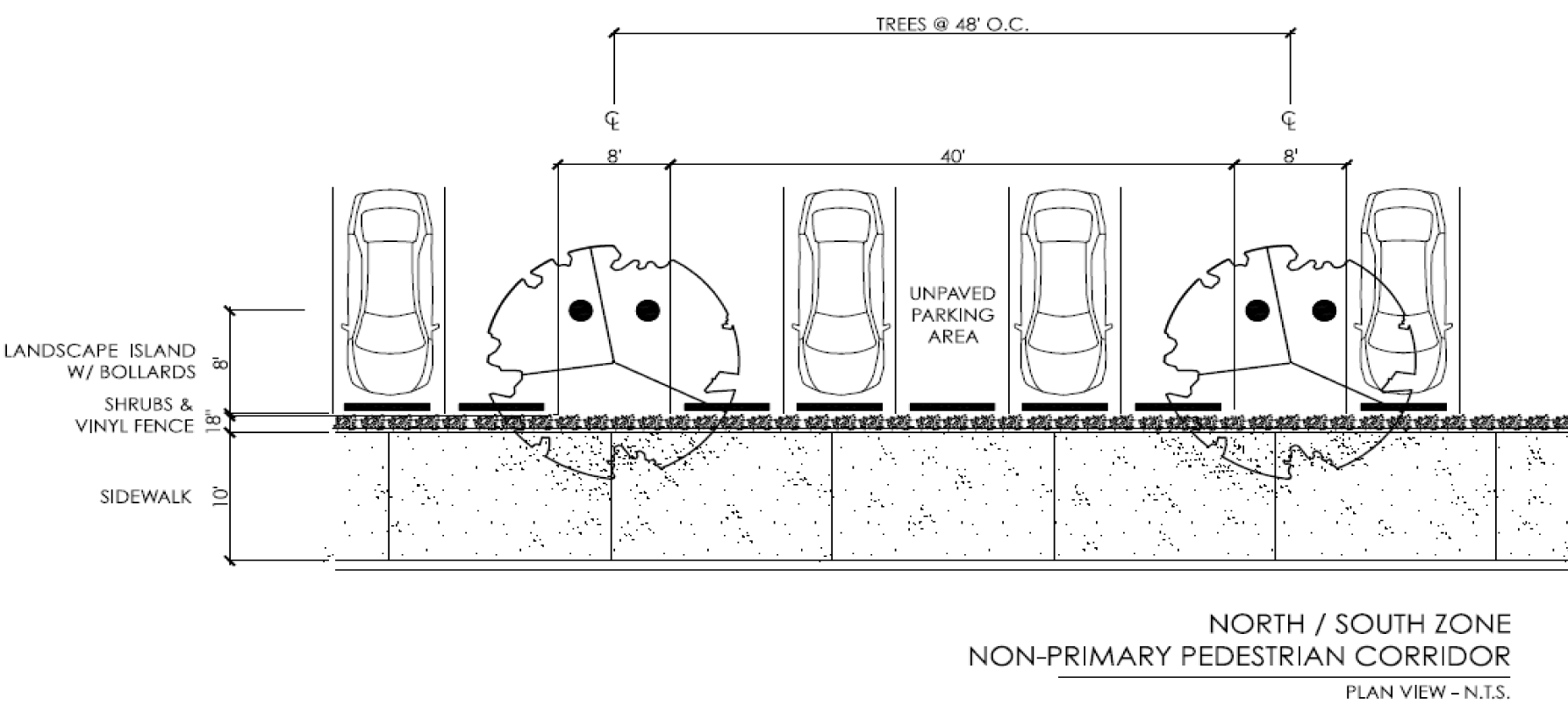
Graphic 18.2c: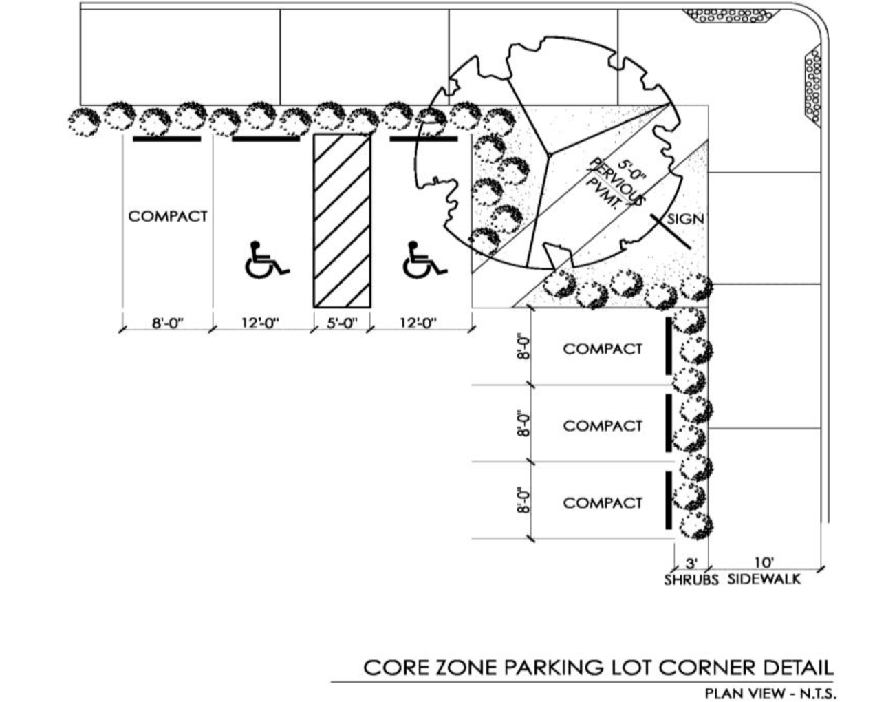
Graphic 18.2f: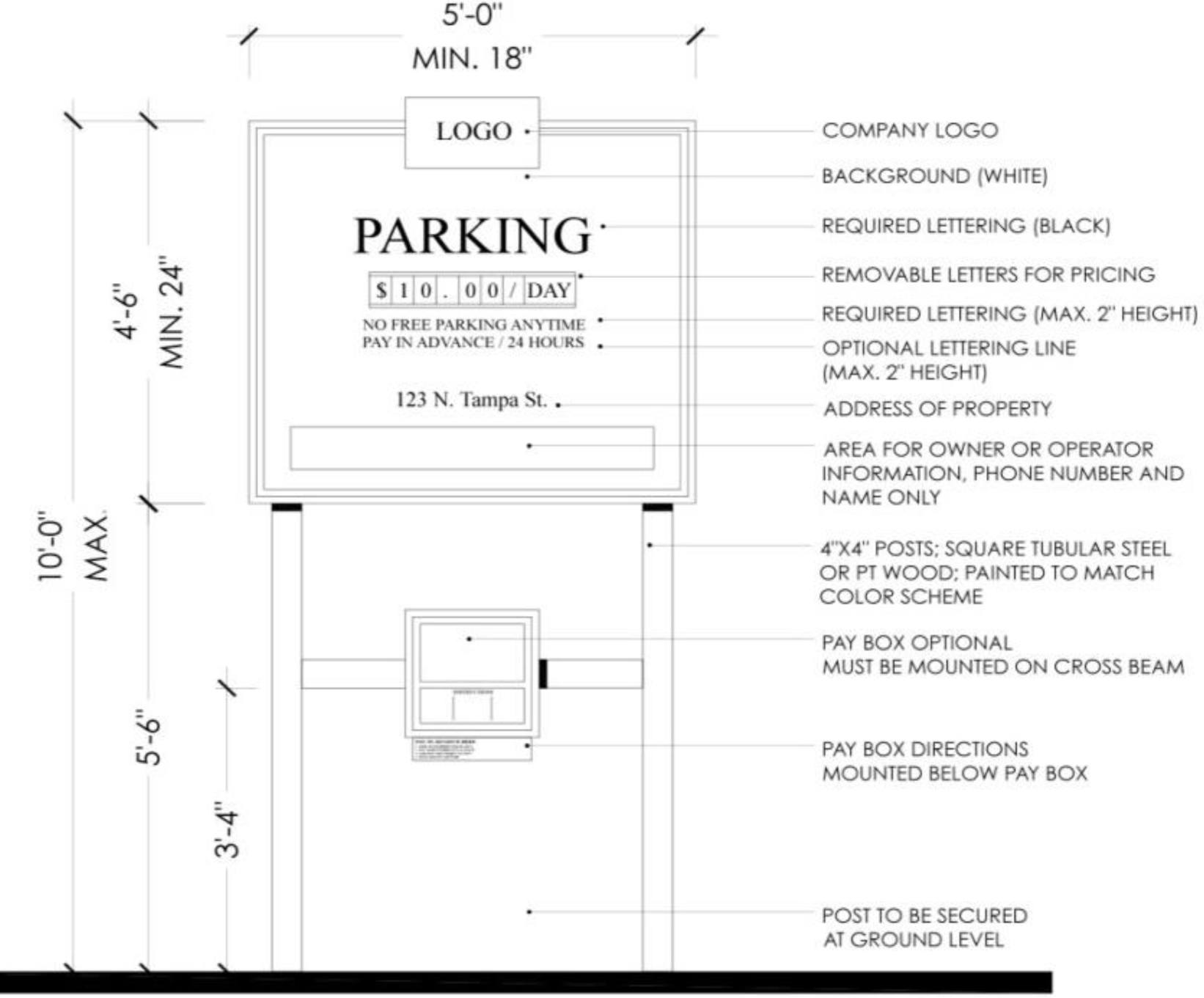
(Ord. No. 2016-79, § 1(Exh. A), 5-26-2016; Ord. No. 2019-54, § 28, 4-18-2019; Ord. No. 2022-155, § 8, 9-1-2022)
Sec. 27-185.2. - Parking compliance; options for alternative compliance.
(a)
Developments, which are required to provide off-street parking in accordance with this subdivision, may opt to comply with the parking requirements through one (1) or a combination of the following options for alternative compliance:
(1)
Option 1—Comply with section 27-184.
(2)
Option 2—Public realm improvement:
a.
Design and install, in accordance with applicable City Code and procedures, parking facilities to be located within the public realm that are available for public use. These facilities may include parking within public right-of-way, or parking on private property, as long as this parking allows general public access (whether or not a usage fee is applied to public use of this parking). This parking may be provided for all or a portion of equivalent to the requirements of section 27-184.
b.
Equivalent parking facilities shall include provision of standard vehicle parking or any alternative transportation mode, in accordance with the standards set forth in section 27-185, Table 185.
(3)
Option 3—In-lieu parking payment:
a.
Using the methodology below, calculate and provide an in-lieu payment to the central business district parking revenue trust fund, established by chapter 15 of this Code. All funds collected through the in-lieu payment process shall be utilized for the express purpose of capital improvement parking projects in the central business district.
b.
Calculation of in-lieu parking payment. The in-lieu payment shall be calculated in accordance with the following method/formula:
Total Assessed Value* of all land in CBD ÷ Total Land Area of all land in CBD (in sq. ft.) = Total Average Assessed Value per SF.
1.
Total Average Assessed Value per SF × 144 SF** = In Lieu Rate (per Parking Space).
In Lieu Rate × Number of Parking Spaces not to be provided = Total Parking In Lieu Payment to be paid pursuant to this section.
* Assessed value of land according to current Hillsborough County Property Appraiser's records.
**144 SF = One (1) standard parking space (8'×18').
2.
For all other renovation, rehabilitation or building improvement, the in-lieu parking payment space credit shall be calculated in accordance with the following formula:
c.
Parking space credit conditions and rights. The following conditions and rights apply to all parking space credits purchased through the in-lieu parking payment:
1.
Parking space credit may be transferred only with the property that is legally desired on the parking space credit form. A restrictive covenant, in a form and with conditions approved by the city attorney, must be recorded with the clerk of the court.
2.
Parking space credit will continue to run with the land, regardless of change in use or redevelopment.
3.
Parking space credit may not be transferred to meet the parking requirements of buildings or structures on other property.
4.
It is the developer's responsibility to maintain a copy of the parking space credit and to provide the copy with the permit application whenever a new renovation, rehabilitation, building improvement or new construction is planned for the site.
5.
No money shall be refunded by the city for parking space credit.
d.
Request for reduction of the parking in-lieu fee shall be submitted as part of the design district review application. Prior to a decision being rendered on the design district review application, and any design alternatives requested therein, the applicant (petitioner) must petition for review, pursuant to section 27-61, if the parking in-lieu fee reduction is still sought. Following the disposition of the review petition for the parking in-lieu fee and any other design alternatives included therein, within five (5) working days, the planning and urban design manager or designee shall issue the detailed written determination for the project.
(b)
As an alternative to the options set forth in subsection (a) above, developments may complete and submit a parking demand study that demonstrates that development requires less parking (i.e. reduced parking demand). Applicants shall use a methodology consistent with industry-accepted best practices, which may include the ITE Parking Generation (5th Edition) or Urban Land Institute's Shared Parking (3rd Edition), as amended, and this methodology must receive approval of the zoning administrator or designee prior to submittal of the parking demand study.
(Ord. No. 2016-79, § 1(Exh. A), 5-26-2016; Ord. No. 2020-166, § 28, 12-17-2020; Ord. No. 2022-155, § 9, 9-1-2022)
Sec. 27-185.3. - Fence regulations.
(a)
Applicability. The requirements set forth herein shall apply to all fences built in the Center City District. The requirements are based on the location of each fence installation in one of the zones indicated on Map CBD 185. These are minimum standards, and if the applicant desires the quality of the fencing material may be upgraded, subject to city planning division design approval. All development shall comply with development standards set forth in Table 185.3 below:
Table 185.3
(Ord. No. 2016-79, § 1(Exh. A), 5-26-2016)
Sec. 27-196. - Purpose and intent.
The purpose and intent of the Channel District ("CD" or "District") is to provide for a growing mixed-use area which lies between and complements the Central Business District and the Ybor City Historic District. The CD provides for protection of existing uses and a variety of residential, commercial, and industrial uses consistent with the Tampa Comprehensive Plan. The CD also seeks to guide development design according to the desired palette as identified in the "Channel District Community Redevelopment Area Strategic Action Plan." While these regulations allow for the potential for mixed-use development in the Channel District, it is the intent of this article to provide existing industrial, maritime, and commercial uses (specifically related to Port Authority activities) with the opportunity to continue, expand, prosper, and grow.
Per the strategic action plan, the district is evolving dramatically to also include increased tourism, higher density residential, and more intense mixed-use projects. This constant evolution of uses makes the Channel District a unique redevelopment opportunity in the eastern side of downtown peninsula, given its proximity and geographical connection to the Central Business District. The District is on a direct path to becoming a destination with an urban, mixed-use, transit-related neighborhood reflecting the smart-planning concept of locating residences near job centers. Creation of inviting urban spaces through innovative, superior design will add to the economic and social success of the neighborhood.
Geographic location and the historic dependence upon port related activity have influenced the district's development pattern. Even today the district reflects the diverse activities emerging at the port and its evolution as a tourist destination. The Channel District is facing dramatic change as its future development pattern emerges at the onset of the 21st Century as part of Tampa's emerging downtown neighborhoods.
Sec. 27-197. - District and subdistricts established; procedures for rezoning.
(a)
District established; boundaries. The Channel District is hereby established as a separate district with subdistricts therein. The boundaries of the District are as follows:
An area within downtown Tampa which is generally located, North of Garrison Channel, South of Tampa South Crosstown Expressway, East of Meridian Avenue, and West of Ybor Channel, and being more particularly described as follows: An area bounded on the North by the Tampa South Crosstown Expressway; on the North beginning at the Tampa South Crosstown Expressway and extending South along the Centerline of Ybor Channel to a point on a line, said point lying on a line which bears North 43 deg. 31 min. West, bisecting the intersection of the Northwesterly Harbour Line of the Ybor Turning Basin and the Westerly Harbour Line of Ybor Channel; thence North 43 deg. 31 min. West, along said line to 13th Street; thence South and Southwesterly along 13th Street to and along Platt Street, to Meridian Avenue; and bounded on the West by Meridian Avenue to the Tampa South Crosstown Expressway.
Any owner of property immediately abutting the boundaries of the Channel District as herein described, and zoned PD or PD-A on the date of adoption of this Article III, Division 2, Subdivision 4, The Channel District, may petition the city to expand the PD or PD-A into the Channel District boundaries, provided such expansion does not enlarge or intensify the existing development rights under the PD or PD-A as it existed on the date of adoption of Article III, Division 2, Subdivision 4. If such petition is approved by the city, the above-referenced boundaries of the Channel District will be modified to exclude the expanded PD or PD-A property.
(b)
Subdistrict established. The following CD zoning subdistricts shall be the only zoning districts permitted within the CD (previously approved CD-3 site plans shall remain valid subject to section 27-138(6) and (7) and any substantial changes thereto require compliance with this article):
(1)
CD-1. This zoning subdistrict is appropriate for a variety of residential, commercial, and industrial uses with an urban and pedestrian development pattern.
(2)
CD-2. This zoning subdistrict is appropriate for those uses and/or structures exceeding those dimensional and intensity criteria set forth in the CD-1 subdistrict.
(c)
Procedures for rezoning to CD subdistricts.
(1)
A property owner requesting a rezoning to CD-1 shall be governed by the parcel rezoning procedures set forth in Article II, Div. 7 of this chapter.
(2)
A property owner requesting a rezoning to CD-2 or an amendment to a CD-2 (or previously adopted CD-3) zoned property shall be governed by the parcel rezoning procedures, the site plan controlled rezoning review procedures, and the provisions of this article, all as set forth in this chapter. A property owner requesting a CD-2 rezoning shall be required to submit an application for preliminary design approval at the time of submission of the rezoning application and final design approval at the time of submission of the commercial site plan application.
Sec. 27-198. - Official schedule of permitted principal, accessory and special uses; required off-street parking ratios by use; parking space equivalencies by transportation mode.
(a)
Except as otherwise specifically provided in this chapter, the use of and required parking count for land, water and structures within the Channel District (CD) shall only be permitted in accordance with Table 19-1A, including those parking space equivalencies by transportation mode set forth in Table 19-1B. All other uses of land, water and structures in the CD which are not expressly listed in Table 19-1 are prohibited uses and shall not be established in the CD. Refer to section 27-185.2 (under CBD standards) for alternative compliance options.
(b)
Parking space equivalencies by transportation mode. Parking shall be provided in accordance with the ratios set forth in Table 19-1A above. Developments may provide all required vehicle parking spaces for automobiles or in combination with the alternative modes of transportation, using associated equivalency ratios, set forth in Table 19-16 below. No more than twenty-five (25) percent of required vehicle parking may be substituted with parking for other transportation modes in this manner.
(Ord. No. 2013-73, § 8, 6-6-2013; Ord. No. 2015-10, § 5, 1-15-2015; Ord. No. 2015-110, § 4, 11-5-2015; Ord. No. 2017-132, § 8, 8-24-2017; Ord. No. 2018-176, § 7, 11-1-2018; Ord. No. 2019-54, § 29, 4-18-2019; Ord. No. 2022-156, § 1, 9-1-2022; Ord. No. 2022-157, § 6, 9-1-2022; Ord. No. 2022-158, § 7, 9-1-2022)
Sec. 27-199. - Official schedule of dimensional regulations.
Except as otherwise specifically provided in this chapter, the minimum lot size and width, minimum required yards, mandatory yards, maximum height, and maximum density and F.A.R. shall be as shown in Table 19-2, Schedule of Dimensional Regulations.
Table 19-2
SCHEDULE OF DIMENSIONAL REGULATIONS
Table 19-2 Notes:
1 Front yards set at zero (0) feet for all other streets.
2 Corner yards set at zero (0) feet for all other streets.
3 Building height may be considered above one hundred seventy-five (175) feet up to the maximum height as prescribed by the HCAA/FAA and as approved by city council. For each ten (10) feet of building height above sixty (60) feet, the required yards shall be increased by a minimum of one (1) foot.
4 Bonus density/intensity (FAR) considered above 3.5, pursuant to requirements of section 27-140, and as approved by city council.
5 Arcades may be set at zero (0) feet for any yard adjacent to a public street.
(Ord. No. 2016-58, § 5, 4-21-2016; Ord. No. 2022-156, § 2, 9-1-2022; Ord. No. 2024-16, § 9, 2-1-2024)
Sec. 27-200. - Reserved.
Editor's note— Ord. No. 2022-156, § 3, adopted September 1, 2022, repealed § 27-200, which pertained to parking requirements and derived from Ord. No. 2017-132, § 9, 8-24-2017.
Sec. 27-201. - Public art requirements.
(a)
Purpose. The purpose of the public art requirements is to:
(1)
Increase the presence of art in the Channel District, visible to the general public;
(2)
Ensure that art can be enjoyed by the general public; and,
(3)
Support the promotion of the Channel District as a vital cultural component of the Center City.
(b)
Requirements.
(c)
Public art fund. A public art fund shall be created and shall consist of all payments for public art requirements within the Channel District (CD). The public art fund shall be used solely for the selection, acquisition, installation, maintenance, and insurance of public art to be displayed on public property in the Channel District, unless otherwise agreed by mutual agreement of a private property owner and the City to be placed on private property (subject to section 27-201.1). Refer to chapter 4, city code.
(d)
Maintenance of public art on private property and maintenance covenant. Refer to section 27-201.1.
(Ord. No. 2017-43, § 5, 3-16-2017)
Sec. 27-201.1. - Maintenance agreements: Public realm; public art.
(a)
For certain improvements made by and/or agreed to by a property owner, the property owner is required to execute a maintenance agreement and covenant for such improvements, within specific areas, as follows:
(1)
Construction/installation of Channel District streetscape improvement(s) within the public right-of-way.
(2)
Public art funded by Public Art Fund monies (refer to sections 27-201).
(b)
The maintenance agreement and covenant shall be executed and compliant with the following:
(1)
The document(s) shall be in a form acceptable to the city attorney;
(2)
The property owner shall maintain and repair all elements of the improvement(s); and
(3)
The document(s) shall be recorded in the public records of Hillsborough County and shall be binding on all successors in interest.
(c)
Maintenance of public art on located on private property and maintenance covenant.
(1)
Public art placed on private property and subject of/to a maintenance agreement and covenant executed prior to April 15, 2017, shall continue to be subject to all terms and requirements of such agreement and covenant, unless otherwise agreed to by the city.
(2)
Public art placed on private property, subsequent to April 15, 2017, shall be subject to a maintenance agreement and covenant terms and requirements of this section, unless otherwise agreed to by the city.
(Ord. No. 2017-43, § 6, 3-16-2017)
Sec. 27-202. - Development design approval and procedures.
(a)
Design approval; when required; submission of application.
(1)
Design approval required. Any property owner or agent thereof proposing to erect a building or structure or conduct major renovations on any building or structure in the Channel District, for which a rezoning application or building permit application is submitted as of the effective date of this article, shall obtain design approval for said building or structure by complying with the provisions of this article.
(2)
Submission of application. An application for design approval shall be submitted to the urban design manager at the same time as an application for commercial site plan review as required by Chapter 5 of this Code, unless design approval was already obtained at time of a rezoning to CD-2.
(b)
Review procedure.
(1)
Pre-application conference. Any property owner or agent thereof required to obtain design approval shall schedule a pre-application conference with the urban design manager prior to the submission of an application for design approval. For those developments seeking consideration of any bonus criteria through the site plan rezoning process, a pre-application conference shall also be scheduled with the zoning administrator for evaluation of those proposed items. The pre-application meeting will serve as an initial exchange of information in order for the applicant to receive a better understanding of the city's standards and requirements for the Channel District and at the same time, the city obtains information related to the applicant's proposed use(s) and location.
(2)
Submission requirements. All applications for design approval shall contain, at a minimum, the following items (as determined by the zoning administrator and urban design manager):
a.
Scaled site plan showing all improvements, existing conditions, and dimensions of the site and building as well as adjacent streets.
b.
Scaled landscape plan, which may be incorporated into site plan, showing preliminary plant material (existing and proposed) with specific information as to location, species, and sizes.
c.
Typical floor plan with major use categories as necessary to describe all levels of building.
d.
Exterior building elevations of all sides with general material designations.
e.
Sketches of signs, locations, and their dimensions.
f.
General exterior color description, including signs.
g.
Exterior perspective (character sketch) in color at the pedestrian level (at least two (2) prominent sides). This drawing may be a sketch perspective rendered in sufficient detail using any color medium such as markers or colored pencil, etc.
h.
Streetscape plan detailing all required public realm features, such as street furnishings, lighting, art, plantings, etc.
(3)
Review of design approval application. The urban design manager shall review applications for design approval to ensure the visual and aesthetic intent of this article is met. For those developments seeking consideration of any bonus criteria through the site plan rezoning process, the zoning administrator shall be responsible for evaluation of those proposed items.
(c)
Approval, denial, and appeals.
(1)
Approval/denial. When design approval is required for a project, review for design approval shall be conducted concurrently with commercial site plan review required by Chapter 5 of the City of Tampa Code. Approval or denial (official determination) shall be reported to the applicant in writing, clearly outlining the basis for the decision including related code sections, within forty-five (45) calendar days of the submittal date.
(2)
Appeals. Applicants that have received an official determination of 'denial' may appeal to the city council, who may grant waivers to the design provisions of this article, through the CD-2 site plan rezoning process as described in this article and Article III, Division 3.
(Ord. No. 2020-166, § 29, 12-17-2020)
Sec. 27-203. - Designation of corridors.
(a)
Designation of gateways. Iconic elements and public art help to provide neighborhood identity at gateway locations throughout the Channel District. Where appropriate, provide gateway monuments through local artists design competitions. Gateways shall occur in several key locations in the Channel District. See Figures 19-1(a) and (b) for a map of gateway locations.
(1)
Major gateways—Significant entries into the District shall contain major identity elements and enhancement.
a.
Intersection of Twiggs Street and Meridian Avenue.
b.
Intersection of Channelside Drive and Meridian Avenue.
c.
Intersection of Cumberland Street and Channelside Drive.
d.
Any location along Channelside Drive between Twiggs Street and Lee Roy Selmon Crosstown Expressway.
(2)
Secondary gateways—Areas where smaller pedestrian scale identity elements shall occur.
a.
Intersection of Kennedy Boulevard and Meridian Avenue.
b.
Intersection of Jackson Street and Meridian Avenue.
c.
Intersection of Whiting Street and Meridian Avenue.
(3)
Standard streetscape design for the district shall adhere to the applicable design palette, as depicted in Figures 19-2 through 19-9. For those developments that propose improvements to achieve bonus density/FAR, the proposed design must exceed those related features depicted herein.
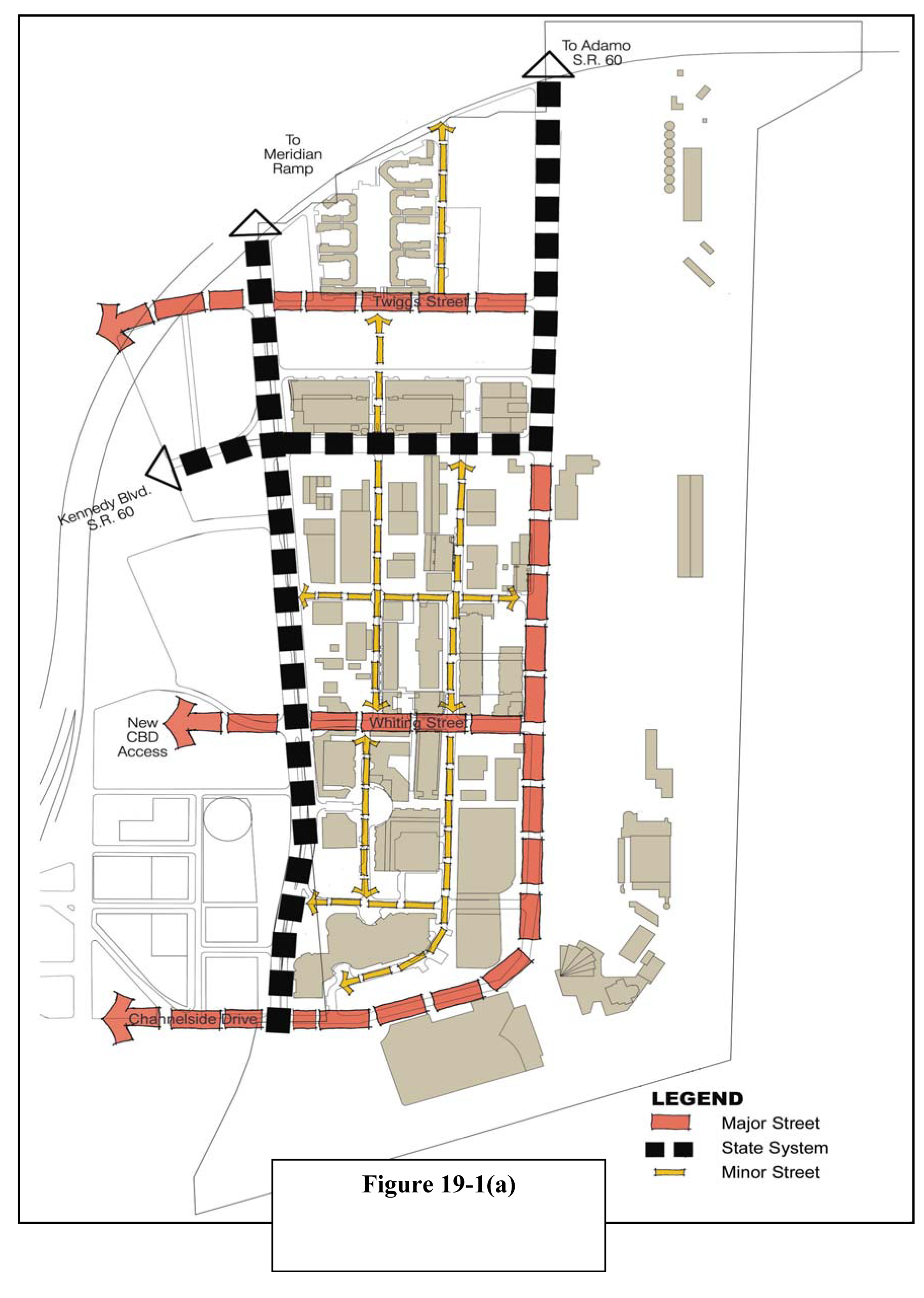
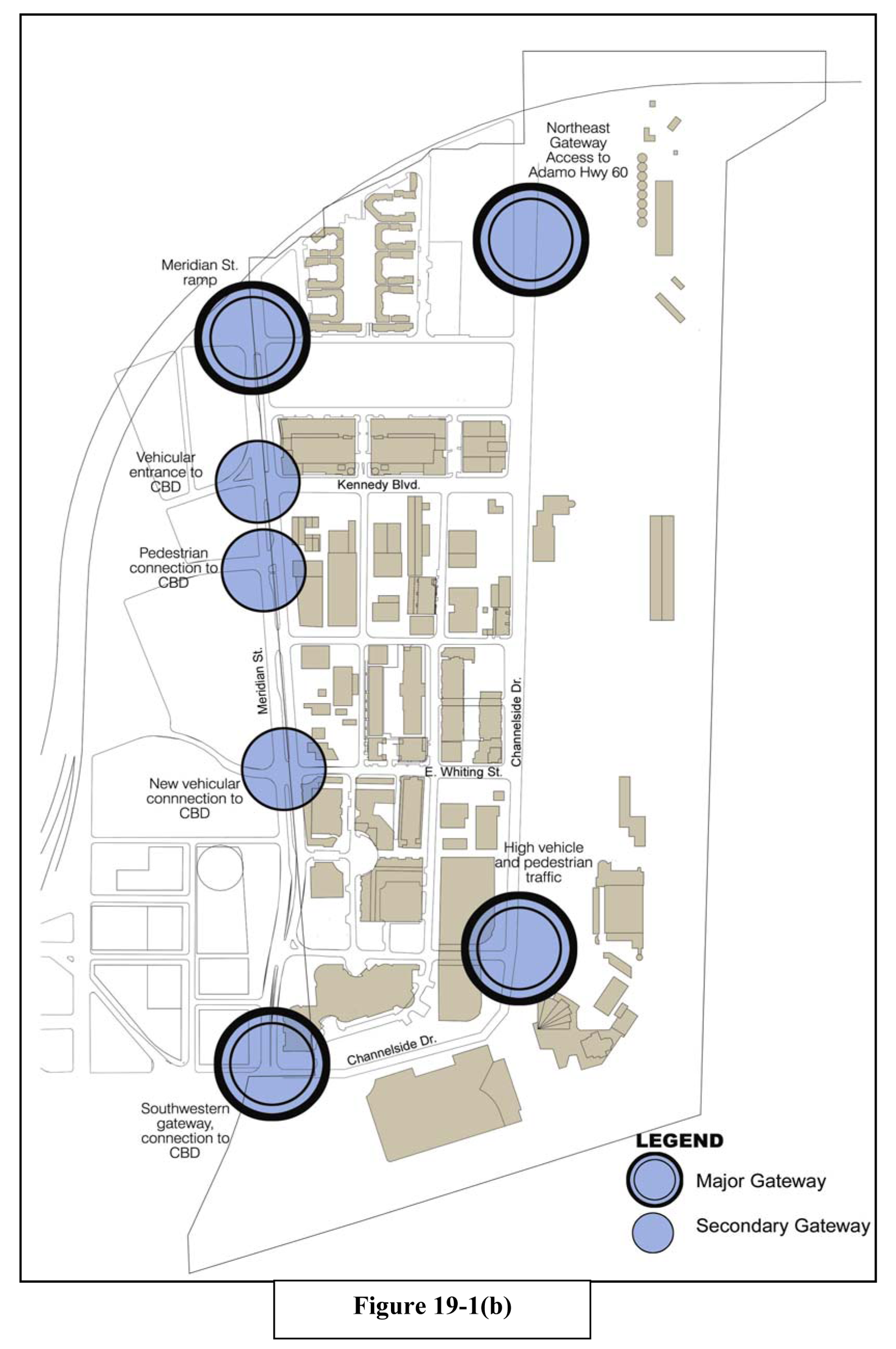
(b)
Streetscape design and layout.
(1)
Channelside Drive. This key corridor provides significant community identity and vitality through the adjacent publicly owned facilities and transportation systems. Channelside Drive is an urban four-lane road with one hundred (100) feet right-of-way. North of Kennedy Boulevard, it is a state regulated facility. In that location, placement and maintenance of design enhancements must comply with FDOT design standards. Improvements to the corridor are needed to increase pedestrian activity, extend active land uses along the east side of the right-of-way, and support increased transit use. Enhanced pedestrian access to Streetcar stations shall be provided. A minimum four-foot buffer zone along the curb including a combination of cobblestone pavers and landscape area shall be provided on both sides of the right-of-way. A minimum fifteen-foot sidewalk is required on the south or east side of the right-of-way. See Figures 19-2 and 19-3 for streetscape concept and cross-section concept.
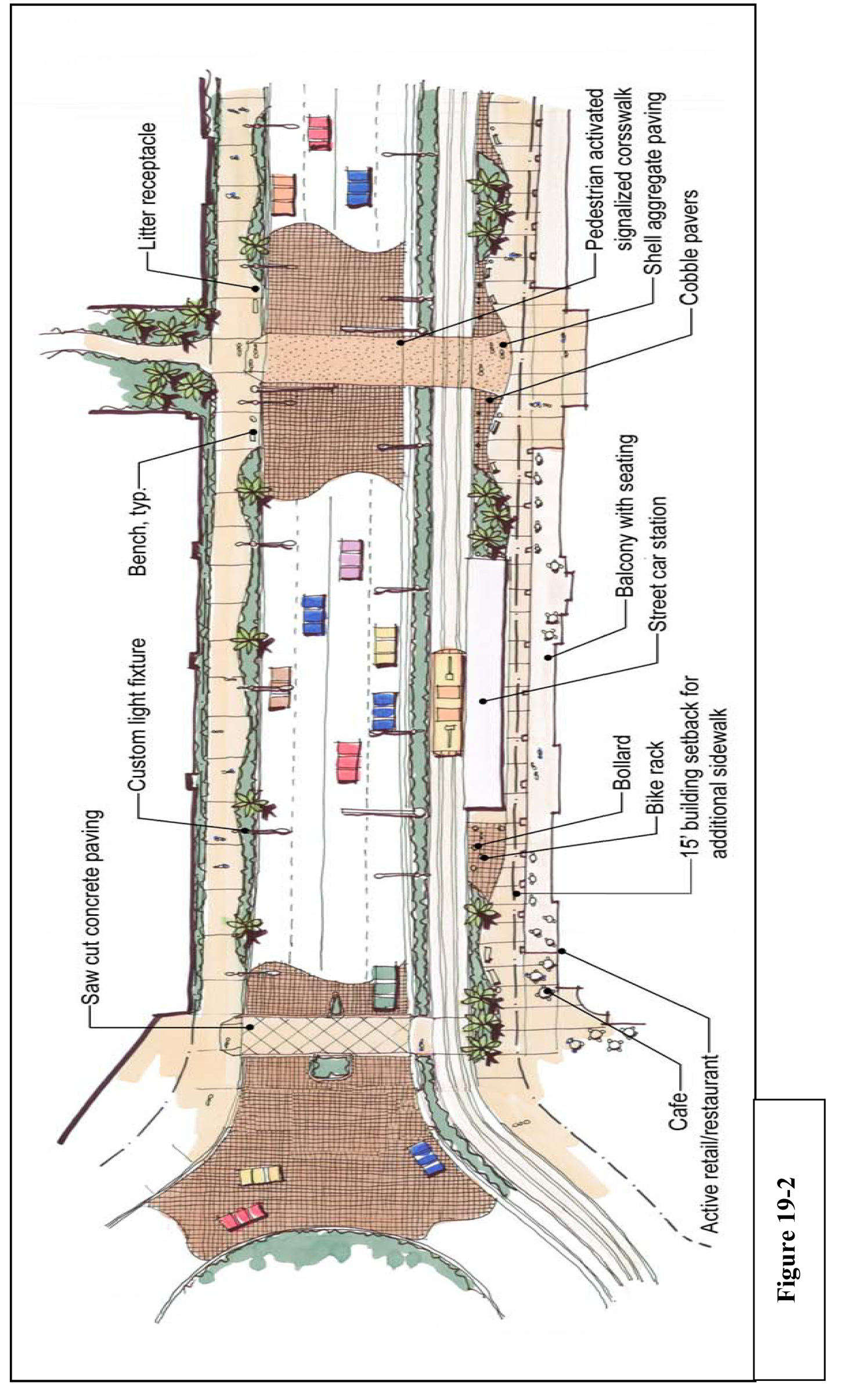
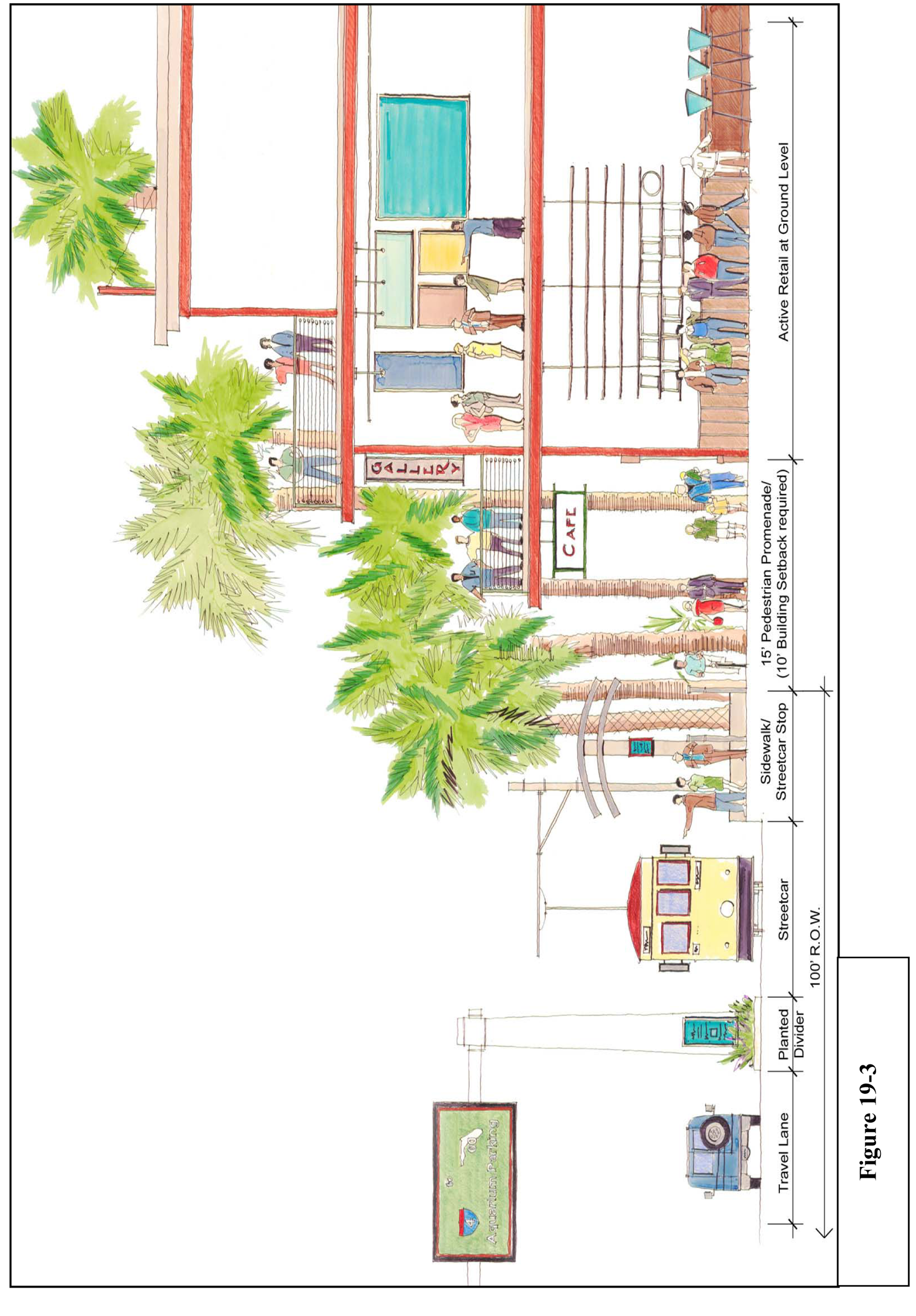
(2)
Kennedy Boulevard/SR 60: This corridor provides direct connection between the Central Business District and Ybor City. It is depicted as an urban five-lane road. As a state regulated facility, placement and maintenance of design enhancements must comply with FDOT design standards. Safe pedestrian crossings are required to ensure that the corridor does not create physical barriers for pedestrians within the District. A minimum four-foot buffer zone along the curb including a combination of cobblestone pavers and landscape area shall be provided on both sides of the right-of-way. See Figures 19-4 and 19-5 for streetscape concept and cross-section concept.
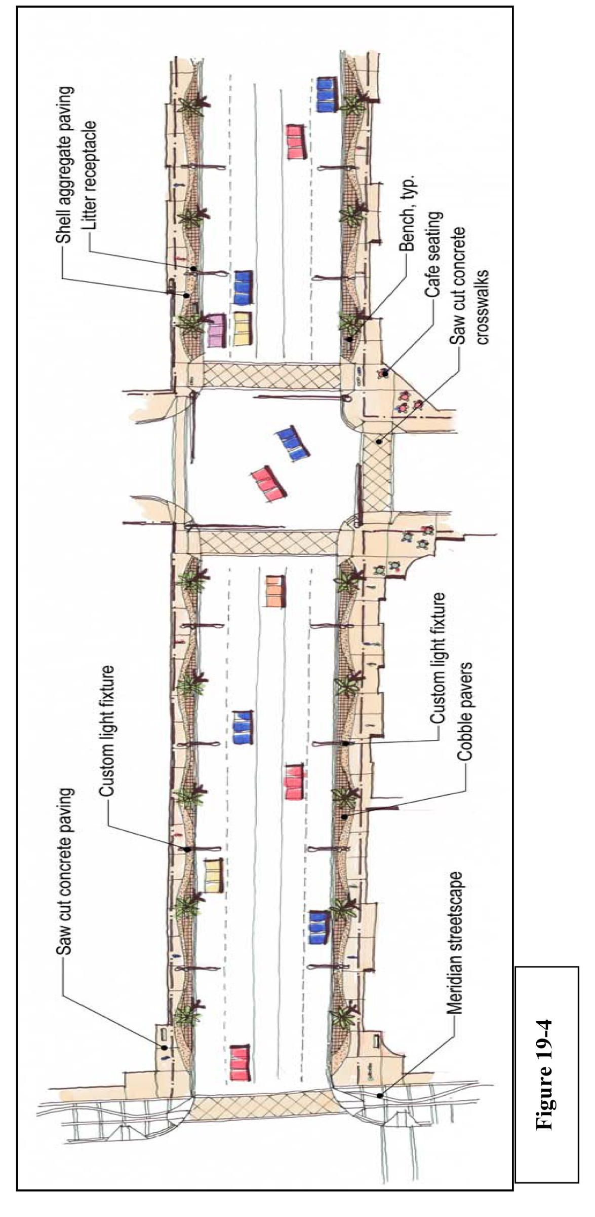
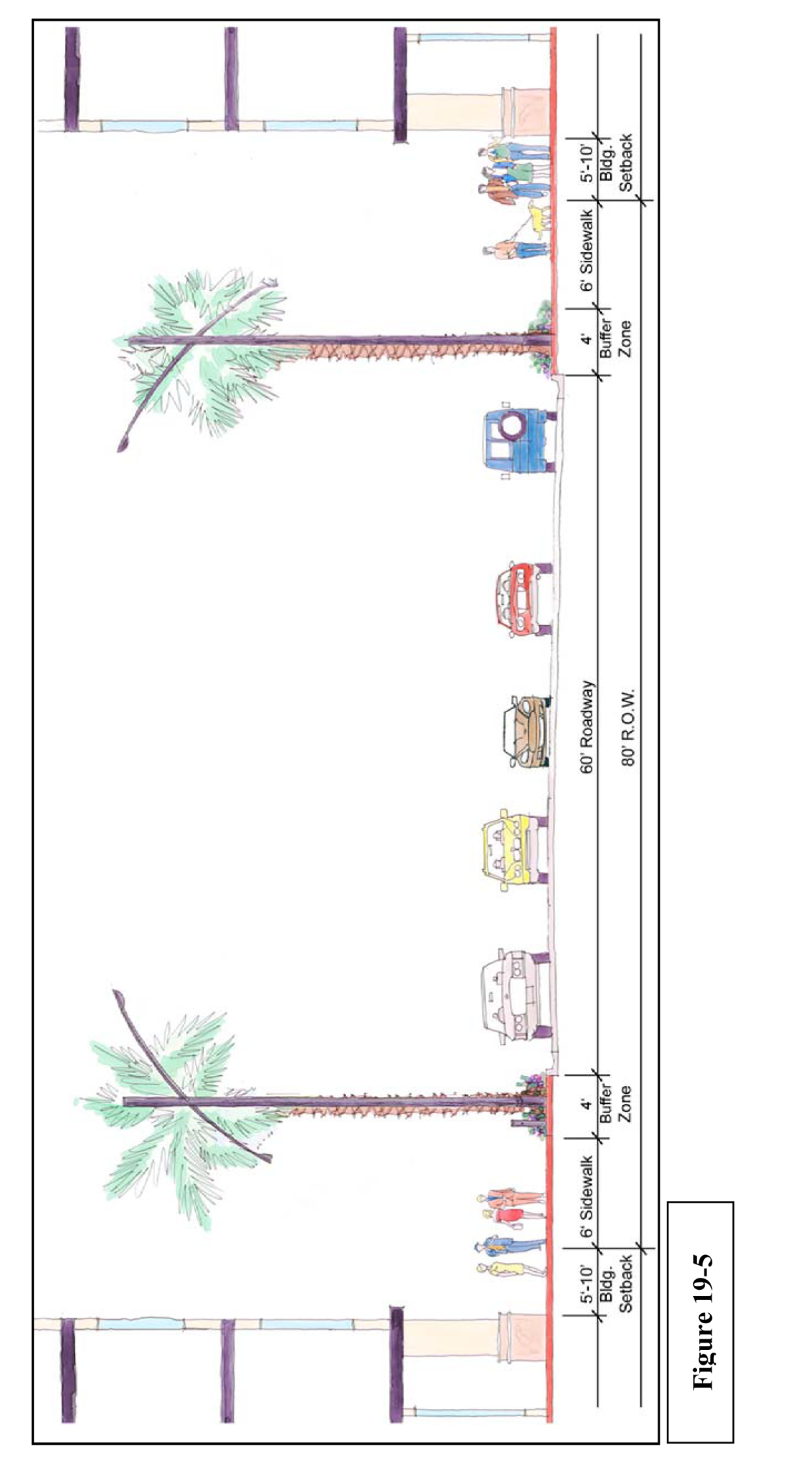
(3)
Twiggs Street: This corridor provides a direct connection between the Central Business District, the Channel District, and Channelside Drive. Additionally, it provides access to the Lee Roy Selmon Crosstown Expressway. Twiggs Street in the District is an urban four-lane road with eighty (80) feet right-of-way. On-street parking shall be provided on the north side of the right-of-way. A ten-foot wide City urban trail shall be provided on the south side of the right-of-way. A minimum four-foot buffer zone along the curb including a combination of cobblestone pavers and landscape area shall be provided on both sides of the right-of-way. See Figures 19-6 and 19-7 for streetscape concept and cross-section concept.
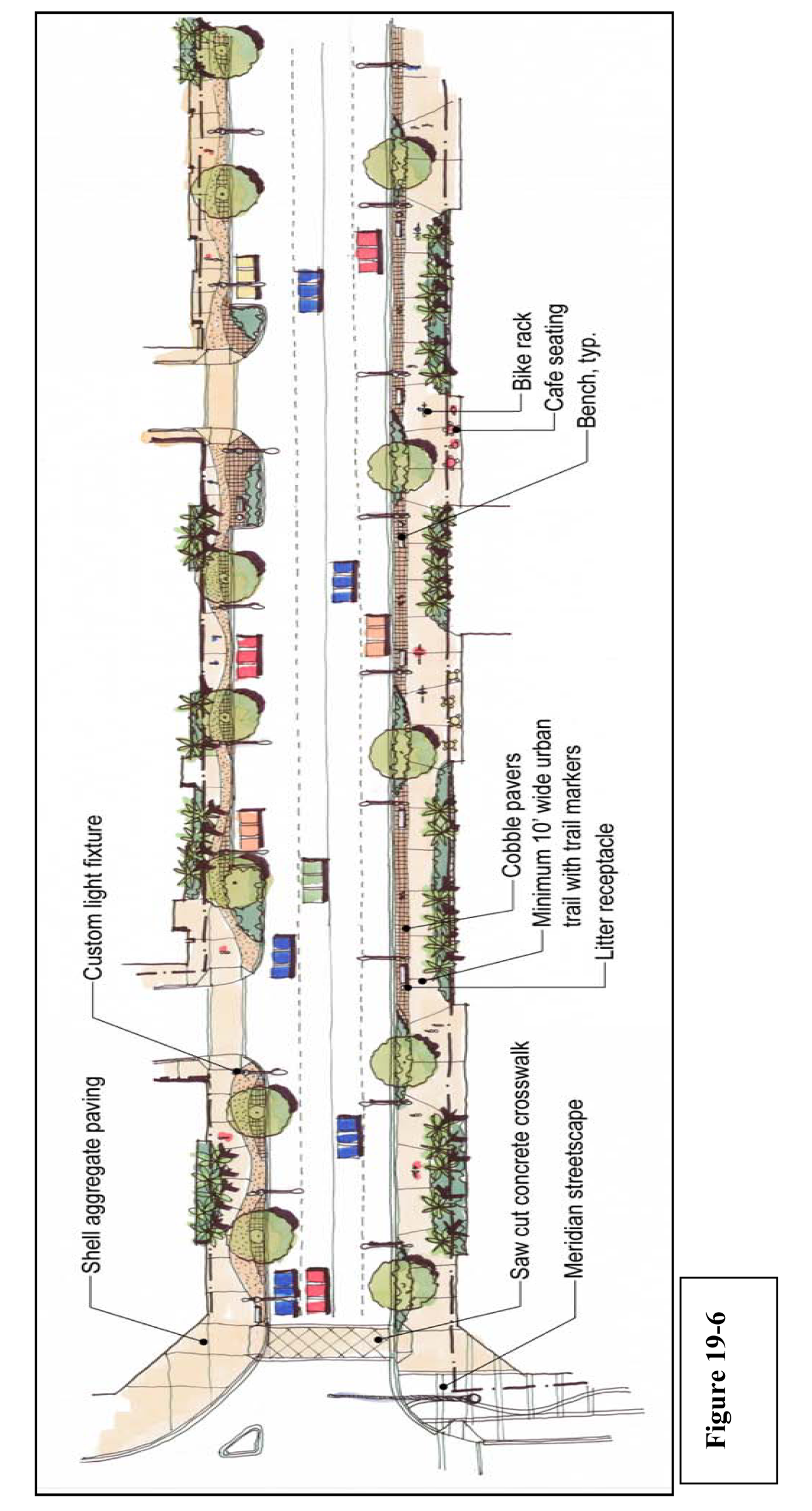
Figure 19-6
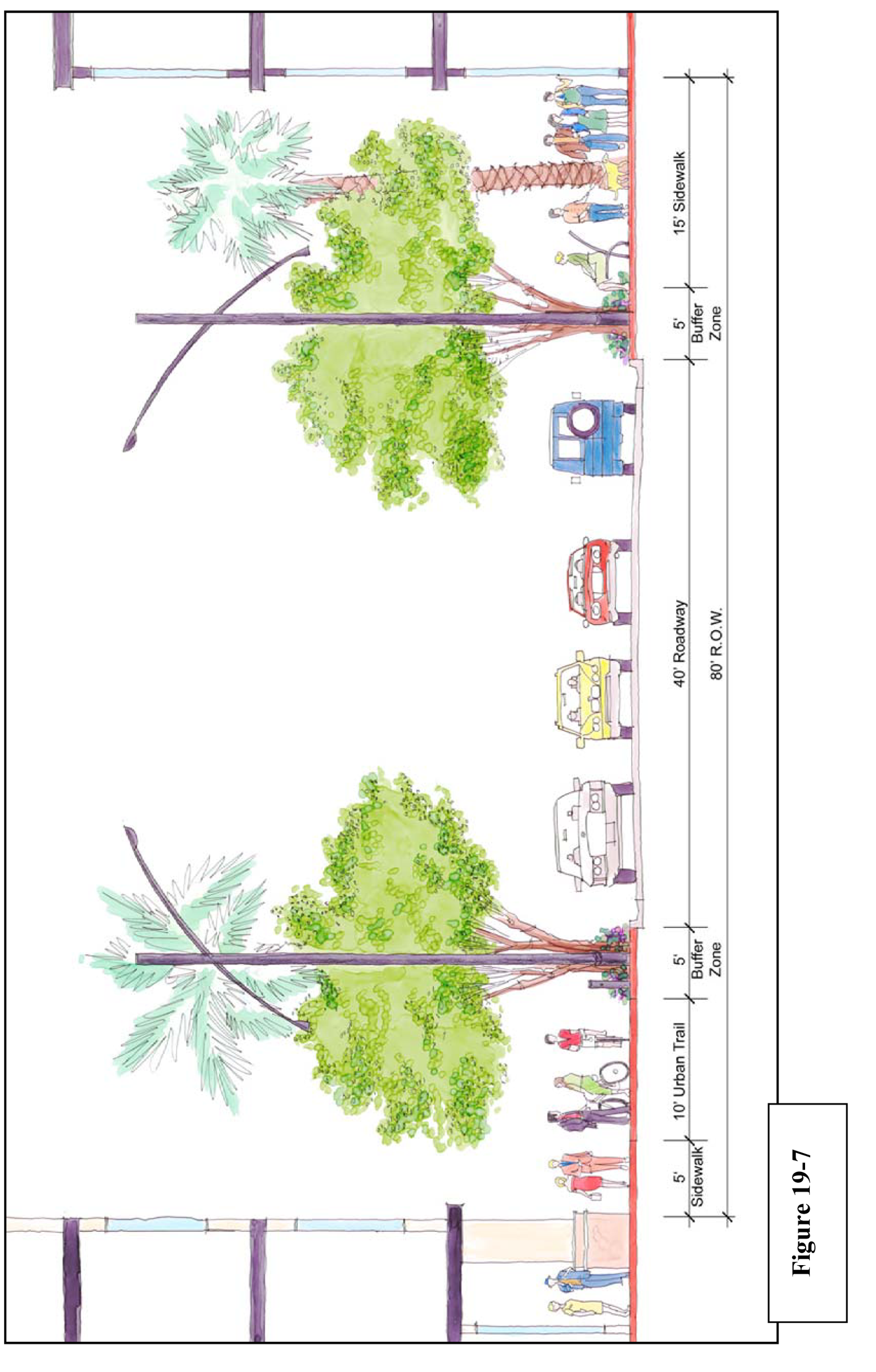
(4)
Interior Streets: The remaining interior street corridors provide interconnections throughout the District. North-south streets are depicted as a typical two-lane urban cross section, with on-street parking on both sides of the right-of-way. East-west streets are two-lane urban cross-section with a continuous left turn lane and on-street parking on one side of the street. Pedestrian crosswalks and mid-block crossings are proposed to provide safe and convenient pedestrian movements. See Figures 19-8 and 19-9 for streetscape concept and cross-section concept.
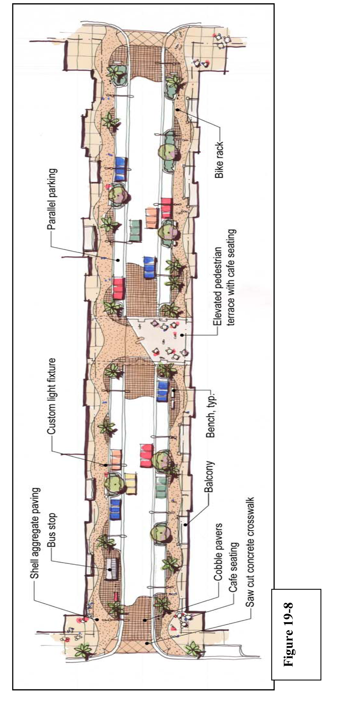
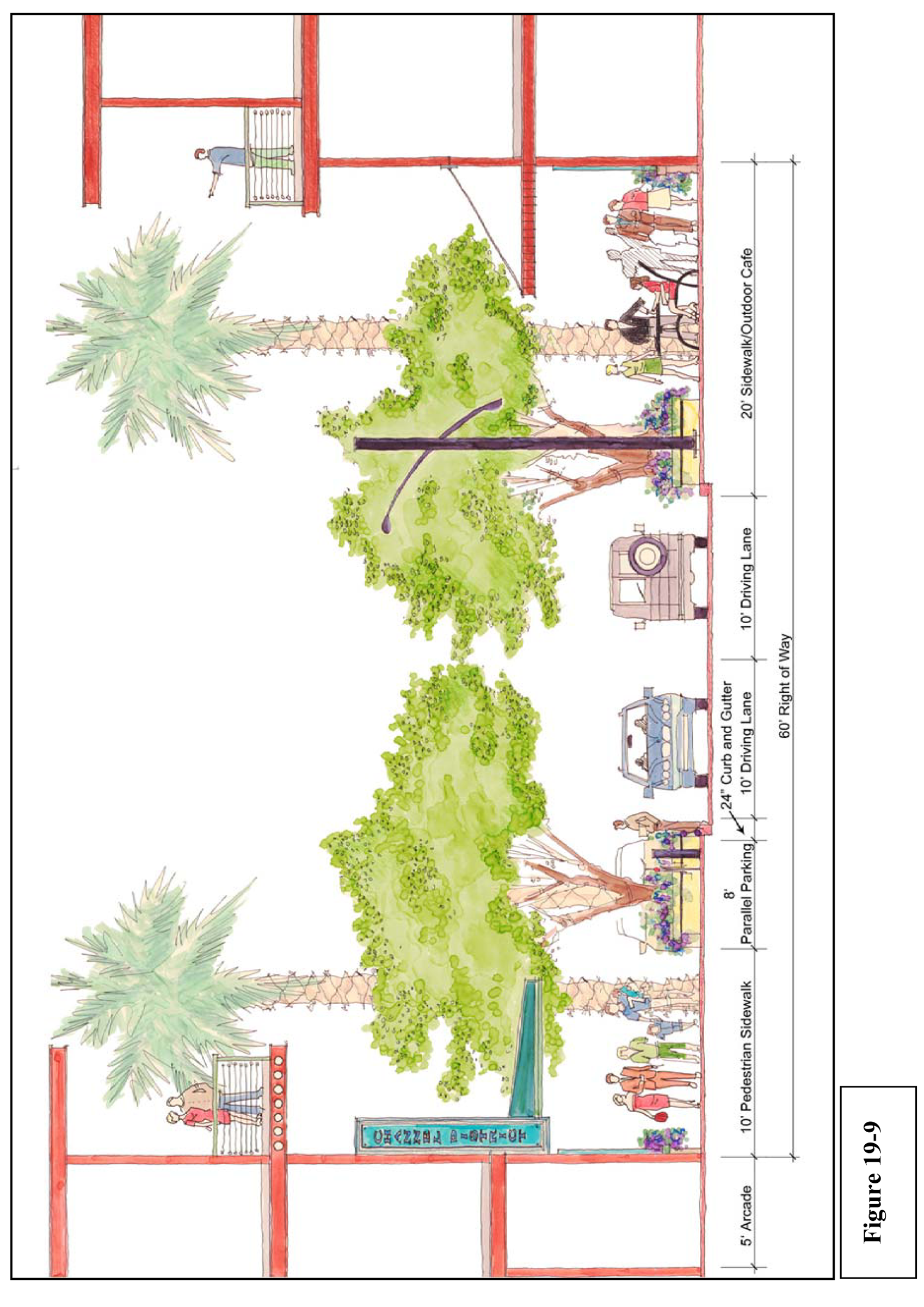
(Ord. No. 2007-190, § 9A, 9-6-07; Ord. No. 2008-183, § 6, 10-16-08; Ord. No. 2016-58, § 6, 4-21-2016)
Sec. 27-204. - Development site and building design standards.
(a)
Compliance. Compliance with the standards included herein shall be required in order to obtain design approval.
(b)
General site and building design standards.
(1)
All developments shall provide residential, office, neighborhood serving commercial uses, including general retail, restaurant, and/or personal services, and said uses shall be located on the ground floor and may extend to the second floor and above for a specific user. Furthermore, the location of said uses within the ground floor assists in the creation of pedestrian interaction and connectivity to the public right-of-way.
(2)
Developments shall provide shade and weather protection for pedestrians along public rights-of-way. This may be accomplished through the use and incorporation of awnings, canopies, arcades, etc. The intent of this standard is to provide weather protection for pedestrian traversing the sidewalk adjacent to the structure. In the rare instance that a surface parking lot is placed at grade and adjacent to a public sidewalk, the proposed streetscape trees shall be increased in caliper and canopy spread, so as to fully shade said public sidewalk.
(3)
Developments shall provide outdoor building light fixtures, which complement the architecture, at all points of ingress/egress from the structure. The light level shall be a minimum of one (1) foot candle.
(4)
[Reserved.]
(5)
Telephones, vending machines, or any facility dispensing merchandise shall be confined to a space built into the building or buildings, or designed as a separate structure compatible with the main building or the theme of development.
(6)
Parking shall be located on the street (if approved by department of public works), or within, on the side, or in the rear of the buildings (oriented away from public rights-of-way. However, in regard to the property between 13th Street and the Ybor Channel, for water transport and other water dependent uses, parking also may be located in the front of buildings.
(7)
Vehicle access and circulation for new development shall not impede pedestrian circulation. This may be accomplished by limiting the frequency and placement of curb cuts, by allowing adjacent property owners to share the same entrance and exit driveway to parking, and/or by utilizing a variation on materials to delineate pedestrian areas.
(8)
Utilities shall be placed underground.
(9)
The design of new buildings or structures and major renovations, specifically the design of building façades, shall demonstrate due respect and consideration for their context within the District; however, developments are not mandated to resemble one another or to utilize the same architectural style as that of an adjacent structure, in order to be compatible. Compatibility can be achieved through the proper consideration of scale, proportion, site planning, landscaping, materials, etc.
(10)
Building surfaces, walls, and roofs shall, however, consider complimenting each other in regard to materials, texture, color, etc. In most cases, mixing façade materials is acceptable but there may be extreme situations where mixing materials such as brick and stone are uncomplimentary and therefore not recommended.
(c)
Performance standards for mini-warehouse in Channel District.
(1)
The use is limited to the upper floors of buildings;
(2)
The use must be part of a mixed use project with at least two (2) uses, one (1) of which must be residential;
(3)
The use may not exceed forty (40) percent of the total square footage of the project;
(4)
The use must be integrated within the structural system of the building;
(5)
The use is allowed in Zoning Districts CD-1, CD-2 and CD-3;
(6)
The rental of mini-warehouse units shall not be limited to the residents of the building housing the use; and,
(7)
The storage of hazardous materials other than materials common in household use and in retail and commercial businesses such as ordinary detergents and other cleaning materials, cosmetics, paints and adhesives, automotive fluids in small quantities, and other such materials, shall be prohibited; and,
(8)
On lands with Heavy Industrial (HI) future land use designation:
a.
Standards set forth in subsections (c)(2) and (c)(3) above shall not apply;
b.
Those portions of the building(s) with street frontage shall contribute to the active pedestrian character of the corridor and shall include office or commercial uses (inclusive of accessory office/retail uses for the mini-warehouse use), for a minimum depth of twenty-five (25) feet.
(d)
General on site landscaping standards.
(1)
Provide landscaping with color where a new building or structure or major renovation encompasses the entire site, by introducing color and plantings with flowers (window boxes or flowering vines).
(2)
Landscape designs shall be integrated into the overall design concept. Landscaping schemes shall consider the design of the structure, adjacent structures, the surrounding areas and the streets.
(3)
A variation in color shall be reflected in the landscape design by use of flowers, flowering plants, or different types of landscaping which result in colorful and complementary schemes.
(4)
Landscaping shall be used to screen objectionable areas located on ground level such as trash and garbage service areas, and outside mechanical equipment (i.e., air conditioning condensers), unless screened through an alternative architectural/structural design.
(e)
General sign standards. The following sign standards shall apply to new buildings or structures and major renovations in the CD and shall be in addition to the sign regulations set forth in Article VI, Division 6; where inconsistent, the more restrictive shall apply.
(1)
No signs are to abut at the corner of a building. A minimum clearance of ten (10) feet shall be required between such signs. A minimum clearance of four (4) feet shall be maintained between signs on the same façade.
(2)
All signage shall be placed on or attached to the building façade, canopy, awning, or marquee. Exceptions to this would include small directional, entrance or exit signs where warranted.
(3)
Awning signs may be located at a tenants main entry under an awning and is intended for pedestrian communication. The sign must be at a right angle (perpendicular) to the exterior wall. Each tenant is allowed one (1) non-illuminated sign only. The tenant name may be placed on the both faces of the sign. The maximum dimensions for the sign are as follows: four (4) feet long, one (1) foot high and six (6) inches thick. The maximum height for the lettering shall be six (6) inches. The bottom of the sign must be a minimum of seven (7) feet above the sidewalk.
(f)
Waterfront access.
(1)
All new buildings or structures and major renovations located in an area bounded by the Crosstown Expressway, 13th/Platt Streets (Channelside Drive), Beneficial Boulevard, and the Ybor/Garrison Channels shall provide public access points to, and along, the water's edge. Where feasible, independent waterfront overlook areas for pedestrians may be developed at dead-ends of existing rights-of-way at the water's edge, or along dock areas which may have intermittent use and allow public access when the property owner's scheduling permits.
(2)
Where feasible, public access along the water's edge shall be incorporated into the designs of all new buildings or structures and major renovations located adjacent to the Channel District waterfront.
(g)
Encroachments. Encroachments into the public right-of-way for awnings, awning signs or architectural features may be authorized administratively through the commercial site plan review process.
A separate encroachment application for awnings or architectural features will not be required provided the projections comply with the following criteria:
(1)
Such features shall be at least eight (8) feet above grade and have a maximum projection into the right-of-way of six (6) feet.
(2)
Building columns are prohibited from projecting into the right-of-way.
(3)
Encroachments shall leave street corners free of obstruction to allow for safe traffic movement and proper placement of utilities.
(4)
Proper lighting underneath overhangs shall be provided and maintained by the property owner.
(5)
A hold harmless agreement must be signed by the owner and submitted to, and approved by, the city attorney's office prior to issuance of building permits.
A separate encroachment application for awning signs will not be required provided the projections comply with section 27-204(g)(3) and a hold harmless agreement is provided.
(Ord. No. 2016-177, § 1, 11-17-2016)
Sec. 27-205. - Public open space design concepts; community-scale, neighborhood-scale, pocket-scale.
(a)
Per the "Channel District Community Redevelopment Area Strategic Action Plan," it was determined that the district was in need of a minimum of one (1) community-scale space (two-acre minimum), four (4) neighborhood-scale spaces (0.5 acre minimum), and eight (8) pocket-scale spaces (0.10 acre minimum), see Figures 19-11 through 19-14.
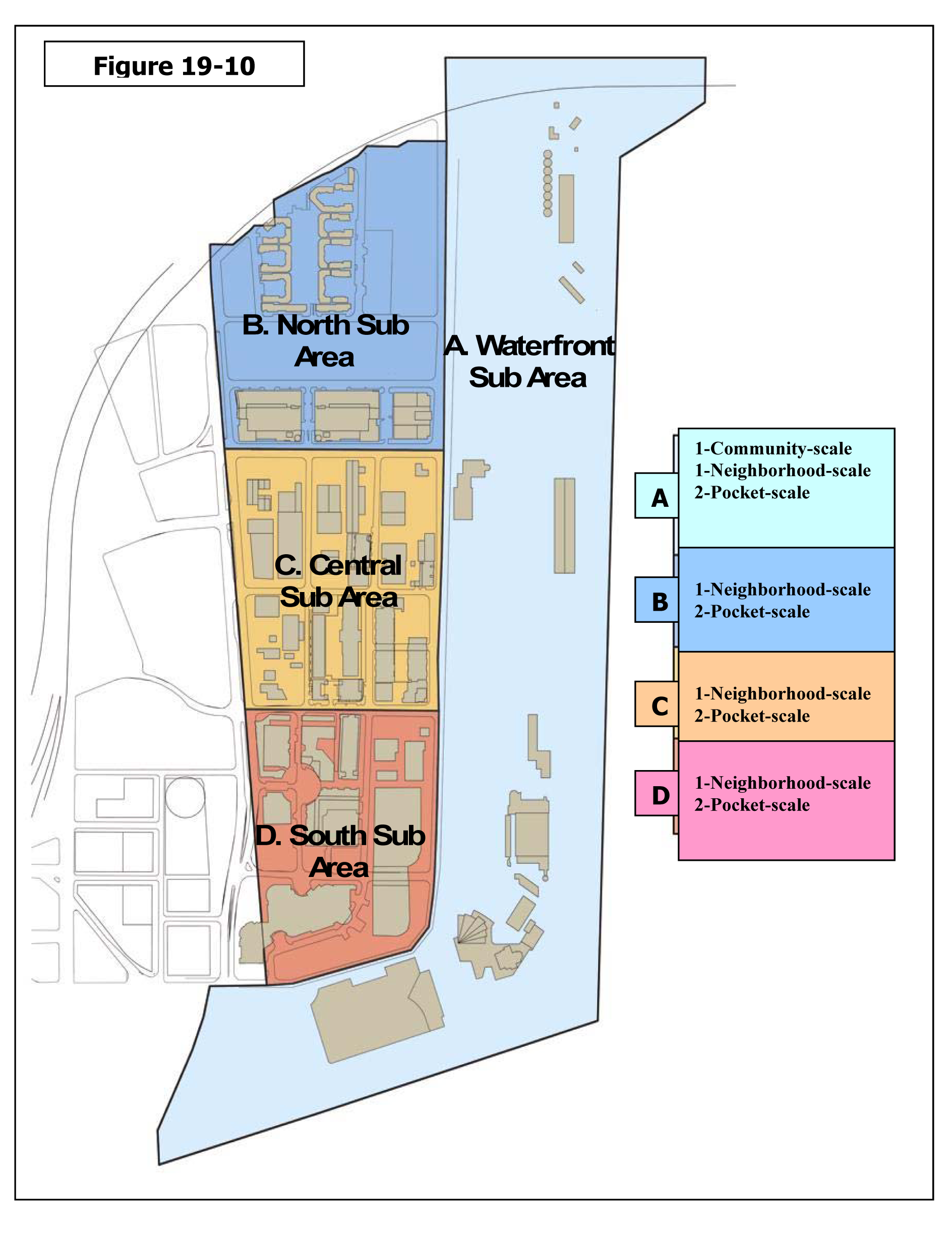
(b)
For those developments that propose public open space amenities to obtain bonus FAR, in accordance to this section, the minimum standards and design concepts shall apply:
(1)
Community-scale space shall be a minimum of two (2) acres and shall follow the general design concept of Figure 19-11:
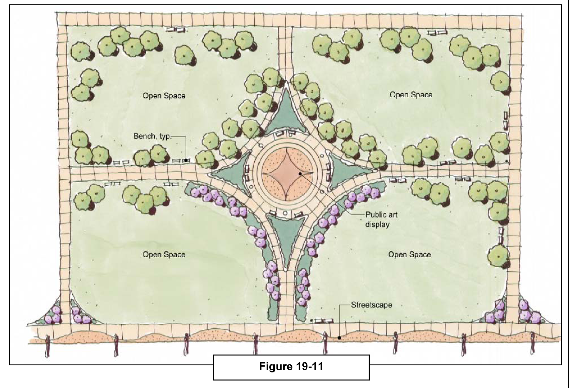
(2)
Neighborhood-scale space shall be a minimum of one-half (0.5) acres and shall follow the general design concept of Figure 19-12:
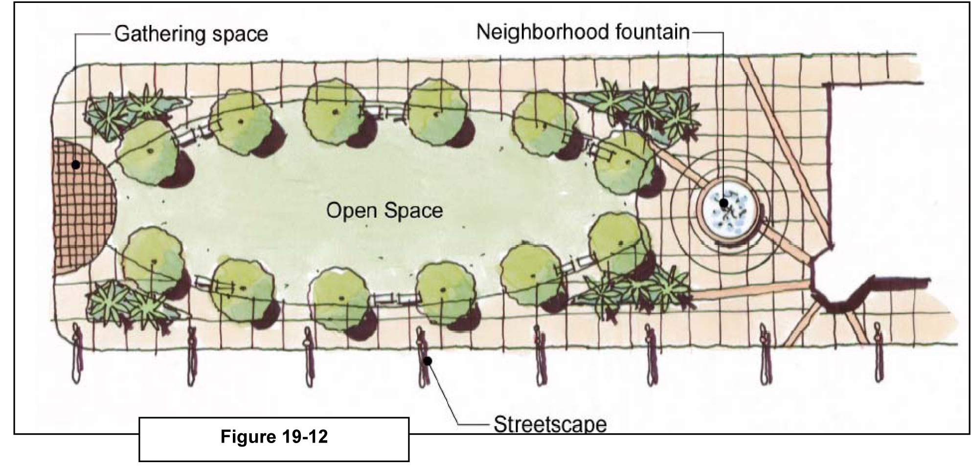
(3)
Pocket-scale space shall be a minimum of one-tenth (0.10) acre and shall follow the general design concept of Figure 19-13:
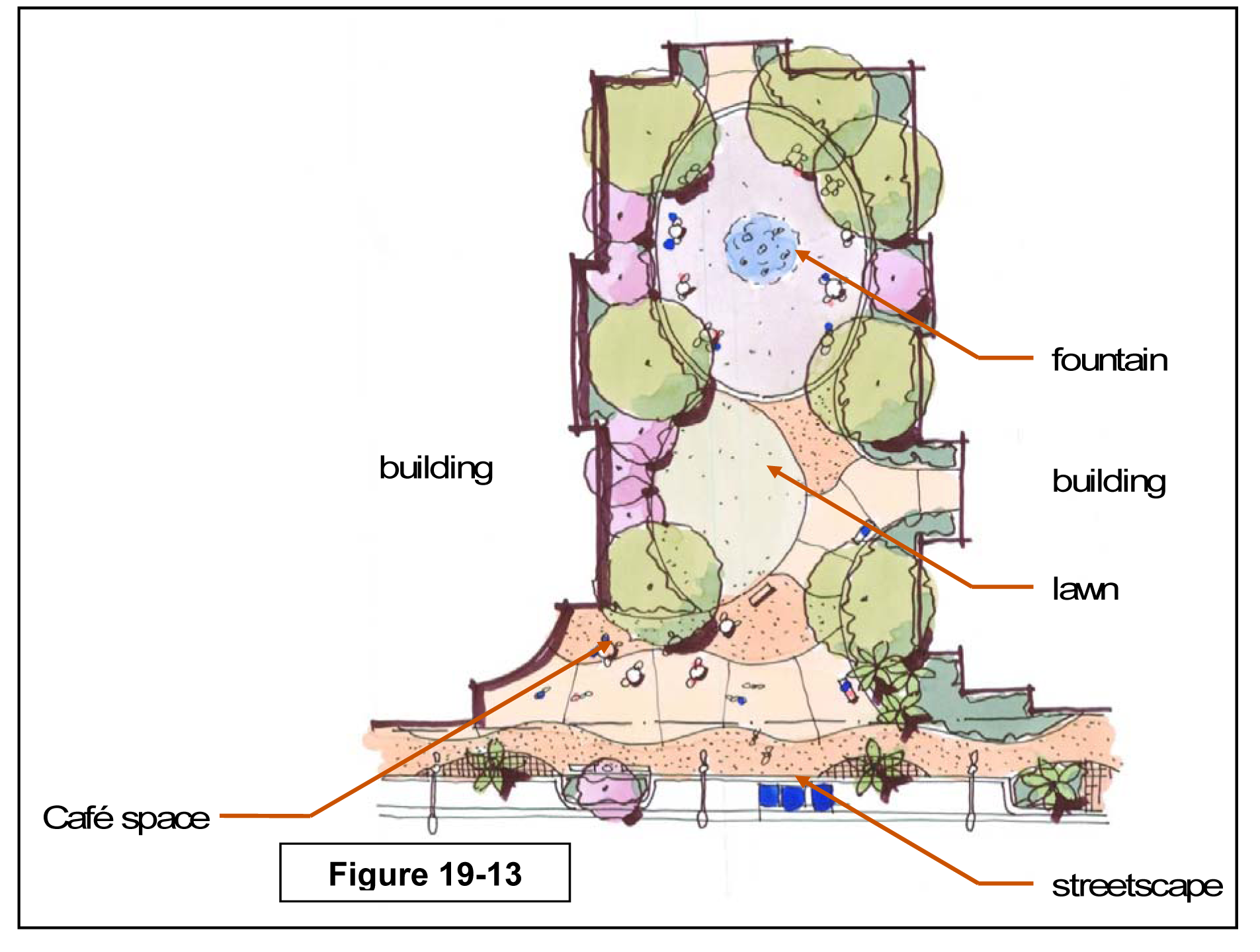
Sec. 27-206. - Channel District bonus methodology and calculation; list of bonus amenities.
Compliance. All developments that seek density/intensity bonuses within the Channel District shall adhere to the regulations set forth in section 27-140. Unless otherwise permitted by this chapter, developments that have been granted bonuses by city council, per the provisions of this section, shall not be granted any further administrative increase in floor area, unit count, or building height through section 27-138 substantial change.
(Ord. No. 2016-58, § 7, 4-21-2016)
Sec. 27-211. - The Greater Seminole Heights Vision; establishment of district boundaries.
(a)
Description of area. The established boundaries of the district are as follows:
From the centerline of the Hillsborough River, beginning at Dr. Martin Luther King, Jr. Blvd, running north and east to the centerline of 22nd Street; thence running south to the centerline of Hillsborough Avenue; thence running west to the centerline of 15th Street; thence running south to the centerline of Dr. Martin Luther King, Jr. Blvd; thence running west to the centerline of the Hillsborough River, to the point of beginning.
(b)
Purpose. The purpose and intent of this article is to ensure that all development is compatible in form, building and structural orientation, general site layout, height, lot dimensional requirements and other site spatial relationships to the precedent within the established block and generally, the surrounding area.
Furthermore, it is the purpose and intent of the Tampa Comprehensive Plan, and of this article, which aids in implementing it, to promote the public health, safety, comfort, amenities, prosperity, and general welfare of the city; and to provide, among other matters, a wholesome, serviceable, and attractive community; to help foster a more favorable environment in which to live, work, and play; to ensure that there is a seamless integration between private property and the public realm; to regulate the use, construction and maintenance of the public realm (including but not limited to streets, alleys, sidewalks, street lights); to regulate the use and development of land; to provide regulations, which allow and encourage creativity, effectiveness, and flexibility in the design and use of land while promoting traffic safety and avoiding an environment that encourages visual blight; to protect trees, wetlands, and natural resources by regulating the trimming or removing of trees, site clearing, landscaping, tree planting, and irrigation in the district.
(c)
Compliance. All requests for zoning changes, new development, new construction, major renovation, change of use, and increase in intensity of use shall be required to comply with the applicable development standards set forth in this article. In cases of conflict, the standards set forth in this article shall apply. For those development issues not addressed in this article, the underlying requirements of Chapter 27 Zoning (such as Article IV, Division 1, Article VI, Divisions 2 and 3) and other applicable land development regulations of the Tampa City Code shall apply.
(d)
Vision Map. The future land use pattern and growth of the district is guided by the Vision Map and the Future Land Use Map, as set forth and described in the Greater Seminole Heights Vision Plan and the Tampa Comprehensive Plan respectively.
(e)
Nodes. The district contains two (2) types of nodes: Neighborhood Scale (¼ mile) and Community Scale (½ mile). Each node represents an area of potential redevelopment with density and/or intensity increase(s), as set forth in the Tampa Comprehensive Plan and Greater Seminole Heights Vision Plan. The potential increase in density/intensity is subject to the list of bonus amenities and bonus methodology and calculation set forth in section 27-140.
(f)
Connectivity Map. The Connectivity Map, known as "Map SH-25.3," hereby establishes the priority pedestrian and bicycle corridors for the district. Any funds, including capital expenditures and inlieu fees that are slated for corridor improvements related to pedestrian and bicycle enhancements, shall be targeted to the corridors identified on this map. Once all identified corridors are enhanced, other corridors may receive funding for similar enhancements. This map may be amended from time to time to address changing needs of the district.
(g)
Public realm. Integration of the public and private realm is imperative in creating and sustaining a livable place. The street cross sections contained in this Overlay District set forth the basic, minimum standard for widths and locations of sidewalks, bicycle lanes, on street parking, travel lanes, and tree plantings within the public realm.
(Ord. No. 2016-58, § 8, 4-21-2016)
Sec. 27-211.1. - General administrative procedures.
(a)
Determination of uses not listed shall be reviewed according to the provisions of section 27-59.
(b)
For those development issues not addressed in this article, the underlying requirements of this chapter (such as Article IV, Division 1, Article VI, Divisions 2 and 3) and other applicable land development regulations of the Tampa City Code shall apply.
(c)
Alternative design exceptions to the standards set forth in the article may be considered by the zoning administrator, subject to section 27-60.
(d)
Any person aggrieved by any order, requirement, decision, or determination of the zoning administrator with regard to these design standards may request review of that order, requirement, decision, or determination in accordance with section 27-61.
(e)
Plan review shall be performed consistent with the applicable plan review procedure, construction plan review, alternative design exception, and/or concurrency.
(Ord. No. 2018-117, § 1(Exh. A), 8-2-2018)
Sec. 27-211.2. - Establishment of the Regulating Map; establishment of sub-districts and associated general land development regulations by sub-district and development form.
(a)
The Regulating Map derives its zoning and development authority through section 27-23. The base layer of the Regulating Map is the Zoning Atlas. Each additional layer represents a regulatory mechanism that directly relates to development layout, building form and/or design character, geographical location, and relationships of these development characteristics to the public realm. The Regulating Map shall be kept on file with the zoning administrator. The layers of the Regulating Map are as follows:
(1)
Map SH-25.1: Residential Building Form.
(2)
Map SH-25.2: Frontage Types.
(3)
Map SH-25.3: Public Realm/Connectivity Map.
(b)
Sub-districts. The following SH (Seminole Heights) sub-districts shall be the only zoning districts permitted within the Greater Seminole Heights District:
(1)
SH-RS: Single-family detached residential (refer to section 27-211.2.1).
(2)
SH-RS-A: Single-family attached residential (refer to section 27-211.2.2).
(3)
SH-RM: Multi-family residential (refer to section 27-211.2.3).
(4)
SH-RO: Residential office (refer to section 27-211.2.4).
(5)
SH-CN: Commercial neighborhood (refer to section 27-211.2.5).
(6)
SH-CG: Mixed use, commercial general (refer to section 27-211.2.6).
(7)
SH-CI: Mixed use, commercial intensive (refer to section 27-211.2.7).
(8)
SH-PD: Planned development (refer to Article III, Division 3 for site plan zoning district requirements and procedures).
(c)
Permitted uses are organized and listed by zoning district in Table SH-25.1
(Ord. No. 2011-45, § 1(Exh. B), 3-24-2011; Ord. No. 2018-117, § 1(Exh. A), 8-2-2018)
Sec. 27-211.2.1. - General District Development Standards for Seminole Heights - Residential Single-family detached (SH-RS) district.
(a)
Building placement, form and layout standards: all development shall comply with development standards set forth below: Graphic 211.2.1a
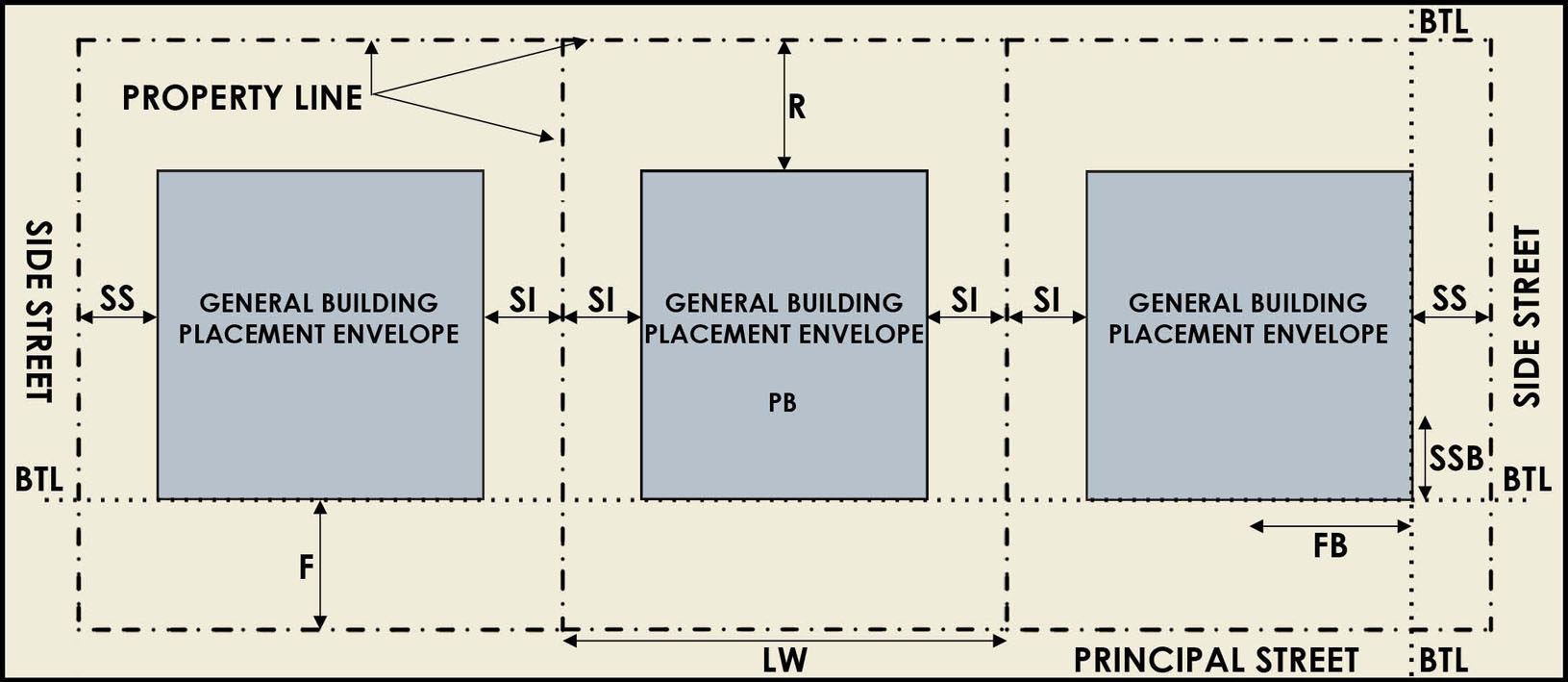
(b)
Use and general building standards: all development shall comply with development standards set forth below: Graphic 211.2.1b Depicts an example 1-story and 2-story residential single-family detached cross section.
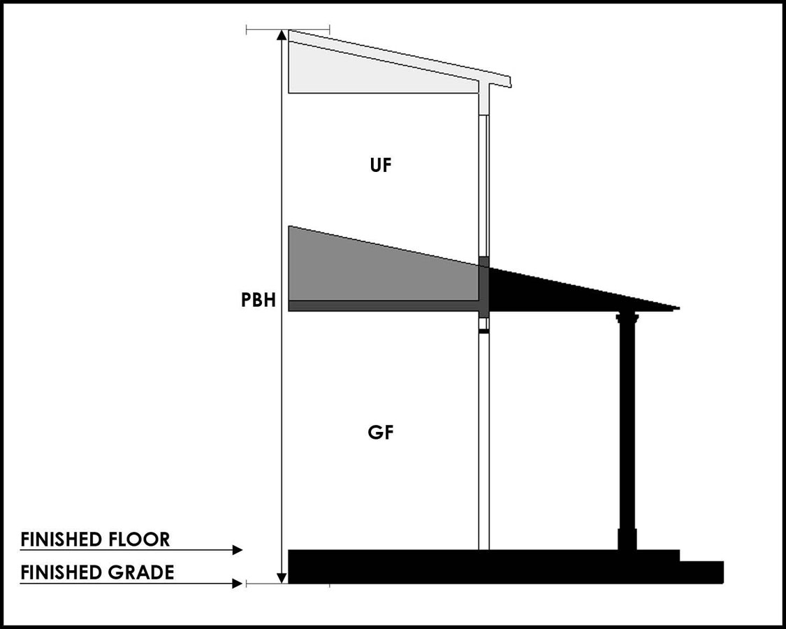
(c)
Parking placement, layout, and general ratio standards: all development shall comply with development standards set forth below: Graphic 211.2.1c
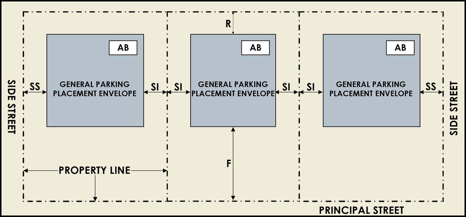
(Ord. No. 2011-45, § 1(Exh. B), 3-24-2011; Ord. No. 2018-117, § 1(Exh. A), 8-2-2018)
Sec. 27-211.2.2. - General District Development Standards for Seminole Heights Residential Single-family attached (SH-RS-A) district.
(a)
Building placement, form, and layout standards: all development, including semi-detached and two-family, shall comply with development standards set forth below: Graphic 211.2.2a
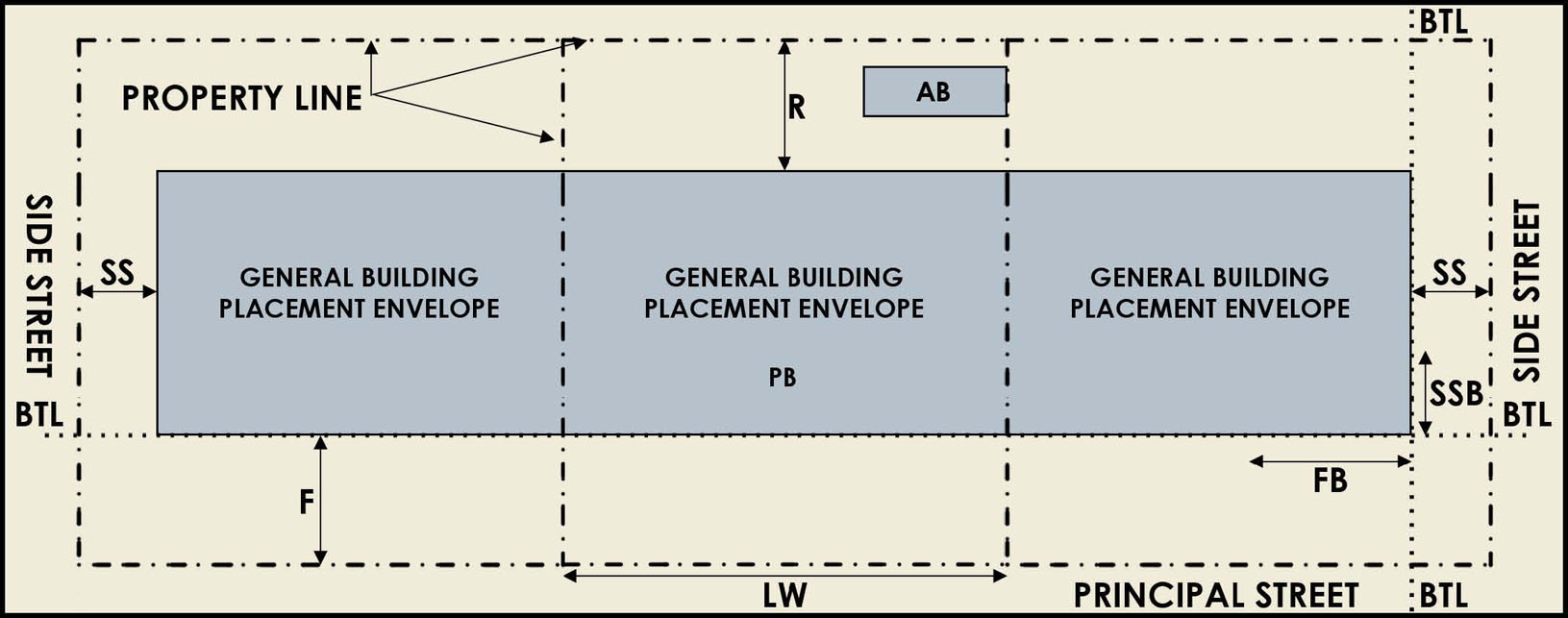
(b)
Use and general building standards: all development shall comply with development standards set forth below: Graphic 211.2.2b: Depicts an example 1-story, 2-story, and 3-story residential single-family attached cross section.
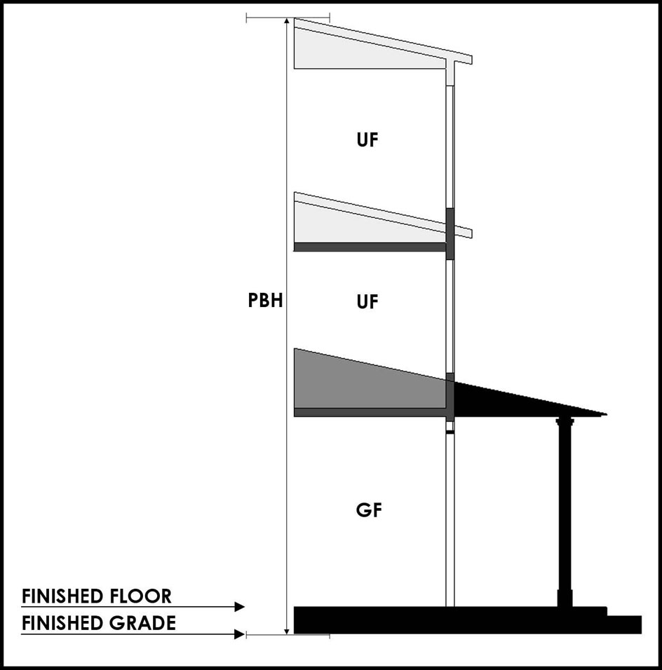
(c)
Parking placement, layout, and general ratio standards: all development shall comply with development standards set forth below: Graphic 211.2.2c:
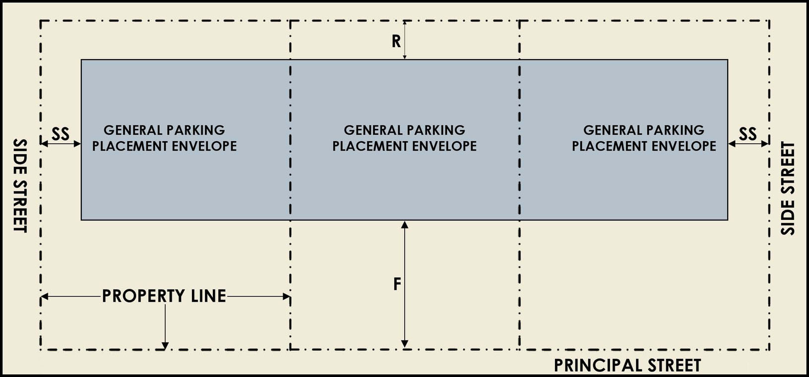
(Ord. No. 2011-45, § 1(Exh. B), 3-24-2011)
Sec. 27-211.2.3. - General District Development Standards for Seminole Heights - Residential Multi-family (SH-RM) district.
(a)
Building placement, form, and layout standards: all development shall comply with development standards set forth below. Two-family, attached, and semi-detached residential shall adhere to the SHRS-A development standards: Graphic 211.2.3a:

(b)
Use and general building standards: all development shall comply with development standards set forth below: Graphic 211.2.3b: Depicts an example 1-story, 2-story, and 3-story residential multi-family cross section.

(c)
Parking placement, layout, and general ratio standards: all development shall comply with development standards set forth below: Graphic 211.2.3c:

Sec. 27-211.2.4. - General District Development Standards for Seminole Heights - Residential-Office (SH-RO) district.
(a)
Building placement, form, and layout standards: all development shall comply with development standards set forth below. Single-family, detached residential shall adhere to the SH-RS development standards. Semi-detached, two-family, and attached residential shall adhere to the SH-RS-A development standards: Graphic 211.2.4a:
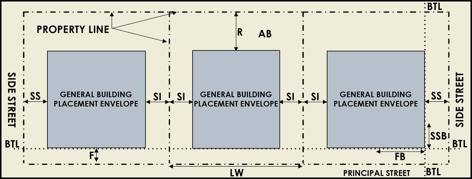
(b)
Use and general building standards: all development shall comply with development standards set forth below: Graphic 211.2.4b: Depicts an example of 1-story, 2-story, and 3-story residential-office cross-section.

(c)
Parking placement, layout, and general ratio standards: all development shall comply with development standards set forth below: Graphic 211.2.4c:
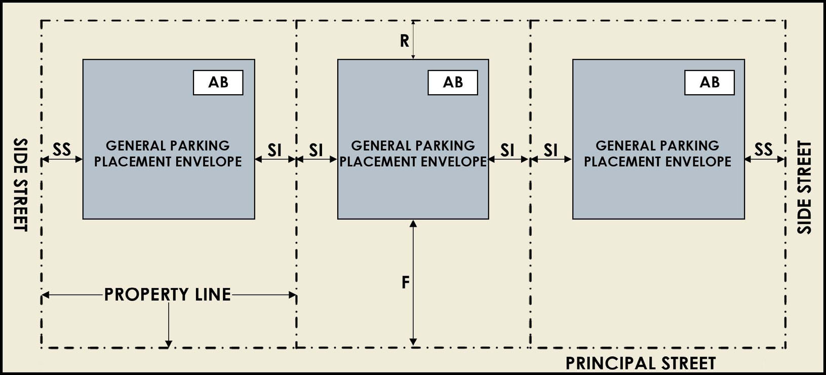
(Ord. No. 2011-45, § 1(Exh. B), 3-24-2011)
Sec. 27-211.2.5. - General District Development Standards for Seminole Heights - Commercial Neighborhood (SH-CN) district.
(a)
Building placement, form, and layout standards: all development shall comply with development standards set form below. Single-family detached residential shall adhere to the development standards of SH-RS. Semi-detached, attached, and two-family residential shall adhere to the development standards of SH-RS-A. Multi-family residential shall adhere to the development standards of SH-RM: Graphic 211.2.5a
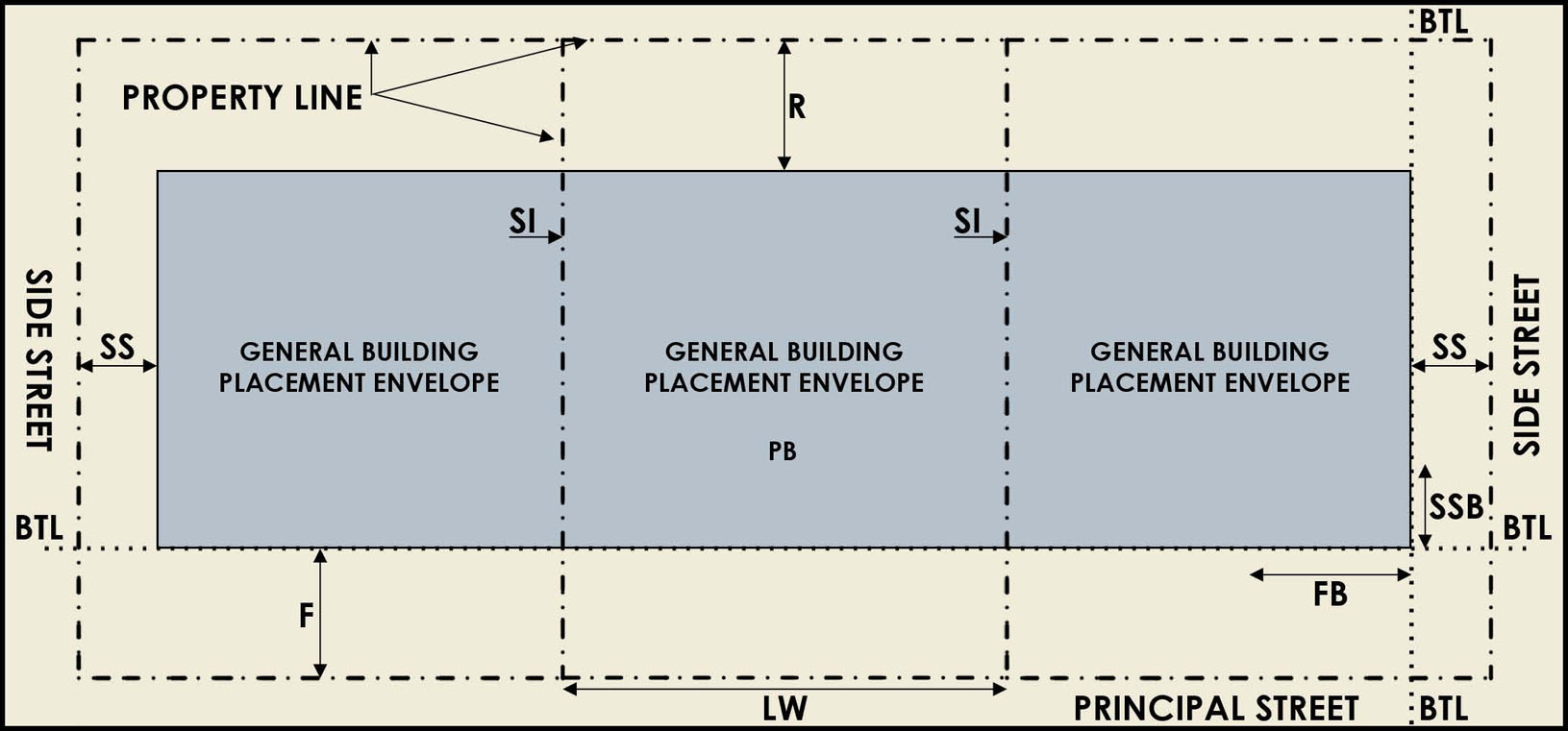
(b)
Use and general building standards: all development shall comply with development standards set forth below: Graphic 211.2.5b Depicts an example of a 1-story, 2-story, and 3-story office cross-section.

(c)
Parking placement, layout, and general ratio standards: all development shall comply with development standards set forth below: Graphic 211.2.5c

(Ord. No. 2011-45, § 1(Exh. B), 3-24-2011)
Sec. 27-211.6. - Development Standards for Commercial, Mixed-Use, or other Non-Residential (SH-CG and SH-CI) development.
(a)
Building placement, form, and layout standards: all development shall comply with development standards set forth below. Single-family detached residential shall adhere to the development standards of SH-RS. Semi-detached, attached, and two-family residential shall adhere to the development standards of SHRS-A Multi-family residential shall adhere to the development standards of SH-RM. Graphic 211.6a
(b)
Use and general building standards: all development shall comply with development standards set forth below: Graphic 211.6b Depicts an example of a 1-story, 2-story, 3-story, and 4-story commercial/mixed use cross-section.
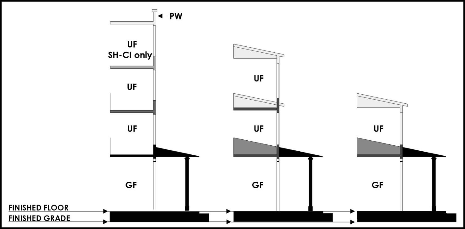
(c)
Parking placement, layout, and general ratio standards: all development shall comply with development standards set forth below: Graphic 211.6c
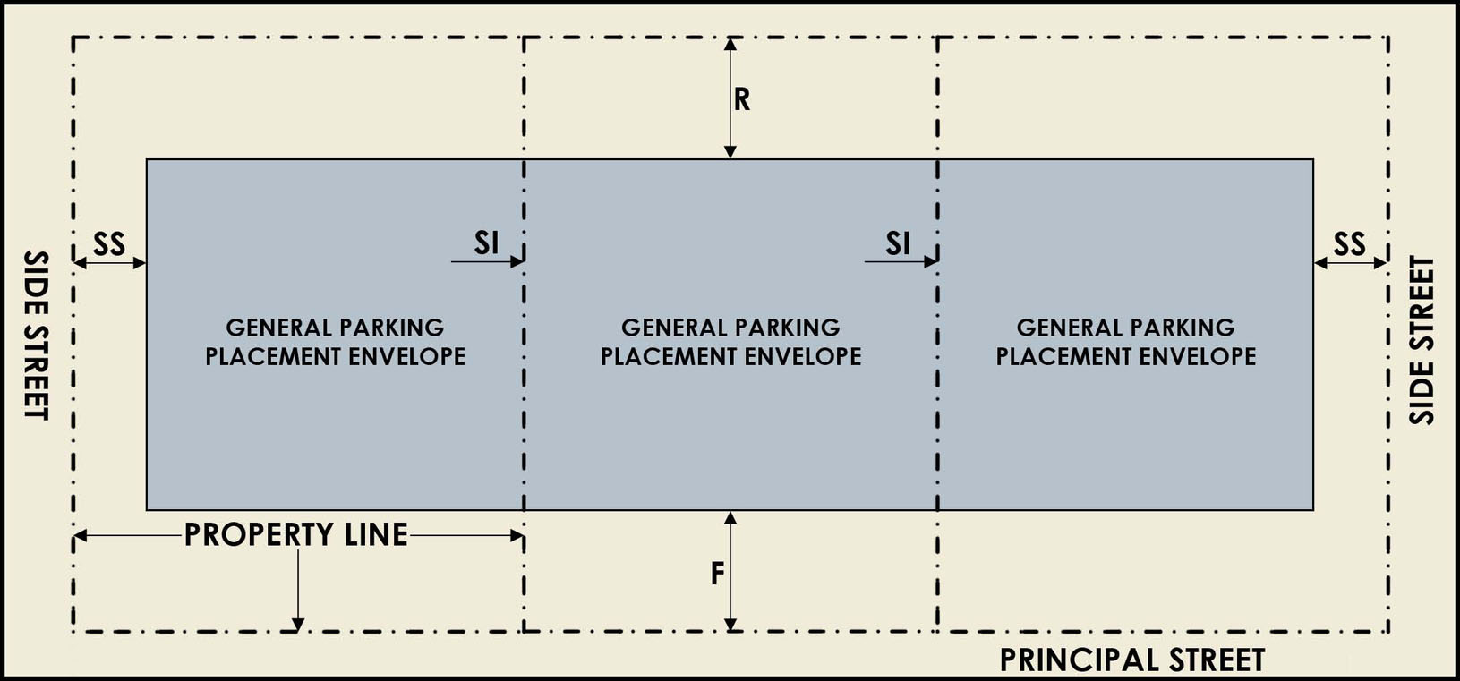
(Ord. No. 2023-128, § 4, 9-21-2023)
Sec. 27-211.7. - Residential Building Forms.
(a)
All residential development within the Seminole Heights district shall refer to Map SH-25.1 for residential building form type, and shall adhere to the applicable form standards set forth below. Requirements of this section do not apply to residential properties that lie within the Seminole Heights Local Historic District. Resources: McAlester, Virginia and Lee. A Field Guide to American House; Paradis, Thomas W. "ARCHITECTURAL STYLES of AMERICA." Web. 22 Nov. 2010
(b)
For those properties identified on Map SH-25.1 as "Craftsman/Southern Vernacular", the applicant may choose one (1) form-type from the following residential building forms:
(1)
Craftsman (CT) [211.7.1].
(2)
National Folk (NF) [211.7.2].
(3)
American Four Square (AFS) [211.7.3].
(4)
Folk Victorian (FV) [211.7.4].
(5)
Queen Anne (QA) [211.7.5].
(6)
Prairie (P) [211.7.6].
(c)
For those properties identified on Map SH-25.1 as "Ranch/Transitional Ranch", the applicant may choose one (1) form-type from the following residential building forms:
(1)
Ranch (RH) [211.7.7].
(2)
Minimal Traditional (MT) [211.7.8].
(3)
Contemporary Modern (CM) [211.7.9].
(4)
Split Ranch (SR) [211.7.10].
(d)
For those properties identified on Map SH-25.1 as "Eclectic", the applicant may choose one (1) form-type from the following residential building forms:
(1)
Spanish Eclectic (SE) [211.7.11].
(2)
Any other residential building form set forth in subsection (b) above.
(3)
Within "Hampton Terrace" boundary, as shown on Map SH-25.1, "Eclectic" designation shall also include any residential building form set forth in (b), (c), or (d)(1) above.
Form Description and Graphics 211.7.1: (CT) Craftsman (Arts & Crafts)
Characterized by square plans with low-pitched gables (occasionally gables are clipped)
or hipped roofs, with wide, unenclosed eave overhang. Roof rafters are usually exposed;
shed dormers and decorative (false) beams or braces are common. Windows are double
hung-sash with three or more vertical lights in the top sash. Craftsman bungalows
have large broad porches which usually extend across the front façade (may wrap around
one side) and are supported by substantial columns resting on stone, frame or brick
piers.
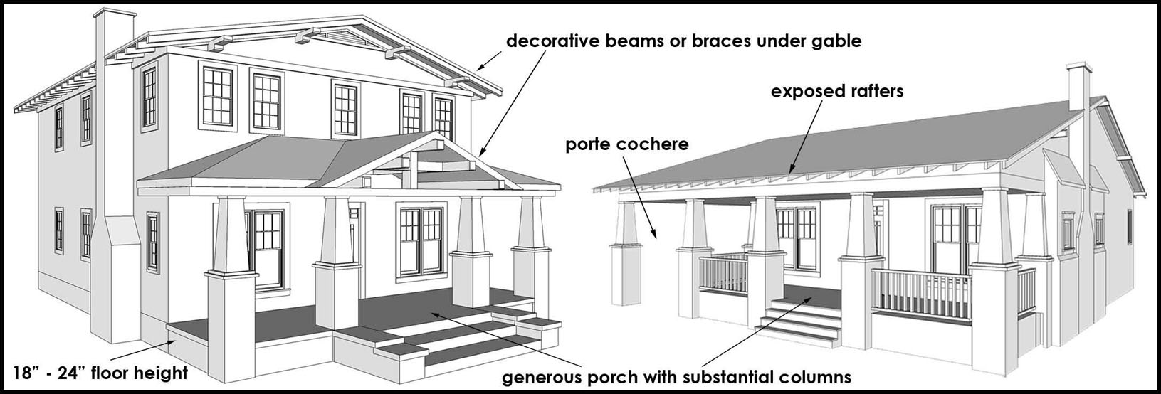
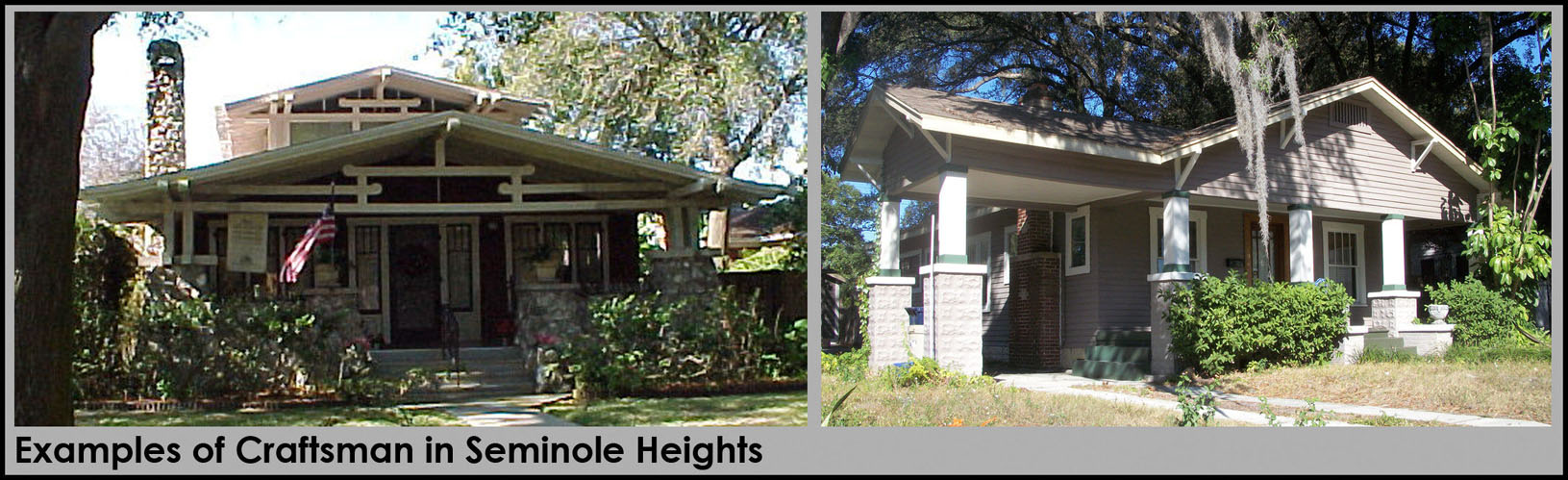
Form Description and Graphics 211.7.2: (NF) National Folk (Southern Vernacular)
Characterized by simple lines, materials and form. The basic forms are described as
gable-front, gable-front and wing, hall-and-parlor, I-house, side-gabled, and pyramidal
family. (In Seminole Heights, it is common to find a national folk form with a craftsman
porch attached.)
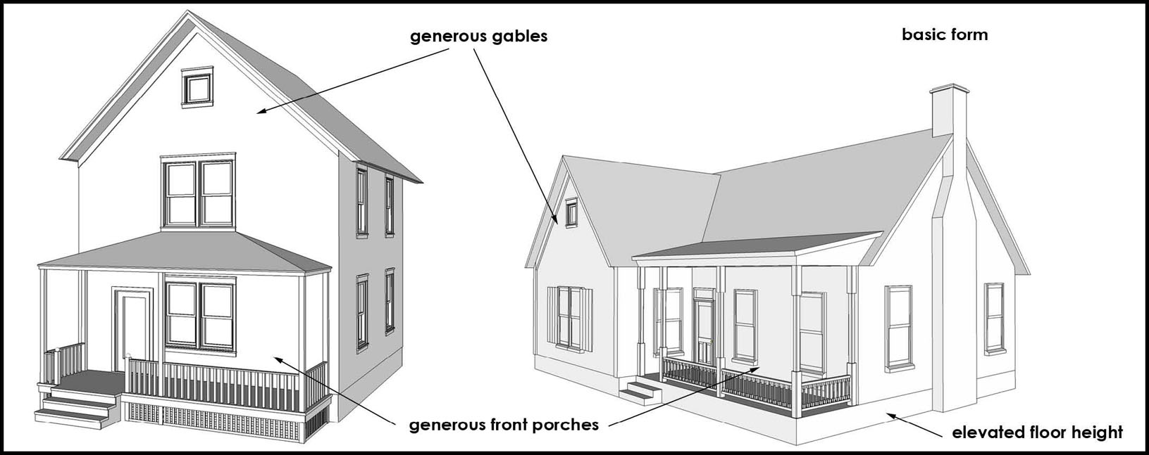
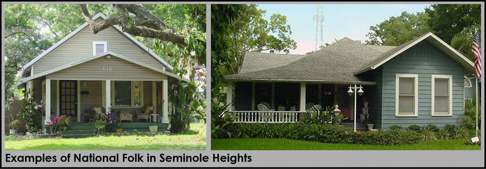
Form Description and Graphics 211.7.3: (AFS) American Four Square
Characterized by a simple, four-square folk plan with a low-pitched hipped or pyramidal
roof and symmetrical façade. A central dormer is common.
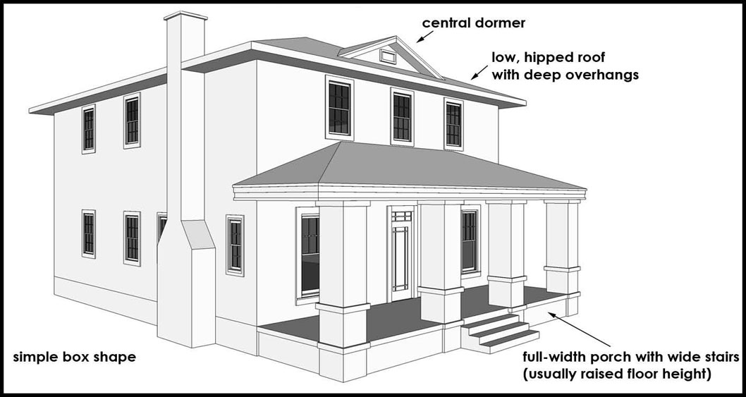
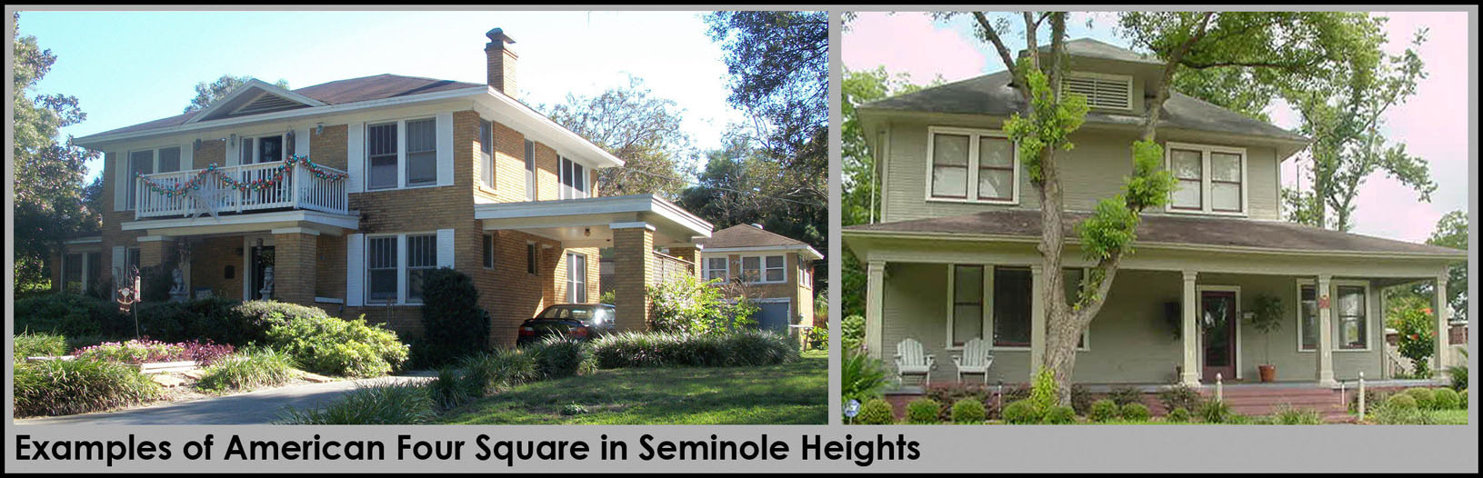
Form Description and Graphics 211.7.4: (FV) Folk Victorian
Characterized by the presence of Victorian decorative detailing on simple folk house
forms (vernacular), which are generally much less elaborate than the Victorian styles.
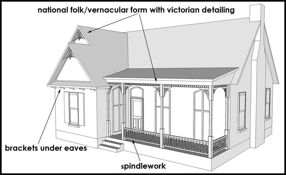
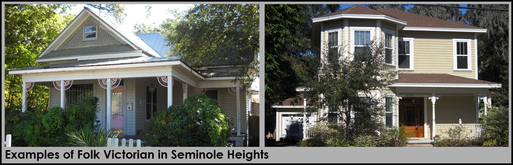
Form Description and Graphics 211.7.5: (QA) Queen Anne
Characterized by steeply pitched roofs of irregular shapes, usually with a dominant
front-facing gable. Queen Annes will often exhibit bay windows and other devices used
to avoid continuous straight walls. Some Queen Annes are lavished with gingerbread,
while some are made of brick or stone and exhibit much simpler details; many have
turrets. The overall façade of the house is asymmetrical.
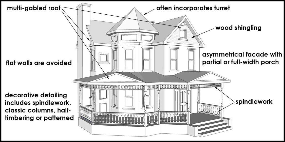
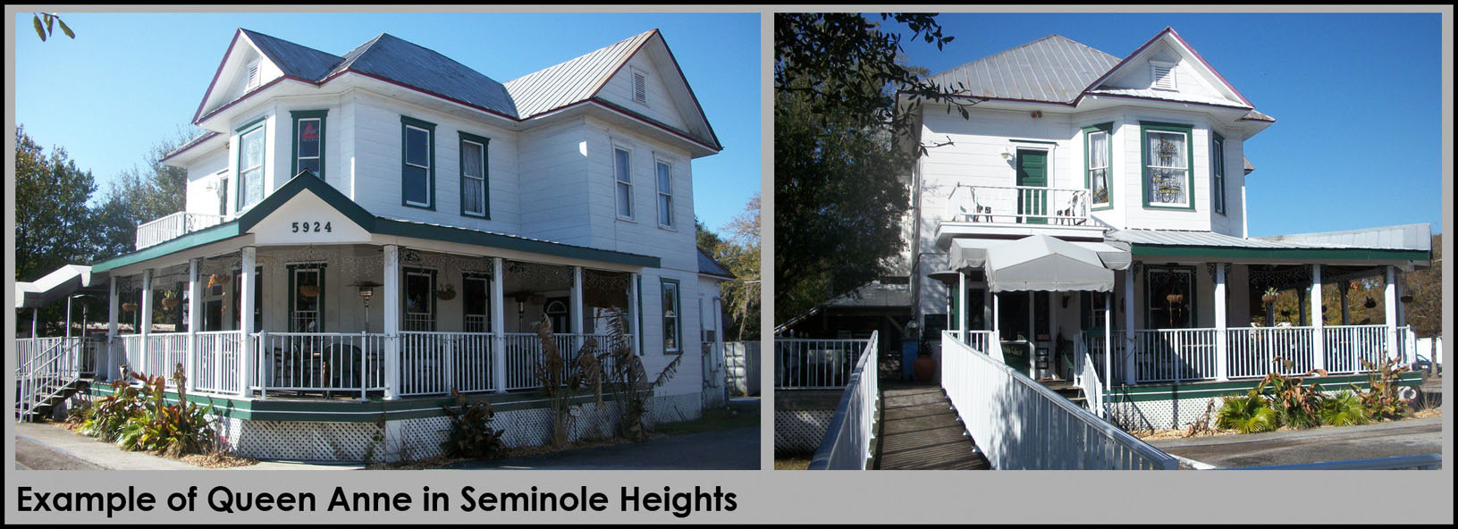
Form Description and Graphics 211.7.6: (P) Prairie
Characterized by low-pitched roof, usually hipped, with widely overhanging eaves;
typically two-stories, with one-story wings or porches. Eaves, cornices, and façade
detailing is quite simple and emphasizes horizontal lines; often with substantial,
square porch supports.
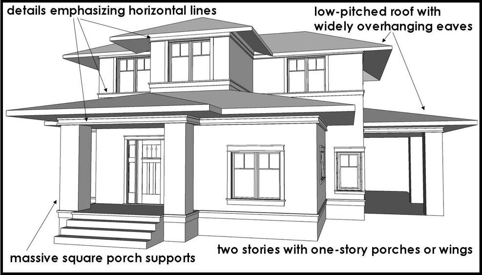
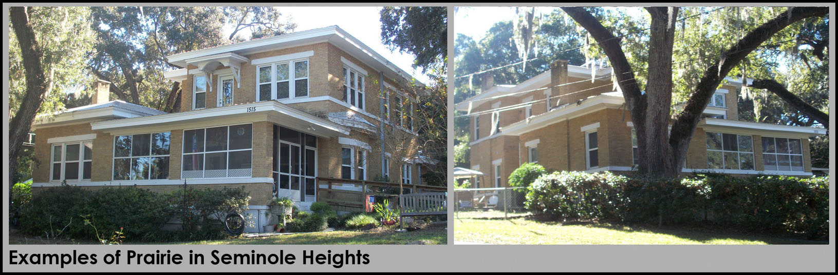
Form Description and Graphics 211.7.7: (RH) Ranch
Characterized by its long, close-to-the-ground profile, and minimal use of decoration,
garages are an integral part of the house. Asymmetrical one-story shapes with low-pitched
roofs dominate. Three common roof forms are used: hipped, cross-gables, and side-gabled.
Usually a moderate or wide eave overhang.
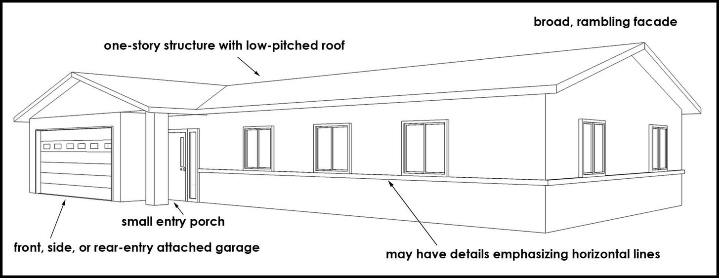
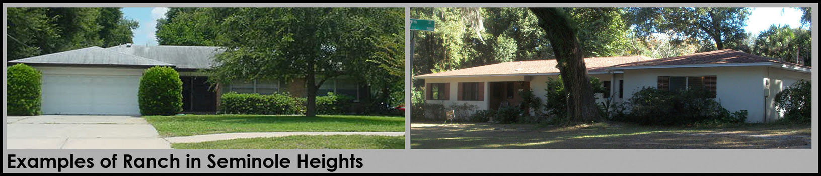
Form Description and Graphics 211.7.8: (MT) Minimal Traditional
Characterized by a simplified form loosely based on the Tudor style of the 1920s and
'30s, the steep Tudor roof pitch may be lower and the façade is simplified by omitting
most of the traditional detailing. Generally has a dominant front gable.
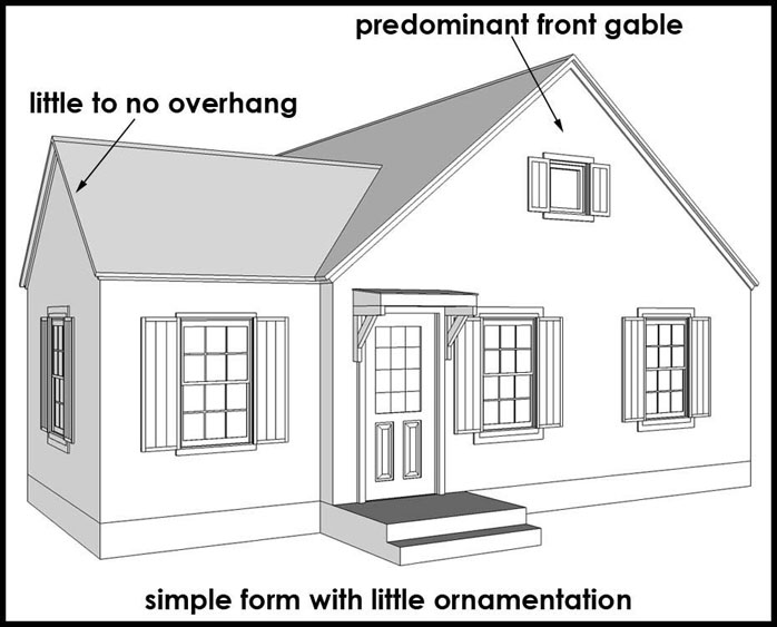
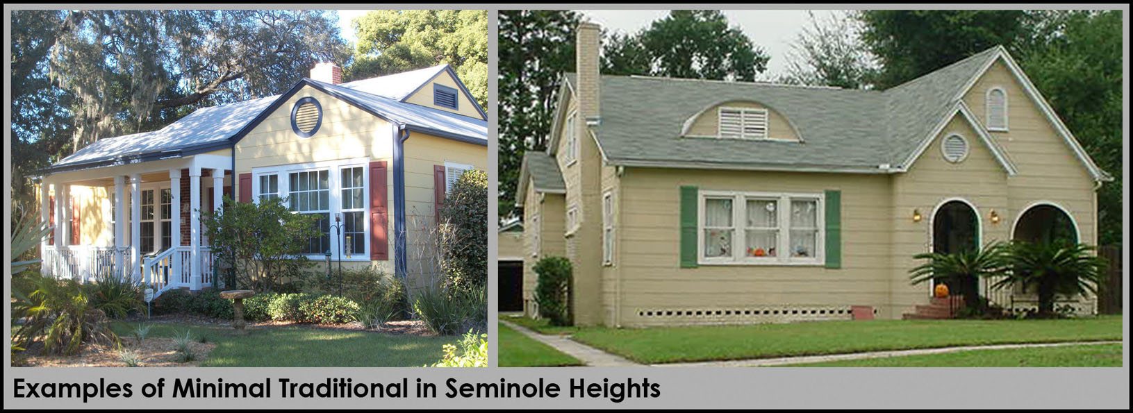
Form Description and Graphics 211.7.9: (CM) Contemporary Modern
Characterized by ample windows and flat or low-sloped roofs (or a combination of the
two). Entry porches are usually small and may or may not be covered.
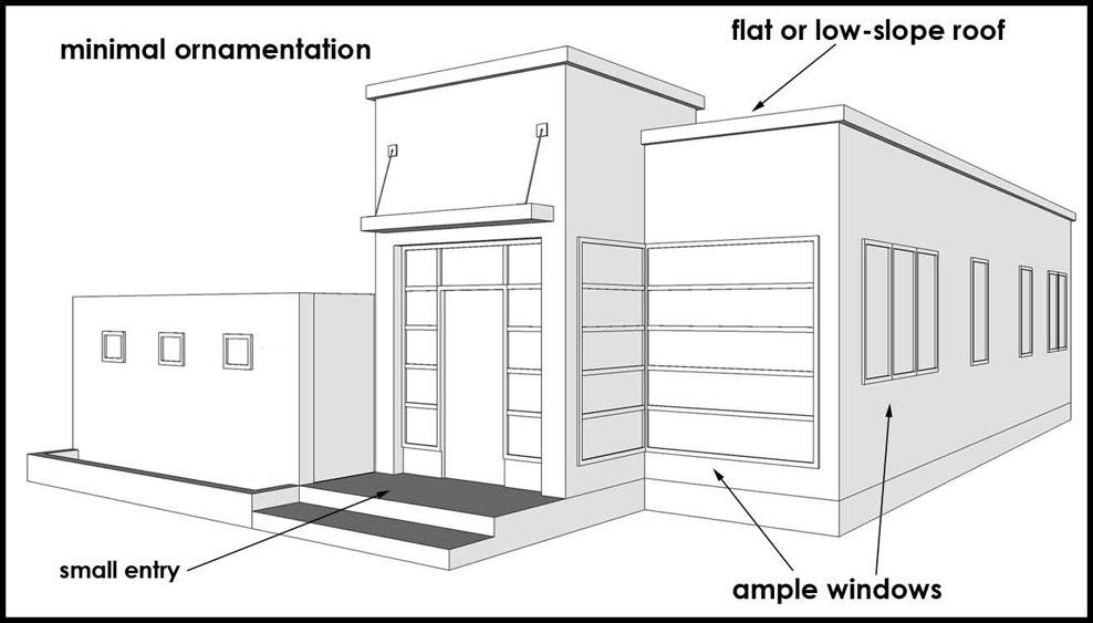
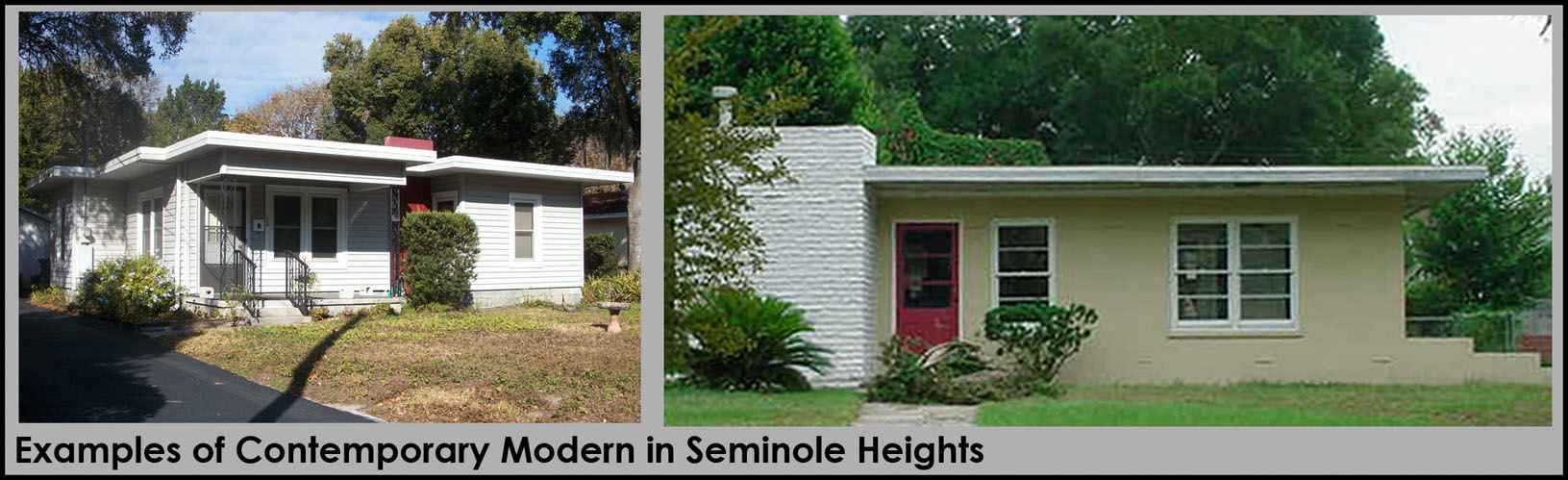
Form Description and Graphics 211.7.10: (SR) Split Ranch
Characterized by a multi-story modification of the one-story Ranch style. A two-story
unit is intercepted at mid-height by a one-story wing to make three floor levels of
interior space. Architectural detailing is based on a variety of architectural styles.
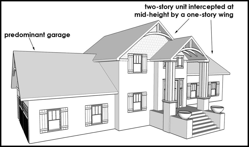
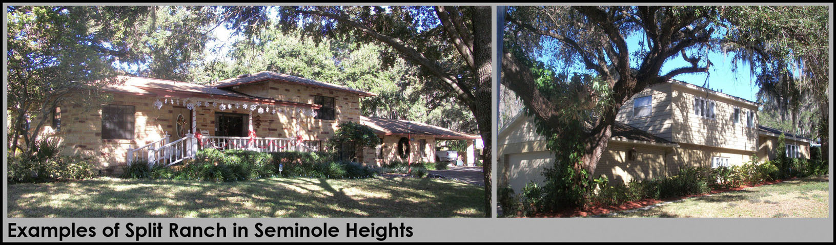
Form Description and Graphics 211.7.11: (SE) Spanish Eclectic (Mediterranean Revival,
Mission, Pueblo)
Characterized by tile roofs, stucco walls and round-arched windows and doorways. House
forms vary; however they are based on a rectangular floor plans. Ornamentation can
range from simple to dramatic, and may draw from a number of Mediterranean references.
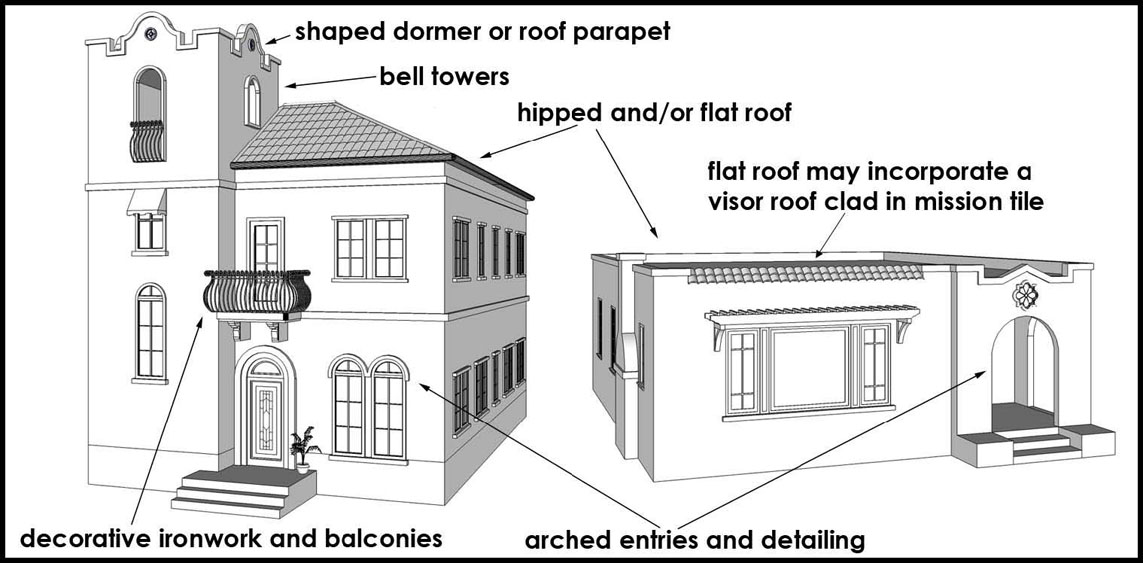
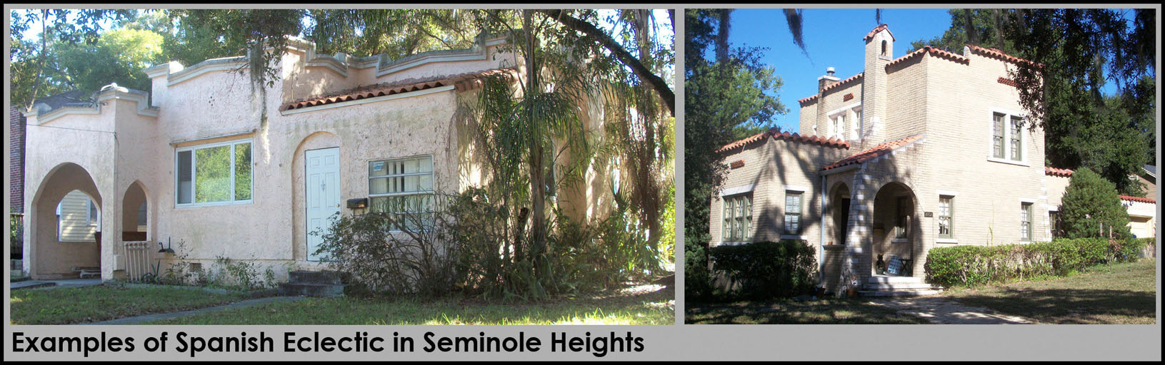
(Ord. No. 2014-87, § 2, 9-18-2014)
Sec. 27-211.8. - Schedule of permitted uses by district.
Table 25-1 sets forth the permitted, special, and accessory uses by zoning district. All lands within the Greater Seminole Heights area shall adhere to this table. Any uses not listed shall be subject to zoning administrator review, pursuant to section 27-59.
(Ord. No. 2013-73, § 9, 6-6-2013; Ord. No. 2013-101, § 4, 7-18-2013; Ord. No. 2015-10, § 6, 1-15-2015; Ord. No. 2015-110, § 5, 11-5-2015; Ord. No. 2017-132, § 10, 8-24-2017; Ord. No. 2018-176, § 8, 11-1-2018; Ord. No. 2022-157, § 7, 9-1-2022; Ord. No. 2022-158, § 8, 9-1-2022; Ord. No. 2023-128, § 5, 9-21-2023)
Sec. 27-211.9. - Historic Preservation.
In addition to adherence to the overlay standards for the Greater Seminole Heights Area, all development within the Seminole Heights Historic District shall adhere to the provisions of Article II, Division 4.
Sec. 27-211.10. - Frontage types and other supplemental regulations.
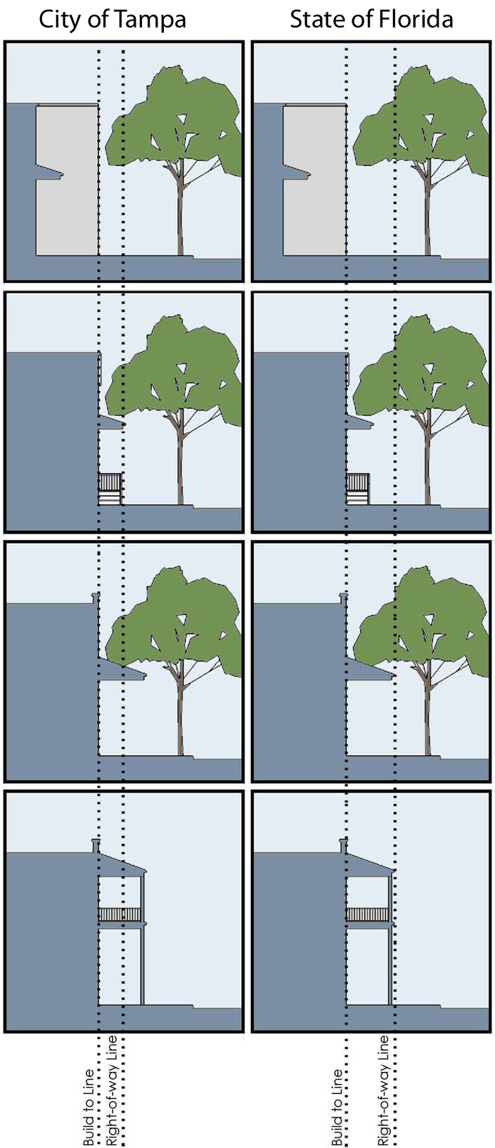
Courtyard: The main façade of the building is placed at the build-to line and a percentage of it is set back (no more than 50%), creating a small court space. The proportions and orientation of these spaces should be carefully considered for solar orientation and user comfort. This frontage type should be used sparingly and should not be repeated within a block. A short wall (no taller than 3' above grade, hedge, or fence shall be placed along the undefined edge.
Stoop: The main façade of the building is placed at the build-to line and the elevated stoop engages/interfaces with the sidewalk. If stairs are used to elevate stoop, the stoop may lead directly to the sidewalk or may be side loaded. The minimum width and depth of the stoop shall be 5 feet. This type is appropriate for residential, non-residential and/or mixed use, subject to appropriate ADA requirements.
Awning, canopy: A frontage wherein the façade is placed at the build-to line with the building entrance at sidewalk grade. This type is conventional for retail/commercial use. It has a substantial glazing/transparency on the sidewalk/pedestrian level and an awning or canopy that may overlap the sidewalk to the maximum extent possible.
Arcade: A frontage wherein the façade is a colonnade that overlaps the sidewalk, while the façade at sidewalk level remains at the build-to line. This type is conventional for retail/commercial uses. The arcade shall be no less than 8 feet in depth and may overlap the whole width of the sidewalk within 2 feet of the curb, as permitted by law.
(a)
All development shall be required to comply with the applicable development standards set forth in this article and article IV, division 1, article VI, divisions 2 and 3 for standards affecting (but not limited to) parking, solid waste enclosure, fences and walls, screen enclosures, air conditioner/mechanical equipment location, tents, etc.
(b)
As of August 30, 2001, pursuant to Ord. No. 2001-192, chain link fences for residential development are prohibited in the district. As of the date of this ordinance, any new chain link fence for non-residential development shall be black, vinyl-coated, and limited to 4' in height along all public rights-of-way (excluding alleys).
Sec. 27-211.11. - Signs.
All signs shall comply with Article VI, Division 6 Signs.
(Ord. No. 2011-45, § 1(Exh. B), 3-24-2011)
Sec. 27-211.12. - Parking design and access management.
(a)
Applicable parking ratios by use:
(b)
Parking Layout.
(1)
Perpendicular spaces (90 degrees)
Standard parking space dimension:
8' × 18'
Drive aisle dimension:
24' (two-way: cars stacked on either side)
10-12' (one-way)
(2)
Angled spaces (45 degrees)
Standard parking space dimension:
Adhere to compact space dimensions set forth in Article VI, Division 3
Drive aisle dimension:
24' (two-way: cars stacked on either side)
10-12' (one-way)
(3)
Parallel spaces (0 degrees).
Parking space dimension:
8' × 22' (interior spaces)
8' × 20' (end spaces)
(c)
Materials. Alternative materials may be considered pursuant to the procedure set forth on section 27-60.
(d)
Access. Access to non-residential parking areas may be located on local streets within and placed no further than 100' of the intersection with an arterial or collector roadway.
(e)
Loading. Required loading shall adhere to section 27-238.15
(Ord. No. 2011-45, § 1(Exh. B), 3-24-2011; Ord. No. 2017-132, § 11, 8-24-2017; Ord. No. 2018-176, § 9, 11-1-2018)
Sec. 27-211.13. - Landscaping.
(a)
General purpose. Preservation of the urban canopy within the Greater Seminole Heights area is not only an invaluable asset to the area residents and businesses' it is a vital part of the City's natural resources. This section provides a diverse and well-suited list of trees for new plantings, while defining appropriately-sized planting areas within parking areas and along property perimeters.
(b)
Applicability. All development shall adhere to the requirements set forth below, and with article VI, division 4, as applicable. The standards set forth below supersede the tree planting requirements of section 27-284.3.3.
(c)
Technical Manual. All development shall adhere to the tree preservation and construction methods of the Tree and Landscape Technical Manual.
(d)
Tree preservation and removal. All development shall preserve, relocate, and/or remove protected and grand trees in accordance with article VI, division 4, subdivisions 2 through 4.
(e)
Required plantings (all landscape materials). In cases of conflict between the general and parking area landscaping, the most restrictive standard applies.
(1)
General site landscaping standards: all development (not including single-family detached, -attached, -semi-detached, or two-family) shall comply with development standards set forth below:
(2)
Parking area landscaping (vehicular use area as defined in section 27-43) standards. All development shall comply with development standards set forth below:
(3)
Acceptable planting materials. Tree selection shall be made from the City Tree Matrix (refer to section 27-284.1.1).
a.
Shade species planting standards:
1.
Shall comply with applicable standards set forth in article VI, division 4;
2.
Minimum four-inch caliper at time of planting.
b.
Understory species planting standards (refer to section 27-284.3.3 for specific requirements for trees and above ground electrical lines):
1.
Shall comply with applicable standards set forth in article VI, division 4;
2.
Minimum three-inch caliper at time of planting.
(Ord. No. 2011-45, § 1(Exh. B), 3-24-2011; Ord. No. 2019-54, § 30, 4-18-2019; Ord. No. 2022-169, § 2, 10-6-2022)
Sec. 27-211.14. - Public Realm.
(a)
General purpose and compliance. The requirements of this section apply to all new streets and to those that may be modified, reconstructed, or retro-fitted. Inclusion of wider sidewalks, bicycle lanes, tree plantings, and narrowed travel lanes shall be a priority and shall be incorporated into all phases of design for improvement of the area.
(b)
ROW Permitting. (refer to Chapter 22)
(c)
Typical street sections. The Greater Seminole Heights area contains a defined and open street grid of varying right-of-way widths with both local and state roads. The following are typical street cross sections that shall apply to new streets and to any future improvements (either public or private as noted in (a) above):
Graphic 27-211.14.1
39' ROW - Typical
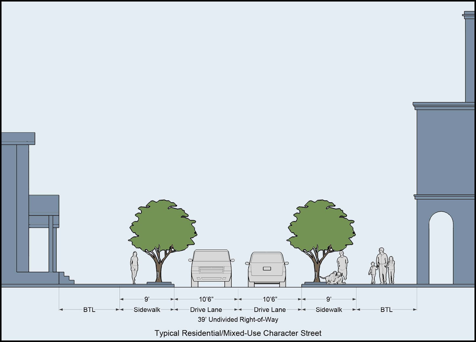
Graphic 27-211.14.2
50' ROW - Typical
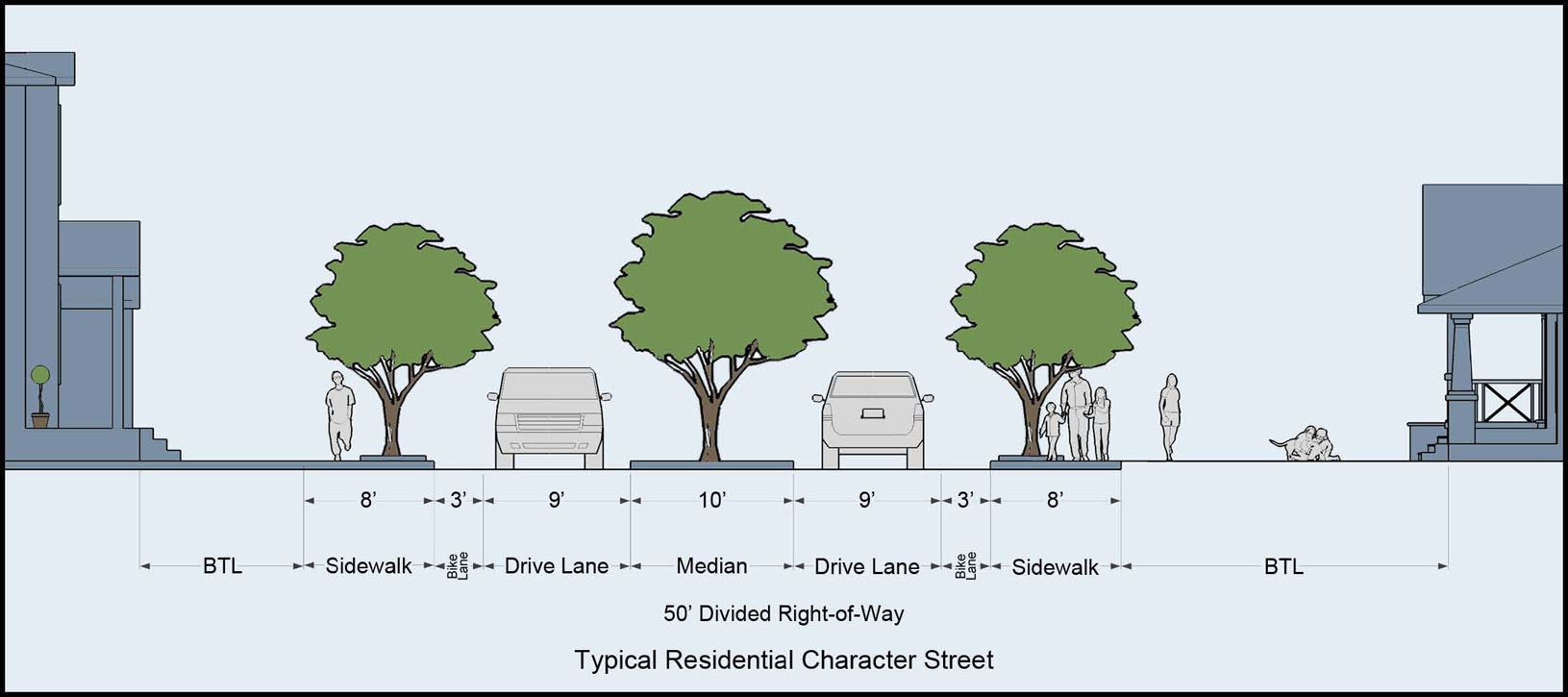
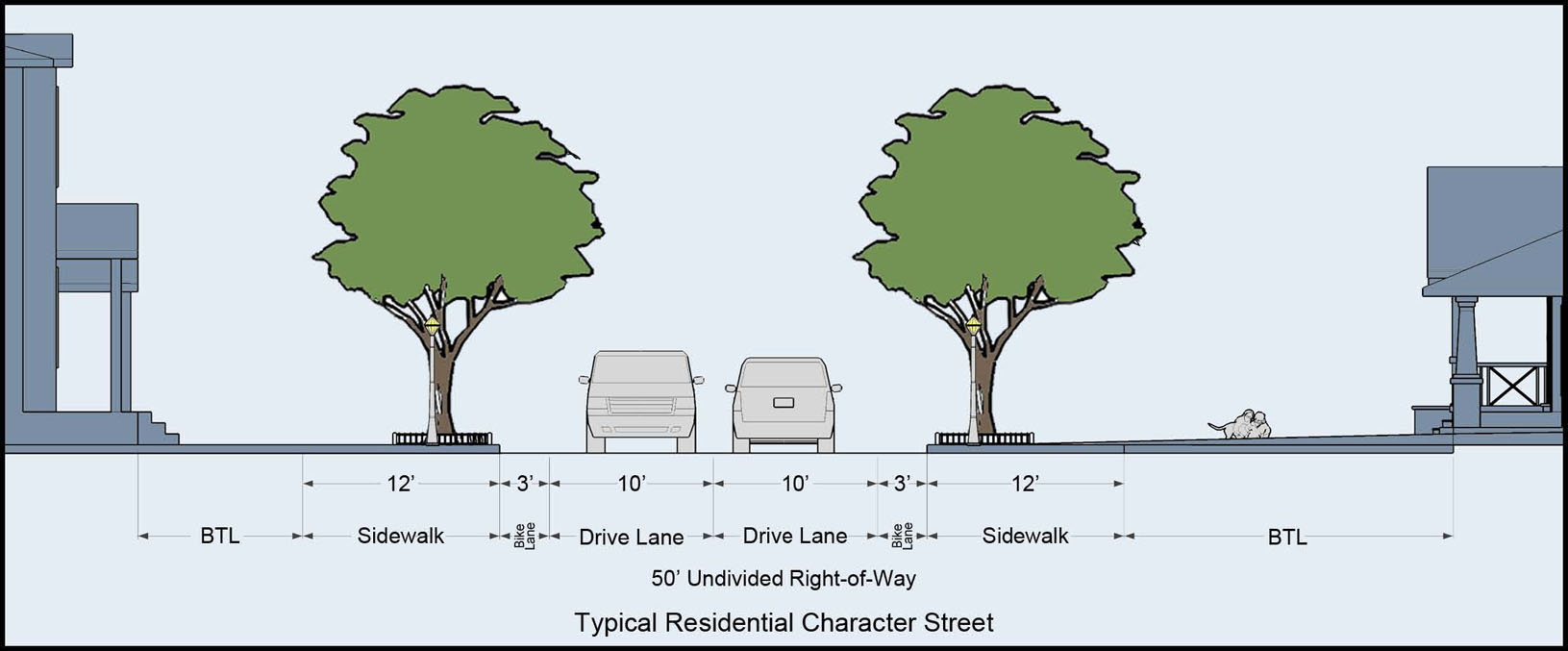
Graphic 27-211.14.3
50' ROW - Typical
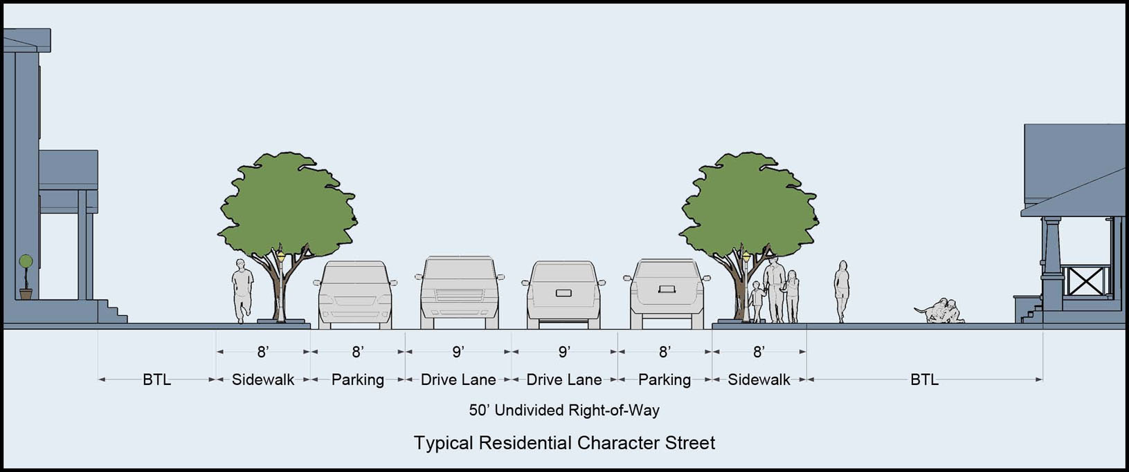
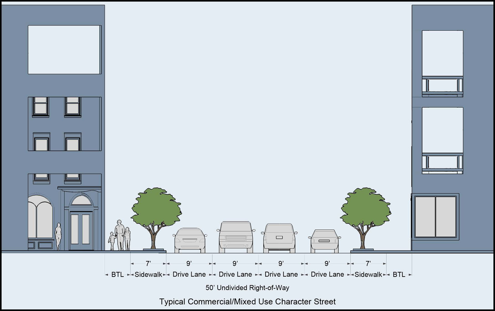
Graphic 27-211.14.4
65' ROW - Typical
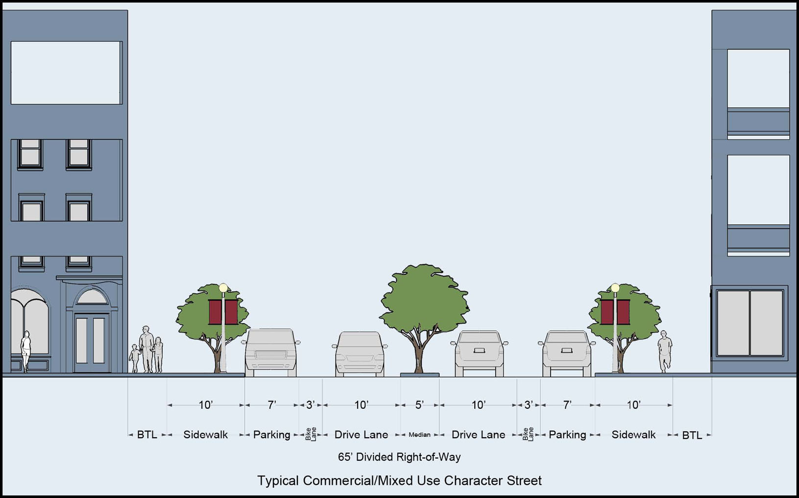
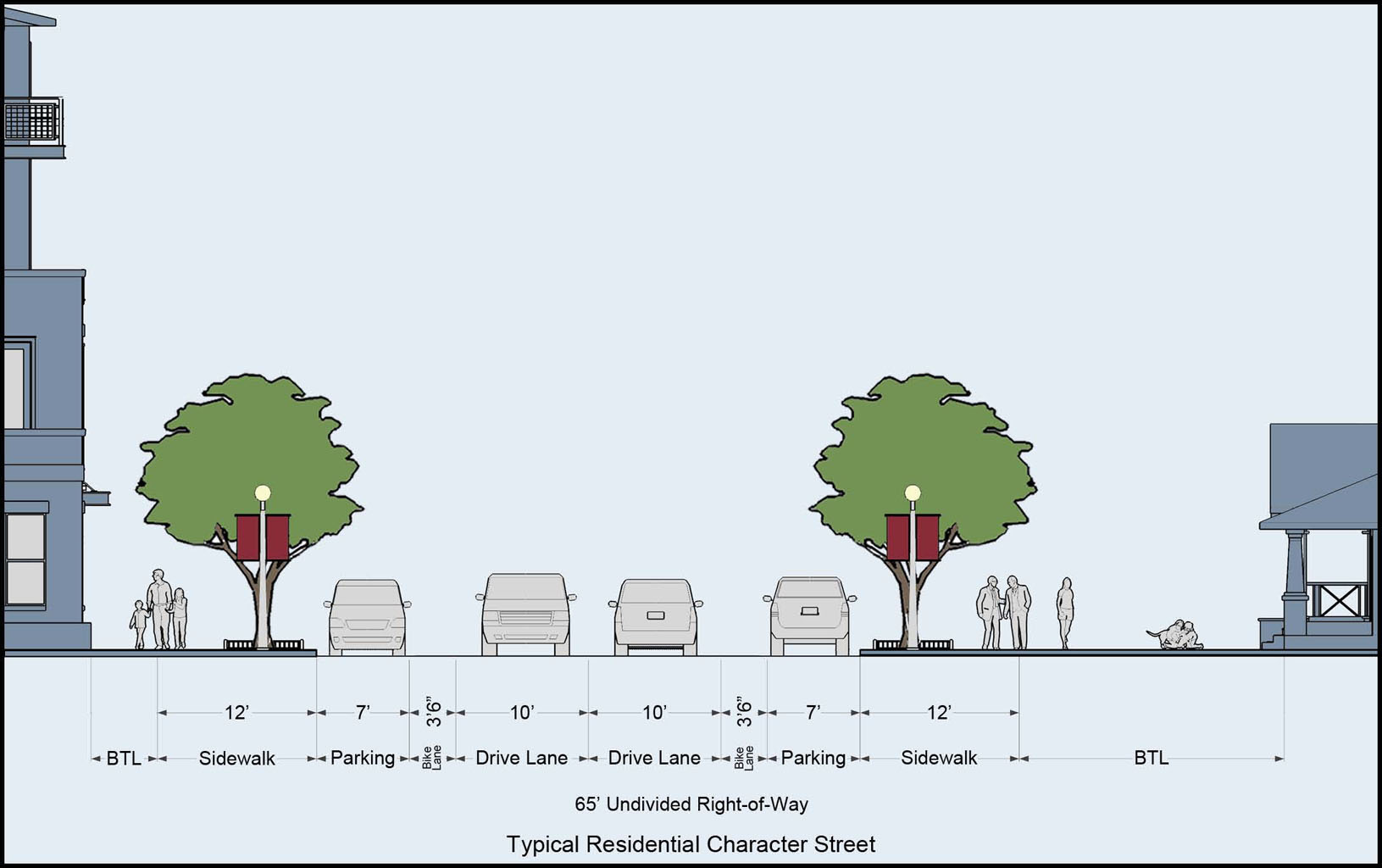
Graphic 27-211.14.5
80' ROW - Typical
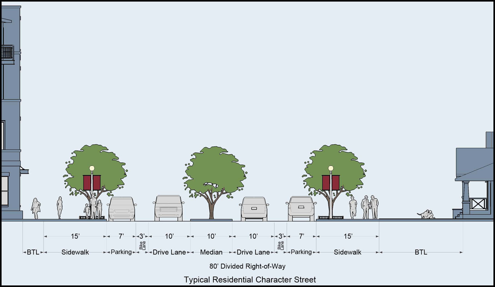
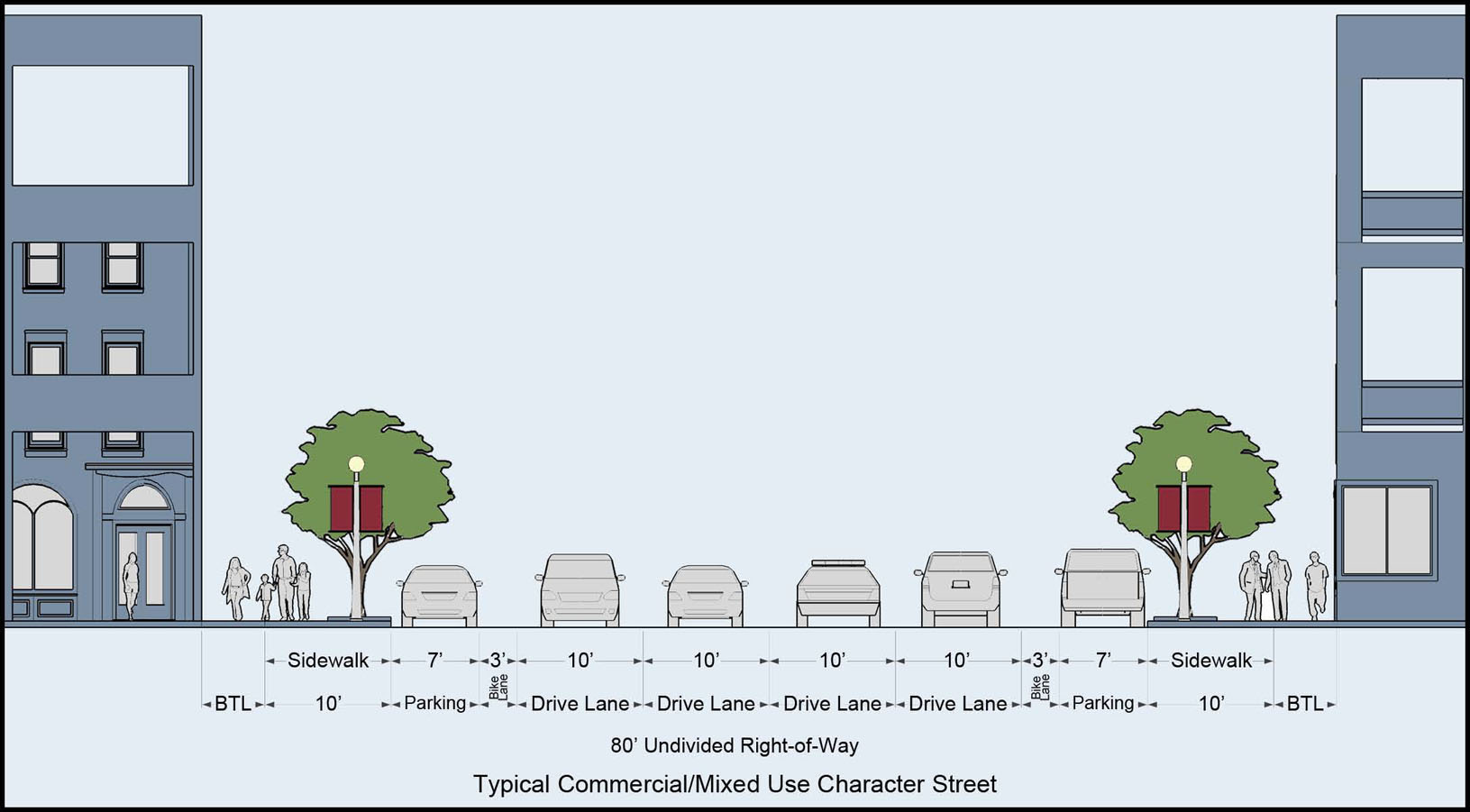
Graphic 27-211.14.6
100' ROW - Typical
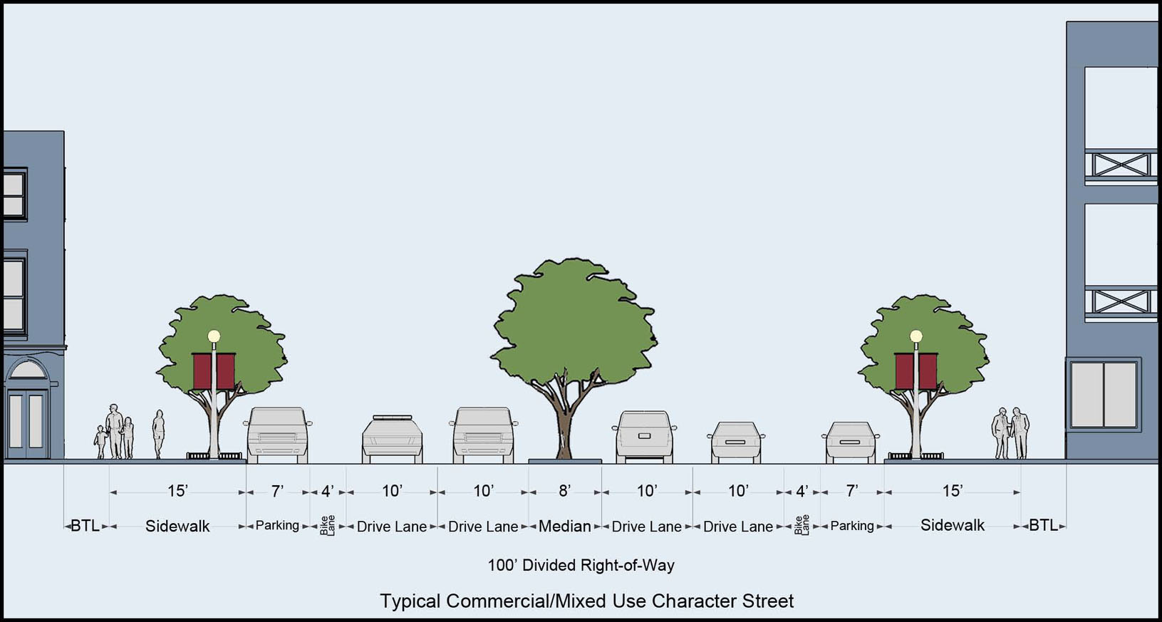
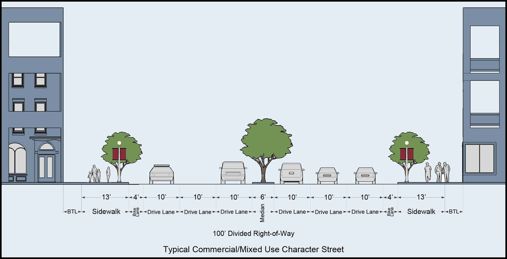
(d)
Streetscape. Landscape materials (tree plantings) are subject to Transportation Division approval and shall adhere to the list provided in section 27-211.13.
(e)
Traffic calming. (Refer to Greater Seminole Heights Vision Plan. Additionally, acceptable forms of traffic calming include: on-street parking, bicycle lanes, wider sidewalks, right-of-way landscaping and tree planting, traffic circles, chicanes, roundabouts, signalized ped- and bike crossings, and adjustments to signal timing. All forms may be considered and are subject to the review and approval of the Transportation Division pursuant to the Transportation Technical Manual.
(f)
Signs. (refer to Article VI, Division 6 and Chapter 22)
(g)
Encroachments, Sidewalk cafés. (Refer to Chapter 22 and sec. 27-132 respectively; however, encroachments of awnings, canopies, and arcades may be reviewed and approved administratively pursuant to the ROW permitting process within City rights-of-way.)
Sec. 27-211.15. - Greater Seminole Heights Bonus; methodology and calculation; list of bonus amenities.
Compliance. All developments that seek density/intensity bonuses within the defined area boundary shall adhere to the regulations set forth in section 27-140. Unless otherwise permitted by this chapter, developments that have been granted bonuses shall not be granted any further increase in floor area, unit count, or building height so as to exceed the maximum threshold set forth in the Tampa Comprehensive Plan.
(Ord. No. 2016-58, § 9, 4-21-2016)
Sec. 27-212. - The Neighborhood Mixed Use (NMU) Districts; applicability.
(a)
Applicability. The Neighborhood Mixed Use Districts (-16, -24, -35) are only permitted within the boundaries of a designated Urban Village, as set forth in the Tampa Comprehensive Plan.
(b)
Purpose. The purpose and intent of this subdivision is to ensure that all development is compatible in form, building and structural orientation, general site layout, height, lot dimensional requirements and other site spatial relationships to the precedent within the established block and generally, the surrounding area. Furthermore, it is the purpose and intent of the Tampa Comprehensive Plan, and of this subdivision, which aids in implementing it, to promote the public health, safety, comfort, amenities, prosperity, and general welfare of the city; and to provide, among other matters, a wholesome, serviceable, and attractive community; to help foster a more favorable environment in which to live, work, and play; to ensure that there is a seamless integration between private property and the public realm; to regulate the use, construction and maintenance of the public realm (including but not limited to streets, alleys, sidewalks, street lights); to regulate the use and development of land; to provide regulations, which allow and encourage creativity, effectiveness, and flexibility in the design and use of land while promoting traffic safety and avoiding an environment that encourages visual blight; to protect trees, wetlands, and natural resources by regulating the trimming or removing of trees, site clearing, landscaping, tree planting, and irrigation in the district.
(c)
Compliance. All new construction, major renovation, and change of use shall be required to comply with the applicable development standards set forth in this subdivision. In addition to adhering to the applicable Neighborhood Mixed Use District standards, all development within the locally designated Historic District shall adhere to the provisions of article V, section 27-212.5. In cases of conflict, the standards set forth in this subdivision shall apply. For those development issues not addressed in this subdivision, the underlying requirements of this chapter and other applicable land development regulations of the Tampa City Code shall apply.
(Ord. No. 2016-76, 3(Exh. A), 5-26-2016)
Sec. 27-212.1. - General administrative procedures.
(a)
Determination of uses not listed shall be reviewed according to the provisions of section 27-59.
(b)
For those development issues not addressed in this subdivision, the underlying requirements of this chapter and other applicable land development regulations of the Tampa City Code shall apply.
(c)
Alternative design exceptions to the standards set forth in the subdivision may be considered pursuant to section 27-60.
(d)
Any person aggrieved by any order, requirement, decision, or determination of the zoning administrator with regard to these design standards may request review of that order, requirement, decision, or determination in accordance with section 27-61.
(e)
Plan review shall be performed consistent with the applicable plan review procedure for special use, construction site plan, alternative design exception, and concurrency.
(Ord. No. 2016-76, 3(Exh. A), 5-26-2016)
Sec. 27-212.2. - Establishment of the sub-districts and associated general land development regulations by sub-district.
(a)
Sub-districts. The following "NMU-16, -24, -35" (Neighborhood Mixed Use) sub-districts shall be the only zoning districts permitted within the Neighborhood Mixed Use land use categories, as set forth in the Tampa Comprehensive Plan (refer to section 27-156 for detailed descriptions):
(1)
NMU-16: Mixed use, neighborhood scale office and commercial, and all single-family dwelling types.
(2)
NMU-24: Mixed use, civic, neighborhood scale office and commercial, and all single-family and multi-family dwelling types.
(3)
NMU-35: Mixed use, civic, neighborhood scale office and commercial, and all single-family and multi-family dwelling types.
(b)
Allowable, permitted, and prohibited uses are organized and listed by zoning district in Table 212-2.
(Ord. No. 2016-76, 3(Exh. A), 5-26-2016)
Sec. 27-212.3. - General development standards for Neighborhood Mixed Use-16, -24, -35 Districts.
| TABLE 212-1 BUILDING PLACEMENT, FORM, AND LAYOUT STANDARDS | ||||
|---|---|---|---|---|
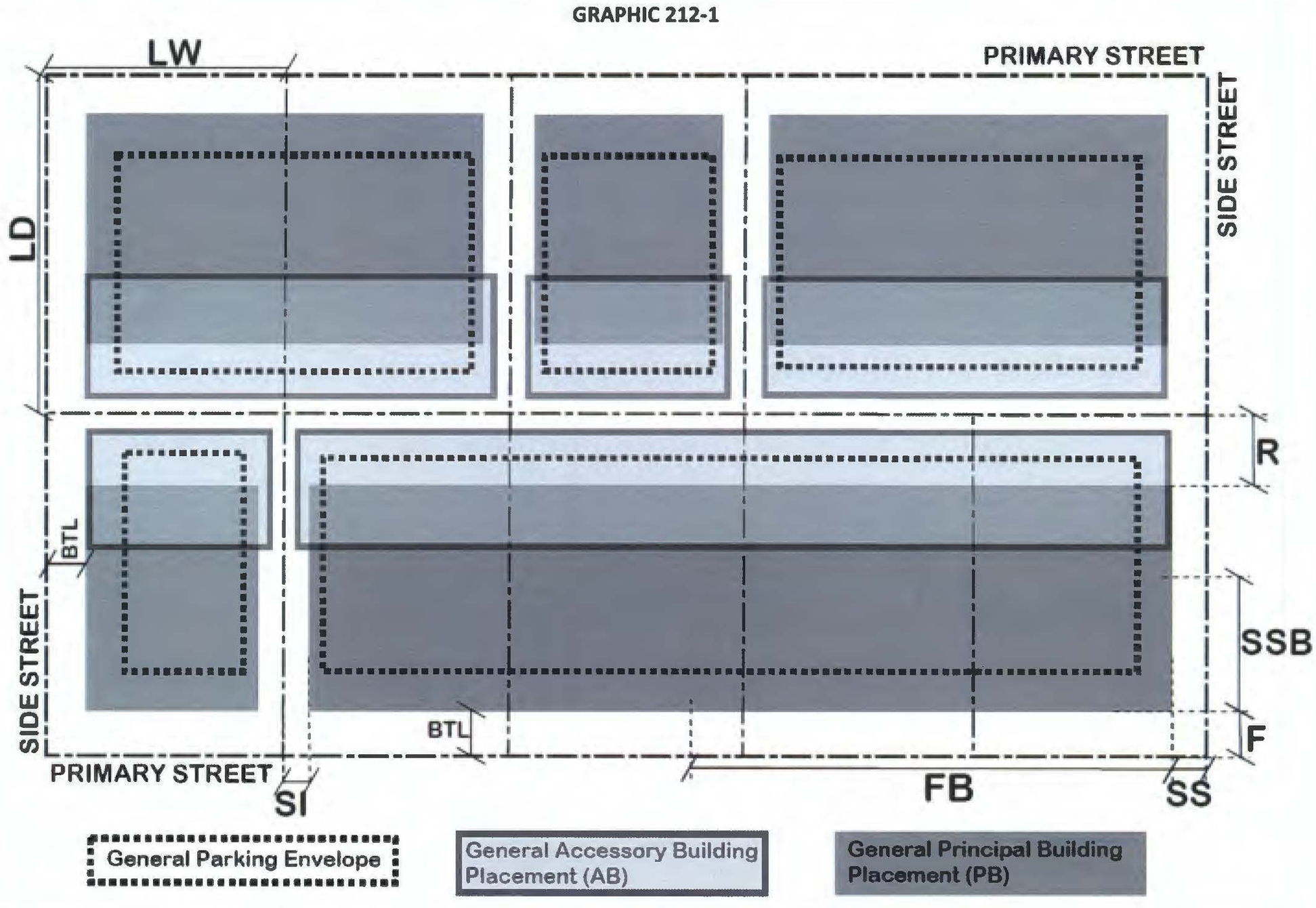 | ||||
| KEY | ||||
| See also Sec. 27-43 Definitions | PB: Principal building
AB: Accessory building PBH: Principal building height ABH: Accessory building height CP: Carport GAR: Garage | BTL: Build-to-line
F: Front SS: Side (street) SI: Side (interior) R: Rear | FB: Front Building Form
SSB: Side Street Building Form PW: Parapet wall GF: Ground floor UF: Upper floor | LW: Lot Width
LD: Lot Depth LA: Lot Area UFA: Usable floor area SF: Square Feet min: minimum |
(Ord. No. 2016-76, 3(Exh. A), 5-26-2016)
Sec. 27-212.4. - Schedule of allowable, permitted, and prohibited uses by district.
Table 212-2 sets forth the permitted, special, and accessory uses by zoning district. All lands within the Neighborhood Mixed Use District shall adhere to this table. Any uses not listed shall be subject to zoning administrator review, pursuant to sec. 27-59.
(Ord. No. 2016-76, 3(Exh. A), 5-26-2016; Ord. No. 2017-132, § 12, 8-24-2017; Ord. No. 2018-176, § 10, 11-1-2018; Ord. No. 2022-157, § 8, 9-1-2022; Ord. No. 2022-158, § 9, 9-1-2022)
Sec. 27-212.5. - Parking layout, general design and materials, and access management.
(Ord. No. 2016-76, 3(Exh. A), 5-26-2016)
Sec. 27-212.6. - Landscaping, tree planting, screening.
(a)
General purpose. Preservation of the urban canopy within the Neighborhood Mixed Use District is not only an invaluable asset to the area residents and businesses, it is a vital part of the city's natural resources. This section provides a diverse and well-suited list of trees for new plantings, while defining appropriately-sized planting areas within parking areas and along property perimeters.
(b)
Applicability. The standards set forth in this section apply to those developments described in (1), (2) below, and unless noted otherwise in (e) below, supersede the tree planting and landscaped area requirements of section 27-284.3.3; however, developments shall comply with all other applicable requirements of article VI, division 4, and any reductions to the required landscaped area set forth below, shall be subject to the applicable landscape in-lieu payment, pursuant to section 27-284.3.4. Standards applicable to:
(1)
All non-residential development;
(2)
Any residential development designed with common/shared surface parking lot(s) and/or common parking garage(s).
(c)
Tree preservation and removal. All development shall preserve, relocate, and/or remove protected and grand trees in accordance with article VI, division 4, subdivisions 2 through 4.
(d)
Technical Manual. All development shall adhere to the tree preservation and construction methods of the Tree and Landscape Technical Manual.
(e)
Required plantings (all landscape materials) for general site and parking/loading areas. Refer to section 27-211.13 for applicable standards. In cases of conflict between the general and parking area landscaping, the most restrictive standard applies.
(Ord. No. 2016-76, 3(Exh. A), 5-26-2016; Ord. No. 2019-54, § 31, 4-18-2019)
Sec. 27-212.7. - Other supplemental regulations.
(a)
All development shall be required to comply with the applicable development standards set forth in this subdivision and articles V, VI, and X for standards affecting (but not limited to) parking, solid waste enclosure, fences and walls, screen enclosures, air conditioner/mechanical equipment location, tents, etc.
(b)
Fences and walls. Fences and/or walls shall adhere to the following requirements:
(1)
On properties that are located within the boundaries of a specific overlay district, local historic district, historic conservation overlay, or historic landmark, fences and walls shall adhere to the applicable requirements of articles II, IV, and V.
(2)
On properties located outside such areas described in (1) above, chain link fences are prohibited. All other fences and/or walls shall adhere to section 27-290.1.
(c)
Signs. All signs shall comply with article VI.
(Ord. No. 2016-76, 3(Exh. A), 5-26-2016)