
Tampa City Zoning Code
ARTICLE IV
OVERLAY DISTRICTS
Sec. 27-231. - Intent and declaration of public policy.
(a)
The purpose of an overlay district is to allow for the application of specific regulations to a distinct geographic area. The geographic area warrants special consideration due to a unique situation or practical difficulties resulting from the historic development pattern. Existing conditions and development are such that it is impractical to comply with underlying district regulations without causing substantial hardship to the public good.
(b)
The overlay district concept is discussed in the Comprehensive Plan as a method of preserving the character of an area. It will encourage development to occur that is compatible with the existing scale and pattern of surrounding properties.
(c)
The effect of an overlay district will be to encourage property development which will maintain the unique characteristics of the area.
(d)
It is the intent of this article to provide an instrument for establishing different types of overlay districts.
(e)
In the event of a conflict between the specific overlay standards for a distinct geographic area in which a property is located and the provisions of this chapter, the more restrictive standards shall apply.
(Ord. No. 2024-16, § 10, 2-1-2024)
Sec. 27-232. - Residential overlay districts.
(a)
Purpose. The purpose of the residential overlay district is to preserve original precedent patterns of development in areas where the underlying zoning regulations could potentially disrupt the existing, desired scale, spatial pattern and character of an area. The residential overlay district is also intended to stabilize and improve property values and foster civic pride.
(b)
Scope of the residential overlay district regulations. The provisions of the overlay district apply to new construction, additions or structural alterations on all land within the designated overlay district. These provisions shall serve to supplement underlying zoning regulations in order to support the stated purpose of the district, and shall control in the event of conflict. Depending on the existing character of the specific area and the recommendation of the Tampa City Council, overlay regulations may include, but are not limited to, items such as:
• Height
• Floor area ratio
• Setbacks
• Lot dimensional regulations
• Parking
• Building orientation and separation
(c)
Starting the designation process. Any resident of the city, any owner of property in the city or any organization in the city may request the Tampa City Council to consider the designation of a residential overlay district. City council may direct the department of business and housing development to analyze the request and make a recommendation.
(1)
Recommendation. The department of business and housing development shall make a recommendation to city council regarding the designation of a residential overlay district. The recommendation must document the existence of distinct and precedent development patterns of an area that justify the establishment of special development regulations. The BHD recommendation shall include a boundary map of the district along with such other documentation which may include:
a.
A staff report verifying that the area is of sufficient compactness and exhibits a distinctive development pattern or character.
b.
A staff analysis of the existing historical building pattern of the area.
c.
Evidence that property development or redevelopment consistent with the original precedent pattern in the area may require variances to development regulations in order for new construction, alterations or rehabilitation to occur.
d.
The presence of a neighborhood organization or other such localized group civic group demonstrating an interest in such an overlay district.
(d)
Report to the planning commission. The planning and development department shall forward to the Hillsborough County City-County Planning Commission the recommendation of the establishment of a residential overlay district. The Hillsborough County City-County Planning Commission shall report within sixty (60) days to the city council, with information on the relationship between the proposed designation and the adopted Tampa Comprehensive Plan.
(e)
Public hearing by the city council. The city council shall hold a public hearing on a proposed designation of an overlay district within ninety (90) days after the receipt of the recommendation from the planning and development department staff. Notice of the hearing on the proposed historic conservation overlay district shall be given pursuant to the requirement for a text amendment and area rezoning contained in this chapter.
(f)
Discussion by the city council. The city council shall approve, modify or disapprove the proposed designation of the overlay district within sixty (60) days after its public hearing. The city council may reduce the size of the proposed overlay district, and it may add additional properties to the proposed overlay district provided it holds a further public hearing with notice on the additional properties in accordance with this chapter. If a designation is made, the official zoning atlas shall be amended to contain the overlay district designation.
(g)
Effect of the overlay district designation. After designation by the city council, no building or site development permit involving any building or other structure shall be erected, rehabilitated or moved into the overlay district in conflict with the established district regulations. It is the responsibility of the zoning administrator to ensure that development within the designated area complies with those regulations established for the district.
(h)
Appeal of decision on designation. Any appeal to city council action within the procedures established in this article shall be to the circuit court, and shall be in the form of a petition for writ of certiorari.
(i)
Application for variance. A variance may be allowed by the variance review board when substantial evidence is presented through the public hearing process established in section 27-81.
Sec. 27-233. - Commercial overlay districts.
(a)
Purpose. The purpose of the commercial overlay district is to preserve existing patterns of development in areas characterized by a distinct grouping of commercial and residential land uses, the destruction of which would disrupt the historical scale, spatial pattern and character of an area. In addition, the commercial overlay district designation allows for the development of specific design guidelines for future growth in the area, thereby enhancing the unique qualities of the district. Furthermore, the commercial overlay district is intended to provide a framework for cooperative integration of residential and commercial business uses in the district, stabilize and improve property values and foster civic pride.
(b)
Scope of Commercial Overlay District regulations. The provisions of the overlay district apply to new construction, additions or structural alterations on all land within the designated commercial overlay district. These provisions shall serve to supplement underlying zoning regulations in order to support the stated purpose of the district, and shall control in the event of conflict. Depending on the unique characteristics of a specific overlay district, overlay regulations may include:
• Landscape
• Streetscape
• Height
• Floor Area Ratio
• Setbacks
• Lot Dimensional Regulations
• Parking
• Building Orientation and Separation
(c)
Starting the designation process. Any resident of the city, any owner of property in the city or any organization in the city may request the Tampa City Council to consider the designation of a Commercial Overlay District. City council may direct the department to analyze the request and make a recommendation.
(1)
Recommendation. The department shall make a recommendation to city council regarding the designation of a Commercial Overlay District. The recommendation must document the existence of distinct development patterns in an area that justify the establishment of special development regulations. The recommendation shall also contain a boundary map of the district along with any other relevant documentation which may include:
a.
A staff report containing an analysis of the historical building pattern of the area which illustrates that the existing configuration of commercial and residential activities in the area has created a distinct and unique environment.
b.
Evidence that in order for property development or redevelopment to be consistent with the existing and historic pattern in the area, variances to development regulations would be required for new construction or rehabilitation to occur.
c.
When appropriate, evidence that commercial activities in the area are organized, such as the existence of an association or a localized chamber of commerce whose membership consists of a majority of business or property owners in the proposed Commercial Overlay District area.
(2)
The department shall forward to the Hillsborough County City-County Planning Commission the recommendation of the establishment of a Commercial Overlay District. The Hillsborough County City-County Planning Commission shall report within sixty (60) days to the city council, with information on the relationship between the proposed designation and the adopted Tampa Comprehensive Plan.
(3)
Public hearing by the city council. The city council shall hold a public hearing on a proposed designation of an overlay district within ninety (90) days after the receipt of the recommendation of the department. Notice of the hearing on the proposed commercial overlay district shall be given pursuant to the requirements for a text amendment and area rezoning contained in this chapter.
(4)
Discussion by the city council. The city council shall approve, modify or disapprove the proposed designation of the overlay district within sixty (60) days after its public hearing. The city council may reduce the size of the proposed overlay district, and it may add additional properties to the proposed overlay district provided it holds a further public hearing with notice on this additional properties in accordance with this chapter and receives a recommendation from the department. If a designation is made, the official zoning atlas shall be amended to contain the overlay district designation.
(d)
Effect of overlay district designation. After designation by the city council, no building or site development permit involving any building or other structure shall be erected, rehabilitated or moved into the commercial overlay district in conflict with the established district regulations. It is the responsibility of the zoning administrator to ensure that development within the designated area complies with those regulations for the district.
(e)
Appeal of decision to designate. Any appeal to city council action within the procedures established in this article shall be to the circuit court, and shall be in the form of a petition for writ certiorari.
(f)
Application for variance. A variance may be allowed by the designated variance board, depending on property location, in cases involving practical difficulties or hardships when substantial evidence is presented through the public hearing process established in Chapter 27, Article II.
(Ord. No. 2020-166, § 30, 12-17-2020)
Sec. 27-236. - South Howard Commercial Overlay District Development Design Standards.
(a)
Area description. The South Howard Commercial Overlay District is primarily composed of relatively small buildings with an eclectic style of architecture which are located in close proximity to one another, oriented toward the street, and constructed on individually developed properties. In general, parking which serves the commercial uses in the area is located to the side or rear of the buildings, and parking bays and curb cuts are not prevalent on South Howard Avenue. The street and adjacent uses have a pedestrian scale and the basic elements of a walkable environment.
(b)
Established boundaries. The South Howard Commercial Overlay District is hereby established as a separate district, the boundaries of which are as follows:
An area approximately one to two blocks in depth along South Howard Avenue, with a northern boundary generally located at Kennedy Boulevard, and a southern boundary at Bayshore Boulevard, and more particularly described as:
That Part of:
NORTH COURIER CITY, a subdivision of record as recorded in Plat Book 2, Page 13; Together With, OSCAWANA, a subdivision of record as recorded in Plat Book 4, Page 85; Together With, AMELIA, a subdivision of record as recorded in Plat Book 4, Page 67; Together With, HOWARD TERRACE, a subdivision of record as recorded in Plat Book 11, Page 11; Together With, ROSEVELT PARK, a subdivision of record as recorded in Plat Book 4, Page 99; Together With, H.J. WATROUS' 2ND ADD'N. TO WEST HYDE PARK, a subdivision of record as recorded in Plat Book 9, Page 57; Together With, NORTH SHORE SUBDIVISION, a subdivision of record as recorded in Plat Book 9, Page 57; Together With, REVISED SUBDIVISION OF BLOCK 1 HOLDEN SUBDIVISION, a subdivision of record as recorded in Plat Book 8, Page 31; Together With, BONGARTS SUBDIVISION, as recorded in Plat Book 9, Page 28; Together With. REVISED MAP HOLDEN'S SUBDIVISION, as recorded in Plat Book 2, Page 19; Together With, FAIRVIEW PLACE, a subdivision of record as recorded in Plat Book 10, Page 23; Together With GEO WEEKS' SUBDIVISION, as recorded in Plat Book 11, Page 49; Together With, REVISED MAP OF LUNA PARK, as subdivision of record as recorded in Plat Book 8, Page 33; Together With, BONGART'S RE-SUBDIVISION OF LOTS 6, 7, & 8, BLOCK 4 OF LUNA PARK, a subdivision of record as recorded in Plat Book 9, Page 53; Together With, A RE-REVISED MAP OF BLOCK 25 OF WEST HYDE PARK, a subdivision of record as recorded in Plat Book 10, Page 5; Together With, HAMNER'S SUBDIVISION, as recorded in Plat Book 9, Page 33; Together With, ULETA, a subdivision of record as recorded in Plat Book 8, Page 12; Together With, HAMNER'S HOWARD AVE. SUBDIVISION, as recorded in Plat Book 9, Page 71; Together With, SWANN AND HOWARD AVENUES SUBDIVISION, as recorded in Plat Book 9, Page 59; Together With, WEST HYDE PARK HENDRY & KNIGHTS SUBDIVISION, as recorded in Plat Book 3, Page 36; Together With, HARBOUR HOUSE CONDOMINIUM, as recorded in Condo Plat Book 2, Page 46; Together With, BAYSHORE ROYAL CONDOMINIUM, as recorded in Condo Plat Book 3, Page 42; Together With, 1508 SOUTH HOWARD CONDOMINIUM, as recorded in Condo Plat Book 12, Page 60, all of the public records of Hillsborough County, Florida, being a part of Sections 23 and 26, Township 29 South, Range 18 East, Hillsborough County, Florida, lying within the following described boundaries, to wit:
Begin at the intersection of the Centerline of John F. Kennedy Boulevard (Grand Central Avenue) and the Northerly projection of the Westerly boundary of the Easterly one-half of Lot 3, Block 6 of said OSCAWANA, a subdivision of record; run thence Easterly along said Centerline to it's intersection with the Northerly projection of the Easterly boundary of the Westerly 54 feet of Lot 3, Block 7 of said OSCAWANA; thence run Southerly along said Northerly projection, Easterly boundary and it's Southerly projection to it's intersection with the Centerline of the East-West alley right-of-way in said Block 7; thence run Westerly along said Centerline to it's intersection with the Northerly projection of the Centerlines of those North-South alley rights-of-way in Blocks 7, 8 and 9 of said OSCAWANA, and Blocks 6, 11 and 22 of said NORTH COURIER CITY, a subdivision of record; thence run Southerly along said Northerly projections and Centerlines and their Southerly projections, across the street rights-of-way of Cleveland Street, Platt Street, Azeele Street, Horatio Street and DeLeon Street, to the Centerline of Swann Avenue; thence run Easterly along said Centerline of Swann Avenue, to it's intersection with the Northerly projection of the Westerly boundary of Block 2 of said SWANN AND HOWARD AVENUES SUBDIVISION, a subdivision of record, said Westerly boundary also herein, the Easterly right-of-way line of vacated Westland Avenue; thence run Southerly along said Northerly projection of said Block 2, and it's Southerly projection across the vacated street right-of-way of Inman Avenue, to and along the Easterly boundary of the Westerly 16.9 feet of Lot 8, Block 3 of said SWANN AND HOWARD AVENUES SUBDIVISION, to it's intersection with the Southerly boundary of said Lot 8; thence run Westerly along the Southerly boundaries of Lots 8, 7, 6, 5 and 4 to it's intersection with the Easterly boundary of Lot 10, of said HAMNER'S HOWARD AVE, SUBDIVISION, a subdivision of record; thence run Southerly along said Easterly boundary of Lot 10, and it's Southerly projection to it's intersection with the Centerline of Bristol Avenue; thence run Westerly along said Centerline, to it's intersection with the Northerly projection of the Easterly boundary of Lot 14 of said subdivision; thence run Southerly along said Northerly Projection and Easterly boundary, to and along the Easterly boundary of Lots 15 and 16 of said subdivision, and their Southerly projection to it's intersection with the Centerline of that unnamed street, lying Southerly of and abutting Lots 16 through 25 of said subdivision and lying Northerly of and abutting Block 5 of ULETA, a subdivision of record; thence run Easterly along said Centerline of unnamed street, to it's intersection with the Centerline of Eleta Street; thence run Southerly along said Centerline of Eleta Street, to it's intersection with the Centerline of Morrison Avenue; thence run Easterly along said Centerline of Morrison Avenue, to it's intersection with the Northeasterly projection of the Southeasterly boundary of Block l, of said ULETA; thence run Southwesterly along said Northeasterly projection and Southeasterly boundary to it's intersection with the Easterly right-of-way line of Howard Avenue; thence run Southerly along said right-of-way line, across the Seaboard Coast Line Rail Road right-of-way and the Tampa Crosstown Expressway (S.R.618), to it's intersection with the Centerline of Watrous Avenue; thence run Easterly along said Centerline, to it's intersection with the Northerly projection of the Centerlines of those North-South alley rights-of-way in HAMNER'S SUBDIVISION, a subdivision of record; thence run Southerly along said Northerly projection and Centerlines and their Southerly projection, across the street right-of-way of Marjory Avenue, to it's intersection with the Centerline of Southview Avenue; thence run Westerly along said Centerline, to it's intersection with the Northwesterly projection of the Easterly boundary of Lot 8 of said, A RE-REVISED MAP OF BLOCK 25 OF WEST HYDE PARK, a subdivision of record; thence run Southeasterly along said Northwesterly projection to and along the Easterly boundary of said Lot 8 to the Southeast corner of said Lot 8; Thence run Southwesterly along the Southerly boundary of said Lot 8 and it's Southwesterly projection to it's intersection with the Centerline of the North-South alley right-of-way lying Easterly of said BONGART'S RE-SUBDIVISION OF LOT 6, 7, & 8, BLOCK 4 OF LUNA PARK, a subdivision of record, and lying Westerly of said A RE-REVISED MAP OF BLOCK 25 OF WEST HYDE PARK, a subdivision of record; thence run Southeasterly along said Centerline of North-South alley and it's Southeasterly projection, across the street right-of-way of Dekle Avenue, to and along the Centerline of the North-South alley right-of-way lying Easterly of Block 4, of said REVISED MAP OF LUNA PARK, a subdivision of record, and lying Westerly of Block 24, of said WEST HYDE PARK HENDRY & KNIGHTS SUBDIVISION, a subdivision of record, to it's intersection with the Easterly projection of the Southerly boundary of Lot 4, of said Block 4 of REVISED MAP OF LUNA PARK; thence run Southwesterly along said Southerly boundary of Lot 4 and it's Westerly projection to it's intersection with the Centerline of Desoto Avenue (Luna Park Avenue); thence run Southeasterly along said Centerline across the street right-of-way of Hills Avenue to it's intersection with the Northeasterly projection of the Southerly boundary of Lot 11, Block 2 of said REVISED MAP OF LUNA PARK; thence run Southwesterly along said Northeasterly projection and Southerly boundary, to it's intersection with the Southerly most corner of said Lot 11; thence run Southeasterly along the Westerly boundary of said Block 2 of REVISED MAP OF LUNA PARK, said Westerly boundary also being the Easterly boundary of GEO WEEKS' SUBDIVISION, to it's intersection with the Northerly right-of-way line for Bayshore Boulevard; thence run Southwesterly along said Northerly right-of-way line, across the street right-of-way of Howard Avenue, to and along said Northerly right-of-way line for Bayshore Boulevard, to it's intersection with the Westerly boundary of the Easterly 30 feet of Lot 8 of said FAIRVIEW PLACE, a subdivision of record, said Westerly boundary of the Easterly 30 feet, also being the Westerly boundary of said HARBOUR HOUSE CONDOMINIUM, a condominium of record; thence run Northwesterly along said Westerly boundary of the Easterly 30 feet of Lot 8, to and along the Westerly boundary of Lot 4, of said FAIRVIEW PLACE, and its Northwesterly projection to it's intersection with the Centerline of Palm Drive; thence run Northeasterly along said Centerline to it's intersection with the Southerly projection of the Centerline of Alabama Avenue; thence run Northerly along said Southerly projection, Centerline and it's Northerly projection across the street rights-of-way of Texas Avenue, Stroud Avenue and Mississippi Avenue to it's intersection with the Centerline of Southview Avenue; thence run Westerly along said Centerline to it's intersection with the Southeasterly right-of-way line of the Tampa Crosstown Expressway (S.R. 618); thence run Northeasterly along said Southeasterly right-of-way line to it's intersection with the Westerly right-of-way line of Howard Avenue; thence run Northerly along said Westerly right-of-way line to it's intersection with the Centerline of Watrous Avenue; thence Westerly along said Centerline to it's intersection with the Southerly projection of the Centerline of that vacated North-South alley right-of-way lying Westerly of Lot 31, of said H.J. WATROUS' 2ND ADD'N. TO WEST HYDE PARK, a subdivision of record; thence run Northerly along said Southerly projection and Centerline and it's Northerly projection across the street right-of-way of Betton Avenue to and along the Centerline of that North-South alley right-of-way lying Westerly of Lots 25-29 of said H.J. WATROUS' 2ND ADD'N. TO WEST HYDE PARK, a subdivision of record, to it's intersection with the Centerline of Morrison Avenue; thence run Easterly along said Centerline to it's intersection with the Southerly projection of that North-South alley right-of-way lying Westerly of Lots 1-5 of said ROSEVELT PARK, a subdivision of record; thence run Northerly along said Southerly projection and Centerline to and along the Centerline of that North-South alley right-of-way lying Westerly of Lots 1-3 of said HOWARD TERRACE, a subdivision of record, and it's Northerly projection across the street right-of-way of Bristol Avenue, to and along the Centerline of that vacated North-South alley right-of-way lying Westerly of Lots 24-26, of said HOWARD TERRACE, to its intersection with the Southerly boundary of Lot 17, of said AMELIA, a subdivision of record; thence run Westerly along said Southerly boundary of Lot 17, to it's intersection with the Centerline of that vacated North-South alley right-of-way, lying in said AMELIA; thence run Northerly along said Centerline, to it's intersection with the Centerline of that East-West alley right-of-way lying in said AMELIA; thence run Westerly along said Centerline, to it's intersection with the Southerly projection of the Westerly boundary of Lot 4, of said AMELIA; thence run Northerly along said Southerly projection, Westerly boundary and it's Northerly projection to it's intersection with the Centerline of Swann Avenue; thence run Easterly along said Centerline of Swann Avenue, to it's intersection with the Southerly projection of the Centerlines of those vacated North-South alley rights-of-way in Blocks 10 and 23 of said NORTH COURIER CITY, a subdivision of record, and the Centerlines of those North-South alley rights-of-way in Block 7 of said subdivision and Blocks 4, 5 and 6 of said OSCAWANA, a subdivision of record; thence run Northerly along said Southerly projections, Centerlines and their Northerly projections, across the street rights-of-way of De Leon Street, Horatio Street, Azeele Street, Platt Street and Cleveland Street, to and along the Westerly boundary of the Easterly one-half of said Lot 3, Block 6 of OSCAWANA, and it's Northerly projection, to it's intersection with the Centerline of said John F. Kennedy Boulevard, and the Point of Beginning.
(c)
Purpose and intent. The purpose and intent of the South Howard Commercial Overlay District Design Standards are to promote and enhance the pedestrian environment and scale of the district, while creating an active and interesting ambiance, and preserving the unique character of the area. In addition, it is important that development in this district be compatible with surrounding residential neighborhoods.
(d)
Compliance. Every building or site permit application for new construction or major renovation of an existing structure (as defined in section 27-43) within the South Howard Commercial Overlay District shall comply with all applicable Land Development Regulations and the standards set forth in subsections (e) through (m). These are the minimum requirements which must be met in order to obtain design approval. Specific design criteria will also be applied individually where appropriate (e.g. new signs, request for change of location or increase in amount of parking, new lighting, etc.). Alternative design exceptions may be considered by the zoning administrator or designee, for those properties located outside of the Hyde Park Local Historic District, if consistent with the stated purpose and intent of this section. Refer to (e) below, regarding review of these decisions.
Properties located in the Hyde Park Local Historic District must adhere to overlay district standards and specific design guidelines for the area, and must obtain a Certificate of Appropriateness (CA) from the Architectural Review Commission (ARC) prior to any development or rehabilitation. Requests for variance(s) to the overlay district standards on these properties shall be heard by the ARC, in accordance with the procedures set forth in section 27-114. Refer to (f) below, regarding review of these decisions. Where there is a conflict between the Hyde Park Design Guidelines and the South Howard Commercial Overlay District Development Design Standards, the more restrictive regulations shall apply.
(e)
Review—Alternative design exception. Any person aggrieved by a zoning administrator determination, related to an alternative design exception to this section, is subject to the review method set forth in section 27-61.
(f)
Review—Variance heard by the ARC. Any person aggrieved by an ARC decision, related to a variance to this section, is subject to the review method set forth in section 27-61. The ARC shall hold a public hearing to consider testimony or evidence from the public to better understand the purpose and intent of the overlay district and the character of the surrounding neighborhood.
(g)
Review procedures.
(1)
Pre-application conference. It is strongly recommended that any property owner or agent thereof required to obtain design approval schedule a courtesy review prior to the submission of an application for design approval.
(2)
Submission requirements. All applications for design approval shall contain the following items:
a.
Site plan. Six (6) folded copies of a site plan (if the development is located in the Hyde Park Historic District, it shall be subject to the submittal requirements of the ARC) conforming to the requirements listed below must be submitted as a part of the commercial site review application.
1.
General location and context map indicating the proposed site relative to all building and street rights-of-way lying immediately adjacent to the proposed site perimeter.
2.
North arrow and scale (Scale: one (1) inch = twenty (20) feet to one (1) inch = fifty (50) feet).
3.
Property line boundaries and dimensions.
4.
Name, location, and width of existing street and alleys adjacent to the site.
5.
Location, size, height, and use of all existing principal and accessory buildings, and any proposed additions and/or new buildings.
6.
Vehicle and pedestrian circulation, including ingress, egress, loading, unloading, parking and accessibility for persons with disabilities.
7.
Location and dimension of existing and proposed driveways, sidewalks, and parking areas, including typical parking space dimensions.
8.
Existing and proposed building setbacks, parking lot landscaping, and buffering from adjacent uses (if applicable).
9.
Proposed design and. location of lighting fixtures.
b.
Landscape plan (may be incorporated into site plan) showing preliminary plant material (existing and proposed) with specific information as to location, size (diameter) and specie.
c.
Exterior elevations of all sides of the project fronting or visible from South Howard Avenue (include any existing structures abutting the proposed project on the same street wall).
(h)
General building design standards.
(1)
Unobstructed pedestrian access and shelter, shade, and/or weather protection shall be provided along streets and public rights-of-way or next to areas used by the public through the use of shade trees, awnings, arcades, balconies, overhangs, etc., and shall provide any other appropriate pedestrian amenities (e.g. benches), subject to subsection (m) below.
(2)
Doors, windows, and other architectural features shall be used to break large wall planes into smaller components, thereby creating a more pedestrian friendly scale and mass. No more than thirty (30) percent of consecutive front façade may remain without architectural detail.
(3)
The principal façade and entry to the building shall front South Howard Avenue (or may be located off the courtyard if applicable) and must be accessible from the sidewalk. At least fifty (50) percent of the ground level of the principal building façade shall be constructed of transparent materials or fenestrated.
(4)
Buildings shall be set back no less than ten (10) feet and no more than eighteen (18) feet from the front property line at ground level. However, second floor area(s) and above may be built out to the front property line, creating an arcade. Structural support for the arcade may be located within the front setback however, arcaded areas may not be enclosed or screened.
(5)
Courtyards are permitted within the front setback. If at least two-thirds (⅔) of the principal façade is devoted to open courtyard space, the remaining portion of the building may be built out to the front property line, subject to section 27-283.5.
(6)
Outdoor cafés. Outdoor cafés are permitted within the front setback, arcaded areas, and open courtyards, and may be enclosed with a hedge, or a removable decorative fence or wall, with a maximum height of three (3) feet. A minimum of six (6) feet of unobstructed walkway must be maintained along any sidewalk area.
(7)
Drive-through window services and queuing lanes for such services may not be located between the front façade of the building and South Howard Avenue, and must be designed so as to have minimal impact on pedestrian traffic along South Howard Avenue.
(8)
Chain link fences may not front or be visible from South Howard Avenue.
(9)
Lighting. Outdoor light fixtures must complement the design of the building.
(10)
Any exterior garbage receptacles, dumpsters, or mechanical equipment must be placed on a suitable slab and screened from view of any right-of-way or residential use with one hundred (100) percent opaque material which is compatible with the front façade of the principal structure. In addition, garbage receptacles and dumpsters must be located on private property and be accessible for service by the Solid Waste Department.
(11)
Property owners shall provide a six (6) foot sidewalk along South Howard Avenue, aligned with and connected to that of adjacent and contiguous properties.
(i)
Parking.
(1)
Surface parking shall be located on the side or rear of the building, on the street if approved by the division of public works, or alternative parking placement may be considered by the zoning administrator (and/or his or her designee) if consistent with the purpose and intent described in section 27-236(c). Alternative parking layouts, which include surface parking abutting right-of-way on South Howard Avenue, must provide increased landscape buffering (e.g., one (1) tree for every twenty (20) feet of vehicular use area (VUA) abutting South Howard Avenue right-of-way and a screen consistent with section 27-285 Vehicular Use Areas, with the exception that planting be done at thirty (30) inches on center). An increase in pedestrian amenities may also be required (e.g., street furniture, decorative paver blocks, planters, etc.)
(2)
The façade of freestanding parking structures fronting South Howard Avenue must consist of commercial, retail, or office uses on the ground level. The entrance to freestanding parking structures shall not front South Howard Avenue.
(3)
Vehicle access and flow for new development shall have minimal impact on pedestrian circulation, and there must be continuity across the mouth of all curbcuts, subject to section 22-315 of the City of Tampa Code of Ordinances.
(j)
Buffers and screening. All development within the South Howard Commercial Overlay District shall comply with section 27-284 Buffers and screening requirements, except that the ten (10) and fifteen (15) foot buffer requirements set forth in the buffer matrix shall be reduced to five (5) feet for all properties located within the district.
(k)
Landscaping. All sites within the South Howard Commercial Overlay District shall comply with the tree, site clearing, and landscaping requirements set forth in this chapter.
(l)
General sign standards. The following sign standards shall apply to new signs in the South Howard Commercial Overlay District, and shall be in addition to the sign regulations set forth in this chapter and in Article VI, Division 6. Where regulations are inconsistent, the provisions of this subsection shall apply and control in the district, subject to the provisions of subsection (m) below. The following provisions are intended to allow the creation of unique and informative signs which give a distinct flavor to the area, while maintaining a non-intrusive, pedestrian environment. These guidelines are not intended to prohibit the design of unusual signs that may enhance the character of the building, or reflect the nature of the business.
(1)
Parcels permitted to have more than one (1) wall sign, a specific type of building sign, per section 27-289.3(b)(6). Regulations for wall signs may not have those wall signs abutting at the corner of a building. A minimum separation of ten (10) feet shall be required between such signs. A minimum separation of four (4) feet shall be maintained between signs on the same façade.
(2)
The size of wall and awning signs shall not exceed one-half (½) square foot per linear foot of building frontage, or twenty-five (25) square feet, whichever is less. Text shall not exceed twelve (12) inches in height.
(3)
Pylon signs are prohibited in the South Howard Commercial Overlay District. Ground signs shall be a maximum of fifteen (15) square feet in area, six (6) feet in height, and may be placed at the property line subject to section 27-283.5.
(4)
One non-illuminated marquee sign with a maximum dimension of four (4) feet in length, one (1) foot in height, and six (6) inches in thickness, may be located at the main entry of each business. The sign must be located under the awning, at least seven (7) feet above the sidewalk, at a perpendicular angle to the exterior wall. Text may be located on both faces of the sign, with a maximum lettering height of six (6) inches.
(5)
Interior illumination of signs ("backlighting") is prohibited in the South Howard Commercial Overlay District.
(m)
Encroachments. Encroachments into the public right-of-way for awnings, awning signs, architectural features, streetscape features, or street furniture may be authorized administratively by the department of public works.
A separate encroachment application for awnings or architectural features may not be required provided the projections comply with the criteria listed in section 27-204(g)(1) through (5) of the City of Tampa Code of Ordinances.
(Ord. No. 2017-103, § 2, 6-22-2017; Ord. No. 2020-166, § 31, 12-17-2020)
Sec. 27-237. - New Tampa Commercial Overlay District Development Standards.
(a)
Area description. The New Tampa Commercial Overlay District is an area which contains commercial and multi-family development and dedicated community and open space; which spans over numerous planned communities, including Tampa Palms, North Palms Village, Hunter's Green, West Meadows, Tampa Technology Park East, and Heritage Isles.
(b)
Established boundaries. The New Tampa Commercial Overlay District is hereby established as an overlay district, the requirements of which shall be applicable to all commercial and multi-family residential properties within the general area bounded by Interstate 275 on the west, Morris Bridge Road on the east, Skipper Road on the south, and the Pasco County line on the north. This will include the commercial and multi-family residential property running along and adjacent to both sides of Bruce B. Downs Boulevard (County Road 581) from Cypress Creek north to the Hillsborough/Pasco County Line, and along Cross Creek (New Tampa) Boulevard, from Heritage Isles to Morris Bridge Road, the junction of Bruce B. Downs and I-75, Tampa Palms Area 8, FDOT Frontage Roads, Commerce Boulevard, Compton Boulevard, Tampa Palms Boulevard, Highwoods Preserve Parkway, and other arterial and collector roads that may be constructed in order to support present and future development, lessing out those parcels not incorporated within the limits of the City of Tampa.
(c)
Purpose and intent. The purpose and intent of the New Tampa Commercial Overlay District is to promote, preserve and advance the unique character of the area through the use of vehicular access management techniques, pedestrian and bicycle amenities, abundant landscaping and green spaces and aesthetic design standards, while also providing standards for the advertisement of goods and services. The intent of these standards is also to ensure that commercial development in this district shall be more compatible with surrounding residential neighborhoods.
(d)
Compliance. Every application for new construction or major renovations of commercial or multi-family residential projects, as defined in Chapter 27, shall comply with all applicable standards set forth in subsections (e) through (k), as well as those outlined in the adopted site plan and performance standards for the community in which the proposed development is located. In cases of conflict, the more restrictive standard(s) shall apply. Alternative design exceptions to these overlay district standards may be considered and approved by the zoning administrator or designee, if consistent with the stated purpose and intent of this section, subject to the procedures set forth in section 27-60. A zoning administrator determination, related to an alternative design exception to this section, is subject to the review method set forth in section 27-61.
(e)
Review procedures. Conceptual site plan review for compliance with development standards will occur during the incremental review process, per section 27-228. Final compliance with all site design, building design, and sign standards will be determined during the commercial site plan and building plan review process.
(f)
General building design standards.
(1)
Drive-through window services must be placed in the side or rear yard of the parcel on which they are located.
(2)
The entrance to all service bays for automotive repair and service businesses must be oriented away from view of any arterial or collector roadway(s). All automotive repair and service shall take place within the fully enclosed area of the building in which such use is located.
(3)
The use of chain link fences, other than vinyl-clad, is prohibited, Vinyl-clad chain link may be used only when backed with a textile mesh screen.
(4)
Unpainted or unfinished block fences or walls are prohibited. All sides and elevations of buildings, walls, or block fences visible at ground level from a public right-of-way or an adjacent parcel must be architecturally finished (i.e. brick, stucco, or textured concrete masonry units).
(5)
Doors, windows, or other architectural features shall be used to break large wall planes into smaller components. No more than thirty (30) percent of consecutive façade that is oriented to and visible at ground level from public right-of-way may remain unembellished.
(6)
The use of cobra head lighting is prohibited in public use areas adjacent to the building(s) (e.g. entryways, courtyards, parking lots, etc.).
(7)
All open storage areas as defined in section 27-43 and mechanical equipment must be screened with one hundred (100) percent opaque material, which is compatible with the materials used on the nearest façade of the principal structure.
(8)
Rooftop equipment, excluding vents and stairwell accesses, which is visible at ground level from the centerline of abutting public right-of-way, shall be screened from view through use of parapet walls, screens, or other building elements or design features.
(9)
For properties with multiple tenants and/or multiple structures, on site pedestrian circulation shall be provided between tenants and/or structures through the use of a sidewalk, or other suitable pedestrian connection, not less than five (5) feet wide, and where applicable, shall align with and connect to that of adjacent and contiguous properties. Sidewalk paving or other pedestrian connections, where applicable, must continue uninterrupted across the mouth of all curb cuts, subject to section 22-315 of the City of Tampa Code of Ordinances.
(10)
Retention ponds smaller than five (5) acres and visible at ground level from public right-of-way or an adjacent parcel shall be landscaped and/or must contain special site features, such as fountains and reflecting pools. Existing natural vegetation may be used in lieu of new planting(s).
(11)
Illuminated tubing (e.g. neon) which outlines a building, fence, or other similar structure or part thereof, measuring more than twenty (20) linear feet, or enclosing any area greater than twenty (20) square feet is prohibited.
(g)
Landscape buffers and screening.
(1)
A landscape buffer with an average width of fifteen (15) feet, and a minimum width of ten (10) feet, shall be provided along the boundary of all vehicular use areas (vua's) abutting public right-of-way. Said buffer shall contain a minimum eighteen (18) inch high earthen berm and shall be landscaped. Berm and landscape combination shall be eighty (80) percent opaque, and be a minimum of four (4) feet in height at time of planting, and all times thereafter, subject to section 27-283.5. Height shall be measured at finished grade of the vehicular use area. A berm shall not be required within the visibility triangle areas for any driveways or pedestrian walkways.
(2)
All portions of each site, which are not devoted to buildings, sidewalks, paving or special landscape features, shall be grassed; but the use of native plant species and xeriscaping shall be encouraged. However, no more than thirty (30) percent of the required landscape area may be grassed, the balance shall be landscaped in shrub and ground covers. All yard grass planted shall be Hybrid Bermuda or St. Augustine. However, Bahia grass may be used or planted in retention/detention areas, drainage areas, and wetland setback and mitigation areas.
(3)
All shade trees used to satisfy landscaping requirements shall be a minimum four (4) inch caliper, per section 27-285.1, Tree & Landscape Code specifications.
(4)
All tree trimming and pruning shall be performed in accordance with the standards set forth in the American National Standards Institute (ANSI) Standard A300-1995.
(h)
General sign standards. The following sign standards shall apply to new buildings or structures and major renovations, as defined in Chapter 27, and shall be in addition to the sign regulations set forth in Article VI, Division 6, and 27. Where regulations are inconsistent, the provisions of this subsection shall apply and control in the district. The following provisions are intended to establish a coordinated graphic program that provides for occupant identification and directional communication, while allowing the creation of unique and informative signs. These guidelines are not intended to prohibit the design of unusual signs that may enhance the character of the building, or reflect the nature of the business.
(1)
Billboards and/or off-site signs are prohibited.
(2)
Exposed neon tubing on pylon and ground signs is prohibited.
(3)
Pylon signs are prohibited.
(4)
Ground signs (except multiple occupancy ground signs) shall be limited to a maximum of fifty (50) square feet in dimension per sign face, and a maximum height of eleven (11) feet, subject to the requirements of section 27-283.5. The base of all ground signs must touch the ground, and continue to the top of the sign without any openings. All ground signs shall be finished in a material(s) consistent with the materials used on the building they serve.
(5)
All ground signs shall be set back a minimum of five (5) feet from any property line, subject to section 27-283.5.
(6)
If a multiple occupancy parcel is entitled to more than one (1) ground sign (a type of freestanding sign), pursuant to section 27-289.3(b)(5), then all allowable ground signs may be combined into a single ground sign not to exceed two hundred ten (210) square feet per sign face, or a maximum of four hundred twenty (420) square feet for a double faced sign. Such ground signs are limited to a maximum of twenty (20) feet in height.
(7)
The aggregate surface area of all shapes, letters, numbers, symbols or illustrations shall not exceed twenty-five (25) percent of the awning or canopy sign surface. Only awnings and canopies constructed of opaque material may be illuminated.
(8)
The maximum allowable display area for each wall or mansard sign shall not exceed one and one-half (1½) square feet per linear foot of building frontage facing a public street, or one hundred fifty (150) square feet, whichever is less.
(9)
One (1) double-faced or two (2) single-faced on-site freestanding signs may be located at each entrance to a platted subdivision or multi-family residential development, subject to all other provisions of section 27-289.3(b). The two (2) single-spaced signs must be located on opposite sides of the entrance drive. Interior illumination (i.e. "backlighting") of such residential signs is prohibited.
(10)
In addition to those signs prohibited in Article VI, Division 6, City of Tampa Code of Ordinances, the following signs are prohibited in the New Tampa Commercial Overlay District:
Roof signs, banners, and inflatable signs, (tethered or free floating).
(i)
Utilities. All utility transmission lines, including, but not limited to those required for electrical services, telephone, telegraph, CATV and street lighting shall be installed underground.
(j)
Transit stops. Public transportation facilities shall be provided where appropriate along arterial or collector roadways and/or within commercial developments in coordination with Hillsborough Area Regional Transit (HARTline).
(k)
Curb cuts/access management. Access to developments within the University North District are internalized through master planned internal roadway systems designed to increase internal trip capture, thereby reducing trip length and encouraging internal trip exchanges between various uses. An increase in internal capture within these developments reduces congestion and preserves capacity on the corridor.
Access to Bruce B. Downs Boulevard, Cross Creek Boulevard, and any other applicable arterial or collector roadways shall be limited to those curb cuts and access points approved on the applicable zoning site master plan, development order and/or DRI master plan.
Requests for additional curb cuts to Bruce B. Downs Boulevard. Cross Creek Boulevard, and any other applicable arterial or collector roadways, including right in and right out driveways, will only be considered in instances of overriding public safety issues. In cases where such a curb cut is approved due to an actual safety need, the petitioner shall be solely responsible for any off-site or site specific improvements which are necessary to facilitate the design of the driveway or curbcut, including, but not limited to, signalization, turn lanes, and acceleration/deceleration lanes. These transportation improvements are in no instance creditable against multi-modal transportation impact fees.
Any proposed new access points to Bruce B. Downs Boulevard, Cross Creek Boulevard, and any other applicable arterial or collector roadways shall constitute a substantial change to the approved zoning site plan, as well as an amendment to the DRI, where applicable, both of which shall require approval by city council.
(Ord. No. 2015-83, § 2, 7-30-2015; Ord. No. 2017-103, § 3, 6-22-2017)
Sec. 27-238. - Westshore Overlay District Development Standards.
(a)
Area description. The Tampa Comprehensive Plan Vision Map describes the Westshore District as an area that stretches from Hillsborough Avenue to the north, Himes Avenue to the east, Kennedy Boulevard to the south and Tampa Bay to the west. The Westshore Overlay District ("the Overlay District") corresponds to the Westshore District as described within the Tampa Comprehensive Plan, but does not include the area known as Rocky Point and other areas west of Eisenhower Boulevard and its imaginary southerly extension to Tampa Bay.
(b)
Established boundaries and applicability. The "Overlay District" defined more specifically as all parcels of land or portions thereof, lying within, along, or adjacent to an area that commences on the northern boundary of Hillsborough Avenue at the city's municipal boundary adjacent to Tampa International Airport, thence runs east along the northern boundary of Hillsborough Avenue to the eastern boundary of Himes Avenue, thence runs south along the eastern boundary of Himes Avenue to the southern boundary of Kennedy Boulevard, thence runs west along the southern boundary of Kennedy Boulevard to Interstate 275 where it intersects with the shoreline of Old Tampa Bay, thence runs north along the shoreline of Old Tampa Bay to a point that would intersect with the southern extension of Eisenhower Boulevard at an area commonly known as Fisheating Creek, thence runs north along the eastern boundary of Eisenhower Boulevard to the city's municipal boundary adjacent to Tampa International Airport, and thence runs northerly along the city's municipal boundary within Tampa International Airport to the point of commencement; and, less all lands or portions thereof, lying along or adjacent to the western boundary of Eisenhower Boulevard.
The Overlay District shall apply within the boundaries established above, to all lands with the following FLU categories, as designated on the Tampa Comprehensive Plan Future Land Use Map, subject to the following parameters:
(1)
Residential-20 or Residential-35, and lying adjacent to the north or south boundaries of Cypress Street, the east or west boundaries of Himes Avenue, the south boundary of Spruce Street, or the east or west boundaries of Trask Street between Kennedy Boulevard and I-275;
(2)
Light Industrial, and lying adjacent to Hillsborough Avenue;
(3)
Urban Mixed Use-60, Community Mixed Use-35, Regional Mixed Use-100, or Municipal Airport Compatibility; and,
(4)
Community Commercial-35, and not lying adjacent to Dr. Martin Luther King, Jr. Boulevard., W. Woodlawn Avenue, N. Manhattan Avenue, N. Hubert Avenue, or N. Coolidge Avenue.
(c)
Purpose and intent. The purpose and intent of the Westshore Overlay District Development Standards is to guide future development by aiding and implementing the Tampa Comprehensive Plan, by establishing a distinct Westshore District character with form-based parameters to ensure that compatible architectural elements are implemented in the district, as well as by creating appealing business, commercial and residential development environments.
The Overlay District sets forth standards to improve the mobility and aesthetic appearance of all roadways, by enhancing the public realm with specialty hardscapes, landscape and buffering. Enhanced pedestrian connections and increased public awareness of the Westshore District will assist in characterizing the district as a significant economic activity area with a development pattern dominated by a concentration of retail, business, high density residential and mixed-uses.
The Overlay District will also continue to protect and preserve the existing lower density residential development in the Westshore District from adverse impacts. This section will regulate the use and development of land through the application of specific regulations to a distinct geographic area and provide for regulations which encourage and allow creativity and flexibility in the design and use of land. The Overlay District shall further the principles of "Crime Prevention Through Environmental Design" (CPTED) through incorporation of the principles of Natural Surveillance, Natural Access Control, and Territorial Reinforcement.
The future land use pattern and growth of the Westshore District is guided by and described within the "Tampa Comprehensive Plan," the implementation strategies and design guidelines outlined in the "Westshore Area Pedestrian System Plan (March 2005) and the Westshore Pedestrian Plan Addendum - Implementation Plan and Design Guidelines (March 2009)", commonly known as "The Westshore Pedestrian Plan" and the "Westshore Mobility Strategy Action Plan." A Framework Map described and illustrated in the Westshore Pedestrian Plan identifies four (4) distinct street types or categories for the road and pedestrian network within the Overlay District. Graphic illustrations and applicable development standards for each street-type are provided in paragraph (g)(1), Tables 238.2a—238.2e below. The following street classifications (Table 238.1) shall apply:
(d)
Compliance and general administrative procedures. Applications for new construction, major renovations, and/or change of use shall comply with all applicable Overlay District and underlying zoning district standards.
Alternative design exceptions to these Overlay District standards may be considered and approved by the zoning administrator or designee if consistent with the stated purpose and intent of this section, subject to the procedures set forth in section 27-60. A zoning administrator determination related to an alternative design exception is subject to the review method set forth in section 27-61.
(e)
Plan review procedures. Review for final compliance with all applicable city standards will be performed during commercial plan/building permit review process. Review for compliance with the Overlay District design standards as an "alternative design exception" will be performed by the zoning administrator or designee.
(1)
Pre-application conference. Any property owner or agent thereof required to obtain site plan and/or design approval pursuant to this section, shall schedule a pre-application plan review with the zoning administrator or designee prior to the submission of any application for design approval. Final compliance with applicable city standards will be determined during commercial plan review process.
(2)
Reviewing agencies. All necessary development review staff/departments within the city, including but not limited to zoning, urban design, transportation, water and wastewater, stormwater, natural resources (tree and landscape), and appropriate external reviewing agencies will be consulted to determine the development plan compliance with applicable development standards. The HCAA shall be included in the review of development plans to determine compliance with applicable airport zoning regulations.
(3)
Submission requirements for review by the zoning administrator.
a.
Site plan. Site plans conforming to the requirements listed below must be a part of the commercial site review application. The zoning administrator shall determine the number of site plan copies required for submission for his/her review.
1.
General location and context map that indicates the proposed site relative to all building and street rights-of-way lying immediately adjacent to the proposed site perimeter.
2.
North arrow, legend and scale (Scale: from one (1) inch equals ten (10) feet up to one (1) inch equals fifty (50) feet).
3.
Property line boundaries, topographic contours and dimensions.
4.
Name, location, width and condition (paved or unpaved) of existing street and alleys adjacent to the site.
5.
Location, size, height, and use of all existing principal and accessory buildings and structures, and any proposed additions and/or new buildings and structures.
6.
Vehicular and pedestrian circulation, including ingress, egress, loading and unloading, parking and accessibility for person with disabilities.
7.
Location and dimension of existing and proposed driveways and sidewalks.
8.
Existing and proposed building setbacks and buffering from adjacent uses (if applicable).
9.
Proposed design (typical elevation) and location of exterior lighting.
10.
The physical description of the size, location and accessibility of open space or pedestrian amenities.
b.
Landscape plan. Recognizing the Overlay District supports a unique Westshore District character and provides regulations which encourage and allow creativity and flexibility in design, the landscaping standards set forth in these Overlay District Development Standards supersede any conflicting standards established within sections 27-285, 27-285.1 and Chapter 13. Except where the Overlay District establishes specific standards of regulations, all other applicable requirements and standards set forth in sections 27-285, 27-285.1 and Chapter 13, City of Tampa Code of Ordinances shall apply. The landscape plan shall be incorporated as part of the overall site plan submittal, and shall include the following:
1.
The preliminary plant material (existing and proposed) with specific information as to location, size (diameter) and species shall be shown.
2.
A tree table of credits and debits that demonstrates the true quantity of protected trees that exist, that will be removed, and that are proposed to be planted.
3.
All proposed and existing landscape buffers, islands, and planting beds used adjacent to internal pedestrian walkways, public sidewalks, perimeter property lines, and within vehicular use areas.
4.
If applicable, alternative landscape design plans and/or in-lieu payment details shall be presented pursuant to section 27-285(e).
c.
Exterior building elevations. The exterior elevations shall be provided in color and show each side of the project fronting or visible from the public right(s)-of-way. They must also include existing structures abutting (photographs allowed - must be color) the proposed project which are also visible from the public right(s)-of-way.
(f)
Establishment of regulating map (use of land). The regulating map derives its zoning and development authority through section 27-23. The base layer of the regulating map is the zoning atlas, which regulates the use of land by the zoning category established for each parcel within the Overlay District (see section 27-156, Table 4-1, Schedule of Permitted Uses by District, and section 27-171, Table 4-3(1) Schedule of M-AP Permitted Uses, Maximum Floor Area Ratio and Maximum Coverage Regulations). Determination of uses not listed shall be reviewed according to the provisions of section 27-59.
(g)
Establishment of the Overlay District's governing land development regulations. The Overlay District establishes a regulatory mechanism, in addition to the underlying zoning district regulations, that relates to development layout, density or intensity of use, building form and/or design character, geographical location, and relationships of these development characteristics to the public realm. It is the intent of the Overlay District to allow flexibility in the design and use of land while encouraging creativity in land use patterns to implement the Goals, Objectives, and Policies of the Tampa Comprehensive Plan for the Westshore District, which is one (1) of the Plan's recognized Business Centers.
The Westshore District has been designated with Future Land Use (FLU) categories that support significant redevelopment potential. In addition, the compilation of documents, referenced herein as "The Westshore Pedestrian Plan," includes many strategies for improving and strengthening the pedestrian environment and relationship of the developed (private) realm to the public realm. The "Westshore Pedestrian Plan" also identifies non-automotive transportation infrastructure projects such as bicycle and transit network enhancements within the Westshore District that are critical to improving the overall mobility and transportation environment of pedestrians, bicyclists, and transit users. The "Westshore Pedestrian Plan" with its series of recommendations and implementation strategies is intended to serve as a guide to City staff and the development community on best practices and preferred design standards that support and enhance the Westshore District's attractiveness.
Therefore, a unique set of land development regulations within the district are created based on the FLU categories and specific street classification(s) that abuts a parcel as outlined in the "Westshore Pedestrian Plan". As previously defined, categories have been created for the road network. "Priority Pedestrian Streets" (Westshore Boulevard, Cypress Street, Lois Avenue, Spruce Street [non-state regulated segments] and Himes Avenue); "Regional Corridors" (Kennedy Boulevard, Dale Mabry Highway, Boy Scout Boulevard Hillsborough Avenue and Spruce Street [State regulated segments], and Columbus Drive); "Local Commercial Streets" (those remaining roadways classified as arterial, collector, or neighborhood collector); and "Neighborhood Streets" (those remaining roadways classified as local on the City of Tampa's Functional Classification Roadway Map). Each roadway classification establishes the specific land development regulations and framework for design applicable to new construction and/or change of use.
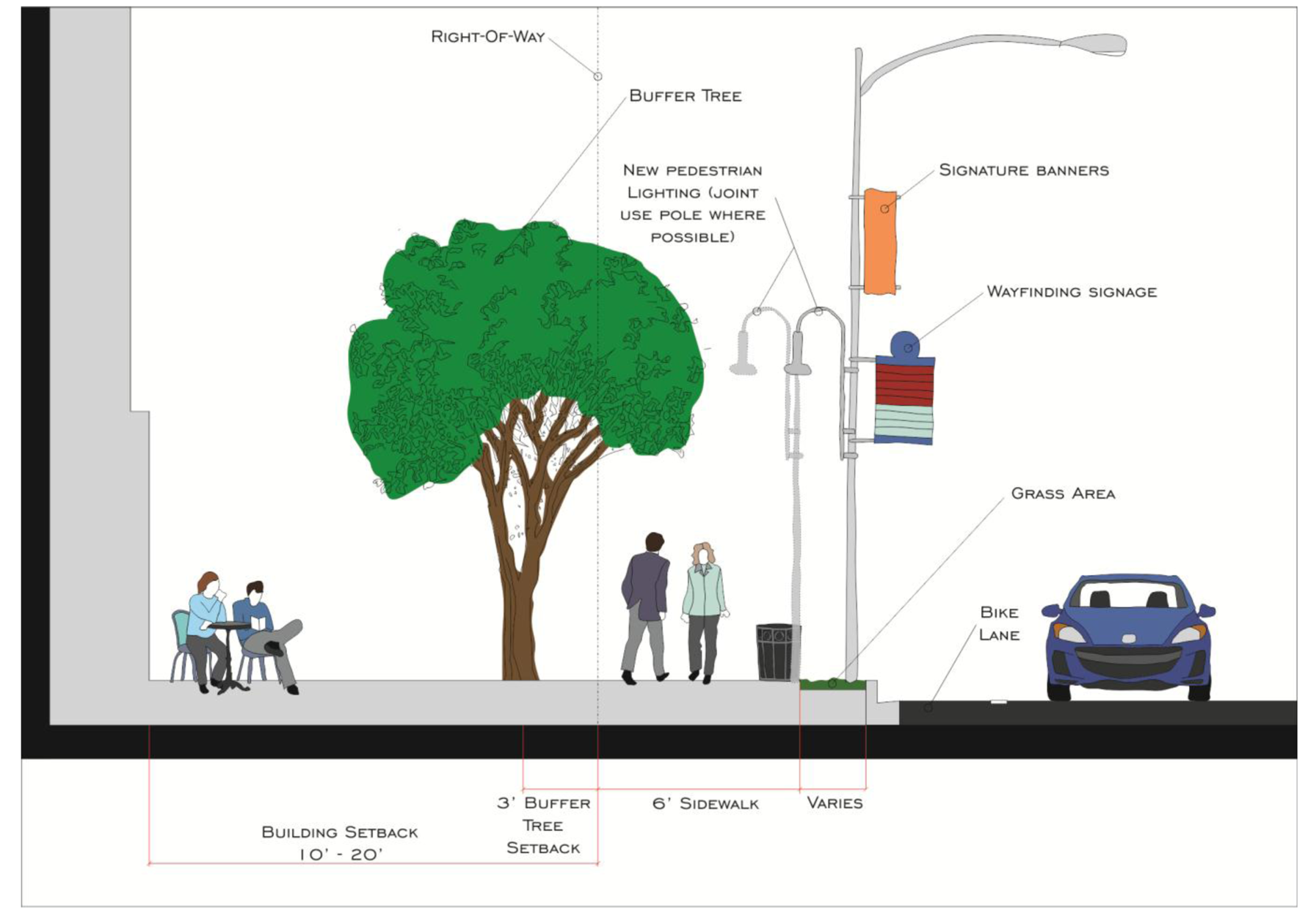
(1)
Building setback, height, sidewalk and streetscape standards for roadway classifications per the Westshore Pedestrian Plan and the following provisions as shown in Tables 238.2a—238.2e below, illustrations are provided for illustrative purposes only:
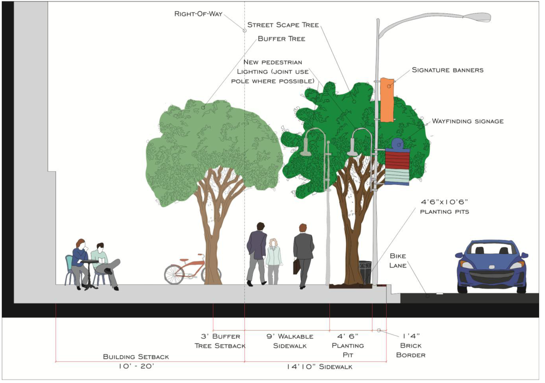
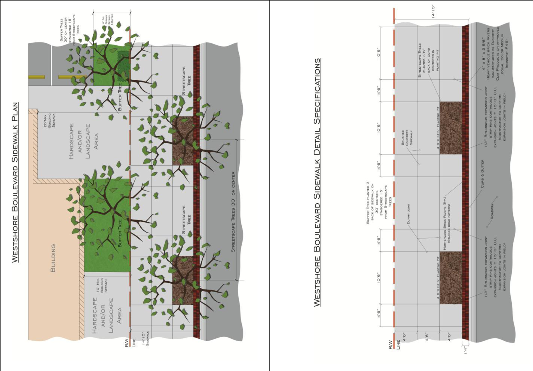
| Table 238.2a | |||||
|---|---|---|---|---|---|
| Priority Pedestrian Street—Westshore Boulevard | |||||
| Building Setback |
Building
Height |
Public
Sidewalk | Street Trees | Buffer Trees | |
| Front | 10′ min./20′ max[1] | [3] | 14′-10″(including 1′-4″ brick edging[5] | 30′ interval; planted within the public right-of-way[6] | 30′ intervals centered between Street Trees; planted 3′ back of sidewalk in setback area[6] |
| Side, corner, rear | 0′[2,4] | ||||
| Graphic Illustrations — Priority Pedestrian Street; Westshore Boulevard | |||||
 | |||||
 | |||||
|
Notes:
[1] May be increased to 58′, only when all other Overlay District parking standards are met, and certain building design features such as arrival amenities (e.g. porticos, visitor drop-off driveways) or pedestrian amenity areas (e.g. courtyards, outdoor cafés) are provided within the increased setback area. A maximum of one (1) row of parking spaces and one (1) drive aisle shall be permitted within the increased setback area; remaining area within increased setback area shall be used for landscaping/tree planting. Intent of the provision is to permit a larger setback to include design features, while also supporting a seamless transition to public realm. The initial ten (10′) feet of building setback as measured from the right-of-way line, or prevailing right-of-way line when applicable, shall maintain the existing grade of the adjacent right-of-way line. [2] Building setback from property lines adjacent to single-family zone or use shall be a minimum of 15′. [3] Building heights in the Overlay District shall be controlled by "Airport Zoning Regulations" and "Airport Height Zoning Map" as adopted and administered by the Hillsborough County Aviation Authority (HCAA) under the provisions of Chapter 333, Florida Statutes and Chapter 2003-370. Laws of Florida, in-lieu of Section 27-156. Table 4-2 . [4] In cases where a zoning lot or parcel abuts land that is zoned or used for single-family residential use, any building that exceeds thirty (30) feet in height shall setback an additional one (1) foot for each foot of building height above thirty (30) feet. [5] The sidewalk width shall be provided regardless of the width of the public right-of-way. If necessary the required sidewalk may utilize any or all of the building setback area. The sidewalk shall be made with scored concrete and textured paving bricks (see Westshore Boulevard Sidewalk Plan). The bricks shall be laid as shown in the Westshore Boulevard Sidewalk Detail Specifications. An applicant may elect to either: (i) install the sidewalk and provide an easement to the Transportation Division, or (ii) dedicate such area to the City of Tampa, if applicable, with applicable Multi-Modal Transportation Impact Fee Credits to be provided if approved or (iii) pay the applicable in lieu fee per section 22-103. [6] Street Trees shall be located three feet (3′) six inches (6″) feet back of curb in a four foot (4′) six inch (6″) by ten foot (10′) six inch (6″) planting area. Buffer Trees shall be located in the setback area centered between Street Trees unless the available buffer area is less than six feet (6′) in width. | |||||
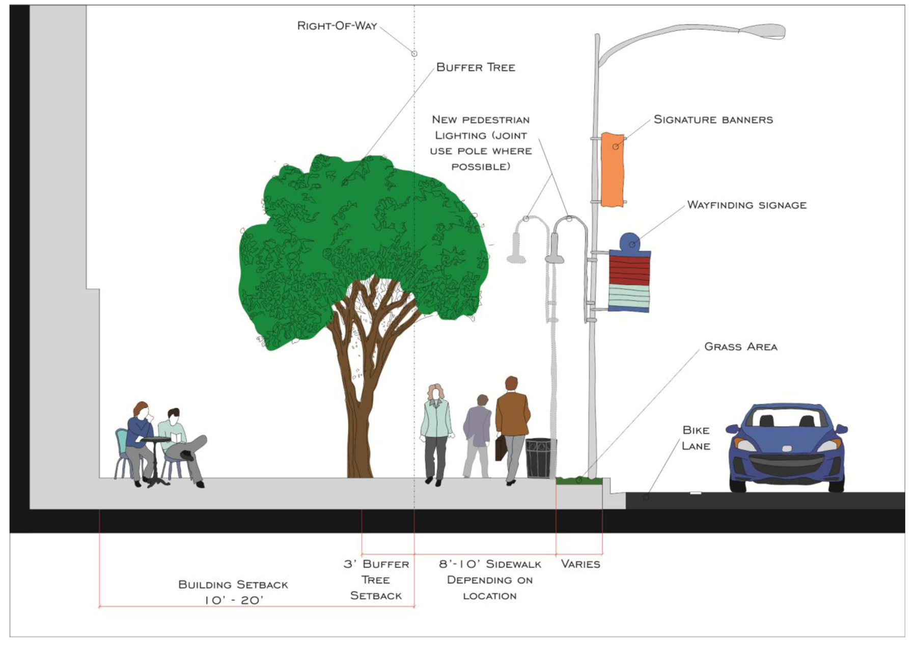
| Table 238.2b | ||||
|---|---|---|---|---|
| All Other Pedestrian Priority Streets | ||||
| Building Setback | Building Height | Public Sidewalk | Buffer Trees | |
| Front | 10′ min./20′ max[1] | [3] |
10′—Cypress Street [5]
8′ All Other Streets[5] | 30′ interval; planted 3′ back of sidewalk in setback area[5] |
| Side, corner, rear | 0′[2, 4] | |||
| Graphic Illustration—Other Priority Pedestrian Streets | ||||
 | ||||
|
Notes:
[1] May be increased to 58′, only when all other Overlay District parking standards are met, and certain building design features such as arrival amenities (e.g. porticos, visitor drop-off driveways) or pedestrian amenity areas (e.g. courtyards, outdoor cafes) are provided within the increased setback area. A maximum of one (1) row of parking spaces and one (1) drive aisle shall be permitted within the increased setback area; remaining area within increased setback area shall be used for landscaping/tree planting. Intent of the provision is to permit a larger setback to include design features, while also supporting a seamless transition to public realm. The initial ten (10′) feet of building setback as measured from the right-of-way line, or prevailing right-of-way line where applicable, shall maintain the existing grade of the adjacent right-of-way line. [2] Building setback from property lines adjacent to single-family zone or use shall be a minimum of 15′. [3] Building heights in the Overlay District shall be controlled by "Airport Zoning Regulations" and "Airport Height Zoning Map" as adopted and administered by the Hillsborough County Aviation Authority (HCAA) under the provisions of Chapter 333, Florida Statutes and Chapter 2003-370, Laws of Florida, in-lieu of Section 27-156, Table 4-2. [4] In cases where a zoning lot or parcel abuts land that is zoned or used for single-family residential use, any building that exceeds thirty (30) feet in height shall setback an additional one (1) foot for each foot of building height above thirty (30) feet. [5] The sidewalk width and adjacent Buffer Trees shall be provided regardless of the width of the public right-of-way. If necessary the required sidewalk may utilize any or all of the building setback area. Buffer Trees shall be located on thirty foot (30′) centers unless the available buffer area is less than six feet (6′) in width. An applicant may elect to either: (i) install the sidewalk and provide an easement to the Transportation Division, (ii) dedicate such area to the City of Tampa, if acceptable, with applicable Multi-Modal Transportation Impact Fee Credits to be provided, if approved, or (iii) pay the applicable in-lieu fee per section 22-103. | ||||
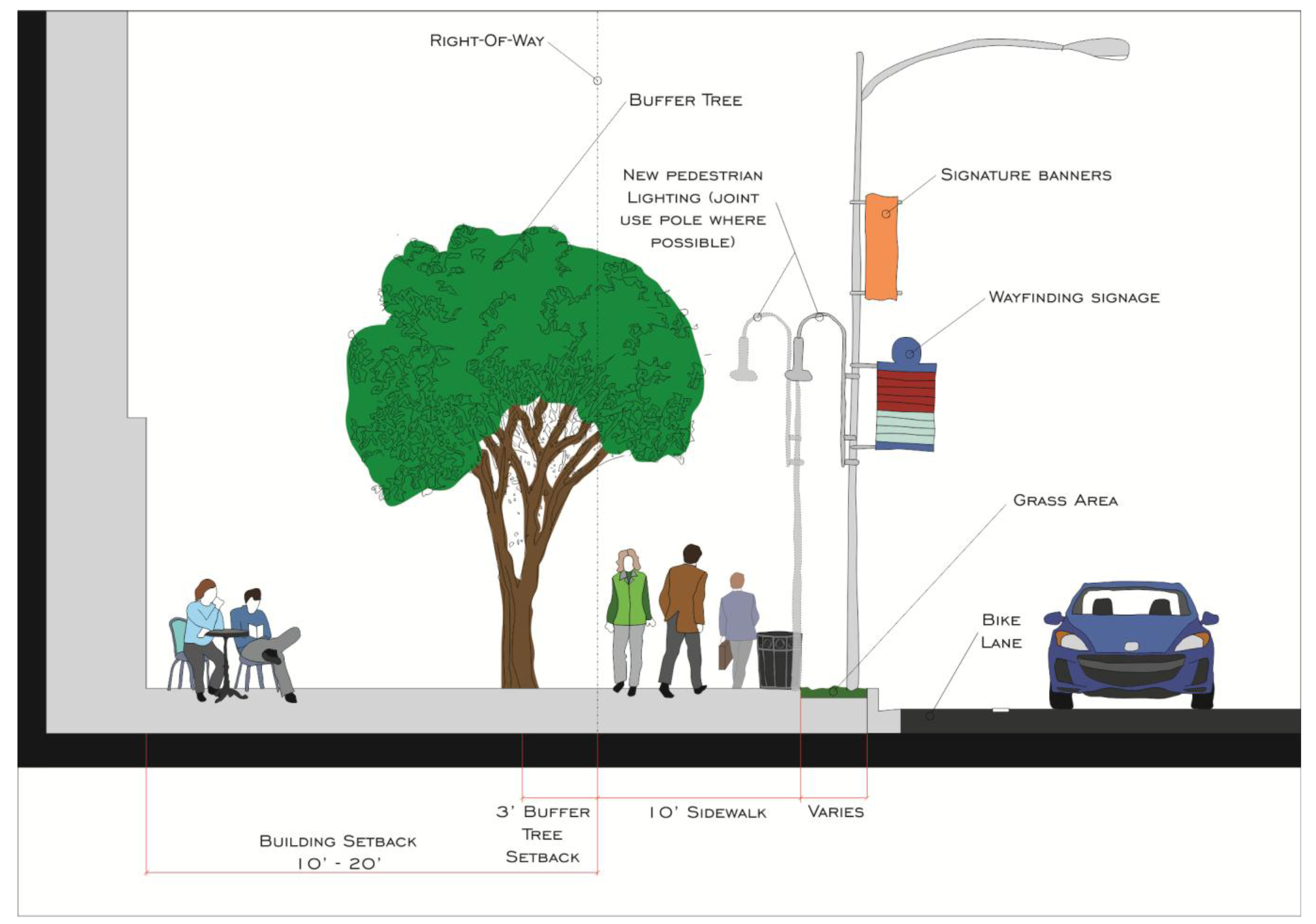
| Table 238.2c | ||||
|---|---|---|---|---|
| Regional Corridors | ||||
| Building Setback | Building Height | Public Sidewalk | Buffer Trees | |
| Front | 10′ min/20′ max[1] | [3] | 10′[5] | 30′ interval; planted 3′ back of sidewalk in setback area[5] within the public right-of-way |
| Side, corner, rear | 0′[2,4] | |||
Graphic Illustration — Regional Corridors
 | ||||
|
Notes:
[1] May be increased to 58′, only when all other Overlay District parking standards are met, and certain building design features such as arrival amenities (e.g. porticos, visitor drop-off driveways) or pedestrian amenity areas (e.g. courtyards, outdoor cafés) are provided within the increased setback area. A maximum of one (1) row of parking spaces and one (1) drive aisle shall be permitted within the increased setback area; remaining area within increased setback area shall be used for landscaping/tree planting. Intent of the provision is to permit a larger setback to include design features, while also supporting a seamless transition to public realm. The initial ten (10′) feet of building setback as measured from the righto-of-way line, or prevailing right-of-way line where applicable, shall maintain the existing grade of the adjacent right-of-way line. [2] Building setback from property lines adjacent to single-family zone or use shall be a minimum of 15′. [3] Building heights in the Overlay District shall be controlled by "Airport Zoning Regulations" and "Airport Height Zoning Map" as adopted and administered by the Hillsborough County Aviation Authority (HCAA) under the provisions of Chapter 333, Florida Statutes and Chapter 2003-370. Laws of Florida, in-lieu of Section 27-156, Table 4-2 . [4] In cases where a zoning lot or parcel abuts land that is zoned or used for single-family residential use, any building that exceeds thirty (30) feet in height shall setback an additional one (1) foot for each foot of building height above thirty (30) feet. [5] The minimum sidewalk width and adjacent Buffer Trees shall be provided regardless of the width of the public right-of-way. Buffer Trees shall be located on thirty foot (30′) centers unless the available buffer area is less than six feet (6′) in width. An applicant may elect to either: (i) install the sidewalk and provide an easement to the Transportation Division, or (ii) dedicate such area to the City of Tampa, if acceptable, with applicable Multi-Modal Transportation Impact Fee Credits to be provided, if approved or (iii) pay the applicable in-lieu fee per section 22-103. | ||||
| Table 238.2d | ||||
|---|---|---|---|---|
| Local Commercial Streets | ||||
| Building Setback | Building Height | Public Sidewalk | Buffer Trees | |
| Front | 10′ min/20′ max[1] | [3] | 6′[5] | 30′ interval; planted 3′ back of sidewalk in setback area[5] |
| Side, corner, rear | 0′[2,4] | |||
Graphic Illustration — Local Commercial Streets
 | ||||
|
Notes:
[1] May be increased to 58′, only when all other Overlay District parking standards are met, and certain building design features such as arrival amenities (e.g. porticos, visitor drop-off driveways) or pedestrian amenity areas (e.g. courtyards, outdoor cafés) are provided within the increased setback area. A maximum of one (1) row of parking spaces and one (1) drive aisle shall be permitted within the increased setback area: remaining area within increased setback area shall be used for landscaping/tree planting. Intent of the provision is to permit a larger setback to include design features, while also supporting a seamless transition to public realm. The initial ten (10′) feet of building setback as measured from the right-of-way line, or prevailing right-of-way line where applicable, shall maintain the existing grade of the adjacent right-of-way line. [2] Building setback from property lines adjacent to single-family zone or use shall be a minimum of 15′. [3] Building heights in the Overlay District shall be controlled by "Airport Zoning Regulations" and "Airport Height Zoning Map" as adopted and administered by the Hillsborough County Aviation Authority (HCAA) under the provisions of Chapter 333, Florida Statutes and Chapter 2003-370. Laws of Florida, in-lieu of Section 27-156, Table 4-2. [4] In cases where a zoning lot or parcel abuts land that is zoned or used for single-family residential use, any building that exceeds thirty (30) feet in height shall setback an additional one (1) foot for each foot of building height above thirty (30) feet. [5] The minimum sidewalk width and adjacent Buffer Trees shall be provided regardless of the width of the public right-of-way. Buffer Trees shall be located on private property on thirty foot (30′) centers unless the available buffer area is less than six feet (6′) in width. An applicant may elect to either: (i) install the sidewalk and provide an easement to the Transportation Division, (ii) dedicate such area to the City of Tampa, if acceptable, with applicable Multi-Modal Transportation Impact Fee Credits to be provided, if approved, or (iii) pay the applicable in-lieu fee per section 22-103. | ||||
| Table 238.2e | ||||
|---|---|---|---|---|
| Neighborhood Streets | ||||
| Building Setback | Building Height | Public Sidewalk | Buffer Trees | |
| Front | Per underlying zoning district[1] | [3] | 5′—6′[5] | 30′ interval; planted 3′ back of sidewalk in setback area |
| Side, corner, rear | 0′[2, 4] | |||
Graphic Illustration — Neighborhood Streets
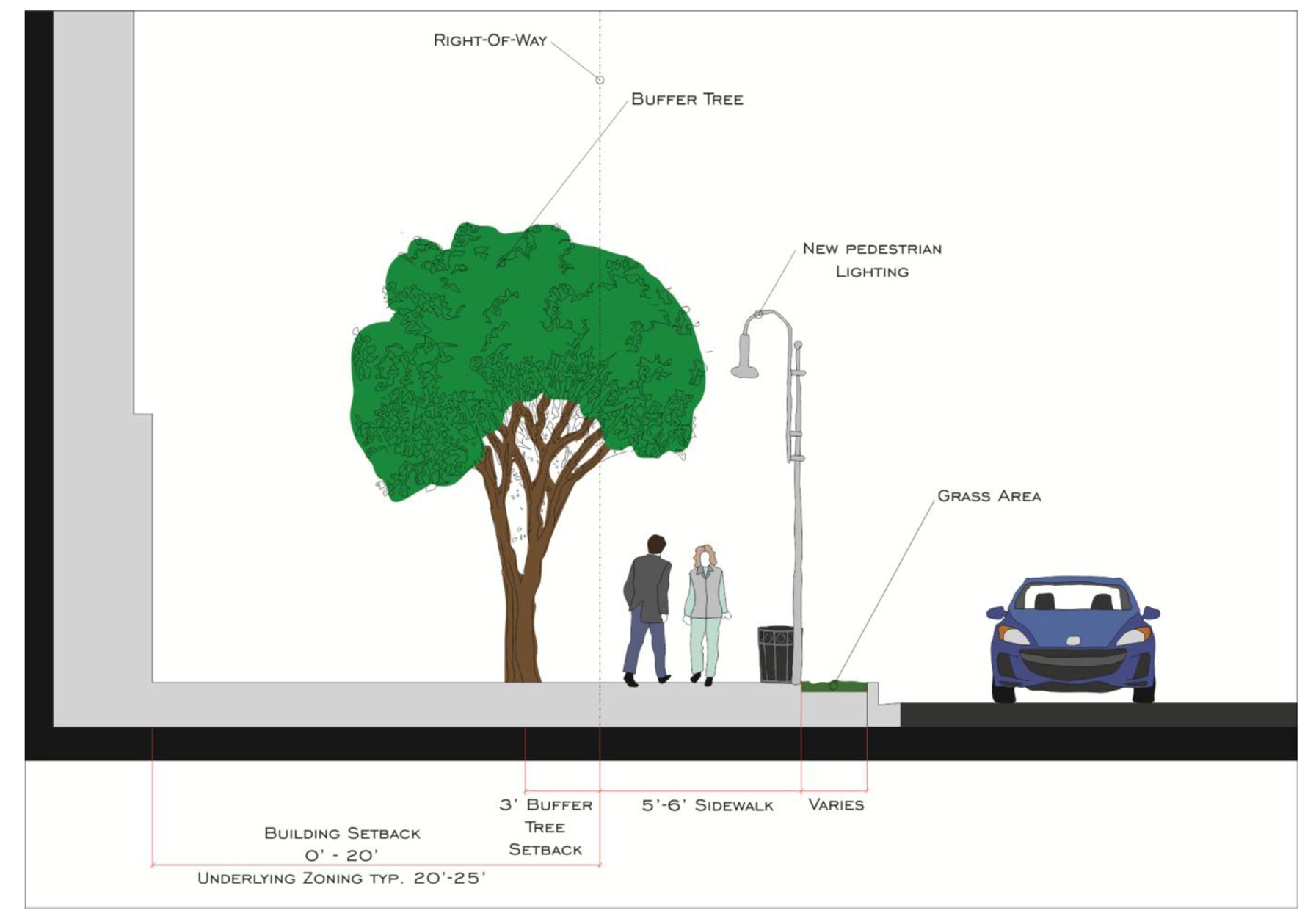 | ||||
|
Notes:
[1] Typically between 10′ and 25′. [2] Building setback from property lines adjacent to single-family zoning or use shall be a minimum of 15′. [3] Building heights in the Overlay District shall be controlled by "Airport Zoning Regulations" and "Airport Height Zoning Map" as adopted and administered by the Hillsborough County Aviation Authority (HCAA) under the provisions of Chapter 333, Florida Statutes and Chapter 2003-370. Laws of Florida, in-lieu of Section 27-156. Table 4-2. [4] In cases where a zoning lot or parcel abuts land that is zoned or used for single-family residential use, any building that exceeds thirty (30) feet in height shall setback an additional one (1) foot for each foot of building height above thirty (30) feet. [5] The minimum sidewalk width and adjacent Buffer Trees shall be provided regardless of the width of the public right-of-way. Buffer Trees shall be located on private property on thirty foot (30′) centers unless the available buffer area is less than six feet (6′) in width. An applicant may elect to either: (i) install the sidewalk and provide an easement to the Transportation Division, (ii) dedicate such area to the City of Tampa, if acceptable, with applicable Multi-Modal Transportation Impact Fee Credits to be provided, if approved, or (iii) pay the applicable in-lieu fee per section 22-103. | ||||
(2)
Intensity of use and bonus opportunities. The base densities and intensities of land use for properties not located in the M-AP Airport Compatibility Plan Category are regulated by the Tampa Comprehensive Plan Future Land Use Plan (hereinafter referred to as FLU), and not those referenced in section 27-156 Table 4-2. Densities and intensities may be increased from the base levels provided in the FLU to the maximum permitted by the FLU through the application of bonus amenities, as described and regulated by the Overlay District's governing land development regulations in this section. In no case shall development levels exceed the maximum densities for residential use and intensities (floor area ratios—FARs) for non-residential use as set forth and defined by the FLU.
The intensity of property (FAR) located within an M-AP airport compatibility district shall be as provided for in the FLU and specifically regulated by section 27-171, Table 4-3(1) Schedule of M-AP Permitted Uses, Maximum Floor Area Ratio and Maximum Coverage Regulations.
a.
Base densities/intensities. The FLU establishes the base densities or intensities of use permitted by the FLU without the requirement to provide bonus amenities.
b.
Bonus densities/intensities; methodology and calculation. An applicant may seek additional density or intensity through the use of bonus amenities up to the maximum level permissible by the FLU. Application to seek an increase over base densities or intensities of use shall be reviewed and approved through the plan review process. The opportunity to achieve density/intensity bonuses shall be based on the regulations set forth in this section and adherence to the methodology and calculations, but not the bonus criteria, set forth in section 27-141. Developments that may achieve bonuses per the provisions of this section shall not exceed the maximum density/intensity levels set forth in the FLU.
c.
Review procedures for bonus densities/intensities. The applicant shall submit the proposed bonus amenities to the zoning administrator for review and evaluation during the plan review process. The zoning administrator shall determine compliance with the provisions set forth in this section and report his/her findings as part of the administrative review process. Subsequent to a bonus density/intensity approval and prior to the issuance of the first permit for vertical construction for the project, applicable documents, costs of materials or any other relevant information shall be presented to the zoning administrator to determine compliance with the bonus related conditions.
d.
List of bonus amenities. The following list represents bonus amenities which may be provided to achieve increases in density and intensity in the Overlay District. The provisions outlined herein do not mandate or guarantee the award of a bonus to the applicant. Total bonuses shall not exceed the maximum density/intensity levels set forth by the FLU. Each bonus item listed includes the "bonus cost ratio" utilized within the formulas and calculations outlined in section 27-141. The list also includes, in some cases, provisions which signify the priority of a bonus item within the district to achieve such amenities, which significance can affect the level of bonus which may be achieved.
1.
Workforce Housing (as defined by the State of Florida) (Bonus Cost Ratio 20:1, plus an additional 0.10 FAR).
2.
Provision of public open space and/or enhancements such as parks, plazas and indoor or outdoor performance space available to the public (Bonus Cost Ratio 20:1, plus an additional 0.10 FAR).
3.
Mid-block pedestrian connectors through buildings (Bonus Cost Ratio 10:1).
4.
Bicycle accommodations such as lockers, shower facilities, etc. (Bonus Cost Ratio 10:1).
5.
Provision of public facilities deemed acceptable to the applicable receiving agency of city department (Bonus Cost Ratio 20:1, plus an additional 0.10 FAR).
6.
Provision, construction, and maintenance of public access to water resources and amenities through trails, marinas or greenways (Bonus Cost Ratio 10:1).
7.
Transit support subsidy or facilities (Bonus Cost Ratio 10:1, plus an additional 0.10 FAR).
8.
Leadership in Energy and Environmental Design (LEED) Certified Construction (Bonus Cost Ratio 10:1, plus an additional 0.10 for Silver Certification, 0.20 for Gold Certification or 0.30 for Platinum Certification).
9.
Energy Star Certification (Bonus Cost Ratio 10:1, plus an additional 0.10 for an 80% score, 0.20 for a 90% score or 0.30 for a 100% score).
10.
Public art pursuant to City of Tampa Code Chapter 4 Public Art (Bonus Cost Ratio 20:1).
11.
Child care center (Bonus Cost Ratio 10:1).
12.
Enhanced or increased streetscape, sidewalk and pedestrian designs accessible to the public (Bonus Cost Ratio 20:1).
(3)
Streetscape design standards. The following specific streetscape design standards shall be required for all properties located adjacent to Pedestrian Priority Streets, Regional Corridors, Local Commercial Streets and Neighborhood Streets. Refer to Tables 238.2a—238.2e, the "Westshore Boulevard Sidewalk Plan" and "Westshore Boulevard Sidewalk Detail Specifications" depicted herein for dimensional, placement, materials, and planting requirements.
a.
Sidewalk standards.
1.
The Westshore Boulevard sidewalk shall be made with scored concrete and textured paving bricks. The bricks shall be laid adjacent and perpendicular to Westshore Boulevard in a one foot (1') four inch (4") wide strip located parallel to the curb line.
2.
Site plans for properties located adjacent to Westshore Boulevard shall depict adjacent portions of sidewalk to demonstrate design consistency in layout and pattern.
3.
All other sidewalks shall be constructed to the designated width in a manner consistent with City of Tampa standards.
b.
Westshore Boulevard Street Trees and Buffer Tree standards.
1.
Street Trees shall be planted within planting areas and located three feet (3′) six inches (6′) back of curb. Buffer Trees shall be planted three feet (3′) back of sidewalk provided the available setback area is six feet (6′) or greater in width. Buffer Trees shall be provided adjacent to the Westshore Boulevard sidewalk provided where a planting area of at least six feet (6') is available. The developer shall be responsible for all costs associated with design, permitting, installation, replacement, irrigation, pruning, and general maintenance of the Street Trees and Buffer Trees and any additional landscape materials provided.
2.
Street Trees shall be Bosque Elm (Ulmus parvifolia, "Bosque" Min. 6″ caliper; 16′—18′ HT × 10′—12′ SPR.; Florida No. 1.). Buffer Trees shall be Bosque Elm, (Ulmus parvifolia, "Bosque" Min. 4″ caliper/10′—12′ HT × 4′—5′ SPR. Florida No. 1.), live oak, (Quercus virginiana, Live Oak "Sky Climber": Min. 4″ caliper/10′—12′ HT × 4′—5′ SPR. Florida No. 1.), Winged Elm (Ulmus alata "Winged Elm" : Min. 4″ caliper/10′—12′ HT × 4′—5′ SPR. Florida No. 1.) or Bald Cypress (Taxodium Distichum, Bald Cypress 'Autumn Gold'—Min. 4" caliper/ 10′—12′ HT. × 4′—5′ SPR. Florida No. 1.). The zoning administrator or designee shall consult the Natural Resources Coordinator on any Buffer Tree alternative selections.
3.
Street Trees and Buffer Trees shall possess the following minimum specifications at time of planting: Six inch (6″) caliper, one hundred-gallon or equivalent, ten foot (10′) to twelve foot (12′) spread.
4.
Street Trees and Buffer Trees shall be planted on thirty foot (30′) staggered centers as depicted herein
c.
Buffer Tree Standards (all non-Westshore Boulevard streets).
1.
Buffer Trees shall be planted three feet (3′) back of sidewalk provided the available setback area is six feet (6′) or greater in width. The developer shall be responsible for all costs associated with design, permitting, installation, replacement, irrigation, pruning, and general maintenance of the Street Trees and Buffer Trees and any decorative materials provided as a part of the streetscape plantings.
2.
Buffer Trees shall be Bosque Elm, (Ulmus parvifolia, "Bosque" Min. 4″ caliper/10′—12′ HT × 4′—5′ SPR. Florida No. 1.), live oak, (Quercus virginiana, Live Oak "Sky Climber": Min. 4″ caliper/10′—12′ HT × 4′—5′ SPR. Florida No. 1.), Winger Elm (Ulmus alata "Winged Elm": Min. 4″ caliper/10′—12′ HT × 4′—5′ SPR. Florida No. 1.) or Bald Cypress (Taxodium Distichum, Bald Cypress 'Autumn Gold'—Min. 4″ caliper/10′—12′ HT. × 4′—5′ SPR. Florida No. 1.). The zoning administrator or designee shall consult the Natural Resources Coordinator on any alternative selections.
3.
Buffer Trees shall possess the following minimum specifications at time of planting: Four inch (4″) caliper, one hundred-gallon or equivalent, eight foot (8′) to ten foot (10′) spread.
4.
Buffer Trees shall be planted on thirty foot (30′) centers.
d.
Streetscape lighting standards: Light poles and fixtures within the Kennedy Boulevard corridor shall follow the street lighting standards set forth in section 27-243. Light poles and fixtures along all other street corridors within the district shall follow the standards set forth in the Westshore Pedestrian Plan. Streetscape lighting shall be aimed away, or otherwise shielded, from residential uses so as not to create a negative impact on the adjacent residential uses.
(4)
Building and site standards.
a.
Pedestrian amenities shall be provided next to areas used by the public, including, but not limited to shade trees, public open space, water features, sitting areas and mass transit stops.
b.
At least fifty (50) percent of the ground level of all principal building façade(s) fronting and visible from a public right-of-way, except single-family, single-family attached, and townhouses, shall be constructed of transparent material.
c.
At least seventy (70) percent of continuous front façade that is oriented to and visible at ground level from public rights-of-way shall be embellished with doors, windows and other architectural features as methods to break large wall planes into smaller components.
d.
The principal façade of all buildings shall front the public right(s)-of-way or may be located off a plaza adjacent to and connected with the public sidewalk located adjacent to the street.
e.
Drive-through window services and queuing lanes shall be placed in the side or rear yard of the parcel on which it is located. Drive through window services and queuing lanes shall be located no closer than fifty (50) feet to residentially zoned properties. Speaker systems shall not be aimed towards residentially zoned properties and the owner of the speaker shall provide evidence that the noise levels created by the speaker system do not exceed noise levels allowed by the city. Queuing lanes areas should incorporate natural surveillance techniques.
f.
Chain link and wooden fences are prohibited on parcels regulated in the Overlay District, except during construction. Construction fencing shall be removed prior to obtaining any certificate of occupancy. Decorative fencing for the purposes of implementing CPTED principles is encouraged. Any existing chain link or wooden fencing shall be removed prior to the issuance of any site or building permit for new construction and/or change of use as defined in Chapter 27, City of Tampa Code of Ordinances. In the event of destruction, damage or deterioration of a non-conforming fence that has occurred in the amount of fifty (50) percent of its material value, that compromises the fence, such fence may only be repaired or reconstructed in conformity with the requirements of this section.
g.
Unpainted or unfinished block fences or walls are prohibited. All sides and elevations of buildings, walls, or block fences visible from public right-of-way or an adjacent parcel must be architecturally finished (i.e. brick, stucco, or textured concrete masonry units) and maintained.
h.
Outdoor onsite light fixtures shall be used at all public use areas adjacent to the building (e.g. entryway, courtyards, parking lots, etc.) to a recommended 0.5 to 1.0 foot candle level of illumination. Light fixtures shall be aimed away, or otherwise shielded, from residentially zoned properties and shall be of an intensity that does not create a negative impact on the adjacent residential properties.
i.
Any exterior garbage receptacles, dumpsters, open storage areas (as defined in section 27-43) or mechanical equipment must be screened from view from public rights-of-way and residential single-family zoned property with opaque or solid materials similar to those utilized by the principal structure. Additionally, garbage receptacles, dumpsters, open storage areas and/or mechanical equipment must be a minimum twenty-five (25) feet from any property zoned for single-family residential uses.
j.
Rooftop equipment, excluding vents and stairwell access, shall be screened from view as visible from a pedestrian on any adjacent public right-of-way by use of parapet walls or architecturally compatible screens.
k.
Continuous sidewalks shall be provided along the entire length of street frontage, and shall be aligned with and connected to that of adjacent and contiguous properties.
l.
For properties with multiple tenants and/or multiple structures on site, pedestrian circulation shall be provided between tenants and/or structures through the use of a sidewalk or other suitable pedestrian connection, not less than five (5) feet wide and where applicable, shall align with and connect to that of adjacent and contiguous properties. Sidewalk paving or other pedestrian connections, where applicable, must continue uninterrupted across the mouth of all curb cuts, subject to section 22-315 of the City of Tampa Code of Ordinances.
m.
Retention ponds shall be maintained and screened with landscaping or fencing or must contain special site features, such as fountains or reflecting pools.
n.
The entrance to all service bays for automotive repair and service businesses must be oriented away from view of any arterial or collector roadway(s) and residentially zoned properties. All automotive repair and service shall take place within the fully enclosed area of the building in which such use is located.
o.
All buildings shall have pedestrian access oriented toward the public sidewalk adjacent to the street.
p.
Illuminated tubing which outlines a building, fence or other similar structure or part thereof, measuring more than twenty (20) linear feet or enclosing any area greater than twenty (20) square feet is prohibited.
q.
The numerical address of each building should be clearly displayed and easily observed from the public right-of-way.
r.
Self-service fueling devices shall be located adjacent to a building with exterior walls and a roof. No self-service fueling device shall be located between a building with exterior walls and a roof and any Pedestrian Priority Street, Regional Corridor or Local Commercial Street.
s.
The setback for a Principal Parking use, Interim Parking use, or Special Event Parking use shall be thirty feet (30′) from any Pedestrian Priority Street, Regional Corridor, or Local Commercial Street.
t.
Public Open Space Standards. Public Open Spaces are generally open areas that allow the movement of light and air, and may be enhanced for general public use and/or pedestrian purposes. Such spaces shall be provided as described below, shall maintain a minimum fifteen (15) feet vertical clearance from finished grade, and shall be deemed and credited as a "landscaped area" in accordance with the requirements of section 27-285.
Minimum Public Open Space area and Placement Requirements:
1.
The initial ten (10′) feet of building setback along Pedestrian Priority Streets, Regional Corridors, and Local Commercial Streets.
2.
Small Public Open Space areas measuring twenty (20) feet by twenty (20) feet shall be provided at the following intersection corners:
i.
Northwest and southeast corners of Westshore Boulevard at Spruce Street, Laurel Street and Gray Street; and
ii.
Northwest and southeast corners of Dale Mabry Highway at Palmetto Street, and Gray Street; and
iii.
Northeast and southwest corners of Kennedy Boulevard at Grady Avenue and Manhattan Avenue; and
iv.
Northeast and southwest corners of Lois Avenue at Boy Scout Boulevard, Spruce Street, and Cypress Street; and
v.
Northeast and southwest corners of Boy Scout Boulevard at Jim Walter Boulevard; and
vi.
Northeast and southwest corners of Cypress Street at O'Brien Street.
vii.
The depth or width of the Small Open Spaces may be decreased to ten (10) feet if the total square footage of four hundred (400) square feet is provided and two (2) amenities such as benches, shade structure, trash receptacle, way-finding map, bus stop, bike racks (five (5) bike stations min.) bike repair station, water fountain, pet walk, pet station, or similar pedestrian amenities, are provided in a manner accessible from the public sidewalk.
3.
Large Public Open Space areas measuring forty (40′) feet by forty (40') feet shall be provided at the following intersection corners:
i.
Northwest and southeast corners of Westshore Boulevard at Cypress Street and Kennedy Boulevard; and,
ii.
Northwest and southeast corners of Dale Mabry Highway at Columbus Drive, Home Depot/Wal-Mart, Cypress Street, and Kennedy Boulevard; and
iii.
Northeast and southwest corners of Kennedy Boulevard and Lois Avenue.
iv.
The depth or width of the Large Open Spaces may be decreased to ten (10) feet if the total square footage of one thousand six hundred (1,600) square feet is provided and four (4) amenities, such as benches, shade structure, trash receptacle, way-finding map, bus stop, bike racks (five (5) bike stations minimum), bike repair station, water fountain, pet walk, pet station, or similar pedestrian amenities, are provided in a manner accessible from the public sidewalk.
v.
The open space requirement for multi-family buildings four (4) stories or higher shall be thirty (30) percent of the parcel excluding building footprint(s) and parking.
(5)
Parking standards:
a.
Existing surface parking areas (vehicular use areas) shall be improved pursuant to the requirements of this section if any site or grading permit is issued, if the pavement materials have to be repaired or replaced due to physical deterioration, or a redesign of said area occurs.
b.
Vehicle access shall have minimal impact on pedestrian circulation. Sidewalk paving must continue uninterrupted across the mouth of all curb cuts, subject to section 22-315 of the City of Tampa Code of Ordinances. Decorative pavers, other textured material, or similar permanent delineations shall be used across the mouth of all curb cuts to provide a pedestrian conveyance.
c.
The façade of parking structures which are within twenty (20) feet of a priority pedestrian street right-of-way must consist of commercial, retail, or office uses or any combination thereof on the ground level.
d.
Parking structures shall provide landscaping adjacent to those areas which are visible from the street right-of-way. When the parking structure is abutting land zoned or used for single-family residential use, the façade of the parking structure shall be made opaque (to the extent possible without installation of forced ventilation) pursuant to Life Safety and Building Code requirements.
e.
A minimum of eighty (80) percent of all surface parking for commercial properties shall be located in the side or rear yard of the property. All surface parking for other non-single-family residential properties shall be located in the rear or side yard of the property, unless it can be demonstrated that the rear yard of the property cannot accommodate such parking, then the side yard may be used to provide the additional parking required. CPTED techniques should be incorporated in the design and security of all parking areas (i.e., visibility, access and security).
f.
Vehicular use areas shall not be closer than twenty-five (25) feet from property zoned for single-family uses and shall be screened from said residential uses with a six-foot high masonry wall and fifteen (15) feet landscaped buffer.
g.
It is recommended that parking facility lighting maintain a minimum onsite illumination as published in the "Illumination Engineering Society, IES Lighting Handbook" (edition current at the time of permit application). Parking facility lighting shall be aimed away, or otherwise shielded from residential uses, so as not to create a negative impact on such uses.
h.
Parking structures should have sufficient security measures and will be reviewed by a certified CPTED practitioner.
i.
Applicable off-street parking and loading ratios by use shall comply with Article VI, Division 3, Off-Street Parking and Loading. For properties not located adjacent to or across a public right-of-way or easement from existing parcels zoned for single-family residential uses, the Alternative Parking Ratios identified in Table 238-3 shall be used. On a site plan, the applicant has to demonstrate the adjacent land uses and zoning in order to determine which parking ratio shall be used. In either case, parking ratios for mixed-use developments or unique development circumstances may be permitted pursuant to procedures set forth in section 27-60, Alternative Design Exceptions. The required overall parking for mixed-use developments not located to adjacent to single-family residential and comprised of two (2) uses from two (2) separate Use Groups as identified in Table 4-1 of the City Code shall be reduced by ten (10) percent. Motorcycle parking spaces may be substituted for vehicle parking spaces on a one (1) space per one (1) space ratio but shall not exceed five (5) percent or ten (10) motorcycle spaces, whichever is less, of the total parking required. Bicycle parking spaces may be substituted for vehicle parking spaces on a five (5) bicycle space spaces per one (1) vehicle space ratio but shall not exceed five (5) percent or the equivalent of ten (10) vehicle spaces, whichever is less, of the total parking required. Regarding off-street loading, every use requiring a loading berth(s) for the receipt and distribution by vehicles of materials and merchandise shall only be required to have one (1) loading berth. When the off-street loading space requirements of a specific use or development can be shown to require anything less than the requirements of this section, a reduction to these standards may be authorized pursuant to section 27-283.15. All parking spaces provided in excess of the ratios referenced above are deemed "Parking, principal" in type and may be used for "off-site" purposes per section 27-283.6 or commercial parking.
j.
Developments located along Local Commercial Streets and non-residential Neighborhood Street as defined in section 27-283.12(j)(1)(d) shall be permitted to maneuver in the right-of-way to access loading berths and solid waste facilities.
(6)
Landscaping, buffers, screening and protected tree standards.
a.
An eight-foot landscape buffer shall be provided along the boundary of all vehicular use areas abutting public right-of-way. Said buffer shall adhere to the following:
1.
One (1) four-inch caliper tree per thirty (30) linear feet of vehicular use area abutting a right-of-way, except adjacent to Westshore Boulevard where one (1) six-inch caliper tree per thirty (30) linear feet of vehicle use area abutting the right-of-way is required;
2.
A two-foot hedge planted twenty-four (24) inches on center;
3.
All plants shall meet or exceed the requirements of Chapter 13;
4.
Trees adjacent to surface parking areas should be trimmed to maintain a six-foot clear height, hedges and shrubs should be trimmed to maintain a maximum of two (2) feet in height.
Through the alternative design exception process, pursuant to section 27-60, the zoning administrator or designee may consider the following;
5.
Buffer trees may be grouped and larger diameter trees may be substituted at a rate of two (2) inches for every one (1) inch required; consideration of this alternative shall be considered on a case by case basis, except along Westshore Boulevard;
6.
Reduction in the width of a landscaped buffer to no less than three (3) feet, for those vehicular use areas that abut priority pedestrian streets and where pedestrian areas (sidewalks or pedestrian/bicycle paths) are proposed and provided payment in-lieu of landscaping is made pursuant to section 27-285(e).
7.
See Tables 238.2 a, b, c, d, and e for additional Buffer Tree requirements.
b.
The standards set forth in section 27-285 shall apply for the calculation of the minimum amount of landscaped area required for a development. If the minimum amount of landscaped area cannot be provided, reduction of the landscaped area (regardless of the percentage being requested) may be considered through an alternative design exception review, and shall be subject to the in-lieu payment procedure set forth in section 27-285(e)(2); however, all portions of each site that are not devoted to building or paving shall be landscaped. No more than thirty (30) percent of any landscaped area may be grassed; the balance shall be landscaped in shrub and ground covers. All types of Bahia grasses shall be prohibited in front yard setbacks or any other grassed areas visible to a pedestrian from an adjacent public right-of-way.
c.
Properties adjacent to residentially zoned properties shall maintain a fifteen-foot landscaped buffer and six-foot high masonry wall. Said buffer shall consist of at least one (1) tree per sixty (60) linear feet of abutting property.
d.
All landscaping must be maintained in good order and all applicants for new construction or change of use shall provide a schedule of maintenance for the installed landscaping.
e.
No more than seventy-five (75) percent of protected trees on a parcel may be removed from the development parcel. For purposes of the Overlay District, protected trees shall be defined as any protected tree that is ten (10) inches or greater in diameter at breast height (d.b.h.). This standard shall not apply to development proposals where the proposed use is principal parking. Mitigation for tree removal (i.e., five (5) inches or greater for trees other than palms and ten (10) inches or greater for palms) shall be in accordance with the criteria established in Chapter 13-165 (f) Schedule E—Tree Equivalency Table.
f.
The removal of grand trees shall only be permitted in accordance with the regulations and processes established in Chapter 13.
g.
Up to fifty (50) percent of protected on site palm trees may be relocated on-site and considered retained for the purpose of tree credits.
(7)
General sign standards. The following standards shall apply to new signs. The following provisions are intended to establish a distinct character for the Overlay District by creating an appealing environment, reduce distractions to motorists and pedestrians and reduce visual blight.
a.
The sign standards provided herein offer a coordinated graphic program that provides for occupant identification and directional communication, while allowing the creation of unique and informative signs that give a distinct and aesthetically pleasing flavor. These standards are not intended to prohibit unusual signs that may enhance the character of the building, or reflect the nature of the business. Also, these standards are intended to provide additional or supplemental sign regulations to Article VI, Division 6, Signs, City of Tampa Code of Ordinances. Reference shall be made to Article VI, Division 6 for any other sign requirements.
1.
Billboards and off-site signs are prohibited. Signs vested under previous agreements between the City of Tampa and the sign owner will not be affected by this district.
2.
No sign on a parcel adjacent to or within three hundred (300) feet of a residence shall be illuminated from 11:00 p.m. to 7:00 a.m., except where the use conducted on the premises is open for business, or unless the sign illumination is wholly shielded from the residential uses in all directions, by a non-residential building. At no time shall the light from a sign be directed towards a residence.
3.
Freestanding signs for single occupancy parcels shall be limited to a maximum of fifty (50) square feet in dimension per sign face. Such signs are limited to a maximum height of ten (10) feet at a setback of five (5) feet, subject to the requirements of section 27-283.5.
4.
Freestanding signs for multiple occupancy parcels which are entitled to one (1) sign shall be limited to a maximum of one hundred (100) square feet in dimension per sign face. Such signs are limited to a maximum height of ten (10) feet, subject to the requirements of section 27-283.5.
5.
Freestanding signs shall be subject to the following additional provisions: for every one (1) foot of additional setback provided, the height of the freestanding sign may be increased by one (1) foot to a maximum of twenty (20) feet. The freestanding sign shall consist of a single pier or pillar with a minimum diameter or horizontal dimension of twenty-four (24) inches, or alternatively, by two (2) piers or pillars each with a minimum diameter or horizontal dimension of twelve (12) inches. The sign structure shall be made of materials consistent with and maintain compatible architectural design with the principal building it serves. Furthermore, the sign shall have a decorative base with a minimum height of two (2) feet and a minimum length of not less than eighty (80) percent of the maximum length of the sign face.
6.
If a multiple occupancy parcel is entitled to more than one (1) freestanding sign, per Article VI, Division 6, then all allowable freestanding signs may be combined into a single freestanding sign not to exceed one hundred (100) square feet per sign face. Ground signs are limited to a maximum height of fifteen (15) feet and pylon signs shall be limited to twenty (20) feet.
7.
The surface area of all shapes, letters, numbers, symbols or illustrations on a marquee, canopy or awning sign shall not exceed twenty-five (25) percent of the marquee, canopy or awning sign surface. Only awnings and canopies constructed of opaque material may be illuminated.
8.
Building signs shall not exceed more than one (1) square foot per one (1) linear foot of building frontage facing a public street. No wall sign shall extend more than twelve (12) inches out from the wall to which it is attached nor shall it extend more than eighteen (18) inches into the public right-of-way.
9.
Multi-family residential dwelling freestanding signs must comply with section 27-289.3(b), and shall not exceed fifteen (15) feet in height.
10.
Pylon signs are prohibited along Kennedy Boulevard, and shall be located no closer than one hundred (100) feet from the Kennedy Boulevard right-of-way.
11.
Signs shall be prohibited on transit shelters, with the exception of government signs, as defined in Article VI, Division 6.
12.
Any sign deemed nonconforming per the sign standards set forth in this section or Article VI, Division 6 shall not be enlarged or altered in a way which increases its degree of nonconformity. Such signs shall not be structurally altered as to prolong the life of the sign; however, reasonable repair and maintenance, including change of copy, is permitted. Reasonable repair and maintenance means the work necessary to keep the sign, including the sign structure, in a good state of repair, but does not include the replacement of structural materials, such as changing a metal sign to a wooden sign, or changing the overall height of the sign, or enhancing the visibility of the sign copy, or the addition of changeable sign faces, or the addition of artificial lighting apparatus.
(h)
Transit stop provisions. Wherever possible, development within the Westshore Overlay District shall be designed to maximize the efficiency of mass transit. The developer shall coordinate with the City of Tampa and the Hillsborough Area Regional Transit (HART line) system to determine if the site warrants transit stop improvements such as easement dedication or transit shelters. These improvements may be considered for justification for the reduction of up to ten (10) percent of the required parking spaces.
(i)
Curb cuts/access management. Requests for additional curb cuts, for existing development, will only be considered in instances of public safety issues. In cases where such a curb cut is approved, the petitioner shall be solely responsible for any off-site or site specific improvements which are necessary to facilitate the design of the driveway or curb cut, including but not limited to signalization, turn lanes, and accel/decel lanes. These transportation improvements are not creditable against multi-modal transportation impact fees.
(j)
Roadway landscaping guidelines. All roadway improvements within the district plus SR 60 from the western city limits to Kennedy Boulevard which serve as gateways into the Westshore Overlay District, shall dedicate a minimum of one (1) percent of the total cost of the improvement for landscaping and irrigation within or adjacent to the improvement area. The design of such landscaping and irrigation should be reviewed and approved by the City of Tampa.
(Ord. No. 2012-127, § 1, 11-1-2012; Ord. No. 2014-104, § 1(Exh. A), 10-16-2014; Ord. No. 2015-83, § 3, 7-30-2015; Ord. No. 2017-103, § 4, 6-22-2017; Ord. No. 2023-128, § 6, 9-21-2023)
Sec. 27-239. - Reserved.
Editor's note— Ord. No. 2017-43, § 8, adopted March 16, 2017, repealed § 27-239, which pertained to Seminole Heights Residential Overlay District Development Design Standards. See Code Comparative Table for complete derivation.
Sec. 27-240. - East Tampa Overlay District Design Standards.
(a)
Area description and boundaries. The East Tampa Overlay District is an area consisting of residential neighborhoods, regional and local commercial centers and industrial areas. Within the district, there are major roadways which serve as the commercial and industrial corridors for the area, with the residential development primarily situated on the local streets.
That Part of Sections 1, 12 and 13, Township 29 South, Range 18 East, AND Sections 31, 32 and 33, Township 28 South, Range 19 East AND Sections 4, 5, 6, 7, 8, 9, 10, 16, and 17, Township 29 South, Range 19 East, all lying within the City of Tampa, Hillsborough County, Florida, lying within the following described boundaries to wit:
Beginning at the intersection of the centerline of Hillsborough Avenue (State Road 600) and the centerline of 50th Street, said intersection also being a point on the Easterly boundary of the corporate limits of the City of Tampa, as established by House Bill 734, approved by the Governor of Florida on, April 28, 1953, filed in the office of the Secretary of the State on, April 29, 1953; thence Southerly along said Easterly boundary of the corporate limits of the City of Tampa, to its intersection with the centerline of Dr. Martin Luther King, Jr. Boulevard (State Road 574); thence Easterly along said centerline of Dr. Martin Luther King, Jr. Boulevard and corporate limits of the City of Tampa, to its intersection with the centerline of 56th Street; thence Southerly along said centerline of 56th Street and corporate limits of the City of Tampa, to its intersection with the centerline of Interstate Highway 4 (State Road 400); thence Southwesterly and Westerly along said centerline of Interstate Highway 4, to its intersection with the with the Easterly boundary of the existing local Ybor City Historic District, as established per City of Tampa Ordinance 9324-A; thence Northerly along said Easterly boundary of the local Historic District, to the Northeasterly corner thereof; thence meandering Westerly and Southerly along said existing Historic District boundary, to its intersection with the centerline of Interstate Highway 4 (State Road 400); thence Westerly along said centerline of Interstate Highway 4, to its intersection with the Interstate Highway 275 (State Road 93); thence Northerly along said centerline of Interstate Highway 275, to its intersection with the centerline of Dr. Martin Luther King, Jr. Boulevard (State Road 574); thence Easterly along said centerline of Dr. Martin Luther King, Jr. Boulevard, to its intersection with the centerline of 15th Street; thence Northerly along said centerline of 15th Street, to its intersection with the centerline of Comanche Avenue; thence Easterly along said centerline of Comanche Avenue, to its intersection with the centerline of 22nd Street; thence Northerly along said centerline of 22nd Street, to its intersection with the centerline of Henry Avenue; thence Easterly along said centerline of Henry Avenue, to its intersection with the centerline of 30th Street; thence Southerly along said centerline of 30th Street, to its intersection with centerline of Comanche Avenue; thence Easterly along said centerline of Comanche Avenue, to its intersection with the centerline of 34th Street; thence Northerly along said centerline of 34th Street, to its intersection with the centerline of Comanche Avenue; thence Easterly along said centerline of Comanche Avenue, to its intersection with the centerline of 37th Street; thence Northerly along said centerline of 37th Street, to its intersection with the centerline of Deleuil Avenue; thence Easterly along said centerline of Deleuil Avenue, to its intersection with the Westerly boundary of the Southerly 291.00 feet of the Northerly 700.00 feet of the Easterly 500.00 feet of the Southeast ¼ of the Southwest ¼ of said Section 33, Township 28 South, Range 19 East; thence Northerly along said Westerly boundary, to its intersection with the Westerly projection of the Southerly boundary of, Lot 8 of POWHATAN HILLS, a subdivision of record as recorded in Plat Book 40, Page 98, of the public records of Hillsborough County, Florida;
Thence Easterly along said Westerly projection and Southerly boundary of Lot 8, to and along the Southerly boundary of Lots 7, 6, 5, 4, 3, 2 and 1 of said POWHATAN HILLS, and its Easterly projection, to its intersection with the centerline of 43rd Street; thence Southerly along said centerline of 43rd Street, to its intersection with the centerline of Deleuil Avenue; thence Easterly along said centerline of Deleuil Avenue, to its intersection with the Easterly boundary of NORTHVIEW TERRACE SUB., a subdivision as recorded in Plat Book 41, Page 12, of the public records of Hillsborough County, Florida, said intersection also being, the Northerly projection of the Westerly boundary of Lot 19, of said NORTHVIEW TERRACE SUB.; thence Southerly along said Northerly projection and Easterly boundary, to and along the Easterly boundary of said Lot 19, to the Southeast corner of said Lot 19, said Southeast corner, also being a point on the Northerly boundary of the following described parcel: Beginning at the intersection of the West boundary of Lot 60 of PLAT OF FUNK'S HOME PARK SUBDIVISION, as recorded in Plat Book 19, Page 9 of the public records of Hillsborough County, Florida, and the north right-of-way line of Hillsborough Avenue, said point lying 17.00 feet North of the Southwest corner of said Lot 60, thence Northerly along Easterly boundary of vacated alley abutting on the East of Block 2 of REVISED MAP OF RUBENSTEINS SUBDIVISION, as recorded in Plat Book 8, Page 38 of the public records of Hillsborough County, Florida, and the Northerly projection of said boundary, a distance of 532.70 feet, to a point lying 66.00 feet, more or less, Southerly of the Northerly boundary of the Southwest ¼ of the Southwest ¼ of the Southeast ¼ of said Section 33, Township 28 South, Range 19 East, thence Westerly 632.00 feet, thence Southerly to the north right-of-way line of Hillsborough Avenue, thence Easterly 632.00 feet, to the Point of Beginning, of said parcel; thence Easterly along said Northerly boundary, of the above described parcel, to a point on the Westerly boundary of Lot 50 of said, PLAT OF FUNK'S HOME PARK SUBDIVISION; thence Northerly along said Westerly boundary of Lot 50, to and along the Westerly boundary of Lot 49, of said PLAT OF FUNK'S HOME PARK SUBDIVISION, to the Northwest corner of said Lot 49, said Northwest corner, also being a point on the Northerly boundary of said PLAT OF FUNK'S HOME PARK SUBDIVISION; thence Easterly along said Northerly boundary of PLAT OF FUNK'S HOME PARK SUBDIVISION, and its Easterly projection, across the street right-of-way of 47th Street, to and along the Northerly boundary of the South ½ of the Southeast ¼ of the Southeast ¼ of said Section 33, Township 28 South, Range 19 East, to its intersection with said Easterly boundary of the corporate limits of the City of Tampa, said intersection also being a point on the centerline of said 50th Street; thence Southerly along said Easterly boundary of the corporate limits of the City of Tampa and centerline of 50th street, to its intersection with the centerline of Hillsborough Avenue (State Road 400), said intersection being the Point of Beginning.
(b)
Purpose and intent. The purpose and intent of the East Tampa Overlay District is to promote a sustainable and economically viable mixed-use community, while protecting and preserving those areas that are predominately residential. The development and redevelopment of the area will need to meet specific design standards to preserve the unique character of the existing community. The Overlay District shall further the principles of Crime Prevention through Environmental Design (CPTED) through the incorporation of the principles of natural surveillance, natural access control, and territorial reinforcement.
(c)
Compliance. Each application for new construction or major renovation, as defined in Chapter 27, City of Tampa Code of Ordinances, and/or any development undergoing a change of use/increase of intensity review, shall comply with all applicable overlay district and underlying zoning district standards and, if applicable, those specific standards outlined in the city council approved site plan. In cases of conflict, the more restrictive standard(s) shall apply. These are the minimum requirements that must be met in order to obtain design approval. Alternative design exceptions to these overlay district standards may be considered and approved by the zoning administrator or designee, if consistent with the stated purpose and intent of this section, subject to the procedures set forth in section 27-60. A zoning administrator determination, related to an alternative design exception to this section, is subject to the review method set forth in section 27-61.
(d)
Review procedures.
(1)
Compliance with all site design, building design, and sign standards will be determined during the site and building plan review process.
(2)
Pre-application conference. Any property owner or agent thereof required to obtain site plan and/or design approval, shall schedule a courtesy review with planning and design coordinator or designee prior to the submission of any application for design approval.
(e)
General building standards.
(1)
Residential properties.
a.
Lot of record established: Any residential lot of record, existing as of January 1, 2000, which is located within the East Tampa Overlay District, shall be deemed to be a conforming lot and may be developed for any use permitted in the underlying zoning district. The proposed development may not exceed the maximum density allowed by the adopted City of Tampa Comprehensive Plan.
b.
Orientation: The building front doors of all new residential structures shall be oriented towards the front yards of the zoning lot. Front yards shall be determined within the review process as defined in section 27-161. Consideration may be given by the zoning administrator for an alternate orientation when building front orientation is requested to follow the precedent pattern of development on the subject and immediately adjacent blocks and the alternate orientation shall be in character with that pattern.
c.
Setbacks: Principal structures must meet all land development regulations with the exception of the yard setback requirements set forth below. The following yard setback requirements shall apply within this overlay district:
d.
Garages, carports, vehicle storage areas:
1.
Garages: The vehicular entrance to an enclosed garage must be setback a minimum two (2) feet or greater from the primary, front façade of the building.
2.
Carports: One-story, unenclosed carports constructed as part of the principal structure may be placed within three (3) feet of side yard property line, if in compliance with all life safety codes.
3.
Alley access: If an existing lot is adjacent to a public alley, vehicular access to the site may be provided from the alley as the primary, vehicular access point provided it meets minimum standards referenced in section 27-283.12, off-street parking space standards. For subdivided, condominiums, or multi-family development, where units are designed with principal entrance orientation toward the alley, there must be provided pedestrian access to the street right(s)-of-way, for each unit on the zoning lot.
e.
Fencing and walls:
1.
The erection of chain link fencing is prohibited except during construction.
2.
Existing chain link fence shall be permitted and shall be considered a nonconforming characteristic as defined by section 27-299. Any repairs to that existing chain link fence may also be permitted as long as it is in good standard.
3.
Decorative fencing for the purposes of implementing CPTED principles is encouraged. Fencing shall be constructed of PVC (poly vinyl chloride), pressure-treated wood, brick, stucco, decorative stone, or wrought iron (decorative metal).
4.
All fencing and walls shall meet section 27-283.5 sight visibility.
f.
Principal and accessory building design:
1.
Unpainted or unfinished block building walls, fences, or other walls are prohibited.
2.
All sides and elevations of buildings, walls, or block fences visible from public right-of-way or an adjacent parcel shall be architecturally finished and maintained with congruous materials, such as brick, stucco, or textured concrete masonry units. Paint over non-textured block shall not be considered architecturally finished.
3.
Transparency shall be provided on all sides of the principal structure. The front elevation shall have a minimum transparency of twenty (20) percent. All other elevations shall have a minimum transparency of ten (10) percent.
g.
Accessory structures: Accessory structures shall be architecturally finished and shall adhere to the building style of the principal structure. The maximum height and separation from existing single-family residential structures, detached garages, or other accessory structures shall be governed by the underlying zoning district.
1.
However, if it can be shown that two-story accessory structures are a precedent characteristic of the subject block and immediately adjacent blocks within the district, the zoning administrator may approve an increased height limit. In no case may the height exceed that of the existing principal structures.
2.
The zoning administrator may allow a reduction of the separation requirement between accessory structures and principal structures when it is demonstrated as the precedent characteristic of the subject block and immediately adjacent blocks within the district.
h.
Parking: Off-street parking requirements as stated in article VI, division 3, off-street parking and loading shall be met, except as follows:
1.
For two-dwelling, single-family semi-detached, single-family attached and multi-family residential uses, the following standards shall apply:
a.
On site common surface parking area shall be located in the rear or side yard of the property. Crime prevention through environmental design (CPTED) techniques shall be incorporated in the design of all parking areas (i.e. visibility, access, and security).
b.
An alternative parking placement may be considered by the zoning administrator (and/or his or her designee) if consistent with the purpose and intent described of this section. Alternative parking layouts must provide increased landscape buffering (e.g., one (1) tree for every twenty (20) feet of vehicular use area (VUA) abutting the public right(s)-of-way and a screen consistent with section 27-285 vehicular use areas, with the exception that planting be done at thirty (30) inches on center), and increased pedestrian amenities (e.g., street furniture, decorative paver blocks, planters, etc.).
c.
Vehicle access and flow shall be designed to have minimal impact on pedestrian circulation, and there must be continuity across the mouth of all curbcuts, subject to section 22-315.
2.
For all residential uses, no driveway shall be constructed from the road to the front yard face of any structure unless providing vehicular access to an attached carport or garage.
3.
Accessory parking structure facades shall have the same design and architectural features as the principal structure, and when oriented toward the front yard, shall be constructed no closer to the street than the front wall of the principal structure.
(2)
Nonresidential properties.
a.
Lot of record established. Any nonresidential lot of record existing as of January 1, 2000, which is located within the East Tampa Overlay District, shall be deemed to be conforming and may be developed for any use permitted in the underlying zoning district. All development shall adhere to the standards of the underlying zoning district and other land development regulations.
b.
Submission requirements.
1.
Site plan. Site plan submission must conform to the requirements listed below and must be submitted as a part of the commercial site review application.
i.
General location and context map indicating the proposed site relative to all building and street rights-of-way lying immediately adjacent to the proposed site perimeter.
ii.
North arrow and scale (Scale: from 1" = 10' up to 1" = 50').
iii.
Property line boundaries and dimensions.
iv.
Name, location, width and condition (paved or unpaved) of existing street and alleys adjacent to the site.
v.
Location, size, height, and use of all existing principal and accessory buildings and structures, and any proposed additions and/or new buildings and structures.
vi.
Vehicular and pedestrian circulation, including ingress, egress, loading and unloading, parking and accessibility for persons with disabilities.
vii.
Location and dimension of existing and proposed driveways and sidewalks.
viii.
Existing and proposed building setbacks and buffering from adjacent uses (if applicable).
ix.
Proposed design (typical elevation) and location of exterior lighting.
x.
The physical description of the size, location and accessibility of public open space or pedestrian amenities.
xi.
Plan or project details which are sufficient to demonstrate compliance with East Tampa Overlay District Design Standards.
2.
Landscape plan. The landscape plan shall be incorporated as part of the overall site plan submittal, and shall include the following:
a.
The preliminary plant material (existing and proposed) with specific information as to location, size (diameter) and species shall be shown.
b.
A tree table of credits and debits that demonstrates the true quantity of protected trees that exist, that will be removed, and that are proposed to be planted.
c.
All proposed and existing landscape buffers, islands, and planting beds used adjacent to internal pedestrian walkways, public sidewalks, perimeter property lines, and within vehicular use areas.
d.
If applicable, alternative landscape design plans and/or in-lieu payment details shall be presented pursuant to section 27-285(e).
3.
Exterior building elevations. The exterior elevation of each side of the project fronting or visible from the public right(s)-of-way. Include existing structures abutting the proposed project which are also visible from the public right(s)-of-way.
c.
Site and building design standards (nonresidential).
1.
Unobstructed pedestrian access and shelter, shade and/or weather protection shall be provided along streets and public rights-of-way through the use of shade trees, awnings, arcades, balconies, overhangs, etc., and shall provide any other appropriate pedestrian amenities (e.g. benches), subject to subsection g. below. Additionally, mass transit stops, when appropriate, shall be provided.
2.
Drive-through window services and queuing lanes shall be placed in the side or rear yard of the parcel on which it is located. Drive through window services and queuing lanes shall be located no closer than fifty (50) feet to residentially zoned properties. Speaker systems shall not be aimed towards residentially zoned properties and the owner of the speaker shall provide evidence that the noise levels created by the speaker system do not exceed levels allowed by the city.
3.
Unpainted or unfinished block building walls, fences or other walls are prohibited. All sides and elevations of buildings, walls, or block fences visible from public right-of-way or an adjacent parcel must be architecturally finished and maintained with congruous materials, such as paint, brick, stucco, or textured concrete masonry units.
4,
Doors, windows, and other architectural features shall be used to break large wall planes into smaller components. No more than thirty (30) percent of consecutive front façade that is oriented to and visible at ground level from public rights-of-way shall remain unembellished, without fenestration or architectural detail.
5.
Front yard setback: Ten (10) feet minimum - twelve (12) feet maximum.
6.
The principal building facade shall be designated as the principal entry to the building and shall front the public right(s)-of-way (or may be located off the courtyard if applicable) and must be accessible from the sidewalk. The relationship of the street frontage to business shall assure pedestrian safety and retail visibility. At least fifty (50) percent of the ground level of the principal building front facade and corner facade, if there is a main entry to a principal use of the building, shall be constructed of transparent materials or fenestrated. The required fifty (50) percent transparency must be equally distributed on the wall plane.
7.
All outdoor light fixtures must be installed in order to light all public use areas adjacent to the building (e.g. entryway, courtyards, parking lots, etc.). Light fixtures shall be aimed away from residentially zoned properties and shall be of an intensity that does not create a negative impact on the adjacent residential properties.
8.
Property owners shall provide a minimum sidewalk width of six (6) feet, aligned with and connected to that of adjacent and contiguous properties.
9.
For properties with multiple tenants and/or multiple structures on site, pedestrian circulation shall be provided between tenants and/or structures through the use of a sidewalk or other suitable pedestrian connection (e.g. striping paved area to show pedestrian connectivity), not less than six (6) feet wide and where applicable, shall align with and connect to that of adjacent and contiguous properties. Sidewalk paving or other pedestrian connections, where applicable, must continue uninterrupted across the mouth of all curb cuts, subject to section 22-315 of the City of Tampa Code of Ordinances.
10.
The entrance to all service bays for automotive repair and service business must be oriented away from view of any arterial or collector roadway(s) and residentially zoned properties. All automotive repair and service shall take place within the fully enclosed area of the building in which such use is located.
11.
Chain link and wooden fences are prohibited except during construction. Such construction fencing shall be removed prior to obtaining any certificate of occupancy. Zoning lots that do not have frontage on an arterial or collector road may use black, vinyl-clad chain link or decorative wire fencing material, except along property lines subject the requirements of section 27-284. Decorative fencing for the purposes of implementing CPTED principles is encouraged.
12.
Any exterior garbage receptacles, dumpsters, or mechanical equipment must be placed on a suitable slab and screened from view of any public right(s)-of-way or residential use with one hundred (100) percent opaque material which is compatible with the front façade of the principal structure. In addition, garbage receptacles and dumpsters must be located on private property and be accessible for service by the solid waste department.
13.
All open storage areas, as defined in chapter 27, City of Tampa Code of Ordinances, and mechanical equipment shall be screened at a minimum one hundred (100) percent opaque material, which is compatible with the materials used on the nearest façade of the principal structure.
14.
Rooftop equipment, excluding vents and stairwell accesses, which is potentially visible at ground level from the centerline of abutting public right(s)-of-way, shall be screened from view through use of parapet walls, screens, or other building elements or design features.
15.
Accessory structures visible from public right-of-way shall be architecturally finished with materials such as brick, stucco, or textured concrete masonry, consistent and complementary with the façade and finish of the principal building.
d.
Parking. On site surface parking for nonresidential uses shall be located in the rear or side yard of the property. Crime prevention through environmental design (CPTED) techniques shall be incorporated in the design of all parking areas (i.e. visibility, access, and security).
1.
An alternative parking placement may be considered by the zoning administrator (and/or his or her designee) if consistent with the purpose and intent described of this section. Alternative parking layouts must provide increased landscape buffering (e.g., one (1) tree for every twenty (20) feet of vehicular use area (VUA) abutting the public right(s)-of-way and a screen consistent with section 27-284, vehicular use areas, with the exception that planting be done at thirty (30) inches on center), and increase pedestrian amenities (e.g., street furniture, decorative paver blocks, planters, etc.).
2.
The façade of any parking structures fronting public right(s)-of-way must consist of commercial, retail, or office uses on the ground level.
3.
Vehicle access and flow shall be designed to have minimal impact on pedestrian circulation, and there must be continuity across the mouth of all curbcuts, subject to section 22-315.
4.
Parking reductions may be utilized subject to the following criteria:
a.
Reuse of existing structures, with no increase in intensity (including restaurants with less than 100 occupant load, medical office with less than 3,000 square feet), and no increase in UFA, shall not be required to provide additional parking to meet code standards. Uses specifically excluded from this method of parking reduction are bars, places of assembly, vehicle sales and vehicle repair.
b.
Reuse of existing structures up to 10,000 square feet including additions thereto, shall be eligible for a reduction in required parking, for all uses, up to a maximum of twenty-five (25) percent of the required amount.
c.
Developments that mix three (3) or more uses (establishments) within a common building, shall be eligible for a fifteen (15) percent reduction in total required parking. Uses specifically excluded from this method of parking reduction are bars, places of assembly, and vehicle sales and/or repair.
d.
Construct on-street parking (non-dedicated and within the public right-of-way) immediately adjacent to subject property for up to twenty-five (25) percent of required spaces.
e.
Up to ten (10) percent of required parking may be off-set with the installation of bicycle racks at a rate of 1 vehicle stall = 5 bicycle slots.
f.
Up to ten (10) percent of required parking may be off-set with the installation of motorcycle parking measuring 4' x 8'.
g.
[b, c] and [e, f] are cumulative and may be combined (sixty (60) percent maximum reduction); or, [d] may be combined with [e, f] (forty-five (45) percent maximum reduction).
5.
Neighborhood main streets. The East Tampa Strategic Action Plan identifies Neighborhood Main Streets as places with the characteristics of historic downtown districts. Historic structures occupy much of the land area, leaving little space for off-street parking. Therefore, within the Neighborhood Main Streets identified below, the following provisions of parking shall apply:
a.
Neighborhood main streets:
i.
North 15th Street from East 14th Avenue going north to East Dr. Martin Luter King Jr. Blvd.;
ii.
North 22nd Street from East 14th Avenue going north to East Dr. Martin Luther King Jr. Blvd.;
iii.
North 29th Street from East 15th Avenue going North to East Dr. Martin Luther King Jr. Blvd.;
iv.
North 34th Street from Interstate 4 going north to East Ellicott.
b.
No off-street parking spaces shall be required for neighborhood serving uses occupying existing structures. Neighborhood serving uses shall include all uses allowed in the commercial neighborhood (CN) zoning district (refer to section 27-156, Table 4-1). This standard does not apply to the following uses: bars; restaurants with greater than one hundred-person occupancy, as determined by the Life Safety Code; places of assembly; alcoholic beverage sales locations that sell exclusively package sales of beer, wine, or liquor with no incidental retail sale; or medical uses with greater than three thousand (3,000) square feet of gross floor area.
c.
All other changes of use shall comply with section 27-283.2 with the following exception: Those properties that have parking spaces wholly located
on private property, do not impede public sidewalks, and have historically maneuvered
within the public right-of-way, may continue to use these parking spaces, contrary
to the provisions of section 27-283.12 and provided that the maneuver does not occur within a travel lane on Nebraska Avenue,
15th Street, 22nd Street, 34th Street, or 29th Street. Furthermore, existing paved
area within the public right-of-way which has been historically used for parking may
be maintained, unless the transportation manager determines its main-
tenance is contrary to the public safety and welfare.
d.
Access. Vehicle access and flow shall be designed to have minimal impact on pedestrian circulation. In all cases, efforts shall be made to provide vehicle access and flow from a contiguous improved public alley, where an alley exists. However, all new access points must adhere to the applicable City of Tampa Code.
e.
When applicable, structured parking façades shall be architecturally embellished and integrated with the overall design of the development on all sides visible from the public right-of-way.
e.
Landscape, buffers and screening.
1.
Residential development shall meet the landscaping and buffering requirements of this chapter.
2.
Nonresidential landscaping standards shall be as follows:
a.
An eight-foot landscape buffer shall be provided along the boundary of all vehicular use areas abutting public right-of-way. Said buffer shall contain one (1) four-inch caliper tree per thirty (30) linear feet of vehicular use area abutting a right-of-way, and a two-foot hedge planted requirements of section 27-284. Buffer trees may be grouped and larger diameter trees may be substituted on a two-inch for one-inch basis within an alternative design concept and considered on a case by case basis. Trees adjacent to surface parking areas should be trimmed to maintain a eight-foot clear height, hedges and bushes should be trimmed to maintain a maximum of two (2) feet in height.
b.
All portions of each site that are not devoted to building or paving shall be landscaped. No more than thirty (30) percent of the landscaped area may be grassed, the balance shall be landscaped in shrub and ground covers.
c.
Properties adjacent to residentially zoned properties shall maintain a fifteen-foot landscaped buffer and six-foot high masonry wall. Said buffer shall consist of at least one tree per sixty (60) linear feet of abutting property.
d.
All landscaping must be maintained in good order.
e.
All landscaping and tree planting plans and irrigation plans shall be inspected and shall be maintained in accordance with chapter 27 of the City Code of Ordinances.
f.
General sign standards. The following sign standards shall apply to new signs:
1.
Billboards and/or off-site signs are prohibited.
2.
No sign on a parcel adjacent to or within one hundred (100) feet of a residence shall be illuminated from 11:00 p.m. to 7:00 a.m., except where the use conducted on the premises is open for business, or unless the sign illumination is wholly shielded from the residential uses in all directions, by a non-residential building. At no time shall the light from a sign be directed towards a residence.
3.
Parcels permitted to have more than one (1) building sign may not have those abut the corner of a building. A minimum separation of ten (10) feet shall be required between such signs. A minimum separation of four (4) feet shall be maintained between signs on the same façade. No individual sign shall exceed twenty-five (25) square feet. Text shall not exceed twelve (12) inches in height.
4.
Freestanding signs shall be a maximum of fifteen (15) square feet in area, six (6) feet in height, and may be placed at the property line subject to section 27-283.5, visibility at intersections.
5.
Along parcels fronting Hillsborough Avenue or Martin Luter King Jr. Blvd., freestanding signs shall meet all the requirements of article VI, division 6, except in new, large scale and master planned developments, where freestanding signs shall be a maximum of fifteen (15) square feet in area, six (6) feet in height, and may be placed at the property line subject to section 27-283.5, visibility at intersections.
g.
Encroachments. Encroachments into the public right-of-way for awnings, awning signs, architectural features, streetscape features or street furniture may authorized by the mobility department.
A separate encroachment application for awnings and architectural features may not be required provided the projections comply with the criteria listed in section 27-204(g)(1) through (5) of the City of Tampa Code of Ordinances.
h.
Transit stops provisions. Wherever possible, development within the East Tampa Overlay District shall be designed to maximize the efficiency of mass transit. The developer shall coordinate with the City of Tampa and the Hillsborough Area Regional Transit (HARTline) system to determine if the site warrants transit stop improvements such as easement dedication or transit shelters. These improvements may be considered for justification for the reduction of up to twenty (20) percent of the required parking spaces.
(Ord. No. 2017-103, § 5, 6-22-2017; Ord. No. 2020-166, § 32, 12-17-2020; Ord. No. 2023-88, § 1, 7-13-2023; Ord. No. 2024-28, § 1, 3-28-2024)
Sec. 27-241. - West Tampa Overlay District Development Design Standards.
(a)
Area description and boundaries. West Tampa is a diverse area comprised of commercial, multi-family, and single family uses existing side by side. A national historic district was mapped in the early 1980's for continuity of structures developed in the 1920's and earlier. The development patterns and physical and dimensional character created by the structures and roadway network built at that time, is the precedent development pattern which this overlay district seeks to maintain. The area is generally bound by Tampa Bay Boulevard and the Hillsborough River on the north, North A and North B streets on the south, Rome Avenue and North Boulevard on the east and Habana & MacDill Avenues on the west. More specifically described as the area bounded by:
That part of Sections 10, 11, 14, 15, 22 and 23, Township 29 South, Range 18 East, all lying within the City of Tampa, Hillsborough County, Florida, lying within the following described boundaries to wit:
Beginning at the intersection of the centerline of North "A" Street and the centerline of Habana Avenue, run thence northerly along said centerline of Habana Avenue, to it's intersection with the centerline of Cypress Street; thence westerly along said centerline of Cypress Street, to it's intersection with the centerline of MacDill Avenue; thence northerly along said centerline of MacDill Avenue, to it's intersection with the centerline of Saint John Street; thence easterly along said centerline of Saint John Street, to it's intersection with the centerline of Habana Avenue; thence northerly along said centerline of Habana Avenue, to it's intersection with the centerline of Tampa Bay Boulevard; thence easterly along said centerline of Tampa Bay Boulevard, to it's intersection with the centerline of Armenia Avenue; thence southerly along said centerline of Armenia Avenue, to it's intersection with the centerline of Dewey Street; thence easterly along said centerline of Dewey Street, to it's intersection with the centerline of Howard Avenue; thence southerly along said centerline of Howard Avenue, to it's intersection with the centerline of Abdella Street; thence easterly along said centerline of Abdella Street, to it's intersection with the westerly shoreline of the Hillsborough River; thence meandering southerly, along said westerly shoreline of the Hillsborough River, to it's intersection with the centerline of Columbus Drive; thence westerly along said centerline of Columbus Drive, to it's intersection with the centerline of Rome Avenue; thence southerly along said centerline of Rome Avenue, to it's intersection with the centerline of Interstate 275 (State Road 400); thence easterly along said centerline of Interstate 275, to it's intersection with the centerline of Boulevard; thence southerly along said centerline of Boulevard, to it's intersection with the centerline of the C.S.X. Railroad; thence Southwesterly along said centerline of the C.S.X. Railroad, to it's intersection with the easterly projection of the centerline of North "B" Street; thence westerly along said easterly projection and centerline of North "B" Street, to it's intersection with the centerline of Rome Avenue; thence southerly along said centerline of Rome Avenue, to it's intersection with the centerline of North "A" Street; thence westerly along said centerline of North "A" Street, to it's intersection with the centerline of Habana Avenue, said intersection being the point of beginning.
(b)
Purpose and intent. The purpose of the overlay district is to insure that all types of new in fill development and major renovations thereto are compatible in building and structural orientation, design elements, height, lot dimensional requirements, public safety, and other site spacial relationships precedent within the area. The City of Tampa supports a crime prevention through environmental design (CPTED) philosophy as a way to reduce crime, improve neighborhood and business environments and improve the quality of life of its citizens and has incorporated CPTED principles throughout the regulatory review process. The various regulatory elements of the overlay district are used during the site plan review process. Their purpose is to provide an aesthetic framework for design to encourage development that creates a sense of interest, promotes a physically attractive and functionally integrated environment and compatibility with pedestrian access.
(c)
Compliance. Each application for new construction or major renovation, as defined in Chapter 27, City of Tampa Code of Ordinances, and/or any development undergoing a change of use/increase of intensity review, shall comply with all applicable overlay district and underlying zoning district standards and, if applicable, those specific standards outlined in the city council approved site plan. In cases of conflict, the more restrictive standard(s) shall apply. These are the minimum requirements that must be met in order to obtain design approval.
Alternative design exceptions to these overlay district standards may be considered and approved by the zoning administrator or designee, if consistent with the stated purpose and intent of this section, subject to the procedures set forth in section 27-60. A zoning administrator determination, related to an alternative design exception to this section, is subject to the review method set forth in section 27-61.
(d)
Review procedures.
(1)
Compliance with all standards will be determined during the site plan review process. The document "West Tampa Overlay District Illustrated Design Standards," as adopted by the city council by resolution, shall be used as the illustrated guide for evaluating compliance. In the event of a conflict between the standards or requirements of this section and the standards or requirements as illustrated in the "West Tampa Overlay District Illustrated Design Standards," the standards or requirements of this section shall apply.
(2)
Pre-application conference. It is strongly recommended that any property owner or agent thereof required to obtain design approval schedule a courtesy review with department staff prior to the submission of any application for design approval. Final compliance with all site design, building design and sign standards will be determined during residential or commercial plan review.
(e)
General building standards.
(1)
Commercial properties.
a.
Lot of record established. Any nonresidential lot of record, as defined by this Code, existing as of January 1, 2004 and located within the boundaries of the West Tampa Overlay District, shall be deemed to be conforming and may be developed for any use permitted in the underlying zoning district.
b.
Submission requirements.
1.
Site plan. Site plan submission must conform to the requirements listed below and must be submitted as a part of the commercial site review application.
i.
General location and context map indicating the proposed site relative to all building and street rights-of-way lying immediately adjacent to the proposed site perimeter.
ii.
North arrow and scale (Scale: from one (1) inch = ten (10) feet up to one (1) inch = fifty (50) feet).
iii.
Property line boundaries and dimensions.
iv.
Name, location, width and condition (paved or unpaved) of existing street and alleys adjacent to the site.
v.
Location, size, height, and use of all existing principal and accessory buildings and structures, and any proposed additions and/or new buildings and structures.
vi.
Vehicular and pedestrian circulation, including ingress, egress, loading and unloading, parking and accessibility for persons with disabilities.
vii.
Location and dimension of existing and proposed driveways and sidewalks.
viii.
Existing and proposed building setbacks and buffering from adjacent uses (if applicable).
ix.
Proposed design and location of exterior lighting.
x.
The physical description of the size, location and accessibility of public open space or pedestrian amenities.
xi.
Plan or project details which are sufficient to demonstrate compliance with "West Tampa Overlay District Illustrated Design Standards".
2.
Landscape plan. All sites within the boundaries of the West Tampa Overlay District shall comply with the tree, site clearing, and landscaping requirements set forth in this chapter, and be consistent with the "West Tampa Overlay District Illustrated Design Standards." The landscape plan shall be incorporated as part of the overall site plan submittal, and shall comply with the following:
i.
The preliminary plant material (existing and proposed) with specific information as to location, size (diameter) and species shall be shown.
ii.
Landscape buffer used adjacent to a pedestrian walkway or sidewalk shall be designed to provide shade as well as a buffer. All shade trees used to satisfy landscaping requirements shall be a minimum of three-inch caliper at time of planting.
iii.
Overhead light poles may not be placed in interior vehicular use area islands planted with shade trees or other canopy producing specie. Only basic ground cover, including but not limited to hedges and shrubs, may be used.
iv.
All newly planted trees and hedges shall maintain a visual clearance between twenty-four (24) inches above grade and seventy-two (72) inches above grade. No more than thirty (30) percent of this visual clearance area shall be obstructed by opaque materials.
3.
Exterior elevations. The exterior elevation of each side of the project fronting or visible from the public right(s)-of-way. Include existing structures abutting the proposed project which are also visible from the public right(s)-of-way.
c.
Site and building standards. The following specific design standards shall be used for all projects located within the boundaries of the West Tampa Overlay District.
1.
Unobstructed pedestrian access and shelter, shade, and/or weather protection shall be provided along streets, public right(s)-of-way and next to areas used by the public through the use of shade trees, awnings, arcades, balconies, overhangs, etc. A contribution toward other appropriate pedestrian amenities (e.g. benches, public art, public open space and street furniture) shall be demonstrated as well. These pedestrian amenities shall be integrated between the street/sidewalk to the building entry.
2.
Doors, windows, and other architectural features shall be used to break large wall planes into smaller components, thereby creating a more pedestrian friendly scale and mass. No more than thirty (30) percent of consecutive front façade may remain unembellished without fenestration or architectural detail. Unpainted or unfinished block fences or walls are prohibited. All sides and elevations of building walls, or block fences visible at ground level from a public right-of-way parcel must be architecturally finished (i.e. brick, stucco, or textured concrete masonry units).
3.
The principal building façade shall be designated as the principal entry to the building and shall front the public right(s)-of-way (or may be located off the courtyard if applicable) and must be accessible from the sidewalk. The relationship of the street frontage to business shall assure pedestrian safety and retail visibility. At least fifty (50) percent of the ground level of the principal building front façade and corner façade, if there is a main entry to a principal use of the building, shall be constructed of transparent materials or fenestrated. The required fifty (50) percent transparency must be equally distributed on the wall plane.
4.
The zoning administrator or designee may approve a waiver of the required front yard setback when the historical pattern of development on the subject block face is less than the current requirement. At no time may the waiver exceed the average front setback of the two adjacent properties; however, if the subject property is vacant, the applicant may submit historical maps and/or reference materials to the zoning administrator for administrative review. It will be the responsibility of the party requesting the waiver to provide a survey that identifies the existing setbacks on the adjacent properties. Consideration shall be given to the existing setbacks on the blocks immediately adjacent to the subject property. Second floor area(s) and above may be set back behind the averaged front setback, or in front of the averaged front setback, up to the front property line, to create an arcade feature. A separate encroachment application will not be required provided the projection(s) comply with the following criteria:
i.
Such features shall be at least eight (8) feet above grade and have a maximum projection into the right-of-way of six (6) feet.
ii.
Building columns are allowed as support columns only and may not project into vehicular portion of public right-of-way.
iii.
Encroachments shall leave street corners free of obstruction to allow for safe traffic movement and proper placement of utilities.
iv.
Proper lighting underneath overhangs shall be provided and maintained by the property owner.
v.
A hold harmless agreement must be signed by the owner and submitted to, and approved by, the city attorney's office prior to issuance of building permits.
Department shall review for the encroachments. Arcade areas may not be enclosed or screened.
5.
Courtyards and outdoor cafés are permitted with no more than two-thirds (⅔) of the principal façade devoted to open courtyard space. The remaining portion of the building must be built out to the front property line, subject to section 27-283.5, Visibility at intersections.
6.
Drive-through window services and queuing lanes for such services may not be located between the front façade of the building on the public right(s)-of-way, and must be designed so as to have minimal impact on pedestrian movement.
7.
Any exterior garbage receptacles, dumpsters, or mechanical equipment must be placed on a suitable slab and screened from view of any public right(s)-of-way or residential use with one hundred (100) percent opaque material which is compatible with the front façade of the principal structure. However, the entry doors to the receptacle area must be no more than fifty (50) percent opaque. In addition, garbage receptacles and dumpsters must be located on private property and be accessible for service by the solid waste department.
8.
Property owners shall provide a six (6) foot sidewalk in the public right(s)-of-way of arterial and/or collector roads. Said sidewalk shall align with and connect to that of adjacent and contiguous properties.
9.
All open storage areas, as defined in Chapter 27, City of Tampa Code of Ordinances, and mechanical equipment must be screened at a minimum fifty (50) percent opaque material, which is compatible with the materials used on the nearest façade of the principal structure.
10.
Rooftop equipment, excluding vents and stairwell accesses, which is potentially visible at ground level from the centerline of abutting public right(s)-of-way, shall be screened from view through use of parapet walls, screens, or other building elements or design features.
11.
On site pedestrian circulation shall be provided between tenants and/or structures, for properties with multiple structures, through the use of a sidewalk, or other suitable pedestrian conveyance. Such interconnectedness shall be established through the use of consistent paving materials (i.e. textured or colored pavement, paver blocks).
12.
The entrance to all service bays for automotive repair and service must be oriented away from view of any arterial or collector roadway(s). All automotive repair and service shall take place within the fully enclosed area of the building in which such use located.
13.
For properties located within the Business Core District of West Tampa, applications for major renovation and new construction shall reflect the architectural design of the majority of the block face.
14.
Accessory structures visible from public right-of-way shall be architecturally finished with materials such as brick, stucco, or textured concrete masonry, consistent and complementary with the facade and finish of the principal building.
d.
Parking. On site surface parking for non-residential uses shall be located in the rear or side yard of the property. Crime prevention through environmental design (CPTED) techniques shall be incorporated in the design of all parking areas (i.e. visibility, access, and security).
1.
An alternative parking placement may be considered by the zoning administrator (and/or his or her designee) if consistent with the purpose and intent described of this section. Alternative parking layouts must provide increased landscape buffering (e.g., one (1) tree for every twenty (20) feet of vehicular use area (VUA) abutting the public right(s)-of-way and a screen consistent with section 27-285, Vehicular use areas, with the exception that planting be done at thirty (30) inches on center), and increase pedestrian amenities (e.g., street furniture, decorative paver blocks, planters, etc.).
2.
The façade of freestanding parking structures fronting public right(s)-of-way way must consist of commercial, retail, or office uses on the ground level.
3.
Vehicle access and flow shall be designed to have minimal impact on pedestrian circulation, and there must be continuity across the mouth of all curbcuts, subject to section 22-315, Same—Number permitted.
4.
The Business Core District of West Tampa (East of Tampania Avenue, South of Columbus Drive, West of Albany Avenue, and North of Cypress Street) is characteristic of historic downtown districts like the Ybor City Core along 7th Avenue. Historic structures occupy much of the land area, leaving little space for off-street parking. Therefore, within the Business Core District of West Tampa, the following provision of parking shall be allowed:
i.
No off-street parking spaces shall be required for neighborhood serving uses occupying existing structures. Neighborhood serving uses shall include all uses allowed in the CN zoning district (refer to section 27-156, Table 4-1), with the following limitation: this exception does not apply to restaurant uses with greater than a one hundred-person occupant load, as determined by the Life Safety Code, or to medical uses with greater than three thousand (3,000) square feet of gross floor area.
ii.
All other changes of use shall comply with section 27-283.2 with the following exception: Those properties that have parking spaces wholly located on private property, do not impede public sidewalks, and have historically maneuvered within the public right-of-way, may continue to use these parking spaces, contrary to the provisions of 27-283.12 and provided that the maneuver does not occur within a drive lane on Armenia Avenue or Howard Avenue. Furthermore, existing paved area within the public right-of-way which has been historically used for parking may be maintained, unless the transportation manager determines its maintenance is contrary to the public safety and welfare.
iii.
Access. Vehicle access and flow shall be designed to have minimal impact on pedestrian circulation. In all cases, efforts shall be made to provide vehicle access and flow from a contiguous improved public alley, where an alley exists. However, all new access points must adhere to the applicable City of Tampa Code.
iv.
When applicable, structured parking facades shall be architecturally embellished and integrated with the overall design of the development on all sides visible from the public right-of-way.
e.
General sign standards. The following sign standards shall apply to new signs in the West Tampa Overlay District, and shall be in addition to the sign regulations set forth in Article VI, Division 6, City of Tampa Code of Ordinances. Where regulations are inconsistent, the provisions of this subsection shall apply and control in the district, subject to the provisions below. The provisions are intended to allow the creation of unique and informative signs that give a distinct flavor to the area, while maintaining a non-intrusive, pedestrian environment. They are not intended to prohibit the design of unusual signs that may enhance the character of the building or overlay district, or reflect the nature of the business.
1.
Parcels permitted to have more than one (1) building sign per Article VI, Division 6, City of Tampa Code of Ordinances, may not have those signs abut at the corner of a building. A minimum separation of ten (10) feet shall be required between such signs. A minimum separation of four (4) feet shall be maintained between signs on the same façade.
2.
Total sign area for all building signs shall not exceed that prescribed by Article VI, Division 6. However, no individual building sign shall exceed twenty-five (25) square feet. Text shall not exceed twelve (12) inches in height.
3.
Freestanding signs shall be a maximum of fifteen (15) square feet in area, six (6) feet in height, and may be placed at the property line subject to section 27-283.5, Visibility at intersections.
4.
Billboards and/or off-site signs, as defined in section 27-43 are prohibited. Only on-site signs, as defined in section 27-43, will be permitted.
f.
Lighting. New construction and major renovations shall provide lighting design for open (surface) parking areas, covered (garage/parking structure) parking, on street parking, the associated sidewalks and grounds, garbage receptacles, and all pedestrian and open space public areas. Lighting design shall follow the "Recommended Illumination" table from the Illumination Engineering Society, IES Lighting Handbook, 10th Edition, 2011.
g.
Fencing. Chain link fences may not front or be visible from the public right(s)-of-way except during construction. Such construction fencing shall be removed prior to obtaining any certificate of occupancy. Decorative fencing for the purposes of implementing CPTED principles is required. The following are examples of approved CPTED fencing as shown in Graphic 241a below:
Graphic 24a West Tampa Overlay - CPTED Fence Examples
Fencing
(2)
Residential properties
a.
Lot of record established. Any residential lot of record, existing as of January 1, 2004 and located within the boundaries of the West Tampa Overlay District, shall be deemed to be a conforming lot and may be developed for any use permitted in the underlying zoning district. The proposed development may not exceed the maximum density allowed by the adopted City of Tampa Comprehensive Plan.
b.
Submission requirements.
1.
Site plan. Site plan submission must conform to the requirements listed below and must be submitted as a part of the residential site review application.
i.
General location and context map indicating the proposed site relative to all building and street right(s)-of-way lying immediately adjacent to the proposed site perimeter.
ii.
North arrow and scale (Scale: from one (1) inch = twenty (20) feet up to one (1) inch = fifty (50) feet.
iii.
Property line boundaries and dimensions.
iv.
Name, locations, width of existing street and alleys adjacent to the site.
v.
Location, size, height, and use of all existing principal and accessory structures, and any proposed additions and/or new buildings.
vi.
Location and dimension of existing and proposed driveways and sidewalks.
vii.
Existing and proposed building setbacks and buffering from adjacent uses (if applicable).
viii.
Plan or project details which are sufficient to demonstrate compliance with the "West Tampa Overlay District Illustrated Design Standards."
ix.
The approximate location of trees, or tree groupings, which may be by reference to aerial photographs at a scale of not less than one inch equals on hundred feet (1" = 100 feet) or less.
2.
Exterior elevations. The exterior elevation of each side of the project fronting or visible from the public right(s)-of-way, include existing structures abutting the proposed project which are also visible from the public right(s)-of-way.
c.
Site and building standards.
1.
Orientation. The building fronts of all new principle structures shall be oriented towards the front yard of the zoning lot. Front yards are defined in Chapter 27, City of Tampa Code of Ordinances. Consideration may be given by the zoning administrator for an alternate orientation when front yard orientation is requested to follow the precedent pattern of development on the subject and immediately adjacent blocks and the alternate orientation is keeping in character with that pattern. (Newly created zoning lots shall have their front, rear, side and corner yard orientations follow the precedent pattern of development on the subject and immediately adjacent blocks)
The front façade of any residential structure, as viewed from the public right(s)-of-way, must contain at least one (1) window at a pedestrian level.
2.
Density and setbacks. Setback dimensions shall be determined as described below. However, the zoning administrator may review and approve setback reductions when the precedent pattern of development on the subject and immediately adjacent blocks is less than the current requirement. It will be the responsibility of the party requesting the reduction to provide a survey, or other suitable documentation (such as Sanborn Maps or other historical records), which verifies the existing or historical setbacks on the adjacent and/or subject properties. The following yard setback requirements shall apply within the West Tampa Overlay District:
Side yard: Five (5) feet.
Rear yard: Fifteen (15) feet for the main structure, six (6) feet for a garage or carport structure, including entrance (when garage or carport is accessed via the rear alley).
Corner yard: Five (5) feet, except garage or carport openings, which must maintain a minimum setback of fifteen (15) feet.
Front yards shall be determined by block averaging.
A variance to the above setbacks will be reviewed and may be granted by the zoning administrator if the owner or developer can show through historic maps that their setback dimensions are consistent with the historic nature of the property and are in compliance with all building, fire and life safety codes.
3.
Carports: One-story, unenclosed carports constructed as part of the principal structure may be placed within three feet of side yard property line, if in compliance with all life safety codes.
4.
Fencing and walls:
i.
The erection of chain link fencing is prohibited except during construction. Such construction fencing shall be removed prior to obtaining any certificate of occupancy. New installation and replacement of chain link fencing shall be prohibited. However where there is an existing chain link fence it shall be permitted and any repairs to that existing chain link fence may also be permitted as long as it is in good standard.
ii.
Decorative fencing for the purposes of implementing CPTED principles is encouraged. Fencing shall be constructed of PVC (poly vinyl chloride), pressure-treated wood, brick, stucco, decorative stone, or wrought iron (decorative metal).
iii.
Retaining walls. Retention of retaining walls is encouraged within the district and to the extent possible existing retaining walls shall be maintained to avoid removal. In such cases where it is necessary to remove a portion of the wall, it shall be properly restored to a satisfactory condition. All walls shall be architecturally finished and painted.
5.
Driveways and alley access: Access to all residential development shall be configured to minimize driveway proliferation; limit additional conflict points between vehicles and pedestrians; and prioritize safety of pedestrians.
i.
If an existing lot is adjacent to an open and used public alley, vehicular access to the site shall be provided from the alley as the primary, vehicular access point provided it meets minimum standards referenced in section 27-283.12, off-street parking space standards.
ia.
When access to single-family detached residential development is provided from a public street, maximum driveway width shall be ten (10) feet, not including flares. Lots greater than seventy (70) feet in width may provide driveway widths up to a maximum of twenty (20) feet, not including flares. The mobility department may approve an alternative design that meets the intent of this section through the design exception process.
ib.
For subdivided, condominiums or multi-family development, where units are designed with principal entrance orientation toward the alley, there must be provided pedestrian access to the street right(s)-of-way, to and from each unit on the zoning lot.
6.
Roof pitch: Minimum roof pitch for new residential structures shall be a minimum of 4:12 for porches or houses (Ratio of Rise to Run). Flat roofs with parapet walls shall be permitted when precedent on the subject and immediately adjacent blocks. Roof pitches for additions to principal structures shall match the pitch of the existing roof.
7.
Floor height: The intent of requiring an elevated finish floor for residential development is to encourage compatible design with the historic housing styles which are characteristic of the West Tampa community. The finished floor height of all new single detached, single-family semi detached, single-family attached and multi-family residential structures shall be a minimum of twenty-four (24) inches above the finish grade, measured along all sides of the structure. The finished grade shall not be the result of trenching or regrading around the structure for the purpose of satisfying this requirement and the site must meet all applicable stormwater requirements. The zoning administrator may consider a front yard encroachment for stairs reaching a height greater than thirty-six (36) inches above finished grade, that provide access to a front porch or front entry, where it is clearly demonstrated that the natural topography of a site, in combination with the minimum finished floor and front setback average requirements, as stated in this section, causes a design conflict.
8.
Parking: Off-street parking requirements as stated in Article VI, Division 3, Off-Street Parking and Loading shall be met, except as follows:
i.
For property within the West Tampa National Historic District, a residential dwelling shall be required one (1) off-street parking space per unit.
ii.
For single-family detached dwellings, the vehicular entrance to an enclosed garage must be setback a minimum eight (8) feet greater from the front façade of the building.
iii.
For two-dwelling, single-family semi-detached, single-family attached and multi-family residential uses, the following standards shall apply:
ia.
On site common surface parking area shall be located in the rear or side yard of the property. Crime prevention through environmental design (CPTED) techniques shall be incorporated in the design of all parking areas (i.e. visibility, access, and security).
ib.
An alternative parking placement may be considered by the zoning administrator (and/or his or her designee) if consistent with the purpose and intent described of this section. Alternative parking layouts must provide increased landscape buffering (e.g., one (1) tree for every twenty (20) feet of vehicular use area (VUA) abutting the public right(s)-of-way and a screen consistent with section 27-285 Vehicular Use Areas, with the exception that planting be done at thirty (30) inches on center), an increase pedestrian amenities (e.g., street furniture, decorative paver blocks, planters, etc.).
ic.
The façade of freestanding multi-family parking structures fronting public right(s)-of-way and in a commercial zoning district must comply with section 27-241(f)(1)d.2. above or be designed so residential units front the public right(s)-of-way.
id.
Vehicle access and flow shall be designed to have minimal impact on pedestrian circulation, and there must be continuity across the mouth of all curbcuts, subject to section 22-315, Same-Number permitted.
ie.
The vehicular entrance to an enclosed garage for single-family semi-detached or attached dwelling unit must be setback a minimum two (2) feet greater from the front façade of the building. When parking is provided from the front, a minimum of one (1) parking space shall be provided in a garage or a carport, either of which must be structurally integrated within the principal dwelling unit. Section 27-282.9(c)(2) shall not apply within the West Tampa Overlay District. Structures shall not be designed with a two-car (side by side) garage where access to the garage is on the front façade of the structure.
iv.
For all residential uses, no driveway shall be constructed from the road to the front yard face of any single-family attached, semi detached or detached structure unless providing vehicular access to an attached carport or garage and no driveway shall be constructed from the road to the front yard face of any single-family use structure with a lot width dimension of thirty-three (33) feet or less where there is a non-vacated alleyway, unless providing vehicular access to an attached carport where there is a non-vacated alleyway.
v.
Accessory parking structure facades shall have the same design and architectural features as the principal structure, and when oriented toward the front yard, shall be constructed no closer to the street than the front wall of the principal structure.
9.
Accessory structure: Accessory structures shall be architecturally finished and shall adhere to the building style of the principal structure. The maximum height and separation from single family residential structures and detached garages or other accessory structures shall be governed by the underlying zoning district.
i.
However, if it can be shown that two (2) story accessory structures are a precedent characteristic of the subject block and immediately adjacent blocks within the district, the zoning administrator may approve a higher height limit. In no case may the height exceed that of the existing principal structures.
ii.
The zoning administrator may also reduce the separation requirement between accessory structures and principal structures when it is demonstrated that it is the precedent characteristic of the subject block and immediately adjacent blocks within the district.
(f)
Encroachments. Encroachments into the public right(s)-of-way for awnings, awning signs, architectural features, streetscape features, or street furniture may be authorized after an administrative review by the planning and development department.
A separate encroachment application for awnings or architectural features may not be required provided the projections comply with the criteria listed in section 27-204, Development design standards.
(g)
Transit stops. Development within the West Tampa Overlay District shall be designed to maximize the efficiency of mass transit. The developer shall coordinate with the City of Tampa and the Hillsborough Area Regional Transit (HART line) system to determine if the site warrants transit stop improvements such as easement dedication and transit shelters. These improvements may be considered for justification for the reduction of up to twenty (20) percent of the required parking spaces.
(h)
Curb cuts/access management. Requests for additional curb cuts, for existing development, will only be considered in instances of public safety issues. In cases where such a curb cut is approved, the petitioner shall be solely responsible for any off-site or site specific improvements which are necessary to facilitate the design of the driveway or curb cut, including but not limited to signalization, turn lanes, and acceleration/deceleration lanes. These transportation improvements are in no instance creditable against any applicable multi-modal transportation impact fees.
(Ord. No. 2015-83, § 4, 7-30-2015; Ord. No. 2017-103, § 6, 6-22-2017; Ord. No. 2021-10, § 1, 2-4-2021; Ord. No. 2020-166, § 33, 12-17-2020; Ord. No. 2023-49, § 4, 3-16-2023)
Sec. 27-242. - Parkland Estates Overlay District.
(a)
Area description and boundaries. The Parkland Estates Overlay District is comprised of the Revised Plat of Parkland Estates, a subdivision of record as recorded in Plat Book 1, Page 156, of the Public Records of Hillsborough County, Florida.
(b)
Purpose and intent. The purpose and intent of the Parkland Estates Overlay is to ensure that infill development and additions thereto are in compliance with Chapter 29126 Laws of Florida, as amended by House Bill 0731 enacted by the Florida Legislature in 2003, hereafter referred to as the "Amended Act," relating to the Parkland Estates Subdivision and the underlying zoning district regulations.
(c)
Compliance. Every application for new construction or additions to existing structures shall comply with the overlay district standards and requirements, underlying zoning district standards and requirements, and the Amended Act standards or those standards outlined in their city council approved site plans. In cases of conflict, the provisions of the Amended Act shall apply. These are the minimum requirements that must be met in order to obtain approval.
(d)
Review procedures. Final compliance with all site and building design standards will be determined during the site plan review permit process.
(e)
Conforming and nonconforming uses, lots and structures.
(1)
Single-family residential.
a.
All lots within Parkland Estates as platted per Plat Book 1, Page 156 shall be used and are zoned for use as a single-family residential dwelling purpose only, unless otherwise noted in the Parkland Estates Overlay District and the Amended Act. Any lot that is not as originally platted must meet the underlying residential zoning district regulations regarding lot size.
b.
In the Parkland Estates Overlay District all platted lots as recorded in Plat Book 1, Page 156 can be developed as a single-family residential detached dwelling regardless of the underlying zoning district lot size standards, provided they meet the setback requirements of the district. All other nonconforming lots must comply with Article VII, section 27-295 of the Zoning Code regarding nonconforming lots.
c.
If substantial and competent evidence is provided to city council at the time of the Parkland Estates Area Rezoning regarding nonconforming single-family residential structures that existed as of December 31, 2002, then those structures shall be granted legal conforming status through an approved PD site plan. All other nonconforming single-family residential structures must comply with Article VII, Section 27-298 of the Zoning Code regarding nonconforming structures.
(2)
Non single-family residential.
a.
Lots 1, 2, 3, 4, 5, 31, 32, 33, 34, 35, 36, and 37 of Block 16 of Parkland Estates as platted per Plat Book 1, Page 156 may be developed and used for church purposes by the erection of place of religious assembly buildings and other improvements. Said lots shall conform either to the conditions as set forth under Article II, Division 5, "Special Use Permits" pertaining to "Place of religious assembly" in Chapter 27 of the Code, or any PD site plan approved for the church by city council in connection with said lots during the Parkland Estates Area Rezoning. Existing church structures shall conform to the conditions as set forth in Article VII "Nonconformities," Section 27-294 if no PD site plan is approved.
b.
Any property on Block B of Parkland Estates as platted per Plat Book 1, Page 156 that was developed and was of existence as of July 1, 1953, for anything other than a single-family residential dwelling shall constitute a legal conforming structure and/or use on the condition that city council finds and approves, based on substantial and competent evidence provided at the Parkland Estates Area Rezoning, that said structure and/or use is consistent with the structure and/or use existing as of July 1, 1953 (including the existence, specific nature and the extent of any use, and the configuration and dimensions of any structure). The non single-family residential use and/or structures on any property in Block B existing as of July 1, 1953 must be indicated in a PD site plan approved by city council at the Parkland Estates Area Rezoning; and shall conform to the provisions outlined on the city council approved PD site plan.
c.
Any property on Block B of Parkland Estates as platted per Plat Book 1, Page 156 that was developed with non single family residential uses and/or structures between July 1, 1953 and December 31, 2000, shall constitute a legal nonconforming use and/or structure on the condition that substantial and competent evidence of the foregoing (including the existence, specific nature and the extent of any use, and the configuration and dimensions of any structure) is provided and approved by city council in accordance with a PD site plan approved by city council as part of the Parkland Estates Area Rezoning. If approved by city council, said properties shall conform to the provisions outlined in the city council approved PD site plan; however the legal nonconforming uses and/or structures must comply with all other applicable regulations provided in Article VII, sections 27-296, 27-297, and 27-299, "Nonconformities," and cannot at any time be enlarged, extended, intensified, or changed, except for a change to a residential single-family use, only. If the specific legal nonconforming use and/or structure identified for each property ceases for 180 days or more then the property must revert back to the underlying zoning district regulations.
d.
Any non single-family residential uses and/or structures developed on any portion of Block B after December 31, 2000 are declared illegal in conformance with the Amended Act; and no PD site plan, rezoning, variance or other approval may be given in connection with said uses and/or structures.
(f)
Setbacks.
(1)
Minimum main structure setbacks required per the Amended Act.
Front: Thirty (30) feet; however a porch may setback twenty (20) feet from the front property line.
Side: Seven and one-half (7.5) feet.
Rear: Per underlying zoning district.
Corner: Per underlying zoning district.
No variances are permitted to the front or side yard minimum setback requirements for the main dwelling or structure per the Amended Act.
(2)
All other structures and equipment shall maintain the required setbacks established in this chapter. The variance review board may consider variances consistent with the provisions in Chapter 27, Article II, Division 3.
Sec. 27-243. - Kennedy Boulevard Corridor District Development Design Standards.
(a)
Area description and boundaries. The Kennedy Boulevard Corridor District is unique in that it provides a scenic and direct transportation link between the Westshore Commercial District and the Central Business District. Historically, the uses ranged from residential to manufacturing. Currently the land use and zoning classifications designate the corridor for office, general commercial and higher density residential uses. Kennedy Boulevard is a divided highway, which lends itself to the potential for increased median landscaping, bicycle lanes, and wider and more inviting pedestrian paths. The boundaries for the purpose of this district are as follows:
The "district" or "corridor" consists of all parcels of land, or portions thereof that lie adjacent to the Kennedy Boulevard right-of-way, from the Hillsborough River west to the eastern boundary of the Himes Avenue right-of-way, abutting the Westshore Commercial Overlay District thereon.
(b)
Purpose and intent.
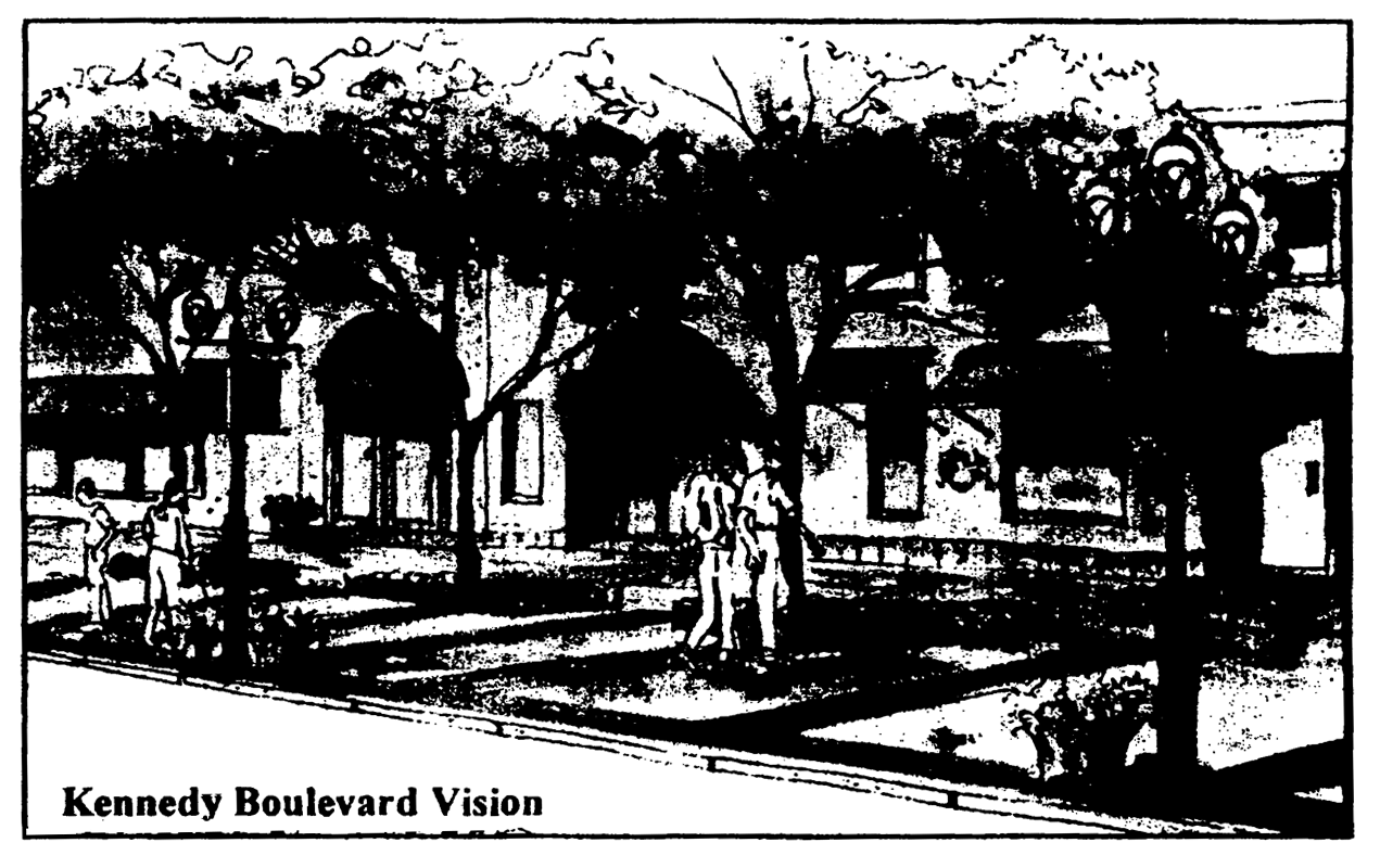
Kennedy Boulevard Vision
The Kennedy Boulevard Corridor District is unique in its history and social and economic lineages. It serves as a gateway corridor that connects diverse neighborhoods within the City and exhibits special scenic characteristics. The standards set forth in this district shall improve the aesthetic appearance of Kennedy Boulevard, connect roadways through the use of enhanced landscaping and buffering, and create form-based parameters to ensure compatible architectural elements are implemented throughout the corridor as a whole. Providing a form-based, aesthetic framework that promotes development that creates a sense of interest and promotes a physically attractive, functionally integrated environment is essential. Additionally, provisions are introduced that establish pedestrian and transit friendly design standards for this corridor. This district shall ensure that all types of new infill development, major renovations, and major additions thereto, are compatible in building and structural orientation, location, height, public safety, and other site specific relationships present within the corridor.
Generally, new development and redevelopment is vital to the future stability and vitality of the City of Tampa as a whole. Redevelopment and infill brings with it new homes, employment opportunities, and economic development, which in turn, helps to increase overall tax revenues to fund needed capital improvement projects and important government services, such as police and fire services. For development and safety purposes, the City of Tampa supports a Crime Prevention through Environmental Design (CPTED) philosophy as a way to reduce crime, advance neighborhood and business environments, and improve the overall quality of life of its citizens. These CPTED principles have also been incorporated throughout the regulatory review process within this district to ensure safe, quality development. Refer to the "Kennedy Boulevard Vision Perspective" incorporated herein.
(c)
Compliance. Each application for new construction and/or major renovation as defined in Chapter 27, City of Tampa Code of Ordinances, shall comply with all applicable overlay district and underlying zoning district standards and, if applicable, those specific standards outlined in the city council approved site plan. In cases of conflict, the more restrictive standard(s) shall apply. These are the minimum requirements that must be met in order to obtain design approval for non-residential or mixed-use projects. Please note that additional compliance standards may be stated within this document, which further restrict the permitting and/or construction process for various site elements.
Alternative design exceptions to these Overlay District standards may be considered and approved by the zoning administrator or designee, if consistent with the stated purpose and intent of this section, subject to the procedures set forth in section 27-60. A zoning administrator determination, related to an alternative design exception to this section, is subject to the review method set forth in section 27-61.
(d)
Review procedures.
(1)
Compliance with all standards will be determined during the site plan review process. The regulations herein include graphics that shall be utilized to visually represent the intent of this section.
(2)
Pre-application conference. It is recommended that any property owner, developer, or agent thereof required to obtain site plan and/or design approval, schedule a plan review with land development coordination division prior to the submission of any application for design approval. Final compliance with all design standards will be determined during residential or commercial plan review.
(3)
Submission requirements:
a.
Site plan. Six (6) folded copies of a site plan conforming to the requirements listed below must be submitted as a part of the commercial site review application.
1.
General location and context map that indicates the proposed site relative to all building and street rights-of-way lying immediately adjacent to the proposed site perimeter.
2.
North arrow and scale (Scale: from one (1) inch = ten (10) feet up to one (1) inch = fifty (50) feet).
3.
Property line boundaries and dimensions.
4.
Name, location, width and condition (paved or unpaved) of existing street and alleys adjacent to the site.
5.
Location, size, height, and use of all existing principal and accessory buildings and structures, and any proposed additions and/or new buildings and structures.
6.
Vehicular and pedestrian circulation, including ingress, egress, loading and unloading, parking and accessibility for persons with disabilities.
7.
Location and dimension of existing and proposed driveways and sidewalks.
8.
Existing and proposed building setbacks and buffering from adjacent uses (if applicable).
9.
Proposed design (typical elevation) and location of exterior lighting.
10.
The physical description of the size, location and accessibility of open space or pedestrian amenities.
11.
Plan or project details which are sufficient to demonstrate compliance with the standards set forth in this section.
b.
Landscape plan. All sites within the boundaries of the Kennedy Boulevard Corridor District shall comply with the standards set forth in this section, in addition to tree, site clearing, and landscaping requirements set forth in this chapter. The landscape plan shall be incorporated as part of the overall site plan submittal, and shall include the following:
1.
The plant material (existing and proposed) with specific information as to location, size (diameter), and species shall be shown.
2.
A tree table of credits and debits that demonstrates the true quantity of protected trees that exist, that will be removed, and that are proposed to be planted.
3.
All proposed and existing landscape buffers, islands, and planting beds used adjacent to internal pedestrian walkways, public sidewalks, perimeter property lines, and within vehicular use areas.
c.
Exterior elevations. The exterior elevations must show each side of the onsite buildings and demonstrate their relationship both internal and external to the project site.
(e)
Design Standards (Building and Site Standards). The following specific design standards shall be used for all projects located within the boundaries of the Kennedy Boulevard Corridor District:
(1)
General building design standards.
a.
The principal building façade and functional pedestrian entry to the building shall be oriented towards Kennedy Boulevard and shall maintain a direct pedestrian connection to the public sidewalk.
b.
A minimum of thirty (30) percent of the ground floor level of the principal building façade shall be constructed of transparent materials. This required transparency must be equally distributed on the wall plane of the ground floor level.
c.
A maximum of twenty-five (25) percent of any building façade that faces a public street right-of-way shall remain unembellished and/or without architectural detail or accent. Doors, windows, and other decorative architectural features or elements shall be used to break large wall planes into smaller components, thereby creating a more pedestrian friendly scale and mass.
d.
Rooftop equipment, including features such as stairwell accesses, elevator housing, etc., shall be screened from view of any adjacent public street right-of-way through use of parapet walls, screens, or other decorative building elements or features. These items shall be architecturally compatible with the principal structure.
e.
Parking structure standards.
1.
The façade of freestanding or attached parking structures fronting Kennedy Boulevard shall incorporate commercial and/or residential uses on the ground level, and these uses must occupy one hundred (100) percent of the wall plane at ground level of the structure.
2.
The façade of freestanding or attached parking structures fronting any other public street right-of-way shall incorporate commercial and/or residential uses on the ground level, and these uses must occupy a minimum of fifty (50) percent of the wall plane at ground level of the structure. For purposes of this specific provision, the petitioner may use features such as window boxes and/or art displays, up to 50% of the area as required herein.
f.
Use specific building standards.
1.
Drive-through window services, including pneumatic devices, other associated mechanical equipment, and any structural canopies or building elements, shall not be located between the front building façade and Kennedy Boulevard. These uses must be designed to have minimal impact on safe pedestrian movement.
2.
The entrance to all vehicle service bays shall not be oriented directly towards Kennedy Boulevard. All vehicle repair and service shall take place within a fully enclosed area of the building in which such use is located.
3.
All open storage areas, air-conditioning, and mechanical equipment must be screened with one hundred (100) percent opaque material, which is compatible with the materials used on the nearest façade of the principal structure. The screen shall reach a height necessary to fully screen the storage area and all equipment therein, as visible from a pedestrian level located on any adjacent public right-of-way.
(2)
Accessory structure building standards. Accessory structures shall adhere to those design standards set forth in this section and those stated in this chapter; where design conflicts may occur, the most restrictive standard shall apply.
(3)
General site layout standards. All site layouts shall adhere to section 27-283.5, Visibility at Intersections.
a.
All developments shall be required to place any and all utility lines (e.g. electrical, cable, telecommunications, etc.) underground on the subject parcel and within adjacent right(s)-of-way.
b.
Build-to lines (setbacks) from all public street right(s)-of-way (at ground level): Five-foot minimum to ten-foot maximum.
c.
Ground level building façade setbacks may be increased to thirty (30) feet from public street right(s)-of-way for areas created to provide courtyards, outdoor cafés, or similar pedestrian amenities. These features shall not occupy more than fifty (50) percent of the building façade along any one (1) street right-of-way.
d.
The 2nd floor level and above may be set back beyond ten (10) feet for design purposes.
e.
The zoning administrator or designee may consider alternative build-to (setback) lines for the principal structure, if clearly demonstrated to meet the purpose and intent of this overlay district.
f.
Onsite pedestrian circulation shall be provided between tenants and/or structures, for properties with multiple structures, through the use of a sidewalk, or other suitable, ADA compliant, pedestrian conveyance. Such interconnectedness shall be established through the use of consistent paving materials (i.e. textured or colored pavement, decorative paving blocks, or the like).
g.
For purposes of this district, refuse bins, containers, and compactors shall be setback a minimum of thirty (30) feet from Kennedy Boulevard right-of-way.
h.
Onsite surface parking shall maintain a minimum thirty-foot setback from the property line located adjacent to Kennedy Boulevard right-of-way.
(4)
Vehicle access management.
a.
Vehicle access and flow shall be designed to have minimal impact on pedestrian circulation, and there must be continuity of sidewalk materials across the mouth of all curb cuts.
b.
Vehicle access standards.
1.
Alley access. Vehicular access may be provided from a contiguous, public alley. The portion of the alley adjacent to the subject site through to the closest intersection shall be improved to meet city driveway design standards, as set forth in this Chapter and Chapters 22, 25, and the City of Tampa "Department of Public Works, Transportation Technical Manual," as amended.
2.
Local street access. In all cases, efforts should be made to provide vehicular access that promotes safe pedestrian movement along Kennedy Boulevard. Access to local streets from commercial uses, subject to review by the transportation manager or designee, and the zoning administrator or designee, may be granted. However, all new access points must adhere to the applicable city driveway design standards, as set forth in this chapter and chapters 22, 25, and the City of Tampa "Department of Public Works, Transportation Technical Manual," as amended, and not create any unnecessary hazards or impacts to pedestrians or adjacent neighborhoods. In no case shall a driveway be granted, at a distance greater than one hundred (100) feet from the intersection of the local street and Kennedy Boulevard, without approval by city council through the site plan controlled rezoning process.
(5)
General onsite lighting standards.
a.
Projects shall provide a lighting design for open (surface) parking, covered (garage/parking structure) parking, internal sidewalks and grounds, garbage receptacles, and all pedestrian, open, and public areas, for all uses. All onsite lighting must be designed to be directed away from any abutting residential use.
b.
Overhead light poles shall not be placed within interior vehicular use area islands planted with shade trees or other canopy producing specie, nor within the canopy drip-line of an onsite or offsite tree. Only basic ground cover shall be used, including but not limited to hedges and shrubs. All onsite overhead light poles shall be limited to a twelve (12) feet maximum height as measured from grade. The light fixtures must be shielded and directed away from all adjacent properties.
c.
Lighting design shall adhere to the standards for required minimum onsite illumination as shown below in the "Required Minimum Illumination" table, from the Illumination Engineering Society, IES Lighting Handbook, 2000.
(6)
General fence and wall standards.
a.
Accepted fence materials: masonry, decorative stone, wrought-iron (aluminum) style, PVC (picket or lattice style), decorative combination style made of masonry or stone with metal or PVC, as described above. Chain link fences are strictly prohibited on any property or development within the Kennedy Boulevard Corridor District, except during any permitted construction activity. Such construction fencing shall be removed prior to obtaining any certificate of occupancy.
b.
Unpainted or unfinished block fences or walls are prohibited. All sides and elevations of block walls or fences visible from a public right-of-way shall be architecturally finished (i.e. brick, stucco, or textured concrete masonry units).
c.
Maximum fence or wall height adjacent to Kennedy Boulevard right-of-way: Two (2) feet above finished grade. The two (2) feet fence or wall may be designed to accommodate public seating.
d.
Maximum fence or wall height adjacent to other public street right(s)-of-way: Four (4) feet above finished grade.
e.
Maximum fence or wall height adjacent to a public alley: Four (4) feet above finished grade. If the public alley separates the subject property from any residential use, the maximum allowable height shall be increased to six (6) feet above finished grade.
f.
Maximum fence or wall height adjacent to any residential use: Six (6) feet above finished grade.
(7)
General sign standards.
a.
The provisions are intended to allow the creation of unique and informative signs that give a distinct flavor to the corridor, while maintaining a non-intrusive, pedestrian environment. They are not intended to prohibit the design of unusual signs that may enhance the character of the building or district, or reflect the nature of the business. Refer to Article VI, Division 6, City of Tampa Sign Code, for any additional sign requirements beyond those noted herein.
1.
Freestanding sign standards.
i.
Pylon signs are prohibited in the Kennedy Boulevard Corridor District.
ii.
Ground signs for single-occupant sites: Signs shall be a maximum of thirty-two (32) square feet in area, four (4) feet in height, and may be placed at the property line subject to Section 27-283.5, Visibility at Intersections.
iii.
Ground signs for multi-occupant sites: Signs shall be a maximum of one hundred (100) square feet in area, six (6) feet in height, and may be placed at the property line subject to Section 27-283.5, Visibility at Intersections
iv.
Each ground sign must be numbered with the property address displayed in a conspicuous manner from the street right-of-way. Said numbers shall consist of dark numerals on a light background or light numerals on a dark background and shall be at least four (4) inches in height.
v.
Billboards and/or off-site signs, as defined in section 27-43 are prohibited. Only on-site signs, as defined in section 27-43, will be permitted.
2.
Standards for signs attached to buildings.
i.
Wall signs shall not exceed more than one-half (½) square foot per one (1) linear foot of building frontage facing Kennedy Boulevard, for structures standing two (2) stories or less.
ii.
Wall signs shall not exceed more than one (1) square foot per one (1) linear foot of building frontage facing Kennedy Boulevard, for structures possessing more than two (2) stories. No wall sign shall extend more than twelve (12) inches out from the wall to which it is attached.
iii.
Parcels permitted to have more than one (1) wall sign per Article VI, Division 6, City of Tampa Sign Code, may not have those signs abut at the corner of a building. A minimum separation of ten (10) feet shall be required between such signs. A minimum separation of four (4) feet shall be maintained between signs on the same façade.
iv.
One non-illuminated marquee sign with a maximum dimension of twelve-inches height, thirty-six-inch length, and six-inch thickness, may be located at the main entry of each business. The sign must be located completely under the awning, canopy, or overhang, at least seven (7) feet above the sidewalk, at a perpendicular angle to the exterior wall. Text may be located on both faces of the sign.
(f)
Streetscape design standards. The following specific streetscape design standards shall be required for all projects located within the boundaries of the Kennedy Boulevard Corridor District. Refer to the "Streetscape Plan View," "Sidewalk Adjacent to Road Cross Section," "Streetscape Lighting," and "Sidewalk Design Specification" exhibits depicted herein for dimensional, placement, materials, and planting requirements.
(1)
Streetscape-sidewalk standards (Kennedy Boulevard right-of-way only). Minimum public sidewalk width shall be ten (10) feet adjacent to Kennedy Boulevard right-of-way.
a.
The sidewalk shall be made with scored concrete and textured paving bricks. The bricks shall be laid perpendicular to Kennedy Boulevard right-of-way in a banded pattern at twelve-foot intervals, and parallel to Kennedy Boulevard right-of-way in a two-foot wide strip located adjacent to the curb line.
b.
Site plans shall depict adjacent portions of sidewalk to demonstrate design consistency in layout and pattern.
(2)
Streetscape landscape standards (along all street right(s)-of-way).
a.
Streetscape trees shall be planted within planting beds measuring a minimum of four (4) feet by six (6) feet located on private property, immediately adjacent to the public right-of-way. A decorative border fence, no taller than eighteen (18) inches in height, shall be placed around the perimeter of the planting bed. The property owner and/or developer shall be responsible for all costs associated with design, permitting, installation, replacement, irrigation, pruning, and general maintenance of the streetscape trees and any decorative materials related streetscape plantings.
b.
Streetscape trees shall be live oak, (Quercus virginiana), East Palatka holly, (Ilex X attenuate), or Chinese elm, (Ulmus parvifolia). The zoning administrator or designee shall consult the city's urban forester on any alternative selections.
c.
Streetscape trees shall possess the following minimum specifications at time of planting: Four-inch caliper, one hundred-gallon, eight- to ten-foot spread.
d.
Streetscape trees shall be planted in direct alignment with the perpendicular brick bands that lie within the public sidewalk, and at an interval of twenty-eight (28) feet on-center based on that brick band pattern.
(3)
Streetscape lighting standards (Kennedy Boulevard right-of-way only).
a.
The property owner and/or developer shall be responsible for all costs associated with design, permitting, installation, replacement, and general maintenance of the streetscape lighting.
b.
The property owner and/or developer shall select lighting fixtures, poles, and related equipment of a style as depicted in the "Streetscape Lighting" exhibit or design equivalent, as approved by the zoning administrator or designee.
c.
Light poles shall be placed on private property immediately adjacent to the public right-of-way/public sidewalk, in direct alignment with the perpendicular brick bands that lie within the public sidewalk, and at an interval of fifty-six (56) feet on-center based on that brick band pattern.
d.
Light poles shall stand approximately thirteen (13) feet in height, as measured from finished grade, and shall be designed to provide safe pedestrian scale lighting.
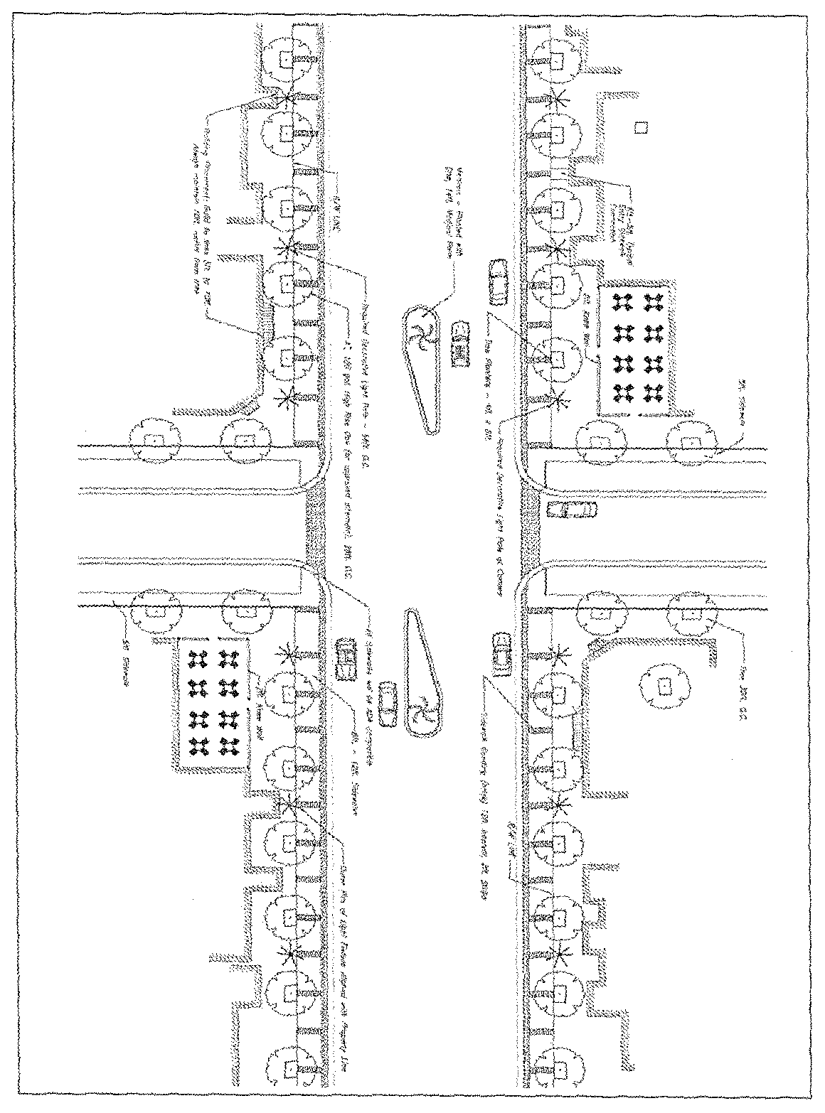
Streetscape Plan View
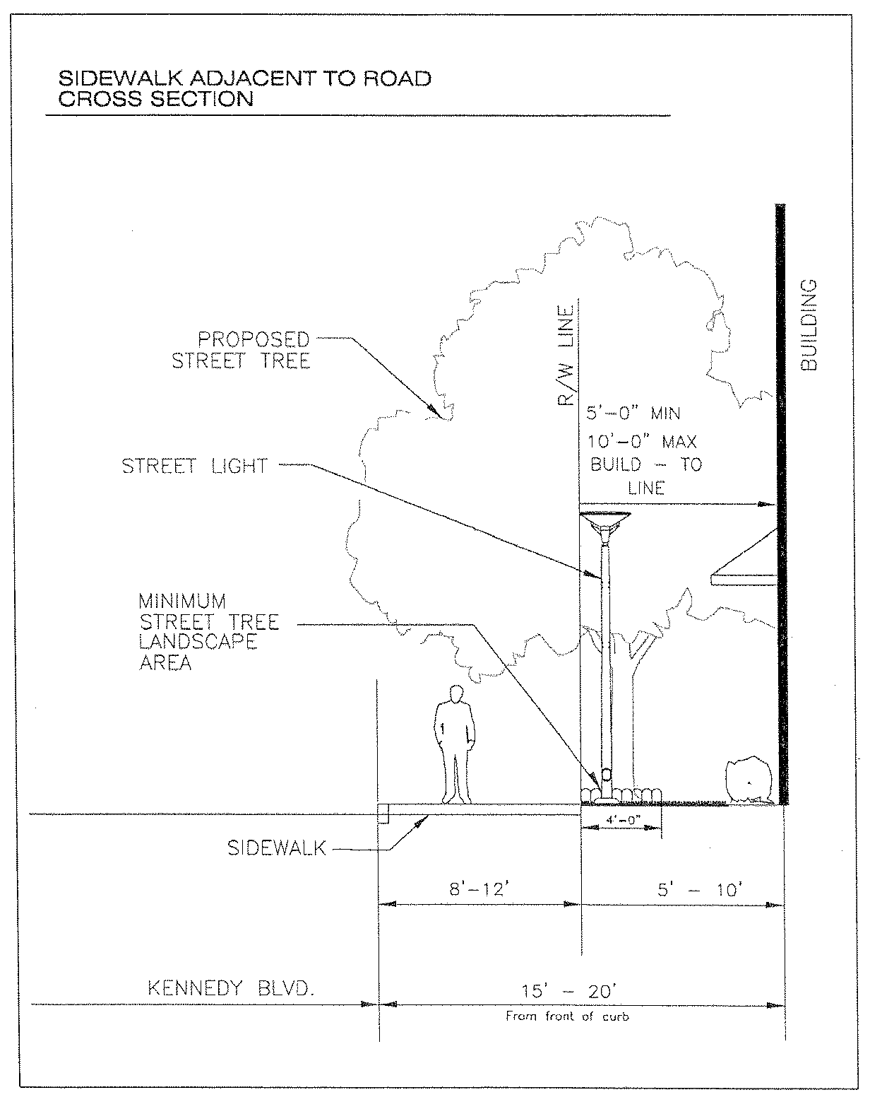
Sidewalk Adjacent to Road Cross Section
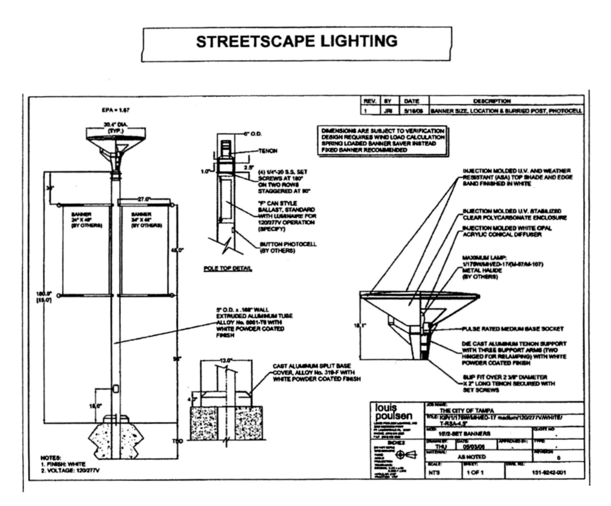
Note: The illustrations above depict the style of lighting required for the Kennedy Boulevard Corridor District. Per the zoning administrator's approval (or designee), design equivalents may be accepted. Please refer to section 27-243(f)(3) for lighting placement, spacing, and maintenance standards.
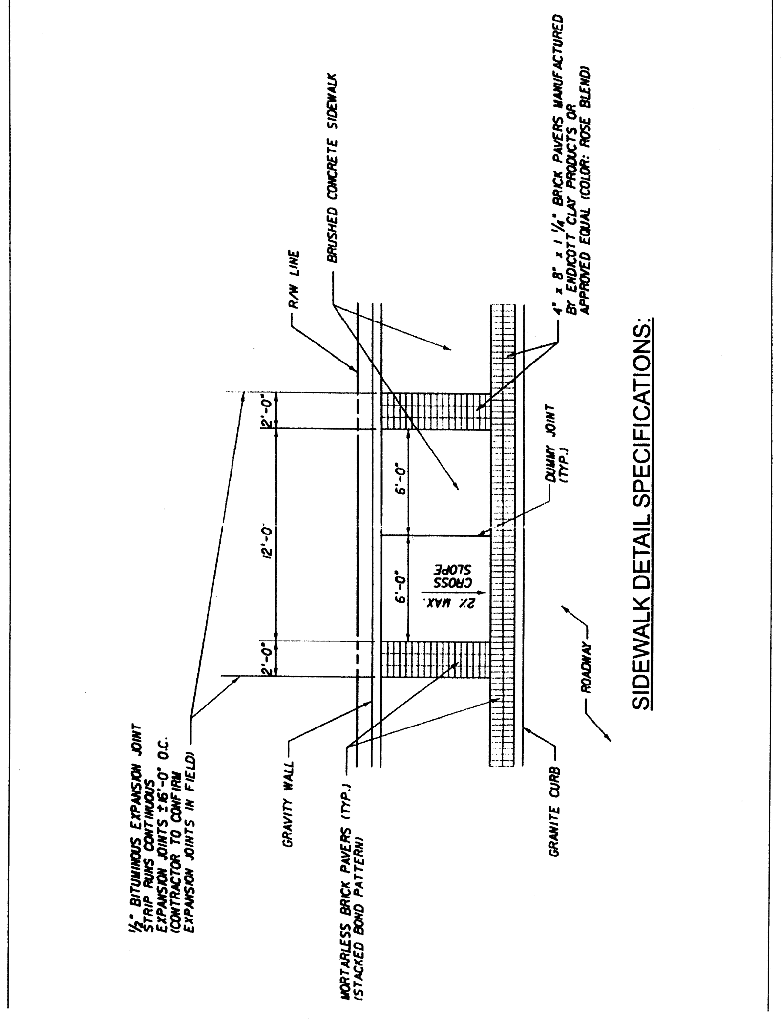
Sidewalk Detail Specifications
(g)
Encroachments. Encroachments into public right(s)-of-way under the City of Tampa's jurisdiction for awnings, awning signs, architectural features, streetscape features, or street furniture may be authorized after an administrative review by the department, department of public works, and any other applicable jurisdictional agency, as required.
Encroachments into Kennedy Boulevard right-of-way require a separate encroachment application and additional approval from the Florida Department of Transportation.
(h)
Transit stops. Development within the Kennedy Boulevard Corridor District shall be designed to maximize the efficiency of mass transit. The developer shall coordinate with the City of Tampa and the Hillsborough Area Regional Transit (HARTline) system to determine if the site warrants decorative, architecturally compatible transit stop improvements, such as easement dedication, transit shelters, or other related features.
(Ord. No. 2017-103, § 7, 6-22-2017; Ord. No. 2020-166, § 34, 12-17-2020)
Sec. 27-244. - Tampa Heights Overlay District Development Standards.
(a)
Area description. The Tampa Comprehensive Plan describes Tampa Heights as being located in the Central Tampa Planning District and is considered a Historic Urban Village neighborhood. The Tampa Heights Overlay District is an area which contains commercial and residential development, national and local designated historic properties and structures, and dedicated parks which spans over the Tampa Heights community.
(b)
Established boundaries and applicability. The "Overlay District", defined more specifically as all land contained within the following boundary:
Commencing at the intersection of the center line of the right-of-way of North Boulevard with the center line of the right-of-way of E. Dr. Martin Luther King, Jr. Boulevard (Point of Beginning), proceed thence in an easterly direction along the center line of the right-of-way of E. Dr. Martin Luther King, Jr. Boulevard to the westerly right-of-way line of Interstate 275; proceed thence in a southerly direction along the westerly right-of-way line of Interstate 275 to its intersection with the easterly right-of-way line of N. Marion Street; then proceed in a westerly direction along the northerly right-of-way line of Interstate 275 to its intersection with the center line of the right-of-way of N. Tampa Street; thence proceed in a northerly direction along the center line of the right-of-way of N. Tampa Street to its intersection with the center line of the right-of-way of W. Palm Avenue; thence proceed in a westerly direction along the center line of the right-of-way of W. Palm Avenue to its intersection with the center line of the right-of-way of N. Ola Avenue; thence proceed in a northerly direction along the center line of the right-of-way of N. Ola Avenue to its intersection with the center line of the right-of-way of W. Ross Avenue; thence proceed in a westerly direction along the center line of W. Ross Avenue to its intersection with the center line of the right-of-way of North Boulevard; thence proceed in a northerly direction along the center line of the right-of-way of North Boulevard to the Point of Beginning.
(c)
Purpose and intent. The purpose of the Tampa Heights Overlay District is to guide future development. The intent of these standards is to promote the unique character of the area, support walkability, encourage transit-oriented development, and promote housing options.
(d)
Compliance and general administrative procedures. Each application for new construction or major renovation as defined in Chapter 27, City of Tampa Code of Ordinances, and/or any development undergoing a change of use/increase of intensity review, shall comply with all applicable overlay district and underlying zoning district standards and, if applicable, those specific standards outlined in the city council approved site plan. In cases of conflict, the more restrictive standard(s) shall apply. The standards herein shall constitute minimum requirements that must be met to obtain design approval. Alternative design exceptions may be considered by the zoning administrator or designee for those properties located in the Overlay District, if consistent with the stated purpose and intent of this section.
(e)
Residential development.
(1)
Lot of record established. Any residential lot of record, as defined by this Code, existing as of September 1, 2022 and located within the boundaries of the Tampa Heights Overlay District, shall be deemed to be conforming and may be developed for any use permitted in the underlying zoning district.
(2)
Site and building standards.
a.
Orientation.
i.
Front doors may be permitted in courtyards or interior plazas, provided garage entrances are not oriented toward the street.
b.
Access and driveways. These standards shall apply to all single-family residential development. The following criteria are intended to maintain safety within the right-of-way, minimize conflict points between vehicles and pedestrians, reduce driveway proliferation, and preserve the integrity of the curbside.
i.
Vehicle access and flow should be designed to have minimal impact on pedestrian circulation.
ii.
If an existing lot is adjacent to an open and used public alley, vehicular access to the site may be provided from the alley as the primary vehicular access point provided it meets minimum standards referenced in section 27-283.12, off-street parking space standards.
iii.
All new driveways on non-functionally classified streets should provide access to zoning lots less than seventy (70) feet in width and should orient all new vehicular access through an adjacent improved alley.
iv.
Parcels which do not abut an alley and parcels which abut an alley that is not navigable by vehicle as determined by the City, may improve the alley to City standards, or provide access from an adjacent public street pursuant to Table 244.1 below.
Footnotes:
1 For the purpose of this section, the term "driveway" means the portion of the traveled way within the right-of-way that connects the edge of the street to the parking area on the private property.
2 Minimum width criteria measured as the narrowest width of the driveway between the edge of the roadway (not including flares) and the right-of-way line.
v.
New driveways on public streets should be located such that the edge of the driveway flare is within one (1) foot of the extended property line. Pairing of driveways with adjacent parcels is encouraged.
c.
Parking for residential uses.
i.
Garages shall not be required to be structurally integrated within the primary structure.
ii.
On-street parking. If on-street parking is available directly adjacent to the property, or is proposed directly adjacent by the applicant, the number of on-street parking spaces provided may count towards the total parking required for each development. The on-street parking spaces shall remain open to the public, shall not be designated for any specific use, and are subject to review and approval by the Mobility Department. If on-site parking is reduced pursuant to this section, the applicable standards in section 27-244(e)2.b. shall be met. On-street parking in city right-of-way shall remain under the operation and management of the City of Tampa and may be altered at any time at the City's discretion.
iii.
Per section 27-283.12, all off-street parking spaces may utilize public alley right-of-way for maneuvering into and out of a legally sized parking space provided the provisions of that section are met. The total width of the public right-of-way of the alley may be counted toward the required aisle width. This provision may only be used if the applicable standards in Section 27-244.(e)2.b. are met.
d.
Accessory structures.
i.
The height of an accessory structure may exceed fifteen (15) feet in height but shall not exceed the maximum height allowed in the underlying zoning district. In the Tampa Heights Local Historic District, accessory structures shall not exceed twenty-two (22) feet six (6) inches (22.5 feet) in height.
ii.
Accessory structures shall be limited to a maximum of one thousand one hundred (1,100) square feet in size.
e.
Accessory dwelling units. Accessory dwelling units are permitted in all residential districts, including properties located in Local Historic Districts, provided the following conditions are met:
i.
Accessory Dwelling Units shall be required to provide one (1) parking space per unit on-site. On-site parking shall only be required for accessory dwelling units greater than six hundred (600) square feet in size. Tandem parking is permitted.
ii.
An accessory dwelling unit may be designed to be located within the single-family dwelling with a separate entrance or in an accessory structure.
iii.
At no time may the number of unrelated occupant(s) of an accessory dwelling unit exceed two (2).
iv.
An accessory dwelling unit may be separately metered for utilities
f.
Front porches. Front porches shall be permitted to encroach into the front setback up to ten (10) feet. This shall be permitted for multiple floors provided the ground floor porch is provided within the same setback.
(f)
Commercial and mixed-use development.
(1)
Lot of record established. Any nonresidential lot of record, as defined by this Code, existing as of September 1, 2022, and located within the boundaries of the Tampa Heights Overlay District, shall be deemed to be conforming and may be developed for any use permitted in the underlying zoning district.
(2)
Parking design and access management.
a.
On street parking. If on-street parking is available directly adjacent to the property, or is proposed directly adjacent by the applicant, the number of on-street parking spaces provided may count towards the total parking required for each development. The on-street parking spaces shall remain open to the public and shall not be designated for any specific use.
b.
Parking placement. On-site parking should be located in the side or rear of the property for new construction built after the effective date of this Overlay District.
c.
Exemption. Any site fronting Franklin Street with less than twenty thousand (20,000) square feet gross floor area of land is exempt from minimum off-street parking requirements in section 27-283.7.
d.
Non-residential parking required. For non-residential development and non-residential uses within a mixed-use development up to twenty thousand (20,000) square feet gross floor area, parking is required at the following ratio: Two (2) spaces per one thousand (1,000) square feet. Structures under one thousand five hundred (1,500) square feet gross floor area shall not be required to provide parking.
e.
Parking offsets. For developments providing bicycle parking on site, the following parking offsets shall apply: Up to ten (10) percent of required parking may be off-set with the installation of bicycle racks at a rate of one (1) vehicle stall = five (5) bicycle slots.
(Ord. No. 2023-135, § 2, 10-5-2023)