
Tampa City Zoning Code
ARTICLE VI
- SUPPLEMENTAL REGULATIONS
DIVISION 4. - NATURAL RESOURCES: TREES, LANDSCAPING, WETLANDS, UPLAND HABITAT[7]
Editor's note— Ord. No. 2019-54, § 33(Exh. A), adopted April 18, 2019, repealed division 4, §§ 27-284—27-287.24, and enacted a new division 4, as set out herein. The former division 4, pertained to natural resources: buffers, general tree planting and landscaping, wetlands and upland habitat. See Code Comparative Table for complete derivation.
DIVISION 6. - SIGNS[10]
Editor's note— Ord. No. 2017-103, § 8(Exh. A), passed June 22, 2017, repealed the former Div. 6, §§ 27-289—27-289.24, and enacted a new Div. 6 as set out herein. The former Div. 6 pertained to similar subject matter. See Code Comparative Table for complete derivation.
Sec. 27-281.- Applicability; effect.
The regulations in this article shall apply generally or in groups of districts as indicated, unless district regulations or regulations for particular uses specifically provide to the contrary, and qualify or supplement other regulations appearing in this chapter.
Sec. 27-282.- Mobile homes and construction trailers.
(a)
No mobile home shall be permitted within the corporate limits of the city except in a duly licensed mobile home park or in PD districts in which mobile homes are an approved use. No mobile home shall be parked upon any public street right-of-way.
(b)
A licensed contractor engaged upon a project or construction for which a construction permit has been issued or if determined by the director of business and community services or his designee that a permit will be issued within a reasonable time frame (permit application has been received and has had at least an initial review of compliance with the codes) the contractor may temporarily use a construction trailer for office facilities in the location where the work is being done, provided further, such construction trailer shall not be placed upon the street but upon the property on which the permit authorizes the construction or for which construction plans have been submitted, and the same shall be removed immediately upon the completion of the work for which the permit has been issued or if the permit expires. In any event the construction trailer for office facilities may not be placed at or on the location where the work is being done prior to thirty (30) days before the construction permit has been issued. Due to the nature of the construction project, if it is impossible or impractical for the construction trailer to be located on the site where the work is being done, the contractor may request the zoning administrator to approve an off-site construction trailer location given the following conditions are met:
(1)
The zoning district of the proposed trailer location must be the same designation or a more intensive zoning district than the zoning district of the construction site.
(2)
A site plan must be submitted to the zoning administrator showing:
a.
The proposed location of the construction trailer, and
b.
Legal description of property, and
c.
A minimum of two (2) temporary off-street parking spaces which comply with the dimensional regulations found in this Code, however are not required to be hard surface, and
d.
A six-foot high solid fence placed along each property line where the adjacent use is residential, and
e.
If there is any other use(s) on the property, the site plan must show that the operation of the existing use(s) is not disrupted to where the existing use(s) are made to be not in compliance with City Codes, and
f.
The contractor must commit to return the site to its original condition or better upon completion of the construction project for which the permit was issued.
Sec. 27-282.1. - Vehicle repair in residential districts.
The repairing of an automobile or a motor vehicle in a residential zoning district within the corporate limits of the city is subject to the following restrictions:
(1)
Only minor repairs and maintenance may be performed which, for the purposes of this section, are defined as the changing and replenishment of fluid levels, such as hydraulic fluid, windshield washer fluid and lubricating oil; the replacement of sparkplugs, ignition points; the rotation of tires and the checking of adequate pressure; and the replacement of drive belts and hydraulic lines.
(2)
Any other repairs on the motor vehicle or automobile shall be restricted to totally enclosed spaces and only accomplished on privately registered vehicles having current state license plates, or motor vehicles designated by the state as qualifying for an antique or horseless carriage designation.
(3)
Such repairs shall be performed only at the address shown on the vehicle registration.
Cross reference— Repairing vehicles on streets, § 25-174.
Sec. 27-282.2. - Model dwelling units and preconstruction sales offices.
(a)
In any residential district where residential dwelling units are allowed, the developers or their agents may operate one (1) model dwelling unit as a sales office for the specific project under construction, subject to the following restrictions:
(1)
The model dwelling unit shall meet all district requirements for lot and yard dimensions.
(2)
Signs shall not be illuminated after 9:30 p.m.
(3)
The model dwelling unit shall not be used for any business activity later than 9:30 p.m.
(4)
A subdivision having three (3) or less model dwelling units shall provide two (2) independently functional parking spaces per unit. A subdivision having four (4) or more model dwelling units shall provide an off-street parking lot within three hundred (300) feet of the sales office with a minimum of five (5) spaces for four (4) model units plus one additional space for each additional model. Due to the temporary nature of the parking lot, the parking area shall be treated with a suitable temporary surface.
(5)
The model dwelling unit shall not be used as a means to sell similar units located elsewhere in the city.
(6)
The model dwelling unit shall be discontinued when the specific residential project is sold out and shall comply with regulations generally applicable within the district.
Model dwelling units may be erected or displayed in districts that exclude residential uses, provided that such models shall not be used for residential purposes, but only for display as a means to sell homes in districts in which they are permitted and provided that all other requirements of the district in which the model dwelling unit is erected shall be met.
(b)
In those zoning districts where multi-family dwelling uses are permitted, a temporary structure may be used as a preconstruction sales office for the purpose of displaying a typical dwelling unit arrangement, subject to the following restrictions:
(1)
The structure shall be limited to one (1) story in height.
(2)
The structure shall be appropriately landscaped and shall be subject to the requirements of section 27-284.
(3)
The structure shall be subject to the same front setback requirements as the principal structure to be erected and shall otherwise be subject to all setback requirements for this district.
(4)
Adequate off-street parking facilities and access driveways shall be developed only within those locations approved for such facilities in conjunction with the permanent apartment structure, and no additional parking areas or access driveways shall be permitted.
(5)
Signs shall be permitted only in accordance with the regulations set forth for such use within the district.
(6)
The structure shall comply fully with all existing building codes and ordinances of the city.
(7)
The structure shall be completely and totally removed within six (6) months from the date of the issuance of a building permit for same or upon the completion of the permanent residential dwelling structure, whichever date is later.
(8)
In the event that the structure should not be removed or demolished by the owner or other parties in interest within the terms of this subsection, the city, acting through its building official, is authorized to vacate, demolish or remove, either with city forces or by independent contractor submitting the lowest and best bid, any such building or structure. The city shall assess the entire cost of such vacation, demolition or removal against the owner or other parties in interest.
Cross reference— Model homes/sales centers in subdivisions, § 27-153.3.3.
Sec. 27-282.3. - Garage and yard sales.
(a)
A limited number of garage, yard, tag, patio and apartment sales are specifically permitted as an accessory use in all residential districts. Such sales shall be limited to one (1) during each six-month period, for a duration not to exceed three (3) days.
(b)
All such sales shall be conducted in compliance with the licensing provisions of chapter 24 of this Code.
Sec. 27-282.5. - Home based business.
Home based businesses shall comply with the following specific standards and a special use permit is not required unless a business of similar nature as the proposed home based business requires a special use approval in any zoning district in which case, a special use shall be required for the home based business:
(1)
The home based business shall be located on property that has a conforming residential use.
(2)
The home based business shall be incidental to the primary function of the residence and whose maximum size shall not exceed more than twenty-five (25) percent of the floor area of the dwelling.
(3)
All employees of the home based business who work in the residential dwelling shall reside in that dwelling, except that a maximum of two employees or two independent contractors who do not reside in the dwelling may work in the dwelling at the home based business. The business may have additional off-site employees who do not work at the location of the residential dwelling. Off-site employees may not visit the home based business for any reason connected with the business.
(4)
There shall be no change in the outside appearance of the building or premises as a result of such home based business, with the exception of a nameplate which shall be attached to the principal structure, shall not be illuminated, and whose maximum size shall not exceed two (2) inches by twelve (12) inches.
(5)
Vehicles and trailers used in connection with the business must be parked in legal parking spaces and comply with all city regulations in accordance with article VI, supplemental regulations.
(6)
No mechanical equipment shall be used for storage on the premises, except such that is normally used for purely domestic or household purposes, nor shall it create noise, vibration, glare, fumes, odors or electrical interference detectable to the normal senses outside the dwelling unit. In the case of electrical interference, no equipment or process shall be used which creates visual or audible interference in any radio or television sets off the premises, or causes fluctuations in line voltage.
(7)
No commodity shall be sold on the premises nor displayed or warehoused on the premises for sale elsewhere.
(8)
No traffic shall be generated by such home based business in greater volume than would normally be expected in the neighborhood.
(9)
A home based business shall not be interpreted to include activities such as, but not restricted to, auto repair and tune-up, clinic, welding shop, animal hospital or kennel.
(10)
The use can qualify for all local, state and federal licenses, certificates and permits.
(11)
Walk-up retail transactions at the home based business shall occur only in the residential dwelling, incidental business uses, and activities may occur elsewhere on the residential property.
(12)
These regulations shall not supersede the requirements of this Code related to the rental or occupancy of dwelling units or portions thereof.
(13)
Parking related to the home based business activities shall comply with the parking requirements of this Code; however, the business shall not generate a need for parking, per the requirements of this Code, that exceeds the volume expected at a similar residence where no business is conducted.
(Ord. No. 2022-158, § 10, 9-1-2022)
Sec. 27-282.6. - Commercial communication towers regulations.
(a)
Purpose. The purpose of these supplemental regulations are to promote the health, safety and general welfare of residents of the City of Tampa, to provide standards for the safe provision of telecommunications consistent with applicable federal and state regulations, and to protect the natural features and aesthetic character of the city with special attention to residential neighborhoods, historic districts and landmarks and the city rights-of-way.
These regulations are not intended to prohibit or have the effect of prohibiting the provision of personal wireless services nor shall they be used to unreasonably discriminate among providers of functionally equivalent services consistent with current federal regulations.
(b)
Development standards.
(1)
Commercial communication tower location requirements. It is the intent of this section to identify appropriate locational requirements for commercial communication towers. Locational requirements seek to minimize the visual obtrusiveness of commercial communication towers to surrounding areas, to allow for the establishment of an efficient telecommunication network through the use of commercial communication towers, when necessary, and to provide high quality service while minimizing the number of commercial communication tower sites.
a.
Height, setback and separation distance requirements for site location in various areas are identified in Table 6-1.
Commercial Communication Towers Locational Requirements
Table 6-1
NOTE: Commercial telecommunication towers seeking to locate in Commercial General (CG) and Office Professional (OP) are considered a Special Use 2 (S-2) subject to compliance with all sections of Article II, Division 5, Special Use Permits set forth herein.
NOTE: Distance separation shall be measured from the base of the tower to the residential, historic or landmark site property line.
NOTE: Distance separation from right-of-way shall be consistent with the requirements of the underlying zoning district.
NOTE: Requests for commercial communication towers in National Historic Districts shall be considered through a special use S(2) public hearing before city council.
NOTE: The construction of commercial communication towers is prohibited in the Accident Potential I and II Zones (APZ) around MacDill Air Force Base as noted on the Future Land Use Map of the City of Tampa Comprehensive Plan.
b.
Communication equipment and communication towers owned and operated by governmental agencies responsible for public safety (e.g. city police and fire department, sheriffs office, federal aviation authority) are not subject to the maximum height restrictions and may be located in any zoning district. The use of guyed or lattice tower, to achieve the necessary height, is allowed only through a special use, S(2) public hearing before city council.
c.
The applicant may petition through the special use, S(2) process to reduce setback and separation requirements or increase maximum tower height listed in Table 6-1. The applicant must submit a petition in sufficient detail to demonstrate compliance with all other provisions in the code not specifically called out for a consideration to be changed. City council may approve such reductions, alterations or changes if it can be demonstrated that the application meets the requirements of 1., 2., or 3. set forth below and the requirements of 4., 5., and 6. are satisfied:
1.
Techniques which have the effect of significantly reducing or eliminating visual obtrusiveness are incorporated into the design of the commercial communication towers. The tower site, associated equipment shelters, fencing and appurtenances are designed to reflect the physical character, massing, scale, architecture and historic nature (where applicable) of the surrounding neighborhood.
2.
Full compliance with all setback or separation requirements would result in the removal of a grand tree, as set forth in Chapter 13, City of Tampa Code of Ordinances, which would otherwise be saved by reducing the setback or separation.
3.
The approval of the variance request will result in multiple carriers (three (3) or more) on the tower.
4.
The variance, if allowed, will not substantially interfere with or injure the rights of others whose property would be affected by allowance of the tower.
5.
The variance is in harmony with and serves the general intent and purpose of the chapter and the adopted Tampa Comprehensive Plan.
6.
Allowing the variance will result in substantial justice being done, considering both the public benefits intended to be secured by the chapter and the individual hardships that will be suffered by a failure of the city council to grant the variance.
(2)
The applicant shall demonstrate by an affidavit from a registered professional engineer or the tower's manufacturer that the commercial communication tower will support the specified number of antennas as set forth below to accommodate collocation, and that it will be constructed to the EIA/TIA 22-E Standards, as published by the Electronic Industries Association, which may be amended from time to time, and all applicable City of Tampa Building Codes.
a.
All commercial communication towers, except camouflaged structures, over eighty (80) feet and up to and including one hundred forty (140) feet in height shall be structurally designed to accommodate at least two (2) antenna arrays.
b.
All commercial communication towers, except camouflaged structures, exceeding one hundred forty (140) feet in height shall be structurally designed to accommodate at least three antenna arrays.
(3)
The proposed commercial communication tower shall be designed and constructed to ensure that the structural failure or collapse will not create a safety hazard to adjoining properties.
(4)
The applicant shall demonstrate that the antenna(s) to be attached to the tower comply with the FCC and other applicable federal or state regulations relative to telecommunications and radio frequency emission levels.
(5)
The commercial communication tower shall not be used for, nor contain signage, designs or logos for private, political or commercial advertising.
(6)
If visible from surrounding properties accessory buildings, structures or appurtenances serving the commercial communication tower site shall be designed to be compatible with the architecture and physical character of the immediate neighborhood.
(7)
The commercial communication tower may be located on a zoning lot containing other principal uses. The commercial communication tower may be located on a parcel smaller than the minimum lot size of the underlying zoning district. This parcel shall be known as the "commercial communication tower site." The commercial communication tower site, and not the entire zoning lot, shall be subject to requirements of this Code. However, where public notice is required, the entire zoning lot shall be considered for calculation of the required area for which notice is to be provided. The creation of the "commercial communication tower site" shall not cause the reduction of required parking, landscaping or other code requirements for the use of the parent tract.
(8)
A minimum eight-foot high finished masonry wall or other decorative type fence shall be required around all portions of commercial communication tower sites adjacent to or visible from residentially zoned or used property or public road rights-of-way. However, in industrial zoned districts, the fence may be a chain link fence or other type security fence. Wooden slat fences shall not be allowed in any zoning district. For purposes of this section, a finished masonry wall includes, but is not limited to stucco, brick, or any other decorative cover or finish.
(9)
The landscaping buffer shall consist of a row of evergreen shade trees a minimum of fifteen (15) feet tall with a four (4) inch caliper. They shall be spaced a maximum of fifteen (15) feet apart around the outside perimeter of the security fence or wall. In addition, a row of evergreen shrubs such as viburnum, ligustrum, holly or juniper, four (4) feet high, seven (7) gallon container, will be planted eight (8) feet on center, in order to maintain eighty (80) percent opacity within one (1) year of planting. This landscaping will be maintained through an irrigation system approved by the Planning and Development Department (PDD) during the term of the lease or the operation of the commercial communication tower, whichever is longer.
a.
When the base of a commercial communication tower site is visible from public right-of-way or residentially zoned or used property, it shall be screened with the required landscape buffering located outside of the security fence.
b.
Existing trees and vegetation shall be preserved to the maximum extent possible and may be used as a substitute towards meeting the landscaping requirements if they are of equal quality and provide effective screening. Any vegetation that is preserved or used as a substitute must be maintained throughout the term of the lease or the operation of the commercial communication tower.
c.
Intervening buildings or other structures which provide the equivalent screening from view from residentially zoned or used properties and public rights-of-way may be used as a substitute toward meeting the screening requirement.
d.
Where it can be demonstrated that the provision of the required trees and/or vegetation would present a safety hazard (such as around an electrical substation) alternative for compliance with the vegetative requirements may be approved by the zoning administrator.
(10)
Commercial communication towers shall not be artificially lighted except to ensure human safety or as required by the FAA.
(c)
Location overlay sites. The purpose of location overlay sites is to allow for a greater flexibility for the location of commercial communication tower sites, provide for areas which are pre-approved allowing for greater ability to pre-plan multiple sites, maximize the use of sites which have been under utilized and to reduce the number of commercial communication tower sites which are visually obtrusive.
Designated public and private facilities and structures may be considered for the location of commercial communication towers without regard to the underlying zoning district prohibitions if certain conditions, called out below, can be met (NOTE: The construction of commercial communication towers in the APZ I and II zones is prohibited). However, the landscape buffer and screening requirements of section 27-282.6(b)(10) apply. If one (1) of the sites identified below is within a zoning district that has less restrictive setback, height or separation requirements the less restrictive requirement shall apply. In addition, if a site is located within a local historic district, a Certificate of Appropriateness (C/A) is still required and the ARC or Barrio Latino Commission may require the tower to be camouflaged.
(1)
Commercial communication towers (monopole) are permitted by right in all utility easements of one hundred (100) in width or greater when they maintain a distance separation equal to or greater than one hundred ten (110) percent of the tower height from a residentially zoned or used property. An existing utility transmission pole can be changed out and increased in height for the purpose of adding one (1) or more communication antennas regardless of the above distance separation requirement, up to seventy-five (75) percent of the existing pole height or one hundred twenty (120) feet which ever is taller. The maximum height of the changed out pole shall be limited to two hundred (200) feet.
(2)
Commercial communication towers are permitted by right in the right-of-way of the Veterans Expressway, the Leroy Selmon Expressway, Interstate 4, Interstate 75 and Interstate 275 when being installed as a lightpole change out, provided there is not a reduction of the distance separation to a residentially zoned or used property.
(3)
Monopoles of one hundred forty (140) feet or less are permitted by right in designated city parklands and recreation facilities when they maintain the following distance separation:
a.
Towers over one hundred (100) feet in height three hundred (300) feet from a residentially zoned or used property; or
b.
Towers one hundred (100) feet or less in height two hundred (200) feet from a residentially zoned or used property. The tower site must meet the landscape and screening requirements of sections 27-282.6.(b)(8) and (9). Alternatives to these requirements may be approved by the city parks department.
(4)
Monopoles of one hundred forty (140) feet or less may be erected within designated utility transfer or electrical substations which have a minimum lot size of ten thousand (10,000) square feet. A visual screening and vegetative hedge must be installed which does not create an electrical safety hazard.
(5)
Monopoles of one hundred forty (140) feet or less may be permitted by right on designated Hillsborough County School Board sites when they maintain the following distance separation:
a.
Towers over one hundred (100) feet in height three hundred (300) feet from a residentially zoned and used property or;
b.
Towers one hundred (100) feet or less in height one hundred (100) feet from a residentially zoned or used property.
(6)
Monopoles of one hundred forty (140) feet or less may be permitted by right on designated city owned sites when they maintain the following distance separation:
a.
Towers over one hundred (100) feet in height—Three hundred (300) feet from a residentially zoned or used property or
b.
Towers one hundred (100) feet or less in height—One hundred (100) feet from a residentially zoned or used property.
(7)
The sites described in subsections (2) through (6) above shall be identified and illustrated on a map which shall be approved and adopted by resolution of city council. The approved map shall be maintained and kept on file by the zoning administrator as Map 27-1.
(d)
Replacement and modification of existing commercial communication towers. To encourage the use of sites on which existing commercial communication towers are already located, and which create a visual or height impact, modifications or replacements of such facilities may occur subject to the following conditions:
(1)
Commercial communication towers existing prior to the adoption of this section shall be considered legal nonconforming uses. Such facilities may be used, repaired, replaced or modified in accordance with this section. An existing commercial communication tower may be modified or replaced to accommodate the co-location of antenna(s). An existing commercial communication tower which, when modified or replaced, will not conform to the requirements of the Code, may be increased in height, one (1) time, up to forty (40) feet above the existing height and/or may be relocated on the same zoning lot, one (1) time, within seventy-five (75) feet of the existing location, with administrative review and without conformance to the distance separation requirements contained herein. For purposes of this section, only those towers which were legally permitted and in existence prior to the adoption of this section shall be considered "existing commercial communications towers.
(2)
A commercial communication tower which is modified or replaced to accommodate the collocation of additional antenna(s) shall be either of the same type as the existing commercial communication towers or shall be a monopole.
(3)
The existing commercial communication towers shall be removed within ninety (90) days of replacement.
(e)
Commercial communication towers site review process. Any applicant or agent thereof proposing to erect or construct a commercial communication tower or modify or replace an existing commercial communication tower by increasing the height or by altering the existing site after the effective date of this ordinance is required to comply with the provisions of this section.
(1)
Submission of application. An application for the construction or alteration of a commercial communication tower site shall be submitted to the Planning and Development Department (PDD) as part of the application for commercial site plan review as required by Chapter 5 of this Code. The city shall retain a technical expert, such as a registered professional engineer with expertise in the telecommunications field, to participate in the review of the application. The cost of the review by the technical expert shall be borne by the applicant.
(2)
Review procedure.
a.
Preapplication conference. Any applicant or agent thereof required to obtain a commercial communication tower site permit shall schedule a courtesy review with the City of Tampa Planning and Development Department prior to the submission of the permit application, in order to review the requirements of this section. The applicant shall bring to the conference the legal description of the proposed commercial communication tower site and zoning lot, a conceptual plan of the commercial communication tower site, and an elevation drawing of the commercial communication tower site improvements.
b.
Submission requirements. All applications for a commercial communication tower site permit shall contain the following items:
1.
The applicant shall be the commercial communication tower owner or their authorized agent. The application shall be signed and notarized by the owner of the property upon which the commercial communication tower is being constructed with the property owner's acknowledgment of the requirements relating to abandonment of the tower as set forth in section (f) below. Documentation shall be submitted as to the telecommunication carrier(s) utilizing the commercial communication tower.
2.
Site and landscape plan (including vegetative pallet) drawn to scale, legal description of commercial communication tower site and zoning lot, north arrow and demonstration of compliance with applicable land development regulations.
3.
An elevation, drawn to scale, of the zoning lot's view from city right-of-way and any abutting residential use or property,
4.
Documentation of compliance with F.A.A. and local aviation authority regulations,
5.
Documentation to assure that the antennas to be placed on the tower meet all relevant FCC regulations and radio frequency emission standards.
6.
Copies of any relevant easements,
7.
The applicant must include in the application an affidavit of its good faith intent to allow the collocation of wireless communication antennas by other telecommunication carriers at a reasonable market rate. The cost of modifying the commercial communication tower to accommodate the collocated antennas shall be borne by the collocating telecommunication carrier,
8.
The applicant shall provide a notice of the proposed location to other telecommunication carriers with potential interest in collocation by "certificate of mailing" through the United States Post Office. Copies of the letters must be submitted with the application. Notice shall direct the carriers interested in collocation to contact the zoning administrator. If a potential user requests collocation in writing to the zoning administrator, the burden shall be on the applicant to demonstrate that collocation can not be accommodated pursuant to the standards set forth in subsection (10), below.
9.
The applicant shall provide the applicable propagation models, search ring maps and other relevant documentation for the telecommunication carrier which has demonstrated an intent to locate a wireless communication antenna on the proposed tower ("intended carrier") and shall identify all existing structures within the telecommunication carrier's search ring of equal or greater height than the proposed commercial communication tower.
10.
The applicant must demonstrate to the satisfaction of the city's technical expert that the wireless telecommunication antenna to be attached to the proposed commercial communication tower cannot be accommodated on the identified existing structures or on a commercial communication tower within the telecommunication carrier's search ring due to one (1) or more of the following reasons:
i.
Both the owner/operator of the existing commercial communication tower and the applicant have verified that an additional antenna array would exceed the structural capacity of the existing commercial communication tower or structure, and the existing commercial communication tower or structure cannot reasonably be replaced with a new tower;
ii.
The city's technical expert has verified that the existing structure(s) will not fulfill the design objective and approach of the intended carrier.
iii.
The city's technical expert has verified that the wireless telecommunication antennae would cause RF or other type of interference or be interfered with by the operation of existing or proposed wireless telecommunication antennas, located on or near the existing structure;
iv.
The existing commercial communication tower does not have the space or availability at the required height, or adequate area upon which to locate and operate the necessary equipment effectively and reasonably;
v.
The lease terms on an existing tower are not economically reasonable and are substantially higher than current market rates.
11.
Documentation establishing the structural integrity for the commercial communication tower's proposed use.
12.
An affidavit from the property owner acknowledging acceptance of the requirements of section 27-282.6.(d).
13.
A lease agreement demonstrating that one (1) or more telecommunication carriers intend to locate wireless communication antenna(s) on the proposed tower.
14.
An affidavit from the applicant documenting the specific number of antennas the proposed tower is designed to support.
15.
Prior to issuance of a certificate of completion, the tower owner shall document liability coverage for the tower and shall submit a sealed survey (completed by a licensed Florida surveyor) verifying the finished tower height is consistent with the approved permit.
c.
Action on application. The Planning and Development Department (PDD) shall review the application for compliance with the requirements of this section. Commercial communication tower site permits shall be issued when such compliance is met. A commercial communication tower site permit shall have a built-out deadline of one (1) year. The built-out deadline shall be deemed to be met if the holder of the permit has completed fifty (50) percent of the permitted construction and is proceeding with the remainder of the construction under an active permit.
If it is determined that an application does not comply with the provisions of this section, the commercial communication tower site permit shall be denied.
(f)
Removal of abandoned commercial communication towers.
(1)
Each commercial communication tower site permit application must include an acknowledgement by the property owner and applicant that if the use of any commercial communication tower is discontinued for more than one hundred eighty (180) days, it shall be deemed to be abandoned. The property owner shall notify the city of the tower abandonment by certified mail within thirty (30) days.
(2)
Determination of the date of abandonment shall be made by the zoning administrator who shall have the right to request documentation and/or affidavits from the commercial communication tower owner/operator regarding the active use of the commercial communication tower.
(3)
The zoning administrator shall provide notice by certified mail to the property owner that the final determination of abandonment has been made.
(4)
The property owner shall have ninety (90) days from the date of the notice of abandonment to either,
a.
Cause the reactivation of the use of the commercial communication tower; or
b.
Dismantle and remove the commercial communication tower.
(5)
At the earlier of ninety-one (91) days from the date of the notice of the zoning administrator's determination of abandonment without reactivation, or upon completion of dismantling and removal, any site approval for the use of the commercial communication tower shall automatically expire.
(6)
The owner of the real property shall be ultimately responsible for all costs of dismantling and removal, and in the event the commercial communication tower is not removed within ninety (90) days of abandonment, the city may initiate the legal proceedings to do so and assess the costs against real property.
(g)
Inspections. The planning and development department shall conduct on-site inspections of all tower sites at regularly scheduled intervals in order to ensure that each site is currently operational and not considered abandoned as set forth in (f)(1) above, is being maintained and is in compliance with its approved site plan.
(Ord. No. 2013-67, § 2, 5-16-2013)
Sec. 27-282.7. - Performance standards for industrial, manufacturing and processing operations.
(a)
Industrial, manufacturing and processing operations shall observe the following performance standards:
(1)
Direct illumination resulting from the operation shall not fall upon any land not covered by the application for a zoning compliance permit for the operation.
(2)
Equivalent sound levels shall not exceed the following standards:
a.
If the receiving use is residential:
Between 7:00 a.m. and 10:00 p.m.—60 dBA
Between 10:00 p.m. and 7:00 a.m.—55 dBA
b.
If the receiving use is commercial:
Between 7:00 a.m. and 10:00 p.m.—65 dBA
Between 10:00 p.m. and 7:00 a.m.—60 dBA
c.
If the receiving use is industrial:
Anytime—75 dBA
(3)
Vibration levels shall not exceed the following standards:
Maximum peak particle velocity:
Note: The maximum particle velocity shall be the maximum displacement vector sums of three (3) mutually perpendicular components, recorded simultaneously, multiplied by the frequency in cycles per second. For purposes of this section, steady-state vibrations are vibrations which are continuous or vibrating in discrete impulses more frequent than sixty (60) per minute. Discrete impulses which do not exceed sixty (60) per minute shall be considered impact vibrations.
(4)
If the use is within two hundred (200) feet of any jurisdictional wetland area, as defined in this chapter, the following restrictions apply:
a.
No storage of underground fuel tanks is permitted.
b.
No open storage of raw materials or chemicals shall be permitted within flood zone A, as established by the Federal Emergency Management Agency, unless the open storage area complies with building elevations set forth in the applicable federal, state, and local building and flood regulations.
(b)
In the case of uses in the CI and IG districts, measurements to determine compliance with subsections (a)(2) and (a)(3) of this section shall be made at the boundaries of the zoning lot containing the use.
(c)
In the case of uses in the IH district, measurements to determine compliance with subsections (a)(2) and (a)(3) of this section shall be made at the nearest boundary of the IH district to the use being evaluated.
(Ord. No. 2020-166, § 40, 12-17-2020)
Sec. 27-282.8. - Single-family, semi-detached design standards.
(a)
Purpose. While infill development is encouraged, to make optimal use of the public facilities, the design of the development shall be consistent with the general site planning of the surrounding neighborhood.
(b)
Applicability. The provisions of this section apply to all proposed development of single-family semidetached dwellings when single-family detached dwellings exist in both of the following locations:
(1)
At least one (1) of the two (2) immediately adjacent properties with the same street frontage as the infill lot; and
(2)
At least two (2) of the three (3) properties most directly opposite and on the same street as the infill lot.
(c)
Design requirements.
(1)
The ground floor entrances (front doors) to the dwelling units shall face a street right-of-way (not including alleys), rather than the side or corner lot lines. Entrances may face interior courts, plazas, or similar design element, with the approval of an alternative design by the zoning administrator.
(2)
A minimum of one (1) parking space shall be provided in a garage or a carport, either of which must be structurally integrated within the principal dwelling unit.
(d)
Enforcement. At the time of building permit application, the applicant shall demonstrate, in a form acceptable to the zoning administrator, whether or not this section is applicable to the proposed development. Further, the applicant shall demonstrate on a site plan submitted with the building permit that the design requirements have been met.
Sec. 27-282.9. - Single-family attached design standards.
(a)
Purpose. The multi-family residential and planned development zoning districts allow for the development of single-family attached dwellings. These unit types are often constructed in areas which have developed with predominantly single-family and two-family structures. The design standards for single-family attached dwellings are intended to ensure compatible development to surrounding residential neighborhoods.
(b)
Development alternatives. Single-family attached dwellings may develop as:
(1)
Townhouse. Developments in which each individual townhouse unit is located on an individual deeded lot having frontage on a public or private street with all parking spaces and all green space (per section 27-285 of this Code) provided on the lot. Where three (3) or more units/lots are proposed, subdivision regulations must be met.
(2)
Condominium or rental developments. Single-family attached developments may be developed as condominium or rental projects. Such developments may design units to front either public or private streets. Required parking spaces may be provided in common parking bays. Some or most of the required green space may be provided in areas designated as common space. Condominium developments of any size shall file a declaration of condominium with the clerk of circuit court as required by law.
(c)
Development requirements.
(1)
The ground floor entrances (front doors) to the dwelling units shall face a street right-of-way (not including alleys), rather than the side or corner lot lines. Entrances may face interior courts, plazas, or similar design element, with the approval of an alternative design by the zoning administrator.
(2)
When auto storage is provided in the front or corner yards, the two (2) required spaces shall be enclosed. When auto storage is provided in the rear yard, the two (2) required spaces may be open or enclosed. Refer to section 27-283.12(h) for regulations governing parking layout.
(3)
No fewer than three (3) dwelling units and no more than eight (8) dwelling units shall be constructed in a continuous configuration. No continuous group of dwellings shall exceed two hundred (200) feet in frontage width.
(Ord. No. 2020-166, § 41, 12-17-2020)
Sec. 27-282.10. - Multi-family townhouse-style design standards.
(a)
Purpose. While infill development is encouraged, to make optimal use of the public facilities, the design of the development shall be consistent with the general site planning of the surrounding neighborhood.
(b)
Applicability. The provisions of this section apply to all proposed development of multi-family townhouse-style dwelling units.
(c)
Design requirements.
(1)
The ground floor entrances (front doors) to the dwelling units shall face a street right-of-way (not including alleys), rather than the side or corner lot lines. Entrances may face interior courts, plazas, or similar design element.
(2)
A minimum of one (1) parking space shall be provided in a garage or a carport, either of which must be structurally integrated within the principal dwelling unit.
(d)
Enforcement. At the time of building permit application, the applicant shall demonstrate, in a form acceptable to the zoning administrator, whether or not this section is applicable to the proposed development. Further, the applicant shall demonstrate on a site plan submitted with the building permit that the design requirements have been met.
(Ord. No. 2022-52, § 4, 3-17-2022)
Sec. 27-282.11. - Townhouse lot regulations.
(a)
Permit applications for new construction (including but not limited to principal and accessory buildings, fences and pools) shall provide the legal description of the zoning lot and any required site plan shall show the zoning lot lines, the townhouse lot lines, and the ability to comply with all zoning regulations.
(b)
Residential development, where units are designed with access to an alley, must also provide a three-foot wide unobstructed pedestrian access easement, to the street right-of-way to and from each unit on the zoning lot. The access easement shall be lit a minimum illuminance equal to five and nine-tenths (5.9) lux for a distance of thirty-five (35) feet, five (5) feet above grade.
(c)
The zoning lot must be designed so that the primary frontage of the development is oriented toward the street right-of-way.
(d)
All units must be addressed from street right-of-way and not an alley or private access easement.
Sec. 27-282.12. - Open storage.
(a)
Screening of open storage yards, except for storage on those lands within the boundary described in subsection (c) below, shall meet the following standards:
(1)
Outdoor storage areas shall be screened from view of any arterial or collector street, as shown on the major street map, as follows: When an outdoor storage area abuts a collector or arterial street, the method of shielding shall consist of solid walls or solid fences at least six (6) feet in height, with access from streets only through solid gates, which shall be closed when not in use. Shielding shall run at least one hundred (100) feet back from the street property line, unless an existing permanent structure shields the storage area.
(2)
When an outdoor storage area immediately abuts or is separated by an alley from a residential use or a residentially zoned district, the method of shielding shall consist of an architecturally finished masonry wall, at least six (6) feet in height along the boundary of the storage areas and the entire residential district. Required wall height and maximum stacking/pile height is set forth in Table 6-2 below. The wall shall be planted with a vine at an interval of ten (10) feet on center. Please refer to section 27-285.1 for preferred species of vine. Where conflict(s) may exist between this section, and section 27-284, buffers and screening conflict and section 27-285.1, the more restrictive regulation shall apply.
(3)
When an outdoor storage area does not abut, but is within two hundred (200) feet of a residential district, the method of shielding shall consist of an architecturally finished masonry wall or opaque decorative fencing, at least six (6) feet in height, so that the storage area is not visible from the residential district, with access only through solid gates, which shall be closed except when in use.
(b)
Open storage areas shall be kept in a neat and orderly arrangement; materials may not be stacked in piles higher than six (6) feet (except for storage on those lands within the boundary described in subsection (c) below) and shall not be visible from surrounding properties or rights-of-way. Pile heights may exceed six (6) feet in height in the IH zoning district subject to the following:
_____
(1)
Requirements for stacking heights within open storage areas that do not abut residential use or residential district:
TABLE 6-1:
(2)
Requirements for stacking heights within open storage areas that immediately abut or are separated by an alley from a residential use or residential district:
TABLE 6-2:
(c)
However, the restrictions set forth in subsection 27-282.12(a) and this subsection (b) shall not apply to the geographic area bordered by Ybor and Sparkman Channels and Cut D to the west; the Leroy Selmon Crosstown Expressway to the north; and 21st Street as it merges southward into 20th Street and continues into Causeway Boulevard as the eastern border. This geographic area also includes the area south of Causeway Boulevard to the City of Tampa city limits to the south, as Causeway Boulevard extends eastward. This geographic area shall comply with a height restriction of ninety (90) feet.
Sec. 27-282.13. - Screening of open display areas.
(a)
Open display areas shall be designed and developed in a manner which does not interfere with proper traffic circulation.
(b)
Open display areas shall be maintained in a neat and orderly fashion and shall not take on the characteristics of a junkyard.
(c)
On any interior lot line which is adjacent to a residential district, the open display area shall be buffered by a solid wall or fence at least six (6) feet in height.
(d)
In the CN and CG zoning districts, open display shall only be allowed during the establishment's hours of operation.
Sec. 27-282.14. - Crematoriums.
Crematoriums as principal uses shall not require a public hearing or administrative review beyond the review required to secure a commercial site plan permit or as required by other regulations of the City of Tampa. However, all crematoriums shall meet the following requirements:
(1)
No such use shall be located within five hundred (500) feet of a national or local historic district or any residential use.
(2)
All loading/unloading and parking areas shall be screened from view of the public right-of-way and abutting properties with an architecturally finished, six-foot high masonry wall subject to section 27-283.5 visibility requirements.
(3)
Such use shall be limited to two (2) combustion units/incinerators.
(4)
The facility must comply with federal, state and local regulations for such a facility.
(5)
The equipment must be certified by the manufacturer that it operates free of smoke and odor and has automatic pollution monitoring equipment to constantly supervise the operation and safeguard against pollution and environmental impact.
Sec. 27-282.15. - Accessory uses.
Accessory uses shall not require a public hearing or administrative review beyond the review required to secure a commercial site plan permit, or as required by other regulations of the City of Tampa. However, all accessory uses (except for all types of alcoholic beverage sales, which require a separate approval process as set forth in Article II, Division 5 and article IX) shall meet the following requirements:
(1)
Any such use shall be located wholly within a structure of a permitted use, except day care and nursery facility as indicated in (4) below.
(2)
Not more than one (1) exterior entrance shall be permitted.
(3)
An identification sign not exceeding three (3) feet square shall be permitted on or adjacent to the entrance of the accessory use. Signs shall have the following limitations:
(a)
Sign text shall be limited to the name of the business.
(b)
Flashing, oscillating and moving signs shall not be permitted.
(c)
Formed plastic or injected molded signs shall not be permitted.
(d)
Exposed raceways, transformers, and similar items are not permitted.
(e)
A "logo" shall be limited to twenty-five (25) percent of the total permitted sign area.
(4)
Such uses shall not individually occupy more than twenty (20) percent of the floor space of the total primary use and all accessory uses shall not collectively account for more than thirty (30) percent of the total floor space with the exception of a child care center which may occupy a freestanding building if said building is located on property occupied by a principal use and is designed to serve said principal uses.
(5)
The following standards, in addition to those listed above, shall be used specifically for crematoriums:
(a)
No such use shall be located within five hundred (500) feet of a national or local historic district or any residential use.
(b)
A crematorium is allowed only as an accessory use to a funeral parlor or cemetery when located in the CI and IG zoning districts.
(c)
As an accessory use, crematoriums shall contain no more than one (1) combustion unit/incinerator.
(d)
All loading/unloading areas shall be screened from view of the public right-of-way and abutting properties with an architecturally finished, six-foot high masonry wall along subject to section 27-283.5 visibility requirements.
(e)
The facility must comply with federal, state and local regulations for such a facility.
(f)
The equipment must be certified by the manufacturer that it operates free of smoke and odor and has automatic pollution monitoring equipment to constantly supervise the operation and safeguard against pollution and environmental impact.
Sec. 27-282.16. - Temporary special event.
For purposes of this chapter, a temporary special event shall mean a special event held entirely on private property; a special event held on a city park or public right-of-way shall be administered in compliance with Chapter 28, the City of Tampa Special Event Code. A temporary special event may be held in any zoning district provided the following limitations are met:
(a)
The maximum duration for a specific event is two (2) weeks. No more than four (4) events per year are allowed on one (1) property.
(b)
If tents or outdoor exhibits/displays are used, a site plan must be submitted to the division of land development coordination to demonstrate compliance with zoning setbacks.
(c)
Adequate parking shall be provided, in accordance with the following, and subject to compliance with subsection (d) below:
(1)
Temporary special events located ≤ one (1) mile from a city-sponsored/co-sponsored special event (issued pursuant to chapter 28):
a.
Any off-site parking, to be used as and counted towards meeting the required parking space count, shall be located no more than five (5) miles from the subject special event site;
b.
Unless otherwise required in subsection (d) below, distance between such off-site parking and the special event site shall be measured in a straight line.
(2)
Any other temporary special events:
a.
Any off-site parking, to be used as and counted towards meeting the required parking space count, shall be located no more than two (2) miles from the subject special event site;
b.
Unless otherwise required in subsection (d) below, distance between such off-site parking and the special event site shall be measured in a straight line.
(d)
Prior to issuance of a temporary special event permit, a parking plan must be submitted for review and approval by the city transportation engineer (PDD), or designee. The parking plan must include the following, as applicable:
(1)
Events that qualify under subsection (c)(1) above:
a.
The total number of required parking spaces for the event;
b.
An explanation of how required parking will be provided and managed, to include the following, as applicable:
1.
Detailed narrative that describes how, and by what means, on- and off-site parking for event attendees, workers, and deliveries will be provided and managed, prior to, during, and after the end of the event;
2.
Documentation, in the form of a sworn statement (or legal equivalent), between the special event applicant/agent and a property owner/agent, that demonstrates authorization to use said owner's off-site parking, for the subject event;
3.
Documentation, in the form of an executed contract/agreement (or legal equivalent), between the special event applicant/agent and a licensed transportation service, that demonstrates the special event applicant's intent to use said service to transport.
c.
Graphic plan/high resolution aerial map (drawn/printed to scale) that clearly and legibly depicts the following:
1.
Parking layout and number of provided spaces. This applies to vehicle, bicycle, bus, delivery/loading, and any other spaces to be used as, and counted towards, meeting the required parking space count (on and/or off-site, as applicable);
2.
For use of any off-site parking located ≤ one-half (½) mile from the subject special event site, at least one (1) pedestrian path that provides a safe, ADA and publicly accessible pathway, to a public entrance of the subject special event. For private events, the pathway shall be shown to an entrance designated for attendees/guests of the event.
d.
Valet service shall be provided, as follows:
1.
For use of any off-site parking located > one-half (½) mile;
2.
Must obtain a valet permit through the right-of-way permit process, as set forth in chapter 22.
When valet service is provided, for any parking within one-half (½) mile from the subject special event site, the valet operator shall adhere to subsection (c)(1)d.2. above. This requirement applies valet service for on-site spaces, for which the valet operator utilizes a public right-of-way to provide such service.
(2)
Events that qualify under subsection (c)(2) above:
a.
Provide required information and documents, as set forth in subsection (d)(1)a.—c. above;
b.
If valet service is provided, such service shall comply with subsection (d)(1)d. above.
(e)
The applicant must demonstrate that bathroom facilities are available at the site of the special event.
(f)
The property must be cleared of all trash and debris immediately after the special event.
(Ord. No. 2019-1, § 2, 1-10-2019)
Sec. 27-282.17. - Temporary film production.
The following specific standards and requirements shall apply to the conduct of temporary film production activity in any zoning district in the city:
(1)
Any person or entity conducting such activity within the City of Tampa shall obtain a permit for such activity from the Tampa/Hillsborough Film Commission, which permit must be provided to the City of Tampa zoning administrator for filing. The permit must include, at a minimum, the following information: the name, address and phone number of the film production company and its client, the type of production, the shooting dates and estimated total production days, the locations at which filming will occur, any city personnel or equipment being requested, and a hold harmless/indemnity agreement consistent with subsection (3) below.
(2)
Any person or entity conducting such activity must provide to the City of Tampa a certificate of insurance in the minimum amount of one million dollars ($1,000,000.00) naming the City of Tampa as an additional insured. Copies of the certificate must be provided to the City of Tampa and the Tampa/Hillsborough Film Commission before filming may begin.
(3)
A person or entity conducting such activity within the City of Tampa shall assume all risk and be solely responsible for damage or injury to property or persons and hold harmless the city, its officers and employees from any and all claims, suits, losses, damages or injury to person(s) or property.
(4)
Any person or entity intending to conduct temporary film production activity upon City of Tampa right-of-way, and/or intending to close a street or sidewalk in order to conduct such activity thereon, must obtain from the transportation department all applicable permits required by Chapters 22 and 25.
(5)
The person or entity conducting temporary film production activity shall post at the location-site, in a conspicuous place on or near the front the property, a sign no smaller than eighteen (18) inches by twenty-four (24) inches. The information posted on the sign shall include, but not be limited to, the estimated dates of film production that will take place at that location and the name and telephone number of a representative of the film production company to be contacted in case of emergency. The sign shall be posted no later than two (2) days prior to the date on which filming will begin and shall remain in place for the duration of the filming at that location.
(6)
In those instances in which film production activity will result in limited access to a street, the person or entity conducting such activity shall provide to all property owners/residents on that street placards to be placed in the windshield of their motor vehicles, which placards shall identify them as property owners/residents of that street in order to allow them to obtain access to their property.
(7)
Adequate sanitary and other required health facilities are, or will be made available, in or adjacent to the production activity area.
(8)
The conduct of the production activity shall not result in noise of a level that would violate the provisions of this code, or that would be otherwise inappropriate for the areas surrounding the production activity.
(9)
The city shall be entitled to recover reasonably estimated expenses for extraordinary services rendered in connection with the production activity, which costs shall include, but not be limited to, charges for personnel and/or equipment provided in support of the production which are outside the scope of normal governmental services. The city shall base its estimate of such costs on the information contained in the permit application submitted to the Tampa/Hillsborough Film Commission and such consultations as may be required between the applicant and the appropriate city officials. The city shall provide an estimate of these costs to the permit applicant and may require prepayment of all or a portion of these costs prior to the commencement of the film production. At the conclusion of the production, expenses below or in excess of the estimates will be refunded by the city or paid by the applicant, respectively.
(10)
Exceptions. Nothing in this section shall be interpreted to require a permit for:
a.
Individuals filming or video taping only for their own personal or family use.
b.
Employees of print or electronic news media when filming on-going news events.
c.
Students and faculty filming exclusively for educational purposes.
Sec. 27-282.18. - Dog-friendly restaurants.
(a)
Purpose. The Dixie Cup Clary Local Control Act, F.S. § 509.23, grants the city the authority to provide exemptions from section 6-501.115, 2001 FDA Food Code, as adopted and incorporated by the division of hotels and restaurants in Chapter 61C-4.010(6), Florida Administrative Code (2006). The purpose of this section is to allow dogs in public food service establishments in a manner consistent with the three-year pilot program approved by state statute. The procedure adopted pursuant to this section provides an exemption, for those public food service establishments which have received a permit, to those sections of the Food and Drug Administration Food Code that prohibit live animals in public food service establishments.
(b)
No dog shall be in a public food service establishment unless allowed by state law and the public food service establishment has received and maintains an unexpired permit pursuant to this section allowing dogs in designated outdoor areas of the establishment.
(c)
Application requirements. Public food service establishments must apply for and receive a permit from the City of Tampa Zoning Administrator or his/her designee, before patrons' dogs are allowed on the premises. The zoning administrator shall establish a reasonable fee to cover the cost of processing the initial application and renewals. The application for a permit shall require such information from the applicant as is deemed reasonably necessary to enforce the provisions of this section, but shall require, at a minimum, the following information:
(1)
Name, location, mailing address and division of hotels and restaurants-issued license number of the public food service establishment.
(2)
Name, mailing address and telephone contact information of the permit applicant. The name, mailing address and telephone contact information of the owner of the public food service establishment shall be provided if the owner is not the permit applicant.
(3)
A diagram and description of the outdoor area which is requested to be designated as available to patrons' dogs, including dimensions of the designated area; a depiction of the number and placement of tables, chairs and restaurant equipment, if any; the entryways and exits to the designated outdoor area; the boundaries of the designated area and of the other outdoor dining areas not available for patrons' dogs; any fences or other barriers; surrounding property lines and public rights-of-way, including sidewalks and common pathways; and such other information as is deemed necessary by the zoning administrator. The diagram shall be accurate and to scale but need not be prepared by a licensed design professional. A copy of the approved diagram shall be attached to the permit.
(4)
A description of the days of the week and hours of operation that patrons' dogs will be permitted in the designated outdoor area.
(5)
For permits authorizing "dog-friendly restaurants" within the outdoor areas of public food service establishments located on city right-of-way, the zoning administrator shall require the applicant to produce evidence of the following:
a.
A valid unexpired sidewalk café permit under section 22-225 of the City of Tampa Code of Ordinances; and
b.
A properly executed certificate of insurance on forms which are to be furnished by the city providing commercial general liability insurance in the amount of one million dollars ($1,000,000.00) per occurrence, and two million dollars ($2,000,000.00) aggregate. The policy shall not have exclusions for animals and animal bites. All insurance shall be from companies duly authorized to do business in the State of Florida. All liability policies shall provide that the city is an additional insured as to the operation of the sidewalk café and shall provide for the severability of interest. Thirty (30) days written notice must be given the city of any cancellation or reduction in the policy coverage.
(d)
Regulations. Public food service establishments that receive a permit for a designated outdoor area pursuant to this section shall require that:
(1)
Employees shall wash their hands promptly after touching, petting or otherwise handling any dog(s) and shall wash their hands before entering other parts of the public food service establishment from the designated outdoor area.
(2)
Employees are prohibited from touching, petting or otherwise handling any dog while serving or carrying food or beverages or while handling or carrying tableware.
(3)
Patrons in a designated outdoor area shall be advised by appropriate signage, at conspicuous locations, that they should wash their hands before eating. Waterless hand sanitizer shall be provided at all tables in the designated outdoor area.
(4)
Patrons shall not leave their dogs unattended for any period of time. Patrons shall keep their dogs on a leash at all times and shall keep their dogs under reasonable control.
(5)
Employees and patrons shall not allow dogs to come into contact with serving dishes, utensils, tableware, linens, paper products or any other items involved with food service operations. Patrons shall be advised of this requirement by appropriate signage at conspicuous locations.
(6)
Employees and patrons shall not allow any part of a dog to be on chairs, tables or other furnishings.
(7)
Employees shall clean and sanitize all table and chair surfaces with an approved product between seating of patrons.
(8)
Employees shall remove all dropped food and spilled drink from the floor or ground as soon as possible, but in no event less frequently than between seating of patrons at the nearest table.
(9)
Employees and patrons shall remove all dog waste immediately and the floor or ground shall be immediately cleaned and sanitized with an approved product. The public food service establishment shall keep a kit with the appropriate materials for this purpose near the designated outdoor area. Dog waste shall not be carried in or through indoor portions of the public food establishment.
(10)
Employees and patrons shall not permit dogs to be in, or to travel through, indoor or nondesignated outdoor portions of the public food service establishment.
(11)
A sign or signs notifying the public that the designated outdoor area is available for the use of patrons and patrons' dogs shall be posted in a conspicuous manner and place, as determined by the zoning administrator or his/her designee, that places the public on notice.
(12)
A sign or signs informing patrons of these laws shall be posted on premises in a conspicuous manner and place as determined by the zoning administrator or his/her designee.
(13)
A sign or signs informing employees of these laws shall be posted on the premises in a conspicuous manner and place as determined by the zoning administrator or his/her designee.
(14)
Ingress and egress to the designated outdoor area shall not require entrance into or passage through any indoor area or nondesignated outdoor portions of the public food service establishment.
(15)
The public food service establishment and designated outdoor area shall comply with all permit conditions and the approved diagram.
(16)
Employees and patrons shall not allow any dog to be in the designated outdoor areas of the public food service establishment if the public food service establishment is in violation of any of the requirements of this section.
(17)
Permits shall be conspicuously displayed in the designated outdoor area.
(18)
It shall be unlawful to fail to comply with any of the requirements of this section. Each instance of a dog on the premises of a public food service establishment without a permit is a separate violation.
(e)
Expiration and revocation.
(1)
A permit issued pursuant to this section shall expire automatically upon the sale of the public food service establishment and cannot be transferred to a subsequent owner. The subsequent owner may apply for a permit pursuant to this section if the subsequent owner wishes to continue to allow patrons' dogs in a designated outdoor area of the public food service establishment.
(2)
Permits shall expire on June thirtieth (30th) of each year.
(3)
A permit may be revoked by the zoning administrator or his/her designee if, after notice and reasonable time in which the grounds for revocation may be corrected, the public food service establishment fails to comply with any condition of approval, fails to comply with the approved diagram, fails to maintain any required state or local license or is found to be in violation of any provision of this section. If the ground for revocation is a failure to maintain any required state or local license, the revocation may take effect immediately upon giving notice of revocation to the permit holder.
(4)
If a public food service establishment's permit is revoked, no new permit may be approved for the establishment until the expiration of one hundred and eighty (180) days following the date of revocation.
(f)
Complaints and reporting.
(1)
Complaints may be made in writing to the zoning administrator. The zoning administrator shall timely accept, document, and respond to all complaints. The zoning administrator or his/her designee shall timely report to the division of hotels and restaurants all complaints and the response to such complaints.
(2)
The zoning administrator or his/her designee shall provide the division of hotels and restaurants with a copy of all approved applications and permits issued.
(3)
All applications, permits and other related materials shall contain the division of hotels and restaurants-issued license number for the public food service establishment.
(g)
[Reserved.]
Sec. 27-282.19. - Emergency evacuation shelter space and the Coastal Planning Area.
(a)
All rezoning requests within the Coastal Planning Area that increase the number of residential dwelling units shall mitigate the impact on shelter space demands based on the shelter space LOS (level of service).
(b)
The applicant shall be required to adhere to the following equation. The cost/dollar amount required by this calculation shall be placed on the approved/adopted site plan as a condition of approval. The equation is as follows:
(c)
Payment of offset/mitigation for construction within the Coastal Planning Area/shelter impact shall be made to Hillsborough County School Board.
Sec. 27-282.20. - Retail bakery, catering shop, and commercial kitchen.
(a)
The following standards shall apply:
(1)
Gross floor area shall be limited to fifteen thousand (15,000) square feet or less.
(2)
No more than four (4) delivery/food trucks may be stored on site, overnight, at any time.
(3)
Delivery/food trucks shall not exceed twenty-six (26) feet in length.
(Ord. No. 2018-176, § 11, 11-1-2018)
Sec. 27-282.21. - Material recovery facility (MRF).
(a)
Within the IG District, the following standards shall apply:
(1)
Subject property shall contain a minimum of ten thousand (10,000) square feet.
(2)
All open storage and processing areas placed outside of an entirely enclosed structure shall be screened with a solid six (6) feet fence and shall adhere to the buffering and screening requirements of sections 27-284 and 27-282.12 and shall not exceed fifty (50) percent of the total area of the subject site.
(3)
If a residential zoning district lies within five hundred (500) feet of the subject location, outdoor receiving/processing/recycling and distribution activities shall only operate during the following hours:
a.
Sunday through Thursday from 7:00 am and 7:00 pm; and,
b.
Friday and Saturday from 7:00 am and 9:00 pm.
Accessory office activities are not subject to the hours stated above.
(b)
Within the IH District, the following standards shall apply:
(1)
Subject property shall contain a minimum of ten thousand (10,000) square feet.
(2)
All open storage and processing areas placed outside of an entirely enclosed structure shall adhere to the buffering and screening requirements of sections 27-284 and 27-282.12.
Sec. 27-282.22. - Recycling—Materials and goods.
(a)
Within the IG District, the following standards shall apply:
(1)
Subject property shall contain a minimum of ten thousand (10,000) square feet and no more than one and one-half (1½) acre. For those properties that lie east of 22 nd Street/US-41 (Business) within the city limits, the land area may exceed one (1) acre.
(2)
All open storage and processing areas placed outside of an entirely enclosed structure shall adhere to the buffering and screening requirements of sections 27-284 and 27-282.12 and shall not exceed seventy-five (75) percent of the total area of the subject site.
(3)
The dismantling of wrecked or inoperative automobile or other vehicles/vessels or machinery is allowed provided that all fluids are removed from the wrecked or inoperative automobile or other vehicles/vessels or machinery prior to its/their arrival onsite, and the removal of all scrap metals or other scrap materials and junk is removed from the property on a semi-annual basis (based on a calendar year).
(4)
If vehicle/vessel/other machinery-related fluids are extracted on the subject location as part of the recycling facility, then all such fluids shall be stored in an environmentally safe manner (subject to applicable law) and removed from the property on a semi-annual basis (based on a calendar year).
(5)
If a residential zoning district lies within five hundred (500) feet of the subject location, outdoor receiving/processing/recycling and distribution activities shall only operate during the following hours:
a.
Sunday through Thursday from 7:00 am and 7:00 pm; and,
b.
Friday and Saturday from 7:00 am and 9:00 pm.
(b)
Within the IH District, the following standards shall apply:
(1)
Subject property shall contain a minimum of ten thousand (10,000) square feet.
(2)
All open storage and processing areas placed outside of an entirely enclosed structure shall adhere to the buffering and screening requirements of sections 27-284 and 27-282.12 and shall not exceed seventy-five (75) percent of the total area of the subject site.
(3)
The dismantling of wrecked or inoperative automobile or other vehicles/vessels or machinery is allowed provided that all fluids are removed from the wrecked or inoperative automobile or other vehicles/vessels or machinery prior to its/their arrival onsite, and the removal of all scrap metals or other scrap materials and junk is removed from the property on a semi-annual basis (based on a calendar year).
(4)
If vehicle/vessel/other machinery-related fluids are extracted on the subject location as part of the recycling facility, then all such fluids shall be stored in an environmentally safe manner (subject to applicable law) and removed from the property on a semi-annual basis (based on a calendar year).
Sec. 27-282.23. - Reserved.
Editor's note— Ord. No. 2016-58, § 10, adopted April 21, 2016 renumbered and amended § 27-282.23 as § 27-141.
Sec. 27-282.24. - Roominghouses.
Roominghouses as permitted uses shall adhere to the following requirements:
a.
Such a use shall not be established within five hundred (500) feet of another such use.
b.
Such use shall comply with standards set forth in section 19-235 (no waivers shall be granted by the city for this provision).
c.
Each lodging unit is limited to two (2) adult occupants and related minors.
d.
Each lodging unit shall contain a minimum of one hundred fifty (150) square feet or the minimum area required by the Florida Building Code for such unit type, whichever is more.
(Ord. No. 2013-72, § 6, 6-6-2013)
Sec. 27-282.25. - Kennel, small.
(a)
Small kennels are permitted to keep only those animals listed below, in the city with valid, applicable local and state licensure, subject to the following standards. Any animal that meets more than one (1) of the "animal" related definitions in this chapter shall comply with the most restrictive applicable regulations.
(b)
The police department is exempted from the provisions of this section and is specifically authorized and empowered to keep, harbor, and maintain horses within the corporate limits of the city.
(Ord. No. 2013-73, § 10, 6-6-2013; Ord. No. 2013-101, § 5, 7-18-2013; Ord. No. 2019-130, § 1, 10-17-2019)
Sec. 27-282.26. - Kennel, large.
(a)
Large kennels are permitted to keep only those animals listed below, in the city with valid, applicable local and state licensure, subject to the following standards. Any animal that meets more than one (1) of the "animal" related definitions in this chapter shall comply with the most restrictive applicable regulations.
(b)
The police department is exempted from the provisions of this section and is specifically authorized and empowered to keep, harbor, and maintain horses within the corporate limits of the city.
(Ord. No. 2013-73, § 11, 6-6-2013; Ord. No. 2013-101, § 6, 7-18-2013; Ord. No. 2019-130, § 2, 10-17-2019)
Sec. 27-282.27. - Animals, in general.
(a)
Any animal that meets more than one (1) of the "animal" related definitions in this chapter must comply with the most restrictive applicable regulations.
(b)
Permitted animals. Domestic, pet, companion, utility and assistance animals are permitted to be kept in the city. Persons and entities licensed by the State of Florida to keep other animals must adhere to the requirements for small or large kennel as applicable.
(c)
Wild or exotic animals. Wild or exotic animals are permitted to be kept in the city pursuant to Florida Game and Freshwater Fish Commission regulations.
(d)
Aquatic animals. Aquatic animals are permitted to be kept pursuant to Florida Game and Freshwater Fish Commission and Department of Natural Resources regulations.
(e)
Farm animals.
(1)
It is unlawful for any person to keep, harbor or maintain any farm animal, except under the following conditions:
a.
Animals must be kept within an enclosed area which is a minimum of two hundred (200) feet from any dwelling on an adjoining parcel of land in separate ownership.
b.
Land requirements per animal shall be as follows:
1.
Horses, cattle or swine: One (1) acre for each animal;
2.
Sheep or goats: One-half (½) acre for each animal;
3.
Fowl (excluding domestic egg-laying chickens): Five thousand (5,000) square feet of land for each five (5) fowl or fraction thereof;
4.
Bees: Ten thousand (10,000) square feet per hive.
Above land requirements are the gross area of premises harboring such animals and include areas used by the resident for residential or other purposes, in addition to the keeping of animals.
(2)
The police department is exempted from the provisions of this section and is specifically authorized and empowered to keep, harbor and maintain horses within the corporate limits of the city.
(Ord. No. 2013-73, § 12, 6-6-2013; Ord. No. 2013-101, § 7, 7-18-2013)
Sec. 27-282.28. - Chickens as accessory use.
Chickens as an accessory use shall adhere to the following requirements:
(Ord. No. 2013-101, § 8, 7-18-2013)
Sec. 27-282.29. - Medical marijuana treatment center (MMTC) facilities; distance separation requirements.
(a)
Medical marijuana dispensaries shall not be located within five hundred (500) feet of the real property on which all or a portion of a school, as defined in section 27-43, is located.
(b)
Medical marijuana processing facilities shall not be located within five hundred (500) feet of the real property on which all or a portion of a school, as defined in section 27-43, is located.
(c)
Applications shall follow the distance separation requirements set forth above. Distance measurements shall be measured in a straight line distance, from the boundary of the building(s) used as a medical marijuana dispensary or processing facility, to the property boundary of the school(s). Distance shall be measured in a straight-line, along the shortest distance between the points described above, without regard to the route of normal travel.
(d)
Any request to reduce distance requirements set forth above, shall be processed as a special use-2 permit (refer to article II, division 5). Requirements of this section shall serve as supplemental special use criteria (refer to section 27-132).
(Ord. No. 2017-132, § 14, 8-24-2017)
Sec. 27-282.30. - Food trucks.
The following standards shall apply to all food trucks, as defined by section 27-43:
(1)
Hours of operation for a food truck shall be limited to 6:00 a.m. to 10:00 p.m.
(2)
There shall be no amplified sound.
(3)
Signage shall be non-illuminated and limited to a maximum size not to exceed ten (10) square feet and shall not be free standing.
(4)
A food truck shall not be placed in any required parking space, loading zone, landscape/buffer area or drainage area.
(5)
There shall be no seats or tables available for patrons.
(6)
The maximum size of a food truck shall be twenty-six (26) feet in length, eight (8) feet in width and ten (10) feet in height.
(7)
Food trucks shall meet the setbacks of the underlying zoning district of the parcel on which it is located.
(8)
Food trucks shall comply with the requirements of section 27-283.5.
(Ord. No. 2022-157, § 9, 9-1-2022)
Sec. 27-283.- Intent.
It is the intent of this article to encourage the appropriate location of off-street parking and off-street loading to provide the needed levels of service to the city, to avoid undue congestion on the streets, to protect the capacity of the street system to move traffic, to avoid unnecessary conflicts between vehicles and pedestrians, to encourage the use of mass transportation, to preserve and enhance the designated pedestrian activity areas within the city and to facilitate the access from streets to off-street parking lots and structures.
Sec. 27-283.1. - Access.
In addition to minimum yard and building spacing requirements specified in this chapter, all buildings and other structures, land preparation and landscaping shall be so located and arranged on lots as to provide safe and convenient access for emergency purposes, fire protection, servicing, and off-street parking and loading located on the premises. As to access through such premises, the following limitations shall apply:
Access to uses not permitted in residential districts; exceptions. No private land that is residentially zoned shall be used for vehicular or pedestrian access to land or structures in other districts used for any purpose not permitted in the residential district except as provided below or otherwise authorized by this chapter or other lawful regulation.
a.
Where provision does not exist for safe access for emergency and public service vehicles and such access is not reasonably feasible except through privately owned residentially zoned land, access reserved for and limited to such vehicles may be authorized by the variance review board or the Architectural Review Commission (in historic districts, generally, or landmark sites) or the Barrio Latino Commission (in the Ybor City Historic District), subject to conditions and safeguards designed to protect the tranquility and character of the residential land so traversed.
b.
Where convenience and safety would be promoted, walkways and bicycle paths to nonresidentially zoned land may be authorized by the VRB, ARC, or BLC, as applicable, across privately owned residentially zoned land, subject to conditions and safeguards to protect the tranquility and character of the residential land so traversed.
(Ord. No. 2020-166, § 42, 12-17-2020)
Sec. 27-283.2. - Off-street parking required.
(a)
In all districts for industrial, commercial, office, residential or any other use, there shall be provided, at the time any new building is erected, any use of a building or land is enlarged by five hundred (500) square feet or five (5) percent whichever is greater, or increased in intensity or any other use or change of use established, off-street parking spaces for automobiles in accordance with requirements herein. However, if the required number of functional spaces can be met by an existing parking area, the improvements described in section 27-283.12(d), (e), (h), and (k) shall not be required.
(b)
For a multi-tenant building such as a shopping center and office plaza where there are a minimum of seventy-five (75) off-street parking spaces existing on the zoning lot, the change of use of an individual suite (not more than two thousand (2,000) square feet of floor area) shall not require review for parking per section 27-283.12.
Sec. 27-283.3. - Compliance with regulations.
(a)
No off-street parking or off-street loading space, now existing or hereafter provided, that meets all or part of the requirements of this chapter for such space, shall be reduced or eliminated by private action, except where approved alternative off-street parking or off-street loading space meeting such requirements is provided, unless no longer required by this article.
(b)
The requirements for off-street parking space and off-street loading space applicable to newly erected or substantially altered structures shall be a continuing obligation of the owner of the real estate on which any such structure is located, so long as the structure is in existence and its use requiring parking or loading or both facilities continues.
Sec. 27-283.4. - Joint use of facilities.
(a)
Nothing in this chapter shall be construed to prevent the joint use of off-street parking or off-street loading space for two (2) or more buildings or uses, if the total of such spaces when used together shall not be less than the sum of the requirements of the various individual uses computed separately in accordance with the requirements of this chapter. Joint use of facilities may also be approved if the zoning administrator determines that the periods of usage of such buildings or uses will not be simultaneous.
(b)
An agreement for such joint use, in the form of a long-term lease, or other method, acceptable to the city attorney's office, shall be filed with the zoning administrator and recorded by the applicant in the public records of Hillsborough County.
Sec. 27-283.5. - Visibility at intersections.
All physical obstructions, landscaping, structures, vehicles, that stand between the heights of two and one-half (2.5) feet and eight (8) feet shall adhere to the Florida Department of Transportation, "Manual of Uniform Minimum Standards for Design, Construction and Maintenance, for Streets and Highways," 2004 edition, as amended. Furthermore, alternative designs may be considered by the transportation manager or designee, and are subject to the appeal method as set forth in this chapter.
Cross reference— Trees, shrubbery, etc., obstructing vision of drivers of motor vehicles, § 22-308; sight obstructions, § 22-310.
Sec. 27-283.6. - Methods of providing required parking and loading.
(a)
All required parking shall be located on the same zoning lot as the principal use it serves, except as provided below.
(b)
In lieu of actual construction of required on-site parking spaces, all or any portion of the off-street parking required in this article may be provided as follows:
Required parking for a use on a zoning lot may be located on another zoning lot, either by itself or combined with parking for other uses, subject to certification by the zoning administrator that the following requirements have been met:
a.
The use being served by the off-site parking must be a permitted principal use, as established in Articles II and III, in the zoning districts within which the zoning lot containing such parking is located.
b.
The off-site parking spaces shall be located within one thousand (1,000) feet walking distance of a public entrance to the structure or land area containing the use for which such spaces are required. A safe, direct, attractive, lighted and convenient pedestrian route with signage to delineate the route, shall exist or be provided between the off-site parking and the use being served.
c.
The continued availability of off-site parking spaces, necessary to meet the requirements of this article, shall be ensured by a long-term lease, or other method, acceptable to the city attorney's office, and shall be filed with the zoning administrators and recorded by the applicant in the public records of Hillsborough County.
d.
For purposes of determining applicable minimum and maximum land use intensities, the land area devoted to off-site parking shall be added to the land area of the zoning lot containing the use being served by such parking and shall be subtracted from the land area of the zoning lot containing the off-site parking.
Sec. 27-283.7. - Number of off-street parking spaces.
The number of off-street parking spaces shall be as set forth in PKG Table 1. Provided, however, the number of required off-street parking spaces for property in the central business district shall be as set forth in Article III, Division 2, Subdivision 3, section 27-187. Provided further, the number of required off-street parking spaces for property in the Channel District shall be as set forth in Article III, Division 2, Subdivision 4, section 27-200.
PKG TABLE 1
TABLE OF REQUIRED PARKING SPACES
Notes:
1. Off-street parking is not required for gardens in the YC-, CBD-, and CD-districts.
2. Subject to subsection 27-282.16(c), the following provisions may be used in any combination:
i. Up to 20% of required parking may be off-set with the installation of bicycle racks/corral, at a rate of 1 vehicle stall = 2 bicycle slots (in racks). One (1) bicycle slot = 2' × 6' (corral);
ii. Up to 10% of required parking may be off-set with the installation of motorcycle parking measuring 4' × 8'. Motorcycle spaces are counted on a 1:1 with automobile parking spaces;
iii. Up to 30% of the required parking spaces attributed to attendees (not event workers), may be off-set through the use of alternative transportation modes, subject to subsection 27-282.16(3);
iv. Up to 100% of the required spaces attributed to event workers/volunteers may be provided off-site with a detailed description of method(s) for transport, for such persons, to and from the site;
v. Up to 100% of the required spaces attributed to any on-site residents attending the event, may be accounted for using existing, on-site resident's parking, or may be provided off-site, with a detailed description of method(s) for transport, for such person, to and from the site.
(Ord. No. 2017-132, § 13, 8-24-2017; Ord. No. 2018-176, § 12, 11-1-2018; Ord. No. 2019-1, § 3, 1-10-2019; Ord. No. 2022-52, § 5, 3-17-2022; Ord. No. 2022-140, § 1, 8-25-2022; Ord. No. 2022-158, § 11, 9-1-2022)
Sec. 27-283.8. - Determination for unlisted uses.
The zoning administrator, after consultation with the department of public works, shall make a determination, in the cases of uses not listed in the table of required parking spaces, of the minimum required off-street parking spaces. In reaching the determination, the zoning administrator and the department of public works shall be guided by the requirements for similar uses, the number and kind of vehicles likely to be attracted to the proposed use and studies of the parking requirements of such uses in other jurisdictions.
Sec. 27-283.9. - Calculation of parking requirements related to number of seats.
Where parking requirements relate to number of seats and seating is in the form of undivided pews, benches or the like, twenty (20) lineal inches shall be construed to be equal to one (1) seat. Where parking requirements relate to movable seating in auditoriums and other assembly rooms, ten (10) square feet of net floor area shall be construed to be equal to one (1) seat, except where otherwise specified. Net floor area shall be the actual area occupied by seating and related aisles, and shall not include accessory unoccupied areas or the thickness of walls.
Sec. 27-283.10. - Administrative variance of required parking spaces.
(a)
The zoning administrator may authorize a reduction of the required number of parking spaces for the following situations:
(1)
The parking requirements of a specific use or development necessitate fewer parking spaces than this article requires. The applicant must demonstrate to the department the reduced parking demand for the development by submitting the appropriate traffic data. However, no reduction of parking for a medical office use may be approved administratively or by any appeal process.
(2)
For existing buildings, construction prior to 1988, when a change of use to a more intensive use (except for restaurants having more than fifty (50) seats, bar/lounge, medical use or vehicular repair) makes full compliance with all land development regulations impossible because of specific site constraints, the applicant may request to reduce up to fifty (50) percent or fifteen (15) spaces of the required number of off-street parking spaces, whichever is more.
(3)
Tandem parking when used for single-family detached or single-family attached designs.
(b)
The variance review board, Architectural Review Commission, and Barrio Latino Commission may consider a request to reduce the number of parking spaces for all uses. The applicants must demonstrate that the requested variance will not have a negative impact on the surrounding neighborhood and the bases for approval meets the criteria for granting a variance (VRB see section 27-80, ARC see section 27-113 and BLC see 27-95.) The city transportation planning division shall review the request and provide the board or commissions information related to neighborhood parking and street and alley right-of-way issues.
Sec. 27-283.11. - Vehicle parking.
(a)
Recreation vehicles and private pleasure craft. Any owner of recreation vehicles and private pleasure craft may park or store such equipment on private residential property subject to the following conditions:
(1)
At no time shall such recreation vehicles or crafts be occupied or used for living, sleeping or housekeeping purposes.
(2)
Parking is permitted anywhere on a lot for loading and unloading purposes for a period not exceeding twenty-four (24) hours.
(3)
At no time shall recreation vehicles be connected to any utility service.
(4)
Parking is not permitted within a waterfront yard except for boats when provisions have been made to place the boat directly into the water from its place of parking.
(5)
a.
If such recreation vehicle or craft is parked or stored outside of an enclosed garage, it may be parked in any rear, side or corner yards; however, no more than one-third (⅓) of the recreation vehicle or craft shall extend past the front facade of the house, excluding the porch or any architectural feature. Such recreation vehicle or craft, including any trailers or equipment used to transport same, may be parked or stored a minimum of zero (0) feet from the side or rear property lines, and shall comply with the corner yard setback of the underlying zoning district.
b.
If it is not possible to park a recreation vehicle or craft in accordance with the provisions of subsection (5)a. above due to the existence of a tree or other natural feature or existing structural or mechanical equipment as shown on a sealed survey, then it shall be permissible to park such recreation vehicle or craft in the front yard, subject to the following limitations:
1.
The recreation vehicle or craft (including any trailer or equipment to transport the same) shall be setback ten (10) feet from the front property line.
2.
No recreation vehicle or craft shall be parked in a location in the front yard that causes a sight obstruction to any pedestrian or operator of any motor vehicle by either materially impeding or obstructing the visibility of oncoming traffic or the visibility of a lawfully placed traffic control device. In accordance with section 27-283.5, visibility at intersections.
3.
No more than one (1) recreation vehicle (including private pleasure crafts) shall be parked in the front yard.
4.
The recreation vehicle or private pleasure crafts may only be parked within the front yard on an existing driveway area which was designed and intended to provide ingress and egress of vehicular traffic from the street.
5.
The height limitation on recreation vehicles and crafts shall be ten (10) feet and the length limitation shall be twenty-six (26) feet. Height shall be measured from the highest point of the vehicle or craft to the lowest point of the vehicle or craft, including all antennas, extensions, appurtenances and trailers (and extensions thereof). Length shall be measured from the longest distance from the front of the vehicle or craft to the back or end of the vehicle or craft, including all antennas, extensions, appurtenances and trailers (and extensions thereof).
c.
The VRB, ARC OR BLC, as applicable, is authorized to vary the limitations set forth in subsections b.1, b.3., b.4., and b.5. above in accordance with the criteria set forth in section 27-80, 27-96 or 27-114, as applicable; however, the limitation set forth in subsection b.2. may not be varied.
(6)
If a craft is parked or stored outside of an enclosed garage, it shall be located on a trailer with tires, and if a recreation vehicle is parked or stored outside of an enclosed garage, it shall be on wheels.
(7)
All recreation vehicles, crafts and trailers parked anywhere on residential property shall be licensed in accordance with all laws of the State of Florida.
(b)
Commercial equipment in residential districts. The parking of commercial equipment in any residential district is prohibited. Temporary parking of commercial equipment (including vehicles) is only permitted in a residential district when: (1) the commercial equipment is being used to provide goods or services to a customer who resides in the residential district; or (2) the commercial equipment is parked on or adjacent to the property where the driver of the commercial equipment resides, provided the commercial equipment does not exceed nine (9) feet in width, twenty-two (22) feet in length, ten (10) feet in height, and ten thousand (10,000) pounds in gross vehicle weight.. Parking of commercial equipment is permitted within any entirely enclosed structure which meets the regulatory requirements for the applicable zoning district. This section does not apply to personal vehicles.
(c)
Commercial equipment in office and commercial districts. The parking of commercial equipment in the office, CN and CG districts is limited to two (2) commercial vehicles per establishment. The maximum size of the vehicles shall be nine (9) feet in width, twenty-two (22) feet in length, ten (10) feet in height, and ten thousand (10,000) pounds gross vehicle weight.
(Ord. No. 2020-166, § 43, 12-17-2020; Ord. No. 2022-135, § 2, 8-25-2022; Ord. No. 2024-16, § 12, 2-1-2024)
Cross reference— Parking, Ch. 15.
Sec. 27-283.12. - Off-street parking space standards.
(a)
Regular car off-street parking layout:
PKG TABLE 2
Note:
1 Bumper overhang not permitted over landscaping or sidewalk area.
(b)
Compact car off-street parking requirements and stall layout:
(1)
Compact car parking may be allowed for up to sixty-five (65) percent of the required spaces. Compact car parking may be provided for up to one hundred (100) percent of the spaces in excess of the required number of spaces.
(2)
For ninety-degree compact parking, the minimum stall width shall be eight (8) feet and the minimum stall length shall be sixteen (16) feet. There need to be no provision for bumper overhang for compact parking.
(3)
Compact parking spaces shall be clustered in groups and located within easy access of an entrance so as to be desirable and fully utilized.
(4)
Compact parking spaces must be designated as being for the exclusive use of compact cars through the use of signage or marking.
(5)
The overall design must be reviewed and approved by the department, with consultation with the department of public works, if required.
(6)
The parking layout dimensions (in feet) for eight-foot compact parking stalls at various angle is shown below in PKG Table 3.
(7)
The off-street parking stall layout for compact cars is also controlled by PKG Graphic-2.
(8)
Compact parking spaces shall not be utilized for single-family detached, semi-detached, attached, two-family, or multi-family townhouse style units, which are located within a garage or in tandem. Please refer to "27-283.12(a) Regular car off-street parking layout" for required dimensions.
_____
PKG TABLE 3
COMPACT CAR OFF-STREET PARKING LAYOUT
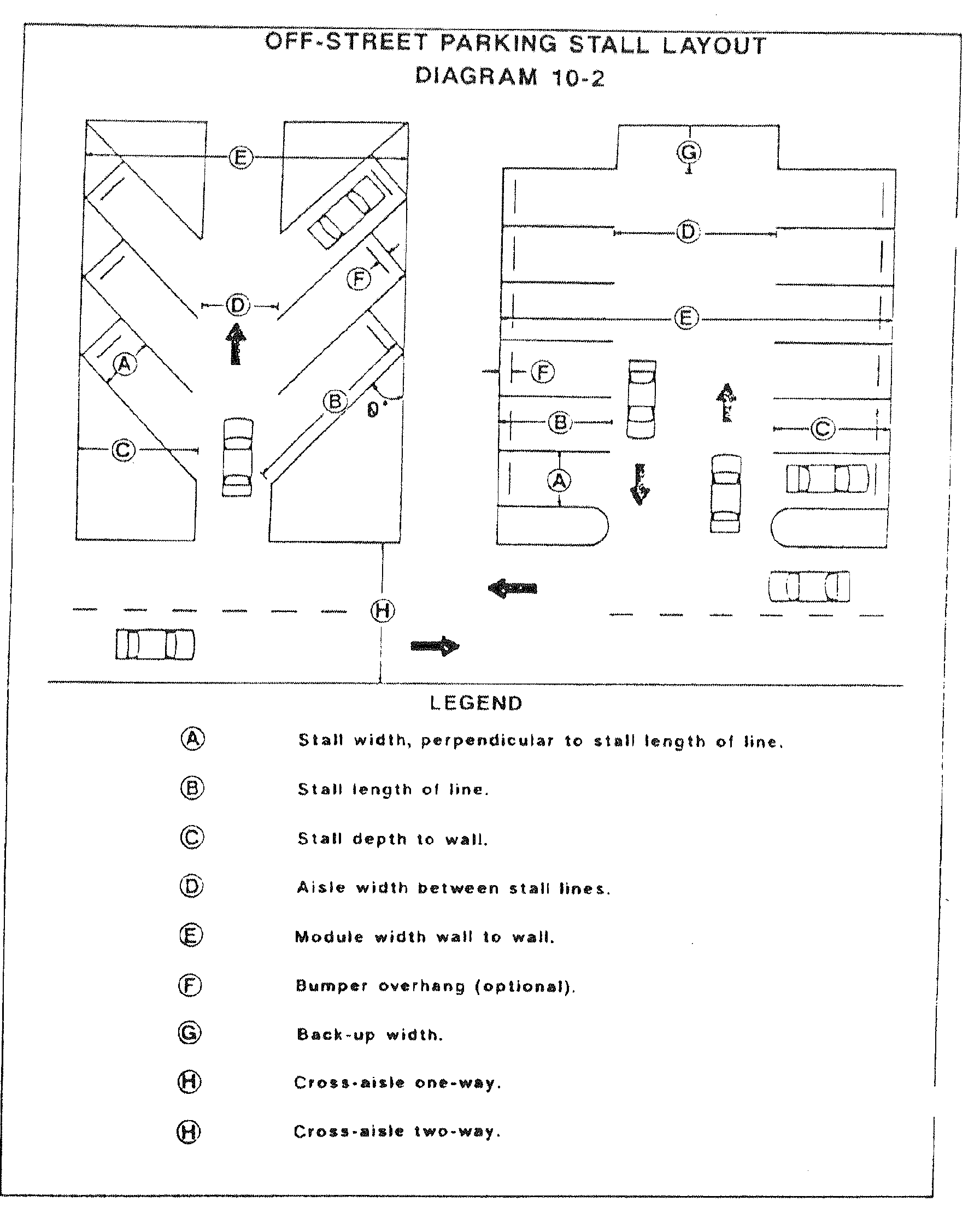
Off-Street Parking Stall Layout—PKG Graphic-2
(c)
Parking for the handicapped shall be provided in accordance with the provisions of the F.S. §§ 316.1955 and 316.1956 and shall be included in the minimum number of parking spaces required by this article.
(d)
All residential uses shall be required to provide a hard surface parking area, made of concrete and/or permeable paver material, within the private lot for all required parking spaces. In addition, the driveway access (apron) located in the public right-of-way is required to be paved in order to preserve the edge of the roadway and protect it from erosion and damage.
(e)
All off-street parking lots shall be graded and drained so as to dispose of all surface water accumulated within the area, in accordance with this Code and the design standards of the department of public works.
(f)
Lighting, if provided, shall be directed away from public streets and residential areas and shall not be a hazard or distraction to motorists traveling on a street.
(g)
Sales, dead storage, repair, dismantling and service of motor vehicles shall not be permitted on off-street parking spaces.
(h)
(1)
All off-street parking spaces, including all areas for maneuvering, shall be located solely on private property and shall not utilize public property or public street rights-of-way, except for single-family detached, semidetached and attached uses and multi-family development with no more than four (4) units on the zoning lot. Single-family detached, semidetached and attached uses and multi-family development with no more than four (4) units on the zoning lot may utilize public rights-of-way for maneuvering, provided that all the following conditions are met:
a.
The proposed use is a permitted or special use;
b.
The parking spaces are located entirely on the zoning lot;
c.
For single-family attached uses and multi-family development with no more than four (4) units on the zoning lot, the available traffic data must show that the traffic count on the street providing access is less than or equal to one thousand five hundred (1,500) vehicles per day. The traffic data shall be verified and approved by the department of public works.
(2)
All off-street parking spaces may utilize public alley right-of-way for maneuvering into and out of a legally sized (per this section 27-283.12) parking space provided the following are met:
a.
If the alley is unimproved, the developer must improve the alley per department of public works standards. Or, if the alley is already being accessed by other properties on the block, the alley must be evaluated by the department of public works to determine if the existing condition of the alley is able to support the additional traffic. The department of public works may require the developer to improve the alley.
b.
The dimensional standards in this section must be met per PKG Table 2 and PKG Table 3. The total width of the public right-of-way of the alley may be counted toward the required aisle width. Modification to these standards may be approved by the manager of the transportation division provided safe ingress and egress to the parking space is demonstrated.
c.
The access to the alley must be designed to ensure adequate visibility is provided per section 27-283.5.
(i)
All off-street parking areas shall be designed to provide safe and convenient circulation, in accordance with commonly accepted traffic engineering practices and subject to the review and approval of the director of the department of public works.
(j)
Nonresidential parking lots and garages shall be designed to minimize impact to residential neighborhoods. In connection herewith the following requirements shall apply to all nonresidential parking lots and garages.
(1)
Ingress and egress to nonresidential parking lots/garages shall be limited to arterial or collector streets, unless one (1) or more of the following conditions exist:
(a)
The property fronts only local street(s); or
(b)
Access to all adjacent arterial or collector street(s) is/are discouraged or rendered impracticable by another provision(s) of the City of Tampa Code; or
(c)
Access to all adjacent arterial or collector street(s) is/are prohibited by the Florida Department of Transportation or another governmental entity; or
(d)
No residentially zoned property exists on the affected segment of a local street where ingress and/or egress is proposed to a nonresidential parking lot or garage. For purposes hereof, the "affected segment of a local street" shall mean the segment of a local street where ingress and/or egress to a nonresidential parking lot or garage is proposed lying between the two (2) closest intersecting arterial or collector streets.
(e)
Access is no further than one hundred fifty (150) feet of the intersection with an arterial or collector roadway.
If one (1) or more of the conditions set forth above exist, then ingress and egress to the nonresidential parking lot or garage on a local street shall be permitted without requiring a waiver or special approval from the city; provided, however, the design and location of the ingress and egress to a nonresidential parking lot or garage on a local street shall comply with the requirements provided herein.
(2)
In the event that none of the conditions contained in subsection 27-283.12(j)(1) apply, the owner of the property on which the nonresidential parking lot or garage is or will be located may file an application with the city requesting a waiver allowing ingress and egress to a nonresidential parking lot or garage on a local street.
Applications for a waiver shall be filed with the Development Services Center and shall include the following information:
(a)
The name and address of the applicant;
(b)
The name and address of the owner of the property on which the nonresidential parking lot is or will be located;
(c)
The legal description of the property;
(d)
Evidence that one or both of the conditions set forth below exist; and
(e)
A list of all property owners located within two hundred fifty (250) feet of the subject property based on information supplied by the Hillsborough County Property Appraiser's Office.
The Development Services Center shall transmit the application to the Transportation Division. The Transportation Division may grant a waiver allowing ingress and egress to a nonresidential parking lot or garage on a local street if the Transportation Division finds that one (1) or both of the following conditions exist:
(a)
The local street primarily serves commercial traffic; or
(b)
The Transportation Division determines that the failure to allow ingress/egress to a local street in addition to, or in lieu of, ingress/egress to an arterial or collector street, will have a significant detrimental impact on traffic flow or safety on surrounding streets.
The Transportation Division shall notify an applicant, in writing, of its decision on an application for a waiver of the driveway location requirements set forth herein. If the Transportation Division issues a written decision approving such a waiver, then the applicant must thereafter provide notice of that decision to the officially registered neighborhood association, as registered with the City of Tampa, in which the subject property is located, and to all other officially registered neighborhood associations that lie within two hundred fifty (250) feet, including roads and streets, in all directions from the subject property, and to his or her neighboring property owners within two hundred fifty (250) feet of the subject property consistent with those public notice procedures set forth in section 27-149(c)(2); however, the applicant must submit an affidavit regarding notification and certificate of mailing to the Transportation Division within ten (10) days of receipt of the Transportation Division's decision. In the event that the applicant fails to properly notice the waiver or fails to timely file the affidavit regarding notification and the certificate of mailing, then the waiver shall be denied. If the application for a waiver is denied for any reason, then no application for the same or similar waiver shall be accepted and considered by the city until three (3) months has elapsed since the date that the prior request for the same or similar waiver was denied. Decisions of the Transportation Division in connection with an application for a waiver may be appealed by an applicant, an appointed representative of the registered neighborhood association, or the owner of property within two hundred fifty (250) feet of the subject property to the variance review board or the Architectural Review Commission (in historic districts, generally, or landmark sites) or the Barrio Latino Commission (in the Ybor City Historic District) in accordance with section 27-61(a). Any such appeal must be filed either within fifteen (15) days of the date of a letter from the Transportation Division denying the waiver, or within fifteen (15) days of the date of the certificate of mailing of notice of a decision approving a waiver, whichever is applicable. No permits shall be issued for construction or development until the applicable fifteen-day appeal period has lapsed, and if an appeal petition has been filed, until the appropriate board has rendered a final decision thereon.
(3)
In the event ingress and egress to a nonresidential parking lot or garage on a local street is allowed in accordance with the terms hereof (by waiver or otherwise) and the local street is adjacent to a residential neighborhood, then, to the extent practicable and safe the driveway shall be designed to channel traffic away from the residential neighborhood. This driveway may not exceed the minimum distance from an intersection as required by the department of public works.
(4)
A proposed development shall be exempt from the requirements of this subsection if it has received a final local development order as defined in the concurrency management system ordinance on or before January 31, 1990.
(k)
For all non-residential uses, half of the required number of off-street parking spaces shall be surfaced with asphalt or Portland cement binder pavement or an equivalent improvement so as to provide a durable and dustless surface. In making a determination as to the suitability of an equivalent improvement, the city traffic engineer shall find that such improvement:
(1)
Provides a safe and permanent surface, suitable for the quantity and quality of traffic expected to use it; and
(2)
Provides a surface that will accept permanent delineation of parking spaces, aisles, accessways and maneuvering areas; and
(3)
Provides a surface that will not contribute to erosion or sedimentation, either on-site or off-site; and
(4)
Provides a surface that meets the design standards of the department of public works; and
(5)
Complies with applicable local, state, and federal regulations regarding access to and maneuverability within said areas for people with disabilities.
The balance of the required parking spaces shall be a hard rock surface or material deemed acceptable by the city traffic engineer, which shall be designed to include bumper stops or other department of public works approved methods of delineating parking spaces.
(l)
For all new developments with over (50) parking spaces, five (5) percent of the proposed parking spaces shall be "Electric Vehicle (EV) Capable," as defined in this Code.
(m)
[Reserved.]
(Ord. No. 2020-166, § 44, 12-17-2020; Ord. No. 2023-49, § 5, 3-16-2023; Ord. No. 2023-128, § 7, 9-21-2023)
Sec. 27-283.13. - Special event parking lots, interim parking lots and residential parking for stadium events.
(a)
Interim parking. It is the purpose of interim parking lots to assist in providing needed levels of parking service to the city. This use is permitted in certain districts, as set forth in the respective use tables by zoning district, as set forth in article III. This use is prohibited in any site plan zoning district, unless specifically authorized on the applicable, adopted, zoning site plan. Their approval may not exceed five (5) years at any location or portion thereof and may be granted one (1) extension not to exceed one (1) year. Applications for permits for interim parking lots shall include a site plan demonstrating compliance with the following standards and requirements:
(1)
Those standards and requirements regarding parking aisle layout, traffic lanes, ingress/egress to the surrounding roadway network and perimeter buffering as set forth in this chapter. The city shall review the parking request for compatibility with the city's maintenance of traffic plan to assess the impact on the surrounding roadway network. The city may impose reasonable conditions, including a traffic study if necessary, to assure the continued compatibility with the surrounding roadway network.
(2)
Any driveway access (apron) located in the public right-of-way shall be paved pursuant to section 22-314 and the Transportation Technical Manual to preserve the edge of the roadway and protect it from erosion or damage.
(3)
Interim parking lots are required to set aside a ten-foot wide level surface area along those portions of the property which abut public right-of-way where sidewalks are not available to accommodate the safe passage of pedestrians off-site, in accordance with commonly accepted traffic engineering practices subject to the review and approval of the city. The ten-foot wide area shall be located along the edge of the curb or road surface and may be required to be extended into the private property if sufficient right-of-way is not available. The city transportation engineer (PDD) may allow a reduction of the ten-foot width if it is determined that safety concerns are otherwise met.
(4)
Parking spaces must be delineated with bumper stops or other city transportation engineer (PDD)-approved methods. See PKG Graphic-3.
(5)
Paved interim parking lots are required to meet all City of Tampa land development regulations; however, paving of the interim parking lot is not required. The surface must be level and suitable for the quantity and frequency of traffic expected to use it. The lot must be maintained with a level and flat surface free from tripping hazards, areas of discontinuity of surface or other potential safety hazards. The lot must also be maintained in good condition and not become a public nuisance. Conditions which must be avoided shall include, and not be limited to, erosion problems (including irrigation blowouts, rain washouts, etc.), silting of streets, dust, overgrowth and the accumulation of litter and debris.
(6)
Unpaved interim parking lots are not required to meet the landscaping and buffering requirements for vehicular use areas set forth in article VI of this chapter. However, there shall be provided a perimeter buffer, including wheel stops (or other approved method) placed two (2) feet back from any landscaped area and a five-foot wide break in the perimeter landscape to accommodate a pedestrian pathway to the right-of-way. There shall be one (1) break per one hundred (100) linear feet of frontage as indicated in options A, B, or C (PKG Graphic-4) along the edge of the surface lot fronting the public right-of-way. Existing protected trees on a permitted interim lot shall be protected in accordance with article VI of this chapter. No removal of trees shall be permitted on interim parking lots.
An alternate landscape plan may be approved by the natural resources coordinator, pursuant to the procedures and criteria set forth in section 27-60. The alternate plan must demonstrate a uniqueness of the site to warrant deviation from the above requirements. The alternate plan must provide landscaping equivalent to or exceeding the minimum landscaping stated above.
(7)
Sales, dead storage, repair, dismantling and service of motor vehicles shall not be permitted at interim parking lots.
(8)
Interim parking lots shall provide parking for disabled persons in accordance with the provisions of F.S. §§ 316.1955 and 316.1956, and such spaces shall be included in the minimum number of parking spaces required by this chapter.
(9)
Maintenance: Turf areas shall be mowed to a maximum height of eight (8) inches. Irrigation systems are to maintain a ninety-eight (98) percent operational status and be controlled by an automatic timer with a rain shutoff mechanism. Trees and shrubs shall be maintained as set forth on article VI of this chapter.
(10)
Interim parking lots may be used for special event parking provided a sign is prominently displayed during each event. The sign (minimum eighteen (18) inches × twenty-four (24) inches) shall be posted on private property at each entrance stating the cost of parking in the lot space. No sign may exceed four (4) square feet in area.
(11)
Wreckers. All permitted interim parking lot operators shall utilize the services of wreckers who have obtained a certificate of eligibility from the Hillsborough County Public Transportation Commission for any nonconsensual towing from the lot.
(b)
Special event parking. Due to the limited land available for parking and the short-term duration and single occurrence of many events, the special event parking use is permitted in certain districts, as set forth in the respective use tables by zoning district, as set forth in article III. This use is prohibited in any site plan zoning district, unless specifically authorized on the applicable, adopted, zoning site plan. Applications for permits for special event parking lots shall include a site plan demonstrating compliance with the following minimum requirements. Any violation of this section shall give the city authority to suspend or revoke the special event parking permit:
(1)
Permits for each lot may be issued for special event parking on private or public property for a period not to exceed six (6) months. Permits for special event parking may be renewed every six (6) months.
(2)
The use of special event parking lots shall coincide with a special event that requires overflow parking on a short-term basis, as further defined herein. The operation of a special event parking lot at any other time is prohibited. Access to the parking lot shall be secured when the lot is not in use.
(3)
Special event parking lots are not required to meet City of Tampa Code requirements related to parking lot landscaping, paving, or drainage. They are required to provide safe access to and from the site without damage to existing sidewalks or curbs through an improved, safe driveway access. Any damaged area shall be immediately secured in such a fashion that will prevent pedestrian or vehicular access to such area, and shall be repaired within two weeks of the occurrence of the damage. If the damage is not repaired within two (2) weeks of occurrence, the city shall have the authority to suspend or revoke the special event parking permit.
(4)
Special event parking lots shall set aside a ten-foot wide level surface area along those portions of the property which abut public right-of-way, where sidewalks are not available, to accommodate the safe passage of pedestrians off-site in accordance with commonly accepted traffic engineering practices, subject to the review and approval of the city. This ten-foot wide area shall be located along the edge of the curb or road surface and may be required to extend into the private property if sufficient right-of-way is not available. The city transportation engineer (PDD) may allow a reduction in the ten-foot width if it is determined that safety concerns are otherwise met.
(5)
The city shall review the special event parking request for compatibility with the city's maintenance of traffic plan to assess the impact on the surrounding roadway network. The city may impose reasonable conditions, including a traffic study if necessary, to the special event parking permit to assure the continued compatibility with the surrounding roadway network.
(6)
Special event parking lots shall provide parking for disabled persons in accordance with the provisions of F.S. §§ 316.1955 and 316.1956, and such spaces shall be included in the minimum number of parking spaces required by this article.
(7)
The parking lot surface must be level and suitable for the quantity and frequency of traffic expected to use it. The lot must be maintained with a level and flat surface free from tripping hazards, areas of discontinuity of surface or other potential safety hazards. The lot must be maintained in good condition and not become a public nuisance. Conditions which must be avoided shall include and not be limited to erosion problems (including irrigation blowouts, rain washouts, etc.), potholes, silting of streets, dust, overgrowth, and accumulation of litter and debris. Litter and debris must be removed from the site after every special event.
(8)
The special event parking lot permit shall be prominently displayed during each event. A sign (minimum eighteen (18) inches × twenty-four (24) inches) shall be posted on private property at each entrance stating the cost of parking in the lot space. No sign can exceed four (4) square feet in area.
(9)
Tree protection. Existing protected trees on a permitted special event lot shall be protected in accordance with those standards found in article VI of this chapter. No removal of trees shall be permitted on special event parking lots.
(10)
Wreckers. All permitted special event parking lot operators shall utilize the services of wreckers who have obtained a certificate of eligibility from the Hillsborough County Public Transportation Commission for any nonconsensual towing from the lot.
PKG Graphic-3. Typical Parking Lot Corner Area.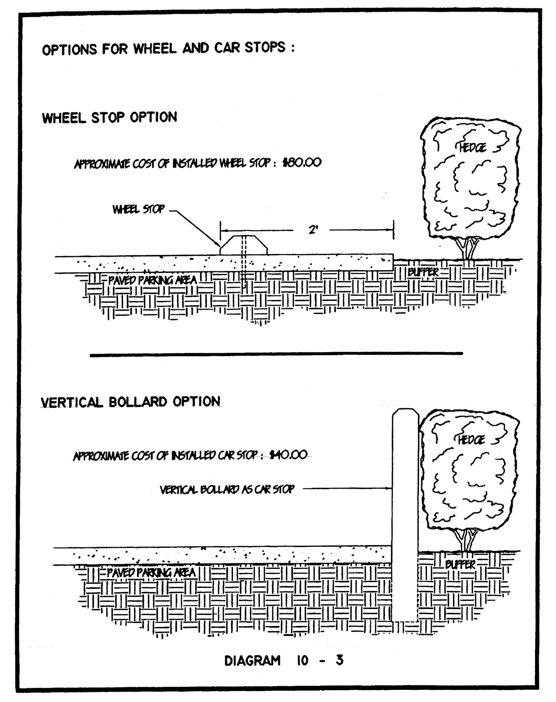
PKG Graphic-4. Typical Parking Lot Corner Area.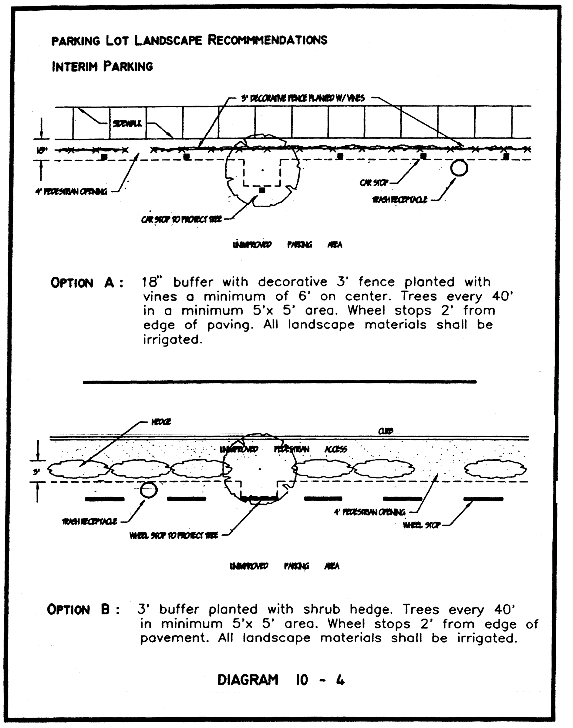
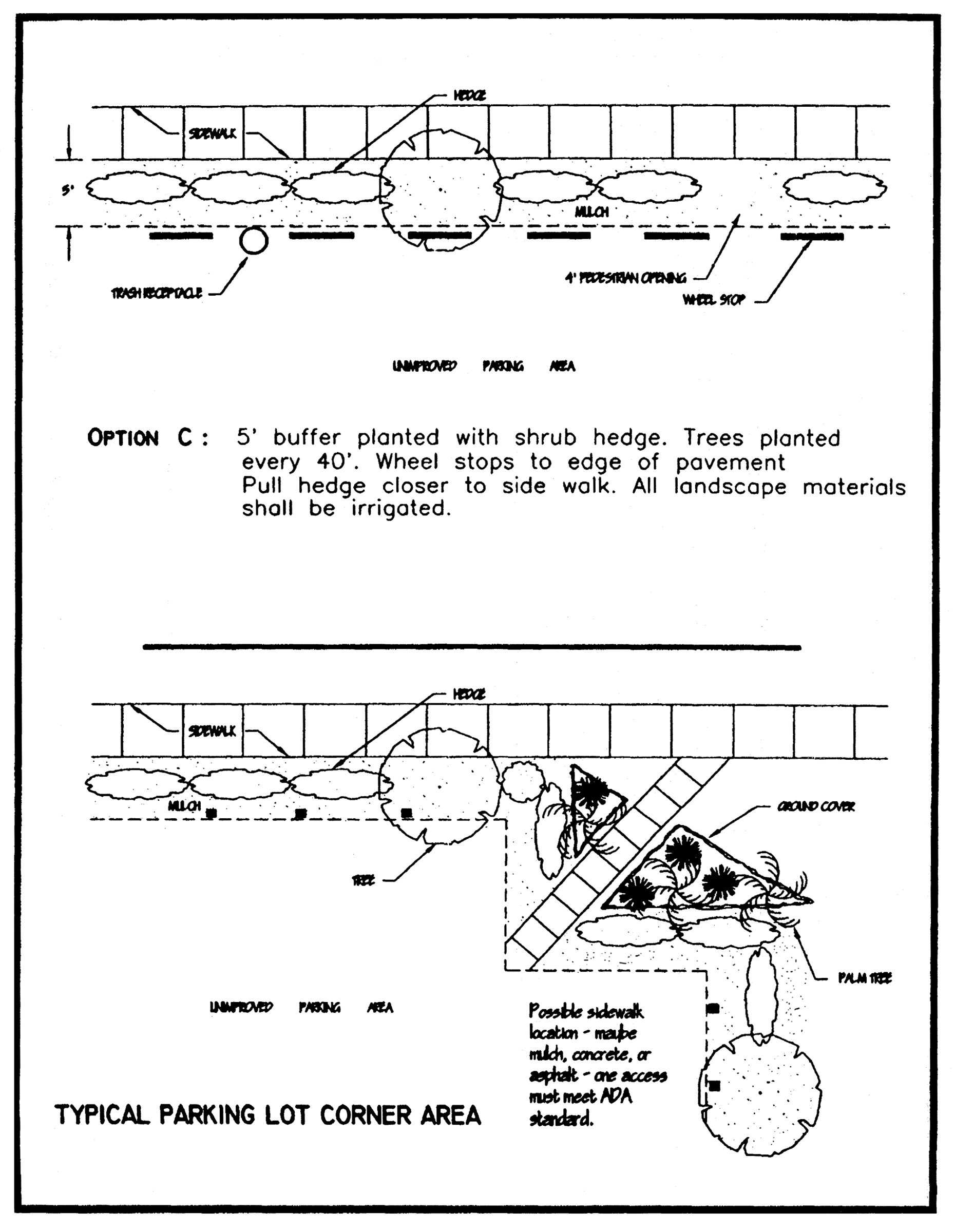
(c)
Amortization schedule. Existing nonconforming parking lots which are legally established, as determined by the zoning administrator and operating upon the effective date of this ordinance may continue to operate without meeting the landscaping criteria set forth in section 27-283.13(a)(1)—(11), for a period of two (2) years. Therefore all existing nonconforming parking lots must meet the criteria stated in article VI, division 3, section 27-283.13(a)(1)—(11). All nonconforming parking lots in existence on the effective date of this ordinance must meet all other minimum standards of section 27-283.13(b)(1)—(10).
(d)
Stadium event parking. Off-street parking shall be a permitted accessory use in those residential districts within the immediate area of Raymond James Stadium, subject to the following criteria:
(1)
Parking on residential lots shall be permitted only on those days or nights when there is a scheduled event being held at Raymond James Stadium.
(2)
The residentially-zoned lot must contain a residential structure that is being used for residential purposes. If the lot does not contain such a structure, it may be used for parking only if it is operated as a special event parking lot in conformance with those requirements set forth in subsection (b) above.
For purposes of this subsection the immediate area of Raymond James Stadium shall be defined as that area North of Interstate I-275, South of Hillsborough Avenue, East of Westshore Boulevard and West of the Hillsborough River.
(Ord. No. 2019-54, § 32, 4-18-2019)
Sec. 27-283.14. - Off-street loading space—Required.
(a)
Every use requiring the receipt or distribution by vehicles of materials and merchandise shall have one (1) or more loading berths or other space for standing and loading on the same or adjoining premises. Loading space shall be sufficient to allow normal loading and unloading operations of a kind and magnitude appropriate to the property served. Also, a required loading space shall be available for the loading and unloading of vehicles and shall not be used for the storage of vehicles or materials or to meet off-street parking requirements or in conducting the use.
(b)
The requirements in the following table shall apply only to new structures or additions to structures, and shall not be considered to make any existing structure nonconforming for lack of such off-street loading:
TABLE 1
OFF-STREET LOADING REQUIREMENTS
(c)
For any land use that is not categorized in the above table, the department of public works, upon review of the proposed use, shall specify the required number of loading spaces to be provided, using generally accepted traffic engineering practices and standards.
Sec. 27-283.15. - Same—Standards.
All off-street loading spaces shall meet the following standards:
(1)
Off-street loading spaces shall be located and arranged so that a semitrailer truck (WB 50 class) shall be able to gain access to and use such spaces by means of one (1) continuous parking maneuver.
(2)
Loading space shall meet the minimum setbacks established for structures.
(3)
All loading space and maneuvering space shall be surfaced with an all-weather material which shall be maintained in a safe, sanitary and neat condition.
(4)
No loading space shall be located so that a vehicle using such space intrudes on or hinders the use of travel lanes, walkways, public or private streets or adjacent properties.
(5)
Each required off-street loading space shall have a minimum width of twelve (12) feet and a minimum vertical clearance of sixteen (16) feet above finished grade of the space. The length shall be a minimum of thirty (30) feet for local delivery and sixty (60) feet for tractor trailers. A maximum of two-thirds of the required loading spaces can be used for local deliveries.
(6)
Where the off-street loading space requirements of a specific use or development can be shown to require fewer loading spaces than the requirements of this article, the department of public works may authorize a reduction [in] number of loading spaces. The applicant must demonstrate the reduced loading space demand for development to the department by submitting the appropriate traffic data either prepared by a professional traffic engineer or approved by the city traffic engineer. The department of public works shall either approve or deny the request for reduction in loading spaces, based on their review of the submitted traffic data and the professional guidelines for traffic generation. If the department of public works denies the request for a reduction in loading spaces, the applicant may appeal the decision to the variance review board or the Architectural Review Commission (in historic districts, generally, or landmark sites) or the Barrio Latino Commission (in the Ybor City Historic District).
Sec. 27-283.16. - Bicycle parking.
(a)
In all districts for industrial, commercial, office, residential or mixed-use development, there shall be provided, at the time any new building is erected, any use of a building or land is enlarged by five hundred (500) square feet or five (5) percent whichever is greater or increased in intensity or any other use or change of use established, bicycle parking spaces in accordance with requirements herein.
(b)
Bicycle parking standards.
(1)
Minimum number of required bicycle spaces. Calculations shall be rounded up to the nearest whole number. In no case shall less than two (2) bicycle parking spaces be provided, unless otherwise noted in BPKG Table 1 below.
(2)
Location. Each bicycle parking space shall be located no farther than one hundred (100) feet from the main entrance to the building, as measured along the most direct pedestrian access route. For sites with more than one main building entrance, the bicycle parking shall be distributed to serve all main buildings.
(3)
Placement and construction. A single 36-inch × 72-inch clear space shall be provided directly adjacent to a firmly mounted durable rack capable of supporting a bicycle upright, in a stable position, by its frame in two (2) places. The dimension of the rack may be included in the clear space calculation.
(4)
Bicycle rack style and design. Racks or mounts commonly known as inverted "U, "staple", "hoop", "secured wheelwell", and "post and ring" may be used to satisfy this section and must be permanently affixed to the ground.
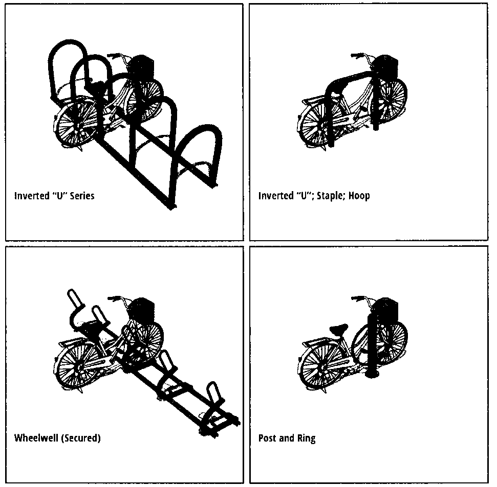
(5)
Conditional rock designs. "Undulating, wave, spiral", "schoolyard, grid, comb", "coathanger" and "wheelwell (unsecured)" racks or mounts may not be used unless the zoning administrator, or designee, determines that the use of an approved rack design is infeasible.
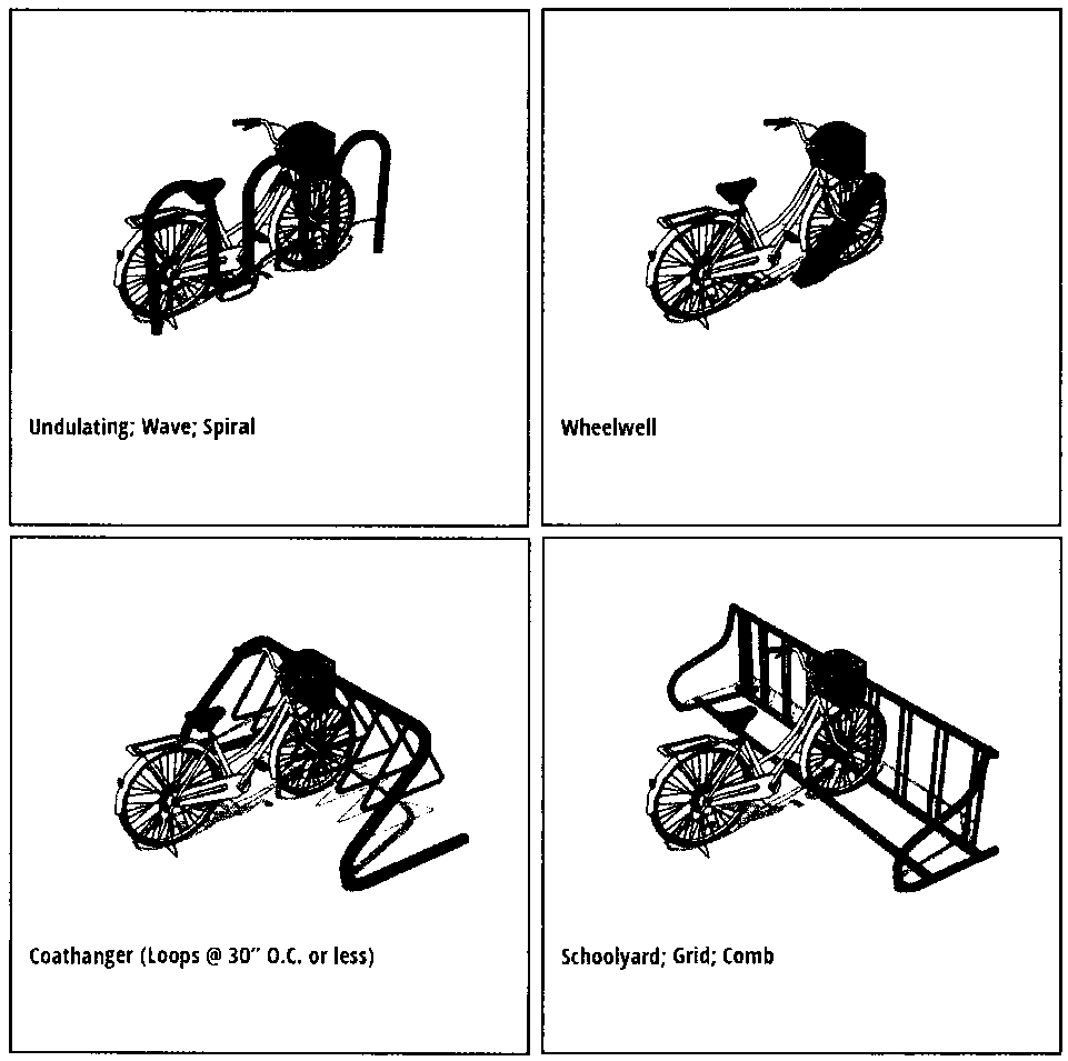
(6)
Minimum number of bicycle spaces required. The following uses shall be required to provide bicycle parking spaces as set forth in BPKG Table 1. [Except section 27-139, general requirements, subdivision 5, Seminole Heights District, section 27-211; section 184 official schedule of permitted principal, accessory and special uses; required off-street parking ratios by use; subdivision 6, neighborhood mixed use districts, section 27-212.4, schedule of allowable, permitted, and prohibited uses by district.
(7)
Bicycle racks shall not interfere with the sight visibility requirements as set forth in article VI, division 3, section 27-283.5.
(Ord. No. 2022-169, § 6, 10-6-2022)
Subdivision 5. - Wetlands[8]
Editor's note— Ordinance No. 2019-54, § 33(Exh. A), adopted April 18, 2019 renumbered Subdivision 3 as Subdivision 5 as herein set out.
Subdivision 6. - Upland Habitat Protection[9]
Editor's note— Ordinance No. 2019-54, § 33(Exh. A), adopted April 18, 2019 renumbered Subdivision 4 as Subdivision 6 as herein set out.
Sec. 27-288.- Solid waste.
(a)
All new construction, major renovation, and/or change of use, for any use, shall provide facilities for the central storage of solid waste within the lot. Solid waste facilities may be located inside or outside of a building, shall contain equipment and necessary space that is compatible with the city's mechanical solid waste collection system, and be designed and placed in a serviceable and safely accessible, approved location. The property owner shall be responsible for keeping the solid waste enclosure and associated gates, concrete pads, and access walkways in good repair at all times, subject to the enforcement requirements of Chapter 19 and 26.
(b)
Where such facilities are provided outside of a building, they shall be screened from the public or private right-of-way and adjacent property by an enclosure containing materials compatible with the materials on the front building wall of the main building. However, uses that utilize container service and are able to place the containers within a lot that is fully screened from a public or private right-of-way and adjacent property by a six-foot high solid fence and/or wall, the construction of a separate enclosure shall not be required. Refuse bins and/or containers for any use shall not be located within a front yard (minimum fifteen (15) feet for non-residential uses) or a buffer area as set forth in section 27-284 Buffer Matrix.
(c)
The following dimensional criteria apply to those refuse bins and/or containers that are required to construct an enclosure for solid waste facilities:
(1)
Each container enclosure shall be a minimum of five (5) feet by five (5) feet with a minimum five-foot opening (these are inside, unobstructed measurements within the container enclosure) and shall be a minimum of four (4) feet in height.
(2)
Each refuse bin enclosure shall be ten (10) feet in depth and a minimum of twelve (12) feet wide with a minimum twelve (12) foot opening or a maximum sixteen (16) foot opening. (These are inside, unobstructed measurements within the bin enclosure.)
(3)
Each compactor/roll-off enclosure shall be a minimum of fifteen (15) feet by thirty-five (35) feet with a minimum fifteen-foot opening (these are inside, unobstructed measurements within the compactor/roll-off enclosure).
(4)
All refuse bin, compactor and roll-off enclosure opening doors shall be solid and the doors shall be required to have locking pins to hold them open during service. Safety bollards shall be installed inside, within the rear two (2) feet, of all refuse bin, compactor, and roll-off enclosures.
(d)
Concrete slabs (grade level) shall be provided for all refuse bins, compactors and roll-offs at a minimum of six (6) inches thick/four thousand (4,000) pounds per square inch.
(e)
Overhead clearance at the point of collection shall be a minimum of twenty-six (26) feet and shall be determined by the type of refuse service to be utilized.
(f)
All solid waste vehicle drive aisles and solid waste vehicle maneuvering areas shall provide a minimum sixteen-foot clearance from finished grade level to lowest part of overhead structure.
(g)
All solid waste vehicle drive aisles and solid waste vehicle-maneuvering areas shall be constructed to current State of Florida, Department of Transportation, Standard Specifications for Road and Bridge Construction.
(h)
The director of solid waste, or designee, may consider design and/or placement alternatives, provided that any proposed design does not conflict with visibility standards set forth in section 27-283.5.
(Ord. No. 2023-128, § 8, 9-21-2023; Ord. No. 2024-4, § 2, 1-11-2024)
Cross reference— Solid waste generally, § 26-146 et seq.
Sec. 27-289.- Purpose.
(a)
The purpose and intent of this chapter is to establish a set of standards for the fabrication, erection, use, maintenance and alteration of signs, symbols, markings or advertising devices within the city. These standards are designed to protect and promote the health, safety and welfare of persons within the city by providing regulations which allow and encourage creativity, effectiveness and flexibility in the design and use of such devices while promoting traffic safety and avoiding an environment that encourages visual blight. The safety of all citizens is affected by the ability of emergency responders to quickly and easily identify locations through appropriate signage, and the size and location of signs may, if uncontrolled, constitute an obstacle to effective emergency response as well as fire-fighting techniques. Further, the safety of motorists, cyclists, pedestrians, and other users of the public streets is affected by the number, size, location, lighting, and movement of signs that divert the attention of drivers. Uncontrolled and unlimited signs may also degrade the aesthetic attractiveness of the natural and manmade attributes of the community and thereby undermine the economic value of tourism, visitation, and permanent economic growth.
(b)
It is not the purpose of this division to regulate or control the copy or the content of signs. It is not the intent of this chapter to afford greater protection to either commercial or noncommercial speech. Any sign, display, or device allowed under this chapter may contain, in lieu of any other copy, any otherwise lawful noncommercial message that does not direct attention to a business operated for profit, or to a commodity or service for sale, and that complies with all other requirements of this chapter.
(c)
This division is intended to be consistent with the Tampa Comprehensive Plan.
(Ord. No. 2017-103, § 8(Exh. A), 6-22-2017)
Sec. 27-289.1. - Short title.
This division shall be referred to and cited as the "City of Tampa Sign Code."
(Ord. No. 2017-103, § 8(Exh. A), 6-22-2017)
Sec. 27-289.2. - Permits required; fees and process.
(a)
Permit required for signs. A sign shall not be erected, demolished, altered, rebuilt, enlarged, extended, relocated, attached to, suspended from, or supported by a building or structure unless a permit for the same has been issued in accordance with chapter 5, unless the sign is specifically exempted from permit procedures set forth in this division.
(b)
Who may obtain sign permits. Licensed general, building, residential, or sign contractor, or authorized agent(s), in accordance with chapter 5, may obtain sign permits.
(c)
When required.
(1)
Sign permits are required as set forth in section 27-289.3.
(2)
Any repair work on a sign affecting the structural integrity of the load bearing elements shall require a permit. Simple, nonstructural maintenance of a sign does not require a permit.
(3)
Repairs to a sign may be conducted prior to obtaining a permit in the event of an emergency imposing an imminent threat to life or property. Provided, however, that any necessary permit is obtained on the first city working day thereafter. Emergency repairs shall be limited to returning the sign to its original permitted state.
(4)
A permit is not required to change or replace the advertising copy, message or sign face on changeable copy signs. Provided, however, that said change or replacement of advertising copy, message or sign face does not enlarge or increase the sign surface area nor adversely affect the original design integrity. If, in order to change or replace the advertising copy, message, or sign face, the supporting sign structure must be unfastened, loosened, or removed, then and in that case, a sign permit shall be required. Copy cannot be replaced such that the sign changes from an on-site sign to an off-site sign.
(d)
The following inspections are required.
(1)
Foundation: To be made after the hole is excavated, forms erected, and reinforcing steel is in place.
(2)
Final: To be made after the sign is completely installed.
(3)
Electrical: Illuminated and electronic signs require an electrical inspection to be made after the electrical work is complete. Underground wiring requires an inspection to be made after all conduits, raceways or other components are installed and prior to the soil being replaced.
(e)
Permit fees shall be paid in accordance with the schedule as established by resolution by the city council (refer to chapter 5).
(f)
Permitting procedure:
(1)
The building official or designee shall be responsible for the administration of sign permits, subject to chapter 5.
(2)
Unless otherwise expressly provided for in this chapter, the building official or designee shall review an application for any permit for the erection, relocation, repair, removal or in any way pertaining to signs, and issue an official determination to the applicant within thirty (30) calendar days of receipt of the completed application. The review and determination period may be extended for an additional forty-five (45) calendar days at the request of the applicant or agent thereof. If the application is in conformity with the terms and requirements of this chapter, the application shall be granted. If the application is not in conformity with the terms and requirements of this chapter the application shall be denied. In the event the application is denied, the building official or the building official's designee shall include the specific basis for the denial in the written determination provided to the applicant. Failure of the building official or the building official's designee requested to review an application relating to constitutionally protected first amendment activity to review and issue a final determination within thirty (30) calendar days of receipt of the completed application shall authorize the applicant to conduct the activity for which the approval of the application would otherwise be required.
(Ord. No. 2017-103, § 8(Exh. A), 6-22-2017; Ord. No. 2020-166, § 50, 12-17-2020)
Sec. 27-289.3. - Allowable signs.
(a)
The following signs are exempt from permit requirements of this Sign Code, unless otherwise stated herein or required pursuant to other provisions of the City of Tampa Code of Ordinances:
(1)
Government signs. No permit is required if a government sign is necessary for the purposes of public health and safety, or is used to identify public services or public facilities, for traffic control, for events, for wayfinding or directions, or to provide information to the community. Otherwise a government sign must comply with requirements of this chapter. Any government sign which contains an electronic message must operate in compliance with subsection 27-289.6(b).
(2)
Flags when displayed on a single pole or other supporting structure, subject to the following restrictions:
(3)
Signs cut into masonry surfaces without paint or other effect. Such signs might include memorial signs or tablets, names of buildings, and dates of erection.
(4)
Two (2) signs per driveway located in non-Residential districts, or at the entrance to a residential subdivision, multi-family development, or mobile home park, provided that:
a.
The signs are located on private property and pertain to directing traffic, emergency responders, or pedestrians safely on or off of such property;
b.
Each sign shall not exceed four (4) square feet in sign area nor thirty (30) inches in height;
c.
If illuminated, an electrical permit shall be obtained in accordance with chapter 5, City of Tampa Code;
d.
Signs may be placed with a zero (0) foot setback from the right-of-way, subject to the provisions of section 27-283.5. The square footage of signs under this subsection (4) shall not be counted as part of the maximum allowable square footage for any parcel.
(5)
Temporary signs, subject to the following restrictions:
a.
Each zoning lot of record shall be allowed the following temporary signs without permit, provided that each temporary sign complies with subsection (a)(5)(ii) below:
1.
One temporary sign per 200 feet of frontage or portion thereof; and
2.
Warning signs; and
3.
Any number of signs, which are associated with an event, including but not limited to:
i.
During the time a property is actively marketed for sale, rent, or lease on such sign or in one or more paper or online listing(s);
ii.
During the time the property is under construction, provided that such signs are removed prior to issuance of a certificate of occupancy;
iii.
For a local, state, or national election;
iv.
Holiday, seasonal, or commemorative decorations; or
v.
For a public or semipublic event or function.
b.
All temporary signs placed under this subsection (5) shall not be considered as part of the maximum square footage permitted on any parcel, and are subject to the following restrictions:
1.
No illumination is permitted, nor may any part of the sign be electronic.
2.
Event signs shall be erected no more than sixty (60) consecutive calendar days prior to the event and shall be removed within six (6) consecutive calendar days of the conclusion of the event.
3.
A maximum of thirty-two (32) square feet of total temporary signage is permitted at any one time per parcel.
4.
No single temporary sign may exceed the following sizes:
(6)
Window signs which comprise, in aggregate, twenty-five (25) percent of the total window area or less.
(7)
Signs incorporated on machinery or equipment at the manufacturer's or distributor's level, such as signs customarily affixed to vending machines, newspaper racks, and gasoline pumps. Such signs shall not be counted as part of the maximum square footage permitted on any parcel.
(8)
Interior signs which are displayed on the inside of a building and not visible from a public place. Such signs shall not be counted as part of the maximum square footage permitted on any parcel.
(9)
One (1) address sign of no more than two (2) square feet of total sign face area in Residential districts and no more than three (3) square feet of total sign face area in Non-Residential districts. The square footage for the address sign shall be allowed in addition to the total sign surface area allowed for freestanding and/or building signs.
(10)
Signage applied to outdoor furniture, including umbrellas, that shall consist of no more than one (1) line of letters or an identification emblem, initials or insignia, or other feature painted on the furniture.
(11)
Signs which are required pursuant to the City of Tampa Code of Ordinances, Florida Statutes or other regulations in the location and up to the size required by the applicable regulation shall be allowed. Such legally required signage shall be allowed in addition to the total sign surface areas allowed for other signage provided for in this Sign Code.
(b)
The following signs are allowed only with a permit:
(1)
In addition to the temporary signage allowed under subsection (a)(5) above, one (1) temporary sign exceeding the size of a sign allowed under section (a)(5) may be displayed for a period not to exceed thirty (30) consecutive calendar days, nor more than sixty (60) days in a single year (up to ninety (90) days in the Central Business District as defined in Chapter 27, City of Tampa Code of Ordinances), provided:
a.
No such temporary sign may be displayed at a height of more than fifteen (15) feet (except in the Central Business District as defined in Chapter 27, City of Tampa Code of Ordinances, a temporary sign attached to a building may not exceed the height of the building upon which the sign is attached), nor shall such sign be any larger than a building sign allowed for the parcel on which the sign is displayed;
b.
The temporary sign shall be displayed only in non-residential zoning districts, or within non-residential or mixed use designated areas of site plan districts;
c.
The temporary sign shall be attached to the building in a manner as provided for in Chapter 5 of the City Code and shall not be affixed to vehicles or utility poles except as provided for in Chapter 22 of the City Code;
d.
The temporary sign shall be maintained in a state of good repair, and such signs that are frayed, torn, or otherwise in disrepair are prohibited. A permit is required prior to the installation of any temporary sign exceeding the size of a temporary sign allowed under section (a)(5) above.
(2)
At each entrance to a platted subdivision, one (1) double-faced or two (2) single-faced permanent sign(s), provided that all of the following requirements are met:
a.
The sign(s) shall not create a physical or visual hazard for pedestrians, bicyclists, or motorists entering or leaving the subdivision and shall be set back a minimum of fifteen (15) feet from the right-of-way line and thirty (30) feet from the intersection of the rights-of-way;
b.
An individual, firm, partnership, association, corporation or other legal entity shall be designated as the person responsible for the perpetual maintenance for the subdivision sign(s);
c.
The sign(s) shall not exceed ten (10) feet in height; and
d.
The sign(s) shall not exceed a total of forty (40) square feet in aggregated display area.
(3)
At each entrance to a multiple family residential development or mobile home park, one (1) double-faced or two (2) single-faced permanent building or freestanding sign(s) may be located, provided that all of the following requirements are met:
a.
The sign(s) shall not create a physical or visual hazard for pedestrians, bicyclists, or motorists entering or leaving the development and shall be set back a minimum of fifteen (15) feet from the right-of-way line and thirty (30) feet from the intersection of the rights-of-way;
b.
Within the CBD, refer to art. III, div. 2., subdn. 3;
c.
Such signs shall not exceed two (2) square feet in display area for each dwelling unit, up to and including twenty (20) units—in no event shall the sign(s) exceed forty (40) square feet of aggregated display area;
d.
Such signs shall not exceed ten (10) feet in height; and
e.
Such signs shall be set back fifteen (15) feet from the right-of-way line and thirty (30) feet from the intersection of the rights-of-way.
(4)
Two (2) signs per driveway located in Non-Residential districts or at the entrance to a residential subdivision, multi-family development, or mobile home park, provided that all of the following requirements are met:
a.
The signs pertain to directing traffic, emergency responders, or pedestrians safely on or off of such property;
b.
The entire sign structure shall not exceed five (5) feet in height;
c.
The sign copy shall not exceed twelve (12) inches or thirty-two (32) square feet; and
d.
Such signs shall meet the separation and setback requirements of freestanding signs in subsection (b)(5) below.
(5)
Freestanding signs. Freestanding signs shall be allowed in office, commercial and industrial districts, provided the following specific regulations are met (refer to sec. 27-289.4 for electronic message sign standards):
a.
Number: One (1) Freestanding sign is permitted for each parcel having street frontage. Additional signs are allowed as follows:
1.
For a corner lot, as defined in section 27-161, one (1) additional freestanding sign is permitted to be located adjacent to the second street frontage provided that the second street frontage is a minimum of three hundred (300) feet of continuous, lineal public street frontage; or
2.
For a parcel with a street frontage greater than three hundred (300) feet, one (1) additional freestanding sign is permitted for each additional three hundred (300) feet of continuous, lineal street frontage.
b.
Placement (See Diagram 2):
1.
The placement and orientation of a freestanding sign shall be limited to arterial and/or collector street roadways (as identified in the City of Tampa Department of Public Works "Roadway Functional Classification System"), unless either of the following situations exist:
i.
The zoning lot has street frontage only on local street; or
ii.
The zoning lot has street frontage on a local street where the entire block face on both sides of the local street has no residentially zoned or used parcels.
2.
Freestanding signs shall be placed no closer than one hundred fifty (150) feet apart on the same zoning lot.
3.
Freestanding signs shall be placed no closer than ten (10) feet from any residential zoning district. For the purpose of determining the spacing requirement found in this subsection, distances shall be measured from the sign structure to the property line of the nearest residentially zoned property.
c.
Size:
1.
The allowable sign area for a freestanding sign shall be one (1) square foot of sign surface area for each lineal foot of street frontage on an abutting public street as follows:
2.
If a parcel is entitled to more than one (1) freestanding sign under this section, then two (2) or more allowable freestanding signs may be combined into a single freestanding sign, not to exceed a maximum allowable sign surface area of one hundred (100) square feet per sign face.
3.
The allowable sign surface area shall not include any decorative elements surrounding the sign face. However the decorative elements shall not protrude more than three (3) feet beyond the sign face.
d.
Height-Setback: The maximum height of a freestanding sign at the five-foot setback line shall be ten (10) feet, measured from the established grade at the property line along the right-of-way from the closest leading edge of the freestanding sign. For every one (1) foot of additional setback, the height of the freestanding sign may be increased by one (1) foot to a maximum height of twenty (20) feet. In no event may the freestanding sign interfere with the visibility triangle as provided in section 27-283.5 of the City Code.
e.
Design: The sign face shall be supported by a sign structure which shall consist of a single pier or pillar with a minimum diameter or horizontal dimension of thirty (30) inches or, alternatively, by two (2) piers or pillars, each with a minimum diameter or horizontal dimension of twelve (12) inches. The sign structure shall have materials and architectural details consistent with the principal building it serves or in a manner shown in Diagrams 3 and 4 below.
Diagram 1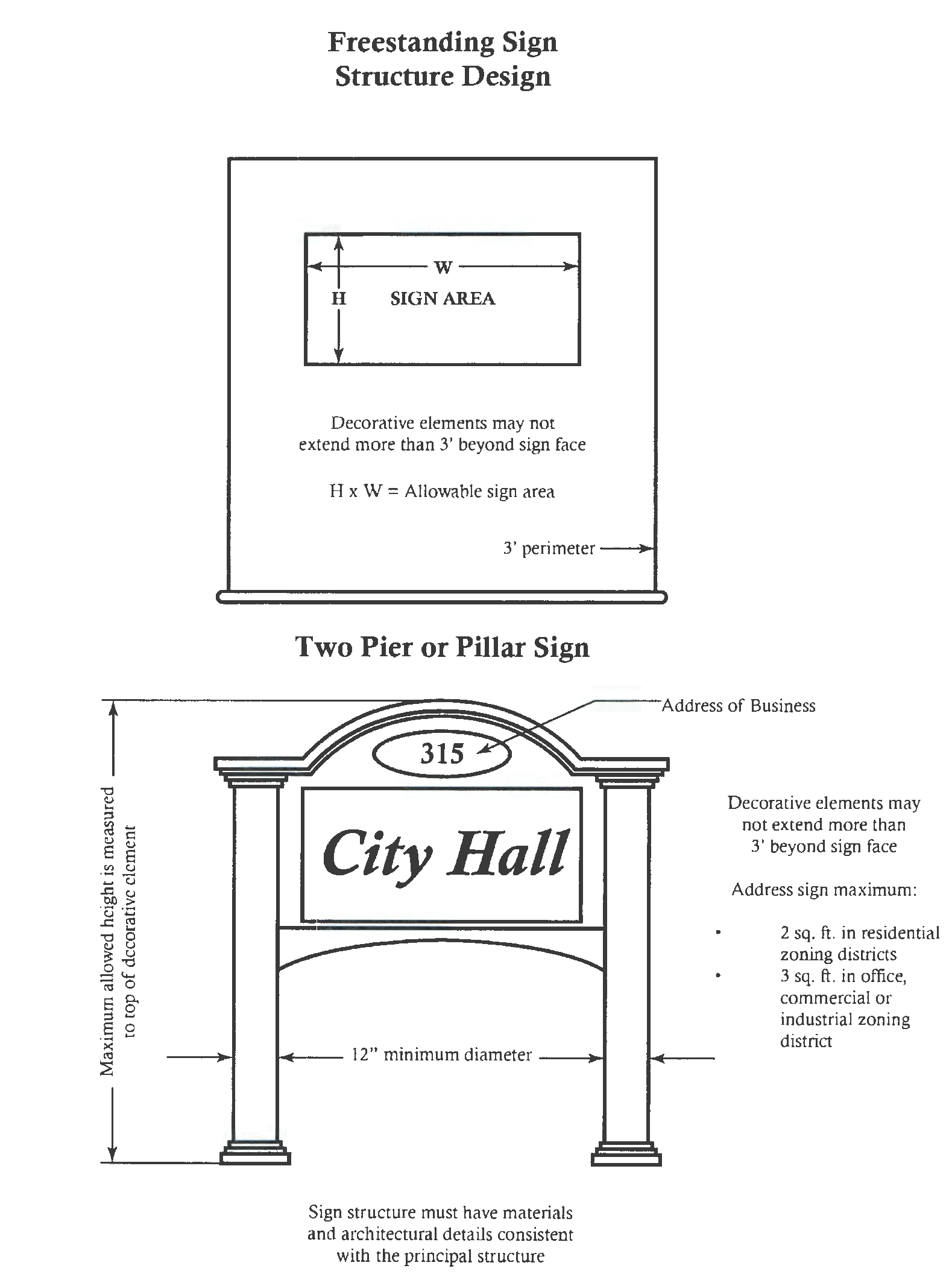
Diagram 2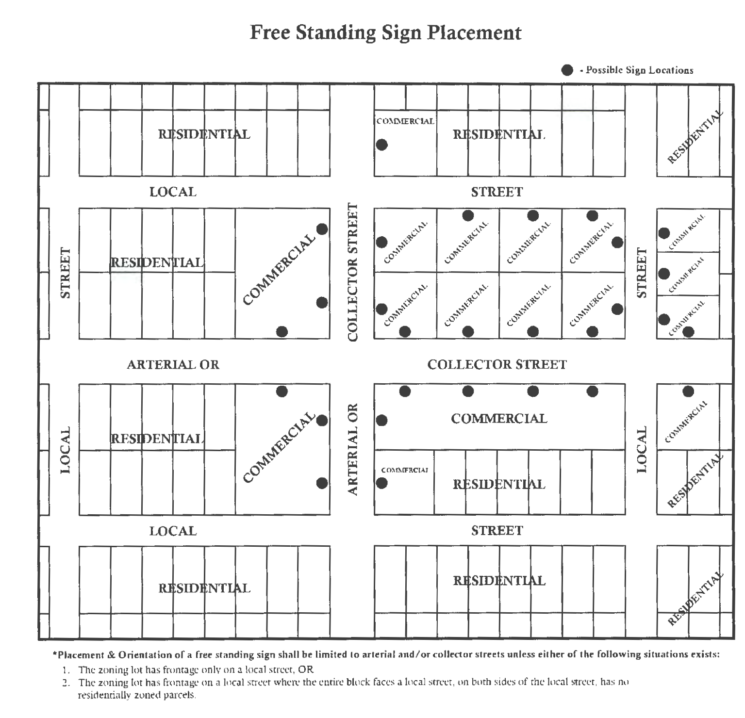
Diagram 3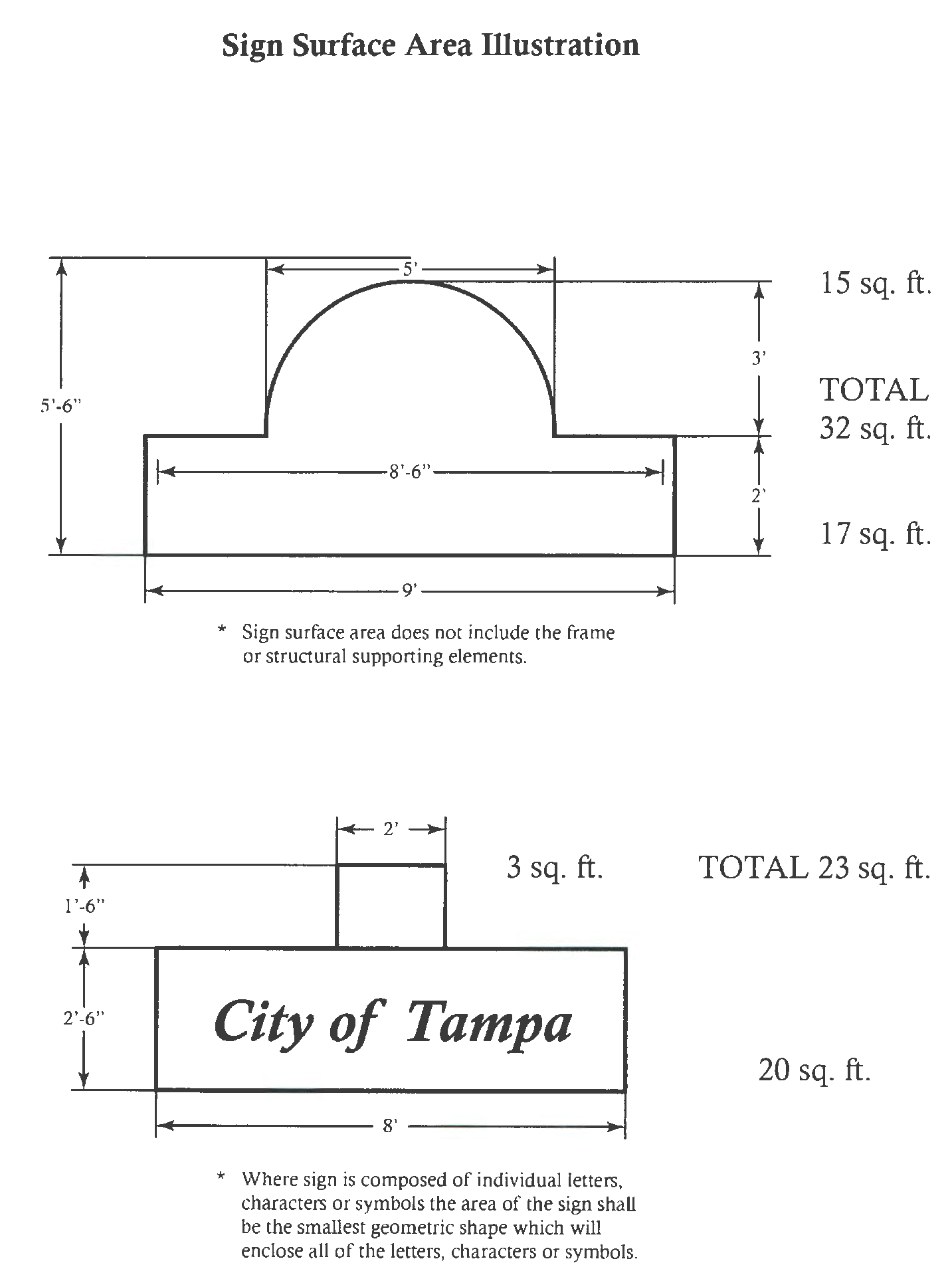
Diagram 4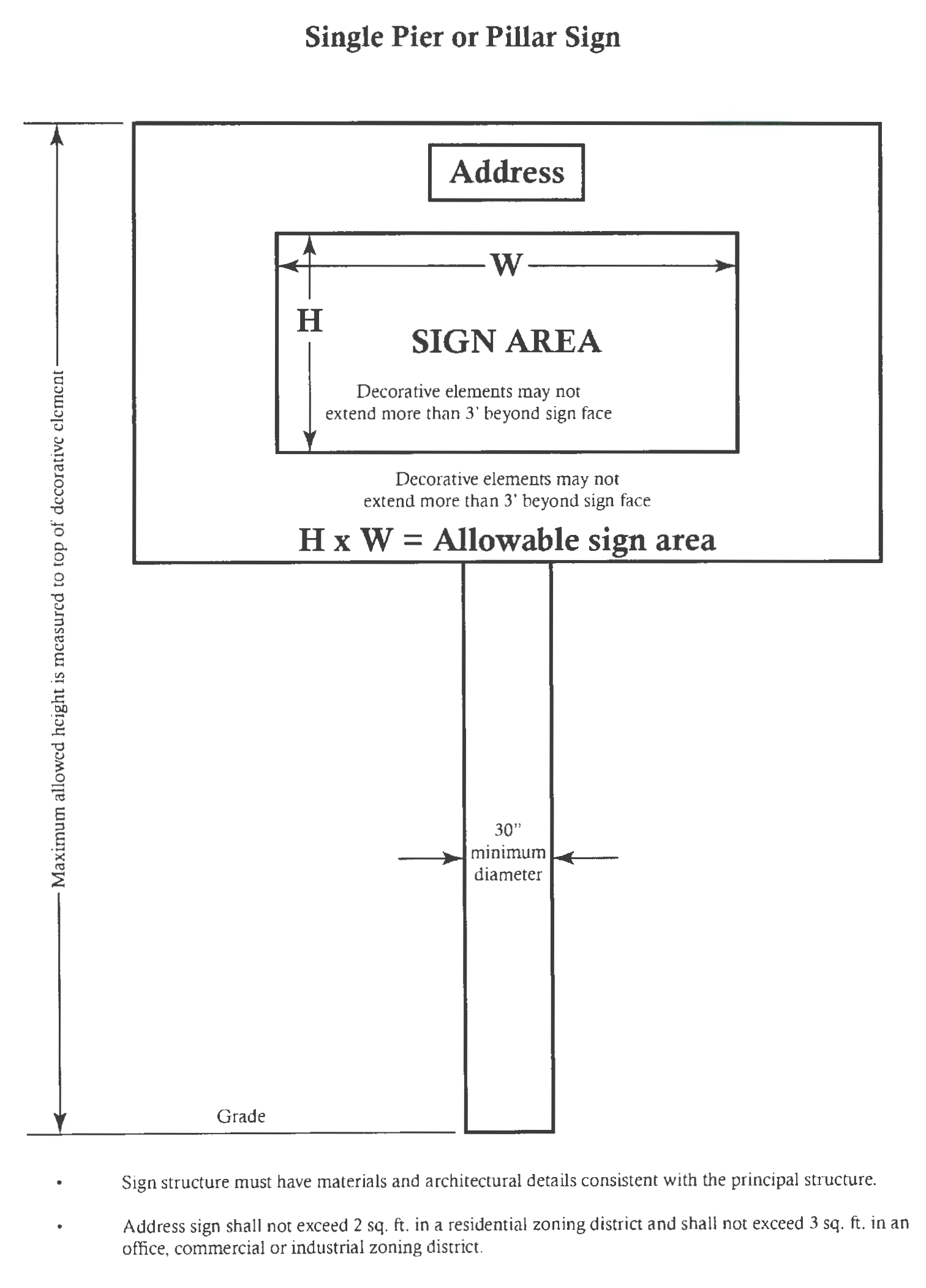
(6)
Building signs. Building signs shall be allowed in office, commercial and industrial districts, provided the following specific regulations are met (refer to section 27-289.4 for electronic message sign standards):
a.
Number:
1.
Single occupancy parcels.
i.
One (1) building sign shall be permitted for each single-occupancy parcel having street frontage. Corner parcels or double-frontage parcels shall be allowed one (1) sign per street frontage.
ii.
One (1) marquee sign or projecting sign, as set forth in subsections (b)(7) below, may be substituted for each permitted building sign.
iii.
Canopy and awning signs may be substituted for, or permitted in addition to, building signs, subject to the maximum sign surface area set forth in subsection (b)(6)b. below.
2.
Multi-occupancy parcels.
i.
One (1) building sign shall be permitted for each establishment with a main door entrance which faces a public street in a multiple-occupancy parcel. Establishments located at a corner shall be allowed one (1) building sign for each side of the establishment which faces a public street.
ii.
One (1) marquee sign or projecting sign, as set forth in subsections (b)(7) below, may be substituted for each permitted building sign, subject to subsection (b)(6)a.2.iv. below.
iii.
Canopy and awning signs may be substituted for, or permitted in addition to, building signs, subject to the maximum sign surface area set forth in subsection (b)(6)b. below.
iv.
Building signs displayed on a multi-occupancy parcel shall be uniformly designed, subject to subsection (b)(6)a.2.iv. below.
b.
Size:
1.
The maximum allowable sign surface area for each building sign shall be one and one-quarter (1¼) square feet per linear foot of building frontage abutting public street, excluding parking garages that abut a public street, unless otherwise specified in article III, division 2, special districts or artticle IV, overlay districts.
2.
The maximum allowable display area for awning, canopy, and marquee signs shall not exceed two (2) square feet per linear foot of building frontage facing a public street.
c.
Design:
1.
One (1) projecting sign may be substituted for each building sign, as provided in subsection (b)(7) below. Marquee, canopy, or awning signs may be substituted for, or permitted in addition to, building signs.
2.
Building signs shall not project beyond the roofline or side walls of the establishment to which the sign is attached, nor shall the building sign project more than twelve (12) inches out from the wall to which it is attached.
3.
Building signs may contain a six-inch decorative border which shall not be counted as part of the sign surface area calculations.
(7)
Projecting signs. Projecting signs shall be allowed in office, commercial and industrial districts, provided the following specific regulations are met:
a.
Projecting signs shall not project more than four (4) feet from the building wall to which the projecting sign is attached.
b.
Projecting signs shall not be located above the roofline of the building.
c.
The supporting hardware, unless incorporated as a decorative component of a projecting sign shall not be visible from the street or sidewalk.
d.
Projecting signs shall not be constructed in violation of the public space encroachment limitations specified in this chapter or other applicable city code.
e.
Projecting signs shall not be erected closer than ten (10) feet from another projecting or marquee sign, or a residential property line.
f.
Projecting signs, when specifically allowed by this Code, which project over any public or private pedestrian way shall be elevated a minimum of ten (10) feet above such pedestrian way. Projecting signs, when specifically allowed by this Code, which project over any public or private street shall be elevated a minimum of sixteen (16) feet above such street.
(Ord. No. 2017-103, § 8(Exh. A), 6-22-2017; Ord. No. 2018-92, § 2, 6-28-2018; Ord. No. 2018-151, § 1, 10-4-2018)
Sec. 27-289.4. - Additional regulations for specific types of signs and signs in special districts; alternative sign plans.
(a)
Illuminated signs, including neon signs, shall not produce more than one (1) footcandle of illumination four (4) feet from the sign, when measured from the base of such sign.
(b)
Electronic message signs may be permitted in place of part or all of the allowable sign surface area, as provided herein, and the sign surface area of an electronic message sign shall comply with the following standards:
(1)
The placement and orientation of an electronic message sign on a property/building with frontage on a street within the city limits shall comply as follows:
a.
Location—Collector and arterial streets. The placement and orientation of an electronic message sign as a freestanding sign, on a property with frontage on an arterial and/or collector street roadways (as identified in the City of Tampa's "Roadway Functional Classification System"), shall comply with provisions set forth in section 27-289.3(5)d-e and the following:
Electronic message signs as a building sign: Signs shall comply with provisions set forth in sec. 27-289.3(6)a.1-2 regarding 'number' of signs. Maximum sign surface area for each allowable building sign shall be one-quarter (¼) square foot per linear foot of building façade frontage abutting and facing an arterial and/or collector street roadways (as identified in the City of Tampa's "Roadway Functional Classification System"), excluding parking garages that abut and face such street type, unless otherwise specified in art. III, div. 2. special districts or art. IV overlay districts.
b.
Location—Local streets. An electronic message sign shall be allowed on a property/building with frontage on a local street only as follows:
1.
Within the boundary of a Community Development District ("CDD") with at least five hundred (500) single-family dwelling units;
2.
The local street is maintained by the CDD;
3.
The electronic message sign shall not be visible from public rights of way located outside of the CDD boundary;
4.
The electronic message sign shall be setback at least thirty (30) feet from any parcel developed with a residential use;
5.
Sign Surface Area: Five (5) feet maximum height; eight (8) feet maximum width;
6.
Sign Structure: Ten (10) feet maximum height above finished grade; and,
7.
The sign shall adhere to all other applicable laws and regulations.
(2)
Dwell Time. The copy on all electronic message signs, including government signs, shall not change more than once in a fifteen (15) second period. The message shall be static during this dwell time. There shall be no flashing or varying light intensity or movement during the message. Messages shall not scroll and shall not give any appearance of moving, or in any way include active movement. Traffic control devices and related signs and government signs, which are necessary for public health and safety, are exempt from this paragraph.
(3)
Lighting. Each electronic sign's operating system shall contain an automatic dimmer control that utilizes GPS to determine sunrise and sunset times and reduce illumination for the time period between one half-hour (½) before sunset and one-half hour (½) after sunrise, and may further contain a light sensing device, placed in a manner to prevent influence by artificial lighting ,to adjust brightness as ambient light conditions change, in order to insure that the message meets the following brightness standards:
(i)
The maximum brightness shall be 0.3 foot-candles above the ambient light measured two hundred fifty (250) feet perpendicular from the face of the sign, unless a residential property is located within two hundred (200) feet of the base of a sign structure, in which case the sign permit applicant must reduce light intensity on, or shade or shield the electronic sign, or direct the lighting from such electronic sign away from such residential property such that the lighting from the electronic sign shall not result in a light intensity greater than three-tenths of one (0.3) foot-candle above ambient lighting, as measured at the property line of any residential property within two hundred (200) feet of the base of the sign structure.
(ii)
At the time of sign permit application, the sign owner applying for the electronic sign permit sign shall submit a certification that this standard has been satisfied.
(iii)
No electronic sign shall display light of such intensity that it interferes with the effectiveness of an official traffic sign, signal or device.
(iv)
The electronic sign shall have a default mechanism or setting that will cause the sign to turn off or freeze in one (1) position at a brightness no brighter than normal operation if a malfunction or failure (meaning any unintended interruption in message sequencing) occurs.
(v)
The electronic sign shall not be configured to resemble a warning or danger signal nor shall there be any configuration which may a cause a driver to mistake the sign for a warning or danger sign. The sign shall not resemble or simulate any lights or official signage used to control traffic.
(4)
Installation on/to/within an existing sign with an electronic message sign shall comply with the standards set forth in section 27-289.8(a)(9) and will require all appropriate permits pursuant to the City of Tampa Code of Ordinances.
(5)
Civil infraction. Any violation of this section 27-289.6(b) is hereby declared a civil infraction that may be prosecuted as provided in section 27-289.14(c). Ownership of the land upon which the sign is located, or information contained in any sign, including names, addresses or phone numbers of persons or entities benefiting from or advertising on the sign, shall be sufficient evidence of ownership and/or beneficial use or interest for purposes of enforcing this section (b)(5). More than one person or entity may be deemed jointly and severally liable for the placement or erection of the same sign. Each unlawful sign shall be deemed a separate violation of this section.
(c)
For purposes of conformance with right-of-way setback regulations, any property owner who has an on-site or an off-site sign which was made nonconforming in regard to required setbacks from the right-of-way by governmental right-of-way acquisition, may measure the setback from the property line location prior to acquisition, provided that the sign is erected on private property and not within the visibility triangle as defined in section 27-283.5 of the City Code.
(d)
Where property is in a site planned controlled zoning district or a designated Overlay District, additional or modified regulations may apply. In those zoned areas, the most restrictive regulation applies.
(e)
Alternative sign plan. As an alternative to the provisions of 27-289.3, the following developments may establish an alternative sign plan:
(1)
The owner(s) of one (1) or more parcels that constitute one (1) zoning lot of record or subject to the same site plan zoning district may erect on-site signs in accordance with an approved alternative sign plan. An alternative sign plan may be approved by city council as part of the site plan zoning of the project or development. If an alternative sign plan is not approved as part of a site plan zoning of a project, then a permit may be issued for an alternative sign plan, subject to review and approval by the zoning administrator in accordance with section 27-60 or the planning and urban design manager in accordance with section 27-60.1, and the following criteria:
(i)
All parcels subject to the sign plan shall be part of the same zoning lot of record and shall be interconnected with internal driveways and easements so that the parcels function as a single project; and
(ii)
The sign plan shall depict the location and nature of all signs to be erected; and
(iii)
The sign plan shall not allow more signs and/or sign surface area than would be allowed under the foregoing regulations if applied to each parcel separately; and
(iv)
The signs proposed in the sign plan shall conform with the height, setback and distance requirements from other parcels not subject to the sign plan or public place contained in 27-289.3; and
(v)
The proposed sign plan shall be set forth in a written agreement executed by all persons or entities owning property or having a mortgage interest in one (1) or more of the parcels subject to said sign plan. If the sign plan is approved by staff, then the agreement shall be recorded in the Public Records of Hillsborough County, Florida as covenants and restrictions applicable to sign on all of the subject parcels. A copy of the recorded agreement shall be provided to the city prior to the issuance of any permits to construct or erect signs pursuant to said sign plan.
(2)
If there is common ownership, the owner(s) of more than one (1) parcel may propose a common alternative sign plan, which advances the purpose of this chapter by substantially relinquishing entitlements to sign on one (1) parcel in exchange for sign on the adjacent parcel. The sign plan must meet the following criteria:
(i)
The purpose of the sign plan is to provide direction to uses located off the arterial or collector roadway.
(ii)
The additional entrance sign shall be permitted in accordance with section 27-289.3(b)(4) and should be located so as to facilitate finding the "user" named on the sign.
(iii)
For each square foot of sign placed off site, there shall be an "in kind" reduction of signs and/or sign surface area on site.
(iv)
The allowable additional entrance sign surface area on the parcel having frontage on the arterial or collector street shall be permitted in accordance with section 27-289.3(b)(4).
(v)
The affected parcels of the development shall abut common improved street right-of-way.
(vi)
The affected parcels of the development shall not be more than one-quarter (¼) mile (one thousand three hundred twenty (1,320) feet) apart, measured from the nearest property lines.
(vii)
The affected parcels of the development shall be located in non-residential zoning districts and shall not be separated by a residential zoning category.
(viii)
The plan must be recorded at the clerk of the circuit court and any revocation of the approved plan must be done with the consent of the City of Tampa. The revocation of the plan will require that each individual zoning lot must comply with the sign regulations of the City of Tampa as a single site.
(Ord. No. 2017-103, § 8(Exh. A), 6-22-2017)
Sec. 27-289.5. - Historic signs.
(a)
Historic signs for local historic districts and landmark sites outside the Ybor City Historic District. Approval of the restoration, rehabilitation, or reconstruction, as defined in section 27-43, of an historic sign that is attached or was previously attached to the historic building shall be based upon documentation of prior existence and shall have existed as a character-defining feature of the historic building. Any historic sign in a historic district or on a landmark site outside the Ybor City Historic District is subject to the final approval by the Architectural Review Commission.
Historic signs shall maintain the historic square footage dimensions for their sign face area and shall be installed as follows:
(1)
Historic signs shall have no maximum projection into the right-of-way; however, no sign may project within two (2) feet, six (6) inches of that portion of the right-of-way intended for vehicular use.
(2)
Historic sign placement into the right-of-way shall leave street corners free of obstructions to allow for safe traffic movement and placement of utilities.
(3)
If the right-of-way is needed by the city for any reason, the owner shall remove or relocate the sign at the owner's expense within sixty (60) calendar days of the written notice by the city.
(4)
The bottom-most portion of the projection shall be a minimum of nine (9) feet above grade.
(5)
Building columns or support poles for historic signs are prohibited from projecting into the right-of-way.
(6)
Lighting underneath sign projections shall be provided and maintained by the property owner.
(7)
A hold harmless agreement in a form acceptable to the city must be signed by the owner and submitted to the city prior to the issuance of the sign permit.
(b)
Regulations for historic signs in the Ybor City Historic District. Approval of the restoration, rehabilitation, or reconstruction, as defined in section 27-43, of an historic sign that is attached or was previously attached to the historic building shall be based upon documentation of prior existence and shall have existed as a character-defining feature of the historic building. Any historic sign in the Ybor City Historic District is subject to the final approval by the Barrio Latino Commission.
Historic signs shall maintain the historic square footage dimensions for their sign face area and shall be installed as follows:
(1)
Historic signs shall have no maximum projection into the right-of-way; however, no sign may project within two (2) feet, six (6) inches of that portion of the right-of-way intended for vehicular use.
(2)
Historic sign placement shall leave street corners free of obstructions to allow for safe traffic movement and placement of utilities.
(3)
If the right-of-way is needed by the city for any reason, the owner shall remove or relocate the sign at his expense within sixty (60) calendar days of the written notice by the city.
(4)
The bottom-most portion of the projection shall be a minimum of nine (9) feet above grade.
(5)
Building columns or support poles for historic signs are prohibited from projecting into the right-of-way.
(6)
Lighting underneath sign projections shall be provided and maintained by the property owner.
(7)
A hold harmless agreement in a form acceptable to the city must be signed by the owner and submitted to the city prior to issuance of sign permit.
(c)
All historic signs that encroach in the right-of-way are subject to the encroachment review process that exists for all other forms of right-of-way encroachments. An historic sign that projects into any portion of the public right-of-way may include, but is not limited to, a marquee (projecting exterior shelter in front of a public building, such as a theater, where the sign is a significant part of the fascia); blade or projecting sign (thin sign attached to the side of a building); canopy sign (sign is attached to the underside of a building canopy); or awning sign (sign imprinted on the surface of the awning).
(Ord. No. 2017-103, § 8(Exh. A), 6-22-2017; Ord. No. 2020-166, § 51, 12-17-2020)
Sec. 27-289.6. - Signs; Lee Roy Selman Expressway.
(a)
Definitions.
(1)
Expressway shall mean the Lee Roy Selman Expressway passing through the City of Tampa, Florida, including all of its facilities, related approaches, viaducts, bridges, interchange facilities and service roads now existing or as may be later constructed or designated.
(2)
Applicable regulations shall mean any pertinent zoning, building or other regulations in effect within the city limits of the City of Tampa of the State of Florida.
(3)
Protected areas shall mean all property in the City of Tampa within five hundred (500) feet of the right-of-way of the expressway right-of-way. Property shall be designated a protected area as soon as it is designated as expressway right-of-way by official act of the Tampa-Hillsborough County Expressway Authority.
(4)
Sign shall mean any display of characters, letters, illustrations, or any ornamentation designed or used as an advertisement, announcement or to indicate direction.
(5)
Erect shall mean to construct, build, rebuild (if more than fifty (50) percent of the structure members involved), relocate, raise, assemble, place, affix, attach, paint, draw, or in any other manner bring into being or establish.
(6)
Temporary sign shall mean signs to be erected on a temporary basis.
(b)
Signs prohibited in protected areas. It shall be unlawful hereafter for any person, firm, corporation, or other legal entity to erect, permit or maintain any sign in protected areas, except as provided for hereinafter.
(c)
Exceptions. Erection of the following signs shall be permitted in protected areas, subject to the conditions and limitations listed herein and further, subject to other applicable regulations where such regulations are more restrictive or more definitive than the provisions of this section and are not inconsistent therewith.
(1)
Temporary signs which are located and oriented to serve streets other than the expressway, and are located at least one hundred (100) feet from the expressway right-of-way, except that such signs may serve and be oriented to the expressway if the property concerned abuts the expressway right-of-way and is not served by a parallel expressway service road, or is abutting the expressway right-of-way and has direct, permanent legal access to the expressway. In no event shall any temporary sign be larger than one hundred (100) square feet.
(2)
Non-temporary signs which are located on and oriented to the frontage on the street which provides actual and direct access to the front or principal entrance of the place of business. "Oriented," shall mean, in the case of detached signs, placed at a ninety (90) degree angle to the street being served; in the case of roof signs, parallel to the fronting such street and within the front twenty-five (25) percent of the building concerned; and in the case of pylon signs, within the front twenty (20) percent of the building concerned. Building signs within two hundred (200) feet of the expressway shall be confined to the wall of the building containing the principal entrance, except that a wall sign may be placed on one (1) other wall of such building and shall be limited to ten (10) percent of such other wall area, but in no event shall be larger than eighty (80) square feet. In no event shall any detached sign be erected within the protected area which is greater in height than twenty-five (25) feet above the average grade of the premises concerned, and no roof sign shall be erected which is greater in height above the roof than ten (10) feet.
(3)
Off-site signs shall not be erected for the purpose of servicing the expressway, and off-site signs in protected areas shall be erected and oriented to serve only streets other than the expressway, subject to the following conditions:
(i)
That in no event shall any off-site sign be erected or placed closer than two hundred (200) feet to the right-of-way lines of the expressway.
(ii)
That no off-site sign shall be erected that is larger than fifteen (15) feet in width and fifty (50) feet in length, whether single or multiple boards.
(iii)
That no detached off-site sign shall be erected which is more than twenty-five (25) feet above the average existing grade of the site on which such sign is erected, or the flood criteria elevation (if property is filled to such elevation) whichever is the greater; nor shall a roof sign be erected which is more than twenty (20) feet above the roof.
(iv)
That no off-site signs shall be erected or placed within three hundred (300) feet of another off-site sign, such distance to be measured in all directions from the outermost edges of such sign.
(v)
That no off-site signs shall be erected or placed within one hundred (100) feet of any church, school, cemetery, public park, public reservation, public playground, state or national forest.
(vi)
That off-site signs shall be erected and placed at right angles to the street which they are serving and shall be located within the front seventy (70) feet of the lot or tract on which erected.
(vii)
That no off-site signs shall be erected or placed on a street dead-ended by the expressway, between the expressway and the first street running parallel to the expressway and on the same side of the dead-end street, even though such distance may be greater than two hundred (200) feet.
(viii)
That off-site signs shall be erected and placed only on property conforming in sign and frontage to the requirements of the zoning district in which located.
(ix)
That off-site sign structures shall be of the so-called cantilever-type construction (double-faced sign, both faces of the same size, secured back to back on vertical supports with no supporting bracing).
(d)
Nonconforming signs. Signs which have been erected prior to the effective date of this section may continue to be maintained until March 1, 1986. Thereafter, unless such signs conform to the provisions of this section, they shall be removed. If a nonconforming spacing situation can be eliminated by the removal of one (1) sign, the sign which has been erected for the longest period of time shall have priority.
(e)
Variances. No variances shall be granted through provisions of applicable regulations which will in any way conflict with or vary the provisions of this section.
(Ord. No. 2017-103, § 8(Exh. A), 6-22-2017)
Sec. 27-289.7. - Prohibited signs enumerated.
(a)
Any sign not specifically permitted or authorized by this Code is prohibited; provided, however, that any authorized or permitted sign under this Code is allowed to contain non-commercial speech in lieu of any other speech.
(b)
The following types of signs are expressly prohibited, except as otherwise provided by this Code:
(c)
Notwithstanding any Code provision to the contrary, neither the city council nor any board of the city may grant a variance allowing the erection of any of the prohibited signs expressly enumerated in this section 27-289.7.
(Ord. No. 2017-103, § 8(Exh. A), 6-22-2017)
Sec. 27-289.8. - Nonconforming signs.
(a)
Any sign which did not conform to the City of Tampa Sign Code on the day before July 1, 2017, and which should have been removed or modified under prior law shall be illegal signs. Any sign which was legally permitted and constructed pursuant to then adopted Sign Code prior to July 1, 2017, shall be considered nonconforming signs and shall be governed as provided herein.
(1)
Unless otherwise subject to the provisions of F.S. § 70.20 or subject to the provisions of section 27-289.15, any sign made nonconforming by this Sign Code shall be considered a nonconforming sign and shall be made to conform to this Sign Code as provided herein. In connection with any billboard sign, if any conflict exists between the terms of this section and section 27-289.15 of this City of Tampa Sign Code, then section 27-289.15 shall control.
(2)
A nonconforming sign may not be enlarged or altered in a way which increases its degree of nonconformity, but any sign or portion thereof may be altered to decrease its degree of nonconformity, except as provided herein.
(3)
A nonconforming sign shall not be structurally altered to prolong the life of the sign. Reasonable repair and maintenance of nonconforming signs, including change of copy, is permitted, as provided for herein. Reasonable repair and maintenance means the work necessary to keep the sign, including the sign structure, in a good state of repair, but does not include replacement of materials in the sign structure. Reasonable repair does not include:
a.
Any modification that changes the structure, or type of structure, such as conversion of a wooden sign structure to a metal sign structure;
b.
Any modification, including the addition of embellishments, that changes the sign area or the height above ground level;
c.
Any modification that enhances the visibility of the sign's copy, or the period of time that the copy is visible;
d.
Any modification that adds changeable faces or electronic message signs to any nonconforming building sign; or
e.
Any modification that adds artificial lighting, or changes the existing lighting such that illumination is increased.
(4)
Should a nonconforming sign become damaged, destroyed or deteriorated by any means to the extent that it requires more than reasonable repair and maintenance, as defined in subsection (3) above, then the sign shall not be reconstructed except in compliance with the sign code. In the event that a nonconforming sign was approved as part of a site plan zoning approval, then the nonconforming sign may be reconstructed in accordance with the site plan zoning approval.
(5)
Should a nonconforming sign be moved for any reason, it shall thereafter conform to the regulations for the district in which it is located after it is moved.
(6)
A nonconforming sign shall be considered an abandoned sign and shall be removed if either the sign or the sign structure has not been used, or if the parcel or parcels upon which the sign is located becomes vacant or unoccupied for a period of ninety (90) consecutive calendar days or more, unless the parcel or parcels upon which the sign is located undergo a major renovation, as provided herein.
(7)
If there is a major renovation on a parcel or parcels upon which the nonconforming sign is located, as defined in Chapter 27 of the Code, then any sign located upon the upon the parcel or parcels must comply with the current sign code unless it can be demonstrated the freestanding sign or signs comply with current wind-load standards as set forth in Chapter 5 of this Code of Ordinances.
(8)
When the city acquires, or is in the process of acquiring, property pursuant to its power of eminent domain, and the acquisition would result in the creation of a nonconformity to the size or location of signs, the size and location of the sign shall not be considered nonconforming.
(9)
An electronic message sign may be installed on/to/within a nonconforming, freestanding sign pursuant to the following:
a.
No more than one (1) electronic message sign shall be permitted per nonconforming, freestanding sign;
b.
The electronic message sign shall be limited to the sign surface area set forth in section 27-289.4(b);
c.
No alterations, other than reasonable repair and maintenance as described in (3) above, shall be permitted to the vertical structural supports for the sign structure. If the sign structure, as it exists, will not comply with current wind-load standards as set forth in chapter 5 of this code, then the electronic message sign shall not be permitted on/to/within the nonconforming sign;
d.
Any electrical improvements made to supply necessary power to the electronic message sign shall be permitted, so long as such improvements do not conflict with paragraph c. above; and,
e.
Any electronic message signs installed pursuant to this subsection shall comply with all operational requirements set forth in this division.
(b)
Unless expressly authorized by this chapter, nonconforming status shall not be afforded to pre-existing signs which have been installed, constructed, placed or maintained in violation of this Code.
(Ord. No. 2017-103, § 8(Exh. A), 6-22-2017)
Sec. 27-289.9. - Abandoned signs; maintenance of all signs.
(a)
An abandoned sign is prohibited and shall be removed by the advertiser, sign owner, sign contractor or owner of land upon which such sign is found within thirty (30) calendar days after written notice by the neighborhood improvement manager. Permanent on-site signs applicable to a business temporarily suspended because of a change in ownership or management shall not be deemed to be abandoned unless the property remains vacant for a period of ninety (90) consecutive calendar days or more.
(b)
All signs regulated by this Code, including their supports, braces, guys and anchors, electrical parts, lighting fixtures and all painted and display areas shall be maintained so as to present a neat, clean appearance. Painted areas and sign surfaces shall be kept in good condition, and illumination, if provided, shall be maintained in safe and good working order.
(c)
Weeds and grass shall be kept cut in front of, behind, underneath and around the base of ground signs for a distance of ten (10) feet, and no rubbish or debris shall be permitted under or near such signs.
(Ord. No. 2017-103, § 8(Exh. A), 6-22-2017)
Sec. 27-289.10. - Signs on right-of-way.
(a)
Prohibition of signs on rights-of-way. It shall be unlawful for any person, firm, corporation or other entity, for its own or the benefit of another, to erect, place, post, install, affix, attach or in any other way locate or maintain a sign upon, within or otherwise encroaching on a City of Tampa right-of-way or upon a structure located within such a right-of-way. Information contained in any sign, including names, addresses or phone numbers of persons or entities benefiting from or advertising on the sign shall be sufficient evidence of ownership and/or beneficial use or interest for purposes of enforcing this section. More than one person or entity may be deemed jointly and severally liable for the placement or erection of the same sign. Each unlawful sign shall be deemed a separate violation of this section.
(b)
Exclusions. The following signs may be erected in rights-of-way within the city:
(1)
Traffic-control devices, as defined in City of Tampa Code Chapter 15;
(2)
Government signs;
(3)
Signs approved or permitted for placement or erection on or within the right-of-way as a historic sign under the provisions of this Sign Code;
(4)
Bench signs as permitted by and in accordance with City of Tampa Code Chapter 22;
(5)
Banner signs as permitted by and in accordance with City of Tampa Code Chapter 22; and
(6)
Such other signs as authorized under the rules and regulations of the transportation division for traffic generation businesses, facilities and institutions.
(c)
Abatement. Except as provided otherwise in this section, any sign located upon or encroaching on a city right-of-way as described in subsection (a) above, shall be subject to immediate removal and impounding by the neighborhood improvement manager at the joint and several expense of (1) the owner of the sign; (2) the person or entity which erected the sign and (3) the person or entity for whose benefit the sign was erected or maintained.
(1)
Illegal signs of negligible or no value; destruction. Any sign placed or erected in a right-of-way in violation of subsection (a), which has negligible or no value due to its perishable or nondurable composition, including, but not limited to, those made out of paper, cardboard or posterboard, shall be deemed abandoned and may be destroyed by the city after removal. No opportunity to reclaim such a sign shall be given by the city.
(2)
Recovery of impounded signs; abandonment and destruction. Except for those signs described in subparagraph (c)(1) above, any sign removed and impounded by the city shall be held in storage and the owner, if the owner's identity and whereabouts are known to city, shall be provided with written notice of impoundment and fifteen (15) calendar days from the date of notice to reclaim any such sign. Any impounded sign stored by the city may be destroyed if not reclaimed within fifteen (15) calendar days of the written notice date or within fifteen (15) calendar days of the date of removal if the identity and whereabouts of the owner is not known to city.
(d)
Civil infraction. Any violation of this section 27-289.10 is hereby declared a civil infraction that may be prosecuted as provided in section 27-289.14(c).
(Ord. No. 2017-103, § 8(Exh. A), 6-22-2017)
Sec. 27-289.11. - Hazardous signs.
The code enforcement official, as authorized by chapter 19, may cause any sign or other advertising structure, which is an immediate peril to persons or property to be removed immediately at the expense of the owner, agent, lessee or other person having beneficial use of the sign, the sign contractor or the owner or lessee of the land upon which the sign is located.
(Ord. No. 2017-103, § 8(Exh. A), 6-22-2017)
Sec. 27-289.12. - Review of sign related decisions.
(a)
An owner, or duly authorized agent of an owner, of any building or structure who receives an official order, requirement, decision or determination made by any staff member in interpreting the sign-related provisions of this chapter may seek review of said order, requirement, decision or determination pursuant to section 1-19. In the event that the zoning administrator delegates the authority to render a sign related decision, then the zoning administrator shall be the reviewing official; otherwise, the reviewing official shall be the director.
(b)
Persons with standing to seek review of any order, requirement, decision or determination under this chapter related to constitutionally protected first amendment activity shall be entitled, as a matter of right, to seek immediate review of such final determination by filing an appropriate pleading with the circuit court.
(Ord. No. 2017-103, § 8(Exh. A), 6-22-2017)
Sec. 27-289.13. - Boards authorized to grant sign-related variances.
(a)
Variance review board. Except as provided in subsections (b) and (c) below, the variance review board (VRB) as designated in section 27-79, shall have the authority to hear and grant variances from any of the sign-related provisions of this chapter.
(b)
Architectural review commission. In any historic districts or landmark sites, excluding the Ybor City Historic District, designated by the historic preservation commission pursuant to section 27-114, shall have the authority to hear and grant variances from any of the sign-related provisions of this chapter.
(c)
Barrio Latino Commission. In the Ybor City Historic District, as designated and defined in section 27-96, the Barrio Latino Commission (BLC) shall have the authority to hear and grant variances from any of the sign-related provisions of this chapter, shall have the authority to hear and grant variances from any of the sign-related provisions of this chapter.
(Ord. No. 2017-103, § 8(Exh. A), 6-22-2017)
Sec. 27-289.14. - Penalties and remedies.
(a)
Unless otherwise stated, a person who engages in conduct in violation of this chapter shall be subject to the following penalties and/or remedies:
(1)
Violations of this chapter may be punished as provided in the City of Tampa Code Section 1-6, General Penalty.
(2)
Each calendar day that a violation continues after receipt of written notice of such violation shall constitute a separate violation and separate offense for purposes of the penalties and remedies specified herein.
(3)
In addition to the penalties and remedies above, the city may institute any appropriate action or proceedings to prevent, restrain, correct or abate a violation of this chapter, as provided by law.
(b)
Pursuant to chapter 5, the building official or designee is hereby authorized and empowered to use all applicable enforcement methods for any sign-related construction work found to be in violation of the City of Tampa Code.
(1)
Any person violating the provisions of this chapter shall be required to pay a triple-permit fee in addition to other penalties specified herein.
(2)
Any remedy or penalty specified in this chapter shall not be deemed to be an exclusive remedy and the building official is hereby expressly authorized and empowered to enforce the provisions of this chapter as set forth below, and in any manner consistent with the City of Tampa Code or laws of the State of Florida.
(c)
Prosecution and penalties for civil infractions. Any violation of section 27-289.4(b) or 27-28910 is hereby declared a civil infraction and may be brought before the County Court in and for Hillsborough County pursuant to and in accordance to the provisions of Chapter 23.5, City of Tampa Code. Such enforcement is supplemental to any other means of enforcement available to the city under this or any other section of the Code.
(1)
Civil penalty. Any person or entity found in violation of sections 27-289.4(b) or 27-289.10 shall be subject to a civil penalty of no less that seventy-five dollars ($75.00) per violation, if not contested, but not to exceed two hundred fifty dollars ($250.00) for a first violation, and a civil penalty of no less than two hundred fifty dollars ($250.00) per violation, if not contested, but not to exceed five hundred dollars ($500.00) for a second or repeated violations. Community service hours shall not be substituted for payment of the monetary penalty.
(2)
Restitution. The courts may order a violator, in addition to a civil penalty, to make restitution to the city for the damage or loss caused by the violator, which may include, but is not limited to any property damage caused by the placement or attachment of a sign or signs, the costs of any abatement action and court costs. Community service hours shall not be substituted for monetary restitution.
(d)
Removal by neighborhood improvement manager. Any sign erected or maintained in violation of this Sign Code or erected in violation of any previously existing ordinance may be removed by the neighborhood improvement manager or designee at the expense of the owner of the property upon which the sign is located. If the sign violation discovered is on private property, then the neighborhood improvement manager or designee shall first give thirty (30) days written notice, by certified mail or hand delivery, to such person of the violation charged. If the sign is a temporary sign, the neighborhood improvement manager will follow the procedure set out below, except that all time frames will be five (5) calendar days rather than thirty (30) or fifteen (15) days.
(e)
Failure to pay. A violator who fails to pay or request a hearing as provided in this Sign Code shall be deemed to owe a civil debt to the city which may be recovered with accrued interest by civil action in a court of competent jurisdiction.
(Ord. No. 2017-103, § 8(Exh. A), 6-22-2017)
Sec. 27-289.15. - Billboard signs.
(a)
Billboard signs prohibited. After the effective date of City of Tampa Ordinance No. 2000-206 [August 3, 2000], the erection of billboard signs is hereby prohibited for the purposes and reasons set forth in Section 1 of City of Tampa Ordinance No. 2000-206 which is incorporated herein by this reference, except as otherwise provided for in this section.
(b)
Definitions.
(1)
Approved settlement agreement. For purposes of this section, an approved settlement agreement means a fully executed and effective settlement agreement entered into between the city and a sign owner (or the owner's predecessor in interest) which resolved litigation relating to a variance or variance agreement granted by or entered into by the city prior to the effective date of City of Tampa Ordinance No. 2000-206 [August 3, 2000], including those approved by Resolution No. 2009-1128 and Resolution No. 2009-1129.
(2)
Designated roadways. For purposes of this section, designated roadways shall be only:
1.
FAP and FAI Roadways:
a.
All of Interstate 275 and Interstate 4;
b.
Property owned by the Hillsborough County Aviation Authority, the Tampa Sports Authority and the Hillsborough Community College through its Board of Trustees located and facing Dale Mabry Highway;
c.
Hillsborough Avenue from Veterans Expressway to MacDill Avenue;
d.
Dale Mabry Highway from Hillsborough Avenue to Kennedy Boulevard (within the Westshore Overlay District, only existing locations are eligible for upgrade to electronic billboard(s), subject to the provisions set forth in this code section); and
e.
Gandy Boulevard from Dale Mabry Highway to Westshore Boulevard (electronic faces shall be elevated and oriented to the top deck of the Gandy Extension of the Lee Roy Selmon Expressway, shall be shielded from surrounding residential uses, and shall be limited to utilizing only locations permitted and installed prior to the initial construction of the Expressway's Gandy extension. The replacement of such structures, in compliance herein, shall not be in conflict with section 27-289.6).
2.
Non-FAP and FAI Roadways:
a.
Fowler Avenue from Interstate 275 to McKinley Street;
b.
Busch Boulevard from Interstate 275 to 40th Street; and
c.
The following roadways, and only the following roadways located within the Downtown Central Business District (as defined in Chapter 27, City of Tampa Code of Ordinances: (i) Channelside Drive from Adamo Drive to Florida Avenue; (ii) Tampa Street from I-275 to Lee Roy Selmon Expressway; (iii) Kennedy Boulevard from Florida Avenue to Meridian Street; and (iv) Florida Avenue from Tyler Street to Lee Roy Selmon Expressway.
Any portion of a designated roadway which is located within the Westshore Overlay District (refer to section 27-238) shall not be considered part of the designated roadways for purposes of this section except that electronic billboard signs facing and servicing (i) Memorial Highway; (ii) the Veterans Expressway; (iii) I-275; and, (iv) those existing locations referenced in subsection (b)(2)1.d. above, may be permitted.
(3)
Electronic billboard sign. For purposes of this section, an electronic billboard sign is defined as a billboard sign that incorporates within or upon one (1) or more of its sign faces digital or other electronic changeable message technology and that allows advertising copy to be changed remotely rather than by changing the advertising copy on site with poster sheets or vinyl, and which meets the following criteria:
a.
The electronic billboard sign face does not exceed six hundred seventy-two (672) square feet where located on an FAP, FAI or expressway or does not exceed four hundred (400) square feet where located anywhere else in the city; and
b.
The electronic billboard is operated in compliance with section 27-289.15(d)(5), Operating standards.
Any billboard sign which has digital or other electronic changeable message technology, but does not comply with this definition of electronic billboard sign shall be deemed a prohibited sign.
(4)
Legally existing, billboard signs defined. For purposes of this section, nonconforming billboard signs and variance signs, defined as follows, are legally existing, billboard signs.
(5)
A nonconforming billboard sign is defined as:
a.
Any billboard sign that was legally erected prior to the effective date of City of Tampa Ordinance No. 2000-206 [August 3, 2000] pursuant to a permit issued by the City of Tampa, except for any billboard signs that were erected prior to October 16, 1989 which signs were required to be made conforming or to be removed pursuant to section 27-289.15 of this Code; or
b.
Any billboard sign that was legally erected before a permit was required by the city for off-site signs; but which billboard sign complies completely with the City of Tampa's off-site sign regulations that were in effect as of January 10, 2000; or
c.
Any billboard sign erected prior to the effective date of City of Tampa Ordinance No. 2000-206 [August 3, 2000] which is subject to a variance granted by the city from any one (1) or more of the off-site sign regulations in effect at the time of the variance, provided that said billboard sign conforms with the terms of the variance granted by the city; or
d.
Any billboard sign erected after the effective date of City of Tampa Ordinance No. 2000-206 [August 3, 2000], that is the subject of, and is erected in strict accordance with an active permit issued by the city prior to the effective date of City of Tampa Ordinance No. 2000-206 [August 3, 2000]. No permits shall be issued for the erection of billboard signs after the effective date of City of Tampa Ordinance No. 2000-206 [August 3, 2000], except as otherwise provided for in this section 27-289.15.
(6)
Variance sign. A variance sign is defined as any billboard sign erected prior to the effective date of City of Tampa Ordinance No. 2000-206 [August 3, 2000] which is the subject to a variance granted by the city from any one (1) or more of the off-site sign regulations in effect at the time of the variance, and/or any sign which is subject to an approved settlement agreement; provided that said billboard sign conforms with the terms of the approved settlement agreement. A variance sign does not include any billboard sign that is required to be removed in accordance with an approved settlement agreement and no variance sign shall be permitted to be upgraded pursuant to this section until such time that all billboard signs that are required to be removed pursuant to the approved settlement agreement are removed. A variance sign is a legal, conforming sign. Any variance sign which is upgraded to an electronic billboard sign shall be required to comply with the most restrictive requirements regulating to the placement, location, relocation, operation, materials and standards for the upgrade of a variance sign to an electronic billboard sign which are contained in either the approved settlement agreement or this section 27-289.15, herein.
Any billboard sign which does not constitute a nonconforming billboard sign or a variance sign, as described above, shall be deemed either a prohibited sign or an abandoned sign and shall be removed on or before February 1, 2003 as hereinafter provided. Nonconforming billboard signs shall be allowed to remain so long as such signs conform with the regulations set forth in this section 27-289.15 of the Code.
(c)
Standards pertaining to legally existing billboard signs. Any legally existing billboard sign as described above shall be subject to the following standards:
(1)
A legally existing billboard sign is allowed to contain noncommercial speech in lieu of any other speech.
(2)
Substitution or interchange of letters, poster panels, painted boards or demountable materials shall be permitted; provided that any such substitution or interchange shall not increase the size, shape, height or the number of sign faces of the sign, except as otherwise provided for in this section 27-289.15. A legally existing billboard sign may, without being defined as an electronic billboard sign, incorporate auxiliary changeable message technology to display not more than three (3) numeric digits provided that the size of such numeric display does not exceed five (5) percent of the sign face (e.g., a billboard sign advertising a lottery game that changes the payout amount from time to time based on tickets sold).
(3)
Nonconforming billboard signs may be maintained and repaired, but shall not be structurally or mechanically extended or altered except as required by the building official of the city in cases where it has been determined by said building official that there exists an imminent danger to the public safety; provided, however, no structural change shall be permitted which would increase the height, size, shape or intensity of lighting of a nonconforming billboard sign except as provided for in this section 27-289.15.
(4)
Any nonconforming billboard sign which is destroyed to the extent of seventy-five (75) percent of its current assessed value (based on the records of the Hillsborough County Property Appraiser) shall not be rebuilt or repaired, unless:
a.
Within thirty (30) calendar days after the destruction of the nonconforming billboard sign, the owner of the sign files an application with the city clerk petitioning city council to allow the reconstruction and maintenance of the nonconforming billboard sign for a period not to exceed seven (7) years; and
b.
The owner of the nonconforming billboard signs provides substantial and competent evidence to city council that: (i) the billboard sign was originally erected less than seven (7) years prior to the date on which the sign was destroyed; and (ii) the sign owner has failed to recoup the sign owner's investment in the nonconforming billboard sign as of the date of the sign's destruction. If such evidence is presented, the city council may allow the sign owner to rebuild or repair the nonconforming billboard sign and to maintain said sign for an additional period of time as determined by the city council in order to allow the sign owner time to recoup his or her investment; provided, however, such a period of time shall not exceed seven (7) years. At the conclusion of said period, the billboard sign shall be removed.
If the nonconforming billboard sign cannot be rebuilt or repaired, then the owner of the sign shall be responsible for removing all remaining portions of the sign structure within sixty (60) calendar days after the date of destruction of the billboard sign.
(5)
Any nonconforming billboard sign which becomes an abandoned sign shall be removed.
(6)
No nonconforming billboard sign shall be relocated except as provided in subsection 27-289.15(h) of this Code. In the event a legally existing, nonconforming billboard sign is relocated, the relocation of the sign shall not result in any increase in the size, height or number of sign faces of the nonconforming billboard sign.
(7)
All nonconforming billboard signs shall be the subject of an operating permit issued in accordance with subsection 27-289.15 of this Code. Any nonconforming billboard sign which does not possess an annual operating permit in accordance with subsection 27-289.15 shall be deemed to constitute an abandoned sign.
(8)
Nothing in this section shall affect the requirements of section 27-289.16 of the Code regarding the removal of all "off-site signs" in the designated view corridors and areas by a date certain as set forth in section 27-289.16 of the Code or the removal of any off-site or billboard signs pursuant to the terms of an approved settlement agreement or any variances previously granted by the city.
(9)
Notwithstanding anything in this subsection (c) to the contrary, legally existing billboard signs may be upgraded to electronic billboard signs in accordance with subsection (d) below.
(d)
Upgrades to electronic billboard signs. Nonconforming billboard signs and variance signs may be upgraded by the sign owner to an electronic billboard sign upon approval of a permit in accordance with section 27-289.2 of the Code. For each electronic billboard sign for which a sign permit is sought by the sign owner, the sign owner or the sign owner's agent, must submit a sign permit application demonstrating that each of the following conditions of approval have been met:
(1)
Exchange rate.
a.
A minimum of ten (10) sign faces of nonconforming billboard signs or variance signs must be permanently removed in exchange for each single sign face on an electronic billboard sign ("electronic billboard sign face") for which a sign permit is sought and approved by the city. In addition, the combined square footage of sign face area removed shall total at least ten (10) times the square footage of the electronic billboard sign face for which the permit is sought.
b.
The ten (10) sign faces used as trade-in exchange as provided in subsection a. above shall comply with the following additional criteria:
i.
A minimum of four (4) sign faces (totaling at least four (4) times the square footage of the electronic billboard sign face) of nonconforming billboard signs or variance signs used as trade-in exchange must be from "billboard signs in place" at the time of the sign permit application and from a different location than the nonconforming billboard sign or variance sign to be upgraded. Banked credits (as defined in an approved settlement agreement) shall not be considered as billboard signs in place at the time of the sign permit application.
ii.
No more than six (6) sign faces (totaling at least six (6) times the square footage of the electronic billboard sign face) of nonconforming billboard signs or variance signs to be removed may be satisfied by the removal of signs in place at the time of the sign permit application or through the use of any banked credits. A minimum of one (1) banked credit utilized for this subsection must have been accrued by the removal of a sign with a minimum of three hundred (300) square feet of sign face area.
iii.
For a period of five (5) years beginning on the date of the issuance of the permit for the construction of the new electronic billboard sign, the owner of the electronic billboard sign may not construct a new sign face on the same roadway as the sign faces that are removed and used as trade-in exchange unless such sign face is located more than two thousand five hundred (2,500) feet from any of the sign faces that are removed and used for such trade-in exchange.
c.
Notwithstanding anything to the contrary in subsection a. above, as an alternative to the exchange rate described above, a sign owner may permanently remove one (1) electronic billboard sign face in exchange for a new electronic billboard sign face at another location for which a sign permit is sought.
(2)
Location. Each electronic billboard sign location must meet each of the following criteria:
a.
The parcel upon which the electronic billboard sign is located must be assigned a zoning classification which is within a commercial or industrial district (as defined in this Article VI, Division 6);
b.
The electronic billboard sign must be setback a minimum of seventy-five (75) feet from any parcel which is zoned or used for residential uses, as measured from the leading edge of the sign face closest to the residential parcel;
c.
The electronic billboard sign shall not be located in any view corridors, as defined in this Article VI, Division 6;
d.
The parcel upon which the electronic billboard sign must not be located within a historic district (as defined in Chapter 27);
e.
The electronic billboard sign must not be located upon a parcel which contains a historically designated structure; and
f.
The parcel upon which the electronic billboard sign is located must be adjacent to one (1) of the designated roadways with the electronic billboard sign being oriented towards and viewable from that designated roadway.
(3)
Lighting control and mitigation. If a residential property is located within two hundred (200) feet of the base of a sign structure, the sign permit applicant must reduce light intensity on, or shade or shield the electronic billboard sign, or direct the lighting from such electronic billboard sign away from such residential property such that the lighting from the electronic billboard sign shall not result in a light intensity greater than three-tenths of one (0.3) foot-candle above ambient lighting, as measured at the property line of any residential property within two hundred (200) feet of the base of the sign structure. At the time of sign permit application, the sign owner applying for the sign permit for the electronic billboard sign shall submit a certification to the designated office of the city that this standard has been satisfied. As an alternative to compliance with the standards established in this subsection, the sign owner may provide at any time prior to the final inspection made pursuant to section 27-289.2 or any time thereafter a document signed by the affected landowner indicating that the landowner and the landowner's successors in interest waive the sign owner's compliance with this subsection. In the event of a waiver, a copy of the written waiver shall be filed with the permit application and compliance with this paragraph shall be measured from the line of the next adjacent residential property.
(4)
Limits on total number of sign faces that may upgrade to electronic billboard signs. Each sign owner that owns or controls nonconforming billboard signs or variance signs may upgrade its existing inventory to electronic billboard signs only within the following limitations on the total number of electronic billboard sign faces:
a.
On FAP and FAI designated roadways: A maximum of ten (10) percent of any single sign owner's existing inventory may be upgraded to electronic billboard sign faces. Provided, however, a single sign owner shall only have the right to upgrade its existing inventory to no more than sixteen (16) electronic billboard sign faces on FAP and FAI designated roadways.
b.
On non-FAP and non-FAI designated roadways: A maximum of ten (10) percent of any single sign owner's existing inventory may be upgraded to electronic billboard sign faces. Provided, however, a sign owner shall only have the right to upgrade its existing inventory to no more than six (6) electronic billboard sign faces on non-FAP and non-FAI designated roadways.
c.
For the purposes of this section, existing inventory shall mean either:
i.
The total number of variance signs owned or controlled by a single person or business entity as of the effective date of the applicable settlement agreement. The sign inventory approved in such settlement agreement shall establish the existing inventory for determining the number of digital sign face upgrades permitted for such initial inventory; or
ii.
The total number of nonconforming signs owned or controlled by a single person or business entity as of the time the owner requests an upgrade to an electronic billboard sign in compliance with this section. In no event may the existing inventory of nonconforming signs contain variance signs.
(5)
Operational standards.
a.
Spacing. Electronic billboard signs shall be spaced a minimum of two thousand five hundred (2,500) feet from another electronic billboard sign measured linearly along the same side of the street.
b.
Dwell time and duration of message. The dwell time, defined as the interval of change between each individual message, shall be consistent with rules promulgated by the Florida Department of Transportation but in no event less than ten (10) seconds on FAP and FAI roadways or fifteen (15) seconds on non-FAP or non-FAI roadways. Any change of message shall be completed in two (2) seconds. The dwell time shall not include the time required to change a message. There shall be no special effects or other content between messages.
c.
The message shall be static during the dwell time set forth in subsection (5)b. above. There shall be no flashing or varying light intensity or movement during the message. Messages shall not scroll and shall not give any appearance of moving, or in any way include active movement.
d.
Each electronic billboard sign's operating system shall contain a light sensing device to adjust brightness as ambient light conditions change in order to insure that the message meets the following brightness standards. The maximum brightness shall be 0.3 foot-candles above the ambient light measured two hundred fifty (250) feet perpendicular from the face of the sign, or such less distance as may be required by section 27-289.15(d)(3).
e.
No electronic billboard sign shall display light of such intensity that it interferes with the effectiveness of an official traffic sign, signal or device.
f.
The electronic billboard sign shall have a default mechanism or setting that will cause the sign to turn off or freeze in one (1) position at a brightness no brighter than normal operation if a malfunction or failure (meaning any unintended interruption in message sequencing) occurs.
g.
The electronic billboard sign shall not be configured to resemble a warning or danger signal nor shall there be any configuration which may a cause a driver to mistake the sign for a warning or danger sign. The sign shall not resemble or simulate any lights or official signage used to control traffic.
h.
The electronic billboard sign operator may provide the city with space on the digital or electronic off-premise sign on a space-available basis for public service announcements, including Amber Alerts, hurricane evacuations, or other emergency situations and messages related to city-sponsored or co-sponsored events in order to provide for traffic management.
(e)
Annual operating permits for nonconforming billboard signs. An operating permit shall be required for all nonconforming billboard signs. All operating permits shall be renewed on an annual basis. After February 1, 2003, any billboard sign other than a variance sign that does not possess a current operating permit shall be presumed to be either a prohibited sign or an abandoned sign and shall be removed. The following requirements and procedure shall apply to the initial issuance of operating permits for nonconforming billboard signs:
(1)
On or before December 31, 2002, all owners of any nonconforming billboard signs shall apply for an operating permit for each nonconforming billboard sign from the city. The application shall include the following information:
a.
The name, telephone number and address of the owner of the nonconforming billboard sign;
b.
The name and address of the owner of the parcel on which the sign is located;
c.
The size and height of the sign;
d.
A site plan, sketch or drawing of the parcel which accurately depicts the location of the sign; and
e.
Evidence that the sign is a nonconforming billboard sign as described in subsection 27-289.15(b) above.
(2)
After reviewing the operating permit application, if the city determines that the application is incomplete, the city shall notify the applicant in writing, and the applicant shall provide the city with all requested information on or before forty-five (45) calendar days after the date the city has requested such information from the applicant. For good cause shown by the applicant, the official may grant the applicant an additional period of time, not to exceed an additional ninety (90) calendar days, in order to provide all requested information in connection with the application.
(3)
Provided that the application contains the information required above and evidences that the sign is a nonconforming billboard sign as described in subsection 27-289.15 the city shall issue an operating permit to the owner of the nonconforming billboard sign. The operating permit shall be renewed thereafter on an annual basis.
(4)
If the city determines that a billboard sign does not meet the criteria for the issuance of an operating permit, the city shall issue a written denial of the permit application to the permit applicant setting forth the reason(s) for the denial of the operating permit. On or before thirty (30) calendar days after the date of the written denial of the operating permit, the owner of the billboard sign may file an appeal of the denial to city council by filing a notice of appeal with the city clerk. The notice of appeal shall specify the grounds for the appeal, the relief desired, and applicable provisions of the Code.
(5)
After February 1, 2003, any billboard sign, for which an operating permit is required and which has not been issued shall be cited by the city. Any billboard sign which does not possess an active operating permit required by this subsection by or at any time after February 1, 2003, shall be deemed either a prohibited billboard sign or an abandoned sign. In such an event, the city shall provide written notice to the owner of the parcel on which the sign is located (according to the most recent ad valorem tax rolls), and the owner of the sign, if that information is readily available in the city's permitting records, that unless a current operating permit is obtained from the city within sixty (60) calendar days, the billboard sign shall constitute an abandoned sign and must be immediately removed by the owner of the parcel or the sign owner.
(6)
Upon the completion of an upgrade of any nonconforming billboard sign to an electronic billboard sign, the city shall issue a revised operating permit for the upgraded sign, reflecting the location and type of sign.
(7)
Variance signs, including those variance signs which are electronic billboard signs, are not required to obtain or maintain an operating permit, or pay any fees applicable thereto.
(f)
Transfer of operating permit. If the ownership of a nonconforming billboard sign is transferred, then the operating permit for that sign shall be transferred within thirty (30) calendar days after ownership of the sign is transferred by filing a "notification of transfer of an operating permit" with the city. The "notification of transfer of an operating permit" shall be executed by both the person or entity that currently holds the operating permit for the nonconforming billboard sign and the new owner of the nonconforming billboard sign.
(g)
Permit fees. City council shall establish by separate resolution permit fees for, (i) the initial issuance of an operating permit for a nonconforming billboard sign, (ii) the annual renewal of an operating permit, and (iii) the transfer of an operating permit.
(h)
Relocation of nonconforming billboard signs. No nonconforming billboard sign may be relocated unless one (1) of the following conditions exist or will occur as a result of the relocation:
(1)
The relocation of the nonconforming billboard sign is expressly allowed by, and is made in accordance with, the terms of a variance granted by the city prior to the effective date of City of Tampa Ordinance No. 2000-206 [August 3, 2000]; or
(2)
The nonconforming billboard sign is located on land which is being acquired for public right-of-way purposes as a part of a federal or state road, including, without limitation, the "federal-aid primary highway system," the "interstate highway system," and the "state highway system" as those terms are defined in F.S. § 479.01; and further provided that the sign owner, property owner, and the condemning authority elect in writing to relocate the nonconforming billboard sign in accordance with F.S. § 479.15, (1999). In such an event, the nonconforming billboard sign may be relocated in accordance with standards and requirements of F.S. § 479.15, (1999); provided, however, the applicant shall demonstrate to the city that the proposed relocation conforms completely with the requirements and standards contained in F.S. § 479.15, (1999). Further, no relocation shall be allowed on or in any of the view corridors or areas described in section 27-289.11 of the Code after February 11, 2004; and any billboard sign that is relocated in one (1) of the designated view or scenic corridors described in section 27-289.11(a) of the Code shall be removed on or before February 11, 2004. In the event that F.S. § 479.15, (1999), is later amended, revised, superseded or revoked, then the relocation of nonconforming billboard signs shall only be allowed or permitted in accordance with such amendments, revisions or superseding statutes enacted by the Florida Legislature.
In addition to satisfying one (1) of the foregoing conditions, no relocation shall occur until the nonconforming billboard sign being relocated has been removed.
(i)
[Relocation of variance signs.] Relocation of any variance sign shall be in accordance with the applicable approved settlement agreement, except as provided in section 27-289.15(b)(6). In the event that any provision of this section or the Code conflicts in any manner with an approved settlement agreement, the provisions of the approved settlement agreement shall control and prevail except as provided for in section 27-289.15(b)(6).
(Ord. No. 2017-103, § 8(Exh. A), 6-22-2017; Ord. No. 2020-70, § 1, 9-3-2020)
Sec. 27-289.16. - View corridors.
(a)
The following are designated as "view corridors" in the city:
(1)
Kennedy Boulevard from its point of intersection with 1-275 on the west to its point of intersection with the Hillsborough River on the east, at a width of two hundred fifty (250) feet in each direction measured from the centerline of Kennedy Boulevard.
(2)
MacDill Avenue from its point of intersection with West De Leon Street on the north to its point of intersection with West Bay Haven Drive to the south, at a width of two hundred fifty (250) feet in each direction measured from the centerline of MacDill Avenue.
(3)
Within the boundaries of the Central Business District as established by section 27-181(a) herein.
(4)
Within the boundaries of the Hyde Park Historic District, as established by City of Tampa Ordinance No. 88-199.
(5)
Within the boundaries of the Ybor City Historic District, as established by section 27-177(b) herein.
(6)
Florida Avenue from its point of intersection with Humphrey Street on the south to approximately three-tenths (3/10) mile north of its intersection with Busch Boulevard, at a width of two hundred fifty (250) feet in each direction measured from the centerline of Florida Avenue.
(b)
Removal of off-site signs and billboards located in the designated view corridors:
(1)
Off-site and billboard signs legally erected and located within the above referenced view corridors in accordance with a permit issued prior to April 4, 1996, and which are specifically identified in 2.b. of those certain Variance Agreements entered into by the City of Tampa and by National Advertising Company and the 3M Company and by Eller Media (a/k/a Patrick Media Group, Inc.) on or about April 4, 1996, may remain at their approved locations until February 11, 2004, after which said signs shall be subject to the prohibitions set forth in subsection (a) above and shall be immediately removed.
(2)
Off-site and billboard signs legally erected and located within the above referenced view corridors in accordance with a permit issued after April 4, 1996 and prior to February 11, 1999 may remain at their approved locations until February 11, 2004, after which said signs shall be subject to the prohibitions set forth in subsection (a) above and shall be immediately removed, provided however, if said sign(s) permit(s) is determined to be invalid pursuant to an Official Decision of the City of Tampa made pursuant to Section 1-19 of the City of Tampa Code or by a court of competent jurisdiction, then said sign(s) shall be subject to the prohibitions set forth in subsection (a) above and shall be immediately removed.
(3)
Off-site and billboard signs proposed to be located within the above referenced view corridors for which a permit was applied for prior to February 11, 1999, but issued subsequent thereto, provided such permit was subsequently issued pursuant to an Official Decision of the City of Tampa made pursuant to Section 1-19 City of Tampa Code or by a court of competent jurisdiction, may be erected at the location identified in the application, and may remain at said location for a period of five (5) years from the date of the permit, after which said signs shall be subject to the prohibitions set forth in subsection (a) above and shall be immediately removed.
(4)
Variance signs located within the above referenced view corridors which are not identified for removal in an approved settlement agreement may remain at their approved locations in accordance with the approved settlement agreement and shall be subject to the provisions of section 27-289.15, including any standards for upgrading to an electronic billboard sign.
(c)
Upon failure to comply with the dates specified herein for sign removal, the neighborhood improvement manager is hereby authorized to cause removal of such sign, and any expense incident thereto shall be paid by the owner, agent or lessee of the sign or by the owner or lessee of the property upon which the sign is located.
(d)
Notwithstanding any other code provision to the contrary, neither the city council nor any board of the city may grant a variance from the prohibitions set forth in subsection (a) above.
(Ord. No. 2017-103, § 8(Exh. A), 6-22-2017)
Sec. 27-290.- Accessory structures.
The following requirements apply to all structures which are accessory to conforming uses. Expansion of nonconforming uses by the construction or addition of accessory structures shall not be permitted.
(1)
Accessory structures to a single-family detached dwelling in all districts.
a.
Accessory structures with a gross floor area (including parking areas) of less than fifteen (15) percent of the minimum required lot size.
1.
Accessory structures must meet the following setbacks:
*The structural edge of the vehicular entrance to the garage, carport or any vehicular storage area must be setback a minimum of fifteen (15) feet from the property line (see Diagram 6.2).
2.
Accessory structures shall not exceed fifteen (15) feet in height, unless the proposed structure is located in a national or local historic district. In such instances, the zoning administrator, after consultation with the administrator for historic preservation, may determine that taller structures are characteristic of the district, and may approve a height increase of up to fifty (50) percent of the height limitation.
3.
For RS-150, RS-100 and RS-75 districts, there shall be a minimum separation of ten (10) feet between principal and accessory structures on the same zoning lot. For all other districts, the minimum separation between the accessory and principal structure shall be five (5) feet. For all districts, a covered walkway open at least two (2) sides may be attached to the principal structure. The required separation shall be the distance measured between the vertical planes established from the eaves to the ground. (See Diagram 6.1) Principal and accessory structures shall not be connected by any type of enclosed passageway or room addition unless all structures meet principal structure setbacks.
b.
Accessory structures with a gross floor area (including parking area) larger than fifteen (15) percent of the minimum required lot size must meet principal structure setbacks as referenced in section 27-156, Table 4-2, Schedule of Area Height, Bulk and Placement Regulations.
c.
An accessory structure shall not be separately metered for electricity or water.
(2)
Accessory structures to multi-family residential dwellings in all districts.
a.
Accessory structures shall not exceed thirty-five (35) feet in height.
b.
Accessory structures shall comply with yard requirements for principal structures in that district.
(3)
Portable accessory structures in all residential districts. Portable accessory structures are those structures without a permanent foundation and capable of being moved intact. Portable accessory structures shall meet all of the requirements for accessory structures as outlined in subsection (1) above and shall also meet the following specific requirements:
a.
Only one (1) portable accessory structure shall be allowed per zoning lot.
b.
Portable accessory structures shall not be permitted within the required water yards of waterfront property.
c.
No mechanical equipment shall be operated within or attached to the structure.
d.
Trailers, storage containers, mobile homes, and tractor trailers shall not be used as permanent or portable accessory structures, except that a commercial storage container may be used while renovation is occurring on the building(s) on the property with an active building permit. The storage container must be placed on the property in compliance with accessory structure setbacks as required above, and shall be removed upon completion and sign-off of the final inspection of the active building permit noted herein.
(4)
Accessory structures to nonresidential uses in all zoning districts.
a.
All structures must comply with yard requirements of the zoning district in which they are located.
b.
Portable accessory structures shall be limited to one (1) per zoning lot and shall be anchored in a method approved by the building department.
c.
Portable accessory structures shall not be located within the required setback of water lots.
d.
Trailers, mobile homes and tractor trailers shall not be used as permanent or portable accessory structures.
(5)
Accessory parking structures.
a.
Parking structures which are accessory to the principal residential use of the property may be permitted in any multi-family district or any multi-family PD project provided the structure meets the schedule of area, height, bulk and placement regulations for primary structures in that district.
b.
Parking structures which are accessory to mixed nonresidential uses are permitted provided they meet the schedule of area, height, bulk and placement regulations for primary structures in that district.
(6)
Temporary portable buildings and trailers located on Hillsborough County School Board property.
a.
All portable buildings and trailers must comply with yard requirements of the zoning district in which they are located.
b.
Installation or relocation of portable buildings or trailers requires compliance with section 27-284, Buffers and screening, and section 27-283.2, Off-street parking required, and a low hedge when across from residences.
c.
Two-year time limit. After two (2) years, the temporary status of the portables and trailers will be deemed to be permanent and their continued use will require approval (including special use approval by city council, if required) as if the use was an increase in intensity.
(7)
All accessory structures must be setback a minimum of fifteen (15) feet from any seawall or jurisdictional high water line on the Hillsborough River.
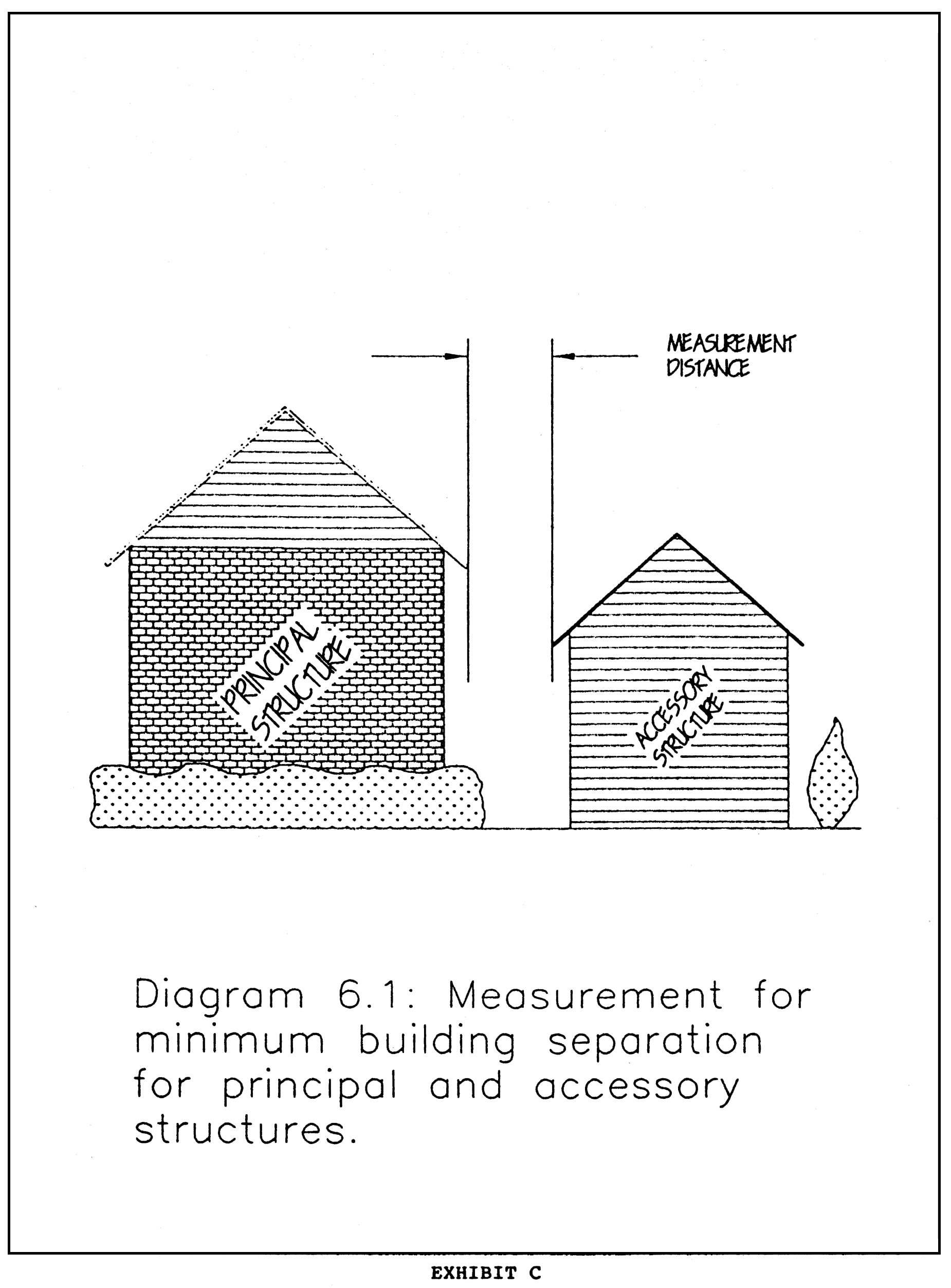
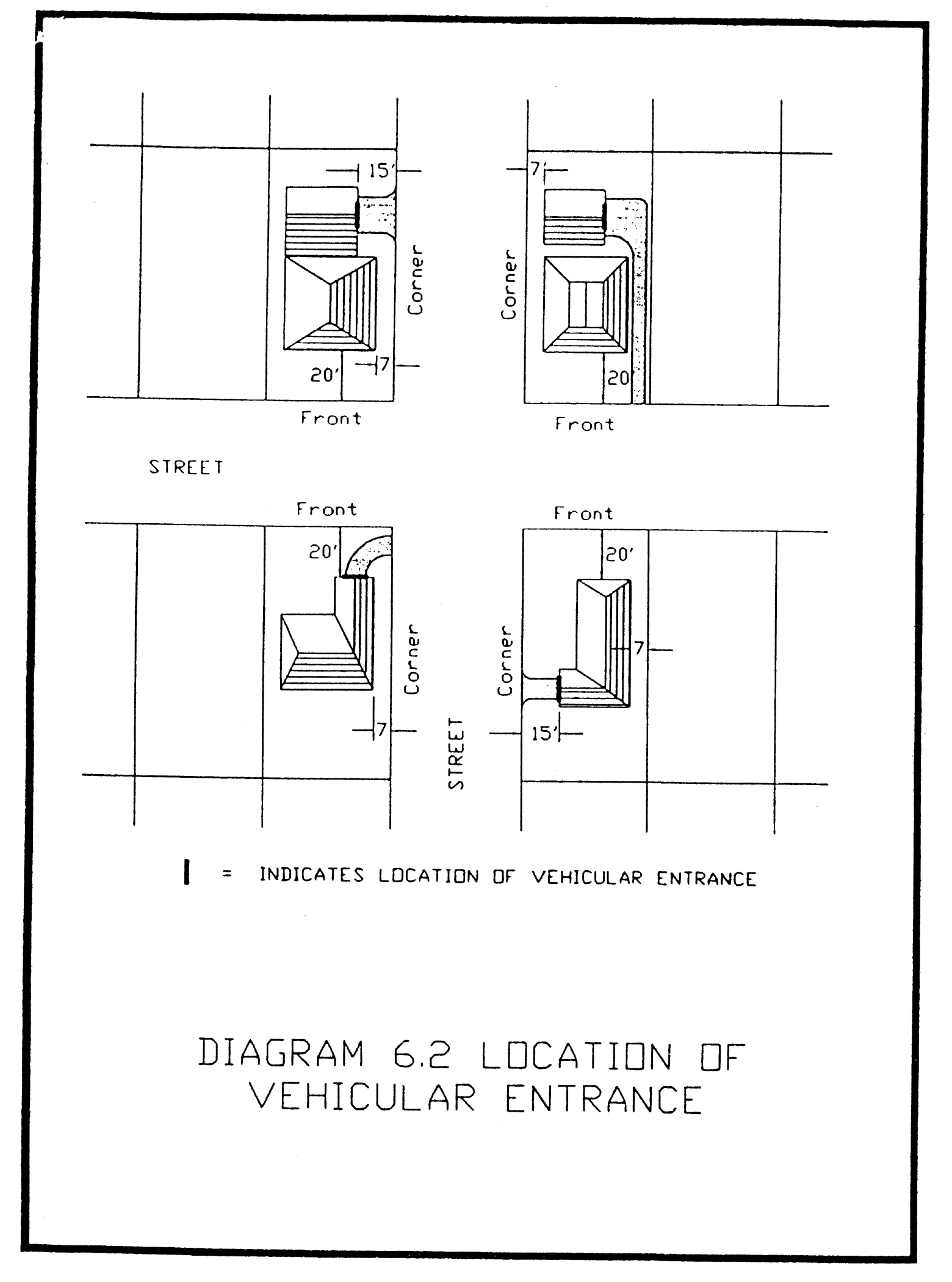
Sec. 27-290.1. - Fence and wall regulations.
(a)
Visibility triangle. All fences and walls shall conform to the requirements of section 27-283.5.
(b)
Conflict with buffer requirements. Where a fence or wall is required to comply with section 27-284, and which fence may be in conflict with this section, the more restrictive regulation shall apply.
(c)
Materials. Fences and walls shall be constructed of chain link, wood, masonry or decorative wrought iron, galvalume corrugated metal panels with a decorative perimeter framing and structural bracing or a PVC (poly vinyl chloride) product manufactured and designed as a fence, except as varied below or as may be further regulated by Historic District design standards or Overlay District regulations.
(1)
Security fencing.
a.
Broken glass. The use of broken glass or other similar materials is prohibited in all districts.
b.
Electric fences. Electric fences or walls may be permitted as accessory to an agricultural use or may be used for security purposes in any industrial district, provided that the following standards are met:
1.
Only low-voltage electrical fencing shall be used with a maximum of twelve (12) volts, primary voltage;
2.
The electrical fence shall be no higher than ten (10) feet tall;
3.
The electrical fence shall be completely surrounded by a non-electrical fence or wall with a height not to exceed six (6) feet;
4.
The surrounding non-electrical fence or wall shall be separated from the electrical fence by at least six (6) inches at the closest point between the electrical fence and the non-electrical surrounding fence or wall;
5.
The electrical fence is identified as such with signage, no larger than one (1) square foot in area, at least every sixty (60) feet;
6.
Any property protected by an electrically charged fence shall provide, outside the perimeter of the fence, an emergency shut-off switch for fire and police department access. Fire department access shall be of a type, location, and marking specified and approved by the fire marshal. Police department access shall be of a type, location, and marking specified and approved by the police chief; and
7.
The zoning lot on which the electric fence is proposed for use shall not be adjacent to a residential use. If a residential use is adjacent to the site, the property owner or his agent may petition the variance review board or the Architectural Review Commission (in historic districts, generally, or landmark sites) or the Barrio Latino Commission (in the Ybor City Historic District) for consideration of the electric fence use as provided below.
c.
Barbed wire. Barbed wire may be used for security purposes in any industrial district or if necessary to an agricultural use, provided that the barbed wire is limited to three (3) strands which are located a minimum elevation of six (6) feet above the ground.
d.
Razor wire. The use of razor wire is prohibited unless approved through the variance process described below.
(2)
Variances. The variance review board (VRB), the Architectural Review Commission (in historic districts, generally, or landmark sites) (ARC) or the Barrio Latino Commission (in the Ybor City Historic District) (BLC) may grant a variance to allow electric fencing, barbed wire, or razor wire for commercial and industrial zoned parcels. As part of demonstrating compliance with the variance criteria utilized by the VRB, ARC, or BLC, as applicable, the applicant must demonstrate a practical difficultly or unnecessary hardship, which for the purposes of this code section only, can be satisfied by showing a significant security need.
a.
In applying the variance criteria, the VRB, ARC, or BLC shall balance the applicant's need for the variance with the visual impact to the surrounding community. The purpose of the provision is to ensure that any use of electric fencing, barbed wire, or razor wire should be used only as the extreme last resort of property protection.
b.
Standards. When approved, the barbed wire and/or razor wire shall be located at a minimum elevation of six (6) feet above the ground. Electric fencing shall be setback a minimum six (6) feet from any property line adjacent to a residential use or residentially zoned property and must meet the first six (6) criteria stated in (c)1.b. above. When the subject parcel is adjacent to a residential use all barbed wire and razor wire shall be removed from the subject property prior to or in conjunction with the installation of an electrically charged fence, unless otherwise approved as a condition of approval by the appropriate board. The variance review board or the Architectural Review Commission (in historic districts, generally, or landmark sites) or the Barrio Latino Commission (in the Ybor City Historic District) may require the fence to be setback from property lines and screened. Buffering and screening requirements shall be consistent with section 27-284. If screening is required, the property must be posted with warning signs (Danger—High Perimeter Security) every one hundred (100) lineal feet along the fence line.
(3)
Exposed framing. Walls or fences made from any permitted building material must be constructed so that the exposed framing of each section of fence faces the interior yard. However, prior to the installation of the fence, the zoning administrator may allow the exposed framing of the fence to face adjacent side and rear yards where the owner or contractor can clearly demonstrate one (1) of the following conditions:
a.
There is an existing fence and/or hedge located on the property adjacent to the parcel for which the new fence is required and the existing fence or hedge is of a construction and location such that it is physically impractical and infeasible to install a wood fence with the exposed framing facing the interior yard.
b.
All adjacent affected property owners have declared in writing that they have no objection to the exposed framing.
(d)
Method of measurement. Where a fence or wall is located at a common property line with varying elevation, including berms or permanent planters, the height shall be measured and averaged at regular intervals on both sides of the property line. The final height shall be determined by averaging the dimensions obtained from the measure interval averages. The measured interval distances shall typically be eight (8) feet.
(e)
Front yards.
(1)
Within the single-family residential zoning districts, and YC-2 and YC-4 subdistricts, fences and walls may be located within required front yards provided that the height does not exceed three (3) feet for fences built of opaque materials, or four (4) feet for fences built of transparent materials which do not obstruct light, air and visibility.
(2)
For all residential uses in any zoning district, fences and walls may be located within required front yards provided that the height does not exceed three (3) feet for fences or walls made of opaque materials, or four (4) feet for fences built of transparent materials, which do not obstruct, light, air and visibility.
(f)
Maximum height. The maximum height for fences and walls is as follows:
Decorative architectural features on fences/walls shall not be included in the height of a fence except that they shall not extend more than one (1) foot above the maximum height and shall have a minimum of eight-foot spacing between them.
(Ord. No. 2023-128, § 9, 9-21-2023)
Sec. 27-290.2. - Antennas.
(a)
General regulations.
(1)
Subsections (a) through (g) of this section shall apply to satellite dish antenna and conventional receive-only communication antennae. Amateur radio antennae are regulated under subsection (h). All other wireless communication antennas are regulated under subsection (i).
(2)
Where the term "antenna" is used, the term refers to both types of antennas. The terms "satellite dish antenna" and "conventional antenna" refer separately to the individual types of antennas.
Satellite dish antennas are defined to include all parabolic or spherical antennas whose purpose is to receive and/or transmit satellite signals of both audio and video transmission.
All antennas are considered structures and shall be installed in accordance with all applicable provisions of the building code of the city.
(3)
No advertising or signage of any type is permitted on an antenna.
(4)
The height of a ground-mounted antenna shall be the total maximum distance to which it is capable of being raised and shall be measured from the finished grade adjacent to the structure. The height of roof-mounted antennas shall be the total maximum distance to which it is capable of being raised and shall be measured from the highest point of the finished grade of the portion of the roof on which it is mounted.
(b)
Regulations for single-family and the RM-12 residential districts and for single-family detached use in any zoning district.
(1)
General regulations. An antenna shall be considered an accessory structure and shall not constitute the principal use of the property.
(2)
Dimensional regulations.
a.
The placement of antennas shall be limited to one (1) satellite dish antenna and one (1) conventional antenna per zoning lot upon which the primary use is located.
b.
The maximum size of the satellite dish antenna shall be limited to twelve (12) feet in diameter. The maximum height of a conventional antenna shall not extend four (4) feet above the roof of the principal structure.
c.
The antenna shall only be located in the rear or side yard provided that the location is between the rear main building wall of the principal structure and the rear lot line. The antenna shall not be located in a front or corner yard.
d.
The satellite dish antenna shall maintain rear and side yards of a depth equal to or greater than its height.
e.
The satellite dish antenna may be roof-mounted only when the dish is no larger than eighteen (18) inches in diameter. A satellite dish antenna over eighteen (18) inches in diameter shall not be permitted on the roof of any structure, regardless of whether the zoning district height limitation can be met.
f.
The overall height of the antenna shall not exceed the maximum height restriction of the applicable zoning district. The height measurement shall include both the antenna and any base or fixture upon which it is constructed.
If the satellite dish antenna is ground-mounted upon a base or fixture, the bottom of the antenna shall not be located more than eighteen (18) inches above the eaves of the roof of the principal structure.
(c)
Regulations for multiple-family residential (except RM-12), office and CN and CG districts.
(1)
General regulations. The following regulations shall apply to an antenna considered an accessory structure to the primary use of the property. Any accessory use shall not be utilized for any off-site commercial purposes.
(2)
Number of antennas.
a.
Single occupancy parcel shall be limited to two (2) antennas per zoning lot.
b.
Multiple occupancy parcel shall be limited to two (2) ground-mounted antennas per zoning lot, one (1) roof-mounted antenna per each establishment in a multiple occupancy parcel, or one (1) wall-mounted antenna, provided the wall-mounted antenna is conventional or satellite dish less than twenty-four (24) inches in diameter. The total number of antennas on the zoning lot may not exceed the number of establishments on the zoning lot.
(3)
Dimensional regulations. The antenna may either be located on the ground or may be located on the wall or roof of the principal structure as prescribed below.
a.
Location, yard and height regulations for ground-mounted antennas.
1.
The antenna shall not be located in the front or corner lot.
2.
The ground-mounted satellite dish antenna shall maintain rear and side yards of a depth equal to or greater than its diameter. The conventional antenna shall maintain rear and side yards of a depth equal to or greater than its height.
3.
The overall height of the satellite dish antenna shall not exceed twenty-two (22) feet. The height measurement shall include both the satellite dish antenna and any base or fixture upon which the antenna is constructed. The maximum height of a conventional antenna shall not exceed the maximum height of the underlying zoning district.
4.
The satellite dish antenna shall be screened from view of adjacent street rights-of-way by intervening buildings and/or trees and vegetation, per section 27-284(2)a. The applicant shall provide documentation to the zoning administrator that the proposed location meets the screening requirements.
b.
Location and height of roof-mounted antennas.
1.
Antennas may be roof-mounted only on principal structures in excess of thirty (30) feet in height. The roof-mounted antenna shall not be more than twenty-two (22) feet in height, including the base and any fixture upon which the antenna is constructed.
2.
The total combined height of the building and antenna shall not in any case exceed the maximum height restriction of the applicable zoning district.
3.
Satellite dish antennas shall be setback a minimum ten (10) feet from the perimeter edge of the roof.
c.
Location and height of wall-mounted antennas.
1.
Antennas may be wall-mounted on a building wall along the side or rear yard of the zoning lot.
2.
The maximum size of a satellite dish shall be twenty-four (24) inches in diameter.
3.
The overall height of the antenna shall not exceed the maximum height restriction of the applicable zoning district. The height measurement shall include both the antenna and the structure upon which it is constructed. The bottom of the antenna shall not be located more than eighteen (18) inches above the eaves of the roof of the structure upon which it is constructed.
(d)
Regulations for CI, industrial and M-AP districts.
(1)
General regulations. The following regulations shall apply to any antenna considered accessory structure unless the transmission and/or reception of satellite signals is intrinsic to the principal use of the property. When considered an accessory structure, the antenna shall not be constructed prior to the construction of the principal use of the property.
a.
Antennas as accessory structures.
1.
The number of antennas shall be limited as follows:
i.
Single occupancy parcel shall be limited to two (2) antennas per zoning lot.
ii.
Multiple occupancy parcels shall be limited to two (2) ground-mounted antennas or one (1) wall-mounted antenna (provided the antenna is conventional or a satellite dish less than twenty-four (24) inches in diameter) per each establishment in a multiple occupancy parcel. At no time can the number of antennas on a zoning lot exceed the number of establishments.
2.
The location, yard, and height shall be required as follows:
i.
Ground-mounted antenna. The antenna shall not be located in the front or corner yard. A satellite dish antenna shall maintain rear and side yards of a depth equal to or greater than its diameter. The conventional antenna shall maintain rear and side yards of a depth equal to or greater than its height. The overall height of the antenna shall not exceed twenty-two (22) feet. The height measurement shall include both the antenna and any base or fixture upon which it is constructed.
ii.
Roof-mounted antenna. The satellite dish antenna shall not be more than twenty (20) feet in overall height. The height measurement shall not be more than twenty (20) feet in overall height. The height measurement shall include both the satellite dish antenna and any base or fixture upon which it is constructed. The total combined height of the building and satellite dish antenna shall not in any case exceed the maximum height restriction of the applicable zoning district. The antenna shall be setback a minimum ten (10) feet from the perimeter edge of the roof.
iii.
Wall-mounted antenna. A satellite dish or conventional antenna may be attached to any building wall along the side or rear yard of the zoning lot. The maximum size of a satellite dish shall be twenty-four (24) inches in diameter. The overall height of the antenna shall not exceed the maximum height restriction of the applicable zoning district. The height measurement shall include both the antenna and the structure upon which it is constructed. The bottom of the satellite dish antenna shall not be located more than eighteen (18) inches above the eaves of the roof of the structure upon which it is constructed.
(b)
Antennas when the transmission and/or reception of satellite signals is intrinsic to the principal use of the property:
1.
Satellite dish antennas may be roof or ground-mounted. If ground-mounted, the satellite dish antenna shall maintain rear and side yards of a depth equal to or greater than its diameter.
2.
The total combined height of the building and satellite dish antenna shall not in any case exceed the maximum height restriction of the applicable zoning district.
(e)
Regulations for satellite dishes located at radio and television studios and colleges.
(1)
The utilization of antennas at radio and television stations and colleges is intrinsic to the operation of the station or college; therefore, the number of antennas is not limited, provided the following location, yard and height regulations are met.
(2)
Antennas may be roof-, wall- or ground-mounted. If ground-mounted, the antenna shall maintain required yards of a depth equal to or greater than its diameter. The total combined height of the building and antenna shall not in any case exceed the maximum height restriction of the applicable zoning district.
(f)
Regulations for the Ybor City Historic District. Antennas are not permitted within the Ybor City Historic District except for locations at a college or office in the YC-3 subdistrict where the utilization of antennas is intrinsic to the operation of the college or office and subject to the following requirements:
(1)
Antennas shall be roof- or ground-mounted.
(2)
Ground-mounted antennas shall maintain any required yards as set forth in Table 8-2, subject to minimum required yards of a depth equal to or greater than its diameter.
(3)
The total combined height of the building and antenna shall not in any case exceed the maximum height restrictions of the applicable zoning district as set forth in Table 8-2.
(g)
Variances. Variances to these requirements shall only be authorized by the variance review board or the Architectural Review Commission (in historic districts, generally, or landmark sites) or the Barrio Latino Commission (in the Ybor City Historic District), according to its procedures as outlined in this Code. However, in the single-family, multiple-family, office, CN and CG districts, the board shall not be authorized to grant variance requests which would allow the installation of an antenna in the required front or corner yard. In addition to the provisions of sections 27-80, 27-99(i)(3)b, 27-114(d), the applicant must clearly demonstrate that the requirements of this section mandate a location of the antenna such that reception is severely restricted or impaired.
(h)
Regulations for amateur radio antennae.
(1)
General regulations.
a.
Antenna shall mean the arrangement of wires or metal rods utilized for the purpose of transmission or reception of electromagnetic waves.
b.
Antenna support structure shall mean any structure, mast, pole, tripod, or tower utilized for the purposes of supporting an antenna or antennae for the purpose of transmission or reception of electromagnetic waves by federally licensed amateur radio or citizens band radio operators.
c.
Antenna height shall mean the overall vertical length of the antenna and antenna support structure above grade, or if such system is located on a building, then the overall vertical length includes the height of the building upon which the structure is mounted.
d.
All antennae are considered structures and shall be installed in accordance with all applicable provisions of Chapter 5, Building Code of the City of Tampa.
e.
No advertising or signage of any type is permitted on an antenna.
(2)
Dimensional regulations.
a.
In all single-family and the RM-12 residential districts, the placement of antennae shall be limited to one (1) antenna per zoning lot upon which the primary use is located. The antenna shall not be permitted on the roof of any structure and no antennae height shall exceed forty-five (45) feet above finished grade.
b.
In RM-16, RM-18, RO, RO-1, CN and all other zoning districts, the placement of antennae shall be limited to two (2) antennae per zoning lot. The antenna may either be located on the ground or may be located on the roof of the principal structure; however the total combined height of the building and antenna shall not exceed forty-five (45) feet above finished grade.
c.
The antenna height allowed if located in all other multi-family residential districts and all office, commercial or industrial zoning districts shall not exceed the maximum height restriction of the applicable zoning district.
d.
The antenna shall maintain accessory structure setbacks as required in section 27-290, Accessory structures.
(3)
Variances. Variances to these requirements shall only be authorized by the variance review board or the Architectural Review Commission (in historic districts, generally, or landmark sites) or the Barrio Latino Commission (in the Ybor City Historic District), according to its procedures as outlined in this Code. In addition to the provisions of sections 27-80, 27-95(i)(3)b., 27-114(d), the applicant must clearly demonstrate the following:
a.
That the requirements of this section mandate a location of the antenna such that reception is severely restricted or impaired, and
b.
That the variance requested is the minimum necessary to make possible the reasonable use of the antenna.
The variance review board or the Architectural Review Commission (in historic districts, generally, or landmark sites) or the Barrio Latino Commission (in the Ybor City Historic District) must consider the following objectives of the Federal Communications Commission in determining whether a variance is appropriate:
a.
There is a strong federal interest in promoting amateur operations.
b.
Amateur communications provide an effective means of communication during disaster and emergency situations.
c.
Amateur radio service provides a reservoir of trained operators, technicians and electronic experts who can be called on in times of national or local emergencies.
d.
By its nature, the amateur radio service also provides the opportunity for individual operators to further international goodwill.
(i)
Wireless communication antennas. Wireless communication antennas may be attached to any structure, conforming or nonconforming. The following conditions must be met:
(1)
Wireless communication antennas shall be installed in accordance with all applicable provisions of the building code of the city.
(2)
No advertising or signage of any type is permitted on wireless communication antennas or equipment storage buildings or areas. Attachment to existing signs following restrictions of this section is permitted.
(3)
The installation of the antenna shall not create any restriction or interference with air safety and any operations as per the Federal Aviation Administration, Hillsborough Aviation Authority or MacDill Air Force Base.
(4)
If visible from surrounding property the wireless communication antenna and equipment storage buildings or area shall be designed to be consistent with the aesthetic properties of the building or structure to be utilized, such as color or material.
(5)
The wireless communication antenna shall comply with the FCC and other applicable federal or state regulations relative to telecommunications and radio frequency emission levels.
Additionally, the following restrictions shall apply:
(6)
On structures (except commercial communication towers) sixty (60) feet and higher:
a.
In the case of building rooftop installation, any wireless communication antenna or equipment storage buildings or areas shall not exceed a height of fifteen (15) feet above the roof line. Height shall be measured from the finish level of the portion of the roof on which it is mounted.
b.
Any antenna placed on any structure other than a building roof (e.g. water tower, billboard, etc.), may not be greater than twenty (20) feet in height.
(7)
On structures (except commercial communication towers) less than sixty (60) feet; but not less than thirty (30) feet:
a.
In the case of building rooftop installation, any wireless communication antenna or equipment storage buildings or areas shall not exceed a height of ten (10) feet above the roof line. Height shall be measured from the finish level of the portion of the roof on which it is mounted.
b.
Any antenna placed on any structure other than a building roof (e.g. water tower, billboard, etc.), may not be greater than ten (10) feet in height.
(8)
The applicant may petition the Variance Review Board, Barrio Latino Commission, or Architectural Review Commission, as applicable for a height variance per section 27-290.2(g).
Sec. 27-290.3. - Swimming pools.
Swimming pools, both aboveground and below ground, are permitted as accessory structures to residential or nonresidential structures, provided that the following requirements are met. Similar structures such as spas shall also meet these requirements.
(1)
Location. Swimming pools may be located within side or rear yards, but shall not be allowed in front or corner yards, as follows:
a.
In-ground (pool deck and water level designed to be at or within twelve (12) inches of the finished grade) swimming pools shall be located a minimum of five (5) feet from any side or rear lot line and no closer to the corner lot line than the corner yard setback, established in section 27-156 Table 4-2 , for the underlying zoning district as measured from the water's edge.
b.
Above-ground pools or pools designed within a retaining wall or having an elevated deck (over twelve (12) inches above finish grade) must meet the required setbacks for principal structures as established in the underlying zoning district. The setback is measured from the property line to the edge of the pool, elevated deck or retaining wall which ever is closer to the property line.
c.
Pools (pool deck and water level designed to be at or within thirty-six (36) inches of the finished grade) may be located in rear yards of waterfront lots and shall be setback a minimum of five (5) feet from the rear property line, mean high water line, or seawall, which ever is more restrictive, as measured from the water's edge of the pool.
d.
Hot tubs and associated decks (deck and water level designed to be at or within thirty-six (36) inches of the finished grade) shall be setback a minimum of three (3) feet from the side and rear property line, however, shall be limited to four hundred (400) total square feet in area.
(2)
Required pool enclosures. All swimming pools and spas for all uses shall be enclosed with a fence, barrier, or screen enclosure that complies with all local, state, and federal regulations. The use of self-latching gates or similar locking/security mechanism shall also be required. The utilization of fencing to enclose the pool or spa must also comply with section 27-290.1, Fence and wall regulations. A screened cage may be installed instead of or in addition to a fence or wall, provided the screen cage meets the protection requirements cited herein and meets the dimensional requirements set forth in section 27-290.5, Screen enclosures.
(3)
Pool equipment and accessory structures. Pool equipment and accessory structures, such as cabanas and pool houses, shall be permitted in compliance with the regulations described in section 27-290, Accessory structures, except that pool equipment is not required to have a ten-foot separation from the principal structure. Accessory structures may be connected to the principal structure by a screen enclosure provided the required separation between the principal and accessory structure is met.
(Ord. No. 9322-A, § 41(43A-81), 7-24-86; Ord. No. 88-301, § 36, 9-29-88; Ord. No. 89-153, §§ 6, 7, 7-6-89; Ord. No. 91-112, §43, 6-27-91; Ord. No. 2002-265, § 5, 12-5-02; Ord. No. 2006-169, § 11, 7-13-06)
Sec. 27-290.4. - Noise attenuation requirements.
Within the Accident Potential Zone I, (APZ), as identified in the Future Land Use Map of the Tampa Comprehensive Plan, all developments of single-family, multi-family and congregate residential uses, schools and hospitals shall be designed and constructed to reduce noise levels by twenty-five (25) decibels. Noise level reduction is the difference, in decibels, between the noise level outside a building and the noise level inside a designated room in the building that was caused by the exterior noise. Refer to section 5-301 for construction standards to achieve noise level reduction of twenty-five (25) decibels.
Sec. 27-290.5. - Screen enclosures.
The following requirements shall apply to all screen enclosures:
(1)
Screen enclosures in single-family residential districts.
a.
All screen enclosures must meet the following setbacks:
From front lot line—Same as required front yard for zoning district
From corner lot line—Same as underlying for zoning district
From side lot line—5 feet*
From rear lot line—5 feet**
Notes:
*For each ten (10) feet of building height above fifteen (15) feet, the required yards shall be increased by one (1) foot.
**For each one (1) foot of building height above fifteen (15) feet, the required yards shall be increased by one (1) foot.
b.
Screen enclosures shall not exceed thirty-five (35) feet in height.
c.
Screen enclosures with solid roofs shall comply with yard requirements for principal structures in that district.
(2)
Screen enclosures in multi-family districts.
a.
Screen enclosures shall not exceed thirty-five (35) feet in height.
b.
Screen enclosures shall comply with yard requirements for principal structures in that district.
c.
Screen enclosures with covered roof shall comply with yard requirements for principal structures in that district.
(3)
Screen enclosures in other than single-family and multi-family residential districts. Screen enclosures in these districts shall comply with the development requirements for principal structures in said district.
Sec. 27-290.6. - Air conditioning and pool equipment.
(a)
For single-family residential uses, air conditioning and pool equipment shall not be permitted in front of the principal structure. The air conditioning and pool equipment may be placed in the corner, side and rear yard provided that the following setbacks are maintained:
(b)
For all other uses, air conditioning and pool equipment shall be placed in compliance with required principal structure setbacks.
Sec. 27-290.7. - Transit shelters and bicycle share program stations.
A transit shelter and a bicycle share program station (with associated bicycle kiosk and bicycle rack) are typical improvements located on public right-of-way. At times there is insufficient space in the right-of-way to accommodate these facilities. When a municipal or other governmental agency acquires an easement on private property for the purpose of constructing one of these facilities, these improvements shall not be subject to minimum setback requirements. Placement of the facilities shall be subject to the provisions of section 27-283.5, visibility at intersections.
(Ord. No. 2014-40, § 3, 6-5-2014)
Sec. 27-290.8. - Tents.
Tents may be erected only as temporary structures provided that the activity for which the tent is being used is consistent with the uses permitted in the underlying zoning district. There shall be no extension to the duration or time frame for which a tent may be erected as specified in this section. Structures erected for longer periods of time than allowed by this section must be designed as permanent structures and comply with current building codes, land development regulations and fire codes.
(a)
Tents one hundred (100) square feet or less in covered area are subject to the following limitations:
(1)
Tents are allowed on public right(s)-of-way during special events or festivals as designated and approved by city council pursuant to a parade, block party or road festival permit, subject to and in accordance with the provisions of such permit, or on private property located contiguous to a public right-of-way that has been closed during a parade, block party or festival. Tents are also allowed in City of Tampa Parks if approved by the City of Tampa Parks Department in connection with an event of limited duration, on residential property when erected for five (5) days or less for an activity normally associated with a residential use, or as otherwise provided by law.
(2)
One (1) tent of this size may be permitted per zoning lot or portion thereof, only as an accessory to an existing approved principal structure. An exception to this condition may be given when multiple tents are requested in conjunction with a major festival and when an approved assembly permit for the zoning lot has been issued through the City of Tampa Fire Marshal's office.
(3)
A tent may be erected for no more than thirty (30) total cumulative days during any consecutive twelve-month period.
(4)
The tent must be placed in compliance with the minimum setback requirements of the underlying zoning district.
(5)
The tent may not block access to any required parking spaces, or impede the safe passage of any vehicle in a parking lot.
(6)
All tent installations shall comply with the latest edition of the applicable Fire Safety Codes.
(7)
All electrical, plumbing or mechanical installations shall be permitted through the applicable City of Tampa Departments.
(8)
Tents shall be taken down in cases of impending tropical storms twenty-four (24) hours in advance.
(b)
Tents larger than one hundred (100) square feet are subject to the following limitations:
(1)
Tents are allowed on public right(s)-of-way during special events or festivals as designated and approved by city council pursuant to a parade, block party or road festival permit, subject to and in accordance with the provisions of such permit, or on private property located contiguous to a public right-of-way that has been closed during a parade, block party or festival. Tents are also allowed in City of Tampa parks if approved by the City of Tampa Parks Department in connection with an event of limited duration, on residential property when erected for five (5) days or less for an activity normally associated with a residential use, or as otherwise provided by law.
(2)
Tents when erected for five days or less for an activity normally associated with a residential use and on residential property must comply with subsections 27-290.8(b)(6), (8) and (10) below.
(3)
Tents when used for longer than a five day period must submit a site plan showing compliance with the following requirements:
a.
Sufficient parking must be available on the zoning lot to accommodate the proposed use taking place within the tent in addition to any other use on the zoning lot, per section 27-283.7, Number of off-street parking spaces, and section 27-283.12, Off-street parking space standards. For vacant, undeveloped property, it is not required that the parking lot surface be paved, provided DPW determines the surface is suitable for the quantity and frequency of traffic expected to use it. A level and flat surface free from tripping hazards and other potential safety hazards must be maintained in good condition so as not to become a public nuisance.
b.
Driveway access, to be approved by the department of public works, is required to provide safe ingress and egress to and from the site without damaging existing sidewalks or curbs.
c.
Adequate restroom facilities must be available at the tent site, or a written agreement allowing access to restroom facilities within two hundred fifty (250) feet of the tent site must be provided.
(4)
Only one (1) tent may be erected per zoning lot or portion thereof. An exception to this condition may be given when multiple tents are requested in conjunction with a major festival and when an approved assembly permit for the zoning lot has been issued through the City of Tampa Fire Marshal's office.
(5)
A tent may be erected for no more than one hundred twenty (120) total cumulative days within any consecutive twelve-month period. There must be a minimum thirty (30) day hiatus for every sixty (60) consecutive days a tent remains erected.
(6)
A tent must be placed in compliance with the setback requirements of the underlying zoning district.
(7)
All tent installations shall comply with the latest edition of the applicable Fire Safety Codes.
(8)
All electrical, plumbing or mechanical installations shall be permitted through the applicable City of Tampa Departments.
(9)
When applicable from other city departments, approvals and permits shall be obtained prior to issuance of the fire marshal tent permit.
(10)
Tents shall be taken down in cases of impending tropical storms twenty-four (24) hours in advance.
(11)
If the listed use of the tent changes from the original use, a new permit is required.
(12)
An assembly permit is required for any tent that is capable of having an occupant capacity of one hundred (100) or more persons. Documentation of seating and table arrangements and emergency exit locations shall be shown on-site plans submitted for review and approval by the fire marshal.
(c)
The zoning administrator may approve tents on an annual basis in commercial and industrial districts when it can be demonstrated by the applicant that:
(1)
The use of a tent is shown to be integral to the type of business proposed.
(2)
There is no signage or advertising on the tent.
(3)
The tent is attached to the ground and maintained free from excessive wear.
(4)
The tent is in compliance with section 27-290.8(b), except as it relates to the time limits set forth therein.
Sec. 27-290.9. - Skateboard ramps.
Skateboard ramps are permitted as accessory structures to residential or nonresidential structures, provided that the following requirements are met:
(a)
Accessory to a residential structure or use.
(1)
Location. Skateboard ramps may be located within side or rear yards, but shall not be allowed in front or corner yards. Skateboard ramps must meet the required yards (setbacks) for principal structures, as established in the underlying zoning district. The yard (setback) is measured from the property line to the closest portion of the skateboard ramp structure.
(2)
Maximum permitted dimensions. Skateboard ramps shall not measure, in aggregate, more than the following:
a.
Eight-foot width;
b.
Twenty-two-foot length; and
c.
Three-foot height.
(b)
Accessory to a nonresidential structure or use.
(1)
Location. Skateboard ramps may be located within side, rear, or corner yards, but shall not be allowed in front yards. Skateboard ramps must meet the required yards (setbacks) for principal structures, as established in the underlying zoning district, but no less than ten (10) feet. The yard (setback) is measured from the property line to the closest portion of the skateboard ramp structure.
(2)
Maximum permitted dimensions. Skateboard ramps shall not measure, in aggregate, more than the following:
a.
Sixteen-foot width;
b.
Thirty-foot length; and
c.
Five-foot height.
(c)
Noise attenuation. Use of skateboard ramps shall not violate any portion of chapter 14, article III. Properties with a skateboard ramp shall be required to attenuate noise as follows:
(1)
Install a solid fence, six (6) feet in height, along the entire length of any property line between the skateboard ramp and an adjacent residential use. Refer to section 27-290.1 for permitted fence materials;
(2)
Plant a row of evergreen trees such as ligustrum, podocarpus, red cedar, or holly, which are planted twenty (20) feet on center, along the entire length of any property line between the skateboard ramp and any residential use. Trees shall meet minimum planting standards set forth in section 27-284.3.3 at planting; and
(3)
Ramps shall be constructed with sound-dampening materials such as insulation, foam-board sheathing, rammed earth, or similar methods.
(Ord. No. 2020-14, § 4, 2-6-2020)
Sec. 27-284. - Title; purpose and applicability; periodic study of Tampa's urban forest.
(a)
This division shall be known and cited as the "City of Tampa Tree, Landscape, and Natural Resources Code." It is intended to set specific parameters for natural resources, including tree and landscape planting, protection, pruning, removal, and mitigation; irrigation; protection of wetlands, upland habitat, and other environmentally sensitive areas; and, buffering and screening between uses of land with differing character. These regulations apply throughout the city, on public and private lands, and within rights-of-way.
(b)
The city initiated an urban forest ecological analysis (also referred to as the "urban forest canopy study") within the geographic boundaries of the city in 2006. Thereafter, the city has and shall continue to conduct such study/analysis, every five (5) years.
(Ord. No. 2019-54, § 33(Exh. A), 4-18-2019)
Sec. 27-284.1. - Administrative authority; definitions; general procedures; fees.
(a)
The provisions of this division shall be administered and enforced by the natural resources coordinator, unless otherwise stated. The natural resources coordinator shall receive applications, review site construction and tree and landscape documents, and issue permits for the planting, pruning, relocation, and removal of protected and grand trees; inspect the premises for which such permits have been issued; and, enforce compliance with the provisions of this division. Refer to section 27-43 for defined terms, and sections 27-60, 27-61, and 27-284.2.5 for removal and review procedures.
(b)
Fees, as set by city council resolution, shall be charged for the following:
(1)
Tree consultation inspection;
(2)
Permit application and associated plan review (when applicable);
(3)
Tree condition and risk evaluation inspection;
(4)
Re-inspection;
(5)
Mitigation tree(s);
(6)
Alternative design exception;
(7)
Public board applications; and
(8)
Review petitions.
(c)
Refer to sections 27-284.2 through 27-284.2.7 for general permitting procedures.
(Ord. No. 2019-54, § 33(Exh. A), 4-18-2019)
Sec. 27-284.1.1. - City Tree Matrix; technical standards; authority to establish, publish, and adopt.
(a)
City Tree Matrix. Refer to section 27-284.3.2.
(b)
The technical standards set forth in the "City of Tampa's Tree and Landscape Technical Manual," ["Technical Manual"], on file in the office of the city clerk, is adopted herein by reference, and shall have the force and effect of law. The Technical Manual sets forth standards that include:
(1)
Tree mitigation method reference tables (refer to section 27-284.4.1 for mitigation method, Tree Retention-Mitigation Equivalency Tables, and applicable permit procedures);
(2)
Tree condition and risk evaluation form (refer to subsection (c) below for general evaluation criteria);
(3)
Tree installation methods with related graphics;
(4)
Tree protection methods during construction with related graphics;
(5)
Example tree and landscape plans with related, supplemental graphics;
(6)
List of tree, landscape, and forestry reference materials.
(c)
Tree condition and risk evaluation criteria. The typical criteria, used by the city for evaluation of a tree's condition and risk factors, are as follows (refer to Technical Manual for applicable form):
(1)
Condition rating of tree roots, tree trunk, tree limbs/branch structure, twigs, and foliage:
a.
A: Excellent/No apparent problem.
b.
B: Good/Minor problem.
c.
C: Fair/Major problem.
d.
D: Poor/Extreme problems.
e.
F: Dead.
(2)
Risk evaluation for failure potential, size of defective part, rating of potential target at risk if failure occurs:
a.
Failure potential (up to four (4) points). Failure potential identifies the most likely failure and rates the likelihood that the structural defects(s) will result in failure within the inspection period. Examples of ratings are:
1.
Low (one (1) point): Defects are minor (e.g. dieback of twigs, small wounds with good woundwood development).
2.
Medium (two (2) points): Defects are present and obvious (e.g. cavity encompassing ten (10) to twenty-five (25) percent of the circumference of the trunk, co-dominant stems without included bark).
3.
High (three (3) points): Numerous and/or significant defects present (e.g. cavity encompassing thirty (30) to fifty (50) percent of the circumference of the trunk, multiple pruning wounds with decay along a branch).
4.
Severe (four (4) points): Defects are very severe (e.g. heartrot, decay conks along the main stem. Cavity encompassing more than fifty (50) percent of the trunk.
b.
Size of defective part (up to four (4) points). Size of defective part rates the size of the part most likely to fail. The larger the part that fails, the greater the potential for damage. Therefore, the size of the failure affects the hazard potential. Examples are:
1.
(One (1) point) Most likely failure less than six (6) inches (fifteen (15) cm) in diameter.
2.
(Two (2) points) Most likely failure six (6) to eighteen (18) inches (fifteen (15) to forty-five (45) cm) in diameter.
3.
(Three (3) points) Most likely failure eighteen (18) to thirty (30) inches (forty-five (45) to seventy-five (75) cm) in diameter.
4.
(Four (4) points) Most likely failure greater than thirty (30) inches (seventy-five (75) cm) in diameter.
c.
Target rating (up to four (4) points). Target rating rates the use and occupancy of the area.
1.
Occasional use (one (1) point): (e.g. jogging/cycling trial).
2.
Intermittent use (two (2) points): (e.g. picnic area, day-use parking).
3.
Frequent-use secondary structure or area (three (3) points): (e.g. seasonal camping area, storage facilities).
4.
Constant-use primary structures (four (4) points): (e.g. year-round use for a number of hours each day, residences).
(3)
The points in each category are added to obtain the overall hazard rating, with twelve (12) being the maximum value, expressed in the following formula: "Risk/Hazard Rating = Failure Potential + Size of Part + Target Rating"
(4)
The assignment of a rating is made with three (3) considerations in mind:
a.
Length of evaluation cycle.
b.
Level of resolution required by the goals of the hazard management program.
c.
Past history and rating.
(5)
If records are not available and not employed in the process, then the rating reflects only one (1) moment in time, rather than the long-term development of the tree.
(6)
Ratings have only relative meaning (i.e. a tree rated an 11 has a greater hazard potential than one rated a 5.) By description, a tree rated a 12 represents a significant hazard, but abating this hazard could be as simple as removing the defect and/or the target.
(Ord. No. 2019-54, § 33(Exh. A), 4-18-2019)
Sec. 27-284.1.2. - Trees—Protected, grand, and exempt trees; measurement methods.
(a)
Protected trees. Any tree species that meets the definition set forth in section 27-43 of the City Code is deemed a "protected" tree.
(b)
Specimen trees. Any tree species that meets the definition set forth in section 27-43 and is listed in Table 284.1.2 below is deemed a "specimen" tree. A specimen tree is a protected tree.
(b)
Grand trees. Any tree species, which meets the definition set forth in section 27-43 and is listed in Table 284.1.2 below, is deemed a "grand" tree. The natural resources coordinator may consider additional species as "grand," which possess similar characteristics, as described in the City Tree Matrix (refer to section 27-284.3.2).
(c)
Measuring diameter at breast height (DBH). Measuring the diameter at breast height ("DBH"), as defined in section 27-43, is a standard method of expressing the diameter of the trunk of a tree. Graphics 284.1.2-A through 284.1.2-E depict and describe the four (4) industry standard, accepted methods for measuring trunk diameter.
| 284.1.2-A: Straight Tree, on land with minimal-to-no slope | 284.1.2-B: Sloped Tree, on land with minimal-to-no slope | 284.1.2-C: Straight Tree, on sloped land | |
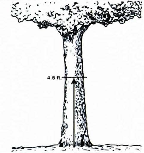 | 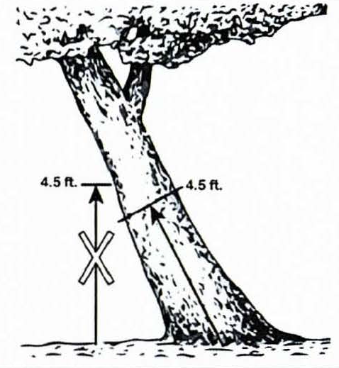 | 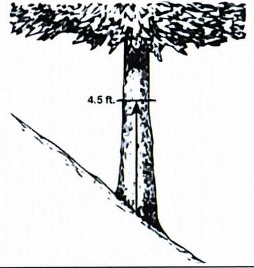 | |
| 284.1.2-D: Low-branching tree, on land with minimal-to-no slope | 284.1.2-E: Multi-stemmed trunk, on land with minimal-to-no slope | ||
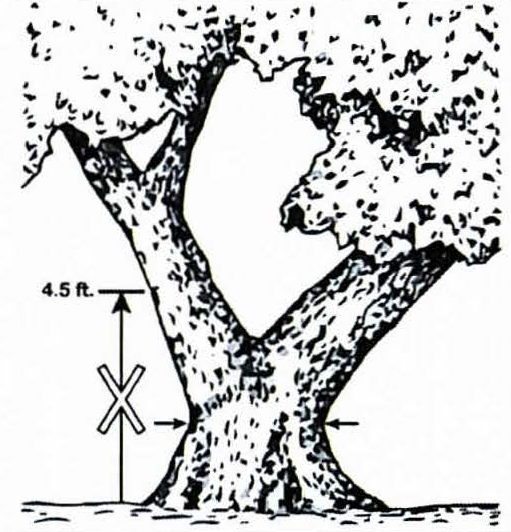 | 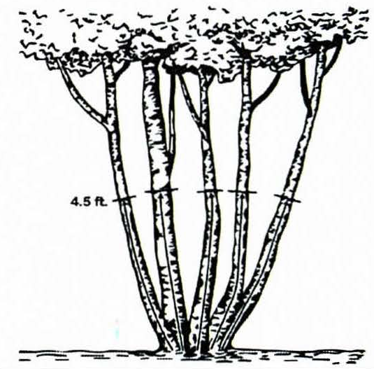 | ||
(d)
Exempt trees—City wide. Exempt trees, as defined in section 27-43 of the City Code, shall not require permit for removal and shall adhere to the following requirements:
(1)
All Category I species, as listed on the Florida Exotic Pest Plant Council's 2017 List of Invasive Plant Species, with the exception of camphor (Cinnamomum camphora), shall be required to be removed concurrent with any site work-related permit, unless otherwise approved by the natural resources coordinator or designee. Category I species shall not be factored into Tree Retention-Mitigation Equivalency Tables, as set forth in section 27-284.4.1, for any project or development. Refer to subsection (3) below for specific requirements related to camphor.
(2)
All Category II species, as listed on the Florida Exotic Pest Plant Council's 2017 List of Invasive Plant Species, if existing may remain in place or be planted as new, but no credit shall be factored into the Tree Retention-Mitigation Equivalency Tables, as set forth in section 27-284.4.1, for retention or planting such species.
(3)
The camphor tree (Cinnamomum camphora) is classified as a Category I invasive species, according to the Florida Exotic Pest Plant Council's 2017 List of Invasive Plant Species. This tree species, however, has been successfully planted and maintained, under certain conditions, throughout the city. With strict adherence to the following criteria and conditions, the camphor tree provides benefits and ample crown footprint to the overall city urban forest canopy, and shall be deemed "protected" for purposes of mitigation (replacement) calculation and can reach 'grand' status for same, subject to the following:
a.
No "credit" awarded for retaining any camphor tree (protected, specimen or grand), that is located within or proximate to (within fifty (50) feet of) any environmentally sensitive land (i.e. river, lake, bay, wetland, upland habitat, or significant wildlife corridor);
b.
Any camphor tree that is located within or proximate to such environmentally sensitive lands shall be required to be removed, and shall be mitigated according to the camphor mitigation requirements;
c.
Regardless of size or location, camphor trees can be removed without performing any applicable public notice or any site development redesign, but shall adhere to the camphor mitigation requirements;
d.
Camphor mitigation requirements: Each grand camphor tree shall be replaced with four (4) two and one-half-inch caliper trees; each specimen camphor tree shall be replaced with three (3) two and one-half-inch caliper trees; each protected camphor tree shall be replaced with two (2) two and one-half-inch caliper trees. For the purposes of this paragraph, all replacement trees shall be Type 1 trees unless exchanged for an equivalent rate of other tree types as noted in Table 27-284.4.1-B.
(Ord. No. 2019-54, § 33(Exh. A), 4-18-2019; Ord. No. 2022-169, § 3, 10-6-2022)
Sec. 27-284.1.3. - Other exemptions.
Specific entities, activities, and/or uses shall be exempt from certain permit procedures described below. Notwithstanding any exemption(s) described in this section, all such entities, activities, and/or uses shall adhere to the tree planting, pruning, root pruning, and removal standards, including tree mitigation requirements, set forth in this division and the Technical Manual:
(a)
The city's urban forestry coordinator, natural resources coordinator, or respective designees:
(1)
Pruning (limb/root) of any protected or grand tree on public land or public right-of-way, to mitigate any potential risk to the safety of the general public, subject to section 27-284.2.3, Table 284.2.3 criteria;
(2)
Removal of any protected tree or hazardous/dangerous grand tree, to mitigate any potential risk to the safety of the general public, on public lands or public rights-of-way. When feasible, the appropriate department shall provide notice of hazardous grand tree removal in accordance with section 27-284.2.5(h) to the owners of property adjoining the public lands or public rights-of-way within two hundred fifty (250) feet of the hazardous grand tree.
(b)
Public utilities. Pruning (limb/root) of any protected or grand tree, on lands owned by the public utility or in the public right-of-way, where in direct conflict with proper operation and maintenance of such utility.
(c)
Hillsborough County Aviation Authority; Aviation public safety. An exemption from the permitting and mitigation requirements of this division shall be granted when federal law, Florida State Law, or local airport zoning regulations (pursuant to Federal Aviation Administration Regulations), governing runways, taxiways, aprons, runway protection zones and approaches, air traffic control towers, and aircraft navigational aids require the pruning or removal of trees for public safety, if:
(1)
The applicant claiming that federal law, Florida State Law, or local airport zoning regulations (pursuant to Federal Aviation Administration Regulations), governing runways, taxiways, aprons, runway protection zones and approaches, air traffic control towers, and aircraft navigational aids require the pruning or removal of trees for public safety purposes, submits a sworn application for exemption from the tree pruning or removal permit and mitigation requirements of this division, to the natural resources coordinator, identifying the trees to be pruned or removed, the federal law, Florida State Law, or local airport zoning regulations (pursuant to Federal Aviation Administration Regulations), governing runways, taxiways, aprons, runway protection zones and approaches, air traffic control towers, and aircraft navigational aids requiring the pruning or removal for public safety, the law or regulations applicability to the applicant, and the public safety concern necessitating the pruning or removal; and
(2)
Upon submission of a completed, sworn application, the natural resources coordinator, or designee finds the federal law, Florida State law, or local airport zoning regulations (pursuant to Federal Aviation Administration Regulations), governing runways, taxiways, aprons, runway protection zones and approaches, air traffic control towers, and aircraft navigational aids requires the pruning or removal of trees for public safety.
(3)
Public international airports. In addition to runways, taxiways, aprons, runway protection zones, approaches, air traffic control towers, and aircraft navigational aids exempt from permitting and mitigation requirements of this division for public safety referred to in section 27-284.1.3(c)(1) and (2), the Hillsborough County Aviation Authority shall be exempt from the requirements of this division related to obtaining a permit for tree removal on all properties owned or controlled by the authority, which is used for airport operations, including, but not limited to, terminals, hangars, maintenance areas, cargo areas, roadways, and parking areas at Tampa International Airport, more particularly described in section 27-171(a).
However, prior to removal of a grand or protected tree, the proposed removal is required to be reviewed through the city's permit process, for purposes of assessing applicable tree replacement and mitigation requirements. Mitigation for tree removal shall be provided in accordance with sections 27-284.4 through 27-284.4.2, and all new construction not exempt by subsection (c)(1) above, shall be subject to compliance with all other provisions of this division, as applicable.
(d)
School board. An exemption from the permitting and mitigation requirements of this division shall be granted when Florida State Law or the latest version of the State of Florida Department of Education's State Requirements for Educational Facilities (SREF) requires.
(1)
The Hillsborough County Public Schools School Board may submit a sworn application for exemption from the tree pruning or removal permit, tree planting, or mitigation requirements of this division, to the natural resources coordinator, identifying the trees to be pruned or removed, trees to be planted, or the mitigation required, and the specific citations to the Florida State Law and SREF provision(s) the School Board alleges require the exemption.
(2)
Upon submission of a completed, sworn application, if the natural resources coordinator, or designee, finds Florida State Law and/or SREF requires an exemption to the requirements of this division, an exemption shall be granted to the extent required by Florida State Law and/or SREF.
(e)
The following uses and activities are exempt from providing a landscape and tree planting plan, for any site-related permit activities, as described in section 27-284.2.1:
(1)
Commercial nurseries.
(2)
Agricultural. Any bona fide agricultural use in furtherance of that use.
(3)
Development affecting existing single-family and two-family dwellings. Any expansion of an existing single- or two-family dwelling. The addition of a vehicular use area to an existing single-or two-family dwelling shall not be considered expansion for the purposes of this division, but shall be considered development subject to the provisions of this division.
(4)
Existing improvements. Any exterior improvement to existing structures that is not an expansion of total floor area.
(5)
Interior improvements. Any interior improvement to existing structures that is not an expansion of total floor area.
(6)
Fuel storage tanks. The expansion of above ground fuel storage tanks and related systems located within existing petroleum bulk storage and processing facilities.
(7)
Mitigation of wetlands. The mitigation of wetlands pursuant to a development order or approved plan that is the subject of and to the requirements of the Florida Department of Environmental Protection, the Army Corps of Engineers, the Southwest Florida Water Management District, the Hillsborough County Environmental Protection Commission and/or the Tampa Port Authority.
(f)
The following uses and activities are exempt from obtaining a permit for site clearing as described in section 27-284.2.1:
(1)
Commercial nurseries.
(2)
Agricultural. Any bona fide agricultural use in furtherance of that use.
(3)
Single-family and two-family lots. Single-family or two-family development on a parcel, excluding driveways, when that development covers an area of less than five hundred (500) square feet and the applicant signs an affidavit that no protected/grand trees or environmentally sensitive lands are located within thirty (30) feet of the proposed development.
(4)
Residential driveways less than five hundred fifty (550) square feet. Residential driveways which cover less than five hundred fifty (550) square feet and the applicant signs an affidavit that no protected/grand trees or environmentally sensitive lands are located within thirty (30) feet of the proposed driveway.
(5)
Certification of no protected/grand trees or environmentally sensitive lands. For all parcels not included in subsections (3) and (4) of these exemptions, the site inspection indicates that no protected/grand trees or environmentally sensitive lands are located within thirty (30) feet of the proposed development or driveway.
(g)
The following uses and activities are exempt from obtaining a permit for pruning and/or removal as described in sections 27-284.2.3 through 27-284.2.5:
a.
Commercial tree operation. Trees grown specifically for sale by commercial nurseries.
b.
Commercial silviculture operation. Trees planted and grown specifically for the production of lumber and its byproducts.
c.
Tree damaged or destroyed by natural disaster. Any tree irreversibly damaged or destroyed by natural disaster pursuant to section 27-284.2.7.
d.
Pruning of protected (non-grand, non-champion) trees on private property.
(Ord. No. 2019-54, § 33(Exh. A), 4-18-2019)
Sec. 27-284.1.4. - Nonconforming landscape area(s) due to governmental acquisition.
Refer to section 27-299.
(Ord. No. 2019-54, § 33(Exh. A), 4-18-2019)
Sec. 27-284.2. - Permits, in general; tree protection during construction; inspections.
(a)
Generally. Any owner or authorized agent who intends to plant, prune, relocate, or remove any protected or grand tree, all of which are regulated by this Code, or to cause any such work to be done, or to do any site work related to environmentally sensitive lands, shall first make application, in a form acceptable to the natural resources coordinator, to the PDD and obtain the required permit.
(b)
Posting of permit. Work requiring a permit shall not commence until the permit holder or authorized agent posts the permit placard and approved plans, if applicable, in a conspicuous place on the premises, located so that the placard is clearly visible from any adjacent public rights-of-way. The permit placard and plans shall be protected from the weather and located in such position, as to allow access by the natural resources coordinator or designee, to conveniently review the plans and make any necessary entries thereon. This permit placard and approved plans shall be maintained in such position, by the permit holder, until the final inspection is approved by the natural resources coordinator and/or a certificate of occupancy or completion is issued by the building official, if applicable.
(c)
Tree protection standards during construction. Any development shall comply with the tree protection standards set forth in the Technical Manual.
(d)
Permit nontransferable. A permit shall not be transferred from one (1) permit holder to another person/entity, and the issuance of a permit for certain work shall not preclude the issuance of a subsequent permit for the same work or for the completion of the work.
(e)
Inspections, in general. Activities regulated by this division shall be subject, at all times, to inspection by the city. The natural resources coordinator or designee shall make all of the required inspections.
(1)
The natural resources coordinator shall have the authority to accept natural resources-related reports of inspection by approved agencies or professionals. Reports of such inspections shall be in writing and be certified by a responsible officer of such approved agency or by the responsible professional. The natural resources coordinator is authorized to engage such expert opinion as deemed necessary to report upon unusual technical issues that arise, subject to the approval of the planning and urban design manager.
(2)
Prior to the approval of a final inspection on the parcel, the natural resources coordinator or designee shall perform a final landscape inspection to verify compliance with the approved landscape and tree planting plan for the parcel. If the parcel is in compliance, the PDD shall approve the final landscaping permit.
(f)
Permit cancellation. Permits may be cancelled as follows:
(1)
Permits may be canceled upon request of the permit holder or authorized agent. Such request shall be in writing to the natural resources coordinator.
(2)
Permits may be canceled by the natural resources coordinator for administrative reasons. Such administrative reasons shall include, but are not limited to, the issuance of duplicate or subsequent permits, or permits issued in error.
(g)
Failure to obtain a permit. Any person who commences any work without first obtaining a permit therefor, and such work results in the irreparable or irreversible damage or abuse of a tree(s), shall be subject to pay a triple permit fee prescribed for the work. This provision shall not apply to emergency work, as set forth in section 27-284.2.7. The payment of a triple fee shall not preclude nor be deemed a substitute for prosecution for commencing work without first obtaining a permit.
(Ord. No. 2019-54, § 33(Exh. A), 4-18-2019)
Sec. 27-284.2.1. - Permit for site clearing; application; required documentation; inspections.
No person shall commence any site clearing, demolition, or receive a building permit for any development on a parcel in the city until a permit is issued by the department in accordance with this division to ensure such activity does not harm any protected tree, grand tree, drainage, soils, wetlands, or other environmentally sensitive areas, on that parcel. In instances where phased development is to occur pursuant to the terms of a zoning plan approval in compliance with this chapter, a person shall only be required to apply for a permit pursuant to the terms of this division for that phase of the development that is proposed, in the permit application, to be developed.
(a)
Site clearing permit. Required for any parcel on which protected trees, grand trees, wetlands, and/or other environmentally sensitive areas, are located within thirty (30) feet of proposed development, as confirmed by the site inspection.
(b)
Applicant, generally. The applicant for a site clearing permit must be one (1) of the following entities:
1.
The property owner of a single- or two-family dwelling or of a parcel upon which a single- or two-family dwelling is to be built;
2.
An arborist;
3.
A licensed landscaping contractor;
4.
A licensed tree service;
5.
A licensed demolition subcontractor;
6.
A licensed house moving subcontractor;
7.
A licensed paving subcontractor;
8.
A licensed excavation subcontractor;
9.
A licensed general contractor;
10.
A licensed building contractor; or
11.
A licensed residential contractor.
(c)
Application for site clearing, or clearing of underbrush/understory vegetation with no construction. The application for site clearing, or clearing of underbrush/understory vegetation on a parcel where no construction is occurring, shall include at a minimum, the property owner information, parcel information, nature of request and proposed development description, and a property survey with accurate data reflecting any wetland(s) or other environmentally sensitive area(s); location(s), specie(s), and DBH of any on site tree; and, any tree within twenty (20) feet of the property. Additional information may be required by the natural resources coordinator or designee, upon review of the application and supporting documentation and/or following a field inspection.
(d)
Standards for review of application and granting of permit. An application shall be approved and a permit for applicable site clearing activities is granted, if it is determined that:
(1)
The tree protection requirements for the proposed site clearing activities are consistent with the requirements of this division and the Technical Manual;
(2)
The erosion control measures proposed adhere to applicable local and/or state law;
(3)
The site clearing will not encroach upon any buffer for wetlands or other environmentally sensitive areas;
(4)
All invasive and noxious species of plant material ("exempt plant species") shall be removed as part of the site clearing permit activity (refer to definition in section 27-43); and
(5)
Any applicable tree mitigation has been properly calculated and presented in a form approved by the department.
(e)
Work authorized for site clearing. The permittee is authorized to clear a site of brush and/or any trees, which have been approved for removal by the department. Such work is authorized after a site inspection pursuant to subsection (f) below and must be completed in accordance with this Code and the Technical Manual.
(f)
On-site inspections. Before an on-site inspection:
(1)
All protected trees or grand trees to be removed during land alteration and site clearing shall be identified by red flagging;
(2)
The rights-of-way of proposed roads, corners of proposed buildings, location of proposed drainage basins, manmade lakes, areas that require fill, and other improvements shall be rough-staked; and
(3)
Protective barricades installed. If upon inspection it is found that the areas and features described in item (2) above have not been rough-staked, the inspection shall be failed. Once these preparations have been corrected/completed, the applicant shall request/schedule a re-inspection.
(g)
Inspection for compliance. Each permit for site clearing shall state that the applicant shall notify the department within forty-eight (48) hours after site clearing activity has been completed. The department shall inspect the site, and if no violations have occurred, the department shall issue a final inspection release. No further development activity of any nature shall commence or be carried out on the parcel that is the subject of the permit for site clearing until the final release has been issued.
(h)
Duration of permit. Each approved permit for site clearing shall provide that site clearing shall commence within six (6) months from the date of issuance of the permit. If development is delayed, an additional six (6) months shall be provided upon written request to the department, with approval by the natural resources coordinator or designee. The permit shall expire and become null and void at the end of this period, if the site clearing authorized has not commenced and occurred in a continuous manner, has ceased or been interrupted at any time after commencement, or a transfer of ownership of the affected parcel has occurred.
(Ord. No. 2019-54, § 33(Exh. A), 4-18-2019; Ord. No. 2020-166, § 45, 12-17-2020)
Sec. 27-284.2.2. - Permit for landscaping and tree planting activities as part of a building permit; application; required documentation; inspections.
Prior to issuance of a building permit for any development on a parcel, the development on that parcel shall secure an approved landscape and tree planting plan, unless otherwise exempt (refer to section 27-284.1.3) consistent with the terms of this division.
(a)
Submission. Before approval of a landscape and tree planting plan can be issued, an applicant must submit a proposed landscape and tree planting plan for the entire parcel.
(b)
Preparation by registered landscape architect; proof thereof; exemptions.
(1)
Except as provided in subsection (3)c. below, each landscape and tree planting plan submitted pursuant to the provisions of this division shall be:
a.
Prepared by or under the responsible supervision and control of a registered landscape architect, or
b.
Reviewed, approved or modified by a registered landscape architect who has adopted such plan as self-performed work, and who thereby accepts full responsibility for the landscape and tree planting plan.
(2)
Except as provided in subsection (3)c. below, each landscape and tree planting plan submitted pursuant to the provisions of this division shall bear the name, signature, address and seal of the registered landscape architect who prepared or supervised the preparation of or was otherwise responsible for the landscape and tree planting plan.
(3)
The following persons are exempt from the provisions of subsection (b) above, and may prepare and submit landscape and tree planting plans without the assistance and corresponding name, signature, address and seal of a registered landscape architect:
a.
Any person who makes any plans, drawings or specifications for any real or personal property owned by him/her, so long as he/she does not use the title, term or designation "landscape architect," "landscape architectural," "landscape architecture," "L.A.," "landscape engineering," or any description tending to convey the impression that he is a registered landscape architect, unless he/she is registered as provided in F.S. Ch. 481;
b.
Any nurseryman, stock dealer, or agent who holds a valid license issued by the state department of agriculture and consumer services, division of plant industry, insofar as he/she is engaged in the preparation of plans or drawings as an adjunct to merchandising his/her product, so long as he/she does not use the title, term or designation "landscape architect," "landscape architectural," "landscape architecture," "L.A.," "landscape engineering," or any description tending to convey the impression that he/she is a registered landscape architect, unless he/she is registered as provided in F.S. Ch. 481;
c.
Any person who performs landscape architectural services not for compensation, or in his/her capacity as an employee of a municipal or county government, except that any person who has been hired under the title of "landscape architect" by any state, county, municipality or any other governmental unit of this state after June 30, 1988, shall not be exempt from subsections (3)a. and (3)b. above.
(4)
The requirements of subsections (3)a. and (3)b. above shall not prevent any of the following actions:
a.
Employees of registered landscape architects acting under the instruction, control or supervision of their employers;
b.
Builders or superintendents employed by such builders supervising the installation of landscape projects by landscape contractors;
c.
Certified or registered general contractors negotiating or performing services under a design build contract as long as any landscape architectural services offered or rendered in connection with the contract are offered or rendered by a licensed registered landscape architect, by an architect licensed and registered under F.S. Ch. 481, or an engineer licensed and registered under F.S. Ch. 471.
(c)
Application contents. The landscape and tree planting plan shall include the information required by the PDD. Refer to the Technical Manual for plan specifications.
(d)
Standards for review. A landscape and tree planting plan shall be approved if it meets the landscaping and tree planting requirements and standards of this division and the Technical Manual.
(e)
Duration of approved plan. The validity of an approved landscape and tree planting plan approved and made part of an "issued" building permit, shall remain valid as part of shall provide that the requested development shall commence within six (6) months from the date of issuance of the approval. If development is delayed, an additional six (6) months shall be provided upon written request to the PDD, with approval by the natural resources coordinator or designee. The approval shall expire and become null and void at the end of this period if the development authorized has not commenced and been carried on in a continuous fashion.
(f)
Inspection and maintenance.
(1)
Landscape and tree planting. The landscape, trees, plants and other items on the parcel, which are shown on the approved landscape and tree planting plan may be inspected six (6) months after planting to ensure consistency with the provisions of this division, and to ensure all trees and plants are in healthy conditions trees planted pursuant to this division found to be in a declining condition, shall be replaced within thirty (30) days of notification. If replacement is necessary, there shall be a re-inspection within six (6) months after the replacement planting.
(2)
Irrigation system. The landscape and irrigation system shall be maintained and managed to ensure water efficiency, and prevent wasteful practices. This should include, but not be limited to, resetting the automatic controller according to season, flushing the filters, testing the rain sensor device, and monitoring, adjusting, and repairing irrigation equipment, such that the efficiency of the system is maintained.
(g)
Final inspection. Prior to the approval of a final inspection on the parcel, PDD shall perform a final landscape inspection to verify compliance with the approved landscape and tree planting plan for the parcel.
(h)
Alternative design exceptions (natural resources coordinator).
(1)
Design exception—Non-hazardous grand tree removal due to unique site constraints/environmental remediation:
a.
Alternative design exceptions may be considered through this process, and as set forth in section 27-60. As applicable, the natural resources coordinator or designee shall consult with the zoning administrator, planning and urban design manager, and/or building official, prior to rendering a final decision, dependent on the nature of the alternative requested.
b.
In addition to the review criteria set forth in section 27-60, the natural resources coordinator shall review and consider the removal of any non-hazardous tree, where it is demonstrated that the following unique circumstances affect the development of the property: unusual topography, fill requirements, and/or any local, state, or deferral mandates for remediation or other environmental clean-up, or similar local, state, or federal requirements.
(2)
Design exception—Landscaped area:
a.
Alternative design exceptions may be considered through this process, and as set forth in section 27-60. As applicable, the natural resources coordinator or designee shall consult with the zoning administrator, planning and urban design manager, and/or building official, prior to rendering a final decision, dependent on the nature of the alternative requested.
b.
In addition to the review criteria set forth in section 27-60, the following factors shall be considered for a request for alternative design related to this request type:
1.
(If applicable) The hazard evaluation of the tree based on the "tree hazard evaluation form" set forth in the Tree and Landscape Technical Manual;
2.
The proposed building(s)/structure(s) (new construction and/or building additions), with consideration of:
i.
The standard zoning district setbacks/yards and maximum height allowed for the proposed building(s)/structure(s) and/or additions thereto;
ii.
The impact of the proposed building(s)/structure(s) building area on the impacted landscaped area, as shown by a survey or drawing of the parcel of property (to scale) accurately depicting the location, area, (includes minimum protective root zone around retained and required tree(s));
3.
Any other provisions of this chapter that may permit the applicant to redesign the proposed accessory building/structure in a manner to retain or preserve the tree(s), such as the alternative design exception-1 or -2 processes.
(3)
Design exception—Upland habitat:
a.
In an effort to preserve significant upland native resources and conserve water, the following regulations may be utilized as an alternative to strict code compliance:
1.
Using the concept of a "Florida Friendly Landscape" or XeriscapeTM, a site plan shall be submitted identifying all existing vegetation to be preserved, proposed turf, and other landscape areas. Installed trees and plants shall be grouped together into landscape plant zones according to water, soil, climate, and light requirements. Plant groupings based on water requirements are as follows; natural, drought tolerant, and oasis.
2.
Development shall be planned to prevent substantial impact to significant upland native resources. Upland resources shall include plant ecosystems described in the conservation and aquifer recharge element of the comprehensive plan, which shall include, but not be limited to, the following:
i.
Pine flatwoods.
ii.
Dry prairies.
iii.
Sand pine scrub.
iv.
Sandhills.
v.
Xeric hammocks.
vi.
Mesic hammocks.
3.
In order to provide for contiguous preservation of native upland resources in the form of corridors, buffers or other land configurations, the following general development criteria may be applied:
i.
Integration of significant upland resource equivalent to the required landscaped area;
ii.
Integration of significant wildlife habitat;
iii.
Identification and preservation of grand trees;
iv.
Identification and preservation of rare and endangered plants and animals. Reference Rare and Endangered Biota of Florida Series;
v.
Upland resource preservation shall be exclusive of wetland setbacks already required in the chapter;
vi.
Alternative methods of compliance must provide at least the equivalent of that specifically required in the chapter. This provision is supplemental to any authority to issue variances;
vii.
Proposed planting must be comprised of seventy-five (75) percent of the species indigenous to the specific site;
viii.
Management plan for designated preserved areas must be submitted and approved by the department;
ix.
Minimum dimensions for upland preservation corridors or buffers shall be fifty (50) feet; and
x.
Alternative forms of compliance are subject to approval by the natural resources coordinator.
4.
General design standard incentives are as follows:
i.
Reduction in vehicular use buffers;
ii.
Reduction in interior landscape islands;
iii.
Full credit towards tree planting requirements where trees have been preserved in a development area in addition to the upland buffer or corridor;
iv.
Exemption from all permanent irrigation systems; and
v.
Other alternative forms of compliance are subject to approval by the natural resources coordinator.
5.
Permitted uses within the protected native upland resource are as follows:
i.
Passive activities;
ii.
Boardwalks or pervious pathways;
iii.
Selective removal of invader species;
iv.
Selective trimming for visibility;
v.
Native plant enhancement;
vi.
Ancillary stilted structures such as observation towers, wildlife monitoring stations, etc.; and
vii.
Other compatible uses are subject to approval by the natural resources coordinator.
6.
If the applicant does not comply with all specific conditions of the alternative form of compliance, the applicant will be required to fully meet the city code in all respects, regardless of any partial compliance previously achieved by the applicant.
b.
If, because of the nature of a parcel or proposed development, strict city code compliance cannot be accomplished, the following criteria may be utilized to allow an alternative method of compliance:
1.
That the alternative arises from a condition specific to the land, structures and buildings involved; and
i.
That the particular physical surroundings, shape or topographical conditions of the specific parcel lend themselves to the alternative as opposed to strict city code compliance; or
ii.
That the specific condition of the parcel that creates the need for the alternative is a condition created by this chapter and not by the person or entity offering the alternative or the owner; and
2.
That the alternative achieves the general intent of this chapter;
3.
That the alternative does not waive any section of this chapter in its entirety as applied to the parcel as a whole; and
4.
That the alternative is the minimum exception from this chapter for the specific parcel under the circumstances.
The natural resources coordinator may impose reasonable changes to, or restrictions or conditions on the alternative, to affect the intent of this section and article VI, division 4, subdivision 7.
c.
Alternate materials or methods of construction or methods of compliance may be utilized, provided the natural resources coordinator or designee determines that the alternate is at least the equivalent of that prescribed in this chapter based upon industry standards.
(Ord. No. 2019-54, § 33(Exh. A), 4-18-2019)
Sec. 27-284.2.3. - Permit for tree pruning; application; standards and criteria for decision; required documentation; inspections.
(a)
Applicant, in general. An application for tree pruning shall be applied for by an arborist or person licensed, or otherwise authorized by the city, to prune trees in the city. If no specific licensing requirements are established, then one (1) of the licensed professionals described in section 27-284.2.1(b) must be designated as the applicant on such an application made to the city. If any person other than the property owner will perform pruning work, the application shall include an affidavit in the form provided by the city executed by each such person guaranteeing all pruning work shall be in accordance with ANSI standards. Building permits shall not be issued without tree pruning permits, where applicable. All applications for a building permit shall include an accurate tree survey, which accurately locates and identifies species and DBH for all existing protected and grand trees located on a parcel, and any protected or grand trees located within twenty (20) feet of the boundary of that parcel.
(b)
Tree pruning, in general. No person shall prune any of the following until such work is authorized by a permit issued by the PDD:
(1)
Any limb of a grand tree;
(2)
Any limb of a specimen tree that is located within, on, or over any public right-of-way or private property, which limb measures four (4) inches or greater in diameter, as measured twelve (12) inches from the base of the limb; and
(3)
Any limb of a protected tree that is located within, on, or over any public right-of-way, which limb measures four (4) inches or greater in diameter, as measured twelve (12) inches from the base of the limb.
Unless specifically allowed by the natural resources coordinator or designee, in accordance with the standards set forth in Table 284.2.3, any pruning of protected or grand trees shall be performed in accordance with the Technical Manual.
(c)
Review of applications for tree pruning. The natural resources coordinator or designee shall determine if the application is complete. If it is determined that the application is not complete, the applicant shall be notified of the application deficiencies. The natural resources coordinator or designee shall take no further action on the application until all deficiencies have been corrected. Once the natural resources coordinator or designee determines the application is complete, a field inspection of the site may be conducted to determine whether the application shall be approved. A field inspection may also be conducted to confirm pruning was performed in accordance with the permit and this section. All pruning shall be done in accordance with this section and Table 284.2.3, as follows:
(Ord. No. 2019-54, § 33(Exh. A), 4-18-2019)
Sec. 27-284.2.4. - Permit for protected tree removal; application; required documentation; standards and criteria for decision; inspections; petition for review.
(a)
Applicant, in general. An application for protected tree removal shall be applied for by the property owner or a person licensed, or otherwise authorized by the city, to remove and plant trees in the city. If no specific licensing requirements are established, then one of the licensed professionals described in section 27-284.2.1(b) must be designated as the applicant on such an application made to the city.
(b)
Application contents. Building permits shall not be issued without approved tree removal permits, where applicable. All applications for a tree removal permit shall include a tree survey, as defined in section 27-43. Arborist verification may be performed by the natural resources coordinator, or designee, or other arborist.
(c)
Protected tree removal, in general. No person shall cut down, remove, relocate, damage, destroy, or in any manner abuse any protected tree in the city, until such work is authorized by a permit issued by the PDD. Removal of a protected tree without a permit is an irreparable or irreversible violation. An application for protected tree removal shall be granted by the natural resources coordinator or designee, when it is determined that criteria in Table 284.2.4 below have been met:
(d)
Tree removal zone (natural resources coordinator). Protected trees may be removed after application to the natural resources coordinator.
(1)
Applications for protected tree removal within the tree removal zone shall be filed, in association with a building permit, with the natural resources coordinator. Applications shall be submitted on forms provided by natural resources coordinator, and shall include the following information:
a.
A tree survey, as defined in section 27-43. Arborist verification may be performed by the natural resources coordinator, or designee, or other arborist;
b.
A site plan, drawn to-scale, depicting the proposed principal building(s)/structure(s) (new construction and/or building additions thereto), along with:
1.
The applicable setbacks/yards for the principal building(s), structure(s), and/or addition(s) thereto;
2.
The tree removal zone ("TRZ");
3.
The location of the existing protected, specimen, and grand trees located on or within twenty (20) feet of the boundary of the parcel, as shown on the tree survey;
4.
Any easements, curb cuts, underground facilities, or other encumbrances that would prevent the shifting of the proposed principal building(s), structure(s), and/or addition(s) thereto, on the property.
(2)
The natural resources coordinator, or designee, shall review the application and determine whether the proposed principal building(s), structure(s), and/or addition(s) thereto, may be placed within the buildable area of the parcel, without any alteration or reconfiguration of the proposed primary building(s)/structure(s), in order to prevent the proposed primary building(s)/structure(s) from encroaching into the protective root zone(s). The natural resources coordinator, or designee, shall grant a tree removal permit for all trees with the majority of the trunk within the tree removal zone when the proposed principal building(s), structure(s), and/or addition(s) thereto, cannot be placed within the buildable area without encroaching on protective root zone(s) of protected tree(s).
(e)
Tree mitigation (replacement), in general. Unless otherwise exempt in this division, removal of any protected tree from any public or private lands or right-of-way, is subject to the tree mitigation (replacement) requirements set forth in sections 27-284.4 and 27-284.4.1. It is a violation to fail to mitigate as required, and each and every day that a person fails to mitigate as required will constitute a separate violation.
(f)
Protected tree damage or destruction. If a protected tree is unlawfully damaged but not destroyed, then the property owner or the person responsible shall hire an ISA Certified Arborist to take appropriate corrective action and restore the tree. If the protected tree cannot be restored or is unlawfully destroyed, and parts thereof remain, the tree shall be completely removed from the site and mitigated for according to sections 27-284.4 and 27-284.4.1.
(Ord. No. 2019-54, § 33(Exh. A), 5-18-2019)
Sec. 27-284.2.5. - Permit for grand tree removal; application; required documentation; standards and criteria for decision; inspections; petition for review.
(a)
Applicant, in general. An application for grand tree removal shall be applied for by a person licensed, or otherwise authorized by the city, to remove and plant trees in the city. If no specific licensing requirements are established, then one (1) of the licensed professionals described in section 27-284.2.1(b) must be designated as the applicant on such an application made to the city.
(b)
Application contents. Building permits shall not be issued without approved tree removal permits, where applicable. All applications for a tree removal permit shall include a tree survey, as defined in section 27-43. Arborist verification may be performed by the natural resources coordinator, or designee, or other arborist.
(c)
Grand tree removal, in general. It shall be unlawful for any person to cut down, remove, relocate, damage, destroy, or in any manner abuse any grand tree in the city, until such work is authorized by a permit issued by the PDD. An application for grand tree removal shall be granted by the appropriate board or commission, as provided in subsection (f) below, or by the natural resources coordinator or designee, when it is determined that criteria in Table 284.2.5 below have been met:
(d)
Tree mitigation (replacement/contribution), in general. Unless otherwise exempt in this division, removal of any grand tree from any public or private lands or right-of-way, is subject to the tree mitigation requirements set forth in sections 27-284.4 through 27-284.4.2. Each and every day that a person fails to mitigate as required will constitute a separate violation.
(e)
Grand tree damage or destruction. If a grand tree is unlawfully damaged but not destroyed, then the property owner or the person responsible shall hire an arborist to take appropriate corrective action to restore the tree. If the grand tree cannot be restored or is unlawfully destroyed, and parts thereof remain, the destroyed tree shall be completely removed from the site and mitigated for according to sections 27-284.4 through 27-284.4.2.
(f)
Quasi-judicial hearing; grand tree(s) removed due to construction activity impact. Grand trees may be removed after application and granting of a variance by the appropriate board and/or commission as provided in section 27-76.
(1)
Applications for variances for non-hazardous grand tree removal permit shall be filed with the zoning administrator. Applications shall be submitted on forms provided by zoning administrator, and shall include the following information:
a.
A tree survey, as defined in section 27-43. Arborist verification may be performed by the natural resources coordinator, or designee, or other arborist;
b.
A site plan, drawn to-scale, depicting the proposed building(s)/structure(s) (new construction and/or building additions), and including:
1.
The applicable setbacks/yards for the building(s), structure(s), and/or addition(s);
2.
The reductions in setbacks/yards for the building(s), structure(s), and/or addition(s) allowed by section 27-156 Table 4-2 n.7, or allowed by an alternative design exception, as provided in section 27-60;
3.
The height and number of stories for each proposed building/structure/addition;
4.
The approximate location and height of any limbs over the buildable area measuring four (4) inches or greater in diameter, as measured twelve (12) inches from the base of the limb; and
5.
Any easements, curb cuts, underground facilities, or other encumbrances that would prevent the shifting of the proposed building(s), structure(s), and/or addition(s) on the property.
The corners of the proposed building(s)/structure(s)/addition(s) shall be staked at the site. If the corners are not staked prior to field inspection by the natural resources coordinator, or designee, an additional fifteen (15) days shall be added to the review period set forth in section 27-284.2.5(f)(2) below.
(2)
Within thirty (30) days after receipt of a complete application for a grand tree removal, the natural resources coordinator, or designee, will forward the grand tree evaluation(s) and a recommendation of whether the proposed building(s)/structure(s)/addition(s) can be reasonably reconfigured to save the grand tree(s) requested for removal to the applicable administrator for the appropriate board or commission for scheduling of the public hearing and processing as a variance. Incomplete applications shall be marked incomplete and will not be forwarded for scheduling of a public hearing until thirty (30) days after the application is determined to be complete.
For applications for grand tree removal for an accessory building/structure, the appropriate administrator shall prepare and include in the staff report an aerial map with zoning overlay depicting the existing development pattern in a radius of one thousand three hundred twenty (1,320) feet (one-fourth (¼) of a mile) of the subject property.
(3)
Public notice. After the recommendation is forwarded to the appropriate administrator, the administrator shall notify the applicant of the public hearing date. The applicant shall then complete notice as provided for in section 27-149. Pursuant to section 27-149(c)(3), the applicant shall file the required affidavit of compliance with the natural resources administrator.
(4)
Consideration by the board or commission. At the public hearing, the board or commission shall consider the following factors in deciding whether to grant or deny the tree removal application:
a.
The impact of the proposed building/structure building area on the impacted tree(s), as shown by a survey or drawing of the parcel of property (to scale) accurately depicting the location, crown spread, and crown spread area, of the tree(s), including the minimum protective root zone around the tree(s);
b.
Whether the proposed building(s)/structure(s) can be reasonably reconfigured, as defined in Table 284.2.5 to preserve the grand tree(s) requested for removal, including the recommendation by the natural resources coordinator, or designee;
c.
Whether the reduction of required setbacks for the primary building(s)/structure(s) as provided in section 27-156 Table 4-2 note 7 will allow relocation of the building(s)/structure(s) sufficient to preserve the grand tree(s) requested for removal;
d.
Whether alternative construction methods can be utilized to preserve the grand tree(s) requested for removal up to the critical root zone;
e.
The cost of utilizing any alternative construction methods and the reduction in use and value of the proposed building(s)/structure(s) necessary to save the tree compared to the tree condition shown on the hazard evaluation form; and
f.
For any removal applications for an accessory building(s)/structure(s) (new construction and/or building additions), the board or commission shall also consider the existing development pattern of similar accessory building(s)/structure(s) in a radius of one thousand three hundred twenty (1,320) feet (one-fourth (¼) of a mile) of the subject property. Only properties that are within the same zoning district and same use type(s) may be considered in making this determination.
(5)
The applicant shall be notified of the decision as provided in section 27-81, and the decision may be appealed in accordance with section 27-61.
(g)
Tree removal zone (natural resources coordinator). Grand trees may be removed after application to the natural resources coordinator.
(1)
Applications for grand tree removal within the tree removal zone shall be filed, in association with a building permit, with the natural resources coordinator. Applications shall be submitted on forms provided by natural resources coordinator, and shall include the following information:
a.
A tree survey, as defined in section 27-43. Arborist verification may be performed by the natural resources coordinator, or designee, or other arborist;
b.
A site plan, drawn to-scale, depicting the proposed principal building(s)/structure(s) (new construction and/or building additions), and including:
1.
The applicable principal structure setbacks;
2.
The tree removal zone (TRZ);
3.
The location of the existing protected, specimen, and/or grand trees located on or within twenty (20) feet of the boundary of the parcel, as shown on the tree survey;
4.
A graphical depiction of any easements, curb cuts, underground facilities, or other encumbrances that would prevent the shifting of the proposed building(s)/structure(s) on the property.
(2)
The natural resources coordinator, or designee, shall review the application and determine whether the proposed primary building(s)/structure(s) may be placed within the buildable area of the parcel, without any alteration or reconfiguration of the proposed primary building(s)/structure(s), in order to prevent the proposed primary building(s)/structure(s) from encroaching into a fifteen-foot radius of the tree trunk, measured from the outside of the trunk at DBH. The natural resources coordinator, or designee, shall grant a tree removal permit for all trees with the majority of the trunk within the tree removal zone when the proposed primary building(s)/structure(s) cannot be placed within the buildable area without encroaching into the fifteen-foot radius of the grand tree(s).
(h)
Hazardous grand tree removal (natural resources coordinator). The applicant shall complete notice as provided for in section 27-149 with supplemental notice provided per section 27-149(c)(1) (mailed notice). Per section 27-149(c)(3), the applicant shall file the required affidavit of compliance with the natural resources coordinator. The natural resources coordinator, or designee, shall grant or deny the application within twenty (20) calendar days of the filing of the affidavit of compliance. The decision may be appealed in accordance with section 27-61.
(i)
Reporting.
(1)
Semi-annual impact report. Natural Resources shall present a report to Tampa City Council evaluating the impact of the TRZ process on Tampa's grand trees every six (6) months, with the first report due six (6) months after May 1, 2019. At a minimum, the report will include: the number of applications acted upon by the Variance Review Board (VRB) to remove grand trees by month for the twelve (12) months preceding and every month after May 1, 2019, including the number of grand trees granted and denied a permit to remove including size, species and location of each tree, and the grand trees removed including size, species, and location of each tree; and the number of applications acted upon by natural resources to remove grand trees by month through the TRZ process, including the number of trees granted and denied a permit for removal including size, species and location of each tree, and the number of grand trees removed including size, species, and location of each tree.
(2)
Quarterly report. The natural resources coordinator, or designee, on a quarterly basis, shall mail or email a copy of the list of approved applications to remove non-hazardous grand trees under the TRZ process to all organizations requesting such information and post same on their website. At a minimum, the list will specify the size, species and location of the tree(s) and date of approval of the removal permit.
(3)
Monthly report. The natural resources coordinator, or designee, on a monthly basis, shall submit a report summarizing date of removal and the size, location and species of non-hazardous grand trees removed pursuant to an administratively approved permit application under the TRZ process to remove a grand tree to city council and post the same on the natural resources public website.
(Ord. No. 2019-54, § 3(Exh. A), 4-18-2019; Ord. No. 2020-166, § 46, 12-17-2020)
Sec. 27-284.2.6. - Tree planting permit; procedures; requirements; inspections.
Any tree to be planted, as mitigation for removal of a protected and/or grand tree, shall be planted pursuant to a tree planting permit, as set forth in section 27-284.4.2, excluding those to be planted on the subject permit property.
(Ord. No. 2019-54, § 3(Exh. A), 4-18-2019)
Sec. 27-284.2.7. - Emergency work.
(a)
If any non-exempt tree imposes an immediate and present risk to life and/or property, placing such in imminent danger, it may it be pruned or removed, as applicable to the risk assessed, prior to permit issuance.
(b)
A permit for such pruning or removal shall be obtained no later than three (3) working days after it has been removed or damaged.
(Ord. No. 2019-54, § 3(Exh. A), 4-18-2019)
Sec. 27-284.3. - Tree preservation, planting, landscaped area requirements.
In accordance with the Tampa Comprehensive Plan and the City's Urban Forest Management Plan, the following regulations are adopted to preserve and protect existing, healthy grand and protected trees in the city; and, where specific trees are determined to be "hazardous" in accordance with this subdivision, these regulations allow for the removal of such trees. Whether a grand or protected tree is approved for removal or removed, it is also the intent of these regulations to require mitigation for properly permitted removed trees and applicable penalties, fines, and mitigation for unauthorized removal, in order to preserve Tampa's urban forest canopy, thereby protecting the environment and enhancing the natural beauty of the city.
(Ord. No. 2019-54, § 3(Exh. A), 4-18-2019)
Sec. 27-284.3.1. - Landscape and tree planting standards; tree preservation (retention) standards.
(Ord. No. 2019-54, § 33(Exh. A), 4-18-2019; Ord. No. 2022-169, § 4, 10-6-2022)
Sec. 27-284.3.2. - Tree planting requirements; tree matrix; irrigation.
(a)
City Tree Matrix; general tree and tree planting standards. Any required or mitigation tree shall meet the following standards:
(b)
General tree planting/landscape standards. All landscaped areas and plant materials shall meet the following, general standards:
(c)
Irrigation.
(1)
All required landscaping, as described in section 27-284.3.3, shall be equipped with an irrigation system except as specified below:
a.
Retained native plant habitat is not required to have an irrigation system.
b.
Single- and two-family dwellings are not required to have an irrigation system. However, the addition of synthetic water absorbing polymers to topsoil prior to planting or sodding to increase water-holding capacity is encouraged.
c.
Drought-tolerant landscape material (see the University of Florida IFAS Extension Florida Yards and Neighborhoods Florida-Friendly Plant List 2006, as may subsequently be revised) planted in specific zones or beds is only required to be irrigated during establishment (minimum thirty (30) days) and protracted drought periods. Irrigation shall be a low-volume irrigation system.
(2)
The landscape and tree planting plan shall illustrate the proposed irrigation zones, delineating low-volume irrigation zones and areas utilizing irrigation techniques other than low-volume irrigation.
(3)
Irrigated turf areas shall utilize irrigation techniques other than low-volume irrigation. Turf areas shall be on separate irrigation zones from other landscape plant zones. In the case of expansion of an existing development, this limitation will apply to the area of new landscape, only.
(4)
In addition, in order to promote water conservation in the community, Florida Friendly Yards are strongly encouraged. A maximum of fifty (50) percent green space may be planted with turfgrass configured with a permanent irrigation system (the maximum allowable new turf grass percentage will be reduced to forty-five (45) percent in 2009, forty (40) percent in 2010, thirty-five (35) percent in 2011, thirty (30) percent in 2012 and twenty-five (25) percent in 2013 and thereafter.) Turf grass in excess of this limitation shall not be allowed to have a permanent or temporary irrigation system. In the case of expansion of an existing development or the completion or continuation of a phased development, limitations identified for allowable new turf grass percentages, will apply to the area of new landscaping only.
(5)
Turf zone head spacing shall achieve head to head coverage.
(6)
Sprays and rotors shall not be combined on the same control valve circuit. Sprays and rotors shall have matching application rates within each irrigation zone.
(7)
All irrigation systems shall be designed to avoid over spray, runoff, low head drainage, or other similar conditions where water flows onto or over adjacent property, non-irrigated areas, walkways, roadways, structures, or water features. Emitters and sprinkler heads are encouraged to be located at least two (2) feet from buildings and water should not hit the building while operating. Narrow areas (four (4) feet wide or less) shall not be irrigated unless low-volume irrigation is utilized.
(8)
Irrigation control equipment shall include an automatic irrigation controller having program flexibility such as repeat cycles and multiple program capabilities. Automatic irrigation controller(s) shall have battery back-up or nonvolatile memory to retain the irrigation program(s). Automatic control systems shall be equipped with an operable rain sensor or other devices, such as soil moisture sensors, to prevent unnecessary irrigation.
(9)
The irrigation system shall be designed to "Standards and Specifications for Turf and Landscape Irrigation Systems," Fifth Edition, 2005, Florida Irrigation Society.
(10)
All installations of new irrigation systems shall connect to the city's reclaimed water system if that system is available, as required by Tampa City Code, Chapter 26 and subsequent amendments.
(11)
Sports fields, golf courses, cemeteries, and stormwater management systems are exempt from the turf area limitation and low-volume irrigation requirements of this ordinance where functional need for turf is demonstrated. All other irrigation and landscape requirements of this article apply.
(Ord. No. 2019-54, § 33(Exh. A), 4-18-2019)
Sec. 27-284.3.3. - Landscaped area and tree planting requirements.
(a)
Buffers and screening between specific use types. In order to reduce the impacts of a new or expanded use of land on adjacent existing uses, which are of a significantly different character, certain buffering and screening shall be required, as set forth in Table 284.3.3, under "Buffer/Screen," below.
(1)
A buffer consists of a horizontal distance from a property line, which shall only be occupied by permitted screening, drainage (stormwater) areas, utilities (excluding solid waste storage facilities) and landscaping materials.
(2)
Compliance with Buffer/Screen (Table 284.3.3 - A.4, B.4, C.4) is required in all cases of new construction, change of use, or expansion of use or structure, subject to the following exceptions:
a.
Addition to an existing structure, which increases the intensity of, or is a change of use, which is less than or equal to five hundred (500) square feet or five (5) percent, whichever is less. This exemption may be exercised only once during the life of the building.
b.
In cases where an addition or change of use exceeds five hundred (500) square feet or five (5) percent, and where a fifteen-foot buffer would now be required, the buffer may include the loading area, only when no alternative location exists. In such cases, the six-foot high masonry wall is required.
(3)
Alternative design exceptions to the applicable "Buffer/Screen" standards set forth in Table 284.3.3 (A.4, B.4, C.4) below, may be considered by the designated reviewing official, pursuant to section 27-60.
(b)
Landscaped area. The following minimum amount of landscaped area and recommended trees shall be required for the following land uses:
(Ord. No. 2019-54, § 33(Exh. A), 4-18-2019; Ord. No. 2020-166, § 47, 12-17-2020; Ord. No. 2022-169, § 5, 10-6-2022)
Sec. 27-284.3.4. - Landscaped area, in-lieu calculation and payment general procedure.
(a)
When minimum landscaped area is reduced by variance or rezoning, a contribution in the form of an in-lieu payment shall be made. Developments which do not provide the minimum amount of landscaped area as established above, and for which a variance or waiver is granted, shall contribute funds through the in-lieu payment process, to an appropriate landscape area trust fund established by section 16-46 of the City Code. Seven (7) landscape districts, as shown on Map 3.1, are established.
(1)
The natural resources coordinator may consider alternative design exception of no more than twenty-five (25) percent of the required landscape area, pursuant to section 27-60, provided the developer can show that practical hardships exist associated with the physical dimensions of the lot, the existence of grand or protected trees, wetlands, or other similar physical constraints. The increased residential density or nonresidential square footage intensity of the development shall not be included as a qualifying hardship.
(2)
Calculation of a landscaped area in-lieu payment. The in-lieu payment shall be calculated in accordance with the following method/formula:
a.
Calculation of in-lieu payment of landscape area is as follows:
The amount of the payment shall be determined by dividing the total assessed land value, according to the current records of the Hillsborough County Property Appraiser's Office, in the individual district by the total land area for that individual landscape district times the square foot reduction of landscape area. The fee schedule is effective the date of the adoption of this section.
An example of the in-lieu payment process in District # 3 is as follows:
Required landscape area for four (4) unit townhouse without vehicular use area = 4 × 750 sq. ft. landscape area = 3,000 sq. ft. landscape area
Proposed landscape area 2,588 sq. ft.
Landscape area deficiency = 3,000 sq. ft. - 2,588 sq. ft. = 412 sq. ft. (approved by variance, city variance board or city council through site plan controlled rezoning process)
Required in-lieu payment = 412 sq. ft. × $ (fee in subject Landscaped Area In-lieu District) = $ (payment amount)
b.
Landscape area in-lieu payment credit conditions and rights.
1.
Landscape area in-lieu payment credit may be utilized only with the property that is legally described on the permit application for development.
2.
Landscape area in-lieu payment credit may be utilized when the use of the property is changed.
3.
Landscape area in-lieu payment credit may not be utilized to meet the landscape area requirements of buildings or structures on other property.
4.
It is the developer's responsibility to maintain a copy of the landscape area in-lieu payment credit and to provide the copy with the permit application whenever a new renovation, rehabilitation, building improvement or new construction is planned for the site.
5.
No money shall be refunded by the city for landscape area in-lieu payment credit.
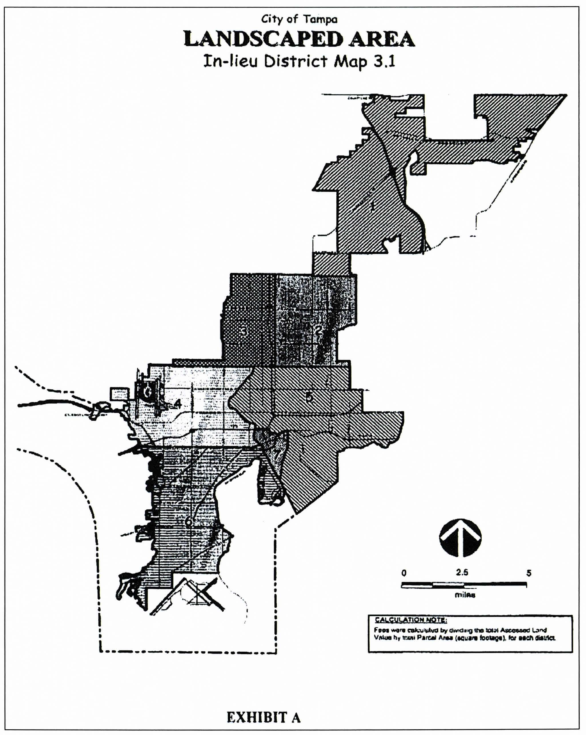
(Ord. No. 2019-54, § 33(Exh. A), 4-18-2019)
Sec. 27-284.4. - Tree mitigation method; requirements.
(a)
Mitigation purpose and intent; requirements generally.
(1)
In accordance with the Tampa Comprehensive Plan and the city's Urban Forest Management Plan, the following regulations are adopted to preserve and protect existing, healthy grand and protected trees in the city; and, where specific trees are determined to be "hazardous" in accordance with this subdivision, these regulations allow for the removal of such trees. Whether a grand or protected tree is approved for removal or removed, it is also the intent of these regulations to require mitigation for properly permitted removed trees and applicable penalties, fines, and mitigation for unauthorized removal, in order to preserve Tampa's urban forest canopy, thereby protecting the environment and enhancing the natural beauty of the city.
(2)
As a condition of the granting of a permit or the granting of approval, the applicant shall mitigate (i.e. "replace") protected trees ("non-grand" and "grand" trees) with payment to the applicable planning district tree trust fund, in accordance with sections 16-86 and 16-87 of the City Code, and the provisions of this section.
(b)
Relocation. Relocation shall be considered for grand trees only and shall be accomplished by relocating the tree(s) in accordance with the planting location options set forth in subsection (c) below. Relocation shall be made immediately, and not to exceed two (2) years after removal of the subject tree(s).
(c)
Replacement. Replacement shall be accomplished by planting the number of trees, by tree shape/type and size, as calculated for tree mitigation (refer to Table 284.4.1-A below). Replacement may occur on the lands or specified area described below, subject to applicable permissions and maintenance agreements:
(1)
On the subject property, as shown on the landscape/planting plan;
(2)
On any right(s)-of-way within the same planning district, with an approved planting plan and maintenance agreement, which covers the one (1) year period for tree(s) to establish, from the date of planting;
(3)
On any public land(s) within the same planning district, with an approved planting plan and maintenance agreement, which covers the one (1) year period for tree(s) to establish, from the date of planting;
(4)
On land(s) under the same ownership within the same planning district, with an approved planting plan and maintenance agreement, which covers the one-year period for tree(s) to establish, from the date of planting;
(5)
On other privately owned land(s) within the same planning district, with an approved planting plan and maintenance agreement, that covers the one year period for tree(s) to establish, from the date of planting, pursuant to an approved tree planting permit with affidavits acknowledging mitigation tree requirements, signed by the owner(s) of the subject property performing the mitigation and the owner(s) of the receiving property.
The owner(s) of the subject to property and the owner(s) of other privately-owned land on which a mitigation tree is planted shall be jointly and severally liable under the tree planting permit, as provided in section 27-284.4.2.
(d)
Payments made to planning district tree trust funds. Mitigating the permitted removal of non-exempt trees may also be accomplished by paying the value, as set by city council resolution (refer to section 16-87 of the City Code), of the required number of mitigation trees, which are calculated as the equivalent replacement of the crown footprint (refer to definition set forth in section 27-43 of the City Code) of the approved trees to be removed, to the applicable planning district tree trust fund (refer to section 16-86 of the City Code).
(1)
A credit shall be provided for purposes of payment for each square-foot of protected tree crown footprint (i.e. "non-grand"), as converted to an equivalent number of trees by caliper or gallon (refer to subsection (f) [Table 284.4.1-A]), pursuant to the 2017 State of Florida Grades and Standards for Nursery Plants;
(2)
A credit shall be provided for purposes of payment for each square-foot of grand tree crown footprint, as calculated from arboriculture-standard field measurement methods, rating the physical condition of the tree and identifying the corresponding Species Rating ("ISA-FL"), then converted to an equivalent number of trees by caliper or gallon (refer to (f) [Table 284.4.1-A]), pursuant to the 2017 State of Florida Grades and Standards for Nursery Plants and International Society of Arboriculture - Florida Chapter - 2016 Tree Species Rating List ("ISA-FL"), respectively.
(3)
A protected/grand tree shall not be mitigated through payment to the applicable trust fund, unless the minimum number of protected trees, grand trees, or tree equivalents are already located on the parcel or permitted to be planted according to the approved landscape/planting plan.
(Ord. No. 2019-54, § 33(Exh. A), 4-18-2019)
Sec. 27-284.4.1. - Tree mitigation calculations.
(a)
Tree equivalency credit for removal or replacement. In determining the number and size of trees that shall be used in the calculation of mitigation of the protected tree or grand tree, Table 284.4.1-A below shall be used.
(1)
All existing, non-exempt/non-grand tree species to be retained and/or removed shall be added to the Table 284.4.1-A below, by applicable tree type (Type 1, 2, 3, or Palm), as set forth in the 2017 State of Florida Grades and Standards for Nursery Plants.
(2)
All existing grand tree species to be retained and/or removed shall be added to the Table 284.4.1-A grand tree table below.
(3)
All resulting debits shall be replaced with tree species from the tree Type (i.e. 1, 2, 3, Palm). Palm trees shall be replaced one (1) for one (1), with any tree type (Type 1, 2, 3, or Palm), as set forth in the 2017 State of Florida Grades and Standards for Nursery Plants. Refer to Table 27-284.4.1-B for equivalency ratios between tree types.
(4)
At least sixty (60) percent of the replacement trees planted on a parcel shall be native trees.
(b)
Tree species for replacement. The species of tree that shall be used in the contribution or replacement of a protected tree or grand tree shall be any of those listed in City Tree Matrix, set forth in section 27-284.3.2 of the City Code.
(c)
Tree Type Equivalency.
(Ord. No. 2019-54, § 33(Exh. A), 4-18-2019)
Sec. 27-284.4.2. - Tree planting permit for mitigation trees.
(a)
Applicability. All trees planted, in those locations set forth in section 27-284.4(c)(2)—(5), as mitigation for removal shall be planted pursuant to a tree planting permit as provided in this section.
(b)
Minimum application submittal requirements. No permit shall be issued unless the party required to provide mitigation trees pursuant to section 27-284.4.1 (i.e. "mitigation party"), submits a written application to the city, in accordance with this section. An application for a tree planting permit shall be filed in the form and manner specified by the city, (such as in an electronic form acceptable to the city) and contain such information as may be required by the city, including, at a minimum, the information contained in this section. The city may require the applicant(s) to provide such additional information as the city deems necessary to complete its review of a requested permit. At a minimum, the applicant shall submit the following information in its application:
(1)
The name, address, electronic mail address, and phone number (cellular number if available) of the applicant who is requesting the permit;
(2)
Written evidence that the applicant has legal authority to place and maintain the tree(s) covered by the requested permit by deed and owner's affidavit (refer to subsection (c) below), other evidence of authority for placement in public rights-of-way or public lands;
(3)
The permit number for the tree removal that requires the mitigation tree(s) sought to be planted;
(4)
A description of the tree(s) sought to be planted, including each trees specie, shape, type, and size;
(5)
A scaled site plan or signed and sealed boundary/topographic survey graphically depicting:
a.
The location of each proposed tree planting scaled and in relation to the property boundaries;
b.
The location, name, classification, and right-of-way width of all right-of-way adjoining the property boundaries, including the location of any sidewalks;
c.
All overhead and underground utilities within thirty (30) feet of any proposed tree planting location;
d.
All existing structures or structures for which a building permit has been applied for within thirty (30) feet of any proposed tree planting location; and
e.
Any other trees within thirty (30) feet of any proposed tree planting location.
(6)
Photographs of the proposed tree planting location(s);
(7)
Acknowledgement of, and agreement to, the requirements of this section.
(c)
Owner's affidavit and receiving property owner liability. All owners of record of any non-public property receiving a mitigation tree shall join in and be an applicant on the tree planting application in addition to the mitigation party. All owners of record shall further sign a receiving property owner's affidavit that shall:
(1)
State the property by address and Hillsborough County Property Appraiser's Identification Number (PIN or Folio);
(2)
Affirm acceptance of a mitigation tree which shall, upon planting, be a protected tree that may not be removed except upon granting of a tree removal permit, which may or may not be granted, and mitigation performed in compliance with section 27-284.4.1;
(3)
Waive any future claims occasioned by the inability to remove the mitigation tree(s);
(4)
Affirm acceptance of and complete responsibility for any and all maintenance, care, replacement, and mitigation costs for the mitigation trees placed on the owner's property;
(5)
Affirm the risk of damage that may be caused by the tree or tree planting is the sole responsibility of the property owner(s); and
(6)
Acknowledges the following:
No owner nor mitigating person shall be excused from liability by reason of another party being responsible therefor. The responsibility of mitigation tree maintenance, care, and replacement shall run with the land the tree is planted on through the issuance of the tree planting permit.
(d)
Property included. A separate application must be submitted for each property for which mitigation tree planting is proposed. For purposes of this section, adjoining zoning lots of record under the same ownership shall be considered one (1) property. Each named right-of-way shall be considered a separate property.
(e)
Completeness. An incomplete tree planting application shall be rejected.
(f)
Processing. The city will notify the applicant of any additional information beyond the minimum application requirements. Upon acceptance by the city of a complete application, or receipt of additional information if additional information is required, the city shall review the application and render a decision on the proposed tree planting locations. The city shall notify the applicant of approval or denial of each location by electronic mail. If one or all of the locations are rejected, the city shall specify in writing the basis for rejection, including whether the tree specie, shape, or type was the basis for rejection.
(g)
Review criteria. The city shall approve a tree planting permit application once the application has demonstrated compliance with the following criteria:
(1)
Each tree species, shape, and type is appropriate, at maturity, in the proposed location;
(2)
Each tree, at maturity, in the proposed location is unlikely to interfere with above or underground utilities and meets the [reference TECO standard];
(3)
Each tree, in the proposed location, at time of planting and at its estimated maturity, shall not interfere with technical requirements, including interfering with ADA compliance or site triangle visibility (refer to section 27-283.5);
(4)
Each tree in the proposed location should not, at estimated maturity, interfere with existing structures or structures for which a building permit is requested;
(5)
Each tree in the proposed location should not, at maturity, interfere with existing structures or for which a building permit is requested;
(6)
All owners of record have signed the owner's affidavit in subsection (c) above.
The city shall deny a tree planting application if the application fails to comply with the criteria set forth above or other applicable codes.
(h)
Maintenance agreement, permit issuance, and final inspection. After approval of the tree planting locations, but prior to issuance of the permit, the owners of record and the mitigating party shall sign a one-year maintenance agreement. Upon issuance of the permit and planting of the mitigation tree(s), the applicant shall provide the city with either:
(1)
Evidence of adding each mitigation tree in its final location to the city's open source tree mapping system; or
(2)
The Global Positioning System (GPS) coordinates of the final location of each mitigation tree. The GPS coordinates shall be based on the reading from a handheld mobile GPS unit set to Datum NAD 83 or WGS84. GPS coordinates based on Google Earth or similar software application may be used where areas of shading occur due to overhead canopy. GPS Coordinates shall be provided in decimal degrees at a 6 decimal point precision.
The city shall perform a final inspection of the mitigation trees. Failure of the applicant to submit the addition of each tree to the city's tree mapping system or the GPS coordinates of each tree, prior to final inspection by the city, will cause the final inspection to be rescheduled, until such time as this required information is provided to the city. If such information is not provided to the city for verification and final inspection, the permit may be revoked and mitigation credit for the original site of tree removal may be affected.
After all mitigation trees pass the final inspection, the permit shall be closed and the mitigating party shall be relieved of mitigation liability, the mitigation trees thereafter being the responsibility of the receiving property owners.
(Ord. No. 2019-54, § 33(Exh. A), 4-18-2019)
Sec. 27-286. - Wetlands protection and buffer.
(a)
Generally. All development landward of a wetland shall be designed so as to minimize any adverse effect on the wetland and its hydroperiod and shall be conducted in a manner that will ensure that soil erosion or other discharge of contaminants will not occur to the detriment of the wetland.
(b)
Buffer. Impacts to wetlands associated with adjacent upland activities such as development shall not be considered adverse if appropriate erosion control and if buffers with a minimum width of fifteen (15) feet and an average width of twenty-five (25) feet is provided. Buffers shall remain in an undisturbed condition. No development is allowed within the buffer except as may be specifically allowed by the provisions of this section.
(c)
Partially exempt development. The following development is allowed and is exempt from the requirement of submitting an application for development as provided in subsection (d) herein:
(1)
Drainage features such as spreader swales and discharge structures, provided the construction or use of these features does not adversely impact wetlands and have been approved by the appropriate regulatory agency.
(2)
Development which has obtained a environmental resource permit (ERP) approved by the Southwest Florida Water Management District and/or the State Department of Environmental Protection.
(d)
Applications for development and determination of buffer. Any person proposing to conduct any of the following development within the landward twenty-five (25) feet of a wetland must first obtain approval by submitting an application for development within wetland buffer and determination of buffer to the PDD Department for review:
(1)
All development abutting seawalls constructed before the date of the passing of this chapter occurring within the corporate city limits including the urban core along the Hillsborough River (from North Boulevard continuing to the Garrison Channel) with the exception of land annexed after 1984 and the remainder of the Hillsborough River corridor;
(2)
All above ground structures within the landward twenty-five (25) feet of the jurisdictional line for all properties abutting open waters including Hillsborough Bay, Old Tampa Bay, McKay Bay, and the Hillsborough River, after the design and placement have been approved by the appropriate regulatory agency;
(3)
Construction of boardwalks;
(4)
Ancillary stilted structures within the landward twenty-five (25) feet;
(5)
Utility lines requiring excavations of no more than an eighteen-inch width within the landward twenty-five (25) feet of the jurisdictional line or within an existing right-of-way that is adjacent to the wetland;
(6)
Underground installation of sprinkler systems;
(7)
Replacement of existing vegetation with native vegetation; and
(8)
Chain link or wooden privacy fences.
(e)
Protection of buffer area during development. Adequate erosion control devices shall be in place and maintained at a line established by the PDD Department as necessary to achieve the objectives and standards contained in subsections (a) and (b). In no event shall such line be less than fifteen (15) feet landward of the wetland boundary or less than the approved buffer line as determined by the appropriate regulatory agency. Natural vegetation within the wetland buffer shall remain intact and undisturbed. In cases of approved development within the wetland buffer, the natural vegetation shall remain intact until installation of the approved development begins.
(f)
Finish grading. Notice shall be provided to the PDD Department within twenty-four (24) hours of commencing any approved finish grading within the buffer area. Adequate erosion control measures will be implemented to protect the wetland during the finish grading process and until the area has revegetated. Graded areas shall be stabilized by sodding or the planting of landscape vegetation within three (3) days of the grading activity or, where seeding is intended, artificial stabilization shall be immediately implemented in conjunction with silt barriers.
(g)
Performance security. Any person may be required as a condition to any granted variance to the wetland buffer to submit security in an amount acceptable to the director and in the form of a performance bond, irrevocable letter of credit or escrow agreement to the director when necessary to guarantee and which guarantees for up to two (2) years after completion that the development or other activity will not cause erosion or sedimentation into or other detriment to the wetland and that the provisions of this subdivision and any rules and regulations promulgated hereunder will be followed. In drawing against the performance bond or letter of credit, the director shall consult with the county environmental protection commission, the Southwest Florida Water Management District, the state department of environmental protection or other appropriate regulatory agency.
(h)
Environmental consultants. In reviewing an application to determine a buffer or to develop within a wetland buffer, the PDD Department may hire up to two (2) environmental consultants to assist with determining whether the proposed development or other activity will significantly affect the biological integrity or hydrology of the wetland. The reasonable fees and costs of such consultant(s) shall be paid by the applicant.
(i)
Any person may appeal a decision of any administrator, director, official or staff member on his application pursuant to the provisions of section 13-91, Appeal method.
(j)
Variance within fifteen feet of wetland jurisdictional line. A variance to the provisions of this section which affects the fifteen (15) feet of the buffer abutting a wetland jurisdictional line shall be allowed only under circumstances where reasonable use is denied and approval for the development has been obtained by the appropriate regulatory agency.
(k)
In addition to the requirements set forth in subsections (a) and (b) and submission of security in a form and amount acceptable to the P&D Department, where applicable, any development for which a development order has been granted subject to conditions which more strictly limit allowable activities within the wetland buffer or the thirty-foot setback than those allowable under subsection (d) herein shall remain limited by the conditions of the development order approval.
Cross reference— Stormwater management, Ch. 21.
Sec. 27-287. - Purpose and legislative intent.
The decision by the owner about whether and how to develop a parcel of land, and the decision by the City of Tampa to approve or disapprove proposed development, may depend on the impact that the proposed development will have on natural resources, upland habitat and public facilities. This article establishes standards and procedures by which these impacts will be determined, and by which the City of Tampa will approve or disapprove the development in light of such impacts.
In the City of Tampa, most of the original upland wildlife habitat has been replaced with urban or suburban development. The remaining upland habitat is comprised of xeric and mesic natural plant communities that are either uncommon, scarce, occur in very restricted geographic areas, or have few high quality sites remaining. Protection of those xeric and mesic habitats which constitute significant wildlife habitat is necessary to retain remaining habitat diversity and wildlife corridors and to maintain healthy and diverse populations of wildlife.
(1)
Purpose. The purpose of the Upland Habitat Protection Ordinance is to set forth regulations for the protection of the few high quality xeric and mesic natural plant communities and wildlife habitat which remain in the City of Tampa, and for the protection of remaining large contiguous environmentally sensitive areas, in order to retain habitat diversity and wildlife corridors and to maintain the quality of life in the City of Tampa and protect the health, safety, welfare and general well being of the citizens of the City of Tampa.
(2)
Intent. It is intended that the implementation of these regulations accomplish the following objectives:
a.
Maximize the retention of existing xeric and mesic natural plant communities which constitute significant wildlife habitat and upland habitat for threatened and endangered plant and wildlife species and species of special concern, a valuable natural resource of the community.
b.
Create an aesthetically pleasing and functional living environment to protect and enhance property values by conserving remaining scarce xeric and mesic natural plant communities.
c.
Protect remaining large contiguous environmentally sensitive areas from activities which would alter their ecological integrity, balance or character.
d.
Protect surface water flow and promote soil conservation by controlling filling activities and changes in drainage patterns.
e.
Ensure compliance with Chapter 163, Florida Statutes, and the City of Tampa Comprehensive Plan.
f.
Ensure that owners and/or developers of property containing areas designated as significant or essential wildlife habitat shall not be unconstitutionally deprived of their property nor be inordinately burdened by the application of these regulations in violation of Fla. Stat. § 70.01; in furtherance thereof, it is the intent of the City of Tampa to provide alternative mechanisms, such as off-site preservation, to achieve the purposes of these regulations while at the same time respecting the rights of the property owners as set forth herein.
g.
Article II, Section 7 of the Florida Constitution provides that it shall be the policy of the state to conserve and protect its natural resources and scenic beauty, and that, effective July 1, 1999, adequate provision shall be made by law for the conservation and protection of natural resources.
Sec. 27-287.1. - Administrative authority.
The provisions of this article shall be administered and enforced by the department. For purposes of administration of the provisions of this article, the department's designee shall be the natural resources coordinator.
(Ord. No. 2020-166, § 48, 12-17-2020)
Sec. 27-287.2. - Administrative guidelines.
The city may adopt administrative guidelines in the form of rules of procedure and regulations for the administration and enforcement of this article. Such rules and regulations, if developed, shall be contained in the Upland Habitat Development Review Manual.
Sec. 27-287.3. - Upland habitat overlay district established; applicability.
(a)
Upland habitat overlay district established; boundaries. The upland habitat overlay district is hereby established as a separate district. The boundaries of the district are shown on the City of Tampa's Upland Habitat Protection Map, dated May 18, 1999, on file in the office of the city clerk, which map is herein adopted by reference. The boundaries of the upland habitat overlay district are more specifically described as follows:
That portion of the jurisdictional limits of the City of Tampa, as they now or may hereafter exist, lying north of Fletcher Avenue.
(b)
Applicability. The provisions of this article shall apply to all buildings, improvements and land within the upland habitat overlay district, unless they are expressly exempted by law, or as provided herein. Before the city issues an approval for a development of regional impact ("DRI"), rezoning, subdivision approval, or a site or building permit for any development on a parcel within the upland habitat overlay district, the development on the parcel shall have an approved upland habitat plan as required pursuant to this article.
Whenever the city annexes any parcel or property, the annexed area shall undergo review for a determination of existence of significant or essential upland wildlife habitat pursuant to the procedure set forth in section 27-287.11(b)(4).
(c)
Other regulations. Nothing in this article is intended to alter or pre-empt any other applicable regulations of the federal, state or county as they may apply within or outside the upland habitat overlay district. Specifically, all federal or state regulations regarding protection of wildlife or plant species essential habitat shall apply throughout the jurisdictional limits of the City of Tampa notwithstanding this article. Further, the regulations set forth in this article shall be in addition to the regulations set forth in this chapter regarding landscaping, tree removal, site clearing and wetland protections and setbacks.
(Ord. No. 2020-166, § 49, 12-17-2020)
Sec. 27-287.4. - Upland habitat plan approval; requirements; exemptions.
(a)
Plan approval required. Except as specifically exempted herein, no person shall commence any site clearing, land alteration, or receive a development approval or building permit for any development on a parcel within the upland habitat overlay district meeting the criteria outlined in sections 27-287.11 through 27-287.15 until an upland habitat plan is approved by the coordinator in accordance with this article to ensure such activity does not harm any significant or essential wildlife habitat on that parcel. In instances where phased development is to occur pursuant to the terms of the city zoning code or ordinance, a person shall apply to the coordinator for approval of an upland habitat plan which addresses all phases of said development, prior to permitting and development of the initial phase of the development.
Further, it shall be unlawful for any person, firm or corporation, either individually or through an agent to allow a condition which is the result of unauthorized land alteration activity to remain unremedied. The property owner at the time a violation is discovered may be held responsible for remedying said violation pursuant hereto.
(b)
Effect of plan approval. Issuance of upland habitat plan approval by the coordinator, or exemption from the requirement thereof, does not abrogate any legal requirement to comply with the regulations of any other governmental agency, local, state or federal, which may have jurisdiction over the proposed activity upon the land.
(c)
Exemptions. The following are exempt from this section:
(1)
A parcel within the upland habitat overlay district that has had a field verification conducted by the coordinator that has determined that no significant or essential upland wildlife habitat, as outlined in sections 27-287.11, 27-287.12; or listed wildlife or plant species as listed in Appendix C, occurs on the parcel.
(2)
The terms of sections 27-287.10 through 27-287.15 pertaining to uplands providing significant and essential wildlife habitat, shall not apply to the following activities:
a.
Land alteration activities for development improvements pursuant to a subdivision preliminary plat and subdivision construction plans which were approved prior to the effective date of this ordinance;
b.
Land alteration activities for development improvements pursuant to a final, unexpired DRI (development of regional impact) or FQD (Florida Quality Development) development order which was approved prior to the adoption of this ordinance. Further, any amendment to such DRI or FQD development order which does not constitute a "substantial deviation" pursuant to Florida Statutes Chapter 380.06, shall be exempt. Provided further, any amendment to a DRI or FQD development order which constitutes a "substantial deviation" pursuant to Florida Statutes Chapter 380.06, but which does not directly relate to, nor substantially increase any impact to, significant or essential wildlife habitat as defined herein, shall also be exempt;
c.
Land alteration activities for development improvements pursuant to a final, unexpired commercial site plan which was approved prior to the adoption of this ordinance, or pursuant to a PD or PD-A rezoning (that is not "expired" under the conditions outlined under section 27-138) which was approved prior to the adoption of this ordinance;
d.
Land alteration activities for development improvements to a single-family residential lot in single lot ownership. This exemption shall not apply to a developer or owner of several lots in a subdivision or development which may be developed in a singular manner.
(d)
Exemption determination. The legal determination as to whether a development, project or parcel is exempt under the provisions above, shall be determined by the city attorney, upon consultation with the coordinator.
Sec. 27-287.5. - Plan approval application; review; approval and denial; prerequisites; conditions.
(a)
Submission. Before any person legally entitled to apply for and receive plan approval under the provisions hereof, they shall submit to the city a proposed upland habitat site plan for the entire parcel.
(b)
Application. Any person legally entitled to apply for and receive plan approval under the provisions of this article shall make such application in writing to the coordinator on forms provided for that purpose. Every applicant for plan approval shall give a description of the character of the work proposed to be done and the location, ownership, occupancy and use of the premises in connection therewith. The coordinator shall require plans, specifications or drawings and such other information as necessary and pertinent prior to the granting of plan approval. The application for a upland habitat plan approval shall identify the plans, specifications or drawings necessary and pertinent for plan review. If necessary, the coordinator may develop an upland habitat development review manual which may further identify and explain the information required to review the application.
(c)
Review of application. An upland habitat plan shall be applied for and reviewed subject to the following:
(1)
For any parcel containing a wetland or natural body of water, no plan approval shall be issued until the application has also been reviewed and wetland jurisdictional lines established by the EPC or other appropriate governmental agency. The applicant shall transmit a copy of an application to the EPC for review when the coordinator receives a complete application and determines, with the aid of the United States Department of Agriculture, Soil Conservation Services's "Soil Survey of Hillsborough County, Florida", an on-site inspection, or an aerial photograph, that a wetland or natural body of water potentially exists on the site or immediately adjacent to the site for which plan approval is requested.
(2)
To review an application, the coordinator and, when appropriate, the EPC, shall conduct on-site inspections.
(d)
Decision on the application. Within thirty (30) days of receipt of a complete application, the coordinator shall approve, approve with conditions, or deny or disapprove an upland habitat plan based upon whether the proposal is in compliance with the upland habitat regulations set forth herein and is necessary for one (1) or more of the following reasons:
(1)
To construct improvements consistent with approved development or permitted physical use of a lot or parcel pursuant to the requirements of the City Code.
(2)
For access to a lot or parcel or construction equipment access to and immediately around proposed structures or other improvements.
(3)
For essential grade changes or essential surface water drainage or utility installations.
(4)
To comply with other ordinances, regulations, or codes of the City of Tampa.
(5)
For the welfare of the general public for reasons other than those set forth above.
In the event the upland habitat plan is denied or disapproved, the coordinator, upon making such determination, shall notify the applicant in writing stating specifically the reasons for denial.
(e)
Prerequisites to plan approval.
(1)
A site clearing permit, if required, shall not be issued until the coordinator has issued a upland habitat plan approval, if required.
(f)
Conditions of the plan approval.
(1)
A copy of the upland habitat plan approval shall be posted on-site during land alteration activities.
(2)
Upon issuance of upland habitat plan approval, protective barriers shall be erected around all vegetation to be preserved. Protective barriers shall remain in place until land alteration and construction activities are completed, or until commencement of grade finishing and sodding.
(3)
An approved management plan agreement pursuant to section 27-287.14(b).
(4)
The coordinator may conduct periodic inspections of the site to determine compliance with the upland habitat plan approval.
(5)
No certificate of occupancy, if required, shall be issued until the coordinator has determined upon final inspection that the land alteration activity was undertaken according to the approved upland habitat plan, if required.
(6)
Any plant material planted in accordance with these regulations shall be replaced by the property owner according to the approved management plan agreement.
(7)
A upland habitat plan approval issued in conjunction with a site clearing permit or grade and fill permit for a subdivision project shall limit land alteration activities to approved fill areas, road rights-of-way, and drainage and utility easements and rights-of-way, unless otherwise authorized. A separate site clearing permit may be required to undertake land alteration activity on individual subdivision lots containing trees or other vegetation.
Sec. 27-287.6. - Plan approval duration and extension.
An upland habitat plan approval shall be effective for a period of two (2) years after issuance unless otherwise specified on the approved plan. Each upland habitat plan approval shall provide that the requested development shall commence within two (2) years from the date of issuance of the plan approval, or shall have the same duration as the approved rezoning or approved DRI of which it is a part. If development is delayed and the plan is not part of a rezoning or DRI approval, a two (2) year plan approval extension may be granted by the coordinator within thirty (30) days after receipt of a written request indicating why an extension is necessary and upon the coordinator's review of the project's work schedule and progress. The plan approval shall expire and become null and void at the end of this period if the development authorized has not commenced. Any plan approval not acted upon within the prescribed time limit shall become void and future work shall require a new application.
Sec. 27-287.7. - Plan approval transferability.
A plan approval shall be transferable from one (1) person or entity to another subject to any restrictions provided for in Chapter 5 of the City Code.
Sec. 27-287.8. - Inspections.
Any activities regulated by this article shall be subject to inspection by the city. The coordinator may require documents, drawings or certificates necessary to effect compliance with this article.
Cross reference— Inspections generally, § 1-27.
Sec. 27-287.9. - Plan approval fees—City council to establish.
The city council shall have the authority to set fees by resolution. Fees may be charged for the following:
(1)
Plan approval application;
(2)
Reinspection.
Sec. 27-287.10. - Environmentally sensitive areas—Uplands providing significant and essential wildlife habitat; general provisions.
(a)
Sections 27-287.11 through 27-287.15 provide standards and guidelines for the protection of upland significant wildlife habitat, generally, as well as upland habitat for endangered and threatened species and species of special concern, (i.e., upland essential wildlife habitat).
(b)
On-site preservation shall be considered the most desirable alternative to protect upland habitat and plant and wildlife species. However, in some cases as specified in these regulations and determined by the coordinator in cooperation with the Florida Game and Freshwater Fish Commission and, when appropriate, the U.S. Fish and Wildlife Service, the protection of upland wildlife habitat or upland habitat for endangered or threatened species or species of special concern will be best accomplished through off-site preservation.
(c)
Natural upland areas within a proposed development project shall count toward meeting the requirements for on-site preservation only when such natural areas meet the applicable on-site preservation criteria.
(d)
When, as a result of applicability of multiple federal, state or local regulations, multiple off-site acreage preservation requirements are applicable to the same on-site habitat, only the requirement which prescribes the largest amount of preservation acreage for that habitat shall apply.
(e)
Nothing in these sections shall limit the ability of the city staff to address other resource issues in the upland portions of a proposed development project for which standards are contained in this Code.
Sec. 27-287.11. - Environmentally sensitive areas—Upland significant wildlife habitat.
(a)
In the City of Tampa, most of the original upland wildlife habitat has been replaced with urban or suburban development. The remaining upland habitat is comprised of xeric and mesic natural plant communities which are either uncommon, scarce, occur in very restricted geographic areas, or have few high quality sites remaining. Protection of those xeric and mesic habitats which constitute significant wildlife habitat is necessary to retain habitat diversity and wildlife corridors and to maintain healthy and diverse populations of wildlife.
(b)
Identification of upland significant wildlife habitat; annexed areas.
(1)
Uplands which potentially constitute significant wildlife habitat are those natural plant communities listed as xeric or mesic habitats in this section and mapped on the City of Tampa's Significant Wildlife Habitat Map as significant wildlife habitat. The City's Significant Wildlife Habitat Map, dated May 18, 1999, on file in the office of the city clerk, is herein adopted by reference. The city's significant wildlife habitat map was derived from the Hillsborough County Significant Wildlife Map as it applies to the City's Upland Habitat Overlay District area.
(2)
Xeric habitats are:
Sandhill
Sand Pine Scrub
Xeric Oak Scrub
Scrubby Flatwoods
Xeric Hammock
(3)
Mesic habitats are:
Dry Prairie
Pine Flatwoods
Mesic Hammock
(4)
Whenever property is annexed into the city and the coordinator determines that the area meets the significant wildlife habitat definition and size/width criteria as described in the significant wildlife habitat guidelines of Appendix A, or if the coordinator determines that a previously unmapped area meets the significant wildlife habitat definition and size/width criteria as described in the significant wildlife habitat guidelines of the Appendix A, the coordinator shall notify affected property owners of the public hearing at which the city council shall consider amending the upland habitat protection map to designate the area as land which potentially constitutes significant wildlife habitat. If a property owner desires to have their property added to the City of Tampa's Upland Habitat Protection Map either because it: (a) meets the significant wildlife habitat guidelines minimum size criteria described in Appendix A, or (b) is contiguous to mapped significant wildlife habitat, they may request a site inspection by submitting a request to the coordinator.
(5)
Determination of the existence, type, and extent of any upland significant wildlife habitat shall be made by the coordinator by conducting an evaluation upon request, or upon submission of an application for development, such as a DRI, rezoning, or permit. This determination shall be refutable upon a showing of clear and convincing evidence to the contrary.
(c)
Protection of upland significant wildlife habitat.
(1)
The developer shall protect xeric and mesic habitats which constitute significant wildlife habitat. Protection of xeric habitat shall consist of preservation of all xeric habitat acreage existing on the property, up to and including fifty (50) percent of the upland area on-site. Preservation of mesic habitat shall consist of preservation of all mesic habitat acreage existing on the property, up to and including twenty-five (25) percent of the upland area on-site. However, in no case shall the preservation requirement exceed fifty (50) percent of the upland area on-site. If the application of the provisions of this paragraph would prevent the construction, operation, or maintenance of a utility corridor, the preservation requirements of this paragraph shall be adjusted the minimum amount necessary to accommodate such activities, provided such activities are designed and conducted in a manner to minimize their adverse impacts to significant wildlife habitat.
(2)
Preservation of significant wildlife habitat shall be required where necessary to prevent fragmentation of a wildlife corridor. Significant wildlife habitat guidelines, as set forth in the Appendix A, shall be used as a guide for identifying wildlife corridors. The factors to consider when determining minimum corridor widths described in the Appendix A, shall be used as a basis for determining the area of significant wildlife habitat to preserve to prevent fragmentation of a wildlife corridor.
(3)
New road rights-of-way shall be routed to avoid traversing significant wildlife habitat, unless there is no reasonably feasible and prudent design alternative, and the proposed alternative roadway design incorporates design features for the safe passage of wildlife, as described in (5), below.
(4)
Improvements to existing roads (i.e., road reconstruction or widening) within significant wildlife habitat shall incorporate design features for the safe passage of wildlife, as described in (5), below.
(5)
Design features for the safe passage of wildlife shall be appropriate for the wildlife species expected to utilize the crossing and shall be designed in accordance with the recommendations of the Florida Game and Freshwater Fish Commission.
(6)
Xeric and mesic habitats to be preserved shall meet the on-site preservation provisions of section 27-287.14.
(7)
On-site preservation shall be recommended only when sufficient management capabilities exist to maintain or restore the habitat to a high quality natural plant community or communities, in accordance with the habitat management guidelines set forth in Appendix B. The coordinator may consider financial impacts in determining whether sufficient management capabilities exist, however, that consideration alone is not sufficient to support a negative determination of feasibility of on-site management capabilities or to justify off-site preservation. The coordinator's determination of the feasibility of on-site management shall be refutable upon a showing of clear and convincing evidence to the contrary.
(8)
When the amount of significant wildlife habitat to be preserved on-site cannot be sufficiently managed, protection shall consist of preservation off-site of habitat acreage equal to the amount of habitat that would have been preserved on-site according to (1) above, and shall meet the off-site preservation provisions of section 27-287.15.
(9)
Notwithstanding a recommendation by the coordinator for on-site preservation, the developer may elect to mitigate for the development's impact to significant wildlife habitat through off-site preservation. In such instance, there will be a net loss of manageable significant wildlife habitat or a viable population of plant species, therefore in addition to all other off-site preservation provisions set forth in section 27-287.15, the following criteria shall be met in lieu of section 27-287.15(a)(1):
a.
The off-site preservation-site shall be degraded lands (i.e., non-significant wildlife habitat), or lands which are the type land, but not the minimum size, set forth in Appendix A; and
b.
The off-site preservation-site shall be of the same general soil type (xeric or mesic) of the significant wildlife habitat existing on-site.
Sec. 27-287.12. - Environmentally sensitive areas—Upland essential wildlife habitat.
(a)
Intent and general provision.
(1)
This section provides standards and guidelines for the protection of upland habitat for populations of endangered and threatened species and species of special concern in the City of Tampa. It is intended that implementation of the provisions in this section preserve upland essential wildlife habitat based on the listed species' habitat needs, in order to maintain viable populations of the listed species.
(2)
New road rights-of-way shall be routed to avoid traversing essential wildlife habitat, unless there is no feasible and prudent alternative and the roadway design incorporates design features for the safe passage of wildlife. Design features for wildlife crossings shall be appropriate for the wildlife species expected to utilize the crossing and shall be designed in accordance with the recommendations of the Florida Game and Freshwater Fish Commission.
(b)
Listed animal species.
(1)
When a listed animal species' essential habitat occurs on-site, the developer shall protect the habitat by locating and designing proposed improvements to ensure no adverse impact to a viable population, nesting pair, or nesting colony which would prevent such population, nesting pair, or nesting colony from being maintained on-site, based on the listed species guidelines in Appendix C. However, it is not the intent of this provision to preclude all reasonable use of a lot or parcel consistent with this Code.
(2)
The coordinator shall presume that a listed animal species' essential habitat occurs on-site whenever a listed animal species has been previously documented on-site; or, upon evaluation of the property, the Coordinator determines that the land by itself, or in combination with off-site lands, meets the minimum habitat needs for a viable population of a listed animal species, as specified in the listed species guidelines in the Appendix C; or, upon conducting an on-site inspection of the property, the coordinator observes evidence of a listed animal species on the property. This presumption shall be refutable upon a showing of clear and convincing evidence to the contrary.
(3)
Protection of a listed animal species' essential habitat shall consist of on-site preservation of the habitat, based on the listed animal species' habitat needs as specified in the listed species guidelines in the Appendix C, and shall meet the on-site preservation provisions of section 27-287.14.
(4)
On-site preservation shall be recommended only when the site is supporting by itself, or in combination with off-site lands, a viable population, nesting pair, or nesting colony of a listed animal species and sufficient management capabilities exist to manage the habitat to maintain the viable population, nesting pair, or nesting colony of the listed animal species. The coordinator's determination of a viable population of a listed animal species and the feasibility of on-site management of the listed species essential habitat shall be refutable upon a showing of clear and convincing evidence to the contrary.
(5)
When the amount of essential wildlife habitat to be preserved on-site cannot be sufficiently managed, protection shall consist of preservation off-site and shall meet the off-site preservation provisions of section 27-287.15.
(6)
Notwithstanding a recommendation by the coordinator for on-site preservation, the developer may elect to mitigate for his/her impact to essential wildlife habitat through off-site preservation. In such instance, there will be a net loss of manageable essential wildlife habitat, therefore in addition to all other off-site preservation provisions set forth in section 27-287.15, the following criteria shall be met in lieu of section 27-287.15(a)(1):
a.
The off-site preservation-site shall be degraded lands (i.e., non-significant wildlife habitat), or lands which are the type land, but not the minimum size, set forth in Appendix A; and
b.
The off-site preservation-site shall be of the same general soil type (xeric or mesic) of the essential wildlife habitat existing on-site.
(7)
The listed animal species covered by these provisions are listed in the listed species guidelines in Appendix C.
(c)
Listed plant species.
(1)
When a listed plant species' essential habitat occurs on-site, the developer shall protect the habitat of the listed plant species by locating and designing proposed improvements to maintain the plants on-site, based on the listed species guidelines set forth in the Appendix C. However, it is not the intent of this provision to preclude the reasonable use of a lot or parcel consistent with this Code.
(2)
The coordinator shall presume that a listed plant species' essential habitat occurs on-site whenever a listed plant species has been previously documented on-site; or, upon conducting an on-site inspection, the coordinator observes a listed plant species on the property. This presumption shall be refutable upon a showing of clear and convincing evidence to the contrary.
(3)
Protection of a listed plant species' essential habitat shall consist of on-site preservation of the plants, based on the listed plant species' habitat needs set forth in the listed species guidelines in the Appendix C, and shall meet the on-site preservation provisions of section 27-287.14.
(4)
On-site preservation shall be recommended only when sufficient management capabilities exist to maintain the plants on-site. The coordinator's determination of the feasibility of on-site management shall be refutable upon a showing of clear and convincing evidence to the contrary.
(5)
When the amount of essential wildlife habitat to be preserved on-site cannot be sufficiently managed, protection shall consist of preservation off-site, and shall meet the off-site preservation provisions of section 27-287.15.
(6)
Notwithstanding a recommendation by the coordinator for on-site preservation, the developer may elect to mitigate for his/her impact to listed plant species' essential habitat through off-site preservation. In such instance, there will be a net loss of manageable listed plant species' essential habitat, therefore in addition to all other off-site preservation provisions set forth in section 27-287.15, the following criteria shall be met in lieu of section 27-287.15(a)(1):
a.
The off-site preservation-site shall be degraded lands (i.e., non-significant wildlife habitat), or lands which are the type land, but not the minimum size, set forth in Appendix A; and
b.
The off-site preservation-site shall be of the same general soil type (xeric or mesic) of the listed plant species' essential habitat existing on-site.
(7)
The listed plant species covered by these provisions are listed in the listed species guidelines in Appendix C.
Sec. 27-287.13. - Natural preserves.
(a)
Land owned by the public or by a non-profit land conservation organization and held for natural preservation purposes shall be protected from any adjacent development that would adversely impact the lands or interfere with the stated habitat management and conservation use objectives of that property, including prescribed burning.
(b)
For development proposed adjacent to a publicly owned natural preserve, compatibility shall be ensured through a project compatibility plan, reviewed and commented upon by the agency managing the publicly owned lands and required as a condition of granting an upland habitat plan approval. The project compatibility plan shall be proposed by the developer and approved by the managing agency during the development review process. The preparation of a project compatibility plan should be a cooperative effort between the agency managing the publicly owned land and the developer of the adjacent property.
(c)
For development proposed adjacent to a private, nonprofit natural preserve, compatibility shall be ensured through a project compatibility plan, reviewed and approved by the coordinator and required as a condition of granting the upland habitat plan approval. In its review of the project compatibility plan, the coordinator shall consider the recommendations of the private, non-profit conservation organization holding title to the land. The project compatibility plan shall be proposed by the developer and approved during the development review process. The preparation of a project compatibility plan should be a cooperative effort between the nonprofit conservation organization holding title to the natural preserve and the developer of the adjacent property.
Sec. 27-287.14. - On-site preservation.
(a)
Site selection. Where alternative on-site preservation-sites exist within a development, the site or sites selected for on-site preservation shall be the best suited to likely maintain a viable population or natural plant community(ies). The selection shall be based upon the following:
(1)
Protectability and manageability of the site;
(2)
The size and shape of the site. Emphasis should be on not creating enclaves of development or areas fragmented by development; and, as specified in the significant wildlife habitat guidelines set forth in Appendix A and listed species guidelines set forth in Appendix C, on providing, where appropriate, adequate buffers from the secondary impacts of development and adequate wildlife corridors;
(3)
The contiguity of the site with significant or essential wildlife habitat off-site;
(4)
The existing species population sizes at the site;
(5)
The life history requirements of the species involved;
(6)
The proximity and accessibility of the site to other populations of the same species; and
(7)
The compatibility of preservation of the site with adjacent land uses.
(b)
Preservation methods.
(1)
On-site preservation, including the establishment of any required buffers, shall be accomplished through the designation of the preserved areas as conservation area or preservation area, as appropriate, on all development plans and plats. (See definition of environmentally sensitive areas.)
(2)
Additionally, the applicant shall submit, or request the coordinator to assist in the preparation of a management plan agreement for the area to be preserved. The management plan agreement shall ensure the continued, adequate and appropriate management of the site and the continued protection of the site from adverse impacts, including the secondary impacts of development, in accordance with the habitat management guidelines in Appendix B or listed species guidelines in Appendix C. The management plan agreement shall designate management responsibility, including a proposed funding mechanism if management of the area to be preserved will be the responsibility of a homeowner's association. Habitat management shall be the landowner's responsibility, or the responsibility of the City of Tampa or of any other land conservation agency or organization that accepts the responsibility in lieu of the landowner. The management plan agreement shall be reviewed and approved prior to the issuance of an upland habitat plan approval.
(3)
A landowner may request the City of Tampa, or a non-profit land conservation agency or organization, accept a transfer of title (by sale or donation) for the preserved area or a dedication of a conservation easement over the preserved area provided that any conservation easement offered by the landowner meets the requirements of Section 704.06, Florida Statutes.
Sec. 27-287.15. - Off-site preservation.
The off-site preservation requirement may be fulfilled either directly by preserving land off-site or indirectly by contributing to an off-site conservation fund, as provided below.
(1)
In-kind preservation.
a.
Off-site significant wildlife habitat preservation-sites, pursuant to the requirements of section 27-287.11, shall be predominantly (i) the same type of habitat or, (ii) land which can be restored to the same type of habitat as the natural plant community being adversely impacted on-site by development.
b.
Off-site preservation-sites for listed species shall be biologically manageable and appropriate habitat for the wildlife or plant species requiring protection or land which can be restored to such habitat. An off-site preservation-site shall be acre-for-acre compensation for the essential wildlife habitat being adversely impacted on-site by development.
c.
If jurisdictional wetlands are acquired incidentally to uplands acquisition, such wetland acreage shall be counted towards the off-site preservation acreage requirements provided such wetlands do not constitute more than fifteen (15) percent of the total off-site preservation acreage requirement.
(2)
Site selection.
a.
The location of off-site preservation-sites shall be within the City of Tampa or Hillsborough County.
b.
Off-site preservation-sites shall meet all appropriate acquisition, preservation, restoration, habitat suitability, manageability, size, and other provisions of this section. Such lands shall be (1) sites composed of additions of land to existing publicly managed areas held for conservation purposes, such as city, state or county parks or preserves, or (2) other suitable sites recommended for preservation or restoration by a state or local governmental land conservation agency. Alternatively, the developer may propose another site within an ecosystem, watershed or river basin in proximity to the habitat being adversely impacted on-site by development. The alternative site shall be subject to review and approval pursuant to the criteria in this section.
c.
In determining whether the selection of a particular off-site preservation-site is appropriate, the coordinator shall consider the overall habitat suitability or restoration suitability, if applicable; the life history requirements of any species being protected; the protectability of the site; the manageability of the site; the size of the site; and recommendations concerning the site from the Florida Game and Freshwater Fish Commission and other appropriate agencies.
d.
When the off-site preservation requirements apply to a listed species' essential habitat, priority shall be given to selecting a site which can be restored to support the listed species.
(3)
Preservation methods.
a.
Off-site preservation-sites shall be for the purpose of restoring (if applicable), preserving, and maintaining natural areas in perpetuity.
b.
The developer shall meet the off-site preservation acreage requirement through one (1) of the following methods:
1.
Land acquisition. The developer shall acquire, at its sole cost and expense, fee simple title or a conservation easement (in accordance with Fla. Stat. § 704.06) and shall transfer or convey such title or easement of an appropriate off-site preservation-site to a governmental agency or non-profit land conservation agency or organization.
(i)
If a conservation easement is acquired and transferred, a management plan shall be developed in cooperation with the landowner which stipulates the limitation on the use of the land and identifies the habitat management activities, restoration activities and assignments of responsibility. All easements shall reference the management plan.
(ii)
If fee simple title is acquired and transferred, a management plan shall developed which stipulates the management and restoration activities and assignments of responsibilities.
2.
Contribution to an off-site conservation fund. The developer may contribute, on a per acre basis, to an off-site conservation fund based upon the off-site conservation fund's actual cost of acquiring in-kind preservation lands, plus cost of restoration, if any, plus estimated total cost of management during the life of the off-site conservation fund, divided by applicable acreage, multiplied by the carrying costs.
(4)
Timing. The upland habitat plan approval shall specify the acreage and location of the off-site preservation-site, the cost and timing of any monetary contributions or off-site acquisitions, the ownership and party responsible for management of the off-site preservation-site, the location of any on-site development, including land alteration and construction activities; and shall contain a requirement that any significant or essential wildlife habitat on the project site, for which off-site preservation is being provided, shall not be disturbed or adversely impacted prior to meeting the off-site preservation requirements.
Sec. 27-287.16. - Inventory.
The coordinator shall forward documentation to the planning division identifying all lands preserved under this article for purposes of maintaining an inventory and record of lands meeting the requirements prescribed those sections in regard to policies in the comprehensive plan.
(Ord. No. 99-141, § 1, 6-24-99)
Sec. 27-287.17. - Penalty restoration fund.
(a)
Purpose. The purpose of the penalty restoration fund is to provide an alternative to the on-site restoration of trees or other vegetation which have been removed from a site. Funds received through the penalty restoration fund shall be administered by the coordinator and shall be utilized for acquiring, planting, protecting, and maintaining upland habitat and other vegetation for public purposes within the City of Tampa. Monies contributed may be used to establish matching fund programs. The coordinator shall coordinate the collection and disbursement of funds in accordance with the provisions of this section.
(b)
Source of funds. Penalty restoration fund monies may consist of the following:
(1)
All monies collected pursuant to the penalties outlined in section 27-287.22(d) for violations of sections of this article.
(2)
All monies accruing as interest to the penalty restoration fund, unless otherwise restricted by specific terms and conditions identified by a particular grant, gift, or other instrument of contribution.
Sec. 27-287.18. - Technical standards may be established.
The coordinator may establish technical standards setting forth:
(1)
Administrative guidelines governing the enforcement of this article;
(2)
Requirements not specifically addressed in this article but necessary to effectuate the purposes of this article; and
(3)
Any other information needed for the uniform and orderly administration of this article.
Such standards are to be published in a technical manual entitled Upland Habitat Development Review Manual, which manual shall be on file in the office of the city clerk at least seven (7) days prior to adoption thereof and shall be made available to the public for inspection and for duplication at cost.
Cross reference— Requirements not covered by city code may be required by the official, § 1-17.
Sec. 27-287.19. - Appendices adopted.
Appendix A, B, and C referred to herein, on file in the office of the city clerk, are herein adopted by references, and, therefore, have the force and effect of law.
Sec. 27-287.20. - Failure to obtain plan approval.
Any person who shall commence any work without first obtaining plan approval therefor shall, if subsequently permitted to obtain plan approval, pay triple the plan approval fee prescribed for the work. The payment of a triple fee shall not preclude nor be deemed a substitute for prosecution for commencing work without first obtaining plan approval.
Sec. 27-287.21. - Stop work and emergency orders.
(a)
Generally. Upon written notice from the coordinator, work on any development that is being done contrary to the provisions of this article or in a dangerous or unsafe manner shall immediately cease. Such notice shall be hand delivered to the owner of the property, his agent or the person doing the work or posted at the job site and shall state the conditions under which work may resume.
(b)
Emergencies. Where an emergency exist, oral notice by the coordinator to the owner of the property, his agent or the person doing the work shall be sufficient to require the work to immediately cease.
Sec. 27-287.22. - Violations; enforcement authority and remedies.
(a)
Authority. The coordinator shall have the power and duty to enforce all provisions of this article. Any action taken by the coordinator pursuant to this article to enforce any section hereof shall be in addition to other penalties and remedies provided elsewhere by ordinance or law.
(b)
General penalties. Any person who violates the provisions of this article shall be subject to penalties as specified in Chapter [section] 1-6 of the City Code.
(c)
Civil remedies. In addition to the criminal penalties provided for violation of this article, the city shall have the right to institute any appropriate action or proceeding against the violator including, but not limited to, prosecution before the code enforcement board or a civil action for damages equal to the total value of mitigating the habitat damaged or purchasing similar habitat, relocation of wildlife species, or any other damage or cost which would be incurred in order to bring the parcel into compliance with this article. In addition, the city or any aggrieved person shall have the right to apply to the circuit court to enjoin or restrain any person from violating the provisions of this article.
(d)
Fines. In addition to the penalties provided above, any person who intentionally and willfully violates the provisions of this article and, as a result causes substantial and irreparable damage to upland habitat protected hereunder, shall be subject to a monetary penalty of ten thousand dollars ($10,000.00).
Sec. 27-287.23. - Appeal (review) methods.
Review of any order, requirement, decision or determination made by the coordinator shall be conducted by city council in accordance with the procedures established in section 27-61(i)(3).
Sec. 27-287.24. - Variances.
Variances to the provisions and requirements of this article may only be approved by the city council in accordance with the same criteria and procedures set forth in Article II, Division 3 of this chapter regarding variance applications to the variance review board.
Sec. 27-287.25. - Enforcement authority; penalties; remedies.
(a)
Authority. The natural resources coordinator shall have the power and duty to enforce all provisions of this division. Any action taken by the natural resources coordinator or designee, pursuant to this division, to enforce any section hereof, shall be in addition to other penalties and remedies provided elsewhere by ordinance or law.
(b)
Penalties, generally. Any person who violates ("violator") the provisions of this division may be subject to penalties set forth in section 1-6, or the procedures described in chapter 9 of the City Code, or any other legal process determined to be necessary and appropriate by the natural resources coordinator with consultation from the city attorney.
(c)
Permit revocation. A permit may be revoked as follows:
(1)
The natural resources coordinator is authorized to suspend or revoke a permit issued under the provisions of this division, wherever the permit is issued in error or on the basis of incorrect, inaccurate, incomplete, or false or misrepresented information, or in violation of any ordinance or regulation or any provisions of this division. All permits issued under this division may be suspended or revoked by the city, at any stage of the work, upon the following grounds:.
a.
The permit was issued by mistake of law or fact;
b.
The permit is for work which violates the provisions of this division;
c.
The permit was issued upon any false statement or misrepresentation as to the material fact in the application or plans on which the permit or approval was based by the applicant;
d.
The permit violates any ordinance of the city or any state or federal law, rule or regulation;
e.
The work is not being performed in accordance with the provisions of this division;
f.
The certificate of competency, upon which said permit was issued to the permittee, has become invalid by reason of expiration, suspension, revocation, or otherwise;
g.
The work is not being performed under the supervision of the holder of the certificate upon which the same was issued;
h.
The work is not being done in accordance with the terms of the permit, the plans or the application upon which the same was issued; or
i.
Payment of the permit fee was not satisfactorily completed, due to insufficient funds or any other reason.
(2)
The city shall issue and serve upon the permit holder written notice of such suspension or revocation and include the grounds for such decision. It shall be unlawful for the permit holder or any other person with knowledge of such suspension or revocation to continue such work thereafter, unless said permit is reinstated by the natural resources coordinator, or a new permit is issued.
(d)
Stop work orders. Stop work orders may be issued as follows:
(1)
Generally. The natural resources coordinator shall have the authority to issue all necessary notices or orders to ensure compliance with this Code.
a.
Whenever the natural resources coordinator finds any work regulated by this division being performed in a manner either contrary to the code provisions or in a dangerous or unsafe manner, the natural resources coordinator is authorized to issue a stop work order, and such work shall cease immediately.
b.
The stop work order shall be in writing and shall be given to the owner of the property involved, or to the owner's agent, or to the person doing the work. Upon issuance of a stop work order, the cited work shall immediately cease. The stop work order shall state the reason for the order, and the conditions under which the cited work will be permitted to resume.
(2)
Unlawful continuance. Any person who actively continues any work after having been served with a stop work order, except such work as that person is directed to perform to remove a violation or unsafe condition, shall be subject to penalties as prescribed by law.
(3)
Emergency stop. Where an emergency exists, oral notice by the natural resources coordinator or designee to the owner of the property or the authorized agent/entity performing the work shall be sufficient to require the work to immediately cease.
(e)
Other penalties. In addition to penalties stated in subsection (b) above, the natural resources coordinator may take any necessary actions to enforce the provisions of this division, including:
(1)
Protected trees.
a.
Assess a triple permit fee for any work performed in violation of this division, which does not cause irreparable or irreversible damage to the subject tree(s). The triple permit fee shall be applied to each protected tree affected by such work;
b.
Assess a triple permit fee and impose applicable tree mitigation (replacement or contribution), pursuant to section 27-284.4.1, for any work performed in violation of this division, which causes irreparable or irreversible damage to the subject tree(s) of any protected species of palm or ornamental tree. The triple permit fee and tree mitigation shall be applied to each protected tree affected by such work;
c.
Assess a triple permit fee and impose applicable tree mitigation (replacement or contribution), pursuant to section 27-284.4.1, for any work performed in violation of this division, which causes irreparable or irreversible damage to the subject tree(s) of any protected shade or conifer species. Additionally, the natural resources coordinator may schedule the violator(s), with provision of required notice for due process purposes, for a hearing before a code enforcement special magistrate, pursuant to procedures set forth in chapter 9, subject to the following:
1.
Imposition of tree mitigation for each subject tree, pursuant to section 27-284.4.1; and,
2.
Imposition of requirement to provide tree replacement, on the subject property, of one (1) three-inch caliper tree per affected tree, from the same tree shape and type grouping on the City Tree Matrix, or equivalent trade-off as set forth in section 27-284.3.2.
3.
Imposition of a fine, to the maximum extent of state law, for each subject tree.
The magistrate shall consider the following factors in determining the amount of the fine:
i.
The gravity of the violation;
ii.
Any actions taken by the violator to correct the violation; and
iii.
Any previous violations committed by the violator.
(2)
Grand trees.
a.
Assess a triple permit fee for any work performed in violation of this division, which does not cause irreparable or irreversible damage to the subject tree(s). The triple permit fee shall be applied to each grand tree affected by such work.
b.
Any work performed in violation of this division, which causes irreparable or irreversible damage to the subject tree(s), the natural resources coordinator may schedule the violator(s), with provision of required notice for due process purposes, for a hearing before a code enforcement special magistrate, pursuant to procedures set forth in chapter 9, and subject to the following:
1.
Imposition of tree mitigation for each subject tree, pursuant to section 27-284.4.1, to be paid to the applicable Planning District tree trust fund;
2.
Imposition of requirement to provide tree replacement, on the subject property, of three (3) three-inch caliper trees, per affected tree, from the same Tree Shape and Type grouping on the City Tree Matrix, or equivalent trade-off, as set forth in section 27-284.3.2; and
3.
Imposition of a fine, to the maximum extent of state law, for each affected tree. The magistrate shall consider the following factors in determining the amount of the fine:
i.
The gravity of the violation;
ii.
Any actions taken by the violator to correct the violation; and
iii.
Any previous violations committed by the violator.
c.
In cases where only a tree stump remains, the natural resources coordinator or designee shall refer to current "Volume Prediction from Stump Diameter and Stump Height," published by the United States Department of Agriculture, Forest Service, to determine DBH of tree, and shall provide the results to the magistrate as part of the hearing record. If the stump is no longer present on the site, the natural resources coordinator or designee shall consult with the planning and urban design manager and refer to high-resolution aerial photography, satellite imagery, or similar imagery, to determine the approximate crown spread and crown footprint, and provide those results to the magistrate as part of the hearing record.
d.
As applicable, if the violator(s) is (are) not subjected to the special magistrate process, the mitigation and replacement requirements set forth in subsections b.1. and b.2. shall be imposed by the natural resources coordinator.
(3)
Unlawful to allow a dangerous tree to remain on property.
a.
It is unlawful for a property owner to allow any tree, or any part thereof, to remain on the property, that has been evaluated and deemed "dangerous," as defined in chapter 27, by the natural resources coordinator, urban forestry coordinator, or respective designee(s).
b.
When a property owner has been issued a notice of violation for a dangerous tree under this section, and the cause of the condition rendering the tree "dangerous" is not a result of a violation of chapter 27, article VI, division 4, the tree removal permit requirements set forth therein, will be waived, and the notice of violation will act as the permit.
(Ord. No. 2019-54, § 33(Exh. A), 4-18-2019; Ord. No. 2024-16, § 13, 2-1-2024)