
Taylor County Unincorporated
City Zoning Code
City Zoning Code
ARTICLE VIII
SITE DEVELOPMENT STANDARDS
DIVISION 5. - OFF-STREET PARKING[13]
Cross reference— Traffic and vehicles, ch. 74.
State Law reference— Provisions for off-street parking required, F.S. § 163.3202(1)(h).
Sec. 42-686. - Purpose and intent.
The purpose of this article is to provide site development standards applicable to all development activity in the county. The provisions of this article are intended to ensure functional and attractive development and allow for flexibility in site design, while ensuring compatibility of neighboring uses through design features such as landscaped buffers. All development shall be designed to encourage unnecessary impervious surface coverage and adverse effects of traffic, noise and drainage.
(LDC § 5.00.01)
Sec. 42-711. - Generally.
This division contains basic standards applicable to the land use districts established in article V, division 2 of this chapter. These standards regulate the impervious surface ratio and open space ratio of both residential and nonresidential development. Other standards, including density standards and floor area ratios are set forth in article V of this chapter. These development standards are designed to encourage innovative design such as zero lot line and cluster housing. The standards also allow for flexibility in determining lot sizes and building placement.
(LDC § 5.01.01)
Sec. 42-712. - Surface and open space ratios.
(a)
Generally.
(1)
Impervious surface ratio. An impervious surface ratio is a measurement of the amount of the site that is covered by any material that substantially reduces or prevents the infiltration of stormwater into previously undeveloped land. Impervious surfaces include, but are not limited to, roofs and streets, sidewalks and parking lots paved with asphalt, concrete, compacted sand, limerock or clay. The impervious surface ratios (ISR) set forth in section 42-714 are applicable to both residential and nonresidential developments.
(2)
Open space ratios. An open space ratio is a measurement of the amount of the site that is devoted to recreation, resource protection, amenity and/or landscaped buffers. Open space may include, but is not limited to, lawns, decorative planting, walkways, active and passive recreation areas, playgrounds, fountains, swimming pools, wooded areas and watercourses. Open space does not include driveways, parking lots or other surfaces designed or intended for vehicular travel. The open space ratios (OSR) set forth in section 42-714 are applicable to both residential and nonresidential developments.
(b)
Calculating impervious surface and open space ratios.
(1)
Open space is calculated by adding up all impervious surfaces and subtracting them from the gross site area.
(2)
The ISR is calculated by adding together all the square footage of all impervious surfaces and dividing this total by the gross site area.
(3)
The OSR is calculated by adding together all the square footage of all open space and dividing this total by the gross site area.
(LDC § 5.01.02)
Sec. 42-713. - Trip generation standards.
(a)
Generally. In order to encourage pedestrian-oriented neighborhoods where people can live, shop and work, this article allows limited office, institutional and commercial development within residential neighborhoods. Nonresidential land uses are generally considered more intensive than residential land uses. They often generate a much greater volume of traffic than do typical residential uses. The trip generation standards included in this division are intended to prevent incompatible land uses based on traffic impacts in residential neighborhoods by ensuring that all land uses within the neighborhood have similar trip generation characteristics. The standards in this section apply to all nonresidential uses allowed in residential land use districts.
(b)
Performance standards.
a.
The proposed use shall be located on a major collector, minor or major arterial roadway only.
b.
Any fraction of an acre shall be apportioned its pro data share of the allowable number of new trips per acre.
c.
Average trip generation based on data from the report entitled "Trip Generation," 4th edition, 1987, by the Institute of Traffic Engineers (ITE) shall be used, and shall be based on the average daily new trips of the proposed development. Passerby trips shall not be considered new trips.
d.
Actual traffic count data may be substituted for ITE data, provided that the following provisions are met:
1.
Actual counts are made by a recording traffic counter. Personal observance shall not be accepted.
2.
Counts shall be made at comparable developments based on scale, bulk, area, functional class of abutting streets or other measures of comparison. All sites shall be within the county.
3.
Counts shall be made for seven consecutive days or longer at each location.
4.
At least two locations of comparable data shall be chosen for actual count data. Additional sites may be required by the planning director. A professional traffic engineer shall verify, in writing, the anticipated trip generation of the proposed development.
(LDC § 5.01.03)
Sec. 42-714. - Development standards.
The maximum impervious surface ratio and minimum open space ratio for residential and nonresidential developments shall be as follows:
1 An accessory use for a single-family residential unit may be approved for use by either the owner, an employee, lessee, custodian or watchman, including immediate family, as part of an approved site plan where such dwelling unit is located on the same lot or parcel. Where an accessory use for a single residential unit has been approved pursuant to the limitations set forth in this table, the impervious surface ratio listed in parenthesis shall be required. This shall apply to the entire site.
(LDC § 5.01.04)
Sec. 42-715. - Minimum setback guidelines.
A minimum 35-foot natural buffer shall be required from all wetlands and a 75-foot natural buffer shall be required from perennial rivers, streams and creeks identified as regionally significant areas within the comprehensive plan. The location of any dwelling structure shall be prohibited within these buffer areas, although nonintensive resource-based recreation activities shall be permitted within these buffer areas. For all uses other than single-family residential, agricultural and silvicultural adjacent to a work of the district as established in F.A.C. ch. 40B-4, a minimum buffer setback shall be required for rivers, streams and creeks, and their floodways, as required within such rule.
(LDC § 5.01.05)
Sec. 42-716. - Clustering.
(a)
The density or intensity of a use that would have been allowed on a site designated as a significant natural area in the absence of the application of this article may be used by clustering the development within nonsensitive areas within the project site or off-site through the transfer of development rights. The term "significant natural areas" is defined in Policy V.4.11 of the comprehensive plan.
(b)
Development on parcels containing significant natural areas may be clustered on nonsensitive portions of the site by concentrating the number of units or the amount of square footage allowed for the entire site under the otherwise applicable land use designations on those nonenvironmentally sensitive portions of the site. The clustered development shall meet all applicable provisions of this article including those in the environmentally sensitive land regulations relating to development activities adjacent to environmentally sensitive areas. A covenant and plat which runs with the land shall also be recorded to define the cluster development and transfer area to be preserved in open space to the area of the plat to be developed.
(LDC § 5.01.06)
Sec. 42-716.5. - Measurement of setbacks in subdivisions.
Henceforth from the effective date of Ord. No. 2006-12, [adopted Aug. 7, 2006], all setbacks in subdivisions in the county, shall be measured from the edge of the right-of-way or easement, as established by the county engineer.
(Ord. No. 2006-12, § 1, 8-7-06)
Sec. 42-717. - Setbacks.
(a)
Mixed use urban development setback.
(1)
Conventional single-family dwellings and duplexes:
a.
Front: 30 feet.
b.
Side: Ten feet for each side yard.
c.
Rear: 15 feet.
(2)
Public and private schools, child care centers, churches, other houses of worship, private clubs and lodges, and all other permitted or permissible uses, unless otherwise specified:
a.
Front: 35 feet.
b.
Side: 25 feet for each side yard.
c.
Rear: 35 feet.
(3)
Mobile home parks (to be applied at site perimeter):
a.
Front: 35 feet.
b.
Side: 25 feet for each side yard.
c.
Rear: 25 feet.
Special provisions. In a mobile home park no mobile home shall be located closer than 20 feet to another mobile home or a mobile home park access or circulation drive.
(4)
Multiple-family dwellings (to be applied to site perimeter):
a.
Front: 30 feet.
b.
Side: 15 feet for each side yard.
c.
Rear: 20 feet.
Special provisions. Where two or more multiple-family structures are located together on one site no detached residential structure shall be closer than 20 feet to another.
(5)
Medical and dental offices, clinics and laboratories; hospitals; business and professional offices; banks and financial institutions; and all other permitted or permissible uses, unless otherwise specified:
a.
Front: 30 feet.
b.
Side: 20 feet for each side yard.
c.
Rear: 20 feet.
Special provisions. As a minimum, no less than one-half the depth of any required front yard shall be maintained as a landscaped area, the remainder may be used for off-street parking, but not for buildings. The depth of this landscaped area shall be measured at right angles to property lines and shall be established along the entire length of an area contiguous to the designated property lines. This landscaped area may be penetrated at right angles by driveways.
(6)
All permitted or permissible commercial uses and structures, unless otherwise specified:
a.
Front: 20 feet.
b.
Side: None, except where a side yard is provided, then a side yard of at least ten feet must be provided.
c.
Rear: 15 feet.
(7)
Recreational vehicles shall maintain a minimum setback distance from property lines consistent with conventional single-family dwelling requirements.
Exception: Existing lots or parcels with insufficient usable land area.
(b)
Industrial setbacks. All permitted or permissible uses and structures, unless otherwise specified:
(1)
Front: 20 feet.
(2)
Side and rear: 15 feet except where a railroad spur abuts a side or rear property line, in which case no yard is required.
(c)
Agricultural 1, agricultural 2 and agricultural/rural residential setbacks.
(1)
Conventional single-family dwellings:
a.
Front: 50 feet.
b.
Side: 35 feet.
c.
Rear: 50 feet.
(2)
Conventional single-family dwellings on vested nonconforming lots of record (lots or parcels which are nonconforming as to size for residential use, and which can individually be identified and described from documents recorded in the public records of the county on June 29, 1990, the date of adoption of the comprehensive plan) less than two acres in size:
a.
Front: 30 feet.
b.
Side: Ten feet.
c.
Rear: 15 feet.
(3)
Conventional single-family dwelling on vested nonconforming lots of record greater than or equal to two acres in size:
a.
Front: 50 feet.
b.
Side: 20 feet.
c.
Rear: 30 feet.
(4)
All permitted agricultural structures, from any lot line, 50 feet. All structures for agricultural activities, including the raising of livestock and poultry, the production of dairy and poultry products, the cultivation of field crops and fruit and berries, forestry, apiculture and similar uses are permitted provided that no intensive animal husbandry activities such as, but not limited to, dairy or other animal feed lots, poultry farms, hog farms or dog kennels (these are intense when due to size and intensity of the activity, are likely to have adverse impacts on the use of adjoining property due to odor, noise or water pollution) shall be subject to the major development review procedure set forth in section 42-149. The planning board may attach conditions to the approval of intensive activities to mitigate the potential adverse impacts. Such conditions may include, but are not limited to:
a.
Minimum land area;
b.
Minimum setbacks of buildings or activity from adjoining property, but not less than 500 feet from the property line and not less than 1,320 feet from a residential structure;
c.
Additional buffering;
d.
Enclosure of specific activities; and
e.
Disposal of waste productions.
Structures for the processing, storage and sale of agricultural products and commodities which are raised or stored on the premises, but are not permitted livestock or poultry slaughterhouse activities, provided that any building used for slaughterhouse activities shall be located pursuant to standards for intensive animal husbandry activities set forth in this subsection.
(d)
Mixed use rural residential setbacks.
(1)
Conventional single-family dwellings:
a.
Front: 50 feet.
b.
Side: 20 feet.
c.
Rear: 30 feet.
(2)
Conventional single-family dwelling on vested nonconforming lots of record less than two acres in size:
a.
Front: 30 feet.
b.
Side: Ten feet.
c.
Rear: 15 feet.
(3)
All permitted agricultural structures, from any lot line: 50 feet.
Setback standards for intensive animal husbandry activities shall be in accordance with the requirements of subsection (c) of this section.
(LDC §§ 5.01.07—5.01.10; Ord. No. 2011-03, § 1, 1-18-2011; Ord. No. 2019-02, § 1, 5-21-2019)
Sec. 42-718. - Water conservation.
(a)
Development projects for which a central water system is being developed shall, when feasible, utilize a reclaimed water system for uses not requiring potable water. The lowest acceptable water quality shall be utilized for the purpose intended.
(b)
All new construction and all remodeling activities shall utilize fixtures conforming to the following schedule of maximum water usage, consistent with F.S. § 553.14:
Maximum Water Usage of Fixtures
(LDC § 5.04.00)
Sec. 42-719. - Height restrictions in Steinhatchee.
(a)
Definitions. The following words, terms and phrases, when used in this section, shall have the meanings ascribed to them in this section, except where the context clearly indicates a different meaning:
Height, building, means the vertical distance from grade to the highest finished roof surface in the case of flat roofs or to a point at the average height of the highest roof having a pitch. Height of a building in stories includes basements, except as specifically provided for in the building code set forth in article IV, division 1, of this chapter.
Steinhatchee area means the unincorporated area of the county which is subject to this section and described as follows:
Commence at the point of intersection of the north boundary line of McCain Tower Road and the west boundary line of State Road 51, located in Section 18, Township 9 South, Range 10 East, Taylor County, Florida; thence run east to the west boundary line of the Steinhatchee River for a point of beginning; thence run west to the point of intersection of the west boundary line of State Road 51 and the north boundary line of McCain Tower Road, continue west along said north boundary line of McCain Tower Road through Section 18 T9S R10E and Sections 13, 14 and 15, T9S R9E to the intersection of County Road 361 (Beach Road); continue west across County Road 361 and through Sections 15 and 16 T9S R9E to the half-section line of Section 16 T9S R9E; thence run south through Sections 16 and 21 T9S R9E to the Gulf of Mexico; thence run southerly, easterly and northerly along the shoreline of the Gulf of Mexico and the northwesterly boundary of the Steinhatchee River back to the point of beginning.
(b)
Intent. It is the intention of this section to set height restrictions for a specific unincorporated area of the county.
(c)
Restrictions. In the Steinhatchee area described in subsection (a) of this section the height limitation is as follows:
(1)
Generally. Maximum structure height is limited to 32 feet. Building height shall be measured from the highest point of the natural or existing ground elevation immediately adjacent to the subject building or structure, except that in those areas of Steinhatchee located in whole or in part within the Coastal High Hazard Area (FEMA V Zone and A Zone) as delineated on the Flood Insurance Rate Map (FIRM) the building height shall be measured from the base flood elevation (BFE) as established on the FIRM.
(2)
Exceptions. Church spires, chimneys, water towers, transmitter towers, smokestacks, flagpoles, television antennas, and similar structures and their necessary mechanical appurtenances, may, where specifically permitted by the commission, be erected above the height limits established in subsection (c)(1) of this section.
(Ord. No. 2000-13, §§ 1—3, 11-21-2000)
Sec. 42-720. - Lot standards and restrictions.
(a)
Length/width ratio, in all land use categories, the length of residential lots which are less than ten acres shall not exceed three times the width.
(b)
Roadway frontage, lots which are less than ten acres shall abut a public or private street for the required current minimum lot dimensions for the land use district where the lots are located.
(c)
Flag lot means an interior lot which is ten acres or more in size and located to the rear of another lot, but with a narrower portion of the lot extending to the street. The narrow portion of the lot that extends to the street shall be suitable for ingress and egress, and shall not be included in the calculation of the minimum lot area. No part of the narrow portion of the lot shall be less than 60 feet in width.
MINIMUM LOT DIMENSIONS
(Ord. No. 2006-14, § 1, 10-17-2006)
Sec. 42-796. - Supplemental standards generally.
Certain uses have unique characteristics that require the imposition of development standards in addition to those minimum standards set forth in other sections of this chapter. These uses are listed in this division together with the specific standards that apply to the specified use or activity. These standards shall be met in addition to all other standards of this chapter, unless specifically exempted.
(LDC § 5.05.01)
Sec. 42-797. - Manufactured housing.
Any person desiring to site a manufactured housing unit in a land use district which allows single-family or multifamily residential shall comply with the following standards:
(1)
Standards for siting manufactured housing units. Manufactured housing units shall meet the requirements of the U.S. Department of Housing and Urban Development Mobile Home Construction and Safety Standards or the Florida Manufactured Building Act.
(2)
Exemptions. Manufactured housing units located within a mobile home park designed exclusively for manufactured housing are exempt from the requirements of this section.
(3)
Application contents.
a.
Any person proposing to site a manufactured housing unit in a residential land use district, unless exempted by subsection (2) of this section, shall submit the following application information to the planning director:
1.
The applicant's name and address;
2.
Legal description, street address, lot number and subdivision name, if any, of the property upon which the manufactured housing unit is to be located;
3.
Statement of ownership;
4.
Size of subject property in square feet and acres;
5.
Proof that the manufactured housing unit has met the requirements of either the U.S. Department of Housing and Urban Development Mobile Home Construction and Safety Standards or the Florida Manufactured Building Act;
6.
Statement describing the type and dimensions of the manufactured housing unit proposed to be located on the property.
b.
In addition to the application requirements set forth in subsection (3)a of this section, applicants proposing to site a manufactured housing unit in neighborhoods designated by the board of county commissioners, unless located in a mobile home park designed exclusively for manufactured housing, shall submit the following to the planning director:
1.
Elevations and photographs of all sides of the manufactured housing unit proposed to be located on the property;
2.
A statement describing the exterior dimensions and roof slope of the manufactured housing unit proposed to be located on the property;
3.
A description of the exterior finish of the manufactured housing unit, including exterior walls and roof;
4.
A description of the skirting materials to be used;
5.
A schematic design of the manufactured housing unit showing the roof, skirting and other improvements.
(4)
Procedure for review of applications.
a.
Within five days after an application has been submitted, the planning director shall determine whether the application is complete. If the planning director determines the application is not complete, he shall send a written statement specifying the application's deficiencies to the applicant by mail. The planning director shall take no further action on the application unless the deficiencies are remedied.
b.
When the planning director determines the application is complete, he shall review the application, and shall decide whether the proposal complies with the standards for manufactured housing unit sites in residential districts. Notification of the decision shall be filed with the office of development and planning and shall be mailed to the applicant.
(LDC § 5.05.02)
Sec. 42-798. - Institutional residential homes.
(a)
Institutional residential homes shall be allowed in residential districts subject to the following conditions:
(1)
When a site for an institutional residential home has been selected by a sponsoring agency in a residential land use district, the agency shall notify the county administrator/coordinator and planning director, in writing, and include in the notice the specific address of the site, the residential licensing category, the number of residents and the community support requirements of the program. Such notice shall also contain a statement from the district administrator of the state department having jurisdiction indicating the need for and the licensing status of the proposed institutional residential home and specifying how the home meets applicable licensing criteria for the safe care and supervision of clients in the home. The district administrator shall also provide to the county administrator/coordinator the most recently published data compiled that identifies all institutional residential homes in the district in which the proposed site is to be located. The planning director shall review the notification of the sponsoring agency in accordance with applicable requirements of this chapter.
(2)
Pursuant to such review, the planning director may:
a.
Determine that the siting of the institutional residential home is in accordance with applicable requirements and approve the siting. If the siting is approved, the sponsoring agency may establish the home at the site selected.
b.
If the planning director fails to respond within 60 days, the sponsoring agency may establish the home at the site selected.
c.
Deny the siting of the home.
(3)
The planning director shall not deny the siting of an institutional residential home unless the planning director establishes that the siting of the home at the site selected:
a.
Does not otherwise conform to existing regulations applicable to other or institutional uses in the area.
b.
Does not meet applicable licensing criteria established by the state department having jurisdiction, including requirements that the home be located to assure the safe care and supervision of all clients in the home.
c.
Would result in such a concentration of institutional residential homes in the area in proximity to the site selected such that the nature and character of the area would be substantially altered. A home that is located within a radius of 1,200 feet of another existing institutional residential home shall be an overconcentration of such homes that substantially alters the nature and character of the area.
(4)
All distance requirements shall be measured from the nearest point of the existing home to the nearest point of the proposed home via the path of travel.
(b)
Upon receipt of the written notice from the sponsoring agency provided for in subsection (a)(1) of this section, the county administrator/coordinator shall notify the board of county commissioners of the pending application. The planning director shall, within 20 days of the receipt of the application, review the application and provide the board of county commissioners and the applicant with a written decision outlining reasons for the decision. The applicant may appeal the decision of the planning director by notifying the county administrator/coordinator within ten days from the date of the planning director's decision. Appeals of the decision of the planning director shall be in accordance with section 42-55.
(LDC § 5.05.03)
Sec. 42-799. - Recreational vehicle parks.
(a)
General requirements. A recreational vehicle park shall meet the following general requirements:
(1)
It shall be primarily for recreational use by persons with transportable recreational housing with appropriate accessory uses and structures.
(2)
The land on which such recreational vehicle park is developed shall be under unified control and shall be planned and developed as a whole in a single development operation or programmed series of development operations for recreational vehicles and related uses and facilities. Subsequent subdivision of lots or conveyance of sites to individual owners by any means is prohibited.
(3)
The principal and accessory uses and structures shall be substantially related to the character of the development in the context of the district of which it is a part.
(4)
The recreational vehicle park shall be developed according to comprehensive and detailed plans that include streets, utilities, lots and building sites.
(5)
The recreational vehicle park shall have a program for provision, maintenance and operation of all areas, improvements and facilities for the common use of all or some of the occupants of the park, but will not be provided, operated or maintained at the general public's expense.
(6)
Show evidence of conformance with F.S. ch. 513.
(b)
Allowable uses. The allowable uses in a recreational vehicle park include the following:
(1)
Recreational vehicles as defined by F.S. ch. 320 and park trailers (park models) as defined by F.S. ch. 320, provided they are placed in an area designated exclusively for that use on an approved final site plan. Park models are not to be set up for more than 90 consecutive days or for more than 45 consecutive days in areas of special flood hazard unless elevated and anchored to comply with the floodplain protection standards of this chapter.
(2)
Convenience establishments for the sale or rental of supplies or for provision of services for the satisfaction of daily or frequent needs of campers within the park may be permitted. These establishments may provide groceries, ice, sundries, bait, fishing equipment, self-service laundry equipment, bottled gas and other similar items needed by users of the park. These establishments shall be designed to serve only the needs of the campers within the park and shall not, including their parking areas, occupy more than five percent of the area of the park, and shall not be so located as to attract patronage from outside the grounds, nor have adverse effects on surrounding land uses.
(c)
Site design requirements. The following site design requirements shall be met:
(1)
The minimum land area for a recreational vehicle park shall be eight acres.
(2)
The maximum density for a recreational vehicle park shall be 18 spaces per gross acre. Storage spaces shall be included in the density calculation.
(3)
Individual spaces shall take access to internal streets and shall not take direct access to adjoining public rights-of-way.
(4)
Access to the recreational vehicle park shall be from a collector or arterial roadway.
(5)
Internal streets shall provide safe and convenient access to spaces and appropriate park facilities. Alignment and gradient shall be properly adapted to topography. Construction and maintenance shall provide a well drained and dustfree surface that is of adequate width to accommodate anticipated traffic.
(6)
Camping spaces shall be so located in relation to internal streets as to provide for convenient vehicular ingress and egress if the space is intended for use by wheeled units. Where back-in or back-out spaces are used, appropriate maneuvering room shall be provided in the adjacent internal street and within the space.
(7)
Where spaces are to be used exclusively for erection of tents on the ground, provision for vehicular access onto such spaces shall not be required, but parking areas shall be located within 100 feet, except in circumstances in which providing such vehicular accessibility would result in excessive destruction of trees or other vegetation or where it would be impractical to provide such parking areas within such distances for particularly desirable campsites.
(8)
Spaces shall be so related to pedestrian ways and principal destinations within the park as to provide for convenient pedestrian access to such destinations by the pedestrian systems.
(9)
No minimum dimensions are specified for spaces but each shall provide the clearances specified in this section, and the boundaries of each space shall be clearly indicated.
(10)
Spaces for dependent units shall be located within 200 feet by normal pedestrian routes of toilet, washroom and bath facilities.
(11)
Spaces for self-contained units, operating as such, may not be located more than 400 feet by normal pedestrian routes from toilet, washroom and bath facilities.
(12)
Stands shall be so located that when used, clearance from units, including attached awnings, etc., shall be as follows:
a.
From units on adjoining stands, ten feet.
b.
From internal streets of common parking area, ten feet.
c.
From portions of a building not containing uses likely to disturb stand occupants or constructed or oriented so that noise and lights will not be disturbing to occupants of space, 25 feet.
d.
From any other use or fueling facility, 50 feet.
(13)
Where fireplaces, cooking shelters or similar facilities for open fires or outdoor cooking are provided within spaces or elsewhere, they shall be so located, constructed, maintained and used as to minimize fire hazards and smoke nuisance within the park and in adjoining areas.
(LDC § 5.05.04)
Cross reference— Parks and recreation, ch. 54.
Sec. 42-800. - Junkyards; restrictions.
(a)
No junkyard, junk or automobile graveyard shall be kept, operated or maintained in the unincorporated areas of the county within 300 feet of the right-of-way of any collector road or highway, except the following:
(1)
Junkyards which are entirely enclosed by a solid wall, except tin, or solid wood fence at least six feet in height, but in no case lower than the material contained in the junkyard. The fence or wall enclosing the junkyard shall not be used for bill postings or other advertising purposes, except that a space not larger than six feet by 12 feet may be used for the advertisement of the business of the owner thereof. The fence or wall shall have no more than one opening for each 300 feet of street frontage. The opening shall not exceed 20 feet in width and shall be provided with a solid gate or door which must be kept closed except for the passage of vehicles.
(2)
Junkyards or scrap metal processing facilities which are located in areas which are within industrial land use districts designated on the county future land use map.
(3)
Two or fewer unlicensed motor vehicles which are located on the private property of the owner of such unlicensed motor vehicles.
(b)
No junkyard shall be located on any local residential street.
(c)
All existing junkyards, junk or automobile graveyards shall be brought into compliance with this section within 12 months after the adoption of this chapter.
(LDC § 5.05.05)
Sec. 42-801. - Trash dumpsters.
All trash dumpsters, except those located on construction sites, not stored within a building, shall be stored in an enclosure designed to fully screen the dumpster from view. The trash dumpster enclosure shall:
(1)
Be enclosed by a fence, wall or landscaping of sufficient height to fully screen the dumpster from view, but not to exceed six feet; and
(2)
Have a concrete slab floor not to exceed 15 feet by 15 feet.
(LDC § 5.05.06)
Cross reference— Solid waste, ch. 62.
Secs. 42-802—42-820. - Reserved.
_____
Sec. 42-821. - Requirements.
Off-street parking shall be provided in accordance with the following:
(LDC § 5.06.01)
_____
Sec. 42-822. - Location.
The required off-street parking facilities shall be located on the same lot or parcel of land they are intended to serve; provided, however, that the board of adjustment may allow the establishment of such off-street parking facilities within 300 feet of the premises they are intended to serve when:
(1)
Practical difficulties prevent the placing of the facilities on the same lot as the premises they are designed to serve;
(2)
The owner of the parking area shall enter into a written agreement with the board of county commissioners with enforcement running to the board of county commissioners providing that the land comprising the parking area shall never be disposed of except in conjunction with sale of the building which the parking area serves so long as the facilities are required; and
(3)
The owner agrees to bear the expense of recording the agreement and agrees that the agreement shall be voided by the board of county commissioners if other off-street facilities are provided in accordance with this chapter.
(LDC § 5.06.02(A))
Sec. 42-823. - Dimensional standards.
Each off-street parking space, with the exception of handicapped parking spaces, shall be a minimum of ten feet by 20 feet in size. Minimum aisle width shall be as follows:
For the purpose of rough computation, an off-street parking space and necessary access and maneuvering room may be estimated at 300 square feet, but off-street parking requirements will be considered to be met only where actual spaces meeting the requirements set forth in the table in this section are provided and maintained, improved in the manner required by this chapter and in accordance with all ordinances and regulations of the board of county commissioners.
(LDC § 5.06.02(B))
Sec. 42-824. - Handicapped parking spaces.
(a)
Except as otherwise specified in this division, required off-street parking areas shall have a number of level parking spaces as set forth in the following table, identified by abovegrade signs as being reserved for physically handicapped persons. Each parking space so reserved shall be not less than 12 feet in width and 20 feet in length.
Parking Spaces for Handicapped
(b)
Parking spaces for the physically handicapped shall be located as close as possible to elevators, ramps, walkways and entrances. These parking spaces should be located so that physically handicapped persons are not compelled to wheel or walk behind parked cars to reach entrances, ramps, walkways and elevators.
(LDC § 5.06.02(C))
Sec. 42-741. - Purpose.
The purpose of this division is to protect the quality of water resources from future degradation by maintaining vegetative cover and encouraging control of disturbances to vegetation, to encourage the selection of native plant species for vegetation, to reduce the impact of urban and suburban development on remaining stands of natural vegetation, to provide shade, to reduce heat and glare, to abate noise pollution, to provide habitat for living things and to buffer incompatible uses.
(LDC § 5.02.01(A))
Sec. 42-742. - Exemptions.
Lots or parcels of land on which a single-family house is used as a residence shall be exempt from the provisions of this division, except that champion, heritage, historic and specimen trees on such parcels shall be protected according to the tree protection regulations. This exemption shall not be construed to apply to residential subdivisions or other residential developments that require site plan approval.
(LDC § 5.02.01(B))
Sec. 42-743. - Landscape materials.
Diversity of plantings should be strived for in all required landscape plantings, and in no case should one species constitute more than 50 percent of a planting.
(LDC § 5.02.01(C))
Sec. 42-744. - Prohibited plants.
The following plants shall not be installed as landscape material:
(1)
Kudzu (Pueraria lobata).
(2)
Popcorn or Chinese Tallow Tree (Supium Sebiferum).
(3)
Florida Holly or Brazilian Pepper (Schinus terebinthifolius).
(LDC § 5.02.01(D))
Sec. 42-745. - Vehicular use areas.
(a)
Applicability. The requirements of this section shall apply to off-street parking facilities and other vehicular use areas that:
(1)
Have ten or more parking spaces; or
(2)
Are designed to accommodate vehicles that are larger or smaller than automobiles and are over 3,500 square feet in area.
(b)
Perimeter requirements. A ten-foot-wide strip of land located along the front property line adjacent to the street right-of-way shall be landscaped. In no case shall this strip be less than ten feet wide. Landscaped material requirements in perimeter areas shall include:
(1)
One tree for each 50 feet of linear foot frontage along the right-of-way shall be preserved or planted. Trees planted to meet this requirement shall measure a minimum of three inches in diameter at breast height. The remaining area within the perimeter strip shall be landscaped with other landscape materials.
(2)
Trees and other landscaping required in the perimeter strip shall be maintained to ensure unobstructed visibility between three and nine feet above the average grade of the adjacent street and the driveway intersections through the perimeter strip.
(LDC § 5.02.03)
Cross reference— Traffic and vehicles, ch. 74.
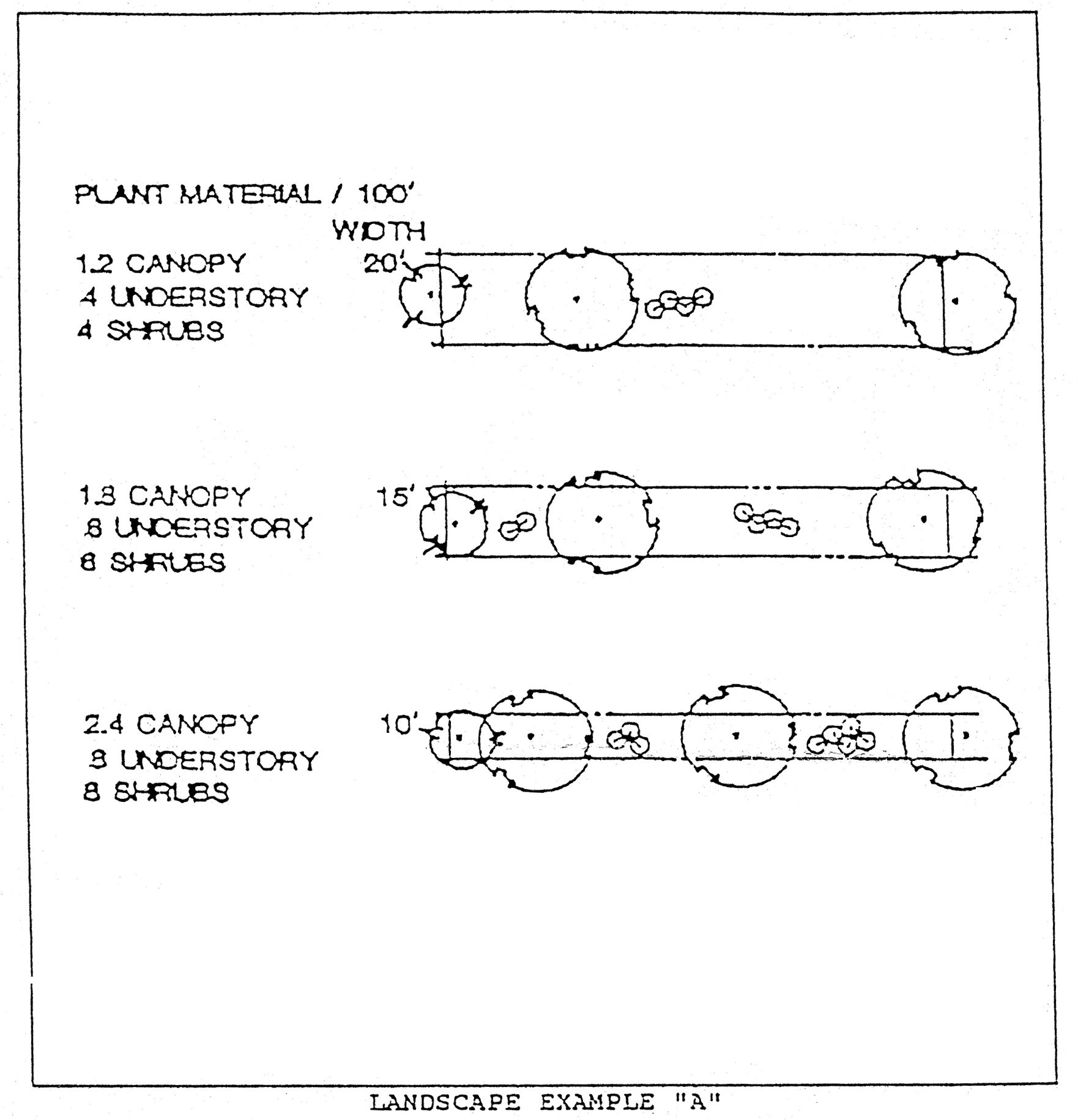
Landscape Example A
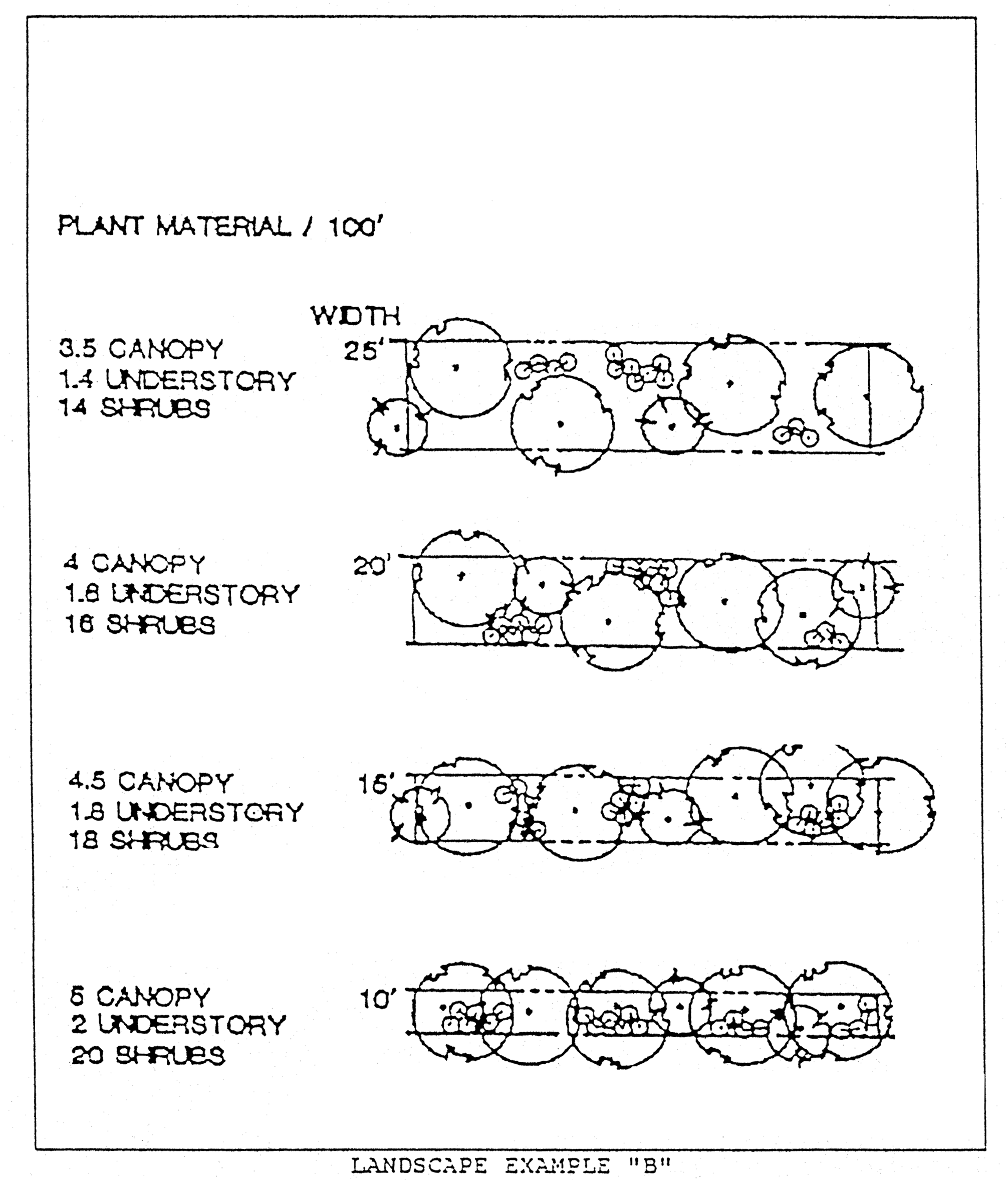
Landscape Example B
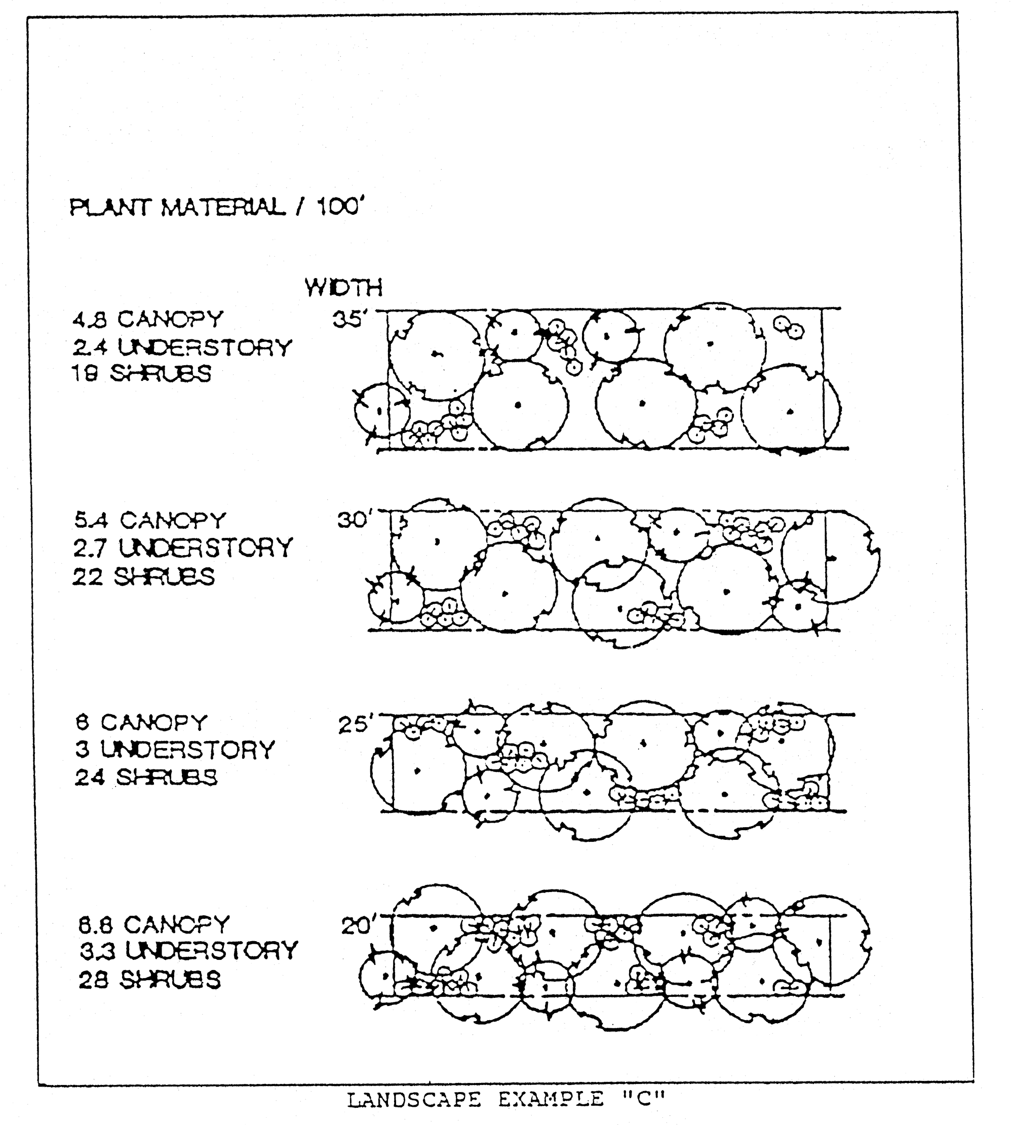
Landscape Example C
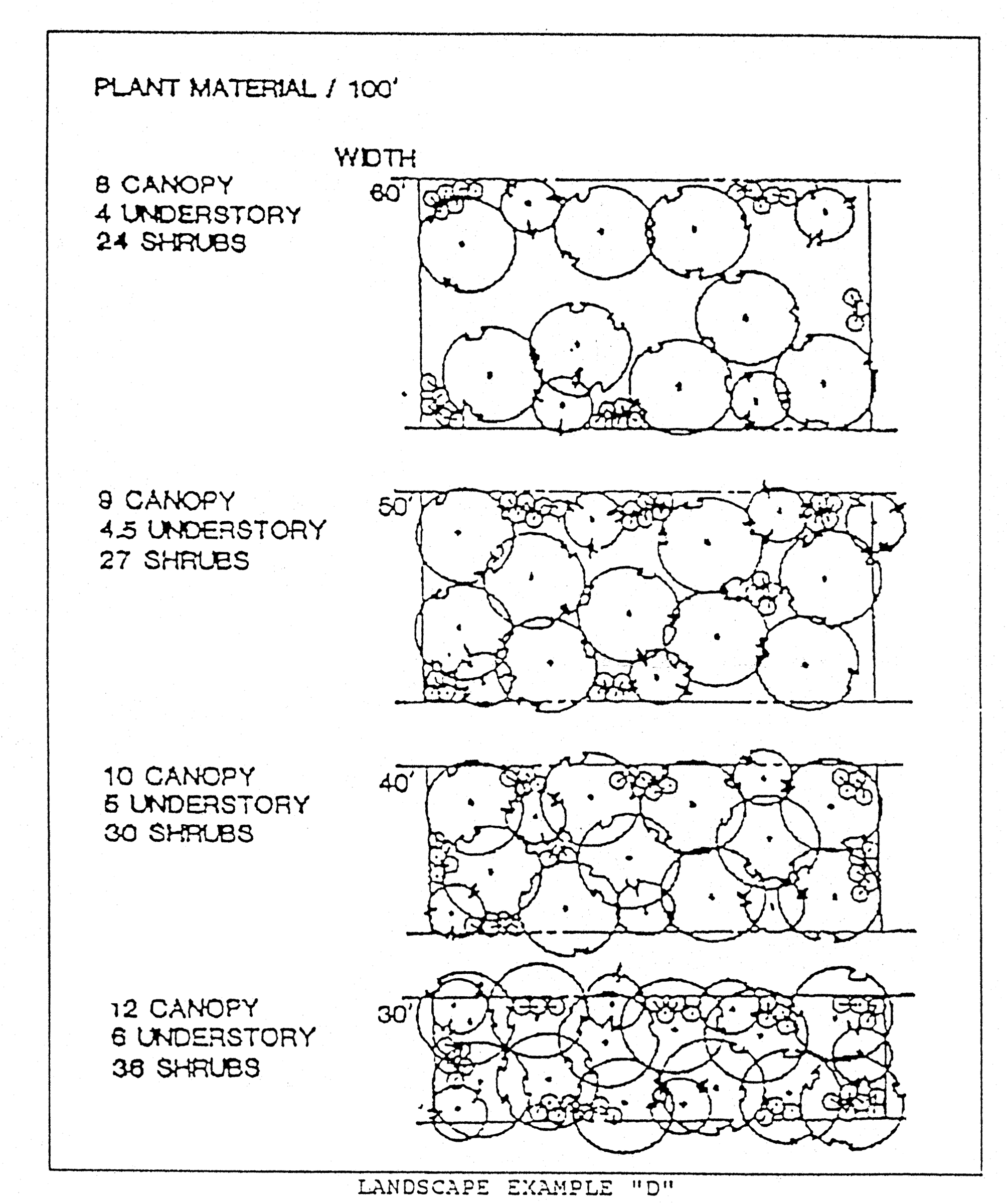
Landscape Example D
Sec. 42-746. - Removal of trees and native vegetation.
(a)
Permit required to remove protected trees. Plans for removing protected trees will be part of the site design. Unless exempt from the provisions of this section or provided for in this site design, no person shall remove or in any way damage any protected tree.
(b)
Protected trees.
(1)
Small trees. The following trees with a diameter at breast height of five inches or greater are considered protected trees for the purposes of this division:
a.
Dogwood (Cornus Florida).
b.
Redbud (Cercis canadensis).
(2)
Medium and large trees. The following trees with a diameter at breast height of 18 inches or greater are considered protected trees for the purposes of this division:
a.
Southern Magnolia (Magnolia grandiflora)***
b.
Southern Red Cedar (Juniperus silicicola)***
c.
Live Oak (Quercus virginiana)***
d.
Myrtle Oak (Quercus myrtifolia)***
e.
Sweet Gum (Liquidambar styraciflua)*
f.
Sycamore (Platanus occidentalis)*
g.
Pecan (Carga illinoensis)*
h.
Florida elm (Ulmus americana floridana)
i.
Red Maple (Acer rubrum)*
j.
Tupelo, Water (Nyssa aquatica)
k.
Walnut, Black (Juglans nigra)*
l.
Hickory (Carya spp.)*
* Shade trees
**Salt tolerant trees
(c)
Exemptions. The following uses shall be exempt from this section:
(1)
Single-family dwelling units. Lots or parcels of land on which a single-family home is used as a residence shall be exempt for all trees where the removal of the tree is necessary for the construction of structural or built improvements and for all trees with a diameter at breast height of less than 18 inches, except that champion, heritage, historic and specimen trees, as described in subsection (d) of this section, on such parcels shall be protected according to the tree protection regulations. This exemption shall not be construed to apply to residential subdivisions or other residential developments that require site plan approval.
(2)
Utility operations. Excavation, tree pruning and removals by duly constituted communication, water, sewer, electrical or other utility companies, or federal, state or county agencies, or engineers or surveyors working under a contract with such utility companies or agencies shall be exempt from this section, provided the activity is limited to those areas necessary for maintenance of existing lines or facilities or for construction of new lines or facilities in furtherance of providing utility service to its customers, and provided further that the activity is conducted so as to avoid any unnecessary removal and, in the case of aerial electrical utility lines, is not greater than that specified by the National Electrical Safety Codes, as necessary, to achieve safe electrical clearances. All pruning and trimming shall be done in accordance with National Arborist Association Standards. Written notice of the areas where authorized work is anticipated shall be provided to the department at least five days prior to the work, except that when the work is needed to restore interrupted service under emergency conditions, no prior notice is required. Excavations affecting historic, specimen, champion or heritage trees shall be limited to maintenance work only. In addition, no notice is required to extend service to a new service connection.
(3)
Rights-of-way. The clearing of a path for existing or new roadway rights-of-way, provided that the rights-of-way are for existing roadways that are built in conformance with county standards or for new roadways that will be built in conformance with county standards. To qualify for the exemption for new roadways, the developer must post a bond, letter of credit, cash or other security guaranteeing the repair or replacement of the roadways in accordance with section 42-156. The width of the path shall not exceed the right-of-way width standards for each type of roadway established in the county transportation standards.
(4)
Commercial growers. All commercial nurseries, botanical gardens, tree farms and grove operations shall be exempt from the provisions of this section, but only as to those trees and sites which were planted or managed for silvicultural or agricultural purposes or for the sale or intended sale in the ordinary course of business.
(5)
Emergencies. During emergencies caused by a hurricane or other disaster, the county administrator/coordinator may suspend these tree protection regulations.
(d)
Historic, specimen and champion trees.
(1)
A historic tree is one that has been designated by the board of county commissioners as one of notable historical interest and value to the county because of its location or historical association with the community. A public hearing shall be held by the board of county commissioners on the designation with due notice to the owner of the tree.
(2)
A specimen tree is one that has been officially designated by the board of county commissioners to be of high value because of its type, size, age or other relevant criteria. A public hearing on the designation shall be held by the board of county commissioners with due notice to the owner of the tree.
(3)
A champion tree is one that has been identified by the state division of forestry as being the largest of their species within the state or by the American Forestry Association as being the largest of their species in the United States. Any tree in the county selected and duly designated a state champion, United States champion or world champion by the American Forestry Association, shall be protected.
(4)
No historic, specimen or champion tree shall be removed without a finding by the planning director that the tree is a hazard or that it is not economically or practically feasible to develop the parcel without removing the tree.
(e)
Protection of historic specimen and champion trees during development activities.
(1)
Generally. To assure the health and survival of protected trees that are not to be removed, the developer shall avoid the following kinds of tree injuries during all development activities:
a.
Mechanical injuries to roots, trunk and branches;
b.
Injuries by chemical poisoning;
c.
Injuries by grade changes;
d.
Injuries by excavations; and
e.
Injuries by paving.
(2)
Tree projection zone. A circular tree protection zone shall be established around each protected tree as follows:
a.
If the drip line is less than six feet from the trunk of the tree, the zone shall be that area within a radius of six feet around the tree.
b.
If the drip line is more than six feet from the trunk of the tree but less than 20 feet, the zone shall be that area within a radius of the full drip line around the tree.
c.
If the drip line is 20 feet or more from the trunk of the tree, the zone shall be that area within a radius of 20 feet around the tree.
(3)
Development prohibited within the tree protection zone. All development activities, except those specifically permitted by this section, shall be prohibited within the tree protection zone provided for any protected trees, including any construction of buildings, structures, paving surfaces and stormwater retention/detention ponds. All temporary construction activities shall also be prohibited within tree protection areas, including all digging, storage of construction material and parking of construction vehicles.
(4)
Fencing of tree protection zone. Prior to the commencement of construction, the developer shall enclose the entire tree protection zone within a fence or similar barrier as follows:
a.
Wooden or similar posts at least 1.5 by 3.5 inches shall be implanted in the ground deep enough to be stable and with at least three feet visible above ground.
b.
The protective posts shall be placed not more than six feet apart, and shall be linked together by a rope or chain.
(LDC §§ 5.02.04, 5.02.05)
Sec. 42-766. - Purpose and intent.
(a)
This subdivision requires landscaped buffers to be provided and maintained when certain land uses are adjacent to or directly across from each other in order to protect uses from the traffic, noise, glare, trash, vibration and odor likely to be associated with a more intensive land use.
(b)
Landscaped buffers are also required to conserve the values of land and buildings and to provide adequate light and air. The width of the buffer and the required plantings within the buffer vary depending upon the relative intensities of the abutting or adjacent uses. The buffer requirements are intended to be flexible; the developer may choose among a number of combinations of buffer width and buffer plantings to satisfy this requirement.
(LDC § 5.02.02(A))
Sec. 42-767. - Requirements.
Landscaped buffers shall be located at the perimeter of the building site for any given use, and shall not be located in any portion of a public right-of-way. The following procedure shall be followed to determine the type of landscaped buffer required:
(1)
Identify the land use category of the proposed use by referring to article V of this chapter. Identify the land use category of the adjacent or adjoining uses by an on-site survey.
(2)
Identify whether the proposed and adjacent or adjoining uses are high, medium or low impact by referring to section 42-770.
(3)
Determine the landscaped buffer required on each building site boundary, or portion thereof, by referring to section 42-771.
(4)
Select the desired landscaped buffer option from those set forth in section 42-772. Any of the listed options shall satisfy the requirement of buffering between adjacent or adjoining land uses.
(LDC § 5.02.02(B))
Sec. 42-768. - Design and materials.
(a)
Existing native plant material. The use of existing native species of plant material is strongly encouraged in landscaped buffers. Existing natural ground cover should be retained where possible by avoiding scraping, grading and sodding within the landscaped buffer.
(b)
Mixed use development. Where a building site is used for a single mixed use development, landscaped buffers shall be required between any residential and nonresidential uses. Landscaped buffers required at the perimeter of the development shall be based upon the individual uses on each portion of the adjacent property.
(c)
Parking lot landscaping. Perimeter plantings required for parking lot landscaping may be counted toward satisfying buffer requirements.
(LDC § 5.02.02(C))
Sec. 42-769. - Use.
(a)
Open space. Landscaped buffers may be counted toward satisfying open space requirements, and may be used for passive recreation. They may contain pedestrian or bike trails, provided that the total width of the buffer yard is maintained. In no event, however, shall the following uses be permitted in landscaped buffers:
(1)
Play fields;
(2)
Stables;
(3)
Swimming pools;
(4)
Tennis courts;
(5)
Parking lots and vehicular use areas;
(6)
Dumpsters;
(7)
Equipment storage and other open storage, buildings or overhangs.
(b)
Stormwater retention/detention facilities. The planning director shall be authorized to allow stormwater retention/detention facilities to encroach into landscaped buffers a maximum of 40 percent of buffer width where it is found that all planning requirements of this division are met and the visual screen provided by the landscaped buffer will be fully achieved.
(LDC § 5.02.02(D))
Sec. 42-770. - Classification of uses.
(a)
Nonresidential uses. For the purposes of determining landscaped buffer requirements, nonresidential land uses are classified as either high, medium or low impact uses as follows:
(1)
High impact uses. High impact uses are particular uses of land that, because of their operational and physical characteristics are expected to have a strong effect on abutting or adjacent uses. High impact uses include the following uses, as defined in article V of this chapter:
a.
Industrial uses, except small scale;
b.
Mining uses;
c.
Water and wastewater treatment plants;
d.
High intensity commercial;
e.
Aviation commercial; and
f.
Major utility uses, i.e., high voltage lines or gas lines.
(2)
Medium impact uses. Medium impact uses are particular uses of land that, because of their operational and physical characteristics, are expected to have a moderate effect on adjoining or adjacent uses. Medium impact uses include the following uses as defined in article V of this chapter:
a.
General commercial uses, except for neighborhood commercial uses;
b.
Public service/utility, except those specifically designated high impact;
c.
Feedlots;
d.
Small scale industrial; and
e.
All accessory uses associated with the uses set forth in this subsection.
(3)
Low impact uses. Low impact uses are particular uses of land that because of their operational and physical characteristics are expected to have a limited effect on abutting or adjacent uses. Low impact uses include the following uses as defined in article V of this chapter:
a.
Institutional uses;
b.
Outdoor recreation uses;
c.
Professional service and office uses;
d.
Agricultural uses;
e.
Silvicultural uses;
f.
Conservation uses;
g.
Residential uses; and
h.
All accessory uses associated with the uses set forth in this subsection.
(LDC § 5.02.02(E))
_____
Sec. 42-771. - Table of requirements.
The following table sets forth landscaped buffer requirements:
(LDC § 5.02.02(F))
_____
Sec. 42-772. - Options.
(a)
The specifications set forth in this section shall be used to select the desired landscaped buffer option for the building site. These buffer requirements are stated in terms of the width of the linear feet of the buffer. The landscaped buffer is normally calculated as parallel to the property line; however, design variations, especially when used to incorporate native vegetation into the buffer area, are allowed. The edges of the landscaped buffer may meander, provided that the:
(1)
Total area of the buffer is equal to or greater than the total area of the required landscaped buffer; and
(2)
Landscaped buffer measures at least five feet in width at all points along the perimeter of the property line of the site requiring a buffer.
(b)
When the requirements of this section result in a fractional number of plantings, the fraction shall be eliminated.
(LDC § 5.02.02(G))
Sec. 42-773. - Maintenance.
The maintenance of all landscaped buffers shall be the responsibility of the property owner. Failure to maintain such landscaped buffers in an attractive and healthy state shall be considered a violation of this article subject to enforcement upon receipt of a complaint from an adjoining property owner in accordance with article II of this chapter.
(LDC § 5.02.02(H))