
Taylor County Unincorporated
City Zoning Code
City Zoning Code
ARTICLE IX
IMPROVEMENT STANDARDS
Sec. 42-856. - Purpose.
The purpose of this article is to establish standards for required development improvements. These standards are applicable to all development activity within the unincorporated areas of the county.
(LDC § 6.00.01)
Sec. 42-857. - Responsibility for improvements.
(a)
All improvements required by this article shall be designed, installed and paid for by the developer (example: public/private partnerships, municipal services benefit unit (MSBU), private corporation or individual, etc.).
(b)
In the case of the subdivision of land, all improvements shall be completed by the developer or guaranteed through bonding prior to final plat approval.
(LDC § 6.00.02)
Sec. 42-858. - Continuing maintenance and upgrading of subdivision improvements.
(a)
Purpose. Because of the financial impact required of the county to maintain and upgrade subdivision improvements throughout the county and within proposed subdivisions, a fair and equitable method for assigning costs and collecting funds is required.
(b)
Special taxing unit.
(1)
Within any proposed subdivision that requires the construction or placement of public facilities there shall be created a special taxing unit and the boundaries of such special taxing unit shall be the defined and platted boundaries of the proposed subdivision.
(2)
The special taxing unit created under this subsection shall be created solely and specifically for establishing an assessment on a per-lot basis to provide the funds necessary to maintain and upgrade the public improvements within the subdivisions that are dedicated to the county for future maintenance.
(3)
There shall be assessed annually against each lot within a subdivision which is subject to a special taxing district an amount of money necessary to pay for the annual maintenance and/or construction costs of the public facilities within the subdivisions which are dedicated to the county. The amount of such assessment for the first year shall be determined by the board of county commissioners at the time of plat approval for new subdivisions or the establishment of a special taxing unit for existing subdivisions and shall be based upon the recommendation of the county engineer or the county road department director.
(4)
The amount assessed annually against each lot shall be reflected on the ad valorem tax bill received by each owner of each lot at the time the ad valorem tax bills are prepared by the county tax collector. The board of county commissioners shall prepare an annual budget for each special taxing unit created pursuant to this subsection and such budget shall be prepared at the same time as the annual county budget.
(5)
Upon final approval and recording of the final plat and/or the establishment of a special taxing unit, the improvements within the subdivision shall be accepted and maintained by the county.
(LDC § 6.00.03)
Sec. 42-859. - Utilities.
(a)
Requirements for all developments. The following basic utilities are required for all developments subject to the criteria listed in this section.
(1)
Electricity. Every principal use and every lot within a subdivision shall have available to it a source of electrical power adequate to accommodate the reasonable needs of such use or an agreement from the applicable utility provider to make available electricity as the need arises.
(2)
Telephone. Every principal use and every lot within a subdivision shall have available to it a telephone service cable adequate to accommodate the reasonable needs of such use or an agreement from the applicable service provider to make available the services as the need arises.
(3)
Water and sewer. Every principal use and every lot within a subdivision shall have central potable water and wastewater hookup whenever required by the county comprehensive plan and where the topography permits the connection to a city or county water or sewer line by running a connecting line no more than 200 feet from the lot to such line.
(b)
Utility easements. When a developer installs or causes the installation of water, sewer, electrical power, telephone or cable television facilities, and intends that such facilities shall be owned, operated or maintained by a public utility or any entity other than the developer, the developer shall transfer to such utility or entity the necessary ownership or easement rights to enable the utility or entity to operate and maintain such facilities.
(LDC §§ 6.02.01, 6.02.02)
Sec. 42-860. - Public and private sewers.
Except as otherwise provided, it shall be unlawful to construct or maintain a septic tank, private sewer system utility or other facility intended or used for the disposal of sewage without a valid state department of environmental protection or department of health permit, and evidence that the operation of the private sewer system utility is in compliance with all state department of environmental protection or department of health standards, shall be prima facie evidence that such private sewer system is operating in a manner that does not endanger the public health, safety and welfare. Any person who owns or operates a private sewer system utility shall allow the county to inspect such utility at reasonable times and in a reasonable manner and shall furnish such information as may be requested by the county sufficient to show such utility is operating in a manner so as not to endanger the public health, safety and welfare.
(LDC § 6.02.03)
Sec. 42-861. - Stormwater management.
(a)
Purpose. The purpose of this section is to protect the surface water, groundwater and other natural resources by ensuring that the stormwater runoff peak discharge rates, volumes and pollutant loadings are managed to minimize the adverse impacts of erosion, sedimentation, flooding and water pollution.
(b)
Stormwater management requirements. The design and performance of all stormwater management systems shall comply with applicable state regulations and requirements of the Suwannee River Water Management District. The construction of structures or landscape alterations that would significantly impact or interrupt mature drainage flows, including sheet flow and flow to isolated wetland systems, is prohibited without a mitigation plan certified by a professional engineer. Normal agricultural and pine silvicultural activities shall be exempt from these requirements, subject to best management practices as adopted by the state department of agriculture or state division of forestry, as appropriate, and also subject to all other existing regulations.
(c)
Dedication. If a stormwater management system approved under this chapter will function as an integral part of the county maintained system, as determined by the county engineer, the facilities shall be dedicated to the county.
(d)
Maintenance by an acceptable entity. If the stormwater management system is not dedicated to the county, the property owner shall submit:
(1)
A written statement describing the actions, including periodic inspections, to be taken to maintain the facility; and
(2)
Bond or other assurance of continued financial capacity to operate and maintain the facility.
(e)
Drainage easements. All necessary drainage easements and rights-of-way shall be furnished at no expense to the board of county commissioners. Such easements shall have a width of not less than the surface width required of the drainage ditch plus a 15-foot berm to lie wholly along one side of the ditch, and in the case of storm sewer, a minimum width of 20 feet.
(LDC §§ 6.03.01—6.03.04)
Sec. 42-862. - Fill material.
The use of organic material that is in a stage of decay as fill material on building lots shall be prohibited.
(LDC § 6.04.01)
Sec. 42-886. - Purpose; scope.
This division establishes minimum requirements applicable to the development transportation system, including public and private streets, bikeways, pedestrian ways and access control to and from public streets. The standards in this division are intended to minimize the traffic impacts of development, to ensure that all developments adequately and safely provide for the storage and movement of vehicles consistent with good engineering and development design practices. Private rural roads constructed on private agricultural and silvicultural lands shall be excluded from the provisions of this division.
(LDC § 6.01.01)
Sec. 42-887. - Street classification system.
(a)
Generally.
(1)
Streets in the county are classified and mapped according to function served in order to allow for regulation of access, road and right-of-way widths, circulation patterns and design speed.
(2)
Private streets and streets that are to be dedicated to the county are classified in a street hierarchy system, with design tailored to function. The street hierarchy system shall be defined by road function and design speed.
(3)
When a street continues an existing street that previously terminated outside the subdivision, or is a street that will be continued beyond the subdivision or development at some future time, the classification of the street will be based upon the street in its entirety, both within and outside of the subdivision or development.
(4)
The street hierarchy shall be local, collector, arterial and freeway. All development proposals containing new streets or taking access from existing streets shall conform to the standards and criteria contained in this section.
(b)
Local streets. Local streets are primarily suited to providing direct access to residential development, but may give access to limited nonresidential uses. All local streets should be designed to minimize unnecessary and/or speeding traffic. Alleys, which provide a secondary means of access to lots, are normally on the same level in the hierarchy as a residential street. Each local street shall be classified and designed for its entire length to meet the minimum standards. Local streets shall be designed to have a minimum posted speed of not less than 15 miles per hour.
(c)
Collector roads. Collector roads provide access to nonresidential uses and connect lower order streets to arterial streets. Design speeds and average daily traffic volumes will be higher than for lower order streets. Collector roads shall be designed to have a minimum posted speed of not less than 30 miles per hour. Design speed may increase depending on conditions and expected traffic volume.
(d)
Arterial roads. Arterial roads provide links between communities or to limited-access expressways, limit direct access from abutting properties except for regionally significant uses and shall be designed for posted speeds up to 55 miles per hour.
(1)
Minor arterial. Minor arterial roads link community districts to regional or state highways. They may also give direct access to regionally significant land uses. These roads may take access from other arterials or freeways and may give access to any lower order nonresidential street type. Minor arterials shall be designed for posted speeds of not less than 45 miles per hour.
(2)
Principal arterials. Principal arterials are major regional highways providing links between communities. These roads may take access from other arterials or freeways and may give access to any lower order nonresidential street type. These roads shall be designed for posted speeds of 55 miles per hour.
(e)
Freeways. Freeways provide links between lower order roads or with other freeways. Access to individual land uses is not permitted. These roads may take access from other arterials or freeways and may give access to other arterials or freeways. Freeways shall have a minimum design speed of 60 miles per hour.
_____
(f)
Local street standards. The following table specifies the road surface widths and minimum curb radii for local streets:
Minimum Road Surface Width
(LDC § 6.01.02)
_____
Sec. 42-888. - Street design.
(a)
General design standards.
(1)
The street system of a proposed development shall be a network with variations as needed for topographic and environmental design considerations. Particular effort should be directed toward securing the flattest possible grade near intersections.
(2)
In order to reduce traffic congestion on arterial and collector roads surrounding the development and to promote a pedestrian environment within the development, streets shall be laid out to:
a.
Avoid environmentally sensitive areas;
b.
Secure the view to prominent natural vistas;
c.
Minimize the area devoted to motor vehicle traffic;
d.
Promote pedestrian movement so that it is generally more convenient and pleasant to walk short distances than to drive; and
e.
Promote the creation of vista terminations.
(3)
The street layout in all new developments shall be coordinated with and interconnected to the street system of the surrounding area.
(4)
Streets in proposed subdivisions shall be connected to rights-of-way in adjacent areas to allow for proper interneighborhood traffic flow. If adjacent lands are unplatted, stub outs in the new development shall be provided for future connection to the adjacent unplatted land.
(5)
Streets shall intersect as nearly as possible at right angles and in no case shall the angle of intersection be less than 75 degrees.
(6)
New intersections along one side of an existing street shall, where possible, coincide with existing intersections. Where an offset (jog) is necessary at an intersection, the distance between curblines of the intersecting streets shall be no less than 150 feet.
(7)
No two streets may intersect with any other street on the same side at a distance of less than 400 feet, measured from centerline to centerline, of the intersection street. When the intersected street is an arterial, the distance between intersecting streets shall be no less than 1,000 feet.
(8)
Subject to the limitations set forth in subsection (e)(4) of this section, private streets may be allowed within developments that will remain under common ownership, provided that they are designed and constructed pursuant to the county's minimum standards specified in subsection (e)(3) of this section.
(9)
The terminus of every cul-de-sac shall have an unobstructed 15-foot wide moving lane with a minimum outside turning radius of 30 feet as shown in figure 6.01.03-A, on file in the county offices.
(b)
Stub streets.
(1)
Residential access and subcollector stub streets may be permitted only within subsections of a phased development for which the proposed street, in its entirety, has received final site plan approval.
(2)
Residential collector and higher order stub streets may be permitted or required by the county provided that the future extension of the street is deemed desirable by the county or conforms to the traffic circulation element of the county comprehensive plan.
(3)
Temporary turnarounds shall be provided for all stub streets providing access to five or more lots or housing units. Where four or fewer units or lots are being served, a sign indicating a dead-end street shall be posted.
(c)
Clear visibility triangle. In order to provide a clear view of intersecting streets to the motorist, there shall be a triangular area of clear visibility formed by two intersecting streets or the intersection of a driveway and a street. The following standards shall be met:
(1)
Nothing shall be erected, placed, parked, planted or allowed to grow in such a manner as to materially impede vision between a height of two feet and ten feet above the grade, measured at the centerline of the intersection.
(2)
The clear visibility triangle shall be formed by connecting a point on each street centerline to be located at the distance from the intersection of the street centerlines indicated in the following diagram, and a third line connecting the two points.
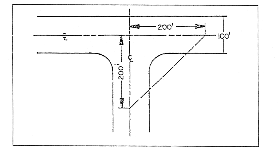
Clear Visibility Triangle
(3)
The distances from the intersection of the street centerlines for the various road classifications shall be as follows:
(d)
Blocks.
(1)
Where a tract of land is bounded by residential streets, excluding alleys, forming a block, such block shall have sufficient width to provide for two tiers of lots of appropriate depths.
(2)
The lengths, widths and shapes of blocks shall be compatible with adjacent areas. In no case shall block lengths in residential areas exceed 2,000 feet or the width of ten lots, whichever is greater, nor be less than 350 feet. If topographic considerations make conformance with this standard impracticable, a variance may be considered by the county planning board.
(e)
Construction standards. Street construction shall be in accordance with the following standards based on land use category, density of development or number of parcels requiring access over the street:
(1)
When located in the mixed use urban and/or rural residential, aviation related commercial, water-oriented commercial, industrial and/or public land use districts, or clustered at a net density of one unit per two acres or greater, streets shall be constructed as a paved roadway and constructed in accordance with the Florida Department of Transportation's Standard Specifications for Road and Bridge Construction and Manual of Uniform Minimum Standards for Design, Construction and Maintenance for Streets and Highways, latest editions, and county specifications as contained in figure 6.01.03-E-2 on file in the county offices.
(2)
When located in any land use other than mixed use urban and/or rural residential, aviation related commercial, water-oriented commercial, industrial and/or public land use districts, and developed at a density of greater than one (1) unit per fifteen (15) acres and less than one per two acres, and consisting of division of land into not more than eight parcels, the standards contained in figure 6.01.03-E-3, on file in the county offices, shall apply and a surface course shall not be required.
(3)
When located in any land use other than mixed use urban and/or rural residential, aviation related commercial, water-oriented commercial, industrial and/or public land use districts, and developed at a density of one unit per 15 acres or less, and greater than one unit per 40 acres, the standards contained in figure 6.01.03-E-3, on file in the county offices, shall apply and a surface course shall not be required.
(4)
When located in any land use other than mixed use urban and/or rural residential, aviation related commercial, water-oriented commercial, industrial and/or public land use districts, and developed at a density of one unit per 40 acres or less, the graded road standards contained in figure 6.01.03-E-4, on file in the County offices, shall apply and a surface course shall not be required.
(5)
Private roads on private agricultural and silvicultural lands shall be excluded from the provisions of this section.
(LDC § 6.01.03; Ord. No. 2001-3, § 2(E), (F), 3-20-2001; Ord. No. 2003-16, 11-18-2003; Ord. No. 2006-21, § 1, 12-12-2006)
Sec. 42-889. - Rights-of-way.
(a)
Purpose. The purpose of this section is to ensure a safe and efficient traffic circulation system in the county by establishing right-of-way widths for future transportation facilities and by prohibiting encroachment of structures into existing rights-of-way.
(b)
Permit. Except as provided in subsection (g) of this section, no person shall construct or maintain any structure or facility, including utilities, or make any other use of a public road or future road right-of-way unless and until a permit has been issued by the board of county commissioners approving and authorizing such construction, maintenance or use. All applications for the use of public rights-of-way must describe the space to be used and the length of time of such use. Permits may be granted for a period of time not exceeding six months, but may be renewed from time to time for periods not to exceed six months if the encroachment does not unreasonably restrict the public use of the right-of-way and the encroachment is necessary to accomplish the objective for which it is requested in a reasonable manner.
(c)
Minimum right-of-way requirements.
(1)
No person shall willfully obstruct any portion of the right-of-way for a new roadway which is identified in the future traffic circulation map of the county comprehensive plan and is public ownership, as is under public ownership or is under option to purchase as a public road right-of-way, or is subject to eminent domain proceedings which have already been initiated. No person shall construct any structure or facility, including utilities, or make any other use of the right-of-way for a new roadway which is identified on the future traffic circulation map of the county comprehensive plan.
_____
(2)
The following minimum right-of-way widths for new roadways are established:
RIGHT-OF-WAY
BY FACILITY TYPE AND AREA TYPE
_____
(d)
Presumption. Any person who obstructs a public road or future road right-of-way which is identified in the future land correlation map of the county comprehensive plan and is public ownership, as is under public ownership or is under option to purchase as a public road right-of-way, as is subject to eminent domain proceedings which have already been initiated shall be presumed to have done so willfully if the obstruction is allowed to remain on the right-of-way for a period of 24 hours after such person has been notified to remove the obstruction by the board of county commissioners or its authorized representative.
(e)
No parking areas.
(1)
Authority. The county administrator/coordinator, acting on behalf of the board of county commissioners, may regulate parking on rights-of-way and such regulations may include the time and place of parking. No person shall park on any portion of the right-of-way of any public road in the county after the board of county commissioners has prohibited the parking thereon in the manner provided in this section.
(2)
Public roads with speed limit of 35 miles per hour or less. The parking of vehicles on that portion of the right-of-way of public roads not used as a traffic lane and on which the speed limit is 35 miles per hour or less shall be authorized and permitted unless the county administrator/coordinator, after considering factors such as the condition and width of the right-of-way, volume of traffic, safety of traveling and parking vehicles and frequency of parking, determines that parking should be prohibited on such right-of-way of a public road and causes signs to be erected on such portion of the right-of-way where parking is prohibited stating "No Parking Between Signs" or "No Parking."
(3)
Public roads with speed limit of over 35 miles per hour. The parking of vehicles on any portion of the right-of-way of public roads on which the speed limit is in excess of 35 miles per hour shall be prohibited unless the county administrator/coordinator, after considering factors such as the condition and width of the right-of-way, volume of traffic, safety of traveling and parking vehicles and frequency of parking, determines that parking may be permitted and causes signs to be erected in such portion of the right-of-way where parking is permitted stating "Parking Permitted Between Signs" or "Parking Permitted."
(4)
Long-term parking. No person shall site a vehicle or recreational vehicle on a county right-of-way in excess of 24-hours unless and until a permit has been issued by the board of county commissioners, or their designee, authorizing such use. The following criteria shall be utilized for consideration of approval for such use:
a.
Whether the property abutting the request site is owned by the applicant.
b.
Whether the abutting property exhibits an existing nonconformity due to flood induced erosion that prohibits onsite parking.
c.
Whether such use will negatively impact safe traffic circulation.
d.
Whether clear zones adjacent to travel lanes will be maintained.
(5)
Issuance of permit. Any permit issued by the county pursuant to subsection (e)(4) of this section 42-889 shall define the following:
a.
Duration of the permit, if any.
b.
Easily identifiable physical description (no legal description necessary) of the geographical bounds to which the permit applies.
c.
Vehicle(s) or recreational vehicle(s) for which the permit applies.
(6)
Any person or entity wishing to appeal the county administrator's decision regarding permitting may appeal to the board of county commissioners. Appeals shall be made by filing a notice of appeal with the planning department within 30 days of the county administrator's decision. The board of county commissioners may, on its own initiative, at any time, review, amend, or revoke, any permit issued pursuant to subsection (e)(4) of this section 42-889.
(7)
Temporary suspension of permit during evacuations. Any permit issued pursuant to subsection (e)(4) of this section 42-889 shall be deemed temporarily suspended during any period in which any rule, regulation, statute, executive order, or other governmental directive is in effect causing voluntary or mandatory evacuations of an area in which such a permit is issued for, and shall not under any circumstance be used to interfere with governmental operations during such voluntary or mandatory evacuations.
(f)
Roadside stands prohibited. It shall be unlawful for any person to operate or cause to be operated any roadside stand within or on any portion of the right-of-way of any public road.
(g)
Exceptions. The following shall be exceptions from the requirements of subsection (b) of this section:
(1)
Improvement of a public road by a property owner of such public road adjacent to his property with landscaping, shrubbery or grass which is not inconsistent with the use of the public road for road purposes;
(2)
The parking of motor vehicles on that portion of the public road not used as traffic lanes if not otherwise prohibited in subsection (e) of this section;
(3)
Use of the public road for road and traffic purposes other than such purposes involving vehicles of such weight or of such characteristics (for example, metal tires or treads) as may, in the opinion of the county engineer, damage the road surface;
(4)
The replacement or maintenance of existing utility facilities, such as telephone poles.
(h)
Nonpermitted structures or facilities. Any structure or facility, including utilities, constructed or maintained on public roads in violation of this section, shall be removed from such right-of-way and such right-of-way shall be restored to the condition which existed immediately prior to the construction or maintenance of such structure or facility at the expense of the person constructing, maintaining or owning such structure or facility. If such structure or facility has not been removed and the right-of-way restored as required by this section within ten days of demand by the board of county commissioners to do so, then such structure or facility may be removed by the board of county commissioners at the expense of the person constructing, maintaining or owning such structure or facility. If such person does not pay to the board of county commissioners the cost of removing such structure and facility and restoring the right-of-way as required by this section within ten days of demand, such cost shall be and constitute a lien against all property owned by such person in the county to be foreclosed in the manner provided by law.
(LDC § 6.01.04; Ord. No. 2013-02, §§ 1—4, 4-16-2013)
Sec. 42-890. - Setbacks from arterial roads.
No building or structure shall be erected within the setbacks from arterial roadways as set forth in the following table. The setback shall be measured from the centerline of the arterial right-of-way as established by the county engineer. The centerline setbacks apply to both sides of the roadway.
CENTERLINE SETBACK REQUIREMENTS
(LDC § 6.01.05)
Sec. 42-891. - Access management.
All proposed development shall meet the following standards for vehicular access and circulation:
(1)
General standards.
a.
Access points must be able to accommodate all vehicles having occasion to enter the site, including delivery vehicles.
b.
Access point design must be such that an entering standard passenger vehicle will not encroach upon the exit lane of a two-way driveway. A right-turning exiting vehicle will be able to use only the first through traffic lane available without encroaching into the adjacent through lane.
c.
There must be reasonable on-site storage to accommodate queued vehicles waiting to park or exit without using any portion of the street right-of-way or in any other way interfering with street traffic.
(2)
Number of access points.
a.
A maximum of one access point shall be permitted to a particular site from each of one or two abutting streets.
b.
When it is in the interest of good traffic circulation, the county engineer, in concurrence with the planning director, may permit one additional access point along a continuous site with frontage in excess of 300 feet, or two additional access points along a continuous site with frontage in excess of 600 feet.
c.
For the purposes of this section, dual one-way access drives will be considered to be one access point.
(3)
Separation of access points.
a.
The separation between access points on state-maintained roads shall be in accordance with Florida Department of Transportation Rules, chs. 14-96—14-97.
b.
On roads that are not maintained by the state, the separation between access points onto arterial and collector roadways, or between an access point and an intersection of an arterial or collector road with another road, shall be as shown in the following table:
c.
The distance between access points shall be measured from the centerline of the proposed driveway or roadway to the centerline of the nearest adjacent roadway or driveway.
d.
The county engineer may permit a single access point for a property that cannot be permitted access consistent with the standards set forth in this subsection and which has no reasonable alternative access as determined by the county engineer in concurrence with the planning director.
(4)
Access management.
a.
Joint access and parking. Any nonresidential use or other development requiring site plan review shall be encouraged to be designed to provide for mutually coordinated or joint parking, access and circulation with adjacent properties.
b.
Design of joint access and vehicular use areas. If a shared driveway is provided, the shared driveway and vehicular use areas shall be of sufficient width to accommodate two-way aisles, joint access and other design features which make it visually obvious that a future abutting vehicular use area may be connected to provide joint access and parking.
1.
Development prior to abutting property. If a building site is developed for a nonresidential or multifamily development before the abutting property is developed or redeveloped, the site design shall ensure that its parking, access and circulation may be modified to create a joint driveway and interconnected parking with the abutting property at a later date.
2.
Development after abutting property. When a building site abuts an existing nonresidential or multifamily use that has been developed using the guidelines for shared access, it shall be designed to connect to the abutting parking, access and circulation areas.
c.
Easements required to be dedicated. When the joint access provisions are used by the owner, the site plan shall not be approved unless the property owner grants an easement for cross access to and from abutting properties. Such easement shall be recorded by the property owner in the public records of the county and constitute a covenant running with the land.
(LDC § 6.01.06)
Sec. 42-892. - Private driveway and roadway regulations.
(a)
Purpose. The regulation and control of private driveway and roadway connections to rights-of-way owned or maintained by the county is necessary to provide for the efficient and safe operation of such roads or highways as may now or hereafter be constructed on such rights-of-way to develop the full potential of the county's investment in roads and rights-of-way, and for the protection of the recognized access right of owners of property fronting on county-owned or county-maintained rights-of-way. The purpose of the regulations set forth in this section are to regulate and control the location, construction, design, operation and method of financing of access driveways and roadways and thereby correlate the rights of the road user and the abutting owner and satisfy the needs of each to the fullest extent possible.
(b)
Permit required. All driveways connecting to any county-owned or county-maintained right-of-way will be constructed by or under the supervision of the board of county commissioners or its designee, who shall initially be the planning department. Where constructed or altered by others, proper permits must be obtained from the board of county commissioners. No one shall enter upon any county-owned or county-maintained right-of-way to construct a driveway or roadway, alter an existing driveway or existing roadway or connect any driveway or roadway except in accordance with section 42-186.
(c)
County road construction projects. On road construction projects of the county, driveways or roadways shall be provided as replacements for turnouts, driveways or roadways existing at the beginning of construction, if desired by the owner.
(d)
Responsibility for construction or alteration. Where driveways or roadways are constructed or altered on any section of county-owned or county-maintained rights-of-way, the entire cost of the construction shall be the expense of the property owner.
(e)
Approval of construction. Unless otherwise specifically provided on a permit issued by the county, all construction on county-owned or county-maintained rights-of-way shall be performed by a contractor previously approved by the board of county commissioners.
(f)
Permit procedures. Permits for the construction or alteration of driveways or roadways on county-owned or county-maintained rights-of-way will be issued in conformity with the procedures set forth in article II of this chapter.
(LDC § 6.01.07)
Sec. 42-893. - Sidewalks and bikeways.
Any development that is adjacent to or within 500 feet of any activity center comprised of commercial, office, service, school or recreational activities shall provide pedestrian and bicycle access in the form of a sidewalk along the roadway frontage of the property. If the adjacent property has a sidewalk, the new sidewalk shall connect with the sidewalk of the adjacent property to form a continuous pathway. The distance from the development to the activity center shall be measured from the property line of the development to the property line of the activity center, along a path of travel.
(LDC § 6.01.08)
Sec. 42-894. - Standards for drive-up facilities.
(a)
Generally.
(1)
Facilities providing drive-up or drive-through service shall not be allowed in residential areas.
(2)
All facilities providing drive-up or drive-through service shall provide on-site stacking lanes in accordance with the standards set forth in subsection (b) of this section.
(b)
Standards.
(1)
The facilities and stacking lanes shall be located and designed to minimize turning movements in relation to the driveway access to streets and intersections.
(2)
The facilities and stacking lanes shall be located and designed to minimize or avoid conflicts between vehicular traffic and pedestrian areas such as sidewalks, crosswalks or other pedestrian accessways.
(3)
A bypass lane shall be provided.
(4)
Stacking lane distance shall be measured from the service window to the property line bordering the furthest street providing access to the facility.
(5)
Minimum stacking lane distance shall be as follows:
a.
Financial institutions shall have a minimum distance of 200 feet. Two or more stacking lanes may be provided which together total 200 feet.
b.
All other uses shall have a minimum distance of 120 feet.
(6)
Alleys or driveways in or abutting areas designed, approved or developed for residential use shall not be used for circulation of traffic for drive-up facilities.
(7)
Where turns are required in the exit lane, the minimum distance from any drive-up station to the beginning point of the curve shall be 34 feet. The minimum inside turning radius shall be 25 feet.
(LDC § 6.01.09)