
Tewksbury Township City Zoning Code
ARTICLE VI
DESIGN AND PERFORMANCE STANDARDS1
Sections:
Sections 600 to 627 are amended from time to time by the New Jersey Department of Community Affairs (DCA): current copies of the Standards may be obtained from the DCA. (RESIDENTIAL SITE IMPROVEMENT STANDARDS) (N.J.A.C. 5:21-1 et seq.)
§ 600 - SCOPE AND APPLICABILITY (N.J.A.C. 5:21-1.5)
A.
The Residential Site Improvement Standards shall govern any site improvements carried out or intended to be carried out or required to be carried out in connection with any application for any subdivision, site plan approval, or variance before any Planning Board or Zoning Board of Adjustment created pursuant to the Municipal Land Use Law (N.J.S.A. 40:55D-1 et seq.); or in connection with any other residential development approval required or issued by any municipality or agency or instrumentality thereof.
B.
Except as is otherwise specifically provided, these rules shall control all matters concerning the construction, alteration, addition, repair, removal, demolition, maintenance, and use of any site improvements constructed by a developer in connection with residential development. The rules are to be interpreted as the minimum required to ensure public health and safety, and the maximum that may be required in connection with residential development.
C.
These rules shall apply to all site improvement work and appurtenant construction including streets, roads, parking facilities, sidewalks, drainage structures, grading, and utilities which are undertaken by a developer in connection with residential development or use.
1.
Where both residential and commercial development are planned in a mixed-use development, these rules shall apply to the residential part or parts of such development where such residential part or parts are discrete and separate from planned commercial parts as evidenced by, for example, separate building(s), separate parking, and separate access features.
2.
These rules shall apply to all utilities created by or deriving their authority from municipal ordinance to operate within a given jurisdiction.
3.
Choice among options contained in these rules shall be the applicant's unless otherwise specified in these rules.
D.
Nothing contained in these rules shall be construed to limit the powers of any municipality to establish and enforce any requirement concerning:
1.
Layout, arrangement, and location of improvements, shade trees, landscaping, or reservation of areas for public use, pursuant to N.J.S.A. 40:55D-38;
2.
Preservation of existing natural resources; arrangement of physical elements for safe and efficient vehicular and pedestrian circulation, by, for example, traffic calming measures as described in "Residential Street Design and Traffic Control," by W. S. Homburger et al. (Institute of Transportation Engineers, 1989), parking, and loading; screening, landscaping, and location of structures; or conservation of energy and use of renewable resources; pursuant to N.J.S.A. 40:55D-41; or
3.
Use, bulk, height, number of stories, orientation, and size of buildings and other structures; the percentage of lot or development area that may be occupied by structures, lot sizes and dimensions, floor area ratios, or other measures to control development intensity; or the provision of adequate light and air pursuant to N.J.S.A.40:55-65.
E.
The provisions of these rules shall not preempt or in any way affect the exercise of any authority by the State or any county government with respect to site improvements conferred by any State law or any regulation promulgated thereunder. Nor shall these rules be in any way interpreted to modify or otherwise affect rules promulgated pursuant to the Pinelands Commission Act, N.J.S.A. 13:18A-1 et seq. (N.J.A.C. 7:50). It is the intent of these rules to be consistent with all other applicable laws, rules and regulations. Where these rules and any other State or county laws, rules or regulations establish differing requirements, then the requirements of these rules shall govern, except where any such differing requirement is more restrictive.
F.
These rules shall not apply to driveways on private property held in fee-simple as individual residential lots outside of the public right-of-way, including common driveways established by easements shared by more than one dwelling unit on private property.
G.
These rules are intended to ensure the public health, safety, and welfare insofar as they are affected by site improvement work, and shall be so construed.
H.
Whenever there is an inconsistency between those standards and revised Site Improvement Standards, the new standards of Statutes C:40.1.
(Ord. 11-2000 (part), 2000)
§ 601 - STREET HIERARCHY (N.J.A.C. 5:21-4.1)
A.
Streets shall be classified in a hierarchy with design tailored to function. The street hierarchy definitions contained within this section are applicable only to local residential streets and are not to be considered related to the U. S. Department of Transportation, Federal Highway Administration's Functional Classification of Highways.
B.
The street hierarchy system shall be defined by road function and average annual daily traffic (AADT), calculated by trip generation rates from the current edition of Trip Generation by the Institute of Transportation Engineers, as indicated in Table 6.1. Trip generation rates from other sources may be used if the applicant demonstrates to the appropriate approving authority that these sources better reflect local conditions. In addition, the applicant shall investigate the opportunities for, and availability of, transit facilities and, if appropriate, consider their impact(s) on motor vehicle traffic trip generation rates per dwelling unit.
Table 6.1
Average Daily Motor Vehicle Traffic Trip Generation per Dwelling Unit
Note:
The trip generation rates listed are guidelines only. The actual use of trip generation rates is derived by the use of regression analysis and should be computed only by professionals proficient in the use of the ITE Manual. The "Land Use" definitions are based on the ITE Manual with slight modifications to address inconsistencies contained within the ITE Manual.
Source:
Institute of Transportation Engineers, Trip Generation (Washington, D.C.: ITE, 1982), 3rd Edition. The table was updated with data from the 5th Edition of the manual published by ITE in January 1991. The peak ADT rates take into consideration Saturday and Sunday rates, as well as weekday rates.
Table 6.2
Trip Generation Definitions for Table 6.1
C.
Each residential street shall be classified and designed to meet the standards for one of the street types defined in Table 6.3.
Table 6.3
Street Hierarchy Definitions
(1) Residential access streets of "loop" configuration, that is, two ways out, should be designed so no section conveys an ADT greater than 1500. Each half of a loop street may be classified as a single residential access street, but the total traffic volume generated on the loop street should not exceed 1500 ADT, nor should it exceed 750 ADT at any point of traffic concentration.
(2) Applicant may choose either the Residential Access or the Residential Neighborhood street type for new streets. See section 4.8(b) for specific right-of-way and cartway width requirements for new streets that are a continuation of an existing street.
D.
The municipality and the developer shall determine the highest order street required to be used in a given residential development, considering all of the following:
1.
The size of the development (number and type of units). For example, using size to determine the highest order of street required, a development of up to 150 single-family detached units would not require any minor collectors or streets of a higher order;
2.
The actual or potential development of adjacent sites (whether there is likely to be traffic passing through from neighboring developments). A "potential" development means a development having approvals granted, applications pending, or undergoing preliminary review; and
3.
The streets proposed for that area, if any, as contained in the municipal master plan.
(Ord. 11-2000 (part), 2000)
§ 602 - CARTWAY WIDTH (N.J.A.C. 5:21-4.2)
A.
Cartway width for each street classification shall be determined by parking and curbing requirements that are based on intensity of development.
B.
Intensity of development shall be based on dwelling units per gross acre as follows:
Table 6.4
Development Intensity for Cartway Determination
(1) In determining the intensity of development, the gross acreage shall not include dedicated common open space or other such areas restricted from future development.
C.
Cartway widths for each street classification are as shown in Table 6.5.
D.
Cartway width also shall consider possible limitations imposed by sight distances, climate, terrain, and maintenance needs.
Table 6.5
Cartway and Right-of-Way Widths
Notes:
(1) See Table 6.3 for definitions of street hierarchy and N.J.A.C. 5:21-4.2 for definitions of low, medium, and high intensity of development.
(2) Parking lane refers to parallel parking; except in the case of parking loop, which is perpendicular parking.
(3) See N.J.A.C. 5:21-4.3(c) for additional requirements.
(4) See N.J.A.C. 5:21-4.5(b) for additional requirements.
(5) Right-of-way width applies only to streets proposed for dedication.
(6) The 30 foot cartway would accommodate two 8 foot parking lanes and one 14 foot moving lane.
(7) 20 foot minor collector cartways are permitted only when there is no direct building lot access to or from the street in question.
(8) Rural streets and rural lanes are permitted only within developments which do not exceed an average daily traffic count of 500 and 200 respectively.
(9) Cartway and right-of-way widths of cul-de-sac stems and right-of-way requirements should conform to standards of residential access or residential neighborhood streets. Cul-de-sac turnarounds shall have a minimum cartway radius of 40 feet and a minimum right-of-way radius of 48 feet.
(10) Cartway and right-of-way widths of marginal access streets and right-of-way requirements should conform to standards of either residential access or minor collector streets, as dictated by average daily traffic. If the classification is a minor collector requiring a 36′ cartway, cartway width may be reduced to 28 feet since frontage is restricted to one side of the street.
(11) Cartway widths of divided streets should conform to standards of street classification, as dictated by anticipated average daily traffic, and be applied to aggregate dimensions of two street segments.
(Ord. 11-2000 (part), 2000)
§ 603 - CURBS OR CURBS AND GUTTERS (N.J.A.C. 5:21-4.3)
A.
Curbs or curbs and gutters shall be used for drainage purposes, safety, and delineation and protection of pavement edge. Where, based on stormwater management system design, there is determined to be a problem with runoff, curbs or curbs and gutters shall be used.
B.
Curb requirements shall vary according to street hierarchy and intensity of development, in accordance with the requirements set forth in Table 4.3 in N.J.A.C. 5:21-4.2. Generally, curbs shall be required on streets with on-street parking.
C.
Where curbing is not required, edge definition and stabilization shall be furnished for safety reasons, and to prevent pavement unraveling. Curbing may be required for: stormwater management, road stabilization, delineation of parking areas, ten (10) feet on each side of drainage inlets, intersections, corners, and tight radii.
D.
Curb requirements may be waived by the appropriate municipal approving agency, and shoulders and/or drainage swales used when it can be shown that: soil and/or topography make the use of shoulders and/or drainage swales preferable; and/or the community desires to preserve its rural character by using shoulders and/or drainage swales instead of curbs. In cases of medium development intensity, the curbing requirement may be waived where front setbacks exceed 40 feet and it can be demonstrated that sufficient on-site parking exists.
E.
Generally, curbs should be constructed of granite block, in accordance with the detail below. Curbing materials shall accommodate the purposes set forth in subsection C of this section.
F.
Curbs shall be constructed according to the specifications set forth in N.J.A.C. 5:21-4.17.
G.
Curbing shall be designed to provide a curb ramp in compliance with the Americans with Disabilities Act or the Barrier Free Subcode of the New Jersey Uniform Construction Code (N.J.A.C. 5:23-7) at street intersections, as applicable.
(Ord. 11-2000 (part), 2000)
§ 604 - SHOULDERS (N.J.A.C. 5:21-4.4)
A.
Shoulders and/or drainage swales should be used instead of curbs when:
1.
Soil and/or topography make the use of shoulders and/or drainage swales preferable; and/or
2.
To preserve rural character.
B.
Shoulders shall be provided in accordance with the requirements in Table 6.5 in N.J.A.C. 5:21-4.2.
C.
Shoulders shall be four (4) feet wide, except for minor collector streets of high intensity with off-street parking; and major collector streets of medium and high intensity shall be six- (6) feet and eight- (8) feet wide respectively on each side for all streets, and located within the right-of-way as shown in the following street illustrations.
D.
Shoulders shall be constructed of materials such as stabilized earth, gravel, crushed stone, bituminous treatment, or other forms of pavement which provide for vehicle load support.
(Ord. 11-2000 (part), 2000)
§ 605 - SIDEWALKS AND GRADED AREAS (N.J.A.C. 5:21-4.5)
A.
Sidewalks and/or graded areas shall be required, depending on road classification and intensity of development, in accordance with the requirements set forth in Table 6.5.
B.
Sidewalks shall be provided where graded areas are specified in Table 4.3 when the conditions described in subsection B.1 or B.2 of this section exist:
1.
The net density of the development or project exceeds one dwelling unit per acre; and
a.
The development or project is located within 2,500 feet of a train station, public or school bus route;
b.
The development or project is located within 2,500 feet of an existing recreational, business or retail use or a site where such use is permitted by existing zoning; or
c.
Where the proposed streets connect to or extend existing streets which have sidewalks on both sides; or
2.
The net density of the development exceeds 0.5 dwelling unit per acre and the development is located within two miles of a school.
3.
In non-residential developments such as office parks where square footage exceeds 10,000 square feet.
C.
Notwithstanding subsections B.1 and B.2 of this section, sidewalks shall only be required on one side of rural streets or rural lanes and shall not be required in alleys.
D.
Sidewalks shall be placed parallel to the street, as shown in the street profile figures, unless an exception has been permitted to preserve topographical or natural features, or if required to provide visual interest, or unless the applicant shows that an alternative pedestrian system provides safe and convenient circulation (e.g., in planned development).
E.
Pedestrian-way easements at least 10-feet wide may be required by the municipal approving authority through the center of blocks more than 600-feet long. In providing circulation or access to schools, playgrounds, shopping, adjoining residential areas, or other community facilities, the municipality shall consider and may require pedestrian-way easements.
F.
Sidewalk width shall be four feet; wider widths may be necessary near pedestrian generators and employment centers. Where sidewalks abut the curb and cars overhang the sidewalk, widths shall be six feet. In high-density residential areas when sidewalks abut the curb, a sidewalk/graded area of at least six feet in width shall be required.
G.
Sidewalks and graded areas shall be constructed according to the specifications set forth in N.J.A.C. 5:21-4.18.
(Ord. 11-2000 (part), 2000)
§ 606 - BIKEWAYS (N.J.A.C. 5:21-4.6)
A.
Separate bicycle paths and lanes shall be required only if such paths and lanes have been specified as part of a municipality's adopted master plan and/or official map.
B.
Bicycle lanes, where provided, shall be placed in the outside lane of a roadway, adjacent to the curb or shoulder. When on-street parking is permitted, the bicycle lane shall be between the parking lane and the outer lane of moving vehicles. Lanes shall be delineated with markings, preferably striping. Raised reflectors or curbs shall not be used.
C.
The construction of bikeways shall comply with the specifications set forth in N.J.A.C. 5:21-4.18.
(Ord. 11-2000 (part), 2000)
§ 607 - UTILITY AREAS (N.J.A.C. 5:21-4.7)
A.
Utilities shall be located within the right-of-way on both sides of and parallel to the cartway, or within utility easements outside the right-of-way.
B.
Utility areas shall be planted with grass, ground cover, or treated with other suitable cover material.
(Ord. 11-2000 (part), 2000)
§ 608 - RIGHT-OF-WAY AND CARTWAY (N.J.A.C. 5:21-4.8)
A.
The right-of-way shall be measured from lot line to lot line. Right-of-way requirements are shown in Table 6.5 and in N.J.A.C. 5:21-4.2 and displayed graphically in the street illustrations N.J.A.C. 5:21-4.5.
B.
The approving authority may require the right-of-way and cartway widths of a new street that is a continuation of an existing street to be at least the same widths as the existing street.
C.
The right-of-way shall be of sufficient width to accommodate future development, as indicated by the municipal master plan.
D.
Where turning lanes are needed based on safety or capacity, additional right-of-way width, not to exceed the width and length of the turning lanes, may be required.
(Ord. 11-2000 (part), 2000)
§ 609 - STREET GRADE AND INTERSECTIONS (N.J.A.C. 5:21-4.9)
Street grade and intersection design shall be constructed according to the specifications set forth in N.J.A.C. 5:21-4.19.
(Ord. 11-2000 (part), 2000)
§ 610 - PAVEMENT (N.J.A.C. 5:21-4.10)
A.
Street pavement thickness shall vary by street hierarchy, subgrade properties, and pavement type.
B.
Pavement design for rural, residential access, neighborhood, minor collector, and major collector streets shall conform to the specifications in N.J.A.C. 5:21-4.19.
(Ord. 11-2000 (part), 2000)
§ 611 - UNDERGROUND WIRING (N.J.A.C. 5:21-4.12)
A.
All electric, telephone, television, and other communication facilities, both main and service lines servicing new developments, shall be provided by underground wiring within easements or dedicated public rights-of-way, installed in accordance with the prevailing standards and practices of the utility or other companies providing such services.
B.
Lots that abut existing easements or public rights-of-way, where overhead electric or telephone distribution supply lines and service connections have heretofore been installed, may be supplied with electric and telephone service from those overhead lines, but the service connections from the utilities' overhead lines shall be installed underground.
C.
Overhead lines may be permitted as an exception by the municipal approving authority in areas of severe geological conditions. The placement and alignment of the poles shall be designed to lessen the visual impact of overhead lines.
(Ord. 11-2000 (part), 2000)
§ 612 - STREET AND TRAFFIC SIGNS (N.J.A.C. 5:21-4.13)
A.
Design and placement of traffic signs included in "Manual on Uniform Traffic Control Devices for Streets and Highways" shall follow the requirements specified in "Manual on Uniform Traffic Control Devices for Streets and Highways," published by the U.S. Department of Transportation and adopted by the N.J. Department of Transportation.
B.
At least two street name signs shall be placed at each four-way street intersection and one at each "T" intersection. Signs shall be placed so as not to obstruct sight distances and under light standards, if present, so that they are clearly visible. The design of street name signs should be: consistent, of a style appropriate to the community, of a uniform size and color, and erected in accordance with local standards.
C.
At signalized intersections, street signs shall be located on the overhead arm supporting the traffic signal, or otherwise suitably suspended over the intersection. Roadway clearance shall be a minimum of 15 feet from the bottom of any sign or supporting equipment and the top of the paved surface.
(Ord. 11-2000 (part), 2000)
§ 613 - PARKING SPACE SIZE (N.J.A.C. 5:21-4.15)
Each off-street parking space shall measure nine (9) feet in width by eighteen (18) feet in length. Parking spaces for people with disabilities shall be in accordance with the New Jersey Uniform Construction Code (N.J.A.C. 5:23-7) or the Americans with Disabilities Act, as applicable. Stalls shall be delineated with double painted lines between each space.
(Ord. 11-2000 (part), 2000)
§ 614 - PARKING AREAS (N.J.A.C. 5:21-4.16)
A.
Off-street parking areas shall be oriented to, and within a reasonable walking distance of, the buildings they are designed to serve.
B.
Access to parking lots shall be designed so as not to induce queues on travel ways, and to provide adequate pedestrian circulation and safety. There shall be adequate provision for ingress to and egress from all parking spaces to ensure ease of mobility, ample clearance, and safety of vehicles and pedestrians.
C.
The width of all aisles providing direct access to individual parking stalls shall be in accordance with the requirements specified in Table 6.6 below. Only one-way traffic shall be permitted in aisles serving single-row parking spaces placed at an angle other than 90 degrees.
D.
Where sidewalks occur in parking areas, parked vehicles shall not overhang or extend over the sidewalk unless an additional two feet of sidewalk width are provided to accommodate such overhang.
Table 6.6
Parking Angles and Aisle Widths
(Ord. 11-2000 (part), 2000)
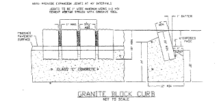
§ 615 - CURB CONSTRUCTION STANDARDS (N.J.A.C. 5:21-4.17)
A.
Construction specifications for acceptable curb types of granite block and concrete are shown in Figure 6.1.
B.
The standard concrete curb section used shall be a maximum of twenty (20) feet in length, with a scored joint every ten (10) feet. All concrete used for curbs or combination curbs and gutters shall be prepared in accordance with the requirements, by class of concrete, of the New Jersey Department of Transportation, Standard Specifications for Road and Bridge Construction effective at the time of preparation. Where bituminous concrete pavement is used for the road surface, the curb and/or gutter shall be constructed first.
C.
In residential develpment only, where drainage inlets are constructed but curbs are not required, curbing must be provided at least ten (10) feet on each side of the inlet, set back one foot (1) from the extension of the pavement edge.
(Ord. 11-2000 (part), 2000)
§ 616 - SIDEWALKS AND BIKEWAYS CONSTRUCTION STANDARDS (N.J.A.C. 5:21-4.18)
A.
The following apply to sidewalks and graded areas:
1.
Sidewalks of concrete shall be four (4) inches thick except at points of vehicular crossing, where they shall be at least six (6) inches thick. At vehicular crossings, concrete sidewalks shall be reinforced with welded wire fabric mesh or an equivalent.
2.
Concrete air-entrained sidewalks shall be Class C concrete, having a 28-day verification strength of 4,000 p.s.i. Other materials may be permitted, depending on the design of the development.
3.
Graded areas shall be planted with grass or treated with other suitable ground cover, and their width and cross slope shall correspond to that of sidewalks.
B.
The following apply to bikeways:
1.
The paved width of the bicycle path shall be established by the municipal master plan.
a.
Choice of surface materials, including bituminous mixes, concrete, compacted gravel, soil cement, stabilized earth, and wood planking shall depend on use and users of the path.
b.
Gradients of bike paths should generally not exceed five percent (5%).
2.
Bicycle-safe drainage grates shall be used in the construction of all residential streets.
(Ord. 11-2000 (part), 2000)
§ 617 - STREET GRADE, INTERSECTIONS AND PAVEMENT CONSTRUCTION STANDARDS AND NON-RESIDENTIAL DRIVEWAYS (N.J.A.C. 5:21-4.19)
A.
The following apply to street grade:
1.
Minimum street grade permitted for all streets shall be one-half percent (0.5%).
2.
Maximum street grade shall vary by road hierarchy with flatter grades required for roads with higher ADTs, in accordance with the requirements shown in Table 6.7. Where terrain makes it necessary, the allowable maximum grade may be increased by up to two percent (2%), but shall not exceed a maximum grade of sixteen percent (16%).
B.
The following apply to intersections:
1.
Street intersections shall be as nearly at right angles as possible and in no case shall be less than 75 degrees.
2.
New intersections along one side of an existing street shall, if possible, coincide with any existing intersections on the opposite side of each street. Use of "T" intersections in subdivisions shall be encouraged. To avoid corner-cutting when inadequate offsets exist between adjacent intersections, offsets shall be at least 150 feet between right-of-way centerlines.
3.
Intersections shall be rounded at the curbline with the street having the highest radius requirement, as shown in Table 6.8, determining the minimum standard for all curblines.
4.
Intersections shall be designed with a flat grade wherever practical.
5.
The minimum centerline radius, minimum tangent length between reverse curves, and curb radii shall be as shown in Table 6.7.
6.
Sight triangles shall be in accordance with 1990 AASHTO's "A Policy on Geometric Design of Highways and Streets" standards and based on the speed limits established by the government agency having jurisdiction. Sight triangle easements shall be required and shall include the area on each street corner that is bounded by the line which connects the sight or "connecting" points located on each of the right-of-way lines of the intersecting street. The planting of trees or other plantings, or the location of structures exceeding thirty (30) inches in height that would obstruct the clear sight across the area of the easements, shall be prohibited; and a public right-of-entry shall be reserved for the purpose of removing any object, material or otherwise, that obstructs the clear sight.
C.
Pavement design for residential access, neighborhood, rural, parking loop, minor collector, and major collector shall follow the specifications shown below. Subgrade categories are shown in Table 6.8.
D.
Alternative pavement design shall be allowed provided it conforms with one of the following: AASHTO Method of Flexible Pavement Design, Caltrans Method of Flexible Pavement Design, Asphalt Institute Method, AASHTO Method of Rigid Pavement Design, Fatigue Strength Method of Design, Multilayer Elastic Analysis, or the National Crushed Stone Association Design, incorporated herein by reference.
Table 6.7
Street Grade and Intersection Design Criteria
Street Hierarchy
* As measured from the nearest right-of-way level.
(Ord. 11-2000 (part), 2000)
§ 618 - CURVES (N.J.A.C. 5:21-4.20)
A.
Vertical and horizontal curves shall be designed in accordance with 1990 AASHTO's "A Policy on Geometric Design of Highways and Streets" standards, incorporated herein by reference.
B.
Sight easements on vertical and horizontal curves shall be required and determined based on the sight distance requirements contained in the 1990 AASHTO's "A Policy on Geometric Design of Highways and Streets" standards, taking into consideration the speed limits established by the government agency having jurisdiction. Residential access, residential neighborhood, and rural street design should be based on a speed limit of 25 miles per hour. Minor and major collector street design should be based on a speed limit of 30 miles per hour.
Table 6.8a
Subgrade Categories Based on Strength Test
Table 6.8b
Subgrade Categories Based on Soil Classification
* Refers to categories of soil types and properties.
Sources:
Per the Rutgers Model Subdivision and Site Plan Ordinance by David Listokin and Carole
W. Baker, January 1987—Original strength test and soil classification information
derived from the Asphalt Institute, "Thickness Design—Full-Depth Asphalt Pavement
Structures for Highways and Streets", MS-1, 8th Edition, August 1970 in Robert F.
Baker et al. (editor), Handbook of Highway Engineering. Inclusion of SW, SP, SC soil
classifications based on information from the Portland Cement Association's Thickness
Design for Concrete Highway and Street Pavements.
Revised CBR strength test and Mr value information are from the Asphalt Handbook for
County and Municipal Engineers, November 1991 (Second Edition), published by the New
Jersey Society of Municipal Engineers, or as may be amended from time to time.
(Ord. 11-2000 (part), 2000)
§ 619 - WATER SUPPLY SYSTEM (N.J.A.C. 5:21-5.1)
Water supply systems, where installed, shall conform to the standards contained in this Article.
(Ord. 11-2000 (part), 2000)
§ 620 - CAPACITY (N.J.A.C. 5:21-5.2)
A.
The water supply system shall be adequate to handle the necessary flow, based on complete development of the tract.
B.
When plans for future development necessitate oversizing of the water supply system, the municipality or utility authority may enter into an agreement with the developer to address the fair share of the costs.
C.
The demand rates for all uses shall be considered in computing the total system demand. Where fire protection is provided in accordance with subsection E of this section, the system shall be capable of providing the required fire demand plus the required average daily residential demand as indicated in Table 6.9, or the peak hour flows indicated in Table 6.10, whichever is greater.
D.
Average daily residential consumption shall be computed in accordance with the housing unit type and size data shown in Table 6.10. The peak daily flows shall be computed by applying a peaking factor of three (3) times the average daily residential consumption. The municipality may require deviations in the peaking factor value provided appropriate documentation and justification for the deviation from the standards is provided.
E.
The design of the on-site water distribution system shall be adequate to provide fire protection as per ISO standard, Fire Suppression Rating Schedule, or per AWWA M31, "Manual of Water Supply Practices—Distribution System Requirements for Fire Protection," ISO method on pages 3-9, incorporated herein by reference.
F.
Areas with Special Water Supply Problems. Based on investigations made by the Planning Board of the Township, including geologic information, well records and experience with wells, certain areas of special concern regarding the availability of safe sustained yeild of water for development have been identified. These areas of special concern are identified on the Map enTitled Zoning Map, attached to and made part of this Ordinance. With respect to all development requiring subdivision or site plan approval in such areas of special concern, before the granting of any final major subdivision or site plan approval, the applicant shall submit hydrogeologic information with the Environmental Impact Statement describing well yields for the site.
(Ord. 11-2000 (part), 2000)
§ 621 - SYSTEM DESIGN AND PLACEMENT (N.J.A.C. 5:21-5.3)
A.
System design and placement shall comply with the following construction specifications, incorporated herein by reference: all applicable NJ Department of Environmental Protection (NJ DEP) rules, the American Water Works Association (AWWA) standards, and in the Pinelands Area, the Standards of the Pinelands Comprehensive Management Plan, with the strictest standards governing.
B.
Distribution mains of the overall system shall be connected into loops so that the supply may be brought to the consumer from more than one direction. In balancing loops in a design, the Hardy-Cross, or an equivalent, method shall be used (see Residential Site Improvement Standards (RSIS), subchapter Appendix, incorporated herein by reference). Manning roughness coefficients listed in Table 7.1 in N.J.A.C. 5:21-7.1 may be used in these calculations. Dead-end lines shall be permitted within the design of a looped system provided that there are no more than 20 dwelling units permanently, or no more than 50 dwelling units temporarily, on a dead-end line. When dead-end lines are used, they shall be provided with a hydrant or blowoff at the terminus as a means of flushing.
Table 6.9
Water Demand/Generation by Type/Size of Housing
* Based on 100 gallons per person per day for single-family detached units and 75 gallons per person per day for other housing types (rounded).
Source:
U.S. Census, Public Use File—New Jersey (Units built 1975-1980).
Table 6.10
Design Standards for Peak Hour Flow
C.
Valves, except on a permitted dead end, shall be located on distribution mains so that no more than one hydrant would be out of service as a result of a single water main break. They shall be located in all small branches off larger mains; and where eight (8) inch or larger mains lines intersect, a valve shall be located in each branch. At street intersections, valves shall be located near pipe intersections for ease in finding in the event of a water main break.
D.
In addition to the above requirements, water mains shall be valved so that not more than one-quarter of a mile would be affected by a single water main break. Geared valves on 16-inch mains or larger shall be furnished.
E.
No pipe shall be placed on private property unless the owner of the land is to own or operate the pipe, or an easement deeded to the municipality or utility authority is obtained. All easements shall be a minimum of 20-feet wide unless depth of pipe, soil conditions, or additional utilities require wider.
F.
A building service connection shall be comprised of a corporation stop at the main, a curb stop, and a water meter. When the meter is located outside a building, an additional shut-off valve shall be installed on the discharge side of the meter. When the meter is located inside a building, valving shall be in accordance with the Plumbing Subcode of the Uniform Construction Code (N.J.A.C. 5:23-3.15). Curb stops and water meters shall be located as specified by the public or private water supplier.
1.
Separate water service connections for each unit shall be utilized for detached housing where maintenance is the responsibility of the individual homeowner.
2.
Common water service connections shall be allowed for multifamily housing where there is an entity, such as a homeowner's association, that is responsible for the maintenance of the common water laterals. Where common laterals are utilized, individual water shutoffs and meters shall be provided for each unit.
G.
Where water system extensions are constructed by developers and meter fees are not paid by the developer, the water meter(s) shall be furnished by the developer and shall be of a manufacture and type approved by the municipality or utility authority. The meter(s) shall be read in "gallons" or "cubic feet" as determined by the municipality or utility authority. Where meter fees are paid by the developer, the meter(s) shall be furnished by the municipality or utility authority.
H.
Pipe size shall comply with the following requirements:
1.
Water mains shall be a minimum diameter of eight (8) inches except at the end of a permanent cul-de-sac, unless another size is required for fire flow and other criteria. A six (6) inch main may be used when it serves not more than 20 dwelling units and only one fire hydrant.
2.
Building service connection pipe shall be a minimum diameter of three-quarter (¾) inch.
3.
Design capacity of water mains shall be such as to maintain a minimum pressure of 20 pounds per square inch (psi) at street level under all flow conditions.
I.
Pipe materials used in the construction of water mains shall be cement-lined ductile iron, prestressed concrete cylinder pipe, or PVC pipe. All pipe and appurtenances shall comply with the applicable AWWA standards in effect at the time of application. All standards referenced in this subsection are incorporated herein by reference.
1.
Ductile iron pipe, appurtenances, and fittings shall comply with ANSI/AWWA C110/A21.10 (fittings), C111/A21.11 (gasket joints), C115/A21.15 (flanged joints), and C151/A21.51 (pipe). Thickness shall be designed in accordance with ANSI/AWWA C150/A21.50 and shall be a minimum of Class 52. It shall be cement-mortar lined in accordance with ANSI/AWWA C104/A21.4. Joints shall be gasketed push-on joints in conformance with ANSI/AWWA C111/A21.11. The exterior of the ductile iron pipe shall be covered with a coal-tar, epoxy-type coating. In aggressive soils, ductile iron pipe wrapped in polyethylene, in accordance with ANSI/AWWA C105/A21.5, shall be used.
2.
Prestressed concrete cylinder pipe with rubber and steel joints shall conform to ANSI/AWWA C301.
3.
PVC pipe, appurtenances, and fittings shall conform to ANSI/AWWA C900 for pipe sizes four (4) inches to 12 inches, and joints shall be elastomeric-gasket couplings of a corresponding size. Laboratory performance requirements, as specified in ASTM D3139, shall be met. Solvent-cement couplings shall not be permitted.
4.
Where transitions to flanged fittings are made, adapters approved by the municipality or water purveyer shall be used.
5.
Gate valves shall be cast-iron body with double-disc gates, bronze-mounted or resilient-seated wedge, nonrising stem mechanical joint as specified by the municipality or utility authority. Valves shall be full size, and those on 16-inch mains or larger shall be geared and have suitable bypasses. Valve boxes shall be of the adjustable type with the cover marked "water" and direction of valve operation indicated.
6.
Building service connection pipe shall be type K copper or polyethylene (PE) pressure pipe that complies with ANSI/AWWA C901.
J.
Pipe bedding and backfill shall be installed in accordance with the pipe manufacturer's recommendations.
1.
The municipality or the authority may require the developer to provide an opinion of a professional engineer relative to the suitability of the on-site material to be used as backfill. The municipality or authority shall rely on this opinion.
2.
Where the on-site material is deemed suitable, the opinion shall specify the appropriate installation methods for the material. Where the on-site material is deemed not suitable, the opinion shall specify modification or replacement of the material and the appropriate installation for the specified material.
(Ord. 11-2000 (part), 2000)
§ 622 - FIRE HYDRANTS (N.J.A.C. 5:21-5.4)
A.
Where public water is available for firefighting, hydrants shall be spaced to provide necessary fire flow. The average building area served per hydrant shall not exceed 120,000 square feet. In addition, the distance between any dwelling and a hydrant shall not exceed 400 feet when measured along the street right-of-way.
B.
Size, type, and installation of hydrants shall conform to the following specifications, incorporated herein by reference, as appropriate.
1.
Size, type, and installation of hydrants shall be in accordance with the requirements of the municipality or the water purveyor or shall conform to the AWWA Standard for Dry-Barrel Fire Hydrants, ANSI/AWWA C502. Hydrants shall have at least three (3) outlets; one outlet shall be a pump-er outlet, and other outlets shall be at least two-and-one-half- (2½ ) inch nominal size. Street main connections shall not be less than six (6) inches in diameter. Hose threads on outlets shall be compatible with existing municipal equipment and shall either conform to NFPA 1963 or shall match existing municipal requirements. A valve shall be provided on connections between hydrants and street mains. All pipe, fittings, and appurtenances supplying fire hydrants shall be AWWA or ASTM approved.
2.
All fire hydrants shall conform to NFPA Standard 291.
3.
In the New Jersey Register dated January 6, 1997, there is an appendix on the Hardy-Cross Method which is a method for determining water main size. Please refer to N.J.A.C. 5:21-5 for an explanation of this method.
4.
Where streams or ponds exist, or are proposed on lands to be developed, or where water is available from other sources, facilities shall be provided to draft water for fire fighting purposes, unless waived by the Approving Authority on the advice of the Township Engineer. This shall include access to a street suitable for use by fire-fighting equipment and construction of or improvements to ponds, dams, or similar on-site development. Underground storage tanks shall have a capacity of 30,000 gallons, and be located no further than 1,200 feet from any building structure; be constructed of fiberglass and installed according to manufacturers specifications; be installed with anti-flotation footings and straps in areas of high water table; have an access manhole; have an inspection port to measure water level; have venting for 1,500 gpm of discharge pumping; have suction pumping connected to the bottom of the tanks; have a suction hydrant with threads compatible with the fire equipment which will serve the development, with the hydrants located no more than 12 feet above the bottom of the tank; and have the hydrant located along an access road suitable for fire trucks. Such facilities shall be constructed to the satisfaction of the Municipal Engineer and in accordance with the standards of the Insurance Services Office of New Jersey.
(Ord. 20-2002 § 5, 2002; Ord. 11-2000 (part), 2000)
§ 623 - SANITARY SEWER SYSTEM (N.J.A.C. 5:21-6.1)
A.
Sanitary sewer systems, where installed, shall conform to the standards contained in this section.
B.
When plans for future development necessitate oversizing or grade changes, the municipality or utility authority may enter into an agreement with the developer to address the fair share of the costs of improvements not required for the proposed development.
C.
If a public sanitary sewer system will be provided to the area within a six-year period as indicated in the municipal sewer master plan, official map, or other official document, a municipality may require installation of a capped system within the road right-of-way or existing utility authority easements to service the approved lots; or, alternatively, a municipality may require a performance guarantee in lieu of the improvement. Capped sanitary sewers shall be allowed only in areas indicated for sewer service in the State of New Jersey Statewide Water Quality Management (WQM) Plans and where permitted by NJ DEP through sewer connection approval.
1.
Individual subsurface disposals systems shall comply with N.J.A.C. 7:9A-3.2 and 3.16.
2.
The applicant shall submit to the municipality or utility authority for review for compliance with this subchapter details of the planned pipes, joints, mains, laterals, and appurtenances. All materials used for sanitary sewer systems shall be manufactured in the United States, wherever available, as governed by P.L. 1982, c. 107, effective date October 3, 1982. The details shall comply with all standards and specifications listed in this subchapter.
(Ord. 11-2000 (part), 2000)
§ 624 - SYSTEM PLANNING, DESIGN, AND PLACEMENT (N.J.A.C. 5:21-6.2)
A.
The planning, design, construction, installation, modification, and operation of any treatment works or sanitary system shall be in accordance with the applicable NJDEP rules implementing the New Jersey Water Pollution Control Act (N.J.S.A. 58:10A-1 et seq.) and the New Jersey Water Quality Planning Act (N.J.S.A. 58:11A-1 et seq.); and, for items not covered by NJDEP rules, with ASCE Manual on Engineering Practice No. 37, incorporated herein by reference; and, in the Pinelands Area, with the Pinelands Comprehensive Management Plan and, in the coastal area, with NJDEP rules implementing the Coastal Area Facilities Review Act (N.J.S.A. 13:19-1 et seq.).
B.
Sanitary sewer pumping stations shall be considered where gravity system design leads to excessive sewer depths which are not economically justifiable and shall comply with N.J.A.C. 7:14A-23.10, 23.11, and 23.12.
C.
System design and placement shall comply with the following specifications:
1.
Except where otherwise specified by municipality or utility authority, sanitary sewer manholes, when located within the municipal right-of-way, shall be at or near the center line of the paved cartway, but at a five- (5) foot minimum from the edge of the pavement. Sanitary sewer mains shall be a minimum of ten (10) feet from the right-of-way line.
2.
Easements shall be in a form approved by the utility authority or the municipal engineer and municipal attorney. Easements shall be required for all sanitary sewer lines which are not within a public right-of-way. Easements shall be a minimum of 20-feet wide for sanitary sewers that are not more than 15-feet deep. For sewers that are more than 15-feet deep, easements shall be a minimum of 30-feet wide. The depth of the sewer shall be measured from the design invert of the pipe to the surface of the proposed final grading.
3.
As with water lines, common sanitary sewer service may be permitted for multifamily housing where there is an entity such as a homeowner's association that is responsible for the maintenance of the common laterals.
4.
All sewers shall be designed to meet the New Jersey Department of Environmental Protection's slope standards at N.J.A.C. 7:14A-23.6(b).
5.
Pipe materials used in the construction of sanitary sewers, including gravity sewers, shall be reinforced concrete, ductile iron, PVC, or clay pipe. All pipe and appurtenances shall comply with AWWA and ASTM standards referenced in this paragraph, which are incorporated herein by reference.
a.
Reinforced concrete pipe shall be used only in sizes 24 inches and larger and shall meet all the requirements of ASTM C76. All pipe shall be Class III strength installed with class C ordinary bedding, except in the following conditions where stronger pipe may be required:
(1)
For depths less than three (3) feet, measured from the top of the pipe, installed under traffic areas, Marston Class IV pipe shall be required.
(2)
The presence of clay soils, poor bedding conditions, or other unusual loading conditions shall be given special consideration and the developer shall submit an engineering analysis to the municipality or authority for approval.
b.
PVC sewer pipe shall have bell and spigot ends and O-ring rubber gasketed joints. PVC pipe and fittings shall conform to ASTM D3034, with a minimum wall thickness designation of SDR 35.
(1)
The plastic material from which the pipe and fittings are extruded shall be impact types of PVC, unplasticized, having high mechanical strength and maximum chemical resistance conforming to Type 1, Grade 1 of the specification for rigid polyvinyl chloride compounds, ASTM D1784.
(2)
Pipe shall be free from defects, such as bubbles or other imperfections, in accordance with accepted commercial practice. Test results demonstrating that the pipe meets ASTM D2444 for impact and ASTM D2321 for deflection and pipe stiffness, shall be provided when requested by the municipality or utility authority.
(3)
Joints shall conform to ASTM D3212. Rubber ring gaskets shall conform to ASTM F477. The gasket shall be the sole element depended upon to make the joint watertight.
(4)
The pipe shall be installed as specified in ASTM D2321. In no case shall less than a Class III material be used for bedding and haunching material, unless approved in writing by the municipal engineer or utility authority engineer. When installing pipe in unstable soil or excessive ground water, a determination regarding special precautions, such as poured concrete slabs, shall be made by the municipal engineer or utility authority engineer.
(5)
Trench cross sections shall comply with the bedding details.
c.
Ductile iron pipe shall be centrifugally cast in metal or sand-lined molds to ANSI/AWWA C151/A21.51. The joint shall be of a type that employs a single, elongated, grooved gasket to effect the joint seal. Pipe should be furnished with flanges where connections to flange fittings are required. Pipe shall be a minimum of Class 50. The outside of the pipe shall be coated with a uniform thickness of hot applied coal tar coating; the inside shall be lined with cement in accordance with ANSI/AWWA C104/A21.4. Ductile iron pipe shall be installed with Class C, Ordinary Bedding, when site conditions allow. In corrosive soils or on sewers that receive discharge from a force main where hydrogen sulfide is present, ductile iron pipe with polyethylene coating, which protects the interior and exterior of the pipe, shall be used.
d.
Clay pipe shall comply with ASTM C700.
6.
Inverted siphons, force mains, and outfalls shall be constructed of ductile iron pipe or PVC pipe, as specified above. Inverted siphons shall consist of two pipes with provisions for flushing. Flow control gates shall be provided in the chambers.
7.
In addition to the pipe materials at N.J.A.C. 7:14A-23.6(b)5, PVC pipe shall be considered a suitable material.
8.
For other than PVC pipe, pipe and manhole bedding and backfill shall be provided as specified in "Design and Construction of Sanitary and Storm Sewers, ASCE Manual on Engineering Practice No. 37," prepared by the Joint Committee on the American Society of Civil Engineers and the Water Pollution Control Federation, New York, 1969. Any pipe material not covered by this manual shall be installed in accordance with the manufacturer's recommendations.
a.
The municipality or the authority may require the developer to provide an opinion of a professional engineer regarding the suitability of the on-site material to be used as backfill. The municipality or authority shall rely on this opinion.
b.
Where the on-site material is deemed suitable, the opinion shall specify the appropriate installation methods for the material. Where the on-site material is deemed not suitable, the opinion shall specify modification or replacement of the material and the appropriate installation methods for the specified material.
9.
Manholes shall comply with the standards in ASCE Manual on Engineering Practice No. 37, and shall meet the following requirements:
a.
Manholes shall be precast concrete or concrete block. Concrete block shall be coated with two (2) coats of portland cement mortar. Precast concrete or concrete block shall be sealed with two (2) coats of an acceptable waterproofing tar, asphalt, or polyplastic alloy, with enough time allowed to bond between the sealed coats.
b.
Masonry brick, concrete block, or half rings may be used to make vertical adjustments to rims.
c.
Where pipe size varies, crowns of pipes shall be matched, except in special conditions, as required by applicable NJDEP rules.
d.
If precast manhole barrels and cones are used, they shall conform to ASTM C478, with round rubber gasketed joints conforming to ASTM C361 and ASTM C443. Maximum absorption shall be nine (9) percent, in accordance with ASTM C478, method A. The entire outside surface of the manhole shall be coated with a bituminous waterproofing material acceptable to the municipal engineer or utility authority. Cracked manholes shall not be used. The top riser section of precast manholes shall terminate less than one (1) foot below the finished grade to provide for proper adjustment.
e.
Manhole frames and covers shall be of cast iron and shall conform to ASTM A48, Class 30, and shall be suitable for H-20 loading capacity. All manhole covers in unpaved rights-of-way or in remote areas shall be provided with a locking device, as specified by the municipality or utility authority. The word "SEWER" shall be cast integrally into the manhole cover.
f.
Where watertight and low profile frames and covers are utilized, they shall conform to ASTM C923. Manholes shall be supplied with flexible, watertight adaptors, such as inserts or gaskets, suitable for the pipe materials used.
10.
Laterals and cleanouts shall comply with the following:
a.
The house connection or lateral from the street main to the cleanout shall be considered an integral part of the sanitary sewer system. The type of material used for the house connection shall be as follows: four (4) inch cast iron soil pipe, extra heavy; four (4) inch PVC pipe, Schedule 40; four (4) inch ABS plastic pipe, SDR 35; or four (4) inch ductile iron pipe. Common laterals for multifamily units shall be designed to have adequate conveyance capacity.
b.
Wye connections shall be the same material as the sewer main. Saddles shall be used only for connection to an existing main.
c.
Bends in house connection lines shall be made using standard fittings. A riser with a cleanout shall be provided in the lateral between the edge of the pavement and property line or within a designated easement as determined by the municipality.
d.
Inspection cleanouts or observation tees within the easement or right-of-way shall be fitted with either a metallic cap or a nonmetal cap fitted with a metallic plug that is suitable for locating the cleanout. Caps shall have a depressed or inverted nut. The inspection cleanout or observation tee shall be placed between the curb or edge of pavement and property line or within a designated easement.
e.
Connections beyond the cleanout are under the jurisdiction of the Plumbing Subcode of the Uniform Construction Code (N.J.A.C. 5:23-3.15) through the Plumbing Subcode official. The pipe size and specifications shall comply with the regulations and requirements of the Plumbing Subcode of the Uniform Construction Code.
f.
As-built drawings that include the location of plumbing wyes, as supplied by the contractor, shall be submitted to the municipal engineer.
(Ord. 11-2000 (part), 2000)
§ 625 - STORMWATER CONTROL
A.
Scope and Purpose.
1.
Policy Statement. Flood control, groundwater recharge, and pollutant reduction shall be achieved through the use of stormwater management measures, including green infrastructure Best Management Practices (GI BMPs) and nonstructural stormwater management strategies. GI BMPs and low impact development (LID) should be utilized to meet the goal of maintaining natural hydrology to reduce stormwater runoff volume, reduce erosion, encourage infiltration and groundwater recharge, and reduce pollution. GI BMPs and LID should be developed based upon physical site conditions and the origin, nature and the anticipated quantity, or amount, of potential pollutants. Multiple stormwater management BMPs may be necessary to achieve the established performance standards for water quality, quantity, and groundwater recharge.
2.
Purpose. The purpose of this ordinance is to establish minimum stormwater management requirements and controls for "major development," as defined below in Section II.
3.
Applicability.
a.
This ordinance shall be applicable to the following major developments:
i.
Non-residential major developments; and
ii.
Aspects of residential major developments that are not pre-empted by the Residential Site Improvement Standards at N.J.A.C. 5:21.
b.
This ordinance shall also be applicable to all major developments undertaken by the Township of Tewksbury.
c.
An application required by this Section that has been submitted prior to October 1, 2024, shall be subject to the stormwater management requirements in effect on September 30, 2024.
d.
An application required by this Section that has been submitted on or after March 2, 2021, but prior to October 1, 2024, shall be subject to the stormwater management requirements in effect on September 30, 2024.
e.
Notwithstanding any rule to the contrary, a major development for any public roadway or railroad project conducted by a public transportation entity that has determined a preferred alternative or reached an equivalent milestone before July 17, 2023, shall be subject to the stormwater management requirements in effect prior to July 17, 2023.
4.
Compatibility with Other Permit and Ordinance Requirements. Development approvals issued pursuant to this ordinance are to be considered an integral part of development approvals and do not relieve the applicant of the responsibility to secure required permits or approvals for activities regulated by any other applicable code, rule, act, or ordinance. In their interpretation and application, the provisions of this ordinance shall be held to be the minimum requirements for the promotion of the public health, safety, and general welfare. This ordinance is not intended to interfere with, abrogate, or annul any other ordinances, rule or regulation, statute, or other provision of law except that, where any provision of this ordinance imposes restrictions different from those imposed by any other ordinance, rule or regulation, or other provision of law, the more restrictive provisions or higher standards shall control.
B.
Definitions. For the purpose of this ordinance, the following terms, phrases, words and their derivations shall have the meanings stated herein unless their use in the text of this Chapter clearly demonstrates a different meaning. When not inconsistent with the context, words used in the present tense include the future, words used in the plural number include the singular number, and words used in the singular number include the plural number. The word "shall" is always mandatory and not merely directory. The definitions below are the same as or based on the corresponding definitions in the Stormwater Management Rules at N.J.A.C. 7:8-1.2.
"Community basin" means an infiltration system, sand filter designed to infiltrate, standard constructed wetland, or wet pond, established in accordance with N.J.A.C. 7:8-4.2(c)14, that is designed and constructed in accordance with the New Jersey Stormwater Best Management Practices Manual, or an alternate design, approved in accordance with N.J.A.C. 7:8-5.2(g), for an infiltration system, sand filter designed to infiltrate, standard constructed wetland, or wet pond and that complies with the requirements of this chapter.
"Compaction" means the increase in soil bulk density.
"Contributory drainage area" means the area from which stormwater runoff drains to a stormwater management measure, not including the area of the stormwater management measure itself.
"Core" means a pedestrian-oriented area of commercial and civic uses serving the surrounding Township, generally including housing and access to public transportation.
"County review agency" means an agency designated by the County Board of Chosen Freeholders to review municipal stormwater management plans and implementing ordinance(s). The county review agency may either be:
1.
A county planning agency; or
2.
A county water resource association created under N.J.S.A 58:16A-55.5, if the ordinance or resolution delegates authority to approve, conditionally approve, or disapprove municipal stormwater management plans and implementing ordinances.
"Department" means the New Jersey Department of Environmental Protection.
"Designated Center" means a State Development and Redevelopment Plan Center as designated by the State Planning Commission such as urban, regional, town, village, or hamlet.
"Design engineer" means a person professionally qualified and duly licensed in New Jersey to perform engineering services that may include, but not necessarily be limited to, development of project requirements, creation and development of project design and preparation of drawings and specifications.
"Development" means the division of a parcel of land into two or more parcels, the construction, reconstruction, conversion, structural alteration, relocation or enlarge-enlargement of any building or structure, any mining excavation or landfill, and any use or change in the use of any building or other structure, or land or extension of use of land, for which permission is required under the Municipal Land Use Law, N.J.S.A. 40:55D-l, et seq.
In the case of development of agricultural land, development means: any activity that requires a State permit, any activity reviewed by the County Agricultural Board (CAB) and the State Agricultural Development Committee (S ADC), and municipal review of any activity not exempted by the Right to Farm Act, N.J.S.A. 4:1C-1, et seq.
"Disturbance" means the placement or reconstruction of impervious surface or motor vehicle surface, or exposure and/or movement of soil or bedrock or clearing, cutting, or removing of vegetation. Milling and repaving is not considered disturbance for the purposes of this definition.
"Drainage area" means a geographic area within which stormwater, sediments, or dissolved materials drain to a particular receiving waterbody or to a particular point along a receiving waterbody.
"Environmentally constrained area" means the following areas where the physical alteration of the land is in some way restricted, either through regulation, easement, deed restriction or ownership such as: wetlands, floodplains, threatened and endangered species sites or designated habitats, and parks and preserves. Habitats of endangered or threatened species are identified using the Department's Landscape Project as approved by the Department's Endangered and Nongame Species Program.
"Environmentally critical area" means an area or feature which is of significant environmental value, including but not limited to: stream corridors, natural heritage priority sites, habitats of endangered or threatened species, large areas of contiguous open space or upland forest, steep slopes, and well head protection and groundwater recharge areas. Habitats of endangered or threatened species are identified using the Department's Landscape Project as approved by the Department's Endangered and Nongame Species Program.
"Erosion" means the detachment and movement of soil or rock fragments by water, wind, ice, or gravity.
"Green infrastructure" means a stormwater management measure that manages stormwater close to its source by:
1.
Treating stormwater runoff through infiltration into subsoil;
2.
Treating stormwater runoff through filtration by vegetation or soil; or
3.
Storing stormwater runoff for reuse.
"HUC 14" or "hydrologic unit code 14" means an area within which water drains to a particular receiving surface water body, also known as a subwatershed, which is identified by a 14-digit hydrologic unit boundary designation, delineated within New Jersey by the United States Geological Survey.
"Impervious surface" means a surface that has been covered with a layer of material so that it is highly resistant to infiltration by water.
"Infiltration" is the process by which water seeps into the soil from precipitation.
"Lead planning agency" means one or more public entities having stormwater management planning authority designated by the regional stormwater management planning committee pursuant to N.J.A.C. 7:8-3.2, that serves as the primary representative of the committee.
"Major development" means an individual "development," as well as multiple developments that individually or collectively result in:
1.
The disturbance of one or more acres of land since February 2, 2004;
2.
The creation of one-quarter acre or more of "regulated impervious surface" since February 2,2004;
3.
The creation of one-quarter acre or more of "regulated motor vehicle surface" since March 2, 2021; or
4.
A combination of Sections 2 and 3, above, that totals an area of one-quarter acre or more. The same surface shall not be counted twice when determining if the combination area equals one-quarter acre or more.
Major development includes all developments that are part of a common plan of development or sale (for example, phased residential development) that collectively or individually meet any one or more of paragraphs 1, 2, 3, or 4 above. Projects undertaken by any government agency that otherwise meet the definition of "major development" but which do not require approval under the Municipal Land Use Law, N.J.S.A. 40:55D-l et seq., are also considered "major development."
"Motor vehicle" means land vehicles propelled other than by muscular power, such as automobiles, motorcycles, autocycles, and low speed vehicles. For the purposes of this definition, motor vehicle does not include farm equipment, snowmobiles, all-terrain vehicles, motorized wheelchairs, go-carts, gas buggies, golf carts, ski-slope grooming machines, or vehicles that run only on rails or tracks.
"Motor vehicle surface" means any pervious or impervious surface that is intended to be used by "motor vehicles" and/or aircraft, and is directly exposed to precipitation including, but not limited to, driveways, parking areas, parking garages, roads, racetracks, and runways.
"Municipality" means any city, borough, town, township, or village.
"New Jersey Stormwater Best Management Practices (BMP) Manual" or "BMP Manual" means the manual maintained by the Department providing, in part, design specifications, removal rates, calculation methods, and soil testing procedures approved by the Department as being capable of contributing to the achievement of the stormwater management standards specified in this chapter.
The BMP Manual is periodically amended by the Department as necessary to provide design specifications on additional best management practices and new information on already included practices reflecting the best available current information regarding the particular practice and the Department's determination as to the ability of that best management practice to contribute to compliance with the standards contained in this chapter. Alternative stormwater management measures, removal rates, or calculation methods may be utilized, subject to any limitations specified in this chapter, provided the design engineer demonstrates to the Township, in accordance with Section D(6) of this Ordinance and N.J.A.C. 7:8-5.2(g), that the proposed measure and its design will contribute to achievement of the design and performance standards established by this chapter.
"Node" means an area designated by the State Planning Commission concentrating facilities and activities which are not organized in a compact form.
"Nutrient" means a chemical element or compound, such as nitrogen or phosphorus, which is essential to and promotes the development of organisms.
"Person" means any individual, corporation, company, partnership, firm, association, political subdivision of this State and any state, interstate or Federal agency.
"Pollutant" means any dredged spoil, solid waste, incinerator residue, filter backwash, sewage, garbage, refuse, oil, grease, sewage sludge, munitions, chemical wastes, biological materials, medical wastes, radioactive substance (except those regulated under the Atomic Energy Act of 1954, as amended (42 U.S.C. §§ 2011 et seq. thermal waste, wrecked or discarded equipment, rock, sand, cellar dirt, industrial, municipal, agricultural, and construction waste or runoff, or other residue discharged directly or indirectly to the land, ground waters or surface waters of the State, or to a domestic treatment works. "Pollutant" includes both hazardous and nonhazardous pollutants.
"Public roadway or railroad" means a pathway for use by motor vehicles or trains that is intended for public use and is constructed by, or on behalf of, a public transportation entity. A public roadway or railroad does not include a roadway or railroad constructed as part of a private development, regardless of whether the roadway or railroad is ultimately to be dedicated to and/or maintained by a governmental entity.
"Public transportation entity" means a Federal, State, county, or municipal government, an independent State authority, or a statutorily authorized public-private partnership program pursuant to P.L. 2018, c. 90 (N.J.S.A. 40A:11-52 et seq.), that performs a public roadway or railroad project that includes new construction, expansion, reconstruction, or improvement of a public roadway or railroad.
"Recharge" means the amount of water from precipitation that infiltrates into the ground and is not evapotranspired.
"Regulated impervious surface" means any of the following, alone or in combination:
1.
A net increase of impervious surface;
2.
The total area of impervious surface collected by a new stormwater conveyance system (for the purpose of this definition, a "new stormwater conveyance system" is a stormwater conveyance system that is constructed where one did not exist immediately prior to its construction or an existing system for which a new discharge location is created);
3.
The total area of impervious surface proposed to be newly collected by an existing stormwater conveyance system; and/or
4.
The total area of impervious surface collected by an existing stormwater conveyance system where the capacity of that conveyance system is increased.
"Regulated motor vehicle surface" means any of the following, alone or in combination:
1.
The total area of motor vehicle surface that is currently receiving water;
2.
A net increase in motor vehicle surface; and/or
3.
Quality treatment either by vegetation or soil, by an existing stormwater management measure, or by treatment at a wastewater treatment plant, where the water quality treatment will be modified or removed.
"Sediment" means solid material, mineral or organic, that is in suspension, is being transported, or has been moved from its site of origin by air, water or gravity as a product of erosion.
"Site" means the lot or lots upon which a major development is to occur or has occurred.
"Soil" means all unconsolidated mineral and organic material of any origin.
"State Development and Redevelopment Plan Metropolitan Planning Area (PAI)" means an area delineated on the State Plan Policy Map and adopted by the State Planning Commission that is intended to be the focus for much of the State's future redevelopment and revitalization efforts.
"State Plan Policy Map" is defined as the geographic application of the State Development and Redevelopment Plan's goals and statewide policies, and the official map of these goals and policies.
"Stormwater" means water resulting from precipitation (including rain and snow) that runs off the land's surface, is transmitted to the subsurface, or is captured by separate storm sewers or other sewage or drainage facilities, or conveyed by snow removal equipment.
"Stormwater management BMP" means an excavation or embankment and related areas designed to retain stormwater runoff. A stormwater management BMP may either be normally dry (that is, a detention basin or infiltration system), retain water in a permanent pool (a retention basin), or be planted mainly with wetland vegetation (most constructed stormwater wetlands).
"Stormwater management measure" means any practice, technology, process, program, or other method intended to control or reduce stormwater runoff and associated pollutants, or to induce or control the infiltration or groundwater recharge of stormwater or to eliminate illicit or illegal non-stormwater discharges into stormwater conveyances.
"Stormwater runoff' means water flow on the surface of the ground or in storm sewers, resulting from precipitation.
"Stormwater management planning agency" means a public body authorized by legislation to prepare stormwater management plans.
"Stormwater management planning area" means the geographic area for which a stormwater management planning agency is authorized to prepare stormwater management plans, or a specific portion of that area identified in a stormwater management plan prepared by that agency.
"Township" means the Township of Tewksbury, Hunterdon County, New Jersey, including all of its officials, officers, committees, boards, professionals, attorneys, engineers and assigns.
"Water control structure" means a structure within, or adjacent to, a water, which intentionally or coincidentally alters the hydraulic capacity, the flood elevation resulting from the two-, 10-, or 100-year storm, flood hazard area limit, and/or floodway limit of the water. Examples of a water control structure may include a bridge, culvert, dam, embankment, ford (if above grade), retaining wall, and weir.
"Waters of the State" means the ocean and its estuaries, all springs, streams, wetlands, and bodies of surface or groundwater, whether natural or artificial, within the boundaries of the State of New Jersey or subject to its jurisdiction.
"Wetlands" or "wetland" means an area that is inundated or saturated by surface water or ground water at a frequency and duration sufficient to support, and that under normal circumstances does support, a prevalence of vegetation typically adapted for life in saturated soil conditions, commonly known as hydrophytic vegetation.
C.
Design and Performance Standards for Stormwater Management Measures.
1.
Stormwater management measures for major development shall be designed to provide erosion control, groundwater recharge, stormwater runoff quantity control, and stormwater runoff quality treatment as follows:
a.
The minimum standards for erosion control are those established under the Soil and Sediment Control Act, N.J.S.A. 4:24-39 et seq., and implementing rules at N.J.A.C. 2:90.
b.
The minimum standards for groundwater recharge, stormwater quality, and stormwater runoff quantity shall be met by incorporating green infrastructure.
2.
The standards in this ordinance apply only to new major development and are intended to minimize the impact of stormwater runoff on water quality and water quantity in receiving water bodies and maintain groundwater recharge. The standards do not apply to new major development to the extent that alternative design and performance standards are applicable under a regional stormwater management plan or Water Quality Management Plan adopted in accordance with Department rules.
D.
Stormwater Management Requirements for Major Development.
1.
The development shall incorporate a maintenance plan for the stormwater management measures incorporated into the design of a major development in accordance with Section J, below.
2.
Stormwater management measures shall avoid adverse impacts of concentrated flow on habitat for threatened and endangered species as documented in the Department's Landscape Project or Natural Heritage Database established under N.J.S.A. 13:1B-15.147 through 15.150, particularly Helonias bullata (swamp pink) and/or Clemmys muhinebergi (bog turtle).
3.
The following linear development projects are exempt from the groundwater recharge, stormwater runoff quality, and stormwater runoff quantity requirements of this Section D, subsections 16, 17 and 18:
a.
The construction of an underground utility line provided that the disturbed areas are revegetated upon completion;
b.
The construction of an aboveground utility line provided that the existing conditions are maintained to the maximum extent practicable; and
c.
The construction of a public pedestrian access, such as a sidewalk or trail with a maximum width of 14 feet, provided that the access is made of permeable material.
4.
A waiver from strict compliance from the green infrastructure, groundwater recharge, stormwater runoff quality, and stormwater runoff quantity requirements of this Section D, subsections 15, 16, 17 and 18 may be obtained for the enlargement of an existing public roadway or railroad; or the construction or enlargement of a public pedestrian access, provided that the following conditions are met:
a.
The applicant demonstrates that there is a public need for the project that cannot be accomplished by any other means;
b.
The applicant demonstrates through an alternatives analysis, that through the use of stormwater management measures, the option selected complies with the requirements of this Section D, subsections 15, 16, 17 and 18 to the maximum extent practicable;
c.
The applicant demonstrates that, in order to meet the requirements of this Section, subsections 15, 16, 17 and 18, existing structures currently in use, such as homes and buildings, would need to be condemned; and
d.
The applicant demonstrates that it does not own or have other rights to areas, including the potential to obtain through condemnation lands not falling under D(4)(c) above within the upstream drainage area of the receiving stream, that would provide additional opportunities to mitigate the requirements of this Section D, subsections 15, 16, 17 and 18 that were not achievable onsite.
5.
Tables 1 through 3 below summarize the ability of stormwater best management practices identified and described in the New Jersey Stormwater Best Management Practices Manual to satisfy the green infrastructure, groundwater recharge, stormwater runoff quality and stormwater runoff quantity standards specified in this Section D, subsections 15, 16, 17 and 18. When designed in accordance with the most current version of the New Jersey Stormwater Best Management Practices Manual, the stormwater management measures found at N.J.A.C. 7:8-5.2 (f) Tables 5-1, 5-2 and 5-3 and listed below in Tables 1, 2 and 3 are presumed to be capable of providing stormwater controls for the design and performance standards as outlined in the tables below. Upon amendments of the New Jersey Stormwater Best Management Practices to reflect additions or deletions of BMPs meeting these standards, or changes in the presumed performance of BMPs designed in accordance with the New Jersey Stormwater BMP Manual, the Department shall publish in the New Jersey Registers a notice of administrative change revising the applicable table. The most current version of the BMP Manual can be found on the Department's website at: https://dep.nj.gov/stormwater/bmp-manual/.
6.
Where the BMP tables in the NJ Stormwater Management Rule are different due to updates or amendments with the tables in this ordinance the BMP Tables in the Stormwater Management rule at N.J.A.C. 7:8-5.2(f) shall take precedence.
(Notes corresponding to annotations (a) through (8) are found below)
(Notes corresponding to annotations (b) through (d) are found below)
Notes to Tables 1, 2, and 3:
designed to maintain at least a 10-foot wide area of native vegetation along at least
50 percent of the shoreline and to include a stormwater runoff retention component
designed to capture stormwater runoff for beneficial reuse, such as irrigation;
(e) designed with a slope of less than two percent;
(f) designed with a slope of equal to or greater than two percent;
(g) manufactured treatment devices that meet the definition of green infrastructure
at Section B;
(h) manufactured treatment devices that do not meet the definition of green infrastructure
at Section B.
7.
An alternative stormwater management measure, alternative removal rate, and/or alternative method to calculate the removal rate may be used if the design engineer demonstrates the capability of the proposed alternative stormwater management measure and/or the validity of the alternative rate or method to the Township. A copy of any approved alternative stormwater management measure, alternative removal rate, and/or alternative method to calculate the removal rate shall be provided to the Department in accordance with Section D(2), above. Alternative stormwater management measures may be used to satisfy the requirements at Section D(15) only if the measures meet the definition of green infrastructure at Section B. Alternative stormwater management measures that function in a similar manner to a BMP listed at Section D(15)(b) are subject to the contributory drainage area limitation specified at Section D(15)(b) for that similarly functioning BMP. Alternative stormwater management measures approved in accordance with this subsection that do not function in a similar manner to any BMP listed at Section D(15)(b) shall have a contributory drainage area less than or equal to 2.5 acres, except for alternative stormwater management measures that function similarly to cisterns, grass swales, green roofs, standard constructed wetlands, vegetative filter strips, and wet ponds, which are not subject to a contributory drainage area limitation. Alternative measures that function similarly to standard constructed wetlands or wet ponds shall not be used for compliance with the stormwater runoff quality standard unless a variance in accordance with N.J.A.C. 7:8-4.6 or a waiver from strict compliance in accordance with Section D(4) is granted from Section D(15).
8.
Whenever the stormwater management design includes one or more BMPs that will infiltrate stormwater into subsoil, the design engineer shall assess the hydraulic impact on the groundwater table and design the site, so as to avoid adverse hydraulic impacts. Potential adverse hydraulic impacts include, but are not limited to, exacerbating a naturally or seasonally high-water table, so as to cause surficial ponding, flooding of basements, or interference with the proper operation of subsurface sewage disposal systems or other subsurface structures within the zone of influence of the groundwater mound, or interference with the proper functioning of the stormwater management measure itself.
9.
Design standards for stormwater management measures are as follows:
a.
Stormwater management measures shall be designed to take into account the existing site conditions, including, but not limited to, environmentally critical areas; wetlands; flood-prone areas; slopes; depth to seasonal high-water table; soil type, permeability, and texture; drainage area and drainage patterns; and the presence of solution-prone carbonate rocks (limestone);
b.
Stormwater management measures shall be designed to minimize maintenance, facilitate maintenance and repairs, and ensure proper functioning. Trash racks shall be installed at the intake to the outlet structure, as appropriate, and shall have parallel bars with one-inch spacing between the bars to the elevation of the water quality design storm. For elevations higher than the water quality design storm, the parallel bars at the outlet structure shall be spaced no greater than one-third the width of the diameter of the orifice or one-third the width of the weir, with a minimum spacing between bars of one inch and a maximum spacing between bars of six inches. In addition, the design of trash racks must comply with the requirements of Section H(3);
c.
Stormwater management measures shall be designed, constructed, and installed to be strong, durable, and corrosion resistant. Measures that are consistent with the relevant portions of the Residential Site Improvement Standards at N.J.A.C. 5:21-7.3, 7.4, and 7.5 shall be deemed to meet this requirement;
d.
Stormwater management BMPs shall be designed to meet the minimum safety standards for stormwater management BMPs at Section H; and
e.
The size of the orifice at the intake to the outlet from the stormwater management BMP shall be a minimum of two and one-half inches in diameter.
10.
Manufactured treatment devices may be used to meet the requirements of this subchapter, provided the pollutant removal rates are verified by the New Jersey Corporation for Advanced Technology and certified by the Department. Manufactured treatment devices that do not meet the definition of green infrastructure at Section B may be used only under the circumstances described at Section D(15)(d).
11.
Any application for a new agricultural development that meets the definition of major development at Section B shall be submitted to the Soil Conservation District for review and approval in accordance with the requirements at this Section D, subsections 15, 16, 17 and 18, and any applicable Soil Conservation District guidelines for stormwater runoff quantity and erosion control. For purposes of this subsection, "agricultural development" means land uses normally associated with the production of food, fiber, and livestock for sale. Such uses do not include the development of land for the processing or sale of food and the manufacture of agriculturally related products.
12.
If there is more than one drainage area, the groundwater recharge, stormwater runoff quality, and stormwater runoff quantity standards at this Section D, subsections 16, 17 and 18 shall be met in each drainage area, unless the runoff from the drainage areas converge onsite and no adverse environmental impact would occur as a result of compliance with any one or more of the individual standards being determined utilizing a weighted average of the results achieved for that individual standard across the affected drainage areas.
13.
Any stormwater management measure authorized under the Township stormwater management plan or Ordinance shall be reflected in a deed notice recorded in the Office of the County Clerk. A form of deed notice shall be submitted to the Township for approval prior to filing. The deed notice shall contain a description of the stormwater management measure(s) used to meet the green infrastructure, groundwater recharge, stormwater runoff quality, and stormwater runoff quantity standards at this Section D, subsections 15, 16, 17 and 18, and shall identify the location of the stormwater management measure(s) in NAD 1983 State Plane New Jersey FIPS 2900 US Feet or Latitude and Longitude in decimal degrees. The deed notice shall also reference the maintenance plan required to be recorded upon the deed pursuant to Section J(2)(v), below. Prior to the commencement of construction, proof that the above required deed notice has been filed shall be submitted to the Township. Proof that the required information has been recorded on the deed shall be in the form of either a copy of the complete recorded document or a receipt from the clerk or other proof of recordation provided by the recording office. However, if the initial proof provided to the Township is not a copy of the complete recorded document, a copy of the complete recorded document shall be provided to the Township within 180 calendar days of the authorization granted by the Township.
14.
A stormwater management measure approved under the Township stormwater management plan or Ordinance may be altered or replaced with the approval of the Township, if the Township determines that the proposed alteration or replacement meets the design and performance standards pursuant to this Section D and provides the same level of stormwater management as the previously approved stormwater management measure that is being altered or replaced. If an alteration or replacement is approved, a revised deed notice shall be submitted to the Township for approval and subsequently recorded with the Office of the County Clerk and shall contain a description and location of the stormwater management measure, as well as reference to the maintenance plan, in accordance with Section D(13), above. Prior to the commencement of construction, proof that the above required deed notice has been filed shall be submitted to the Township in accordance with Section D(13), above.
15.
Green Infrastructure Standards.
a.
This subsection specifies the types of green infrastructure BMPs that may be used to satisfy the groundwater recharge, stormwater runoff quality, and stormwater runoff quantity standards.
b.
To satisfy the groundwater recharge and stormwater runoff quality standards at Sections D(16) and D(17), the design engineer shall utilize green infrastructure BMPs identified in Table 1 at Section D(6). and/or an alternative stormwater management measure approved in accordance with Section D(7). The following green infrastructure BMPs are subject to the following maximum contributory drainage area limitations:
c.
To satisfy the stormwater runoff quantity standards at Section D(18), the design engineer shall utilize BMPs from Table 1 or from Table 2 and/or an alternative stormwater management measure approved in accordance with Section D(7).
d.
If a variance in accordance with N.J.A.C. 7:8-4.6 or a waiver from strict compliance in accordance with Section D(4) is granted from the requirements of this subsection, then BMPs from Table 1, 2, or 3, and/or an alternative stormwater management measure approved in accordance with Section D(7) may be used to meet the groundwater recharge, stormwater runoff quality, and stormwater runoff quantity standards at this Section D, subsections 16, 17 and 18.
e.
For separate or combined storm sewer improvement projects, such as sewer separation, undertaken by a government agency or public utility (for example, a sewerage company), the requirements of this subsection shall only apply to areas owned in fee simple by the government agency or utility, and areas within a right-of-way or easement held or controlled by the government agency or utility; the entity shall not be required to obtain additional property or property rights to fully satisfy the requirements of this subsection. Regardless of the amount of area of a separate or combined storm sewer improvement project subject to the green infrastructure requirements of this subsection, each project shall fully comply with the applicable groundwater recharge, stormwater runoff quality control, and stormwater runoff quantity standards at this Section D, subsections 16, 17 and 18 unless the project is granted a waiver from strict compliance in accordance with Section D(4).
16.
Groundwater Recharge Standards.
a.
This subsection contains the minimum design and performance standards for groundwater recharge as follows:
b.
The design engineer shall, using the assumptions and factors for stormwater runoff and groundwater recharge calculations at Section E, either:
i.
Demonstrate through hydrologic and hydraulic analysis that the site and its stormwater management measures maintain 100 percent of the average annual pre-construction groundwater recharge volume for the site; or
ii.
Demonstrate through hydrologic and hydraulic analysis that the increase of stormwater runoff volume from pre-construction to post-construction for the projected 2-year storm, as defined and determined pursuant to Section E(4) is infiltrated.
c.
This groundwater recharge requirement does not apply to projects subject to Section 16(d), below.
d.
The following types of stormwater shall not be recharged:
i.
Stormwater from areas of high pollutant loading. High pollutant loading areas are areas in industrial and commercial developments where solvents and/or petroleum products are loaded/unloaded, stored, or applied, areas where pesticides are loaded/unloaded or stored; areas where hazardous materials are expected to be present in greater than "reportable quantities" as defined by the United States Environmental Protection Agency (EPA) at 40 CFR 302.4; areas where recharge would be inconsistent with Department approved remedial action work plan approved pursuant to the Administrative Requirements for the Remediation of Contaminated Sites rules, N.J.A.C. 7:26C, or Department landfill closure plan; and areas with high risks for spills of toxic materials, such as gas stations and vehicle maintenance facilities; and
ii.
Industrial stormwater exposed to "source material." "Source material" means any material(s) or machinery, located at an industrial facility, that is directly or indirectly related to process, manufacturing or other industrial activities, which could be a source of pollutants in any industrial stormwater discharge to groundwater. Source materials include, but are not limited to, raw materials; intermediate products; final products; waste materials; by-products; industrial machinery and fuels, and lubricants, solvents, and detergents that are related to process, manufacturing, or other industrial activities that are exposed to stormwater.
17.
Stormwater Runoff Quality Standards.
a.
This subsection contains the minimum design and performance standards to control stormwater runoff quality impacts of major development. Stormwater runoff quality standards are applicable when the major development results in an increase of one-quarter acre or more of regulated motor vehicle surface.
b.
Stormwater management measures shall be designed to reduce the post-construction load of total suspended solids (TSS) in stormwater runoff generated from the water quality design storm as follows:
i.
Eighty percent TSS removal of the anticipated load, expressed as an annual average shall be achieved for the stormwater runoff from the net increase of motor vehicle surface.
ii.
If the surface is considered regulated motor vehicle surface because the water quality treatment for an area of motor vehicle surface that is currently receiving water quality treatment either by vegetation or soil, by an existing stormwater management measure, or by treatment at a wastewater treatment plant is to be modified or removed, the project shall maintain or increase the existing TSS removal of the anticipated load expressed as an annual average.
iii.
The requirement to reduce TSS does not apply to any stormwater runoff in a discharge regulated under a numeric effluent limitation for TSS imposed under the New Jersey Pollutant Discharge Elimination System (NJPDES) rules, N.J.A.C. 7:14A, or in a discharge specifically exempt under a NJPDES permit from this requirement. Every major development, including any that discharge into a combined sewer system, shall comply with 2 above, unless the major development is itself subject to a NJPDES permit with a numeric effluent limitation for TSS or the NJPDES permit to which the major development is subject exempts the development from a numeric effluent limitation for TSS.
iv.
The water quality design storm is 1.25 inches of rainfall in two hours. Water quality calculations shall take into account the distribution of rain from the water quality design storm, as reflected in Table 4, below. The calculation of the volume of runoff may take into account the implementation of stormwater management measures.
v.
If more than one BMP in series is necessary to achieve the required 80 percent TSS reduction for a site, the applicant shall utilize the following formula to calculate TSS reduction:
R = A + B — (A x B) /100, Where
R = total TSS Percent Load Removal from application of both BMPs, and
A = the TSS Percent Removal Rate applicable to the first BMP
B = the TSS Percent Removal Rate applicable to the second BMP.
vi.
Stormwater management measures shall also be designed to reduce, to the maximum extent feasible, the post-construction nutrient load of the anticipated load from the developed site in stormwater runoff generated from the water quality design storm. In achieving reduction of nutrients to the maximum extent feasible, the design of the site shall include green infrastructure BMPs that optimize nutrient removal while still achieving the performance standards in this Section D, subsections 16, 17 and 18.
vii.
In accordance with the definition of FW1 at N.J.A.C. 7:9B-1.4, stormwater management measures shall be designed to prevent any increase in stormwater runoff to waters classified as FW1.
viii.
The Flood Hazard Area Control Act Rules at N.J.A.C. 7:13-4.1(c) 1 establish 300-foot riparian zones along Category One waters, as designated in the Surface Water Quality Standards at N.J.A.C. 7:9B, and certain upstream tributaries to Category One waters. A person shall not undertake a major development that is located within or discharges into a 300-foot riparian zone without prior authorization from the Department under N.J.A.C. 7:13.
ix.
Pursuant to the Flood Hazard Area Control Act Rules at N.J.A.C. 7:13-11.2(j)3.i, runoff from the water quality design storm that is discharged within a 300-foot riparian zone shall be treated in accordance with this subsection to reduce the post-construction load of total suspended solids by 95 percent of the anticipated load from the developed site, expressed as an annual average.
x.
This stormwater runoff quality standards do not apply to the construction of one individual single-family dwelling, provided that it is not part of a larger development or subdivision that has received preliminary or final site plan approval prior to December 3,2018, and that the motor vehicle surfaces are made of permeable material(s) such as gravel, dirt, and/or shells.
18.
Stormwater Runoff Design and Performance Standards.
a.
This subsection contains the minimum design and performance standards to control stormwater runoff quantity impacts of major development.
b.
In order to control stormwater runoff quantity impacts, the design engineer shall, using the assumptions and factors for stormwater runoff calculations at Section F, complete one of the following:
i.
Demonstrate through hydrologic and hydraulic analysis that for stormwater leaving the site, post-construction runoff hydrographs for the current and projected 2-, 10-, and 100-year storm events, as defined and determined in Section E, do not exceed, at any point in time, the pre-construction runoff hydrographs for the same storm events;
ii.
Demonstrate through hydrologic and hydraulic analysis that there is no increase, as compared to the pre-construction condition, in the peak runoff rates of stormwater leaving the site for the current and projected 2-, 10- and 100-year storm events, as defined and determined in Section E, and that the increased volume or change in timing of stormwater runoff will not increase flood damage at or downstream of the site. This analysis shall include the analysis of impacts of existing land uses and projected land uses assuming full development under existing zoning and land use ordinances in the drainage area; or
iii.
Design stormwater management measures so that the post-construction peak runoff rates for the current and projected 2-, 10- and 100-year storm events, as defined and determined in Section E, are 50, 75 and 80 percent, respectively, of the pre-construction peak runoff rates. The percentages apply only to the post-construction stormwater runoff that is attributable to the portion of the site on which the proposed development or project is to be constructed.
c.
The stormwater runoff quantity standards shall be applied at the site's boundary to each abutting lot, roadway, watercourse, or receiving storm sewer system.
E.
Calculation of Stormwater Runoff and Groundwater Recharge.
1.
Stormwater runoff shall be calculated in accordance with the following:
a.
The design engineer shall calculate runoff using the following method:
i.
The USDA Natural Resources Conservation Service (NRCS) methodology, including the NRCS Runoff Equation and Dimensionless Unit Hydrograph, as described in Chapters 7, 9, 10, 15 and 16 Part 630, Hydrology National Engineering Handbook, incorporated herein by reference as amended and supplemented. This methodology is additionally described in Technical Release 55 - Urban Hydrology for Small Watersheds (TR-55), dated June 1986, incorporated herein by reference as amended and supplemented. Information regarding the methodology is available from the Natural Resources Conservation Service website at: https://directives.sc.eL:ov.usda.gov/viewerFS.aspx?hid=21422 or at United States Department of Agriculture Natural Resources Conservation Service, New Jersey office.
ii.
For the purpose of calculating curve numbers and groundwater recharge, there is a presumption that the pre-construction condition of a site or portion thereof is a wooded land use with good hydrologic condition. The term "curve number" applies to the NRCS methodology above at Section E(1). A curve number or a groundwater recharge land cover for an existing condition may be used on all or a portion of the site if the design engineer verifies that the hydrologic condition has existed on the site or portion of the site for at least five years without interruption prior to the time of application. If more than one land cover has existed on the site during the five years immediately prior to the time of application, the land cover with the lowest runoff potential shall be used for the computations. In addition, there is the presumption that the site is in good hydrologic condition (if the land use type is pasture, lawn, or park), with good cover (if the land use type is woods), or with good hydrologic condition and conservation treatment (if the land use type is cultivation).
iii.
In computing pre-construction stormwater runoff, the design engineer shall account for all significant land features and structures, such as ponds, wetlands, depressions, hedgerows, or culverts, that may reduce pre-construction stormwater runoff rates and volumes.
iv.
In computing stormwater runoff from all design storms, the design engineer shall consider the relative stormwater runoff rates and/or volumes of pervious and impervious surfaces separately to accurately compute the rates and volume of stormwater runoff from the site. To calculate runoff from unconnected impervious cover, urban impervious area modifications as described in the NRCS Technical Release 55—Urban Hydrology for Small Watersheds or other methods may be employed.
v.
If the invert of the outlet structure of a stormwater management measure is below the flood hazard design flood elevation as defined at N.J.A.C. 7:13, the design engineer shall take into account the effects of tailwater in the design of structural stormwater management measures.
2.
Groundwater recharge may be calculated in accordance with the New Jersey Geological Survey Report GSR-32, A Method for Evaluating Groundwater-Recharge Areas in New Jersey, incorporated herein by reference as amended and supplemented. Information regarding the methodology is available from the New Jersey Stormwater Best Management Practices Manual; at the New Jersey Geological Survey website at: https://www.nj.gov/dep/nigs/pricelsVgsreport/gsr32.pdf or at New Jersey Geological and Water Survey, 29 Arctic Parkway, PO Box 420 Mail Code 29-01, Trenton, New Jersey 08625-0420.
3.
The precipitation depths of the current two-, 10-, and 100- .....year storm events shall be determined by multiplying the values determined in accordance with items i and ii below:
a.
The applicant shall utilize the National Oceanographic and Atmospheric Administration (NOAA) National Weather Service's Atlas 14 Point Precipitation Frequency Estimates: NJ, in accordance with the locations) of the drainage area(s) of the site. This data is available at: https://hdsc.nws.noaa.gov/hdsc/pfds/pfds_map_cont.html?bkmrk=nj; and
b.
The applicant shall utilize Table 5: Current Precipitation Adjustment Factors below, which sets forth the applicable multiplier for the drainage area(s) of the site, in accordance with the county or counties where the drainage area(s) of the site is located. Where the major development lies in more than one county, the precipitation values shall be adjusted according to the percentage of the drainage area in each county. Alternately, separate rainfall totals can be developed for each county using the values in the table below.
4.
Future Precipitation Change Factors provided in Table 6 below sets forth the change factors to be used in determining the projected two-, 10-, and 100-year storm events for use in this Section. The precipitation depth of the projected two-. 10-, and 100-year storm events of a site shall be determined by multiplying the precipitation depth of the two-, 10-, and 100-year storm events determined from the National Weather Service's Atlas 14 Point Precipitation Frequency Estimates pursuant to (c)l above, by the change factor in the table below, in accordance with the county or counties where the drainage area(s) of the site is located. Where the major development and/or its drainage area lies in more than one county, the precipitation values shall be adjusted according to the percentage of the drainage area in each county. Alternately, separate rainfall totals can be developed for each county using the values in the table below.
F.
Sources for Technical Guidance.
1.
Technical guidance for stormwater management measures can be found in the documents listed below, which are available to download from the Department's website at: https://dep.nj.gov/stormwater/bmp-manual/002E.
a.
Guidelines for stormwater management measures are contained in the New Jersey Stormwater Best Management Practices Manual, as amended and supplemented. Information is provided on stormwater management measures such as, but not limited to, those listed in Tables 1, 2, and 3.
b.
Additional maintenance guidance is available on the Department's website at: https://dep.nj.gov/stormwater/maintenance-guidance/.
2.
Submissions required for review by the Department should be mailed to: The Division of Watershed Protection and Restoration, New Jersey Department of Environmental Protection, Mail Code 501-02A, PO Box 420, Trenton, New Jersey 086250420.
G.
Solids and Floatable Materials Control Standards.
1.
Site design features identified under Section D(6), above, or alternative designs in accordance with Section D(7), above, to prevent discharge of trash and debris from drainage systems shall comply with the following standard to control passage of solid and floatable materials through storm drain inlets. For purposes of this paragraph, "solid and floatable materials" means sediment, debris, trash, and other floating, suspended, or settleable solids. For exemptions to this standard see Section G(4), below.
a.
Design engineers shall use one of the following grates whenever they use a grate in pavement or another ground surface to collect stormwater from that surface into a storm drain or surface water body under that grate:
i.
The New Jersey Department of Transportation (NJDOT) bicycle safe grate, which is described in Chapter 2.4 of the NJDOT Bicycle Compatible Roadways and Bikeways Planning and Design Guidelines; or
ii.
A different grate, if each individual clear space in that grate has an area of no
more than seven (7.0) square inches, or is no greater than 0.5 inches across the smallest
dimension.
Examples of grates subject to this standard include grates in grate inlets, the grate
portion (non-curb-opening portion) of combination inlets, grates on storm sewer manholes,
ditch grates, trench grates, and grates of spacer bars in slotted drains. Examples
of ground surfaces include surfaces of roads (including bridges), driveways, parking
areas, bikeways, plazas, sidewalks, lawns, fields, open channels, and stormwater system
floors used to collect stormwater from the surface into a storm drain or surface water
body.
iii.
For curb-opening inlets, including curb-opening inlets in combination inlets, the clear space in that curb opening, or each individual clear space if the curb opening has two or more clear spaces, shall have an area of no more than seven (7.0) square inches, or be no greater than two (2.0) inches across the smallest dimension.
b.
The standard in A. 1. above does not apply:
i.
Where each individual clear space in the curb opening in existing curb-opening inlet does not have an area of more than nine (9.0) square inches;
ii.
Where the Township agrees that the standards would cause inadequate hydraulic performance that could not practicably be overcome by using additional or larger storm drain inlets;
iii.
Where flows from the water quality design storm as specified in N.J.A.C. 7:8 are conveyed through any device (e.g., end of pipe netting facility, manufactured treatment device, or a catch basin hood) that is designed, at a minimum, to prevent delivery of all solid and floatable materials that could not pass through one of the following:
i.
A rectangular space four and five-eighths (4.625) inches long and one and one-half (1.5) inches wide (this option does not apply for outfall netting facilities); or
ii.
A bar screen having a bar spacing of 0.5 inches.
Note that these exemptions do not authorize any infringement of requirements in the Residential Site Improvement Standards for bicycle safe grates in new residential development (N.J.A.C. 5:21 -4.18(b)2 and 7.4(b)1).
iv,
Where flows are conveyed through a trash rack that has parallel bars with one-inch (1 inch) spacing between the bars, to the elevation of the Water Quality Design Storm as specified in N.J.A.C. 7:8; or
v.
Where the New Jersey Department of Environmental Protection determines, pursuant to the New Jersey Register of Historic Places Rules at N.J.A.C. 7:4-7.2(c), that action to meet this standard is an undertaking that constitutes an encroachment or will damage or destroy the New Jersey Register listed historic property.
H.
Safety Standards for Stormwater Management Basins.
1.
This section sets forth requirements to protect public safety through the proper design and operation of stormwater management BMPs. This section applies to any new stormwater management BMP.
2.
The provisions of this section are not intended to preempt more stringent municipal or county safety requirements for new or existing stormwater management BMPs. Municipal and county stormwater management plans and ordinances may, pursuant to their authority, require existing stormwater management BMPs to be retrofitted to meet one or more of the safety standards in Section H(3)(a), (b) and (c), below, for trash racks, overflow grates, and escape provisions at outlet structures.
3.
Requirements for Trash Racks, Overflow Grates and Escape Provisions:
a.
A trash rack is a device designed to catch trash and debris and prevent the clogging of outlet structures. Trash racks shall be installed at the intake to the outlet from the Stormwater management BMP to ensure proper functioning of the BMP outlets in accordance with the following:
i.
The trash rack shall have parallel bars, with no greater than six-inch spacing between the bars;
ii.
The trash rack shall be designed so as not to adversely affect the hydraulic performance of the outlet pipe or structure;
iii.
The average velocity of flow through a clean trash rack is not to exceed 2.5 feet per second under the full range of stage and discharge. Velocity is to be computed on the basis of the net area of opening through the rack; and
iv.
The trash rack shall be constructed of rigid, durable, and corrosion resistant material and designed to withstand a perpendicular live loading of 300 pounds per square foot.
b.
An overflow grate is designed to prevent obstruction of the overflow structure. If an outlet structure has an overflow grate, such grate shall meet the following requirements:
i.
The overflow grate shall be secured to the outlet structure but removable for emergencies and maintenance.
ii.
The overflow grate spacing shall be no greater than two inches across the smallest dimension
iii.
The overflow grate shall be constructed and installed to be rigid, durable, and corrosion resistant, and shall be designed to withstand a perpendicular live loading of 300 pounds per square foot.
c.
Stormwater management BMPs shall include escape provisions as follows:
i.
If a stormwater management BMP has an outlet structure, escape provisions shall be incorporated in or on the structure. Escape provisions include the installation of permanent ladders, steps, rungs, or other features that provide easily accessible means of egress from stormwater management BMPs. With the prior approval of the Township pursuant to Section H(3), a free-standing outlet structure may be exempted from this requirement;
ii.
Safety ledges shall be constructed on the slopes of all new stormwater management BMPs having a permanent pool of water deeper than two and one-half feet. Safety ledges shall be comprised of two steps. Each step shall be four to six feet in width. One step shall be located approximately two and one-half feet below the permanent water surface, and the second step shall be located one to one and one-half feet above the permanent water surface. See H(5) for an illustration of safety ledges in a stormwater management BMP; and
iii.
In new stormwater management BMPs, the maximum interior slope for an earthen dam, embankment, or berm shall not be steeper than three horizontal to one vertical.
4.
Variance or Exemption from Safety Standard. A variance or exemption from the safety standards for stormwater management BMPs may be granted only upon a written finding by the Township that the variance or exemption will not constitute a threat to public safety.
b.
Safety Ledge Illustration
Elevation View—Basin Safety Ledge Configuration
I.
Requirements for a Site Development Stormwater Plan.
1.
Submission of Site Development Stormwater Plan. Whenever an applicant seeks Township approval of a development subject to this ordinance, the applicant shall submit three (3) copies of all of the required components of the Checklist for the Site Development Stormwater Plan at Section 1(3), below, as part of the submission of the application for approval. The applicant shall demonstrate that the project meets the standards set forth in this Ordinance.
2.
Site Development Stormwater Plan Approval. The applicant's Site Development project shall be reviewed as a part of the review process by the Township Land Use Board, which shall consult the Township's review engineer to determine if all of the checklist requirements have been satisfied and to determine if the project meets the standards set forth in this Ordinance.
3.
Submission of Site Development Stormwater Plan. The following information shall be required:
a.
Topographic Base Map. The reviewing engineer may require upstream tributary drainage system information as necessary. It is recommended that the topographic base map of the site be submitted which extends a minimum of 200 feet beyond the limits of the proposed development, at a scale of 1 inch= 200 feet or greater, showing 2-foot contour intervals. The map as appropriate may indicate the following: existing surface water drainage, shorelines, steep slopes, soils, erodible soils, perennial or intermittent streams that drain into or upstream of the Category One waters, wetlands and flood plains along with their appropriate buffer strips, marshlands and other wetlands, pervious or vegetative surfaces, existing man-made structures, roads, bearing and distances of property lines, and significant natural and manmade features not otherwise shown.
b.
Environmental Site Analysis. A written and graphic description of the natural and man-made features of the site and its surroundings should be submitted. This description should include a discussion of soil conditions, slopes, wetlands, waterways and vegetation on the site. Particular attention should be given to unique, unusual, or environmentally sensitive features and to those that provide particular opportunities or constraints for development.
c.
Project Description and Site Plans. A map (or maps) at the scale of the topographical base map indicating the location of existing and proposed buildings roads, parking areas, utilities, structural facilities for stormwater management and sediment control, and other permanent structures. The map(s) shall also clearly show areas where alterations will occur in the natural terrain and cover, including lawns and other landscaping, and seasonal high groundwater elevations. A written description of the site plan and justification for proposed changes in natural conditions shall also be provided.
d.
Land Use Planning and Source Control Plan. The plan shall provide a demonstration of how the goals and standards of Sections C through E, above, are being met. The focus of this plan shall be to describe how the site is being developed to meet the objective of controlling groundwater recharge, stormwater quality and stormwater quantity problems at the source by land management and source controls whenever possible.
e.
Stormwater Management Facilities Map. The following information, illustrated on a map of the same scale as the topographic base map, shall be included:
i.
Total area to be disturbed, paved or built upon, proposed surface contours, land area to be occupied by the stormwater management facilities and the type of vegetation thereon, and details of the proposed plan to control and dispose of stormwater.
ii.
Details of all stormwater management facility designs, during and after construction, including discharge provisions, discharge capacity for each outlet at different levels of detention and emergency spillway provisions with maximum discharge capacity of each spillway.
f.
Calculations:
i.
Comprehensive hydrologic and hydraulic design calculations for the pre-development and post-development conditions for the design storms specified in Section D of this Ordinance.
ii.
When the proposed stormwater management control measures depend on the hydrologic properties of soils or require certain separation from the seasonal high water table, then a soils report shall be submitted. The soils report shall be based on onsite boring logs or soil pit profiles. The number and location of required soil borings or soil pits shall be determined based on what is needed to determine the suitability and distribution of soils present at the location of the control measure.
g.
Maintenance and Repair Plan. The design and planning of the stormwater management facility shall meet the maintenance requirements of Section J, below.
h.
Waiver from Submission Requirements. The Township Land Use Board reviewing an application under this Ordinance may, in consultation with the Township's review engineer, waive submission of any of the requirements in Section I(3)(a) through (f) of this Ordinance when it can be demonstrated that the information requested is impossible to obtain or it would create a hardship on the applicant to obtain and its absence will not materially affect the review process.
J.
Maintenance and Repair.
1.
Applicability. Projects subject to review as in Section I.C of this ordinance shall comply with the requirements of Section J(2) and (3), below.
2.
General Maintenance. The design engineer shall prepare a maintenance plan for the stormwater management measures incorporated into the design of a major development.
a.
The maintenance plan shall contain specific preventative maintenance tasks and schedules; cost estimates, including estimated cost of sediment, debris, or trash removal; and the name, address, and telephone number of the person or persons responsible for preventative and corrective maintenance (including replacement). The plan shall contain information on BMP location, design, ownership, maintenance tasks and frequencies, and other details as specified in Chapter 8 of the NJ BMP Manual, as well as the tasks specific to the type of BMP, as described in the applicable chapter containing design specifics.
b.
If the maintenance plan identifies a person other than the property owner (for example, a developer, a public agency or homeowners' association) as having the responsibility for maintenance, the plan shall include documentation of such person's or entity's agreement to assume this responsibility, or of the owner's obligation to dedicate a stormwater management facility to such person under an applicable ordinance or regulation.
c.
Responsibility for maintenance shall not be assigned or transferred to the owner or tenant of an individual property in a residential development or project, unless such owner or tenant owns or leases the entire residential development or project. The individual property owner may be assigned incidental tasks, such as weeding of a green infrastructure BMP, provided the individual agrees to assume these tasks; however, the individual cannot be legally responsible for all of the maintenance required.
d.
If the party responsible for maintenance identified under Section J(2)(c), above, is not a public agency, the maintenance plan and any future revisions based on Section J(2)(g), below, shall be recorded upon the deed of record for each property on which the maintenance described in the maintenance plan must be undertaken.
e.
Preventative and corrective maintenance shall be performed to maintain the functional parameters (storage volume, infiltration rates, inflow/outflow capacity, etc.).of the stormwater management measure, including, but not limited to, repairs or replacement to the structure; removal of sediment, debris, or trash; restoration of eroded areas; snow and ice removal; fence repair or replacement; restoration of vegetation; and repair or replacement of non-vegetated linings.
f.
The party responsible for maintenance identified under Section J(2)(c), above, shall perform all of the following requirements:
i.
Maintain a detailed log of all preventative and corrective maintenance for the structural stormwater management measures incorporated into the design of the development, including a record of all inspections and copies of all maintenance-related work orders;
ii.
Evaluate the effectiveness of the maintenance plan at least once per year and adjust the plan and the deed as needed; and
iii.
Retain and make available, upon request by any public entity with administrative, health, environmental, or safety authority over the site, the maintenance plan and the documentation required by Section X.B.6 and B.7 above [J(2)(f) and (g)].
g.
The requirements of Section J(2)(c) and (d), above, do not apply to stormwater management facilities that are dedicated to and accepted by the Township or another governmental agency, subject to all applicable stormwater general permit conditions, as issued by the Department.
h.
In the event that the stormwater management facility becomes a danger to public safety or public health, or if it is in need of maintenance or repair, the Township shall so notify the responsible person in writing. Upon receipt of that notice, the responsible person shall have fourteen (14) days to effect maintenance and repair of the facility in a manner that is approved by the Township engineer or his designee. The Township, in its discretion, may extend the time allowed for effecting maintenance and repair for good cause. If the responsible person fails or refuses to perform such maintenance and repair, the Township may immediately proceed to do so and shall bill the cost thereof to the responsible person. Nonpayment of such bill may result in a lien on the property.
3.
Nothing in this subsection shall preclude the Township from requiring the posting of a performance or maintenance guarantee in accordance with N.J.S.A. 40:55D-53.
K.
Penalties. Any person(s) who erects, constructs, alters, repairs, converts, maintains, or uses any building, structure or land in violation of this Ordinance shall be subject to the penalties set forth in the Township's General Penalty Ordinance, Section 1.08.010 of the Township Code of Ordinances, and each day that the building, structure or land is permitted to remain in violation of this Ordinance shall be considered a separate and distinct offense. The Municipal Court shall have jurisdiction to enforce and collect any such penalty imposed in a summary manner and in accordance with the Penalty Enforcement Law, N.J.S.A. 2A:58-1, et seq.
(Ord. 04-2022 § 1, 2022; Ord. 12-2020 § 1, 2020; Ord. 02-2006 §§ 1—11, 2006; Ord. No. 07-2024. § 1, 2024)
§ 626 - STORMWATER MANAGEMENT WATER QUALITY (N.J.A.C. 5:21-7.6)
Repealed by Ordinance 02-2006.
(Ord. 02-2006 (part), 2006)
§ 627 - REQUIRED IMPROVABLE AREA
Any subdivision proposed shall divide the tract comprising the subdivision in such a manner that each resulting lot created shall contain a required improvable area of not less than 14,000 square feet. This requirement shall apply independently of any minimum lot area requirement set forth in Article VII of this Ordinance.
(Ord. 03-2003 § 3, 2003: Repealed Ord. 18-2000 § 2, 2000)
§ 628 - EASEMENTS
A.
As a condition of approval of any application for major development, easements for utility installation may be required. Such easements shall be at least twenty-five (25) feet wide for one utility, five (5) additional feet for each additional utility, and be located in consultation with the utility companies or Township departments concerned and, to the fullest extent possible, be adjacent to or centered on rear or side lot lines.
B.
Flood plain and conservation easements shall be indicated on the preliminary and final plats and shown in such a manner that their boundaries can be accurately determined.
C.
The boundary line of any easement shall be monumented at its intersection with all existing or proposed street lines. Easements dedicated to the Township shall be approved after review by the Attorney for the Approving Authority.
D.
Boundary markers shall be required, to demarcate any easement boundaries and photographs shall be required to document same. A "Carsonite" boundary marker, or approved equal, shall be installed at intervals not exceeding one hundred feet (100) or where there is a change in direction of more than sixty (60) degrees. The markers shall be labeled with permanent sign decals to indicate the easement and type of easement. The markers shall be a plastic composite, a minimum width of 2.5 inches and a length of 6 feet, with at least 4 feet exposed above ground.
E.
Equestrian Trails. Provision for and preservation of existing bridle trails, if feasible, is encouraged in subdivisions, whenever such trails traverse a site or a portion thereof. Where preservation of an existing trail alignment imposes practical difficulties for future lot utilization, the trail should be realigned, whenever practicable and as agreed to by the developer, so as to maintain the integrity of the trail.
(Ord. 11-2000 (part), 2000)
§ 629 - HISTORIC DISTRICT AND LANDMARK REVIEW
A.
The provisions of this section apply to all real property, existing or proposed man-made structures, natural objects or configurations or any portion or group of the foregoing which are located in an Historic District, or specifically identified as historic sites within the Historic Preservation Plan of the Master Plan pursuant to N.J.S.A. 40:55D-28b(10). All of the foregoing items are collectively referred to herein as Landmarks.
B.
All applications for development, building permits, demolition permits, or other municipal permits shall be consistent with the standards set forth herein to the extent such application relates to Landmarks.
C.
Standards of Considerations.
1.
Demolitions. No application to demolish a Landmark shall be approved unless the following matters have been adequately considered:
a.
Its historic, architectural and aesthetic significance;
b.
Its use;
c.
Its importance to the municipality and the extent to which its historical or architectural value is such that its removal would be detrimental to the public interest;
d.
The extent to which it is of such old, unusual or uncommon design, craftsmanship, texture or material that it could not be reproduced or could be reproduced only with great difficulty;
e.
The extent to which its retention would promote the general welfare;
f.
The extent to which its retention would encourage study and interest in American history, stimulate interest and study in architecture and design, educate citizens in American culture and heritage, or make the municipality a more attractive and desirable place in which to live; and
g.
If it is within an Historic District, the probable impact of its removal upon the ambience of the historic district.
2.
Relocation Out of the Township of Tewksbury. No application to move a Landmark to a location outside the municipality shall be approved unless the following matters shall have been adequately considered along with any other factors the approving authority considers relevant:
a.
The possible historic loss to the site of original location;
b.
The reasons for not retaining the Landmark or structure at its present site;
c.
The proximity of the proposed new location to the Township of Tewksbury, including the accessibility by the residents of the Township of Tewksbury and other citizens;
d.
The probability of significant damage to the Landmark during the relocation; and
e.
The applicable matters listed in subsection C.1 of this section.
3.
Relocation within the Township of Tewksbury. No application to move a Landmark to a new location within the Township of Tewksbury shall be approved unless the following matters shall have been adequately considered an addition to the matters listed in subsection C.2 of this section:
a.
The compatibility, nature and character of the current and of the proposed surrounding areas as they relate to the intent and purposes of this Ordinance; and
b.
If the proposed new location is within an Historic District, the visual compatibility factors as set forth in subsection C.4 of this section.
4.
Visual Compatibility Considered for Landmarks. No application to construct a new structure or an addition to an existing structure, or to move, destroy, or alter the exterior of any Landmark shall be approved unless the visual compatibility of the proposal with the structures and surroundings to which it would be visually related shall have been adequately considered in terms of the visual compatibility factors as set forth in subsection C.6 of this section.
5.
Additional Matters Considered. In regard to all applications, additional pertinent matters may be considered, but in no instance shall interior arrangement be considered except as it may result in exterior changes important to the integrity of the Landmark, such as chimneys, roof design, blocking of windows, or similar changes. These additional pertinent matters may include the following standards and objectives:
a.
Every reasonable effort should be made to provide a compatible use for buildings which will require minimum alterations to the building and its environment;
b.
Exterior alterations should not destroy the distinguishing qualities or character of the property and its environment, and the removal or alteration of any historical material or architectural features should be held to a minimum consistent with the proposed use;
c.
Deteriorated architectural features should be repaired rather that replaced wherever possible, and in the event replacement is necessary, the new material should match the material being replaced in composition, design, color, texture and other visual qualities;
d.
Repair or replacement of missing architectural features should be based on accurate duplication of original features, substantiated by physical or pictorial evidence rather than on conjectural designs, or the availability of different architectural features from other buildings;
e.
Distinctive stylistic features or examples of craftsmanship which characterize older buildings should be treated with sensitivity;
f.
It should be recognized that many changes to buildings and environments are evidence of the history of the building and the neighborhood, and that these changes may have developed significance in their own right;
g.
All buildings should be recognized as products of their own time, and alterations which may be inconsistent with the actual character of the building should be discouraged;
h.
Contemporary designs for new buildings in old neighborhoods and additions to existing buildings or landscaping should not be discouraged if such design is compatible with the character of the neighborhood, building or its environment;
i.
Wherever possible, new additions or alterations to buildings should be done in such a manner that if they were to be removed in the future, the essential form and integrity of the original building would be unimpaired; and
j.
Wherever possible, there should be compliance with the standards set forth in "Secretary of Interior of Standards for Historic Preservation Projects", as amended from time to time, prepared by the Office of Archaeology and Historic Preservation, Heritage Conservation and Recreation Service, U.S. Department of Interior, Washington, D.C.
6.
Visual Compatibility Factors.
a.
Height. The height of any structure and landscaping shall be visually compatible with adjacent Landmarks.
b.
Proportion of Building's Front Facade. The relationship of the width of any building to the height of the front elevation shall be visually compatible with buildings and things to which it is visually related.
c.
Proportion of Openings Within the Facility. The relationship of the width of windows to the height of windows in a building shall be visually compatible with the buildings and things to which it is visually related.
d.
Rhythm of Solids to Voids on Facades Fronting on Public Places. The relationship of solids to voids in facades of buildings shall be visually compatible with the buildings and things to which they are visually related.
e.
Rhythm of Spacing of Structures on Streets. The relationship of any structure to the open space between it and adjoining structures shall be visually compatible with the buildings and things to which it is visually related.
f.
Rhythm of Entrance and/or Porch Projection. The relationship of entrance and porch projections to the street shall be visually compatible with the buildings and things to which it is visually related.
g.
Relationship of Materials, Texture and Color. The relationship of materials, texture and color of the facade and roof of a building shall be visually compatible with the predominant materials used in the buildings to which it is visually related, especially those immediately adjacent.
h.
Roof Shapes. The roof shape of a building shall be visually compatible with buildings to which it is visually related.
i.
Walls of Continuity. Appurtenances of a building such as walls, open-type fencing, evergreen landscape masses, shall form cohesive walls of enclosure along a street, to the extent necessary to maintain visual compatibility of any structure with the buildings and things to which it is visually related.
j.
Scale of Building. The size of a building, the mass of a building in relation to open spaces, the windows, door opening, porches and balconies shall be visually compatible with the buildings and things to which it is visually related.
k.
Directional Expression of Front Elevation. A building shall be visually compatible with buildings and places to which it is visually related in its directional character, whether this be vertical character, horizontal character or nondirectional character.
D.
This Section 629 shall not apply to an application for development in the TH-V District involving lower income housing.
(Ord. 11-2000 (part), 2000)
§ 630 - TREE CUTTING AND TREE REMOVAL
A.
Standards for Protection. Submission of site plans or subdivision shall include information on existing trees over eighteen inches (18′) in caliper (DBH). All persons shall exercise due care to protect trees which are to be retained from damage during construction. The following procedures shall be observed in order to protect remaining trees.
1.
Protection from mechanical injury.
a.
Prior to any grubbing or clearing, all trees in the tree protection area twenty-five (25) feet away from the trees to be protected shall be protected from equipment damage by enclosing the dripline within sections of snow fence or by other suitable means. All exposed roots, trunks and low-hanging branches shall be equally protected. Groups of trees may be protected by fencing the entire area where they are located.
b.
Compaction of the ground by mechanical, vehicular or other means within the dripline area shall not be permitted.
c.
Feeder roots should not be cut within the dripline. Unavoidable cuts shall be made with pruning shears or other tools which shall make a clean cut.
d.
Tree trunks and exposed roots accidentally damaged during construction shall be protected from further damage. Damaged branches shall be sawed off at the branch collar. No shellac or pruning paint shall be used. When the portion of the tree that is to be removed is diseased, the pruning equipment shall be dipped in alcohol prior to use on another tree to prevent the spread of the disease.
e.
Deciduous trees shall be given an application of liquid, slow-release, low-nitrogen, all-purpose fertilizer to aid in their recovery from possible damage caused by construction operations. Such application shall be made at a distance of one (1) foot from the trunk to the dripline and shall be made as soon as construction is completed and again one (1) year after the first application has been made.
f.
Trees shall not be used for roping, cables, signs or fencing. Nails and spikes shall not be driven into trees.
g.
The area around the base of existing trees shall be left open to provide access for water and nutrients. No impervious cover, storage of equipment, materials, debris or fill shall be allowed within the dripline of any existing tree. In the event that no other storage area is available on site, materials may be stored for a period not to exceed three (3) months.
h.
Trees being removed shall not be felled, pushed or pulled into a tree protection zone or into trees that are to be retained.
2.
Protection from Grade Change.
a.
Increase in grade. If an increase in the grade of the land is proposed, the developer shall install either:
(1)
A system of gravel and drain tiles at the old soil level which opens into a dry well built around the trunk and designed for each tree, individually fitting the contour of the land so that it drains water away from the tree trunk; or
(2)
A retaining wall between the existing grade and the higher grade. A detailed plan for each proposed retaining wall shall be provided.
b.
Lowering the grade. If a lowering grade is proposed, one (1) of the following methods to protect the trees shall be initiated:
(1)
Terracing the grade at the dripline and out from the tree.
(2)
A retaining wall between the existing grade and the lower. A detailed plan for each proposed retaining wall shall be provided.
c.
Excessive grade change. If the proposed grade change is too excessive to allow the retention of existing trees, the developer shall be required to replace the trees to be removed on the basis of one (1) inch of new tree diameter for every four (4) inches of tree diameter to be removed.
d.
Protection from excavation. Trenches for utility lines or other similar uses shall adhere to the following, listed in descending order of preference:
(1)
Trenches shall bypass the root area, unless the Environmental Commission or such other body or persons as designated by resolution of the Township Committee determines that no other practical alternative exists; in which case
(2)
Trenches should be tunneled under the trees, unless the Environmental Commission or such other body or persons as designated by resolution of the Township Committee determines that no practical alternative exists; in which case
(3)
Trenches may be dug within the dripline of a tree, provided that the following precautions shall be observed:
Trenches shall be no closer to the trunk than half the distance from the dripline.
Roots shall be cut with sharp instruments to reduce the potential damage to the tree.
The trench shall be backfilled within the shortest amount of time possible and the soil shall not be compacted.
e.
Protection during cleanup.
(1)
All construction debris shall be hauled to an approved landfill and shall not be burned or buried.
(2)
Snow fences, barriers or other tree protection devices shall be the final item to be removed from the site prior to occupancy.
B.
Planting of New Trees.
1.
Placement of trees lost during construction or illegal removal. The Township and the Environmental Commission or such other body or persons as designated by resolution of the Township Committee shall be consulted before any replacement trees are planted and shall approve or disapprove the species proposed for planting. New trees shall have a minimum diameter of two and one-half (2½) inches measured six (6) inches above the ground. Planting shall be in accordance with the standards specified by the American Nurserymen's Association.
2.
Criteria for selection of new trees. Replacement trees shall be of the same species that were removed or, with the Township Committee's approval, with other tree species native to Hunterdon County (see attached list of recommended replacement trees). In selecting replacement trees, the following criteria shall be used in their selection. These guidelines shall also be followed in site planning to determine which trees shall be retained or removed.
a.
Positive criteria:
(1)
A species that is long-lived.
(2)
A species that is native to the area.
(3)
The hardiness of the tree, including but not limited to, wind firmness, climate requirements and the characteristic of the soil.
(4)
A species with good aesthetic value, including autumnal coloration, flower and fruit types and tree shape.
(5)
A low incidence of exfoliating bark, branch drop and pruning.
(6)
The protection of buildings from wind, sun and other climatic characteristics.
(7)
the encouragement of wildlife residence.
(8)
The suitability of size at maturity to the tree's function.
(9)
The ability to retain soil and control erosion.
(10)
The ability to reduce noise.
b.
Negative criteria.
(1)
Susceptibility to insect and disease attack and to air or water pollution.
(2)
Existence of disease, rot or other damage to the individual tree.
3.
Recommended Trees
Note:
cvs. = Cultivars
w = wet site tolerant
Tree size shall be a minimum of two and one-half (2½) inches minimum caliper, B&B, thirteen to fifteen (13-15) feet height at time of planting.
4.
Criteria for Plan Approval and Compliance.
a.
Trees on a proposed building site or within thirty (30) feet around a foundation location may be removed. However, they may not exceed any setback requirements if they are less than thirty (30) feet from the foundation.
b.
Trees may be removed where the proposed stoned or paved portion of a parking area is planned. In off-street parking areas, other than for a single-family dwelling, islands of trees must be left. No paving of any impervious nature shall be placed generally within five (5) feet of the trunk of any tree, and the grade shall be such that drainage of rainwater will keep the root area watered without pooling or exceeding the requirements of the species. Excess water shall be admitted to dry wells or storm sewers of the parking lot or drained by other acceptable means.
c.
Trees may be removed in private rights-of-way and driveways within ten (10) feet of each side of the planned paved area. Alignment of the driveways should be planned to save as many trees as possible.
d.
If no area other than a wooded area or area with trees can be found to accommodate the sewage system and disposal field, meeting the approval of the municipal sanitary inspector, necessary tree removal shall be permitted.
e.
Where more than three (3) inches of fill is required around trees, the trees must be protected by an air well six (6) feet in diameter or as needed around the trunk to prevent the intrusion of soil. Tile pipe must radiate like spokes from the well to provide oxygen to the roots. The top of the well must extend six (6) inches above the graded level. If the tree is of a species that will eventually die due to root disturbance or change in drainage, or the owner prefers to remove the tree, it may be removed and replaced with another tree after the fill has stabilized.
f.
Any grading operation must protect standing trees from machine operation, soil storage, or material storage by a distance equal to or greater than the drip line of the tree through the use of snow fencing four (4) feet high erected around the drip line, as per the State of New Jersey Standards for Soil Erosion and Sediment Control, prior to the commencement of construction. Any live tree which is substantially damaged as a result of grading or general construction must be replaced with another tree. A tree shall be substantially damaged when at least one-half (½) of the tree bark shall be destroyed up to a height not to exceed four (4) (diameter breast height) feet measured from the ground.
g.
A buffer zone of trees and shrubs shall be established according to the zoning regulations of this ordinance.
h.
Cluster development, commercial development, and other non-residential development shall consider the use of treeless areas, if possible, for building sites. If it is necessary, in the case of such developments, to develop wooded areas or remove trees for proposed building sites, the planning board may require tree planting in treeless areas.
i.
Trees in the area between the street line and the setback line of the building shall be preserved to the greatest extent possible.
j.
Tree removal from any slope or environmentally sensitive area is prohibited if it will contribute, in the opinion of the township, the township engineer, or township planner/landscape architect, to extra runoff of surface water onto adjoining property and erosion and silting, unless other means approved by the municipal engineer are provided to prevent runoff and erosion.
k.
No healthy tree that is special by virtue of history, unusual size, or age, or of a rare species, shall be removed except as may be required for the protection of health, safety or public welfare.
(Ord. 11-2000 (part), 2000)
§ 631 - LANDSCAPE STANDARDS
Every applicant for subdivision or site plan approval shall comply with the following minimum standards, except that, with respect to the alternative design concepts set forth below, the applicant may choose between the concepts or present an alternate design equal or superior to the design concepts in terms of quantity of landscaping materials and suitability to the site and to the proposed development. The approving Board may require additional landscaping, if necessary, to create an appropriate landscaping scheme for the site, given the nature of the site and the proposed development thereof. Where subdivisions only are applied for, the minimum standards shall apply only to street trees and to common open space and areas proposed to be dedicated to the public.
1.
General. Landscape plans shall conform to the following general design principles:
a.
Use landscaping to accent and complement building, eg., groupings of tall trees to break up long, low buildings and lower plantings for taller buildings.
b.
Locate landscaping to provide for climate control, eg., shade trees on the south to shield the hot summer sun and evergreens on the north side for windbreaks.
c.
Provide for a variety and mixture of landscaping. The variety shall consider susceptibility to disease, colors, season, textures, shapes, blossoms, and foliage.
d.
Local soil conditions and water availability shall be considered in the choice of landscaping.
e.
Consider the impact of any proposed landscaping plan at various time intervals so that, eg., shrubs do not grow and eventually block sight distances or encroach upon road or sidewalks.
f.
All landscape plants shall be typical full specimens conforming to the American Association of Nurserymen Standards and/or Landscape Plans and Specifications for quality and installation.
g.
Assure that no aspect of the landscape design inhibits access to a development by emergency vehicles.
2.
Street Trees. Street trees shall be provided for all streets.
a.
Spacing between trees shall be 40 feet on center.
b.
The use of more than one (1) variety of street tree along a roadway shall be provided in order to avoid problems to be associated with monoculture.
c.
Trees shall be planted in groupings of similar varieties. Use trees of similar form, height and character along a roadway to promote uniformity and allow for smooth visual transition between species.
d.
Tree variety selection shall be based upon on-site conditions and tree suitability to these conditions. The Street Tree Selection Guide (approved street tree list) shall be followed.
Street Tree Selection Guide
Shade Trees for Street Planting
e.
Trees shall be a minimum of three (3) inches to three and one-half (3½) inches caliper (based upon American Nurserymen Standards). Within sight triangles, a single tree may be permitted only with site-specific approval of the Township Engineer. Such trees, including those at driveways, shall be of such size as will enable them to be immediately pruned up to seven (7) feet branching height upon planting.
3.
Cul-de-Sacs. Cul-de-sac islands provide an opportunity to create visual interest, soften the harshness of a large paved area, increase groundwater recharge, screen headlight glare into residences, and preserve existing vegetation.
a.
All plant material shall exhibit a mature height under 30 inches or above 7 feet with no more than three trunks in order to allow for proper visibility.
b.
All plants shall be tolerant of harsh, dry roadwide conditions.
c.
Ground cover plantings shall be consistent with the degree of maintenance expected for the cul-de-sacs and of sufficient density to entirely cover the ground plane.
4.
Stormwater. Stormwater management areas include retention and detention basins, drainage ditches and swales, and wetland areas. Sensitively-designed basins and swales can benefit the health, welfare and safety of Township residents. This may involve integration of these areas as aesthetic landscape features, naturalized wetland areas, or active and passive recreation areas, in addition to their stormwater management function.
a.
Stormwater Detention Areas.
(1)
The detention area shall be graded creatively to blend into the surrounding landscape and imitate a natural depression with an irregular edge. This shall include gentle berming and avoiding linear, geometric basins.
(2)
The quantity of trees to be planted on the interior of the basins shall be equal to the number of trees that would be necessary to cover the entire area, based upon a 20 foot by 20 foot grid to the high water line or outflow elevation. Of this number 10% shall be 2-22 inches caliper, 20% shall be 1-2 inches caliper, and 70% shall be 6-8′ height whips. The trees shall be planted in groves and spaced 5 feet to 15 feet on center.
(3)
The ground plane shall be seeded with a naturalization, wildflower and/or wet meadow grass mix. The specific blend shall be approved by the Township Landscape Architect.
(4)
All woody and herbaceous plants shall be species indigenous to the area and/or tolerant to typical wet/dry floodplain conditions.
Trees and Shrubs Recommended for Wet Sites
(5)
Planting shall not be located within ten (10) feet of low flow channels to allow for maintenance.
(6)
The perimeter area (slopes above the high water line) shall include shade trees (approximately 60/1,000 linear feet), evergreen trees (approximately 30 ornamental trees and shrubs screening drainage structures and creating visual interests.
(7)
Provisions for emergency access as well as general maintenance of the basins shall be reviewed by the Township Engineer. Plantings shall be designed to disguise yet not hinder vehicular access.
(8)
Plantings are not permitted upon any dikes associates with a detention basin unless approved by the Township Engineer.
b.
Stormwater Retention Areas—Open Space/Recreation Features. This landscape treatment can take on a variety of landscape forms, from formal reflecting pools and canals or entry fountain features to natural park-like lakes and ravines.
(1)
Water fountains/features are encouraged in the design of sites for office, research and development.
(2)
The waters edge shall be easily maintained and stable. Possible treatments might include rip-rap, stone walls, natural plantings, decking and bulkheads.
(3)
The planting of the perimeter of the feature shall accentuate views and interest and integrate pedestrian paths, sitting areas, and other uses.
(4)
Plantings shall include formal or informally-massed deciduous and evergreen trees and shrubs to screen and frame views with ornamental trees, shrubs and grasses used for visual interest or special effects. A continuous landscape area shall be provided.
(5)
If used as a recreational feature, the connection to the water must be addressed and controlled. The types of uses shall be specified and the plantings and pedestrian spaces shall be integrated with these uses.
(6)
Plants with pervasive root systems shall not be located where they may cause damage to drainage pipes or other underground utilities.
(7)
All engineered basin structures shall be designed to blend into the landscape in terms of construction materials, color, grading and planting.
5.
Open Space. Common or public open space provided as a part of any cluster development shall be landscaped in one of the following ways, depending upon the intent of the use for the open space.
a.
Preservation of Open Space. This treatment is appropriate in areas adjacent to and inclusive of natural amenities to be preserved, such as wooded areas, water bodies; streams and wetlands, as well as other undevelopable areas.
The following standards shall apply:
(1)
Use open space to preserve existing natural amenities during site planning.
(2)
Provide pedestrian walkways and bridges as necessary to connect to open space on adjacent tracts of land.
(3)
Cleared areas shall be renaturalized where appropriate.
(4)
The planting quantities and sizes for renaturalized areas shall be as per renaturalization standards.
(5)
The ground plane shall be seeded with a naturalization wildflower and/or meadow grass mix. The specific blend shall be approved by the Township Landscape Architect.
b.
Recreational Open Space. Recreational open space includes lands provided for active recreation and passive recreation and as additions to park lands. It can take on many forms, from a tot lot or tennis and swimming facility in a residential development to an English landscape garden in an office development. The landscape treatment of these areas shall address safety, visual interest, microclimate and use.
The following standards shall apply:
(1)
The proposed use of all open space areas shall be indicated and comply with Township ordinances.
(2)
Open space in commercial, office or similar developments shall include sitting and outdoor eating areas. Provisions for other active and passive recreation facilities is encouraged.
(3)
Grading and plantings of the recreation area shall remain consistent with the overall landscape design. The landscape design shall consist of massed deciduous and evergreen trees and berms to create spaces and views and ornamental trees and shrub masses for visual variety, interest and detail.
(4)
Plants shall be provided in a mix of sizes with shade trees averaging 2-2½ inches caliper, ornamental and evergreen trees averaging 6-8 feet in height and shrubs 24-36 inches height.
(5)
In general, plants shall be provided at the following rate:*
* These quantities do not include plants necessary to achieve screening, which shall be provided.
(6)
Irrigation of all open space/planted areas within non-residential developments shall be provided.
(7)
All plants shall be tolerant of specific site conditions, which shall be indigenous species. Exotic, invasive plant species are not permitted.
(8)
Suggested improvements for residential recreation open space areas include a tot lot (play structure with slide and a separate swing set), an open air shelter, an open lawn area for open field play, pedestrian pathways, and benches. Other improvements shall be provided as required by ordinance based upon population.
(9)
The adjacent residences shall be partially screened from play areas using berms and planting.
(10)
If a recreation facility fronts onto a roadway, a post and rail fence or other protective measures may be integrated to provide protection and separation. The adjacent street tree planting shall be continued along this area, and any reverse frontage buffer planting shall be integrated with open space planting.
(11)
All open space should optimally be located centrally within a development. In large developments, several smaller facilities may be appropriate. Adequate access from buildings, roadways, and other open space areas shall be provided. Pedestrian easements between lots, connecting to open space areas in another development or a public facility, shall be provided.
6.
Buffers. Landscaping buffers are areas provided to minimize and screen any adverse impacts or nuisances on a site or from any adjacent area. Included within any landscape buffer area shall be a landscape strip consisting of trees, conifers, shrubs, berms, and if appropriate, fences or walls and providing a completely planted visual barrier. In areas of less than twenty-five (25) feet width, the provisions of the windbreak/heavy buffer requirements shall be followed.
a.
Nonconforming Use Buffer. These buffers shall be provided where a residential zone abuts an area currently used or zoned for a different or higher intensity use. The following landscape treatment shall be provided to assure complete visual screening.
(1)
Provide a buffer area as per zoning ordinance yard/setback requirements.
(2)
Preserve existing trees within the provided landscape buffer area. If existing vegetation is insufficient, the landscape strip shall be supplemented with new understory plantings of shade-tolerant coniferous and ornamental trees in naturalistic groupings in order to provide a complete visual screen.
(3)
Areas void of existing vegetation shall receive landscape treatment including berming and planting consisting of groupings of predominantly evergreen trees, with deciduous and ornamental trees and shrubs for visual interest and variety.
(4)
Berming shall be 2-8 feet in height and meander in a naturalistic manner without adversely affecting natural drainage.
(5)
Planting shall consist of evergreen trees of minimum height 6-8 feet planted 10 feet on center, shade trees 2½ - 3 inches caliper, flowering tree 4-5 feet height and shrubs 2 feet high, planted in naturalistic groupings of mixed plant varieties and sizes.
b.
Reverse Frontage Buffer. Reverse frontage screening shall be required where residential units and/or lots back onto any arterial or major collector street. The following landscape treatments shall be provided in order to screen private residential spaces from the roadway.
(1)
Provide a continuous landscape/sidewalk easement or open space strip of not less than 50 feet width.
(2)
Preserve existing trees within the provided landscape buffer area. Supplement understory with shade tolerant naturalistic massed plantings of evergreen and ornamental trees in order to complete screening of residences. Meander sidewalk into new plantings and, as necessary, to preserve existing trees.
c.
Filtered Buffer. Filtered screening shall be required around the perimeter of parking areas and where interior roads run parallel with other roads, parking areas, or the perimeter of a site in order to screen unsafe distractions and avoid confusion. The following standards shall apply:
(1)
Provide landscape buffer area of 25 feet in width or as per zoning ordinance front yard requirements, whichever is greater.
(2)
Preserve existing trees within the landscape buffer area. If existing vegetation is insufficient, the landscape strip shall be supplemented with new understory plantings of shade-tolerant coniferous and ornamental trees in naturalistic groupings.
(3)
In areas of necessary disturbance, existing quality vegetation shall be relocated for use in other areas. Detailed plans for tree removal and relocation must be made on plans and in the field (tag trees) for review and inspection.
(4)
The landscape design shall provide shade for parking areas and evergreen and ornamental trees to screen nuisances and emphasize appropriate views.
(5)
All plants shall be tolerant of harsh roadside conditions.
(6)
If a twenty five (25) foot landscape strip cannot be provided, a row of evergreen trees or a combination of a low wall and berm with planting may be required.
d.
Windbreak/Heavy Screening. Windbreak screening shall be required where necessary to provide windbreak or to stop windborne debris from leaving a site. This type of screening may also be required in undersized buffer areas or around outdoor storage facilities. The following standards shall apply:
(1)
Provide a landscape strip consisting of a double staggered row of evergreen trees of 6-8 feet height spaced 8 feet on center.
(2)
If a landscape buffer area is less than 10 feet wide, or windborne debris is produced, then a fence may be required in addition to planting.
(3)
All outdoor storage facilities shall be screened with a landscape strip. If the strip is less than 10 feet wide, a fence shall be required.
(4)
If a fence is required, it shall be 6 feet high and of a design consistent with the architecture of the principal building. Planting shall be included in any fencing plan.
e.
Parking Areas. The objectives of the landscape architectural treatment of all parking areas shall be to provide for safe and convenient movement of vehicles, to limit pedestrian/vehicular conflicts, to limit paved areas, to provide for screening from public right-of-way and buildings, to soften the overall visual impact of parking lots, and to provide shade and reduce heat island effects.
(1)
Large parking lots shall be subdivided into modules of 10-12 spaces on a side. Separation of modules should be achieved by a landscape buffer area and strip of 10 feet width. Integrating pedestrian circulation into these strips should be considered.
(2)
Trees within the parking areas shall be provided at a minimum rate of 2 trees per 10 parking spaces. Preservation or relocation of existing trees greater than 5 inches in caliper is encouraged to meet this requirement. Landscape buffer or parking area perimeter plantings do not satisfy this requirement.
(3)
Any parking area in a front yard or within clear view from the public right-of-way shall be screened from view by a landscape buffer area.
(4)
Parking areas shall be screened from interior drives using evergreen, deciduous and flowering trees and shrubs to create a continuous landscape strip of 10 feet minimum width. Consider integration of pedestrian walkways within these strips.
(5)
Plant sizes shall be a minimum 2½-3 inches caliper for shade trees, 5-6 feet height for evergreen and ornamental trees and 2 feet height for shrubs.
(6)
Parking lot lighting should be sited within landscape islands. However, trees shall not hinder safe lighting coverage. Therefore, varieties must be considered. Shade trees should be used so as to reduce glare to adjacent properties, buildings and roadways.
(7)
Pedestrian and vehicular conflicts shall be minimized through design, yet, when necessary, clearly indicated by change of paving and/or plant material.
7.
Amenities/Resources. The objectives of landscape architectural treatment of sites inclusive of historic resources and natural amenities shall be to preserve and enhance such amenities for present and future residents. Historic resources and natural amenities are areas of unique landscape character. This may include, but is not limited to, bodies of water, streams, wetlands, windbreaks, groves of trees, hedge rows, orchards, unique vistas, farmsteads, villages and historic structures and landmarks. Land developments in the Township shall be designed to preserve and utilize these amenities as features. The architectural, site plan and landscape architectural design shall utilize these amenities for design themes, preserving their heritage and enhancing their significance.
8.
Provisions applicable to Site Plans and Subdivisions.
a.
Utilize the uniqueness of the existing bodies of water, groves of trees, hedge rows, historic structures and landmarks, and farmsteads within the site plan as features.
b.
Respect the historic value and character of the villages and hamlets which exist in the Township. Development within these areas shall conserve their individual character.
c.
Provide landscaping as required, integrated with existing vegetation or historic landscape themes.
d.
When appropriate, the development of historical markers or displays in coordination/agreement with the Historic Preservation Commission shall be required.
9.
Landscape Maintenance. A landscape management/maintenance specification shall be provided in conjunction with all approved subdivisions as to street trees, common open space and areas to be dedicated to the public and all approved site plans.
(Ord. 11-2000 (part), 2000)
§ 632 - LIGHTING
A.
Where proposed, street lighting of a type supplied by the applicable utility and of a type and number approved by the approving authority shall be provided for all street intersections and along all arterial, collector and local streets and anywhere else deemed necessary for safety reasons. Wherever electric utility installations are required to be underground, the applicant shall provide for underground service for street lighting.
B.
All parking areas and walkways thereto and appurtenant passageways and driveways serving commercial, public, office, multiple family, recreational or other uses having common off-street parking and/or loading areas shall be adequately illuminated for security and safety purposes. The lighting plan in and around the parking areas shall provide for non-glare lights focused downward. The light intensity provided at ground level shall be indicated in footcandles on the submitted site plans and shall average at least five-tenths (0.5) footcandles at intersections. Refer to Exhibit A for other areas to be illuminated. Lighting shall be provided by fixtures with a mounting height not more than twenty-five feet (25′) or the height of the building, whichever is less, measured from the ground level to the centerline of the light source.
C.
Any other outdoor lighting such as building and sidewalk illumination, driveways with no adjacent parking, the lighting of signs and ornamental lighting, shall be shown on the lighting plan in sufficient detail to allow a determination of the effects upon adjacent properties, traffic safety and overhead sky glow. The objectives of these specifications is to minimize undesirable off-premises effects. No light shall shine into building windows, nor onto streets and driveways so as to interfere with or distract driver vision. To achieve these requirements, the intensity of such light sources, the light shielding and similar characteristics shall be subject to site plan approval. Wall mounted fixtures are only permitted if directed into a site and not positioned towards neighboring properties or public streets.
1.
Exhibit A—Illumination Guidelines for Street, Parking, and Pedestrian Areas.
a.
Street Illumination:
b.
Parking Illumination (Open parking facilities):
c.
Pedestrian Way Illumination (Average Levels for Special Pedestrian Security):
D.
Facilities for Pedestrians and Bicyclists.
1.
Where appropriate, pedestrian sidewalks shall be provided throughout the development, interconnecting all units with community facilities and active open space and in such locations, including entrances and exits, where normal pedestrian traffic will occur. Where appropriate, bikeways may be provided instead of sidewalks. Provision of bikeways along streets shall be made upon determination and requirement by the Planning Board and the Master Plan.
(Ord. 11-2000 (part), 2000)
§ 633 - RESERVED[2]
Editor's note— Ord. 07-2017, adopted Dec. 12, 2017, deleted § 633 entitled "Rockaway Village Architectural Design Standards," which derived from: Ord. 28-2004 § 4, 2004; and Ord. 29-2004 §§ 1, 2, 2004.
§ 634 - REQUIREMENTS FOR NEW INSTALLATIONS OF EVSE AND MAKE-READY PARKING SPACES
1.
As a condition of preliminary site plan approval, for each application involving a multiple dwelling with five or more units of dwelling space, which shall include a multiple dwelling that is held under a condominium or cooperative form of ownership, a mutual housing corporation, or a mixed-use development, the developer or owner, as applicable, shall:
a.
prepare as Make-Ready Parking Spaces at least 15 percent of the required off-street parking spaces, and install EVSE in at least one-third of the 15 percent of Make-Ready Parking Spaces;
b.
within three years following the date of the issuance of the certificate of occupancy, install EVSE in an additional one-third of the original 15 percent of Make-Ready Parking Spaces; and
c.
within six years following the date of the issuance of the certificate of occupancy, install EVSE in the final one-third of the original 15 percent of Make-Ready Parking Spaces.
d.
Throughout the installation of EVSE in the Make-Ready Parking Spaces, at least five percent of the electric vehicle supply equipment shall be accessible for people with disabilities.
e.
Nothing in this subsection shall be construed to restrict the ability to install electric vehicle supply equipment or Make-Ready Parking Spaces at a faster or more expansive rate than as required above.
2.
As a condition of preliminary site plan approval, each application involving a parking lot or garage not covered in 1. above shall:
a.
Install at least one Make-Ready parking space if there will be 50 or fewer off-street parking spaces.
b.
Install at least two Make-Ready Parking Spaces if there will be 51 to 75 off-street parking spaces.
c.
Install at least three Make-Ready Parking Spaces if there will be 76 to 100 off-street parking spaces.
d.
Install at least four Make-Ready Parking Spaces, at least one of which shall be accessible for people with disabilities, if there will be 101 to 150 off-street parking spaces.
e.
Install at least four percent of the total parking spaces as Make-Ready Parking Spaces, at least five percent of which shall be accessible for people with disabilities, if there will be more than 150 off-street parking spaces.
f.
In lieu of installing Make-Ready Parking Spaces, a parking lot or garage may install EVSE to satisfy the requirements of this subsection.
g.
Nothing in this subsection shall be construed to restrict the ability to install electric vehicle supply equipment or Make-Ready Parking Spaces at a faster or more expansive rate than as required above.
h.
Notwithstanding the provisions of Section 2.e, above, a retailer that provides 25 or fewer off-street parking spaces or the developer or owner of a single-family home shall not be required to provide or install any electric vehicle supply equipment or Make-Ready Parking Spaces.
(Ord. 08-2021 § 3, 2021)
§ 635 - STANDARDS FOR NEW EVSE AND MAKE-READY PARKING SPACES
1.
The location and layout of EVSE and Make-Ready Parking Spaces is expected to vary based on the design and use of the primary parking area. It is expected that flexibility will be required to provide the most convenient and functional service to users. Standards and criteria should be considered guidelines and flexibility should be allowed when alternatives can better achieve objectives for provision of this service.
2.
Installation.
a.
Installation of EVSE and Make-Ready Parking Spaces shall meet the electrical subcode of the Uniform Construction Code, N.J.A.C. 5:23-3.16.
b.
Each EVSE or Make-Ready parking space that is not accessible for people with disabilities shall be not less than 9 feet wide or 18 feet in length. Exceptions may be made for existing parking spaces or parking spaces that were part of an application that received prior site plan approval.
c.
To the extent practical, the location of accessible parking spaces for people with disabilities with EVSE and Make Ready equipment shall comply with the general accessibility requirements of the Uniform Construction Code, N.J.A.C. 5:23, and other applicable accessibility standards.
d.
Each EVSE or Make-Ready parking space that is accessible for people with disabilities shall comply with the sizing of accessible parking space requirements in the Uniform Construction Code, N.J.A.C. 5:23, and other applicable accessibility standards.
3.
Safety.
a.
Each publicly-accessible EVSE shall be located at a parking space that is designated for electric vehicles only and identified by green painted pavement and/or curb markings, a green painted charging pictograph symbol, and appropriate signage pursuant to the requirements of this chapter.
b.
Where EVSE is installed, adequate site lighting and landscaping shall be provided in accordance with Township ordinances and regulations.
c.
Adequate EVSE protection such as concrete-filled steel bollards shall be used for publicly-accessible EVSE. Non-mountable curbing may be used in lieu of bollards if the EVSE is setback a minimum of 24 inches from the face of the curb. Any stand-alone EVSE bollards should be 3 to 4-feet high with concrete footings placed to protect the EVSE from accidental impact and to prevent damage from equipment used for snow removal.
d.
EVSE outlets and connector devices shall be no less than 36 inches and no higher than 48 inches from the ground or pavement surface where mounted, and shall contain a cord management system as described in e. below. Equipment mounted on pedestals, lighting posts, bollards, or other devices shall be designated and located as to not impede pedestrian travel, create trip hazards on sidewalks, or impede snow removal.
e.
Each EVSE shall incorporate a cord management system or method to minimize the potential for cable entanglement, user injury, or connector damage. Cords shall be retractable or have a place to hang the connector and cord a safe and sufficient distance above the ground or pavement surface. Any cords connecting the charger to a vehicle shall be configured so that they do not cross a driveway, sidewalk, or passenger unloading area.
f.
Where EVSE is provided within a pedestrian circulation area, such as a sidewalk or other accessible route to a building entrance, the EVSE shall be located so as not to interfere with accessibility requirements of the Uniform Construction Code, N.J.A.C. 5:23, and other applicable accessibility standards.
g.
Publicly-accessible EVSEs shall be maintained in all respects, including the functioning of the equipment. A 24-hour on-call contact shall be provided on the equipment for reporting problems with the equipment or access to it. To allow for maintenance and notification, the Township shall require the owners/designee of publicly-accessible EVSE to provide information on the EVSE's geographic location, date of installation, equipment type and model, and owner contact information.
4.
Signs.
a.
Publicly-accessible EVSE shall have posted regulatory signs, as identified in this section, allowing only charging electric vehicles to park in such spaces. For purposes of this section, "charging" means that an electric vehicle is parked at an EVSE and is connected to the EVSE. If time limits or vehicle removal provisions are to be enforced, regulatory signs including parking restrictions shall be installed immediately adjacent to, and visible from the EVSE. For private EVSE, installation of signs and sign text is at the discretion of the owner.
b.
All regulatory signs shall comply with visibility, legibility, size, shape, color, and reflectivity requirements contained within the Federal Manual on Uniform Traffic Control Devices as published by the Federal Highway Administration.
c.
Wayfinding or directional signs, if necessary, shall be permitting at appropriate decision points to effectively guide motorists to the EVSE parking space(s). Wayfinding or directional signage shall be placed in a manner that shall not interfere with any parking space, drive lane, or exit and shall comply with 4.b. above.
d.
In addition to the signage described above, the following information shall be available on the EVSE or posted at or adjacent to all publicly-accessible EVSE parking spaces:
i.
Hour of operations and/or time limits if time limits or tow-away provisions are to be enforced by the municipality or owner/designee;
ii.
Usage fees and parking fees, if applicable; and
iii.
Contact information (telephone number) for reporting when the equipment is not operating or other problems.
(Ord. 08-2021 § 5, 2021)