
Thomasville City Zoning Code
ARTICLE V
- DISTRICT REGULATIONS
Regulations for the various classes of districts shall be as set forth in the tables on the following pages, and in the notes thereto.
Section 1. - Description of districts.
R-20 Restricted low density residential.
This district is similar in purpose to the R-15 district, however, requires greater overall lot area and lot width.
CZ-R-20 Restricted low density residential.
This district is identical to the R-20 district except that a conditional zoning permit is required as a prerequisite to any use or development, as provided for in this ordinance.
R-15 Restricted low density residential.
This district is defined as a low density residential area of single family dwellings located on large lots with greater setbacks to facilitate open space and maintain the rural character of the neighborhood. This district is designed to apply especially to areas where corporate limit extension has encompassed rural and suburban areas in an effort to preserve the integrity and high quality of life in such communities.
CZ-R-15 Restricted low density residential.
This district is identical to the R-15 district except that a conditional zoning permit is required as a prerequisite to any use or development, as provided for in this ordinance.
R-10 low density residential.
This district is defined as low density residential areas of mostly single-family dwellings plus open areas where similar residential development will likely occur. The uses permitted in this district are designed to stabilize and protect the essential characteristics of the area and to prohibit all activities of a commercial nature except certain home occupations controlled by specific limitations.
CZ - R-10 low density residential.
This district is identical to the R-10 low density residential district except that a conditional zoning permit is required as a prerequisite to any use or development, as provided for in this ordinance.
R-10M low density residential and mobile home parks.
This district is defined as low density residential areas of mostly single-family dwellings, open areas where similar residential development will likely occur and mobile home parks. The uses permitted in this district are designed to stabilize and protect the essential characteristics of the area and to prohibit all activities of a commercial nature except certain home occupations controlled by specific limitations.
CZ - R-10M low density residential and mobile home parks.
This district is identical to the R-10M low density residential and mobile home parks district except that a conditional zoning permit is required as a prerequisite to any use or development, as provided for in this ordinance.
R-8 medium density residential.
This district is defined as medium density residential areas of mostly single-family dwellings and certain open areas where similar residential development will likely occur. The uses permitted in this district are designed to stabilize and protect the essential characteristics of the area and prohibit all activities of a commercial nature except certain home occupations controlled by specific limitations.
CZ - R-8 medium density residential.
This district is identical to the R-8 medium density residential district except that a conditional zoning permit is required as a prerequisite to any use or development, as provided for in this ordinance.
R-6 high density residential.
This district is defined as medium to high density residential areas where single-family and multifamily dwellings are commingled and certain open areas where similar residential development will likely occur. The uses permitted in this district are designed to stabilize and protect the essential characteristics of the area and prohibit all activities of a commercial nature except certain home occupations controlled by specific limitations.
CZ - R-6 high density residential.
This district is identical to the R-6 high density residential district except that a conditional zoning permit is required as a prerequisite to any use or development, as provided for in this ordinance.
O-I office and institutional district.
This district is defined as certain land areas with structures that provide office space for professional services and for certain institutional functions; and residential accommodations, usually medium or high density. The district is normally small, and may include older homes undergoing conversion. The district is usually situated between business and residential districts, and the regulations are designed to permit development of the enumerated functions and still protect and be compatible with nearby residential districts.
CZ - O-I office and institutional district.
This district is identical to the O-I office and institutional district except that a conditional zoning permit is required as a prerequisite to any use or development, as provided for in this ordinance.
C-1 neighborhood commercial district.
This district is defined as a compact neighborhood shopping district which provides convenience goods, such as groceries and drugs, and some types of personal services, to the surrounding residential area. The regulations are designed to protect the surrounding residential districts and provide an appropriate community appearance.
CZ - C-1 neighborhood commercial district.
This district is identical to the C-1 neighborhood commercial district except that a conditional zoning permit is required as a prerequisite to any use or development, as provided for in this ordinance.
C-2 highway commercial district.
This district is defined as certain areas that are primarily designed for citizens using the major highways that run through or around the city. The district is customarily located along the major arterial highways. This district may also provide retailing and personal services for the benefit of residents in nearby areas and nonresidents. Included also are certain functions, such as warehousing, that are compatible with the primary uses.
CZ - C-2 highway commercial district.
This district is identical to the C-2 highway commercial district except that a conditional zoning permit is required as a prerequisite to any use or development, as provided for in this ordinance.
C-3 general commercial district.
This district is defined as certain commercial areas which provide a wide selection of convenience and comparison shopping outlets, furniture showrooms, and for personal services, in an orderly arrangement of retail facilities, parking and other amenities. This district is customarily located at the intersection of one or more highways or major arterial thoroughfares.
CZ - C-3 general commercial district.
This district is identical to the C-3 general commercial district except that a conditional zoning permit is required as a prerequisite to any use or development, as provided for in this ordinance.
C-4 central commercial district.
This district is defined as certain land and structures that provide personal services, retailing and business services of all kinds for local and regional commerce. The area is located in the heart of the city where major streets and highways converge.
The regulations are designed to permit a concentrated development of permitted facilities and to protect the district itself from overintensive development and congestion.
CZ - C-4 central commercial district.
This district is identical to the C-4 central commercial district except that a conditional zoning permit is required as a prerequisite to any use or development, as provided for in this ordinance.
M-1 light industrial district.
This district is defined as certain areas more suited for industrial use than residential use, but situated where residential development, or prospective development, is in close proximity on one or more sides of the district. The uses which are permitted in this district are those characterized by low traffic density, low land coverage, and absence of objectionable external effects. Large setbacks are required in this district and landscaping in keeping with residential areas encouraged.
CZ - M-1 light industrial district.
This district is identical to the M-1 light industrial district except that a conditional zoning permit is required as a prerequisite to any use or development, as provided for in this ordinance.
M-2 heavy industrial district.
This district is defined as certain lands so situated as to be suitable for industrial development, usually along railroad sidings or major thoroughfares, but where certain operations could adversely affect nearby properties. The purpose of this district is to permit the normal operations of almost all industries excepting those that would be detrimental to adjoining properties. Excluded from this district are those industries which are noxious by their emission of smoke, dust, fumes, glare, noise and vibrations and those industries which deal primarily in hazardous products such as explosives. Selected business uses are also appropriate in this district.
CZ - M-2 heavy industrial district.
This district is identical to the M-2 heavy industrial district except that a conditional zoning permit is required as a prerequisite to any use or development, as provided for in this ordinance.
Historic preservation overlay district (HP).
The purpose of the historic preservation overlay district (HP) is to provide regulations to help maintain the historical integrity of certain areas within the city jurisdiction.
Lake Reese watershed balance of watershed overlay district (LRWS-BW).
The purpose of the Lake Reese watershed balance of watershed overlay district (LRWS-BW) is to provide for protection of the Lake Reese water supply consistent with the WS-III balance of watershed management rules as adopted by the North Carolina Environmental Management Commission.
Adult oriented business overlay district (AOB).
The purpose of the adult oriented business overlay district (AOB) is to provide areas in which adult entertainment or sexually oriented business may be established. Adult establishments, because of their very nature, are recognized as having serious objectionable operational characteristics upon adjacent neighborhoods and residential or institutional uses. It has been demonstrated that the establishment of adult businesses often creates problems for law enforcement agencies, by the very nature of these businesses and the difficulty often experienced in trying to determine if the operations are of a legal nature. Special regulation of these establishments is necessary to ensure that these adverse affects will not contribute to a de facto downgrading or blighting of surrounding neighborhoods and uses. It is the intent of this overlay district to restrict the concentration of these uses and to separate these uses from residential and institutional uses or areas.
Municipal service overlay district—Downtown commercial district (MSB).
The purpose of the downtown commercial district municipal service overlay district is to revitalize the commercial, industrial, and financial prosperity of the center of Thomasville. The Downtown Commercial District Tax Incentive Program was created to provide an incentive for development in this area. Special zoning regulation of this area is necessary to further enhance the development of the area and to ensure the quality of life for the residents in the central city and surroundings.
Conditional zoning districts.
It will be noted that a conditional zoning district (bearing the designation CZ) corresponds to each of the other districts authorized in this ordinance. It is recognized that certain types of zoning districts would be inappropriate at particular locations in the absence of conditions.
Where the applicant for rezoning desires property to be rezoned to such a district in such situations, the conditional zoning district is a means by which such special conditions can be imposed in the furtherance of the purpose of this ordinance. The conditional zoning district classification will be considered only upon request of an applicant property owner for rezoning, and the applicant or landowner must provide written consent to conditions related to the conditional zoning permit. If for any reason any condition imposed pursuant to these regulations is found to be illegal or invalid or if the applicant should fail to accept any condition, it is the intent of this ordinance that the authorization of such conditional zoning permit shall be null and void and of no effect and that proceedings be instituted to rezone the property to its previous zoning classification.
Within a conditional zoning district only those uses authorized in article V, section 2 as permitted in the zoning district with which the CZ corresponds shall be permitted, and all other requirements of the corresponding district shall be met as minimum standards. In addition no use shall be permitted except pursuant to a conditional zoning permit authorized by the city council, which shall specify the use or uses authorized. Such permit may further specify the location on the property of the proposed use or uses, the number of dwelling units, the location and extent of supporting facilities such as parking lots, driveways and access streets, the location and extent of buffer areas and other special purpose areas, the timing of development, the location and extent of rights-of-way and other areas to be dedicated for public use, and other such matters as the applicant may propose as conditions upon the request, but not to include architectural review or controls or other conditions not generally a part of land development controls. In granting a conditional zoning permit the city council may impose such additional reasonable and appropriate safeguards upon such permit as it may deem necessary in order that the purpose and intent of this ordinance are served, public welfare secured and substantial justice done. The applicant or landowner must provide written consent to conditions related to the conditional zoning.
(Ord. of 6-21-93(2), pt. 3; Ord. of 4-18-94(2), pt. 2; Ord. of 11-18-96, § I; Ord. of 3-20-00(1), pt. 2; Ord. No. 03-2021-ORD05, 3-15-21; Ord. No. 06-2021-ORD12, § 1(Exh. 1), 6-21-21)
Section 2. - Table of permitted uses.
Districts in which particular uses are permitted as a use by right are indicated by "X." Districts in which particular uses are permitted as a use by right with certain conditions are indicated by "X" with a reference to a footnote to this table [see section 3].
Districts in which particular uses are prohibited are indicated by a blank.
Section 3. - Notes to the table of permitted uses.
These notes provide regulations and conditions for certain uses which are unusual in their nature or complexity, or are potentially incompatible with their surroundings unless special protective restrictions are applied. Each use listed shall comply with the regulations of the district in which it is located and with the requirements specified herein.
Note 1. Accessory uses.
An accessory use in R-20, R-15, R-10, R-10M, R-8, R-6 and O-I districts may include residential occupancy by domestic employees employed on the premises and the immediate families of such employees subject to certain conditions: (See Dwelling for caretaker or domestic employees on permitted uses chart). An accessory use in R-20, R-15, R-10 and R-10M districts may include temporary residential occupancy of a mobile home by immediate family members to care for other immediate family members with serious medical conditions who reside in a single-family detached dwelling on the same lot subject to certain conditions (See Note 19). Swimming pools as an accessory use in R-20, R-15, R-10, R-10M, R-8, R-6, and O-I districts shall be enclosed by protective fencing. In O-I, C-1, C-2, C-3 and C-4 districts there shall be no open storage as an accessory use. In M-1 districts, open storage shall be permitted as an accessory use provided it is enclosed by a fence not less than six feet in height. (For construction yard see Note 6) (Also see Note 9)
Note 2. Home occupations.
Home occupations are permitted only as an incidental use inside the home and are limited to the following:
(a)
The office or studio of an artist (but not including a studio of a commercial photographer), musician, lawyer, teacher or other like professional person residing on the premises, provided no chattels or goods, wares or merchandise are commercially created, displayed, stored, exchanged or sold;
(b)
Workshops not conducted for profit;
(c)
Customary home occupations such as millinery, dressmaking, laundering or pressing and tailoring, conducted by a person residing on the premises;
(d)
Rooming and/or board of not more than two persons;
(e)
Single-operator beauty shops and barbershops; and
(f)
Day care, adult—Not more than five persons.
Day care, child (small home) (See note 20).
Day care, child (large home) (See note 20).
(g)
Single-operator dog grooming salon.
Provided further, home occupations listed above shall be permitted subject to the following limitations:
(a)
No display of products shall be visible from the street;
(b)
No mechanical equipment shall be installed or used except such that is normally used for domestic or professional purposes and which does not cause noises or other interference in radio and television reception;
(c)
No accessory buildings or outside storage shall be used in connection with the home occupation;
(d)
Not over 25 percent of the total actual floor area or 400 square feet, whichever is less, shall be used for a home occupation;
(e)
Only residents of the dwelling may be engaged in the home occupation.
(f)
No odors, noise, dust or other objectionable effects shall be emitted to the outside of the building.
Note 3. Automobile service stations.
1.
Automobile service stations shall be a permitted use in the C-1 districts provided the following conditions are met:
(a)
The service station is contained in a structure limited in size to two single-car service bays, plus office, restrooms, and storage.
(b)
The service station is limited in function to dispensing gasoline, oil, grease, antifreeze, tires, batteries, and automobile accessories directly to motor vehicles, and to washing, polishing, and servicing motor vehicles only to the extent of installation of the enumerated items and to selling at retail the items customarily sold by service stations.
(c)
The service station does not overhaul motors, [or] provide upholstery work, auto glass work, painting, welding, body work, tire recapping or auto dismantling.
(d)
The service station does not rent or sell motor vehicles, trailers, or major replacement parts.
(e)
The service station is provided with barriers of such dimensions that occupants of nearby residential structures are not unreasonably disturbed, either by day or night, and the movement of vehicles and light facilities are so arranged that they neither unreasonably disturb occupants of nearby residential properties nor interfere with traffic.
(f)
The service station extinguishes all floodlights at close of business or 11:00 p.m., whichever is earlier.
(g)
The service station shall have a minimum lot area of 10,000 square feet, with a frontage of not less than 150 feet. No service station shall be located within 200 feet of any preexisting school, playground, church, library, or community center as measured from any point on the property line.
(h)
The service station has no pumps, aboveground tanks, or parked vehicles closer than 25 feet to any street right-of-way line.
2.
Automobile service stations in the C-2, C-3, and C-4 districts shall have no gasoline or oil pump located within 40 feet of any street right-of-way line.
Note 4. Dry cleaners and laundries.
Dry cleaning and laundry establishments shall be permitted when only oil, gas, or electricity is used for heat, when screening and filtering devices are used to prevent the introduction of objectionable smoke, dust, fumes, odors, or steam into the atmosphere.
Note 5. Industries.
The following industrial uses shall not be allowed:
(a)
The manufacturing, processing, fabrication and/or bulk storage of acetylene gas (except for use on premises), ammunition, explosives, fireworks, gunpowder, jute, or matches.
(b)
The manufacturing, processing and/or fabrication of acids (except noncorrosive acids), ammonia, ammonium nitrate, animal byproducts, bleaching powder, cellulose, cement, chlorine, creosote and creosote treatment, detergents, enamels, lacquers, lime, linoleum, live animals (except in connection with the operation of an abattoir), oilcloth, ores and ore reduction, paints, paper pulp, pigments, plaster, rubber (except tire recappers), soaps, tannery products, turpentine, varnishes, whiting and/or wood fillers, or any other use which is noxious or offensive by reason of vibration, or the emission of dust, odor, smoke, gas or noise.
Notwithstanding the provisions of article VIII, Nonconforming Situations, the city council may permit the expansion, relocation, or relocation and expansion of any existing use which is nonconforming as a result of note 5, subject to the following conditions:
1.
That the city council finds that the expansion, relocation or relocation and expansion will result in a situation which is more compatible with the surrounding neighborhood than the use in operation at the time the application for a permit to expand, relocate or relocate and expand is made. Such finding by the city council shall be based upon a comparative analysis of the existing and proposed situations in regard to such factors as, but not limited to:
(a)
Character of the surrounding property including land use, population densities, zoning and similar factors.
(b)
Transportation access including access by emergency equipment to and around the site.
(c)
Building and site improvements such as setbacks, sprinkler systems, firewalls and other safety factors.
(d)
Other facilities and equipment relating to safety.
(e)
Other physical characteristics of the site and surrounding property.
2.
That the expansion, relocation or relocation and expansion is made on land that is zoned M-1 or M-2 industrial district.
3.
That, notwithstanding the provisions of article VIII, section 5, in any case where a permit involving relocation is made pursuant to the provisions of this note, the former location shall lose its status as a nonconforming use, all such nonconforming use of land and buildings at that location shall be terminated, and all future use of that location shall be for uses in conformance with the use provisions of this ordinance.
4.
That in granting a permit to expand, relocate or relocate and expand the city council may impose such additional restrictions and requirements upon such permit as it may deem necessary in order that the purpose and intent of this ordinance are served, public welfare secured and substantial justice done. If all requirements and conditions are accepted by the applicant, the city council shall authorize the issuance of the permit, otherwise the permit shall be denied.
Any permit so authorized shall be perpetually binding upon the property included in such permit unless subsequently changed or amended by the city council, as provided for in this ordinance.
Final plans for any development to be made pursuant to any permit shall be submitted to the board of planning and adjustment for review in the same manner as other development plans are now required to be approved by the board. In approving such final plans, the board of planning and adjustment may modify the additional restrictions and requirements imposed by the city council on such permit where in the opinion of the board such modification will result in equal or better performance and provided that the objective and purpose of the requirements and conditions of the permit are maintained.
In granting modifications the board of planning and adjustment may require such conditions as will secure the objectives of the requirements or restrictions modified. Any violation of a term or condition of a permit shall be treated the same as a violation of this ordinance and shall be subject to the same remedies and penalties as any such violation.
No proposal to amend or change any such permit shall be considered within 12 months of the date of the original authorization of such permit or within 12 months of hearing of any previous proposal to amend or change any such permit.
5.
That upon the expansion, relocation or relocation and expansion of any use pursuant to the provisions of this note, such expanded, relocated or relocated and expanded use shall remain a nonconforming situation and shall be subject to all of the requirements of article VIII, Nonconforming Situations, of this ordinance.
In considering requests for permits pursuant to this note, the same procedure as set forth in article X, Amendments, for rezoning property shall be followed.
Note 6. Storage, outdoor.
Storage yards for coal, wood or construction materials in the M-1 district shall be permitted provided it is enclosed by a fence not less than six feet in height, and such fence shall screen completely from view the stored materials. In the residential districts, outdoor storage is specifically prohibited except for items clearly incidental to residential use purposes.
Note 7. Hazardous chemicals.
This note shall apply to materials which are highly flammable, or which may react to [or] cause fires or explosions, or which by their presence create or augment a fire or explosion hazard, or which because of their toxicity, flammability, or liability to explosion render firefighting abnormally dangerous or difficult; also to which materials and formulations which are chemically unstable and which may spontaneously form explosive compounds, or undergo spontaneous or exothermic reactions of explosive violence or with sufficient evolution of heat to be a fire hazard. Hazardous chemicals shall include such materials as corrosive liquids, flammable solids, highly toxic materials, oxidizing materials, poisonous gases, radioactive materials, and unstable chemicals, as defined in section 20.2 of the American Insurance Association Fire Prevention Code. Where such materials are stored, their storage shall not be considered a use by right except when written authorization is given by the fire chief of the City of Thomasville.
Note 8. Temporary events, uses and structures.
A.
Permit required. Temporary events, uses and structures shall obtain a temporary permit from the zoning enforcement officer prior to the commencement of any activity. Application for the permit shall be made at least three working days prior to the start of the event. Permits may be issued for any period of up to seven days and may be renewed for additional periods of up to seven days but not to exceed a total of 21 days, including the initial permit, by the zoning enforcement officer upon a finding by the officer that the original and any subsequent permit was completed within substantial compliance with this and other state and local laws. Any proposed activity intended for a duration of more than 21 days is considered to be of a permanent nature and shall obtain a certificate of occupancy as required by this ordinance.
Temporary events, uses and structures sponsored or sanctioned by the City of Thomasville and its agencies shall not be subject to these provisions in any manner.
B.
Purpose of permit. The purpose of the permit is to authorize a specific temporary use or event and related structures for a defined period of time, and to provide for the coordination of health, safety, traffic and other code specific inspections necessary to the safe and healthful operation of the activity.
C.
Conditions. The temporary permit shall not be issued until the zoning enforcement officer is satisfied that the following conditions have been met or are assured to be met:
1.
Ample off-street parking shall be provided.
2.
The owner of the property, or his agent, has authorized in writing for the activity to be held on his property.
3.
Noise generated by the activity shall meet the requirements of chapter 34, article II, Noise, and that any permit for "outdoor amplified sound" or "permit to exceed" has been obtained. Permit applicants for property outside the city limits must consent to enforcement of the noise ordinance on the property during the time of the permit.
4.
Any activity area located outside of a building and within 1,000 feet of any occupied residence shall cease operation at 11:00 p.m. and not resume prior to 7:00 a.m. the following day. Activities taking place in tents and similar facilities are considered to be "outside of a building."
5.
Licenses and/or permits required by other agencies shall be obtained prior to the issuance of the temporary permit.
6.
Arrangements shall be made for suitable toilets and drinking water facilities. No temporary living quarters or arrangements shall be permitted as part of any temporary permit.
7.
Arrangements shall be made for suitable garbage disposal and for site cleanup after the close of activities daily and at the cessation of the activity. The permit applicant shall deposit with the zoning enforcement officer an amount of cash equal to 150 percent of the cost as estimated by the zoning enforcement officer of the cost of final site cleanup. Such funds may be used by the city to clean up the site in the event of default of cleanup by the applicant or returned to the applicant in the event of successful performance of the cleanup by the applicant. If the cost of cleanup by the city is less than the funds deposited the difference will be returned to the applicant. Default on cleanup does not release the applicant from liability/responsibility for the cleanup and the applicant may be subject to additional remedies.
D.
Maximum number of permit days. No more than 21 days of temporary permits may be issued for the same property (including all or part) during one calendar year and no more than 21 days of consecutive permit days may be issued on the same property (including all or part) without an intervening period of 30 days regardless of calendar years.
Note 9. Outdoor vehicle storage.
Accessory outdoor storage of vehicles which are junk vehicles, are being dismantled, salvaged, undergoing major structural repair, on blocks, in dead storage or in any similar condition shall be limited to an area of not more than 600 square feet, shall meet the setback requirement for buildings and shall be completely enclosed by a screening device at least six feet in height and 90 percent opaque.
Note 10. Automobile parking lots serving uses in another district.
Parking in one zoning district in connection with a use not permitted in that district shall be permitted without additional requirements in accordance with the following:
(1)
Commercial uses may park in industrial districts.
(2)
Industrial uses may park in commercial districts.
(3)
Institutional uses may park in commercial and industrial districts.
(4)
Residential uses may park in commercial, industrial and institutional districts.
In addition, any use located in one zoning district which is also a permitted use in another zoning district may also park in such other zoning district in which the use is permitted without additional requirements.
Note 11. Cemetery or mausoleum.
A cemetery or mausoleum may be established provided that, unless it is on the same tract of land as a church, it must consist of at least three contiguous acres and must have direct access to an arterial or collector street.
Note 12. Clubs and lodges, etc.
(a)
Swimming clubs shall have a minimum of one acre for each 40 club memberships or families for which designed.
(b)
The swimming pool area shall be enclosed by fencing not less than five feet in height.
(c)
Clubs having only one operating swimming pool with bathhouse facilities and open only during the swimming season are exempt from the minimum lot area requirements if all activities and facilities (other than parking) are located no closer than 50 feet to any property line when adjoining a residential district.
(d)
No improvements, structures, sidewalks or play areas or equipment shall be closer than 50 feet to any adjoining property lines when adjoining a residential district. Parking areas may be permitted within 20 feet of an adjoining residential district property line if a screening device is provided as set forth in article V, section 3 [sic].
(e)
Lights shall be located and shielded so as not to adversely affect adjacent property.
Note 13. Dwellings, multifamily including two-family, single-family attached, townhouses, patio homes, etc.
(a)
No multifamily dwelling or series of attached single-family, multifamily buildings or other such arrangements shall exceed a length of 250 feet when measured along the longest axis of the building or series of attached units when placed in a theoretical straight alignment, however, the board of planning and adjustment may permit as a modification, upon site plan review, a greater length when in the opinion of the board the greater length will result in a better utilization of the site, better serve the intended occupants, and not, because of its length, adversely affect the value of adjoining property.
(b)
An individual multifamily building or a single series of attached dwelling units to be located on an individual lot shall be developed in accordance with the area, yard and height requirements of article V, section 4, the same as any other individual building on an individual lot. The conveyance of ground space for single-family attached units or for common area or similar purposes shall not preclude development under this subsection. Such conveyances however shall be subject to the requirements of the subdivision ordinance and may be subject to the North Carolina Condominium Act.
(c)
In any case where more than one multifamily building or more than one series of attached dwelling units are proposed to be constructed on one lot, such development shall be in conformance with the following residential group development standards.
(d)
Residential group development standards.
1.
No zoning permit or building permit shall be issued for any construction in a group residential development except in accordance with a site plan approved by the board of planning and adjustment, in accordance with the standards herein. Site plans shall be submitted in the same manner as that required for preliminary subdivision plans. In any case where land is to be dedicated in a group residential development, a final plat may be required by the subdivision ordinance. Developments that are proposed to be developed under the North Carolina Condominium Act shall meet the requirements of that act by recording the declaration and plan with the Davidson County register of deeds. Where land is to be conveyed in accordance with such declaration and plan, the developer shall first comply with the subdivision ordinance.
2.
The minimum total lot area for a residential group development of more than two principal buildings shall be:
In an R-8 district: 40,000 square feet.
In an R-6 or O-I district: 30,000 square feet.
Public street right-of-way or land proposed or required for public street right-of-way shall not be included when calculating the minimum total lot area or in calculating the number of dwelling units.
3.
The number of dwelling units per unit of land area shall not exceed the number of dwelling units per unit of land area permitted in the district in which the development is located as determined in article V, section 4. Fractional units above one-half may be rounded to the next highest number once the basic number of units exceeds 20.
4.
The front yard, rear yard and side yard; the frontage in feet; and the maximum height of structures shall be as determined by article V, section 4.
5.
The minimum distance between multifamily buildings or between individual series of attached dwellings, or any combination thereof, shall be 20 feet. In addition, in any residential group development of more than two principal buildings any structure which has a facade of two or more stories in height shall comply with the following spacing requirement: On the site plan an isosceles triangle (yard space triangle) shall be drawn from each building facade of two stories or more which, at its closest point, lies within 100 feet of a lot line other than a street right-of-way line or within 100 feet of another building in the development. Facades shall be designated on each building so that a minimum number, normally four, results. The base of the triangle shall be a line connecting the extreme ends of the facade (ignoring one-story storage rooms and other one-story protrusions of 100 square feet or less, exterior stairways, and decks), and its altitude shall be the length of the base line multiplied by a factor related to the height of the building as shown below:
An isosceles triangle thus established shall not overlap any portion of another residential building, another triangle, or another property, unless that property is public parkland, dedicated drainageway and open space, or street right-of-way.
6.
To permit adequate fire protection, all portions of every building or series of attached buildings shall be located within 300 feet of a public street that furnishes direct access to the property unless the fire chief determines that fire hydrants and service drives will offer adequate protection.
7.
All common service drives shall have approved two-way traffic circulation and shall be kept available for emergency and public service use. All common service drives shall be paved to withstand anticipated traffic usage.
8.
Off-street parking shall be provided in accordance with the standards of this ordinance.
9.
All electric, communications, water and sewer utility lines shall be placed underground.
10.
Arrangement of buildings in barracks-like rows shall not be allowed.
11.
Stationary sanitary containers shall be located so as not to interfere with sight distance or the free movement of vehicles on streets or service drives and so as to allow collector trucks adequate maneuvering space to empty the containers and to leave the property without excessive backing. Concrete pads in conformance with the public works department's stationary container location standards shall be located beneath of and in the approach to each stationary sanitary container. Where single-family attached units make up the total development and are all located along a public street in a manner similar to a typical single-family development, the public works director may approve an individual household pickup system where such is provided.
12.
Open space and/or recreation facilities designed for the anticipated type of group residential development population shall be provided on the site at a rate of five percent of the total land area. Such area shall be clearly delineated by fencing or similar devices and improved for the intended use. Only areas at least 24 feet in width and 1,000 feet in area shall be counted toward this requirement. No swimming pool or similar intensive activity area shall be located closer than 50 feet to any adjoining property line.
13.
Stormwater drainage shall be provided for in the same manner as required in the subdivision ordinance.
Note 14. Dwellings for caretaker or domestic employees on premises where employed.
(a)
No accessory dwelling shall be constructed or occupied prior to the construction and occupancy of the principal use structure and such accessory dwelling shall be within the principal structure.
(b)
The accessory dwelling shall occupy no more than 25 percent or more than 400 square feet of the heated floor of the principal building.
(c)
An accessory dwelling which is contained within the principal structure shall not alter any principal single-family residential structure in such a way as to make the structure appear to be other than a single-family dwelling.
Note 15. Junkyards.
(a)
Junkyards shall be screened on the entire periphery except the main entrance with six-foot-high fencing or other screening devices that provide 90 percent opaqueness. Entrances shall be baffled to prevent direct sight of the storage area from outside.
(b)
Junkyards shall be operated in such a manner to prevent excessive dust and tracking of mud and debris onto adjoining streets.
Note 16. Mobile home parks.
(a)
No zoning permit or building permit shall be issued for the development of any mobile home park or the placement of any mobile home in any such park except in accordance with a site plan approved by the board of planning and adjustment in accordance with the standards required for the preliminary subdivision plans. In any case where land is to be conveyed or public street right-of-way or other land is to be dedicated in a mobile home park, a final plat may be required by the subdivision ordinance.
(b)
Mobile home park standards.
1.
Minimum mobile home park site size: 80,000 square feet.
2.
Minimum number of spaces: Six.
3.
Minimum frontage on a public street for site: 100 feet.
4.
Minimum lot areas for each mobile home space: 5,000 square feet.
5.
Minimum mobile home space width: 50 feet.
6.
Minimum number of parking spaces per mobile home space (located on the space): Two.
7.
Hard-surface walk width required to connect each mobile home to parking spaces: Two feet.
8.
Minimum required paved private street width:
Two-way: 21 feet.
One-way: 12 feet.
9.
Maximum number of mobile home space driveways connected to public streets: Zero.
10.
Maximum number of private street connections to public streets per park: Three.
11.
Minimum distance between private street connections to public streets: 150 feet.
12.
Maximum length of dead-end or cul-de-sac private street: 800 feet.
13.
Minimum diameter of private turnaround at end of cul-de-sac for private street: 70 feet.
14.
Street lights required at all private street intersections or minimum intervals of 300 feet: Yes.
15.
Approved water supply and sewage disposal plan required: Yes.
16.
Minimum open space per mobile home space: 200 square feet.
17.
Screening device required in accordance with article 5, section 3A: Yes.
18.
Minimum setback of mobile home to exterior property line: 25 feet.
19.
Minimum interior distance between mobile homes: 15 feet.
20.
Minimum distance of mobile home to private street: 15 feet.
21.
Maximum number of mobile home spaces with sole access to one-way private street: Ten.
22.
Approved private street name signs required: Yes.
23.
Garbage collection and disposal plan required: Yes.
Note 17. Public utilities, etc.
1.
Minimum lot area required:
(a)
Public utility stations and substations except sewage pump stations: One-half acre.
(b)
Telephone exchange: One acre.
(c)
Radio and TV towers and stations: Three acres.
2.
A screening device shall be provided as set forth in article V, section 3A. Substations shall be fenced to prevent intrusion.
Note 18. Dwellings in C-4 central commercial district.
Dwellings shall be a permitted use in the C-4 central commercial district provided the following additional specific requirements are met:
(1)
All buildings shall be made to comply with the North Carolina State Building Codes for any proposed uses.
(2)
Residential uses shall be restricted to second floor with first floor remaining a commercial use.
Exception: Up to 40 percent of the rear portion of the first floor may be used as accessory space serving the residential unit(s), and other permitted uses as conditional zoning. The remaining front section of the first floor shall remain commercial use.
Accessory space shall include the following: Private garage(s), foyer/entry way(s), storage, utility.
(3)
No outside storage allowed.
(4)
Garbage containers to be provided as specified by department of public works and must be secured within an enclosed structure or approved enclosure.
Note 19. Temporary mobile homes for family member caretakers.
One mobile home may be temporarily established on the same lot with a site-built or modular single-family detached dwelling for occupancy by family members while caring for other family members with serious medical conditions who live in such site-built or modular single-family detached dwelling provided the following conditions are met and pursuant to G.S. 160D-915:
a)
Family members may include first- or second-degree relative—A spouse, lineal ascendant lineal descendant, sibling, uncle, aunt, nephew, or niece and includes half, step, and in-law relationships.
b)
Serious medical conditions must be documented by a medical doctor.
c)
Approval of the board of planning and adjustment shall be required for structures over 300 sq. ft. if less than 300 sq. ft the board of planning and adjustment will not be required to approve placement of the structure.
d)
The mobile home must be removed within 60 days when the serious conditions are no longer verifiable by a medical doctor or the individual leaves the premises.
e)
The lot on which the mobile home is to be placed must contain sufficient area to accommodate two single-family dwellings.
f)
The mobile home must meet all setback and other zoning requirements as well as setup requirements of the North Carolina Building Code and have separate utilities and electrical services.
g)
The board of planning and adjustment in granting approval may require documentation that the owner is the legal guardian of the individual being cared for on the property.
h)
The permit can be granted for a maximum period of two years but may be renewed.
Note 20. Day care facilities, child.
Subject to approval of the board of planning and adjustment child care facilities may be established provided they comply with the following requirements:
General requirements.
(1)
Child care facilities shall be licensed by and meet all requirements of the North Carolina Department of Human Resources.
Building requirements.
(2)
Child care facilities shall be located in a building which meets the appropriate requirements of the North Carolina Building Code under standards developed by the North Carolina Building Code Council specifically for child care facilities, including facilities operated in a private residence, and contain a minimum of 25 square feet of primary space per child, not including closets, hallways, storage areas, kitchens, bathrooms, utility areas, thresholds, foyers, and space or rooms used for administrative purposes or not used by children.
(3)
Child care facilities shall be located in a building that meets appropriate requirements for fire prevention and safe evacuation that apply to child care facilities established by the North Carolina Department of Insurance.
Site requirements.
(4)
Child care facilities shall have well-drained outside play area located outside the front yard not including parking, drives or land otherwise unsuitable, consisting of a minimum of 75 square feet per child with such play area enclosed with a secured fence at least four feet in height, and when adjacent to residentially zoned property, shall be opaque and of acceptable material approved by the zoning enforcement officer.
(5)
Driveway curb cuts for child care facilities shall be approved by the city public works department or NCDOT, where appropriate.
(6)
Child day care centers shall be located on a collector or thoroughfare street as identified on the city thoroughfare plan.
(7)
Child day care homes shall have a paved on-site passenger loading area and a paved drive with separate entrance and exit points or a vehicular turn around.
(8)
Child day care homes shall have one parking space for each employee not residing on the premises in addition to the required parking for the resident(s). Child care centers shall have one parking space for each employee plus one visitor space for each 15 children.
Compatibility requirements.
(9)
Child care facilities shall comply with other conditions imposed by the board of planning and adjustment to insure compatibility with surrounding properties.
Plan requirements.
(10)
Detailed scaled site plans shall be submitted for review and approval of the board of planning and adjustment showing at a minimum:
Structures—Location and size of all existing and proposed structures.
Parking and loading—Proposed off-street parking, driveways and loading area.
Playground area—Location and size of playground area.
Note 21. Bed and breakfast inns.
All proposed bed and breakfast inns must meet the following definition:
Bed and breakfast inn: A use that takes place within a building that, prior to such an establishment, was a single-family residence, that consists of renting from one to six dwelling rooms on a daily basis to tourists, vacationers and business travelers.
Bed and breakfast inns may be allowed in single-family dwellings subject to the following:
1.
The proposed bed and breakfast inn be located in one of the following zoning districts: R-15, R-10 and R-8. Bed and breakfast inns will be allowed in other districts but will require a special use permit which must be approved by the board of planning and adjustment and the city council.
2.
A floor plan is required to indicate rooms available to guests.
3.
A site plan must be submitted showing the location of existing structures on the property, including any proposed additions, screening, parking, driveway dimensions and location, lighting and signage.
4.
Certification of approval from the City of Thomasville inspections and fire departments will be required before renting any rooms out.
5.
The bed and breakfast use must be maintained within an owner-occupied single-family dwelling.
6.
Employment shall not exceed two employees in addition to the owner(s).
7.
Signage shall be limited to one nonilluminated wall-mounted sign not to exceed four square feet in area.
8.
Adequate off-street parking shall be provided and must consist of a minimum of two parking spaces plus one additional space per room to be rented. With each parking space being a minimum of eight feet wide by 19 feet in depth.
9.
Driveway and parking area must be graded and paved.
10.
Parking area must be screened from adjacent properties by using solid wooden fencing and/or evergreen trees.
11.
Smoke alarms must be required for each guest room.
Note 22. Flea markets/open air sales.
Flea markets/open air sales are defined as buildings or open areas in which sales areas or stalls are set aside or rented, and which are intended for use by two or more individuals or by educational, religious or charitable organizations to sell a variety of articles such as those which are either homemade, homegrown, handcrafted, old, obsolete or antique.
Outdoor flea markets and open air sales may be allowed in the following zoning districts: M-1, M-2, C-2 and C-3 and will be subject to the following:
1.
All proposed flea markets must be located on at least a two acre tract of land.
2.
A site plan must be submitted showing the location of existing structures on the property, including any proposed additions, screening, parking, driveway dimensions and location, lighting and signage.
3.
Certification of approval from the City of Thomasville inspections and fire departments will be required before renting any booths or stalls.
4.
Metal carports are allowed with all sides remaining open.
5.
Restrooms shall be located in a permanent building. These facilities must be handicap accessible.
6.
Any and all electrical service shall comply with the national electric code guidelines.
7.
Offstreet parking sufficient to insure public safety shall be provided, and adequate fire lanes will be maintained.
8.
Driveway and parking area must be graded and maintained.
9.
Flea market must be screened from adjacent properties by using solid wooden fencing and/or evergreen trees, unless natural foliage or other topographic conditions provide adequate screening. See Zoning Ordinance Article V, Section 3A for further details.
10.
Adequate dumpsters must be on the site.
11.
Sales or trade of domestic animals (cats and dogs) shall be prohibited.
12.
Sale or trade of livestock is permitted, including, but not limited to, horses, cows, goats, sheep, rabbits, and chickens.
Note 23. Indoor Shooting Ranges.
Subject to approval of the board of planning and adjustment and the city council, indoor shooting ranges may be established provided they comply with the following requirements:
Conditions.
Indoor shooting ranges will be permitted in Conditional Zoning Districts CZ-C-2, CZ-M-1, and CZ-M-2.
Definition:
Indoor shooting range: An enclosed permanent building open to the public or to members of an organization where firearms are discharged at targets.
Submissions.
A site plan must be submitted showing the boundaries of the property, proposed buildings, and parking area. The names of adjacent property owners and zoning classifications of adjacent properties shall be provided.
Standards.
(1)
All structures and facilities shall adhere to all federal, state, and local regulations and code requirements.
(2)
All indoor shooting ranges shall be planned and constructed according to U.S. Department of Energy (Office of Health, Safety and Security) range design criteria.
(3)
Indoor shooting range locations shall be designed to minimize noise to surrounding properties.
(4)
There shall be no less than one parking space per shooting lane in addition to employee parking.
(5)
Indoor shooting ranges shall not be operated between the hours of 9:00 p.m. and 8:00 a.m.
(6)
No indoor shooting range shall be located closer than 500 feet (measured from property line to property line) from the following: Public or private school; church, synagogue, mosque, or other religious establishment; hospital, clinic, or doctor's office; nursing home; public parks and recreational facilities; or daycare facility (adult or child).
Note 24. Solar Farms.
Subject to the approval of the board of planning and adjustment and the city council, solar farms may be established provided they comply with the following requirements:
Definitions.
A.
Building: Any structure having a roof supported by columns or walls, and designated or intended for the shelter, support, enclosure, or protection of persons, animals, or chattels.
B.
Fence: A continuous barrier extending from the surface of the ground to a uniform height of not less that six feet from the ground at any given point, constructed of dirt, wood, stone, steel, or other metal, or any substance of a similar nature and strength.
C.
Improved area: An area containing solar panels, electrical inverters, storage buildings, and access roads.
D.
Public road: Any road or highway, whether primary or secondary, which is now or hereafter designated and maintained by the North Carolina Department of Transportation as part of the State Highway System; any hard-surfaced or other dependable road which provides access to a residential area. Setbacks for improved areas shall be measured from the road right-of-way.
E.
Solar energy facility: An energy facility or area of land principally used to convert the rays of the sun into electricity. The facility includes, but is not limited to, the use of one or more solar energy systems. This definition shall include only those facilities that sell electricity to be used off-site.
Submissions.
A.
Five copies of the site plan for submission the city technical review committee. The plan must include a 30-foot buffer for development activities along all perennial waters, including streams, rivers and, impoundments. The buffer is measured landward from the normal pool elevation of impounded structures and from the bank of each side of streams or rivers.
B.
If construction within a floodplain is anticipated, a floodplain development permit obtained from the city engineering department.
C.
A driveway permit obtained from the North Carolina Department of Transportation.
D.
A copy of the application to the utility company that will be purchasing electricity from the proposed site.
E.
An affidavit or evidence of an agreement between the lot owner and the facility's owner or operator confirming that the owner or operator has permission of the property owner to apply for the necessary permits for construction and operation of the facility.
F.
Any other relevant studies, reports, certificates, or approvals as may be reasonably required by the city.
G.
A description of the proposed technology to include: type of solar panel and system; fixed mounted versus solar tracking; number of panels; and angles of orientation.
General regulations.
A.
All solar energy facilities must comply with the requirements established in the City of Thomasville Code of Ordinances.
B.
Solar energy facilities may be permitted in CZ-M-1, and CZ-M-2 zoning districts.
Supplemental regulations.
A.
Each solar energy facility shall maintain a perimeter fence meeting the definition provided above and shall be designed to restrict unauthorized access.
B.
The manufacturer's or installer's identification and an appropriate warning sign shall be posted on or near the panels in a clearly visible manner.
C.
A sign which lists the name and phone number of the operator shall be posted and maintained at each entrance.
Decommissioning plan.
A.
A decommissioning plan signed by the party responsible for decommissioning and the landowner (if different) shall be submitted prior to the issuance of a conditional zoning approval.
B.
The plan shall address the following:
1.
Defined conditions upon which decommissioning will be initiated (e.g., end of land lease, no power production for 12 months, abandonment, etc.).
2.
Removal of all non-utility-owned equipment, conduit, structures, fencing, roads, solar panels, and foundations.
3.
Restoration of the property to substantially the same physical condition that existed immediately before the development of the improved area.
4.
The time frame for completion of decommissioning activities.
5.
Description of any agreement (e.g., lease) with landowner regarding decommissioning.
6.
The party currently responsible for decommissioning.
7.
Plans for updating this decommissioning plan.
Note 25. Temporary Use Permit for Recreational Vehicle/Camper Use
In all residential districts, the Director shall have the authority to issue a Temporary Use Permit for use of a recreational vehicle or camper on a lot under the following conditions:
1.
The parcel has an active building permit for residential new construction of a principal structure, the existing principal residential structure has an active building permit for renovation, or repair (if destroyed by a fire, tornado or other disaster). A temporary permit is necessary to allow the owner to live at the property during the completion of work associated with the applicable building permit(s).
2.
Travel Trailer/Recreational Vehicle for temporary stay. Director of Community Development may grant a temporary use permit for a travel trailer or recreational vehicle in a residential zoning district for a family visiting for a short stay of not more than two weeks.
3.
In cases of repair or renovation, an inspection shall be conducted by the City to determine that the principal structure is rendered uninhabitable or in a condition, that, necessitates or qualifies for the issuance of a temporary use permit. Qualification is at the discretion of the Building Official.
4.
The fee for a temporary use permit and electrical permit shall be waived, in the case of repair due to fire, tornado, or other disaster.
5.
The Temporary Use Permit shall only be valid for the time period as prescribed (in the table below) in accordance with the applicable type of work being completed on the principal structure. The Temporary Use Permit may be extended on a one-time basis (as listed in the table) if deemed necessary by the Director or their designee. Each work type listed in the table below has a progression milestone at 60 days whereby a passing inspection on the active Building Permit (BP) must be obtained, in order for the Temporary Use Permit (TUP) to remain valid.
Unless otherwise invalidated or revoked prior, the temporary use permit shall expire upon the issuance of the certificate of occupancy or final inspection for the active building permit for the principal structure.
Applicants or holders of temporary use permits that are revoked due to inactivity for failing to meet the required time-period(s) listed in the table above are subject to a waiting period of six months before application for any future temporary use permit can be approved.
The Director or their designee reserves the right to evaluate the time-period(s) listed in the above table based on the active building permit and make determinations with guidance from the Chief Building Official in the case of extenuating circumstances that may necessitate further extension beyond what is prescribed herein.
6.
The recreational vehicle may only be placed in the side or rear yard (in relation to the principal residential structure) or in the front yard a minimum of 100 feet from the edge of the road right-of-way line, and no closer that ten feet to any side or rear lot line. The Director shall have the authority to make exceptions to the setbacks as he deems appropriate.
7.
Electrical connections shall be inspected and approved by the Electrical inspector. The property owner shall properly dispose of sewage and obtain any required permit and approval.
(Ord. of 11-18-96, § II; Ord. of 9-21-98, § 2; Ord. of 4-19-99(4), §§ 1, 2; Ord. of 5-17-99; Ord. of 5-19-08, § 1; Ord. No. 11-30-ORD40, 11-30-09; Ord. No. 07-2018-ORD12, Exh. A, 7-16-18; Ord. No. 08-2018-ORD16, Exh. A, 8-20-18; Ord. No. 03-2019-ORD05, Exh. A, 3-18-19; Ord. No. 06-2021-ORD12, § 1(Exh. 1), 6-21-21; Ord. No. 05-2023-ORD17, 5-15-23; Ord. No. 12-2024-ORD42, 12-16-24; Ord. No. 12-2024-ORD43, Exh. A, 12-16-24)
Section 3A. - Landscape buffer yard and screening requirements.
1.
[Intent.] The intent of this provision is to protect and promote the public health, safety and general welfare by requiring specific areas to be landscaped which will serve to reduce wind and air turbulence, heat and noise, and the glare of automobile lights; to reduce the level of carbon dioxide and return pure oxygen to the atmosphere; to prevent soil erosion; and to otherwise facilitate the creation of a convenient, attractive and harmonious community; to relieve the blighted appearance of parking lots; and to generally preserve a healthful and pleasant environment.
2.
Applicability. Landscape or site plan approval is required by this section for the following:
(A)
All new principal buildings or open uses of land constructed, reconstructed, or established after the adoption of this section and all new parking areas, with the exception of single family detached dwellings and the C-4 central commercial district.
(B)
All existing nonconforming buildings, parking areas or open uses of land proposed for expansion or improvement which are subject to provisions of article VIII nonconforming situations, shall be required to meet the standards of this section at a rate of 75 percent. For example, a new parking area would be required to provide one tree per 2,000 square feet and one shrub per 750 square feet, whereas an existing parking area would provide one tree per 2,500 square feet and one shrub per 938 square feet.
(C)
Reduction in parking requirements: To allow compliance with the landscaping requirements, the number of off-street parking spaces may be reduced by the planning staff up to ten percent.
3.
Procedure.
(A)
Plans shall be reviewed and approved by the department of planning and inspections. When an application is made for a building permit on any land where the landscaping requirements of this section are applicable, such building permit application shall be accompanied by a landscape plan. The landscape plan or site plan shall contain the information listed in paragraphs (1) through (3) below, or any additional information as determined by the department of planning and inspections to enable them to determine whether the permit application or plan should be issued or approved. If the landscape plan does not meet the following criteria or it contains incomplete information, it may be returned to the developer/owner for corrections.
(1)
The number, location, species, height and size in circumference four and one-half feet above grade of existing natural trees between the principal building and public street right-of-way which are to be maintained or preserved for credit;
(2)
Proposed landscaping, including landscaping and screening that is required by this section, the location and species of new trees in planting area to comply with this section; the location and dimensions of planting areas, street yard parking areas and; the number, spacing, size and species of planting material, an indication of the size of walls, earth berms and fences; and
(3)
The location and description of any barriers to be erected to protect any vegetation from damage both during and after construction.
(B)
If, at the time of a request for a certificate of occupancy, the required landscaping is not in place and it can be determined by the department of planning and inspections that because of the unavailability of plant material or that requiring completion of the landscaping at the time of such request would jeopardize the health of plant materials or weather conditions would prohibit the completion of planting, the developer/owner shall submit a copy of a signed contract for installation of the required planting areas and may be required to post a surety equal to the amount of the contract. In no instance shall the surety be for a period greater than 180 days.
4.
Alternate method of compliance. Although certain material or a particular method of construction is specifically prescribed by this section it is not intended, especially whenever a stream, natural rock formation or other physiographic condition exits, to prevent the use of a material or method of construction not specifically prescribed by this section; provided, any such alternate material or method of construction has been approved in writing or in plan and its use authorized by the technical review committee (TRC). The TRC shall consist of the department of planning and inspections, the department of public works, the department of public utilities and the fire department.
The TRC may approve in writing or in plan any such alternate material or method of construction; provided, it is found that the proposed alternate material or method of construction is, for the purpose intended, at least the equivalent of that specifically prescribed by this section in quality, effectiveness, durability, hardiness, and performance. The department of planning and inspections may require that sufficient evidence or proof be submitted to substantiate any claim that may be made regarding use.
5.
Street yards. The required minimum street yard shall be eight feet, measured perpendicular, beyond and in addition to the road or street right-of-way. All street yards must have vegetative cover. An average of one overstory tree per 40 feet of road frontage is required. Innovative design in tree arrangement is encouraged. However, minimum spacing between street yard trees is ten feet and the maximum spacing is 75 feet. Trees, existing or planted must be a minimum of eight feet tall, six and one quarter inches in circumference and two inches in caliper measured six inches above grade. If two street yards cross, only one is counted. Driveways are not calculated into the square footage of street yards. No more than 15 percent of the street yard shall be covered with an impervious surface which may be used for walkways, fountains or walls, but not for parking, storage, service, display or loading areas.
6.
Parking areas. All parking areas, (not parking structures) shall provide and maintain landscaped planting areas within the interior of or adjacent to the parking area or both. Landscaped planting areas are to be located in or adjacent to the parking area as tree islands, at the end of parking bays, inside seven-foot wide or greater medians, or between rows of cars. The number and shape of landscaped planting areas shall be at the discretion of the owner; however, no parking space shall be located farther than 65 feet from the tree trunk of an overstory tree. Trees and shrubs required for parking areas may be planted within buffer yards or street yards.
Trees shall be required at a minimum rate of one for every 2,000 square feet of total parking area. Shrubs shall be required at a rate of one shrub per 750 square feet. All trees and shrubs are to be planted within landscaped planting areas that are a minimum of 250 square feet with a minimum width dimension of seven feet. Trees, existing or planted, must be a minimum of eight feet tall, six and one quarter inches in circumference and two inches in caliper measured six inches above grade. Expected height at maturity should be 35 feet with a crown width of 30 feet or greater.
Shrubs, existing or planted, must be a minimum of 18 inches in spread and must reach a minimum height of 30 inches within three years. No more than 40 percent may be deciduous.
7.
Structures—Perimeter plantings.
Parking areas, unless located on or within a structure, shall be separated from the exterior wall of a structure, exclusive of pedestrian entrance ways or loading areas, by a landscaped planting area of at least four feet in width.
Shrubs shall be required within the area at a minimum rate of one per eight linear feet, 18 inches minimum height at planting and reach a minimum height of 30 inches within three years. No more than 40 percent may be deciduous. The use of understory or ornamental deciduous or evergreen trees is encouraged in appropriate situations.
8.
Landscape planting and maintenance specifications.
(a)
Landscaping shall not be installed or retained in any location which constitutes a hazard or infringement to the public health, safety and welfare. Landscaping shall not obstruct the view of motorists using any street, private driveway, parking aisles or the approach to any street intersection so as to constitute a traffic hazard or a condition dangerous to the public safety upon any such street, driveway, parking aisle or street intersection. (See article V, section 5, Note 4).
(b)
Whenever any planting areas required by this section are adjacent to parking or vehicular circulation areas, the planting areas shall be protected from vehicular intrusion or damage from excessive vehicle or fuels by emplacing curbing, cross ties, or any other device approved by the department of planning and inspections.
(c)
All landscaping planting areas shall be stabilized from soil erosion immediately upon planting and shall be maintained for the duration of the premises.
(d)
The owner is responsible for maintaining all required plant material in good health. Any dead, unhealthy or missing plants must be replaced with vegetation which conforms with the initial planting standards of this section within 180 days.
(e)
Overstory tree: Minimum height of eight feet at planting; minimum expected height of 35 feet at maturity.
Understory tree: Minimum height of six feet at planting; minimum expected height of 25 feet at maturity.
Shrub: Minimum height of 18 inches at planting; minimum expected height of 30 inches at maturity.
Ground cover: Any shrub-like plant which does not meet the size requirements of Shrub as specified above.
9.
Existing vegetation preserved.
(A)
Protected vegetation. Any healthy existing tree or group of trees which stands within or near a required planting area and meets or exceeds the standards of this section may be used to satisfy the tree requirements of the planting area. The protection of tree stands, rather than individual trees, is strongly encouraged.
(B)
Protected ground area. A protected ground area shall be established for all existing trees and shrubs to be credited toward new plantings. All trees designated for preservation shall be marked with surveyors ribbon and all protected ground areas shall be designated with some form of fencing materials, erected in a secured manner, at a minimum height of three feet, prior to the issuance of a building permit.
Protected ground areas for trees shall consist of the area within the vertical line extending from the outermost portion of the tree canopy to the ground (drip line). Protected ground areas for shrubs shall consist of an area twice the diameter of the shrub in question.
To receive credit, trees must be protected from direct and indirect root damage and trunk and crown disturbance. Construction site activities such as parking, material storage, dirt stockpiling, and concrete washout shall not be permitted within tree protection areas. Protective fencing shall be installed around tree protection areas prior to any land disturbance. Such fences shall be three feet high and may consist of snow fencing or polyethylene safety fencing. Fencing shall remain in place until construction is complete and other landscaping has been installed.
(C)
Credit for preserved vegetation. Preservation of a site's existing vegetation shall be credited toward the required landscaping of a site as follows:
One-sixth of the sum of the circumference of all preserved trees greater than two inches in diameter as measured six inches above grade.
Tree Credit = (Sum of the circumference of all preserved trees) × 0.166
Shrubbery may be credited toward landscaping requirements at the discretion of the department of planning and inspections but may not be credited toward trees for internal landscaping or bufferyards.
Any credits awarded shall become null and void in the event that preserved vegetation is destroyed by man or an act of God. If such vegetation is destroyed, the property owner shall be required to replace and distribute such vegetation per the requirements of this section. If the planning staff determines that distribution of planting materials in accordance with this section will cause the failure to meet other provisions of this ordinance, the property owner may submit an alternative landscaping plan to the department of planning and inspections for approval.
10.
Bufferyard requirements. A bufferyard consists of a horizontal distance from the property line which may only be occupied by screening, utilities, pedestrian ways and landscaping materials. Roadways may cross bufferyards with minimum spacing of one crossing per 150 feet. All bufferyards shall consist of one of the following types:
The type of bufferyard required is set forth in the bufferyard matrix.
11.
Screening required. The screening required within the different types of bufferyards shall consist of the following:
See "Bufferyard illustration."
12.
Bufferyard matrix.
O = Opaque SO = Semi-Opaque A = Aesthetic
Bufferyard and screening are not required in the C-4 zoning district. Where two incompatible uses are fronting and separated by a street, an aesthetic bufferyard of eight feet in width shall be required.
13.
Alternative buffers and screening. An opaque wall or fence with a minimum height of six feet shall reduce the number of evergreen plantings required by 50 percent and buffer yard width by 30 percent. If one-sided fencing is used the front side of the fencing shall face the adjacent property. Plantings shall not be required in the case of semi-opaque buffer yard screening for a multi-family unit adjoining uses in R-20, R-15, R-10, R10M, R-8 and R-6 zoning districts.
Alternative methods of buffering and screening, including but not limited to existing vegetation, fences, wall and earthen berms, may be permitted if, upon submission of detailed plans to the technical review committee, the committee finds that the alternative methods will afford a degree of buffering and screening equivalent to that provided by the above requirements. Adequate information shall include but not be limited to:
• A detailed, clearly legible landscaping plan, drawn to scale;
• Horizontal profiles of the critical areas for which alternative buffering is being requested.
If the department of planning and inspections staff determines that compliance with the above stated buffer yard and screening requirements will not accomplish the intent of creating effective barriers between conflicting uses, the staff may refer the project to the technical review committee which may require alternative methods of screening.
14.
Bufferyard Requirements for Office Institutional District, Commercial District, and Industrial District adjacent to Residential District. All development use in the O-1, C-1, C-2, C-3, M-1, and M-2 districts adjacent to R-20, R-15, R-10, R-8, and R-6 districts shall have an opaque fence with a minimum height of eight feet with a fifteen feet buffer yard landscaped with Deciduous Trees, Evergreen Trees, and Evergreen Shrubs. (See Note 14 Bufferyard Illustration.)
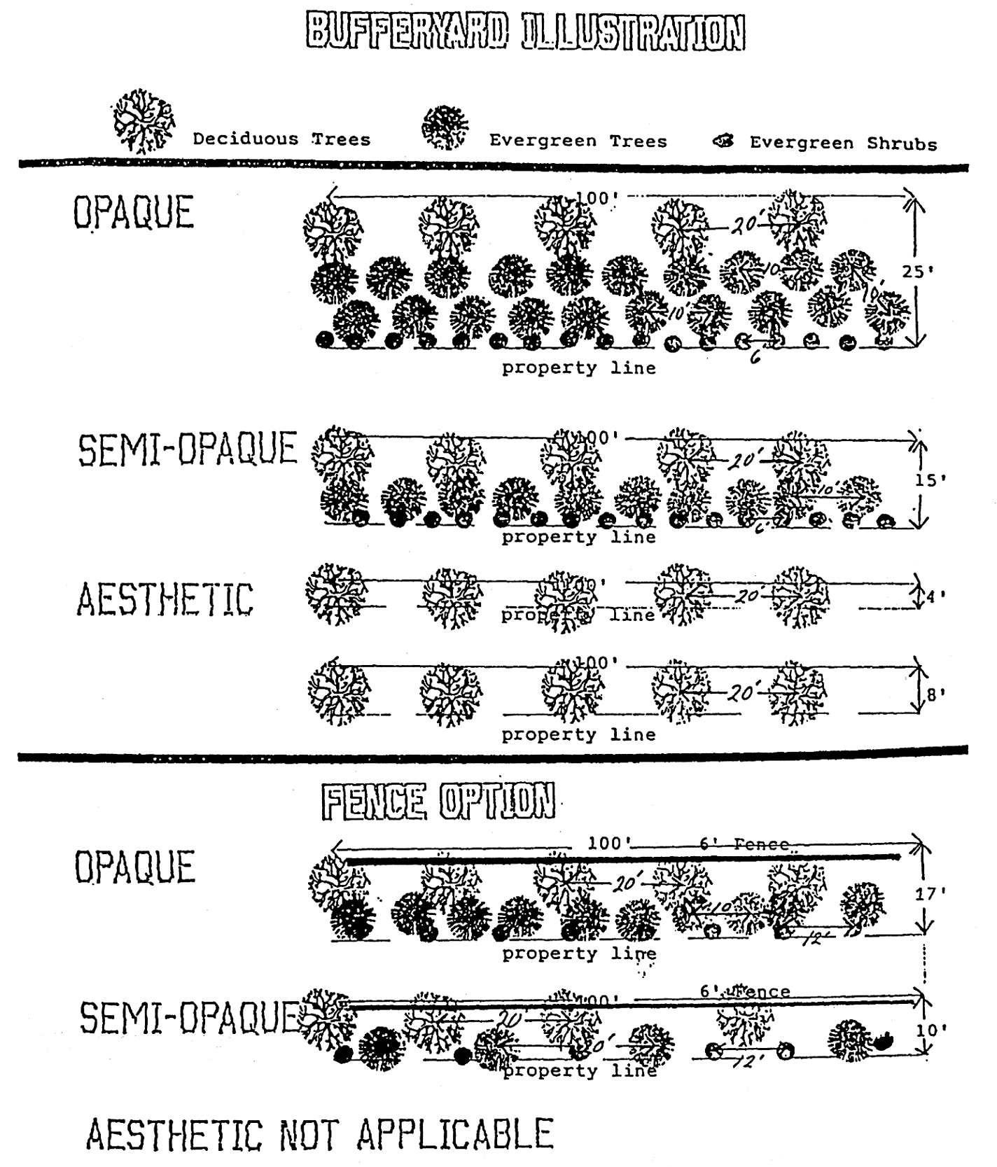
(Ord. of 4-18-94(1); Ord. of 11-21-94(1), pt. 1; Ord. of 10-16-95, § 3; Ord. of 11-19-01, § 1; Ord. No. 05-2022-ORD12, 5-16-22)
Section 4. - Table of area, yard, and height requirements.
(See notes 1—14[section 5].)
*The minimum lot size of any O-I, R-8 or R-6 lot not served by water or sewer shall conform to requirements of the Davidson County Health Department, notwithstanding the requirements in this table.
(Ord. of 11-18-96, § III)
Section 5. - Notes to the table of area, yard and height requirements.
Note 1. Computing the number of multifamily type dwelling units.
In computing the number of multifamily type dwelling units (including attached units) permitted for a given area of land, subtract the amount of land area in square feet required for the first two dwelling units from the total net land in square feet and then divide the remainder by the amount of land required for each unit over two. The quotient plus two is the number of dwelling units permitted for the given area of land. For example, on a land area of 80,000 square feet located in an R-6 residential district:
71,000 divided by 2,500 (each additional unit) = 28.4
28.4 + 2 = 30.4
Therefore 30 multifamily dwelling units may be placed on the 80,000-square-foot property. Fractional units over one-half may be rounded to the next higher whole number when the base number of units is 20 or more.
On projects with one building per lot, the computation must be repeated for each lot separately. On projects with more than one building on a lot, the computation need only be made one time.
Note 2. Fences, walls and planted buffer strips.
Notwithstanding other provisions of this ordinance, fences, walls and planted buffer strips may be permitted in any required yard, or along the edge of any yard, provided that no fence, wall or planted buffer strip along the sides or front edge of any front yard shall be over three feet in height, except that in commercial and industrial zoning districts a non-opaque fence (e.g. chain link) along the sides or front edge of any front yard may be up to six feet in height. Whenever in this ordinance a fence or planted buffer strip is required to shield a residential district from an incompatible use in a business or industrial district, said fence or planted buffer strip need not extend nearer to a street or highway right-of-way line than the established building line of the adjoining residential lots.
Note 3. Front yard setbacks for dwellings.
The front yard setback requirements of this ordinance for dwellings shall not apply to any lot where the average setback of existing buildings located wholly or partially within 100 feet on either side of the proposed dwelling and on the same side of the same block and use district and fronting on the same street as such lot is less than the minimum required front yard depth. In such case the setback on such lots may be less than the required setback but not less than the average of the existing setbacks on the aforementioned lots, or a distance of ten feet from the street right-of-way line, whichever is greater.
Note 4. Corner visibility.
In all districts except the C-4 central commercial district, no obstruction of any kind or nature to the visibility of vehicles on streets at intersections shall be erected, maintained or allowed to exist. This area of visibility in which no obstruction can be placed shall be between a height of three feet and a height of ten feet above the average intersecting curb or shoulder levels and within a triangular area formed by the intersecting street rights-of-way and an imaginary line connecting points on the street rights-of-way measured ten feet back from the point of intersection.
Note 5. Corner lots in residential and office-institutional districts.
On corner lots in any residential or office-institutional district, the side yard, on that side of the lot abutting the side street, shall not be less than one-half of the front yard requirement on that side street. Accessory buildings on that side of the lot abutting the side street shall not project beyond the full front yard requirements on that side street.
Note 6. Corner lots in commercial and manufacturing districts.
On corner lots in any commercial or manufacturing district, except the C-4 district, the side yard on that side of the lot abutting the side street shall not be less than one-half of the front yard requirement on that side street.
Note 7. Curb cuts in commercial, manufacturing and office-institutional districts.
No portion of any entrance driveway leading from a public street shall be closer than 15 feet to the corner of any intersection measured from the right-of-way line. The width of any entrance driveway leading from the public street shall not exceed 36 feet at its intersection with curb or street line. No two driveways leading from a public street shall be within 20 feet of each other measured along the right-of-way line.
Note 8. Side yard provided but not required.
Where any side yard is provided, though not required, the same shall be not less than 3½ feet.
Note 9. Automobile service stations.
See note to table of permitted uses [section 3] for lot and yard dimensions.
Note 10. Maximum lot coverage.
In the C-2 and C-3 districts, the maximum lot coverage shall be 40 percent of the total lot area. In the M-1 and M-2 districts the maximum lot coverage shall be 60 percent of the total lot area.
Note 11. Outside can or container washing or cleaning.
Any commercial facility, particularly food service establishments, requiring and/or providing outside can wash equipment, shall maintain such equipment a minimum of 25 feet from any adjacent property line. This requirement shall be applicable to equipment attached or detached in respect to the principal structure.
Note 12. Solid waste storage equipment (dumpmaster).
Any commercial or manufacturing establishment abutting a residential zoning district, including O-I district, and providing solid waste storage equipment (dumpmaster) shall locate such equipment a minimum of 25 feet from said residential property line and shall enclose said equipment with fencing not less than six feet in height.
Note 13. Frontage in feet.
The required frontage in feet for any lot which has any part of its frontage on the curved turnaround portion of a cul-de-sac or on the outer edge of the curved portion of any street section may be reduced by up to 30 percent of the requirement for the zoning district in which the lot is located by the board of planning and adjustment as a modification upon a finding by the board that a better lotting arrangement will result.
Note 14. Reduction of side yard setback in R-20 and R-15 Districts.
The side yard setback may be reduced from 15 feet to 10 feet for lots in R-20 and R-15 districts when the lot area exceeds the minimum required lot area by 20 percent or more.
Note 15. Reduction of Rear and Side Yards for Open Carports.
Required rear and side yards on a lot containing a single-family or two-family dwelling may be reduced to five feet for an open carport accessory structure, except in the case of a side yard on the side of a lot abutting a side street, provided the carport is unenclosed on all four sides of the structure and is installed or constructed in accordance with the North Carolina Building Code.
Note 16. Accessory buildings and accessory uses.
Accessory buildings and accessory uses shall be permitted and can be built or used within a minimum of ten feet of the side and rear yard property lines. The following stipulations apply:
1.
The property must be located in one of the following zoning districts: R-15, R-10, R-8 or R-6 residential districts.
2.
The structure must be located behind the main house on the lot.
3.
For permitting uses, the accessory structure will be classified as nonresidential and cannot be used as sleeping quarters.
4.
The primary residence cannot encroach the 25-foot rear yard setback requirements.
5.
The accessory structure cannot be used for any commercial use.
6.
The structure must be completely detached from the primary residence.
(Ord. of 4-19-99(3), § 3; Ord. of 5-15-00(1), § 1; Ord. of 10-23-00(2), § 1; Ord. of 11-18-02(2), § 2; Ord. of 11-18-02(4), § 1; Ord. of 12-17-07, § 1; Ord. No. 12-2016-ORD20, 12-19-17; Ord. No. 11-2019-ORD25, 11-18-19)
Section 6. - Watershed overlay district regulations.
Within the Lake Reese watershed balance of watershed (LRWS-BW) overlay districts the following regulations shall apply:
6.1 General development standards.
(a)
The construction of new roads and bridges and nonresidential development should minimize built-upon area, divert storm water away from surface water supply waters as much as possible, and employ best management practices (BMPs) to minimize water quality impacts. The North Carolina Department of Transportation BMPs as outlined in their document entitled "Best Management Practices for the Protection of Surface Waters" shall be used in all road and bridge construction projects in the watershed overlay districts.
(b)
All development activities within watershed overlay districts, in addition to those activities specifically regulated by these provisions, are subject to the standards, usage conditions and other regulations contained in the Rules and Requirements of the Surface Water Supply Protection Rules adopted by the North Carolina Environmental Management Commission.
(c)
A minimum 30-foot vegetative buffer for development activities is required along all perennial waters, including streams, rivers and impoundments, indicated on the most recent versions of USGS 1:24,000 scale topographic maps, provided, that nothing in this subsection shall prevent artificial streambank or shoreline stabilization. No new development is allowed in the buffer, except that water dependent structures, and public works projects such as road crossings and greenways may be allowed where no practicable alternative exists. These activities shall minimize built-upon surface area, direct runoff away from the surface water, and maximize the utilization of BMPs.
(d)
Existing development, as defined in this ordinance, is not subject to the requirements of the overlay provisions. Expansions to structures classified as existing development must meet the requirements of these provisions, provided however, the built-upon area of the existing development is not required to be included in the density calculations. In determining expansions to existing development, the maximum permitted additional built-upon area is derived by multiplying the area of the portion of the property that is not built-upon by the appropriate percent built-upon limitation for the overlay district in which the property is located.
(e)
A pre-existing lot created prior to the effective date of this ordinance, regardless of whether or not a vested right has been established, may be developed or redeveloped for single family residential purposes without being subject to the restrictions of these overlay provisions.
(f)
Any existing building or built-upon area not in conformance with the limitations of these provisions that has been damaged or removed for any reason may be repaired and/or reconstructed, provided:
(1)
Repair or reconstruction is initiated within 12 months and completed within two years of such damage or removal.
(2)
The total amount of space devoted to built-upon area may not be increased.
(3)
The repair or reconstruction is otherwise permitted under the provisions of this ordinance.
(g)
No activity, situation, structure or land use shall be permitted or allowed to operate within a watershed which poses a threat to water quality and the public health, safety and welfare. Such conditions may arise from inadequate on-site sewage systems which utilize ground absorption; inadequate sedimentation and erosion control measures; the improper storage or disposal of junk, trash or other refuse within a buffer area; the absence or improper implementation of a spill containment plan for toxic and hazardous materials; the improper management of stormwater runoff; or any other situation found to pose a threat to water quality.
(h)
No new discharging landfills are allowed.
(i)
Nonresidential development shall maintain an inventory of all toxic and hazardous materials and shall implement a spill/failure containment plan approved by the Davidson County director of emergency management or his designated agent.
(j)
The zoning enforcement officer may require such information on zoning permit and development plan applications, including density/built-upon area calculations, as he may deem necessary to determine compliance with watershed overlay district provisions.
(k)
The zoning enforcement officer may, prior to the issuance of any permit in a watershed overlay district, require evidence of a valid sedimentation control permit issued by the State of North Carolina or evidence satisfactory to the officer that no permit is required.
(l)
The zoning enforcement officer shall maintain records of the administration of the watershed overlay district regulations and shall submit any modifications of the regulations to the North Carolina Division of Environmental Management, Division of Environmental Health and Division of Community Assistance. The zoning enforcement officer shall also maintain a record of variances issued and shall submit an annual report of each project receiving a variance and the reason for the variance to the North Carolina Division of Environmental Management.
6.2 Density/built-upon limitations.
(a)
Residential development shall not exceed two dwelling units per acre or, optional, 24 percent built-upon area, on a project by project basis.
(b)
Nonresidential development shall not exceed 24 percent built-upon area, on a project by project basis.
(c)
Notwithstanding the limitation of subsection 6.2(b) above, ten percent of the LRWS-BW area may be developed with new nonresidential development projects of up to 70 percent built-upon area as special nonresidential intensity allocations (SNIAs). SNIAs shall be allocated and developed in accordance with the following rules:
(1)
SNIAs shall be allocated by the zoning enforcement officer through the zoning permit/development plan process. The zoning enforcement officer shall maintain a record of the total acreage in the LRWS-BW area eligible for SNIAs, the acreage that has been allocated and the acreage that has been used as of the latest date. In no case shall allocated acreage exceed the acreage eligible for allocation.
(2)
SNIAs shall be allocated on a "first come, first served" basis upon the approval and issuance of the appropriate permit.
(3)
The right to develop a SNIA shall terminate with the loss of the right to develop due to the expiration of a zoning permit, zoning permit with vested rights, or building permit. In such a case, the allocated acreage, or unused allocated acreage, shall be returned to the unallocated total acreage eligible for allocation.
(4)
In no case shall the built-upon area of a SNIA exceed the built-upon limitations of the primary zoning district in which the SNIA is located as stated in article III, section 2 and article VI, section 5, Note 10.
(Ord. of 6-21-93(2), pt. 4; Ord. of 8-16-04(6), § 1)
Section 7. - Adult oriented business overlay district.
Within the adult oriented business overlay district (AOB) the following regulations shall apply:
7.1
Uses permitted.
(a)
All uses permitted in the underlying C-2 highway commercial district or the C-3 general commercial district.
(b)
Adult oriented businesses.
7.2
Special additional requirements for adult oriented businesses. In addition to the general regulations and requirements of this ordinance for the underlying C-2 highway commercial district or C-3 general commercial district, adult oriented businesses located in an adult oriented business overlay district shall comply with the following standards and requirements:
(a)
No such business shall locate within 1,000 feet of any other adult oriented business, as measured in a straight line from property line to property line;
(b)
No adult oriented business shall be located within 1,200 feet of a church, public or private elementary or secondary school, child day care or nursery school, public park, residentially zoned or residentially used property, or any establishment with an on-premise ABC license, as measured in a straight line from property line to property line;
(c)
The gross floor area of any adult oriented business shall not exceed 3,000 square feet and all business related activity shall be conducted in a building;
(d)
Except for an adult motel, no adult oriented business may have sleeping quarters;
(e)
There shall not be more than one adult oriented business in the same building, structure, or portion thereof. No other principal or accessory use may occupy the same building, structure, property, or portion thereof with any adult oriented business;
(f)
Except for signs as may be permitted by article VI of this ordinance, no printed material, slide, video, photograph, written text, live show, or other visual presentation format shall be visible from outside the walls of the establishment, nor shall any live or recorded voices, music, or sounds be heard from outside the walls of the establishment;
(g)
No enclosed or underground parking shall be permitted.
(Ord. of 4-18-94(2), pt. 3)
Section 8. - Historic preservation overlay district.
Within the historic preservation overlay district (HP) the following regulations shall apply:
8.1 Designation procedure. Historic preservation overlay historic districts (HP) as provided for herein may be designated, amended or repealed through the following procedure.
(a)
An investigation and report describing the significance of the buildings, structures, features, sites, or surroundings included in any such proposed district, and a description of the boundaries of such district shall be prepared by the historic preservation commission and a recommendation thereon made to the board of planning and adjustment.
(b)
The North Carolina Department of Cultural Resources, acting through the state preservation officer or his designee, shall make an analysis of and recommendations concerning such report and the description of proposed boundaries. Failure of the North Carolina Department of Cultural Resources to submit its written analysis and recommendation to the city within 30 calendar days after a written request for such analysis has been received shall relive the city of any responsibility for awaiting such analysis.
(c)
The city council may also refer the report and proposed boundaries to any local preservation commission or other interested body for its recommendations prior to taking action.
(d)
Changes in the boundaries of such district subsequent to its initial establishment, or the creation of additional districts within the city jurisdiction, shall require the preparation of investigative studies by the historic preservation commission; and they shall be referred to the North Carolina Department of Cultural Resources for its review and comment according to the procedures set forth in this subsection. Changes in the boundaries of a district or proposals for additional districts shall also be submitted to the North Carolina Department of Cultural Resources in accordance with the provisions of this subsection.
(e)
The board of planning and adjustment shall review the recommendations and shall process the historic preservation overlay district as a zoning map amendment in the same manner set forth in this ordinance.
8.2 Dimensional regulations and exceptions. Structures within a historic preservation overlay district shall comply with the regulations of the underlying zoning district, except as follows:
(a)
All streets setback, interior setback, building coverage, and heights shall comply with applicable zoning regulations unless a variance is approved by the board of planning and adjustment. The variance shall be granted only if it complies with the intent of the architectural and historic guidelines of the historic preservation overlay district.
(b)
Where the historic preservation commission, in considering an application for a certificate of appropriateness, shall find that the number of off-street parking spaces and/or design standards for parking lots specified by this ordinance would render the site incompatible with historic preservation overlay district design guidelines and the historic aspects of the district, it may recommend to the board of planning and adjustment a variance to the provisions of the off-street parking requirements and/or design standards. The board of planning and adjustment may authorize as a variance a reduced standard concerning off-street parking provided it finds:
(1)
That the lesser standard will not create problems due to increased street parking; and
(2)
That the lesser standard will not create a threat to the public safety.
8.3 Certain changes not prohibited. Nothing in this section shall be construed to prevent the following:
(a)
The ordinary maintenance or repair of any exterior architectural feature in a historic preservation overlay district which does not involve a change in design, material, or outer appearance thereof.
(b)
The construction, reconstruction, alteration, restoration, moving or demolition of any such feature if the building inspector or zoning enforcement officer has certified in writing to the historic preservation commission that such action is required to protect the public safety because of unsafe or dangerous conditions.
(c)
The ordinary maintenance or repair of streets, sidewalks, pavement markings, utility service lines, street signs, traffic signs, and/or replacement of street light fixtures in the event of equipment failure, accidental damage, or natural occurrences such as electrical storms, tornadoes, ice storms, and the like.
8.4 Certificate of appropriateness required.
(a)
After the designation of a historic preservation overlay district, no exterior portion of any building or other structure (including but not limited to masonry walls, fences, light fixtures, steps and pavement, or other appurtenant features), nor above ground utility structure, nor any type of advertising sign shall be erected, altered, restored, moved, or demolished within such district until after an application for a certificate of appropriateness as to exterior features has been submitted and approved by the historic preservation commission.
(b)
"Exterior features" shall include the architectural style, general design, and general arrangement of the exterior of a building or other structure, including the kind and texture of the building material, the size and scale of the building; and the type and style of all windows, doors, light fixtures, signs and other appurtenant fixtures. In the case of advertising signs, "exterior features" shall be construed to mean the style, material, size, and location of all such signs. Such "exterior features" may include historic signs, color, and significant landscape, archaeological, and natural features of the area.
(c)
The historic preservation commission may impose standards as may be set forth elsewhere in this subsection or adopted by the commission. Any building permit not issued in conformity with this subsection shall be invalid.
(d)
The discontinuance of work or the lack of progress toward achieving compliance with the certificate of appropriateness for a period of one year shall render the certificate null and void and of no effect. However, in the event the issuance of a certificate is appealed, the one year period shall not commence until a final decision is reached regarding the matter.
(e)
The commission may, after adoption of architectural and historic guidelines, allow the zoning enforcement officer or his designee to review and approve minor work provided, however, that no application for a certificate of appropriateness may be denied without formal action by the historic preservation commission.
(f)
The city and all public utilities, except as provided under subsection (4) above, (certain changes not prohibited), shall be required to obtain a certificate of appropriateness prior to initiating in a historic preservation overlay district any changes in the character of street paving, street width, utility installations or removals, lighting, street trees, walls, fences, sidewalks, or exterior of buildings or structures on property or streets in which they have a fee or other interest.
8.5 Application procedures.
(a)
Application for a certificate of appropriateness shall be made to the historic preservation commission on forms provided. The application shall be filed no later than 14 days prior to the next regularly scheduled meting of the historic preservation commission. Each application shall be accompanied by sketches, drawings, photographs, specifications, descriptions, and/or other information of sufficient detail to clearly show the proposed move, exterior alterations, additions, changes, new construction, or demolition.
(b)
The historic preservation commission shall make a reasonable attempt to identify and notify the owners of surrounding property likely to be affected by the application for a certificate of appropriateness. The commission shall act upon the application within 90 days after the filing thereof, otherwise failure to act upon the application shall be deemed to constitute approval and a certificate of appropriateness shall be issued. Nothing herein shall prohibit an extension of time where mutual agreement has been reached between the commission and the applicant.
(c)
Prior to issuance or denial of a certificate of appropriateness, the historic preservation commission shall give the applicant and other property owners likely to be affected by the application an opportunity to be heard. In cases where the commission deems necessary, it may hold a public hearing concerning the application and seek the advice of the North Carolina Department of Cultural Resources or other expert advise.
(d)
The commission shall not refuse to issue a certificate of appropriateness except for the purpose of preventing the construction, reconstruction, alteration, restoration or moving of buildings, structures appurtenant features, or signs in the historic preservation overlay district which would be incompatible with the architectural and historic guidelines adopted by the commission.
(e)
An appeal may be taken to the board of planning and adjustment from the historic preservation commission's action in granting or denying any certificate. The appeal may be taken by any aggrieved party; shall be taken within 30 days after the decision of the commission.
(f)
Any appeal from the board of planning and adjustment's decision in any such case shall be heard by the superior court of the county.
8.6 Review criteria.
(a)
In granting a certificate of appropriateness, the historic preservation commission shall take into account the historic or architectural significance of the property under consideration and the exterior form and appearance of any proposed additions or modifications to a structure.
(b)
The commission shall not consider interior arrangement.
(c)
The provisions of this subsection shall not become effective for a historic preservation overlay district until after the commission has adopted detailed architectural and historic guidelines applicable to proposals within the district. These criteria shall take into account the historic, architectural and visual elements of the district and shall be reviewed a minimum of every five years. At a minimum, the criteria shall contain guidelines addressing the following factors:
(1)
Historic significance or quality. The quality or significance in history, architecture, archeology, or culture present in districts, sites, structures, buildings or objects that possess integrity of location, design, setting, materials, workmanship, and feeling and association:
a)
That are associated with events that have made a significant contribution to the broad patterns of local, state, or national history; or that are associated with the lives of persons significant in the past; or
b)
That embody the distinctive characteristics of a type, period, or method of construction; or
c)
That represent the work of a master or that possess high artistic values; or
d)
That represent a significant and distinguishable entity whose components may lack individual distinction; or that have yielded, or may be likely to yield, information important in prehistory or local, state or national history.
(2)
Exterior form and appearance. In considering exterior form and appearance, the commission may take into account, but is not limited to, the following elements to ensure that they are consistent with the historic or visual character or characteristics of the district:
a)
Exterior features as described in subsection 8.4 above (certificate of appropriateness required);
b)
Height of the building or structure;
c)
Setback and placement on lot of the building or structure, including lot coverage and orientation;
d)
Exterior construction materials, including textures, patterns and colors;
e)
Architectural detailing, such as lintels, cornices, brick bond, foundation materials and decorative wooden features;
f)
Roof shapes, forms and materials
g)
Proportions, shapes, positionings and locations, patterns, and sizes of any elements of fenestration;
h)
General form and proportions of buildings and structures;
i)
Appurtenant fixtures and other features such as lighting;
j)
Structural condition and soundness;
k)
Use of local or regional architectural traditions; and
l)
Effect of trees and other landscaping elements.
8.7 Delay in demolition of buildings and sites.
(a)
An application for a certificate of appropriateness authorizing the relocation, demolition, or destruction of a building, structure, or site within a historic preservation overlay district may not be denied except as provided in this section. However, the effective date of such a certificate may be delayed for a period of up to 365 days from the date of approval. The maximum period of delay authorized by this subsection shall be reduced by the historic preservation commission where it finds that the owner would suffer extreme hardship or be permanently deprived of all beneficial use of or return from such property by virtue of the delay. During such period, the commission shall negotiate with the owner and with any other parties in an effort to find a means of preserving the building or site. If the commission finds that a building or site within a historic preservation overlay district has no special significance or value toward maintaining the character of the district, it shall waive all or part of such period and authorize earlier demolition or removal.
(b)
If the historic preservation commission has recommended designation of an area as a historic preservation overlay district, and final designation has not been made by the city council, the demolition or destruction of any building, site, or structure located on the property in the proposed district may be delayed by the commission for a period of up to 180 days or until the city council takes final action on the designation, whichever occurs first.
(c)
The city council may enact an ordinance to prevent the demolition by neglect of any building or structure within an established historic preservation overlay district. Such ordinance shall provide appropriate safeguards to protect property owners from undue economic hardship.
(d)
An application for a certificate of appropriateness authorizing the demolition or destruction of a building, site, or structure determined by the state historic preservation officer as having statewide significance as defined in the criteria of the national register of historic places may be denied except where the historic preservation commission finds that the owner would suffer extreme hardship or be permanently deprived of all beneficial use or return by virtue of the denial.
8.8 Designated Landmarks.
The provisions of sections 8.1 through 8.7 of this article in addition to applying to buildings, structures and sites within a historic preservation overlay district shall also be applicable to designated landmarks located outside of a historic preservation overlay district.
(Ord. of 3-20-00(1), pt. 3; Ord. of 6-18-01, § 1)
Section 9. - Video sweepstakes business and internet café business overlay district.
Within the video sweepstakes business and internet café business overlay district (VSB) the following regulations shall apply:
9.1 Uses permitted.
(a)
All uses permitted in the underlying C-2 highway commercial district.
(b)
Video sweepstakes business and internet café business.
9.2 Special additional requirements for video sweepstakes business and internet cafe business.
In addition to the general regulations and requirements of this ordinance for the underlying C-2 highway commercial district, video sweepstakes businesses and internet café businesses shall comply with the following standards and requirements:
(a)
No video sweepstakes business and internet café business shall operate within any designated historic district nor within the municipal service district.
(b)
No video sweepstakes business and internet café business shall operate within 1,000 feet, measured in a straight line from property line to property line, from any other video sweepstakes business and internet café business.
(c)
No video sweepstakes business and internet café business shall operate within 1,200 feet, measured in a straight line from property line to property line, from any church, public or private school, child day care or nursery school, public park, residentially zoned or residentially used property, or any establishment with an on-premise ABC license.
(d)
There shall be no more than one such business operated in each quadrant of the city. A quadrant is determined by the Norfolk-Southern Rail Lines acting as the north/south divider and Randolph Street, south of the Norfolk-Southern Rail line, and Salem Street, north of the Norfolk-Southern Rail Line, acting as the east/west divider.
(e)
No enclosed parking area shall be permitted.
9.3 Signage and audio advertisement.
In addition to the regulations and requirements permitted in Article VI Signs, video sweepstakes business and internet café business shall comply with the following standards and requirements:
(a)
Except for signs as may be permitted in Article VI, no printed material, slide, video, photograph, written text, live show, or other visual presentation format shall be visible from outside the walls of the establishment.
(b)
No live or recorded voices, music or sounds shall be heard from outside the walls of the establishment.
(Ord. No. 07-2015-ORD15, 7-20-15)
Section 10. - Municipal service overlay district—Downtown commercial district.
Within the municipal service overlay district (MSD) the following regulations shall apply:
10.1 Uses permitted. Properties in the municipal service overlay district are subject not only to the requirements of the municipal service overlay district but also to the requirements of the underlying use district. In conflicts among these requirements, the most restrictive requirement shall prevail.
10.2 Uses prohibited. The following uses are prohibited within the municipal service overlay district—downtown commercial district (MSD):
a.
Outdoor advertising signs. Outdoor advertising signs shall not be permitted in this district.
(Ord. No. 03-2021-ORD05, 3-15-21)