Thurston County Unincorporated
City Zoning Code
City Zoning Code
CHAPTER 20
64 - MAJOR EDUCATIONAL INSTITUTION MEI
20.64.010 - Purposes.
The purposes of this chapter are to regulate Thurston County's major educational institutions in order to:
1.
Provide a zoning district for major colleges, universities, and educational facilities;
2.
Encourage the concentration of educational facilities and development on existing campuses that are planned, designed, and managed in a way that minimizes impact on adjacent areas;
3.
Provide for the social needs of the community as those needs relate to public services, open space and institutions whether publicly or privately sponsored;
4.
Ensure that the expansion of institutional uses does not significantly affect the quality of life in adjacent residential areas; and
5.
Provide and protect parks, open space and other natural, physical assets of the community to improve the aesthetic and functional features of the community.
(Ord. No. 15837, § 2(Att. A, § IV), 11-12-2019)
20.64.020 - Permitted uses.
Subject to the provisions of this title, the permitted uses within this district include:
1.
Colleges and universities, and uses supporting these facilities including:
a.
Academic buildings and lecture halls;
b.
Student and faculty housing and dormitories;
c.
Wellness centers, medical facilities and pharmacies;
d.
Retail and food services, including general, grocery, convenience, bank, book, and drug stores;
e.
Marine facilities such as docks, boat launch, boat houses, and other shoreline facilities;
f.
Athletic facilities and stadiums;
g.
Program-related agricultural buildings, farmer's markets and farm stands;
h.
Retreat facilities;
i.
Theaters, public art facilities, libraries, community meeting, and recreation halls;
j.
Licensed child care homes and day care centers; and
k.
Parks, trails, greenbelts, and open spaces used for passive or active recreation.
2.
Infrastructure in support of the above listed uses, including but not limited to internal roads and streets, access driveways, communications, and utilities.
3.
Similar or related uses as are typical on residential and nonresidential higher education campuses. Criteria for determination of similarity or relatedness, are as follows:
a.
Uses similar to, or related to, those listed in Section 20.64.020 are permitted upon a finding of the department that a particular unlisted use does not conflict with the intent of this chapter or the policies of the Comprehensive Plan;
b.
The criteria for such finding of similarity shall include but not be limited to the following:
i.
The proposed use is appropriate in this area;
ii.
The development standards for permitted uses can be met by the proposed use;
iii.
The public need is served by the proposed use.
c.
Appeals of this determination may be made to the hearing examiner pursuant to Section 20.60.060 (Appeal procedures), or a request submitted to the board of county commissioners for consideration of a text amendment.
(Ord. No. 15837, § 2(Att. A, § IV), 11-12-2019)
20.64.025 - Accessory uses.
Accessory Uses. Subject to the provision of this title, the following accessory uses are permitted in this district:
1.
Fire district facilities;
2.
Law enforcement facilities; and
3.
Storage and maintenance facilities.
(Ord. No. 15837, § 2(Att. A, § IV), 11-12-2019)
20.64.030 - Special uses.
See Chapter 20.54 for special uses permitted in this district.
(Ord. No. 15837, § 2(Att. A, § IV), 11-12-2019)
20.64.035 - Review process.
The developer shall submit a site plan in accordance with the requirements in Chapter 20.37.
(Ord. No. 15837, § 2(Att. A, § IV), 11-12-2019)
20.64.040 - Design standards.
Site development plans shall conform with the following standards:
1.
Minimum Lot Dimensions.
a.
Area — forty acres,
b.
Width — two hundred feet;
2.
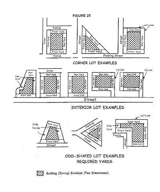
Minimum Yards Measured From Property Line.
a.
Front — ten feet from right-of-way easement or property line, except twenty feet from right-of-way easement line or property line on arterials,
b.
Side:
i.
Interior — ten feet,
ii.
Abutting residentially developed or zoned property — eighty feet,
iii.
Street (flanking) — ten feet,
c.
Rear:
i.
Twenty-five feet,
ii.
Abutting residentially zoned or developed property — one hundred feet,
d.
Exception. Two adjoining lots which have a common side lot line which are developed concurrently may be developed with zero side yards on the common side lot line, provided that the opposite side yard is not less than thirty feet if it is an interior side yard or not less than forty feet if it is a street side yard;
3.
Maximum hard surface coverage for new development in this district is as follows (also see Chapter 20.07).
a.
Within the Green Cove Creek Drainage Basin:
i.
Lots two and one-half acres or greater: Ten percent.
ii.
Lots less than two and one-half acres: Sixty percent or ten thousand square feet, whichever is less.
b.
For all other new construction: seventy-five percent;
4.
Maximum Building Height.
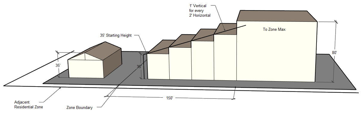
a.
Building heights shall not exceed eighty feet, except for structures exempted from this height requirement pursuant to Section 20.07.080.
b.
For buildings within one-hundred fifty feet of any residentially developed or zoned property, building heights shall start at thirty-five feet at the property line. Additional building height may be added at a ratio of 1 to 2 (one foot of additional building height for every two feet of additional horizontal distance from the closest property line shared with a residential zone or development). The building height transition requirement ends one hundred fifty feet from the residential zone/development. Beyond the transition the maximum building height allowed in zone applies. This applies to all uses except for structures exempted from this height requirement pursuant to Section 20.07.080;
____________
____________
5.
All landscaping shall be provided in accordance with Chapter 20.45. In addition:
a.
A minimum ten-foot wide landscaped strip shall be provided adjacent to all street frontages.
b.
A minimum twenty-five foot landscaped buffer shall be provided adjacent to all residential uses or residential zoned properties. This buffer is intended to create physical buffer and a very dense sight barrier that may be less than one hundred percent sight-obscuring. The department may require additional landscaping buffers based upon individual site conditions.
i.
Vegetative landscaping shall consist of evergreen trees or a combination of approximately sixty percent evergreen and forty percent deciduous trees, tall shrubs, and ground cover. Retention and salvage of existing native vegetation and trees is preferred over removal and replacement of vegetation.
ii.
In required landscaping areas, the applicant shall retain landmark and heritage trees which do not constitute a safety hazard.
iii.
A combination of trees, shrubs, earthen berms, and related plant materials or design features may be selected, provided that the resultant is sight-obscuring from adjoining properties. In addition, fences and walls may be incorporated into the landscaping buffer.
iv.
A variance to reduce the buffer may be permitted pursuant to Section 20.07.050.
c.
Landscaping along any bicycle or pedestrian pathways, including those which connect to adjacent residential areas, should use Crime Prevention through Environmental Design (CPTED) principles to promote safety and visibility.
i.
Landscaping and fencing shall avoid configurations that create dangerous hiding spaces and minimize views.
6.
Dedication of Common Open Space. Each planned campus development shall dedicate an acreage equivalent to at least ten percent of the development footprint for common open space for the use of its students and faculty. The following standards shall apply:
a.
Land dedicated for open space should be usable for either (i) greenbelts that serve as a buffer between land uses, using existing native vegetation or replacement vegetation; (ii) active recreational activities; (iii) passive recreational activities such as hiking; or (iv) protecting environmentally sensitive areas such as wetlands.
b.
The proposed open space shall be within reasonable walking distance of campus residences or parking areas.
c.
Common open space areas may contain complimentary structures, such as a picnic table, gazebo or maintenance equipment shed. Stormwater facilities may be allowed by the county as part of dedicated open space subject to the criteria in TCC 20.32.070.
d.
The area proposed for common open space shall be identified on an administrative site plan, pursuant to Section 20.37.
(Ord. No. 15837, § 2(Att. A, § IV), 11-12-2019; Ord. No. 16940, § 1(Att. A, § V), 5-21-2024)
20.64.050 - Performance standards.
Every property within the major educational institution (MEI) district shall conform to the following minimum performance standards:
1.
Nuisances. No use, activity, or equipment shall be permitted which creates a nuisance or is offensive, objectionable, or hazardous by reason of creation of odors, noise, sound, vibrations, dust, dirt, smoke, or other pollutants, noxious, toxic, or corrosive fumes or gases, radiation, explosion or fire hazard, or by reason of the generation, disposal, or storage of hazardous or dangerous wastes or materials.
2.
Parking areas and facilities, trash and refuse storage areas, ventilating mechanisms, and other noise-generating or odor-generating equipment, fixtures or facilities shall be located so as to minimize noise and odor impacts on the surrounding area.
3.
Maintenance. The owner, lessee or user shall be responsible for maintaining an orderly appearance of all properties and shall be responsible for the care and maintenance of all installed landscaped areas and any natural growth retained on the site. All required yards, parking areas, storage area, operation yards, and other open uses on the site shall be maintained at all times in a neat and orderly manner, appropriate for the district.
4.
Loading and parking areas shall be provided in a manner that reduces parking demand on streets in surrounding areas and minimizes traffic congestion in the area. Parking areas should be centrally located to support academic facilities uses supporting that facility. Parking and loading areas shall be provided in accordance with Section 20.44 and identified on an administrative site plan, pursuant to Section 20.37.
a.
For uses which require an associated parking lot adjacent to the building footprint, such as a day care facility, parking and loading requirements are reviewed with the associated building permit and subject to the requirements under Section 20.44. Parking space requirements shall be determined by using the required spaces of the associated use and may not be counted towards the overall parking requirements of the educational institution.
(Ord. No. 15837, § 2(Att. A, § IV), 11-12-2019)
20.64.060 - Additional regulations.
Refer to the following chapters for provisions which may qualify or supplement the regulations presented above:
1.
Chapter 20.07, Lot, Yard, Use and Structure Regulations;
2.
Chapter 20.34, Accessory Uses and Structures;
3.
Chapter 20.37, Site Plan Review;
4.
Chapter 20.40, Signs and Lighting;
5.
Chapter 20.44, Parking and Loading;
6.
Chapter 20.45, Landscaping and Screening;
7.
Chapter 20.60, Violations and Enforcement;
8.
Articles III and IV of the Thurston County Sanitary Code;
9.
Chapter 13.56, Thurston County Rights-of-Way;
10.
Chapter 15.05, Thurston County Drainage Design and Erosion Control Manual;
11.
Chapter 17.15, Thurston County Agricultural Activities Critical Areas Ordinance;
12.
Title 19, Shoreline Master Program;
13.
Title 24, Thurston County Critical Areas Ordinance.
(Ord. No. 15837, § 2(Att. A, § IV), 11-12-2019)
Thurston County Zoning
Appendix I
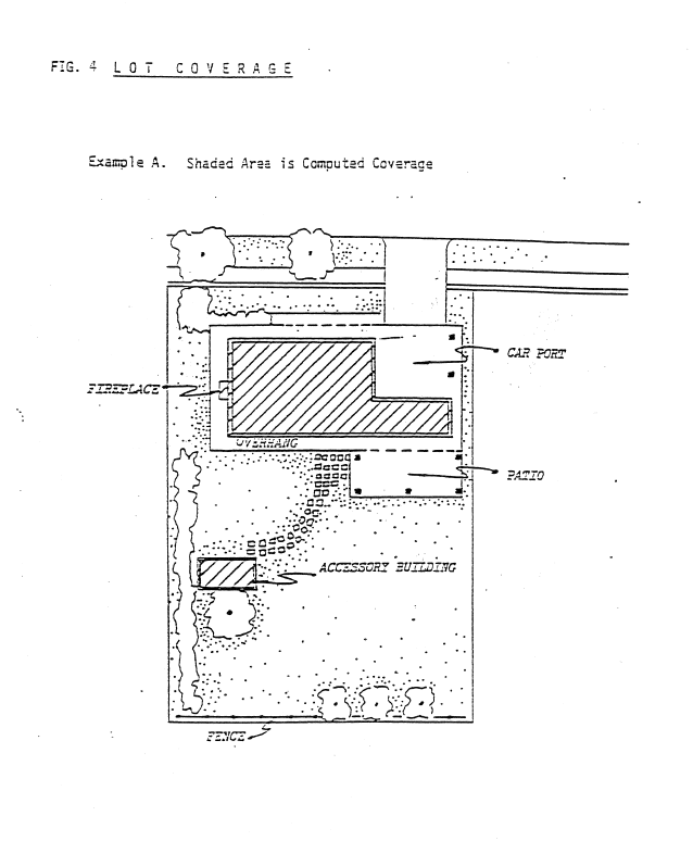
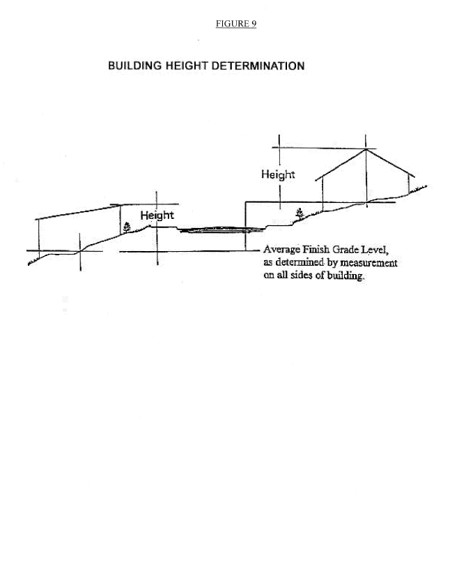
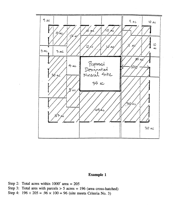
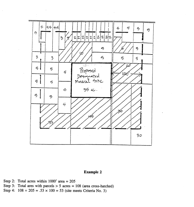
Figure 18
METHODOLOGY FOR DETERMINING EXTENT OF ADJACENT RESIDENTIAL USES
CRITERIA FOR DESIGNATING LONG-TERM MINERAL LANDS
THURSTON COUNTY
Zoning Chapter 20.30B, Designated Mineral Lands, lists six criteria that must be met in order for a proposed mineral extraction site to be considered for designation as long-term commercially significant mineral resource lands. Criteria No. 3 (page _____) reads as follows:
"At least sixty percent of the area within one thousand feet of the site must have parcels larger than five acres in size, at the time of the application for designation."
Criteria No. 3 is based on the following assumptions:
1.
Parcels five acres or smaller in size will primarily be used for residential purposes, and parcels larger than five acres will primarily be used for other rural uses (such as farming and forestry).
2.
Designated long-term mineral sites, which typically have at least a fifty-year supply of mineral deposits and may be eligible for private nuisance protection, should be located in areas where residential uses do not predominate.
3.
While the zoning may allow additional five-acre parcels to be created after a mineral site is designated, from that point on new property owners are notified that there is a long-term mineral operation nearby and that there may be temporary periods when the mining activities may not be compatible with residential development. Therefore, Criteria No. 3 focuses solely on surrounding parcel sizes existing at the time of application for designation.
To ensure consistent application of this criteria, the following methodology should be used:
Step 1: Draw a continuous line one thousand feet from site boundary around proposed mineral site.
Step 2: Calculate the total acreage of the area between the site boundary and the one-thousand-foot line.
Step 3: Identify all road rights-of-way and parcels over five acres in size that are partially or entirely within the one-thousand-foot area, and calculate the total acreage within the one-thousand-foot area that these identified parcels cover. (For those roads and parcels that are partially within the area, calculate the acreage of only the portion within the one-thousand-foot area.)
Step 4: Divide the acreage from Step 3 by the total acreage from Step 2, and multiply this number by one hundred. If the final result is sixty or greater, Criteria No. 3 has been met and, if all other criteria are met, the proposed mineral site may be approved for designation status. If the final result is less than sixty, the proposed mineral site does not meet Criteria No. 3 and, therefore, does not qualify for designation status.
Editor's note— Ord. No. 14524, § 13, adopted June 7, 2011, repealed Title 20, App. I, Figures 19, 20, 21, 22, 23 and 24 in Appendix I of Title 20, which pertained to planned rural residential development. These figures bore no history note.