
Tremonton City Zoning Code
CHAPTER 1
16 - OVERLAY ZONES15
(ORD 03-14, ORD 04-18, ORD 07-15, ORD 10-15, ORD 10-17, ORD 11-16, ORD 14-23, ORD 18-13, ORD 19-12, ORD 19-15, ORD 20-05, ORD 24-02)
1.16.005 - SPRING HOLLOW LEGENDS OVERLAY ZONE PURPOSE.
An overlay district is intended to provide different and/or supplemental regulations or standards from the underlying zoning district necessary to address certain geographic features, land uses, or desired outcomes.
1.16.010 - SPRING HOLLOW LEGENDS OVERLAY ZONE USES.
The underlying zoning district of the Spring Hollow Legends Overlay Zone is R-12 and all of the land uses shall remain the same as contained in Title I Chapter 1.07 of the Tremonton City Land Use Code for the R1-12 Zoning District.
1.16.015 - SPRING HOLLOW LEGENDS OVERLAY ZONE LOT REGULATIONS.
This Section shall apply to all principal structures and accessory structures within the Spring Hollow Legends Overlay Zone. Whenever there is a conflict between the regulations of the underlying zoning district of R1-12 and the Spring Hollow Legends Overlay Zone lot regulations, the lot regulations contained in this section shall control.
1.16.020 - SPRING HOLLOW LEGENDS OVERLAY ZONE REQUIRED AMENITIES AND SPECIFIED TIMEFRAME.
To mitigate the density associated with the Spring Hollow Legends Overlay Zone, the project shall have the following amenities within the specified timeframe:
A.
The common walking trail, landscaping of the common areas and common parking lot shall be constructed and completed prior to issuing any Building Permit as shown on Map 1.08.
B.
The developer shall on or within one (1) year after the first home has been constructed, construct and complete the Club House as shown on Map 1.08.
C.
The remaining hard surface common recreation improvements (tennis court, basketball and pickle ball courts) as shown on Map 1.08 shall be constructed and completed after fifteen (15) building lots are sold or thirty-six (36) months from the date the final plat is recorded with the Box Elder County Recorder.
D.
Perimeter fencing around the subdivision shall be completed after fifteen (15) building lots are sold or thirty-six (36) months from the date the final plat is recorded with the Box Elder County Recorder.
E.
Front yard and side yard landscaping shall be completed at time of occupancy except during the winter season.
F.
The Tremonton City Council shall be authorized to substitute any of the aforementioned required amenity for another amenity through a negotiated development agreement with the developer.
1.16.025 - TREMONT CENTER MIXED USE OVERLAY ZONE PURPOSE.
The purpose of the Tremont Center Overlay Zone is to provide an area for higher density, larger building, with a variety of retail, office, entertainment and multi-family residential uses.
1.16.030 - UNDERLYING ZONE OF THE TREMONT CENTER OVERLAY ZONE.
The underlying zoning district of the Tremont Center Overlay Zone is the Mixed Use Zone as contained in Title I Chapters 1.08 and 1.09 of the Tremonton City Land Use Code for Commercial Development Zone District and Mixed Use Zone District.
1.16.035 - TREMONT CENTER MIXED USE OVERLAY ZONE USES.
This Section shall apply to land uses within the Tremont Center Mixed Use Overlay Zone. Whenever there is a conflict between the land uses of the underlying zoning district of Mixed Use and the Tremont Center Mixed Use Overlay Zone uses, the use regulations contained in this section shall control. Uses of land or buildings which are permitted in the Tremont Center Mixed Use Overlay Zone are shown as a "P" for "permitted uses" in the appropriate column, or a "C" for "conditional uses" in the appropriate column. If a use is not permitted it is either not named in the uses list or it is indicated in the appropriate column by a dash "-" as "not permitted" or not applicable or is stated as such.
1 Note: See Chapter 1.25 of this Title, Conditional Use Permit.
2 Note: See Chapter 1.26 of this Title, Site Plan Permit for uses that are Commercial, Institutional, and all Multi-Family Dwellings.
3 Note: See Chapter 1.27 of this Title, Sign Permit.
4 Note: No dwelling or dwelling unit shall be less than four hundred (400) square feet in living space. All dwelling units are for Single-Family occupancy. See Chapter 1.19 Supplementary Regulations of this Title for Residential Architectural Standards.
5 Note: Applicant shall also ensure that the there are no restrictive covenants that exclude Manufacturing and Modular Housing as required by Utah Code Annotated 10-9a-514. See Chapter 1.19 Supplementary Regulations of this Title for Residential Architectural Standards.
1.16.040 - TREMONT CENTER MIXED USE OVERLAY ZONE LOT REGULATIONS.
This Section shall apply to all structures and accessory structures in the Tremont Center Mixed Use Overlay Zone. Whenever there is a conflict between the regulations of the underlying zoning district of Mix Use Zone District and the Tremont Center Overlay Zone lot regulations, the lot regulations contained in this section shall control.
1 Note: See Chapter 1.17 of this Title Off-Street Parking Regulations.
2 Note: See Chapter 1.18 of this Title Landscaping, Buffering, and Fencing Regulations.
3 Note: Minimum Lot Area: There shall be no minimum lot area in TC-MU zone, except as established with a site plan approval.
4 Note: Minimum Lot Width and Frontage: There shall be no minimum lot width or frontage required in the TC-MU zone except as established with a site plan approval. Each lot or parcel in TC-MU zone must front on or have legal access to a public street.
5 Note: Front, Rear and Side yard setbacks shall be established and approved through the Site Plan approval process.
6 Note: Maximum Building Height; Building Height shall be established and approved through a Site Plan approval but in no case shall the building height exceed three (3) stories.
1.16.045 - TREMONT CENTER MIXED USE OVERLAY ZONE REQUIRED DESIGN GUIDELINES.
To mitigate the density associated with the Tremont Center Overlay Zone, the project shall have the following design elements:
A.
A minimum of sixty (60) percent of the frontage on Main Street shall consist of by buildings facades. The facades along Main Street shall be between one and a half and two stores tall, with two story elements marking main entry drives(s) into the site. The facades should further be articulated with multiple sections using changes of plane, materials, colors or cornice heights. All these facades shall have a generous amount of windows. Facades shall be approved through the Site Plan approval process.
B.
The site area between street curb and parking areas shall be designed for pedestrian use. The development shall limit the amount of parking and sponsor sidewalks, street lighting, and landscaping outdoor seating and entry plaza between property line and building line. Parking, pedestrian uses and amenities shall be approved through the Site Plan approval process.
C.
Roadway interior to the site shall be designed and constructed to resemble public streets with sidewalks, street lighting and street trees. Parking shall be consolidated into small lots as much as possible and separated from roadways. Roadway interior to the site and configuration of parking areas shall be approved through the Site Plan approval process.
1.16.050 - TREMONT CENTER SIGN STANDARDS.
This Section shall apply to signs within the Tremont Center Mixed Use Overlay Zone. Whenever there is a conflict between the sign standards in Chapter 1.27 and the Sign Standards herein, standards in this section shall control.
A.
Due to the size of Tremont Center being approximately thirty-seven (37) acres and having a frontage along Main Street of 1,235 feet. The Tremont Center is allowed a total of three (3) Multi-Tenant Signs along its Main Street frontage, being either Multi-Tenant On Premise Pole Sign or Multi-Tenant On Premise Monument Signs, of which only one (1) of these signs may have an electronic message display. Building wall signs and monument signs along public street frontage shall be approved through a Site Plan approval process. The aforementioned signs shall be in conformance with the standards in the table below.
7 Note: Monument Signs and Wall Signs other than Multi-Tenant Monument Signs shall be approved through the Site Plan approval process; the maximum number of Wall Sign shall be one (1) per building wall face and one (1) Monument Sign. Awnings, Temporary, and other signs not listed in Section 1.16.050 shall comply with the Sign Standards in Chapter 1.27.
1.16.055 - ASPEN GROVE RECREATIONAL VEHICLES (RV) PARK PURPOSE.
An overlay district is intended to provide different and/or supplemental regulations or standards from the underlying zoning district necessary to address certain geographic features, land uses, or desired outcomes.
1.16.060 - ASPEN GROVE RECREATIONAL VEHICLES (RV) PARK OVERLAY ZONE USES.
This Section shall apply to land uses within the Aspen Grove Recreational Vehicles (RV) Park Overlay Zone. Whenever there is a conflict between the land uses of the underlying zoning district of RM-8 and the Aspen Grove Recreational Vehicles (RV) Park Overlay Zone uses, the use regulations contained in this section shall control. Uses of land or buildings which are permitted in the Aspen Grove Recreational Vehicles (RV) Park Overlay Zone are shown as a "P" for "permitted uses" in the appropriate column, or a "C" for "conditional uses" in the appropriate column. If a use is not permitted, it is either not named in the uses list or it is indicated in the appropriate column by a dash "-" as "not permitted" or not applicable or is stated as such.
1.16.065 - ASPEN GROVE RECREATIONAL VEHICLES (RV) PARK OVERLAY ZONE SITE REGULATIONS.
The Aspen Grove RV Park Overlay Zone shall be governed and comply with the Recreational Vehicle Park Regulations contained in Chapter 1.19 of the Supplementary Regulations.
1.16.070 - STOKES WARNER SIGN STANDARDS.
This Section shall apply to signs within the Stokes Warner Development, zoned Manufacturing Distribution (MD). Whenever there is a conflict between the sign standards in Chapter 1.27 and the Sign Standards herein, standards in this section shall control.
A.
Signs shall be in conformance with the standards in the table below.
1.16.075 - EDGEWOOD OVERLAY ZONE PURPOSE.
An overlay district is intended to provide different and/or supplemental regulations or standards from the underlying zoning district necessary to address certain geographic features, land uses, or desired outcomes. The purpose of the Edgewood Overlay Zone is to provide area for a variety of housing types allowed within the Mix Use (MU) Zone District, while prohibiting commercial uses such as stores or shops that are also allowed in the underlying Mixed Use (MU) Zone District.
1.16.080 - EDGEWOOD OVERLAY ZONE USES.
The underlying zoning district of the Edgewood Overlay Zone is Mixed Use (MU). Whenever there is a conflict between the regulations of the underlying zoning district of Mixed Use (MU) as contained in Title I Chapter 1.09 of the Tremonton City Land Use Code and the Edgewood Overlay Zone uses, this section shall control.
Uses of land or buildings, which are permitted in the Edgewood Overlay Zone, are shown as a "P" for "permitted uses" in the appropriate column, or a "C" for "conditional uses" in the appropriate column. If a use is not permitted, it is either not named in the uses list or it is indicated in the appropriate column by a dash "-" as "not permitted" or not applicable or is stated as such.
Commercial uses that are allowed in the underlying Mixed Use (MU) Zone District are prohibited as a permitted or conditional use within the Edgewood Overlay Zone.
1 Note: No dwelling or dwelling unit shall be less than nine hundred (900) square feet in living space. All dwelling units are for Single-Family occupancy. See Chapter 1.19 Supplementary Regulations of this Title for Residential Architectural Standards.
1.16.085 - EDGEWOOD OVERLAY ZONE LOT REGULATIONS.
This Section shall apply to all principal structures and accessory structures within the Edgewood Overlay Zone.
1 Note: Lot Regulation based on lot configuration and placement of structures on property as approved through the Site Plan approval process.
2 Note: Porte-Cochére's, Portico's and similar structures not more than one (1) story when attached to the main building and remains open on three (3) sides may extend into the required building setback as approved through the Site Plan approval process.
3 Note: The Building Official is authorized to reduce setbacks to six (6') feet for the side yard for Single-Family homes based upon ensuring proper drainage occurs between the adjoining lots.
1.16.090 - EDGEWOOD OVERLAY ZONE HOUSING TYPE LOCATION AND DENSITY.
The general housing type location associated with the Edgewood Overlay Zone is shown on Map 1.09. The boundaries of the housing types shown on Map 1.09 may be expanded or contracted based upon the decision of the developer/builder, but the developer is required to develop single-family lots no less than 8,000 square feet adjacent to the existing boundaries of Archibald Estates subdivision and no lots less than 6,000 square feet adjacent to eastern boundary of the Edgewood Overlay Zone. The maximum density of the Edgewood Overlay Zone is seven (7) dwelling units per acre.
1.16.095 - EDGEWOOD OVERLAY ZONE REQUIRED AMENITIES AND SPECIFIED TIMEFRAME.
To mitigate the density associated with the Edgewood Overlay Zone, the project shall have the following amenities within the specified timeframe:
A.
Active Adult Community. That a pickle ball court be construct in the active adult community prior to issuance of the last active adult building permit.
B.
Townhouse Amenities. That the townhouse playground, pergola, picnic and barbeque grill area be constructed prior to the last issuance of the townhome building permit.
C.
Variety of Building Elevations for Townhomes. That there be no less than five (5) different building elevations for the townhome project and that there are no two (2) identical building elevations that are adjacent to each other.
D.
Landscaping. That the developer/builder landscape each building lot, active adult community, and townhome community within Edgewood Overlay Zone to generally coincide with the completion of the home and the issuance of a certificate of occupancy. During months of inclement weather, the developer/builder shall complete the landscaping within six (6) months of receiving a certificate of occupancy. Landscaping will include but is not limited lawn, irrigation systems to be compatible with secondary water, etc., and shall be installed in the front-yard, side-yards, and back-yards. The developer/builder shall install street trees in the park strip with an irrigation source in accordance with Public Tree Ordinance (Chapter 8-700) of the Tremonton City Revised Ordinances.
1.16.100 - ASPEN RIDGES OVERLAY ZONE PURPOSE.
An overlay district is intended to provide different and/or supplemental regulations or standards from the underlying zoning district necessary to address certain geographic features, land uses, or desired outcomes.
The purpose of the Aspen Ridges Overlay Zone is to reduces the maximum number of dwelling units per acre from sixteen (16), as allowed within the underlying zoning district of Residential Multiple District, RM-16 to a maximum dwelling units of ten (10) per acre within the Aspen Ridges Overlay Zone.
1.16.105 - ASPEN RIDGES OVERLAY ZONE USES.
The underlying zoning district of the Aspen Ridges Overlay Zone is Residential Multiple District, RM-16 Zone District and all of the land uses shall remain the same as contained in Title I Chapter 1.07 of the Tremonton City Land Use Code for the RM-16 Zoning District.
1.16.110 - ASPEN RIDGES OVERLAY ZONE LOT REGULATIONS.
This Section shall apply to all principal structures and accessory structures within the Edgewood Overlay Zone.
1 Note: Lot Regulation based on lot configuration and placement of structures on property as approved through the Site Plan approval process.
2 Note: Exceptions to Height Regulations. Roof structures for the housing of elevators, stairways, tanks, ventilating fans or similar equipment required to operate and maintain the building, and fire or parapet walls, skylights, towers, steeples, flag poles, chimneys, smokestacks, water tanks, wireless or television masts, theater lofts, silos, or similar structures may be erected above the height limit herein prescribed. But no space above the height limit for residential purposes shall be allowed for purposes of providing additional floor space, nor shall such increased height be in violation of any other Ordinance or regulation of Tremonton City. Public Buildings, Utility Buildings, and Multi-Family Dwellings when authorized in a district, may be erected to a height greater than the district height limit by Site Plan approval.
3 Note: Porte-Cochére's, Portico's and similar structures not more than one (1) story when attached to the main building and remains open on three (3) sides may extend into the required building setback as approved through the Site Plan approval process.
1.16.115 - ASPEN RIDGES OVERLAY ZONE HOUSING TYPE MATERIALS.
All building structures shall be constructed out of masonry materials including but not limited to stone, stucco, cement board, etc.
1.16.120 - ASPEN RIDGES OVERLAY ZONE HOUSING TYPE LOCATION, NUMBER OF UNITS, AND DENSITY.
The housing type location, number of units, and density associated with the Aspen Ridges Overlay Zone, the project shall be in accordance with Map 1.10 Aspen Ridges Overlay Housing Type Location and Density. The maximum density of the Aspen Ridges Overlay Zone is ten (10) dwelling units per acre.
1.16.125 - ASPEN RIDGES OVERLAY ZONE REQUIRED AMENITIES AND SPECIFIED TIMEFRAME.
To mitigate the density associated with the Aspen Ridges Overlay Zone, the project shall have the amenities noted herein. These amenities shall commence upon seventy-five (75) percent of the units being completed within the project. The completion of the amenities shall occur before the ninety (90) percent of the units being completed within the project.
A.
Swimming Pool and Spa. A large swimming pool with built in splash pad along with an oversized custom in ground Jacuzzi.
B.
Clubhouse. A clubhouse that features thirty (30) seat community movie theater; large great room with vaulted ceilings; and a community banquet area with kitchenette.
C.
Fitness Center. Fitness center with commercial grade cardio machines, fitness equipment, surround sound system and satellite TV.
D.
Playground and Pavilion. Large playground with artificial turf and oversized pavilion with numerous picnic tables.
1.16.130 - 1000 NORTH CORRIDOR PRESERVATION OVERLAY ZONE PURPOSE.
An overlay district is intended to provide different and/or supplemental regulations or standards from the underlying zoning district necessary to address certain geographic features, land uses, or desired outcomes.
Due to the topography of the area, the expansion of 1000 North Street will require cuts and fills necessary to support the expanded travel lanes and curb gutter and sidewalks. The purpose of the fill slope easements is to ensure that these fill slopes can legally exist on private property and remain undisturbed by property owners. Additionally, expanded setbacks are necessary to ensure that the future construction of structures along 1000 North are not unduly encroach upon with the expansion of 1000 North Street.
1.16.135 - 1000 NORTH CORRIDOR PRESERVATION OVERLAY ZONE ESTABLISHMENT.
The Tremonton City Engineer has performed preliminary engineering for the proposes of determining the boundaries of the 1000 North Corridor Preservation Overlay Zone and the future fill slopes necessary to construct the expansion of 1000 North Street. The 1000 North Corridor Preservation Overlay Zone is hereby established and the boundaries of this overlay district are shown on Map 1.11.
1.16.140 - 1000 NORTH CORRIDOR PRESERVATION OVERLAY ZONE USES.
The 1000 North Corridor Preservation Overlay Zone spans several underlying zoning districts. The underlying zoning district of the 1000 North Corridor Preservation Overlay Zone for a particular property shall be determined by locating the current zoning of a property by using the Map 1.01 Tremonton City Zoning Map. All of the land uses shall remain the same as contained within the underlying zoning district of the respective property.
1.16.145 - 1000 NORTH CORRIDOR PRESERVATION OVERLAY ZONE CUT AND/OR FILL SLOPE EASEMENTS.
The dedication of slope fill easements to Tremonton City is required along all frontages of property developed on 1000 North between 2300 West to Interstate 84 as a condition of receiving site plan permit, subdivision permit, or a building permit. Tremonton City shall provide the legal description for the fill slope easement along with a plot of the easement. As a condition of receiving a site plan permit, subdivision permit, or a building permit the property owner shall sign the approved fill slope easement contained in Ordinance No. 19-15 which shall be recorded in the Box Elder Recorders Office.
1.16.150 - 1000 NORTH CORRIDOR PRESERVATION OVERLAY ZONE LOT REGULATIONS.
This Section shall apply to all principal structures and accessory structures within the 1000 North Corridor Preservation Overlay Zone. The Front Yard Setback along 1000 North Street between 2300 West and Interstate 84 with the 1000 North Corridor Preservation Overlay Zone shall be a minimum of fifty (50') feet, unless otherwise reduced by the written approval of the City Engineer.
1.16.155 - RIVERS EDGE OVERLAY ZONE PURPOSE.
The purpose of the Rivers Edge Overlay Zone is to provide different and/or supplemental regulations or standards to accommodate for a variety of housing types, housing densities, and commercial uses allowed within the Mix-Use (MU) Zone District while mitigating the impacts of these land uses within this zone and surrounding areas.
1.16.160 - PRE-ANNEXATION AGREEMENT and MASTER DEVELOPMENT AGREEMENT.
The Rivers Edge Overlay Zone allows for greater development activities, higher density, and range of land uses that have increased demand on municipal services or could have a detrimental impact on the development within this zone district and surrounding areas if not mitigated through specific terms, conditions, and improvements. The zoning of the Rivers Edge Overlay Zone is agreement zoning, which is legal and valid if the City follows the legal procedures and public process to establish the zone, which includes but is not limited to 1) following the public process to zoning property; 2) the City Council adopting a zoning ordinance that delineates the range of land uses, the maximum densities, and other related zoning standards for the zone; 3) the City and Developer agree to an Agreement.
The specific terms, conditions, and improvements to mitigate the detrimental impacts of density agreed to by the Developer is contained fully within Ordinance No. 21-12, adopting the Rivers Edge Pre-Annexation and Master Development Agreement for Approximately 135.5 Acres. Notwithstanding the special development requirements, conditions, and improvements required in the Agreement, the Developer is required to meet all the development requirements contained in the City's Zoning and Land Use Development Codes, the City's General Public Works, Construction Standards, and Specifications, and the Rivers Edge Overlay Zone. Ordinance No. 21-12 is a fundamental element of the Rivers Edge Overlay Zone, and amendments to this Ordinance and the Rivers Edge Pre-Annexation and Master Development Agreement for Approximately 135.5 Acres shall follow the process the rezoning and land procedure and public process for adoption of a land use regulation.
1.16.165 - CONFLICTS WITH THE RIVERS EDGE OVERLAY ZONE USES.
The underlying zone district of the Rivers Edge Overlay Zone is Mixed Use (MU). Whenever there is an explicit conflict between the regulations of the underlying zone district of Mixed Use (MU) as contained in Title I Chapter 1.09 of the Tremonton City Land Use Code, and the Rivers Edge Overlay Zone uses, this section shall control. If there is an explicit conflict between the Rivers Edge Pre-Annexation and Master Development Agreement for Approximately 135.5 Acres (the "Master Agreement") and the Rivers Edge Overlay Zone, the Master Agreement shall control.
Uses of land or buildings, which are permitted in the Rivers Edge Overlay Zone, are shown as a "P" for "permitted uses" in the appropriate column or a "C" for "conditional uses" in the appropriate column. If a use is not permitted, it is either not named in the uses list or it is indicated in the appropriate column by a dash "-" as "not permitted" or not applicable or is stated as such.
1 Note: See Chapter 1.25 of this Title, Conditional Use Permit.
2 Note: See Chapter 1.26 of this Title, Site Plan Permit for uses that are Commercial, Institutional, and all Multi-Family Dwellings.
3 Note: See Chapter 1.27 of this Title, Sign Permit.
4 Note: No dwelling or dwelling unit shall be less than four hundred (400) square feet in living space. All dwelling units are for Single-Family occupancy.
1.16.170 - RIVERS EDGE OVERLAY ZONE LOT REGULATIONS.
This Section shall apply to all principal structures and accessory structures within the Rivers Edge Overlay Zone.
1 Note: Lot configuration, setbacks, regulations, and placement of structures on property as approved through the Site Plan approval process.
(Ord. No. 24-06, 5-7-2024)
1.16.175 - RIVERS EDGE OVERLAY ZONE HOUSING TYPE LOCATION AND DENSITY.
The general housing type and location associated with the Rivers Edge Overlay Zone is shown on Map 1.12. The boundaries of the housing types shown on Map 1.12 may be expanded or contracted based upon the decision of the developer/builder, but in all cases the developer is required to develop single-family lots no less than 10,000 square feet west of the 950 East Collector Road. The maximum density of the Rivers Edge Overlay Zone is as described herein. Housing types allowed within the Rivers Edge Overlay Zone, shown on Map 1.12 include approximately 224 townhomes on two (2) parcels totaling 14.01 acres (a maximum density of sixteen (16) units per acre); approximately 240 apartments on 10.23 acres (a maximum density twenty-four (24) units per acre); approximately 264 single-family lots with a minimum of 10,000 square feet per lot; and 5.5 acres of commercial development. The actual density shall be determined by the proposed Development Activities compliance with the dimensional standards for setbacks, parking, buffering, etc., in the Zoning Ordinances and Land Use Codes as determined during the final plat and site plan review and approval process.
1.16.180 - PARKING STALLS DIMENSIONAL STANDARDS FOR MULTI-FAMILY STACKED HOUSING.
For multi-family stacked housing, the parking lot standards the Developer may reduce (a) the length of the parking stalls to eighteen feet (18) and six (6") inches in length, and (b) the number of required parking stalls per dwelling to 2.1. All other parking standards for lot dimensions, aisle width, the width of parking stalls, landscaped island, etc., shall remain the same for multi-family stacked housing and other all other land uses.
1.16.185 - RIVERS EDGE OVERLAY ZONE REQUIRED IMPROVEMENTS AND SPECIFIED TIMEFRAME.
Ordinance No. 21-12, adopting the Master Agreement (as defined herein), identifies and requires improvements that are needed and are unique to the development and vital to the success and desired outcomes within the Rivers Edge Overlay Zone. The Agreement also describes the Developer's responsibilities for these improvements and defines the category of the improvement, which includes Project Improvements, System Improvements, and Zoning and Density Improvements and are described below. Also listed below in Table 1 — Summary of Improvements for the Rivers Edge Overlay Zone is a summary of the improvement, category of the improvement, and description of improvement. If questions arise to the specific details, terms, and conditions of the improvements, the Zoning Administrator shall review the Rivers Edge Pre-Annexation and Master Development Agreement for Approximately 135.5 Acres contained in Ordinance No. 21-12 for clarity.
Project Improvement. "Project Improvement" shall refer to future public facilities designed and constructed to provide municipal services to the Property or otherwise required by the City's land use ordinances. Project Improvements may also be designed and constructed for the use and convenience of the occupants or users of the Property. Developer agrees that the Project Improvements identified within this Agreement are roughly proportionate in both the nature and extent of the impacts resulting from Development Activity. Developer agrees that Project Improvements are exactions that occur consistent with Utah Code Annotated 10-9a-508 and are not subject to any consideration of cash, Impact Fee credits, or Impact Fee reimbursement from the City.
System Improvement. "System Improvement" shall refer to existing or future public facilities designed and constructed to provide municipal services to the Property and other areas of the City. In accordance with Tremonton City Ordinance No. 14-02 and Utah Code Annotated 11-36a-402 as amended, the Parties agree that Developer may be eligible to receive a proportionate Impact Fee credit or proportionate Impact Fee reimbursement when Developer builds and dedicates some or all of a System Improvement subject to the terms contained herein. As stated elsewhere in this Agreement, Developer agrees that if a Public Infrastructure District (PID) is established in part to construct the required System Improvements included in this Agreement, or if the PID is established and reimburses Developer for System Improvements that Developer constructed before the establishment of the PID, that the PID shall receive the proportionate Impact Fee reimbursement that Developer would otherwise have been eligible for.
Zoning and Density Improvement. "Zoning and Density Improvement" may be either Project Improvements, System Improvements, or other improvements that are designed and constructed in consideration of the City granting the residential densities described herein and to mitigate the impacts of the Rivers Edge Zoning Overlay on the Property. Zoning and Density Improvements are made through agreement zoning, which is legal and valid if the City follows the legal procedures which include but are not limited to 1) following the public process to zone property; 2) the City Council adopting a zoning ordinance that delineates the range of land uses, the maximum densities, and other related zoning standards for the subject property; 3) the City and Developer agreeing to this the zoning in a written agreement. Developer agrees that these Zoning and Density Improvements are dedicated to the City or made without any additional consideration of cash, proportionate Impact Fee credits, and proportionate Impact Fee reimbursement.
Table 1. Summary of Improvements.
1.16.190 - ASPEN RIDGES NORTH OVERLAY ZONE PURPOSE.
An overlay district is intended to provide different and/or supplemental regulations or standards from the underlying zoning district necessary to address certain land uses or desired outcomes.
The purpose of the Aspen Ridges North Overlay Zone is to reduce the maximum number of dwelling units per acre from sixteen (16), as allowed within the underlying zoning district of Residential Multiple District, RM-16, to a maximum dwelling units of 9.32 per acre or 102 dwelling units within the Aspen Ridges North Overlay Zone and to provide amenities to mitigate the density and improvements need to provide municipal services.
1.16.195 - ZONING DEVELOPMENT AGREEMENT FOR ORDINANCE NO. 24-02.
The zoning of the Aspen Ridges North Overlay Zone is zoning by agreement for the land identified in Exhibit "E.01," which is valid if the City follows the legal procedures and public process to establish the zone, which includes, but are not limited to, 1) following the public process to zoning property; 2) the City Council adopting a zoning ordinance that delineates the range of land uses, the maximum densities, and other related zoning standards for the zone; and 3) the City and Developer executing an Agreement that formalizes the zoning requirements and negotiated amenities and improvements associated with zoning.
As formalized within the Zoning Development Agreement for Ordinance No. 24-02, the Developer agrees that the requirements, conditions, and improvements contained in the Aspen Ridges North Overlay Zone contained herein are vital to the success and desired outcomes of the Aspen Ridges North Overlay Zone.
Further, as formalized within Zoning Development Agreement for Ordinance No. 24-02, the Developer agrees and covenants to complete, construct, or otherwise fulfill the requirements and improvements within the Aspen Ridges North Overlay Zone and complete these said requirements and improvements within the timelines specified within in the Aspen Ridges North Overlay Zone, the City's Land Use Development Code, the City's General Public Works, Construction Standards, and Specifications, City's Revised Ordinances without any additional consideration of cash, proportionate Impact Fee credits, and proportionate Impact Fee reimbursement.
Any amendments to the Aspen Ridges North Overlay Zone and the Zoning Development Agreement for Ordinance No. 24-02 shall follow the rezoning process, including the public process for adopting a land use regulation.
1.16.200 - ASPEN RIDGES NORTH OVERLAY ZONE USES.
The underlying zoning district of the Aspen Ridges Overlay Zone is Residential Multiple District, RM-16, and all of the land uses shall remain the same as contained in Title I Chapter 1.07 of the Tremonton City Land Use Code for the Residential Multiple District, RM-16 Zoning District unless specifically stated otherwise in the use table below.
Uses are shown as "P" permitted uses in the appropriate column or as "C" conditional uses in the appropriate column. If a use is not allowed, it is either not named in the uses list, or it is indicated by a dash, "-" as not permitted or not applicable or is stated as such.
1 Note: See Chapter 1.25 of this Title — Conditional Uses Permit.
2 Note: See Chapter 1.17 of this Title — Off-Street Parking Regulations.
3 Note: See Chapter 1.18 of this Title — Landscaping, Buffering, and Fencing Regulations.
4 Note: Accessory buildings serving the entire complex, such as clubhouse, pool house, bowery, etc., are permitted.
5 Note: All dwelling units are for Single-Family occupancy.
6 Note: No dwelling or dwelling unit shall be less than four hundred (400) square feet in living space.
7 Note: See Chapter 1.03 of this Title — Definitions.
1.16.205 - ASPEN RIDGES NORTH OVERLAY ZONE LOT REGULATIONS.
This Section shall apply to all principal structures and accessory structures within the Aspen Ridges North Overlay Zone.
1 Note: Lot Regulation based on lot configuration and placement of structures on property as approved through the Site Plan approval process.
2 Note: Exceptions to Height Regulations. Roof structures for the housing of elevators, stairways, tanks, ventilating fans or similar equipment required to operate and maintain the building, and fire or parapet walls, skylights, towers, steeples, flag poles, chimneys, smokestacks, water tanks, wireless or television masts, theater lofts, silos, or similar structures may be erected above the height limit herein prescribed, but no space above the height limit for residential purposes shall be allowed for purposes of providing additional floor space, nor shall such increased height be in violation of any other ordinance or regulation of Tremonton City.
3 Note: Porte-Cochére's, Portico's, and similar structures not more than one (1) story when attached to the main building and remaining open on three (3) sides may extend into the required building setback as approved through the Site Plan approval process.
1.16.210 - ASPEN RIDGES NORTH OVERLAY ZONE HOUSING TYPE AND DENSITY.
The housing type within the Aspen Ridges North Overlay Zone shall be either Multi-Family Twin Home or Multi-Family Attached, with each dwelling unit on a separate lot. Multi-Family Stacked Dwellings are prohibited.
The Overlay Zone reduces the maximum number of dwelling units in the underlying zoning of Residential Multiple District, RM-16 per acre from sixteen (16), to a maximum dwelling units of 9.32 or 102 dwelling units within the Aspen Ridges North Overlay Zone and to achieve other desired outcomes. As such, the maximum density of the Aspen Ridges North Overlay Zone is 9.32 dwelling units per acre or 102 dwelling units. The actual density within the Aspen Ridges North Overlay Zone shall be determined during the subdivision and site plan review and approval process, and compliance with the development meeting the City's dimensional standards for setbacks, parking, stormwater retention, buffering, the right of way easement in favor of the Tremonton-Garland Drainage District, and the prescriptive easement by the Bear River Canal Company, etc.
1.16.215 - ASPEN RIDGES NORTH OVERLAY ZONE ARCHITECTURAL AND DESIGN STANDARDS and FRONT YARD LANDSCAPING.
To mitigate the impacts of density associated with the Aspen Ridges North Overlay Zone, the Owner agrees to construct housing that is "Substantially Similar" to the architectural renders in Exhibit "E.02" — Architectural Renderings for Aspen Ridges North Overlay Zone.
As part of the Site Plan review process, the Developer shall submit building elevations that shall comply with the architectural and design standards contained herein. "Substantially Similar" shall be determined by the Development Review Committee (D.R.C.) during the site plan process by the D.R.C. reviewing and approving the submitted building elevations. While there is flexibility allowed in approving the building elevations by the D.R.C., the Owner and Developer covenants to propose and develop an attached housing project that has architectural and design elements that are equal to or exceed the renderings shown in Exhibit "E.02." The D.R.C. shall use the renderings contained in Exhibit "E.02" and the architectural standards listed below in determining "Substantially Similar" or meeting or exceeding the renderings shown in Exhibit "E.02."
A.
Masonry Materials. That the building elevations, including front, side, and rear be comprised of one hundred (100) percent of masonry, which includes brick, stone, stucco, and cement fiberboard.
B.
Roofline. That there is varied roofline, as shown in the architectural renderings contained in Exhibit "E.02," which includes but is not limited to having multiple gables extending above the eaves, that there be varied roofline heights between units and gabled roofs.
C.
Front Elevations and Front Doors to Face Private Streets. The front elevations of buildings should be oriented towards private streets, and the front doors should be visible from the street.
D.
Garages. Each unit shall have a one-car or two-car garage, and each garage shall have a dedicated space for the garbage can.
E.
Building Elevations. The building elevations constructed shall be the as shown in Exhibit "E.02."
F.
Landscaping. There shall be landscaped strips between each building to include plant materials, including trees.
1.16.220 - ASPEN RIDGES NORTH OVERLAY ZONE LANDSCAPING, BUFFERING, FENCING, AND CENTRAL TRAIL IMPROVEMENTS.
To mitigate the impacts of density associated with the Aspen Ridges North Overlay Zone, the Developer agrees to make the following improvements in addition to the requirements contained in Chapter 1.18 Landscaping, Buffering, and Fencing Regulations. All of these improvements enumerated below are constructed by the Developer and dedicated to Tremonton City without any additional consideration of cash, proportionate impact fee credits, and proportionate impact fee reimbursement by the City. As part of recording the subdivision improvements, the Developer agrees to provide a financial guarantee (subdivision bond) that these public improvements shall be constructed.
A.
Extension of the Central Trail Corridor to 600 South. The Developer shall dedicate to the City real property necessary to extend the Central Trail corridor to 600 South in an alignment that is depicted and described in Exhibit "E.03." The width of the corridor shall be at a minimum of twenty (20') feet, but shall be enlarged if necessary to allow for a sweeping turn for the section of the Central Trail that turns to align parallel with 300 West to cross over the canal. The dedication of real property shall occur with the recording of the Aspen Ridges North phase adjacent to the gap in the trail corridor from parcel 05-186-0057 (the City-owned parcel on which the Central Trail is to be constructed) and 600 South. Additionally, at the City's request, the Developer shall dedicate the aforementioned described real property, at Developer's expense, within sixty (60) days of the City making this request in writing. The Developer acknowledges that dedicating real property for the trail corridor, described in this section, does not reduce their ability to develop the 102 dwelling units on the Property.
B.
Central Trail Improvements 600 South to 1200 South.
Trail Landscape Buffer. The Developer shall ensure a landscape buffer of no less than fifteen (15') feet created along the Central Trail corridor unless otherwise approved by the Development Review Committee. The landscape buffer shall include the required improvement specified in 1.18.035 of the Land Use Code and shall be constructed with each phase of Aspen Ridges North that is recorded and thereafter developed that is adjacent to parcel 05-186-0057 (the City-owned parcel on which the Central Trail is to be constructed).
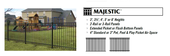
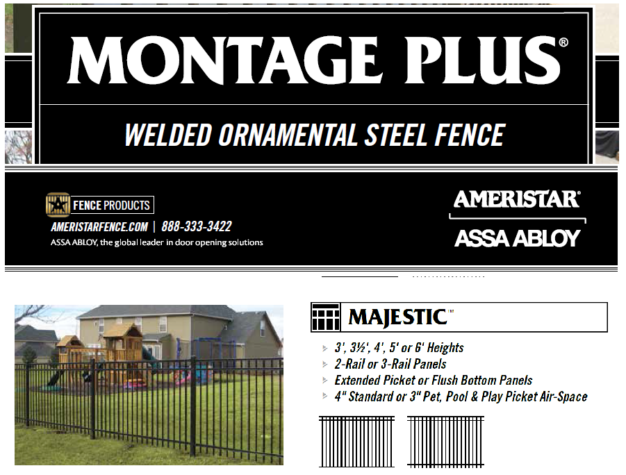
Fencing and Concrete Mow Strip. The Developer shall install or otherwise construct and dedicate to the City a four (4') foot Majestic Fencing, or a commercial-grade equivalent, as shown below, with an eighteen (18") inch concrete strip located directly under the fencing to prevent vegetation from growing up through the fencing on both sides of Parcel No. 05-186-0057. The fencing shall also include self-closing gates that allow pedestrian access from the Property to the Central Trail. The fencing and concrete mow strip shall be constructed with each phase of Aspen Ridges North that is recorded and thereafter developed adjacent to parcel 05-186-0057.
Construction of Ten (10') Trail. The Developer shall construct and dedicate to the City, at the Developer's expense, a ten (10') foot wide asphalt trail from 1200 South Street to 600 South Street, with the trail section crossing the canal to be constructed of concrete. The construction of the ten (10') foot wide trail shall occur no later than the recording and development of the last phase of the Aspen Ridges North Overlay Zone.
Fee-In-Lieu of Constructing Ten (10') Trail. The Developer covenants to do all within their ability to ensure that the ten (10') foot wide asphalt trail is constructed, including, if necessary, dedicating real property needed for the trail corridor so long as such dedication does not reduce the ability to develop the 102 dwelling units. However, if, for some reason, the construction of the trail is not feasible due to circumstances beyond the control of the Developer during the term that the Developer is developing Aspen Ridges North, the Developer agrees to pay a fee-in-lieu amount of no less than $60.00 per linear foot for the ten (10') wide asphalt trail. This amount shall increase based on the percentage of inflation that has occurred since the year 2024 to the time that the payment of the fee-in-lieu is made to the City.
The City shall determine the percentage of inflation since the year 2024 by using the Engineering News Record Construction Cost Index. The Developer's payment of the fee-in-lieu of constructing the ten (10') foot wide trail to the City shall occur no later than the recording and developing the last phase of the Aspen Ridges North Overlay Zone. While the Developer agrees that there is no date certain of when Central Trail shall be constructed, this fee-in-lieu payment made by the Developer shall be used to construct any section of the Central Trail at the sole discretion of the Tremonton City Council or another City recreation improvement.

C.
Fencing. The Developer acknowledges that Fencing is a required improvement along the canal and railroad corridors as required by 1.18.035 of the Tremonton City Land Use Code.
1.16.225 - ASPEN RIDGES NORTH OVERLAY ZONE REQUIRED AMENITIES AND A SPECIFIED TIMEFRAME.
To mitigate the impacts of density associated with the Aspen Ridges North Overlay Zone, the Developer agrees to provide all of the improvements enumerated below. Unless specifically stated otherwise, these improvements are done by the Developer and dedicated to the City without any additional consideration of cash, proportionate impact fee credits, and proportionate impact fee reimbursement by the City.
A.
Dedication of Water Shares. The Developer agrees to convey and dedicate to the City 3.82 water shares in the Bear River Canal Company for the irrigation of the existing Parks, which includes those enumerated in the table below, or for other existing or future parks. The conveyance and dedication of the 3.82 water shares shall occur within three (3) months of adopting the Aspen Ridges North Overlay Zone. The City shall be responsible for all fees associated with the Developer conveyance and dedication of the Bear River Canal Company water shares to Tremonton City. The Developer's dedication and conveyance of Bear River Canal Company water shares is made to the City without additional consideration of cash, proportionate impact fee credits, and proportionate impact fee reimbursement.
B.
On-site Amenities Including Clubhouse, Swimming Pools, Etc. The Developer shall ensure that Aspen Ridges North Overlay Zone residents have access equal to the Aspen Ridge Townhome Project's existing clubhouse, theater, swimming pool, spa, and fitness center contained in the Aspen Ridges Development. The Aspen Ridges North Overlay Zone residents shall have access to the aforementioned amenities as they occupy dwelling units within the Aspen Ridges North Overlay Zone.
C.
Minimum On-site Amenities (Playground and Park Benches). At a minimum, the Developer shall install a large on-site playground with trees and park benches with backs surrounding the playground. These amenities shall be private and owned and maintained by the Aspen Ridges Homeowners Association. The aforementioned amenities shall commence construction no later than seventy-five (75) percent of the units being completed within the project. The amenities shall be completed before ninety (90) percent of the units are completed within the project.
1.16.230 - ASPEN RIDGES NORTH OVERLAY ZONE ROAD IMPROVEMENTS.[16]
A.
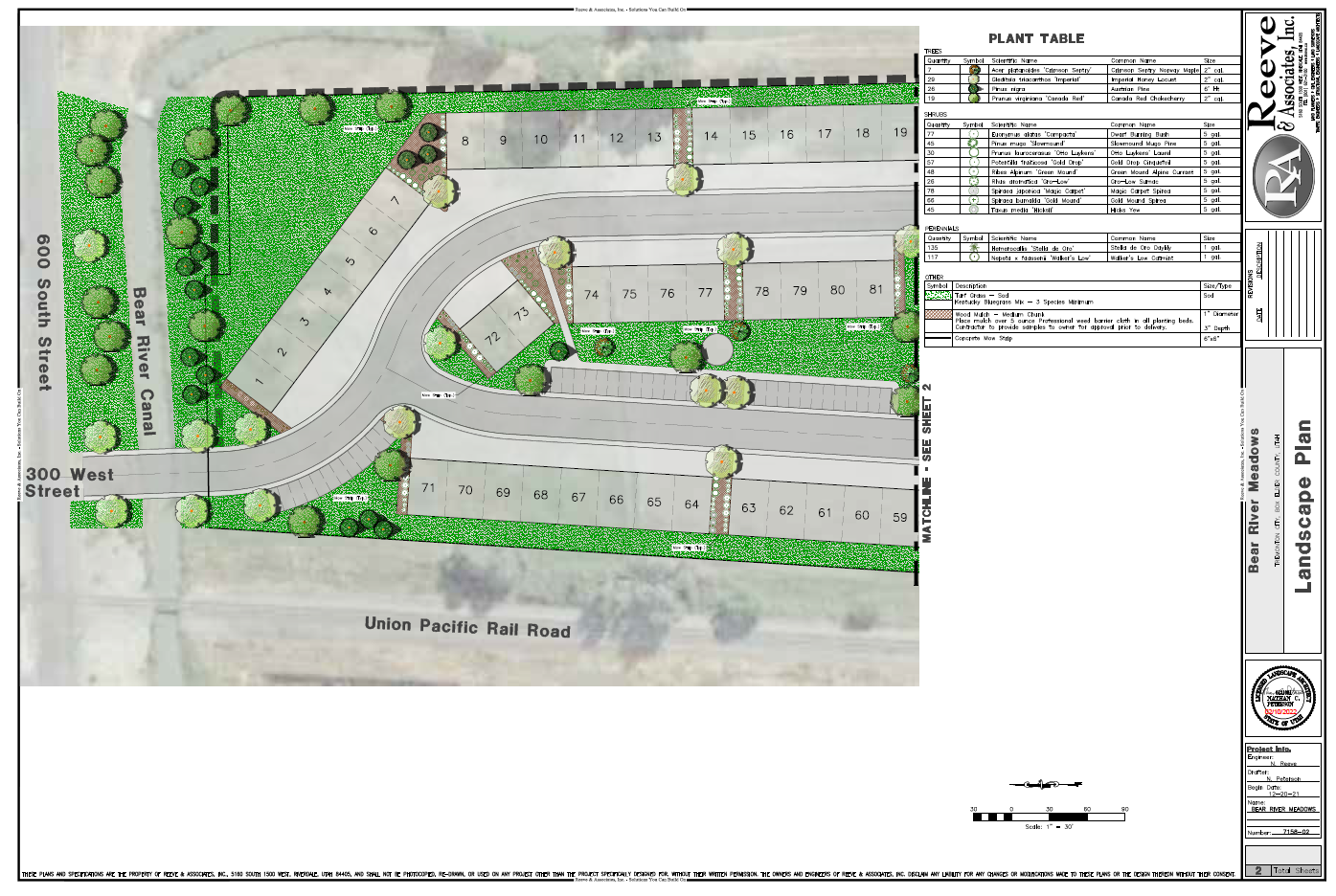
Frontage Improvements of 600 South. The Developer shall construct the following 600 South frontage improvements in front of the Development, which shall include a park strip, a four (4') foot sidewalk, landscaping, an irrigation system, and water shares associated with this landscaped area. The landscaping for this area shall be a similar size and scope as shown in Exhibit "E.04"; however, the final design, including size and scope, shall be based upon the Developer's Landscape Architect's proposed design being approved by the Development Review Committee and any limitations associated the Bear River Canal Company's continued use of their easement. The aforementioned improvements shall be completed with the second phase subdivision or site plan, or as the Development Review Committee determines otherwise. The Developer shall provide a financial guarantee for these landscape improvements (subdivision bond). As necessary, the Developer shall be responsible for receiving all approvals and permits from the Bear River Canal Company to landscape any area in which they claim an easement. The Developer shall expressly include language regarding the perpetual maintenance obligation of the landscaping improvements and sidewalk for the frontage improvements on 600 South in the homeowner's association Covenants, Conditions, and Restrictions recorded in the Box Elder County Recorder's Office.
B.
Enlarged Intersections at 600 South and 300 West. Developer acknowledges and agrees to construct the enlarged intersection improvements at 600 South and 300 West to accommodate all vehicular turning movements and provide trail connectivity. Due to the proximity of this intersection to the railroad tracks and the congestion that can occur when the trains prevent traffic from turning left onto 600 South, the intersection of 600 South and 300 West shall be designed to have a shared left turn and straight thru lane and a separate right turn lane with adequate stacking distances. The City Engineer and Public Works Director shall approve the intersection width and the canal crossing design to accommodate traffic circulation for all vehicle movements at the intersection, but in no case shall the width of the road be less than forty-two (42') feet from the back of curb to back of curb. This intersection and canal crossing shall also be designed and constructed to accommodate the ten (10') foot concrete trail, including an A.D.A. ramp at the intersection of 600 South (See Exhibit "E.03"). The Developer shall remove the existing canal crossing as shown in Exhibit "E.03." As necessary, the Developer shall be responsible for receiving all approvals and permits from the Bear River Canal Company. The enlarged intersection and trail crossing shall be completed within the second phase of the subdivision or site plan, or as required by the Development Review Committee. The Developer shall provide a financial guarantee (subdivision bond) for the improvements described in this section. The canal crossing is not a public road and shall be owned and maintained by the Aspen Ridges Homeowners Association like other private roads. The Developer shall provide an irrevocable public trail easement no less than ten (10') feet wide, to be recorded within the Box Elder County Recorder's Office, with the canal crossing for the Central Trail.
C.
Irrevocable Cross Access Easement and Maintenance Agreement. Unless otherwise approved by the City Attorney, the Developer of Aspen Ridges North Overlay Zone and Aspen Ridge shall enter into an irrevocable cross-access easement and maintenance agreement allowing traffic from both developments to pass through their respective developments. Unless otherwise approved by the City Attorney, this irrevocable cross-access easement and maintenance agreement shall be recorded within the Box Elder County Recorder's Office.
Exhibit "E.02" — Architectural Renderings for Aspen Ridges North Overlay Zone.
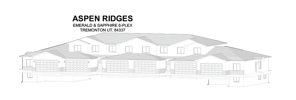
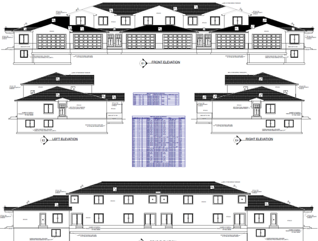
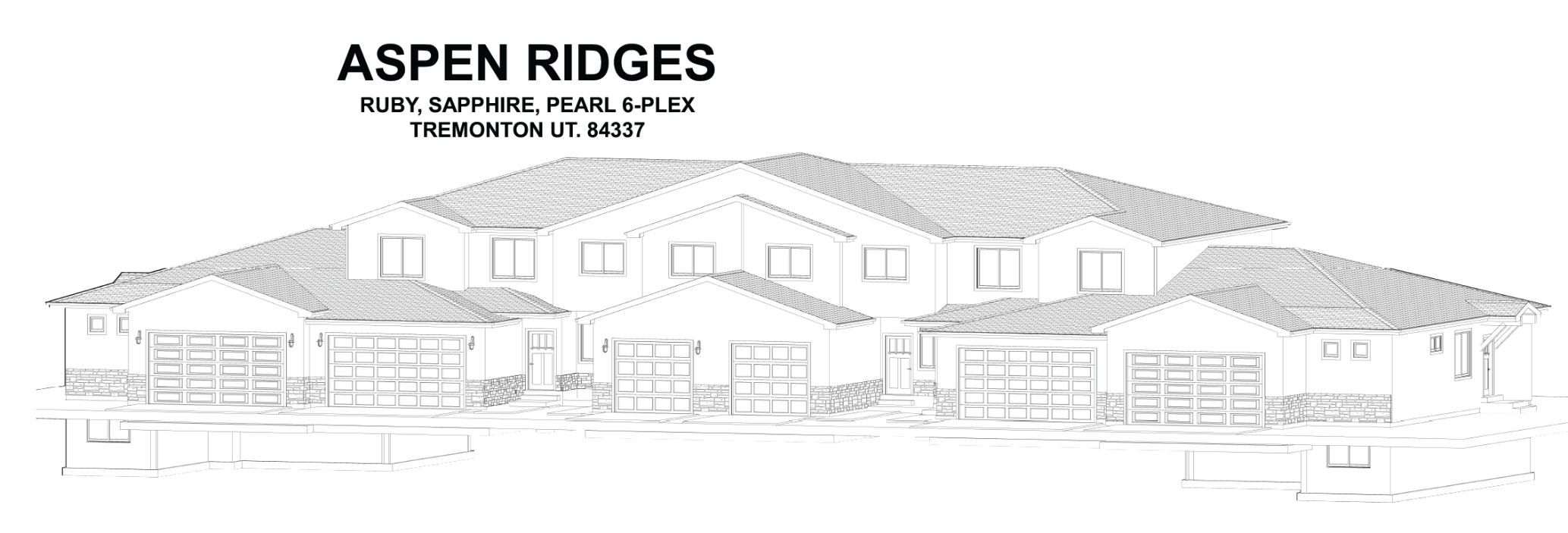
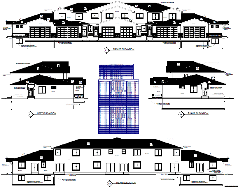
Exhibit "E.03" — Extension of the Central Trail Corridor to 600 South.
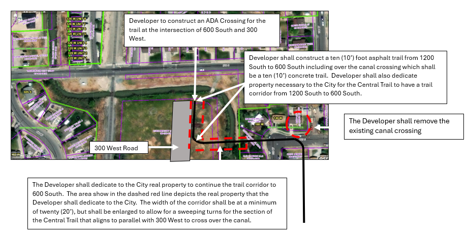
Exhibit "E.04" — Frontage Improvements of 600 South
Frontage Improvements of 600 South. The Developer shall construct the following 600 South frontage improvements in front of the Development, which shall include a park strip, a four (4') foot sidewalk, landscaping, an irrigation system, and water shares associated with this landscaped area. The landscaping for this area shall be a similar size and scope as shown below; however, the final design, including size and scope, shall be based upon the Developer's Landscape Architect's proposed design being approved by the Development Review Committee and any limitations associated the Bear River Canal Company's continued use of their easement.
(REV 14-03, REV 14-23, REV 15-07, REV 15-10, REV 16-11, REV 17-10, REV 18-04, REV 18-13, ORD 19-12, ORD 19-15, ORD 20-05, ORD 24-02)
1.16.235 - SINGLE FAMILY RESIDENTIAL TRANSITION OVERLAY ZONE PURPOSE.
An overlay district is intended to provide different and/or supplemental regulations or standards from the underlying zoning district necessary to address certain geographic features, land uses, or desired outcomes. The purpose of the Single Family Residential Transition Overlay (SFRTO) Zone is to serve as a transition between medium-density Single-Family Residential Zones (Rl-8, Rl-10, Rl-12) and multifamily residential, mixed use, or commercial zones (RM-8, RM-16, MU, CD, CG, CH, CN). This is achieved by accommodating a variety of single-family, patio home, and/or cottage home residential uses at densities higher than the underlying residential zone and lower than multi-family residential zones.
A.
The SFRTO Zone supports the development of areas with a residential character comparable to that of a single-family residential area, and is intended to promote, stabilize, and protect an environment suitable for family life.
B.
A development master plan will be required for developments in this zone.
(Ord. No. 24-05, 4-2-2024)
1.16.240 - SINGLE FAMILY RESIDENTIAL TRANSITION OVERLAY ZONE USES.
The underlying zoning district of the SFRTO Zone is the existing Single-Family Residential Zone of the development and all of the land uses shall remain the same as contained in Title I Chapter 1.07 of the Tremonton City Land Use Code for the Rl-8, Rl-10, or Rl-12 Zoning District. Whenever there is an explicit conflict between the regulations of the underlying residential zone district and the SFRTO Zone uses, this section shall control. If there is an explicit conflict between the Development Agreement and the SFRTO Overlay Zone, the Development Agreement shall control.
(Ord. No. 24-05, 4-2-2024)
1.16.245 - SINGLE FAMILY RESIDENTIAL TRANSITION OVERLAY ZONE LOT REGULATIONS.
This Section shall apply to all principal structures and accessory structures within the SFRTO Zone.
1 Note: Lot Regulation based on lot configuration and placement of structures on property as approved through the Site Plan approval process. A minimum of 25 percent of lots shall be Small Single-Family, mixed variably at random within the subdivision.
2 Note: Front setbacks shall be varied, with 30 percent of structures being setback a minimum of 25 feet, in groups of two to three placed at random within the subdivision.
3 Note: For lot layouts with detached or alley access garages, a minimum rear-yard setback of 25 feet is required.
4 Note: Exceptions to Height Regulations. Roof structures for the housing of elevators, stairways, tanks, ventilating fans or similar equipment required to operate and maintain the building, and fire or parapet walls, skylights, towers, steeples, flag poles, chimneys, smokestacks, water tanks, wireless or television masts, theater lofts, silos, or similar structures may be erected above the height limit herein prescribed. But no space above the height limit for residential purposes shall be allowed for purposes of providing additional floor space, nor shall such increased height be in violation of any other Ordinance or regulation of Tremonton City. Public Buildings, Utility Buildings, and Multi-Family Dwellings when authorized in a district, may be erected to a height greater than the district height limit by Site Plan approval.
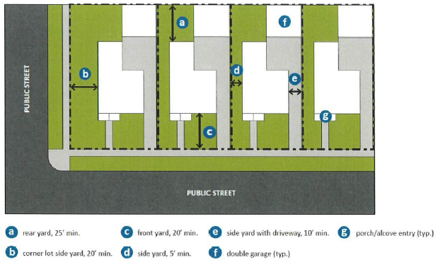
Figure 1: Sample home layout diagram with detached two-car garage located at the rear
of lot; a side yard driveway provides vehicular access from the street.
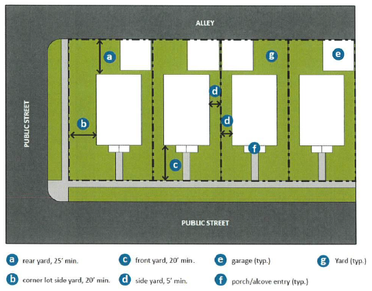
Figure 2: Sample home layout diagram with detached garage located in rear of lot with
direct alley access.
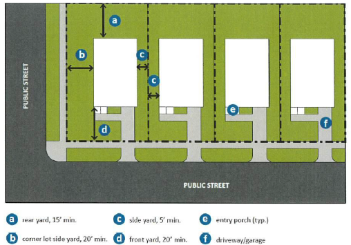
Figure 3: Sample home layout diagram with attached garage at the front of building
and street access.
(Ord. No. 24-05, 4-2-2024)
1.16.250 - SINGLE FAMILY RESIDENTIAL TRANSITION OVERLAY ZONE HOUSING TYPE LOCATION AND DENSITY.
The housing type within the SFRTO Zone shall be Small Single-Family and Patio/Cottage single-family homes, with a minimum of 25 percent of the lots to be Small Single-Family. The maximum density of the Single Family Residential Transition Overlay Zone is nine (9) dwelling units per acre net density.
(Ord. No. 24-05, 4-2-2024)
1.16.255 - SINGLE FAMILY RESIDENTIAL TRANSITION OVERLAY ZONE DEVELOPMENT STANDARDS.
A.
Development Master Plan. In addition to the other requirements of this Chapter, an application for development in the SFRTO Zone shall be accompanied by a development master plan, that clearly demonstrates that:
i.
The development will be built with a consistent, but not necessarily uniform, character and compatible architectural styles;
ii.
Overall control during the development process by a single development entity;
iii.
Design and implementation guidelines to ensure the overall vision is captured and maintained.
B.
Architectural and Design Standards. The following design materials and features are required and shall appear on the Development Master Plan:
i.
A variety of one-story and two-story floor plans.
ii.
High-quality exterior materials featuring a combination of at least 2 of the following materials: Stone, brick, engineered wood siding, or cement/composite fiberboard (which may be used as 2 separate materials if styles are clearly distinct either in orientation, design or texture), covering at least 40% of all front facades and 20% of side facades on comer lots facing a public street; a single aforementioned material may be used if it covers 100% of the street-facing facade; the remainder of the rear surfaces may be composed of a single material such as EIFS or similar material.
iii.
A variety of exterior paint/material colors and textures, preventing a uniform or "cookie cutter" appearance.
iv.
Inclusion of front-facing architectural features such as dormers, front porches, awnings, alcoves, decorative covered door stoops, and similar features. Front doors/main entrances shall face the front yard; main entrances that face a side yard are prohibited.
v.
Varied rooflines, which includes but is not limited to having multiple gables extending above the eaves, that there be varied roofline heights between units and gabled roofs.
C.
Garages. All units in this zone shall have a completely enclosed two-car or one-car garage. Garages may be incorporated into the main dwelling or may be built as a detached accessory building. Where built as an accessory building, the garage shall meet all requirements of this title for accessory buildings and shall be constructed of the same materials required for the main building and with the same architectural theme.
D.
Parking Access — Driveways. All driveways in this zone shall meet the following minimum requirements:
i.
Attached Garage Facing Street: Minimum width equal to opening of garage.
ii.
Sole Use Driveway to Detached Garage in Rear Yard: Minimum width often feet.
iii.
Common Use Driveway or Accessway (Alley) to Attached or Detached Garage(s) in Rear of Residential Unit: Minimum width of 24 feet; or wider as required to meet fire safety requirements and efficient and safe flow of vehicular and pedestrian traffic.
E.
Landscaping, Buffering, and Fencing. Landscaping and fencing shall be provided per the requirements of Chapter 1.18 Landscaping, Buffering, and Fencing Regulations. The Developer shall install street trees in the park strip with an irrigation source in accordance with Public Tree Ordinance (Chapter 8-700) of the Tremonton City Revised Ordinances.
F.
Park and Trails Improvements. The Developer shall either construct park and trail improvements as part of the City's park and trails system in accordance with City Standards, or pay a fee-in-lieu to the City for system-wide improvements. These improvements/fees shall be determined as part of the Development Master Plan and included in the Development Agreement.
G.
Other Rules.
i.
The DRC or Planning Commission may require engineering studies or other studies to ensure compliance with, and mitigation of, health, safety, and welfare concerns.
(Ord. No. 24-05, 4-2-2024)
1.16.260 - VILLAGE AT NORTH PARK OVERLAY ZONE PURPOSE.
The Village at North Park Overlay Zone is an overlay district that is intended to provide different and/or supplemental regulations or standards from the underlying zoning district necessary to address certain land uses and achieve other desired outcomes through regulations or requirements.
(Ord. No. 22-07, Exh. G, 9-6-2022)
1.16.265 - ZONING DEVELOPMENT AGREEMENT FOR ORDINANCE NO. 22-07.
The zoning of the Village at North Park Overlay Zone is zoning by agreement, which is legal and valid if the City follows the legal procedures and public process to establish the zone, which includes but are not limited to 1) following the public process to zoning property; 2) the City Council adopting a zoning ordinance that delineates the range of land uses, the maximum densities, and other related zoning standards for the zone; 3) the City and Developer agreeing to an Agreement that formalizes the zoning and negotiated amenities and improvements associated with zoning.
As formalized within Zoning Development Agreement for Ordinance No. 22-07, the Developer agrees that the requirements, conditions, and improvements contained in the Village at North Park Overlay Zone contained herein are vital to the success and desired outcomes of the Village at North Park Overlay Zone. Further, as formalized within Zoning Development Agreement for Ordinance No. 22-07, the Developer agrees and covenants to complete, construct, or otherwise fulfill the requirements and improvements within the Village at North Park Overlay Zone and complete these said requirements and improvements within the timelines specified within in the Village at North Park Overlay Zone, the City's Land Use Development Code, the City's General Public Works, Construction Standards, and Specifications, City's Revised Ordinances without any additional consideration of cash, proportionate Impact Fee credits, and proportionate Impact Fee reimbursement. Any amendments to the Village at North Park Overlay Zone and the Zoning Development Agreement for Ordinance No. 22-07 shall follow the rezoning process, including the public process for adoption of a land-use regulation.
(Ord. No. 22-07, Exh. G, 9-6-2022)
1.16.270 - VILLAGE AT NORTH PARK OVERLAY ZONE USES.
The underlying zoning district of the Village at North Park Overlay Zone is Residential Multiple District, RM-16, and all of the land uses shall remain the same as contained in Title I Chapter 1.07 of the Tremonton City Land Use Code for the Residential Multiple District, RM-16 Zoning District unless specifically stated otherwise in the use table below. Uses shown as "P" permitted uses in the appropriate column or as "C" conditional uses in the appropriate column. If a use is not allowed it is either not named in the uses list, or it is indicated by a dash, "-" as not permitted or not applicable or is stated as such.
1 Note: See Chapter 1.25 of this Title - Conditional Uses Permit.
2 Note: See Chapter 1.17 of this Title - Off-Street Parking Regulations.
3 Note: See Chapter 1.18 of this Title - Landscaping, Buffering, and Fencing Regulations.
4 Note: Accessory buildings serving the entire complex, such as clubhouse, pool house, bowery, etc., are permitted.
5 Note: All dwelling units are for Single-Family occupancy.
6 Note: No dwelling or dwelling unit shall be less than four hundred (400) square feet in living space.
7 Note: Applicant shall also ensure that there are no restrictive covenants that exclude Manufacturing and Modular Housing as required by Utah Code Annotated 10-9a-514.
8 Note: See Chapter 1.03 of this Title - Definitions.
(Ord. No. 22-07, Exh. G, 9-6-2022)
1.16.275 - VILLAGE AT NORTH PARK OVERLAY ZONE LOT REGULATIONS.
This Section shall apply to all principal structures and accessory structures within the Village at North Park Overlay Zone.
1 Note: Lot Regulation based on lot configuration and placement of structures on property as approved through the Site Plan approval process.
2 Note: Exceptions to Height Regulations. Roof structures for the housing of elevators, stairways, tanks, ventilating fans, or similar equipment required to operate and maintain the building, and fire or parapet walls, skylights, towers, steeples, flag poles, chimneys, smokestacks, water tanks, wireless or television masts, theater lofts, silos, or similar structures may be erected above the height limit herein prescribed, but no space above the height limit for residential purposes shall be allowed for purposes of providing additional floor space, nor shall such increased height be in violation of any other ordinance or regulation of Tremonton City.
3 Note: Porte-Cochére's, Portico's, and similar structures not more than one (1) story when attached to the main building and remains open on three (3) sides may extend into the required building setback as approved through the Site Plan approval process.
4 Note: The Development Review Committee or Land Use Authority may reduce the Village at North Park Overlay Zone Lot Regulations with the Developer's dedication of additional right-of-way along 600 North or 1000 North to accommodate additional width in travel lanes and or pedestrian improvements within the right-of-way.
(Ord. No. 22-07, Exh. G, 9-6-2022)
1.16.280 - VILLAGE AT NORTH PARK OVERLAY ZONE HOUSING TYPE AND DENSITY.
The housing type within the Village at North Park Overlay Zone shall be either Multi-Family Twin Home or Multi-Family Attached, with each dwelling unit on a separate lot. Multi-Family Stacked Dwellings are prohibited. The Village at North Park Overlay Zone reduces the maximum number of dwelling units in the underlying zoning of Residential Multiple District, RM-16 per acre, from sixteen (16) to maximum dwelling units of twelve (12) per acre within the Village at North Park Overlay Zone and to achieve other desired outcomes. The maximum density of the Village at North Park Overlay Zone is twelve (12) dwelling units per acre. The actual density within the Village at North Park Overlay Zone shall be determined during the subdivision and site plan review and approval process, and compliance with the development meeting the City's dimensional standards for setbacks, parking, stormwater retention, buffering, and other applicable development requirements contained within the City's Zoning and Land Use Development Codes, the City's General Public Works, Construction Standards, and Specifications, and the Village at North Park Overlay Zone.
(Ord. No. 22-07, Exh. G, 9-6-2022)
1.16.285 - VILLAGE AT NORTH PARK OVERLAY ZONE ARCHITECTURAL AND DESIGN STANDARDS.
To mitigate the impacts of Multi-Family Twin Home and or Multi-Family Attached housing, the Developer agrees to construct structures that meet or exceed the following architecture and design standards listed below. Further, the Developer agrees to record architectural and design standards within Covenants, Conditions, and Restrictions that are recorded in the Box Elder County Recorder's Office with the platting of each subdivision for multi-family attached housing within the Project if sold to a third-party. As part of the Site Plan review process, the Developer shall submit building elevations that shall comply with the architectural and design standards and be approved by the Development Review Committee.
A.
Masonry Materials. That the building elevations, including front, side, and rear be comprised one-hundred (100) percent of masonry, which includes brick, stone, stucco, and cement fiberboard.
B.
Roofline. That there is varied roofline, which includes but is not limited to have multiple gables extending above the eaves, that there be varied roofline heights between units and gable and shed roofs.
C.
Glazing. That there be a significant amount of glazing/windows on the front elevation, which is not less than twelve (12) percent of the front elevation.
D.
Front Elevations and Front Doors to face the Public Street. That the front elevations of buildings be oriented towards public streets, and that the front doors are visible from the public street.
E.
Covered Front Door Entries. That all the units have a covered entry over the front door.
F.
Garages. Each unit shall have a two-car garage that is located on the rear elevation.
G.
Architectural Elements in the Front Elevations. That the front elevations be comprised of the following architectural elements, including pillars, gabled roofs, and shed roofs. Each architectural element should be integrated harmoniously into the design.
H.
Landscaping. That the front yards are landscaped, and off-street parking areas are landscaped according to the Tremonton City Land Use Code.
(Ord. No. 22-07, Exh. G, 9-6-2022)
1.16.290 - VILLAGE AT NORTH PARK OVERLAY ZONE LANDSCAPING, BUFFERING, FENCING, AND CENTRAL TRAIL IMPROVEMENTS.
To mitigate the of Multi-Family Twin Home and or Multi-Family Attached housing, the Developer agrees to make the following improvements in addition to the requirements contained in Chapter 1.18 Landscaping, Buffering, and Fencing Regulations. All of these improvements enumerated below are constructed by the Developer and dedicated to the City without any additional consideration of cash, proportionate impact fee credits, and proportionate impact fee reimbursement by the City.
A.
Street Trees and Enlarged Park Strip. That either small street trees with a mature height of twenty-five (25') feet or less or medium street trees with a mature height between twenty-five (25') feet and forty (40') feet be planted in landscaped park strips. The size of the street tree, either small or medium, and the exact species of trees shall be determined by a licensed landscape architect as part of the submitted landscape plan. All street trees shall be no less than two (2") inches at the time of planting. If a medium-size street tree is planted, the park strip shall be a minimum of six (6') feet in width. The street trees and other vegetation within the park strips have an irrigation source. These street trees, landscaped park strips, and irrigation sources shall be installed within one (1) year of a certificate of occupancy being issued for a dwelling unit with frontage on the street. See Chapter 8-700 Public Street Tree Ordinance of the City's Revised Ordinances for more information on street tree requirements.
B.
Central Trail Improvements. That a twenty (20') foot landscape buffer be created along the Central Trail corridor. The landscape buffer shall include the required improvement specified in 1.18.035 of the Land Use Code. The Developer shall install or otherwise construct a four (4') foot Majestic Fencing, or a commercial-grade equivalent, as shown below, with an eighteen (18") inch concrete strip located directly under the fencing to prevent vegetation from growing up through the fencing on both sides of Parcel No. 05-043-0020. The City and Developer shall equally split the costs of the construction of the fencing and concrete mow strip. The Developer shall install or otherwise construct a ten (10') foot wide asphalt trail on Parcel No. 05-043-0020, approximately two thousand six hundred (2,600') feet in length. The trail is to be constructed according to City's standards. The timing and construction of these trail improvements shall be at the election of the Developer, but in no case shall the Developer fail to start the construction of these trail improvements before seventy-five (75) percent of the units being completed within the Development.
(Ord. No. 22-07, Exh. G, 9-6-2022)
1.16.295 - VILLAGE AT NORTH PARK OVERLAY ZONE REQUIRED AMENITIES AND SPECIFIED TIMEFRAME.
To mitigate the Multi-Family Twin Home and or Multi-Family Attached housing, the Developer agrees that rather than constructing private on-site amenities, the Developer shall make contributions as described in this section to improve existing or future Tremonton City parks, recreation, open space, and trail improvements. All of these improvements enumerated below are constructed by the Developer and dedicated to the City without any additional consideration of cash, proportionate impact fee credits, and proportionate impact fee reimbursement by the City.
A.
Dedication of Water Shares. The Developer agrees to convey and dedicate to the City 11.96 water shares in the Bear River Canal Company to irrigate the existing North Park (6.47 acres) and South Park (5.49 acres) owned by Tremonton City. The conveyance and dedication of the 11.96 water shares shall occur within three (3) months of the adoption of the Village at North Park Overlay Zone and signing of the Zoning Development Agreement for Ordinance No. 22-07. The City shall be responsible for all of the fees associated with the Developer conveyance and dedication of the Bear River Canal Company water shares to Tremonton City.
B.
Financial Contributions in lieu of On-Site Amenities. In addition to parks, recreation, open space, and trails impact fees required to be paid by any Tremonton City Impact fee enactment ordinance, the Developer shall make a financial contribution to the City for parks, recreation, open space, and trail improvements. This financial contribution shall be no less than $1,337 for each unit and shall increase based upon the percentage of inflation that has occurred since the year 2022 and the time that the payment of the financial contribution is made to the City. The City shall determine the percentage of inflation that has occurred since the year 2022 by using the Engineering News Record Construction Cost Index. The Developer shall contribute based on the number of units that the Developer shall construct with each phase of subdivision or site plan, with the contribution being formalized in a subdivision or site plan development agreement and paid prior to the recording of the subdivision or approval of the site plan. These financial contributions shall be used at the sole discretion of the Tremonton City Council for the construction of any future park, recreation, open space, or trail improvement or the rehabilitation of any existing public parks, recreation, open space, or trail improvements.
(Ord. No. 22-07, Exh. G, 9-6-2022)
1.16.300 - VILLAGE AT NORTH PARK OVERLAY ZONE ROAD IMPROVEMENTS.
A.
Dedication of Additional Right-of-Way. If needed, the Developer shall dedicate additional right-of-way needed to perfect the roadway for 1000 North and 600 North. Specifically, the Developer shall dedicate the right-of-way needed to meet the City's standard right-of-way width for the classification of the applicable road with the approval of subdivision or site plan permit. This dedication of right-of-way by the Developer to the City shall be done without any additional consideration of cash, proportionate impact fee credits, and proportionate impact fee reimbursement.
B.
Frontage Improvements of 1000 North. The Developer shall construct the following 1000 North frontage improvements in front of the Development, which shall include a curb, gutter, and an eight (8') foot sidewalk along with irrigation, sod, street trees, and streetlights in the park strip with the approval and construction of subdivision or site plan. The City and the Developer shall equally share in the cost of constructing the eight (8') foot sidewalk as well as any additional structural fill required to bring the City's half to grade, with the Developer being responsible for the cost of the remainder of the aforementioned frontage improvements. The aforementioned improvements shall be included in the bond. The Developer shall expressly include language regarding the perpetual maintenance obligation of the landscaping improvements and sidewalk in the homeowner's association Covenants, Conditions, and Restrictions. These frontage improvements by the Developer to the City shall be done without any additional consideration of cash, proportionate impact fee credits, and proportionate impact fee reimbursement.
C.
Frontage Improvements of 600 North. The Developer shall construct the following 600 North frontage improvements in front of the Development, which shall include a curb, gutter, and a four (4') foot sidewalk along with irrigation, sod, street trees, and streetlights in the park strip with the approval and construction of a subdivision or site plan. The aforementioned improvements shall be included in the bond. The Developer shall expressly include language regarding the perpetual maintenance obligation of the landscaping improvements and sidewalk in the homeowner's association Covenants, Conditions, and Restrictions. These frontage improvements by the Developer to the City shall be done without any additional consideration of cash, proportionate impact fee credits, and proportionate impact fee reimbursement.
D.
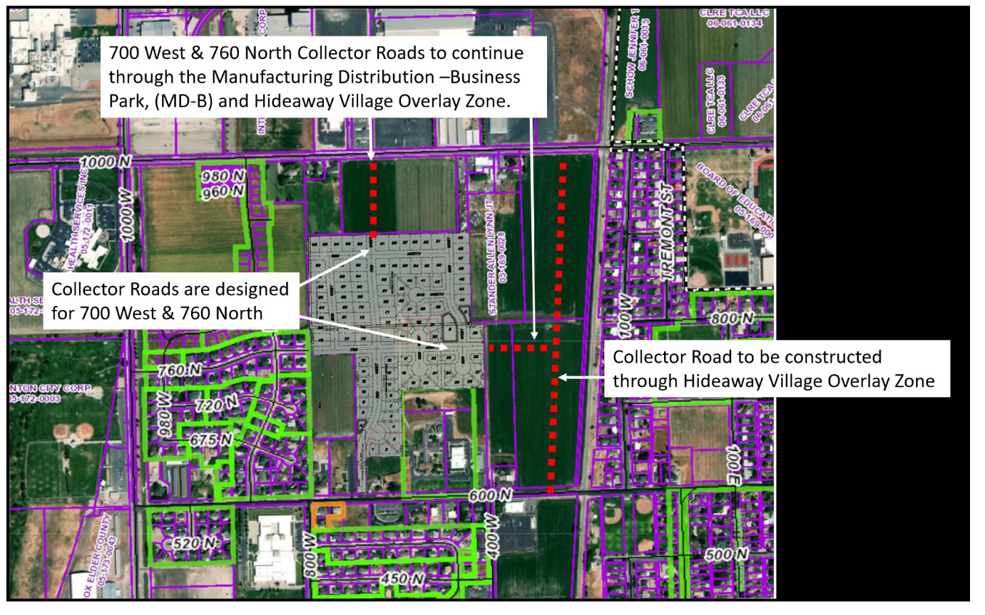
Collector Roads Adjacent to and through the Village at North Park Overlay Zone. The Developer shall continue the collector roads, which are sixty-six (66') feet in width, as shown by red dashed lines in the image below, with the approval and construction of a subdivision or site plan.
E.
Enlarged Intersections of Collector Roads and Minor Arterial Roads. Developer acknowledges and agrees to construct the enlarged intersection improvements and dedicate right-of-way widths for all intersections where a collector road (which is sixty-six (66') feet in width) intersects with a minor arterial road being 1000 North (which is sixty-six (66') feet in width). The known location of these enlarged intersections is depicted in the graphic below, noted with the yellow circle at two intersections of collector roads intersecting the minor arterial road of 1000 North. The enlarged intersections shall be according to the dimension shown below. These frontage improvements by the Developer to the City shall be done without any additional consideration of cash, proportionate impact fee credits, and proportionate impact fee reimbursement.
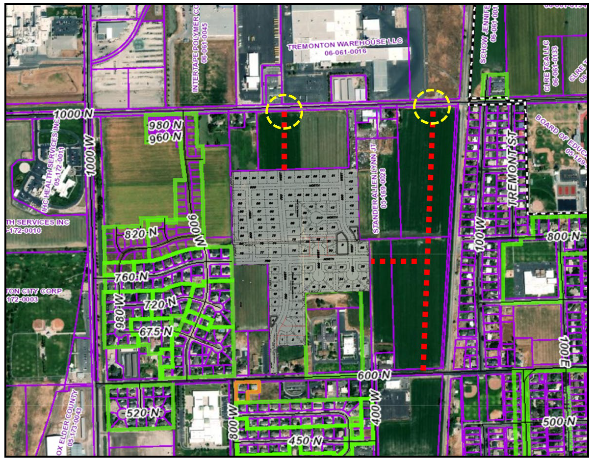
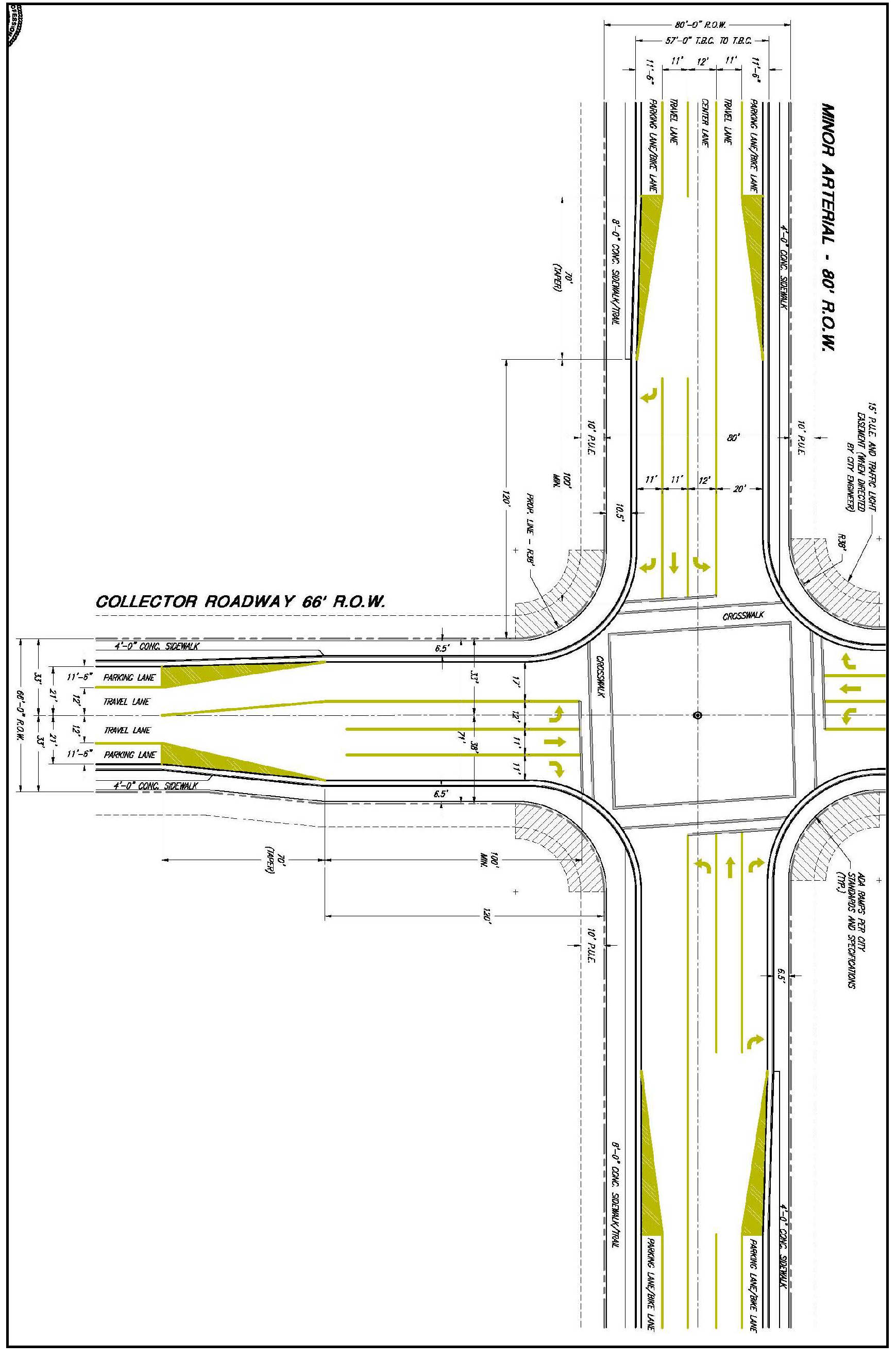
(Ord. No. 22-07, Exh. G, 9-6-2022)