
Tuscaloosa City Zoning Code
ARTICLE IV
ZONING DISTRICTS
Sec. 25-48. - General.
This ordinance establishes the base, planned development, and overlay zoning districts identified in this section. The boundaries of the zoning districts are identified on the official zoning map, in accordance with article I, division 3, official zoning map.
(Ord. No. 9572, § 2, 12-17-24)
Sec. 25-49. - Open space district.
The open space (OS) district is the only open space district.
(Ord. No. 9572, § 2, 12-17-24)
Sec. 25-50. - Residential districts.
Residential districts include the following districts:
1.
Compact neighborhood (CN) district (see section 25-58);
2.
Single family residential estate (SFR-E) district (see section 25-59);
3.
Lake residential (LR) district (see section 25-60);
4.
Lake multifamily (LMF) district (see section 25-61);
5.
Single family residential 1 (SFR-1) district (see section 25-62);
6.
Single family residential 2 (SFR-2) district (see section 25-63);
7.
Single family residential 3 (SFR-3) district (see section 25-64);
8.
Single family residential 4 (SFR-4) district (see section 25-65);
9.
Single family residential 5 (SFR-5) district (see section 25-66);
10.
Mixed residential 1 (MR-1) district (see section 25-67);
11.
Mixed residential 2 (MR-2) district (see section 25-68);
12.
Mixed residential university (MRU) district (see section 25-69);
13.
Multifamily residential university (MFRU) district (see section 25-70);
14.
Multifamily residential (MFR) district (see section 25-71); and
15.
Mobile home residential (MHR) district (see section 25-72).
(Ord. No. 9572, § 2, 12-17-24)
Sec. 25-51. - Institutional districts.
Institutional districts include the following districts:
1.
Institutional university (IU) district (see section 25-74);
2.
Institutional public (IP) district (see section 25-75); and
3.
Institutional semi-public (ISP) district (see section 25-76).
(Ord. No. 9572, § 2, 12-17-24)
Sec. 25-52. - Business districts.
Business districts include the following districts:
1.
Downtown (D) district (see section 25-78);
2.
Downtown perimeter (DP) district (see section 25-79);
3.
Downtown historic edge (DHE) district (see section 25-80);
4.
Riverfront (R) district (see section 25-81);
5.
Lake commercial (LC) district (see section 25-82);
6.
General commercial (GC) district (see section 25-83);
7.
University commercial (UC) district (see section 25-84);
8.
Neighborhood commercial (NC) district (see 25-85); and
9.
Highway commercial (HC) district (see section 25-86).
(Ord. No. 9572, § 2, 12-17-24)
Sec. 25-53. - Industrial districts.
Industrial districts include the following districts:
1.
Industrial light (IL) district (see section 25-88);
2.
Industrial general (IG) district (see section 25-89); and
3.
Industrial heavy (IH) district (see section 25-90).
(Ord. No. 9572, § 2, 12-17-24)
Sec. 25-54. - Planned development districts.
Planned development districts include the following districts:
1.
General planned development (GPD) district (see section 25-92); and
2.
Riverfront planned development (RPD) district (see section 25-93).
(Ord. No. 9572, § 2, 12-17-24)
Sec. 25-55. - Overlay district.
The historic buffer overlay (HBO) district is the only overlay district.
(Ord. No. 9572, § 2, 12-17-24)
Sec. 25-56. - Open space.
a.
Purpose. The open space (OS) district is intended to provide lands in the city for open space, large public parks and trails, farmland, viewsheds, wildlife habitat, and related uses. The district is characterized by areas designed for active or passive recreation, public parks and trails, and natural areas.
b.
Use standards. Allowed uses and use-specific standards for principal, accessory, and temporary uses are established in article V, use regulations.
c.
Intensity and dimensional standards. All development in the OS district shall comply with the standards in table IV-1: OS intensity and dimensional standards.
Table IV-1: OS Intensity and Dimensional Standards
Notes:
[1] max = maximum; min = minimum; ft = feet
[2] Publicly-owned parks are not subject to these dimensional standards
d.
References to other standards. Development in the OS district shall comply with all applicable standards of this zoning ordinance and the subdivision regulations, including but not limited to the standards referenced in table IV-2: cross-references to other standards.
Table IV-2: Cross-References to Other Standards
(Ord. No. 9572, § 2, 12-17-24)
Sec. 25-57. - General purpose.
The general purpose of residential districts is to:
a.
Support the development pattern and character of Tuscaloosa's established neighborhoods;
b.
Provide a variety of neighborhoods and housing options;
c.
Create and expand complete neighborhoods that integrate transit, employment, retail, and services within convenient walking distances to homes;
d.
Encourage well-planned and appropriately-scaled infill and redevelopment that is generally compatible with development in the surrounding area;
e.
Allow for human-scale, neighborhood-serving commercial and employment uses; and
f.
Ensure the requirements of this ordinance are in accordance with the comprehensive plan.
(Ord. No. 9572, § 2, 12-17-24)
Sec. 25-58. - Compact neighborhood.
a.
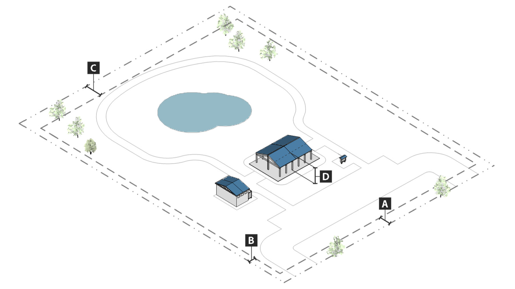
Purpose. The purpose of the compact neighborhood (CN) district is to provide lands for clustered development on residential lots that are smaller than would otherwise be permitted under conventional development regulations, with the remaining land being retained as common open space. The district is intended to support a medium-density residential environment, with additional density allowed where additional open space is provided, and may include compatible public, civic, and institutional uses.
b.
Use standards. Allowed uses and use-specific standards for principal, accessory, and temporary uses are established in article V, use regulations.
c.
Intensity and dimensional standards. All development in the CN district shall comply with the standards in table IV-3: CN intensity and dimensional standards.
Table IV-3: CN Intensity and Dimensional Standards
Notes:
[1] max = maximum; min = minimum; du = dwelling units; ft = feet; sf = square feet
[2] Density and percentage of common open space shall be calculated based on the total area of the project site and the total number of dwelling units, or total area of land occupied by common open space, respectively, within the project site.
[3] For single-family detached uses, the minimum width of a lot with front vehicular access shall be 40 feet, and the minimum width of a lot with only rear vehicular access shall be 30 feet.
d.
General standards.
1.
Residential lots shall be organized in one or more clusters so as to maximize contiguity and integration of open space areas.
2.
Streets internal to the project site, driveways, and buildings shall be sited to maintain existing natural grades, to the maximum extent practicable.
3.
Dwellings shall be sited and/or buffered to avoid the rear of the dwellings being visible from the front of other dwellings or streets external to the project site.
4.
All parking lots shall be screened from view from streets external to the project site in accordance with section 25-132(c), parking lot perimeter landscaping standards.
5.
All residential lots shall be served by public water and sewer systems.
6.
Trees on ridgelines shall be preserved, to the maximum extent practicable.
e.
Additional density allowance. Where a development includes open space areas in excess of the minimum ten (10) per cent required by table IV-3, the maximum residential density allowed in the development shall be increased in accordance with this section, if all open space areas in the development comply with subsection f. below. No open space area shall count toward both the general allowance specified in subsection 1. below, and the increased allowance specified in subsection 2. below (that is, land may not be double counted toward both allowances; it may be used only for one allowance or the other).
1.
General allowance. For every additional fifteen (15) per cent of the land area in a proposed development consisting of open space areas, above the ten (10) per cent minimum required by table IV-3: CN intensity and dimensional standards, an additional density of one dwelling unit per acre, above six (6) dwelling units per acre, is allowed, up to a total maximum density of eight (8) dwelling units per acre.
2.
Increased allowance for well-connected open space. For every additional ten (10) per cent of the land area in a proposed development consisting of well-connected open space areas, above the ten (10) per cent minimum required by table IV-3: CN intensity and dimensional standards, an additional density of one dwelling unit per acre, above six (6) dwelling units per acre, is allowed, up to a total maximum density of ten (10) dwelling units per acre. For purposes of this section, "well-connected" means the open space set-aside:
(a)
Is compact and contiguous, unless a different configuration is needed to continue an existing pedestrian way or multi-modal path; and
(b)
Includes lighted, all-weather pedestrian ways or multi-modal paths that allow pedestrians to pass through the open space set-aside from one side to another. At least two (2) of the following shall be provided within the open space-set aside in convenient proximity to the pedestrian ways or multi-modal paths:
(1)
Wayfinding signage;
(2)
Benches;
(3)
Shade canopies;
(4)
Water fountains;
(5)
Outdoor strength training/fitness stations;
(6)
Similar pedestrian/bicyclist amenities; or
(7)
Additional amenities as approved by the director of planning.
f.
Open space.
1.
Open space used to meet the requirement in table IV-3, or provided in accordance with subsection d. above, shall also count toward the minimum open space requirements in article VI, division 4, open space standards, and shall comply with all other standards in article VI, division 4, open space standards, except as otherwise provided in this section.
2.
A maximum of sixty (60) per cent of the total open space area in the project site may consist of lands that the director of planning determines cannot be developed because they contain wetlands, bodies of water, dedicated easements or rights-of-way (except those existing to only protect underground utilities such as water or sewer lines), or other constraints.
3.
Use of the open space shall be limited to agriculture (including forestry), passive recreation, preservation of natural areas (such as wildlife corridors, existing stands of trees, and shoreline buffers), and preservation of areas of special historical significance.
4.
Open spaces shall be contiguous, to the maximum extent practicable.
5.
The following notation shall be placed on all open space on the subdivision plat: "Designated open space, not to be further subdivided or used for future building lots."
g.
References to other standards. Development in the CN district shall comply with all applicable standards of this zoning ordinance and the subdivision regulations, including but not limited to the standards referenced in table IV-4: cross-references to other standards.
Table IV-4: Cross-References to Other Standards
(Ord. No. 9572, § 2, 12-17-24)
Sec. 25-59. - Single family residential estate.
a.
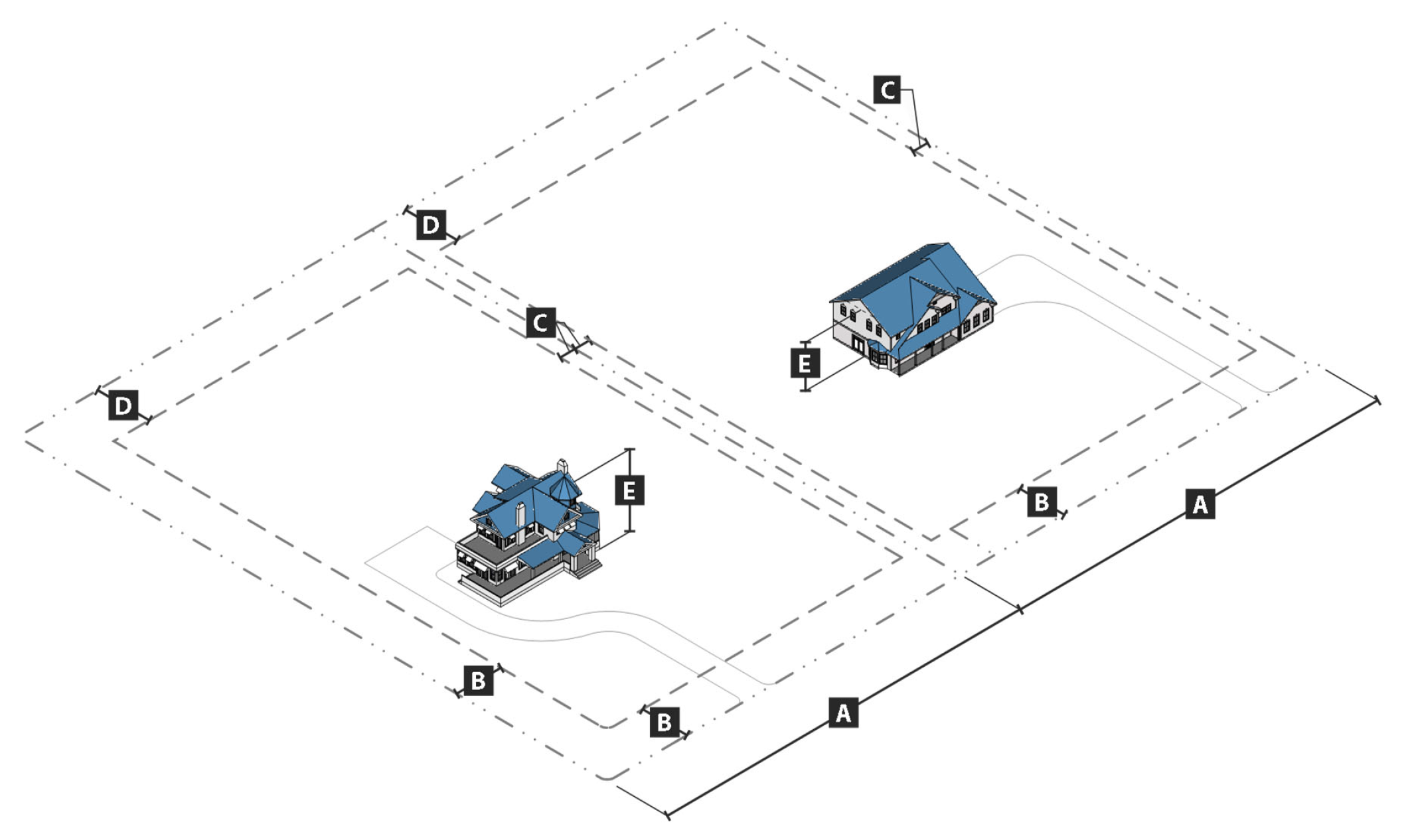
Purpose. The purpose of the single family residential estate (SFR-E) district is to provide lands for large-lot suburban neighborhoods that accommodate single-family detached homes at a maximum density of one unit per two (2) acres. The district supports a low-density residential environment and may include compatible public, civic, and institutional uses.
b.
Use standards. Allowed uses and use-specific standards for principal, accessory, and temporary uses are established in article V, use regulations.
c.
Intensity and dimensional standards. All development in the SFR-E district shall comply with the standards in table IV-5: SFR-E intensity and dimensional standards.
Table IV-5: SFR-E Intensity and Dimensional Standards
Notes:
[1] max = maximum; min = minimum; du = dwelling units; ft = feet; sf = square feet
d.
References to other standards. Development in the SFR-E district shall comply with all applicable standards of this zoning ordinance and the subdivision regulations, including but not limited to the standards referenced in table IV-6: cross-references to other standards.
Table IV-6: Cross-References to Other Standards
(Ord. No. 9572, § 2, 12-17-24)
Sec. 25-60. - Lake residential.
a.
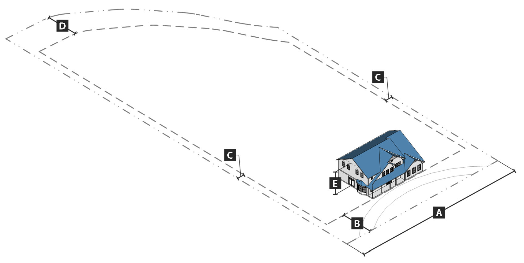
Purpose. The purpose of the lake residential (LR) district is to provide lands for residential development consisting of detached single-family dwellings near Tuscaloosa's lakes and reservoirs that is consistent with the character of surrounding development and that protects water quality. To accomplish this purpose, it is intended that at minimum all land abutting Lake Tuscaloosa be classified in the LR district. This district is intended to implement the lakeside living character type on the future land use and character map in the comprehensive plan.
b.
Use standards. Allowed uses and use-specific standards for principal, accessory, and temporary uses are established in article V, use regulations.
c.
Intensity and dimensional standards. All development in the LR district shall comply with the standards in table IV-7: LR intensity and dimensional standards.
Table IV-7: LR Intensity and Dimensional Standards
Notes:
[1] max = maximum; min = minimum; du = dwelling units; ft = feet; sf = square feet
[2] If the lot includes a septic system, the minimum lot area shall be the minimum required by the health department.
[3] The minimum front setback may be decreased to the average alignment of existing buildings within 100 feet on either side of subject building and within the same block if such alignment is less than 35 feet.
d.
Development standards. All development in the LR district shall comply with the following standards:
1.
Primary building materials.
i.
The following building material shall be used for not less than seventy-five (75) per cent of the building wall surface area on each façade. Primary material changes may occur only at building corners where a maximum of one of the façades faces the street:
(a)
Brick masonry.
(b)
Natural stone (or synthetic equivalent);
(c)
Wood-clapboard or shingles;
(d)
Glass curtain wall; or
ii.
The use of EIFS or aluminum siding is prohibited.
2.
Accent building materials. The following materials may make up twenty-five (25) per cent of the building wall surface area on each façade:
i.
Pre-cast masonry (only for trim and cornice elements);
ii.
Gypsum reinforced fiber concrete—GFRC (for trim elements only);
iii.
EIFS only for trim;
iv.
Metal (for beams, lintels, trim elements, and ornamentation);
v.
Split-faced block (only for piers, foundation walls, and chimneys);
vi.
Glass block;
vii.
Cementitious siding;
viii.
Vinyl shakes or shingles;
ix.
Vinyl clapboard (with a minimum thickness of 0.044 inches); and
x.
Stucco (panels with cementitious finish, not tiles or EIFS—external insulation finishing system).
3.
Alternative building materials. Alternative building materials not listed in subsections 1. and 2. above may be approved if the director of planning determines that the alternative materials are equivalent or better than the listed materials. The use of regionally-available materials is preferred.
e.
References to other standards. Development in the LR district shall comply with all applicable standards of this zoning ordinance and the subdivision regulations, including but not limited to the standards referenced in table IV-8: cross-references to other standards.
Table IV-8: Cross-References to Other Standards
(Ord. No. 9572, § 2, 12-17-24)
Sec. 25-61. - Lake multifamily.
a.
Purpose. The purpose of the lake multifamily (LMF) district is to provide lands near Lake Tuscaloosa for multifamily residential development that is appropriately set back from the lake, in order to protect water quality, and that is compatible with the character of surrounding areas. District standards support a low-to-medium-density residential environment that may include compatible public, civic, and institutional uses.
b.
Use standards. Allowed uses and use-specific standards for principal, accessory, and temporary uses are established in article V, use regulations.
c.
Intensity and dimensional standards. All development in the LMF district shall comply with the standards in table IV-9: LMF intensity and dimensional standards.
Table IV-9: LMF Intensity and Dimensional Standards
Notes:
[1] max = maximum; min = minimum; du = dwelling units; ft = feet; sf = square feet
[2] There is no minimum side setback for townhouses, except a minimum side setback of seven feet is required at each end of a row of townhouses. No townhouse unit shall be less than one-third wide as it is deep.
d.
Development standards. All development in the LMF district shall comply with the following standards:
1.
Building design. Building façades facing the lake shall include windows, functional entrances, and balconies, verandas, porches, or other similar architectural features.
2.
Building materials.
i.
Primary materials.
(a)
The following building material shall be used for not less than seventy-five (75) per cent of the building wall surface area on each façade. Primary material changes may occur only at building corners where a maximum of one of the façades faces the street:
(1)
Brick masonry.
(2)
Natural stone (or synthetic equivalent);
(3)
Wood-clapboard or shingles;
(4)
Cementitious siding; or
(5)
Glass curtain wall.
(b)
The use of EIFS or aluminum siding is prohibited.
ii.
Accent materials. The following materials may make up twenty-five (25) per cent of the building wall surface area on each façade:
(a)
Pre-cast masonry (only for trim and cornice elements);
(b)
Gypsum reinforced fiber concrete—GFRC (for trim elements only);
(c)
EIFS only for trim;
(d)
Metal (for beams, lintels, trim elements, and ornamentation);
(e)
Split-faced block (only for piers, foundation walls, and chimneys);
(f)
Glass block;
(g)
Vinyl shakes or shingles;
(h)
Vinyl clapboard (with a minimum thickness of 0.044 inches); and
(i)
Stucco (panels with cementitious finish, not tiles or EIFS—external insulation finishing system).
iii.
Alternative materials. Alternative building materials not listed in subsections i. and ii. above may be approved if the director of planning determines that the alternative materials are equivalent or better than the listed materials. The use of regionally-available materials is preferred.
e.
References to other standards. Development in the LMF district shall comply with all applicable standards of this zoning ordinance and the subdivision regulations, including but not limited to the standards referenced in table IV-10: cross-references to other standards.
Table IV-10: Cross-References to Other Standards
(Ord. No. 9572, § 2, 12-17-24; Ord. No. 9670, §§ 1, 2, 8-19-25)
Sec. 25-62. - Single family residential 1.
a.
Purpose. The purpose of the single family residential 1 (SFR-1) district is to provide lands for medium- and large-lot suburban neighborhoods that accommodate single-family detached homes. The district is intended to support a low-density residential environment that may include compatible public, civic, and institutional uses.
b.
Use standards. Allowed uses and use-specific standards for principal, accessory, and temporary uses are established in article V, use regulations.
c.
Intensity and dimensional standards. All development in the SFR-1 district shall comply with the standards in table IV-11: SFR-1 intensity and dimensional standards.
Table IV-11: SFR-1 Intensity and Dimensional Standards
Notes:
[1] max = maximum; min = minimum; du = dwelling units; ft = feet; sf = square feet
[2] The minimum front setback may be decreased to the average alignment of existing buildings within 100 feet on either side of subject building and within the same block if such alignment is less than 35 feet.
d.
References to other standards. Development in the SFR-1 district shall comply with all applicable standards of this zoning ordinance and the subdivision regulations, including but not limited to the standards referenced in table IV-12: cross-references to other standards.
Table IV-12: Cross-References to Other Standards
(Ord. No. 9572, § 2, 12-17-24)
Sec. 25-63. - Single family residential 2.
a.
Purpose. The purpose of the single family residential 2 (SFR-2) district is to provide lands for medium- and large-lot suburban neighborhoods that accommodate single-family detached homes. The district is intended to support a low-density residential environment and may include compatible public, civic, and institutional uses.
b.
Use standards. Allowed uses and use-specific standards for principal, accessory, and temporary uses are established in article V, use regulations.
c.
Intensity and dimensional standards. All development in the SFR-2 district shall comply with the standards in table IV-13: SFR-2 intensity and dimensional standards.
Table IV-13: SFR-2 Intensity and Dimensional Standards
Notes:
[1] max = maximum; min = minimum; du = dwelling units; ft = feet; sf = square feet
[2] The minimum front setback may be decreased to the average alignment of existing buildings within 100 feet on either side of subject building and within the same block if such alignment is less than 30 feet.
d.
References to other standards. Development in the SFR-2 district shall comply with all applicable standards of this zoning ordinance and the subdivision regulations, including but not limited to the standards referenced in table IV-14: cross-references to other standards.
Table IV-14: Cross-References to Other Standards
(Ord. No. 9572, § 2, 12-17-24)
Sec. 25-64. - Single family residential 3.
a.
Purpose. The purpose of the single family residential 3 (SFR-3) district is to provide lands for medium-lot suburban neighborhoods that accommodate single-family detached homes. The district is intended to support a medium-density residential environment and may include compatible public, civic, and institutional uses.
b.
Use standards. Allowed uses and use-specific standards for principal, accessory, and temporary uses are established in article V, use regulations.
c.
Intensity and dimensional standards. All development in the SFR-3 district shall comply with the standards in table IV-15: SFR-3 intensity and dimensional standards.
Table IV-15: SFR-3 Intensity and Dimensional Standards
Notes:
[1] max = maximum; min = minimum; du = dwelling units; ft = feet; sf = square feet
[2] The minimum front setback may be decreased to the average alignment of existing buildings within 100 feet on either side of subject building and within the same block if such alignment is less than 25 feet.
d.
References to other standards. Development in the SFR-3 district shall comply with all applicable standards of this zoning ordinance and the subdivision regulations, including but not limited to the standards referenced in table IV-16: cross-references to other standards.
Table IV-16: Cross-References to Other Standards
(Ord. No. 9572, § 2, 12-17-24)
Sec. 25-65. - Single family residential 4.
a.
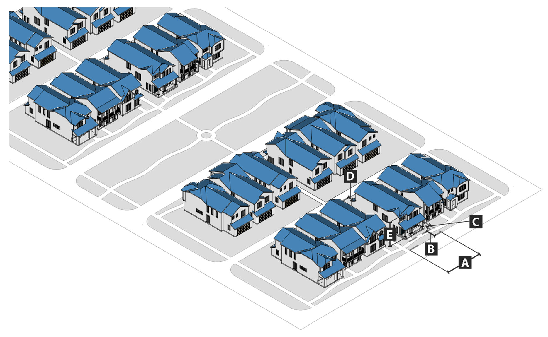
Purpose. The purpose of the single family residential 4 (SFR-4) district is to provide lands for residential neighborhoods that accommodate small- and medium-lot single-family detached homes, duplexes, and limited scale townhouses. The district is intended to support a medium-density residential environment and may include compatible public, civic, and institutional uses.
b.
Use standards. Allowed uses and use-specific standards for principal, accessory, and temporary uses are established in article V, use regulations.
c.
Intensity and dimensional standards. All development in the SFR-4 district shall comply with the standards in table IV-17: SFR-4 intensity and dimensional standards.
Table IV-17: SFR-4 Intensity and Dimensional Standards
Notes:
[1] max = maximum; min = minimum; du = dwelling units; ft = feet; sf = square feet
[2] No townhouse unit shall be less than one-third as wide as it is deep.
[3] The minimum front setback may be decreased to the average alignment of existing buildings within 100 feet on either side of subject building and within the same block if such alignment is less than 15 feet. A street-facing garage shall be set back at least 20 feet from the front lot line.
[4] Does not apply on side lot lines where dwelling units are attached. There is no minimum side setback for townhouses, except a minimum side setback of seven feet is required at each end of a row of townhouses.
d.
Additional development standards. The following building material requirements apply to all development in the SFR-4 district.
1.
Primary materials. Primary material changes may occur only at building corners where a maximum of one of the façades faces a street. The following materials are required for not less than seventy-five (75) per cent of the building wall surface area on each façade:
i.
Brick masonry;
ii.
Natural stone (or synthetic equivalent), such as limestone, granite, and marble;
iii.
Cementitious siding, provided no single panel is larger than three (3) feet by three (3) feet;
iv.
Glass curtain wall; and
v.
For detached building types only, vinyl shakes or singles, and vinyl clapboard (with a minimum thickness of 0.044 inches).
2.
Accent materials. The following materials may make up twenty-five (25) per cent of the building wall surface area on each façade:
i.
Pre-cast masonry (for trim and cornice elements only);
ii.
Gypsum reinforced fiber concrete—GFRC (for trim elements only);
iii.
EIFS, only for trim;
iv.
Metal (for beams, lintels, trim elements, and ornamentation);
v.
Stucco (panels with cementitious finish, not tiles or external insulation finishing system—EIFS);
vi.
Split-faced block (only for piers, foundation walls and chimneys); and
vii.
For detached building types only:
(a)
Vinyl shakes or shingles; and
(b)
Vinyl (only trim elements).
3.
Foundation and crawlspace materials. The following materials shall cover exposed foundations and open crawlspaces on each façade, and shall meet minimum ventilation requirements of the building code.
i.
Brick and tile masonry;
ii.
Natural stone;
iii.
Split-faced block; and
iv.
Formed concrete (painted or stained).
4.
Alternative materials. Alternative building materials not listed in subsections 1. through 3. above may be approved by the director of planning if the director determines the alternative building materials are equivalent or better than the listed materials. The use of regionally-available materials is preferred.
e.
References to other standards. Development in the SFR-4 district shall comply with all applicable standards of this zoning ordinance and the subdivision regulations, including but not limited to the standards referenced in table IV-18: cross-references to other standards.
Table IV-18: Cross-References to Other Standards
(Ord. No. 9572, § 2, 12-17-24; Ord. No. 9670, § 3, 8-19-25)
Sec. 25-66. - Single family residential 5.
a.
Purpose. The purpose of the single family residential 5 (SFR-5) district is to provide lands for residential neighborhoods that accommodate small-lot single-family detached homes, duplexes, and limited scale townhouses, along with limited infill. The district is intended to support a medium-density residential environment and may include compatible public, civic, and institutional uses.
b.
Use standards. Allowed uses and use-specific standards for principal, accessory, and temporary uses are established in article V, use regulations.
c.
Intensity and dimensional standards. All development in the SFR-5 district shall comply with the standards in table IV-19: SFR-5 intensity and dimensional standards.
Table IV-19: SFR-5 Intensity and Dimensional Standards
Notes:
[1] max = maximum; min = minimum; du = dwelling units; ft = feet; sf = square feet
[2] The minimum lot area is 6,000 sf if both units in the duplex are on one lot, or 4,500 sf if each unit is on a separate lot.
[3] No townhouse unit shall be less than one-third as wide as it is deep.
[4] The minimum front setback may be decreased to the average alignment of existing buildings within 100 feet on either side of subject building and within the same block if such alignment is less than 15 feet. A street-facing garage shall be set back at least 20 feet from the front lot line.
[5] Does not apply on side lot lines where dwelling units are attached. There is no minimum side setback for townhouses, except a minimum side setback of seven feet is required at each end of a row of townhouses.
d.
References to other standards. Development in the SFR-5 district shall comply with all applicable standards of this zoning ordinance and the subdivision regulations, including but not limited to the standards referenced in table IV-20: cross-references to other standards.
Table IV-20: Cross-References to Other Standards
(Ord. No. 9572, § 2, 12-17-24; Ord. No. 9670, § 4, 8-19-25)
Sec. 25-67. - Mixed residential 1.
a.
Purpose. The purpose of the mixed residential 1 (MR-1) district is to provide lands for neighborhoods that accommodate a mix of single-family detached dwellings, two-family dwellings, and townhouses. The district is intended to support a medium-density residential environment and incorporate some context-sensitive neighborhood-oriented community and educational development.
b.
Use standards. Allowed uses and use-specific standards for principal, accessory, and temporary uses are established in article V, use regulations.
c.
Intensity and dimensional standards. All development in the MR-1 district shall comply with the standards in table IV-21: MR-1 intensity and dimensional standards.
Table IV-21: MR-1 Intensity and Dimensional Standards
Notes:
[1] max = maximum; min = minimum; du = dwelling units; ft = feet; sf = square feet
[2] No townhouse unit shall be less than one-third as wide as it is deep.
[3] The minimum front setback may be decreased to the average alignment of existing buildings within 100 feet on either side of subject building and within the same block if such alignment is less than 20 feet. A street-facing garage shall be set back at least 20 feet from the front lot line.
[4] There is no minimum side setback for townhouses, except a minimum side setback of seven feet is required at each end of a row of townhouses.
d.
References to other standards. Development in the MR-1 district shall comply with all applicable standards of this zoning ordinance and the subdivision regulations, including but not limited to the standards referenced in table IV-22: cross-references to other standards.
Table IV-22: Cross-References to Other Standards
(Ord. No. 9572, § 2, 12-17-24; Ord. No. 9670, § 5, 8-19-25)
Sec. 25-68. - Mixed residential 2.
a.
Purpose. The purpose of the mixed residential 2 (MR-2) district is to provide lands for neighborhoods that accommodate a mix of single-family detached, two-family, and three-family dwellings; townhouses; and small-scale multifamily developments. The district is intended to support a medium-density residential environment that may include neighborhood-oriented community and educational development.
b.
Use standards. Allowed uses and use-specific standards for principal, accessory, and temporary uses are established in article V, use regulations.
c.
Intensity and dimensional standards. All development in the MR-2 district shall comply with the standards in table IV-23: MR-2 intensity and dimensional standards.
Table IV-23: MR-2 Intensity and Dimensional Standards
Notes:
[1] max = maximum; min = minimum; du = dwelling units; ft = feet; sf = square feet
[2] The minimum total site area for a townhouse project is 15,000 square feet.
[3] The minimum lot width applies to single family homes only. There is no minimum lot width for duplexes and multifamily buildings. No townhouse unit shall be less than one-third as wide as it is deep.
[4] The minimum front setback may be decreased to the average alignment of existing buildings within one hundred (100) feet on either side of subject building and within the same block if such alignment is less than twenty-five (25) feet. A street-facing garage shall be set back at least twenty (20) feet from the front lot line.
[5] There is no minimum side setback for townhouses, except a minimum side setback of seven feet is required at each end of a row of townhouses.
d.
Additional development standards. The following building material requirements apply to all development in the MR-2 district.
1.
Primary materials. Primary material changes may occur only at building corners where a maximum of one of the façades faces a street. The following materials are required for not less than seventy-five (75) per cent of the building wall surface area on each façade:
i.
Brick masonry;
ii.
Natural stone (or synthetic equivalent), such as limestone, granite, and marble;
iii.
Cementitious siding, provided no single panel is larger than three (3) feet by three (3) feet;
iv.
Glass curtain wall; and
v.
For detached building types only, vinyl shakes or singles, and vinyl clapboard (with a minimum thickness of 0.044 inches).
2.
Accent materials. The following materials may make up twenty-five (25) per cent of the building wall surface area on each façade:
i.
Pre-cast masonry (for trim and cornice elements only);
ii.
Gypsum reinforced fiber concrete—GFRC (for trim elements only);
iii.
EIFS, only for trim;
iv.
Metal (for beams, lintels, trim elements, and ornamentation);
v.
Stucco (panels with cementitious finish, not tiles or external insulation finishing system—EIFS);
vi.
Split-faced block (only for piers, foundation walls and chimneys); and
vii.
For detached building types only:
(a)
Vinyl shakes or shingles; and
(b)
Vinyl (only trim elements).
3.
Foundation and crawlspace materials. The following materials shall cover exposed foundations and open crawlspaces on each façade, and shall meet minimum ventilation requirements of the building code.
i.
Brick and tile masonry;
ii.
Natural stone;
iii.
Split-faced block; and
iv.
Formed concrete (painted or stained).
4.
Alternative materials. Alternative building materials not listed in subsections 1. through 3. above may be approved by the director of planning if the director determines the alternative building materials are equivalent or better than the listed materials. The use of regionally-available materials is preferred.
e.
References to other standards. Development in the MR-1 district shall comply with all applicable standards of this zoning ordinance and the subdivision regulations, including but not limited to the standards referenced in table IV-24: cross-references to other standards.
Table IV-24: Cross-References to Other Standards
(Ord. No. 9572, § 2, 12-17-24; Ord. No. 9670, § 6, 8-19-25)
Sec. 25-69. - Mixed residential university.
a.
Purpose. The purpose of the mixed residential university (MRU) district is to provide lands for primarily single-family detached, duplex, and triplex residential development around the University of Alabama campus. The district is intended to support a medium-density residential environment and incorporate limited context-sensitive neighborhood-oriented community and educational activities.
b.
Use standards. Allowed uses and use-specific standards for principal, accessory, and temporary uses are established in article V, use regulations. In addition, the following standards apply to U-dwellings, as defined in section 6-109 of this Code:
i.
U-dwellings shall be constructed in accordance with section 6-109 of this Code.
ii.
When all permitted work is completed on an eligible U-dwelling development, as defined in subsection iii. below, and the U-dwelling has passed all final site, building, and zoning inspections and has been issued a final certificate of occupancy by the chief building official, the property may be certified to allow up to five (5) unrelated persons to live in a single dwelling unit.
iii.
Eligible U-dwelling development in the MRU district which may be certified in accordance with subsection ii. above, shall include the following:
(a)
New construction of a permitted U-dwelling allowed in the base zoning district that complies with the requirements of this ordinance and all other applicable city, county, state, and federal regulations; or
(b)
Redevelopment or conversion of an existing building and site to a U-dwelling in order to fully comply with the requirements of this ordinance and all other applicable city, county, state, and federal regulations.
c.
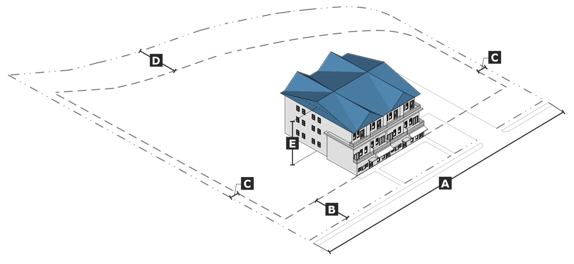
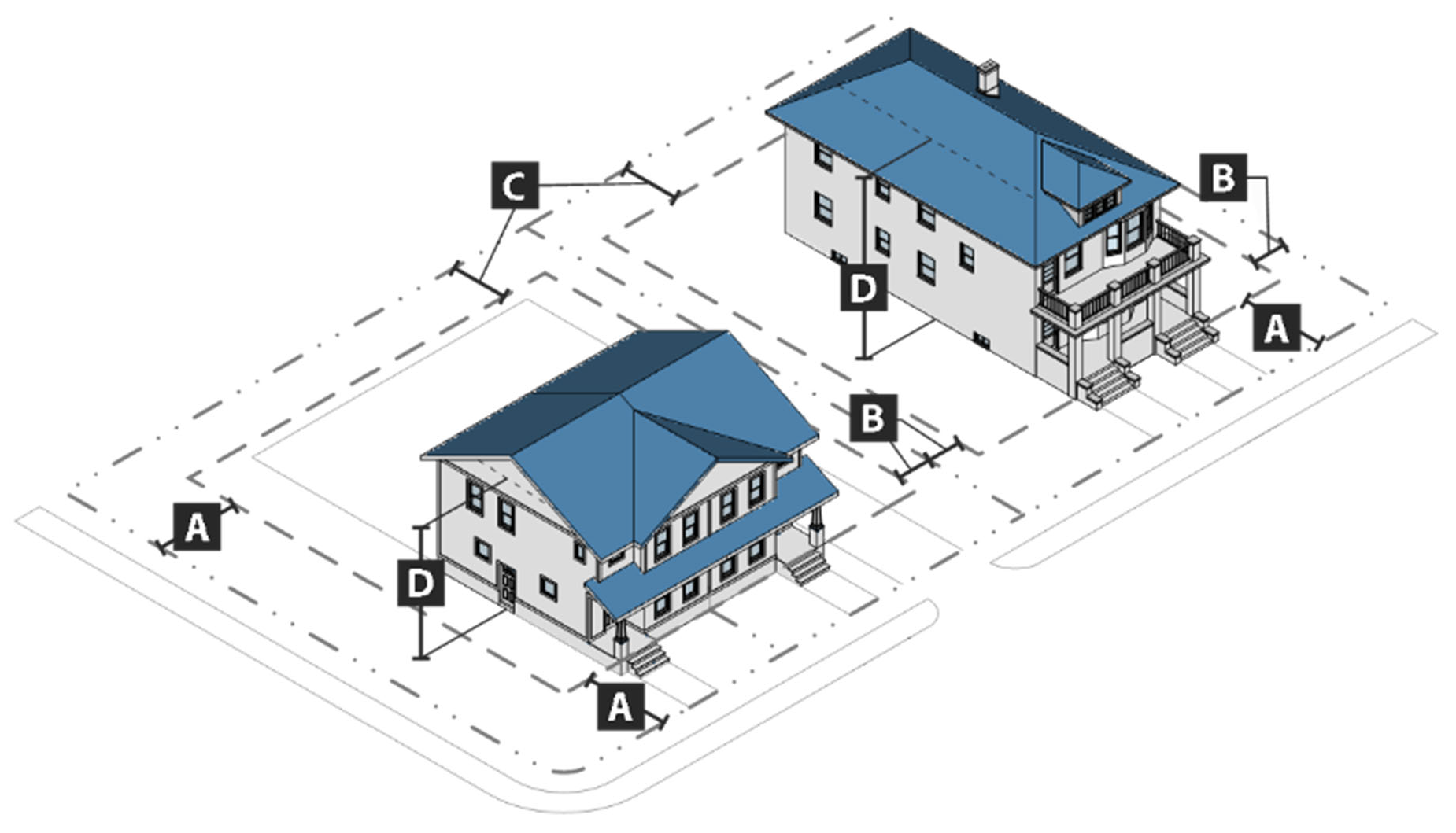
Intensity and dimensional standards. All development in the MRU district shall comply with the standards in table IV-25: MRU intensity and dimensional standards.
Table IV-25: MRU Intensity and Dimensional Standards
Notes:
[1] max = maximum; min = minimum; du = dwelling units; ft = feet; sf = square feet
[2] For corner lots, the minimum front setback abutting the side street shall be five feet. The minimum front setback may be decreased to the average alignment of existing buildings within 100 feet on either side of subject building and within the same block if such alignment is less than 10 feet. For single-family detached and townhouse dwellings, a street-facing garage shall be set back at least 20 feet from the front lot line.
[3] There is no minimum side setback for townhouses, except a minimum side setback of seven feet is required at each end of a row of townhouses. No townhouse unit shall be less than one-third as wide as it is deep.
d.
Site design standards.
1.
Neighborhood compatibility. Development, other than a detached single-family dwelling, that abuts the historic buffer (HB) overlay district, an historic district, or an existing single-family detached house used for residential purposes in a residential zone district, shall comply with the following standards:
i.
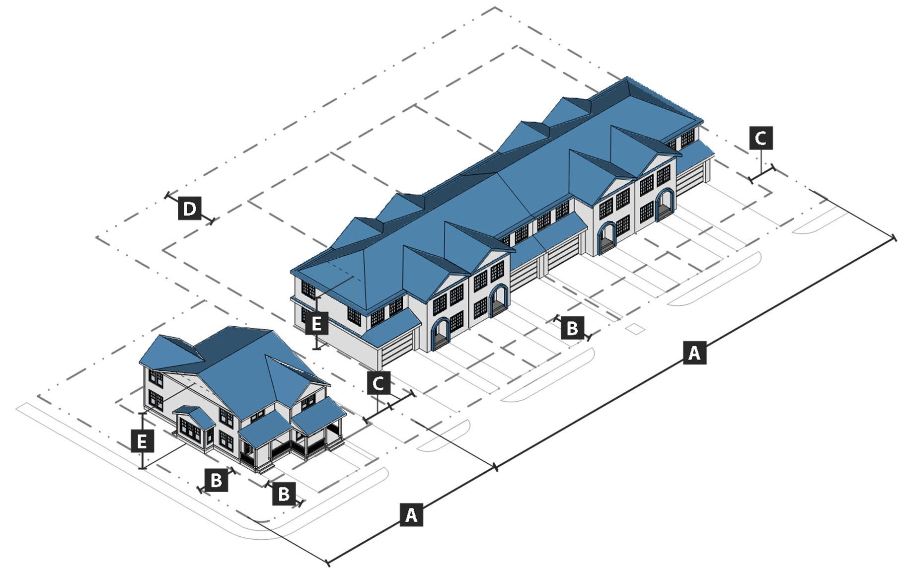
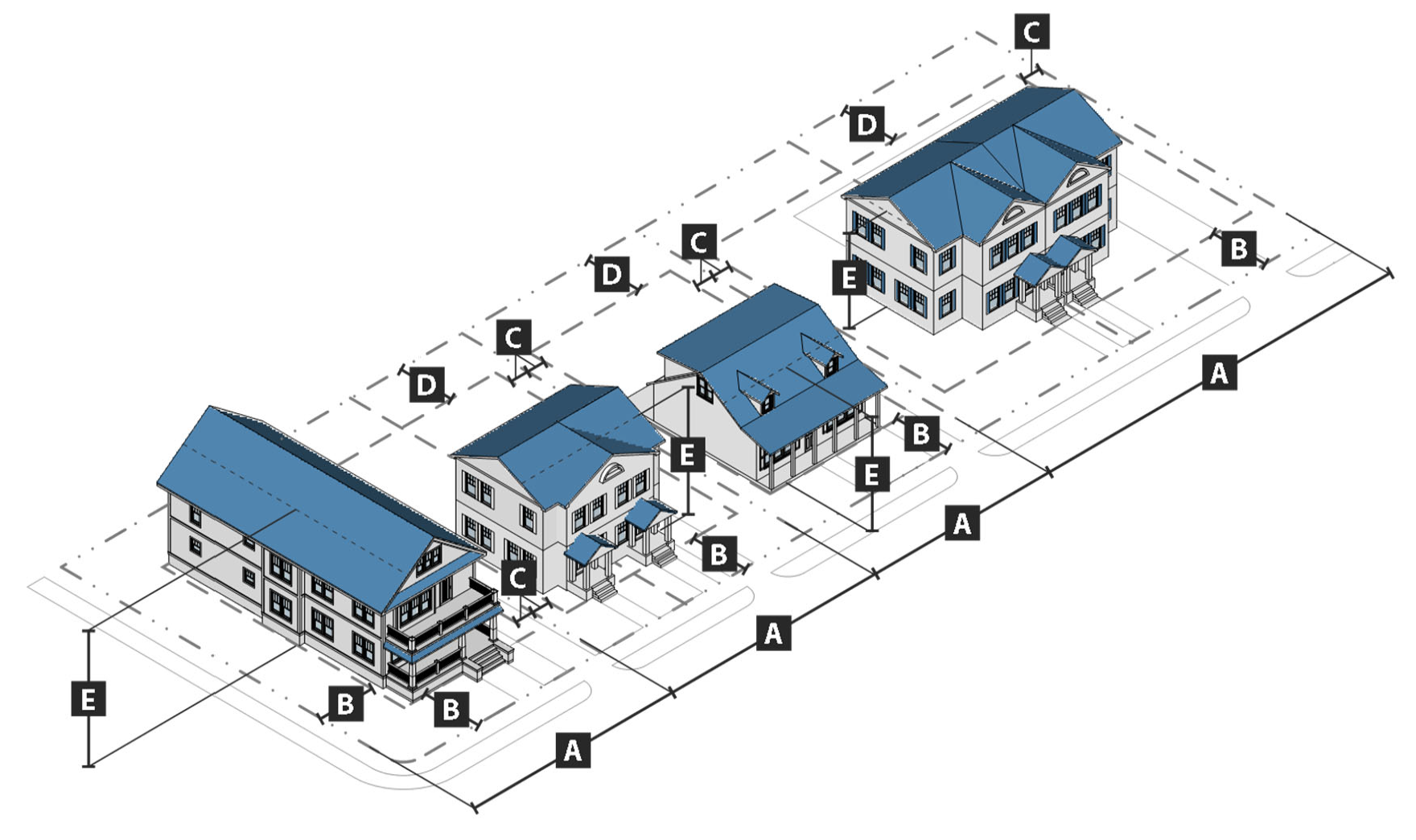
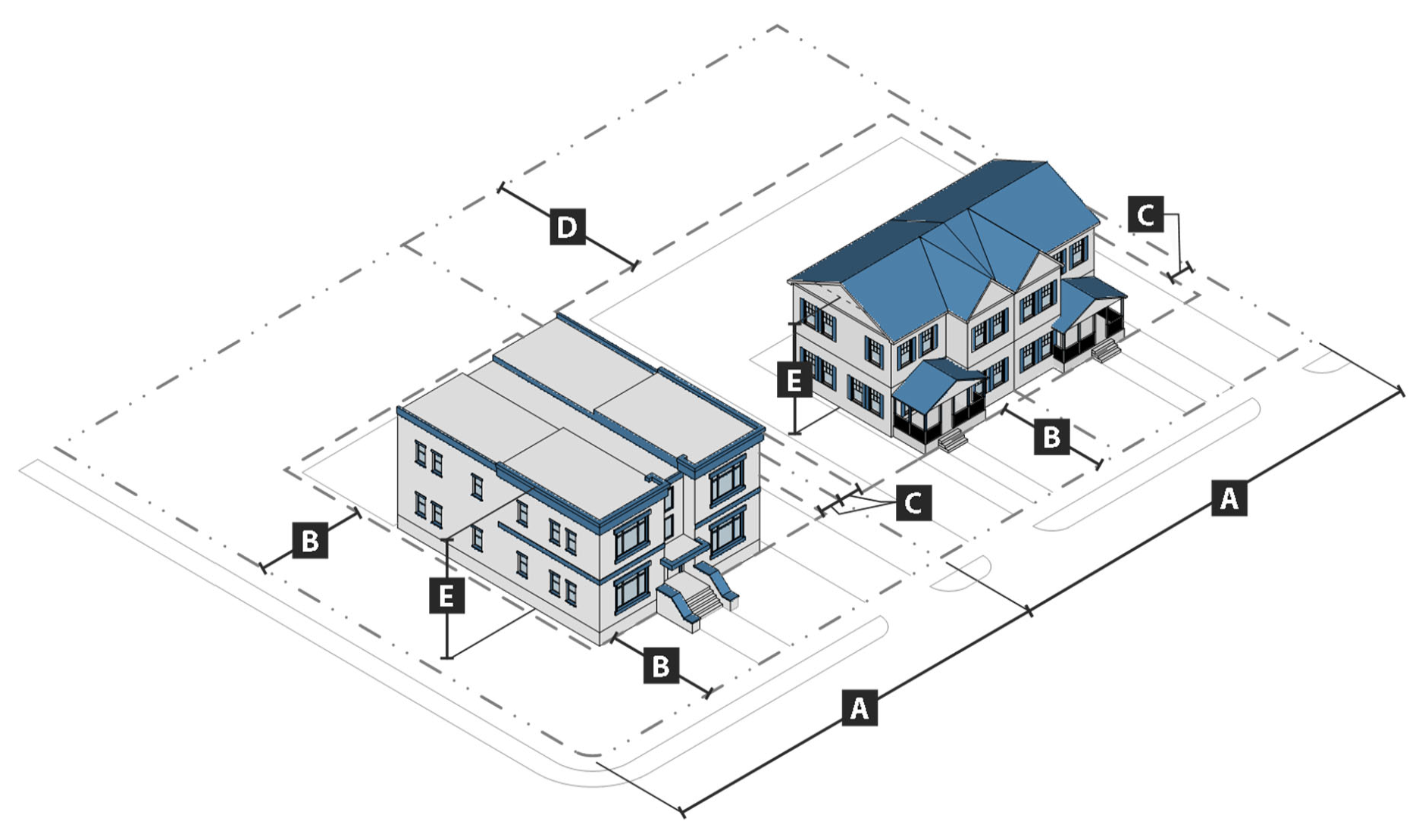
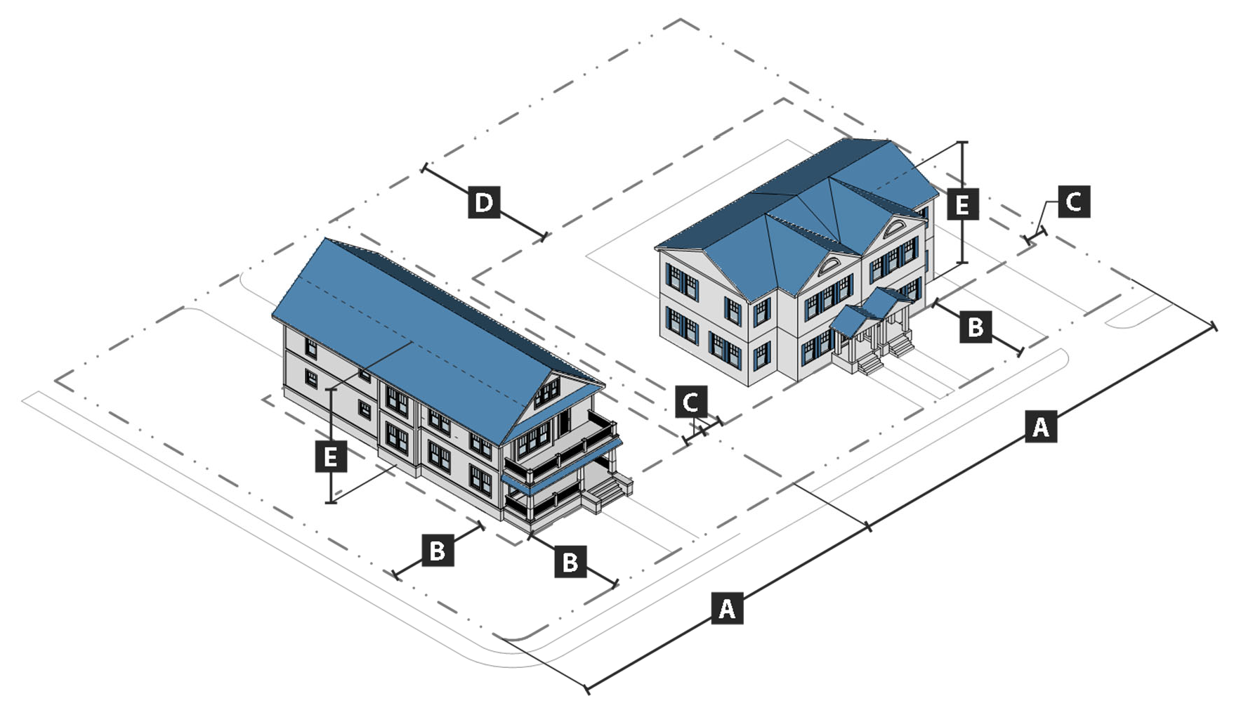
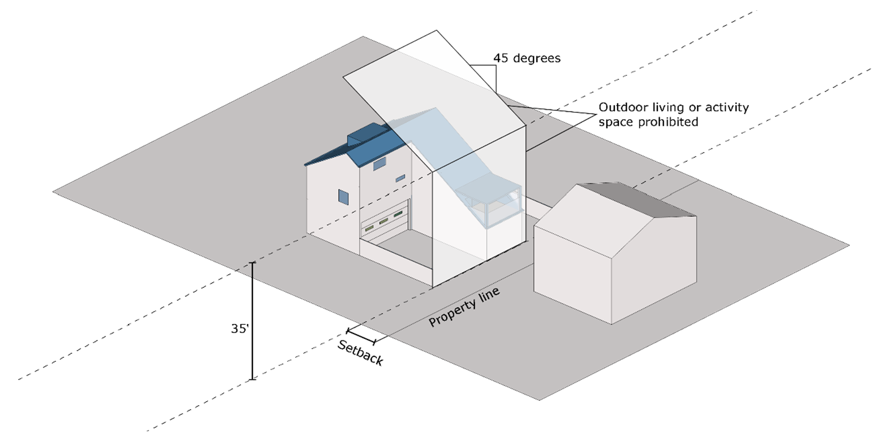
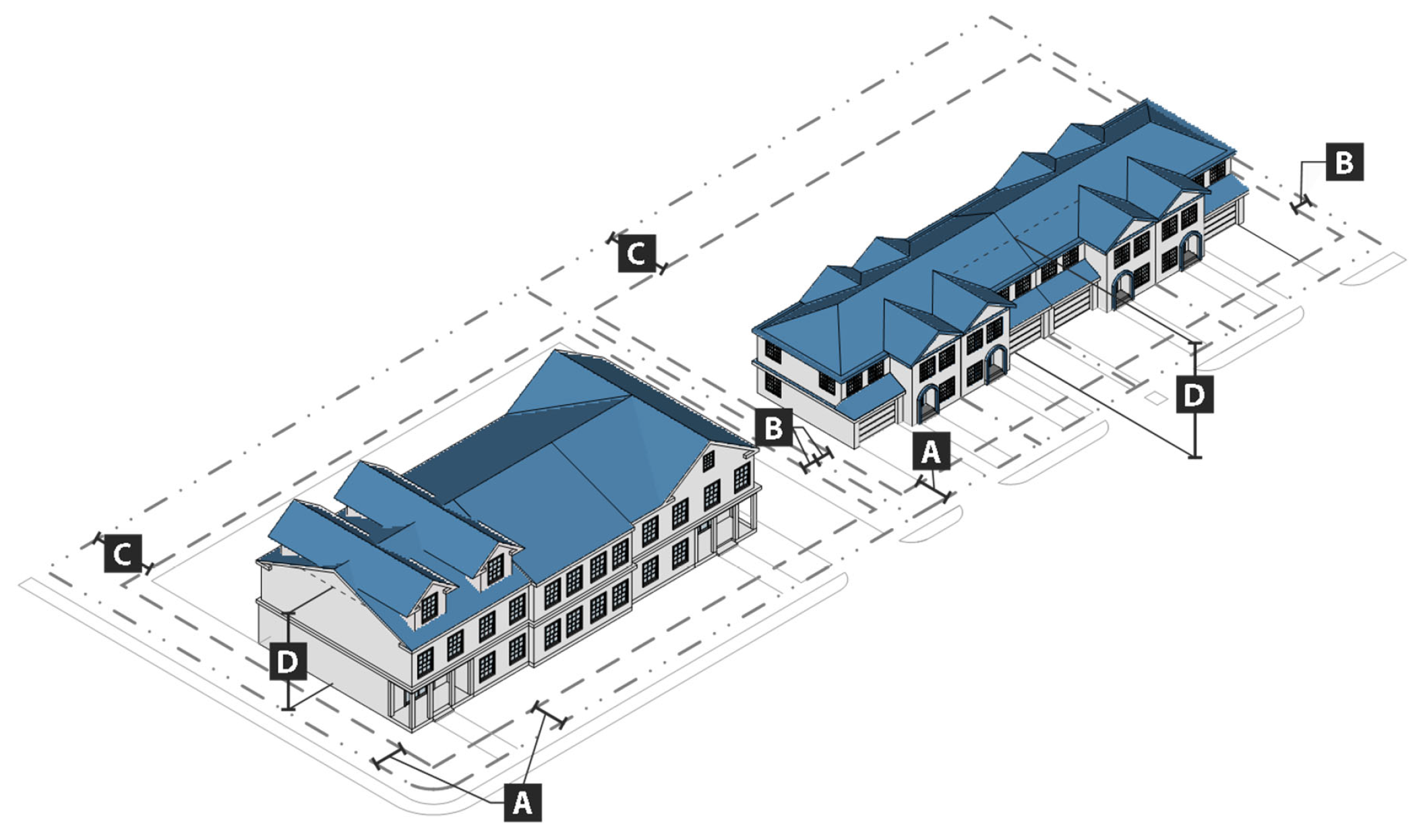
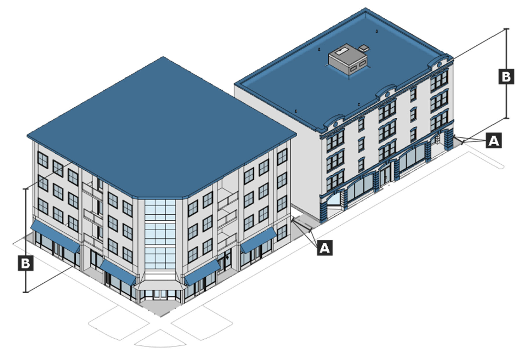
No building shall extend into a forty-five (45) degree angular plane projecting over the property, measured from a height of thirty-five (35) feet at the side interior or rear setback line. Where a building roof is stepped back to comply with this requirement, rooftop living space is prohibited. See figure IV-1: rooftop living space restrictions.
Figure IV-1: Rooftop Living Space Restrictions
ii.
A fence or wall having a minimum height of six (6) feet shall be constructed along the property line shared with the abutting property. The finished side of the fence shall face out (see subsection 6., fences and walls, below).
2.
Parking.
i.
Minimum parking required.
(a)
A minimum of one parking space per bedroom is required. All parking spaces used to comply with this minimum parking standard shall be off-street parking spaces, except as otherwise provided in this section.
(b)
On property located south of University Boulevard, north of Paul W. Bryant Drive, east of Gene Stallings Avenue, and west of Hackberry Lane, on-street parking spaces that comply with the following standards may be used to comply with the minimum parking standard in subsection (a) above:
(1)
The on-street space is located on a public right-of-way immediately abutting the subject property;
(2)
The on-street space is located on an "Avenue," not a "Street;"
(3)
No more than fifty (50) per cent of the on-street parking located in the areas specified in subsections (1) and (2) above is counted towards the minimum parking requirements for a development;
(4)
The number of on-street parking spaces used does not exceed twenty (20) per cent of the total number of required parking spaces; and
(5)
Curb stops are installed so that sidewalks are not affected.
(c)
Along Convent Street, Oak Avenue, and 14th Avenue properties adjacent to the historic districts, the on-street parking spaces immediately abutting the subject property may be used to comply with the minimum parking standard in subsection (a) above.
(d)
On-street parking spaces may be used to comply with the minimum parking standard in subsection (a) above, for small redevelopments in accordance with subsection (f), small redevelopment standards below.
ii.
Location. Parking is prohibited between the front façade of the structure and the front property line. On corner lots, the parking may encroach past the front façade along the side street, but the parking must be screened from the public right-of-way by a wall that is at least forty-two (42) inches in height and constructed of the same materials as the principal building(s).
iii.
Large parking lots. Open, surface parking lots containing fifty (50) or more spaces shall be divided into smaller areas separated by:
(1)
Landscaped areas at least ten (10) feet wide that comply with subsection 4. below; or
(2)
A building or a group of buildings.
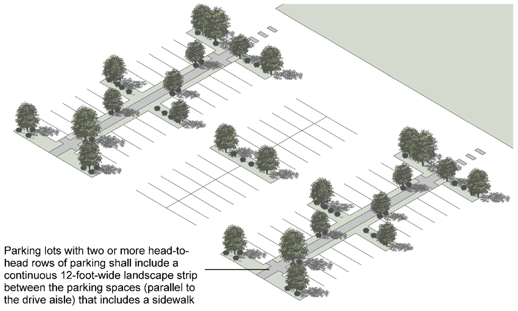
At least ten (10) per cent of the total surface area of each such parking lot shall be used for landscaping that is distributed and designed in accordance with an overall landscaping plan. See figure IV-2: large parking lot landscaping in MRU district.
Figure IV-2: Large Parking Lot Landscaping in MRU District
iv.
Parking structures.
(a)
Parking structures, if provided, shall be architecturally integrated or designed with an architectural theme similar to that of the principal building(s).
(b)
Vehicles shall be screened from view with a metal or architectural panel such as galvanized welded wire steel/mesh panels, an aluminum louver system, or similar treatments. The following materials, as well as materials which the director of planning determines to be visually similar to the listed materials, are prohibited:
(1)
Chain link (including coated chain link);
(2)
Vinyl or other fabrics; and
(3)
Window screen material.
v.
Mechanical lifts. The use of mechanical lifts for parking is prohibited.
vi.
Bicycle parking. Bicycle parking shall be provided in accordance with section 25-126, bicycle parking standards, and the following standards:
(a)
In each new development or redevelopment, a minimum of one bicycle parking space per unit shall be provided for developments with four (4) and five (5) bedrooms per unit. In a new development or redevelopment featuring units containing one, two (2), or three (3) bedrooms per unit, a minimum one bicycle parking space per every five (5) bedrooms shall be provided, rounded to the next highest whole number.
(b)
Bicycle racks shall be installed on the exterior side or rear of a building and shall be high-quality, inverted "U"-type construction or be attached to the building. Alternative high-quality bicycle parking racks may be approved by the director of planning if they can be shown to support the bicycle at two (2) points of contact to the bicycle wheels and frame.
(c)
Bicycle parking spaces may be located in an internal bicycle storage room if the room is lockable and contains systems for locking to allow for at least two (2) points of contact to the bicycle wheels and frame.
3.
Sidewalks.
i.
In order to establish safe and efficient pedestrian circulation, new development shall include sidewalks that directly connect the main entrances of buildings on the site with each other and with available access points including parking areas, streets, sidewalks, and transit stops. Where such sidewalks traverse parking areas, the sidewalk shall be clearly identifiable through changes in material or elevation.
ii.
New development shall install sidewalks along all street frontages as needed for pedestrian mobility or safety and as appropriate to the location. Installation of such sidewalks is not required where the director of planning determines a sidewalk is impractical or unfeasible. Each sidewalk shall have a minimum width of four (4) feet or the width of the widest existing abutting sidewalk, whichever is greater.
iii.
Except as otherwise provided by subsection ii. above, a landscaped strip at least five (5) feet wide shall be provided between the street and the sidewalk along all street frontages. The landscaped strip shall be grass, landscaping, or trees, and shall incorporate the provisions of the right-of-way landscape requirements in subsection 4. below. Additionally, bollards shall be provided between the street and the sidewalk at intervals of four (4) feet, except where the director of planning determines the bollards are impractical or unfeasible. Where on-street parking is provided adjacent to a development or where the director of planning determines the landscape strip to be impractical, the landscape strip can be waived or modified for a six (6) feet wide sidewalk with alternative landscaping as approved by the director of planning.
4.
Landscaping.
i.
At least one canopy tree having a minimum three-inch base caliper shall be planted or preserved in the required rear yard. The tree may be an existing tree on the site that is preserved or it may be planted. Every parking space provided in accordance with subsection 2. above shall be within a sixty-foot radius of the trunk of at least one tree. All efforts should be made to retain existing healthy canopy trees.
ii.
Where development occurs adjacent to an existing street, one canopy tree having a minimum three-inch base caliper shall be planted or preserved in the right-of-way for every fifty (50) feet of lot width. All efforts should be made to retain existing healthy canopy trees.
iii.
Trees planted to comply the requirements of this section shall be installed with an irrigation bag or be watered by an irrigation system operated by the developer to ensure healthy growth. The director of planning may waive or modify this requirement if trees are determined impractical or unfeasible. The irrigation bag or system shall be maintained for a minimum of two (2) summer growing seasons.
iv.
Except as otherwise provided in this section, all trees required by this section shall be maintained in landscape islands. Each landscape island shall be sodded, seeded, mulched, or planted with shrubs and/or groundcover, and may incorporate low impact development best management practices, such as rain gardens and bioswales, to promote infiltration of stormwater.
5.
Screening.
i.
All parking lots and parking spaces shall be screened in accordance with section 25-132(c), parking lot perimeter landscaping standards.
ii.
Solid waste containers shall be screened from view from the right-of-way and adjacent properties using similar building materials as the primary structure.
iii.
All mechanical equipment located on the roof of a structure shall be screened by parapet walls that exceed the height of the mechanical unit by at least one foot. All other mechanical equipment must be screened with a wall or fence. All such screens shall be constructed from the primary building material or opaque landscaping at least thirty (30) inches in height at installation and maintained at that minimum height in a healthy condition.
6.
Fences and walls.
i.
Fences and walls shall be constructed of wood, brick, stucco, or metal. Wood fences must be of a decorative style, such as shadow box or picket. The finished side of a fence should face out.
ii.
Chain link, razor wire, barbed wire, and concertina wire are prohibited as fencing material.
iii.
In a front setback, no part of a fence shall be within ten (10) feet of the curb line. Fences are prohibited in the public right-of-way.
7.
Exterior lighting.
i.
All light fixtures shall be designed and oriented so as to not direct glare or excessive illumination onto adjacent properties, streets, or sidewalks.
ii.
Flood lights, wall packs, and flood lamps must either:
(i)
Be aimed downward at least forty-five (45) degrees from vertical; or
(ii)
Use a shielded fixture so that no portion of the light bulb extends below the bottom edge of the shield.
iii.
The maximum height for freestanding light fixtures is twelve (12) feet. Service connections for all freestanding light fixtures must be installed underground.
iv.
All surface parking areas shall be illuminated using light fixtures so that lighting is consistent across the parking area. Freestanding light poles may be located within required landscaped areas in surface parking areas.
v.
All structured parking shall be illuminated using light fixtures so that lighting is consistent across all public areas in the structure and no areas are dark or dim.
8.
Mechanical equipment and utilities.
i.
Mechanical equipment associated with residential uses, such as HVAC units and security lighting, may encroach into a required rear or side setback, provided that such extension is at least two (2) feet from the vertical plane of any lot line.
ii.
All existing and proposed utilities including communication, cable, electric, and the like, shall be installed underground except where such utilities are not visible from any right-of-way. The zoning officer may provide an exception for poles that support only high voltage wires, switches, and transformers.
9.
Accessory structures. Accessory structures on any lot used primarily for residential purposes shall comply with the following standards:
i.
Accessory structures are prohibited in front yards.
ii.
Accessory structures may be located within a side yard provided they are not located between the principal building and a street, and set back at least five (5) feet from all lot lines.
iii.
Accessory structures may be located within rear yards, provided they are set back at least five (5) feet from all lot lines and that no more than thirty (30) per cent of any rear yard is covered by accessory structures.
iv.
Accessory structures shall not be occupied at any time as a dwelling.
v.
No single accessory structure shall exceed six hundred (600) square feet or forty (40) per cent of the principal building's building floor area, whichever is greater.
e.
Building design standards.
1.
Entrances. Operable, street-facing entrances are required on each building façade that fronts a public street.
2.
Ground floor elevation. The ground floor elevation of each building shall be at least twenty-four (24) inches and shall not exceed thirty (30) inches. For purposes of this requirement, ground floor elevation is measured from the top of the sidewalk or the mean level of the finished grade abutting the building to the top of the finished ground floor.
3.
Variation among adjacent buildings. To avoid uniform styles and provide visual interest, adjacent buildings shall be constructed with variations in materials, roof form, window patterns, elements, and façade projections, as approved by the director of planning.
4.
Façade projections. Each residential structure must include a front porch, stoop, or balcony that complies with the standards in this section on each building façade that fronts a public street.
i.
Front porch.
(a)
A front porch must be at least six (6) feet deep, not including any steps providing access to the porch.
(b)
A front porch must have an unbroken width of at least fifty (50) per cent of the width of the building façade from which it projects, not including any steps providing access to the porch.
(1)
If one set of access stairs is required, those stairs shall not be located along the front façade of the building.
(2)
If two sets of access stairs are required, one may be located on the front façade, as long as the usable porch space is not less than fifty (50) per cent of the building façade from which it projects.
(c)
A front porch must be roofed and may be screened, but shall not be fully enclosed.
(d)
A front porch may extend up to nine (9) feet, including the steps, into a required setback, provided that such extension is at least two (2) feet from the vertical plane of any lot line.
ii.
Stoop.
(a)
A stoop must be no more than six (6) feet deep and twenty-four (24) inches wide, not including any steps providing access to the stoop.
(b)
A stoop may be covered but shall not be fully enclosed.
iii.
Balcony. A balcony may be covered and/or screened, but shall not be fully enclosed.
5.
Façade variation. Each ground-floor building façade facing a public street shall include at least one of the following every ten (10) feet of its width, between the ground level and a height of ten (10) feet:
i.
A substantial material change (paint color is not considered a substantial change);
ii.
A window or door;
iii.
A stoop or balcony; or
iv.
A column, pilaster, or other articulation greater than twelve (12) inches in depth.
6.
Building materials allowed.
i.
Primary materials. Primary material changes shall occur only at inside corners. The following materials are required for not less than seventy-five (75) per cent of the building wall surface area on each façade:
(a)
Brick and tile masonry;
(b)
Natural stone (or synthetic equivalent), such as limestone, granite, and marble;
(c)
Wood-clapboard or shingles;
(d)
Glass curtain wall;
(e)
Cementitious siding; and
(f)
Stucco (cementitious finish).
ii.
Accent materials. The following materials may make up twenty-five (25) per cent of the building wall surface area on each façade:
(a)
Pre-cast masonry (for trim and cornice elements only);
(b)
External insulation finishing system—EIFS (for trim and cornice elements only);
(c)
Gypsum reinforced fiber concrete—GFRC (for trim elements only);
(d)
Metal (for beams, lintels, trim elements, and ornamentation);
(e)
Split-faced block (for piers, foundation walls and chimneys only);
(f)
Glass block;
(g)
Vinyl shakes or shingles; and
(h)
Vinyl clapboard (with a minimum thickness of 0.044 inches).
iii.
Alternative materials. Alternative building materials not listed in subsections i. or ii. above may be approved by the director of planning if it is determined the alternative building materials are equivalent or better than the listed materials. The use of regionally-available materials is preferred.
iv.
Parking structure screening materials. Where screening of parking areas within a structure is required, it shall use a metal or architectural panel, such as galvanized welded wire steel/mesh panels or an aluminum louver system. The following materials, and any material the director of planning determines closely mimics any of the following materials, shall not be used to screen parking areas:
(a)
Chain link (including coated chain link);
(b)
Vinyl or other fabrics; and
(c)
Window screen material.
7.
Elevated structures.
i.
Elevated structures are prohibited in the MRU subdistrict except as otherwise provided in subsection f., small redevelopment standards, below.
ii.
All elevated structures with at-grade parking areas located beneath the building shall include exterior screening walls to conceal the parking lot from view from the public right-of-way, not including alleys. Screening walls shall be at least four (4) feet tall and shall be constructed of same materials as the principal building. A minimum landscaping strip that is at least three (3) feet wide shall be provided between the screening wall and all adjacent rights-of-way. The landscaping strip shall be planted with shrubbery having a minimum height of thirty (30) inches at installation and capable of forming a continuous evergreen hedge having a minimum height of thirty-six (36) inches.
f.
Small redevelopment standards.
1.
The following standards apply to development on a lot of 0.25 acres or less that will result in density of one-third (⅓) or less of the density allowed by this section:
i.
Up to one on-street parking space immediately abutting the property may count toward the minimum parking required by section 25-69(d)(2)(i), minimum parking required.
ii.
Elevated structures are allowed and may include living space that overhangs the rear of the structure, as long as the overhang is less than fifty (50) per cent of the depth of the main footprint and requires no posts for support.
2.
The following standards apply to development on a lot of more than 0.25 acres and less than 0.50 acres that will result in density of one-third (⅓) or less of the density allowed by this section:
i.
Up to two (2) on-street parking spaces immediately abutting the property may count toward the minimum parking required by section 25-69(d)(2)(i), minimum parking required.
ii.
Elevated structures are allowed and may include living space that overhangs the rear of the structure, as long as the overhang is less than fifty (50) per cent of the depth of the main footprint and requires no posts for support.
3.
For development on a lot 0.50 acres in size or larger that will result in density of one hundred (100) or fewer bedrooms per acre, the minimum parking required by section 25-69(d)(2)(i), minimum parking required, may be reduced by ten (10) per cent, rounded down to the nearest whole number.
g.
References to other standards. Development in the MRU district shall comply with all applicable standards of this zoning ordinance and the subdivision regulations, except as otherwise provided in this section, including but not limited to the standards referenced in table IV-26: cross-references to other standards.
Table IV-26: Cross-References to Other Standards
(Ord. No. 9572, § 2, 12-17-24; Ord. No. 9670, §§ 7, 8, 8-19-25)
Sec. 25-70. - Multifamily residential university.
a.
Purpose. The purpose of the multifamily residential university (MFRU) district is to provide lands within close proximity of the University of Alabama for primarily residential neighborhoods that include multifamily development. The district is intended to support a high-density residential environment, community, and educational activities.
b.
Use standards. Allowed uses and use-specific standards for principal, accessory, and temporary uses are established in article V, use regulations. In addition, the following standards apply to U-dwellings, as defined in section 6-109 of this Code:
i.
U-dwellings shall be constructed in accordance with section 6-109 of this Code.
ii.
When all permitted work is completed on an eligible U-dwelling development, as defined in subsection i. above, and the U-dwelling has passed all final site, building, and zoning inspections and has been issued a final certificate of occupancy by the chief building official, the property shall be certified to allow up to five (5) unrelated persons to live in a single dwelling unit.
iii.
Eligible U-dwelling development in the MFRU district which may be certified in accordance with subsection ii. above, shall include the following:
(a)
New construction of a permitted U-dwelling allowed in the base zoning district that complies with the requirements of this ordinance and all other applicable city, county, state, and federal regulations; or
(b)
Redevelopment or conversion of an existing building and site to a U-dwelling in order to fully comply with the requirements of this ordinance and all other applicable city, county, state, and federal regulations.
c.
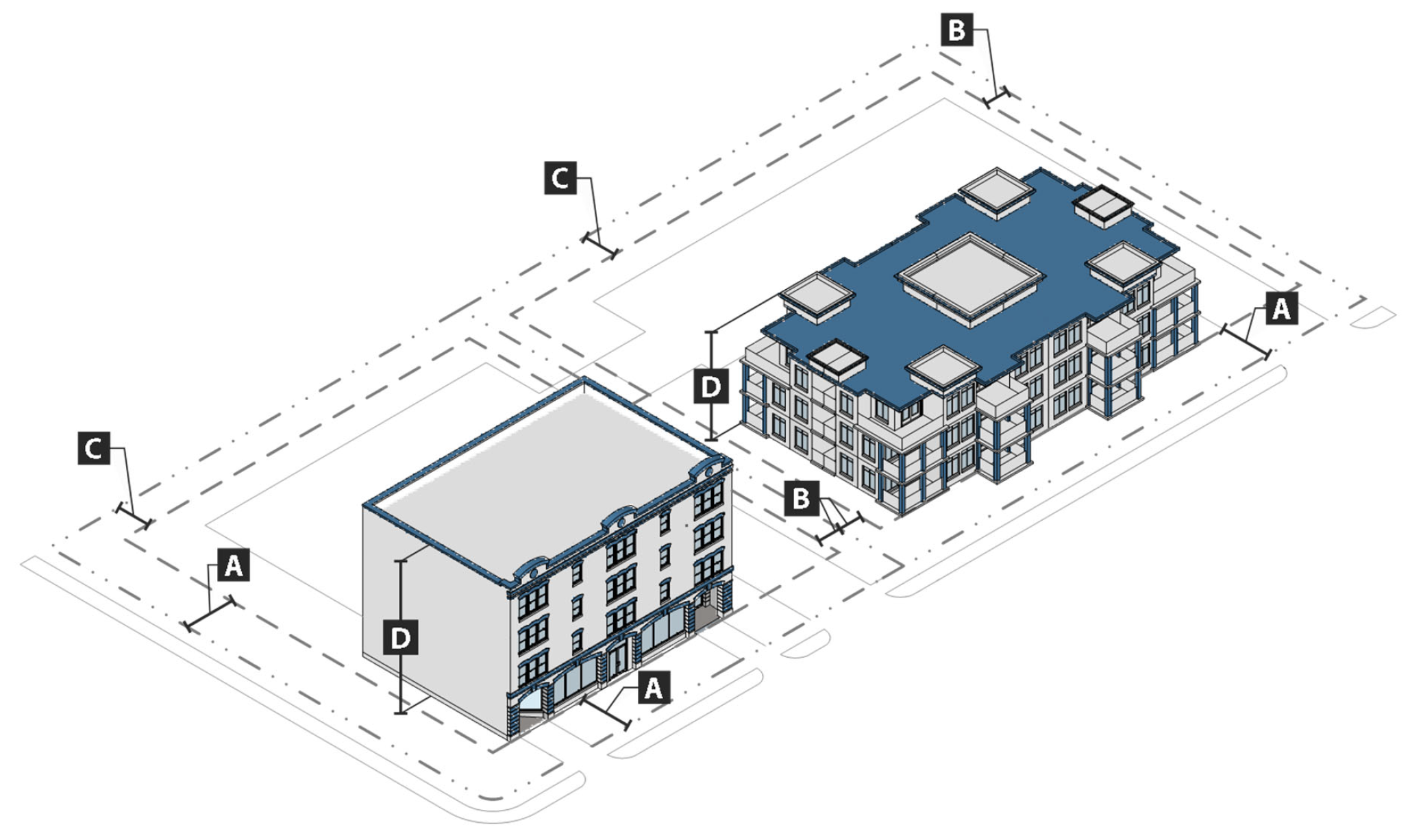
Intensity and dimensional standards. All development in the MFRU district shall comply with the standards in table IV-27: MFRU intensity and dimensional standards.
Table IV-27: MFRU Intensity and Dimensional Standards
Notes:
[1] max = maximum; min = minimum; du = dwelling units; ft = feet; sf = square feet
[2] Maximum density is 110 bedrooms per acre in a line running from Campus Drive West, along University Blvd.to Gene Stallings Ave., south to Bryant Drive, along Bryant Drive to 12th Ave.
[3] No townhouse unit shall be less than one-third as wide as it is deep.
[4] For corner lots, the minimum front setback abutting the side street shall be five feet. The minimum front setback may be decreased to the average alignment of existing buildings within 100 feet on either side of subject building and within the same block if such alignment is less than 10 feet. For single-family detached and townhouse dwellings, a street-facing garage shall be set back at least 20 feet from the front lot line.
[5] There is no minimum side setback for townhouses, except a minimum side setback of seven feet is required at each end of a row of townhouses.
[6] For development on a lot of more than 0.50 acres that will result in density of 100 or fewer bedrooms per acre, the maximum building height shall be 60 feet.
[7] Each story in a building shall be a minimum of nine feet in height, measured floor to ceiling.
d.
Design and small redevelopment standards. Development shall comply with the site design, building design, and small redevelopment standards that apply in the MRU district (see sections 25-69(d), 25-69(e), and 25-69(f) above), except:
1.
All elevated structures with at-grade parking areas located beneath the building shall comply with section 25-69(e)(7), elevated structures; and
2.
On property south of University Boulevard, north of 13th Street, and east of Gene Stallings Avenue, a landscape strip is not permitted for sidewalks in accordance with section 25-69(d)(3)(iii) Instead, trees required by the landscaping standards in section 25-69(d)(4), shall be placed in grates with tree guards between the sidewalk and street, incorporating the provisions of the right-of-way landscape requirements of section 25-69(d)(4).
e.
References to other standards. Development in the MFRU district shall comply with all applicable standards of this zoning ordinance and the subdivision regulations, except as otherwise provided in this section, including but not limited to the standards referenced in table IV-28: cross-references to other standards.
Table IV-28: Cross-References to Other Standards
(Ord. No. 9572, § 2, 12-17-24; Ord. No. 9670, § 9, 8-19-25)
Sec. 25-71. - Multifamily residential.
a.
Purpose. The purpose of the multifamily residential (MFR) district is to provide lands for primarily residential neighborhoods that include multifamily development. The district supports a medium-density residential environment and may include compatible public, civic, and institutional uses.
b.
Use standards. Allowed uses and use-specific standards for principal, accessory, and temporary uses are established in article V, use regulations.
c.
Intensity and dimensional standards. All development in the MFR district shall comply with the standards in table IV-29: MFR intensity and dimensional standards.
Table IV-29: MFR Intensity and Dimensional Standards
Notes:
[1] max = maximum; min = minimum; du = dwelling units; ft = feet; sf = square feet
[2] No townhouse unit shall be less than one-third as wide as it is deep.
[3] The minimum front setback may be decreased to the average alignment of existing buildings within 100 feet on either side of subject building and within the same block if such alignment is less than 10 feet.
[4] There is no minimum side setback for townhouses, except a minimum side setback of seven feet is required at each end of a row of townhouses.
d.
References to other standards. Development in the MFR district shall comply with all applicable standards of this zoning ordinance and the subdivision regulations, including but not limited to the standards referenced in table IV-30: cross-references to other standards.
Table IV-30: Cross-References to Other Standards
(Ord. No. 9572, § 2, 12-17-24; Ord. No. 9670, § 10, 8-19-25)
Sec. 25-72. - Mobile home residential.
a.
Purpose. The purpose of the mobile home residential (MHR) district is to provide land for the provision of mobile home neighborhoods in order to provide market rate affordable housing opportunities for low- and moderate-income persons, consistent with state and federal law. The district is intended to provide for the use of a mobile home as a principal use of land developed in accordance with specific design and/or installation regulations.
b.
MHR lot and building standards. Mobile home parks shall conform to the design and development standards prescribed in chapter 15 of this Code, the Tuscaloosa Mobile Home Park Ordinance.
(Ord. No. 9572, § 2, 12-17-24)
Sec. 25-73. - General purpose.
The general purpose of institutional districts is to:
a.
Accommodate lands for major public institutions that serve the public like universities, colleges, government buildings, civic uses, secondary public and private schools, and hospital uses;
b.
Provide lands for smaller institutional uses such as libraries and government offices; and
c.
Ensure development in the city is in accordance with the comprehensive plan.
(Ord. No. 9572, § 2, 12-17-24)
Sec. 25-74. - Institutional university.
a.
Purpose. The purpose of the institutional university (IU) district is to provide lands for the publicly funded campus of the University of Alabama. While the district includes general standards to support the continued growth and development of the University of Alabama, since the university operates in the public interest, has demonstrated it is a good steward of the state's resources, and generally has a positive influence on the character of the city, the district places principal reliance upon the voluntary cooperation of the university to maintain a high quality of development consistent with its master campus plan, and ensure development impacts will not have an adverse effect on surrounding properties.
b.
Use standards. Allowed uses shall be consistent with the master campus plan approved by the University of Alabama.
c.
Intensity and dimensional standards. All development in the IU district shall comply with the standards in table IV-31: IU intensity and dimensional standards.
Table IV-31: IU Intensity and Dimensional Standards
Notes:
[1] max = maximum; min = minimum
d.
References to other standards. Development in the IU district is not required to comply with the other standards of this zoning ordinance and the subdivision regulations, including but not limited to the standards referenced in table IV-32: cross-references to other standards.
Table IV-32: Cross-References to Other Standards
(Ord. No. 9572, § 2, 12-17-24)
Sec. 25-75. - Institutional public.
a.
Purpose. The purpose of the institutional public (IP) district is to provide lands for governmental uses typically developed on larger sites such as city, county, state, and federal government offices, court buildings, and the Tuscaloosa National Airport. The district also accommodates accessory uses such as eating establishments that primarily serve these principal institutional uses. Standards are intended to protect surrounding residential uses from incompatible development.
b.
Use standards. Allowed uses and use-specific standards for principal, accessory, and temporary uses are established in article V, use regulations.
c.
Intensity and dimensional standards. All development in the IP district shall comply with the standards in table IV-33: IP intensity and dimensional standards.
Table IV-33: IP Intensity and Dimensional Standards
Notes:
[1] max = maximum; min = minimum
d.
References to other standards. Development in the IP district is not required to comply with the other applicable standards of this zoning ordinance and the subdivision regulations, including but not limited to the standards referenced in table IV-34: cross-references to other standards.
Table IV-34: Cross-References to Other Standards
(Ord. No. 9572, § 2, 12-17-24)
Sec. 25-76. - Institutional semi-public.
a.
Purpose. The purpose of the institutional semi-public (ISP) district is to provide lands for colleges and universities other than the University of Alabama campus, public and private secondary schools, cultural facilities like museums and libraries, and hospitals and hospital complexes. District standards support appropriate growth and development within the district, while ensuring development impacts will not have an adverse effect on surrounding properties.
b.
Use standards. Allowed uses and use-specific standards for principal, accessory, and temporary uses are established in article V, use regulations.
c.
Intensity and dimensional standards. All development in the ISP district shall comply with the standards in table IV-35: ISP intensity and dimensional standards.
Table IV-35: ISP Intensity and Dimensional Standards
Notes:
[1] max = maximum; min = minimum
d.
District-specific development standards. All hospital and hospital complexes in the ISP district shall comply with the standards in table IV-35: ISP intensity and dimensional standards, and the following general standards:
1.
The development shall be compatible with existing development adjacent to the hospital complex, in terms of form, function, and building separation.
2.
Anticipated traffic generation and circulation patterns shall be compatible with internal and external street capacities and configurations.
3.
Pedestrian circulation within a hospital or hospital complex shall be properly integrated with buildings, parking areas, and open space, and all infrastructure supporting pedestrian circulation shall be designed and built in accordance with nationally accepted standards for such infrastructure.
4.
The development shall be consistent with the comprehensive plan.
e.
References to other standards. Development in the ISP district shall comply with all applicable standards of this zoning ordinance and the subdivision regulations, including but not limited to the standards referenced in table IV-36: cross-references to other standards.
Table IV-36: Cross-References to Other Standards
(Ord. No. 9572, § 2, 12-17-24)
Sec. 25-77. - General purpose.
The purpose of business districts is to provide lands that accommodate a wide range of retail, office, service, employment, and related development to meet the needs of the city's residents, and more specifically to:
a.
Strengthen the city's economic base, and provide employment opportunities close to home for city residents;
b.
Provide appropriately located lands for a full range of business, commercial, and industrial uses needed by the city's residents, businesses, and workers, in accordance with the comprehensive plan and other adopted city plans;
c.
Create suitable environments where business, office, retail, and residential development can be designed and integrated in compatible ways;
d.
Encourage, support, and ensure quality design in retail, office, service, employment, and related development;
e.
Accommodate new infill development and redevelopment that is in accordance with the comprehensive plan and other adopted city plans; and
f.
Ensure business development is located and designed to minimize impacts on single-family neighborhoods.
(Ord. No. 9572, § 2, 12-17-24)
Sec. 25-78. - Downtown.
a.
Purpose. The purpose of the downtown (D) district is to provide lands that support a walkable, visually attractive, and economically vital mix of employment, entertainment, civic, and residential uses in the city's historic downtown, consistent with the downtown's historic character and with public and private investment in the area. District standards are intended to ensure the downtown is architecturally interesting and pedestrian-friendly, and supports vibrant street life.
b.
Use standards. Allowed uses and use-specific standards for principal, accessory, and temporary uses are established in article V, use regulations. Additional limitations on ground floor uses are included in subsection e.3., street level uses, below.
c.
Intensity and dimensional standards. All development in the D district shall comply with the standards in table IV-37: D district intensity and dimensional standards.
Table IV-37: D District Intensity and Dimensional Standards
Notes:
[1] max = maximum; min = minimum; ft = feet
[2] The maximum front setback may be increased by 15 feet along 35 per cent of the lot width for an outdoor dining area, plaza, or other area that is open to the public and that includes features such as a garden, fountain, and seating.
d.
Residential development. Residential dwelling units in new development and redevelopment are permitted only above a single story of a building that has only non-residential uses on its ground floor.
e.
Additional development standards.
1.
Applicability.
i.
Unless otherwise provided in subsections ii. through iv. below, all development in the D district shall comply with the standards in this subsection d.
ii.
If there is a conflict between a standard in this section and the regulations and district standards under the purview of the historic preservation commission, the regulations and standards of the commission shall govern.
iii.
The following are exempt from all standards of this subsection d:
(a)
Existing single-family homes used for residential purposes;
(b)
Ordinary repairs and maintenance of buildings, signage, lighting, or other features;
(c)
Construction within the interior of a structure that is not visible from the exterior of the building;
(d)
Removal of existing signage without replacement;
(e)
Emergency repairs ordered by the city's code enforcement officials in order to protect health and safety; and
(f)
All municipal, state, and federal buildings.
iv.
Any change of use of an existing structure that does not include an expansion of gross floor area shall be exempt from the standards in article IV, division 5, section 25-78(e)(4), sidewalks.
2.
Building design standards.
i.
Building materials allowed.
(a)
Primary materials. Primary material changes may occur only at building corners where a maximum of one of the façades faces a street. The following materials are required for not less than seventy-five (75) per cent of the building wall surface area on each façade:
(1)
Brick masonry;
(2)
Natural stone (or synthetic equivalent), such as limestone, granite, and marble; and
(3)
Cementitious siding, provided no single panel is larger than three (3) feet by three (3) feet.
(4)
Accent materials.
(b)
Accent materials. The following materials may make up twenty-five (25) per cent of the building wall surface area on each façade:
(1)
Pre-cast masonry (for trim and cornice elements only);
(2)
Gypsum reinforced fiber concrete—GFRC (for trim elements only);
(3)
EIFS, only for trim;
(4)
Metal (for beams, lintels, trim elements, and ornamentation);
(5)
Glass curtain wall;
(6)
Stucco (panels with cementitious finish, not tiles or external insulation finishing system—EIFS);
(7)
Split-faced block (only for piers, foundation walls and chimneys); and
(8)
Cementitious siding.
(c)
Balconies.
(1)
Balconies shall be constructed of the following materials:
i.
Brick and masonry;
ii.
Natural stone (or synthetic equivalent);
iii.
Metal; and
iv.
Stucco (panels with cementitious finish);
(2)
Balconies shall not be constructed of wood.
(d)
Alternative materials. Alternative building materials not listed in subsections (a) through (c) above may be approved by the director of planning if the director determines the alternative building materials are equivalent or better than the listed materials. The use of regionally-available materials is preferred.
(e)
Parking structure screening materials. Where screening of parking areas within a structure is required, a metal or architectural panel shall be used, such as galvanized welded wire steel/mesh panels or an aluminum louver system. The following materials, and any material the director of planning determines closely mimics any of the following materials, shall not be used to screen parking areas:
(1)
Chain link (including coated chain link);
(2)
Vinyl or other fabrics; and
(3)
Window screen material.
ii.
Fenestration.
(a)
Where the façade of a building abuts or faces a street or an adjoining public gathering space, at least thirty (30) per cent of the street-level façade area shall be comprised of transparent windows or door openings.
(b)
For purposes of this subsection ii., the street-level façade area shall include the area of the façade between the ground level of the street or gathering space and eight (8) feet in height.
(c)
For purposes of this subsection ii., a window or door opening shall be considered transparent if it consists of glass that is clear and nonreflective.
iii.
Building massing and scale. If the street-facing façade of a building is more than forty (40) feet wide, at least one of the following design elements shall be incorporated into the façade at least once every forty (40) feet along the width of the façade:
(a)
Changes in texture or color of wall surfaces;
(b)
Ground level awnings, canopies, or similar overhangs;
(c)
Recesses or projections in the wall plane at least one foot deep;
(d)
Window bays;
(e)
Second floor galleries or balconies;
(f)
Primary pedestrian entrances; or
(g)
Variations in roof lines, roof form, or parapet height.
iv.
Building entrances. All primary pedestrian entrances into principal buildings shall be clearly defined and emphasized using changes in the wall plane or façade material, lintels, pediments, pilasters, arches, awnings, canopies, porches, or other additional architectural elements.
3.
Street level uses.
i.
The following standards apply to all ground floor frontages of buildings other than a parking facility that face commercial uses across the street and along the same block:
(a)
Except as otherwise provided in subsection (b) below, on the ground floor the only uses allowed are nonresidential uses that are open to the public and are not limited for use only by occupants or guests of residential uses on the site
(b)
The zoning board of adjustment, in accordance with section 25-39, special exception use permit, may waive the requirement in subsection (a) above if the board determines that the applicant demonstrates the proposed alternative use will not fragment the commercial frontage in a way that impairs the commercial vitality of the D district.
ii.
A parking facility shall include uses that are not parking and not a use in the residential use classification along forty (40) per cent of the frontage that faces a street.
4.
Sidewalks. To the maximum extent practicable, and in coordination with the office of the city engineer, sidewalks along public streets shall be at least fifteen (15) feet wide and shall provide a clear path at least five (5) feet wide that is maintained free of tables, seating, above-ground utilities, planters, A-frame signs, and other obstructions to pedestrian movement.
5.
Parking and vehicular access.
i.
All off-street parking shall be located within a parking structure or to the rear of the building(s) on the block, to the maximum extent practicable. Off-street parking shall not be located between the front of the principal structure and the public right-of-way.
ii.
Driveways shall be designed with the minimum pedestrian crossing area and turning radii allowed by the city's land development manual technical standards and chapter 21 of this Code in order to improve pedestrian safety and slow turning movements.
6.
Screening.
i.
All loading areas and docks, outdoor storage areas, trash collection areas, mechanical equipment, satellite dishes, and other service support equipment shall be located behind the front façade to the maximum extent practicable and be fully screened from the view from the ground level of the right-of-way and of adjacent properties.
ii.
All rooftop mechanical equipment including HVAC units shall be fully screened from public view at street level, bridge level, and from adjoining buildings using parapet walls, screens, or similar features.
iii.
Areas for outdoor storage, trash collection areas, and loading areas shall be incorporated into the primary building design.
iv.
All screening shall use only materials of comparable quality and appearance as that of the primary building.
7.
Lighting.
i.
All lighting fixtures shall be located and directed to minimize spillover onto abutting properties, except as necessary to illuminate abutting parking areas.
ii.
Neon lighting and neon-style LED lighting is prohibited except for use as an architectural accent.
8.
Signs.
i.
Channel letter or logo signs may be internally lit or back lit, including with neon lighting. All other signs, if lighted, shall be externally lit. Internally lit, translucent box-type signs, and electronic message boards are prohibited
ii.
Painted window signs and backlit or illuminated awnings are prohibited.
iii.
Projecting signs shall comply with the following standards:
(a)
For buildings less than thirty-five (35) feet in height:
(1)
The projecting sign shall not extend above the second floor.
(2)
The projecting sign shall have no more than twelve (12) square feet of copy area.
(b)
For buildings thirty-five (35) feet in height or taller, a projecting sign shall have no more than fifty (50) square feet of copy area or one square foot of copy area for each linear foot of building frontage, whichever is greater, up to a maximum one hundred (100) square feet of copy area.
(c)
A projecting sign may project up to six (6) feet from the building.
(d)
Projecting signs may encroach into a public right-of-way (other than an alley) only with the appropriate city permit.
(e)
Projecting signs shall not display messages on a digital display board.
9.
Awnings and canopies.
i.
Awnings and canopies shall not be lighted from their interior.
ii.
Awnings shall project at least thirty-six (36) inches from the wall to which they are attached and shall not extend across multiple storefronts or multiple buildings.
10.
Balconies. A balcony may encroach into a public right-of-way (other than an alley) only with the appropriate city permit.
11.
Utilities. All existing and proposed utilities including communication, cable, electric, and the like, shall be installed underground except where such utilities are not visible from any right-of-way. The zoning officer may provide an exception for poles that support only high voltage wires, switches, and transformers.
f.
References to other standards. Development in the D district shall comply with all applicable standards of this zoning ordinance and the subdivision regulations, including but not limited to the standards referenced in table IV-38: cross-references to other standards, to the extent they do not conflict with the standards of subsection d. above.
Table IV-38: Cross-References to Other Standards
(Ord. No. 9572, § 2, 12-17-24)
Sec. 25-79. - Downtown perimeter.
a.
Purpose. The purpose of the downtown perimeter (DP) district is to provide lands that support a variety of moderate-intensity office and commercial uses that may be mixed with medium-scale multifamily residential dwellings, single-family detached dwellings on small lots, and a range of attached residential uses, such as triplexes and townhouses. The district also allows a variety of civic and institutional uses. It is intended to serve as a pedestrian-friendly transition between the higher density and intensity of uses in the downtown district and the lower-density development in adjacent residential and commercial districts.
b.
Use standards. Allowed uses and use-specific standards for principal, accessory, and temporary uses are established in article V, use regulations.
c.
Intensity and dimensional standards. All development in the DP district shall comply with the standards in table IV-39: DP intensity and dimensional standards.
Table IV-39: DP Intensity and Dimensional Standards
Notes:
[1] max = maximum; min = minimum; ft = feet
[2] The front building façade must be located within the minimum and maximum front setbacks. The maximum front setback may be increased by 1) 15 feet along 35 per cent of the lot width for an outdoor dining area, plaza, or other area that is open to the public and that includes features such as a garden, fountain, and seating; or 2) up to the average alignment of existing buildings within 100 feet on either side of subject building and within the same block if such alignment is greater than 15 feet.
[3] A minimum setback of eight feet is required from any lot line abutting a Residential district. There is no minimum side setback for townhouses, except a minimum side setback of seven feet is required at each end of a row of townhouses. No townhouse unit shall be less than one-third wide as it is deep.
[4] Applies to any lot containing a building.
[5] The minimum building height for single-family detached and duplex dwellings is 1.5 stories.
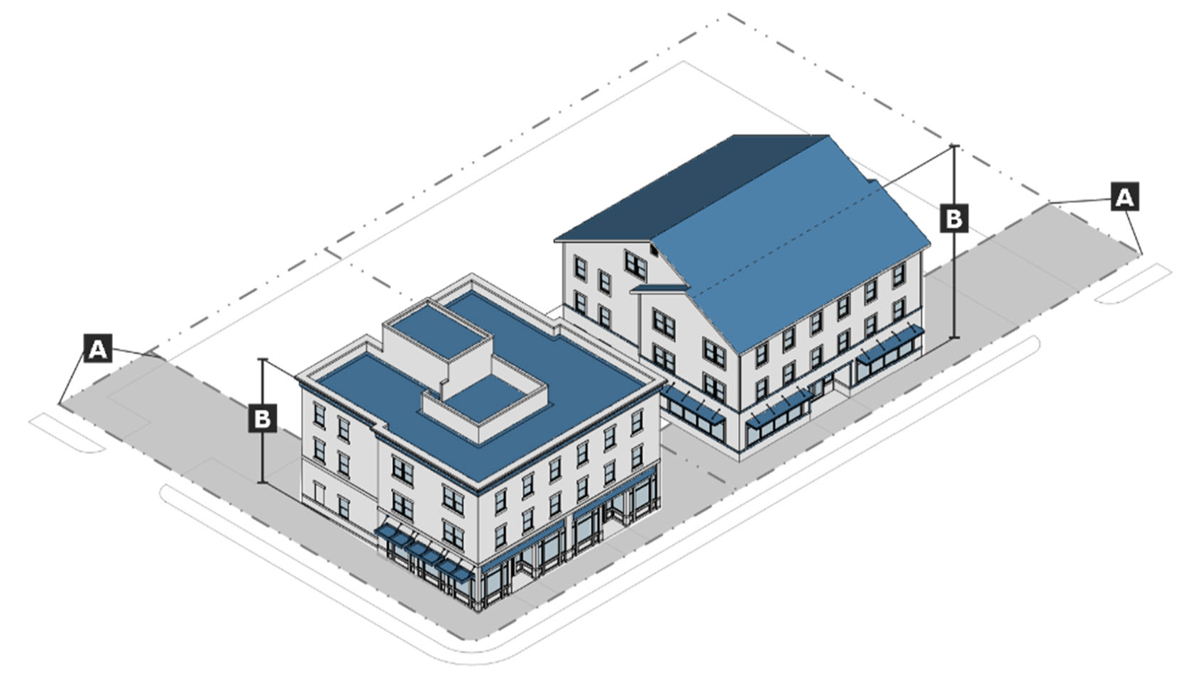
d.
Parking location.
1.
All off-street parking shall be located to the rear of the building(s) on the block, to the maximum extent practicable.
2.
Except as provided in subsection 3. below, off-street parking shall not be located between the front of the principal structure and the public right-of-way.
3.
Off-street parking may be located within the front of the principal structure and the public right-of-way in the are bounded one the east by Lurleen B. Wallace Boulevard North; on the north by 6th Street; on the west by Lurleen B. Wallace Boulevard South; and on the south by 15th Street.
e.
Utilities. All utilities serving individual buildings or developments shall be located underground.
f.
Building materials. The building materials and applicability standards that apply in the D district, at section 25-78(e)(2)(i), building materials allowed, also apply in the DP district.
g.
References to other standards. Development in the DP district shall comply with all applicable standards of this zoning ordinance and the subdivision regulations, including but not limited to the standards referenced in Table IV-40: cross-references to other standards.
Table IV-40: Cross-References to Other Standards
(Ord. No. 9572, § 2, 12-17-24; Ord. No. 9670, § 11, 8-19-25)
Sec. 25-80. - Downtown historic edge.
a.
Purpose. The purpose of the downtown historic edge (DHE) district is to provide lands that protect the historic districts and support a limited mix of moderate-intensity office and commercial uses along with medium-scale multifamily residential dwellings, single-family detached dwellings on small lots, and a range of attached residential uses, such as triplexes and townhouses. The district also allows a variety of civic and institutional uses. The scale of the development is intended to complement existing development in the neighborhood and support a pedestrian-friendly transition between the higher density and intensity of uses in the downtown district and the lower-density development in adjacent residential and commercial districts.
b.
Use standards. Allowed uses and use-specific standards for principal, accessory, and temporary uses are established in article V, use regulations.
c.
Intensity and dimensional standards. All development in the DHE district shall comply with the standards in table IV-41: DHE intensity and dimensional standards.
Table IV-41: DHE Intensity and Dimensional Standards
Notes:
[1] max = maximum; min = minimum; ft = feet
[2] The front building façade must be located within the minimum and maximum front setbacks. The maximum front setback may be increased by 1) 15 feet along 35 per cent of the lot width for an outdoor dining area, plaza, or other area that is open to the public and that includes features such as a garden, fountain, and seating; or 2) up to the average alignment of existing buildings within 100 feet on either side of subject building and within the same block if such alignment is greater than 15 feet.
[3] The historic preservation commission may allow or require larger or smaller front setbacks within a historic district if it determines that with such modification a development will better conform with nearby properties, or with the development patterns within the DHE district and any applicable historic district.
[4] A minimum setback of eight feet is required from any lot line abutting a residential district. There is no minimum side setback for townhouses, except a minimum side setback of seven feet is required at each end of a row of townhouses. No townhouse unit shall be less than one-third wide as it is deep.
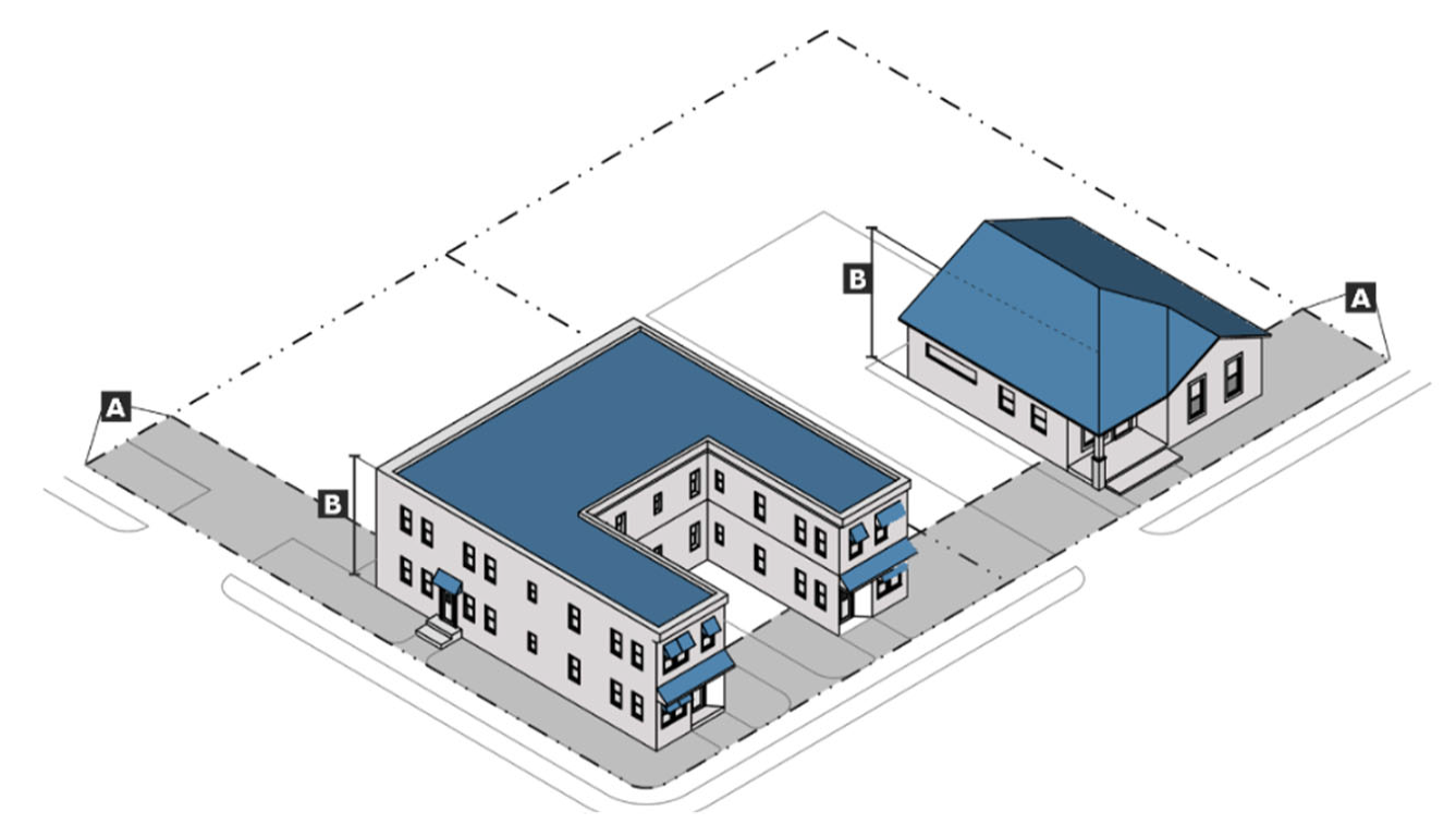
d.
Parking location. The location and configuration of off-street parking in relation to the building(s) on the site, adjacent lots, and the street shall match the location and configuration of off-street parking on the majority of land with active uses within five hundred (500) feet on either side of the site along the front setback.
e.
Utilities. All existing and proposed utilities including communication, cable, electric, and the like, shall be installed underground except where such utilities are not visible from any right-of-way. The zoning officer may provide an exception for poles that support only high voltage wires, switches, and transformers.
f.
Building materials. The building materials standards that apply in the D district, at section 25-78(e)(2)(i), building materials allowed, also apply in the DHE district, except to the extent they are inconsistent with standards applied by the historic preservation commission, including any design guidelines established by the commission, to buildings in a historic district or to a property designated as historic in accordance with chapter 20, division 2 of this Code.
g.
References to other standards. Development in the DHE district shall comply with all applicable standards of this zoning ordinance and the subdivision regulations, including but not limited to the standards referenced in table IV-42: cross-references to other standards.
Table IV-42: Cross-References to Other Standards
(Ord. No. 9572, § 2, 12-17-24; Ord. No. 9670, § 12, 8-19-25)
Sec. 25-81. - Riverfront district.
a.
Purpose. The riverfront of the Black Warrior River is a unique natural, scenic, and historic resource of the city. The purpose of the riverfront (R) district is to, as appropriate, provide lands that support pedestrian-friendly, high-quality development that takes advantage of the Black Warrior River's history and scenic beauty, protect against flooding, and preserves the natural features of the river and its floodplain. The district should include only nonresidential uses, or residential uses mixed with complimentary nonresidential uses. Streets, buildings, and open space should create synergy with the natural riverfront environment, preserving and/or enhancing environmentally sensitive areas while allowing people within and around the district to maintain a visual or actual connection with the riverfront through the riverwalk.
b.
Procedure. Development or redevelopment in the R district shall be subject to approval in one of two (2) ways.
1.
Small-scale development.
i.
Small-scale development shall be treated as allowed development in the R district and is subject to all the applicable standards, procedures, and requirements of the district, this zoning ordinance, and the subdivision regulations, except for redevelopment identified in subsection 3. below, which is exempt from certain development standards.
ii.
For the purpose of the R district, except for certain redevelopment identified in subsection 3. below, small-scale development is proposed development that results in twenty thousand (20,000) square feet or less of nonresidential development, and/or twenty (20) residential units, or development that is located on a lot that is twenty-five thousand (25,000) square feet or less.
2.
Large-scale development.
i.
Large-scale development shall be classified as a riverfront planned development (RPD) district, in accordance with the procedures and standards of section 25-37, planned development, section 25-91, general provisions, and section 25-93, riverfront planned development.
ii.
For the purpose of the R district, large-scale development is all proposed development in the district that is not small-scale development.
3.
Exemptions. The expansion or alteration of development existing prior to January 1, 2025 that increases the building's floor area by less than fifty (50) per cent or involves alterations that involve less than fifty (50) per cent of the building's gross floor area, shall also be considered small-scale development, but shall only be required to comply with the following development standards to the extent listed below:
i.
Subsection e.1., site design standards.
(a)
Subsection e.1.i., view of river preserved (comply);
(b)
Subsection e.1.ii., supplemental zone adjacent to riverwalk (comply to the maximum extent practicable);
(c)
Subsection e.1.iv., pedestrian circulation system (comply to the maximum extent practicable);
(d)
Subsection e.1.v., parking (comply to the maximum extent practicable);
(e)
Subsection e.1.vii., exterior lighting (comply);
(f)
Subsection e.1.viii., signs (comply to the maximum extent practicable); and
(g)
Subsection e.1.ix., utilities (comply to the maximum extent practicable).
ii.
Subsection e.2., building design
(a)
Subsection e.2.iv., fenestration/transparency (comply to the maximum extent practicable); and
(b)
Subsection e.2.vi., loading, service, and equipment areas (comply to the maximum extent practicable).
c.
Use standards.
1.
Small-scale development. Allowed uses and use-specific standards for principal, accessory, and temporary uses for small-scale development are the allowed uses for the R district that are established in article V, use regulations.
2.
Large-scale development. Allowed uses and use-specific standards for principal, accessory, and temporary uses for large-scale development are those uses identified in article V, use regulations, as uses that may be allowed in the RPD district. However, only those uses identified as permitted in the approved PD plan are permitted in an individual RPD district, subject to the conditions and requirements in the approved PD plan and PD agreement, (see c, classification of land to a planned development district).
3.
Use-specific standards. The following use specific standards apply to both small-scale development and large-scale development, in addition to any additional applicable standards for specific uses in article V, use regulations.
i.
Multifamily.
(a)
Multifamily dwellings are allowed only if thirty-five (35) per cent or more of the total floor area of all buildings in the proposed development is used for commercial uses. (Townhomes are not subject to this requirement).
(b)
The maximum residential density for multifamily and townhomes is sixty (60) bedrooms per acre. There shall be a maximum of three (3) bedrooms in a dwelling unit.
d.
Intensity and dimensional standards. All small-scale development in the R district shall comply with the standards in table IV-43: R intensity and dimensional standards.
Table IV-43: R Intensity and Dimensional Standards
Notes:
[1] max = maximum; min = minimum; ft = feet
[2] A street-facing garage shall be set back at least 20 feet from the front lot line, and a garage facing a rear alley shall be set back at least 20 feet from the rear lot line.
[3] There is no minimum side setback for townhouses, except a minimum side setback of seven feet is required at each end of a row of townhouses. No townhouse unit shall be less than one-third as wide as it is deep.
[4] The minimum floor to ceiling height for commercial space shall be 12 feet.
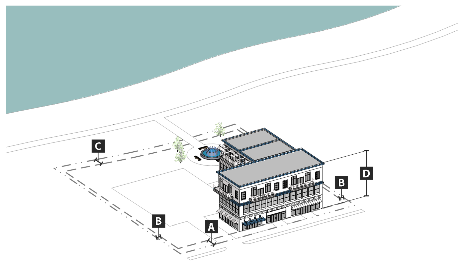
e.
Development standards. All development in the R and RPD districts (both small-scale and large-scale development) shall comply with the following standards:
1.
Site design standards.
i.
View of riverfront preserved. To the maximum extent practicable, streets, open space, and buildings shall be located, designed, and oriented to preserve the view of the Black Warrior River and the riverfront from adjacent streets and buildings in the district, and from development directly contiguous to the district located on public streets.
ii.
Supplemental zone adjacent to riverwalk. All sites adjacent to the riverwalk shall establish a supplemental zone twenty-five (25) feet in width adjacent to the riverwalk, which serves as an outdoor transitional space between the riverwalk and the development on the site. The supplemental zone may remain in its natural condition or be landscaped, and may include patios, benches, or gazebos. It shall include a pedestrian way that connects the riverwalk to the primary building entrance facing the riverwalk.
iii.
Blocks, streets, and alleys. Where streets are added or modified, they should be designed and laid out in blocks with sidewalks, or if that is impractical, with an alternative design that ensures the development provides sidewalks and a pedestrian-friendly environment that is well connected to adjacent streets and sidewalks, and the street and pedestrian system within the district.
iv.
Pedestrian circulation system.
(a)
Development shall:
(1)
Provide sidewalks on both sides of every street. Each sidewalk shall be a minimum of six (6) feet in width, be separated from the street by a street tree planting area at least five (5) feet in width, and have street trees that are located in the street tree planting area and are spaced between forty (40) and fifty (50) feet on center;
(2)
Provide sidewalks from building entrances to other sidewalks on the site;
(3)
Clearly mark where sidewalks, trails, or other pedestrian ways cross a street or driveway by using a change in paving material, color, or height, decorative bollards, or similar elements; and
(4)
When on a site adjacent to the riverwalk, provide a connection to the riverwalk in the form of a defined pedestrian way that is a minimum of eight (8) feet in width, that connects the riverwalk to the primary building entrance on the river-facing side of the building.
(b)
All sidewalks shall be surfaced with pavers or imprinted concrete, except in the interior of parks or other less formal areas, where all-weather surfacing may be used.
v.
Parking. All off-street parking, except for buildings on a site adjacent to the riverwalk shall be located, to the maximum extent practicable, to the side or rear of principal building(s) as defined by the abutting street. Parking for a building on a site adjacent to the riverwalk shall be located to the side of the building, to the maximum extent practicable, and if that is not possible because of site or other conditions, between the building and the street. Parking to the side of the building shall be screened from the riverwalk by an opaque screen of shrubs that are at least four (4) feet in height at maturity.
vi.
Landscaping and fencing.
(a)
Transition landscaping shall be provided in the supplemental zone adjacent to the riverwalk. To the maximum extent practicable, existing tree canopy and native vegetation shall be used.
(b)
Landscaping and hardscaping shall be designed so it does not interfere with accessibility for persons with disabilities.
(c)
Fences are allowed, where necessary for security or privacy reasons. However, the fences shall be designed to not block public access to the riverwalk. Any wall or fence between a building adjacent to the riverwalk and the riverwalk shall not exceed four (4) feet in height, shall have a minimum opacity of fifty (50) per cent, and shall be decorative (chain link fences are prohibited).
vii.
Exterior lighting. Light fixtures shall be of a standard ornamental type installed by Alabama Power Company, or a more ornate type of fixture approved by the director of planning to be owned and maintained by the developer or an owners association.
viii.
Signs.
(a)
Freestanding signs shall be limited to monument signs only.
(b)
The maximum allowable sign copy area for signs erected on a building (including on a canopy or awning) on a street frontage or river-facing shall not exceed one square foot per every linear foot of street or river-facing frontage, up to a maximum of eighty (80) square feet per sign. The director of planning may increase the maximum allowable copy area by ten (10) per cent for any building with a building height that is greater than forty (40) feet, if it is demonstrated that the location of the sign and the increase in sign area is done in a way that is compatible with the character of surrounding development and the general purposes of the district.
(c)
Channel letter or logo signs placed on the building may be internally lit or back lit, but shall not be lit with neon lighting. All other signs, if lighted, shall be externally lit, internally lit, or translucent box-type signs. Electronic message boards are prohibited.
(d)
Painted window signs and backlit or illuminated awnings are prohibited.
(e)
Signs on canopies or awnings shall have at least one square foot and no more than three (3) square feet of copy area.
(f)
Projecting signs shall comply with the following standards:
(1)
For buildings less than forty (40) feet in height:
i.
The projecting sign shall not extend above the second floor.
ii.
The projecting sign shall have no more than twelve (12) square feet of copy area.
iii.
The projecting sign shall not project more than two (2) feet from the building façade, and may extend into a public right-of-way (other than an alley) only with the appropriate city permit.
(2)
For buildings forty (40) feet in height or taller:
i.
The projecting sign shall have copy area no larger than fifty (50) square feet in area, or one square foot for each linear foot of building frontage, whichever is greater, up to a maximum one hundred (100) square feet of copy area.
ii.
The projecting sign shall not project more than three (3) feet from the building face, and may extend into a public right-of-way (other than an alley) only with the appropriate city permit.
(3)
Projecting signs shall not display messages on a digital display.
ix.
Utilities. All existing and proposed utilities including communication, cable, electric, and the like, shall be installed underground except where such utilities are not visible from any right-of-way. The zoning officer may provide an exception for poles that support only high voltage wires, switches, and transformers.
x.
Design of features in flood hazard areas. In flood hazard areas, all structural, landscape, hardscape, and utility features installed at or below the base flood elevation shall be:
(a)
Designed to withstand repeated immersion and other predictable effects of flooding with minimum damage and with least maintenance expense;
(b)
Designed in a way that is compatible with the color, scale, and architectural elements of the building; and
(c)
Where appropriate, screened from view from all streets and the riverwalk.
2.
Building design.
i.
Building orientation.
(a)
The front façade of all new buildings, as defined by the primary entrance, shall be oriented and front onto a street, a courtyard, or plaza.
(b)
For a building on a site contiguous to the riverwalk, there shall also be a primary entrance on the façade of the building facing the riverwalk, unless topographical features make it infeasible.
(c)
All single-building developments shall be configured with the long axis of the building parallel to the street it fronts, or be consistent with existing development patterns, rather than being sited at unconventional angles, to the maximum extent practicable.
(d)
The primary entrances of buildings in a multi-building development shall:
(1)
Be oriented towards a street along the perimeter of a development, or towards streets or driveways interior to the development; and
(2)
If appropriate, frame the corner of adjacent street intersections or entry points.
ii.
Entrances.
(a)
All buildings facing a primary street shall provide a primary pedestrian entrance from the primary street.
(b)
All buildings on a site contiguous to the riverwalk shall provide a primary pedestrian entrance from the riverwalk unless topographical features make it infeasible.
(c)
All primary pedestrian entrances into principal buildings from both the street and the riverwalk (where applicable) shall be clearly defined and emphasized using changes in the wall plane or façade material, lintels, pediments, pilasters, arches, awnings, canopies, porches, or other architectural elements.
(d)
For all sites adjacent to the riverwalk, a street address number shall be located directly above or beside the primary building entrance from the riverwalk, and be visible from the riverwalk.
iii.
Façades.
(a)
Building façades facing the riverwalk shall provide views of the riverwalk and riverfront through the use of windows, doors, terraces, balconies, or other architectural features.
(b)
The street-facing and river-facing side of a building, where visible off-site along a street or the riverwalk, shall be articulated with the same façade details as provided on the building's street-facing or river-facing façade.
(c)
Outbuildings located in front or behind other buildings within the same development shall include a consistent level of façade articulation and architectural detail on all sides of the building, as well as exterior materials and colors that are compatible with the primary building in the development.
iv.
Fenestration/transparency.
(a)
A minimum of thirty-five (35) per cent of the street-facing façade area of the ground-level floor of buildings (as measured from the grade to the underside of the eave, top of the parapet, or the story line denoting the second floor) shall be occupied by windows or doorways.
(b)
A minimum of thirty-five (35) per cent of the river-facing façade area of a building (as measured from the grade to the underside of the eave, top of the parapet, or the story line denoting the top floor) shall be occupied by windows or doorways.
v.
Roofs. Buildings shall use a common, unifying design for roofs in terms of roof type, pitch, color, and materials. The intent of this requirement is not to create a uniform appearance, but rather a distinct sense of place.
vi.
Loading, service, dumpster, mechanical and other equipment areas.
(a)
Loading, service, dumpster, and mechanical and other equipment areas shall be located in a manner that screens their visibility from adjacent streets and the riverwalk.
(b)
Loading, service, dumpster, mechanical and other equipment areas, and other similar facilities shall not be oriented toward the riverwalk.
(c)
Outdoor storage areas shall be fully screened from adjacent streets, the riverwalk, and single-family detached dwellings.
3.
Building materials.
i.
Primary materials.
(a)
The following building material shall be used for not less than seventy-five (75) per cent of the building wall surface area on each façade. Primary material changes may occur only at building corners where a maximum of one of the façades faces the street:
(1)
Brick masonry.
(2)
Natural stone (or synthetic equivalent), such as limestone, granite, and marble;
(3)
Wood-clapboard or shingles;
(4)
Cementitious siding; or
(5)
Glass curtain wall.
(b)
The use of EIFS or aluminum siding is prohibited.
ii.
Accent materials. The following materials may make up twenty-five (25) per cent of the building wall surface area on each façade:
(a)
Pre-cast masonry (only for trim and cornice elements);
(b)
Gypsum reinforced fiber concrete—GFRC (for trim elements only);
(c)
EIFS only for trim;
(d)
Metal (for beams, lintels, trim elements, and ornamentation);
(e)
Split-faced block (only for piers, foundation walls, and chimneys);
(f)
Glass block;
(g)
Vinyl shakes or shingles;
(h)
Vinyl clapboard (with a minimum thickness of 0.044 inches); and
(i)
Stucco (panels with cementitious finish, not tiles or EIFS—external insulation finishing system).
iii.
Alternative materials. Alternative building materials not listed in subsections i. and ii. above may be approved if the director of planning determines that the alternative materials are equivalent or better than the listed materials. The use of regionally-available materials is preferred.
4.
Utilities. All existing and proposed utilities including communication, cable, electric, and the like, shall be installed underground except where such utilities are not visible from any right-of-way. The zoning officer may provide an exception for poles that support only high voltage wires, switches, and transformers.
f.
References to other standards. Development in the R district shall comply with all applicable standards of this zoning ordinance and the subdivision regulations, including but not limited to the standards referenced in table IV-44: Cross-references to other standards, unless they conflict with the standards of the R district. In case of conflict between the standards of the R district and the other applicable standards of the zoning ordinance or subdivision regulations, the standards of the R district shall control.
Table IV-44: Cross-References to Other Standards
(Ord. No. 9572, § 2, 12-17-24; Ord. No. 9670, §§ 13, 14, 8-19-25)
Sec. 25-82. - Lake commercial.
a.
Purpose. The purpose of the lake commercial (LC) district is to provide lands near Lake Tuscaloosa for limited commercial development that supports the recreational use of the lake and/or residential uses in the immediate surrounding area. Uses are limited to small-scale restaurant, retail, and office uses, as well as marinas and ancillary development.
b.
Use standards. Allowed uses and use-specific standards for principal, accessory, and temporary uses are established in article V, use regulations.
c.
Intensity and dimensional standards. All development in the LC district shall comply with the standards in table IV-45: LC intensity and dimensional standards.
Table IV-45: LC Intensity and Dimensional Standards
Notes:
[1] max = maximum; min = minimum; ft = feet; sf = square feet
[2] Lake frontage width minimum applies only to lots abutting the Acquisition Line.
[3] Applies to all uses other than marinas, and to all restaurant and retail sales areas within a marina.
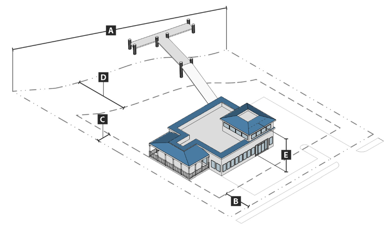
d.
Development standards. All development in the LC district shall comply with the following standards:
1.
Screening. All off-street parking areas, waste and recycling storage areas, and ground-based HVAC equipment shall be screened from view from the lake and public street using a fence or wall and a combination of shrubs and trees planted along the lake-facing and public street-facing side of the fence or wall.
2.
Parking. Any off-street parking spaces provided in excess of the number of parking spaces required by section 25-123, off-street parking standards, shall be surfaced only with pervious surfacing. The permeability of all such surfacing shall be maintained through regular upkeep (e.g. sweeping, annual vacuuming, repair of surface damage) to ensure proper functioning.
3.
Building materials.
i.
Primary materials.
(a)
The following building material shall be used for not less than seventy-five (75) per cent of the building wall surface area on each façade. Primary material changes may occur only at building corners where a maximum of one of the façades faces the street:
(1)
Brick masonry.
(2)
Natural stone (or synthetic equivalent), such as limestone, granite, and marble;
(3)
Wood-clapboard or shingles; or
(4)
Glass curtain wall.
(b)
The use of EIFS or aluminum siding is prohibited.
ii.
Accent materials. The following materials may make up twenty-five (25) per cent of the building wall surface area on each façade:
(a)
Pre-cast masonry (only for trim and cornice elements);
(b)
Gypsum reinforced fiber concrete—GFRC (for trim elements only);
(c)
EIFS only for trim;
(d)
Metal (for beams, lintels, trim elements, and ornamentation);
(e)
Split-faced block (only for piers, foundation walls, and chimneys);
(f)
Glass block;
(g)
Cementitious siding;
(h)
Vinyl shakes or shingles;
(i)
Stucco (panels with cementitious finish, not tiles or EIFS—external insulation finishing system); and
(j)
Vinyl clapboard (with a minimum thickness of 0.044 inches).
iii.
Alternative materials. Alternative building materials not listed in subsections i. and ii. above may be approved if the director of planning determines that the alternative materials are equivalent or better than the listed materials. The use of regionally-available materials is preferred.
e.
References to other standards. Development in the LC district shall comply with all applicable standards of this zoning ordinance and the subdivision regulations, including but not limited to the standards referenced in table IV-46: cross-references to other standards.
Table IV-46: Cross-References to Other Standards
(Ord. No. 9572, § 2, 12-17-24)
Sec. 25-83. - General commercial.
a.
Purpose. The purpose of the general commercial (GC) district is to provide lands for the development of a wide range of nonresidential uses including office, commercial, employment and retail businesses, that may be developed in conjunction with residential uses, either in the same building or on the same development site.
b.
Use standards. Allowed uses and use-specific standards for principal, accessory, and temporary uses are established in article V, use regulations.
c.
Intensity and dimensional standards. All development in the GC district shall comply with the standards in table IV-47: GC intensity and dimensional standards.
Table IV-47: GC Intensity and Dimensional Standards
Notes:
[1] max = maximum; min = minimum; ft = feet
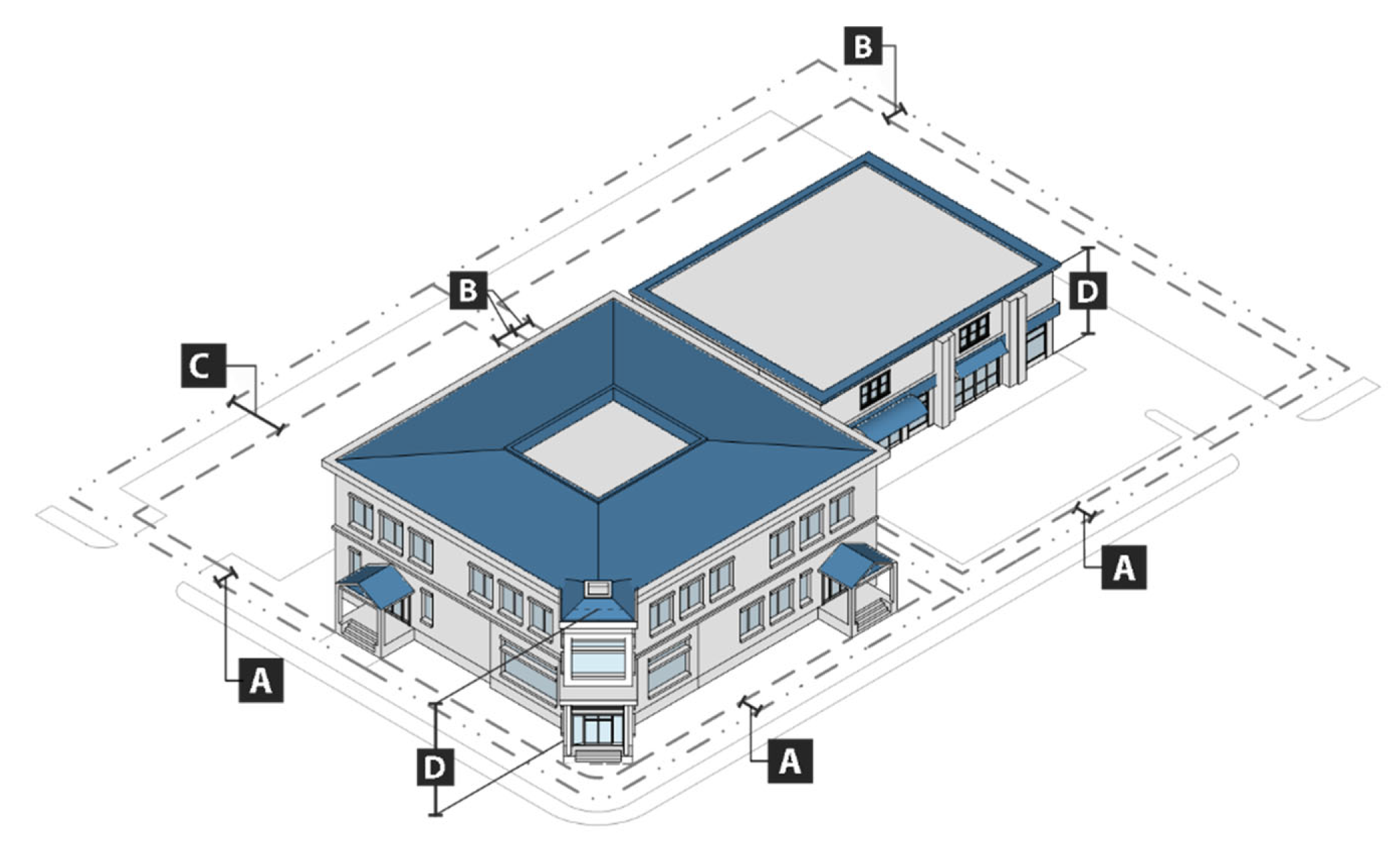
d.
Development standards. All development in the GC district shall comply with the following standards:
1.
Residential development. Residential dwelling units in new development and redevelopment are permitted only above a single story of a building that has only non-residential uses on its ground floor.
2.
Building materials allowed.
i.
Primary materials. Primary material changes shall occur only at inside corners. The following materials are required for not less than seventy-five (75) per cent of the building wall surface area on each façade:
(a)
Brick and tile masonry;
(b)
Natural stone (or synthetic equivalent), such as limestone, granite, and marble;
(c)
Wood-clapboard or shingles;
(d)
Glass curtain wall;
(e)
Cementitious siding; and
(f)
Stucco (cementitious finish).
ii.
Accent materials. The following materials may make up to twenty-five (25) per cent of the building wall surface area on each façade:
(a)
Pre-cast masonry (for trim and cornice elements only);
(b)
External insulation finishing system—EIFS (for trim and cornice elements only);
(c)
Gypsum reinforced fiber concrete—GFRC (for trim elements only);
(d)
Metal (for beams, lintels, trim elements, and ornamentation);
(e)
Split-faced block (for piers, foundation walls and chimneys only);
(f)
Glass block;
(g)
Vinyl shakes or shingles; and
(h)
Vinyl clapboard (with a minimum thickness of 0.044 inches).
iii.
Alternative materials. Alternative building materials not listed in subsections i. or ii. above may be approved by the director of planning if it is demonstrated the alternative building materials are equivalent or better than the listed materials. The use of regionally-available materials is preferred.
e.
References to other standards. Development in the GC district shall comply with all applicable standards of this zoning ordinance and the subdivision regulations, including but not limited to the standards referenced in table IV-48: cross-references to other standards, to the extent they do not conflict with the standards in subsection d. above.
Table IV-48: Cross-References to Other Standards
(Ord. No. 9572, § 2, 12-17-24)
Sec. 25-84. - University commercial.
a.
Purpose. The purpose of the university commercial (UC) district is to provide lands adjacent to major colleges and universities within the city that are walkable and include a variety of retail, restaurant, entertainment, lodging, office, and residential uses.
b.
Use standards. Allowed uses and use-specific standards for principal, accessory, and temporary uses are established in article V, use regulations.
c.
Intensity and dimensional standards. All development in the UC district shall comply with the standards in table IV-49: UC intensity and dimensional standards.
Table IV-49: UC Intensity and Dimensional Standards
Notes:
[1] max = maximum; min = minimum; du = dwelling units; ft = feet
[2] The maximum front setback may be increased by 15 feet along 35 per cent of the lot width for an outdoor dining area, plaza, or other area that is open to the public and that includes features such as a garden, fountain, and seating.
[3] In the area bounded by Queen City Avenue (west), Jack Warner Parkway (north), Hackberry Lane (east), and 13th Street (south), the maximum front setback shall be ten (10) feet.
[4] A buffer may be required along a side or rear lot line in accordance with section 25-133, buffers.
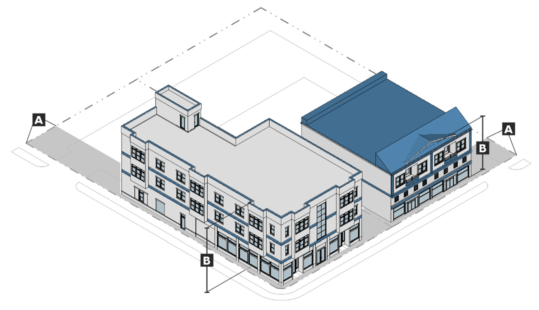
d.
Development standards. All development in the UC district shall comply with the following standards:
1.
Residential development. Residential dwelling units in new development and redevelopment are permitted only on or above the second story of the building.
2.
Parking location. In the area bounded on the west by Queen City Avenue, on the north by Jack Warner Parkway, on the east by Hackberry Lane, and on the south by 13th Street, off-street parking shall be located to the side or rear of the principal structure, and not between the front of the principal structure and the public right-of-way.
3.
Mechanical equipment and utilities.
i.
Mechanical equipment, such as HVAC units and security lighting, may encroach into a required rear or side setback, provided that such extension is at least five (5) feet from the vertical plane of any lot line. The mechanical equipment shall be screened from rights-of-way with a wall or fence. All such screens shall be constructed from the primary building material or opaque landscaping and be at least thirty (30) inches in height at installation and maintained at that minimum height in a healthy condition.
ii.
All existing and proposed utilities including communication, cable, electric, and the like, shall be installed underground except where such utilities are not visible from any right-of-way. The zoning officer may provide an exception for poles that support only high voltage wires, switches, and transformers.
4.
Sidewalks.
i.
In order to establish safe and efficient pedestrian circulation, new development shall include sidewalks that directly connect the main entrances of buildings on the site with each other and with available access points including parking areas, streets, sidewalks, and transit stops. Where such sidewalks traverse parking areas, the sidewalk shall be clearly identifiable through changes in material or elevation.
ii.
New development shall install sidewalks along all street frontages as needed for pedestrian mobility or safety and as appropriate to the location. Installation of such sidewalks is not required where the director of planning determines a sidewalk is impractical or unfeasible.
iii.
Except as otherwise provided by subsection d.3.ii., a landscaped strip at least five (5) feet wide shall be provided between the street and the sidewalk along all street frontages. The landscaped strip shall consist of grass, landscaping, or trees, and shall incorporate the provisions of the right-of-way landscape requirements in subsection d.5. below. Where on street parking is provided adjacent to a development, landscape strip can be substituted for a six (6) feet wide sidewalk with trees planted in tree grates.
5.
Landscaping.
i.
Where development occurs adjacent to an existing street, one canopy tree having a minimum three-inch base caliper shall be planted or preserved in the right-of-way for every fifty (50) feet of lot width. The director of planning may waive or modify this requirement if trees are determined impractical or unfeasible. All efforts should be made to retain existing healthy canopy trees.
ii.
Trees planted to comply with the requirements of this section shall be installed with an irrigation bag or be watered by an irrigation system operated by the developer to ensure healthy growth. The irrigation bag or system shall be maintained for a minimum of two (2) summer growing seasons.
iii.
Except as otherwise provided in this section, all trees required by this section shall be maintained in landscape islands. Each landscape island shall be sodded, seeded, mulched, or planted with shrubs and/or groundcover, and may incorporate low impact development best management practices, such as rain gardens and bioswales, to promote infiltration of stormwater.
6.
Building materials allowed.
i.
Primary materials. Primary material changes shall occur only at inside corners. The following materials are required for not less than seventy-five (75) per cent of the building wall surface area on each façade:
(a)
Brick and tile masonry;
(b)
Natural stone (or synthetic equivalent), such as limestone, granite, and marble;
(c)
Wood-clapboard or shingles;
(d)
Glass curtain wall;
(e)
Cementitious siding; and
(f)
Stucco (cementitious finish).
ii.
Accent materials. The following materials may make up to twenty-five (25) per cent of the building wall surface area on each façade:
(a)
Pre-cast masonry (for trim and cornice elements only);
(b)
External insulation finishing system—EIFS (for trim and cornice elements only);
(c)
Gypsum reinforced fiber concrete—GFRC (for trim elements only);
(d)
Metal (for beams, lintels, trim elements, and ornamentation);
(e)
Split-faced block (for piers, foundation walls and chimneys only);
(f)
Glass block;
(g)
Vinyl shakes or shingles; and
(h)
Vinyl clapboard (with a minimum thickness of 0.044 inches).
iii.
Alternative materials. Alternative building materials not listed in subsections i. or ii. above may be approved by the director of planning if it is demonstrated the alternative building materials are equivalent or better than the listed materials. The use of regionally-available materials is preferred.
e.
References to other standards. Development in the UC district shall comply with all applicable standards of this zoning ordinance and the subdivision regulations, including but not limited to the standards referenced in table IV-50: cross-references to other standards, to the extent they do not conflict with the standards in subsections d.1. and d.2. above.
Table IV-50: Cross-References to Other Standards
(Ord. No. 9572, § 2, 12-17-24)
Sec. 25-85. - Neighborhood commercial.
a.
Purpose. The purpose of the neighborhood commercial (NC) district is to provide lands for a limited range of small-scale commercial uses within or at the edge of residential neighborhoods and along roadways. The district may apply to portions of a block, consisting of a few storefronts with limited on-site parking, and is intended for neighborhood-serving uses that are primarily pedestrian-oriented. The district regulations are intended to ensure that uses, development intensities, and development forms are consistent with this pedestrian-friendly and neighborhood scale. Second-floor residential development over ground floor commercial uses is also permitted at a scale and form that is consistent with district character.
b.
Use standards. Allowed uses and use-specific standards for principal, accessory, and temporary uses are established in article V, use regulations.
c.
Intensity and dimensional standards. All development in the NC district shall comply with the standards in table IV-51: NC intensity and dimensional standards.
Table IV-51: NC Intensity and Dimensional Standards
Notes:
[1] max = maximum; min = minimum; ft = feet; sf = square feet
[2] The maximum setback shall be 20 feet along a street classified as a collector street or greater in the Major Street Plan of Tuscaloosa. The minimum setback shall be 20 feet along all other streets.
[3] A wider buffer may be required along a side or rear lot line in accordance with section 25-133, buffers.
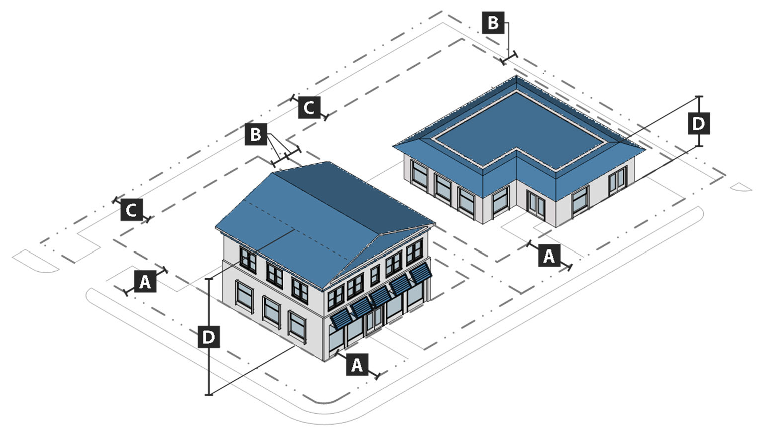
d.
Development standards. All development in the NC district shall comply with the following standards:
1.
Parking location. All off-street parking shall be located to the side or rear of the principal structure, to the maximum extent practicable.
2.
Building materials allowed.
i.
Primary materials. Primary material changes shall occur only at inside corners. The following materials are required for not less than seventy-five (75) per cent of the building wall surface area on each façade:
(a)
Brick and tile masonry;
(b)
Natural stone (or synthetic equivalent), such as limestone, granite, and marble;
(c)
Wood-clapboard or shingles;
(d)
Glass curtain wall;
(e)
Cementitious siding; and
(f)
Stucco (cementitious finish).
ii.
Accent materials. The following materials may make up to twenty-five (25) per cent of the building wall surface area on each façade:
(a)
Pre-cast masonry (for trim and cornice elements only);
(b)
External insulation finishing system—EIFS (for trim and cornice elements only);
(c)
Gypsum reinforced fiber concrete—GFRC (for trim elements only);
(d)
Metal (for beams, lintels, trim elements, and ornamentation);
(e)
Split-faced block (for piers, foundation walls and chimneys only);
(f)
Glass block;
(g)
Vinyl shakes or shingles; and
(h)
Vinyl clapboard (with a minimum thickness of 0.044 inches).
iii.
Alternative materials. Alternative building materials not listed in subsections i. or ii. above may be approved by the director of planning if it is demonstrated the alternative building materials are equivalent or better than the listed materials. The use of regionally-available materials is preferred.
e.
References to other standards. Development in the NC district shall comply with all applicable standards of this zoning ordinance and the subdivision regulations, including but not limited to the standards referenced in table IV-52: cross-references to other standards, to the extent they do not conflict with the standards in subsection d. above.
Table IV-52: Cross-References to Other Standards
(Ord. No. 9572, § 2, 12-17-24)
Sec. 25-86. - Highway commercial.
a.
Purpose. The purpose of the highway commercial (HC) district is to provide lands for commercial uses serving the needs of people traveling on major roadways and for other auto-oriented, community- or region-serving commercial development located along major roadway corridors.
b.
Use standards. Allowed uses and use-specific standards for principal, accessory, and temporary uses are established in article V, use regulations.
c.
Intensity and dimensional standards. All development in the HC district shall comply with the standards in table IV-53: HC intensity and dimensional standards.
Table IV-53: HC Intensity and Dimensional Standards
Notes:
[1] max = maximum; min = minimum; ft = feet
[2] Buffer standards in section 25-133, buffers, apply and may require that buildings and structures be set back from the lot line.
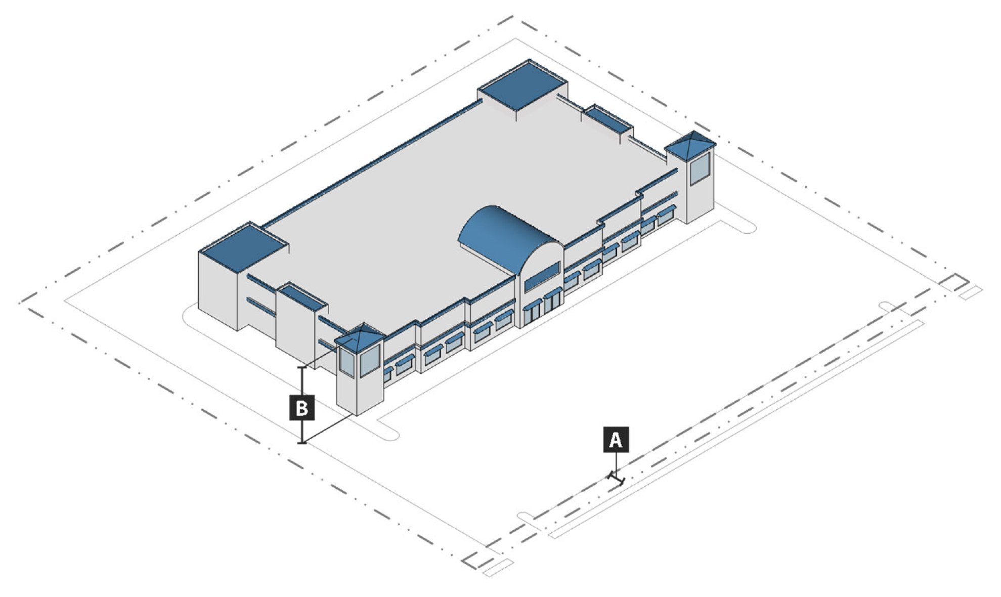
d.
Development standards. All development in the HC district shall comply with the following standards:
1.
Building materials allowed.
i.
Primary materials. Primary material changes shall occur only at inside corners. The following materials are required for not less than seventy-five (75) per cent of the building wall surface area on each façade:
(a)
Brick and tile masonry;
(b)
Natural stone (or synthetic equivalent), such as limestone, granite, and marble;
(c)
Wood-clapboard or shingles;
(d)
Glass curtain wall;
(e)
Cementitious siding; and
(f)
Stucco (cementitious finish).
ii.
Accent materials. The following materials may make up to twenty-five (25) per cent of the building wall surface area on each façade:
(a)
Pre-cast masonry (for trim and cornice elements only);
(b)
External insulation finishing system—EIFS (for trim and cornice elements only);
(c)
Gypsum reinforced fiber concrete—GFRC (for trim elements only);
(d)
Metal (for beams, lintels, trim elements, and ornamentation);
(e)
Split-faced block (for piers, foundation walls and chimneys only);
(f)
Glass block;
(g)
Vinyl shakes or shingles; and
(h)
Vinyl clapboard (with a minimum thickness of 0.044 inches).
iii.
Alternative materials. Alternative building materials not listed in subsections i. or ii. above may be approved by the director of planning if it is demonstrated the alternative building materials are equivalent or better than the listed materials. The use of regionally-available materials is preferred.
e.
References to other standards. Development in the HC district shall comply with all applicable standards of this zoning ordinance and the subdivision regulations, including but not limited to the standards referenced in table IV-54: cross-references to other standards.
Table IV-54: Cross-References to Other Standards
(Ord. No. 9572, § 2, 12-17-24)
Sec. 25-87. - General purpose.
The purpose of the industrial districts is to:
a.
Provide appropriately-located lands for the full range of industrial uses needed by the city's residents, businesses, and workers, in accordance with the comprehensive plan;
b.
Strengthen the city's economic base, and provide employment opportunities close to home for residents of the city and surrounding communities;
c.
Support a range of uses dedicated to processing, manufacturing, assembly, warehousing, outdoor storage, and distribution of goods;
d.
Create suitable environments for uses that have heavy freight traffic, and which may generate noise, odors, or other impacts;
e.
Ensure industrial development is located and designed to protect and preserve the character of existing residential districts and neighborhoods;
f.
Improve the design quality of industrial areas; and
g.
Provide a place to locate uses that are generally incompatible with other uses in other zone districts.
(Ord. No. 9572, § 2, 12-17-24)
Sec. 25-88. - Industrial light.
a.
Purpose. The purpose of the industrial light (IL) district is to provide lands for research and development, light industrial, assembly, flex space and other business support uses in an attractive and high-quality form and setting, which minimizes impacts to adjacent lands. Uses allowed include research and development, other light industrial uses that are compatible with a general office environment (e.g. establishments primarily engaged in the transformation of previously prepared materials into new products, including the assembly of component parts), offices, warehousing and wholesale uses, compatible multifamily development, and limited retail, institutional, and service uses, and eating and drinking establishments that serve those employed at the light industrial and office development.
b.
Use standards. Allowed uses and use-specific standards for principal, accessory, and temporary uses are established in article V, use regulations.
c.
Intensity and dimensional standards. All development in the IL district shall comply with the standards in table IV-55: IL intensity and dimensional standards.
Table IV-55: IL Intensity and Dimensional Standards
Notes:
[1] max = maximum; min = minimum; ft = feet
[2] If there is an existing structure on the lot on January 1, 2025 that does not comply with the front setback standard of this table, the minimum front setback of any new structure shall be no greater than the average of the front setback of any existing structures within 100 feet on either side.
[3] If lot abuts a lot in an industrial district.
[4] Buffer standards in section 25-133, buffers, apply and may require that buildings and structures be set back further from the lot line all standards if lot abuts a lot in a residential district, development shall comply with article VI division 7, neighborhood compatibility standards.
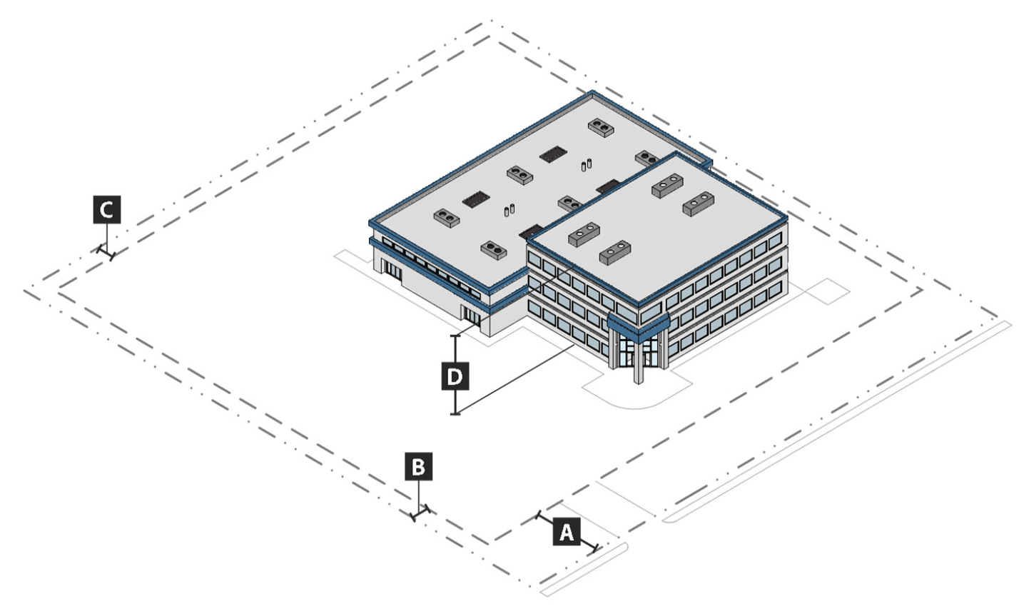
d.
References to other standards. Development in the IL district shall comply with all applicable standards of this zoning ordinance and the subdivision regulations, including but not limited to the standards referenced in table IV-56: cross-references to other standards.
Table IV-56: Cross-References to Other Standards
(Ord. No. 9572, § 2, 12-17-24)
Sec. 25-89. - Industrial general.
a.
Purpose. The purpose of the industrial general (IG) district is to provide lands for a range of indoor and outdoor industrial uses such as fabrication, extraction, manufacturing, assembly, processing, major utility uses, and bulk storage. District standards are intended to minimize impacts to adjacent residential land uses.
b.
Use standards. Allowed uses and use-specific standards for principal, accessory, and temporary uses are established in article V, use regulations.
c.
Intensity and dimensional standards. All development in the IG district shall comply with the standards in table IV-57: IG intensity and dimensional standards.
Table IV-57: IG Intensity and Dimensional Standards
Notes:
[1] max = maximum; min = minimum; ft = feet
[2] If there is an existing structure on the lot on January 1, 2025 that does not comply with the front setback standard of this table, the minimum front setback of any new structure shall be no greater than the average of the front setback of any existing structures within 100 feet on either side.
[3] If lot abuts a lot in a residential district, development shall also comply with article VI, division 7, neighborhood compatibility standards.
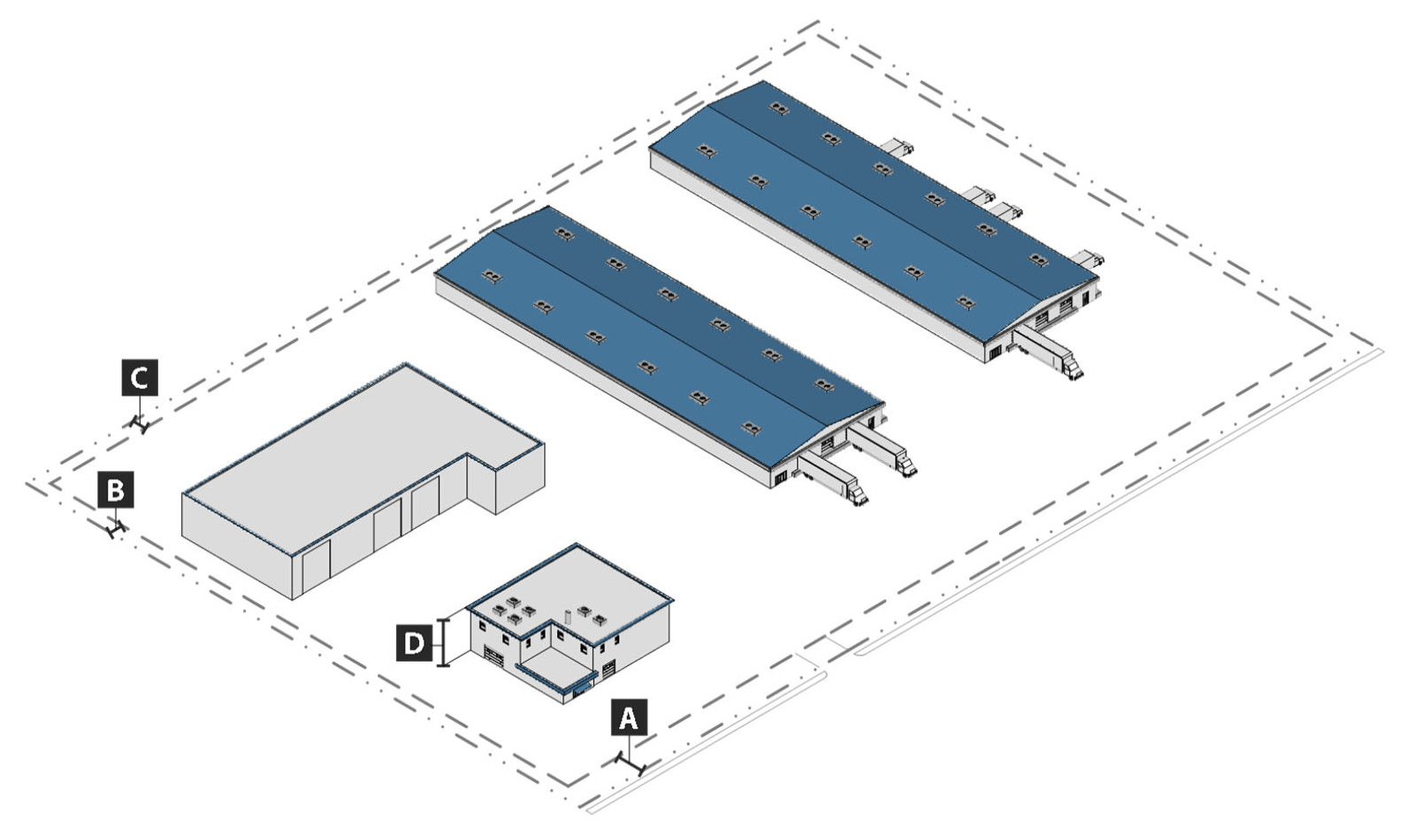
d.
References to other standards. Development in the IG district shall comply with all applicable standards of this zoning ordinance and the subdivision regulations, including but not limited to the standards referenced in table IV-58: cross-references to other standards.
Table IV-58: Cross-References to Other Standards
(Ord. No. 9572, § 2, 12-17-24)
Sec. 25-90. - Industrial heavy.
a.
Purpose. The purpose of the heavy industrial (IH) district is to provide lands for intense industrial development that generally requires large sites, as well as industrial uses that are important to the city's economic growth but may impact adjacent lands. The uses generally involve greater potential for adverse off-site impacts on the environment and surrounding development (e.g. from dust, fumes, smoke, odor, noise, or vibration, or due to extensive movement of vehicles, materials, and goods). Allowed uses include heavy manufacturing, production, extraction, warehouse distribution, waste disposal, wholesale sales, major utility facilities, and research laboratories. District regulations are intended to encourage the reuse of existing industrial development. District development is intended to include buffers and the use of mitigation techniques to ensure heavy industrial development mitigates potential impacts to surrounding development.
b.
Use standards. Allowed uses and use-specific standards for principal, accessory, and temporary uses are established in article V, use regulations.
c.
Intensity and dimensional standards. All development in the IH district shall comply with the standards in table IV-59: IH intensity and dimensional standards.
Table IV-59: IH Intensity and Dimensional Standards
Notes:
[1] max = maximum; min = minimum; ft = feet
[2] If there is an existing structure on the lot on January 1, 2025 that does not comply with the front setback standard of this table, the minimum front setback of any new structure shall be no greater than the average of the front setback of any existing structures within 100 feet on either side.
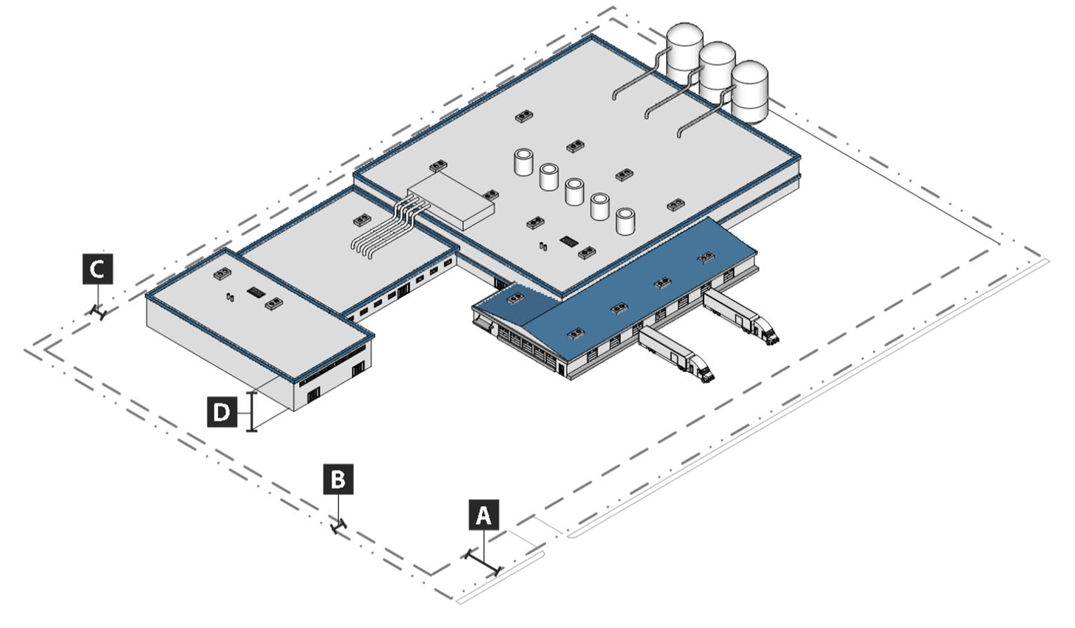
d.
References to other standards. Development in the IH district shall comply with all applicable standards of this zoning ordinance and the subdivision regulations, including but not limited to the standards referenced in table IV-60: cross-references to other standards.
Table IV-60: Cross-References to Other Standards
(Ord. No. 9572, § 2, 12-17-24)
Sec. 25-91. - General provisions.
a.
General purpose of planned development districts. The purpose of planned development (PD) districts is to encourage innovative and efficient land planning and physical design concepts. Planned development districts are intended to:
1.
Achieve a high quality of development, environmental sensitivity, and energy efficiency, and adequate provision of public services;
2.
Reduce the inflexibility of zoning district standards that sometimes results from strict application of the base district regulations and development standards established in this ordinance;
3.
Provide greater freedom and flexibility in selecting:
i.
The form and design of development;
ii.
The mix of uses;
iii.
The ways by which pedestrians and vehicular traffic circulate;
iv.
How the development will be located and designed to respect the natural features of the land and protect the environment;
v.
The location and integration of open space and civic space into the development; and
vi.
Design amenities.
4.
Allow more efficient use of land, with coordinated and right-sized networks of streets and utilities;
5.
Provide pedestrian connections within the same development, and to the public right-of way;
6.
Encourage the provision of centrally-located open space amenities within the development;
7.
Promote development forms and patterns that respect the character of established surrounding neighborhoods and other types of land uses;
8.
Promote development form that respects and takes advantage of a site's natural and man-made features, such as rivers, lakes, wetlands, floodplains, trees, and historic resources.
b.
Relationship to existing planned unit developments and RDD district. Lands designated in a planned unit development (PUD) or the riverfront development district (RDD) on January 1, 2025 are recognized as valid, and shall be carried out in accordance with the terms and conditions of their approval, so long as they remain valid and have not expired or been revoked, or been substantially modified with respect to the character of the development or the intent of the approval. If the development approval or permit expires or is revoked (e.g. for failure to comply with the terms and conditions of approval), or is substantially modified with respect to the character of the development or the intent of the approval, all subsequent development of the site shall comply with the procedures and standards of this ordinance. (See also article I, division 4, transitional provisions). Substantial modifications may include but are not limited to modifications to the plan of development that result in:
1.
An increase in the density of development by more than two (2) per cent;
2.
A decrease in the amount of open space;
3.
An increase of more than two (2) per cent in the number of external vehicular trips generated by the project, as determined by comparing the amount of external trip generation created by the approved planned development or phase, versus the external trip generation created by the proposed modification, using trip generation data and analysis from the most recent edition of the trip generation manual or other publications of the Institute of Traffic Engineers (ITE), or comparable information;
4.
Loss of environmentally sensitive lands or identified and preserved wildlife habitat;
5.
Modifications to the internal traffic circulation system that result in an increase in the number of internal vehicular trips within the project by more than five (5) per cent, as determined by comparing the internal trip generation created by the approved planned development or phase, versus the internal trip generation created by the proposed modification, using trip generation data and analysis from the most recent edition of the trip generation manual or other publications of the Institute of Traffic Engineers (ITE), or comparable information;
6.
A reduction in the land or facilities provided for active and passive recreation; or
7.
A reduction in accessibility provided by the pedestrian circulation system.
c.
Classification of land to a planned development district. Land shall be classified to a PD district only in accordance with the procedure in section 25-37, planned development. Approval of a planned development (PD) plan and a planned development (PD) agreement that comply with the requirements in subsections 1. and 2. below are required for the establishment of each PD district. Each approved PD plan and PD agreement shall comply with the purposes and requirements of the specific type of planned development district set forth in sections 25-92 and 25-93 below.
1.
Planned development (PD) plan and narrative.
i.
A PD plan shall at a minimum identify the following, through the submission of plans, elevations, narrative (see subsection ii. below), and similar materials:
(a)
The planning and development goals for the PD district;
(b)
The principal, accessory, and temporary uses permitted in the PD district and any standards that apply to specific uses in the district, in accordance with article V, use regulations;
(c)
The general location of each development area in the PD district, its acreage, types and mix of land uses, number of residential units (by use type), nonresidential floor area (by use type), residential density, and nonresidential intensity;
(d)
The dimensional standards that apply in the PD district;
(e)
Where relevant, the standards and requirements that ensure development on the perimeter of the PD district is designed and located to be compatible with the character of adjacent existing or approved development. Determination of compatible character shall be based on densities/intensities, lot size and dimensions, building height, building mass and scale, form and design features, building materials, hours of operation, exterior lighting, and siting of service areas;
(f)
The general location, amount, and type (whether designated for active or passive recreation) of open space;
(g)
The location of environmentally sensitive lands, resource lands, wildlife habitat, and waterway corridors, and measures to ensure protection of these lands consistent with the requirements of this section and this ordinance;
(h)
The on-site sidewalks and pedestrian circulation system and how it will connect to off-site sidewalks and pedestrian systems, consistent with the requirements of this ordinance;
(i)
The general design and layout of the on-site streets and transportation circulation system, including the general location of all public streets, existing or projected transit corridors, and how they interface with the pedestrian circulation system (sidewalks and pedestrian and bicycle pathways and trails), and connect to existing and planned city and regional systems, consistent with the requirements of this ordinance;
(j)
The general location of on-site potable water and wastewater facilities, and how they will connect to existing and planned city and regional systems, consistent with the requirements of this ordinance;
(k)
The general location of on-site storm drainage facilities, and how they will connect to existing and planned city systems, consistent with the requirements of this ordinance;
(l)
The general location and layout of all other on-site and off-site public facilities serving the development, including but not limited to: parks, schools, and facilities for fire protection, police protection, emergency management, stormwater management, and solid waste management;
(m)
The ways in which transportation, potable water, wastewater, stormwater management, and other public facilities will be provided to accommodate the proposed development; and
(n)
Any modifications to the development standards in article VI, development standards, that will be applied in the PD district, in accordance with table IV-61: development standards that may be modified. Any modifications to development standards shall be documented in the PD plan and the PD agreement, with a clear basis for why the change is needed, how it supports the purpose of the PD district, and how it supports high-quality development.
Table IV-61: Development Standards That May Be Modified
Notes:
[1] The proposed development shall include adequate off-street parking to serve the development. If the proposed planned development provides lands for single-family detached lots, the applicant shall provide a detailed graphic depiction of the proposed off-street parking arrangements for the dwelling units with, and for units without, enclosed garages. The applicant shall also provide proposed covenant provisions or other safeguards in regard to future yard and house modifications which ensures the permanent maintenance of a minimum of two off-street parking spaces for the single-family detached units.
ii.
A PD plan shall include a narrative of the proposed planned development, describing the concept of the planned development, its general character, its uses, and its development parameters and plan of development. The narrative shall identify the number and size of dwelling units and whether the dwelling units are planned for sale or rental, the size of nonresidential development, the expected total population of the planned development, the market it is intended to serve, arrangements for the ownership and maintenance of any common open space to include a copy of any covenants and restrictions to apply to property sold to homeowners, and other controls that are included to ensure the planned development accomplishes its objectives.
iii.
If development in a PD district is proposed to be phased, the PD plan shall include a development phasing plan that identifies the general sequence or phases in which the district is proposed to be developed, including how residential and nonresidential development will be timed, how infrastructure (public and private) and open space and other amenities will be provided and timed, how development will be coordinated with the city's capital improvements program, and how environmentally sensitive lands will be protected and monitored.
iv.
The PD plan may include a conversion schedule that identifies the extent to which one type of use may be converted to another type of use.
2.
Planned development (PD) agreement.
i.
A PD agreement shall at a minimum include the following:
(a)
Conditions related to approval of the application for the individual PD district classification;
(b)
Conditions related to the approval of the PD plan, including any conditions related to the form and design of development shown in the PD plan;
(c)
Provisions addressing how public facilities (transportation, potable water, wastewater, stormwater management, and other public facilities) will be provided to accommodate the proposed development. This shall include but not be limited to:
(1)
Recognition that the applicant/landowner will be responsible to design and construct or install required and proposed on-site public facilities in compliance with applicable city, state, and federal regulations; and
(2)
The responsibility of the applicant/landowner to dedicate to the public, where appropriate, the rights-of-way and easements necessary for the construction or installation of required and proposed on-site public facilities in compliance with applicable city, state, and federal regulations;
(d)
Provisions related to environmental protection and monitoring (e.g. restoration or mitigation measures, annual inspection reports);
(e)
Identification of community benefits and amenities that will be provided to compensate for the added development flexibility afforded by the individual PD district; and
(f)
Any other provisions the city council determines are relevant and necessary to development of the planned development.
ii.
All conditions shall be related in both type and amount to the anticipated impacts of the proposed development on the public and surrounding lands.
(Ord. No. 9572, § 2, 12-17-24)
Sec. 25-92. - General planned development.
a.
Purpose. The general planned development (GPD) district is intended to allow for integrated, high-quality master planned development within certain base zoning districts in the city. A range of residential and nonresidential uses are allowed, and substantial flexibility is provided with respect to district dimensional and intensity standards, with an expectation that development in the district will be of a quality that surpasses what is otherwise achievable through the base zoning district, and will support the efficient use of land and resources, protect natural features and the environment, promote greater efficiency in providing public facilities and infrastructure, and mitigate potential adverse impacts on surrounding development.
b.
Classification of land to general planned development district (GPD). Land shall be classified to a GPD district only in accordance with the procedure in section 25-37, planned development. Approval of a planned development (PD) plan and a planned development (PD) agreement that comply with the requirements in section 25-91, general provisions, and the other provisions of that section, are required for the establishment of an individual GPD district. Each approved PD plan and PD agreement shall also comply with the purposes and requirements of this section.
c.
Base districts where GPD may be established. Lands in the following base zoning districts may be classified to a GPD district:
1.
Any residential base district except the OS, CN, SFR-E, MRU, MFRU, or MHR districts; and
2.
Any business base district except the D district.
d.
Use standards. Allowed uses and use-specific standards for principal, accessory, and temporary uses in the GPD district are identified in article V, use regulations. In accordance with section 25-91(c), classification of land to a planned development district, only those uses identified as permitted in the approved PD plan are permitted in the individual GPD district established, subject to the conditions and requirements in the approved PD plan and PD agreement.
e.
Dimensional standards. All development in the GPD district shall comply with the standards in table IV-62: GPD dimensional standards.
Table IV-62: GPD Dimensional Standards
Notes:
[1] max = maximum; min = minimum; du = dwelling units; ft = feet; sf = square feet
[2] The tract should consist of a single contiguous area of land, except the land may be bisected by local service streets only.
[3] Except the lot width for a lot for single-family detached dwellings shall be a minimum of 45 feet at the building line, have a minimum front setback of 20 feet, and a minimum side setback of four feet. All lots designed for duplex units shall meet the same standards as those for single family detached dwellings, except that a zero setback along the common wall between units is allowed. All townhouse or other similar attached units shall provide a minimum front setback of 20 feet.
f.
Density. Residential density in a GPD district shall not exceed the maximum density established in table IV-63: maximum density of GPD in specific districts, based on the base zoning district(s) in which the lands proposed to be included in the GPD are classified. Lands classified to districts not listed in table IV-63 are not subject to a maximum residential density in the GPD.
Table IV-63: Maximum Density of GPD in Specific Districts
Notes:
[1] The land on which nonresidential uses are placed in a GPD shall not be included in the land area calculation for gross site area.
[2] If major recreation amenities such as swimming pools, tennis courts, walking trails, bikeways, or similar recreation facilities are provided for the residents of the GPD, an increase of two dwelling units an acre may be allowed. The open space shall have a minimum of 20 feet of frontage on a public street, and satisfactory access to fire equipment. Equipment for maintenance of the open space shall also be provided. The construction of the open space shall be in place before a final plat is signed for any phase of a development in which the open space is located. A homeowners association shall own and assume ultimate responsibility for maintenance of the open space. The articles of incorporation of the homeowners association shall state that the association shall not be dissolved nor shall it dispose of the open space, by sale or otherwise, without first offering to dedicate the same to the public. Maintenance of the open space shall be addressed with a bond until such time that the homeowners association assumes control.
g.
Periphery. Land on the periphery of the GPD shall comply with article VI, division 7, neighborhood compatibility standards, and the lot area, setback, and height standards of the base district that is adjacent to the GPD.
h.
Development standards. Each GPD district shall comply with the following standards:
1.
Uses shall be generally compact and well-integrated, rather than widely separated and buffered. Where appropriate, compatibility between different uses shall be achieved through site planning and architectural design.
2.
If dwelling units are proposed, the district's intensity and dimensional standards shall ensure appropriate privacy, light, air, access, and off-street parking are provided to each dwelling unit.
3.
Streets serving development in the district shall be capable of accommodating projected traffic needs of the proposed development. Proposed streets and alleys in the district:
i.
Shall be designed for the safe and efficient movement of automobiles, bicycles, and pedestrians; and
ii.
Should be designed to discourage through traffic from traversing the development.
4.
Streets and drainage features shall comply with the subdivision regulations for a conventional subdivision, except valley type gutters and cul-de-sacs in excess of six hundred (600) feet in length are allowed.
5.
At a minimum, sidewalks and other pedestrian amenities shall be provided as required by article VI, division 1, mobility and connectivity standards, and the subdivision regulations.
6.
All electrical, telephone, and other utility lines shall be underground, unless such requirements are waived by the planning and zoning commission due to undue hardship or severe practical difficulties.
(Ord. No. 9572, § 2, 12-17-24)
Sec. 25-93. - Riverfront planned development.
a.
Purpose. The riverfront of the Black Warrior River is a unique natural, scenic, and historic resource of the city. The purpose of the riverfront planned development (RPD) district is to ensure large scale development in the riverfront (R) district along and in the vicinity of the Black Warrior River supports pedestrian-friendly, high-quality planned development and takes advantage of the river's historic and scenic beauty while protecting against flooding and preserving the natural features of the river and its floodplain. The district may include nonresidential uses or residential uses mixed with nonresidential uses or residential uses, but shall not include student-oriented dwellings. Streets, buildings, and open space should create synergy with the natural riverfront environment, preserving and/or enhancing environmentally sensitive areas while allowing people within and around the district to maintain a visual or actual connection through the riverwalk with the riverfront.
b.
Large-scale development.
1.
Only proposed large-scale development in the R district shall be classified as a riverfront planned development (RPD) district.
2.
For the purpose of the RPD and R districts, large-scale development is proposed development that results in over twenty thousand (20,000) square feet of nonresidential development, and/or over twenty (20) residential units, or development that is located on a lot that is over twenty-five thousand (25,000) square feet in area.
3.
The development shall maintain views to the river and/or provide physical access to the riverfront through the riverwalk as set forth in the adopted PD plan and PD agreement.
c.
Classification of land to riverfront planned development district (RPD). Land shall be classified to a RPD district only in accordance with the procedure in section 25-37, planned development. Approval of a planned development (PD) plan and a planned development (PD) agreement that comply with the requirements in section 25-91, general provisions, and the other provisions of that section, are required for the establishment of an individual RPD district. Each approved PD plan and PD agreement shall also comply with the purposes and requirements of this section.
d.
Use standards.
1.
Allowed uses. Allowed uses and use-specific standards for principal, accessory, and temporary uses for development in the RPD district are those uses identified in article V, use regulations, as allowed in the R district. In accordance with section 25-91(c), classification of land to a planned development district, only those uses identified as permitted in the approved PD plan are permitted in an approved RPD district, subject to the conditions and requirements in the approved PD plan and PD agreement.
2.
Use-specific standards. In addition to the applicable standards for specific uses in article V, use regulations, uses in the RPD shall also be subject to the use specific standards that apply to uses in the R district in section 25-81(c)(3), use-specific standards, and any conditions or limitations on uses in the approved PD plan and PD agreement.
e.
Dimensional standards. All development in an RPD district shall comply with the standards in table IV-64: RPD intensity and dimensional standards.
Table IV-64: RPD Intensity and Dimensional Standards
Notes:
[1] max = maximum; min = minimum; du = dwelling units; ft = feet; sf = square feet
[2] The tract should consist of a single contiguous area of land, except the land may be bisected by local service streets only.
[3] To the maximum extent practicable, buildings shall define the street edge and the distinction between the public domain of the street and the private space of individual lots. To this end, buildings should avoid substantial variations in setback alignment along the street frontage on each block face.
f.
Development standards. In addition to the requirements of this section, development in the RPD district shall comply with the standards in section 25-81(e), development standards, except as modified in the PD plan and PD agreement.
(Ord. No. 9572, § 2, 12-17-24)
Sec. 25-94. - General provisions.
a.
Purpose. The purpose of overlay districts is to provide supplemental standards with respect to special areas, land uses, or environmental features that supersede the standards of the underlying base and planned development districts.
b.
Relationship to other districts. Overlay districts establish standards that apply in addition to, or instead of, the standards governing development in the underlying base zoning district or planned development district. If the regulations governing an overlay district expressly conflict with those governing an underlying base zoning district or planned development district, the regulations governing the overlay district shall control, unless expressly stated to the contrary. If land is classified into multiple overlay districts and the regulations governing one overlay district expressly conflict with those governing another overlay district, the more restrictive regulations shall control.
(Ord. No. 9572, § 2, 12-17-24)
Sec. 25-95. - Historic buffer overlay.
a.
Purpose. The purpose of the historic buffer (HBO) overlay district is to ensure that the façades of new structures on lands adjacent to a historic district are compatible with the façades of buildings located in the adjacent historic districts.
b.
District boundaries. The HBO district boundaries are identified on the official zoning district map.
c.
District requirements. No new building shall be erected in the HBO overlay district unless the planning commission determines the proposed building's façade is compatible with the façades of buildings located in the adjacent designated historic district(s).
(Ord. No. 9572, § 2, 12-17-24)