
Vallejo City Zoning Code
PART I
- Basic Provisions
Chapter 16.101 through Chapter 16.105, inclusive, shall be known as the general provisions of the zoning ordinance.
16.101.01 - Title and authority.
The provisions of Title 16 of the municipal code shall be known as the "zoning ordinance" of the city of Vallejo and cited herein as "the zoning code". These regulations are adopted pursuant to the authority contained in section 65850 of the California Government Code.
16.101.02 - Purpose and applicability.
The purpose of the Zoning Code shall be to serve the public health, safety and general welfare, to provide the advantages resulting from the implementation of the Vallejo general plan, cited in the Zoning Code as 'the general plan", and to achieve the following objectives:
A.
To provide a precise guide for the physical development of the city in a manner that will progressively achieve the arrangement of land uses depicted in the general plan, consistent with the goals and policies of the general plan;
B.
To foster harmonious and workable relationships between different land uses to ensure compatible infill development consistent with the general plan;
C.
To support economic development and job creation and provide for the housing needs of all economic segments of the community consistent with the housing element;
D.
To promote high quality architecture, landscaping and urban design that will conserve the city's natural beauty, improve its appearance and enhance its physical character;
E.
To provide adequate open spaces for light and air;
F.
To facilitate the adequate provision and appropriate location of community facilities, institutions, parks, and recreational areas;
G.
To promote the stability of existing land uses that conform with the general plan, protecting them from adverse influences and harmful intrusions, and conserve and enhance the value of real property; and
H.
Promote responsible use and conservation of natural resources taking full account of present needs and interests without compromising the interests of future generations and other species. The Zoning Code shall apply, to the extent permitted by law, to all property within the corporate limits of the city of Vallejo and to property for which applications for annexation and/or subdivisions have been submitted to the city of Vallejo, including all uses, structures and land owned by any private person, firm, corporation or organization, or the city of Vallejo or other local, State or federal agencies. Any governmental agency shall be exempt from the provisions of the Zoning Code only to the extent that such property may not be lawfully regulated by the city of Vallejo.
I.
Compliance with Regulations. No land shall be used, and no structure shall be constructed, occupied, enlarged, altered, demolished or moved in any zoning district, except in accordance with the provisions of the Zoning Code. The lawful use or uses of all buildings, improvements and premises existing in any zoning district at the time of the adoption of and codified in the Zoning Code may be continued except as provided by the Zoning Code.
1.
Conformity of Open Spaces. No yard, court or open space, or part thereof, shall be included as a part of the yard, court or open space similarly required for any other building, structure or dwelling under this Code.
2.
Permitted Uses. Any use that is not listed or enumerated in the Zoning Code is prohibited. Unless specified in this Code, no land use may be established within the city by right. All persons wishing to establish a use within the city must apply to the planning and development services director (director), as defined in Section 16.601.604, planning and development services director or his or her designee to ascertain if the proposed use is permitted and must apply for and receive approval for the proposed use as provided in the Zoning Code.
3.
Permits. Any person desiring to operate, establish, expand, convert one use to another, or relocate any use shall file with the planning division an application for the appropriate permit on a standard application form supplied by the planning division.
4.
Use Justification. It is the burden of the applicant to supply evidence to justify the approval of the proposed use, as applicable.
J.
Relation to Other Regulations.
1.
General. The regulations of the Zoning Code and requirements or conditions imposed pursuant to the Zoning Code shall not supersede any other regulations or requirements adopted or imposed by the Vallejo city council, the state of California, or any federal agency that has jurisdiction by law over uses and development authorized by the Zoning Code. All uses and development authorized by the Zoning Code shall comply with all other such regulations and requirements. Where conflict occurs between the provisions of the Zoning Code and any other city ordinance, chapter, resolution, guideline or regulation, the more restrictive provisions shall control, unless otherwise specified.
2.
Permit Streamlining Act. It is the intent of the Zoning Code that all actions taken by the review authority and decision-making body pursuant to the Zoning Code that are solely adjudicatory in nature be within a time frame consistent with the provisions of Government Code Section 65920 et seq. (The Permit Streamlining Act). Nothing in the Zoning Code shall be interpreted as imposing time limits on actions taken by the review authority and decision-making body pursuant to the Zoning Code that are legislative in nature or that require both adjudicatory and legislative judgments.
3.
Relation to Private Agreements. The Zoning Code shall not annul any recorded easement, covenant, or other agreement now in effect, provided that where the Zoning Code imposes greater restriction than imposed by an easement, covenant, or agreement, the Zoning Code shall control.
4.
Relation to Prior Ordinance. The provisions of the Zoning Code supersede all prior Zoning Ordinances codified in Title 16 of the Vallejo Municipal Code and any amendments. No provision of the Zoning Code shall validate any land use or structure established, constructed or maintained in violation of the prior Zoning Ordinance, unless such validation is specifically authorized by the Zoning Code and is in conformance with all other regulations.
1.
Application During Local Emergency. The city council may authorize a temporary deviation from a provision of the Zoning Code during a local emergency declared and ratified under the Vallejo Municipal Code. The city council may authorize a temporary deviation during such emergency by resolution without notice or public hearing.
K.
Consistency with the General Plan. Any permit, license or approval issued pursuant to the Zoning Code must be consistent with the General Plan and all applicable specific plans. In any case where there is a conflict between the Zoning Code and the general plan, the general plan shall prevail.
L.
Effect on previously approved projects and projects in progress. Notwithstanding the provisions of this Zoning Code, the following projects may proceed in accordance with the provisions of the previous Zoning Code.
1.
Projects with Currently Valid Building Permit. Any building or structure for which a building permit has been issued may be completed and used in accordance with the plans, specifications and permits on which said building permit was granted, provided that the issued building permit has not expired and that substantial construction has begun and is diligently pursued, and completed prior to the expiration of the building permit. Only one extension of up to one year shall be granted for any such building permit.
2.
Previously Approved Development Permit. The erection, construction, enlargement, demolition, moving, conversion of, and excavation and grading for any building or structure for which a development permit had been approved prior to the Effective Date of Ordinance Number 1855 N.C., and for which construction has begun and the entitlement vested within one year of the Effective Date of Ordinance Number 1855 N.C. is valid and remains in effect.
3.
Applications Deemed Complete. Any project for which an development permit application was filed and determined by the department to be or which is deemed complete by operation of law, prior to the effective date of Ordinance Number 1855 N.C. will be reviewed under the prior Zoning Code. However, in the event that such application is approved, a building permit must be applied for within one year of approval of such development permit approval, if such building permit is approved within such one year period, construction must be commenced and be vested within one year of the approval of such building permit. Any application submitted after the effective date of Ordinance Number 1855 N.C. or any application not vested within the time period set forth herein shall result in any future development at the site being required to be in compliance with this Zoning Code.
16.101.03 - Severability.
If any chapter, section, paragraph, sentence, clause or phrase of the Zoning Code is for any reason held to be invalid or unconstitutional by the decision of any court of competent jurisdiction, such decision shall not affect the validity of the remaining portions of the Zoning Code. The Vallejo city council hereby declares that it would have passed the Zoning Code, and each chapter, section, sentence, clause and phrase thereof, regardless of the fact that any or one or more sections, subsections, sentences, clauses or phrases be declared invalid or unconstitutional.
16.101.04 - Fees.
The city council shall by resolution establish, and from time to time, amend the Master Fee Schedule that includes fees for permits, appeals, amendments, and approvals required or permitted by the Zoning Code. Applications processed concurrently shall be subject to separate fees for each application filed unless specifically exempted by the city council.
16.102.01 - Establishment of districts.
The is divided into the zoning districts that are consistent with and implement the general plan. The zoning districts are described in Parts II (16.200), Districts and Development Types and III (16.300), Use Standards of this Code and are described in Table 16.102-A: Zoning Districts.
16.102.02 - Official zoning map and district boundaries.
The boundaries of the zoning districts are established as shown on the map entitled "The Zoning Map of the City of Vallejo" on file in the office of the planning division. The map, including all explanatory matter thereon, is hereby made part of the Zoning Code.
16.102.03 - Zoning boundary interpretations.
Where uncertainty exists with respect to the boundaries of any of the district listed in Section 16.102.01, Establishment of Districts as shown on the zoning map or as otherwise established, the following rules shall apply:
A.
Where Boundaries Approximately Follow Streets, Alleys or Highways. Where zoning district boundaries are indicated as approximately following the centerline or street line of streets, the centerline or alley line of alleys, or the centerline or the right-of-way line of highways, such lines shall be construed to be the zoning district boundaries.
B.
Where Boundaries Parallel Street Lines, Alley Lines or Highway Right-of-Way Lines. Where zoning district boundaries are so indicated that they are approximately parallel to the centerlines or street lines of streets, the centerlines or alley lines of alleys, or the centerlines or right-of-way lines of highways, such zoning district boundaries shall be construed as being parallel thereto and at such distance therefrom as indicated on the zoning map. If no distance is given, such dimension shall be determined by the use of the scale shown on the zoning map.
C.
Where Boundaries Approximately Follow Lot Lines. Where zoning district boundaries are indicated as approximately following lot lines, such lot lines shall be construed to be the boundaries.
D.
Where Boundaries Divide or Subdivide a Lot or Parcel. Where a lot is divided by a zoning district boundary, the regulations applicable to each portion of the lot shall be applied as per the split district, and no use, other than parking serving a principal use on the site, can be located in a zoning district in which it is not a permitted or conditionally permitted use. A property owner may file an application for a zoning map amendment and if applicable, general plan amendment, pursuant to the provisions of Chapters 16.611, Zoning Text and Map Amendments and Chapter 16.612, General Plan Amendments of the Zoning Code, such that regulations applicable to one zoning district are applied to all areas of the lot or parcel.
E.
Where the Boundary Follows a Railroad Line. Where the boundary of a zoning district follows a railroad line, such boundary shall be deemed to be located midway between the main tracks of the railroad line.
F.
Where the Boundary Follows a Body of Water. Where the boundary of a zoning district follows a stream, lake or other body of water, the boundary line shall be construed to be at the limit of the jurisdiction of the unless otherwise indicated.
G.
Submerged Areas Not Included in a Zoning District. All areas within the corporate limits of the that are under water and are not shown as included within any zoning district shall be subject to all of the regulations of the zoning district that immediately adjoins with water area. If the water area adjoins two or more districts, the boundaries of each district shall be construed to extend into the water area in a straight line until they meet the other district.
H.
District Regulations Apply to Schools, Parks, etc. Any areas shown on the zoning map as park, playground, school, cemetery, water, street or right-of-way, shall be subject to the zoning regulations of the zoning district in which they are located. In case of doubt, the zoning regulations of the most restricted adjoining zoning district shall govern.
I.
Where property has not been included in a zoning district—Annexations.
1.
In every case where property has not been specifically included within a zoning district, the matter shall be brought to the planning commission on the application of the planning division for establishment of a zoning district at the time any development is proposed or upon sooner discovery that the property is not included in a zoning district.
2.
Where territory is proposed to be annexed to the city, and it has not been previously pre-zoned, the territory shall be pre-zoned by the planning commission on application of the planning division prior to the proposed annexation.
3.
In establishing the appropriate zoning districts as provided in this section, the planning commission shall consider the following:
a.
Consistency with the general plan;
b.
Existing land use and structures;
c.
Existing services and facilities; and
d.
In pre-zoning territory proposed for annexation, the previous zoning district (if applicable) and if consistent with the General Plan.
4.
Vacation of public ways. Whenever any street, alley, or other public way is vacated in the manner authorized by law, the zoning district adjoining each side of such street, alley, or public way shall be automatically extended to the center of such vacation, and all areas included in the vacation shall then and henceforth be subject to all regulations of the extended districts.
J.
Interpretations. In case of any remaining uncertainty, the planning and development services director, as defined in Section 16.601.04, Planning and Development Services Director shall determine the location of the district boundary. The director's decision may be appealed to the planning commission in accordance with the procedures in Section 16.601.07, Summary of Review Authorities for Decisions and Appeals.
16.102.04 - Official plan lines.
A.
Official plan lines showing the future right-of-way line or plan lines for any street, highway, or other thoroughfare consistent with the general plan mobility, transportation and connectivity element, adopted specific plans, or any other applicable plan approved by the city council may be established on the zoning map or other plan map appended to the zoning map.
B.
No building, structure, or other improvement other than landscaping or paving, whether publicly or privately owned, shall hereafter be erected, altered in any manner, moved in or placed within the official plan lines of streets and highways as adopted pursuant to or by this, Zoning Code or closer to the street lines than the building setback lines as determined by this Zoning Code.
C.
Official plan lines shall replace adjacent property lines in determining the location of structures.
16.103.01 - Purpose and applicability.
The purpose of this chapter is to provide precision in interpretation of the zoning regulations.
16.103.02 - Rules for language.
When interpreting the various portions of the Zoning Code, the following rules shall apply:
A.
The particular controls the general.
B.
Unless the context clearly indicates the contrary, the following conjunctions shall be interpreted as follows:
1.
"And" indicates that all connected words or provisions shall apply.
2.
"Or" indicates that the connected words or provisions may apply singularly or in any combination.
3.
"Either . . . or" indicates that the connected words or provisions shall apply singularly but not in combination.
C.
In case of conflict between the text and a diagram or graphic, the text controls.
D.
All references to departments, committees, commissions, boards, or other public agencies are to those of the city of Vallejo, unless otherwise indicated.
E.
All references to public officials are to those of the city of Vallejo, and include designated deputies of such officials, unless otherwise indicated.
F.
All references to days are to calendar days, unless otherwise indicated. If a deadline falls on a weekend or holiday, or a day when the offices are closed, it shall be extended to the next working day. The end of a time period shall be the close of business on the last day of the period.
G.
The words "shall," "will," "must" and "is to" are always mandatory and not discretionary. The words "should" or "may" are permissive.
H.
The present tense includes the past and future tenses, and the future tense includes the past.
I.
The singular number includes the plural, and the plural, the singular.
J.
Chapters and section headings contained herein shall not be deemed to govern, limit, modify, or in any manner affect the scope, meaning, or intent of any chapter.
16.103.03 - Rules for interpretation.
The director shall make the interpretation for any term or definition not expressly identified in the Zoning Code or provide clarification and determination of these rules.
16.104.01 - Purpose and applicability.
The purpose of this chapter is to explain how to perform calculations and measurements required to implement the zoning regulations. All terms have the same meaning as the definitions in Part VII, General Terms, of the Zoning Code.
16.104.02 - Fractions.
Whenever the Zoning Code requires consideration of distances, parking spaces, residential dwelling units or other aspects of development or the physical environment expressed in numerical quantities, and the result of a calculation contains a fraction of a whole number, the results will be rounded as follows:
A.
General Rounding. Fractions of one-half (0.5) or greater must be rounded up to the nearest whole number, and fractions of less than one-half (0.5) must be rounded down to the nearest whole number, except as otherwise provided.
B.
Exception for State Affordable Housing Density Bonus. The calculation of fractions when an applicant seeks a density bonus for a housing development pursuant to Government Code Section 65915 or any successor statute shall be done as provided by state law.
16.104.03 - Determining lot area.
Lot area is the total amount of land within the property lines of a parcel, usually calculated in square feet or acres. Lot area is used to calculate floor area ratio (FAR), residential density, and lot coverage.
16.104.04 - Determining floor area.
The floor area of a building is the sum of the gross horizontal areas of all floors of a building or other enclosed structure measured from the interior face of the exterior walls or, in the case of a shared wall, from the centerline of a wall separating the two buildings. Floor area is used to calculate floor area ratio (FAR), determine parking requirements and all relevant impact fees, but the different types of floor area used to determine required parking for different uses, maximum FAR, and perform other calculations specific to different uses must be verified. Floor area is calculated in square feet.
A.
Included in Floor Area. Floor area includes unenclosed decks, balconies, porches, and platforms if used for commercial or restaurant activity, if not used for commercial activity, it is not counted. In the case of a multi-story building that has covered or enclosed stairways, stairwells or elevator shafts, the horizontal area of such features shall be counted only once at the floor level of their greatest area of horizontal extent. Floor area also includes:
1.
All habitable space as defined in the Building Code on all levels and mezzanines, interior balconies, lofts, and closets;
2.
Restrooms, lounges, lobbies, kitchens, storage areas, and interior hallways and corridors;
3.
Portions of basements that meet Building Code requirements for habitable space;
4.
Enclosed (within walls) and roofed porches and balconies;
5.
Interior courtyards, atria, paseos, walkways and corridors that are fully enclosed;
6.
Storage and equipment spaces that are roofed and enclosed on all sides; and
7.
Covered parking at or above grade.
B.
Excluded from Floor Area. Floor area does not include:
1.
Stairways and stairwells (except at floor level);
2.
Elevators and elevator equipment rooms and elevator shafts except at floor level;
3.
Ramps to a subterranean or semi-subterranean parking structure or ramps between floors of a parking structure provided the ramp does not accommodate parking;
4.
Loading spaces and docks used exclusively for loading and unloading;
5.
Unenclosed decks, balconies, porches, and platforms not used for commercial or restaurant activity;
6.
Subterranean or underground parking areas located below finished grade or finished floor of habitable space where the vertical distance between finished grade and finished floor is five feet or less;
7.
Semi-subterranean parking areas that meet the following criteria:
a.
The parking area is located below finished grade along a minimum of one street frontage;
b.
The portions of the parking area located above finished grade are a result of the site's slope and cannot feasibly be fully subterranean due to geological or physical site constraints; and
c.
The facades of any of the visible portions of the parking area located above finished grade are designed and landscaped to meet all of the applicable provisions of the Zoning Code;
8.
Mechanical equipment rooms, electrical rooms, telecommunication equipment rooms, and similar space located below grade; and
9.
Attics as defined in Chapter 16.701, Land Use Terms and Definitions.
C.
Commercial. In addition to above, the following apply when calculating commercial floor area:
1.
Uncovered courtyards, arcades, atria, paseos, walkways, and corridors located at or near the street level or which are accessible to the general public are excluded from the floor area provided they are not used as sales, display, storage, service, or production areas.
2.
Unenclosed decks, balconies, porches, and platforms that are used for commercial or restaurant activity are included in the floor area.
D.
Floor Area for Parking Determination. When calculating floor area for determining required parking, floor area means:
1.
In the case of retail establishments, the area which is devoted to the display and selling of merchandise including space occupied by counters, fixtures, storage cabinets, and shelves;
2.
In other cases, unless otherwise stated, the gross floor area is as calculated above.
16.104.05 - Determining residential density.
The maximum number of residential dwelling units allowed on any site is determined by dividing the area of the site in square feet by the minimum number of square feet of lot area required for each residential dwelling unit in the zoning district where the site is located.
16.104.06 - Determining lot frontage.
Lot frontage refers to that part of a lot abutting a street and determines the applicability of setback, access, and other requirements. The front lot line is the shortest line abutting a street line. The front yard on different types of lots is typically defined by the primary orientation and includes the following:
A.
Corner Lot. The front of a lot bounded by two or more intersecting streets is the narrowest dimension of the lot with street frontage or the building orientation from which front door access is taken.
B.
Double Frontage Lot. When a lot that is not a corner lot has a pair of opposite lot lines along two more or less parallel public streets, both street lines shall be deemed front lot lines. Where buildings exist on the lot, frontage may be established by the orientation of the buildings, or if the building orientation does not clearly indicate lot frontage, by the location of the principal entrance.
C.
Flag Lot. The front of a flag lot is the side from which access is taken.
D.
Irregular Lot. In cases of an irregular lot or where there is discrepancy in determining the lot frontage, the director shall make the determination.
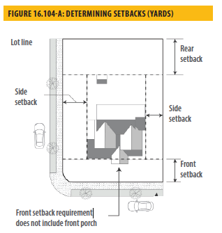
16.104.07 - Determining setbacks.
A setback line defining a required yard is parallel to and at the specified distance from the corresponding front, side, or rear lot line. The following regulations for determining yards apply when a lot abuts a proposed street or alley. For non-rectilinear parcels, setbacks shall be determined in accordance with the standards for measuring parcel width and depth in Section 16.104.11, Measuring Lot Width and Depth.
A.
Yards abutting planned street expansions. If a property abuts an existing or proposed street for which the existing right-of-way is narrower than the right-of-way ultimately required for the street, the required setback shall be established from the future right-of-way rather than the property line.
Yards on alleys.
1.
If a side lot line abuts any alley, the yard shall be considered an interior side yard rather than a corner side yard.
2.
In computing the minimum yard for any lot where such yard abuts an alley, no part of the width of the alley may be considered as part of the required yard.
B.
Measuring setbacks or yards. Setbacks shall be measured as the distance between the nearest lot line and the closest point on the exterior of a building or structure, excluding building projections permitted by Section 16.501.07, Projections Into Required Yards, along a line at right angles from the adjacent right-of-way. Setbacks shall be unobstructed from the ground to the sky unless an easement encroachment has been authorized or exceptions have been made, subject to compliance with the Building Code.
C.
Unknown property lines. Where the property line of a developed lot is not known, the director shall require an applicant to submit a survey by a licensed Professional Land Surveyor to verify or establish a property line.
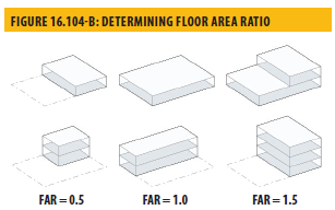
16.104.08 - Determining floor area ratio.
The floor area ratio (FAR) is the ratio of the floor area, excluding the areas described below, of all principal and accessory buildings on a site to the site area. To calculate the FAR, floor area is divided by lot area, and typically expressed as a decimal. For example, if the floor area of all buildings on a site totals twenty thousand square feet, and the site area is ten thousand square feet, the FAR is expressed as 2.0.
A.
Excluded from Floor Area in Calculating FAR. The following are excluded from the floor area when calculating FAR:
1.
Underground Areas. Floor area located below finished grade.
2.
Parking. Parking areas located below finished grade or finished floor of habitable space where the vertical distance between finished grade and finished floor is five feet or less. Structured parking areas located above finished grade where the vertical distance between finished grade and the floor of the parking level is five feet or less.
B.
Lot Area Adjustments When Calculating FAR. The following adjustments to the lot area shall be made when calculating FAR:
1.
Vehicular Easements. (Excluding easements for utility purposes), private streets and the pole portion of flag lots shall be excluded from the calculation of lot area.
2.
Street Dedications. If a street dedication is required, the calculation shall be based on the total area of the lot excluding the street dedication area.
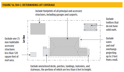
16.104.09 - Determining lot coverage.
Lot coverage is the ratio of the total footprint area of all structures on a lot to the lot area, typically expressed as a percentage. The footprints of all principal and roofed accessory structures, including garages, carports, and roofed porches and decks shall be summed in order to calculate lot coverage. The following structures shall be excluded from the calculation:
A.
Unenclosed, unroofed decks, uncovered patio slab, porches, landings, balconies and stairways less than six feet in height;
B.
Eaves and roof overhangs projecting up to three feet from a wall;
C.
Trellises and similar structures that do not have solid roofs; and
D.
Swimming pools and hot tubs that are not enclosed in roofed structures.
E.
Dog houses, children's playhouses, garbage enclosures, accessory structures less than one hundred twenty square feet and other similar structures, provided they are less than six feet in height.
16.104.10 - Measuring distances.
A.
Measurements are Shortest Distance. When measuring a required distance, such as the minimum distance between a structure and a lot line, the measurement is made at the closest or shortest distance between the two objects.
B.
Distances are Measured Horizontally. When determining distances for setbacks and structure dimensions, all distances are measured along a horizontal plane from the appropriate line, edge of building, structure, storage area, parking area, or other object. These distances are not measured by following the topography or slope of the land.
C.
Measurements Involving a Structure. Measurements involving a structure are made to the closest support element of the structure and include portions of the structure above or below the ground.
D.
Measurement of Vehicle Stacking or Travel Areas. Measurement of a minimum travel distance for vehicles, such as garage entrance setbacks and stacking lane distances, are measured along the shortest side of the vehicle path. For example, curving driveways and travel lanes are measured along the shortest path of the driveway or travel lane.
E.
Measuring a Buffer or Radius. When a specified land use is required to be located a minimum distance from another land use, the minimum distance is measured in a straight line from all points along the lot line of the subject project, in all directions.
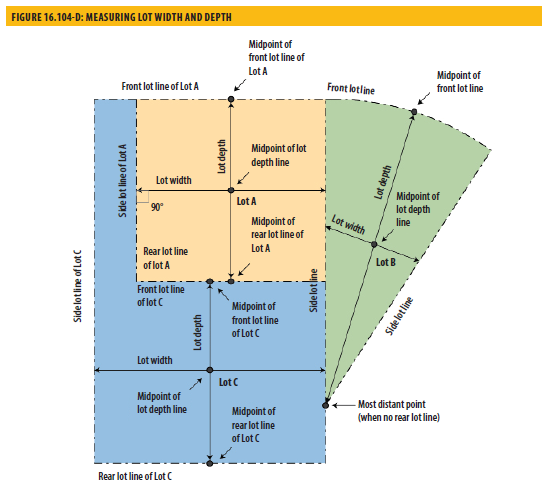
16.104.11 - Measuring lot width and depth.
Figure 16.104-D: Measuring Lot Width and Depth, shows the various ways to calculate lot width and depth as described below. Lot A represents a rectilinear lot, Lot B a non-rectilinear lot, and Lot C a flag lot.
A.
Lot Width. Lot width is the horizontal distance between the side lot lines, measured at right angles to the lot depth at a point midway between the front and rear lot lines.
B.
Lot Depth. Lot depth is the horizontal distance between the front and rear property lines measured along a straight line drawn from the midpoint of the front lot line to the midpoint of the rear lot line or to the most distant point on any other lot line where there is no rear lot line.
16.104.12 - Determining grade.
Grade is the location of the ground surface. For purposes of the Zoning Code, the grade of a building site used to determine building height shall be determined by one or more of the following:
A.
Existing Grade. The existing elevation of the ground at any point on a lot prior to grading for development. Existing grade may also be referred to as natural grade.
B.
Finished Grade. The lowest point of elevation of the finished surface of the ground, paving, or sidewalk within the area between the building and the lot line, or when the lot line is more than five feet from the building, between the building and a line five feet from the building.
C.
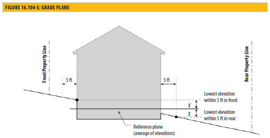
Grade Plane. A reference plane representing the average elevation of the highest and lowest point of the finished surface of the ground adjoining the exterior building walls as defined in the California Building Code. Where the finished ground level slopes away from the exterior walls, the reference plane shall be established by the lowest points within the area between the building and the lot line or, where the lot line is more than five feet from the building, between the building and a point five feet from the building.
16.104.13 - Measuring building height.
A.
The height of a proposed residential structure or addition is measured from the average elevation of that portion of the lot covered by the proposed residential structure or addition to the highest point of the roof with the following exceptions:
1.
In the case of a roof with parapet walls, height is measured to the top of the parapet wall;
2.
In the case of a gambrel roof, the average height of the roof is measured to a point between the ridge and the point where the uppermost change in the roof slope occurs; and
3.
In the case of a mansard roof, height is measured to the upper level of the roof deck.
B.
Dormers, as defined in Chapter 16.701, Land Use Terms and Definitions, shall not be included in the average height calculation.
C.
If a single structure crosses a zoning district boundary (e.g., where one structure is located in two or more different zoning or height districts), the maximum height shall be measured separately for each portion of the structure in order to ensure compliance with the zoning district in which it is located.
D.
Building height calculations shall exclude rooftop appurtenances and features that do not contain conditioned space and are not intended for human occupancy, and public utility facilities, which by design or function must exceed the established height limits as provided for in Section 16.501.05, Height Exceptions.
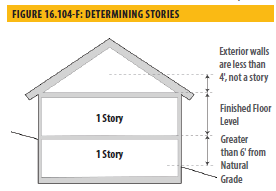
16.104.14 - Determining the number of stories in a building.
A.
A building story is that portion of a building between the upper surface of any floor and the upper surface of the floor next above, except that the topmost story shall be that portion of a building included between the upper surface of the topmost floor and the ceiling or roof above.
1.
If the finished floor level directly above a basement or cellar is more than six feet above natural grade for more than fifty percent of the total perimeter, such basement or cellar shall be considered a story.
2.
A partial story under a gable, hip, or gambrel roof shall be considered a story when its top wall plates, on at least two opposite exterior walls, are four feet or more above the floor of such story.
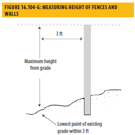
16.104.15 - Measuring height of fences and walls.
The height of any fence or wall shall be determined by measuring the vertical distance from the lowest finished grade within a three-foot radius of any point on the fence or wall to the highest point of any portion of the fence or wall. In the case of fences or walls between the setback line and lot line, height shall be measured from highest finished grade adjacent to the fence or wall to the top of the fence or wall.
A.
Measuring Height of Fences on Retaining Walls. The height of a fence that is on top of a retaining wall is measured from the lowest finished grade point within a three-foot radius of any point on such fence to the highest point of the fence on the highest side of the wall. Any fence or railing required to comply with minimum height in applicable Building Code requirements is permitted.
B.
Measured in a Continuum. The height shall be measured in a continuum at each point along the wall or fence.
16.105.01 - Purpose and applicability.
The purpose of these regulations is to permit the continuation of uses and continued occupancy and maintenance of structures that were legally established but do not comply with all of the standards and requirements of the Zoning Code in a manner that promotes the public health, safety, and general welfare and does not conflict with the goals and objectives of the General Plan. These regulations are also intended to:
A.
Permit non-conforming structures and uses to remain as long as they are not determined to be public nuisances, as defined in Title 7, Article III of the Vallejo Municipal Code, and to allow for their regular maintenance and repair consistent with the regulations herein.
B.
Reduce the number of non-conforming structures and uses that are no longer appropriate in the zoning districts in which they are located after abandonment, destruction, or major damage.
C.
Permit the reestablishment of legally established residential units to provide additional housing opportunities for the community without changing the historic density and character of older residential areas.
D.
Limit the number and extent of non-conforming structures by prohibiting their movement, alteration, restoration, or enlargement in a manner that would increase the nonconformity between the existing conditions and the current standards for the zoning districts in which they are located.
E.
Permit the development of non-conforming lots in appropriate circumstances consistent with the regulations of this chapter and the provisions of the Subdivision Map Act.
16.105.02 - Establishment of legal non-conforming uses, structures and lots.
A.
Any legally established use, structure, or lot that is in existence on the effective date of the Zoning Code or any subsequent amendment but does not comply with all of the standards and requirements of the Zoning Code shall be considered non-conforming. Non-conforming uses and structures may only be continued subject to the requirements of this chapter.
B.
These regulations shall apply to all non-conforming lots, structures, and uses, except for those within the Mare Island Specific Plan area.
C.
The provisions of these non-conforming regulations do not restrict any authority to require modification or termination of any non-conforming use or structure that has been declared to be a public nuisance by the city council, pursuant to Title 7, Chapter III of the Vallejo Municipal Code.
D.
Non-conforming uses, structures, and lots include:
1.
Those made non-conforming by the addition of a standard or requirement of the Zoning Code previously not required for such use or structure; and
2.
Uses and structures reclassified from permitted to being subject to a discretionary permit.
3.
Uses and structures reclassified from permitted or being subject to a discretionary permit to being non-permitted or not allowed with a discretionary permit.
E.
Nothing contained in the Zoning Code shall be deemed to require any change in the plans, construction, or designated use of any building or structure for which a Building Permit has properly been issued, in accordance with the provision of ordinances then in effect and upon which actual construction has been started prior to the Effective Date of the Zoning Code, provided that in all such cases, actual construction shall be diligently carried on until completion of the building or structure.
16.105.03 - Nonconformities.
A.
A nonconformity may result from any inconsistency with any one or more requirements of the Zoning Code including, but not limited to, location, density, intensity, floor area, coverage, height, yard, usable open space, buffering, performance standards, or the lack of an approved use permit, development review permit, or other required authorization.
B.
A use or structure shall not be deemed non-conforming solely because it does not conform with the parking dimension standards, overnight vehicle parking limitations, loading, planting area, or screening regulations of the zoning district in which it is located, or does not conform to the standards for the following building features:
1.
Garage door location or garage door width;
2.
Cornices, eaves, and other ornamental features that exceed maximum projections into required yards; or
3.
Bay windows, balconies, and terraces above the second floor that exceed maximum projections into required yards. Also see, Section 16.508.02(D), Non-conforming Parking.
16.105.04 - Non-conforming uses and structures—Right to continue.
Any use or structure that was lawfully established prior to the effective date of the Zoning Code or of any subsequent amendments to its text or to the zoning map may only be continued and maintained provided there is no alteration, enlargement, or addition to any use, building or structure including, but not limited to:
A.
No substitution, expansion, or other change in use nor any alteration or other change in structures, except as otherwise provided in this chapter.
B.
The right to continue a non-conforming use or structure shall attach to the land and shall not be affected by a change in ownership.
16.105.05 - Non-conforming lots.
Any lot that is smaller than the minimum lot size required by the Zoning Code or does not meet any of the applicable dimensional requirements shall be considered a legal non-conforming lot if it is described in the official records on file in the office of the Solano County Recorder as a lot of record under one ownership. A non-conforming lot may be used as a building site subject to compliance with all applicable requirements, unless a Variance or other modification or exception is approved as provided for in this Zoning Code.
A.
A non-conforming lot shall not be adjusted in any way that would increase the nonconformity in any way.
B.
A conforming structure or use may be established on a non-conforming lot provided the structure or use conforms to the current standards of the zoning district in which it is located or meets the exception requirements in Chapter 16.608, Exceptions.
C.
A non-conforming lot within a residential zoning district shall conform to the maximum allowable density of that zoning district. However, at a minimum, one single-unit dwelling unit and customary accessory buildings may be established on a non-conforming lot, provided the unit and accessory buildings conform to the current standards of the zoning district.
16.105.06 - Non-conforming structures.
A.
Ordinary maintenance and repairs or nonstructural alterations are encouraged and may be made to a non-conforming structure as required to improve and preserve the structure's existing condition, retard or eliminate wear or tear or physical deterioration, render space more usable, improve livability, or comply with the requirements of law.
B.
A non-conforming structure shall not be moved unless it results in more conformity with the current standards of the zoning district of the new location.
C.
Non-conforming structures not in a designated heritage or historic district may be restored as follows:
1.
A non-conforming structure that is damaged, destroyed, or voluntarily demolished to the extent of less than fifty percent of the current market value may be restored with development review approval pursuant to Chapter 16.605, Development Review. The determination of the appraised value shall be the higher of:
a.
The records of the Assessor of the County of Solano for the fiscal year during which the application is received; or
b.
An appraisal performed by a certified appraiser.
2.
Restoration shall be authorized and completed within twelve months of the date the damage, destruction, or demolition occurred. Failure to complete the restoration within twelve months, except as provided in Section 16.105.12, Time Extensions, may result in abatement pursuant to Chapter 7.54, Property Maintenance, of the Vallejo Municipal Code.
3.
A non-conforming structure that is damaged, destroyed, or voluntarily demolished to the extent of fifty percent or more of the current market value may be restored to its original condition or to a more conforming condition provided a major use permit is issued by the planning commission after making the findings required in Chapter 16.606, Minor and Major Use Permits. The restoration of the structure shall be authorized and completed within twelve months of the date of the damage, destruction or demolition. Failure to complete the restoration within twelve months, except as provided in this chapter may result in abatement pursuant to Chapter 7.54, Property Maintenance, of the Vallejo Municipal Code.
4.
A non-conforming structure in a designated heritage or historic district may be restored to its original condition or to a more conforming condition with the approval of a certificate of appropriateness, pursuant to Chapter 16.614, Architectural Heritage and Historic Preservation. The restoration of the structure shall be authorized and completed within twelve months of the date of the damage, destruction, or demolition. Failure to complete the restoration within twelve months may result in abatement pursuant to Chapter 7.54, Property Maintenance, of the Vallejo Municipal Code.
D.
If the non-conforming structure is required by law to be demolished, the structure shall not be restored except in full conformity with the current standards for the zoning district in which it is located.
E.
For the purposes of this chapter, the extent of damage, destruction, or demolition shall be based on the ratio of the estimated market appraised value of the structure prior to such damage, destruction, or demolition to the estimated cost of duplicating the entire structure as it existed prior thereto. Estimates for this purpose shall be made in writing by the applicant and shall be reviewed by the director and the chief building official and the director. Their final determination of estimated market appraised value by the chief building official and director shall be considered final.
16.105.07 - Non-conforming uses.
The following provisions shall apply to all non-conforming uses, except for residential uses made non-conforming from reductions in density that are subject to the provisions of Section 16.105.08, Non-conforming Residential Units Resulting From Reductions In Density. No lawful residential use can lapse regardless of the length of time of non-use.
A.
Non-conforming uses may be continued indefinitely subject to the provisions of this chapter.
1.
A non-conforming residential use shall not intensify in terms of exceeding the residential density allowed by the applicable General Plan land use or zoning district in which the use is located.
2.
The non-conforming use of a structure or portion of structure shall not be expanded into any other portion of the structure nor changed except to a conforming use.
3.
If a non-conforming use ceases activity for a continuous period of twelve months, it shall be considered abandoned. Thereafter, the structure in which the non-conforming use was located shall be used only in accordance with the standards for the zoning district in which it is located. Abandonment or discontinuance shall include the cessation of a use for any reason, regardless of intent to resume or not abandon the use, except as provided in Sections B and C below. An active building permit shall indicate the use is not abandoned.
4.
If the primary structure occupied by a non-conforming use is hereafter removed, the subsequent use of the land on which such structure was located and the subsequent location and use of any new structure thereon shall be in conformity with the standards of the zoning district in which the land is located.
5.
No accessory use to a primary non-conforming use shall continue after such primary use ceases or is terminated.
6.
A non-conforming use may be reestablished when the structure occupied by the non-conforming use is damaged, destroyed, or voluntarily demolished by less than fifty percent of the estimated market appraised value is restored to its original condition or a more conforming condition with the approval of a development review permit, pursuant to the Zoning Code. Restoration of the structure shall be completed within twelve months of the date the damage or partial destruction occurred. Failure to complete the restoration within twelve months, except as provided in Section 16.105.14, Time Extensions, means the non-conforming status of the use is terminated and the use shall not be reestablished. Further, the failure to complete the restoration within twelve months may result in abatement of the structure pursuant to Chapter 7.54, Property Maintenance, of the Vallejo Municipal Code.
B.
If a structure occupied by a non-conforming use is damaged, destroyed, or involuntarily demolished by fifty percent or more of the current market value, the non-conforming use may be restored under the following conditions:
1.
If the structure is restored to its original conditions and conforms to all the current standards of the zoning district in which it is located with the approval of a development review permit, pursuant to Chapter 16.105, Non-Conforming Uses; and
2.
Provided the Planning Commission, pursuant to Chapter 16.105 Non-Conforming Uses, approves a Major Use Permit.
C.
The restoration of the structure shall be authorized and completed within twelve months of the date of the damage or destruction. Failure to complete the restoration within twelve months, except as provided in Section 16.105.14, Time Extensions, Time Extensions, means the non-conforming status of the use is terminated and the use shall not be reestablished. Further, the failure to complete the restoration within twelve months may result in abatement of the structure pursuant to Chapter 7.54, Property Maintenance, of the Vallejo Municipal Code.
D.
If a structure occupied by a non-conforming use is required by law to be demolished, the structure shall not be restored except in full conformity with the current standards for the zoning district in which it is located with the approval of a development review permit, pursuant to Chapter 16.600, Procedures And Permits. The non-conforming status of the use shall be terminated, and the use shall not be reestablished.
E.
For the purposes of this chapter, the extent of damage, destruction, or demolition shall be based on the ratio of the appraised value of the structure at the time of such damage, destruction, or demolition to the estimated cost of duplicating the entire structure as it existed prior thereto. Estimates for this purpose shall be made in writing by the applicant and shall be reviewed by the chief building official and director as follows:
1.
The chief building official or the director may require submittal of an appraisal by a qualified real estate appraiser if the estimates are disputed by any affected party.
2.
The cost of such an appraisal shall be the responsibility of the applicant.
3.
Determinations of estimated market value by the chief building official and director resulting in controversy shall be forwarded to the Planning Commission for final determination.
F.
A use that does not conform with the parking, loading, landscaping, screening, or sign regulations of the zoning district in which it is located shall not be considered a non-conforming use solely because of one or more of these physical nonconformities.
G.
Once a non-conforming residential unit is abandoned, and unless a certificate of conformity has been issued pursuant to Section 16.105.08, Non-conforming Residential Units Resulting From Reductions In Density, the chief building official and/or director may require the removal of features of the unit contributing to the nonconformity. These features include, but are not limited to, multiple kitchens, multiple exterior doors and walls defining individual units.
16.105.08 - Non-conforming residential units resulting from reductions in density.
Non-conforming residential units resulting from decreases in density or other changes in zoning may be reestablished after ceasing activity for more than twelve months under the circumstances described below.
A.
Reestablishing the Conformity of a Non-conforming Residential Unit. It shall be the responsibility of the applicant seeking a certificate of conformity to provide substantial evidence to support the required findings. Such evidence could include, but not be limited to, the following:
1.
Completed application form;
2.
Application fee, as established by the Master Fee Schedule; and
3.
Substantial evidence to support the required findings in Section (5), below, with the applicant responsible for the burden of proof as defined in Section 16.105.13, Burden of Proof including:
4.
Plans showing original construction of the unit.
5.
Copies of building permits and/or other authorization for the unit.
6.
Historic photographs and/or documents.
7.
Written declarations made under the penalty of perjury.
8.
Upon receipt of a complete application, the director shall provide a public notice pursuant to Chapter 16.602, Common Procedures.
9.
The director shall issue a certificate of conformity only if, based on substantial evidence, all the following findings are made:
a.
The unit was originally and legally constructed (as can best be determined by available plans, permits, and other documentation) either as part of a multi-unit structure or as a separate structure within a group of units on one parcel;
b.
The reestablishment of the unit will not be detrimental to any existing or potential use or structure in the zoning district in which the non-conforming use is located. (Issues to be considered include but shall not be limited to the availability of parking, aesthetics, privacy, and physical compatibility with adjacent properties);
c.
The structure containing the unit cannot be easily converted for a use which conforms to the current zoning district; and
d.
If the structure is on the city's historic resources inventory, the loss of the non-conforming unit could result in the degradation of the architectural integrity of the structure or other adjacent structures or could result in the loss of the structure.
10.
Appeals shall be processed and acted upon in compliance with Chapter 16.602, Common Procedures.
11.
Once a certificate of conformity is issued, the unit shall be considered conforming. This conforming status shall not be lost, except as described in Section (B), below, even if the unit is not occupied for over twelve months.
B.
All units reestablished under the provisions of this chapter shall be brought into compliance with current building and housing codes, including the state historic building code for eligible structures, as determined necessary by the chief building official, within six months of the date of the certificate of conformity. Failure to complete all required improvements within the six-month period may result in the revocation of the certificate and the termination of the unit, except as provided in Section 16.105.07, Non-conforming Uses.
16.105.09 - Changes and substitutions of non-conforming uses.
No legal non-conforming use shall be changed to a different use type or sub-classification without the approval of a major use permit unless the new use is a principally permitted use.
This requirement shall not apply to a change of ownership, tenancy, or management where the new use is of the same use type and use classification, if applicable, as the previous use, as defined in Part VII, and the use is not expanded or intensified. For the purposes of this chapter, intensification includes an increase in the number of vehicle trips generated by a use, parking demand, number of employees on a site, hours of operation, and other similar characteristics as determined by the director.
16.105.10 - Change from non-conforming to permitted use.
Any non-conforming use may be changed to a principally permitted use in the zoning district in which it is located and complies with all applicable standards for such use.
16.105.11 - Absence of permit.
Any use that is non-conforming solely by reason of the absence of a use permit may be changed to a conforming use by obtaining a minor use permit pursuant to the requirements in Chapter 16.606, Minor and Major Use Permits.
16.105.12 - Time extensions.
There shall be no extension of time granted for an abandoned non-conforming use or structure, except as noted in Sections 16.105.06, Non-conforming Structures, and 16.105.07 Non-conforming Uses.
A.
In the event of judicial proceedings pertaining to the non-conforming use or structure that prevent the active operation of the use or occupation of the structure, the use or structure shall be considered abandoned if active operation or occupation has not occurred within twelve months after the conclusion of the judicial proceedings.
B.
The director may grant an extension of time, not to exceed an additional twelve months, to complete the authorized restoration of a non-conforming structure if the following findings are made:
1.
An unreasonable hardship would otherwise be imposed on the applicant;
2.
The delay in completing the restoration was beyond the control of the applicant; and
3.
The extension of time to complete the restoration would not be detrimental to any existing or potential permitted use or structure in the zoning district in which the structure is located.
16.105.13 - Burden of proof.
A.
Continuing the Non-conforming Status of a Structure or Use. It shall be the responsibility of the party interested in continuing the non-conforming status of a structure or use to prove that the structure or use is in active operation. Such proof could include, but not be limited to, the following:
1.
Active building permits;
2.
Judicial proceedings, including probate;
3.
Rental receipts;
4.
Utility records showing service periods and levels of consumption consistent with the active operation of the use or structure; and/or
5.
Records documenting efforts to actively rent, market, or sell the use or structure.
B.
The burden of proof shall be met only if the following findings can be made:
1.
The use or structure was permitted when established;
2.
No conditions have occurred since the legal establishment that would require its abatement; and
3.
No unauthorized expansion, enlargement, or intensification of the use or structure has occurred and currently exists.