
Vallejo City Zoning Code
PART II
DISTRICTS AND DEVELOPMENT TYPES
Chapter 16.201 through Chapter 16.215, inclusive, shall be known as the basic zoning districts.
16.201 - Zoning districts and development standards.
This section describes the zoning districts that are consistent with and implement the general plan. The zoning districts and corresponding general plan designations are provided in Table 16.201-A: Zoning District and General Plan Land Use Designation.
This section also provides the development regulations applicable to each zoning district. These standards are supplemented by Part V (16.500) Site Development Standards, of this Zoning Code. Whenever there is a conflict in the general plan and Zoning Code standards, the general plan shall prevail.
16.202.01 - Purpose and applicability.
The purposes of the Residential ("R") Districts are to:
A.
Preserve, protect, and enhance the character of the city's residential neighborhoods.
B.
Ensure adequate light, air, and open space for each dwelling.
C.
Ensure that the scale and design of new development and alterations and additions to existing structures are compatible with surrounding homes and appropriate to the physical characteristics of the site and the surrounding area.
D.
Promote opportunities for housing for all income groups and for those with special housing needs.
E.
Provide sites for public and semi-public land uses.
More specifically, the purposes of the individual residential zoning districts are as follows:
RR Rural Residential: The RR Zoning District is intended for rural residential, agriculture, open space, and very low-density residential development with necessary supporting public service facilities.
RLD Residential Low Density: The RLD Zoning District is for low-density residential areas in which permanent single unit residences, including detached and attached (duplexes and townhouses) units, are the primary use. Other residential types including cottages and bungalows around courts may be seen in this district as well as small neighborhood serving retail. This district also allows a variety of neighborhood supportive services, public and educational facilities, open spaces and community facilities. The maximum permitted residential density is nine dwelling units per acre, excluding accessory dwelling units.
RMD Residential Medium Density: The RMD Zoning District is intended to create and establish regulations for a district with a mix of housing types, including attached and detached, and small apartment buildings, subject to density limits (up to twenty-five dwelling units per acre) and design and development standards to ensure land use compatibility. Mixed-use development with residential and small commercial spaces may also be seen in this district. This district also allows a variety of neighborhood supportive services, public and educational facilities, open spaces and community facilities. Front, corner side, and rear yards are required, and zero-side yard development is permitted subject to discretionary review. In the established neighborhoods of the city, it is the intent of this district to maintain the existing pattern of single-family residences, including attached units and duplexes, while in the undeveloped areas of the city, it is the intent of this district to encourage the creation of multi-unit residential neighborhoods with a variety of housing types.
RHD Residential High Density: The RHD Zoning District is intended to create and establish regulations for a high-density residential district, in which a mix of housing types are allowed, subject to density limits (up to forty dwelling units per acre) and design and development standards to ensure land use compatibility. Mixed-use development with residential and small commercial spaces is allowed. This district also allows a variety of neighborhood supportive services, public and educational facilities, open spaces and community facilities.
16.202.02 - Development regulations - RR and RLD districts.
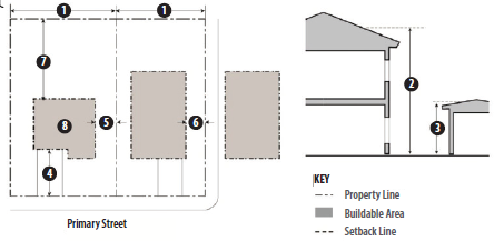
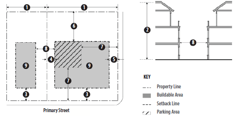
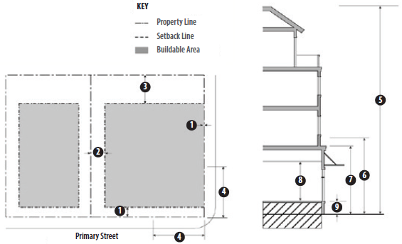
Table 16.202-A: Development Standards - RR and RLD Districts, prescribes the development standards for the RR and RLD Zoning Districts. The numbers in the illustration refers to corresponding regulations in the "#" column. Additional regulations are denoted in the fourth column where chapter numbers refer to other parts of the Zoning Code, and individual letters refer to sections as additional development standards that directly follow the table. Diagrams below depict primary structures. See Section 16.501.02, Accessory Buildings and Structures.
TABLE 16.202-A: DEVELOPMENT STANDARDS - RR AND RLD DISTRICTS
 | ||||
|---|---|---|---|---|
| FIG # | DISTRICT | RR | RLD | ADDITIONAL REGULATIONS |
| LOT AND DENSITY STANDARDS | ||||
| Maximum Density (units/net acre) | 9 | 9 | ||
| Minimum Lot Size (sq. ft.) | 2.5 acres (5 acres in -5; 10 acres in -10; and 15 acres in -15) | 5,000 | See Section 16.202.05, Small Lot Development | |
| ① | Minimum Lot Width (ft.) | (A) | 50 | |
| BUILDING FORM AND LOCATION | ||||
| Maximum Height (ft.) | ||||
| ② | Main Building | 35 (B) | 35 (B) | See Section 16.104.13, Measuring Building Height, and Section 16.501.02, Accessory Buildings and Structures |
| ③ | Accessory Building | 14 (B) | 14 | |
| Minimum Setbacks (ft.) | ||||
| ④ | Front | 30 (A) | 15 (A) | See Section 16.501.07, Projections Into Required Yards |
| ⑤ | Interior Side | 20 (A) | 5 (A) | |
| ⑥ | Street Side | 20 (A) | 10 (A) | |
| ① | Rear | 20 (A) | 5 (A) | |
| ④ ⑦ | Garage Front/Rear | 20/20 | 20/5 | |
| Minimum Distance between Buildings (ft.) | 30 | 5 | ||
| ⑧ | Maximum Lot Coverage (% of Lot) | - | 50 | See Section 16.202.05, Small Lot Development, and Chapter 16.104, Rules For Measurement |
| PARKING | ||||
| On-site spaces per Unit (Total) | 1 | 1 | See Section 16.501.05, Height Exceptions | |
| On-site spaces per Unit (covered) | 1 | 1 | ||
| LANDSCAPING AND FENCING | ||||
| Front Yard | Required | See Chapter 16.504, Landscaping | ||
| Street Trees | 1 per 50 ft. of frontage | |||
|
Fence Height Limit (ft)
Rear and Side | 6 | 6 | A one-foot extension up to 7 feet with a decorative finish such as lattice is allowed. See Chapter 16.505, Fences, Walls, and Screening | |
| ADDITIONAL STANDARDS | ||||
| Exceptions to Height Limits | See Section 16.501.05, Height Exceptions | |||
| Fences and Walls | See Chapter 16.505, Fences, Walls, and Screening | |||
| Lighting | See Chapter 16.506, Lighting and Glare | |||
| Off-Street Parking and Loading | See Chapter 16.508, Off-Street Parking and Loading | |||
| Hillside Development Standards | See Chapter 16.212, Hillside Development Standards | |||
| Accessory Structures | No accessory structure in the RLD Zoning District shall exceed 1,000 sq. ft. in floor area. See Section 16.501.02, Accessory Buildings and Structures | |||
| Projections Into Required Yards | See Section 16.501.07, Projections into Required Yards | |||
A.
Additional Development Standards for RR and RLD Districts.
1.
Lot Dimensions. The ratio of lot depth to lot width shall not be greater than 4:1.
2.
Building Height. Height shall not exceed thirty-five feet. Accessory structures shall not exceed fourteen feet.
3.
Setback for Structures to Contain Animals.
a.
Yards abutting streets: Sixty feet and twenty feet for corrals and paddocks.
b.
Other yards: Twenty feet plus two feet for each foot of building height over fourteen feet.
4.
Variable Yards - Interior Lots. One yard: ten feet and the other: five feet plus two feet for each foot of building height over twenty-four feet.
5.
Exceptions to Required Depth of Side Yards.
a.
Lots less than fifty feet Wide. The depth of a side yard on a lot less than fifty feet wide may be reduced to ten percent of width of the lot provided:
i.
The lot was recorded with Solano County prior to the adoption of Ordinance No. 15 N.C. (March 19, 1947);
ii.
The yard does not abut a street;
iii.
The building constructed does not exceed one story within five feet of the property line; and
iv.
The minimum setback is three feet.
b.
Lot Shown on Approved Tentative Map. The setback of a side yard on a lot shown on a tentative map approved prior to February 24, 1970, may be reduced to a minimum of five feet upon director approval.
6.
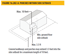
Side Setback Projection. Covered walkways, porches, and verandas may project up to three feet into the required side setback for a maximum length of ten feet. (See Figure 16.202-A)
7.
Side Setback for Narrow Lots.
a.
Minimum. The minimum side setback for lots with an average width of forty-five feet or less shall be a minimum of ten percent of the lot width, or three feet on one side, whichever is greater.
b.
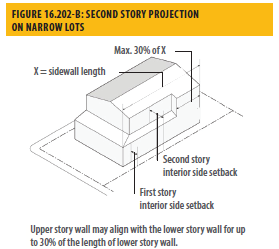
Second Story Projection. On lots less than forty-five feet in width, the upper story wall may project a maximum of four feet into the required second story setback for up to thirty percent of the length of the lower story wall. (See Figure 16.202-B)
8.
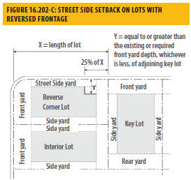
Street Side Yards on Lots with Reversed Frontage. The rear one-quarter of the street side yard shall not be less than the front yard required or existing on the lot adjoining such street side yard. (See Figure 16.202-C)
9.
Rear Setback. In the RLD district, the rear setback may be reduced to ten feet if the rear setback for abutting lots is ten feet.
16.202.03 - Design standards for single unit housing (detached and attached).
A.
Design of Building Additions. Rooflines, exterior materials, windows, railings, porches, and other design elements shall be designed in the same style as the existing building unless an alternative design is approved through Chapter 16.605, Development Review.
B.
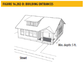
Building Entrances. The principal entry shall be in a visible location facing the street and shall incorporate a projection (e.g., porch) or recess, with a minimum depth of five feet. A reduction in the depth of the projection or an alternative design that create a welcoming entry feature facing the street, such as a trellis or landscaped courtyard entry, and other design approach that is typical of the architectural style of the building based on documentation provided by the applicant may be approved subject to the provisions of Chapter 16.605, Development Review. (See Figure 16.202-D for example.)
C.
Architectural Articulation. Buildings shall include design features to create visual variety and avoid a large-scale and bulky appearance.
1.
No street-facing facade shall run in a continuous plane of more than twenty-five feet without a window or a minimum four-foot projection, offset, or recess of the building wall at least one foot in depth. Building entrances and front porches, and projections into required front or street side yards such as stoops, bays, overhangs, chimneys, and trellises count towards this requirement.
2.
Building elevations abutting street side yards shall be designed to provide at least one horizontal plane break of at least 3 feet, and one vertical break of at least one foot. Alternative designs to create consistency with the architectural style of the building may be approved subject to the provisions of Chapter 16.605, Development Review.
3.
Materials. All materials shall allow for long-term durability and appearance. The exterior use of plywood or unfinished aluminum as siding materials is prohibited unless approved by the director following review and approval under Chapter 16.605, Development Review.
D.
Garage Frontage.
1.
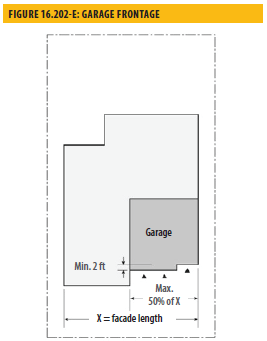
Where an attached garage is located on the front half of the lot and garage doors face a street, garage width shall not exceed fifty percent of the width of the front facade of the building (forty percent on lots wider than one hundred feet). (See Figure 16.202-E)
2.
On front facades with both a two-car garage and a separate single car garage, (a total of three garage doors) the facades of the two garages must be offset a minimum of two feet.
E.
Paving. The maximum amount of paving (impervious surface) in street-facing yards is fifty percent of the required yard.
F.
Driveways. In addition to any other applicable requirements of Chapter 16.508, Off-Street Parking and Loading, curb cuts and driveways shall comply with the following:
1.
Driveway approaches (curb cuts) are permitted only to provide access to garages, carports and parking spaces.
2.
A maximum of one driveway up to 20 feet wide is permitted to serve a single unit. Driveways serving two or more units shall be the minimum width required by the Zoning Code.
3.
All driveways shall be setback at least 5 feet from side property lines.
4.
Driveways must have minimum three-foot wide planted area along a side or rear lot line.
G.
Alley Access. A detached garage or carport is permitted to have access to the alley if:
1.
The garage or carport entrance is setback a minimum of 5 feet from the rear property line;
2.
The garage door does not cross the property line when opened or closed;
3.
The alley is paved; and
4.
The director or traffic engineer finds that such access will not adversely affect vehicle or pedestrian use of the alley.
TABLE 16.202-B: DEVELOPMENT STANDARDS - RMD AND RHD DISTRICTS
 | ||||
|---|---|---|---|---|
| FIG # | DISTRICT | RMD | RHD |
ADDITIONAL
REGULATIONS |
| LOT AND DENSITY STANDARDS | ||||
| Density (units/net acre) | Max. 25 | Max. 40 | ||
| Minimum/Maximum Density (units/net acre for Business/Limited Residential General Plan Designation) | n/a | Max. 50 | ||
| Minimum Lot Area per Unit (sq. ft.) | 1,740 | 1,100 | ||
| Minimum Lot Size (sq. ft.) | 5,000 | 5,000 | ||
| ① | Minimum Lot Width (ft.) | 50 | 50 | |
| BUILDING FORM AND LOCATION | ||||
| Maximum Height (ft.) | ||||
| ② | Main Building | 50 | 75 | See Section 16.501.05, Height Exceptions |
| Accessory Building | 14 | 14 | ||
| Minimum Setbacks (ft.) | ||||
| ③ | Front | 15 (A) | 15 (A) | See Section 16.501.07, Projections Into Required Yards |
| ④ | Interior Side | 5 for the first 2 stories, 10 thereafter (A) | ||
| ⑤ | Street Side | 10 (A) | 10 (A) | |
| ⑥ | Rear | 10 (A) | 10 (A) | |
| ⑦ | Parking, from street facing property line | 40 (A) | 40 (A) | See Section 16.202.04.A.5, Parking Setback |
| ⑧ | Minimum Distance between Buildings (ft.) as required by Fire and Building Codes or at least | 5 | 5 | |
| ⑨ | Maximum Lot Coverage (% of Lot) | 60 | 75 | |
| Maximum Upper Story Massing (% of Ground Floor Footprint) | ||||
| 2nd Story | 100 | |||
| 3rd Story and Above | 60 may be articulated through bays, relief, and architectural articulation | |||
| PARKING | ||||
| On-site spaces per Unit (covered) | 1 | 1 | ||
| On-site spaces per Unit (total) | See Chapter 16.508, Off-Street Parking and Loading, Table 16.508-B, Off Street Parking Requirements | See Chapter 16.508, Off-Street Parking and Loading | ||
| OPEN SPACE, LANDSCAPING AND PAVING | ||||
| Minimum Private Open Space (sq. ft. per unit) | 75 | 60 | See Section 16.202.04.A.6, Open Space and Chapter 16.504, Landscaping | |
| Minimum Total Open Space (sq. ft. per unit) | 150 | 120 | ||
| Required Additional Open Space for 3 or more bedrooms (sq. ft. per unit) | 100 (common or private) | |||
| Minimum Amount of Landscaping (% of site) | 30 | 25 | See Chapter 16.504, Landscaping | |
| Maximum Paving in Street-facing yards (% of required yard) | 50 | 50 | ||
| Street Trees | 1 per 50 ft. of frontage | See Chapter 16.504, Landscaping | ||
| ADDITIONAL STANDARDS | ||||
| Exceptions to Height Limits | See Section 16.501.05, Height Exceptions | |||
| Fences and Walls | See Chapter 16.505, Fences, Walls, and Screening | |||
| Lighting | See Chapter 16.506, Lighting and Glare | |||
| Off-Street Parking and Loading | See Chapter 16.508, Off-Street Parking and Loading | |||
| Hillside Development | See Chapter 16.212, Hillside Development Standards | |||
| Accessory Structures | No accessory structure in the RLD Zoning District shall exceed 1,000 sq. ft. in floor area. See Section 16.501.02, Accessory Buildings and Structures | |||
A.
Additional Development Standards — RMD and RHD Districts.
1.
Transitional Standards. Where an RMD or RHD District adjoins an RLD District, unless separated by a public right-of-way or other physical barrier:
a.
The building setback from the RLD District boundary shall be ten feet for interior side yards and twenty feet for rear yards; and
b.
A landscaped planting area, a minimum of five feet in width from the lot line, shall be provided along all RLD District boundaries. A tree screen shall be planted in this area, with trees planted at maximum interval of fifteen feet along with shrubs and or ground cover. (See Chapter 16.505, Fences, Walls, and Screening)
2.
Upper Story Setback - RHD District. The fourth story of a street-facing building frontage shall be stepped back a minimum of ten feet from the stories below. Exceptions may be granted by the director, provided that an entry courtyard with a minimum depth of twenty feet, landscaping, and seating amenities are provided on the ground level, subject to Chapter 16.608, Exceptions.
3.
Reduced Front Setback. Where seventy-five percent or more of the lots in a block, on both sides of the street, have been improved with buildings, the minimum front setback required for the entry element (stoop or projected porch) shall be the average of those on the improved lots or fifteen feet, whichever is less.
4.
Street Side Yards on Lots with Reversed Frontage. The rear one-quarter of the exterior side yard shall not be less than the front yard required or existing on the lot adjoining such exterior side yard.
5.
Parking Setback. Parking may be located within 40 feet of the street-facing property line in accordance with the following standards.
a.
Underground and Partially Submerged Parking. Parking completely or partially underground shall match the setbacks of the main structure. The maximum height of a parking podium visible from a street shall not exceed five feet from finished grade to the edge of the podium.
b.
Surface Parking. Above ground parking may be located within forty feet of a street facing property line with the approval of minor use permit when the all of following findings can be made:
i.
The building is close to the street edge and parking is off the primary street;
ii.
The design incorporates habitable space built close to the street facing to the maximum extent feasible;
iii.
The parking area is well screened with a wall, hedge, trellis, and/or landscaping; and
iv.
The site is small and constrained such that underground, partially submerged, or surface parking located more than 40 feet from the street frontage is not feasible.
v.
There are unusual site constraints such as the slope, grading, easements etc.
6.
Open Space. Private and common open space shall be provided in accordance with this section. Private areas consist of balconies, decks, patios, fenced yards, and similar areas outside the residence. Common open space consists of landscaped areas, walks, patios, swimming pools, barbeque areas, playgrounds, turf, or other improvements that enhance the outdoor environment. Landscaped courtyard entries that are oriented towards the public street and create a welcoming entry feature are also considered common areas.
a.
Minimum Dimensions.
i.
Private Open Space. Private open space located on the ground level (e.g., yards, decks, patios) shall have no dimension less than ten feet Private open space located above ground level (e.g., balconies) shall have no dimension less than six feet.
ii.
Common Open Space. Minimum dimension of fifteen feet.
b.
Usability. A surface within the common open space shall be provided that allows convenient use for outdoor living and/or recreation. Such surface may be any practicable combination of lawn, garden, flagstone, wood planking, concrete, or other serviceable, dust-free surfacing with a slope not exceeding 10 percent.
c.
Accessibility.
i.
Private Open Space. The space shall be accessible to only one living unit by a doorway or doorways to a habitable room or hallway.
ii.
Common Open Space. The space shall be accessible to all living units on the lot. It shall be served by any access way qualifying as an egress facility from a dwelling unit.
7.
Planting Areas.
a.
Setback Areas Adjoining Streets. All visible portions of a required yard adjoining a street shall be planting area or hard scape that includes parking areas, driveways and walks, as well as areas covered by ornamental gravel, crushed rock or similar materials.
b.
Interior Setback Areas. At least 50 percent of each required interior side setback and rear setback shall be planting areas having a minimum width of five feet adjoining a side or rear property line; provided, that the width of a required planting area may be reduced to two feet in one side or rear yard adjoining a driveway and an accessory structure may occupy a portion of the planting area in a rear yard.
c.
Adjoining an RLD District. A continuous planting area having a minimum five-foot width shall adjoin an RLD District.
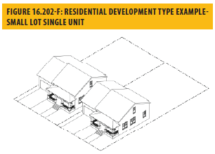
16.202.05 - Small lot development.
A.
Purpose. This section provides opportunities to increase the supply of smaller dwelling units and potential rental housing units in the by allowing housing development on smaller lots. It also is intended to establish design and development standards for these projects to ensure compatibility with the surrounding neighborhood where the general plan proposes no change to existing neighborhood character.
B.
Permit Required. Small lot development shall require a minor use permit pursuant to Chapter 16.606, Minor and Major Use Permits and Small Lot Subdivision Parcel or Tentative Map approval pursuant to Vallejo Municipal Code Title 15, Subdivisions. The minor use permit and small lot subdivision parcel map or tentative map may be submitted and considered concurrently.
C.
Location. Small lot development may be proposed and approved on any site within an RLD and RMD Zoning District where such development would be compatible with adjacent uses and the character of the area, and the density will not exceed the general plan maximum. A small lot development shall not be allowed where the director determines that such compatibility will not occur, public utilities and services are inadequate, or the landform is inappropriate for such development because of grading or impacts on views from adjacent lots.
D.
Lot Standards. The director or planning commission may approve smaller lots than required for the base district, but no less than two thousand square feet in area and twenty-five feet in width, upon finding that the scale of the development will be similar to that of surrounding development and will contribute to underserved segments of the city's housing market in addition to any other findings required by Chapter 16.606, Minor and Major Use Permits.
E.
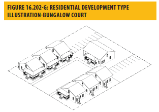
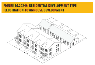
Permitted Development Types. This section illustrates development types allowed within all residential districts and provides supplemental standards for small lot single unit, bungalow court, and townhouse development types as defined in Part VII.
F.
Additional Development Standards — Small Lot Development Types.
1.
Entries are designed as prominent features, and garages are less dominant through:
a.
Minimum of four-foot setback
b.
Design features such as framing and trim and lights
2.
Small lot development types shall be subject to the development standards in Table 16.202-C: Development Standards - Small Lot Single Unit, Bungalow Court, & Townhouse Development.
16.203.01 - Purpose and applicability.
This chapter establishes the use regulations and site development standards for the mixed-use zoning districts. The purposes of the mixed-use districts are as follows:
NMX Neighborhood Mixed Use: The NMX Zoning District is intended to create and establish regulations for neighborhood-serving mixed-use areas along the primary commercial corridors of Tennessee Street, Solano Avenue, Springs Road, Broadway, Sonoma Boulevard as well as other areas. Design and development standards will ensure that development at neighborhood nodes, as identified in the General Plan, is appropriately scaled to ensure the physical form relates to and does not overwhelm adjacent single-family residential neighborhoods.
DMX Downtown Mixed Use: The DMX Zoning District is intended to create and establish regulations to implement the Downtown Vallejo Specific Plan that will promote a vibrant, pedestrian-oriented place that seamlessly integrates Downtown with the waterfront. A broad range of permitted uses are allowed to provide flexibility in the use of space. Standards for physical form will create an urban character in Downtown, with minimal setbacks and views into ground floor space to activate frontages.
WMX Waterfront Mixed Use: The WMX Zoning District is intended to create and establish regulations for a waterfront mixed-use district that will allow waterfront shopping and services, and other activities and residential development implementing the Vallejo Waterfront Planned Development Master Plan (Waterfront PDMP). Design and development standards will create a pedestrian-oriented environment that seamlessly integrates the waterfront with downtown. Public access to the shoreline must be provided where development is adjacent to the Mare Island Strait, as consistent with the Bay Conservation Development Commission requirements.
(Ord. No. 1879 N.C.(2d), § 3(Exh. A), 3-11-2025)
16.203.02 - Development regulations.
The Table below prescribes the development standards for the mixed-use districts. The numbers in each illustration below refer to corresponding regulations in the "Fig #" column in the table.
A.
WMX Exceptions. Waterfront PDMP supersedes these regulations in the event of a conflict unless preempted by state requirements.
TABLE 16.203-A: DEVELOPMENT STANDARDS: MIXED-USE DISTRICTS
 | ||||
|---|---|---|---|---|
| FIG # | DISTRICT | NMX | DMX | WMX |
| LOT AND DENSITY | ||||
| Minimum/Maximum Density (units/net acre) |
16/30 (if General Plan is Neighborhood Commercial)
- 25/50 (if General Plan is Business/Limited Residential) |
30/90 (if General Plan is District-Downtown/Waterfront)
- 16/50 (if General Plan is Central Corridor) |
30/90 (if General Plan is District-Downtown/Waterfront)
- 16/50 (if General Plan is Central Corridor) | |
| Minimum Lot Size (sq. ft.) | 5,000 | n/a | n/a | |
| Minimum Lot Width (ft.) | 50 | n/a | n/a | |
| Maximum Non-Residential Floor Area Ratio (FAR) | 2.0 |
3.0 (if General Plan is Central Corridor)
- 6.0 (if General Plan is District-Downtown/Waterfront) |
3.0 (if General Plan is Central Corridor)
- 6.0 (if General Plan is District-Downtown/Waterfront) | |
| BUILDING PLACEMENT | ||||
| Setback and build-to lines for Commercial and Mixed-Use Development (ft.) | ||||
| ① | Street Frontage | 0 Setback |
0 Setback
Build-to line of 10 feet | 0 Setback |
| ② | Interior Side | 0 Setback, where abutting R District | ||
| ③ | Rear | 5 Setback, where abutting R District | ||
| ④ | Corner Build Area (ft.) | Buildings must be located in accordance with the required setbacks within 30 ft. of the front and exterior side property lines. Public plazas may be at the street corner provided buildings are built to the edge of the public plaza | ||
| BUILDING HEIGHT | ||||
| ⑤ | Building Maximum Height (stories) | 5 | 8 | Per Waterfront PDMP |
| Building Maximum Height (ft.) | 75 | 102 | Same as above | |
| ⑥ | Building Minimum Height (ft.) | n/a | n/a | Same as above |
| GROUND FLOOR MINIMUM HEIGHT (FT.) | ||||
| ⑦ | Ground Floor Residential Uses | n/a | 12 | 12 |
| ⑦ | Ground Floor Non-Residential Uses | 15 | 15 | 15 |
| ⑧ | First Floor Ceiling Height, Non-Residential Uses | 12 | 12 | 12 |
| ⑨ | Parking Podium | Maximum height of a parking podium visible from the street is 9 ft. from finished grade | ||
| OPEN SPACE | ||||
| Residential | ||||
| Minimum Private Open Space (sq. ft. per unit) | 60 | 60 | 60 | |
| Minimum Common Open Space (sq. ft. per unit) | 150 | 150 | 150 | |
| ADDITIONAL STANDARDS | ||||
| Fences and Walls | See Chapter 16.505, Fences, Walls, and Screening | |||
| Lighting | See Chapter 16.506, Lighting and Glare | |||
| Off-Street Parking and Loading | See Chapter 16.508, Off-Street Parking and Loading | |||
| Measurement | See Chapter 16.104, Rules For Measurement | |||
| Projections into Required Yards | See Section 16.501.07, Projections Into Required Yards | |||
| Height Exceptions | See Section 16.501.05, Height Exceptions | |||
| Additional Landscaping regulations | See Chapter 16.504, Landscaping | |||
(Ord. No. 1879 N.C.(2d), § 3(Exh. A), 3-11-2025)
16.203.03 - Additional regulations.
A.
Mixed-Use Development. A combination of permitted commercial uses may be established in the same building or on the same lot as a residential use subject to compliance with all applicable requirements for the use and the development intensity. A minimum of fifteen percent of non-residential space on the ground floor is required along street frontage (does not include alley).
B.
Minimum Required Active Commercial Uses on Frontages. Development in mixed-use districts with more than one hundred linear feet of frontage shall provide the following minimum ground-floor street frontage for active commercial uses (that have regular customers throughout the day e.g., retail shops, restaurants).
a.
NMX District. Thirty percent on the primary frontage and twenty percent on secondary frontages.
b.
DMX District. Forty percent on the primary frontage and thirty percent on secondary frontages.
C.
Reductions When Allowed. The minimum required active use on secondary frontages may be reduced if the director finds that (1) the proposed use has unique operational characteristics where the required active use is incompatible, such as in the case of a movie or live theater, and (2) street facing walls exhibit architectural relief and detailing that enhance the pedestrian environment.
D.
Pedestrian Entrances and Paths.
a.
Entrances. All non-residential activities located at the street level shall provide one direct at-grade entrance from the public right-of-way for each street frontage exceeding fifty feet.
i.
Where such frontages exceed one hundred feet, one entrance shall be provided for each one hundred feet of frontage or portion thereof.
ii.
Separate pedestrian entrances for a single tenant must be at least twenty-five feet apart.
iii.
Recessed entrances shall not exceed feet in width and the face of a door or gates shall be within fifteen feet of the lot line.
b.
Pedestrian Paths. In shopping centers and mixed-use development, each commercial tenant space shall be accessible from an abutting public street by a pedestrian path that is at least six feet wide or as required by the city engineer, whichever is greater.
i.
The path shall be continuous, clear of obstructions, easily identifiable as a pedestrian path, and visually distinguishable from other hardscaping.
ii.
Pedestrian paths shall be separated from vehicular access areas by wheel stops, curbs, landscaping, or other physical barriers, except when crossing driveways or aisles.
iii.
Pedestrian paths and sidewalks connecting building entrances to the street and public sidewalks shall be continuous, clear of obstructions, easily identifiable, and visually distinguishable from surrounding concrete or hardscape areas.
iv.
Pedestrian paths and sidewalks must be separated from parking area by wheel stops, curbs, landscaping, or other physical barriers.
E.
Additional Residential Density. See Chapter 16.214, Affordable Housing Incentives, for provisions regarding additional density for affordable housing development.
F.
Street Preservation. Existing public right-of-way shall be preserved. Public right-of-way shall not be eliminated or abandoned, unless substantial public benefits are provided, such as a new park, a community garden or a trail on pedestrian passages.
G.
Street Frontage Improvements. New development shall provide street frontage improvements consistent with standards and as required by the city engineer in accordance with the following:
a.
Between the property line and curb.
i.
Sidewalks. Sidewalks shall be provided if none exists or if the existing sidewalks are in poor condition and shall require approval by the city engineer.
ii.
Street Furniture. Trash receptacles, benches, bike racks, and other street furniture shall be provided.
iii.
Streetlights. Pedestrian-scaled streetlights not to exceed fourteen feet in height, including attachments from which banners may be hung, shall be provided.
iv.
Street Trees. Shade trees shall be planted no more than thirty feet on center. Tree guards shall be provided. Trees shall be a minimum of fifteen gallons in size, and at least ten percent of the required trees shall be twenty-four-inch box size or larger.
b.
Interior from Property Line. Except where occupied by a building or necessary for parking access, the street frontage, for a depth of ten feet from the property line, shall be utilized for pedestrian circulation or active outdoor uses, including, but not limited to outdoor dining; paved for public uses so that it functions as part of a wider public sidewalk; or improved with landscaping, public art, and/or pedestrian amenities, such as outdoor seating.
H.
Building Orientation and Entrances.
a.
Buildings shall be oriented to face public streets.
b.
Building frontages shall be generally parallel to streets, and the primary building entrances shall be located on or within twenty feet of a public sidewalk. The director may grant exceptions to this standard in the DMX and WMX Zoning Districts for uses with unique needs.
c.
Entrances located at corners shall generally be located at a forty-five-degree angle to the corner and shall have a distinct architectural treatment, such as angled or rounded corners, arches, and other architectural elements.
d.
Entrances to residential units shall be physically separated from the entrance to commercial uses and clearly marked with a physical feature incorporated into the building or an appropriately scaled element applied to the facade.
I.
Building Transparency. Required Openings for Non-Residential Uses. Exterior walls facing and within twenty feet of a front property line on any primary street shall include windows, glass doors, or other openings for at least sixty percent of the building wall area located between two and one-half and seven feet above the level of the sidewalk. (See Figure 16.203-A)
a.
Maximum Length Without Openings. No wall may run in a continuous plane for more than twenty-five feet or forty percent of a building's facade without a window or other opening. If a lot has more than one street frontage, this standard applies to the primary frontage. The director may approve alternatives to the building transparency requirement if the director finds that:
i.
The proposed use has unique operational characteristics where providing the required windows and openings is incompatible, such as in the case of a movie or live theater; or
ii.
Street-facing building walls will exhibit architectural relief and detail and will be enhanced with landscaping in such a way as to create visual interest at the pedestrian level.
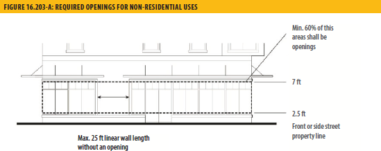
b.
Design of Required Openings. Openings fulfilling this requirement shall have transparent glazing and provide views into work areas, display areas, sales areas, lobbies, or similar active spaces, or into window displays that are at least twenty-four inches deep and set into a wall. Windows that provide visibility into storage areas, vehicle parking areas, utility areas and display cases attached to outside walls do not qualify.
c.
Exceptions for Parking Garages. Multi-level garages are not required to meet the building transparency requirement of this section. Instead, they must be screened and treated, consistent with the requirements of Chapter 16.508, Off-Street Parking and Loading.
d.
Alternatives Subject to Director's Approval. Alternatives to the building transparency requirement may be approved if the director finds that (1) the proposed use has unique operational characteristics where providing the required windows and openings is incompatible, and (2) street-facing building walls will exhibit architectural relief and detail and be enhanced with landscaping in such a way as to create visual interest at the pedestrian level.
J.
Building Design and Articulation. The following standards apply to commercial and mixed-use development.
a.
Design of Street-Facing Facades. In order to make streets more attractive to pedestrians, the street-facing facades of new development shall incorporate the following design features at the ground-floor level:
i.
Articulated facades at the ground floor street frontage, which may include such measures as indentation in plane, change of materials in a complimentary manner, sensitive composition and juxtaposition of openings and solid wall and/or building frame and projecting elements such as awnings and marquees to provide shade and shelter;
1.
Exterior lighting which provides for a secure nighttime pedestrian environment by reinforcing entrances, public sidewalks and open areas with a safe level of illumination which avoids off-site glare.
2.
Residential uses at the ground floor street frontage shall incorporate planted areas, porches, front stairs and/or other elements that contribute to a pedestrian environment. Pedestrian-oriented design elements may also include street furniture or other seating surfaces on private property and design amenities scaled to the pedestrian such as awnings, drinking fountains, paseos, arcades, colonnades, plazas, noncommercial community bulletin boards, public or private art and alternative paving materials in areas of pedestrian access. When provided, storefront security grates or grilles shall be located inside exterior windows, shall be retractable into pockets or overhead cylinders, and shall be completely concealed when retracted.
b.
Vertical Relationship. Buildings shall be designed to have a distinctive base (ground floor level), middle (intermediate upper floor levels), and top (either top floor or roof level). Cornices, balconies, roof terraces, and other architectural elements should be used, as appropriate, to terminate rooflines and accentuate setbacks between stories.
c.
Windows.
i.
Window frames shall be inset at least two inches from the face of the building to enhance shadow-lines around the opening.
ii.
Snap-in vinyl mullions between double pane glass are prohibited. If a divided light appearance is desired, mullions must be made of dimensional material projecting in front of the panes on both the inside and outside of the window.
iii.
Exceptions may be granted by the director to accommodate alternative window design complementary to the architectural style of the structure.
d.
Building Details.
i.
Building facades shall include building projections or recesses, doorway and window trim, and other details that provide architectural articulation and design interest.
ii.
All applied surface ornamentation or decorative detailing shall be consistent with the architectural style of the building.
iv.
Each side of the building that is visible from a public right-of-way shall be designed with a complementary level of detailing.
v.
A unified palate of materials shall be used on all sides of the building.
K.
Building Design Near Interstate Highway 80. For any site that is fully or partially located within two hundred feet of the right-of-way line of an Interstate Highway, buildings shall be designed with four-sided architecture where each exterior wall is designed with the same building articulation and the same quality of exterior materials as the primary facade.
L.
Roof Articulation. Buildings exceeding forty thousand square feet in floor area shall be designed with staggered rooflines, shaded roof decks, or other forms of architectural articulation.
M.
Pedestrian Access on Large Sites (Over five acres).
a.
Internal Connections. A system of pedestrian walkways shall connect all buildings on a site to each other, to on-site automobile and bicycle parking areas, and to any on-site open space areas or pedestrian amenities.
b.
Circulation Network. Regular connections between on-site walkways and the public sidewalk and other planned or existing pedestrian routes and trails shall be provided. An on-site walkway shall connect the primary building entry or entries to a public sidewalk on each street frontage.
c.
Adjacent Properties. Direct and convenient access shall be provided from commercial and mixed-use projects to adjoining residential and commercial areas to the maximum extent feasible, while still providing for safety and security.
d.
Transit. Safe and convenient pedestrian connections shall be provided from transit stops to building entrance.
i.
Interior Pedestrian Walkway Design.
1.
Walkways shall have a minimum clear, unobstructed width of six feet, where feasible, but at least four feet, shall be hard-surfaced, and paved with concrete, stone, tile, brick, or comparable material.
2.
Where a required walkway crosses driveway, parking areas, or loading areas, it must be clearly identifiable through the use of a raised crosswalk, a different paving material, or similar method.
3.
Where required walkway is parallel and adjacent to an auto travel lane, it must be raised or separated from the auto travel lane by a raised curb at least four inches high, bollards, or another physical barrier.
N.
Shopping Centers. Shopping centers containing twenty-five thousand square feet or more of floor area are subject to the following standards and criteria for approval.
a.
Entry Plazas/Passenger Loading Areas. A plaza shall be provided at the entry to each anchor tenant that provides for pedestrian circulation and loading and unloading. Entry plazas and passenger loading areas shall include unique, decorative paving materials, adequate seating areas, and provision of adequate shade from the summer sun, and attractive landscaping including trees or raised planters. Entry plazas with features described under paragraph 4(c) below may be counted toward the public plaza requirements.
b.
Location of Parking Areas. Surface parking lots shall be located to provide users with maximum access to buildings within the shopping center without moving their vehicles either behind or to the side of buildings. Parking areas shall not be located between buildings and any primary street.
c.
On-Site Public Plazas. Privately-owned, publicly accessible outdoor plazas for the use of customers and visitors shall be provided at a rate of five square feet per one thousand square feet of floor area, up to one thousand five hundred square feet for required outdoor plazas.
i.
Location. Public plazas shall be visible from a public street, or from on-site areas normally frequented by customers, and shall be accessible during business hours.
ii.
Amenities. On-site privately-owned public outdoor space shall include benches or other seating, and the ground surface shall be landscaped or surfaced with high-quality paving materials. Amenities shall be provided that enhance the comfort, aesthetics, or usability of the space, such as shade trees and other landscaping, shade structures, drinking fountains, water features, public art, and performance areas.
d.
Design Criteria. In order to receive approval for a shopping center, the director or the planning commission, whichever has final approval authority, shall find that all of the following criteria have been met.
i.
Integrated Theme. Buildings and structures exhibit an integrated architectural theme that includes similar or complementary materials, colors, and design details.
ii.
Site Entrance. The driveway entrance provides an organizing element to the site design with features such as a landscaped entry corridor or a divided median drive separated by a landscaped center dividing island.
iii.
Building Entrances. Building entrances to anchor tenants and other large stores are prominent and inviting. The architectural details of building entrances are integrated with the overall building design in terms of materials, scale, proportion, and design elements.
iv.
Vehicular Circulation. Safe, convenient vehicular circulation is provided within the development through an appropriate system of internal vehicular circulation routes based on a hierarchy of driveway aisles and cross routes. Where pedestrian circulation routes cross vehicular traffic aisles and driveways within a development, there are clearly delineated crosswalks that include clear sight lines, adequate warning signage, adequate lighting, and protective barrier posts or similar features at walkway entrances.
v.
Cart Corrals. Adequate, convenient cart corrals are provided near building entrances and throughout the parking areas.
vi.
Lighting. A combination of attractively designed and located lighting fixtures, including low pole lights, ground-mounted fixtures, light bollards, and architectural lighting provides interesting compositions for outdoor lighting, as well as a safe, secure environment.
vii.
Shade Areas. Pedestrian areas, such as walkways, building entrances, and gathering areas, are adequately shaded from the summer sun through such techniques as the careful placement of trees and landscaping, trellis structures, projecting canopies, covered walkways, arcades, porticos, building orientation, and similar techniques.
O.
Public Access for Shoreline Development. Any development abutting or within one hundred feet of the San Pablo Bay, the Napa River, Mare Island Strait, or the Carquinez Strait shall provide public access to and long the shoreline consistent with state and Bay Conservation and Development Commission requirements, and shall include in-water access where feasible, consistent with General Plan Policy NBE-4.1.
P.
Build-to Line. Buildings in the DMX District shall be constructed at the street frontage or the build-to line for at least sixty percent of the building frontage, or as required by the DTSP. At least two-thirds of the area between the building and lot line shall be paved so that it functions as a wider public sidewalk. This requirement may be modified or waived by the director upon finding that:
a.
Substantial landscaping (60% of area or more) will be located between the build-to line and ground floor residential units to soften visual impact of buildings;
b.
Entry courtyards, plazas, entries, or outdoor eating and display areas will be located between the build-to line and building, provided that the buildings will be built to the edge of the courtyard, plaza, or outdoor dining area; or
c.
The building will incorporate an alternative entrance design facing the street that conforms to adopted design guidelines.
Q.
Required Setbacks for Residential Uses.
a.
Front Setbacks. Buildings that are entirely residential and portions of buildings with residential uses on the ground floor may be setback up to eight feet from the street lot line. The setback must be landscaped, but up to one third of the setback area can be hard surfaced for pedestrian or bicycle access. Vehicle access is not allowed through the setback unless the frontage provides the only access to the residential portion of the site.
b.
Interior Side and Rear Setbacks. In order to provide light and air for residential units, the following minimum setbacks apply to any building wall containing windows for residential units and facing an interior side or rear setback area.
i.
For any wall containing windows, a setback of at least five feet shall be provided.
ii.
The required setbacks apply to that portion of the building wall containing a window and extending three feet on either side of the window.
R.
Height Limitations and Exceptions. In order to encourage more development along corridors, regardless of district, however acknowledging and preserving existing single-family residential areas, a height limit and landscape buffer is proposed as follows:
a.
Daylight Plane Required Adjacent to Residential Districts. Buildings shall not extend above a plane starting at twenty-five feet in height directly above the property line abutting any residentially zoned parcel, or where there is an alley, the centerline of the alley, and from that point, extending in at a forty-five-degree angle from vertical toward the interior of the site. The twenty-five-foot height measurement shall be taken from the same reference grade as determined for the subject site pursuant to Chapter 16.104, Rules for Measurement.
b.
Architectural Features. A parapet wall, cornice or sloping roof or solar energy system may project up to four feet above the height limit. Uninhabited roof structures that screen mechanical equipment and elevator penthouses are not included in the measurement of building height. Mechanical equipment shall be integrated and architecturally designed to match the building and not visible from adjacent streets.
c.
Corner projections. If the project site is on a corner site that is greater than fifteen thousand square feet, a tower or other projecting architectural elements may extend up to twelve feet above the top of a primary roof, provided that the square footage of the element(s) does not total more than fifteen percent of the building footprint. The area above the uppermost permitted floor of the element(s) shall not be habitable space. The composition of the tower element shall be balanced, where the width of the tower has a proportional relationship to the height of the tower.
i.
The tower element shall be proportional to the rest of the building.
ii
The tower element shall not be stepped back more than one foot at any point.
iii.
The maximum horizontal dimension of the tower element shall not exceed one hundred feet.
iv.
Fenestration at the base of the tower shall be greater than the top.
v.
The roof shall include architectural detailing, such as a cornice or eave.
d.
Landscaped Buffer Required. A landscaped area at least four feet in width planted with evergreen shrubs shall be installed along the rear property line adjacent to any residential district to create a sound barrier and privacy screen. Shrubs shall be a minimum of five feet in height at the time of installation.
S.
Wide Buildings. Any building over sixty feet wide shall be broken down to read as a series of buildings no wider than sixty feet each. Increases in the maximum building width and length may be approved through design review if recesses, offsets, or other architectural articulation modulate a "box-like" appearance.
T.
Building Projections. The maximum width of any projection, including bay windows, is ten feet, and the total of all projections along a building face shall not be more than ten feet wide or twenty-five percent of the building frontage, whichever is greater.
U.
Residential Landscaping and Open Space. Where residential uses are provided, both common and private residential open space must be provided.
a.
Minimum Dimensions.
i.
Private Open Space. Private open space located on the ground level (e.g., yards, decks, or patios) shall have no horizontal dimension less than ten feet. Private open space located above ground level (e.g., balconies) shall have no horizontal dimension less than six feet.
ii.
Common Open Space. The minimum horizontal dimension is twenty feet.
b.
Usability. A surface shall be provided that allows for outdoor living and/or recreation. Such surface may be any practicable combination of lawn, garden, flagstone, wood planking, concrete, or other serviceable, dust-free surfacing. The maximum slope shall not exceed ten percent.
c.
Accessibility.
i.
Private Open Space. The space shall be accessible to only one dwelling unit by a doorway to a habitable room or hallway.
ii.
Common Open Space. The space shall be accessible to the living units on the lot. It shall be served by any stairway or other accessway qualifying as an egress facility from a dwelling unit.
V.
Non-residential Landscaping and Open Space. All portions of the building site, exclusive of structures, parking areas, recreational uses, driveways and walkway, shall be landscaped.
(Ord. No. 1879 N.C.(2d), § 3(Exh. A), 3-11-2025)
16.204.01 - Purpose and applicability.
This chapter establishes the use regulations and site development standards for the commercial zoning districts. The purpose of the commercial zoning districts is to:
A.
Provide for the orderly, well-planned, and balanced growth of commercial districts.
B.
Encourage a mix of uses that promote convenience, economic vitality, fiscal stability, and quality of life in Vallejo.
C.
Promote pedestrian- and transit-oriented, medium and high-density multi-family housing, mixed-use commercial centers at appropriate locations.
D.
Establish design standards that improve the visual quality of development and create a unified, distinctive, and attractive character in commercial districts.
E.
Provide appropriate buffers and transition standards between commercial and adjacent residential neighborhoods.
More specifically, the purposes of the individual commercial zoning districts are as follows:
NC Neighborhood Commercial: The NC Zoning District is intended to create and establish regulations for neighborhoods in which limited retail commercial goods and services are provided on small sites to meet the day-to-day needs of local residents.
CC Central Corridor Commercial: The CC Zoning District is intended to create and establish regulations for community serving mixed-use areas along the Sonoma Boulevard Central Corridor and areas subject to the Sonoma Boulevard Specific Plan. Land uses include mixed-use with housing, medium and high density residential or non-residential uses at street level, subject to design and development standards to promote a mixed-use and pedestrian orientation.
WC Waterfront Commercial: The WC Zoning District is intended to create and establish regulations for areas along the waterfront that provide waterfront-related retail and service uses and visitor accommodations in building forms appropriately scaled to the waterfront. Public access to the shoreline must be provided where development is adjacent to the Napa River, Mare Island Strait, or Carquinez Strait. No residential uses are allowed.
RC Regional Commercial: The RC Zoning District is intended to create and establish regulations for sites that provide general retail, services, and commercial recreation and entertainment for local residents as well as consumers and visitors from the region. Design and development standards will accommodate auto-oriented uses and require buffering and transitions to adjacent residential neighborhoods.
(Ord. No. 1879 N.C.(2d), § 3(Exh. A), 3-11-2025)
16.204.02 - Development regulations.
The Table below prescribes the development standards for the commercial districts. The numbers in each illustration below refer to corresponding regulations in the "Fig #" column in the table.
TABLE 16.204-A: DEVELOPMENT STANDARDS: COMMERCIAL DISTRICTS
 | |||||
|---|---|---|---|---|---|
| FIG # | DISTRICT | NC | WC | CC | RC |
| LOT SIZE AND DENSITY | |||||
| Minimum/Maximum Density (units/net acre) |
16/30 (if General Plan is Neighborhood Commercial)
- Max. 12 (if General Plan is Primarily Single-Family) | n/a |
16/50 (if General Plan is Central Corridor)
- 25/50 (if General Plan is Business Limited Residential) - 30/50 (if General Plan is District-North Gateway) |
n/a (if General Plan is Retail/Entertainment)
- 25/50 (if General Plan is Business Limited Residential) | |
| Minimum Lot Size (sq. ft.) | n/a | 5,000 | 5,000 | 5,000 | |
| Minimum Lot Width (ft.) | n/a | 50 | 50 | 100 | |
| Maximum Non-Residential Floor Area Ratio (FAR) | 2.0 | 1.5 |
2.0
- 3.0 (if General Plan is Central Corridor) |
1.5
- 2.0 (if General Plan is Business/Limited Residential) | |
| BUILDING PLACEMENT AND SETBACKS | |||||
| Minimum Front Setback, Residential Development | 0 | n/a | 0 | ||
| ① | Street Frontages | 0 | 0;-10 where abutting R District | ||
| ② | Interior Side | 0; -10 where abutting R District | 5;-10 where abutting R District | ||
| ③ | Rear | 0; -10 where abutting R District | 5;-10 where abutting R District | ||
| BUILDING HEIGHT | |||||
| ④ | Building Maximum Height (stories) | 3 | 3 | 8 | 8 |
| ⑤ | Building Minimum Height (ft.) | n/a | n/a | n/a | n/a |
| ⑥ | Ground Floor Residential Uses | n/a | n/a | 12 | 12 |
| ⑥ | Ground Floor Non-Residential Uses | 15 | 15 | 15 | n/a |
| ⑧ | Parking Podium | Maximum height of a parking podium visible from the street is 9 ft. from finished grade | |||
| GROUND FLOOR MINIMUM HEIGHT | |||||
| Ground Floor Residential Uses | 12 | n/a | 12 | 12 | |
| Ground Floor Non-residential Uses | 15 | 15 | 15 | 15 | |
| ⑦ | First Floor Ceiling Height, Non-residential Uses | 12 | 12 | 12 | 15 |
| OPEN SPACE | |||||
| Residential | |||||
| Minimum Private Open Space (sq. ft. per unit) | 60 | n/a | 60 | 60 | |
| Minimum Common Open Space (sq. ft. per Unit) | 200 | n/a | 200 | 200 | |
| ADDITIONAL STANDARDS | |||||
| Fences and Walls | See Chapter 16.505, Fences, Walls, and Screening | ||||
| Lighting | See Chapter 16.506, Lighting and Glare | ||||
| Off-Street Parking and Loading | See Chapter 16.508, Off-Street Parking and Loading | ||||
| Measurement | See Chapter 16.104, Rules for Measurement | ||||
| Projections into Required Yards | See Section 16.501.07, Projections Into Required Yards | ||||
| Height Exceptions | See Section 16.501.05, Height Exceptions | ||||
| Landscaping | See Chapter 16.504, Landscaping | ||||
A.
Required Side and Rear Yards for Residential Uses. In order to provide light and air for residential units, the following minimum setbacks apply to any building wall containing windows for residential units and facing an interior side or rear yard.
1.
For any wall containing windows, a setback of at least five feet shall be provided.
2.
For any wall containing living room or bedroom windows, a setback of at least ten feet shall be provided.
3.
The required setbacks apply to that portion of the building wall containing a window and extending three feet on either side of the window.
B.
Daylight Plane Required Adjacent to Residential Districts. Buildings shall not extend above a plane starting at twenty-five feet in height directly above the property line abutting any residentially-zoned parcel, or where there is an alley, the centerline of the alley, and from that point, extending in at a forty-five-degree angle from vertical toward the interior of the site. The 25-foot height measurement shall be taken from the same reference grade as determined for the subject site pursuant to Chapter 16.104, Rules for Measurement.
C.
Architectural Features. A parapet wall, cornice, sloping roof or solar energy installation may project up to four feet above the height limit. Uninhabited roof structures that screen mechanical equipment and elevator penthouses are not included in the measurement of building height. Mechanical equipment shall be integrated and architecturally designed to match the building and not visible from adjacent streets.
D.
Corner Projections. If the project site on a corner site that is greater than fifteen thousand square feet, a tower or other projecting architectural elements may extend up to twelve feet above the top of a pitched roof, provided that the square footage of the element(s) does not total more than fifteen percent of the building footprint. The area above the uppermost permitted floor of the element(s) shall not be habitable space.
1.
The composition of the tower element shall be balanced, where the width of the tower has a proportional relationship to the height of the tower.
2.
The tower element shall be proportional to the rest of the building.
3.
The tower element shall not be stepped back at any point.
4.
The maximum horizontal dimension of the tower element shall not exceed one hundred feet.
5.
Fenestration at the base of the tower shall be greater than the top.
6.
The roof shall include architectural detailing, such as a cornice or eave.
E.
Landscaped Buffer Required. A landscaped area at least four feet in width planted with evergreen shrubs shall be installed along the rear property line adjacent to any residential zoning district to create a sound barrier and privacy screen. Shrubs shall be a minimum of five feet in height at the time they are planted.
F.
Upper Story Limitations. For the RC and CC Zoning Districts, the maximum allowable number of stories shall not exceed three within fifty feet of an RLD District.
(Ord. No. 1879 N.C.(2d), § 3(Exh. A), 3-11-2025)
16.204.03 - Additional regulations.
A.
Mixed-Use Development. A combination of permitted commercial uses may be established in the same building or on the same lot as a residential use subject to compliance with all applicable requirements for the use and the development intensity. A minimum of fifteen percent of non-residential space on the ground floor is required along street frontage (does not include alley).
1.
Minimum Required Active Commercial Uses on Frontages. Development in commercial districts with more than one hundred feet of frontage shall provide the following minimum ground-floor street frontage for active commercial uses (that have regular customers throughout the day e.g., retail shops, restaurants).
a.
CC District. Forty percent on the primary frontage and thirty percent on secondary frontages.
b.
NC District. Thirty percent on the primary frontage and twenty percent on secondary frontages.
B.
Reductions When Allowed. The minimum required active use on secondary frontages may be reduced if the director finds that (1) the proposed use has unique operation characteristics where the required active use is incompatible, such as in the case or a movie or live theater, and (2) street facing walls exhibit architectural relief and detailing that enhance the pedestrian environment.
C.
Pedestrian Entrances and Paths.
1.
Entrances. All non-residential activities located at the street level shall provide one direct at-grade entrance from the public right-of-way for each street frontage exceeding fifty feet.
a.
Where such frontages exceed one hundred feet, one entrance shall be provided for each one hundred feet of frontage or portion thereof.
b.
Separate pedestrian entrances for a single tenant must be at least twenty-five feet apart.
c.
Recessed entrances shall not exceed twenty-five feet in width and the face of a door or gates shall be within fifteen feet of the lot line.
2.
Pedestrian Paths. In shopping centers and mixed-use development, each commercial tenant space shall be accessible from an abutting public street by a pedestrian path that is at least four feet wide. The path shall be continuous, clear of obstructions, easily identifiable as a pedestrian path, and visually distinguishable from other hardscaping.
a.
Pedestrian paths shall be separated from vehicular access areas by wheel stops, curbs, landscaping, or other physical barriers, except when crossing driveways or aisles.
b.
Pedestrian paths and sidewalks connecting building entrances to the street and public sidewalks shall be continuous, clear of obstructions, easily identifiable, and visually distinguishable from surrounding concrete or hardscape areas.
c.
Pedestrian paths and sidewalks must be separated from parking area by wheel stops, curbs, landscaping, or other physical barriers.
D.
Additional Residential Density. Additional residential density may be approved, as set forth in Chapter 16.214, Affordable Housing Incentives.
E.
Street Preservation. Existing public right-of-way shall be preserved. Public right-of-way shall not be eliminated or abandoned, unless substantial public benefits are provided, such as a new park, a community garden or a trail on pedestrian passages.
TABLE 16.204-B: BUILDING FORM STANDARDS: COMMERCIAL DISTRICTS
 | |||||
|---|---|---|---|---|---|
| FIG # | DISTRICT# | NC# | WC# | CC# | RC# |
| ⑩ | Maximum Length of Blank Wall (ft.) |
10 for ground floor,
25 for upper floors | 25 for upper floors |
20 for ground floor,
25 for upper floors | 50 |
| ⑪ | Bay Window Projections (ft.) | Max. 3 ft. from primary facade and min. 12 ft. above sidewalk grade | |||
| ⑫ | Awnings & Overhangs (ft.) | Min. 4 ft. from primary facade and 8 ft. above sidewalk grade | |||
| ⑬ | Awning Setback from Curb | Min. 2 ft. clear | |||
F.
Street Frontage Improvements. New development shall provide street frontage improvements in accordance with the following:
1.
Between the Property Line and Curb.
a.
Sidewalks. Sidewalks shall be provided if none exists or if the existing sidewalks are in poor condition, as determined by the City Engineer/Public Works Director.
b.
Street Furniture. Trash receptacles, benches, bike racks, and other street furniture shall be provided, as determined by the approving body.
c.
Streetlights. Pedestrian-scaled streetlights not to exceed fourteen feet in height, including attachments from which banners may be hung, shall be provided.
d.
Street Trees. Shade trees shall be planted no more than thirty feet on center. Tree guards shall be provided. Trees shall be a minimum of fifteen gallons in size, and at least ten percent of the required trees shall be twenty-four-inch box size or larger.
2.
Interior from Property Line. Except where occupied by a building or necessary for parking access, the street frontage, for a depth of ten feet from the property line, shall be utilized for pedestrian circulation or active outdoor uses, including, but not limited to outdoor dining; paved for public uses so that it functions as part of a wider public sidewalk; or improved with landscaping, public art, and/or pedestrian amenities, such as outdoor seating.
G.
Building Orientation and Entrances.
1.
Buildings shall be oriented to face public streets.
2.
Building frontages shall be generally parallel to streets, and the primary building entrances shall be located on or within twenty feet of a public sidewalk. The director may grant exceptions to this standard for uses with unique needs.
3.
Entrances located at corners shall generally be located at a forty-five-degree angle to the corner and shall have a distinct architectural treatment, such as angled or rounded corners, arches, and other architectural elements.
4.
Entrances to residential units shall be physically separated from the entrance to commercial uses and clearly marked with a physical feature incorporated into the building or an appropriately scaled element applied to the facade.
H.
Building Transparency Required for Non-Residential Uses. Exterior walls facing and within twenty feet of a front or street side property line shall include windows, glass doors, or other openings for at least sixty percent of the building wall area located between 2.5 and seven feet above the level of the sidewalk.
1.
Required Openings. No wall may run in a continuous plane (See Table 16.204-B: Building Form Standards: Commercial Districts) without a window or other opening. If a lot has more than one street frontage, this standard applies to the primary frontage.
2.
Design of Required Openings. Openings fulfilling this requirement shall have transparent glazing and provide views into work areas, display areas, sales areas, lobbies, or similar active spaces, or into window displays that are at least twenty-four inches deep and set into a wall. Windows that provide visibility into storage areas, vehicle parking areas, utility areas and display cases attached to outside walls do not fulfill this requirement.
3.
Exceptions for Parking Garages. Multi-level garages are not required to meet the building transparency requirement of this section. Instead, they must be screened and treated, consistent with the requirements of Chapter 16.508, Off-Street Parking and Loading.
4.
Alternatives through Director's Review. Alternatives to the building transparency requirement may be approved if the director finds that:
a.
The proposed use has unique operational characteristics where providing the required windows and openings is incompatible, such as in the case of a movie or live theater; and
b.
Street-facing building walls will exhibit architectural relief and detail and will be enhanced with landscaping to create visual interest at the pedestrian level.
I.
Building Design and Articulation. Commercial and mixed-use buildings shall provide adequate architectural articulation and detail to avoid a bulky and "box-like" appearance subject to the following standards.
1.
Vertical Relationship. Buildings shall be designed to have a distinctive base (ground floor level), middle (intermediate upper floor levels), and top (either top floor or roof level). Cornices, balconies, roof terraces, and other architectural elements should be used, as appropriate, to terminate rooflines and accentuate setbacks between stories.
2.
Windows.
a.
Window frames shall be inset at least two inches from the face of the building to enhance shadow-line around opening.
b.
Snap-in vinyl mullions between double pane glass are prohibited. If a divided light appearance is desired, mullions must be made of dimensional material projecting in front of the panes on both the inside and outside of the window.
c.
Exceptions may be granted by the director to accommodate an alternative window design that is consistent with the architectural style of the structure.
3.
Exterior Building Materials and Colors.
a.
A unified palette of materials shall be used on all sides of buildings.
b.
Colors shall be used to help delineate windows and other architectural features to increase architectural interest.
4.
Building Details.
a.
Building facades shall include building projections or recesses, doorway and window trim, and other details that provide architectural articulation and design interest.
b.
All applied surface ornamentation or decorative detailing shall be consistent with the architectural style of the building.
c.
Each side of the building that is visible from a public right-of-way shall be designed with a complementary level of detailing.
5.
Roof Articulation. Buildings exceeding forty thousand square feet in floor area shall be designed with staggered rooflines, shaded roof decks, or other forms of architectural articulation.
J.
Pedestrian Access on Large Sites (Over five acres).
1.
Internal Connections. A system of pedestrian walkways shall connect all buildings on a site to each other, to on-site automobile and bicycle parking areas, and to any on-site open space areas or pedestrian amenities.
2.
Circulation Network. Regular connections between on-site walkways and the public sidewalk and other planned or existing pedestrian routes and trails shall be provided. An on-site walkway shall connect the primary building entry or entries to a public sidewalk on each street frontage.
3.
Adjacent Properties. Direct and convenient access shall be provided from commercial and mixed-use projects to adjoining residential and commercial areas to the maximum extent feasible, while still providing for safety and security.
4.
Transit. Safe and convenient pedestrian connections shall be provided from transit stops to building entrances.
5.
Interior Pedestrian Walkway Design.
a.
Walkways shall have a minimum clear, unobstructed width of six feet, where feasible, but at least four feet, shall be hard-surfaced, and paved with concrete, stone, tile, brick, or comparable material.
b.
Where a required walkway crosses driveway, parking areas, or loading areas, it must be clearly identifiable through the use of a raised crosswalk, a different paving material, or similar method.
c.
Where a required walkway is parallel and adjacent to an auto travel lane, it must be raised or separated from the auto travel lane by a raised curb at least four inches high, bollards, or other physical barrier.
K.
Shopping Centers. Shopping centers containing twenty-five thousand square feet or more of floor area are subject to the following standards and criteria for approval.
1.
Entry Plazas/Passenger Loading Areas. A plaza shall be provided at the entry to each anchor tenant that provides for pedestrian circulation and loading and unloading. Entry plazas and passenger loading areas shall include unique, decorative paving materials, adequate seating areas, and provision of adequate shade from the summer sun, and attractive landscaping including trees or raised planters. Entry plazas with features described under paragraph 4(c) below may be counted toward the public plaza requirements.
2.
Location of Parking Areas. Surface parking lots shall be located to provide users with maximum access to buildings within the shopping center without moving their vehicles either behind or to the side of buildings. Parking areas shall not be located between buildings and any primary street.
3.
On-Site Public Plazas. Privately-owned, publicly accessible outdoor plazas for the use of customers and visitors shall be provided at a rate of five square feet per one thousand square feet of floor area, up to one thousand five hundred square feet for required outdoor plazas.
a.
Location. Public plazas shall be visible from a public street, or from on-site areas normally frequented by customers, and shall be accessible during business hours.
b.
Amenities. On-site privately-owned public outdoor space shall include benches or other seating, and the ground surface shall be landscaped or surfaced with high-quality paving materials. Amenities shall be provided that enhance the comfort, aesthetics, or usability of the space, such as shade trees and other landscaping, shade structures, drinking fountains, water features, public art, and performance areas.
4.
Design Criteria. In order to receive approval for a shopping center, the director or the planning commission, whichever has final approval authority, shall find that all of the following criteria have been met.
a.
Integrated Theme. Buildings and structures exhibit an integrated architectural theme that includes similar or complementary materials, colors, and design details.
b.
Site Entrance. The driveway entrance provides an organizing element to the site design with features such as a landscaped entry corridor or a divided median drive separated by a landscaped center dividing island.
c.
Building Entrances. Building entrances to anchor tenants and other large stores are prominent and inviting. The architectural details of building entrances are integrated with the overall building design in terms of materials, scale, proportion, and design elements.
d.
Vehicular Circulation. Safe, convenient vehicular circulation is provided within the development through an appropriate system of internal vehicular circulation routes based on a hierarchy of driveway aisles and cross routes. Where pedestrian circulation routes cross vehicular traffic aisles and driveways within a development, there are clearly delineated crosswalks that include clear sight lines, adequate warning signage, adequate lighting, and protective barrier posts or similar features at walkway entrances.
e.
Cart Corrals. Adequate, convenient cart corrals are provided near building entrances and throughout the parking areas.
f.
Lighting. A combination of attractively designed and located lighting fixtures, including low pole lights, ground-mounted fixtures, light bollards, and architectural lighting provides interesting compositions for outdoor lighting, as well as a safe, secure environment.
g.
Shade Areas. Pedestrian areas, such as walkways, building entrances, and gathering areas, are adequately shaded from the summer sun through such techniques as the careful placement of trees and landscaping, trellis structures, projecting canopies, covered walkways, arcades, porticos, building orientation, and similar techniques.
L.
Public Access for Shoreline Development. Any development along San Pablo Bay, the Napa River, Mare Island Strait, or the Carquinez Strait shall provide public access to and along shoreline consistent with state and Bay Conservation and Development Commission requirements, and shall include in-water access where feasible, consistent with General Plan Policy NBE-4.1.
(Ord. No. 1879 N.C.(2d), § 3(Exh. A), 3-11-2025)
16.205.01 - Purpose and applicability.
The purposes of the Office "O" and Medical "M" Zoning Districts are to:
A.
Provide sites for medical and office uses at appropriate locations.
B.
Encourage a mix of compatible uses within these districts including multi-family residential development.
C.
Establish design standards that improve the visual quality of development and create a unified, distinctive, and attractive character in these districts.
D.
Provide appropriate buffers and transition standards between these districts and adjacent residential neighborhoods.
More specifically, the purposes of the individual O and M Zoning Districts are as follows:
O Office: The O Zoning District is intended to create and establish regulations for areas having an employment focus, but also supporting a mix of uses, especially business supportive uses. Residential-only development and office development with a residential component are allowed as major uses if design and compatibility standards are met.
M Medical: The M Zoning District is intended to create and establish regulations for areas with a concentration of medical facilities and supporting commercial services can be provided without the encroachment of incompatible uses. Design and development standards will ensure land use compatibility and appropriate buffers and transitions to adjacent residential neighborhoods.
16.205.02 - Development regulations.
Table 16.205-A: Development Standards : Office And Medical Districts, prescribes the development standards for the O and M Zoning Districts. Additional regulations are listed in the right-hand column. Chapter numbers in this column refer to other chapters of the Zoning Code and individual letters refer to sections that directly follow the table. The numbers in each illustration below refer to corresponding regulations in the "#" column in the table.
TABLE 16.205-A: DEVELOPMENT STANDARDS: OFFICE AND MEDICAL DISTRICTS
 | ||||
|---|---|---|---|---|
| FIG # | DISTRICT | O | M | ADDITIONAL REGULATIONS |
| LOT AND DENSITY STANDARDS | ||||
| Minimum/Maximum Density | 16/30 | 16/50 | ||
| Minimum/Maximum Density for Business /Limited Residential General Plan Designation | 16/50 | n/a | ||
| Minimum Lot Size (sq. ft.) | 5,000 | 10,000 | ||
| Corner Lots | 6,000 | 10,000 | ||
| ① | Minimum Lot Width (ft.) | 50 | 50 | |
| ② | Corner Lots | 60 | 60 | |
| BUILDING FORM AND LOCATION | ||||
| ③ | Maximum Height (ft.) | 75; 35 within 50 ft. of an R District | 75: 35 within 50 ft. of and R District | See Section 16.501.05, Height Exceptions |
| Ground Floor Minimum (ft.) | ||||
| ④ | Ground Floor Commercial Uses | 15 | 15 | See Section 16.501.07, Projections Into Required Yards |
| ⑤ | First Floor Ceiling Height, Commercial uses (ft. clear) | 12 | 12 | |
| Minimum Setbacks (ft.) | ||||
| ⑥ | Front | 15 | See Section 16.501.07, Projections Into Required Yards | |
| ⑦ ⑩ | Interior Side | 5 plus 2 ft. for each story over 2 | ||
| ⑧ | Street Side | 10 | ||
| ⑨ ⑩ | Rear | 10, 15 adjacent to R District | ||
| Maximum Floor Area Ratio (FAR) | 2.0 | 1.0 | See Chapter 16.104, Rules for Measurement | |
| OPEN SPACE | ||||
| Minimum Private Open Space (sq. ft. per unit) | 40 (A) | n/a | See Chapter 16.505, Fences, Walls, and Screening and Chapter 16.504, Landscaping | |
| Minimum Common Open Space (sq. ft. per Unit) | 150 (A) | n/a | ||
| LANDSCAPING | ||||
| Minimum Amount of Landscaping (% of site) | 25 | See Chapter 16.504, Landscaping | ||
| Street Trees (ft. frontage) | 1 per 30 ft. of frontage (A) | |||
| ADDITIONAL STANDARDS | ||||
| Fences and Walls | See Chapter 16.505, Fences, Walls, and Screening | |||
| Lighting | See Chapter 16.506, Lighting and Glare | |||
| Off-Street Parking and Loading | See Chapter 16.508, Off-Street Parking and Loading | |||
| Parking Lot Landscaping | See Chapter 16.504, Landscaping | |||
A.
Additional Development Standards. All development in the O and M Zoning Districts is subject to the following standards.
1.
Mixed-Use Development. A combination of permitted commercial uses may be established in the same building or on the same lot as a residential use subject to compliance with all applicable requirements for the use and the development intensity. A minimum of fifty percent of non-residential space on the ground floor is required along street (not alley) frontage.
2.
Landscaping. A minimum of twenty-five percent of the site must be landscaping. The minimum required landscaped area may be reduced to twenty percent of site area when the site includes an area with minimum dimensions of thirty feet by thirty feet planted with at least one large-canopy tree. At least fifty percent of the ground area within this space must planted with ground cover plants and the remainder may be hard-surfaced for use by pedestrians.
3.
Public Improvements.
a.
Sidewalks. Sidewalks shall be provided if none already exist or if the existing sidewalks are in poor condition.
b.
Street Furniture. Trash receptacles, benches, bike racks, and other street furniture shall be provided.
c.
Streetlights. Pedestrian-scale streetlights shall be provided.
d.
Street Trees. Shade trees shall be planted no more than thirty feet on center. Tree guards shall be provided. Trees shall be a minimum fifteen gallons in size, and at least ten percent of the required trees shall be twenty-four-inch box size or larger.
e.
Orientation of Primary Building Entrance. The primary building entrance shall face or be oriented to within forty-five degrees of or parallel to the street frontage.
f.
Building Articulation. Building facades shall include building projections or recesses, doorway and window trim, and other details that provide architectural articulation and design interest.
g.
Exterior Building Materials. A unified palette of materials shall be used on all sides of buildings. Exterior building materials shall be stone, brick, stucco, and concrete block, painted wood clapboard, painted metal clapboard or other quality, durable materials.
4.
Pedestrian Access on Large Site (Over ten acres). On-site pedestrian circulation and access must be provided in compliance with the following standards.
a.
Internal Connections. A system of pedestrian walkways shall connect all buildings on a site to each other, to on-site automobile and bicycle parking areas, and to any on-site open space areas or pedestrian amenities.
b.
Circulation Network. Regular connections between on-site walkways and the public sidewalk shall be provided. An on-site walkway shall connect the primary building entry or entries to a public sidewalk on each street frontage.
c.
Transit. Safe and convenient pedestrian connections shall be provided from transit stops to building entrances.
d.
Interior Pedestrian Walkway Design.
i.
Walkways shall have a minimum unobstructed width of six feet and shall be hard-surfaced.
ii.
Where a required walkway crosses driveway, parking areas, or loading areas, it must be clearly identifiable through the use of a raised crosswalk, a different paving material, or similar method.
iii.
Where a required walkway is parallel and adjacent to an auto travel lane, it must be raised or separated from the auto travel lane by a raised curb at least four inches high, bollards, or other physical barrier.
5.
Truck Docks, Loading, and Service Areas. Truck docks, loading areas, and service areas must be screened and not visible from public streets. Drop-off areas may be located at the primary building entry.
16.206.01 - Purpose and applicability.
The purpose of the Industrial "I" Zoning Districts is to:
A.
Designate adequate land for businesses, manufacturing and industrial operations, and related storage, distribution and services supporting industry in the city;
B.
Maintain and strengthen the city's economic and fiscal resources and provide employment opportunities for residents of the city and surrounding communities.
C.
Establish appropriate development and design standards and buffering requirements to protect adjacent uses and ensure land use compatibility; and
D.
Minimize the impacts of industrial development on adjacent residents.
More specifically, the purposes of the industrial zoning districts are as follows:
IL Limited Industrial: The IL Zoning District is intended to create and establish regulations for a diverse range of light industrial and supportive uses as well as limited office and live/work uses. This district is primarily intended to accommodate industrial and flex space types of development.
IG General Industrial: The IG Zoning District is intended to create and establish regulations for a broad range of industrial activities, including general industrial, heavy industrial, manufacturing and supportive ancillary offices. This district is intended for activities that may potentially generate more noise, hazards and truck traffic than those in the IL district and establishes buffering and transition standards for any adjacent residential uses. Uses in this designation may also utilize rail and ships to transport materials and manufactured goods.
16.206.02 - Development regulations.
Table 16.206-A: Development Standards : Industrial Districts, prescribes the development standards for industrial districts. Additional regulations are denoted in a right-hand column. Chapter numbers in this column refer to other chapters of the Zoning Code, while individual letters refer to sections that directly follow the table. The numbers in each illustration below refer to corresponding regulations in the "#" column in the associated table.
TABLE 16.206-A: DEVELOPMENT STANDARDS : INDUSTRIAL DISTRICTS
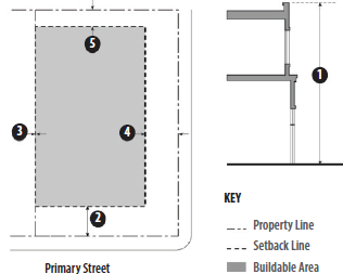 | ||||
|---|---|---|---|---|
| FIG # | DISTRICT | IL | IG |
ADDITIONAL
REGULATIONS |
| BUILDING FORM AND LOCATION | ||||
| ① | Maximum Height (ft.) | 45 | 75 | See Section 16.204.03.A, Mixed-Use Development and Section 16.501.05, Height Exceptions |
| Minimum Setbacks (ft.) (B) | ||||
| ② | Front | 10 | 10 | See Section 16.501.07, Projections Into Required Yards |
| ③ | Interior Side | 0; 15 where abutting an R district | 0; 15 where abutting an R district | |
| ④ | Street Side | 10 | 10 | |
| ⑤ | Rear | 0; 15 where abutting an R district | See Section 16.501.07, Projections Into Required Yards | |
| Maximum Floor Area Ratio (FAR) | 2.5 | 2.0 | ||
| BUILDING FORM AND LOCATION | ||||
| Fences and Walls | See Chapter 16.505, Fences, Walls, and Screening | |||
| Lighting | See Chapter 16.506, Lighting and Glare | |||
| Off-Street Parking and Loading | See Chapter 16.508, Off-Street Parking and Loading | |||
| Parking Lot Landscaping | See Chapter 16.504, Landscaping | |||
16.206.03 - Additional regulations.
A.
Mixed-Use Development. A combination of permitted industrial or commercial uses may be established in the same building or on the same lot as a live/work use in the IL Zoning District, subject to compliance with all applicable requirements for the use and the development intensity. A minimum of fifty percent of non-residential space on the ground floor is required along street frontage (street does not include alley).
B.
Transitional Standards. Where an industrial district adjoins an R Zoning District, the following standards apply:
1.
The maximum height is thirty-five feet within fifty feet of an RLD Zoning District, and forty-five feet within fifty feet of an RMD and RHD Zoning Districts.
2.
A landscaped planting area, a minimum of ten feet in width, shall be provided along all residential zoning districts boundaries, with trees planted at a minimum interval of twenty feet.
C.
Perimeter Landscaping. A perimeter planting strip of at least five feet shall be provided along all arterial streets and street frontages that are adjacent to mixed-use and residential zoning districts.
D.
The following additional improvements are required:
1.
Public Improvements.
a.
Sidewalks. Sidewalks shall be provided if none already exist or if the existing sidewalks are in poor condition.
b.
Streetlights. Pedestrian-scale streetlights shall be provided.
c.
Street Trees. Shade trees shall be planted no more than thirty feet on center. Tree guards shall be provided. Trees shall be a minimum fifteen gallons in size, and at least ten percent of the required trees shall be twenty-four-inch box size or larger.
2.
Orientation of Primary Building Entrance. The primary building entrance shall face or be oriented to within forty-five degrees of or parallel to the street frontage.
a.
Building Articulation. Building facades shall include building projections or recesses, doorway and window trim, and other details that provide architectural articulation and design interest.
b.
Exterior Building Materials. A unified palette of materials shall be used on all sides of buildings. Exterior building materials shall be stone, brick, stucco, and concrete block, painted wood clapboard, painted metal clapboard or other quality, durable materials.
3.
Pedestrian Access on Large Site (Over ten acres). On-site pedestrian circulation and access must be provided in compliance with the following standards.
a.
Internal Connections. A system of pedestrian walkways shall connect all buildings on a site to each other, to on-site automobile and bicycle parking areas, and to any on-site open space areas or pedestrian amenities.
b.
Circulation Network. Regular connections between on-site walkways and the public sidewalk shall be provided. An on-site walkway shall connect the primary building entry or entries to a public sidewalk on each street frontage.
c.
Transit. Safe and convenient pedestrian connections shall be provided from transit stops to building entrances.
d.
Interior Pedestrian Walkway Design.
i.
Walkways shall have a minimum unobstructed width of six feet and shall be hard-surfaced.
ii.
Where a required walkway crosses driveway, parking areas, or loading areas, it must be clearly identifiable through the use of a raised crosswalk, a different paving material, or similar method.
iii.
Where a required walkway is parallel and adjacent to an auto travel lane, it must be raised or separated from the auto travel lane by a raised curb at least four inches high, bollards, or other physical barrier.
E.
Truck Docks, Loading, and Service Areas. The outermost point of the truck docks, loading, and service areas are not permitted within fifty feet of the boundary of an R Zoning District.
16.207.01 - Purpose and applicability.
The purposes of the parks, recreation, and open space and the resource conservation zoning districts are to:
A.
Provide land for development of parks and recreational facilities, consistent with the general plan, and;
B.
Ensure design compatibility between public uses and adjacent residential neighborhoods.
The specific purposes of the parks, recreation, and open space and the resource conservation zoning districts are as follows:
PROS Parks, Recreation and Open Space: The PROS Zoning District is intended to create and establish regulations for parks, recreation and open space areas allowing for recreational activities and/or natural resource preservation.
RCN Resource Conservation: The RCN Zoning District is intended to create and establish regulations to preserve remaining open spaces in their natural state and protect valuable resources. More specifically, this district is intended for undeveloped publicly owned lands, visually significant open lands, water areas, wetlands, and wildlife habitat. These areas are set aside as permanent open space preserves and may include trails, trail heads, and other facilities for low-impact public recreational uses. This district includes wetlands, mudflats, creek corridors and other natural preservation areas, as well as private lands deed-restricted for open space preservation.
16.207.02 - Development regulations.
Table 16.207-A: Land Use Regulations - Parks, Recreation And Open Space, And Resource Conservation Districts, prescribes the development standards for PROS and RCN Zoning Districts. Additional regulations are listed in the right-hand column. Chapter numbers in this column refer to other chapters of this Zoning Code. The numbers in each illustration below refer to corresponding regulations in the "#" column in the associated table.
TABLE 16.207-A: LAND USE REGULATIONS - PARKS, RECREATION AND OPEN SPACE, AND RESOURCE
CONSERVATION DISTRICTS
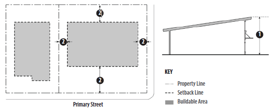 | ||||
|---|---|---|---|---|
| FIG | DISTRICT | PROS | RCN |
ADDITIONAL
REGULATIONS |
| LOT SIZE; BUILDING FORM AND LOCATION | ||||
| Minimum Lot Size | 10,000 sq. ft. | n/a | ||
| Minimum Lot Width (ft.) | n/a | n/a | ||
| ① | Maximum Height (ft.) | 35 | n/a | See Section 16.501.05, Height Exceptions |
| ② | All Setbacks and Buffers (ft.) | 50 | ||
| LANDSCAPING | ||||
| Minimum % of Site | 20 (A) | n/a | See Chapter 16.504, Landscaping | |
| Street Trees | 1 per 30 sq. ft. of frontage | n/a | ||
| Parking Lot Landscaping | See Chapter 16.504, Landscaping | |||
16.207.03 - Additional regulations.
A.
Landscaping. A minimum of twenty percent of the site must be landscaped.
B.
Truck Docks, Loading and Service Areas. Truck docks, loading areas, and service areas must be located at the rear or interior sides of buildings and screened, and not visible from public streets or residential neighborhoods.
C.
Any development along San Pablo Bay, the Napa River, Mare Island Strait, or the Carquinez Strait shall provide public access to and along the shoreline consistent with state and Bay Conservation and Development Commission requirements, and shall include in-water access where feasible, consistent with General Plan Policy NBE-4.1.
16.208.01 - Purpose and applicability.
The purposes of the Public and Semi-Public "PS" Zoning District are to:
A.
Provide land for development of public, cultural and institutional uses that provide services to the community;
B.
Create and establish lower use regulations developments and for a public and semi-public facilities public utilities, and other community facilities; and
C.
Ensure design compatibility between public uses and adjacent residential neighborhoods.
The specific purpose of the PS Zoning District is as follows:
PS Public and Semi-Public District: The PS Zoning District is intended to regulate areas that provide governmental and quasi-governmental services and supportive services.
16.208.02 - Development regulations.
Table 16.208-A: Development Standards - Public And Semi-Public District, prescribes the development standards for the PS Zoning District. Additional regulations are denoted in a right-hand column. Chapter numbers in this column refer to other chapters of the Zoning Code. The numbers in each illustration below refer to corresponding regulations in the "#" column in the associated table.
TABLE 16.208-A: DEVELOPMENT STANDARDS - PUBLIC AND SEMI-PUBLIC DISTRICT
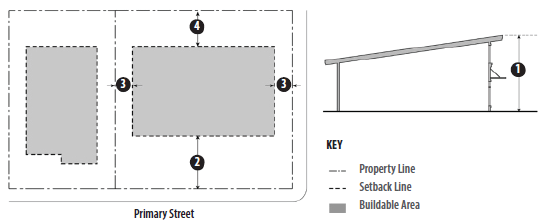 | |||
|---|---|---|---|
| FIG # | DISTRICT | PS |
ADDITIONAL
REGULATIONS |
| LOT SIZE; BUILDING FORM AND LOCATION | |||
| Minimum Lot Size | 10,000 sq. ft. | ||
| Minimum Lot Width (ft.) | n/a | ||
| ① | Maximum Height (ft.) | 45; 35 within 50 ft. of an R District | See Section 16.501.05, Height Exceptions |
| Minimum Setbacks (ft.) | |||
| ② | Front | 10; when adjacent to an R district, the front setback is the same as that of the R district | See Section 16.501.07, Projections Into Required Yards |
| ③ | Side | 10 - street side; 5 interior side, plus 2 ft. per story for buildings over two stories adjacent to an R District | |
| ④ | Rear | 10; 15 adjacent to an R District | |
| Maximum Floor Area Ratio (FAR) | 1.0 | ||
| LANDSCAPING | |||
| Minimum % of site | 30 (A) | ||
| Street Trees | 1 per 30 ft. of frontage | See Chapter 16.504, Landscaping | |
| Parking Lot Landscaping | See Chapter 16.504, Landscaping | ||
16.208.03 - Additional regulations.
A.
Landscaping. A minimum of thirty percent of the site must be landscaping. The minimum required landscaped area may be reduced to twenty percent of site area when the site includes an area with minimum dimensions of thirty feet by thirty feet planted with at least one large-canopy tree. At least fifty percent of the ground area within this space must be planted with ground cover plants and the remainder may be hard-surfaced for use by pedestrians.
B.
Truck Docks, Loading and Service Areas. Truck docks, loading areas, and service areas must be located at the rear or interior sides of buildings and screened and not visible from public streets or residential properties.
16.209.01 - Purpose and applicability.
This chapter establishes regulations for planned development zoning districts that allow for one or more properties to be developed under a plan that provides for better coordinated development and incorporates development standards crafted to respond to site conditions in order to:
A.
Provide flexibility by allowing diversification in regulations such as building relationships, setbacks, height limitations, lot sizes, types of structures, parking and the amount and location of open space;
B.
Ensure substantial compliance with and implement the land use and density policies of the general plan and any applicable specific plan;
C.
Provide for efficient and cost-effective public facilities and services;
D.
Allow for creative and experimental approaches to land development projects that incorporate design features that are more sensitive to site conditions including the application of new technologies or the innovative application of existing technologies relating to resource conservation;
E.
Facilitate projects that provide greater amenities than would likely result from conventionally planned development; and
F.
Protect public health, safety, and general welfare without unduly inhibiting developers attempting to secure the advantages of modern large-scale site planning for residential, commercial, or industrial purposes.
These provisions shall apply for:
Development in Areas Subject to Existing Master Plans. Properties located in approved subdivisions or within the boundaries of an area subject to an existing master plan and/or planned development unit plan and meet the following criteria shall comply with the development standards of the applicable master plan and/or planned development unit plan if:
1.
Located within one of the following five areas:
a.
Garthe Ranch
b.
Glen Cove
c.
Hiddenbrooke
d.
Mare Island
e.
Northgate (Residential)
2.
Located in a planned development zoning district;
3.
Processed as a planned development unit plan, part of a master plan.
Waterfront and Vallejo Station Planned Development Master Plan. Projects within the WMX Zoning District and as specified in the Waterfront and Vallejo Station Project Planned Development Master Plan (PDMP) and accompanying Waterfront Design Guidelines (collectively, the "Waterfront PDMP/design guidelines") for the waterfront area (the "waterfront area") shall be prepared consistent with the Waterfront PDMP/Design Guidelines, the Disposition and Development Agreement (the "DDA") between the city of Vallejo (the "City") and the developer of the waterfront area (the "developer"), and the development agreement between the city and the developer. Pursuant to the DDA, the city and the developer are obligated to timely appeal decisions of the design review board regarding development review permits for major projects, as determined by the director, to the city council.
PD Planned Development. PD Zoning Districts shall be noted on the zoning map by the designation "PD". PD districts must be consistent with the general plan land use designation in which they are located.
16.209.02 - Land use regulations.
No use other than an existing use is permitted in a PD Zoning District except in accordance with a valid planned development plan. Any permitted or conditional use authorized by the Zoning Code may be included in an approved planned development plan consistent with the general plan land use designation(s) for the property. Where a proposed land use is encompassed by the definition of the PD district's permitted use types but conflicts with the statement of purposes for this district, the proposed land use will not be permitted.
16.209.03 - Development regulations.
A.
Establishment. The development standards for a PD Zoning District shall be established as provided in Section 16.610, Planned Development Districts.
B.
Minimum Area. The minimum area of a PD Zoning District shall be four contiguous acres; however, the city council may approve a district smaller than four acres if it finds that rezoning to PD would provide greater benefits to the general welfare of Vallejo's residents and property owners than development under any base zoning district due to the unique characteristics of the site or the proposed use.
C.
Residential Unit Density. Except where a density bonus is granted in compliance with the requirements of Table 16.209-A: Density Bonuses For Planned Development Benefits, or the city's density bonus regulations for affordable housing and childcare pursuant to Chapter 16.214, Affordable Housing Incentives, the total number of dwelling units in a PD Zoning District shall not exceed the maximum number permitted by the general plan density for the total area designated for residential use, excluding areas devoted to public and private streets.
1.
Densities may be mixed within the area included in the approved PD Plan.
2.
The planning commission may authorize density bonuses that exceed the ranges specified in the general plan as provided in the following table.
D.
Other Development Regulations. Minimum lot area, yard requirements, building heights, and other physical development standards shall be as prescribed by the PD Plan.
16.210.01 - Purpose and applicability.
Specific plans are regulatory documents established by the city to carry out specific purposes, as authorized by the Government Code, for specific geographic areas shown on the zoning map. Such plans are governed by a set of regulations, which address specific subjects, such as land use, physical development, community design, transportation and public improvements, or impose requirements for detailed plans that may be applicable in sub-areas within the specific plan area. The provisions of a specific plan may be combined with provisions of a base zoning district for the area to which the specific plan applies, and the more restrictive provisions will govern. Specific plan provisions also may be substituted for citywide provisions included in the Zoning Code or subdivision regulations, as more specifically specified in the specific plan.
The existing specific plan areas subject to this chapter are provided in Table 16.210-A below.
16.210.02 - Development regulations.
A specific plan shall be established and amended as provided in Section 16.609.04, Administration.
A.
Minimum Area. The minimum area for a specific plan shall be four contiguous acres; however, the city council may approve a district smaller than four acres if it finds that rezoning to a specific plan would provide greater benefits to the general welfare of Vallejo's residents and property owners than development under any base zoning district due to the unique characteristics of the site or the proposed use/s.
B.
Residential Unit Density. Except where a density bonus is granted in compliance with the requirements of this chapter or the city's density bonus regulations for affordable housing and childcare (Chapter 16.214, Affordable Housing Incentives) the total number of dwelling units in a specific plan area shall not exceed the maximum number permitted by the general plan density for the total area designated for residential use, excluding areas devoted to public and private streets.
16.210.03 - Additional standards.
The specific plan shall establish the development standards for a specific plan area as provided in Section 16.609.04, Administration.
16.211.01 - Establishment of historic and landmark districts.
This chapter establishes two overlay zoning districts, the "H" Historic District designation and "L" Landmark. The "H" district may be combined with any base zoning district and an "L" property designation may be within any base zoning district or "H" Historic District.
16.211.02 - Classification and intent of districts.
A.
Historic District. This district may be made applicable to any area in the city with significant architectural heritage. Any zoning district, or a portion thereof, may be designated an "H" district. The intent is to preserve areas and specific buildings and structures which reflect elements of the cultural, social, economic, political and architectural history of the city. This district is intended to stabilize and improve property values in historical areas and to preserve specific buildings and structures which are considered to be of historical or architectural value, to foster civic pride and beauty, and to strengthen the community's economy.
B.
Landmark Designation. The intent of a Landmark "L" designation is to achieve maximum feasible rehabilitation of properties with historic significance. Rehabilitation, as distinct from restoration, is the process of returning a property to a state of utility, through repair or alteration, which makes possible an efficient contemporary use. In rehabilitation, those portions of the property important to illustrating historic, architectural and cultural values are preserved or restored.
16.212.01 - Purpose and applicability.
These regulations ensure that Hillside Development complements and is sensitive to existing terrain, views, and significant natural landforms and features, and preserves and enhances Vallejo's scenic character, including its natural waterways and hillsides.
The provisions of this chapter apply to any subdivision, new use, or structure (including accessory structures), additions to existing structures and other development on any parcel with an average slope of fifteen percent or greater, hereinafter referred to as a "Hillside Parcel."
A.
Slope measurement. Average slope is the characteristic slope of the ground surface of an area of land, expressed as a percent, based on the most accurate available topographic information. Average slope shall be based upon the natural slope of the ground surface and determined based as follows:
B.
All measurements shall be taken in no greater than ten foot increments for the vertical distance of contour lines, taking the vertical distance, or "rise," over the horizontal distance, or "run." The resulting fraction, or percentage, is the "slope" of the land.
C.
Conflicts. In the event of a conflict between the provisions of this chapter and other development code regulations, including the provisions of the applicable zoning district, the provisions of this chapter shall apply. The exception is when a project is also subject to Chapter 16.213, Residential View District, the more restrictive and greatest noticing requirements shall apply.
D.
Exceptions.
1.
The provisions of this chapter do not apply to additions to existing single-unit residences when the area of the addition is less than fifty percent of the area of the existing residence and there is no Hillside Development Permit for the existing residence.
2.
Nothing in this chapter shall prohibit the construction and occupancy of a single-unit residence on a hillside parcel created pursuant to the Subdivision Map Act and the city's subdivision ordinance. New development shall be built in compliance with this chapter.
(Ord. No. 1879 N.C.(2d), § 3(Exh. A), 3-11-2025)
16.212.02 - Requirements.
A.
Hillside Development Permit required. A Hillside Development Permit shall be required for all development on any parcel where the average slope is fifteen percent or greater and shall be processed in the same manner as a minor use permit pursuant to Chapter 16.606, Minor and Major Use Permits, subject to the requirements of this chapter.
B.
Soils and Geotechnical Report and Peer Review required. All applications for a Hillside Development Permit, shall include, in addition to the requirements of Chapter 16.606, a soils and geotechnical studies prepared by a qualified licensed geotechnical engineer and engineering geologist.
1.
The study shall include all information and materials required by the city engineer.
2.
The report shall be all such reports shall be subject to peer review by a qualified licensed geotechnical engineer and engineering geologist hired by the city and paid for by the applicant.
3.
The applicant shall incorporate all recommendations into the design of the project.
4.
This requirement may be waived if the city engineer determines that the project, because of its size, location, or design, will not have a significant impact on the hillside, or that sufficient information already exists, and further analysis is not necessary.
C.
Density Reductions. The minimum density shall be reduced on a hillside parcel such that no density is afforded for areas of the parcel that exceed a thirty percent slope.
D.
Development standards. All hillside development shall comply with the following development standards in addition to the standards for the applicable base zoning district.
1.
Slope Limits. Land with an average slope of thirty percent or more shall not be developed, except to allow necessary grading for slope stability, as approved by the City Engineer/Public Works Director. Development on land with an average slope of twenty percent or more may be permitted by the director only when all of the following findings can be made:
a.
It is substantially infeasible to locate the proposed building inside the maximum percent slope area;
b.
Where such location would have a substantially less impact on the environment;
c.
Where such location is deemed appropriate to facilitate clustered development; and
d.
Measures are included that provide adequate mitigation of environmental impacts such as visual, biological, and geotechnical impacts.
2.
Treatment of Sloped Areas.
a.
All areas with an existing average slope of thirty percent or greater shall be left undisturbed, except to allow necessary grading for slope stability, as approved by the City Engineer/Public Works Director;
b.
All areas with an existing average slope of twenty percent or more that are not covered with structures or used for access to the property shall not be paved, and shall only be disturbed as necessary to develop the site;
c.
Slopes created or altered by grading shall not exceed thirty percent; and
d.
For slopes up to fifteen percent, impervious surfaces shall not exceed forty percent of the gross land area. Slopes that exceed fifteen percent shall not have impervious surfaces that exceed thirty percent or less.
3.
Protection of Ridgeline Views. The highest point of any structure shall not be located within one hundred vertical feet of a ridgeline (i.e., a ground line located at the highest elevation of a connected series of major and minor hills).
4.
Subfloor Parking for Nonresidential Buildings. The maximum allowable floor area for nonresidential development may be increased to a maximum of twenty percent when at least twenty-five percent of the required parking spaces are provided below grade, or in a subfloor, and incorporated into the design of the building.
E.
Fences. Exterior fencing on hillside parcels shall be limited to wire mesh with wood posts or other similar natural materials that are transparent and do not significantly affect views of the site. Chain link fencing, solid wood, masonry, or other opaque fence/wall materials are prohibited.
F.
Grading control. All development subject to the requirements in this chapter shall also be subject to the provisions of Chapter 12.40 of the Vallejo Municipal Code, entitled "Excavations, Grading and Filling."
(Ord. No. 1879 N.C.(2d), § 3(Exh. A), 3-11-2025)
16.213.01 - Purpose and applicability.
The purpose of this chapter is create regulations for residential view districts which recognize that many of the city's residential neighborhoods are located on hills, thus affording residents panoramic views of the surrounding natural and manmade environment. These visual resources are significant neighborhood amenities and include views of San Pablo Bay, Mare Island Channel, the waterfront, Sulphur Springs Mountain, the Vaca Mountains, White Slough, the Napa River Wetlands, Sky Valley and the city itself. The existing development pattern of one-story and two-story structures, which predominates in these neighborhoods, has preserved these visual resources. Thus, it is the intent of this district to perpetuate this development pattern to the maximum extent practicable.
More specifically, the purpose of this chapter is to promote the health, safety and general welfare of the public through:
A.
The protection, enhancement, and perpetuation of views to the residents of the unique topographical features which the Vallejo area offers, or that provide unique and irreplaceable assets to the city;
B.
The retention of views;
C.
The establishment of a design review process by which the city may pursue in conjunction with property owners the objective that views enjoyed by residents of the city will not be significantly obstructed;
D.
The protection of views as it pertains to the general plan goals and policies to preserve the natural character of the hillsides.
E.
The residential view district may be applied to residential neighborhoods with significant panoramic views as designated by neighborhood development plans, by specific area plans, or by the planning commission and adopted by the city council using the procedures established in Chapter 16.611, Zoning Text and Map Amendments of this code. Any residential zoning district or a portion thereof may be designated as a residential view district.
16.213.02 - Director review and evaluation.
A.
To protect the visual quality of highly scenic areas and maintain the character of the city, the director will review all building plans for exterior changes or new structures on a site prior to the issuance of a building permit in a residential view district.
B.
The director will have three options available depending on the intent of the proposed plans:
1.
If the plans do not propose changes in the building envelope of an existing structure, do not propose new structures, and the proposal satisfies all other planning concerns, the plans may be signed off to allow issuance of a building permit.
2.
If the plans make changes in the building envelope of an existing structure or they propose construction of a new accessory structure, including an accessory dwelling unit, but the director determines that the improvements will not adversely impact adjacent property owners' views, the director will cause all property owners within two hundred feet of the site to be notified of the proposed application by mail deposited at least fifteen working days prior to the date on which the director intends to make a decision on the issuance of the building permit. If adjoining property owners believe the proposed application will impact their views, they shall notify the director within ten days of the city's notification. Upon such notice, the director will then cause the applicant to submit a site development review application, per Chapter 16.605, Development Review and plans will be referred to the planning commission for determination, pursuant to Chapter 16.602.09, Public Hearings.
3.
If the plans make changes in the building envelope of an existing structure, or propose construction of a new accessory structure, including an accessory dwelling unit, that in the director's opinion could obstruct significant views, or proposes a new primary structure, the applicant will submit a development review application, per Chapter 16.605, Development Review. That application shall be forwarded to the planning commission for determination, pursuant to Chapter 16.602.09, Public Hearings.
C.
Conditions. The director or planning commission may attach conditions to project review and/or site development review approvals. Such conditions must be consistent with this chapter as the director deems reasonable and necessary to carry out the intent of the chapter.
D.
Findings Required. If the planning commission grants a site development review approval in a view district, it shall find that the proposed project:
1.
Will maximize open space preservation;
2.
Protects view corridors, natural vegetation, land forms and other features;
3.
Minimizes the appearance of visually intrusive structures;
4.
Prevents the obstruction of property owners' views by requiring appropriate construction of new structures or additions to existing buildings or adjacent parcels;
5.
Minimizes potential view loss from public areas;
6.
Incorporates reasonably available design options that eliminate or lessen view obstructions.
E.
The director and the planning commission shall be required to make the findings set forth in Section 16.605.03, Findings Required.
F.
Referral to Neighborhood Organization. Where an identified neighborhood planning or improvement organization exists, the director shall give notice of and application within the residential view district if such proposed development would fall within or is immediately adjacent to the neighborhood. The organization shall be invited to make comment within ten days of notification on the application.
G.
Appeals of the director or planning commission decision shall be filed in accordance with Chapter 16.602, Common Procedures, Section 16.602.14, Appeals.
16.213.03 - Notice recording.
With respect to the parcels of real property located within the boundaries of a residential review district per the provisions of this section, the city clerk shall cause to be recorded in the office of the recorder of Solano County, California, a "notice of restriction" substantially as follows:
Notice of Restriction
Notice is hereby given that this property in the city of Vallejo, Solano County, California, is subject to city of Vallejo Municipal Code Restrictions as provided in Chapter 16.212 Residential View District. Prior to commencing any construction/remodeling the property owner shall consult with the planning division, city of Vallejo and secure a development review permit if required by the above referenced ordinance.
16.213.04 - Other ordinances not affected.
Nothing in this chapter shall be construed to exempt any application from compliance with any requirement of any other provision of this code or any other ordinance of this city, or to amend any such other ordinance unless so stated in the ordinances codified in this chapter.
16.213.05 - Relation to use permit, variance and zoning ordinance amendment.
When a development proposal subject to approval under this chapter additionally requires a use permit, variance, or an amendment of the Zoning Code, this approval shall be conducted concurrently with any review required by the use permit, variance or amendment application.
16.214.01 - Purpose and applicability.
This chapter is intended to implement the State Density Bonus Law in compliance with the requirements of California Government Code Sections 65915 and 65917 and the Streamlined Ministerial Approval Process in Government Code Section 65913.4. It also implements the adopted housing element of the general plan by providing incentives to encourage developers to construct affordable housing that will benefit lower income households.
16.214.02 - Definitions.
All terms have the same meaning as the definitions in Government Code Sections 65913.4, 65915 and 65917 unless otherwise defined by Part VII of this Zoning Code.
16.214.03 - State-mandated density bonus.
A developer agreeing to construct at least twenty percent of a project's total housing units for lower- income households or ten percent of the total units for very low-income households shall be granted an increase of five to thirty-five percent over the maximum residential density otherwise permitted, depending on the level of affordability, percentage of units that are affordable, and inclusion of child care facilities, and owner occupancy requirements in the housing development. Such Density Bonus shall be as set forth in California Government Code Section 65915. The provisions of this Chapter shall apply to the construction of projects that include five or more dwelling units.
16.214.04 - Density bonus for land donation, childcare facility, or condominium conversion.
A.
A housing development may be eligible for a density bonus for land donation pursuant to the requirements set forth in California Government Code Section 65915(g).
B.
A housing development that contains a childcare facility as defined in California Government Code Section 65915(h) may be eligible for density bonus, concession, or incentive pursuant to the requirements set forth in California Government Code Section 65915(h).
C.
Condominium conversions may be eligible for a density bonus, concession, or incentive pursuant to the requirements of California Government Code Section 65915.5.
16.214.05 - Calculation of density bonus.
A.
Each housing development is entitled to only one density bonus, which may be selected based on the percentage of either density bonus units affordable to very low-income households, low-income households, or moderate-income households, or the housing development's status as a senior citizen housing development except as provided in this Title. Density bonuses from more than one category may not be combined. An applicant may propose and the planning commission, at its own discretion, may grant an additional density bonus as an incentive to a project eligible for such a benefit pursuant to California Government Code Section 65915(d)(2).
B.
When calculating the number of permitted bonus units, any calculations resulting in fractional units shall be rounded to the next larger whole number.
C.
The bonus units shall not be included when determining the number of density bonus units required to qualify for a density bonus. When calculating the required number of density bonus units, any calculations resulting in fractional units shall be rounded to the next larger integer.
D.
The applicant may request a lesser density bonus than the housing development is entitled to, but no reduction will be permitted in the minimum percentages of required density bonus units pursuant to this chapter.
16.214.06 - State-mandated concessions and incentives.
If an applicant proposes to provide at least one of the percentages of affordable units indicated in California Government Code Section the city shall grant one or more concessions or incentives, as defined in applicable state law, in order to facilitate achievement of the density bonus. The city shall only consider applications for concessions or incentives when a developer is eligible for and seeks and receives a state density bonus.
A.
Additional density bonuses may be awarded by the planning commission based on the need for a particular housing type (e.g. 3- or 4-bedroom units).
B.
Waiver of development standards. Applicants may seek a waiver of a development standard through an exception permit in accordance with Chapter 16.608, Exceptions, in Accordance with the Requirements of Government Code Section 65915.
16.214.07 - City financial participation not required.
Nothing in this chapter requires the provision of direct financial incentives for the housing development, including but not limited to the provision of financial subsidies, publicly owned land, fee waivers, or waiver of dedication requirements. The city at its sole discretion may choose to provide such direct financial incentives.
16.214.08 - Prevailing wages.
Financial and certain other incentives may require payment of prevailing wages by the developer if required by state law.
16.214.09 - Density bonus agreement.
To ensure that the parties meet their responsibilities, the city requires the developer to enter into a legally recorded Affordable Housing Agreement I form approved by the director and the city attorney which shall at a minimum include the following:
A.
A description of the residential development, including whether the housing units which qualify the housing development for a density bonus will be rented or owner-occupied;
B.
Purchase of for sale units and occupancy of rental units shall be reserved for applicable moderate, low and very low income households as applicable, and as such income limits are established by the Department of Housing and Urban Development (HUD). These figures are updated from time to time and will be given to the developer or owners as they are made available to the city by HUD.
C.
Rents charged for the reserved units shall be no more than thirty percent of sixty percent of the area median income for moderate, and low income households and thirty percent of fifty percent for very low-income households.
D.
The number, size and location of the housing units which qualify the housing development for a density bonus;
E.
Provisions and/or documents for resale restrictions, deeds of trust, right of first refusal or rental restrictions;
F.
Provisions for monitoring the ongoing affordability of the housing units which qualify the housing development for a density bonus, and the process for qualifying prospective resident households for income eligibility; and
G.
Any additional obligations relevant to the compliance with this chapter.
H.
Owner-Occupied Agreements. The affordable housing agreement shall also include the agreement requiring that purchaser of each owner-occupied housing unit which qualified the housing development for a density bonus to execute the city's standard form agreement as approved by the planning director and city attorney, to be recorded against the parcel, and which includes such provisions as the city may require to ensure continued compliance with this chapter.
I.
Agreements for Child Care Facilities and Land Donations. Density bonus housing agreements for child care facilities and land dedications shall ensure continued compliance with all conditions included in Government Code Section 65915 (h)(2)(A) and (B) and Government Code Section 65915 (g)(2)(A through H), respectively.
J.
The developer and/or future owner of the project, and each subsequent purchaser thereof shall be required to reserve the lower income units at the controlled rents for a minimum of fifty-five years or such other period as required or permitted by state law.
K.
To certify that the current owner has complied with the terms of the agreement, the owner shall file a certification of compliance form with the city on an annual basis. A copy of this form is available from the planning division. This form indicates the lessees of the controlled units, their respective unit numbers, monthly rents, sales prices, household incomes, and phone numbers. Lease agreements for each of the units shall also be attached.
L.
Should the owner or developer not be in compliance with the terms of the agreement they shall be subject to a fine established by the city council and the length of the agreement shall be extended on an equivalent day-for-day basis, which shall be accessed on the property tax rolls pursuant to the administrative citation procedures in the Vallejo Municipal Code.
M.
To compensate the city for processing costs, the developer or owner will be required to pay the city a fee established by the city council and adopted in the annual master fee schedule.
N.
Applicability. All projects with approved density bonuses prior to the formulation of this policy are subject to the restrictions that were placed on them as conditions of their density bonuses. Projects that were constructed and occupied prior to the formulation of this policy are exempt from any density bonus restrictions.
16.214.10 - Application process.
A.
Prior to the submittal of any formal permit request, a developer shall submit to the city a preliminary proposal for a residential project for which a density bonus is sought. A formal request for the density bonus pursuant to the requirements of this chapter may then be submitted to the city concurrently with the application(s) for any necessary permits. This request shall be considered by the planning commission along with the required affordable housing agreement after any necessary permits are approved by the appropriate body (or concurrently if city council approval is required as well).
B.
All requests for density bonuses, concessions and incentives, any additional city incentives, parking reductions, and waivers provided pursuant to this chapter, shall be submitted with the BMR Housing Plan required by this chapter. The developer shall include the following additional information in the Below Market Rate (BMR) Housing Plan:
1.
A site plan depicting the number and location of all market rate units, BMR units, density bonus BMR units, and bonus units.
2.
A calculation of the maximum number of dwelling units permitted by this title and the general plan, excluding any density bonus.
3.
The targeted income level of the proposed density bonus BMR units.
4.
Description of any requested concessions, incentives, waivers of development standards, or parking reductions requested pursuant to Section 16.214.06, State-Mandated Concessions and Incentives.
C.
For all concessions and incentives except those listed in this chapter, concessions not requiring financial pro forma from applicant, a pro forma demonstrating that the requested concessions and incentives result in identifiable, financially sufficient, and actual cost reductions. The pro forma shall include:
1.
The actual cost reduction achieved through the concession or incentive; and
2.
Evidence that the cost reduction allows the developer to provide affordable rents or affordable sales prices.
D.
For waivers of development standards: evidence that the development standards for which the waivers are requested will have the effect of physically precluding the construction of the residential development with the density bonus, concessions, or incentives requested.
E.
The director may require that any pro forma submitted pursuant to this chapter include information regarding capital costs, equity investment, debt service, projected revenues, operating expenses, and such other information as is required to evaluate the pro forma. The cost of reviewing any required pro forma data, including but not limited to the cost to the city of hiring a consultant to review the pro forma, shall be borne by the developer.
F.
If a mixed-use building or development is proposed, the developer shall provide evidence that nonresidential land uses will reduce the cost of the residential development, and the nonresidential land uses are compatible with the residential development and existing or planned surrounding development.
G.
If a density bonus is requested for a land donation, the BMR Housing Plan shall show the location of the land to be dedicated, provide proof of site control, and provide evidence that each of the findings included in California Government Code Section 65915(g) can be made.
H.
If a density bonus or concession is requested for a childcare facility or condominium conversion, the BMR Housing Plan shall provide evidence that the findings in California Government Code Section 65915(h) or 65915.5, as appropriate, can be made.
I.
Concessions Not Requiring Financial Pro Forma from Applicant. The following concessions and incentives shall be available to the builder without any requirement that the builder submit a pro forma to the city demonstrating that the requested concession or incentive results in identifiable, financially sufficient, and actual cost reductions:
1.
A reduction in the usable open space requirement;
2.
An increase in the maximum lot coverage requirement;
3.
A reduction in minimum lot dimensions;
4.
A reduction in minimum distance between buildings;
5.
A reduction in landscaping area requirements;
6.
Deferral until occupancy of development impact fees.
16.214.11 - City review of application for state mandated density bonus, concessions, and incentives.
Any request for a density bonus, concessions, incentives, waivers, or parking reductions shall be processed, reviewed, and approved or denied by the review authority (Planning commission or the city council on appeal) concurrently with the BMR Housing Plan required for the housing development. In accordance with state law, neither the granting of a concession or incentive, nor the granting of a density bonus, shall be interpreted, in and of itself, to require a general plan amendment, zoning change, or other discretionary approval.
16.214.12 - Findings for approval of state-mandated density bonus, concessions, and incentives.
A.
The housing development is eligible for a density bonus and any concessions, incentives, waivers, or parking reductions requested.
B.
Any requested incentive or concession will result in identifiable, financially sufficient, and actual cost reductions based upon appropriate financial analysis and documentation if required.
C.
The density bonus is based all or in part on donation of land, the findings included in California Government Code Section 65915(g).
D.
If the density bonus, incentive, or concession is based all or in part on the inclusion of a childcare facility, the findings included in California Government Code Section 65915(h).
E.
If the incentive or concession includes mixed-use development, the findings included in California Government Code Section 65915(k)(2).
F.
If a waiver is requested, the development standards for which a waiver is requested would have the effect of physically precluding the construction of the residential development with the density bonus, concessions, or incentives permitted.
16.214.13 - Findings for denial of incentives, concessions or waivers.
A.
Denial of concessions and incentives. If the findings required by the previous chapter can be made, the decision-making body may deny a concession or incentive only if it makes a written finding, supported by substantial evidence, of either of the following:
1.
The concession or incentive is not required to provide for affordable rents or affordable ownership costs.
2.
The concession or incentive would have a specific adverse impact upon public health or safety or the physical environment or on any real property that is listed in the California Register of Historical Resources, and there is no feasible method to satisfactorily mitigate or avoid the specific adverse impact without rendering the development unaffordable to low- and moderate-income households. For the purpose of this division, specific adverse impact means a significant, quantifiable, direct, and unavoidable impact, based on objective, identified, written public health or safety standards, policies, or conditions as they existed on the date that the application for the residential development was deemed complete.
3.
The concession or incentive would be contrary to state or federal law.
B.
Denial of waivers. If the findings required by the previous chapter can be made, the review authority may deny a waiver only if it makes a written finding, supported by substantial evidence, of any of the following:
1.
The waiver would have a specific adverse impact upon health, safety, or the physical environment, and there is no feasible method to satisfactorily mitigate or avoid the specific adverse impact without rendering the development unaffordable to low- and moderate-income households. For the purpose of this chapter, specific adverse impact means a significant, quantifiable, direct, and unavoidable impact, based on objective, and identified, written public health or safety standards, policies, or conditions as they existed on the date that the application was deemed complete.
2.
The waiver would have an adverse impact on any real property that is listed in the California Register of Historical Resources.
3.
The waiver would be contrary to state or federal law.
c.
Denial of incentive or bonus for childcare center. If the findings required by the previous chapter can be made, the review authority may deny a density bonus, incentive, or concession that is based on the provision of childcare facilities only if it makes a written finding, based on substantial evidence, that the city already has adequate childcare facilities.
D.
Appeals. The developer may appeal the denial of a request for a density bonus or a concession or incentive to the city council.
16.214.14 - Streamlined infill projects.
An applicant proposing a residential development that includes at least fifty percent affordable units and meets the eligibility criteria of Government Code Section 65913.4 may request that the entitlement be approved through a streamlined, ministerial approval process. Projects that meet the eligibility criteria in this chapter and the requirements of the state law shall be approved under a ministerial approval process, which exempts them from environmental review under the California Environmental Quality Act. This process also exempts such projects from any discretionary review that would otherwise be required by this Zoning Code, including, but not limited to requirements for use permit approval or development review and does not allow public hearings.
A.
Eligibility criteria for streamlined ministerial approval. The project shall meet all the following requirements pursuant to Government Code Section 65913.4:
1.
The development shall be multi-family housing that contains two or more dwelling units that will be offered for rental or for sale. This definition does not include accessory dwelling units (ADU) unless the project is for new construction of a single-unit home with an attached ADU in a zone that allows multi-family development.
2.
At least two-thirds of the square footage of the development shall be designated for residential use.
3.
The developer shall dedicate at least fifty percent of the units in the project to households making eighty percent or less of the area median income and restricted by an agreement.
4.
The development shall be consistent with all applicable standards of this Zoning Code.
5.
At least seventy-five percent of the perimeter of the development site shall be developed with urban uses. For purposes of this chapter, parcels that are only separated by a public street or highway shall be adjacent.
6.
The zoning district or general plan designation of the site shall allow for residential or residential mixed-use development as applicable to the project.
7.
The project shall meet the parking requirements in Chapter 16.508, Off-Street Parking and Loading, of the Zoning Code or a maximum of one parking space per unit, whichever is lower. However, no parking will be required if the project is located:
a.
Within one half mile of a public transit stop,
b.
A designated architecturally or historically significant district;
c.
Within one block of a car-share vehicle station; or
d.
In a permit parking area but permits are not offered to development occupants.
8.
The project site shall not be located in any of the following areas:
a.
Wetlands as defined by federal law;
b.
Within a flood plain designated by the Federal Emergency Management Agency (FEMA) or a FEMA-designated regulatory floodway prime farmland or farmland of statewide importance as defined by the United States Department of Agriculture and designated on maps prepared by the State Department of Conservation or land zoned or designated for agricultural protection or preservation by a local voter-approved measure;
c.
A very high fire hazard severity zone designated by the State Department of Forestry and Fire Protection;
d.
A hazardous waste site designated by the State Department of Toxic Substances Control (DTSC) unless it has been cleared for residential or residential mixed-use by DTSC;
e.
Within an earthquake fault zone unless the development meets applicable seismic protection building code standards;
f.
Protected species habitat area;
g.
Lands under a conservation easement or identified for conservation in an adopted conservation plan or other adopted natural resource protection plan;
h.
A site where development would require demolition of housing subject to recorded rent restrictions or occupied by tenants during the past ten years;
i.
A site where demolition of an historic structure listed on a local, state, or federal register;
j.
A site governed by the Mobile Home Residency Law, the Recreational, Vehicle Park Occupancy Law, the Mobile Home Parks Act, or the Special Occupancy Parks Act.
B.
Prevailing Wages. If a land division is required, the project developer shall pay prevailing wages to a trained and skilled workforce as defined in the state law and the project shall be financed with low-income housing tax credits.
C.
Application and Review Process. An applicant seeking approval under the requirements of this chapter and Government Code Section 65913.4 shall submit proposed plans and an application for streamlined approval on the form issued by the planning division. The application shall be accompanied by a fee adopted by the city council, affordable housing supplemental application form signed by property owner or authorized agent, and dimensioned plans that meet the current application and checklist requirements.
16.215.01 - Purpose and applicability.
The purpose of the Transit-Oriented Development (TOD) Chapter is to encourage an appropriate mixture and density of activity around transit centers and major transit routes to increase ridership and promote alternative modes of transportation to the automobile. The intent is to decrease auto-dependency and mitigate the effects of congestion and pollution. These regulations seek to achieve this by providing a pedestrian-, bicycle-, and transit-supportive environment configured in a compact pattern and a complementary mix of land uses all within a comfortable walking and bicycling distance from transit centers and major transit routes.
The specific objectives of the district are to:
A.
Encourage people to walk, ride a bicycle or use transit;
B.
Allow for a mix of uses to create an environment that engages people at the pedestrian scale;
C.
Achieve a compact pattern of development that is more conducive to walking and bicycling;
D.
Provide a high level of amenities that create a safe and comfortable environment for pedestrian, bicyclists, and other users;
E.
Maintain an adequate level of parking and access for automobiles;
F.
Create fine-grained detail in architectural and urban form that provides interest and complexity at the level of the pedestrian and bicyclist;
G.
Encourage uses that allow round-the-clock activity around transit stations; such as twenty-four hour gyms, restaurants, and convenient stores.
H.
Provide sufficient density of employees, residents and recreational users to support transit; and,
I.
Generate a relatively high percentage of trips serviceable by transit.
These provisions shall apply to lands that are generally within a twenty-five hundred foot radius of a park and ride lot or major transit stop as defined by this title and California Public Resources Code Section 21064.3. including, but not limited to the following:
1.
Curtola Park & Ride;
2.
Sereno Transit Center (STC);
3.
Downtown Vallejo Transit Center (VTC); and
4.
Vallejo Waterfront Ferry Terminal.
5.
If the underlying zoning district standards or any other ordinance or regulations are inconsistent with the provisions of this chapter, the TOD standards shall control within the district.
6.
For the purposes of this chapter, non-residential and mixed-use development projects may include any use permitted in the zone where an eligible site is located except the following:
a.
Auto/vehicle sales and service
b.
Equipment rental
c.
Building materials sales and service
d.
Retail, large format
e.
Retail, with drive-through.
f.
Nursery and garden centers
g.
Fleet-based services.
h.
Repair services, appliances, equipment.
i.
Utility, major
j.
Warehousing, storage, and distribution.
16.215.02 - Development standards.
The following requirements apply to any eligible TOD project. The incentives provided shall be provided in addition to any incentive or concession to which the project may be entitled under other provisions of the Zoning Code.
A.
Maximum Density. The maximum density allowed in the zoning district where a TOD development is proposed may be increased up to a maximum of twenty-five percent for residential projects that meet the requirements of this chapter.
B.
Maximum Floor Area Ratio. The maximum FAR allowed in the zone where a TOD development is proposed may be increased up to a maximum of twenty-five percent for mixed-use and non-residential projects that meet the requirements of this chapter.
C.
Increase in Density. A minor use permit shall be required to approve any increase in density or FAR, in accordance with Chapter 16.606, Minor and Major Use Permits. In addition to any findings required for approval of the use permit and any other required discretionary planning approval, the review authority shall find that the TOD development meets the following criteria:
1.
The minor use permit shall only be granted if the project includes at least one of the following elements:
a.
Privately-maintained common open space with public seating or other street furniture that is accessible to the general public;
b.
Grocery store with at least one thousand five hundred square feet of gross floor area;
c.
Limited-service restaurant with indoor or outdoor seating for customers;
d.
Pedestrian and bicycle path providing safe and convenient access to the transit center using the most direct route;
e.
Art feature such as a sculpture, mural, or fountain that is visible to the general public.
16.215.03 - Parking requirements.
For an eligible TOD project, there shall be no minimum number of parking spaces as otherwise required by Chapter 16.508, Off-Street Parking and Loading.