
Walton County Unincorporated
City Zoning Code
City Zoning Code
APPENDIX PDO-3
- TOPSAIL WEST MIXED USE CONCEPTUAL PUD OVERLAY DISTRICT PDO-3
Overlay District Legal Description: The boundary of the overlay district includes current tax ID parcels — 29-2S-20-33000-050-0000, 29-2S-20-33000-011-0010, and 30-2S-20-33230-000-001A, 30-2S-20-33230-000-001D, 30-2S-20-33230-000-001E, 30-2S-20-33230-000-00IF, and 30-2S-20-33230-000-001G as described in the following legal description:
Tract east of West Hewett Road:
Commence at the northeast corner of Section 30, Township 02 South, Range 20 West, Walton County, Florida; thence south 02 degrees 04 minutes 55 seconds west along the east line of said Section 30, a distance of 4169.01 feet; thence north 87 degrees 55 minutes 03 seconds west, a distance of 31.87 feet to the west right-of-way of East Hewett Road (66 foot right-of-way), being the point of beginning; thence south 02 degrees 03 minutes 59 seconds west along said right-of-way, a distance of 962.47 feet to the intersection of said right-of-way and the north right-of-way of U.S. Highway 98 (State Route 30, right-of-way varies); thence leaving said East Hewett Road right-of-way and along said U.S. Highway 98 right-of-way along the following courses: north 87 degrees 41 minutes 50 seconds west, a distance of 702.65 feet; thence north 02 degrees 18 minutes 11 seconds east, a distance of 8.20 feet; thence north 87 degrees 41 minutes 50 seconds west, a distance of 300.53 feet; thence south 31 degrees 44 minutes 10 seconds west, a distance of 13.19 feet; thence north 87 degrees 41 minutes 50 seconds west, a distance of 605.26 feet; thence north 02 degrees 18 minutes 10 seconds east, a distance of 13.12 feet; thence north 87 degrees 41 minutes 50 seconds west, a distance of 966.63 feet to the intersection of said right-of-way and the east right-of-way of West Hewett Road; thence leaving said U.S. Highway 98 right-of-way, north 02 degrees 11 minutes 47 seconds east along said West Hewett Road right-of-way, a distance of 1,140.73 feet; thence leaving said West Hewett Road right-of-way, south 88 degrees 09 minutes 18 seconds east, a distance of 2,175.81 feet; thence south 28 degrees 18 minutes 25 seconds west, a distance of 233.34 feet; thence south 88 degrees 10 minutes 35 seconds east, a distance of 506.28 feet to the point of beginning. Containing 66.35 acres, more or less.
Tract west of West Hewett Road:
Commence at the northeast corner of Section 30, Township 02 South, Range 20 West, Walton County, Florida; thence south 02 degrees 04 minutes 55 seconds west along the east line of said section 30, a distance of 4169.01 feet; thence north 87 degrees 55 minutes 03 seconds west, a distance of 31.87 feet to the west right-of-way of East Hewett Road (66 foot right-of-way) thence leaving said r/w, north 88 degrees 10 minutes 35 seconds west, a distance of 506.28 feet; thence north 28 degrees 18 minutes 25 seconds east, a distance of 233.34 feet; thence north 88 degrees 09 minutes 18 seconds west, a distance of 2175.81 feet to the east right-of-way of West Hewett Road (66 foot right-of-way); thence north 87 degrees 48 minutes 13 seconds west, a distance of 66.00 feet to the west right-of-way of West Hewett Road, being the point of beginning; thence south 02 degrees 11 minutes 47 seconds west along said West Hewett Road right-of-way, a distance of 997.97 feet; thence south 21 degrees 52 minutes 01 seconds west, a distance of 52.81 feet; thence south 02 degrees 11 minutes 47 seconds west, a distance of 102.79 feet to the north right-of-way of U.S. Highway 98 (State Route 30, right-of-way varies); thence along said U.S. Highway 98 right-of-way along the following courses: north 87 degrees 41 minutes 50 seconds west, a distance of 677.70 feet; thence north 05 degrees 06 minutes 10 seconds east, a distance of 8.21 feet; thence north 87 degrees 41 minutes 50 seconds west, a distance of 593.22 feet; thence leaving said U.S. Highway 98 right-of-way, north 02 degrees 13 minutes 56 seconds east, a distance of 1,145.57 feet; thence south 87 degrees 32 minutes 53 seconds east, a distance of 1,287.55 feet to the point of beginning. Containing 33.90 acres, more or less.
Tract east of East Hewett Road:
Lot 50 and the remaining portion of Lot 49, Santa Rosa Plantation Company's map of Section 29, Township 2 South, Range 20 West, Walton County, Florida, as recorded in Plat Book 2, Page 4, Public Records of Walton County, Florida. Said property as per most recent order of taking for Florida Department of Transportation right-of-way recorded in Official Records Book 2113, Page 10, and more particularly described as follows: commence at the southwest corner of Section 29, Township 2 South, Range 20 West, Walton County, Florida. Thence run north 02 degrees 03 minutes 59 seconds east, along the west boundary line of said Section 29, for a distance of 187.07 feet. Thence leaving said west boundary line, run south 87 degrees 41 minutes 50 seconds east for a distance of 33.00 feet to the point of intersection of the east right-of-way line of East Hewett Road with the north right-of-way line of State Road No. 30 (also known as U.S. Highway 98) per order of taking recorded in Official Records Book 2113, Page 10, Public Records of Walton County, Florida, for the point of beginning.
From said point of beginning, thence run north 02 degrees 03 minutes 59 seconds east, along the east right-of-way line of East Hewett Road, for a distance of 512.55 feet to the northwest corner of said Lot 50. Thence leaving said east right-of-way line, run south 87 degrees 20 minutes 13 seconds east, along the north boundary line of said Lot 50, for a distance of 1329.37 feet to the northeast corner of said Lot 50. Thence leaving said north boundary line, run south 01 degrees 56 minutes 28 seconds west, along the east boundary line of Lots 49 and 50, for a distance of 492.07 feet to the north right-of-way line of State Road No. 30. Thence leaving said east boundary line of Lot 49, run north 89 degrees 59 minutes 41 seconds west, along said north right-of-way line, for a distance of 133.34 feet. Continuing along said north right-of-way line, run south 02 degrees 18 minutes 10 seconds west for a distance of 5.14 feet. Continuing along said north right-of-way line, run north 87 degrees 41 minutes 50 seconds west for a distance of 221.59 feet. Continuing along said north right-of-way line, run north 02 degrees 18 minutes 10 seconds east for a distance of 11.48 feet. Continuing along said north right-of-way line, run north 87 degrees 41 minutes 50 seconds west for a distance of 296.32 feet. Continuing along said north right-of-way line, run south 02 degrees 18 minutes 10 seconds west for a distance of 16.40 feet. Continuing along said north right-of-way line, run north 87 degrees 41 minutes 50 seconds west for a distance of 192.02 feet. Continuing along said north right-of-way line, run north 02 degrees 18 minutes 10 seconds east for a distance of 13.12 feet. Continuing along said north right-of-way line, run north 87 degrees 41 minutes 50 seconds west for a distance of 138.83 feet. Continuing along said north right-of-way line, run south 11 degrees 44 minutes 50 seconds east for a distance of 10.15 feet. Continuing along said north right-of-way line, run north 87 degrees 41 minutes 50 seconds west for a distance of 350.81 feet to the point of beginning.
Said lands lying in and being a portion of Section 29, Township 2 South, Range 20 West, Walton County, Florida, subject to a perpetual nonexclusive easement for utility purposes recorded in Official Records Book 1747, Page 134, a lateral ditch easement recorded in Official Records Book 988, Page 276, and a possible ingress and egress easement recorded in Official Records Book 1912, Page 297, amended in Official Records Book 2401, Page 652, and terminated in Official Records Book 2344, Page 700, Public Records of Walton County, Florida, and having an area of 666,608.6854 square feet or 15.303 acres, more or less.
A.
Permitted Uses: The property covered by this overlay district contains more than one land use designation (TC-2 and VMU). As allowed by Comprehensive Plan Policy L-1.12.1, the PUD overlay district may include all of the uses allowed in those categories but may not exceed the total allowable densities and intensities for each of those uses. The allowable uses approved for this overlay district more specifically described in the Final Order and Staff Report referred to in Section C below.
B.
Regulatory Conditions Pertaining to the Development Plan are as specifically described in the:
a.
Walton County Board of County Commissioners amended Final Order for the Topsail West Mixed Use Conceptual PUD and Master Plan as approved on October 27, 2009 and filed on October 28, 2009 and Addendum to Development Order No. 09-00100011 approved on June 26, 2012, and;
b.
Walton County Planning and Development Services Division Staff Report prepared by Tim Brown, AICP, dated August 25, 2009, and;
c.
Walton County Comprehensive Plan and Land Development Code for development standards not otherwise specifically covered in the above described documents.
C.
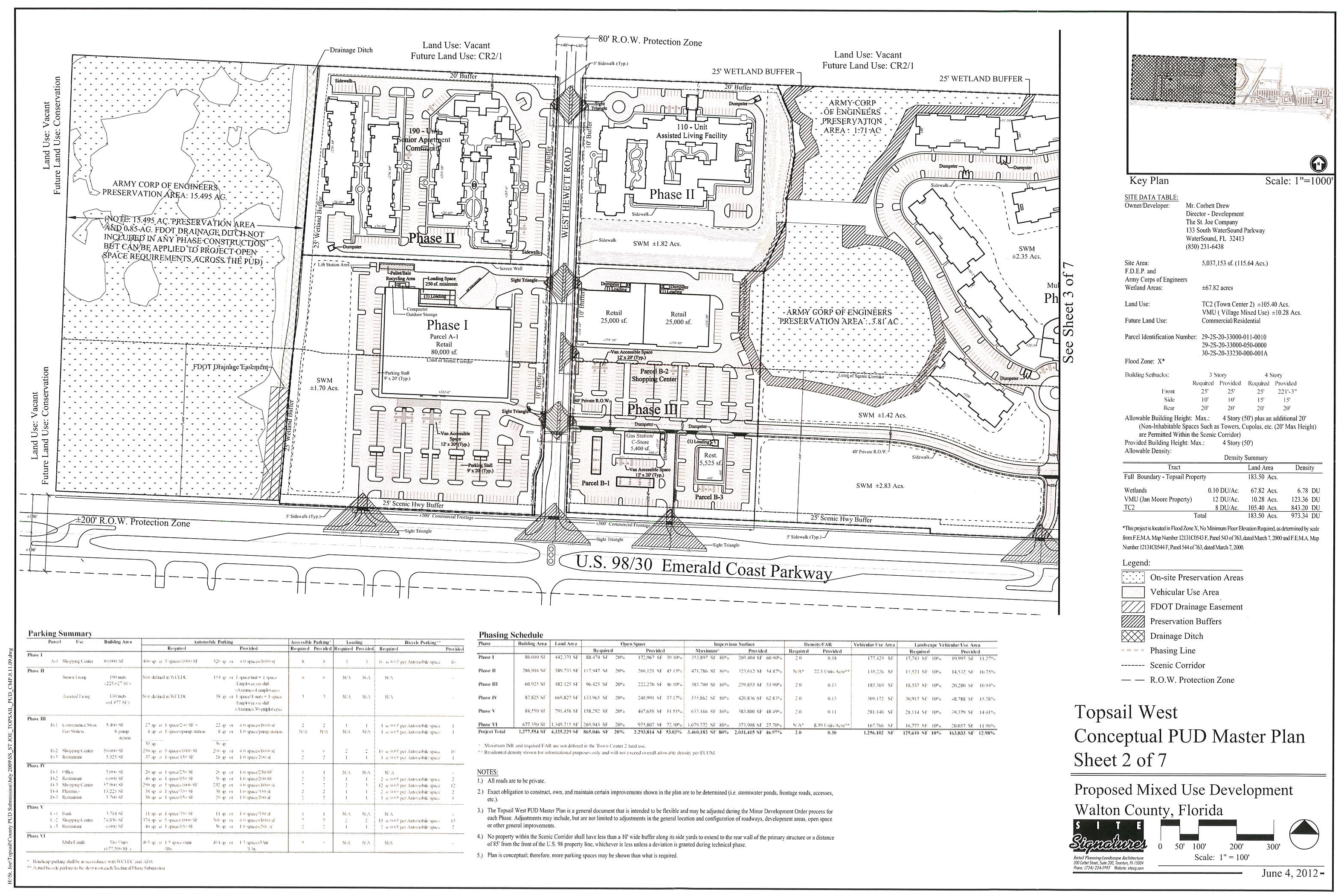
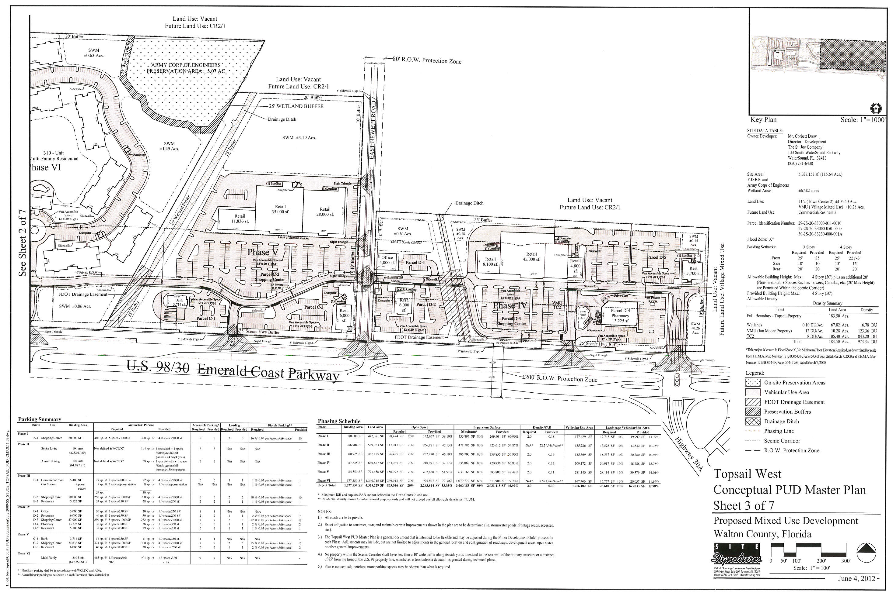
Topsail West Mixed Use Conceptual PUD Master Plan Map:
(Ord. No. 2016-20, § 2, 8-9-16)