
Walton County Unincorporated
City Zoning Code
City Zoning Code
CHAPTER VI
SIGNS, SCENIC CORRIDOR AND VISTA OVERLAY DISTRICTS7
Editor's note— Ord. No. 2018-29, § II(Att. A), adopted December 11, 2018, amended chapter VI in its entirety to read as herein set out. Former chapter VI, §§ 6.00.00, 6.01.01—6.01.05, 6.02.01, 6.02.02, 6.03.01, 6.04.01—6.04.05 accessory and temporary structures and uses. See Code Comparative Table for complete derivation.
6.00.00.- PURPOSE
These sign regulations are established to safeguard the health, safety, convenience, order and welfare of all residents of Walton County. The Sign regulations in this Chapter are not intended to censor speech or to regulate viewpoints, but instead are intended to regulate the adverse secondary effects of Signs. The purpose of this Chapter is to provide a balanced and fair legal framework for the design, construction, and placement of signs that:
A.
Promote the safety of persons and property by ensuring that signs do no create a hazard by:
1.
Confusing or distracting motorists; or
2.
Impairing drivers' ability to see pedestrians, obstacles or other vehicles, or to read traffic signs.
B.
Promote the efficient communication of messages, and ensures that persons exposed to signs are not overwhelmed by the number of messages presented;
C.
Protect the public welfare and enhance the appearance and economic value of the landscape by reducing and preventing sign clutter;
D.
Ensure that signs are compatible with their surroundings, and prevent the construction of signs that are a nuisance to occupants of adjacent and contiguous property due to brightness, reflectivity, bulk or height;
E.
Enhance property values and business opportunities;
F.
Assist in wayfinding;
G.
Provide for fair and consistent permitting and enforcement;
H.
Ensure that signs are constructed, installed, maintained in a safe and satisfactory manner, and to protect the public from unsafe signs;
I.
Allow signs that are compatible with adjacent land uses and preventing signs which contribute to sign proliferation or that conceal or obstruct adjacent land uses or signs; and
J.
Prevent the physical obstruction of streets and sidewalks, creating public safety hazards.
(Ord. No. 2018-29, § II(Att. A), 12-11-18)
6.02.00. - EXEMPT SIGNS
Unless otherwise specified, the following signs are exempt from the operation of these sign regulations, and from the requirement in this Code that a permit be obtained for the erection of permanent signs, provided they are not placed within the right-of-way of any road or constructed so as to create a hazard of any kind:
A.
Signs erected by the County or other government agency.
B.
Signs required by law or regulation.
C.
Signs being carried by a person provided that such signs are not set down or propped on objects.
D.
Temporary decorations or displays, if they are clearly incidental to, customarily, or commonly associated with any national, State, or local holiday or religious celebration; such decorations and displays may be of any type, number, area, height, location, illumination or animation.
E.
Signs that are not designed or located so as to be visible from any street or adjoining property.
F.
On-premises signs of two square feet or less and signs that include no letters, symbols, logos, or designs in excess of two inches in a vertical or horizontal position.
G.
Signs necessary to promote health, safety and welfare, and other regulatory, statutory, traffic control or directional signs erected on public property with permission as appropriate from the State of Florida, the United States, or Walton County.
H.
Decorative flags and bunting for a celebration, convention, or commemoration of significance to the entire community when authorized by the County Commission for a prescribed period of time.
I.
Flags, emblems, or insignias of the United States, State of Florida, or Walton County.
J.
Temporary signs for political candidacy, nonprofit organizations, religious institutions and other signs conveying a non-commercial message for a one-time event provided that such signs are removed within 15 days following the campaign, drive, or event.
(Ord. No. 2018-29, § II(Att. A), 12-11-18)
6.04.00. - GENERAL REGULATIONS
All signs installed in the unincorporated areas of Walton County shall comply with the following regulations.
(Ord. No. 2018-29, § II(Att. A), 12-11-18)
6.09.00. - SCENIC CORRIDOR AND VISTA OVERLAY DISTRICTS
It is the intent of the County Commission to preserve the aesthetic values of certain scenic corridors and vistas as viewed from various public roadways within the County through the adoption of this Section. These scenic corridors and related vistas contribute to the enjoyment and environmental enrichment of the citizens of the County and visitors thereto, protect and enhance the County's attraction to tourists, enhance the civic pride, protect economic values of affected properties.
(Ord. No. 2018-29, § II(Att. A), 12-11-18)
6.10.00. - THE ROUTE 30A SCENIC CORRIDOR OVERLAY
A.
Purpose. The purpose of the Route 30A Scenic Corridor Overlay design standards shall be to preserve and maximize views of the Gulf of Mexico and to enhance the visual characteristics of the north and south sides of the Route 30A right-of-way as well as the east and west rights-of-way of the connector roadways.
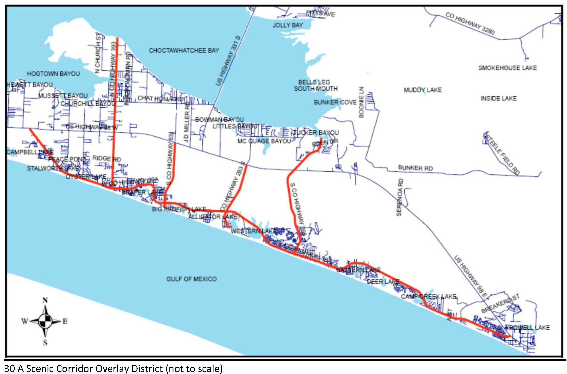
B.
Applicability. All properties that are located contiguous to County Road 30A, County Road 393, or County Road 395 and those properties that are contiguous to the portions of County Road 83 and County Road 283 located south of U.S. 98 (as depicted in map 6-1) shall, for the purposes of this section, be considered within the Route 30A Scenic Corridor Overlay. All properties within the Route 30A Scenic Corridor Overlay shall comply with the design standards in this section.
C.
Florida Scenic Highway Distinction. Route 30A Scenic Corridor Overlay is a County designation and the Florida Scenic Highway program is a State of Florida designation this is separate and distinct from the County program. Although these programs are separate and distinct from one another, the Route 30A Scenic Corridor encompasses the Florida Scenic Highway designated roadways.
D.
The rights-of-way of Route 30A and these connector roadways are the property of Walton County and their use by any private or public entity is permissible only with the expressed and written authorization of the Board of County Commissioners
(Ord. No. 2018-29, § II(Att. A), 12-11-18)
6.11.00. - THE U.S. 98 AND U.S. 331 SCENIC CORRIDOR OVERLAY DISTRICT DESIGN STANDARDS
A.
Intent. The specific intent of the standards lies in limiting the quantity of curb cuts; encouraging the use of cross-access corridors and joint-use driveways to increase safe access to commercial entities; retaining natural vegetation when at all possible; establishing a lush, vegetative street-front canopy; creating and preserving green space between development; encouraging safe pedestrian and vehicular travel along the corridors encouraging parking in side and rear areas; and limiting the number and size of signs to maintain the natural beauty of the area.
B.
Overlay District Established. All projects within the Scenic Corridors shall comply with the design and other standards included herein.
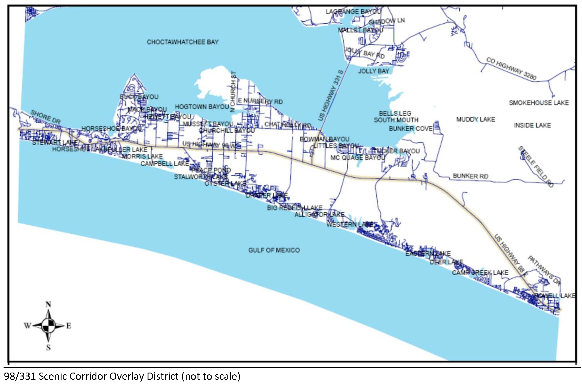
The following areas are hereby included within the U.S. 98 and U.S. 331 Scenic Corridor Overlay District:
A.
The Scenic Corridor width extends 400 feet north and 400 feet south of the outward edges of U.S. Highway 98 right-of-way from the Okaloosa/Walton County line east to the Walton/Bay County line.
B.
The Scenic Corridor width extends 400 feet east and 400 feet west of the outward edges of the U.S. 331 right-of-way from U.S. Highway 98 north to the south end of the bridge at Choctawhatchee Bay.
C.
Specific Provisions Related to Change of Use or Expansion within the U.S. 98 and U.S. 331 Scenic Corridor Overlay District.
1.
Change of Use (see Glossary). Color, paving/parking, paving/walks, walls and landscaping requirements of these standards shall be met when a site changes use provided; however, the compliance with these standards shall be met in a time period not exceeding three years from the use change as provided by Walton County Land Development Code or interpretation by Walton County. With the exception of single-family homes, a change to the exterior of a building, through new siding, repainting, or similar change, shall require review and approval by the Corridor Review Specialist unless the materials and colors have already received DRB approval.
2.
Expansion of Building(s). Expansion of any existing building that is greater than 2,000 square feet or where such expansion will increase the building to more than 2,000 square feet shall require full compliance with these standards. Expansion that does not exceed 2,000 total square feet shall require that the newly expanded building and site (existing and new construction) meet only the color, signage, paving/parking, paving/walks and landscaping requirements of these standards.
(Ord. No. 2018-29, § II(Att. A), 12-11-18)
6.14.00. - APPROVED PLANT LIST FOR SCENIC CORRIDOR OVERLAY DISTRICTS
Plants noted with an asterisk (*) are non-native and shall be used only as accent plantings. They shall be subordinate in number and massing to native plantings.
A.
Canopy Trees:
B.
Understory Trees:
C.
Shrubs:
D.
Vines and Groundcovers:
E.
Palms:
(Ord. No. 2018-29, § II(Att. A), 12-11-18)
6.00.01. - Intent.
The intent of these regulations is to promote the public health, safety and general welfare through reasonable, consistent and non-discriminatory sign standards. These sign regulations are not intended to regulate signs based on their message, censor speech or regulate viewpoints, but instead are intended to regulate the adverse secondary effects of signs, including impact to aesthetics and traffic and pedestrian safety. The intent of these regulations is to provide for the proper control of signs in a manner consistent with the First Amendment guarantee of free speech and to advance the following important, substantial, and compelling governmental interests.
(Ord. No. 2018-29, § II(Att. A), 12-11-18)
6.00.02. - Title and Authority.
This Chapter may be known as the Sign Code of Walton County, Florida.
This Chapter is adopted pursuant to the police power of the County and State law. The Director of Planning and Development Services, or designee is authorized and directed to administer and enforce this Chapter.
(Ord. No. 2018-29, § II(Att. A), 12-11-18)
6.00.03. - Applicability.
The provisions of these regulations shall apply to the display, construction, erection, alteration, use, maintenance, and location of all signs within Walton County.
A.
All signs displayed, constructed, erected or altered after the date of the adoption of these regulations shall be in conformance with the provisions of these regulations.
B.
All signs that are existing at the time of the adoption of these regulations shall not be altered or enlarged without being brought into conformance with these regulations.
(Ord. No. 2018-29, § II(Att. A), 12-11-18)
6.00.04. - Nonconforming Signs.
Nonconforming signs shall be subject to the provisions of Section 1.15.08C.
(Ord. No. 2018-29, § II(Att. A), 12-11-18)
6.00.05. - Viewpoint Neutrality.
Notwithstanding anything in this Chapter to the contrary, no sign or sign structure shall be subject to any limitation based upon the viewpoint of the message contained on such sign or displayed on such sign structure.
(Ord. No. 2018-29, § II(Att. A), 12-11-18)
6.00.06. - Substitution of Noncommercial Speech for Commercial Speech.
Notwithstanding anything contained within this Chapter to the contrary, any sign erected pursuant to the provisions of this Chapter may, at the option of the owner, contain a noncommercial message in lieu of a commercial message and the noncommercial copy may be substituted in whole or in part at any time in place of the commercial copy. The noncommercial message (copy) may occupy the entire sign face or any portion thereof. The sign face may be changed from a commercial message to a noncommercial message or from one noncommercial message to another noncommercial message; provided, however, that there is no change in the size, height, setback, spacing or other non-content based criteria contained in this Chapter.
(Ord. No. 2018-29, § II(Att. A), 12-11-18)
6.00.07. - Sign Maintenance.
All signs shall be maintained in a safe condition in compliance with all building and electrical codes, and in conformance with this section.
A.
All signs, including sign structures and sign faces, shall be kept in good repair so as not to be distracting, unattractive, dangerous or a public nuisance and effectively serve the purpose for which they are intended. For the purposes of this subsection, good repair shall mean there are no loose, broken, torn or severely weathered portions of the sign structure or sign face.
B.
All signs shall be properly maintained. Exposed surfaces shall be clean and painted to present a neat and professional appearance.
C.
The Director of Planning and Development shall have the right to order repair or removal of any sign which is defective, damaged or substantially deteriorated, as defined in the adopted building code.
(Ord. No. 2018-29, § II(Att. A), 12-11-18)
6.00.08. - Sign Removal and Replacement.
Any alteration to an existing sign, other than for a change of copy, shall require a new sign permit. Alterations include changing the size, height, material, location shape and lighting of the sign.
(Ord. No. 2018-29, § II(Att. A), 12-11-18)
6.00.09. - Sign Removal or Repair.
In addition to other remedies available under this Code, the Director of Planning and Development Services may issue a written notice to sign owners of the need to remove or repair a sign, as follows:
A.
Any sign that does not meet the requirements established by this Chapter and does not qualify as a legal nonconforming sign as defined by this Code.
B.
Any sign that has not been used in a bona fide manner as a sign for a consecutive period of thirty (30) days and deemed abandoned by the Director of Planning and Development Services or designee.
C.
Any sign that is in disrepair or unsafe and determined hazardous by the Director of Planning and Development Services or designee.
D.
Any sign identifying a business, professional or industrial establishment that has moved from the premises.
E.
The Building Official is authorized to remove or require the immediate removal or repair without written notice of any unsafe sign that creates an immediate hazard to persons or property.
(Ord. No. 2018-29, § II(Att. A), 12-11-18)
6.01.01. - Relationship to Building and Electrical Codes.
These sign regulations are intended to complement the requirements of the building and electrical codes adopted by the County. Wherever there is inconsistency between these regulations and the building code, electrical code or National Electrical Safety Code, the more stringent requirement shall apply.
(Ord. No. 2018-29, § II(Att. A), 12-11-18)
6.01.02. - Signs on Public Property.
Except as required by state law or otherwise permitted by this Chapter, any sign installed or placed on public property shall be deemed illegal and shall be forfeited to the public and subject to confiscation. In addition to other remedies hereunder, the County shall have the right to recover from the owner or person placing the sign the cost of removal and disposal of the sign as provided in Chapter 7 of this Code.
(Ord. No. 2018-29, § II(Att. A), 12-11-18)
6.01.03. - Relationship to Scenic Corridor Requirements.
These sign regulations are replaced and/or supplemented by the regulatory provisions of found later in this Chapter for all areas within the boundaries of one of the designated Scenic Corridor and Vista Overlay Districts in the County.
(Ord. No. 2018-29, § II(Att. A), 12-11-18)
6.01.04. - Application Process.
The application process for sign permits shall be governed by the provisions of Section 1.13.09.D of this Code. Signs displayed by bona fide nonprofit organizations are exempt from sign permitting fee requirements. This exemption shall not extend to the other provisions and requirements of this Chapter.
(Ord. No. 2018-29, § II(Att. A), 12-11-18)
6.03.01. - Specifically.
The following signs are expressly prohibited:
A.
Signs that are in violation of the building code or electrical code adopted by the County.
B.
Any sign that, in the opinion of the building official or the Director of Planning and Development Services Department, does or will constitute a safety hazard.
C.
Blank temporary signs.
D.
Signs that obstruct the vision of pedestrians, cyclists, or motorists traveling on or entering public streets.
E.
Signs placed upon benches, bus shelters or waste receptacles, except as authorized in writing pursuant to Florida Department of Transportation standards.
F.
Snipe signs.
G.
Signs with a revolving, flashing or rotating beam or beacon of light that simulates any emergency light or design.
H.
Portable signs, except as described herein, located in the South Walton and South Central Walton Planning Areas.
I.
All signs excluding regulatory signs and signage specifically approved by the Board of County Commissioners are prohibited within rights-of-way.
J.
All signs not expressly permitted herein or exempt pursuant to Section 6.02.00.
K.
Any sign located on or attached to a building roof.
L.
Any sign attached to any utility pole or structure within any public rights-of-way.
M.
Any sign that projects, overhangs or otherwise is located in the public rights-of-way, except as specifically permitted by this Chapter.
N.
Any sign that impedes safe pedestrian or vehicular movement.
O.
Signs attached to trees or other plant materials.
P.
Abandoned signs.
(Ord. No. 2018-29, § II(Att. A), 12-11-18)
6.04.01. - Permissible Number, Area and Height of On-Premises Signs.
A.
Ground Signs. The permissible number, area, spacing and height of on-premises ground signs for each multiple-occupancy complex and each occupant not located in a multiple-occupancy complex shall be determined according to the following tables and text:
B.
Building Signs.
1.
Subject to the design criteria in Section 6.08.00 of this chapter, the maximum height of a building sign shall be 18 feet, except that on a building of more than two stories, a single building sign is allowed above 18 feet on each side of the building.
2.
Each multiple-occupancy complex may display one permanent building sign on each side of the principal building or buildings in which the complex is located, not to exceed a sign area of up to ten percent of the facade area (see Section 6.07.00, Measurement determinations).
3.
Each occupant of a multiple-occupancy complex may display three permanent building signs on any exterior portion of the complex that is part of the occupant's unit (not including a common or jointly owned area), not to exceed a total combined sign area of 15 percent of the facade area (see Section 6.07.00, Measurement determinations) of such exterior portion.
4.
Each occupant not located in a multiple-occupancy complex may display three permanent building signs on each side of the principal building in which the occupancy is located, not to exceed a total combined sign area for each building side of 20 percent of the facade area (see Section 6.07.00, Measurement determinations) of the building side.
(Ord. No. 2018-29, § II(Att. A), 12-11-18)
6.04.02. - Directional Signs.
Directional signs limited in area to four square feet, giving directions to motorists regarding the location of parking areas and access drives shall be permitted as permanent signs on all parcels and shall not be counted as part of an occupancy's allowable sign area.
(Ord. No. 2018-29, § II(Att. A), 12-11-18)
6.04.03. - Signs at Entrances to Communities, Residential Developments, Farms and Ranches.
A.
Generally. A permanent sign may be displayed at the entrance to communities, residential developments, farms and ranches.
B.
Community Directory Signs.
1.
Community directory signs are permitted at the intersections of state or U.S. Highways and County roads throughout the County to serve as a directional point of reference for communities and the small businesses therein that are located off main arterial roads. This section is intended to foster community identity and discourage the proliferation of individual business signs at roadway intersections.
2.
Community Directory signs shall be of a standard composition as prescribed in Exhibit 1 of this Code to present a neat, uncluttered appearance along the roadway. Copy shall be limited to identification of the community at the top, and the name of each participating business located in that community. Multi-tenant complexes shall be allowed one panel on the sign to indicate the location of the complex, but individual businesses within that complex shall not be shown. Commercial advertising or other messages on this type of sign are prohibited, except the bottom of the sign may be reserved for temporary signs for yard sales or other events within the community if desired.
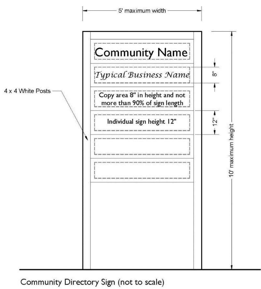
Exhibit 1. Community Directory Signs
3.
Participating businesses or community groups may erect one sign at the intersection of the state or U.S. Highway and the County Road leading into the community. The sign shall be sited out of the state or U.S. Highway right-of-way, and on the back edge of the County's right-of-way. It may be angled for better presentation toward the main road. Applications for community directory signs shall be submitted by a representative of the participating businesses to the planning department using a Walton County Sign Permit Application. The Planning Director or a representative will review the plans for compliance with this section and approve the sign for construction. The Code Enforcement Department will monitor subsequent usage of the sign after it is built and erected. Walton County shall not incur additional cost in the construction, erection, or the maintenance of these signs.
C.
Restrictions for Individual Residential Developments, Farms or Ranches.
1.
One sign is permitted at each entrance into the development, farm or ranch from each abutting street. The sign may be a single sign with two faces of equal size or may be two single-faced structures of equal size located on each side of the entrance. No face of the sign shall exceed 40 square feet in size, and the sign may be illuminated in a steady light only.
2.
When considering the placement of such signs, the Director of planning and zoning shall consider the location of public utilities, sidewalks and future street widenings.
(Ord. No. 2018-29, § II(Att. A), 12-11-18)
6.04.04. - Utility Signs.
Public utility signs that identify the location of underground utility lines and facilities, high-voltage lines and facilities, and other utility facilities are permitted.
(Ord. No. 2018-29, § II(Att. A), 12-11-18)
6.04.05. - Transit Stop Signage.
Transit Stop signs may be allowed on private property as part of an approved Transit Stop plan, and shall be in addition to the number and type of signs otherwise authorized by this Code. Permission of the landowner shall be required and such signs may not exceed two (2) square feet in sign face area. Such signs may be post-mounted, transit stop shelter-mounted, or building-mounted as determined by the location/design of the transit stop being advertised on the transit stop signage. Transit stop signs located on private property require permitting in accordance with Chapter 1 of the Land Development Code. Transit stop signage as part of an approved Transit Stop plan may be located on public property after review and approval by Walton County Division of Public Works.
(Ord. No. 2018-29, § II(Att. A), 12-11-18)
6.04.06. - FDOT Tourist-Oriented Directional Signs (TODS).
Program implementation. The Board of County Commissioners of Walton County adopts and establishes the tourist-oriented directional signs (TODS) program as more fully described by Florida Administrative Code 14-51, Part VI, within Walton County, Florida, and authorizes the placement of appropriate signage in accordance therewith. The following criteria is established for Tourist-Oriented Directional Signs (TODS) program eligibility within Walton County, Florida.
A.
TODS may be installed on non-limited access facilities within Walton County, Florida as defined in F.S. § 334.03, on the state highway system in accordance with the Florida Department of Transportation Manual on Uniform Traffic Control Devices (MUTCD).
B.
Prior to the installation of a TODS on the state highway system the Department of Transportation must approve, by permit, the design, location and placement based on the criteria set forth in chapter 14-51 of the Florida Administrative Code, as applicable.
C.
The TODS program is not eligible within three designed Scenic Corridor Overlay Districts.
D.
No franchise or national chains are permitted in the TODS program.
E.
To qualify as a TODS designation, the tourist-oriented businesses, services, or activities shall meet the following minimum conditions:
1.
The major portion (51%) of income or visitors during the normal business season shall be from tourists not residing with 20 miles of the destination. A business shall not qualify if admission or access is based on a membership fee or other means of exclusive admission, or where minors are excluded. All state and local building and occupational permits, licensing, and registrations shall be current and in good standing.
2.
Eligibility criteria for the TOD program within Walton County shall initially be limited to family-oriented businesses which receive a major portion of income and visitors from people who do not live in the immediate area, including recreational activities, agriculture production, eateries offering local cuisine, retail markets, galleries, and like businesses. The Board reserves the right to include future designated local treasures or to expand the categories to other designated facilities by a properly passed resolution of the Board.
3.
All applicants for participation in the TODS program shall first complete an application as to the sign they are requesting for approval by the Board of County Commissioners, prior to submission of a permit request to Florida Department of Transportation for permit approval for signage on the state highway system.
4.
Following receipt of the appropriate permit from the Florida Department of Transportation, Walton County shall be responsible for the approved design, fabrication, installation, and maintenance of the signs, in accordance with applicable Florida Department of Transportation standards.
5.
Applicants for TODS shall be responsible for all costs for permitting and signage. Any permit fees shall be paid at time of application. Upon approval of the application by Walton County and the permit by Florida Department of Transportation, the applicant shall then pay the cost for manufacture of the requested signage prior to its manufacture.
6.
All signage placed upon the state highway system shall at all times be kept in a neat and attractive condition, and the need for replacement or maintenance of such signage shall be in the sole discretion of the Board of County Commissioners or its designee. All costs for replacement, or maintenance of such signage shall be at the sole expense of the business or owner for whom the sign is placed.
F.
Location and Placement.
1.
TODS may be installed on the state highway system only after permitted by the Florida Department of Transportation.
2.
TODS shall not be permitted by the Florida Department of Transportation if they interfere with the effectiveness of other traffic control devices.
3.
TODS shall only be permitted at the nearest intersection providing the most direct practical route to the eligible facility. An additional sign may be approved at the closest state road intersection with a roadway on the Strategic Intermodal System (SIS) when the nearest state road intersection is not on an SIS facility.
4.
Each destination is limited to one sign panel in each direction of travel on the state highway system.
5.
The maximum distance from the business to where a TODS may be placed on the state highway system shall be 25 miles.
6.
If a facility with state road frontage is more than 10 miles from the nearest state highway system intersection suitable for TODS installation, the jurisdiction with TODS authority may apply for a permit to sign for this facility with a "one mile" advanced TODS sign. This is the instance an advanced sign may be permitted on the state highway system.
7.
TODS shall be limited to placement on rural conventional roads, as stated in the Manual on Uniform Traffic Control Devices (MUTCD). TODS shall not be placed within the right-of-way of limited access facilities. TODS shall not be located in the right-of-way of limited access facilities. TODS shall not be located in the right-of-way of a limited access facility interchange regardless of jurisdiction.
8.
The location of other traffic control devices shall take priority over the location of TODS. TODS shall have standard spacing with other traffic control devices in accordance with Florida Department of Transportation rules and regulations.
9.
The Florida Department of Transportation, or Walton County as applicable, may remove without notice, and with no obligation to relocate the sign or compensate for its removal, any TODS on the state highway system, for highway safety or operational purposes or activities including but not limited to construction, reconstruction, or maintenance.
(Ord. No. 2018-29, § II(Att. A), 12-11-18)
6.05.01. - Generally.
The County has a substantial and/or compelling interest in preventing negative impacts associated with temporary signs. Temporary signs may be degraded, damaged, moved, or destroyed by wind, rain, snow, ice, and sun, and after such degradation, damage, movement, or destruction, such signs harm the safety and aesthetics of the County's streets if they are not removed.
The County recognizes that, by their nature, some signs are intended from their construction to serve a temporary purpose only. Such signs shall be identified as temporary signs and be allowed throughout the County, provided that they satisfy the restrictions imposed by this section and other relevant parts of this Code.
(Ord. No. 2018-29, § II(Att. A), 12-11-18)
6.05.02. - Removal of Illegal Temporary Signs.
Any temporary sign not complying with the requirements of this section is illegal and subject to immediate removal. The owner will be notified by the County and given a reasonable amount of time to remove the illegal sign. If the illegal sign is not removed at the end of the time period as established in the Notice of Violation, the County may impose a fine in accordance with Chapter 7 of this Land Development Code.
(Ord. No. 2018-29, § II(Att. A), 12-11-18; Ord. No. 2022-13, § II, 8-25-22)
6.05.03. - Permissible Temporary Signs Not Requiring a Permit.
Temporary signs serving the functions below shall not require a sign permit and shall be of temporary nature and removed following the described event, provided that they satisfy the provisions of this code:
A.
To indicate that an owner, either personally or through an agent, is actively attempting to sell, rent or lease the property on which the sign is located.
B.
To announce or advertise such temporary uses or events such as open houses, fairs, carnivals, circuses, revivals, sporting events, flea markets, farmers markets, or any public, charitable, educational or religious event or function. Such message shall be removed within five days after the special event.
C.
To identify construction in progress. Temporary construction signs [are permitted] when displayed on the property of a County-permitted building project, subject to the requirements of section 6.05.06, Permissible size, height, and number of temporary signs.
(Ord. No. 2018-29, § II(Att. A), 12-11-18; Ord. No. 2019-19, § II(Att. A), 9-10-19)
6.05.04. - Permissible Temporary Signs Requiring a Permit.
Temporary signs serving the functions below shall require a sign permit and shall be subject to the provisions of this Code:
A.
To indicate the grand opening or promotional sale for a business or other activity. Such message may be displayed for a period not exceeding 14 days and such display shall be limited to no more than four times per year, except that interior window signs indicating a sale may be displayed any number of times per year.
B.
To indicate the existence of a new business, or a business in a new location, if such business has no permanent signs. Such message may be displayed for a period of not more than 60 days or until installation of permanent signs, whichever shall occur first.
(Ord. No. 2018-29, § II(Att. A), 12-11-18)
6.05.05. - Permissible Location of Temporary Signs.
Temporary signs may be located throughout the County, subject to the property line setback requirements and the visibility triangle described in Chapter 5.
(Ord. No. 2018-29, § II(Att. A), 12-11-18)
6.05.06. - Permissible Size, Height and Number of Temporary Signs.
A.
One-family and two-family residences. A parcel on which is located a single one-family or two-family residence may display not more than two temporary signs with an aggregate sign area of not more than 12 square feet, excluding real estate sign riders. No individual sign shall exceed six square feet, excluding real estate riders, nor exceed eight feet in height.
B.
Multifamily residences. A parcel on which is located a multifamily residence may display not more than four temporary signs with an aggregate sign area of not more than 24 square feet. No individual sign shall exceed six square feet, excluding real estate riders, nor exceed eight feet in height.
C.
On all other parcels. All other parcels may display one square foot of temporary signage per ten feet of frontage up to a cumulative maximum of 100 square feet per parcel. However, no individual sign shall exceed 32 square feet nor exceed ten feet in height. Signs located on the same parcel erected pursuant to this section must be spaced at least 100 feet apart.
(Ord. No. 2018-29, § II(Att. A), 12-11-18; Ord. No. 2019-19, § II(Att. A), 9-10-19)
6.05.07. - Sandwich Board Signs.
Sandwich board signs shall be reviewed and approved by the Building and Planning Department with the following conditions:
A.
Sign Area. Sandwich Boards shall not exceed three feet six inches in height, 24 inches in width. (Sandwich Board sign area shall not count against the total allowed square footage of signage per business).
B.
Location. Sandwich Boards shall be located so that they do not block sidewalks, driveways, trails or paths. Signs shall be located in front of the physical business it is serving but shall not impede access to the business's primary entrance. Businesses in multi-tenant structures shall maintain the sign in front of the individual unit or units of the individual business. Such signs shall not be used as a substitute for permanent on-premises signage. Sandwich boards are prohibited from placement on or within the right-of-way of any public trail or roadway.
C.
Number. Only one sandwich board shall be permitted per business.
D.
All such signs must be removed and stored inside a structure at the close of business each day, and may be placed in the permitted location at the opening of business the following day, for the period that the sign permit is valid.
E.
Sandwich boards shall have a maximum of two panels.
F.
Permit numbers shall be placed on the upper right-hand corner of each face of the Sandwich board sign. Permit numbers shall be one inch in height.
(Ord. No. 2018-29, § II(Att. A), 12-11-18; Ord. No. 2019-19, § II(Att. A), 9-10-19; Ord. No. 2022-13, § II, 8-25-22)
6.06.01. - Size of Permanent Outdoor Advertising Signs.
The maximum area of a permanent outdoor advertising sign face shall be 950 square feet.
(Ord. No. 2018-29, § II(Att. A), 12-11-18)
6.06.02. - Location of Permanent Outdoor Advertising Signs.
Permanent outdoor advertising signs which conform to the provisions of this section shall be permitted in the unincorporated area of Walton County and shall be subject to the following:
A.
No two permanent outdoor advertising signs shall be spaced less than 1,500 feet apart on any thoroughfare, such distance measured along the nearest edge of the pavement between points directly opposite the center of the signs along each side of the highway. Where an exception to this spacing may be necessary, a variance may be applied for as provided within this Code.
B.
No permanent outdoor advertising sign shall be located in such a manner as to obscure, or otherwise physically interfere with the effectiveness of, an official traffic sign, signal or device, or obstruct or physically interfere with a driver's view of approaching or intersecting traffic.
C.
For the purposes of determining compliance with the spacing restriction in paragraph A. above:
1.
Each side of a thoroughfare shall be considered separately;
2.
V-type or back-to-back permanent outdoor advertising signs shall be considered one sign; and
3.
The spacing shall be determined based on valid County permits, and a prior permit holder shall have priority over a later applicant in determining compliance with the spacing restrictions.
D.
Where two or more permanent outdoor advertising signs, each of which was lawfully installed at its time of installation, are situated closer to each other than permitted by Section 6.06.02(A), then all such signs except the first one installed in the County shall be nonconforming.
E.
No permanent outdoor advertising sign shall consist of two or more sign faces stacked on top of each other or placed side by side to each other.
F.
Permanent outdoor advertising signs shall not be established at any location having principal frontage on any street within 100 feet of any property which is used for public parks, public schools, church, courthouse, city hall or public museum having principal frontage on the same street.
G.
No permanent outdoor advertising sign or part thereof shall be located on any property without the written consent of the owner, holder, lessee, agent or trustee.
(Ord. No. 2018-29, § II(Att. A), 12-11-18)
6.06.03. - Height of Permanent Outdoor Advertising Signs.
There shall be a minimum clearance of ten feet to the bottom of a permanent outdoor advertising sign face and a maximum height of 65 feet to the top of a permanent outdoor advertising sign face, from grade of the thoroughfare to which the sign is oriented. Any embellishments at the bottom of the sign face will be considered in determining the ten-foot minimum clearance.
(Ord. No. 2018-29, § II(Att. A), 12-11-18)
6.06.04. - Construction Standards.
All permanent outdoor advertising signs shall be constructed in accordance with the building code of the County, and no permits shall be issued pursuant to the building code until information is provided to the building official demonstrating the sign will be constructed in accordance with this section. The building official is authorized to order the removal and to remove all signs constructed in contravention of this section in the same manner and by following the procedure for removing unsafe signs as set out in the building code.
(Ord. No. 2018-29, § II(Att. A), 12-11-18)
6.07.01. - Sign Area.
A.
Generally. The area of a sign shall be the area within the smallest square, rectangle, parallelogram, triangle, circle or semicircle, the sides of which touch the extreme points or edges of the sign face.
B.
Special Situations.
1.
Where a sign is composed of letters or pictures attached directly to a facade, window, door, or marquee, and the letters or pictures are not enclosed by a border or trimming, the sign area shall be the area within the smallest rectangle, parallelogram, triangle, circle or semicircle, the sides of which touch the extreme points of the letters or pictures.
2.
Where two sign faces are placed back to back on a single sign structure, and the faces are at no point more than four (4) feet apart, the area of the sign shall be counted as the area of one of the faces.
3.
Where four sign faces are arranged in a square, rectangle, or diamond, the area of the sign shall be the area of the two largest faces. Where a sign is in the form of a three-dimensional object, the area shall be determined by drawing a square, rectangle, parallelogram, triangle, circle or semicircle, the sides of which touch the extreme points or edges of the projected image of the sign and multiplying that area by two. The "projected image" is that image created by tracing the largest possible two-dimensional outline of the sign.
(Ord. No. 2018-29, § II(Att. A), 12-11-18)
6.07.02. - Number of Signs.
A.
Generally. In general, the number of signs shall be the number of noncontiguous sign faces. Multiple noncontiguous sign faces may be counted as a single sign if all the sign faces are included in the geometric figure used for determining the sign area.
B.
Special Situations.
1.
Where two sign faces are placed back to back and are at no point more than three feet apart, it shall be counted as one sign.
2.
If a sign has four faces arranged in a square, rectangle or diamond, it shall be counted as two signs.
(Ord. No. 2018-29, § II(Att. A), 12-11-18)
6.07.03. - Sign Height.
The height of a sign shall be measured as the vertical distance from the finished grade at the base of the supporting structure to the top of the sign, or its frame or supporting structure, whichever is higher. The grade shall not be artificially changed solely to affect the sign height measurement.
(Ord. No. 2018-29, § II(Att. A), 12-11-18)
6.08.01. - Generally.
All permanent signs must comply with the following design, construction, maintenance and location standards.
(Ord. No. 2018-29, § II(Att. A), 12-11-18)
6.08.02. - Compliance with Building and Electrical Codes Required.
All permanent signs, and the illumination thereof, shall be designed, constructed and maintained in conformity with applicable provisions of the building code and electrical codes adopted by the County and the National Electrical Safety Code.
(Ord. No. 2018-29, § II(Att. A), 12-11-18)
6.08.03. - Sign Design.
A.
Signs shall incorporate unifying elements which may include uniformity in materials, colors, size, height, letter style, sign type, shape, lighting, location on buildings and design motif.
B.
Materials and textures of signs shall be compatible with the architectural character of the building. Supporting sign structures of freestanding signs shall match the primary finish and colors of the associated buildings.
C.
When possible, freestanding signs shall integrate tenant signs into a single sign structure.
D.
Wayfinding signage systems shall reflect a unified design in terms of style, colors and materials. Wayfinding signs shall be placed at consistent locations at project entries, circulation road intersections, building entries, seating areas and sidewalk intersections.
(Ord. No. 2018-29, § II(Att. A), 12-11-18)
6.08.04. - Illumination Standards.
A.
Sign lighting may not be designed or located to cause confusion with traffic lights.
B.
Illumination by floodlights or spotlights is permissible so long as none of the light emitted shines directly onto an adjoining property or into the eyes of motorists or pedestrians using or entering public streets.
C.
Illuminated signs shall not have lighting mechanisms that project more than 18 inches perpendicularly from any surface of the sign over public space.
(Ord. No. 2018-29, § II(Att. A), 12-11-18)
6.08.05. - Placement Standards.
A.
In right-of-way.
1.
Supports for signs or sign structures shall not be placed in or upon a public right-of-way or public easement, except under the terms of a lease between the owner of the easement or right-of-way and the owner of the sign.
2.
No ground sign shall project over a public right-of-way.
B.
The lowest portion of any sign which extends over an area intended for pedestrian use shall not be less than nine (9) feet above finished grade.
C.
The lowest portion of any sign which extends over an area intended for vehicular use shall not be less than sixteen (16) feet above finished grade.
D.
Any sign must comply with this Chapter and applicable provisions of the Americans with Disability Act.
E.
Except for appropriately placed traffic control signs, no sign shall be placed in the sight visibility triangle, except as provided in Chapter 5 of this Code.
F.
No sign shall be erected that impedes use of any fire escape, emergency exit, or standpipe.
G.
A building sign shall not extend beyond any edge of the surface to which it is attached, nor disrupt a major architectural feature of the building.
H.
A building sign may project no more than four feet perpendicularly from the surface to which it is attached.
(Ord. No. 2018-29, § II(Att. A), 12-11-18)
6.08.06. - Format for Multiple-Occupancy Complexes.
Building signs for multiple-occupancy complexes constructed or remodeled after the effective date of this code shall conform to an approved sign format. The sign format shall be included as a submittal for authorization to erect such a sign and shall be maintained on file in the department of planning and zoning. The format shall be presented in a plan or sketch, together with written specifications in sufficient detail to enable the Director of Planning and Development Services to authorize signs based on the specifications. As a minimum, the sign format shall specify the types of signs and dimensions (not to exceed the size limits contained in this chapter) which will be permitted each occupant within the complex. The sign format shall also contain common design elements, such as placement, color, shape, or style of lettering, which lend a unified appearance to the signs of the occupants within the complex. The sign format may only be modified with the approval of the Director of Planning and Zoning upon submission of a revised plan and specifications detailing the revised format.
(Ord. No. 2018-29, § II(Att. A), 12-11-18; Ord. No. 2019-19, § II(Att. A), 9-10-19)
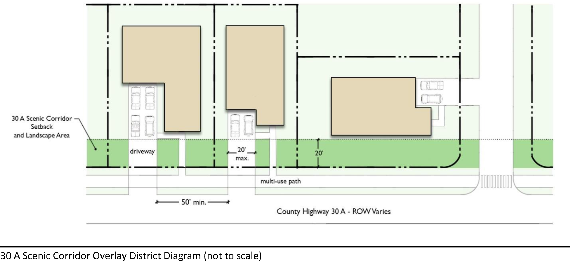
6.10.01. - Setbacks and Building Widths within the Route 30A Scenic Corridor Overlay.
A.
A 20' scenic corridor setback from the adjacent outward edge of the existing right-of-way is required. Except that, properties designated Mixed Use on the adopted Future Land Use Map are not subject to the 20' scenic corridor setback requirement.
1.
Front yard or corner lot side yard building setbacks within Mixed Use Future Land Use Map category as shown on the adopted Future Land Use Map may be less than otherwise required by Chapter 5 if a lesser setback is warranted in order to facilitate better design such as rear or center parking, pedestrian oriented streetscape, better defined public realm, etc.
B.
Building setbacks for structures proposed on lots or parcels located within the Route 30A Scenic Corridor Overlay and not located within the Mixed Use Future Land Use Map category as shown on the adopted Future Land Use Map shall conform to Chapter 5 of this Code.
C.
Awnings and mailboxes are exempt from any required setback.
(Ord. No. 2018-29, § II(Att. A), 12-11-18)
6.10.02. - View Corridor Protection.
The total width of structures built on lots or parcels adjacent to the south right-of-way of Route 30A with a view corridor to the Gulf of Mexico shall not exceed 65 percent of the width of the lot or parcel. Single-family residential is exempt from this requirement unless developed as part of a new single-family residential subdivision, in which case the 65 percent ratio shall apply.
(Ord. No. 2018-29, § II(Att. A), 12-11-18)
6.10.03. - Landscaping Standard within the Route 30A Scenic Corridor Overlay.
A.
Any required setback area in the Route 30A Scenic Corridor shall be landscaped and planted with salt and drought tolerant native species. Salt tolerant species are indicated on the landscape material lists in Chapter 5.
B.
Native natural communities within the Route 30A Scenic Corridor shall be preserved in accord with Section 4.05.00 of this Land Development Code as part of an overall landscape plan. The preservation requirements of Section 4.05.00 shall apply to all parcels within the Route 30A Scenic Corridor Overlay regardless of parcel size.
C.
Landscaping of public right-of-way: Property owners whose property fronts on C.R. 30-A are encouraged to provide landscaping on the public right-of-way. Such landscaping shall utilize native or other approved salt and drought tolerant vegetation as listed in Section 6.14.00 in this Land Development Code.
1.
Each plan for landscaping the public right-of-way shall be prepared and submitted to the Planning and Development Services Division for approval.
2.
Plans will be reviewed by the Walton County Public Works Department for safety issues and by utility companies that make use of the location, and may be subject to a right-of-way use agreement between the applicant and the Walton County Public Works Division.
3.
Under these conditions of public purpose removal, the cost of replacement shall be by the applicant and Walton County will bear no obligation as a result of its approval of landscaping. When utility companies or Walton County find it necessary to remove landscaping on the right-of-way they shall provide reasonable notice to the abutting property owner to allow for that owner to remove and protect plants. When minor and/or emergency repairs by utility companies or by Walton County or when notice has been given and plants have not been removed and landscaping is damaged by the activity of the utility companies or by Walton County, the restoration and the cost of such restoration shall be the responsibility of the abutting property owner.
4.
The applicant, including the providing of an irrigation system shall maintain all landscaping in the public right-of-way. The sprinkler system for all shrub beds shall be drip irrigation. Spray heads are permitted for turf and annual color areas but shall strictly limit overspray onto roadways, bike paths, and driveways, or any other non-landscaped areas to the greatest extent possible. In general the use of low-angle spray heads is encouraged. Rotor heads or other "long-throw" heads are forbidden in the public right-of-way. It shall be the responsibility of the owner to maintain the irrigation system to minimize overspray outside of turf or annual color beds. Upon request, the owner shall operate the irrigation system for the County enforcement officer. Violators shall be subject to fines per County code. All sprinkler controls shall be located to be accessible by the County.
(Ord. No. 2018-29, § II(Att. A), 12-11-18; Ord. No. 2019-19, § II(Att. A), 9-10-19)
6.10.04. - Driveway/Access/Parking Standards within the Route 30A Scenic Corridor Overlay District.
A.
No parking is allowed within the public rights-of-way or public easements unless the parking is for a public purpose and approved by the Board of County Commissioners after engineering technical review of the proposed design by either the Engineering Manager or the County Engineer.
B.
Driveways shall be paved from the edge of the pavement to the property line as a part of any development.
C.
Driveways shall be no closer than 50 feet apart, except where parcel width does not allow for this separation. In such cases where parcel width does not provide for the required driveway separation, the site shall be designed to maximize the separation of driveways, including reducing overall driveway width, driveway sharing and cross access connections. Separation shall be measured from the outward edge of each driveway.
D.
Driveways shall be a maximum of 20 feet in width.
E.
Commercial uses are encouraged to provide parking in the rear of the building to allow building facades and landscaping to predominate in the view from the road. The parking requirements in Chapter 5 shall be reduced 20 percent for all commercial, or mixed use developments that provide parking in the rear of the building.
F.
Other Uses of the Public Right-of-Way Prohibited:
1.
The permanent placement of trash/garbage cans, dumpsters and other such receptacles on the public right-of-way is prohibited. Such containers may be placed on the public right-of-way on the days of pickup, only.
2.
Display of merchandise or merchandising materials (e.g., signs, banners) is prohibited on the public right-of-way.
3.
The use of the public right-of-way for repeated and/or continual deliveries and offloading is prohibited.
4.
The use of brick pavers or concrete for the bike path is prohibited. The only acceptable paving material shall be asphalt.
(Ord. No. 2018-29, § II(Att. A), 12-11-18)
6.10.05. - Sign Standards within the Route 30 A Scenic Corridor Overlay District.
A.
Applicability. Signs within the Route 30-A Scenic Corridor shall conform to this Chapter and shall also be subject to the following standards and prohibitions:
B.
Prohibited signs. In addition to the signs prohibited in Section 6.03.00, the following signs shall be prohibited in the Route 30-A Scenic Corridor:
1.
Permanent off-premises outdoor advertising signs (an off-premises sign is any sign located on property other than that to which the sign relates);
2.
Pole signs;
3.
Water towers as commercial advertising;
4.
Wall murals as commercial advertising;
5.
Off-premises signs;
6.
Temporary mobile or portable signs;
7.
Interior lit single panel plastic or Lexan face;
8.
Streamers, feather flags, pennants, ribbons, spinners, banners and other similar devices;
9.
Flashing signs;
10.
Signs containing reflective elements that sparkle or twinkle in the sunlight;
11.
Roof signs;
12.
Signs containing moving parts;
13.
Any sign exceeding 24 square feet.
C.
Sign Design Standards.
1.
Ground Signs. A maximum of one on-premises ground sign shall be permitted per parcel. The ground sign area shall not exceed 24 square feet and the sign height shall not exceed 12 feet in height.
2.
Building Signs. Building signs shall not exceed 24 square feet.
3.
Illumination standards. All signs or lighting for signs shall be directed or shielded such that the light sources or glare from the light sources is directed away from or shielded from the beach and the right-of-way (Scenic 30A).
(Ord. No. 2018-29, § II(Att. A), 12-11-18; Ord. No. 2019-19, § II(Att. A), 9-10-19; Ord. No. 2022-13, § II, 8-25-22)
6.10.06. - Fences and Walls within the Route 30A Scenic Corridor Overlay District.
A.
Walls, chain link fences, and/or wire fences, including barbed wire, are prohibited along the entire Route 30A Scenic Corridor.
B.
Fences may be located in all front, side and rear yards. No fences shall be less than three feet in height or greater than six feet in height. Fences shall not exceed four feet in height when placed in the front yard.
C.
Fences shall be of a design consistent with the architectural theme of the site as developed, and shall be compatible with adjacent properties and the neighborhood.
1.
Fences on properties with masonry or stucco buildings must have masonry pilasters spaced at a maximum of 24 feet apart.
2.
Fences and pilaster/fence combinations are to be painted to complement the building color. Plywood, particle board, or similar wood materials are prohibited.
3.
The finished side shall face outward, and stringers and posts shall not be visible from the outside.
4.
Fences on lots or parcels adjacent to the north or south right-of-way of Route 30A with a view corridor to the Gulf of Mexico shall be subject to a 65 percent see through width to lot ratio limitation.
(Ord. No. 2018-29, § II(Att. A), 12-11-18)
6.10.07. - Limited Lodging Provision.
Within the Route 30A Scenic Corridor Overlay District lodging is only limited lodging allowed within applicable zoning districts where lodging is an allowable use. Limited lodging means an inn of no more than 50 rooms and can include full services, such as supporting restaurant use.
6.10.08. - Farmers Markets as Temporary Uses.
Farmers Markets as temporary uses shall be permitted provided the following provisions and conditions are met:
A.
Permit Requirements:
1.
All market locations shall be approved by the Walton County Planning and Development Services appointed designee. All applications must be submitted and approved a minimum of one month preceding the proposed opening date of the market.
2.
No farmers market shall be permitted to operate without the approval of the Walton County Planning and Development Services through the Outdoor Event Review process and receiving an annual Farmers Market permit from the Planning and Development Services appointed designee.
B.
Location: Farmers markets shall only be permitted in commercial centers of approved development projects that contain event or common areas
(Ord. No. 2018-29, § II(Att. A), 12-11-18)
6.10.09. - Review of Projects Located within the Route 30A Scenic Corridor Overlay District.
A.
In general all projects shall comply with the following:
1.
All projects located within the Route 30A Scenic Corridor Overlay District shall be reviewed in accordance with the appropriate development review process prescribed by Chapter 1 of this Code based on project size. A building permit shall not be issued until such time as the project is in full compliance with the scenic corridor overlay standards.
2.
Projects shall be reviewed by the designated Planning and Development Services Department Scenic Corridor Review Specialist for compliance with these standards as part of the technical review.
3.
Projects shall be referred to the Design Review Board (DRB) for review and recommendation, as appropriate. Conceptual or preliminary reviews of a project by the Design Review Board before beginning the Development Review process are encouraged.
4.
Projects shall not be placed on the Planning Commission agenda until full compliance is certified by the Corridor Review Specialist.
B.
Submittals. All submittals shall meet the standards as identified under Section 6.11.10(B) of this Land Development Code.
C.
Deviations. Any deviations to this section shall be required to adhere to the standards set forth in Section 6.11.11 of this Land Development Code.
(Ord. No. 2023-15, § II, 6-26-23)
6.11.01. - Prohibited Uses/Activities within the U.S. 98 and U.S. 331 Scenic Corridor Overlay District.
The following uses are expressly prohibited within this overlay district even if permitted in the underlying zoning district:
A.
Commercial outdoor amusements such as water parks, go carts (or other vehicle racing tracks or courses), arcades, amusement parks, miniature golf courses, batting cages, or any other project which are primarily used for the purposes of outdoor entertainment (not including public and private golf courses).
B.
Any imitation of natural or manmade features including, but not limited to, mountains, volcanoes, gorges, animals, dinosaurs, windmills, oil derricks, airplanes or any other artificial depiction.
C.
Off-site model homes of any kind.
D.
There shall be no outdoor display of merchandise, goods or products within the scenic corridor buffer area. Open or covered storage for merchandise, goods or products shall be screened from view of U.S. 98 or U.S. 331 unless an Outdoor Display Area permit has been granted by Walton County in accordance with the standards and procedure further described in this section. The unscreened outdoor display of merchandise, goods or products shall be permitted only in conjunction with an existing permitted use of property owned or leased and operated by the business entity occupying the premises on which the items are being displayed, and is be subject to the following standards:
1.
Merchandise, goods, or products may only be displayed under a permanent arcade, porch or canopy structure that is part of the front façade of a building. After the effective date of this ordinance (insert effective date here), new structures created for purpose of outdoor display (permanent arcade, porch, or canopy structure that is part of the front façade of a building) shall be not less than three (3) feet deep nor more than 12 feet deep, measured from the front vertical wall of the building to the drip line of structure. Such new structures require Walton County Design Review Board approval prior to creation of same.
2.
The allowable outside display area shall not exceed 40% of the total square footage of the permanent arcade, porch or canopy structure, not to exceed 120 square feet of total outdoor display area. An outdoor display area shall be limited to not more than seventy-five (75) square feet of contiguous space. Each display shall also be limited to no more than fifteen (15) feet in length, five (5) feet in width and eight (8) feet in height, with no more than two (2) individual display areas for one store.
3.
An outdoor display area shall not be located closer than five (5) feet from any public entrance, or impair pedestrian traffic or otherwise create an unsafe condition and shall be in full compliance with all applicable federal and state accessibility standards, including but not limited to, the Americans with Disabilities Act (ADA) as amended.
4.
No outdoor display shall contain any moving parts, devices or exhibits.
5.
All merchandise or goods displayed shall be properly anchored, secured or stored in such a manner to avoid shifting or movement.
6.
Outdoor display areas must be located on a hard durable surface such as concrete.
7.
The use of boxes, crates, pallets or other kinds of shipping containers is prohibited.
8.
Vending machines, ice machines, and similar machines which dispense goods, as well as propane tank sales, fire wood and similar items shall only be located in the permitted display area.
9.
Temporary Structures for Promotional Purposes. Temporary structures, specifically tents, are allowed only for certified nonprofit organizations and must be approved as outlined in Section 2.02.00 of this Code. In addition, such structures are subject to the following:
(a)
The tent or temporary structure shall be placed only for a maximum time period of 72 hours.
(b)
A nonprofit organization shall only be granted a maximum of two temporary structure permits within a calendar year.
(c)
Temporary tents are allowed for farmers markets as part of the site plan development through the permitting process.
10.
Exceptions to outdoor storage and display prohibition:
(a)
In the case of plant nurseries or garden stores and in addition to the allowance described above in Section 6.11.01(D)(1)., unscreened outdoor storage or display shall be allowed for live plant materials only, since such vegetation is in keeping with the landscaping intent of the Scenic Corridor Standards.
(b)
Short-term sales of agriculture products which are seasonal in nature, including but limited to Christmas trees and pumpkin patches shall only be allowed between October 1st and January 5th through a temporary use permit. Said permit shall be separate and distinct from the outside display approval.
(c)
Fuel pumps and/or energy-dispensing devices which have been legally permitted shall not be subject to these regulations. Other than fuel pumps and/or energy-dispensing devices, outdoor display of merchandise, goods, or products at the fueling stations where pumps are located, is prohibited.
(d)
News racks.
(Ord. No. 2018-29, § II(Att. A), 12-11-18)
6.11.02. - Permit Required.
An application for an outdoor display permit must be filed and approved by the Planning and Development Services Division prior to any outdoor display of merchandise, goods, or products not covered by the Exceptions in subsection 10 above or the Exemptions in subsection 11 above. The permit period will not exceed one (1) year and must be renewed annually. The following information shall be provided in such application:
(a)
A dimensioned site plan (drawn to scale) delineating the display area to be permitted showing the public entrance and pedestrian pathways of the business.
(b)
Demonstration of ownership or leasehold interest in the property to be occupied by the outdoor display.
(c)
If a leasehold interest, written consent of the landlord (or landlord's agent) for the use and location of the outdoor display area(s) to be permitted.
(d)
The proposed outdoor display and outdoor display area must be in full compliance with all other requirements of the Walton County Land Development Code.
(e)
Said Outdoor Display Area permit must be kept on the business premises and available for inspection at all times.
(Ord. No. 2018-29, § II(Att. A), 12-11-18)
6.11.03. - Farmers Markets as Temporary Uses.
For the purposes of this ordinance a "Farmers Market" in the U.S. 98 and U.S. 331 Scenic Corridor shall be defined as: A cultural activity where a common facility or area is utilized and local farmers/growers gather on a regular, recurring basis to sell a variety of fresh fruits, vegetables, produce, baked goods, food products, fresh-cut flowers, and plants from independent stands directly to consumers, and consisting of no less than five individual vendors. Items shall not be for resale. Up to ten percent of non-food product vendors are allowed.
Farmers Markets as temporary uses shall be permitted provided the following provisions and conditions are met:
A.
Permit Requirements:
1.
All market locations shall be approved by the Walton County Planning and Development Services appointed designee. All applications must be submitted and approved a minimum of one month preceding the proposed opening date of the market.
2.
No farmers market shall be permitted to operate without the approval of the Walton County Planning and Development Services through the Outdoor Event Review process and receiving an annual Farmers Market permit from the Planning and Development Services appointed designee. Farmer's market permits shall be non-transferable and will be required on an annual basis for each farmer's market location. No additional activities are permitted under this temporary use permit.
B.
Location:
1.
In order to preserve the aesthetic values of the scenic corridors and vistas as viewed from the U.S. Highway 98/331, Farmers Markets shall only be permitted in commercial centers of approved development projects that contain event or common areas.
2.
Site plan approval will be required by the Design Review Board for requests that are closer than 150 feet from the FDOT ROW or to utilize parking lots that front the Scenic Corridor as the location for all or part of the Farmers Market.
C.
Operation:
1.
Each market may only operate two days per week per location between the hours of 7 a.m. and 7 p.m. for four hours per day. Set-up time shall be limited to one hour before operating time and clean-up shall be limited to one hour after closing time.
D.
Signage:
1.
Signage is allowed on an approved reader board on an existing monument sign.
2.
One temporary sign as described in Section 6.11.08 E. shall be allowed.
E.
Tents:
1.
Tents shall be white and be 10' by 10' size.
(Ord. No. 2018-29, § II(Att. A), 12-11-18; Ord. No. 2019-19, § II(Att. A), 9-10-19)
6.11.04. - Design Standards within the U.S. 98 and U.S. 331 Scenic Corridor Overlay District.
A.
Character and Design. These design standards provide for defined special setbacks, additional architectural design standards, additional signage regulations, additional landscaping requirements and general site development standards. They are adopted to assure that the intended character of this area is realized.
B.
Maintenance Required. Meeting the requirements of these standards does not relieve the owner/developer from the responsibility of providing and maintaining aesthetically pleasing, well designed landscapes, lighting, signage, paving, walls, etc. All plant material shall be maintained in a healthy and vigorous state. Dead plants and/or trees shall be replaced within 90 days from failure.
C.
Quality of Design Generally Required. Particular attention required on orientation, setbacks, spacing, site coverage, open space, scale, height, massing, proportions of the facade, facade openings, rhythm of solids to voids in facades, rhythm of buildings on the highway, rhythm of entrances and canopies, relationship of materials, texture, color, roof shape and other elements of design detailing.
D.
Approved Materials. These standards are very specific in nature. Approved materials styles, colors, etc. are listed. Materials, styles, colors, etc. which are not listed are not approved for use within the scenic corridor; however new products/materials shall be considered based on their merit. Approval of new products/materials shall be by the Board of County Commissioners in a public hearing acting upon a recommendation from the Planning Commission and Design Review Board.
E.
Development Width. The total width of all structures shall not exceed 70 percent of the width of the site at any point along the building, and there shall be no less than a ten foot side yard on each side. This measurement shall be made parallel to the front face of the building.
F.
Buffer Setbacks. A 25-foot landscaped setback shall be created for each lot or parcel parallel to the U.S. 98 right-of-way (extending from the east to west property lines) and the U.S. 331 right-of-way (extending from the north to south property lines). If an existing sidewalk is in place, the setback is 20 feet beyond the sidewalk. The intent is to have the setback fully landscaped. Such landscaping shall utilize native salt and drought tolerant vegetation as listed in the Section 6.14.00 Plant List. Existing lots of record, and lots subject to eminent domain, that are 150 feet or less in depth shall have a minimum seven and one-half foot buffer setback from the back of curb (already in place by DOT) or right-of-way, whichever is applicable.
G.
Buffer Setback Retention. Stormwater runoff shall be subjected to best management practices prior to discharge into natural or artificial drainage systems. Best management practices have been determined by the State Department of Environmental Protection to be the most effective, practical means of preventing or reducing the amount of pollution generated by the project to a level compatible with the state's water quality standards found in Chapter 17-3 of the F.A.C. The following standards apply:
1.
Where it can be demonstrated that other areas on the site are insufficient to meet retention requirements, stormwater retention/detention facilities shall be allowed to encroach into a 25 foot front landscape buffer a maximum of 40 percent of buffer area. All planting requirements along the Scenic Corridor Setback must be met and the visual screen provided by the landscaped buffer shall be fully achieved.
2.
The bottom of all stormwater retention/detention facilities shall be located a minimum of two feet above seasonal high groundwater.
3.
Sideslopes for retention/detention areas shall be no greater than 3:1, as a safeguard against personal injury or other accidents, and to encourage the growth of vegetation.
4.
Retention/detention basins shall be dry 72 hours following a storm event.
H.
Utilities.
1.
All electric, cable TV, and telephone, or other service feeds from public rights-of-way to buildings must be underground.
2.
All air conditioning units, transformers, backflow preventers or other utility devices must be screened from public view.
3.
No satellite dishes/air conditioning units or other extraneous equipment shall be visible from a public right-of-way.
4.
All new utility line installations designed to serve new individual end use sites must be located underground outside the public rights-of-way. In all cases, utilities will evaluate and strive to limit the number of aerial crossings necessary to serve future customer growth.
5.
Major transmission lines are not covered by this regulation.
I.
Fences and Walls.
1.
Walls and fences are optional.
2.
Solid walls and fences may be used to partially offset side and rear yard buffering requirements. (See landscape standards, buffer requirements.)
3.
Walls and fences used for visual screening and relief from buffer requirements shall be six feet high; no fences or walls shall be less than three feet high.
4.
Masonry walls are to match building.
5.
Fences at sites with masonry or stucco buildings must have masonry pilasters spaced at a maximum of 24 feet. Fences, pilaster/fence combinations and walls are to be painted to complement the building color or be of similar materials as the building, in the case of walls.
6.
Acceptable fencing materials include painted or stained wood, aluminum, steel.
7.
Chain link or wire fences are permitted provided a landscaped buffer consisting of shrubs and trees is maintained to screen the fence. These fence styles are not permitted in the front yard.
8.
Decorative walls, fences, pilaster/fence combinations are permitted in the scenic corridor buffer setback front yard; they must be no less than three feet high nor greater than four feet high.
(Ord. No. 2018-29, § II(Att. A), 12-11-18; Ord. No. 2019-19, § II(Att. A), 9-10-19)
6.11.05. - Parking, Internal Circulation, and Access Requirements within the U.S. 98 and U.S. 331 Scenic Corridor Overlay District.
A.
Parking Standards.
1.
Sites which provide at least 50 percent rear yard parking shall receive a 20 percent reduction in the overall parking requirements of Chapter 5. This credit is intended to reduce parking in the front yard and therefore shall apply only after 50 percent of the pre-credit parking is located in the rear yard. No parking or cross access corridors are permitted in the scenic corridor buffer setbacks. Any parking exceeding the code-required minimum shall be located on the side or the rear of the building.
2.
All other parking requirements shall adhere to Chapter 5 with the following exceptions:
a)
Office: Three spaces/1,000 square feet.
b)
Shopping Center: Four paved spaces/1,000 square feet. One overflow/unpaved space/1,000 square feet.
3.
Paving of Parking Areas Required. Asphalt; concrete (pervious, colored or plain); brick concrete pavers; turf block (parking areas only; no drives). Gravel, clay, dirt, shell, etc. are not permitted.
B.
Internal Circulation. Paving of On-Site Walkways Required. Concrete (colored or plain); brick, concrete pavers are acceptable materials.
C.
Access Management Requirements.
1.
Curb Cuts. No closer than 400 feet O.C. for owner contiguous parcels.
2.
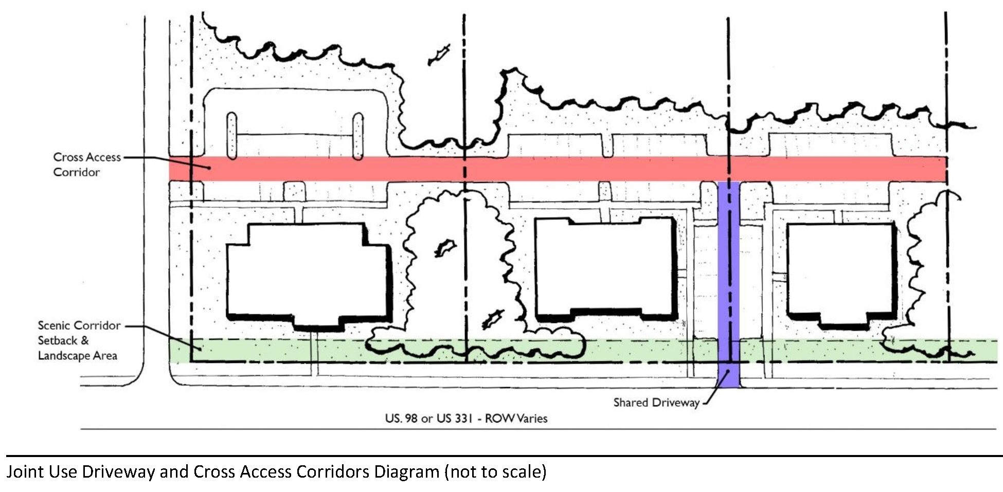
Joint Use Driveways. Required to meet the curb cut requirements stated above, joint use driveways shall be utilized between two adjoining undeveloped sites. The driveway centerline shall be the common property line. In such cases, cross access corridors should be provided.
3.
Cross Access Corridors. Cross access corridors, where utilized, shall be designed to provide unified circulation and access between sites and the previously described curb cuts.
4.
Coordinated Circulation Design. Where a cross access corridor is developed, the owners/developers of the affected properties shall provide for mutually coordinated parking, access and circulation systems, and shall provide design features as necessary to make it visually obvious that abutting properties shall be tied together to create a unified system. If a site is developed prior to an abutting property, it shall be designed so that its parking, access and circulation are easily tied together to create a unified system at a later date. If the building site abuts an existing developed property, it is recommended that it tie into the abutting parking, access and circulation to create a unified system.
(Ord. No. 2018-29, § II(Att. A), 12-11-18)
6.11.06. - Architectural Controls within the U.S. 98 and U.S. 331 Scenic Corridor Overlay District.
Building architecture should flow easily with existing development and reflect high-quality standards of construction and design. The standards also intend to establish a character that is compatible in design with a mixture of land uses, and to that end the standards discourage the use of any material, color, statement, structure or otherwise which will appear flashy or intrusive to residents, visitors, or other businesses. This applies especially to the use of highly reflective materials, such as mirrored glass or stainless steel.
A.
Roofing.
1.
Styles: Gable; hip; built-up (with detailed parapet, meaning the roofline facing the corridor contains at least three vertical changes), and shed. If parapet is present, it must be finished on all visible sides. If a parapet is used for screening, it must be finished on all sides.
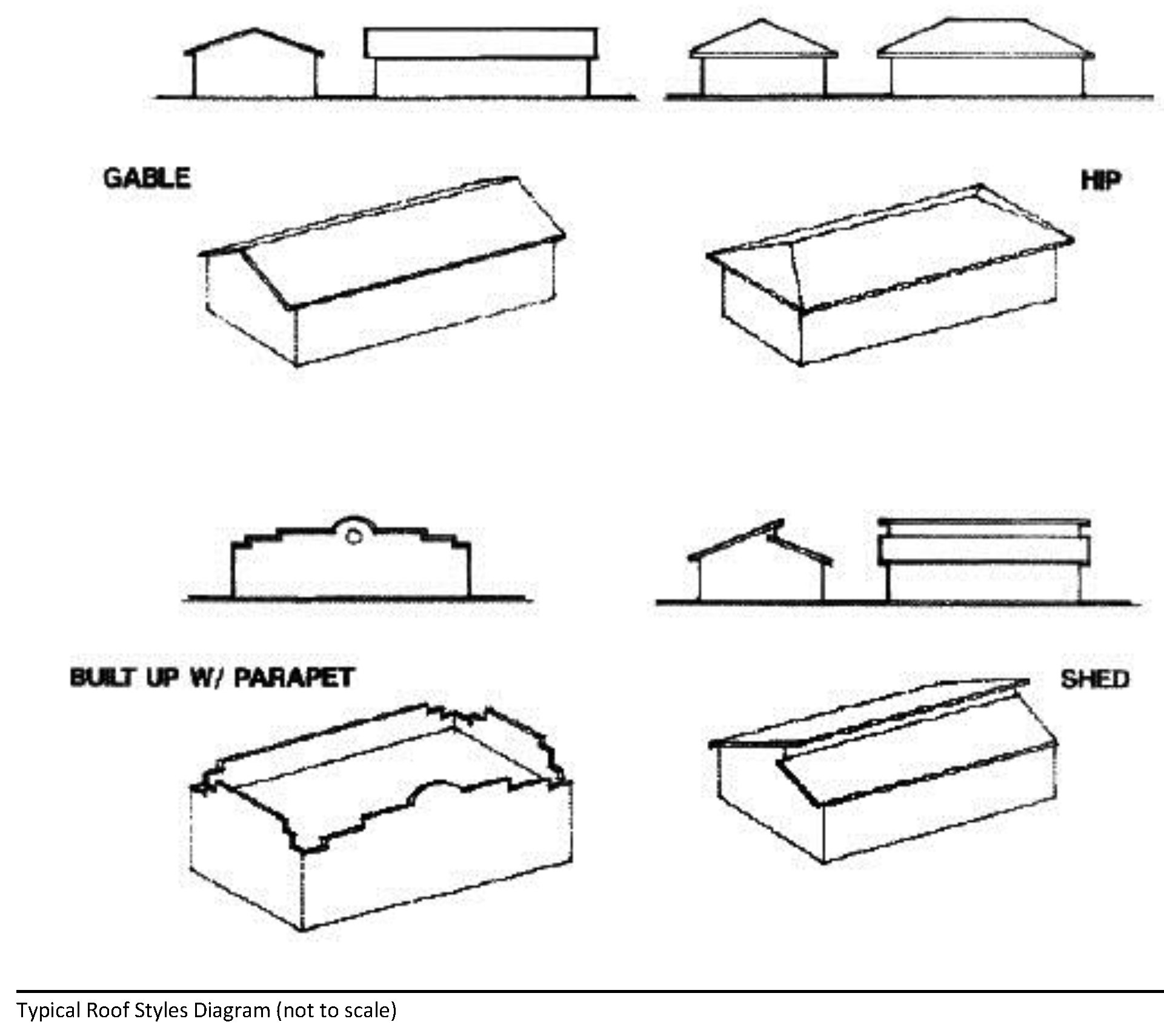
2.
Materials: Barrel tile (clay or concrete); standing seam metal; concrete tile; slate; copper; wood shingles/shakes; and dimensional asphalt shingles.
3.
Pitch (other than built-up parapet): No less than 4:12 and no greater than 8:12.
B.
Siding.
1.
Materials: Stucco; keystone (coquina); split face block; wood shingles; lap wood siding; fiber cement siding; white quartz stone; and brick. Architectural insulated metal panel may be approved by the Design Review Board on a case by case basis with the condition that it is of a modular design and appropriate to the scale of the building. Approved siding material is required on all sides of the structure. With the exception of single-family homes, a change to the exterior of a building, through new siding, repainting, or similar change, shall require review and approval by DRB.
C.
Colors. Color drawings of the building elevations shall be submitted with color chips for all walls, awnings, and accent colors proposed, as part of the site plan submitted for review. Where changing or repainting of an existing structure is proposed, photographs may be submitted in lieu of building elevations.
1.
Building materials and color selection shall achieve visual order through the consistent use of compatible color palettes.
2.
The color shall complement the design and not be so extreme that the color competes with the building for attention.
3.
The use of color to attract attention to a business from a distance is discouraged.
4.
Principal Colors Permitted: Fluorescent colors, including neon or the appearance of neon, are not permitted. There shall be a maximum of one principal color per building. Principal colors shall be selected from the following list from the Munsell Book of Color:
5.
Accent Colors Permitted: Fluorescent colors are not permitted. Neon tube, or the appearance of neon, or fiber optics trim and accents are prohibited. Use of intense or contrasting accent colors to draw attention to the building is not permitted. Where canopies, awnings, balconies, porches, decks, doors, windows, shutters or other architectural elements are not the same color as the principal color, they shall be considered to be an accent color. The number of accent colors permitted shall be limited to the minimum appropriate to the architectural character and form of the building. Accent colors shall be selected from the following list from the Munsell Book of Color:
D.
Canopies and Awnings. No interior illumination of awnings is permitted. Canopies are to be hung or column mounted. Color is to complement the building. No solid vinyls or plastics are permitted.
E.
Accessory Buildings. Match the main building's materials, roof style and color.
F.
Heights of Buildings.
1.
Minimum 12 feet to eave required.
2.
Height of overhead canopies is not regulated by these standards, nor is the minimum building height related to canopy height.
3.
Cupolas, towers, and spires are allowed and may extend to an additional 20 feet above roof lines or allowable height specified in Chapter 5 of this Land Development Code, but they shall be non-leasable and non-habitable.
a.
If one cupola, tower, or spire is used in the design, the square footage of the cupola, tower, or spire shall be limited to a maximum of 10% of the building footprint.
b.
If two or more cupolas, towers, or spires are used in the design, the total square footage of all cupolas, towers, or spires shall be limited to a maximum of 20% of the building footprint.
G.
Balconies, Porches and Decks. Balconies, porches and decks are permitted. Railings are to be decorative metal or concrete balustrades; provided, however, that other products/materials shall be considered based on merit.
(Ord. No. 2018-29, § II(Att. A), 12-11-18)
6.11.07. - Lighting Standards within the U.S. 98 and U.S. 331 Scenic Corridor Overlay District.
A.
Lighting within the U.S. 98 and U.S. 331 Scenic Corridor Overlay shall comply with the requirements found in Chapter 5 of this Code with the following additional requirements applicable:
1.
Convenience Stores: Lighting for convenience stores shall be consistent with State law, as amended from time to time. However, lights under canopies and roof structures over pump areas shall be recessed, and the intensity shall be two foot-candles per square foot at 18 inches above the surface. A light meter reading shall be required prior to occupancy.
2.
Parking Lots: Parking Lot lighting shall be not less than 3,000 Kelvins and no greater than 5,000 Kelvins. Light fixtures shall not exceed 14 feet in height and light fixtures exceeding 10 feet in height shall be set back from the property line by a minimum of 10 feet unless further limited by the buffer setback.
(Ord. No. 2018-29, § II(Att. A), 12-11-18)
6.11.08. - Signage Requirements within the U.S. 98 and U.S. 331 Scenic Corridor Overlay District.
The purpose and intent of this section is to regulate the use of signs so that they are compatible with their surroundings, to promote the aesthetic character of the Scenic Corridor Overlay District, to enhance the local business environment; to preserve the natural appearance of the Corridor; to promote tourism; to promote traffic safety for motorists and pedestrians; to maintain property values; to express the unique identities of individual proprietors and the community as a whole; and to regulate signs so that they are legible in the circumstances in which they are seen and constructed to standards which protect the safety, health and general welfare of the public. Signage should be unobtrusive, yet visible and easy to read in general.
A.
Prohibited Signs. In addition to those prohibited signs described in Section 6.03.00, the following are also prohibited:
1.
Outdoor advertising.
2.
Pole signs.
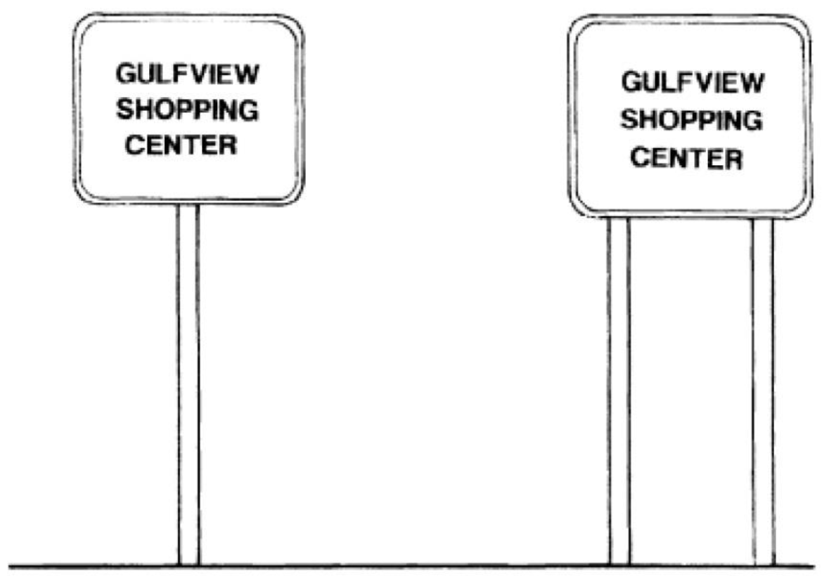
PROHIBITED POLE SIGNS
3.
Water towers and wall murals as commercial advertising.
4.
Off-premises signs, except community directory signs per Section 6.11.08(L) and directional signs per Section 6.11.08(I).
5.
Portable signs.
6.
Single panel plastic or Lexan face signs.
7.
Abandoned signs.
8.
Neon tube lighting or fiber optics in signage. This includes neon signage placed in storefront windows that may be seen from the roadway. Neon "Open" and "Vacancy" signs not exceeding 12" by 24" are allowed as the sole exception to this rule.
9.
Flags, spinners, banners, feather signs, pennants and inflatable signs or balloons of any type except as provided below:
a.
Certified nonprofit organizations may be permitted to use flags or banners in conjunction with a special event provided they are placed no sooner than two weeks before the event and removed immediately following the event.
b.
The official flags of the United States and the State of Florida are excepted provided that the display of flags shall be limited to not more than these two flags flying from a single vertical pole no taller than 40 feet.
10.
Vehicles bearing the name of an establishment may not be parked in a location visible from the road so as to serve as "additional signage" for the establishment. No vehicles bearing business signage shall be parked in landscaped or Scenic Corridor buffer areas.
B.
Non-Conforming Signs. Non-conforming signs shall not be altered to another non-conforming sign. They shall not be expanded, improved (including double or triple rotating panels), moved, or reconstructed into another non-conforming sign after damage, destruction or change of use or ownership. Existing signs that do not meet the requirements of these standards shall be removed or modified into conforming signs by January 1, 2003. Existing signs that do not exceed 20% of the height, width and copy area of these standards are not required to be removed within the amortization period.
Notwithstanding any other provisions of this ordinance, non-conforming signs which have been or are removed after July 1, 1999, by reason of public acquisition of the land upon which they are situated may, in lieu of acquisition at the election of the owner, be relocated or reconstructed in accordance with F.S. § 479.15. The provisions of Section 1.15.08 pertain.
C.
Allowable Signs.
1.
Temporary signs,
2.
Main identification (ID) signs,
3.
Building signs,
4.
Directional signs,
5.
Directory signs/kiosks,
6.
Permitted off-premises signs, and
7.
Street signs shall be constructed in accordance with the following standards and exhibits.
D.
Sign Permitting. Procedures for review may vary depending upon the type of sign, and are included in the regulations pertinent to those sign types and to master signage plans as follows:
1.
All signs erected on the Scenic Corridor, except those temporary signs specifically excluded, shall require a sign permit issued by the Walton County Building Department.
2.
The Design Review Board shall review all master sign plans, main identification signs, and building signs which are not submitted under a master plan.
3.
The Scenic Corridor Review Specialist shall review building signs submitted under an approved master plan, name substitutions for an approved sign and community directory signs.
4.
The Code Enforcement Officer shall review temporary signage, except as excluded in this Chapter.
E.
Temporary Signs. Temporary ground signs shall be built and installed as follows:
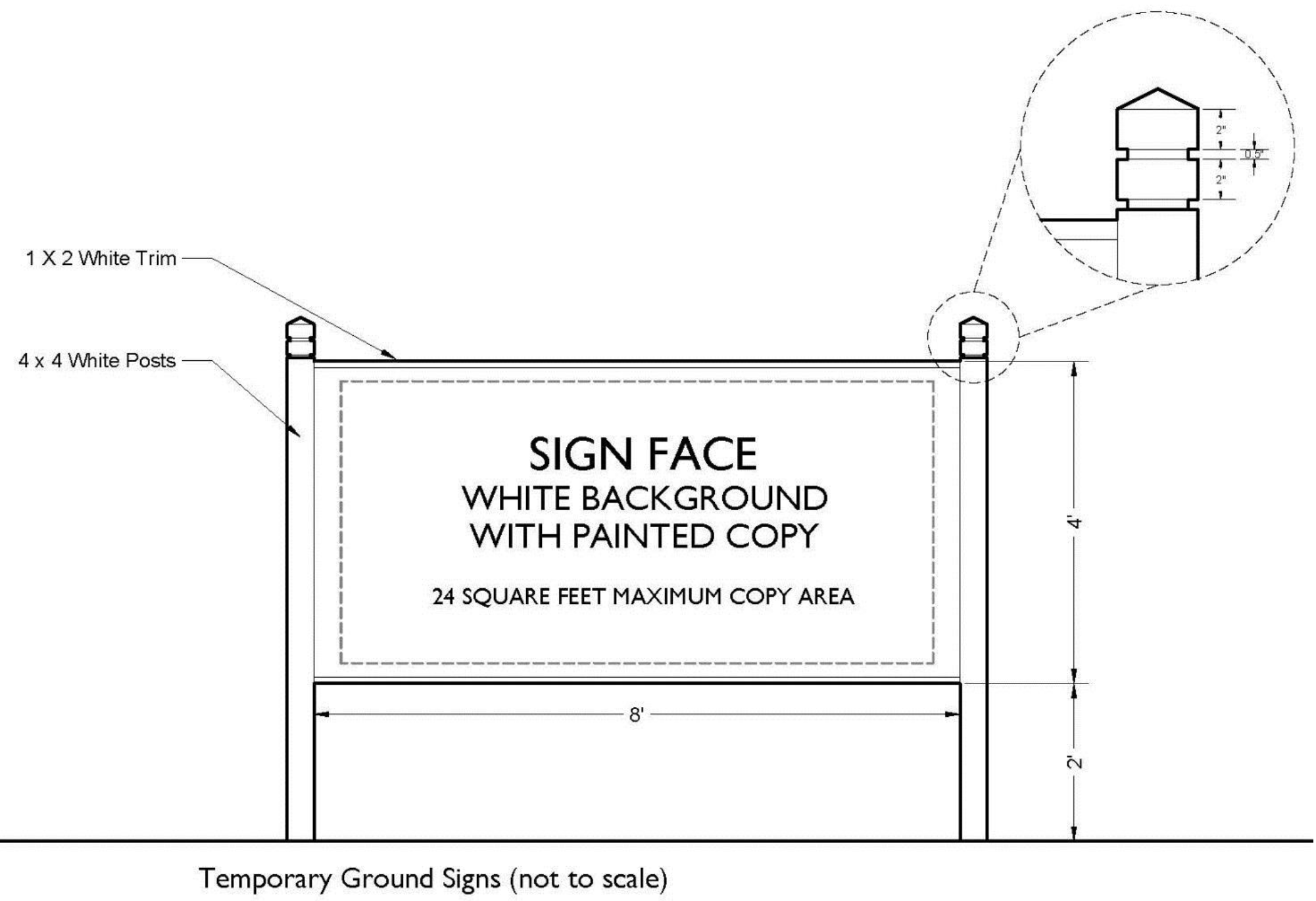
1.
Colors utilized are required to be consistent with those permitted above;
2.
A maximum of one temporary sign per property is allowed;
3.
Illumination of temporary signs is not permitted;
4.
All temporary ground signs over six square feet require permitting;
5.
Temporary signs may be permitted for a period up to six months;
6.
Temporary ground signs shall be allowed only for the functions below:
a.
To indicate that an owner, either personally or through an agent, is actively attempting to sell, rent or lease the parcel on which the sign is located.
b.
To announce or advertise such temporary uses as fairs or any charitable, educational or religious event or function. Such message shall be removed within five days after the special event.
c.
To identify construction in progress with an approved building permit.
d.
To indicate the existence of a new business or a business in a new location, if such business has no permanent signs. Such message may be displayed for a period of not more than 60 days or until installation of permanent signage, whichever shall occur first.
7.
Temporary storefront signage inside the storefront window is permitted, provided that signage:
a.
Is limited to a two-week period a maximum of six times per year;
b.
Is limited to a maximum of two windows per tenant;
c.
Does not exceed 25 percent of the individual window area or a height of two feet and a width of four feet, whichever is less; and
d.
Is professionally printed, painted or constructed. Hand lettered cardboard or paper temporary signs are not permitted.
8.
Temporary building signs or banners are permitted during renovation of an existing business or project providing they are limited to:
a.
Fifty-four square feet with maximum height of three feet, and
b.
A maximum of 90 days.
F.
Master Signage Plans. Master Signage Plans are intended to provide a distinct character or "identity" to signage in a project and to allow larger projects the advantages of using directional signage and directory signs and kiosks. Such a master plan shall indicate the location for all types of signage in the project visible from Highway 98 or Highway 331 with proposed style, dimensions, copy area, and materials. Individual variation will be considered for building signage. However some form of consistency must be maintained for building signs, such as location on the building, size, or color for the entire development, regardless of the distance from Highway 98 or Highway 331.
All multiple occupancy complexes of four or more units shall submit a Master Signage Plan to the Design Review Board for all types of signage which are visible from Highway 98 or Highway 331. Projects of fewer than four units are encouraged to submit Master Signage Plans to facilitate permitting.
Locations for anchor stores, if appropriate, within the multiple occupancy complex must be identified in the Master Signage Plan. The developer may designate one anchor store for each 25,000 square feet of building floor area of the project. Copy area for not more than two anchor stores may be located on main identification signs. In circumstances where a regular tenant occupies more than one tenant bay or space in a multiple occupancy complex, a master signage plan may be approved by the Design Review Board to allow a regular tenant to qualify for a longer building sign than would be allowed for a single regular tenant, not to exceed the cumulative length of building signage individual regular tenants would be allowed when occupying the same number of tenant bays or spaces, while maintaining building sign height at 3' maximum. Further, for purposes of qualification as an anchor tenant in order to appear on a monument sign for a multiple occupancy complex, a regular tenant occupying more than one tenant bay or space may be allowed such designation for monument sign purposes if appropriate and approved by the Design Review Board in a Master Signage Plan.
Submittals shall include graphic depiction and specifications on the site plan and architectural elevations for the project, including where a regular tenant occupies more than one tenant bay or space. A regular tenant occupying more than one tenant bay or space is not allowed multiple identical building signs for those tenant bays or spaces. It shall also include a sample copy of the tenant lease agreement enumerating the Master Signage Plan requirements and stipulating compliance as a condition of the lease. Projects intended to be sold as condominium commercial units shall include the Master Signage Plan in deed restrictions or covenants and shall provide a copy of that document with their project submittal.
Once approved, Master Signage Plans shall last for the life of the project, regardless of any future changes to this Code that may be more restrictive than when the Master Signage Plan was approved.
G.
Main Identification Signs. The purpose of the main identification sign is to identify the project or development and is not intended to serve as a directory sign to identify all the tenants within a multiple occupancy complex (see Sections 6.11.08(I) and 6.11.08(L)). The format shall be a monument sign.
1.
Color must compliment main architecture of the building;
2.
Illumination: Illumination shall be by externally located steady stationary light source, shielded and directed solely at the sign. Reverse channel letters shall qualify as external illumination. Light sources to illuminate signs shall neither be visible from any street right-of-way nor cause glare hazardous to pedestrians or vehicle drivers entering public streets. Signs shall not have light reflecting backgrounds, but may use light-reflecting lettering. Colored lamps are not permitted.
3.
Materials allowed: Stucco on suitable substrate; painted aluminum; keystone; brick; split face block; routed and sandblasted wood, expanded PVC, fiberglass, or high density urethane. Additional materials must be complementary with the architectural character of the building.
4.
Shape of sign must reinforce architectural character of the building;
5.
New main identification signs must include the 911 address number for the site which must be between six (6) and eight (8) inches in height and placed where it can easily be read.
6.
May be located within the Scenic Corridor buffer setback;
7.
One sign shall be permitted for each 400 feet of Scenic Corridor highway frontage;
8.
Maximum height is 12 feet measured from the crown of the road, the existing grade of the sign site, or the edge of pavement adjacent to the sign, whichever is greater. Bases for signs over 12 feet in height require landscaping;
9.
Maximum width is 12 feet and the width at the base of the sign shall be at least 80 percent of the sign face area;
10.
Maximum total sign area is 80 square feet; and
11.
Maximum sign face copy area is 35 percent of the sign face area per side of sign. This area may not be combined on one side. (Example: 80 square foot sign would allow for 28 square feet of copy area per side)
a.
Reader boards are allowed but shall be included in the copy area allowance described above. Reader boards shall not exceed 50 percent of the sign copy area and shall provide a transparent medium (clear or transparent material) or track for changeable lettering. The reader board shall have the same background as the sign face, which may be accomplished in various ways.
b.
The 911 address number shall not be included in the copy area computation of the sign.
12.
Sign Permitting: All proposals for Main ID signs shall be submitted to the Design Review Board for review and approval prior to issuance of a sign permit. Submittals shall be made using a Walton County Sign Permit Application together with the documents specified on that application.
The proposal shall be submitted with the Development Review package for the entire project, and reviewed by the Design Review Board and Planning Commission as an integral part of that project.
Applicants are cautioned that Walton County Sign Permits are issued for a duration of six months. If construction of the project and/or the Main ID sign is anticipated to exceed that time, they may wish to withhold permitting until ready to install the sign.
A Design Review Board sign approval may be held by the Planning Department until the applicant is ready to permit the sign and begin construction. In the event that a sign permit lapses, the proposed sign may require a second review by the Design Review Board at the judgment of the Corridor Review Specialist.
H.
Building Signs.
1.
Type 1 Building Signs: Tenants in multiple occupancy complexes and single tenant projects less than 15,000 square feet.
A.
Maximum sign face area - under canopy: Maximum 21" × 42", two sided.
B.
Maximum sign face area - façade mount: Maximum 54 square feet with a maximum height of 3 feet.
C.
Maximum sign face letter height is 24" for words in upper case letters. When words are both upper and lower case letters, the main body of lower case letters may extend 6" above and/or below the body of the letter.
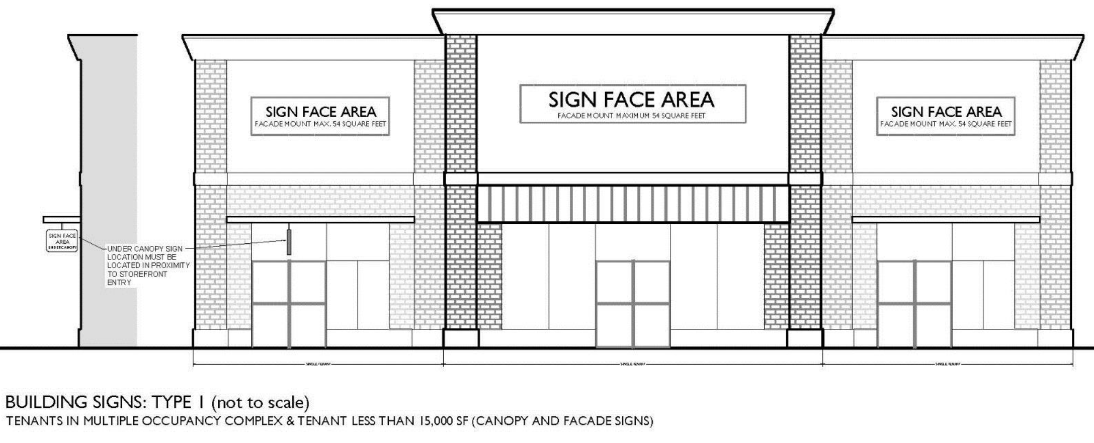
2.
Type 2 Building Signs: Single tenant projects larger than 15,000 square feet and anchor stores in multiple occupancy complexes.
A.
Maximum sign face area - under canopy: Maximum 21" × 42", two sided
B.
Maximum sign face area - façade mount: Maximum 100 square feet with a maximum height of 5 feet.
C.
Maximum sign face letter height is 36" for words in upper case letters. When words are both upper and lower case letters, the main body of lower case letters is limited to 30". However, a capitalized first letter or parts of lower case letters may extend 6" above and/or below the body of the letter.
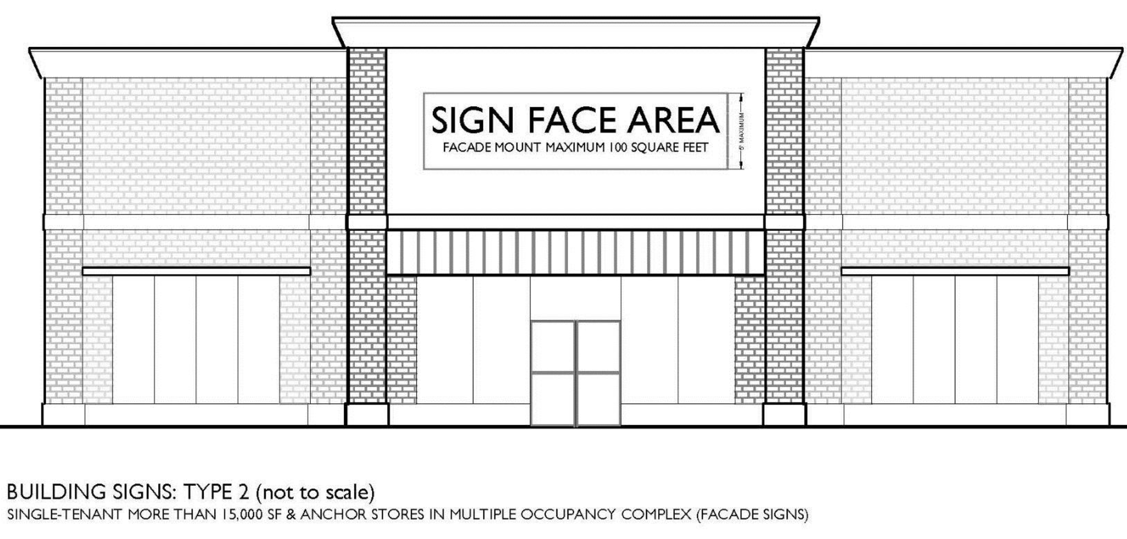
3.
The following standards shall apply to both Type 1 and Type 2 Building Signs:
A.
Maximum copy area under canopy or façade mount: Maximum 11" × 30", per side fascia façade including parapet wall or roof and within limits of storefront.
B.
Location under canopy: Hang from or mount under canopy within limits of storefront. Must be set perpendicular to storefront.
C.
Location façade mount: To be mounted along building façade, including parapet wall or roof fascia and within limits of storefront. Façade mounted signs shall be contained within any single wall panel, window, door or other architectural component upon which they are placed. Façade mounted signs shall not project above the roof line.
D.
Maximum number of signs under canopy: Maximum of one (1) sign per tenant, double sided.
E.
Maximum number of signs façade mount: Maximum of one (1) sign per tenant or individual building except tenants on building corners may have one (1) per façade within the limits of the storefront of the same business.
F.
Color must compliment the architecture of the main building(s).
G.
Illumination: Only exterior light sources are permitted except for channel lettering.
H.
Material: Individually mounted backlit reverse channel or interior lit channel letters, expanded PVC, aluminum, stainless steel, fiberglass, or high density urethane letters; painted, sandblasted or routed signs with a minimum depth of ¼".
i.
Raised individual routed letters up to a maximum of 6" in height shall have a minimum rise of ⅜".
ii.
Raised individual routed letters that are between 6" and 12" in height shall have a minimum rise of ¾".
iii.
Raised individual routed letters between 12" and 24" shall have a minimum rise of 1".
iv.
All signs must have a three dimensional quality in appearance. Plywood or any flat wood with hand painted letters, individually mounted, flat cut vinyl letters or Styrofoam are prohibited.
I.
Shape: All under canopy signs shall have a horizontal form.
J.
Permitting: Proposals for building signs under an approved Master Signage Plan shall be submitted to the Corridor Review Specialist for review and approval prior to issuance of a sign permit. All other building signs shall be submitted to the Design Review Board for Review. Submittals shall be made using a Walton County Sign Permit Application together with the documents specified on that application. The proposal shall be submitted with the Development Review Package for the entire project, and reviewed by the Design Review Board as an integral part of that project.
I.
Directional Signs. Permitted only under Master Signage Plans, Directional Signs are intended to assist motorists to locate businesses within a multiple occupancy complex by providing arrows to buildings or zones within the project. Type 1, or internal directional signs, are for use after entering the complex. Type 2, or external directional signs, are intended to direct motorists to use the proper turning lane for entering a complex which spans the Scenic Corridor. The only logos allowed on directional signs are project logos.
Type 1 directional signs are those signs internal to project shall comply with the following standards:
1.
Maximum sign face area: Horizontal format signs shall have a maximum height of four (4) feet and a maximum width of eight (8) feet. Vertical format signs shall have a maximum height of eight (8) feet and a maximum width of four (4) feet.
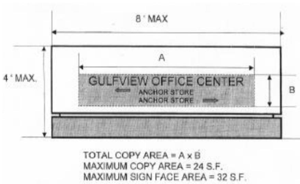
DIRECTIONAL SIGN TYPE 1 (INTERNAL TO PROJECT)
2.
Maximum copy area: Twenty-four square feet per side of sign.
3.
Location: Must be located on the site and not within the buffer setback area.
4.
Maximum number of signs allowed: The number of directional signs allowed is dependent upon final site layout, including the amount of frontage and number of entrances.
Type 2 directional signs for projects located on both sides of the scenic corridor shall comply with the following standards:
1.
Maximum sign face area: The maximum sign face area shall be fifty (50) square feet with a maximum height of ten (10) feet and a maximum width of five (5) feet.
2.
Maximum copy area: The maximum copy area permitted is 17.5 square feet per side of sign. No copy shall be located on bottom three feet of sign. Copy shall be limited to the name of the development and facilities within it, the direction vehicles must turn and the distance to the turn. Graphics shall be limited to logos and directional arrows.
3.
Location: Locate in Scenic Corridor buffer area of the multiple occupancy complex. Developments of Regional Impact or Planned Unit Developments may erect off-premises directional signs on property within the boundaries of the Development of Regional Impact or Planned Unit Development for the purpose of directing vehicle traffic to destinations within the development.
4.
Maximum number of signs allowed: The number of directional signs allowed is dependent upon final site layout, including the amount of frontage and number of entrances.
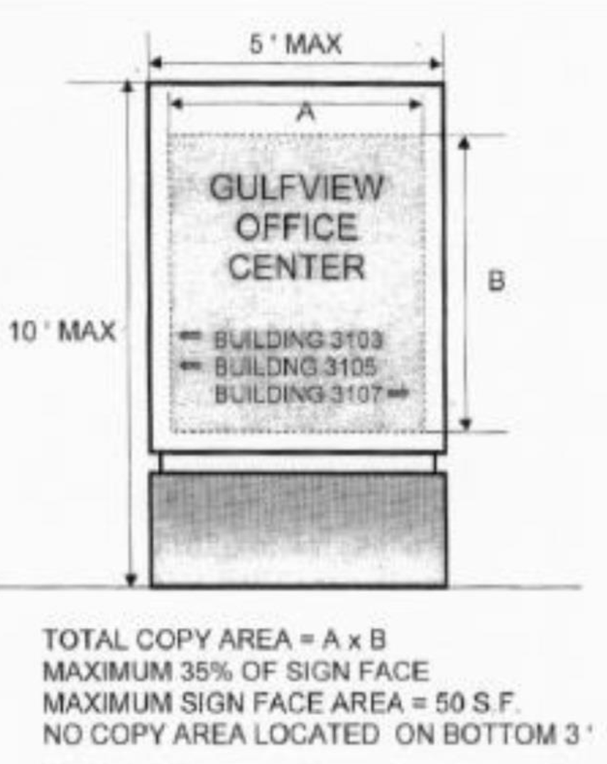
DIRECTIONAL SIGN TYPE 2 (BUFFER SETBACK)
The following standards shall apply to both Type 1 and Type 2 directional signs:
1.
Color: Color of signs must compliment the architecture of the main building(s).
2.
Illumination: Exterior (ground mounted) or interior light source. Interior lighting may be used for individual recessed or raised letters on an opaque background.
3.
Materials: Stucco on appropriate substrate; painted aluminum; brick; split face block; routed and sandblasted wood; expanded PVC; fiberglass or high density urethane. Additional materials shall be considered for approval.
4.
Shape: All directional signs must be installed in a vertical format.
5.
Permitting: Proposals for directional signs shall be submitted to the Design Review Board as part of a Master Signage Plan for review and approval prior to issuance of a sign permit. Submittals shall be made using a Walton County Sign Permit Application together with the documents specified on that application. The proposal shall be submitted with the Development Review package for the entire project, and reviewed by the Design Review Board as an integral part of that project.
J.
Directory Signs/Kiosks. Permitted only under master signage plan, Directory Signs or Kiosks are intended to assist pedestrians to locate businesses within a multiple occupancy complex.
1.
Maximum size allowable: Directory signs/kiosks shall not exceed a maximum height of eight (8) feet and a maximum width of four (4) feet.
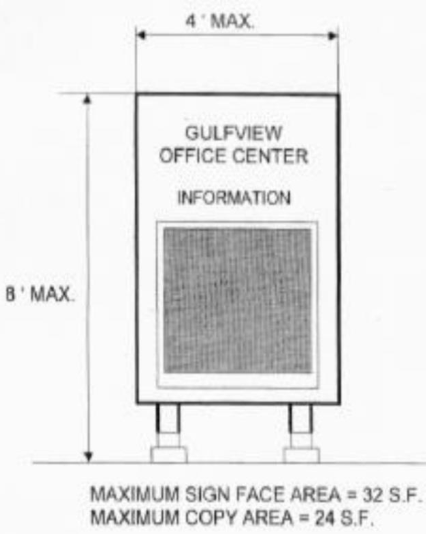
DIRECTORY SIGN/KIOSK MAXIMUM SIGN FACE AREA
2.
Maximum copy area: The maximum copy area shall be 24 square feet per side of sign.
3.
Location: Directory signs/kiosks shall be located at primary pedestrian areas.
4.
Maximum number allowed: The maximum number of directory signs/kiosks is dependent on the final site layout.
5.
Color: Color of signs must compliment the architecture of the main building(s).
6.
Illumination: Illumination is not required, however, external lighting directed exclusively at the sign or internally lit individual letters is allowable.
7.
Materials: Stucco on appropriate substrate; painted aluminum; brick; split face block; routed and sandblasted wood; expanded PVC; fiberglass or high density urethane. Additional permissible accent materials shall be considered for approval, glass block; brass; decorative painted metal; decorative stone (i.e. granite, marble, etc.). All above materials must be complementary with the architectural character of the building.
8.
Shape: All directory signs/kiosks signs must be installed in a vertical format.
9.
Permitting: Proposals for directory signs and kiosks shall be submitted to the Design Review Board as part of a Master Signage Plan for review and approval prior to issuance of a sign permit. Submittals shall be made using a Walton County Sign Permit Application together with the documents specified on that application. The proposal shall be submitted with the Development Review package for the entire project, and reviewed by the Design Review Board as an integral part of that project.
K.
Street Signs. Street sign designs will be reviewed on an individual basis as an integral part of the project. Regulatory signs (stop, yield, etc.) shall meet all current Florida Department of Transportation requirements.
L.
Community Wayfinding Signs. There are a number of long-standing small and home businesses located in small communities that can be accessed only from U.S. 98 or U.S. 331. To lessen the adverse impact on those businesses caused by prohibition on off-premises signage in this code, this section allows a sign that will serve as a directional point of reference for each community.
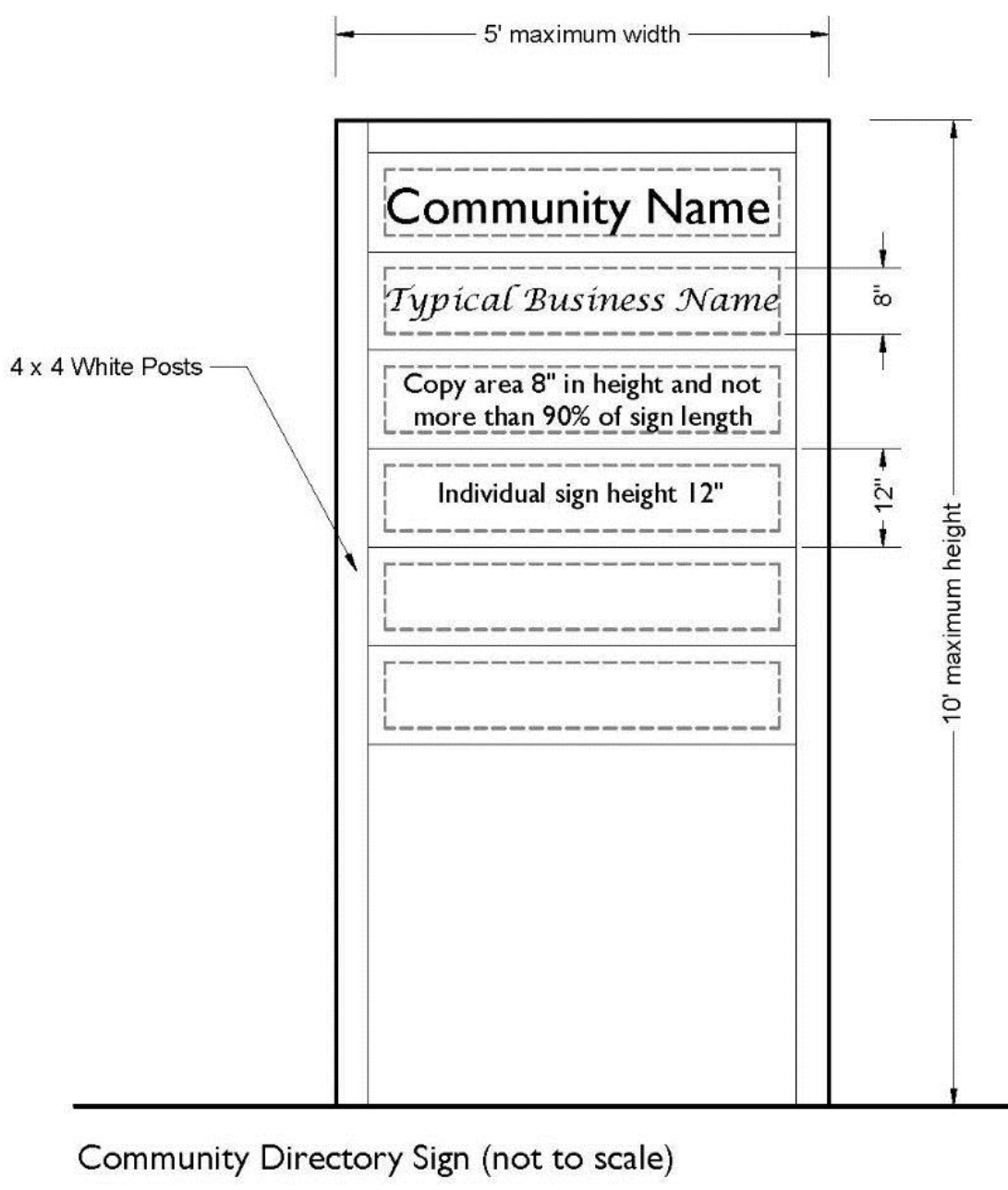
1.
In keeping with the intent of the Scenic Corridor standards, these signs shall be of a standard composition and appearance to present a neat, uncluttered appearance along the roadway. Copy shall be limited to identification of the community at the top, and the name of each participating business located in that community.
2.
Multi-tenant complexes that are located off the main corridor shall be allowed one panel on the sign to indicate the location of the complex, but individual businesses within that complex shall not be shown. Commercial advertising on this type of sign is prohibited, except the bottom of the sign may be reserved for temporary signs for yard sales within the community if desired.
3.
Participating businesses may erect this type of sign using the standards shown below. Walton County shall not incur additional cost in the construction, erection, or the maintenance of these signs.
a.
Maximum size: The maximum height of such wayfinding signs shall be ten (10) feet. The required height to width ratio shall be 2:1 (example: 10' high sign × 50% yields a maximum width of 5'). Height shall be measured from the existing grade of the site.
b.
Maximum copy area: Each business shall be limited to 12 inches in height of sign area. Lettering shall be no greater than eight inches in height and length shall not exceed 90 % of the sign width.
c.
Location: Wayfinding signs shall be located at intersection of U.S. 98 and the County Road leading into the community. The sign shall be sited out of the U.S. 98 (state) right-of-way, and on the back edge of the County's right-of-way. It may be angled for better presentation toward U.S. 98.
d.
Number of wayfinding signs allowable: One wayfinding sign per intersection is allowable.
e.
Color: Wayfinding signs shall be white.
f.
Illumination: Illumination is not allowable.
g.
Materials: Wayfinding signs shall be wood.
h.
Shape: Wayfinding signs shall be rectangular in shape and installed in vertical format.
4.
Permitting: Applications for Community Wayfinding signs shall be submitted by a representative of the participating businesses to the Corridor Review Specialist using a Walton County Sign Permit Application. The Corridor Review Specialist will review the plans for compliance with this section, then forward the application to the Walton County Building Department for permitting. The Code Enforcement Department will monitor subsequent usage of the sign after it is built and erected.
(Ord. No. 2018-29, § II(Att. A), 12-11-18; Ord. No. 2019-19, § II(Att. A), 9-10-19)
6.11.09. - Landscaping Standards within the U.S. 98 and U.S. 331 Scenic Corridor Overlay District.
A.
Tree and Shrub Planting Requirements Within Scenic Corridor Setback.
1.
Lots with a 25 foot setback, or 20 feet with an existing sidewalk, shall have the following:
a.
Live oaks with four inch caliper minimum planted within the setback at the rate of one tree per 40 feet of right-of-way.
i.
Spacing shall not be less than 20 feet or greater than 75 feet apart.
b.
The total number of understory trees required within the Scenic Corridor Setback shall equal one per 75 feet of U.S. 98 or U.S. 331 frontage.
i.
Understory trees shall be planted in groups and shall have a minimum height of eight feet and width of five feet at installation and shall be selected from the list provided in the Section 6.14.00 Plant List.
ii.
Spacing between understory trees shall not be less than 12 feet.
c.
Shrubs and/or groundcovers shall be planted within the Scenic Corridor Setback at a rate of two plants per foot of U.S. 98 and U.S. 331 roadway frontage.
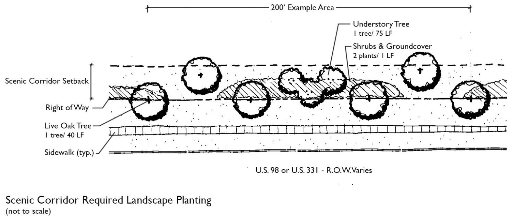
2.
Lots with a seven and one-half foot setback shall have the following:
a.
Live oaks with four inch caliper minimum planted behind the right-of-way adjacent to U.S. 98 at the rate of one tree per 40 feet of right-of-way.
i.
Spacing shall not be less than 20 feet or greater than 75 feet apart.
b.
Understory trees are not required.
c.
Shrubs. A 36-inch high hedge shall be placed at the rear of the seven and one-half foot setback. Groundcovers shall be planted between the property line and hedge. Shrubs and groundcovers shall be selected from the list provided in the Section 6.14.00 Plant List.
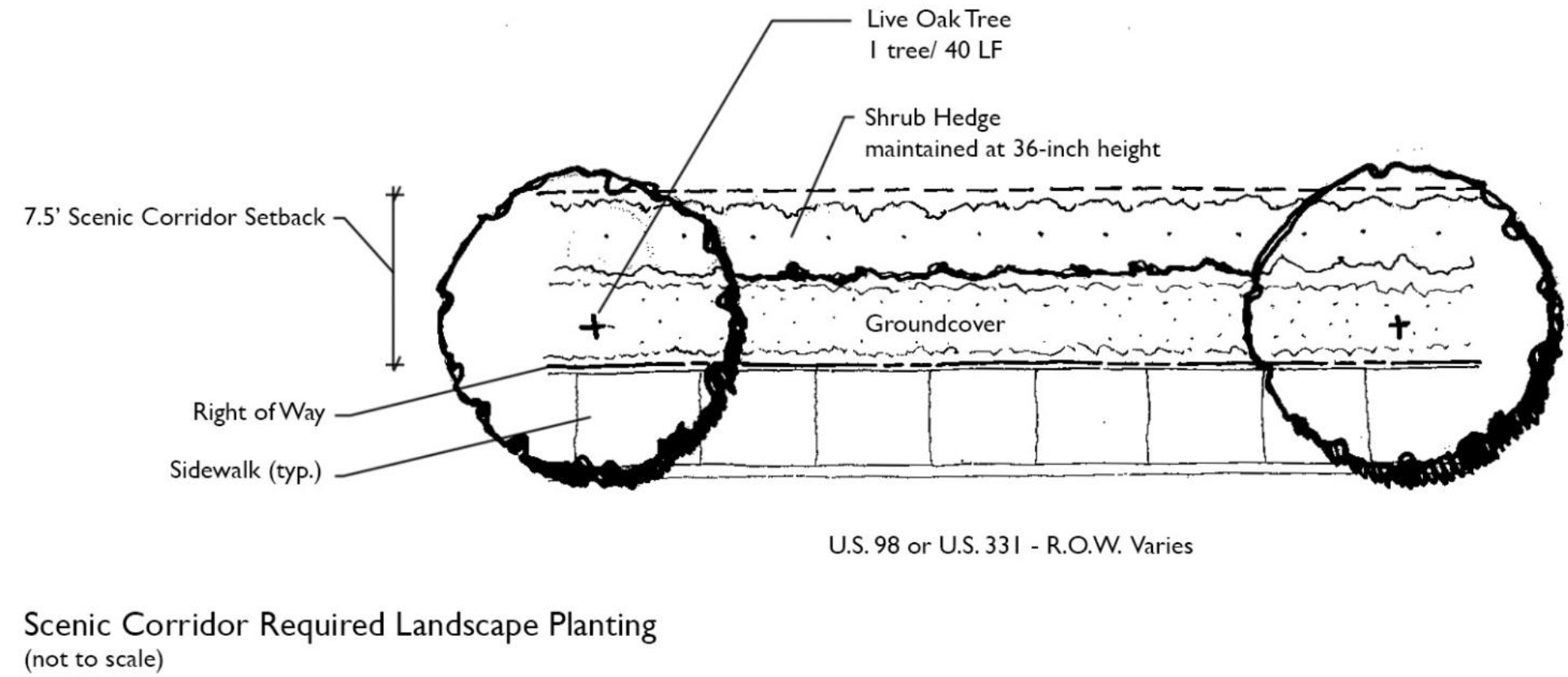
B.
Live Oaks Alternatives. In areas where space or soil conditions are not conducive to the horticultural needs of Live Oaks, or where overhead utilities are affected, alternative tree species shall be selected from the list provided in the Section 6.14.00 Plant List. In cases where overhead utilities are present, an understory tree may be used instead of a canopy tree.
C.
Tree Preservation Credit. Where existing trees are preserved within the buffer area, one live oak planting may be deleted for each three existing trees of eight inch caliper or more that are preserved.
D.
Landscaping of Vehicular Use Areas. The following requirements are applicable for all off-street parking facilities that have ten or more parking spaces or are 3,500 square feet or more.
1.
Planting Requirements. All vehicular use areas shall be visually buffered from adjacent properties and rights-of-way through the use of a continuous shrub hedge. Shrubs shall be a minimum of two and one-half feet in height at installation, and shall be spaced three feet on center or closer. Said hedge shall be maintained at a height of no lower than three feet.
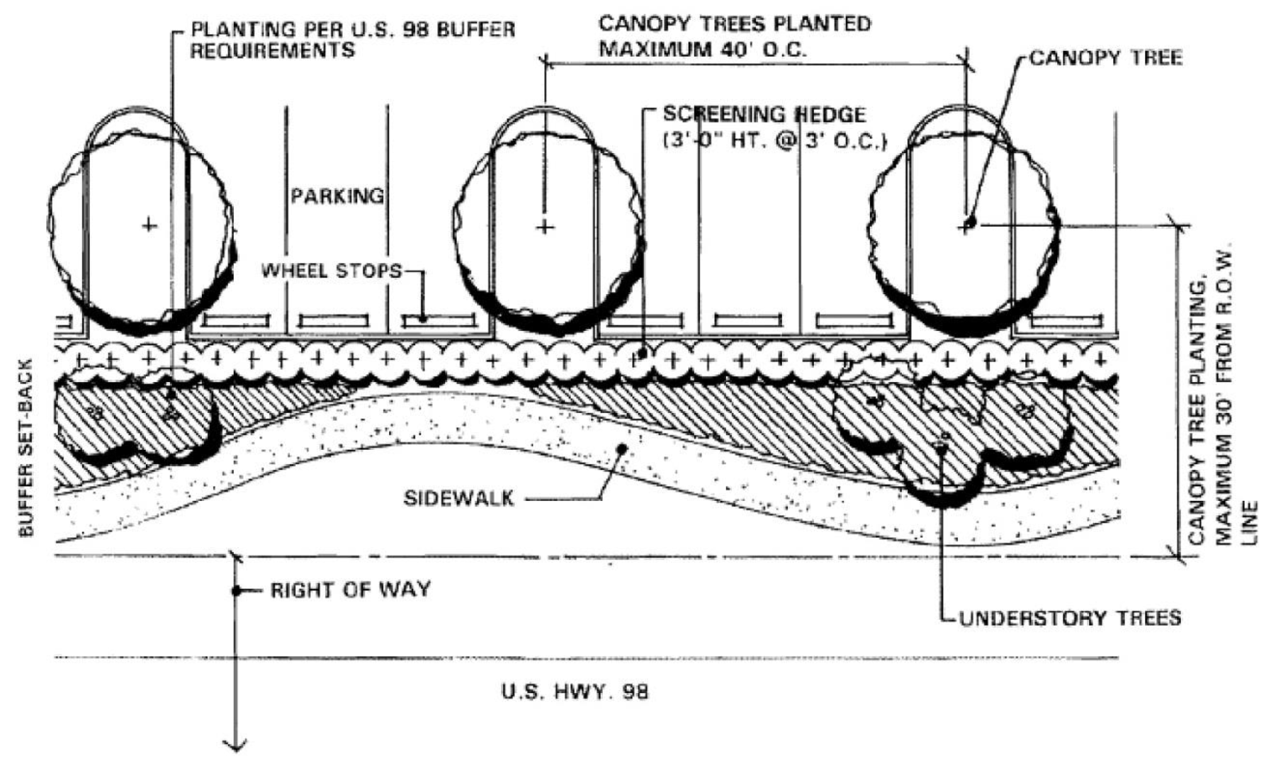
LANDSCAPING OF VEHICULAR USE AREAS NOT TO SCALE
2.
Vehicular use area shrub hedges adjacent to U.S. 98 or U.S. 331 shall be located adjacent to the parking within the scenic corridor setback, and, as such, they may constitute a portion of the shrub planting requirements within the scenic corridor setback. Parking spaces facing into the shrub hedge shall require wheel stops unless the shrub hedge is planted four feet or more back from a raised curb.
3.
At least ten percent of the gross area of the interior vehicular use area shall be landscaped. Interior planting areas are to be located within or adjacent to the parking area as tree islands, at the end of parking bays, inside seven-foot-wide or greater medians, or between rows of cars or as part of continuous street or transitional protective yards. Interior planting areas shall be located to most effectively accommodate stormwater runoff and provide shade in large expanses of paving and contribute to orderly circulation of vehicular and pedestrian traffic.
4.
No more than ten parking spaces shall be permitted in a continuous row without being interrupted by an interior planting area. Each interior planting area shall include one canopy tree and shall be a minimum of 150 square feet in size. Required trees shall be selected from the designated canopy tree list and shall be at least eight feet in height and two inches in caliper at installation.
E.
Berming within Scenic Corridor Setback. Berms not greater than four feet in height with a maximum slope of 4:1 may be constructed within the Scenic Corridor Setback where such construction shall not require the removal of existing trees. The berm may extend the entire length of the lot or parcel. The height may vary to create a more natural form.
(Ord. No. 2018-29, § II(Att. A), 12-11-18; Ord. No. 2019-19, § II(Att. A), 9-10-19)
Editor's note— Ord. No. 2019-19, § II, adopted September 10, 2019, renumbered the former § 6.11.10 as 6.11.09.
6.11.10. - Review of Projects Located within the U.S. 98 and U.S. 331 Scenic Corridor Overlay District.
A.
In General all projects shall comply with the following:
1.
All projects located within the U.S. 98 and U.S. 331 Scenic Corridor Overlay District shall be reviewed in accordance with the appropriate development review process prescribed by this Chapter 1 of this Code based on project size. A building permit shall not be issued until such time as the project is in full compliance with the scenic corridor overlay standards.
2.
Projects shall be reviewed by the designated Planning and Development Services Department Scenic Corridor Review Specialist for compliance with these standards as part of the technical review.
3.
Projects shall be referred to the Design Review Board (DRB) for review and recommendation. Conceptual or preliminary reviews of a project by the Design Review Board before beginning the Development Review process are encouraged. An open forum may be scheduled on an as needed basis to review conceptual and or preliminary design development plans and signage at the end of each monthly meeting of the DRB.
4.
Projects shall not be placed on the Planning Commission agenda until full compliance is certified by the Corridor Review Specialist.
B.
Submittals. All plans must be complete and shall be signed and sealed by a Florida-registered architect, landscape architect, and engineer, each for his or her respective discipline. Such plans shall include building plans and elevations, site plans (as applicable), landscape plans, exterior building and site lighting, signage, utilities, and grading and drainage. Specific requirements related to the Scenic Corridor are:
1.
Existing topographic and boundary survey at the same scale as the required site development plan. This survey shall show all trees six inches DBH or larger in the Scenic Corridor buffer area.
2.
Preliminary landscape plan indicating the DBH of the existing trees to remain and the existing trees to be removed. Proposed plant material shall be labeled for size, botanical and common name. Proposed berming shall also be included on this plan.
3.
Floor plans and roof plans at a scale no smaller than 1/8" = 1'-0".
4.
Elevations of all exterior facades, indicating existing and proposed grade lines, at the same scale as the required floor plans. At least a portion of the elevations shall indicate the proposed colors of the building.
5.
Full color or color indexed elevations of proposed site signage (tenant/building signs, if any, shall be indicated on the architectural elevations).
6.
Copies of any proposed agreements between adjacent property owners, including agreements for joint use and access easements.
(Ord. No. 2018-29, § II(Att. A), 12-11-18; Ord. No. 2019-19, § II(Att. A), 9-10-19; Ord. No. 2020-22, § I, 11-10-20)
Editor's note— Ord. No. 2019-19, § II, adopted September 10, 2019, renumbered the former § 6.11.11 as 6.11.10.
6.11.11. - Deviations.
The Design Review Board may permit a deviation from the scenic corridor standards provided the following terms and conditions are met:
A.
The applicant submits the deviation request in writing explaining the deviation and the specific reason why it is being requested; and
B.
The requested deviation:
1.
Is the minimum necessary to achieve the applicant's desired result with the proposed project otherwise meeting all other requirements of this Chapter;
2.
Does not undermine the visual appearance, continuity, and character of the scenic corridor;
3.
Contributes to the enjoyment and enrichment of the citizens and visitors of Walton County;
4.
Protects and promotes economic values of the affected properties;
5.
Exhibits harmonious relationships with the structure itself, and the scenic corridor as a whole, by using the principles of skillful design; and
6.
Otherwise results in a high quality of development that achieves the intent and purpose of this Chapter.
C.
In addition, the Design Review Board may require that any or all of the following techniques be used to wholly or partially mitigate adverse impacts to the scenic corridor from the proposed deviation:
1.
Variable buffers, combining land and landscaping
2.
Variable setbacks;
3.
Placement and effective screening or shielding of site features; or
4.
Other innovative site design features that effectively mitigate potential negative impacts.
D.
Because each deviation will reflect the unique circumstances of an individual site and an individual proposed development, a deviation granted to an applicant in one case shall not be construed as establishing precedent for other such requests. Requests for deviations shall be considered on a case-by-case basis.
(Ord. No. 2018-29, § II(Att. A), 12-11-18; Ord. No. 2019-19, § II(Att. A), 9-10-19)
Editor's note— Ord. No. 2019-19, § II, adopted September 10, 2019, renumbered the former § 6.11.12 as 6.11.11.
6.11.12. - Reserved.
Editor's note— Ord. No. 2019-19, § II, adopted September 10, 2019, repealed § 6.11.12, which pertained to deviations and was renumbered as 6.11.11.
6.12.01. - U.S. HWY 331 North and State Road 20, Economic Development Corridor Overlay District Standards.
A.
Purpose and Intent. This section establishes development standards designed to implement Walton County Comprehensive Plan and the adopted US 331 Economic Development Corridor Plan within the US HWY 331 and SR 20 corridors. The standards found herein seek to foster high quality development throughout the proposed corridor areas, to attract and retain a robust and diverse business atmosphere, to protect against adverse impacts to the Eglin Air Force Base installation and operation, to promote an overall aesthetic quality and to protect the corridor and environmentally important connected areas.
B.
U.S. HWY 331 North and State HWY 20 Economic Development Corridor Overlay District Established.
C.
All new development reviewed under this section shall be reviewed for consistency with current and future adopted transportation/mobility plans and projects.
(Ord. No. 2023-15, § II, 6-26-23)
Editor's note— Ord. No. 2023-15, § II, 6-26-23 set out provisions numbered as 6.12.00. In order to follow the numbering style used throughout the Land Development Code, and at the editor's discretion, said provisions were broken into sections 6.12.00 and 6.12.01.
6.12.06. - Review of Projects Located within the U.S. HWY 331 and State HWY 20 Economic Development Corridor Overlay District.
A.
In general all projects shall comply with the following:
1.
All projects located within the U.S. HWY 331 and State HWY 20 Economic Development Corridor Overlay District shall be reviewed in accordance with the appropriate development review process prescribed by Chapter 1 of this Code based on project size. A building permit shall not be issued until such time as the project is in full compliance with the scenic corridor overlay standards.
2.
Projects shall be reviewed by the designated Planning and Development Services Department Scenic Corridor Review Specialist for compliance with these standards as part of the technical review.
3.
Projects shall be referred to the Design Review Board (DRB) for review and recommendation, as appropriate. Conceptual or preliminary reviews of a project by the Design Review Board before beginning the Development Review process are encouraged.
4.
Projects shall not be placed on the Planning Commission agenda until full compliance is certified by the Corridor Review Specialist.
B.
Submittals. All submittals shall meet the standards as identified under Section 6.11.10(B) of this Land Development Code.
C.
Deviations. Any deviations to this section shall be required to adhere to the standards set forth in Section 6.11.11 of this Land Development Code.
(Ord. No. 2023-15, § II, 6-26-23)
6.13.01. - Purpose and Intent.
The purpose of the Scenic Gulf Drive Corridor Overlay District design standards shall be to preserve and maximize the views of the Gulf of Mexico, to enhance the visual characteristics of the north and south side of Scenic Gulf Drive, and to eliminate roadside clutter. The rights-of-way of Scenic Gulf Drive are the property of Walton County and the use by any private or public entity is permissible only with the expressed and written authorization of the Board of County Commissioners.
(Ord. No. 2018-29, § II(Att. A), 12-11-18)
6.13.02. - Scenic Gulf Drive Corridor Overlay District Established.
All properties that are located south of the Scenic Gulf Drive right-of-way to the Gulf of Mexico and all properties that are located within four hundred (400) feet north of the right-of-way line shall, for the purposes of this section, be considered within the Scenic Gulf Drive Scenic Corridor. All properties within the Scenic Gulf Drive Scenic Corridor shall comply with the design standards in this section.
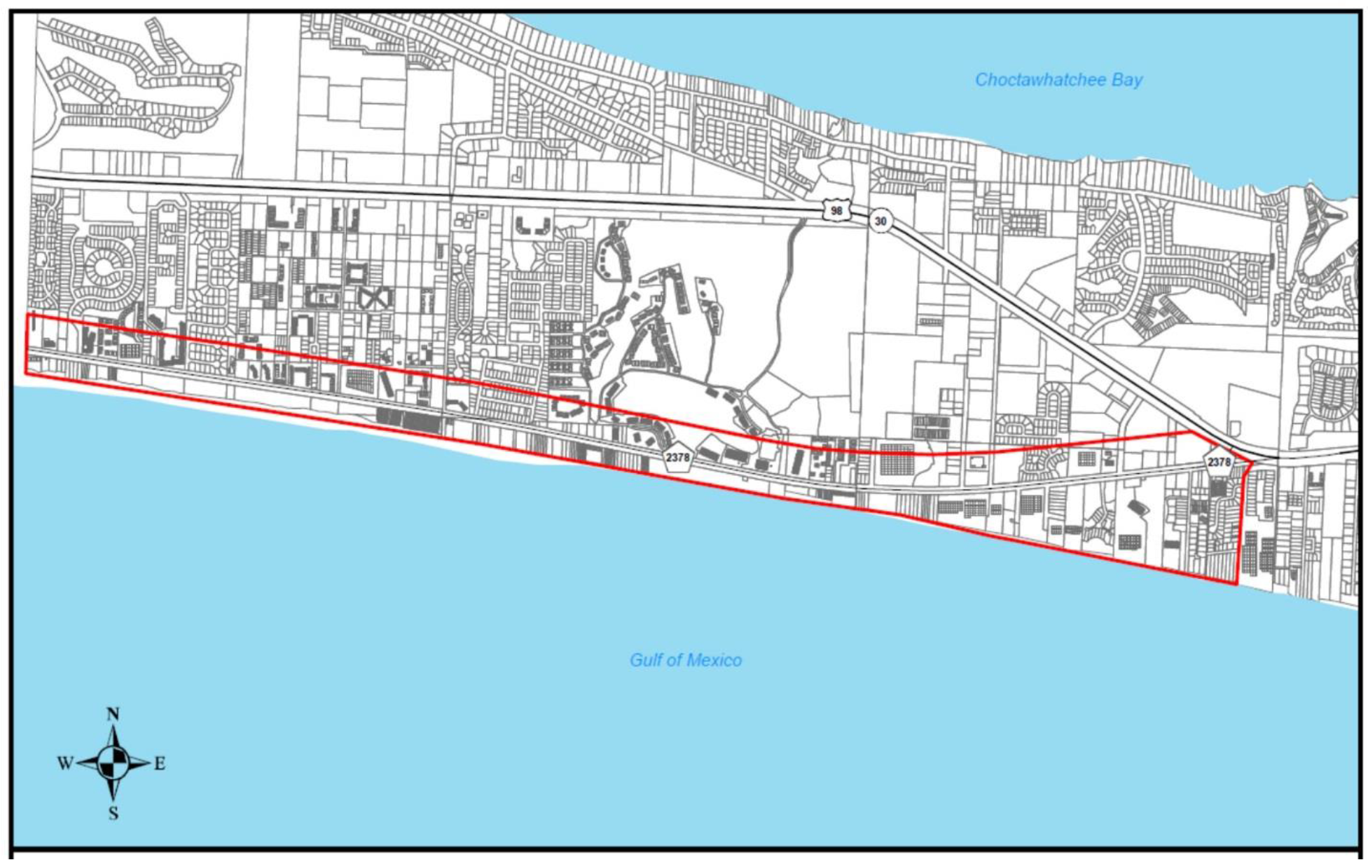
(Ord. No. 2018-29, § II(Att. A), 12-11-18)
6.13.03. - Prohibited Uses and Structures.
Temporary structures shall be prohibited along the Scenic Gulf Drive Corridor with the exception of temporary construction trailers and port-o-lets, and any structure that is governed by the most recent version of the Beach Activities ordinance.
(Ord. No. 2018-29, § II(Att. A), 12-11-18)
6.13.04. - Landscaping Standards.
A.
Landscaping within any required setback area or buffer area in the Scenic Gulf Drive Corridor shall be planted with salt and drought tolerant native species. Salt and drought tolerant native species are indicated on the landscape materials lists in Chapter 5.
B.
Landscaping of public right-of-way: Property owners whose property fronts on Scenic Gulf Drive are encouraged to provide landscaping on the public right-of-way. Such landscaping shall utilize native or other approved salt and drought tolerant vegetation as listed in Section 6.14.00 in this Land Development Code.
1.
Each plan for landscaping the public right-of-way shall be prepared and submitted to the Planning and Development Division for approval. Plans will be reviewed by the Walton County Public Works Division for safety issues and by utility companies that make use of the location, and are subject to a right-of-way use agreement between the applicant and the Walton County Public Works Division. Any landscaping proposed and approved for the public right-of-way of Scenic Gulf Drive is subject to removal by the County for any public purpose and by any utility company whose services are located within the right-of-way when necessary for repair, improvements or extensions of service. Under these conditions of public purpose removal, the cost of replacement shall be by the applicant and Walton County will bear no obligation as a result of its approval of landscaping. When utility companies or Walton County find it necessary to remove landscaping on the right-of-way they shall provide reasonable notice to the abutting property owner to allow for that owner to remove or protect plants. When minor and/or emergency repairs by utility companies or by Walton County or when notice has been given and plants have not been removed and landscaping is damaged by the activity of the utility companies or by Walton County, the restoration and the cost of such restoration shall be the responsibility of the abutting property owner.
2.
The applicant shall maintain all landscaping in the public right-of-way including the providing of an irrigation system. The sprinkler system for all shrub beds shall be drip irrigation. Spray heads are permitted for turf and annual color areas but shall strictly limit overspray onto roadways, bike paths, and driveways, or any other non-landscaped areas to the greatest extent possible. In general, the use of low-angle spray heads are encouraged. Rotor heads or other "long-throw" heads are forbidden in the public right-of-way. It shall be the responsibility of the owner to maintain the irrigation system to minimize overspray outside of turf or annual color beds. Upon request, the owner shall operate the irrigation system for the County enforcement officer. Violators shall be subject to fines per County code. All sprinkler controls shall be located to be accessible by the County.
3.
The permanent placement of trash/garbage cans, dumpsters and other such receptacles on the public right-of-way is prohibited. Such containers may be placed on the public right-of-way on the days of pickup, only.
4.
Display of merchandise or merchandising materials (e.g., signs, banners) is prohibited on the public right-of-way.
5.
The use of the public right-of-way for repeated and/or continual deliveries and offloading is prohibited.
6.
The use of brick pavers or concrete for the bike path is prohibited. The only acceptable paving material shall be asphalt.
(Ord. No. 2018-29, § II(Att. A), 12-11-18; Ord. No. 2019-19, § II(Att. A), 9-10-19)
6.13.05. - Driveway/Access/Parking Standards.
1.
No parking is allowed within the public rights-of-way or public easements unless the parking is for a public purpose and approved by the Board of County Commissioners after engineering technical review of the proposed design by the County.
2.
Driveways shall be paved from the edge of the pavement to the property line as a part of any development.
3.
Commercial uses are encouraged to provide parking in the rear of the building to allow building facades and landscaping to predominate in the view from the road. The parking requirements in Chapter 5 shall be reduced 20 percent for all commercial developments that provide parking in the rear of the building. However, the parking area shall not encroach into the coastal protection zone established in Section 4.02.02.
(Ord. No. 2018-29, § II(Att. A), 12-11-18)
6.13.06. - Sign Control.
Signs within the Scenic Gulf Drive Corridor Overlay District shall conform the general sign provisions of this Chapter and shall also be subject to the following standards and prohibitions:
A.
Prohibited signs. In addition to the signs prohibited in Section 6.03.00, the following signs shall be prohibited in the Scenic Gulf Drive Corridor:
1.
Permanent off-premise outdoor advertising signs (an off-premise sign is any sign located on property other than that to which the sign relates);
2.
Pole signs;
3.
Water towers as advertising;
4.
Wall murals as advertising; off-premise signs;
5.
Temporary mobile signs;
6.
Interior lit single panel plastic or Lexan face;
7.
Streamers, pennants, ribbons, spinners and other similar devices;
8.
Flashing signs;
9.
Signs containing reflective elements that sparkle or twinkle in the sunlight;
10.
Roof signs and signs containing moving parts.
B.
Sign design standards. All signs within the Scenic Gulf Drive Corridor Overlay District shall comply with the following design standards:
1.
Ground Signs:
a.
Ground Signs shall be limited to the following allowable sizes based on use:
i.
Single-family residence: Maximum allowable size is 2 square feet.
ii.
Condo/Commercial up to 4 stories: Maximum allowable size is 32 square feet.
iii.
Condo/Commercial greater than 4 stories: Maximum allowable size is 64 square feet.
b.
Ground signs shall be a maximum of 10 feet high and shall be located in an approved landscape buffer area. Ground signs shall not impede traffic visibility per site triangle requirements.
c.
Except for shopping centers, there shall only be one (1) ground sign per parcel.
d.
The maximum ground sign area shall be calculated to include the outside edge of the sign cabinet or frame.
e.
Ground signs shall only be used to advertise a business on the same site.
2.
Building Signs:
a.
The total amount of building signs allowed shall be two (2) square feet of signage per one (1) linear foot of addressed business frontage, not to exceed sixty-four (64) square feet.
b.
The area of a building sign shall be calculated by summing the area of each letter and the corporate logo in the sign.
c.
Shall only be used to advertise a business on the same site.
d.
The total amount of building signs allowed shall be two (2) square feet of signage per one (1) linear foot of addressed business frontage, not to exceed sixty-four (64) square feet.
e.
The area of a building sign shall be calculated by summing the area of each letter and the corporate logo in the sign.
3.
Shopping Center Signs:
a.
Ground signs for shopping centers may be constructed subject to compliance with the criteria described in the table below:
b.
Interior lighted signs shall be limited to two colors, red and blue only, not to exceed 20 percent of the window area that it is displayed in.
c.
Illumination standards. All signs or lighting for signs shall be directed or shielded such that the light sources or glare from the light sources is directed away from or shielded from the beach and the right-of-way of the Scenic Gulf Drive Corridor and shall comply with the Wildlife Lighting Ordinance if applicable.
4.
Non-Conforming Signs: The purpose of this Section is to regulate and limit the continued existence of signs that were lawfully established prior to the effective date of this Code but do not conform to the provisions of this Code.
a.
Authority to Continue. Nonconforming signs may continue in accordance with the provisions of this Section.
b.
Ordinary Repair and Maintenance. Normal maintenance and repair of existing nonconforming signs may be performed.
c.
Expansions. Nonconforming signs shall not be expanded.
d.
Relocation. A nonconforming sign may not be moved unless the sign will thereafter conform to the requirements of this Code.
e.
Termination.
f.
Damage or Destruction. If a nonconforming sign is damaged or destroyed to the extent of fifty percent (50%) or more then the nonconforming sign may not be restored unless the sign will thereafter conform to the requirements of this Code.
(Ord. No. 2018-29, § II(Att. A), 12-11-18)
6.13.07. - Fences and Walls.
The following standards shall apply to all fences and walls within the Scenic Gulf Drive Corridor Overlay District:
A.
Walls, chain link fences, and/or wire fences, including barbed wire, are prohibited along the entire Scenic Gulf Drive Corridor.
B.
Fences may be located in all front, side and rear yards.
C.
No fences shall be less than three feet in height or greater than six feet in height. Fences shall not exceed four feet in height when placed in the front yard unless set back from the front property line a minimum of the required building setback.
D.
Plywood, particle board, or similar wood materials are prohibited. The finished side shall face outward, and stringers and posts shall not be visible from the outside.
E.
Fences on lots or parcels adjacent to the north or south right-of-way of Scenic Gulf Drive with a view corridor to the Gulf of Mexico shall be subject to a 65 percent see through width to lot ratio limitation.
(Ord. No. 2018-29, § II(Att. A), 12-11-18)
6.13.08. - Review of Projects Located within the Scenic Gulf Drive Corridor Overlay District.
A.
In general all projects shall comply with the following:
1.
All projects located within the Scenic Gulf Drive Corridor Overlay District shall be reviewed in accordance with the appropriate development review process prescribed by Chapter 1 of this Code based on project size. A building permit shall not be issued until such time as the project is in full compliance with the scenic corridor overlay standards.
2.
Projects shall be reviewed by the designated Planning and Development Services Department Scenic Corridor Review Specialist for compliance with these standards as part of the technical review.
3.
Projects shall be referred to the Design Review Board (DRB) for review and recommendation, as appropriate. Conceptual or preliminary reviews of a project by the Design Review Board before beginning the Development Review process are encouraged.
4.
Projects shall not be placed on the Planning Commission agenda until full compliance is certified by the Corridor Review Specialist.
B.
Submittals. All submittals shall meet the standards as identified under Section 6.11.10(B) of this Land Development Code.
C.
Deviations. Any deviations to this section shall be required to adhere to the standards set forth in Section 6.11.11 of this Land Development Code.
(Ord. No. 2023-15, § II, 6-26-23)