
Waupaca City Zoning Code
17.100
ZONING DISTRICTS AND ZONING MAP
17.101 - ESTABLISHMENT OF ZONING DISTRICTS.
In order to carry out the purposes and provisions of this Chapter, the following zoning districts are hereby established:
(1)
A-1 Agricultural District
(2)
Residential Districts
(a)
R-1 Single-Family Residential District
(b)
R-2 Two-Family Residential District
(c)
R-3 Multi-Family Residential District
(d)
MH Mobile Home District
(3)
Business Districts
(e)
B-1 Neighborhood Commercial District
(f)
B-2 Central Business District
(g)
B-3 General Commercial District
(h)
B-4 Strip Commercial District
(i)
B-5 Planned Commercial District
(j)
B-6 Interchange Zone District
(k)
B-7 Riverfront District
(4)
Industrial Districts
(l)
I-1 Light Industrial District
(m)
I-2 Heavy Industrial District
(5)
Non-Standard Districts (Am. Ord. #09-22; Am. Ord. #04-23)
(a)
SPO Shoreland Protection Overlay District
(b)
PUD Planned Development District
(c)
RC Resource Conservation and Parks District (Am. Ord. #02-23)
(d)
PUL Public Facility and Utility Lands District
(e)
Q-1 Quarrying District
(f)
FSC Fulton Street Corridor Overlay District
(g)
TZ Transitional Zoning District
(h)
HS Homeless Shelter Overlay District (Cr. Ord. #04-21)
(i)
APD Airport District
17.102 - INCORPORATION OF ZONING DISTRICT MAP. (Am. Ords. #01-2021; #19-2021; #01-2022; #16-2022(2022); #20-2022(2022))
The location and boundaries of the zoning districts are hereby established as shown on the map entitled "City of Waupaca Zoning Districts" (hereafter, the zoning map) on file in the Community & Economic Development Department office. The zoning district map, together with all information shown thereon and all amendments thereto, shall be as much a part of this Chapter as if fully set forth and described herein.
17.103 - LOCATION OF DISTRICT BOUNDARIES.
The following rules shall apply with respect to the boundaries of the zoning districts as shown on the zoning district maps:
(1)
A boundary shown as following, or approximately following, a street, alley or railroad shall be construed as following the centerline of such feature.
(2)
A boundary line shown as following, or approximately following, a lot line, Section line, survey or other property line, or municipal boundary shall be construed as following such line or boundary.
(3)
Streets or alleys which are shown on the zoning district maps and which were previously vacated, or which may be vacated in the future, shall be construed to be in the same zoning district as the lots, pieces or lots abutting both sides of the street or alley involved. If the lots, pieces or lots abutting each side of the street or alley were located in different zoning districts before the said street or alley was vacated, the center line of such vacated street or alley shall be the boundary line of the respective zoning districts.
(4)
The boundaries of a base zoning district shall correspond with the boundaries of a legal lot. No un-subdivided property shall possess more than one base zone. Where a district boundary divides a platted lot, the zone classification of the greater portion shall prevail throughout the lot unless and until one of the following occurs:
(a)
All portion of the lots are rezoned to a single zone classification.
(b)
A land division is approved to establish separate legal lots coinciding with the boundaries of the zone classifications as they appear on the zoning map.
(5)
The boundaries of the SPO Shoreland Protection Overlay District consists of the first tier of riparian lots abutting Mirror Lake and Shadow Lake, the specific boundaries of which are shown on the official City of Waupaca Shoreland Protection Overlay District Map.
(6)
Where any uncertainty exists as to the exact location of zoning district boundary lines, the Zoning Board of Appeals, upon written application, shall determine the location of such boundary lines.
17.104 - PERMITTED USES AND CONDITIONAL USES. (Am. Ord. #24-22(2022); Am. Ord. #12-23)
(1)
Base Districts. The table appearing below and on the following pages presents the complete list of Permitted Uses and Conditional uses for all base districts. The Intent, Dimensional Standards, and additional regulations and standards applicable to each district follow the table.
(2)
Non-Standard Districts. The regulations and standards for Non-Standard Districts, along with applicable Permitted, Conditional, and Accessory Uses follow immediately thereafter.
(3)
Permitted Uses and Conditional uses by Base District.
17.111 - A-1 AGRICULTURAL DISTRICT.
(1)
Intent. This district is intended to:
(a)
Preserve a very low density, high quality rural setting for estate residential accommodating limited agricultural uses and livestock not to exceed one animal unit per acre with the Principal Structure accounting for one acre.
(b)
Provide for the continuance of commercial agriculture, consistent with Chapter 91, Wis. Stats., on properties of sufficient area to permit compatibility with surrounding residential development.
(2)
Uses. See Section 17.104 of this Chapter for a complete list of Permitted Uses and Conditional uses for all zoning districts.
(3)
Dimensional Standards.
17.121 - R-1 SINGLE-FAMILY RESIDENTIAL DISTRICT. (Am. Ord. #21-22(2022))
(1)
Intent. This district is intended to permit development which has a moderate density community character. Density and intensity standards for this district are designed to ensure that the single-family residential district shall serve as a designation which preserves and protects the residential community character of its area.
(2)
Uses. See Section 17.104 of this Chapter for a complete list of Permitted Uses and Conditional uses for all zoning districts.
(3)
Dimensional Standards.
17.122 - R-2 TWO-FAMILY RESIDENTIAL DISTRICT. (Am. Ord. #21-22(2022))
(1)
Intent. This district is intended to permit development which has a moderate density community character. The land use standards for this district permit both single-family detached residential development and twin house/duplexes permitted by right. Density and intensity standards for this district are designed to ensure that the district shall serve as a designation which preserves and protects the moderate density residential community character of its area.
(2)
Uses. See Section 17.104 of this Chapter for a complete list of Permitted Uses and Conditional uses for all zoning districts.
(3)
Dimensional Standards.
17.123 - R-3 MULTI-FAMILY RESIDENTIAL DISTRICT. (Am. Ord. #21-22(2022); Am. Ord. #03-24)
(1)
Intent. This district is intended to permit development which has a moderate density community character. The land use standards for this district permit single-family detached, twin house/duplex, 2-flats, townhouses, and multiplexes and apartments permitted by right and related institutional land uses. Density and intensity standards for this district are designed to ensure that the multifamily residence district shall serve as a designation which preserves and protects the community character of its area.
(2)
Uses. See Section 17.104 of this Chapter for a complete list of Permitted Uses and Conditional uses for all zoning districts.
(3)
Dimensional Standards.
17.124 - MH MOBILE HOME DISTRICT.
(1)
Intent. This district is intended to provide a safe, attractive, and functional environment for mobile and manufactured home parks and subdivisions, where the characteristics of manufactured homes do not allow them to be classified as single-family dwellings. The district shall be mapped only where the mobile or manufactured home park will be provided with public sanitary sewer service.
(2)
Uses. See Section 17.104 of this Chapter for a complete list of Permitted Uses and Conditional uses for all zoning districts.
(3)
Dimensional Standards.
(4)
Additional Standards.
(a)
Site Plan Requirements. The following information is required for all mobile home parks:
1.
A written description of the proposed mobile or manufactured home park, including proposed terms of sale or lease of sites; park rules; a maintenance program and responsibilities; types of homes to be constructed or allowed; other ancillary uses for the site; and assurances that the site will be developed and operated in accordance with all approved plans, including bylaws and deed restrictions.
2.
A site plan map drawn to scale showing proposed mobile or manufactured home park layout; location of home sites, roads, parking areas, and site boundaries; existing topography lines; existing natural features including waterways, wetlands, floodplains, woodlands, and shoreland areas; required perimeter and home setbacks and spacing; existing and proposed buildings and other structures; water supply well and lines; sanitary waste disposal lines and system; grading and stormwater management plan; covered or screened refuse storage areas; proposed types and locations of landscape plantings and recreation areas; proposed development phasing if any; and any other information the Zoning Administrator shall deem necessary. Professional engineering assistance is encouraged in such design, especially of roadways, home siting, site grading and stormwater management, and utility placement.
(b)
Shall conform to requirements of HFS 177, Wis. Adm. Code.
(c)
Shall provide an acceptable sewage treatment and/or disposal system meeting the requirements of all applicable State regulations and Chapter 15: Plumbing Code of the Waupaca Municipal Code.
(d)
Shall have direct access to a public road and a circulation plan that facilitates the safe and efficient movement of emergency vehicles.
(e)
All access interior park roads shall meet the minimum construction standards required by Chapter 18: Subdivision and Platting. All interior park roads, driveways to individual home sites, and parking areas shall be hard surfaced, and maintained in a dust-free condition. Where driveways to individual home sites are located on opposite sides of the road, they shall be offset to avoid collisions when backing out.
(f)
Home sites and access drives shall be located, graded, and maintained to provide each site with positive site drainage and for each site to be free from flooding. All sites shall be provided with anchor points for securing mobile or manufactured homes.
(g)
Shall provide a minimum of one acre of common recreation open space, plus an additional 500 square feet for each home site or lot in the park. The minimum required perimeter setback and individual home sites shall be included in the gross site area, but not in the calculation of common recreation open space. Such common open space shall be regular in shape and shall not be subject to flooding or lengthy periods of wet conditions. Common recreation open space shall be maintained in perpetuity by the mobile or manufactured park owner.
(h)
Each mobile or manufactured home, principal and accessory building, and vehicle parking area shall meet the minimum shoreland setback associated with any navigable waterway in Chapter 21: Shoreland-Wetland Code. There shall be a 40-foot landscaped buffer setback from all other exterior lot lines of the mobile or manufactured home park to all home sites, roads, parking areas, recreation areas, wells, and private sewage disposal systems. Roads and utility crossings of the buffer setback shall be minimized and shall occur at right angles wherever possible. The project shall provide a landscaped bufferyard along all exterior lot lines.
(i)
All mobile or manufactured homes shall be used for dwelling purposes. No mobile or manufactured home site shall be rented for a period of less than 30 days.
(j)
The mobile or manufactured home park shall be owned by a single individual, trust, partnership, public or private association, or corporation, except for a mobile or manufactured home subdivision, where a homeowners association shall be established for the management and maintenance of all common areas not in public ownership.
17.131 - B-1 NEIGHBORHOOD BUSINESS DISTRICT. (Am. Ord. #21-22(2022))
(1)
Intent. This district is intended to provide for individual or small groups of retail and customer service establishments serving primarily the convenience of a local neighborhood and the character, appearance and operation of which are compatible with the character of the surrounding area.
(2)
Uses. See Section 17.104 of this Chapter for a complete list of Permitted Uses and Conditional uses for all zoning districts.
(3)
Dimensional Standards. (Am. Ord. #10-2024)
17.132 - B-2 CENTRAL BUSINESS DISTRICT.
(1)
Intent. This district is intended to permit both large and small scale "downtown" commercial development at an intensity which provides significant incentives for infill development, redevelopment, and the continued economic viability of existing development. A wide range of office, retail, and lodging land uses are permitted within this district. In an effort to minimum the potential disruptions to existing residential development, nonresidential development within this district should minimize direct access to local residential streets or residential collector streets. No requirements for on site landscaping or parking are required in this district. This district is strictly limited to the central City locations.
(2)
Uses. See Section 17.104 of this Chapter for a complete list of Permitted Uses and Conditional uses for all zoning districts.
(3)
Dimensional Standards.
17.133 - B-3 GENERAL COMMERCIAL DISTRICT.
(1)
Intent. This district is intended to permit large and small scale commercial development which is compatible with the desired overall community character of the area in general. Significant areas of landscaping are required in this district to ensure that this effect is achieved. A wide range of office, retail, and lodging land uses are permitted within this district. In order to ensure a minimum of disruption to residential development, direct access to a local residential street or a residential collector street is strongly discouraged.
(2)
Uses. See Section 17.104 of this Chapter for a complete list of Permitted Uses and Conditional uses for all zoning districts.
(3)
Dimensional Standards.
17.134 - B-4 STRIP COMMERCIAL DISTRICT.
(1)
Intent. The strip commercial district was created to facilitate the development of land annexed to the City of Waupaca on the West Side. This property was envisioned to be developed into larger retail properties which would attract businesses that would desire a close proximity to U.S. Highway 10 (i.e., hotels, fast food restaurants, convenience stores/gas stations, and other convenience type businesses). (Am. Ord. #04-21)
(2)
Uses. See Section 17.104 of this Chapter for a complete list of Permitted Uses and Conditional uses for all zoning districts.
(3)
Dimensional Standards.
17.135 - B-5 PLANNED COMMERCIAL DISTRICT.
(1)
Intent. This district is intended to permit large- and small-scale commercial development which is compatible with the desired overall community character of the area in general. Significant areas of landscaping are required in this district to ensure that this effect is achieved. A wide range of office, retail, and lodging land uses are permitted within this district. In order to ensure a minimum of disruption to residential development, development within this district should take access from a collector or arterial street.
(2)
Uses. See Section 17.104 of this Chapter for a complete list of Permitted Uses and Conditional uses for all zoning districts.
(3)
Dimensional Standards.
17.136 - B-6 INTERCHANGE ZONE DISTRICT.
(1)
Intent. The interchange zone district was created to facilitate the development of land within an approximate ½-mile radius of the U.S. Highway 10/State Highway 22/54 Interchange. This property was envisioned to be developed into large-scale and travel-oriented retail with design standards that result in a welcoming gateway to the City of Waupaca.
(2)
Uses. See Section 17.104 of this Chapter for a complete list of Permitted Uses and Conditional uses for all zoning districts.
(3)
Dimensional Standards.
(4)
Additional Standards.
(a)
Building Architecture and Style Regulations.
1.
Exterior building materials shall be of high and comparable aesthetic quality on all sides. Building materials such as glass, brick, decorative concrete block, metal panel with concealed fastener, or stucco shall be used.
2.
A minimum of 20 percent of all of the combined façades of the structure shall employ actual façade protrusions or recesses.
3.
A minimum of 20 percent of all the combined linear roof eave or parapet lines of the structure shall employ differences in height, with such differences being six feet or more as measured from eave to eave or parapet to parapet.
4.
Building colors shall reflect earth tones (tan, brown, green, gray, blue, etc.) with other accent colors. Variations in color shall be kept to a minimum. (Am. Ord. #09-22)
5.
Windows shall be integrated into building design.
6.
Building entrances shall be clearly marked by incorporating distinct architectural features such as canopies, overhangs, projections, arcades, peaked roof forms, arches, display windows or other similar features.
7.
Barbed wire or electrical and single-, double- or triple-strand fences are prohibited.
8.
All mechanical and utility equipment shall be screened or painted to be similar to the surrounding area.
9.
All loading docks, outdoor storage and refuse areas shall be screened from public view using walls, or enclosures constructed of materials consistent with those used on the Principal Structure on the property. Screening fences, walls or enclosures shall be no less than eight feet in height.
(b)
Landscaping and Open Space Regulations. (Am. Ord. #09-22)
1.
All landscaping shall be consistent with the landscaping requirements of this Chapter.
2.
All parking areas shall be landscaped with a buffer strip not less than 15 feet wide located between the edge of the right-of-way and the surface of the parking area. Corner lots shall provide said landscape buffer along both abutting rights-of-way. At least one tree per 50 feet of street frontage shall be provided. The same total number of trees may be planted in clusters with varied spacing to create a more natural look. Areas between trees shall be landscaped using a combination of shrubs, berms or planted ground cover.
3.
Any frontage abutting a residential use shall have a landscape buffer or other screening material that is consistent with those used on the Principal Structure along the abutting frontage and no less than 8 feet in height. The buffer shall include at least one tree per 40 feet of abutting frontage.
4.
All trees located adjacent to designated parking areas must be pruned so that branching begins no less than 6 feet above pavement.
(c)
Traffic Impact and Circulation.
1.
A Traffic Impact Analysis conducted by a licensed professional engineer with expertise in traffic engineering shall be required when staff determines a probability of potentially significant effects on offsite traffic and circulation as a result of proposed development.
2.
The extent of the boundaries for the Traffic Impact Analysis study area shall be determined by staff in consultation with the developer.
3.
The analysis shall specify necessary improvements to existing road infrastructure and detailed on-site traffic circulation strategies. On-site traffic circulation shall account for vehicle and pedestrian access to existing adjacent developments. Traffic circulation shall also account for vehicle and pedestrian access to existing infrastructure.
4.
Shared access and interconnected design best practices shall be used. Generally, adjacent lots shall share access to public rights-of-way and parking lots shall interconnect whenever practical. Shared access and interconnected parking lots will be assessed in accordance [with] traffic impact analysis results.
5.
Vehicular access points planned to be located along property lines, or closer than six feet from a property line, should be considered for shared vehicular access points with the abutting lot or parcel. The vehicular access point centerline may be the property line between two lots or parcels of land or may be a mutually agreed upon land access easement.
6.
Staff may require curb and islands for internal parking circulation when such structures are deemed necessary for safety vehicular and pedestrian circulation.
(d)
Bicycle and Pedestrian Accommodations. Bicycle and pedestrian accommodations shall be included to encourage bicycle and pedestrian circulation by providing adequate and safe storage and parking facilities for bicycles and providing adequate and safe facilities and access for pedestrians.
1.
One bicycle parking space shall be provided for each 2,000 square feet of floor area up to a maximum of 10 spaces. In all cases where bicycle parking is required a minimum of two spaces shall be provided.
2.
Bicycle parking spaces shall be located close to automobile parking spaces but kept separate and out of conflict with motor vehicle traffic.
3.
Bicycle parking facilities shall be located in a clearly designated and convenient location and shall be harmonious with the surrounding environment and shall be at least as convenient as the majority of auto parking spaces provided.
4.
Bicycle parking is allowed in the front and side setbacks of the parcel provided that the parking area requires no more than 25 percent of the required setback area being paved and the bicycle parking area is no further than 100 feet from the primary entrance of the building.
5.
Required bicycle parking racks must be designed to support the bicycle by its frame and allow the use of either a cable lock or a U-shaped lock. Bicycle lockers and secure indoor storage facilities are also allowed.
6.
Bicycle parking facilities shall be at least two feet wide and six feet deep with an access aisle at least five feet wide.
7.
Continuous pedestrian walkways shall be provided from building entries to the public sidewalk or right-of-way, existing community trails, parking areas, transit stops, and adjacent properties, as appropriate to encourage connectivity to off-site pedestrian walkways.
8.
On-site pedestrian walkways and sidewalks shall be a minimum of five feet wide, except that walkways adjacent to a parking area where cars may overhang the walkway shall be a minimum of seven feet wide.
9.
At each point that the on-site pedestrian walkway system crosses a parking lot or internal street or driveway, the walkway or crosswalk shall be clearly marked through the use of a change in color, texture, or height.
17.137 - B-7 RIVERFRONT DISTRICT.
(1)
Intent. This district is intended to permit the combined residential and commercial use of buildings in correlation with the 'Live-Work' style of first story living. The B-7 district is created with the idea of residential living on the first floor in part due to the location of the buildings in proximity to the water. At the time of adoption, all new or future development shall maintain a minimum of two-story building frontage along all public streets. The live-work style promotes increased usage of the backside of the buildings which has significant topographic grade changes towards Riverview Park. A range of retail, commercial, and residential land uses are permitted within this district.
(2)
Uses. See Section 17.104 of this Chapter for a complete list of Permitted Uses and Conditional uses for all zoning districts.
(3)
Dimensional Standards. The dimensional standards in the B-7 District are those of existing structures.
17.141 - I-1 LIGHT INDUSTRIAL DISTRICT. (Am. Ord. #21-22(2022))
(1)
Intent. This district is intended to permit both large and small scale industrial and office development at an intensity which is consistent with the overall desired suburban community character of the community. Beyond relatively extensive landscaping, the primary distinguishing feature of this district is that it is geared to indoor industrial activities which are not typically associated with high levels of noise, soot, odors and other potential nuisances for adjoining properties. In order to ensure a minimum of disruption to residential development, no development within this district shall take direct access to a local residential street or a residential collector street.
(2)
Uses. See Section 17.104 of this Chapter for a complete list of Permitted Uses and Conditional uses for all zoning districts.
(3)
Dimensional Standards.
17.142 - I-2 HEAVY INDUSTRIAL DISTRICT. (Am. Ord. #21-22(2022))
(1)
Intent. This district is intended to permit both large and small scale industrial and office development at an intensity which provides ample incentive for infill development and redevelopment of industrial areas existing as of the effective date of this Chapter. This district is designed to permit a very wide variety of industrial uses which may occur both indoors and outdoors, including certain land uses which are permitted in no other zoning district because of their potential to create nuisances for adjoining properties. In order to ensure a minimum of disruption to residential development, no development within this district shall take direct access to a local residential street or a residential collector street.
(2)
Uses. See Section 17.104 of this Chapter for a complete list of Permitted Uses and Conditional uses for all zoning districts.
(3)
Dimensional Standards.
17.151 - SPO SHORELAND PROTECTION OVERLAY DISTRICT.
(1)
Intent. This District is intended to preserve and protect the environmental quality of surface waters and the natural and economic values of shoreland areas within the City of Waupaca.
(a)
District Application. The Shoreland Protection Overlay District shall be superimposed (overlaid) upon the base zoning district in effect. The regulations and requirements imposed by the Shoreland Protection overlay District shall be in addition to those established by the base zoning district which jointly apply. Under joint application of the districts, the more restrictive requirements shall apply.
(b)
Exemption. A structure or use which was lawful before adoption of this Section, but which is not in conformity with the provisions of the Shoreland Protection Overlay District, may be continued subject to the Nonconformities Section of this Chapter.
(2)
Uses. Any use permitted by right or by Conditional Use Permit in the underlying base zoning district is allowed as a permitted or Conditional use in the Shoreland Protection Overlay District. See Section 17.104 of this Chapter for a complete list of Permitted Uses and Conditional uses for all zoning districts.
(3)
Dimensional Standards. All dimensional standards are as applicable for the underlying base zone.
17.152 - PUD PLANNED UNIT DEVELOPMENT DISTRICT.
(1)
Intent. This Section is intended to encourage residential and commercial planned unit developments offering greater creativity and flexibility in site plan design than is provided under the strict application of zoning and subdivision regulations while, at the same time, preserving the health, safety, order, convenience, prosperity and general welfare of the City. Specifically, the purpose of the planned unit development district is to:
(a)
Assure that growth is planned and accomplished within the City's goals, both for the surrounding neighborhood and the community as a whole.
(b)
Promote flexibility in design and the efficient use of land to facilitate a more economic arrangement of buildings, uses, circulation systems and utilities.
(c)
Provide for the accomplishment of external architectural unity so as to promote design harmony.
(d)
Preserve, to the greatest extent possible, existing landscape features and natural amenities and utilize such features in an effective manner.
(e)
Enhance the natural setting through the placement of man-made facilities and plant materials.
(f)
Provide more usable and suitably located common and open space areas than would otherwise be provided under conventional land development procedures.
(2)
Uses. Uses permitted in a planned unit development may consist of one or a mixture of land uses clearly designated by type on the approved final development plan. Mixed uses may occur among or within buildings as long as the uses are compatible with each other and with planned and existing uses surrounding the PUD.
(3)
District Standards.
(a)
Access. All land uses shall abut on a public street or have adequate access to a public street by means of a private drive. All streets and drives shall tie in effectively with the City's existing street system and with those arterial and collector streets proposed in its future land use plan.
(b)
Architectural Style. The architectural style of individual structures shall be compatible with other structures in the PUD, with the overall site design and with surrounding land uses.
(c)
Common Open Space. Whenever possible, common open space shall be linked to the open space areas of surrounding developments. Common open space shall be of a size, shape, location and usability for its proposed purpose.
(d)
Density. Density shall be governed by the standards of the zoning district most similar in function to the proposed use. A residential PUD may provide up to a 25 percent increase in the number of units per acre if the PUD provides substantially more site amenities than are found in a conventional residential development. The character, use of existing landscape, design variation and environmental concern of a PUD shall govern the amount of approved density increase.
(e)
Determining Standards. Standards for lot area, coverage, setbacks, parking and screening shall be governed by the standards of the zoning district most similar in function to the proposed PUD use, as determined by the Plan Commission. Deviation from those standards may be permitted only if such deviation is consistent with the total design of the development, encourages a desirable living environment and is not detrimental to the welfare of the City.
(f)
Exterior Boundary Setback. No principal building shall be set back less than 20 feet from the exterior of a PUD or a public street right-of-way. No commercial or industrial structure shall be nearer than 50 feet to its side or rear property lines where such line abuts a single-family use.
(g)
Property Owner's Association. If not platted in a conventional manner, membership in a property owner's association shall be mandatory for all owners of property within the PUD. The property owner's association shall own and maintain all common open space and private interior drives.
1.
Designation of Recreational Trails. When possible, trails should be integrated into the PUD. Trails within a PUD shall be encouraged to connect to existing or future exterior trail systems. A PUD not conventionally platted shall include at least 10 percent common open space.
2.
Minimum PUD Development Area. At least two acres of land in single ownership or control shall be the minimum land area for a PUD. However, a site of less than two acres may qualify if one or more of the following conditions exist:
a.
Natural features of the land are such that development under standard zoning regulations would not be appropriate in order to conserve such features; or,
b.
The land is adjacent to or across the street from property which has been developed as a PUD and is to be developed in relationship to such prior development; or,
c.
Flexible design is needed to address detrimental site features affecting the development potential of a site such as heavily used highways, railroad tracks traversing a property, rock outcroppings, adjacent incompatible land uses or similar site constraints.
(4)
Environmental Review Standards and Site Design Standards. In reviewing a proposed planned development, the City shall apply the following standards and the Plan Commission shall recommend approval of such planned development only when it has determined that the following standards have been reasonably satisfied.
(a)
The proposal shall demonstrate an effective and unified treatment of the development possibilities on the project site, making appropriate provision for the preservation of scenic features and physical amenities of the site and the surrounding areas.
(b)
The project shall be planned and developed to harmonize with any existing or proposed surrounding land uses.
(c)
Individual buildings shall be related to each other in design, mass, placement and connection to provide a visually and physically integrated development.
(d)
All buildings shall be arranged so as to be accessible to services and emergency vehicles.
(e)
Landscape treatment for open spaces, roads, paths, service and parking areas shall be designed as an integral part of a coordinated landscape design for the entire project area, except lands donated to the City for park or trial development.
(f)
Primary landscape treatment shall consist of shrubs, ground cover and street trees, and shall combine with appropriate walks and street surfaces to provide an attractive development pattern. Whenever possible, existing trees shall be conserved and integrated into the landscape design plan.
(g)
All streets bordering the project area shall be planted at regular intervals with street trees.
(h)
There shall be an adequate, safe and convenient arrangement of pedestrian circulation facilities, i.e., sidewalks and/or trails; roadways; driveways; off-street parking and loading spaces; trash removal facilities; and outdoor storage areas. All such facilities shall be designed to City specifications.
1.
Materials and design of paving, lighting fixtures, retaining walls, fences, signage, curbs, benches, etc. shall be of good appearance, easily maintained and indicative of their function.
2.
Parking facilities shall be designed with careful regard to orderly arrangement, topography, landscaping and ease of access, and shall be developed as an integral part of an overall site design. To reduce unsightliness and the visual monotony of parked cars, such facilities shall be screened from public view with landscaping or fencing.
3.
Any above-grade loading facility shall be screened from public view to the extent necessary to reduce unsightliness.
(5)
Preliminary Development Plan Application.
(a)
Preliminary Plan. The preliminary plan shall include the following:
1.
Existing wooded areas, streams, marshes and other predominant natural features.
2.
Phasing schedule stating the geographical phasing and approximate construction timing of the PUD or portions thereof.
3.
Preliminary drainage plan.
4.
Preliminary utility plan for all public utilities.
5.
Site plan showing the lot lines, building locations, street system, parking spaces, drives, common open space areas, trails, recreational improvements and structures.
6.
Summary sheet indicating the area of land in each land use, number of units proposed, density of development, percentage of land in usable open space, number of acres of common recreational open space and number of parking spaces provided.
7.
Vicinity map showing sufficient area surrounding the proposed PUD to demonstrate the development's relationship to the adjacent land uses and street system.
(b)
Application Information. The application form shall include the following:
1.
A written explanation of the character and purpose of the proposed planned development including the type and density of any housing proposed; the nature and purpose of any nonresidential development; the proposed method for preserving and maintaining open space, streets and parking areas; and a general statement of proposed financing for the project.
2.
Each proposal for planned development shall be accompanied by a schedule showing the times within which each phase or segment of the PUD will be completed. Approval of any PUD by the Council shall carry with it approval of the time schedule for completion of each phase or segment contained in the proposal and any changes or amendments.
(6)
Procedure for Review of a Preliminary PUD. To obtain PUD zoning, the following procedures shall be followed:
(a)
Prior to filing an application for a planned unit development zoning, the City shall schedule a pre-filing conference with the developer. The purpose of this to jointly review the proposal and consider any modifications or conditions that should be included in the application and preliminary site plan.
(b)
Following the pre-filing meeting, the petitioner shall file six copies of a preliminary development plan and application form with the City at least 10 days prior to the Plan Commission meeting.
(c)
Within 45 days from the filing date, the Plan Commission shall make a recommendation to the Council to approve, approve with modifications or disapprove the proposal.
(d)
After receipt of the Plan Commission report, the Council shall hold a public hearing on the proposed development. Within 45 days after such public hearing, the Council shall approve conditionally or disapprove the proposed planned unit development. Conditional approval shall be valid for one year and shall be subject to acceptance by the City of a final plan for all or a portion of the preliminary development plan. The final plan shall incorporate all conditions and modifications imposed by the Council.
(e)
If part of the PUD involves the subdivision of land into parcels for sale to individual owners, the site plan review required pursuant to this Section may run concurrent with a subdivision review consistent with the City's platting requirements.
(7)
Application for Final PUD Plan Approval. Prior to issuance of a building permit, an application for final development plan approval for particular phases or for the entire preliminary PUD project shall be filed with the City. Said application and final development plan shall include the following:
(a)
A definite time frame for start of construction and approximate amount of time to build out the project.
(b)
All pertinent dimensions shown to the nearest foot.
(c)
Final grading, drainage, utility, lighting and landscape plans.
(d)
Any signs, consistent with City's sign code.
(e)
Deed restrictions and instruments dedicating all rights-of-way, access easements and public lands, drafted to the satisfaction of the City Attorney.
(f)
By-laws of the property owner's association if one is pertinent to the project.
(g)
Building elevation drawings, including specifications, except for detached single-family dwellings meeting required single-family residential district standards. The City may waive this requirement.
(h)
Before a building permit may be issued, the developer shall file with the City a security instrument, i.e., a performance bond acceptable to the City in an amount equal to 150% of the estimated cost of public utilities and infrastructure in accordance with the subdivision regulations; paved parking; landscaping; walkways; recreational equipment, if any; and lighting in accordance with final development plans. Such bond shall be posted for each phase as it is proposed for development. The estimated cost for termination of each phase shall be retained by the City' until subsequent phases are under construction.
(8)
Final PUD Plan Approval. Within 30 days after the final development plan is submitted, the Plan Commission shall make a recommendation to the Council on such plan as to its conformity with the preliminary development plan, fulfillment of all required items and continued compliance with findings required for preliminary development plan approval. Upon receiving the Plan Commission's recommendation, the Council shall either grant, grant subject to conditions or deny the final development plan. If approval is granted, a PUD permit shall be issued to the developer by the City, which permit shall contain any conditions attached by the Council.
(9)
Filing of Final PUD Plan. Upon approval, the City Clerk shall certify three copies of such plan with one plan filed in the Clerk's office, the second plan in the planning office and the third plan in the Assessor's office. Such plan shall be drawn to a scale of 40 feet to one inch or larger. The dimensions of such plan shall not exceed three feet by six feet. In case of a large plan, two or more sheets may be required. If so, the sheets shall be numbered.
(10)
Final PUD Plan Changes.
(a)
Any significant changes in the approved final development plan may be made only after Plan Commission and Council approval. No changes in the final development plan may be made unless they are shown by the developer to be required by changes in conditions or circumstances not foreseen at the time of the final plan approval. Any significant changes shall be recorded as amendments to the approved final development plan. Minor changes and adjustments to the final site plan may be approved by City administration.
(b)
In the event that any portion of such time schedule in the approved final development plan is not met, the developer may submit a written request for an extension of time, delivered to the Council at least 20 days prior to the expiration of the build out date. The Council may, for good cause, extend the previously agreed completion date. The petitioner has no limit upon the number of time extensions requested.
(c)
If the developer fails to satisfy any phase or segment of the completion schedule within 20 days of the expiration date or within 30 days of an extension denial by the Council, said phase or portion of a previously approved site plan associated with the PUD shall become null and void.
(11)
Termination of Final PUD Plan Approval. If final development plan approval is given to a developer and thereafter he/she wishes to abandon the plan, the developer shall notify the City in writing. If the developer fails to commence the development within 18 months or upon a finding by the Plan Commission that there has not been substantial progress, as indicated by installation of utilities or completion of five percent of the proposed floor area, such final development plan approval may be terminated after public hearing by the Council.
17.153 - RC RESOURCE CONSERVATION AND PARKS DISTRICT. (Am. Ord. #02-23)
(1)
Intent. The City's parks system, multi-use trails, recreational activities, recreational facilities, water access and all other natural resources are all seen as critical assets when maintaining quality of life, attracting visitors, and leveraging future residential, commercial, and industrial development. This District's intent is to:
(a)
Preserve and restore natural and/or manmade resources;
(b)
Protect areas which are not adequately drained, are environmentally-sensitive, and/or are subject to periodic or potential flooding;
(c)
Prevent development that would result in hazards to health or safety, would deplete or destroy irreplaceable resources, and/or would be otherwise incompatible with the public welfare;
(d)
Preserve, restore and expand Waupaca's parks, trails, and natural environment to ensure a high quality of life and maintain attractiveness of the community.
(2)
Uses.
(a)
Permitted Uses.
1.
Fishing, gardening, and wildlife preserves.
2.
Preservation, conservation, forestry, and water retention.
3.
Public parks, parks and recreational facilities, playgrounds, athletic fields/courts, and any supporting accessory uses/structures.
4.
Recreational trails, including but not limited to biking, walking, hiking, and cross-country skiing.
5.
Public roads, streets, docks, piers, wharves, and boat landing ramps.
6.
Any other use not listed that is determined by the Zoning Administrator and Parks and Recreation Director to satisfy and fit cohesively with the intent of this district.
(b)
Conditional uses.
1.
Drainage, grazing, orchards, and wild crop harvesting.
2.
Utilities, including but not limited to structures, substations, transmission lines, or pipelines that do not directly support the primary use of the parcel.
3.
Dams, dikes, drainage channels, reservoirs and other structures or devices for the control of flowing or standing water.
4.
Shooting ranges and archery target ranges.
5.
Campgrounds and lodges.
(3)
Standards.
(a)
Branding and Colors. All structures and facilities located in this district shall adhere to the City of Waupaca's branding guidelines. Alternative, but cohesive, colors and branding may be used if a unique case is determined by the Zoning Administrator and Parks and Recreation Director.
17.155 - Q-1 QUARRYING DISTRICT.
(1)
Intent. This District is intended to provide for nonmetallic mining opportunities at appropriate locations in the City.
(2)
Uses. The following uses are Permitted Uses in the Q-1 District:
(a)
Mineral extraction operations including washing, crushing or other processing of minerals.
(3)
Dimensional Standards.
17.156 - PUL PUBLIC FACILITY AND UTILITY LANDS DISTRICT.
(1)
Intent. This district is intended to provide areas for utilities and public uses such as government buildings, public works facilities, recreation, education, safety services and passive open space.
(2)
Uses.
(a)
Permitted Uses.
1.
Public facilities.
2.
Government buildings.
3.
Government maintenance facilities.
4.
Safety services.
5.
Schools.
6.
Libraries.
7.
Passive open space.
(b)
Conditional uses.
1.
Waste facilities.
2.
Indoor/outdoor recreational facilities.
3.
Mobile towers.
4.
Recycling facilities.
5.
Road maintenance facilities.
6.
Water towers, electrical substations, wastewater treatment facilities, and similar such public utilities. (Cr. Ord. #04-21)
(3)
Dimensional Standards.
(4)
Additional Standards.
(a)
Gated Facility Entrances. A minimum of 60 feet of vehicle queuing area shall be provided behind each gated area. The minimum width of the vehicular entry shall be 20 feet in width. A vehicular turn-around area shall be provided between the gated access points. The vehicular turning area shall have a minimum interior turning radius of 35 feet and an exterior turning radius of 55 feet.
(b)
Outdoor Storage. All outdoor storage shall be screened from public view using fencing materials as required the Fences section of this Chapter. All proposed storage areas shall be illustrated on the site plan. Unless otherwise approved by Plan Commission, all surfaces must be paved.
(c)
Paved Surfaces. Paved surfaces are required for all driveways, parking areas and storage areas. Crushed gravel may be used as a surface in outdoor storage areas but must be approved by Plan Commission.
(d)
Fences. Fences shall be required for all areas used for outdoor storage, refuse, and other uses requiring screening from public view, as required by city staff. Fence height shall be a minimum of six feet and a maximum of eight feet high when enclosing an area designated for storage or refuse.
17.157 - FSC FULTON STREET CORRIDOR OVERLAY DISTRICT. (Am. Ord. #04-21)
(1)
Intent. This district is intended to accommodate established uses along West Fulton Street while providing for its gradual transformation to a mixed-use commercial corridor offering a varied array of retail, service, office, residential, technology, distribution, and light manufacturing uses integrated via site plan review. The Fulton Street Corridor Overlay District (hereafter, FSC District) is also intended to:
(a)
Create an environment conducive to pedestrian, bicycle, transit, and motor vehicle activity.
(b)
Improve the quality of landscaping, site design, and urban design along this corridor.
Maintain the viability of existing residential uses located along the corridor.
(c)
Encourage appropriate transitions between higher-intensity uses along the corridor and adjacent lower-density residential uses.
(d)
Facilitate preservation development or redevelopment consistent with the adopted goals, objectives, policies, and recommendations of the Comprehensive Plan and of adopted neighborhood, corridor or special area plans.
(e)
Facilitate the transition of the corridor from an auto-oriented commercial strip to a comprehensive multiuse corridor complementary to Downtown Waupaca.
(f)
Facilitate a positive impression and identifiable gateway to the City of Waupaca through the use of signature architecture, inviting public plazas, and development that supports a walkable environment.
(2)
Location. All B-4 District parcels designated FSC District on the City of Waupaca Zoning Map.
(3)
Uses.
(a)
Permitted Uses. Any use listed as a Permitted Use in the B-4 District.
(b)
Conditional uses. Any use listed as a Permitted Use or Conditional use in the R-1, R-2, R-3, B-1, B-2, B-3, B-5, B-7, and I-1 District, consistent with Subsection (3) below.
(4)
Applicability. The requirements of Chapter 17.157 apply to all new development and the redevelopment of existing sites and structures on all parcels located within the FSC District.
(5)
General Standards.
(a)
Loading and Unloading Activities. Where applicable, the covenants, conditions, and restrictions of a mixed-use development shall indicate the times when the loading and unloading of goods may occur on the street, provided that, in no event, shall loading or unloading take place after 10:00 p.m. or before 7:00 a.m. on any day of the week.
(b)
Lighting. Lighting for nonresidential uses shall be appropriately designed, located, and shielded to ensure that they do not negatively impact the residential uses in the development nor any adjacent residential uses. In no case shall lighting spill over onto an adjoining parcel.
(c)
Recycling and Refuse Storage Facilities. Recycling and refuse storage facilities for nonresidential uses shall be located as far as possible from residential units and shall be completely screened from view from the residential portion of the development. Recycling and refuse storage facilities for nonresidential uses shall be compatible in architectural design and details with the overall project. The location and design of trash enclosures shall mitigate nuisances from odors when residential uses might be impacted. Trash areas for food service and sales uses, when occupying the same building as residential uses, shall be refrigerated to control odor.
(d)
Residential Noise Notice. Residents of new residential or mixed-use development projects in the FSC District, whether owners or tenants, shall be notified in writing before taking up residence that they will be living in a mixed-use environment and that the noise levels may be higher than a strictly residential area. The covenants, conditions, and restrictions of a residential or mixed-use project shall require that prospective residents acknowledge the receipt of the written noise notification. Signatures shall confirm receipt and understanding of this information.
(6)
Design Standards. Development of any structure that will contain a commercial or light industrial use shall comply with the following:
(a)
Siting. The siting of the building shall:
1.
Reflect, rather than obscure natural topography.
2.
Enable significant or important trees and other natural landscape elements to be preserved as determined by the Plan Commission.
3.
Be compatible with the original structure, when the structure is an addition to an existing structure.
(b)
Building Orientation. Local climatic conditions shall be considered when orienting buildings. For example, north-facing facades are especially susceptible to winter snow and ice accumulation, and entries may require special treatment. Snow piling zones along street shall be considered in arranging building elements on the site. Adequate solar access shall be considered when planning outdoor spaces, with shade and relief from glare provided by landscaping and overhead structures.
(c)
Street Corners. Buildings located on street corners shall recognize the importance of their location by:
1.
Concentrating tallest portions of the building at the intersection where they may frame the corner.
2.
Employing architectural features, such as angled façades, prominent entrances, a stepped parapet wall, or other unique building features at the corner or employing a similar technique as approved by the Plan Commission.
(d)
Pedestrian Environment.
1.
Site design shall locate pedestrian routes connecting residential, recreational, and commercial uses to minimize contact with normal vehicular traffic. This can be achieved by designing crossings at traffic stop points, and/or by announcing crossings with signage, pavement changes, and landscape features.
2.
Pedestrian use can be increased by the addition of amenities such as benches, drinking fountains, planters, trash receptacles, path lighting, and bicycle racks.
3.
When existing sidewalks, curbs, gutters, or other public improvements have deteriorated, the development shall be required to replace and/or repair the public amenities.
4.
When sidewalks exist or are proposed, new development shall be sited and designed to encourage pedestrian activity.
(e)
Building Massing and Form. Unless otherwise provided in this chapter, building form may vary widely, as long as certain features of building form are considered:
1.
Within the development, variability in size and shape of buildings shall occur.
2.
Incorporating pedestrian-scale features at the ground level will help encourage pedestrian use. Examples include articulated entries and window canopies, arcades, recessed entries, changes in color, material, or texture.
3.
Façade modulation shall be utilized to reduce the apparent bulk of a large building, where applicable.
4.
Large, unbroken expanses and long, continuous rooflines shall be avoided.
(f)
Building Materials.
1.
A wide range of exterior building materials is acceptable, including, but not limited to, wood, brick and stone. Materials appearing to derive from local natural settings are encouraged.
2.
Metal-sided buildings are prohibited, except concealed fasteners, pre-finished metal, and architectural metal panels. Metal roofing is acceptable. Metal wainscot treatments not exceeding four feet in height are acceptable.
(g)
Architectural Style. The architectural character of new buildings or additions shall complement the architectural character of adjacent existing buildings.
(h)
Four-Sided Design. All building façades shall be designed with a similar level of design detail. Blank walls void of architectural detailing shall not be permitted. Exceptions may be granted in those areas of the building envelope that the applicant can demonstrate are not visible from adjacent development, public rights-of-way, trails, lakes, etc.
(i)
Entrance Visibility. Entrances shall be clearly delineated and visible from the street.
1.
Buildings shall be designed with delineated and unobstructed entries accessible from adjacent streets, as opposed to entries accessible only from parking lots.
2.
When entries cannot be located adjacent to the street, delineated and unobstructed pathways using building and landscape elements shall enhance building entries.
(j)
Green space. Lots with multiple buildings shall include community green space.
(7)
Mixed-Use Requirements.
(a)
Integration of uses. Compatible residential and nonresidential uses may be integrated vertically or mixed horizontally.
1.
Transition areas between residential and nonresidential uses, including parking and pedestrian/bicycle amenities, shall be carefully designed and landscaped.
2.
Entrances. When nonresidential and residential uses are located in the same building, separate pedestrian entrances shall be provided for each use. The entrances for nonresidential uses shall be designed to be visually distinct from the entrances for residential uses.
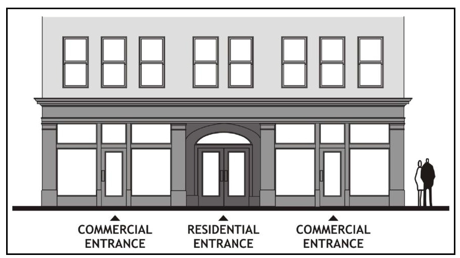
a.
Mixed-Use Façade. Commercial and Residential Entrances.
(b)
Compatibility of Uses. The proposed use shall be determined by the Plan Commission to be compatible with, or that through appropriate site planning can be rendered compatible with, the following, as applicable:
1.
The existing use of an abutting parcel.
2.
The existing use in another structure located on the same parcel.
3.
All existing uses located within the same structure, excepting business incubators as defined in this chapter.
(c)
Limitations on Use. The nonresidential component of a mixed-use project shall be a use allowed within the applicable zone subject to the following additional limitations.
1.
Prohibited uses. The following uses and activities shall not be permitted within any mixed-use development:
a.
Storage of flammable liquids or hazardous materials beyond that normally associated with a residential use.
b.
Manufacturing or industrial activities, including, but not limited to, welding, machining, or any open flame work.
c.
Any other activity or use, as determined by the Plan Commission to have the possibility of affecting the health or safety of residents due to potentially harmful external impacts including, but not necessarily limited to: dust, glare, heat, noise, noxious gases, odor, smoke, traffic, vibration or any other action that would be hazardous because of materials, processes, products, or wastes.
2.
Changes in use. After approval, a mixed-use building shall not be converted to entirely residential use.
(8)
Non-Mixed-Use Residential Development.
(a)
Single-family.
1.
Creative and unique development patterns are expected.
2.
Subdivision development shall respect natural features or topography and create a sense of neighborhood.
(b)
Multi-family.
1.
Lots for apartment or condominium buildings shall balance the functional requirements of parking with the provision of pedestrian amenities.
2.
Courtyards or internal parks enclosed by apartment or condominium structures are highly encouraged.
3.
A logical network of walkways that connect sidewalks, common open space, and parking lots shall be provided.
4.
When site conditions enable the locations of apartment or condominium buildings close to Fulton Street, a landscape buffer between the street and development lot lines shall be provided.
5.
Setbacks and screening shall be provided between apartment or condominium buildings, parking areas, and adjacent properties.
(c)
General.
1.
Whenever possible, developments shall be organized around interconnected greenways.
2.
Large expanses of one housing style (i.e., single-family, garden apartments, duplexes, etc.) are not desirable.
3.
Neighborhood designs shall encourage walking to destinations in the area.
4.
Street layouts shall not be so circuitous and lacking in connections between streets that residents are forced to drive.
5.
The use of cul-de-sacs are not permitted, unless by using them significant environmental resources are protected.
6.
Front porches and stoops are encouraged on both single and multi-family units.
7.
Buildings with multiple dwelling units are expected to include varied rooflines, and varied façade depths to create variety and individuality of dwelling units within the building.
17.158 - TZ TRANSITIONAL ZONING DISTRICT.
(1)
Intent. The intent of the TZ Transitional Zoning District is to provide a temporary zoning district to accommodate lands recently annexed to the City of Waupaca, subject to the following:
(a)
Annexation to or consolidations with the City subsequent to the effective date of this Code shall be placed in the TZ District.
(b)
Such lands shall remain in the TZ District for a period of time not to exceed 365 days from the date of approval of the annexation
(2)
Uses. Permitted Uses in the TZ District are those uses currently in place on the land. No other uses other than uses incidental to the current use are allowable.
(3)
Fees. Notwithstanding the provisions of Chapter 16.53(14), Wis. Stats., the Common Council may, in its sole discretion, pay the annexation petition review fees prescribed by the Wisconsin Department of Administration.
17.159 - HS HOMELESS SHELTER OVERLAY DISTRICT. (Cr. Ord. #04-21)
(1)
Intent. The intent of the HS Homeless Shelter Overlay District (hereafter, HS District) is to provide for development and operational standards to ensure appropriate emergency housing and services for homeless persons.
(2)
Location. Any B-1, B-3, B-4, B-5, or I-1 District parcel designated HS District on the City of Waupaca Zoning Map.
(3)
Permitted Uses.
(a)
Homeless shelter
(b)
Mass shelter
(c)
Family shelter
(4)
General Standards.
(a)
Homeless shelters, mass shelters, and family shelters shall comply with all applicable state and federal statutory requirements.
(b)
Homeless shelters, mass shelters, and family shelters shall comply with the Uniform Building Code and Fire Codes, including maximum occupancy restrictions.
(c)
Proposed homeless shelters, mass shelters, and family shelters shall provide data demonstrating to the satisfaction of the Plan Commission the proposed shelter is necessary to address the existing needs of the area's homeless community.
(d)
All homeless shelters, mass shelters, and family shelters shall be located no fewer than 500 feet from any other homeless shelter. The Planning Commission may consider waiving this requirement if the spacing being considered is between a mass shelter and family shelter.
(e)
The maximum number of beds shall be 16.
(f)
Smoke detectors approved by the City of Waupaca Fire Department shall be provided in all sleeping and food preparation areas.
(g)
The facility shall provide:
1.
Adequate private living space. Single bed bedrooms shall have a minimum of 80 square feet and multiple bed bedrooms shall have a minimum of 48 square feet per bed.
2.
Adequate bathroom facilities. Family shelters shall have a minimum of one full bathroom and mass shelters shall provide a minimum of two full bathrooms.
3.
A shared/communal area for socializing.
4.
Secure storage areas for its intended residents.
5.
Laundry facilities.
6.
Bicycle rack.
7.
A designated location shall be provided for waste receptacles and such receptacles shall be screened from view from the street and abutting parcels.
(h)
The size of a homeless shelter, mass shelter, or family shelter shall be in character with the surrounding buildings in the neighborhood.
(i)
Homeless shelters, mass shelters, and family shelters shall not be permitted within a multi-tenant structure.
(5)
Operational and Design Standards.
(a)
Facility.
1.
If the facility is located within 150 feet of a residential zoning district, all outdoor activity shall be screened from view of the street and abutting parcels.
2.
If the facility plans to offer drug or alcohol abuse counseling to residents of the shelter, the applicant shall advise the City of Waupaca on any state licensing that may be required and demonstrate compliance as appropriate.
(b)
Lighting.
1.
Lighting shall be sufficient to provide illumination and clear visibility to all outdoor areas, with minimal shadows or light leaving the property.
2.
Lighting shall be stationary, directed away from adjacent properties and public rights-of- way, and of intensity compatible/comparable with the neighborhood.
(c)
Parking. Parking shall comply with the requirements of Chapter 17.600 Traffic, Parking and Access.
(d)
Staffing.
1.
Adequate management, support staff and security must be present during the hours of operation of the facility.
2.
A minimum of one supervisory level staff member must be present on the site during hours of operation.
3.
Management staff shall make best efforts to ensure that loitering does not occur on the property during off-hours and must ensure that clients are not creating a nuisance to the neighborhood.
(e)
Hours of Operation.
1.
The shelter shall have set hours of operation and the hours shall be posted in a publicly visible and accessible location.
2.
The intake process for new residents should be handled from an internal office within the homeless shelter.
(f)
Management Policies.
1.
An applicant for a homeless shelter, mass shelter, or family shelter as part of the application process, shall prepare and file with the City of Waupaca its management policies as they relate to the following:
a.
A resident identification process.
b.
Timing and placement of outdoor activities.
c.
Standards governing expulsions.
d.
Hours of operation and standard lights-out.
e.
Policies regarding safety and security and to include emergencies.
f.
Smoking policy to include identification of areas where smoking is to be permitted.
g.
Volunteer and donation procedures.
h.
Communications with the City of Waupaca and surrounding neighborhood.
(6)
Shelter Approval. The City may deny a homeless shelter, mass shelter, or family shelter proposed in the HS District if it makes findings that:
(a)
The proposed shelter fails to meet one or more of the required standards of this section or other applicable state or federal law.
(b)
The shelter would have a specific, adverse impact upon the public health or safety, and there is no feasible method to satisfactorily mitigate or avoid the specific adverse impact without rendering the development of the emergency shelter financially infeasible.
1.
As used in this subsection, a "specific, adverse impact" means a significant, quantifiable, direct, and unavoidable impact, based on objective, identified written public health or safety standards, policies, or conditions as they existed on the date the application was deemed complete.
(7)
Notification. If an application is denied, the reasons for that denial shall be recorded in the motion to deny. If an application is approved with conditions, the conditions shall be included in the motion to approve. The applicant shall be notified in writing of any denial or conditions imposed upon an approval.
17.160 - APD AIRPORT DISTRICT. (Cr. Ord. #04-23)
Special Authority at Airport and in the Airport Zoning District. After review and recommendation by the Airport Manager or designee, Airport Board, and the City Council, airport property owned by the City may be leased to allow for the development of businesses, industries, or other development opportunities that are compatible with the use of the entire property as a municipal airport.
(1)
A use application shall be submitted and reviewed with any lease contract.
(a)
In the review of the appropriateness of a particular use of a site or area, the following factors shall be considered:
1.
Land use compatibility with airport activity. To promote safe airport operations, the City will restrict the use of this land to activities and purposes compatible with airport operations, including landing and takeoff of aircraft.
2.
City services required by the lessee.
a.
Terminal restrooms shall be made available to the public.
b.
No private sewer can be placed on City property without the written approval of the City.
c.
Public parking is located throughout the site.
3.
Effect on the environment.
4.
Traffic that may be generated on adjoining streets or highways.
5.
Any adverse effect that could have a negative effect on the safe operation of the airport. Future plans for airport expansion.
6.
Effect on surrounding properties.
(2)
All new construction or alterations to an existing structure shall require compliance with the Commercial Building Code and City Code requirements through the review and approval of a Site Plan and Building Permit. Building inspectors shall review and approve all building permits. Site plan permits shall be reviewed and approved by the Community and Economic Development Director and Airport Manager, or designees.
(a)
All exterior lighting on any hangar or leased premise shall be provided by Lessee and limited only to LED Lighting in 5000k color temperature. Any installation or modification of lighting requires advance approval from the Airport Manager or designee.
(b)
Colors shall be selected to be in general harmony with existing airport buildings. The use of bright colors shall be limited and used only as an accent.
(c)
Landscaping shall be required, when possible, to enhance the aesthetics of the building but shall not be incompatible with the Airport's general purpose or cause the safety of the airport to be compromised.
(d)
All new construction or alterations shall be in the best interest of the Airport, shall comply with all City, State, and Federal rules and regulations, and shall follow all Airport Master Plans or Layout Plans unless otherwise determined by the Airport Manager and Airport Board.
(e)
At the determination of the Airport Manager and Community and Economic Development Director, or designees, additional site plan elements may be imposed on a development if such elements are determined to be in the best interest of the Airport, the Airport's general purpose, or airport operations.
(3)
Signage Standards. All airport signage shall adhere to the below standards and shall be approved by the Airport Manager or designee, or by the Zoning Administrator or designee.
(a)
Airport District
(b)
Signs not requiring a permit.
1.
Two temporary signs, subject to the following:
a.
Approval by the Airport Manager or designee;
b.
No sign shall exceed 32 square feet in total face area;
c.
Signs shall not be located in any public right-of-way;
d.
Signs shall not be artificially illuminated;
e.
Signs shall not be erected more than 10 days before, and shall be removed no later than 5 days after, the event, activity, or purpose for which the sign is intended;
f.
In no cases shall signs be maintained for more than 60 days, other than specifically allowed under Chapter 12.04, Wis. Stats.
2.
For sale or for lease signs, subject to the following:
a.
Approval by the Airport Manager or designee;
b.
No more than 2 signs per building;
c.
Wall signs only;
d.
No sign shall exceed 16 square feet.
3.
Window or door signs, subject to the following:
a.
Approval by the Airport Manager or designee.
4.
Official and governmental signs, such as traffic control, parking, information, identification, notices, event signs, or any other sign that is determined to be integral to the Airport by the Airport Manager or designee.
(c)
All other signs are prohibited.