
Wayland City Zoning Code
ARTICLE III
GENERAL REGULATIONS
DIVISION 3. - NONCONFORMANCE[2]
State Law reference— Nonconforming uses and structures, MCL 125.583a.
DIVISION 4. - SITE PLAN PROCEDURES[3]
Editor's note— Ord. No. 177, §§ 1, 2, adopted July 2, 2001, repealed sections 20-116—20-128, and replaced them with new sections 20-116—20-121, 20-124—20-128. Former sections 20-116—20-128 pertained to similar material and derived from Ord. No. 123, §§ 4.6, 4.61—4.72, adopted June 5, 1989.
Sec. 20-61. - Effects of zoning.
(a)
Zoning affects every structure and use. Except as hereinafter specified, no building, structure or premises shall hereafter be used or occupied, and no building or part thereof or other structure shall be erected, moved, placed, reconstructed, extended, enlarged, or altered, except when in conformity with the regulations herein specified for the zoning district in which it is located.
(b)
In case any building or part thereof is issued, erected, altered or occupied contrary to law or to the provisions of this chapter, such building shall be declared a nuisance and may be required to be vacated, torn down, or abated by any legal means and shall not be used or occupied until it has been brought into conformance.
(c)
If construction on a building is lawfully begun prior to adoption of this chapter, nothing in this chapter shall be deemed to require any change in the planned or designed use of any such building provided that actual construction is being diligently carried on, and further provided that such building shall be entirely completed for its planned or designed use within one (1) year from the effective date of this chapter, or affecting amendment.
(Ord. No. 123, § 4.0, 6-5-89)
Sec. 20-62. - Application of regulations.
The regulations set by this chapter throughout the city and within each district shall be minimum regulations and shall apply uniformly to each class or kind of structure, land or use.
(1)
All buildings, structures or land may hereafter be used, constructed, altered or occupied, only when in conformity with all of the regulations herein specified for the district in which it is located.
(2)
No building or other structure shall hereafter be altered:
a.
To accommodate or house a greater number of persons or families than permitted by the zoning district.
b.
To have narrower or smaller rear yards, front yards, or other side yards, other than permitted.
(3)
No yard or lot existing at the time of passage of this chapter shall be subdivided or reduced in dimension or area below the minimum requirements set forth herein. Yards or lots created after the effective date of this chapter shall meet at least the minimum requirements established by this chapter.
(Ord. No. 123, § 4.1, 6-5-89)
Sec. 20-76. - Schedule of district regulations.
Regulations affecting the arrangement of buildings, materials and equipment occupying such land for each of the districts are hereby established as set forth in the schedule of regulations being article XVII, sections 20-521 through 20-545.
(Ord. No. 123, § 4.2, 6-5-89; Ord. No. 181, § 1, 11-5-01)
Sec. 20-77. - Building permit required, conformance to zoning.
In accordance with other city codes, ordinances and regulations duly adopted by the city council, and in accordance with this chapter, no building shall hereafter be erected, relocated or altered in its exterior or interior dimension or use, and no excavation for any building shall be begun until a building permit has been issued. With respect to this zoning chapter, eligibility for a building permit shall be established upon conformance with the provisions contained herein. This shall apply to all new construction and all major improvements to existing structures. In the case of detached accessory buildings and structures, a building permit is required.
(Ord. No. 123, § 4.31, 6-5-89)
Sec. 20-78. - Certificate of occupancy required.
No new principal building or dwelling subject to the provisions of this chapter shall be occupied, inhabited or used until a certificate of occupancy is issued by the building inspector.
(Ord. No. 123, § 4.32, 6-5-89)
Sec. 20-79. - Structures.
(a)
Restoring unsafe buildings. Nothing in this chapter shall prevent the strengthening or restoring to a safe condition of any part of any building or structure declared unsafe by the building inspector or the county health department. A building or structure condemned by the building official may be restored to safe condition provided change of use or occupancy is not contemplated or compelled by reason of such reconstruction or restoration; except that if the damage or cost of reconstruction or restoration is equal to or in excess of its state-equalized value, the structure shall be made to comply in all respects with the requirements for materials and methods of construction of structures hereafter erected.
(b)
Structure to have access. Every principal structure hereafter erected or moved shall be on a lot adjacent to a public street, or with access to an approved private street, and all structures shall be located on lots as to provide safe and convenient access for servicing fire protection, and required off-street parking.
(c)
One single-family structure per lot. No single-family detached residential structure shall be erected upon a lot with another single-family detached residential structure. In addition, every building hereafter erected or structurally altered to provide dwelling units shall be located on a lot as herein defined.
(d)
Accessory building. No accessory building shall be erected in any required front yard, and no separate accessory building shall be erected on any property line.
(e)
Exceptions to height regulation. The height limitations contained in the chapter do not apply to spires, belfries, cupolas, antennae, water tanks, ventilators, chimneys, or other appurtenances usually required to be placed above the roof level and not intended for human occupancy.
(Ord. No. 123, § 4.33, 6-5-89)
Sec. 20-80. - Lots.
(a)
New lots to be buildable. All newly created lots shall have buildable area. The net buildable area of a lot shall be a contiguous piece of land excluding land subject to flooding six (6) months of the year, poor drainage, steep slopes, rock outcrops and land encumbered by easements preventing the use of the land.
(b)
Creation of new lots. No new lots shall be created which do not meet the minimum lot size regulations of this chapter and the provisions of chapter 17, section 17-177 relating to the ratio of depth to width and access.
(c)
Corner lots. On a corner lot, each lot line which abuts a street shall be deemed to be a front lot line, and the required yard along both lot frontages shall be a required front yard. The owner shall elect, and so designate on his application for permit, which of the remaining two (2) required yards shall be the required side yard and which the required rear yard.
(d)
Existing platted lots. Any residential lot laid out on an approved plat or existing at the time of adoption of this chapter that fails to comply with the minimum requirements of this chapter may be used for a single-family dwelling, provided the lot is in single ownership as defined in this chapter and further provided that ninety (90) percent of all yard requirements are complied with. An existing platted lot which contains ninety (90) percent or more of the required area and width may be utilized as a separate lot. The use of more than one (1) lot in common ownership where the same do not comply with ninety (90) percent of the minimum requirements of this chapter shall be determined by the board on the basis of neighborhood character. For the purpose of this section, the board shall use the following standards to determine neighborhood character:
(1)
Two lots. If each of the two (2) adjacent lots in question has both frontage and area measurements that equal or exceed the individual frontage and area measurements of at least sixty (60) percent of the total number of developed lots within four hundred (400) feet on both sides of the same street, each of the lots in question shall be construed to be in character with the neighborhood. If not, the two (2) lots shall be considered a single lot.
(2)
Three lots. If each of the three (3) lots in common ownership has both frontage and area measurements that equal or exceed the individual frontage and area measurements of at least sixty (60) percent of the total number of developed lots within four hundred (400) feet on both sides of the same street, each of the lots shall be construed to be in character with the neighborhood. If not, the three (3) lots shall be considered one (1) or two (2) lots meeting the zone district requirements.
(3)
Four or more lots. If each of the four (4) or more lots in common ownership are less than the minimum requirements, they shall be resubdivided into one (1), two (2) or three (3) lots meeting the zone district requirements.
(Ord. No. 123, § 4.34, 6-5-89; Ord. No. 181, § 2, 11-5-01)
Sec. 20-81. - Off-street parking and loading.
(a)
All buildings located in the city shall provide off-street parking adequate for the use intended.
(b)
The dimensions of off-street parking spaces shall be in accordance with the following minimum dimensions:
The graphic entitled "Parking Layouts" is included for illustration purposes only and not drawn to scale.
(1)
Residential off-street parking. Parking in residential zones is only permitted as an accessory use or as a transitional use and in no case is it intended that parking or access drives to parking be permitted as a principal use of any residentially zoned lot.
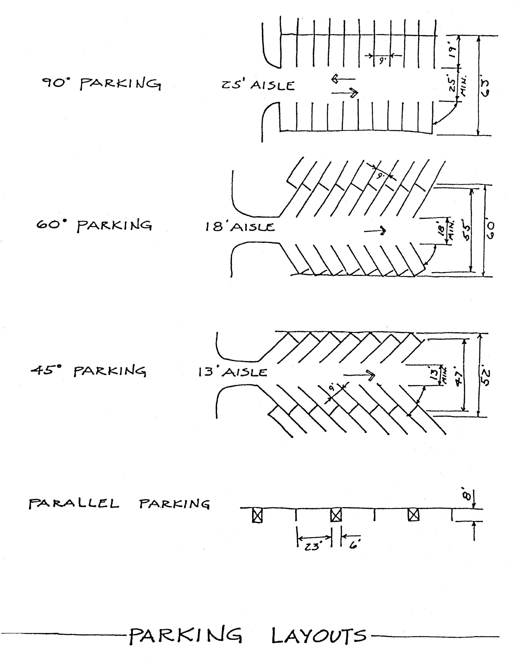
Parking Layouts
(2)
Nonresidential off-street parking. Except in parking exempt areas, provisions shall be made for off-street parking for all nonresidential buildings or additions to such buildings in all districts. The conversion of an existing residence to any other use shall be deemed to be a new use which must meet all provisions of this chapter.
(3)
Mixed occupancies and uses not specified. In the case of mixed uses, the total requirements for off-street parking areas shall be the sum of the requirements of the various uses computed separately. Collective provision for off-street parking spaces shall not be less than the sum of the requirements for the various uses computed separately. Parking areas for churches, theaters or other uses in which the primary parking demand occurs out of normal store operation hours may be jointly used where adequate arrangements are made to ensure that the space is available for each function.
(4)
Location of off-street parking facilities. Off-street parking facilities shall be located as hereafter specified. Where a distance is specified it shall be the distance measured from the nearest point of the parking facility to the nearest point of the building that such facility is required to serve, as follows:
a.
For all residential buildings and for all nonresidential buildings in residential zones, required parking shall be provided on the same lot with the building.
b.
One and two-family dwellings: Required on-premise parking shall be provided on the same lot or parcel as the dwellings they are intended to serve. Off-premise parking must be outside of the public right of way and may consist of driveway areas, parking strips or parking aprons adjacent to the driveway and/or space internal to a garage or car-port. Parking strips and aprons must be placed between the driveway and the side property line and may not otherwise extend in front of habitable ground floor area of the dwelling. Within the permissible areas between the driveway and the side property line, parking strips and parking aprons may be located no closer than three (3) feet to a street right of way line and one (1) foot from the property line. The maximum combined width of parking aprons, parking strips and driveways within the front yard shall be thirty (30) feet. For single-family dwellings, the width of driveway throats within the public right of way shall not exceed twenty-four (24) feet. Total driveway/parking strip/apron width and the width of driveway throats within the public right of way for two-family dwellings shall not exceed forty-eight (48) feet.
c.
For commercial and all nonresidential uses in commercial zones, required parking shall be provided within seven hundred (700) feet of the business or the owner may be required to contribute to a community parking fund, if established by the city council and in existence at the time of development.
d.
For industrial uses, required parking shall be provided within seven hundred (700) feet.
e.
In the cases of attached three, four family or multiple family dwelling complexes, the planning commission shall review and approve the location of off street parking spaces as part site plan approval required under section 20-116.
(5)
Parking areas in commercial office and industrial districts. Every parcel of land hereafter established as a public or private parking area in any commercial or industrial district or hereafter enlarged or altered shall be developed and maintained in accordance with the following requirements:
a.
Off-street parking areas shall be effectively screened on any side which adjoins or faces premises situated in any residential zone district or institutional premises, by a screening or evergreen hedge or other material approved by the planning commission. Screening provisions in section 20-84 shall control.
b.
Every such off-street parking area shall be surfaced in accordance with section 20-81(11). Any lighting in connection with off-street parking shall be so arranged as to reflect the light away from all adjoining residential buildings zones and streets. Lighting provisions of section 20-84 shall control.
c.
The off-street parking area shall be subject to the approval of the planning commission to ensure its adequacy in relation to traffic safety, lighting, and protection of the adjacent property.
d.
The use of required parking areas for the storage or display of vehicles and/or merchandise, or for vehicle or machinery repair or maintenance, is prohibited, unless specifically approved by the planning commission as part of site-plan review or by special-use permits.
e.
The storage of semi-trailers outside of areas approved for such storage on an approved site plan is prohibited.
f.
The use of parking areas for the storage or parking of vehicles unrelated to the business for which the parking is intended is prohibited.
g.
The use of semi-trailers for storage purposes for a period longer than seven (7) days is prohibited.
(6)
Parking areas in residential zones. Any person desiring to establish a parking area as an accessory use in a residential zone shall submit plans to the planning commission showing the location, size, shape, design, landscape, curb cuts, and other features of the parking lot. The establishment and operation of a parking area accessory to a commercial or industrial use in such parts of any residential district that abut either directly or across the street or alley from a commercial or industrial district is not permitted. All such parking areas and parking areas required for new multiple-family dwellings and nonresidential buildings in all residential zones may then be authorized, subject to the following conditions:
a.
All parking areas shall be landscaped, screened, surfaced, and drained as provided in this chapter.
b.
No part of such parking areas shall extend into the required front yard more than one-half of the yard required for a residential building, and where the lot or a portion of the lot lies between two (2) privately owned residential properties, the full front yard setback shall be observed. In either case, the front yard area not occupied by the access drive shall be landscaped.
c.
All such parking areas shall be at least forty (40) feet in width.
d.
Such parking areas shall be used solely for the parking of passenger automobiles, and no commercial repair work or sales or service of any kind shall be conducted on such parking lot. No sign, other than entrance, exit, and condition of use signs shall be maintained, and the aggregate area of all such signs shall not exceed twelve (12) square feet.
e.
Each entrance to and exit from such parking lot shall be at least twenty (20) feet distant from any adjacent property located in any residential zone, and the location and design of entrances, exits, surfacing, landscaping, markings, and lighting shall be subject to the approval of the planning commission to ensure adequate relation to traffic safety, lighting and protection of the adjacent residential area.
f.
The building inspector shall thereafter issue a permit, which may be revoked at any time that the aforementioned requirements are not complied with. Any person operating the premises to which a permit relates in violation of any of the conditions specified by this chapter or fixed to such permit shall be deemed in violation of this chapter and shall be subject to the penalties prescribed in this chapter.
(7)
Parking and storage of unlicensed vehicles, commercial vehicles, recreation vehicles and equipment and trailers.
a.
Parking and storage of unlicensed vehicles. Automotive vehicles and trailers of any kind or type without current license plates may not be stored on residentially zoned property unless it is within an enclosed building.
b.
Parking of commercial vehicles. In residential districts the parking of commercial vehicles is prohibited unless it is compliance with the following:
1.
No more than one (1) commercial vehicle is permitted.
2.
Regularly manufactured vehicles such as pickup trucks, cargo vans stake trucks, or utility body trucks may not exceed a rated capacity of one (1) ton. Box vans, step vans, dump trucks, ladder/bucket trucks and all other commercial vehicles and utility trailers used for commercial purposes are prohibited.
3.
The vehicle must be owned by a person residing at the address where the vehicle is being parked or the vehicle must be driven by such person as a function of his or her employment.
4.
Parking of commercial vehicles on vacant parcels is prohibited.
c.
Parking of recreation vehicles and equipment, and utility trailers. Within any residential zoning district, the parking of recreation vehicles and equipment, travel trailers and utility trailers on occupied single- or two-family residential lots or parcels is permitted subject to the following requirements:
1.
The parking and storage of recreation vehicles and equipment and utility trailers on residential lots or parcels shall be limited to only those vehicles owned by, and licensed or registered to, the occupant of the residential lot or parcel on which the vehicle is stored.
2.
Unless parked on an approved parking strip or apron as provided herein, all recreational vehicles or trailers not parked or stored in a garage must be parked or stored in the rear or side yard. This requirement shall also apply to corner lots. A minimum of one (1) foot of side or rear yard shall be maintained between the vehicle and the side or rear lot line. Vehicles or trailers may occupy space in front of the front line of the dwelling only if it is parked on an improved hard surfaced parking strip or apron located in accordance with the provisions of section 20-81, subsection (4), paragraph b and does not obstruct the view of street traffic and of vehicular and pedestrian traffic in adjacent driveways.
3.
No more than one (1) travel trailer or recreational vehicle or light utility trailer shall be stored or parked outdoors within the front yard of a single lot. For the purpose of this section, multiple recreation vehicles such as snowmobiles, motorcycles, personal watercraft loaded on a single utility trailer shall be considered one unit.
4.
Recreational equipment parked or stored shall not have fixed connections to electricity, water, gas or sanitary sewerage, and at no time shall such equipment be used for living, sleeping or housekeeping purposes.
5.
Parking and storage of recreational vehicles and equipment, and utility trailers on vacant parcels of record is prohibited.
6.
In the case of attached three family, four family, multiple family dwelling complexes and mobile home parks, the parking of recreation vehicles and equipment, and utility trailers is prohibited unless adequate area for such is established and aside for such in off street parking areas on an approved site plan for the development. As part of site plan approval the planning commission may require that additional parking spaces and screening be provided on the site for the parking and storage of vehicles and equipment.
(8)
Table of parking requirements. The amount of required off-street parking space for new uses or buildings, additions thereto, and additions to existing buildings as specified above, shall be determined in accordance with the following table, and the space, so required shall be stated in the application for a building permit and shall be irrevocably reserved for such use and otherwise shall comply with the provisions of this section.
For uses not specifically listed in the following table, the requirements for off-street parking shall be determined as follows:
a.
If the use is substantially similar to a use listed in the table, the zoning administrator may use the parking requirements for that similar use.
b.
The zoning administrator may use the average-rate of parking for the use as identified in the most recent edition of Parking Generation Manual, published by the Institute of Transportation Engineers, as amended.
c.
If the proposed use is not similar in parking requirement to a use listed in the table and is not included in the Parking Generation Manual, then the zoning administrator shall refer the determination of parking need to the zoning board of appeals to make such determination.
(9)
Required off-street loading berths. In all districts every building, or part thereof, hereafter erected, which is to be occupied by manufacturing, storage, warehouse, group of stores, or other use similarly requiring the receipt or distribution in vehicles of materials or merchandise, there shall be provided and maintained, on the same premises with such buildings, off-street loading spaces in relation to floor area as follows:
Square Feet
Spaces
5,000 to 20,000 .....1
20,000 to 50,000 .....2
50,000 to 100,000 .....3
1 additional space for each additional 100,000 square feet or part thereof; provided that:
a.
Each loading space shall be at least twelve (12) feet in width, forty-four (44) feet in length, and have a clearance of fourteen (14) feet above grade.
b.
Such space may occupy all or any part of any required yard or court space, except the front yard.
(10)
Increased parking, surfacing. When the floor area, dwelling units, or other unit of measure employed to determine off-street parking requirements shall be increased, it shall be the duty and obligation of the owner and occupant of such residence, business or other use to provide additional off-street parking space of sufficient area. Such parking space may be on the same lot or lots with the main building or within a maximum distance of three hundred fifty (350) feet from any such lot, whichever may have been originally required under this chapter. All such parking spaces herein required shall be surfaced as provided in section 20-81(11).
(11)
Surface and drainage requirements. All parking areas for a multifamily, commercial, industrial or governmental use shall be paved with a durable, concrete or sealed bituminous asphalt surface and shall be graded and provided with an engineered, enclosed stormwater collection system. The requirement for paving may be waived in total or in part by the planning commission at the time of site plan approval or as a specific application to the planning commission when site plan approval by the planning commission is not otherwise required. Such waiver may only be granted if it is demonstrated that the use of the parking area is secondary to a fully improved parking area and can be described as low volume, infrequent and intermittent, or will result in unusual weight or wear. In granting such waivers, the planning commission shall stipulate an appropriate substitute surface material.
(12)
Striping. All parking spaces, aisles, and unloading zones shall be striped or marked, using a durable exterior paint. Such striping or other required demarcation shall be maintained in a condition such that easy interpretation of such markings by intended users is possible. In those cases where it is determined by the planning commission or zoning administrator that striping of spaces and the definitions of aisle space would not be effective, three hundred (300) square feet of parking area shall be provided for each required parking space.
(13)
Lighting. All parking lot lighting shall be designed, located, directed and/or shielded to prevent glare and spillover onto adjacent properties, and shall be arranged to prohibit adverse effects on the vision of motorist on adjacent public roadways. The maximum height of parking lot light fixtures shall be twenty (20) feet for any fixture to be located within three hundred (300) feet of a residential or agricultural district or use, and a maximum of thirty-five (35) feet in other locations (ref. also sec. 20-84).
(Ord. No. 123, § 4.35, 6-5-89; Ord. No. 182, §§ 1—5, 11-5-01; Ord. No. 193, arts. I, II, 7-7-03)
Sec. 20-82. - Animals, bees, livestock, fowl; use, shelter, storage.
No animals, livestock or fowl, or structures for same, other than common household pets shall be permitted in any zoning district.
(Ord. No. 123, § 4.36, 6-5-89; Ord. No. 217, § 1, 7-7-08)
Sec. 20-83. - Reserved.
Editor's note— Ord. No. 217, § 2, adopted July 7, 2008, amended the Code by repealing former § 20-83, which pertained to noncommercial antennas and satellite receiving stations, and derived from Ord. No. 123, adopted June 5, 1989.
Sec. 20-84. - General lighting, screening requirements, and fences.
(a)
Lighting. All private lights used for the illumination of dwellings or business establishments or for the illumination of business buildings or areas surrounding them, or the illumination or display of merchandise or products of business establishments shall be completely shielded from the view of vehicular traffic using the road or roads abutting such business property. Lighting which is designed to illuminate the premises shall be installed in a manner which will not cast direct illumination on adjacent properties.
(b)
Nonresidential uses abutting residentially zoned lots. Except as otherwise provided in this zoning chapter, all premises used for business, commercial or industrial purposes shall be screened from abutting residential districts in accordance with the provisions of article XVII, division 2.
(c)
Fences.
(1)
Retaining walls and fences not more than three (3) feet in height are permitted in the required yards of all zones, provided the fences are not more than twenty-five (25) percent solid. Walls and solid fences of not more than six (6) feet in height are permitted only in side or rear yards in any zone.
(2)
In all districts, the frontage for corner lots shall follow the same limitations as provided for residential front yard fencing. In addition, no fence, structure or planting over thirty (30) inches in height above the curb line except deciduous trees shall be erected or maintained within twenty (20) feet of intersecting street right-of-way lines so as to interfere with traffic visibility across the corner.
(3)
Barbed wire or concertina wire fences are prohibited in all zoning districts. However, barbed wire strands may be used to enclose storage areas or other similar industrial and commercial uses. The strands may not project outward from the vertical plain of the fence, away from the industrial or commercial use and shall be restricted to the uppermost portion of the fence and shall not extend lower than a height of six (6) feet from the nearest ground level.
(4)
In the event of any controversy as to the adequacy of any proposed or existing screening or the creation of any nuisance or annoyance by artificial lighting, the board of zoning appeals shall have the right and is hereby given the authority to interpret and determine the screening and lighting provisions and the purpose herein sought to be accomplished.
(Ord. No. 123, § 4.4, 6-5-89; Ord. No. 217, § 3, 7-7-08)
Sec. 20-85. - Private road and streets.
(a)
All plats and lots not fronting on a public street must be accessible by a private drive. A private drive or street is required to have a minimum driveway right-of-way of sixty-six (66) feet and must be either owned or established by a driveway easement granted by the adjacent property owners.
(b)
The layout of private streets in respect to their location, intersections, cul-de-sacs, etc., shall conform to the city's requirements for platted streets.
(c)
The construction of the roadway shall conform to the city's standards for a local road.
(d)
Vertical street alignments, street grades, horizontal curves, curb openings at intersecting streets, etc., shall conform to the city standards for platted streets.
(Ord. No. 181, § 3, 11-5-01)
Editor's note— Ord. No. 181, § 4, adopted November 5, 2001, renumbered the provisions of section 20-601(9) as new section 20-85.
Sec. 20-86. - Accessory antennas.
Except as otherwise permitted in this chapter, accessory antennas shall be subject to the following regulations:
(1)
Accessory antennas shall be permitted in all districts as accessory uses provided they are not used for commercial or profit making activities.
(2)
Where the accessory antenna is structurally attached to a main building, it shall be subject to and must conform to all regulations of this chapter applicable to main or principal buildings.
(3)
An accessory antenna may be erected in any required yard except a front yard, shall not project forward of the rear building line, and shall not be closer than five (5) feet to any side or rear lot line. Movable antennas shall not revolve closer than three (3) feet to any side or rear lot line.
(4)
An accessory antenna shall not exceed one (1) story or fifteen (15) feet in height. The total yard area devoted to an accessory antenna use shall not exceed one hundred (100) square feet of yard area. Said height limitation shall be waived by the zoning administrator if it is shown to unreasonably restrict an amateur radio operator lawfully licensed by the Federal Communications Commission.
(5)
A corner lot, the side yard of which is substantially a continuation of the front lot line of the lot to its rear, shall be regarded as having two (2) front yards. When an antenna is located on this type of lot, it shall not project beyond the continued front lot line of the rear lot.
(6)
In the case of double frontage lots, accessory antennas shall observe front yard requirements on both street frontages whenever there are any principal buildings fronting on such streets in the same block or adjacent blocks.
(7)
In all cases, an accessory antenna shall be anchored or fastened securely to the building or surface to which it is attached or upon which it rests.
(Ord. No. 181, § 4, 11-5-01; Ord. No. 217, § 4, 7-7-08)
Editor's note— Ord. No. 181, § 4, adopted November 5, 2001, renumbered the provisions of section 20-601(14) as new section 20-86.
Sec. 20-87. - Outdoor trash containers or dumpsters.
Outdoor trash containers or dumpsters may be required for any use in the RM, B-1, B-2, CBD, I-1, I-2 and RO zoning districts and any institutional or special use located in a residential district provided that they comply with the following requirements:
(1)
Adequate vehicular access shall be provided to such containers for truck pickup either via a public alley or vehicular access aisle which does not conflict with the use of off-street parking areas or entrances to or exits from principal buildings. The placement of the container shall be subject to site plan review.
(2)
A solid ornamental screening wall or fence shall be provided around all sides of such containers. An access gate shall also be provided and be of such height as to completely screen such containers. The maximum height of walls, fence or gate shall be six (6) feet.
(3)
The container or containers, the screening walls, fence and gate shall be maintained in a neat and orderly manner, free from loose rubbish, wastepaper and other debris.
(Ord. No. 181, § 5, 11-5-01)
Editor's note— Ord. No. 181, § 5, adopted November 5, 2001, renumbered the provisions of section 20-601(15) as new section 20-87.
Sec. 20-88. - Minimum standards for dwellings.
All dwellings located outside of a designated mobile home park shall comply with the following minimum standards, in addition to those contained elsewhere in this Code.
(1)
It shall comply with the minimum square footage requirements of the zoning district in which it is located.
(2)
It shall have a minimum width across any front, side or rear elevation of twenty-four (24) feet and at least fifty (50) percent of the longest view must have a depth of no less than twenty-four (24) feet.
(3)
All dwelling units shall provide a minimum height between the floor and ceiling of seven and one half (7½) feet; or if a mobile home, it shall meet the requirements of the United States department of housing and urban development regulations, entitled Mobile Home Construction and Safety Standards, effective June 15, 1976, as amended.
(4)
Each dwelling shall be firmly attached to a permanent foundation constructed on the site in accordance with the city building code and the area between the grade elevation of the lot and the structure shall have a wall of the same perimeter dimensions of the dwelling and constructed of such materials and type as required in the applicable building code for single-family dwellings. In the event that the dwelling is a mobile home, as defined herein, such dwelling shall be installed pursuant to the manufacturer's setup instructions, shall be secured to the premises by an anchoring system or device complying with the rules and regulations of the state mobile home commission, and shall contain a perimeter wall as required in this subsection.
(5)
If a dwelling is a mobile home as defined herein, each mobile home shall be installed with the wheels removed. Additionally, no dwelling shall have any exposed towing mechanism, undercarriage or chassis.
(6)
Each dwelling shall be connected to a public sewer and water supply or to such private facilities as are approved by the local health department.
(7)
Each dwelling shall contain a storage capability area in a basement located under the dwelling, in an attic area, in closet areas, or in a separate structure of standard construction similar to or of better quality than the principal dwelling, which storage area shall be equal to ten (10) percent of the square footage of the dwelling or one hundred (100) square feet, whichever shall be less.
(8)
If a dwelling is a mobile home, as defined herein, each mobile home shall contain skirting along the entire perimeter of the main frame between the ground and the bottom edge of the mobile home body. The skirting shall compliment the appearance of the main walls of the mobile home and consist of the same materials or materials of equal or greater durability as those customarily used on the exterior walls of mobile homes. Brick or concrete block wall construction shall also be permitted as skirting. The skirting shall be securely attached and sealed to the mobile home body and shall contain a rat proof wall or slab to prevent the entrance of rodents and other animals to underneath the mobile home. One (1) access door shall be permitted in the skirting, and adequate screening vents shall be required in the skirting around the entire perimeter at intervals of not more than twenty (20) feet so as to provide adequate cross-ventilation. All skirting shall be maintained in good condition at all times. Unprotected flammable materials including hay bales or newspaper shall not be allowed as skirting for mobile homes.
(9)
All dwellings shall provide steps or porch areas, permanently positioned in the ground or permanently attached to the foundation, where there exists an elevation differential of more than one (1) foot between the door and the surrounding grade. All dwellings shall provide a minimum of two (2) points of ingress and egress.
(10)
All additions to dwellings shall meet all of the requirements of this ordinance.
(11)
All dwellings shall be aesthetically compatible in design and appearance with other residences in the vicinity, with either a roof overhang of not less than six (6) inches on all sides, or alternatively with window sills or roof drainage systems concentrating roof drainage at collection points along sides of the dwellings. The compatibility of design and appearance shall be determined in the first instance by the building inspector upon review of the plans submitted for a particular dwelling. An appeal by an aggrieved party may be taken to the zoning board of appeals. Any determination of compatibility shall be based upon the standards set forth in this section as well as the character, design and appearance of residential dwellings located outside of mobile home parks within seven hundred fifty (750) feet of the subject dwelling. The foregoing shall not be construed to prohibit design concepts involving such matters as solar energy, view, unique land contour, or relief from the common or standard designed home.
(12)
Prior to issuance of a building permit for any dwelling unit, construction plans at a scale of no less than one quarter (¼) inch to one (1) foot, including a plot plan, adequate to illustrate compliance with the requirements of this ordinance shall be submitted to the building inspector. If the dwelling unit is a mobile home, there shall also be submitted adequate evidence to assure that the dwelling complies with the standards applicable to mobile homes set forth in subsection (12) hereof.
(13)
All mobile homes shall meet the standards for mobile home construction contained in the United States department of housing and urban development regulations entitled "Mobile Home Construction and Safety Standards" effective June 15, 1976, as amended. All other dwellings shall meet the requirements of the construction code adopted by the city.
(Ord. No. 181, § 6, 11-5-01)
Sec. 20-89. - Accessory buildings and structures; general.
(a)
In a zoning district, an accessory building may be erected detached from the permitted principal building or as an integral part of the permitted principal building. When erected as an integral part of the permitted principal building, it shall comply in all respects with the requirements of this ordinance applicable to the permitted principal building. The architectural character of all accessory buildings shall be compatible and similar to the principal building.
(b)
Detached accessory buildings shall not be located closer than five (5) feet to rear lot line or closer than forty (40) feet to the water's edge in the case of a waterfront lot (except that pump houses may be located within forty (40) feet of the water's edge if they do not exceed three (3) feet in height) and; they shall not be closer to any side lot line or front lot line than the principal building is permitted.
(c)
The distance between a detached accessory building and any principal building shall not be less than ten (10) feet. Accessory buildings shall be considered as attached to a principal building when the distance between the two (2) buildings is solidly covered by a breezeway, portico, covered colonnade or similar architectural device.
(d)
Accessory buildings or structures shall not include living quarters for human beings.
(e)
No accessory buildings or structures shall be constructed on any parcel on which there is no principal building. If a detached accessory building and principal building are to be erected concurrently, a building permit for the accessory building shall not be issued until such time that construction of the principal building has been at least ten (10) percent completed.
(Ord. No. 181, § 7, 11-5-01; Ord. No. 249, § 1, 6-3-19)
Sec. 20-90. - Accessory buildings—Residential.
Attached and detached accessory buildings on residential lots shall not directly involve any business, trade, occupation or profession. In addition, the following regulations shall apply:
(1)
Private garage customary: On any single-family residential lot a customary private garage consisting of a garage attached to a principal residential structure, or in its place, a detached garage is permitted in a side or rear yard only, subject to the following limitations.
a.
The maximum size of an attached private garage shall be limited to eight hundred thirty-two (832) square feet for the first one thousand three hundred (1,300) square feet of habitable floor area contained in the residence. In addition, for each whole increment of five (5) square feet that the floor area of the residence exceeds one thousand three hundred (1,300) square feet, the floor area of the attached garage may be increased by one (1) square foot.
b.
The size of a detached private garage permitted by right shall be limited to eight hundred thirty-two (832) square feet of floor area. A detached private garage in excess of eight hundred thirty-two (832) square feet may be approved as a special use provided that the square footage approved may not exceed twenty-five (25) percent of the rear yard area.
c.
In addition to the one attached or detached private garage permitted above, one additional detached accessory building not to exceed three (3%) percent of the total lot area shall be permitted by right.
d.
The Planning Commission may choose to approve accessory buildings larger than three (3) percent of the total lot area or those taller than permitted by right by Special Use, subject to the procedures and standards of Sections 20-128.
e.
The total lot coverage, which includes the dwelling and all accessory structures, shall not exceed 35% of the area of the parcel.
f.
Accessory buildings shall have a sidewall height not greater than ten (10) feet.
g.
Maximum height for accessory buildings shall not exceed eighteen (18) feet deck height as defined by section 20-5 of this ordinance.
(2)
Notwithstanding the above provisions, one attached garage not exceeding five hundred (500) square feet, and one detached accessory building not exceeding one hundred fifty (150) square feet may be permitted for each duplex or attached single family dwelling.
(Ord. No. 181, § 8, 11-5-01; Ord. No. 249, § 1, 6-3-19)
Sec. 20-91. - Solar (photovoltaic-PV) panel energy (SPE) systems.
A solar energy system utilizing solar (photovoltaic) panels is an allowed accessory use and structure in all zoning districts and when in compliance with the requirements and limitations of this section is not considered a distinct principal or business use. Solar (PV) panel energy (SPE) systems shall comply with to the standards in this section.
(1)
Connection to the electrical utility grid system. SPE systems may be connected to the electrical utility grid system in accordance with established Michigan Public Service Commission and public utility incentives, policies, and limitations.
(2)
Solar (PV) panels located in the front or side yard. In any zoning district, solar panels (or arrays thereof) exceeding four (4) square feet in area are not permitted in any front or side yard area or on any wall or face of a building or structure facing a street (except for roof-mounted panels as set forth below) unless such panel(s) is integrated with the ordinary construction of the building or structure, and/or is fully screened from view of the adjacent street (except that screening is not required for roof-mounted solar panels as set forth below).
(3)
Ground-mounted solar (PV) panels and SPE systems. All ground-mounted solar (PV) panels and arrays not permitted in the front or side yard shall meet the following requirements:
a.
The panels shall be located in rear yard only.
b.
The panels shall not exceed sixteen (16) feet in height as measured from the highest point of the panel or mounting bracket to the ground at the base of the panel.
c.
The panels shall not be located closer to any side lot line or front lot line than the principal building is permitted to be located.
d.
The panels shall not be located closer than five (5) feet from any rear lot line or exterior site easement lines (in the case of a cooperative SPE system site.)
e.
Except for the first forty (40) square feet of solar panel area, ground-mounted solar (PV) panels will be considered a detached accessory structure as defined in section 20-5. As such, ground-mounted solar (PV) panels shall be included in the calculation of maximum rear yard area coverage as applied to detached accessory buildings and structures; the maximum coverage by the aggregate of all detached accessory structures is limited to twenty-five (25) percent (see sections 20-89 and 20-90).
Note: The exemption of the first forty (40) square feet of solar panel area from the area calculation is intended to allow up to forty (40) square feet of solar panel area regardless of total rear yard coverage. Measurement of the panel area shall be based upon the area of the solar panel(s), regardless of the adjustment angle of the panel.
f.
Notwithstanding the above lot coverage limitations, a ground-mounted solar panel, panel array, or portion thereof, not visible from abutting streets or property at any time of the year is exempt from the area coverage calculations.
(4)
Roof-mounted solar (PV) panels. Roof-mounted solar panels are permitted and may include "integrated" solar panels that are either integrated architecturally as part of the roof structure or as part of the surface layer of the roof structure causing no apparent change in relief or projection, as well as separate "flush" and "tilt-mounted" solar panel systems attached to the roof surface as follows:
a.
An integrated solar panel may not cause the height of a building or structure to exceed the height limitations of the district in which the building or structure is located.
b.
"Flush" and "tilt-mounted" solar panels installed on a pitched roof surface shall not project vertically above the ridgeline of the roof to which it is attached.
c.
"Flush" or "tilt-mounted" solar panels located on a mansard or flat-roofed building shall be set back at least six (6) feet from the edge of the deck or roof on all elevations and shall be exempt from district height limitations, provided that the panels shall not project more than five (5) feet above the roof surface of a flat roof or the deck of a mansard roof.
(5)
Location. Solar (PV) panels and SPE systems shall be located on the same lot as the building being served or shall be located on a cooperative "solar panel array site" as stipulated paragraph (7) below. Where there is no principal building, the system is not permitted.
(6)
Cooperative solar (PV) panel energy system site. A cooperative SPE system site is a site created with the mutual consent of two (2) or more adjacent property owners for the purpose of supporting a ground-mounted array of solar (PV) panels. Cooperative solar panel array sites shall meet the following standards:
a.
The site supporting the solar panel array shall be comprised of a legally described and recorded easement encompassing all or portions of two (2) or more adjacent lots or parcel occupied by a permitted principal building.
b.
A system located on a cooperative site shall maintain the required exterior lot line setbacks of this section and shall not exceed the generating capacity for the applicable zoning district as outlined in subsection (1) of this section.
c.
As outlined in sections 20-89 and 20-90, the rear yard coverage limitations for any individual lot included in the cooperative easement area may not be exceeded.
(Ord. No. 225, § 3, 2-1-10; Ord. No. 276, art. I, 3-4-24)
Sec. 20-92. - Marijuana businesses.
(a)
Definitions.
Adjacent property means any property that borders said property or when separated by street or public right of way would be bordering the property by at least fifty (50) percent of its frontage should separating street or right of way be removed.
Class A grower means a grower of not more than one hundred (100) marijuana plants.
Class B grower means a grower of not more than five hundred (500) marijuana plants.
Class C grower means a grower of not more than two thousand (2,000) marijuana plants.
Co-located marijuana business means a marijuana business with two (2) or more types of state operating licenses operating within a single location.
Designated consumption establishment means a business licensed as a designated consumption establishment under the MRTMA.
Excess marijuana grower means a business licensed as an excess marijuana grower under the MRTMA.
Grower means a business licensed as a grower under the MRTMA.
LARA means the department of licensing and regulatory affairs and any successor agency to the department.
Marijuana means, depending on the context, the same thing as "marihuana" as defined in the MRTMA.
Marijuana business is a land use involving one (1) or more licenses issued under the MRTMA.
Microbusiness means a business licensed as a marijuana microbusiness under the MRTMA.
MRTMA means the Michigan Regulation and Taxation of Marihuana Act, 2018 IL 1, as amended, MCL 333.27951 et seq.
Processor means a business licensed as a processor under the MRTMA.
Retailer means a business licensed as a retailer under the MRTMA.
Safety compliance business means a business licensed as a safety compliance facility under the MRTMA.
Secure transporter means a business licensed as a secured transporter under the MRTMA.
Stacked grower licenses means two (2) or more grower licenses issued to a single person under the MRTMA.
State operating license or license means a license that is issued under the MRTMA or any rule promulgated by the state.
Temporary marijuana event means an event where the onsite sale or consumption of marijuana products, or both, are authorized at the location indicated on a state operating license issued under the MRTMA during the specified dates.
(b)
Regulations and conditions. Marijuana businesses are permitted as special uses in the zoning districts as outlined below, subject to the provisions of this section and section 20-127, Standards for Special Use:
(1)
All marijuana businesses must comply with the MRTMA, and any applicable rules promulgated under state statute.
(2)
Co-located marijuana businesses and stacked grower licenses may be permitted subject to the rules and regulations contained in this section.
(3)
No marijuana business may operate without first obtaining final authorization for each applicable state operating license from the city manager as set forth in the city adult-use marijuana licensing ordinance (codified as ch. 6.5, art. II).
(4)
Marijuana businesses (including both the building and surrounding site) shall be sufficiently designed in a manner to minimize light spillage, odor, and noise (including noise associated with truck traffic or other machinery), affecting adjacent properties.
(5)
Special use permit applicants must provide a plan for the storage and disposal of marijuana or chemicals associated with marijuana cultivation, so as to minimize the risk of theft or harm resulting from chemical exposure. At no time should byproducts be deposited into the ground.
(6)
No marijuana may be stored overnight outside of an enclosed building. By way of example and without limitation, it is unlawful to store marijuana overnight in an outdoor waste bin.
(7)
No licensed facility shall be located immediately adjacent to any R-1 or R-2 zoned property.
(8)
The outdoor storage of trash or rubbish shall be appropriately screened.
(9)
Signage for marijuana businesses shall be approved with the general provisions set forth in chapter 20, article XIX as well as the following additional regulations:
a.
Permitted signage.
1.
Signage may indicate the licensee's business or trade name, stating the location, identifying the nature of the business (type of license) directional information, contact information, and business hours.
2.
Signage stating that possession and use of marijuana products must be done in accordance with applicable state laws.
b.
Prohibited signage.
1.
Signage may not advertise with the word(s) marijuana, marihuana or cannabis, or any other word, phrase or symbol commonly understood to refer to marijuana.
2.
Signage may not use advertising that is misleading, deceptive, or false or that, as evidenced by the content of the advertising material or by the medium in which the advertising materials is disseminated is designed to appeal to minors.
3.
Use of images depicting an image or visual representation of usable marijuana, marijuana-infused products, or marijuana concentrates, or an image that indicates the presence of a product such as smoke.
4.
With the exception of directional signage there can be no indication of type of business on signage that is in a direct line of sight from the entrance/exit of any public or private school.
A.
"Directional signage" shall include signage that indicates the hours of operation, entrance/exit, location of parking, designated delivery area, etc.
(10)
The cultivation and processing of marijuana must be conducted in a manner that minimizes adverse impacts on the public sanitary sewer and natural environment. The applicant shall submit, for review and comment, all pertinent information relating to the applicant's proposed sewer discharges to the city sanitary sewer and any other proposed methods of byproduct disposal or reuse.
(11)
Marijuana businesses must control and eliminate odor as follows:
a.
The building must be equipped with an activated air scrubbing and carbon filtration system for odor control to ensure that air leaving the building through an exhaust vent first passes through an activated carbon filter and air scrubbing system.
b.
The filtration system must consist of one (1) or more fans, activated carbon filters and be capable of scrubbing the air prior to leaving any building. At a minimum, the fan(s) must be sized for cubic feet per minute (CFM) equivalent to the volume of the building (length multiplied by width multiplied by height) divided by three (3). The filter(s) shall be rated for the applicable CFM.
c.
The air scrubbing and filtration system must be maintained in working order and must be in use at all times. The filters must be changed per manufacturers' recommendation to ensure optimal performance.
d.
Negative air pressure must be maintained inside the building.
e.
Doors and windows must remain closed, except for the minimum time length needed to allow people to enter or exit the building.
f.
An alternative odor control system is permitted if the special use applicant submits a report by a mechanical engineer licensed in the state sufficiently demonstrating that the alternative system will eliminate odor as well or better than the air scrubbing and carbon filtration system otherwise required.
(12)
For growers and excess growers:
a.
Cultivation must occur within an enclosed building with exterior facades (not including windows) consisting of opaque materials typical of an industrial or commercial building. Windows shall be arranged in such a way that marijuana plants are not visible from the exterior of the building.
b.
The roof of the building may be constructed of a rigid transparent or translucent material designed to let in light, such as glass or rigid polycarbonate or fiberglass panels. Films or other non-rigid materials cannot be used to construct any component of the building's exterior structure.
(13)
For provisioning centers, retailers, and microbusinesses:
a.
Provisioning centers, retailers, and microbusinesses may not be open to customers between the hours of 11:00 p.m. and 8:00 a.m.
b.
Provisioning centers, retailers, and microbusinesses may not receive deliveries between the hours of 12:00 a.m. and 6:00 a.m.
c.
The exterior appearance of a provisioning center, retailer, or microbusiness must be compatible with surrounding businesses with respect to façade type, ground floor opacity, size and placement of signage, site layout, etc.
d.
The interior of the building must be arranged in a way such that neither marijuana, marijuana-infused products, nor paraphernalia are visible from the exterior of the building.
(14)
Prohibited locations:
a.
The lot on which any marijuana licensed facility is located must be at least two hundred (200) feet from a lot that, as of the date of the applicant's special use application, contains:
1.
A public or private school providing education in kindergarten or any grade 1 through 12.
2.
A facility owned by Wayland Union Schools that is used (or planned for use) to provide childcare or educational services to children under twelve (12) years of age.
b.
The two hundred-foot buffer shall be computed by measuring a straight line from the nearest property line on the lot used as described in subsections 1 and 2 above to the nearest property line of the lot used by a marijuana licensing facility. This buffering requirement modifies and supersedes the default requirements in section 9 of the MRTMA.
(15)
Violations:
a.
Any violations of this section shall be subject to the enforcement and penalties as set forth in 20-804 of the city zoning ordinance.
b.
If at any time an authorized marijuana business violates this section, any condition imposed through a special use permit, or any other applicable city ordinance, the city council may request that LARA revoke or refrain from renewing the business's state operating license. Additionally, the special use permit may be revoked pursuant to the generally applicable process provided in this zoning ordinance.
(Ord. No. 262, § 1, 7-18-22)
Sec. 20-96. - Continuance of nonconforming uses and structures.
Only lawful nonconforming uses or structures in existence at the time of passage of this chapter or amendments thereof, may be continued, but shall not be extended, added to or altered unless each such extension, alteration or addition is in conformity with the provisions of this chapter. Land now occupied by an illegal nonconforming use or structure shall not be eligible for any variance or zoning permit until the illegal nonconformity is removed.
(Ord. No. 123, § 4.51, 6-5-89)
Sec. 20-97. - Discontinuance of nonconforming uses.
If the nonconforming use of any land shall terminate for a continuous period of over six (6) months or more, such use shall not be reestablished and any future use of such land or structure shall be in conformity with this chapter.
(Ord. No. 123, § 4.52, 6-5-89)
Sec. 20-98. - Restoration and repair.
(a)
Such repairs and maintenance work as are required to keep a nonconforming building or structure in a sound condition may be made.
(b)
If any nonconforming building or structure shall be damaged by fire, wind or an act of God or the public enemy, it may be rebuilt or restored provided the cost of restoration thereof shall not equal or exceed the state-equalized value of such building or structure. Such determination shall be made by either the building inspector or city assessor.
(c)
If any nonconforming building or structure shall be damaged by fire, wind, or an act of God or the public enemy and the cost of rebuilding or restoration shall equal or exceed the state-equalized value of such building or structure, the same shall be permitted only with the approval of the board of zoning appeals, which approval shall be granted only upon a finding:
(1)
That such rebuilding or restoration will not substantially extend the probable duration of such nonconforming use.
(Ord. No. 123, § 4.53, 6-5-89)
Sec. 20-99. - Change of use or structure.
A nonconforming use may be changed to another nonconforming use if the board of zoning appeals find that such a new use would markedly decrease the degree of nonconformance and would enhance the desirability of adjacent conforming uses. This shall not be construed to permit the conversion of a nonconforming use to a prior nonconforming use, nor to waive the other provisions of this chapter.
(Ord. No. 123, § 4.54, 6-5-89)
Sec. 20-100. - Nonconforming due to reclassification.
The foregoing provisions of this chapter shall also apply to buildings, land or uses which hereafter become nonconforming due to any reclassification of districts or any subsequent change in the regulations of this chapter.
(Ord. No. 123, § 4.55, 6-5-89)
Sec. 20-116. - Site plan review required; purpose.
(a)
Site plan review shall be required as set forth in this chapter. The purpose of site plan review is to consider the proposed use of a site in relation to surrounding uses, accessibility, pedestrian and vehicular circulation, spatial relationships, off-street parking, public utilities, general storm drainage characteristics, environmental considerations, site vegetation, screening and buffering, development characteristics and other site development factors which may have an effect on the public health, safety and general welfare, and to ensure compliance with this chapter.
(b)
The following provisions shall apply to all uses requiring site plan review, including multiple-family developments, mobile home parks, commercial developments, industrial developments, and all uses requiring a special use permit. An approved site plan shall control the development of the site, unless modified as provided in this chapter.
(Ord. No. 177, § 1, 7-2-01)
Sec. 20-117. - Submission and review requirements.
Thirteen (13) copies of a site plan shall be submitted to the city for distribution to the planning commission. Site plans shall be subject to the following procedures:
(1)
Professional review by an architect, planner or engineer may be obtained by the city. The costs of such review will be paid by the applicant. No building permit will be issued until these costs are paid.
(2)
The planning commission shall consider the site plan at its next regularly scheduled meeting. The planning commission may postpone consideration of a site plan until its next regularly scheduled meeting if the site plan is determined to be incomplete, has been submitted within forty-eight (48) hours of the meeting, or there was insufficient time for the planning commission to obtain professional review of the site plan.
(3)
The planning commission shall approve, approve with specified changes and/or conditions, or disapprove a site plan, using the standards described in section 20-120.
(4)
Conditions or changes required by the planning commission shall be recorded in the minutes of the meeting and provided to the applicant in writing. Three (3) copies of an approved site plan shall contain the signatures of the chairperson of the planning commission and the applicant.
(Ord. No. 177, § 1, 7-2-01)
Sec. 20-118. - Information to accompany site plan.
The following information shall accompany all site plans submitted for review:
(1)
A legal description of the property under consideration.
(2)
A map indicating the gross land area of the development, the present zoning classification and the zoning classification and land use of the area surrounding the proposed development, including the location of structures and other improvements.
(3)
The names and addresses of the architect, planner, designer, or engineer responsible for the preparation of the site plan.
(4)
Drawings or sketches of the exterior and elevations, and/or perspective drawings of the buildings or structures under consideration.
(Ord. No. 177, § 1, 7-2-01)
Sec. 20-119. - Information to be on plan.
The following information shall be included on the site plan unless specifically waived by the planning commission or is not applicable.
(1)
A scale of not less than one (1) inch = forty (40) feet, if the subject property is less than three (3) acres, and one (1) inch = one hundred (100) feet, if it is three (3) acres or more.
(2)
Date, north point and scale.
(3)
The dimensions of all lot and property lines, showing the relationship of the subject property to abutting properties.
(4)
The location of all structures and driveways, catch basins and fire hydrants on the subject property and on abutting properties within one hundred (100) feet, and the location and dimensions of driveways and fire hydrants situated on the opposite side of the street from the subject property.
(5)
The location of each proposed structure in the development area, the use or uses to be contained therein, the number of stories, gross building areas, distances between structures and lot lines, setback lines, and location of vehicular entrances and loading points.
(6)
The location of all existing and proposed drives and parking areas with the number of parking and/or loading spaces provided.
(7)
All existing and proposed pedestrian walks, malls and open areas.
(8)
The location and height of all walls, fences and screen planting, including a detailed landscape plan. The landscape plan may be incorporated within the general site plan or it may be a separate plan, but it shall have sufficient detail and clarity so as to enable the planning commission to fully evaluate all aspects of the proposed landscaping and to determine whether the plan complies with the provisions of this chapter. The landscape plan shall include, but is not necessarily limited to, the following:
a.
Existing vegetation on the site and a clear indication of which existing plants, if any, will be retained. Individual trees over six (6) inches in diameter shall be identified.
b.
Existing and proposed contours of the site, shown at reasonable intervals.
c.
Typical straight cross-section, including the slope, height and width of berms.
d.
The location, spacing and size of each plant type proposed to be used in all landscaped areas.
e.
A list of all plants, showing the required and proposed quantities thereof.
f.
Topographic features of the site which will be utilized as a part of the landscaping of the site.
g.
Methods and details for protecting during construction activity any existing trees and other existing vegetation that are to be retained on the site.
h.
Description of a proposed landscape maintenance program, including a statement that all diseased, damaged or dead plant materials shall be promptly replaced.
i.
Typical straight cross-section, including the slope, height and width of berms. Such requirement may be required to extend up to one hundred (100) feet beyond the property when the plan is required to determine the effectiveness of required screening for adjacent properties.
(9)
The location and right-of-way widths of all abutting streets.
(10)
Types of surfacing, such as paving, turf or gravel to be used at the various locations.
(11)
A grading plan with topographic elevations of the area, showing the proposed method of storm drainage into city storm sewer system through catch basins.
(12)
Size and location of proposed sewer and water lines and connections.
(13)
The number of proposed units (or multiple-family developments).
(14)
Significant environmental features such as wetlands, shorelines, streams, woodlots, existing trees and vegetation.
(15)
Other information as may be reasonably required by the planning commission to assist in the consideration of the proposed development.
(16)
Identification of the limits of any required "natural vegetation zone" adjacent to the Rabbit River, as established by the riparian area protection standards contained in article XVIC.
(Ord. No. 177, § 1, 7-2-01; Ord. No. 205, § 3, 5-15-06; Ord. No. 217, § 5, 7-7-08)
Sec. 20-120. - Criteria.
In order that structures, improvements, open space and landscaping be in harmony with other structures and improvements in the area, to assure that no undesirable health, safety, noise, visual and traffic conditions will result from the development, and to comply with the purposes set forth in section 20-116(a), the planning commission shall determine whether the site plan meets the following criteria, unless the planning commission determines that one (1) or more of the criteria are inapplicable:
(1)
The vehicular traffic pattern shall provide for circulation throughout the site and for efficient ingress and egress to all parts of the site by police, fire and other emergency equipment.
(2)
Pedestrian walkways shall be provided for separating pedestrian and vehicular traffic unless deemed unnecessary by the planning commission.
(3)
Recreation and open space areas shall be provided in all multiple-family residential developments.
(4)
The site plan shall comply with the requirements for minimum floor space, height of building, lot size, yard space, density and all other requirements of this chapter, unless otherwise provided.
(5)
The site plan shall comply with the requirements for fencing, walks, and other protective barriers as required in this chapter.
(6)
The site plan shall provide for adequate storage space for the uses proposed.
(7)
Reasonable security measures shall be provided as deemed necessary by the planing commission upon the recommendation of the chief of police for resident protection in all multiple-family residential developments.
(8)
Reasonable fire protection measures shall be provided as deemed necessary by the planning commission upon the recommendation of the fire chief and in conformance with applicable laws and ordinances.
(9)
The site plan shall comply with all requirements of the applicable zoning district, unless otherwise provided.
(Ord. No. 177, § 1, 7-2-01)
Sec. 20-121. - Planning commission authorization.
The planning commission shall approve, deny, modify, or approve with conditions a site plan. A building permit shall not be issued until a site plan has been approved as required herein.
(1)
The planning commission shall approve a site plan if it contains the information required by and is in compliance with this chapter and the conditions imposed thereunder, other applicable ordinances, and state and federal statutes. Upon approval of a site plan, three (3) copies of the plan shall be signed and dated by the planning commission. One (1) copy of the plan shall be retained by the applicant, one (1) by the planning commission and one (1) shall be submitted to the building inspector as part of the building permit review process.
(2)
Effect of approval. Approval of a site plan authorizes issuance of a building permit, provided all other requirements for the issuance of a building permit have been satisfied.
(3)
Expiration of approval. Approval of a site plan shall expire and be of no effect unless a building permit shall have been issued within one (1) year of the date of the site plan approval. Approval of a site plan shall expire and be of no effect five hundred thirty-five (535) days following the date of approval unless construction has begun on the property and is diligently pursued to completion in conformance with the approved site plan.
(4)
Approval with conditions. The planning commission may attach reasonable conditions to its approval of a site plan. The conditions shall do all the following:
a.
Be designed to protect natural resources, the health, safety, and welfare, as well as the social and economic well-being of those who will use the land use or activity under consideration, residents and landowners immediately adjacent to the area of the site plan, and the community as a whole;
b.
Be related to the valid exercise of the police power and purposes which are affected by the proposed use or activity; and
c.
Be necessary to meet the intent and purpose of this chapter, be related to the standards established in this chapter for the land uses or activities under consideration, and be necessary to insure compliance with those standards.
(Ord. No. 177, § 1, 7-2-01)
Sec. 20-122. - Appeals.
An appeal of the planning commission's final site plan decision, may be made to the city council. Such appeal may be made by the site plan applicant or by any adjacent or nearby building occupant or property owner aggrieved by the decision of the planning commission on the basis of an alleged error in a requirement, approval or denial. The appeal must be filed in writing with the city clerk within five (5) days of the date of the planning commission's decision.
The city clerk shall upon receipt place the appeal on the agenda of the city council's next available regular meeting. If the party making the appeal is different than the site plan applicant, the applicant shall be immediately notified of the appeal and the alleged error in writing.
An appeal stays and site plan approval and all proceedings, actions or work authorized by the decision of the planning commission. The city council shall affirm, reverse, or modify the action of the planning commission. The city council shall state the basis for its decision in its minutes and forward its decision and basis on writing to the applicant and the aggrieved party.
(Ord. No. 177, § 1, 7-2-01)
Sec. 20-124. - Revocation of building permit.
A building permit may be revoked if any work done under the permit is not in compliance with the site plan upon which the building permit was issued. In such case, the planning commission shall give the holder of the building permit ten (10) days prior written notice of its intention to revoke the permit, the proposed reasons therefore, and the date, time, and place when the matter will be considered by the planning commission. The planning commission shall give the permit holder or his representative an opportunity to address the planning commission during its consideration of the matter and before it makes a decision. The planning commission may revoke such permit if it finds that the site plan and/or any conditions thereof have not been complied with and have not been remedied prior to its consideration. The decision of the planning commission and reasons upon which it is based shall be provided in writing to the permit holder.
(Ord. No. 177, § 1, 7-2-01)
Sec. 20-125. - Change to site plan after approval.
Any change to a site plan after approval, except for minor changes described below, shall be approved by the planning commission. Minor changes to a site plan may be reviewed and approved administratively by the city manager or his/her designee provided that the site plan complies with all applicable requirements of this chapter.
Administrative site plan approval shall be limited in scope to the following:
(1)
Minor changes to a site plan involving the addition or relocation of any of the following items, provided that the change does not alter a requirement or condition of approval specifically imposed by the planning commission:
a.
Landscape materials (change of type or location);
b.
Sidewalks;
c.
Refuse containers;
d.
Lighting;
e.
Signs;
f.
Retention/detention ponds;
(2)
A decrease in the size of structures.
(3)
Moving a proposed structure not more than ten (10) feet, or five (5) percent of the distance to the closest property line, whichever is shorter.
(4)
An increase in building size that does not exceed one thousand (1,000) square feet or five (5) percent of the gross floor area, whichever is smaller.
(5)
New parking lots with fewer than six (6) car spaces or one thousand eight hundred (1,800) square feet of surface and no additional curb cuts.
(Ord. No. 177, § 1, 7-2-01)
Sec. 20-126. - Phased construction.
Where phases or staged construction is contemplated for the development of a project, the site plan submitted must show the interrelationship of the proposed project to the future stages, including the following:
(1)
Relationship and identification of future structures, roadways, drainage, water, and sewer.
(2)
Pedestrian and vehicular circulation.
(3)
Time schedule for completion of the various phases of the proposed construction.
(4)
Temporary facilities or construction of same as required to facilitate the stated development.
(Ord. No. 177, § 1, 7-2-01)
Sec. 20-127. - Special use permits.
(a)
Special use permits are required for proposed activities which are essentially compatible with other uses or activities permitted in a zoning district, but which possess unique characteristics or locational qualities which require individual review and which may be allowed upon the imposition of reasonable conditions. The purpose of this review is to ensure compatibility with the character of the surrounding area, with public services and facilities, with adjacent properties, and to ensure conformance with the standards set forth in this chapter.
(b)
All special use permit applications must include a site plan meeting the content requirements of section 20-119 unless specifically waived by other provisions of this chapter. Only those uses or activities specifically identified in use districts or other sections of this chapter require special use permits.
(c)
The following steps shall be taken in making and processing an application for a special use permit.
(1)
A special use permit application shall be filed by the applicant with the city manager along with the required site plan and application fee. The application shall also include the name and address and telephone number of the applicant, the address and location of the property that is subject of the proposed special use and the date of the application. The application shall include a statement indicating the sections of the ordinance under which the special use permit is required.
(2)
The city manager shall review the application for completeness and forward the application, with his or her recommendation, to the planning commission for their review and consideration.
(3)
The planning commission shall hold at least one (1) public hearing on all special land use requests it receives and shall provide notice for said hearing in the manner provided in section 20-805.
(4)
The planning commission shall within a reasonable period of time after the public hearing, make and forward to the city council, recommendations relative to the denial, approval or approval with conditions of the special use. Thereafter within a reasonable time, a decision of the city council shall be made.
(5)
The city council shall grant a special use permit upon the finding that the proposed special use is in compliance with the standards specified in section 20-128.
a.
The city council shall not render a decision on any special use request until it receives the recommendations of the planning commission and a summary of comments received at the public hearing. Upon making a decision on whether to deny, approve, or approve with conditions a special use, the city council shall incorporate its decision in a statement containing the conclusions relative to the special use which specifies the basis for the decision and any conditions attached to the approval as authorized by section 20-128(b). The statement shall be filed with the city clerk and recorded in a record of the approval action and shall be filed together with the special use application and site development plan.
b.
The city council may impose conditions which limit the duration of the special use where the same is of a temporary nature.
c.
If deemed necessary to meet the purpose and intent of this ordinance, the city council may require that the special use be periodically reviewed for the purpose of determining whether or not to revoke or require further conditions, depending upon the degree of compliance then existing.
d.
All conditions of the special use approval shall remain unchanged except upon the mutual consent of the city council and the special use applicant. The city council shall maintain a record of any conditions which are changed and said record shall be filed with the city clerk. The breach of, or noncompliance with, any conditions of the special use shall be grounds for revocation of the approval. In such case, the city council shall give the holder of the special use not less than ten (10) days prior written notice of its intention to revoke the special use, the proposed reasons therefore, and the date, time, and place when the matter will be considered by the city council. The city council shall give the holder or his representative an opportunity to address the city council during its consideration of the matter and before it makes a decision. The city council may revoke the special use approval if it finds that any conditions have not been complied with and have not been remedied prior to its consideration. The decision of the city council and reasons upon which it is based shall be provided in writing to the holder.
(6)
In cases where the special use which is approved has not been commenced or substantial construction started within one (1) year of the date of the approval, and an application for extension has not been filed as provided in this section, the approval shall automatically terminate.
(7)
Upon written application filed before the end of the one-year approval period, the city council may authorize an extension of the time limit for a further period of not more than one (1) year. Such extension may be granted based on evidence from the applicant that the development has a reasonable likelihood of commencing construction within the one (1) year extension.
(Ord. No. 177, § 2, 7-2-01; Ord. No. 211, § 3, 2-5-07)
Sec. 20-128. - Standards for approval of special uses.
(a)
In formulating recommendations or approving any special use, the planning commission and city council shall make determinations as to whether the proposed special use will:
(1)
Be designed, constructed, operated and maintained so as to be harmonious and appropriate in appearance with the existing or intended character of the area in which the special use is proposed.
(2)
Be adequately served by essential facilities and services such as highways, streets, police and fire protection, drainage, refuse disposal, water and sewer facilities and schools.
(3)
Not create excessive additional requirements at public cost for public facilities and services.
(4)
Not cause traffic congestion, conflict or movement in greater proportion to that normally prevailing for the uses in the particular zoning district.
(5)
Not be detrimental, hazardous, or unreasonably disturbing to existing or future neighboring uses, persons, property, or the general welfare by reason of noise, smoke, fumes, odor, glare, vibration, traffic, or any other factor.
(6)
Be compatible and in accordance with the goals and policies contained in the city future land use plan, as amended.
(b)
The city council may attach reasonable conditions to its approval of a special use deemed necessary to protect the public interest of the city, the neighboring property, and to achieve the objectives and purposes of this chapter. The conditions may include, conditions necessary to insure that public services and facilities affected by a proposed land use or activity will be capable of accommodating increased service and facility loads caused by the land use or activity, to protect the natural environment and conserve natural resources and energy, to insure compatibility with adjacent uses of land, and to promote the use of land in a socially and economically desirable manner. The conditions shall:
(1)
Be designed to protect natural resources, the health, safety, and welfare, as well as the social and economic well-being of those who will use the special use, residents and landowners immediately adjacent to the proposed special use, and the community as a whole.
(2)
Be related to the valid exercise of the police power and purposes which are affected by the proposed special use.
(3)
Be necessary to meet the intent and purpose of this chapter; be related to the standards established in this chapter for the special use under consideration; and be necessary to insure compliance with those standards.
(c)
The general requirements in this section are requirements which must be met by all special uses. In addition, certain special uses are subject to the specific design standards outlined in section 20-601.
(Ord. No. 177, § 2, 7-2-01)
Sec. 20-129. - Temporary permits.
Temporary permits may be authorized by the board after a hearing, for a period not to exceed one (1) year, for nonconforming uses incidental to construction projects on the same premises and including such uses as storage of building supplies and machinery, signs and the assembly of building materials. In addition, the board, after a hearing, may authorize a certificate for a dwelling house to be temporarily used as a sales and management office for the sale of homes within a subdivision for a period of one (1) year, provided all of the following requirements are complied with:
(1)
The house to be used as such office is built upon a lot approved as part of the approved subdivision and is of substantially similar design as those houses to be sold within the subdivision.
(2)
No retail sales or business other than that accessory to the management and sales of the land in the subdivision owned by the applicant shall be permitted.
(3)
Such dwelling house shall meet all other zoning restrictions of the zone in which it is located.
(Ord. No. 123, § 4.8, 6-5-89)
Sec. 20-130. - Purpose and scope.
Site condominium projects are condominium developments in which each condominium unit consists of an area of vacant land and a volume of vacant air space within which a building or other improvements may be constructed by the condominium unit owner. Each site condominium unit may also have an appurtenant limited common element reserved for the exclusive use of the owner of the condominium unit. Either the condominium unit by itself, or the condominium unit taken together with any contiguous, appurtenant limited common element, shall be considered to constitute a building site which is the functional equivalent of a "lot" for purposes of determining compliance with the requirements of the zoning ordinance and other applicable laws, ordinances, and regulations. Site condominium projects may also include general common elements consisting of common open space, recreational areas, streets, and other areas available for use by all owners of condominium units within the project. Subject to the district zoning provisions applicable to the project's location, any land use permitted by the Wayland City Zoning Ordinance may be permitted in a site condominium project.
The purpose of this section is to ensure that plans for developments within Wayland City proposed under the provisions of the Condominium Act, Act 59 of the Public Acts of 1978, shall be reviewed with the objective and intent of achieving the same or comparable essential characteristics achieved if the development and improvements therein were being proposed pursuant to the Subdivision Control Act, Act 288 of the Public Acts of 1967, as amended. It is also the intent of this section to ensure that such development is in conformance with the requirements of this zoning ordinance, as amended, and other applicable city ordinances and state and federal regulations.
(Ord. No. 150, § 1, 4-15-96)
Sec. 20-131. - Definitions.
The following words, terms and phrases, when used in this division, shall have the meanings ascribed to them in this section, except where the context clearly indicates a different meaning:
Building envelope. The area of a condominium unit within which the principal building or structure may be constructed, together with any accessory structures, as described in the master deed for the site condominium project. In a single-family residential site condominium project, the building envelope refers to the area of each condominium unit within which the dwelling and any accessory structures may be built. A "building envelope" can also be a condominium structure.
Building site. In the context of a site condominium project, "building site" is the functional equivalent of a "lot" and is that portion(s) of a condominium project designed and intended for separate ownership and/or exclusive use, as described in the project's master deed. Building site shall be further defined as:
(a)
A condominium unit consisting of the area under a building envelope and the contiguous area around the building envelope which, by itself, meets the minimum area and yard requirements for lots as required by the Wayland City Zoning Ordinance as amended; or
(b)
The contiguous limited common element under and surrounding a condominium unit or units that is or shall be assigned to the owner(s) of the condominium unit(s) for the owner(s) exclusive use and which, together with the condominium unit or building envelope meets the minimum area and yard requirements for lots as required by the Wayland City Zoning Ordinance as amended.
Common element, limited. An area which is appurtenant to a condominium unit and which is reserved in the master deed for the condominium project for the exclusive use of less than all of the owners of the condominium project.
Common land. A parcel or parcels of land with the improvements thereon, the use, maintenance and enjoyment of which are intended to be shared by the owners and or occupants of individual building units in a subdivision or other planned unit development.
Common open space. An unoccupied area within a development which is reserved primarily for the leisure and recreational use of all the planned unit development residents and generally owned and maintained in common by them, often through a homeowners association.
Condominium project. Means a plan or project consisting of not less than two (2) condominium units if established and approved in conformance with the Condominium Act (Act 59, 1978).
Condominium structure. The principal building or structure intended for or constructed upon a lot or building site, together with any attached accessory structures; e.g., in a residential development, the condominium structure would refer to the house and any attached garage. A "condominium structure" can also be a "building envelope".
Condominium subdivision (site condominium). A division of land on the basis of condominium ownership, which is not subject to the provisions of the Subdivision Control Act, Public Act 288 of 1967, as amended.
Condominium subdivision plan. The drawings attached to the master deed for a condominium subdivision which describe the size, location, area, horizontal and vertical boundaries and volume of each condominium unit contained in the condominium subdivision, as well as the nature, location and size of common elements.
Condominium unit. That portion of a condominium project designed and intended for separate ownership and use, as described in the master deed, regardless of whether it is intended for residential, office, industrial, business or recreational use as a time-share unit, or any other type of use. A condominium unit may consist of either vacant land or space which either encloses or is enclosed by a building structure. The term "condominium unit" may, in certain instances, be subdivision with provisions of this ordinance pertaining to minimum lot size, minimum lot width, maximum lot coverage and maximum floor area ratio (ref. building site).
Lot. A parcel of land separated from other parcels of land by description on a recorded plat or by metes and bounds description, including a building site as defined herein as relating to a condominium subdivision, having frontage upon a public or private-street and having sufficient size to comply with the requirements of this ordinance for minimum area, setbacks, coverage and open-space.
Master deed. The document recorded as part of a condominium subdivision to which are attached as exhibits and incorporated by reference the approved by-laws for the project and the condominium subdivision plan for the project.
Mobile home condominium project. A condominium project where mobile homes are intended to be located upon separate sites which constitute individual condominium units.
(Ord. No. 150, § 1, 4-15-96)
Sec. 20-132. - Site condominium review and approval procedures.
Application for review and approval of a site condominium subdivision shall be in accordance with the following procedures:
(a)
Conceptual preliminary review. Prior to the formal application for a site condominium subdivision, the developer may meet with the planning commission. The purpose of this meeting is to inform the planning commission of the applicant's intent to initiate a site condominium project. On or before this meeting, the applicant shall submit the following to the city clerk (or appropriate designee) who shall distribute it to all planning commissioners, the city manager, city planner, and city engineer.
(1)
A sketch drawn to scale, indicating the general location and configuration of the property to be developed; the alignment of streets and building sites; and the relationship of the proposed project to adjacent streets and neighboring properties.
(2)
A statement regarding the provision of sewer service and water supply.
(3)
During the preliminary discussion meeting, the planning commission, based on the information available to it, may inform the applicant about the following:
a)
General requirements of this section and other applicable provisions of the zoning ordinance.
b)
Planned or anticipated sites of parks and recreation areas and other public uses.
c)
Utility system capabilities.
d)
Planned or anticipated public improvements, including streets, pedestrian and bikeways, utility extensions, and the like.
e)
Street plans and potential problems relative to the natural features of the area including, but not limited to, floodplains, soil conditions, topography, and groundwater tables.
f)
Additional information which may assist the applicant in proceeding in a reasonable and sound manner toward final approval of the site condominium project.
Conceptual preliminary review is intended for information purposes only and does not constitute binding commitments on the part of the city. Neither does it imply preliminary approval of any proposed site condominium project. Furthermore, such discussions shall not carry the authority to proceed with construction or to sell or transfer property.
(b)
Agency review. Following conceptual preliminary review, the applicant is advised to submit their site condominium subdivision plans to the following agencies for their review and comment and, if required, their approval:
(1)
Allegan County Drain Commission.
(2)
Michigan Department of Natural Resources.
(3)
Other state and county review and enforcement agencies having direct approval or permitting authority over all or part of the project's construction phases.
(4)
Michigan Department of Transportation (if applicable).
(5)
Gas and electrical utility corporations serving the area.
(6)
Wayland Schools and Allegan County Intermediate School District.
(c)
Preliminary plan review.
(1)
Submission requirements. Formal application for preliminary review of a site condominium subdivision project shall be made to the city clerk along with the appropriate fees as required by city council resolution. The application shall, at a minimum, contain the following information:
a)
The applicant's name, address, and phone number.
b)
Proof that the applicant is the owner of the property or has a legal or financial interest in the property such as a purchase agreement.
c)
The name, address, and phone number(s) of the owner(s) of record if different than the applicant.
d)
The legal description, address and tax parcel number(s) of the property.
e)
Project description, including number of structures, dwelling units, square feet of building sites (lots), open spaces, and estimated inhabitants, phasing etc.
f)
Gross and net size of the parcel in acres.
g)
A certified list of state and county agencies responsible for review and approval of the project along with any written comments and/or preliminary or final approvals from the agencies.
h)
A copy of the proposed deed restrictions or covenants for the site condominium subdivision.
i)
A copy of any preliminary agreements which may be required before final plan approval is granted.
j)
A copy of the proposed master deed of the project and the supportive information which is intended to be recorded with the register of deeds as required by state law. The applicant shall provide at least ten copies of the preliminary plan and additional copies if deemed necessary by the clerk. The plans shall contain the information outlined in section 4.0 and the application and plans shall be submitted at least twenty (20) days before the next regularly scheduled meeting of the planning commission. Upon receipt of the preliminary site condominium project plans, the clerk shall forward one (1) copy to each member of the planning commission, city planner and city engineer.
(2)
Planning commission review (preliminary plan). The city clerk shall notify by mail all the members of the planning commission that a meeting will take place at a specified time concerning the proposed project. At this or a subsequent meeting, a public hearing shall be held. Notice of said hearing shall be given in the manner provided in section 20-805 of the zoning ordinance.
In reviewing the preliminary plan, the planning commission shall give particular attention to the requirements of subsection (4) contained herein. The planning commission shall also review all deed restrictions and covenants for the site condominium project for adequacy to ensure ultimate completion of the project in accordance to the proposed project plan. If the preliminary plan meets the requirements of this ordinance and all other applicable local, county, state and federal regulations, the planning commission shall within sixty (60) days of the date of application recommended its preliminary approval.
The planning commission shall forward one (1) copy of the preliminary plan along with a notation indicating its recommendation for preliminary approval and any other recommendations to the city council for review and approval.
If the plan does not meet the requirements of this ordinance, the planning commission shall:
a.
Recommend denial of the preliminary plan, setting forth the reasons in writing; or
b.
Recommend granting of preliminary plan approval contingent upon completion of the revisions as noted.
(3)
City council review and approval (preliminary plan). After receipt of the preliminary plan and recommendations from the planning commission, the city council shall consider the preliminary plan at its next meeting, or within thirty (30) days from the date of receipt from the planning commission.
a)
The city council shall consider the preliminary plan along with the recommendations of the planning commission. If the plan meets the requirements of this ordinance, the city council shall grant preliminary plan approval. The city clerk shall sign the plan with the notation that it has received preliminary approval and the applicant shall be so notified. Preliminary plan approval shall give the applicant the following rights for a two-year period from the date of approval:
1)
That the general terms and conditions under which preliminary approval was granted will not be changed by the city.
2)
That the building site sizes, number and orientation, and street layout have been approved.
b)
If the preliminary plan substantially, but does not totally, meet the requirements of this ordinance, the city council may grant conditional approval of the preliminary plan. This approval shall be conditioned upon the submission of such changes, revisions or additional material as is determined to be necessary to complete the preliminary plan. Upon the submission of such changes, revisions, or additional material to the city council, the preliminary plan shall be granted unconditional approval and the applicant shall be so notified.
c)
If the preliminary plan does not meet the requirements of this ordinance, the city council shall deny preliminary approval and shall notify the applicant along with the reasons for denial.
(4)
Effect of preliminary approval. Approval of a preliminary site condominium subdivision project by the city council shall serve as conditional authorization to proceed with the project, including the sale of individual building sites on the basis of condominium ownership and the construction of required improvements to the land in conformity with approved project plans. Preliminary site condominium subdivision approval shall not serve as the direct authorization for construction of buildings on individual building sites within the subdivision. Prior to building construction, individual uses shall be subject to the customary provisions of article XX, administration and enforcement and any general or special regulations applicable to the individual structure or use as outlined or referenced in the general or district regulations of this zoning ordinance.
(d)
Final plan approval.
(1)
Within two (2) years from the date of preliminary plan approval, the applicant shall prepare and submit the necessary copies of the final site condominium plan to the city clerk along with a completed application form and any fee established by the city council at least two (2) weeks prior to the next regularly scheduled board meeting. The applicant must also submit the following:
a)
Two (2) copies of as-built plans of all required public improvements which shall be reviewed by the city engineer for compliance with applicable city standards.
b)
A copy of all final agreements and the master deed which is to be recorded with the Allegan County Register of Deeds.
c)
Letters of final approval from all applicable agencies and utilities having responsibility within the project stating that improvements have been properly installed and inspected, and inspection fees paid, or that performance guarantees or other similar surety have been submitted for uncompleted improvements.
(2)
If all submissions are found acceptable, the clerk shall submit the same to the city council at its next regular meeting for approval.
(3)
The city council shall approve or reject the final plan based upon the plans and other material submitted and the recommendation of the city engineer and notify the applicant in writing. The notice may be a copy of the minutes of the meeting at which the council took the action.
(4)
If the final plan is rejected, the clerk shall notify the applicant stating the reasons for denial in writing. Said notice may be a copy of the minutes of the meeting at which the council took the action.
(5)
All city approved provisions of the site condominium subdivision plans must be incorporated, as approved, in the master deed for the condominium project. A copy of the master deed as filed with the Allegan County Register of Deeds for recording must be provided to the city clerk within ten days after such filing with the county.
(Ord. No. 150, § 1, 4-15-96; Ord. No. 211, § 4, 2-5-07)
Sec. 20-133. - Financial guarantee.
In lieu of completion of all required public or private improvements prior to approval of the final plan, the city council may permit the developer to provide a financial guarantee of performance in one or a combination of the following arrangements. Completion of improvements shall be required prior to the issuance of occupancy and use permits for any dwelling or business establishment.
(a)
Cash deposit, certified check, irrevocable letter of credit.
(1)
A cash deposit, certified check, or irrevocable letter of credit shall accrue to the respective public agency responsible for administering the construction, operation, or maintenance of the specific public improvement. These deposits shall be made with the treasurer of the respective unit of government of which the public agency is a part, or deposited with a responsible escrow agent, or trust company, subject to the approval of the respective governmental body.
(2)
The dollar value of the cash deposit, certified check, or irrevocable letter of credit shall be equal to the total estimated cost of construction of the specified public improvement.
(3)
The escrow time for the cash deposit, certified check, or irrevocable letter of credit shall be for a period to be specified by the city.
(4)
In the case of either cash deposits or certified check, an agreement between the city and the developer may provide for progressive payments out of the cash deposit or reduction of the certified check to the extent of the estimated cost of the completed portion of the public improvement in accordance with the standard practices of the public agency responsible for administering the specific public improvement.
(b)
Penalty for failure to complete the construction of a required improvement. In the event the developer shall, in any case, fail to satisfactorily complete the required construction of a required improvement within such period of time as required by the conditions of the guarantee for the completion of public improvements, the city council may declare the developer to be in default and require that all the improvement(s) be installed regardless of the extent of the building development at the time the developer is declared to be in default. The city council may obtain sums necessary for the cost and expense of such installation by appropriating the amounts necessary to complete the project from the cash deposit, certified check or irrevocable letter of credit. Nothing contained herein shall prohibit the city from the pursuit of any other remedies which may be available for breach of agreement and/or for damages including requests for actual attorney fees and costs.
(Ord. No. 150, § 1, 4-15-96)
Sec. 20-134. - Site condominium subdivision plans.
(a)
Required content; preliminary plan. The preliminary plan shall be drawn at a scale of not more than two hundred (200) feet to the inch and shall include or be accompanied by the following information:
(1)
The name of the project; the name and address of the developer; the name, address and seal of a registered surveyor or engineer preparing the plan; and a description of the property to be subdivided.
(2)
A key map showing the location and position of the property and its relationship to surrounding streets and the surrounding area including existing zoning of abutting areas.
(3)
North arrow, scale, contour interval, and legend when appropriate.
(4)
Contour elevations adjusted to USGS datum at not more than two-foot intervals.
(5)
Where appropriate, established floodplain contours and elevations adjusted to USGS datum.
(6)
The location of all existing streets, lots, plats, public utilities, drains, streams or bodies of water on/or abutting the property.
(7)
The lot lines, intended layout, and intended use of the entire property owned or represented by the developer, including future phases. The following shall be included:
a)
Street and stub street right-of-way — location, width and curve radii.
b)
Proposed street names.
c)
Building site lines, site dimensions to the nearest foot, site and block numbers, and building site areas to the nearest ten (10) square feet.
(8)
The location and dimensions of all existing or proposed easements or open space reserves, including electrical and telephone easements.
(9)
The locations and tentative sizes of proposed sanitary sewers, storm sewers and catch basins, water mains, culverts, bridges, ponding areas or lagoons.
(10)
Statements regarding:
a)
Intent to utilize public or private water or sewage facilities.
b)
Zoning and lot size requirements.
c)
Zoning requirements for front, side and rear yards.
d)
A summary of the total number of building sites, minimum and average building site sizes and the square footage of all limited and general common areas.
e)
Size and type of street in accord with city public and/or private street standards.
f)
Intent to install gas, sidewalks, street lights, and shade trees.
g)
Use of waterways, rivers, streams, creeks, lakes or ponds.
(11)
The location of all general and limited common elements.
(12)
The use and occupancy restrictions and maintenance provisions for all general and limited common elements as will be contained in the master deed.
(13)
Identification of the limits of any required "natural vegetation zone" and/or "transition zone" adjacent to the Rabbit River, as established by the riparian area protection standards contained in article XVIC.
(b)
Required content final plan. The final plan for a site condominium subdivision shall include:
(1)
One set of approved as-built or final construction plans for all required improvements to be kept on file by the city.
(2)
One copy of the final master deed intended for recording.
(3)
Performance or installation agreements for improvements, such as streets, sidewalks, street lights, or shade trees.
(4)
One copy of any financing arrangements between the city and the proprietor for the installation of required improvements, if any.
(Ord. No. 150, § 1, 4-15-96; Ord. No. 205, § 4, 5-15-06)
Sec. 20-135. - Site condominium subdivision layout, design, and required improvements.
(a)
Conformity to zoning. All land uses and building sites within a site condominium subdivision project shall be subject to the requirements of the City of Wayland Zoning Ordinance for that zoning district in which it is located.
(b)
Streets. All site condominium subdivision lots shall be served by a public street system, a private street system, or a system that comprises a combination thereof. All streets shall be constructed in accordance with the design standards for streets contained in the City of Wayland Subdivision Regulations, being Chapter 17 of the City Code, Articles III and IV and the city construction standards. The following shall also apply to private streets within the development.
(1)
Private streets shall not interconnect with the public street network in a manner that will preclude the extension of public streets within areas where it is deemed by the City the future extension of public streets is necessary that to further the logical, orderly, and efficient development of the overall public street network. In making such determination, the city council shall consider the circulation pattern and traffic volumes on nearby public streets, existing and proposed land use in the general area, the recommendations contained within the Wayland City Master Plan and Master Roadway Plan, the Street and Highway Plans of the Allegan County Road Commission and Michigan Department of Transportation, and the Street and Land Use Plans of adjacent townships if applicable.
(2)
All streets shall be given a street name that is not the same or similar to any other street name in the city. A street sign bearing the street name, its designation as a private street and meeting Allegan County Road Commission standards as to design, location, and maintenance shall be erected and maintained where such private road adjoins any public road.
(3)
The master deed shall specify all private street easements and shall further contain easements granted to the city and private utilities for the purpose of providing for the installation, operation, inspection, maintenance, alteration, replacement, and/or removal of public and private utilities, including conveyance of sewer, water, stormwater, electrical distribution, telephone, natural gas, and cable television.
(4)
All private improvements installed or constructed as required under the terms of this ordinance shall be made and maintained at the expense of the property owner(s) or developer.
(5)
Any portion of a residential street which provides direct or indirect means of access to more than fifty (50) building sites or condominium units shall be dedicated to the public.
(6)
A private street which is to serve two (2) or more commercial or industrial uses shall be constructed to the city standards for commercial and industrial streets.
(7)
The master deed shall include provisions which provide for the perpetual private (non-public) maintenance of the private road and easement to a necessary and reasonable standard to serve the several interests involved. These documents shall contain the following provisions:
a)
A method of financing in order to keep the street in good and usable condition.
b)
A workable method of apportioning the costs of maintenance and improvements.
c)
A notice that no public funds of the City of Wayland are to be used to build, repair, or maintain the private streets, and a statement that the city will be held harmless for any personal or property damage claims stemming from incidents occurring on or in connection with the private street.
d)
Easements to the public for purposes of public and private utilities, emergency and other public vehicles for whatever public services are necessary.
e)
A provision that the co-owners shall refrain from prohibiting, restricting, limiting, or in any manner interfering, with normal ingress and egress and use by any of the other owners. Normal ingress and egress and use shall include use by family, guests, invitees, tradesmen, employees, and others bound to or returning from any of the properties having a right to use the street.
f)
An agreement stipulating that the developer or condominium association agrees to the creation and imposition of a special assessment district to cover the cost of reconstruction of streetways to city standards should the developer or association, subsequent to final plan approval by the city, desire to have existing private streets dedicated to the public. Such agreement shall be prepared in such form as shall be necessary, in the reasonable opinion of the city attorney to effectuate the purposes of this provision.
(c)
Water, sanitary sewer, storm drainage and private utilities.
(1)
Site condominium subdivisions shall be required to install water and sanitary sewer systems and fire hydrants as stipulated in Chapter 17, Article IV of the City Code. Said requirements being herein incorporated by reference.
(2)
All electric, gas and cable television utilities, when provided, shall be installed underground within easements dedicated for such use.
(3)
Storm drainage collection, retention, and detention facilities shall be constructed to Allegan County Drain Commission standards and approved by the city engineer based upon city construction standards.
(d)
Other required improvements.
(1)
Monuments shall be located in the ground at all angles along the boundaries of the site condominium subdivision. These monuments shall be made of solid iron or steel bars at least ½ inch in diameter and thirty-six (36) inches long and completely encased in concrete at least four inches in diameter.
(2)
All corners of lots within a site condominium subdivision shall be staked in the field by iron or steel bars or iron pipes at least eighteen (18) inches long and ½ inch in diameter or other uniform, non-degradable markers as approved by the building inspector.
(e)
Condominium Act. The requirements, procedures, regulations and powers set forth in the Condominium Act, Act 59 of 1978, as amended, shall apply except as provided by this ordinance.
(f)
Inspection and specifications. The city council may establish inspection fees, inspection requirements, specification standards, and administrative procedures as provided by law and such shall be deemed to be requirements of this ordinance. All plans and installation of improvements called for shall be subject to the approval of the city or its agent, or such other competent persons as designated by the city. All inspection fees shall be paid by the applicant before the final plan is signed by the city unless adequate financial guarantees to cover these expenses are given to the city prior to final plan approval.
(g)
For properties affected by the riparian area protection overlay zone as delineated on the "Riparian Areas Protection Overlay Map," and the official zoning map of the city, master deed provisions and restrictive covenants shall include the following statement: "There shall be no clearing grading, placement of fill, construction or disturbance of vegetation within any lot (unit), out-lot, park or common area labeled "natural vegetation zone" and the "transition zone" as it appears on the exhibit (insert letter designation) drawings of this development except as permitted by Chapter 20 Article XVIC of the Wayland City Code (Zoning Ordinance).
(Ord. No. 150, § 1, 4-15-96; Ord. No. 205, § 5, 5-15-06)
Sec. 20-136. - Variances.
(a)
Building site area, width, and depth regulations. Variances with respect to individual building site width, depth, and area regulations governed by the district regulations of the zoning district in which the site condominium project is located shall be made to the zoning board of appeals pursuant to the procedures, rules, and conditions contained in the zoning ordinance, unless the proposal is for a planned unit development. In such instances, paragraph (b) below shall apply.
(b)
Planned unit developments. Variances with respect to building site dimensions and uses for planned unit developments under the site condominium form of development may be achieved under the procedures and standards contained in Article XVIII, Division 2, Planned Unit Developments.
(c)
Applications. Applications for variances or planned unit development shall be made in writing by the petitioner prior to the time when the preliminary plan is filed for the consideration of the planning commission. The application shall state fully and clearly all facts relied upon by the petitioner and shall be supplemented with maps, plans, or other additional data which may aid the planning commission and zoning board of appeals in the analysis of the proposed variance.
(Ord. No. 150, § 1, 4-15-96)
Sec. 20-137. - Intent.
The city recognizes the direct correlation between land use decisions and traffic operations. The intent of this division is to assist decision making by permitting accurate evaluation of expected traffic impacts of proposed development projects. This division is further intended to help achieve the following objectives:
(1)
Provide a standard set of analytic tools and format for preparing traffic impact studies.
(2)
Allow the city to assess the effects of a proposed project by outlining information needed and evaluation procedures to be used.
(3)
Help ensure safe and reasonable traffic operating conditions on streets and intersections after development of the proposed use.
(4)
Reduce the negative traffic impacts created by individual developments (which may also negatively impact such developments) by helping to ensure the transportation system can safely and efficiently accommodate the expected traffic.
(5)
To evaluate if rezoning is timely and, if consistent with the future land use plan, if the rezoning will be a reasonable alternative to uses recommended by the future land use plan.
(6)
Provide clarity to city decision makers and developers of expected impacts of a project.
(7)
Alert the city and developers of improvements or modifications needed to the roadway, access, or site design.
(8)
Protect the substantial public investment in the existing street system.
(Ord. No. 196, § 1, 7-8-04)
Sec. 20-138. - Definitions.
The following terms used in this division shall be defined as follows:
Average day: A Tuesday, Wednesday, or Thursday for most uses. The average day may be a Saturday for uses that have higher peak-hour traffic volumes on a Saturday rather than mid-week.
Development: A site plan, subdivision tentative preliminary plat, condominium project, mobile home park, redevelopment, re-use, or expansion of a use or building.
Future land use plan: The plan adopted by the city which illustrates the intended future land use pattern and may also describe roadway functional classifications and intended improvements to the transportation system.
Gap (critical gap): The median time headway (in seconds) between vehicles in a major traffic stream which will permit side-street vehicles at stop or yield controlled approach to cross through or merge with the major traffic stream under prevailing traffic and roadway conditions.
Level of service: A qualitative measure describing operational conditions within a traffic stream; generally described in terms of such factors as speed and travel time, delay, freedom to maneuver, traffic interruptions, comfort and convenience, and safety.
Peak hour: A one-hour period representing the highest hourly volume of traffic flow on the adjacent street system during the morning (a.m. peak hour), during the afternoon or evening (p.m. peak hour); or representing the hour of highest volume of traffic entering or exiting a site (peak hour of generator).
Study area: The geographic area containing those critical arterial intersections (and connecting roadway segments) which are expected to be affected by the site-traffic generated by a development.
Traffic impact study: The analysis of the potential traffic impacts generated by a proposed project. This type of study and level of analysis will vary dependent upon the type and size of the project. Traffic impact assessment, rezoning traffic impact study, traffic impact statement, and regional traffic impact study.
Trip (i.e., directional trip): A single or one-direction vehicle movement with either the origin or destination (exiting or entering) inside a study site.
(Ord. No. 196, § 1, 7-8-04)
Sec. 20-139. - Applicability.
A traffic impact study shall be required and shall be submitted by an applicant for a rezoning, site plan, or subdivision plan under any of the following situations. The type of study required shall be dependent upon the type and scale of the proposed use and existing traffic conditions.
(1)
A "rezoning traffic impact study" for the following rezoning and future land use plan amendment requests:
a.
A proposed rezoning consistent with the city's future land use plan, but when the timing of the change may not be appropriate due to traffic issues. This threshold applies when a rezoning would permit uses that could generate one hundred (100) or more directional trips during the peak hour, or at least one thousand (1,000) more trips per day, than the majority of the uses that could be developed under current zoning.
b.
A proposed rezoning inconsistent with the future land use plan when permitted uses could generate at least one hundred (100) directional trips during the peak hour of the traffic generator or the peak hour on the adjacent streets or over seven hundred fifty (750) trips in an average day.
c.
A site along any corridor identified as a critical/congested/safety management corridor in the future land use plan or long range transportation plan (if any).
d.
Proposed amendments to the future land use plan which would recommend uses which would generate higher traffic volumes.
(2)
Development proposals. Special use permits, site plans, plats, mobile home parks, and site condominium projects:
a.
A traffic impact statement shall be required for any proposed development which would be expected to generate over one hundred (100) directional trips during the peak hour of the traffic generator or the peak hour on the adjacent streets, or over seven hundred fifty (750) trips in an average day.
b.
A traffic impact assessment shall be required for projects which could generate fifty (50) to ninety-nine(99) directional trips during a peak hour.
c.
A traffic impact statement shall be required for any proposed development along a corridor experiencing significant congestion or relatively high crash rates which would be expected to generate over fifty (50) directional trips during the peak hour of the traffic generator or the adjacent streets, or over five hundred (500) trips in an average day.
d.
A traffic impact statement or assessment, based on the thresholds in a. and b. above, shall be required for new phases or changes to a development where a traffic study is more than two (2) years old and roadway conditions have changed significantly (volumes increasing more than two (2) percent annually).
e.
A traffic impact assessment shall be required for a change or expansion at an existing site where the increased land use intensity is expected to increase traffic by at least fifty (50) directional trips in a peak hour or result in at least seven hundred fifty (750) vehicle trips per day for the entire project. A traffic impact statement shall be required if the traffic is expected to increase by over one hundred (100) directional trips in the peak hour.
f.
Special land uses, planned unit developments, and other uses which are specifically required to provide a traffic impact study in the zoning ordinance. The type of study shall be based on the thresholds in items a. and b.
g.
A change in a planned unit development (PUD) to a more intense use may require either a traffic impact assessment or a traffic impact statement based on the thresholds above.
h.
All other projects where required by the city engineer to evaluate access issues.
(Ord. No. 196, § 1, 7-8-04)
Sec. 20-140. - Traffic impact study contents.
(a)
Description of the site, surroundings, and study area. Illustrations and a narrative should describe the characteristics of the site and adjacent roadway system (functional classification, lanes, speed limits, etc.). This description should include surrounding land uses, expected development in the vicinity which could influence future traffic conditions, special site features and a description of any committed roadway improvements. The study should define and justify the study area selected for analysis.
(b)
Description of the requested zoning or use.
(1)
Traffic study for a rezoning or future land use plan amendment request: A description of the potential uses which would be allowed, compared to those allowed under current zoning. If the use is not consistent with the city's future land use plan, an explanation of the difference should be provided.
(2)
Traffic study for a site plan review, mobile home park, site condominium project, or subdivision tentative preliminary plat, or specified special land uses: A description of factors such as the number and types of dwelling units, the gross and usable floor area, the number of employees and shift change factors. Intended phasing or future expansion should also be noted.
(c)
Description of existing traffic conditions.
(1)
Traffic counts: Existing conditions including existing peak-hour traffic volumes (and daily volumes if applicable) on street(s) adjacent to the site. Existing counts and levels of service for intersections in the vicinity that are expected to be impacted, as identified by the city at a pre-application conference or discussion, should be provided for projects requiring a traffic impact statement or regional traffic analysis. Traffic count data shall not be over two (2) years old, except the city may permit 24-hour counts up to three (3) years old to be increased by a factor supported by documentation or a finding that traffic has increased at a rate less than two (2) percent annually in the past three (3) to five (5) years.
Traffic counts shall be taken on a Tuesday, Wednesday, or Thursday of non-holiday weeks. Additional counts (i.e., on a Saturday for a proposed commercial development) may also be required in some cases. The individual or firm performing the impact study shall obtain the traffic counts during average or higher than average volume conditions (i.e., regarding weather or seasonal variations and in consideration of any construction or special events) for the area under study.
(2)
Roadway characteristics shall be described and illustrated, as appropriate. Features to be addressed include lane configurations, geometrics, signal timing, traffic control devices, posted speed limits, average running speeds and any sight distance limitations. Existing levels of service shall be calculated for intersections included within the study area.
(3)
Existing driveways and potential turning movement conflicts in the vicinity of the site shall be illustrated and described.
(4)
The existing right-of-way shall be identified along with any planned or desired expansion of the right-of-way requested by the applicable road agency.
(5)
Traffic crash data and analysis covering the most recent three (3) years for the study area of proximity to site access points may be required by the city, particularly for sites along roadways identified as critical or congested corridors. (Note: crash analyses are not generally appropriate for a rezoning traffic study or a traffic impact assessment).
(d)
Background traffic growth. For any project requiring a traffic impact statement with a completion date beyond one (1) year at the time of the traffic study, the analysis shall also include a scenario analyzing forecast traffic at date of completion along the adjacent street network using a forecast based on a network traffic assignment model (if available), historical annual percentage increases, and/or future development in the area which has been approved. For projects requiring a regional traffic analysis available long range traffic projections shall be used.
(e)
Trip generation.
(1)
Forecasted trip generation of the proposed use of the a.m. (if applicable) and p.m. peak hour and average day. The forecasts shall be based on the data and procedures outlined in the most recent edition of trip generation published by the Institute of Transportation Engineers (ITE). The applicant may use other commonly accepted sources of data or supplement the standard with data from at least three (3) similar projects in the state.
(2)
For rezoning requests where a traffic study is required, the study should contrast the traffic impacts of typical uses permitted in the requested zoning district with uses permitted in the current zoning district. The determination of typical uses shall be made by the city. For traffic impact assessments, statements, or regional traffic analyses, the rates for the specific use(s) proposed shall be used.
(3)
Any trip reduction for pass-by trips, transit, ridesharing, other modes, internal capture rates, etc. shall be based both on ITE findings and documented survey results acceptable to the city. For projects intended to be developed in phases, the trip generation by phases shall be described.
(f)
Trip distribution. The projected traffic generated shall be distributed (inbound v. outbound, left turn v. right turn) onto the existing street network to project turning movements at the site access points, and nearby intersections where required. Projected turning movements shall be illustrated in the report. A description of the application of standard engineering procedures for determining the distribution should also be attached (trip distribution model, market studies, counts at existing driveways, etc.) For projects requiring a regional traffic analysis, use of a network traffic assignment model projection (if available) may be required to help evaluate impacts.
(g)
Impact analysis.
(1)
Level of service or "capacity" analysis at the proposed access points using the procedures outlined in the most recent edition of the Highway Capacity Manual published by the Transportation Research Board. For projects requiring a traffic impact statement or regional traffic analysis, before and after capacity analyses shall also be performed for all street intersections where the expected traffic generated at the site will comprise at least five (5) percent of the existing intersection capacity and/or for roadway sections and intersections experiencing congestion or a relatively high crash rate, as determined by the city or applicable road agency.
Option: Level of service analysis for intersections identified at the pre-application conference.
(2)
Gap studies for un-signalized intersections where applicable.
(3)
The city may require a regional traffic analysis which evaluates the impact on the street network over a wide area and/or for up to twenty (20) years for a project of regional significance, if a network model is available.
(h)
Access design/access management standards. The report shall include a map and description of the location and design of proposed access (driveways or new street intersections) including: any sight distance limitations, dimensions from adjacent driveways and intersections within two hundred fifty (250) feet on either side of the main roadway, data to demonstrate that the number of driveways proposed is the fewest necessary, support that the access points will provide safe and efficient traffic operation and be in accordance with the standards of the city and the applicable road agency. (Not required for a rezoning traffic study).
(i)
Other study items. The traffic impact study shall include:
(1)
Need for, or provision of, any additional right-of-way where planned or desired by the applicable road agency.
(2)
Changes which should be considered to the plat or site plan layout.
(3)
Description of any needed non-motorized facilities.
(4)
If the use involves a drive-through facility, the adequacy of the queuing/stacking area should be evaluated.
(5)
If a traffic signal is being requested, the relationship of anticipated traffic to traffic signal warrants in the Michigan Manual of Uniform Traffic Control Devices. Analysis should also be provided on the impacts to traffic progression along the roadway through coordinated timing, etc.
(6)
Description of site circulation and available sight distances at site driveways.
(j)
Mitigation/alternatives. The study shall outline mitigation measures and demonstrate any changes to the level of service achieved by these measures. Any alternatives or suggested phasing of improvements should be described. The mitigation measures may include items such as roadway widening, need for bypass lanes or deceleration tapers/lanes, changes to signalization, use of access management techniques or a reduction in the proposed intensity of use. Proposed mitigation measures should be discussed with the city engineer. The responsibility and timing of roadway improvements shall be described.
(k)
Qualifications; preparer. The preparation of a thorough traffic impact study requires extensive background and experience in traffic-related analyses. Therefore, the experience of the preparer best defines his or her ability to provide a technically sound analysis. Recommended preparer requirements are outlined below.
The person responsible for the preparation of the study shall meet the following requirements:
(1)
Three (3) or more years of recent experience in the preparation of traffic impact studies.
(2)
The development of impact studies (and similar intersection and/or corridor analyses) comprise a major component of the preparer's recent professional experience. This requires ongoing experience and familiarity with the highway capacity manual techniques as well as the computer software (highway capacity software and others) that provide level of service results and other analysis findings needed to fully assess potential impacts.
(3)
Specific education, training, and/or professional coursework in traffic impact analysis from an accredited college or university or other professional transportation training organization (National Highway Institute, Northwestern University Traffic Institute, etc.).
(4)
The study preparer shall be an associate (or higher) member of one (1) or more professional transportation-related organizations, particularly the Institute of Transportation Engineers (ITE) or the Transportation Research Board (TRB). This helps ensure that the prepared is maintaining their knowledge as new research is published and analysis techniques are changed or refined.
In addition, the preparer should have one of the following professional qualifications:
(1)
A registered engineer (PE).
(2)
A community planner with AICP or PCP certification.
(3)
A trained professional transportation planner.
Any study involving a roadway or traffic signal design work shall be prepared by or under the supervision of a registered engineer (PE) with specific training in traffic engineering.
The study should include a resume of the preparer responsible for the report. The study may also include relevant experience of the preparer's firm. The study should also be signed by the prepared with full recognition of potential liability for the results and recommendations outlined in the report.
(Ord. No. 196, § 1, 7-8-04)
Sec. 20-141. - Procedures.
(a)
The applicant shall discuss or meet with city staff to determine if a study is needed, what type of study is needed, and specific items to be addressed.
(b)
The applicant submits traffic impact study to the city, with the request for rezoning or development proposal. A revised study may be required as the scope and details of the request change.
(c)
City staff shall distribute the traffic impact study to the appropriate road agencies, and adjacent community, if appropriate. A copy may also be submitted to the metropolitan planning organization, transit agency, etc., as appropriate for projects of regional significance or along critical corridors.
(d)
City staff shall provide comments and recommendations to the planning commission prior to any action on the project.
(Ord. No. 196, § 1, 7-8-04)
Sec. 20-142. - Waiver of study requirements.
The requirement for a traffic impact study, or the study elements listed in section 20-140 "traffic impact study contents," may be waived/modified following consultation with the city engineer, planning and zoning administrator. Reasons for the waiver or modification should be documented. Factors to be considered include:
(1)
Roadway improvements are scheduled which are expected to mitigate any impacts associated with the proposed project.
(2)
The level of service along the roadway is not expected to drop below LOS C due to the proposed project.
(3)
The existing level of service is not expected to be significantly impacted by the proposed project due to specific conditions at this location.
(4)
A similar traffic study was previously prepared for the site and is still considered applicable.
(Ord. No. 196, § 1, 7-8-04)
Sec. 20-143. - Information to be made public.
All collected traffic data, analysis and findings required under this chapter shall be considered public information and shall be provided to the city in both printed and electronic format. Such information shall contribute to a traffic data base and may be further utilized without limitation by public or private entities in the conduct of subsequent land use and traffic planning efforts.
(Ord. No. 196, § 1, 7-8-04)

