
West Covina City Zoning Code
ARTICLE III
REGULATIONS APPLICABLE TO ALL ZONES
Sec. 26-63. - Purpose.
The following development standards are set forth to ensure that property in all zones in the City of West Covina will be developed in a uniform and orderly manner which will promote public health, safety, comfort, convenience, and general welfare. These development standards shall be in addition to the property development standards set forth for each zone.
(Ord. No. 2519, § 5(Exh. A), 2-20-24)
Sec. 26-64. - Lot coverage measurement.
Lot coverage (also referred to as building coverage) is the percentage of the site area covered by structures shall be measured by dividing the number of square feet of horizontal area covered by structures by the total horizontal area within the property boundaries of the site. For purposes of lot coverage, underground parking facilities, parking structures, and semi-covered structures (e.g. trellis lattice patio covers) do not count towards required lot coverage.
(Ord. No. 2519, § 5(Exh. A), 2-20-24)
Sec. 26-65. - Height measurement and exceptions.
All structures shall comply with the following regulations relating to height, except for fences and walls, which shall conform to standards set forth in article III, division 3 (fences, walls and hedges).
(a)
The height of structures shall not exceed the standards set forth by the applicable zoning district in article II (zones, allowable uses and development standards), except as otherwise provided by this section.
(b)
The maximum allowable height shall be measured as the vertical distance from the finished grade of the site to the top of the roof, as shown in Figure 3-1 below:
Figure 3-1 Measurement of Building Height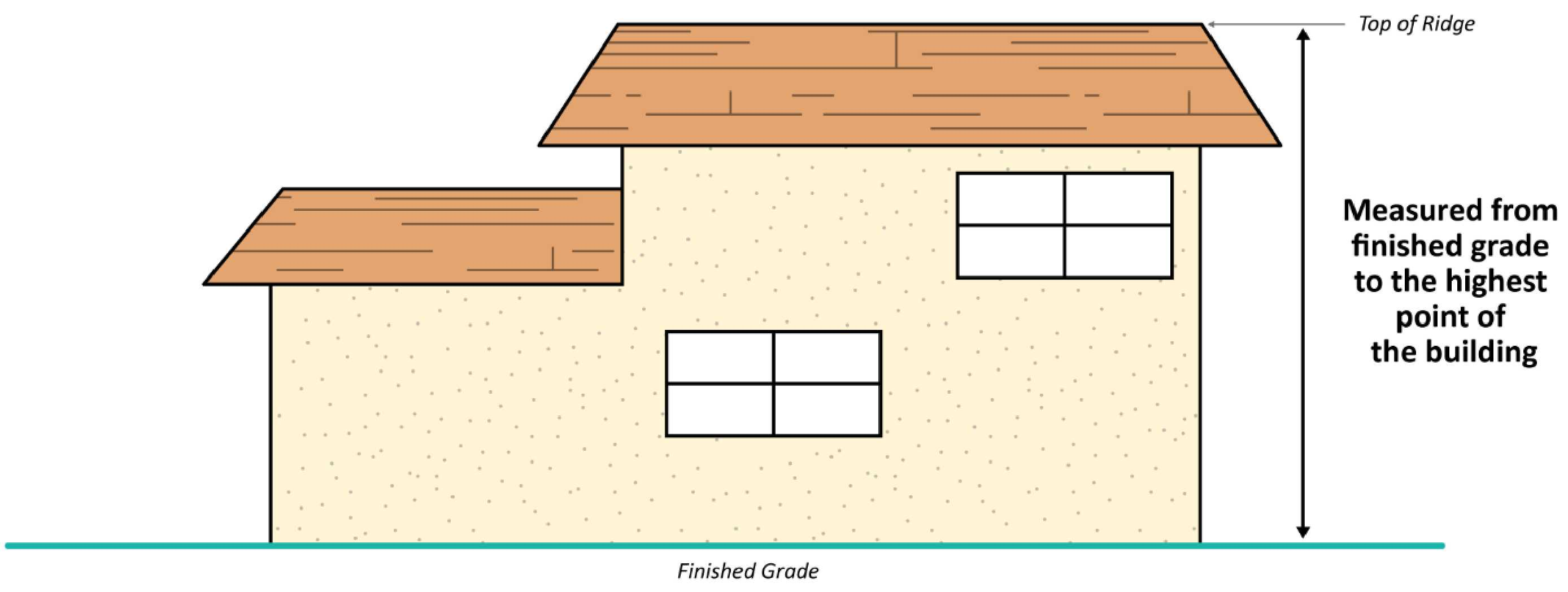
(a)
The following height projections are permitted:
(1)
Architectural features, including chimneys, cupolas, steeples, weather vanes, and similar nonstructural element designed to enhance the building architecture, may exceed the height limit by up to ten (10) feet.
a.
Such features shall not exceed a width of twenty-five (25) feet or one-third (⅓) of the length of the structure's façade, whichever is less. Height exceptions shall not be granted for structural features designed or intended to provide floor space. Signs shall not be included within the additional height limits. Lights and poles are not considered architectural features and are not included in this exemption.
(2)
Elevator shafts, stairwells, and roof-mounted mechanical equipment (inclusive of screening for the mechanical equipment) may exceed the height limit by up to ten (10) feet, provided that these elements do not exceed ten (10) percent of the total roof area.
(3)
Parapets on flat roofs may exceed the height limit by up to forty-two (42) inches.
(4)
Solar energy systems (e.g. panels) may exceed the height limit by up to five (5) feet, or the minimum required based on installation cost and/or energy production thresholds established by state law, whichever is less.
(Ord. No. 2519, § 5(Exh. A), 2-20-24)
Sec. 26-66. - Setback measurement and exceptions.
All structures shall comply with the setback requirements set forth for each zoning district, and with any special setbacks established for specific uses by article II (zones, allowable uses, and development standards), except as otherwise provided by this article.
Figure Figure 3-2 Setbacks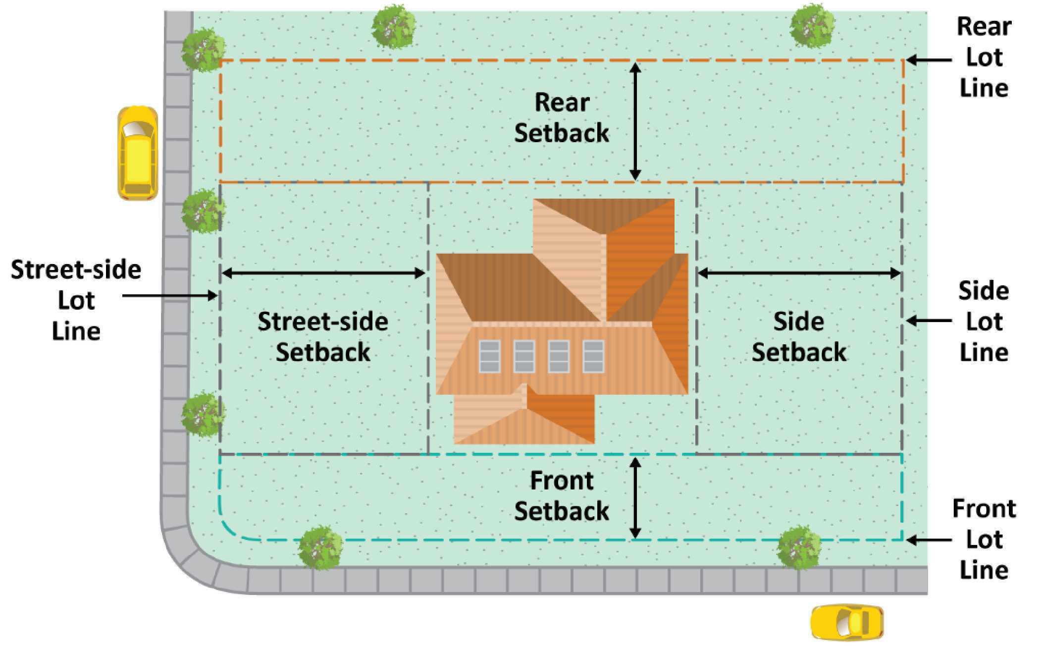
(a)
Setback requirements.
(1)
Each yard shall be open and unobstructed from the ground upward, except as provided in this subsection.
(2)
Yards shall be landscaped in compliance with article III, division 5 (landscaping).
(b)
Exemptions from setback requirements.
(1)
Fences or walls constructed within the height limitations within the height limitations set forth in article III, division 3 (fences, walls and hedges).
(2)
Steps, and other site design elements that are placed directly upon the finished grade and are less than eighteen (18) inches above the surrounding finished grade.; and
(3)
Freestanding signs shall be pursuant to sign requirements set forth in article III, division 8 (sign regulations).
(4)
Water features with a water depth of less than eighteen inches (18").
(c)
Measurement of setbacks.
(1)
The front yard setback shall be measured at a right angle from the nearest point of the front property line (or edge of access or utility easement) to the nearest wall of the structure, except as follows:
a.
For a flag lot, the front yard setback shall be taken from the nearest wall of the structure to the point where the access strip meets the bulk of the parcel, establishing a building line parallel to the lot line nearest to the public street or right-of-way.
(2)
The side yard setback shall be measured at a right angle from the nearest point on the side property line (or edge of access or utility easement) to the nearest wall of the structure, establishing a setback line parallel to the lot line nearest the public street or right-of-way.
a.
The side yard on the street side of a corner parcel shall be measured at right angles from the nearest point on the street side property line to the nearest wall of the structure.
(3)
The rear yard setback shall be measured at a right angle from the nearest point on the rear property line (or edge of access or utility easement) to the nearest wall of the structure, establishing a setback line parallel to the rear property line that extends between the side yards, except;
a.
The rear yard on the street side of a double frontage lot shall be measured from the nearest point of the rear property line adjoining the street. If an access easement or street right-of-way line extends into or through a rear yard, the measurement shall be taken from the nearest point of the easement or right-of-way line; and
b.
Where the side lot lines converge to a point, a line ten (10) feet long within the parcel, parallel to the front lot line, shall be deemed the rear lot line for the purpose of determining the depth of the required rear yard.
Figure 3-3 Lot Lines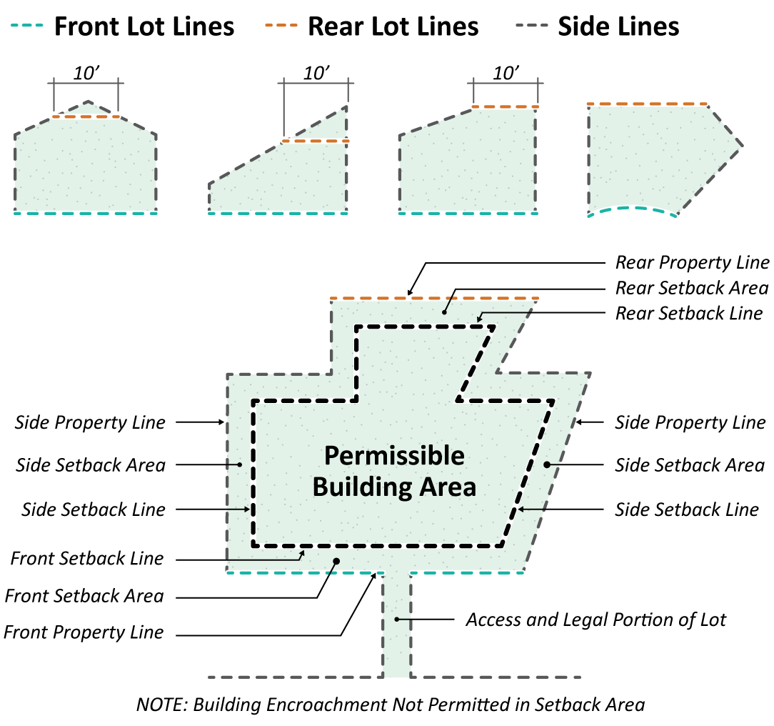
(Ord. No. 2519, § 5(Exh. A), 2-20-24)
Sec. 26-67. - Sight triangle areas.
The following standards shall apply to all intersections of streets, alleys, and private driveways in order to provide adequate visibility for vehicular traffic. There shall be no visual obstructions within sight triangle areas established herein.
(a)
There shall be a corner sight triangle area at all intersecting and intercepting public streets or highways. The sight triangle area shall be in a horizontal plane, making an angle of forty-five (45) degrees with the side, front, or rear property line. It shall pass through the points located on both the side and front (or rear) property lines at a distance of thirty (30) feet from the intersection of such lines at the corner of a public street or highway.
(b)
There shall be a corner sight triangle area on each side of any private driveway intersecting a street or alley. The sight triangle lines shall be in a horizontal plane, making an angle of forty-five (45) degrees with the side, front or rear property lines. They shall pass through a point not less than ten (10) feet from the edges of the driveway where it intersects the street of alley right-of-way.
(c)
There shall be a corner sight triangle area on each side of any alley intersecting a street or alley. The sight triangle lines shall be in a horizontal plane, making an angle at forty-five (45) degrees with the side, front or rear property line. They shall pass through a point of not less than ten (10) feet from the edges of the alley where it intersects the street or alley right-of-way.
(d)
If, due to an irregular lot shape, a line at a 45-degree angle does not provide for intersection visibility, such corner cutoff shall be defined by a line drawn from a point on the front (or rear) property line which is not less than thirty (30) feet from the intersection of the side and front (or rear) property lines and through a point on the side property line which is not less than thirty (30) feet from such intersection of the side and front (or rear) property lines.
(e)
The following shall not be erected, placed, planted or allowed to grow within the sight triangle area.
(1)
Solid fences, walls, signs, structures, mounds of earth, solid post mailboxes, or other visual obstructions over thirty-six (36) inches in height and open work fences up to forty-two (42)inches in height.
(2)
Hedges, shrubbery and vegetation over, or with a growth characteristic over twenty-four (24) inches in height.
(3)
The lower edge of tree canopies of a single trunk tree shall be maintained at a minimum height of eight (8) feet above ground level, as measured from the adjacent street curb elevation.
Figure 3-4 Sight Triangle Areas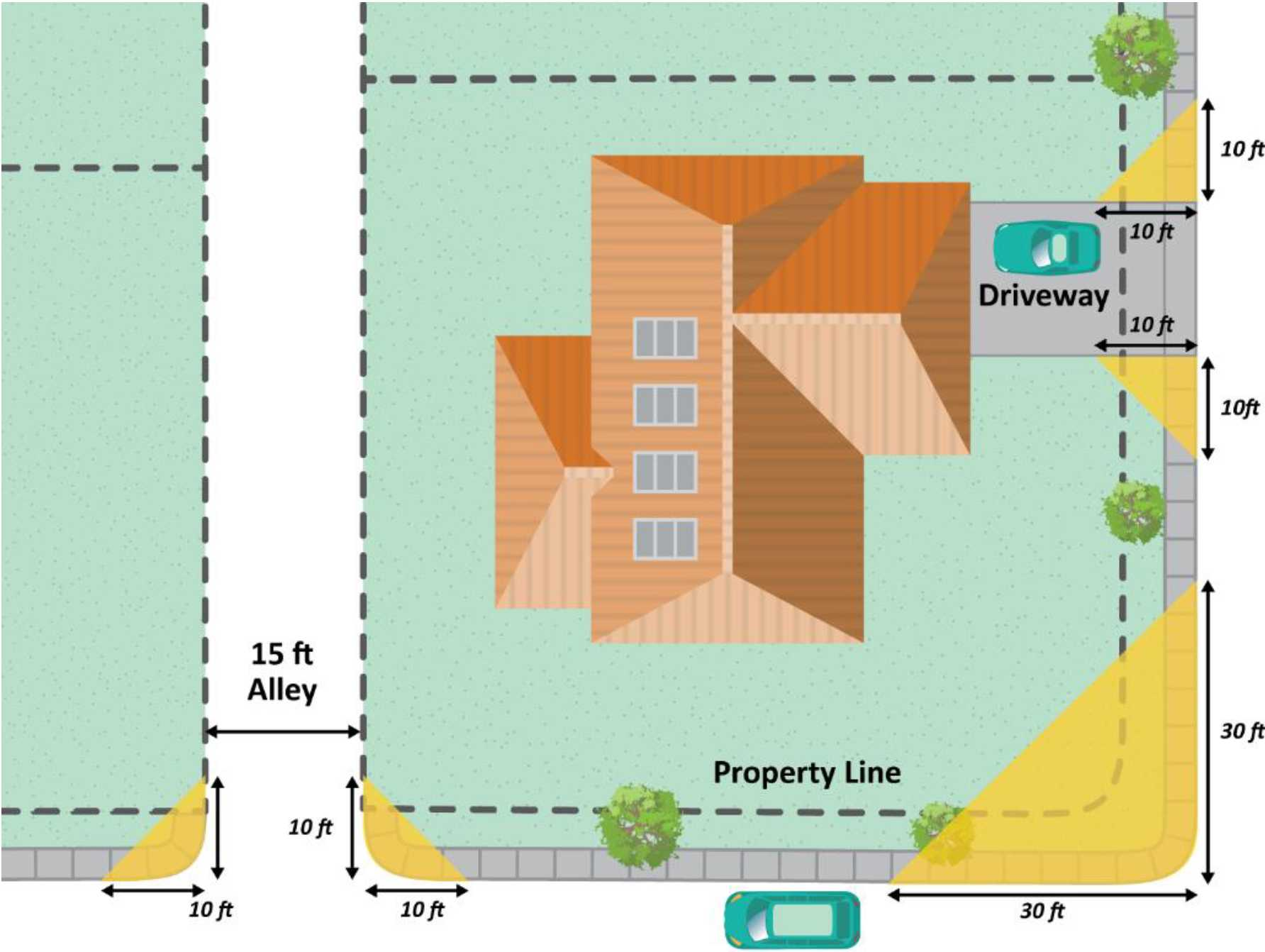
(Ord. No. 2519, § 5(Exh. A), 2-20-24)
Sec. 26-68. - Encroachments into required setbacks.
(a)
Swimming pools, spas, sports courts, and other similar private recreation areas may be located within the front yard, through an administrative permit process when the lot configuration, building placement, and/or street adjacent location justify its location due to the uniqueness of the property as determined by the Community Development Director or their designee, provided there is a minimum five-foot setback to adjoining properties, the project will not create a line-of-sight hazard, there is no other suitable location for the proposed structure on site, and all other standards for the underlying zone are met. Swimming pools and spas may encroach into the required interior side yard and rear yard provided that there is a minimum five (5) feet setback, as measured from the edge of the bond beam to the property line.
(b)
Swimming pools and spas, whether portable or permanently constructed, shall be enclosed by fencing as required by the City's Building Code.
(c)
Cornices, eaves, or similar features may project into yards.
(1)
Cornices, eaves, belt courses, sills, or other similar architectural features may extend or project into a required front, side, or rear yard in single- and multi-family residential zones by not more than three (3) feet provided that the projection is no closer than two feet, six inches (2'-6") from the side and rear property lines.
(d)
Uncovered porches and platforms may project into yards.
(1)
An uncovered porch, platform or landing place which does not extend above the level of the first floor of the building in R-A and R-1 zones may extend or project into any required front, side or rear yard by not more than six (6) feet except as permitted in section 26-46(f), provided such structure in a side yard shall not reduce to less than three (3) feet the unobstructed pedestrian walkway or sidewalk on ground level to less than three (3) feet.
(Ord. No. 2519, § 5(Exh. A), 2-20-24)
Sec. 26-69. - Maintenance and security standards for vacant, unoccupied or abandoned buildings or structures.
(a)
Property owners and/or persons who possess or have control of an abandoned, vacated or undeveloped property, area or place, including buildings and structures, shall maintain and secure said property in such a way that will not be injurious to public health, safety and general welfare or to the stability of real property so as to interfere with the comfortable enjoyment of life or property, nor become attractive to unauthorized persons, including but not limited to juveniles and transients, nor constitute a health, fire or safety hazard.
(b)
Property owners and/or persons who possess or is in control of any undeveloped real property in the City or any other real property in the City that has been vacant or abandoned for a period in excess of thirty (30) calendar days shall do the following:
(1)
Unsecured access points. All means of ingress or egress to the property or structure on the property, including but not limited to, windows, doors, gates and fences that have been breached, vandalized, or damaged, shall be boarded up and/or secured in compliance with Federal Housing Authority board-up standards to ensure the property or structure is secured against unauthorized entry.
(2)
Paint. All boards securing a breach in any ingress or egress on a structure shall be fully painted in such a manner as to complement or match the paint color of the structure.
(3)
Fencing. Any undeveloped real property within the City, or any other vacant real property in the City that an enforcement officer has determined in writing, based upon specific findings regarding the conditions of said real property and surrounding area(s), poses a threat to the health, safety, and welfare of the general public, shall be enclosed by a security fence as approved by the Community Development Director or their designee. Such security fencing shall measure a minimum of six feet (6') in height measured from grade, unless such fencing is located within a required sight triangle, shall be constructed of chain-link or tubular steel materials, and shall be erected in accordance with all requisite City approvals, permits, and inspections. Conditions that shall be considered when determining the necessity of a temporary security fence include, but shall not be limited to, instances of unauthorized entry and/or vandalism, and the degree of decay, deterioration, dilapidation, or neglect of the real property and structures.
(4)
Signage and emergency contact. Signs prohibiting trespassing, and the name and phone number of the person or entity responsible for the maintenance and security of the vacant property shall be posted on all vacant structures and/or security fencing surrounding vacant properties. Security fencing shall be kept clear of all other signs. Each sign shall conform to standards set forth in article III, division 8.
(Ord. No. 2519, § 5(Exh. A), 2-20-24)
Sec. 26-70. - Purpose and applicability.
(a)
The following development standards shall apply to all detached accessory structures, not including accessory dwelling units governed by the requirements of article IV, division 2. The purpose of this division is to protect the public health, safety and welfare by maintaining safe distances between structures, establish architectural compatibility between primary structures and certain types of accessory structures, and minimizing potential impacts associated with lot coverage, privacy, and maintenance of light and air space.
(b)
The development standards contained in this division shall apply to accessory structures on private property and shall be in addition to other applicable development standards contained in the Development Code. In the event of a conflict between the provisions set forth in this division and any other provisions of this Development Code, the stricter regulation shall control. This division regulates detached accessory structures that are larger than one hundred twenty (120) square feet in size and/or taller than seven (7) feet in height. Accessory structures shall not contain indoor cooking facilities (combination of a sink, cooking apparatus, and refrigeration appliance) and should not be designed for full time living or rental purposes. Guesthouses, pool houses, accessory dwelling units and junior accessory dwelling units that conform to the requirements of this chapter are permitted.
(Ord. No. 2519, § 5(Exh. A), 2-20-24)
Sec. 26-71. - Permit requirements and exemptions.
(a)
Certain accessory structures located in single-family zones referenced within this section (division 2 accessory structures) and within section 26-46 as requiring an administrative permit, and all accessory structures located in multi-family, mixed-use, commercial and industrial zones shall require an administrative permit, pursuant to the procedures and findings outlined in article VI, division 6.
(b)
The following structures located in the single-family and multi-family zones are exempt from planning entitlements provided they comply with the requirements listed below and standards set forth in section 2672. Exempt accessory structures may require building permits to maintain conformance with the California Building Code adopted by the City.
(1)
Accessory structures that are less than one hundred twenty (120) square feet in size and no portion of the structure is seven (7) feet or greater in height, provided that no more than two (2) of such structures are located within the same lot or site.
(2)
A detached structure typically used for decorative or landscape design purposes such as a fountain, water wall, bird bath and similar features that are less than one hundred twenty (120) square feet in size and no portion of the feature is six (6) feet in height or greater.
(3)
Accessory dwelling units and junior accessory dwelling units pursuant to article IV, division 2 (accessory dwelling units and junior accessory dwelling units).
(Ord. No. 2519, § 5(Exh. A), 2-20-24; Ord. No. 2525, § 19, 3-18-25)
Sec. 26-72. - Development standards.
(a)
The development standards listed in table 3-1 are intended to supplement the requirements in the applicable zone for types of accessory structures. In the event of a conflict between these requirements and the requirements of the underlying zone, the requirements of this section shall apply. The following requirements shall apply to all accessory structures, both exempt and non-exempt under section 26-71.
(b)
Minimum setback distances for accessory structures from property lines and between all structures shall include all portions of the structure(s).
(c)
Accessory structures may be constructed in conjunction with or subsequent to the construction of the primary structure(s) on the site.
Table 3-1 Development Standards for Accessory Structures
(d)
Accessory buildings in R-A and R-1 zones.
(1)
Accessory buildings, or the sum of accessory buildings, except accessory dwelling units, shall be a maximum of one thousand (1,000) square feet. Accessory buildings which causes the total square footage of accessory buildings to exceed greater than one thousand (1,000) square feet (except accessory dwelling units) may be granted subject to the approval of an administrative permit pursuant to the procedures and findings outlined in article VI, division 6. Required garages are exempt from the administrative permit requirements. Individual accessory buildings with an area greater than the primary dwelling unit shall not be allowed. The area for individual accessory buildings shall be limited to seventy (70) percent of the floor area of the primary dwelling unit.
(Ord. No. 2519, § 5(Exh. A), 2-20-24; Ord. No. 2525, § 20, 3-18-25)
Sec. 26-73. - Solar energy systems.
(a)
The purpose of this section is to allow for timely and cost-effective installations of solar energy systems that shall:
(1)
Provide for the installation of small to medium solar energy systems to enable the generation of electricity from the sun, for on- and off-site uses.
(2)
To minimize potential adverse impacts associated with solar energy systems.
(b)
Development standards.
(1)
Ground-mounted solar energy collectors. Ground-mounted solar energy collectors shall be installed and maintained in accordance with the following requirements:
a.
Location. Ground-mounted solar energy collectors are permitted in all zoning districts. In residential zoning districts, solar energy collectors and their mounting framework shall not be located within the front setback and shall not be visible from the public right-of-way adjacent to the front, or side property line. In nonresidential zoning districts, solar energy collectors may be visible from the public right-of-way with approval of an administrative permit.
b.
Height. In residential zoning districts, the height of a ground-mounted solar energy collector system shall not exceed twelve (12) feet. The maximum height shall be twenty-five (25) feet when located on a non-residential property not abutting a residential zone. The maximum height of a ground-mounted solar energy collector system shall be fifteen (15) feet when located on a non-residential property abutting a residential zone.
c.
Setbacks. Installations of less than six (6) feet in height may project up to two (2) feet into a required setback. Installations of six (6) feet or more in height shall comply with building setback requirements for patio covers.
(2)
Roof-mounted solar energy collectors.
a.
Location. It is preferred that photovoltaic solar energy systems in the single-family residential zone on roofs are designed in a way that is flush-mounted and/or are not installed on the portion of the roof that faces the street, and/or are screened from the public right-of-way. If the photovoltaic solar energy systems on roofs are not flush-mounted and/or installed on the portion of the roof that faces the street, and/or is visible from the street, applicant submittal of additional documentation to the planning division is required prior to the first building division inspection to receive inspector sign-off. The required documentation shall be a written analysis prepared by a licensed engineer indicating that all options to redesign the photovoltaic system with a flush-mounted design and/or without utilizing the street facing roof will:
1.
Increase the installation cost by more than one thousand dollars ($1,000.00); and
2.
Will cause a drop in energy production by more than ten (10) percent.
b.
Height. Photovoltaic solar energy systems on the roof may extend up to five (5) feet above the height limit in the district in which it is located or the roof surface on which they are installed, provided that the height extension is necessary to be within the installation cost and/or energy production thresholds mandated by state law.
c.
Solar water or swimming pool heating systems may extend up to seven (7) feet above the height limit in the district in which it is located or the roof surface on which they are installed.
(3)
Solar energy collector on carports.
a.
Photovoltaic equipment, as defined by section 26-36, "solar energy systems," may be installed on the roof of carports for the purpose of collecting, storing, or transferring solar energy as part of a larger solar energy system installed in structure(s) on the same building site without additional discretionary permit.
b.
The maximum height of solar energy collector equipment on carport roofs shall not exceed the maximum height of the underlying district.
(c)
Reflection angles and glare. Reflection angles for solar collectors shall be oriented such that they do not project glare onto adjacent properties. Solar collectors shall be designed such that concentrated solar glare does not project onto nearby structures, roadways, or the public right-of-way. Installation of anti-glare panels and/or anti-glare film is preferred. The property owner shall be responsible for mitigating any glare issues discovered after installation.
(Ord. No. 2519, § 5(Exh. A), 2-20-24; Ord. No. 2525, § 21, 3-18-25)
Sec. 26-74. - Purpose and applicability.
(a)
The purpose of this chapter is to establish standards and regulations relating to the construction of fences, walls and hedges used for screening or buffering purposes. The standards are intended to ensure that all fences, walls, and hedges provide desired privacy and safety but do not create a public safety hazard or nuisance, and that fences, walls and hedges meet the City's standards for quality design and regular maintenance.
(b)
For planned development permits and specific plans, fence, wall, and hedge standards shall comply with the standards set forth in the applicable planned development permit or Specific Plan. Where the Planned Development Permit or Specific Plan is silent on fence, walls and hedge height, the standards for the underlying zone shall apply, as determined by the Community Development Director, or their designee.
(Ord. No. 2519, § 5(Exh. A), 2-20-24)
Sec. 26-75. - Measurement of fence or wall height.
(a)
Measurement of height.
(1)
The height of a fence or wall is measured as the vertical distance between the top of finished grade at the base of the fence or wall to the top of the fence or wall.
(2)
For fences or walls on sloping ground or varying grades, height shall be measured from the lowest grade on either side of the fence or wall to the highest point of the fence or wall. For the purposes of this section a retaining wall with a fence above it shall be considered one (1) structure.
(3)
Fence or wall height includes any materials attached to the fence or wall.
Figure 3-5 Measuring Fence or Wall Height
(Ord. No. 2519, § 5(Exh. A), 2-20-24)
Sec. 26-76. - Height limitations for freestanding fence, walls and hedges.
(a)
Street-fronting fences and walls. The maximum allowed height for freestanding fences and walls within the required front setback, or the street side yard, or the rear yard of a through lot with street driveway/garage access shall comply with the following standards:
(1)
Fences and fence/wall combinations shall not exceed a maximum height of six (6) feet. The fence and/or fence/wall combination shall be of a design that creates at least seventy (70) percent open work above forty-two inches (42") in height. Pilasters and/or columns no greater than eighteen inches (18") in width may be incorporated with the design of the fence or wall if the required visibility is met. Street-fronting fences on street side yards of lots not considered a reverse corner lot and on rear yards of through lots may construct a solid, non-transparent fence/wall provided that no neighboring adjacent single-family residential lot is developed with a primary residence with its front facade oriented towards the same street.
(2)
Corner cut back area. On corner lots, walls, fences, hedges, trees, or other physical obstructions shall not exceed a maximum height of thirty-six inches (36") within the sight triangle areas set forth in section 26-67.
(3)
Fences and walls adjacent to arterial streets. Walls and fences on single-family residential lots along the side and rear property lines adjacent to rights-of-way of streets designated as principal or minor arterials on the master plan of streets and highways shall have a maximum height of eight (8) feet provided that design standards contained within subsection (a)(1) is complied with.
(4)
On single-family residential zones, light fixtures may be added on the top of the street-fronting fencing or its pillar, provided the overall height of the fence or pillar and light does not exceed a height of six feet, six inches (6'-6"). The intensity of the lights shall be limited to low level lighting of less than one thousand six hundred (1,600) lumens.
(5)
Fences atop retaining walls, shall conform to the limits set forth in section 26-77.
(b)
Side and rear yard fences and walls. The maximum allowed height for freestanding fences and walls (nonretaining) within the required side and rear yard setbacks shall comply with the following standards:
(1)
Street fronting side yard and rear yard fences shall conform to the height limits set forth in subsection (a) of this section.
(2)
A freestanding fence or wall between single-family residential properties shall not exceed seven (7) feet in height.
(3)
A freestanding fence or wall between multi-family residential properties or along a major arterial street shall not exceed seven (7) feet in height.
(4)
A freestanding fence or wall between a residential and commercial property shall not exceed eight (8) feet in height.
(5)
A maximum of eight (8) foot freestanding fence or wall between a residential and commercial property or between two commercial properties.
(6)
On commercially zoned properties, a free-standing fence or wall shall not exceed a maximum of eight (8) feet in height.
(7)
Freestanding fences or walls located at intersections of streets, alleyways and driveways within traffic sight areas shall conform to standards set forth in section 26-67(e).
(8)
Fences atop retaining walls, shall conform to the limits set forth in section 26-77.
(c)
Hedges. No maximum height shall be established for hedges, except for hedges located within the required front yard which shall conform to the standards for fences and walls, and for the sight triangle area standards set forth in section 26-67(e).
(Ord. No. 2519, § 5(Exh. A), 2-20-24)
Sec. 26-77. - Height limitations for retaining walls and change of grade.
(a)
Interior facing retaining walls or garden walls where the retaining wall faces inward to the subject property and are negligibly visible from surrounding properties or the public right-of-way, and located within the required setbacks, the retaining wall may reach a maximum height of seven (7) feet. The total height of an interior facing retaining wall and a free-standing fence or wall atop it shall not exceed the following height limitations:
(1)
Within the front setback. Twelve (12) feet provided that the design of the freestanding fence/wall complies with section 26-76(a)(1), or fourteen (14) for properties that qualify under section 26-76(a)(3).
(2)
Side and rear yard. Thirteen (13) feet, or fourteen (14) feet for properties that qualify under section 26- 76(b)(4) through (6).
(b)
Exterior facing retaining walls or garden walls. Where the retaining wall faces outward towards a public street or facing a neighboring property and is, located within the required setbacks, the retaining wall may reach a maximum height of three (3) feet, The total height of an exterior facing wall and free-standing fence or wall atop it shall not exceed the following height limitations:
(1)
Within the front setback. Nine (9) feet provided that the design of the freestanding fence/wall complies with section 26-77(a)(1)
(2)
Side and rear yard. Ten (10) feet, or eleven (11) feet for properties that qualify under section 26-76(b)(4) through (6)
(c)
Interior and exterior facing retaining walls or garden walls which complies with the required building setbacks of the zoning district shall not exceed a maximum height of fifteen (15) feet.
(d)
Parallel retaining walls and landscaping terracing. Any retaining wall constructed in combination with other retaining walls, screen walls and/or fences on the same property may be terraced with a gradient up to 1:1 to obtain approval of an aggregate height of retaining walls exceeding the single-wall limit set forth in this section. The distance between walls shall be no less than the height of the tallest wall.
(Ord. No. 2519, § 5(Exh. A), 2-20-24)
Sec. 26-78. - Fence materials.
(a)
Prohibited fence materials.
(1)
Residential zoning districts. Barbed wire, electrical fences, razor wire, and other similar objects on the top of fences or walls shall not be allowed within a residential zoning district. The use of chain link fence is prohibited in residential districts within any front yard area or any area visible from the public street, except for construction sites and other temporary uses and where otherwise specifically permitted in this Development Code.
(2)
Commercial and industrial zoning districts. Barbed wire, electrical razor wire, and other similar objects shall not be allowed on the top of fences or walls within a commercial zoning district, except on the top of fences or walls surrounding outdoor storage areas.
(b)
Special fencing and wall requirements.
(1)
Swimming pools, spas and similar features. Swimming pools, spas, and other similar features shall be fenced in compliance with the requirements set forth by the City's Building Code.
(2)
Outdoor equipment, storage, and work areas. Screening of outdoor use, equipment and activities shall conform to the standards set forth in division 4 (screening and buffering).
(3)
Recreational courts. Fences for recreational courts including basketball, tennis, badminton courts and similar play areas shall not exceed twelve (12) feet in height providing that all parts of the fencing are not located within the minimum required setback areas.
(4)
Temporary fences. Temporary fencing may be necessary for the protection of archaeological, historic resources and/or trees during site preparation and construction. Temporary fencing for these purposes shall be subject to the approval of the Community Development Director or their designee, and shall comply with applicable building codes.
(5)
Walls along public rights-of-way. Masonry, concrete block and wood perimeter walls that adjoin public rights-of-way and are constructed as part of a subdivision or other planned development shall be maintained in original condition, including the color and texture of the block and any cap elements. Fences/walls along the public right-of-way shall be either finished on both sides, finished on the side facing the public right-of-way, or made of decorative block.
(6)
Fences and walls exceeding six (6) feet in height in between properties. Fences/walls exceeding six (6) feet in height located within five (5) feet from the property line shall be either finished on both sides, finished on the side facing the neighboring property, or made of decorative block.
(Ord. No. 2519, § 5(Exh. A), 2-20-24)
Sec. 26-79. - Required walls.
(a)
Walls in multi-family residential zones.
(1)
A thirty-six (36) inch high concrete, masonry, or decorative block wall shall be provided and maintained on the outside perimeter of all off-street parking areas abutting or visible from a public street, except at points of ingress and egress for vehicular or pedestrian traffic. The wall shall be set back a minimum of five (5) feet from the property line and this setback area shall be landscaped. Other materials may be used if approved by the Planning Commission.
(2)
In lieu of the thirty-six (36) inch high screen wall, land contouring and landscaping equivalent to thirty-six (36) inches in height, or a combination of wall and land contouring, may be provided.
(b)
A seven-foot wall when abutting single-family zone:
(1)
A seven (7) foot high concrete, masonry or decorative block wall shall be provided and maintained on the boundary of any multiple-family zone which abuts or lies across a public alley from a residential-agricultural (R-A) or single-family (R-1) zone, except in the front setback area, where said wall shall conform to the sight triangle area standards set forth in section 26-67(e).
(2)
When there is a difference in site elevation and the abutting property zoned R-A or R-1 is a minimum of seven (7) feet higher than the development site zoned multiple-family, at the discretion of the Planning Commission, the requirements for a seven (7) foot high wall may be waived.
(Ord. No. 2519, § 5(Exh. A), 2-20-24)
Sec. 26-80. - Purpose.
This section provides standards for the screening and buffering of adjoining land uses, equipment, outdoor storage areas and surface parking areas.
(Ord. No. 2519, § 5(Exh. A), 2-20-24)
Sec. 26-81. - Screening and buffering standards.
(a)
Required screening in office, commercial and industrial zones. All exterior storage areas and service yards, loading docks and ramps, electrical cage enclosures and storage tanks are to be screened from view by a fence, wall or mature landscaped materials.
(1)
Mechanical equipment and duct work.
a.
All roof top mechanical equipment shall be placed behind a permanent parapet wall and be completely restricted from all ground level views from adjacent public rights-of-way. Such screening shall be as high as the highest portion of the equipment or ducting, and shall be permanently maintained.
b.
No mechanical equipment is to be exposed on the wall surface of a building.
c.
Gutters and downspouts that are utilitarian in nature are not to project from the vertical surface of the buildings. Decorative gutters and downspouts, when appropriate to the proposed architectural style of the building may project from the surface of the building and shall be subject to review of the Planning Commission.
d.
Vents, louvers, exposed flashing, tanks, stacks, overhead doors, rolling and "man" service doors are to be treated in a manner consistent with the color scheme of the building.
e.
All ground mechanical equipment shall be screened to the maximum extent feasible and as allowed by the utility provider by a permanent structure or landscape.
(2)
Refuse storage.
a.
All outdoor trash, garbage and refuse containers shall be screened from public view, within a trash enclosure containing a roof and screening on all sides consisting of minimum five and one-half (5½) foot high concrete, or masonry decorative block wall, and the opening provided with a solid gate.
b.
Such area shall be so located as to be easily accessible for trash pick-up.
c.
Storage. Except in the case of uses listed "outdoor displays" in section 26-51(a) of this chapter, all storage of wares, merchandise, crates, bottles or similar items shall be within a completely enclosed building.
(3)
Screening of parking areas.
a.
All parking areas shall be screened from public rights-of-way with various means of screening such as land contouring, low-profile walls, shrub plantings and similar screens or a combination thereof.
b.
A seven (7)-foot high concrete, masonry or decorative block wall shall be provided and maintained on the boundary of any nonresidential zone which abuts or lies across a public street or alley from a residential zone except in the front setback area where said wall shall conform to the sight triangle area standards set forth in section 26-67(e).
c.
All walls shall be architecturally compatible with the main buildings. Type, texture, and color shall be approved by the Planning Commission. Barbed wire shall not be permitted.
(Ord. No. 2519, § 5(Exh. A), 2-20-24)
Sec. 26-82. - Purpose.
The purpose of this division is to establish minimum landscaping standards to enhance the appearance of developments, increase green space throughout the City, reduce heat and glare, control soil erosion, conserve water, ensure the ongoing maintenance of landscaped areas, reduce wildfire hazards, and ensure that landscape installations do not create hazards for motorists or pedestrians.
(Ord. No. 2519, § 5(Exh. A), 2-20-24)
Sec. 26-83. - Applicability.
The requirements contained in this division shall apply to all new and existing development and shall be in addition to any other development standards contained elsewhere within the Development Code.
(Ord. No. 2519, § 5(Exh. A), 2-20-24)
Sec. 26-84. - Water efficient landscape ordinance.
(a)
The purpose of this section is to ensure the design, installation and maintenance of landscapes meet the requirements of the State of California's Model Water Efficient Landscape Ordinance (MWELO)
(b)
The City adopts by reference the State of California's Model Water Efficient Landscape Ordinance, which is found at Sections 490—495 of chapter 2.7, division 2, Title 23, of the California Code of Regulations, as it may be amended from time to time. A copy of the MWELO will be maintained in the community development department and will be made available for public inspection during regular business hours.
(c)
Applicability. The MWELO applies to the following projects:
(1)
New landscape projects with an aggregate landscape area equal to or greater than five hundred (500) square feet.
(2)
Rehabilitated landscape projects with an aggregate landscape area equal to or greater than two thousand five hundred (2,500) square feet and requiring a building, plan check or design review; and
(3)
For purposes of this section, aggregate landscape area does not include footprints of buildings or structures, sidewalks, driveways, parking lots, decks, patios, gravel, or stone walkways, other pervious or non-pervious hardscapes, and other non-irrigated areas designated for nondevelopment.
(d)
Exemptions. The following projects or landscapes are exempt from or subject to limited review pursuant to MWELO.
(1)
Projects involving new construction of an aggregate landscape area of less than two thousand five hundred (2,500) square feet that comply with the prescriptive measures.
(Ord. No. 2519, § 5(Exh. A), 2-20-24)
Sec. 26-85. - General landscaping standards.
(a)
General location for landscape improvements. All landscaping shall be provided in the following locations for all types of development as listed below, unless the approval authority determines that the required landscape is not necessary to fulfill the provisions of this division. Nothing in this division is intended to discourage landscaping in excess of the minimum requirements listed herein.
(b)
Setbacks, public frontage and street frontage. All setback areas required by this Development Code, areas between the curb and setback, public frontage areas, or portions of the site with any street frontage, shall be landscaped and maintained in compliance with this division, except where an area of required setback is improved with a paved surface such as a sidewalk or driveway.
(1)
In all industrial zones, the front and exterior side yard setback areas adjoining public rights-of-way are required to be landscaped, including the property frontage within the right-of-way.
(2)
Trees are required along sidewalks and primary street frontages, in addition to other landscaping requirements. Street trees shall be required where the public parkway is at least four (4) feet wide. A twenty-four (24) inch box street tree shall be planted for each thirty (30) feet of linear street frontage along any property line abutting a public or private street (on average). The director of public works may approve deviations to these standards when site conditions (e.g. utilities or significant topography constraints) preclude the placement of trees.
(c)
Undeveloped areas. All areas of a site that are part of an entitled and/or approved master planned development application, such as pad sites being held for future development, shall be landscaped in compliance with this division.
(d)
Pedestrian paths and pedestrian entrances. Along pedestrian pathways and at building entrances, trees shall be provided in compliance with this division for shade and climate control to define public spaces, and moderate high temperatures and wind speeds.
(e)
Plant type. Landscape planting shall emphasize climate appropriate, drought-tolerant, native, and non-invasive species shall complement the architectural design of the structures on site, and shall be suitable for the soil and climatic condition specific to the site. Plant species known to be invasive and listed on the California Invasive Plant Inventory published by the California Invasive Plant Council (Cal-IPC) are prohibited. Within Fire Hazard Severity Zones as determined by CALFire, plantings shall not include fire prone species and the plant palette shall be approved by the West Covina Fire Department.
(f)
Planting layout and plant diversity. Plant selection shall vary in the type and planting pattern. Informal planting patterns are preferred over uniform and entirely symmetrical planting patterns. Use of deciduous flowering trees and shrubs and colorful plantings is encouraged in conjunction with evergreen species. Groupings of shrubs shall contain multiple plant types, interspersed with varying heights and blooming seasons for year round interest.
(g)
Street and parking lot trees.
(1)
Street and parking lot trees shall be selected from the City's adopted master list of street trees and parking lot trees.
(2)
Parking lot trees. An average of at least one (1) tree (minimum fifteen (15) gallon) of a species satisfactory to the Community Development Director or their designee shall be planted for every six (6) parking spaces.
(3)
The total number of required parking trees may be reduced to one (1) tree for every ten (10) parking stalls if the lot landscape requirements set forth in section 26-86(a) is increased by fifty (50) percent (12% of total lot area for all zones, except M-1, which is 6).
(4)
Any tree that partially shades a parking space or a drive aisle may be considered a parking lot tree and included in the calculation of total parking lot trees.
(5)
There shall be a minimum three (3) foot wide (inside dimension,) landscape planter separating a building or wall from a driveway or parking area.
(6)
All planted areas shall be surrounded by a concrete curb six (6) inches above final grade or above asphalt level of the parking lot. However, when such planted areas lie adjacent to a concrete sidewalk, masonry wall, or a building, a raised concrete curb need not be provided in the adjacent area.
(h)
Trees planted within ten (10) feet of a street, sidewalk, paved trail, or walkway shall be a deep-rooted species or shall be separated from hardscapes by a root barrier to prevent physical damage to public improvements.
(i)
Planting size, spacing, and planter widths. In order to achieve an immediate effect of a landscape installation and to allow sustained growth of planting materials, minimum plant material sizes, planting spacing, and minimum planter widths (inside measurements) are as follows:
(1)
Trees. The minimum planting size for trees for industrial, mixed-use, commercial, office, and community or civic uses shall be 15-gallon, with twenty-five (25) percent of all trees on a project site planted at a minimum 24-inch box size. For industrial, mixed-use, commercial, office and community or civic uses, tree spacing within perimeter planters along streets and abutting residential properties shall be planted no further than twenty-five (25) feet on center, on average. Minimum planter widths for trees shall be between five (5) and ten (10) feet, consistent with the City's adopted master list of street trees and parking lot trees.
(2)
Shrubs. Shrub planting shall be a minimum five-gallon size, with a 15-gallon minimum size required where a landscape screen (visual buffer) is conditioned by the designated approving authority (e.g., screening of headlights from drive-through aisles). The minimum planter width for shrubs is four (4) feet.
(3)
Ground cover. Plants used for mass planting may be grown in flats of up to sixty-four (64) plants or in individual one-gallon containers. Rooted cuttings from flats shall be planted no farther apart than twelve (12) inches on center, and containerized woody, shrub ground cover plantings shall be planted no farther apart than three (3) feet on center in order to achieve full coverage within one (1) year. Minimum planter width for ground cover is two (2) feet, with the exception of sod, which requires a minimum planter width of six (6) feet.
(j)
Synthetic turf. Synthetic turf may be used as a substitute for natural turf for the purposes of water conservation. The use of synthetic turf on properties zoned for multi-family residential or non-residential uses shall require an administrative permit, pursuant to article VI, division 6. The following standards shall apply to the use and maintenance of synthetic turf.
(1)
Synthetic turf shall be allowed in areas visible from a public street, park, public parking lot for non- residential developments or located within the setback areas of properties zoned R-1 or R-A.
(2)
Synthetic turf shall consist of lifelike individual blades of grass that emulate real grass in look and color and have a minimum pile height of one and one-half (1½) inches.
(3)
The installation of synthetic turf shall also include a proper drainage system installed underneath to prevent excess runoff or the pooling of water.
(4)
Landscaping comprised of synthetic turf shall be periodically maintained to simulate the appearance of a well-maintained lawn.
(5)
The use of indoor or outdoor plastic or nylon carpeting as a replacement for synthetic or natural turf shall be prohibited.
(6)
Synthetic turf shall be installed in combination with natural plant materials including trees, shrubs, hedges and ground cover to enhance the overall landscape design.
(7)
All landscape areas where synthetic turf is implemented shall be cleaned and maintained based on manufacturers' guidelines for maintenance.
(8)
The administrative permit shall be valid for up to ten (10) years or as determined by the recommended longevity of the synthetic turf manufacturer.
(9)
Application submittal requirements. An application for the use of synthetic turf shall include the following items:
a.
A site plan including the dimensions and details of the landscaped area, including both the proposed synthetic turf area and live plant material landscaped areas. The plan shall also describe the specific type of synthetic turf to be installed.
b.
A sample of the synthetic turf to be implemented.
c.
Specifications of the synthetic turf detailing including the synthetic turf materials and components, longevity of the turf.
(k)
Landscape criteria for multi-family residential and mixed-use zones that include residential uses.
(1)
All open areas or unused space exceeding twenty-four (24) square feet resulting from the design or layout of parking spaces or accessory structures with the exception of vehicular accessways and parking areas, pedestrian walkways, and paved or covered recreational facilities, shall be landscaped and irrigated with a fully automatic system in conformance with this division. Such landscaping and irrigation shall be permanently maintained in a functional, dust free, disease free, and weed free condition.
(2)
No planting area shall be less than twenty-four (24) square feet or less than three (3) feet in width (inside dimensions) with the exception of raised planter boxes around or in close proximity to buildings.
(3)
A minimum of six (6) feet of the rear or side yard adjacent to single-family or multi-family residential zoning or development shall be landscaped with plant materials and trees appropriate in size and type to create a solid plant screen, subject to the approval of the Community Development Director or their designee, and as represented on the approved landscaping plan.
(4)
Undeveloped areas proposed for future expansion shall be maintained in a weed free and dust free condition.
(5)
Landscape areas, whether installed pursuant to this chapter or not, shall be maintained free of litter and diseased or dead plants. Diseased, dead, damaged and/or disfigured plants shall be replaced as deemed necessary by the Community Development Director or their designee. Irrigation systems and their components shall be maintained in a fully functional manner consistent with the originally approved design and the provisions of this division.
(6)
Landscape areas shall be maintained to ensure water efficiency and minimize water waste leading to excessive runoff, low-head drainage, overspray and other similar conditions where water flows onto adjacent property, non-irrigated areas, walks, roadways or structures. A regular maintenance schedule should include but not be limited to, checking, adjusting, and repairing irrigation equipment; resetting the automatic controller; aerating and dethatching turf areas; replenishing mulch; fertilizing; pruning; and weeding in all landscaped areas. All tree pruning shall be performed in compliance with acceptable standards as set forth by the Western chapter International Society of Arborists.
(7)
The landscaping and irrigation plan shall be approved by the Community Development Director or their designee subject to the following criteria. Landscape and irrigation plans for projects with required landscaping consisting of five thousand (5,000) square feet or more, shall be prepared by a licensed landscape architect. The Community Development Director or their designee has the right to disapprove a landscaping plan if the quantity, size, type, placement, and use of plant material do not meet the minimum requirements of this section. The Community Development Director or their designee shall also determine whether the type, size, and location of the proposed landscaping is appropriate given the scale and design of the development.
(8)
All landscape areas and irrigations systems shall be subject to the water efficiency provisions contained in article III, division 5, standards for water efficient landscaping, unless specifically exempted by those water efficiency provisions.
(Ord. No. 2519, § 5(Exh. A), 2-20-24; Ord. No. 2525, § 22, 3-18-25)
Sec. 26-86. - Landscape area requirements.
(a)
Landscape criteria for office, commercial, mixed-use, and industrial zones.
(1)
A minimum of eight (8) percent of the total net area (net area shall be computed by excluding public streets) of the development, in all zones except the manufacturing (M-1) zone, shall be landscaped, and permanently watered with a water efficient automatic irrigation system. In the manufacturing (M-1) zone, a minimum of four (4) percent of the total net area (net area shall be computed by excluding public streets) of the development shall be landscaped, and permanently watered with a water efficient automatic irrigation system, and seventy-five (75) percent of the landscaping shall be within fifty (50) feet of a public street.
(2)
Approximately one-half of such landscaped area shall be generally distributed throughout the parking lot with the remainder as planted areas around buildings, peripheral planters around the site, parkways, street tree wells and other locations as deemed appropriate by the Community Development Director or their designee. The Community Development Director or their designee shall also determine whether the type, size, and location of the proposed landscaping is appropriate given the scale and design of the development.
(3)
No planting area shall be less than twenty-four (24) square feet or less than three (3) feet in width (inside dimensions) with the exception of raised planter boxes around or in close proximity to buildings.
(4)
A minimum of six (6) feet of either the rear or side yard adjacent to single-family or multi-family residential zoning or development shall be landscaped with specimen plant materials and trees appropriate in size and type to create a solid plant screen, subject to the approval of the Community Development Director or their designee, and as represented on the approved landscaping plan.
(5)
Undeveloped areas proposed for future expansion shall be maintained in a weed-free and dust free condition.
(6)
All landscaping referred to in this section shall be maintained in a neat orderly fashion and free of debris.
(7)
The landscaping and irrigation plan shall be approved by the Community Development Director or their designee in compliance with the provisions of this division. Landscape and irrigation plans or projects with required landscaping consisting of two thousand five hundred (2,500) square feet or more, shall be prepared by a licensed landscape architect. The Community Development Director or their designee has the right to disapprove a landscaping plan if the quantity, size, type, placement and use of plant material do not meet the minimum requirements of this division, Planning Commission guidelines for water efficient landscaping.
(b)
Existing/established landscapes.
(1)
All landscape areas and irrigations systems shall be subject to the water efficiency provisions contained in article III, division 5 of this Code, and the Planning Commission guidelines for water efficient landscaping, unless specifically exempted by those water efficiency provisions.
(Ord. No. 2519, § 5(Exh. A), 2-20-24)
Sec. 26-87. - Maintenance.
In addition to any other provisions of this Development Code, the following requirements apply to all residential zones:
(a)
All landscaped areas shall be maintained in a healthy and growing condition and shall receive routine pruning, fertilizing, mowing, and trimming.
(b)
All irrigation systems shall be kept operable, including adjustments, replacements, repairs, and necessary cleaning as part of routine maintenance.
(c)
All landscape areas shall be kept free of weeds and debris.
(d)
If a property proposed for mixed-use, commercial or industrial use, maintenance of any landscaping between the curb of any street abutting the property and the property line shall be the responsibility of the owner of that property.
(Ord. No. 2519, § 5(Exh. A), 2-20-24)
Sec. 26-88. - Purpose and applicability.
(a)
The purpose of this division is to establish parking, loading and bicycle standards and regulations to provide for safe, attractive, and convenient parking areas and ensure that parking areas are compatible with surrounding and uses.
(b)
Applicability.
(1)
Off-street parking shall be provided for both vehicles and bicycles per the requirements of the Development Code for the following applications:
a.
New development.
b.
Building additions.
c.
Temporary uses.
d.
Changes in land uses.
(2)
In all situations where additional vehicular parking spaces are required, all existing and proposed handicapped parking spaces shall be located on site shall be marked and striped in accordance with the State of California Building Standards Code, Title 24 of the California Code of Regulations.
(3)
All parking spaces shall be independently accessible, with the exception of tandem spaces as permitted in the standards below.
(Ord. No. 2519, § 5(Exh. A), 2-20-24)
Sec. 26-89. - General provisions.
(a)
Vehicles in R-A and R-1 zones.
(1)
Commercial vehicles. It shall be unlawful to park or store any commercial vehicles, trailers, or other related equipment. The provisions of this subsection (1) do not apply to passenger vehicles, pickup trucks, passenger or cargo vans, or recreational vehicles.
(2)
Allowed parking area. For residentially zoned lots developed with a single-family residence, allowed parking areas, in addition to a permitted garage or carport, are:
a.
Allowed paved areas of the front yard and paved areas of the unscreened street side yard as defined in section 26-46.
b.
Areas of interior side, street side, as defined in section 26-46, or rear yards which are fully screened by solid six-foot fences or walls and/or view-obscuring landscaping, except within five (5) feet of the rear property line.
c.
Public sidewalks and paved areas of a public parkway are not considered allowed parking areas.
(3)
Parking of recreational vehicles, recreational equipment and trailers, and utility trailers within side and rear yards. Recreational vehicles, recreational equipment and trailers, and utility trailers may be parked in fully-screened side or rear yard areas as set forth in subsection (2)b.
(4)
Parking of recreational vehicles, recreational equipment and trailers, and utility trailers in the front yard or unscreened street side yard.
a.
Under no circumstance may utility trailers be parked in the front yard or unscreened street side yard.
b.
Campers and camper shells placed on the ground or otherwise not properly mounted on a pickup or other truck may not be stored in the front yard or unscreened street side yard.
c.
Vehicles must be registered to the permanent resident of the property and registered to the property address.
d.
Vehicles shall be maintained in proper condition. Vehicles stored or maintained in one (1) or more of the following conditions shall be deemed to be in violation of this standard:
1.
Vehicles with damaged or broken windows or doors, or damaged or torn screens or shades.
2.
Vehicles that are covered with tarps or other covers which are deteriorating or torn.
3.
Vehicles with damaged or broken parts, including, but not limited to, tow bars, mirrors, light shields, bumpers, tanks, ladders, soft top cover for popups, luggage compartment doors, air handling units, and luggage racks.
4.
Vehicles with any peeling, blistering, rusting, or otherwise deteriorating exterior surface.
5.
Vehicles with open awnings, open slide-outs, and/or open popups.
e.
In addition to other applicable standards, vehicles may not be parked closer than a distance of five (5) feet from the curb face or the edge of the street pavement, if no curb exists.
f.
In no case shall the parking of a motor home, accessory recreational vehicle, or recreational equipment and trailer occupy greater than fifty (50) percent of the width of the primary driveway and/or block access or use of the primary driveway by other vehicles.
g.
One (1) motor home or accessory recreational vehicle may be parked on the side pad, circular drive, or primary driveway without the approval of an administrative permit.
h.
Motor homes, accessory recreational vehicles, and recreational equipment and trailer, up to an overall total of two (2) such vehicles, may be parked in any allowed parking area, subject to the approval of an administrative permit pursuant to the provisions of section article VI, division 6, and further pursuant to the provisions of subsection (e) below. A first motor home or accessory recreational vehicle permitted to be parked pursuant to subsections (4)f. and (4)g. above shall be included in the total of two (2) vehicles.
(5)
Administrative permit. The approval of an administrative permit for the parking of motor homes, accessory recreational vehicles, and recreational equipment and trailers pursuant to subsection (4)h. above shall be subject to the following:
a.
The parking of vehicles shall comply with all requirements of subsection 26-89(a)(4).
b.
The administrative permit shall be valid only for the specific vehicle(s) identified in the permit. Approval to park any new or replacement vehicle(s) shall require a separate administrative permit.
c.
An administrative permit to park recreational equipment and/or trailers may only be approved in cases where no other suitable parking area exists in a garage, carport, or side or rear yard, as determined by the Community Development Director or their designee. Grounds for the inability to use the side or rear yard shall include the inability to provide appropriate access to said yards and/or inadequate area. Grounds for the inability to use a garage or carport shall include inadequate size and dimensions. The parking of other vehicles or the storage of other goods and equipment shall not constitute grounds for the inability to use a garage or carport.
d.
An administrative permit to park vehicles in the primary driveway may only be approved in cases where no other suitable parking area exists outside of the primary driveway and the installation of such suitable parking area is not possible or practicable given topography, lot size or configuration, or other existing improvements on the lot, as determined by the Community Development Director or their designee.
e.
The administrative permit may prescribe a specific area or location where the vehicle must be parked in the front yard.
f.
Parking of motor homes, accessory recreational vehicles, and/or recreational equipment and trailers shall not be allowed in the primary driveway if the subject lot does not have a garage and/or carport.
g.
Findings. Before an application for an administrative permit may be granted, the following findings shall be made:
1.
The manner and location proposed for the parking of vehicles is sensitive to visibility from and adverse aesthetic impacts to surrounding properties.
2.
The manner and location proposed for the parking of vehicles is sensitive to the safety and convenience of pedestrians and motorists.
3.
The proposed parking of vehicles will not unreasonably infringe upon the use and enjoyment of adjoining properties.
4.
In the case of an application for parking of recreational equipment and trailers, no other suitable parking area exists in a garage, carport, or side or rear yard.
5.
In the case of an application for parking of vehicles in the primary driveway, no other suitable parking area exists outside of the primary driveway and the installation of such suitable parking area is not possible or practicable given topography, lot size or configuration, or other existing improvements on the lot.
(6)
Inoperable vehicles. It shall be unlawful to park or store any inoperable vehicle in any front yard, or any other yard where not screened from all off-site ground-level views, for more than seventy-two (72) hours. Up to two (2) inoperable vehicles may be parked for any length of time in an enclosed garage or the rear or side yards where such yards are completely enclosed with six-foot solid walls or fences.
(7)
Auto repair and service.
a.
It shall be unlawful to service or repair any vehicle, inoperable or not, whether or not registered to the occupant of the property, or otherwise belonging to him/her, except completely within the garage, carport, or on the primary driveway. Only one (1) vehicle at a time may be serviced or repaired on the primary driveway or in a carport per residential lot.
b.
Notwithstanding subsection (5)a., it shall be unlawful to conduct more than two (2) incidents of repair or service within a thirty-day period on vehicles not registered or otherwise belonging to the occupant(s) of the property on which the repair or service is taking place. An incident shall include all repair or service activities occurring within a seventy-two-hour period. This section shall not apply to an incident of repair or service required by an emergency.
c.
An incident of repair or service under subsections (5)a. and b. shall be allowed only if the repair or service is conducted between 8:00 a.m. and 10:00 p.m., noise levels created do not exceed the ambient noise level by more than five (5) decibels at the property line, and the repair or service complies with applicable environmental, health and safety codes and regulations. Further, use of power tools (pneumatic or electrical) shall not be permitted beyond the hour of 8:00 p.m.
d.
No tools, motor vehicle parts, supplies, or equipment used for automobile repair and service shall be left, stored or maintained outdoors in a location that is readily visible from a public right-of-way or an adjoining property upon any overnight interruption or cessation of repair work.
e.
All fluids, liquids and oil or other petroleum products that are taken out of a motor vehicle or used in conjunction with any repair work shall be disposed of in a lawful manner. In no instance shall these products or substances be allowed to drain or spill onto adjoining property or into the public right-of- way, storm drain, plumbing system or sewer system.
f.
Hydraulic vehicular lifts and/or similar types of mechanical or hydraulic equipment (as determined by the Community Development Director or their designee) are prohibited from being installed, kept, stored, maintained or otherwise used for conducting automotive repair or storing of vehicles.
(8)
Operations of vehicles on private property. The following shall apply:
a.
It shall be unlawful to operate any motor vehicle (as defined in Section 415 of the Vehicle Code of the State of California) upon the private property of another without first obtaining the written permission of said owner.
b.
Persons who obtain permission from private property owners to operate motor vehicles thereon shall maintain in their possession such written permission at all times when operating motor vehicles on said private property.
c.
This subsection in no way prohibits the use of such private property by:
1.
Emergency vehicles.
2.
Vehicles of commerce in the course of the conduct of normal business.
3.
Vehicles being operated on property devoted to commercial purposes where the general public is expressly or implicitly invited to such property.
4.
Vehicles operated on property actually used for residential purposes and where such vehicle is there at the express or implicit invitation of the owner or occupant.
(9)
Use of vehicles as living quarters. It shall be unlawful to use or allow to be used any motor home, accessory recreational vehicle, or similar type trailer as a living quarters. For purposes of this subsection living quarters shall mean occupying the vehicle for the purpose of living, eating, cooking, or sleeping on a permanent basis in a manner similar to the occupancy of a dwelling unit. No plumbing or electrical permits shall be issued for the purposes of serving a motor home, accessory recreational vehicle of similar type of trailer on a single-family property. A permit to use a motor home, accessory recreational vehicle, or similar type trailer, as temporary habitation shall be allowed under the following conditions:
a.
An administrative permit shall be obtained from the planning division.
b.
Permits shall be granted for a maximum total of fifteen (15) days in a calendar year at a property with a habitable single-family residence.
(10)
Public nuisance. It shall be declared unlawful and a public nuisance for any person owning, leasing, occupying, or having charge or possession of any residential property in the City to allow the existence of any violation of this section.
(b)
Vehicles in multi-family residential and mixed-use zones.
(1)
Commercial vehicles. It shall be unlawful to park or store any commercial vehicles, trailers or other related equipment. The provisions of this subsection (a) do not apply to passenger vehicles, pickup trucks, passenger or cargo vans, or recreational vehicles.
(2)
Utility trailers and accessory recreational vehicles. Utility trailers and accessory recreational vehicles may be parked in enclosed parking areas only.
(3)
Inoperable vehicles. No more than one (1) inoperable vehicle may be kept on-site per dwelling unit for no more than seventy-two (72) hours. If so kept, an inoperable vehicle must be fully within a garage, carport, or other approved covered or enclosed parking space.
(4)
Auto repair and service.
a.
It shall be unlawful to service or repair any vehicle, inoperable or not, whether or not registered to an occupant of the property, or otherwise belonging to him/her, except completely within the garage, carport, or other approved parking space. Only one (1) vehicle at a time may be repaired or serviced in a carport or approved parking space per dwelling unit.
b.
Notwithstanding subparagraph (4)a., it shall be unlawful to conduct more than two (2) incidents of repair or service within a thirty-day period on vehicles not registered or otherwise belonging to the occupant(s) of the property on which the repair or service is taking place. An incident shall include all repair or service activities occurring within a seventy-two-consecutive-hour period. This section shall not apply to incidents of repair or service required by an "emergency."
c.
An incident of repair or service under subsections (4)a. and b. shall be allowed only if the repair or service is conducted between 8:00 a.m. and 10:00 p.m., noise levels created do not exceed the ambient noise level by more than five (5) decibels at the property line, and the repair or service complies with applicable environmental, health, and safety codes and regulations. Further, use of power tools (pneumatic or electric) shall not be permitted beyond the hour of 8:00 p.m.
(5)
Public nuisance. It shall be declared unlawful and a public nuisance for any person owning, leasing, occupying, or having charge or possession of any residential property in the City to allow the existence of any violation of this section.
a.
No tools, motor vehicle parts, supplies, or equipment used for automobile repair and service shall be left, stored or maintained outdoors in a location that is readily visible from a public right-of-way or an adjoining property upon any overnight interruption or cessation of repair work.
b.
All fluids, liquids and oil or other petroleum products that are taken out of a motor vehicle or used in conjunction with any repair work shall be disposed of in a lawful manner. In no instance shall these products or substances be allowed to drain or spill onto adjoining property or into the public right-of- way, storm drain, plumbing system or sewer system.
c.
Hydraulic vehicular lifts and/or similar types of mechanical or hydraulic equipment (as determined by the Community Development Director or their designee) are prohibited from being installed, kept, stored, maintained or otherwise used for conducting automotive repair or storing of vehicles.
(c)
Off-street parking standards for commercial, office and industrial zones.
(1)
Generally. All parking areas in nonresidential zones shall conform to the requirements set forth in Planning Commission Resolution No. 2513 and article III, division 6.
(2)
Location. Off-street parking facilities shall be located as specified hereinafter, and shall also comply with article III, division 6. Where a distance is specified, such distance shall be the walking distance measured from the nearest point of the parking facility to the nearest point of the building entrance that such facilities are required to serve:
a.
For hospitals, homes for the aged, orphanages, and other similar uses, not more than 300 feet from the building they are required to serve; and
b.
For uses other than those specified above not over three hundred (300) feet from the building they are required to serve.
c.
Off-street parking facilities at greater distances than specified above may be permitted subject to the approval of a conditional use permit as set forth in article VI of this chapter.
(3)
Mixed occupancies. In the case of mixed uses, the total requirements for off-street parking facilities shall be the sum of the requirements for the various uses computed separately. Off-street parking facilities for one (1) use shall not be considered as providing required parking facilities for any other use, except as hereinafter specified for joint use in section 26-92.
(4)
Uses not specified. Where the parking requirements for a use is not specifically defined herein, the parking requirements for such use shall be determined by the Community Development Director, or their designee, in the manner set forth in article I, division 2 of this chapter, and such determination shall be based upon the requirements for the most comparable use specified herein.
(5)
Minor parking reduction. The Community Development Director or their designee may, upon application of an administrative use permit by the owner or lessee of any property, authorize a five (5) percent reduction of the number of spaces required by section 26-90, based on quantitative information (e.g., parking survey of the site, documentation of customer frequency, etc.) documents the need for fewer spaces.
(Ord. No. 2519, § 5(Exh. A), 2-20-24; Ord. No. 2525, § 23, 3-18-25)
Sec. 26-90. - Number of parking spaces required and parking design standards.
(a)
Number of parking spaces required.
Table 3-2 Number of Parking Spaces Required
(b)
Vehicle parking standards.
(1)
Off-street parking standards for R-A and R-1 zones.
a.
Each single-family dwelling shall provide four (4) accessible off-street parking spaces for each dwelling unit. A minimum of two (2) spaces shall be enclosed on three (3) sides and roofed.
b.
For single-family dwellings with a gross floor area (exclusive of garages) of four thousand five hundred (4,500) square feet or greater or with five (5) or more bedrooms a minimum of the three (3) off-street parking spaces located within an enclosed garage is required. Tandem parking may be permissible for the purpose of providing the three (3) required parking spaces provided tandem parking is limited to not more than one (1) vehicle behind another and a minimum of two (2) parking spaces are provided side-by-side at the garage entrance. Legal nonconforming covered parking spaces that do not fully meet these requirements may continue to be maintained, repaired, and/or rebuilt to the same size and configuration as long as such nonconforming covered parking spaces were legally established and maintained. The requirements of this section shall apply to new construction and the expansion of existing single-family dwellings.
c.
When a carport is not readily visible from the street, the City may determine that six-foot or higher masonry walls around the perimeter of the property (or other view-obscuring physical or topographical features) constitute enclosure.
d.
All covered parking spaces shall be enclosed on three (3) sides and roofed unless a carport is not readily visible from the street, the City may determine that six-foot or higher masonry walls around the perimeter of the property (or other view-obscuring physical or topographical features) constitute enclosure. Porte cocheres may be allowed when visible from the street if the architectural style and materials are consistent with the house, subject to the review and approval of the planning director.
e.
Garages and carport shall have a minimum interior clear width and depth of twenty (20) feet between columns or walls. Three-car garages shall have a minimum interior clear width of thirty (30) feet and depth of twenty (20) feet. In cases where a tandem parking space is proposed to comply with a required three-car garage, a minimum of two (2) parking spaces shall be provided side-by-side at the garage entrance and a minimum of ten (10) feet by twenty (20) feet shall be provided behind. Unless otherwise approved in advance by the Community Development Director in writing, placement of garage doors shall be centered between columns or walls. Access to such parking shall be paved, not less than twelve (12) feet in width, nor wider than the garage or carport, except as modified in section 26-46(c). The balance of the required spaces, if uncovered, shall have minimum dimensions of eight (8) feet by sixteen (16) feet.
1.
In the case where an expansion to the existing single-family structure exceeds three hundred (300) square feet, a new garage or carport conforming to the provisions regulating width and depth in subsection (e) of this section shall be required. If the property is developed with an existing two-car garage or carport, the existing garage or carport shall be maintained. In addition, compliance with the provisions regulating the number of required off-street parking spaces in subsection (a) and any front, side and rear yards as regulated by this article shall be required.
f.
Garages or carports opening towards a side street shall be set back a minimum of twenty-two (22) feet from the property line.
g.
In addition to the minimum number of off-street parking spaces required for each dwelling unit, additional off-street parking space(s) shall be required on the basis of dwelling unit size according to the following schedule:
Table 3-3 Additional Required Parking Spaces
h.
Said additional parking space(s) may, but need not be provided in a carport or garage. The minimum required dimensions for uncovered parking spaces shall be eight (8) feet by sixteen (16) feet.
i.
Garages which are intended to accommodate four (4) or more cars shall not open to any public street, unless designed as a subterranean garage.
j.
A minimum unobstructed vehicular maneuvering distance of twenty-five (25) feet measured from the opening of the garage or carport shall be provided, except as otherwise permitted in this section. Minor design modifications may be approved, due to the uniqueness of the property as determined by the planning director.
(2)
Off-street parking standards for multi-family residential zones (MF-8, MF-15, MF-20, and MF-45)
a.
Condominiums:
1.
Carports shall not be permitted.
2.
The required parking shall be provided in a garage or garages. The location of parking spaces shall be within sixty (60) feet of the dwelling unit.
3.
Guest parking does not need to be enclosed. The guest parking shall be located within one hundred fifty (150) feet of the units and dispersed throughout the development.
b.
In multi-family dwellings (non-condominium):
1.
Multi-family dwellings shall provide parking as indicated in article III, division 6. At least one (1) parking space per unit shall be enclosed on three (3) sides and roofed. Guest parking shall be labeled "Guest Parking Only," and shall be dispersed throughout the development.
2.
Each covered parking space shall be at least ten (10) feet wide by twenty (20) feet long except individual garages shall be at least eleven (11) feet wide and twenty (20) feet long. Garage doors shall be at least ten (10) feet wide.
3.
Parking areas shall be evenly distributed throughout the development and no dwelling unit shall be located more than two hundred (200) feet from its assigned parking area.
4.
All covered spaces shall be enclosed on three (3) sides. However, if the spaces are built in combinations of two (2) or more, only the rear and the two (2) ends need be enclosed. Design and material shall be architecturally compatible with the main structures.
c.
In multi-family dwellings (including condominiums):
1.
Each uncovered space shall be at least nine (9) feet wide and twenty (20) feet long.
2.
Covered or uncovered spaces, when adjacent to walls shall be at least eleven (11) feet wide, twelve (12) feet where the wall extends beyond the space. Three-car garages are exempt from this requirement.
3.
No off-street parking shall be permitted within any front or side yard setback area when adjacent to a street.
4.
Garages or carports (carports prohibited in MF-8 zone) may be located within the side or rear yard setbacks except when side or rear yards abut a public street. In no case, however, may a garage or carport be constructed within twenty (20) feet of any side or rear street or twenty-five (25) feet of any front street in MF-8, MF-15 or MF-20 zones and fifteen (15) feet from any street in MF-45 zone.
5.
No carport or garage shall open directly upon a public street.
6.
Required parking and guest parking shall be maintained permanently.
7.
All parking areas shall conform to Planning Commission Resolution No. 2513.
(Ord. No. 2519, § 5(Exh. A), 2-20-24; Ord. No. 2525, §§ 24, 25, 3-18-25)
Sec. 26-91. - Bicycle parking standards.
Bicycle parking facilities shall be provided in the following manner:
(a)
Number of spaces required.
Table 3-4 Bicycle Parking Spaces Required
(b)
Bicycle parking design. Bicycle parking areas shall be designed and provided in the following manner:
(1)
Parking racks. Each bicycle parking space shall include a stationary parking device to adequately support the bicycle.
(2)
Parking layout.
a.
Aisles. Access to bicycle parking spaces shall be at least four (4) feet in width.
b.
Storage space design.
1.
Horizontal storage. Each horizontal bicycle space shall be designed to maintain a minimum of two (2) feet in width and six (6) feet in length and have a minimum of seven (7) feet of overhead clearance.
2.
Vertical storage. Each vertical or wall-mounted bicycle space shall be designed to maintain a minimum of three (3) feet six (6) inches in length per space (this may overlap with tandem-mounted orientations) with a minimum of seven (7) feet of floor to ceiling height.
c.
Bicycle parking location.
1.
Long-term bicycle parking. Bicycle spaces shall be located on the ground floor or first level of a parking structure/garage of a building in a secured location (i.e within in-unit bike storage, indoor or outdoor bike lockers, exterior storage rooms) within proximity to the main entrance of the building and shall not interfere with pedestrian access. There shall be a minimum lighting level of one (1) foot-candle for all outdoor bicycle racks.
2.
Short-term/visitor bicycle Parking. Visitor bicycle parking spaces shall be located in well-lit and convenient areas on private property within fifty (50) feet of the main entrance to the building. There shall be a minimum lighting level of one (1) foot-candle for all outdoor bicycle racks.
3.
For existing buildings and changes of use where the Community Development Director or their designee determines existing site constraints prohibit locating short term bicycle parking on-site, the applicant may satisfy the requirement by paying the City an established cost of an appropriately sized bicycle rack for providing the short-term parking within the public right-of-way.
4.
Security. Long-term bicycle parking shall be secured as follows:
(i)
An enclosed locker for individual bicycles; or
(ii)
An enclosed locked bicycle storage area with bicycle racks within; or
(iii)
A rack or stand inside the ground floor of a building that is within view of an attendant or security guard.
d.
Relationship to motor vehicle parking. Bicycle spaces shall be separated from motor vehicle parking spaces or aisles by a fence, wall, or curb, or by at least five (5) feet of open area, marked to prohibit motor vehicle parking.
e.
Surfacing. The surface of bicycle parking areas shall be subject to approval of the planning and development services director.
(c)
Signs. Where short-term bicycle parking areas are not clearly visible to approaching cyclists, signs shall be provided to indicate the locations of the facilities.
(d)
Interior parking spaces. Square footage dedicated to interior bicycle parking shall not be included in the gross floor area for calculating the parking requirement.
(e)
The Community Development Director or their designee may approve a modified bicycle parking plan that allows for changes to required location, layout, and number of spaces if a finding is made that special circumstances preclude full compliance with the bicycle parking requirements.
(Ord. No. 2519, § 5(Exh. A), 2-20-24)
Sec. 26-92. - Reduction of parking requirements and joint use parking.
The number of parking spaces specified for a new development and/or use is established in section 26-90. This section establishes alternatives to providing required on-site parking subject to specific requirements. These include in order of importance allowing for shared parking, providing parking off-site, or reductions in the overall required number of parking spaces.
(a)
Joint use/shared parking. To encourage efficient use of parking spaces and consistency with best design practices, the total parking requirements for conjunctive uses shall be based on the number of spaces adequate to meet various needs of the individual uses operating during the peak parking period.
(1)
The Planning Commission may, upon application by the owner or lessee of any property for a conditional use permit as set forth in article VI of this chapter, authorize the joint use of parking facilities by the following uses or activities under the conditions specified herein:
a.
Up to fifty (50) percent of the parking facilities required by this article for a use considered to be primarily a daytime use may be provided by a use considered to be primarily a nighttime and/or Sunday use; up to fifty (50) percent of the parking facilities required by this article for a use considered to be primarily a nighttime use may be provided by a use considered to be primarily a daytime use, provided that such reciprocal parking area shall be subject to conditions as set forth in subsection d. below.
b.
Up to one hundred (100) percent of the parking facilities required by this article for a church or for an auditorium incidental to a public or parochial school may be supplied by parking facilities of a use considered to be primarily daytime use, provided that such reciprocal parking area shall be subject to conditions set forth in subsection d. below.
c.
The following are typical daytime uses: Banks, business and financial offices, manufacturing uses. The following uses are typical nighttime and/or Sunday uses: Auditoriums, incidental to a public or parochial school, churches, dance halls Restaurants, retail and theaters.
d.
Conditions required for joint use:
1.
The building or use for which application is being made for authority to utilize the existing off- street parking facilities provided by another building or use, shall be located within three hundred (300) feet of such parking facilities.
2.
The applicant shall show that there is no substantial conflict in the principal operating hours for the buildings or uses for which the joint use of off-street parking facilities is proposed.
3.
Parties concerned in the joint use of off-street parking facilities shall evidence agreement for such joint use by a proper legal instrument approved by the City Attorney as to form and content. Such instrument, when approved as conforming to the provisions of this chapter, shall be recorded in the office of the county recorder and copies thereof filed with the building, planning, and engineering divisions.
(2)
Conditional use permit for shared parking. A conditional use permit may be approved for shared parking facilities service multiple uses on a site or serving more than one (1) property. The use permit may allow for a reduction of the total number of spaces required by this article if the following findings are made:
a.
The peak hours of parking demand from all uses do not coincide so that peak demand will not be greater than the parking provided.
b.
The efficiency of parking will equal or exceed the level that can be expected if parking for each use were provided separately.
(3)
Common facilities. The Planning Commission may, upon application by the owner or lessee of any property for a conditional use permit as set forth in article VI of this chapter, authorize common parking facilities. Common parking facilities shall include size, shape, and relationship to business sites to be served. Only calculated parking required may be reduced by up to the percentages provided below as approved by the Planning Commission.
a.
When any such common facility is to occupy a site of five thousand (5,000) square feet or more, then the parking requirements as specified herein for each of two (2) or more participating buildings or uses may be reduced not more than fifteen (15) percent.
b.
When any such common facility is to occupy a site of seventy-five thousand (75,000) square feet or more, then the parking requirements as specified herein for each of two (2) or more participating buildings or uses may be reduced not more than twenty (20) percent.
(4)
Required improvement and maintenance of parking areas and used car sales areas. Every lot or parcel of land used as a public or private parking area and having a capacity of five (5) or more vehicles, or car sales area, shall be developed and maintained in accordance with the requirements as established from time to time by resolution of the Planning Commission.
(5)
Comprehensive planned facilities (parking districts). Areas may be exempted from the parking requirements as otherwise set up in this article, provided:
a.
Such area shall be accurately defined by the Planning Commission in the manner prescribed for conditional uses in article VI of this chapter.
b.
No such district may be established and exempted from the provisions of section 26-90, unless sixty (60) percent or more of all record lots comprising such proposed district are devoted to uses first permitted in a commercial or manufacturing zone.
c.
Before such defined district shall be exempt as provided in this section, active proceedings under any applicable legislative authority shall be instituted to assure that the exempted area shall be provided with comprehensive parking facilities which will reasonably serve the entire district.
(6)
Multiple story parking. Multiple story parking shall be permitted within an above-grade or underground structure, or combination thereof.
(7)
Parking or storage of commercial vehicles restricted. It shall be unlawful to park any commercial vehicle on property which is zoned for commercial purposes except in a space which is reserved for that purpose in the parking facility required to be maintained in connection with such commercial use.
(8)
Shared parking agreement. A written agreement between the landowners, and in some cases the City, that runs with the land shall be filed, in a form satisfactory to the Community Development Director and include:
a.
A guarantee that there will be no substantial alteration in the uses that will create a greater demand for parking without application for approval of an amended use permit.
b.
A reciprocal grant of nonexclusive license among the business operator(s) and landowner(s) for access to and use of the shared parking facilities.
c.
Prior to the issuance of any certificates of occupancy, evidence that the agreement has been recorded at the County Assessor's Office shall be provided to the planning department.
(b)
Mixed-use parking. All mixed-use projects shall include a parking study prepared by a qualified traffic or parking consultant. The study shall demonstrate how the proposed land uses utilize the parking spaces that are required by section 26-80. Parking studies are subject to review and acceptance by the Community Development Director.
(1)
The parking study shall include a discussion of the following options or a reduction of required parking, including but not limited to:
a.
Shared parking that may be provided in accordance with section 26-92(a).
b.
State density bonus that may be provided in accordance with article 4, division 3.
c.
Tandem parking that may be counted toward the required parking calculation.
(2)
The parking study shall include a parking management plan, that the City require the developer, management and/or owner of the developments to implement, which shall contain the following provisions including, but not limited to:
a.
Periodic evaluation of the parking management plan to ensure that it continues to address any parking issues on and of site and that on and off-site conditions are consistent with the analysis of the parking study;
b.
Monitoring with periodic inspections by the property owner, property owners' association, or property management to ensure that all parking areas are used exclusively for that purpose. These inspections may occur jointly with the City at the discretion of the City;
c.
Prohibition of non-vehicle related storage in a garage and measured to ensure that such storage only occurs within the dwelling unit associated with the garage unless restricted by the property owner. Measures to prevent storage in a garage include restrictions in the tenant lease, periodic inspections, and windows on garage to facilitate visual inspection;
d.
Property owner, property owners' association, or property management enforcing a limitation on the number of vehicles per dwelling unit;
e.
Day(s) and time(s) of restrictions on the use of guest parking;
f.
Creation of parking permit district off site and permit parking programs on site by the property owner, property owners' association, or property management; and
g.
Alternative solutions for physically providing parking spaces on site including converting single-stall spaces to tandem spaces, installing parking lifts, methods to prevent parking spaces by nonresidents of the development, and shuttles or valet services catering to users within the development.
(c)
Off-site parking. Where on-site parking for a new development or use is not feasible or practical, off-premises parking may be provide subject to the standards established in this section. All distances specified shall be between the nearest property line of such parking facilities to the nearest property line of the site of the development/use being served.
(1)
Pedestrian access between the site, where the development or uses is proposed, and the off-premise parking area shall have the following features:
a.
A paved sidewalk or walkway connecting the new developments or uses with the shared parking area;
b.
Pedestrian-oriented lighting that illuminates the entire length of the sidewalk or walkways; and
c.
Trees and/or shade structures along the entire length of the sidewalk or walkways.
(2)
The developer, management, and/or property owner of the developments or use requesting off-site parking shall be responsible for the financing, construction, and maintenance of the above-referenced features.
(3)
The project developer and/or property owner of the site shall provide a recorded parking agreement describing the intended users of the off-site parking, and the arrangement with the owner of the off-site parking area in accordance with 26-92(a).
(4)
If the off-site parking facility is shared, the Community Development Director may allow a reduction in the following manner:
a.
The reduction in the number of required parking spaces shall be based on a parking demand study. The parking demand study shall be in accordance with established professional practices and prepared by a qualified traffic engineer or parking consultant.
b.
The shared parking agreement shall require a recorded covenant that runs with the land, defining the location of the shared parking area in accordance with section 26-92(a)
(5)
The required parking may be provided in an off-street parking facility on another property located within six hundred (600) feet of the site proposed for the development or use.
(6)
Off-site parking facilities for non-residential use shall not be located within a residential zone.
(7)
Off-site parking facilities for residential use may be located within a non-residential use.
(Ord. No. 2519, § 5(Exh. A), 2-20-24)
Sec. 26-93. - Parking facility design standards.
Prior to the issuance of a building permit for any parking facility, or any project including parking facilities, the review authority shall review and approve each such facility or project so that the proposed parking facility is designed and constructed to conform with the following standards.
(a)
Location of parking facilities.
(1)
Required off-street parking shall be located on the same parcel as the uses served, except with the approval of a conditional use permit for shared parking pursuant to section 26-92(a)(2).
(b)
Access to parking facilities and parking spaces.
(1)
Access to parking lots. Parking facilities shall be designed to prevent vehicle access at any point other than at designated driveway entrances.
(2)
Internal circulation. Parking facilities shall provide suitable maneuvering so that vehicles enter the street in a forward direction, except for lots with four or fewer residential units. Non-residential parking facilities shall also provide a queueing area between the street and the first point where vehicles may maneuver within the parking facility. A minimum of fifteen (15) feet clearance behind the sidewalk to the first parking space shall be provided at all driveway entrances. If there is no sidewalk, a minimum of twenty-five (25) feet to the face of the curb shall be provided.
(3)
Access to adjacent sites. For non-residential uses, shared vehicle and pedestrian access to adjacent non- residential properties is required to the maximum extent feasible for convenience, safety and efficient circulation. A joint access agreement guaranteeing the continued availability of shared access between the properties and running with the land shall be recorded by the owners of the abutting properties, as approved by the Community Development Director.
(c)
Parking space and facility dimensions.
(1)
Covered spaces in residential uses. Parking spaces within garages and carports shall have a minimum dimension of nine (9) feet in width by eighteen (18) feet in length or eight and one-half (8½) by eighteen (18) feet in length, clear of any obstructions.
(2)
Covered or uncovered spaces, when adjacent to walls shall be at least eleven (11) feet wide, twelve (12) feet where the wall extends beyond the space. Three-car garages are exempt from this requirement.
(3)
All other parking spaces. Minimum parking space dimensions shall be as follows, except as shown in table 3-5 below and figure 3-6:
Table 3-5 Minimum Parking Space and Drive Aisle Dimensions
Figure 3-6 Minimum Parking Space and Drive Aisle Dimensions
(Ord. No. 2519, § 5(Exh. A), 2-20-24)
Sec. 26-94. - Off-street loading requirements.
The purpose of off-street loading requirements is to provide the number, size, location, and screening requirements for loading areas in various types of developments and uses. The intent of these regulations is to minimize disruptions of traffic flow and vehicular and pedestrian conflicts through adequate sizing and siting of these facilities.
(a)
Loading areas for goods and materials. The following requirements shall apply to loading areas for goods and materials.
(1)
Loading regulations shall apply to all industrial, commercial, office and similar land uses. Buildings or tenant spaces smaller than ten thousand (10,000) square feet in size are exempt from the requirements of this section.
(2)
General loading area requirements. The number of required loading areas is based on the use of the building and the building size, subtracted by the area of any residential component, as described in table 3-6, below. Where two (2) or more uses are located on the same lot, the number of loading area spaces required is the sum of the spaces required for each use.
Table 3-6 Required Minimum Loading Spaces
(3)
Loading area standards.
a.
The loading space(s) required by this section may be construed as either a dock (where a trick back up directly into a building or platform and goods may be unloaded from the floor of the truck to the floor of the building or platform without the use of a ramp or lift gate) or a designated loading area such as a paved area (with appropriate striping and/or signage), as appropriate for the use and development, subject to the approval of the review authority.
b.
Loading spaces for all uses shall be at least ten (10) feet in width and thirty-five (35) in length, with fourteen (14) feet of vertical distance, except for office uses, where loading spaces shall be at least ten (10) in width and twenty-five (25) in length.
c.
Loading areas shall comply with the applicable screening standards provided in division 4 of this article.
d.
Loading and maneuvering areas shall be hard surfaced unless a permeable surface is required to reduce surface runoff, as determined by the City.
e.
Parking of passenger vehicles may be allowed in off street loading areas subject to specific time limits to prevent conflicts with off street loading activities. If parking is allowed, the parking time limits shall be clearly posted. These parking spaces shall not count toward meeting parking requirements for the associated use.
(b)
Passenger loading areas. Public parking areas for development projects consisting of twenty-five thousand (25,000) square feet or more or shall designate a passenger loading area or areas for embarking and disembarking from ridesharing vehicles. Passenger loading areas shall be located at the point(s) of primary pedestrian access from the parking area to the adjacent building, or buildings, and shall be designed in such a manner that vehicles waiting in line to the loading area do not impede vehicular circulation in the parking area. The passenger loading areas shall be designed as a turnout and shall be large enough to accommodate the number of waiting vehicles equivalent to one-half (0.5) percent of the required parking for the project. This requirement may also be applied to alternative parking designs such as the creation of passenger loading spaces. Parking spaces included within a proposed passenger loading areas shall count toward the requirement parking for the project.
(Ord. No. 2519, § 5(Exh. A), 2-20-24)
Sec. 26-95. - Purpose.
(a)
The purpose of this section is to adopt and implement a land use analysis program to ensure that the City, in addition to examining and mitigating transportation impacts on the local street network, considers the regional transportation impact of new development through the land use approval process. Integrated with CEQA, this program is designed to provide a consistent, countywide methodology, to determine the impact of new development on the CMP roadway system. It is the intent of this program to promote increased coordination between jurisdictions, transit providers, local decision makers and interested parties, and thereby enhancing countywide mobility and improving air quality.
(Ord. No. 2519, § 5(Exh. A), 2-20-24)
Sec. 26-96. - Applicability.
(a)
Applicability of requirements. All development projects required to prepare an environmental impact report (EIR) based on the City's determination, will be subject to the land use analysis program. In addition to the procedural guidelines already established by CEQA, traffic and transit impacts shall be assessed using the "Transportation Impact Analysis" methods contained in the Los Angeles County Congestion Management Program and/or Planning Commission Resolution No. 1-93-4135.
(Ord. No. 2519, § 5(Exh. A), 2-20-24)
Sec. 26-97. - Transportation demand management ordinance.
(a)
The purpose of this section is to adopt and implement a trip reduction and travel demand management ordinance that promotes alternative transportation methods, such as carpools, vanpools, transit, bicycles, walking and park-and-ride lots, improvement in the balance between jobs and housing, and other strategies, including flexible work hours, telecommuting, and parking management programs, as necessary to meet congestion and air quality goals.
(b)
Prior to approval of any development project for which an environmental impact report (EIR) will be prepared pursuant to the requirements of the California Environmental Quality Act (CEQA) or based on a local determination, regional and municipal fixed-route transit operators providing service to the project shall be identified and consulted with. Projects for which a notice of preparation (NOP) for a draft EIR has been circulated pursuant to the provisions of CEQA prior to the effective date of this division shall be exempted from its provisions. The "Transit Impact Review Worksheet", contained in the Los Angeles County Congestion Management Program Manual, or Planning Commission Resolution No. 1-93-4135, shall be used in assessing impacts. Pursuant to the provisions of CEQA, transit operators shall be sent a NOP for all contemplated EIR's and shall, as part of the NOP process, be given opportunity to comment on the impacts of the project, to identify recommended transit service or capital improvements which may be required as a result of the project, and to recommend mitigation measures which minimize automobile trips on the CMP network. Impacts and recommended mitigation measures identified by the transit operator shall be evaluated in the draft environmental impact report prepared for the project. Related mitigation measures adopted shall be monitored through the mitigation monitoring requirements of CEQA. Phased development projects, development projects subject to a development agreement, or development projects requiring subsequent approvals, need not repeat this process as long as no significant changes are made to the project. It shall remain the discretion of the lead agency to determine when a project is substantially the same and therefore covered by a previously certified EIR.
(c)
Transportation demand and trip reduction measures.
(1)
Applicability of requirements. Prior to approval of any development project, the applicant shall make provisions for, as a minimum, all of the following applicable transportation demand management and trip reduction measures.
(2)
Development standards.
a.
Nonresidential development of twenty-five thousand (25,000) square feet or more shall provide the following to the satisfaction of the City:
1.
A bulletin board, display case, or kiosk displaying transportation information located where the greatest number of employees are likely to see it. Information in the area shall include, but is not limited to, the following:
(i)
Current maps, routes and schedules for public transit routes serving the site;
(ii)
Telephone numbers for referrals on transportation information including numbers for the regional ridesharing agency and local transit operators;
(iii)
Ridesharing promotional material supplied by commuter-oriented organizations;
(iv)
Bicycle route and facility information, including regional/local bicycle maps and bicycle safety information;
(v)
A listing of facilities available for carpoolers, vanpoolers, bicyclists, transit riders and pedestrians at the site.
b.
Nonresidential development of fifty thousand (50,000) square feet or more shall comply with subsection (c)(2)a. above and shall provide all of the following measures to the satisfaction of the City:
1.
Not less than ten (10) percent of employee parking area, shall be located as close as is practical to the employee entrance(s), and shall be reserved for use by potential carpool/vanpool vehicles, without displacing handicapped and customer parking needs. This preferential carpool/vanpool parking area shall be identified on the site plan upon application for building permit, to the satisfaction of the City. A statement that preferential carpool/vanpool spaces for employees are available and a description of the method for obtaining such spaces must be included on the required transportation information board. Spaces will be signed/striped as demand warrants; provided that at all times at least one (1) space for projects of fifty thousand (50,000) square feet to one hundred thousand (100,000) square feet will be signed/striped for carpool/vanpool vehicles.
2.
Preferential parking spaces reserved for vanpools must be accessible to vanpool vehicles. When located within a parking structure, a minimum vertical interior clearance of seven (7) feet two (2) inches shall be provided for those spaces and accessways to be used by such vehicles. Adequate turning radii and parking space dimensions shall also be included in vanpool parking areas. Compliance with this minimum vertical clearance standard is not intended to relieve the duty or obligation that may be imposed with any requirements or provisions of the Americans with Disabilities Act or Title 24, State of California Energy/Insulation Regulations and Handicapped Persons Standards.
3.
Bicycle racks or other secure bicycle parking shall be provided to accommodate four (4) bicycles per the first fifty thousand (50,000) square feet of nonresidential development and one (1) bicycle per each additional fifty thousand (50,000) square feet of non-residential development. Calculations which result in a fraction of 0.5 or higher shall be rounded up to the nearest whole number. A bicycle parking facility may also be a fully enclosed space or locker accessible only to the owner or operator of the bicycle, which protects the bike from inclement weather. These standards are intended to exceed the minimum bicycle parking and loading standards set forth in article III, division 6. Specific facilities and location (e.g., provision of racks, lockers, or locked room) shall be to the satisfaction of the City.
c.
Nonresidential development of one hundred thousand (100,000) square feet or more shall comply with subsections (c)(2)a. and (c)(2)b. above, and shall provide all of the following measures to the satisfaction of the City:
1.
A safe and convenient zone in which vanpool and carpool vehicles may deliver or board their passengers.
2.
Sidewalks or other designated pathways following direct and safe routes from the external pedestrian circulation system to each building in the development.
3.
If determined necessary by the City to mitigate the project impact, bus stop improvements must be provided. The City will consult with the local bus service providers in determining appropriate improvements. When locating bus stops and/or planning building entrances, entrances must be designed to provide safe and efficient access to nearby transit stations/stops.
4.
Safe and convenient access from the external system to bicycle parking facilities on-site.
(d)
Transportation demand and trip reduction measures monitoring. All development projects for which an environmental impact report (EIR) will be prepared pursuant to the requirements of the California Environmental Quality Act (CEQA), and for which all applicable demand management and trip reduction measures are required per this division, shall comply with the mitigation monitoring program and enforcement of mitigation measures as established within Section 9 of the City's CEQA Resolution as adopted and amended.
(e)
Transportation demand and trip reduction measures enforcement. No person shall violate or fail to comply with any or all of the applicable demand management and trip reduction measures, as required per this division and as enforceable as conditions of approval of the conditional use permit, precise plan or other discretionary approval(s) for the project. Should the developer, or responsible or trustee agency, violate or fail to comply with this division, and applicable conditions of approval, all permits including, but not limited to, the certificate of occupancy and/or business license, conditional use permits, precise plans or other discretionary approvals for the project may be revoked by the City. Furthermore, any such violation or failure to comply with any or all of this division may result in the revocation of the certificate of occupancy and/or business license.
Table 3-7 CMP TDM Ordinance Requirements
;adv=6;(Ord. No. 2519, § 5(Exh. A), 2-20-24)
Sec. 26-98. - Purpose and applicability.
(a)
This division provides standards for the regulation of the location, size, type, illumination, and number of signs with the goal of enhancing the visual appearance of the City.
(b)
The requirements and development standards set forth in this division shall apply to all zones in the City. Sign authorized by this division shall only be allowed in that zone unless otherwise expressly provided in this division.
(Ord. No. 2519, § 5(Exh. A), 2-20-24)
Sec. 26-99. - Sign permit required.
No sign, including temporary signs, shall be installed, constructed or altered unless a sign permit, administrative sign permit, or a sign program approval has first been obtained in compliance with this section, or the sign is allowed without a sign permit approval pursuant to this section. A building permit may be required prior to the installation, construction or alteration of a sign. Following the approval of a proposed sign or sign program, each sign installed and maintained shall comply with the requirements of the sign permit and/or sign program.
(a)
Sign permit application. An application for a sign permit shall be prepared, filed, and processed, in compliance with the requirements of article VI. The application shall include architectural elevations and plans of all proposed signs. The signs on the plans shall be dimensioned, drawn to scale, and include illustrations of copy, colors, and materials. The plans submitted shall also include the location of each proposed sign on any structure(s) at the site.
(b)
Sign permit review authority. The Community Development Director or their designee shall review all sign permit applications. A sign permit (SP) shall be considered ministerial and reviewed the same way as a zoning clearance. An administrative sign review (ASR) and/or a sign program shall be considered discretional and shall be processed as specified within subsections (c) through (e) below. The review authority may require conditions of approval as reasonably necessary to achieve the purposes of this division.
(c)
Sign Programs. A sign program shall be required for commercial office, business park, or complexes that include three (3) or more enclosed tenant spaces, multiple buildings or in non-residential developments where the individual tenant spaces are not adjacent to the proposed individual tenant signs. Sign programs requiring the coordination of signs on the same site shall be required for sites with two (2) or more enclosed tenant spaces. Developed sites shall comply with this section upon requests for either new signs through sign administrative review or sign exception review or for building design remodel requests through precise plan revision or planning director's modification. This may include, but not be limited to adding building square footage, separation of one (1) tenant unit into two (2), or a change of the exterior architectural color, style, or design. Sign programs for other developments may include shopping centers, industrial complexes, establishments with drive-throughs or business parks where the sign locations are located on any individual tenant spaces are optional at the discretion of the property owner. A sign program may also be proposed to provide identity and directional signage for a neighborhood or district recognized by the City. Sign programs shall be reviewed and approved by the Community Development Director or their designee, or elevated to the appropriate review authority, at the discretion of the Community Development Director or their designee.
(1)
The purposes of the sign program is to establish signage for all tenants and users of a complex, shopping center of neighborhood or district. An approved sign program shall set forth standards for all signs within the complex, shopping center, building, neighborhood, or district.
(2)
A sign program shall comply with the provisions set forth in this division. A sign program may be more restrictive than the criteria in this section and the sign program shall set forth standards regulating the size, number, location and types of signage permitted.
(d)
Findings for approval. The approval of an administrative sign review or sign program shall require that the review authority make all of the following findings:
(1)
The proposed signs do not exceed the standards set forth in article III, division 8, and are of the minimum size and height necessary to identify the site from a sufficient distance for the purposes of conveniently and safely accessing the site;
(2)
The size, location and design of the proposed signs are compatible and complementary with the scale and architecture of the primary structures and any prominent natural features on the site and for any adjacent properties along the same street; and
(3)
The proposed signs are in conformance with any applicable design criteria in the City's design guidelines.
(e)
Approval period, expiration, and time extension of sign permits. A sign permit approval shall expire one (1) year from the date of issuance unless the sign has been installed within the period.
(1)
Prior to the expiration of a sign permit, the applicant may apply and request to the Community Development Director or their designee, an extension of up to one (1) additional year.
(2)
A sign permit shall become null and void if circumstances occurring prior to the installation of the sign change significantly and such changes would not conform to the requirements of this division.
(Ord. No. 2519, § 5(Exh. A), 2-20-24; Ord. No. 2525, § 26, 3-18-25)
Sec. 26-100. - Exempt signs.
The following signs are allowed in all districts and exempt from the requirements of a sign permit provided the sign is not illuminated and does not create a public nuisance and are not located in a public right-of-way. The area of the signs listed in this section shall not be included in the calculation of the maximum total sign area per parcel as set forth in section 26-102.
(a)
Temporary noncommercial signs no larger than thirty-two (32) square feet in area and no longer than eight (8) feet in any dimension, on private residential zoned properties, properties used for residential, and/or institutional uses; review exempt signs must be free from tears, rips, rust, deterioration, or similar condition described within section 15-200 of this Code. No such sign shall be placed on the roof of any structure, City-protected trees, or on the public right-of-way.
(b)
Official traffic signs or other state, federal, county or local government signs, legal notices, advertisements prescribed by law and placed by governmental entities, and signs indicating utility lines or any notice posted by a government agency.
(c)
Directional, warning, or information signs required or authorized by federal, state, county, or local government agencies including, but not limited to, traffic control signs, highway route identification signs and construction zone signs.
(d)
Street address signs conforming to the City-adopted building and/or fire codes or applicable regulations of the City's Municipal Code.
(e)
Signs prohibiting trespassing or providing property security warnings (e.g. alarm, guard dogs, camera).
(f)
Election season signs and posters subject to the following conditions:
(1)
No sign shall be erected earlier than ninety (90) days prior to the start of the closest future election date and each sign shall be removed within ten (10) days after that election.
(2)
No sign shall be placed within the public right-of-way or on public property.
(3)
No such sign shall be placed on private property without the property owner's permission and/or approval.
(4)
No such sign shall be placed on the roof of any structure.
(g)
Temporary on-site real estate signs subject to the following conditions:
(1)
Real estate signs located within any residential zone shall not exceed six (6) square feet in area, and such signs within commercial, industrial, or mixed-use zoning districts shall not exceed sixteen (16) square feet in area.
(2)
Freestanding real estate signs shall not exceed six (6) feet in height.
(3)
A maximum of one (1) real estate sign shall be displayed per street frontage.
(4)
All real estate signs shall be removed no later than fifteen (15) days after the closing of the transaction proposed by the sign.
(h)
Temporary off-site real estate signs advertising an open house for a home sale or special leasing event. Such signs shall be no larger than two (2) square feet, and shall be removed each evening after the close of the open house or when the leasing center closes.
(i)
Any window signs located in non-residential zones, provided that the aggregate sign area does not exceed fifty (50) percent of the area of any single window (or as otherwise required by this Development Code) to maintain reasonable visibility into the business for security purposes.
(j)
Murals that are non-commercial in nature are allowed on mixed-use and non-residential buildings provided property owner and City approval, subject to the requirements set forth in chapter 17, article II (art in public places) have been obtained. The area of the mural shall not count toward any total sign area allowed for the site or building. Any mural displaying an advertisement or commercial message shall be regulated by any applicable standards set forth in article III, division 8.
(k)
Temporary and permanent address signs and numbers within commercial, industrial, mixed-use and multifamily zoning districts shall not exceed six (6) square feet in area, unless additional area is required by the City-adopted building and/or fire codes.
(l)
Temporary garage, estate or yard sale signs advertising the day sale of items shall be limited to a maximum of one (1) sign not exceeding six (6) square feet in area. The sign shall not be displayed for a period longer than one (1) day within a one (1) year period. The sign shall not be displayed or posted within the public right-of-way.
(m)
Temporary construction signs. One (1) temporary sign per construction site which identifies the developer, designers, and contractors, up to thirty-two (32) square feet in area. This sign shall be removed once construction activities have ceased.
(n)
Tract grand opening or new leasing center signs. One (1) ground-mounted sign per street frontage (maximum of two (2) per site) that provide sale and/or leasing information is permitted up to twelve (12) square feet per sign panel with a maximum character height of eight (8) inches. The leasing sign structure may have a maximum height of ten (10) feet. These signs shall be separated by a minimum of one hundred (100) feet, unless if they are separated by a driveway/road. No illumination is permitted for this sign type. Wood, steel, and pre-punched galvanized U-posts are not acceptable. No balloons, streamers, or other temporary attachments are permitted.
(Ord. No. 2519, § 5(Exh. A), 2-20-24; Ord. No. 2525, §§ 27—29, 3-18-25)
Sec. 26-101. - Prohibited signs and locations.
(a)
The following signs are prohibited except as provided in article V, division 3, nonconforming signs and section 26-104, temporary signs:
(1)
Any sign erected or maintained without the consent of the owner of the land upon which the sign is situated.
(2)
Any sign erected upon over public property, other than the signs installed by state, county or City agencies.
(3)
Flashing, moving or otherwise animated elements or any revolving signs.
(4)
Projecting signs that project within the public right-of-way or private street or have a vertical clearance of less than nine (9) feet from the sidewalk.
(5)
Abandoned signs which advertise goods and/or services which have not been available for a period of ninety (90) or more days.
(6)
Any A-frame sign, or ground sign temporarily supported by poles or braces places upon the ground, or any other sign propped against a vehicle or object in a parking lot or public right-of-way unless permitted under tables 3-17 and 3-18.
(7)
Bench signs located at bus stops, excluding any authorized bus stop signage.
(8)
Roof signs or any sign proposed above a roof line that is not architecturally integrated within the structure of the roof unless approved as a creative sign as part of a sign program (see sections 26-99 and 26-103).
(9)
Any sign containing harmful matter as defined by chapter 15 of this Code.
(10)
All banner signs, wind signs, balloons, and tube signs of a commercial nature except those permitted as temporary signs, under tables 3-17 and 3-18, and/or section 26-104.
(11)
All inflatable signs and sign designated to be flown, including balloons, strings of balloons, kites or atrial signs, that are made of an electrically conductive material.
(12)
Signs which create sound.
(13)
Any sign greater than six (6) square feet on property located within a residential zone, except as otherwise provided by this Development Code.
(14)
Painted wall signs.
(15)
Off-site commercial signs.
(Ord. No. 2519, § 5(Exh. A), 2-20-24)
Sec. 26-102. - Signs allowed by zoning district and use.
Each sign shall comply with the sign standards set forth by this section, unless otherwise provided in this division.
(a)
Multifamily residential zoning districts. Each sign in a residential zoning district established by article II of this Development Code shall comply with the following requirements:
Table 3-8 Sign Standards for Multifamily Residential Zoning Districts.
Table 3-9 Sign Standards for Mobilehome Parks.
(b)
Office and institutional uses (e.g. religious facilities). Each sign in an office or institutional zone shall comply with the requirements set forth in table 3-10 below, and to the requirements set forth in section 26-100, and to all applicable standards set forth in this division.
Table 3-10 Sign Standards for Office Buildings including institutional use (e.g. religious facilities).
(c)
Commercial, mixed-use, and industrial zoning district sign standards. Each sign in a commercial, mixed-use or industrial zoning district shall comply with the requirements set forth in Tables 3-11 through 3-18 below, and to all applicable standards set forth in this division.
Table 3-11 Sign Standards for Commercial and other non-office sites (on-site noncommercial signs included).
Table 3-12 Sign Standards for Commercial and other non-office sites (on-site noncommercial signs included)—Detached signs (for single-tenant buildings not part of a planned center).
Table 3-13 Sign Standards for Commercial and other non-office sites (on-site noncommercial signs included)—Detached signs (for multi-tenant buildings or buildings part of a planned center).
Table 3-14 Sign Standards for Commercial and other non-office sites (on-site noncommercial signs included)—Detached signs (General and Special Uses).
Table 3-15 Sign Standards for Commercial and other non-office sites (on-site noncommercial signs included)—Detached signs (Temporary Special Use). No permit required.
Table 3-16 Readerboards—Administrative Sign Review required unless otherwise stated.
Table 3-17 Sign Standards for Events on Commercial Sites Requiring a Temporary Use Permit.
Table 3-18 Sign Standards for Events on Commercial Sites Requiring a Special Event Permit.
(Ord. No. 2519, § 5(Exh. A), 2-20-24)
Sec. 26-103. - Sign development standards and regulations.
(a)
The standards set forth in this section shall be utilized for advertising displays and signs and shall not apply to the design of temporary signs.
(1)
Sign height measurement. The height of a proposed sign shall be measured from the upper most portion of the sign used in determining the area of the sign to the base of the sign of the sign to the nearest base of the adjacent on-site building, or the nearest curb of the public street, whichever is closest to the location of the sign.
(2)
Measurement of sign area. any supporting structures including sign bases and columns shall not be included in the calculation of sign area. Sign area shall include the entire area within a single continuous perimeter composed of up to four (4) triangles, squares, or rectangles that enclose the extreme limits of all sign elements, including borders, written copy, logos, symbols, illustrations and color.
(3)
Sign illumination. The following standards shall apply to all illuminated signs:
a.
Signs may be internally or externally lit, however any illumination shall spill onto adjacent properties, nor create a public nuisance or public safety hazards. Any exterior lighting sources shall be shielded from view and directed to illuminate only the sign face.
b.
The line of sight from an illuminated sign shall not be of an intensity or brightness or directed in a manner that will negatively impact residential properties in a direct line of sight to the sign.
c.
Any lights illuminating signs shall not flash, blink, flitter, nor include intermittent or chasing lights, or any illumination that is in motion or appears to be in motion.
d.
Colored lights shall not be used in a manner that may be confused or construed as traffic control devices.
(4)
Sign maintenance. Signs and any supporting hardware shall be maintained in a safe condition, painted, and adequately protected from weathering with all braces, bolts, and structural parts, supporting frames, and fastenings reasonably free from deterioration, rot, rust, and loosening so that they do not create a hazard to persons or property or constitute a nuisance.
(5)
Design and style. Any proposed sign shall be designed to be compatible with and relate to the architectural style of the main structure(s) of the site where the sign will be located. Signs located on commercial sites near residential areas shall be unobtrusive and compatible with adjacent residential areas. Any new can or cabinet signs are prohibited, with the exception of nationally recognized logos. New wall signs shall be individual channel letters with a minimum depth of two (2) inches.
(b)
To allow for innovative, imaginative, and a variety of signage that would positively contribute to the aesthetics of the City, a creative sign may be proposed as part of a sign program. Murals that advertise the business is an example of creative signage.
(1)
Applicability. An applicant may propose a creative sign in order to request approval of development standards that differ from the provisions of this chapter (except as indicated herein), but comply with the purpose and findings of this section. However, a creative sign may not be any of the prohibited sign types identified in section 26-101.
(2)
Application. All creative signs shall be processed pursuant to a sign program.
(3)
Approval authority. The Planning Commission shall review all creative signs.
(4)
Standards.
a.
Creative signs are only permitted within non-residential and mixed-use zones.
b.
Creative signs shall not encroach into the public right-of-way unless an encroachment permit is approved by the City Engineer or their designee.
c.
Creative signs shall comply with the height limit of the zone.
d.
A business cannot have both a creative sign and a standard wall sign. If a business opts to have a creative sign, the business shall not have a standard wall sign.
e.
An electronic readerboard and/or any type of digital signage shall not be considered a creative sign.
(5)
Findings. The Planning Commission shall not approve a creative sign unless the proposed sign meets the following design criteria:
a.
Design quality. The sign shall:
1.
Constitute a substantial aesthetic improvement to the site and shall have a positive visual impact on the surrounding area;
2.
Be of unique design, and exhibit a high degree of imagination, inventiveness, spirit, and thoughtfulness; and
3.
Provide strong graphic character through the imaginative use of color, graphics, proportion, quality materials, scale, and texture.
b.
Contextual criteria. The sign shall contain at least one (1) of the following elements:
1.
Classic historic design style;
2.
Creative image reflecting current or historic character of the City; or
3.
Inventive representation of the logo, name, or use of the structure or business.
c.
Architectural criteria. The sign shall:
1.
Utilize or enhance the architectural elements of the building; and
2.
Be placed in a logical location in relation to the overall composition of the building's facade and not cover any key architectural features and details of the facade.
d.
Impacts on surrounding uses. The sign shall be located and designed not to cause light and glare impacts on surrounding uses, especially residential uses.
(Ord. No. 2519, § 5(Exh. A), 2-20-24)
Sec. 26-104. - Temporary banner signs.
All temporary building mounted banner signs shall comply with the standards provided in this section. A temporary sign permit shall be obtained from the Community Development Department prior to the display of a temporary sign, unless specified in herein. The purpose of this section is to provide standards to prevent temporary signs from creating a distraction for the traveling public by limiting the proliferation of temporary signs and eliminating aesthetic blight that is detrimental to public health, safety and general welfare.
(a)
Standards for temporary banners. Temporary banners are allowed in non-residential zones subject to the following standards:
(1)
A business may be granted a temporary banner permit to display an on-site temporary banner for a maximum of ninety (90) days within one (1) calendar year. This can be accrued in multiple or consecutive days up to ninety (90) days.
(2)
Number of temporary banner signs allowed. The maximum number of temporary banner signs that may be displayed at the same time is subject to the applicable requirements of this section.
(3)
Sign area calculation. The number and area of temporary banner signs shall not be included in the calculation of aggregate permanent sign area allowed.
(4)
Materials and maintenance. Temporary banners shall be made of durable, weather-resistant materials.
(5)
Removal of temporary banners. All components shall be removed at the expiration of the temporary banner permit.
(b)
Temporary banner sign standards.
(1)
Sign Area.
a.
Total temporary banner signs for a single business on a single parcel shall not exceed a total aggregate area of more than one (1) square foot per linear foot of building frontage on a public street and shall not exceed a total aggregate area of thirty-two (32) square feet.
b.
Individual tenants or buildings with less than twenty-four (24) lineal feet of building frontage may be allowed twenty-four (24) square feet.
c.
Individual tenants within a shopping center may be allowed a total aggregate area of one (1) square foot per lineal foot of store frontage at the main entrance and shall not exceed twenty-four (24) square feet of total sign area.
d.
Only one (1) temporary sign shall be allowed for each individual business.
e.
In no case shall a temporary sign obstruct an adjacent or permanent sign.
f.
Temporary banner signs shall be placed only upon the site in which they are intended to advertise and shall only be mounted on the building. Off-site temporary banner signs shall not be allowed.
(Ord. No. 2519, § 5(Exh. A), 2-20-24)
Sec. 26-105. - Appeals and violations.
(a)
After denial of an application for an administrative sign permit or a sign program, the applicant may appeal that action in compliance with article VI.
(b)
Public nuisance declared by Community Development Director. Any sign erected or maintained contrary to the provisions of this division may be declared to be a public nuisance by the Community Development Director and proceedings for its removal may take place in compliance with the Development Code.
(c)
Public nuisance declared by the City Council. The director may ask the council to declare a sign a public nuisance under the following conditions:
(1)
The sign is significantly damaged either in support structure or sign face, as determined by the building official;
(2)
The sign is illegible either through fading, rusting, or erosion of the sign face or through faulty or missing illumination; or
(3)
The sign is unsafe for vehicles or pedestrians.
(Ord. No. 2519, § 5(Exh. A), 2-20-24; Ord. No. 2525, § 30, 3-18-25)
Sec. 26-106. - Severability.
The provisions of this division are declared to be separate and severable. The invalidity of any clause, phrase, sentence, paragraph, subdivision, section or portion of this chapter, or the invalidity of the application thereof to any person or circumstance shall not affect the validity of the remainder of this division, or the validity of its application to other persons or circumstances.
(Ord. No. 2519, § 5(Exh. A), 2-20-24)