
Westlake City Zoning Code
ARTICLE VII
PLANNED DEVELOPMENT REGULATIONS
Sec. 102-241. - Purpose.
The purpose of this article is to provide for the creation of planned development zoning districts ("PD districts"). PD districts are intended to provide for the development of land as an integral unit for single or mixed use in accordance with a PD Concept Plan that may include uses, regulations and other requirements that vary from the Unified Development Code or from other ordinances, rules or regulations of the town. PD districts are intended to implement generally the goals and objectives of the town's Comprehensive Plan, but may be accompanied by specific amendments to provisions of the plan, the Open Space Plan or the Thoroughfare Plan. PD districts are also intended to encourage flexible and creative planning, to ensure the compatibility of land uses, and to allow for the adjustment of changing demands to meet the current needs of the community by meeting one or more of the following purposes:
(1)
To provide for a superior design of lots or buildings;
(2)
To provide for increased recreation and/or open space opportunities for public use;
(3)
To provide rural amenities or features that would be of special benefit to the property users or community;
(4)
To protect or preserve natural amenities and environmental assets such as trees, creeks, ponds, floodplains, slopes or hills and viewscapes;
(5)
To protect or preserve existing historical buildings, structures, features or places; or
(6)
To provide an appropriate balance between the intensity of development and the ability to provide adequate supporting public facilities and services.
(UDC 1994, art. XI, § 1.1)
Sec. 102-242. - Nature of districts; minimum standards.
Each PD district is intended to be a freestanding zoning district in which land uses and intensities of land use may be tailored to fit the physical features of the site and to achieve compatibility with existing and planned adjacent uses. In order to ensure that a PD district implements the policies of the Comprehensive Plan, and to further ensure that the PD district is in accordance with a comprehensive plan of zoning regulation, it is necessary to establish minimum standards for residential and nonresidential uses proposed for the PD district that must be incorporated within an ordinance adopted by the board (the "PD Ordinance").
(1)
Land use.
a.
Uses. Unless otherwise provided by the PD Ordinance, only those uses authorized by the UDC are permitted in PD districts, except that the following special uses may be authorized in accordance with the minimum standards set forth in this section following promulgation of specific dimensional, area, and design criteria governing such uses:
1.
Retail shopping mall;
2.
Destination resort; and
3.
Mixed use town center.
b.
Location. The location of all authorized uses shall be consistent with the PD concept plan and PD site plan.
c.
Residential density. Unless otherwise provided by the PD Ordinance on the basis of exceptional design and provision of enhanced open space, residential density shall not exceed two units per gross acre for single-family residential use and 18 units per gross acre for multifamily use.
(2)
Open space standards.
a.
Public and private open space. Unless otherwise provided by the PD Ordinance, a minimum of 20 percent of the gross land area within the entire PD district shall be devoted to open space, consistent with the open space requirements of the town's Open Space Plan. Open space for PD districts may be satisfied by either public or by a combination of public and private open space. Open space requirements specified in this subsection are in addition to requirements for site landscaping and buffering. Public open space shall be dedicated to the town.
b.
Preservation of natural features. Unless otherwise provided by the PD Ordinance or PD concept plan:
1.
Floodplain areas shall be preserved and maintained as open space; and
2.
Significant stands of native trees and shrubs shall be preserved and protected from destruction or alteration.
c.
Open space amenities. An applicant for a PD district may propose open space amenities in order to intensify the uses of the land within the district.
d.
Open space allocation. Open space requirements shall be satisfied for each phase of a multiphased residential development. If open space is not to be provided proportionally among phases of development, the applicant must execute a reservation of open space in a form that will ensure the town that such open space will be provided. The town may require that all open space within the district must be provided prior to completion of development within the district.
(3)
Other minimum development standards.
a.
Dimensional and area standards. Unless otherwise provided by the PD Ordinance, dimensional and area standards for uses shall be the most restrictive standards authorized by the UDC for the same or similar uses.
b.
Nonresidential uses. Unless otherwise provided by the PD Ordinance, the following standards shall apply to all nonresidential uses within a PD district:
1.
Height. No structure shall exceed the lower of three stories or 45 feet above natural grade; however, the board may allow up to five stories or 75 feet adjacent to State Highway 114 if authorized by view analysis from residential areas.
2.
Drainage. Drainage features shall be integrated into the design of the development and shall be contained within ponds and streams with a natural appearance wherever possible.
3.
Floor area ratio. Floor area ratio shall not exceed 0.3; however, the board may authorize higher intensities of use if supported by traffic impact analysis and site-specific open space analysis.
(UDC 1994, art. XI, § 1.2)
Sec. 102-243. - Plans required.
There are three types of plans that may be required as part of the development process within a PD district. The general purpose and use of each plan is described as follows:
(1)
PD concept plan. The PD concept plan is mandatory and is intended to be used as the first step in the PD development process. It establishes the most general guidelines for the PD district by identifying the land uses and intensities, thoroughfare locations, and open space boundaries (including public trail systems). It also illustrates the integration of these elements into a master plan for the whole PD district. The PD concept plan, as incorporated in the PD Ordinance and together with the text of the ordinance, establishes the development standards for the PD district. The board may waive PD concept plan requirements in the adopting ordinance and defer satisfaction of such requirements until the time of PD development plan or attach specific conditions to be satisfied at site plan approval.
(2)
PD development plan. A PD development plan is optional and is intended to be used where necessary as the second step of the PD development process. A PD development plan may be used where the developer requests or the board requires certain standards for the PD district to be specified after initial establishment of the PD district, and constitutes an amendment to the approved PD concept plan and PD Ordinance. A PD development plan includes more detailed information as to the specific land uses and their boundaries. The purposes of a PD development plan are to allow flexibility in the development process by deferring specification of all development standards at the time of PD district creation and to enable developers to satisfy conditions imposed on creation of the district prior to submittal of a PD site plan.
(3)
PD site plan. A PD site plan is mandatory and is the final step of the PD development process. The purposes of a PD site plan are to ensure that the development of individual building lots, parcels, or tracts within the PD district are consistent with the approved concept plan and development plan, if any, and to ensure that the standards applicable within the PD district are met for each such lot, parcel or tract. A PD site plan shall continue to be valid for a period of four years after it is approved by the commission; however, such period may be extended by the board. A PD site plan shall terminate at the end of such four-year period (or extended period if approved by the board) unless, within such period, a preliminary plat has been filed with the town for all of the land covered by such PD site plan. If a PD site plan terminates, development of the land covered by the terminated plan cannot occur until a new PD site plan has been approved for the land as provided by this article.
(UDC 1994, art. XI, § 1.3)
Sec. 102-244. - Preapplication conference.
An applicant for a PD development plan or PD site plan is encouraged to request a preapplication conference with the town planner prior to formal application. At the preapplication conference, the applicant should present a draft plan with as much detail as possible. Based on the information presented, the town planner will provide initial comments concerning the compliance of the proposed development and inform the applicant of additional requirements for preparation of the formal application.
(UDC 1994, art. XI, § 1.4)
Sec. 102-245. - Compliance with approved plans.
Except as otherwise provided by chapter 82, no development shall begin and no building permit shall be issued for any land within a PD district until a PD site plan that is consistent with the PD concept plan and applicable PD development plan has been approved. Each PD district shall be developed, used, and maintained in compliance with the approved PD site plans for the district. Compliance with the PD Ordinance shall be construed as a condition precedent to granting of certificates of occupancy.
(UDC 1994, art. XI, § 1.5)
Sec. 102-246. - Ordinances establishing, altering districts incorporated.
The ordinances of the town in effect on or after the effective date of this Code which establish, alter or otherwise pertain to planned development districts (see appendix A) are hereby adopted as provisions in this section as if set out at length in this section. Copies of such ordinances have been filed as required in the office of the town secretary and are available to the public.
Sec. 102-266. - Establishment of district and concept plan.
(a)
Zoning amendment. An application for the establishment of a PD district shall be made to the commission. The application shall:
(1)
Be accompanied by a PD concept plan;
(2)
Be accompanied by a list of proposed PD district development standards;
(3)
Identify the town's then-current zoning district which shall apply to the extent not otherwise provided by the PD concept plan or by the proposed PD district development standards; and
(4)
Be accompanied by a concept plan informational statement and traffic impact analysis unless waived by the board.
Except to the extent provided by the PD concept plan and the PD Ordinance, development within the PD district shall be governed by all of the ordinances, rules, and regulations of the town in effect at the time of such development (including the standards of the town's zoning district so identified in the application). In the event of any conflict between (i) the PD concept plan and the PD Ordinance and (ii) the then-current ordinances, rules, and regulations of the town, the terms, provisions, and intent of the PD concept plan and PD Ordinance shall control. In addition, prior to action by the commission on the establishment of the PD district, the applicant shall submit a traffic impact analysis.
(b)
PD concept plan. A PD concept plan or, at the applicant's option, a PD development plan, shall be processed simultaneously with the zoning amendment application; and if the zoning amendment application is approved, the PD concept plan or PD development plan shall be incorporated as part of the PD Ordinance. The graphic depictions contained on a PD concept plan shall be considered as regulatory standards. Each PD concept plan shall be prepared on one or more standard sheets of sizes of 30 inches by 42 inches or 24 inches by 36 inches and at an engineering scale of one inch equals 100 feet or larger. If multiple sheets are required, an overall plan shall be submitted as well (which may be to any scale). Unless waived by the board on recommendation of the town manager, each PD concept plan shall graphically depict the following:
(1)
A diagram or drawing of the boundaries of the proposed PD district;
(2)
Proposed and existing land uses by category (including, if applicable, proposed and existing land uses by category for any subareas to be developed within the PD district);
(3)
Proposed density by type of residential uses, including the maximum numbers of dwelling units for residential uses other than single-family detached and lot sizes for single-family detached;
(4)
Proposed estimated total floor area and floor area ratios by category of nonresidential uses, together with residential view analysis, if any;
(5)
Proposed configuration of public and private open space serving the development, showing the relationship to the town's Open Space Plan, including trail system and access points to the trail system, estimated dimensions and approximate area, and areas to be dedicated to the public or to a private maintenance organization, if known;
(6)
Proposed and existing thoroughfares, boulevards and large streets;
(7)
To the extent known for adjoining land, existing land uses (by zoning district), existing thoroughfares; and existing open space for such adjoining land;
(8)
Any amenities proposed for purposes of achieving density or intensity bonuses; and
(9)
A general plan for circulation of traffic and pedestrians within and external to the development, including designated points of access.
(c)
Proposed PD development standards. Proposed PD district development standards shall be processed simultaneously with the zoning amendment application, and if the zoning amendment application is approved, such standards shall be incorporated as part of the PD Ordinance. Such proposed development standards may include (but shall not be limited to) uses; density; lot size; lot dimensions; setbacks; coverage; height; landscaping; lighting, fencing, parking and loading; signage; open space; drainage; and utility and street standards. Any graphic depictions used to illustrate such standards, unless otherwise provided in the PD Ordinance, shall be considered as regulatory standards.
(d)
Concept plan informational statement. A PD concept plan shall be accompanied by an informational statement containing the information set forth in this subsection. If the zoning amendment application is approved, the informational statement shall not be binding on the applicant or the land owner and shall not be considered part of the PD concept plan or the PD Ordinance. Informational statements shall be updated concurrently with any amendment to the PD concept plan and with each PD development plan. Each statement shall include the following:
(1)
A general statement setting forth how the proposed PD district will relate to the town's Comprehensive Plan;
(2)
The total acreage within the proposed PD district;
(3)
If the development is to occur in phases, a conceptual phasing plan that identifies the currently anticipated general sequence of development, including the currently anticipated general sequence for installation of major capital improvements to serve the development; and
(4)
An aerial photograph with the boundaries of the PD concept plan clearly delineated.
(e)
Traffic impact analysis. Prior to or simultaneous with submission of an application for the establishment of a PD district, the applicant shall submit to the town manager or his designee a traffic impact analysis for the proposed PD district. The analysis must be approved by the board prior to or concurrently with the approval by the board of the PD district. The traffic analysis shall not be considered part of the PD concept plan or the PD Ordinance but may be used to condition the density or intensity of uses or the timing of development within the district based upon the existence of a supporting roadway network adequate to accommodate the traffic expected to be generated. The traffic impact analysis shall be updated with each PD site plan.
(f)
Complete application. No application for the establishment of a PD district shall be deemed to be filed with the town until the town manager has determined that the PD concept plan is complete, that the proposed PD district development standards have been identified, a traffic impact analysis has been submitted, and that the informational statement is complete. Fifteen copies of all such materials shall be submitted.
(g)
Commission recommendation. The commission, after notice and public hearing in accordance with the UDC procedures, shall formulate its recommendation with respect to establishment of a PD district. The recommendation of the commission shall be forwarded to the board for decision.
(h)
Board decision. Following receipt of the commission's recommendation, the board, after notice and public hearing in accordance with the UDC procedures, shall conduct a public hearing and shall approve, approve with conditions, or deny the application for establishment of the PD district.
(i)
Approval criteria. Based upon the PD concept plan, the commission, in making its recommendations to the board, and the board, in determining whether the PD district should be established, shall consider whether the following criteria have been met:
(1)
The plan of development is generally consistent with the town's Comprehensive Plan (as such plan may be amended prior to or concurrently with approval of the PD district);
(2)
Proposed uses and the configuration of uses are compatible with existing and planned adjoining uses;
(3)
The general arrangement of streets conforms to the town's Thoroughfare Plan (as such plan may be amended prior to or concurrently with approval of the PD district);
(4)
Proposed uses, development densities and intensities, and development regulations are generally consistent with this article;
(5)
The configuration of the proposed open space serving the development is consistent with the town's Open Space Plan (as such plan may be amended prior to or concurrently with approval of the PD district);
(6)
The amenities proposed justify proposed densities or intensities;
(7)
The proposed plan of development furthers the public health, safety and general welfare of the community; and
(8)
The traffic impact analysis demonstrates that the capacity of the proposed roadways shown on the proposed PD concept plan, together with any roadways within related PD districts and the supporting roadway network, are adequate to accommodate the traffic expected to be generated by the uses, densities and intensities of use shown on the PD concept plan in and authorized in the PD Ordinance in a timely and efficient manner.
(j)
Conditions. The commission may recommend, and the board may require, such conditions to the establishment of a PD district and to the approval of a PD concept plan as are reasonably necessary to ensure that the purposes of the district and the approval criteria for the PD concept plan are met. Such conditions may include the requirement of a PD development plan.
(k)
Adopting ordinance. The PD Ordinance shall include the PD concept plan as an exhibit to the ordinance and shall include the following:
(1)
A statement of the purpose and intent of the PD district;
(2)
A metes and bounds description of the land within the PD district;
(3)
A list of the specific land uses permitted within the PD district, together with a description of the subareas, if any, in which such uses are allowed;
(4)
The maximum density or intensity of each permitted land use;
(5)
A list of all the PD district development standards, together with necessary graphic illustrations;
(6)
Identification of the town's then-current zoning district standards that shall apply to the extent not otherwise provided by the PD concept plan or PD Ordinance;
(7)
Identification of the development standards, if any (whether in the PD Ordinance or in the then-existing ordinances, rules, or regulations of the town), that may be deferred for specification until approval of a PD development plan or that may be varied by the board as part of the approval process for a PD site plan;
(8)
Unless otherwise identified on the PD concept plan, the general location and size of open space serving the development, including any proposed dedication of open space to the public or to a maintenance organization;
(9)
Provisions governing amenities, if any, to justify densities or intensities; and
(10)
Such additional conditions as are established by the board to ensure that the PD district and PD concept plan are consistent with the purposes of the district and the approval criteria for the concept plan.
(UDC 1994, art. XI, § 2.1; Ord. No. 512, § 18, 4-23-2007)
Sec. 102-267. - Development plans.
If the board requires, as a condition of establishing the PD district and approving a PD concept plan, that PD development plans be submitted prior to submittal of a PD site plan, a PD development plan may be prepared and submitted for the entire development at one time or for individual phases of development. Each plan shall be submitted in 15 copies to the town manager or his designee. Each PD development plan shall be accompanied by (i) a development plan informational statement and (ii) a preliminary drainage study for the area covered by the proposed plan. If deemed necessary by the town manager, the applicant for a PD development plan shall also submit an updated traffic impact analysis prior to commission action.
(1)
Submittal requirements for PD development plans. The following are submittal requirements for PD development plans:
a.
Approximations of the following: site boundaries and dimensions, lot lines, site acreage and square footage, and distances to the nearest cross streets;
b.
Location map, north arrow, title block and site data summary table;
c.
Existing land uses and zoning classifications on adjacent properties;
d.
Any features omitted from the PD concept plan upon board authorization; and
e.
Such additional features as are necessary to ensure compliance with conditions established by the board to be satisfied by the development plan.
(2)
PD development standards. Development standards that were not specified in the PD Ordinance, as authorized by the board, shall be submitted and approved as an amendment to the PD Ordinance and incorporated therein, in conjunction with approval of the PD development plan.
(3)
Development plan informational statement. Each PD development plan shall be accompanied by an informational statement containing the information set forth in this subsection. The informational statement shall not be binding on the applicant or the land owner and shall not be considered part of the PD development plan or PD Ordinance. Informational statements shall be updated concurrently with any amendment to a PD development plan and with each PD site plan. Each informational statement shall include the following:
a.
Name and address of landowner and date of preparation of the PD development plan;
b.
Name and address of architect, landscape architect, planner, engineer, surveyor, or other persons involved in the preparation of the PD development plan;
c.
A table listing the specific permitted uses proposed for the property, and, if appropriate, the boundaries of the different land uses and the boundary dimensions;
d.
Development standards for each proposed land use, as follows:
1.
Minimum lot area;
2.
Minimum lot width and depth;
3.
Minimum front, side, and rear yard areas;
4.
Maximum height of building; and
5.
Maximum building coverage.
e.
A list of the development standards, if any (whether in the PD Ordinance or in the then-existing ordinances, rules, or regulations of the town that apply to development within the PD district), for which the applicant is seeking amendment by the board as part of the PD development plan approval process;
f.
If board approval of any height increase is being requested, a view analysis of the impact of such requested variance on adjacent residential areas of the town;
g.
Preliminary and approximate building locations and building footprints;
h.
Preliminary elevations and perspectives to show the relationship of building heights to surrounding topography;
i.
Location of parking areas and structures for multifamily and nonresidential uses, including areas for off-street parking;
j.
A detailed description of how open space serving the development will be satisfied for the phase of development represented by the PD development plan, including any proposed dedications of open space to the public or to a private maintenance organization;
k.
If the PD development plan is a phase of the project (as described in the applicant's original informational statement submitted with the PD concept plan), depiction of the area subject to the development in relation to the then-current phasing plan, together with any updates of the then-current phasing plan that was submitted as part of the applicant's original informational statement;
l.
Preliminary tree survey;
m.
A list detailing each condition imposed by the PD Ordinance that is to be satisfied through approval of the PD development plan; and
n.
A list identifying each proposed addition or amendment to the PD Ordinance.
(4)
Preliminary drainage study. Each PD development plan shall be accompanied by a preliminary drainage study for the area covered by the study. The study shall be prepared by a professional engineer licensed in the state and experienced in the study of drainage issues. The preliminary drainage study shall (i) contain a topographical map of the area proposed for development to a scale not smaller than one inch equals 200 feet, (ii) generally describe how the proposed development will comply with the drainage design policies set forth in this subsection; (iii) include all information deemed necessary by the preparing engineer to support his/her determination that the proposed development will comply with the drainage design policies; and (iv) include all information reasonably requested by the town engineer to support his/her review of the preliminary drainage study. The purposes of the drainage design policies are to prevent flooding of adjacent properties, owned by third parties and to regulate water surface elevations and peak discharges. Development within the PD district shall not produce any increase in the water surface elevation (either upstream or downstream) due to a five-year, ten-year, 50-year, or 100-year storm. If the discharge from the area proposed for development would increase the water surface elevation above predevelopment conditions on any property owned by third parties due to any of such storms, then such peak discharge must be regulated to the extent necessary to eliminate the increased water surface elevation. The regulation of discharges to eliminate such increases may be achieved using either on-site or off-site stormwater management facilities, such as detention areas, retention areas, and infiltration and sedimentation ponds.
(5)
Updated traffic impact analysis. If deemed necessary by the town manager or if required by the PD Ordinance, the applicant for a proposed PD development plan shall submit an updated traffic impact analysis prior to action by the commission. The purpose of the updated analysis is to determine whether the traffic estimated to be generated by the development shown on the proposed PD development plan will necessitate specific on-site or adjacent traffic improvements (e.g., turn lanes, stacking lanes, signalization, etc.) and to determine whether conditions attached to the concept plan based on the original traffic impact analysis have been met.
(6)
Commission recommendation. The commission, after notice and public hearing in accordance with the UDC procedures, shall recommend to the board whether to approve, approve with conditions, or disapprove each PD development plan, together with each proposed amendment to the PD Ordinance.
(7)
Board decision. Upon receipt of the commission's recommendation, the board, after notice and public hearing in accordance with the UDC procedures, shall approve, approve with conditions, or disapprove each PD development plan and each proposed addition or amendment to the PD Ordinance.
(8)
Approval criteria. The commission, in making its recommendation to the board, and the board, in acting upon each PD development plan and proposed addition or amendment to the PD Ordinance, shall determine whether the proposed PD development plan and ordinance addition or amendment meets the following criteria:
a.
The plan generally is consistent with the approved PD concept plan (including open space, trails, and thoroughfares);
b.
The plan generally is consistent with the development standards set forth in the PD Ordinance;
c.
The plan satisfies any conditions established by the board in the PD Ordinance relating to development plan approval;
d.
The plan is generally consistent with the standards and conditions of the UDC and of other ordinance provisions, rules and regulations of the town (to the extent that such standards and conditions are applicable to development within the PD district);
e.
The traffic estimated to be generated by the plan is generally consistent with the original, board approved traffic impact analysis and any conditions to be satisfied at the time of the development plan approval have been met;
f.
The plan includes the necessary on-site or adjacent traffic improvements to accommodate traffic generated by the plan (e.g., turn lanes, stacking lanes, signalization, etc.); and
g.
The preliminary drainage study for the plan indicates that the proposed development can be achieved without increasing the upstream or downstream water surface elevation on property owned by third parties and that detention and drainage areas can be improved in a natural manner.
(9)
Conditions. The commission may recommend, and the board may require, such conditions to the approval of a PD development plan as are reasonably necessary to ensure that the approval criteria are met.
(10)
Approving ordinance. The development plan shall be incorporated within an ordinance amending the PD Ordinance and the concept plan. The amending ordinance shall set forth all standards necessary for development of the land subject to the development plan that were not included in the PD Ordinance. The amending ordinance also shall repeal or amend any conditions that were attached to the PD Ordinance that have been satisfied as a result of approving the development plan and associated amendments.
(UDC 1994, art. XI, § 2.2; Ord. No. 512, § 18, 4-23-2007)
Sec. 102-268. - PD site plans.
(a)
Delegation to commission. The commission hereby is delegated the authority to approve, conditionally approve, or deny PD site plans and all amendments thereto, subject to appeal to the board. Any site plan subject to a request for variances or other modifications that are reserved for the board by these PD regulations shall be decided by the board upon recommendation of the commission.
(b)
Submittal requirements. The following requirements apply to each application for PD site plan approval:
(1)
Size. PD site plans shall be prepared on one or more standard sheets of sizes of 30 inches by 42 inches or 24 inches by 36 inches and at an engineering scale of one inch equals 100 feet or larger. If multiple sheets are required, an overall plan shall be submitted as well (which may be to any scale). PD site plans shall be prepared by a registered engineer, architect, or landscape architect.
(2)
General information.
a.
North arrow;
b.
Total site acreage;
c.
Submission date;
d.
Scale (written and graphic);
e.
Vicinity map;
f.
Names, addresses, and telephone numbers of designer, engineer, developer, and owner;
g.
A boundary survey of the site with the location of proposed land uses;
h.
Adjacent subdivision names and property lines; and
i.
Adjacent land uses and structures.
(3)
Structures.
a.
Location, dimensions, and use of all existing facilities and proposed building sites;
b.
Setback and separation distances between building sites;
c.
Proposed construction type and facade materials for all multifamily and nonresidential buildings (the commission may require elevations and perspective drawings);
d.
Proposed density of each use; and
e.
Proposed location of screening along public roadways shown on the PD concept plan.
(4)
Streets and sidewalks.
a.
Location and width of all rights-of-way and easements;
b.
Location and dimensions of all pavement and curbing;
c.
Location and width of all sidewalks;
d.
Location and width of all ingress/egress points;
e.
Location and width of all medians and median breaks; and
f.
Location of any special traffic regulation facilities.
(5)
Off-street parking and loading areas.
a.
Number, location, and dimension of spaces;
b.
Type of surface material of parking facility;
c.
Dimension of aisles, driveways, maneuvering areas, and curb return radii;
d.
Distance between spaces and adjacent rights-of-way;
e.
Location of all existing and proposed fire lanes and hydrants; and
f.
Proposed lighting diagram.
(6)
Landscaping.
a.
Location and size of major tree groupings and existing hardwood trees of six-inch caliper or greater, noting whether they are to be removed or retained;
b.
Location and size of proposed plant materials, including paving, together with type and species of plants;
c.
Number and type of each landscape element;
d.
Height and type of all fencing or buffering;
e.
Height of all planters, sculptures, and decorative screens;
f.
Location and type of trash receptacle screening;
g.
Location and type of lighting for streets, signage, and parking areas; and
h.
Location of visibility triangles where required.
(7)
Drainage.
a.
Direction of water flow;
b.
Quantity of on and off-site water generation;
c.
Topographic contours at a minimum of five-foot intervals;
d.
Points of concentrated water discharge;
e.
Areas where special design and construction may be necessary due to slope or soil conditions;
f.
Location and design of all water detention and drainage areas; and
g.
Drainageways, creeks, and limits of the 100-year floodplain and floodway as shown on current Federal Emergency Management Agency mapping or the town's master drainage plan, including location and acreage, together with a general plan for accommodating floodwaters and drainage.
(8)
Preliminary service plan.
a.
A preliminary drainage plan of the area showing the size and location of each existing and proposed drainage way and retention or detention area. If no development plan has been required and approved by the board, the drainage plan shall incorporate the requirements of the preliminary drainage study specified in subsection 102-267(4).
b.
The proposed method of providing water and sewer service.
c.
If no development plan has been required and approved by the board, an updated traffic impact analysis as required by subsection 102-267(5).
(9)
Development standards. A list of the development standards, if any (whether in the PD Ordinance or in the then-existing ordinances, rules, or regulations of the town that apply to development within the PD district), for which the applicant is seeking a variance by the board as part of the PD site plan approval process.
(10)
View analysis of height increase variance. If board approval of any height increase is being requested, the applicant shall prepare (at the request of the town manager) a view analysis of the impact of such requested variance on adjacent residential areas of the town.
(c)
Commission decision. The commission, after notice and public hearing in accordance with the UDC procedures, shall approve, approve subject to conditions, or deny each PD site plan.
(d)
Approval criteria. The commission, in approving, conditionally approving, or denying a PD site plan, shall consider the following criteria:
(1)
The plan complies with the applicable PD concept plan or development plan, if any, and with the PD Ordinance, including express conditions attached to the concept plan, development plan or PD Ordinance;
(2)
The plan complies with the standards and conditions of the UDC and of other ordinances, rules and regulations of the town (to the extent that such standards and conditions are applicable to development within the PD district);
(3)
If no development plan was required and approved by the board, the traffic estimated to be generated by the plan is generally consistent with the original, board approved traffic impact analysis;
(4)
If no development plan was required and approved by the board, the plan includes the necessary on-site or adjacent traffic improvements to accommodate traffic generated by the plan (e.g., turn lanes, stacking lanes, signalization, etc.);
(5)
If no development plan was required and approved by the board, the preliminary drainage study for the plan indicates that the proposed development can be achieved without increasing the upstream or downstream water surface elevation on property owned by third parties and that detention and drainage areas can be improved in a manner approved by the board; and
(6)
Landscaping for the town edge promotes continuity and unity consistent with the landscape plan for the development and encourages views to public open space and public landmarks.
(e)
Conditions. The commission, or the board on appeal, may establish such conditions to the approval of a PD site plan as are reasonably necessary to ensure that the approval criteria are met.
(f)
Appeal from commission action. If the commission approves a PD site plan with conditions or if it disapproves a PD site plan, the applicant may appeal the decision to the board by filing a written request with the town secretary within ten days after the commission's decision.
(g)
Variances. If the applicant requests a variance from PD Ordinance standards or other ordinance requirements, the variance request will be forwarded to the board with the commission's recommendation for decision. Procedures and criteria for approval shall be those applicable to variances under subsection 26-68(d).
(UDC 1994, art. XI, § 2.3; Ord. No. 512, § 18, 4-23-2007)
Sec. 102-269. - Amendment of plans.
(a)
PD concept plans. PD concept plans (excluding informational statements) are considered part of the PD Ordinance. Any amendment to a PD concept plan shall be considered a zoning change, and the provisions of V.T.C.A., Local Government Code ch. 211, relating to notices, public hearings, and written protests for changes in zoning districts or regulations shall apply. If a PD district is established subject to approval of PD development plans, the provisions of this subsection shall apply to such PD development plan.
(b)
PD site plans. PD site plans are not considered part of a PD Ordinance. Except as otherwise provided in this subsection, any amendment to an approved PD site plan must be approved by the commission. Notwithstanding the provisions of this subsection, however, minor modifications to any PD site plan may be approved by the town manager or designee. If the town manager, or designee, believes that a request for minor modification entails a significant change in the site plan, he/she may refer the request to the commission for determination. A minor modification to a PD site plan is defined as any modification that does not:
(1)
Alter the basic relationship of proposed development to adjacent property;
(2)
Change the uses permitted;
(3)
Increase the maximum density, floor area, or height; or
(4)
Decrease the amount of off-street parking, unless parking remains sufficient in number and conforms to ordinance requirements.
(UDC 1994, art. XI, § 2.4; Ord. No. 512, § 18, 4-23-2007; Ord. No. 1010, § 2, 10-21-2024)
Sec. 102-286. - Site plans.
For any PD district established under prior planned development regulations for which at least one site plan has been approved pursuant to such prior regulations, the provisions of this article shall not apply, except that procedures related to approval of PD site plans pursuant to section 102-268 shall apply to any application for PD site plan approval submitted more than 30 days after May 9, 1994.
(UDC 1994, art. XI, § 3.)
Sec. 102-287. - District amendments.
If an amendment is proposed after May 9, 1994, to any concept plan, development plan, site plan or planned development ordinance approved prior to such date under prior planned development regulations, the provisions of the article shall apply to such proposed amendment.
(UDC 1994, art. XI, § 3.2)
Sec. 102-288. - Short title.
These regulations shall be known and may be cited as the "Transfer of Development Intensity Program Regulations" or simply as the "TDI Regulations."
(Ord. No. 817, § 2, 1-23-2017)
Sec. 102-289. - Purpose.
Where eligible, and where approved according to the standards and processes established in this article, the purpose of this article is to implement the town's comprehensive plan (as adopted by ordinance 747 and hereafter as may be amended). Specifically, implementation of the town's comprehensive plan, as it relates to this article, pertains to:
(1)
The plan's stated intent to preserve various view corridors via massing of certain permitted uses in certain zoning districts while off-setting that massing by decreasing zoning use intensities in other district(s). The town's comprehensive plan sets out those areas in the town where view corridor preservation may be achieved by increasing or decreasing development mass of approved zoning.
(2)
The plan's stated intent to better distribute and better manage the traffic volumes generated by future development.
(3)
Facilitate implementation of open space and public facility needs as set out by the comprehensive plan.
These stated purposes can be implemented by the massing of development intensity associated with certain permitted land uses in one zoning district while decreasing the development intensity associated with permitted land uses in another district and shall be termed, "Transfer of Development Intensity" or TDI. The transfer of development intensity may be between identical permitted land uses in both the sending area and the receiving district PD/PD planning area or between dissimilar sending district/receiving land uses when the sending district land use has been converted to a permitted land use in the receiving district PD/PD planning area. In no event shall a TDI application represent a net increase in permitted development intensity when considering both sending and receiving zoning districts in the aggregate for a transfer between identical land uses or an increase in permitted development intensity as converted in accordance with this article, unless a development intensity bonus has been granted in accordance with section 6 of the ordinance from which this division is derived.
(Ord. No. 817, § 2, 1-23-2017)
Sec. 102-290. - Definitions.
Definitions in this division are intended only for certain key terms integral to describing the TDI process, and is not meant to be an exhaustive list of all terms contained in the all of the town's zoning regulations.
Building envelope shall mean the recommended building space of a lot, parcel, or tract located in a receiving district. The building envelope is a buildable space as described by the height, non-residential FAR (floor to area ratio), and/or residential unit density as recommended in exhibit A.
Community character district shall mean specific zones identified on the comprehensive plan land use plan element and used to identify sub-zones of the receiving district where different building envelope capacity (expressed as building height, far, and/or residential unit density) is specified.
Comprehensive plan is the general development plan for the Town as adopted by the town council on March 2, 2015 by ordinance 747 and may, from time to time, be amended by said council.
Development intensity shall mean the eligible square footage of a non-residential use permitted in a PD/PD planning area or the number of residential units of a residential use permitted in a PD/PD planning area that are eligible to be considered for severance or transfer in accordance with the provisions of this division. Only eligible development intensity shall be considered in any request for severance or as a base level to which development intensity can be added through transfer. The development intensity eligible to be considered in the TDI program are documented in exhibit B for all properties zoned as a planned development at the time the ordinance, from which this division is derived, is adopted. Future planned developments will necessitate a revision of exhibit B when such future planned developments are approved by the town council. Development intensity may be severed from a planned development and transferred to a planned development as permitted by this division and in accordance with the processes described herein. In any transfer of development intensity, the development square footage and/or residential uses transferred must be associated with an identical use that is permitted in both the sending district PD/PD planning area and the receiving district PD/PD planning area or the development intensity from a sending area associated with a land use that is not permitted in the receiving district PD/PD planning area or is not the same as the land use to which the transferred development intensity will be assigned, must be converted to a specific use permitted in the receiving district, in accordance with section 8 of the ordinance from which this division is derived. The calculation of all conversions must comply with the conversion rates established in exhibit D. Land uses may only be converted into non-residential use; there shall be no conversion of a non-residential use or a residential use into a multi-family residential use.
Development intensity bonus means an additional square foot of transferred development intensity allowed for each square foot of development intensity severed from a sending property as an incentive for setting aside public land described in the ordinance from which this division is derived (section 6). Development intensity bonuses are added to the development intensity, severed from a sending district PD/PD planning area upon transfer and do not increase or diminish the development intensity that has not been severed. A development intensity bonus is added to the development intensity severed after severance, thereby increasing the total development intensity transferred. The sending district party may benefit from the bonus if the bonus is granted for public land set aside by the sending district party. However, if bonus is granted for public land set aside by the receiving district party, then the benefits of the transfer accrue to the receiving district party.
Development plan is a specific plan describing how a PD/PD planning area is to be developed according to its approved uses in the ordinance establishing that particular PD/PD planning area as it may be amended from time to time. Further, where applicable, the development plan for a PD/PD planning area is subject to the general requirements of the town's PD regulations.
Dual eligibility districts shall mean an area identified in exhibit C, portions of which can serve as a sending district when associated with a sending district or serve as a receiving district when associated with a receiving district. The determination as to whether a PD/PD planning area located in the dual eligibility district is to be designated as a sending district or a receiving district shall be determined by the town manager or designee and thereby identified as eligible to move forward for consideration of severance and/or transfer by the town planning commission and council. Disagreement with a designation by the town manager may be appealed to the town council.
Land use character districts shall mean districts as defined within the land use plan section of the Westlake 2015 Comprehensive Plan which describe the build-out qualities and aspects of various sectors of the Town labeled as either regional commercial community, community commercial, town core community, town common, open space community, or pastoral community.
Planned development districts or PD shall mean those zoning districts that have specific zoning and development regulations for a specific geographically defined area as adopted in the ordinance establishing a specific PD (and as may be amended) as well as, where applicable, is subject to the general PD zoning regulations of the town. Only properties zoned as a planned development are eligible for TDI.
PD planning area shall mean a planned development sub-district created by the planned development ordinance and to which development intensity is assigned by that ordinance.
Public land shall mean land that remains undeveloped by the property owner and is set aside for any of the following purposes:
(1)
Open space that implements or compliments the parks, trails, and open space plan element of Westlake's comprehensive plan and is not credited toward meeting the open space requirements of the regulating planned development ordinance.
(2)
Public facility site including fire stations, police stations, city hall, public civic halls/centers, public museum, library, public school or other such use that the town agrees is a public facility.
(3)
Preservation of landmark landforms or other natural landmarks for which the town seeks preservation.
Public land set aside shall mean the means by which public land is committed to a public use or purpose. Set aside shall be by such means as determined necessary by the town council at the time such council approves a severance or transfer. Means of set aside may include (but not limited to):
(1)
Dedication.
(2)
Easement.
(3)
Contractual agreement.
Receiving district shall mean the designated area in which a specific quantity of square footage of previously approved non-residential use or a specific number of residential dwelling units of a previously approved residential use is adjoined to a PD/PD planning area when transferred from another PD/PD planning area located in a designated sending district, with a corresponding increase in development intensity credited to the PD/PD planning area located in a district receiving the transfer.
Sending district shall mean the designated area from which a specific quantity of square footage of previously approved non-residential use or a specific number of residential dwelling units of a previously approved residential use is severed from a PD/PD planning area located in a designated district for sending the transfer to another PD/PD planning area located in a receiving district, with a corresponding reduction of the transferred development intensity in the district sending out the transfer.
Severance shall mean the commitment on the part of a land owner having a right granted by a planned development ordinance to develop an amount of non-residential square footage or residential units to limit the use of that right by an official act of severance that is approved by the town council. Severed development intensity may be held without attachment via transfer, awaiting a future transfer. A severance that is pending transfer is called a "severance pending transfer."
Transfer shall mean the attachment of an approved amount of non-residential square footage or residential units severed from a PD/PD Planning Area designated as a Sending District to a PD/PD Planning Area designated as a Receiving District.
Transfer of development intensity or TDI shall mean the process as established in this Article by which development square footage for approved uses is transferred from one PD/PD Planning Area to another with the intent to achieve preservation of view corridors and other purposes stated in this Article via increased massing of certain permitted uses in the designated Receiving District with an off-setting decrease of massing of the same permitted use(s) in the designated Sending District.
(Ord. No. 817, § 2, 1-23-2017)
Sec. 102-291. - Zoning districts eligible to participate in TDI.
Only properties zoned as a planned development are eligible to be considered for TDI. Only the development intensity authorized by the PD/PD planning area and associated with land uses that are permitted by the PD/PD planning area (as defined in this article) shall be eligible for consideration to be severed or transferred by the town:
(1)
Only development intensity associated with the same permitted use in both the sending district and the receiving district, or a development intensity associated with a land use in a sending district that is converted to an equivalent development intensity for a land use permitted in the receiving district using the conversion rates established in exhibit D, can be considered for TDI and transferred.
(2)
Only TDI requests determined to meet the intent and criteria of the comprehensive plan will be considered eligible for consideration under this division. A development intensity severance and/or transfer must be approved by the town council as the council determines appropriate to the town. A property owner of property located in a PD/PD planning area does not have a right to sever or transfer.
(3)
TDI requests for properties that wish to exceed the maximum development potential as established by exhibit A shall do so with town council approval.
(Ord. No. 817, § 2, 1-23-2017)
Sec. 102-292. - Sending districts, receiving districts, and dual eligibility districts.
(a)
Sending districts, receiving districts, and dual eligibility districts are identified in exhibit C. When PD/PD planning area lies partially within a sending district or a receiving district or lies within a dual eligibility district, the town manager or designee shall make a recommended determination whether the entire PD/PD planning area is a sending district or a receiving district and such recommended determination shall be confirmed or modified by the town council upon approval of an application for severance or transfer. Any adjustment to the general boundaries of sending districts, receiving districts, or dual eligibility districts resulting from such recommended determinations of the town manager or designee shall be documented by making revision to exhibit C and exhibit A, when applicable, reflecting the council's final determination.
(b)
After a severance of development intensity, a sending district PD/PD planning area may be developed for any remaining amount of development intensity remaining after such severance. If the sending district property qualifies to benefit from and is granted a transfer bonus for setting aside public land in the sending district, then any subsequent development of that property must implement the public land use or purpose for which the bonus was granted. Any documentation of the severance in accordance with this division must document the public land set aside.
(c)
After a transfer of development intensity, a receiving district PD/PD planning area may be developed for any amount of development intensity specified in the transfer plus any additional development intensity permitted by the regulating PD Ordinance provided that the building envelope prescribed for the community character district, in which the receiving PD/PD planning area is located, is not exceeded. If the receiving district PD/PD planning area qualifies for and is granted a transfer bonus for setting aside public land within the receiving district, then any subsequent development of that property must implement the public land use or purpose for which the bonus was granted. Any documentation of the transfer in accordance with this division must document the public land set aside.
(d)
When a severance separates 100 percent of the eligible development intensity, the affected property:
(1)
Must immediately plat to show public land set asides, if such set aside was part of the severance approval;
(2)
May be used to product agricultural or forest products; and
(3)
May be placed within a conservation easement granted to a conservation trust.
(4)
Must be noted on the master TDI log as a "ineligible" until and if such property is rezoned.
(e)
When a transfer would occupy 100 percent of the building envelope as identified in exhibit A, the PD/PD planning area cannot receive any additional development intensity and the property will be noted on the town's master TDI log as "ineligible" until and if the property is rezoned.
(f)
The town council may approve a severance without identifying a PD/PD planning area to which the severed development intensity will be affixed via transfer. A property owner may hold such severance until a transfer can be identified. Un-affixed severance is noted on the town's master TDI log as "un-affixed." This provision is expressly intended to facilitate those property owners who develop a property according to market demand but below the development intensity permitted by the regulating PD Ordinance and wish to retain unused development intensity for a future transfer. Any un-affixed development intensity that remains with the severance due to limits imposed by the limited capacity of a receiving district building envelope may only be transferred to another receiving district property through the processes set out in this division and upon approval by the town council.
(g)
Once development intensity is severed from a PD/PD planning area, the current property owner and any future property owners are obligated to limit development of the property from which development intensity has been severed to the portion of development intensity, permitted by the planned development ordinance that has not been committed to severance. The severance limitation remains in effect until the property is rezoned.
(Ord. No. 817, § 2, 1-23-2017)
Sec. 102-293. - Development intensity bonus.
(a)
When an applicant for a severance and/or a transfer of development intensity wishes to withhold land from future development and commit such land as public land, that applicant is eligible to benefit from a development intensity bonus. Development intensity bonuses are added to the development intensity, severed from a sending district PD/PD planning area and do not increase or diminish the development intensity that has not been severed. A development intensity bonus is added to the development intensity severed after severance, thereby increasing the total development intensity transferred. A development intensity bonus is only granted as an incentive to set aside public land. The sending district party may benefit from the bonus if the bonus is granted for public land set aside by the sending district party. However, if bonus is granted for public land set aside by the receiving district party, then the benefits of the transfer accrue to the receiving district party. The bonus established below is only granted to benefit either the sending district party or the receiving district party, depending on which party sets aside public land. If both parties set aside public land, then the town council shall determine what the appropriate bonus shall be.
(b)
Only the following public land set asides are eligible to be considered for a development intensity bonus:
(1)
Open space that implements or compliments the parks, trails, open space plan element of Westlake's comprehensive plan and is not credited toward meeting the open space requirements of the regulating planned development ordinance.
(2)
Public facility site including fire stations, police stations, city hall, public civic halls/centers, public museum, libraries, public schools, or other such use that the town agrees is a public facility.
(3)
Preservation of landmark landforms or other natural landmarks for which the town seeks preservation.
(c)
Development intensity bonus for each of the above listed eligible public lands is calculated based on the transfer ratios listed below and in accordance with the methods portrayed in the following example diagram:
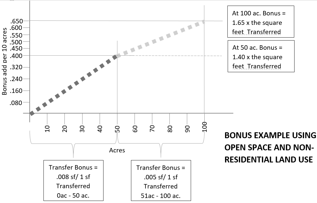
(1)
Open space. For public land up to 50 ac., 0.008 sf. will be added to each square foot of severed non-residential use at transfer or .005 residential units will be added to each severed residential unit at transfer for each acre of open space.
For public land between 51 ac. and 100 ac.: The first 50 acres shall be calculated based on the above specified transfer rate applicable up to 50 acres. For additional acreage, over 50 acres, 0.005 sf. added will be added to each square foot of severed non-residential use at transfer or .003 residential units will be added to each severed residential unit at transfer for each acre of open space over 50 ac.
For public land over 100 acres: The transfer rate shall be determined by town council.
(2)
Public facility and preservation land. Public land ten ac. or less: 0.02 sf. added to each square foot of the severed non-residential use at transfer or 0.02 residential units added to each permitted residential unit at transfer for each acre of public facility site or preservation site that is ten ac. or less. Where public land for a public facility or preservation is greater than ten ac. the eligible transfer bonus shall be as follows:
a.
For public land from 11 to 50 ac.: 0.005 sf. will be added to each square foot of severed non-residential use at transfer or .005 residential units will be added to each severed residential unit at transfer for each acre of public facility or preservation land greater than ten ac.
b.
For public land from 51 to 100 ac.: The first 50 acres shall be calculated based on the above specified transfer rates applicable to ten acres and between ten and 50 acres. For additional acreage, over 50 acres, 0.004 sf. added will be added to each square foot of severed non-residential use at transfer or .004 residential units will be added to each severed residential unit at transfer for each acre of public facility or preservation land over 50 ac.
c.
For public land over 100 acres: The transfer rate shall be determined by town council.
(d)
When the public land set aside is an open space and advances the plan of Westlake Academy, the final bonus non-residential square footage or residential units added to the transfer may increase by 15 percent.
(e)
When the applicant for a severance or a transfer supports the Westlake Public Art Program in any of the following ways, the applicant shall qualify for a bonus under this bonus Section:
(1)
When the applicant is a sponsor of a public art competition event and assumes the financial costs thereof (including prize awards), that applicant may receive a bonus at transfer of the severed development intensity equal to 15 percent of the severed intensity or an additional 15 percent bonus added to any bonus received in accordance with item "C" or "D," above (whichever constitutes the larger bonus benefit.)
(2)
When the applicant donates to the acquisition of public art or acquires public art for the benefit of the town and that acquisition is approved and supported by the town manager, or designee, and the value of that acquisition is equal to, or greater than, the normal cost of sponsoring a "competition event" (described in "a."); that applicant may receive a bonus at transfer of severed development intensity equal to 15 percent of the severed intensity or an additional 15 percent bonus added to any bonus received in accordance with item "C" or "D," above (whichever constitutes the larger bonus benefit.).
(f)
If the severance or transfer includes a bonus for setting land aside as public land, the bonus transfer can be acted upon simultaneously with such measures that the town deems acceptable and sufficient to establish the public land set aside and its use.
(Ord. No. 817, § 2, 1-23-2017)
Sec. 102-294. - Relationship to zoning.
(a)
Development intensity may only be increased within a designated receiving district through a transfer of development intensity from a designated sending district. An increase of development intensity through any means other than a transfer of development intensity, approved by the town council, is prohibited without measures by a property owner to assure that there will be an increased vehicular capacity in the town thoroughfare system, as presented in the town's official thoroughfare plan, required to accommodate an increase in the town's aggregate average daily trips (ADT's), generated by existing entitlements, or needed to prevent any change in the existing threshold level of service (LOS) to LOS E or higher at various intersections of the regional arterials and town arterials (as identified in the town's official thoroughfare plan).
(b)
Only a property zoned as a planned development is eligible to participate in the TDI program presented in this division. Any property not zoned as a PD may make application to the town to have the development rights currently conveyed through categorical zoning reauthorized in the form of a planned development ordinance which meets the requirements of this chapter.
(Ord. No. 817, § 2, 1-23-2017)
Sec. 102-295. - Conversion.
When the development intensity severed is associated with a land use that is permitted in a sending district PD/PD planning area but not permitted in the receiving district PD/PD planning area to which a transfer is requested, then the sending area development intensity must be converted to an equivalent development intensity associated with a land use permitted in the receiving district. The process of conversion requires:
(1)
Determination of the conversion rate. Exhibit D shows the conversion rate for a base land use (column A, vertical axis) for each land use listed in conversion land use (row A, horizontal axis). The conversion rate to use in calculation of the conversion is that rate specified in the cell where the base land use and the conversion land use intersect.
(2)
Calculation of the equivalent development intensity. The number of non-residential square footage and/or the residential units severed must be multiplied by the applicable conversion rate to establish an equivalent development intensity.
(3)
Calculation of applicable bonus. If a bonus is applicable due to the set aside of public land, then the bonus shall be added to the development intensity associated with the base land use.
(4)
Disclosure of calculation. All calculations and identification of land uses used to determine the equivalent development intensity must be full documented in any application for transfer.
(Ord. No. 817, § 2, 1-23-2017)
Sec. 102-296. - Approval of a development plan associated with a transfer constitutes an amendment.
(a)
The council approval of a transfer constitutes the following:
(1)
Approval of the affixation of a specified amount of severed development intensity to a specific PD/PD planning area provided that the additional development intensity is applied to identical land uses permitted by the planned development entitlement in both the sending district PD/PD planning area and the receiving district PD/PD planning area, or a sending district development intensity that has been converted to an equivalent development intensity associated with a land use permitted in the receiving district PD/PD planning area.
(2)
Approval of the "development plan" required with each transfer or severance constitutes an amendment/variance of certain existing development provisions of the planned development entitlement (except land use) when such amendments/variances are identified in the development plan, required as part of the transfer and/or severance application.
(b)
The PD amendment/variance granted through approval of the development plan is only applicable for the property included in that development plan for which requested amendments/variances are identified. All other properties (lots, parcels, or tracts) must comply with the conditions of the planned development entitlement. Any PD condition that is not addressed by the development plan shall remain in force as specified by the entitlement ordinance. Land uses permitted by the PD/PD planning area may only be amended through rezoning.
(Ord. No. 817, § 2, 1-23-2017)
Sec. 102-297. - TDI process and recordation of approved TDI's.
(a)
Initiation of the TDI process/determination of eligibility for TDI consideration. Upon inquiry by a land owner, said TDI process shall begin with a pre-application meeting with the owner(s) of the proposed sending and receiving PD's. This pre-application meeting is to determine eligibility for participation in the TDI process. Following this pre-application meeting, a written determination shall be made by the town manager or designee as to the eligibility of the property in question to participate for consideration under the TDI process and certification that the PD/PD planning area in which the property is located is a sending district or receiving district (designated sending districts and receiving districts are identified in exhibit C. If found ineligible to participate in the TDI process, the owners of the land in the PD/PD planning area's in question may instead, at their option, apply for a zoning change. If certification as a sending district or a receiving district is not deemed by the town manager or designee as possible at the administrative level, the owners of the property in question may seek designation by the town council.
(b)
Application for TDI. If the property in question is found to be eligible by the town manager, under the criteria established herein, for participation in the TDI process and a written determination has been issued so stating that the owner(s) of the subject property are found eligible, then the property owner may submit a TDI application that, as a minimum, shall contain the following information:
(1)
Sending and/or receiving PD/PD planning area — A specific field note description and map of the sending and (if the severance request includes a transfer) receiving PD/PD planning area.
(2)
A specific, quantifiable description of the development intensity associated with permitted uses effected by this severance or transfer and calculations of what the corresponding reduction in development intensity will be for the sending district and what the corresponding increase in development intensity will be for the receiving district and showing how there is no net increase in approved overall eligible development intensity as a result of this transfer except as may be the result of providing public land as described in section 6(b) [of the ordinance from which this division is derived].
(3)
A development plan showing the total impact of the transfer, specifically including:
a.
All information required for PD site plans as set out in that district's establishment ordinance (as may be amended), and
b.
Where applicable as determined by the town manager or designee, all information required for development plans as set out in the town's general PD regulations, and
c.
The layout and specific requirements of proposed PD/PD planning area amendments/variances needed to accommodate changes to the sending and receiving districts as would be effectuated by the TDI including, but not limited to, location of building envelopes, parking, open space and park land and where applicable, public land. Land use is not a permitted amendment or variance.
d.
The percentage of total building envelope that is occupied by the transfer and/or documents the development intensity severed from and remaining within the sending district PD/PD planning area.
e.
Any and all variances from the regulating PD Ordinance that are necessary to implement the transfer development plan as shown.
f.
Any and all public land set asides that are part of the severance and/or transfer transaction.
g.
Building height, building square footage and/or number of residential units.
h.
T.I.A. as applicable in accordance with Ordinance No. ____.
(c)
Additional information as may be required. The town manager or designee is authorized to require additional information from the TDI applicant as may be needed to determine if the proposed application comports to the comprehensive plan or as needed to present this matter to the town planning and zoning commission and town council.
(d)
Master TDI log. The town manager or designee shall develop all necessary administrative processes and forms to accurately track all applications for severance or transfer of any and all approved TDI's and any special conditions attached thereto. The town manager or designee shall have maintained a master list of all approved TDI applications to ensure that:
(1)
No approved TDI transfer application represent a net increase in the development intensity permitted by the regulating PD Ordinance(s) when considering both sending and receiving zoning districts in aggregate in any TDI application unless a development intensity bonus has been granted to the transfer for providing public land as specified in this division.
(2)
At no time will any approved TDI application achieve a net increase in development intensity permitted by the regulating PD ordinances for all PD/PD planning area's in the town, considered in aggregate, unless a development intensity bonus has been granted to the transfer for providing public land as specified in this division.
(Ord. No. 817, § 2, 1-23-2017)
Sec. 102-298. - Required public hearing and notices.
(a)
Public process for TDI consideration. Once the proposed TDI application is deemed complete by the town manager or designee, public hearings shall be scheduled for consideration of the TDI application before both the planning & zoning commission (commission) and the town council (council). Notices for said TDI public hearings before the commission and the council shall be provided in accordance with proposed zoning change notice requirements. Proposed TDI applications scheduled for commission and council consideration will be brought forward with a staff recommendation that includes how this application comports to the comprehensive plan. The commission will conduct the first public hearing on any proposed TDI application. Following this public hearing, the commission shall make a recommendation to the council regarding the proposed TDI application. The council, following conduct of its public hearing on the proposed TDI application, shall approve, modify, or disapprove said application.
(b)
Approval of a TDI shall be done by adoption of a zoning ordinance amendment that contains, as a minimum, the following information:
(1)
Location of the sending and receiving PD/PD planning area's with field note description and map of the sending PD/PD planning area and receiving PD/PD planning area's.
a.
A specific, quantifiable description of the approved use associated development intensity transferred by the TDI and calculations of the corresponding reduction in development intensity for the sending district and the corresponding increase in development square intensity for the receiving district, and showing how there is no net increase in the vehicular volume associated with permitted development in aggregate for these specific districts, with this transfer, unless a development intensity bonus has been granted to the transfer for providing public land as specified in this division.
(2)
An amended development plan showing:
a.
All information required for PD site plans as set out in that district's establishment ordinance (as may be amended), and
b.
Where applicable, all information required for development plans as set out in the town's general PD regulations, and
c.
How the development plan is now amended to accommodate changes to the sending and receiving districts as effectuated by the TDI including, but not limited to, location of building envelopes, parking, open space and park land, and
d.
Any public land set asides (by any means described in section 6 [of the ordinance from which this division is derived]), if applicable.
(Ord. No. 817, § 2, 1-23-2017)
Exhibit A: Building Envelope
* When the Town Council determines that an area not already identified as a Receiving District shall be a Receiving District, the Building Envelope Aspects shall be established at the time of such determination and this Exhibit shall be amended to include the new Receiving District.
** The suitable height specified herein may be adjusted by the Town Council in conjunction with the approval of a Transfer Request.
*** Single-Family density in the Regional Commercial Land Use Setting shall be determined by the Town Council in conjunction with the approval of a Transfer Request.
(Ord. No. 817, § 2, 1-23-2017)
Exhibit B: Eligible Development Intensity
* Eligible development intensity is the difference between the development intensity specified in this exhibit and any portion of that development plan, PD site plan, approved transfer of severance, or building permit.
** Per ordinance 202 as may be amended or replaced by council action.
(Ord. No. 817, § 2, 1-23-2017)
Exhibit C: Sending, Receiving and Dual Eligibility Districts
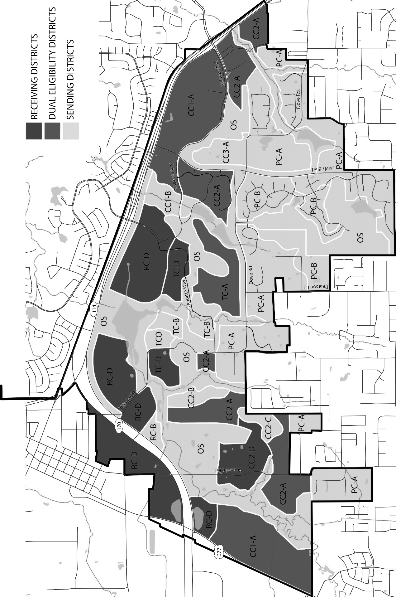
(Ord. No. 817, § 2, 1-23-2017)
Exhibit D: Conversion Rates
new use/existing use
new use/existing use
* Multi-family may be converted to any use presented in the table, but no use may be converted into multi-family.
** Data center conversions in exhibit E.
(Ord. No. 817, § 2, 1-23-2017)
Exhibit E: Conversion Rates for Data Centers (DRAFT)
* Office campus conversion ratio used for conversion of other uses into data center.
Ratios above should be read as sf of data center/sf. of existing use.
(Ord. No. 817, § 2, 1-23-2017)