
Wilmington City Zoning Code
TITLE ONE
SUBDIVISION REGULATIONS1
Editor's note—Ord. No. O-24-45, § 2(Exh. A), adopted Oct. 3, 2024, repealed the former Tit. One, Ch. 1111, §§ 1111.01—1111.99, Ch. 1113, §§ 1113.01, 1113.02, Ch. 1115, §§ 1115.01—1115.11, Ch. 1117, §§ 1117.01—1117.04, Ch. 1119, §§ 1119.01, Ch. 1121, §§ 1121.01, 1121.02, Ch. 1123, §§ 1123.01, 1123.02, Ch. 1125, §§ 1125.01—1125.10, Ch. 1127, §§ 1127.01—1127.06, and enacted a new Tit. One as set out herein. The former Tit. One pertained to similar subject matter and derived from Ord. No. 3587, 7-20-95, Ord. No. 3698, 8-15-96, Ord. No. 5111, 9-19-13.
CHAPTER 1111.- GENERAL PROVISIONS[2]
Cross reference— Authority to adopt Subdivision Regulations - see Ohio R.C. 711.101; Violation of rules and regulations - see Ohio R.C. 711.102; Definitions - see P. & Z. Ch. 1125; Variances and Appeals - see P. & Z. Ch. 1117
CHAPTER 1113. - SUBDIVISION PROCEDURES[3]
Cross reference— Fee of designated public land to vest when plat recorded - see Ohio R.C. 711.01, 711.07; Plat acknowledgement and recording - see Ohio R.C. 711.06; Planning Commission established - see Ohio R.C. 713.01; Planning Commission powers and duties - see Ohio R.C. 713.02, 713.06; Minor Subdivisions - see P. & Z. Ch. 1115
CHAPTER 1117. - VARIANCES AND APPEALS[4]
Cross reference— Planning Commission as platting authority - see P. & Z. 1111.03
CHAPTER 1121. - SUBDIVISION DESIGN STANDARDS[5]
Cross reference— Street improvements - see P. & Z. 1123.02; Sanitary sewer improvements - see P. & Z. 1123.03; Water system improvements - see P. & Z. 1123.04
CHAPTER 1123. - SITE IMPROVEMENTS[6]
Cross reference— Street design standards - see P. & Z. 1121.04; Sanitary sewer design standards - see P. & Z. 1121.06; Water line design standards - see P. & Z. 1121.07; Street width and grades - see Chapter 300 of the City of Wilmington Standard Construction Drawings and Specifications Manual.
CHAPTER 1125. - DEFINITIONS[7]
Cross reference— Plat and subdivision defined - see Ohio R.C. 711.001.
Sec. 1111.01. - Purpose.
The purpose of these Subdivision Regulations shall be to promote and protect the public health, safety, and general welfare by:
(1)
Establishing standards of design which will promote a healthful and stable community;
(2)
Providing safe and convenient traffic circulation;
(3)
Assuring efficient, adequate, and economic supply of utilities and public services;
(4)
Providing ample open spaces for schools, recreational and other public purposes; and
(5)
Obtaining accurate surveying of land, and to coordinate land development in accordance with the zoning regulations, thoroughfare plan and other plans of the City.
(Ord. No. O-24-45, § 2(Exh. A), 10-3-24)
Sec. 1111.02. - Jurisdiction.
The rules and regulations governing subdivisions of land contained herein shall apply to the real estate within the incorporated boundaries of the City of Wilmington.
(Ord. No. O-24-45, § 2(Exh. A), 10-3-24)
Sec. 1111.03. - Administration.
The City Planning Commission is hereby designated as the platting authority of and for the City and is charged with the duty of making investigations and recommendations on the design and improvement of proposed subdivisions, and is hereby authorized to approved, conditionally approved, or disapproved proposed subdivisions.
(Ord. No. O-24-45, § 2(Exh. A), 10-3-24)
Sec. 1111.04. - Effective dates.
(a)
These Subdivision Regulations shall be effective upon their adoption by the City Council. Any preliminary plat which does not comply with these regulations shall not be approved after the effective date. No final plat which does not comply with these regulations shall be approved after the effective date, whether a preliminary plat for such subdivision has been approved prior to the effective date of these regulations.
(b)
The official submittal date of the plat for a major or minor subdivision shall be considered the date of the meeting of the Planning Commission in which the plat of the subdivision is first discussed. On that date, the statutory period required for formal approval or disapproval shall commence.
(Ord. No. O-24-45, § 2(Exh. A), 10-3-24)
Sec. 1111.05. - Relation to other laws.
The provisions of these Subdivision Regulations shall supplement any and all laws of the State of Ohio, other codes and ordinances of the City, and/or any and all rules and regulations formulated by authority of such law or ordinance relating to the purpose and scope of these regulations. Whenever the requirements of these regulations are at variance with the requirements of the Zoning Code or any other adopted ordinance of the City, the provisions of the most restrictive of such ordinances or laws shall govern.
(Ord. No. O-24-45, § 2(Exh. A), 10-3-24)
Sec. 1111.06. - Severability.
If any part, section, provision, clause, or portion of these Subdivision Regulations is adjudged invalid or unconstitutional, such invalidity or unconstitutionality shall not affect the validity or constitutionality of these Subdivision Regulations as a whole, or of any other part or section.
(Ord. No. O-24-45, § 2(Exh. A), 10-3-24)
Sec. 1111.07. - Penalty.
Any person who violates any provision of these Subdivision Regulations shall be served by the City Service Director with written notice, stating the nature of the violation and providing a reasonable time limit for the satisfactory correction thereof. The offender shall, within the period of time stated in such notice, permanently cease all violations. Any person who continues any violation beyond the time limit provided for herein shall be guilty of a minor misdemeanor on the first offense. Any person who is found guilty of two or more violations of these Subdivision Regulations shall be guilty of a misdemeanor of the fourth degree. A separate offense shall be deemed committed each day during or on which an offense occurs or continues.
(Ord. No. O-24-45, § 2(Exh. A), 10-3-24)
Sec. 1111.08. - Fees.
(a)
The City Council shall establish a schedule of fees applicable to the filing of plats for both major and minor subdivisions and for any other submission pertaining to these regulations. The fee schedule may be amended from time to time by approval of the City Council.
(b)
Until all applicable fees have been paid in full, no action shall be taken on any application for approval of plats regarding these regulations.
(c)
The applicant shall be responsible for the actual cost to the City of all inspections, engineering review, and testing of materials and soil for the subdivision whether performed by the City or others. Such costs may be billed to the subdivider periodically as the work progresses and/or the Director of Public Services may require a deposit to cover such costs.
(d)
Plats shall not be recorded until all required fees are paid by the applicant.
(Ord. No. O-24-45, § 2(Exh. A), 10-3-24)
Sec. 1113.01. - Purpose.
The purpose of this chapter is to establish the procedure for review and approval of subdivisions, planned unit developments, and similar large-scale developments as authorized under Ohio R.C. 711.
(Ord. No. O-24-45, § 2(Exh. A), 10-3-24)
Sec. 1113.02. - Applicability.
(a)
All persons or corporations proposing to make an application for a subdivision within the City, or has made an application for a subdivision within the City, shall not enter into any contract for the sale of such subdivision, or any part thereof, or proceed with any construction work on the proposed subdivision, including grading, until approval of the preliminary plat of the subdivision by the Planning Commission and approval of construction plans by the City Service Director have been obtained.
(b)
The approval of the final plat by the Planning Commission shall not constitute or effect an acceptance by the public of the responsibility for construction or maintenance of any street, other proposed public way, space shown on such plat, or any other improvements.
(c)
Approval of the final plat by the Planning Commission shall not authorize a waiver of any officially adopted design and construction requirements which may have been inadvertently omitted during the technical review of the final plat.
(Ord. No. O-24-45, § 2(Exh. A), 10-3-24)
Sec. 1113.03. - Overview.
The subdivision procedure shall conform to the following steps, as indicated on the flow chart, and which are further explained in the following sections.
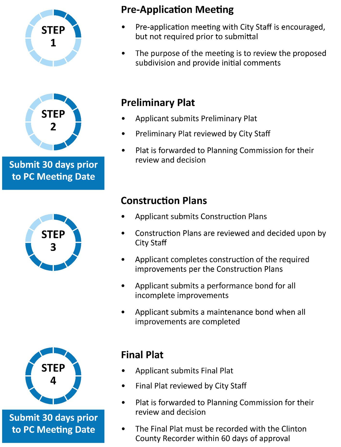
(Ord. No. O-24-45, § 2(Exh. A), 10-3-24)
Sec. 1113.04. - Pre-application meeting (Step 1).
(a)
Prior to submitting the primary plat, the applicant is encouraged to meet with the City Service Director.
(b)
The purpose of the pre-application meeting is to:
(1)
Discuss the proposed subdivision layout;
(2)
Review the design, development, and submittal requirements; and
(3)
Discuss the location of existing and proposed public facilities including roadways, utilities, parks, playgrounds, sidewalks, drainage facilities, etc.
(Ord. No. O-24-45, § 2(Exh. A), 10-3-24)
Sec. 1113.05. - Preliminary plat (Step 2).
(a)
Submission.
(1)
The applicant shall apply for a preliminary plat of the proposed subdivision to the Secretary of the Planning Commission 30 days prior to the date of the Planning Commission's meeting.
(2)
The submitted preliminary plat shall include all information required in the application.
(b)
Review by staff.
(1)
Once the preliminary plat is submitted, the Secretary of the Planning Commission will transmit copies to the City Service Director who will determine whether the application and plat are complete.
(2)
The preliminary plat will be reviewed for compliance with the master plan of the City, the Ohio Revised Code, the Subdivision Regulations herein, the Planning and Zoning Code for the City, and any other applicable regulations.
(3)
The City Service Director may transmit copies of the preliminary plat to other City departments or consultants to the City for their review. Any comments produced shall be transmitted to the applicant to allow for plan revisions. Any outstanding issues shall be forwarded to the Planning Commission for their consideration.
(c)
Review and decision by Planning Commission.
(1)
The preliminary plat shall be forwarded to the Planning Commission for their review and decision once the application has been deemed complete and following the review by any other City departments or consultants to the City.
(2)
The Planning Commission shall review and approve, approve with conditions, or disapprove the submitted preliminary plat. The Planning Commission shall make their determination within 45 days of the official submission of the plat which shall be the date on which the Planning Commission first considers the plat at a meeting.
(d)
Following the approval.
(1)
After approval of the preliminary plat by the Planning Commission, the City Service Director may modify any engineering or construction details proposed by the applicant, whenever required for the protection of the public interest.
(2)
The preliminary plat is valid for two years from the date of approval.
(Ord. No. O-24-45, § 2(Exh. A), 10-3-24)
Sec. 1113.06. - Construction plans (Step 3).
(a)
Submission.
(1)
Following the approval of the preliminary plat, the applicant shall prepare construction and grading plans, specifications, and cost estimates of the required site improvements.
(2)
The items of the estimates shall be grouped as follows:
a.
Street and parking area improvements, including curb, pavement, sidewalks, street lighting, and storm drainage;
b.
Water mains, including lines, valves, and hydrants;
c.
Sanitary sewers, including manholes, Y's, Tee's, and cleanout; and
d.
Site improvements, including seeding and sodding.
(3)
All improvements and utilities will be satisfactorily installed within one year from the date of approval of the construction plans or within such time schedule as presented and approved by Council as part of the final plat approval.
(b)
Required improvements. The owner or their designee shall provide and pay the entire cost of improvements, except as agreed upon through a public-private partnership or a development agreement. The improvements shall meet the requirements of the City Standard Plans and Specifications as adopted by City Council. The required improvements are as follows:
(1)
Streets and parking areas, graded full width and paved, including drainage structures, bridges, sidewalks, and curbing;
(2)
Sanitary sewers, including manholes, services, and all appurtenances;
(3)
Water distribution system including mains, services, valves, fire hydrants, and all other appurtenances;
(4)
Monuments and stakes;
(5)
Street signs designating the name of each street at each intersection within the development. Street signs shall conform to the standards established by the City;
(6)
Street lighting including poles, underground conduits, and appurtenances;
(7)
Utilities, including electric and cable television services;
(8)
Any temporary facilities or improvements as required by the Planning Commission and City Service Director;
(9)
All other improvements shown on the plans as approved by the City Service Director;
(10)
Streets, water mains, sanitary sewers, and storm sewers as described above shall be extended by the owners across the full length or width of the subdivision properties and all adjacent properties of the owners in a manner to be determined by the City Service Director, exempting only such properties of the owner as are outside the proposed subdivision and which in the opinion of the City Service Director would create an extraordinary hardship for the owner.
(c)
Review and decision by staff. Lots, parcels, and tracts shall not be transferred from the proposed development, nor shall any construction work on such development, including grading, be started that may affect the arrangements of public streets or other public improvements until the construction plans have been reviewed and approved by the City Service Director.
(d)
Bonding requirements.
(1)
To guarantee the construction of required improvements prior to the approval and recording of the final plat, the developer shall be required to provide a performance bond per Section 1119.02.
(2)
To guarantee the maintenance of required improvements prior to the approval and recording of the final plat, the developer shall be required to provide a maintenance bond per Section 1119.03.
(Ord. No. O-24-45, § 2(Exh. A), 10-3-24)
Sec. 1113.07. - Final plat (Step 4).
(a)
Submission.
(1)
The applicant shall apply for the final plat of the proposed subdivision to the Secretary of the Planning Commission 30 days prior to the date of the Planning Commission's meeting.
(2)
Any application for a final plat shall be submitted within two years of the date of approval of the preliminary plat.
(3)
The submitted final plat shall include all information required in the application.
(b)
Review by staff.
(1)
Once the preliminary plat is submitted, the Secretary of the Planning Commission will transmit copies to the City Service Director who will determine whether the application and plat are complete.
(2)
The final plat will be reviewed by the City Service Director and forwarded to the Planning Commission once it has been determined that:
a.
The final plat conforms to the provisions of the Ohio Revised Code and the Subdivision Regulations contained herein;
b.
The final plat is consistent with the preliminary plat and any modifications made by the Planning Commission;
c.
Satisfactory provisions have been made regarding site improvements and costs as required in Section 1113.06.
(3)
The City Service Director may transmit copies of the final plat to other City departments or consultants to the City for their review. Any comments produced shall be transmitted to the applicant to allow for plan revisions. Any outstanding issues shall be forwarded to the Planning Commission for their consideration.
(c)
Review and decision by Planning Commission.
(1)
The final plat shall be forwarded to the Planning Commission for their review and decision once it has been determined that:
a.
The final plat conforms to the provisions of the Ohio Revised Code and the Subdivision Regulations contained herein;
b.
The final plat is consistent with the preliminary plat and any modifications made by the Planning Commission;
c.
Satisfactory provisions have been made regarding site improvements and costs as required in Section 1113.06.
(2)
The Planning Commission shall review and approve, approve with conditions, or disapprove the final plat. The Planning Commission shall make their determination within 45 days of the official submission of the plat which shall be the date on which the Planning Commission first considers the plat at a meeting.
(3)
If the Planning Commission fails to act upon the final plat within 30 days after the submission of the plat for approval or within an extended timeframe as agreed to by the applicant, the final plat shall be considered approved.
(4)
Approved final plats shall be signed by the Secretary of the Planning Commission.
(d)
Recording of plat. Within 60 days following the approval of the final plat by the Planning Commission, the plat shall be filed and recorded by the applicant in the office of the Clinton County Recorder. The applicant shall submit the City of Wilmington with proof of recording. Lots shall not be sold until the final plat has been recorded.
(e)
Invalidation of the plat. The following shall render the approval of the final plat by the Planning Commission null and void:
(1)
Failure by the applicant to file and record the final plat in the office of the Clinton County Recorder within the timeframe specified by Section 1113.07(d).
(2)
Modifying the final plat after approval of the Planning Commission.
(f)
Appeals. Any party may appeal a decision of the Planning Commission to City Council after filing formal notice of such appeal with the Clerk of Council within ten days after such action by the Commission. Such appeal shall be heard by City Council at the first regular meeting occurring at least 15 days after the appeal is filed.
(Ord. No. O-24-45, § 2(Exh. A), 10-3-24)
Sec. 1113.08. - Modifications due to hardships.
(a)
Where the Planning Commission finds that extraordinary and unnecessary hardship may result from strict compliance with these Subdivision Regulations, due to exceptional topographic or other physical limitations of the particular land involved, the Planning Commission may vary the regulations so as to relive such hardship. The varied standards shall meet the following criteria:
(1)
There will not be any detriment to the public interest;
(2)
It will not impair the intent and purpose of these Subdivision Regulations; and
(3)
It will not disrupt the desirable development of the neighborhood and community in accordance with the City's adopted Comprehensive Plan, Thoroughfare Plan, Zoning Code, and any other adopted codes or plans.
(b)
The Planning Commission shall record any modification granted in the official minutes of the Board, setting forth the reasons which the requested modification is justified.
(Ord. No. O-24-45, § 2(Exh. A), 10-3-24)
Sec. 1115.01. - Minor subdivision.
(a)
Purpose. The purpose of a minor subdivision is to allow for small-scale subdivisions that will not result in new public roads or major extensions of infrastructure.
(b)
Applicability.
(1)
A subdivision is a minor subdivision if it meets all of the following conditions:
a.
The subdivision will result in no more than five lots after the original tract has been completely subdivided;
b.
The tract to be subdivided is five acres or less;
c.
The subdivision will occur along an existing public street;
d.
The subdivision will not result in the opening, widening, extension or improvement of any roadway, or installation of any public utilities;
e.
The subdivision complies with the Zoning Code, the Subdivision Regulations contained herein, and the City's Thoroughfare and Open Space Plan.
(2)
Minor subdivisions include lot splits or lot consolidations that conform to the regulations.
(c)
Review and decision by Minor Subdivision Review Committee.
(1)
Minor subdivision applications shall be submitted to the Building and Zoning Department. Such applications shall be approved or disapproved by the Minor Subdivision Review Committee, as established in the Planning and Zoning Code, within seven days of submission.
(2)
In addition to the minor subdivision application, only such drawings and information as determined necessary by the Committee to determine compliance with pertinent platting, zoning, and other regulations needed to be submitted for approval.
(3)
If a minor subdivision does not meet all requirements set forth in these Subdivision Regulations, it shall be forwarded to the Planning Commission for their review and decision.
(d)
Recording of plat.
(1)
Within 60 days following the approval of the minor subdivision, including lot splits and lot consolidations, by the Minor Subdivision Review Committee, the plat shall be filed and recorded by the applicant in the office of the Clinton County Recorder. The applicant shall submit the City of Wilmington with proof of recording.
(e)
Invalidation of the plat. The following shall render the approval of the final plat by the Planning Commission null and void:
(1)
Failure by the applicant to file and record the final plat in the office of the Clinton County Recorder within the timeframe specified by Section 1115.01(d).
(Ord. No. O-24-45, § 2(Exh. A), 10-3-24)
Sec. 1115.02. - Replats.
(a)
Any minor subdivision that involves the consolidation of lots or the adjustment of boundaries between lots that are located within existing platted subdivisions shall be subject to the review and approval of the City Service Director.
(b)
Any subdivision of land within a previously platted subdivision which results in one to five additional conforming lots shall be subject to the review and approval of the City Service Director.
(c)
Any subdivision of land within a previously platted subdivision which results in six or more additional lots shall adhere to the subdivision requirements as set forth in Chapter 1113.
(Ord. No. O-24-45, § 2(Exh. A), 10-3-24)
Sec. 1117.01. - Variances.
The following regulations shall govern the granting of variances:
(1)
Where the Planning Commission finds that extraordinary and unnecessary hardship may result from strict compliance with these Subdivision Regulations, due to exceptional topographic or other physical limitations of the particular land involved, it may vary the regulations so as to relieve such hardship, provided such relief may be granted without detriment to the public interest and without impairing the intent and purpose of these regulations or the desirable development of the neighborhood and community. Such variances shall not have the effect of nullifying the intent and purpose of these regulations, the master plan, or the Zoning Code. Any variance which is approved shall represent the minimum or least possible modification of the standard or standards in question which alleviate the hardship.
(2)
Additionally, the requirements of these regulations may be modified when a plat is submitted for a complete community or neighborhood, which ensures that adequate public spaces, circulation, recreation, light and air will be provided, and the needs of the entire community or neighborhood will be met, provided such modifications are consistent with the master plan for the City.
(3)
In granting variances or modifications, the Commission may require such conditions as will, in its judgment, secure substantially the objective of the standards or requirements so varied or modified.
(4)
The Commission, at its discretion, may waive any or all of the City's subdivision standards and substitute the current standards of the Clinton County Subdivision Regulations for subdivisions outside the City corporation limits in such cases where the Commission deems that the proposed subdivision is clearly beyond the growth pattern of the City. The Commission shall consult the City Master Plan as a significant guide in making such determination.
(Ord. No. O-24-45, § 2(Exh. A), 10-3-24)
Sec. 1117.02. - Appeals.
Any party may appeal a decision of the Planning Commission to Council after filing formal notice of such appeal with the Clerk of Council within ten days after such action by the Commission. Such appeal shall be heard by Council at the first regular meeting occurring at least 15 days after the appeal is filed.
(Ord. No. O-24-45, § 2(Exh. A), 10-3-24)
Sec. 1119.01. - General requirements.
(a)
To guarantee the construction and/or maintenance of required improvements prior to the approval and recording of the final plat, the applicant shall be required to provide a performance guarantee in accordance with the following:
(1)
Performance bonds and maintenance bonds shall be approved by the City Law Director. The applicant shall post a bond, by a surety company, in accordance with the terms as noted herein. Under no circumstances shall the required performance bond be tied to, or be considered a portion of, the applicant's financing for the development. Any refinancing, restricting, expiration, sale, or transfer of a developer's debt or obligations related to these performance guarantees must be approved in advance by the City Law Director.
(2)
The applicant may make a deposit with the City, with an escrow agent, or a trust company approved by the City Law Director.
(3)
Any and all performance guarantee measures detailed herein shall be in the favor of the City, and the City may utilize these guarantees for the construction and maintenance of the improvements as well as the ongoing removal of ice and snow from the dedicated roadways according to the approved construction plans. In addition to the performance guarantee, the developer shall carry liability and other insurance as appropriate in the minimum amount of $1,000,000.00.
(Ord. No. O-24-45, § 2(Exh. A), 10-3-24)
Sec. 1119.02. - Performance bonds.
(a)
Submittal of the performance bond. All improvements must be completed according to the approved construction plans before the final plat is signed and recorded. If not all improvements are completed, the applicant shall submit a performance bond in compliance with the following:
(1)
The applicant shall post a performance bond in the amount of 130 percent of the estimated cost of all incomplete improvements plus 20 percent of the estimated cost of all completed improvements.
(2)
The applicant shall post a separate performance bond in an amount equal to the estimated cost plus 30 percent of all temporary facilities and improvements required by the Planning Commission and City Service Director.
(3)
Once the bond has been posted, the final plat may be signed and recorded.
(4)
The performance bond shall be in conformance with the type of bond and requirements in Section 1119.01.
(b)
Release of the performance bond. After all the construction work is completed, it shall be inspected by the City to ensure that the work has been correctly performed. Any deficiencies shall be recorded, and a list forwarded to the applicant for correction. Once the deficiencies have been corrected and checked by the City, a maintenance bond shall be posted, and the performance bond released. In no case shall the performance bond exceed two years.
(Ord. No. O-24-45, § 2(Exh. A), 10-3-24)
Sec. 1119.03. - Maintenance bonds.
(a)
Submittal of the maintenance bond.
(1)
After all the construction is complete and approved by the City Service Director, the applicant must maintain and keep in good repair all improvements for a period of one year, known as the maintenance period.
(2)
The applicant shall post with the City a maintenance bond to secure the required maintenance of the improvements. The bond excludes ordinary wear and tear but includes:
a.
Any and all defects and deficiencies in workmanship and materials;
b.
The cost of all labor, materials, equipment, and other incidentals required to maintain, repair, and replace any or all of such improvements and to maintain them in good and proper condition; and
c.
Filling trenches and restoring lawns, sidewalks, yards, streets, sewer pipelines, vales, boxes, etc.
(3)
The City Service Director is authorized to permit the applicant, or their successors, to transfer from the performance bond period to the maintenance bond period if all the improvements have been completed in accordance with all of the conditions of the performance bond. In no case shall a subdivision be accepted for maintenance without all improvements being completed per the approved construction plans.
(4)
The applicant shall post a performance bond in the amount of five percent of the total cost of the improvements.
(b)
Release of the maintenance bond.
(1)
At the termination of the one-year maintenance period, the subdivision shall again be inspected by the City. Any issues that are identified will be forwarded to the applicant for correction.
(2)
It shall be the responsibility of the applicant to request such an inspection. If the inspection is not requested, the maintenance period shall not expire, and the applicant shall be responsible for all defects found in the subdivision whether or not the one-year period has expired.
(3)
If the inspection is requested and when all defects have been corrected, a request shall be submitted to the City Council for the acceptance of the subdivision.
(4)
The final release of all maintenance bonds shall be by approval of the City Law Director, following subdivision acceptance.
(Ord. No. O-24-45, § 2(Exh. A), 10-3-24)
Sec. 1121.01. - General applicability.
(a)
Conformity with standards. The design standards and requirements of this chapter shall apply to all subdivisions of land as defined in Chapter 1123. All public improvements undertaken in any subdivision shall conform to the improvement standards of this chapter and the City Standard Plans and Specifications.
(b)
Streets. The arrangement, character, width and location of all arterial and collector thoroughfares or extensions thereof shall conform to the thoroughfare plan. The Planning Commission shall have the authority and responsibility to interpret both the text and maps of the thoroughfare plan to determine the most appropriate precise locations and alignments for proposed thoroughfares, to select from among alternatives, and to provide for appropriate substitutions and additions. Thoroughfares not contained in said plan shall conform to the recommendations of the Commission based on the design standards set forth in this chapter and Chapter 1123, and on currently accepted levels of quality for neighborhood and site planning and design as supported by publications of the American Planning Association or other professionally recognized urban planning organizations as such publications are interpreted by the Commission.
(c)
Zoning. No final plat of land within the area in which an existing Zoning Code or resolution is in effect shall be approved unless it conforms with such code or resolution.
(Ord. No. O-24-45, § 2(Exh. A), 10-3-24)
Sec. 1121.02. - Land suitability.
If the Planning Commission finds that land proposed for subdivision development is unsuitable due to flooding, poor drainage, topography, inadequate public facilities and/or other condition that may be detrimental to the general health, safety or welfare of the public, and if it is determined that the land should not be developed for the purpose proposed, the Commission shall not approve such subdivision unless adequate methods are proposed by the applicant/owner for alleviating the problems that would be created by development of the land.
(1)
Land subject to flooding. The Commission shall not allow subdivision of land or lands subject to flooding, as defined in Chapter 1125, unless the following requirements are met:
a.
No subdivision or part thereof shall be approved if the proposed subdivision development will, individually or collectively, significantly increase flood flows, heights, or damages.
b.
No subdivision, or part thereof, shall be approved for floodway fringe areas which will substantially affect the storage capacity of the flood plain.
c.
Building sites used or intended to be used for human occupation shall not be permitted in floodway areas. Sites for these uses may be permitted outside the floodway if the sites are elevated to a height at least one foot above the 100-year base flood elevation, as established by the Ohio Department of Natural Resources, or provisions are otherwise made for elevating structures to achieve the same result. Required fill areas shall extend 15 feet beyond the limits of the structure(s).
d.
When the Commission determines that only part of a proposed plat can be developed in compliance with these requirements, it shall limit development to only that portion, and shall require that the method of development is consistent with its determination.
e.
The Commission may attach other reasonable conditions as is appropriate to the approval of plats within areas subject to flooding. Such conditions may include, but are not limited to, requirement for the construction of dikes, levees, or other similar measures, or floodproofing of structures.
f.
It shall be the responsibility of the land owner or their designee to submit engineering analysis, acceptable to the City Service Director, regarding the likelihood of any proposed fill or obstruction in the flood plain to significantly increase flood flows, heights or damages, whether such fill or obstruction is for the purpose of creating building sites or for any other purpose.
(2)
Lands subject to airport noise. Lands proposed for subdivision which contain residential uses located within the established 65 Ldn noise contour of the Wilmington Air Park, as shown on the Wilmington Air Park Noise Contour Map as maintained on file with the Wilmington City Service Director, shall have a notice of potentially high aircraft noise affixed to and recorded with the final plat (or, in the case of a minor subdivision, the deed). Suggested wording for said notice is as follows:
"NOTE: All or part of this is located in an area potentially subject to aircraft noise levels high enough to annoy users of the property, and to interfere with its unrestricted use. Contact local airport, zoning or subdivision authorities for information regarding the calculated levels of current and forecast aircraft noise levels on the property."
(Ord. No. O-24-45, § 2(Exh. A), 10-3-24)
Sec. 1121.03. - Surface runoff and storm drainage.
(a)
Outlets. No subdivision shall be approved by the Planning Commission unless there is an adequate outlet for stormwater as determined by the City Service Director. Generally, it will be necessary to pipe storm water to an adequate watercourse, stream or existing storm system which has the capacity to accommodate the flow, or to utilize acceptable on-site water retention methods adequate to minimize excessive off-site stormwater flows. Street rights-of-way shall generally be located and designed so that all storm sewers and other drainage facilities can be and are located within such street rights-of-way.
(b)
Preservation of natural drainage courses. No natural drainage course shall be altered, and no fill, buildings or structures shall be located unless provision is made for the flow of surface water, in a manner satisfactory to the City Service Director. An easement shall be provided on both sides of the existing surface drainage course adequate for the purpose of fixture widening, deepening, enclosing or otherwise improving said drainage course. If such drainage course crosses private property, easements must be obtained by the developer for construction and immature maintenance. These easements shall be shown on the construction plans. A copy of the recorded easement shall be shown on the final plat or incorporated by reference to the volume and page number of the recorded easement.
(c)
Grades. All surface areas not covered by a hard surface improvement or stone shall be seeded or sodded and sloped to drain according to the following:
(1)
Grass areas shall have a minimum slope or grade of eight-tenths percent.
(2)
Grass areas next to buildings shall slope away from the building at not less than five percent for a minimum of ten feet.
(3)
Ditches or swales in grassed areas with a bottom slope or grade between two percent and seven percent shall be sodded.
(4)
Ditches or swales with a bottom slope or grade greater than seven percent shall have a paved or stone gutter as required by the City Service Director.
(d)
Submittal of drainage data. Information and data pertaining to water volumes and velocities for all watersheds entering and on the property, along with calculations to show that proposed drainage improvements will adequately address such flows, shall be submitted to the City Service Director along with required construction plans. Storm drainage systems shall generally be designed so that the peak rate of stormwater runoff from the site after development does not exceed the peak rate of runoff before development and meet the requirements of the City of Wilmington Stormwater Management and Erosion Control Specifications.
(e)
Culverts. All culverts utilized in subdivisions shall have the appropriate headwalls and other structures and improvements to protect the facility, as determined by the City Service Director.
(Ord. No. O-24-45, § 2(Exh. A), 10-3-24)
Sec. 1121.04. - Streets.
(a)
Conformity and alignment.
(1)
The arrangement, classification and location of all streets shall conform to the thoroughfare plan and to currently accepted levels of quality for neighborhood and site planning and design. The Planning Commission shall make the final determination as to the classification of any street upon which there is disagreement, based on the character and potential development of the surrounding area, and the street classification system of these Subdivision Regulations and the City Standard Plans and Specifications.
(2)
The street pattern shall make provision for the continuance of streets into all adjoining areas and properties and for the connection to existing rights-of-way in adjacent areas.
(3)
If a subdivision adjoins or contains an existing or proposed principal arterial street or minor arterial street, the Commission shall require marginal access streets or reverse frontage with a planting strip of a minimum width of 20 feet on the rear of those lots abutting the streets and no vehicular access across the strip. Exceptions may be allowed by the Commission for very low density residential or industrial development where sight distances along the arterial street or highway are sufficient relative to the expected speeds and volumes of traffic.
(4)
Local streets shall be laid out so as to discourage use by through traffic. Traffic calming solutions may be required by the City Service Director.
(5)
Streets shall intersect one another at 90 degrees, or as near to 90 degrees as possible, but in no case less than 85 degrees. The approaches to the intersection shall be maintained at the angle of intersection for a minimum distance of 100 feet from the closest right-of-way line.
(6)
Street jogs shall be discouraged. Where such jogs are unavoidable, in no case shall the centerlines be offset by less than 125 feet.
(7)
The curb at intersections shall be rounded to a minimum radius of 15 feet.
(8)
The maximum length of a cul-de-sac shall be 500 feet, measured from the centerline of the intersecting street to the middle of the turn around.
(9)
Half streets shall be prohibited.
(10)
Street intersections shall be located and designed so as to give careful attention to sight distances along all streets and roads. The Commission shall not approve any intersection which in the opinion of the Commission does not allow safe accessibility for vehicles or pedestrians.
(11)
All subdivisions shall have two or more connections to existing streets, located in such a manner as to allow maximum opportunity for quick access to all parts of the subdivision by emergency vehicles. Exceptions shall be allowed only for very small subdivisions with no more than 30 single-family residential lots or 100 multi-family housing units in which such connections are not feasible. In allowing such exceptions the Commission shall require larger than minimum right-of-way and pavement widths for the entrance street or other special provisions which optimize the accessibility of emergency vehicles in a variety of emergency situations.
(b)
Blocks. Blocks shall not exceed 1,500 feet in length except where specific topographic conditions require a greater length.
(c)
Street names. The names of new streets shall not duplicate names of existing dedicated streets except that new streets which are extensions of existing streets shall bear the names of such existing streets.
(d)
Street width and grades. Street widths and grades shall be as specified in Chapter 300 of the City of Wilmington Standard Construction Drawings and Specifications Manual. While it is the intent of these regulations that the dedication of additional street right-of-way be required also for subdivisions along existing streets where such streets are currently below the minimum standards in Chapter 300, the Planning Commission or the Minor Subdivision Review Committee may waive all or part of the additional dedication requirements where in the opinion of the Commission or Committee the street frontage of such street has already been developed to such an extent that future widening of the street in this vicinity is not feasible.
(e)
Curbs, gutters, and sidewalks. Curbs, gutters, and sidewalks shall be required in all subdivisions except that the Commission may waive all or part of such requirement: For low density residential development outside the City corporation limits where the Commission deems that the proposed subdivision is clearly beyond the growth pattern of the City as provided in Section 1117.01(4); or for streets generally serving only industrial or industrial/commercial areas.
(f)
Driveways.
(1)
No driveway shall be approved providing direct access from a single- or two-family residential lot to a street designated on the thoroughfare plan as a principal arterial or minor arterial street, except where no alternative access is available.
(2)
Driveway approaches shall be constructed in conformity with Chapter 903 of the Codified Ordinances and with Chapter 300 of the City of Wilmington Standard Construction Drawings and Specifications Manual.
(Ord. No. O-24-45, § 2(Exh. A), 10-3-24)
Sec. 1121.05. - Lots.
(a)
All lots shall have a minimum frontage on an improved public street or an approved private street of 40 feet measured at the street right-of-way line and all lots shall have an average lot width of at least 50 feet. The size, location, and configuration of lots shall comply with currently accepted levels of quality for neighborhood and site planning and design.
(b)
Lots in subdivisions located within the City shall meet the dimension and area requirements of the zoning district in which such subdivision is located.
(c)
All residential lots shall be approximately rectangular in shape and should not have a depth in excess of three times their width, except where extra depth is necessary due to topography and/or natural conditions, or to meet the requirements of Sections 1121.02, 1121.03(b),1123.02, and 1123.03(b).
(d)
Double frontage and reverse frontage lots should be avoided, except where required to provide separation from arterial streets, or to overcome specific conditions of topography and/or orientation. In such cases, an open space easement shall be provided along the rear lot line across which there shall be no vehicular access.
(e)
Whenever possible, side lot lines should be at right angles or radial to street lines.
(f)
Except where alleys are provided for such purpose, or where it is not feasible to locate all utilities in the street right-of-way, each lot shall have necessary easements along the side and rear lot lines for utility lines. Such easements shall not be less than six feet wide on each lot.
(g)
Easements shall be provided on both sides of any open drainage courses for the purposes of widening, deepening or general maintenance. Such easements shall be a minimum of 12 feet wide on both sides from the design width of the drainage course.
(h)
All new lots shall have minimum building setback lines of at least 60 feet from the centerline of the street pavement. New lots fronting on a collector street as shown on the thoroughfare plan shall have minimum setback lines of at least 85 feet from the centerline of the street pavement; those fronting on a minor arterial street shall have minimum setbacks of 125 feet; and those fronting on a principal arterial street shall have minimum setback lines of 150 feet.
(Ord. No. O-24-45, § 2(Exh. A), 10-3-24)
Sec. 1121.06. - Sanitary sewers.
(a)
Sanitary sewer lines should be located in the street right-of-way, except under special conditions, when this requirement may be waived by the Planning Commission, upon recommendation of the City Service Director.
(b)
Sanitary sewers should be designed to maintain a minimum velocity of two feet per second. The design of the overall sewer system should be in conformance with the requirements of the City Standard Plans and Specifications, and Title Three of Part 9 of the Codified Ordinances of the City.
(Ord. No. O-24-45, § 2(Exh. A), 10-3-24)
Sec. 1121.07. - Water lines.
(a)
Water lines should be located within the street right-of-way, except under special circumstances, when this requirement may be waived by the Planning Commission, upon recommendation of the City Service Director.
(b)
Water lines shall be sized and designed, and fire hydrants located, so that adequate fire flow to each structure, based on the current guidelines of the Insurance Services Office (ISO) can be met, subject to the approval of the City Fire Department. The design of the overall water system should be in conformance with the requirements of Chapter 900 of the City Standards Plans and Specifications.
(Ord. No. O-24-45, § 2(Exh. A), 10-3-24)
Sec. 1121.08. - Underground utilities and street lighting.
(a)
Underground utilities shall be required for all subdivisions within the subdivision jurisdiction of the City. Such utilities should be located in a utility easement beyond the street right-of-way. If a utility easement does not exist, underground utilities may be placed in the street right-of-way upon approval by the Planning Commission with the recommendation of the City Service Director.
(b)
Street lights shall be required for all subdivisions within corporate boundaries of the City, and for all subdivisions where the total number of residential lots exceeds ten, or where the lots average 100 feet or less of frontage, as shown on the preliminary plat.
(c)
The type of street light fixtures to be used shall be reviewed by the Commission and shall be of a type consistent with the scale and character of the proposed subdivision. Streetlights shall be located not less than 200 feet nor more than 350 feet apart. Lights shall be placed within 200 feet from the closed end of each cul-de-sac, and at each street intersection. Photometric analysis shall be submitted for review by the City Service Director.
(Ord. No. O-24-45, § 2(Exh. A), 10-3-24)
Sec. 1121.09. - Public sites and open space.
(a)
Relationship to master plan. Where a proposed park or school site as shown on the thoroughfare and open space plan is located in whole or in part within a proposed subdivision, the planning Commission shall require the dedication, to a public entity approved by the Commission, of the park or school site or such portion of such site as the Commission interprets as being called for by the open space plan.
Where neither a proposed park nor school site as shown on the thoroughfare and open space plan is proposed in whole or in part within a proposed subdivision, the landowner shall be required to meet the provisions of subsections (b) and (c) hereof.
Whereas the purpose of the thoroughfare and open space plan is to propose the most ideal locations for neighborhood school sites and neighborhood park sites in patterns best serving the creation of small city neighborhood formations, and whereas such locations are intended to be somewhat approximate and flexible, the Commission shall have the authority and responsibility to interpret both the text and map(s) of the City's Plan to determine the most appropriate precise location and sizes of the proposed open spaces, to select from among various alternatives, and to provide appropriate substitution or additions. It may, at its discretion, invoke the provisions of any one or more of provisions of subsections (a), (b) or (c) hereof in combination for any one subdivision. At its discretion the Commission may also invoke the dedication provisions of subsection (a) hereof on properties not included in the proposed subdivision but under the same ownership and nearby where in the opinion of the Commission such dedication is necessary and reasonable to provide the needed open space for the proposed subdivision in a timely manner. In no case, however, shall the owner of a subdivision be required to dedicate or pay fees in lieu of dedication for an individual or combined amount exceeding the value of five percent of the land within the proposed subdivision.
(b)
Minimum dedication requirements. The owner/developer shall be required to reserve a minimum of five percent of the total area of the land included in the proposed plat as permanent open space. The open space shall either be dedicated to a public agency which has expressed a desire to accept and maintain the open space or shall be transferred to a private association or entity. If the open space is transferred to a private association or entity, acceptable provisions for the perpetual maintenance of the open space shall be stated on the plat.
Land proposed for open space shall be suitable for recreational purposes. The Commission shall have the authority to determine whether or not the proposed open space and maintenance provisions are acceptable. Lands used for the purposes of utilities shall not be considered open space for the purposes of these regulations.
(c)
Fee in lieu of dedication. Where the Commission determines that the open space dedication is not desirable within the proposed subdivision, the owner/developer shall be required to pay an amount equal to five percent of the total market value of the land within the proposed subdivision, as shown on the current tax records, to the City. This payment in lieu of dedication shall be placed in a separate fund to be used by the City only for the purposes of open space acquisition or improvement of public open space and recreational facilities for the benefit of the residents of the proposed subdivision.
(Ord. No. O-24-45, § 2(Exh. A), 10-3-24)
Sec. 1121.10. - Monuments.
(a)
Location. Monuments shall be placed at each change of direction of a subdivision, dedication, or development boundary, at the point of intersection of the centerlines of all streets, at the beginning and end of each street centerline curve and at the center of each cul-de-sac. Monuments in the street centerlines shall be placed upon the completion of paving. Monuments outside of the street pavement shall be placed or verified upon the completion of work in the immediate area of the location of the monument.
(b)
Standards. Monuments and markers shall be set approximately one-fourth inch above finished grade and shall be:
(1)
Concrete monuments cast in place using a copper or iron dowel pin insert for the point marker. The cast-in-place concrete shall be approximately six inches in diameter and 36 inches deep. The dowel shall be embedded at least three inches into the concrete.
(2)
Iron or steel bars with a diameter of one-half inch to one inch and a length not less than 36 inches.
(Ord. No. O-24-45, § 2(Exh. A), 10-3-24)
Sec. 1123.01. - General.
The improvements required by these Subdivision Regulations shall conform to the City Standard Plans and Specifications, and other applicable portions of the Codified Ordinances of the City, and shall be designed, furnished, and installed by the owner/developer of the subdivision. The owner/developer shall be responsible for the costs of all tests required by the City Service Director to establish that the materials and methods utilized in construction of the improvements meet the specifications. Subdivisions shall be provided with the same improvements whether the streets are public or private, except in special situations as approved by the Planning Commission and only as justified by the variance provisions of Section 1117.01.
(Ord. No. O-24-45, § 2(Exh. A), 10-3-24)
Sec. 1123.02. - Streets.
(a)
Street grading. No street grading shall be permitted until the final construction plans have been approved by the City Service Director and all fees have been paid. No street grading shall be commenced without a 24 working hour notice to the City Service Director.
(b)
Street subgrade. All streets shall be graded to their full width, including side slopes. No obstructions shall be placed or allowed to remain in the street right-of-way. The subgrade shall be free of sod and/or vegetative or organic matter. Soft clay and other unsuitable material shall be cleared to a depth as determined by the City Service Director. The subgrade shall be shaped and compacted subject to the requirements of the City Service Director, and no fill shall be placed until said subgrade has been inspected and approved.
(c)
Pavement application. No pavement shall be placed until the prepared subgrade has been inspected and approved. The finish pavement course shall not be placed over the base course until a period of time as specified by the City Service Director, normally one year, has elapsed. All failures in the base course must be repaired prior to installation of the finish course.
(d)
Street signs. The owner/developer shall provide and install street name and parking signs at intersections and other locations as designated by the City Service Director. The material, graphics and content are subject to approval by the City Service Director.
(Ord. No. O-24-45, § 2(Exh. A), 10-3-24)
Sec. 1123.03. - Sanitary sewers.
(a)
Concrete encasement. Concrete encasement shall be used when required for the sanitary sewer to withstand trench loadings, when rock is encountered in the trench bottom or when the cover is less than two-and-one-half feet.
(b)
Testing. Leakage tests are required for all sanitary sewers except building sewers. Deflection tests are required for all sewers utilizing PVC pipe.
(c)
Building sewers. Building sewers shall be constructed at no expense to the City. Before any building sewer is constructed, a tap permit shall be obtained from the City. Installation of building sewers shall conform to applicable regulations of the City and/or the Clinton County Health Department. An "S" shall be stamped into the face of the curb at the location of any building sewer tap.
(Ord. No. O-24-45, § 2(Exh. A), 10-3-24)
Sec. 1123.04. - Water systems.
(a)
Water service lines. All water service lines shall be installed not less than 42 inches below the ground or pavement surface. No water service line shall be installed in the same trench with a sewer line. Services shall be constructed after the street is rough graded and prior to the installation of paved surfaces and curbs.
(b)
Curb boxes. Curb boxes shall be located between the sidewalk and the curb. All curb boxes shall be adjusted to the finished ground surface. A "W" shall be stamped into the face of the curb opposite each curb box before the concrete has set.
(Ord. No. O-24-45, § 2(Exh. A), 10-3-24)
Sec. 1123.05. - Certification of improvements.
Upon the completion of construction, and prior to acceptance by the City, the owner/developer's engineer shall provide the City with a letter which certifies that the construction is in conformance with the approved construction plans and the City Standard Plans and Specifications.
(Ord. No. O-24-45, § 2(Exh. A), 10-3-24)
Sec. 1123.06. - Responsibility and liability during construction.
No streets or public improvements shall be the responsibility of any public entity prior to formal acceptance. Until such time as such improvements have been approved and accepted, the owner/developer shall assume full responsibility and liability for all areas dedicated to the public, and the improvements thereon. The owner/developer shall agree to indemnify and hold harmless the City until such time as the improvements are accepted.
(Ord. No. O-24-45, § 2(Exh. A), 10-3-24)
Sec. 1125.01. - Interpretation.
For the purpose of these Subdivision Regulations, certain terms and words are to be defined as found in this chapter. Words and terms not specifically defined carry their customarily understood meanings. The word "shall" is mandatory, the word "may" is permissive. The City Planning Commission shall have the authority to interpret the meanings of all words and phrases in these regulations in a manner determined by the Commission to be most consistent with the intent of these Subdivision Regulations in so far as such interpretations are not otherwise in conflict with these regulations or the Ohio Revised Code.
(Ord. No. O-24-45, § 2(Exh. A), 10-3-24)
Sec. 1125.02. - Definitions.
A.
Alley means a permanent public right-of way providing secondary access to abutting property.
B.
Block means the property abutting one side of a street and lying between two consecutive intersecting streets.
Building line means the line nearest the street right of way, upon which the front or side of a building may be erected.
C.
City means the City of Wilmington, Ohio.
City Service Director means the Service Director of the City of Wilmington, Ohio, or their designated agent.
City Standard Plans and Specifications means the standards for streets, curbs, water lines, sewer lines, and other public improvements, as promulgated by and on file with the City Service Director.
Commission means the Planning Commission of the City of Wilmington, Ohio.
Cul-de-sac. (See "Street.")
D.
Driveway means a private roadway providing access for vehicles to a parking space, garage, dwelling, structure, or other use of a property.
E.
Easement means a right or privilege of use of land, as distinct from fee simple ownership.
F.
Floodway means the portion of land subject to flooding that comprises the channel of a watercourse, and the adjacent lands, that must be reserved in order to discharge the base flood without cumulatively increasing the water surface elevation more than one foot.
Floodway fringe means that portion of land subject to flooding that is outside the floodway.
I.
Improvements means any addition to the natural state of land which increases its value or utility, including buildings, street pavements, sidewalks, crosswalks, water mains, sanitary sewers, storm sewers, landscaping, street lighting, street trees, public utilities, paved parking areas, and other appropriate items.
Improvements, public means all improvements financed entirely or in part by public funds or which have been dedicated to public use by plat, easement, or deed of transfer.
Improvements, site means the improvements made to the land outside the exterior limits of a structure or structures.
L.
Land subject to flooding means those lands adjacent to a watercourse subject to a one percent or greater chance of flooding in any given year. For the purposes of these regulations, such lands shall be as identified by the Federal Emergency Management Agency (FEMA) as within the floodway or floodway fringe on the flood boundary and floodway maps and dates as follows:
390075 005C (August 24, 1979)
390764 004B (September 16, 1984)
390764 001B (September 16, 1984)
Any subsequent revision to the above maps is hereby adopted by reference.
Lot means a parcel of land which was or is intended to be created for the purpose, whether immediate or fixture, of transfer of ownership or for building development. All lots to be created through the subdivision process shall have frontage on an improved public street, or on a private street approved by the Planning Commission, and all such lots shall be of sufficient size to meet the requirements of these Regulations and those of the Zoning Code applicable to such political jurisdiction.
M.
Master plan, also known as a comprehensive plan, means a generalized physical development plan for the preservation and growth of public and private development in the City and surrounding area, projecting forward in time approximately 20 years or more, including a plan or plans for the major streets or thoroughfares and for parks and other open public grounds, such plan or plans adopted by the Planning Commission, subject to subsequent amendment
P.
Person means any individual, corporation, company, business partnership, association, or legal entity.
Plan means a drawing showing the proportion and relation of parts of improvements to each other and their surroundings.
Plans, construction means a plan which gives information required to construct improvements including plan views, sections, profiles, details, quantities, reference specifications and standard drawings.
Plat means a plan of a tract or parcel of land made by a surveyor registered in the State of Ohio showing public dedication, property lines, lot lines, and such other information as is required herein.
R.
Right-of-way means a strip of land lying between property lines of a street, parkway, alley, or easement dedicated or otherwise acquired for use by the public.
S.
Sidewalk means a paved portion of a street lying outside the curb lines or edge of pavement of a roadway, intended for pedestrian use.
Street means the full width of the right-of-way between two property lines, both paved and unpaved, intended to provide principal means of access to an abutting property.
Street, collector means a thoroughfare which primarily carries vehicular traffic from local streets to arterial streets.
Street, cul-de-sac means a short, minor, or residential street having one end open for motor traffic and the other end terminated by a vehicular turn-around or backaround. For the purposes of these Subdivision Regulations a cul-de-sac street shall at least meet the requirements of a "local street."
Street, local means a street on which the majority of the traffic originates or terminates in the abutting properties.
Street, minor arterial means a highway that interconnects and augments principal arterial streets. The minor arterial street places more emphasis on land access than the principal arterial street and offers a lower level of traffic mobility.
Street, principal arterial means a highway serving the major centers of activity in the City. This street carries the largest volume of traffic usually on a continuous route. Service to the adjacent land is subordinate to the provision of travel service.
Street, private means a strip of privately-owned land providing access to abutting properties. For the purposes of these Subdivision Regulations a "private street" shall at least meet the street requirements of a "local street."
Street, public means a strip of land providing access to abutting property as dedicated upon a plat which has been duly approved, filed and recorded in the Office of the County Recorder. Public streets shall normally be classified as either local streets, collector streets, minor arterial streets or principal arterial streets and shall meet the street requirements of the most appropriate classification.
Street, access, or service means a minor street parallel to a thoroughfare to afford abutting property owners access to the thoroughfare at limited points. The Planning Commission shall determine the most appropriate street requirements for service or access roads on a case-by-case basis.
Subdivision means:
(1)
The division of any parcel of land shown as a unit or as contiguous units on the last preceding tax roll, into two or more parcels, sites or lots, any one of which is less than five acres for the purpose, whether immediate or fixture, of transfer of ownership, provided, however, that the division or partition of land into parcels of more than five acres not involving any new streets or easements of access, and the sale or exchange of parcels between adjoining lot owners, where such sale or exchange does not create additional building sites and where the lots resulting are not reduced below minimum sizes required by law, shall be exempted; or
(2)
The improvement of one or more parcels of land for residential, commercial or industrial structures or groups of structures involving the division or allocation of land for the opening, widening or extension of any street or streets, except private streets serving industrial structures, the division or allocation of land as open spaces for common use by owners, occupants or leaseholders or as easements for the extension and maintenance of public sewer, water, storm drainage or other public facilities.
Subdivision, major means any subdivision not classified as a minor subdivision.
Subdivision, minor means a division of a parcel of land that conforms to the applicability standards of Chapter 1115.
T.
Thoroughfare plan means the component of the master plan or comprehensive plan, now or hereafter adopted, which sets forth the location, alignment and/or classification of existing proposed streets. Such thoroughfare plan may also be identified herein as the thoroughfare and open space plan to the extent that such plan also contains a plan for parks and other open public grounds.
Z.
Zoning or Zoning Code means the City regulations limiting the height, area, and use of buildings, structures, and/or areas.
(Ord. No. O-24-45, § 2(Exh. A), 10-3-24)
APPENDIX A
Required Statements and Signatures on Final Plats For Final Plats of Subdivisions within the Corporation Limits of the City of Wilmington [8]
(1)
Planning Commission Approval.
Under authority provided by acts of the General Assembly of the State of Ohio, and ordinances adopted by Council of the City of Wilmington, Ohio, this plat was given approval by the City of Wilmington as follows:
Approved by City Planning Commission at a meeting held _______, 19_______.
_______
Chairman
_______
Secretary
(2)
Engineer or Surveyor Certification.
I, _______, hereby certify that I am a Professional Engineer or Surveyor, licensed in compliance with the laws of the State of Ohio, that this plat correctly represents a survey made or supervised by me, and that all monuments shown thereon actually exist at their locations.
_______
Engineer - Surveyor
_______
Registration No.
_______
Date
(3)
Dedication Certification.
We the undersigned _______, and _______, owners of the real estate shown and described herein, do hereby certify that we have laid off, platted, and subdivided and do hereby lay off, plat and subdivide said real estate in accordance with this plat, and do hereby agree that we will abide by all requirements of the City Standard Plans and Specifications of the City of Wilmington, Ohio.
This subdivision, to be known as _______, shall be an addition to the City of Wilmington, Ohio, and all streets, alleys, and public areas shown and not heretofore dedicated, are hereby dedicated to public use.
All easements shown as a part of this plat are dedicated to the use of private utilities (i.e., cable, telephone and gas) or public utilities for the installation, maintenance and replacement of utility lines and appurtenances. Any and all water and sewer lines and their appurtenances and any lift stations which may be located within said easements are also dedicated and conveyed to the City of Wilmington, Ohio. No structures shall be placed within an easement and any trees, flowers or other objects upon the easement are placed there at the property owner's risk.
After construction and grading is completed, monuments shall be placed on all lot corners where they do not exist at that time.
(4)
Engineer's Approval.
I have checked this plat, find the bearings and distances plat satisfactorily, and find no conflict with the City Subdivision Regulations.
_______
City Engineer
_______
Date
(Ord. No. O-24-45, § 2(Exh. A), 10-3-24)
Note— For final plats of subdivisions not within the corporation limits required statements and signatures shall be as directed by the City Service Director.