
Wilmington City Zoning Code
TITLE NINE
ZONING DISTRICT PROVISIONS13
Editor's note—Ord. No. O-18-68, §§ 2, 3(Exh. A), adopted Dec. 20, 2018, repealed the former Tit. Nine, Chs. 1150—1160, and enacted a new Tit. Nine as set out herein. The former Tit. Nine pertained to zoning uses and derived from Ord. No. 3783, 8-7-97; Ord. No. 3809, 10-16-97; Ord. No. 4699, 8-16-07; Ord. No. 4780, 8-21-08; Ord. No. 4811, 12-4-08; Ord. No. 5156, 5-1-14; Ord. No. O-18-30, § 1, 5-17-18.
Sec. 1151.01. - Establishment of zoning districts and overlays.
(a)
List of districts and overlays. The City of Wilmington is hereby classified and divided into ten base zoning districts and four types of overlay districts designated as follows:
(b)
Official zoning map. The boundaries of the zones and overlays as established are indicated upon the zoning map of the incorporated area of Wilmington, Ohio, said map being a part of this Zoning Code and duly filed in the office of the Zoning Administrator. The said zoning map inclusive of all notations, references and other matters set forth thereon is properly attested in being the Official Zoning Map for this Zoning Code.
(c)
Zoning classifications for newly annexed property. After the effective date of this Zoning Code, parcels annexed into the City of Wilmington shall be automatically rezoned to the RR "Rural Residential" District in accordance with this Zoning Code and state law. After annexation, the zoning of the subject property may be amended in accordance with Section 1135.09 (Zoning text and map amendments).
(d)
Vacation of public ways. Whenever any street, alley, or other public way is vacated by official action of City Council, the zoning district adjoining each side of such street, alley, or public way shall be automatically extended to the center of such vacation.
(Ord. No. O-18-68, § 3(Exh. A), 12-20-18)
Sec. 1151.02. - District boundaries location and interpretation.
(a)
Where the location or interpretation of existing zoning district boundaries is uncertain, the following rules shall apply in resolving such problem:
(1)
Boundaries that appear to follow the center lines of public streets, roads or highways shall actually be interpreted to follow the right-of-way easement line.
(2)
Boundaries that appear to follow the parcel division lines shall be interpreted as following such lines.
(3)
Boundaries that appear to follow the corporation limit line of a municipality shall be interpreted as following such line.
(4)
Boundaries that appear to follow an abandoned railroad shall be interpreted as following the centerline of such, except where such has been re-utilized for purpose of a public right-of-way, in which case the boundary shall be to the outside edge(s) of such right-of-way.
(5)
Boundaries that appear to follow a watercourse, such as a river, creek or stream, or the shoreline of a lake or pond shall be interpreted as following the outside edge of such watercourse or body of water and as changing with such physical edge as it may change.
(b)
Boundaries that do not appear to follow any recognizable natural features or man-made line of occupation or physical improvement shall in absence of any zoning case action or legal description in the initial establishment of such boundary be resolved by the Board of Zoning Appeals (BZA).
(Ord. No. O-18-68, § 3(Exh. A), 12-20-18)
Sec. 1151.03. - Site measurement provisions.
(a)
Distance measurements. Unless otherwise expressly stated, distances specified in this Zoning Code are to be measured as the length of an imaginary straight line joining those points.
(b)
Lot area measurements.
(1)
The area of a lot includes the total horizontal surface area within the lot's boundaries.
(2)
The area of a panhandle on a panhandle lot shall not count toward the minimum lot area requirement.
(c)
Reductions in area prohibited. No lot, yard, court, parking or other space shall be reduced in area or dimensions so as to make said area or dimensions less than the minimum required by this Code unless approved as part of a Planned Unit Development (PUD) overlay or Conservation Design Option (CDO) subdivision; and, if already less than the minimum required by this Code, said area or dimensions shall not be further reduced.
(d)
Permitted obstructions in setbacks.
(1)
The following architectural features may project into any required front or rear yard setbacks:
a.
Cornices, canopies, eaves or other architectural features may project a distance not exceeding two feet, six inches. This dimension is measured horizontally from the adjacent exterior wall, and shall include allowance for eave, gutter and any other attachment.
b.
Fire escapes may project a distance not exceeding four feet, six inches.
c.
An uncovered stair and necessary landing may project a distance not to exceed six feet, provided such stair and landings shall not extend above the front entrance floor of the building except for a railing not exceeding three feet in height or as required by the applicable Building Code.
d.
Bay windows, balconies and chimneys may project a distance not exceeding three feet, provided that such features do not occupy, in the aggregate, more than one-third of the length of the building wall on which they are located.
(2)
The architectural features identified in subsection (1) above may project into any required side yard a distance not to exceed one-fifth of the required width of such side yard.
(e)
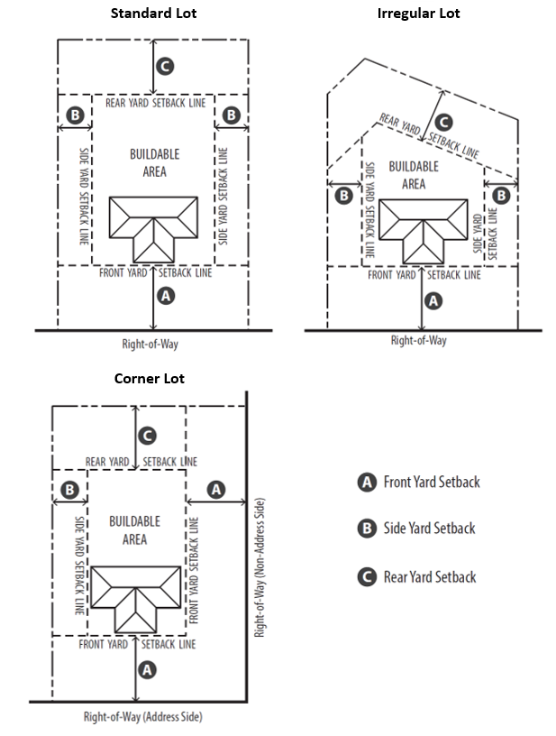
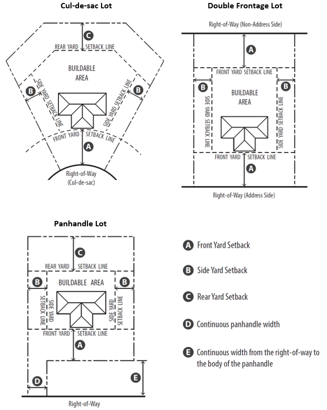
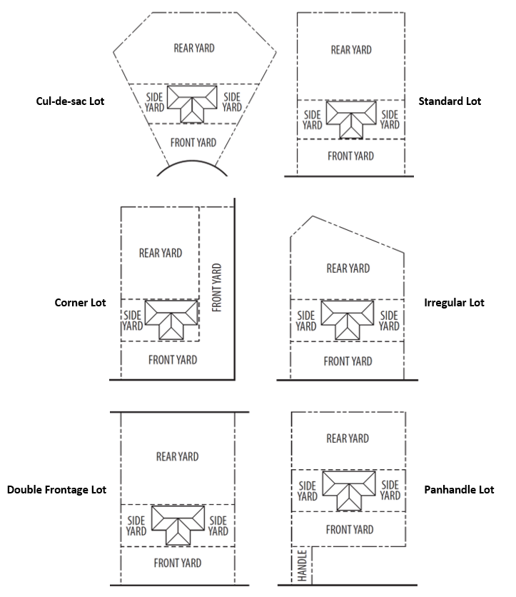
Setbacks. The illustrations in this section dictate the manner in which setbacks shall be measured for different lot types. Setbacks are measured from property lines except where street right-of-way is present, in which case setbacks shall be measured from the right-of-way. All structures, inclusive of any additions/add-ons/expansions excepting the features listed in Section 1151.03(d) (Permitted Obstructions in Setbacks), shall be built within the buildable area only.
(f)
Yards. The illustrations in this section dictate the manner in which yards shall be measured for different lot types. The locations of yards are dependent upon on the location of the principal structure. If more than one structure exists on the same lot, the measurement of yards will be different for each structure.
(g)
Lot frontage. Lot frontage is the common boundary line between a private or public lot and adjacent road right-of-way, measured in accordance with the illustrations below.

(h)
Lot width. Lot width is the distance between the side lot lines measured at the points of intersection with the minimum front yard setback line.
(i)
Panhandle lots. Panhandle lots (also referred to as 'flag lots') shall be discouraged and may only be approved if necessitated by unique topographic features or other special physical conditions. Panhandle lots shall be subject to setback measurement provisions as shown in Section 1151.03(e) (Minimum setbacks), as well as the following provisions:
(1)
Panhandle lots shall not be used to avoid the construction of a street.
(2)
The panhandle shall have a minimum width of 40 feet along the entire width of the panhandle, and thus are not subject to normal minimum lot frontage and lot width requirements required by the base zoning district. The length of the panhandle portion of a lot shall be a maximum of 300 feet.
(3)
The panhandle portion of the lot shall not be used for storage nor shall any structures be permitted in such portion of the lot.
(4)
Minimum front yard setbacks shall be measured from the front property line that parallels the roadway from which the panhandle lot has access, as shown in the Panhandle Lot illustration in Section 1151.03(e) (Setbacks).
(5)
There shall be a continuous width from the right-of-way to the body of the panhandle lot, as shown in the Panhandle Lot illustration in Section 1151.03(e) (Setbacks).
(6)
The minimum lot area requirement for panhandle lots shall be two times the minimum lot area requirement of the applicable zoning district.
(7)
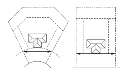
There shall be not more than one panhandle lot behind a frontage lot, as shown in the illustration below.

(j)
Height measurement.
(1)
Where specified in stories, building height shall be measured in number of complete stories above the finished grade for any elevation fronting on a public street including attics, half-stories, mezzanines, at-grade structured parking, but excluding features that are greater than one-half story or completely below grade, such as basements, cellars, crawl spaces, subbasements, and underground parking structures.
(2)
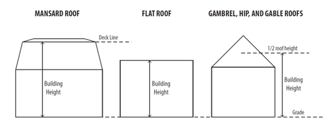
Where specified in feet, building height shall be measured as the vertical distance from grade at the front door/entrance of the structure to:
a.
The highest point of a flat roof;
b.
The deck line of a mansard roof; or
c.
The mean height between the eaves and ridge on gable, hip, or gambrel roofs.
(k)
Height measurement exceptions. Permitted height exceptions in all districts shall be as follows:
(1)
The height limitations of this Zoning Code shall not apply to chimneys, clocks, or bell towers, spires, belfries, water tanks, public monuments, steeples, personal radio or TV antennae, flag poles, vent pipes, structures housing or screening fans, air conditioning units or elevator machinery, and other similar features provided that nothing on a structure shall exceed twice the district height.
(2)
Architectural features that include building and roof line elements (parapet walls, cornice) that are intended to add architectural interest and not for the purpose of adding signage to the building may be allowed to exceed the maximum height of the district by not more than ten feet.
(Ord. No. O-18-68, § 3(Exh. A), 12-20-18)
Sec. 1151.04. - General standards.
(a)
Applicability. The standards of Section 1151.04 shall be applicable to all zoning districts within the City of Wilmington.
(b)
Mobile home use. Mobile homes, and manufactured homes that do not qualify as permanently sited, shall not be used as a single-family dwelling or permanent residence in any district, except within a manufactured home park as defined in ORC Section 4781.01(D).
(c)
Ingress and egress. No building shall be erected in any zoning district on any lot that does not have permanent means of ingress and egress to a public road or street.
(d)
Railroad right-of-way location. Railroad right-of-way, exclusive of such uses as marshalling yards, spur lines, passenger and freight terminals, maintenance shops, fueling facilities, and round houses, may be located in any zoning district in this Zoning Code provided such railroad right-of-way meets the requirements of the applicable sections of the Ohio Revised Code.
(e)
Interference with traffic control devices. No sign, structure, tree, planting, vegetation, or other obstruction shall protrude into any right-of-way so as to create confusion around, or otherwise interfere with, traffic signals and/or signage of any kind unless otherwise specified in this Zoning Code.
(f)
Traffic safety visibility triangle.
(1)
A traffic safety visibility triangle area, which may include private property and/or public right-of-way, is a triangle area defined by measuring 30 feet from the intersection of the extension of the front and side curb lines (or pavement lines if there is no curb) and connecting the lines across the property, as shown in the illustration below.

(2)
No structure, sign, or landscape element within any zoning district except the Downtown Core (DC) District, shall exceed 30 inches in height, measured from the top of the curb, within the traffic safety visibility area, unless approved by the Zoning Administrator.
(3)
An exception to this requirement shall be that trees with at least eight feet of limbless trunk may be permitted in the visibility triangle.
(4)
The provisions of subsections (1) through (3) above only apply to intersections of public roads and streets. Driveways and private streets are not applicable.
(g)
Design and construction of public improvements.
(1)
Any proposed development requiring the construction of public streets (including curb and gutters) sidewalks, sewers (sanitary and storm), water lines, or other improvements, which does not constitute a subdivision, as herein defined, shall be required to be designed and constructed in accordance with the applicable chapters and sections of the Subdivision Regulations.
(2)
Where the street is in existence, Council may delay curb, gutter, sidewalk, and road widening, until such time as it is determined that the improvements are necessary. If such delay is granted, the property owner shall execute an agreement committing to such improvements of curb, gutter, sidewalk, and road widening, and will without protest, submit to the method of financing directed by the City. Such agreement shall be filed for record with the Clinton County Recorder as a covenant on the property.
(h)
General retail sales prohibited. General retail sales or commercial activities in residential districts are prohibited except as otherwise expressly authorized by this Zoning Code. Garage sales are permitted only insofar as they are conducted consistent with the limitations set forth in Title Seven, Chapter 1145 (Temporary Use Provisions).
(i)
Compliance with Building Code. All development within the City of Wilmington shall comply with the provisions of Part 13 (Building Code) of the Codified Ordinances of Wilmington Ohio, inclusive of Flood Hazard Permit provisions in Chapter 1305 and Flood Damage Prevention provisions in Chapter 1307.
(j)
Compliance with Property Maintenance Code. All development within the City of Wilmington shall comply with the provisions of Part 17 (Property Maintenance Code) of the Codified Ordinances of Wilmington Ohio.
(k)
Water and sanitary sewer service requirement. If a building or use can be reasonably served by the extension of an existing public sanitary sewer, as determined by the City Engineer, the subdivider or developer shall provide sanitary sewer mains connecting to such existing sewer and shall provide lateral connections for each lot.
(l)
Fencing.
(1)
Residential fencing. The standards of this subsection (1) shall apply to properties which are exclusively used for residential. Within the side and rear yards, as depicted in Section 1151.03(f) (Yards), the maximum fence height shall be seven feet. Within the front yard, also depicted in Section 1151.03(f) (Yards), only ornamental fence designs are allowed and the maximum fence height shall be four feet. Fences may be erected along the boundaries of yards, or erected within yards.
(2)
Non-residential fencing. Fencing locations and materials for non-residential uses shall be approved by the Director of Public Service or designee. If the fence installation is part of site improvements that warrant Site Plan Review, the fencing location and materials shall be approved by the Planning Commission as part of the site plan review process.
(3)
Prohibited fencing materials. Barbed wire, razor wire, and electric fence are prohibited in SN (Suburban Neighborhood), TN (Traditional Neighborhood), DT (Downtown Transition), DC (Downtown Core), MF (Multi-Family), and MH (Manufactured Home Park) districts.
(m)
Performance standards.
(1)
Purpose and applicability. It is the purpose of the performance standards to provide for the peaceful and quiet enjoyment of property and to set forth regulations so that no use shall be constructed or operated so as to create a nuisance or to create any noxious, objectionable or other undesirable effect on persons or property outside of the property line of said use. Materials, uses and products produced shall be adequately housed, shielded or screened so that the health, safety and welfare of persons occupying the property or adjacent properties are not jeopardized. The performance standards are applicable to all land uses in all zoning districts within the City, and both initial and continued compliance is required.
(2)
Noise.
a.
Purpose and intent. It is the intent of these performance standards in Section 1151.04(m)(2) to regulate those noises and sounds which are associated with the activities pertaining to the use of land and sites in the City of Wilmington, and are often times a consistent or recurring problem causing disturbance to nearby properties. Issues of noise which occur on a one-time basis (e.g. a party event on a residential property) are generally not the concern of these regulations, unless they become a consistently present problem. One-time or event-based noise complaints should first be directed to the police department of jurisdiction prior to contacting the Zoning Administrator.
b.
Noise control. No activity on private property shall emit noise in excess of the sound levels listed in subsection c., with the exception that when the existing ambient noise level meets or exceeds the maximum permitted level, a source may not add more than two dBA to the ambient noise level.
c.
Maximum permitted sound levels. This table assembles a listing of noise source properties organized by use category with their corresponding maximum permitted sound levels for receiving properties during the times specified.
d.
Measurement of noise. Sound levels shall be measured and determined subject to the following conditions:
1.
Sound levels shall be determined by the use of a sound meter designed to give A-weighted measurements designated as dBA or dB(A). The use of the fast, slow, or impulse response setting on the sound level meter shall be at the discretion of the Zoning Administrator.
2.
Measurement shall be taken, at the discretion of the Zoning Administrator, at the property line or anywhere beyond the property line of the source property.
3.
The property used to collect the sound level measurement need not be contiguous to the property creating the noise.
e.
Noise source exemptions. Certain noise sources shall be exempt from the standards contained within this subsection (2) subject to the following conditions:
1.
The following noise sources shall be exempt during the hours of 7:00 a.m. through 10:00 p.m.:
i.
Firearms on authorized ranges;
ii.
Legal blasting;
iii.
Construction equipment and activity;
iv.
Installation of utility services; and
v.
Lawn, yard, and garden equipment, such as lawn mowers, blowers, and chain saws.
2.
The following noise sources shall be exempt at all times:
i.
Aircraft;
ii.
Railroads;
iii.
Emergency vehicles and equipment;
iv.
Critical infrastructure, such as generators, utilized for emergency use during electrical power outages for public and private entities and/or persons;
v.
Warning devices operating continuously for not more than five minutes;
vi.
The repair of essential utility services;
vii.
The improvement of the public right-of-way; and
viii.
Officially sanctioned parades and other public events.
(3)
Odors. No use shall cause or allow the emission of odorous air contaminants from any source sufficient to result in detectable odors beyond any lot line on which the use occurs.
(4)
Vibrations. Every use shall be so operated that ground vibration inherently and recurrently generated is not perceptible, without instruments, at any point on or outside the property line of the property on which the use is located.
(5)
Glare and heat. Any operation producing intense light or heat, including high temperature processes such as combustion or welding, shall not be visible or felt beyond any lot line bounding the property wherein the use is conducted. All exterior lighting on private property shall be positioned as to extend glare away from adjacent properties or right-of-ways.
(6)
Air and water pollutants. The emission of air and water pollutants shall not violate the standards and regulations of any local, state or federal agency having jurisdiction in this matter.
(7)
Hazardous materials. The storage, utilization and manufacture of solid, liquid and gaseous chemicals and other materials shall be permitted subject to the standards and regulation of any local, state or federal agency having jurisdiction in this matter.
(8)
Smoke. All development shall comply with the City of Wilmington's Fire Prevention Code.
(Ord. No. O-18-68, § 3(Exh. A), 12-20-18; Ord. No. O-22-36, § 4, 8-18-22; Ord. No. O-24-70, § 1, 1-16-25)
Sec. 1151.05. - Conservation design option.
(a)
Purpose and intent. The Conservation Design Option (CDO) provides for and encourages flexible and creative development techniques aimed toward providing a natural and built environment that is both healthy and safe. The CDO is available to properties located in the Rural Residential (RR) and Suburban Neighborhood (SN) zoning districts, and is optional at the landowner/applicant's request. Developments utilizing this option shall undergo the major subdivision process (i.e. a subdivision involving extension of public or private streets) in accordance with the City of Wilmington Subdivision Regulations.
(b)
Property requirements.
(1)
The applicant must own in fee simple or have the option to purchase all lands within the CDO subdivision. Any lawful ownership arrangement including, but not limited to fee simple lots or condominiums is permitted in a CDO subdivision.
(2)
The arrangement of dwelling units shall comply with all development standards contained in the applicable zoning district as modified in this section, and shall comply with all applicable subdivision requirements.
(3)
The minimum size for a CDO subdivision is ten acres.
(c)
Maximum number of units. The maximum number of units allowed for a conservation design option (CDO) shall be determined by the following steps:
(1)
Determine gross tract square footage (total project area);
(2)
Multiply the gross tract square footage by 0.85;
(3)
Divide by the minimum lot area (in square feet) in the underlying zoning district;
(4)
Multiply by 1.3; and
(5)
Round down to the nearest whole number.
(d)
Modifications to zoning district provisions.
(1)
Setbacks. Developments utilizing the conservation design option (CDO) need not meet the minimum setback standards of the applicable underlying zoning district for principal structures and accessory structures. Minimum setback standards shall be determined at the time of subdivision approval by the Planning Commission.
(2)
Lot dimensions. Developments utilizing the Conservation Design Option (CDO) need not meet the minimum lot dimension standards (lot area, lot frontage, and lot width) of the applicable underlying zoning district, except for:
a.
Panhandle lots, which shall meet the requirements of Section 1151.03(i) (Panhandle lot Standards); and
b.
Lots fronting on a cul-de-sac, which shall have a minimum frontage of 25 feet.
c.
Lots which may otherwise be required to be larger in size by the Clinton County Combined Health District to accommodate on-site wastewater systems.
(e)
Open space requirement. Developments utilizing the Conservation Design Option (CDO) shall comply with the open space requirements of Title 11, Chapter 1169 (Open space).
(Ord. No. O-18-68, § 3(Exh. A), 12-20-18; Ord. No. O-22-36, § 3, 8-18-22)
Sec. 1151.06. - Adult use cannabis operators prohibited.
(a)
The term adult use cannabis operator shall have the same meaning as in Ohio R.C. 3780.0l(A)(2), effective December 7, 2023.
(b)
No person or entity licensed as an adult use cannabis operator under Ohio R.C. Chapter 3780 shall open, establish, or operate any business or commercial enterprise of any kind within the corporate limits of the City unless it is pre-existing, non-conforming establishment.
(c)
Notwithstanding the provisions of Ohio R.C. Chapter 3780, all cultivating, processing and dispensing of adult use cannabis, cannabis and marijuana is prohibited within the corporate limits of the City.
(d)
No permit, zoning variance or exception, or other administrative approval shall be approved or issued by any administrative official of the City to any person, entity or other applicant desiring or intending to operate a business or commercial enterprise as an adult use cannabis operator within the corporate limits of the City.
(e)
Any use or condition caused or permitted to exist in violation of any of the provisions of Section 1151.06 shall be and hereby is declared to be a public nuisance and shall be abated by the City.
(Ord. No. O-24-16, § 1(Exh. A), 4-4-24)
Sec. 1153.01. - General provisions.
(a)
Applicability. The provisions of this chapter shall apply to all uses (including all principal, accessory, and temporary uses), buildings and structures which are established and/or constructed within the base zoning districts identified as "Business Districts" in Section 1151.01(a) (List of districts and overlays) and shown on the Official Zoning Map of the City of Wilmington.
(b)
Principal uses on lots. Properties which are wholly zoned as a business district, or properties partly zoned as a business district but only within the portions of each property zoned as such, may contain multiple principal buildings and may include multiple principal uses within each building, as permissible under Section 1141.02 (Table of Principal Uses by Zoning District), although principal residential uses are excluded from being housed on the same property or within the same building as another principal use.
(c)
Site development. All site development within business districts shall comply with the provisions in the following chapters of this Zoning Code:
(1)
Title Eleven, Chapter 1165 - Buffering and Landscaping
(2)
Title Eleven, Chapter 1167 - Lighting
(3)
Title Eleven, Chapter 1171 - Parking and Circulation
(4)
Title Eleven, Chapter 1173 - Signs
(d)
Rules of measurement. Setbacks, yards, structure heights, and other dimensional standards shall be measured in accordance with the provisions specified in Section 1151.03 (Site measurement provisions).
(e)
Non-conformities. Any non-conforming lots, uses, or structures/buildings present are subject to the provisions of Section 1135.13 (Non-conformity provisions).
(Ord. No. O-18-68, § 3(Exh. A), 12-20-18)
Sec. 1153.02. - LI—Light Industrial District.
(a)
Purpose statement. The purpose of the LI "Light Industrial" District is to provide for appropriate areas within the City of Wilmington for light industrial, manufacturing, and warehouse uses with limited objectionable external effects, where public sewer and water utilities are available.
(b)
District standards.
(c)
Performance standards. For Industrial Uses, there shall be no outside operations associated with the use; all operations and activities shall be conducted completely within the confines of one or more buildings and pose no adverse impact to surrounding properties. An exception to the above provision is made for outdoor storage, which shall occupy no greater than five percent of the site and must be completely screened from the view of adjacent properties and public right-of-way.
(Ord. No. O-18-68, § 3(Exh. A), 12-20-18)
Sec. 1153.03. - GI—General Industrial District.
(a)
Purpose statement. The purpose of the GI "General Industrial" District is to provide for appropriate areas within the City of Wilmington for high impact industrial and manufacturing uses where external effects may be objectionable and need to be mitigated, and where public sewer and water utilities are available. GI zoned areas should be appropriately located so as to cause minimal disturbance to residential areas.
(b)
District standards.
(c)
Performance standards. For industrial uses, no more than 50 percent of the site may be utilized for outside storage, operations, or activities associated with the use. If an applicant seeks approval for an otherwise permitted industrial use which proposes a percentage greater than 50 percent, the use shall be required to go through the conditional use process with the BZA.
(Ord. No. O-18-68, § 3(Exh. A), 12-20-18)
Sec. 1153.04. - SC—Suburban Commercial District.
(a)
Purpose statement. The purpose of the SC "Suburban Commercial" District is to provide for appropriate areas within the City of Wilmington for a range of commercial uses, including retail, restaurants, offices, and other personal and professional service businesses, with access and circulation that is primarily oriented toward the private automobile. Activities in this district are often large space uses along arterial or major collector roadways, with conveniently located off-street parking areas.
(b)
District standards.
(Ord. No. O-18-68, § 3(Exh. A), 12-20-18)
Sec. 1155.01. - General provisions.
(a)
Applicability. The provisions of this chapter shall apply to all uses (including all principal, accessory, and temporary uses), buildings and structures which are established and/or constructed within the base zoning districts identified as "Mixed-Use Districts" in Section 1151.01(a) (List of Districts and Overlays) and shown on the Official Zoning Map of the City of Wilmington.
(b)
Principal uses on lots. Properties which are wholly zoned as a Mixed-Use District, or properties partly zoned as a Mixed-Use District but only within the portions of each property zoned as such, may contain multiple principal buildings and may include multiple principal uses within each building, as permissible under Section 1141.02 (Table of Principal Uses by Zoning District). However, in the Downtown Transition (DT) zone, when a principal commercial use is located in the same structure as a principal residential use, the commercial use shall be restricted to the first floor of the structure only.
(c)
Site development. All site development within mixed-use districts shall comply with the provisions in the following chapters of this Zoning Code:
(1)
Title Eleven, Chapter 1165 - Buffering and Landscaping
(2)
Title Eleven, Chapter 1167 - Lighting
(3)
Title Eleven, Chapter 1171 - Parking and Circulation
(4)
Title Eleven, Chapter 1173 - Signs
(d)
Rules of measurement. Setbacks, yards, structure heights, and other dimensional standards shall be measured in accordance with the provisions specified in Section 1151.03 (Site measurement provisions).
(e)
Non-conformities. Any non-conforming lots, uses, or structures/buildings present are subject to the provisions of Section 1135.13 (Non-conformity provisions).
(Ord. No. O-18-68, § 3(Exh. A), 12-20-18)
Sec. 1155.02. - DC—Downtown Core District.
(a)
Purpose statement. The purpose of the DC "Downtown Core" District is to demarcate the City's central business district (CBD) and subsequently allow for an appropriate mix of uses, including but not limited to storefront commercial business uses, public/institutional uses, and upper-story residential. Development in this district should be designed in a way that engages the street and public realm, with parking areas and facilities preferably located to the rear of structures.
(b)
District standards.
1 Or as may be modified and approved by the Planning Commission as part of a site plan review or PUD review. Uses which do not require site plan review and are not proposed as part of a PUD are not included in this provision.
2 For non-residential and multi-family uses only.
(c)
Historic preservation standards. Development and/or re-development within the DC Downtown Core District shall comply with the standards and provisions of the H-1 Commercial Historic Overlay District, as provided in Section 1159.03, as applicable according to the boundaries of the overlay district.
(Ord. No. O-18-68, § 3(Exh. A), 12-20-18)
Sec. 1155.03. - DT—Downtown Transition District.
(a)
Purpose statement. The purpose of the DT "Downtown Transition" District is to demarcate areas along major arterial and collector thoroughfares outside of the CBD which currently support a mix of uses, including but not limited to single-family residential, multi-family residential, public/institutional uses, storefront commercial businesses, and automobile-oriented commercial uses with off-street parking provided. This is a primarily residential district which allows for some commercial uses so long as such uses are on the first floor and have direct automobile and pedestrian access to a major thoroughfare.
(b)
District standards.
1 Or as may be modified and approved by the Planning Commission as part of a Site Plan Review or PUD review. Uses which do not require Site Plan Review and are not proposed as part of a PUD are not included in this provision.
2 For non-residential and multi-family uses only.
(c)
Historic preservation standards. Development and/or re-development within the DT Downtown Transition District shall comply with the standards and provisions of the H-1 Commercial Historic Overlay District, as provided in Section 1159.03, as applicable according to the boundaries of the overlay district.
(Ord. No. O-18-68, § 3(Exh. A), 12-20-18)
Sec. 1157.01. - General provisions.
(a)
Applicability. The provisions of this chapter shall apply to all uses (including all principal, accessory, and temporary uses), buildings and structures which are established and/or constructed within the base zoning districts identified as "Residential Districts" in Section 1151.01(a) (List of districts and overlays) and shown on the Official Zoning Map of the City of Wilmington.
(b)
Principal uses on lots. Properties which are wholly zoned as a Residential District, or properties partly zoned as a Residential District but only within the portions of each property zoned as such, shall be allowed no more than one principal use as permissible under Section 1141.02 (Table of Principal Uses by Zoning District). However, properties may contain multiple principal buildings which serve the same use on a single property, as permissible specific to uses under the standards of Title Seven, Chapter 1141 (Principal uses).
(c)
Site development. All site development within Residential Districts shall Comply with the provisions in the following Chapters of this Zoning Code:
(1)
Title Eleven, Chapter 1165 - Buffering and Landscaping
(2)
Title Eleven, Chapter 1167 - Lighting
(3)
Title Eleven, Chapter 1171 - Parking and Circulation
(4)
Title Eleven, Chapter 1173 - Signs
(d)
Rules of measurement. Setbacks, yards, structure heights, and other dimensional standards shall be measured in accordance with the provisions specified in Section 1151.03 (Site measurement provisions).
(e)
Non-conformities. Any non-conforming lots, uses, or structures/buildings present are subject to the provisions of Section 1135.13 (Non-conformity provisions).
(Ord. No. O-18-68, § 3(Exh. A), 12-20-18)
Sec. 1157.02. - MF—Multi-Family District.
(a)
Purpose statement. The purpose of the MF "Multi-Family" District is to provide for appropriate areas within the City of Wilmington for multi-family residential development, including apartments, condominiums, landominiums, townhomes, and other similar uses. All principal commercial uses are prohibited in this zoning district.
(b)
District standards.
(Ord. No. O-18-68, § 3(Exh. A), 12-20-18)
Sec. 1157.03. - MH—Manufactured Home Park District.
(a)
Purpose statement. The purpose of the MH "Manufactured Home Park" District is to provide for appropriate areas within the City of Wilmington for private manufactured home park developments, where individual lots within the park are leased to occupants for the purpose of permanent habitation. Manufactured home parks are distinguished from recreational vehicle parks (campgrounds), which are for recreation, vacation, or business purposes.
(b)
Manufactured home parks. Manufactured home parks, as defined in ORC 4781.01(D), are subject to the rules and regulations of the Ohio Manufactured Homes Commission (OMHC) in accordance with state law, and thus shall not be subject to the provisions of Section 1157.03(c) (District standards). Manufactured home parks are still required to comply with the applicable use-specific standards of this Zoning Code in Section 1141.03(h) (Manufactured home parks).
(c)
District standards. The district standards for the MH "Manufactured Home Park" District for uses other than manufactured home parks shall be the same as the standards provided for the RR "Rural Residential" District in Section 1157.04(b) (District standards).
(Ord. No. O-18-68, § 3(Exh. A), 12-20-18)
Sec. 1157.04. - RR—Rural Residential District.
(a)
Purpose statement. The purpose of the RR "Rural Residential" District is to recognize the existence of the demand for residential lots of a relatively rural and spacious nature on which agricultural activities may represent only a minor use by the occupants. This district is intended for application in outlying rural areas where urbanization and the extension or creation of central water supply and wastewater disposal systems are either not appropriate or not expected to occur for an extended period of time into the future.
(b)
District standards.
* Except in cases where the accessory structure is set back at least 150 feet from right-of-way.
(Ord. No. O-18-68, § 3(Exh. A), 12-20-18)
Sec. 1157.05. - SN—Suburban Neighborhood District.
(a)
Purpose statement. The purpose of the SN "Suburban Neighborhood" District is to provide for appropriate areas within the City of Wilmington for primarily single-family residential dwelling units in a suburban neighborhood setting. Some public/institutional uses are allowed on a conditional basis, such as schools, churches/places of worship, parks, and other similar uses.
(b)
District standards.
* The required front yard setback shall be calculated by averaging the front yard setbacks on adjacent properties to either side of the lot in question, but in no case shall be less than 25 feet. If no principal structures exist on adjacent properties, the required setback shall be calculated by averaging the front yard setbacks for the entire length of the block (only on the side of the street where the lot in question is located).
(Ord. No. O-18-68, § 3(Exh. A), 12-20-18)
Sec. 1157.06. - TN—Traditional Neighborhood District.
(a)
Purpose statement. The purpose of the TN "Traditional Neighborhood District" is to recognize areas of the City of Wilmington which have historically developed on a gridiron pattern of streets and alleys, and to allow for any additional (re)development of such areas which blends in with the existing context already established. This district is primarily for single-family residential uses, though some two-family residential uses, small-scale commercial office/retail uses, and public/institutional uses (such as schools, churches/places of worship, parks, and other similar uses) may also be allowed on a conditional basis.
(b)
District standards.
* The required front yard setback shall be calculated by averaging the front yard setbacks on adjacent properties to either side of the lot in question, but in no case shall be less than five feet. If no principal structures exist on adjacent properties, the required setback shall be calculated by averaging the front yard setbacks for the entire length of the block (only on the side of the street where the lot in question is located).
(c)
Development standards.
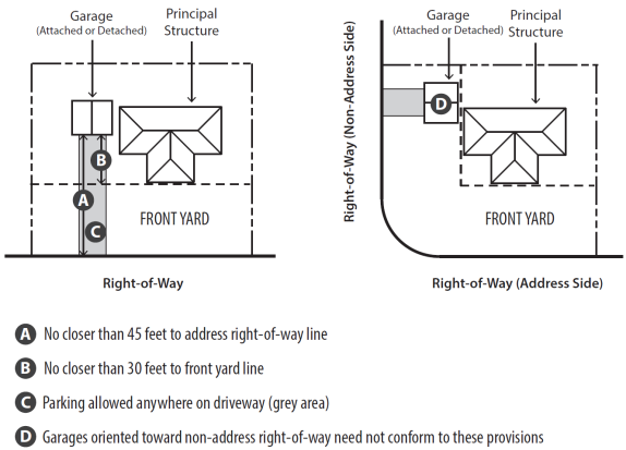
(1)
Garage and parking locations.
a.
Garages shall be located no closer than 45 feet to the right-of-way of the street where the address of the principal structure is located.
b.
Garages shall neither be located in, nor share a boundary with, the front yard on the address side of the property.
c.
Garages shall be recessed at least 30 feet from the closest front yard line. Garages on corner lots which are oriented toward non-address right-of-way need not conform to this provision.
d.
Parking of vehicles is otherwise permitted on driveways located in the front, side, and rear yards.
(Ord. No. O-18-68, § 3(Exh. A), 12-20-18)
Sec. 1159.01. - Applicability.
Where land is classified into an overlay district as well as a base zoning district, the regulations governing development in the overlay district shall apply in addition to the regulations governing the underlying base zoning district. In the event of an express conflict between the standards of the overlay zoning district and the base zoning district, the standards governing the overlay district shall control.
(Ord. No. O-18-68, § 3(Exh. A), 12-20-18)
Sec. 1159.02. - Airport Overlay Districts.
(a)
Purpose. It is the purpose of Section 1159.02 to regulate land uses in the areas surrounding the Wilmington Air Park Airport, formerly the Clinton County Air Force Base herein referred to as ILN, in order to minimize injury, loss of life, and hazards to the safety of persons or to the security of property within such zones, and to assist in the implementation of the Clinton County Comprehensive Plan. Accordingly, it is declared that:
(1)
The creation or establishment of non-compatible land uses which have the potential to reduce the size of the area available for taking off, maneuvering, and landing of aircraft, thus tending to impair or destroy the utility of the airports, and the investment therein, is a public nuisance and an injury to the regions served by the ILN and I66;
(2)
Certain other land uses in the vicinity of the airports also have the potential for being hazardous to normal aircraft operations or to increase the potential for personal and property damage in the event of an aircraft accident; therefore, it is necessary in the interest of the public health, public safety, and general welfare that non-compatible uses of land within the areas surrounding the airports be prevented; and
(3)
The prevention of these non-compatible land uses should be accomplished, to the extent legally possible, by the exercise of the police power.
(b)
Definitions. The following definitions shall apply in the interpretation of this section:
Airport means any area of land designated and set aside for the landing and taking off of aircraft, including all necessary taxiways, aircraft storage and tie-down areas, hangars, and other necessary buildings, and open spaces, designated for the storage, repair, and operation of aircraft, and utilized or to be utilized for such purposes.
Airport hazard means any structure or object of natural growth or use of land within an airport hazard area that obstructs the air space required for flight of aircraft in landing or taking off at the airports or is otherwise hazardous to such air navigation.
Airport hazard area means any area of land adjacent to the airports which includes any of the following areas and surfaces:
(1)
Runway landing areas. The runway landing areas, or "primary surfaces," are rectangular areas symmetrically about the runway centerline with an overall width of 1,000 feet for ILN and 500 feet for I66, and with their length extending to a line 200 feet beyond each end of the runways, which line is defined as the landing area end.
(2)
Approach surfaces.
a
The approach surface for each end of the instrument runways at ILN is the airspace above a plane sloping upward and outward from the end of the runway landing area to its outer boundary at the uniform rate of one foot in elevation for each 50 feet measured horizontally along the extended centerline of said runway. This plane shall increase in width at a uniform rate symmetrically about the extended runway centerline from 1,000 feet at its beginning to 4,000 feet at its outer boundary which, at 10,000 feet distance from the end of the runway landing area measured horizontally along the extended centerline of the runway, is 200 feet above the elevation at the end of the runway.
b
The Approach Surface for each end of the instrument runway at I66 is the airspace above a plane sloping upward and outward from the end of the runway landing area to its outer boundary at the uniform rate of one foot in elevation for each 20 feet measured horizontally along the extended centerline of said runway. This plane shall increase in width at a uniform rate symmetrically about the extended runway centerline from 500 feet at its beginning to 3,500 feet at its outer boundary which, at 10,000 feet distance from the end of the runway landing area measured horizontally along the extended centerline of the runway, is 294 feet above the elevation at the end of the runway.
(3)
Transitional surfaces. The transitional surfaces consist of the airspace above planes which slope upward and outward laterally from the sides of the planes forming the base of the approach/departure surfaces and from the sides of the runway landing areas. These planes shall be contiguous with the sides of the planes forming the base of the approach/departure surfaces and, with the sides of the runway landing areas and extending upward and outwardly at the uniform rate of one foot in elevation for each seven feet in horizontal distance. These planes extend upward and outward until they intersect with the planes forming, respectively, the bases of the horizontal and conical surfaces, which are described in the following paragraphs.
(4)
Horizontal surfaces.
a.
The horizontal surface at ILN is the airspace above a horizontal plane 150 feet above the airport elevation established by swinging arcs of 10,000 feet from the center of each end of the primary surface of each runway (a point of 200 feet beyond the runway end) and connecting the adjacent arcs by drawing lines tangential to those arcs.
b.
The horizontal surface at I66 is the airspace above a horizontal plane 150 feet above the airport elevation established by swinging arcs of 10,000 feet from the center of each end of the primary surface of each runway (a point 200 feet beyond the runway end) and connecting the adjacent arcs by drawing lines tangential to those arcs.
(5)
Conical surface.
a
The conical surface is the airspace above a conical surface extending upward and outward at a uniform rate of one foot in elevation for each 20 feet in horizontal distance starting at the periphery of the Horizontal Surface at a slope of 20 to one for a horizontal distance of 4,000 feet.
b.
This definition of "airport hazard area" is to be construed in conformity with Title 14: Aeronautics and Space, of the Code of Federal Regulations, Federal Aviation Regulation Part 77, Objects Affecting Navigable Airspace. Furthermore, the definition of the "airport hazard area" may be amended from time-to-time by the approved airport layout plans (ALP) for the airports.
Airport notice area means the space within a horizontal distance of 20,000 feet of the nearest point of the nearest runway of either the ILN or I66 and above a surface extending out from the nearest point, which surface rises at a slope of 100:1 horizontally, i.e., 100 feet horizontally for each one foot vertically.
Blanket approval means approval by the FAA, given to a local jurisdiction, to waive FAA approval requirements for buildings or structures located within the boundaries of specifically defined areas. The waiver of FAA approval shall only apply if a building or structure does not exceed a maximum height detailed in an FAA Blanket Approval Agreement for a specifically defined area. Transmitting devices and/or buildings or structures which exceed the maximum height shall not be included in a "blanket approval" and proof of FAA approval must be provided before any building permit may be issued.
FAA means the Federal Aviation Administration and any legally appointed, designated or elected agent or successor.
FCC means the Federal Communications Commission and any legally appointed, designated or elected agent or successor.
Feed lot means an area of land for the fattening or finishing of animals, generally beef cattle, in which the stocking densities - the number of animals per unit of land at a particular time - exceed six cattle per acre.
Fish processing means a factory or other place where fish are prepared for canning, or other commercial uses.
Landfill means a place where waste material is disposed by the process of reclaiming areas of the ground.
Person means any individual, firm, co-partnership, corporation, company, association, joint stock association, or body politic and includes any trustee, receiver, assignee, or other similar representative thereof.
Political subdivision means any municipal corporation, township, or county.
Pond means a small, natural, or man-made body of standing fresh water filling a surface depression, usually smaller than a lake, where the retention of water takes place.
Sewage pond means a shallow pond where sunlight, bacterial action, and oxygen work to purify wastewater.
Slaughter house means a building or place where animals are butchered for food.
Sludge disposal means the collection and removal of the concentration of solids from sewage during wastewater treatment in conjunction with the use of a spread area.
Transfer station means any site, location, tract of land, installation or building that is used or intended to be used primarily for the purpose of transferring solid waste that is generated off the premises of the facility from vehicles or containers into other vehicles or containers for transportation to a solid waste disposal facility. The term does not include any facility that consists solely of portable containers that have an aggregate volume of 50 cubic yards or less, nor any facility where legitimate recycling activities are conducted.
Water fowl production means any activity or plan which promotes and/or aides the reproduction or breeding of water fowl species.
Water reservoir means a multipurpose project may generate hydro-electric power, controls floods, provides recreational benefits and supplies water.
Wildlife sanctuary means an area of land set aside for, among other purposes, providing a refuge for wildlife species, or a small area in private ownership for breeding purposes.
(c)
Airport Zoning Districts. The following Airport Zoning Districts (see Airport Overlay Zone Map) are hereby established and shall be governed by the accompanying regulations:
(1)
Airport Zoning District One (AZD-1).
a.
AZD-1 encompasses the land on which ILN is situated. The boundary for the AZD-1 zone for ILN is set forth in yellow on the referenced map.
b.
Permitted uses within AZD-1 include open space and airport-related uses.
(2)
Airport Zoning District Two (AZD-2).
a.
AZD-2 generally encompasses land that experiences direct overflights to and from ILN. The boundary for the AZD-2 zone for ILN is set forth in blue on the referenced map.
b.
Permitted uses within AZD-2 include open space, airport-related uses, agriculture, general commercial, industrial, and existing institutional and educational uses.
c.
Those uses specifically prohibited in AZD-2 include residential uses, nursing care facilities, hospitals, schools, libraries, landfills, transfer stations, sewage ponds, sludge disposal, feed lots, slaughter houses, waterfowl production, wildlife sanctuary, or fish processing. Lakes or ponds intended to attract or harbor waterfowl are prohibited (see Federal Aviation Administration Advisory Circular (AC) 150/5200-33B Hazardous Wildlife Attractants On or Near Airports).
d.
All new primary buildings and alterations to existing residential buildings in AZD-2 shall be constructed so as to reduce noise by 30 dBA.
(3)
Airport Zoning District Three (AZD-3).
a.
AZD-3 generally encompasses land that would occasionally experience direct overflights to and from the ILN. The boundary for the AZD-3 zone for ILN is set forth in green on the referenced map.
b.
Permitted uses within AZD-3 include open space, agricultural, airport-related uses, general commercial, industrial, institutional, single-family residential, and those uses otherwise permitted by the applicable base zoning under this Zoning Code, unless prohibited in paragraph (3).
c.
Those uses specifically prohibited in AZD-3 include multi-family residential, libraries, landfills, transfer stations, sewage ponds, sludge disposal, feed lots, slaughter houses, waterfowl production, wildlife sanctuary, or fish processing. Lakes or ponds intended to attract or harbor waterfowl are prohibited (see Federal Aviation Administration Advisory Circular (AC) 150/5200-33B Hazardous Wildlife Attractants On or Near Airports).
d.
Any new single-family residential minor or major subdivision of lots occurring within AZD-3 shall include deed covenants and restrictions:
1.
Notifying the occupants that they will reside within the Airport Zoning District of ILN;
2.
Acknowledging that they understand that they will be exposed to noise from aircraft;
3.
Notifying the residents that they are prohibited from using any equipment which can interfere with the communications or other electronics of the ILN:
4.
Waiving the occupants' right to oppose any continued use or growth of the ILN for its current purposes.
e.
Platted subdivisions shall include these covenants and restrictions on the final plat.
f.
All new primary buildings and alterations to existing residential buildings in AZD-3 shall be constructed so as to reduce noise by 25 dBA.
g.
Drawings for the construction of any new single-family dwelling in AZD-3 shall be submitted to the Building Department for review and certification that the proposed materials and construction techniques comply with the provisions of this AZD-3.
(4)
Airport Zoning District Four (AZD-4).
a.
AZD-4 generally encompasses land that would occasionally experience direct overflights to and from the airports. The boundary for the AZD-4 zone for the ILN is set forth in red on the referenced map.
b.
Permitted uses within AZD-4 include open space, agricultural, airport-related uses, general commercial, industrial, institutional, single-family residential, and those uses otherwise permitted by the applicable base zoning under this Zoning Code, unless prohibited within paragraph (3).
c.
Those uses specifically prohibited in AZD-4 include multi-family residential, libraries, landfills, transfer stations, sewage ponds, sludge disposal, feed lots, slaughter houses, waterfowl production, wildlife sanctuary, or fish processing. Lakes or ponds intended to attract or harbor waterfowl are prohibited (see Federal Aviation Administration Advisory Circular (AC) 150/5200-33B Hazardous Wildlife Attractants On or Near Airports).
d.
Any new single-family residential minor or major subdivision of lots occurring within AZD-4 shall include deed covenants and restrictions:
1.
Notifying the occupants that they will reside within the Airport Zoning District of ILN;
2.
Acknowledging that they understand that they will be exposed to noise from aircraft;
3.
Notifying the residents that they are prohibited from using any equipment which can interfere with the communications or other electronics of the ILN;
4.
Waiving the occupants' right to oppose any continued use or growth of ILN for its current purposes.
e.
Platted subdivisions shall include these covenants and restrictions on the final plat.
f.
All new primary buildings and alterations to existing residential buildings in AZD-4 shall be constructed so as to reduce noise by 20 dBA.
g.
Drawings for the construction of any new single-family dwelling in AZD-4 shall be submitted to the Building Department for review and certification that the proposed materials and construction techniques comply with the provisions of this AZD-4.
(5)
Notwithstanding any other provision of this section, no use may be made of land within any zone established by this section in such a manner as to create electrical interference with radio communication between the airports and aircraft, to make it difficult for pilots to distinguish between airport lights and other lights, to create glare in the eyes of pilots using the airports, to impair visibility in the vicinity of the airports, or to otherwise endanger the landing, taking off, or maneuvering of aircraft.
(6)
Notwithstanding any other provision of this section, no use may be made of and no installation may be placed on land within any airport hazard area that will produce smoke, fumes, gases, or odors that would interfere with the safe use by aircraft of the airports. Notwithstanding any other provisions of this section, no use may be made of, or an installation placed on, land within any airport zone for public or private rifle ranges, or private aircraft landing fields, which would interfere with the safe use by aircraft of the airports. No owner or occupant of real property shall construct or create, or permit to be constructed or created, an airport hazard.
(d)
Certification of "no hazard" required. The Zoning Administrator may require any person who proposes to construct, erect, place or otherwise locate a structure that will be within the airport notice area, as defined, to receive written certification from the Federal Aviation Administration (FAA) and the Ohio Department of Transportation, Division of Aviation (ODOT-DOA), that the proposed project does not constitute an airport hazard.
(Ord. No. O-18-68, § 3(Exh. A), 12-20-18)
Sec. 1159.03. - Commercial Historic (H-1) Overlay District.
(a)
Findings.
(1)
Council hereby finds and determines that the establishment of restrictions on the construction, erection, alteration, removal, moving or demolition of buildings and structures in areas of historic significance or of landmark designation is vital to the preservation of the educational, cultural, economic and general welfare of the City of Wilmington and of its citizens.
(2)
Council further finds that the Wilmington Commercial Historic District (WCHD) is significant for historical, architectural, aesthetic, cultural, social and economic reasons. The architecture in the district, which covers a variety of architectural styles and reflects the growth of the City from 1810 to the present, is very distinctive in southern Ohio and unique within Clinton County. The maintenance and enhancement of the distinctive and unique character of the district, as the same has been recognized (and in satisfying the criterion necessary for inclusion of a substantial part thereof on the National Register of Historic Places) is dependent in large part on the harmonious and compatible external appearance of the properties within the district.
(3)
Council further finds and determines, on the basis of its own observations and knowledge, and the information in the application for inclusion of the WCHD on the National Register of Historic Places, that the purposes set forth below will be served by the enactment of this chapter.
(b)
Declaration. Council declares as a matter of public policy that preserving, protecting, and enhancing the distinctive and unique character of the Wilmington Commercial Historic District, and designated Landmark Properties in the City of Wilmington, and fostering the harmonious and compatible external appearance of the properties within the district, are matters of public necessity and are required in the interest of the public safety, health, morals, convenience, prosperity, and welfare.
(c)
Purposes. The purposes of Section 1159.03 (Commercial Historic (H-1) Overlay District) are:
(1)
To maintain and enhance the distinctive character of the historic and architecturally significant buildings within designated districts or for properties designated as landmarks;
(2)
To insure architectural harmony between buildings of widely varying architectural periods and styles;
(3)
To insure the compatibility of the exteriors of any and all construction of new improvements and buildings and changes on the exterior of existing structures within the historic and architectural character of the historic district or landmark property;
(4)
To protect and enhance the visual and aesthetic character, diversity and interest in the City of Wilmington;
(5)
To contribute to the economic, recreational, cultural and educational development of the City of Wilmington by:
a.
Encouraging the development of vacant properties in accordance with the character of the designated districts and landmark properties;
b.
Protecting and enhancing the City's attractions to prospective residents, tourists, and visitors;
c.
Stabilizing, improving, and protecting property values;
d.
Fostering civic pride in the beauty and notable accomplishments of the past and present;
e.
Facilitating the reinvestment and revitalization of the designated districts and landmarks properties;
f.
Promoting the use and preservation of historic sites and structures for the education and general welfare of the people of the City of Wilmington and visitors.
(d)
Applicability.
(1)
A certificate of appropriateness shall be required before any change may be instituted within the H-1 Overlay District, whether or not such change requires a building permit. A "change" is defined as any alteration, reconstruction, or restoration of the exterior of a structure; construction of a new structure; demolition of an existing structure; placement of new landscaping; erection of new signs; or any material alteration in the landscaping, signage, exterior color(s) or external architectural features of any property.
(2)
The requirements of this section shall be met in addition to the established requirements and standards of this Zoning Code, and other applicable ordinances of the City. Where conflicts exist between requirements of this section and other ordinances adopted by Council, the strictest requirements shall apply and supersede the less strict requirements.
(e)
Development guidelines. In making a determination on an application for a certificate of appropriateness, the Planning Commission, Zoning Administrator, or designee shall consider the following:
(1)
The U.S. Secretary of the Interior's Standards for Rehabilitation.
a.
A property shall be used for its historic purpose or be placed in a new use that requires minimal change to the defining characteristics of the building and its site and environment.
b.
The historic character of a property shall be retained and preserved. The removal of historic materials or alteration of features and spaces that characterize a property shall be avoided.
c.
Each property shall be recognized as a physical record of its time, place, and use. Changes that create a false sense of historical development, such as adding conjectural features or architectural elements from other buildings, shall not be undertaken.
d.
Most properties change over time; those changes that have acquired historic significance in their own right shall be retained and preserved.
e.
Distinctive features, finishes, and construction techniques or examples of craftsmanship that characterize a historic property shall be preserved.
f.
Deteriorated historic features shall be repaired rather than replaced. Where the severity of deterioration requires replacement of a distinctive feature, the new feature shall match the old in design, color, texture, and other visual qualities and, where possible, materials. Replacement of missing features shall be substantiated by documentary, physical, or pictorial evidence.
g.
Chemical or physical treatments, such as sandblasting, that cause damage to historic materials shall not be used. The surface cleaning of structures, if appropriate, shall be undertaken using the gentlest means possible.
h.
Significant archeological resources affected by a project shall be protected and preserved. If such resources must be disturbed, mitigation measures shall be undertaken.
i.
New additions, exterior alterations, or related new construction shall not destroy historic materials that characterize the property. The new work shall be differentiated from the old and shall be compatible with the massing, size, scale, and architectural features to protect the historic integrity of the property and its environment.
j.
New additions and adjacent or related new construction shall be undertaken in such a manner that if removed in the future, the essential form and integrity of the historic property and its environment would be unimpaired.
(2)
Colors for buildings and signage.
a.
Color palette. For the exterior of buildings, structures and signage, applicants will choose paint colors from the color palette adopted by the Planning Commission. If historically accurate or architecturally appropriate, black, white, and metallic colors may be used as trim colors, as accent colors, and on signs. Exceptions to the use of the colors in the color palette may be made by the Planning Commission if the applicant provides historical or architectural justification.
b.
Main body color. The more simple the building design, the fewer the number of colors should be used on it, but never more than three different colors on the same building in addition to the main body color. The main body of the building should be painted all the same color.
c.
Trim and accent color. The body trim of the building should be painted in different, complimentary colors. Select colors which complement abutting buildings. If historically accurate or architecturally appropriate, black, white, and metallic colors may be used as trim and accent colors.
d.
Historical accuracy and complimentary colors. The Planning Commission may deny the use of a color on a part of the building if not historically accurate or complimentary. If paint was used on a building in the past, an applicant should research the original paint colors as a starting point when selecting a color. Most historic color schemes were fairly simple. Colors must be appropriate to the building's age and style.
e.
Exceptions to color palette. The Planning Commission may, in its sole discretion, make exceptions to the use of the color palette for murals, significant works of exterior art, or restorations of historical murals. Colors in murals, significant works of exterior art, or restorations of historical murals may be exempted from the color palette.
(4)
Fonts for lettering on buildings and signs. The Planning Commission may adopt fonts that will be approved for use in the H-1 Overlay District. Exceptions to the use of the approved fonts may be made if the applicant provides historical or architectural justification for using a font not on the approved font palette.
(5)
Sign design and placement.
a.
The addition of or removal of a sign to a property or alteration of a sign is a "change" as defined by Section 1159.03(d)(1) herein.
b.
Prior to the installation or placement of a sign, the applicant must obtain both a certificate of appropriateness from the Planning Commission, Zoning Administrator, or designee for the sign as well as a sign permit (if applicable) from the Zoning Administrator. A sign permit will not be issued until the certificate of appropriateness is issued by the Planning Commission, Zoning Administrator, or designee.
c.
The Zoning Administrator will evaluate the size, placement and other characteristics of signs in H-1 Overlay District pursuant to the criteria set forth in Title Eleven, Chapter 1173 (Signs). The Zoning Administrator will report to the Planning Commission whether the proposed sign or change in a sign complies with the provisions of Title Eleven, Chapter 1173 (Signs).
d.
In evaluating a sign for the issuance of a certificate of appropriateness, the Planning Commission shall consider not only the Zoning Administrator's report regarding the sign's compliance with Title Eleven, Chapter 1173 (Signs), but also the following regulations:
1.
There shall be not more than two styles nor more than three sizes of lettering used for any sign, including characters or trademarks used for identification.
2.
The number of items, letters, symbols, and shapes shall be consistent with the amount of information which can be comprehended by the viewer, reflect simplicity, avoid visual clutter and improve legibility.
3.
The shape of the sign shall be simple, and the sign should be consolidated into a minimum number of elements. It should be a basic geometric form, usually a rectangle. Except for extraordinary circumstances, no element of the sign should violate the boundaries of the basic shape.
4.
A ratio between the message and the background shall permit easy recognition of the message.
5.
The size, style and location of the sign shall be appropriate to the activity of the site.
6.
The sign shall complement the building and adjacent buildings by being designed and placed to enhance the architecture.
7.
There shall not be more than five colors, including black, white and metallic colors, used on any sign. Florescent colors are prohibited. Colors shall be in conformity with the approved color palette for the historic district or landmark property under consideration. There are no exceptions or variances to the color palette.
8.
Signs identifying multiple tenants of a building should be designed to allow changes in tenant occupancy. Unused tenant identification areas shall be filled with matching decorative panels so as to minimize the appearance of vacancy.
9.
Signs, if seen in series, shall have a continuity of design with the style of sign generally consistent throughout the building or block.
10.
Incidental signs shall contain the minimum information and the minimum area necessary to convey the message and instruct the viewer in the safe and efficient use of the facility.
11.
A sign should be constructed with a minimum of different types of material so as to provide a consistent overall appearance. Materials shall be consistent with those of the building or of older origin such as brick, stone, masonry, and wood. Undisguised contemporary materials such as aluminum, plaster, fiberglass and glass shall not be used.
(6)
Awnings.
a.
Fixed or retractable awnings are permitted if they complement the building's architectural style, material, color and details.
b.
Awnings should be diagonal, concave or umbrella shaped. Other shapes may be considered by the Commission.
c.
Any visible supporting framework should be painted a dark color corresponding to either the awning or the awning's building.
d.
Striped patterns or solid colors should be selected.
e.
An awning may not conceal architectural features (such as cornices, columns, pilasters, or decorative details).
f.
Metal and aluminum awnings are not permitted.
g.
Awnings may be made of solution-dyed acrylic, canvas or marine fabric. The material may be opaque.
h.
Any signage text must comply with this section and any other applicable provisions of the Zoning Code.
i.
Awning signage text may be screen-printed on the skirt or sewn using the same fabric type of white or translucent color.
j.
Awning colors shall be those in the approved color palette chosen by the Planning Commission.
k.
Awnings must not be under lighted.
l.
Awnings over an entrance shall be centered on the entrance with a minimum seven foot clearance between the bottom of the skirt and the pavement or ground.
m.
Perpendicular canopies shall match the slope of any existing stairs or ramps.
(7)
Site/structure appearance and compatibility.
a.
Documentation of the original appearance of a building or property or similar properties in the City of Wilmington may be considered.
b.
Every reasonable effort shall be made to provide a compatible use for a property which requires minimal alteration of the building, structure or site and its environment, or to use a property for its originally intended purpose.
c.
The distinguishing original qualities or character of a building, structure or site and its environment shall not be destroyed. The removal or alteration of any historic material or distinctive architectural features should be avoided when possible.
d.
All buildings, structures and sites shall be recognized as products of their own time. Alterations that have no historical basis and which seek to create an earlier appearance shall be discouraged.
e.
Changes which may have taken place in the course of time are evidence of the history and development of a building, structure, or site and its environment. These changes may have acquired significance in their own right, and this significance shall be recognized and respected.
f.
Distinctive stylistic features or examples of skilled craftsmanship which characterize a building, structure or site shall be treated with sensitivity.
g.
Deteriorated architectural features shall be repaired rather than replaced, whenever possible. In the event replacement is necessary, the new material should match the material being replaced in composition, design, color, texture, and other visual qualities. Repair or replacement of missing architectural features should be based on accurate duplications of features, substantiated by historical, physical or pictorial evidence rather than on conjectural designs or the availability of different architectural elements from other buildings or structures.
h.
The surface cleaning of structures shall be undertaken with the gentlest means possible. Sandblasting and other cleaning methods that will damage the historic building materials shall not be undertaken.
i.
Contemporary design for alterations and additions to existing properties shall not be discouraged when such alterations and additions do not destroy significant historical, architectural or cultural material and such design is compatible with the size, scale, color, material, and character of the property, neighborhood or environment.
j.
Wherever possible, new additions or alterations to structures shall be done in such a manner that if such additions or alterations were to be removed in the future, the essential form and integrity of the structure would be unimpaired.
(Ord. No. O-18-68, § 3(Exh. A), 12-20-18; Ord. No. O-22-36, § 5, 8-18-22)
Sec. 1159.04. - Planned Unit Development (PUD) Overlay District.
(a)
Purpose. The purpose of the Planned Unit Development (PUD) Overlay District shall be as specified in Section 1135.10(a) (Purpose).
(b)
Review procedure. The initiation, review, approval, and modification of a PUD overlay shall comply with the provisions of Section 1135.10 (Planned Unit Developments).
(c)
Development standards.
(1)
Prohibited uses. The following non-residential uses are expressly prohibited in all PUDs, and may not be added as a permitted use to any PUD overlay:
a.
Adult entertainment facilities.
b.
Outdoor shooting range.
c.
Asphalt or concrete batch plant or products manufacturing.
d.
Slaughterhouse and stockyard.
e.
Mineral extraction.
f.
Sanitary landfills.
g.
Solid waste disposal facility.
h.
Motor vehicle impound lots.
i.
Scrap metal salvage yard and recycling centers.
j.
Outdoor storage or displays associated with industrial use.
(2)
Open space requirements. PUD overlays shall comply with the open space requirements and standards of Title Eleven, Chapter 1169 (Open space).
(Ord. No. O-18-68, § 3(Exh. A), 12-20-18)
Sec. 1159.05. - Stream and Riparian (SR) Overlay District.
(a)
Purpose. The purpose of the Stream & Riparian Overlay is to maintain a strip of land adjacent to streams and rivers in which natural vegetation is retained and/or re-vegetated, in order to reduce the velocity of overland water flow, trap sediment and eroded soil from cropland or land being developed, and limit pollutants from entering the waterway. All streams and rivers shown on the USGS QuadrangleMaps as a blue line shall be subject to the requirements of the Riparian Overlay. Such stream locations may be field verified, and modified as necessary by the Zoning Administrator in consultation with the Planning Commission.
(b)
Location. A 50 foot stream buffer zone shall be established on both sides of all perennial streams and watercourses indicated as a solid blue line on the USGS Quadrangle maps along with all current and/or future designated floodways and flood-fringe areas as defined and/or determined by the Federal Emergency Management Agency (FEMA).
(c)
Requirements and restrictions.
(1)
No development of any kind, including placement of all structures and all soil-disturbing activities, shall occur within this the buffer area described in Section 1159.05(b) (Location), except as listed in the subsections below.
(2)
Open space reserves in subdivisions or developments should be located to maximize the preservation of riparian corridors.
(3)
Generally, stream buffer areas within this overlay zone shall remain undisturbed. When agricultural soil disturbing activities such as plowing, grading, ditching, excavating, placement of fill materials, or similar activities must occur, they shall conform to all State and Federal regulations. Other unnamed agricultural activities that would result in significant disturbance of the existing soil, increase erosion, or destroy plant and wildlife habitats are prohibited and can only occur with an approved replacement program consistent with Ohio Department of Natural Resources standards.
(4)
Permitted activities/uses within the buffer areas include sewer easements, providing the activities strictly adhere to applicable State, Federal and local soil and erosion control regulations and guidelines. Permanent appropriate native perennial vegetation must be established as a necessary step in completing the construction of any sewer facilities. Sewer easements should be as close to perpendicular to the stream channel to minimize the impact on the stream buffer. Other overhead and/or underground utilities (e.g. water lines), roads, streets, bridges, trails, railways, or similar structures should be placed within existing right-of-ways or existing corridors (where active or abandoned) if possible, but in any case, must cross the buffer as close to perpendicular as possible.
(5)
All disturbed areas within the buffer zone shall be re-vegetated with permanent appropriate native perennial vegetation immediately after the disturbance. This includes the re-forestation of forest areas with more mature growth as detailed by the Service Director or Planning Commission.
(Ord. No. O-18-68, § 3(Exh. A), 12-20-18)