
Wimberley City Zoning Code
ARTICLE 9
03 - ZONING6
Editor's note— This article consists of the zoning ordinance, Ordinance 2001-010 adopted April 1, 2001, previously published as ch. 155 in the 2006 Code of Ordinances, and as subsequently amended. Section numbers, style, capitalization and formatting have been changed to be consistent with the remainder of the Code of Ordinances, and this will be maintained in future amendments to this article. Changes in the names of state agencies have been incorporated without notation. The word "village" has been changed to "city." Obviously misspelled words have been corrected without notation. Except for these changes, such provisions are printed herein as published in the 2006 Code. Any other material added for purposes of clarification is enclosed in brackets.
State Law reference— Municipal zoning authority, V.T.C.A., Local Government Code, Ch. 211.
APPENDIX A. - FIGURES
FIGURE 1. SAMPLE LANDSCAPE PLAN
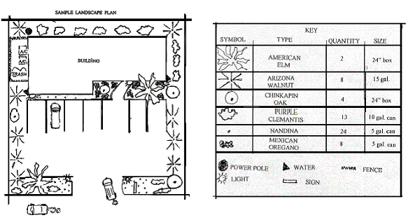
(Ordinance 2001-010, figure I, adopted 4/1/01; 2006 Code, app. A, figure 1)
FIGURE 2. PARKING LOT SCREENING
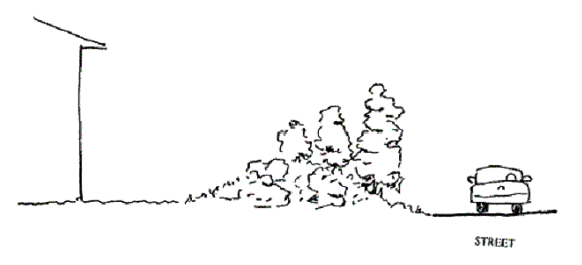
(Ordinance 2001-010, figure II, adopted 4/1/01; 2006 Code, app. A, figure 2)
FIGURE 3. DRAINAGEWAY CONSTRUCTION
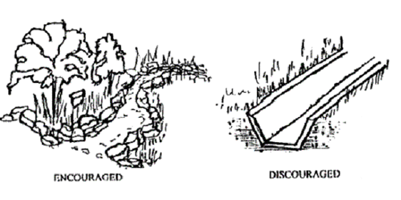
(Ordinance 2001-010, figure III, adopted 4/1/01; 2006 Code, app. A, figure 3)
FIGURE 4. PATH AND WALKWAY LAYOUT
(Ordinance 2001-010, figure IV, adopted 4/1/01; 2006 Code, app. A, figure 4)
FIGURE 5. RETAINING WALL CONFIGURATIONS
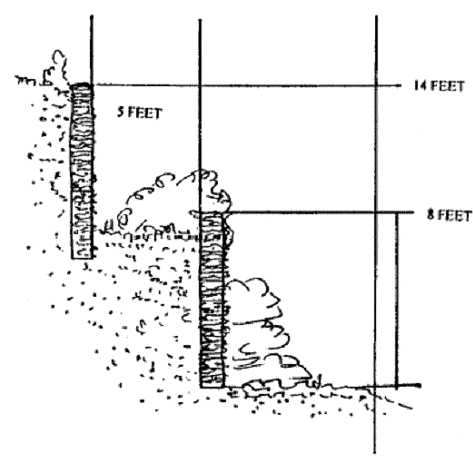
(Ordinance 2001-010, figure V, adopted 4/1/01; 2006 Code, app. A, figure 5)
FIGURE 6. CITY CENTER OVERLAY DISTRICT
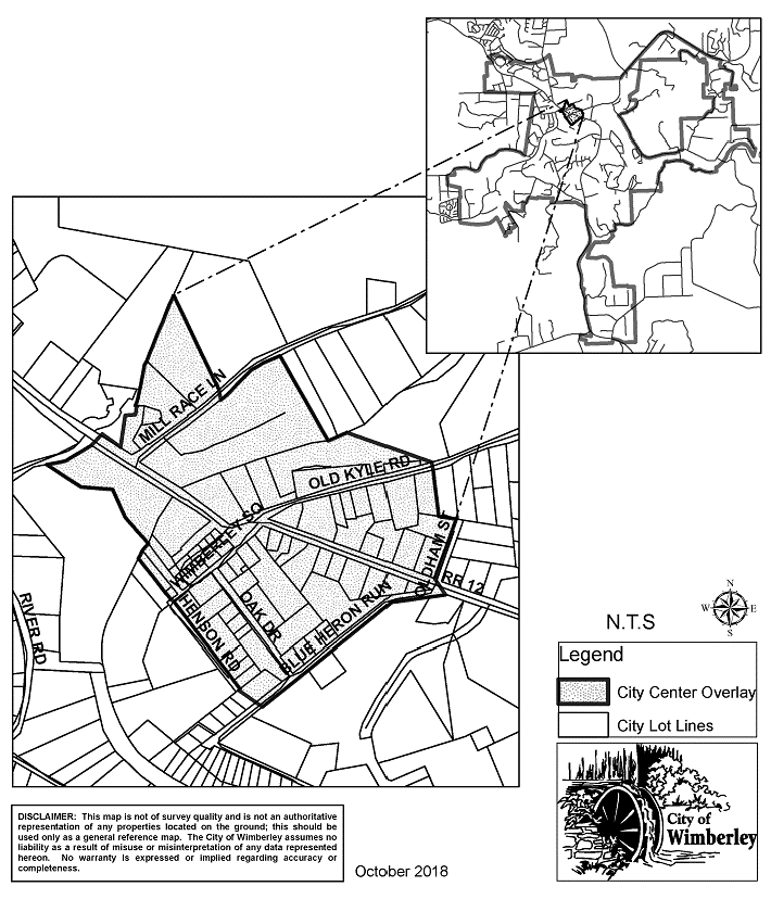
(Ordinance 2001-010, § 49, adopted 4/1/01; 2006 Code, app. A, figure 6; Ordinance adopting 2018 Code)
FIGURE 7. ENTRANCE CORRIDOR OVERLAY DISTRICT
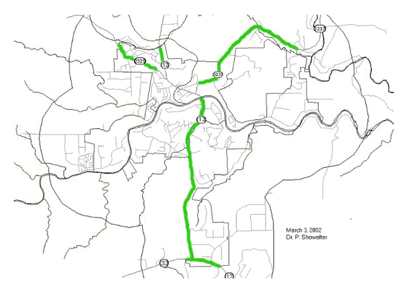
(Ordinance 2001-010, figure VI, adopted 4/1/01; 2006 Code, app. A, figure 7)
FIGURE 8. BUFFERING SETBACK; ENTRANCE CORRIDOR OVERLAY DISTRICT
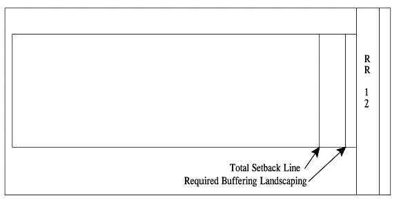
(Ordinance 2001-010, figure VII, adopted 4/1/01; 2006 Code, app. A, figure 8)
Sec. 9.03.001 - Title
This article shall commonly be referred to as the city's comprehensive zoning ordinance.
(Ordinance 2001-010, § 1, adopted 4/1/01; 2006 Code, § 155.001)
Sec. 9.03.002 - Purpose
As authorized by the city's police powers and V.T.C.A., Local Government Code, Chs. 54, 211, 212, 213, 215, and 217, the zoning regulations and districts as herein established have been made in accordance with an adopted comprehensive plan for the purpose of promoting the public health, safety, morals, and general welfare, and protecting and preserving places and areas of historical, cultural, or architectural importance and significance within the city. They have been designed to lessen the congestion in the streets; to secure safety from fire, panic, and other dangers; to ensure adequate light and air; to prevent the overcrowding of land and thus avoid undue concentration of population; and to facilitate the adequate provision of transportation, water, wastewater treatment, schools, parks, and other public requirements. These regulations have been made with reasonable consideration, among other things, for the character of each zoning district and its peculiar suitability for the particular uses specified; and with a view to conserving the value of buildings and encouraging the most appropriate use of land throughout the city. The city council may amend and modify these regulations so as to protect the public interest.
(Ordinance 2001-010, § 3, adopted 4/1/01; 2006 Code, § 155.002)
Sec. 9.03.003 - Compliance required
(a)
All land, buildings, structures, or appurtenances thereon located within the city which are hereafter occupied, used, constructed, erected, removed, placed, demolished, or converted shall be occupied, used, erected, altered, removed, placed, demolished, or converted in conformance with the zoning regulations prescribed for the zoning district in which the land or building is located as hereinafter provided or subject to penalties under this article. All of the standards and regulations prescribed herein shall be considered as the minimum requirement unless explicitly stated otherwise.
(b)
The city administrator, and his or her designee, may visit the proposed building site in order to confer with the applicant and to advise about specific sections of this article (such as steep slope, protected waterway overlay, and the like) that might affect the development of the property. All building permit procedures, including applicable inspections and fees, will be followed.
(c)
No building permits shall be issued, site plans reviewed, or plats approved unless the subject property, including those having grandfathered status, is located within a zoning district authorizing the requested use (has the required zoning) except as follows:
(1)
Residential projects or properties where none of the following occur:
a.
Construction of a new residential structure or building;
b.
An addition to an existing residential structure or building which adds 25 percent or more to the existing floor area or which adds an independent living area or apartment, separated from the main living area, which includes separate entrance and separate kitchen facilities;
c.
A construction or remodel project which results in a building height (as defined in section 9.03.005) which exceeds the following:
1.
Main building: Not more than two stories and not more than 28 feet with flat roof (see definition) or 35 feet with pitched roof (as defined in section 9.03.005);
2.
Accessory building: Not more than 18 feet, including a roof; or
3.
Decks: Not more than 12 feet, including a railing only or 18 feet including a roof.
d.
There is a failure to observe the setback requirements of the zoning district that would be applicable to the property according to its area;
e.
There is a failure to comply with any provision of section 9.03.184 of this Code; or
f.
There is a failure to comply with the provisions of any other applicable ordinance of the city.
(2)
Nonresidential projects or properties where none of the following occur:
a.
The project results in the addition of new buildings or structures on the property or the expansion of building area under roof;
b.
The project results in an increase in impervious cover on the site;
c.
The project contains features which facilitate a change in the use of the property or building;
d.
A construction or remodel project which results in a building height (as defined in section 9.03.005) which exceeds the following:
1.
Main building: two stories and not more than 28 feet or 35 feet with a gabled roof (as defined in section 9.03.005);
2.
Accessory building: Not more than 18 feet, including a roof; or
3.
Decks: Not more than 12 feet, including a railing only or 18 feet including a roof.
e.
There is a failure to comply with any provision of section 9.03.184 of this Code; or
f.
There is a failure to comply with the provisions of any other applicable ordinance of the city.
(3)
Administrative exceptions include: For a residential project where the conditions for exception in subsection (c)(1) of this section are not met and rezoning or initial zoning is required, and the city administrator finds that there has been error or omission by the city in the processing of an application, the city administrator may cause a building permit to be issued while the zoning action proceeds, if the applicant applies for the zoning change and agrees in writing that the project will fully comply with the requirements of this article.
(d)
For the purpose of this section, the following definitions shall apply, unless the context clearly indicates or requires a different meaning:
Nonresidential project. One where the features and intended uses of the completed project are not exclusively for residential purposes.
Residential project. One where buildings are neither designed nor intended for commercial or business uses except for home commercial: crafts and hobbies (as defined in section 9.03.005).
(Ordinance 2001-010, § 6, adopted 4/1/01; 2006 Code, § 155.003)
Sec. 9.03.004 - Interpretation; minimum requirements; abrogation and greater restrictions
In interpreting and applying the provisions of this article, they shall be held to the minimum requirements for the promotion of the public safety, health, convenience, comfort, prosperity, or general welfare. It is not intended by this article to interfere with or abrogate or annul any easements, covenants, or other agreements between parties; provided, however, that where this article imposes a greater restriction upon the use of buildings or premises or upon height of buildings, or requires larger open spaces than are imposed or required by agreements, the provisions of this article shall govern.
(Ordinance 2001-010, art. VII, adopted 4/1/01; 2006 Code, § 155.004)
Sec. 9.03.005 - Definitions
For the purpose of this article, the following definitions shall apply, unless the context clearly indicates or requires a different meaning:
Above-ground flammable liquid storage: general. Storage in portable or permanent above-ground tanks of class I and II flammable or combustible liquids to be used for motor fuels. The maximum capacity of all storage tanks in this use unit on the site may exceed 10,000 gallons and must be used for the bulk storage of the fuel. Typical uses include tank farms not associated with a petroleum refinery on the site.
Above-ground flammable liquid storage: limited. Storage in portable or permanent above-ground tanks of class I and II flammable or combustible liquids to be used for motor fuels. The maximum capacity of all storage tank(s) in this use unit on the site may not exceed 10,000 gallons, except as approved as a special exception, and must be used in association with the dispensing of fuel into a fleet of vehicles owned by the property owner where the tank(s) is located. Typical uses include fuel storage tanks for private business fleets, manufacture or storage; acid manufacture; alcohol manufacture; ammonia, bleaching powder, or chlorine manufacture; cement, lime, gypsum, or plaster of Paris manufacture; gas manufacture; refining of petroleum or its products; asphaltic mixing plants or asphalt plants; disinfectant manufacture; pesticides, herbicides, or poison manufacture or storage; explosives manufacture or storage; refining, recycling, or processing of radioactive materials. The above-ground storage of flammable liquids shall not be considered a typical use within this classification unless it is accessory to the manufacturing, processing, or refinement of any typical use listed above.
Administrative and professional office. Offices of firms or organizations providing professional and executive management or administrative services. Typical uses include advertising agencies, law offices, real estate offices, architectural and engineering offices, financial institutions, and corporate offices.
Adult day care facility. Any place, home, or institution which for periods of over six hours in any one 24-hour calendar day or for more than 20 hours per week provides supervision and care, but not overnight housing, for six or more individuals for part of the 24-hour day on either a temporary or ongoing basis.
Adult entertainment use. A sexually oriented business or commercial enterprise the primary purpose of which is to offer a service or items intended to provide sexual stimulation or gratification to the customer. Amusement or entertainment which is distinguished or characterized by an emphasis on acts or material depicting, describing or relating to sexual conduct or specified anatomical areas, including, but not limited to, topless or bottomless dancers, exotic dancers, strippers, male or female impersonators, or similar entertainment. These uses also include but are not limited to adult bookstores, adult motion picture theaters, adult motels, massage parlors, sexual encounter centers, and adult motion picture arcades.
Agricultural processing: general. Packing or processing of crops and their byproducts raised on or off the premises, including picking, cutting, sorting, and boxing; but not including canning, reduction, or similar activity.
Agricultural/residential. See "Residential acreage."
Agricultural supplies and services. Establishments or places of business primarily engaged in the retail or wholesale sales from the premises of feed, grain, fertilizer, pesticides, and similar goods, as well as the provision of agriculturally related services with incidental storage on lots other than where the service is rendered. Typical uses include feed and grain stores, crop dusting supply stores, and tree service firms.
Alcoholic beverage. Alcohol, or any beverage containing more than one-half of one percent of alcohol by volume, which is capable of use for beverage purposes, either alone or when diluted.
Animal interment services. Interring services involving the permanent disposition of animal bodies. Typical uses include animal cemeteries.
Animal raising: feedlots. Premises where animals are fed or kept for commercial use or for animal products, animal weight increase, or value increases.
Animal sales and services: auctioning. Auctioning of livestock on a wholesale or retail basis with incidental on-site storage of animals on a temporary basis not to exceed 48-hour periods. Typical uses include animal auctions or livestock auctions or livestock auction yards.
Animal sales and services: grooming. Grooming of dogs, cats, animals. Typical uses include dog bathing and clipping salons, or pet grooming shops.
Animal sales and services: horse stables. Boarding, breeding, or raising of horses not owned by the occupants of the premises or riding of horses by other than the occupants of the premises. Typical uses include boarding stables or public stables.
Animal sales and services: kennels and veterinary, general. Kennel and veterinary services for domestic animals, with incidental outdoor storage permitted. Typical uses include animal and veterinary hospitals, boarding and breeding kennels, pet motels, and animal training centers.
Animal sales and services: kennels and veterinary, limited. Kennel and veterinary services for small domestic animals, such as dogs, cats, or other household pets, with all operations and storage conducted within an enclosed building. Typical uses include animal or veterinary hospitals, boarding and breeding kennels, pet motels, and animal training centers.
Animal waste processing. Processing of animal waste and byproducts, including, but not limited to, animal manure, animal bedding waste, and similar byproducts of an animal-raising agricultural operation, for use as a commercial fertilizer or soil conditioner, and including composting operations.
Arts and crafts sales or instructions. Establishments or places of business engaged in the large-scale manufacture and sales of arts and crafts or teaching the production of arts and crafts. This does not include home crafts which have no on-site sales outlet. Typical uses include glass blowing, pottery making, and metal sculpting.
Automotive: parking lot and parking garage. Transient parking (non-storage) of motor vehicles with or without a fee within an off-street parking area or an enclosed structure of one or more stories. This use unit does not refer to parking areas contiguous to a residential, commercial, industrial, or civic development which have been provided to meet parking requirements for the use and are permitted as a part of the use. A parking garage shall be considered a primary structure and not an accessory use for purposes of applying the development regulations of a district.
Automotive: sales and rentals. Sale or rental from the premises of automobiles and light panel trailers, or delivery vehicles, together with incidental maintenance, including paint and body repair facilities which are a part of the agency. Typical uses are a new and used automobile dealership with showroom, sales lot, and service facility; or a small trailer rental facility included in a service station operation.
Automotive: washing. Establishments or places of business engaged in washing, polishing, and cleaning automobiles. Typical uses include automated carwashes and facilities for manual washing and vacuuming.
Automotive and equipment: automotive sales, rentals, and repairs. Establishments or places of business engaged in the washing, polishing, and light repairing of automobiles; and the sale, installation, and servicing of automobile equipment and parts; but excluding body repairs and painting. Typical uses include automated carwashes, utilities for manual washing and repairing of light motor vehicles, including muffler shops, transmission repair, tune-up shops, or auto glass shops.
Automotive and equipment: heavy repairs and heavy equipment. Repair of motor vehicles such as aircraft, boats, recreational vehicles, and trucks, as well as the sale, installation, and servicing of automotive equipment and parts, together with body repairs, painting, and steam cleaning. Typical uses include engine replacement or rebuilding operations, truck transmission shops, body shops, or motor freight maintenance facilities, and wrecking services which include temporary storage of damaged vehicles.
Automotive and equipment: sales and rentals, farm and heavy equipment. Sales or rental from the premises of heavy farm or construction equipment, trucks, buses, trailers, aircraft, or similar heavy mobile equipment, together with incidental maintenance.
Automotive and equipment: sales and rentals, light equipment. Sale or rental from the premises of light automotive equipment together with incidental maintenance, including paint and body repair facilities which are a part of the agency. Typical uses include light truck sales, motor home and travel trailer sales, mobile home sales, boat sales, and automobile or light truck rental agency.
Automotive and equipment: storage. Storage of vehicles used regularly in business operations and not available for sale or long-term storage, and facilities or structures for the storage of non-operating motor vehicles. Typical uses include new car dealer's off-site auto storage lots, taxi fleets, truck storage facilities or yards, auto storage garages, and tow-away or impound yards, but excluding junk or salvage yards.
Average slope: topographic map method. For a defined map area, is determined from a topographic map by the product of the interval and the sum of the lengths of all contour lines within the defined area divided by the area, such as:
S = (100 x I x L)/A
Where S is the average slope in percent;
I is the contour interval in feet;
L is the sum of the length of all contour lines within the defined area; and
A is the defined area in square feet.
Banks and savings and loans. Establishments or places of business used primarily for financial transactions and the depositing, withdrawal, and management of money.
Bars and taverns. Establishments or places of business where customers are seated and served which are primarily engaged in the sale, mixing, or dispensing of beer, wine and alcoholic beverages for consumption on the premises, and [for] which 50 percent or more of gross revenue is derived from the on-premises sale of alcoholic beverages. Typical uses include a tavern, bar or cocktail lounge with minimal or no kitchen facilities and little or no food items served.
Biomedical research. Administrative offices plus research facilities of a technical or scientific nature which are located within a completely enclosed building, which deal with organic material and whose ultimate products are designed to be used in the medical field. There is no product manufacturing and no outside storage, display, or activity. Typical uses include medical research facilities, product testing laboratory, or a pharmaceutical laboratory.
Boat sales/rentals and repair. Establishments or places of business engaged in the washing, polishing, and repairing of boats; and the sale, installation, and servicing of boat equipment and parts, including body repairs and painting. Typical uses include marinas, new and used boat dealerships, and boat service operations.
Building envelope. A defined area, possibly larger and of different shape than the building footprint, in which a building may be located.
Building footprint. The area defined by the outline of a building from outside wall to outside wall including unenclosed parts under roof.
Building maintenance services. Establishments or places of business primarily engaged in the sale, rental, or repair of equipment and supplies used by office, professional, and service establishments primarily to other firms, rather than to individuals, but excluding automotive, construction, and farm equipment. Typical uses include office equipment and supply firms, janitorial services, disinfecting and exterminating services, and vending machines sales and services.
Business support services. Establishments primarily engaged in the provision of services of a clerical, employment, protective, or minor processing nature to firms, rather than individuals, and where the storage of goods or equipment other than as samples or as necessary for daily operation is prohibited. Typical uses include secretarial services, telephone answering services, blueprint services, and reproduction services.
Campgrounds, with facilities. Campground services with sanitary facilities involving temporary accommodations areas for travelers, recreational vehicles, or tents, including food, drink, and other sales and services intended for the convenience of guests. Typical uses include recreational vehicle parks, and campgrounds.
Campgrounds, without facilities. Campground services with no sanitary facilities involving temporary accommodations areas for travelers, recreational vehicles, or tents, including food, drink, and other sales and services intended for the convenience of guests. Typical uses include recreational vehicle parks, and campgrounds.
Certificate of occupancy or CO. An administrative permit authorizing the use or occupancy of property or structures.
Child care center. Any day nursery, nursery school, foster home, or preschool, or any place, home, or institution which receives eight or more children under the age of 18 years and not of common parentage for foster care apart from their natural parents, legal guardians, or custodians, whether for compensation or not. This use shall not include public or private schools which offer before- or after-school activities of an educational or recreational nature and shall not include any nonprofit corporation or nonprofit organization which receives eight or more children under the age of 18 years, and not of common parentage, for foster care apart from their natural parents, legal guardians, or custodians, when received for periods not exceeding six hours in a 24-hour calendar day, and which operates no more than 20 hours per week.
Commercial blood centers. Establishments engaged in extracting blood or plasma from individuals and paying those individuals for the blood or plasma. This use unit does not include those facilities where blood or plasma is donated by individuals.
Commercial livestock. Premises where animals are fed or kept for commercial purposes or projects by the owner or occupant of the premises. Typical uses include beef ranches, sheep ranches, piggeries, chicken farms, and dairy farms, but exclude stockyards or commercial feedlots.
Commercial/residential. Housing units designed as a part of a multi-use building which also contains commercial uses. It is located on a lot or building site which may contain one or more residential structures or commercial uses if they are permitted in the zoning district. Typical uses include townhouses and apartments.
Common lot line. Adjoining lots lines which include at least one side lot line.
Communication services: antennas. Any structure or device used to collect or radiate electromagnetic waves, including both directional antennas, such as panels, microwave dishes, and satellite dishes, and omni-directional antennas, such as whips, but not including satellite earth stations, and other equipment to be used in connection with mobile cellular telephones, mobile radio systems facilities, and commercial mobile services which are not located on a tower.
Communications services: broadcast towers. Any tower used for radio and television broadcasting, or business dispatching or receiving antennas located on a tower which is taller than 45 feet above ground level at grade, or any broadcast tower attached to a building which is proposed to reach a height over 15 feet above the roof line of the building. Where a broadcast tower is permitted, a broadcast studio is permitted to locate on the same site. This use unit does not include any tower used for wireless or cellular telecommunications facilities, or any tower used for amateur uses (such as ham radio operator) if the tower is under a height of 45 feet.
Communications services: limited. Establishments primarily engaged in the provision of broadcasting and other information relay services accomplished through the use of electronic and telephone mechanisms but excluding those classified as major impact services and utilities. Typical uses include television or radio studios, and telecommunication service centers.
Communications services: telecommunication towers. Towers used for wireless or cellular telecommunications facilities. This facility is inclusive of the placement of the following referenced equipment on a communication tower 45 feet or taller: whip antennas, panel antennas, microwave dishes, cell enhancers, towers, and related equipment for wireless transmission from a sender to one or more receivers, such as for mobile cellular telephones, mobile radio systems facilities, and commercial mobile radio service.
Community center. Recreational, social, or multi-purpose open or enclosed uses and accessory buildings. Typical uses include clubhouses, swim centers, tennis centers, playgrounds, playfields, and public parks.
Community recreation: limited. Recreational, social, and multi-purpose uses that operate during daylight hours and generally are available for public use. Typical uses include: golf courses with accessory clubhouses and buildings, and swim centers, tennis courts, playgrounds, playfields, and public parks. Any use which has outdoor lights for illuminating nighttime activities shall be included in this use unit.
Concept plan. A plan for the development of a property which is general in nature but specific in ways that limit the development so that it conforms to the requirements of the zoning district in which it applies. It has the form of a map or maps and all necessary accompanying narrative and supporting documents. The concept plan, when adopted by the city council, confers development rights on the property as permitted and limited by the plan. The concept plan is applicable as: a preliminary plan which must be superseded by a site plan before the physical development of the property or a phase thereof can begin; or as a defining plan which may substitute for a site plan for certain properties and zoning districts where the complexity and intensity of development is limited according to the ordinance. The specific requirements of a concept plan are set forth in the ordinance.
Conditional use. Specific designated uses that are allowed in certain zoning districts, but that require specific screening, mitigation, and supervision to minimize adverse neighborhood impacts. See section 9.03.251.
Congregate care housing and convalescent homes. Residential facilities that provide support services for their residents that may range from prepared meals to nursing home care. These are not treatment centers for people with emotional or mental disturbances, or drug or alcohol problems, or who exhibit antisocial behavior. Nor are these facilities for criminal offenders. The facilities do not contain retail activities that are open to and marketed towards the general public. Typical uses include nursing homes for the elderly and multi-family residential projects providing limited support for elderly persons who are largely capable of independent living.
Construction sales and services. Establishments or places of business primarily engaged in construction activities and incidental storage on lots other than construction sites. This includes the retail or wholesale, from the premises, of materials used in the construction of buildings or other structures, but excluding equipment and uses found in the automotive and heavy equipment use classifications. Typical uses include lumberyards and building materials stores, tools and equipment rental or sales, electrical supplies, plumbing supplies, and air conditioning or heating shops.
Convalescent services. Residential facilities that provide their residents support services while they recover from traumatic injury or other medical conditions not related to emotional or mental disturbances or drug or alcohol related problems. Typical uses include rehabilitation centers and specialized nursing homes.
Convenience sales and personal services. Establishments or places primarily engaged in the provision of frequently needed, day-to-day retail commercial goods and services. These uses are designed and intended to serve a limited local market, and to be generally within a short walking or short driving distance of a residential area. Furthermore, only uses that do not create increased traffic, noise, or such other impacts considered incompatible with a residential use will be permitted. Typical uses include small grocery stores, drugstores, candy stores, ice cream parlors, dry cleaning establishments, barbershops, shoe repair shops, self-service laundries, and newsstands.
Cultural exhibits: general. Museum-like preservation and exhibition of objects of artistic, cultural, scientific interest, and gallery exhibition of works of art for study and pleasure which accommodate more than 100 participants. Typical uses include aquariums, art galleries, museums, planetariums, and observatories.
Cultural exhibits: limited. Museum-like preservation and exhibition of objects of artistic, cultural, scientific interest, and gallery exhibition of works of art for study and pleasure which accommodate 100 participants or less. Typical uses include aquariums, art galleries, museums, planetariums, and observatories.
Custom manufacturing. Establishments engaged in the contract manufacture, assembly, or processing of products and goods with all operations and processes entirely within an enclosed structure, requiring no outdoor industrial wastewater treatment system, and producing no airborne emissions, objectionable noise, glare, odor, vibrations, smoke, or dust associated with the industrial operation. There is no outdoor storage of raw materials and products. Typical uses include cabinet shop, clothing manufacturing, electronic equipment assembly and manufacturing, furniture upholstering, engraving plant, instrument and meter manufacture, optical goods manufacture, photographic equipment manufacture.
Deck. A deck, porch, or surface separate from or projecting outward from the exterior wall of a building, supported from the ground, above which there may be a railing and roof but no enclosed portion of the building. For the purposes of determining height, a deck and any building to which it is attached shall be considered separately.
Detached cabins and cottages: low impact. Lodging services involving room accommodations for travelers which are located in freestanding and structurally separated buildings with sanitary facilities. Low impact facilities have no more than 15 guest bedrooms.
Detached cabins and cottages: moderate impact. Lodging services involving room accommodations for travelers which are located in freestanding and structurally separated buildings with sanitary facilities. Moderate impact facilities have 15 to 30 guest bedrooms.
Development plan. Any plan for development of a property that may or may not be qualified for official review. Defined forms of development plan that are qualified for official review are concept plan and site plan. A defined form that is not qualified for official review is preliminary concept plan. See definitions of these forms herein.
Director. The director of the planning staff for the city, or his or her designee. The mayor shall appoint the director and serve in the absence of a director, with the consent of the city council.
Domestic violence shelter. Residential institutions where domestic violence victims and their families can be physically secure from their abuser. In addition to overnight shelter and meals, the facility may also provide counseling and other types of support services.
Drive-in sales facilities. Facilities in an establishment or place of business that permit a number of patrons, more or less at the same time, at a number of parking spaces on the site, to buy and take delivery of commodities or services while at or in their parked vehicles, or outside on the premises by means of patron self-service or service by an establishment employee. This kind of facility is commonly used in drive-in eating establishments and gasoline sales establishments.
Drive-through sales facilities. Facilities in an establishment or place of business that permit patrons in a vehicle queue to buy and take delivery of commodities or services at a window or transaction station facing on a drive-through vehicle lane. This kind of facility is commonly used in fast food eating establishments and drive-through banking establishments.
Duplex residential. A building designed and used expressly for residential purposes providing independent living facilities for occupancy by two families. The two units are placed adjacent to one another, with structural parts touching. This unit is freestanding and structurally separated from any other dwelling or building, and is located on a lot or building site that is unoccupied by any other main dwelling or building unit. A typical use is a duplex residence. Also included is a single-family residence and a garage apartment.
Eating establishments: drive-in. Establishments or places of business with drive-in sales facilities, where prepared food and beverages are consumed within a motor vehicle on the premises or outside on the premises or are carried away. These uses are normally adjacent to high volume vehicular movement areas and are usually characterized by either remote order of food from within the vehicle and delivery by attendants, or by carryout packages for consumption on or off the premises.
Eating establishments: fast-food with drive-through order windows. Establishments or places of business with drive-through facilities, primarily engaged in the sale of prepared food and beverages for both on- and off-premises consumption. The facilities have drive-through windows or transaction stations that allow patrons to pick up food orders from their vehicles.
Eating establishments: sit-down. Establishments or places of business where customers are seated and served, and that are primarily engaged in the sale of prepared foods and beverages, and, depending on the zoning district, may include alcoholic beverages for on-premises consumption either as a permitted use or upon approval of a conditional use permit. They are located at high capacity or high volume sites that are easily accessed by vehicles and pedestrians. Typical uses include restaurants, short-order eating places, cafeterias, and coffee shops.
Eating establishments: sit-down fast-foods. Establishments or places of business primarily engaged in the sale of prepared food and beverages for both on- and off-premises consumption. These uses are normally adjacent to high volume pedestrian or vehicular movement areas, and are characterized by prepackaged and precooked foods and by a central ordering and serving point within the establishment.
Emergency shelter and feeding site (human). Charitable institutions providing transient sleeping accommodations on a nightly basis or meals directly to the needy.
Fixture. An assembly constructed to contain one or more lamps and including lenses, reflectors, and shields designed to direct the light in a defined manner.
Flat roof. Any roof with a pitch of two inches or less in 12 inches (such as 2:12).
Food and beverage retail sales. Establishments or places of business primarily engaged in the retail sale of food and beverages for home consumption. Typical uses include grocery stores and delicatessens, but does not include sale of beer, wine, or alcoholic beverages for on- or off-premises consumption.
Footcandle. A unit of light intensity equal to one lumen per square foot.
Funeral and interment services: cremating. Crematory services within a funeral home or within a special structure on the grounds of a cemetery involving the purification and reduction of the human dead by fire. Typical use includes crematoriums.
Funeral and interment services: interring. Interring services involving the permanent disposition of human bodies. Typical use is a cemetery, which may include on-site structures for such accessory uses as columbariums, crematoriums, funeral homes, and mausoleums.
Funeral and interment services: undertaking. Undertaking services such as preparing the dead for burial and arranging and managing funerals. Typical uses include funeral homes or mortuaries.
Gasoline sales: limited. Establishments or places of business primarily engaged in the on-site retail sale of petroleum products with incidental retailing. Typical uses include automobile service stations. Road service tow trucks are permitted, but not the temporary or permanent parking or storage of damaged, wrecked, or inoperable vehicles.
Gasoline sales: truck stops. Establishments or places of business primarily engaged in the on-site retail sale of petroleum products with incidental sale of tires, batteries, and replacement items, lubricating services, and minor repair services for both vehicles and trucks. Other incidental uses may include the sale of prepared foods and beverages for on-premises consumption, along with sleeping and showering facilities. Typical uses include truck stops.
Grandfathered. The status granted to a use, lot, or structure that lawfully existed prior to April 5, 2001. See section 9.03.252.
Group residential. The residential occupancy of living units by a number of occupants not constituting a family or otherwise related but occupying the structure on a non-transient basis. Typical uses include occupancy of fraternity or sorority houses, dormitories, boardinghouses, lodging houses, and monasteries.
Halfway house: voluntary admission. Supervised places of residence with treatment and counseling for stabilized mental health and alcohol abuse clients before reentering the community. Clients are at the facility under their own volition, and are free to discharge themselves.
Hazardous waste disposal. The disposal of any waste or refuse that by its nature or volume poses a direct threat to public health and safety or to property. Explosives, acids, caustics, poisons, drugs, radioactive materials, and other substances that may pose a hazard as determined by the director shall be classified in this use unit.
Heavy public protection and utility. Public services and utilities which may have a substantial impact due to attendant hazards, nuisance characteristics, traffic generation characteristics, or maintenance and operational characteristics. Typical uses include sewage disposal facilities, water treatment plants, water storage reservoirs, refuse transfer stations, and solid waste disposal facilities, excluding sanitary landfills.
Height. Of a structure, the vertical distance between the existing or finished grade under the structure, whichever is lower, to the highest point of the structure, including chimneys. For a stepped or terraced building, the height of each segment of the structure is determined individually.
High impact institutional: general. Public, quasi-public, or private activities of a medical or educational nature which, due to their area requirements, traffic generation, light or noise generation, or the nature of intended activities, have the potential for major impact on surrounding land uses. Typical uses include hospitals, colleges, universities, and military installations.
High impact institutional: limited. Facilities in which persons accused or convicted of offenses are held in custody and confined after trial and conviction (excluding individuals confined to their own homes by means of electronic surveillance or an equivalent thereto). Also, supervised residential facilities for detoxification, as well as treatment and counseling for persons who have undergone detoxification. The residents are not at this facility under their own volition and are not free to discharge themselves, or are undergoing detoxification. Typical uses include prisons, jails, work release facilities, pre-release centers, and halfway houses.
Home commercial: crafts and hobbies. Establishments primarily engaged in the on-site production of goods by hand manufacturing which involves only the use of hand tools or small mechanical equipment not exceeding two horsepower or a single kiln not exceeding eight kilowatts and the incidental direct sale to consumers of only those goods produced on-site. Typical uses include ceramic studios, candle-making shops, or custom jewelry manufacturers.
Home day care. A family home that provides supervision, care, and protection for seven or fewer children for part of the 24-hour day. This definition shall not include informal arrangements which parents make independently with neighbors, friends (an informal arrangement is a situation, not on a regular basis, where the caregiver is not compensated and no advertising is done in any way), nor shall it include the child's home. A family day care home shall be classified as a home occupation and subject to the applicable provisions thereof.
Home occupation. An occupation carried on in a dwelling unit, or in an accessory building to a dwelling unit, by a resident of the premises, which occupation is clearly incidental and secondary to the use of the premises for residential purposes. See section 9.03.181 [9.03.182].
Impervious cover. The percentage of a lot within the setbacks covered by material, objects, structures, and human-made conditions that prevent the absorption of rainfall into the ground at a natural rate or which increase the volume and velocity of stormwater runoff from a property. Such materials, structures, objects, and human-made conditions include, but are not limited to:
(1)
Roofs of buildings;
(2)
Decks and porches;
(3)
Swimming pools;
(4)
Roads and parking areas;
(5)
Surfaces consisting of concrete, asphalt, stone, or compacted caliche; and
(6)
Areas covered by material or equipment.
Industrial: hazardous. Establishments engaged in operations, research, or process involving explosives, radioactive material, caustic or toxic substances, or other material posing a potential threat to public safety and health or to property. Outdoor storage of raw materials and products is permitted as long as appropriate state and federal health and safety standards are met. Typical uses include, but are not limited to, acetylene gas manufacture or storage; acid manufacture; alcohol manufacture; ammonia, bleaching powder, or chlorine manufacture; cement, lime, gypsum, or plaster of paris manufacture; gas manufacture; refining of petroleum or its products; asphaltic mixing plants or asphalt plants; disinfectant manufacture; pesticides, herbicides, or poison manufacture or storage; explosives manufacture or storage; refining.
Industrial: heavy. Establishments engaged in the manufacture, assembly, research, or processing of products and goods with outside storage, operations, and processes meeting applicable federal, state, and municipal standards for wastewater and airborne industrial emissions but not necessarily meeting the performance standards of this article for noise, vibration, smoke, dust, and odor. Outdoor storage of raw materials and products is permitted. Typical uses include, but are not limited to, slaughterhouse and packing plants; smelting of tin; copper foundries; boiler works; tire or rubber manufacture; paint manufacture; fat rendering; garbage or offal reduction; fertilizer manufacture; glue manufacture; blast furnace; brick, tile, pottery, or terra-cotta manufacture other than manufacture of handcraft products only; celluloid manufacture or treatment; central mixing plant for concrete or cement mortar, plaster, or paving materials; coke oven; creosote manufacture or treatment; distillation of bones, coal, or wood; stove polish manufacture; tallow grease, or lard manufacture or refining from or of animal fat; tanning, curing, or storage of rawhides or skins; tar roofing or waterproofing manufacture; vinegar manufacture; potash manufacture; automotive manufacture or assembly; lampblack manufacture; bag cleaning; match manufacture; oilcloth or linoleum manufacture; pickle manufacture; pyroxylin manufacture; rock crusher; sauerkraut manufacture; and shoe polish manufacture.
Industrial: limited. Establishments engaged in the manufacture, assembly, research, or processing of products and goods with all operations and processes entirely within an enclosed structure, requiring no outdoor industrial wastewater treatment system, producing no airborne emissions, objectionable noise, glare, odor, vibrations, smoke, or dust associated with the industrial operation. There is no outdoor storage of raw materials and products. Typical uses include, but are not limited to, bakery employing more than five employees, book bindery, cabinet shop, clothing manufacturing, electronic equipment assembly and manufacturing, furniture upholstering, ice plant, laundry and dry cleaning plant employing more than five people, printing plant, engraving plant, instrument and meter manufacture, optical goods manufacture, photographic equipment manufacture. The following other manufacturing uses which may also be considered appropriate, provided there is not outdoor storage of raw materials and products, include but need not be limited to, bottling plant, pottery and figurine manufacturing, machine shop, and stone and monument works.
Industrial: moderate. Establishments engaged in the manufacture, assembly, research, or processing or storage operations and processes meeting the performance standards of this article for noise, vibrations, smoke, dust, and odor, and meeting applicable federal, state, and municipal standards for wastewater and airborne industrial emissions. Outdoor storage of raw material and products is permitted with proper screening. Typical uses include, but are not limited to, candle manufacture, cotton gin, cotton seed oil manufacture, dyestuff manufacture, soap manufacture other than liquid soap, soda and compounds manufacture.
Industrial/residential. Housing units designed as a part of a multi-use building which also contains industrial uses. It is located on a lot or building site which may contain one or more residential structures or industrial uses if they are permitted in the zoning district. Typical uses include townhouses and apartments.
Laundry services. Establishments primarily engaged in the provision of laundering, dry cleaning, or dyeing services other than those classified as convenience sales and personal services: general. Typical uses include laundry agencies, diaper services, or linen supply services.
Library services and community centers. Uses that directly serve a residential neighborhood or a cluster of neighborhoods and provide a gathering and collecting site for residents to meet, read, study, and partake of book collections, manuscripts, and lessons.
Light impact transportation facilities: surface, passenger. Surface facilities which contribute to the movement of people on a local or cross-country basis. Typical uses include inter-city bus or railroad passenger terminals and local mass transportation passenger stations.
Light public protection and utility: limited. Public services needing locations near the area to be served but not requiring incidental storage of equipment or vehicles. These uses have minimal land needs and no negative impact upon surrounding land uses. Typical uses include directional, warning, safety, historical, and informational signs; elevated water tanks; water or sewage pumping stations; stormwater control facilities; bus and transit stops; utility facilities; garbage collection facilities, excluding refuse transfer stations.
Limited duration/on-premises alcohol sales and consumption. Establishment located within another permitted land use that derives 75 percent or less of the establishment's gross revenue from the on-premises sale of alcoholic beverages and that is open to the public only in conjunction with a recreation and entertainment event, cultural exhibit, or musical or theatrical performance, during the time that the event is in progress and no more than one hour before and after the event.
Liquor store. A store that sells bottled or canned alcoholic beverages for consumption off the premises.
Local street. Streets within a residential subdivision or commercial center.
Lodging: high impact. Lodging services involving room accommodations for travelers, which may include food, drink, and other sales and services intended for the convenience of guests, with 31 or more bedrooms. Typical uses include hotels, motels, and transient boardinghouses. Size and location of all retail facilities shall be subject to all the zoning district regulations in which the use unit is located.
Lodging: low impact. Lodging services involving room accommodations for travelers, which may include food, drink, and other sales and services intended for the convenience of guests, with 15 or fewer bedrooms. Typical uses include hotels, motels, and transient boardinghouses. Size and location of all retail facilities shall be subject to all the zoning district regulations in which the use unit is located.
Lodging: moderate impact. Lodging services involving room accommodations for travelers, which may include food, drink, and other sales and services intended for the convenience of guests, with 15 to 30 bedrooms. Typical uses include hotels, motels, and transient boardinghouses. Size and location of all retail facilities shall be subject to all the zoning district regulations in which the use unit is located.
Low impact institutional: residential oriented. Public, quasi-public, or private residential facilities that because of the nature and scale of their program are compatible in a residential setting. Individual residents may occupy the facility on a permanent or temporary basis. Residents may be in need of special care, supervision, or treatment and may be handicapped, aged, disabled, or undergoing rehabilitation. Residents may be assigned to facilities by a court, but not as a result of being adjudicated criminal, delinquent, or mentally ill. Typical uses include group homes for the mentally or physically handicapped and assisted living facilities.
Lumen. A unit of light flux.
Manufactured home. A "HUD-Code manufactured home" or manufactured house or housing as a structure, constructed on or after June 15, 1976, according to the rules of the United States Department of Housing and Urban Development, designed for use as a dwelling with or without a permanent foundation when the structure is connected to the required utilities, transportable in one or more sections. Each home shall comply with the wind and safety provisions and bear a seal certifying that it is built in compliance with the federal Manufactured Housing Construction and Safety Standards.
Manufactured home sales/rentals and repair. Establishments or places of business engaged in the sale, installation and servicing of manufactured home equipment and parts including body repairs and painting. Typical uses include manufactured home showplaces and dealerships.
Market days area. An area used by multiple vendors with independently owned or occupied separate structures that is only open to the public on an occasional basis that does not exceed two days per month and that was existence on the date of the ordinance from which this chapter derived.
Medical services: general. Establishments primarily engaged in the provision of personal health services and including related retail sales activities. Typical uses include medical offices, dental offices, dental laboratories, clinics, or health maintenance facilities with related sales facilities such as opticians or apothecaries in the same structure; but not including hospitals, convalescent centers, or nursing homes.
Medical services: limited. Establishments primarily engaged in the provision of personal health services including prevention, diagnosis, and treatment or rehabilitation services provided by physicians, dentists, nurses, and other health personnel as well as the provision of medical testing and analysis services. Typical uses include medical offices, dental offices, dental laboratories, clinics, or health maintenance organizations, but not including any sales facilities, hospitals, convalescent centers, or nursing homes.
Mining and processing: minerals and raw materials. Places primarily devoted to surface or subsurface mining, excavation, or extraction of metallic and non-metallic materials with essential on-site processing of such products. Typical uses are a barrow pit, sand pit, quarry, or mine.
Mining and processing: oil and gas. Places primarily devoted to subsurface mining, storage, and transmission of oil and gas. Typical uses include oil and gas drilling and production operations, storage tank batteries, and pressure control station for gas or liquid pipelines.
Mobile home. A structure, constructed before June 15, 1976, designed for use as a dwelling with or without a permanent foundation when the structure is connected to the required utilities, and is transported in one or more sections.
Moderate impact institutional. Public and private institutional activities which may have significant impact on surrounding uses. Typical uses include high schools, middle schools, and vocational schools.
Multi-family dwellings. A project with an overall density of four to 12 dwelling units in any vertical or horizontal arrangement.
Net site area.
(1)
Excluding land areas in wetlands, floodways, wastewater irrigation areas, and areas having average slope exceeding 35 percent, calculate the net site area as:
a.
One hundred percent of the land area with 0 percent to 15 percent average slope; plus
b.
Seventy percent of the land area with 16 percent to 20 percent average slope; plus
c.
Thirty percent of the land area with 21 percent to 25 percent average slope; plus
d.
Ten percent of the land area with 26 percent to 30 percent average slope; plus
e.
Five percent of the land area with 31 percent to 35 percent average slope.
(2)
The average slope of a defined map area may be calculated by any of the methods defined in this article.
Noncommercial livestock. Premises where agricultural animals are fed or kept for personal use and for agriculturally related projects by the owner or occupant of the premises. For this use unit, agricultural animals shall mean livestock and poultry, including, but not limited to, the following domesticated animals: cattle, horses, sheep, goats, asses, mules, swine, chickens, turkeys, ducks, geese, and guinea fowl. Domesticated chickens, turkeys, ducks, guinea fowl, and geese are the only birds included in this use unit.
Nonconforming use or structure. A use or structure that lawfully predated the adoption or application of zoning district boundaries and any accompanying regulations that prohibit or restrict that use or structure. See section 9.03.252.
Nonprofit civic organizations. Lodge and meeting halls, including, but not limited to, a Masonic lodge, VFW post, and Shrine temple, shall also be included in this use unit. Excluded are services which would be classified under spectator sports and entertainment, participant recreation and entertainment, or transient accommodation.
Occupancy. The number of guests who are permitted to sleep in a STR1, STR2 or other commercial lodging facility.
Occupant. A person permitted hereunder to occupy a STR1, STR2 or other commercial lodging facility.
Office/residential. Housing units designed as a part of a multi-use building which also contains office uses. It is located on a lot or building site which may contain one or more residential structures or office uses if they are permitted in the zoning district. Typical uses include townhouses and apartments.
Outside display. Outside temporary display of finished goods that are specifically intended for retail sales but not displayed outside overnight.
Overland drainage. Stormwater runoff which is not confined by any natural or human-made channel such as a creek, drainage ditch, storm sewer, or the like.
Overlay district. An overlay district is a geographically designated area within which applicable regulations, including but not limited to height, use, and area, apply uniformly. Overlay districts encompass base zoning districts and provide additional restrictions on use and construction, and added requirements for development.
Package store. A store that sells bottled or canned beer and wine beverages for consumption off the premises.
Participant recreation and entertainment: high impact. Participant recreation and entertainment uses which accommodate more than 100 participants. Typical uses include driving ranges, miniature golf courses, dance halls, skating rinks, drive-in theaters, and amusement parks.
Participant recreation and entertainment: low impact. Participant recreation and entertainment uses which accommodate 100 or fewer participants. Typical uses include bowling alleys, billiard parlors, gymnasiums, health clubs, and arcades.
Party wall. A common shared wall between two separate structures, buildings, or dwelling units.
Party wall agreement. Any binding agreement, contract, or covenant related to a party wall.
Personal care home. An establishment that:
(1)
A homeowner furnishes in their home or on their residential property lodging to three or less persons with disabilities or elderly persons who are unrelated to the owner of the establishment by blood or marriage; and
(2)
Provides community meals, light housework, meal preparation, transportation, grocery shopping, money management, laundry services, or assistance with self-administration of medication and/or provision of home health, hospice, or other personal assistance services; and
(3)
At least one caretaker is present at all times; and
(4)
The owner must reside in and occupy the property, and apply for and receive a conditional use permit prior to use of the property as a personal care home.
Personal services: general. Establishments primarily engaged in the provision of services to customers or clients which have one or more of the following characteristics: high customer volume, hand-carried parcel delivery or mailing facilities, overnight parking for small service or delivery vehicles, or sale of non-mercantile items such as postage stamps, or public event tickets. Typical uses include a post office, theater ticket office, or a utility company business office, and all activity takes place within a completely enclosed building.
Personal services: limited. Establishments primarily engaged in the provision of informational, instructional, and personal improvements and similar services which are able to be located in an office-type building. Typical uses include photography studios, travel agencies, automobile driving schools, reducing salons, dancing and music academies, and classrooms for business schools.
Personal storage. Buildings containing enclosed individual rental storage facilities not exceeding 800 square feet per unit. These facilities are not used for sales purposes or storage of highly combustible materials. Typical uses include mini-warehouses and storage for recreational vehicles, boats, or trailers.
Pitched roof. Any roof with a pitch greater than two inches in 12 inches.
Planned development district or WPDD. A special zoning district category that provides an alternate approach to conventional land use controls. The WPDD may be used on individual tracts or on tracts or parcels of land that are under common ownership and are to be developed as one unit according to a master design statement or a master development plan. The WPDD is subject to special review procedures, and once approved by the city council, it becomes a special zoning classification for the property it represents. Conventional land use controls tend to segregate uses and concentrate them into specific areas on the land. One of the key objectives of this article is to ensure the continuation of the eclectic, mixed-use pattern which characterizes the Wimberley Valley. Toward that end, WPDDs shall be allowed in all planning areas and shall be used to allow otherwise incompatible uses to be sited side by side. The WPDD will be the planning and zoning commission tool of choice to ensure that this article does not adversely impact the historical growth patterns of the city.
Planning area. A broad category of land uses characterized as groupings of uses which are similar in anticipated impacts on the city and surrounding properties.
Plant nurseries. These uses are primarily devoted to the cultivation and storage of horticultural and floricultural specialties such as flowers, shrubs, and trees intended for ornamental or landscaping purposes on a wholesale sales basis. Typical uses include plant nurseries.
Preliminary concept plan or pre-application concept plan. A plan of any degree of complexity required by an applicant to illustrate the ideas for a development. It may be submitted prior to, or after, the filing of an application. Neither the plan nor any of its parts or details are subject to approval by the planning and zoning commission or the city council.
Primary arterial. Streets serving as connecting routes between principal traffic generation centers or major city activity centers. They function equally for traffic moving and serving abutting land uses. Access to abutting land use and services spaced so as not to impede traffic flow.
Primary collector. Streets intended to serve local traffic distribution needs and access to the arterial system. They provide access and traffic circulation within residential, commercial, or industrial neighborhoods or concentrations. Collect traffic from secondary collectors and local roadways and distribute it to the arterial system.
Public protection and utility: general. Public services involving direct citizen contact as well as incidental storage and maintenance of necessary equipment or vehicles including public protection or essential utility services. These services may have technical and locational requirements necessitating proximity to the area served but should have a minor impact on surrounding uses. Typical uses include City Hall, ambulance service, fire protection facilities, police substations, civil defense shelters and facilities.
Public recreation facilities. Outdoor recreation uses which are designed for general public use and are owned by government agencies. Typical uses include parks, trails, bicycle and bridle paths, and open spaces.
Recreation building. Private recreational, social, and multi-purpose building within a subdivision that is operated and maintained by a property owners' association for the benefit and enjoyment of its members. These uses are planned as an integral part of the development.
Recycling collection and processing facility. A facility engaged in the collection and processing of reusable materials including metals, glass, plastic, and paper, which are intended for reuse, remanufacture, or reconstruction for the purpose of using the altered form. All materials are stored within an enclosed structure. The materials are not displayed for sale outside the structure, regardless of the particular regulations of the applicable zoning district. Recyclable materials do not include refuse or hazardous materials. Processing means the preparation of material for efficient shipment or to an end-user's specifications by such means as baling, compacting, flattening, crushing, mechanical sorting, shredding, or cleaning. Typical uses include paper salvage or aluminum can recycling operations. This use unit does not include the collection and sale of used clothing.
Religious assembly. A use customarily associated with a building where persons regularly assemble for religious worship and incidental educational and social activities. It includes churches, rectors, temples, and accessory buildings and uses, including the on-site housing of ministers, rabbis, priests, nuns, and similar staff personnel, and is maintained and controlled by a religious body organized to sustain public worship.
Repair services: consumer. Establishments primarily engaged in the provision of repair services to individuals and households rather than to firms. Typical uses include appliance repair, apparel repair, musical instrument repair, electrical repair, shoe repair, plumbing repair, and jewelry repair shops.
Research services: limited. Administrative offices plus research facilities of a technical or scientific nature which are located within a completely enclosed building. There is no product manufacturing and no outside storage, display, or activity. Typical uses include electronics or medical research facilities, product testing laboratory, or a pharmaceutical laboratory.
Residential. Uses which include dwelling units that are freestanding and structurally separated buildings used exclusively for residential purposes.
Residential acreage. Premises used for growing crops or raising livestock which also includes one dwelling unit that is a freestanding and structurally separated building used exclusively for residential purposes.
Residential facility for dependent and neglected children. Supervised residential institutions for children who cannot reside in their natural homes for various reasons such as the absence of parents or the dysfunctional characteristics of the households. Typical uses include homes for orphans, abandoned children, or runaways.
Retail sales and services: flea market/market days. The display, exchange, barter, or sale of new or used common household items, arts and crafts, or office equipment and furnishings, carried out on any open lot. Typical uses include flea markets where clothing, personal effects, household furnishings, and household appliances are sold or otherwise exchanged.
Retail sales and services: general. Establishments engaged in the sale or rental of goods and services, both retail and wholesale, of commonly used goods, merchandise, and services, not including the sale of beer, wine, or alcoholic beverages for on- or off-premises consumption.
Retail sales and services: limited. Establishments engaged in the sale or rental of commonly used retail goods and services, and serving primarily neighborhood or localized population centers, not including the sale of beer, wine, or alcoholic beverages for on- or off-premises consumption.
Row and field crops: commercial. Premises primarily devoted to the cultivation, primarily for sale rather than home consumption, of agricultural products grown in regular or scattered patterns, such as wheat, field, forage, and other plant crops intended to provide food or fibers.
Row and field crops: noncommercial. Premises largely devoted to the cultivation, primarily for home consumption, of agricultural products grown in regular or scattered patterns, such as fruits, vegetables, forage, and other plant crops intended to provide food or fibers.
Rural lane. One-, 1.5-, or two-lane roadways designed to access rural residential properties. They may provide access to collector or arterial systems.
RV park: high impact. Camping services with sanitary facilities involving temporary accommodations areas for travelers, recreational vehicles, or tents with 15 to 30 spaces; including food, drink, and other sales and services intended for the convenience of guests. Typical uses include recreational vehicle parks.
RV park: low impact. Camping services with sanitary facilities involving temporary accommodations areas for travelers, recreational vehicles, or tents with 15 or fewer spaces; including food, drink, and other sales and services intended for the convenience of guests. Typical uses include recreational vehicle parks.
RV sales/rentals and repairs. Establishments or places of business engaged in the sale, installation, and servicing of recreational vehicle equipment and parts, including body repairs and painting. Typical uses include RV showrooms and dealerships.
Sanitary landfill. The use of land for the permanent disposal of non-hazardous solid waste, in accordance with applicable state and municipal standards governing solid waste disposal.
Scrap operations. Places of business primarily engaged in the storage, sale, dismantling, or processing of used or waste materials that are not intended for reuse in their original form. Typical uses include automotive wrecking operations and junkyards.
Secondary arterial. Streets that augment and interconnect with the primary arterial system, but are designed for distributing traffic to smaller, more local activity areas. Access to abutting land uses and services more available, with controls.
Secondary collector. A major roadway within a specific subdivision or business/industrial concentration. This serves to distribute traffic to and from local streets. May provide access to abutting properties.
Short-term rental one (STR1). Formerly known as a "bed and breakfast," is an owner occupied, owner present property used for transient lodging for stays of 30 consecutive days or less.
Short-term rental two (STR2). Formerly known as a "vacation rental," is an owner nonoccupied, owner not-resident property used for transient lodging for stays of 30 consecutive days or less.
Showroom. The portion of a retail establishment to which the public has access and that provides area for the regular transaction of business, including the presentation of displayed merchandise in a finished building setting.
Sign: non-accessory. A sign or advertising device which directs attention to an activity, service, or product sold or offered elsewhere than on the premises in which the sign is located; a principal use of the land on which it is located.
Single-family residential. One dwelling unit, other than a mobile home or a manufactured home, that is a freestanding and structurally separated building used exclusively for residential purposes. It is located on a lot or building site that is unoccupied by any other dwelling unit or main building and is constructed to meet the National Building Code adopted by the city. This definition includes industrialized housing which is a residential structure constructed in one or more modules built at a location other than the permanent site, and designed to be used as a permanent structure, transported to a permanent site and installed on a permanent foundation system. All single-family residential and industrialized housing must be constructed to meet all regulations adopted by the city. A typical use is a single-family detached dwelling.
Site plan. A detailed, engineered plan for the development of a property. It has the form of a map or maps and all necessary accompanying narrative and supporting documents to completely define the development to occur on the site. Certain properties, depending on the nature of the site and the zoning district on the property, require that a site plan be reviewed and approved by the planning and zoning commission before permits for the physical development of the property can begin. The site plan, when adopted by the city council, confers development rights on the property as permitted and limited by the plan. The specific requirements of a site plan are set forth in the ordinance.
Spectator sports and entertainment: high impact. Establishments or places engaged in the provision of cultural, entertainment, athletic, and other events to spectators as well as providing space for social or fraternal gatherings. These uses are conducted in open facilities or within an enclosed building with a capacity of more than 100 people which may generate significant noise, odor, traffic, or other impacts and include retail sales, storage facilities, and other activities incidental to the operation. Typical uses include drag strips, racetracks, fairgrounds, rodeo grounds, large exhibition halls, sports stadiums, and trade expositions.
Spectator sports and entertainment: low impact. Establishments or places engaged in the provision of cultural, entertainment, athletic, and other events to spectators as well as parking space for social or fraternal gatherings. These uses are conducted in open facilities or within an enclosed building with a capacity of 100 or fewer people and include retail sales, storage facilities, and other activities incidental to the operation. Typical uses include theaters or amusement places, not including the sale of beer, wine, or alcoholic beverages for on- or off-premises consumption.
Specular reflector. A reflector which is part of a fixture having a mirror-like surface that reflects an image, no matter how imperfect or distorted, of a light source.
Stockyards. Stockyard services involving the temporary keeping of transient livestock for slaughter, market, or shipping. Typical uses include stockyards or animal sale yards.
STR. Either a STR1 or a STR2.
Transient lodging. Is defined as a property use which has paying guests, tenants, and/or renters of a STR property who stay 30 or less consecutive days in the subject property.
Transitional mental health residential facility. Supervised places of residence with treatment and counseling for stabilized mental health clients before reentering the community. Clients are not at the facility under their own volition, are not free to discharge themselves, but are the responsibility of, and under the control of, the state mental health system, or similar authority.
Transportation facilities: aircraft. Permanent and temporary facilities which provide access to airborne transport for people and goods. Typical uses include airport, landing strip, heliport, and helicopter landing pad.
Transportation facilities: surface goods, general. Facilities which contribute to the surface movement of inter-city freight and heavy equipment, including processing, loading, and transferring. Freight goods and materials may be stored outside. Typical use is a railroad classification or marshaling yard with supplementary containerized or raw material loading facilities and storage of rolling stock. The processing, repackaging, loading, unloading, or transferring of hazardous waste materials, biomedical waste material, or refuse at railroad facilities shall not be classified under this use unit but shall be classified as railroad facilities: refuse, biomedical waste, and hazardous waste.
Transportation facilities: surface, limited. Facilities which contribute to the surface movement of inter-city freight, including processing, loading, and transferring. All freight goods are stored within enclosed buildings, and outside activity is restricted to loading of these goods. Typical uses include cross-country truck lines and their distribution warehouses, with supplementary parking of tractors and trailers.
Triplex and quadriplex family residential. Three- and four-dwelling units are placed so some structural parts are touching one another, but remain freestanding and structurally separated from any other building or group of dwelling units. The dwelling units are located on a lot or building site which is unoccupied by any other dwelling unit or main building. A typical use is a triplex or a fourplex residence.
Underground injection wells: disposal. Places primarily devoted to subsurface injection of fluids in connection with oil or natural gas production. Typical uses include disposal wells which inject, for purposes other than enhanced recovery, those fluids brought to the surface in connection with oil or natural gas production.
Underground injection wells: enhanced recovery. Places primarily devoted to subsurface injection of fluids in connection with oil or natural gas production. Typical uses include enhanced recovery injection wells which inject fluids to increase the recovery of hydrocarbons.
Usable open space. An open area or recreational facility which is designed and intended to be used for outdoor living or recreation purposes. An area of usable open space shall have a slope not exceeding ten percent, shall have no dimension of less than ten feet, and may include landscaping, walks, recreational facilities, water features, and decorative objects such as artwork or fountains.
Variance. The relief from strict application of any term or provision of this article when the strict application would cause an undue hardship. The hardship must be due to the nature of the land or tract of land, and cannot be economic in nature. Under no circumstances can a variance be issued to allow any use other than those set forth in the zoning district in question.
Wholesaling, storage, and distribution: general. Open-air storage, distribution, and handling of materials and equipment. Typical uses include monument or stone yards, grain elevators, or open storage yards where activity may generate noise and dust.
Wholesaling, storage, and distribution: limited. Wholesaling, storage, and warehousing services within enclosed structures. Typical uses include wholesale distributors, storage warehouses, or moving and storage firms; chewing tobacco manufacture or treatment; wool pulling or scouring; blacksmith's shop; dying or storage yard; emery cloth or sandpaper manufacture; fish smoking or curing operations; cold rolled steel mills; glass manufacture or processing; planing mill; and saltworks.
WPDD. See "Planned development district."
Zoning district. Geographically designated areas within which applicable regulations, including, but not limited to, height, use, and area, apply uniformly.
(Ordinance 2001-010, app. A, adopted 4/1/01; Ordinance 2003-006, adopted 7/3/03; Ordinance 2004-002, adopted 2/19/04; Ordinance 2004-010, adopted 5/6/04; Ordinance 2004-017, adopted 8/5/04; Ordinance 2005-002 adopted 2/17/05; 2006 Code, § 155.005; Ordinance 2006-013, adopted 11/2/06; Ordinance 2006-014, § II(A), adopted 2/1/07; Ordinance 2009-031, § II(A), adopted 7/16/09; Ordinance 2009-050, § II(A), adopted 12/3/09; Ordinance 2011-004, § II(A), adopted 1/20/11; Ordinance 2011-013 adopted 4/21/11; Ordinance 2012-003, § II(A), adopted 2/2/12; Ordinance 2015-005, § II(A), adopted 2/19/15; Ordinance 2016-032, § II(A), adopted -/-/16; Ordinance 2017-021, § II(A), adopted 8/17/17; Ordinance 2018-07, § II(A), adopted 2/15/18; Ordinance adopting 2018 Code; Ordinance 2019-08, adopted 5/2/19)
Sec. 9.03.006 - Prohibited uses
(a)
Wind energy.
(1)
Definitions. For the purpose of this section, the following definitions shall apply, unless the context clearly indicates or requires a different meaning:
Tower. The monopole, freestanding, or guyed structure that supports a wind energy system.
Turbine. The parts of a wind energy system including the blades, generator and tail.
Utility grid wind energy system. A wind energy system designed and built with a primary purpose to provide electricity to the electric utility grid.
Wind energy system or system. A system that is designed and built with a primary purpose to convert wind energy into electricity through the use of a wind turbine, a tower or attached apparatus, and associated control or conversion electronics, and is intended for on-site production and consumption of electricity to serve the needs of the consumer on-site. Systems capable of reversing the electric meter, as an ancillary function to on-site consumption, shall be included in this definition.
(2)
General prohibition. No tower, turbine, utility grid energy system, or wind energy system may be constructed, erected, installed, located, operated or used within the city's corporate limits.
(Ordinance 2011-026, adopted 10/6/11)
Sec. 9.03.041 - Zoning district map adopted
(a)
Upon designation by the city council, the boundaries of zoning districts authorized herein shall be delineated upon the zoning district map of the city, that map being adopted as a part of this article as fully as if the same were set forth herein in detail.
(b)
One original of the zoning district map shall be filed in the office of the director of the planning staff and labeled 2001-Appendix D. This copy shall be the official zoning district map and shall bear the signature of the mayor and attestation of the director. This copy shall only be changed by ordinance. In case of any question, this copy, together with amending ordinances, shall be controlling.
(c)
A copy of the zoning district map shall be placed in the office of the director. The copy shall be used for reference and shall be maintained up to date by posting thereon all subsequent amendments. Reproductions for informational purposes may only be made of the official zoning district map or this copy.
(Ordinance 2001-010, § 4, adopted 4/1/01; 2006 Code, § 155.020)
Sec. 9.03.042 - District boundary lines; interpretation
(a)
The district boundary lines shown on the zoning district map shall be along streets, alleys, property lines, or extensions thereof.
(b)
Where uncertainty exists as to the boundaries of districts as shown on the official zoning district map, the following rules shall apply:
(1)
Boundaries indicated as approximately following the centerline of streets, highways, or alleys shall be construed to follow that centerline;
(2)
Boundaries indicated as approximately following platted lot lines shall be construed as following those lot lines;
(3)
Boundaries indicated as approximately following city limits shall be construed as following city limits;
(4)
Boundaries indicated as following railroad lines shall be construed to be midway between the right-of-way lines;
(5)
Boundaries indicated as following the centerline of creeks, streams, or drainageways shall be construed to follow that centerline, and in the event of change in the centerline shall be construed to move with the centerline;
(6)
Boundaries indicated as parallel to or extensions of features indicated with subsections (b)(1) through (b)(5) above shall be so construed. Distances not specifically indicated on the official zoning district map shall be determined by the scale of the map;
(7)
Whenever any street, alley, or other public way is vacated by official action of the city council or whenever such an area is franchised for building purposes, the zoning district line adjoining each side of that street, alley, or other public way shall be automatically extended to the centerline of the vacated street, alley, or public way and all areas so involved shall then and henceforth be subject to all regulations of the extended districts;
(8)
The zoning classification applied to a tract of land adjacent to a street shall extend to the centerline of the street unless, as a condition of zoning approval, it is stated that the zoning classification shall not apply to the street; and
(9)
Where physical features on the ground are at variance with information shown on the official zoning district map, or if there arises a question as to how or whether a parcel of property is zoned and the question cannot be resolved by the application of subsections (b)(1) through (b)(8) above, or if the zoning of property is invalidated by a judgment of a court of competent jurisdiction, the property shall be considered classified as RA (residential acreage) in the same manner as provided for newly annexed territory.
(Ordinance 2001-010, § 5, adopted 4/1/01; 2006 Code, § 155.021)
Sec. 9.03.043 - Zoning upon annexation
(a)
As soon as practical following annexation, but in no event more than 120 days thereafter, the city council shall, on its own motion, initiate proceedings to establish the zoning on the newly annexed territory. The director, or his or her designee, shall commence public notification and other standard procedures for zoning amendments as set forth in section 9.03.255 of this Code. The proceedings to establish zoning may be undertaken concurrently with annexation procedures (such as notified at the same time, public hearings scheduled at the same time as annexation, and the like). However, zoning approval and formal adoption of the ordinance establishing zoning must occur after annexation approval and adoption has occurred and as a separate and distinct city council action.
(b)
The initial zoning of a land parcel, whether it is interim in nature, by initiation of the landowner, or by initiation of the city, must meet the requirements for notification and public hearings as set forth in section 9.03.255 of this Code and all other applicable state laws.
(c)
The owner of land to be annexed may submit an application for zoning the property simultaneously with submission of the petition for annexation, but no such annexation application may be made conditioned upon the approval of any particular zoning classification.
(d)
Within an area classified as RA (residential acreage):
(1)
No building permit or other authorization for the use of land shall be issued by the building official, or his or her designee, other than a permit which will allow the construction of a building or use permitted in the RA district, unless and until that territory has been classified in a zoning district other than the RA district by the city council in the manner prescribed by section 9.03.255, except as provided in subsection (d)(2) below; and
(2)
If plans or preparations for developing a property for a use other than those specified in the RA district were already in progress prior to annexation of the property into the city, then the city council may authorize construction of the project by a majority vote. Application of this subsection is contingent upon the following:
a.
An application for a building permit for the proposed building or use must be made to the building official, or his or her designee, within three months after annexation of the property into the city; and
b.
The applicant must be able to demonstrate that plans and other preparations for developing the property commenced prior to (such as were already in progress at the time of) annexation into the city.
(e)
In its deliberations concerning authorization to proceed with construction of a project which meets the above criteria, the city council shall take into consideration the appropriate land use for the area. Upon approval by the city council, the mayor or the mayor's designee shall notify the building official, or his or her designee, of that approval.
(Ordinance 2001-010, § 7, adopted 4/1/01; 2006 Code, § 155.022)
Sec. 9.03.044 - Districts established; designation and review
(a)
Districts authorized. The districts authorized herein shall be known as (abbreviated designation/zoning district name):
(1)
Base districts:
(2)
Overlay districts:
Certain terms and definitions used within this article can be found in section 9.03.005.
(b)
Designation of initial district boundaries. The following provisions establish the process for designating the initial district boundaries within the city.
(c)
Declaration of policy.
(1)
The city council finds it to be in the public interest to have the initial designation of zoning district boundaries deliberated and determined on a district-by-district basis. In furtherance of interactive and participatory government, and out of respect for private property rights, the city council sets forth this open process by which the establishment of the geographic boundaries of zoning districts may be initiated by: the owner of real property, the authorized representative of an owner of real property, the planning and zoning commission, or the city council. Having established the parameters within which district boundaries may be assigned, the city council prefers for the owner of real property, or the authorized representative of an owner of real property, to come forward with a request for zoning. In order to be granted, the zoning request must be in compliance with the comprehensive plan and accompanied by documentation that his or her property meets the requirements provided by this article for the proposed zoning district. This approach allows for the maximum amount of public and property owner input while providing for a heightened level of legislative scrutiny by the city council.
(2)
While recognizing and retaining its statutory authority to unilaterally demarcate boundaries, the city council sets forth this policy for encouraging property owner participation in conformance with the comprehensive plan adopted by the city council. In light of the specific nature and character of the city's natural environment, existing development, and political climate, the city council finds this regulatory approach to be reasonably necessary for the orderly development of the community.
(3)
The city council also finds that the criteria and restrictions provided for herein ensure the uniformity of land use regulations and the compatibility of uses within the city.
(d)
Authority to designate boundaries. The city council may from time to time, after receiving a final report thereon by the planning and zoning commission and after public hearings required by law, designate the geographic boundaries of the zoning districts authorized in this article in accordance with the comprehensive plan. The designation of district boundaries shall be a legislative enactment by the city council in the form of amendments to this article.
(e)
Initiating boundary designation.
(1)
Consideration for designation of any district boundary line may be initiated only by the following parties: the property owner, the property owner's authorized agent (proof of this authorization must be submitted with a zoning application), the planning and zoning commission, or the city council on its own motion when it finds that public benefit will be derived from consideration of the matter.
a.
In the event the ownership stated on an application and that shown in city records are different, the applicant shall submit proof of ownership or verification that he or she is acting as an authorized agent for the property owner.
b.
As an agent for purposes of this section, homeowners' associations and property owners' associations (hereafter collectively referred to as "POA") may initiate zoning on behalf of an entire neighborhood or subdivision represented by the POA. The planning and zoning commission and the city council shall consider designation of a residential district boundary for an entire neighborhood or subdivision upon receipt of a petition for residential zoning submitted by the POA and signed by at least 80 percent of the residents or property owners.
(2)
No person who owes delinquent taxes, delinquent paving assessments, impact fees, or any other delinquent debts or obligations to the city, and which are directly attributable to a piece of property requested for zoning shall be allowed to submit a zoning request until the taxes, assessments, debts, or obligations directly attributable to that property and owed by the owner or previous owner thereof shall have been first fully discharged by payment, or until an arrangement satisfactory to the city has been made for the payment of those debts or obligations. It shall be the applicant's responsibility to provide evidence or proof that the taxes have been paid.
(f)
Application.
(1)
Each application for zoning shall be made in writing on an application form available at the city, filed with the city, and shall be accompanied by payment of the appropriate fee as adopted by the city from time to time and maintained on file. The application shall also be accompanied by the following information:
a.
Plans detailing any proposed construction, if any;
b.
Maps indicating the location of the property;
c.
Exhibits;
d.
Legal description of property;
e.
Description of proposed uses; and
f.
Other materials deemed necessary by the mayor, or the mayor's designee, in order to ensure that the request is understood.
(2)
No development right, if any, shall vest upon the submission of a zoning application or other request for zoning.
(g)
General review criteria. In making a determination regarding requested zoning, the planning and zoning commission and city council shall consider the following factors:
(1)
Whether the request demonstrates consistency with the adopted comprehensive plan;
(2)
Whether the request demonstrates compliance with the regulations applying to the requested district established by this article, as it may be amended, or other city ordinances as may be adopted or amended;
(3)
Whether granting the request will result in disparate treatment of similarly situated properties;
(4)
Whether the uses permitted by the proposed change will be appropriate in the immediate area concerned and their relationship to the general area and the city as a whole;
(5)
Whether the proposed change is in accord with any existing or proposed plans for providing public schools, streets, water supply, sanitary sewers, and other utilities to the area;
(6)
Whether granting the request will affect the amount of vacant land currently classified for similar development in the vicinity and elsewhere in the city, and any special circumstances which may make a substantial part of that vacant land unavailable for development;
(7)
Whether granting the request will affect the recent rate at which land is being developed in the same zoning classification as the request, particularly in the vicinity of the proposed change;
(8)
How areas designated for similar development will be likely to be affected if the proposed amendment is approved;
(9)
Whether granting the request will have an adverse effect on places of ecological, aesthetic, historic, or cultural significance;
(10)
Whether granting the request will have an adverse effect on the environment by elevating the levels of noise, sign, light, or other forms of pollution;
(11)
Whether granting the request will promote an orderly transition between adjacent and nearby zoning districts and developments;
(12)
Whether the request demonstrates compliance with the other city ordinances applicable to the subject property and the requested district;
(13)
Whether granting the request will substantially affect the public health, safety, morals, or general welfare; and
(14)
Whether granting the request will further the land use objectives and principles adopted by the city.
(h)
Land use policies and planning area uses.
(1)
Land use policies. The goal of these land use policies is to protect and improve the city as it exists today and to prevent degradation of the traditional character of the city. As a major policy, the planning and zoning commission and the city council will not support any suburbanization of land uses, strip commercial development, dominant single-use districts, or developments that are out of character or scale with the historic development pattern of the city.
a.
General policies.
1.
A height limitation of two stories throughout the city;
2.
WPDDs encouraged to maintain mixed uses throughout the city;
3.
Transitions between adjacent land uses should reflect appropriately compatible levels of intensity;
4.
Landscape preservation;
5.
Resources preservation; and
6.
Construction restricted on slopes of more than 15 percent.
b.
Policies relative to conditional uses.
1.
Hours of operation;
2.
Levels of activity;
3.
Traffic generation;
4.
Environmental compatibility;
5.
Compatibility with adjacent uses;
6.
Resource preservation; and
7.
Architectural and design compatibility with adjacent uses and in character and in scale with the historical development pattern of the city.
c.
Residential districts (RA - R-5). Consistent with the overall land use planning rationale for the community, residential areas are to be developed in a manner that reflects an inverse relationship between density and distance from the village center, such as higher density developments are to be located toward the village center. Residential development in connection with low-impact retail or office development is encouraged.
d.
Office districts (O-1, O-2). When proposed as adjacent to residential areas, office uses are to be evaluated on the basis of their overall compatibility with the adjacent residential district. Office uses may be permitted along both major and minor arterials, subject to the following siting criteria:
1.
Maximum frontage along a major arterial is 225 feet;
2.
Maximum frontage along a minor arterial is 150 feet; and
3.
In calculation of these maximum frontages, the criteria apply to single sites, or a combination of adjacent sites.
e.
Lodging districts (L-1, L-2, [RR-1], VI). Larger scale facilities (31 or more units) shall be limited to Highway Commercial (HC) districts.
f.
Commercial districts (SC, C-1, C-2 and C-3). When proposed as adjacent to residential areas, commercial districts are to be evaluated on the basis of their overall compatibility with adjacent residential district.
1.
Commercial uses may be permitted along both major and minor arterials, subject to the following siting criteria:
i.
Maximum frontage along a major arterial is 225 feet;
ii.
Maximum frontage along a minor arterial is 150 feet; and
iii.
In the calculation of these maximum frontages, the criteria apply to single sites, or a combination of adjacent sites.
2.
Commercial concentrations at all corners of any intersection (through single or multiple sites) are limited to a maximum of two acres.
3.
C-3 and C-2 uses are to be located toward the city center.
4.
HC uses shall be limited to Planning Area VI.
g.
Industrial uses (I-1, I-2, and IP).
1.
Industrial uses are best situated in locations accessed through a series of collector streets and developed as a unified industrial park.
2.
Industrial uses are not permitted if any part of the site abuts a major arterial, with the exception of those uses located in a highway commercial district.
3.
Industrial uses may be permitted if one or more portions of the site abut a minor arterial, provided that no portion of the site is adjacent to any residential district or existing residential development.
4.
Industrial uses are prohibited within all overlay districts.
5.
All I-1 uses must be developed in a manner that ensures total containment of all activities in an enclosed area and no outside storage of materials used in the conduct of the operation.
6.
All I-2 uses must have sufficient site area so as to provide adequate screening of any materials used in the conduct of the operation.
7.
I-2 uses are not permitted adjacent to existing single-family or duplex areas or districts.
(2)
Planning area uses. The comprehensive plan of the city notes that it is the responsibility of the city council, with the assistance of the planning and zoning commission, to develop a system for the general application of zoning districts to the comprehensive plan map planning areas. The boundaries of each planning area are shown in the comprehensive plan adopted by council, and on file with the city. The following is a listing of the planning areas with the zoning districts that are appropriate for the areas. The full district names are as found in subsection (a)(1) of this section.
(i)
Specific review criteria.
(1)
Land use intensity gradations. Land use intensity gradation is an expression of external effects on the environment. In reviewing zoning requests, the planning and zoning commission and the city council shall consider the intensity of the proposed zoning district in relation to the intensities of adjoining or nearby districts. The land use intensity gradation rankings (from lowest to highest) adopted by the city are as follows:
a.
RA, R-1, R-2, R-3, R-4, NS;
b.
R-5, MH, MF-1, MF-2, PPU, NS;
c.
VI, C-1, SC, O-1, L-1, PR-1;
d.
C-2, O-2, L-2, [RR-1];
e.
C-3, PR-2, PF, [RR-1];
f.
I-1, AS/S; and
g.
HC, I-2, IP.
(2)
In order to promote reasonable transitions between districts within the city and ensure the compatibility of neighboring uses, zoning district boundaries may not be approved if the difference between the intensity of the requested district and an adjoining district is greater than two, except as recommended by the planning and zoning commission, and as may be approved by the city council. For example, a permitted use in Intensity Grade D may be adjacent to a permitted use in Intensity Grade B.
(3)
Note that WPDDs, overlays and CUPs are not subject to the land use intensity gradation rankings. Their external effects on the environment are evaluated on a case-by-case basis. These districts may include specific provisions for mitigation and screening.
(j)
Public hearing and notice.
(1)
The planning and zoning commission shall hold at least one public hearing on each zoning application, as per applicable state law (V.T.C.A., Local Government Code, Ch. 211, as it may be amended).
(2)
Notice of the planning and zoning commission hearing shall be accomplished by publishing the purpose, time, and place of the public hearing in the official newspaper of the city not less than 15 days prior to the date of the public hearing.
(3)
Posting the purpose, time, and place of the hearing in compliance with the Texas Open Meetings Act, and providing written notice by mail to those owners of real property within 200 feet of the property made subject of the zoning request.
(4)
Signs must be posted on any property that is proposed for a zoning district by the applicant or its agent(s).
(5)
The city may, at its option, establish additional rules and procedures for public notification of proposed zoning district boundaries. Adherence to those rules and procedures, if established by the city, shall be the responsibility of the applicant and shall be required as part of a zoning enactment.
(k)
Failure to appear. The applicant or his or her representative must appear before the planning and zoning commission for each public hearing. Failure of the applicant or his or her representative to appear before the planning and zoning commission for more than one hearing without an approved delay by the commission chairperson, or his or her designee, shall constitute sufficient grounds for the planning and zoning commission to postpone consideration of or deny the application unless the city is notified in writing by the applicant at least 72 hours prior to the hearing. The applicant, or his or her representative, must also appear before city council for each public hearing unless the applicant has filed a written waiver with the city. The applicant must waive his or her right to appear before the city council for the zoning matter in question and the waiver must be available to the city council at the time the zoning matter is to be considered.
(l)
Planning and zoning commission consideration and report.
(1)
The planning and zoning commission shall function in accordance with section 9.03.253 of this Code. The commission, after the public hearing is closed, shall prepare its report and recommendations on the proposed zoning change stating its findings, and its evaluation of the request and of the relationship of the request to the comprehensive plan. The commission may defer its report for not more than 90 days from the time it was posted on the agenda, or until it has had an opportunity to consider other proposed changes which may have a direct bearing thereon, unless a postponement is requested by the applicant. The minutes of a commission meeting may constitute a report for purposes of this section.
(2)
If the planning and zoning commission recommends denial of the zoning change request, it shall offer reasons to the applicant for the denial, if requested by the applicant. The commission chairperson shall inform the applicant of the right to receive reasons for the denial.
(m)
City council consideration.
(1)
Applications forwarded to city council. Every application or proposal which is heard by the planning and zoning commission shall be automatically forwarded to the city council for setting and holding of public hearing thereon. An application which is recommended by the commission for approval shall be forwarded to city council along with the commission's favorable recommendation. An application which is recommended by the commission for denial shall be forwarded to city council along with the commission's reasons for denial, and ultimate approval of the request by city council will require a two-thirds majority vote from the city council. Any designation of a zoning district boundary shall not become effective until after the adoption of an ordinance for same and its publication as required by law.
(2)
City council action on zoning requests. After a public hearing is held before the city council regarding the zoning application, the city council may approve the request in whole or in part, deny the request in whole or in part, or postpone consideration of the application to a future meeting, or it may refer the application back to the planning and zoning commission for further study.
a.
If the city council approves the request, then subsection (m)(5) below would apply.
b.
If the city council denies the request, then no other zoning application may be filed for all or part of the subject tract of land (or for that portion of this article, in the case of a text amendment request submitted by a property owner or citizen) for a waiting period of three months following the denial. The city council may, at its option, waive the three-month waiting period if, after due consideration of the matter at a scheduled and posted meeting, it is determined that denial of the request was based upon erroneous or omitted information, or if substantial new information pertaining to the request is discovered.
(3)
City council hearing and notice for zoning boundary. Notice of the city council public hearing for zoning requests shall be given by:
a.
Posting the purpose, time, and place of the hearing in compliance with the Texas Open Meetings Act; and
b.
Providing written notice by mail to those owners of real property within 200 feet of the property made subject of the zoning request.
(4)
Joint hearings. The city council may conduct hearings jointly with the planning and zoning commission at the discretion of the city council. The city council may also publish joint notices.
(5)
Final approval and ordinance adoption. Upon approval of the zoning request by the city council, the applicant shall submit all related material with revisions, if necessary, to the city for the preparation of the amending ordinance. A description of all property (such as metes and bounds, field notes, or another description acceptable to the city), a survey (such as drawing) exhibit, and other appropriate exhibits that are determined necessary by the mayor, or the mayor's designee, must be submitted with the zoning change request application. The zoning request shall be deemed approved at the time the city council makes a decision to approve the request as submitted or with certain conditions. However, the amending ordinance will not be prepared or formally adopted until a correct description and all required exhibits have been submitted to the director, or his or her designee.
(n)
Delineation on map. Upon approval of the zoning request by the city council, the zoning district boundaries shall be delineated on the zoning district map provided for by this article.
(Ordinance 2001-010, § 13, adopted 4/1/01; Ordinance adopted 10/16/03; Ordinance 2004-002, adopted 2/19/04; Ordinance 2004-017, adopted 8/5/04; Ordinance 2005-010, adopted -/-/05; 2006 Code, § 155.023; Ordinance 2009-029, § II(A), adopted 7/16/09; Ordinance 2010-031, adopted 9/2/10; Ordinance 2011-001, § II(A), adopted 1/6/11; Ordinance adopting 2018 Code)
Sec. 9.03.045 - Classification of new or unlisted uses
(a)
It is recognized that new types of land use will develop, and forms of land use not presently anticipated may seek to locate in the city.
(b)
In order to provide for such changes and contingencies, a determination as to the appropriate classification of any new or unlisted form of land use shall be made as follows:
(1)
Initiation:
a.
A person, city department, the planning and zoning commission, or the city council may propose zoning amendments to regulate new and previously unlisted uses;
b.
A person requesting the addition of a new or unlisted use shall submit to the director, or his or her designee, all information necessary for the classification of the use, including, but not limited to:
1.
The nature of the use and whether the use involves dwelling activity, sales, services, or processing;
2.
The type of product or service sold or produced under the use;
3.
Whether the use has enclosed or open storage and the amount and nature of the storage;
4.
Anticipated employment typically anticipated with the use;
5.
Transportation requirements;
6.
The nature and time of occupancy and operation of the premises;
7.
The off-street parking and loading requirements;
8.
The amount of noise, odor, fumes, smoke, light, dust, toxic materials, and vibration likely to be generated; and
9.
The requirements for public utilities such as sanitary sewer and water and any special public services that may be required.
(2)
The director, or his or her designee, shall refer the question concerning any new or unlisted use to the planning and zoning commission requesting a recommendation as to the zoning classification into which the use should be placed. The referral of the use interpretation question shall be accompanied by the statement of facts in subsection (b)(1)b above. An amendment to this article shall be required as prescribed by section 9.03.255.
(3)
The planning and zoning commission shall consider the nature and described performance of the proposed use and its compatibility with the uses permitted in the various districts and determine the zoning district or districts within which the use is most similar and should be permitted.
(4)
The planning and zoning commission shall transmit its findings and recommendations to the city council as to the classification proposed for any new or unlisted use. The city council shall approve or disapprove the recommendation of the planning and zoning commission or make that determination concerning the classification of the use as is determined appropriate based upon its findings. If approved, the new or unlisted use shall be amended in the use charts of this article according to section 9.03.255.
(5)
Standards for new and unlisted uses may be interpreted by the director, or his or her designee, as those of a similar use. When a determination of the appropriate zoning district cannot be readily ascertained, the same criteria outlined above in subsection (b)(1)b shall be followed for determination of the appropriate district. The decision of the director, or his or her designee, may be appealed according to the process outlined in subsections (b)(2) through (b)(4) above.
(Ordinance 2001-010, § 43, adopted 4/1/01; 2006 Code, § 155.024)
Sec. 9.03.070 - Residential use prohibitions
Except as otherwise provided for in this Code rental of a residence or residential structure of 30 days or less is prohibited in RA, R-1, R-2, R-3, R-4, R-5, MF-1, MF-2 and MH.
(Ordinance 2019-08, adopted 5/2/19)
Sec. 9.03.071 - Residential acreage; RA
(a)
General purpose and description. The RA, residential acreage district is designed to permit the use of land for the propagation and cultivation of crops and similar uses of vacant land. Single-family uses on large lots are also appropriate for this district. Territory that has been newly annexed into the city is given the RA classification until it is assigned another more permanent zoning district.
(b)
Permitted uses.
(1)
One residence, including:
a.
One single-family detached dwelling.
(2)
Farms, barns, nurseries, greenhouses, or gardens on parcels five acres or larger, limited to the propagation and cultivation of plants, provided no retail business is conducted on the premises except as provided under home occupation, as defined in section 9.03.005, and except as may be permitted with a conditional use permit (CUP);
(3)
Accessory buildings and uses, customarily incidental to the above uses and located on the same lot therewith or on a contiguous lot under the same ownership that satisfies the requirements of section 9.03.182, but not involving the conduct of a retail business except as provided herein:
a.
The term "accessory use" shall include customary home occupations as herein defined. See section 9.03.182 for additional accessory use requirements;
b.
A detached private garage used in conjunction with the main building;
c.
Detached garages with living quarters (such as garage/accessory dwelling), detached employee (such as caretaker's) quarters (with a garage), or other accessory buildings such as barns, sheds, and other structures are permitted. Detached employee quarters without a garage may be permitted only by CUP, and are required to be on a lot five acres or larger. Only one accessory dwelling unit (such as garage/accessory dwelling, employee quarters, and the like) shall be allowed on any lot within the RA district, and it shall be clearly incidental to the primary use (such as single-family detached residential). These accessory living structures shall not, in any case, be sold separately from the main dwelling.
(4)
Private open space or other private recreational amenities as part of a residential subdivision and not for commercial purposes;
(5)
Swimming pool (private);
(6)
Commercial row and field crops;
(7)
Commercial livestock;
(8)
Religious assembly; and
(9)
One secondary single-family residential building built on-site, provided the secondary residence is not used as a short- or long-term rental.
(c)
Conditional uses.
(1)
STR1 which may be in the primary or secondary residential building or in cottages or cabins;
(2)
Home day care;
(3)
Home commercial crafts or hobbies;
(4)
Telecommunications towers, commercial antennas, and broadcast towers, subject to all applicable city regulations;
(5)
Two-family residential (duplex);
(6)
Utilities;
(7)
One manufactured home installed on a permanent foundation, as the primary residence;
(8)
STR2; and
(9)
Personal care home.
(d)
Development regulations.
(1)
Minimum lot size: five acres or more.
(2)
Maximum building height (as defined in section 9.03.005):
a.
Primary residential building: Not more than two stories and not more than 28 feet with flat roof (see definition) or 35 feet with pitched roof;
b.
Secondary residential building: Not more than two stories and not more than 28 feet with flat roof (see definition) or 35 feet with pitched roof;
c.
Accessory buildings: Not more than 18 feet and not more than one story;
d.
Decks: Not more than 12 feet including a railing only or 18 feet including a roof; and
e.
Barns, silos, water towers: 45 feet if more than 90 feet from residential buildings or property line, otherwise 28 feet.
(3)
The minimum setbacks shall be the larger of the dimensions in section 9.03.184(a), table A, or the following:
a.
Dominant street: 50 feet;
b.
Secondary street: 25 feet; and
c.
Interior side and rear: 15 percent of lot width, but need not be greater than 25 feet.
(4)
Minimum floor area:
a.
Primary residential building: 1,000 square feet;
b.
Secondary residential building: 600 square feet; and
c.
STR1 units: 200 square feet.
(5)
Maximum impervious cover: 20 percent. Impervious cover shall be calculated as a percentage of the net site area.
(6)
The parking and trash collection ordinances will apply.
(e)
Special requirements.
(1)
Recreational vehicles, travel trailers, or motor homes may not be used for on-site dwelling purposes.
(2)
Electrical fencing and barbed wire is prohibited as perimeter fencing except for containment of farm animals on two or more acres.
(3)
Open storage is prohibited, except for materials for the resident's personal use or consumption such as firewood, garden materials, and the like.
(4)
Single-family homes with side entry garages where lot frontage is only to one street (not a corner lot) shall have a minimum of 25 feet from the door face of the garage or carport to the side property line for maneuvering.
(f)
Other regulations. As established in division 5 of this article, development standards.
(Ordinance 2001-010, § 14, adopted 4/1/01; Ordinance 2003-006, adopted 7/3/03; 2006 Code, § 155.035; Ordinance 2006-014, § II(B), (C), adopted 2/1/07; Ordinance 2008-023, § II(A), adopted 7/17/08; Ordinance 2009-050, § II(F), adopted 12/3/09; Ordinance 2011-004, § II(F), adopted 1/20/11; Ordinance 2012-003, § II(C), adopted 2/2/12; Ordinance 2012-028, § II, adopted 8/2/12; Ordinance 2017-023, § II(A), adopted 8/3/17; Ordinance 2019-08, adopted 5/2/19)
Sec. 9.03.072 - Rural residential 1; R-1
(a)
General purpose and description. The R-1 district is intended to provide for development of primarily detached, single-family residences on lots of not less than two acres.
(b)
Permitted uses.
(1)
One residence including:
a.
One primary single-family residential building built on-site.
(2)
Accessory buildings and uses, customarily incidental to the above uses and located on the same lot therewith or on a contiguous lot under the same ownership that satisfies the requirements of section 9.03.182, but not involving the conduct of a retail business except as provided herein:
a.
The term "accessory use" shall include customary home occupations as herein defined;
b.
Accessory buildings, including a private garage, shall not occupy more than 50 percent of the minimum required rear yard. When the accessory building is directly attached to the main building, it shall be considered an integral part of the main building. See section 9.03.182 for additional accessory use requirements;
c.
A detached private garage used in conjunction with the main building;
d.
Private open space or other private recreational amenities as part of a residential subdivision and not for commercial purposes; and
e.
One accessory dwelling unit.
(3)
Noncommercial row and field crops;
(4)
Noncommercial livestock;
(5)
Swimming pool (private);
(6)
Utilities; and
(7)
Religious assembly.
(c)
Conditional uses.
(1)
One secondary residential building built on-site;
(2)
STR1 which may be in the primary or secondary residential building or in cottages or cabins;
(3)
Home day care;
(4)
Home commercial crafts or hobbies;
(5)
Telecommunications towers, commercial antennas, and broadcast towers, subject to all applicable city regulation;
(6)
Two-family residential (duplex);
(7)
One manufactured home installed on a permanent foundation, as the primary residence;
(8)
STR2; and
(9)
Personal care home.
(d)
Development regulations.
(1)
Lot size: Minimum two acres but less than five acres.
(2)
Maximum building height (as defined in section 9.03.005):
a.
Primary residential building: Not more than two stories and not more than 28 feet with flat roof (see definition) or 35 feet with pitched roof;
b.
Secondary residential building: Not more than two stories and not more than 28 feet with flat roof (see definition) or 35 feet with pitched roof;
c.
Accessory buildings: Not more than 18 feet and not more than one story; and
d.
Decks: Not more than 12 feet including a railing only or 18 feet including a roof.
(3)
The minimum setbacks shall be the larger of the dimensions in section 9.03.184(a), table A, or the following:
(A)
Dominant street: 50 feet;
(B)
Secondary street: 25 feet; and
(C)
Interior side and rear: 15 percent of lot width, but need not be greater than 25 feet.
(4)
Minimum floor area of residential buildings:
(A)
Primary residential building: 1,000 square feet;
(B)
Secondary residential building: 600 square feet; and
(C)
STR1 units: 200 square feet.
(5)
Maximum impervious cover: 20 percent. Impervious cover shall be calculated as a percentage of the net site area.
(6)
The parking and trash collection ordinances will apply.
(e)
Special requirements.
(1)
Recreational vehicles, travel trailers, or motor homes may not be used for on-site dwelling purposes.
(2)
Open storage is prohibited, except for materials for the resident's personal use or consumption such as firewood, garden materials, and the like.
(3)
Single-family homes with side entry garages where lot frontage is only to one street (not a corner lot) shall have a minimum of 25 feet from the door face of the garage or carport to the side property line for maneuvering.
(f)
Other regulations. As established in division 5 of this article, development standards.
(Ordinance 2001-010, § 15, adopted 4/1/01; Ordinance 2003-006, adopted 7/3/03; 2006 Code, § 155.036; Ordinance 2006-014, §§ II(D), (E), adopted 2/1/07; Ordinance 2008-023, § II(B), adopted 7/17/08; Ordinance 2009-050, § II(F), adopted 12/3/09; Ordinance 2011-004, § II(F), adopted 1/20/11; Ordinance 2012-003, § II(C), adopted 2/2/12; Ordinance 2017-023, § II(B), adopted 8/3/17; Ordinance 2019-08, adopted 5/2/19)
Sec. 9.03.073 - Single-family residential 2; R-2
(a)
General purpose and description. The R-2 district is intended to provide for development of primarily detached, single-family residences on lots of not less than 20,000 square feet.
(b)
Permitted uses.
(1)
One residence, including:
a.
Single-family detached dwellings.
(2)
Accessory buildings and uses, customarily incidental to the above uses and located on the same lot therewith or on a contiguous lot under the same ownership that satisfies the requirements of section 9.03.182, but not involving the conduct of a retail business except as provided herein:
a.
The term "accessory use" shall include customary home occupations as herein defined;
b.
Accessory buildings, including a private garage, shall not occupy more than 50 percent of the minimum required rear yard. When the accessory building is directly attached to the main building, it shall be considered an integral part of the main building. See section 9.03.182 for additional accessory use requirements;
c.
A detached private garage used in conjunction with the main building;
d.
Private open space or other private recreational amenities as part of a residential subdivision and not for commercial purposes; and
e.
One accessory dwelling unit.
(3)
Swimming pool (private);
(4)
Utilities (public); and
(5)
Religious assembly.
(c)
Conditional uses.
(1)
STR1 located only in the residential building;
(2)
Home day care;
(3)
Home commercial crafts or hobbies;
(4)
Telecommunications towers, commercial antennas, and broadcast towers, subject to all applicable city regulations;
(5)
Two-family residential (duplex);
(6)
One secondary single-family residential building built on-site;
(7)
One manufactured home installed on a permanent foundation, as the primary residence;
(8)
STR2; and
(9)
Personal care home.
(d)
Development regulations.
(1)
Lot size: Minimum 20,000 square feet but less than two acres.
(2)
Maximum building height (as defined in section 9.03.005):
a.
Primary residential building: not more than two stories and not more than 28 feet with flat roof (see definition) or 35 feet with pitched roof;
b.
Secondary residential building: Not more than two stories and not more than 28 feet with flat roof (see definition) or 35 feet with pitched roof;
c.
Accessory buildings: Not more than 18 feet and not more than one story; and
d.
Decks: Not more than 12 feet including a railing only or 18 feet including a roof.
(3)
The minimum setbacks shall be the larger of the dimensions in section 9.03.184(a), table A, or the following:
a.
Dominant street: 40 feet;
b.
Secondary street: 15 feet;
c.
Interior side yard: ten feet; and
d.
Rear yard: 20 feet.
(4)
Minimum floor area:
a.
Primary residential building: 600 square feet.
(5)
Maximum impervious cover: 35 percent. Impervious cover shall be calculated as a percentage of the net site area.
(6)
The parking and trash collection ordinances will apply.
(e)
Special requirements.
(1)
Recreational vehicles, travel trailers, or motor homes may not be used for on-site dwelling purposes.
(2)
Open storage is prohibited, except for materials for the resident's personal use or consumption such as firewood, gardening materials, and the like.
(3)
Single-family homes with side entry garages where lot frontage is only to one street (not a corner lot) shall have a minimum of 25 feet from the door face of the garage or carport to the side property line for maneuvering.
(f)
Other regulations. As established in division 5 of this article, development standards.
(Ordinance 2001-010, § 16, adopted 4/1/01; Ordinance 2003-006, adopted 7/3/03; 2006 Code, § 155.037; Ordinance 2006-014, §§ II(F), (G), adopted 2/1/07; Ordinance 2008-023, § II(C), adopted 7/17/08; Ordinance 2009-050, § II(F), adopted 12/3/09; Ordinance 2011-004, § II(F), adopted 1/20/11; Ordinance 2012-003, § II(C), adopted 2/2/12; Ordinance 2017-023, § II(C), adopted 8/3/17; Ordinance 2019-08, adopted 5/2/19)
Sec. 9.03.074 - Single-family residential 3; R-3
(a)
General purpose and description. The R-3, single-family residential 3 district is intended to provide for development of primarily detached, single-family residences on lots of not less than 10,000 square feet.
(b)
Permitted uses.
(1)
One residence, including:
a.
Single-family detached dwellings.
(2)
Accessory buildings and uses, customarily incidental to the above uses and located on the same lot therewith or on a contiguous lot under the same ownership that satisfies the requirements of section 9.03.182, but not involving the conduct of a retail business except as provided herein:
a.
The term "accessory use" shall include customary home occupations as herein defined;
b.
Accessory buildings, including a private garage, shall not occupy more than 50 percent of the minimum required rear yard. When the accessory building is directly attached to the main building, it shall be considered an integral part of the main building. See section 9.03.182 for additional accessory use requirements;
c.
A detached private garage used in conjunction with the main building; and
d.
Private open space or other private recreational amenities as part of a residential subdivision and not for commercial purposes.
(3)
Religious assembly.
(c)
Conditional uses.
(1)
STR1 located only in the residential building;
(2)
Home day care (fewer than seven children);
(3)
Home commercial crafts or hobbies;
(4)
Telecommunications towers, commercial antennas, and broadcast towers, subject to all applicable city regulations;
(5)
Two-family residential (duplex);
(6)
One manufactured home installed on a permanent foundation, as the primary residence;
(7)
STR2; and
(8)
Personal care home.
(d)
Development regulations.
(1)
Lot size: Minimum 10,000 square feet, but less than 20,000 square feet.
(2)
Maximum building height (as defined in section 9.03.005):
a.
Primary residential building: Not more than two stories and not more than 28 feet with flat roof (see definition) or 35 feet with pitched roof;
b.
Accessory buildings: Not more than 18 feet and not more than one story; and
c.
Decks: Not more than 12 feet including a railing only or 18 feet including a roof.
(3)
The minimum setbacks shall be the larger of the dimensions in section 9.03.184(a), table A, or the following:
a.
Dominant street: 30 feet;
b.
Secondary street: 15 feet;
c.
Interior side yard: five feet; and
d.
Rear: 20 feet.
(4)
Minimum floor area:
a.
Residential building: 600 square feet.
(5)
Maximum impervious cover: 45 percent. Impervious cover shall be calculated as a percentage of the net site area.
(6)
The parking and trash collection ordinances will apply.
(e)
Special requirements.
(1)
Recreational vehicles, travel trailers, or motor homes may not be used for on-site dwelling purposes.
(2)
Electrical fencing and barbed wire is prohibited as perimeter fencing.
(3)
Open storage is prohibited, except for materials for the resident's personal use or consumption such as firewood, gardening materials, and the like.
(4)
Single-family homes with side entry garages where lot frontage is only to one street (not a corner lot) shall have a minimum of 25 feet from the door face of the garage or carport to the side property line for maneuvering.
(f)
Other regulations. As established in division 5 of this article, development standards.
(Ordinance 2001-010, § 17, adopted 4/1/01; Ordinance 2003-006, adopted 7/3/03; 2006 Code, § 155.038; Ordinance 2006-014, §§ II(H), (I), adopted 2/1/07; Ordinance 2008-023, § II(D), adopted 7/17/08; Ordinance 2009-050, § II(F), adopted 12/3/09; Ordinance 2011-004, § II(F), adopted 1/20/11; Ordinance 2012-003, § II(C), adopted 2/2/12; Ordinance 2017-023, § II(D), adopted 8/3/17; Ordinance 2019-08, adopted 5/2/19)
Sec. 9.03.075 - Single-family residential 4; R-4
(a)
General purpose and description. The R-4, single-family residential 4 district is designed to provide for development of primarily detached single-family residences on smaller and more compact lots or parcels of land not less than 6,000 square feet.
(b)
Permitted uses.
(1)
One residence, including:
a.
One single-family detached dwelling.
(2)
Accessory buildings and uses, customarily incidental to the above uses and located on the same lot therewith or on a contiguous lot under the same ownership that satisfies the requirements of section 9.03.182, but not involving the conduct of a retail business except as provided herein:
a.
The term "accessory use" shall include customary home occupations as herein defined;
b.
Accessory buildings, including a private garage, shall not occupy more than 50 percent of the minimum required rear yard. When the accessory building is directly attached to the main building, it shall be considered an integral part of the main building. See section 9.03.182 for additional accessory use requirements;
c.
A detached private garage used in conjunction with the main building; and
d.
Private open space or other private recreational amenities as part of a residential subdivision and not for commercial purposes.
(3)
Religious assembly.
(c)
Conditional uses.
(1)
Telecommunications towers, commercial antennas, and broadcast towers, subject to all applicable city regulations;
(2)
Two-family residential (duplex);
(3)
One manufactured home installed on a permanent foundation, as the primary residence; and
(4)
Personal care home.
(d)
Development regulations.
(1)
Lot size: Minimum 6,000 square feet but less than 10,000 square feet.
(2)
Maximum building height (as defined in section 9.03.005):
a.
Primary residential building: Not more than two stories and not more than 28 feet with flat roof (see definition) or 35 feet with pitched roof;
b.
Accessory buildings: Not more than 18 feet and not more than one story; and
c.
Decks: Not more than 12 feet including a railing only or 18 feet including a roof.
(3)
The minimum setbacks shall be the larger of the dimensions in section 9.03.184(a), table A, or the following:
a.
Dominant street: 30 feet;
b.
Secondary street: 15 feet;
c.
Interior side yard: five feet; and
d.
Rear yard: 20 feet.
(4)
Minimum floor area of residential building: 600 square feet.
(5)
Maximum floor area of residential building: 2,800 square feet.
(6)
Maximum impervious cover: 60 percent. Impervious cover shall be calculated as a percentage of the net site area.
(e)
Special requirements.
(1)
Recreational vehicles, travel trailers, or motor homes may not be used for on-site dwelling purposes.
(2)
Electrical fencing and barbed wire is prohibited as perimeter fencing.
(3)
Open storage is prohibited, except for materials for the resident's personal use or consumption such as firewood, gardening materials, and the like.
(4)
Single-family homes with side entry garages where lot frontage is only to one street (not a corner lot) shall have a minimum of 25 feet from the door face of the garage or carport to the side property line for maneuvering.
(f)
Other regulations. As established in division 5 of this article, development standards.
(Ordinance 2001-010, § 18, adopted 4/1/01; 2006 Code, § 155.039; Ordinance 2006-014, §§ II(J), (K), adopted 2/1/07; Ordinance 2008-023, § II(E), adopted 7/17/08; Ordinance 2009-050, § II(F), adopted 12/3/09; Ordinance 2012-003, § II(C), adopted 2/2/12; Ordinance 2017-023, § II(E), adopted 8/3/17)
Sec. 9.03.076 - Two-family residential (duplex); R-5
(a)
General purpose and description. The R-5, two-family residential (duplex) district is intended to promote stable, quality multiple-occupancy residential development at slightly increased densities. Individual ownership of each of the two-family or duplex units is encouraged. This district may be included within single-family neighborhoods, or, when in accordance with the intent of the comprehensive plan, may provide a buffer or transition district between lower density residential areas and higher density or nonresidential areas or major thoroughfares.
(b)
Permitted uses.
(1)
Two-family residence (duplex).
(2)
Accessory buildings and uses, customarily incidental to the above uses and located on the same lot therewith or on a contiguous lot under the same ownership that satisfies the requirements of section 9.03.182, but not involving the conduct of a retail business except as provided herein:
a.
The term "accessory use" shall include customary home occupations as herein defined;
b.
Accessory buildings, including a private garage, shall not occupy more than 50 percent of the minimum required rear yard. When the accessory building is directly attached to the main building, it shall be considered an integral part of the main building. See section 9.03.182 for additional accessory use requirements;
c.
A detached private garage used in conjunction with the main building; and
d.
Private open space or other private recreational amenities as part of a residential subdivision and not for commercial purposes.
(3)
Religious assembly.
(c)
Conditional uses.
(1)
Telecommunications towers, commercial antennas, and broadcast towers, subject to all applicable city regulations; and
(2)
Personal care home.
(d)
Development regulations.
(1)
Minimum lot area: 10,000 square feet.
(2)
Maximum building height (as defined in section 9.03.005):
a.
Primary residential building: Not more than two stories and not more than 28 feet with flat roof (see definition) or 35 feet with pitched roof;
b.
Accessory buildings: Not more than 18 feet and not more than one story; and
c.
Decks: Not more than 12 feet including a railing only or 18 feet including a roof.
(3)
The minimum setbacks shall be the larger of the dimensions in section 9.03.184(a), table A, or the following:
a.
Primary street: 30 feet;
b.
Secondary street: 25 feet;
c.
Interior side yard: five feet; and
d.
Rear yard: 20 feet.
(4)
Minimum floor area per dwelling unit: 800 square feet.
(5)
Maximum bedrooms per dwelling unit: three.
(6)
Maximum impervious cover: 60 percent. Impervious cover shall be calculated as a percentage of the net site area.
(e)
Special requirements.
(1)
The elimination of a garage space by enclosing the garage with a stationary building wall shall be prohibited.
(2)
Recreational vehicles, travel trailers, or motor homes may not be used for on-site dwelling purposes.
(3)
Electrical fencing and barbed wire is prohibited as perimeter fencing.
(4)
Open storage is prohibited, except for materials for the resident's personal use or consumption such as firewood, gardening materials, and the like.
(5)
Homes with side entry garages where lot frontage is only to one street (not a corner lot) shall have a minimum of 25 feet from the door face of the garage or carport to the side property line for maneuvering.
(f)
Other regulations. As established in division 5 of this article, development standards.
(Ordinance 2001-010, § 19, adopted 4/1/01; 2006 Code, § 155.040; Ordinance 2008-023, § II(F), adopted 7/17/08; Ordinance 2009-050, § II(F), adopted 12/3/09; Ordinance 2012-003, § II(C), adopted 2/2/12; Ordinance 2017-023, § II(F), adopted 8/3/17)
Sec. 9.03.077 - Multi-family residential 1 (triplex/quadriplex/apartments); MF-1
(a)
General purpose and description. The MF-1, multi-family residential 1 district is an attached residential district intended to provide a residential density of not more than six dwelling units per acre. The principal permitted land uses will include low-rise, three- to six-unit modules of multi-family dwelling units.
(b)
Permitted uses.
(1)
Multi-family dwelling greater than two units per building, but not more than six units per building;
(2)
Municipally owned facilities and uses;
(3)
Religious assembly;
(4)
Leasing offices for the complex;
(5)
Accessory buildings and uses, customarily incidental to the above uses and located on the same lot therewith or on a contiguous lot under the same ownership that satisfies the requirements of section 9.03.182, but not involving the conduct of a retail business except as provided herein:
a.
The term "accessory use" shall include customary home occupations as defined in section 9.03.005;
b.
Covered parking areas;
c.
Swimming pool (private); and
d.
Common open space, community center, recreational building, and other facilities or amenities, provided they are for use by the residents and guests of the multi-family complex.
(6)
Utilities.
(c)
Conditional uses.
(1)
Telecommunications towers, commercial antennas, and broadcast towers, subject to all applicable city regulations; and
(2)
Personal care home.
(d)
Development regulations.
(1)
Minimum building lot area: 16,000 square feet.
(2)
Minimum lot area per dwelling unit: 4,000 square feet.
(3)
Minimum lot width: 80 feet.
(4)
Minimum lot depth: 120 feet.
(5)
Maximum total number of dwelling units: ten.
(6)
Maximum bedrooms per dwelling unit: four.
(7)
Maximum number of bedrooms per building: two times the number of dwelling units (dwelling units × two). An efficiency unit is counted as a one-bedroom unit.
(8)
Maximum building height (as defined in section 9.03.005):
a.
Primary residential building: Not more than two stories and not more than 28 feet with flat roof (see definition) or 35 feet with pitched roof;
b.
Accessory buildings: Not more than 18 feet and not more than one story; and
c.
Decks: Not more than 12 feet including a railing only or 18 feet including a roof.
(9)
The minimum setbacks shall be the larger of the dimensions in section 9.03.184(a), table A, or the following:
a.
Primary street: 30 feet;
b.
Secondary street: 15 feet;
c.
Interior side yard: five feet, 20 feet when adjacent to a single-family residential district;
d.
Rear yard: 20 feet, 60 feet when adjacent to a single-family residential district; and
e.
Building separation: ten feet.
(10)
Minimum floor area per dwelling unit:
a.
Efficiency unit: 400 square feet; or
b.
One- to four-bedroom units: 400 square feet, plus 200 square feet per bedroom.
(11)
Maximum impervious coverage: 50 percent. Impervious cover shall be calculated as a percentage of the net site area.
(e)
Parking regulations.
(1)
a.
For each efficiency or one-bedroom unit, 1.75 spaces;
b.
For each two-bedroom unit, two spaces;
c.
For each three-bedroom unit, 2.5 spaces; and
d.
For each four or more bedroom unit, three spaces.
(2)
All parking areas adjacent to public streets shall be screened from view. Screening may be in the form of live plant materials, berms, or brick or masonry walls.
(3)
See section 9.03.181, off-street parking and loading requirements, for additional requirements.
(f)
Refuse facilities.
(1)
Every multi-family dwelling unit shall be located within 100 feet of a refuse facility, measured along the designated pedestrian and vehicular travel way. A refuse facility shall be a dumpster or other similar receptacle designed for receiving garbage in bulk for more than one dwelling. Refuse dumpsters shall be no closer than 30 feet to any adjacent single-family property.
(2)
Each refuse facility shall be screened from view on three sides (gate on fourth side is optional) from persons standing at ground level on the site or immediately adjoining property, by a solid screening device constructed of materials approved by the director, or his or her designee, and not less than six feet in height, or by an enclosure within a building. Refuse containers shall be provided and maintained in a manner to satisfy local public health and sanitary regulations. Each refuse facility shall be located so as to provide safe and convenient pickup by refuse collection agencies.
(g)
Special requirements.
(1)
Single-family or duplex units constructed in this district shall conform to R-4 and R-5 district standards, respectively.
(2)
Recreational vehicles, travel trailers, or motor homes may not be used for on-site dwelling purposes.
(3)
Open storage is prohibited.
(4)
The front door of each dwelling unit shall be no more than 150 feet from a fire lane, measured by an unobstructed pathway, or route, for fire hoses.
(5)
A paved walkway shall connect the front door of each ground floor unit to a parking area.
(6)
Buildings shall not exceed 200 feet in length.
(7)
Boats, campers, trailers, and other recreational vehicles shall be prohibited unless oversize parking areas are provided as part of the approved site plan. This parking area shall not be used to meet the minimum parking requirements and shall not be visible from a public street.
(8)
All buildings containing residential units shall provide signage which clearly identifies the numbers (such as addresses) of the units within each building. Signage shall be visible from entrances into the complex and from vehicular drive aisles within the complex so that each individual unit is easy to locate by visitors, delivery persons, and emergency personnel.
(9)
All parking areas shall have appropriate lighting and shall be positioned so that no light adversely impacts adjacent residential areas.
(h)
Usable open space.
(1)
Requirement. Each lot or parcel of land which is used for triplexes, quadriplexes, or five- to six-unit apartment buildings (such as MF-1 zoning) shall provide landscaping or usable open space on at least 30 percent of the lot area. Required landscaping or open space area shall be located on the same lot or parcel of land upon which the triplex or quadriplex uses are located.
(2)
Specific criteria for usable open space. Areas provided as usable open space shall meet the following criteria:
a.
All residential lots must be located within 600 feet of a usable open space area as measured along a street. The planning and zoning commission may increase this distance to 1,200 feet if the shape of the subdivision is irregular or if existing trees and vegetation on the site can be preserved by increasing the distance.
b.
Individual usable open space areas shall be at least 20,000 square feet in size. Usable open space must be a minimum of 50 feet wide, and must have no slope greater than ten percent. At the time of site plan or subdivision plat approval, the planning and zoning commission or city council may give full or partial credit for open areas that exceed the ten percent maximum slope if it is determined that those areas are environmentally or aesthetically significant and that their existence enhances the development or the surrounding area.
c.
Pools, tennis courts, walkways, trails, patios, and similar outdoor amenities may be located within areas designated as usable open space. Areas occupied by enclosed buildings (except for gazebos and pavilions), driveways, parking lots, overhead electrical transmission lines, drainage channels, and antennas may not be included in calculating usable open space.
d.
Within usable open space areas, there shall be at least one tree for every 1,000 square feet of space. New trees planted to meet this requirement shall be a minimum three-inch caliper.
e.
A usable open space area must have street frontage on at least 33 percent of the area's perimeter to ensure that the area is accessible to residents of the subdivision.
f.
Usable open space areas must be easily viewed from adjacent streets and homes.
(3)
Credit for off-site open space. At the time of site plan or subdivision plat approval, the planning and zoning commission or city council may allow up to one-third of the required open space to be credited for off-site dedicated open space (such as park land) that meets the development's needs in terms of adjacency, accessibility, usability, and design integration. The granting of any off-site credit for open space is a discretionary power of the planning and zoning commission and city council. The guidelines below may assist in considering if credit is appropriate.
a.
Adjacency. Is at least 15 percent of the development's boundary adjacent to park land?
b.
Accessibility. Are there defined pedestrian connections between the development and the park land?
c.
Usability. Is the park land immediately adjacent to the development suitable for use by residents?
d.
Design integration. Does the design of the development provide a significant visual and pedestrian connection to the park land?
(4)
Landscaped areas. Additional common open space and landscaped areas that do not qualify as usable open space may be provided, but shall not be counted toward the usable open space requirement.
(5)
Garage spaces. The elimination of a garage space by enclosing the garage with a stationary building wall shall be prohibited.
(6)
RVs and the like. Recreational vehicles, travel trailers, or motor homes may not be used for on-site dwelling purposes.
(7)
Perimeter fencing. Electrical fencing and barbed wire is prohibited as perimeter fencing.
(8)
Storage. Open storage is prohibited, except for materials for the resident's personal use or consumption such as firewood, gardening materials, and the like.
(9)
Side entry garage. Single-family homes with side entry garages where lot frontage is only to one street (not a corner lot) shall have a minimum of 25 feet from the door face of the garage or carport to the side property line for maneuvering.
(i)
Other regulations. As established in division 5 of this article, development standards.
(Ordinance 2001-010, § 20, adopted 4/1/01; 2006 Code, § 155.041; Ordinance 2008-023, § II(G), adopted 7/17/08; Ordinance 2009-050, § II(F), adopted 12/3/09; Ordinance 2012-003, § II(C), adopted 2/2/12; Ordinance 2017-023, § II(G), adopted 8/3/17)
Sec. 9.03.078 - Multi-family residential 2 (apartments); MF-2
(a)
General purpose and description. The MF-2, multi-family residential 2 district is an attached residential district intended to provide the highest residential density of seven to 12 dwelling units per acre. The principal permitted land uses will include low-rise multi-family dwellings and garden apartments.
(b)
Permitted uses.
(1)
Multi-family dwellings that are typically greater than three units per building, but no more than 12 units per building;
(2)
Religious assembly;
(3)
Municipally owned facilities and uses;
(4)
Leasing offices for the apartment complex;
(5)
Accessory buildings and uses, customarily incidental to the above uses and located on the same lot therewith or on a contiguous lot under the same ownership that satisfies the requirements of section 9.03.182, but not involving the conduct of a retail business except as provided herein:
a.
The term "accessory use" shall include customary home occupations as herein defined; and
b.
Covered parking areas.
(6)
Swimming pool (private);
(7)
Common open space, community center, recreational building, and other facilities or amenities, provided they are for use by the residents and guests of the multi-family complex; and
(8)
Utilities.
(c)
Conditional uses.
(1)
Low impact institutional;
(2)
Domestic violence shelters;
(3)
Residential facility for dependent and neglected children;
(4)
Halfway house: voluntary admission;
(5)
Telecommunications towers, commercial antennas, and broadcast towers, subject to all applicable city regulations; and
(6)
Personal care home.
(d)
Development regulations.
(1)
Minimum lot area: 30,000 square feet.
(2)
Minimum lot area per dwelling unit: 2,500 square feet.
(3)
Minimum lot width: 120 feet.
(4)
Minimum lot depth: 180 feet.
(5)
Maximum total number of dwelling units: 60.
(6)
Maximum dwelling units per building: 12.
(7)
Maximum bedrooms per dwelling unit: four.
(8)
Maximum bedrooms in the development: two times the number of dwelling units (dwelling units × two). An efficiency unit is counted as one-bedroom unit.
(9)
Maximum building height (as defined in section 9.03.005):
a.
Primary residential building: Not more than two stories and not more than 28 feet with flat roof (see definition) or 35 feet with pitched roof;
b.
Accessory buildings: Not more than 18 feet and not more than one story; and
c.
Decks: Not more than 12 feet including a railing only or 18 feet including a roof.
(10)
The minimum setbacks shall be the larger of the dimensions in section 9.03.184(a), table A, or the following:
a.
Primary street: 30 feet;
b.
Secondary street: 15 feet;
c.
Interior side yard: five feet, 20 feet when adjacent to a single-family district;
d.
Rear yard: 20 feet, 80 feet when adjacent to a single-family district; and
e.
Building separation: ten feet.
(11)
Minimum floor area per dwelling unit:
a.
Efficiency unit: 400 square feet; or
b.
One- to four-bedroom units: 400 square feet, plus 200 square feet per bedroom.
(12)
Maximum impervious coverage: 70 percent. Impervious coverage shall be calculated as a percentage of the net site area.
(e)
Parking regulations.
(1)
a.
For each efficiency or one-bedroom unit, 1.75 spaces;
b.
For each two-bedroom unit, two spaces;
c.
For each three-bedroom unit, 2.5 spaces; and
d.
For each four or more bedroom unit, three spaces.
(2)
All parking areas adjacent to public streets shall be screened from view. Screening may be in the form of live plant materials, berms, or brick or masonry walls.
(3)
See section 9.03.181, off-street parking and loading requirements, for additional requirements.
(f)
Refuse facilities.
(1)
Every multi-family dwelling unit shall be located within 250 feet of a refuse facility, measured along the designated pedestrian and vehicular travel way. A refuse facility shall be a dumpster or other similar receptacle designed for receiving garbage in bulk for more than one dwelling. Refuse dumpsters shall be no closer than 30 feet to any adjacent single-family property.
(2)
Each refuse facility shall be screened from view on three sides (gate on fourth side is optional) from persons standing at ground level on the site or immediately adjoining property, by a solid screening device constructed of materials approved by the director, or his or her designee, and not less than six feet in height, or by an enclosure within a building. Refuse containers shall be provided and maintained in a manner to satisfy local public health and sanitary regulations.
(3)
Each refuse facility shall be located so as to provide safe and convenient pickup by refuse collection agencies.
(g)
Special requirements.
(1)
Single-family or duplex units constructed in this district shall conform to R-4 and R-5 district standards, respectively.
(2)
Recreational vehicles, travel trailers, or motor homes may not be used for on-site dwelling purposes.
(3)
Open storage is prohibited.
(4)
The front door of each dwelling unit shall be no more than 150 feet from a fire lane, measured by an unobstructed pathway, or route, for fire hoses.
(5)
A paved walkway shall connect the front door of each ground floor unit to a parking area.
(6)
Buildings shall not exceed 200 feet in length.
(7)
Boats, campers, trailers, and other recreational vehicles shall be prohibited unless oversize parking areas are provided as part of the approved site plan. This parking area shall not be used to meet the minimum parking requirements and shall not be visible from a public street.
(8)
All buildings containing residential units shall provide signage which clearly identifies the numbers (such as addresses) of the units within each building. Signage shall be visible from entrances into the complex and from vehicular drive aisles within the complex so that each individual unit is easy to locate by visitors, delivery persons, and emergency personnel.
(9)
All parking areas shall have appropriate lighting positioned so that no light adversely impacts adjacent residential areas.
(h)
Usable open space. Each lot or parcel of land which is used for multi-family residential uses shall provide usable open space (see section 9.03.077(h)) area(s) on at least 30 percent of the total lot area. Required open space area(s) shall be located on the same lot or parcel of land upon which the multi-family uses are located.
(i)
Other regulations. As established in division 5 of this article, development standards.
(Ordinance 2001-010, § 21, adopted 4/1/01; 2006 Code, § 155.042; Ordinance 2008-023, § II(H), adopted 7/17/08; Ordinance 2009-050, § II(F), adopted 12/3/09; Ordinance 2012-003, § II(C), adopted 2/2/12; Ordinance 2017-023, § II(H), adopted 8/3/17)
Sec. 9.03.079 - Mobile home; MH
(a)
General purpose and description. The MH, mobile home district is a detached residential district establishing standards for the development of manufactured, HUD-Code manufactured home and mobile home parks and subdivisions. Mobile home subdivisions include individually platted lots for sale or rent within the subdivision, for the placement of mobile home units. A mobile home park offers spaces for the placement of mobile or manufactured home units on a lease or rental basis. The mobile home district establishes area and design requirements for parks and subdivisions, as well as yard requirements for individual lots within such parks or subdivisions. Both parks and subdivisions provide open space and recreational areas appropriate for the acreages and number of units contained.
(b)
Permitted uses.
(1)
Individually owned manufactured homes installed on a permanent foundation on platted lots;
(2)
Mobile or manufactured home parks for residential use, providing, on a rental basis, lots for placement of mobile homes with utilities. Small offices and washaterias are permitted as incidental uses within the park;
(3)
Industrialized housing;
(4)
Single-family detached dwellings;
(5)
Religious assembly;
(6)
Municipally owned facilities and uses (no open storage or repair);
(7)
Accessory buildings and uses, as provided by section 9.03.182, customarily incidental to the above uses and located on the same lot therewith or on a contiguous lot under the same ownership that satisfies the requirements of section 9.03.182, but not involving the conduct of a retail business or an accessory dwelling unit, except as provided herein:
a.
The term "accessory use" shall include customary home occupations as herein defined;
b.
Accessory buildings, including a private garage, shall not occupy more than 50 percent of the minimum required rear yard. When the accessory building is directly attached to the main building, it shall be considered an integral part of the main building. See section 9.03.182 for additional accessory use requirements;
c.
A detached private garage used in conjunction with the main building; and
d.
Private open space or other private recreational amenities as part of a residential subdivision and not for commercial purposes.
(8)
Swimming pool (private), including recreation or community areas; and
(9)
Utilities (public or private).
(c)
Conditional uses. Telecommunications towers, commercial antennas, and broadcast towers, subject to all applicable city regulations.
(d)
Required facilities.
(1)
Electric, water, and sewer hook-up for each home site;
(2)
Permanent secure building space for storm refuge for tenants;
(3)
For planned rentals, a minimum of one bathroom with shower and toilet for each ten rental sites; and
(4)
A laundromat having a minimum of one washer and one dryer for each ten dwelling sites.
(e)
Development regulations.
(1)
Minimum number of lots per park or subdivision: eight.
(2)
Maximum number of lots per park or subdivision: 30.
(3)
Minimum area per lot: 3,000 square feet.
(4)
Minimum lot width: 30 feet.
(5)
Minimum lot depth: 100 feet.
(6)
Maximum building height (as defined in section 9.03.005):
a.
Permanent security/service building: 18 feet and not more than one story; and
b.
Accessory buildings: 18 feet and not more than one story.
(7)
The minimum setbacks shall be the larger of the dimensions in section 9.03.184(a), table A, or the following:
a.
Dominant street: 40 feet;
b.
Secondary street: 25 feet; and
c.
Interior side or rear: 15 feet, 20 feet if next to any single-family residential district.
(8)
Maximum impervious cover: 50 percent. Impervious cover shall be calculated as a percentage of the net site area.
(Ordinance 2001-010, § 22, adopted 4/1/01; 2006 Code, § 155.043; Ordinance 2006-014, § II(L), adopted 2/1/07; Ordinance 2008-023, § II(I), adopted 7/17/08; Ordinance 2009-050, § II(F), adopted 12/3/09; Ordinance 2017-023, § II(I), adopted 8/3/17)
Sec. 9.03.080 - Special requirements for mobile home parks
(a)
Special requirements.
(1)
Tenant parking. Each parking space shall be an approved all-weather surface, in accordance with city standards, and shall be located to eliminate interference with access to parking areas provided for other mobile homes and for public parking in the park (see section 9.03.181, off-street parking and loading requirements).
(2)
Visitor and supplemental parking. In addition to parking spaces required for each mobile home unit, there shall be parking provided for the mobile home community in general (see section 9.03.181, off-street parking and loading requirements):
a.
Two visitor parking spaces for every three mobile home spaces;
b.
One supplemental parking or vehicle storage space for the parking or storage of boats, campers, and similar vehicles or equipment for every four mobile home spaces;
c.
Supplemental spaces may be located anywhere within the mobile home community, provided that no mobile home space shall be situated further than 150 feet from a visitor space; and
d.
Each parking space will be not less than nine feet by 18 feet, which is not to be included in the lot size.
(3)
Access. Each mobile home community shall have direct access from a public street or an internal street. Where an internal private street provides access, the same shall be paved, in accordance with city standards, and shall be dedicated to the public as an emergency access or fire lane easement to allow for the rapid and safe movement of vehicles used in providing emergency health or public safety services. Each emergency access easement shall have a clear unobstructed width of 24 feet, shall connect to a dedicated public street, and shall have a turning area and radius of a minimum of 50 feet to permit free movement of emergency vehicles. Dead-end streets are not allowed. Cul-de-sac streets shall not exceed 400 feet in length. Fire lane easements shall be maintained by the mobile home park.
(4)
Walkways. Designated concrete walkways four feet in width will be provided on both sides of roadways or streets.
(5)
Other signs. Along all sections of emergency access easements, the owner or agent shall erect metal signs prohibiting parking. The sign type, size, height, and location shall be in accordance with the Manual of Uniform Traffic Control Devices and approved by the city.
(6)
Intersections. Internal streets shall intersect adjoining public streets at approximately 90 degrees and at locations which will eliminate or minimize interference with traffic on the public streets.
(7)
Street lighting. Any street lighting within a mobile home park shall be maintained by the owners of the mobile home park.
(8)
Electric and telephone service. All electrical distribution lines and all telephone lines shall be underground except the primary service lines to the park.
(9)
Drainage and soil protection. The ground surface in all parts of the park shall be graded and equipped to drain all surface water in a safe, efficient manner. Each mobile home space shall provide adequate drainage for the placement of a mobile home. Exposed ground surfaces in all parts of every mobile home park shall be paved or covered with stone, brick paving, or other similar solid material, or protected with a vegetative growth, such as grass, capable of preventing soil erosion and eliminating dust.
(10)
Firefighting.
a.
Approaches to all mobile homes shall be kept clear for firefighting.
b.
The owner or agent of a mobile home park shall be responsible for the instruction of any staff in the use of the park fire protection equipment and in their specific duties in the event of a fire. The owner shall supply standard city fire hydrants located within 500 feet of all mobile home spaces, measured along the drive or street.
c.
The owner or agent of a mobile home park shall be responsible for maintaining the entire area of the park free of dry brush, leaves, and weeds in excess of 12 inches.
(11)
Refuse handling and collection. The owner or agent of a mobile home park shall provide an adequate system of collection and safe disposal of rubbish, as approved by the city. Storage, collection, and handling of refuse shall be conducted so as to create no health hazards, rodent harborage, insect breeding areas, accident or fire hazards, or air pollution. Every dwelling unit shall be located within 250 feet of a refuse facility measured along the designated pedestrian or vehicular travelway. There shall be available at least six cubic yards of refuse containers per 30 units or fraction thereof. If trash dumpsters are used, they shall be screened from public view.
(12)
Anchorage of mobile homes. To ensure against natural hazards such as tornados, high winds, and electrical storms, anchorage for each manufactured or mobile home shall be provided according to the building code and state law.
(13)
Skirting.
a.
All mobile home units not attached to a permanent foundation shall provide skirting from the top of the unit's frame to grade. Skirting shall totally enclose and secure from view the unit's axles and all required anchors, footings, and piers.
b.
All required skirting shall be masonry, or other material approved by the director or his or her designee, and shall be of a color similar to the materials used in the construction of the mobile home unit so that it blends with the overall appearance of the unit.
(b)
Other special requirements.
(1)
Single-family dwellings, and their respective lots, constructed within this district shall conform to the standards as set forth in the R-4 district.
(2)
Open storage is prohibited.
(3)
Usable open space requirements. Each parcel of land, developed as an MH park or subdivision (as defined in section 9.03.005) totaling ten percent of the area of the MH development.
(c)
Other regulations. As established in division 5 of this article, development standards.
(Ordinance 2001-010, § 23, adopted 4/1/01; 2006 Code, § 155.044)
Sec. 9.03.081 - Office - low impact; O-1
(a)
General purpose and description. The O-1, office 1 district is established to create a flexible district for low intensity office and professional uses. The district can be used as a transition district between more intense uses and residential uses. Permitted uses must be compatible with adjacent residential areas by limiting heights to two stories, utilizing buffers, and meeting landscape requirements. Adaptive reuse of existing structures is encouraged. Buildings in this district must be compatible and in similar scale with residential uses and adjacent property.
(b)
Permitted uses.
(1)
Administrative and professional office:
a.
Insurance, real estate, attorneys, accountants, architects, investment services, travel agencies;
b.
Photography studios, doctors, dentists;
c.
Nonprofit organizations (with certain restrictions);
d.
Research services: limited; and
e.
Office.
(2)
Religious assembly;
(3)
Civic uses (such as city halls);
(4)
Office/residential;
(5)
Medical services: limited;
(6)
Accessory uses to primary use; and
(7)
Single-family residence.
(c)
Conditional uses.
(1)
A drive-through or drive-in facility otherwise allowed in any permitted use in this district shall be allowed only with a conditional use permit;
(2)
STR1;
(3)
Telecommunications towers, commercial antennas, and broadcast towers, subject to all applicable city regulations;
(4)
STR2; and
(5)
Personal care home.
(d)
Development regulations.
(1)
Minimum lot size: 6,000 square feet.
(2)
Maximum building height (as defined in section 9.03.005):
a.
Primary buildings: Not more than two stories and not more than 28 feet with flat roof (see definition) or 35 feet with pitched roof;
b.
Accessory buildings: Not more than 18 feet and not more than one story; and
c.
Decks: Not more than 12 feet including a railing only or 18 feet including a roof.
(3)
The minimum setbacks shall be the larger of the dimensions in section 9.03.184(a), table A, or the following:
a.
Dominant street: 25 feet;
b.
Secondary street: 15 feet; and
c.
Interior side and rear yard: ten feet, 20 feet when adjacent to a residential district and the building is more than one story.
(4)
Maximum impervious cover: 60 percent. Impervious coverage shall be calculated as a percentage of the net site area.
(5)
Maximum building coverage: 50 percent. Building coverage shall be calculated as a percentage of the net site area.
(6)
Maximum building footprint: 4,500 square feet.
(7)
Maximum floor area: 9,000 square feet.
(e)
Special district requirements. Fencing and landscaping are required to mitigate and screen adverse impacts on adjacent residential properties.
(f)
Special requirements.
(1)
Open storage is prohibited.
(2)
For site plan requirements, see section 9.03.183.
(3)
Recreational vehicles, travel trailers, or motor homes may not be used for on-site dwelling or nonresidential purposes.
(g)
Parking regulations. As established by section 9.03.181, off-street parking and loading requirements.
(h)
Other regulations. As established in division 5 of this article, development standards.
(Ordinance 2001-010, § 24, adopted 4/1/01; Ordinance 2003-006, adopted 7/3/03; Ordinance 2004-017, adopted 8/5/04; 2006 Code, § 155.045; Ordinance 2008-023, § II(J), adopted 7/17/08; Ordinance 2009-050, § II(F), adopted 12/3/09; Ordinance 2011-004, § II(F), adopted 1/20/11; Ordinance 2012-003, § II(C), adopted 2/2/12; Ordinance 2019-08, adopted 5/2/19)
Sec. 9.03.082 - Office - high impact; O-2
(a)
General purpose and description. The O-2, office 2 district is established to create a flexible district for high intensity office and professional uses. These uses are larger in scope and generate more traffic, and the like, than those uses in O-1. Permitted uses must be compatible with adjacent areas by limiting heights to two stories, utilizing buffers, and meeting landscape requirements. Adaptive reuse of existing structures is encouraged. Buildings in this district must be compatible and in similar scale with adjacent property.
(b)
Permitted uses.
(1)
Administrative and professional office:
a.
Insurance, real estate, attorneys, accountants, architects, investment services, travel agencies;
b.
Photography studios, doctors, dentists;
c.
Nonprofit organizations (with certain restrictions); and
d.
Office.
(2)
Religious assembly;
(3)
Civic uses (such as city halls);
(4)
Research services;
(5)
Accessory uses to primary use;
(6)
Office/residential;
(7)
Medical services: general; and
(8)
Single-family residence.
(c)
Conditional uses.
(1)
A drive-through or drive-in facility otherwise allowed in any permitted use in this district shall be allowed only with a conditional use permit;
(2)
STR1;
(3)
Telecommunications towers, commercial antennas, and broadcast towers, subject to all applicable city regulations; and
(4)
STR2.
(d)
Development regulations.
(1)
Minimum lot size: 12,000 square feet.
(2)
Maximum building height (as defined in section 9.03.005):
a.
Primary buildings: Not more than two stories and not more than 28 feet with flat roof (see definition) or 35 feet with pitched roof;
b.
Accessory buildings: Not more than 18 feet and not more than one story; and
c.
Decks: Not more than 12 feet including a railing only or 18 feet including a roof.
(3)
The minimum setbacks shall be the larger of the dimensions in section 9.03.184(a), table A, or the following:
a.
Dominant street: 35 feet;
b.
Secondary street: 25 feet; and
c.
Interior, side or rear yard: ten feet, 20 feet when adjacent to a residential district and the building is more than one story.
(4)
Maximum impervious cover: 60 percent. Impervious coverage shall be calculated as a percentage of the net site area.
(5)
Maximum building coverage: 50 percent. Building coverage shall be calculated as a percentage of the net site area.
(6)
Maximum building footprint: 9,000 square feet.
(7)
Maximum floor area: 12,000 square feet.
(e)
Other regulations. As established in division 5 of this article, development standards.
(f)
Special requirements.
(1)
Open storage is prohibited.
(2)
For site plan requirements, see section 9.03.183.
(3)
Recreational vehicles, travel trailers, or motor homes may not be used for on-site dwelling or nonresidential purposes.
(g)
Parking regulations. As established by section 9.03.181, off-street parking and loading requirements.
(Ordinance 2001-010, § 25, adopted 4/1/01; Ordinance 2003-006, adopted 7/3/03; Ordinance 2004-017, adopted 8/5/04; 2006 Code, § 155.046; Ordinance 2008-023, § II(K), adopted 7/17/08; Ordinance 2009-050, § II(F), adopted 12/3/09; Ordinance 2011-004, § II(F), adopted 1/20/11; Ordinance 2019-08, adopted 5/2/19)
Sec. 9.03.083 - Commercial - low impact; C-1
(a)
General purpose and description. The C-1, commercial 1 district is established as a limited retail category intended for the purpose of supplying day-to-day needs and personal services. Establishments may include small, freestanding retail structures, and personal service establishments.
(b)
Permitted uses.
(1)
Administrative and professional office:
a.
Insurance, real estate, attorneys, accountants, architects, investment services, travel agencies;
b.
Photography studios, doctors, dentists;
c.
Nonprofit organizations (with certain restrictions);
d.
Civic uses (such as city halls);
e.
Research services: limited; and
f.
Office.
(2)
Religious assembly;
(3)
Retail sales and services: limited;
(4)
Business support services;
(5)
Child care center;
(6)
Repair services: consumer;
(7)
Eating establishments: sit-down, not including the sale of beer, wine, or alcohol for on-premises consumption;
(8)
Animal sales and services: grooming;
(9)
Convalescent services;
(10)
Arts and crafts sales and instruction;
(11)
Commercial/single-family residential;
(12)
Adult day care facility;
(13)
Private primary educational services;
(14)
Private secondary educational services;
(15)
Medical services: limited;
(16)
Personal services: limited;
(17)
Bank and savings and loan;
(18)
Accessory uses to the main use;
(19)
Single-family residence; and
(20)
Low impact institutional: residential oriented.
(c)
Conditional uses.
(1)
A drive-through or drive-in facility otherwise allowed in any permitted use in this district shall be allowed only with a conditional use permit;
(2)
Bank and savings and loan (drive-through);
(3)
STR1;
(4)
Telecommunications towers, commercial antennas, and broadcast towers, subject to all applicable city regulations;
(5)
Eating establishments: fast food with drive-through order windows;
(6)
Package store;
(7)
Eating establishments: sit-down, including the sale of beer, wine, and alcohol for on-premises consumption;
(8)
STR2; and
(9)
Personal care home.
(d)
Development regulations.
(1)
Minimum lot size: 5,000 square feet.
(2)
Maximum building height (as defined in section 9.03.005):
a.
Primary buildings: Not more than two stories and not more than 28 feet or 35 feet with gable roof;
b.
Accessory buildings: Not more than 18 feet and not more than one story; and
c.
Decks: Not more than 12 feet including a railing only or 18 feet including a roof.
(3)
The minimum setbacks shall be the larger of the dimensions in section 9.03.184(a), table A, or the following:
a.
Dominant street: ten feet;
b.
Secondary street: ten feet; and
c.
Interior side or rear yard: ten feet, 20 feet when adjacent to a residential district and the building is more than one story.
(4)
Maximum impervious cover: 70 percent. Impervious coverage shall be calculated as a percentage of the net site area.
(5)
Maximum building coverage: 60 percent. Building coverage shall be calculated as a percentage of the net site area.
(6)
Maximum building footprint: 11,500 square feet.
(7)
Maximum floor area: 15,000 square feet.
(e)
Special requirements.
(1)
Open storage is prohibited.
(2)
For site plan requirements, see section 9.03.183.
(3)
Recreational vehicles, travel trailers, or motor homes may not be used for on-site dwelling or nonresidential purposes.
(f)
Other regulations. As established in division 5 of this article, development standards.
(g)
Parking regulations. As required by section 9.03.181, off-street parking and loading requirements.
(Ordinance 2001-010, § 26, adopted 4/1/01; Ordinance 2003-006, adopted 7/3/03; Ordinance 2004-017, adopted 8/5/04; 2006 Code, § 155.047; Ordinance 2006-013, adopted 11/2/06; Ordinance 2008-009, § II(A), adopted 2/21/08; Ordinance 2008-023, § II(L), adopted 7/17/08; Ordinance 2009-031, § II(B), (C), adopted 7/16/09; Ordinance 2009-050, § II(F), adopted 12/3/09; Ordinance 2011-004, § II(F), adopted 1/20/11; Ordinance 2012-003, § II(C), adopted 2/2/12; Ordinance 2015-005, § II(B), (C), adopted 2/19/15; Ordinance 2019-08, adopted 5/2/19)
Sec. 9.03.084 - Commercial - moderate impact; C-2
(a)
General purpose and description. The C-2, commercial 2 district is established to provide areas for shopping and service facilities for the retail sales of goods and services. These shopping areas must satisfy established landscape and buffering requirements.
(b)
Permitted uses.
(1)
Administrative and professional office:
a.
Insurance, real estate, attorneys, accountants, architects, investment services, travel agencies;
b.
Photography studios, doctors, dentists;
c.
Nonprofit organizations (with certain restrictions);
d.
Civic uses (such as city halls);
e.
Research services: limited; and
f.
Office.
(2)
Religious assembly;
(3)
Medical services: limited;
(4)
Personal services: general;
(5)
Accessory uses to the main use;
(6)
Retail sales and services: general;
(7)
Retail sales and services: flea market/market day;
(8)
Eating establishments: sit-down, not including the sale of beer, wine, or alcohol for on-premises consumption;
(9)
Plant nurseries;
(10)
Emergency shelter and feeding site (humans);
(11)
Communications services: limited (such as studios);
(12)
Commercial/residential;
(13)
Banks and savings and loan associations;
(14)
Funeral and interment services: cremating;
(15)
Funeral and interment services: interring;
(16)
Funeral and interment services: undertaking;
(17)
Animal interment services;
(18)
Private primary educational services;
(19)
Private secondary educational services;
(20)
Single-family residence; and
(21)
Low impact institutional: residential oriented.
(c)
Conditional uses.
(1)
A drive-through or drive-in facility otherwise allowed in any permitted use in this district shall be allowed only with a conditional use permit;
(2)
Personal services: limited;
(3)
Gasoline sales: limited;
(4)
Automotive washing;
(5)
Personal storage;
(6)
STR1;
(7)
Telecommunications towers, commercial antennas, and broadcast towers, subject to all applicable city regulations;
(8)
Eating establishments: fast-food with drive-through order windows;
(9)
Eating establishments: sit-down, including the sale of beer, wine, or alcohol for on-premises consumption;
(10)
Package store;
(11)
Liquor store;
(12)
STR2; and
(13)
Personal care home.
(d)
Development regulations.
(1)
Minimum lot size: 5,000 square feet.
(2)
Maximum building height (as defined in section 9.03.005):
a.
Primary buildings: Not more than two stories and not more than 28 feet with flat roof (see definition) or 35 feet with pitched roof;
b.
Accessory buildings: Not more than 18 feet and not more than one story; and
c.
Decks: Not more than 12 feet including a railing only or 18 feet including a roof.
(3)
The minimum setbacks shall be the larger of the dimensions in section 9.03.184(a), table A, or the following:
a.
Dominant street: 15 feet;
b.
Secondary street: 15 feet; and
c.
Interior side or rear yard: ten feet, 20 feet when adjacent to a residential district and the building is more than one story.
(4)
Maximum impervious coverage: 70 percent. Impervious cover shall be calculated as a percentage of the net site area.
(5)
Maximum building coverage: 60 percent. Building coverage shall be calculated as a percentage of the net site area.
(6)
Maximum building footprint: 15,000 square feet.
(7)
Maximum floor area: 20,000 square feet.
(e)
Parking regulations. As required by section 9.03.181, off-street parking and loading requirements.
(f)
Special requirements.
(1)
For site plan requirements, see section 9.03.183.
(2)
Open storage is prohibited; however, periodic display of seasonal items (such as Christmas trees, pumpkins, and the like) is allowed during the appropriate time periods.
(3)
These districts shall be limited to properties fronting on major transportation arterials, provided the location is not incompatible with an existing residential neighborhood or property.
(g)
Other regulations. As established in division 5 of this article, development standards.
(Ordinance 2001-010, § 27, adopted 4/1/01; Ordinance 2003-006, adopted 7/3/03; Ordinance 2004-017, adopted 8/5/04; 2006 Code, § 155.048; Ordinance 2007-010, adopted 5/22/07; Ordinance 2008-009, § II(B), adopted 2/21/08; Ordinance 2008-023, § II(M), adopted 7/17/08; Ordinance 2009-031, §§ II(D), (E), adopted 7/16/09; Ordinance 2009-050, § II(F), adopted 12/3/09; Ordinance 2011-004, § II(F), adopted 1/20/11; Ordinance 2012-003, § II(C), adopted 2/2/12; Ordinance 2015-005, §§ II(D), (E), adopted 2/19/15; Ordinance 2019-08, adopted 5/2/19)
Sec. 9.03.085 - Commercial - high impact; C-3
(a)
General purpose and description. The C-3, commercial 3 district is established to provide areas for more intense and concentrated shopping and service facilities for the retail sales of goods and services. These shopping areas shall utilize established landscape and buffering requirements. The C-3 district should be located along or at the intersection of major collectors or thoroughfares to accommodate higher traffic volumes.
(b)
Permitted uses.
(1)
Administrative and professional office:
a.
Insurance, real estate, attorneys, accountants, architects, investment services, travel agencies;
b.
Photography studios, doctors, dentists;
c.
Nonprofit organizations (with certain restrictions);
d.
Civic uses (such as city halls);
e.
Research services: limited; and
f.
Office.
(2)
Religious assembly;
(3)
Food and beverage retail sales (such as grocery);
(4)
Medical services: general; large facilities, hospitals;
(5)
Eating establishments: sit-down, including the sale of beer, wine, or alcohol for on-premises consumption;
(6)
Eating establishments: sit-down fast-foods;
(7)
Agricultural supplies and services;
(8)
Commercial blood centers;
(9)
Commercial off-street parking;
(10)
Parking lot and parking garage, automotive;
(11)
Transportation facilities: surface, limited (such as cross-country truck companies and their distribution centers);
(12)
Transportation facilities: aircraft;
(13)
Commercial/single-family residential;
(14)
Private primary educational services;
(15)
Private secondary educational services;
(16)
Nonprofit civic;
(17)
Retail sales and services: general;
(18)
Bank and savings and loan;
(19)
Personal services: general;
(20)
Accessory uses to the main use;
(21)
Single-family residence; and
(22)
Retail sales and services: flea market/market day.
(c)
Conditional uses.
(1)
A drive-through or drive-in facility otherwise allowed in any permitted use in this district shall be allowed only with a conditional use permit;
(2)
Alcoholic beverage sales and consumption in a private club as defined and registered by the Texas Alcoholic Beverage Code;
(3)
Bars/taverns;
(4)
Gasoline sales: truck stops;
(5)
Automotive sales, rentals, and repairs;
(6)
Automotive and equipment: sales and rentals, farm and heavy equipment;
(7)
Automotive and equipment: sales and rentals, light equipment;
(8)
Custom manufacturing;
(9)
Construction sales and services;
(10)
Eating establishments: fast-food with drive-through order windows;
(11)
Eating establishments: drive-in;
(12)
Adult entertainment (such as sexually oriented business) use as may be provided for or restricted by other city ordinances;
(13)
STR1;
(14)
Automotive washing;
(15)
Personal storage;
(16)
Telecommunications towers, commercial antennas, and broadcast towers, subject to all applicable city regulations;
(17)
STR2;
(18)
Personal care home;
(19)
Liquor store; and
(20)
Package store.
(d)
Development regulations.
(1)
Minimum lot size: 20,000 square feet.
(2)
Maximum building height (as defined in section 9.03.005):
a.
Primary buildings: Not more than two stories and not more than 28 feet with flat roof (see definition) or 35 feet with pitched roof;
b.
Accessory buildings: Not more than 18 feet and not more than one story; and
c.
Decks: Not more than 12 feet including a railing only or 18 feet including a roof.
(3)
The minimum setbacks shall be the larger of the dimensions in section 9.03.184(a), table A, or the following:
a.
Dominant street: 25 feet;
b.
Secondary street: 15 feet; and
c.
Interior side or rear yard: ten feet, 20 feet when adjacent to a residential district and the building is more than one story.
(4)
Maximum impervious coverage: 70 percent. Impervious coverage shall be calculated as a percentage of the net site area.
(5)
Maximum building coverage: 60 percent. Building coverage shall be calculated as a percentage of the net site area.
(6)
Maximum building footprint: 20,000 square feet.
(7)
Maximum floor area: 20,000 square feet.
(e)
Parking regulations. As required by section 9.03.181, off-street parking and loading requirements.
(f)
Special requirements.
(1)
Open storage is prohibited in the city center (CC) overlay district.
(2)
These districts shall be limited to properties fronting on major transportation arterials, provided the location is not incompatible with an existing residential neighborhood or property.
(g)
Other regulations. As established in division 5 of this article, development standards.
(Ordinance 2001-010, § 28, adopted 4/1/01; Ordinance 2003-006, adopted 7/3/03; Ordinance 2004-017, adopted 8/5/04; 2006 Code, § 155.049; Ordinance 2008-009, §§ II(C), (D), adopted 2/21/08; Ordinance 2008-023, § II(N), adopted 7/17/08; Ordinance 2009-031, § II(F), (G), adopted 7/16/09; Ordinance 2009-050, § II(F), adopted 12/3/09; Ordinance 2011-004, § II(F), adopted 1/20/11; Ordinance 2012-003, § II(C), adopted 2/2/12; Ordinance 2015-005, §§ II(F), (G), adopted 2/19/15; Ordinance adopting 2018 Code; Ordinance 2019-08, adopted 5/2/19; Ordinance 2020-22, adopted 9/17/20)
Sec. 9.03.086 - Highway commercial; HC
(a)
General purpose and description. The HC, highway commercial district is established to provide a relatively high intensity area which permits a mixture of land uses including office, retail, some types of commercial and entertainment uses, and highway-oriented uses, such as hotels, motels, and restaurants, which should generally be located along high volume thoroughfares. The characteristics of each development site must be designed in such a manner as to create an attractive appearance from any public roadway, and preserve the impressive gateway into the community. Because these areas are major thoroughfare entry points into the city, emphasis has been placed upon building arrangement, signage, setbacks, parking, and landscape treatment, which are elements that tend to influence the visual appeal of the city as viewed from the highway and which may help to attract visitors to the community. It is the intent of the HC zoning district to allow certain commercial uses and to create an attractive and unique entrance into the city.
(b)
Permitted uses.
(1)
Administrative and professional office:
a.
Insurance, real estate, attorneys, accountants, architects, investment services, travel agencies;
b.
Photography studios, doctors, dentists;
c.
Nonprofit organizations (with certain restrictions);
d.
Civic uses (such as city halls);
e.
Research services: limited; and
f.
Office.
(2)
Religious assembly;
(3)
Eating establishments: sit-down;
(4)
Eating establishments: sit-down fast-foods;
(5)
RV parks with 31 or more RV sites or units;
(6)
Hotel or motel with 31 or more units;
(7)
Automotive sales, rentals, and repairs;
(8)
Automotive and equipment: sales and rentals, farm and heavy equipment;
(9)
Automotive and equipment: sales and rentals, light equipment;
(10)
Boat sales/rentals and repairs;
(11)
RV sales/rentals and repairs;
(12)
Mobile home sales/rentals and repairs;
(13)
Modular home sales;
(14)
Accessory uses to the main use;
(15)
Retail sales and services: general;
(16)
Personal services: general; and
(17)
Single-family residence.
(c)
Conditional uses.
(1)
A drive-through or drive-in facility otherwise allowed in any permitted use in this district shall be allowed only with a conditional use permit;
(2)
Bars/taverns;
(3)
Telecommunications towers, commercial antennas, and broadcast towers, subject to all applicable city regulations;
(4)
Gasoline sales: truck stops;
(5)
Eating establishments: fast-food with drive-through order window; and
(6)
Eating establishments: drive-in.
(d)
Development regulations.
(1)
Minimum lot size: 20,000 square feet.
(2)
Maximum building height (as defined in section 9.03.005):
a.
Primary buildings: Not more than two stories and not more than 28 feet with flat roof (see definition) or 35 feet with pitched roof;
b.
Accessory buildings: Not more than 18 feet and not more than one story; and
c.
Decks: not more than 12 feet including a railing only or 18 feet including a roof.
(3)
The minimum setbacks shall be the larger of the dimensions in section 9.03.184(a), table A, or the following:
a.
Dominant street. 25 feet;
b.
Secondary street: 15 feet; and
c.
Interior side and rear yard: 0 feet, 40 feet when adjacent to a residential district and the building is more than one story.
(4)
Maximum impervious cover: 70 percent. Impervious coverage shall be calculated as a percentage of the net site area.
(5)
Maximum building coverage: 50 percent. Building coverage shall be calculated as a percentage of the net site area.
(6)
Maximum building footprint: 20,000 square feet.
(7)
Maximum floor area: 20,000 square feet.
(e)
Special requirements.
(1)
Review and approval of a site plan by the planning and zoning commission and city council (in accordance with section 9.03.183) shall be required for any tract or lot within the HC district. No certificate of occupancy shall be issued unless all construction and development conforms to the site plan as approved by the city council.
(2)
Building facade (such as elevation) plans shall be submitted for review and approval along with the site plan. Facade plans shall clearly show how the building(s) will look, especially as viewed from Highway RR 12/32, and will portray a reasonably accurate depiction of the materials and colors to be used. The director or his or her designee may, as he or she deems appropriate, require submission of additional information and materials (possibly actual samples of materials to be used) during the site plan review process.
(3)
Recreational vehicles, travel trailers, or motor homes may not be used for on-site dwelling or nonresidential purposes.
(4)
Open storage is prohibited.
(5)
All buildings and walls shall have 80 percent masonry exterior construction, exclusive of doors and windows. Glass block may be counted as masonry for the purposes of this section. Stucco may be allowed with site plan approval (see section 9.03.184).
(6)
Landscaping requirements, as may be established by city ordinance, shall be satisfied.
(7)
Signage requirements shall be as set forth in other city ordinances adopted by the city council.
(f)
Other regulations.
(1)
As established in division 5 of this article, development standards.
(2)
These districts shall be limited to frontage and intersections of state highways.
(g)
Parking regulations. As required by section 9.03.181, off-street parking and loading requirements.
(Ordinance 2001-010, § 29, adopted 4/1/01; Ordinance 2004-017, adopted 8/5/04; 2006 Code, § 155.050; Ordinance 2008-023, § II(O), adopted 7/17/08; Ordinance 2009-050, § II(F), adopted 12/3/09; Ordinance 2015-005, § II(H), adopted 2/19/15)
Sec. 9.03.087 - Industrial - low impact; I-1
(a)
General purpose and description. The I-1, industrial 1 district is intended primarily for the conduct of light manufacturing, assembling, and fabrication, and for warehousing, research and development, wholesaling, and service operations that do not typically depend upon frequent customer or client visits.
(b)
Permitted uses.
(1)
The following uses are permitted in the I-1 district, provided that these light manufacturing or industrial operations shall not disseminate dust, fumes, gas, noxious odor, smoke, glare, or other atmospheric influence beyond the boundaries of the property upon which the use is located, and which produces no noise exceeding the average intensity of noise of street traffic, as further defined by the performance standards, section 9.03.185, at that point, and provided that the use does not create fire or safety hazards on surrounding property;
(2)
Light industrial, fabrication, and manufacturing plants, including the assembling of prefabricated parts for the production of finished equipment, where the process of manufacturing or treatment of materials is such that no dust, odor, fumes, gas, smoke, or noise is emitted, and not more than ten percent of the lot or tract is used for the open storage of products, materials, or equipment;
(3)
Certain low risk industrial/manufacturing or high risk or hazardous industrial uses are not permitted. In this district, "high risk or hazardous industrial use" means any industrial use whose operation, in the opinion of the building official, or his or her designee, or the fire marshal, involves a much higher than average risk to public health and safety. These uses include, but are not limited to, facilities where significant amounts of radiation, radioactive materials, highly toxic chemicals or substances, or highly combustible or explosive materials are present, used, produced, stored, or disposed of;
(4)
Laundry services;
(5)
Building maintenance service;
(6)
Industrial: limited;
(7)
Custom manufacturing;
(8)
Construction materials supplies;
(9)
Industrial;
(10)
Religious assembly;
(11)
Accessory uses to the main use; and
(12)
Single-family residence.
(c)
Conditional uses.
(1)
Automotive and equipment: cleaning and repairs, light equipment; and
(2)
Telecommunications towers, commercial antennas, and broadcast towers, subject to all applicable city regulations.
(d)
Development regulations.
(1)
Minimum lot size: 20,000 square feet.
(2)
Maximum building height (as defined in section 9.03.005):
a.
Primary buildings: Not more than two stories and not more than 28 feet with flat roof (see definition) or 35 feet with pitched roof;
b.
Accessory buildings: Not more than 18 feet and not more than one story; and
c.
Decks: Not more than 12 feet including a railing only or 18 feet including a roof.
(3)
The minimum setbacks shall be the larger of the dimensions in section 9.03.184(a), table A, or the following:
a.
Dominant street: 50 feet;
b.
Secondary street: 25 feet; and
c.
Interior side and rear yard: 0 feet, 80 feet when adjacent to a residential district and the building is more than one story.
(4)
Maximum impervious coverage: 70 percent. Impervious coverage shall be calculated as a percentage of the net site area.
(5)
Maximum building coverage: 60 percent. Building coverage shall be calculated as a percentage of the net site area.
(6)
Maximum building footprint: 15,000 square feet.
(7)
Maximum floor area: 20,000 square feet.
(e)
Special requirements.
(1)
For site plan requirements, see section 9.03.183.
(2)
No permanent use of temporary buildings or dwellings.
(3)
Screening from public rights-of-way and residential zones required.
(f)
Other regulations.
(1)
As established in the development standards, division 5 of this article.
(2)
These districts are not permitted if any part of the site abuts a major arterial.
(3)
Industrial districts may be permitted if one or more portions of the site abuts a minor arterial, provided that no portion of the site is adjacent to any residential district or existing residential development.
(g)
Parking regulations. As required by section 9.03.181, off-street parking and loading requirements.
(Ordinance 2001-010, § 30, adopted 4/1/01; 2006 Code, § 155.051; Ordinance 2008-023, § II(P), adopted 7/17/08; Ordinance 2009-050, § II(F), adopted 12/3/09)
Sec. 9.03.088 - Industrial - high impact; I-2
(a)
General purpose and description. The I-2, industrial 2 district is intended primarily for the conduct of manufacturing, assembling, and fabrication, and for warehousing, research and development, wholesaling, and service operations that typically depend upon frequent customer or client visits or have the potential to have a serious effect on the surrounding uses.
(b)
Permitted uses.
(1)
Heavy industrial;
(2)
Automotive and equipment: heavy repairs and heavy equipment;
(3)
Automotive and equipment: storage;
(4)
Wholesaling, storage, and distribution: limited;
(5)
Accessory uses to the main use;
(6)
Religious assembly; and
(7)
Personal storage.
(c)
Conditional uses. Certain low risk industrial/manufacturing or high risk or hazardous industrial uses may be permitted by conditional use permit only. In this district, "high risk or hazardous industrial use" means any industrial use whose operation, in the opinion of the building official or his or her designee, or the fire marshal, involves a much higher than average risk to public health and safety. These uses include, but are not limited to, facilities where significant amounts of radiation, radioactive materials, highly toxic chemicals or substances, or highly combustible or explosive materials are present, used, produced, stored, or disposed of, such as:
(1)
Underground injection wells;
(2)
Mining and processing: oil and gas;
(3)
Wholesaling, storage, and distribution: general;
(4)
Recycling collection and processing facility;
(5)
Hazardous industrial;
(6)
Scrap operations;
(7)
Underground injection wells: disposal wells;
(8)
Sanitary landfill;
(9)
Hazardous waste disposal;
(10)
Above-ground flammable liquid storage: general;
(11)
Above-ground flammable liquid storage: limited;
(12)
Stockyards;
(13)
Animal waste processing;
(14)
Agricultural processing;
(15)
Feedlots; and
(16)
Telecommunications towers, commercial antennas, and broadcast towers, subject to all applicable city regulations.
(d)
Development regulations.
(1)
Minimum lot size: One acre.
(2)
Maximum building height (as defined in section 9.03.005):
a.
Primary buildings: Not more than two stories and not more than 28 feet with flat roof (see definition) or 35 feet with pitched roof;
b.
Accessory buildings: Not more than 18 feet and not more than one story; and
c.
Decks: Not more than 12 feet including a railing only or 18 feet including a roof.
(3)
The minimum setbacks shall be the larger of the dimensions in section 9.03.184(a), table A, or the following:
a.
Dominant street: 50 feet;
b.
Secondary street: 25 feet; and
c.
Interior side and rear yard: 0 feet, 80 feet when adjacent to a residential district and the building is more than one story.
(4)
Maximum impervious coverage: 50 percent. Impervious coverage shall be calculated as a percentage of the net site area.
(5)
Maximum building coverage: 35 percent. Building coverage shall be calculated as a percentage of the net site area.
(6)
Maximum building footprint: 20,000 square feet.
(7)
Maximum floor area: 20,000 square feet.
(e)
Special requirements.
(1)
For site plan requirements, see section 9.03.183.
(2)
No permanent use of temporary buildings or dwellings.
(3)
Screening from public rights-of-way and residential zones required.
(f)
Other regulations.
(1)
As established in the development standards, division 5 of this article.
(2)
These districts are not permitted if any part of the site abuts a major arterial.
(3)
Industrial districts may be permitted if one or more portions of the site abuts a minor arterial, provided that no portion of the site is adjacent to any residential district or existing residential development.
(g)
Parking regulations. As required by section 9.03.181, off-street parking and loading requirements.
(Ordinance 2001-010, § 31, adopted 4/1/01; 2006 Code, § 155.052; Ordinance 2008-023, § II(Q), adopted 7/17/08; Ordinance 2009-050, § II(F), adopted 12/3/09)
Sec. 9.03.089 - Animal sales/services; AS/S
(a)
General purpose and description. The AS/S, animal sales/services district is established to provide for uses primarily involving domestic pets, livestock, and animal services. These uses are consistent with the rural nature of the city, but require mitigation of adverse effects.
(b)
Permitted uses.
(1)
Animal sales and services;
(2)
Accessory uses to the main use; and
(3)
Religious assembly.
(c)
Conditional uses.
(1)
Animal sales and services: kennels and veterinary, general;
(2)
Animal sales and services: kennels and veterinary, limited;
(3)
Animal sales and services: auctioning;
(4)
Animal sales and services: horse stables;
(5)
Animal raising: commercial feedlots;
(6)
Animal raising: commercial; and
(7)
Telecommunications towers, commercial antennas, and broadcast towers, subject to all applicable city regulations.
(d)
Development regulations.
(1)
Minimum lot size: One acre.
(2)
Maximum building height (as defined in section 9.03.005):
a.
Primary buildings: Not more than two stories and not more than 28 feet with flat roof (see definition) or 35 feet with pitched roof;
b.
Accessory buildings: Not more than 18 feet and not more than one story; and
c.
Decks: Not more than 12 feet including a railing only or 18 feet including a roof.
(3)
The minimum setbacks shall be the larger of the dimensions in section 9.03.184(a), table A, or the following:
a.
Dominant street: 50 feet;
b.
Secondary street: 25 feet; and
c.
Interior side and rear yard: ten feet, 80 feet when adjacent to a residential district and the building is more than one story.
(4)
Maximum impervious coverage: 50 percent. Impervious coverage shall be calculated as a percentage of the net site area.
(5)
Maximum building coverage: 35 percent. Building coverage shall be calculated as a percentage of the net site area.
(6)
Maximum building footprint: 10,000 square feet.
(7)
Maximum floor area: 13,000 square feet.
(e)
Special requirements.
(1)
Open storage is prohibited.
(2)
For site plan requirements, see section 9.03.183.
(3)
Recreational vehicles, travel trailers, or motor homes may not be used for on-site dwelling or nonresidential purposes.
(f)
Other regulations. As established in division 5 of this article, development standards.
(g)
Parking regulations. As required by section 9.03.181, off-street parking and loading requirements.
(Ordinance 2001-010, § 32, adopted 4/1/01; 2006 Code, § 155.053; Ordinance 2008-023, § II(R), adopted 7/17/08; Ordinance 2009-050, § II(F), adopted 12/3/09)
Sec. 9.03.090 - Lodging; L-1
(a)
General purpose and description. The L-1, lodging 1 district is intended primarily for the conduct of small lodging operations that do not typically depend upon frequent customer or client visits.
(b)
Permitted uses.
(1)
STR1; maximum of five dwelling units in main building;
(2)
Detached cabins or cottages; maximum of 15 dwelling units;
(3)
Accessory uses to the main use;
(4)
Religious assembly; and
(5)
Sale of beer, wine and alcohol for in room consumption.
(c)
Conditional uses.
(1)
RV park; maximum of 15 sites (dwelling units);
(2)
Telecommunications towers, commercial antennas, and broadcast towers, subject to all applicable city regulations; and
(3)
Eating establishments: sit-down, including the sale of beer, wine or alcohol for on-premises consumption.
(d)
Required facilities.
(1)
All STR1 and cabin or cottage units shall have a private bath.
(2)
Electric, water, and sewer hook-up are required for each RV site.
(3)
Permanent secure building space is required for storm refuge for RV tenants.
(4)
A minimum of one bathroom with shower and toilet is required for each ten RV sites or fraction thereof.
(5)
A laundromat with one washer and one dryer is required for each ten dwelling units of all types.
(e)
Development regulations.
(1)
Minimum lot size: One acre.
(2)
Maximum guest bedrooms (all forms) per acre: ten.
(3)
Maximum guest bedrooms (all forms): 30.
(4)
Maximum building height (as defined in section 9.03.005):
a.
Primary buildings: Not more than two stories and not more than 28 feet with flat roof (see definition) or 35 feet with pitched roof;
b.
Accessory buildings: Not more than 18 feet and not more than one story; and
c.
Decks: Not more than 12 feet including a railing only or 18 feet including a roof.
(5)
Minimum floor area of the lodging/service buildings: 600 square feet, plus 200 square feet per guest bedroom, plus 100 square feet per RV space.
(6)
The minimum setbacks shall be the larger of the dimensions in section 9.03.184(a), table A, or the following:
a.
Dominant street: 30 feet;
b.
Secondary street: 30 feet;
c.
Interior side yard: ten feet, 30 feet when adjacent to a residential district, 50 feet if the building is more than one story; and
d.
Rear yard: 20 feet, 40 feet when adjacent to a residential district, 60 feet if the building is more than one story.
(7)
Maximum impervious coverage: 70 percent. Impervious coverage shall be calculated as a percentage of the net site area.
(8)
Maximum building coverage, including RV parking sites: 50 percent. Building coverage shall be calculated as a percentage of the net site area.
(9)
Maximum footprint of the lodging/service building: 2,500 square feet.
(f)
Special requirements.
(1)
Open storage is prohibited.
(2)
For site plan requirements, see section 9.03.183.
(3)
Recreational vehicles, travel trailers, or motor homes may not be used for on-site dwelling or nonresidential purposes.
(g)
Other regulations. As established in division 5 of this article, development standards.
(h)
Parking regulations. As required by section 9.03.181, off-street parking and loading requirements.
(Ordinance 2001-010, § 33, adopted 4/1/01; Ordinance 2003-006, adopted 7/3/03; 2006 Code, § 155.054; Ordinance 2008-023, § II(S), adopted 7/17/08; Ordinance 2009-050, § II(F), adopted 12/3/09; Ordinance 2019-05, § II.A, adopted 2/7/19; Ordinance 2019-08, adopted 5/2/19)
Sec. 9.03.091 - Lodging; L-2
(a)
General purpose and description. The L-2, lodging 2 district is intended primarily for the conduct of moderate lodging operations that typically depend upon frequent customer or client visits.
(b)
Permitted uses.
(1)
Hotel or motel; maximum of 30 dwelling units;
(2)
Detached cabins or cottages; maximum of 30 dwelling units;
(3)
Accessory uses to the main use;
(4)
Religious assembly; and
(5)
Sale of beer, wine and alcohol for in room consumption.
(c)
Conditional uses.
(1)
RV park; maximum of 30 sites (dwelling units);
(2)
Telecommunications towers, commercial antennas, and broadcast towers, subject to all applicable city regulations;
(3)
Eating establishments: sit-down, including the sale of beer, wine, or alcohol for on-premises consumption; and
(4)
Bars/taverns.
(d)
Required facilities.
(1)
All motel and cabin or cottage units shall have private bath.
(2)
Electric, water, and sewer hook-up are required for each RV space.
(3)
Permanent secure building space is required for storm refuge for RV tenants.
(4)
A minimum of one bathroom with shower and toilet is required for each ten RV sites or fraction thereof.
(5)
A laundromat with one washer and one dryer is required for each ten dwelling units of all types.
(e)
Development regulations.
(1)
Minimum lot size: two acres.
(2)
Maximum guest bedrooms (all forms) per acre: ten.
(3)
Maximum guest bedrooms (all forms): 60.
(4)
Maximum building height (as defined in section 9.03.005):
a.
Primary buildings: Not more than two stories and not more than 28 feet with flat roof (see definition) or 35 feet with pitched roof;
b.
Accessory buildings: Not more than 18 feet and not more than one story; and
c.
Decks: Not more than 12 feet including a railing only or 18 feet including a roof.
(5)
Minimum floor area of the lodging/service buildings:
a.
Six hundred square feet, plus 200 square feet per internal guest bedroom, plus 100 square feet per RV site; or
b.
Six hundred square feet, plus 200 square feet per internal dwelling unit, plus 100 square feet per RV site.
(6)
The minimum setbacks shall be the larger of the dimensions in section 9.03.184(a), table A, or the following:
a.
Dominant street: 30 feet;
b.
Secondary street: 30 feet;
c.
Interior side yard: ten feet, 30 feet when adjacent to a residential district, 50 feet if the building is more than one story; and
d.
Rear yard: 20 feet, 40 feet when adjacent to a residential district, 60 feet if the building is more than one story.
(7)
Maximum floor area of the lodging/service building: 15,000 square feet.
(8)
Maximum impervious coverage: 60 percent. Impervious coverage shall be calculated as a percentage of the net site area.
(9)
Maximum building coverage, including RV parking sites: 50 percent. Building coverage shall be calculated as a percentage of the net site area.
(10)
Maximum building footprint: 7,500 square feet.
(f)
Special requirements.
(1)
Open storage is prohibited.
(2)
For site plan requirements, see section 9.03.183.
(3)
Recreational vehicles, travel trailers, or motor homes may not be used for on-site dwelling or nonresidential purposes.
(g)
Other regulations. As established in division 5 of this article, development standards.
(h)
Parking regulations. As required by section 9.03.181, off-street parking and loading requirements.
(Ordinance 2001-010, § 34, adopted 4/1/01; 2006 Code, § 155.055; Ordinance 2008-023, § II(T), adopted 7/17/08; Ordinance 2009-050, § II(F), adopted 12/3/09; Ordinance 2013-014, adopted 8/1/13; Ordinance 2019-05, § II.B, adopted 2/7/19)
Sec. 9.03.092 - Industrial park; IP
(a)
General purpose and description. The IP, industrial park district is intended primarily for the conduct of light manufacturing, assembling, and fabrication, and for warehousing, research and development, wholesaling, and service operations that typically depend upon frequent customer or client visits. These uses can be conveniently grouped together and generally require accessibility to major thoroughfares, major highways, or other means of transportation.
(b)
Permitted uses.
(1)
Industrial production and offices;
(2)
Research and development;
(3)
Administrative facilities;
(4)
Product testing facility;
(5)
Light manufacturing meeting high performance standards;
(6)
Industrial research services: limited;
(7)
Mail order fulfillment center, subject to traffic flow restrictions;
(8)
Accessory uses to the main use; and
(9)
Religious assembly.
(c)
Conditional uses.
(1)
Biomedical research;
(2)
Automobile parts manufacturing;
(3)
Automobile and equipment painting facility;
(4)
Metallurgical processing or plating; and
(5)
Telecommunications towers, commercial antennas, and broadcast towers, subject to all applicable city regulations.
(d)
Development regulations.
(1)
Minimum lot size: five acres.
(2)
Maximum lot size: ten acres.
(3)
Maximum frontage, major arterial: 225 feet.
(4)
Maximum frontage, minor arterial: 150 feet.
(5)
Minimum lot width: 150 feet.
(6)
Maximum building height (as defined in section 9.03.005):
a.
Primary buildings: Not more than two stories and not more than 28 feet with flat roof (see definition) or 35 feet with pitched roof;
b.
Accessory buildings: Not more than 18 feet and not more than one story; and
c.
Decks: Not more than 12 feet including a railing only or 18 feet including a roof.
(7)
Maximum impervious cover: 65 percent. Impervious coverage shall be calculated as a percentage of the net site area.
(8)
The minimum setbacks shall be the larger of the dimensions in section 9.03.184(a), table A, or the following:
a.
Front yard: 80 feet;
b.
Street side yard: 40 feet; and
c.
Interior side and rear yard: 20 feet; 40 feet when adjoining a residential property.
(9)
Building architectural controls apply.
(10)
Site landscaping standards apply.
(11)
Allowable building exterior construction materials:
a.
Natural stone or brick;
b.
Stucco or plaster;
c.
Architectural concrete; and
d.
Exterior insulating finishing system (EIFS).
(12)
Maximum building coverage: 50 percent. Building coverage shall be calculated as a percentage of the net site area.
(13)
Maximum building footprint: 20,000 square feet.
(e)
Special requirements.
(1)
Open storage is prohibited.
(2)
For site plan requirements, see section 9.03.183.
(3)
Recreational vehicles, travel trailers, or motor homes may not be used for on-site dwelling or nonresidential purposes.
(f)
Other regulations. As established in division 5 of this article, development standards.
(g)
Parking regulations. As required by section 9.03.181, off-street parking and loading requirements.
(Ordinance 2001-010, § 35, adopted 4/1/01; 2006 Code, § 155.056; Ordinance 2008-023, § II(U), adopted 7/17/08; Ordinance 2009-050, § II(F), adopted 12/3/09)
Sec. 9.03.093 - Public protection/utility; PPU
(a)
General purpose and description. The PPU, public protection/utility district is intended to accommodate uses of governmental protection services and public services facilities. The location of these facilities is intended to facilitate the coordination of community services while minimizing the potential disruption of the uses of nearby properties.
(b)
Permitted uses. Public protection and utility, general.
(c)
Conditional uses.
(1)
Light public protection and utility, restricted;
(2)
Heavy public protection and utility; and
(3)
Telecommunications towers, commercial antennas, and broadcast towers, subject to all applicable city regulations.
(d)
Development regulations.
(1)
Minimum lot size: No requirement.
(2)
Maximum building height (as defined in section 9.03.005):
a.
Primary buildings: Not more than two stories and not more than 28 feet with flat roof (see definition) or 35 feet with pitched roof;
b.
Accessory buildings: Not more than 18 feet and not more than one story; and
c.
Decks: Not more than 12 feet including a railing only or 18 feet including a roof.
(3)
Maximum impervious cover: 90 percent. Impervious cover shall be calculated as a percentage of the net site area.
(4)
The minimum setbacks shall be the larger of the dimensions in section 9.03.184(a), table A, or the following:
a.
Front yard: Same as most restrictive district adjacent to PPU;
b.
Street side yard: Same as most restrictive district adjacent to PPU;
c.
Interior side yard: Same as most restrictive district adjacent to PPU; and
d.
Rear yard: Same as most restrictive district adjacent to PPU.
(e)
Special requirements.
(1)
Open storage is prohibited.
(2)
For site plan requirements, see section 9.03.183.
(3)
Recreational vehicles, travel trailers, or motor homes may not be used for on-site dwelling or nonresidential purposes.
(f)
Other regulations. As established in division 5 of this article, development standards.
(g)
Parking regulations. As required by section 9.03.181, off-street parking and loading requirements.
(Ordinance 2001-010, § 36, adopted 4/1/01; 2006 Code, § 155.057; Ordinance 2008-023, § II(V), adopted 7/17/08; Ordinance 2009-050, § II(F), adopted 12/3/09)
Sec. 9.03.094 - Participant recreation - low impact; PR-1
(a)
General purpose and description. The PR-1, participant recreation - low impact district is intended to accommodate non-governmental recreation and general public services uses that have a minimum impact on adjacent uses. PR-1 uses are confined to those accommodating fewer than 100 participants at any one time.
(b)
Permitted uses.
(1)
Campgrounds with facilities;
(2)
Recreation and entertainment: low impact;
(3)
Cultural exhibits: limited;
(4)
Library services;
(5)
Parks;
(6)
Theater;
(7)
Community centers, low impact; and
(8)
Religious assembly.
(c)
Conditional uses. Telecommunications towers, commercial antennas, and broadcast towers, subject to all applicable city regulations.
(d)
Development regulations.
(1)
Minimum lot size: No requirement.
(2)
Maximum building height (as defined in section 9.03.005):
a.
Primary buildings: Not more than two stories and not more than 28 feet with flat roof (see definition) or 35 feet with pitched roof;
b.
Accessory buildings: Not more than 18 feet and not more than one story; and
c.
Decks: Not more than 12 feet including a railing only or 18 feet including a roof.
(3)
Maximum building coverage: 50 percent. Building coverage shall be calculated as a percentage of the net site area.
(4)
Maximum building footprint: 5,000 square feet.
(5)
Maximum impervious cover: 65 percent. Impervious coverage shall be calculated as a percentage of the net site area.
(6)
The minimum setbacks shall be the larger of the dimensions in section 9.03.184(a), table A, or the following:
a.
Front yard: Same as most restrictive district adjacent to PR-1;
b.
Street side yard: Same as most restrictive district adjacent to PR-1;
c.
Interior side yard: Same as most restrictive district adjacent to PR-1; and
d.
Rear yard: Same as most restrictive district adjacent to PR-1.
(e)
Other regulations.
(1)
As established in the development standards, division 5 of this article.
(2)
Outdoor storage of materials or equipment is prohibited.
(3)
Permanent secure building space is required for storm refuge for camping facilities.
(4)
A minimum of one bathroom with shower and toilet is required for each ten camping sites or fraction thereof.
(f)
Special requirements. For site plan requirements, see section 9.03.183.
(g)
Parking regulations. As required by section 9.03.181, off-street parking and loading requirements.
(Ordinance 2001-010, § 37, adopted 4/1/01; 2006 Code, § 155.058; Ordinance 2008-023, § II(W), adopted 7/17/08; Ordinance 2009-050, § II(F), adopted 12/3/09)
Sec. 9.03.095 - Participant recreation - high impact; PR-2
(a)
General purpose and description. The PR-2, participant recreation - high impact district is intended to accommodate non-governmental recreational and general public services uses that tend to impact adjacent uses. PR-2 uses are defined as those accommodating more than 100 participants at any one time.
(b)
Permitted uses.
(1)
Recreational and entertainment: high impact;
(2)
Cultural exhibits: general;
(3)
Library services;
(4)
Parks;
(5)
Theater;
(6)
Community centers; and
(7)
Religious assembly.
(c)
Conditional uses.
(1)
Campgrounds without facilities;
(2)
Telecommunications towers, commercial antennas, and broadcast towers, subject to all applicable city regulations; and
(3)
Limited duration/on-premises alcohol sales and consumption.
(d)
Development regulations.
(1)
Minimum lot size: No requirement.
(2)
Maximum building height (as defined in section 9.03.005):
a.
Primary buildings: Not more than two stories and not more than 28 feet with flat roof (see definition) or 35 feet with pitched roof;
b.
Accessory buildings: Not more than 18 feet and not more than one story; and
c.
Decks: Not more than 12 feet including a railing only or 18 feet including a roof.
(3)
Maximum building coverage: 50 percent. Building coverage shall be calculated as a percentage of the net site area.
(4)
Maximum building footprint: 7,500 square feet.
(5)
Maximum impervious cover: 70 percent. Impervious coverage shall be calculated as a percentage of the net site area.
(6)
The minimum setbacks shall be the larger of the dimensions in section 9.03.184(a), table A, or the following:
a.
Front yard: Same as most restrictive district adjacent to PR-2;
b.
Street side yard: Same as most restrictive district adjacent to PR-2;
c.
Interior side yard: Same as most restrictive district adjacent to PR-2; and
d.
Rear yard: Same as most restrictive district adjacent to PR-2.
(e)
Other regulations.
(1)
As established in the development standards, division 5 of this article.
(2)
Outdoor storage of materials or equipment is prohibited.
(3)
Permanent secure building space is required for storm refuge for camping facilities.
(4)
A minimum of one toilet is required for each ten camping sites or fraction thereof.
(f)
Special requirements. For site plan requirements, see section 9.03.183.
(g)
Parking regulations. As required by section 9.03.181, off-street parking and loading requirements.
(Ordinance 2001-010, § 38, adopted 4/1/01; 2006 Code, § 155.059; Ordinance 2008-023, § II(X), adopted 7/17/08; Ordinance 2009-050, § II(F), adopted 12/3/09; Ordinance 2016-032, § II(B), adopted 11/3/16)
Sec. 9.03.096 - Public facilities; PF
(a)
General purpose and description. The PF, public facilities district is intended to provide for the placing of high to moderate impact uses of governmental services and public services facilities in proximity to various forms of neighborhood land uses, to provide needed public services to the community on a local basis, and to provide for the placing of governmental facilities in areas where they are needed to complement the needs of surrounding land uses.
(b)
Permitted uses.
(1)
Schools: high school, middle school, vocational school, and elementary school;
(2)
Guidance services;
(3)
Administrative services (example: WISD administration building);
(4)
Library services;
(5)
Postal facilities;
(6)
City halls;
(7)
Public recreational facilities;
(8)
National Guard offices; and
(9)
Religious assembly.
(c)
Conditional uses.
(1)
Institutional: jails, halfway houses, mental health and drug rehabilitation facilities, and involuntary confinement;
(2)
Probation offices and other criminal justice system facilities;
(3)
Detention facilities;
(4)
Vehicle storage for public service institutions;
(5)
Institutional (hospitals and colleges);
(6)
Military installations;
(7)
Telecommunications towers, commercial antennas, and broadcast towers, subject to all applicable city regulations; and
(8)
Personal care home.
(d)
Development regulations.
(1)
Maximum building height (as defined in section 9.03.005):
a.
Primary buildings: Not more than two stories and not more than 28 feet with flat roof (see definition) or 35 feet with pitched roof;
b.
Accessory buildings: Not more than 18 feet and not more than one story; and
c.
Decks: Not more than 12 feet including a railing only or 18 feet including a roof.
(2)
Maximum impervious cover: 60 percent. Impervious coverage shall be calculated as a percentage of the net site area.
(3)
Maximum building coverage: 50 percent. Building coverage shall be calculated as a percentage of the net site area.
(4)
Maximum building footprint: 7,500 square feet.
(5)
The minimum setbacks shall be the larger of the dimensions in section 9.03.184(a), table A, or the following:
a.
Dominant street: Same as most restrictive district adjacent to PF;
b.
Secondary street: Same as most restrictive district adjacent to PF; and
c.
Interior side and rear yard: Same as most restrictive district adjacent to PF.
(e)
Other regulations.
(1)
As established in the development standards, division 5 of this article.
(2)
Outdoor storage of materials or equipment is prohibited.
(f)
Special requirements. For site plan requirements, see section 9.03.183.
(g)
Parking regulations. As required by section 9.03.181, off-street parking and loading requirements.
(Ordinance 2001-010, § 39, adopted 4/1/01; 2006 Code, § 155.060; Ordinance 2008-023, § II(Y), adopted 7/17/08; Ordinance 2009-050, § II(F), adopted 12/3/09; Ordinance 2012-003, § II(C), adopted 2/2/12)
Sec. 9.03.097 - Neighborhood services district; NS
(a)
General purpose and description. The NS, neighborhood services district is established to provide areas for limited local neighborhood, low intensity retail and service facilities for the retail sales of goods and services. These business areas shall utilize established landscape and buffering requirements and can also act as a buffer between residential areas and more intense commercial areas.
(b)
Permitted uses.
(1)
Single-family residence;
(2)
Religious assembly; and
(3)
Accessory uses as permitted in section 9.03.182.
(c)
Conditional uses.
(1)
Administrative and professional office:
a.
Insurance, real estate, attorneys, accountants, architects, investment services, travel agencies;
b.
Photography studios, doctors, dentists;
c.
Nonprofit organizations (with certain restrictions);
d.
Research services: limited;
e.
Office; and
f.
Arts and crafts.
(2)
Civic uses (such as city halls);
(3)
Office/residential;
(4)
Medical services: limited;
(5)
Retail sales and services: limited;
(6)
Repair services: consumer;
(7)
STR1;
(8)
Telecommunications towers, commercial antennas, and broadcast towers, subject to all applicable city regulations;
(9)
Private primary educational services;
(10)
Accessory uses as permitted in section 9.03.182;
(11)
STR2; and
(12)
Personal care home.
(d)
Development regulations.
(1)
Minimum lot size: 6,000 square feet.
(2)
Maximum building height (as defined in section 9.03.005):
a.
Primary buildings: Not more than two stories and not more than 28 feet with flat roof (see definition) or 35 feet with pitched roof;
b.
Accessory buildings: Not more than 18 feet and not more than one story; and
c.
Decks: Not more than 12 feet including a railing only or 18 feet including a roof.
(3)
The minimum setbacks shall be the larger of the dimensions in section 9.03.184(a), table A, or the following:
a.
Dominant street: 25 feet;
b.
Secondary street: 15 feet; and
c.
Interior side and rear yard: ten feet, 20 feet when adjacent to a residential district and the building is more than one story.
(4)
Maximum impervious cover: 60 percent. Impervious coverage shall be calculated as a percentage of the net site area.
(5)
Maximum building coverage: 50 percent. Building coverage shall be calculated as a percentage of the net site area.
(6)
Maximum building footprint: 4,500 square feet.
(7)
Maximum floor area: 9,000 square feet.
(e)
Special district requirements. Fencing and landscaping are required to mitigate and screen adverse impacts on adjacent residential properties.
(f)
Supplemental development standards.
(1)
All permitted uses within this district, with the exception of medical services, STR1, residential, and government and public uses, shall have hours of operation between 6:00 a.m. and 10:00 p.m.
(2)
Open storage is prohibited for all uses.
(3)
Recreational vehicles, travel trailers, and motor homes may not be used for on-site dwelling or nonresidential purposes.
(4)
Other development standards as established in division 5 of this article, development standards, apply.
(g)
Parking requirements.
(1)
As established by section 9.03.181, off-street parking and loading requirements.
(2)
Open storage is prohibited.
(3)
For site plan requirements, see section 9.03.183.
(4)
Recreational vehicles, travel trailers, or motor homes may not be used for on-site dwelling or nonresidential purposes.
(Ordinance 2001-010, § 40, adopted 4/1/01; Ordinance 2004-002, adopted 2/19/04; 2006 Code, § 155.061; Ordinance 2008-023, § II(Z), adopted 7/17/08; Ordinance 2009-050, § II(F), adopted 12/3/09; Ordinance 2011-004, § II(F), adopted 1/20/11; Ordinance 2012-003, § II(C), adopted 2/2/12; Ordinance 2019-08, adopted 5/2/19)
Sec. 9.03.098 - Planned development district; WPDD
(a)
Intent.
(1)
A Wimberley Planned Development District (WPDD) is a special zoning district category that provides an alternate approach to conventional land use controls. WPDDs shall be allowed in all planning areas in those cases in which the permitted uses or the related regulations are not appropriate for the intended use or development. The WPDD may be used for land that is to be developed in the future according to a WPDD concept plan described in this section (the "WPDD concept plan") and for land that is to be used in accordance with the WPDD concept plan without further development. A WPDD may be appropriate for projects such as industrial districts, offices, retail, commercial or service centers, shopping centers, and residential developments of multiple or mixed housing, including attached single-family dwellings. Any appropriate use or combination of uses may be considered for zoning as a WPDD.
(2)
The WPDD concept plan constitutes an integral part of an application for a WPDD and in its final form will be incorporated into and becomes a part of the ordinance establishing the WPDD. The WPDD is subject to special review procedures, and once approved by the city council, becomes a special zoning district for the property it represents. A WPDD does not confer the right to begin any actual development of the property to which it relates. Any such development will require an approved development plan in accordance with section 9.03.183.
(b)
General purpose and description.
(1)
The intent and purpose of the WPDD provisions are to:
a.
Encourage innovative projects while maintaining appropriate limitations on the character and intensity of use, and assuring compatibility with adjoining and proximate properties;
b.
Permit flexibility and creativity within a project to maximize the unique physical features of the particular site;
c.
Encourage efficient use of land, facilitate economic arrangement of buildings and circulation systems, and encourage diversified living environments and land uses;
d.
Achieve continuity of function and design within the project and encourage diversified living environments and land uses, including open space and common areas;
e.
Provide a vehicle for negotiating modifications in standard uses and development requirements in order to encourage innovative projects, while mitigating the effects of such projects and protecting the health, safety and welfare of the city;
f.
Encourage the conservation of energy and natural resources;
g.
Carry out the goals, purposes, and intent of the comprehensive plan.
(2)
The city council, after public hearing and proper notice to all parties affected and after recommendation from the planning and zoning commission, may authorize the creation of a WPDD by ordinance.
(c)
Approval process and procedure.
(1)
The procedure for establishing a WPDD zoning district shall follow the procedures set forth in section 9.03.255.
(2)
Any potential applicant for a WPDD may, at his or her discretion, schedule a pre-application review conference with the city administrator and with the planning and zoning commission. During the pre-application conference with the planning and zoning commission it will review the applicant's preliminary development concept and will provide the potential applicant with non-binding preliminary information as to any items of particular concern that could surface during the application review process. Other items of concern to the commission and the city administrator may surface as the review process continues and no rights are granted on the basis of any pre-application conference.
(3)
During the review process for a WPDD application, the planning and zoning commission and/or the city council may direct the applicant to include items in the WPDD concept plan in addition to those items that must be addressed under the terms of this section.
(4)
All WPDD zoning districts approved in accordance with the provisions of this article in its original form, or by subsequent amendments thereto, shall be referenced on the zoning district map. A list of such WPDD districts, showing the uses permitted and any other special stipulations of the WPDD, shall be maintained as part of this article.
(d)
Selection of base zoning district(s). An application for a WPDD shall specify the base zoning district upon which each tract in the WPDD is based. Each base zoning district specified must be a zoning district permitted in the planning area in which the tract to which it relates is located. Unless specifically addressed and modified by the ordinance establishing the WPDD, all terms and conditions of the base zoning district, including use and development regulations, shall apply to the development of the tract to which it applies. The terms and conditions of the base zoning district which are applicable to each tract in the WPDD that are in effect at the time of the adoption of the ordinance establishing the WPDD shall remain applicable to the WPDD and are not subject to change by reason of future amendments of the base zoning district unless an amendment to the WPDD ordinance is sought and obtained.
(e)
Permitted uses.
(1)
Any use permitted as a use by right in the base zoning district shall be treated as a use by right on the tract within the WPDD to which such base zoning district applies unless specifically changed in the ordinance establishing the WPDD.
(2)
Any use that is not permitted as a use by right in the base zoning district is prohibited on the tract within the WPDD to which such base zoning district applies, unless specifically authorized as an "additional use" in the ordinance establishing the WPDD.
(3)
Any conditional use permitted in the base zoning district is prohibited on the tract within the WPDD to which the base zoning district applies unless specifically authorized as a "conditional use" in the ordinance establishing the WPDD.
(f)
WPDD requirements.
(1)
The permitted land uses and development requirements for each WPDD and each tract within the WPDD shall be set forth in a WPDD concept plan. The WPDD concept plan is an integral part of the WPDD application. The items to be covered in the WPDD concept plan shall include, but are not limited to those items set forth below in subsection (g) below. The planning and zoning commission and the city council may require additional items to be addressed in the WPDD concept plan as they may deem appropriate.
(2)
The WPDD concept plan shall list all requested deviations from the standard uses and development requirements set forth in this article as well as from all other provisions of this article and from other ordinances of the city (applications without this list will be considered incomplete). Development on each tract within the WPDD shall also conform to all other zoning regulations and ordinances of the city unless specifically changed or excluded in the WPDD concept plan.
(3)
The ordinance granting a WPDD shall include a statement as to the purpose and intent of the WPDD granted therein.
(4)
The minimum acreage for a WPDD request shall be one acre.
(5)
In establishing a WPDD in accordance with this section, the planning and zoning commission shall recommend, and the city council shall approve and file, as part of the WPDD ordinance, the final WPDD concept plan resulting from the review process. The WPDD concept plan, as incorporated in the WPDD ordinance and together with the text of the ordinance, establishes the WPDD.
(g)
Requirements for the WPDD concept plan.
(1)
The WPDD concept plan shall, at a minimum, present a summary description of the WPDD in sufficient detail to provide a clear outline of the proposed project, including its uses and development regulations. It shall set forth the requested deviations from the provisions of the applicable base district or districts, this article, and other ordinances of the city. It shall be organized to provide summary data for the entire WPDD and detailed data for each tract within the WPDD as follows:
a.
Total number of acres of the entire WPDD;
b.
The number of tracts to be created in the WPDD;
c.
The maximum number of lots to be created as a result of subdivision of each tract and their configuration;
d.
The base zoning district applicable to each tract;
e.
The deviations from the provisions of the base zoning district requirements applicable to each tract;
f.
All uses (permitted, prohibited, and conditional) on each tract;
g.
All development regulations applicable to each tract;
h.
Any overlay district applicable to each tract, if any;
i.
The deviations from the provisions of any applicable overlay district applicable to each tract;
j.
The deviations from any other provisions of this article and other city ordinances and regulations applicable to each tract;
k.
Plans for signs, landscaping, buffering, architectural style and continuity, wastewater treatment, stormwater management and outdoor lighting;
l.
Potential impact on infrastructure, including traffic and utilities.
(2)
The WPDD concept plan shall include a map or maps at least 24 inches by 36 inches, drawn to scale, with the scale and north direction shown. Such map or maps shall:
a.
Set forth all of the features required in the WPDD concept plan;
b.
Set forth the legal description, address, configuration, area and dimensions of the property;
c.
Set forth the relationship of the WPDD to surrounding properties and streets;
d.
Show all existing buildings within the WPDD and all existing buildings on all abutting tracts; and
e.
Show the proposed building envelopes, internal streets and parking design within each tract.
(3)
No development may take place within a WPDD until a development plan has been approved in compliance with section 9.03.183. The purpose of a development plan is to assure that the development of individual building lots, parcels, or tracts within the WPDD are consistent with the WPDD ordinance (the ordinance establishing the WPDD), this article and other city ordinances and regulations.
(4)
If a WPDD ordinance contemplates future development prior to use in accordance with the WPDD and a development plan has not been approved in accordance with section 9.03.183 with respect to a significant portion of the WPDD within five years from the date of the adoption of the WPDD ordinance, then the WPDD ordinance and the associated concept plan shall expire and be of no further force and effect. However, prior to the expiration of the five years, a landowner may apply for one extension of the WPDD ordinance for up to six months beyond the five-year period. In the event that a WPDD ordinance shall expire, the zoning of each tract included in the WPDD will become the base zoning established by the WPDD ordinance with respect to such tract.
(h)
Procedure for amendments to an approved WPDD. Amendments of an approved WPDD are treated as a re-opening of the application and approval process as set forth in section 9.03.255.
(Ordinance 2001-010, § 41, adopted 4/1/01; Ordinance 2005-002, adopted 2/17/05; 2006 Code, § 155.062; Ordinance 2019-21, adopted 4/4/19)
Sec. 9.03.099 - Rural retreat 1; RR-1
(a)
General purpose and description. The rural retreat 1 (RR-1) district is intended to accommodate the needs and desires of visitors, tourists and transient guests. It applies to specific areas where public roads and public utilities are available or where suitable alternate private facilities are assured. It is the intent of the district to provide for tourist retreat development, excluding hotels and motels, in the form of cottages, cabins, lodges and RV sites available for short-term rental and accessory uses to serve visitors to such facilities.
(b)
Permitted uses.
(1)
Lodges;
(2)
Detached cabins or cottages;
(3)
Recreational vehicle (RV) sites; one RV site is equal to two guest bedrooms;
(4)
Accessory uses to the main use including, but not limited to, retail sales and service, restaurant and recreation facilities;
(5)
Single-family residential; and
(6)
Religious assembly.
(c)
Conditional uses.
(1)
Sit-down eating establishments with the sale of beer, wine and alcohol for on-premises consumption.
(2)
Telecommunications towers, commercial antennas, and broadcast towers, subject to all applicable city regulations.
(d)
Required facilities.
(1)
All lodges, cabins and cottage units shall have electricity and sanitary facilities to include bathing facilities with running hot water and restroom facilities adequate to accommodate the guests residing in the lodge, cabin or cottage.
(2)
Electric, water, and sewer hook-ups are required for each RV space.
(3)
Permanent secure building space is required for storm refuge for RV tenants.
(4)
A minimum of one bathroom with shower and toilet is required for each ten RV sites or fraction thereof.
(e)
Development regulations.
(1)
Minimum lot size: 20 acres;
(2)
Maximum guest bedrooms (all forms) per individual acre: No more than ten guest bedrooms may be located within the boundaries of any single acre;
(3)
Maximum guest bedrooms (all forms) per total development: Two hundred (200);
(4)
Maximum RV sites per total development site: Ten;
(5)
Maximum building height (as defined in section 9.03.005);
(6)
Primary buildings: Not more than two stories and not more than 28 feet with flat roof (see definition) or 35 feet with pitched roof;
(7)
Accessory buildings: Not more than 18 feet and not more than one story;
(8)
Minimum floor area per cottage or cabin: 400 square feet;
(9)
Minimum floor area per a lodge: 2,500 square feet;
(10)
Maximum building footprint per lodge: 15,000 square feet;
(11)
Maximum floor area of the lodging/service building: 30,000 square feet; and
(12)
For minimum required setbacks, no construction, including buildings, parking areas, and driveways, except entry driveways, and no placement or display of commercial material and equipment shall be allowed in the setbacks.
a.
Dominant street: 50 feet;
b.
Secondary street: 30 feet;
c.
Interior side yard: 20 feet, 30 feet when adjacent to a residential district or residential use, 50 feet if the building is more than one story;
d.
Rear yard: 50 feet, 75 feet when adjacent to a residential district or residential use, 100 feet if the building is more than one story.
(13)
Maximum impervious coverage: 20 percent. Impervious coverage shall be calculated as a percentage of the net site area. The maximum impervious cover limits may be increased five percentage points, if more than one-half of roof runoff from combined structures on-site is isolated, treated and used for irrigation.
(14)
Maximum building coverage: 20 percent. Building coverage shall be calculated as a percentage of the net site area.
(f)
Special requirements.
(1)
Open storage is prohibited.
(2)
For site plan and development standards requirements, see section 9.03.183 and section 9.03.181 [et seq.].
(3)
Recreational vehicles, travel trailers, or motor homes may not be used for on-site dwelling for a period greater than 30 consecutive days or for nonresidential purposes.
(4)
Outdoor camping, including tents and pop-up trailers, is prohibited.
(5)
No property shall be zoned RR-1, if any portion of the property lies within the protected waterway overlay district (PW), as defined in section 9.03.223, or as may be amended from time to time.
(g)
Other regulations.
(1)
All site utility installations on the property shall be underground.
(2)
No dumpsters or other trash collection containers shall be visible from any adjacent property or roadway and shall be screened in accordance with provisions in the city Code.
(3)
The desired architectural design shall be consistent with the traditional Hill Country style. Designs should acknowledge the traditional Hill Country scale, colors and materials appropriate for the natural beauty of the area and should preserve views and use scale, colors and materials compatible with the nature of the area.
(4)
When a natural vegetative buffer does not already exist, a landscape buffer shall be required and maintained along all lodging property lines abutting property zoned or used for residential purposes so as to visually screen the retreat lodging uses. If required by this section, the buffer shall be installed prior to the issuance of any certificates of occupancy or as required in accordance with this section. Any buffer may be included as part of the required setbacks.
(5)
No lodge, cottage, cabin or RV site shall be located within 100 feet of Cypress Creek and 150 feet of the Blanco River, whichever is greater, or within the floodplain.
(h)
Parking regulations. As required by section 9.03.181, off-street parking and loading requirements.
(Ordinance 2010-030, adopted 9/2/10)
Sec. 9.03.100 - Village inn; VI
(a)
General purpose and description. The VI, village inn district is intended to allow for a less intense commercial lodging alternative limiting congestion, facilitating traffic flow, and providing for the safety of motorists, cyclists, pedestrians, businesses, residents, and landowners.
(b)
Permitted uses.
(1)
Single-family residence;
(2)
Lodging facility;
(3)
Religious assembly;
(4)
Eating establishments: sit-down, not including the sale of beer, wine, or alcohol for on-premises consumption; and
(5)
Accessory uses to the main use.
(c)
Conditional uses.
(1)
Telecommunications towers, commercial antennas, and broadcast towers, subject to all applicable city regulations;
(2)
Eating establishments: sit-down, including the sale of beer, wine, and alcohol for on-premises consumption.
(d)
Setbacks. Except for entry driveways, septic tank system complying with state law, landscaping (including irrigation), fences, utilities, and drainage, no construction, including buildings, parking areas, and driveways, and no placement or display of commercial material and equipment shall be allowed in the setbacks.
(1)
Minimum setbacks: The front yard setback measured from the front property line of any property zoned VI shall be 30 feet;
(2)
Secondary street: 30 feet;
(3)
Interior side: Ten feet, 30 feet when adjacent to a residential district and 50 feet when building is more than one story; and
(4)
Rear yard: 20 feet, 40 feet when adjacent to a residential district and 60 feet when building is more than one story.
(e)
Maximum impervious coverage: 60 percent; impervious cover shall be calculated as a percentage of the net site area
(f)
Maximum building coverage: 50 percent. Building coverage shall be calculated as a percentage of the net site area.
(g)
Maximum building footprint: 2,500 square feet.
(h)
Maximum floor area: 5,000 square feet.
(i)
Minimum lot size: One-half acre.
(j)
Maximum building height (as defined in section 9.03.005):
(1)
Primary residential building: Not more than two stories and not more than 28 feet with flat roof (see definition) or 35 feet with pitched roof;
(2)
Accessory buildings: Not more than 18 feet and not more than one story; and
(3)
Decks: Not more than 12 feet including a railing only or 18 feet including the roof.
(k)
Room requirements: Not more than one sleeping room for 500 square feet of floor area, with a maximum of ten sleeping rooms.
(l)
Maximum occupancy: 30.
(m)
Required facilities. A minimum of one bathroom, with shower and toilet, is required for each sleeping room.
(n)
Food service. Optional; such service shall involve pre-packaged food or come from a licensed kitchen.
(o)
Fire safety. One smoke alarm in each guest bedroom along with a fire extinguisher visible and accessible to guests; a fire escape plan shall be developed and graphically displayed in each guest room; a second exit from the lodging facility shall be provided.
(p)
Water access. Only renters may access the water from the subject property and such access shall be from a point at least 20 feet from any adjacent property lines and occur during daylight hours only.
(q)
Inspection. Property subject to inspection at any time by designated city representatives, if compliance is in question, with proper notice provided.
(r)
Parking. All parking shall be off-street. One parking space per room rented shall be provided. The required setbacks shall not be used for parking. All parking shall be located behind buffered landscaping. Parking structures or multi-car garages of more than two spaces shall be prohibited.
(s)
Signs. Signage shall be limited to one non-illuminated sign not to exceed 16 square feet in area and shall be of traditional Hill Country color and design. No pole signs shall be permitted.
(t)
Not more than one sleeping room for 500 square feet of floor area, with a maximum of ten sleeping rooms.
(u)
Special requirements.
(1)
For site plan requirements, see section 9.03.183.
(2)
Open storage is prohibited; however, periodic display of seasonal items (such as Christmas trees, pumpkins, and the like) is allowed during the appropriate time periods.
(3)
Recreational vehicles, travel trailers, or motor homes may not be used for on-site dwelling or nonresidential purposes.
(4)
Other regulations. As established in division 5 of this article, development standards.
(Ordinance 2011-001, § II(B), adopted 1/6/11)
Sec. 9.03.101 - Scenic corridor; SC
(a)
General purpose and description. The SC, scenic corridor is intended to preserve and enhance the visual quality of the principal gateways to the city and to reduce congestion, facilitate traffic flow, and provide for the safety of motorists, cyclists, pedestrians, businesses, residents, and landowners. This district is designed to permit placement of single-family residential and minimal commercial and community service businesses along the three major highways through the city. The characteristics of each development site should be designed in such a manner as to create an attractive and safe environment along Ranch Road 12 creating aesthetically pleasing and safe entrances to the city. Because these areas are major thoroughfare entry points into the city, emphasis has been placed upon building arrangements, setbacks, sight lines, parking, and landscape treatment, which are elements that tend to influence both visual appeal and safe and orderly flow of traffic along the major entry corridors to the city.
(b)
Permitted uses.
(1)
Single-family residence.
(2)
Administrative and professional office:
a.
Insurance, real estate, attorneys, accountants, architects, investment services, travel agencies;
b.
Photography studios, doctors, dentists;
c.
Nonprofit organizations (with certain restrictions);
d.
Civic uses (such as city halls);
e.
Research services: limited; and
f.
Office;
(3)
Religious assembly;
(4)
Retail sales and services: limited;
(5)
Business support services;
(6)
Funeral and interment services: interment;
(7)
Repair services: consumer;
(8)
Eating establishments: sit-down, not including the sale of beer, wine, or alcohol for on-premises consumption;
(9)
Communications services: limited (such as studios);
(10)
Commercial/residential;
(11)
Animal sales and services: grooming;
(12)
Convalescent services;
(13)
Arts and crafts sales and instruction;
(14)
Commercial/single-family residential;
(15)
Adult day care facility;
(16)
Private primary educational services;
(17)
Private secondary educational services;
(18)
Medical services: limited;
(19)
Personal services: limited;
(20)
Bank and savings and loan; and
(21)
Accessory uses to the main use.
(c)
Conditional uses.
(1)
A drive-through or drive-in facility otherwise allowed as a permitted use in this district shall be allowed only with a conditional use permit;
(2)
Bank and savings and loan (drive-through);
(3)
STR1;
(4)
Telecommunications towers, commercial antennas, and broadcast towers, subject to all applicable city regulations;
(5)
Eating establishments: sit-down, including the sale of beer, wine, and alcohol for on-premises consumption;
(6)
Package stores;
(7)
STR2; and
(8)
Personal care home.
(d)
Setbacks. Except for entry driveways, septic tank system complying with state law, landscaping (including irrigation), fences utilities, and drainage, no construction, including buildings, parking areas, and driveways, and no placement or display of commercial material and equipment shall be allowed in the setbacks.
(1)
Minimum setbacks: The front yard setback measured from the front property line of any property zoned SC shall be 50 feet. The front yard setback for any tract of land which is two acres or less in size shall be 30 feet.
(2)
Secondary street: 15 feet; and
(3)
Interior side or rear yard: ten feet, 20 feet when adjacent to a residential district and the building is more than one story.
(e)
Maximum impervious coverage. 70 percent. Impervious cover shall be calculated as a percentage of the net site area and shall be the lesser of the percentage specified above in this district description or the percentage for the average lot slope in section 9.03.184(m).
(f)
Maximum building coverage. 60 percent. Building coverage shall be calculated as a percentage of the net site area.
(g)
Maximum building footprint. 11,500 square feet.
(h)
Maximum floor area. 15,000 square feet.
(i)
Landscaping.
(1)
The front setback area in this district shall be used for buffering type landscaping. Buffering is defined as the use of a mix of landscaping, consisting primarily of shrubs and trees, but including berms to reduce the impact of noise and unsightly visual intrusions. The specified landscaped area shall adjoin the road.
(2)
Any landscaping and vegetative materials in this setback shall emulate the natural form of the rural landscape. Formal planting patterns with uniform intervals are not allowed. Plant materials shall be grouped informally, emulating native patterns. Planting shall provide the appearance of depth to the site, not just a single-dimensional screen. Landscaping and parking lot screening shall be in accordance with the city's landscape requirements. All developments shall be encouraged to use xeriscape techniques with an emphasis on drought-resistant plants and water-conserving irrigation methods.
(j)
Parking.
(1)
Special provisions for parking are included for the district. Required setbacks shall not be used for parking. All parking shall be located behind buffered landscaping. Parking structures or multi-car garages of more than two spaces shall be prohibited.
(2)
Except as otherwise provided herein, no more than 50 percent of the required parking spaces, including ADA required spaces shall be permitted at the front of the property, all remaining parking shall be located in the side or rear yard. If a minimum front setback of 100 feet is provided, then no more than 75 percent of the required parking spaces, including ADA required spaces shall be permitted at the front of the property, all remaining parking shall be located in the side or rear yard.
(k)
Future rights-of-way. Where a future right-of-way line has been established for widening or opening a street or thoroughfare upon which a lot abuts, then the front, side, or rear yard shall be measured from the future right-of-way line.
(l)
Signs. Monument signs are permitted provided their total area does not to exceed [sic] 64 square feet and the height does not exceed ten feet. No pole signs shall be permitted.
(m)
Fencing. Masonry walls no greater than three feet in height and fences no greater than four feet in height are permitted within the front setback and shall comply with the city regulations regarding same. Walls and fencing on the side and rear property lines shall comply with the city's regulations regarding same.
(n)
Special requirements.
(1)
For site plan requirements, see section 9.03.183.
(2)
Open storage is prohibited; however, periodic display of seasonal items (such as Christmas trees, pumpkins, and the like) is allowed during the appropriate time periods.
(3)
Recreational vehicles, travel trailers, or motor homes may not be used for on-site dwelling or nonresidential purposes.
(4)
Other regulations. As established in division 5 of this article, development standards.
(Ordinance 2009-029, § II(B), adopted 7/16/09; Ordinance 2011-004, § II(F), adopted 1/20/11; Ordinance 2012-003, § II(C), adopted 2/2/12; Ordinance adopting 2018 Code; Ordinance 2019-08, adopted 5/2/19)
Sec. 9.03.141 - Short-term rentals
(a)
Purpose. The requirements of these regulations are designed and intended to promote the orderly development use, and ongoing management of STR1 and STR2 properties, collectively referred to within this Code as "STR," to promote the public health and safety of the community and promote a positive transient lodging experience. In addition, because short term rentals are permitted in and near residential zoning districts these regulations are determined to be the minimum necessary to mitigate any possible negative impact of such uses on any residential areas.
(b)
For a STR located in a residentially zoned area the residential look, feel and character of STR properties shall be maintained and the STR owners are prohibited from negatively intruding upon the adjacent neighbors and community atmosphere.
(c)
A conditional use permit (CUP), legislatively approved pursuant to section 9.03.255 and this section, shall be required for all transient lodging approved after the enactment of these regulations.
(d)
Reserved.
(e)
Reserved.
(f)
Refund of application fees. An applicant for an STR CUP who withdraws his/her application prior to presentation at the planning and zoning commission is entitled to a refund of all but one-half of the applicant's application fee. No fees shall be refunded if the CUP application is withdrawn after presentation to the planning and zoning commission.
(g)
In addition to the CUP considerations provided for in section 9.03.251(b) the planning and zoning commission and the city council shall consider the following in the approval of a STR:
(1)
Owner requested versus permitted planning and zoning uses in the applicable zoning district;
(2)
The impact of potential transient lodging activity on any surrounding residential properties;
(3)
The area and the impact of STR lodging activities on the area;
(4)
The incremental environmental impact of the STR;
(5)
The proposed property occupancy relative to the size of the property;
(6)
Setbacks, encroachments, and proximity to any abutting residential structures;
(7)
Privacy fencing, landscaping, and natural noise barriers on the STR property that are appropriate for the protection of any abutting uses;
(8)
Impact analysis and plan of occupant access to waterways and other environmentally sensitive areas;
(9)
Vehicle access, on-site parking, and the number of parking spaces available relative to maximum acceptable occupancy; and
(10)
Any other factors in the city's comprehensive plan deemed appropriate and consistent with the city's zoning authority.
(h)
In addition to any conditions imposed as part of the approved CUP the following regulations shall be applicable to a STR lodging facilities and shall be incorporated into any legislatively approved CUP:
(1)
The STR CUP shall terminate and be considered abandoned if and when there is evidence of no transient lodging rental activity, based in part on the state occupancy tax reports, for a period of nine consecutive months. The burden is on the property owner to prove the property has been in continuous use.
(2)
For STR1 property, the owner or the owner's designated representative shall occupy the property when the property is rented and in use as a transient lodging facility.
(3)
Parking shall comply with the base zoning district except as provided in this subsection. On-street parking is prohibited in RA, R-1, R-2, R-3, R-4, R-5, MF-1, MF-2 and MH zoning districts and parking in said zoning districts shall be subject to the following requirements:
a.
STR1. Two parking spaces are required. Required off-street parking shall be provided on the same site as the use it is to serve. Parking areas shall be clearly identified on the property and adequate maneuvering space shall be provided for vehicle ingress and egress. In planning areas I and II, all vehicle parking shall be on a suitable parking surface as determined by the city. In all other planning areas, all off-street parking shall be surfaced in accordance with the parking lot surfacing requirements in the city's regulations. No parking shall be permitted on grass, within landscaped areas, or on other unimproved surfaces.
b.
STR2. One parking space is required. Required off-street parking shall be provided on the same site as the use it is to serve. Parking areas shall be clearly identified on the property and adequate maneuvering space shall be provided for vehicle ingress and egress. In planning areas I and II, all vehicle parking shall be on a suitable parking surface approved by the city. In all other planning areas, all off-street parking shall be surfaced in accordance with the parking lot surfacing requirements in the city's regulations. No parking shall be permitted on grass, within landscaped areas, or on other unimproved surfaces.
(i)
Reserved.
(j)
The council recognizes orderly and accurate recordkeeping of STR activity is essential to the successful enforcement of this section and requires the following:
(1)
City staff is directed to add a GIS layer through the city's electronic mapping software that identifies the locations of all approved CUP STR locations and unapproved CUP STR locations for which the city has information.
(2)
City staff is directed to create a database for recording all complaints received by the city that allege a violation of state and/or local law and/or violation of a CUP by the owner, operator, or renter of a STR within the city limits. Each entry in the complaint database should include, at a minimum, the following information:
a.
The location of the STR;
b.
The nature of the alleged violation;
c.
The date of the alleged violation;
d.
A notation indicating how the complaint was resolved.
(3)
The GIS layer and the complaint database described by this section should be updated as necessary and shall be made available to members of the public as required by the Texas Public Information Act.
(4)
Members of the public, including individuals who reside adjacent to or in the vicinity of a STR, are encouraged to promptly report complaints to the city.
(k)
All currently existing transient lodging uses that do not have a CUP under this chapter shall be subject to section 9.03.252.
(Ordinance 2011-004, § II(D), adopted 1/20/11; Ordinance 2019-08, adopted 5/2/19; Ordinance 2020-09, adopted 4/2/20)
Sec. 9.03.142 - Reserved
Editor's note— Former § 9.03.142 pertaining to vacation rental lodging requirements and deriving from Ordinance 2011-004, § II(E), adopted 1/20/11 and Ordinance 2017-018, § 2(B), adopted 10/5/17, was deleted in its entirety by Ordinance 2019-08, adopted 5/2/19.
Sec. 9.03.143 - Personal care home requirements
(a)
Purpose.
(1)
The requirements listed below are intended to promote the orderly development and use of property as a personal care home in order to promote the public health and safety of the community. Personal care homes are permitted in certain residential and commercial zoning districts and as such the regulations herein are the minimal necessary to mitigate any possible impact of such uses on the surrounding neighborhood while allowing property owners to reasonably use their property. The residential feel and character of a personal care home shall be maintained and not unnecessarily intrude upon the adjacent neighbors.
(2)
By requiring the presence of the owner while the home is utilized as a personal care home will help ensure that the impact of traffic, noise or other nuisance does not occur or is immediately stopped to avoid any adverse effects on the surrounding neighborhood.
(b)
An approved conditional use permit (CUP) shall be required for a personal care home.
(c)
All approved CUPs shall comply with any conditions imposed as part of the CUP application process, this section 9.03.143, and any other applicable ordinance, law or regulation.
(d)
The review for CUP approval of a personal care home shall consider the impact of the use on the surrounding properties, the neighborhood and environment, and other factors as the commission deems appropriate. Factors for review of a CUP application shall include, but not be limited to, consideration of the following:
(1)
Permitted uses in the applicable zoning district;
(2)
The proposed occupancy and size of the property, and whether a smaller occupancy level is appropriate;
(3)
Setbacks and proximity to other dwellings;
(4)
Vehicle access and on-site parking and the number of parking spaces available;
(5)
Compliance with all state, county and city ordinances, laws, rules, and regulations, including the building code, health and sanitation code, and fire code; and
(6)
Adequacy of wastewater treatment systems.
(e)
In addition to any conditions imposed as part of the approved CUP, the following regulations shall be applicable to a personal care home:
(1)
An approved conditional use permit (CUP) shall be required.
(2)
The property shall be subject to inspection, at any time, by designated city representatives to make an inspection, survey, or to investigate to ensure the residents' health, safety, comfort, and protection from fire hazard.
(3)
The CUP shall terminate and be considered abandoned if and when there is evidence of no activity authorized in the CUP for a period of nine consecutive months. The burden is on the property owner to prove that the use of the property has been in continuous use.
(4)
One smoke alarm shall be provided in each room of the home along with a fire extinguisher visible and accessible to all occupants. A fire escape plan shall be developed and graphically displayed in each bedroom. A second exit from the home shall be provided.
(5)
No exterior signage identifying the home is allowed.
(6)
A state license and taxpayer number for reporting any Texas tax, if applicable, shall be provided to the city no later than 30 days following the approval of the CUP.
(7)
If there is a change in ownership of the property, the city shall be notified of any change in property ownership within 30 days of such change.
(8)
At the time of application, the on-site sewage facility shall be inspected and shall be sufficient to provide adequate capacity for the maximum occupancy permitted. The city may request that written proof of capacity be provided at any time.
(9)
Occupancy by the owner is required at all times whenever the property is being used to provide care.
(10)
On-street parking is prohibited. At least two off-street parking spaces are required. Required off-street parking shall be provided on the same site as the use it is to serve. Parking areas shall be clearly identified on the property and adequate maneuvering space shall be provided for vehicle ingress and egress. In planning areas I and II, all vehicle parking shall be on a suitable parking surface as determined by the city. In all other planning areas, all off-street parking shall be surfaced in accordance with the parking lot surfacing requirements in the city's ordinances. In such areas, no parking shall be permitted on grass, within landscaped areas, or on other unimproved surfaces.
(11)
No more than three persons with disabilities or elderly persons, who are unrelated to the owner of the establishment by blood or marriage, may be taken care of for a fee at any given time in the personal care home.
(12)
At least one caretaker must be present in the home whenever the home is being used to provide care.
(13)
The maximum occupancy allowed in a personal care home shall be reviewed and determined in each individual CUP application based on number of rooms, beds, parking, neighborhood input, septic system capacity and any other factor determined to be relevant by the commission and/or council.
(14)
The city shall have access to the books, records, and other documents maintained by or on behalf of a personal care home to enforce the standards adopted by the city.
(15)
Upon request by the city, copies of all federal, state and local licenses issued for all caretakers providing care at the personal care home shall be provided to the city.
(16)
Any person, including, but not limited to, a personal care home owner, operator, or care provider in such a home, who has cause to believe that an individual being cared for in the home is being or has been abused, neglected, or exploited shall report the abuse, neglect, or exploitation to the state department of family and protective services for investigation by that agency.
(17)
The personal care home owner, operator, care providers and those living in the home but not receiving care shall be required to sign a statement that the individual acknowledges that they may be criminally liable under V.T.C.A., Human Resources Code, § 48.052, for failure to report abuse, neglect, or exploitation.
(18)
Only the owner of the personal care home, individuals related to the home owner by blood or marriage, and those persons with disabilities or elderly persons, who are unrelated to the owner of the establishment by blood or marriage, for which care is being provided for a fee, are allowed to reside in a personal care home. Individuals related to the home owner by blood or marriage may not be paid or charged rent to reside in the home.
(Ordinance 2012-003, § II(B), adopted 2/2/12)
Sec. 9.03.181 - Off-street parking and loading requirements
(a)
Purpose. To secure safety from fire, panic, and other dangers; to lessen congestion on public streets; to facilitate the adequate provision of transportation; to conserve the value of buildings; and to encourage the most appropriate use of land, minimum off-street parking and loading shall be provided as set forth in the following schedules and provisions.
(b)
Residential districts; special off-street parking provisions.
(1)
Required off-street parking shall be provided on the same site as the use it is to serve.
(2)
All vehicle parking shall be on a suitable parking surface. All driveways and approaches to parking spaces shall be similarly surfaced.
(3)
No required parking space, garage, carport, or other automobile storage space shall be used for the storage of any heavy load vehicle.
(c)
Nonresidential and multi-family districts; special off-street parking provisions.
(1)
To prevent nuisance situations, all parking area lighting shall be designed and operated so as not to reflect or shine on adjacent properties and in accordance with the standards established by the city.
(2)
For safety and firefighting purposes, free access through to adjacent nonresidential parking areas shall be provided in accordance with subsection (j) of this section.
(3)
All off-street parking, maneuvering, loading, and storage areas shall be surfaced in accordance with the parking lot surfacing requirements in the city's ordinances. No parking shall be permitted on grass, within landscaped areas, or on other unimproved surfaces.
(4)
Permanent paved parking spaces shall be permanently and clearly identified by stripes, buttons, tiles, curbs, barriers, or other approved methods. Non-permanent type marking, such as paint, shall be regularly maintained to ensure continuous clear identification of the space.
(5)
Each standard off-street surface parking space size shall be in accordance with the design standards provided herein for space size and design. Specific parking space sizes, exclusive of aisles, driveways, and maneuvering areas, shall be in accordance with the following minimum sizes:
a.
Standard: 9.5 feet by 20 feet;
b.
Compact: 8.5 feet by 16.5 feet; limited to a maximum of ten percent of the required number of parking spaces; must be clearly designated with appropriate signage; and
c.
Parallel: 8.5 feet by 25 feet.
(6)
All parking and loading spaces, and vehicle sales areas on private property shall have a vehicle stopping device installed so as to prevent parking of motor vehicles in any required landscaped areas, to prevent vehicles from hitting buildings, to protect public or private utility structures and facilities, and to prevent parked vehicles from overhanging a public right-of-way line, public sidewalk, or adjacent private property. An extra-wide sidewalk on private property may be permitted so as to allow encroachment of vehicle overhang while maintaining an unobstructed three-foot minimum sidewalk width. The requirement shall apply only where spaces are adjacent to the walks, right-of-way, and required landscaping. Parking shall not be permitted to encroach upon the public right-of-way in any case. For new construction only, all vehicle maneuvering shall take place on-site. No public right-of-way shall be used for backing or maneuvering into or from a parking space, or for circulation within the parking lot.
(7)
In all nonresidential and multi-family zoning districts, the perimeter of all parking lots and driveways shall be provided with concrete curbs or other means to control traffic.
(8)
Refuse storage facilities placed in a parking lot shall not be located in a designated parking or loading space. Each refuse facility shall be located so as to facilitate pickup by refuse collection agencies.
(9)
Handicap parking space(s) shall be provided according to building codes, state laws, and requirements of the Americans With Disabilities Act (ADA).
(10)
In all nonresidential and multi-family zoning categories, designated parking and loading areas shall not be used for the repair, storage, dismantling, or servicing of vehicles or equipment, except for normal maintenance of a private vehicle; or for the storage of materials or supplies; or for any other use in conflict with the designated parking and loading areas (such as advertising or open storage of raw materials).
(11)
To ensure that all requirements set forth in this section are carried forward, it will be the responsibility of the owner of the parking area to adequately maintain the facility. All off-street parking areas shall be kept free of trash, debris, vehicle repair operation, or display and advertising uses. At no time after initial approval of the parking area layout can changes be made in the location and number of provided spaces without approval of the director, or his or her designee.
(12)
Off-street stacking requirements for drive-through facilities:
a.
A stacking space shall be an area on a site measuring eight feet by 20 feet with direct forward access to a service window or station of a drive-through facility which does not constitute space for any other circulation driveway, parking space, or maneuvering area. An escape lane, of at least eight feet in width and with negotiable geometric design, must be provided to allow vehicles to get out of the stacking lane in the event of a stalled vehicle, emergency, accidental entry, and the like;
b.
For financial institutions with drive-through facilities, each teller window or station, human or mechanical, shall be provided with a minimum of five stacking spaces. One escape lane shall be provided;
c.
For each service window of a drive-through restaurant, a minimum of six spaces shall be provided for the first vehicle stop (usually the menu/order board), and two spaces shall be provided for each additional vehicle stop (order and pickup windows, and the like). One escape lane shall be provided from the beginning of the stacking lane to the first stop (such as menu/order board);
d.
For retail operations (other than restaurants, banks, and the like) and kiosks that provide drive-up service (such as pharmacy, dry cleaners, and the like), a minimum of three stacking spaces for each service window shall be provided;
e.
For a full-service carwash, each vacuum or gas pump lane shall be provided with a minimum of four stacking spaces. For the finish and drying area, adequate vehicle stacking and storage space must be provided to keep finished vehicles out of circulation aisles, access easements, fire lanes, streets, and the like;
f.
For each automated self-service (drive-through/rollover) carwash bay, a minimum of three stacking spaces, in addition to the wash bay itself, shall be provided. One stacking space shall be provided at the exit end of each wash bay for window-drying and other detailing;
g.
For each wand-type self-service (open) carwash bay, a minimum of two stacking spaces, in addition to the wash bay itself, shall be provided. One stacking space shall be provided at the exit end of each wash bay for window-drying and other detailing, unless a separate area or shade structure is provided (outside of circulation aisles) for these activities; and
h.
For automobile quick-lube type facilities, a minimum of three stacking spaces shall be provided for each service bay in addition to the service bay(s) itself.
(d)
Off-street loading space; all districts.
(1)
All retail, commercial, industrial, and service structures shall provide and maintain off-street facilities for receiving and loading merchandise, supplies, and materials within a building or on the lot or tract. All drives and approaches shall provide adequate space and clearances to allow for the maneuvering of trucks off-street. Each site shall provide a designated on-site maneuvering area for trucks. Each off-street loading space may be adjacent to a public alley or private service drive or may consist of a truck berth within the structure. The off-street loading space or truck berth shall consist of a minimum area of ten by 45 feet, and these spaces or berths shall be provided in accordance with the following schedule:
(2)
In all zoning districts loading docks or service and delivery entrances shall not be constructed facing any public street and shall not be visible from any public street.
(3)
Loading docks for any establishment which customarily receives goods between the hours of 9:00 p.m. and 8:00 a.m. and is adjacent to a residential use or district shall be designed and constructed so as to enclose the loading operation on three sides, in order to reduce the effects of the noise of the operation on adjacent residences.
(4)
Kindergartens, elementary schools, day schools, and similar child training and care establishments shall provide one paved off-street pedestrian loading and unloading space for an automobile on a through, circular drive for each ten students cared for, excluding child care in a residence. An additional lane shall also be required to allow passby or through traffic to move while automobiles waiting or parked to pick up children occupy loading and unloading areas.
(e)
Parking access from a public street; all districts.
(1)
In the approval of a detailed site plan, design consideration shall be given to providing entrance and exit drives which extend into the site to provide adequate queuing of vehicles on the site.
(2)
In all districts (except all single-family and duplex zoning districts), building plans shall provide for entrance and exit drive(s) appropriately designed and located to minimize traffic congestion or conflict within the site and with adjoining public streets as approved by the director, or his or her designee.
a.
Based upon analysis by the city, if projected volumes of traffic entering or leaving a development are likely to interfere with the projected peak traffic flow volumes on adjoining streets, additional right-of-way and paving in the form of a deceleration lane or turn lane may be required of a developer in order to reduce that interference.
b.
The determination of additional right-of-way or paving requirements shall be made at the time the final site plan is submitted for approval.
(3)
Vehicular access to nonresidential uses shall not be permitted from alleys serving residential areas.
(4)
Parking space configuration, location, arrangement, size, and circulation in all districts shall be constructed according to current standards.
(f)
Parking requirements based upon use. In all districts, there shall be provided at the time any building or structure is erected or structurally altered, or at the time of any change of use, off-street parking spaces in accordance with the following requirements:
(1)
Automobile parts sales (indoors): one space per 500 square feet of indoor floor area, plus one space for each 2,000 square feet of outside sales area;
(2)
Automobile sales or service: see motor vehicle sales under subsection (f)(37) below;
(3)
Bank, savings and loan, or similar institution: one space per 200 square feet of gross floor area, in addition to required stacking spaces (see subsection (c));
(4)
Bowling alley or center: six parking spaces for each alley or lane;
(5)
Bus or truck repair, storage area, or garage: one space for each 500 square feet of floor area and repair garage with a minimum of five spaces;
(6)
Business or professional office (general): one space per 300 square feet of gross floor area, except as otherwise specified herein;
(7)
a.
Carwash (self-serve): one space per washing bay or stall, in addition to the washing areas or stalls themselves and required stacking spaces; or
b.
Carwash (full-service): one space per 150 square feet of floor area, in addition to the required stacking spaces (also see subsection (c)(12)).
(8)
Church, rectory, or other place of worship: one parking space for each three seats in the main auditorium or sanctuary (see subsection (h)(2));
(9)
College or university: one space per three day students, based upon maximum occupancy or enrollment numbers;
(10)
Commercial amusement (indoor): one space per 100 square feet of gross floor area, or as follows:
a.
Racquetball or handball courts: three spaces for each court;
b.
Indoor tennis courts: six spaces for each court;
c.
Gymnasium, skating rinks, and martial arts schools: one space for each three seats at a maximum seating capacity, based upon maximum occupancy, plus one space for each 200 square feet;
d.
Swimming pool: one space for each 100 square feet of gross water surface and deck area;
e.
Weight lifting or exercise areas: one space for each 100 square feet;
f.
Indoor jogging or running tracks: one space for each 100 linear feet;
g.
Motion picture theaters (which do not include live performances):
1.
One space per 3.5 seats for single-screen theaters; or
2.
One space per five seats for motion picture theaters with two or more screens (see subsection (h)(2)).
h.
Amusement center: one space for each game table and one space for each amusement device; and
i.
All areas for subsidiary uses not listed above or in other parts of this section, such as restaurants, office, and the like, shall be calculated with the minimum specified for those individual uses.
(11)
Commercial amusement (outdoor): ten spaces, plus one space for each 500 square feet over 5,000 square feet of building and recreational area;
(12)
Commercial use: one space per 250 square feet of floor area;
(13)
Community center, library, museum, or art gallery: ten parking spaces, plus one additional space for each 300 square feet of floor area in excess of 2,000 square feet. If an auditorium is included as a part of the building, its floor area shall be deducted from the total and additional parking provided on the basis of one space for each four seats that it contains (see subsection (h)(2));
(14)
Convenience store with gasoline pumps: one space per 200 square feet of floor area, plus one space for each gasoline pump unit (a unit may have up to six nozzles for gasoline disbursement). Spaces within pump areas qualify as spaces for the parking requirement. If no gasoline sales are provided, then the parking requirements shall be the same as for a retail store. Adequate space shall be provided for waiting, stacking, and maneuvering automobiles for refueling (see also subsection (g)(6));
(15)
Dance/aerobics studio, or assembly/exhibition hall without fixed seats: one parking space for each 100 square feet of floor area thereof;
(16)
Day nursery: one space per ten pupils, based upon maximum occupancy or licensing capacity, plus one space per teacher, plus one space for each bus or van;
(17)
Defensive driving school or class: one space for each classroom seat (see subsection (h)(2));
(18)
Fraternity, sorority, or dormitory: one parking space for each two beds on campus, and 1.5 spaces for each two beds in off-campus projects;
(19)
Furniture or appliance store, hardware store, wholesale establishments, clothing or shoe repair or service: two parking spaces, plus one additional space for each 300 square feet of floor area over 1,000 square feet;
(20)
Gasoline station: one space per 200 square feet of floor area, plus one space for each gasoline pump unit (a unit may have up to six nozzles for gasoline disbursement). Spaces within pump areas qualify as spaces for the parking requirement. Adequate space shall be provided for waiting, stacking, and maneuvering automobiles for refueling (see also subsection (g)(6));
(21)
Golf course: four parking spaces per hole or green, plus requirements for retail, office, and club house areas, and one space per each two employees;
(22)
Golf driving range: 1.5 spaces for each driving tee;
(23)
Health club, health spa, or exercise club: one space per 150 square feet of floor area;
(24)
Hospital: one space for each two beds or examination room, whichever is applicable, plus one space for every two employees during periods of full occupancy;
(25)
Hotel or motel: one space per room, plus one space per five restaurant or lounge area seats, based upon maximum occupancy, plus one space per 125 square feet of meeting and conference areas.
a.
One and one-half spaces per room which contains kitchenette facilities, plus parking for restaurant and meeting areas per ratio stated in this subsection (25).
b.
Two spaces per guest room provided with full kitchen facilities, plus parking for restaurant and meeting areas per the ratio stated in this subsection (25).
c.
One space for every two employees during peak (such as busiest) time periods when the hotel or motel is fully occupied.
(26)
Industrial (light) uses: one space for each 1,000 square feet of floor area;
(27)
Institutions of a philanthropic nature: ten spaces, plus one space for each employee;
(28)
Library or museum: ten spaces, plus one space for every 300 square feet;
(29)
Lodge or fraternal organization: one space per 200 square feet;
(30)
Lumber yard or home improvement center: one space per 400 square feet display area, plus one space per 1,000 square feet of warehouse;
(31)
Machinery or heavy equipment sales: one space per 500 square feet of gross floor area;
(32)
Mobile home or mobile home park: two spaces for each mobile home unit, plus visitor or supplemental parking in accordance with section 9.03.080(a)(2), plus additional spaces as required herein for accessory uses;
(33)
Manufacturing, processing, or repairing: one space for each two employees or one space for each 1,000 square feet of total floor area, whichever is greater;
(34)
Medical or dental office: one space per 200 square feet of floor area. Facilities over 20,000 square feet shall use the parking standards set forth for hospitals;
(35)
Mini-warehouse: four spaces per establishment, plus one additional space per 10,000 square feet of storage area;
(36)
Mortuary or funeral home: one parking space for each 200 square feet of floor space in slumber rooms, parlors, or individual funeral service rooms, or one space for each three seats in the auditorium or sanctuary (see subsection (h)(2)), whichever is greater. Adequate on-site stacking spaces shall also be provided for the organization and forming of processions so that these activities do not cause excessive or extended traffic congestion or delays on a public roadway;
(37)
Motor vehicle sales and new or used car lots: one parking space for each 500 square feet of sales floor/office and other indoor uses, plus one parking space for each 1,000 square feet of exterior lot area used for storage, sales, and parking areas, plus one parking space per repair bay in service areas (indoors or outdoors), plus one parking space per service or towing vehicle to be stored on-site;
(38)
Nursing home, convalescent home, or home for the aged: one space per six beds, plus one parking space for each 300 square feet of floor area devoted to offices, cafeterias, exercise and therapeutic rooms, and other similar ancillary uses, plus one space for every two employees at full occupancy;
(39)
Office (administrative or professional): one space for each 300 square feet of floor area;
(40)
Outdoor display: one space for each 600 square feet of open sales and display area;
(41)
Places of public assembly not listed: one space for each three seats provided (see subsection (h)(2));
(42)
Real estate office: one space for each 200 square feet;
(43)
Restaurant, private club, nightclub, cafe, or similar recreation or amusement establishment: one parking space for each 100 square feet of seating or waiting area, or one space for every three seats under maximum seating arrangement (such as occupancy), whichever is greater; required parking spaces are in addition to any stacking spaces that may be required for drive-through facilities (see subsection (c)(11) [(c)(12)]);
(44)
Retail or personal service establishment, except as otherwise specified herein: one space per 200 square feet of gross floor area, in addition to any required stacking spaces for drive-through facilities (see subsection (c)(11) [(c)(12)]);
(45)
Retirement housing for the elderly (independent living): 1.5 spaces for each dwelling unit, plus any additional spaces for accessory retail, office, service, or recreational uses as defined for those uses;
(46)
Rooming or boarding house: one parking space for each sleeping room, plus one parking space for each host resident or employee during maximum (such as peak) shift;
(47)
Sanitarium or similar institution: one parking space for each six beds, plus one parking space for every two employees at maximum (such as peak) shift and full occupancy;
(48)
School, elementary (grades K—6): one parking space for each 15 students (design capacity);
(49)
School, secondary or middle (grades 7—8): one parking space for each 12 students (design capacity);
(50)
School, high school (grades 9—12): one space for each three students, faculty, and staff (design capacity);
(51)
Storage or warehousing: one space for each two employees or one space for each 1,000 square feet of total floor area, whichever is greater;
(52)
Telemarketing: one space for each 250 square feet of space;
(53)
Theater, indoor or outdoor (live performances), sports arena, stadium, gymnasium, or auditorium, except school auditorium: one parking space for each three seats or bench seating spaces (see subsection (h)(2));
(54)
Truck stops: one truck parking space for each 10,000 square feet of site area plus one vehicle parking space per 200 square feet of building area;
(55)
Veterinarian clinic: one space per 300 square feet of gross floor space; and
(56)
Warehouse or wholesale type uses: one space for 5,000 square feet of gross floor area.
(g)
City center overlay parking. Notwithstanding any other provision of this section to the contrary, the off-street parking requirements as set forth in subsection (f) of this section shall not apply to properties located within the city center overlay, as defined in section 9.03.222 of this Code.
(h)
Rules for computing number of parking spaces. In computing the number of parking spaces required for each of the above uses, the following rules shall govern:
(1)
"Floor area" shall mean the gross floor area of the specific use.
(2)
"Seat" shall be interpreted as follows:
a.
For fixed (such as church pews, grandstands, benches, and the like) seating, one seat equals 1.75 feet of length; and
b.
For flexible (such as folding chairs, and the like) seating areas, one seat equals eight square feet of floor area occupied by that seating area (includes aisles).
(3)
Where fractional spaces result, the parking spaces required shall be constructed up to the next whole number.
(4)
The parking space requirements for a new or unlisted use not specifically mentioned herein shall be the same as required for a use of similar nature. If the proposed use is not similar to any of the uses listed herein, a determination shall be made by the director, or his or her designee, in accordance with the requirements for the most closely related use specified in this section.
(5)
Whenever a building or use is changed or enlarged in floor area, number of employees, number of dwelling units, seating capacity, or otherwise, to create a need for an increase of ten percent or more in the number of existing parking spaces, those spaces shall be provided on the basis of the enlargement or change.
(6)
For buildings which have mixed uses within the same structure (such as retail and office), the parking requirement shall be calculated for the most intensive use. In cases where the design of the interior of the structure is not practical for alteration, the parking requirement may be calculated for each use within a structure for buildings over 40,000 square feet.
(7)
Shared parking may be allowed in the case of mixed uses (different buildings) under the following conditions. Up to 50 percent of the parking spaces required for a theater or other place of evening entertainment (after 6:00 p.m.), or for a church, may be provided and used jointly by banks, offices, and similar uses not normally open, used, or operated during evening hours. Shared parking must be on the same parking lot. Reduction due to shared parking shall be determined by the director or his or her designee. To ensure retention of the shared parking spaces, each property owner shall properly draw and execute a document expressing the same and shall file this agreement with the city.
(8)
In the O-1, O-2, L-1, and L-2 districts, compact car parking spaces may be permitted when approved as part of a detailed site plan by the planning and zoning commission, provided one of the following conditions applies:
a.
Where it is necessary to preserve the natural landscape and native trees, a maximum of ten percent of required parking may be designed for compact cars;
b.
On parking lots larger than 50 spaces involving large industrial buildings or large offices and where there is only one tenant, a maximum of ten percent of the required parking may be for compact cars; or
c.
On parking lots larger than 50 spaces involving a shopping center, a maximum of ten percent of the required parking may be for compact cars.
(i)
Location of parking spaces. All parking spaces required herein shall be located on the same lot with the building or use served, except as follows:
(1)
Where an increase in the number of spaces is required by a change or enlargement of use or where the spaces are provided collectively or used jointly by two or more buildings or establishments, the required spaces may be located not to exceed 600 feet from any nonresidential building served.
(2)
In any case where the required parking spaces are not located on the same lot with the building or use served, or where the spaces are collectively or jointly provided and used, approval by the planning and zoning commission and the city council is required according to the following criteria:
a.
Off-site parking may be permitted on an immediately contiguous lot or tract, or on a lot or tract within 150 feet, or 1,000 feet within the C-2 zoning district, of the building or structure, provided:
1.
A permanent easement of the parking facilities in favor of the premises to be benefitted shall be dedicated and recorded as a condition of that use; or
2.
A long-term remote parking lease agreement be provided upon approval by the city as a condition of that use.
(3)
Parking in the village center shall conform to the specific requirements for the city center overlay district.
(j)
Use of required parking spaces; nonresidential districts. Required off-street parking and loading spaces shall be used only for these respective purposes and shall not be used for refuse containers, cart corrals, recycling kiosks, storage or permanent display of boats, trailers, campers, motor vehicles, or other goods, materials, or products for sale.
(k)
Fire lanes. Fire lanes shall be provided in all multi-family and nonresidential developments, as required by the adopted fire code of the city (also see article 9.02 for certain fire lane regulations).
(Ordinance 2001-010, § 44, adopted 4/1/01; Ordinance 2003-006, adopted 7/3/03; 2006 Code, § 155.075; Ordinance 2011-004, § II(B), adopted 1/20/11; Ordinance adopting 2018 Code; Ordinance 2021-30, § 1, adopted 9/2/21; Ord. No. 2025-15, § 1, 5/15/25)
Sec. 9.03.182 - Accessory building and use regulations
(a)
Generally.
(1)
In a single-family or multi-family district, an accessory building is a subordinate or incidental building, attached to or detached from the main building, not used for commercial purposes and not rented. To the extent possible, accessory buildings shall be located toward the rear portion of the property.
(2)
In nonresidential districts, an accessory building is a subordinate building, the use of which is secondary to and supportive of the main building. Accessory buildings shall not be permitted without a main building or primary use being in existence. Accessory buildings should, wherever possible, be located toward the rear portion of the property.
(3)
Accessory dwelling units in RA districts shall be allowed as an incidental residential use of a building on the same lot or on a contiguous lot under the same ownership that satisfies the requirements of this section, as the main dwelling unit and used by the same person or persons of the immediate family, and meets the following standards:
a.
The accessory dwelling unit may be constructed only with the issuance of a building permit and shall be constructed out of the same material as the main structure;
b.
The accessory dwelling unit may not be sold separately from sale of the entire property, including the main dwelling unit; and
c.
Setback requirements shall be the same as for the main structure.
(4)
Accessory dwellings (including garage/accessory dwellings and detached units) are permitted in residential zoning districts R-1 and R-2. Only one accessory dwelling unit (such as garage/accessory dwelling, servant's/caretaker's quarters, and the like) shall be allowed on any lot or on a contiguous lot under the same ownership that satisfies the requirements of this section, within any such zoning district, and it shall be clearly incidental to the primary use. Accessory living structures shall not, in any case, be sold separately from the main dwelling. At no time shall any accessory building be permitted to cross lot lines.
(5)
An accessory building may be located on a contiguous lot under the same ownership as the lot on which the principal building or use is located, as follows:
a.
For purposes of this subsection, the term "contiguous lot" shall include two or more lots that touch one another and that all are under the same ownership.
b.
The owner must provide an affidavit of accessory building and use on a contiguous property under the same ownership, which must include the following language: "I hereby acknowledge that if any of the contiguous lots are conveyed to a third party, such that the lots are no longer under the same ownership, the accessory building or use may not continue but must be brought into compliance with the City of Wimberley Code of Ordinances, which will require the accessory building or use to be solely located on the same lot as the principal use before either the accessory use or principal use may continue. I further acknowledge that this may mean that the accessory building or use will have to be removed and/or provided on the same lot as the principal use. I hereby further acknowledge that the transfer of title (whether voluntary or otherwise) of any lot such that contiguous lots are no longer under the same ownership, does not result in a nonconforming use (i.e., grandfathered) that is entitled to remain, but rather results in an illegal use caused solely and directly by such transfer and for which the city may seek enforcement action to bring the property into compliance with all applicable codes. I agree that I will notify the city secretary in writing within 30 days of any such transfer of title, and should an enforcement action to bring the property into compliance be necessary, I agree that I will be responsible for all associated administrative fees and attorney's fees."
(b)
Area regulations for accessory buildings in residential and multi-family districts.
(1)
Size of yards.
a.
Front yard. To the extent possible, accessory buildings shall not be placed in front of the main building.
b.
Side yard. There shall be a side yard not less than five feet from any side lot line, or alley line, for any accessory building, provided that this building is separated from the main building by a minimum distance of ten feet. In the case of an accessory building being closer than ten feet to the main building, the minimum side yard requirements for the main building shall be observed. Accessory buildings adjacent to a side street shall have a side yard not less than 15 feet. Garages or carports located and arranged so as to be entered from the side yard shall have a minimum distance of 20 feet from the side lot line, alley line, or alley easement line. Carports or garages arranged to be entered from the side yard, facing a public street, shall have a minimum distance equal to the required front yard for the main building.
c.
Rear yard.
1.
There shall be a rear yard not less than five feet from any lot line or alley line, or alley easement line, except that:
i.
Where apartments are permitted, the main building and all accessory buildings shall not cover more than 60 percent of that portion of the lot lying to the rear of a line erected joining the midpoint of one side lot line with the midpoint of the opposite side lot line;
ii.
Carports, garages, or other accessory buildings, located within the rear portion of a lot as heretofore described, constructed closer than ten feet to the main building, shall have a rear yard equivalent to the rear yard requirement for the main building; or
iii.
Accessory buildings constructed ten feet or more from the main building shall have a rear yard of five feet.
2.
If an alley exists, accessory buildings may be located within five feet of a rear lot line if the maximum (such as ridge) height of the building is no greater than eight feet and if a solid fence or wall of the same height is built on the rear lot line to screen the building from property located to the rear.
3.
Garages or carports that are arranged so as to be entered by a motor vehicle from an alley or rear alley easement shall be set back from the rear property line or alley easement line a minimum distance of 20 feet.
(2)
Carports. Carports shall be measured from the posts supporting the roof nearest to the street or alley.
(3)
Accessory buildings.
a.
Accessory buildings are not permitted without a main structure.
b.
Accessory buildings shall not exceed one story in height. Garages or accessory dwelling units up to two stories may be permitted in other districts by CUP if there is no adverse impact upon adjacent properties.
c.
Except for RA and R-1, metal accessory buildings less than 240 square feet are permitted but shall not be used as an enclosed parking area or garage.
(Ordinance 2001-010, § 45, adopted 4/1/01; 2006 Code, § 155.076; Ordinance 2017-023, § II(J), adopted 8/3/17)
Sec. 9.03.183 - Development plan review
(a)
Purpose. This section establishes a development plan review process for proposed developments. The purpose of the review is to ensure efficient and safe land development, harmonious use of land in a manner that ensures the continuation of the eclectic, mixed-use pattern which characterizes the Wimberley Valley, compliance with appropriate design standards, safe and efficient vehicular and pedestrian circulation, parking, and loading, and safe water supply, drainage, and stormwater management, sanitary facilities, and other utilities and services. Development plans may be drawn in a manner that permits reasonable flexibility in the physical development of the site.
(b)
Types of development plans.
(1)
Preliminary concept plan. The term "preliminary concept plan" applies specifically to a development plan of any level of complexity which may be used in discussion and illustration during the pre-approval stages of planning a development; it is never subject to the approval process and never confers development rights on the property.
(2)
Concept plan. The term "concept plan" applies specifically to a development plan that is general in nature but specific in ways that permit and limit the development so that it conforms to the requirements of the zoning district in which it applies. It has the form of a map or maps and all necessary accompanying narrative and supporting documents. The concept plan, when adopted in accordance with this section, confers development rights on the property as permitted and limited by the plan.
(3)
Site plan. The term "site plan" applies specifically to a detailed, engineered development plan consisting of a map or maps and all necessary accompanying narrative and supporting documents to completely define the development to occur on the site. The site plan, when adopted in accordance with this section, confers development rights on the property as permitted and limited by the plan.
(c)
Applicability. No construction activity shall take place on a site until the appropriate required development plan has been approved and a site development permit and building permits have been issued by the city.
(1)
No building permit shall be issued for any developments until any required development plan and all other required engineering/construction plans are first approved by the city. No certificate of occupancy shall be issued until all construction and development conforms to the development plan and engineering/construction plans, as approved by the city.
(2)
For purposes of this section, the term "construction activity" shall be defined as the commencement of any significant site preparation activity including the clearing of vegetative cover or disturbance of the land surface, the clearing of trees or brush, contouring, grading, or leveling, excavation of any kind, dredging or filling, any land modification activity including construction of any building or structure, construction of a road, whether paved or not, construction or installation of any storage facility, the addition of paving or parking, the installation of fencing or erosion controls, installation of site layout or building stakes or batter boards, or any activity normally conducted in preparation of site development or building construction. Provided however, the term "construction activity" shall not include minor clearing conducted to accommodate a boundary survey of a site or tract for purposes of: allowing the connection of a utility or cable to an existing building or structure; or for habitat improvement; or for property maintenance.
(3)
For purposes of this section, the term "site" shall include the area upon which the development will occur and shall not be smaller than the boundary of the tract of land where the development will occur.
(4)
No person who owes delinquent taxes, delinquent paving assessments, impact fees, or other delinquent debts or obligations to the city, and which are directly attributable to a piece of property shall be allowed to submit an application for site plan/development review until the taxes, assessments, debts, or obligations directly attributable to the property and owed by the owner or previous owner thereof shall have been first fully paid, or until an arrangement satisfactory to the city has been made for the payment of such debts or obligations. It shall be the applicant's responsibility to provide evidence or proof that the taxes have been paid.
(5)
Development plan review and approval shall be required for the following:
a.
Any nonresidential development.
b.
Any multi-family development or mobile home park.
c.
Any phased construction of a nonresidential or multi-family residential development where a portion of the property is to remain initially undeveloped and where construction of additional buildings is to begin at a later date.
d.
The development of any Wimberley Planned Development District.
e.
Any conditional use permit.
f.
Any addition of a residential unit in a nonresidential district.
g.
Any development where the average slope of the net site area or the average slope of a building footprint exceeds 15 percent.
(6)
One of the two following levels of development plan review shall be followed according to the nature, complexity and intensity of the development. The levels and applicability to development classifications shall be as follows:
a.
Level 1 development plan review (see subsection (d)(2)) applies to single-family residential zoning for lots where the average slope of the net site area or the average slope of the building footprint is less than 15 percent.
b.
Level 2 development plan review (see subsection (d)(3)) applies to all other developments and phases thereof.
(7)
Development plan review shall not be required for single-family (attached or detached) or two-family residential developments, except as provided in subsection (c)(5) above, unless the proposed subdivision will include a private amenity/facility comprised of one or more buildings (such as a private recreation/swimming facility, and the like) or a golf course, or unless the proposed development will have private (such as not public) streets. In these instances, a development plan submission and approval (in accordance with this section) will be required for the private amenity/facility, the golf course clubhouse/hospitality area, and the gated (such as restricted access) entrances.
(d)
Development plan submission requirements. Submission requirements for development plan review depend on the development plan review level required by subsection (c)(6). All required items and information must be received by the city, in order for a development plan review submission to be considered complete; incomplete submissions will not be reviewed until all deficient items and information have been received. The director or his or her designee shall determine the number of copies required of documents submitted for development plan review.
(1)
Development plan submissions of either level shall include all of the following:
a.
Application form (to be provided by the city) signed by the owner or his or her designated representative. If the applicant is not the owner of the subject property, then he or she shall submit verification in the form of a notarized statement that he or she is acting as an authorized agent for the property owner;
b.
Filing fee (as adopted by the city from time to time and maintained on file); and
c.
Verification that all taxes and assessments on the subject property have been paid.
(2)
Level 1 development plan review submissions shall include at least the following:
a.
Four copies of a map measured 11 inches by 17 inches (tabloid size) drawn to scale with the scale and north direction shown, including an electronic version in a format acceptable to the city, which shall show information including but not limited to the following:
1.
Legal configuration, area, and dimensions of the property;
2.
Locations and identity of contiguous streets or roads;
3.
Locations of existing buildings and other structures;
4.
Locations and descriptions of existing and proposed utility services and easements, including size of water and sewer mains and laterals;
5.
Maximum areas and extents for proposed or future buildings and structures;
6.
Maximum areas and extents of roads, driveways, parking areas, and intersections with city streets or roads;
7.
Areas reserved as open space, parks, playgrounds, or school sites;
8.
Areas and extents of setbacks including special setbacks required to reduce impacts on adjacent property;
9.
Areas of screening features required to reduce impacts on adjacent property;
10.
Areas and extents of stormwater detention and filtration facilities;
11.
Areas and extents of on-site wastewater treatment facilities;
12.
Areas encompassing natural watercourses, caves, sinkholes, aquifer recharge features, creeks, and bodies of water;
13.
Areas within a studied floodplain or floodway; and
14.
Areas and extents of significant vegetation and other natural features.
b.
The areas (subsections (d)(2)a.5 through (d)(2)a.11 above) for the proposed development features may be approximate, to provide development flexibility, but with sufficient accuracy to clearly and unambiguously define the scope and density of the development, and may be subject to change at the time of physical development to comply with development regulations of this article. Areas for features required by this article and by regulations of the state and county shall take precedence over other areas on the property.
c.
The plan shall include, on the face of the map or on attachments, sufficient notes and narrative to fully explain the purpose, intent, and impact of all development features, both existing and proposed or future, and any other documents relative to the proposed development. These notes and narrative shall include, but may not be limited to, the following:
1.
All information required by a concurrent zoning application;
2.
The existing development on all abutting sites and the zoning classification thereof;
3.
Impervious cover percentage;
4.
Disturbed surface percentage including caliche or unimproved roads;
5.
Building coverage percentage;
6.
Building site and lot slope percentage;
7.
Parking space calculations based on parking ratios for various uses in the development;
8.
Signage plan; and
9.
Stormwater management plan.
(3)
Level 2 development plan review submissions shall include, but may not be limited to, the following:
a.
Four copies of a map measured 24 inches by 36 inches drawn to scale with the scale and north direction shown, including an electronic version in a format acceptable to the city, which shall show all the information required by subsection (d)(2)a above, plus information including, but not limited to, the following:
1.
Footprints of all proposed or future buildings and structures showing possible locations within the areas defined in subsection (d)(2)a.5 above;
2.
Dimensions and locations of roads, driveways, parking areas, and intersections showing possible locations within the areas defined in subsection (d)(2)a.6 above;
3.
Dimensions and possible locations of stormwater detention and filtration facilities within the areas defined in subsection (d)(2)a.10 above;
4.
Dimensions and possible locations of on-site wastewater treatment facilities within the areas defined in subsection (d)(2)a.11 above;
5.
Dimensions and locations of specimen trees of four-inch caliper or greater within the areas defined in subsection (d)(2)a.12 above;
6.
Areas and extents of steep slopes (greater than 15 percent). A separate or included topographic map with interval no greater than three feet shall be required;
7.
A sealed geotechnical survey signed and sealed by an engineer licensed in the State of Texas; and
8.
An analysis of planned changes in the natural features delineated in the areas defined in subsection (d)(2)a.13 [(d)(2)a.12 above.
b.
The plan shall include all information listed in subsections (d)(2)c and (d)(2)d [sic], and the additional documents and plans as follows:
1.
Complete sets of engineering and construction drawings for all site work and for all required public improvements (such as water, wastewater, grading and storm drainage, streets, alleys, fire lanes and hydrants, and the like);
2.
Final plat or replat submission, as per article 9.02, if the property has not yet been platted, or if additional easements or rights-of-way will need to be established for the proposed development;
3.
Landscaping and irrigation plans;
4.
Building facade (elevation) plans;
5.
For areas and extents of steep slopes (greater than 15 percent), the structural engineering plans of the foundation for all proposed structures on the site sealed by a structural engineer licensed in the State of Texas;
6.
For areas and extents of steep slopes (greater than 15 percent), written proof of submission of all plans to the head or designee of each emergency services entity to include but not limited to fire, sheriff and emergency medical services. Prior to approval of any plans the applicant shall submit a written evidence of approval of each emergency service entity which services the area verifying they have reviewed the plans, the date of the plans reviewed and whether or not a steep slope in excess of 15 percent shall be a threat or hindrance to the provision of emergency services to the property; and whether or not it diminishes the public health, safety and welfare of the occupants and surrounding properties. Failure to obtain the written approval of all applicable emergency service entities shall result in automatic denial of the application by the city, and failure to obtain written approval specifying that services can be provided by all applicable emergency service entities to the subject property shall result in automatic denial of the application by the city;
7.
Any other additional information and materials (plans, maps, exhibits, legal description of property, information about proposed uses, and the like) as deemed necessary by the director or his or her designee.
(4)
As supplemental requirements, the city may require other information for a specific development plan. Approval of a development plan may establish conditions for construction based upon this information that may include, but is not limited to:
a.
Geologic information;
b.
Water yields;
c.
Flood data;
d.
Environmental information;
e.
Traffic impact analysis;
f.
Existing and proposed road capacities;
g.
Market and economic data;
h.
Hours of operation;
i.
Elevations and perspective drawings; and
j.
Outdoor lighting plan.
(5)
Provision of the above items shall conform to the principles and standards of this article. To ensure the submission of adequate information, the director, or his or her designee, is hereby empowered to maintain and distribute a separate list of specific requirements for development plan review applications. Upon periodic review, the director, or his or her designee, shall have the authority to update the requirements for development plan review applications.
(e)
Approval process.
(1)
Evaluation. The director or his or her designee shall review and evaluate all development plan submissions, and shall make a recommendation to the planning and zoning commission to approve the development plan, to approve the development plan with conditions or stipulations, or to deny the development plan for certain reasons. The director or his or her designee may prepare a written report or evaluation of the development plan and development application, which may include background information on the subject property, its zoning history, development and zoning patterns surrounding the site, discussion of any issues or concerns, and a staff recommendation as described above. The staff report or evaluation should be made available to members of the planning and zoning commission prior to the meeting date on which the application will be considered in order to allow time for review and for site visitation, if necessary.
(2)
Approval or denial; appeal. The director, or his or her designee, shall schedule consideration of the development plan on the regular agenda of the planning and zoning commission within 30 days after the submission is received, or, in the case of an incomplete submission, within 30 days after the submission is deemed complete. The commission shall review the development plan and shall approve the development plan, approve the development plan with conditions or stipulations, or deny the development plan. The final action of the commission may be appealed by the applicant or any affected party to the city council. The development plan shall then be scheduled for consideration by the city council at its next possible meeting. The city council shall determine whether to uphold or overturn the planning and zoning commission's approval or denial of a development plan.
(3)
Effect of development plan approval. If development of a property with an approved development plan has not commenced (such as a building permit has not been applied for or issued) within two years of the date of final city council approval of the development plan, then the development plan shall be deemed to have expired.
(4)
Principles and standards for development plan review and evaluation. The following criteria have been set forth as a guide for evaluating the adequacy of proposed development within the city, and to ensure that all developments are, to the best extent possible, constructed according to the city's codes and ordinances.
a.
The director, or his or her designee, shall review the development plan for compliance with all applicable city ordinances and with the comprehensive plan; for harmony with surrounding uses and with long-range plans for the future development of the city; for the promotion of the health, safety, order, efficiency, and economy of the city; and for the maintenance of property values and the general welfare.
b.
Development plan review and evaluation by the director or his or her designee shall be performed with respect to the following:
1.
The development plan's compliance with all provisions of this article and other ordinances of the city including, but not limited to, off-street parking and loading, outdoor lighting, open space, and the generation of objectionable smoke, fumes, noise, odors, dust, glare, vibration, or heat, and the off-site distribution of hazardous materials and pollutants;
2.
The impact of the development relating to the preservation of existing natural resources on the site and the impact on the natural resources of the surrounding properties and neighborhood;
3.
The relationship of the development to adjacent uses in terms of harmonious design, setbacks, maintenance of property values, and any possible negative impacts;
4.
The provision of a safe and efficient vehicular and pedestrian circulation system;
5.
The design and location of off-street parking and loading facilities to ensure that all such spaces are usable and are safely and conveniently arranged;
6.
The sufficient width and suitable grade and location of streets designed to accommodate prospective traffic and to provide access for firefighting and emergency equipment to buildings;
7.
The coordination of streets so as to arrange a convenient system consistent with the roadway plan of the city;
8.
The use of landscaping and screening to provide adequate buffers to shield lights, noise, movement, or activities from adjacent properties when necessary, and to complement and integrate the design and location of buildings into the overall site design;
9.
Exterior lighting to ensure safe movement and for security purposes, which shall be arranged so as to eliminate glare and limit trespass light upon adjacent properties in accordance with article 4.09, regarding outdoor lighting;
10.
The location, size, and configuration of open space areas to ensure that these areas are suitable for intended recreation and conservation uses;
11.
Protection and conservation of soils from erosion by wind or water or from excavation or grading;
12.
Protection and conservation of watercourses and areas subject to flooding;
13.
The adequacy of water, sewerage facilities, solid waste disposal, and other utilities necessary for essential services to residents and occupants;
14.
The adequacy of the stormwater management plan for the two-, ten-, and 25-year storm events. The plan shall include engineered designs for stormwater retention and detention facilities, show 100-year conveyance, and a demonstration that the proposed development of the property:
i.
Shall preserve established watercourses as conduits for stormwater runoff from higher properties and to lower properties;
ii.
Shall not result in damage or diminished value of downstream properties by a peak flow of stormwater runoff exceeding the historical peak flow rate for each above-referenced storm event;
iii.
Shall not result in an alteration in the historical overland flow pattern of stormwater; and
iv.
Shall not result in the conduct of hazardous materials and pollutants onto another property or into a waterway.
15.
The plan shall include an analysis of the effect of land grading, including any cut and fill, and natural land surface alteration outside of the areas of impervious cover. The city may require a hydrological engineering report to demonstrate the adequacy of the plans. Detention and filtration facilities may be shared between multiple properties.
(f)
Revisions to the approved development plan.
(1)
Minor revisions or amendment. It is recognized that final architectural and engineering design may necessitate minor changes in the approved development plan. In these cases, the director, or his or her designee, shall have the authority to approve minor modifications to an approved development plan, which shall be submitted as an amended development plan which substantially conforms to the previously approved development plan, provided that the modifications do not materially change traffic circulation, building location(s) on the site, proximity of building(s) to nearby residential areas, the size or height (such as enlargement) of building(s), or any other conditions specifically attached as part of the city council's approval of the development plan. Submission materials and requirements for approval of an amended development plan shall be as determined by the director, or his or her designee.
(2)
Major revisions. In the event of revisions that are more extensive in nature (such as do not conform to the description for minor amendments above), a revised development plan must be submitted, reviewed by the director or his or her designee, and reconsidered by the planning and zoning commission and, if necessary, the city council in accordance with the procedures set forth in this section. These submissions shall be considered new (such as original) submissions for purposes of any timelines established by this article. No development right, if any, shall vest in a prior development plan submission that undergoes major revisions as defined by this section.
(Ordinance 2001-010, § 46, adopted 4/1/01; Ordinance adopted 6/19/03; Ordinance 2005-002, adopted 2/17/05; 2006 Code, § 155.077; Ordinance 2009-050, § II(B), adopted 12/3/09; Ordinance 2016-030, § II(B), adopted 9/1/16; Ordinance adopting 2018 Code)
Sec. 9.03.184 - Supplemental regulations
(a)
Setbacks. All setback measurements shall be made in accordance with this article, as it may be amended.
(1)
Setbacks in single-family residential and the city center overlay districts shall be as described in the district descriptions, and table A below shall not apply.
(2)
Setbacks in nonresidential districts and multi-family (MF-1 and MF-2) residential districts shall be the larger of the dimensions in table A, or the dimensions in the district description.
Table A
(3)
Unless otherwise provided in the Code, no construction, including buildings, parking areas, and driveways, shall be permitted except entry driveways, septic tank systems complying with state law and other utility infrastructure to include water, wastewater, telephone, electric, cable and gas.
(4)
No placement or display of commercial material and equipment shall be allowed in setbacks.
(b)
Front yard.
(1)
On all corner lots, the front yard setback shall be observed along the frontage of both intersecting streets, unless approved specifically otherwise on a final plat. Where single-family and duplex lots have double frontage, extending from one street to another, or are on a corner, a required front yard shall be provided on both streets unless a side or rear yard building line has been established along one frontage on the plat, in which event only one required front yard need be observed. The side and rear yards in the case of single-family and duplex uses shall be identified, and the front of the structure shall not face the side or rear yard.
(2)
Where the frontage on one side of a street between two intersecting streets is divided by two or more zoning districts, the front yard shall comply with the requirements of the most restrictive district for the entire frontage.
(3)
The front yard shall be measured from the property line to the front face of the building, to the nearest supporting member of a covered porch or terrace, or to any attached accessory building. Eaves and roof extensions or a porch without posts or columns may project into the required front yard for a distance not to exceed four feet, and subsurface structures, platforms, or slabs may not project into the front yard to a height greater than 30 inches above the average grade of the yard.
(4)
Minimum lot widths for lots with predominate frontage on the curved radius of a street (such as cul-de-sac or "eyebrow" portion of a street) shall be measured as the linear distance of the curved front building line, and shall be shown on the subdivision plat. Lot widths for all lots shall be as set forth in the respective zoning district for each lot.
(5)
Gasoline service station pump islands that parallel a public street may be located a minimum of 18 feet to the property line adjacent to a public street. For pump islands that are perpendicular or diagonal to a public street, the setback shall be 30 feet in order to prevent vehicles stacking out into the street while waiting for a pump position. Pump islands may extend beyond the front building line as described above, provided that all other requirements of this article are met, but shall not be closer than 15 feet to any property line that is not adjacent to a public street.
(6)
Where a future right-of-way line has been established for future widening or opening of a street or thoroughfare, upon which a lot abuts, then the front, side, or rear yard shall be measured from the future right-of-way line.
(c)
Side yards.
(1)
On a corner lot used for single- or two-family dwellings, both street exposures shall be treated as front yards, except that where one street exposure is designated as a side yard and separated from the adjacent lot by an alley, in such a case, a building line may be designated by the director, or his or her designee, with a minimum side yard of 15 feet or more. On lots which were official lots of record prior to the effective date of this article, the minimum side yard adjacent to a side street shall comply with the minimum required side yard for the respective district.
(2)
Every part of a required side yard shall be open and unobstructed except for the ordinary projections of window sills, belt courses, cornices, and other architectural features not to exceed 12 inches into the required side yard, and roof eaves projecting not to exceed 36 inches into the required side yard. Air conditioning compressors and similar equipment are permitted in the side yard.
(3)
Where a future right-of-way line has been established for future widening or opening of a street or thoroughfare, upon which a lot abuts, then the front, side, or rear yard shall be measured from the future right-of-way line.
(d)
Special height regulations. In the districts where the height of buildings is restricted to two stories, water standpipes and tanks, church steeples, domes, and spires, school buildings, and institutional buildings may be erected to exceed the height limit, as specified in the particular zoning district, provided that one additional foot shall be added to the front, side, and rear yard setbacks for each foot that these structures exceed the district height limit.
(e)
Minimum dwelling unit area. Minimum dwelling unit areas specified in this article shall be computed exclusive of breezeways, garages, open porches, carports, and accessory buildings.
(f)
Open storage areas. Open storage or placement of materials, commodities, or equipment, including inoperative or unlicensed motor vehicles and unlicensed trailers, shall be located behind the front building line and observe all setback requirements for the main structure or building, and shall be screened by fence or vegetative screening from city streets or roads or adjacent or facing residential districts. This standard does not apply to outside display (as defined in section 9.03.005).
(g)
Sight visibility.
(1)
Visual clearance shall be provided in all zoning districts so that no fence, wall, architectural screen, earth mounding, or landscaping 30 inches or higher above the street centerline obstructs the vision of a motor vehicle driver approaching any street, alley, or driveway intersection, as follows:
a.
At a street intersection, clear vision must be maintained for a minimum of 25 feet across any lot measured from the corner of the property line in both directions;
b.
At an intersection with an alley, this clearance must be maintained for ten feet; and
c.
Shrubs and hedges that are typically less than 30 inches in height at maturity may be located in the visual clearance areas of all districts.
(2)
For multi-family and nonresidential zones, all HVAC and ventilating equipment shall be screened from view from any public street.
(h)
Steep slope regulations. All construction subject to the steep slope regulations shall comply with the requirements herein, in section 9.03.183 (development plan review), article 4.06 (steep slopes) and all other applicable Code provisions.
(i)
Fence regulations. The established small-town character of the city is due in part to the absence of high solid fences that obscure views and create an urban appearance. In order to follow the intent of the vision statement and the comprehensive plan to preserve the small-town character, the following regulation of fences facing a city street shall apply.
(1)
Any fence that faces a city street or road and is more than four feet in height:
a.
Shall be erected only with a city building permit;
b.
Shall have a solid-to-void ratio no greater than 1:8 (12.5 percent); and
c.
If the material is chain link-fencing, shall be placed only within the street side building setback provided by the zoning district.
(2)
Any fence which faces a city street or road and which has been damaged to the extent that the cost of repair exceeds 60 percent of the cost of replacement shall be considered destroyed. The owner shall remove a destroyed fence within 90 days of the date it was found to be in a destroyed condition. A destroyed fence may be replaced only with a fence that conforms to this regulation.
(3)
The city shall permit or require opaque fencing higher than four feet facing a city street or road if the city finds it to be necessary or desirable to:
a.
Screen from public view the outdoor placement or storage of vehicles or equipment or materials; or
b.
Screen a residential property from an adjacent or facing commercial activity.
(j)
Outdoor lighting regulation. The established small-town character of the city is due in part to the absence of high intensity and excessive outdoor lighting that illuminates the sky and creates glare. In order to follow the intent of the vision statement and the comprehensive plan to preserve, and where possible restore the small-town character, the following regulation of outdoor lighting shall apply:
(1)
Any outdoor lighting fixture installed in the city having total electric consumption in excess of 150 watts or total light emission in excess of 1,800 lumens, except those illuminating a flag of a state or nation, shall be shielded in a manner that:
a.
Confines the light so that it falls entirely on a wall or sign, or confines the light entirely below an angle 15 degrees below a horizontal plane at the level of the lowest point of the fixture at which light is emitted or reflected by a specular reflector; and
b.
Prevents a line of sight from any point off the property on which the fixture is situated to a light source or a specular reflector within or incidental to the fixture.
(2)
No property in the city shall have outdoor lighting fixtures that do not conform to subsection (j)(1) above which collectively have total electric consumption exceeding 600 watts or total light emission exceeding 7,200 lumens.
(3)
a.
The illumination on any outdoor surface or object, including signs, at the point of maximum illumination shall not exceed:
1.
Six footcandles in districts RA, R-1 to R-5, MF-1, or MF-2;
2.
Eighteen footcandles in other districts on a business property when the business is open; or
3.
Three footcandles in other districts on a business property when a business is closed or absent.
b.
Reduction of illumination, if necessary, shall be accomplished by the disconnection or re-lamping of fixtures or electrical dimming.
(4)
The installation or replacement of a mercury arc or mercury discharge lamp of any size or kind is prohibited.
(5)
Any outdoor lighting fixture existing on a property at the time when zoning is applied to the property and which does not conform to subsection (j)(1) of this section, and which can be re-aimed, shall be re-aimed:
a.
So it conforms with subsection (j)(1);
b.
So the optical axis is at an angle not less than 60 degrees below the horizontal; or
c.
So the optical axis is at the lowest angle permitted by the nature of the fixture and existing or available mounting hardware.
(6)
Any outdoor lighting fixture existing on a property at the time when zoning is applied to the property and which does not conform to subsection (j)(1) of this section and which has been damaged to the extent that the cost of repair exceeds 60 percent of the cost of replacement shall be considered destroyed and shall be replaced only with a fixture that conforms to this regulation.
(7)
Any outdoor lighting fixture, except those of a public entity, existing on a property at the time when zoning is applied to the property and which does not conform to subsection (j)(1) of this section shall be removed or disconnected within ten years from the time of application of initial zoning to the property.
(8)
For the purpose of this section, and in the absence of manufacturer's ratings, the light emission of lamps shall be calculated as follows:
a.
Common tungsten incandescent: 12 lumens per watt;
b.
Halogen incandescent: 18 lumens per watt;
c.
Metal halide: 82 lumens per watt;
d.
High pressure sodium: 82 lumens per watt; and
e.
Fluorescent tubes: 75 lumens per watt.
(k)
Exterior building materials requirements.
(1)
The following requirements shall apply to all buildings except for those:
a.
Used as single-family structures in single-family zoned districts;
b.
Used as single-family accessory structures in single-family zoned districts; or
c.
Housing industrial uses which are located in, and only allowed in, the I-2 zoning district.
(2)
It is the intention of this subsection (k) to reinforce and maintain the existing character of the built environment in the city by specifically encouraging the use of exterior building materials which are compatible with this character.
(3)
At least 80 percent of the vertical walls of all buildings which are adjacent to, face, and are visible from roadways, public parks, or residential districts, excluding doors and windows, shall be finished in one or more of the following materials:
a.
Brick, stone, cast stone, rock, marble, granite, glass block, tile;
b.
Stucco or plaster when applied using a three-step process over diamond metal lath mesh to a seven-eighths-inch thickness or by other processes producing comparable stucco finish with equal or greater strength and durability specifications;
c.
Exterior insulating finishing system (EIFS);
d.
Cellulose fiber-reinforced cement building board products, such as Hardiboard products or other cement building products approved by a nationally recognized building products evaluation service and complying with the city building code;
e.
Glass with less than 20 percent reflectance. However, only a maximum of 50 percent of a building may be constructed in glass;
f.
Split face concrete block, architectural poured-in-place concrete, and tilt-wall concrete. It is the intent that any use of concrete products shall have an integrated color and be textured or patterned. Tilt-wall concrete structures shall include reveals, punch-outs, or other similar surface characteristics to enhance the facade on at least ten percent of each facade and are limited to industrial districts;
g.
Stained, treated, or painted natural wood, in combination with masonry materials, and comprising no more than 75 percent of the total area of the facade;
h.
Side and rear facades shall be finished in a similar color as the front of the building; and
i.
Expansions of existing buildings which comply with these standards shall themselves comply with these standards.
(l)
Impediment to drainage of streets and roads. No structure or feature, such as, but not limited to, a wall, fence, berm of earth or rock, or curb shall be created on the easement or right-of-way of any street or road or within six feet of the edge of an existing street or road surface on which vehicles travel that substantially modifies the established pattern of overland drainage or drainage in an established channel.
(m)
Impervious cover. Impervious cover shall be calculated as a percentage of the net site area.
(n)
Private wastewater treatment permit. For any property on which habitable buildings exist, and which has no connection to a state licensed central wastewater treatment utility, a current county private wastewater treatment permit for the proposed use and discharge rate shall be required as a condition for initial zoning or rezoning.
(o)
Commercial landscape regulations.
(1)
Purpose. This regulation is adopted to provide for the safe, orderly, and attractive development of commercial property within the community. The provisions contained herein are deemed necessary to promote the business community and enhance the community's ecological, environmental, and aesthetic qualities.
a.
Buildings, paved surfaces, and other developments impact the land by reducing the ability of rainfall to enter the groundwater supply and simultaneously produce higher temperatures. Impervious surfaces create greater runoff producing contamination, erosion, and flooding problems. Conversely, plant materials by their transpiration and shade properties have the opposite effects, supporting the natural environment. Proper use of landscape elements can thus help to preserve the natural environment and contribute to the process of air purification, oxygen generation, water absorption, purification, and conservation.
b.
The city is located in an area that experiences frequent drought conditions that can be best tolerated through the proper planning of landscape elements in property development.
(2)
Applicability. The requirements set forth herein shall apply to all new developments within the city with the exception of property improved with single- and two-family residences. Builders and developers of residential properties, zoned R-1 to R-5 and RA, are directed to the provisions of subsection (o)(4) hereof and are encouraged to abide by the provisions of that subsection. Builders and developers should take note of the impervious cover provisions addressed throughout the development regulations contained in this article. The requirements and standards set forth herein shall not apply to existing improved property as it may exist on the date of this enactment, but shall apply to any such structures in which 50 percent or more of the building is reconstructed or the footprint is expanded by 20 percent or more.
(3)
General requirements.
a.
Installation. Installation of all required materials shall be in accordance with the Texas Nursery and Landscape Association standards. Landscape plans should rely primarily upon the use of plant species selected from the city's preferred plant list which is published by and available through the civic association, Keep Wimberley Beautiful. These reference materials are available at City Hall.
b.
Maintenance. The owner and his or her successors, managers, or agents shall be responsible for the continued maintenance of all landscaped areas. This will include, without limitation, maintaining an orderly and clean appearance without contamination of refuse and debris as well as the timely replacement of all and any dead material that was a part of the original landscape plan for the property.
c.
Irrigation. To ensure the survival of newly planted materials the area shall be served by either manual or automatic watering systems. A proper watering plan must be in place for no less than the first three years after plant installation. No irrigation plan shall be required for natural or undisturbed areas.
d.
Planting criteria. Trees shall be a minimum of two-inch caliper measured three feet above ground level; shrubs, vines, and ground cover shall be at a minimum one-gallon container size; grasses chosen from available drought hardy species are encouraged.
e.
Landscape plan. The owner or his or her agent shall at the time of his or her request for a building permit submit a detailed landscape plan demonstrating compliance with the requirements contained herein. A sample landscape plan is included as figure 1 in appendix A of this article.
(4)
Required site landscaping.
a.
Minimum coverage. An area equal to the following percentages of impervious cover on the developed site shall be dedicated to meet the minimum area dedicated to landscaping:
1.
In the case of common multi-family residential developments, 30 percent;
2.
In the case of office and professional building development, 22 percent; or
3.
In the case of institutional, commercial, or industrial use, 15 percent.
b.
Required placement. Of the above required landscaped area, no less than 50 percent shall be located between the front property lines and the proposed construction. Corner lots shall be required to include an additional 25 percent of landscaped area to be located between the improvements and the adjoining side street.
c.
Required plant material. For every 600 square feet of landscaped area, two trees and four shrubs shall be required.
d.
Replacement of trees. Should a tree that has been required by this plan die or be removed, it shall be replaced with a tree or trees with equal potential to provide canopy as was true of the plan as submitted.
e.
Tree credits. To reward the preservation of existing trees, a credit against the requirements set forth herein equal to 150 percent of the crown area of undisturbed trees shall be granted.
f.
Overlay districts. The provisions of this section notwithstanding, all developments must also comply with the requirements of any designated overlay district that may impact the site.
(5)
Parking lot landscaping.
a.
Dominant street parking requirements. Parking areas located between the building and the dominant street shall have landscaping requirements that are proportional to the ratio of that front area parking to total area parking. If 25 percent or less of the parking spaces are located in the dominant street frontage area, 13 square feet of landscaped area per stall will be required; if 26 percent to 75 percent of the spaces are located in that area, the requirement shall increase to 18 square feet per stall. In the case where more than 75 percent of the total parking spaces are located in the dominant street frontage area, the requirement shall increase to 23 square feet of landscaped area per parking stall.
b.
Internal parking lot landscape requirements. For every 600 square feet of required landscaped area, two trees and four shrubs shall be installed. All trees must be planted in pervious areas of at least 150 square feet in size. Trees must be arranged so as to provide maximum shade over the parking areas. No portion of the parking lot should be more than 64 feet distant from the trunk of a tree.
c.
Parking lot screening. All parking areas shall be screened by means of a berm, a planted hedge, a wall, or some combination of these items. See figure 2 in appendix A of this article for an example of this design.
d.
Overlay districts. The provisions of this section notwithstanding, all developments must also comply with the requirements of any designated overlay district that may impact the site.
(6)
Screening.
a.
Mechanical equipment. Properties within view of residential areas shall screen all roof, wall, or ground level mechanical equipment. Roof-mounted equipment shall be screened on all four sides. Plantings, walls, fences, or a combination of these items may screen ground level equipment.
b.
Outside storage. Outside storage locations shall be limited to side or rear yard locations and shall be screened from public view. Screening shall be at least one foot taller than the item being screened. The screening may be achieved by dense plantings, a wall or fence that is in keeping with the architecture of the primary structure, or a landscaped berm.
c.
Waste containers. All waste containers shall be located in side or rear yard locations and screened from public view. Waste containers must be screened on all four sides with an enclosure that is no less than one foot taller than the container being screened. The screening material must be a masonry wall, a wooden fence, or densely planted shrubbery that is maintained in a healthy state. All waste container screens shall also be protected with concrete or concrete-filled bollards to protect the enclosure from damage by waste removal trucks.
d.
Loading docks. Loading docks shall, to the extent possible, be located at the side or rear of buildings. Loading areas shall be screened from the view of the street or adjacent property. Loading areas shall not be located closer than 50 feet to any single-family residential lot, unless the facility is wholly within the structure. Screening may be accomplished with walls, fences, or shrubbery designed to provide 100 percent screening within two years of the construction of the dock.
(7)
Lighting. Refer to article 4.09 governing the nature and extent of outdoor illumination for the provisions of that enactment as they may apply to overall landscape plans.
(8)
Slope development. Refer to subsection (h) of this section imposing specific requirements for steep slope development for the provisions of that enactment as they may apply to landscape plans for new development.
(9)
Fencing. Fencing may be an integral portion of a well-developed landscape plan. Refer to article 4.07 for certain requirements on the erection of new fencing.
(10)
Drainage.
a.
Management of stormwater runoff both during and after construction of a property is of key significance to property owners and their neighbors. The increase in impervious cover that is inherent in any development presents a challenge that can only be managed through careful planning. During construction the use of silt barriers and retention ponds is encouraged. In the post-development phase, as the disturbed areas are re-vegetated, the runoff characteristics may become more normal; however, in some cases the permanent use of retention ponds may be unavoidable.
b.
In the management of stormwater runoff, it is often necessary to create drainageways that are permanently affixed to the land. In these cases, the use of natural materials is encouraged. See figure 3 in appendix A of this article for drawings that highlight the preferred method of constructing these drainageways.
(11)
Hazardous trees. Dead or diseased plant materials or plants that have been severely damaged by a storm so as to present a hazard to citizens or passersby shall be promptly removed by the owner or tenant. Any tree that is found to be infected or infested with disease such as oak wilt shall be promptly removed and disposed of in accordance with the best standards of practice as advanced by the Texas Nursery and Landscape Association (TXNLA). Information from TXNLA is available by mail at the association's address, 7730 South IH 35, Austin, TX 78745-6698; by telephone at 512-280-5182; by e-mail at info@txnla.org; or at the association's website, www.txnla.org.
(12)
Paths, walkways, and retaining walls.
a.
In the construction of paths and walkways the use of pervious materials, to the maximum extent possible, is encouraged. These materials would include crushed granite, pebbles, tree mulch, and wooden decking. The use of concrete, asphalt, and densely packed caliche is discouraged. Paths and walkways that are designed in a free-form fashion are preferred over geometric layouts. For an example of the desired path and walkway layout, see figure 4 in appendix A of this article.
b.
Where retaining walls are necessary, construction heights of more than eight feet are discouraged. If elevation changes require more height than can be achieved in an eight-foot high wall, it is suggested that the terrain be stepped with additional lower height walls placed at five-foot or more intervals to achieve the overall objective. For examples of desirable retaining wall configurations, please see figure 5 in appendix A of this article.
c.
When construction plans suggest that retaining walls may be found necessary, one should consult this article and comply with the requirements of the steep slope development regulations, subsection (h) of this section.
(p)
Temporary sales and field offices.
(1)
Real estate sales offices may be located on-site during residential build-out until 95 percent of the building permits of the platted lots in the subdivision are issued. Site plan review and approval by the director, or his or her designee, are required for both permanent (such as subdivisions in which the office model home [is] used as a sales office) and non-permanent (such as trailer or movable building unit) structures to be used as real estate sales offices; issuance of a temporary structure permit by the city is also required for non-permanent structures. The city may, at its option, establish additional rules and procedures for permanent or non-permanent structures to be used as real estate sales offices in residential zoning districts. Adherence to those rules and procedures, if established by the city, shall be the responsibility of the applicant and shall be required as part of a proposed zoning change or development application.
(2)
Temporary field or construction office for uses incidental to construction work on the premises, which buildings shall be removed upon the completion or abandonment of construction work or by order of the director, or his or her designee. The specific time period allowed shall be specified by the director or his or her designee upon issuance of a temporary structure permit, and site plan review and approval by the director or his or her designee is also required. The allowed time period may be extended for an additional one-year period upon approval of an extension by the director or his or her designee.
(q)
Industrialized housing requirements.
(1)
Permit and inspection requirements.
a.
All industrialized housing must have all local permits and licenses that are applicable to other residential dwellings constructed in the city;
b.
Prior to the installation or construction of industrialized housing, the applicant shall comply with the following requirements:
1.
Shall comply with mandatory building codes; submit a complete set of designs, plans, and specifications bearing the state industrialized building code council's stamp of approval for each installation of industrialized housing or buildings in the city;
2.
Each module or modular components shall bear an approved decal or insignia indicating inspection by the state; and
c.
The building official shall inspect all construction involving industrialized housing and buildings to be located in the city to ensure compliance with designs, plans, and specifications, including inspection of:
1.
The construction of the foundation system; and
2.
The erection and installation of the modules or modular components on the foundation.
d.
Prior to occupancy, a final inspection or test shall be required in accordance with all city mandatory building codes; and any deficiency identified by the test or discovered in the final inspection shall be corrected.
(2)
Value requirements. All industrialized housing shall have a value equal to or greater than the median taxable value for each single-family dwelling located within 500 feet of the lot on which the industrialized housing is proposed to be located, as determined by the most recent certified tax appraisal roll for each county in which the properties are located. Proof of the value of the proposed housing and the value of the dwellings located within 500 feet of the lot shall be submitted with the permit application.
(r)
Market days area. A market days area may have an accumulative structure maximum aggregate area of 9,000 square feet, provided that all structures thereon do not exceed one story. In addition, a market days area must satisfy the following requirements:
(1)
Market days areas must have a minimum open space of at least ten feet between each area;
(2)
Each individual structure within an area must have a class A or class B interior finish as defined by section 803.1 of the International Building Code;
(3)
Each individual structure within an area must contain a working fire extinguisher at all times; and
(4)
The use, display, or sale of portable heaters or other devices that create a glow, flame, or spark is prohibited in all areas.
(Ordinance 2001-010, § 47, adopted 4/1/01; Ordinance 2005-003, adopted 2/3/05; 2006 Code, § 155.078; Ordinance 2006-014, § II(M), adopted 2/1/07; Ordinance 2008-023, § II(AA), adopted 7/17/08; Ordinance 2009-050, § II(C), (E), adopted 12/3/09; Ordinance 2017-021, § II(B), adopted 8/17/17; Ordinance adopting 2018 Code)
Sec. 9.03.185 - Performance standards
(a)
In all zoning districts, any use indicated in the permitted use list shall conform in operation, location, and construction to the performance standards as administered by county, state, or federal agencies. All uses, including those which may be allowed by WPDD or CUP, shall conform in operation, location, and construction to appropriate performance standards for noise, smoke, and particulate matter, odorous matter, fire or explosive hazard material, toxic and noxious matter, vibration, and glare.
(b)
All federal and state pollution, noise, and requirements for toxic waste disposal shall be observed.
(Ordinance 2001-010, § 48, adopted 4/1/01; 2006 Code, § 155.079)
Sec. 9.03.221 - Application
Overlay and special prefix districts shall be used in conjunction with base zoning districts. In the use of the following overlay zoning classifications, the base district shall remain in effect if it is already in existence unless changed by zoning amendment. New base districts or changes in existing base districts may be requested at the same time overlay districts are requested.
(Ordinance 2001-010, art. VI, adopted 4/1/01; 2006 Code, § 155.090)
Sec. 9.03.222 - City center overlay district; CC
(a)
Purpose.
(1)
The city center overlay district is intended to protect, perpetuate, and enhance the character, scale, and general appearance of development within and surrounding the historic center of the city known as the Wimberley Square, and its contiguous environs.
(2)
Structures of historical significance exist within this area. Whether or not these buildings are zoned historic, or are included in the National Registry of Historic Places, they, and many of the structures adjacent to them or nearby, merit protection under this city center overlay district.
(b)
Limits of overlay. Application of this overlay is limited to those properties within the shaded area of the attached map in figure 6 of appendix A of this article.
(c)
Permitted uses. Any use permitted in any residential, office, or commercial zoning district, with the exception of MF-2, L-2, I-1, I-2, and IP uses, and certain commercial uses as defined below.
(d)
Conditional uses. A drive-through or drive-in facility otherwise allowed in any permitted use in this district shall be allowed only with a conditional use permit.
(e)
Prohibited uses and zoning.
(1)
Eating establishment: drive-through;
(2)
Distribution centers of trucking terminals;
(3)
Adult-oriented businesses;
(4)
Automotive repair, painting, or washing facilities;
(5)
Commercial blood centers;
(6)
Funeral and interment facilities (all types);
(7)
Animal interment services;
(8)
General medical facilities (hospitals);
(9)
Agricultural supplies and services;
(10)
Personal storage; and
(11)
Liquor stores, excluding establishments that have both: (i) a maximum total area of 1,700 square feet; and (ii) a maximum showroom area of 1,300 square feet.
(f)
Building mass restrictions. Building size and construction must conform to the underlying zone as a minimum.
(g)
Site development standards.
(1)
Minimum lot size: None.
(2)
Maximum building height (as defined in section 9.03.005):
a.
Primary buildings: Not more than two stories and not more than 28 feet with flat roof (see definition) or 35 feet with pitched roof;
b.
Accessory structures: 18 feet; and
c.
Decks: Not more than 12 feet including a railing only or 18 feet including a roof.
(3)
Minimum setbacks:
a.
Street side: six feet;
b.
Side lot line: The greater of three feet from the property line or six feet from the nearest existing structure, except 0 in the case of a party wall agreement; and
c.
Rear lot line: six feet.
(4)
Maximum impervious cover: NA (Square), 90 percent - other. Impervious cover shall be calculated as a percentage of the net site area.
(h)
Parking regulations. As required by section 9.03.181, off-street parking and loading requirements.
(i)
Supplemental development standards.
(1)
Exterior building finishes. Exterior finishes of exterior walls visible from any public roadway, alleyway, or pedestrian way shall utilize only the following materials:
a.
Native stone or rock;
b.
Brick;
c.
Stucco or plaster;
d.
Unpainted or rustic wood;
e.
Painted wood of other than primary colors;
f.
Exterior insulating finishing system (EIFS); and
g.
Glass in combination with any of the above, and according to adopted building codes.
(2)
Pre-engineered metal buildings. Pre-engineered metal buildings are prohibited within this overlay district, unless all exterior walls visible from any public roadway, alleyway, or pedestrian way are finished or veneered using one of the following materials:
a.
Native stone or rock;
b.
Brick;
c.
Stucco or plaster;
d.
Unpainted or rustic wood;
e.
Painted wood of other than primary colors;
f.
EIFS; or
g.
Glass in combination with any of the above, and according to adopted building codes.
(3)
Signs.
a.
All signs within this overlay district are subject to the city sign permitting requirements and must be in full compliance with article 4.08 of this Code.
b.
No sign or signs shall be permitted which prohibit, reserve, or limit parking on any public roadway, except as erected by the city for the purpose of compliance with ADA or other emergency regulations.
(Ordinance 2001-010, § 49, adopted 4/1/01; Ordinance 2004-010, adopted 5/6/04; Ordinance 2004-017, adopted 8/5/04; 2006 Code, § 155.091; Ordinance 2009-031, § II(H), adopted 7/16/09; Ordinance 2009-050, § II(F), adopted 12/3/09; Ordinance 2018-07, § II(B), adopted 2/15/18; Ordinance adopting 2018 Code)
Sec. 9.03.223 - Protected waterway overlay district; PW
(a)
Definitions. For the purpose of this section, the following definitions shall apply, unless the context clearly indicates or requires a different meaning:
Creek. A watercourse smaller than a river.
River. A natural stream of water of fairly large size flowing in a definite course or channel or series of diverging and converging channels.
Watershed. An area of land over and through which water flows to the lowest point, which can be a creek, river, wetland, or lake.
(b)
General purpose and description.
(1)
The PW, protected waterway district is intended primarily for the protection of the rivers and creeks, as well as private property in close proximity to those rivers and creeks, found within the city limits and extraterritorial jurisdiction.
(2)
The goal of the overlay is to maintain or improve the condition of the city's rivers and creeks by limiting the amount of impervious cover allowed near those features, to provide viable habitat for fish and wildlife, to reduce the possibility of future property loss due to flood damage while accommodating new growth, to maintain the integrity of high quality surface and ground water, and to help restore impaired waters by protecting vegetation, trees, and other features that serve to protect watershed health (such as ground and surface water quality). It is important that the city preserve the integrity of the community's watersheds because watersheds provide our drinking water, as well as resources for the area's economy, recreation, and wildlife.
(c)
Limits of overlay. Application of this overlay is limited to Federal Emergency Management Agency (FEMA) studied and unstudied (unstudied are typically zone A) waterways, as depicted on flood insurance rate maps (FIRM). It is limited to areas extending 150 feet from current riverbanks and 100 feet from current creek banks, or to that area defined on the most current FIRM as special flood hazard areas inundated by 100-year flood, whichever is greater. These areas may be generically referred to, below, as the setback.
(d)
Permitted uses. Except as noted below, all construction within the PW district shall be prohibited. Permitted uses described for the PW district are governed by the allowable underlying zoning districts found associated with each river and creek (see this article and the city's planning areas map that accompanies the comprehensive plan). These permitted uses must conform to the following criteria, as well as to the special development standards set forth for this overlay district:
(1)
Utilities, only if those utilities cannot feasibly be located outside the setback, and only under the following circumstances:
a.
The utilities shall be located as far from the watercourse bank as possible;
b.
Their installation and maintenance shall protect the integrity of the setback areas;
c.
They shall not impair the quality of the water found in the adjoining river(s) or creek(s); and
d.
Construction of any utility crossing shall meet the requirements of all applicable federal, state, county, and city ordinances on soil erosion and sedimentation control.
(2)
Agricultural activities, provided:
a.
The activity does not impair the quality of the water found in the adjoining river(s) or creek(s); and
b.
The use meets all federal, state, county, and city environmental rules and regulations.
(3)
Industrial and commercial land uses existing prior to the establishment of the PW district, provided:
a.
No previously existing use shall be expanded;
b.
The activity does not impair the quality of the water found in the adjoining river(s) or creek(s); and
c.
Those uses meet all federal, state, county, and city environmental rules and regulations.
(4)
Single-family dwellings, including the usual appurtenances, if they comply with the following conditions:
a.
The dwelling is in compliance with all city zoning and building regulations;
b.
A septic tank or tanks servicing such a dwelling may be located within the PW district, and shall be pumped by a certified septic tank servicing company every three years;
c.
However, septic tank drainfields shall not be located within the PW district; and
d.
Only engineered wastewater treatment and disposal systems may be installed in the PW district.
(5)
The construction of road crossings is allowed, provided that the construction meets the requirements of all applicable federal, state, county, and city ordinances on soil erosion and sedimentation control.
(6)
Recreational usage, consistent either with the maintenance of a vegetative buffer or with river-dependent recreation, is allowed. Docks, paths, and walkways shall be consistent with this criterion.
(7)
Nonconforming commercial septic systems. A nonconforming commercial septic system is defined as a commercial septic system (including septic tanks and appurtenances to the system) located on real property within the PW overlay, regardless of zoning of such property that was in use prior to April 1, 2001 and since such date. Notwithstanding the provisions of section 9.03.252 (nonconforming uses and structures), a nonconforming commercial septic system may be upgraded or replaced in its entirety, only if the following conditions are met:
a.
A certified inspector has determined that the nonconforming commercial septic system must be upgraded or replaced due to the system failing, constitutes a health hazard and can no longer be repaired in a feasible manner; and
b.
All state and local laws and regulations are complied with, including application for a permit and inspection of the new septic system; and
c.
Expansion of capacity of the septic system is not permitted to allow for excess capacity of the existing nonconforming commercial system attributable to additional uses on the property after the septic system became nonconforming; and
d.
A public wastewater system does not exist. If a public system exists then connection to the public system shall be required in accordance with applicable city ordinances, and a nonconforming commercial septic system may not be upgraded or replaced.
(8)
Prior to commencement of any construction permitted by this subsection, or commencement of development as defined in article 9.04 (Water Quality Protection), as may be amended from time to time, the property owner shall apply for and obtain the approval of a site development permit. The requirements and process for approval for a site development shall be the same as set forth in section 9.03.183 (Development plan review).
(e)
Site development standards. The site development standards of the PW district are the same as those of the allowable underlying district except for the following additional requirements and conditions:
(1)
Construction. Except as expressly provided for under subsection (d) of this section, no new buildings shall be constructed within the special flood hazard areas inundated by 100-year flood zone as designated on the most current flood insurance rate map;
(2)
Septic tanks. Except as expressly provided for under subsections (d)(4) and (d)(7) of this section, septic tanks and septic tank drainfields are prohibited within the PW district;
(3)
Maximum impervious cover. No impervious surface shall be constructed within a 150-foot setback area on both sides of a river as measured from the river's bank or within a 100-foot setback area on both sides of a creek as measured from the creek's bank, except for those uses described in subsection (d) above. This regulation shall not apply for residential building sites above the floodplain; and
(4)
Landscaping. To reduce runoff into rivers and creeks, vegetation abutting river and creek banks shall not be eliminated within a distance of ten feet from the banks except to provide a single point of access to the river or creek for each platted lot. The width of the single point of access shall not exceed ten percent of the length of the lot's river- or creek-front footage or 20 feet, whichever is smaller. Following any land-disturbing activity within the river corridor, vegetative buffer shall be restored as quickly as possible.
(f)
Prohibited uses.
(1)
Handling areas for the receiving and storage of hazardous waste shall be prohibited.
(2)
Hazardous waste or solid waste landfills shall be prohibited.
(3)
Wastewater treatment plants shall be prohibited.
(4)
Parking lots shall be prohibited.
(Ordinance 2001-010, § 50, adopted 4/1/01; 2006 Code, § 155.092; Ordinance 2011-015, adopted 4/21/11)
Sec. 9.03.224 - Entrance corridor overlay district; EC
(a)
General purpose and description. The EC, entrance corridor overlay district is intended to preserve and enhance the natural beauty and visual quality of the principal gateways to the city and to reduce congestion, facilitate traffic flow, and provide for the safety of motorists, cyclists, pedestrians, businesses, residents, and landowners. Emphasis has been placed upon building arrangements, design standards, setbacks, sight lines, parking, and landscape treatment, which are elements that tend to influence both visual appeal and safe and orderly flow of traffic along the major entry corridors to the city.
(b)
Limits of overlay. Application of this overlay shall apply to all properties abutting and having frontage on the following roads (see figure 7 in appendix A of this article):
(1)
RR 12 beginning at the Blanco River Bridge and ending where RR 12 crosses the south city limit;
(2)
RR 12 beginning at South Joe Wimberley Blvd., and ending where RR 12 crosses the north city limit;
(3)
Highway 32 beginning at its junction with RR 12 and proceeding west to end where Highway 32 crosses the city limit;
(4)
FM 2325 beginning at Green Acres Road and ending where FM 2325 crosses the west city limit; and
(5)
FM 3237 beginning at the junction of Old Kyle Road and New Kyle Road and ending where FM 3237 crosses the east city limit.
(c)
Permitted uses. Permitted uses in the entrance corridor overlay are governed by the allowable underlying zoning districts found in each individual entrance corridor. (See the general application of zoning districts to the planning areas of the city.) These permitted uses must conform to the special development standards set forth for this overlay district.
(d)
Site development standards. The site development standards of the EC district are the same as those of the underlying zoning district except for the additional requirements and conditions that follow. If there is a conflict between the following standards and the requirements of the underlying zoning district, the more stringent requirement shall apply.
(1)
Minimum setbacks.
a.
The front yard setback measured from the front property line of the property for all land fronting on an entrance corridor road as defined in subsection (b) above, shall be 50 feet (see figure 8 in appendix A of this article). The front yard setback for any tract of land which has been platted as of the date of this ordinance and is two acres or less in size shall be 1.5 times the front setback of the underlying district. The setback for the side and rear yard shall be the setback established in the underlying zoning district regulations.
b.
Except for entry driveways, septic tank system complying with state law, utilities, drainage, and landscaping, no construction, including buildings, sidewalks and driveways, and no placement or display of commercial material and equipment shall be allowed in the setbacks.
(2)
Maximum impervious cover. The same as the underlying district.
(3)
Landscaping.
a.
The front setback area in this overlay district shall be used for buffering type landscaping. Buffering is defined as the use of a mix of landscaping, consisting primarily of shrubs and trees, but including berms to reduce the impact of noise and unsightly visual intrusions. Masonry walls and fences no greater than three feet in height are allowed within the front setback and shall be located in accordance with the city's regulations regarding same. Walls and fencing on the side and rear property lines shall comply with the city's regulations regarding same. The specified landscaped area shall adjoin the entrance corridor road.
b.
Any landscaping and vegetative materials in this setback shall emulate the natural form of the rural landscape. Formal planting patterns with uniform intervals are not allowed. Plant materials shall be grouped informally, emulating native patterns. Planting shall provide the appearance of depth to the site, not just a single-dimensional screen. Landscaping and parking lot screening shall be in accordance with the city's landscape requirements. All developments shall be encouraged to use xeriscape techniques with an emphasis on drought-resistant plants and water-conserving irrigation methods.
(4)
Parking.
a.
Special provisions for parking are included for the EC overlay district. Required setbacks shall not be used for parking. All parking shall be located behind buffered landscaping. Parking structures or multi-car garages of more than two spaces shall be prohibited.
b.
Except as otherwise provided herein, no more than 50 percent of the required parking spaces, including ADA required spaces shall be permitted at the front of the property, all remaining parking shall be located in the side or rear yard. If a minimum front setback of 100 feet is provided, then no more than 75 percent of the required parking spaces, including ADA required spaces shall be permitted at the front of the property, all remaining parking shall be located in the side or rear yard.
(5)
Future rights-of-way. Where a future right-of-way line has been established for widening or opening a street or thoroughfare upon which a lot abuts, then the front, side, or rear yard shall be measured from the future right-of-way line.
(6)
Signs. Monument signs are permitted provided their total area does not to exceed [sic] 64 square feet and the height does not exceed ten feet. No pole signs shall be permitted.
(Ordinance 2001-010, § 52, adopted 4/1/01; 2006 Code, § 155.093; Ordinance 2009-030, adopted 7/6/09)
Sec. 9.03.225 - Historic preservation overlay district; HD (historic districts) HL (historic landmarks)
(a)
General purpose and description. The historic overlay districts are intended to protect and enhance the landmarks and districts which represent distinctive elements of Wimberley's historic, architectural, and cultural heritage; to foster civic pride in the accomplishments of the past; to protect and enhance Wimberley's attractiveness to visitors and the support and stimulus to the economy thereby provided; to insure the harmonious, orderly, and efficient growth and development of the city that is sensitive to its historic resources; and to promote economic prosperity and welfare of the community by encouraging the most appropriate use of historic properties within the city.
(b)
Limits of overlay. Application of this overlay shall be limited to properties within a given boundary as described by a legal description and/or illustrated in an attached map.
(c)
Permitted uses. Permitted uses shall be governed by the underlying zoning.
(d)
Site development standards. The site development standards are the same as the underlying zoning except for the additional requirements and conditions as described in the specific historic district design guidelines.
(e)
City administrator. The city administrator or its designee shall appoint a qualified person to serve as historic preservation officer (HPO).
(1)
Administer this these regulations and advise the commission on matters submitted to it.
(2)
Receive and review applications pursuant to this division to ensure their completeness.
(3)
Review and forward with any recommendation's applications for certificates of appropriateness subject to review by the commission pursuant to the design guidelines.
(4)
Review and take action on all applications that qualify for administrative review pursuant to the design guidelines.
(f)
Criteria for designation of local historic landmarks and districts. To be considered for historic designation of individual landmark or historic district will meet the following criteria.
(1)
An individual landmark will meet the criteria of a determination of significance if it is at least 50 years old and it substantially complies with two or more of the following:
a.
Possesses significance in history, architecture, archeology, and culture.
b.
Is associated with events that have made a significant contribution to the broad patterns of local, regional, state, or national history.
c.
Represents the work of a master designer, builder, or craftsman.
d.
Embodies the distinctive characteristics of a type, period, or method of construction.
e.
Represents an established and familiar visual feature of the city.
f.
Associated with an antiquated use due to technological or social changes, such as, but not limited to, a blacksmith's shop or railroad trestle.
(2)
A historic district may be designated if it substantially complies with both of the following:
a.
Contains properties and an environmental setting which meet two or more of the criteria for designation of a landmark; and
b.
Constitutes a distinct section of the city.
(g)
Designation of historic landmarks and historic districts overlays. The process for designation of overlay districts shall follow the process as outlined in section 9.03.255.
(h)
Minimum maintenance standards. No owner or person with an interest in real property designated as a landmark or a property located within a district shall permit the property to fall into a serious state of disrepair so as to result in the significant deterioration of any exterior architectural feature which would, in the judgment of the HPO, create a detrimental effect upon the historic character of the landmark or district. Examples of serious disrepair or significant deterioration include:
(1)
Deterioration of exterior walls, foundations, or other vertical support that causes leaning, sagging, splitting, listing, or buckling.
(2)
Deterioration of external chimneys that causes leaning, sagging, splitting, listing, or buckling.
(3)
Deterioration or crumbling of exterior plaster finishes, surfaces or mortars.
(4)
Ineffective waterproofing of exterior walls, roofs, and foundations, including broken windows or doors.
(5)
Defective protection or lack of weather protection for exterior wall and roof coverings, including lack of paint, or weathering due to lack of paint or other protective covering.
(6)
Rotting, holes, and other forms of material decay.
(7)
Deterioration of exterior stairs, porches, handrails, window and door frames, cornices, entablatures, wall facings, and architectural details that causes delamination, instability, loss of shape and form, or crumbling.
(8)
Deterioration that has a detrimental effect upon the special character of the district as a whole or the unique attributes and character of the contributing structure.
(9)
Deterioration of any exterior feature so as to create or permit the creation of any hazardous or unsafe conditions to life, health, or other property.
(i)
Ordinary maintenance. Nothing in these regulations shall be construed to prevent the ordinary maintenance and repair of any exterior architectural feature of a landmark or property within a historic district which does not involve a change in design, material, or outward appearance that require the issuance of a building permit. In-kind repair/replacement and repainting is included in this definition of ordinary maintenance unless painting involves an exterior masonry surface that was not previously painted. The HPO shall be in charge of making the decisions as to what is "ordinary maintenance."
(j)
Certificates of appropriateness for alterations or new construction affecting landmarks or historic districts. No person shall carry out any construction, reconstruction, alteration, restoration, rehabilitation, or relocation of any landmark or any property within a district, nor shall any person make any material change in the light fixtures, signs, sidewalks, fences, steps, paving, or other exterior elements visible from a public right-of-way which affect the appearance and cohesiveness of any landmark or any property within a district without a certificate of appropriateness application. The application must be reviewed and approved by the city administrator or commission prior to the issuance of any building permit involving any landmark or property located within a district. The application shall be required in addition to, and not in lieu of, any required building permit.
(k)
Review criteria for certificates of appropriateness for alterations or new construction affecting landmarks or historic districts. In considering an application for a certificate of appropriateness, the HPO and the planning and zoning commission shall review it for compliance with the Secretary of the Interior's standards for rehabilitation and any applicable adopted design guidelines approved by the city council.
(l)
Procedure for certificates of appropriateness for alterations or new construction affecting landmarks or historic districts. The procedure for obtaining a certificate of appropriateness may be initiated by the individual property owner(s) of the subject landmark or for a property located within a district. The application must be submitted for review and approved by the HPO or the commission prior to the commencement of any work. An application for certificate of appropriateness shall be made on forms as prescribed by the city and shall be filed along with fees in accordance with the city's fee schedule.
(1)
Design review affecting landmarks and properties located in districts.
a.
Upon receipt of a completed certificate of appropriateness application as determined by the HPO, the HPO shall review the application for a preliminary determination of compliance with the Secretary of the Interior's standards for rehabilitation and any applicable adopted design guidelines. If the application meets the Secretary of Interior's standards or the design guidelines the city administrator may administratively approve the C of A if the proposed work falls within the scope laid out in the design guidelines of work eligible for administrative approval.
b.
Upon receipt of a completed certificate of appropriateness and a preliminary determination of compliance, the HPO shall schedule a public hearing at a regularly scheduled commission meeting of all work that is not subject to administrative approval as determined in the design guidelines.
c.
The commission shall review the application at a regularly scheduled meeting. At that time, the applicant shall have an opportunity to be heard, present testimony and evidence to demonstrate that the proposed work complies with the Secretary of the Interior's standards for rehabilitation and any adopted design guidelines. Other interested parties and technical experts may also present testimony or documentary evidence which will become part of a record. The burden of proof shall be upon the applicant.
d.
The commission may take action to approve, postpone requesting additional information or deny the application.
e.
If approved, the HPO shall issue a certificate of appropriateness to the applicant with the written findings of fact, and any specific conditions of approval (if any) supporting the decision. No subsequent changes shall be made to the approved design without the prior review and approval of the HPO. An applicant shall have one year from the date of issuance of a certificate of appropriateness to secure a building permit for the specified improvements or it shall become null and void.
f.
If the commission finds the proposed work will have an adverse effect on the landmark, or property located within a district, or if the proposed work is inconsistent with the Secretary of the Interior's standards for rehabilitation or any applicable adopted design guidelines, the commission shall advise the applicant at the hearing of the disapproval of the application and of any changes to the application which are necessary to approval of the same. The HPO shall provide the applicant in writing of the disapproval of the application and of any changes to the application which are necessary for approval of the same. A certificate of appropriateness application that has been denied may not be resubmitted without incorporating changes to the application which are necessary for approval of the same.
g.
The applicant may appeal the decision to the city council. Appeal requests shall be filed in writing to the HPO within ten days of the commission's decision.
h.
The city council shall give notice, follow publication procedure, hold hearings, and make its decision in the same manner as provided in the general zoning regulations of the city.
(m)
Demolition of landmarks or property within a historic district. It is the intent of this and succeeding sections to preserve the historic and architectural resources of the city through economically feasible, practical, and necessary. The demolition or removal of historic buildings, structures and sites in the city diminishes the character of the city's historic districts and it is strongly discouraged. Instead, the city recommends and supports preservation, rehabilitation and relocation within a historic district. It is recognized however that structural deterioration, economic hardship and other factors not entirely within the control of the property owner may result in the necessary demolition or removal of a historic building structure or site.
(1)
Removal or repair of hazardous or dangerous landmarks.
a.
If the city administrator or his/her designee determines a landmark to be structurally unsound and a hazardous or dangerous building pursuant to any appropriate regulation, the city administrator or his/her designee shall be required to provide written notice to the HPO and the commission of the ordered removal or repair of the landmark prior to taking such action.
b.
Upon notification of the city administrator or his/her designee the owner shall take immediate steps to comply with the building officials directives, including, but not limited to, the placement of a security fence around the subject structure in such a manner as to protect the public from danger.
c.
The HPO shall convene experts such as architects and structural engineers familiar with historic buildings to assess the situation and suggest alternatives to demolition.
(n)
Certificates of appropriateness for demolition affecting landmarks or historic districts. No person shall carry out the demolition of a landmark or property within a district, including secondary buildings and landscape features that are not previously deemed a hazardous or dangerous building by the city administrator or his/her designee, or without the review and approval of a certificate of appropriateness for demolition application by the commission. The application shall be required in addition to, and not in lieu of, any required building permit. All demolition permits require a 60-day stay of demolition to allow for exploration of options to preserve the structure.
(1)
In the absence of a determination by the city administrator or his/her designee of the subject property as a hazardous or dangerous building, the commission may consider an application for a certificate of appropriateness for demolition of a landmark or property located within a district, only if it meets compliance with one of the following:
a.
The subject property of the application is not a recognized landmark.
b.
The subject building, structure or object is not an accessory building and/or landscape features that is integral to the historic interpretation or integrity of the landmark.
c.
The applicant is requesting a certificate of appropriateness for demolition of a landmark on the basis of economic hardship pursuant to subsections (o) and (p) of this section.
d.
The subject building, structure or object has lost its architectural significance and integrity over time for reasons not entirely within the control of the current or previous property owner(s).
(o)
Procedure for certificates of appropriateness for demolition affecting landmarks or historic districts. The procedure for obtaining a certificate of appropriateness for demolition may be initiated by the individual property owner(s) of the subject landmark or property within a district. The application must be submitted to the HPO for review and approval by the commission prior to the commencement of any work.
(1)
The application shall contain:
a.
Name, address, telephone number of applicant, and physical address of the individual property.
b.
Site plan of the individual property or map indicating the area of the proposed demolition showing all affected buildings and/or structures on the site.
c.
Photographs of existing conditions as well as any historical photographs, if available.
d.
All future development plans for the property, if available.
e.
Any other information which the commission may deem necessary.
(2)
An individual property that is under review by the city for a certificate of appropriateness for demolition shall be protected by and subject to all of the provisions governing demolition, minimum maintenance standards and penalties until a final decision by the commission becomes effective.
(3)
The procedure for a certificate of appropriateness for demolition application involving a claim of economic hardship shall be as follows:
a.
Upon receipt of a completed certificate of appropriateness for demolition application, the HPO shall review the application for a preliminary determination of compliance with the standards for economic hardship and the criteria for review.
b.
Upon receipt of a completed certificate of appropriateness involving a claim of economic hardship and a preliminary determination of compliance, the HPO shall schedule a public hearing at a regularly scheduled commission meeting. The owner shall be required to stabilize and secure the property subject to the penalties of this article until a final decision by the commission becomes effective.
c.
The commission shall conduct its initial review of the application at a regularly scheduled meeting. At that time, the applicant shall have an opportunity to be heard, present testimony and evidence to demonstrate that standards for economic hardship and the criteria for review have been met. Other interested parties and technical experts may also present testimony or documentary evidence which will become part of a record. The burden of proof shall be upon the applicant.
d.
In considering the application, the commission shall take action to postpone the application to establish a stay of demolition period, between sixty (60) and one hundred eighty (180) days, during which time the owner shall allow the city to post a sign stating that the property is subject to demolition. Said sign shall be at least three (3) feet by two (2) feet readable from a point of public access and state that more information may be obtained from the HPO for the duration of the stay. The owner shall conduct in good faith with the city local preservation organizations and interested parties a diligent effort to seek an alternative that will result in the rehabilitation of the landmark. Negotiations may include, but are not limited to, such actions to utilize various preservation incentive programs to sell or lease the landmark or facilitate proceedings for the city to acquire the landmark under its power of eminent domain, if appropriate, and financially possible. If negotiations are successful, the certificate for demolition application shall be considered withdrawn, and all associated applications closed.
e.
At the end of the stay period, if prior negotiations are unsuccessful and the request for demolition stands, the HPO shall schedule a second public hearing on the application at the next available regularly scheduled commission meeting.
f.
At the end of the second hearing, the commission may take action to approve, postpone requesting additional information or deny the application. If no hearing has been scheduled within sixty (60) days of the end of the stay period, a certificate of appropriateness shall be deemed issued and the HPO shall advise the applicant in writing.
g.
If approved, the HPO shall issue a certificate of appropriateness to the applicant with the written findings of fact, and any specific conditions of approval (if any) supporting the decision. The approval shall be valid for one (1) year from the hearing date of the commission's final decision.
h.
Prior to demolition, the city may as a condition of approval require the owner to provide documentation of the demolished historic property at the owner's expense in accordance with the standards of the Historic American Building Survey (HABS). Such documentation may include photographs, floor plans, measured drawings, an archeological survey, or other information as specified.
i.
Approval for the demolition of a structure may be conditioned upon the construction of an acceptable replacement structure, or landscape or park plan. A bond or other financial guarantee in the amount of the cost of the replacement structure may be required in order to assure the construction of the replacement structure, or park, or landscape plan.
j.
The city may also require the owner to incorporate an appropriate memorialization of the building, structure, or site such as a photographic display or plaque into any proposed future development project on the property.
k.
Denial of a certificate of appropriateness application for demolition involving economic hardship shall prevent the owner from demolishing the property or reapplying for another certificate of appropriateness application for demolition for a period of three (3) years from the hearing date of the commission's final decision unless substantial changes in circumstances have occurred other than resale of the property or those caused by acts beyond the control of the owner. It shall be the responsibility of the owner to stabilize and maintain the minimum maintenance standards for the property so as not to create a hazardous or dangerous building.
l.
The owner may appeal the decision of the commission to the city council. Appeal requests shall be filed in writing to the HPO within ten (10) days of the commission's decision. The city council shall give notice, follow publication procedure, hold hearings, and make its decision in the same manner as provided in the general zoning regulations of the city.
(p)
Economic hardship involving certificates of appropriateness for demolition affecting landmarks or property within a historic district. No certificate of appropriateness for demolition involving a claim of economic hardship may be approved, nor shall a demolition permit be issued by the city unless the owner proves compliance with the following standards for economic hardship:
(1)
The property is incapable of earning a reasonable return in its current or rehabilitated state, regardless of whether that return represents the most profitable return possible.
(2)
The property cannot be adapted for any other use, whether by the current owner or by a purchaser, which would result in a reasonable return.
(3)
Earnest and reasonable efforts to find a purchaser interested in acquiring the property and preserving it have failed.
(4)
The structure cannot be moved or relocated to another site similar site or within the district.
(5)
The criteria for review in considering claims of economic hardship for non-income producing properties can be adopted by the commission. Non-income properties shall consist of owner-occupied single-family dwellings and non-income producing institutional properties. All standards for review shall be made available to the owner prior to the hearing. The information to be considered by the city may include, but not be limited to, the following:
a.
Purchase date price and financing arrangements.
b.
Current market value.
c.
Form of ownership.
d.
Type of occupancy.
e.
Cost estimates of demolition and post demolition plans for development.
f.
Maintenance and operating costs.
g.
Inspection report by licensed architect or structural engineer having experience working with historic properties.
h.
Costs and engineering feasibility for rehabilitation.
i.
Property tax information.
j.
Rental rates and gross income from the property.
k.
Other additional information as deemed appropriate.
(6)
Claims of economic hardship by the owner shall not be based on conditions resulting from:
a.
Evidence of demolition by neglect or other willful and negligent acts by the owner.
b.
Purchasing the property for substantially more than market value at the time of purchase.
c.
Failure to perform normal maintenance and repairs.
d.
Failure to diligently solicit and retain tenants.
e.
Failure to provide normal tenant improvements.
(q)
Enforcement. All work performed pursuant to a certificate of appropriateness issued under these regulations shall conform to any requirements included therein. It shall be the duty of the city building official to inspect periodically any such work to assure compliance. In the event work is not being performed in accordance with the certificate of appropriateness, or upon notification of such fact by the commission and verification by the HPO, the city building official shall issue a stop work order and all work shall immediately cease. The property owner shall then be required to apply for a hearing before the commission to explain the non-compliance. No further work shall be undertaken on the project if a stop work is in effect until a decision is rendered by the commission on the application.
(r)
Penalties. It shall be unlawful to construct, reconstruct, significantly alter, restore, or demolish any building or structure designated as a landmark or in a designated district in violation of the provisions of these regulations. The city in addition to other remedies may institute any appropriate action or proceeding to prevent such unlawful construction reconstruction significant alteration or demolition to restrain correct or abate such violation or to prevent any illegal act business or maintenance in and about such premises including acquisition of the property.
(1)
Any person, firm or corporation violating any provision of this division shall be guilty of a Class C misdemeanor punishable by a fine of not less than $250.00 or more than $2,000.00. Each day the violation continues shall be considered a separate offense. Such remedy under this section is in addition to the abatement restitution.
(Ordinance 2023-11, § 3, adopted 6/1/23; Ordinance 2024-25, Art. I (Exh. A), adopted 12/19/24)
Sec. 9.03.251 - Conditional use permits
(a)
Conditional uses.
(1)
The purpose of the CUP, conditional use permit, process is to allow certain uses which are not specified, permitted uses within a zoning district. To be considered for a CUP, the requested use must be listed under "conditional uses" within the specific zoning district. Possible conditional uses, if any, are listed in each zoning district.
(2)
The city council by an affirmative vote may, after public hearing and proper notice to all parties affected, and after recommendations from the planning and zoning commission that the uses are in general conformance with the intent of the comprehensive plan and with general objectives of the city, and containing such requirements and safeguards as are necessary to protect adjoining property, authorize certain uses by a CUP. As a zoning action, issuance of a CUP shall only apply to real property (such as shall not be attached to any person, business entity, or the like) and shall not be transferred from one property to another (such as shall not move if a business operation relocates).
(3)
A zoning application for a CUP shall be accompanied by a metes and bounds description and a survey or scale drawing showing the property for which the CUP is being requested, and by a development plan (see section 9.03.183) drawn to scale and showing the general arrangement of the project, together with essential requirements such as off-street parking facilities; size, height, construction materials, and locations of buildings and the uses to be permitted; location and construction of signs; means of ingress and egress to public streets; the type of visual screening such as walls, plantings, and fences; and the relationship of the intended use to all existing properties and land uses in all directions to a minimum distance of 200 feet. The city shall make available application forms specifying drawing requirements. The director or his or her designee, the planning and zoning commission, or the city council may require additional information or drawings (such as building floor plans), operating data, and expert evaluation or testimony concerning the location, function, and characteristics of any building or use proposed. The development plan shall be reviewed and approved along with the CUP zoning application, and in accordance with section 9.03.183 of this Code.
(b)
Conditional use permit regulations.
(1)
In recommending that a conditional use permit for the premises under consideration be granted, the city shall determine that the uses are harmonious and adaptable to building structures and uses of abutting property and other property in the vicinity of the premises under consideration, and shall make recommendations as to requirements for the paving of streets, alleys, and sidewalks, means of ingress and egress to public streets, provisions for drainage, adequate off-street parking, screening, and open space, heights of structures, and compatibility of buildings. In approving a requested CUP, the planning and zoning commission and the city council may consider any or all of the following:
a.
The use is harmonious and compatible with surrounding existing uses or proposed uses, and does not more adversely affect an adjoining site than would a permitted use;
b.
The architecture, facade, and signage designs of the use are traditional Hill Country designs and are harmonious with those of adjacent uses. In the case of chain establishments, they shall not include or simulate the signature designs of those establishments beyond the absolute minimum necessary to identify the establishment;
c.
The use requested by the applicant is set forth as a conditional use in the base district;
d.
The nature of the use is reasonable;
e.
The conditional use does not adversely affect the safety or convenience of vehicular or pedestrian circulation, including reasonably anticipated traffic and uses in the area;
f.
The conditional use does not adversely affect an adjacent property by its resulting traffic through the location, or its lighting, or its type of sign; and
g.
Any additional conditions specified, if any, ensure that the intent and purposes of the base district are being upheld.
(2)
In granting a conditional use permit, the planning and zoning commission and the city council may impose conditions which shall be complied with by the owner or grantee before a certificate of occupancy may be issued by the building official, or his or her designee, for use of the building on that property pursuant to the conditional use permit and the conditions precedent to the granting of the certificate of occupancy. Any special conditions shall be set forth in writing by the city council prior to issuance of the certificate of occupancy, and shall be incorporated into the amending ordinance establishing the CUP.
(3)
No conditional use permit shall be granted unless the applicant, owner, and grantee of the conditional use permit shall be willing to accept and agree to be bound by and comply with the written requirements or conditions of the conditional use permit, as incorporated into the amending ordinance establishing the CUP, and as reviewed by the planning and zoning commission and approved by the city council.
(4)
In the event that no progress has been made toward the completion of the project described by a CUP, the CUP shall expire two years from the effective date of the ordinance authorizing the CUP. No development right, if any, shall vest in a CUP that has expired or is no longer valid.
(5)
No building, premises, or land used under a conditional use permit may be enlarged, modified, structurally altered, or otherwise significantly changed unless an amended conditional use permit is granted for that enlargement, modification, structural alteration, or change. Minor changes or alterations may be approved by the director or his or her designee.
(6)
The board of adjustment shall not have jurisdiction to hear, review, reverse, or modify any decision, determination, or ruling with respect to the specific land use designated by any conditional use permit.
(7)
In residential districts, the planning and zoning commission and the city council shall have the right to waive the requirements of this section in whole or in part if they find that the proposed use conforms to the criteria of section 9.03.255(a)(2) and that conforming to the requirements of this section places an undue burden upon the applicant.
(8)
When the city council authorizes granting of a conditional use permit, the zoning district map shall be amended according to its legend to indicate that the affected area has conditional and limited uses, and the amendment is to indicate the appropriate zoning district for the approved use and prefixed by a CUP designation.
(c)
Special development regulations for telecommunication towers, commercial antennas, and broadcast towers. In addition to compliance with article 4.10, regarding antenna facilities, a tower and tower site approved as a conditional use under this article shall comply with the following site development regulations:
(1)
Minimum lot size: 10,000 square feet;
(2)
Maximum accessory building height: 18 feet and not more than one story;
(3)
Minimum setbacks for on-site building(s):
a.
Dominant street: 50 feet;
b.
Secondary street: 25 feet;
c.
Interior side yard: 15 feet, 30 feet when adjacent to a residential district; and
d.
Rear yard: 15 feet, 80 feet when adjacent to a residential district.
(4)
Minimum setbacks for towers and antennas: Must conform with article 4.10;
(5)
Maximum impervious cover: 30 percent. Impervious cover shall be calculated as a percentage of the lot net site area and shall be the lesser of the percentage specified above in this district description or the percentage for the average lot slope in section 9.03.184(m);
(6)
Maximum building coverage: 25 percent;
(7)
Maximum floor area: 2,000 square feet per building; and
(8)
Special requirements include:
a.
Development plan review. Review and approval of a development plan by the planning and zoning commission and city council, in accordance with section 9.03.183, shall be required for all lots. No certificate of occupancy shall be issued unless all construction and development conforms to the development plan as approved by city council;
b.
Building facade (such as elevation) plans shall be submitted for review and approval along with the development plan. Facade plans shall clearly show how the building(s) will look, especially as viewed from any roadway, and will portray a reasonably accurate depiction of the materials and colors to be used. The city administrator or his or her designee may, as he or she deems appropriate, require submission of additional information and materials, possibly actual samples of materials to be used, during the development plan review process;
c.
Open storage is prohibited;
d.
All buildings and walls shall have at least 80 percent masonry exterior construction, exclusive of doors and windows. Glass block may be counted as masonry for the purposes of this section; stucco may be allowed with development plan approval (see section 9.03.183);
e.
Buildings, the base of any tower, and any appurtenances shall be screened with natural materials so that they are not visible from major and minor roads nor adjacent residential districts. Additionally, those areas that are addressed within the city streetscape plan shall meet the standards cited therein;
f.
Signage requirements shall be as set forth in other city ordinances adopted by the city council.
(Ordinance 2001-010, § 42, adopted 4/1/01; Ordinance 2003-006, adopted 7/3/03; Ordinance 2004-017, adopted 8/5/04; 2006 Code, § 155.105; Ordinance 2011-004, § II(C), adopted 1/20/11; Ordinance 2016-030, § II(A); adopted 9/1/16; Ordinance adopting 2018 Code)
Sec. 9.03.252 - Nonconforming uses and structures
(a)
Grandfathered status.
(1)
Within the city there may exist lots, structures, uses of land and structures, and characteristics of use which were lawful before this article was enacted. It is the intent of this article to permit these grandfathered uses and structures to continue, as long as the conditions within this section and other applicable sections of this article and other ordinances are met.
(2)
Grandfathered uses and structures shall not be enlarged upon, expanded, or extended, and shall not be used as a basis for adding other structures or uses prohibited elsewhere in the same district.
(b)
Nonconforming status. Any use, platted lot, or structure which does not conform with the regulations of the zoning district in which it is located shall be deemed a nonconforming use, platted lot, or structure when:
(1)
The use, platted lot, or structure was in existence and lawfully operating as of the effective date of the ordinance designating the district boundaries in which it is located, and has since been in regular and continuous use;
(2)
The use, platted lot, or structure was in existence and lawfully operating as of the effective date of any amendment to this article, but by that amendment is placed in a district wherein that use, platted lot, or structure is no longer permitted, and has since been in regular and continuous use; or
(3)
The use, platted lot, or structure was in existence and lawfully operating at the time of annexation into the city, and has since been in regular and continuous use.
(c)
Proof of status; administrative provisions.
(1)
Evidence. The property owner or user claiming nonconforming status under this section has the burden to prove such nonconforming status by a preponderance of evidence by submission of written evidence to include but not limited to sworn affidavits, legally filed plats, sales, use, income and occupancy tax records, building and on-site sewage facility permits, construction receipts, or any other information requested by the city administrator to prove the structure's or use's nonconforming status.
(2)
Appeal. The applicant may appeal a decision of the city administrator to the board of adjustment in accordance with the procedure set forth in section 9.03.254 (Board of adjustment; variances and appeals).
(3)
Conditions. The board of adjustment may adopt any conditions it considers necessary when it issues an order concerning a nonconforming use.
(d)
Continuing lawful use of property and existence of structures.
(1)
The lawful use of land or lawful existence of structures as of the effective date of this article, although they do not conform to the provisions hereof, may be continued; but if the nonconforming use or structure is discontinued or abandoned, as these terms are defined in subsection (d)(2) below, any future use of the premises shall be in conformity with the provisions of this article.
(2)
For the purpose of this subsection (d), the following definitions shall apply, unless the context clearly indicates or requires a different meaning:
Abandonment. Of a nonconforming use or structure, the actual act or date of abandonment as described in subsection (d)(3) below.
Discontinuance. Of a nonconforming use, the actual act or date that the use is discontinued (such as ceases to operate on the subject property).
(3)
When a nonconforming use or structure which does not meet the development standards in this article ceases to be used in that manner as stated in subsection (d)(2) above for a time period of six months or longer, that use shall not be resumed, and proof of that event shall constitute prima facie evidence of an act of abandonment, except as allowed in subsection (f)(5) [(f)(6)] of this section. Any nonconforming use which does not involve a permanent type of structure or operation and which is moved from the premises shall be considered to have been abandoned.
(4)
No nonconforming use or structure may be expanded, reoccupied with another nonconforming use, or increased following the effective date of this article except as provided in subsection (f) below.
(5)
Conforming single-family residential uses on platted lots which were approved prior to the effective date of this article, which may now be nonconforming due to stricter standards, shall be deemed in conformance with this article as long as the use of the lot is allowed in the respective district. Only the lot size, depth, setbacks, and width shall be allowed to be less than the regulations prescribed in the zoning district in which it is located. All other regulations of this article shall be met or the lot shall be considered nonconforming.
(6)
Any existing vacant lot platted prior to the effective date of this article, which was legally conforming, shall be deemed a conforming lot.
(e)
Changing nonconforming uses.
(1)
Any nonconforming use may be changed to a conforming use, and once that change is made, the use shall not be changed back to a nonconforming use.
(2)
Where a conforming use is located in a nonconforming structure, the use may be changed to another conforming use by the process outlined in subsection (f) below.
(3)
A nonconforming use may not be changed to another nonconforming use.
(f)
Expansion of nonconforming uses and buildings. An expansion of a nonconforming use or structure is allowed in accordance with the following:
(1)
A nonconforming use located within a building may be extended throughout the existing building, provided that:
a.
No structural alteration (except as may be provided herein) may be made on or in the building except those required by law to preserve the building in a structurally sound condition; and
b.
The number of dwelling units or rooms in a nonconforming residential use shall not be increased so as to exceed the number of dwelling units or rooms existing at the time the use became a nonconforming use.
(2)
No nonconforming use within a building may be extended to occupy any land outside the building;
(3)
No nonconforming use of land or building shall be enlarged, increased, or extended to occupy a greater area of land than was occupied at the time the land became a nonconforming use, except to provide off-street loading or off-street parking space;
(4)
The minimum residential lot areas for the various zoning districts shall be in accordance with their respective districts, except that a lot having less area than herein required, which was an official lot of record prior to the effective date of this article, may be used for a single-family dwelling;
(5)
Buildings or structures which do not conform to the area regulations or development standards in this article but where the uses are deemed conforming shall not increase the gross floor area by more than ten percent;
(6)
Buildings or structures which have been vacant or abandoned for more than six months and do not meet the current area regulations or development standards shall be allowed to be reoccupied by a conforming use if the building or structure is brought into full compliance with this article; and
(7)
A nonconforming use may be required to provide screening so that its operations, or some portion of its operations or facility, are not visible from the street or surrounding property, may be required to eliminate any nuisance factor caused by the nonconforming use, or the nonconforming use may be eliminated itself if it is deemed detrimental or hazardous to the health, safety, or welfare of nearby residents or other citizens. The planning and zoning commission may, after notice and public hearing, review any of the above situations and make an appropriate recommendation to city council. The city council may, after notice and public hearing, make a final ruling on any of the above situations. The planning and zoning commission's recommendation (such as to provide screening, to eliminate a nuisance factor, or to eliminate the nonconforming use itself) may be appealed to city council, whereupon a majority vote of the council will be required to reverse the commission's recommendation.
(g)
Restoration of nonconforming structure. If a structure occupied by a nonconforming use is destroyed by fire, the elements, or some other cause, it may not be rebuilt except to conform to the provisions of this article. In the case of partial destruction of a nonconforming structure which does not exceed 50 percent of its total appraised value as determined by the county central appraisal district, reconstruction will be permitted, but the previously existing square footage of the structure and the function of the nonconforming use cannot be expanded.
(h)
Relocation of nonconforming structure.
(1)
A nonconforming structure can be relocated (such as moved) to another site on the same lot or tract upon which it was previously located, subject to submission of a structure relocation plan to the building official or his or her designee for review and approval, and subject to compliance with setback regulations for the zoning district in which the structure is located. If the setback regulations of the zoning district cannot be reasonably adhered to, then the building official or his or her designee may waive this requirement upon a finding that the waiver would be in the public interest and would not be detrimental or hazardous to the health, safety, or welfare of nearby property owners or other citizens.
(2)
Should a nonconforming structure be relocated (such as moved) from its original site to a different lot or tract, it shall thereafter conform to the regulations (such as setbacks, height, square footage, construction materials, and the like) for the zoning district into which it is moved.
(i)
Completion of structures. Nothing herein contained shall require any change in the plans, construction, or designated use of the following:
(1)
A building or structure for which a building permit has been issued or a site plan approved prior to the effective date of this article; or
(2)
A building or structure for which a substantially complete application for a building permit was accepted by the building official or his or her designee on or before the effective date of this article; provided, however, that the building permit shall comply with all applicable ordinances of the city in effect on the date the application was filed, and the building permit is issued within 30 days of the effective date of this article.
(Ordinance 2001-010, § 8, adopted 4/1/01; 2006 Code, § 155.106; Ordinance 2011-014, adopted 4/21/11)
Sec. 9.03.253 - Planning and zoning commission
(a)
Generally. The planning and zoning commission shall function according to the following criteria which establish membership and operating procedures.
(b)
Creation; membership; officers; rules and bylaws.
(1)
There is created, in accordance with V.T.C.A., Local Government Code, Ch. 211, the planning and zoning commission, hereafter sometimes referred to as the "commission," which shall consist of seven members who are either resident citizens of the city or are residents of the extraterritorial jurisdiction of the city, provided no more than two members shall reside in the extraterritorial jurisdiction of the city. In the event that a vacancy occurs on the commission that results in the majority of the commission members being residents that reside outside the city limits, then the commission will not meet or conduct business until such time as the vacancy can be filled by appointment of the city council so that a majority of the commission members are residents living within the city limits. For purposes of this section, the member that moved outside the city limits which caused the commission to lose its majority of members who reside within the city limits shall be deemed to have automatically resigned from membership of the commission. If the member's move outside the city limits does not result in a majority of members residing outside the city limits, then the member will continue to serve on the commission.
(2)
Any member of the city council may nominate an eligible person to fill a vacant position on the commission. Each person so nominated must be approved by a simple majority vote of the council before becoming a member of the commission.
(3)
Commissioners shall be nominated and appointed to a particular place on the commission, by the second meeting in June of each year, (such as planning and zoning commissioner, place No. 1) that correlates with the place on the city council responsible for their nomination (such as city council place 1). The mayor shall be responsible for nominating the mayor and consensus places on the commission. Beginning December 3, 2020, commissioners shall serve two-year staggered terms, which correspond with the city council member or mayor who appointed the commissioner. In the event that a commissioner is appointed to fill a vacancy, the remainder of the term for which the commissioner is appointed, unless the commissioner resigns or is removed prior to the expiration of the term. The members of the commission shall serve until their successors are appointed. Each commissioner shall be eligible for reappointment. Terms shall commence on July 1st.
(4)
If a vacancy occurs on the commission, the city council may fill the unexpired term at the first regular meeting of city council following notification of vacancy.
(5)
Removal of commission members. The city council may, by majority vote, remove a commission member for lack of confidence, incompetence, corruption, misconduct or malfeasance. The commission shall hold one regular meeting per month on the second Thursday of the month. The commission may hold special called meetings at any other time, when deemed necessary. Any commission member who misses three regular meetings or special called meetings, under the circumstances set forth in this article, within a 12-month time period shall be deemed to have automatically vacated his or her position on the commission. When any commission member has missed two regular meetings or special called meetings, under the circumstances set forth in this article, in a 12-month time period, the city administrator shall notify the subject commission member and city council, in writing, about the subject commission member's absences. For the purpose of this meeting attendance requirement, it shall be considered a missed meeting for any member who misses a special called meeting that was cancelled due to a lack of quorum because of the subject commission member's absence. In addition, it shall be considered a missed meeting for any commission member who leaves a meeting prior to the completion of all action items on the posted agenda for a meeting for any other reason other than to avoid a potential conflict of interest. For the purpose of this policy, any commission member who automatically vacates his or her position on the commission may be considered for reappointment to the commission or appointment to another city board in the future by the city council.
(6)
Members of the commission shall regularly attend meetings and public hearings of the commission, and shall serve without compensation. Voluntary absences from three meetings of the commission in a calendar year will result in the automatic resignation of the commissioner. The chairperson may excuse an absence if the commissioner concerned seeks an excused absence. Once three unexcused absences are recorded, the chairperson will refer the commissioner in question to the city council to schedule the appointment of a replacement.
(7)
From among its members the commission shall elect its officers, those being the chairperson, vice-chairperson, and parliamentarian. Officers shall be elected for terms of one year. The chairperson shall not hold the position for two consecutive terms. The commission, at their July meeting, shall select all the positions. New officers shall begin serving during the meeting following their selection and they shall serve until the next election of officers.
(8)
The chairperson shall preside over all meetings of the commission and may vote. The vice-chairperson shall preside in the absence of the chairperson, and the parliamentarian shall preside in the absence of both the chairperson and vice-chairperson. In the absence of the parliamentarian, a parliamentarian pro tem shall be appointed by the chairperson or vice-chairperson as appropriate.
(9)
The commission may appoint consultants, citizen committees, and council [counsel] to assist in the work of the commission on the approval of the person(s) and a duly passed motion of the commission. These groups have standing without vote as advisors in commission meetings. The entire work product of a consultant, committee, or council relating to an agenda item may become part of the records of the commission, at the discretion of the chairperson.
(10)
The commission shall take no final action on any matter before it without first obtaining reports from the city departments concerned.
(11)
Releases and statements to the public and press in the name of the commission shall be made only by the chairperson or the chairperson's designated representative. The chairperson shall sign all written recommendations of the commission.
(c)
Parliamentary procedure; quorum; voting. The commission will follow the parliamentary procedure adopted by the city council for all boards and commissions, and procedures shall not be in conflict with the laws applicable to the commission on [or] the following:
(1)
Quorum. A quorum shall consist of five members of the commission. Motions shall carry with a simple majority vote; however, in no case shall less than four votes in favor of a motion constitute a majority;
(2)
Voting on motions. Voting on zoning applications shall be by rotating roll-call vote with the chairperson always voting last. Voting on all other questions may be by voice, provided that a roll-call vote shall be taken upon demand of the public or any commissioner;
(3)
Reconsideration of decisions. Reconsideration of a finding of the commission shall be granted by the chairperson when any interested party for the reconsideration demonstrates to the chairperson that essential facts were not brought to the attention of the commission;
(4)
Conflict of interest. A member shall not vote or participate in any deliberations regarding a matter before the commission if the member has any personal interest in or any property within 200 feet of the property in question, whether that interest is direct, indirect, financial, or otherwise. In any case, where the question of a member's interest is raised, the chairperson shall rule on whether the member should be disqualified; and
(5)
Use of Robert's Rules. Any question of order of procedure not covered herein shall be decided according to the latest edition of Robert's Rules of Order, insofar as that may be applicable.
(d)
Meetings; public record.
(1)
Time and place; notice. Regular meetings shall be held in the city hall, except as otherwise provided herein, when called by the chairperson. There shall, however, be at least one meeting each quarter. The chairperson may call special meeting times and locations, provided that written notice thereof is sent to each member 72 hours prior to the time of the meeting. All meetings shall be posted for public review at least 72 hours prior to the meeting date. No approval, disposal, or final action shall be taken on any zoning application unless all notice requirements mandated by state statute, these rules and procedures, or any other ordinance pertaining to the application or notice requirements have been met.
(2)
Open and closed meeting; minutes. Meetings shall be open to the public, and minutes shall be kept and shall be treated as public record. Closed meetings (such as executive sessions) shall be permitted as authorized by law. The city secretary or his or her designee shall keep minutes and records of all proceedings of the commission. These records shall be secured at the City Hall as a matter of public record.
(3)
Public comment. A public forum will be a regular part of each meeting agenda for remarks unrelated to other agenda items. Public comment will be heard on each agenda item. Each comment shall be limited to three minutes unless questions by the commission are in order. Public comment requiring more than three minutes must be placed on the agenda in a timely manner at the request of a commissioner or city council member. This provision may be waived in regard to work sessions at the discretion of the commission.
(e)
Establishing extraterritorial jurisdiction.
(1)
Statutes of the state authorizing and empowering cities to regulate the platting and recording of subdivisions or additions within the corporate limits and establishing extraterritorial jurisdiction are hereby adopted, and the commission, acting through its duly authorized officials, shall have all the rights, powers, privileges, and authority authorized and granted by and through the statutes pertaining to regulation of subdivisions and extraterritorial powers.
(2)
Subject to restrictions imposed by the city council, the commission shall have all the rights, powers, privileges, and authority authorized and granted by and through the statutes of the state authorizing and granting cities the power of zoning as found in V.T.C.A., Local Government Code, Ch. 211, as amended.
(f)
Powers and duties.
(1)
In general, the planning and zoning commission shall be an advisory body and adjunct to the city council, and shall make recommendations regarding amendments to the comprehensive plan, changes of zoning, and zoning to be given to newly annexed areas, and shall make recommendations regarding the approval of plats of subdivisions as may be submitted to it for review and other planning related matters. The commission shall conduct an annual review of the city's comprehensive plan and shall be prepared to make recommendations to the city council as deemed necessary to keep the city's comprehensive plan current with changing conditions and trends and with the planning needs of the city. The commission shall serve in an advisory capacity on any planning related item(s) in the city, including the city's capital improvements program, annexation plan, and the expansion or extension of city infrastructure such as roadways, utility services, and public facilities. The commission shall also make recommendations to the city council regarding historical and architectural standards.
(2)
The commission shall perform those other duties as may be assigned by the city council by ordinance or resolution.
(3)
Review and act on the designation of landmarks and the delineation of districts, subject to approval by the city council. Monitor and report to the Texas Historical Commission all actions affecting any recorded Texas historic landmark, state archaeological landmark, National Register property and any locally designated landmark, as deemed necessary. Review and take action on all certificates of appropriateness applications for compliance with adopted design guidelines pursuant to this division. Review and take action on all appeals on action taken regarding the administrative review of certificates of appropriateness applications for compliance with adopted design guidelines pursuant to this division. Develop, prepare and adopt specific design guidelines which shall be ratified by the city council, for use in the review of all certificates of appropriateness applications. Recommend to city council the acquisition of endangered landmarks by demolition where its preservation is essential to the purpose of this article and where private preservation is not feasible. Provide comment to the Texas Historical Commission on any federal undertakings (projects utilizing federal funds or requiring a federal permit) pursuant to Section 106 of the National Historic Preservation Act of 1966, as amended.
(g)
Procedure on zoning hearings. The procedure and process for zoning changes and amendments shall be in accordance with section 9.03.255 of this Code.
(Ordinance 2001-010, § 9, adopted 4/1/01; Ordinance 2003-007, adopted 8/21/03; 2006 Code, § 155.107; Ordinance 2006-018, adopted 2/15/07; Ordinance 2007-008, §§ 17—19, adopted 4/5/07; Ordinance 2007-030, adopted 10/18/07; Ordinance 2009-007, adopted 3/5/09; Ordinance 2010-024, adopted 8/5/10; Ordinance 2011-002, § II(A), adopted 1/6/11; Ordinance 2011-029, § II(A), adopted 10/20/11; Ordinance 2014-012, adopted 5/15/14; Ordinance 2016-025, adopted 7/21/16; Ordinance 2020-30, adopted 12/3/20; Ordinance 2022-12, adopted 6/16/22; Ordinance 2023-11, § 2, adopted 6/1/23)
State Law reference— Zoning commission, V.T.C.A., Local Government Code, § 211.007.
Sec. 9.03.254 - Board of adjustment; variances and appeals
(a)
Creation. There is hereby created a board of adjustment (BA), also referred to as the "board," for the purpose, in appropriate cases and subject to appropriate conditions and safeguards, to grant variances from certain specific and literal terms of this article that are consistent with the general purpose and intent of this article. The board shall be composed of members who are resident citizens and qualified voters of the city.
(b)
Members; terms of office.
(1)
The board of adjustment shall consist of seven appointed members, five regular and two alternate, who are resident citizens and qualified voters of the city. One alternate member shall be nominated by the city council as a group ("consensus"). One alternate member ("designated non-consensus") shall be nominated for appointment by the mayor. Each city council member shall nominate a regular board member ("designated non-consensus"). Board members shall serve for a term of two years and be appointed by a simple majority vote of the city council, in accordance with V.T.C.A., Local Government Code, §§ 211.008—211.011, as amended.
(2)
Each member of the city council and mayor shall present their nominations for designated non-consensus board members before the second regular city council meeting in June, following their election to office. One additional alternate member shall be appointed by consensus of the city council. Nominations for the consensus member shall be presented by any member of the city council or the mayor before the second meeting in June following the election of the mayor, city council shall consider those nominations for appointment at the second meeting in June following the election of the mayor. If a vacancy occurs on the board, the city council member who originally appointed that board member, or his/her successor filling that same term, shall appoint a person, with the approval of a majority of the city council, to fill the unexpired term. In the case of a vacancy occurring in the consensus position of the board, the city council shall by majority vote appoint a person to fill the unexpired term.
(3)
Non-consensus board member terms shall run concurrent with the city council member and/or mayor appointing the member. The consensus board member term shall run concurrent with the mayor. Terms shall commence on July 1st.
(4)
Removal of board members. The city council may by majority vote remove a board member for lack of confidence, incompetence, corruption, misconduct, or malfeasance. In addition, upon recommendation of the board of adjustment, the city council by super-majority vote may remove any board member who misses three consecutive meetings within a 12-month period of time or four meetings within a 12-month time period. For the purpose of this meeting attendance requirement, it shall be considered a missed meeting for any board member who leaves a meeting prior to the completion of all action items on the posted agenda for a meeting, for any other reason than to comply with any law regarding conflicts of interest. Any board member who is removed shall not be considered for appointment to a board by the city council for a period of six months from the date of their removal.
(5)
The members of the board shall serve without compensation.
(6)
The board shall elect a chairperson and a vice-chairperson from among its membership, and each officer shall hold office for one year or until replaced by a simple majority vote of the full board. The director or his or her designee shall keep minutes of all meetings held by the board.
(c)
Meetings. Meetings of the board of adjustment shall be held at the call of the chairperson and at other times as the board may determine. All meetings of the board shall be open to the public. Closed meetings (such as executive session) shall be permitted as authorized by law. Four members of the board shall constitute a quorum for the conduct of business. All cases to be heard by the board will always be heard by at least 75 percent of the members, which constitutes four members.
(d)
Authority of board. The board of adjustment shall have the authority, subject to the standards established in V.T.C.A., Local Government Code, §§ 211.008—211.011, and those established herein, to exercise powers and to perform duties including the following:
(1)
Hear and decide an appeal that alleges error in an order, requirement, decision, or determination made by an administrative official in the enforcement of this article and other city ordinances granting appellate jurisdiction to the board;
(2)
Authorize in specific cases a variance (see subsection (f) below) from the terms of this article if the variance is not contrary to the public interest and, due to special conditions, a literal enforcement of this article would result in unnecessary hardship, and so that the spirit of this article is observed and substantial justice is done;
(3)
In exercising its authority under subsection (d)(1) above, the board may reverse or affirm, in whole or in part, or modify the administrative official's order, requirement, decision, or determination from which an appeal is taken and make the correct order, requirement, decision, or determination, and for that purpose the board has the same authority as the administrative official; and
(4)
The concurring vote of a majority plus one (super-majority) of the board is necessary to:
a.
Reverse an order, requirement, decision, or determination of an administrative official;
b.
Decide in favor of an applicant on a matter on which the board is required to review by ordinance; or
c.
Authorize a variance from the strict and literal terms of this article.
(e)
Limitations on authority of board.
(1)
The board may not grant a variance authorizing a use other than those permitted in the district for which the variance is sought, except as provided in subsection (f) below. Generally, the board is not authorized to grant use variances.
(2)
The board shall have no power to grant or modify conditional use permits authorized under these regulations.
(3)
The board shall have no power to grant a zoning amendment. In the event that a request for a zoning amendment is pending before the planning and zoning commission or the city council, the board shall neither hear nor grant any variances with respect to the subject property until final disposition of the zoning amendment.
(4)
The board shall not grant a variance for any parcel of property or portion thereof upon which a site plan, preliminary plat, or final plat, where required, is pending on the agenda of the planning and zoning commission and, where applicable, by the city council. All administrative remedies available to the applicant shall have been exhausted prior to hearing by the board of adjustment.
(f)
Variances.
(1)
A variance is the relief from strict application of any term or provision of this article when such strict application would cause an undue hardship. The hardship must be due to the nature of the land or tract of land, and cannot be solely economic in nature. Under no circumstances can a variance be issued to allow any use other than those set forth in the zoning district in question.
(2)
The board of adjustment may authorize a variance from these regulations when, in its opinion, undue hardship will result from requiring strict compliance. In granting a variance, the board shall prescribe only conditions that it deems necessary for or desirable to the public interest. In making the findings hereinbelow required, the board shall take into account the following:
a.
The nature of the proposed use of the land involved;
b.
Any existing uses of land in the vicinity; and
c.
The probable effect such variance will have upon traffic conditions and upon the public health, safety, convenience and welfare of the community.
(3)
No variance shall be granted without first having given public notice and having held a public hearing on the variance request in accordance herewith and unless the board of adjustment makes specific, written findings as follows:
a.
That there are special circumstances or conditions affecting the property involved such that the strict application of the provisions of this article would: (i) deprive the applicant of the reasonable use of the property; and (ii) create an unnecessary hardship in the development of the property;
b.
That such circumstances or conditions are: (i) not self-imposed; (ii) not based solely on economic gain or loss; and (iii) do not generally affect most properties in the vicinity of the property;
c.
The variance is necessary for the preservation and enjoyment of a substantial property right of the applicant;
d.
The variance if granted will not:
1.
Adversely affect the public health, safety or welfare;
2.
Be contrary to the public interest; and
3.
Be injurious to or adversely affect the orderly use of other property within the area.
e.
The property involved is otherwise in compliance with all other applicable city ordinances, rules, and regulations; and
f.
The granting of the variance will be in harmony with the spirit and purpose of this article.
(4)
In making the finding required in subsection (3)e. above, the board may rely solely on a representation by the city administrator. If the city administrator's representation is that the property is not in compliance with any city ordinance, it shall specify such noncompliance (the "noncompliance"). In the event that the board can make the findings required to grant a variance but for the noncompliance, it may grant a variance to the applicant conditioned upon the property coming into compliance within 90 days of such conditional grant, or within such longer period as may be specified by the board of adjustment. The applicant shall take no action based upon such variance until the expiration of such period. If the city administrator does not determine that the noncompliance has been cured within such period the variance shall expire automatically.
(5)
The applicant bears the burden of proof in establishing the facts justifying a variance.
(6)
A building permit shall be applied for (if required) and construction initiated within one year of the issuance of a variance. If this condition is not met, the variance shall expire automatically unless extended by the BA. No development right (if any) shall vest in an expired variance.
(g)
Appeals to the board of adjustment.
(1)
Authority. In addition to the authorization of variances from the terms of this article, the BA shall have the authority to hear and decide an appeal that alleges error in an order, requirement, decision, or determination made by an administrative official in the enforcement of this article. The BA may reverse or affirm, in whole or in part, or may modify the administrative official's order, requirement, decision, or determination from which an appeal is taken and make the correct order, requirement, decision, or determination, and for that purpose, the BA has the same authority as the administrative official. The BA may also hear and decide other matters authorized by article 9.02 of this Code and other ordinances regarding land use regulations.
(2)
Who may appeal. Any of the following persons may appeal to the BA a decision made by an administrative official:
a.
A person directly aggrieved by the decision; or
b.
Any officer, department, board, or office of the municipality affected by the decision.
(3)
Procedure for appeal. The appellant must file with the BA and the administrative official from whom the appeal is taken a written notice of appeal specifying the grounds for the appeal. The appeal must be filed within 60 days after the decision has been rendered. Upon receiving the notice, the official from whom the appeal is taken shall immediately transmit to the BA all papers constituting the record of action that is appealed. An appeal stays all proceedings in furtherance of the action that is appealed unless the official from whom the appeal is taken certifies in writing to the BA facts supporting the official's opinion that a stay would cause imminent peril to life or property. In that case, the proceedings may be stayed only by a restraining order granted by the BA or a court of record on application, after notice to the official, if due cause is shown. The appealing party may appear at the appeal hearing in person or by agent or attorney. The board shall decide the appeal within four weeks after a public hearing is concluded, after which time the request shall be deemed automatically approved if no formal action is taken. The board may reverse or affirm, in whole or in part, or modify the administrative official's order, requirement, decision, or determination from which an appeal is taken, and make the correct order, requirement, decision, or determination.
(h)
Procedures.
(1)
Application and fee. An application for a variance by the board of adjustment shall be made in writing using forms prescribed by the BA, and shall be accompanied by an application fee (as adopted by the city from time to time and maintained on file), a site plan, and additional information as may be requested in order to properly review the application. This information may include, but is not limited to, plat plans, site building plans, photographs, topographic contour maps, and other similar documents.
(2)
Review and report by the city. The mayor or the mayor's designee shall visit the site where the proposed variance will apply and the surrounding area, and shall report his or her findings to the BA.
(3)
Notice and public hearing. The board of adjustment shall hold a public hearing for consideration of the variance request no later than 45 days after the date the application for action, or an appeal, is filed. Notice of the public hearing shall be provided to all property owners within 200 feet of the affected property at least ten days prior to the public hearing, and also published in the official local newspaper at least ten days prior to the public hearing.
(4)
Action by the BA. The BA shall not grant a variance unless it finds, based upon compelling evidence, that each of the conditions in subsection (f) above has been established. The BA may impose conditions, limitations, and safeguards as it deems appropriate upon the granting of any variance. Violation of any such condition, limitation, or safeguard shall constitute a violation of this article.
(i)
Finality of decisions; judicial review. All decisions of the BA are final and binding. However, any person aggrieved by a decision of the BA may present a verified petition to a court of record which states that the decision of the BA is illegal, in whole or in part, and specifying the grounds of the illegality. This petition must be presented within ten days after the date the decision is filed in the director's office. Subject to the provisions of V.T.C.A., Local Government Code, § 211.011, only a court of record may reverse, affirm, or modify a decision of the BA.
(Ordinance 2001-010, § 10, adopted 4/1/01; Ordinance 2004-009, adopted 6/3/04; 2006 Code, § 155.108; Ordinance 2007-008, § 20, adopted 4/5/07; Ordinance 2011-002, § II(B), adopted 1/6/11; Ordinance 2011-029, § II(B), adopted 10/20/11; Ordinance adopting 2018 Code; Ordinance 2021-07, adopted 3/4/21; Ordinance 2022-13, adopted 6/16/22)
State Law reference— Establishment and authority of zoning board of adjustment, V.T.C.A., Local Government Code, § 211.008 et seq.
Sec. 9.03.255 - Amendment of regulations and districts
(a)
Review criteria for changes in zoning districts.
(1)
The city declares the enactment of these regulations governing the use and development of land, buildings, and structures as a measure necessary to the orderly development of the community. Therefore, no change shall be made in the boundaries of the zoning districts except:
a.
To correct any error in the regulations or map;
b.
To recognize changed or changing conditions or circumstances in a particular locality;
c.
To recognize changes in technology, the style of living, or manner of conducting business; or
d.
To change the property to uses in accordance with the approved comprehensive plan, as it may be amended.
(2)
In making a determination regarding a requested zoning change, the planning and zoning commission and city council shall consider the following factors:
a.
Whether the uses permitted by the proposed change will be appropriate in the immediate area concerned and their relationship to the general area and the city as a whole;
b.
Whether the proposed change is in accord with any existing or proposed plans for providing public schools, streets, water supply, sanitary sewers, and other utilities to the area, and shall note the findings;
c.
The amount of vacant land currently classified for similar development in the vicinity and elsewhere in the city, and any special circumstances which may make a substantial part of that vacant land unavailable for development;
d.
The recent rate at which land is being developed in the same zoning classification as the request, particularly in the vicinity of the proposed change;
e.
How other areas designated for similar development will be, or are unlikely to be, affected if the proposed amendment is approved;
f.
Any other factors which will substantially affect the public health, safety, morals, or general welfare; and
g.
Whether granting the request furthers the land use objectives and principles adopted by the city.
(b)
Authority to amend ordinance.
(1)
The city council may, from time to time, after receiving a final report thereon by the planning and zoning commission and after public hearings required by law, amend, supplement, or change the regulations herein provided or the boundaries of the zoning districts specified on the zoning district map. Any ordinance, regulation, or zoning district boundary amendment may be ordered for consideration by the city council, be initiated by the planning and zoning commission, or be requested by the owner of real property or the authorized representative of an owner of real property.
(2)
Consideration for a change in any district boundary line or special zoning regulation may be initiated only by the property owner or his or her authorized agent (proof of that authorization must be submitted with the zoning application), or by the planning and zoning commission or city council on its own motion when it finds that public benefit will be derived from consideration of the matter. In the event the ownership stated on an application and that shown in city records are different, the applicant shall submit proof of ownership or verification that he or she is acting as an authorized agent for the property owner.
(3)
No person who owes delinquent taxes, delinquent paving assessments, impact fees, or any other delinquent debts or obligations to the city, and which are directly attributable to a piece of property requested for zoning, shall be allowed to submit a zoning request until the taxes, assessments, debts, or obligations directly attributable to that property and owed by the owner or previous owner thereof shall have been first fully discharged by payment, or until an arrangement satisfactory to the city has been made for the payment of those debts or obligations. It shall be the applicant's responsibility to provide evidence or proof that the taxes have been paid.
(c)
Application. Each application for zoning or for an amendment or change to the existing provisions of this article shall be made in writing on an application form available at the City Hall, filed with the city, and shall be accompanied by payment of the appropriate fee as adopted by the city from time to time and maintained on file. The application shall also be accompanied by the following information: plans, maps, exhibits, legal description of property, information about proposed uses, and other material as deemed necessary by the director or the director's designee, in order to ensure that the request is understood. No improvements, modifications, or changes in the land or use shall be done until the application has been granted by the city. No development right, if any, shall vest upon the submission of a zoning application.
(d)
Public hearing and notice.
(1)
For zoning or rezoning requests involving real property, the planning and zoning commission shall hold at least one public hearing on each zoning application, as per applicable state law (V.T.C.A., Local Government Code, Ch. 211, as it may be amended). For proposed changes to zoning district boundaries, including rezoning requests, written notice of the public hearing to occur before the planning and zoning commission shall be sent to all owners of property, as indicated by the most recently approved city tax roll, that is located within the area of application and within 200 feet of any property affected thereby, this written notice to be sent not less than ten days before the hearing is held. The notice may be served by using the last known address as listed on the most recently approved tax roll and depositing the notice, postage paid, in the U.S. mail.
(2)
For requests involving proposed changes to the text of this article, notice of the planning and zoning commission hearing shall be accomplished by publishing the purpose, time, and place of the public hearing in the official newspaper of the city not less than 15 days prior to the date of the public hearing. Changes in the text of this article which do not change zoning district boundaries (such as which do not involve a specific real property) do not require written notification to individual property owners.
(3)
Signs must be posted on any property that is proposed for a zoning change or development proposals by the applicant or its agent(s). Sign construction shall be in conformance with specifications established by the building official.
(4)
The city may, at its option, establish additional rules and procedures for public notification of proposed zoning changes and development proposals (such as site plans, plats, and the like). Adherence to those rules and procedures, if established by the city, shall be the responsibility of the applicant and shall be required as part of a zoning change or development application.
(e)
Failure to appear. The applicant or his or her representative must appear before the planning and zoning commission for each public hearing. Failure of the applicant or his or her representative to appear before the planning and zoning commission for more than one hearing without an approved delay by the commission chairperson, or his or her designee, shall constitute sufficient grounds for the commission to postpone consideration or deny the application. If the city is notified in writing by the applicant at least 72 hours prior to the hearing, then the application will be automatically continued. The applicant, or his or her representative, must also appear before city council for each public hearing unless the applicant has filed a written waiver with the city. The applicant must waive his or her right to appear before the council for the zoning matter in question and the waiver must be available to the council at the time the zoning matter is to be considered.
(f)
Planning and zoning commission consideration and report.
(1)
The planning and zoning commission shall function in accordance with section 9.03.253 of this Code. The commission, after the public hearing is closed, shall prepare its report and recommendations on the proposed zoning change, stating its findings, and its evaluation of the request and of the relationship of the request to the comprehensive plan. The commission may defer its report for not more than 90 days from the time it was posted on the agenda, or until it has had an opportunity to consider other proposed changes which may have a direct bearing thereon, unless a postponement is requested by the applicant. The minutes of the commission may constitute a report for purposes of this section.
(2)
If the planning and zoning commission recommends denial of the zoning change request, it shall offer reasons to the applicant for the denial, if requested by the applicant. The commission chairperson shall inform the applicant of the right to receive reasons for the denial.
(g)
City council consideration.
(1)
Applications forwarded from the commission. Every application or proposal that is heard by the planning and zoning commission shall be automatically forwarded to the city council for the setting and holding of a public hearing thereon. An application that is recommended by the planning and zoning commission for approval shall be forwarded to the city council along with the commission's favorable recommendation. An application that is recommended by the planning and zoning commission for denial shall be forwarded to the city council along with the commission's reasons for denial. No zoning change, however, shall become effective until after the adoption of an ordinance for same and its publication as required by law.
(2)
Council action on zoning, rezoning, or text amendment requests. After a public hearing is held before the city council regarding the zoning application, whether the commission recommendation is approval or denial of the proposed amendment or application, by a simple majority vote, the city council may approve the request in whole or in part, deny the request in whole or in part, table the application to a future meeting, or it may refer the application back to the planning and zoning commission for further study.
a.
If the city council approves the request, then subsection (g)(6) below would apply.
b.
If the city council denies the request, then no request for the same zoning may be filed for all or part of the subject tract of land for a waiting period of one calendar year following the denial. For a zoning request which is substantially different, in the judgment of the planning and zoning commission, from the request which was denied by the city council, that request may not be filed prior to 30 days following the denial.
c.
The city council may, at its option, waive the one-year waiting period if, after due consideration of the matter at a scheduled and posted meeting, it is determined that denial of the request was based upon erroneous or omitted information, or if substantial new information pertaining to the request is discovered.
(3)
Council hearing and notice for zoning changes. Notice of the city council public hearing for zoning or rezoning and zoning ordinance text amendment requests shall be given by:
a.
Publishing the purpose, time, and place of the hearing in the official newspaper of the city not less than 15 days prior to the date of the public hearing; and
b.
Providing written notice by mail to owners of real property within 200 feet of the property made subject of the zoning request.
(4)
Joint hearings. The city council may conduct a hearing jointly with the planning and zoning commission at the city council's discretion.
(5)
Majority plus one vote. A favorable vote of a majority plus one (super-majority) of all members of the city council shall be required to approve any change in zoning when written objections are received from 20 percent of the area of the adjacent landowners which comply with the provisions of V.T.C.A., Local Government Code, § 211.006, commonly referred to as the "20% rule." If a protest against the proposed amendment, supplement, or change has been filed with the director, duly signed and acknowledged by the owners of 20 percent or more, either of the area of the lots included in the proposed change or those immediately adjacent to the area thereof extending 200 feet therefrom or of those directly opposite thereto extending 200 feet from the street frontage of those opposite lots, such amendments shall not become effective except by a super-majority vote of the city council.
(6)
Final approval and ordinance adoption. Upon approval of the zoning request by the city council, the applicant shall submit all related material with revisions, if necessary, to the city for the preparation of the amending ordinance. A metes and bounds description of all property, a survey (such as drawing) exhibit, and other appropriate exhibits that are determined necessary by the director or his or her designee, must be submitted with the zoning change request application. The zoning request shall be deemed approved at the time the city council makes a decision to approve the request as submitted or with certain conditions. However, the amending ordinance will not be prepared or formally adopted (such as effective) until a correct description and all required exhibits have been submitted to the director or his or her designee.
(Ordinance 2001-010, § 11, adopted 4/1/01; 2006 Code, § 155.109; Ordinance 2007-031, adopted 11/1/07; Ordinance adopting 2018 Code)
Sec. 9.03.256 - Certificates of occupancy
(a)
Certificates required.
(1)
Certificates of occupancy (CO) shall be required for any of the following:
a.
Occupancy and use of a building hereafter erected or structurally altered, including renovation or rehabilitation of residential structures;
b.
Change in use of an existing building to a use of a different classification; or
c.
Change in the use of land to a use of a different classification.
(2)
No such use, or change of use, shall take place until a certificate of occupancy therefor shall have been issued by the building official or his or her designee. The application fee(s) for a certificate of occupancy shall be as set forth by ordinance.
(b)
Procedure for new or altered buildings. Written application for a certificate of occupancy for a new building or for an existing building which is to be altered shall be made at the same time as the application for the building permit for that building. The certificate shall be issued after the building official, or his or her designee, orders the building or structure inspected and finds no violations of the provisions of this article or other regulations which are enforced by the building official or his or her designee. The certificate shall be issued by the building official or his or her designee after the erection or alteration of the building or part thereof has been completed in conformity with the provisions of this article.
(c)
Procedure for vacant land or change in building use. Written application for a certificate of occupancy for the use of vacant land, a change in the use of land, or a change in the use of a building, or for a change from a nonconforming use to a conforming use, shall be made to the building official or his or her designee. If the proposed use is a conforming use, as herein provided, written application shall be made to the building official or his or her designee. If the proposed use is found to be in conformity with the provisions of this article, the certificate of occupancy shall be issued after the application for same has been made and all required inspections are completed and approved by the building official or his or her designee.
(d)
Contents. Every certificate of occupancy shall contain the following:
(1)
The building permit number;
(2)
The address of the building;
(3)
The name and address of the owner;
(4)
A description of that portion of the building for which the certificate is issued;
(5)
A statement that the described portion of the building has been inspected for compliance with the requirements of the city building code(s);
(6)
The name of the building official, or his or her designee;
(7)
The use(s) allowed;
(8)
The maximum number of persons or occupants; and
(9)
The issue date of certificate of occupancy.
(e)
Posting. The certificate of occupancy shall be posted in a conspicuous place on the premises and shall not be removed except by the building official or his or her designee.
(f)
Revocation. The building official or his or her designee may, in writing, suspend or revoke a certificate of occupancy issued under the provisions of this article whenever the certificate is issued in error, or on the basis of incorrect information supplied, or when it is determined that the building or structure or portion thereof is in violation of any ordinance or regulation or any of the provisions of this article or the building code and other codes adopted by the city, and any amendments thereto.
(Ordinance 2001-010, § 12, adopted 4/1/01; 2006 Code, § 155.110)
Sec. 9.03.257 - Penalty
(a)
Any person who violates any provision of this article for which no other penalty is provided shall, upon conviction, be subject to penalties as set forth in section 1.01.009 of this Code.
(b)
(1)
Civil and criminal penalties apply. The city shall have the power to administer and enforce the provisions of this article as may be required by governing law. Any person violating any provision of this article is subject to suit for injunctive relief as well as prosecution for criminal violations. Any violation of this article is hereby declared to be a nuisance.
(2)
Criminal prosecution. Any person violating any provision of this article shall, upon conviction, be fined a sum not exceeding $2,000.00. Each day that a provision of this article is violated shall constitute a separate offense. An offense under this article is a misdemeanor.
(3)
Civil remedies. Nothing in this article shall be construed as a waiver of the city's right to bring a civil action to enforce the provisions of this article and to seek remedies as allowed by law, including, but not limited to, the following:
a.
Injunctive relief to prevent specific conduct that violates this article or to require specific conduct that is necessary for compliance with this article;
b.
A civil penalty up to $500.00 a day when it is shown that the defendant was actually notified of the provisions of this article and, after receiving notice, committed acts in violation of this article or failed to take action necessary for compliance with this article; and
c.
Other available relief.
(Ordinance 2001-010, art. VIII, adopted 4/1/01; 2006 Code, § 155.999)