
Yadkinville City Zoning Code
ARTICLE 4
- DEVELOPMENT STANDARDS
4.1 - General development standards.
4.1.1 Suitability of land.
A.
Land which, on the basis of engineering or surveys, has been determined to pose an ascertainable danger to life or property by reason of its unsuitability for the use proposed shall not be developed for that purpose, until such measures are taken to correct said conditions and to eliminate said dangers.
B.
Areas that have been used for disposal of solid waste shall not be developed unless tests by the Health Department, a structural engineer, and a soils expert determine that the land is suitable for the purpose proposed.
C.
All development proposals shall be consistent with the need to minimize flood damage in accordance with regulations of the Flood Damage Prevention regulations in Section 4.3.3.
4.1.2 Lot use.
A.
No building or land shall hereafter be used and no building or part thereof shall be erected, moved or altered except in conformity with the regulations herein specified for the district in which it is located, except as hereinafter provided in this Ordinance.
B.
Only one (1) principal building and its customary accessory structure(s) may hereafter be erected on any single-family or two-family residential lot.
Figure 4.1 Principal and
Accessory Structures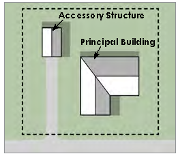
4.1.3 Lot access.
A.
No building, structure or use of land, for other than agricultural purposes, shall be established on a lot nor shall any lot be created that does not abut upon a public street or private street built to Town or State standards to which it has legal access.
B.
The minimum frontage upon a public or private right-of-way shall be 25 feet for each lot of record. This access requirement shall not apply to lawfully existing lots of record with a minimum of 25 feet of frontage on a dedicated access easement.
C.
The Town of Yadkinville discourages and restricts the creation of flag lots. A flag lot may be permitted only if necessary to allow a property owner reasonable use and benefit of a parcel of land or to alleviate a situation that would otherwise cause extreme hardship for the owner. The following shall apply to any new flag lot:
1.
Flag lots may be allowed only in minor subdivisions, and no more than one (1) flag lot may be allowed per subdivision;
2.
No flag lot shall be located closer than 500 feet from another flag lot, existing or proposed;
3.
No flag lot shall be allowed if it increases the number of access points onto a major thoroughfare;
4.
No flag lot shall be allowed for the sole purpose of increasing the number of salable lots in a subdivision.
5.
Lots in existing major subdivisions shall not be re-subdivided to create flag lots.
6.
In any case where a flag lot is allowed under provisions (1) through (5) above, the following shall apply:
•
The access portion of the flag lot shall not be included in computation of the lot size for zoning compliance.
•
The frontage of the flag lot shall have a minimum width of 25 feet and the front setback shall be measured from where the minimum lot width is first met.
•
The length of the access portion of the flag lot shall not be more than 300 feet.
4.1.4 Lot of record.
A.
No yard or lot existing at the time of passage of this Ordinance shall be reduced in size or area below the minimum requirements set forth herein. Yards or lots created after the effective date of this Ordinance shall be at least the minimum requirements established by this Ordinance.
B.
Where the owner of a lawfully existing lot of official record in any residential district or the owner's successor in title thereto does not own sufficient contiguous land to enable the owner to conform to the minimum lot size requirements of this Ordinance, such lot may be used as a residential building site, where permitted, provided that the other requirements of the district are complied with or a variance is obtained from the Board of Adjustment. Such lot must have access in accordance with Section 4.1.3(B).
C.
Notwithstanding the foregoing, whenever two (2) or more adjoining vacant lots of record are in a single ownership at any time after the adoption of this Ordinance and such lots individually have less area or width than the minimum requirements of the district in which such lots are located, such lots shall be combined or recombined to meet the minimum lot standards prior to the development of any such lot.
4.1.5 Flexibility in administration.
A.
In the event that the unusual topography, location of existing buildings, or location or size of the parcel to be developed would make strict adherence to the requirements of this Article serve no meaningful purpose or would make it physically impossible to install and maintain the required improvements, the Administrator may alter the requirements of this Section up to 10% less than the minimum requirement or 10% more than the maximum requirement, provided the spirit and intent of the Section are maintained. This flexibility shall not apply to minimum building setbacks as set forth in Section 4.2.2. Such an alteration may occur only at the request of the developer, who shall submit a plan to the Administrator showing existing site features or alternative improvements that would achieve the intent of the requirements of this Article. The vacancy or non-use of an adjoining parcel shall not constitute grounds for providing relief to the requirements contained in this Article. Neither shall the desire of an owner to make a more intensive use or greater economic use of the property be grounds for reducing the requirements.
B.
Any deviation from minimum setbacks shall require the issuance of a Variance by the Board of Adjustment as set forth in Section 2.2.6. Any deviation from any other requirement of this Article by greater than 10% shall require review and approval by the Planning Board as an Alternative Design subject to the procedures set forth in Section 2.2.9.
4.2 - Density and dimensional standards.
4.2.1 General provisions.
A.
The lot sizes required for the various districts in this Ordinance were established upon the assumption that adequate water supply and sewage disposal systems are available to each and every lot. The lack of adequate systems for one (1) or both facilities may require larger lot areas or, in some instances, because of Health Department Standards, may not permit development as intended.
B.
In all zoning districts, double frontage or through lots shall provide the minimum yard requirements for front yards along both street fronts.
C.
Where a property abuts a street right-of-way or access easement, the setback shall be measured from the right-of-way of easement line.
D.
The front setbacks of lots shall be established where the lot width is met.
Figure 4.2 Flag Lot Front Setback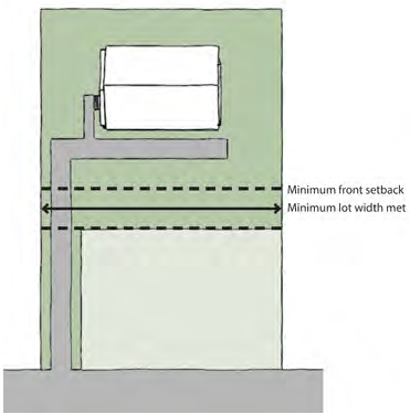
E.
On a corner lot in any zoning district other than the Central Business (CB) district, no planting, structure, fence, wall, or other obstruction to vision that is more than two (2) feet tall as measured at street level shall be placed in the sight triangle. The sight triangle is the area formed by a diagonal line connecting two (2) points located on intersecting property lines (or a property line and the curb or a driveway). The following are the distances used to establish a sight triangle as measured from the edge-of-pavement of intersecting streets:
Table 4.1 Sight Distance
Figure 4.3 Sight Triangle (Shaded Area)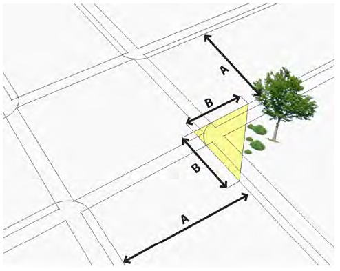
F.
All structure heights shall be measured as shown in Figure 4.4.
Figure 4.4 Height Measurement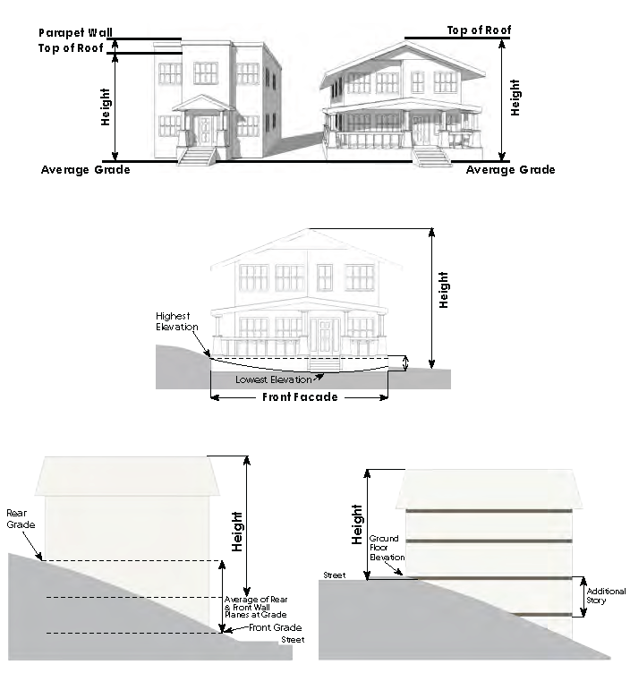
G.
All setbacks shall be measured from the property line to the nearest point of the structure as shown in Figure 4.5 below.
Figure 4.5 Yard Designations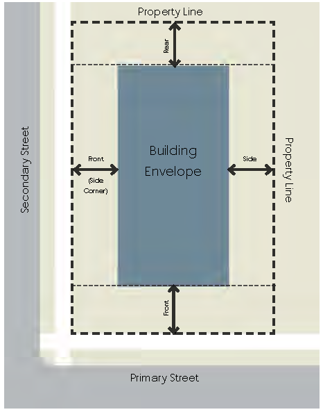
4.2.2 Density and dimensional table The following table provides the density and dimensional standards for each zoning district.
Table 4.2 Density and Dimensional Standards
N/A = NOT APPLICABLE
Figure 4.6 Dimensions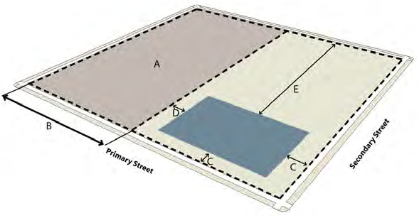
4.2.3 Exceptions to dimensional standards.
A.
Minimum lot size (A2), lot width (B), and side setbacks (D) shall not apply to townhomes, where permitted.
B.
Lot size (A2) and lot width (B) for duplexes, permitted in the RH, RMH, OI, and NB District, shall be 1.5 times the minimum shown in the table. Lot sizes in the RM District, where permitted subject to the issuance of a Minor Special Use Permit, shall be subject to the density and dimensional standards of Section 3.5.2.5.
C.
Minimum lot size (A2), lot width (B), and setbacks (C—E) shall not apply in conservation developments, as permitted subject to Section 4.2.4, as long as maximum density (A1) for the district is not exceeded.
D.
The front setback for each district shall apply to the side yard of corner lots abutting a public street and to double frontage lots.
E.
The front setback requirements (C) shall not apply to any lot where the front yard coverage on developed lots, located wholly or in part within 100 feet on each side of such lot and within the same block and zoning district and fronting on the same street as such lot, is less than the minimum required front yard. In such cases, the front yard on such lot may be less than the required front yard but not less than the average of the existing front yards on the developed lots; provided, that the front yard on such lot shall not be less than one-half (½) of the required front yard.
F.
The maximum height (F) shall only apply to habitable structures and portions of structures and shall not apply to elevator shafts, stairwells, tanks, mechanical equipment, water towers, observation towers, fire training towers, power and communication transmission towers, flag poles, steeples, spires, cupolas, and similar structures provided such structures meet the required North Carolina Building Code. Such projections may be subject to the screening requirements of Section 4.4.7. Height limitations shall apply to wireless telecommunications towers as regulated in Section 3.5.7.5.
G.
Allowable encroachments into setbacks.
1.
Cornices, eaves and overhangs, gutters, chimneys, awnings. May extend up to 3 feet into any required setback, but in no case shall be closer than 3 feet to any lot line.
2.
Bay windows. May extend up to 3 feet into any required setback, if no more than 9 feet wide, but in no case shall be closer than 3 feet to any lot line.
3.
Sills or entablatures. May extend up to 12 inches into any required setback.
4.
Flagpoles, mailboxes, lamp and address posts, exterior light poles. May be located in any required setback.
5.
Open balconies, fire escapes, or exterior open stairways. May extend up to 3 feet into any required setback, but in no case shall be closer than 3 feet to any lot line.
6.
Uncovered porches, stoops, decks, patios, terraces, walkways, or driveways. May extend into or be located in any required setback, if less than 12 inches high.
7.
Canopies, awnings, and marquees attached to a building in the CB District. May extend into the Town's street right-of-way if no portion is closer than 4 feet to the face of the curb; no portion is less than 9 feet above grade; and no portion requiring vertical support from the sidewalk is located above a sidewalk of less than 8 feet in width.
8.
Handicapped ramps. May be located within any required setback.
9.
HVAC condensers, heat pumps, or other outdoor mechanical equipment. May be located within any required setback.
10.
Sign, wall, projecting or freestanding in the CB District. May extend into any required Town setback, subject to Section 6.4.1 Building Signs.
11.
Utility cabinets and well houses. May be located in any required setback.
12.
Pick up or bus shelters and gatehouses. May be located in any required setback.
H.
The dimensional provisions of this section do not apply to residential accessory structures, which are regulated in Section 3.5.3.2.
I.
Utility uses as defined by this Ordinance are not subject to the minimum lot sizes set forth for each zoning district.
J.
Where any buffer width as required by Section 4.4.3 exceeds the minimum setback, the required buffer width shall also be the minimum setback.
K.
Fences shall not be subject to minimum setbacks, subject to the fence requirements set forth in Section 4.4.9. Necessary retaining walls and fences less than eight (8) feet high when located in the rear yard, shall be exempt from the setback requirements of this Section; except that on a corner lot no fence more than three (3) feet in height shall be located within any yard or building setback required along the side street line by any other provision of this chapter. The height of any fence located within a yard abutting on a street line shall be measured from the sidewalk; and if there is no sidewalk, from the top of the curb; and if there is no sidewalk or curb, from the centerline of the street. All other fence heights shall be measured from natural grade.
4.2.4 Conservation development.
4.2.4.1Purpose and applicability.
A.
The purpose of Conservation Development design is an optional residential development design tool intended to preserve agricultural and forestry lands, natural and cultural features and environmentally sensitive areas that would be likely lost through conventional development approaches.
B.
The conservation development design option may be utilized for any residential development of greater than 10 units within the RR and RM zoning districts.
4.2.4.2 Development density and dimensions.
A.
The development density shall not exceed the overall density permitted in the zoning district in which the development is located (except as set forth in Section 4.2.4.3. Areas with slopes of greater than 25% and floodway areas shall not be included in the overall allowable density calculation.
B.
Lot widths and setbacks in residential districts may be reduced subject to the requirements set forth in this section. The district setbacks set forth in Section 4.2.2 (Table 4.2) shall apply along the boundaries of the development. Setbacks within the development shall be set forth as part of the design process as outlined in Section 4.2.4.4, but in no case shall be reduced to less than a minimum 10 foot separation between buildings.
4.2.4.3 Required open space and density bonus.
A.
A minimum of 40% of the total area of the development shall be set aside in Common Open Space and shall meet the requirements of Section 4.3.4.
B.
Any development exceeding the minimum open space of 40% may increase the number of residential units by 1% for every 1% increase in open space up to a maximum of 120% of the density yield for the base zoning district.
4.2.4.4 Conservation development approval process. Approval of conservation development shall follow the major subdivision approval process as set forth in Section 2.2.4, except that the following steps shall be added to the sketch plan phase:
A.
During the first step, the total yield for the property is calculated based on the total property area and the density for zoning district, minus the minimum required open space for a conventional development, as set forth in Section 4.2.2.
B.
Next, all potential Conservation Areas (primary, secondary, and tertiary), as defined in shall be identified as described in Section 4.3.4.3.
C.
During the third step, potential building sites (up to the maximum identified in Step 1) are tentatively located. House sites should generally be located not closer than 50 feet to Primary Conservation Areas.
D.
The fourth step consists of aligning proposed streets to provide vehicular access to each house in the most reasonable and economical way. When lots and access streets are laid out, they shall be located in a way that avoids, or at least minimizes, adverse impacts on the Conservation Areas. Wetland crossings should be avoided. Street connections shall be provided to minimize the number of culs-de-sac and to facilitate easy access to and from homes in different parts of the property (and on adjoining parcels).
E.
The fifth step is simply to draw the lot lines where applicable. Lot sizes and setbacks may be no less than one-half (½) of the minimum size for the district as set forth in Section 4.2.2.
Figure 4.7 Conventional Development vs.
Conservation Development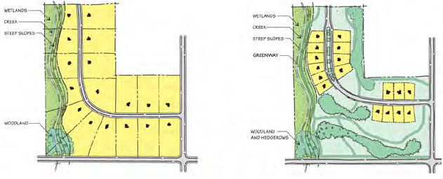
(Ord. of 6-3-2019, ZTA 2019-02; ZTA Ord. No. 2021-02, § 8, 4-5-21; ZTA Ord. No. 2021-03, § 25, 5-3-21; ZTA Ord. No. 2021-04, § 4, 2-7-22)
4.3 - Environmental and open space standards.
4.3.1 Purpose. The purpose of this section is to establish provisions for the protection of the environment as required by state and federal law and to provide for adequate open space, green space, and recreation within Yadkinville's jurisdiction.
4.3.2 Watershed protection standards. All amendments to this section shall be filed with the N.C. Division of Water Quality, N.C. Division of Environmental Health, and the N.C. Division of Community Assistance.
4.3.2.1 Designated watershed area. A small area located in the southwestern portion of the extraterritorial jurisdiction (ETJ) of the Town lies within the Deep Creek Water Supply Watershed, mapped and classified as WS-III-BW (Balance of Watershed) by the N.C. Department of Environment Quality, Division of Water Quality. Lands within this watershed shall be regulated by the standards of this Section. All development within the regulated watershed area shall comply with the watershed protection rules adopted by the N.C. Environmental Management Commission.
4.3.2.2 Maximum density and built-upon area.
A.
In addition to compliance with all requirements of the zoning district, to maintain a low to moderate land use intensity, single family detached uses shall develop at a maximum of two (2) dwelling units per acre. All other residential and non-residential development shall be allowed at a maximum of 24% built-upon area.
B.
In addition, new development and expansions to existing development may occupy 10% of the balance of the watershed area with up to 70% (built-upon area when approved as a special intensity allocation (SIA). The Administrator is authorized to approve SIAs consistent with the following provisions. Each project within the WSPO overlay district shall, to the maximum extent practicable:
1.
Minimize built-upon surface area.
2.
Direct stormwater away from surface waters.
3.
Incorporate Best Management Practices to minimize water quality impacts.
C.
The Administrator may require certification by a licensed engineer, surveyor and/or architect to ensure compliance with these provisions.
4.3.3 Floodplain damage prevention standards.
4.3.3.1 Statutory authorization. The Legislature of the State of North Carolina has in NC GS Ch. 143, Art. 21, Part 6; G.S. Ch. 160A, Art. 19, Part 3, 5 and 8; G.S. Ch. 160A, Art. 8, delegated to local governmental units the responsibility to adopt regulations designed to promote the public health, safety, and general welfare of its citizenry including the regulations set out in this article. Therefore, the Board of Commissioners of Yadkinville, North Carolina, does ordain as follows in this Section.
4.3.3.2 Findings of fact.
A.
The flood prone areas within the jurisdiction of Yadkinville are subject to periodic inundation which results in loss of life, property, health and safety hazards, disruption of commerce and governmental services, extraordinary public expenditures of flood protection and relief, and impairment of the tax base, all of which adversely affect the public health, safety, and general welfare.
B.
These flood losses are caused by the cumulative effect of obstructions in floodplains causing increases in flood heights and velocities, and by the occupancy in flood prone areas by uses vulnerable to floods or hazardous to other lands which are inadequately elevated, floodproofed, or otherwise unprotected from flood damages.
4.3.3.3 Statement of purpose. It is the purpose of this chapter to promote public health, safety, and general welfare and to minimize public and private losses due to flood conditions within flood prone areas by provisions designed to:
A.
Restrict or prohibit uses which are dangerous to health, safety, and property due to water or erosion hazards, or which result in damaging increases in erosion, flood heights or velocities;
B.
Require that uses vulnerable to floods, including facilities which serve such uses, be protected against flood damage at the time of initial construction;
C.
Control the alteration of natural floodplains, stream channels, and natural protective barriers, which are involved in the accommodation of flood waters;
D.
Control filling, grading, dredging, and all other development which may increase erosion or flood damage; and
E.
Prevent or regulate the construction of flood barriers which will unnaturally divert floodwaters or which may increase flood hazards to other lands.
4.3.3.4 Objectives. The objectives of this chapter are;
A.
To protect human life and health;
B.
To minimize expenditure of public money for costly flood control projects;
C.
To minimize the need for rescue and relief efforts associated with flooding and generally undertaken at the expense of the general public;
D.
To minimize prolonged business losses and interruptions;
E.
To minimize damage to public facilities and utilities (i.e. water and gas mains, electric, telephone, cable and sewer lines, streets, and bridges) that are located in flood prone areas;
F.
To help maintain a stable tax base by providing for the sound use and development of flood prone areas in such a manner as to minimize flood blight areas; and
G.
To insure that potential homebuyers are notified that property is in a Special Flood Hazard Area.
4.3.3.5 Lands to which this chapter applies. This chapter shall apply to all Special Flood Hazard Areas within the jurisdiction, including the extra-territorial jurisdictions (ETJ) of Yadkinville.
4.3.3.6 Basis for establishing the special flood hazard areas. The Special Flood Hazard Areas are those identified by the Federal Emergency Management Agency (FEMA) or produced under the Cooperating Technical State (CTS) agreement between the State of North Carolina and FEMA in its Flood Hazard Boundary Map (FHBM) or Flood Insurance Study (FIS) and its accompanying flood maps such as the most recent Flood Insurance Rate Map(s) (FIRM), which with accompanying supporting data, and any revision thereto, including Letters of Map Amendment or Revision, are adopted by reference and declared to be a part of this chapter. The Special Flood Hazard Areas also include those defined through standard engineering analysis for private developments or by governmental agencies, but which have not yet been incorporated in the FIRM. This includes, but is not limited to, detailed flood data:
A.
Generated as a requirement of section 4.3.3.15(K) and (L) of this chapter;
B.
Preliminary FIRMs where more stringent than the effective FIRM; or
C.
Post-disaster flood recovery maps.
4.3.3.7 Establishment of floodplain development permit. A Floodplain development permit shall be required in conformance with the provisions of this chapter prior to the commencement of any development activities within Special Flood Hazard Areas as determined in section 4.3.3.6.
4.3.3.8 Compliance. No structure or land shall hereafter be located, extended, converted, altered, or developed in any way without full compliance with the terms of this chapter and other applicable regulations.
4.3.3.9 Abrogation and greater restrictions. This chapter is not intended to repeal, abrogate, or impair any existing easements, covenants, or deed restrictions. However, where this chapter and another ordinance conflict or overlap, whichever imposes the more stringent restrictions shall prevail.
4.3.3.10 Interpretation. In the interpretation and application of this chapter, all provisions shall be:
A.
Considered as minimum requirements;
B.
Liberally construed in favor of the governing body; and
C.
Deemed neither to limit nor repeal any other powers granted under state statutes.
4.3.3.11 Warning and disclaimer of liability. The degree of flood protection required by this chapter is considered reasonable for regulatory purposes and is based on scientific and engineering consideration. Larger floods can and will occur on rare occasions. Actual flood heights may be increased by man-made or natural causes. This chapter does not imply that land outside the Special Flood Hazard Areas or uses permitted within such areas will be free from flooding or flood damages. This chapter shall not create liability on the part of Yadkinville or by any officer or employee thereof for any flood damages that result from reliance on this chapter or any administrative decision lawfully made hereunder.
4.3.3.12 Penalties for violation. Any person, firm or corporation who violates the provisions of this chapter or failure to comply with any of its requirements, including violation of conditions and safeguards established in connection with grants of variance or special exceptions, shall, upon conviction thereof, be fined not more than fifty dollars ($50.00). Each day such violation continues shall be considered a separate offense. Nothing herein contained shall prevent Yadkinville from taking such other lawful action as is necessary to prevent or remedy any violation.
4.3.3.13 Designation of floodplain administrator. The Administrator or designee is hereby appointed to administer and implement the provisions of this Section.
4.3.3.14 Floodplain development permit and certification requirements.
A.
Plans and application requirements. Application for a floodplain development permit shall be made to the Floodplain Administrator on forms furnished by him or her prior to any development activities proposed to be located within flood prone areas. The following items/information shall be presented to the Floodplain Administrator to apply for a floodplain development permit.
1.
A plot plan drawn to scale which shall include, but shall not be limited to, the following specific details of the proposed floodplain development:
a.
The nature, location, dimensions, and elevations of the area of development/disturbance; existing and proposed structures, the location of utility systems, proposed grading/pavement areas, fill materials, storage areas, drainage facilities, and other proposed development;
b.
The boundary of the Special Flood Hazard Area as delineated on the FIRM or other flood map as determined in Section 4.3.3.6 or a statement that the entire lot is within the Special Flood Hazard Area;
c.
Flood zone(s) designation of the proposed development area as determined on the FIRM or other flood map as determined in section 4.3.3.6;
d.
The boundary of the floodway(s) or non-encroachment area(s) as determined in section 4.3.3.6;
e.
The Base Flood Elevation (BFE) where provided as set forth in section 4.3.3.6; section 4.3.3.15(K) and (L); sections 4.3.3.20, 4.3.3.21 and section 4.3.3.19(E);
f.
The old and new location of any watercourse that will be altered or relocated as a result of proposed development;
2.
Proposed elevation, and method thereof, of all development within a Special Flood Hazard Area including but not limited to:
a.
Elevation in relation to mean sea level of the proposed reference level (including basement) of all structures;
b.
Elevation in relation to mean sea level to which any non-residential structure will be flood-proofed;
c.
Elevation in relation to mean sea level to which any proposed utility systems will be elevated or floodproofed;
3.
If floodproofing, a floodproofing certificate and back-up plans from a registered professional engineer or architect certifying that the non-residential flood-proofed development will meet the flood-proofing criteria in section 4.3.3.19(B) and section 4.3.3.20(B).
4.
A foundation plan drawn to scale, which shall include details of the proposed foundation system to ensure all provisions of this Section are met. These details include but are not limited to:
a.
Proposed method of elevation, if applicable (i.e., fill, solid foundation perimeter wall, solid backfilled foundation, open foundation on columns/piers);
b.
Should solid foundation perimeter walls be used in floodplains, details of sufficient openings to facilitate the unimpeded movements of floodwaters in accordance with section 4.3.3.19(D);
5.
Usage details of any enclosed space below the regulatory flood protection elevation.
6.
Plans and/or details for the protection of public utilities and facilities such as sewer, gas, electrical, and water systems to be located and constructed to minimize flood damage;
7.
Copy of all other local, state and federal permits required prior to floodplain development permit issuance (i.e. wetlands, erosion and sedimentation control, riparian buffers, mining, etc.)
8.
If a floodplain development permit is issued for placement of recreational vehicles and/or temporary structures, documentation to ensure section 4.3.3.19(F) and (G) of this Code are met.
9.
If a watercourse is proposed to be altered and/or relocated, a description of the extent of watercourse alteration or relocation; an engineering report on the effects of the proposed project on the flood-carrying capacity of the watercourse and the effects to properties located both upstream and downstream; and a map (if not shown on plot plan) showing the location of the proposed watercourse alteration or relocation.
B.
Floodplain development permit data requirements. The following information shall be provided at a minimum on the floodplain development permit to ensure compliance with this code.
1.
A description of the development to be permitted under the floodplain development permit issuance.
2.
The Special Flood Hazard Area determination for the proposed development per available data specified in section 4.3.3.6.
3.
The regulatory flood protection elevation required for the reference level and all attendant utilities.
4.
The regulatory flood protection elevation required for the protection of all public utilities.
5.
All certification submittal requirements with timelines.
6.
State that no fill material shall encroach into the floodway or non-encroachment area of any watercourse, if applicable.
C.
Certification requirements.
1.
An elevation certificate (FEMA Form 81-31) or Floodproofing Certificate (FEMA Form 81-65) is required after the reference level is completed. Within twenty-one (21) calendar days of establishment of the reference level elevation, or floodproofing, by whatever construction means, whichever is applicable, it shall be the duty of the permit holder to submit to the Floodplain Administrator a certification of the elevation of the reference level, or flood proofed elevation, whichever is applicable in relation to mean sea level. Said certification shall be prepared by or under the direct supervision of a registered land surveyor or professional engineer and certified by same. When floodproofing is utilized, said certification shall be prepared by or under the direct supervision of a professional engineer or architect and certified by same. Any work done within the twenty-one (21) day calendar period and prior to submission of the certification shall be at the permit holder's risk. The Floodplain Administrator shall review the certificate data submitted. Deficiencies detected by such review shall be corrected by the permit holder immediately and prior to further progressive work being permitted to proceed. Failure to submit the certification or failure to make said corrections required shall be cause to issue a stop-work order for the project.
2.
A final as-built elevation certificate (FEMA Form 81-31) or floodproofing certificate (FEMA Form 81-65) is required after construction is completed and prior to certificate of compliance/occupancy issuance. It shall be the duty of the permit holder to submit to the Floodplain Administrator a certification of final as-built construction of the elevation or floodproofed elevation of the reference level and all attendant utilities. Said certification shall be prepared by or under the direct supervision of a registered land surveyor or professional engineer and certified by same. When floodproofing is utilized, said certification shall be prepared by or under the direct supervision of a professional engineer or architect and certified by same. The Floodplain Administrator shall review the certificate data submitted. Deficiencies detected by such review shall be corrected by the permit holder, immediately and prior to certificate of compliance/occupancy issuance. In some instances, another certification may be required to certify corrected as-built construction. Failure to submit the certification or failure to make said corrections required shall be cause to withhold the issuance of a certificate of compliance/occupancy.
3.
If a manufactured home is placed within an A, AO, AE, or AI—30 zone and the elevation of the chassis is above thirty-six (36) inches in height, an engineered foundation certification is required per section 4.3.3.19(C).
4.
If a watercourse is to be altered or relocated, a description of the extent of watercourse alteration or relocation; an engineering report on the effects of the proposed project on the flood-carrying capacity of the watercourse and the effects to properties located both upstream and downstream; and a map showing the location of the proposed watercourse alteration or relocation shall all be submitted by the permit applicant prior to issuance of a floodplain development permit.
5.
Certification exemptions. The following structures, if located within A, AO, AE or AI—30 zones, are exempt from the elevation/floodproofing certification requirements specified in items (1) and (2) above:
a.
Recreational vehicles meeting requirements of section 4.3.3.19(F 1);
b.
Temporary structures meeting requirements of section 4.3.3.19(G); and
c.
Accessory structures less than one hundred fifty (150) square feet meeting requirements of section 4.3.3.19(H).
4.3.3.15 Duties and responsibilities of the floodplain administrator. Duties of the Floodplain Administrator shall include, but not be limited to:
A.
Review all floodplain development applications and issue permits for all proposed development within flood prone areas to assure that the requirements of this chapter have been satisfied.
B.
Advise permittee that additional federal or state permits (i.e., wetlands, erosion and sedimentation control, riparian buffers, mining, etc.) may be required, and if specific federal or state permits are known, require that copies of such permits be provided and maintained on file with the floodplain development permit.
C.
Notify adjacent communities and the North Carolina Department of Crime Control and Public Safety, Division of Emergency Management, State Coordinator for the National Flood Insurance Program prior to any alteration or relocation of a watercourse, and submit evidence of such notification to the Federal Emergency Management Agency.
D.
Assure that maintenance is provided within the altered or relocated portion of said watercourse so that the flood-carrying capacity is not diminished.
E.
Prevent encroachments within floodways and non-encroachment areas unless the certification and flood hazard reduction provisions of section 4.3.3.22 are met.
F.
Obtain actual elevation (in relation to mean sea level) of the reference level (including basement) of all attendant utilities of all new or substantially improved structures, in accordance with section 4.3.3.14(C).
G.
Obtain the actual elevation (in relation to mean sea level) to which the new or substantially improved structures and all utilities have been floodproofed, in accordance with section 4.3.3.14(C).
H.
Obtain actual elevation (in relation to mean sea level)of all public utilities, in accordance with section 4.3.3.14(C).
I.
When flood proofing is utilized fora particular structure, obtain certifications from a registered professional engineer or architect in accordance with section 4.3.3.14(C) and section 4.3.3.19(B).
J.
Where interpretation is needed as to the exact location of boundaries of the Special Flood Hazard Areas (for example, where there appears to be a conflict between a mapped boundary and actual field conditions), make the necessary interpretation. The person contesting the location of the boundary shall be given a reasonable opportunity to appeal the interpretation as provided in this Section.
K.
When Base Flood Elevation (BFE) data has not been provided in accordance with section 4.3.3.14, obtain, review, and reasonably utilize any Base Flood Elevation (BFE) data, along with floodway data and/or non-encroachment area data available from a federal, state, or other source, including data developed pursuant to section 4.3.3.20(D), in order to administer the provisions of this Section.
L.
When Base Flood Elevation (BFE) data is provided but no floodway nor non-encroachment area data has been provided in accordance with section 4.3.3.6, obtain, review, and reasonably utilize any floodway data, and/or non-encroachment area data available from a federal, state, or other source in order to administer the provisions of this chapter.
M.
When the exact location of boundaries of the Special Flood Hazard Areas conflict with the current, natural topography information at the site, the property owner may apply and be approved for a Letter of Map Amendment (LOMA) by FEMA. A copy of the Letter of Map Amendment issued from FEMA will be maintained by the Floodplain Administrator in the floodplain development permit file.
N.
Permanently maintain all records that pertain to the administration of this ordinance and make these records available for public inspection.
O.
Make on-site inspections of work in progress. As the work pursuant to a floodplain development permit progresses, the Floodplain Administrator shall make as many inspections of the work as may be necessary to ensure that the work is being done according to the provisions of the local ordinance and the terms of the permit. In exercising this power, the Floodplain Administrator has a right, upon presentation of proper credentials, to enter on any premises within the jurisdiction of the community at any reasonable hour for the purposes of inspection or other enforcement action.
P.
Issue stop-work orders as required. Whenever a building or part thereof is being constructed, reconstructed, altered, or repaired in violation of this chapter, the Floodplain Administrator may order the work to be immediately stopped. The stop-work order shall be in writing and directed to the person doing the work. The stop-work order shall state the specific work to be stopped, the specific reason(s) for the stoppage, and the condition(s) under which the work may be resumed. Violation of a stop-work order constitutes a misdemeanor.
Q.
Revocation of floodplain development permits as required. The Floodplain Administrator may revoke and require the return of the floodplain development permit by notifying the permit holder in writing stating the reason(s) for the revocation. Permits shall be revoked for any substantial departure from the approved application, plans, or specifications; for refusal or failure to comply with the requirements of state or local laws; or for false statements or misrepresentations made in securing the permit. Any floodplain development permit mistakenly issued in violation of an applicable state or local law may also be revoked.
R.
Make periodic inspections throughout all special flood hazard areas within the jurisdiction of the community. The Floodplain Administrator and each member of his or her inspections department shall have a right, upon presentation of proper credentials, to enter on any premises within the territorial jurisdiction of the department at any reasonable hour for the purposes of inspection or other enforcement action.
S.
Follow through with corrective procedures of section 4.3.3.16.
4.3.3.16 Corrective procedures.
A.
Violations to be corrected. When the Floodplain Administrator finds violations of applicable state and local laws, it shall be his or her duty to notify the owner or occupant of the building of the violation. The owner or occupant shall immediately remedy each of the violations of law pertaining to their property.
B.
Actions in event of failure to take corrective action. If the owner of a building or property shall fail to take prompt corrective action, the Floodplain Administrator shall give the owner written notice, by certified or registered mail to the owner's last known address or by personal service, stating:
1.
That the building or property is in violation of the Flood Damage Prevention Ordinance;
2.
That a hearing will be held before the Floodplain Administrator at a designated place and time, not later than ten (10) days after the date of the notice, at which time the owner shall be entitled to be heard in person or by counsel and to present arguments and evidence pertaining to the matter; and
3.
That following the hearing, the Floodplain Administrator may issue such order to alter, vacate, or demolish the building; or to remove fill as appears appropriate.
C.
Order to take corrective action. If, upon a hearing held pursuant to the notice prescribed above, the Floodplain Administrator shall find that the building or development is in violation of the Flood Damage Prevention Ordinance, he or she shall make an order in writing to the owner, requiring the owner to remedy the violation within a specified time period, not less than sixty (60) days. Where the Floodplain Administrator finds that there is imminent danger to life or other property, he or she may order that corrective action be taken in such lesser period as may be feasible.
D.
Appeal. Any owner who has received an order to take corrective action may appeal the order to the local elected governing body by giving notice of appeal in writing to the Floodplain Administrator and the clerk within ten (10) days following issuance of the final order. In the absence of an appeal, the order of the Floodplain Administrator shall be final. The local governing body shall hear an appeal within a reasonable time and may affirm, modify and affirm, or revoke the order.
E.
Failure to comply with order. If the owner of a building or property fails to comply with an order to take corrective action from which no appeal has been taken, or fails to comply with an order of the governing body following an appeal, he or she shall be guilty of a misdemeanor and shall be punished in the discretion of the court.
4.3.3.17 Variance procedures.
A.
The Board of Adjustment serving as the Watershed Review Board as established by Yadkinville, hereinafter referred to as the "Appeal Board", shall hear and decide requests for variances from the requirements of this chapter.
B.
Any person aggrieved by the decision of the Appeal Board may appeal such decision to the Court, as provided in NC GS Ch. 7A.
C.
Variances may be issued for the repair or rehabilitation of historic structures upon the determination that the proposed repair or rehabilitation will not preclude the structure's continued designation as a historic structure and the variance is the minimum necessary to preserve the historic character and design of the structure.
D.
In passing upon variances, the Appeal Board shall consider all technical evaluations, all relevant factors, all standards specified in other sections of this Section and
1.
The danger that materials may be swept onto other lands to the injury of others;
2.
The danger to life and property due to flooding or erosion damage;
3.
The susceptibility of the proposed facility and its contents to flood damage and the effect of such damage on the individual owner;
4.
The importance of the services provided by the proposed facility to the community;
5.
The necessity to the facility of a waterfront location, where applicable;
6.
The availability of alternative locations, not subject to flooding or erosion damage, for the proposed use;
7.
The compatibility of the proposed use with existing and anticipated development; the relationship of the proposed use to the comprehensive plan and floodplain management program for that area;
8.
The safety of access to the property in times of flood for ordinary and emergency vehicles;
9.
The expected heights, velocity, duration, rate of rise, and sediment transport of the flood waters and the effects of wave action, if applicable, expected at the site; and
10.
The costs of providing governmental services during and after flood conditions including maintenance and repair of public utilities and facilities such as sewer, gas, electrical and water systems, and streets and bridges.
E.
A written report addressing each of the above factors shall be submitted with the application for a variance.
F.
Upon consideration of the factors listed above and the purposes of this Section, the Appeal Board may attach such conditions to the granting of variances as it deems necessary to further the purposes of this Section.
G.
Variances shall not be issued within any designated floodway or non-encroachment area if any increase in flood levels during the base flood discharge would result.
H.
Conditions for variances:
1.
Variances may not be issued when the variance will make the structure in violation of other federal, state, or local laws, regulations, or ordinances.
2.
Variances shall only be issued upon a determination that the variance is the minimum necessary, considering the flood hazard, to afford relief.
3.
Variances shall only be issued upon:
a.
A showing of good and sufficient cause;
b.
A determination that failure to grant the variance would result in exceptional hardship; and
c.
A determination that the granting of a variance will not result in increased flood heights, additional threats to public safety, or extraordinary public expense, create nuisance, cause fraud on or victimization of the public, or conflict with existing local laws or ordinances.
4.
Any applicant to whom a variance is granted shall be given written notice specifying the difference between the Base Flood Elevation (BFE) and the elevation to which the structure is to be built and a written statement that the cost of flood insurance will be commensurate with the increased risk resulting from the reduced reference level elevation. Such notification shall be maintained with a record of all variance actions.
5.
The Floodplain Administrator shall maintain the records of all appeal actions and report any variances to the Federal Emergency Management Agency and the State of North Carolina upon request.
4.3.3.18 General standards. In all Special Flood Hazard Areas the following provisions are required;
A.
All new construction and substantial improvements shall be anchored to prevent flotation, collapse, or lateral movement of the structure.
B.
All new construction and substantial improvements shall be constructed with materials and utility equipment resistant to flood damage.
C.
All new construction or substantial improvements shall be constructed by methods and practices that minimize flood damages.
D.
Electrical, heating, ventilation, plumbing, air conditioning equipment, and other service facilities shall be designed and/or located so as to prevent water from entering or accumulating within the components during conditions of flooding. These include but are not limited to HVAC equipment, water softener units, bath/kitchen fixtures, ductwork, electric meter panels/boxes, utility/cable boxes, appliances (i.e., washers, dryers, refrigerator, etc.), hot water heaters, electric outlets/switches.
E.
All new and replacement water supply systems shall be designed to minimize or eliminate infiltration of flood waters into the system.
F.
New and replacement sanitary sewage systems shall be designed to minimize or eliminate infiltration of flood waters into the systems and discharges from the systems into flood waters.
G.
On-site waste disposal systems shall be located and constructed to avoid impairment to them or contamination from them during flooding.
H.
Any alteration, repair, reconstruction, or improvements to a structure which is in compliance with the provisions of this chapter, shall meet the requirements of "new construction" as contained in this Section.
I.
Non-conforming structures or other development may not be enlarged, replaced, or rebuilt unless such enlargement or reconstruction is accomplished in conformance with the provisions of this chapter. Provided, however, nothing in this Section shall prevent the repair, reconstruction, or replacement of a building or structure existing on the effective date of this chapter and located totally or partially within the floodway, non-encroachment area, or stream setback, provided that the bulk of the building or structure below the regulatory flood protection elevation in the floodway, non-encroachment area, or stream setback is not increased and provided that such repair, reconstruction, or replacement meets all of the other requirements of this Section.
J.
New solid waste disposal facilities, hazardous waste management facilities, salvage yards, and chemical storage facilities shall not be permitted in Special Flood Hazard Areas. A structure or tank for chemical or fuel storage incidental to an allowed use or to the operation of a water treatment plant or wastewater treatment facility may be located in a Special Flood Hazard Area only if the structure or tank is either elevated or floodproofed to at least the regulatory flood protection elevation and certified according to section 4.3.3.14(C) of this Ordinance.
4.3.3.19 Specific standards. In all Special Flood Hazard Areas where Base Flood Elevation (BFE) data has been provided, as set forth in section 4.3.3.6 or section 4.3.3.15(K), the following provisions are required:
A.
Residential construction. New construction or substantial improvement of any residential structure (including manufactured homes) shall have the reference level, including basement, elevated no lower than the regulatory flood protection elevation.
B.
Non-residential construction. New construction or substantial improvement of any commercial, industrial, or other non-residential structure shall have the reference level, including basement, elevated no lower than the regulatory flood protection elevation. Structures located in A, AO, AE and AI—30 Zones may be floodproofed to the regulatory flood protection elevation in lieu of elevation provided that all areas of the structure below the required flood protection elevation are watertight with walls substantially impermeable to the passage of water, using structural components having the capability of resisting hydrostatic and hydrodynamic loads and the effect of buoyancy. A registered professional engineer or architect shall certify that the standards of this subsection are satisfied. Such certification shall be provided to the official as set forth in section 4.3.3.14(C).
C.
Manufactured homes.
1.
New or replacement manufactured homes shall be elevated so that the reference level of the manufactured home is no lower than the regulatory flood protection elevation.
2.
Manufactured homes shall be securely anchored to an adequately anchored foundation to resist flotation, collapse, and lateral movement in accordance with the State of North Carolina Regulations for Manufactured/Mobile Homes, 1995 Edition, and any revision thereto adopted by the Commissioner of Insurance pursuant to NC GS 143-143.15 or a certified engineered foundation. Additionally, when the elevation would be met by an elevation of the chassis thirty-six (36) inches or less above the grade at the site, the chassis shall be supported by reinforced piers or other foundation elements of at least equivalent strength. When the elevation of the chassis is above thirty-six (36) inches in height, an engineering certification is required.
3.
All foundation enclosures or skirting shall be in accordance with section 4.3.3.19(D).
4.
An evacuation plan must be developed for evacuation of all residents of all new, substantially improved or substantially damaged manufactured home parks or subdivisions located within flood prone areas. This plan shall be filed with and approved by the Floodplain Administrator and the local Emergency Management coordinator.
D.
Elevated buildings. New construction or substantial improvements of elevated buildings that include fully enclosed areas that are below the regulatory flood protection elevation shall not be designed to be used for human habitation, but shall be designed to be used only for parking of vehicles, building access, or limited storage of maintenance equipment used in connection with the premises, be constructed entirely of flood resistant materials below the regulatory flood protection level in A, AO, AE, and AI—30 zones and meet the following design criteria:
1.
Measures for complying with this requirement shall be designed to automatically equalize hydrostatic flood forces on exterior walls by allowing for the entry and exit of floodwaters. To meet this requirement, the foundation must either be certified by a professional engineer or architect or meet the following minimum design criteria:
a.
Provide a minimum of two (2) openings on different sides of each enclosed area subject to flooding;
b.
The total net area of all openings must be at least one (1) square inch for each square foot of each enclosed area subject to flooding;
c.
If a building has more than one enclosed area, each area must have openings on exterior walls to allow floodwater to directly enter;
d.
The bottom of all required openings shall be no higher than one (1) foot above the adjacent grade; and
e.
Openings may be equipped with screens, louvers, or other opening coverings or devices provided they permit the automatic flow of floodwaters in both directions.
f.
Foundation enclosures:
1.
Vinyl or sheet metal skirting is not considered an enclosure for regulatory and flood insurance rating purposes. Therefore such skirting does not require hydrostatic openings as outlined above.
2.
Masonry or wood underpinning, regardless of structural status, is considered an enclosure and requires hydrostatic openings as outlined above to comply with this Section.
3.
Access to the enclosed area shall be the minimum necessary to allow for parking of vehicles (garage door) or limited storage of maintenance equipment used in connection with the premises (standard exterior door) or entry to the living area (stairway or elevator). The interior portion of such enclosed area shall not be partitioned or finished into separate rooms, except to enclose storage areas.
E.
Additions/improvements.
1.
Additions and/or improvements to pre-FIRM structures whereas the addition and/or improvements in combination with any interior modifications to the existing structure:
a.
Are not a substantial improvement, the addition and/or improvements must be designed to minimize flood damages and must not be any more non-conforming than the existing structure.
b.
Are a substantial improvement, both the existing structure and the addition and/or improvements must comply with the standards for new construction.
2.
Additions to post-FIRM structures with no modifications to the existing structure shall require only the addition to comply with the standards for new construction.
3.
Additions and/or improvements to post-FIRM structures whereas the addition and/or improvements in combination with any interior modifications to the existing structure:
a.
Are not a substantial improvement, the addition and/or improvements only must comply with the standards for new construction.
b.
Are a substantial improvement, both the existing structure and the addition and/or improvements must comply with the standards for new construction.
4.
Where a fire wall or independent perimeter load-bearing wall is provided between the addition and the existing building, the addition(s) shall be considered a separate building and only the addition must comply with the standards for new construction.
F.
Recreational vehicles. Recreation vehicles placed on sites within a Special Flood Hazard Area shall either:
1.
Be on site for fewer than one hundred eighty (180) consecutive days and be fully licensed and ready for highway use (a recreational vehicle is ready for highway use if it is on its wheels or jacking system, is attached to the site only by quick disconnect type utilities and has no permanently attached additions); or
2.
Meet all the requirements for new construction, including anchoring and elevation requirements of section 4.3.3.14 and sections 4.3.3.18 and 4.3.3.19(C).
G.
Temporary structures. Prior to the issuance of a floodplain development permit for a temporary structure, the following requirements must be met:
1.
Applicants must submit to the Floodplain Administrator a plan for the removal of such structure(s) in the event of a hurricane or flash flood warning notification. The plan must include the following information:
a.
A specified time period for which the temporary use will be permitted;
b.
The name, address, and phone number of the individual responsible for the removal of the temporary structure;
c.
The time frame prior to the event at which a structure will be removed (i.e. minimum of seventy-two (72) hours before landfall of a hurricane or immediately upon flood warning notification);
d.
A copy of the contract or other suitable instrument with a trucking company to insure the availability of removal equipment when needed; and
e.
Designation, accompanied by documentation, of a location outside the Special Flood Hazard Area to which the temporary structure will be moved.
2.
The above information shall be submitted in writing to the Floodplain Administrator for review and written approval.
H.
Accessory structures. When accessory structures (sheds, detached garages, etc.) are to be placed within a Special Flood Hazard Area, the following criteria shall be met:
1.
Accessory structures shall not be used for human habitation (including work, sleeping, living, cooking or restroom areas);
2.
Accessory structures shall be designed to have low flood damage potential;
3.
Accessory structures shall be constructed and placed on the building site so as to offer the minimum resistance to the flow of floodwaters;
4.
Accessory structures shall be firmly anchored in accordance with section 4.3.3.18(A);
5.
All service facilities such as electrical and heating equipment shall be installed in accordance with section 4.3.3.18(D); and
6.
Openings to relieve hydrostatic pressure during a flood shall be provided below regulatory flood protection elevation in conformance with section 4.3.3.19(D (1)).
An accessory structure with a footprint less than 150 square feet does not require an elevation or floodproofing certificate. Elevation or floodproofing certifications are required for all other accessory structures in accordance with section 4.3.3.14(C).
4.3.3.20 Subdivisions, manufactured home parks and major developments.
A.
All subdivision, manufactured home park and major development proposals located within Special Flood Hazard Areas shall:
1.
Be consistent with the need to minimize flood damage;
2.
Have public utilities and facilities such as sewer, gas, electrical, and water systems located and constructed to minimize flood damage;
3.
Have adequate drainage provided to reduce exposure to flood hazards; and
4.
Have Base Flood Elevation (BFE) data provided if development is greater than the lesser of five (5) acres or 50 lots/manufactured home sites. Such Base Flood Elevation (BFE) data shall be adopted by reference per section 4.3.3.6 to be utilized in implementing this code.
4.3.3.21 Standards for floodplains without established base flood elevations. Within the Special Flood Hazard Areas established in section 4.3.3.6, where no Base Flood Elevation (BFE) data has been provided, the following provisions shall apply:
A.
No encroachments, including fill, new construction, substantial improvements or new development shall be permitted within a distance of 20 feet each side from top of bank or five times the width of the stream whichever is greater, unless certification with supporting technical data by a registered professional engineer is provided demonstrating that such encroachments shall not result in any increase in flood levels during the occurrence of the base flood discharge.
B.
If section 4.3.3.20(A) is satisfied and Base Flood Elevation (BFE) data is available from other sources, all new construction and substantial improvements within such areas shall also comply with all applicable provisions of this chapter and shall be elevated or floodproofed in accordance with elevations established in accordance with section 4.3.3.15(K) and (L). When Base Flood Elevation (BFE) data is not available from a federal, state, or other source, the reference level, including basement, shall be elevated at least two (2) feet above the highest adjacent grade.
4.3.3.22 Standards for floodplains with BFE but without established floodways or non-encroachment areas. Along rivers and streams where Base Flood Elevation (BFE) data is provided but neither floodway nor non-encroachment areas are identified for a Special Flood Hazard Area on the FIRM or in the FIS, no encroachments, including fill, new construction, substantial improvements, or other development, shall be permitted unless certification with supporting technical data by a registered professional engineer is provided demonstrating that the cumulative effect of the proposed development, when combined with all other existing and anticipated development, will not increase the water surface elevation of the base flood more than one (1) foot at any point within the community.
4.3.3.23 Floodways and non-encroachment areas. Located within the Special Flood Hazard Areas established in section 4.3.3.6 are areas designated as floodways or non-encroachment areas. The floodways and non-encroachment areas are extremely hazardous areas due to the velocity of floodwaters that have erosion potential and carry debris and potential projectiles. The following provisions shall apply to all development within such areas:
A.
No encroachments, including fill, new construction, substantial improvements and other developments shall be permitted unless it has been demonstrated through hydrologic and hydraulic analyses performed in accordance with standard engineering practice that the proposed encroachment would not result in any increase in the flood levels during the occurrence of the base flood. Such certification and technical data shall be presented to the Floodplain Administrator prior to issuance of floodplain development permit.
B.
If section 4.3.3.23(A) is satisfied, all development shall comply with all applicable flood hazard reduction provisions of this chapter.
C.
No manufactured homes shall be permitted, except replacement manufactured homes in an existing manufactured home park or subdivision provided the following provisions are met:
1.
The anchoring and the elevation standards of section 4.3.3.19(C); and
2.
The no encroachment standards of section 4.3.3.23(A) are met.
4.3.3.24 Effect upon outstanding building permits. Nothing herein contained shall require any change in the plans, construction, size or designated use of any development or any part thereof for which a floodplain development permit has been granted by the Floodplain Administrator or his or her authorized agents before the time of passage of this Section; provided, however, that when construction is not begun under such outstanding permit within a period of six (6) months subsequent to passage of this Section or any revision thereto, construction or use shall be in conformity with the provisions of this Section.
4.3.4 Open space standards.
4.3.4.1 Applicability. The provisions of this section shall apply to all new residential development of more than five (5) dwelling units and a density of more than one (1) dwelling unit per two (2) acres (0.5 DUA).
4.3.4.2 Open space allocation. Open space shall be dedicated at a rate of 0.02 acres per dwelling unit, except that Conservation Developments, as set forth in Section 4.2.4, shall be a minimum of 40% open space for the total project area.
4.3.4.3 Identification of primary, secondary, and tertiary conservation areas. As part of the sketch plan phase for residential development the conservation areas outlined in this section shall be identified in order to establish the optimum locations of open space.
4.3.4.3.1 Primary conservation areas. The following areas shall be considered primary conservation areas and shall be preserved first in designating areas for required open space:
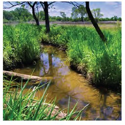
•
Land within riparian buffers on perennial and intermittent streams as required NCDEQ.
•
Wetlands and buffers of 50 feet from edge of wetland.
•
Areas within a 100-year floodplain (special flood hazard areas).
•
Non-regulated isolated wetlands and depressions that accommodate ephemeral pools.
•
Natural Heritage Areas (NHNA) as defined by the National Heritage Program.
•
Areas within a Natural Heritage Element Occurrence (NHEO) as defined by the National Heritage Program.
•
Areas identified by the Biodiversity and Wildlife Habitat Assessment (BWHA) by the National Heritage Program.
4.3.4.3.2 Secondary conservation areas. The following areas shall be considered secondary conservation areas and shall be preserved after all primary conservation areas have been used towards meeting minimum open space requirements.
•
Buffers within 100 feet of a designated wetland or perennial stream.
•
Areas within a 500-year floodplain.
•
Areas adjacent to existing preserved, or managed open space areas.
•
Mature forest of at least one contiguous acre.
•
Unfragmented forest areas that comprise any portion of a 50 acre or more forest block.
•
Wildlife corridors of a minimum of 150 feet in width that connect to NHNAs, NHEOs, BWHA areas, wetlands, or floodplains.
•
Greenways as shown on adopted Town and County plans.
•
Slopes of greater than 10%.
•
Rock outcroppings and a 200 foot protection area.
•
Farmland within a present use value program and a 200 foot buffer area.
•
Areas with sensitive soils including Armenia loam (Ar), Altavista sandy loam (AaB), Chewalca sandy loam (Ch), Iredell loam (IdA), Sedgefield sandy loam (SfB) and Wednadkee (We).
4.3.4.4.3 Tertiary conservation areas. The following areas shall be considered tertiary conservation areas and shall be preserved after all primary and secondary conservation areas have been used towards meeting minimum open space requirements:
•
Land with cultural or historic significance.
•
Viewsheds (contributes to rural view from public roadway).
•
Heritage trees (existing healthy individual trees greater than 12 inches DBH).
•
Undeveloped land and tree save areas.
•
Farmland of statewide importance.
•
Agricultural uses and pollinator gardens.
4.3.4.4.4 Other open space areas. The following areas that are not primary, secondary, or tertiary conservation areas may be used to meet remaining minimum opens space requirements:
•
Passive recreational areas including squares, greens, or parks.
•
Active recreational areas including playgrounds and recreation amenity centers.
4.3.4.4.5 Configuration of open space. The minimum standards for open space configuration are outlined below:
A.
The minimum width for any open space is 25 feet. Access from a public or private street shall be provided to all designated open space with a minimum 15 foot wide access to the open space area.
B.
At least 60% of open space shall be contiguous. For the purposes of this section, contiguous includes any open space bisected by a local street, provided that:
1.
A pedestrian crosswalk provides access to the open space on both sides of the street; and
2.
The right-of-way area is not included in the calculation of minimum open space required.
C.
Where feasible, the open space should adjoin any neighboring areas of open space, other protected areas, and non-protected natural areas.
D.
Open space should be directly accessible to the largest practicable number of dwelling units within the development.
E.
No lot shall be more than one quarter (¼) mile from open space, as measured in a straight line from the lot line to the nearest point of open space.
F.
Area within a floodway shall not be counted towards meeting the minimum open space requirements. A maximum of 75% of the required open space shall be located within a primary conservation area or a slope of greater than 25%.
4.3.4.5 Open space types. All open space used to meet the minimum requirements of this section shall be classified as one (1) or more of the following categories and be classified as private common area open space or public open space. The sketch plan should be used as a guide by the developer and Administrator to determine the most appropriate open space type and location, based upon the primary, secondary, and tertiary conservation areas outlined in Section 4.3.4.3. In addition to the Town's Comprehensive Plan, other trail, parks and recreation, and open space plans shall be considered when evaluating the most appropriate open space type.
4.3.4.5.1 Nature preserve. The nature preserve open space type shall be used for the conservation of primary and secondary conservation areas. Areas designated as nature preserves shall be left largely undisturbed except for the optional clearing of underbrush for the provision of a walking trail. Nature preserves are also the encouraged open space type for tertiary conservation areas that consist of tree conservation areas and scenic viewsheds such as ridge lines, field borders, meadows, fields, stream views, and natural woodlands that can be seen from roadways.
4.3.4.5.2 Greenway. Greenways are large, irregular open spaces designed to incorporate natural settings such as creeks and significant stands of trees within and between neighborhoods. Greenways connect points of interest in a community such as schools, parks, civic uses, and, in some cases, primary and secondary conservation areas. Greenways shall be used for, at a minimum, trails for walking, jogging, and biking. If land proposed for development within an area designated for a greenway on adopted Town and County plans, then a greenway right-of-way or easement shall be set aside, and a greenway constructed by the developer in accordance with the requirements of Section 4.6.4.

4.3.4.5.3 Greenbelt. Greenbelts typically run along the perimeter of a neighborhood, and serve to buffer a neighborhood from surrounding non-compatible uses such as a highway corridor or industrial district, or a developed area from agricultural areas or adjacent communities. Greenbelts can also provide a valuable wildlife corridor between primary and secondary conservation areas. Greenbelts are wider and provide more existing natural vegetation than any buffer yard required as part of Section 4.4.3. Greenbelts differ from greenways in that they are left natural, and are not intended for recreational use. A greenbelt shall have an average width of not less than 40 feet in order to count towards the minimum open space requirement.

4.3.4.5.4 Agricultural preserve. Open spaces designated as agricultural preserves shall be used for active farming in the form of crop cultivation, the keeping of livestock, or equestrian facilities as secondary and tertiary conservation areas. Agricultural preserves are encouraged to protect areas of agricultural and rural heritage and promote compatible active agricultural operations. If farming operations cease, an agricultural preserve may be used as a nature preserve or greenbelt.

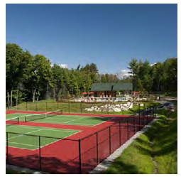
4.3.4.5.5 Recreational amenity center. Recreational amenity centers are intended for active recreational use and may include swimming pools, splash pads, tennis courts, and similar uses. Recreational amenity centers shall be centrally located to the residences that they serve.
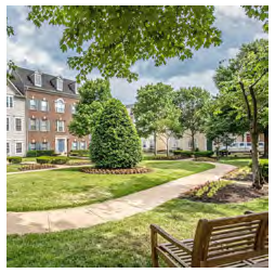
4.3.4.5.6 Square or green. Squares or greens are primary intended for passive recreational use and may have monuments, pavilions, sitting areas. Squares or greens shall be bounded by streets on a minimum of 50% of their perimeter. Squares or greens are encouraged to be entirely bounded by streets, lanes, or buildings. Squares and greens shall be planted parallel to all streets and shall contain canopy trees along street frontages.
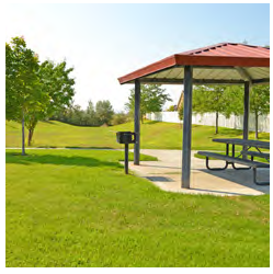
4.3.4.5.7 Park. Parks may be designed for passive and/or active recreational use. Parks shall be bounded by streets on a minimum of 10% of their perimeter. Large parks should create a central open space which services an entire neighborhood or group of neighborhoods; or incorporates physical features which are an asset to the community (i.e. lake or river frontage, high ground, significant stands of trees). Undergrowth should be limited and landscaping shall be installed in a manner that promotes attractiveness and safety. Parks may be combined with greenways and greenbelts and may include golf courses and community gardens.
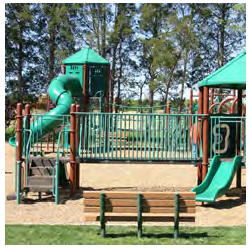
4.3.4.5.8 Playground. Playgrounds are for active recreational use and provide sunny and shaded play equipment and play areas for children as well as open shelter with benches. Playgrounds may be part of other types of open space, such as parks or recreational amenity centers, or may stand alone.
4.3.4.6 Use of open space.
4.3.4.6.1 Allowed uses of open space. Unless otherwise stated, open space intended to achieve the performance standard may be used for the following:
•
Conservation areas for natural, archaeological or historic resources;
•
Meadows, woodlands, wetlands, wildlife corridors, game preserves, or similar conservation-oriented areas;
•
Pedestrian or multi-purpose trails;
•
Passive recreation areas;
•
Active recreation areas, provided that impervious area is limited to no more than 25% of the total open space for the development;
•
Golf courses (excluding clubhouse areas and maintenance facilities), provided that the area does not exceed 50% of the total open space for the development and that impervious area is no more than 25% of the total open space for the development;
•
Water bodies, such as lakes, pond and floodways, provided that the total surface area does not exceed 50% of the total open space for the development;
•
Crop production, community garden;
•
Stormwater control measures, provided that area does not exceed 25% of the total open space for the development and the stormwater control measure is designed as a pond amenity of greater than one-half (½) acre or greater, is surrounded by open space, and is accessible to all residents; and
•
Easements for drainage, access and underground utilities.
4.3.4.6.2 Prohibited uses of open space. Open space intended to achieve the performance standard shall not be used for the following:
•
Individual conventional wastewater disposal systems (excluding innovative systems);
•
Overhead electric transmission lines or high voltage electric transmission lines; and
•
Streets and impervious parking areas.
4.3.4.7 Open space dedication, ownership, and maintenance.
A.
Any areas reserved as open space shall be indicated on a preliminary and/or final subdivision plat. An phasing plan shall be submitted as a part of the application for preliminary plat approval. An Open Space Maintenance Plan shall be submitted prior to the approval of the first final plat. All open space shall be dedicated prior to or simultaneously with the first final plat approval. Any active open space shall be completed prior to the issuance of the a zoning permit for the fifth dwelling unit and prior to approval of a second phase final plat.
B.
Open space may be owned or administered by one (1) or a combination of the following methods:
•
Fee simple ownership by a unit of government or private non-profit land conservancy;
•
Common ownership by Homeowners Association;
•
Split deeded ownership by individual property owners within the development;
•
By individual private ownership such as a farmer, developer or other private entity that maintains the open space in accordance with the purposes of this Section. (i.e. farming, equestrian facility); or
•
Deed restricted open space easements on individual private properties.
C.
The Town Board of Commissioners shall have the authority to accept or reject land dedications made as a requirement of this Section.
D.
The owner of dedicated open space shall be responsible for the continuing upkeep and proper maintenance of the same.
E.
In the case of common ownership by a Homeowners Association, the restrictive covenants shall provide that, in the event the Homeowners Association fails to maintain the open space according to the standards of this Ordinance, the Town may, following reasonable notice, demand that deficiency of maintenance be corrected, or enter the open space to maintain it. The cost of such maintenance shall be charged to the Homeowners Association.
F.
The developer shall place in a conspicuous manner upon the Final Plat of the subdivision a notation concerning control of open space.
G.
The developer will provide proof of registration of the Articles of Incorporation with the appropriate state agency for the formation of the Homeowners Association to the Administrator. Such document shall include, but not be limited to, the following:
1.
Provision for the establishment of the association or similar entity is required before any lot in the development is sold or any building occupied and membership shall be mandatory for each homeowner and any successive buyer.
2.
The association or similar legal entity has clear legal authority to maintain and exercise control over such common open space areas.
3.
The association or similar legal entity has the power to compel contributions from residents of the development to cover their proportionate shares of the costs associated with the maintenance and upkeep of such common areas. Further, assessments levied can become a lien on the property if allowed in the master deed establishing the homeowners association or similar legal entity.
4.
The open space restrictions must be permanent, not just for a period of years.
5.
The association or similar legal entity must be responsible for liability insurance, applicable taxes and the maintenance of open space and other facilities under their control.
6.
The association or similar legal entity must be able to adjust the assessment to meet changing needs.
7.
The association shall be responsible for maintaining all public storm water drainage systems and easements within the development not being maintained by the Town, County, State or other approved entity.
8.
It shall be expressly stated within the restrictive covenants/Homeowners Association documents that it will be the responsibility of the developer or successors or assigns to enforce such covenants or restrictions until such time as control has been transferred to the Homeowners Association Board of Directors. It shall be the sole responsibility of the developer, successor or assigns to correct any deficiencies prior to transfer of control over to the Homeowners Association Board of Directors.
4.3.4.8 Alternatives to dedication.
A.
As an alternative to providing required open space on a development site, the developer has the option of:
1.
Requesting that the Town permit the purchase of land lying within a planned public park or open space system within or immediately adjacent to the Town's zoning jurisdiction and its dedication to the appropriate public authority; or
2.
Requesting that the Town accept fees in lieu of land dedication for the purpose of providing public open space.
B.
Any request for alternative open space locations shall be accompanied by the following information:
1.
The exact location (either a tax identification number or a metes and bounds description), size, and current assessed and appraised value of land proposed for purchase and public dedication.
2.
The intended recipient of the dedication of land and evidence that the recipient (if other than the Town) approves of the dedication.
3.
The proposed timing of the purchase and dedication.
C.
If fees in lieu are proposed, the amount of fees offered shall be commensurate with the cost of land used for the development and the amount of open space required. For example, if one acre of open space is required per this ordinance and the cost of usable land within the development site is $50,000 per acre, then the minimum fee in lieu of open space would be equal to $50,000. All fees in lieu of open space dedication shall be placed in a fund separate from the General Fund to be used exclusively for the purchase of open space or park land or for the improvement of open space or park land already owned by the Town.
(Ord. No. 2021-05, § 6, 12-6-21)
4.4 - Landscaping and screening standards.
4.4.1 Purpose and applicability.
A.
The purpose of this Section is to regulate the installation, protection, and long-term management of trees and shrubs and to minimize potential nuisances, such as visual impacts, noise, dust, odor, litter, heat, and glare of lights, from adjacent properties and the community. The appropriate use of existing and supplemental landscaping enhances the appearance of the built environment, blends new development with the natural landscape, and reduces the environmental impact of development. Existing vegetation should be protected and retained where possible to ensure a natural established landscape.
B.
The requirements of this section do not apply to single-family or two-family residential development on existing lots of record. The requirement for installation of landscaping shall be initiated by any one (1) or more of the following activities on a property:
•
New construction or the initial use of the property
•
A substantial change of use or change in zoning classification
•
Any building or parking expansion of greater than 20%
•
Residential lots within new major subdivisions
C.
The provisions of this Section are designed to specifically address the application of landscape resources to varying styles of development and the impact of such applications on the appearance, health and financial well-being of the community. The provisions are broken into six (6) landscaping and screening categories:
Figure 4.8 Landscaping Yards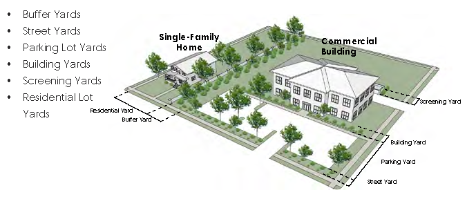
4.4.2 General standards for all landscaping.
A.
The preservation of existing vegetation and natural features is encouraged. Significant trees, forest stands, natural vegetation, specimen trees, severe natural topography, drainage features and water courses are encouraged to be preserved to the extent that is reasonable and practical while otherwise not reasonably prohibiting development.
B.
In cases where an existing, landscaped or vegetated area is located on the same property as the proposed development, further plantings and or improvements shall not be required so long as existing vegetation is of sufficient width and contains adequate materials to meet the requirements of this Ordinance. If the landscaped or vegetated area is deficient, the developer shall make needed improvements and/or additions to satisfy the landscaping requirements and intent of this Ordinance.
C.
No structure other than a wall, fence, sidewalk, mailbox, sign, light fixture, or driveway shall be permitted within a required landscaping area. No off-street parking may take place in any required landscaping area. Where plant materials are required, the required amount of plant materials shall be installed on the side of any wall or fence opposite the new development.
D.
Within 30 feet of overhead utility lines, two (2) small trees shall be used in lieu of each large tree required. Such small trees shall not reach a mature height of greater than 15 feet.
E.
At least 75% of the required shrubs shall be evergreen species locally adapted to the area.
F.
No landscaping feature shall impede sight lines of traffic within the sight triangle as defined in Section 4.2.1 (E).
G.
All diagrams in this Section are for illustrative purposes only.
4.4.3 Buffer yards.
A.
Buffer yards area intended to separate higher intensity and lower intensity. Buffers shall be measured from the subject property line into the site to be developed. All required buffer yards shall abut the subject property line. Required buffer yard width shall not decrease the required building setback for each zoning district as set forth in Section 4.2.
B.
Buffer yards shall function as opaque visual screens with a minimum height of six (6) feet.
C.
Generally, the responsibility for screening is that of the more intense land use. However, new developments with a less intense use being constructed next to an existing more intense use shall provide the required landscaping on the new development's property.
D.
Fences located within a buffer yard shall be located on the side closest to the neighboring property line while allowing adequate room to maintain both sides of the fence.
E.
In addition to the requirements of this Section, street yard landscaping shall meet the general standards set forth in Section 4.4.4.
F.
There are three (3) types of buffer yards. The requirements and depictions of these buffer yards are shown on the following pages.
1.
Type 1 Buffer: Non-residential or Multi-family Residential development adjacent to any type of residential development (not including development within an LI or HI District)
2.
Type 2 Buffer: All development in a Heavy Industrial (HI) adjacent to all other zoning districts. This shall not apply to the front property line along a street right-of-way unless the adjacent district is RR, RM, RH, or RMH.
3.
Type 3 Buffer: All development in a Light Industrial (LI) adjacent to all other zoning districts. This shall not apply to the front property line along a street right-of-way unless the adjacent district is RR, RM, RH, or RMH.
Table 4.4 Type 1 Buffer Yard
Figure 4.9 Type 1 Buffer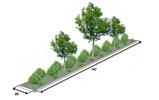
Figure 4.10 Type 1 Buffer with
Fence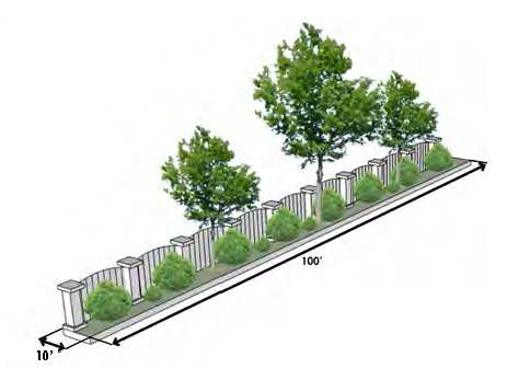
Table 4.5 Type 2 Buffer Yard
Figure 4.11 Type 2 Buffer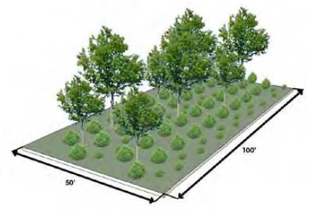
Figure 4.12 Type 2 Buffer
with Fence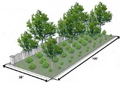
4.4.4 Street yards.
A.
Street yards are intended to provide transition between roads and developed sites and to create a continuous vegetated aesthetic along the street rights-of-way.
B.
Street yards shall be measured from the right-of-way line (front property line) into the subject property.
C.
Street yard requirements shall not apply to development within the CB zoning district.
D.
In addition to the requirements of this Section, street yard landscaping shall meet the general standards set forth in Section 4.4.2.
E.
Developments along streets with existing street trees may use such trees to satisfy the tree requirements of the street yard as long as the minimum number of trees are present. Required street yard shrubs shall be installed around existing street trees in a manner that does not damage the existing trees.
F.
In the presence of overhead utility lines, two (2) small trees shall replace one (1) large tree.
Table 4.6 Street Yard
Figure 4.13 Street Yard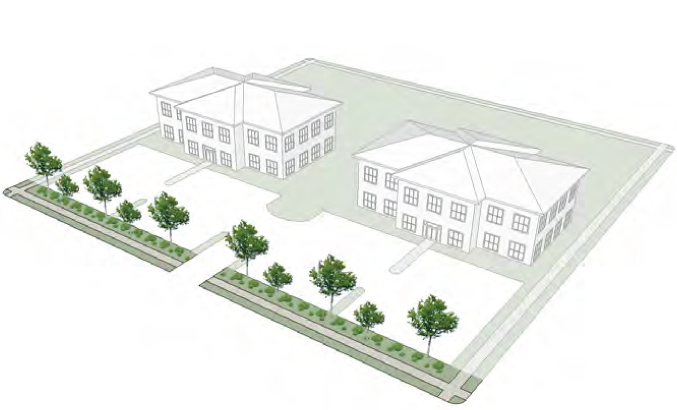
4.4.5 Parking lot yards.
A.
Parking lot landscaping is required within all non-residential parking lots of greater than 10 spaces except automobile or boat sales display areas. Instead, perimeter landscaping around motor vehicle or boat sales display areas shall be utilized at the same rate as required in Table 4.7, as applicable.
B.
The parking lot yard requirement may be met by the street yard requirement, buffer yard requirement, or building yard requirement for parking that is immediately adjacent to a street yard, buffer yard, or building yard.
C.
Trees shall be planted in a manner that provides shade for parking area at maturity within 10 feet of the pavement edge. Each planting area shall be a minimum of 50 square feet, with a minimum dimension of seven (7) feet. Planting areas shall be protected with concrete curbing or wheel stops.
D.
Required shrubs may be located around the parking lot perimeter (within 10 feet of the pavement edge) or within planting islands.
E.
In addition to the requirements of this Section, parking lot yard landscaping shall meet the general standards set forth in Section 4.4.2.
F.
In the presence of overhead utility lines, two (2) small trees shall replace one (1) large tree.
Table 4.7 Parking Lot Yard
Figure 4.14 Parking Lot Yard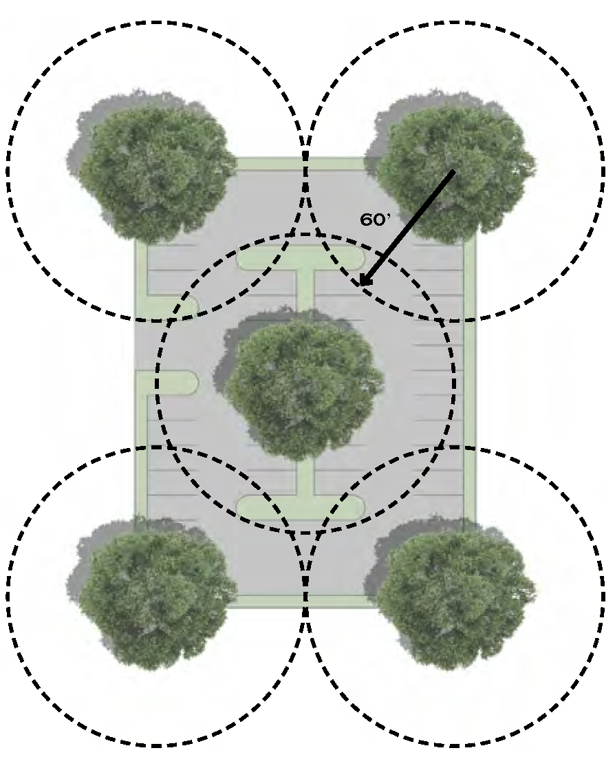
4.4.6 Building yards.
A.
The intent of building yards is to create a buffer between buildings and parking areas for pedestrians entering and exiting buildings and to improve the appearance of building entrances.
B.
Building yard width shall be based on the total area of the building. Widths shall be measured from the applicable building wall. Building yards shall be located on any side of a building where parking area is adjacent to the building. This shall not apply to the CB, LI, or HI districts, or single-family or two-family dwellings.
C.
The building yard requirement may be met by the street yard requirement or parking lot yard requirement for buildings immediately adjacent to a street yard or parking lot.
D.
Building yards may be crossed by walkways to general access doorways, however a maximum of 25% of the building yard may be composed of walkways.
E.
In addition to the requirements of this Section, parking lot yard landscaping shall meet the general standards set forth in Section 4.4.2.
Table 4.8 Building Yard
Figure 4.15 Building Yard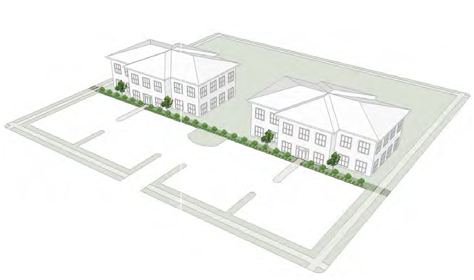
4.4.7 Screening yard. The screening requirements of this Section shall apply to garbage containers, mechanical equipment, and outdoor storage for all new and expanding non-residential and multi-family residential development:
A.
Any permitted outdoor storage, utility equipment, or solid waste receptacles (including dumpsters) shall be screened in the form of a wall or fence and shrubs as to provide an opaque screen. The screen shall exceed the height of the storage, equipment, or receptacle by a minimum of six (6) inches and shall not exceed the height limitations set forth in Section 4.4.9 for fences and walls and shall not interfere with the operation of utility equipment.
B.
Dumpsters and other waste collection containers shall not be located in the front yard of any structure or within any required buffer yard.
C.
Ground-mounted mechanical equipment shall be located in the rear or side yard and screened from view of the street.
D.
Any fencing used to fulfill the requirements of this Section shall be supplemented with landscaping. Chain link fence with slats shall not be used to meet the requirement of this Section.
E.
All screens shall utilize building materials and design which are compatible with those used for the exterior of the principal building.
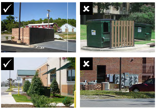
4.4.8 Residential yards.
A.
The intent of the Residential Yard is to replace some of the trees removed during the grading process and establish a residential tree canopy and to provide a building yard transition between the street and structure.
B.
Residential yards are required for all single-family and two-family residential lots in new major subdivisions.
C.
Trees and shrubs shall be planted outside of the public right-of-way. Maintenance of the trees and shrubs shall be the responsibility of the individual property owner. Vegetation shall be selected from the approved plant list in Section 4.4.11. The use of existing vegetation to satisfy the large tree standard is encouraged.
Table 4.9 Residential Yard
Figure 4.16 Residential Yard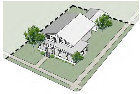
4.4.9 Fences and walls.
4.4.9.1 General requirements.
A.
Fences and walls shall only be installed subject to the issuance of a Zoning Permit and the requirements of this Section.
B.
Unless otherwise specified within this Ordinance, fences and walls shall be exempt from setback and yard requirements. Fences may be located up to the property line, but shall not be located in any right-of-way or sight-triangle. For streets without a right-of-way, fences shall be located a minimum of 10 feet from the edge of pavement. Fences may be located closer than 10 feet to the edge of pavement if there is an existing retaining structure, as long as the fence is no closer to the pavement than the existing retaining structure.
C.
Fences and walls not maintained in a safe manner or good order through neglect, lack of repair, manner of construction, method of placement, or otherwise deemed unsafe by the Town shall be repaired, replaced, or removed.
D.
Fences and walls shall not contain advertising, signs, logos or other lettering.
E.
Where a fence or wall is used as part of required screening, all required vegetation shall be planted on the exterior side of the fence or wall (exterior to the lot).
F.
Retaining walls built to State Building Code are exempt from the maximum height requirements.
G.
Nothing in this subsection shall preclude the installation of temporary fences around construction works, erected or maintained pursuant to the NC Building Code or Soil Erosion and Sedimentation Control Act requirements.
4.4.9.2 Height and materials. All new fences and walls shall meet the height and material requirements in the table below. The requirement of this subsection shall not apply to bona fide farms.
Table 4.10 Fence Height and Materials
4.4.9.3 Design.
A.
Materials may include a combination of the listed permitted materials for each fence type. Fences shall be constructed of materials manufactured and sold as fencing materials. Wood palettes, tires, pipes, and similar items shall not be used as fencing materials.
B.
Front yard fences shall not be opaque and shall be at least 50% transparent unless part of a required buffer or screen.
C.
The finished side of the fence shall be installed facing the street right-of-way and adjacent properties.
D.
The capital or finial of a fence post or column may extend up to one (1) feet above the maximum height.
E.
Chain link fences for non-residential and multi-family residential uses shall be supplemented with landscaping to the outside of the fence at a minimum rate of one (1) large shrub per five (5) linear feet. Chain link fence with slats shall not be used to meet screening requirements.
F.
Barbed or razor wire on top of chain link fences is permitted for rear yard fences not visible from a street in the LI and HI districts only.
G.
Fences and walls shall be compatible in design and material of the buildings on the property.
H.
No fence or wall which will block or materially impede the flow of stormwater runoff shall be constructed within a storm drainage easement.
4.4.10 Berms. Any berm that is constructed as part of a landscaping yard shall meet the following standards:
A.
The berm shall have a minimum height of three (3) feet, a minimum crown width of two (2) feet, and a side slope with a width to height ratio of no greater than three to one (3:1) if less than four (4) feet in height and a width to height ratio of no greater than four to one (4:1) if more than four (4) feet in height.
B.
Berms shall have adequate groundcover or other plant material to prevent erosion and shall be substantially planted and covered with live vegetation. No berm shall consist entirely of turf grass, groundcover, mulch or similar material.
C.
Berms shall be designed to prevent standing water or the impeded flow of stormwater.
D.
Berms shall be free of structures or merchandise.
4.4.11 Plant installation standards.
A.
Trees and shrubs to be planted shall be selected from the latest edition of the NC Cooperative Extension Publication AG 508-3 Drought Tolerant Plants for North Carolina as shown in Table 4.12. The Administrator may approve alternative large or small maturing trees excluding, but not limited to, Callory pears, Bradford pears, sweet gum (excludes fruitless varieties), catalpa, wild cherry, wild elm, princess, hackberry and tree-of-heaven.
B.
All plants shall be installed in accordance with the latest edition of the American Standards for Nursery Stock, published by the American Nurserymen's Association and the American National Standards Institute (ANSI).
C.
No trees identified as large trees shall be planted within 30 feet of overhead utility lines or within five (5) feet of a utility easement. This does not include low-voltage insulated or covered lines of 240 volts or less or telecommunication lines.
D.
All plant material installed shall be free from disease and scarring and shall be installed in a manner that ensures the availability of sufficient soil and water to sustain healthy growth, and which is not intrusive to utilities or pavement.
E.
Except as herein provided, on a corner lot in any district, no hedge, shrubbery, tree, natural growth, sign, fence, wall, or other obstruction shall be placed or maintained within a sight triangle as defined by this Ordinance.
F.
Required landscaping shall be installed with the minimum size specifications:
Table 4.11 Plant Installation Size Standards
Table 4.12 Approved Plant List
Source: NC Cooperative Extension Publication AG 508-3 Drought Tolerant Plants for North Carolina
4.4.12 Landscaping maintenance.
A.
Required landscaping shall be maintained to mature growth habit, and trees shall not be topped.
B.
The owner of the property where landscaping is required shall responsible for the maintenance of all landscaping materials. Such maintenance shall include all actions necessary to keep the landscaped area free of litter and debris; to keep plantings healthy; to keep plant growth from interfering with safe vehicular and pedestrian travel, or use of parking areas, or from creating nuisances to adjoining properties; and to keep walls, fences and berms in good repair and neat appearance.
C.
Any vegetation that is part of a required landscaping area shall be replaced within 60 days in the event that it dies. All landscaping materials shall be protected from damage by erosion, motor vehicles, or pedestrians which could reduce the effectiveness of the required landscaping.
D.
See the American National Standards for Tree Care Operations: Tree, Shrub, and Other Woody Plant Maintenance-Standard Practices (Pruning) published by the American National Standards Institute (ANSI A300) for pruning tips.
(Ord. of 6-3-2019, ZTA 2019-02)
4.5 - Parking standards.
4.5.1 Purpose and applicability.
A.
The purpose of this Section is to ensure that adequate and well-designed parking and site access is provided for developments in the Town of Yadkinville.
B.
Unless otherwise specified, the requirements of this Section shall be initiated by any one (1) or more of the following activities on a property:
1.
New construction or the initial use of the property.
2.
A substantial change of use or change in zoning classification.
3.
Any building or parking expansion of greater than 20%.
C.
The requirements of this section do not apply to single-family or two-family residential development on existing lots of record.
4.5.2 General provisions.
A.
All off-street parking areas shall be landscaped in accordance with the regulations in Section 4.4.5.
B.
No off-street parking area shall be located over an on-site wastewater drain field.
C.
Off-street parking areas shall be properly maintained in all respects. In particular, off-street parking area surfaces shall be kept in good condition (free from potholes, etc.) and parking space lines or markings shall be kept clearly visible and distinct.
4.5.3 Parking lot design.
A.
Off-street parking areas shall be designed so that parked vehicles do not encroach upon, extend onto, or cause vehicles to back into public rights-of-way, sidewalks or strike against or damage any wall, vegetation, utility, or other structure. Curbs or bumpers are required and shall be a minimum of six (6) inches high.
B.
Off-street parking areas shall be designed to facilitate adequate movement and access by sanitation, emergency and other public service vehicles.
C.
No surface parking or circulation driveway is permitted within any required or established buffer area, except that driveways providing access to the parking area may be installed across these areas.
D.
No parking aisle serving the general public that contains more than 10 parking spaces shall dead end, except that the Administrator may approve dead-end aisles for up to 20 spaces on small lots where expected traffic is minimal. Any parking aisle that dead-ends shall be provided a suitable turnaround.
E.
Parking lots shall not be located closer than 10 feet from a public right-of-way, except in the CB zoning district.
F.
In the CB zoning district, parking lots shall not be located closer than five (5) feet from the public right-of-way. No new off-street parking area in the CB districts shall extend toward a public street right-of-way beyond the front wall of the closest adjacent building. See Figure 4.17. All new or expanding off-street parking areas in the CB zoning district that abut a public street right-of-way shall be screened with a hedgerow, masonry wall, or fence of at least three (3) feet in height that meets the fence and wall requirements of Section 4.4.9. These features shall not impeded sight lines within sight triangles as defined in Section 4.2.1(E).
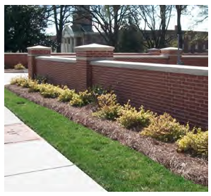
Figure 4.17 Parking Location in CB District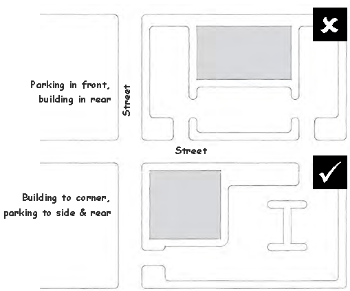
G.
No more than three (3) parking aisles (defined as a travel lane and the parking located on each side) shall abut. Otherwise, parking aisles shall be separated from each other by planted medians which may include pedestrian walkways. Large parking lots shall be designed to allow pedestrians to safely move from their vehicles to the building(s).
H.
For non-residential uses with more than two (2) rows of parking located in the front yard of the principal building, parking shall have additional screening using one (1) of the following methods:
1.
The minimum street yard width required by Section 4.4.4 shall be doubled and the number of shrubs shall be increased by 25%; or
2.
Parking may be shared and screened with outparcel buildings as shown Figure 4.18.
Figure 4.18 Example of Parking Area for Large Scale Development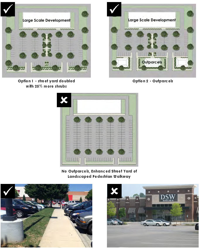
4.5.4 Parking dimensions. All new parking spaces shall meet the following dimensional requirements:
Table 4.13 Parking Dimensions
Figure 4.19 Parking Dimensions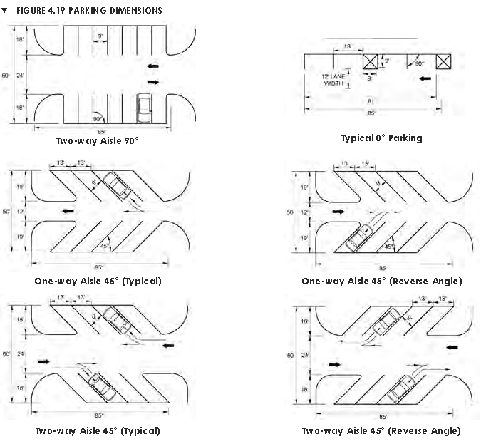
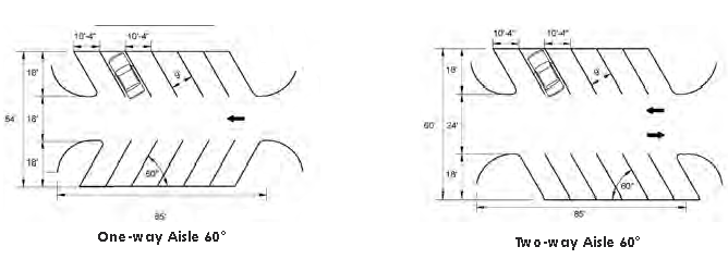
4.5.5 Parking surface.
A.
The following areas shall be paved with asphalt, concrete, pavers or similar paving material and shall be landscaped in accordance with the requirements of Section 4.4.5. This shall not apply to single-family and two-family residential uses.
•
The minimum number of spaces for each use (as set forth in Section 4.5.6).
•
All front and side yard parking areas.
•
Driveways.
•
ADA parking spaces.
B.
Any additional parking areas located in rear yards may be gravel.
C.
All parking areas of greater than 20 spaces shall be constructed with standard or valley curb and gutter or an alternative Low Impact Development method as shown in the pictures below.
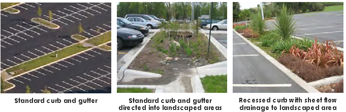
4.5.6 Number of parking spaces.
A.
All new developments in all zoning districts shall provide a sufficient number of off-street parking spaces to accommodate the number of vehicles that ordinarily are to be attracted to the development in question. Proof of sufficient parking shall be provided upon application for a Zoning Permit. No portion of any street right-of-way shall be considered as fulfilling or partially fulfilling the minimum number of off-street parking required by this Section. Properties within the CB zoning district shall be exempt from the minimum number of parking spaces.
B.
The Town recognizes that the Parking Requirements Table set forth in this Section cannot and does not cover every possible situation that may arise. Therefore, in cases not specifically covered, the Administrator is authorized to determine the parking requirements using the Table as a guide.
C.
See the Parking Requirements Table on the following pages for minimum parking space requirements. The Administrator may reduce the minimum number of parking spaces required or increase the maximum number allowed by up to 10% if the applicant can demonstrate that the number of required parking spaces is excessive or inadequate due to use or property constraints.
D.
Except for single-family residential uses, two-family residential uses, and uses providing 20 or fewer on-site parking spaces, the maximum number of parking spaces provided shall be 125% of the required minimum shown in the Parking Requirements Table on the following pages. Any number of parking spaces above the maximum shall utilize permeable pavers or Low Impact Development design.
E.
The minimum number of ADA accessible spaces shall be installed in accordance with NC Building Code. ADA spaces may be included in the total required minimum number of parking spaces.
Table 4.14 Minimum Number of Parking Spaces
4.5.7 Parking location, sharing, and connectivity.
A.
On all off street parking lots, the required spaces shall be provided on the same lot of record with the use or on a lot separated therefrom by not more than 400 feet, except for residential uses, which must be provided on the same lot of record.
B.
The joint use of shared off-street parking between two (2) uses may be made by contract by two (2) or more adjacent property owners. A copy of the contract or agreement shall be provided to the Town prior to the issuance of a Zoning Permit for the use. Developments that operate at different times may jointly use or share the same parking spaces with a maximum of one-half (½) of the parking spaces credited to both uses.
C.
All newly constructed parking lots shall be designed to accommodate interconnection between the sites unless natural features prevent connection.
Figure 4.20 Parking Connectivity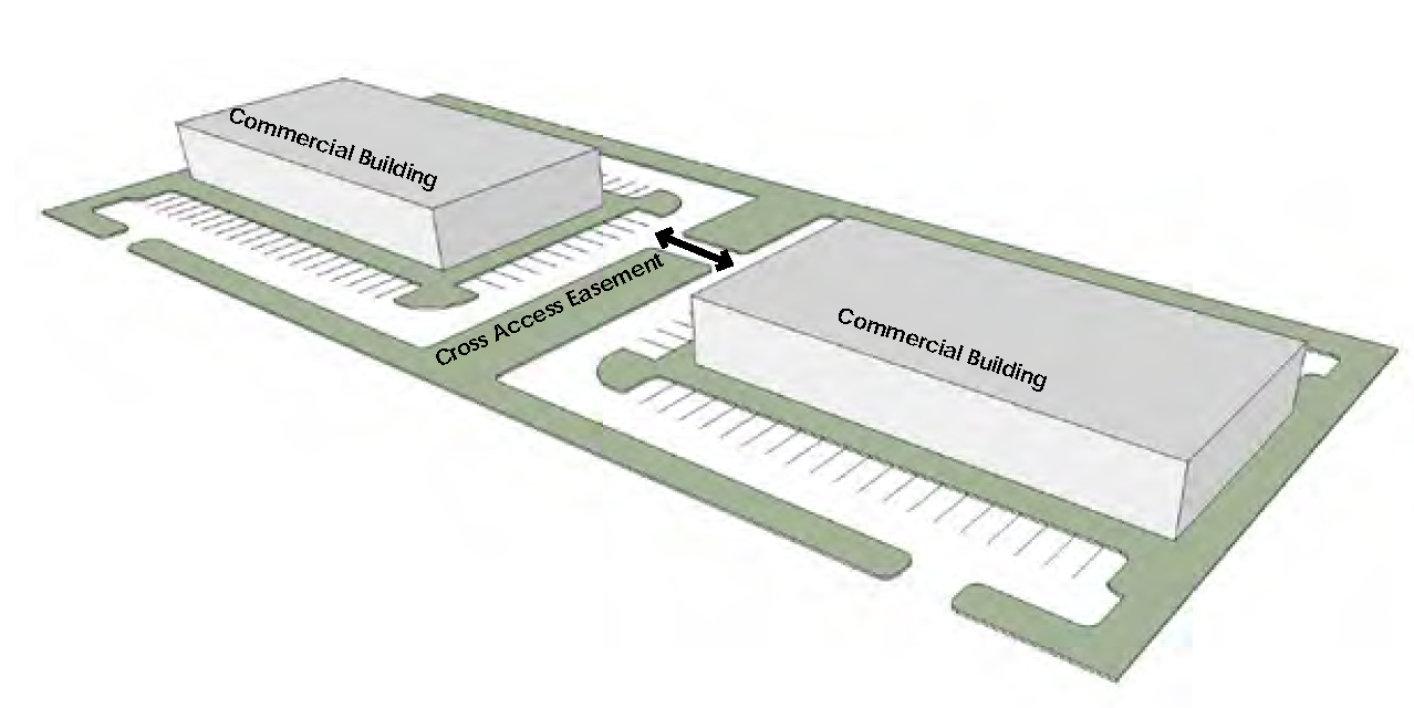
4.5.8 Loading area requirements.
A.
Whenever the normal operation of any development requires that goods, merchandise, or equipment be routinely delivered to or shipped from that development, a sufficient off-street loading and unloading area must be provided in accordance with this Section to accommodate the delivery or shipment operations in a safe and convenient manner.
B.
Loading and unloading areas shall be so located and designed so that the vehicles intended to use them can:
•
maneuver safely and conveniently to and from a public right-of-way; and
•
complete the loading and unloading operations without obstructing or interfering with any public right-of-way or any parking space or parking lot aisle.
C.
No area allocated to loading and unloading facilities may be used to satisfy the area requirements for off-street parking.
D.
The following table shows the minimum number of loading spaces based on gross floor area of any nonresidential building. A loading shall space shall be a minimum of 12 feet by 55 feet with an overhead clearance of 14 feet.
Table 4.15 Loading Spaces
4.5.9 Parking of commercial and recreational vehicles.
A.
On any residentially-zoned lot of less than one (1) acre in size, commercial vehicles which may be parked on an overnight basis shall be limited to vans and trucks of no greater than three (3) axles. This requirement shall not be interpreted to prohibit vehicles from loading and unloading household goods in any residential zoning district for a period of up to 24 hours.
B.
No residentially-developed lot may be used as the base of operation for any freight hauling truck.
C.
For purposes of this Ordinance, a recreational vehicle shall not be deemed a dwelling unit and the usage of a recreational vehicle for living, sleeping or housekeeping purposes and the connection of such vehicle to utility services (other than for periodic maintenance and/or repair purposes) shall be prohibited unless the vehicle is located in a camping and recreational vehicle park so designed to accommodate recreation vehicles.
D.
In case of extreme emergency, not for convenience purposes, recreational vehicles may be utilized for temporary living quarters for a period of no longer than 60 days.
4.5.10 Driveways.
A.
Driveways that connect to state-maintained streets shall comply with NCDOT standards.
B.
Driveways that connect to Town-maintained streets shall comply with the following standards:
1.
Driveways onto Town-maintained streets shall be located a minimum of 60 feet from an intersection with another town-maintained street and 100 feet from an intersection with a state-maintained street.
2.
Driveways shall be not less than 10 feet in width for one-way traffic and 18 feet in width for two-way traffic. Driveway width onto a Town-maintained street shall not exceed 36 feet.
3.
Ten (10)-foot wide driveways are permissible for two-way traffic when:
•
The driveway is not longer than 50 feet; and
•
The driveway provides access to not more than five (5) parking spaces; and
•
Sufficient turning space and stacking area is provided so that vehicles need not back into a public street.
C.
Driveways shall be as nearly perpendicular to the street right-of-way as possible and shall not exceed 10% grade, dependent upon approval of the Fire Code Official in consultation with the Fire Chief based on fire apparatus size.
D.
Driveways shall line up with other driveways across the street and be shared between adjacent uses wherever possible.
E.
The maximum number of access points shall be one (1) per 300 feet of frontage. Only one (1) combined entrance and exit connection will be permitted where the frontage is less than 300 feet. Any lot of record in existence on the effective date of this section shall be allowed one (1) access point to the roadway notwithstanding the provisions of this Section that may prohibit such access; provided, however, that two (2) or more lots under common ownership shall be considered one (1) lot and shall comply with the requirements of this Section.
4.6 - Infrastructure standards.
4.6.1 Purpose and applicability.
A.
The purpose of this Section is to ensure that new developments provide adequate infrastructure that is compatible with adopted plans and Town standards.
B.
Unless otherwise specified, the requirements of this Section shall be initiated by any one (1) or more of the following activities on a property:
1.
New construction or the initial use of the property;
2.
A substantial change of use or change in zoning classification;
3.
Any building or parking expansion of greater than 20%; or
4.
New major subdivisions.
4.6.2 Conformance with comprehensive transportation plan (CTP).
A.
The location and design of streets shall be in conformance with the Yadkinville Comprehensive Transportation Plan (CTP). Pursuant to NC GS 136-66.2, for new developments with frontage along a state-maintained street, half of the minimum width of the cross section designated in the CTP shall be reserved along the frontage as "future right-of-way", and no structures or parking shall be constructed within this area.
B.
In any case where any part of a development lies within the corridor of a thoroughfare shown on a roadway corridor map adopted pursuant to NC GS Chapter 136, Article 2E, no development approval shall be granted with respect to the property in the roadway corridor. Provided, however, no development plan approval shall be delayed by the provision of the roadway corridor map procedure for more than three (3) years from the date of its original submittal.
4.6.3 Streets.
4.6.3.1 Minimum construction standards.
A.
The Town has adopted North Carolina Department of Transportation (NCDOT) construction standards. Unless otherwise specified in this Ordinance, all street design criteria shall meet the standards in the latest published editions of NCDOT's Subdivision Roads Minimum Construction Standards and Standard Specifications for Roads and Structures unless otherwise specified in this Ordinance. Street cross sections shall follow those set forth in the NCDOT Complete Streets guidelines and shall meet the minimum standards of the International Fire Code. The diagrams below show the typical cross sections for local streets with and without on-street parking.
Figure 4.21 Typical Street with On-Street Parking
Figure 4.22 Typical Street without On-Street Parking
*Use of this minimum cross section requires a minimum of three (3) off-street parking spaces per lot for residential uses.
B.
All proposed streets shall be graded to the full width of the right-of-way and improved with a pavement width and standard curb and gutter. Pavement, curb and gutter shall meet the minimum NCDOT construction standards. In addition, street paving, curb and gutter shall be installed in the following situations:
1.
Any existing street segment that has not been accepted for maintenance by either the Town or NCDOT, and that is to serve as the required frontage for one (1) or more lots created pursuant to these regulations, shall be improved and dedicated to the public, as provided for above, in such a way that the street segment meets the standards of these regulations for the particular classification of street, including right-of-way width. Such street segment shall be directly connected to the existing public street system by way of at least one (1) public street accepted for maintenance by either the Town or the NCDOT. No development shall be permitted on any street that is not connected directly to the public street system.
2.
Where a development fronts on any existing street segment maintained by either the Town or NCDOT and the street does not meet the minimum standards of these regulations for the classification of street, the developer shall improve the portion of street adjoining the development to meet the minimum standards including construction and width. When the development adjoins only one (1) side of an existing street, one-half (½) of the minimum right-of-way shall be provided, measured from the centerline of the street.
3.
The Technical Review Committee (TRC) may require pavement and widening or pavement and widening and curb and gutter and storm drainage for turning lanes along any street that forms a significant entrance to a proposed development where in the opinion of the TRC such improvements are necessary in order to provide for safe vehicular movement into and out of the proposed development.
4.
Where a street is stubbed into adjoining property for future extension and such street serves as the frontage for one (1) or more lots, which are not corner lots, the Technical Review Committee may require the pavement of a temporary turn-around in a form similar to a cul-de-sac on such street where such turnaround is necessary for the public convenience, safety and service.
4.6.3.2 Connection to state streets. An approved NCDOT permit is required to connect to any existing state system street.
4.6.3.3 Connection to adjoining property. Proposed streets shall be extended to the boundary of the development for connection to existing streets on the boundary of adjoining property or for future connection. Culs-de-sac shall not be used to avoid connection with an existing street to avoid the extension of a thoroughfare or collector street, or to avoid connection to adjoining property. In general, culs-de-sac shall not be used to provide access to development on the boundary of the development. Culs-de-sac shall not exceed 800 feet in length unless necessitated by topography or property accessibility and specifically approved by the Board of Commissioners. Measurement shall be from the point where the centerline of the dead end street intersects with the centerline of a general circulation street to the center of the turnaround of the cul-de-sac. Where one cul-de-sac extends from another cul-de-sac, the end of each cul-de-sac shall be no more than 800 feet from a general circulation street as measured by the centerline of the streets.
4.6.3.4 Restriction of access. Where a development abuts or contains an existing or proposed thoroughfare, the Technical Review Committee (TRC) or NCDOT may require marginal access streets, reverse frontage or such other treatment, as may be necessary for adequate separation of through and local traffic.
4.6.3.5 Reserve strips and half-streets. Reserve strips and non-access easements adjoining street rights-of-way for the purpose of preventing access to or from adjacent property (except those required by the Town Board or NCDOT to prevent access to thoroughfares) and half-streets shall not be permitted under any condition.
4.6.3.6 Private streets. Private streets are not permitted.
4.6.3.7 Fire access and secondary access.
A.
For developments of greater than 30 lots, a minimum 30 foot secondary access easement is required for Fire Department access. The easement shall be cleared so that a fire truck may pass, but does not have to be improved to public road standards.
B.
At least two (2) entry points, constructed to NCDOT road standards, shall be provided in developments that contain 100 or more dwelling units and to all lots within the development. Alternatives may be allowed by the Technical Review Committee (TRC) if the curb cuts for the two (2) accesses cannot meet the minimum distance allowed according to NCDOT or Town regulations at any location.
4.6.3.8 Street alignment and separation. Streets shall be designed so as to intersect as nearly as possible at right angles, and no street shall intersect any other street at an angle of less than 60 degrees. Streets crossing natural areas or streams shall cross at or near to right angles as possible within limits of topographic conditions. Offset intersections shall be avoided. A minimum intersection offset of 200 feet shall be maintained on local streets.
4.6.3.9 Blocks.
A.
The lengths, widths, and shapes of blocks shall be determined with due regard to the provision of adequate building sites suitable to the special needs of the type of use contemplated; zoning requirements as to lot sizes and dimensions; needs for vehicular and pedestrian circulation, control and safety of street traffic; limitations and opportunities of topography; and convenient access to water areas.
B.
Blocks shall not be less than 400 feet nor more than 1,200 feet in length.
C.
Blocks shall have sufficient width to allow two (2) tiers of lots of minimum depth except where single-tier lots are required to separate residential development from through vehicular traffic or another type of use, or when special limitations are created due to natural features and topography.
4.6.3.10 Street connectivity.
A.
The proposed street layout within a development shall be coordinated with the existing street system of the surrounding area and where possible, existing principal streets shall be extended.
B.
Where, in the opinion of the Technical Review Committee it is necessary to provide for street access to an adjoining property, proposed streets shall be extended.
4.6.3.11 Culs-De-Sac.
A.
Dead-end roads in excess of 150 feet shall be provided with a cul-de-sac or turnaround meeting North Carolina Fire Code.
B.
Permanent dead end streets shall not exceed 1,000 feet in length unless necessitated by topography or property accessibility.
4.6.3.12 Street names. Proposed streets which are obviously in alignment with existing streets shall be given the same name. In assigning new names, duplication of existing names shall be avoided and in no case shall the proposed name be phonetically similar to existing names irrespective to the use of a suffix such as street, road, drive, place, court, etc. Street names shall be subject to the approval of the Yadkin County E-911 Addressing Coordinator.
4.6.3.13 Cluster mail box units. Residential subdivision shall incorporate centralized cluster mailbox in accordance United States Postal Service standards and North Carolina Department of Transportation policy on the placement of mail cluster box units (CBU).
4.6.4 Sidewalks, multi-use paths, and greenways.
A.
Sidewalks or multi-use paths shall be provided in the following locations:
1.
Along any street front shown in the Town's adopted Comprehensive Transportation Plan or Pedestrian Master Plan to have a sidewalk or multi-use path for all new non-residential and multi-family residential development; and
2.
At least on one (1) side of new streets for within major subdivisions
B.
Sidewalks shall be at least five (5) feet wide and shall be separated from the street by a minimum four (4) foot buffer. The minimum thickness of the concrete shall be four (4) inches. At vehicular traffic areas such as driveways the minimum thickness shall be six (6) inches. Also poured in place dummy joints shall be installed to match the width and expansion joints every 20 feet.
C.
Where required or provided, greenways and multi-use paths shall be a minimum of 8-feet wide with a preferred width of 10 feet. Multi-use paths adjacent to roadways shall be paved with two-inches of asphalt. Greenway paths may be two-inches of asphalt or crushed stone.
Figure 4.23 Sidewalk Details
4.6.5 Lighting standards.
4.6.5.1 Applicability.
A.
This standards off this section shall apply to all new lighting all lighting for new nonresidential and multi-family residential development.
B.
The following types of lighting shall be exempt from the standards of this Section:
1.
Underwater lighting used for the illumination of swimming pools and fountains;
2.
The lighting of governmental flags;
3.
Lighting used for nighttime street and utility construction and repair shall not be subject to these lighting standards, but shall comply with the street lighting policy of the Town;
4.
Lighting used for agricultural purposes or in conjunction with a bona fide farm operation, except that such lighting shall be designed and sited to prevent light trespass onto public streets or adjacent occupied lots;
5.
Emergency lighting, used by police, firefighting, or medical personnel, or at their direction for as long as the emergency exists; and
6.
Lighting attached to or associated with single-family or two-family residential structures customarily used for security and safety, provided that light does not cause light trespass or glare onto adjacent properties.
4.6.5.2 General requirements.
A.
All light fixtures shall be located, aimed or shielded so as to minimize stray light trespassing across property boundaries and be directed in a way so as not to jeopardize traffic safety.
B.
To demonstrate compliance with the regulations of this section, a photometric lighting plan for shall be submitted for review by the Administrator.
4.6.5.3 Prohibited lighting. The following types of lighting shall be prohibited:
A.
Flashing or colored lighting;
B.
Tube or strand lighting except between November 15 and January 15;
C.
Flood or spot lamps aimed higher than 45 degrees above straight down (half-way between straight down and straight to the side);
D.
Non-shielded wall packs;
E.
The use of laser source light or any similar high intensity light for outdoor advertising or entertainment, when projected above the horizontal; and
F.
The operation of searchlights for advertising purposes.
4.6.5.4 Design standards.
A.
Lighting design shall be coordinated throughout a development site.
B.
Pedestrian scale lighting shall have a character compatible with the nature of the area and complementary to the building architecture. Pedestrian-scale lighting shall be provided at pedestrian intersections, public spaces and along paths to parking lots and other destinations.
C.
Lighting shall not be mounted on wood poles, and all light poles and fixtures shall be black.
4.6.5.5 Light levels. All site lighting shall be designed so that the initial level of illumination as measured in foot-candles (fc) meets the standards in the table below with minimum and maximum levels measured on the pavement within the lighted area.
Table 4.16 Light Level Standards
4.6.5.6 Light height.
A.
No freestanding light poles shall exceed a maximum of 25 feet mounting height except that sports facility lighting shall not be limited but shall be the minimum necessary to provide proper illumination of the active play area and surrounding spectator areas.
B.
Pedestrian-scale lighting shall be 15 feet or less in height.
C.
All attached light fixtures shall be placed at the minimum height necessary to achieve their purpose.
4.6.5.7 Maintenance.
A.
All light fixtures that are required to be shielded shall be installed and maintained in such a manner that the shielding is effective as required.
B.
Anything other than routine servicing and same-type lamp replacement of any exterior lighting shall require town approval prior to installation.
C.
Lighting shall be maintained in good condition. No poles shall remain in a damaged state or have excessive peeling or chipped paint. All bulbs shall be in working order.
4.6.5.8 Street lighting. Street lighting within new major subdivisions shall be installed along new streets in accordance with Town standards at the developer's expense. The Town will accept street lighting for maintenance at the same time streets are accepted for maintenance in accordance with the Town's street acceptance policy.
4.6.5.9 Sign lighting. Sign lighting shall meet the requirements set forth in Section 6.2.5.
4.6.6 Utility standards. All utilities shall be installed in accordance with Title 5 Municipal Utilities of the Code of Ordinances and the provisions of this Section.
4.6.6.1 Water and sanitary sewer systems.
A.
All developments shall be designed to provide Town water and sewer or meet Health Department requirements for on-site systems where Town services are not available. Water and sewer system shall be designed in accordance with Town standards. The developer shall be responsible for obtaining all necessary permits and approvals.
B.
Where the system is to be connected to the system owned and operated by the Town, or any other municipality associated sanitary district, or any sanitary facility of Yadkin County, but not constructed by the municipalities or county, the preliminary subdivision plat shall be accompanied by a complete set of construction plans for the proposed system, prepared by a registered engineer, and approved by the engineer of the public sewer system or public water system, and the appropriate state agency.
C.
Water and sewer lines must have been in use for a period of one (1) year before the line will be accepted by the Town.
D.
No sewer mains shall be less than eight (8) inches in diameter.
E.
The owner of the subdivision shall pay the cost of all materials necessary to connect to the town's water and sewer system. This cost shall include but shall not be limited to tapping sleeves, tees, valves, valve boxes, encasement, and pipes.
F.
The developer shall install at his or her expense the water and sewer taps as the system is constructed. The tap shall include all materials except the water meter. The developer has the option of furnishing and installing the meter, per Town specifications, or the water meter shall be furnished and installed by the Town.
G.
All materials installed by the developer shall be approved by the Town and inspected prior to installation. All construction shall be inspected prior to being covered.
H.
Where the proposed system does not contemplate the use of facilities owned and operated by any of the above and the developer intends to construct a separate system to service one (1) or more developments, the proposed facilities shall be approved by the appropriate agency.
I.
Where public and private water supply and/or sewerage systems are not available or to be provided, a written statement from the Yadkin County Health Department shall be submitted with the preliminary plat indicating that each lot has adequate land area and soil conditions suitable to accommodate the proposed methods of water supply and sewage disposal. The statement from the Health Department shall be based upon a field investigation. The field investigation for sewage disposal shall include a sufficient number of percolation tests (in accordance with state standards) to determine the absorption capacity of the soil and test holes at least six (6) feet deep (as needed) to determine the depth to the ground water table, and the presence of rock formations or other impervious strata.
J.
The Town may, in order to serve future development, require the developer to install certain oversized water and sewer improvements and/or to increase such improvements to a size and/or extend beyond that necessary for the needs created by a nonresidential development. In such cases, the Town shall enter into an agreement to reimburse the developer for the oversizing and/or extension based upon rates as agreed to by the Town.
K.
All waterline extensions must be constructed according to the latest edition of Title 15A.18C "Rules Governing Public Water Systems." All sewer extensions must be constructed according to the latest edition of Title 15A.2T "Minimum Design Criteria for the Permitting of Gravity Sewers". All pump stations and force mains must be constructed in accordance with Title 15A.2T "Minimum Design Criteria for Permitting of Pump Stations and Force Mains".
L.
All proposed water and sewer facilities are subject to the review and approval of the Town's consulting engineer prior to the application for a permit from the correct permitting authority
M.
If substandard water and sewer services are within the immediate vicinity of the project and would require extending or accessing these facilities for the purpose of the development, then the developer is responsible for upgrading the facilities at no additional expense to the Town to meet the minimum design standards.
N.
Any development, which has public water system lines available, shall be required to extend the public water system throughout the development to each lot located therein. All required water line extensions shall include appropriate valves, hydrants, taps and service to the property line of each lot as required by the standards of the Town. All required sewer line extensions shall include appropriate manholes, lift stations pumps, clean outs, taps and service to the property line of each lot as required by the standards of the Town.
O.
For developments within or partially within the Town, the term "available" shall mean that there is an existing water line of adequate size and water flow and/or pressure either crossing the development property or immediately available from an adjacent public right-of-way or the Town indicates its commitment to extend such a water line to the property line of the development at no cost to the developer.
P.
For developments located entirely outside the boundaries of the Town but within the jurisdiction of this Ordinance, the term "available" shall mean that there is an existing water line of adequate size and water flow and/or pressure within the distances shown on the Table below of the outside boundary line of the development or the Town indicates its commitment to extend such a water line within the distances shown on the Table below of the property line of the development at no cost to the developer and there are no legal or topographic problems which prevent the developer from connecting onto and extending the existing system to the development. In the event there are phases to the development or else the development is a part of a larger tract of land owned or under the control of the developer, then, and in that event, public water service shall be deemed to be available if an existing or proposed public water system line extends or will be extended within the distances shown in Table 4.17 to the larger tract of the land.
Q.
In the event the Town elects not to extend a water line of sufficient size, flow and/or pressure, to the development (if in the Town) or within the distance shown on the Table below of the development boundary (if outside the Town) because of topographic features, legal obstacles, or financial reasons, then, the developer shall not be required to extend water lines to each lot nor provide water service to the development.
Table 4.17 Available Utilities
R.
In any case where a water or sewer system intended to serve more than two (2) lots is proposed to be installed in a development as part of the plan approval process, such system shall be considered to be a "Required Improvement" within the context of this Article regardless of whether such a system is an extension of the Town system or not and such system shall be required to be installed by the developer. This requirement includes both facilities within the development and off-site facilities, which are essential to providing the service to the property.
S.
Water or sewer is available if the development contains the number of lots listed in "Lots" column and public lines are within the distance shown in the "Distance" column of Table 4.17.
4.6.6.2 Utility location.
A.
Utilities shall be located within the right-of-way. All electrical and telephone lines in new developments shall be buried. Lines shall be buried to the depth required by Public Works or the utility provider.
B.
Utility pedestals shall be located minimum of two (2) feet behind the sidewalk and near property lines between buildings and shall be screened with a wall, fence, or evergreen landscaping.
C.
To provide for electric, telephone and gas service, community antenna television distribution systems, water and sewer lines and other such facilities within a subdivision, appropriate utility easements not less than 20 feet shall be provided on the final plat. The locations of such easements shall be based upon the approved construction plans. All subdivision plats shall have a note stating that all lot lines shall be subject to a 10-foot utility easement centered on the lot line. All utilities and wire services shall be placed underground. The developer shall be responsible for incorporating the design of all utilities and services into the easement and construction design.
D.
All utilities located outside of the public right-of-way shall require a 20-foot easement centered on the utility line. No structures or retaining wall shall be allowed within this easement. The Town may require a developer to reserve a 20-foot utility easement for the purpose of extending sewer to adjacent properties at a location specified by the Town's consulting engineer.
4.6.6.3 Electrical and telecommunications service.
A.
All electrical and telecommunications lines shall be installed underground unless the subdivision is merely an extension of electrical and telephone service involving only several new customers. Transformers and other apparatus may be installed above ground.
B.
Minimum design standards. Easements for underground or above-ground utilities shall be provided where necessary across lots or preferably centered on rear or side lot lines and shall be at least 20 feet in width.
4.6.7 Stormwater management standards.
4.6.7.1 Stormwater system requirements.
A.
The developer shall provide a street surface water drainage system constructed to the standards of the NCDOT, as reflected in the latest published edition of Guidelines for Drainage Studies and Hydraulic Design, subject to review by the Town's consulting engineer.
B.
Stormwater design shall follow the most recent edition of NCDEQ Division of Water Quality Stormwater Best Management Practices.
C.
For all developments of greater than one (1) acre, post-development run-off rate shall be the same as pre-development run-off rate. This may be achieved with on-site storm water detention, LID design (as described in the latest published edition of Low Impact Development: A Guidebook for North Carolina) or other methods approved the Town's consulting engineer. Detention facilities shall be designed to maintain the pre-development rate from the one-year, 10-year and 24-hour design storm events.
D.
The design of storm drainage systems and plans, including calculations, shall clearly indicate the easements and dedicated areas required for the construction and maintenance of the drainage system.
E.
It shall be the responsibility of the developer to provide a drainage system, which is designed to meet the following objectives:
1.
No surface water shall be channeled or directed into a sanitary sewer.
2.
Connect onto an existing storm drainage system, where feasible.
3.
Where an existing storm drainage system cannot feasibly be extended to the subdivision, a drainage system shall be designed to protect the proposed development and adjacent properties from water damage.
4.
Provide for adequate drainage from all roads, parking lots and other developed areas.
5.
Provide a suitable building area on each lot intended for building development, which is safe from inundation, erosion, or subsidence.
6.
Prevent both the unnecessary impoundment of natural drainage ways and the creation of areas of standing water.
7.
Ensure the existing drainage ways serving adjacent properties are maintained.
8.
Ensure that natural runoff levels are not substantially increased in order to prevent harmful flooding downstream and to maintain desirable groundwater levels.
9.
Protect all roads, driveways, utilities and other types of development from major damages caused by improper drainage control.
F.
Surface drainage courses shall have side slopes, where feasible, or at least two (2) feet of horizontal distance for each one (1) foot of vertical distance (2:1). Courses should be of sufficient size to accommodate the drainage area and be designed to comply with the standards and specifications for erosion control as required by the North Carolina Sedimentation Pollution Control Act, NC GS 143-34.12, Chapter 113k Article 4, and the North Carolina Administration Code Title 15, Chapter 4, and any locally adopted erosion and sedimentation control ordinance.
G.
The minimum grade along the bottom of a surface drainage course shall be a vertical fall of at least one (1) foot in each 200 feet of horizontal distance.
H.
Stream banks and channels downstream from any land disturbing activity shall be protected from increased degradation by accelerated erosion caused by increased velocity of runoff from the land disturbing activity in accordance with the North Carolina Sedimentation Pollution Control Act, NC GS 143.34.12, Chapter 113A, Article 4, and the North Carolina Administrative Code Title 15, Chapter 4, and any locally adopted erosion and sedimentation control ordinances.
I.
Any dam constructed within a subdivision which is greater than 15 feet in height (measured from the lowest point on downstream top of the dam to the highest point on the fill) and is also greater than 10 acre-feet in area (measured from the top of the dam) shall comply with the North Carolina Dam Safety Law of 1967 and the North Carolina Administrative Code Title 15, Subchapter 2K.
4.6.7.2 Easements.
A.
Where a development is traversed by a water course, drainage way, channel, or stream, there shall be provided a storm water easement or drainage right-of-way conforming substantially with the lines of such water course, and such further width or construction, or both as may be adequate for the purpose of drainage.
B.
No fences or structures shall be constructed across an open drainage channel that will reduce or restrict the flow of water. The Administrator may require any water course or stormwater management facility to be located within dedicated a drainage easement officially recorded at the Yadkin County Register of Deeds as a "public storm drainage easement" that provides sufficient width for maintenance.
C.
Where easements are required, they shall be noted on the Final Plat.
4.6.7.3 Grading standards. The following standards shall be met in establishing the grading plan for any development:
A.
No grading shall take place in an stream buffer, within 50 feet of a perennial stream or 30 feet of an intermittent stream as identified by USGS.
B.
Developments shall be designed and constructed with a positive drainage flow away from buildings and towards approved storm water management facilities. Plans for drainage facilities shall be approved and sealed by a registered Professional Engineer.
C.
In the design of site grading plans, all impervious surfaces in the proposed development (including off-street parking) shall be considered.
D.
Site grading and drainage facilities shall protect sinkholes, wetlands, ponds and lakes from increased sediment loading.
E.
All disturbed areas within the dedicated right-of-way and easements of any development street shall be restored with vegetation and the landscaping standards of Section 4.4 shall be met. No grading in the future right-of-way shall exceed one (1) vertical foot for two (2) horizontal feet.
F.
All grading shall meet North Carolina's Sedimentation and Erosion Control standards.
4.6.8 Fire protection standards.
A.
All fire protection measures shall meet the standards of this Section and of the latest edition of the North Carolina Fire Prevention Code and appendices, adopted by the North Carolina Building Code Council. All amendments thereto shall be effective on the date prescribed by the North Carolina Building Code Council. The Fire Code Official is the officer or other designated authority, or his duly authorized representative, charged with administration and enforcement of the Fire Prevention Code. All persons empowered with the administration and enforcement of the Fire Prevention Code possess an appropriate valid certificate issued by the North Carolina Fire Code Officials Qualification Board.
B.
Water supply systems shall be approved by the Fire Code Official as to location of hydrants and size of mains. No water mains shall be less than six (6) inches in diameter, and they shall be laid out so as to create a complete circuit, with no dead-end lines in excess of three hundred (300) feet. A water hydrant shall be placed at the dead-end.
C.
The developer shall install fire hydrants as required by the Fire Code Official dependent on available fire flow.
D.
Multi-family residential developments and subdivisions shall require fire hydrants located such that each structure or portion thereof will be within 500 feet of a hydrant.
E.
Non-residential subdivisions shall require fire hydrants to be located such that each structure or portion thereof will be within 500 feet of a hydrant. This determination shall be made via vehicle access routes, (roadways, fire lanes, etc.) and by hose placement from the firefighting equipment in lieu of linear measurements. Fire hydrants shall be located at the right-of-way and the hydrant shall be located as not to exceed 500 feet between hydrants. When practical hydrants shall be located at street intersections, with intermediate hydrants between intersections, and at entrance drives to the property.
F.
For any structures that have a sprinkler system or a standpipe system, a fire hydrant shall be located no more than 100 feet from the fire department connection. This hydrant shall be dedicated to the fire department connection and shall be in addition to the hydrants required above. When possible, fire hydrants shall be located a minimum of 50 feet from any structure.
G.
In proposed subdivisions, where all structures have not been constructed, hydrant spacing shall be measured along the street right-of-way with spacing provided as shown above.
H.
The determination of distance shall be made via vehicle access routes (roadways, fire lanes, etc.) and by hose placement from the firefighting equipment located adjacent to the fire hydrant in lieu of direct measurements. The distances specified above are meant to reflect the actual length of fire hose which would be laid by the fire department to reach the structure in the event of a fire at or in that structure. Distances shall be measured beginning at the point of the structure farthest from the hydrant, thence along an unobstructed pathway to a point in the centerline of the street, thence along the centerline of the street to a point opposite the hydrant. Unobstructed Pathway means a route which may be taken by firemen in laying fire hose. The unobstructed pathway shall be, and remain, free of trees and shrubs, walls, fences, wells, structures, or other obstacles to the passage of firefighters, hose and equipment for a width of 20 feet and a minimum vertical distance of 13 feet and six (6) inches (13'-6") and shall not be through, under, or over any portion of any structure, ditch or waterway.
I.
The developer of any new subdivision, subdivision or project, or development, whether it be single or multiple, or whether residential or commercial, is responsible for funding and installing the required fire hydrant(s) and water main to comply with the above requirements.
4.6.9 Garbage and refuse collection.
A.
All industrial nonresidential, all other nonresidential greater than 2,500 square feet, and all multi-family residential development greater than four (4) units shall be required to provide one (1) or more dumpsters for solid waste collection that are:
1.
Located so as to facilitate collection and minimize any negative impact on persons occupying the development site, neighboring properties, or public rights-of-way;
2.
Located in the side or rear yard; and
3.
Screened in accordance with Section 4.4.7.
B.
All nonresidential and multi-family development not required to have a dumpster in accordance with Section 4.6.9.A may have up to four (4) trash cans and shall locate their solid waste receptacle area in the side or rear yard; and be required to screen the solid waste receptacle area in accordance with Section 4.4.7.
C.
The method of garbage disposal shall be indicated on each Site Plan or Preliminary Plat that is submitted.
(Ord. of 1-6-2020, ZTA 2019-05; ZTA Ord. No. 2021-03, § 26, 5-3-21)