
Ypsilanti City Zoning Code
ARTICLE IV
DISTRICTS
Sec. 122-400. - Establishment of districts.
Ypsilanti's master plan classifies the city into neighborhoods, corridors, centers, and special districts. These classifications are the basis for the regulation of these areas.
For the purposes of this chapter, the city is hereby divided into the following zoning districts having the names and symbols here shown:
Use-Based Districts
•
P, Parks
•
R1, Single-Family Residential District
•
MD, Multiple Dwelling Residential District
•
PMD, Production, Manufacturing and Distribution
Walkable Urban Districts
•
CN-SF, Core Neighborhood Single Family
•
CN-Mid, Core Neighborhood Mid
•
CN, Core Neighborhood
•
C, Center
•
HC, Historic Corridor
•
NC, Neighborhood Corridor
•
GC, General Corridor
•
HHS, Health and Human Services
Sec. 122-401. - Zoning map.
(a)
The locations and boundaries of the zoning districts are hereby established as shown on a map adopted by the city council. The map is entitled the "Zoning Map, City of Ypsilanti, Washtenaw County, Michigan," and must bear the date adopted or amended. It is the duty of the city mayor and clerk to authenticate such records by placing their official signatures thereon. Such map with all accompanying explanatory matter is hereby made a part of this chapter as if the matters and information set forth thereon were all fully described in this chapter.
(b)
In the walkable urban districts the zoning map contains notations on property where building types noted in §122-465 are allowed in certain areas and required street construction or connections.
(c)
A copy of the zoning map shall be available for sale or distribution to the public. The zoning map shall be updated regularly.
Sec. 122-402. - Application of chapter.
(a)
Land uses are permitted specifically in the various zoning districts of this chapter. Where not specifically permitted, uses are thereby specifically prohibited unless construed to be similar to a use expressly permitted.
(b)
Except as otherwise provided in this chapter, erection of buildings and uses of land must conform to the specific provisions for the zoning districts involved. No land shall be redeveloped or a use commenced, expanded or continued within the city except as specifically, or by necessary implication, authorized by this chapter.
(c)
Lawful nonconforming structures and uses existing at the time of passage of this chapter are specifically governed by article III, division 3 "nonconformities," and generally governed by this chapter.
Sec. 122-403. - Interpretation of district boundaries.
Where uncertainty exists with respect to the boundaries of the various districts as shown on the zoning map, the following rules apply:
(a)
Boundaries indicated as approximately following lot lines, the centerlines of streets or alleys, and city limits must be construed as following such lines.
(b)
Boundaries indicated as parallel to or extension of features indicated in subsection (a) of this section shall be so construed. Distances not specifically indicated on the official zoning map are determined by the scale of the map.
(c)
Where physical or natural features existing on the ground are at variance with those shown on the zoning map, or in other circumstances not covered above, the zoning board of appeals must interpret the district boundaries.
(d)
Where one parcel is divided into two or more portions by reason of different zoning district classifications, each of these portions must be used independently of the others in respective zoning classifications; and for the purposes of applying the regulations of this chapter, each such portion must be considered as if in separate and different ownership. However, if the zoning board of appeals finds that any portion of a lot so divided is inadequate in area for a viable use, such portion may be combined with an adjacent lot and/or rezoned as appropriate.
Sec. 122-404. - Uses permitted as a right.
Permitted uses, as identified in the divisions covering each district, are recognized as uses of land and buildings in certain districts which are harmonious with other such uses which may lawfully exist within the same district. A permitted use is subject to the general provisions, parking regulations, district intent, permit, certificate and site plan requirements found elsewhere in this chapter, but otherwise is considered to be a lawful use not requiring special or extraordinary controls or conditions, unless otherwise indicated in this chapter.
Sec. 122-405. - Uses permitted under special approval.
The uses identified as special uses in divisions covering each district are recognized as possessing characteristics of such unique and special nature (relative to location, off-site impacts, design, size, public service and utility needs, and other similar characteristics) as necessitating individual standards and conditions in order to safeguard the general health, safety and welfare of the community. Article III, division 2 "permits," subdivision II "special land uses," regarding procedure and requirements for special uses, applies to these uses.
Sec. 122-406. - Zoning of vacated land.
Vacated streets or alleys, or the divided portions thereof, are automatically given the same zoning classification as the private property to which they are attached upon vacation.
Sec. 122-407. - Zoning of annexed land.
Property duly annexed to the City will be zoned R1, single-family residential, upon annexation. However, the city council may, in the annexation ordinance, designate an appropriate zoning designation upon annexation, based upon existing use of the property, the city's adopted master plan, or the use of surrounding properties.
Sec. 122-410. - Purpose.
Outlying neighborhoods (outlying residential and multiple-family) and special districts (parks and production, manufacturing, and distribution) are areas where regulation by use and intensity is appropriate. These districts were primarily constructed after the Second World War, were developed with the automobile in mind as much as the individual, and generally were developed well after the advent of zoning regulations. These neighborhoods tend to be less dense and have stronger separation between commercial, residential, and industrial uses than do areas developed prior to the 1940s. The regulations set forth herein continue the separation of uses where prudent, enable the continuing integration of the automobile into daily life while maintaining transportation choices, reinforce connections between these and other neighborhoods, and respect the history of the neighborhoods.
Sec. 122-435. - Purpose.
Core neighborhoods, corridors, and centers are classified as walkable urban places, where the regulations go beyond use or intensity to reinforce the context of the built environment through form and scale. The office district as laid out in the master plan, included here as health and human services, has been classified as a walkable urban area because it is surrounded by neighborhoods, centers, and corridors, and has an underlying street network and mixture of uses. These districts were primarily developed prior to the 1940s, and around the concept that individuals would not be driving in the course of daily business. These districts are still places where a person can walk, bike, or ride transit to work and to fulfill most shopping and recreation needs; they allow for the use of automobiles and freight vehicles, but do not require them. They are largely supported through a network of interconnected, tree-lined streets, diverse housing choices, a mix of commercial and residential uses, and public transit. The regulations set forth herein are meant to encourage a sensible mix of compatible uses, to enable residents to live without a personal vehicle, and to respect the history of the neighborhoods.
Sec. 122-415. - Purpose.
The park (P) district is designed to preserve green space for recreation and for preservation of natural resources. Temporary uses may be allowed to encourage use and vitality of these areas.
Sec. 122-416. - Permissible uses.
In the parks district, no uses shall be permitted except the following.
(Ord. No. 1335, 4-2-2019; Ord. No. 1354, 1-21-2020; Ord. No. 1385, 3-1-2022)
Sec. 122-417. - Non-use and dimensional regulations.
(Ord. No. 1440, 10-4-2024)
Sec. 122-420. - Purpose.
The single-family residential (R1) district is designed to provide an environment of predominantly low-density, single-family detached dwellings, along with related facilities such as schools and religious institutions.
Sec. 122-421. - Permissible uses.
In the single-family residential (R1) district, no uses shall be permitted except the following.
(Ord. No. 1334, 3-5-2019; Ord. No. 1335, 4-2-2019; Ord. No. 1354, 1-21-2020; Ord. No. 1370, 12-1-2020; Ord. No. 1382, 9-21-2021)
Sec. 122-422. - Non-use and dimensional regulations.
Sec. 122-425. - Purpose.
The multiple-family residential district is located adjacent to high traffic generators and major thoroughfares and corridors, and can serve as zones of transition between nonresidential districts and neighborhoods It is designed to allow a multiple-family residential development, rental or owner-occupied, designed specifically for apartments, townhouses, and/or other housing types. It is further designed to ensure sound development policies for areas having a concentration of multifamily units, while assuring an adequate supply of multiple-family living units in the housing mix of the city overall. Recreation, service, and retail uses are permissible as special land uses to allow residents to access everyday needs by foot, if they are not already within a quarter-mile walking distance.
Sec. 122-426. - Permissible uses.
In the multiple dwelling (MD) district, no uses shall be permitted except the following.
(Ord. No. 1334, 3-5-2019; Ord. No. 1335, 4-2-2019; Ord. No. 1354, 1-21-2020; Ord. No. 1370, 12-1-2020)
Sec. 122-427. - Non-use and dimensional regulations.
Sec. 122-430. - Purpose.
The production, manufacturing and distribution (PMD) district is designed to create and sustain producing, manufacturing, storing, and distributing goods. These districts are generally located where buildings can be on large plots of contiguous land, serviced by railroad lines or major thoroughfares, and adequately served by required utilities and services. Uses are expected to generate waste, noise, odor, and truck traffic; however, uses should produce minimal external impacts that are detrimental in any way to other uses in the district or to properties in adjoining districts. Special uses are expected to produce undesirable external impacts and should, therefore, be located only where such impacts will not be detrimental to other uses in the PMD district or to properties in adjoining districts.
Sec. 122-431. - Permissible uses and use-based regulations.
(a)
Deleterious operations. No activity, operation, or use is permitted on any property which by reason of the emission of odor, fumes, smoke, vibration, radiation, heat, glare, dust, soot, noise, or disposal of waste is deleterious to other permitted activities in the zoning district or is obnoxious or offensive to uses permitted in neighboring districts, or is harmful to the general health, safety, or welfare, of the community.
(b)
Enclosed buildings. All manufacturing, compounding, assembling, processing, packaging, or other industrial or business activity in must be conducted within a completely enclosed building, except as otherwise specified.
(c)
Unclassified uses. Any unclassified use may be permitted as a special use by determination of the city council after having been recommended by the planning commission. The city council may impose any required setback and/or performance standards above and beyond the requirements of this chapter so as to ensure public health, safety and general welfare.
(Ord. No. 1335, 4-2-2019; Ord. No. 1354, 1-21-2020; Ord. No. 1370, 12-1-2020; Ord. No. 1379, 9-14-2021)
Sec. 122-432. - Non-use and dimensional regulations.
Sec. 122-440. - Purpose.
Core neighborhoods are built on a grid street network connected to the adjacent business districts. They border center districts or other core neighborhoods. These neighborhoods have a range of residential building types, with religious institutions, schools, stores and automobile filling stations intermixed. There are three types of core neighborhoods:
(a)
Core neighborhood single family (CN-SF). These neighborhoods are east of Depot Town and north of Michigan Avenue, known as the historic eastside. Housing types include mansions, estates, houses, and cottages. Residential uses are restricted to single-family; neighborhood businesses are limited.
(b)
Core neighborhood mid (CN-Mid). These neighborhoods generally abut the core neighborhoods, and offer a less dense and less intense residential area with opportunities for accessibly-placed low-intensity walkable, neighborhood businesses. Housing types range from mansions to cottages, with multiple-family and single-family uses. This zoning may also be used as a transition zone between single-family districts and mixed use districts.
(c)
Core neighborhoods (CN). These neighborhoods directly border center districts and have a variety of housing types, ranging from cottages to apartment buildings. This district affords opportunities for accessibly-placed walkable, neighborhood businesses.
Sec. 122-441. - Permissible uses.
In the core neighborhood districts, no uses shall be permitted except the following.
(Ord. No. 1334, 3-5-2019; Ord. No. 1335, 4-2-2019; Ord. No. 1354, 1-21-2020; Ord. No. 1370, 12-1-2020; Ord. No. 1382, 9-21-2021)
Sec. 122-442. - Non-use and dimensional requirements for site improvements not regulated by building type.
(Ord. No. 1440, 10-4-2024)
Sec. 122-445. - Purpose.
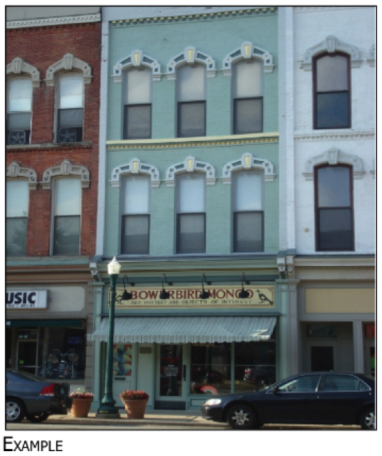
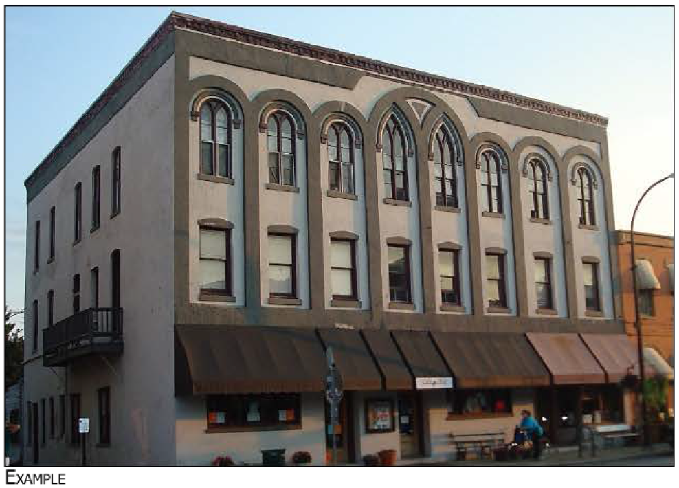
These are mixed-use areas with historic buildings. These are the places where people shop, go to school, live, come to work, visit, drop by city hall, eat, gather and have fun. They host events that bring thousands of visitors each year and bring the city together as a community. The intent of the zoning district is preserve the urban form, walkable nature and vibrant mix of uses in these areas.
Sec. 122-446. - Permissible uses.
In the center district, no uses shall be permitted except the following.
(Ord. No. 1305, 4-3-2018; Ord. No. 1335, 4-2-2019; Ord. No. 1354, 1-21-2020; Ord. No. 1370, 12-1-2020)
Sec. 122-447. - Non-use and dimensional requirements for site improvements not regulated by building type.
(Ord. No. 1440, 10-4-2024)
Sec. 122-450. - Purpose.
Corridors are mixed-use and commercial areas located along the arteries of the City, such as Washtenaw, Huron, Hamilton, Michigan, Harriet, and River.
(a)
Historic corridor (HC). Historic corridors are located primarily in the historic district, and are on Cross Street, Huron Street, Hamilton Street, and River Street. These corridors are lined with historic buildings and are integrated into the adjacent neighborhoods and centers. The intent of this district is to preserve the walkability, character and historic nature of these streets, while allowing for adaptive re-use of historic buildings.
(b)
Neighborhood corridor (NC). Neighborhood corridors have a linear land pattern and are adjacent to residential neighborhoods. The size, form and scale of buildings and the type and intensity of uses should be complementary to abutting single-family or core neighborhoods, including less intense multiple-family residential building types and uses.
(c)
General corridor (GC). General corridors are located along roads with heavy traffic and have commercial establishments, restaurants, offices, and other businesses that are geared toward automobile traffic. Multiple-family residential building types and uses are appropriate in this district.
Sec. 122-451. - Permissible uses.
In the corridor districts, no uses shall be permitted except the following.
(Ord. No. 1305, 4-3-2018; Ord. No. 1306, 4-3-2018; Ord. No. 1315, 7-17-2018; Ord. No. 1316, 7-17-2018; Ord. No. 1334, 3-5-2019; Ord. No. 1335, 4-2-2019; Ord. No. 1354, 1-21-2020; Ord. No. 1363, 9-1-2020; Ord. No. 1370, 12-1-2020)
Sec. 122-452. - Non-use and dimensional requirements for site improvements not regulated by building type.
(Ord. No. 1385, 3-1-2022; Ord. No. 1440, 10-4-2024)
Sec. 122-460. - Purpose.
The health and human services district is located on either side of Towner between Prospect and Arnet Streets. A cluster of office, health and human service uses are in this district. The intent of the district is to require a more urban form through redevelopment of parking lots and reconnecting the street grid and circulation system.
Sec. 122-461. - Permissible uses.
In the health and human services district, no uses shall be permitted except the following.
(Ord. No. 1334, 3-5-2019; Ord. No. 1335, 4-2-2019; Ord. No. 1354, 1-21-2020; Ord. No. 1370, 12-1-2020)
Sec. 122-462. - Non-use and dimensional requirements for site improvements not regulated by building type.
(Ord. No. 1440, 10-4-2024)
Sec. 122-465. - Building types.
Building types are specific sets of height, bulk, and setback regulations, dictated by district and lot size and dimension. Building types only apply in walkable urban districts, and apply to any new construction or expansion in those districts. The building types are consistent with the size, scale and character desired within each zoning district.
(a)
Building types by neighborhoods, centers, corridors and health and human services district. The following building types are allowed in neighborhoods, centers, corridors and health and human services districts as shown in the table below. "P" stands for permitted building types, "L" stands for building types allowed in special locations shown on the zoning map.
(b)
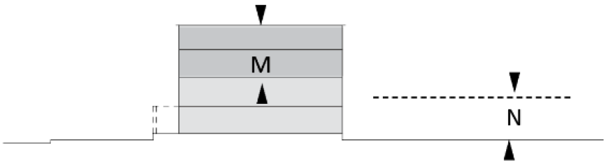
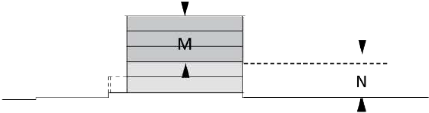
How to read building type diagrams. The following categories are included in each building type diagram. Each standard is labeled by a letter; that letter corresponds to a location on an illustration of the standard. Each standard is described as follows:
(1)
Building type parameters. The diagrams and text that follow provide the building parameters by building type. Building types must be consistently applied by district and not permitted a variance or waiver to increase in lot size.
(2)
Lot size determines building type. The size of the lot determines what type of building may be placed on a lot. For instance, a cottage or a house building type may be constructed on 5,000 square foot lot, since all of the those building types fit within the allowed lot size for those building types, but an estate building type is not allowed. Maximum lot depth and width do not determine building types, but all building types must meet the minimum lot width, depth and size.
(3)
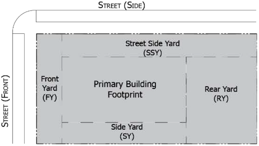
Lot requirements. Lists the minimum and maximum lot width, lot depth, and lot size; also the maximum lot coverage.
(4)
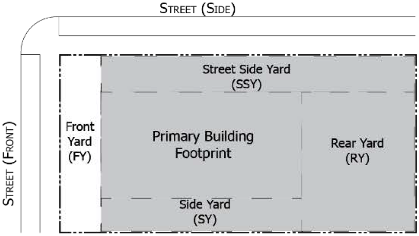
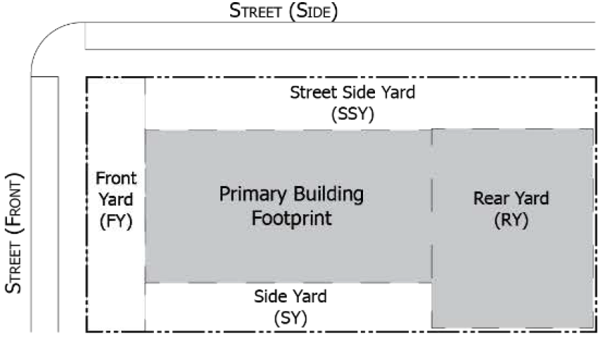
Building envelope. Lists the minimum and maximum setbacks for street, side, and rear setbacks, as well as the required frontage buildout.
(5)
Accessory structure envelope. Lists the setbacks and maximum building footprint permitted for accessory structures.
(6)
Building height. Lists permitted heights in stories.
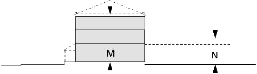
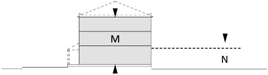
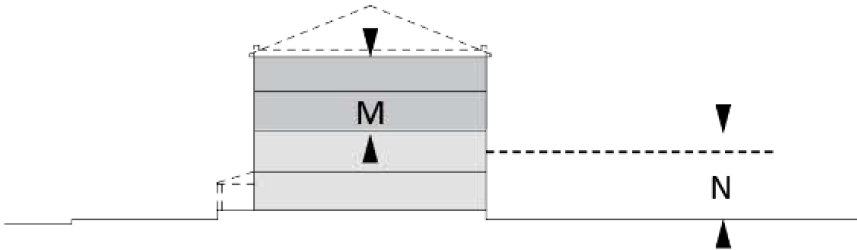
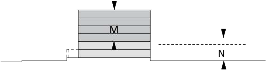
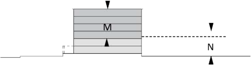
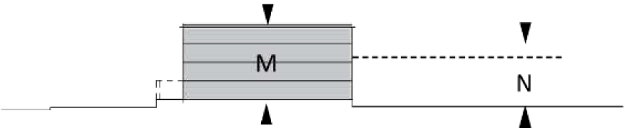
(i)
First or ground story. The minimum height for all first stories is 12 feet. For the MA, ES, HS, CO, TH, CA, and AB building types the maximum height for the first story shall be 14 feet; for all others, the maximum height for the first floor shall be 20 feet. Institutional building types, however, have no maximum height for the first floor. This shall not be construed as limiting multi-story or open foyers or lobbies.
(ii)
Subsequent stories. The minimum height for second story and above is ten feet; the maximum height for second story and higher must not exceed 12 feet. However, the top story of any building has a minimum height of ten feet, but no maximum height.
(iii)
Basements. There are no required maximum or minimum heights for basements outside of that required under Building Code.
(iv)
Exceptions to height requirements. See exceptions in §122-613.
(7)
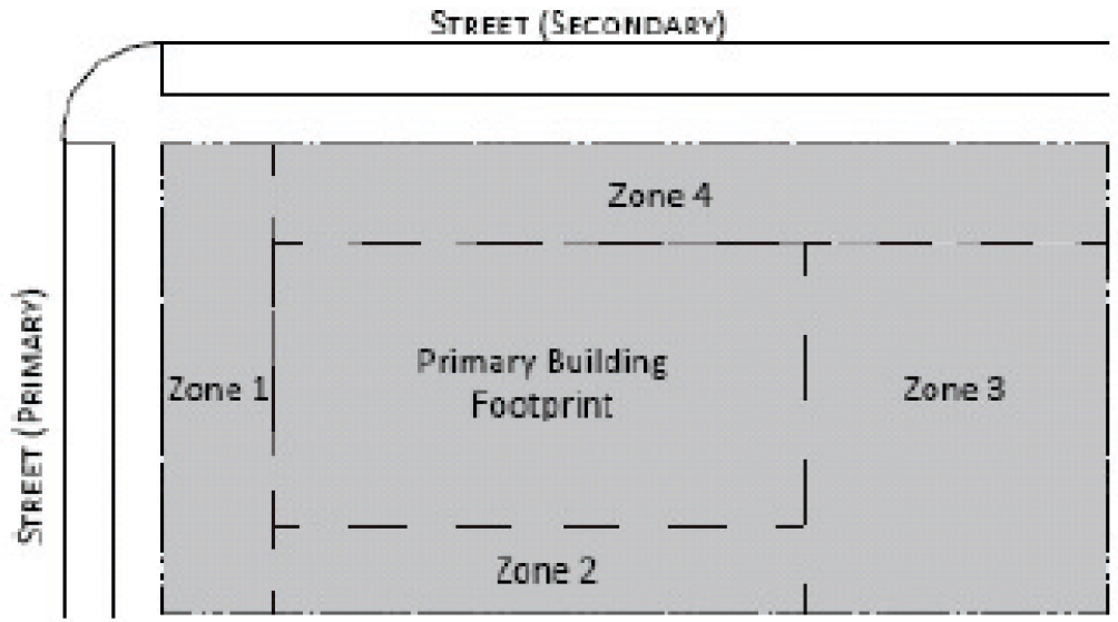
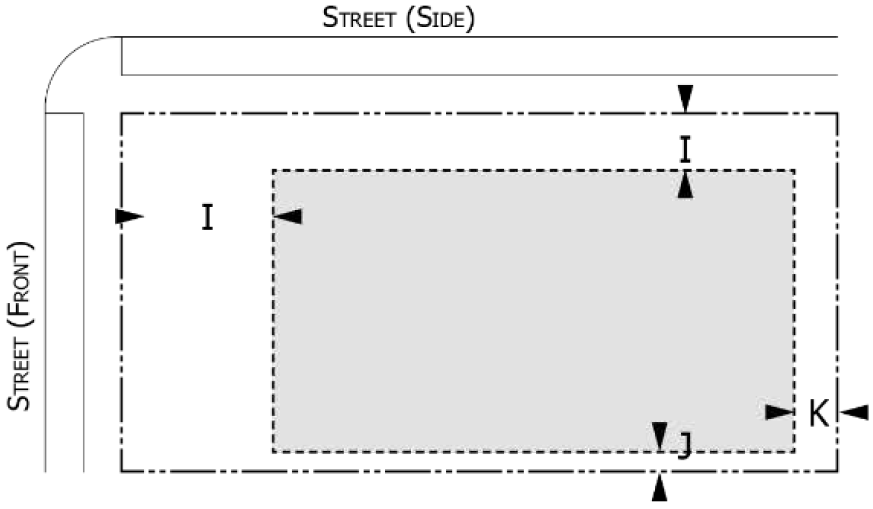
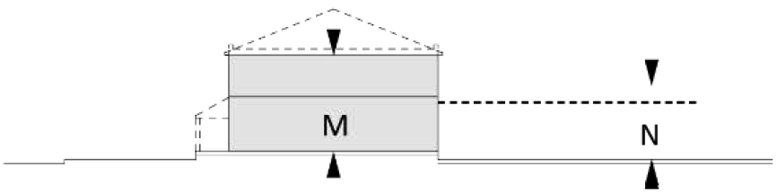
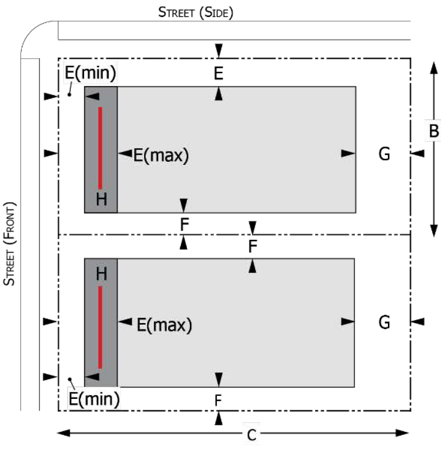
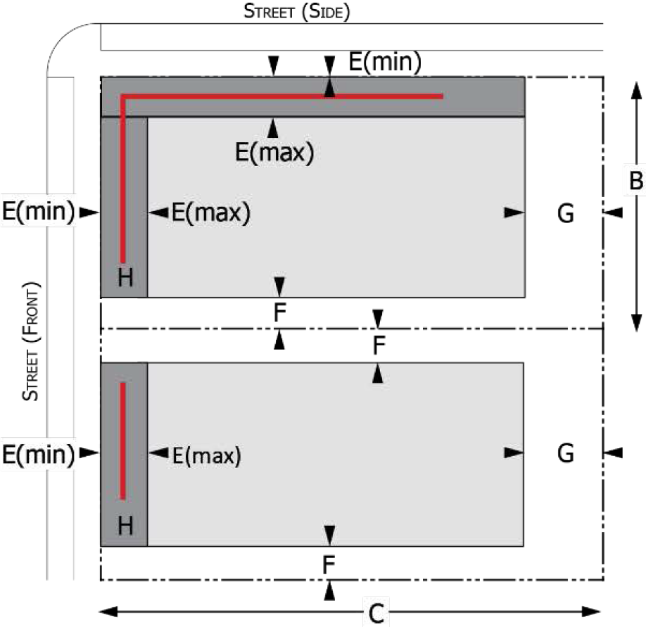
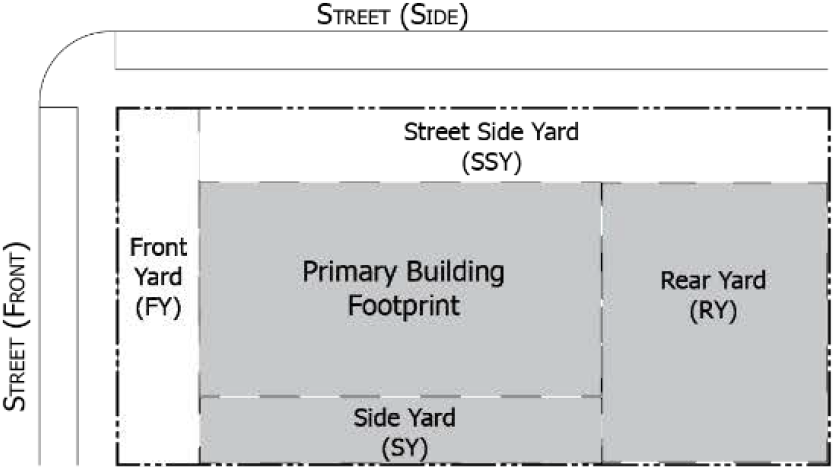
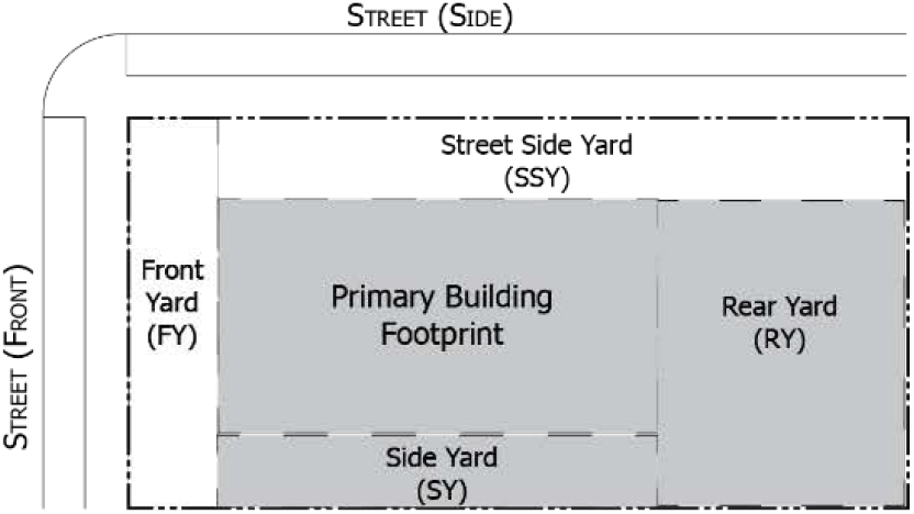
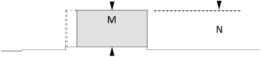
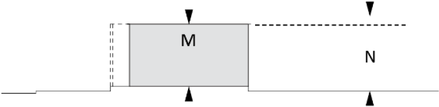
Parking zones. The amount of parking is determined by article VI, division 8 "parking types and quantities," but the area in which parking may be provided is determined by building type. Driveways are permitted in any zone, provided all other requirements of this chapter have been met. The diagrams illustrate a corner lot on a primary and non-primary street. Zones are the lot area between the principal building and:
Zone 1: the right-of-way of any primary street;
Zone 2: any common interior lot line;
Zone 3: any rear lot line;
Zone 4: the right-of-way of any non-primary street.
(8)
Private frontages. The private frontage style may be noted as "required" or as "preferred." If there are multiple frontages provided in the table, the applicant may choose which to provide per building.
(9)
Exceptions to setbacks. The following exceptions apply to setbacks for all building types:
(i)
Historic structure. A structure may encroach up to within five feet of a required front or rear yard setback, or within three feet of a side yard setback, upon a recommendation from the historic district commission that contains a finding that such setbacks allow for the restoration of a historic feature and with planning commission approval.
(ii)
Accessory structure adjacent to alley or railroad. Any setback for an accessory structure adjacent to an alley or railroad right-of-way is one foot.
(10)
Double frontage lots. In the case of a row of double frontage lots, one street must be designated as the front street for all lots in the row, with rear setbacks applying to the yards fronting the other street. If there are existing buildings in the same block fronting on one or both of the streets, the required minimum front yard setback must be observed on the street where buildings presently front.
(c)
Infill and redevelopment. Additions, renovations, and new buildings on existing built parcels may require the assembly of building types. The building types are outlined by lot size, and can often fit within existing lots. For instance, an addition to an existing building that meets the setbacks for their building type, but is on a lot deeper than the maximum, does not need to adjust lot lines.
(1)
Lot requirements for new construction. Several buildings of either one type or multiple types are permitted on one lot, provided that each building type is provided at least the minimum area required by building type, and other requirements of this chapter are met. There is no requirement to plat or divide land to create lots on the existing parcel site. For example, a multiple-story building and a commercial mixed use building can be built on the same parcel, without any changes to the lot line locations or a lot split, as long as the other lot requirements for the district can be met. In a single-building type example, two rows of townhouses can be built on a single parcel, without changes or splits of the lot, as long as the width of each unit meets the lot requirements and the distance between the two buildings meets the side or rear yard setback for both buildings, whichever is applicable.
(2)
Lot and block requirements for existing buildings. In the event when an addition is proposed for an existing building, and the existing building exceeds the height requirements or encroaches on the setbacks for the building type, the city planner must determine if an administrative waiver can be granted, or if it should require a review by the planning commission. An administrative waiver can be issued with a finding that the existing building with proposed additions will not cause the block perimeter to exceed a total length of 1,600 feet in the C, CN, CN-Mid, and CN-SF districts or 2,000 feet in the HC, NC, GC, and HHS districts; or a block side length of 400 feet in the C, CN, CN-Mid, and CN-SF districts or 500 feet in the HC, NC, GC, and HHS districts.
If the proposed additions to an existing building exceed the block requirements, the applicant is subject to review by the planning commission.
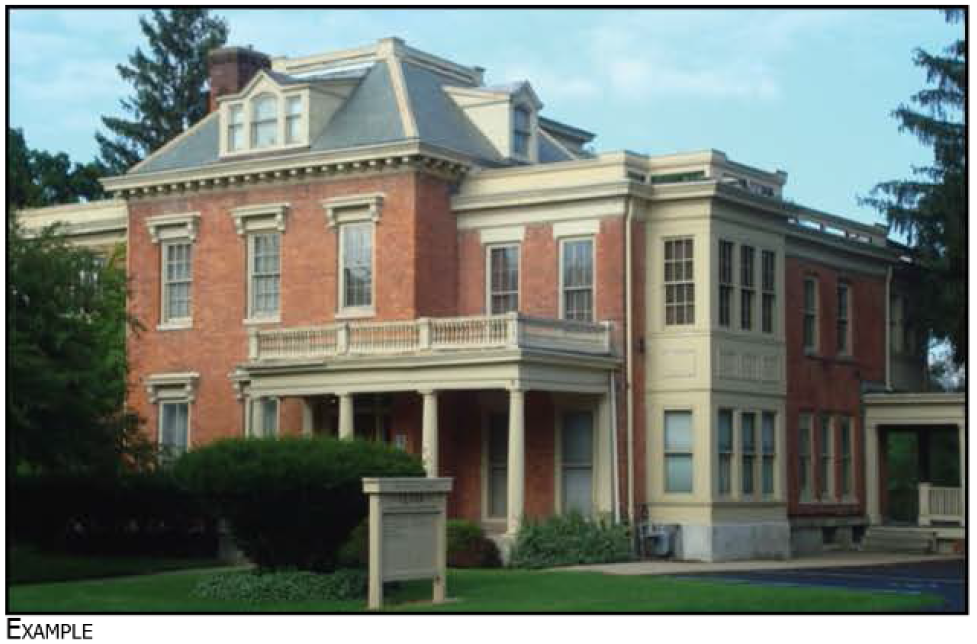
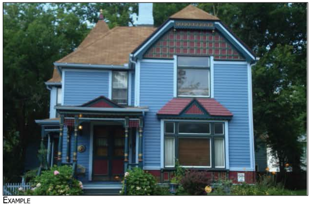
Sec. 122-466. - MA Mansion.
MANSION (MA)
Mansions are generally very large buildings originally built as residences, located on very large lots that distinguish the building from others nearby with expansive yards. They generally have a single primary entrance.
This building type is only permitted as a limited building type.
(1) Where an existing front yard setback line has been established by existing residential dwellings occupying 50 percent or more of the frontage within the same block on the same side of the street, the depth of the front yard must be within the range so established.
(2) The lesser of 25 feet or such that the highest point of the accessory structure is equal to or lesser than the height of the primary structure.
| LOT REQUIREMENTS AND BUILDING ENVELOPE |
 |
| ACCESSORY BUILDING ENVELOPE |
 |
| BUILDING HEIGHT |
 |
| PARKING LOCATION |
 |
(Ord. No. 1331, 1-8-2019)
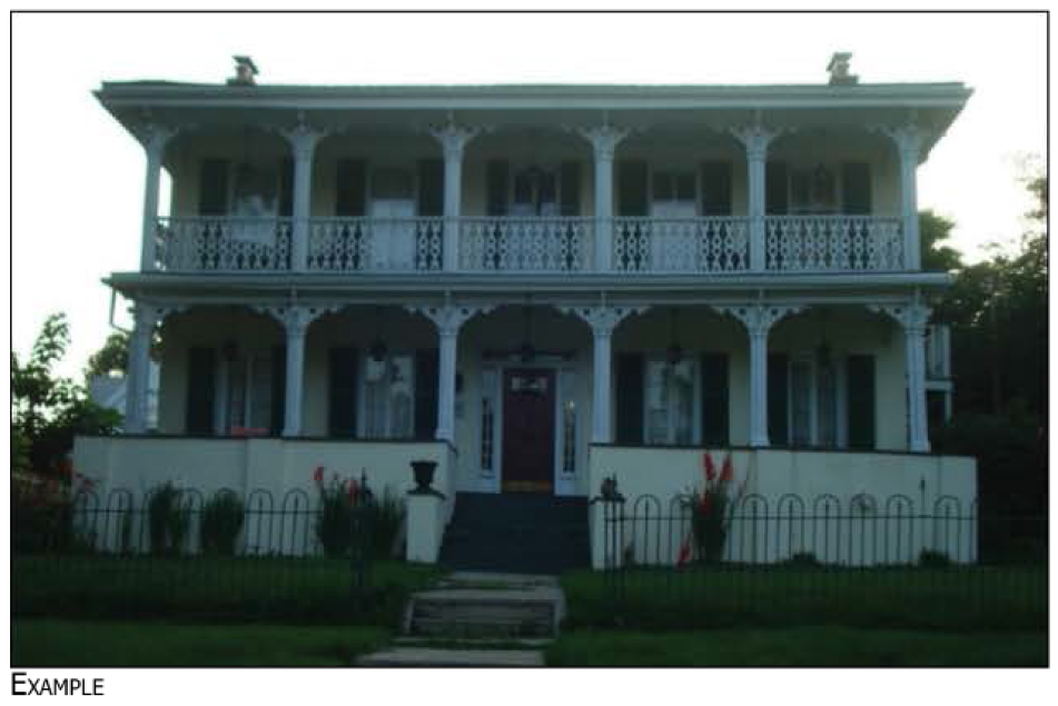
Sec. 122-467. - ES Estate
ESTATE (ES)
Large buildings, built as residences, located on large lots that accommodate large yards. They generally have distinguishing architectural features and one primary entrance.
(1) Where an existing front yard setback line has been established by existing residential dwellings occupying 50 percent or more of the frontage within the same block on the same side of the street, the depth of the front yard must be within the range so established.
(2) The lesser of 25 feet or such that the highest point of the accessory structure is equal to or lesser than the height of the primary structure.
(3) Setback reduced to one foot if abutting an alleyway.
| LOT REQUIREMENTS AND BUILDING ENVELOPE |
 |
| ACCESSORY BUILDING ENVELOPE |
 |
| BUILDING HEIGHT |
 |
| PARKING LOCATION |
 |
(Ord. No. 1331, 1-8-2019; Ord. No. 1334, 3-5-2019)
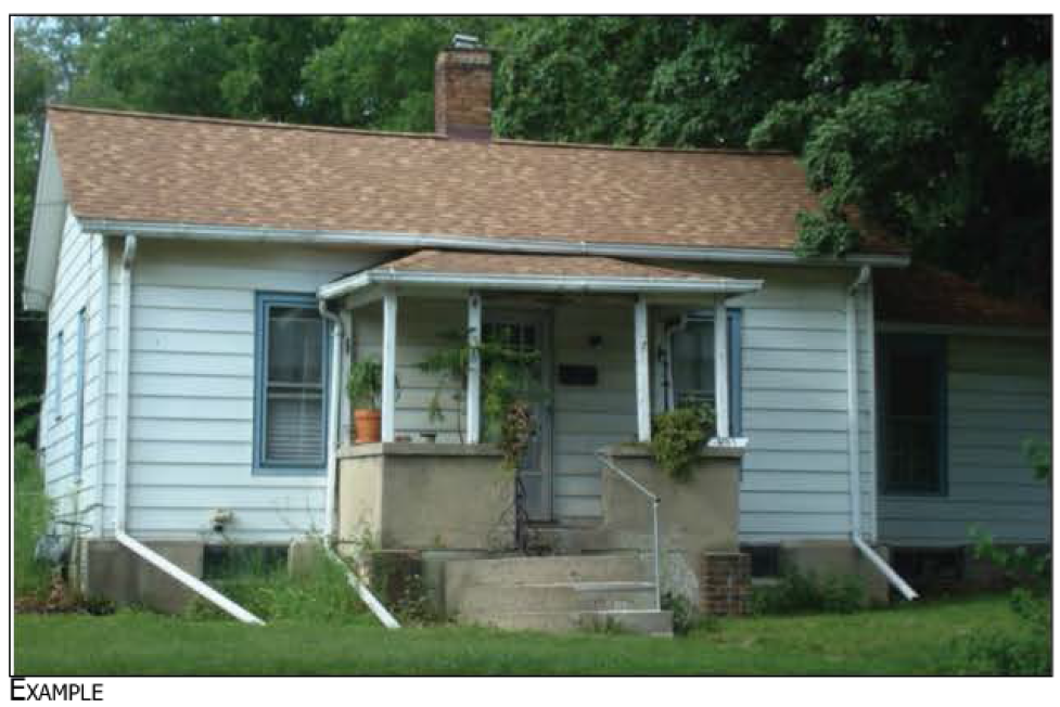
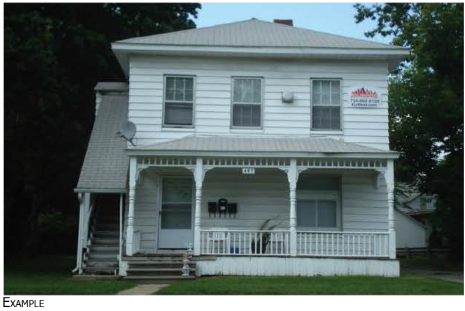
Sec. 122-468. - HS House.
HOUSE (HS)
Houses are detached, generally single-family dwelling units. They are located on lots that accommodate a primary building with small side yards and relatively large rear or front yards. They generally have one primary entrance.
(1) Where an existing front yard setback line has been established by existing residential dwellings occupying 50 percent or more of the frontage within the same block on the same side of the street, the depth of the front yard must be within the range so established.
(2) The lesser of 25 feet or such that the highest point of the accessory structure is equal to or lesser than the height of the primary structure.
(3) Setback reduced to one foot if abutting an alleyway.
| LOT REQUIREMENTS AND BUILDING ENVELOPE |
 |
| ACCESSORY BUILDING ENVELOPE |
 |
| BUILDING HEIGHT |
 |
| PARKING LOCATION |
 |
(Ord. No. 1331, 1-8-2019; Ord. No. 1334, 3-5-2019; Ord. No. 1382, 9-21-2021)
Sec. 122-469. - CO Cottage.
COTTAGE (CO)
Cottages are generally small residential buildings, sized for a single dwelling, located on lots that accommodate a detached primary building with small yards. They are generally a single-story building or bungalow with a single primary entrance.
(1) Where an existing front yard setback line has been established by existing residential dwellings occupying 50 percent or more of the frontage within the same block on the same side of the street, the depth of the front yard must be within the range so established.
(2) The lesser of 25 feet or such that the highest point of the accessory structure is equal to or lesser than the height of the primary structure.
(3) Setback reduced to one foot if abutting an alleyway.
| LOT REQUIREMENTS AND BUILDING ENVELOPE |
 |
| ACCESSORY BUILDING ENVELOPE |
 |
| BUILDING HEIGHT |
 |
| PARKING LOCATION |
 |
(Ord. No. 1331, 1-8-2019; Ord. No. 1334, 3-5-2019; Ord. No. 1382, 9-21-2021)
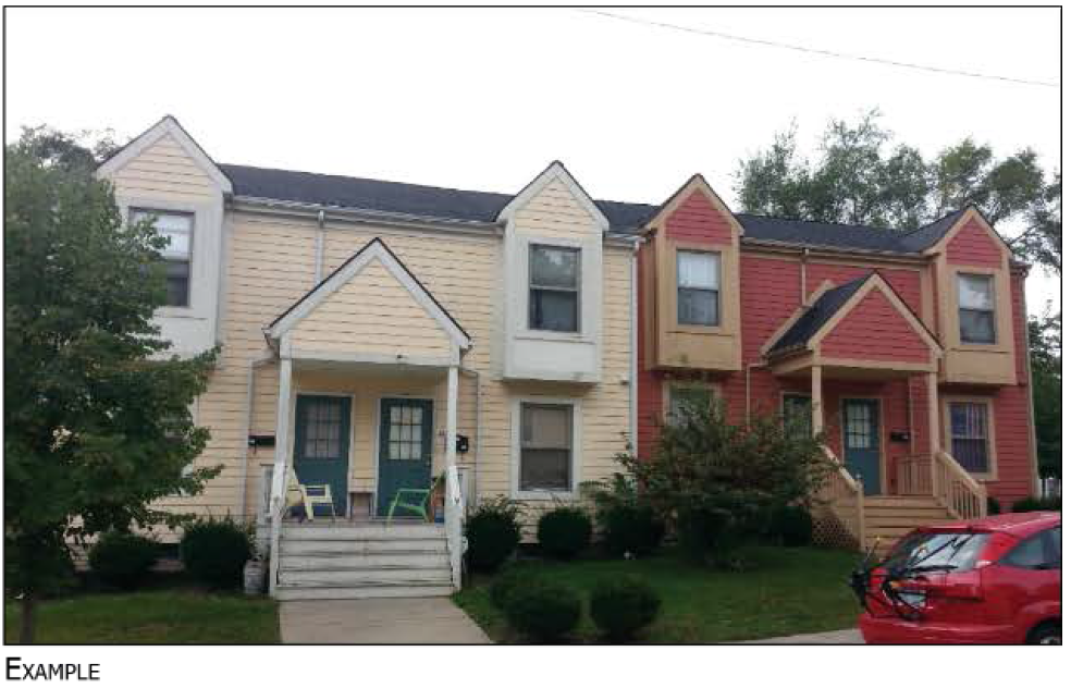
Sec. 122-470. - TH Townhouse.
TOWNHOUSE (TH)
Townhouses consist of rows of attached residential buildings. They are located on lots which accommodate a building with more than one dwelling unit, party walls, and a private back yard. Each dwelling has its own entrance to the street.
(1) Where an existing front yard setback line has been established by existing residential dwellings occupying 50 percent or more of the frontage within the same block on the same side of the street, the depth of the front yard must be within the range so established.
(2) End unit lot may be up to ten feet larger.
(3) Setback reduced to one foot if abutting an alleyway.
(4) In the case of an accessory dwelling unit, the highest point may match, but shall not exceed the highest point of principal structure.
| LOT REQUIREMENTS AND BUILDING ENVELOPE |
 |
| ACCESSORY BUILDING ENVELOPE |
 |
| BUILDING HEIGHT |
 |
| PARKING LOCATION |
 |
(Ord. No. 1334, 3-5-2019; Ord. No. 1382, 9-21-2021)
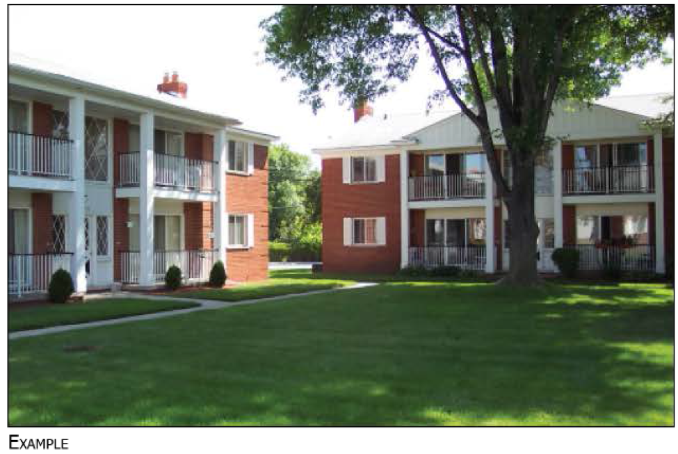
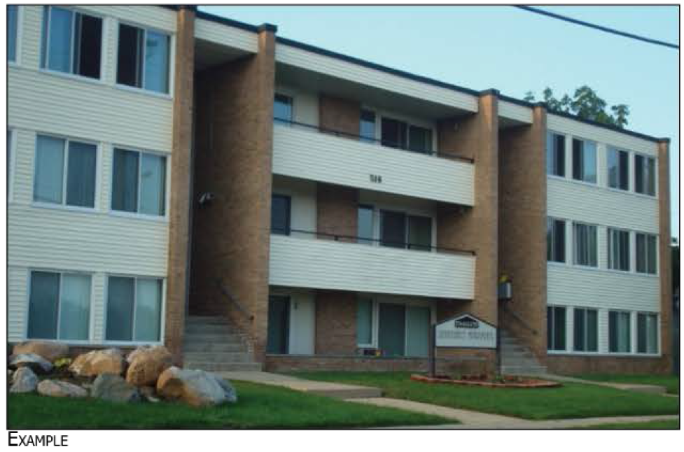
Sec. 122-471. - AH Apartment House.
APARTMENT HOUSE (AH)
Apartment houses may be buildings converted from single-family detached buildings or built to resemble them that contain two or more dwelling units, with lots that accommodate the parking and outdoor living areas for several dwellings.
(1) Where an existing front yard setback line has been established by existing residential dwellings occupying 50 percent or more of the frontage within the same block on the same side of the street, the depth of the front yard must be within the range so established.
(2) If located on Washtenaw Avenue, must build no more than ten feet from future right-of-way line as defined in the ReImagine Washtenaw plan.
(3) Setback reduced to one foot if abutting an alleyway.
(4) In the case of an accessory dwelling unit, the highest point may match, but shall not exceed the highest point of principal structure.
| LOT REQUIREMENTS AND BUILDING ENVELOPE |
 |
| ACCESSORY BUILDING ENVELOPE |
 |
| BUILDING HEIGHT |
 |
| PARKING LOCATION |
 |
(Ord. No. 1334, 3-5-2019; Ord. No. 1382, 9-21-2021)
Sec. 122-472. - CA Courtyard Apartment.
COURTYARD APARTMENT (CA)
A courtyard apartment is generally a grouping of apartment buildings arranged around and fronting on a central courtyard that may be partially or wholly open to the street, on a lot that accommodates the associated parking and outdoor living areas. Each dwelling may have its own entrance.
(1) If located on Washtenaw Avenue, must build no more than ten feet from future right-of-way line as defined in the ReImagine Washtenaw plan.
(2) In the case of an accessory dwelling unit, the highest point may match, but shall not exceed the highest point of principal structure.
| LOT REQUIREMENTS AND BUILDING ENVELOPE |
 |
| ACCESSORY BUILDING ENVELOPE |
 |
| BUILDING HEIGHT |
 |
| PARKING LOCATION |
 |
(Ord. No. 1382, 9-21-2021)
Sec. 122-473. - AB Apartment Building.
APARTMENT BUILDING (AB)
Apartment buildings are generally multiple-story multifamily residential buildings, located on lots that may be as large as a city block and can accommodate two or more buildings and accessory parking, waste disposal, and outdoor living areas.
(1) If located on Washtenaw Avenue, must build no more than ten feet from future right-of-way line as defined in the ReImagine Washtenaw plan.
(2) When adjacent to existing detached single-family homes, the rear setback shall be a minimum of 25 feet.
(3) In the case of an accessory dwelling unit, the highest point may match, but shall not exceed the highest point of principal structure.
| LOT REQUIREMENTS AND BUILDING ENVELOPE |
 |
| ACCESSORY BUILDING ENVELOPE |
 |
| BUILDING HEIGHT |
 |
| PARKING LOCATION |
 |
(Ord. No. 1382, 9-21-2021)
Sec. 122-474. - CS Commercial/Mixed-Use Small.
COMMERCIAL/MIXED-USE—SMALL (CS)
These are generally small multiple-story buildings designed for commercial uses on the ground floor and dwellings or offices above, located on lots that can accommodate a building that is less than 20 percent of that block's width.
(1) If located on Washtenaw Avenue, must build no more than ten feet from future right-of-way line as defined in the ReImagine Washtenaw plan.
(2) In the case of an accessory dwelling unit, the highest point may match, but shall not exceed the highest point of principal structure.
| LOT REQUIREMENTS AND BUILDING ENVELOPE |
 |
| ACCESSORY BUILDING ENVELOPE |
 |
| BUILDING HEIGHT |
 |
| PARKING LOCATION |
 |
(Ord. No. 1382, 9-21-2021)
Sec. 122-475. - CM Commercial/Mixed Use Medium.
COMMERCIAL/MIXED-USE—MEDIUM (CM)
These are generally moderately-sized multiple-story buildings designed for commercial uses on the ground floor and dwellings or offices above, located on lots that can accommodate a building that spans 20—40 percent of that block's width.
(1) If located on Washtenaw Avenue, must build no more than ten feet from future right-of-way line as defined in the ReImagine Washtenaw plan.
(2) When adjacent to existing detached single-family homes, the rear setback shall be a minimum of 25 feet.
| LOT REQUIREMENTS AND BUILDING ENVELOPE |
 |
| ACCESSORY BUILDING ENVELOPE |
 |
| BUILDING HEIGHT |
 |
| PARKING LOCATION |
 |
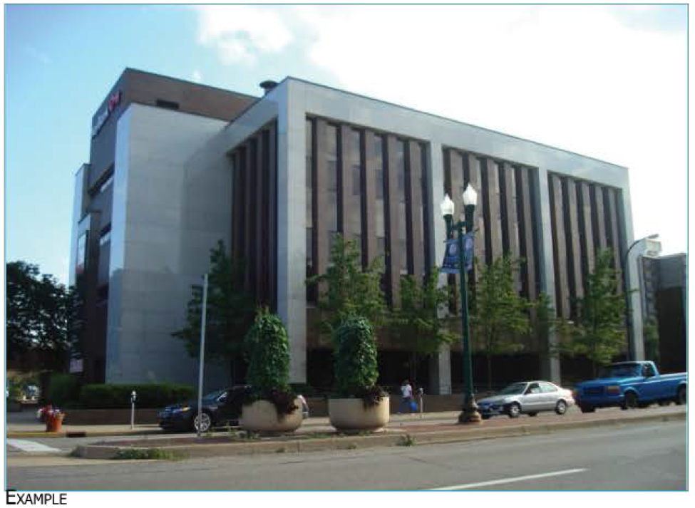
Sec. 122-476. - CL Commercial/Mixed Use Large.
COMMERCIAL/MIXED-USE—LARGE (CL)
These are generally large multiple-story buildings designed for commercial uses on the ground floor and dwellings or offices above, located on lots that can accommodate a building that spans up to an entire block's width.
(1) If located on Washtenaw Avenue, must build no more than ten feet from future right-of-way line as defined in the ReImagine Washtenaw plan.
(2) When adjacent to existing detached single-family homes, the rear setback shall be a minimum of 25 feet.
| LOT REQUIREMENTS AND BUILDING ENVELOPE |
 |
| ACCESSORY BUILDING ENVELOPE |
 |
| BUILDING HEIGHT |
 |
| PARKING LOCATION |
 |
Sec. 122-477. - SC Single Story Commercial Building.
SINGLE STORY COMMERCIAL BUILDING (SC)
These are generally designed for a single commercial use, located in lots that accommodate accessory parking, loading, and waste disposal areas.
(1) If located on Washtenaw Avenue, must build no more than ten feet from future right-of-way line as defined in the ReImagine Washtenaw plan.
(2) When adjacent to existing detached single-family homes, the rear setback shall be a minimum of 25 feet.
| LOT REQUIREMENTS AND BUILDING ENVELOPE |
 |
| ACCESSORY BUILDING ENVELOPE |
 |
| BUILDING HEIGHT |
 |
| PARKING LOCATION |
 |
(Ord. No. 1329, 1-8-2019)
Sec. 122-478. - LS Large Single Story Commercial Building.
LARGE SINGLE STORY COMMERCIAL BUILDING (LS)
These are generally designed for more than one commercial use, each generally with its own entrance, located in lots that accommodate accessory parking, loading, and waste disposal areas.
(1) If located on Washtenaw Avenue, must build no more than ten feet from future right-of-way line as defined in the ReImagine Washtenaw plan.
(2) When adjacent to existing detached single-family homes, the rear setback shall be a minimum of 25 feet.
| LOT REQUIREMENTS AND BUILDING ENVELOPE |
 |
| ACCESSORY BUILDING ENVELOPE |
 |
| BUILDING HEIGHT |
 |
| PARKING LOCATION |
 |
(Ord. No. 1329, 1-8-2019)
Sec. 122-479. - MB Multiple Story.
MULTIPLE STORY BUILDING (MB)
These are generally designed for more than one commercial use or user, with a common entrance on the ground floor. They are located on lots that accommodate accessory parking, loading, and waste disposal areas, spanning up to an entire block width.
(1) If located on Washtenaw Avenue, must build no more than ten feet from future right-of-way line as defined in the ReImagine Washtenaw plan.
(2) When adjacent to existing detached single-family homes, the rear setback shall be a minimum of 25 feet.
| LOT REQUIREMENTS AND BUILDING ENVELOPE |
 |
| ACCESSORY BUILDING ENVELOPE |
 |
| BUILDING HEIGHT |
 |
| PARKING LOCATION |
 |
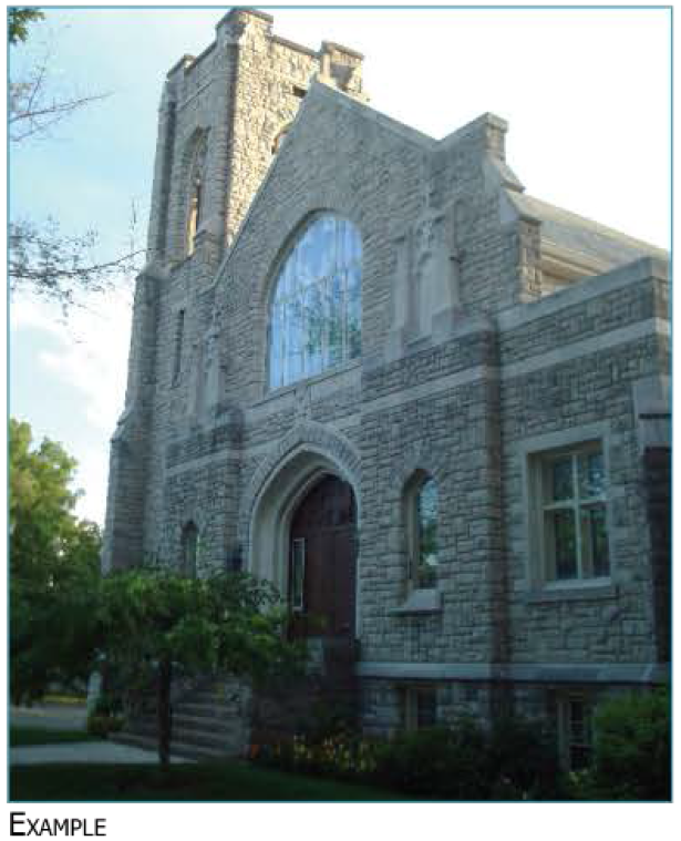
Sec. 122-480. - IT Institutional.
INSTITUTIONAL (IT)
These buildings are generally designed to house government, assembly, or institutional uses, on lots that can accommodate the primary building, associated parking, loading, waste disposal areas, and outdoor space.
(1) If located on Washtenaw Avenue, must build no more than ten feet from future right-of-way line as defined in the ReImagine Washtenaw plan.
(2) Additional height may be permitted by planning commission with a finding that the additional height is consistent with other buildings in that block.
| LOT REQUIREMENTS AND BUILDING ENVELOPE |
 |
| ACCESSORY BUILDING ENVELOPE |
 |
| BUILDING HEIGHT |
 |
| PARKING LOCATION |
 |
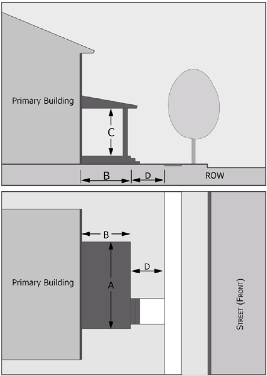
Sec. 122-481. - Porch.
PORCH (P)
The façade is set back from the front lot line per applicable street setback requirements. The façade includes an attached front porch structure. A wide variety of porch designs are possible. Unenclosed porches can project up to ten feet into the required front yard.
| DIMENSIONS |
 |
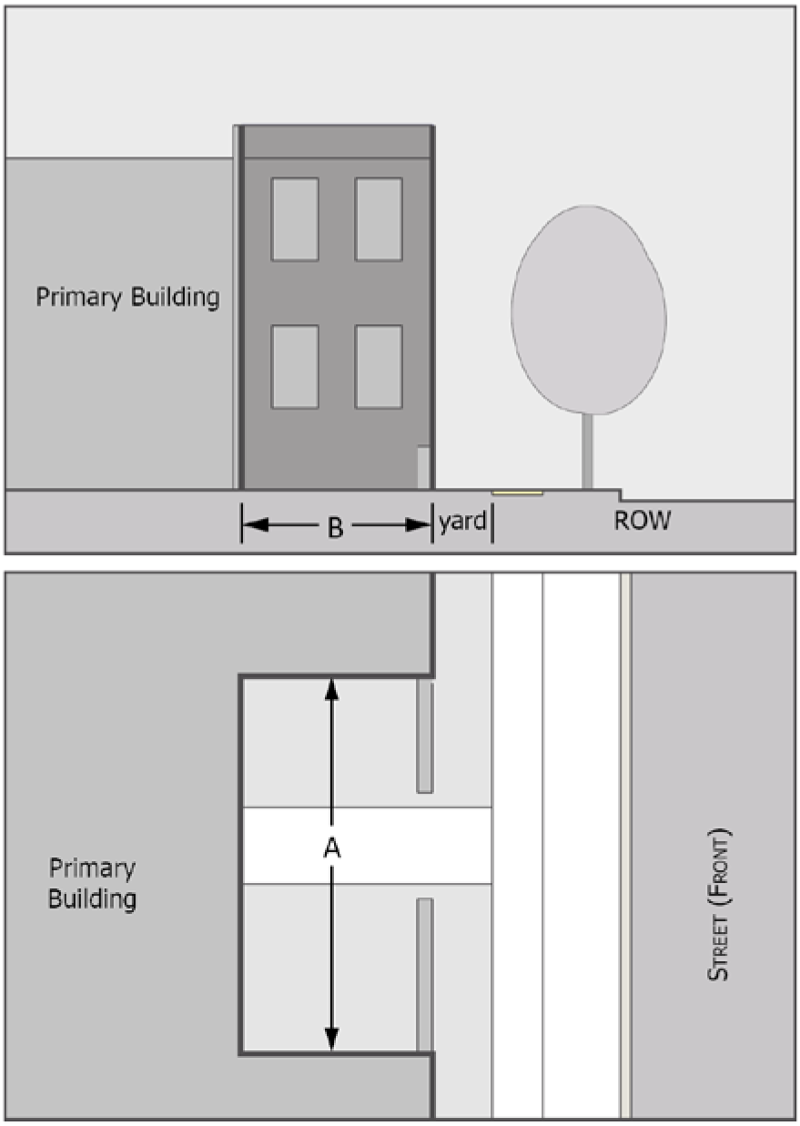
Sec. 122-482. - Stoop.
STOOP (S)
The building façade is set back from the front lot line per applicable street setback requirements. The façade includes an attached entry stoop (an elevated landing with stairs) that is placed at or near the front lot line. The ground floor is elevated to provide privacy. The stoop may include a roof.
| DIMENSIONS |
 |
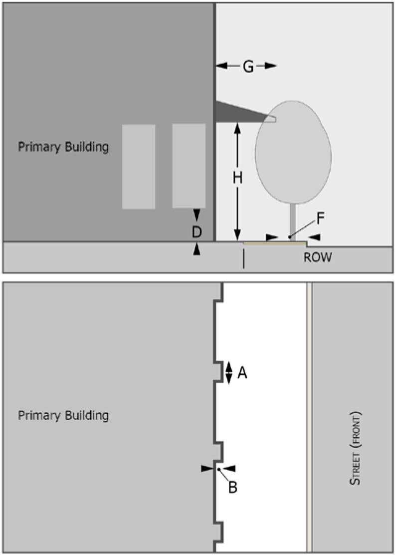
Sec. 122-483. - Forecourt.
FORECOURT (F)
The façade is set back from the front lot line per applicable street setback requirements. A portion of the façade is recessed to form an uncovered court. The court is suitable for outdoor dining, gardens, formal entries etc.. A fence, wall, or landscaping may be used to define the private space of the court. The court may be elevated behind a retaining wall at or near the front lot line with entry steps to the court. The court and building entry need not face the street, rather an open space, so long as there is a direct pedestrian connection to the public sidewalk.
| DIMENSIONS |
 |
(Ord. No. 1374, 3-2-2021)
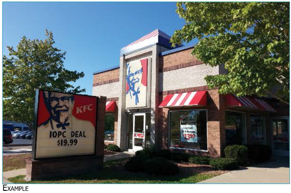
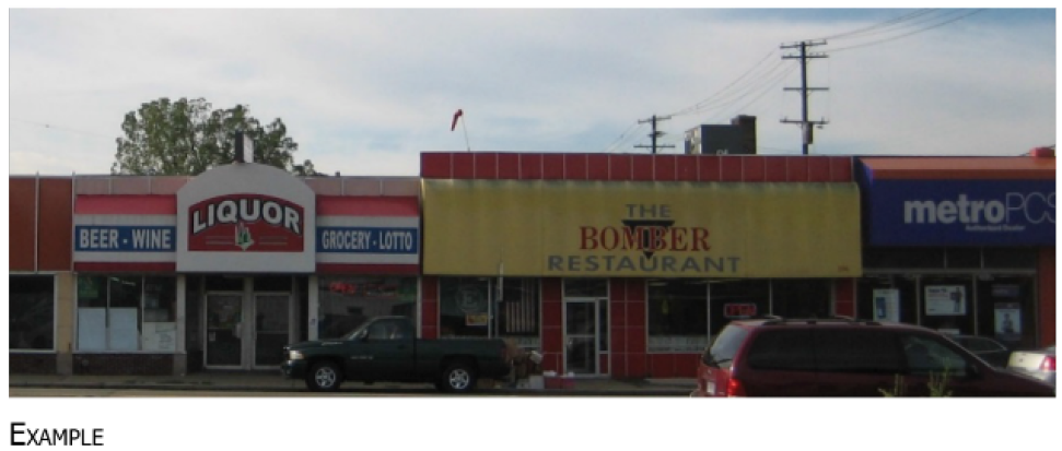
Sec. 122-484. - Commercial.
COMMERCIAL (C)
The façade is set back from the front lot line per applicable street setback requirements, typically at or near the front lot line with the entrance at sidewalk grade. The façade may include an awning, shed roof, or gallery (a lightweight colonnade with no habitable building space above it) that covers the sidewalk and may extend into the right-of-way. The facade has a substantial amount of glazing at the sidewalk level. Recessed entrances are acceptable.
| FRONTAGE ZONE AND INTERFACE ZONE |
 |
Sec. 122-485. - Thoroughfare Commercial.
THOROUGHFARE COMMERCIAL (C)
This frontage design is intended to allow for design flexibility in certain areas of the city with a high volume of fast-moving traffic, in the interests of promoting both walkability and safety.
I.
Any requirement of thoroughfare commercial may be modified by planning commission, provided the planning commission first makes a find that:
i.
The frontage will be less than 15 feet from the edge of the roadway, and
ii.
There is no on-street parking permitted on the block, and
iii.
The frontage has an ADT of more than 15,000, and
iv.
The roadway has a speed limit of 35 mph or above.
| FRONTAGE ZONE AND INTERFACE ZONE DIMENSIONS |
 |
(Ord. No. 1329, 1-8-2019)