Yuba County Unincorporated
City Zoning Code
City Zoning Code
DIVISION 1
INTRODUCTORY PROVISIONS
11.01.010. - Title and authority.
Title 11 of the Yuba County Ordinance Code shall be known and cited as the "Yuba County Development Code," "Development Code of Yuba County," "Development Code," or "Code."
The Yuba County Development Code is adopted pursuant to the authority contained in Section 65850 of the California Government Code. In addition, the provisions of this Code relating to the regulation and control of subdivisions are adopted pursuant to the authority contained in Title 7, Division 2 of the California Government Code, commencing with Section 66410, hereinafter referred to as the "Subdivision Map Act," as may be amended from time to time.
(Ord. No. 1624)
11.01.020. - Purpose.
The purpose of this Code is to implement the County's General Plan and to protect and promote the public health, safety, peace, comfort, convenience, prosperity and general welfare. More specifically, the Code is adopted to achieve the following objectives:
(1)
To provide a precise guide for the physical development of the County in a manner as to progressively achieve the arrangement of land uses depicted in the Yuba County General Plan, consistent with the goals and policies of the General Plan.
(2)
To foster a harmonious, convenient and workable relationship among land uses and ensure compatible development, consistent with the General Plan.
(3)
To ensure that public and private lands ultimately are used for purposes which are appropriate and most beneficial for the County.
(4)
To support economic development and job creation.
(5)
To provide for the housing needs of all economic segments of the community.
(6)
To promote high quality development, consistent with the General Plan.
(7)
To protect the character and the social and economic stability of agricultural, residential, commercial, industrial, recreational, and other areas within the County.
(8)
To facilitate the appropriate location of community facilities, institutions, parks, and other recreational areas.
(9)
To define duties and powers of administrative bodies and officers responsible for implementation of the Code.
(Ord. No. 1624)
11.01.030. - Structure of Development Code regulations.
(a)
Organization of regulations. This Code consists of six divisions:
Division I—Introductory Provisions.
Division II—Zoning and Overlay Districts.
Division III—Regulations Applying to Some or All Districts.
Division IV—Land Divisions.
Division V—Administration and Permits.
Division VI—General Terms.
(b)
Types of regulations. Four types of development code regulations control the use and development of property:
(1)
Land use regulations. These regulations specify land uses permitted, conditionally permitted or specifically prohibited in each zoning district, and include special requirements, if any, applicable to specific uses. Land use regulations for base and overlay zoning districts are in Division II of this Code. Certain regulations, applicable in some or all of the districts, and performance standards which govern special uses, are in Division III.
(2)
Development regulations. These regulations control the height, bulk, location and appearance of structures on development sites. Development regulations for base and overlay zoning districts are in Division II of this Code. Certain development regulations, applicable to some or all districts are in Division III. These include regulations for specific uses, development and site regulations, performance standards, parking, signage, antennas and wireless communications and nonconforming uses.
(3)
Land division regulations. These regulations control the division of land and specify the design, improvement, and survey data of subdivisions as well as the procedures to be followed to secure final approval for subdivision maps. Land division regulations are in Division IV of this Code.
(4)
Administrative regulations. These regulations contain detailed procedures for the administration of this Code, and include common procedures, processes and standards for discretionary entitlement applications and other permits. Administrative regulations are in Division V.
(5)
General terms and use classifications. Division IV provides a list of use classifications and a list of terms and definitions used in the Code.
(Ord. No. 1624)
11.01.040. - General rules for applicability of zoning regulations.
(a)
Applicability to property. This Code shall apply, to the extent permitted by law, to all property within the unincorporated limits of Yuba County, including all uses, structures and land owned by any private person, firm, corporation or organization, or Yuba County or other local, State or federal agencies. Any governmental agency shall be exempt from the provisions of this Code only to the extent that such property may not be lawfully regulated by Yuba County.
(b)
Compliance with regulations. No land shall be used, and no structure shall be constructed, occupied, enlarged, altered, demolished or moved in any zoning district, except in accordance with the provisions of this Code.
(c)
Relation to other regulations.
(1)
General. The regulations of this Code and requirements or conditions imposed pursuant to this Code shall not supersede any other regulations or requirements adopted or imposed by the Yuba County Board of Supervisors, the State of California, or any federal agency that has jurisdiction by law over uses and development authorized by this Code. All uses and development authorized by this Code shall comply with all other such regulations and requirements. Where conflict occurs between the provisions of the Code and any other County ordinance, chapter, resolution, guideline or regulation, the more restrictive provisions shall control, unless otherwise specified.
(2)
Permit Streamlining Act. It is the intent of this Code that all actions taken by the decision-making authority pursuant to this Code that are solely adjudicatory in nature be within a time frame consistent with the provisions of Government Code Section 65920 et seq. (the Permit Streamlining Act). Nothing in this Code shall be interpreted as imposing time limits on actions taken by the decision-making authority pursuant to this Code that are legislative in nature or that require both adjudicatory and legislative judgments.
(d)
Relation to private agreements. This Code shall not interfere with or annul any recorded easement, covenant, development agreements, or other agreement now in effect, provided that where this Code imposes greater restriction than imposed by an easement, covenant, or agreement, this Code shall control.
(e)
Relation to prior code. The provisions of this Code supersede all prior Codes and any amendments. No provision of this Code shall validate any land use or structure established, constructed or maintained in violation of the prior Code, unless such validation is specifically authorized by this Code and is in conformance with all other regulations.
(f)
Application During Local Emergency. The Board of Supervisors may authorize a deviation from a provision of this Code during a local emergency declared and ratified under the Yuba County Ordinance Code. The Board of Supervisors may authorize a deviation by resolution without notice or public hearing.
(Ord. No. 1624)
11.01.050. - Consistency with the General Plan.
Any permit, license or approval issued pursuant to this Code must be consistent with the Yuba County General Plan and all applicable specific plans. In any case where there is a conflict between this Code and the General Plan, the General Plan shall prevail.
(Ord. No. 1624)
11.01.060. - Effect on previously approved projects and projects in progress.
Any building or structure for which a building permit was issued under the prior ordinance code may be completed in accordance with plans, specifications, and permits upon which the building permit was granted, provided at least one inspection had been requested prior to adoption of this ordinance and provided that construction is diligently pursued. Upon completion of the structure, the occupancy permit shall allow the uses allowed under the project's permits and conditions of approval. No extensions of time shall be granted for commencement of construction unless it complies with the provisions of this Code.
(Ord. No. 1624)
11.01.070. - Severability.
If any section, subsection, paragraph, sentence, clause or phrase of this Code is for any reason held to be invalid or unconstitutional by the decision of any court of competent jurisdiction, such decision shall not affect the validity of the remaining portions of this Code. The Yuba County Board of Supervisors hereby declares that it would have passed this Code, and each section, subsection, sentence, clause and phrase thereof, regardless of the fact that any or one or more sections, subsections, sentences, clauses or phrases be declared invalid or unconstitutional.
(Ord. No. 1624)
11.01.080. - Fees.
The Board of Supervisors shall establish by resolution, and may amend and revise from time to time, fees for processing the discretionary entitlement applications and other permits authorized or required by this Code. All fees shall be paid at the time an application is filed, and no processing shall commence or when applicable hearing scheduled until the fees are paid in full.
(Ord. No. 1624)
11.02.010. - Purpose.
The purpose of this Chapter is to provide precision in the interpretation of the zoning regulations. The meaning and construction of words and phrases defined in this Chapter apply throughout the Code, except where the context indicates a different meaning.
(Ord. No. 1624)
11.02.020. - Rules for construction of language.
In interpreting the various provisions of the Code, the following rules of construction shall apply:
(1)
The particular controls the general.
(2)
Unless the context clearly indicates the contrary, the following conjunctions shall be interpreted as follows:
a.
And indicates that all connected words or provisions shall apply.
b.
And/or indicates that the connected words or provisions may apply singly or in any combination.
c.
Or indicates that the connected words or provisions may apply singly or in any combination.
d.
Either . . . or indicates that the connected words or provisions shall apply singly but not in combination.
(3)
In case of conflict between the text and a diagram or graphic, the text controls.
(4)
All references to departments, committees, commissions, boards, or other public agencies are to those of Yuba County, unless otherwise indicated.
(5)
All references to public officials are to those of Yuba County, and include designated deputies or designees of such officials, unless otherwise indicated.
(6)
All references to days are to calendar days, unless otherwise indicated. If a deadline falls on a weekend or holiday, or a day when the County offices are closed, it shall be extended to the next working day. The end of a time period shall be the close of business (public office hours) on the last day of the period.
(7)
The words "shall," "will," "must" and "is to" are always mandatory and not discretionary. The words "should" or "may" are permissive.
(8)
The present tense includes the past and future tenses, and the future tense includes the past.
(9)
The singular number includes the plural, and the plural, the singular.
(10)
Sections and section headings contained herein shall not be deemed to govern, limit, modify, or in any manner affect the scope, meaning, or intent of any section.
(Ord. No. 1624)
11.02.030. - Rules of interpretation.
The CDSA Director shall make the interpretation for any definition not expressly identified in this Code or provide clarification and determination of these rules. In cases where a specific land use or activity is not defined, the CDSA Director shall assign the land use or activity to a classification that is substantially similar in character to other use classifications listed in Chapter 11.72: Use Classifications. Use classifications and subclassifications not listed in the land use regulation tables found in Division II: Zoning and Overlay Districts or not found to be substantially similar to the listed uses are prohibited in said zone district. The CDSA Director shall maintain a written record of all such determinations. The CDSA Director may forward questions about permitted uses directly to the Planning Commission for an interpretation at a public meeting. Determinations by the CDSA Director or Planning Commission may be appealed pursuant to Section 11.53.150; Appeals and Calls for Review. The following findings shall be made when making a zoning interpretation:
(1)
The common functional product or compatibility characteristics and activities associated with the proposed use are consistent with one of the use classifications listed as an allowed use (principally permitted or upon approval of a use permit or zoning clearance) within the zone district;
(2)
The proposed use will not be adverse to the public health, safety, or general welfare of the community, nor detrimental to the character of the zone district or surrounding properties; and
(3)
The proposed use is consistent with the goals, policies, and objectives of the General Plan and any applicable adopted specific plan or community plan.
(Ord. No. 1624)
11.03.010. - Purpose.
The purpose of this Chapter is to explain how various measurements referred to in this Code are to be calculated.
(Ord. No. 1624)
11.03.020. - General provisions.
For all calculations, the applicant shall be responsible for supplying drawings illustrating the measurements that apply to a project. These drawings shall be drawn to scale and of sufficient detail to allow easy verification upon inspection by the CDSA Director.
(Ord. No. 1624)
11.03.030. - Fractions.
Whenever this Code requires consideration of distances, parking spaces, dwelling units or other aspects of development or the physical environment expressed in numerical quantities, and the result of a calculation contains a fraction of a whole number, the results will be rounded as follows:
(1)
General rounding. Fractions of one-half or greater shall be rounded up to the nearest whole number and fractions of less than one-half shall be rounded down to the nearest whole number, except as otherwise provided.
(2)
Exception for state affordable housing density bonus. For projects eligible for bonus density pursuant to Government Code Section 65915 or any successor statute, and Chapter 11.30, Density Bonus Incentive Program, any fractional number of permitted bonus density units shall be rounded up to the next whole number.
(Ord. No. 1624)
11.03.040. - Measuring distances.
(a)
Measurements are shortest distance. When measuring a required distance, such as the minimum distance between a structure and a lot line, the measurement is made at the closest or shortest distance between the two objects.
(b)
Distances are measured horizontally. When determining distances for setbacks and structure dimensions, all distances are measured along a horizontal plane from the appropriate line, edge of building, structure, storage area, parking area, or other object. These distances are not measured by following the topography or slope of the land.
(c)
Measurements involving a structure. Measurements involving a structure are made to the closest support wall of the structure. For structures that do not have a wall such as porches and patio covers, the measurement is from the closest vertical support. Structures or portions of structures that are entirely underground are not included in measuring required distances.
(d)
Measurement of vehicle stacking or travel areas. Measurement of a minimum travel distance for vehicles, such as garage entrance setbacks and stacking lane distances, are measured down the center of the vehicle travel area. For example, curving driveways and travel lanes are measured along the center arc of the driveway or traffic lane.
(e)
Measurements involving different land uses. When a specified land use is required to be located a minimum distance from another land use, the minimum distance is measured in a straight line from all points along the lot line of the subject project. In instances where the setback is from a structure, the minimum distance is measured in a straight line from the two closest points between the structures.
Figure 11.03.040: Measuring Distances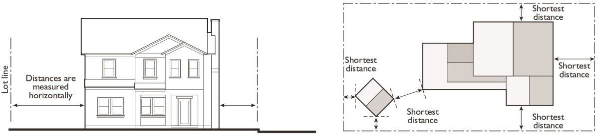
(Ord. No. 1624)
11.03.050. - Measuring height.
(a)
Measuring building height. Building height is measured from the average level of the highest and lowest points where the vertical plane of the exterior walls would touch the natural grade level of the site to the highest point on the ridge of the roof.
Figure 11.03.050(a): Measuring Building Height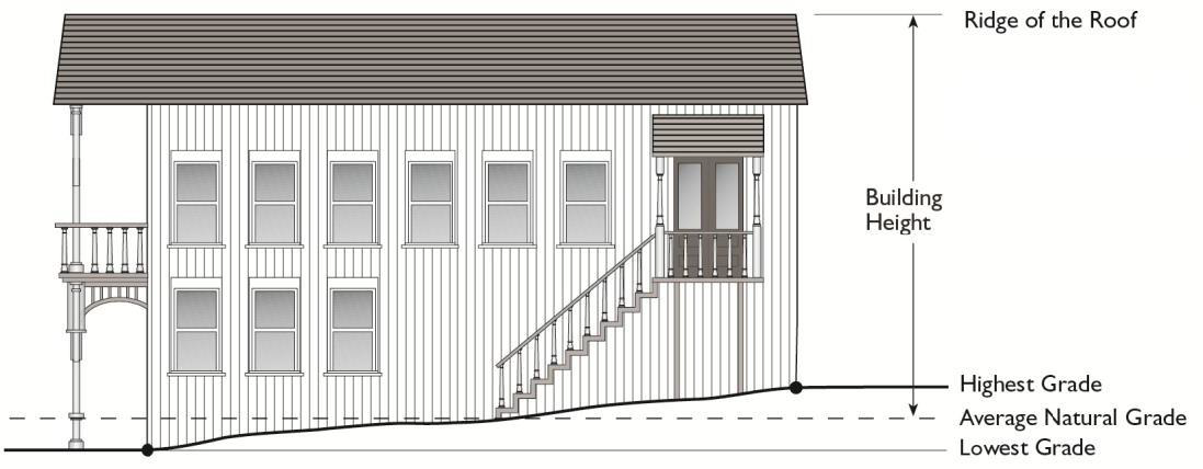
(b)
Measuring height of other structures. The height of other structures such as fences is the vertical distance from the ground level immediately under the structure to the top of the structure. Special measurement provisions are also provided below:
(1)
Measuring the height of fences on retaining walls. The height of a fence that is on top of a retaining wall is measured from the ground level on the highest side of the fence and wall.
Figure11.03.050(b)(1): Measuring Height of Fences on Retaining Walls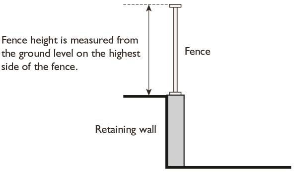
(2)
Measuring the height of decks. Deck height is determined by measuring from the ground to the top of the floor of the deck.
Figure 11.03.050(b)(2): Measure Height of Decks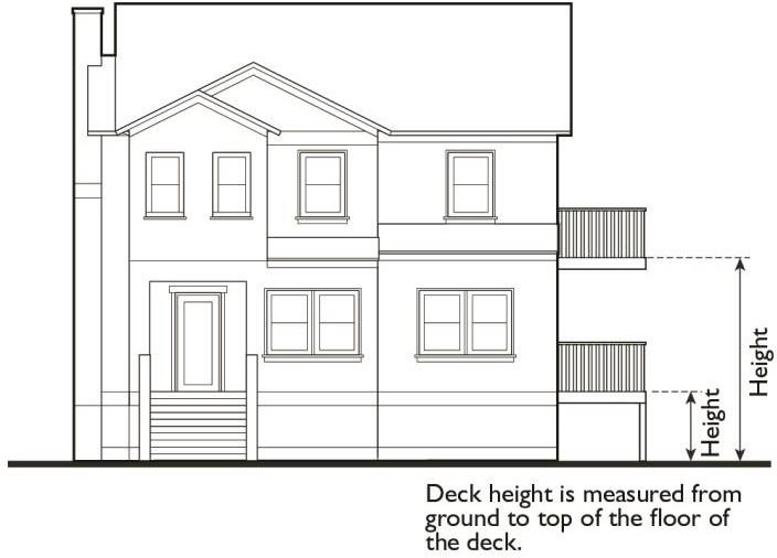
(3)
Measuring the height of signs. Measuring the height of signs is described in Chapter 11.27, Signs.
(Ord. No. 1624)
11.03.060. - Measuring lot area.
Lot area shall consist of the gross square footage of the lot or parcel.
(Ord. No. 1624)
11.03.070. - Measuring lot width and depth.
(a)
Lot width. Lot width is the horizontal distance between the side lot lines, measured at right angles to the lot depth at a point midway between the front and rear lot lines for rectangular shaped lots. Lot width on cul-de-sac lots shall be measured at the front setback line. Measuring lot widths for non-rectangular and non-cul-de-sac lots, commonly referred to as irregular shaped lots, will be as determined by the Planning Director, with the intent of having the average width of the buildable portion of the lot be the lot width.
(b)
Lot depth. Lot depth is measured along an imaginary straight line drawn from the midpoint of the front property line of the lot to the midpoint of the rear property line or to the most distant point on any other lot line where there is no rear lot line.
(Ord. No. 1624)
Figure 11.03.070: Measuring Lot Width and Depth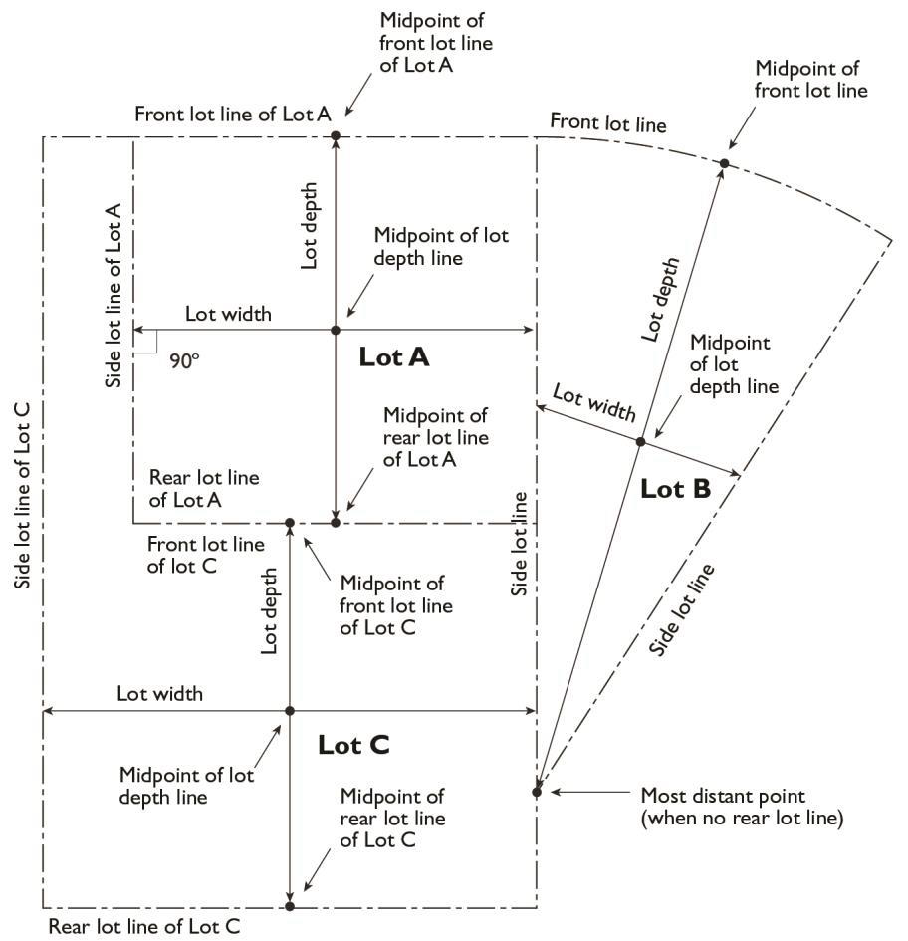
11.03.080. - Determining floor area.
The floor area of a building is the sum of the gross horizontal areas of all floors of a building or other enclosed structure.
(a)
Included in floor area. Floor area includes, but is not limited to, habitable (as defined in the California Building Code) basements and cellars that are below the roof and within the outer surface of the main walls of principal or accessory buildings or the centerlines of party walls separating such buildings or portions thereof or within lines drawn parallel to and two feet within the roof line of any structure without walls. In the case of a multi-story building that has covered or enclosed stairways, stairwells or elevator shafts, the horizontal area of such features shall be counted only once at the floor level of their greatest area of horizontal extent.
(b)
Excluded from floor area. Floor area does not include mechanical, electrical, and communication equipment rooms that do not exceed two percent of the building's gross floor area; bay windows or other architectural projections where the vertical distance between the lowest surface of the projection and the finished floor is 30 inches or greater; areas that qualify as usable open space; and areas below the finish grade of the property that are used for off-street parking spaces or loading.
(Ord. No. 1624)
11.03.090. - Determining floor area ratio.
Floor area ratio (FAR) is the ratio of the floor area, excluding the areas described below, of all principal and accessory buildings on a site to the site area. To calculate FAR, floor area is divided by site area, and typically expressed as a decimal. For example, if the floor area of all buildings on a site totals 20,000 square feet, and the site area is 10,000 square feet, the FAR is expressed as 2.0.
Figure 11.03.090: Determining Floor Area Ratio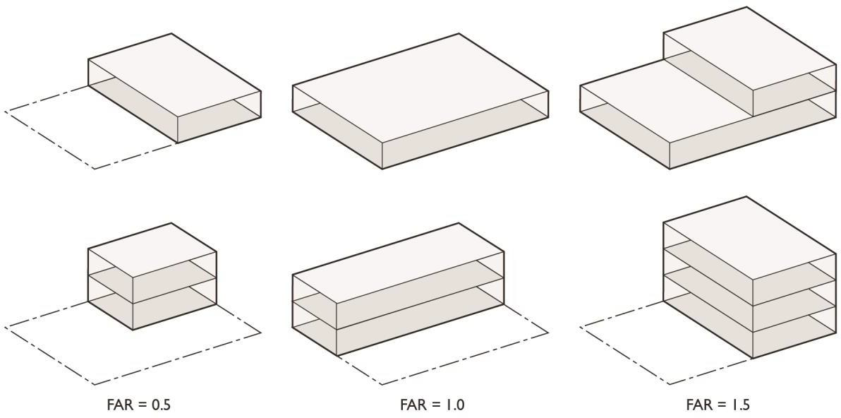
(Ord. No. 1624)
11.03.100. - Determining lot coverage.
Lot coverage is the ratio of the total footprint area of all structures on a lot to the net lot area, typically expressed as a percentage. The footprints of all principal and accessory structures, including garages, carports, covered patios, and roofed porches, shall be summed in order to calculate lot coverage. The following structures shall be excluded from the calculation:
(1)
Unenclosed and unroofed decks, uncovered patio slab, porches, landings, balconies and stairways less than six feet in height;
(2)
Eaves and roof overhangs projecting up to three feet from a wall;
(3)
Trellises and similar structures that have roofs that are at least 50 percent open to the sky through uniformly distributed openings;
(4)
Swimming pools and hot tubs that are not enclosed in roofed structures or decks; and
(5)
One non-habitable accessory structure under 120 square feet in area and under eight feet in height.
Figure 11.03.100: Determining Lot Coverage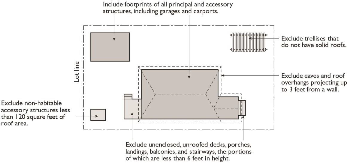
(Ord. No. 1624)
11.03.110. - Determining lot frontage.
(a)
Corner lot. The front of a lot is the narrowest dimension of the lot with street frontage. In the event that the lot lines with street frontage are equal dimensions, the lot frontage shall be determined by the Planning Director.
(b)
Through lot (double frontage lot). The front yard borders the street primarily used as frontage by neighboring lots.
(Ord. No. 1624)
11.03.120. - Determining setbacks (yards).
A setback line defining a required yard is parallel to and at the specified distance from the corresponding front, side, or rear property line or back edge of the street curb, whichever results in a greater setback. The following special regulations for determining yards apply when a lot abuts an alley or Official Plan Line.
(1)
Yards on alleys.
a.
If a side lot line abuts an alley, the yard shall be considered an interior side yard rather than a corner side yard (street side).
b.
In computing the minimum yard for any lot where such yard abuts an alley, no part of the width of the alley may be considered as part of the required yard.
(2)
Yards abutting official plan lines. If a property abuts an official plan line, the required setback shall be established from the official plan line or the property line, whichever results in a greater setback.
(Ord. No. 1624)
Figure 11.03.120: Determining Setbacks (Yards)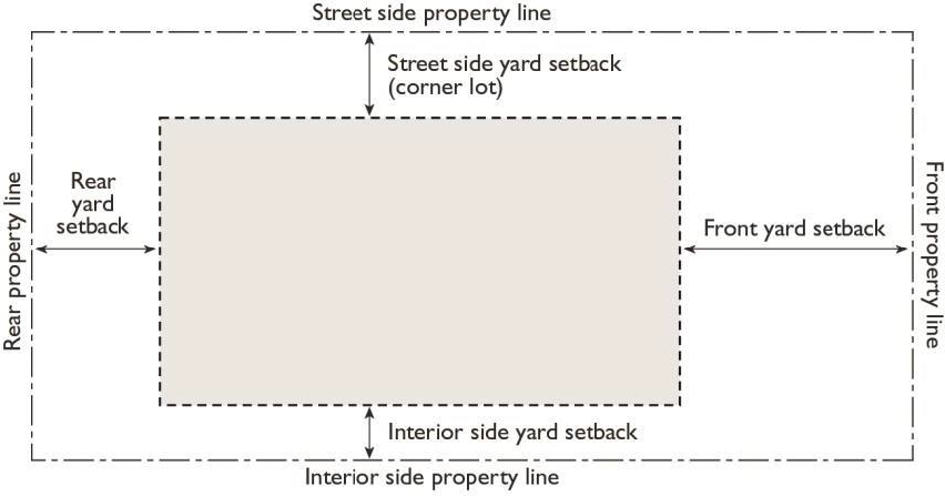
11.03.130. - Measuring signs.
Calculation of sign area and the measurement of sign height are described in Chapter 11.27, Signs.
(Ord. No. 1624)
11.03.140. - Measuring parking lot landscaping.
For the purpose of calculating required parking lot landscaping, parking lot areas are deemed to include parking and loading spaces and maneuvering areas, but not including entry access ways. Parking lot area does not include enclosed vehicle storage areas or covered parking areas that do not have landscape planters when calculating landscape requirements.
(Ord. No. 1624)
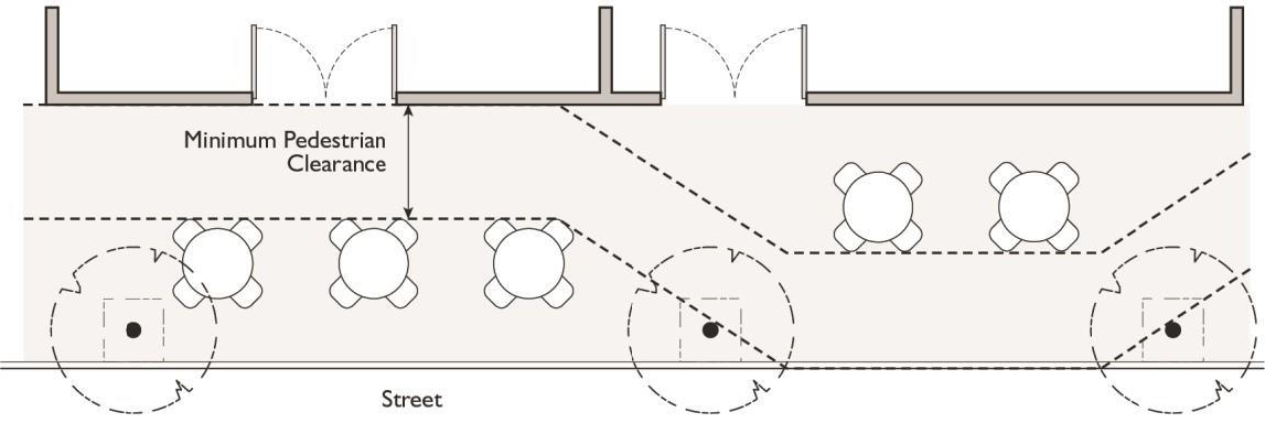
11.03.150. - Measuring pedestrian clearance.
The minimum distance shall be measured from the edge of any table, chair, bench, planter, or other appurtenance used as part of an outdoor dining area or outdoor display area to any obstruction within the sidewalk area.
(Ord. No. 1624)
Figure 11.03.150: Measuring Pedestrain Clearance