
Yukon City Zoning Code
ARTICLE 2
- DEFINITIONS
Sec. 215-201. - Rules of interpretations.
A.
Words used in the present tense include the future, and the future tense includes the present.
B.
The singular shall include the plural, and the plural the singular.
C.
The word "building" shall also mean "structure."
D.
The word "used" shall include "arranged," "designed," "constructed," "altered," "converted," "rented," "leased," or "intended to be used."
E.
The words "must," "shall" is mandatory and not directory, except where the natural construction of the writing indicates otherwise.
F.
The word "may" is permissive.
G.
The words "must not," "will not," and "may not" are prohibiting.
H.
Whenever a defined word or term appears in the text of this UDC, its meaning must be construed as set forth in the definition. Words not defined must be interpreted in accordance with the definitions considered to be normal dictionary usage.
(Ord. No. 1438, § I, 8-1-2023)
Sec. 215-202. - Abbreviations.
A.
"DBH" is an abbreviation for "diameter at breast height."
B.
"GFA" is an abbreviation for "gross floor area."
C.
"ft" is an abbreviation for "feet."
D.
"N/A" is an abbreviation for "not applicable."
E.
"sf" is an abbreviation for "square feet."
F.
"WTFP" is an abbreviation for "wireless telecommunications facility permit."
(Ord. No. 1438, § I, 8-1-2023)
Sec. 215-203. - Defined terms.
Accessory use or structure: A use or structure customarily incidental, appropriate, and subordinate to the principal use of a building or to the principal use of land and which is located upon the same lot.
Abut: Having a common border with or being separated from such common border by an alley or easement. This term implies a closer proximity than the term "adjacent."
Adjacent: Lying near or close to, but not necessarily having a common property line.
Alley: A minor right-of-way dedicated to public use not more than 30 feet wide affording a secondary means of access to the back or side of properties otherwise abutting a street, and which may be used for public utility purposes.
Block: In describing the boundaries of a district, the word "block" refers to the legal description. In all other cases, the word "block" refers to the property abutting on one side of the street between two intersecting streets or between an intersecting street and a railroad right-of-way or between an intersecting street and a watercourse.
Board of adjustment: The Board of Adjustment of the City of Yukon, Oklahoma; also referred to as the "board."
Buffer: An area of land with a fence, wall, landscaping, open spaces, berms or a combination thereof, used to physically separate or screen one use or property from another so as to visually shield or block noise, lights, buildings, nuisances or provided privacy.
Building: Any structure having a roof supported by columns or walls that is used or intended to be used for the shelter or enclosure of persons, animals, or property.
Building, accessory: See "accessory use or structure."
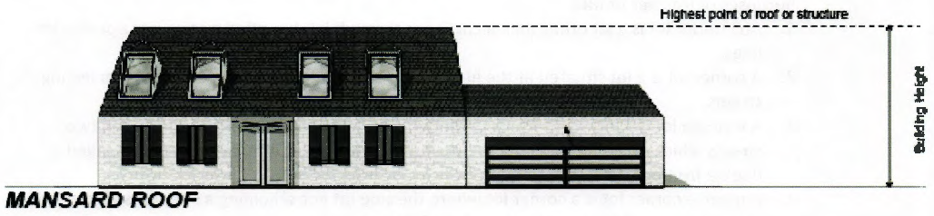
Building height: The vertical distance from the average line of the highest and lowest points of that portion of the lot covered by the building to the highest point of coping of a flat roof, or the deckline of a mansard roof or the average height of the highest gable of a pitch or hip roof.
Building line: A line established beyond which no part of a building shall project, except as otherwise provided by this chapter.
Building line or setback line: A line or lines designating the area outside of which a building may not be erected. See article II, section 215-204, for more information on measurement of setback line.
Building, principal: A building or buildings in which the principal use of the building site is conducted. In any residential district, any dwelling shall be deemed to be the principal building on the building site.
Bulletin board: Any sign announcing the activities of an educational, religious, institutional or similar use.
Canopy-mounted lights: Lighting that is pendant, recessed or surface mounted to a structure's ceiling or soffit.
City: The City of Yukon, Oklahoma.
City (council) (commission) (board of trustees): The official governing body of the City of Yukon.
City planning commission: The Yukon City Planning Commission, as established by the statutes hereinbefore cited, also referred to as "planning commission." The city planning commission shall also be the Zoning Commission for the City of Yukon.
Comprehensive plan: The official city plan of the City of Yukon, Oklahoma.
Coverage: The lot area covered by all buildings located thereon, including the area covered by all overhanging roofs.
Data center: A facility used primarily for the storage, management, processing, and dissemination of digital data. Data centers house computer systems, servers, networking equipment, and associated infrastructure such as backup power supplies, cooling systems, fire suppression, and security devices. Data centers do not include customer-facing retail operations and are characterized by limited on-site staff presence.
Development density: Density in terms of gross land area are:
1.
Low - less than five dwelling units per acre;
2.
Medium - less than 12 dwelling units per acre;
3.
High - more than 12 and less than 30 dwelling units per acre.
Dwelling: Any building or portion thereof designed or used as a residence of one or more persons, but not including a tent, cabin, trailer coach, recreational vehicle, boarding or rooming house, hotel or motel.
Dwelling unit: A room or group of rooms arranged, intended or designed as a habitable unit, containing kitchen, bath and sleeping facilities for not more than one family living independently of any other family.
Easement: A grant of the use of a strip of land for specific purposes by the property owner to the public, a corporation or persons.
Electronic message display (EMD): Any electronic communication display device utilizing lights, diodes or similar illumination to create letters, numerals or graphic presentations, capable of one or more of such various functions or operating modes as steady, scrolling, travelling, alternating or flashing copy.
Encroachment (floodplain): Construction, placement of fill or similar alteration of topography in the floodplain that reduces the area available to convey floodwaters.
Essential services: The erection, construction, alteration or maintenance by public utilities or municipal or other governmental agencies of underground or overhead gas, electrical, steam or water transmission or distribution systems, collection, communication, supply or disposal systems, including poles, wires, mains, drains, sewers, pipes, conduits, cables, fire alarm boxes, police call boxes, traffic signals, hydrants, and other similar equipment and accessories thereof, reasonably necessary for the furnishing of adequate services by such public utilities or municipal or other governmental agencies or for the public health or safety or general welfare, but not including buildings.
Façade: The face of a building, especially the principal front that looks onto a street or open space.
Family: A person living alone or two or more persons related by blood or marriage, living together as a single housekeeping unit, using a single facility in a dwelling unit, for culinary purposes, as distinguished from a group occupying a boardinghouse, lodging house, hotel, motel, fraternity house, or sorority house.
Flag-shaped lot: A lot having access to a street by means of a parcel of land having a depth greater than its frontage and having a width less than the minimum required lot width. May also be referred to as a panhandle lot.
Flood (one hundred year frequency): A flood having an average frequency of occurrence once in 100 years although the flood may occur in any year, based on statistical analyses of stream flow records available for the watershed and analyses of rainfall and runoff characteristics in the general region of the watershed, as determined by the city engineer, or as determined by the U.S. Corps of Engineers and confirmed by the city engineer or as determined by a registered professional engineer and certified by the city engineer.
Flood control works: Any natural or manmade configuration, structure, feature or facility, individually or in combination, that functions as a control device in the manipulation of stormwater.
Flood hazard area: The land area adjoining a floodway which is not reasonably required to carry and discharge the floodwater of the 100-year frequency flood but which would be inundated by the floodwater of the 100-year frequency flood based on full urbanization of the watershed.
Floodway: The channel of a watercourse or drainway and those portions of the adjoining lands which are reasonably required to carry and discharge the floodwater of the 100-year frequency flood.
Floor area: The sum of the gross horizontal areas of the several floors of a building or buildings, measured from the exterior faces of the exterior walls or from the center lines of walls separating two buildings.
Footcandle: A unit of incident light stated in lumens per square foot and measurable with an illuminance meter, a.k.a. footcandle or light meter.
Frontage: The lineal [linear] measurement of a lot boundary which is abutting a street.
Glare: The sensation produced by lighting that causes an annoyance, discomfort or loss in visual performance and visibility to the eye.
Height: The vertical measurement of any structure on any parcel of land measured from the average elevation of the lot or parcel to the uppermost point of the structure.
Industry: Storage, repair, manufacture, preparation or treatment of any article, substance, or any commodity for commercial use.
Institutional uses: Those uses organized, established, used or intended to be used for the promotion of a public, religious, educational, charitable, cultural, social, or philanthropic activity and normally operated on a nonprofit basis.
Landscaped area: Are all non-turf planting areas shown on a landscape plan, such as parking islands, planters, landscape beds, and the like.
Loading space: A space on the same lot as the principal use of at least ten feet in width and 30 feet in length and having a vertical clearance of at least 14 feet, designated for the temporary parking of commercial vehicles while loading or unloading merchandise or materials.
Lot: A piece or parcel of land occupied or intended to be occupied by a principal building or a group of such buildings and accessory buildings or utilized for a principal use and uses accessory thereto, together with such open spaces as required by this Ordinance, and having access on a public street. A subdivision of a block or other parcel intended as a unit for the transfer of ownership or for development.
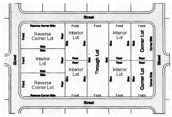
Lot, corner: A lot which has at least two adjacent sides abutting on a street, provided that the interior angle at the intersection of such two sides is less than 135 degrees.
Lot, depth: The mean horizontal distance between the front and rear lot lines.
Lot, double frontage: A lot having a frontage on two nonintersecting streets, as distinguished from a corner lot.
Lot, interior: A lot other than a corner lot.
Lot, reverse frontage: A lot intentionally designed so that the front lot line faces a local street rather than facing a parallel arterial street and which provides no access to the major street.
Lot line: Any boundary of a lot.
Lot line, front: The boundary of a lot which abuts a public street. Where the lot abuts more than one street, the owner may select the front lot line.
Lot line, rear: The boundary of a lot which is most distant from and most nearly parallel to the front lot line.
Lot line, side: Any boundary of a lot which is not a front lot line or a rear lot line.
Lot, wedge-shaped: A lot situated so that the front is either wider or narrower than the rear of the lot.
Lots of record: A separate and distinct parcel designated on a legally recorded subdivision plat or a legally recorded deed filed in the records of Canadian County, State of Oklahoma.
Lumen: The light-output rating of a lamp (light bulb), as used in the context of this UDC.
Mean lot elevation: The average elevation of a lot.
Open space: Area included in any side, rear, or front yard, or any other unoccupied space on a lot that is open and unobstructed to the sky except for the ordinary projection of cornices and eaves of porches.
Parcel: A lot as defined herein.
Parking space: A permanently surfaced area of not less than 180 square feet, either within a structure or in the open, exclusive of driveways or access drives, for the parking of motor vehicles.
Planning commission: See "city planning commission."
Plat, preliminary: A map of a proposed land subdivision showing the character and proposed layout of the tract in sufficient detail to indicate the suitability of the proposed subdivision of land.
Plat, final: A map of a land subdivision prepared in a form suitable for filing of record with necessary affidavits, dedications, and acceptances, and with complete bearings and dimensions of all lines defining lots and blocks, streets and alleys, public areas, and other dimensions of land.
Portable message centers: Sign structures that are moveable and not permanently attached to a foundation/ground. These include sign structures attached to a trailer chassis or other vehicle.
Right-of-way: An area acquired or reserved for streets, drainage, utilities, pedestrian ways, or for another special use. For platting purposes, right-of-way established and shown on a final plat is separate and distinct from the lots or parcels adjoining such right-of-way and not included within the dimensions or area of such lots or parcels.
Roadway: That portion of any street so designated for vehicular traffic; and where curbs are in place, that portion of the street between curbs.
Roominghouse: See "boardinghouse."
Shielded: The description of a light fixture from which no direct glare is visible at normal viewing angles, by virtue of its being properly aimed, oriented, and located and properly fitted with such devices as shields, barn doors, baffles, louvers, skirts or visors.
Sign: Any word, lettering, part of letters, figures, numerals, phrases, sentences, emblems, devices, designs, pictures, trade names or trademarks by which anything is made known, such as are used to designate an individual, a firm, an association, a corporation, a profession, a business, a service, a commodity or product, which are visible from any public street or right-of-way and designed to attract attention. "For Sale" and "For Rent" shall be deemed signs within the meaning of this definition, but the term "sign" shall not include the flag, pennant, or insignia of any nation, state, city, or other political, educational, charitable, philanthropic, civic, professional, religious, or like campaign, drive, movement, or event used for a public purpose in the public interest.
Sign, display surface area: The net geometric area of the surface of the sign upon, against or through which the message is displayed or illustrated, including the outward extremities of all letters, figures, characters and delineations, provided that only one face of a double-faced sign shall be included in the computation of display surface area.
Sign, illuminated: A sign designed to give forth any artificial light, or designed to reflect light from one or more sources, natural or artificial.
Sign, monument: A sign permanently affixed to the ground at its base, supported entirely by a base structure, and not mounted on a pole or attached to any part of a building. Also known as a ground sign.
Sign, pole: A freestanding sign permanently supported in a fixed location by a structure of one or more pole, posts, uprights, or braces from the ground and not supported by a building or base structure.
Sign, projecting: A sign erected on the face or outside wall of a building which projects out at any angle therefrom.
Sign, temporary: Signs of non-permanent nature, typically displayed for short periods of time. These may include signs relating to special events or festivals. A temporary sign is a portable structure that is intended to be used for a brief period of time (no more than 60 days).
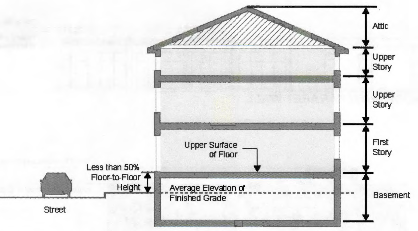
Story: That portion of a building included between the surface of any floor and the surface of the floor next above it; or, if there be no floor above it, then the space between the floor and the ceiling next above it.
Street: A public right-of-way which provides the primary public means of access to abutting property and used primarily for vehicular circulation.
Street, arterial: Any street designated by the city council and/or as may be designated on the thoroughfare plan as an arterial, primary arterial, secondary arterial, major street, etc.
Street, collector: A street collecting traffic from minor streets and serving as the most direct route to an arterial street or a community facility. Any street may be designated by the city council as a collector street when it serves, or when extended, may serve more than 50 dwelling units.
Street, minor: Any street not designated on the thoroughfare plan as an arterial.
Structural alteration: Any change in the structural members of a building, such as walls, columns, beams or girders.
Structure: Anything constructed, the use of which requires permanent location on the ground or attachment to something having a permanent location on the ground (not including sidewalks, driveways and similar improvement areas).
Subdivider: Any person, firm, partnership, or corporation or other entity acting as a unit, subdividing or proposing to subdivide land as herein defined.
Subdivision: The division or redivision of land by map into two or more lots, tracts, sites or parcels for the purpose of transfer of ownership or for development, or the dedication or vacation of a public or private right-of-way or easement.
Thoroughfare plan: The part of the comprehensive plan referring to transportation development goals, principles, and standards; also includes use of the words "major street plan", "roadway network" and "trafficways plan."
Trailer: A portable or mobile unit, other than a mobile home, used or designed to carry or transport material or animals.
Vacate: The termination, by written instrument, or judicial act of the district court, of private and/or public rights in a public way, easement, or plat.
Yard: A required space on a lot unobstructed except as expressly permitted.
Yard, front: A yard extending across the full width of a lot from side lot line to side lot line abutting on a street, into which a building may not protrude.
Yard, rear: A yard extending across the rear of a lot measured from side lot line to side lot line.
Yard, side: A yard extending from front yard to the rear yard abutting the side lot line, into which no building may protrude.
Zoning administrator: Designated staff person in charge of administration of zoning code also known as development services director or designee.
(Ord. No. 1438, § I, 8-1-2023; Ord. No. 1472, § 2, 4-15-2025)
Sec. 215-204. - Rules of measurements.
This section provides the rules of measurement for the dimensional standards and locational characteristics within the code.
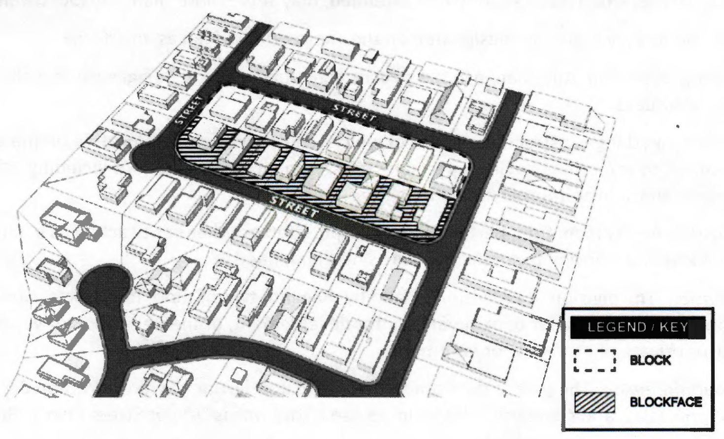
A.
Block and blackface:
1.
A block is a tract of land bounded by streets, or a combination of streets and railroad rights-of-way, shorelines of waterways, or municipal boundary lines.
2.
Blockface is measured as that portion of a block or tract of land facing the same side of a single street and lying between the closest intersecting streets.
B.
Building coverage: That portion of the lot that is or may be covered by buildings and accessory structures.
C.
Building height:
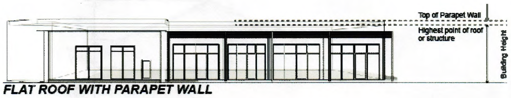
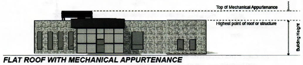
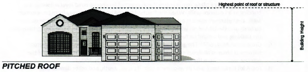
1.
Building height is measured as the vertical distance from grade to the top of the highest point of the roof or structure. This method of building height applies to all structures unless specifically exempted by this Code. The distance excludes spires, chimneys, flag poles, and the like, as described in paragraph 2 below.
2.
The following structures or parts thereof are exempt from maximum height limitations, unless otherwise limited by any height restriction imposed by any airport authority, or other similar federal, state, or local authority.
a)
Public utility poles, towers, and wires. This does not include wireless telecommunication towers and wind turbines that are regulated separately by this code.
b)
Water tanks and standpipes.
c)
Building appurtenances such as chimneys, skylights, steeples, flag poles, smokestacks, cooling towers, elevator bulkheads, fire towers, monuments, water towers, stacks, stage towers, or scenery lofts, tanks, ornamental towers and spires, rooftop accessory structures, recreational facilities, necessary mechanical appurtenances, or penthouses to house mechanical appurtenances.
3.
A story is that portion of a building between the upper surface of any floor and the upper surface of the floor next above, including any portion of a building used for human occupancy between the topmost floor and the roof.
D.
Caliper: Tree caliper is the diameter of a tree trunk, measured at 12 inches above the ground; used for measuring nursery trees not mature trees.
E.
Diameter at breast height: Diameter at breast height is used for establishing the size mature trees by measuring the diameter of a tree trunk and four and a half feet above the ground.
F.
Grade: A reference plane representing the average of finished ground level adjoining the building at all exterior walls. When the finished ground level slopes away from the exterior walls, the reference plane is established by the lowest points within the area between the building and the lot line or, when the lot line is more than six feet from the building, between the building and a point six feet from the building.
G.
Gross floor area (GFA): The gross floor area (GFA) of a structure is the sum of the gross horizontal areas of all floors of the structure as measured from the exterior faces of the exterior walls or from the centerline of walls separating two buildings.
H.
Lot: A lot is the basic land development unit. Its area, depth, and other dimensional regulations, and boundaries have been established by an approved subdivision plat filed with Canadian County, or an unplatted lot and which is recognized as a separate legal entity for purposes of transfer of title.
1.
An interior lot is a lot other than a corner or through lot, bounded by two interior side lot lines.
2.
A corner lot is a lot situated at the junction of, and abutting on, two or more intersecting streets.
3.
A through lot is a lot which fronts upon two parallel streets, or which fronts upon two streets which do not intersect at the boundaries of the lot. A through lot is also called a double frontage lot.
4.
A reverse corner lot is a corner lot where the side lot line adjoining a street is substantially a continuation of the front lot line of the first lot to its rear.
I.
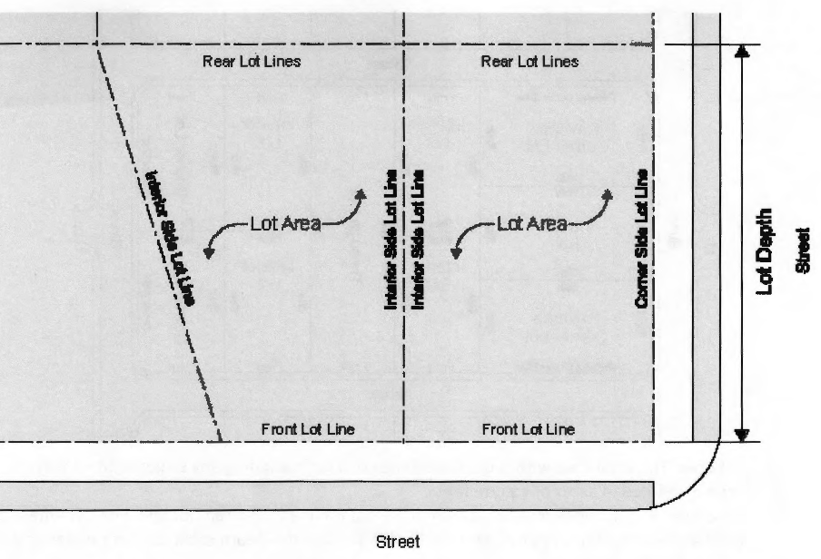
Lot area: The total area within the boundaries of a lot, excluding any street right-of-way, usually defined in acres or square feet.
J.
Lot depth: The distance measured from the front lot line to the rear lot line. For lots where the front and rear lot lines are not parallel, the lot depth is the depth calculated at the deepest part of the lot.
K.
Lot line: A line of record bounding a lot, as indicated on an approved, filed, and recorded subdivision plat, which divides one lot from another lot or from a public or private street or any other public or private space and includes:
1.
A front lot line is the lot line separating a lot from a street right-of-way. The front lot line of a corner lot is the shortest street lot line of a corner lot abutting a street. A front lot line for a through lot is both lot lines that abut a street.
2.
A rear lot line is the lot line opposite and most distant from the front lot line, or in the case of triangular or otherwise irregularly shaped lots, an assumed line at least ten feet in length entirely within the lot, parallel to and at a maximum distance from the front lot line.
3.
On a corner lot, the corner side lot line is perpendicular or approximately perpendicular to the front lot line and is the longer street abutting lot line of a corner lot.
4.
On an interior lot, the interior side lot line is perpendicular or approximately perpendicular to the front lot line and abuts the adjacent lot.
5.
A street lot line is any lot line separating a lot from a street right-of-way.
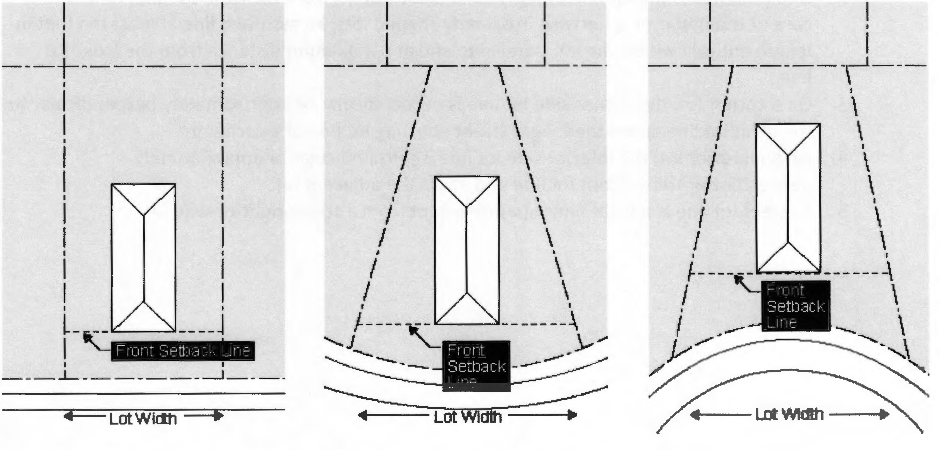
L.
Lot width: Lot width is the horizontal distance between the side lot lines measured at right angles to its depth along a straight line parallel to the front lot line at the minimum front setback line. For cul-de-sac lots or pie-shaped lots, lot width is measured at the front building line of the structure between side lot lines.
M.
Sign area measurements:
1.
For signs on a background, the entire area of the background is calculated as sign area, including any material or color forming the sign face and the background used to differentiate the sign from the structure against which it is mounted. Sign area does not include any supports or bracing.
2.
For signs consisting of freestanding letters or logos, the sign area is calculated as the total area of each square, circle, rectangle, or triangle, or combination thereof, which encompasses each individual letter or logo. Sign area does not include any supports or bracing.
3.
Window signs printed on a transparent film and affixed to the interior or exterior of a windowpane are calculated as individual letters or logos, provided that the portion of the transparent film around the perimeter of the individual letters or logos maintains 100 percent transparency of the window.
4.
The sign area of a three-dimensional, free-form, or sculptural (non-planar) sign is calculated as 50 percent of the sum of the area of the four vertical sides of the smallest cube that will encompass the sign.
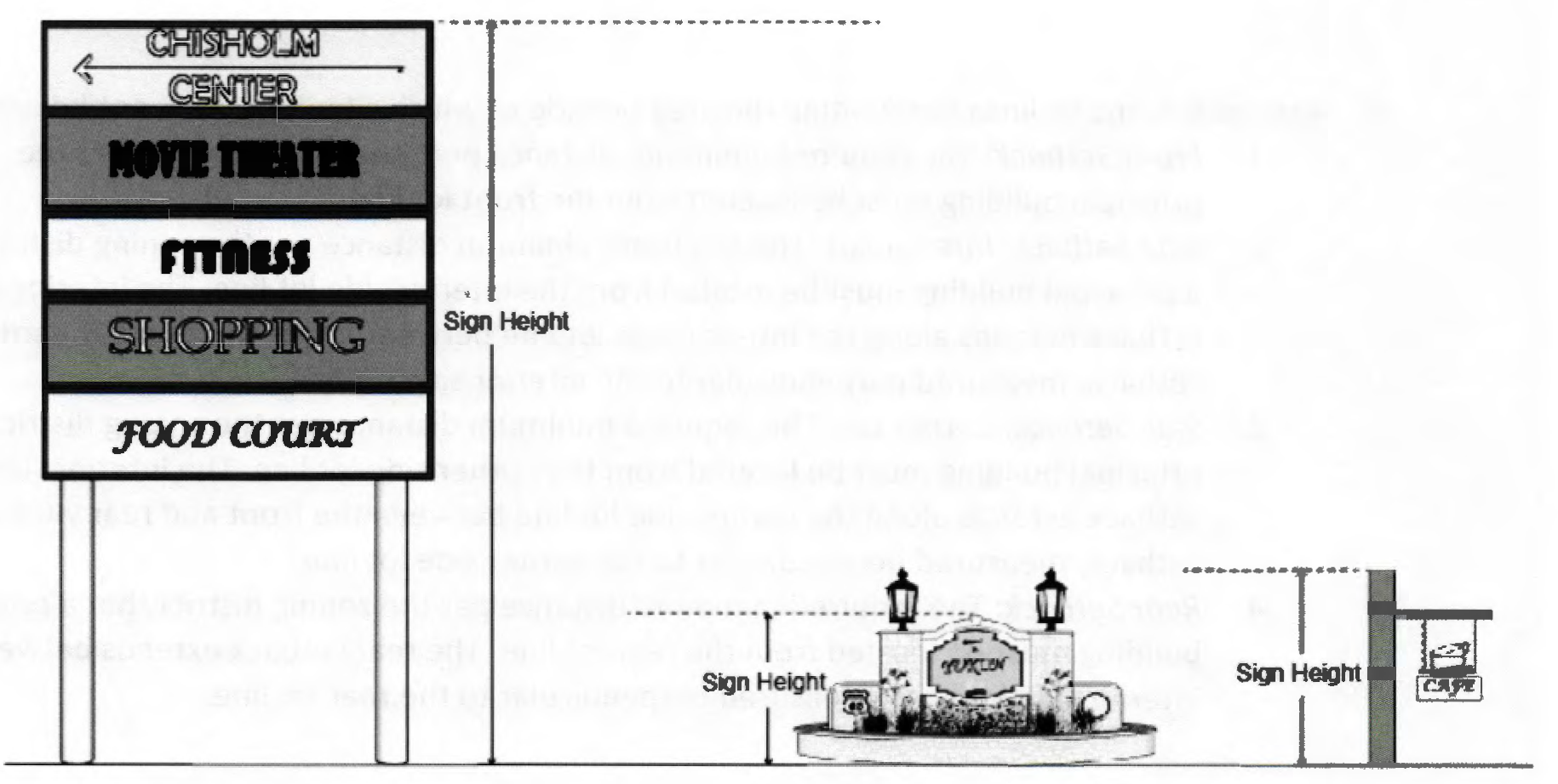
N.
Sign height measurement: For freestanding signs, height is calculated as the vertical distance measured from the ground adjacent to where the sign is to be installed to the highest point of the sign.
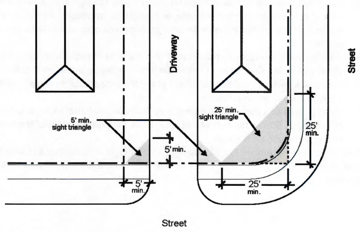
O.
Sight triangle: Sight triangle is measured at a line joining the points at a distance as follows:
1.
Five feet from the point of the intersection of driveways and the lot line, as measured along the lot line and edge of driveway pavement.
2.
Twenty-five feet from the point of the intersection of streets and/or alleys (public or private) of a corner lot as measured along the lot line.
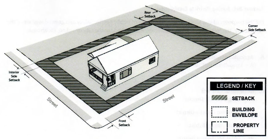
P.
Setbacks: A line or lines designating the area outside of which a building may not be erected.
1.
Front setback: The required minimum distance per the zoning district that the principal building must be located from the front lot line.
2.
Side setback, interior lot: The required minimum distance per the zoning district that a principal building must be located from the interior side lot line. The interior side setback extends along the interior side lot line between the front and rear yard and setback, measured perpendicular to the interior side lot line.
3.
Side setback, corner lot: The required minimum distance per the zoning district that a principal building must be located from the corner side lot line. The interior side setback extends along the corner side lot line between the front and rear yard and setback, measured perpendicular to the corner side lot line.
4.
Rear setback: The required minimum distance per the zoning district that a principal building must be located from the rear lot line. The rear setback extends between interior side lot lines, measured perpendicular to the rear lot line.
Q.
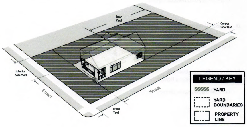
Yards: A yard is the open space area between the building line of a principal building and the adjoining lot lines.
1.
Front yard: A front yard is located between a principal building line and the front lot line.
2.
Side yard, interior: An interior side yard is located between a front setback and the interior side lot line.
3.
Side yard, corner: A corner side yard is located between a front setback and the corner side lot line.
4.
Rear yard: A rear yard is located between the rear lot line and rear building wall.
(Ord. No. 1438, § I, 8-1-2023)