
Addison City Zoning Code
ARTICLE III
- ZONING DISTRICTS
Sec, 3.1. - Zoning districts established.
The following zoning districts are established by the Town's adoption of the Official Zoning Map pursuant to § 3.2.
Sec. 3.2. - Official zoning map.
3.2.1.
Incorporation of zoning map. The location and boundaries of the zoning districts established in this UDC are shown upon the Official Zoning Map of the Town, which is on file in the office of the City Secretary, available on the Town's website, and made a part of this UDC.
3.2.2.
Zoning district boundaries. Zoning district boundaries on the Official Zoning Map shall be interpreted as follows:
A.
Zoning district boundaries shown within or parallel to the lines of roads, easements, and transportation rights-of-way shall be deemed to follow the centerline of the affected road, easement, or right-of-way.
B.
Zoning district boundaries indicated as following or being parallel to lot lines or Town corporate boundary lines shall be construed as following or paralleling such lines.
C.
Zoning district boundaries indicated as approximately following the centerline of streams, rivers, or other bodies of water shall be construed to follow such centerlines.
D.
Whenever any street, alley, public way, railroad right-of-way, waterway, or other similar area is vacated by proper authority, the zoning districts adjoining each side of vacated areas shall be extended automatically to the center of the vacated area. All areas included in the vacation shall after the vacation be subject to all regulations of the extended zoning districts. In the event of a partial vacation, the adjoining zoning district, or zoning district nearest the portion vacated, shall be extended automatically to include all the vacated area.
E.
A lot that is fully covered (bounded) by an overlay district shall be interpreted to be subject to the overlay district standards found in § 3.8: Overlay Districts.
F.
A lot that is partially covered (transected) by an overlay district shall be interpreted to be subject to the overlay district standards to the extent the lot area is covered by the overlay district.
3.2.3.
Zoning district boundary clarification.
A.
If a zoning district boundary is unclear or is disputed, the Director shall determine the location of the zoning district boundary.
B.
Any appeal of the Director's determination of the zoning district boundary shall be heard by the Board of Zoning Adjustment pursuant to § 2.10.4: Appeal of Administrative Decision.
3.2.4.
Amendments to the official zoning map. Changes in the boundaries of any zoning district shall require an amendment to the Official Zoning Map pursuant to §§ 2.5.2: Rezoning and 2.5.3: Rezoning to Planned Development (PD). All changes in district boundaries shall be noted on the Official Zoning Map following approval by the City Council.
3.2.5.
Annexations.
A.
All territory annexed to the Town shall be classified in the R-1 Residential zoning district until a different zoning designation is assigned by the governing body of the Town pursuant to §§ 2.5.2: Rezoning and 2.5.3: Rezoning to Planned Development (PD).
B.
The Town may institute proceedings on its own motion to assign the newly annexed territory a zoning designation pursuant to § 2.5.6.B: Concurrent Zoning.
Sec. 3.3. - Organization of this article.
3.3.1.
Base Zoning Districts
A.
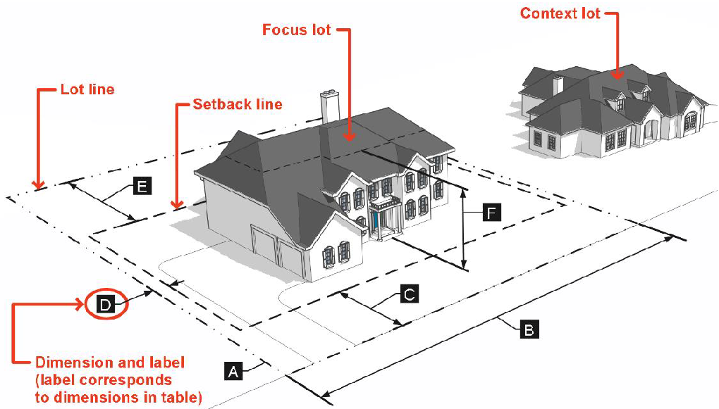
Content. Sections 3.4 through 3.6 of this article follow a common structure and describe the purpose and intended character of the zoning districts, the lot and building standards applying to development in the districts, and any district-specific development standards.
B.
Graphics. For each base zoning district, this article includes an illustration depicting how the district's lot and building standards apply to lots and typical building forms. Illustrations are intended to exemplify the general character of the district and do not show specific locations or buildings. Illustrations do not necessarily reflect all the standards that may apply to a particular development. If a standard shown in an illustration is inconsistent with the respective table of lot and building standards, the standards in the table shall govern.
3.3.2.
Overlay zoning districts.
A.
Overlay zoning districts are established by an amendment to the Official Zoning Map (see §§ 2.5.2: Rezoning and 2.5.3: Rezoning to Planned Development (PD)). They are superimposed over one or more underlying base or planned development zoning districts. If the standards for an overlay district expressly conflict with those for an underlying base zoning district, planned development district, or another overlay district, the more restrictive standards shall apply.
B.
§ 3.8: Overlay Districts, identifies the overlay zoning districts and establishes each overlay district's purpose and the standards that modify those of underlying districts.
3.3.3.
Legacy zoning districts.
A.
The Apartment Dwelling (A) and Planned Development - Townhouse/Condominium (PD-TH) zoning districts are declared legacy districts upon adoption of this UDC.
B.
No land will be rezoned to a legacy zoning district. The City Council may modify the allowed uses, special uses, and development standards within these zoning districts. Landowners are encouraged to rezone land from a legacy zoning district classification.
C.
Development in a legacy zoning district is subject to the requirements and conditions that were in place at the time the properties were rezoned under the Code of Ordinances. In addition, all other standards of this UDC shall apply to legacy zoning districts, including the standards in § 8.1: A - Apartment District Regulations, and § 8.2: PD-TH - Planned Development, Townhouse/Condominium, unless otherwise stated in the requirements and conditions in place at the time the properties were established under the Code of Ordinances, as amended.
Sec. 3.4. - Residential zoning districts.
3.4.1.
R-1 - Residential.
A.
Purpose. The R-1 district is intended to accommodate single-family detached residential development on large suburban lots. Secondary uses include parks, limited community and educational uses, and accessory uses. This district may be used as a transition between larger-lot residential development and smaller-lot residential development.
B.
Dimensional standards.
Figure 3-1: R-1 Dimensional Standards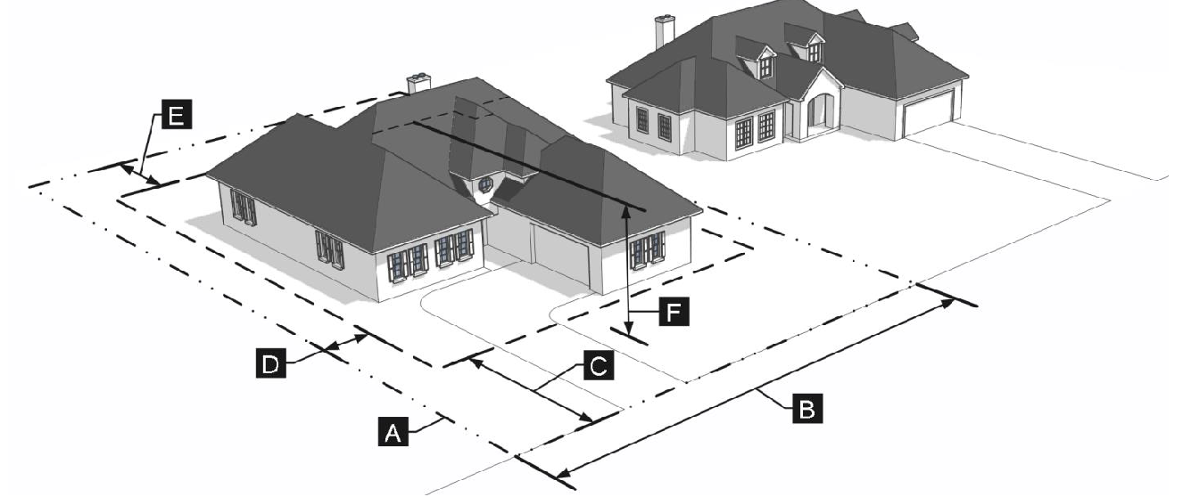
3.4.2.
R-2 - Residential.
A.
Purpose. The R-2 district is intended to accommodate moderately compact single-family detached residential development in a low-density urban neighborhood context. Secondary uses include parks, limited community and educational uses, and accessory uses. This district may be used as a transition between residential development on larger-lots and more intense residential development.
B.
Dimensional standards.
Figure 3-2: R2 Dimensional Standards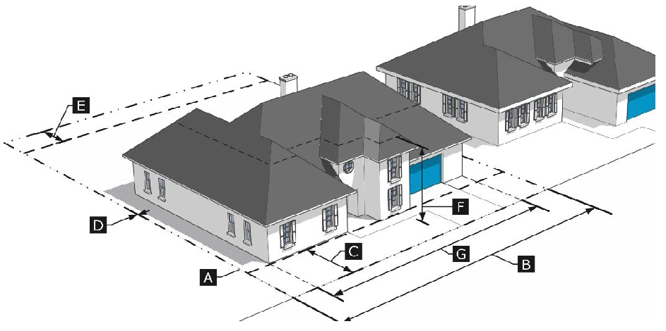
3.4.3.
R-3 - Residential.
A.
Purpose. The R-3 district is intended to accommodate a variety of compatible residential housing types including single-family detached, single-family attached, duplex, triplex, fourplex, small-scale multifamily, and live/work dwellings. Secondary uses include parks, limited community and educational uses, and accessory uses. This district is typically characterized by moderately compact residential blocks and a variety of lot sizes. This district may be used as a transition between less-intense residential development and more-intense residential development and/or small-scaled mixed-use development.
B.
Dimensional Standards.
Figure 3-3: R-3 Dimensional Standards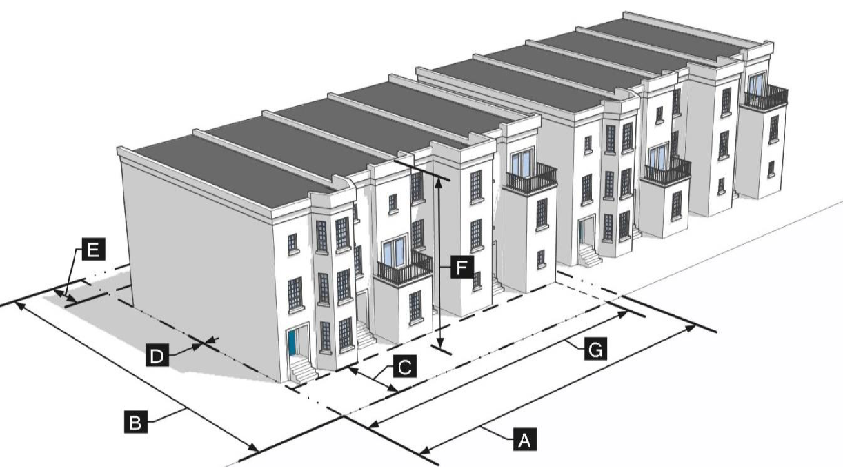
Sec. 3.5. - Mixed-use zoning districts.
3.5.1.
M-1 - Mixed-use neighborhood.
A.
Purpose. The M-1 district is intended to accommodate small- to medium-scale mixed-use development that supports a comfortable and safe bicycle and pedestrian friendly development pattern and that accommodates infill and redevelopment. This district allows for a variety of compatible residential, commercial, retail, office, service-oriented, and accessory uses, and is commonly located adjacent to areas where higher pedestrian activity is desired. Higher-intensity uses are located adjacent to key corridors and transit facilities while lesser intense uses are located adjacent to Residential zoning districts. Additional standards are included to ensure that the site design, uses, and scale are consistent with adjacent residential neighborhoods.
B.
Dimensional standards.
Figure 3-4: M-1 Dimensional Standards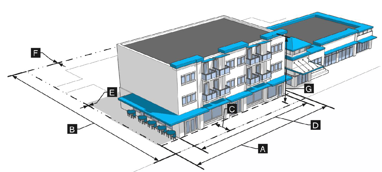
3.5.2.
M-2 - Mixed-use suburban corridor.
A.
Purpose. The M-2 district is intended to accommodate a mix of small- to medium-scale mixed-use development that promotes sustainable infill and redevelopment of older commercial sites, while ensuring that the site design, uses, and scale are consistent with adjacent residential neighborhoods. This district allows for a variety of compatible residential, commercial, retail, office, service-oriented, and accessory uses, and is commonly located adjacent to high-traffic corridors and designed to allow for safe access by pedestrians, bicyclists, transit users, and motorists. Additional standards are included to ensure that the site design, uses, and scale are consistent with adjacent residential neighborhoods.
B.
Dimensional standards.
Figure 3-5: M-2 Dimensional Standards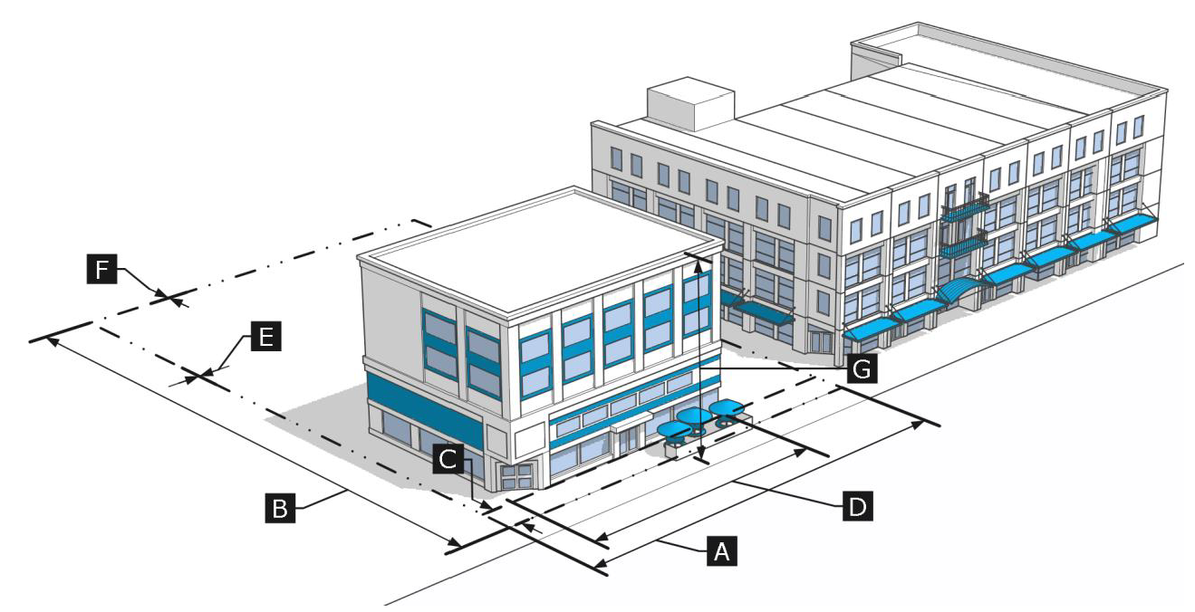
3.5.3.
M-3 - Mixed-use urban corridor.
A.
Purpose. The M-3 district is intended to accommodate a mix of medium- to large-scale mixed-use development that supports pedestrian- and transit-oriented uses. This district allows for a variety of compatible residential, commercial, retail, office, service-oriented, and accessory uses, and is commonly located adjacent to areas where higher pedestrian activity is desired along key corridors. Higher-intensity uses are located adjacent to major roads and transit facilities while lesser intense uses are located adjacent to Residential zoning districts. Additional standards are included to ensure that the site design, uses, and scale are consistent with adjacent residential neighborhoods.
B.
Dimensional standards.
Figure 3-6: M-3 Dimensional Standards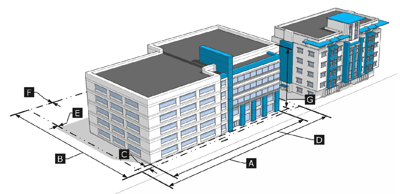
3.5.4.
M-4 - Mixed-use center.
A.
Purpose. The M-4 district is intended to support the most intensive, transit supportive development to create a unique, mixed-use, and integrated regional destination. This district allows for a mix of compatible residential, commercial, retail, office, service-oriented, and accessory uses, with a strong activity anchor focused around the DART transit station. Development intensity in this district is intended to support an effective transit- and pedestrian-oriented environment that delivers a high-quality pedestrian experience, supports major civic events, and emphasizes a well-connected trail and open space system.
B.
Dimensional standards.
Figure 3-7: M-4 Dimensional Standards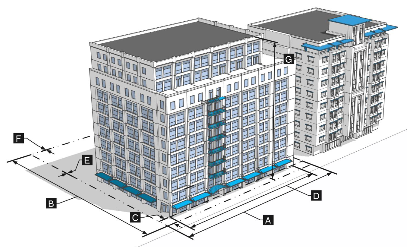
Sec. 3.6. - Nonresidential zoning districts.
3.6.1.
CL - Commercial limited.
A.
Purpose. The CL district is intended to accommodate small-scale commercial, retail, office, service-oriented, and accessory uses. This district is typically located along collector and arterial corridors and is designed to allow for safe access by pedestrians, bicyclists, transit users, and motorists. The CL district is intended to promote sustainable infill and redevelopment of older commercial sites, while ensuring that the site design, uses, and scale are consistent with adjacent residential neighborhoods.
B.
Dimensional standards.
Figure 3-8: CL Dimensional Standards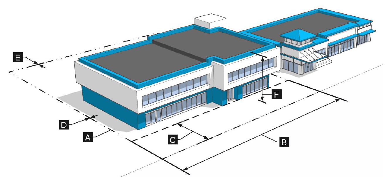
3.6.2.
CG - Commercial general.
A.
Purpose. The CG district is intended to accommodate medium- to large-scale commercial, retail, office, service-oriented, and accessory uses. This district is typically located along collector and arterial corridors and is designed to allow for safe access by pedestrians, bicyclists, transit users, and motorists. The CG district is intended to promote sustainable infill and redevelopment of older commercial sites, while ensuring that the site design, uses, and scale are consistent with adjacent areas.
B.
Dimensional standards.
Figure 3-9: CG Dimensional Standards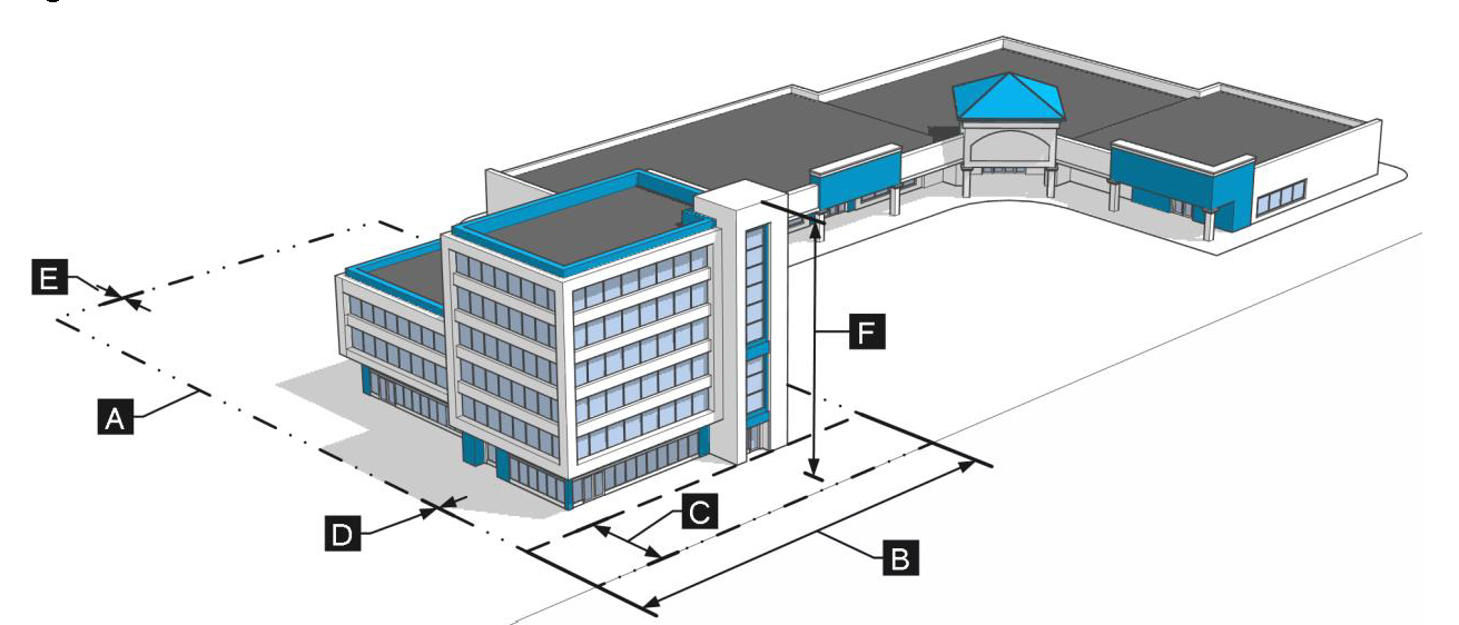
3.6.3.
LI - Light industrial.
A.
Purpose. The LI district is intended to accommodate a mix of light manufacturing, warehousing and distribution, auto-oriented uses, research and development operations, offices, showrooms, and a limited range of associated retail services, and accessory uses. This district is typically located along collector and arterial corridors away from residential development. This district promotes sustainable infill and redevelopment of older industrial and commercial sites, while ensuring that the site design, uses, and development scale are consistent with adjacent development.
B.
Dimensional standards.
Figure 3-10: LI Dimensional Standards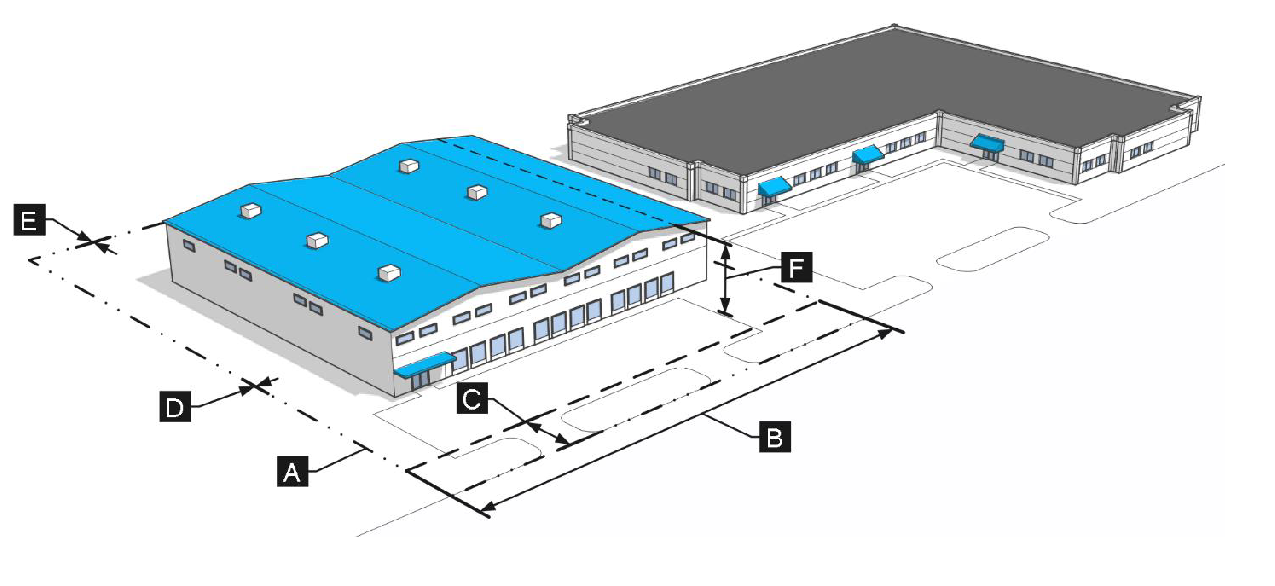
3.6.4.
AA - Addison airport.
A.
Purpose. The AA district is intended to support and optimize operational efficiency of the Addison Airport and to support the airport's role as a key economic engine for the Town and region. The AA district allows a variety of flexible uses that support the airport, that are responsive to the dynamic aviation industry, and that ensure public safety and security. This district is predominantly located within the airport operations area (airside) of Addison Airport and ensures that the development quality of periphery properties is compatible with adjacent and nearby development.
B.
Dimensional standards.
Sec. 3.7. - PD - Planned development district.
3.7.1.
Purpose. The PD district is intended to encourage new and imaginative concepts in urban design and land development to promote and improve the health, safety, and general welfare of the citizens of Addison and to create distinct neighborhoods with unique urban design, commercial areas, employment centers, amenities, and substantial additional benefit to the Town that would not otherwise be required by this UDC. The PD district is also intended to accommodate innovative development layouts that preserve the natural, environmental, and scenic features of the site or address challenges presented by specific site conditions.
3.7.2.
Qualifying standards. An application for Rezoning to a PD district may only be considered if the following criteria are met, as determined by the Director:
A.
The proposed PD could not be developed using conventional zoning districts or standards established in this UDC; and
B.
The land included in the proposed PD is under single ownership or control. Single control of property under multiple ownership may be considered when the application includes enforceable agreements, covenants, or commitments that run to the benefit of the Town and that the Town may require to be recorded if the PD is approved.
3.7.3.
Permitted uses.
A.
Land uses in a PD district are subject to the approval of the Planning and Zoning Commission and City Council.
B.
Land uses shall be determined based on consistency with the Comprehensive Plan, the existing zoning district designation of the area being rezoned to a PD district, the land uses contiguous to the area being rezoned to a PD district, and the development standards and design standards of this UDC.
C.
If the terms of the PD approved by the City Council do not clearly address the availability of specific uses in all or part of the development, then the uses and use-specific standards that would otherwise be applicable to development of the same character and scale if it were zoned into one of the base zone districts in §§ 3.4 through 3.6, as determined by the Director, shall apply.
3.7.4.
Planned development standards.
A.
The PD standards in a PD district are subject to the approval of the Planning and Zoning Commission and City Council.
B.
The PD standards shall identify the applicable base zoning district(s) that are modified according to specific adjustments approved through the PD review and approval process.
C.
The PD standards shall be determined based on consistency with the Comprehensive Plan, the existing zoning district designation of the area being rezoned to a PD district, and the development and design standards of this UDC.
D.
Requested adjustment to the standards of the base zoning districts shall be identified by location on the PD Preliminary Concept Plan and Final PD Site Plan. If the terms of the PD approved by City Council do not state that the development standards or subdivision standards differ from those listed in Article V: Development Standards or Article VI: Subdivision Standards, then the standards in those Articles that would otherwise be applicable to development of the same type and scale if it were zoned into one of the base zoning districts in § 3.4: Residential Zoning Districts through § 3.6: Nonresidential Zoning Districts, as determined by the Director, shall apply.
3.7.5.
Review and approval procedures. See § 2.5.3: Rezoning to Planned Development (PD) for specific procedures and review criteria for evaluating a Rezoning to PD district request.
Sec. 3.8. - Overlay districts.
3.8.1.
AO - Airport overlay.
A.
Purpose. The Airport Overlay District is intended to regulate and restrict the height of structures and objects of natural growth and the use of property in the vicinity of the Addison Airport to prevent the creation or establishment of obstructions that are a hazard to air navigation. Application of this district will help prevent the encroachment of noise sensitive or otherwise incompatible land uses which may endanger the health, safety, and welfare of the owners, occupants, or users of the land. This district is also intended to implement the Airport Master Plan and state and federal rules associated with land uses in the vicinity of airports. Such state and federal rules shall apply within the Airport Overlay District.
B.
Airport overlay district established.
1.
Federal Aviation Regulations (FAA) part 77 establishes civil airport imaginary surfaces for the regulation of airspace surrounding airports. The Airport Overlay District is the area generally located within the zones created and established in §§ 3.8.1.B.1.a through 3.8.1.B.1.d that includes all of the land lying beneath the approach surfaces, transitional surfaces, horizontal surface and conical surface as they apply to Addison Airport. Such zones are depicted in the current Airport Master Plan. An area located in more than one of the following zones is considered to be only in the zone with more restrictive height limitation. The various zones are hereby established and defined as follows:
a.
Approach zones. Approach zone is established beneath the approach surface at the end of Runway 15/33 on Addison Airport for 50:1 landings and take-offs. The inner edge of the approach zone shall have a width of 1,000 feet which coincides with the width of the primary surface at a distance of 200 feet beyond each end of the runway, widening thereafter uniformly to a width of 16,000 feet at a horizontal distance of 50,000 feet beyond each end of the primary surface, its centerline being the continuation of the centerline of the runway.
b.
Transition zones. Transition zones are hereby established beneath the transition surface adjacent to each runway and approach surface as indicated on the Zoning Map. Transition surfaces are symmetrically located on either side of runways and have variable widths. Transitional surfaces extend outward and upward at right angles to the runway centerline and the runway centerline extended at a slope of seven to one from the sides of the primary surface and from the sides of approach surfaces. Transitional surfaces for those portions of the precision approach surface which project through and beyond the limits of the conical surface extend 5,000 feet measured horizontally from the edge of the approach surface and at right angles to the runway centerline.
c.
Horizontal zone. The area beneath a horizontal plane 150 feet above the established airport elevation, the perimeter of which is constructed by swinging arcs of 10,000 feet radii from the center of each end of the primary surface of the runway and connecting the adjacent arcs by lines tangent to those arcs.
d.
Conical zone. The area beneath the conical surface extending outward and upward from the periphery of the horizontal surface at a slope of 20 to one for a horizontal distance of 4,000 feet.
2.
Changes and amendments. The City Council may from time to time amend, supplement or change by ordinance the boundaries of the airport approach zones, transition zones and the airport hazard areas established in this § 3.8.1. A public hearing shall be held by the City Council before adopting any proposed amendment, supplement, or change. At least 15 days' notice of the hearing shall be published in the official paper, or a paper of general circulation in the Town, stating the time and place of such hearing.
C.
FAA requirements.
1.
All development within the Airport Overlay District shall comply with FAA regulations.
2.
Any proposed development or construction of buildings or structures shall require the submission of FAA Form 7460-1 to the local FAA office for review. A positive recommendation from the FAA stating that the development will have no negative effect on the airport or navigational airspace must be received and reviewed by the Town prior to initiation of construction.
D.
Height limitations. Except as otherwise provided in this article, no structure shall be erected, altered, or maintained, and no object of natural growth shall be allowed to grow in any zone created by this article to a height in excess of the following applicable height limits established for each zones as follows:
1.
Approach zones. Runway 15/33: One foot in height for each 50 feet in horizontal distance beginning at the end of and at the elevation of the primary surface and extending to a point 10,000 feet from the end of the primary surface, then rising one foot in height for each 40 feet in horizontal distance for an additional 40,000 feet from the end of the primary surface.
2.
Transition zones. Slope seven feet outward for each foot upward beginning at the sides of and at the same elevation as the primary surface and the approach surface and extending to a height of 150 feet above the airport elevation, which is 643 feet above mean sea level. In addition to the foregoing, there are established height limits sloping seven feet outward for each foot upward beginning at the sides of and at the same elevation as the approach surface and extending to where they intersect the conical surface. Where the precision instrument runway approach zone projects beyond the conical zone, there are established height limits sloping seven feet outward for each foot upward beginning at the sides of and at the same elevation as the approach surface, and extending a horizontal distance of 5,000 feet measured at 90-degree angles to the extended runway centerline.
3.
Horizontal zone. Established at 150 feet above the airport elevation, or a height of 793 feet above mean sea level.
4.
Conical zone. Slopes 20 feet outward for each foot upward beginning at the periphery of the horizontal zone and at 150 feet above the airport elevation and extending to a height of 350 feet above the airport elevation.
5.
Excepted height limitations. Nothing in this article shall be construed as prohibiting the growth, construction, or maintenance of any object of natural growth or structure to a height up to 50 feet above the surface of the land.
E.
Permitted uses.
1.
The following uses are permitted in the AO district:
a.
Airport, public-owned; and
b.
Airport, private-owned.
2.
For private-owned airports, hangars are only permitted if there is legal access to a runway.
F.
Use restrictions. Notwithstanding any other provisions of this § 3.8.1: AO - Airport Overlay, no use may be made of land or water within any zone established by this article in such a manner as to create electrical interference with navigational signals or radio communication between the airport and aircraft, make it difficult for pilots to distinguish between airport lights and others, result in glare in the eyes of pilots using the airport, impair visibility in the vicinity of the airport, create bird strike hazards, or otherwise in any way endanger or interfere with the landing, taking off, or maneuvering of aircraft intending to use the airport.
G.
Nonconforming uses.
1.
Regulations not retroactive. The regulations prescribed by this § 3.8.1, shall not be construed to require the removal, lowering, or other change or alteration of any structure or object of natural growth not conforming to the regulations as of November 25, 1980, or otherwise interfere with the continuance of any nonconforming use. Nothing contained in this § 3.8.1, shall require any change in the construction, alteration, or intended use of any structure, the construction or alteration of which was begun prior to November 25, 1980, and is diligently prosecuted.
2.
Marking and lighting. Notwithstanding § 3.8.1.G.1 above, the owner of any nonconforming structure or object of natural growth is hereby required to permit the installation, operation, and maintenance thereon of such markers and lights as shall be deemed necessary by the Director to indicate to the operators of aircraft in the vicinity of the airport, the presence of such airport hazards. Such markers and lights shall be installed, operated and maintained at the expense of the owner.
H.
FAA Form 7460-1 Permits.
1.
Future uses. Except as specifically provided below, no material change shall be made in the use of land, no structure shall be erected or otherwise established, and no object of natural growth shall be planted in any zone established in this § 3.8.1, unless a permit therefore shall indicate the purpose for which the permit is desired, with sufficient particularity to permit it to be determined whether the resulting use, structure, or object of natural growth would conform to the regulations prescribed in this section. If such determination is in the affirmative, the permit shall be granted. No permit for a use inconsistent with the provisions of this section shall be granted unless a Variance has been approved in accordance with § 3.8.1.1.
a.
In the area lying within the limits of the horizontal zone and conical zone, no permit shall be required for any object of natural growth or structure less than 75 feet of vertical height above the grounds, except where, because of terrain, land contour, or topographic features, such object of natural growth or structure would extend above the height limits prescribed for such zones.
b.
In areas lying within the limits of the approach zones, but at a horizontal distance of not less than 4,200 feet from each end of the runway, no permit shall be required for any object of natural growth or structure less than 75 feet of vertical height above the ground, except when such object of natural growth or structure would extend above the height limit prescribed for such approach zones.
c.
In the areas lying within the limits of the transition zones beyond the perimeter of the horizontal zone, no permit shall be required for any object of natural growth or structure less than 75 feet of vertical height above the ground, except when such object of natural growth or structure, because of terrain, land contour, or topographic features, would extend above the height limit prescribed for such transition zones.
d.
Nothing contained in any of the exceptions above shall be construed as permitting or intending to permit any construction, or alteration of any structure, or growth of any object of natural growth in excess of any of the height limits established by § 3.4: Residential Zoning Districts through § 3.6: Nonresidential Zoning Districts, or this § 3.8.1: AO - Airport Overlay, except as set forth in § 3.8.1.D.5.
2.
Existing uses. No permit shall be granted that would allow the establishment or creation of any airport hazard or permit a nonconforming use, structure, or object of natural growth to be made or become higher, or become a greater hazard to air navigation, than it was on the effective date of this UDC or than it is when the application for a permit is made. Except as indicated, all applications for such a permit shall be granted.
3.
Nonconforming uses abandoned or destroyed. Whenever the Building Official determines that a nonconforming structure or object of natural growth has been abandoned or more than 80 percent torn down, physically deteriorated, or decayed, no permit shall be granted that would allow such structure or object of natural growth to exceed the applicable height limit or otherwise deviate from the zoning regulations.
I.
Variances.
1.
Any person desiring to erect or increase the height of any structure, or permit the growth of any object of natural growth or use his/her property, in violation of the regulations prescribed in this § 3.8.1: AO - Airport Overlay, may apply to the Board of Zoning Adjustment for a Variance from such regulations in question.
2.
The application for Variance shall be accompanied by a determination from the Federal Aviation Administration as to the effect of the proposal on the operation of air navigation facilities and the safe, efficient use of navigable airspace.
3.
Such Variances shall be allowed where it is duly found that a literal application or enforcement of the regulations will result in unnecessary hardship and the relief granted would not be contrary to the public interest, but will do substantial justice, and will be in accordance with the spirit of this § 3.8.1, pursuant to TLGC Chapter 241.
4.
No application for Variance to the requirements of this § 3.8.1: AO - Airport Overlay may be considered by the Board of Zoning Adjustment unless a copy of the application has been furnished to the Director of Development and Neighborhood Services for advice as to the aeronautical effects of the Variance. If the Director of Development and Neighborhood Services does not respond to the application within 15 days after receipt, the Board of Zoning Adjustment may act on its own to grant or deny such application.
J.
Obstruction marking and lighting. Any permit or Variance granted may, if such action is deemed advisable by the Building Official or the Board of Zoning Adjustment to effectuate the purpose of this § 3.8.1: AO - Airport Overlay, and be reasonable in the circumstances, be so conditioned as to require the owner of the structure or object of natural growth in question to allow the Building Official to install, operate and maintain, at the expense of owner, such markings and lights as may be necessary.
Sec. 3.9. - Measurements and exceptions.
3.9.1.
Purpose. The purpose of this section is to provide uniform methods of measurement for interpretation and enforcement of the lot and building standards in this UDC.
3.9.2.
Density. The density of residential units expressed as the number of dwelling units per gross acre, calculated by multiplying the number of units permitted per gross acre by a fraction, the numerator of which is the number of gross acres and the denominator of which is the number of acres in the gross development site as defined in Article VII: Definitions.
3.9.3.
Lot and space requirements.
A.
Minimum lot dimensions.
1.
Any lot that is created, developed, used, or occupied shall meet the minimum lot dimensional requirements established in this UDC for the zoning district in which it is located, except as otherwise established in this UDC for particular uses. New lots shall also meet the applicable development standards established in Article V: Development Standards and Article VI: Subdivision Standards.
2.
Any area needed to meet the dimensional standards, parking, or other requirements of this UDC for a lot or building may not be sold or leased away from such lot or building.
3.
No parcel of land that has less than the minimum lot width or lot area requirements for the zoning district in which it is located may be divided from a larger parcel of land for the purpose, whether immediate or future, of building or development as a lot.
B.
Number of principal buildings per lot.
1.
Except for projects approved as a cottage development pursuant to § 4.3.2.A: Cottage Development, or a manufactured home development pursuant to § 4.3.2.H: Manufactured Home Development (HUD-Code), only one principal building for single-family, duplex, triplex, and fourplex uses, with permitted accessory buildings, may be located upon a lot or parcel. Every dwelling shall have legal means of access to a right-of-way.
2.
Where a lot or parcel is used for multifamily, mixed-use, commercial, or industrial purposes, more than one principal building may be located upon the lot or parcel, provided such buildings conform to all applicable requirements of this UDC.
3.
No lot or parcel shall be divided to contain more dwelling units than are permitted by the regulations of the zoning district in which they are located.
3.9.4.
Setback and build-to requirements.
A.
Measurement. Setback and build-to requirements referred to in this UDC shall be measured as stated in Article VII: Definitions, under the terms "setback" and "build-to."
B.
Multiple buildings on one lot. For purposes of setback calculations for side-by-side multifamily, only those dwelling units that do not share a common wall with an adjacent unit need observe the required side setback for the district.
C.
Exceptions to setback and build-to requirements. Every part of a required setback shall be unobstructed from ground level to the sky, except as follows:
1.
The setback and build-to exceptions established in this section shall not authorize the encroachment of any development across property lines, into a public right-of-way, or into or over a recorded easement.
2.
Setback restrictions do not apply to slabs, uncovered patios, walks, steps, landscaping and/or hedges, or retaining walls; however, such features are subject to § 5.4.6: Vision Triangle.
3.
Certain architectural features and improvements may encroach into required setbacks and extend beyond required build-to areas as follows:
D.
Contextual front setbacks. For properties where a build-to-line or build-to-range is not required, the front setback for infill development may be established as a range based on the locations of the primary structures on abutting lots in the same zoning district located on the same street frontage as, and on each side of, the subject lot (e.g., two abutting lots set the range), as approved by the Director.
Figure 3-12: Contextual Front Setbacks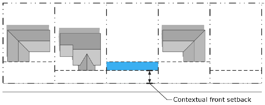
E.
Corner lots.
1.
Unless a specific dimension is provided for a street side setback, on corner lots, the required front yard setback and build-to requirement, as applicable, shall be observed along both street frontages upon which the building is located.
Figure 3_13: Corner Lot Setbacks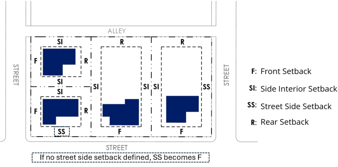
2.
Corner lots shall comply with the vision triangle standards established in § 5.4.6: Vision Triangle.
F.
Double-frontage lots. Lots with multiple street frontages, except for corner lots, shall be required to comply with the required front setback and build-to requirements, as applicable, along each lot line abutting a street.
Figure 3-14: Double-Frontage Lots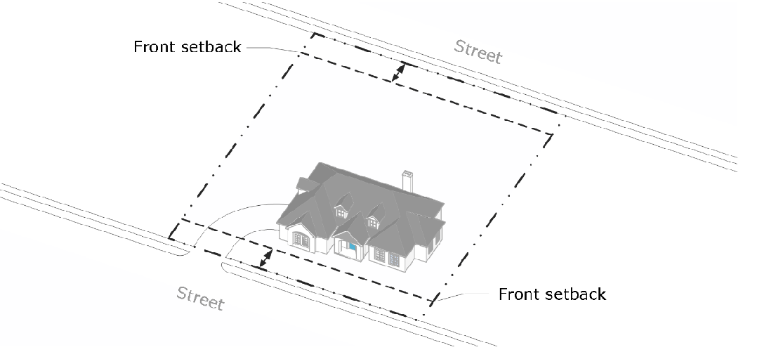
G.
Irregularly shaped lots.
1.
Lots with multiple side and/or rear lot lines not abutting a street shall comply with side setback requirements for all lot lines except that any lot line abutting a street shall comply with the front setback and the lot line farthest from the front lot line shall comply with the rear setback.
2.
The Director may establish alternative setbacks for properties with irregularly shaped lots based on unique site and/or lot conditions.
Figure 3-15: Irregularly Shaped Lots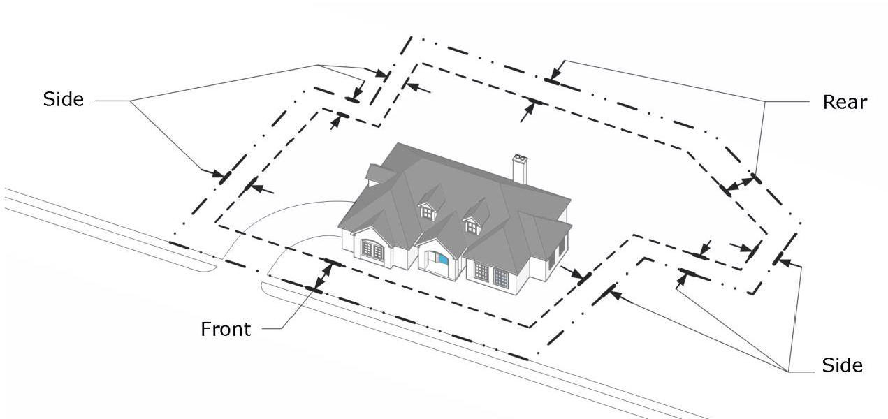
3.9.5.
Building height.
A.
Measurement. Heights referred to in this UDC shall be measured as stated in Article VII: Definitions, under the term "building height."
B.
Special height limitations in airport controlled area. Building and structure height may be further limited according to § 3.8.1: AO - Airport Overlay.
C.
Exceptions to height requirements.
1.
The height exceptions established in this section shall not authorize the encroachment of any development into any zones or areas identified in § 3.8.1: AO - Airport Overlay.
2.
Certain architectural features and improvements may exceed maximum building heights as follows:
3.9.6.
Impervious coverage. The area of the lot or parcel covered by the following shall be included in the calculation of total impervious coverage in all zoning districts:
A.
Principal buildings at their greatest extent and so as to include areas overhung by eaves, balconies, and other projecting features of the structures;
B.
Accessory buildings, parking garages, carports, pools, and utility and storage sheds at their greatest extent and so as to include areas overhung by eaves, balconies, and other projecting features of the structures;
C.
Sidewalks, stairways, elevated walkways, or paved areas;
D.
Parking areas and driveways, regardless of surfacing materials unless an alternative pervious paving system is approved by the Director; and
E.
Decomposed granite, gravel, flagstone, and river rock.
3.9.7.
Minor modification. Minor modifications to some of the dimensional standards in this section may be available through the Minor Modification process established in § 2.10.3.