
Aiken County Unincorporated
City Zoning Code
City Zoning Code
ARTICLE II
ESTABLISHMENT, PURPOSE AND REGULATION OF ZONING DISTRICTS
Sec. 24-2.1.- Establishment of zoning districts.
For purposes of this chapter, the following zoning districts are hereby established:
(Ord. No. 07-6-12, § 5, 6-5-07; Ord. No. 08-04-16, § 1, 4-1-08; Ord. No. 08-06-28, § 1, 6-17-08; Ord. No. 08-09-34, § 1, 9-16-08)
Sec. 24-2.2. - Purpose of districts.
Collectively, these districts are intended to advance the purposes of this chapter and the comprehensive plan as stated in Article I. Individually, each district is designed and intended to accomplish the following more specific objectives.
Primary Districts;
(1)
AP, Agricultural Preservation District: The intent of this district is to conserve, sustain, and protect from premature urban encroachment rural areas and resources, particularly agricultural and forested lands; and maintain a balanced rural-urban environment without interfering with the entrepreneurial abilities and endeavors of local residents.
The retention of open lands, woodlands, and farmlands, which makeup the bulk of this area, are essential to clean air, water, wildlife, many natural cycles, and balanced environment, among other things. Even more essential from an economic perspective are the agricultural lands and farming operations in this area, as well as the right of rural property owners to conduct owner based entrepreneurial businesses. Also protected by this district is a rural environment preferred by many people over subdivisions and higher density urban or community settings.
(2)
IND, Industrial District: The intent of this district is to protect and accommodate wholesaling, distribution, warehousing, processing, manufacturing, office and related business uses on individual lots and in business park settings. This district also is intended to protect for future development land with industrial potential.
(3)
LD, Limited Development District: The intent of this district is to accommodate multi-use development on a limited basis and to minimize land use conflicts along major transportation corridors where use controls and limitations are needed to enhance aesthetic values, ensure land use compatibility and promote a viable growth and development situation.
(4)
NC, Neighborhood Commercial District: The intent of this district is to meet the commercial and service needs generated by nearby residential areas. Goods and services normally available in this district are of the "convenience variety." The size of this district should relate to surrounding residential markets and the location should be at or near major intersections, in proximity to and/or on the periphery of residential areas, existing or proposed.
(5)
OR, Office-Residential District: This district is intended to accommodate office, institutional, and residential uses in areas whose character is changing, or where such a mix of uses is appropriate. It is designed principally for use in transitioning from residential to commercial or business use, and along major streets dominated by older houses in transition. In this district, ancillary and directly related services and uses may not be the principal uses on the property.
(6)
RC, Residential Single-Family Conservation District: This district is intended to foster, sustain, and protect areas in which the principal use of land is for single-family dwellings and related support uses, and to reserve sufficient undeveloped land to meet future single-family housing demands. This district also is intended to encourage infilling and expansion of "like development" consistent with the character of existing development.
(7)
RRC, Residential Rural Commercial: The intent of this district is to preserve the residential and agricultural nature of an area while allowing limited number of agricultural uses, small-scale commercial uses, and recreational uses.
(8)
RD, Residential Multifamily Development District: This district is intended to promote and accommodate housing development that meets the diverse economic and social needs of a diverse population. To this end, this district is designed and intended to allow for the development of a variety of housing styles, types and densities on small lots or in project settings, including single-family, duplexes, triplexes, air-space condominiums, rental apartments, patio homes, townhouses, residentially designed manufactured homes, etc., and to do so in a protected, compatible residential environment. This district is intended for application in areas accessible by major streets, and in proximity to commercial uses, employment opportunities and community facilities.
(9)
RH5, Residential-Horse 5 District: This district is intended to promote and accommodate low-density residential development on large lots of at least five-acre size by prohibiting multifamily residential, industrial, and most commercial activities except those related directly to equine and equestrian uses.
(10)
RH5B- Residential-Horse Business District: This district is intended to promote and accommodate low-density residential development on large lots of at least five-acre in size in prohibiting multifamily residential, industrial, and most commercial activities except those related directly to equine and equestrian uses and selected agricultural.
(11)
RM, Residential Limited Mixed Use District: This district is intended to promote and accommodate a limited mix of residential development, including single-family dwellings, duplexes, townhouses, patio homes, manufactured homes and related support uses, and do so in a protected, compatible residential environment.
(12)
RUC, Rural Community District: The intent of this district is to sustain existing rural-community values and environments, and to facilitate future development which will strengthen the economies of these areas, making them less dependent on outside services and resources, while ensuring land use compatibility and fostering a sense of community.
(13)
RUD, Rural District: The RUD District conforms with the area and development regulations of the Rural District designation contained in the County's 1984 Development Standards Ordinance. It also embraces the same development objectives of its predecessor: "To facilitate (for the area) the adequate provision of transportation, water, sewage disposal, and other public improvements and services."
(14)
UD, Urban Development District: This district is intended to accommodate much of the projected growth in the unincorporated area of Aiken County during the time span of the county's comprehensive plan. It also may be established in other intensely developing areas so designated by the Aiken County Planning Commission. This district is projected to have most public facilities and infrastructure needed to support urban development such as schools, sewer, water, streets, etc. It is applied in areas where development logically should locate as a consequence of planned public facilities and associated capital expenditures. This district is characterized by mixed-use development, providing for a full range of residential uses as well as commercial, institutional, and industrial uses.
Special Purpose Districts
(15)
AO, Airport Overlay District: It is the intent of this district to protect the dual interests of airports and neighboring land uses, and to:
a.
Protect and promote the general health, safety, economy, and welfare of airport environs;
b.
Prevent the impairment and promote the utility and safety of airports;
c.
Promote land use compatibility between airports and surrounding development;
d.
Protect the character and stability of existing land uses; and
e.
Enhance environmental conditions in areas affected by airports and airport operations.
(16)
FHO, Flood Hazard Overlay District: It is the intent of this district to protect human life and health, minimize property damage, encourage appropriate construction practices, and minimize public and private losses due to flood conditions by requiring that uses vulnerable to floods, including facilities which serve such uses, be protected against flood damage at the time of initial construction.
Additionally, this district is intended to help maintain a stable tax base by providing for the sound use and development of flood-prone areas and to ensure that potential home buyers are notified that property is in a flood area. The provisions of this district are intended to minimize damage to public facilities and utilities such as water and gas mains, electric, telephone, and sewer lines, street and bridges located in the floodplain, and prolonged business interruptions; and to minimize expenditures of public money for costly flood control projects and rescue and relief efforts associated with flooding.
(17)
HCO, Highway Corridor Overlay District: The intent of this district is to protect and to enhance the appearance of developments and to improve the traffic flow in primary commercial corridors on the main entrance roads into the municipalities in Aiken County.
(18)
PUD, Planned Use District: The intent of the Planned Use District is to encourage flexibility in the development of land in order to promote its most appropriate use, and to do so in a manner that will enhance public health, safety, morals, and general welfare.
Within the PUD, regulations adapted to unified planning and development are intended to accomplish the purpose of zoning and other applicable regulations to an equivalent or higher degree than where such regulations are designed to control unscheduled development on individual lots or tracts, promote economical and efficient land use, provide an improved level of amenities, foster a harmonious variety of uses, encourage creative design, and produce an enhanced environment.
In view of the substantial public advantage of "planned use development", it is the intent of these regulations to promote and encourage or require development in this form where appropriate in character, timing, and location, particularly where large undeveloped tracts are involved.
(19)
SPI, Special Public Interest District: The creation of Special Public Interest Districts is intended to identify and protect for future generations:
a.
Existing natural resources, and
b.
Historical buildings, grounds and other unique environs with special and substantial public interest.
(20)
WPO, Wellhead Protection Overlay District: The intent of this district is to protect ground water resources, a major source of drinking water in Aiken County, from contamination by potentially high-risk land uses and activities.
(Ord. No. 07-6-12, § 5, 6-5-07; Ord. No. 08-04-16, § 1, 4-1-08; Ord. No. 08-09-34, § 1, 9-16-08)
Sec. 24-2.3. - Establishment of official Aiken County zoning map.
Aiken County is divided into zoning districts as shown on the Official Aiken County Zoning Map which is maintained by the GIS Mapping Division of the Aiken County Planning and Development Department. This map is adopted as the Official Aiken County Zoning Map by this chapter. The Official Aiken County Zoning Map may be amended as set forth in Article X of this chapter.
(Ord. No. 07-6-12, § 5, 6-5-07)
Sec. 24-2.4. - Interpretation of zoning district boundaries.
(a)
Unless otherwise shown on the official zoning map of Aiken County, the boundary lines of districts coexist at lot lines, centerlines of streets or alleys, or such lines extended, railroad right-of-way lines, centerlines of creeks and streams, or corporate limit lines.
(b)
District boundary lines not coinciding with the above shall be determined by use of the scale of the official zoning map unless actual dimensions are noted.
(c)
Where uncertainty exists regarding the boundaries as shown by the official zoning map, the planning commission shall act to resolve any question or controversy arising over such district boundary line.
(Ord. No. 07-6-12, § 5, 6-5-07)
Sec. 24-2.5. - Establishment of district regulations.
(a)
District regulations are presented with the use of tables. Table 1 identifies and lists all permitted uses in the several primary zoning districts established by section 24-2.1, together with off-street parking requirements for each use or category of uses. Table 2 establishes lot area, yard, setback, height, density, and impervious surface requirements for all uses, by zone district.
(b)
Special purpose district regulations are contained in section 24-2.7, PUD, planned use district; section 24-2.8 SPI, special public interest; section 24-2.9, AO, Airport Overlay District; section 24-2.10, FHO, Flood Hazard Overlay District; and section 2.11, WPO, Wellhead Protection Overlay District, and HCO, Highway Corridor Overlay District.
(Ord. No. 07-6-12, § 5, 6-5-07)
Sec. 24-2.6. - Use of tables.
(a)
The North American Industry Classification System, 2002, is the basis for determining the use of property permitted by the various zoning districts. Where uncertainty exists relative to a given use not specifically listed on the table, the NAICS Manual should be consulted. In general, all uses listed by a given NAICS number and category shall be construed as being permitted in the assigned zoning district, unless separately listed.
(b)
Uses not listed in the NAICS Manual, or to which a reference is not applicable are identified by the letters "NA" (not applicable).
(c)
Where the letter "P" is shown on the table, the use to which it refers is permitted as a use by right in the indicated district, provided it complies fully with all applicable development standards of this chapter.
(d)
Where the letter "C" is shown on the table, the use to which it refers is conditionally permitted in the indicated district, subject to requirements for uses set out in Article III.
(e)
Where the letter "N" is shown on the table, the use to which it refers is not permitted in the indicated district.
(f)
Where a given use or NAICS reference is not listed on the table, said use shall not be permitted.
(g)
A section number reference following a use category means the use must meet the additional conditions and requirements of the referenced section.
(h)
To aid in the use of the Table, major land use categories are arranged numerically by NAICS Sectors, followed by the uses and codes included in each sector, as shown below:
Uses and NAICS code references are displayed within the appropriate sector in numerical order, beginning with Sector 11 (Agricultural, Forestry, Fishing and Hunting) and running through Sector 92 (Public Administration). Residential uses do not represent an industry classification and therefore are not included in the NAICS code. However, they are listed on the Table 1, after Sector 92.
(a)
Off-street parking requirements computed on basis of number of spaces per square feet of gross floor area (GFA).
(b)
Permitted on existing lot of record as of July 1, 1992, and on any new lot ten (10) acres or greater in size, or any court-ordered subdivision.
(c)
Permitted in NC District, not to exceed five thousand (5,000) square feet GFA.
(d)
1.0 per eight hundred (800) square feet GFA, or as determined by review by the planning and development director on a case-by-case basis to be sufficient for the largest number of employees on any shift, including any additional spaces required for overlapping shifts.
(e)
Refer to Section 3.14.1 Manufactured Housing, which reads as follows: "However, such "pre-76" manufactured housing built before 1976 may be relocated within Aiken County until November 1, 2011 provided that such housing is registered with Aiken County in compliance with State and County Codes, that an Aiken County Moving Permit is obtained, and that such housing is owner-occupied".
(f)
Family daycare homes in RH5 Districts are considered to be home occupations and therefore subject to the requirements described in Section 3.16 Home Occupations of this chapter.
(g)
In the event that the uses permitted by this Table 1 in the HCO District conflict with the uses permitted in the Districts which underlie the HCO District, the more restrictive and stringent use regulations shall prevail (see section 24-2.12.15).
(h)
Refer to section 24-3.5.9 for these districts.
(i)
In the AP District, commercial business where permitted in Table 1 shall meet the following condition to insure it remains "small scale" in keeping with its neighborhood: No more than twelve (12) employees, including fulltime and part-time employees, contract workers, and family member/residents of the property.
(j)
Use is permitted on parcels with an area of three acres or greater. Horse and Other Equine and Poultry shall be subject to additional requirements found in Sections 24-3.2 and 24-3.26.
(Ord. No. 07-6-12, § 5, 6-5-07; Ord. No. 07-11-25, § 1, 11-27-07; Ord. No. 08-03-13, § 1, 3-4-08; Ord. No. 08-03-17, 4-1-08; Ord. No. 08-06-28, § 1, 6-17-08; Ord. No. 08-09-34, § 1(LMR 6), 9-16-08; Ord. No. 14-12-18, § 1, 12-9-14; Ord. No. 15-10-11, § 1, 10-20-15; Ord. No. 16-09-16, § 1.A, 9-20-16; Ord. No. 18-02-04, § 1, 2-6-18; Ord. No. 18-02-05, § 1, 2-6-18; Ord. No. 19-06-19, § 1, 6-18-19; Ord. No. 24-01-04, § 1, 1-2-24)
Table 2: Schedule of Lot Area, Setback, Height, Density, and Impervious Surface Ratio, By Zoning Districts
Notes to Table 2:
NA = Not applicable.
*100′ industrial only; 50′ other uses.
**75′ industrial only; 50′ other uses.
***50′ industrial only; 30′ other uses.
(A)
Minimum lot size shall be eighty (80) percent of the average size of existing lots of record within the area in which the use is proposed, measured within one thousand (1,000) feet of the proposed use. All existing lots three acres or smaller shall be included in the calculation of "average lot size." Existing lots larger than three (3) acres shall be considered to be three acres for purpose of calculating average lot size. Lots not entirely contained within the 1,000-foot radius of the proposed lot shall not be included in the calculation. All lots included in the calculation must be recorded on the Aiken County tax maps. Where such measurement or calculation is inconclusive, the following minimums shall apply: one (1) acre per unit without community water and sewer; one-half (½) acre minimum without community sewer; fourteen thousand (14,000) square feet with community water and sewer.
(B)
Ten thousand (10,000) square feet for one residential unit: Four thousand (4,000) for each additional unit.
(C)
For residential developments other than single-family detached dwellings, setbacks shall be determined on the basis of project density and adjacent land use, as follows:
(D)
30-foot setback when proposed use abuts single-family use on local street; 20-foot setback when proposed use abuts all other residential uses; and 10-foot setback when proposed use abuts another non-residential use.
(E)
A buffer setback not less than fifty (50) feet shall be provided along the banks of all water bodies, streams and rivers. The buffer area shall remain largely undisturbed, except for piers, docks, benches or other outdoor furniture. Landscaping and Best Management Practices (BMPs) For Forestry in Streamside Management Zones, promulgated by the SC Forestry Commission shall be used to protect the embankment from erosion and prevent stormwater runoff from draining directly into the contiguous water resource. These provisions shall not apply to intermittent streams.
(F)
No limit; however, required minimum side and rear setbacks shall be increased at the rate of three and one-half (3.5) feet for each floor over the second.
(G)
Measurement from the average finished grade at the building line to the highest point of a flat roof or midpoint of a pitched roof.
(H)
Unattached buildings occupying the same lot shall be separated by a distance of twenty (20) feet, plus three and one-half (3.5) feet for each additional floor over the first floor, or as specified by the International Building Code.
(I)
Minimum lot size or building site (where more than one (1) dwelling per lot is proposed) shall be based on soil conditions and DHEC area requirements for on-site wastewater disposal and water supply systems.
(J)
"Reserved"
(K)
Minimum setbacks shall be thirty (30) feet from side and rear property lines, plus five (5) feet for each additional five thousand (5,000) square feet of gross cumulative plant floor area over twenty thousand (20,000) square feet. Maximum setback shall be two hundred (200) feet from side and rear property lines.
(L)
Width at building line for townhouses is specified in section 24-3.12 and for patio and zero lot line housing in section 24-3.13.
(M)
Minimum lot area for townhouses, duplex, triplex, and quadruplex is specified in section 24-3.12 and for patio and zero lot line housing in section 24-3.13.
(N)
Permitted on existing lot of record as of July 1, 1992, and on any new lot ten (10) acres or greater in size, or any court-ordered subdivision.
(O)
In the event that the standards made applicable to the HCO District by this Table 2 conflict with the standards applicable to the Districts which underlie the HCO District, the more restrictive and stringent standards shall prevail.
(P)
In the AP district, manufacturing businesses where permitted in Table 1 shall meet the following condition: Any manufacturing building or activity must be located 100 feet from any property line.
(Q)
Two-acre minimum. However, only small subdivisions involving the creation of 10 or fewer lots shall be permitted, and once approved, such small subdivisions shall not be enlarged beyond their initial platted boundaries, unless and until such subdivisions may be rezoned to a higher-density residential district, in accord with the County's Comprehensive Plan.
(Ord. No. 07-6-12, § 5, 6-5-07; Ord. No. 07-11-25, § 1, 11-27-07; Ord. No. 08-04-17, § 1, 3-5-08; Ord. No. 08-06-28, § 1, 6-17-08; Ord. No. 08-09-34, § 1, 9-16-08; Ord. No. 09-08-17, § 1, 8-18-09; Ord. No. 16-08-13, § 1, 8-16-16; Ord. No. 19-02-20, § 1, 6-19-19; Ord. No. 25-06-16, § 1, 6-17-25)
Sec. 24-2.7.1. - Establishment of PUD, planned use district.
(a)
There are hereby created two types of PUD Districts, Type A and Type B.
(1)
Type A. A Type A PUD is one which is similar in use and intensity to the district in which it is to be located.
Type A PUDs may be established in any zoning district, subject to the requirements of this section and review and approval by the planning commission. Rezoning is not required to establish a Type A PUD. Planning commission approval shall be final for Type A PUDs.
(2)
Type B. A type B PUD is one which may include any use or combination of uses and intensity levels irrespective of prevailing zoning district requirements where it is to be located.
Type B PUDs shall be established on the official zoning map by the same procedure as for amendments generally (Article X) and in accord with the requirements of this section.
(b)
Additionally, each PUD shall be identified by a prefix and number indicating the particular district, as for example "PUD-03-1" (Zone-Year-Number), together with whatever other identification appears appropriate.
(Ord. No. 07-6-12, § 5, 6-5-07)
Sec. 24-2.7.2. - Permitted uses in PUD.
(1)
Type A PUDs. Permitted uses in Type A PUDs shall include only those listed in Table 1 for the district in which the PUD is to be established. No use shall be permitted in a Type A PUD that is not clearly permitted in the district in which it is to be established.
(2)
Type B PUDs. Any use or combination of uses meeting the objectives of this section may be established in a Type B PUD upon review and approved amendatory action by the planning commission and county council. Once approved, the proposed use(s) and no others shall be permitted. Said uses shall be identified and listed on the basis of classification, i.e. retail, office, wholesale, residential, multifamily residential, single-family detached housing, manufactured housing, etc. The list of approved uses shall be binding on the applicant and any successor in title, so long as the PUD zoning applies to the land, unless otherwise amended by ordinance.
(Ord. No. 07-6-12, § 5, 6-5-07)
Sec. 24-2.7.3. - Development standards.
(1)
Minimum area required. Minimum area requirement for establishing a PUD shall be five (5) acres.
(2)
Density. Residential density, setbacks, impervious surface ratios, and building heights shall be determined by the scale of the project in relation to its surroundings and its impact on existing and proposed support facilities, i.e. transportation, water, and sewerage systems, recreation facilities, fire and police protection, etc.
(3)
Overall site design. Overall site design shall be harmonious in terms of landscaping, enclosures of principal and accessory uses, size of structures, street patterns, and use relationships. Variety in building types, heights, facades, setbacks, and size of open spaces shall be encouraged.
(4)
Parking and loading. Off-street parking and loading spaces for each PUD shall comply with the requirements of Table 1, as applicable for the uses proposed for the PUD, and the requirements of Article IV.
(5)
Buffer areas. Buffer areas shall be required for peripheral uses only, and shall be provided in accord with the minimum requirements for adjacent uses prescribed by section 24-5.1. Buffer areas are not required for internal use.
(6)
Streets and street improvements. Private streets may be permitted in a PUD provided such streets meet the design and construction standards for public streets; further provided that an acceptable maintenance plan is submitted to and approved as part of the PUD plan.
(7)
Landscaping and common open space. Landscaping and open space requirements for each PUD shall comply with the provisions of sections 24-5.3 and 24-5.4 of this chapter.
(8)
Signage. Signage shall be in harmony and scale with and reflective of the proposed PUD.
(9)
Offsetting public benefits. If the site design and/or plans of a PUD submitted for approval include or request concessions, relief or variances from the usual development standards prescribed in this chapter, such as density, setbacks, roadway width, or other standards, additional public benefits shall be provided in the PUD by the applicant so as to offset and justify the concessions, relief, or variances. Such additional benefits may include the provision of additional open space over that normally required, parks, recreation facilities, walking trails, and other amenities. The planning commission and/or the county council, as appropriate, shall determine whether the additional benefits to be provided are sufficient to offset and justify the requested concessions, relief or variances.
(Ord. No. 07-6-12, § 5, 6-5-07; Ord. No. 08-04-17, § 1, 4-1-08)
Sec. 24-2.7.4. - Site plan required.
A conceptual site plan or master plan for a PUD showing the entire proposed PUD development, including future phases, in sufficient detail so as to present a clear, general, graphic depiction of the overall elements of the PUD to the planning commission and to the county council shall be prerequisite to the approval of a PUD. Further, the fully detailed site plan presented for approval of each specific individual phase of a PUD, including residential, commercial, and other phases and portions of the PUD, shall adhere to the requirements of this section and also shall show all of the information called for in Table 11 of this chapter as appropriate for the type of development involved in that phase of the PUD, whether that phase involves land subdivision (preliminary plat approval or final plat approval), land development, or major land development as defined in section 24-10.6.1 of this chapter and described in full detail in Article VII of this chapter.
(Ord. No. 07-6-12, § 5, 6-5-07)
Sec. 24-2.7.5. - Financial guarantees.
Where public improvements and/or common amenities or infrastructure are proposed, such improvements shall be installed in accord with a development schedule to be approved as part of the PUD plan.
Where proposed or required improvements have not been completed by the applicant/developer prior to the scheduled target date and certified by the planning and development director, the applicant/developer may provide financial guarantees acceptable to the county, to ensure the proper installation of such required improvements.
(Ord. No. 07-6-12, § 5, 6-5-07; Ord. No. 14-12-18, § 1, 12-9-14)
Sec. 24-2.7.6. - Action by the planning commission and council.
Action by the planning commission and council may be to approve the plan and application to establish a PUD, to include specific modifications to the plan, or to deny the application to rezone or establish a PUD. If the plan and/or rezoning are approved, the applicant shall be allowed to proceed in accord with the approved plan as supplemented or modified in a particular case, and shall conform to any time or priority limitations established for initiating and/or completing the development in whole, or in specified stages. If the application is denied, the applicant shall be so notified.
(Ord. No. 07-6-12, § 5, 6-5-07)
Sec. 24-2.7.7. - Final administrative action.
Once the plan is approved, the planning and development director shall issue or cause to be issued building and sign permits in accord with the approved plan as a whole or in stages, or portions thereof, as approved. Said permits shall be issued in the same manner as for building and sign permits generally.
(Ord. No. 07-6-12, § 5, 6-5-07; Ord. No. 14-12-18, § 1, 12-9-14)
Sec. 24-2.7.8. - Changes in approved PUD plans.
(a)
Except as provided in this section, approved PUD plans shall be binding on the owner and any successor in title.
(b)
Minor changes in an approved PUD site plan may be handled administratively by the planning and development director on application by the applicant, upon making a finding that such changes:
(1)
Do not increase density;
(2)
Do not change the exterior boundaries or height;
(3)
Do not increase the intensity of land use;
(4)
Do not materially change the location or amount of land devoted to specific land uses;
(5)
Do not significantly change the exterior appearance of the project.
Minor changes may include, but not be limited to minor shifting of buildings, proposed streets, public or private ways, utility easements, parks or other public open spaces, or other features of the plan.
Temporary signs within a PUD which exceed the limit for temporary signs under the sign provisions may be approved by staff provided such approval does not exceed a one-year period.
(c)
Major changes to an approved Type A or B PUD shall require review by the county planning commission. Major changes include the following:
(1)
Any increase in intensity or use resulting in added floor area, number of dwelling or lodging units, or an increase in the amount of outside land area devoted to sales, displays, or demonstrations.
(2)
Any change in parking areas resulting in an increase or reduction greater than five (5) percent in the number of spaces.
(3)
Structural alterations significantly affecting the size, form, style, and location of buildings as shown on the fully detailed approved plan.
(4)
Any reduction in the amount of open space or buffer area, or any change in the location or characteristics of open space.
(5)
Any change in pedestrian or vehicular access or circulation.
(6)
Any change in use from one use group to another.
(d)
Any change in the use, intensity or density of a Type B PUD shall constitute a change requiring the reestablishment of the PUD through the amendatory process (Article X).
(Ord. No. 07-6-12, § 5, 6-5-07; Ord. No. 14-12-18, § 1, 12-9-14)
Sec. 24-2.7.9. - References.
Refer to sections 24-10.18 and 24-10.19 of this chapter.
Sec. 24-2.8.1. - Establishment of SPI District.
An SPI District may be established as a primary or overlay zoning district in accord with the same procedures as for amendments generally, Article X. Additionally, each SPI District shall be identified by the SPI prefix and a number indicating the particular district, and shall contain information and proposals as indicated below concerning the area, building(s), and/or premises proposed for such regulation:
(1)
Statement of intent.The requested establishment of an SPI District on the zoning map shall include a statement of intent, specifying the nature of the special and substantial public interest involved and the objectives of the special regulations and procedures.
(2)
Proposed district boundaries. The proposed district shall be presented on a map or maps showing the boundaries and the designations of all portions of underlying districts, if any, which will remain after SPI zoning is superimposed.
(3)
Proposed regulations. Proposed regulations shall be set out in the statement of intent. Such regulations may require submission of detailed site plans, building plans and elevations and maps indicating the relation of proposed development to surrounding or otherwise affected property.
(Ord. No. 07-6-12, § 5, 6-5-07)
Sec. 24-2.8.2. - Changes to established SPI District.
Once created by amendment, no change in the regulations or map boundaries of an established SPI District shall be approved except by amendatory action as provided for in section 24-10.5.
(Ord. No. 07-6-12, § 5, 6-5-07)
Sec. 24-2.9. - AO, Airport Overlay District.[2]
Editor's note— Ord. No. 18-09-26, adopted September 18, 2018, amended Sec. 24-2.9 in its entirety to read as herein set out. Former Sec. 24-2.9 pertained to the same subject matter, consisted of §§ 24-2.9.1—24-2.9.12, and derived from Ord. No. 07-6-12, adopted June 5, 2007.
Sec. 24-2.9.1. - Purpose.
The purpose of this district is to promote the dual interests of airports and neighboring land uses, and to:
(1)
Protect and promote the general health, safety, economy and welfare of residents of airport environs;
(2)
Prevent the impairment and promote the utility and safety of airports;
(3)
Promote land use compatibility between airports and surrounding development;
(4)
Protect the character and stability of existing land uses; and;
(5)
Enhance environmental conditions in areas affected by airports and airport operations.
(Ord. No. 18-09-26, § 1(Att.), 9-18-18)
Sec. 24-2.9.2. - Establishment or expansion of airport overlay districts.
(a)
Airport overlay districts and expansions thereof shall be established by ordinance in accord with the same procedures as for amendments as prescribed in article X of this chapter. Said districts shall include as a minimum all of the area lying beneath the primary zones, approach zones, transitional zones, horizontal zones, heliport approach zones, heliport transitional zones, and conical zones as herein defined and applicable to an existing or proposed airport or heliport.
(b)
No airport or expansion thereof shall be permitted for construction and allowed to operate in Aiken County unless and until said use and the surrounding area impacted by said use have been established in an airport overlay district in accord with the provisions of this section.
(c)
The Aiken Municipal Airport Overlay District is hereby established as shown on the airport overlay district maps entitled "Exhibit 1 Land Use/Height Restriction Zones, dated December 1993, Sheets 1 and 2 of 3," which are maintained by the Aiken County Planning and Development Department and hereby incorporated into this chapter and made a part thereof.
(Ord. No. 18-09-26, § 1(Att.), 9-18-18)
Sec. 24-2.9.3. - Boundaries of airport overlay districts.
The boundaries of airport overlay districts shall be determined by application of the following zones, as applicable, to an existing or proposed airport or heliport. Such zones shall be shown on the airport district maps. Said maps also shall clearly depict the property boundary lines and tax parcel numbers of all properties included in the airport overlay district.
(1)
Primary zone. All land along the runway that extends two hundred fifty (250) feet perpendicular to the centerline of the runway; and all land extending two hundred (200) feet from the end of any runway or proposed extension. The elevation of any point on the primary surface is the same as the elevation of the nearest point on the runway centerline.
(2)
Transitional zone. All land which lies directly under an imaginary surface extending outward and upward at a slope of seven to one (7:1) from the sides of the primary surface and from the sides of the approach surfaces, until they intersect the horizontal surface or the conical surface. Where a precision instrument runway approach zone projects beyond the conical zone, the transitional zone includes all land which lies directly under imaginary surfaces extending outward and upward at a slope of seven to one (7:1) from the sides of and at the same elevation as the approach surface, and extending a horizontal distance of five thousand (5,000) feet measured at ninety-degree angles to the extended runway centerline.
(3)
Horizontal zone. All land which lies directly under an imaginary horizontal surface one hundred fifty (150) feet above the established airport elevation (for Aiken Municipal Airport the horizontal surface elevation is six hundred seventy-nine (679) feet MSL) and is established by swinging arcs ten thousand (10,000) feet along from the ends of the primary surface along the extended runway centerline, then connecting the arcs by straight lines tangent to those arcs.
(4)
Approach zone. All land which lies directly under an imaginary approach surface longitudinally centered on the extended centerline at each end of the runway. The inner edge of the approach surface is at the same width and elevation as, and coincides with, the end of the primary surface.
The approach surfaces for runways at the Aiken Municipal Airport are hereby established as follows:
a.
The approach surface for Runway 1/19 inclines outwards and upwards at a slope of twenty to one (20:1) for a distance of five thousand (5,000) feet from the end of the primary surface. The approach zone is two hundred fifty (250) feet wide at the inner edge and one thousand two hundred fifty (1,250) feet wide at a distance of five thousand (5,000) feet from the end of the primary surface centered on the runway centerline.
b.
The approach surface for Runway 7 inclines outward and upwards at a slope of fifty to 1 (50:1) for a distance of ten thousand (10,000) feet from the end of the primary surface, then forty to one (40:1) for the remaining forty thousand (40,000) feet. The approach is one thousand (1,000) feet wide at the inner edge and three thousand five hundred (3,500) feet wide at a distance of ten thousand (10,000) feet from the end of the primary surface centered on the runway centerline.
c.
The approach surface for Runway 25 inclines outward and upwards from a width of one thousand (1,000) feet at the inner edge to a width of sixteen thousand (16,000) feet at a horizontal distance of fifty thousand (50,000) feet from the primary surface centered on the runway centerline. This approach slope is presently for height restriction only. Actual approach slope for aircraft is thirty-four to one (34:1)).
(5)
Conical zone. All land which lies directly under an imaginary conical surface extending upward and outward from the periphery of the horizontal surface at a slope of twenty to one (20:1) for a horizontal distance of four thousand (4,000) feet measured radially.
(6)
Heliport approach zone. All land which lies directly under an imaginary surface whose inner edge coincides with the width of the heliport primary surface (eighty (80) feet) and which expands outward uniformly at a slope of eight to one (8:1) to a width of five hundred (500) feet at a horizontal distance of four thousand (4,000) feet from the primary surface.
(7)
Heliport transitional zone. All land which lies directly under an imaginary surface which begins at the sides of and at the same elevation as the primary surface and the heliport approach zones and extends at a slope of two to one (2:1) a distance of two hundred fifty (250) feet measured horizontally from and at ninety-degree angles to the primary surface centerline and heliport approach zones centerlines.
(Ord. No. 18-09-26, § 1(Att.), 9-18-18)
Sec. 24-2.9.4. - Interpretation of airport overlay district boundaries.
Where uncertainty exists with respect to the boundary of any district shown on an airport overlay district map, the following rules shall govern:
(1)
Where any district boundary is indicated on a district map as following approximately the county boundary line or the corporate limits line of any incorporated place within the county, then such county boundary or corporate limits line shall be construed to be such district boundary.
(2)
Unless otherwise indicated, the district boundaries shall follow natural features such as marsh edges and stream banks.
(3)
Where indicated, district boundaries are parallel to the centerlines of streets, highways, or railroads, or the right-of-way of same; property lines; streams or other bodies of water; or said lines extended at such distances therefore as indicated on the district map. If no distance is given, such distance shall be determined by the use of the scale on said district map.
(4)
Where district boundary lines are so indicated that they approximately follow property or lot lines, such property or lot lines shall be constructed to be such boundary lines.
(5)
Where a district boundary line divides a parcel or lot, the location of any such district boundary lines, unless indicated by dimensions shown on the district map, shall be determined by the use of the scale on said district map.
(Ord. No. 18-09-26, § 1(Att.), 9-18-18)
Sec. 24-2.9.5. - Height restrictions.
(a)
Notwithstanding the provisions below and the other provisions of section 24-2.9, any proposed object in an airport overlay district that is identified under 14 Code of Federal Regulations Part 77, as amended, as a potential hazard to air navigation must be evaluated by the Federal Aviation Administration through the Federal Aviation Administration's 7460 process prior to construction.
(b)
Except as otherwise provided or as necessary to airport operations:
(1)
No structure or tree shall be constructed, altered, maintained, or allowed to grow in any zone created in section 24-2.9.3 so as to project above any of the imaginary surfaces described.
(2)
No structure or object which is classified as or considered to be an obstruction to air navigation shall be constructed, altered, or maintained in any zone created in section 24-2.9.3.
A structure or object is classified as or considered to be an obstruction to air navigation if it is of greater height than either of the following heights:
a.
A height of five hundred (500) feet above ground level at site of the structure or object.
b.
A height that is two hundred (200) feet above ground level or two hundred (200) feet above the established airport elevation, whichever is higher, within three (3) nautical miles of the established reference point of the airport. The established elevation of Aiken Municipal Airport is five hundred twenty-nine (529) feet MSL.
(3)
Notwithstanding the other provisions of this section 24-2.9.5, where an area is covered by more than one (1) height limitation, including those in section 24-2.9, any airport overlay district maps authorized by the section 24-2.9, or any applicable provisions of federal or state laws or regulations, the more restrictive height limitation shall prevail.
(Ord. No. 18-09-26, § 1(Att.), 9-18-18)
Sec. 24-2.9.6. - Use restrictions.
(a)
In an airport overlay district, permitted uses are determined by the underlying or primary zoning district (IND, UD, RUD, etc.). However, the provisions of this chapter are intended to temper and modify the use and development standards of the primary district to the extent necessary to achieve the objectives of section 24-2.9.1. To that end, primary district regulations are hereby amended as follows:
(1)
In all airport zones, the following uses are prohibited:
Any use which would:
a.
Create electrical interference with navigational signals or radio communication between the airport and aircraft;
b.
Diminish the ability of pilots to distinguish between airport lights and other lights;
c.
Result in glare in the eyes of pilots using the airport;
d.
Impair visibility in the vicinity of the airport;
e.
Create bird strike hazards, or otherwise in any way endanger or interfere with the landing, takeoff, or maneuvering of aircraft intending to use the airport.
(2)
In safety zone A as described in section 24-2.9.6(4), the following uses are prohibited:
a.
Single-family residential dwellings, including mobile, manufactured, or modular dwellings, in excess of two (2) units per acre;
b.
Multifamily dwellings, cluster housing projects, mobile home parks, and group housing;
c.
Transient lodging, motels and hotels;
d.
Hospitals, sanatoriums and nursing homes;
e.
Schools and day care centers;
f.
Churches, theaters, auditoriums and similar place of assembly. However, for the purposes of this section of this chapter, restaurants are excluded from the term "places of assembly", and therefore restaurants are allowed within safety zone A.
(b)
The following four (4) supplemental provisions are applicable in the Aiken Municipal Airport Overlay District:
(1)
There shall be free and unobstructed passage of aircraft in, through and across the air space above the glide angle of fifty to one (50:1) of Runway 7, thirty-four to one (34:1) of Runway 25 and twenty to one (20:1) of Runway 1/19 on extension of each runway over and across so much of the property and lands situated in Aiken County and lying adjacent to the runway approaches hereinabove set out.
(2)
The county shall have the right to remove underbrush, trees and other obstacles in the pathways of said runways so as to prevent interference with the slopes hereinabove set out, and no buildings or other structures shall be constructed of a height so as to interfere with such slopes.
(3)
The county shall have the right to clear an area beyond the border of the airport property:
a.
Extending two hundred fifty (250) feet each side of each runway as measured from runway centerline.
b.
Along the extended runway centerlines of Runway 1/19 from a width of two hundred fifty (250) feet at a distance two hundred (200) feet from end of the runway to a width of four hundred fifty (450) feet at a distance one thousand two hundred (1,200) feet from the end of the runway.
c.
Along the extended runway centerline, from a width of one thousand (1,000) feet at a distance two hundred (200) feet from the end of Runway 7, widening to one thousand seven hundred fifty (1,750) feet at a distance two thousand seven hundred (2,700) feet from the runway end.
d.
Along the extended runway centerline, from a width of one thousand (1,000) feet at a distance two hundred (200) feet from the end of Runway 25, widening to one thousand five hundred ten (1,510) feet at a distance one thousand nine hundred (1,900) feet from the runway end.
(4)
Safety zones. In order to restrict those uses which may be hazardous to the operational safety of aircraft operating to and from the Aiken Municipal Airport, thereby creating sufficient open space so as to protect life and property and in case of an accident, there are hereby created and established certain safety zones, as delineated on the Aiken Airport Overlay District Maps as described as follows:
a.
Safety zone A. All land in the primary and approach zones of a runway as defined in section 24-2.9.3 of this chapter which extends outward for a distance of one thousand seven hundred (1,700) feet from Runway 25 primary surface, two thousand five hundred (2,500) feet from Runway 7 primary surface and one thousand (1,000) feet from all other runways primary surface. Those safety zones A which are located in the approach zones are identified as runway protection zones (RPZ's).
b.
Safety zone B. All land in that portion of the approach zones of the runway, as defined in section 24-2.9.3 of this chapter, which extends outward from safety zone A for a distance of four thousand (4,000) feet; and also all land in that portion of the area defined as the transitional zone in section 24-2.9.3 of this chapter which lies below the horizontal surface as described in section 24-2.9.3 of this chapter.
c.
Safety zone C. All land which is enclosed within the perimeter of the horizontal zone and conical zone as defined in section 2.9.3 of this chapter and which is not included in safety zones A or B.
(Ord. No. 18-09-26, § 1(Att.), 9-18-18)
Sec. 24-2.9.7. - Noise restrictions and contours.
(1)
Noise restrictions. Where permitted within the noise contour areas (see item (2) below) of an airport overlay district, residential dwellings and portions of buildings to which the public has access shall be structurally designed and constructed to achieve an outdoor-to-indoor peak noise level reduction (NLR) of at least thirty (30) db (decibels). All other permitted uses and structures are exempt from this section.
Normal construction can be expected to provide an NLR of twenty (20) db, thus the actual recommended reduction is only ten (10) db. Lowering the NLR can be achieved through incorporation, into the design and construction of all proposed uses, of appropriate sound insulation materials and methods for improving acoustic insulation performance.
(2)
Noise contours. The expected noise exposure of areas near an airport is defined by the average day-night sound level (Ldn) noise estimation methodology. There are two (2) differing sound exposure areas identified for the Aiken Municipal Airport: Ldn curve area fifty-five (55) and Ldn curve area sixty (60). These two (2) areas are shown on the Aiken Airport Overlay District Map.
(Ord. No. 18-09-26, § 1(Att.), 9-18-18)
Sec. 24-2.9.8. - Lighting restrictions.
No permitted use, subdivision or project in an airport overlay district shall have outdoor lighting or illumination arranged and/or operated in such a manner as to be misleading to or pose a danger to aircraft operations.
(Ord. No. 18-09-26, § 1(Att.), 9-18-18)
Sec. 24-2.9.9. - Airport location restrictions.
In order to promote land use compatibility between airports and surrounding development, and in order to protect the character and stability of existing residential land uses; airport runways and taxiways, aircraft parking areas, aircraft hangers, and related uses shall be located no closer than two thousand (2,000) feet from any RC or RM district (measured in a straight line).
(Ord. No. 18-09-26, § 1(Att.), 9-18-18)
Sec. 24-2.9.10. - Regulations applicable to existing structures and vegetation.
The owner of any existing structure or vegetation that is currently penetrating any referenced surface within an established airport overlay district shall permit the installation, operation, and maintenance thereon of whatever markers and lights deemed necessary by the Federal Aviation Administration or the South Carolina Aeronautics Commission to indicate to the operators of aircraft in the vicinity of the airport the presence of that airport obstruction. These markers and lights shall be installed, operated and maintained at the expense of the airport operator.
However, the regulations prescribed in this section shall not be construed to require the removal, lowering, or other change or alteration of any existing structure or tree not conforming to the regulations as of the effective date of this chapter, or otherwise interfere with the continuance of an existing use. Nothing contained herein shall require any change in the construction, alteration, or intended use of any structure, the construction or alteration of which was begun prior to the effective date of this chapter and is diligently prosecuted.
(Ord. No. 18-09-26, § 1(Att.), 9-18-18)
Sec. 24-2.9.11. - Private airfields/airstrips/airports.
(1)
All requests for private airfields/airstrips within the county shall be made known to the county and to the operators of all other airports in the county, as defined in article XI of this chapter, by means of submission of an Federal Aviation Administration Form 7480-1 "Notice of Landing Area Proposal" to the county and to the operators of all said other airports in the county by the developer or owner of such private airfields/airports/airports.
(2)
No permit for construction of private airfields/airstrips/airports will be granted by the county under this chapter if it is determined by FAA review that such a facility would encroach on public lands and airways.
(Ord. No. 18-09-26, § 1(Att.), 9-18-18)
Sec. 24-2.9.12. - Variances.
(a)
Any person or entity desiring to erect or increase the height or size of any structure not in accordance with the regulations prescribed in this section may apply for a variance from such regulations to the Aiken County Board of Appeals, in accord with the provisions of article X of this chapter. The application for a variance shall be accompanied by a determination from the Federal Aviation Administration as to the effect of the proposal on the operation of air navigation facilities and the safe, efficient use of navigable airspace.
(b)
Additionally, no application for a variance from the requirements of this section may be considered by said board unless a copy of the application has been furnished to the airport operator for advice as to the aeronautical effects of the variance. If the airport operator does not respond to the application within fifteen (15) days after receipt, said board may act on its own to grant or deny the application for a variance.
(c)
Any permit or variance granted, if such action is deemed advisable to effectuate the purpose of this section and be reasonable in the circumstances, may be so conditioned as to require the owner of the structure in question to install, operate and maintain at the owner's expense such markings and lights as may be deemed necessary by the Federal Aviation Administration, the South Carolina Aeronautics Commission, or the airport operator.
(Ord. No. 18-09-26, § 1(Att.), 9-18-18)
Sec. 24-2.10. - FHO, Flood Hazard Overlay District.[3]
The flood hazard overlay district includes (1) floodplains, (2) areas of shallow flooding, (3) areas of special flood hazard, and (4) floodways. The development of these areas, where shown on flood insurance rate maps issued by the Federal Emergency Management Agency (FEMA) for Aiken County, may not occur where alternative locations exist, because of the inherent hazards and risks involved. Before a building permit and/or a development permit is issued, the applicant shall demonstrate that new structures cannot be located out of the flood hazard district. Where there is no alternative to a location in a flood hazard overlay district, proposed development shall be regulated by the following.
Editor's note— Ord. No. 18-07-21, adopted July 17, 2018, amended Sec. 24-2.10 in its entirety to read as herein set out. Former Sec. 24-2.10 consisted of §§ 24-2.10—24-2.10.24, pertained to the same subject matter and derived from Ord. No. 12-05-11, adopted May 22, 2012.
Sec. 24-2.10.1. - Statutory authorization and findings of fact.
(1)
The legislature of the State of South Carolina has in SC Code of Laws, Title 4, Chapters 9 (Article 1), 25, and 27, and amendments thereto, delegated the responsibility to local governmental units to adopt regulations designed to promote the public health, safety, and general welfare of its citizenry. Therefore, the County Council of Aiken County, South Carolina has ordained and adopted section 24.10 and all the subsections thereof.
(2)
The special flood hazard areas of Aiken County are subject to periodic inundation which results in loss of life, property, health and safety hazards, disruption of commerce and governmental services, extraordinary public expenditures of flood protection and relief, and impairment of the tax base, all of which adversely affect the public health, safety and general welfare.
(3)
These flood losses are caused by the cumulative effect of obstructions in floodplains causing increases in flood heights and velocities, and by the occupancy in flood hazard areas by uses vulnerable to floods or hazardous to other lands which are inadequately elevated, floodproofed, or otherwise unprotected from flood damages.
(Ord. No. 18-07-21, § 1(Att.), 7-17-18)
Sec. 24-2.10.2. - Statement of purposes.
It is the intent of this section 24-2.10 to promote the public health, safety and general welfare and to minimize public and private losses due to flood conditions in specific areas by provisions designed to:
(1)
Restrict or prohibit uses which are dangerous to health, safety and property due to water or erosion hazards, or which result in damaging increases in erosion, flood heights, or velocities;
(2)
Require that uses vulnerable to floods, including facilities which serve such uses, be protected against flood damage at the time of initial construction;
(3)
Control the alteration of natural floodplains, stream channels, and natural protective barriers which are involved in the accommodation of floodwaters;
(4)
Control filing, grading, dredging and other development which may increase erosion or flood damage; and
(5)
Prevent or regulate the construction of flood barriers which will unnaturally divert floodwaters or which may increase flood hazards to other lands.
(Ord. No. 18-07-21, § 1(Att.), 7-17-18)
Sec. 24-2.10.3. - Objectives.
The objectives of this section are:
(1)
To protect human life and health;
(2)
To minimize expenditure of public money for costly flood control projects;
(3)
To minimize the need for rescue and relief efforts associated with flooding and generally undertaken at the expense of the general public;
(4)
To minimize prolonged business interruptions;
(5)
To minimize damage to public facilities and utilities such as water and gas mains, electric, telephone and sewer lines, and streets and bridges located in floodplains;
(6)
To help maintain a stable tax base by providing for the sound use and development of floodprone areas in such a manner as to minimize future flood blight areas; and
(7)
To ensure that potential property buyers are notified that property is in a flood area.
(Ord. No. 18-07-21, § 1(Att.), 7-17-18)
Sec. 24-2.10.4. - Lands to which this section applies.
This section 24-2.10 shall apply to all areas of special flood hazard within the unincorporated portions of Aiken County identified by the Federal Emergency Management Authority Agency (FEMA) in its flood insurance study dated August 16, 2018, with the accompanying maps and other supporting data that are hereby incorporated herein by reference and declared to be part of this section 24-2.10. Upon annexation, any special flood hazard areas identified by the Federal Emergency Management Agency (FEMA) in its flood insurance study for the unincorporated areas of Aiken County, with accompanying map and other data, are adopted by reference and declared part of this section 24-2.10.
(Ord. No. 18-07-21, § 1(Att.), 7-17-18)
Sec. 24-2.10.6. - Building permits and/or development permits.
A building permit and/or a development permit shall be required in conformance with this section 24-2.10 and with the provisions of article X of this chapter 24 on administration, application and permits prior to the commencement of any development activities proposed to be located within areas of special flood hazard on the FEMA flood maps for Aiken County.
(Ord. No. 18-07-21, § 1(Att.), 7-17-18)
Sec. 24-2.10.7. - Compliance and penalties.
(1)
No structure or land shall hereafter be located, extended, converted, or structurally altered without full compliance with the terms of this section 24-2.10 and other applicable regulations.
(2)
Violation of the provisions of this section 24-2.10 or failure to comply with any of its requirements, including violation of conditions and safeguards established in connection with grants of variance or special exceptions, shall constitute a misdemeanor. Any person who violates this ordinance or fails to comply with any of its requirements shall, upon conviction thereof, be fined not more than five hundred dollars ($500.00) or imprisoned for not more than thirty (30) days, or both. Each day the violation continues shall be considered a separate offense. Nothing herein contained shall prevent Aiken County from taking such other lawful action as is necessary to prevent or remedy any violation.
(Ord. No. 18-07-21, § 1(Att.), 7-17-18)
Sec. 24-2.10.8. - Abrogation and greater restrictions.
This section 24-2.10 is not intended to repeal, abrogate, or impair any existing easements, covenants, or deed restrictions. However, where this section 24-2.10 and another ordinance conflict or overlap, whichever imposes the more stringent restrictions shall prevail.
(Ord. No. 18-07-21, § 1(Att.), 7-17-18)
Sec. 24-2.10.9. - Interpretation and severability.
In the interpretation and application of this section 24-2.10, all provisions shall be:
(1)
Considered as minimum requirements;
(2)
Liberally construed in favor of the governing body; and
(3)
Deemed neither to limit nor repeal any other powers granted under state statutes or county ordinances.
(4)
This section is intended to instruct a court or other adjudicatory body on how it must interpret the rest of the ordinance. It is instructive and does not grant other authority.
(5)
If any part of this section 24-2.10 is declared invalid, the remainder of this section shall not be affected and shall remain in force.
(Ord. No. 18-07-21, § 1(Att.), 7-17-18)
Sec. 24-2.10.10. - Warning and disclaimer of liability.
The degree of flood protection required by this ordinance is considered reasonable for regulatory purposes and is based on scientific and engineering considerations. Larger floods can and will occur on rare occasions. Flood heights may be increased by manmade or natural causes. This ordinance does not imply that land outside the areas of special flood hazard or uses permitted within such areas will be free from flooding or flood damages. This ordinance shall not create liability on the part of Aiken County Council or by any officer or employee thereof for any flood damages that result from reliance on this or any administrative decision lawfully made hereunder.
(Ord. No. 18-07-21, § 1(Att.), 7-17-18)
Sec. 24-2.10.11. - Keeping of records.
All records pertaining to the provisions of this section 24-2.10 shall be maintained in the office of the building official in the county planning and development department and shall be open for public inspection.
(Ord. No. 18-07-21, § 1(Att.), 7-17-18)
Sec. 24-2.10.12. - Definitions.
Unless specifically defined below, words or phrases used in this section shall be interpreted so as to give them the meaning they have in common usage and to give this section 24-2.10 its most reasonable application.
Accessory structure (appurtenant structure). Structures that are located on the same parcel of property as the principal structure and the use of which is incidental to the use of the principal structure. Accessory structures should constitute a minimal investment, may not be used for human habitation, and be designed to have minimal flood damage potential. Examples of accessory structures are detached garages, carports, storage sheds, pole barns, and hay sheds.
Addition (to an existing building). An extension or increase in the floor area or height of a building or structure. Additions to existing buildings shall comply with the requirements for new construction regardless as to whether the addition is a substantial improvement or not. Where a firewall or load-bearing wall is provided between the addition and the existing building, the addition(s) shall be considered a separate building and must comply with the standards for new construction.
Agricultural structure. A structure used solely for agricultural purposes in which the use is exclusively in connection with the production, harvesting, storage, drying, or raising of agricultural commodities, including the raising of livestock. Agricultural structures are not exempt from the provisions of this ordinance.
Appeal. A request for a review of the local floodplain administrator's interpretation of any provision of this section 24-2.10 or a request for a variance.
Area of shallow flooding. A designated AO or VO zone on a community's flood insurance rate map (FIRM) with base flood depths from one (1) to three (3) feet, where a clearly defined channel does not exist, where the path of flooding is unpredictable and indeterminate, and where velocity flow may be evident.
Area of special flood hazard. The land in the floodplain within a community subject to a one-percent or greater chance of flooding in any given year (or subject to a "100-year" flood).
Base flood. The flood having a one-percent chance of being equaled or exceeded in any given year; also known as the 100-year flood.
Basement. Any enclosed area of a building that is below grade on all sides.
Breakaway wall. A wall that is not part of the structural support of the building and is intended through its design and construction to collapse under specific lateral loading forces without causing damage to the elevated portion of the building or the supporting foundation system.
Building. Any structure built for support, shelter, or enclosure for any occupancy, storage, or use.
Building official. The Aiken County Building Official who also shall serve as the floodplain administrator. The terms "building official" and "floodplain administrator" shall mean one and the same official for purposes of this section 24-2.10.
Conditional letter of map revision (CLOMR). This document is FEMA's comment on a proposed project that would, upon construction, affect the hydrologic or hydraulic characteristics of a flooding source and thus result in the modification of the existing regulatory floodway, the effective base flood elevations (BFEs), or the special flood hazard area (SFHA). The letter does not revise an effective National Flood Insurance Program (NFIP) map. It indicates whether the project, if built as proposed, would be recognized by FEMA.
Critical development. Development that is critical to the community's public health and safety, is essential to the orderly functioning of a community, store or produce highly volatile, toxic or water-reactive materials, or house occupants that may be insufficiently mobile to avoid loss of life or injury. Examples of critical development include jails, hospitals, schools, fire stations, nursing homes, wastewater treatment facilities, water plants, and gas/oil/propane storage facilities.
Development. Any manmade change to improved or unimproved real estate, including, but not limited to, buildings or other structures, mining, dredging, filling, grading, paving, excavation or drilling operations, or storage of equipment or materials.
Elevated building. A nonbasement building built to have the lowest floor elevated above the ground level by means of solid foundation, perimeter walls, pilings, columns, piers, or shear walls parallel to the flow of water.
Executive Order 11988 (floodplain management). Issued by President Carter in 1977, this order requires that no federally assisted activities be conducted in or have the potential to affect identified special flood hazard areas, unless there is no practicable alternative.
Existing construction. Any structure for which the "start of construction" commenced before March 4, 1980.
Existing manufactured home park or subdivision. A manufactured home park or subdivision for which the construction of facilities for servicing the lots on which the manufactured homes are to be affixed (including at a minimum the installation of utilities, the construction of streets, and either final site grading or the pouring of concrete pads) was completed before June 27, 1986, the effective date of Ordinance No. 86-6-47.
Expansion to an existing manufactured home park or subdivision. The preparation of additional sites by the construction of facilities for servicing the lots on which the manufactured homes are to be affixed (including the installation of utilities, the construction of streets, and either final site grading or the pouring of concrete pads).
Flood or flooding. A general and temporary condition of partial or complete inundation of normally dry land areas from:
(1)
The overflow of inland or tidal waters, and/or
(2)
The unusual and rapid accumulation of runoff of surface waters from any source.
Flood hazard boundary map (FHBM). An official map of a community, issued by the Federal Emergency Management Agency, where the boundaries of the areas of special flood hazard have been defined as Zone A.
Flood insurance rate map (FIRM). An official map of a community on which the Federal Emergency Management Agency has delineated both the areas of special flood hazard and the risk premium zones applicable to the community.
Flood insurance study. The official report provided by the Federal Emergency Management Agency which contains flood profiles, as well as the flood boundary/floodway map and the water surface elevation of the base flood.
Flood-resistant material. Any building material capable of withstanding direct and prolonged contact (minimum seventy-two (72) hours) with floodwaters without sustaining damage that requires more than low-cost cosmetic repair. Any material that is water-soluble or is not resistant to alkali or acid in water, including normal adhesives for above-grade use, is not flood-resistant. Pressure-treated lumber or naturally decay-resistant lumbers are acceptable flooring materials. Sheet-type flooring coverings that restrict evaporation from below and materials that are impervious, but dimensionally unstable are not acceptable. Materials that absorb or retain water excessively after submergence are not flood-resistant. Please refer to Technical Bulletin 2, Flood Damage-Resistant Materials Requirements, dated 8/08, and available from the Federal Emergency Management Agency. Class 4 and 5 materials, referenced therein, are acceptable flood-resistant materials.
Floodplain administrator. The person responsible for administering this ordinance. The Aiken County Administrator and/or his designee is assigned this responsibility. The county administrator assigns this duty to the floodplain manager as designated in section 24-2.10.13.
Floodway. The channel of a river or other watercourse and the adjacent land areas that must be reserved from encroachment in order to discharge the base flood without cumulatively increasing the water surface elevation more than one (1) foot.
Floor. The top surface of an enclosed area in a building (including basement), i.e., top of slab in concrete slab construction or top of wood flooring in wood frame construction. The term does not include the floor of a garage used solely for parking vehicles.
Freeboard. A factor of safety usually expressed in feet above a flood level for purposes of floodplain management. "Freeboard" tends to compensate for the many unknown factors that could contribute to flood heights greater than the height calculated for a selected size flood and floodway conditions, such as wave action, bridge openings, and the hydrological effect of urbanization of the watershed.
Functionally dependent use. A use which cannot be used for its intended purpose unless it is located or carried out in close proximity to water. The term includes only docking or port facilities that are necessary for the loading and unloading of cargo or passengers, shipbuilding, or ship repair facilities, but does not include long-term storage or related manufacturing facilities.
Highest adjacent grade. The highest natural elevation of the ground surface, prior to construction, next to the proposed walls of a structure.
Historic structure. Any structure that is:
(1)
Listed individually in the National Register of Historic Places (a listing maintained by the Department of Interior) or preliminarily determined by the Secretary of the Interior as meeting the requirements for individual listing on the National Register;
(2)
Certified or preliminarily determined by the Secretary of the Interior as contributing to the historical significance of a registered historic district or a district preliminarily determined by the Secretary to qualify as a registered historic district;
(3)
Individually listed on a state inventory of historic places in states with historic preservation programs which have been approved by the Secretary of the Interior; or
(4)
Individually listed on a local inventory of historic places in communities with historic preservation programs that have been certified either:
a.
By an approved state program as determined by the Secretary of the Interior; or
b.
Directly by the Secretary of the Interior in states without approved programs.
Some structures or districts listed on the state or local inventories may not be "historic" as cited above, but have been included on the inventories because it was believed that the structures or districts have the potential for meeting the "historic" structure criteria of the Department of the Interior (DOI). In order for these structures to meet National Flood Insurance Program (NFIP) historic structure criteria, it must be demonstrated and evidenced that the South Carolina Department of Archives and History has individually determined that the structure or district meets Department of Interior (DOI) historic structure criteria.
Increased cost of compliance (ICC). Applies to all new and renewed flood insurance policies effective on and after June 1, 1997. The NFIP shall enable the purchase of insurance to cover the cost of compliance with land use and control measures established under Section 1361. It provides coverage for the payment of a claim to help pay for the cost to comply with state or community floodplain management laws or ordinances after a flood event in which a building has been declared substantially or repetitively damaged.
Limited storage. An area used for storage and intended to be limited to incidental items that can withstand exposure to the elements and have low flood damage potential. Such an area must be of flood resistant or breakaway material, void of utilities except for essential lighting and cannot be temperature controlled. If the area is located below the base flood elevation in an A, AE and A1-A30 zone it must meet the requirements of Section 24-2.10.18(4) of this ordinance. If the area is located below the base flood elevation in a V, VE and V1-V30 zone it must meet the requirements of section 24-2.10.15(3) of this ordinance.
Lowest adjacent grade (LAG). An elevation of the lowest ground surface that touches any deck support, exterior walls of a building or proposed building walls.
Lowest floor. The lowest floor of the lowest enclosed area (including basement). An unfinished or flood-resistant enclosure, usable solely for parking of vehicles, building access, or storage in an area other than a basement area is not considered a building's lowest floor; provided, that such an enclosure is not built so as to render the structure in violation of other provisions of this chapter.
Manufactured home. A structure transportable in one (1) or more sections, which is built on a permanent chassis and designed to be used with or without a permanent foundation when connected to the required utilities. The term "manufactured home" does not include a "recreational vehicle".
Manufactured home park or subdivision. A parcel (or contiguous parcels) of land divided into two (2) or more manufactured home lots for rent or sale.
Mean sea level means, for the purpose of this ordinance, the National Geodetic Vertical Datum (NGVD) of 1929, North American Vertical Datum (NAVD) of 1988, or other datum, to which the base flood elevations shown on a community's flood insurance rate maps (FIRM) are shown.
National Geodetic Vertical Datum (NGVD). As corrected in 1929, a vertical control used as a reference for establishing varying elevations within the floodplain. (Refer to "mean sea level," above.)
North American Vertical Datum (NAVD) of 1988. Vertical control, as corrected in 1988, used as the reference datum on flood insurance rate maps.
New construction. Any structure for which the "start of construction" commenced after June 27, 1986, the effective date of this section 24-2.10. The term also includes any subsequent improvements to such structure.
New manufactured home park or subdivision. A manufactured home park or subdivision for which the construction of facilities for servicing the lots on which the manufactured homes are to be affixed (including, at a minimum, the installation of utilities, the construction of streets, and either final site grading or the pouring of concrete pads) is completed on or after June 27, 1986, the effective date of this section 24-2.10.
Recreational vehicle. A vehicle which is:
(a)
Built on a single chassis;
(b)
Four hundred (400) square feet or less when measured at the largest horizontal projection;
(c)
Designed to be self-propelled or permanently towable by a light-duty truck; and
(d)
Designed primarily not for use as a permanent dwelling, but as temporary living quarters for recreational, camping, travel, or seasonal use.
Repetitive loss. A building covered by a contract for flood insurance that has incurred flood-related damages on two (2) occasions during a ten-year period ending on the date of the event for which a second claim is made, in which the cost of repairing the flood damage, on the average, equaled or exceeded twenty-five (25) percent of the market value of the building at the time of each such flood event.
Section 1316 of the National Flood Insurance Act of 1968. The act provides that no new flood insurance shall be provided for any property found by the Federal Emergency Management Agency to have been declared by a state or local authority to be in violation of state or local ordinances.
Start of construction. For other than new construction or substantial improvements under the Coastal Barrier Resources Act (P. L. 97-348), includes substantial improvement, and means the date the building permit was issued, provided the actual start of construction, repair, reconstruction, rehabilitation, addition, or improvement was within one hundred eighty (180) days of the permit date. The actual start means the first placement of permanent construction of a structure (including a manufactured home) on a site, such as the pouring of slabs or footings, installation of piles, construction of columns, or any work beyond the stage of excavation or the placement of a manufactured home on a foundation. Permanent construction does not include land preparation, such as clearing, grading and filling; nor does it include the installation of street and/or walkways; nor does it include excavation for a basement, footings, piers or foundations or the erection of temporary forms; nor does it include the installation on the property of accessory buildings, such as garages or sheds not occupied as dwelling units or not part of the main structure. For a substantial improvement, the actual start of construction means the first alteration of any wall, ceiling, floor or other structural part of a building, whether or not that alteration affects the external dimensions of the building.
Structure. A walled and roofed building that is principally above ground, a manufactured home, a gas or liquid storage tank that is principally above ground, or other manmade facilities or infrastructures.
Substantial damage. Damage of any origin sustained by a structure whereby the cost of restoring the structure to its before-damaged condition would equal or exceed fifty (50) percent of the market value of the structure before the damage occurred. Such repairs may be undertaken successively and their costs counted cumulatively. Please refer to the definition of "substantial improvement".
Substantial improvement. Any repair, reconstruction, rehabilitation, addition, or other improvement of a structure, the cost of which equals or exceeds fifty (50) percent of the market value of the structure before the start of construction of the improvement. In the case of damage, the value of the building prior to the damage occurring. This term includes structures which have incurred repetitive loss or substantial damage, regardless of the actual repair work performed. The term does not, however, include either:
(a)
Any project of improvement to a structure required to comply with existing health, sanitary, or safety code specifications which have been identified by the code enforcement official and which are solely necessary to assure safe living conditions, or
(b)
Any alteration of a historic structure, provided that the alteration will not preclude the structure's designation as a historic structure.
Permits shall be cumulative for a period of five (5) years. If the improvement project is conducted in phases, the total of all costs associated with each phase, beginning with the issuance of the first permit, shall be utilized to determine whether "substantial improvement" will occur.
Substantially improved existing manufactured home park or subdivision. An existing manufactured home park or subdivision where the repair, reconstruction, rehabilitation or improvement of the streets, utilities and pads equals or exceeds fifty (50) percent of the value of the streets, utilities and pads before the repairs, reconstruction or improvement commenced.
Variance. A grant of relief to a person from the requirements of this section 24-2.10 which permits construction in a manner otherwise prohibited by this section 24-2.10 where specific enforcement would result in unnecessary hardship. (See section 24-2.10.16.)
Violation. The failure of a structure or other development to be fully compliant with these regulations.
(Ord. No. 18-07-21, § 1(Att.), 7-17-18)
ADMINISTRATION
Sec. 24-2.10.13. - Designation of building official as floodplain administrator.
The building official is designated as the floodplain administrator to administer and implement the provisions of this section 24-2.10.
(Ord. No. 18-07-21, § 1(Att.), 7-17-18)
Sec. 24-2.10.14. - Adoption of letter of map revisions (LOMR).
All LOMRs that are issued in the areas identified in section 24-2.10.5 of this ordinance are hereby adopted.
(Ord. No. 18-07-21, § 1(Att.), 7-17-18)
Sec. 24-2.10.15. - Development permit and certification requirements.
(1)
Development permit. Application for a development permit shall be made to the local floodplain administrator on forms furnished by him or her prior to any development activities. The development permit may include, but not be limited to, plans in duplicate drawn to scale showing: the nature, location, dimensions, and elevations of the area in question; existing or proposed structures; and the location of fill materials, storage areas, and drainage facilities. Specifically, the following information is required:
(a)
A plot plan that shows the 100-year floodplain contour or a statement that the entire lot is within the floodplain must be provided by the development permit applicant when the lot is within or appears to be within the floodplain as mapped by the Federal Emergency Management Agency or the floodplain identified pursuant to either the duties and responsibilities of the local floodplain administrator in section 24-2.10.16(a)(11) or the standards for subdivision proposals in section 24-2.10.22 and the standards for streams without estimated base flood elevations and floodways in section 24-2.10.21. The plot plan must be prepared by or under the direct supervision of a registered land surveyor or professional engineer and certified by it. The plot plan must show the floodway, if any, as identified by the Federal Emergency Management Agency or the floodway identified pursuant to either the duties or responsibilities of the local floodplain administrator in section 24.2.10.16(a)(11) or the standards for subdivision proposals in section 24-2.10.22 and the standards for streams without estimated base flood elevations and floodways in section 24-2.10.21.
(b)
Where base flood elevation data is provided as set forth in section 24-2.10.4 or the duties and responsibilities of the local floodplain administrator in section 24-2.10.16(a)(11), the application for a development permit within the flood hazard area shall show:
1.
The elevation (in relation to mean sea level) of the lowest floor of all new and substantially improved structures, and
2.
If the structure will be floodproofed in accordance with the nonresidential construction requirements in section 24.2.10.19(2) the elevation (in relation to mean sea level) to which the structure will be floodproofed.
(c)
Where base flood elevation data is not provided as set forth in section 24-2.10.4 or the duties and responsibilities of the local floodplain administrator in section 24-2.10.16(a)(11), then the provisions in the standards for streams without estimated base flood elevations and floodways in section 24-2.10.21 must be met.
(d)
Alteration of watercourse. Where any watercourse will be altered or relocated as a result of proposed development, the application for a development permit shall include a description of the extent of watercourse alteration or relocation, an engineering study to demonstrate that the flood-carrying capacity of the altered or relocated watercourse is maintained and a map showing the location of the proposed watercourse alteration or relocation.
(2)
Certifications.
(a)
Floodproofing certification. When a structure is floodproofed, the applicant shall provide certification from a registered, professional engineer or architect that the nonresidential, floodproofed structure meets the floodproofing criteria in the nonresidential construction requirements of section 24-2.10.19.
(b)
Certification during construction. A lowest floor elevation or floodproofing certification is required after the lowest floor is completed. As soon as possible after completion of the lowest floor and before any further vertical construction commences, or floodproofing by whatever construction means, whichever is applicable, it shall be the duty of the permit holder to submit to the local floodplain administrator a certification of the elevation of the lowest floor, or floodproofed elevation, whichever is applicable, as built, in relation to mean sea level. Said certification shall be prepared by or under the direct supervision of a registered land surveyor or professional engineer and certified by it. Any work done prior to submission of the certification shall be at the permit holder's risk. The local floodplain administrator shall review the floor elevation survey data submitted. The permit holder immediately and prior to further progressive work being permitted to proceed shall correct deficiencies detected by such review. Failure to submit the survey or failure to make said corrections required hereby shall be cause to issue a stop work order for the project.
(c)
As-built certification. Upon completion of the development a registered professional engineer, land surveyor or architect, in accordance with South Carolina law, shall certify according to the requirements of section 2.10.16 that the development is built in accordance with the submitted plans and previous pre-development certifications.
(Ord. No. 18-07-21, § 1(Att.), 7-17-18)
Sec. 24-2.10.16. - Duties and responsibilities of the building official/floodplain administrator.
(a)
Duties of the building official shall include, but not be limited to:
(1)
Permit review. Review all development permits to assure that the requirements of this ordinance have been satisfied.
(2)
Requirement of federal and/or state permits. Review proposed development to assure that all necessary permits have been received from those governmental agencies from which approval is required by federal or state law, including Section 404 of the Federal Water Pollution Control Act Amendments of 1972, 33 U.S.C. 1334.
(3)
Watercourse alterations.
a.
Notify adjacent communities and the South Carolina Department of Natural Resources, Land, Water, and Conservation Division, State Coordinator for the National Flood Insurance Program, prior to any alteration or relocation of a watercourse, and submit evidence of such notification to the Federal Emergency Management Agency.
b.
In addition to the notifications required for watercourse alterations per section 24-2.10.16, written reports of maintenance records must be maintained to show that maintenance has been provided within the altered or relocated portion of said watercourse so that the flood-carrying capacity is maintained. This maintenance must consist of a comprehensive program of periodic inspections, and routine channel clearing and dredging, or other related functions. The assurance shall consist of a description of maintenance activities, frequency of performance, and the local official responsible for maintenance performance. Records shall be kept on file for FEMA inspection.
c.
If the proposed project will modify the configuration of the watercourse, floodway, or base flood elevation for which a detailed flood insurance study has been developed, the applicant shall apply for and must receive approval for a conditional letter of map revision with the Federal Emergency Management Agency prior to the start of construction.
d.
Within sixty (60) days of completion of an alteration of a watercourse, referenced in the certification requirements of section 24-2.10.16, the applicant shall submit as-built certification, by a registered professional engineer, to the Federal Emergency Management Agency.
(4)
Floodway encroachments. Prevent encroachments within floodways unless the certification and flood hazard reduction provisions of section 24-2.10.16 are met.
(5)
Adjoining floodplains. Cooperate with neighboring communities with respect to the management of adjoining floodplains and/or flood-related erosion areas in order to prevent aggravation of existing hazards.
(6)
Notifying adjacent communities. Notify adjacent communities prior to permitting substantial commercial developments and large subdivisions to be undertaken in areas of special flood hazard and/or flood-related erosion hazards.
(7)
Certification requirements.
a.
Obtain and review actual elevation (in relation to mean sea level) of the lowest floor of all new or substantially improved structures, in accordance with administrative procedures outlined in section 24-2.10.15.
b.
Obtain the actual elevation (in relation to mean sea level) to which the new or substantially improved structures have been floodproofed, in accordance with the floodproofing certification outlined in section 24-2.10.16.
c.
When floodproofing is utilized for a particular structure, obtain certifications from a registered professional engineer or architect in accordance with the nonresidential construction requirements outlined in section 24-2.10.19(2).
(8)
Map interpretation. Where interpretation is needed as to the exact location of boundaries of the areas of special flood hazard (for example, where there appears to be a conflict between a mapped boundary and actual field conditions), make the necessary interpretation. The person contesting the location of the boundary shall be given a reasonable opportunity to appeal the interpretation as provided in sections 24-2.10.13 to 24-2.10.16.
(9)
Prevailing authority. Where a map boundary showing an area of special flood hazard and field elevations disagree, the base flood elevations for flood protection elevations (as found on an elevation profile, floodway data table, etc.) shall prevail. The correct information should be submitted to FEMA as per the map maintenance activity requirements outlined in section 24-2.10.19(6).
(10)
Use of best available data. When base flood elevation data and floodway data has not been provided in accordance with section 24-2.10.4, obtain, review, and reasonably utilize best available base flood elevation data and floodway data available from a federal, state, or other source, including data developed pursuant to the standards for subdivision proposals outlined in section 2.10.21, in order to administer the provisions of this ordinance. Data from preliminary, draft, and final flood insurance studies constitutes best available data from a federal, state, or other source. Data must be developed using hydraulic models meeting the minimum requirement of NFIP approved model. If an appeal is pending on the study in accordance with 44 CFR Ch. 1, Part 67.5 and 67.6, the data does not have to be used.
(11)
Special flood hazard area/topographic boundaries conflict. When the exact location of boundaries of the area's special flood hazards conflict with the current, natural topography information at the site, the site information takes precedence when the lowest adjacent grade is at or above the BFE, the property owner may apply and be approved for a letter of map amendment (LOMA) by FEMA. The local floodplain administrator in the permit file will maintain a copy of the letter of map amendment issued from FEMA.
(12)
On-site inspections. Make on-site inspections of projects in accordance with the administrative procedures outlined in section 24-2.10.16(b).
(13)
Administrative notices. Serve notices of violations, issue stop-work orders, revoke permits and take corrective actions in accordance with the administrative procedures in section 24-2.10.16(b).
(14)
Records maintenance. Maintain all records pertaining to the administration of this ordinance and make these records available for public inspection.
(15)
Annexations and detachments. Notify the South Carolina Department of Natural Resources Land, Water and Conservation Division, State Coordinator for the National Flood Insurance Program within six (6) months, of any annexations or detachments that include special flood hazard areas.
(16)
Federally funded development. The President issued Executive Order 11988, Floodplain Management May 1977. E.O. 11988 directs federal agencies to assert a leadership role in reducing flood losses and losses to environmental values served by floodplains. Proposed developments must go through an eight-step review process. Evidence of compliance with the executive order must be submitted as part of the permit review process.
(17)
Substantial damage determination. Perform an assessment of damage from any origin to the structure using FEMA's residential substantial damage estimator (RSDE) software to determine if the damage equals or exceeds fifty (50) percent of the market value of the structure before the damage occurred.
(18)
Substantial improvement determinations. Perform an assessment of permit applications for improvements or repairs to be made to a building or structure that equals or exceeds fifty (50) percent of the market value of the structure before the start of construction. Cost of work counted for determining if and when substantial improvement to a structure occurs shall be cumulative for a period of five (5) years. If the improvement project is conducted in phases, the total of all costs associated with each phase, beginning with the issuance of the first permit, shall be utilized to determine whether "substantial improvement" will occur.
The market values shall be determined by one (1) of the following methods:
a.
The current assessed building value as determined by the county's assessor's office or the value of an appraisal performed by a licensed appraiser at the expense of the owner within the past six (6) months.
b.
One (1) or more certified appraisals from a registered professional licensed appraiser in accordance with the laws of South Carolina. The appraisal shall indicate actual replacement value of the building or structure in its pre-improvement condition, less the cost of site improvements and depreciation for functionality and obsolescence.
c.
Real estate purchase contract within six (6) months prior to the date of the application for a permit.
(b)
Administrative procedures.
(1)
Inspections of work in progress. As the work pursuant to a permit progresses, the local floodplain administrator shall make as many inspections of the work as may be necessary to ensure that the work is being done according to the provisions of the local ordinance and the terms of the permit. In exercising this power, the floodplain administrator has a right, upon presentation of proper credentials, to enter on any premises within the territorial jurisdiction at any reasonable hour for the purposes of inspection or other enforcement action.
(2)
Stop work orders. Whenever a building or part thereof is being constructed, reconstructed, altered, or repaired in violation of this section, the floodplain administrator may order the work to be immediately stopped. The stop work order shall be in writing and directed to the person doing the work. The stop work order shall state the specific work to be stopped, the specific reasons for the stoppage, and the conditions under which the work may be resumed. Violation of a stop work order constitutes a misdemeanor.
(3)
Revocation of permits. The local floodplain administrator may revoke and require the return of the development permit by notifying the permit holder in writing, stating the reason for the revocation. Permits shall be revoked for any substantial departure from the approved application, plans, or specifications; for refusal or failure to comply with the requirements of state or local laws; or for false statements or misrepresentations made in securing the permit. Any permit mistakenly issued in violation of an applicable state or local law may also be revoked.
(4)
Periodic inspections. The local floodplain administrator and each member of his/her inspections department shall have a right, upon presentation of proper credentials, to enter on any premises within the territorial jurisdiction of the department at any reasonable hour for the purposes of inspection or other enforcement action. Periodic inspections will be performed when a complaint is received, when construction is in progress without a permit, or when requested by the property owner.
(5)
Violations to be corrected. When the local floodplain administrator finds violations of applicable state and local laws, it shall be his/her duty to notify the owner or occupant of the building of the violation. The owner or occupant shall immediately remedy each of the violations of law on the property he owns. The owner or occupant of the building in violation will receive a thirty-day warning to abate the violation.
(6)
Actions in event of failure to take corrective action. If the owner of a building or property shall fail to take prompt corrective action, the floodplain administrator shall give him written notice, by certified or registered mail to his last known address or by personal service, that:
a.
The building or property is in violation of the flood damage prevention ordinance;
b.
A hearing will be held before the local floodplain administrator at a designated place and time, not later than ten (10) days after the date of the notice, at which time the owner shall be entitled to be heard in person or by counsel and to present arguments and evidence pertaining to the matter; and
c.
Following the hearing, the local floodplain administrator may issue such order to alter, vacate, or demolish the building; or to remove fill as appears appropriate.
d.
Appeals of the floodplain manager's decision shall be made to the Aiken County Board of Appeals.
(7)
Order to take corrective action. If, upon a hearing held pursuant to the notice prescribed above, the floodplain administrator shall find that the building or development is in violation of the flood damage prevention ordinance, he/she shall make an order in writing to the owner, requiring the owner to remedy the violation within such period, not less than sixty (60) days, the floodplain administrator may prescribe; provided that where the floodplain administrator finds that there is imminent danger to life or other property, he may order that corrective action be taken in such lesser period as may be feasible.
(8)
Failure to comply with order. If the owner of a building or property fails to comply with an order to take corrective action from which no appeal has been taken, or fails to comply with an order of the governing body following an appeal, he shall be guilty of a misdemeanor and shall be punished in the discretion of the court.
(9)
Denial of flood insurance under the NFIP. If a structure is declared in violation of this section, and after all other penalties are exhausted to achieve compliance with this section, then the local floodplain administrator shall notify the Federal Emergency Management Agency (FEMA) to initiate a Section 1316 of the National Flood Insurance Act of 1968 action against the structure upon the finding that the violator refuses to bring the violation into compliance with the ordinance. Once a violation has been remedied the local floodplain administrator shall notify FEMA of the remedy and ask that the Section 1316 be rescinded.
(10)
Incorporated by reference. The following documents are incorporated by reference and may be used by the local floodplain administrator to provide further guidance and interpretation of this ordinance as found on FEMA's website at www.fema.gov:
a.
FEMA 55 Coastal Construction Manual.
b.
All FEMA Technical Bulletins.
c.
All FEMA Floodplain Management Bulletins.
d.
FEMA 348 Protecting Building Utilities from Flood Damage.
e.
FEMA 499 Home Builder's Guide to Coastal Construction Technical Fact Sheets.
(Ord. No. 18-07-21, § 1(Att.), 7-17-18)
Sec. 24-2.10.17. - Variances.
Any person who wishes to make an appeal for a variance from the requirements of this section 24-2.10 may apply for such variance to the board of appeals in accord with the provisions of sections 24-9.3.5 and 24-10.17 of this chapter.
(1)
Establishment of appeal board. The Aiken County Board of Appeals as established by Aiken County Council, shall hear and decide requests for variances from the requirements of this ordinance.
(2)
Right to appeal. Any person aggrieved by the decision of the appeal board or any taxpayer may appeal such decision to the court.
(3)
Historic structures. Variances may be issued for the repair or rehabilitation of historic structures upon the determination that the proposed repair or rehabilitation will not preclude the structure's continued designation as a historic structure and the variance is the minimum necessary to preserve the historic character and design of the structure.
(4)
Functionally dependent uses. Variances may be issued for development necessary for the conduct of a functionally dependent use, provided the criteria of this section are met, no reasonable alternative exist, and the development is protected by methods that minimize flood damage and create no additional threat to public safety.
(5)
Agricultural structures. Variances may be issued to wet floodproof an agricultural structure provided it is used solely for agricultural purposes. In order to minimize flood damages during the base flood and the threat to public health and safety, the structure must meet all of the conditions and considerations of subsection (8) in this section, and the following standards:
a.
Use of the structures must be limited to agricultural purposes as listed below:
1.
Pole frame buildings with open or closed sides used exclusively for the storage of farm machinery and equipment,
2.
Steel grain bins and steel frame corncribs,
3.
General-purpose barns for the temporary feeding of livestock that are open on at least one (1) side,
4.
For livestock confinement buildings, poultry houses, dairy operations, and similar livestock operations, variances may not be issued for structures that were substantially damaged. New construction or substantial improvement of such structures must meet the elevation requirements of section 2.10.16(7) of this ordinance; and
b.
The agricultural structure must be built or rebuilt, in the case of an existing building that is substantially damaged, with flood-resistant materials for the exterior and interior building components and elements below the base flood elevation.
c.
The agricultural structure must be adequately anchored to prevent flotation, collapse, or lateral movement. All of the structure's components must be capable of resisting specific flood-related forces including hydrostatic, buoyancy, hydrodynamic, and debris impact forces. Where flood velocities exceed five (5) feet per second, fast flowing floodwaters can exert considerable pressure on the building's enclosure walls or foundation walls.
d.
The agricultural structure must meet the venting requirement of section 24-2.10.18(7) of this ordinance.
1.
Any mechanical, electrical, or other utility equipment must be located above the base flood elevation (BFE) so that they are contained within a watertight, floodproofed enclosure that is capable of resisting damage during flood conditions in accordance with section 24-2.10.19 of this ordinance.
2.
The agricultural structure must be comply with the floodway encroachment provisions of section 24-2.10.19(8) of this ordinance.
3.
Major equipment, machinery, or other contents must be protected. Such protection may include protective watertight floodproofed areas within the building, the use of equipment hoists for readily elevating contents, permanently elevating contents on pedestals or shelves above the base flood elevation, or determining that property owners can safely remove contents without risk to lives and that the contents will be located to a specified site out of the floodplain.
(6)
Considerations. In passing upon such applications, the appeal board shall consider all technical evaluations, all relevant factors, all standards specified in other sections of this ordinance, and:
a.
The danger that materials may be swept onto other lands to the injury of others;
b.
The danger to life and property due to flooding or erosion damage, and the safety of access to the property in times of flood for ordinary and emergency vehicles;
c.
The susceptibility of the proposed facility and its contents to flood damage and the effect of such damage on the individual owner;
d.
The importance of the services provided by the proposed facility to the community;
e.
The necessity to the facility of a waterfront location, where applicable;
f.
The availability of alternative locations, not subject to flooding or erosion damage, for the proposed use;
g.
The compatibility of the proposed use with existing and anticipated development, and the relationship of the proposed use to the comprehensive plan and floodplain management program for that area;
h.
The expected heights, velocity, duration, rate of rise, and sediment transport of the floodwaters and the effects of wave action, if applicable, expected at the site;
i.
The costs of providing governmental services during and after flood conditions including maintenance and repair of public utilities and facilities such as sewer, gas, electrical and water systems, and streets and bridges; and
j.
Agricultural structures must be located in wide, expansive floodplain areas, where no other alternative location for the agricultural structure exists. The applicant must demonstrate that the entire farm acreage, consisting of a contiguous parcel of land on which the structure is to be located, must be in the special flood hazard area and no other alternative locations for the structure are available.
(7)
Findings. Findings listed above shall be submitted to the appeal board, in writing, and included in the application for a variance. Additionally, comments from the Department of Natural Resources, Land, Water and Conservation Division, State Coordinator's Office, must be taken into account and included in the permit file.
(8)
Floodways. Variances shall not be issued within any designated floodway if any increase in flood levels during the base flood discharge would result unless a CLOMR is obtained prior to issuance of the variance. In order to ensure the project is built in compliance with the CLOMR for which the variance is granted the applicant must provide a bond for one hundred (100) percent of the cost to perform the development.
(9)
Conditions. Upon consideration of the factors listed above and the purposes of this ordinance, the appeal board may attach such conditions to the granting of variances as it deems necessary to further the purposes of this ordinance. The following conditions shall apply to all variances:
a.
Variances may not be issued when the variance will make the structure in violation of other federal, state, or local laws, regulations, or ordinances.
b.
Variance shall only be issued upon a determination that the variance is the minimum necessary, considering the flood hazard, to afford relief.
c.
Variances shall only be issued upon a showing of good and sufficient cause, a determination that failure to grant the variance would result in exceptional hardship, and a determination that the granting of a variance will not result in increased flood heights, additional threats to public safety, extraordinary public expense, create nuisance, cause fraud on or victimization of the public, or conflict with existing local laws or ordinances.
d.
Any applicant to whom a variance is granted shall be given written notice specifying the difference between the base flood elevation (BFE) and the elevation to which the structure is to be built and a written statement that the cost of flood insurance will be commensurate with the increased risk. Such notification shall be maintained with a record of all variance actions.
e.
The local floodplain administrator shall maintain the records of all appeal actions and report any variances to the Federal Emergency Management Agency (FEMA) upon request.
f.
Variances shall not be issued for unpermitted development or other development that is not in compliance with the provisions of this ordinance.
Violations must be corrected in accordance with section 24-2.10.16(a) of this ordinance.
(Ord. No. 18-07-21, § 1(Att.), 7-17-18)
PROVISIONS FOR FLOOD HAZARD REDUCTION
Sec. 24-2.10.18. - General standards.
Development may not occur in the special flood hazard area (SFHA) where alternative locations exist due to the inherent hazards and risks involved. Before a permit is issued, the applicant shall demonstrate that new structures cannot be located out of the SFHA and that encroachments onto the SFHA are minimized.
In all areas of special flood hazard the following provisions are required:
(1)
Reasonably safe from flooding. Review all permit applications to determine whether proposed building sites will be reasonably safe from flooding.
(2)
Anchoring. All new construction and substantial improvements shall be anchored to prevent flotation, collapse and lateral movement of the structure.
(3)
Flood-resistant materials and equipment. All new construction and substantial improvements shall be constructed with flood-resistant materials and utility equipment resistant to flood damage in accordance with Technical Bulletin 2, Flood Damage-Resistant Materials Requirements, dated 8/08, and available from the Federal Emergency Management Agency.
(4)
Minimize flood damage. All new construction and substantial improvements shall be constructed by methods and practices that minimize flood damages.
(5)
Critical development. Shall be elevated to the 500-year flood elevation or be elevated to the highest known historical flood elevation (where records are available), whichever is greater. If no data exists establishing the 500-year flood elevation or the highest known historical flood elevation, the applicant shall provide a hydrologic and hydraulic engineering analysis that generates 500-year flood elevation data.
(6)
Utilities. Electrical, heating, ventilation, plumbing, air conditioning equipment (including ductwork), and other service facilities shall be designed and/or located so as to prevent water from entering or accumulating within the components during conditions of the base flood plus one (1) foot.
(7)
Water supply systems. All new and replacement water supply systems shall be designed to minimize or eliminate infiltration of floodwaters into the system.
(8)
Sanitary sewage systems. New and replacement sanitary sewage systems shall be designed to minimize or eliminate infiltration of floodwaters into the systems and discharges from the systems into floodwaters. On-site waste disposal systems shall be located and constructed to avoid impairment to them or contamination from them during flooding.
(9)
Gas or liquid storage tanks. All gas or liquid storage tanks, either located above ground or buried, shall be anchored to prevent floatation and lateral movement resulting from hydrodynamic and hydrostatic loads.
(10)
Alteration, repair, reconstruction, or improvements. Any alteration, repair, reconstruction, or improvements to a structure that is in compliance with the provisions of this ordinance, shall meet the requirements of "new construction" as contained in this ordinance. This includes post-FIRM development and structures.
(11)
Nonconforming buildings or uses. Nonconforming buildings or uses may not be enlarged, replaced, or rebuilt unless such enlargement or reconstruction is accomplished in conformance with the provisions of this ordinance. Provided, however, nothing in this ordinance shall prevent the repair, reconstruction, or replacement of an existing building or structure located totally or partially within the floodway, provided that the bulk of the building or structure below base flood elevation in the floodway is not increased and provided that such repair, reconstruction, or replacement meets all of the other requirements of this ordinance.
(12)
American with Disabilities Act (ADA). A building must meet the specific standards for floodplain construction outlined in section 24-2.10.19, as well as any applicable ADA requirements. The ADA is not justification for issuing a variance or otherwise waiving these requirements. Also, the cost of improvements required to meet the ADA provisions shall be included in the costs of the improvements for calculating substantial improvement.
(Ord. No. 18-07-21, § 1(Att.), 7-17-18)
Sec. 24-2.10.19. - Specific standards.
In all areas of special flood hazard where base flood elevation data has been provided, as set forth in section 24-2.10.4 or in section 24-2.10.15, the following provisions are required:
(1)
Residential construction. New construction and substantial improvement of any residential structure (including manufactured homes) shall have the lowest floor, including basement, elevated no lower than one (1) foot above the base flood elevation (100-year flood elevation). Should solid foundation perimeter walls be used to elevate a structure, flood openings sufficient to facilitate the unimpeded movements of floodwaters shall be provided.
(2)
Nonresidential construction. New construction and substantial improvement of any commercial, industrial or other nonresidential structure shall have the lowest floor elevated no lower than plus one (1) foot above the base flood elevation. Should solid foundation perimeter walls be used to elevate a structure, flood openings sufficient to automatically equalize hydrostatic flood forces, shall be provided in accordance with the elevated buildings requirements in section 24-2.10.19(3). No basements are permitted. Structures located in "A" zones may be floodproofed in lieu of elevation provided that all areas of the structure below the required elevation are watertight with walls substantially impermeable to the passage of water, using structural components having the capability of resisting hydrostatic and hydrodynamic loads and the effect of buoyancy. A registered professional engineer or architect shall certify that the standards of this subsection are satisfied. Such certification shall be provided to the building official as set forth in section 2.10.15. A variance may be considered for wet-floodproofing agricultural structures in accordance with the criteria outlined in section 24-2.10.17(4) of this ordinance. Agricultural structures not meeting the criteria of section 24-2.10.17(4) must meet the nonresidential construction standards and all other applicable provisions of this ordinance. Structures that are floodproofed are required to have an approved maintenance plan with an annual exercise. The local floodplain administrator must approve the maintenance plan and notification of the annual exercise shall be provided to it.
(3)
Elevated buildings. New construction and substantial improvements of elevated buildings that include fully enclosed areas below the lowest floor that are usable solely for the parking of vehicles, building access, or limited storage in an area other than a basement, and which are subject to flooding shall be designed to preclude finished space and be designated to automatically equalize hydrostatic flood forces on exterior walls by allowing for the entry and exit of floodwaters.
Designs for complying with this requirement must either be certified by a professional engineer or architect or meet the following minimum criteria:
a.
Provide a minimum of two (2) openings having a total net area of not less than one (1) square inch for every square foot of enclosed area subject to flooding.
b.
The bottom of all openings shall be no higher than one (1) foot above the higher of the interior or exterior grade immediately under the opening.
c.
Only the portions of openings that are below the base flood elevation (BFE) can be counted towards the required net open area.
d.
Openings may be equipped with screens, louvers, valves or other coverings or devices provided they permit the automatic flow of floodwaters in both directions.
e.
Fill placed around foundation walls must be graded so that the grade inside the enclosed area is equal to or higher than the adjacent grade outside the building on at least one (1) side of the building.
f.
Hazardous velocities. Hydrodynamic pressure must be considered in the design of any foundation system where velocity waters or the potential for debris flow exist. If flood velocities are excessive (greater than five (5) feet per second), foundation systems other than solid foundation walls should be considered so that obstructions to damaging flood flows are minimized.
g.
Enclosures below lowest floor.
i.
Access to the enclosed area shall be the minimum necessary to allow for parking of vehicles (garage door) or limited storage of maintenance equipment used in connection with the premises (standard exterior door) or entry to the living area (stairway or elevator).
ii.
The interior portion of such enclosed area shall not be finished or partitioned into separate rooms, must be void of utilities except for essential lighting as required for safety, and cannot be temperature controlled.
iii.
One (1) wet location switch and/or outlet connected to a ground fault interrupt breaker may be installed below the required lowest floor elevation specified in the specific standards outlined in section 24-2.10.19.
iv.
All construction materials below the required lowest floor elevation specified in the specific standards outlined in section 24-2.10.19 should be of flood-resistant materials.
(4)
Standards for manufactured homes and recreational vehicles.
a.
All manufactured homes placed, or substantially improved, on individual lots or parcels in expansions to existing manufactured home parks or subdivisions, or in substantially improved manufactured home parks or subdivisions, must meet all the requirements for new construction, including elevation and anchoring.
b.
All manufactured homes placed or substantially improved in an existing manufactured home park or subdivision must be elevated so that:
1.
Manufactured homes that are to be placed or substantially improved on sites in an existing manufactured home park or subdivision that are not subject to the provisions for residential construction in section 24-2.10.19 of this ordinance must be elevated so that the lowest floor of the manufactured home is elevated no lower than plus one (1) foot above the base flood elevation, and be securely anchored to an adequately anchored foundation to resist flotation, collapse, and lateral movement.
2.
Manufactured homes shall be anchored to prevent flotation, collapse, and lateral movement. For the purpose of this requirement, manufactured homes must be anchored to resist flotation, collapse, and lateral movement in accordance with section 40-29-10 of the South Carolina Manufactured Housing Board Regulations, as amended. Additionally, when the elevation requirement would be met by an elevation of the chassis thirty-six (36) inches or less above the grade at the site, the chassis shall be supported by reinforced piers or engineered foundation. When the elevation of the chassis is above thirty-six (36) inches in height an engineering certification is required.
3.
An evacuation plan must be developed for evacuation of all residents of all new, substantially improved or substantially damaged manufactured home parks or subdivisions located within floodprone areas. This plan shall be filed with and approved by the local floodplain administrator and the local emergency preparedness coordinator.
(5)
Recreational vehicles. All recreational vehicles placed on sites must either:
a.
Be fully licensed and ready for highway use; or meet the development permit and certification requirements of section 24-2.10.15 general standards outlined in section 24-2.10.18.
b.
On site for fewer than one hundred eighty (180) consecutive days.
c.
A recreational vehicle is ready for highway use if it is:
i.
On wheels or jacking system;
ii.
Attached to the site only by quick-disconnect type utilities and security devices; and
iii.
Has no permanently attached additions.
(6)
Map maintenance activities. The National Flood Insurance Program (NFIP) requires flood data to be reviewed and approved by FEMA. This ensures that flood maps, studies and other data identified in section 24-2.10.4 accurately represent flooding conditions so appropriate floodplain management criteria are based on current data. The following map maintenance activities are identified:
a.
Requirement to submit new technical data.
1.
For all development proposals that impact floodway delineations or base flood elevations, the community shall ensure that technical or scientific data reflecting such changes be submitted to FEMA as soon as practicable, but no later than six (6) months of the date such information becomes available. These development proposals include, but are not limited to:
i.
Floodway encroachments that increase or decrease base flood elevations or alter floodway boundaries;
ii.
Fill sites to be used for the placement of proposed structures where the applicant desires to remove the site from the special flood hazard area;
iii.
Alteration of watercourses that result in a relocation or elimination of the special flood hazard area, including the placement of culverts; and
iv.
Subdivision or large scale development proposals requiring the establishment of base flood elevations in accordance with section 24-2.10.22.
2.
It is the responsibility of the applicant to have technical data, required in accordance with section 24-2.10.19, prepared in a format required for a conditional letter of map revision or letter of map revision, and submitted to FEMA. Submittal and processing fees for these map revisions shall also be the responsibility of the applicant.
3.
The local floodplain administrator shall require a conditional letter of map revision prior to the issuance of a floodplain development permit for:
i.
Proposed floodway encroachments that increase the base flood elevation; and
ii.
Proposed development which increases the base flood elevation by more than one (1) foot in areas where FEMA has provided base flood elevations but no floodway.
iii.
Floodplain development permits issued by the local floodplain administrator shall be conditioned upon the applicant obtaining a letter of map revision from FEMA for any development proposal subject to section 24-2.10.19.
b.
Right to submit new technical data. The floodplain administrator may request changes to any of the information shown on an effective map that does not impact floodplain or floodway delineations or base flood elevations, such as labeling or planimetric details. Such a submission shall include appropriate supporting documentation made in writing by the local jurisdiction and may be submitted at any time.
(7)
Accessory structures. An accessory structure or garage, the size of which is greater than two hundred (200) square feet, must comply with the elevated structure requirements of section 24-2.10.19(3). When accessory structures of two hundred (200) square feet or less are to be placed in the floodplain, the following criteria shall be met:
a.
Accessory structures shall not be used for any uses other than the parking of vehicles and storage.
b.
Accessory structures shall be designed to have low flood damage potential.
c.
Accessory structures shall be constructed and placed on the building site so as to offer the minimum resistance to the flow of floodwaters.
d.
Accessory structures shall be firmly anchored to prevent flotation, collapse, or lateral movement of the structure.
e.
Service facilities such as electrical and heating equipment shall be installed in accordance with section 24-2.10.18(5).
f.
Openings to relieve hydrostatic pressure during a flood shall be provided below base flood elevation in conformance with section 24-2.10.19.
(8)
Floodways. Located within areas of special flood hazard established in section 2.10.5 are areas designated as floodways. Since the floodway may be an extremely hazardous area due to the velocity of floodwaters which carry debris and potential projectiles, and has erosion potential, the following provisions shall apply within designated floodway areas:
a.
No encroachments, including fill, new construction, substantial improvements, additions, and other developments shall be permitted unless:
i.
It has been demonstrated through hydrologic and hydraulic analyses performed in accordance with standard engineering practice that the proposed encroachment would not result in any increase in the flood levels during the occurrence of the base flood. Such certification and technical data shall be presented to the local floodplain administrator.
ii.
A conditional letter of map revision (CLOMR) has been approved by FEMA. A letter of map revision must be obtained upon completion of the proposed development.
b.
If section 24-2.10.19(a) is satisfied, all new construction and substantial improvements shall comply with all applicable flood hazard reduction provisions of section 24-2.10.19.
c.
No manufactured homes shall be permitted, except in an existing manufactured home park or subdivision. A replacement manufactured home may be placed on a lot in an existing manufactured home park or subdivision provided the anchoring and the elevation standards of the section 24-2.10.19(3) and the encroachment standards of section 24-2.10.19(a) are met.
d.
Permissible uses within floodways may include: general farming, pasture, outdoor plant nurseries, horticulture, forestry, wildlife sanctuary, game farm, and other similar agricultural, wildlife, and related uses. Also, lawns, gardens, play areas, picnic grounds, and hiking and horseback riding trails are acceptable uses, provided that they do not employ structures or fill. Substantial development of a permissible use may require a no-impact certification. The uses listed in this subsection are permissible only if and to the extent that they do not cause any increase in base flood elevations or changes to the floodway configuration.
(9)
Swimming pool utility equipment rooms. If the building cannot be built at or above the BFE, because of functionality of the equipment then a structure to house the utilities for the pool may be built below the BFE with the following provisions:
a.
Meet the requirements for accessory structures in section 24-2.10.19(7).
b.
The utilities must be anchored to prevent flotation and shall be designed to prevent water from entering or accumulating within the components during conditions of the base flood.
(10)
Elevators.
a.
Install a float switch system or another system that provides for the same level of safety necessary for all elevators where there is a potential for the elevator cab to descend below the BFE during a flood per FEMA's Technical Bulletin 4-93 Elevator Installation for Buildings Located in Special Flood Hazard Areas.
b.
All equipment that may have to be installed below the BFE such as counter weight roller guides, compensation cable and pulleys, and oil buffers for traction elevators and the jack assembly for a hydraulic elevator must be constructed using flood-resistant materials where possible per FEMA's Technical Bulletin 4-93 Elevator Installation for Buildings Located in Special Flood Hazard Areas.
(Ord. No. 18-07-21, § 1(Att.), 7-17-18)
Sec. 24-2.10.20. - Fill.
Fill is discouraged because storage capacity is removed from areas of special flood hazard. Elevating buildings by other methods must be considered. An applicant shall demonstrate that fill is the only alternative to raising the building to at least one (1) foot above the base flood elevation, and that the amount of fill used will not affect the flood storage capacity or adversely affect adjacent properties. The following provisions shall apply to all fill placed in special flood-hazard areas:
1.
Fill may not be placed in the floodway unless it is certified in accordance with section 24-2.10.19(3).
2.
Fill may not be placed in tidal or non-tidal wetlands without the required state and federal permits.
3.
Fill must consist of soil and rock materials only. Dredged material may be used as fill only upon certification of suitability by a registered professional geotechnical engineer. Landfills, rubble fills, dumps, and sanitary landfills are not permitted in the areas of special flood hazard.
4.
Fill used to support structures must comply with ASTM Standard D-698, and its suitability to support structures certified by a registered professional engineer.
5.
Fill slopes shall be no greater than two (2) horizontal to one (1) vertical. Flatter slopes may be required where velocities may result in erosion.
6.
The use of fill shall not increase flooding or cause drainage problems on neighboring properties.
7.
Will meet the requirements of FEMA Technical Bulletin 10-1, ensuring that structures built on fill in or near special flood hazard areas are reasonably safe from flooding.
(Ord. No. 18-07-21, § 1(Att.), 7-17-18)
Sec. 24-2.10.21. - Standards for streams without established base flood elevations and floodways.
Located within the areas of special flood hazard (zones A and V) established in section 24-2.10.5, are small streams where no base flood data has been provided and where no floodways have been identified. The following provisions apply within such areas:
1.
In all areas of special flood hazard where base flood elevation data are not available, the applicant shall provide a hydrologic and hydraulic engineering analysis that generates base flood elevations for all subdivision proposals and other proposed developments containing at least fifty (50) lots or five (5) acres, whichever is less.
2.
No encroachments, including fill, new construction, substantial improvements or new development shall be permitted within one hundred (100) feet of the stream bank unless certification with supporting technical data by a registered, professional engineer is provided demonstrating that such encroachments shall not result in any increase in flood levels during the occurrence of the base flood discharge.
3.
If section 24-2.10.21 is satisfied and base flood elevation data is available from other sources, all new construction and substantial improvements within such areas shall comply with all applicable flood hazard ordinance provisions of section 24-2.10.18 and section 24-2.10.19 and shall be elevated or floodproofed in accordance with elevations established in accordance with section 24-2.10.19.
4.
Data from preliminary, draft, and final flood insurance studies constitutes best available data. Refer to FEMA Floodplain Management Technical Bulletin 1-98 Use of Flood Insurance Study (FIS) Data as Available Data. If an appeal is pending on the study in accordance with 44 CFR Ch. 1, Part 67.5 and 67.6, the data does not have to be used.
5.
When base flood elevation (BFE) data is not available from a federal, state, or other source one of the following methods may be used to determine a BFE. For further information regarding the methods for determining BFEs listed below, refer to FEMA's manual Managing Floodplain Development in Approximate Zone A Areas:
a.
Contour interpolation.
i.
Superimpose approximate zone A boundaries onto a topographic map and estimate a BFE.
ii.
Add one-half of the contour interval of the topographic map that is used to the BFE.
b.
Data extrapolation. A BFE can be determined if a site within five hundred (500) feet upstream for which a 100-year profile has been computed by detailed methods, and the floodplain and channel bottom slope characteristics are relatively similar to the downstream reaches. No hydraulic structures shall be present.
c.
Hydrologic and hydraulic calculations. Perform hydrologic and hydraulic calculations to determine BFEs using FEMA approved methods and software.
d.
Standards for streams with established base flood elevations but without floodways. Along rivers and streams where base flood elevation (BFE) data is provided but no floodway is identified for a special flood hazard area on the FIRM or in the FIS.
i.
No encroachments including fill, new construction, substantial improvements, or other development shall be permitted unless certification with supporting technical data by a registered professional engineer is provided demonstrating that the cumulative effect of the proposed development, when combined with all other existing and anticipated development, will not increase the water surface elevation of the base flood more than one (1) foot at any point within the community.
6.
Subdivision proposals and other developments shall also comply with all of the other applicable provisions of this chapter, and shall meet the requirement to submit technical data to FEMA in section 24-2.10.19(8) when a hydrologic and hydraulic analysis is completed that generates base flood elevations.
(Ord. No. 18-07-21, § 1(Att.), 7-17-18)
Sec. 24-2.10.22. - Standards for subdivision proposals and other development.
1.
All subdivision proposals and other proposed new development shall be consistent with the need to minimize flood damage and are subject to all applicable standards in these regulations.
2.
All subdivision proposals and other proposed new development shall have public utilities and facilities such as sewer, gas, electrical, and water systems located and constructed to minimize flood damage. An access road at or above the base flood elevation shall be provided to allow emergency access during flood conditions.
3.
All subdivision proposals and other proposed new development shall have adequate drainage provided to reduce exposure to flood damage.
4.
Base flood elevation data shall be provided by the applicant for subdivision proposals and other proposed developments which are greater than the lesser of fifty (50) lots or five (5) acres.
(Ord. No. 18-07-21, § 1(Att.), 7-17-18)
Sec. 24-2.10.23. - Standards for areas of shallow flooding (AO zones).
Located within the areas of special flood hazard established in section 24-2.10.5 are areas designated as shallow flooding areas. The following provisions apply within such areas:
1.
All new construction and substantial improvements of residential structures shall have the lowest floor elevated to at least as high as number specified on the flood insurance rate map, in feet, above the highest adjacent grade. If no depth number is specified, the lowest floor, including basement, shall be elevated at least three (3) feet above the highest adjacent grade; or
2.
All new construction and substantial improvements of nonresidential structures shall:
a.
Have the lowest floor, including basement, elevated to the depth number specified on the flood insurance rate map, in feet, above the highest adjacent grade; if no depth number is specified, the lowest floor, including basement, shall be elevated at least three (3) feet above the highest adjacent grade; or
b.
Together with attendant utility and sanitary facilities, be completely flood-proofed to or above the level described in subsection 24-2.10.18 immediately above so that any space below that level is watertight with walls substantially impermeable to the passage of water and with structural components having the capability of resisting hydrostatic and hydrodynamic loads and effects of buoyancy. Certification is required as stated in section 24-2.10.16.
3.
All structures on slopes must have drainage paths around them to guide water away from the structures.
(Ord. No. 18-07-21, § 1(Att.), 7-17-18)
Sec. 24-2.10.24. - Standards for all site design and development within flood hazard overlay district.
All standards prescribed in this section 24-2.10 shall apply to all site design and development hereafter undertaken within the flood district. The flood district corresponds to special flood hazard areas officially designated on the flood insurance rate map prepared by the Federal Emergency Management Agency and dated August 15, 2018, as revised.
1.
Indication of special flood hazard areas. Plats of development lying in a special flood hazard area shall have such areas clearly delineated on the plat by indication of the topographic contour line corresponding to the 100-year flood elevation shown on official county floodplain maps and/or on maps prepared by the Federal Emergency Management Agency.
2.
Flood hazard design standards. Engineering plans and specifications shall be submitted showing that adequate design has been incorporated to assure to the maximum extent possible that:
a.
Water supply systems will be constructed to minimize or eliminate infiltration by floodwaters;
b.
Wastewater disposal systems, including septic tanks, will be constructed to preclude infiltration by floodwaters; and
c.
Types of and construction of fill materials used for building foundations are such so as to minimize settlement, slope erosion, siltation, and facilities drainage of potential surrounding floodwaters.
3.
Protective deed restrictions required. Covenant or deed restrictions shall be placed in the deeds for all lots in a development lying within a special flood hazard area stipulating to the owner that:
a.
Construction of a structure on any lot lying within a special flood hazard area shall have the lowest floor, including basement, elevated no lower than one (1) foot above the base flood elevation (100-year flood elevation) as designated on official county floodplain maps and/or maps prepared by the Federal Emergency Management Agency; and that
b.
All other requirements of Aiken County Building Codes relating to construction in special flood hazard areas must be met.
4.
Disclosure statements required. On all plats of development for which lots, sites, or structures lying within special flood hazard areas are to be sold or leased, the following statement shall be clearly affixed to the plat(s) and readily visible:
"The areas indicated on this plat as special-flood-hazard areas have been identified as having at least a one (1) percent chance of being flooded in any given year by rising waters. Local regulations require that certain flood hazard protective measures be incorporated in the design and construction of structures in these designated areas. Reference shall be made to the covenants and deed restrictions of this development and the requirements of the Aiken County Building Codes."
"In addition, Federal or State law may require mandatory purchase of flood insurance as a prerequisite to mortgage financing in these designated special-flood-hazard areas."
"Aiken County originally adopted the Flood Insurance Program by Ordinance No. 86-6-47."
(Ord. No. 18-07-21, § 1(Att.), 7-17-18)
Sec. 24-2.11. - WPO, Wellhead Protection Overlay District.
(a)
Wellhead Protection Overlay Districts shall be established on the Official Aiken Zoning Map by ordinance in accord with the same procedures as for amendments generally. Such WPO Districts shall be established only at the written request of the official board of the water district involved. Such request shall include a scaled wellhead map which depicts the wellhead areas to be protected by the WPO District.
(b)
Each WPO District shall be identified by the WPO prefix and a number indicating the particular district, as for example "WPO-1".
(c)
Copies of all permit applications for development in established Wellhead Protection Overlay Districts shall be provided by the planning and development director to the drinking water suppliers for the districts for comment and questions regarding preventive measures that the applicant will use to assure that water contamination will not occur.
(Ord. No. 07-6-12, § 5, 6-5-07; Ord. No. 14-12-18, § 1, 12-9-14)
Sec. 24-2.12.1. - Purpose.
The intent of this district is to protect and to enhance the appearance of developments and to improve the traffic flow in primary commercial corridors on the main entrance roads into the municipalities in Aiken County. The county council may establish Highway Corridor Overlay Districts by ordinance on highway corridors in various areas of Aiken County.
(Ord. No. 07-6-12, § 5, 6-5-07)
Sec. 24-2.12.2. - Permitted uses.
Refer to Table 1: Permitted and Conditional Uses and Off-Street Parking Requirements by District (Note g).
(Ord. No. 07-6-12, § 5, 6-5-07; Ord. No. 08-4-17, § 17, § 1, 4-1-08)
Sec. 24-2.12.3. - Delineation of Highway Corridor Overlay Districts.
(a)
This section applies to property parcels fronting on or within two hundred (200) feet of the right-of-way of the roads listed below, except property zoned and used for a single-family residential use, such as residential property located in an RC or UD District:
(1)
S-19 (Whiskey Road) from Boardman Road to the New Ellenton city limits.
(2)
S-125 (Atomic Road) from US-1 (Jefferson Davis Highway) to the North Augusta city limits.
(3)
S-230 (Martintown Road) from US-1 (Jefferson Davis Highway) to the North Augusta city limits.
(4)
S-126 (Belvedere Clearwater Road) from US-1 to US-25.
(5)
US-25 (Edgefield Road) from the North Augusta city limits to the Edgefield county line.
(6)
US-1 (Jefferson Davis Highway) from the Savannah River to S-125 (Atomic Road).
(7)
US-1 (Jefferson Davis Highway) from SC-125 (Atomic Road) to SC-118 (Hitchcock Parkway).
(8)
S-936/SC-302 (Silver Bluff Road) from Whiskey Road to Richardson's Lake Road.
(b)
If such property is rezoned for any use other than single-family, such property shall be subject to all Highway Corridor Overlay District regulations contained in this section. Development of property zoned RC is subject to the other applicable provisions of this chapter. This section also applies to a development in a PUD District located within an HCO District except for the single-family residential portion of such a PUD.
(Ord. No. 07-6-12, § 5, 6-5-07; Ord. No. 12-04-08, § 1, 4-17-12)
Sec. 24-2.12.4. - Applicability.
This section applies to all new construction other than single-family residential. The chapter also applies to an entire site or development other than single-family residential if the building official determines that any renovation or expansion of the site or development exceeds fifty (50) percent of its appraised value as set by the Aiken County Tax Assessor, the South Carolina Tax Commission, or any other State or local governmental entity or official with authority to do so, or by the building official for developments that are tax-exempt. For a development composed of individual lots, the determination of whether the aforesaid limit has been exceeded shall be based on the appraised value of the individual lot or lots on which the proposed improvement or improvements will be located and not on the appraised value of the entire development, including other lots.
(Ord. No. 07-6-12, § 5, 6-5-07)
Sec. 24-2.12.5. - Building height.
Refer to Table 2: Schedule of Lot Area, Setback, Height, Density and Impervious Surface Ratio, By Zoning Districts.
(Ord. No. 07-6-12, § 5, 6-5-07; Ord. No. 08-4-17, § 17, § 1, 4-1-08)
Sec. 24-2.12.6. - Open space.
A minimum of twenty-five (25) of the site must be devoted to open space not covered by buildings or pavement for a nonresidential use and forty (40) percent for a multifamily residential use.
(Ord. No. 07-6-12, § 5, 6-5-07)
Sec. 24-2.12.7. - Signs.
(1)
Applicability. The regulations of this section shall apply only to signs visible from any point on a street right-of-way in this overlay district.
(2)
Design standards.
a.
All signs shall conform to the provisions for signs and outdoor displays of the International Building Code and of this section.
b.
No sign or sign structure shall be erected, constructed, or maintained so as to obstruct any fire escape, window, door, opening, or any means of ingress and/or egress used for firefighting purposes.
c.
Illuminated signs shall be so placed and so shielded that glare from the sign does not adversely affect any residential district or use nor interfere with the operation of a vehicle on any public right-of-way.
(3)
Sign measurement.
a.
Sign area. The square footage of a sign face shall be the area enclosed within a perimeter consisting of a series of straight lines at right angles enclosing all parts of the sign face. The area of a freestanding sign includes the area of the sign face on one side only. The certification of measurements by a licensed professional engineer, the sign manufacturer, or other professional may be accepted for irregularly shaped or uniquely shaped signs, subject to review and approval by the planning and development director.
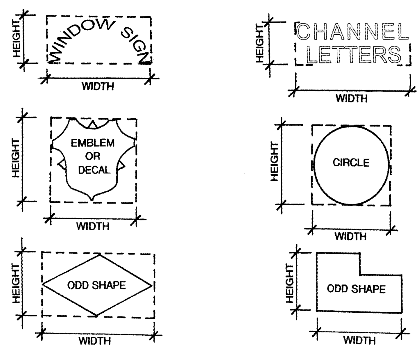
b.
Height. The height of a sign shall be measured from the edge of the pavement of the street abutting or closest to the sign structure to the top of the sign or sign structure, whichever is higher.
c.
Federally mandated or state-mandated requirements. Signs or components of signs that are expressly mandated to be of a specific required minimum size by federal or state laws or regulations are exempt from the sign area limitations, but only to the extent of such minimum requirements.
(4)
Prohibited signs and exceptions. The following signs, in addition to those prohibited by Article VI, Signs, are prohibited in this overlay district:
a.
Off-site signs. No sign identifying or advertising a business or use shall be permitted other than on the premises of such building or use. Acknowledgements for sponsorships or sizable contributions for public projects related to recreation facilities, public buildings, or public infrastructure will be considered off-premises advertising.
b.
Signs imitating warning signals. No sign shall display intermittent lights resembling the flashing lights customarily used in traffic signals or in police, fire, ambulance, or rescue vehicles, nor shall any sign use the words "stop," "danger," or any other word, phrase, symbol, or character in a manner that might mislead or confuse any vehicle driver, except for temporary construction signs and lights indicating a hazard.
c.
Certain attached and painted signs. Signs painted on or attached to trees, fence posts, and telephone or other utility poles; signs painted on or attached to rocks or other natural features; or signs painted on the roofs of buildings.
d.
Flashing and pulsating signs. Signs which contain a high intensity illuminating device causing it to blink, flash, pulsate, fluctuate, or animate, except signs giving public service information such as time, temperature, date, weather, or similar information intermittently with low intensity lights.
e.
Changeable face signs and changeable-copy signs on which the message changes statically more than once every ten (10) seconds. See definition for "Sign, changeable-face/copy/electronic message board".
f.
Mobile or portable signs. Signs and sign structures which are not attached to a permanent foundation. Portable signs incorporated into monument bases and in compliance with article VI, table 5 are permitted.
g.
Ribbons, streamers, and similar materials or devices. Any ribbon, streamer, pennant, spinner, or similar object or material, whether moving or not.
h.
Signs within street or highway right-of-way. No sign, sign structure, or obstruction of any character shall be erected in the street right-of-way except:
1.
One (1) newspaper box per family.
2.
Standard highway signs and markers that the South Carolina State Department of Transportation and Aiken County may authorize.
3.
Historical, commemorative and other monuments and memorials approved by staff.
4.
Signs for public events located in the right-of-way.
5.
Signs for the entrance or identification of subdivisions or PUD developments which are approved by the planning and development director, so long as such signs are not located on right-of-way property owned by a government.
j.
Abandoned signs.
k.
Signs placed with the primary purpose of providing a sign not otherwise allowed by this section.
(5)
Wall or projecting signs.
a.
Wall signs. Signs on the walls of a building (including signs attached flat against the wall, painted wall signs, and projecting signs) shall meet the following requirements:
1.
Signs on the front surface of a building. The total area of signs on the exterior front surface of a building shall not exceed twenty (20) percent of that surface.
2.
Signs on the side and rear surface of a building. The total area of signs on the exterior side or rear surface of a building shall not exceed twenty-five (25) percent of that surface.
3.
Depth of wall signs. Wall signs attached flat against a wall may extend not more than eighteen (18) inches from the wall. A wall sign which extends more than two (2) inches from the wall shall be placed a minimum of eight (8) feet above any sidewalk.
b.
Projecting signs. A projecting sign perpendicular to the wall of a building may be substituted for a wall sign. Projecting signs shall be placed a minimum of eight (8) feet above any sidewalk and may project a maximum of six (6) feet. Total area of projecting signs shall not exceed ten (10) percent of front surface area of building.
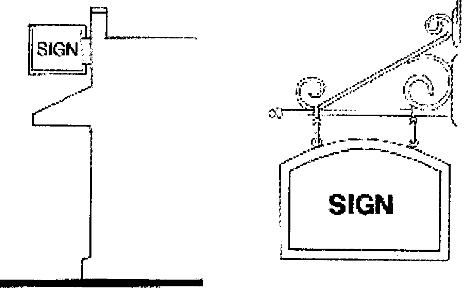
(6)
Freestanding Signs.
a.
General.
1.
Any freestanding sign must be a monument sign complying with item c., monument signs, below.
2.
A freestanding sign is a sign not attached to a building and containing a sign face on one (1) or more sides.
3.
Freestanding signs shall not project into any street or highway right-of-way.
4.
All freestanding signs must be monument signs with a maximum height ranging from four (4) feet to twelve (12) feet; refer to sections 24-2.12.7(9) and (10) below for details. All such signs shall have a consistent style or unifying theme.
b.
Number of signs. Not more than one (1) freestanding sign shall be permitted per lot, except where the lot fronts on two (2) major arterials as determined by the planning and development director, in which case an additional freestanding sign may be permitted with no more than one (1) such sign located along each arterial.
c.
Monument signs. The structure supporting a ground-level, freestanding monument sign shall not be included in calculating the area of the sign permitted by this section. The area of the supporting structure shall not exceed fifty (50) percent of the total combined area of the sign and supporting structure. Any pedestal on which a sign rests shall be at least sixty-seven (67) percent of the width of the entire sign.
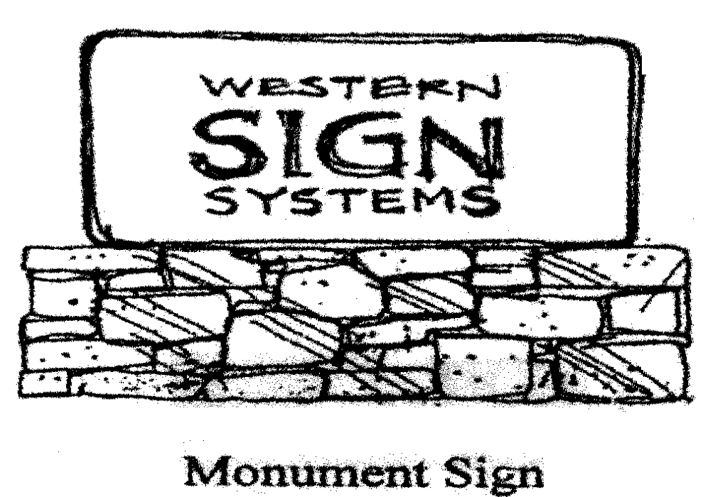
d.
Reader boards. Reader boards on which the message changes statically more than once every ten (10) seconds are not permitted.
e.
Shopping center signs.
1.
Signs identifying the name of the shopping center as well as the individual stores shall be consolidated on one (1) monument sign standard.
2.
Not more than one (1) such sign standard shall be permitted per shopping center except where a shopping center fronts on two (2) major arterials as determined by the planning and development director. If a shopping center fronts on two (2) major arterials with more than one hundred fifty (150) feet of frontage on each, one (1) additional sign standard shall be permitted with no more than one (1) such standard being placed on each such arterial.
(7)
Miscellaneous sign types.
a.
Entrance, identification or institutional signs. For institutional signs for such uses as schools and churches, one (1) double-face sign or two (2) single-face signs shall be permitted for each entrance to the project or use. If a double sign is proposed, the total area of the faces of both signs shall not exceed the maximum permitted sign area for a single sign. All such signs shall be ground-mounted, monument-type signs. No additional freestanding sign shall be permitted. Where approved by the planning and development director, such signs may be located in a landscaped median in the right-of-way.
b.
Banners for governmental or civic organizations. Banners for governmental or civic organizations are allowed at the entity's main location or at the location of the activity promoted on the banner. No banners shall be erected in a street right-of-way except as approved by the planning and development director.
c.
Flags. A maximum of three (3) flags may be displayed on each lot of record zoned any category other than single-family residential. There are no restrictions on flags displayed on a lot zoned for single-family residential use unless the lot is used for another purpose.
d.
Canopy or awning signs. Canopy or awning signs in place of wall or projecting signs are allowed in accordance with the following provisions:
1.
Canopies or awnings extending over the sidewalk or walkway may display one (1) business identification sign at each building entrance with a combined area not to exceed twenty (20) percent of the surface of the awning or canopy.
2.
Canopy or awning signs shall not project beyond the curb line of the adjacent street or alley.
3.
One business identification sign not exceeding one and one-half (1.5) square feet is permitted to hang underneath the awning or canopy, in addition to the sign displayed on the canopy.
(8)
Temporary signs.
a.
Signs on new projects under construction. One (1) non-illuminated sign, not exceeding thirty-two (32) square feet in nonresidential areas and sixteen (16) square feet in residential areas, displaying the name of the building, the contractors, the architects, the engineers, the owners, and the financial, selling, and development agencies, is permitted upon the premises of any project under construction, alteration, or relocation. Such sign shall be removed from the site within thirty (30) days after substantial completion of the project, as determined by the planning and development director.
b.
Construction, remodeling and other signs. Signs not exceeding five (5) square feet in size identifying the contractor involved in remodeling, re-roofing, landscaping or other similar service are permitted provided they are removed within ten (10) days after substantial completion of the project, as determined by the planning and development director.
c.
Real estate signs. Any real estate sign advertising a property for sale or lease is permitted provided it conforms to all of the following standards:
1.
Size shall not exceed five (5) square feet in any residential district or for a single-family residential unit in a PUD District and thirty-two (32) square feet in any other district, including all peripheral attachments.
2.
Copy shall be limited to: (1) the name of the owner or the listing agent, (2) the real estate company, (3) the type of offering, and (4) telephone numbers.
3.
The quantity shall be limited to one (1) per street frontage of the affected premises.
4.
A freestanding sign shall be mounted so that its top edge is no higher than four (4) feet above grade, and the top of a facade-mounted sign shall be mounted no higher than eight (8) feet above grade.
5.
The sign shall not be illuminated.
6.
A second sign announcing an open house that is no larger than the primary sign or a smaller sign attached to the primary sign may be erected for a period not to exceed forty-eight (48) hours on the subject property.
7.
Signs offering tenant space shall not be freestanding, but may be placed as a tenant panel on a permitted directory sign or in the window of the tenant space being offered.
d.
Grand opening signs. A banner is permitted for the grand opening of a retail establishment for a period not to exceed twenty-one (21) days. One (1) banner not to exceed seventy-five (75) square feet in size may be allowed on the facade of the building. This regulation shall not be construed to regulate the use of small balloons.
(9)
Size and height of signs permitted for residential uses. The maximum size of a sign for a multifamily residential project or a project with attached single-family units shall be thirty-two (32) square feet in area and six (6) feet in height on any arterial roadway and twenty (20) square feet in area and four (4) feet in height on any street other than a arterial roadway. Any such sign may be illuminated only by exterior incandescent lighting.
(10)
Size and height of signs permitted for nonresidential uses. Any individual nonresidential use on an individual lot may have one (1) freestanding sign not to exceed fifty (50) square feet in area and twelve (12) feet in height on any arterial roadway and one (1) sign not to exceed thirty (30) square feet and four (4) feet in height on any street that is not a arterial roadway.
Any shopping center with two (2) or more businesses may have one (1) freestanding sign not to exceed sixty (60) square feet for the first two (2) tenants and an additional ten (10) square feet for each additional tenant over two (2), with a maximum of one hundred twenty (120) square feet.
(Ord. No. 07-6-12, § 5, 6-5-07; Ord. No. 10-06-11, § 1, 6-1-10; Ord. No. 13-05-13, § 1, 5-21-13; Ord. No. 14-12-18, § 1, 12-9-14)
Sec. 24-2.12.8. - Parking spaces to be provided.
(1)
Spaces required. Off-street parking for all structures and uses of land shall conform to the requirements shown in Table 1: Permitted Uses and Conditional Uses and Off-Street Parking Requirements, By District. The planning and development director may accept a different number of spaces in accordance with subsection 2.12.8(4)(a) below.
(2)
Calculation of off-street parking requirements.
a.
When calculating the minimum number of off-street parking spaces in accordance with the table above, calculations shall be rounded to the nearest whole number.
b.
Calculation of required off-street parking for any eating establishment shall include all seating areas located outdoors.
(3)
Parking for uses not in table. Parking for uses not expressly provided for above shall be governed by the provisions in those paragraphs most suitable for that use as determined by the planning and development director.
(4)
Developer-submitted parking data.
a.
The planning and development director at his discretion may accept a higher or lower number of parking spaces than required in 24-2.12.8(1) above (or a specific number of spaces for a use not listed) based on developer-submitted parking data such as a shared parking analysis or appropriate standards from another accepted source.
b.
If the planning and development director accepts a lower number of parking spaces than is required in 24-2.12.8(1) above, the site shall be required to accommodate the higher number of spaces in case of future need. The design and location of these additional parking spaces shall meet the site design standards at 24-2.12.8(1) above and the following:
1.
The area necessary to accommodate these spaces shall not be included as part of the site's minimum open space requirement.
2.
The area necessary to accommodate these spaces shall be included in the impervious coverage for the site and accounted for in the drainage design.
3.
Until or unless such spaces are needed, as determined by the planning and development director, the area shall be maintained as open space.
(5)
Off-street parking design standards.
a.
General design standards. Every parcel of land developed as or changed to a parking area shall be developed in accordance with the following design standards:
1.
Any parking facilities containing ten (10) or more parking spaces shall be paved with concrete or asphalt. If parking facilities containing fewer than ten (10) parking spaces are not paved with concrete or asphalt, the parking spaces reserved for handicapped parking and the pathway leading from the handicapped parking spaces to the entrance to the building shall be paved with concrete or asphalt.
2.
No more than one (1) bay of parking shall be allowed between a structure and the right-of-way of the primary street fronting the site.
3.
Driveways and parking areas shall be designed to limit the removal of significant and grand trees to the maximum extent feasible. See 24-2.12.13 below.
4.
Landscaped buffers for parking areas adjacent to any property zoned or used residentially shall be provided in accordance with 24-2.12.14(4) below. No parking shall be permitted in required side yards adjacent to any residential district or use. Any light used to illuminate said parking area shall be directed away from any property zoned or used residentially.
5.
All off-street parking facilities shall be designed with appropriate means of access to street, alley, or maneuvering area.
6.
Each required parking space shall be at least nine (9) feet in width by nineteen (19) feet in length.
b.
Parking fronting arterials. All off-street parking in conjunction with development fronting on an arterial street shall be designed so that vehicles can turn around within the parking facility without backing into the street.
c.
Parking and aisle dimensions. Parking stalls shall be not less than nine (9) feet by nineteen (19) feet, except that a maximum of twenty (20) percent of the total number of stalls may be eight and one-half (8.5) feet by eighteen (18) feet. However, the dimensions of all parallel parking stalls shall be not less than nine (9) feet by twenty-four (24) feet. Minimum isle widths shall be as follows:
90 degree parking .....24 feet
60 degree parking .....20 feet
45 degree parking .....15 feet
Only one-way traffic shall be permitted in driving aisles serving single-row parking spaces placed at an angle other than ninety (90) degrees.
d.
Wheel-stops required.
1.
Secured wheel-stops shall be provided in all parking facilities without curbing. The vehicle side of the wheel-stop shall be no less than eighteen (18) inches from the end of the parking space.
2.
Where sidewalks or other walkways occur in parking facilities, parked vehicles shall not overhang or extend over the sidewalk. In these parking facilities, wheel-stops shall be provided even if the parking facility has curbing. Where sidewalks are six (6) feet or more in width, wheel stops-shall not be required.
(Ord. No. 07-6-12, § 5, 6-5-07; Ord. No. 08-04-17, § 1, 4-1-08; Ord. No. 14-12-18, § 1, 12-9-14)
Sec. 24-2.12.9. - Driveway standards.
(1)
All driveways shall comply with South Carolina Department of Transportation standards for separation. No more than one (1) driveway shall be allowed for every three hundred (300) feet of street frontage on major thoroughfares as designated on the most current version of the Aiken County Official Major Thoroughfares Map.
(2)
No driveway or curb cut into a public parking area shall exceed thirty (30) feet in width for two-lane driveways and fifteen (15) feet in width for single-lane driveways. For the purposes of this paragraph, the width of any landscaped median shall not be included in determining driveway width.
(3)
No driveway serving a nonresidential use shall be permitted through a residential district or use, and no driveway serving a multifamily use shall be permitted through a single-family district or use.
(4)
Detailed plans shall be submitted to the planning and development director for approval of all driveway openings or curb cuts before a permit may be obtained.
(5)
Interconnecting driveways. Where a parking area is within fifty (50) feet of a property line which is not on a street right-of-way, an easement shall be provided to allow for a future driveway connection to the adjacent property. A cross-access easement and hold-harmless agreement shall be required for interconnecting drives.
(Ord. No. 07-6-12, § 5, 6-5-07; Ord. No. 14-12-18, § 1, 12-9-14)
Sec. 24-2.12.10. - Off-street loading space.
(1)
General. Whenever the normal operation of any development requires that goods, merchandise, or equipment be routinely delivered to or shipped from that development, a sufficient off-street loading and unloading area must be provided in accordance with this section to accommodate the delivery or shipment operations in a safe and convenient manner. Determination of the applicability of this section shall be made by the planning and development director.
(2)
Typical loading area requirements. The following table indicates the number and size of spaces that normally shall satisfy the standard set forth in this subsection. However, the planning and development director may require more or fewer spaces if necessary to satisfy the intent of this standard, upon evaluation of adequate data submitted by the applicant.
(3)
Design standards.
a.
Minimum dimensions for each space shall be twelve (12) × forty (40) feet. Additional length or width may be required by the planning and development director if deemed necessary for a given expected type of vehicle use. An overhead clearance of fourteen (14) feet from pavement grade shall be required.
b.
Loading areas shall be so located and designed that the vehicles intended to use them can maneuver safely and conveniently to and from a street right-of-way and complete loading and unloading operations without obstructing or interfering with any public right-of-way, parking space, or parking lot aisle. No backing into the street shall be permitted.
c.
No area allocated to loading and unloading facilities may be used to satisfy the area requirements for off-street parking, nor shall any portion of any off-street parking area be used to satisfy the area requirements for loading and unloading facilities. Detached single-family dwellings are not subject to this requirement.
(4)
Exceptions. Whenever there exists a lot that meets all of the requirements below, then the developer need only comply with this section to the extent reasonably possible:
a.
One (1) or more structures on the lot were constructed before the effective date of this chapter; and
b.
A change in use is proposed that does not involve any enlargement of a structure; and
c.
The loading area requirements of this section cannot be satisfied because there is insufficient area available on the lot that can practically be used for loading and unloading.
(Ord. No. 07-6-12, § 5, 6-5-07; Ord. No. 14-12-18, § 1, 12-9-14)
Sec. 24-2.12.11. - Large retail projects.
(a)
A large retail project is defined as any new, predominantly retail development or collection of retail uses with a gross indoor floor area in excess of forty thousand (40,000) square feet or any enlargement or alteration to an existing predominantly retail project that would result in a gross indoor floor area in excess of forty thousand (40,000) square feet.
(b)
Any new large retail project or one for which the cost of alterations, renovation, or expansion in any one-year period exceeds fifty (50) percent of the appraised value of the development as set by the Aiken County Tax Assessor shall comply with the following.
(1)
Permitted locations. Such a project shall be located only in the planned use district (PUD) or urban district (UD) zones within the overlay district. Site/landscape plan approval shall be required prior to issuance of a building permit.
(2)
Character of design. Buildings shall be designed in a way that will reduce massive scale, provide visual interest, and avoid overwhelming surrounding development. The buildings shall be configured in a manner harmonious with topography and vegetation.
(3)
Architectural controls.
a.
Materials. Predominant exterior building materials may include brick, wood, stone, tile, split concrete block, or stucco. Smooth-faced concrete block are not permitted.
b.
Colors. Exterior facade colors must be low-reflecting, low-intensity, subtle, and neutral or earth-toned. Building trim may feature brighter, complementary colors that do not overwhelm the primary colors. Neon tubing is not allowed as an accent material.
c.
Rooflines. Rooflines shall be varied to add interest, minimize massive scale, and complement the character of nearby neighborhoods by using parapets, gables, eaves, or other similar designs.
d.
Exterior walls. No large expanse of blank exterior walls will be allowed. Variation may be achieved by using recesses, projections, windows, columns, horizontal and vertical offsets, awnings, canopies, and other features.
e.
Screening of rooftop or other mechanical or electrical equipment. Equipment shall be screened to minimize noise and views from all directions except overhead. If the equipment is roof-mounted, the screening shall be designed to conform architecturally to the design of the building. Walls or evergreen shrubbery must screen ground-mounted mechanical or electrical equipment; shrubbery must be large enough at the time of planting to screen the equipment.
f.
Location of walkways and entrances. The building design shall clearly indicate to visitors where entrances are located. Walkways shall be well-lighted and marked, easily accessible to parking areas, and in the safest areas.
g.
Location and appearance of outdoor sales and storage areas. Outdoor sales areas shall be incorporated into the overall design of the building and shall be screened with walls and/or fences not to exceed fifteen (15) feet in height. Materials, colors, and design of such walls and fences shall conform to those used predominantly on the principal building. To prevent unsightly clutter, outdoor storage of products in an area where customers are not permitted is prohibited.
h.
Outdoor lighting. Lighting shall comply with section 24-2.12.12 below.
i.
Types, heights, and location of perimeter fences. Fences shall not exceed eight (8) feet in height except those for outdoor sales and storage areas. Chain-link fencing is not permitted.
(4)
Landscaping.
a.
General. A landscape plan for a large retail project shall be incorporated as part of site-plan approval. Prior to issuance of a building permit or a development permit (site permit), a detailed landscape plan conforming to the tree preservation and landscaping provisions in sections 24-2.12.13 below and 24-2.12.14 below and conforming to the provisions of article V, bufferyards. Screening must be approved except where such provisions would conflict with the following provisions, which shall prevail over any conflicting provisions of sections 24-2.12 and article V:
b.
Bufferyard along a street right-of-way.
1.
Along any frontage adjacent to a street right-of-way, including out-parcels, there shall be a landscaped bufferyard 2 at least thirty (30) feet in depth.
2.
In the bufferyard, in addition to the required trees there shall be a continuous screen consisting of either evergreen shrubbery and/or a berm with plantings complying with the provisions of section 24-5.1 and with the following provisions:
i.
The shrubbery shall be at least three (3) feet high after pruning at the time of planting and shall be planted no more than five (5) feet on center in at least two (2) staggered rows.
ii.
Any berm must be at least three (3) feet high. Any berm less than five (5) feet high must be planted with evergreen shrubbery at least two (2) feet high after pruning at the time of planting and shall be planted no more than five (5) feet on center in at least two (2) staggered rows.
iii.
The screen shall be maintained at a minimum of five (5) feet in height after plantings have matured.
3.
The bufferyard may include a sidewalk or pathway parallel to the street and/or sidewalks or pathways perpendicular to the street to provide a pedestrian connection to parking areas.
c.
Screening of garbage and trash collection areas and delivery and loading areas. These areas shall be screened from view of adjacent property and street rights-of-way with a masonry wall or wooden fence and/or evergreen shrubbery, shall be located away from pedestrian and vehicular traffic, and shall be out of sight to the maximum feasible extent.
(5)
Delivery and loading.
a.
General. Delivery and loading areas shall be designed and located to minimize visual and noise impacts to residential areas.
b.
Setbacks and buffers. Each delivery and loading dock shall be set back at least seventy-five (75) feet from adjacent land zoned or used residentially including a landscaped buffer at least thirty (30) feet in depth along the property line conforming to the provisions of section 24-5.1, bufferyards of this chapter.
c.
Trucks. Delivery trucks shall not be parked during non-delivery hours with any motor, compressor, refrigerator or similar device running unless it is at least one hundred (100) feet from property zoned or used residentially.
(6)
Signage. In addition to complying with the sign provisions in section 24-2.12.7 above, all signs within in a new or altered large retail project shall be compatible and use similar design elements.
(7)
Traffic. The applicant shall submit a traffic impact study for the proposed project. The study shall include information as required by the planning and development director. The developer/owner shall be responsible for any new or additional roads or improvements, turn lanes, traffic signals, or other improvements made necessary by the project.
(8)
Waiver of requirements. The board of appeals may waive any requirements of this section for alteration or enlargement of an existing project where compliance would be impractical.
(Ord. No. 07-6-12, § 5, 6-5-07; Ord. No. 14-12-18, § 1, 12-9-14)
Sec. 24-2.12.12. - Outdoor lighting.
(1)
General. All lighting shall be designed to minimize the amount of ambient light perceptible from adjacent properties or that would impair the vision of motorists.
(2)
Fixture design.
a.
Each fixture shall be a full cut-off, down-directional lighting fixture whose source is recessed within an opaque housing.
b.
Each fixture under a building canopy shall be flush-mount with a flat lens.
c.
Electricity levels per fixture shall not exceed the following:
i.
On a pole: Four hundred twenty (420) watts.
ii.
In a wall-pack: Two hundred fifty (250) watts.
iii.
Under a canopy: Four hundred (400) watts.
d.
The cone of light from any fixture shall not be directed at a property line.
e.
Only incandescent, fluorescent, metal halide, mercury vapor, or high-pressure sodium sources may be used generating either white or off-white light.
(3)
Pole height. No pole may exceed forty-two (42) feet in height including the base except that no pole within one hundred (100) feet of any property zoned or used residentially shall exceed twenty-five (25) feet.
(4)
Maximum lighting levels. Maximum lighting levels in footcandles shall not exceed the following:
(5)
Maximum spillover. Light intensity shall not exceed two (2) footcandles at the property line adjacent to a street right-of-way or property zoned to allow commercial use and one-half (0.5) footcandle at the property line adjacent to any property zoned or used residentially.
(6)
Underground connections. All wiring and service connections for lighting must be underground.
(7)
Site lighting plan. A plan depicting the proposed lighting shall be submitted in conjunction with the site plan at a minimum scale of one (1) inch = twenty (20) feet and include the following:
a.
The location, design, type of lamp, distribution, manufacturer's photometric data (including number of lumens and wattage), and mounting information for each light fixture including those under a canopy;
b.
The location and height of each light standard;
c.
Light intensity levels in footcandles at points on a ten-foot grid and the minimum average and maximum footcandle calculations excluding the area of any buildings; and
d.
A notation that all requirements of the lighting provisions will be met.
(8)
Reduced lighting after closing. Lighting levels shall be reduced to fifty (50) percent of the full operational levels within thirty (30) minutes after the close of business but no later than 11:00 p.m., whichever is earlier, by turning off and/or dimming lights except that a business open twenty-four (24) hours a day shall not be subject to this provision. However, security lighting shall be maintained at night on the grounds of any property at a minimum of two (2) footcandles measured horizontally at the surface of the ground whether the structures on the property are occupied or not.
(9)
Planning and development director discretion. After the issuance of a certificate of occupancy for a project, the planning and development director may require changes to fixtures to bring the lighting levels into compliance with these provisions or to alleviate particular impacts on residential areas or motorists.
(10)
Compliance by existing projects. Any existing large retail project shall come into compliance with these provisions if the cost of any renovation or expansion in any one-year period exceeds fifty (50) percent of the appraised value of the development as set by the Aiken County Tax Assessor, the South Carolina Tax Commission, or any other state or local government entity or official with authority to do so, or by the building official for developments that are tax-exempt. For a development composed of individual lots, the determination of whether the aforesaid limit has been exceeded shall be based on the appraised value of the individual lot or lots on which the proposed improvement or improvements will be located and not on the appraised value of the entire development.
(11)
Light from vehicles. To prevent vehicle lights from affecting adjacent property which is zoned or used residentially, parking areas and driveways shall be screened from such property by evergreen shrubbery planted at least five (5) feet on center and three (3) feet high at the time of planting after pruning or by a berm at least three (3) feet high. The planning and development director official may waive this provision if it is not necessary because of topography or other reasons.
(12)
Lights intended to attract attention. Searchlights, flashing lights, or other lights used to attract attention to a site are prohibited.
(13)
Lighting during construction. All site lighting during construction must be full cut-off or directionally shielded fixtures that are aimed and controlled so the directed light is substantially confined to the object intended to be illuminated. A building is considered no loner under construction once exterior walls and windows are installed and permanent lighting replaces temporary lighting as the primary source of lighting for the building.
(14)
Exemptions. Holiday lighting displays and neon lighting used to outline a structure are exempt though such lighting may not extend above the roofline.
(15)
Variances. A request for a variance from the developer or his engineer for relief from any of the fourteen (14) lighting requirements described above (1) must be accompanied by a detailed explanation of the additional impact the granting of the variance would have on surrounding properties and (2) must comply with the variance provisions of section 24-9.3.
(Ord. No. 07-6-12, § 5, 6-5-07; Ord. No. 07-11-25, § 1, 11-27-07; Ord. No. 14-12-18, § 1, 12-9-14)
Sec. 24-2.12.13. - Tree preservation.
(1)
Significant tree and grand tree. A significant tree is an oak, pine, magnolia, or other tree that grows to be large with a DBH of eight (8) to twenty-four (24) inches, or a dogwood, redbud, or other tree that does not grow to be large with a DBH of four (4) to six (6) inches. A Grand Tree is an oak, pine, magnolia or other tree over twenty-four (24) inches DBH or a dogwood, rosebud, or other tree over eight (8) inches DBH.
(2)
Removal of existing trees.
a.
The natural landscape, including existing trees, shall be preserved wherever possible. On all nonresidential and multifamily developments within the overlay district, no significant or grand tree may be removed in the setback, bufferyard or open-space areas (tree-protection areas) of a development site unless one (1) or more of the following can be demonstrated to the satisfaction of the planning and development director, at his discretion:
1.
It is in the interest of good forestry management;
2.
The tree is diseased, dying, or dead;
3.
The tree causes a safety hazard to nearby buildings or pedestrian or vehicular traffic;
4.
The tree is a pine, pecan, or magnolia that is dropping debris or sap that is significantly affecting vehicles in a parking lot;
5.
The tree is causing significant structural damage to a building or other structure that reasonable maintenance cannot prevent;
6.
The tree is interfering with an existing underground utility line; and/or
7.
It is necessary to allow construction of a road or driveway essential for access to the site, subject to the requirement that the inches of grand and significant trees removed therefore shall be replaced when the site is developed.
b.
If significant or grand trees are removed on land zoned to permit single-family residential, no application for rezoning to a commercial or multifamily residential zoning classification will be considered for two (2) years after staff determines that such removal has occurred.
(3)
Removal of trees associated with development. Prior to issuance of a development permit (site permit) for a nonresidential or multifamily residential project, a site/landscape plan must be approved in accordance with section 24-2.12.14 below and the following provisions:
a.
Tree survey.
1.
For every nonresidential and multifamily project within the overlay district, there shall be submitted a detailed tree survey of the tree-protection areas (setback areas, bufferyard areas, and open-space areas) of the entire development site depicting the DBH, variety, and location of all Significant and grand trees at the same scale as the site plan including the information listed in 24-2.12.14 below.
2.
Information required by paragraph 1 above shall be prepared by a licensed engineer, surveyor, landscape architect, forester, arborist or other person with demonstrated experience in preparing accurate tree surveys as determined by the planning and development director. Such information shall not be more than two (2) years old on the date of submission of the application for landscape plan approval.
b.
Tree-protection areas (setback, bufferyard, and open-space areas).
1.
Protection of significant and grand trees. Within the tree-protection areas, all grand and significant trees shall remain unless their preservation would prevent the installation of a necessary driveway, sidewalk, permitted sign, or essential utility. All such driveways, sidewalks, signs, and utilities shall be located so as to preserve the maximum number of grand and significant trees as determined by the planning and development director. To insure tree survival, a protected area pursuant to 24-2.12.13(4)b below shall be provided around each tree as required by the planning and development director.
2.
No grand tree may be removed from the tree-protection areas unless the planning and development director determines there is absolutely no alternative because of unavoidable grading or because of the required configuration of paving, essential utilities, or buildings. No more than eighty (80) percent of the DBH inches of significant trees may be removed from the tree-protection areas (setback, bufferyard and open-space areas) unless the planning and development director determines there is absolutely no alternative because of unavoidable grading or because of the required configuration of paving essential utilities, or buildings.
3.
Grand and significant DBH inches removed from the tree-protection areas shall be replaced somewhere within the tree-protection areas, or elsewhere on the development site as approved by the planning and development director, except for trees removed (1) pursuant to the requirements of county ordinances and regulations, (2) after determination by the county staff to be diseased, dying, or dead, or (3) in conjunction with construction of athletic fields at a public or private school required by the South Carolina State Department of Education or other licensing or accreditation organizations for such schools.
4.
The cumulative DBH of replacement trees shall at least equal the cumulative caliper of the grand and significant trees removed except that the DBH of any grand or significant tree on the approved tree list saved or newly planted may count double as replacement trees under this provision.
5.
Trees planted to meet other requirements of this section may be counted as replacement trees. The minimum caliper for a replacement tree shall be two (2) inches and the tree must be from the approved tree list.
6.
The planning and development director shall approve the type, size, and location of each replacement tree.
7.
Where the planning and development director determines that planting the required number of trees on the site will result in an unacceptable density of trees based upon good forestry management, the planning and development director may reduce that number; provided, however, in such event, that off-street parking shall be limited to no more than ten percent over the minimum number of parking spaces required by 24-2.12.8(1) above if necessary to maximize the number of replacement trees to be planted on the site.
(4)
Tree protection during and after development.
a.
Standards. Trees that are to remain or are planted shall be protected in accordance with standards provided in paragraph b. below, and the tree protection and landscaping manual. The standards in the manual shall provide for protective barriers around trees, the prevention of compaction or other disturbance within the protected tree dripline, and the installation of utilities.
b.
Protected construction areas. During grading and construction, a circular protected area with a radius equal to one (1) foot for every inch of DBH of each tree shall be provided within which paving, grading, or the storage of dirt, building materials, debris, or any other materials or any other equipment shall not be allowed. Each protected area shall be enclosed by a barrier constructed in a manner required and approved by the planning and development director prior to commencement of clearing and grubbing and grading of the site and prior to issuance of the development permit (site permit) or building permit. Failure to maintain barriers may result in revocation of the building permit and/or development permit. Protective barriers shall be maintained until issuance of a certificate of occupancy. The protected areas shall be permanent and maintained by the property owner. No pavement shall be installed in the protected areas. The planning and development director may reduce the protected areas or allow intrusions into them if such actions would not adversely affect the survival and health of the trees.
c.
Tree maintenance. The following tree-maintenance provisions shall apply to all permanent trees on the subject site. No matter what pruning methods are used, no more than one-third (⅓) of the crown shall be removed in any one (1) growing season.
1.
Where necessary to improve visibility for public safety purposes, suckers of limbs below seven (7) feet in height may be removed through proper crown raising or elevations as described in ANSI Tree Maintenance Guide, Best management Practices, Tree Pruning, ANSI A300 (part 1), 2001 Printing, revision of ANGIA 3000 1995.
2.
Maintenance of trees shall take their natural shape and growth patterns into account. Trees that are intended to grow full to the ground, such as magnolias, shall not be limbed up.
3.
No topping or heading back shall be permitted which involves the cutting of limbs back to a stub, bud, or lateral branch not large enough to assume the terminal role. Crown reduction shall be used to reduce the size of a tree and is best accomplished by cutting limbs back to laterals that are at least one-third (⅓) the diameter of the parent limb.
(5)
Approved site/landscape plan to be on site. During construction and until issuance of a certificate of occupancy, a copy of the approved site/landscape plan must be kept on the site.
(6)
Removal of trees after development. After issuance of a certificate of occupancy for a commercial or multifamily residential project in the overlay district, no significant or grand tree or a tree planted pursuant to this section may be removed without the approval of the planning and development director pursuant to 24-2.12.13(2) above.
(Ord. No. 07-6-12, § 5, 6-5-07)
Sec. 24-2.12.14. - Open space, landscaping, and buffering requirements.
(1)
Area required for open space. The minimum required open space area shall be twenty-five (25) percent of the site for commercial uses and forty (40) percent of the site for multifamily residential uses. The bufferyards, setbacks, and retention/detention pond areas may be included in calculating the required open, landscaped area. Where a portion of a larger undeveloped tract is being developed, only landscaped area reasonably associated with the project as determined by the planning and development director shall be counted in meeting the requirements of this provision.
(2)
Application requirements.
a.
An application for approval of the site plan, including the landscape plan, shall be submitted to the planning and development director, with the number of copies set by the planning and development director, along with the appropriate fee.
b.
The site/landscape plan shall include the following (unless waived by the planning and development director):
1.
Name of the project;
2.
Tax parcel number;
3.
Acreage or square footage of the lot or parcel on which the project is situated;
4.
Acreage or square footage to be disturbed;
5.
Dimensions of the lot or parcel on which the project is situated;
6.
Graphic scale and north arrow;
7.
Name, address, and telephone number of the property owner;
8.
Name, address, and telephone number of the plan preparer;
9.
Zoning of the site;
10.
Location map at a scale sufficient to depict the exact location of the site;
11.
Calculation of the area of the total site required to be landscaped as open space and that actually provided;
12.
In the tree-protection areas (setback, bufferyard, and open-space areas), the location, type, and caliper of all grand and significant trees, indicating those to be removed and existing trees to be counted in meeting the requirements for bufferyards in section 24-5.1;
13.
The total DBH of significant trees in the tree-protection areas (setback, bufferyard, and open-space areas) and the total DBH of such significant trees being removed;
14.
The protected area required around each grand and significant tree based on one-foot radius for each inch DBH;
15.
A statement of the total caliper of the replacement inches required and the total caliper of those provided;
16.
Clear delineation of the limits of clearing;
17.
The number, location, and botanical and common names of plants to be installed including:
i.
The caliper of required trees;
ii.
Shrubbery, berms, and fences;
iii.
A clear indication of the areas to be seeded or sodded.
18.
A notation that protective measures for trees, installation methods for new plant material, maintenance of landscaped areas, and maintenance and pruning of trees and shrubs will comply with the standards established by this section, the tree protection and landscaping manual, and the county staff;
19.
Existing and proposed improvements, including structures, parking areas, detention facilities, exterior lighting, driveways, open space areas, setbacks, street rights-of-way and paving; and buffering in accordance with article V, sections 24-5.1 through 24-5.5 of this chapter; and
20.
Other information as required by county staff to facilitate review.
(3)
Buffering and screening. Buffering and screening shall be provided for nonresidential and multifamily projects in accordance with the provisions of article V, sections 24-5.1 through 24-5.5 of this chapter. However, landscaping in parking areas shall be provided in accordance with the following subsection (4), landscaping in vehicular use areas.
(4)
Landscaping in vehicular use areas.
a.
Perimeter planting areas. Each parking area should be defined by linear landscaped areas to delineate driveways and control traffic flow. Such linear landscaped areas should be at least eight (8) feet in width and include canopy trees as determined by the planning and development director unless such trees would interfere with traffic movement in which case other types of trees may be used.
b.
Islands between parking spaces. In a parking area with more than one (1) double bay of parking spaces, no more than ten (10) spaces are allowed in a row without a landscaped island of at least three hundred (300) square feet excluding curbing and having a minimum width of eight (8) feet. Each such island shall have at least one (1) canopy tree allowed in parking lots as set forth in the approved tree list. Such islands must be offset so that they are evenly distributed in the parking area and are not in straight lines.
c.
Islands at end of row. A landscaped island of at least one hundred (100) square feet in area shall be provided at the ends of each single row of parking spaces closest to a building; each such island shall have a berm two (2) feet high planted with ground cover, or, where there are two (2) such islands together totaling at least two hundred (200) square feet, a small tree allowed in parking lots as set forth in the approved tree list. A landscaped island of at least one hundred fifty (150) square feet shall be provided at the ends of each single row of parking spaces nearest the street frontage; where there are two (2) such islands together totaling at least three hundred (300) square feet, there shall be one (1) canopy tree. The islands shall be designed and maintained so as not to obstruct visibility for motorists. The planning and development director may modify or waive this provision if compliance would not be practical.
d.
Trees in islands. Islands shall be located to preserve the maximum number of existing trees. The maximum number of trees must be planted as determined by the planning and development director taking into account the size of the trees at maturity. The planning and development director shall approve the size, type, and location of the trees. Any combination of large and small trees may be planted to meet the minimum number required by this provision with the approval of the planning and development director.
e.
Screening of dumpsters. Dumpsters, utility boxes, and similar structures must be screened in accordance with the provisions of section 24-5.2 of this chapter.
(5)
Detention ponds and lakes. A detention pond may be counted as open landscaped area unless it is unable to support healthy trees, as determined by the county. Each detention pond shall be screened for aesthetic purposes pursuant to the standards in the tree protection and landscaping manual provided for by 24-2.12.14(9) below or as otherwise directed by the planning and development director to accomplish the purposes of this section. A lake shall be counted as landscaped area if approved by the planning and development director as effecting the purposes of this section.
(6)
Design of project landscaping. Landscaping installed during development should meet the following design guidelines:
a.
Landscaping should be designed for the long term; the size of plants at maturity should be considered when selecting plant material and designing its installation.
b.
Landscaping should continue thematic elements, if any, found in the surrounding area, including plant types and planting patterns.
c.
Landscaping should be designed to be functional (reducing the heat island effect of impervious surfaces, helping to control runoff, etc.), as well as beautiful.
(7)
Irrigation. An automatic irrigation system must be installed to water all new landscaped areas. The system must remain operational and have a timer set to water plantings to keep them alive.
(8)
Completion and maintenance of landscaping.
a.
Completion. All landscaping shall be installed in accordance with the approved landscape plan unless substitutions are approved by the planning and development director and noted in writing on the plan. A certificate of occupancy for any business or use on a site with such an approved plan shall not be issued until the required landscaping is installed by the property owner and approved by the planning and development director or a cash or equivalent performance guarantee is posted with the planning and development director in the minimum amount of one hundred ten (110) percent of the total cost of the required uncompleted landscaping, including the labor, as determined by the planning and development director. A site not requiring a certificate of occupancy may not be used until the required landscaping is installed or a guarantee posted.
The guarantee and accompanying surety shall be in a form approved by the planning and development director and shall be released and returned to the party posting the guarantee upon installation by the property owner of all required landscaping and acceptance by the planning and development director of such installation. The landscaping shall be installed within three (3) months of the posting of the performance guarantee with the planning and development director. However, the planning and development director may extend the time period for installation of landscaping for a maximum of an additional three (3) months if weather conditions are not suitable for such installation or trees are not available during the initial three-month period. If the landscaping is not installed within the required period, the guarantee shall be forfeited to and used by the county to complete the approved landscaping with any remaining funds being returned to the party who posted the guarantee. For a project in an unincorporated area receiving city services and for which a landscape plan has been approved, the use of those services may not commence until the requirements of this section are met.
b.
Maintenance. The property owners, occupants, and tenants or their agents shall be jointly and severally responsible for the maintenance of all landscaping. All landscaping required by or installed pursuant to landscaping plans approved under this section or prior ordinances shall be maintained in good condition so as to present a healthy, neat and orderly appearance; shall be kept free of refuse, debris, and dead, diseased, or severely damaged plants or vegetation; and shall contain at all times the number, variety, and location of plants and trees required thereby.
(9)
Tree protection and landscaping. The county staff shall promulgate mandatory standards for the installation, maintenance, survival, health and protection of trees and landscaping required to be retained, planted, installed, or maintained by this section or prior ordinances. Those standards shall promote and effect the purposes set forth in section 24-2.12.1 above and be compiled in a tree protection and landscaping manual. The manual shall also establish an approved tree list setting forth trees allowed to be planted including those permitted in parking lots.
(Ord. No. 07-6-12, § 5, 6-5-07; Ord. No. 14-12-18, § 1, 12-9-14)
Sec. 24-2.12.15. - Conflict with other regulations.
In the event that the provisions of this section 24-2.12 HCO, highway corridor overlay district conflict with other regulations, including the permitted uses of the zoning districts which underlie the HCO Districts, the more restrictive and stringent regulations shall prevail.
(Ord. No. 07-6-12, § 5, 6-5-07; Ord. No. 08-4-17, § 1, 4-1-08)
Sec. 24-2.12.16. - Compliance with other regulations.
Nonresidential and multifamily projects within the overlay districts must comply with all other applicable provisions of Chapter 24, Land Management Regulations, which are not in conflict with the preceding provisions of this section 24-2.12.
(Ord. No. 07-6-12, § 5, 6-5-07)