
Aiken County Unincorporated
City Zoning Code
City Zoning Code
ARTICLE VII
LAND DEVELOPMENT REGULATIONS
Sec. 24-7.1.- Purpose.
The purpose of this article is to advance the objectives of section 6-29-1120 of the Code of Laws of South Carolina, 1976, as amended, to require harmonious, orderly, and progressive development of land in pursuit of public health, safety, economy, good order, appearance, convenience, morals, and the general welfare. In furtherance of these objectives, the regulation of land development in Aiken County is designed:
(1)
To encourage economically sound and stable development;
(2)
To assure the timely provision of required streets, utilities, and other facilities and services to new land development;
(3)
To assure the adequate provision of safe and convenient traffic access and circulation, both vehicular and pedestrian in and through new land developments;
(4)
To assure the provision of needed public open space and building sites in new land developments through the dedication or reservation of land for recreation, education, transportation, and other public purposes; and
(5)
To assure, in general, the wise and timely development of new areas in harmony with the Comprehensive Plan of Aiken County.
(Ord. No. 07-6-12, § 5, 6-5-07)
Sec. 24-7.2. - Site design standards.
(1)
Site analysis. It is recommended that an analysis be made by the applicant of characteristics of the development site, such as site context, geology and soil, topography, ecology, existing vegetation, structures, and road networks, visual features, and past and present use of the site.
(2)
Site design considerations. Site design shall take into consideration all existing local and regional plans, and should be based on the site analysis. To the extent practical, development shall be located to preserve any natural features on the site, to avoid areas of environmental sensitivity, to minimize negative impacts and alteration of natural features, to avoid adversely affecting ground water and aquifer recharge, to reduce cut and fill, to avoid unnecessary impervious cover, to prevent flooding, to provide adequate access to lots and sites, and to mitigate adverse effects of shadow, noise, odor, traffic, drainage, and utilities on neighboring properties.
The following specific areas and resources shall be preserved to the extent consistent with the reasonable utilization of the site.
a.
Unique and/or fragile areas, including wetlands as defined in Sec. 404, Federal Water Pollution Control Act Amendments of 1972, as determined by the U.S. Corps of Engineers, and/or as defined by the State of South Carolina.
b.
Flood plain areas, as determined by FEMA (Federal Emergency Management Agency) and delineated on flood boundary maps, flood insurance rate maps and floodway maps for Aiken County.
c.
Habitats of endangered wildlife, as identified on federal and state lists.
d.
Historically significant structures and sites, as listed on federal, state, and/or local lists of historical places.
e.
Archaeologically significant sites, as listed on federal, state, and/or local lists and reports of archaeological sites.
The planning and development director and other county staff can assist by providing suggested sources for the data required in items a. through e. above.
(Ord. No. 07-6-12, § 5, 6-5-07; Ord. No. 14-12-18, § 1, 12-9-14)
Sec. 24-7.3. - Streets and driveways.
(1)
Unspecified standards and circulation system design.
a.
Where standards for required road design and construction are not specifically set forth in this chapter, the applicable standards or requirements of the Aiken County Council and the South Carolina Department of Transportation shall govern. All work must be performed in the manner prescribed in the standard specifications for road construction of the South Carolina Department of Transportation.
b.
Street systems shall be designed to permit the safe, efficient, and orderly movement of traffic; to have a simple and logical pattern; to respect natural features and topography; to present an attractive streetscape; and to promote linkage of major collector streets.
(2)
Layout and alignment.
a.
Proposed streets shall be coordinated with the existing street system in the surrounding area and, where possible, shall provide for the continuation of existing streets abutting the development. Existing roads shall be continued at the same or greater width, but in no case shall be less than the width required by the provisions of this chapter.
b.
All streets shall be opened to the exterior property lines of the development unless permanently terminated by a vehicular turnaround or intersection with another street.
c.
Reserve strips controlling access to streets are prohibited except where their control is placed with the county, under conditions approved by the planning commission.
d.
Proposed streets should be aligned both vertically and horizontally to provide for the following clear-sight distances:
i.
Arterial road: Five hundred (500) feet.
ii.
Collector road: Two hundred (200) feet.
iii.
All other roads: One hundred (100) feet.
(3)
Alleys. Paved alleys are permitted and may be required by the planning commission in commercial, multifamily and industrial developments to provide service access, off-street loading and unloading, and parking consistent with and adequate for the proposed use. Dead-end alleys shall be avoided, but may be permitted, provided they terminate with a turnaround having a radius of not less than forty (40) feet. Alleys shall be maintained by means of a private perpetual maintenance agreement approved by the county attorney and recorded in the RMC office by county staff.
(4)
Cul-de-sacs.
a.
Dead-end streets designed to be permanently closed at one (1) end shall not exceed two thousand five hundred (2,500) feet in length, measured from the right-of-way of the connecting street to the center point of the turn-around. In the case of a subdivision with only one (1) entrance, the distance by street between the subdivision entrance and farthest end of any road within the subdivision shall determine the length of the cul-de-sac.
b.
A turn-around shall be provided at the closed end of a street and shall have a minimum diameter of eighty (80) feet to the outside edge of the pavement and one hundred (100) feet to the legal right-of-way line. Riding surface width shall have a minimum curb radius of forty (40) feet. A landscaped center island may be provided if sight lines are not obstructed. If such island is provided the pavement width of the turn-around may be reduced to thirty (30) feet.
c.
Cul-de-sacs shall be avoided wherever possible by connecting new subdivision roads with nearby or adjacent existing roads. The planning commission shall determine whenever such connections are required.
d.
In all subdivisions, whether single-phase or multi-phased, all reasonable efforts shall be made to provide current or future connections with existing nearby roads and/or with proposed future roads in an attempt to eliminate excessively long cul-de-sacs.
e.
Temporary dead-end streets shall terminate with a temporary cul-de-sac having a diameter of not less than eighty (80) feet.
(5)
Intersections.
a.
No more than two (2) streets shall intersect at any one (1) point.
b.
All streets shall intersect as nearly as possible at ninety-degree right angles. However, in no instance shall the angle be less than eighty (80) degrees or more than one hundred (100) degrees. The maximum grade approaching intersections shall not exceed five (5) percent for a distance of less than one hundred (100) feet from the intersection.
c.
Streets entering upon opposite sides of a given street shall have their center lines directly opposite or shall be offset a minimum distance of two hundred (200) feet, measured along the centerline of the streets being intersected.
d.
Street intersections shall be located at least two hundred (200) feet from the right-of-way of any railroad track, measured from the center point of the intersection to the railroad right-of-way line nearest the intersection.
e.
Minor and collector streets and driveways shall not intersect with a major thoroughfare as designated on the most recent version of the Aiken County Official Major Thoroughfares Map dated August 8, 1998 at intervals of less than three hundred (300) feet. Streets and driveways which intersect a street other than a major thoroughfare shall not intersect the street less than one hundred (100) feet from other street intersections. All measurements are taken from centerlines of streets and driveways.
f.
Minor and collector streets shall be in alignment with existing and planned streets which intersect or will intersect with a major thoroughfare as designated on the most recent version of the Aiken County Official Major Thoroughfares Map.
g.
Right-angle intersections shall be used wherever practical.
h.
Clear-sight intersections shall be provided in accord with the requirements of section 24-8.5.
(6)
Right-of-way and pavement widths. Minimum street right-of-way and pavement widths shall be as follows:
The planning commission may require additional right-of-way where necessary for public safety and convenience, or parking in commercial, industrial or high-density residential areas. Refer to Table 8 for construction standards. Landscaped islands may be provided if sight lines are not obstructed. Such islands shall not be deeded to the county, but shall be maintained by a perpetual maintenance agreement approved by the county attorney.
(7)
Horizontal curvature. Where connecting right-of-way lines deflect from each other by more than ten (10) degrees, the lines must be connected with a true, circular curve, the minimum radius of which shall be:
a.
Arterial street: Five hundred seventy-three (573) feet.
b.
Collector street: Five hundred seventy-three (573) feet.
c.
Minor local street: One hundred fifty (150) feet.
d.
All other streets: One hundred (100) feet.
Arterial and collector streets must be tangent a distance of not less than (100) feet between reverse curves, and sixty (60) feet between a horizontal curve and an intersection with another street or railroad. Refer to Table 8 for construction standards.
(8)
Construction requirements—Streets and drainage.
(a)
General.
1.
All streets, both public and private, shall be constructed in accord with Aiken County Construction Specifications, latest edition, and the construction standards of Table 8 of this chapter.
2.
Paved streets that are to be accepted into the county road-maintenance system shall be paved by the applicant and shall be constructed to the grades and dimensions drawn on the plans, profiles and cross-sections submitted by the applicant and approved by the planning commission and/or planning and development director and/or county engineer. However, before paving is begun, the applicant shall install all required utilities and provide adequate drainage in accord with these regulations, all to be approved by the county engineer before the commencement of paving.
3.
Drainage and detention facilities shall adhere to the provisions of chapter 19, public works, article IV, section 19-80, drainage and storm sewers of the Aiken County Code of Ordinances.
(b)
Private subdivisions.
1.
Private subdivisions are intended for exclusive use by their developers, the lot owners, and their guests. The public may not be privileged to the use of private roads, parks, and other improvements in private subdivisions; and in private subdivisions the public shall not be responsible or liable for street and drainage repair, maintenance of water and sewerage systems, subdivision-park maintenance, or any other maintenance of any improvements in private subdivisions normally provided by public tax dollars in public subdivisions. Private subdivisions are subject to all other requirements of this chapter, including the following:
a.
Preliminary and final plat review and approvals; and
b.
All road standards, drainage standards, and other development standards shall comply with Aiken County minimum standards for roads, shall comply with sound engineering principals and shall be designed by and inspected by a South Carolina licensed professional engineer. The engineer of record shall provide a certified letter to the planning and development department, along with the final plat, stating that the project was constructed according to the plans and specifications approved by the planning commission.
2.
The planning commission may not grant preliminary plat approval to any private subdivisions until satisfactory documentation has been provided, and approved by the county attorney, for the perpetual private care and maintenance of all roads, easements, water and sewerage systems, drainage facilities, parks, and other improvements, including provisions for such perpetual private-maintenance requirement in all deeds conveying lots in such subdivisions. After its approval by the county attorney, this documentation, commonly referenced as the "private subdivision maintenance agreement", shall be recorded with the subdivision final plat by the planning and development director in the RMC office. The recording fee shall be paid by the applicant to the planning and development director.
3.
Streets, paved or unpaved, in private subdivisions approved by the Aiken County Planning Commission after to November 2, 2006, shall not be eligible for acceptance by the county council into the county maintenance system unless such streets and related drainage facilities are brought up to current county standards for paved streets and drainage facilities at no cost to the county. Before considering such streets for accepted into the county maintenance system, the county council must determine that the private road:
a.
Serves a public purpose,
b.
Connects to an existing publicly maintained street,
c.
Is open to the public at all times,
d.
Serves a minimum of three (3) tax parcels owned by different individuals, and
e.
Has a minimum of three (3) dwellings present whose entrances front on the road. Said dwellings shall have been present for a minimum of five (5) years prior to the date of request for acceptance of the street as evidenced by county property tax records.
4.
Where such private subdivision documentation required by subsection 24-7.3(8)(b)2. was not completed and recorded in the RMC office due to an error by the county, the county council may, in its discretion and in the interest of the public health, safety and general welfare, consider acceptance of the private subdivision into the county street maintenance system. To be eligible for acceptance, such private subdivision must:
a.
Connect to an existing publicly maintained street,
b.
Be open to the public at all times,
c.
Serve a minimum of three (3) tax parcels owned by different individuals, and
d.
Have a minimum of three (3) dwellings present whose entrances front on the road. Said dwellings shall have been present for a minimum of five (5) years prior to the date of request for acceptance of the street as evidenced by county property tax records.
(c)
Existing unpaved county roads—Cooperative agreement. In the event an individual or organization wishes to enter into an agreement with the county to improve an existing county maintained road by paving it, the following procedures shall apply:
1.
The individual or organization shall, in writing, offer to enter into a cooperative agreement to pave existing county roads.
2.
The county administrator shall bring the offer before the development committee of county council. After consultation with appropriate county staff, the development committee shall make a recommendation to the full council as to the advisability of entering into such a cooperative agreement. If council so desires, the county and the applicant shall enter into an agreement which specifically delineates the responsibilities of each of the parties.
3.
The applicant shall provide to the county a right-of-way deed of sixty-six (66) feet for roadways with open ditches and fifty (50) feet for roadways with valleys and gutters.
4.
The applicant shall provide all required engineering drawings and other work for road paving and drainage to meet applicable requirements of this article.
5.
The applicant shall supply all drainage material, such as pipe, tops, boxes, etc. and coordinate with all utility companies the relocation of poles and boxes.
6.
The county will provide the equipment and labor to clear the roadway, will grade the road and install the pipe, will compact the sub-grade, and will install and compact the sand/clay base to required densities.
7.
Upon completion of the base, the applicant will apply primer and will pave the road according to approved county and/or state standards.
8.
The county will dress the shoulders and ditches.
9.
The applicant will provide all required grassing to shoulders and ditches.
10.
The county will furnish and install all required road signs.
(9)
Driveway standards for residential building lots.
a.
General.
1.
Driveways must have a minimum width of twelve (12) feet and serve no more than two (2) parcels of land.
2.
Driveways must have stable shoulders and adequate drainage and stormwater controls to prevent erosion of the driveway and excessive stormwater or sediment runoff onto connecting public or private road rights-of-way.
3.
Driveway pipes for stream crossing or stormwater drainage must be sized appropriately for the passage of at least the ten-year design storm and able to withstand the anticipated loads of emergency vehicles and other vehicles without deforming.
4.
If an existing driveway serves more than two (2) lots, the driveway shall be named and a driveway-name sign erected in accordance with the provisions of the Aiken County Guidelines for Naming Roads and Erecting Road Signs.
5.
Vertical and horizontal curves and grades must accommodate the safe passage of emergency vehicles.
6.
Refer to applicable intersection requirements for driveways in section 24-7.3.5 above.
b.
Unpaved driveways.
1.
The first thirty (30) feet of length (measured from the edge of the travel surface of the access road) of driveways that are constructed with material other than concrete or asphalt must be covered by at least a two-inch-thick compacted all-weather surface material such as gravel, crushed stone, or shell. Porous paving blocks or other similar materials may be used. The use of recycled materials also may be used with approval from the planning and development director.
2.
Driveways that are constructed with material other than concrete or asphalt must not exceed five (5) percent grade for the first twenty (20) feet of driveway length, measured from the edge of the travel surface of the street. An exception may be granted by the planning and development director provided a qualified engineer can certify that adequate stormwater and sediment controls have been installed. This information must be provided prior to recording of a final plat or before a certificate of occupancy is issued.
c.
Paved driveways.
1.
The first ten (10) feet of length (measured from the edge of the travel surface of the access road) of driveways that are constructed with material other than concrete or asphalt shall not exceed six (6) percent slope. While it is desirable to maintain the same grade for the next ten (10) feet, it should not exceed fifteen (15) percent slope. Additionally, changes in slope deflection should not exceed ten (10) percent so as not to cause vehicles to "bottom out".
2.
The subsection c.1 immediately above does not apply to driveways with negative grades when measured from a public or private right-of-way provided the site complies with applicable building codes and stormwater regulations. The planning and development director may grant exceptions provided the following construction standards are followed:
i.
Asphalt or concrete has been crowned or sloped to ensure that excessive stormwater does not impact connecting public or private rights-of-way.
ii.
Shoulders of the driveway are properly constructed, landscaped, and stabilized so as to prevent erosion and to prevent stormwater runoff and sediment deposits onto connecting public or private road rights-of-way.
Table 8: Construction Standards For Subdivisions
* Wider drainage easements may be required at the discretion of the county engineer.
(Ord. No. 07-6-12, § 5, 6-5-08; Ord. No. 07-11-25, § 1, 11-27-07; Ord. No. 14-12-18, § 1, 12-9-14; Ord. No. 16-08-13, § 1, 8-16-16; Ord. No. 21-05-12, § 1, 5-4-21)
Sec. 24-7.4. - Curb and gutter.
(1)
Requirement. Curbs and gutters shall be installed where required by Table 8. The planning commission also may require the installation of curbs and gutters in subdivisions or portions of subdivisions devoted to commercial or industrial development, where considered necessary to ensure public safety and convenience.
(2)
Construction specifications.
a.
Curbs and gutters shall be constructed in accordance with Section 9 of the Aiken County Construction Specifications, latest edition. (Also refer to the Construction Standards of Table 8)
b.
The radii of curbs and gutters at intersections shall be determined by the types of intersecting streets, as follows:
Arterial intersecting arterial .....32′
Arterial intersecting collector .....32′
Collector intersecting collector .....25′
Collector intersecting minor .....25′
Minor intersecting minor .....20′
Service drive or alley .....10′
(3)
Transition. The transition from one (1) type of curb or gutter to another shall be made only at street intersections with adequate provisions being made for driveway entrances.
(Ord. No. 07-6-12, § 5, 6-5-07)
Sec. 24-7.5. - Shoulders.
Shoulders shall consist of stabilized turf or other material acceptable to the county and shall be prepared in compliance with the construction standards of Table 8 and applicable provisions of the Aiken County Construction Specifications, latest edition.
(Ord. No. 07-6-12, § 5, 6-5-07)
Sec. 24-7.6. - Signage and names.
(1)
Street and road signs.
a.
Design and placement of traffic signs shall follow state regulations or the requirements specified in the Manual of Uniform Traffic Control Devices for Streets and Highways, latest edition, published by the U.S. Department of Transportation. The applicant shall be responsible for the cost of manufacture and erection of required signs. The county public works department shall be responsible for the manufacture and erection of said signs.
b.
Any party requesting a change in a road sign shall be responsible for the expense of the change. However, should the county initiate the change, the county shall bear the expense. Custom-made signs, if requested, shall be subject to approval by the county public works department.
c.
At least two (2) street-name signs shall be placed at each four-way street intersection, and one (1) at each "T" intersection. Signs shall be installed under streetlights, where possible, and free of visual obstruction.
d.
Custom-manufactured street signs, if requested, shall be subject to approval by the county public works department and shall meet the same standard county requirements for height, location, placement, erection, and reflectivity as for signs manufactured by the public works department.
(2)
Names. Street names shall be subject to approval of the planning commission and shall be substantially different in sound and spelling from existing streets in the county unless at a future date plans call for a tie-in between the proposed street and an existing street. The naming of streets shall comply with section 19-30 of the County Code of ordinances and with the county "Guidelines for Naming Roads".
(Ord. No. 07-6-12, § 5, 6-5-07; Ord. No. 08-4-17, § 1, 4-1-08)
Sec. 24-7.7. - Street lighting.
(1)
Location. Street lighting, when provided, shall be provided at street intersections and between intersections in commercial and industrial areas where the distance is eight hundred (800) feet or more from an intersection.
(2)
Height. The maximum height of streetlights shall be twenty-five (25) feet.
(3)
Shielding. Street lighting shall be properly shielded so as not to create a hazard to drivers or a nuisance to residents.
(Ord. No. 07-6-12, § 5, 6-5-07)
Sec. 24-7.8. - Easements.
The provision of easements shall be governed by Table 8 and the following, as applicable to a particular type of easement.
(1)
Drainage easements. Drainage easements shall be provided whenever a subdivision or development is traversed by a watercourse, drainage way, channel, or stream. The easement shall conform substantially to the lines of such watercourse, and be not less than twenty (20) feet wide or of sufficient width to preserve the unimpeded flow of the natural drainageway for a one hundred-year storm event, as determined by the county engineer, to carry off stormwater and provide for maintenance and improvements of the watercourse. Approval of such easements by the county does not obligate the county for perpetual maintenance of the easements nor for liabilities or damages resulting from the watercourse, drainageway, channel, or stream.
(2)
Utility easements. Utility easements, where provided, should be adjacent to or centered on side or rear lot lines. Easements shall be not less than ten (10) feet in width and no structures or trees shall be placed within such easements. The location of utility easements shall be coordinated with the utility provider.
(3)
Access easements. (See section 24-7.9.4, flag lots and access easements.)
(4)
Maintenance of easements.
a.
A note shall be placed on the final plat of a subdivision which contains utility easements, stipulating that the county or utility with lines in such easements shall have full right of access.
b.
Easements shall be maintained by the property owner(s) and may be used to satisfy yard requirements, unless specifically accepted for public maintenance by the county or utility with lines in such easement.
(Ord. No. 07-6-12, § 5, 6-5-07)
Sec. 24-7.9. - Lots.
(1)
Accessibility. All lots shall be accessible by a public street maintained by a public body, except for:
a.
Lots in approved PUDs, as provided for in section 24-2.7;
b.
Lots on approved access easements, as provided for in section 24-7.9.4; and
c.
Lots on private streets with approved maintenance agreements.
(2)
Design. Lot size, width, depth, shape, grade, and orientation shall be in proper relation to street and block design, to existing and proposed topographical conditions, and for the type of development and use contemplated. Maximum ratio of average width to average depth of a lot shall be 1:4 for residential subdivisions. However, the maximum required road frontage of a lot shall not exceed three hundred (300) feet regardless of depth of lot.
(3)
Dimensions All lots shall meet the minimum lot area and dimensional requirements of Table 2, unless elsewhere specified by this chapter.
(4)
Flag lots and/or access easements. The creation of flag lots and/or access easements shall not be allowed except under the following conditions:
a.
To permit full use of an existing lot of record; and/or
b.
To overcome unusual topographic conditions or existing lot configurations.
c.
To permit access to an additional single parcel of land.
When meeting the above conditions, as determined by the planning and development director, flag lots shall be created and access easements shall be permitted in accord with the following development standards:
a.
Creation of flag lot or access easement to permit full use of an existing lot of record.
A flag lot or access easement may be created from an existing lot of record to allow full and complete development thereof, provided that:
1.
The existing lot of record meets all zoning requirements specified for the zoning district in which it is located, both before and after subdivision; and
2.
The "flag" section of the flag-shaped lot, or of a single lot accessed by an access easement, shall meet or exceed the dimensional requirements specified for the zoning district in which the lot is located. The area of the access driveway of the flag lot or access easement (the flagpole portion) shall not be included in computing minimum lot area requirements. Title to the access driveway (the "flagpole" portion of the flag lot) must be conveyed by general warranty deed in the same manner as title to the "flag" portion of the lot, or in the case of an easement, recorded with the deed to the accessed lot; and
3.
The driveway ("flagpole") section of the flag lot or of the access easement shall be not less than thirty (30) feet wide, and the nearest edge of the driveway ("flagpole") section shall be located no closer than one hundred (100) feet to any driveway or street, measured from the edge of the nearest driveway or street. In order to facilitate possible future development, for any parcel of fifty (50) feet or more acres in size, the flag pole section of a flag lot or of an access easement shall not be less than fifty (50) feet in width for its entire length and shall have a minimum road frontage of fifty (50) feet.
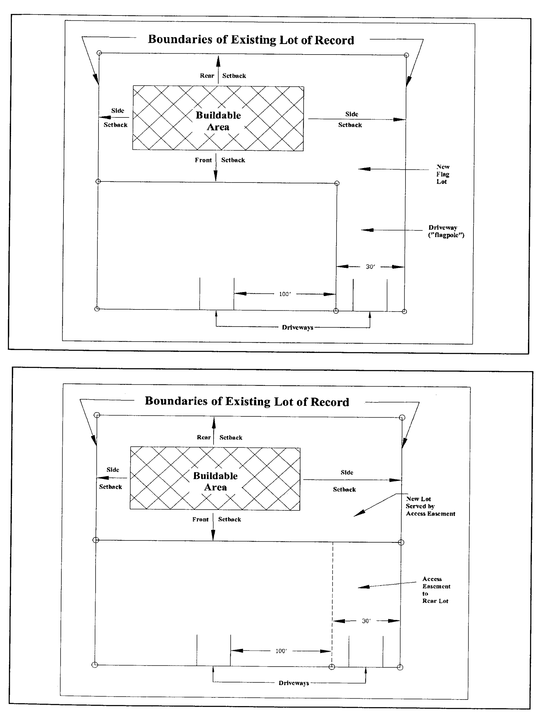
4.
Once subdivided to include a flag lot, the existing lot of record shall not be further subdivided for a period of twelve (12) months from and after the creation and recording of the flag lot.
5.
A driveway shall provide access to no more than two (2) parcels of land.
b.
Creation of flag Lot to overcome unusual natural or topographic conditions or existing lot configurations.
Flag lots may be created in new subdivisions only where natural or topographic conditions or where existing lot configurations create access problems, provided:
1.
Access easements or the "flagpole" parts of flag lots shall be not less than thirty (30) feet wide for their entire length, and shall front for at least thirty (30) feet on a public street. In order to facilitate possible future development, for any parcel of fifty (50) or more acres in size, the flag pole section of a flag lot or of an access easement shall not be less than fifty (50) feet in width for its entire length and shall have a minimum road frontage of fifty (50) feet.
2.
Centerlines of flag-lot and access easement driveways shall be separated by the required minimum lot width for the zoning district in which the flag lot is to be created, measured at the front property line. Contiguous or adjoining flag lots and/or access easements are prohibited.
3.
Use of flag-lot and access easement driveways by adjoining lots on either side of the driveway is encouraged as a means of limiting curb cuts, but neither a flag-lot driveway nor an access-easement driveway shall be used to access a second flag lot or access easement.
4.
Neither the area of a "flagpole" section of a flag lot nor the area of an access easement shall be counted when computing the minimum area of a lot as required by article 2, table 2 of this chapter.
5.
A driveway shall provide access to no more than two (2) parcels of land.
c.
Creation of flag lot or access easement to permit access to an additional single parcel of land.
A flag lot or access easement may be created to access an additional single parcel of land, provided that:
1.
The parcel meets all zoning requirements specified for the zoning district in which it is located, both before and after subdivision; and
2.
The "flag" section of the flag-shaped lot, or of a single lot accessed by an access easement, shall meet or exceed the dimensional requirements specified for the zoning district in which the lot is located. The area of the access driveway of the flag lot or access easement (the flagpole portion) shall not be included in computing minimum lot area requirements. Title to the access driveway (the "flagpole" portion of the flag lot) must be conveyed by general warranty deed in the same manner as title to the "flag" portion of the lot, or in the case of an easement, recorded with the deed to the accessed lot; and
3.
The driveway ("flagpole") section of the flag lot or of the access easement shall be not less than thirty (30) feet wide in width for its entire length and shall have a minimum road frontage of thirty (30) feet, and the nearest edge of the driveway ("flagpole") section shall be located no closer than one hundred (100) feet to any driveway or street, measured from the edge of the nearest driveway or street. In order to facilitate possible future development, for any parcel of fifty (50) or more acres in size, it is recommended that the flag pole section of a flag lot or of an access easement should not be less than fifty (50) feet in width for its entire length and should have a minimum road frontage of fifty (50) feet.
4.
Once subdivided to include a flag lot or access easement, the lots may not be further subdivided unless additional access is provided via a public or private road.
5.
A driveways shall provide access to no more than two (2) parcels of land.
Access easements shall not be permitted in new multi-lot subdivisions.
(5)
Double-frontage lots. Lots in residential subdivisions involving new streets, where proposed for areas adjacent to an arterial street, shall be denied direct access to and separated from such arterial streets by double- or reverse-frontage lots. Elsewhere, double-frontage lots shall be prohibited.
Residential reverse-frontage lots shall have a minimum rear yard of fifty (50) feet next to the arterial street, measured from the shortest distance of the proposed back building line to the street right-of-way. Within such rear yard and immediately adjacent to the right-of-way, there shall be a non-access planting screen easement at least ten (10) feet in depth.
(6)
Alignment. Side lot lines shall be aligned at approximately right angles to straight street lines and radial to curved street lines.
(Ord. No. 07-6-12, § 5, 6-5-07; Ord. No. 09-08-17, § 1(LMR 6), 8-18-09; Ord. No. 14-12-18, § 1, 12-9-14)
Sec. 24-7.10. - Blocks.
(1)
Residential.
a.
Block lengths shall be appropriate to topographic conditions and density to be served, but shall not exceed one thousand two hundred (1,200) feet in length, or be less than three hundred (300) feet in length.
b.
Blocks should be of sufficient width to allow for two (2) tiers of lots of appropriate depth, except where reverse-frontage lots are required along a major street, or where prevented by size, topographical conditions, or other inherent conditions of the property.
(2)
Commercial and industrial. Blocks intended for commercial or industrial development may vary from the standards of design detailed above in favor of dimensions more suitable to their prospective use; provided such blocks permit adequate traffic circulation and efficient pickup and delivery.
(Ord. No. 07-6-12, § 5, 6-5-07)
Sec. 24-7.11. - Areas subject to flooding.
If the area being developed, or any part thereof, is located within the boundary of a designated flood hazard area, as delineated on FEMA Maps for Aiken County, that development shall conform to the requirements of section 24-2.8.
(Ord. No. 07-6-12, § 5, 6-5-07)
Sec. 24-7.12. - Water supply.
(1)
DHEC approval required. All development and lots within subdivisions shall be provided by the applicant with water supplies and systems conforming to the requirements, rules, and policies of the South Carolina Department of Health and Environmental Control (DHEC), and approved by said agency.
(2)
When required to connect to a public or community water system. Depending on the number of housing units, residential subdivisions shall be required to connect to a public or community water supply system if such water system is available within the following distances, provided that the water system does not require annexation, whether immediate or future, and further provided that the operator of the water system has not determined in writing that such connection is not feasible:
Multifamily and nonresidential developments, but not including agricultural uses, shall be required to connect to a public or community water supply system if such system is located within one thousand five hundred (1,500) feet, provided that the water system does not require annexation, whether immediate or future, and further provided that the operator of the water system has not determined that such connection is not feasible.
The above distances are measured in a straight line between the nearest access point of the available water system to the nearest edge of any portion of the development property. In the case of phased developments, the above connection requirements apply regardless of the order of development of the phases. Subdivisions comprised of lots five (5) acres or more in size are exempt from the above requirements to connect with a water system. In the case of such subdivisions with lots of five (5) acres or more in size, if connection is not made to a sewer system, the final recorded plat of the subdivision shall be inscribed with a statement reading "No further subdivision of any of the parcels depicted hereon into any parcels less than five (5) acres in size is allowed unless the parcels are connected to a public or community sewer system prior to such further subdivision."
If a water system is not in place or cannot be extended, the developer must provide individual well-water systems, subject to applicable DHEC regulations and approval.
(3)
Water system requirements. The water supply system shall be adequate to handle domestic demand including fire flow, based on complete development, and shall be installed in accord with Aiken County Construction Specifications, latest edition, and DHEC regulations.
Multifamily and nonresidential developments, but not including agricultural uses, shall be required to connect to a public or community water supply system if such system is located within one thousand five hundred (1,500) feet, provided that the water system does not require annexation, whether immediate or future, and further provided that the operator of the water system has not determined that such connection is not feasible.
The above distances are measured in a straight line between the nearest access point of the available water system to the nearest edge of any portion of the development property. In the case of phased developments, the above connection requirements apply regardless of the order of development of the phases. Subdivisions comprised of lots five (5) acres or more in size are exempt from the above requirements to connect with a water system. In the case of such subdivisions with lots of five (5) acres or more in size, if connection is not made to a sewer system, the final recorded plat of the subdivision shall be inscribed with a statement reading "No further subdivision of any of the parcels depicted hereon into any parcels less than five (5) acres in size is allowed unless the parcels are connected to a public or community sewer system prior to such further subdivision.
If a water system is not in place or cannot be extended, the developer must provide individual well-water systems, subject to applicable DHEC regulations and approval.
(4)
Water system to include fire hydrants. The applicant shall install fire hydrants in accordance with section 24-7.14.
(Ord. No. 07-6-12, § 5, 6-5-07; Ord. No. 08-04-17, § 1, 4-1-08)
Sec. 24-7.13. - Sanitary sewer facilities.
(1)
DHEC approval required. All development and lots within subdivisions shall be provided by the applicant with sanitary sewer facilities conforming to requirements, rules, and policies of the South Carolina Department of Health and Environmental Control (DHEC), and approved by said agency. Said facilities shall be "stubbed out" prior to road surfacing.
(2)
When required to connect to public or community sewerage system. Depending on the number of dwelling units, residential subdivisions, including manufactured home subdivisions, and other residential developments such as duplex, triplex, quadruplex, and multifamily developments, including apartment complexes, and manufactured home parks shall be connected to a public or community sanitary sewer system if such sewer system is available within the following distances, unless the operator of the sewer system has determined in writing that such connection is not feasible:
Nonresidential developments, but not including agricultural uses, shall be required to connect to a public or community sewer system if such sewer system is located within one thousand five hundred (1,500 feet), provided that the operator of the sewer system has not determined in writing that such connection is not feasible.
The above distances are measured in a straight line between the nearest access point of the available sewer system to the nearest edge of any portion of the development property. In the case of phased developments, the above connection requirements apply regardless of the order of development of the phases. Subdivisions comprised of lots five (5) acres or more in size are exempt from the above requirements to connect with a sewer system. In the case of such subdivisions with lots of five (5) acres or more in size, if connection is not made to a sewer system, the final recorded plat of the subdivision shall be inscribed with a statement reading:
"No further subdivision of any of the parcels depicted hereon into any parcels less than five (5) acres in size is allowed unless the parcels are connected to a public or community sewer system prior to such further subdivision."
If a sewer system is not in place or cannot be extended, the developer must provide individual subsurface disposal systems, subject to applicable DHEC regulations and approval.
(3)
Sewer system requirements. The sanitary sewer system shall be adequate to handle the necessary flow based on complete development, and shall be installed in accord with Aiken County Construction Specifications, latest edition, and DHEC regulations.
(Ord. No. 07-6-12, § 5, 6-5-07; Ord. No. 08-04-17, § 1, 4-1-08)
Sec. 24-7.14. - Fire hydrants.
(1)
When a public or community water system is used in a residential subdivision or other development, fire hydrants shall be installed and spaced throughout each subdivision or development to maintain a 500-foot radius between hydrants. The county engineer or appropriate fire official shall approve the location and spacing of hydrants.
(2)
At their discretion, especially when a public or community water system is not used in a residential subdivision, or other subdivision, the planning commission may require the installation of "dry" fire hydrants if suitable bodies of water are available, as recommended by county staff and/or appropriate fire officials.
(Ord. No. 07-6-12, § 5, 6-5-07)
Sec. 24-7.15. - Sidewalks.
Sidewalks shall be required on one (1) side of each street in all subdivisions with fifty (50) lots or more with an average lot size of one-half (½) acre or less. Sidewalks also may be required by the planning commission to continue an existing walk in an adjacent subdivision or along an existing street to access nearby schools and/or public recreation areas. Within subdivisions, sidewalks shall be at least four (4) feet wide; when providing access to public facilities, sidewalks shall be not less than five (5) feet wide.
Where proposed for construction, sidewalks shall be installed in accord with Aiken County Construction Specifications, latest edition.
(Ord. No. 07-6-12, § 5, 6-5-07)
Sec. 24-7.16. - Surveys and plats.
All land developments within the jurisdiction of this Land Management Regulations chapter shall be surveyed, platted, and marked in accordance with the Aiken County Plat Standards and the Aiken County Survey Requirements as maintained by the GIS mapping division of the county planning and development department and in accordance with the Minimum Standards Manual for the Practice of Land Surveying in South Carolina, as promulgated by the Code of Laws of South Carolina, 1976, Title 40, chapter 21.
(Ord. No. 07-6-12, § 5, 6-5-07)
Sec. 24-7.17. - Dedications and reservations.
The responsibility for installing improvements required by sections 24-7.3 through 24-7.16 rests with the applicant. Upon installation of these improvements, the owner of any development within the unincorporated area of Aiken County shall take steps to dedicate them to and have them accepted by county council as follows:
(1)
Prepare a deed conveying the improvements to the county.
a.
Use standard deed forms for property conveyance.
b.
The title of conveyance shall be: "Aiken County, South Carolina, a body politic and corporate and a political subdivision of the State of South Carolina."
c.
In the conveyance of roads and/or easements the deed must include a phrase reading that "…and appurtenances to said premises belonging or in any way incident or appertaining" in order to convey related structures such as drainage structures, catch basins, etc., to the county.
d.
A derivation clause must be included in the deed, referencing tax map, block, parcel numbers, recordation date, book and page number of the related plat.
e.
Prior to acceptance by County Council of any conveyance deed, it shall be submitted to the Planning & Development Department for approval by the County Attorney.
(2)
Provide title certification and affidavit.
a.
The applicant shall provide to county council a title certification by an attorney licensed in South Carolina, certifying that the applicant owns fee-simple title to such improvements, free and clear of liens and encumbrances. Should exceptions be noted, they must be specifically recited and recognized in the resolution for acceptance of such improvements by county council.
b.
Prior to acceptance of title to a newly constructed street (one (1) completed within two (2) years of consideration by council), the applicant and the road contractor shall provide county council with an affidavit stating that all construction costs have been paid and that the road is clear of all encumbrances.
(3)
Record dedicated improvements. Recording by the planning and development department of an approved final plat constitutes a dedication of all public roads to public use, a dedication of all publicly maintained neighborhood parks (not privately maintained and/or privately dedicated) and other public areas to public use, and a reservation for possible future public acquisition of such areas as may be required by the planning commission or county council.
(4)
Response of county council. The offer to dedicate roads and other improvements does not impose any obligation on county council until council has made an actual acceptance by resolution.
(5)
Submittal of maintenance bond. Prior to the acceptance of new roads, drainage facilities, stormwater detention facilities and related appurtenances into the county maintenance system, the applicant shall furnish a maintenance bond in an amount determined by the engineering department to secure the maintenance of said improvements for a period of at least one (1) year. The bond shall be in a form available from the planning and development department and shall be approved by the county attorney. The surety, as specified in the bond, shall be a corporate surety licensed to do business in South Carolina. In lieu of such surety, the applicant shall post a cash bond or an irrevocable letter of credit from a bank licensed by the State of South Carolina or from a federally insured lending institution.
(Ord. No. 07-6-12, § 5, 6-5-07; Ord. No. 12-04-08, § 1, 4-17-12)
Sec. 24-7.18. - Certifications and disclosure statements.
The following certifications, copies of which are available from the planning and development department, shall be inscribed by the applicant on all copies of the final plat:
(1)
Certificate of final approval;
(2)
Engineer's or surveyor's certification;
(3)
Owner's certification;
(4)
Disclosure Statements for flood hazard areas, if applicable (section 24-2.10.22(4); and
(5)
Other certificates as required.
(Ord. No. 07-6-12, § 5, 6-5-07)
Sec. 24-7.19. - Stormwater drainage systems.
Stormwater drainage systems shall be designed and installed by the applicant to permit the unimpeded flow of natural water courses, to ensure drainage of all low points along the line of roads, to intercept stormwater runoff along roads, and to provide drainage away from on-site sewage disposal systems. No development shall be undertaken that appreciably increases the rate of surface water runoff. Refer to chapter 19, article IV, section 19-80 of the Aiken County Code of Ordinances for stormwater-drainage requirements.
The best available technology shall be utilized to minimize off-site stormwater runoff, increase on-site infiltration, encourage natural filtration function, simulate natural drainage systems, and minimize off-site discharge of pollutants to ground and surface water. Best-available technology may include measures such as detention/retention basins, recharge trenches, porous paving and piping, contour terraces, swales, and low-impact development (LID) practices. Where detention/retention basins are used, privately or publically maintained, an all-weather access road is required to the facility.
(Ord. No. 07-6-12, § 5, 6-5-07; Ord. No. 12-04-08, § 1, 4-17-12)